mining records curator arizona geological survey...
TRANSCRIPT

The following file is part of the
Richard Mieritz Mining Collection
ACCESS STATEMENT
These digitized collections are accessible for purposes of education and research. We have indicated what we know about copyright and rights of privacy, publicity, or trademark. Due to the nature of archival collections, we are not always able to identify this information. We are eager to hear from any rights owners, so that we may obtain accurate information. Upon request, we will remove material from public view while we address a rights issue.
CONSTRAINTS STATEMENT
The Arizona Geological Survey does not claim to control all rights for all materials in its collection. These rights include, but are not limited to: copyright, privacy rights, and cultural protection rights. The User hereby assumes all responsibility for obtaining any rights to use the material in excess of “fair use.”
The Survey makes no intellectual property claims to the products created by individual authors in the manuscript collections, except when the author deeded those rights to the Survey or when those authors were employed by the State of Arizona and created intellectual products as a function of their official duties. The Survey does maintain property rights to the physical and digital representations of the works.
QUALITY STATEMENT
The Arizona Geological Survey is not responsible for the accuracy of the records, information, or opinions that may be contained in the files. The Survey collects, catalogs, and archives data on mineral properties regardless of its views of the veracity or accuracy of those data.
CONTACT INFORMATION Mining Records Curator
Arizona Geological Survey 416 W. Congress St., Suite 100
Tucson, Arizona 85701 520-770-3500
http://www.azgs.az.gov [email protected]
o
.0.,
r--
(
A
GEOLOGICAL
and
SAMPLING REPORT
on the
RUTH CLAIMS
Pinal County, Arizona
by
Richard E. Mieritz Mining Consultant
Phoenix, Arizona
January 13, 1977

TABLE of CONTENTS
INTRODUCTION • . .
PROPERTY, LOCATION and ACCESSIBILITY
FACILITIES . . . . . .
HISTORY, DEVELOPMENT and PRODUCTION
GEOLOGY
MINERALIZATION .
SAMPLING . . . .
SUGGESTED EXPLORATION
Included Exhibits: Map No. 1 - Index Map, Portion of Arizona
Page · 1
· 1
· 2
· 2
· 2
· 2
· 3
· 3
Map No.2 - General Geology Map, Portion of Maricopa County, AZ Map No. 3 - Surface Map, RUTH Claims Schedule I - Sample Descriptions and Assays Map No.4 - Sample Map, RUTH Claims Assay Certificate - Jacobs Assay Office Assay Certificate - Iron King Assay Office
i i
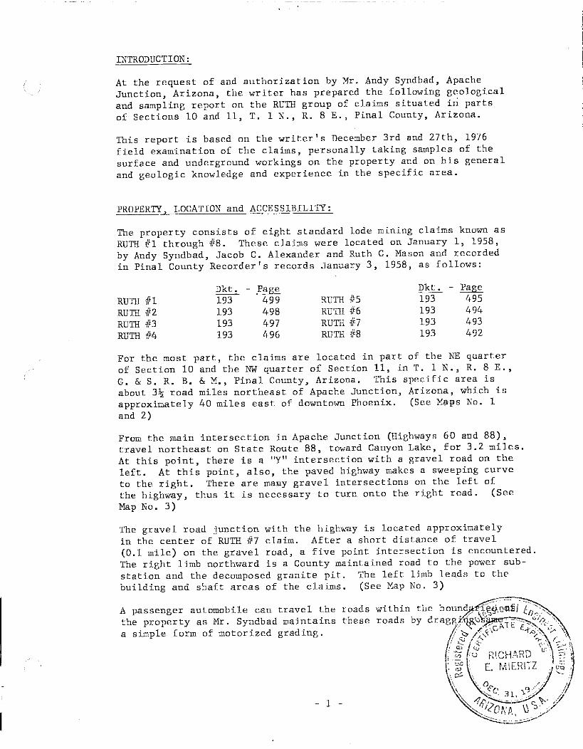
INTRODUCTION:
At the request of and authorization by Mr. Andy Syndbad, Apache Junction, Arizona, the writer has prepared the following g~ological and sampling report on the RUTH group of claims situated in parts of Sections 10 and 11, T. 1 N., R. 8 E., Pinal County, Arizona.
This report is based on the writer's December 3rd and 27th, 1976 field examination of the claims, personally taking samples of the surface and underground workings on the property and on his general and geologic knowledge and experience in the specific area.
PROPERTY, LOCATION and ACCESSIBILITY:
The property consists of eight standard lode m~n~ng claims known as RUTH #1 through #8. These claims were located on January 1, 1958, by Andy Syndbad, Jacob C. Alexander and Ruth C. Mason and recorded in Pinal County Recorder's records January 3, 1958, as follows:
RUTH 111 RUTH 1/2 RUTH 113 RUTH 1/4
Dkt. 193 193 193 193
- Page 499 498 497 496
RUTH 115 RUTH 116 RUTH 117 RUTH 118
Dkt. 193 193 193 193
- Page .495 494 493 492
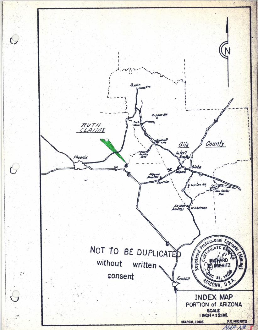
For the most part, the claims are located in part of the NE quarter of Section 10 and the NW quarter of Section 11, in T. 1 N., R. 8 E., G. & S. R. B. & M., Pinal County, Arizona. This specific area is about 3~ road miles northeast of Apache Junction, Arizona, which is approximately 40 miles east of downtown Phoenix. (See M~ps No. 1 and 2)
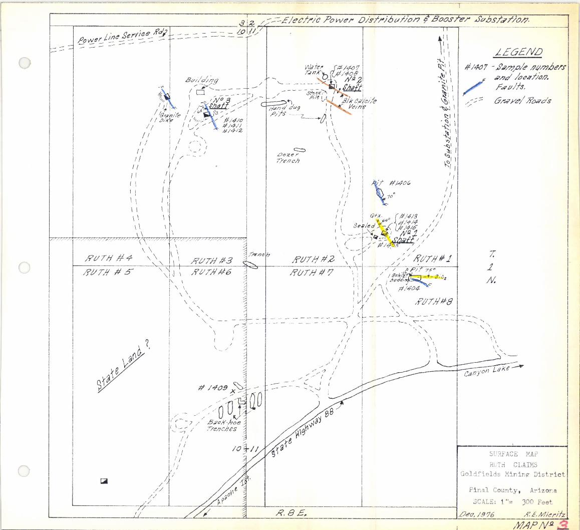
From the main intersection in Apache Junction (Highways 60 and 88), travel northeast on State Route 88, toward Canyon Lake, for 3.2 miles. At this point, there is a "Y" intersection with a gravel road on the left. At this point, also, the paved highway makes a sweeping curve to the right. There are ma~y gravel intersections on the left of the highway, thus it is necessary to turn onto the right road. (See Map No.3)
The gravel road junction with the highway is located approximately in the center of RUTH #7 claim. After a short distance of travel (0.1 mile) on the gravel road, a five point intersection is encountered. The right limb northward is a County maintained road to the power substation and the decomposed granite pit. The left limb leads to the building and shaft areas of the claims. (See Map No.3)
A passenger automobile can travel the roads the property as Mr. Syndbad maintains these a simple form of motorized grading.
- 1 -

C)
- - -_ ... _-._ .. _--_ . . _ ... ..•... -.• ------ -..... _--_ •.. -
FACILITIES:
Although the electric power substation adjoins the property on the north end, and there are several residential electrical supply lines nearby, the owner has no power on his claims.
Natural gas service is not readily available at or near the property.
As to water, two shafts have water in them but little is known as to quality and quantity since the owner has not been able to make tests, at least to quantity, because of 'lack of electric power supply.
HISTORY, DEVELOPMENT and PRODUCTION:
The claims were located in January 1958. Since then, the principal owner, Mr. Andy Syndbad, has slowly, prudently, sy~tematica1ly and consistently explored the claims by means of surface trenches (dozer, backhoe and hand-dug), vertical and declined shafts to test potential mineralization which the owner has discovered by his diligent, persistent work on the property. (See Surface Map No.3)
GEOLOGY:
For the most part, the property is alluvium covered with sand, and soil. A few small natural rock outcrops are visible which some granite, a conglomerate, a little schist and some rhyolite. demonstrated by some of the shallower trenches and cuts, much of the surface sand, gravel and soil is underlain by a bed of caliche of variable thickness which, of course, "hides" the underlying rock and any mineralization and thus makes for difficult exploration. In spite of this, Mr. Syndbad has uncovered and partially explored sparse silver and gold mineralization within the property. Some work thus far has not been successful, but this is not unusual and is part of the ''mining'' risk.
MINERALIZATION:
As a result of the field examination, the writer has found that weak gold and silver mineralization occurs in several ways; in calcite veins, quartz veins, faults and in a porphyritic pyritic host rock. The degree or strength of mineralization varies but the strength of the host structures and rock is such that prudence to explore and develop in prospector fashion is there, thus justifying expenditure of the individual's time, energy and money.
The mineralized structures (faults and veins) assume a pattern trend of three directions, namely east-west (pit on #8 claim), N.30OW. (pit and shaft on #1 claim, shaft on #3 claim and shaft on #4 claim)
- 2 -

j-------------------~---~-----------------------------. . _- - - - -- ._.
and N.60Dw. (surface exposure and in shaft on #2 claim). See Map No.3}
Dips of the structures also show their general trends, namely vertical, south, northeast and southwest. These trends indicate possible convergence at depth. Other, yet undiscovered structures could exist, interspersed between the presently known and mapped structures, which could enhance the structural geologic picture of more massive host rock presence and stronger mineralization at depth. Specific reference is to the near bottom exposure in No. 1 shaft (#1 claim) of the porphyritic host rock containing sulphides, principally pyrite. Moreover, the host rock is altered and part of the pyrites are oxidized - usually good signs of potential mineralization at depth.
The exposed quartz vein (hanging wall of No. 1 shaft near where sampled shows an improved silver content over its of the footwall fault gouge (Samples 1413 and 1415).
SAMPLING:
During the course of the field examination, the writer samples of the workings within the property.
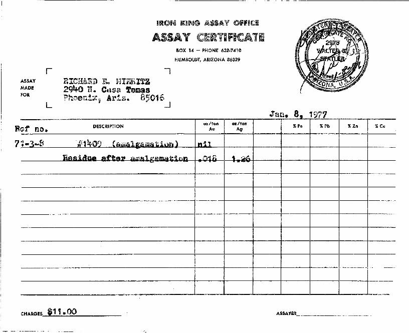
Sample #1409 represents about two pounds of sand and gravel (up to pea size) shoveled from a small wash near the surface pits on #6 claim. The gathered sample was dry screened through a 16 mesh sieve and sent to the Iron King Assay Office for an amalgamation test.
The amalgamation test indicates no free gold. Fire assay of the sand showed 0.018 and 1.26 ounces per ton respectively for gold and silver.
SUGGESTED EXPLORATION:
In the opinion of the writer, underground exploration efforts should be concentrated in Shaft No. 1 on #1 claim and Shaft No. 2 on #2 claim. These two shafts presently expose three modes of mineralization deserving of consideration.
Shaft No. 1 exposes a strong quartz vein in the shaft hanging wall for 11 feet below the collar, at which point it enters the shaft hanging wall because of its flatter dip. Shaft No. 1 also exposes a pyritic, porphyritic altered rock at the bottom of the shaft. Both these occurrences should be further prospected.
The calcite structures in the vicinity of Shaft No. 2 on #2 claim should be further prospected from the shaft. These structures appear to have good strength.
- 3 -

Unfortunately, both shafts contain ground water which must be pumped out. Without electric power on the property, the de-watering may be a bit difficult, laborious, and unnecessarily expensive with electric power available so near the property.
January 13, 1977
- 4 -
, •• c ~
' 0 I I f I
'.
, -A, . " . ~
.... ~. '.
,"
, " . .. ':.:
/i'VT# CLAIMS
-
NOT rOBE DUPLICAT without writte,n
~bnsent
".A~ 1'41 ,' " '
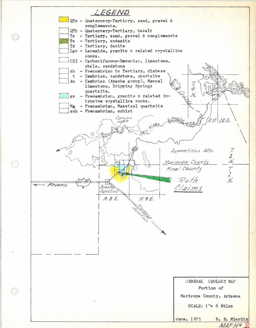
LEGENLJ o QT. - QuaternAry-Tertiary, sand. gravel &
conglomerate. Q'l'b - Qu.aternary-Tert1ary, basalt Ts - Tertiary, .and, ~ra.el & conglomerate r. - Tertiary, andeaite Td - Tertiary, dacite Lgr - Laramide. ,ranite & Ntlat4ld orystalline
rocks. o CDI - Carbonitel'Olu -Devonian, 1 estone. shale, sandstone
§ db - Precambrian to Tertiary, diaba se t - C brian, sandstone, quartzite ~
A.u - Cebrian (Apaohe group), Mesoal L, limestone, Dripping Springs - ' : quartsite. ~
D gr - Precatebrian, granite & relat.ed in- ~~ truei ... orystalline rocks. nMA - Precambrian, Mazatzal quartzite o eh - PreeUlbr1&n. achi.!t
;$~"'. [l07/7,on .. "....... ~~.>7 (i(
-:: ~. M ~:' .. ' ! )(l!' Jl J : .. : .. , .... ". ---.-:. i.l~
1~'" ;':. ~::-~/ /j''.~')~ :;: .......-;, - ,t ,
):1."", ~ ".,., ~ ,1'., ~;',: 't/ '::
.~." .'. ": ~ ..-.... \,"1 <.... ~: ;;1:~···-·)::J--···
:,....... .-... _ .... --
R. 9E.
/f.// /.2£ \ \
\ I.
,2 d --~
T 1 M
GENERAL GEOLOOY MAP
Portion of
Maricopa County, Arbona
SCALEs 1··s: 6 MUes
June. 1975 R. E. Mier1tz
MA?N.Q
--
'/
------, ------- --- ------ - - -- -- - -
.Boosre.r Su/;Js/,,/)o/?
~: \ \ 1 ! ~\ .~\\
\)1 \
~,\
/ __ - - - -~;I/;"" ~\ 1 ./ ~ PI)'! L,l I ~\ \
I/#I?d cluJ ; ( -~ \ ,P/,fs ---L _ -.!.l \ ~I I
u:\ \ ,~ \ ~i , \ ~I \ ( \ ~~ .
~I \ \ ~I
\ \ ~; 1 \ \ ~! 1
\ \ J I \ ; I I I I /
) I / I / J > 10
0 I J
J / I // / f ) I Q-f.z , 0 {/I/4J3 / I , I ;. 64 II /4- 140 I I \ Sl'i(J~d f - / ;//415 I /
t I~ fI\~ 1/ , '\,. :-----r-l ~ I/(" '/ ;11 1/1 . - - / \ ( _ ,/ ,., II 1 0, 7 I '
IftiTI/1/2 \'~-/ / ., '~~lrtlTI!#J \ \ '//' ------"'"l - --- ---~---O-P'=-,/-'---75-C---+
/i' (j;r 1111 ;;7 \ i / / / 9'h;~ iJ'~Z I ') / ."ed~, : \ I 1/ '\ \ #/404 I I I I \ \
I V J \ " RilT)/#8
--' -' - -------.- -- ./ ,; If- -- --.~; " ~ - -- -- ---, -- - -- - -- - - - -- '\ /' - - - - - '--- ,,- - - - - -
I / '- ,
. ; I "" " / .
/ I I
./ / II / /
,/1 / 1
I !
lE6£NLJ #/407 - .s..r'm,P/~ /l/lm};C'l'f
t#' /)d ~ e'er I/(J/J. r~uJls,
7-L AI,
SlIRFACE MAP ttl 1 ti C LAI:r--:S
Gold~ields Min1n~ Distric t
FirLal County .
3CALE: 1 t':
A~iz or. a
300 Feet
L)<'?o, 1976 /?'£'M;~//Iz ---.---;}JAPNJ2 _

(j \...-_/
Sample Number
1404
1405
1406
1407
1408
1410
1411
1412
1413
1414
1415
~ .-~ ! \
!
SCHEDULE I SAMPLE DESCRIPTIONS and ASSAYS
Claim #8, small pit, 0.3 feet across structure exposed in east bank, sugary white quartz, black disseminated specks. Grab of dump material at No.1 Shaft. Granitoid, porphyritic, some pyrite, some chalcopyrite(?), some disseminated brown FeOx limonite, also in veinlets. Claim #1, small Pit, 16 inch chip across fault structure. Pit in bank of wash. Caliche showing on southwest bank. Shaft No.2, 12 inch chip across N. 50oW. vertical calcite vein, black, some yellow-tan FeOx and earthy manganese oxide. Sample taken on east wall at 13 feet below collar. Same Shaft, same material, west wall at 19 feet below collar. Depth to water 6 more feet, total, 25 feet below collar. Claim #3, Shaft No.3. 14 inches across fault zone at 19 feet below collar on dip. Mostly gouge and breccia with pink to red FeOx . Zone enters hanging wall of Shaft at 25 feet. Same Shaft, 1.5 foot chip across N. 700 W., vertical fault, mostly gouge. Fault is 3 feet wide. Sample taken at 35.5 feet down shaft dip. A short drift to the left at 41 feet. Same Shaft, 28 inch chip across same fault at 46 feet below Shaft collar. Breccia, noticeable limestone, shale and granite fragments with pink to red FeOx and deteriorated calcite. Gouge. Claim #1, Shaft No.1, 15 inch chip across fault zone overlain by a quartz vein. Gouge and some breccia of small fragments. Sample taken at 11 feet below collar. Zone widens to 18 inches at 15 feet but enters hanging wall of shaft at that point. Same Shaft. 3 foot chip along east wall of porphyritic, highly altered granitoid which has a N. 70 0 E. contact line and appears to be vertical. Sample taken at 35 feet just above water level. Water level is 36 feet, shaft bottom 6 feet more. Rock shows pyrite, chalcopyrite(?), and yellow to orange FeOx . 18 inch chip ac~oss quartz vein in same Shaft at 7 feet below collar and steel ring. Mostly white quartz with some yellow,
greenish and brown FeOx limonites.
Ounces per Ton Gold Silver
Trace 0.10
Trace 0.10
0.01
Trace
0.005
Trace
0.005 0.10
Trace 0.15
Trace 0.15 .
Trace 0.10
0.01 0.30
;' '\ \ / ' '----/
Percent Copper
Trace

r-----.------.- - ._------------------- ---..------------
.shArT N g 3 /l/. G5°£ -+ I £IJAFT ~.z #,(1".lh
\
\~ . \ \~.\ i ~~ol/ ,Zol1e>. ~r,)(-/<!'cI /~t;x) \ '-:-.. \ .... ~Ou3<!'- #. :25
6 W
\ \ \ .
" '\ \ \ /~/ \ ~ "\ Y- '"
\
4/
#/4/x; /'/, W9//
L 00*;/79 A( ~5° w~
/:3/
\ '
(
\
\
I
1
1
I I
. .Plet.~/ (..?',~//ar
..4' /
#1407 E~ W--1I/
(LI/~,!K (~/((:fire- Vii; /l
1//,,j-08 W. W.6'.I/
--·Wakl'" \ ,t eve/
I
)
( I
\
l \ \
l __ J- .-s--;t/
LtJok/nq Wesr V"
,j'/iAFT /V-'?.1 #.37°£.-'
.. f/ee/ Co/ Jell'
I I
7/#/~/5 I ,1/W W*,/II t/a-.:¥I'I.z ;/e;J7
/ 'e ;j':l
.c- 1/0 .;t::1'''',r''' / cyvl .zo/?e? ','
/1/. 2 ow. 6~:YJY./ Cfa~3<9/ ~6"".x '
///#/~/3 I #W WIll
W<1f6'1' ~ t=rL:! ,;t/ /414-'-:::! __ ~ - g6 ~~ W;/! /" mOx' I /b1".tJfh.rJ-'/,i;c ;ZtJ/1C'>
( y _ _ f· / Cc/) 1..9<7/ /V, 70<'tS Y6'//-
1 . / ~ 0/' ~ ytfJ. 7t? O/'dn.9c9 ~6't3-\.... ---- - - ' ---
,LcJok//?9 /l/, 58~ W
;:) .~'1PLE MAP
-,][ :i CLAllLS Gol df':'31ds Mining D~~:;t.rl c
-- ira1 Cour:~.y , ArizOf ?
SCALE: 1 fI= 10 Feot
______ 1'-061(:" /.3 76
Jl1AP N.Q_

1435 SOUTH 10TH AVENUE 1atnbs Assay Qt)ffitt ~ PHONE 622-0813
TUCSON. ARIZONA 85713
i&t!li!ittrt~ Assuytrs t,' <;): iJ R ~ ;In.;'/J/Z Tucson, Mizon" /J'~.29 • 19~
Sample Submitted by Mr. ~. A
""
Sample GOLD
'3* SILVER COPPER
~ , / \ -' \
Marked Oz.~. per ton Value r ton Ozs. per ton Per cent Per t ~nt ~~ -~nt
ore re· ore Wet Assay As y t ~ say W ssay et s.~ay
/¥tfJ ¢ ,--tiRa r.-~ 10 /£) 6'~- ~ ~&( 1~ tf)~ /£1
t!J~ to. tP/ ---- t'. ~S" &7 -; ~a .-.(£ tO~ IS C/S If) /lt1~- - - . tf}, /S /0 -1A~(. "e ttl, /() I
II ~, tltJS - '--- (fJ, ItJ ;.2 ---; l??o< tfJ, I/.s-
. .
e.- o - " . . ' ..
;$ ...-~a. ( & 1/5 .' ~ ., . \.
.e. ;t, i ' · ·
/y ",... ~#.L k!! t1Jr /t?_ ;t;~ ,: i; •. ! 7~
I/)//S" /)" ~/ ~, 30 '. " . - " .
- -- I---... - .-/' - --- 1--'-
-Gold Figured $100.00 per oz. Troy -7 ad
Charges $ .:} -
Very respect~~ ,f) . {~#' )/A t}/~
':/ ._------- -
I
(\ \ )
,.-~.

R
7
ASSAY MADE FOR
r
L
ef no.
1::3-8
IRON KING j.\,SSA Y OFFICE
ASSAY CERTIFICATE BOX 14 - PHONE 632·7410
HUMBOLDT1 ARIZONA 86329
RICHARD E. HIERITZ 2940 N. Casa Tomas Phoenix, Ariz. 85016
DESCRIPTION
-,
.J
#1409 (amalgamation)
Residue after am:::llp'am.qtion
oz/ton oz/ton Au "g'
nil
018 1 ?f.t
CHARGES. $11 .00
0'
Jan. 8, 1977 r
Sf. % Pb ~Zn J, CU
•
- -- ~.-.--
---
ASSAYEI ________ _


Ii
"
ASSAY
MADE
FOR
I
L
at no.
1-3-8
IRON lUNG ASIA Y OFFmC!!
ASSAY CERTIFICATE BOX 14 - PHONE 632·7410
HUMBOLDT, ARIZONA 86329
I RleRA,n.I) E~ Nlbl.hI!Z 291+0 N. CHsa lomas Phosc1x~ Ariz. 85016
~
DESCRIPTION
·· 'i1l;.09 ($.Wl~"l t.e-. m f4tiun)
T4~~iAI.~a Af'fiMP £1Ittl~1 U~I'!I.:Aa~'; r..t\ .....
oz/ton oz/ton Au Ag
0:11
f'J"!R .. ~~ ... - -- "T'IIII'--
CHARGES '11.00
~
r _ • Jan. 8. 1977 " Fe " Pb " In " Cu
- --.- .. - - .. ---
----
ASSAYU

*
* *
·s~unp!d l{t!M ,(0P"ItJ!q "IIOOl s,o~!Jawv
aloJqala:)
BICENTENNIAL AMEBICA
remember great moments ... bring your camera


Cj
C)
LOOKING EASTERLY Shows B. L. M. brass oap ot common oomer ot Sections 2, 3. 10 and 11, T. 1 N., R. 8 E., Pinal County, Arizona. Electric power sub-station 1n baokground.
LOOKING NORTHERLY Typical claim corner monument and 4" x 4ft post. Also marked with small aluminum plate and comer number and cla1m stamped en plate. This is a pioture of the NW oor. ot Ruth #3 and the NB corner ot Ruth {i4. The writer visited all oorners.

(J
LOOKING EASTERLY Shows east bank ot small pit on Claim #8. Exposed here is an east-west striking ta.ult zone dipping to the south and contains a sugary quartz type material. This ZODe cuts through granite and sohist.
o o
LOOKING WESTERLY Shows west bank of small pit on western bank of small wash. Shows tault structure and caliche on the south bank of Pit. The Pit is on Claim #1 t northwest of Shaft No.1.
()
c·····" _.)
LOOKING NORTH Shows ooncrete collar and entrance to Shaft No.1, Claim '1.
LOOKING NORl'HERLY Shows concrete collar and entrance to Shaft No.2, Claim 1'2. This Sha.ft has water, thus. tank in distanoe.
LOOKING NORl'HBRLY Collar and small head frame of No.3 Shaft, Claim. I ,. Electrio power sub-station equipment in baokground. Also high tension
' transmission power line passes through northern portion of claims I ) & 4.