metadata for national agricultural … · web viewthe bbs follows the concepts and definitions of...
TRANSCRIPT

Metadata for National Agricultural Statistics in Bangladesh
METADATA FOR NATIONAL AGRICULTURAL STATISTICS IN BANGLADESH
CHAPTER 1. NATIONAL SYSTEM OF AGRICULTURAL STATISTICS
1.1 Legal Framework and Statistical Advisory Bodies
Statistical Laws
There is no comprehensive statistical law for Bangladesh Bureau of Statistics. A comprehensive statistical law is planned to prepare in the model of Common Wealth and to enact. However, some acts are in force to conduct the national censuses and these include the following:
1. Agricultural Census Act XLI, 1958 (Amended in 1983)2. The Census Order, 1972 (Amended in 1980)3. The Industrial Statistics Act, 1942, Act No. XIX of 1942, 3rd April, 1942
Independence of Statistical System
Bangladesh Bureau of Statistics is the National Statistical Organization (NSO) of the country. According to the allocation of business of the government, Bangladesh Bureau of Statistics is assigned to collect, compile and disseminate agricultural, social and economic statistics through surveys and censuses. Data published by BBS are considered as the official statistics for the country. There is no outside interference on BBS and it enjoys the independence in its work on data production and publication.
Confidentiality
Individual information in the questionnaires is kept confidential. Only summarized data are released. Regular data collection programmes of the Agriculture Wing of Bangladesh Bureau of Statistics are implemented through Regional and Upazila (sub-district) level offices by its regular staff. In case of any special large-scale survey, outside enumerators are hired from the locality. Then, the hired persons are trained properly at Upazila level and engaged into the survey or census works. For special case studies, specialized firms are hired through an open advertisement.
Legal Basis for Conducting Agricultural Censuses and Surveys
The legal basis for conducting agricultural census in Bangladesh is the Agricultural Census Act XLI of 1958 amended in 1983. The act, inter-alia, authorizes the Government to appoint the Director General of Bangladesh Bureau of Statistics as the Census Commissioner and other required staff for conducting the Census.
Chapter 1. National System of Agricultural Statistics 1

Metadata for National Agricultural Statistics in Bangladesh
Respondents were required to answer questions put to them by authorized census enumerators. At the same time, the Census Act ensures strict confidentiality of the information collected from individual holders. The Act authorizes the collection of information of some broad items in the agriculture sector as specified below:
1. Land ownership and land tenure2. Land unit and sub division of land3. Land utilization4. Crop acreage and production5. Livestock and poultry6. Employment in agriculture 7. Agricultural production8. Agricultural equipment and machinery 9. Irrigation and drainage 10.Fertilizers and social dressing11.Wood and fishery products12.Agricultural credit13.Agriculture and sericulture 14.Fruits and vegetables products
And such other matters which the government may deem fit to include as census items for collection of information in Agricultural Census.
Statistical Advisory Bodies
The highest advisory body of BBS is the National Statistical Council. The Minister in the Ministry of Planning is the chairman of the council, while the secretaries of the other relevant Ministries and the head of the related Departments are the members of the Council. Usually, the Council sits once or twice in a year and broad policy decisions are examined and recommended regarding collection, compilation and dissemination of statistics. Before conducting a national census,the recommendation of the National Statistical Council is necessary.
Moreover, there is a Steering Committee (SC) headed by the Secretary, Planning Division which approves the broad technical and policy issues. There is a Technical Committee (TC) headed by the Director General, BBS that looks into technical details and operational issues.
1.2 Structure and Organization of the Major Agricultural Statistical Agencies According to the allocation of business of the government, the BBS is assigned to collect, compile and disseminate agricultural, social and economic statistics through surveys and censuses. Data published by BBS are the official statistics for the country. BBS functions through 8 wings. Agriculture statistics consists of structural and annual statistics. For structural statistics, the Census wing of BBS conducts the decennial agricultural census, whereas the Agriculture wing is responsible for
Chapter 1. National System of Agricultural Statistics 2

Metadata for National Agricultural Statistics in Bangladesh
compilation of current agriculture statistics. Agriculture is one of the functional wings of BBS. There are sub-national level offices of BBS. There are Regional Statistical Offices and 476 Upazilla (Sub-District) Statistical Offices. Officers and staffs of Upazilla offices are mainly responsible for collecting the data from the field and these are sent to regional statistical offices. Regional offices scrutinize and edit the filled up questionnaires and send them to the headquarters (agriculture wing). In the agriculture wing, the officers and staffs compile, finalize and release the data after taking the approval of the proper authority.
The current programs of Agriculture wing are the following:
1. estimation of the area and production of 6 major crops and 115 minor crops;
2. estimation of the production cost of major crops;3. conduct of special survey for some important crops;4. estimation of agricultural wage rate at monthly basis;5. collection and compilation of land use and irrigation statistics;6. collection and finalization of the area and production forecast report of 6
major crops;7. collection and compilation of the area of crop damaged due to various
natural calamities, e.g. drought, flood, hailstorm, cyclone etc.8. estimation of the annual fish production in the country;9. compilation of the annual livestock and poultry statistics; and10.survey and finalization of the annual forest statistics
Although in Bangladesh, the Directorate of Fisheries and Department of Forest compile the fishery and forestry statistics, respectively but last year BBS introduced the system of compilation of these data.
In Bangladesh, the most important department in generating Agricultural Statistics is the BBS which is headed by the Director General with the following contact details:
Mr. A Y M Ekramul HoqueDirector General Bangladesh Bureau of StatisticsParishankhyan BhabanE-27/A, Agargaon, Dhaka-1207, BangladeshPh. (88-02) 9112589Fax: (88-02) 9111064E-mail: [email protected]
Chapter 1. National System of Agricultural Statistics 3

Metadata for National Agricultural Statistics in Bangladesh
Mr. Satya Ranjan Mondal (Focal Point Officer)Deputy DirectorAgriculture Wing Bangladesh Bureau of StatisticsParishankhyan BhabanE-27/A, Agargaon, Dhaka-1207, BangladeshPh. (88-02) 9138641Fax: (88-02) 9111064E-mail: [email protected]
Mr. A M Saidur RahmanDirectorAgriculture Census Project Bangladesh Bureau of StatisticsParishankhyan BhabanE-27/A, Agargaon, Dhaka-1207, BangladeshPh. (88-02) 9114910Fax: (88-02) 9111064E-mail: [email protected]
Chapter 1. National System of Agricultural Statistics 4

Metadata for National Agricultural Statistics in Bangladesh
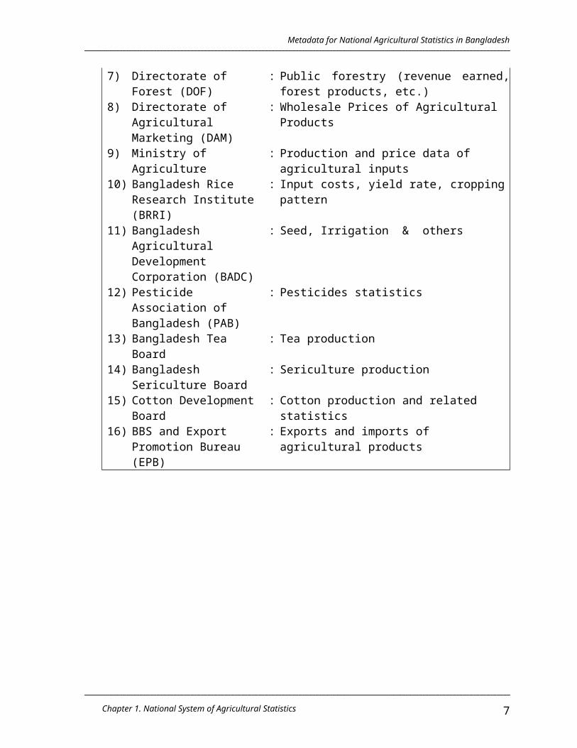
List of Agencies Responsible for Compilation of Agricultural Statistics
Agency Type of Agricultural Statistics1) Bangladesh Bureau of
Statistics (BBS): Agricultural Census data - Land ownership,
Land use, cropping pattern, irrigation, livestock & poultry, agricultural inputs, agricultural land holding by sex, farm population, etc.
2) BBS : Current agricultural statistics – crop production estimates, yield rate, acreage of crops by types of 121 crops.
3) BBS : Land use and irrigation statistics4) BBS : Agricultural wage rates and production cost
of major crops.5) BBS : Livestock and poultry, forestry (extrapolated
data)6) Directorate of Fisheries
(DOF): Fish production/catches, marine, inland
catches7) Directorate of Forest
(DOF): Public forestry (revenue earned, forest
products, etc.)8) Directorate of
Agricultural Marketing (DAM)
: Wholesale Prices of Agricultural Products
9) Ministry of Agriculture : Production and price data of agricultural inputs
10) Bangladesh Rice Research Institute (BRRI)
: Input costs, yield rate, cropping pattern
11) Bangladesh Agricultural Development Corporation (BADC)
: Seed, Irrigation & others
12) Pesticide Association of Bangladesh (PAB)
: Pesticides statistics
13) Bangladesh Tea Board : Tea production 14) Bangladesh Sericulture
Board: Sericulture production
15) Cotton Development Board
: Cotton production and related statistics
16) BBS and Export Promotion Bureau (EPB)
: Exports and imports of agricultural products
Chapter 1. National System of Agricultural Statistics 5

Metadata for National Agricultural Statistics in Bangladesh
1.3 Outputs and Dissemination of Agricultural Statistics
The BBS is the focal point for dissemination of agricultural statistics. The contact details of the Director General of Bangladesh Bureau of Statistics is as follows:
AYM Akramul HoqueDirector GeneralBangladesh Bureau of StatisticsE-27/A, Agargaon, Dhaka-1207, BangladeshPh: (88-02) 9112589Fax: (88-02) 9111064E-mail: [email protected]
BBS Major Statistical Reports and Publications
Agricultural Statistics of Bangladesh are released through the following publications.
Title of Publication
Domains/ContentsMediu
m FormatPeriodicity
/Frequency
Release Calendar
Yearbook of Agricultural Statistics of Bangladesh
Production, area, crop damage, land use, irrigation, inputs etc.
English Book Annual December
Statistical Yearbook of Bangladesh (Ag. Chapter)
Production, area of crops, land use and irrigation statistics, production and price of fertilizer, structural statistics, fish, livestock and poultry production, Agriculture sector contribution in GDP
English Book Annual March
Statistical Pocketbook (Ag. Chapter)
Agriculture census data, classification of Ag holding, ownership of land, production, sowing and harvesting period of different crop
English Book Annual January
Chapter 1. National System of Agricultural Statistics 6
Metadata for National Agricultural Statistics in Bangladesh
BBS Major Statistical Reports and Publications (cont’d…)
Title of Publication
Domains/Contents Medium Format Periodicity/Frequency
Release Calendar
Advance Release of Major Crops
Area, yield rate and production of crops by district
English Book Annual After the completion of harvest
Monthly Statistical Bulletin (Food & Ag. Chapter)
Area and production index of crops, land use, means of irrigation, irrigated area, area and production, production and sales of inputs, import, procurement and distribution of food
English Book Monthly Four (4) months time lag
Agricultural Census Reports
Structural statistics like land ownership, tenancy, number of farm and non-farm household, classification of farmers, area of different crops
English Book Adhoc After the completion of census
Report on Cost of Production of Major Crops
Cost of cultivation, labour, fertilizer, harvesting, caring etc.
English Book Seasonal Two months after survey
Time Lag, Pricing and Distribution of Publications
Time lag of yearly publications is about one year and that of the monthly publications is 4-5 months. Prices of the publication are fixed at production cost. Complementary copies are also distributed to the Ministries, relevant Departments, University libraries and UN agencies etc.
Chapter 1. National System of Agricultural Statistics 7

Metadata for National Agricultural Statistics in Bangladesh
1.4 Dialogue with Data Users and Cooperation with International Organizations
The users of agricultural statistics include representative officers from the Ministries (Planning Commission, Ministry of Agriculture, Food, Relief and Disaster Management, Forestry, Fisheries and Livestock, etc.), University teachers, Research Organizations, NGOs, Donor agencies, Exporters, Importers etc.
In most cases, the users of the BBS data are knowledgeable, imminent scholars and accomplished persons in their respective fields. Bangladesh Bureau of Statistics appreciates to have dialogue and exchange views to fulfill the users needs and to improve the quality of works. The Agriculture Wing of BBS utilizes the advantage of the following forums to communicate and interact with the data users. Seminar
BBS arranges data dissemination seminars to explain concepts, definitions, methods and data trend etc. and to have users views and suggestions to improve future works.
Workshop
Prior with the adoption of new method or programme, BBS organizes workshop inviting the experts of the relevant field. Outcome of the workshop provides useful input in finalizing the issues in question.
Council and Committee Meetings
The National Statistical Council is the highest policy forum for Bangladesh Bureau of Statistics. The NSC provides broad policy guidance to undertake major statistical operations.
The Steering Committee headed by the Secretary, Planning Division and comprising members from the donor agencies, universities and research organizations provides broad technical decisions.
The Technical Committee headed by the Director General, BBS, comprising members from the Directors, BBS, representative from the donor agencies, universities, research organizations, experts of the relevant fields and stakeholders. The Technical Committee provides detailed technical and operational guidance to undertake statistical programmes.
Chapter 1. National System of Agricultural Statistics 8

Metadata for National Agricultural Statistics in Bangladesh
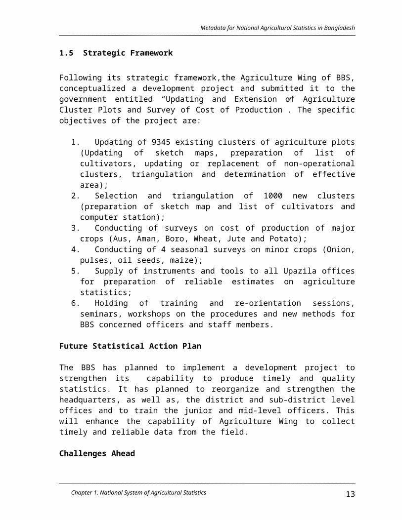
1.5 Strategic Framework
Following its strategic framework,the Agriculture Wing of BBS, conceptualized a development project and submitted it to the government entitled “Updating and Extension of Agriculture Cluster Plots and Survey of Cost of Production”. The specific objectives of the project are:
1. Updating of 9345 existing clusters of agriculture plots (Updating of sketch maps, preparation of list of cultivators, updating or replacement of non-operational clusters, triangulation and determination of effective area);
2. Selection and triangulation of 1000 new clusters (preparation of sketch map and list of cultivators and computer station);
3. Conducting of surveys on cost of production of major crops (Aus, Aman, Boro, Wheat, Jute and Potato);
4. Conducting of 4 seasonal surveys on minor crops (Onion, pulses, oil seeds, maize);
5. Supply of instruments and tools to all Upazila offices for preparation of reliable estimates on agriculture statistics;
6. Holding of training and re-orientation sessions, seminars, workshops on the procedures and new methods for BBS concerned officers and staff members.
Future Statistical Action Plan
The BBS has planned to implement a development project to strengthen its capability to produce timely and quality statistics. It has planned to reorganize and strengthen the headquarters, as well as, the district and sub-district level offices and to train the junior and mid-level officers. This will enhance the capability of Agriculture Wing to collect timely and reliable data from the field.
Challenges Ahead
The main challenge of BBS is to provide timely data to monitor progress of Poverty Reduction Strategy (PRS) and Millennium Development Goals (MDG). Moreover, new horizons of statistical data needs are unveiled to meet the challenges of the new millennium. Some of these are environment statistics, participation, empowerment and gender disaggregated statistics. Special care is taken to provide necessary data for PRS and MDG monitoring and to fill up the data gaps.
Need for Technical Assistance
Technical Assistance is urgently required for the proposed project on “Updating and Extension of Agriculture Cluster Plots and Survey of Cost of Production” in respect of training, expert service, transport and equipments, etc.
Chapter 1. National System of Agricultural Statistics 9

Metadata for National Agricultural Statistics in Bangladesh
Since the clusters were formed 20 years ago, these need to be updated and expanded for reliable district level estimates.
Chapter 1. National System of Agricultural Statistics 10

Metadata for National Agricultural Statistics in Bangladesh
CHAPTER 2. MAJOR DOMAINS AND SELECTED INDICATORS OF AGRICULTURAL STATISTICS
2.1 List of Major Domains and Selected Statistics and Indicators
Domain Statistics/ Indicators
PRODUCTION Crops
Livestock and Poultry
Fishery
Macroeconomic indicators
Volume of all crops produced in BangladeshArea harvestedValue of cropsCost of production of major cropsCrop damaged by natural calamities Area forecasts of Major CropsYield and Production forecasts of Major Crops
Volume of livestock and poultryValue of livestock and poultryVolume of fishery productionValue of fishery production
Gross National ProductGross Domestic ProductGross Value Added in AgricultureGrowth Rate in Agriculture Sector
TRADE Total Quantity of Export and ImportTotal Value of Export and ImportTotal Value and Quantity of Agricultural Export and Import
FOOD CONSUMPTION Food Balance Sheet
PRICES Average monthly prices of selected agricultural commoditiesProducer Price IndexConsumer Price Index
AGRICULTURAL LABOUR WAGE
Daily Agricultural Labour Wage by male and female disaggregation
FERTILIZER Total domestic production, Import, Sales and
Chapter 3. Major Data Sources for Agricultural Statistics 11

Metadata for National Agricultural Statistics in Bangladesh
Prices2.1 List of Major Domains and Selected Statistics and Indicators (cont’d…)
Domain Statistics/ Indicators
PESTICIDES Quantity and prices
LAND USE AND IRRIGATION STATISTICS
Total cultivated land, Irrigated area, Area harvested of crops
LABOUR FORCE Percentage of Labour Force in Agriculture SectorEmployment Trend in Agriculture SectorChild Labour Force by Industry Active Population in Agriculture Sector
OTHERS Income and Expenditure, Nutritional, Health data of Rural People
2.2 Metadata for Each of the Major Domains
The BBS follows the concepts and definitions of the UN and in particular, the FAO guidelines for agricultural statistics.
2.2.1 Production
2.2.1.1 Concepts, Definitions and Classifications
CROPS
Volume of Crop Production: Total production for 6 major crops and 115 minor crops are published by metric tons. Per acre/hectare yield is also released in kilograms. For major crops, average yield rates at district level are computed through crop cutting experiment. Crop cut experiment are conducted within the sample cluster plots over the whole country. Data are produced by district and number of cuts is dependent on the size of the district.
Area Harvested: For area estimation, constituted 9348 clusters are visited four times a year and acreage under different crops in each plot are recorded by the field staff in the prescribed forms. The completed forms are sent to Dhaka from the Upazilla Statistical Offices through the Regional Statistical Offices. These forms are scrutinized, checked and then processed for acreage estimation. The acreage estimates by crop by region are obtained by ratio method of expansion as follows:
Chapter 3. Major Data Sources for Agricultural Statistics 12
Metadata for National Agricultural Statistics in Bangladesh
Area for a crop = Effective area X Area ratio devoted to …(1.1) for the region for the region the crop for the region
Where,Effective area = Total Land Area - Area not utilized for Agriculturalfor the region for the region purposes for the region
Area ratio devoted to = Sum of area devoted to the crop from crop for thecrop for the region plots within the clusters for the region . Sum of areas of corresponding cluster for the region
Value of Crop: Valuation of the production of crop is done by multiplying the volume of production by the producer’s price.
Cost of Production of Major Crops: For 6 major crops, costs of production survey are carried out separately just after completion of harvest of each crop. From each Upazilla (sub- district) 6 farmers are selected (1 large farmer, 1 medium farmer and 4 small farmers) by simple random sampling for interview. Average cost of production (cultivation, plantation, harvesting, caring, etc.) is estimated.
Crop damage: Upazilla statistical offices collect the information regarding any natural calamities just after the incident. Area damaged and estimated production lost of the crops are computed.
Forecasting of major crops: For 6 major crops (three rice, wheat, jute and potato) area and production forecast reports are prepared. For each crop, forecast data are compiled twice. Firstly, just after completion of the plantation of the crop, Upazilla offices collect the area of the crop and secondly before three weeks of the harvest of the crop, yield of the crop are forecast.
LIVESTOCK AND POULTRY (ANIMAL FARMING)
Volume of Livestock and Poultry: Agriculture and Livestock census are the basic sources of data of this sub sector. Periodic surveys on livestock and administrative records of the Livestock Directorate are also used for current estimation. Estimates of animal farming populations are made on the basis of inter census growth rates (1983-84 and 1996 Agriculture Census) of livestock population and then adjusted in the light of the current livestock surveys.
Chapter 3. Major Data Sources for Agricultural Statistics 13

Metadata for National Agricultural Statistics in Bangladesh
The following products of livestock and poultry populations are included in the output estimates.
1. Meat2. Milk3. Hides and Skins4. Cow dung5. Animal fats and others6. Eggs
Annual flows of these products are obtained by applying specific yield coefficients established through special studies, field investigations and consultations with the experts of the Directorate of Livestock.
The following coefficients have been used to estimate the outputs:
Livestock and PoultryMajor Coefficients
Annual average extraction rate (% of stock slaughtered)
Meat rate per animal(kg)
Cow 23 55.0Buffalo 10 75.0Goat 50 6.0Sheep 33 6.0Chicken 120 0.6Duck 120 0.9Source: Survey on Selected Economic Activities, 1994-95 and Directorate of
Livestock
Value of Livestock and Poultry: Prices used for valuation of these products are collected from Department of Agricultural Marketing (DAM). On an average 26.6 percent of the value of output is deducted as intermediate consumption or input cost to obtain the value added in the animal farming sub-sector.
Chapter 3. Major Data Sources for Agricultural Statistics 14

Metadata for National Agricultural Statistics in Bangladesh
FISHERY
Production of Fishery: The activities in fishing sector include a) commercial fishing in high seas, coastal and offshore waters and catching and gathering fish from inland rivers, canals, lakes, haors (wet land), bils (low lying area), ponds, etc. and subsistence fishing in inland waters. Estimates of the aggregate fish production both inland and marine are obtained from the Directorate of Fisheries (DOF). The fish production obtained from the DOF is further validated with Household Income and Expenditure (HIES) data (per capita fish consumption) and availability estimated by total production plus exports minus presumed imports. Estimated fish production (inland and marine) are disaggregated by major fish species by applying the species ratio obtained from the DOF and ad-hoc Fish Species Survey of 1993-94 conducted by BBS.
The following species’ ratios are applied on the Inland and Marine Fish catches: Proportion of Fish Catches Distribution by Selected Species:
Major Species Proportion of Total Catch
InlandHilsha 6.4Ruhi / Katla / Mrigel 15.9Shrimp 6.4Boal / Pangash etc. 2.7Live fish 5.6Exotic Carp 5.5Snake head fish 5.4Other Carp 1.2Other inland fish 50.9Total Inland 100.00
MarineHilsha 37.9Bombay Duck 5.9Jew fish 3.9Shrimp/ Prawn 7.2Others 45.1Total Marine 100.00
Chapter 3. Major Data Sources for Agricultural Statistics 15

Metadata for National Agricultural Statistics in Bangladesh
Value of Fishery Products: To convert the output figures into value terms, wholesale prices by species types, obtained from Directorate of Agricultural Marketing (DAM) are converted into producer prices by deducting trade and transport margins. The gross value of production thus arrived at is then reduced by the following input proportion or intermediate consumption.
Fish type Proportion of input costs as % of output
Inland fish 13.68Marine fish 17.59
The proportions of intermediate consumption were determined by the Fishery Study which were commissioned by BBS in 1993 to 1994.
MACROECONOMIC INDICATORS
Gross Domestic Product (GDP) at Market Price: Gross domestic product at basic prices plus indirect taxes minus subsidies on products.
Gross National Income (GNI): Aggregate Value of the gross balances of primary incomes for all institutional sectors of the economy is defined as Gross National Income. Thus, GNI = GDP at basic price + net primary incomes from abroad
Value Added: Gross Value Added in the value of output less the value of intermediate consumption. Net value added in the value of output less the values of both intermediate consumption and consumption of fixed capital.
Chapter 3. Major Data Sources for Agricultural Statistics 16

Metadata for National Agricultural Statistics in Bangladesh
2.2.1.2 Coverage, Availability, Data Sources and Responsible Agencies
STATISTICS/ INDICATORS COVERAGE AVAILABILITY DATA
SOURCERESPONSIBLE
AGENCYCROPSValue of rice and wheat production
national level
1981-2005 Wholesale and Retail Price Survey
DAM
Rice and Wheat Inventory
national and district levels
1981-2005 Food Planning & Monitoring Unit
Volume of Jute Production
national and district levels
1981-2005 Jute Production Survey
BBS
Value of Jute Production
national and district levels
1981-2006 Wholesale and Retail Price Survey
DAM
Volume of Crop Production(Other than Rice and Wheat)
national and district levels
1981-2006 Crop Production Survey
BBS
Value of Crop Production(Other than Rice and Wheat)
national level
1981-2005 Price Survey
DAM
LIVESTOCK AND POULTRYValue of Livestock and Poultry Production
national level
1981-2005 Price Survey
DAM
FISHERIESValue of Fishery Production
national level
1981-2005 Price Survey
DAM
MACROECONOMIC INDICATORSGross Domestic Product
national level
1975-2005 (national level)1990-2001 (Regional level)
BBS BBS
Gross Value Added in Agriculture
National and sub-national levels
1975-2005 (national level)1990-2001 (Regional level)
BBS BBS
Chapter 3. Major Data Sources for Agricultural Statistics 17

Metadata for National Agricultural Statistics in Bangladesh
2.2.1.3 Data Processing, Estimation and Revision Methodology
CROPS
Volume of Rice, Wheat and Potato Production
Data Processing
Upazilla Statistical Offices fill up the forms/schedule and send it to the head quarter through regional statistical offices. In the head quarter, the filled in schedules are edited, scrutinized and manually processed. After finalization of data, approval of proper authority is needed.
Estimation and/or Compilation Procedure
Area estimation: The acreage estimates by crop by district are obtained by ratio method of expansion as follows:
Area for a crop = Effective area X Area ratio devoted to …(1.1) for the district for the district the crop for the district
Where,Effective area = Total land area - Area not utilized for Agri.for the district for the district purposes for the district
Area ratio devoted to = Sum of area devoted to the crop from crop for thecrop the for the district plots within the clusters for the district .
Sum of areas of corresponding cluster for the district Production Estimation: District level Production are estimated by the formula given Pi = Yi * Ai
Where:Pi = Production of ith district.Yi = Per unit yield of ith districtAi = Harvested area of ith district
P = ∑Pi
Chapter 3. Major Data Sources for Agricultural Statistics 18

Metadata for National Agricultural Statistics in Bangladesh
Where:P = Total country production
Volume of Other Temporary Crop Production
Data ProcessingPlease refer to the discussion in Rice, Wheat and Potato Production
Estimation and/or Compilation Procedure
Area estimationCurrent year Area of the union = X * Last year area of the union
Where: X = Ratio of the area of 5 farmers of this year to the area of last year
Production estimationCurrent year Production of the union = Y * Last year Production of the union
Where:Y = Ratio of the production of 5 farmers of this year to the production of
last year
2.2.2 Trade
2.2.2.1 Concepts, Definitions and Classifications
Volume of agricultural exports and imports – both quantity and value of agricultural import and export data are compiled. Export of jute goods, raw jute, mesta, tea, fish, raw cotton, spices are expressed in metric tons
Value of agricultural exports and imports – F.O.B value for export and C.I.F value for import are used.
Free on Board (F.O.B) value - The value in the market at the customs frontier of a country of her exports merchandise and other goods including all costs of transporting the goods to the custom frontier, export duties and the cost of loading the goods on the carrier unless the later cost is borne by the carrier.
Cost Insurance Freight (C.I.F) value - The value in the market at the custom frontier of a country of her imports of merchandise, other goods etc. including all charges for transporting and insuring the goods from the country of export and the given country but excluding the cost of unloading from ship, aircraft etc., unless it is borne by the carrier.
Chapter 3. Major Data Sources for Agricultural Statistics 19

Metadata for National Agricultural Statistics in Bangladesh
2.2.2.2 Coverage, Availability, Data Sources and Responsible Agencies
STATISTICS/ INDICATORS COVERAGE AVAILABILIT
YDATA
SOURCERESPONSIBLE
AGENCIES
Total value of exports and imports
International (by country of origin and destination)
1977 – 2005(annual)
Foreign Trade Statistics
BBS
Total volume of agricultural exports and imports
International(by country of origin and destination)
1977 – 2005(annual)
Foreign Trade Statistics
BBS
Total value of agricultural exports and imports
International(by country of origin and destination)
1977 – 2005(annual)
Foreign Trade Statistics
BBS
2.2.2.3 Data Processing, Estimation and Revision Methodology
The Foreign Trade Section of BBS collects data in CD-ROMs from National Board of Revenue (NBR) on monthly basis. On receipt of export and import information from NBR, the said CDs are sent to BBS computer section for rearranging, processing etc. After completion of the job, data are sent to Foreign Trade Section, BBS which does the work of correction, compilation and editing and then these are sent to computer section for rearrangement of the said data. Again, the computer section will send the printed export and import data to Foreign Trade Section (FTS). Finally, after correction and amendment by FTS these are again sent to the computer section for printing of the final data.
On receipt of trade bills from Burimari (Land Customs) and shipping bills from Khulna, entries are made in the control register and the bills are sorted out according to the date and type of trade. After sorting, the documents are bound in the form of a book which is known as batch. Each batch consists of 50-60 bills covering the bills of a particular date. The batch is distributed among the coders for coding the information. The basic information, such as commodity specified by type, quantity of each commodity according to the units prescribed in the HS, value, export destination and other relevant information are coded, checked and edited properly on the documents. On the completion of coding work, the value is taped from the documents. Batch totals are entered in the control register for subsequent matching with computer totals. Batches are then sent to the Computer Wing of BBS for capturing data in diskettes.
Chapter 3. Major Data Sources for Agricultural Statistics 20

Metadata for National Agricultural Statistics in Bangladesh
Though most of the tabulations are made according to Harmonized commodity description and coding system, selected tabulations are made on the basis of category of goods by different exporting or importing accounts. The tables are published in Foreign Trade Statistics (annual) and in other publications of BBS. Foreign Trade Statistics are published on fiscal year that is July I to June 30.
2.2.3 Food Consumption
2.2.3.1 Concepts, Definitions and Classifications
Foodgrain Balance Sheet - It covers major foodgrain consumed by the people of Bangladesh.
Domestic Production - Total domestic production of rice and wheat.
Net grain production - Total production - (deducting 10% as seed, feeds and wastage)
Mid year population - estimated mid year population
Food consumption on requirements (453.6 g/cap/d) - according to the household income and expenditure survey.
Foodgrain gap: food availability - consumption
2.2.4 Prices 2.2.4.1 Concepts, Definitions and Classifications
Farmgate prices - prices received by farmers for the sale of their produce at the first point of sale that is at farm or home of the farmers.
Wholesale prices - prices for wholesale buying or wholesale selling.
Producer’s price - price receivable by the producer from the purchaser for a unit of a good or service produced as output minus any VAT or similar deductible tax invoiced to the purchaser.
Purchaser’s price - prices at the point of delivery to the purchasers which also include trade and transport margins appropriate to the commodity being purchased.
Consumer price index - The CPI measures changes in prices paid by consumers for consumption of goods and services. CPI does not cover all household expenditure, it excludes investment, saving and transfers.
Chapter 3. Major Data Sources for Agricultural Statistics 21

Metadata for National Agricultural Statistics in Bangladesh
2.2.4.2 Coverage, Availability, Data Sources and Responsible Agencies
STATISTICS/ INDICATORS COVERAGE AVAILABILITY DATA SOURCE RESPONSIBL
E AGENCY
Average monthly prices of selected agricultural commodities
National, Rural and Urban
1995-2006 Price Survey DAM
Monthly Consumer Price Index
National, Rural and Urban
1972-73 to February 2007
Prices of all Commodities and weights used
BBS
2.2.4.3 Data Processing, Estimation and Revision Methodology
Data Processing
A. Prices of Agricultural Commodities
Immediately after receiving the filled in price returns from the field, the data are scrutinized and edited by the respective data compilers under the supervision of two/three officers. Verification letters are regularly issued to different Regional/Upa-zilla statistical offices for verification of wrong and inconsistent price data.
B. Consumer Price Index (CPI)
The CPIs are compiled on monthly basis. Monthly prices of various items are used for computation of the indices. Annual indices are also computed by averaging the 12 months indices. The reference groups of the indices are the average urban and rural households of Bangladesh. Three principal consumer indices (CPIs) are produced and disseminated i.e. National, all urban and all rural. The national CPI is calculated by combining the urban and rural indices using as weights, the country-wide urban and rural households expenditure multiplied by the total number of urban / rural households as available from population Census data. For computing the three CPIs all goods and services included in the index baskets were classified under eight commodity groups following the ILO standard and recommendations of the IMF mission. The indices covered eight commodity groups which are:
1. Food, beverage and tobacco2. Clothing and footwear3. Gross rent, fuel and lighting4. Furniture, furnishings, household equipment & operation5. Medical care and health expenses6. Transport and communications7. Recreation, entertainment, education and cultural services8. Miscellaneous goods and services
Chapter 3. Major Data Sources for Agricultural Statistics 22

Metadata for National Agricultural Statistics in Bangladesh
Coverage and Source of Data
The price data are collected from the selected markets and outlets by the trained field staff of Bangladesh Bureau of Statistics.
1. Market: For price data collection, 140 markets have been selected all over the country. The selected number of urban markets are76 and the number of rural markets are 64. The field staff of BBS collect the price data from 64 urban and 64 rural markets (One urban and one rural market from each district) all over the country. The prices and wages section of National Accounting Wing collects the price data from selected 12 markets in different parts of Dhaka metropolitan city.
2. Outlets: For each item, price is collected from three selected outlets. There are some big outlets in a market which have varieties of consumer items, generally that type of outlets is selected to collect the price data. Prices of different commodities and services included in the index baskets are collected by BBS personnel from selected outlets. For example, for CPI Dhaka SMA, 12 representative markets in Dhaka SMA have been selected. These are big markets but not Super markets. Similarly for other areas price data are collected from selected outlets of 64 urban and 64 rural markets all over the country by BBS field staff. These are also big markets but not like as Dhaka metropolitan Area markets. There are many outlets in a market, among them three big outlets are selected to collect the price data of individual item. The locations of outlets are in different areas like the urban, rural, District and Divisional Head quarters.
3. Collection Procedure: Prices are collected during the peak hours of transaction. During the process of data collection, the price collectors are supposed to act as a true buyer, to act and bargain like a true buyer and to make an actual purchase. Price collectors should make sure that they are pricing the correct product based on the product specifications in the CPI product list. Price data are properly scrutinized in immediately after collection.
Selection of Items
The items selected should be as representative as possible. In the case of cost of living index, the items selected should represent the consumption habit of the people. To achieve this, the total number of items is divided into groups and subgroups and then from each group a representative sample is selected for inclusion. The BBS regularly (after certain interval), conducts the Household Expenditure Survey (HES). HES data can be used for this purpose. Expenditures incurred in various items based on 1995-96 HES was the basis of determining weights for the selection of items in the index basket. The earlier price schedules
Chapter 3. Major Data Sources for Agricultural Statistics 23

Metadata for National Agricultural Statistics in Bangladesh
were updated on the basis of 1995-96 HES as suggested by the IMF mission (December 29, 1997-January.1998).
The CPI items for the National index and its regional components have been classified into 8 majors groups. Some new items are incorporated in the new five price schedules in the index basket. There is no selected item for National basket that is priced all over the country. National basket comprises of urban and rural.
Price schedules and items number:
Sl.No
Name of price schedules Number of items
Remarks
1. Price schedule-1, weekly/Monthly retail (Urban)
469 CPI
2. Price schedule-2, Monthly retail (Rural)
341 CPI
3. Price schedule-3, Monthly wholesale (Urban)
112 WPI
4. Price schedule-4 Monthly BMP, wage & salary charge and quarterly house rents
161 BMPI, WRI, HRI
5. Price schedule-5Monthly retail prices of Durable & Capital goods.
138 DCI
The National market basket consists of urban and rural market. baskets. A detailed list of index basket with classification item number and weights including all specifications such as brand names, weights are in Table A.Number of items index basket (Base: 1995-96=100):
Sl.No. Name of index Number of items
Remarks
1. CPI Rural 215
2. CPI Urban 302
3. CPI National -
Selection of Base year
Index numbers are designed to make comparison between prices with reference to different time periods. For any index number computation there must be a base year/reference year for comparison. The base year should be a year of economic stability or in other words, a normal year. The base year should be a normal year and it must be free from economic, political and Social disturbances and as far as possible. Under the recommendation of IMF mission (December 29, 1997-January, 1998), the year 1995-96 has been selected as the base year for the computation of
Chapter 3. Major Data Sources for Agricultural Statistics 24

Metadata for National Agricultural Statistics in Bangladesh
consumer price index (CPI). The BBS has been regularly compiling the following consumer price index numbers on the basis of 1995-96 as the base year.
1. Consumer price index, all urban areas2. Consumer price index, all rural areas3. Consumer price index, National
Determination of Weights
The BBS conducts the Household Expenditure Survey (HES). Consumption patterns were determined on the basis of the results of the 1995-96 HES based on a sample size of 7420 households of which 5040 were rural and 2380 are urban households. Item weights were devised to reflect the significant changes that had occurred in the consumption pattern. Almost all the item weights have been taken from tabulation of HES data. In calculating the National CPI, all urban and all rural indices have been combined using as weights the total country wide urban and rural household expenditure i.e. average monthly urban/rural expenditure multiplied by the total number of urban/rural households as available from population census data. The weights of national CPI, all urban and all rural have been derived from the computer data sheets of 1995-96 HES . The base year was 1995-96 and the basket and weights were determined on the basis of the 1995-96 HES.
Weighting patterns of CPI National, Base year 1995-96=100
Locality Average monthly household
Expenditure (Tk.)
No. of households
(Million)
Total monthly Expenditure(Million Tk.)
Weight(%)
Bangladesh - 22.13 90630.66 100Urban 7274 3.63 26383.56 29.11Rural 3473 18.50 64247.10 70.89
The National CPI was derived from the indices compiled separately for the urban and rural households, based on the new weights calculated by the IMF mission using the 1995-96 HES. BBS revised the new weights to better reflect the consumption patterns of household. The weights of individual items, groups and sub-groups of CPI, all urban and all rural were derived from the 1995-96 HES and are presented below (Table A).
Chapter 3. Major Data Sources for Agricultural Statistics 25

Metadata for National Agricultural Statistics in Bangladesh
Table A. Group Weights, Base year: 1995-96=100
Group WeightRural (100)
WeightUrban (100)
I. Food, Beverage And Tobacco: 62.96 48.80Non-Food 37.04 51.20
II. Clothing and Footwear: 6.88 6.79III. Gross Rent, Fuel & Lighting 14.69 22.17IV. Furniture & Furnishing Household
Equipments & Operations 2.70 2.58V. Medical Care and Health Expenses: 2.79 2.97VI. Transport & Communication: 2.98 7.07VII. Recreation, Entertainment Education &
Cultural Services: 3.20 6.40VIII. Miscellaneous Goods & Services 3.80 3.22
Formula Used
For computation of the indices, Laspeyres formula is used. The formula is given below:
P n
i -------- X Wi P o
I = --------------- X 100 W
where, 1 = Consumer price index. Pn = Price in the current year Po = Price in the base year
Wi = Weight at the ith item W = Weight of the group
Price Consideration
1. Special offer prices are not considered.2. Three price quotations are collected for each of the items in the market
basket.3. There is a two price schedule for CPI, one for urban and one for rural
areas. The urban schedule is collected from 64 urban area containing 469 items, of them 302 are index item. Where as rural schedule is collected from 64 rural areas which contain 341 items, of them 215 are index items.
Chapter 3. Major Data Sources for Agricultural Statistics 26

Metadata for National Agricultural Statistics in Bangladesh
Recommendation for the Improvement of Price Statistics
To improve quality and timelines of CPI data some issues need to be resolved relating to price collection procedures, coverage of products, treatments of seasonal products, adjustment of quality change and the substitution of CPI products and updating the CPI list of items and weights.
1. Re-basing of CPI: There are some basic reasons for re-basing of consumer price index (CPI). Such as structural changes in production structure, structural changes in consumption patterns, structural changes in relative prices, appearance of new products, disappearance of old products and larger quality changes. Goods and services are not comparable between periods that are too far apart. So, the present base year may be changed on the basis of latest HES..
2. Updating of price schedules: The re-basing also offers an opportunity to up date the list of items and outlets. Quality adjustment and item substitution are big problems in CPI compilation. Item substitution may occur due to changes in fashion, tastes, income and technology.
There can also be substitution of outlets where consumers purchase products. Quality adjustment is difficult for statistical agencies to carryout, because it cannot be done mechanically in a routine way; each quality change requires individual attention. CPI staff is often put in a situation where they have to make subjective judgment about the extent of quality change and statistical agencies are uncomfortable making such judgments. So, the price schedules may be updated on the basis of latest HES.
3. Computerization: The standard Laspeyres formula used in the data processing and compilation of the current CPI remain essentially manual. This makes it difficult, for instance, to check inconsistencies in the relatively large amount of basic data and delays publication of the index. So, the process of computerization of consumer price index (CPI) activities may be expanded up-to District/Upazilla level offices.
4. Training: Computer and statistical training is essential for price collectors, compilers and supervisors to produce quality statistics. There is need for adequate training facilities for price collectors, compilers and supervising officers on regular basis.
5. Supervision: Price collectors, compilers and supervisors of the price index should meet regularly for seminars at which the supervisors would give instructions on how to deal with the practical problems encountered in the data collection process. Supervisors should verify the work of the price collectors on a regular basis.
6. Financial incentives: The working conditions of price collectors should also be improved i.e. by giving them monetary allowances for travel and other minor items of expenditure.
Chapter 3. Major Data Sources for Agricultural Statistics 27

Metadata for National Agricultural Statistics in Bangladesh
2.2.4.4 Other Reference Information
Collected price data are analyzed and prepared by the price section of BBS for regular publication. Analyses of some price data are regularly published in the Monthly Advance release and Monthly Statistical Bulletin of BBS for general use.
2.2.5 Fertilizer
2.2.5.1 Concepts, Definitions and Classifications
Fertilizer - a substance used to make the soil more fertile.
Fertilizer Prices - are the retail selling prices of different types of fertilizer. Data are collected fortnightly in different places of the country.
Fertilizer Production - total volume of production of fertilizer by local company.
Imports - total volume of fertilizer imports
Export - total volume of fertilizer exports.
Domestic sale - total volume of chemical fertilizer sold in the domestic market.
2.2.5.2 Coverage, Availability, Data Sources and Responsible Agencies
STATISTICS/ INDICATORS COVERAGE AVAILABILITY DATA SOURCE RESPONSIBL
E AGENCY
Domestic Production
national 1981-2005 Records of the Ministry of Agriculture
Ministry of Agriculture
Imports national 1981- 2005 Records of the Ministry of Agriculture
Ministry of Agriculture
Sales national 1981-2005 Records of the Ministry of Agriculture
Ministry of Agriculture
Prices national and sub-national levels
1995-2006 Records of the Ministry of Agriculture
Ministry of Agriculture
Chapter 3. Major Data Sources for Agricultural Statistics 28

Metadata for National Agricultural Statistics in Bangladesh
2.2.5.3 Data Processing, Estimation and Revision Methodology Data on production, sales and imports are collected and compiled from the official records of fertilizer factory and National Board of Revenue by the Ministry of Agriculture. The prices data are collected fortnightly in different places of the country.
2.2.6 Pesticides
2.2.6.1 Concepts, Definitions and Classifications
Pesticides - are substances or mixtures of some chemical substances which are used for preventing the pest attack of crops or destroying the insects of the crops. Data of several types of pesticides are compiled by Bangladesh Crop Protection Association. Those are insecticides, fungicides, herbicides and rodenticides.
2.2.6.2 Coverage, Availability, Data Sources and Responsible Agencies
STATISTICS/ INDICATORS COVERAGE AVAILABILITY DATA
SOURCERESPONSIBLE
AGENCY
Volume of consumption
national 1989 - 2005 Administrative records
Bangladesh Crop Protection Association
Import national 1981 - 2005 Administrative records
BBS
2.2.6.3 Data Processing, Estimation and Revision Methodology
Bangladesh Crop Protection Association and Bangladesh Bureau of Statistics compile the data from the administrative records.
2.2.7 Land Use
2.2.7.1 Concepts, Definitions and Classifications
Total Area - the total geographic area of Bangladesh
Forest area - the area of government reserve forest. Private forests are not included.
Not available for cultivation - urban area, big river area, important high ways etc.
Cultivable waste - cultivable but never cultivated
Chapter 3. Major Data Sources for Agricultural Statistics 29

Metadata for National Agricultural Statistics in Bangladesh
Currently fallow – means that the area can be cultivated but for one or two seasons the land is kept fallow.
Single cropped area - produced only one crop in a year.
Double-cropped area - produced two crops in a year.
Triple cropped area - produced three cropped in a year.
Net-cropped area - summation of single cropped area, double cropped area and triple cropped area.
Total cropped area: sum (single cropped area * 1 + double cropped area * 2 + triple cropped area * 3)
Irrigated area - area under the artificial irrigation system. Irrigated area by means of irrigation; irrigated areas by crops and regions are compiled.
2.2.7.2 Coverage, Availability, Data Sources and Responsible Agencies
STATISTICS/ INDICATORS COVERAGE AVAILABILIT
Y DATA SOURCE RESPONSIBLE AGENCY
Total area national and sub-national levels
1981- 2005 Administrative records
BBS
Forest area national and sub-national levels
1981- 2005 Administrative records
BBS
Not available for Cultivation area
national and sub-national levels
1981- 2005 Administrative records
BBS
Cultivable waste area
national and sub-national levels
1981- 2005 Administrative records
BBS
Current fallow area
national and sub-national levels
1981- 2005 Administrative records
BBS
Single cropped area
national and sub-national levels
1981- 2005 Administrative records
BBS
Double cropped area
national and sub-national levels
1981- 2005 Administrative records
BBS
Chapter 3. Major Data Sources for Agricultural Statistics 30

Metadata for National Agricultural Statistics in Bangladesh
Total area national and sub-national levels
1981- 2005 Administrative records
BBS
Triple cropped area
national and sub-national levels
1981- 2005 Administrative records
BBS
Net-cropped area
national and sub-national levels
1981- 2005 Administrative records
BBS
2.2.8 Labour and Employment
2.2.8.1 Concepts, Definitions and Classifications
Rural population - population living outside the declared municipal area.
Employment - persons in the labour force who are reported either at work or with a job or business although not at work during the reference week.
Employment in agriculture sector - persons who are employed or engaged in agriculture sector.
Agriculture Labour Wage Rate - daily wage rate of agricultural laborer.
2.2.8.2 Coverage, Availability, Data Sources and Responsible Agencies
STATISTICS/ INDICATORS COVERAGE AVAILABILITY DATA
SOURCERESPONSIBL
E AGENCY
Rural population
national and sub-national levels
1974, 1981, 1991 and 2001
Population Census
BBS
Employment national and sub-national levels
2005 Labour Force Survey
BBS
Employment in agriculture sector
national and sub-national levels
2005 Labour Force Survey
BBS
Agriculture Labour Wage Rate
National and subnational levels
1981- 2006Monthly
Agriculture Labour Wage
BBS
Chapter 3. Major Data Sources for Agricultural Statistics 31

Metadata for National Agricultural Statistics in Bangladesh
Survey
CHAPTER 3. MAJOR DATA SOURCES FOR AGRICULTURAL STATISTICS
3.1 List of Major Agricultural Censuses and Surveys
Census1. Agriculture Census of Bangladesh, 2007
Surveys1. Labour Force Survey, 2002-032. Livestock Survey
3.2 Metadata for Each of the Major Censuses
3.2.1 Agriculture Census of Bangladesh, 2007
3.2.1.1 Overview
Legal Basis of Agriculture Census
The Agriculture Census operations in Bangladesh have been carried out under the Agriculture Census Act XLI of 1958 (as amended in 1983). The Act, inter-alia, authorizes the Government to appoint Director General of Bangladesh Bureau of Statistics (BBS) as the Census Commissioner and other required staff for conducting the census. The Act makes it binding on the respondents to answer questions put to them by authorized census enumerators. At the same time it ensures strict confidentiality of the information collected from individual holders. The Act authorizes the collection of information of some broad items in the agriculture sector as specified below:
Land ownership and land tenure; Agricultural equipment and machinery;Land unit and sub-division of land;
Irrigation and drainage;
Land utilization; Fertilizers and soil dressing;Crop acreage and production; Wood and fishery products;Livestock and poultry; Agricultural credit;Employment in agriculture; Agriculture and Sericulture;Agricultural population; Fruits and vegetables products; and
such other matters which the Government may deem fit to include as census items for collection of information in Agriculture Census. The Census Act is placed in Chapter-III.
Chapter 3. Major Data Sources for Agricultural Statistics 32

Metadata for National Agricultural Statistics in Bangladesh
Agriculture Censuses in Bangladesh
The first Agriculture Census was held in the territory now comprising Bangladesh in 1960 covering 10% cadastral mauzas. The 1st Agriculture Census of Bangladesh was undertaken in 1977 in 14% rural mauzas. The first 100% Census of Agriculture and Livestock which is second in order, was undertaken in 1983/84. The 3 rd full count Agriculture Census in rural areas of Bangladesh was undertaken in 1996/97. To meet the immediate data needs of the Three-year Re-rolling Plan of the Government, Agriculture Sample Survey 2005 was undertaken during May 17-31, 2005. However, to continue the decennial periodicity of the Agriculture Census it is decided to conduct the 4th Agriculture Census of Bangladesh in 2007.A statement of the major activities of the past censuses of agriculture in Bangladesh is shown below:
Comparison of Activities of Agriculture Censuses of Bangladesh, 1960 - 1997
Activity 1960 1977 1983/84 1996/97
Enumeration Dates
15th February to 21st March, 1960
24th April to 31st May, 1977
April, May & June of 1983 and 1984
25th December, 1996 to 25th January 1997
Census Methodology
10% sample of rural mauzas using a book type questionnaire for each farm household.
14% sample of rural mauzas using a listing form and a census questionnaire.
Complete count in both rural and urban areas using short questionnaire and long questionnaire
Complete count in rural areas only using both short and long questionnaire.
Field Personnel
1881 Assistant Tehsildars worked as enumerators who were supervised by 485 officers at different levels.
4300 primary school teachers and 2000 Asst. Tehsildars worked as enumerators
66,493 worked as enumerators
25 RCCs, 92 DCCs, 466 TCCs, 1,967 Zonal officers and98,353 worked as enumerators
Chapter 3. Major Data Sources for Agricultural Statistics 33

Metadata for National Agricultural Statistics in Bangladesh
Comparison of Activities of Agriculture Censuses of Bangladesh, 1960 - 1997 (cont’d…)
Activity 1960 1977 1983/84 1996/97Training of field staff
Data Dissemination
Enumerators were given intensive training including classroom lectures and practical training in field.
East Pakistan Census data were published in three reports- Report-1 giving data by Districts, Report-2 giving data by sub-Division and Report-3 providing Analytical notes.
Training was given in two phases- 1st phase for Master trainers in Dhaka for three days and 2nd phase for enumerators and supervisors in 83 centres for 7 days.
The preliminary results were published in November, 1980 and the final results were published in one National Volume giving summary results for Districts.
Two tiers training at Dhaka for Master trainers and for Zonal officers who were trained Division-wise. Zonal officer then trained enumerators and supervisors at Union levels in 1125 center for two days.
Census data were published in 6 National Volumes and 64 Zila. Reports. The National Volumes were subjects-wise viz agriculture holding cropping pattern, sample enumeration characteristics Municipal Areas, Institutional holdings etc.
Three tiers of training:1. Dhaka for
RCCs & DCCs
2. District HQ for UCCs & Zonal officers
3. Zonal centres for supervisors and enumerators for two days at Zone level.
The results of the full count census were published in one National Volume and 64 Zila Reports and those of the sample enumeration were published in one National Volume. Preliminary Report was published in July, 1997.
Chapter 3. Major Data Sources for Agricultural Statistics 34

Metadata for National Agricultural Statistics in Bangladesh
3.3 Metadata for Each of the Major Surveys
3.3.1 Agriculture Sample Survey of Bangladesh
3.3.1.1 Overview
In order to meet the growing national and international demands for data on structural changes in agriculture, censuses have become important for providing data on the structure of agriculture within the country in an internationally comparable form.
It includes various characteristics of agricultural holdings and their operation, distribution of agricultural assets among different classes of farmers, auxiliary occupation of farmers, farm production, livestock, poultry, forest, and fishery, etc. Emphasis is also given on other economic activities of the farm households.
Comparison of Activities of Agriculture Sample Survey of Bangladesh, 2005
Activity 2005
Enumeration Dates 17th May to 31st May 2005
Census Methodology 10% sample EAs in both rural & urban areas using short questionnaires. Long questionnaire will be canvassed in October-November 2005.
Field Personnel
Training of field staff
Data Dissemination
312 Coordinators at various levels, 1193 Zonal officers and13,539 worked as enumerators
Three tiers of training:1. Dhaka for RCCs & DCCs2. Zila for UCCs & Zonal officers3. Zonal Centre (Upazila) for supervisors and enumerators for
two days at Zone level
A preliminary report was released in July 2005 basing on the summary control forms.A National Volume-1 based on the short Questionnaire data by Zila and 64 Zila Reports of Zila level data and the National Volume-2 basing on the long Questionnaire data are planned to be published by Zila.
Chapter 3. Major Data Sources for Agricultural Statistics 35

Metadata for National Agricultural Statistics in Bangladesh
3.3.1.2 Survey Design
Sampling Design / Statistical Unit / Selection Procedure:A Technical Sub-committee was formed with experts from the universities and government departments to develop the sampling design for the survey which is reproduced below.The sampling design in this case is taken as stratified cluster sampling with Mahallah/Mauza as cluster of household.
Stratification
Primarily, the whole country is divided into 3 strata: (i) Metropolitan area consisting of municipalities of 6 Metropolitan cities, (ii) Urban area consisting of municipalities of other zila towns, (iii) Rural area consisting of remaining areas of the country.
For each stratum, sampling design is basically a single-stage cluster sampling with Mahallah as cluster for first 2 strata and Mauza as cluster for third stratum. A fixed number of clusters (10%) will be selected in each zila/city and agricultural households will be interviewed in each selected cluster. This means that about 10% Mahallah will be selected in samples for first 2 strata and about 10% Mauza will be selected in the third stratum. For selected larger clusters having>500 households, sub-sampling is done in order to keep sample size of households to around 10%.
Allocation of sample size
Approximate proportional allocation may be used with some higher proportion for first 2 strata since agricultural farmer is a rare item and larger sample is needed there. In actual practice, 10% clusters are selected in all strata systematically.
For the rest of this note, Rural area (third stratum) is considered. The other 2 strata can be dealt with in a similar way with selected households of livestock and poultry also included in the sample for interview.
Selection of Cluster (Mauza)
Mauza of Rural area varies in size. So, these are to be selected in a zila with probability proportional to estimated size (PPES) systematic sampling without replacement. The number of households of a Mauza, obtained from the report of 2001 Population census, is considered as the estimated measure of size. For selection of Mauza, the numbers of households are to be cumulated in computer over all Mauza of the zila. Then taking a random start, the interval is applied. Here the interval is the total number of households in the zila divided by the number of mauza to be selected in that zila. Random start is a random number between 1 and the calculated interval. Since zila estimates are needed, this selection process is to be carried out independently for each zila. In actual practice, one random start and
Chapter 3. Major Data Sources for Agricultural Statistics 36

Metadata for National Agricultural Statistics in Bangladesh
one interval are considered for each stratum and the same interval is applied to all zilas/cities one after another.
In the selection process, if a selected Mauza is small (having 500 households), the EA’s touched by the Mauza will be enumerated. If a selected Mauza is large having >500 households, one third of the EA's in the Mauzas will be enumerated in each Mauza. This combining and splitting of selected Mauza are done in order to reduce wide variation in size of selected Mauza so that standard error of the estimate is reduced and to have roughly uniform load for the interviewers.
Main Data Items and Variables for Operational Purposes:The schedule-1 (short questionnaire), which was canvassed and used for collecting data on agriculture in the 10% sample enumeration contains the following information:
Land ownershipLand useArea under permanent cropsArea under temporary cropsArea under bamboo bushesArea under pondsHomestead areaCurrent fallow area
Cultivated landCommercial farmsLoan taken and use of loanLivestock and poultryUse of agricultural equipmentsEmployment in agricultureFarm transportsFarm population, etc.
The items of information included in the short questionnaire were finalized by the Technical Committee formed for the purpose after considering the issues in a number of meetings.Another long questionnaire (Schedule-2) was used to collect detailed information from the selected households through sub-sampling from the enumerated households of the sample survey for the schedule-1.
Concepts and Definitions:
Urban areaIn the Agriculture Sample Survey 2005, urban areas constituted six metropolitan cities of the country (Dhaka, Chittagong, Khulna, Barisal, Sylhet & Rajshahi) and the areas within municipalities of other zila towns.
Rural areaThe rest of the country including other urban areas were included in rural areas. Small growth centres with urban characteristics adjacent to municipalities and metropolitan cities were also included in rural areas in the 2005 agriculture sample survey.
Chapter 3. Major Data Sources for Agricultural Statistics 37

Metadata for National Agricultural Statistics in Bangladesh
Mauza Mauza is the demarcated lowest administrative territorial unit having separate jurisdiction list number (J.L.No.) in the revenue records. Every mauza has its well-demarcated cadastral map. Mauza should be distinguished from local village for a mauza may consist of one or more villages or part of a village.
Enumeration area (EA)An enumeration area means a well-defined and specified area of enumeration assigned to an enumerator to conduct the survey. It may consist of one or more than one mauza. It may also be a part of a mauza or a mahallah. It may be a part of the mauza/mahallah or a complete mauza which consisted of 200 households on an average in the rural areas. In case of a selected mauza having less than 175 households, required numbers of households were included from adjacent mauza. Similarly in case of a mahallah in the urban areas consisting of 300 households on an average considered an enumeration area for this agriculture sample survey. Each enumeration area was identified by a specific number.
HouseholdA household means a group of persons normally living together and eating in one mess (i.e. with common arrangement of cooking) with their dependents, relatives, servants etc. A household may be a one-person household or a multi-person household. In other words, when a group of persons living together generally maintains a family or family like relations and take meals from the same kitchen is termed as a household. Popularly, it is described as “Khana”. In some cases there may be more than one household in a single house or in one dwelling arrangement, a household may have more than a house or structure or shed. The household must be distinguished from a family which consists of blood related members who may live in different places but members of the household must share the same kitchen and live together.
HolderThe holder is the member of the household who exercises management control over the operations of the agricultural holding and takes the major decisions regarding the utilization of the available resources. He has technical and economic responsibility for the holding, which he may operate directly as owner or tenant or through a manager (hired person) to whom he has delegated the responsibility for day to day management of the work.
Agriculture holdingAn agriculture holding is a techno-economic unit of agricultural production under single management comprising of all livestock kept and all land used wholly or partly for agricultural production purposes, without regard to title, legal form, or size. Single management may be exercised by an individual household, jointly by two or more individuals or households or a juridical person such as a corporation, cooperative or government agency. A holding may consist of more than one parcel (fragment) located in one or more separate areas or mauzas or in more than one administrative
Chapter 3. Major Data Sources for Agricultural Statistics 38

Metadata for National Agricultural Statistics in Bangladesh
unit or division provided that all the separate parcels or fragments form a part of the same technical unit under operational control of the same management. The definition covers practically all holdings or virtually all households engaged in agricultural production and includes livestock with no agricultural land. So, holdings may have no significant agricultural land area, e.g. poultry, hatcheries, holding keeping livestock for which land is not an indispensable element for their production. In the context of this report, a holding and a household may be treated as the same.
Agriculture Labour HouseholdAgriculture labour household was defined as a member or members of a household who work most of the time in a reference year on land operated by other households in exchange for wages in cash or kind or both. The agriculture labour household may have some cultivated land and may posses some livestock.
Agricultural workAgricultural work on the holding refers to all activities of the holder and his/her labour force involving planning, management and operation of the holdings. It includes preparing land, sowing, weeding, harvesting, feeding and caring for livestock and poultry, collection of fodder, fertilizer and insecticide, working in the field or kitchen garden, supervising agricultural workers, keeping farm records and accounts, preparing agricultural products for marketing (including packaging), repairing fences, farm equipment, machinery etc. constructing farm building, cow shed and fences, and engaging in land reclamation and improvement and other related activities.
Farm holding The basic unit of enumeration in the survey was the household. The household could constitute a farm holding which is a techno-economic unit of agricultural production comprising all livestock kept and all the land which is used wholly or partly for agricultural purposes and is operated under a single management by one person alone or with others, without regard to title, size or location. Households with less than 0.05 acre of cultivated area were treated as non-farm households. Land operated more than 0.05 acre of cultivated area situated at different villages/mauzas but under the same operational control constitutes one farm holding.
Classification of farm holdings Farm holdings are broadly classified as (a) Marginal (b) Small (c) Medium and (d) Large.
1. Marginal farm is a farm holding having an operated area of 0.05 to 0.49 acre of land
2. Small farm is a farm holding having an operated area of 0.50 to 2.49 acres of land
3. Medium farm is a farm holding having an operated area of 2.50 to 7.49 acres of land
4. Large farm is a farm holding having an operated area of 7.50 acres and above
Chapter 3. Major Data Sources for Agricultural Statistics 39

Metadata for National Agricultural Statistics in Bangladesh
The cut-off point distinguishing farm holdings was fixed at 0.04 acre of cultivated area, and the holdings having cultivated area up to 0.04 acre were considered as non-farm household. Small cultivated area like 0.04 acre or less is generally utilized as kitchen garden. Vegetables are grown within the homestead area. Even the seeds of white gourd, water gourd, pumpkin etc. are sown by the side of the structures and house but keeps spreading on and around the roofs and the structures. Considering all these factors, the minimum cultivated area of .05 acre was fixed for qualifying to be a farm holding.
Owned landOwned land means the area of land owned by the holder including the members of his family having a title to the land with the right to determine the nature and extent of its use and to transfer the same. Moreover, there might be some land over which the holder or any member of his household has owner-like possession. This type of land was included in the area of owned land. The land held by the holder in owner like possession can be operated by him in the same way as owned land although the holder does not possess a title of ownership.
Land given to othersThis is the area of the holder's owned land, which is given out to some other persons/body on rent or on lease usually for a limited period of time on payment in cash or kind. The consideration for use of the land may vary from area to area.
Land taken from othersThe land taken from others on any basis including payment in cash or kind has broadly been sub-divided into two groups:
1. Land share cropped (barga) on different terms means the area of land leased from other farmer(s) or individual (s), or from any organization on share cropping basis and under operational control on the day of enumeration.
2. Land taken on any basis other than barga, such as lease, usufractuary right, mortgage etc. and under operational control on the day of enumeration.
Tenancy Owner holdings are those who own some land. May or may not lease out some land but they operate only on their own land.
Tenant holdings are those who do not own any land, but operate some land taken from others on share cropping basis or on other terms.
Owner cum tenant holdings are those who own some land may or may not lease out their own land to others but take some land from others on share cropping basis or on other terms.
Chapter 3. Major Data Sources for Agricultural Statistics 40

Metadata for National Agricultural Statistics in Bangladesh
Operated areaTotal operated area of a holding is the area owned by the household plus the area taken from others and minus the owned area given to others for operation. The operated area also includes uncultivated land operated by the household including homestead area.
Homestead areaHomestead area means the area of residence of the holder’s household with all its structures, courtyard and the land occupied by the passage for entrance and exit. It should be remembered that the adjacent land to the household used for temporary or perennial crops, ponds and tanks, compact plantations are to be excluded from the area of homestead.
Net cultivated area Net cultivated area is the area actually cropped during the census year regardless of the number of crops grown and it includes the area under temporary crops, current fallow and permanent crops (fruit and wood trees). In other words, it is the actual area or physical area occupying perennial and non-perennial crops and area under current fallow.
Area under permanent cropsArea under permanent crops or fruits is the part of net sown area with permanent crops or planted with fruit trees which occupy the land for a long period of time and do not need to be planted for many years after each harvest, e.g. mango, jack fruit, coconut etc. Area under permanent crops or fruit trees may be of two types, namely:
1. Compact plantation Area under compact plantation means the area under fruit trees, plants and
shrubs which are planted in a planned and regular pattern within a specified area of land; and
2. Scattered plantation Area under scattered plantation means the area under fruit trees and shrubs
which are scattered or located in such a way that it is not feasible to measure and record the aggregate area occupied by such fruit trees, plants and shrubs. Area under scattered plantation has not been accounted for.
Net area under temporary cropsNet area of land under temporary crops is the physical area of land under temporary crops such as paddy, jute, sugar cane, pulses, potato, brinjal, vegetables etc., irrespective of number of crops harvested during the survey year.
Gross cropped areaThe gross cropped area represents the aggregate area of temporary crops raised in the same farmland during the survey year. If one acre of land is used for growing
Chapter 3. Major Data Sources for Agricultural Statistics 41

Metadata for National Agricultural Statistics in Bangladesh
Aus, Aman and winter crops in the same year, it is taken as one acre of "net cultivated area'' but three acres of "gross cropped area."
Intensity of croppingIntensity of cropping represents the ratio of the gross cropped area to the net temporary cropped area expressed in terms of percentage. It indicates the extent to which the same area is used for cropping. Thus, the intensity of cropping is determined as follows:Intensity of cropping = (Gross cropped area / Net temporary cropped area) X 100
Diversification of Crop Cultivation Different types of temporary crops are grown by the farm holders. A farm holder dropped cultivation of any specific crop during the last five years or cultivated a new crop during the last five years. The data on crop diversification were also collected in the Agriculture Sample Survey 2005.
Reference Period:The data collected in the survey referring the period from 14 April, 2004 to 13 April, 2005 corresponding to the Bangla Year 1411 from 1st Baishakh to 30th Chaitra.
For the items of information on holder, size of land holding, land tenure, operated land and farm population the reference time was the day of enumeration. For some major items of information reference period is shown below:
Survey Year
Information on: Holdings Size of farm Land tenure Farm population Livestock, poultry and other inventory Items Operated land
Employment in agriculture
14th April, 2004 to 13th April 2005 i.e.1st Baishak to 30th Chaittra 1411 BS
Reference Time:The day of enumerationThe day of enumeration The day of enumerationThe day of enumerationThe day of enumeration
Survey yearSurvey year
Date of Data Collection: Agriculture Sample Survey 2005 was undertaken during May 17-31, 2005
Chapter 3. Major Data Sources for Agricultural Statistics 42

Metadata for National Agricultural Statistics in Bangladesh
3.3.1.3 Conduct, Operations, Data Quality Control
Estimation Formulae for Single Stage Cluster Sampling
Since the method of selection is the same for each zila and for each thana in the zila, following estimation formulae will be applicable to both zila and thanas.
Let yij be the measure of a variable y, for jth farmers in ith cluster or Mauza Let yi =yij be total of y for all farmers of ith selected cluster (Mauza),
y=yi =yij be total of y for the whole sample of a zila(j=1, 2............ki & i=1, 2............... n),
Let ki be number of farmers in ith selected cluster(Mauza)obtained from sample, mi be number of households in ith selected Mauza (m iki) obtained from 2001 Census, n be total number of clusters (Mauza) in the sample of the zila N be total number of clusters in the whole zila.
M0 = mi be total number of households in the zila obtained in 2001 population census and pi=mi/M0 be the probability of selection of ith Mauza.
Estimate of Population Total, YThe estimated total is given by
This is an unbiased estimate of population total Y of variable y. Since sampling fraction is small (0.1), the variance of can be estimated by with - replacement formula. This is as follows:
with pi=mi/M0 as probability of selection of ith cluster.Standard error of is
2SE
is the error of the estimate, , which means that population total, Y, is expected to lie within this error of the estimate in 95% cases.Ratio Estimate of Population Mean, Y, of variable y
Chapter 3. Major Data Sources for Agricultural Statistics 43
be the total of values of y for all farmars in the whole zila ,
2

Metadata for National Agricultural Statistics in Bangladesh
Since M0=mi is the total number of households in the zila for the year 2001 when the population census was taken, this cannot be used to obtain estimate of mean from estimated total. Instead, total number of farmers (K0) in the zila for current year is estimated as follows for the purpose since K0 is unknown.The number of farmers, ki, of ith sample Mauza is known and it varies from Mauza to Mauza. Hence, total number of farmers in the zila can be estimated by the formula as:
This number of farmers ki for ith selected mauza, is obtained from survey data. The estimated variance of is obtained by with - replacement formula, as
The ratio estimate of population mean, , is then given by
Its estimated variance by ratio method is
with
Estimated standard error is
Estimated variance of total , by ratio method Multiplying both sides of (2) by the estimated variance of estimated total
, by ratio method is given by
This estimated variance of is likely to be smaller than that obtained from (1) of section 2(a) when there is high correlation between y i & ki which is likely.In actual practice estimated variance of estimated total , may be obtained by both the methods of 2(a) and 2(c) and smaller one of the two may be accepted for finding standard error.
Estimate of population (zila) proportion, PProportion is a special case of mean when the variable y, is defined by
if (i,j) th farmer possesses the characteristic under consideration
Chapter 3. Major Data Sources for Agricultural Statistics 44

Metadata for National Agricultural Statistics in Bangladesh
otherwise
With this definition of variable y, the estimating formulae in 2(b) can be applied for estimation of proportion.
In this case, if yi =yij=ri is the number of households having the characteristic under study for ith Mauza, then ri can be used in place of yi in the above formulae for estimation of mean and its standard error to obtain estimates for proportion.
Estimates for metropolitan and urban strata
The above formulae can be used for other 2 strata with Mahallah as cluster. In these strata, there may be few households in the sample, which rear livestock & poultry only So data on livestock should be collected from such sample households also. The data on livestock & poultry may be analyzed using above formulae.
Sub-sampling for larger Mauza/Mahalla in the Sample
After selection of Mauza by PPES, it is observed that many large Mauza having more than 500 households are included in the sample of rural area with the result that about 35% households are included in the sample instead of required 25%. So, sub-sampling is needed for the selected large Mauza in order to reduce the sample size of households and the cost.
Post –stratification In order to solve the problem, all the sample Mauza of each zila are divided into 2 sub-strata as follows:
Sub stratum –IThis sub stratum contains those Mauza each of which has 500 or less number of households.
Sub stratum –IIThis sub-stratum contains those Mauza each having more than 500 households. For sub-stratum II, sub-sampling is done with one third of the EA (Enumeration Area) having around 200 households each, randomly selected with equal probability for each selected Mauza at the second stage. Here Mauza is primary sampling unit (PSU) and EA is second-stage unit. This sampling procedure reduces the total sample size of farmers of Rural area to about 10% of total number.
Estimation Procedure
Post stratification divides the whole sample of a zila into 2 sub-strata as stated above. This stratification also divides the whole zila into similar implicit and artificial 2
Chapter 3. Major Data Sources for Agricultural Statistics 45

Metadata for National Agricultural Statistics in Bangladesh
sub-strata depending on size of PSU. So, estimates for these sub-strata of population (zila) are provided below so that zila estimates can be obtained from these sub-strata estimates.
Sub-stratum- IFor this sub-stratum, sampling procedure is single-stage cluster sampling. All farmers in each selected mauza are investigated here. Hence, estimating formulae of section 2 are applicable for this sub-stratum.
Sub-stratum IIFor this sub-stratum, sampling design is 2-stage cluster sampling with constant sampling fraction (1/3) at the second stage. Estimating formulae for this sub-stratum are as follows:
Estimate of total for 2- stage cluster sampling in sub-stratum II
Let yijk be observation for kth farmer in jth EA of ith selected Mauza (PSU)(i=1, 2, --------, n1, j=1, 2, --------- n2i and k=1,2,-------tij)
Let n1 be number of PSU in the sample of the stratumn1i be number of EA in the sample of ith PSUN2i total number of EA in whole of ith PSUtij be number of farmers in (i,j)th EA in the sample
It is assumed that sampling fraction f2=n2i/N2i at the second stage is constant (1/3). Let yij=yijk be sum of observations for (i, j)th sample EA and yi=yij
Then is as an unbiased estimate of
total
Yi=yijk of ith PSU
Also, is an unbiased estimate of total Y of intrinsic
sub-stratum II in the zila.
Estimated variance of by with-replacement formula is
Estimation of mean of the sub-stratum II
Chapter 3. Major Data Sources for Agricultural Statistics 46

Metadata for National Agricultural Statistics in Bangladesh
The total number of farmers, in the sub-stratum is not known. This is estimated as follows.An unbiased estimate of number of farmers (T i) in ith PSU in the sub-stratum II of the zila, is
with ti = tij
Then
is also unbiased for, T0 , the total number of farmers in the sub-stratum
II, of the zila. Its estimated variance by with-replacement formula, is
The ratio estimate of sub-stratum mean, , is
Its estimated variance by ratio method is
Where
The proportion can be estimated using the above formulae following the procedure of section 2(d).
Ratio estimate of variance of estimated total
Multiplying (4) by variance of estimated total by ratio method is
This estimate is likely to be smaller than that obtained by (3) of section 3(a).
Chapter 3. Major Data Sources for Agricultural Statistics 47
V(Ŷ0) -

Metadata for National Agricultural Statistics in Bangladesh
Estimates for whole zila and Rural Area
For each zila, the estimation formulae of section 4 below for stratified samples are to be used to obtain zila estimates from the two sub-strata estimates. The population weight Wh = Nh/N is based on number of households (Nh) for hth sub-stratum h=1,2. The numbers, Nh, of households are to be obtained from census report of the zila.
The estimated total and mean for whole of Rural area and their estimated variances, can similarly be obtained from corresponding zila estimates following the method of section 4.
Estimates for other 2 strata The above procedure is applicable to other 2 strata: Metropolitan area & Urban Area with similar definition of sub-strata in order to deal with selected large Mahallah for reducing sample size of households.
National estimatesNational estimates can be obtained from those of 3 strata-Metroplitan area, Urban area and Rural area.
Estimation of TotalFor estimating national total of a variable, stratum totals of the variable and their estimated variances are added separately to get the national estimated total and its estimated variance respectively.
Estimation of Mean and proportion The estimated mean of a variable for whole country is the weighted mean of 3 stratum means. Let Nh- and N be the number of households of hth stratum and that of whole country respectively. The estimated mean of y for whole country is given by
where Wh= Nh/N is the weight for hth stratum, estimated mean for hth stratum, h = 1,2,3
Nh= number of households in hth stratum &N= Nh
The estimated variance of is
where is estimated variance of mean for hth
stratum. These formulae can be used for estimating national proportion replacing
__ by proportion, pppsh of hth stratum.
Chapter 3. Major Data Sources for Agricultural Statistics 48

Metadata for National Agricultural Statistics in Bangladesh
Pre-testing of survey Schedule-1
The 1996 Agriculture Census Schedule-1 that was used to collect information from farm households was taken as the basis for developing the 2005 Agriculture Sample Survey enumeration schedule. In addition to the 19 items of information contained in the 1996 agriculture census Schedule-1, a few more items viz number of owned ponds, loan taken (credit), commercial farms operated and preservation of seeds were included in the draft enumeration Schedule-1 for the sample survey 2005.Thus, the draft Schedule-1 for the Agriculture Sample Survey 2005 was developed containing the following 23 items of information:
1. Identification number of the holding and head of the holding2. Sex of the head of holding3. Agriculture labour holding4. Owned land (of all members of the holding)5. Land given to others (rented out)6. Land taken from others (rented in)7. Total operated area of land8. Homestead land area9. Net cultivable land (permanent cropped area, temporary cropped area and
current fallow)10.Permanent cropped area11.Temporary cropped area12. Irrigated area of cultivated land13.Net area of land using chemical fertilizer14.Number of livestock and poultry15.Number of commercial farms (fishery, dairy, fattening cows and buffaloes,
sheep-goats, poultry and silk worm)16.Uses of agricultural equipments17.Agricultural population engaged in agricultural work (10 years and above)18.Preservation of seeds19.Cottage industries (holding based)20.Rural transports21.Number and area of ponds22.Agricultural loan (rural credit)23.Area of land under temporary crops
This draft enumeration schedule as prepared including 23 items as mentioned above was pre-tested in the field in a few spots with respect to their feasibility of inclusion in the survey. The results of the pretest were reviewed and another version by the enumeration schedule was prepared which dropped some old items viz. net irrigated land, net land under chemical fertilizer and holding based cottage industries and included some new items viz. members of holding below 10 years and above 10 years, agricultural workers below 10 years and above 10 years, persons engaged in others’ agricultural farm, persons engaged in agricultural farm and non-agricultural farm in other zilas, land under bamboo bushes and land under current fallow.
Chapter 3. Major Data Sources for Agricultural Statistics 49

Metadata for National Agricultural Statistics in Bangladesh
Commercial farms which were absent in 1996 Agriculture Census were included in the 2005 sample enumeration schedule. Pigeons and poultry farms were also included as additional items in 2005 sample enumeration. Land area under fishery, sericulture/silk worm, flower nursery and tree nursery were also added in the 2005 enumeration schedule. Ownership of agricultural equipments viz. owned, jointly owned and hired and some new items of equipments viz. weeding machine, spray machine, threshing machine and plough were also newly added to the 2005 sample enumeration schedule. The draft enumeration schedule after incorporating these new items and approved by the Technical Sub-committee was pre-tested in various spots and the results were analyzed and revised and were placed before the Technical Sub-committee for consideration and approval. Finally, the Technical Sub-Committee approved the sample enumeration schedule-1 with 24 items.
Zonal Operations
Two zonal operations were undertaken primarily with the zonal officers and coordinators of the Agriculture Sample Survey Programme. The first zonal operation was conducted during 21-31 December 2004 and the second zonal operation was organized during the period 28 March–10 April 2005. The activities done in the zonal operations include the following:
1. Forming and demarcating enumeration areas (EAs) and showing location of the EAs in the sketch maps;
2. Preparing a list of enumerators and supervisors from local unemployed educated youths;
3. Preparing a list of training centres for training of enumerators and supervisors;
4. Formation of survey committees and contacting local administrative authorities;
5. Preparing a list of survey control rooms; and 6. Preparing a list of Sonali Bank branches for disbursing remuneration
through cheques.
The zonal operations and their dates of operation are shown below:
Zonal operation Date and duration of operations1st zonal operation 21-31 December, 20042nd zonal operation 28 March-10 April, 2005Final enumeration 17 –31 May, 2005
Chapter 3. Major Data Sources for Agricultural Statistics 50

Metadata for National Agricultural Statistics in Bangladesh
National Technical Committee
A 22 - member Technical Committee headed by the Director General of BBS was formed. The members are representatives of DG, IMED, DG Directorate Forestry, DG Directorate of Agriculture Extension, DG Directorate of Fisheries, DG Directorate of Livestock, DG BIDS, ISRT, Dhaka University, Agricultural University, Joint Chief, Planning Commission and Deputy Secretary, Planning Division. All the technical activities relating to the conduct of agriculture sample survey 2005 including design of questionnaire, pre-testing, sample design and survey operation were undertaken with the guidance and approval of this committee.
Formation of Survey Local Committees
For successful implementation of enumeration Zila and Upazila Survey Committees were formed with member of parliament concerned as adviser vide notification No.PB/PM/4(494/94 (part-1)-401 dated 17 March 2005 issued by the Ministry of Planning with the approval of Hon’ble Speaker of the parliament. This notification was endorsed and circulated by the Cabinet Division to the members of parliament and to the field administration for carrying out the following assigned duties and responsibilities during the period of survey operation:
1. Supervision and extension of co-operation with necessary directions in controlling survey activities and their implementation properly;
2. Provision of necessary direction by the Chairperson (Deputy Commissioner for the Zila Survey Committee and Upazila Nirbahi Officer for the Upazila Survey Committee) in formulating survey committees and organizing orientation meeting, arrange publicity among the members of the public seeking co-operation and participation in implementation of the survey enumeration;
3. Cooperation for temporary employment of local unemployed educated enumerators and supervisors;
4. Active participation of the Government officers and staff in operation of the survey; and
5. Taking administrative actions in establishment of survey control rooms at Zila and Upazila levels
The committees were abolished automatically after completion of the sample survey. With the assigned duties and responsibilities of the committees formed at Zila and Upazila level including all the public representatives and local level heads of Government offices made the survey operation easy and well controlled which helped ensure the quality of collected data to a greater extent.
Publicity Programme
A well-planned publicity campaign of the sample survey operation was launched with a view to generating public awareness. Posters and stickers were displayed and distributed at the Upazila and enumeration area levels. The Zila and Upazila
Chapter 3. Major Data Sources for Agricultural Statistics 51

Metadata for National Agricultural Statistics in Bangladesh
Committees were involved in the publicity campaign. The basic aim of survey publicity was to make people aware of:
1. Sample survey programme;2. Need for providing correct information to enumerators;3. Need for co-operation of mass people in survey work;4. Keep confidentiality of the survey information; and5. Providing total cooperation and assistance to enumerators and other
survey officials
Big - sized posters carrying messages relating to the agricultural activities were distributed and pasted at public places. Stickers were also posted at appropriate places. Microphone announcements, drum beatings, etc. were undertaken at hats, bazaars and public places. Organization Period of Training
An elaborate training programme for imparting uniform and effective training to personnel of all levels on Agriculture Sample Survey was chalked out. A verbatim training manual was developed for this purpose. A field manual detailing every pros and cons of the field operations, collecting information, survey calendar, specifying duties and responsibilities of officers of all levels, supervisors and enumerators including the responsibilities of the survey committees were developed. The training programme of the survey was divided into three phases:
Phase Wise Training on Sample Survey
1st zonal operation 1st phase: Training of the Master Trainers at Dhaka Office (Divisional, Regional and Zila Co-ordinators) 2nd phase: Upazila Co-ordinators/zonal officers at Regional Statistical Offices/ Zila HQs
2nd zonal operation 1st phase: TOT for the Master Trainers at Dhaka office (Divisional, Regional and Zila Co-ordinators) 2nd phase: Upazila Co-ordinators/ Zonal Officers at Regional Statistical Offices/Zila HQsFinal Enumeration 1st phase: Master Trainers at Dhaka office (Divisional, Regional and Zila Co-ordinators) 2nd phase: Upazila Co-ordinators/ zonal officers at Regional Statistical Offices/ Zila HQs 3rd phase: Supervisors and Enumerators at Upazila HQs
Chapter 3. Major Data Sources for Agricultural Statistics 52

Metadata for National Agricultural Statistics in Bangladesh
Three days and two days training were imparted in 1st zonal operation and in 2nd
zonal operation/final enumeration respectively at each level. In conducting the training in final enumeration verbatim manual of instructions were utilized in the classroom on the first day. On the second day of the training, the participants themselves conducted field demonstration practically. Survey kits containing survey materials including instruction manual of schedule-1 were distributed to enumerators and supervisors at the closing of the training programme. The instruction manual distributed at the field level enumeration areas played an effective role in collection of quality data.
Data Processing
- At the Field LevelData processing virtually begins with the coverage and consistency checks of the information collected in the filled in questionnaires immediately after their receipt from the field staff. For such coverage and consistency checks, two forms were developed at the field level. A tally sheet to arrive at the total of some important items of information for the enumeration area as a whole was developed. These items of information such as number of households, number of farm households, etc. were enumerated in the Enumeration Area.
Another form to summarize some of the important information of the survey at the Enumeration Area level viz. Form No. 16 was also developed which provided indication of consistency of the information collected in the survey. This form contained 12 items of important information such as number of households, number of farm households, households working in another’s farm, households having no land of their-own, agricultural farms run for business purposes only, farm households owning agricultural equipments, farm households owning transport, etc. Some of the selected and specially trained enumerators were asked to fill in these two forms after they were received by the upazila coordinators on completion of all assigned duties by the enumerators and supervisors.
The Zonal Officer received all filled in questionnaires of the EAs within his respective zone just after completion of enumeration as per schedule. Zonal Officers and supervisors were trained for manual editing and checking of the filled in questionnaires in the field. After such checks they submitted the filled in questionnaires to the upazila coordinators.
- At the Upazila Level (Editing of Filled in forms)A ten-day editing programme was organized at upazila coordinator’s office where information from Form-1 (Short questionnaire) were transcribed to Form-16 by some selected and specially trained enumerators and supervisors. They were also trained to check and edit all items of Form-1 and also check their consistency with Form 16. In some identified cases
Chapter 3. Major Data Sources for Agricultural Statistics 53
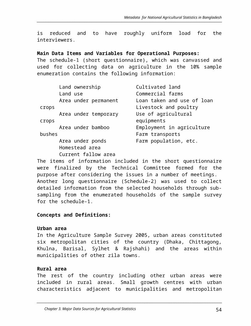
Metadata for National Agricultural Statistics in Bangladesh
imputation of missing data in Form-1 as well as in Form-16 was made by them through spot verification. These edited data at the field level in Form-16 were quickly taken to Dhaka where special arrangement was made to process the data as quickly as possible.
- At the HeadquarterThe information contained in Form-1 and Form-16 were again and edited at Dhaka by a specially trained group of editors. These editors were drawn from university students and unemployed educated youths and were trained by the master trainers. The editing of these forms were first completed manually. The edited data were entered into the computer in two shifts by entry operators and finally editing and imputation were done by computer. The whole data processing and production of 10 tables by Zila and 15 tables at National levels were completed in about six months and the process of data editing and tabulation were also done.
Data Dissemination Plan
A wide variety of agricultural data was collected through Schedule-1 of the agriculture sample survey 2005 covering a bigger sample of 10% farm households. The results would thus be possible to be estimated up to Upazila level but would be of far lower precision. All the information collected in Schedule-1 would be tabulated at Zila level and the data be disseminated in one National Volume containing basic data by Zila and 64 Zila Reports, each containing detailed data by Zila be prepared.
As Schedule-2 of the survey was already canvassed to a sub-sample of the selected farm holdings the data can be estimated at Zila level and upward and so another National Volume containing detailed information of each Zila will be published.
Reliability and Standard Error of the 2005 Survey Estimates
It is pertinent that the results obtained in a census or a survey be evaluated in respect of their reliability and acceptability. The estimates of various characteristics obtained from the 10% sample enumeration areas of the country apparently appear to be more or less consistent with those available in previous full count censuses of agriculture held in rural areas of Bangladesh, 1996 and in both urban and rural areas of Bangladesh during 1983-84. Some of these estimates of important characteristics are compared between the 2005 sample survey and the earlier censuses of 1996 and 1983-84 at page xiii of the report.
Standard errors have been calculated for some of the estimates of important items of the survey viz. All holdings (farm and non- farm), Farm holdings, Cultivated area, Aus crop and Aman crop and are produced below. 1
Chapter 3. Major Data Sources for Agricultural Statistics 54

Metadata for National Agricultural Statistics in Bangladesh
Item Area EstimateStandard
Error
Relative error(%)
All holdings(number)
Total 28165700 278939 0.99Rural 24564210 237299 0.97Urban 3601489 213042 5.92
Farm holdings (number)
Total 15089087 133504 0.88Rural 14699811 135150 0.92Urban 389276 30370 7.80
Cultivated area (acres)
Total 18083529 186667 1.03Rural 17724806 188160 1.06Urban 358723 31181 8.69
Aus crop (acres) Total 2671219 67310 2.52Rural 2603170 66600 2.56Urban 68048 11947 17.56
Aman crop (acres) Total 10490337 128857 1.23Rural 10326378 129683 1.26Urban 163958 15312 9.34
The above figures show that the standard errors of the estimates of all holdings and farm holdings were less than 1% (0.99% for all holdings and 0.88% for farm holdings) of the respective estimates. For cultivated area (acres) and Aman crop (acres), the standard errors were slightly higher than 1% (1.03% for cultivated area and 1.23 % for Aman crop) of the respective estimates. For Aus crop however, the standard error was slightly higher at 2.52% of the estimate of Aus crop. It may however, be observed that by urban and rural breakdown, the standard errors are highly variable and are much higher in urban areas compared to those in rural areas. Thus while the rural area estimates are highly dependable, the urban area estimates are subject to some error and need to be used with some caution. This precaution applies to the estimates of all items of information in the urban areas of the report.
1 In calculating these standard errors, the estimation procedures as suggested in the sampling design of the survey could not be applied due to some unforeseen reasons. The software STRATA have been used to calculate these standard errors which are believed to be very close to real situation. This software used the weight, stratum definition and PSU for the estimation of standard error.
Chapter 3. Major Data Sources for Agricultural Statistics 55
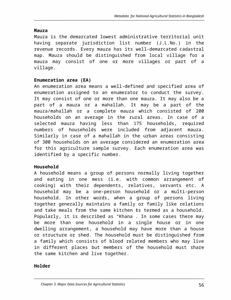
Metadata for National Agricultural Statistics in Bangladesh
3.3.2 Labour Force Survey, 2002-2003
3.3.2.1 Overview
Historical Background
The BBS has been conducting Labour Force Survey (LFS) regularly since 1980. Although some of the previous surveys were not conducted at specific time intervals due to resource constraints. The report of LFS 2002-03 is the ninth in the series. To save time and resource, this survey was integrated with the National Child Labour Force Survey (NCLS), 2002-03. It covered all population of age 15 years and over who were engaged in economic activities as defined by UN system of National Accounts (SNA’ 93). All persons covered by the survey are classified as usual into three direct categories, namely (i) employed or at work (ii) not in labour force or economically inactive.
The survey covered the whole country disaggregated by urban and rural areas as in the case of previous ones. International concepts and definitions have been followed and industry and occupation classifications are based on relevant Bangladesh standard industry and occupation classifications (BSIC, 2000 & BSOC, 1988), which are comparable to the corresponding international standard classification. The usual or conventional definition of labour force or economically active population of the population aged 15 years and over has been used in the LFS 2002-03. According to the usual definition any person aged 15 years and over who was either employed or unemployed during the reference period and any person of the same age putting in a minimum of one hour’s work in family farm / enterprise for pay or profit during the reference period is considered economically active. But in the previous four consecutive surveys since 1989, two sets of definitions namely (i) usual definition and (ii) extended definitions of economically active population aged 10 years and over were used to estimate the size of labour force and other characteristics of the economically active population. The LFS 2002-03 did not cover the age group 10-14 because it is considered as child population. From now on, only usual definition of economically active population would followed for the population of age 15 years and over to estimate the labour force characteristics of Bangladesh.
The purpose of the survey, like those of earlier ones, is to estimate the size and composition of civilian labour force and its characteristics such as age and genders specific labour force participation rate, status in employment, hours worked, earning, unemployment and duration of unemployment etc. The major occupation and industry of employed person and the broad sector and place of employment are also presented in this report. In order to facilitate comparison of data of this survey with those of the previous ones, some of the basic tables on civilion labour force, employed and unemployed population have been shown covering population 15 years of age and over.
Chapter 3. Major Data Sources for Agricultural Statistics 56

Metadata for National Agricultural Statistics in Bangladesh
Objectives
The main objective of the survey is to collect comprehensive data based on current activity status of the population 15 years and over. The specific objectives of the survey are as follows:
- to estimate the size of the labour force (economically active population) by age, gender, education and locality;
- to estimate the number of employed persons by occupation, industry and status in employment;
- to assess the demographic and socio-economic characteristics of labour force;
- to assess the average hours worked, earnings etc. of employed population;
- to assess the extent of unemployment/underemployment; and- to estimate the number of educated unemployment by age and gender
and locality etc.
3.3.2.2 Survey Design
Sampling Design / Statistical Unit / Selection Procedure:
The Labour Force Survey 2002-03 was undertaken using Integrated Multipurpose Sample (IMPS) design. The IMPS design is constructed on the basis of Population Census 2001. It consists of 1000 primary sampling units (PSUs) or enumeration blocks (EBs). Out of the total PSUs/EBs, 642 are selected from rural areas, 80 from statistical metropolitan areas (SMAs) and 278 from other urban or municipalities. In the rural areas, the PSU/EB is defined as a mouza or part of a mouza or the combination of neighboring mouza and in the urban areas as a mohalla or part of a mohalla with average household size 200.
The enumeration Block (EB) is constructed on the basis of contiguous census EAs such that each EB is comprised of 180 to 220 households. There are two stages of stratification. At first, 6 administrative divisions are treated as super strata and within these super strata there is a second stage of stratification comprising (i) rural areas (ii) statistical metropolitan areas (SMAs) and municipalities. The SMAs and municipalities constitute urban area or urban stratum. The IMPS design consist of 6 strata which are:
1. 6 rural strata for 6 divisions;2. 6 urban strata for 6 division; and3. 4 SMA strata for 4 metropolitan cities
Chapter 3. Major Data Sources for Agricultural Statistics 57

Metadata for National Agricultural Statistics in Bangladesh
The proportion allocation of 1000 PSUs/EBs for these strata are shown below:
Division Rural PSUsUrban
TotalTotal SMA Urban
Barisal 55 25 - 25 80Chittagong 116 63 14 49 179Dhaka 174 115 44 71 289Khulna 89 57 12 45 146Rajshahi 170 81 10 71 251Sylhet 38 17 - 17 55Total 642 358 80 278 1000
Sampling Scheme The sampling scheme is PPS with proportional allocation within 16 strata at three stages with one unit selected at each stage. Three different stages are considered to select PSUs for each strata. Out of these three stages, two stages are dummy stages such that the selection of PSUs are essentially drawn by a single stage cluster sampling procedure.
These stages are:1. Thanas are selected at first stage;2. Unions/wards are selected at 2nd stage; and3. Mouza/mohalla are selected at third stage
Then PSU are selected from the selected mouza by dividing a selected mouza or by combining a neighouring mouza with the selected mouza so as to make the size of the PSU around 200 households.
Probabilities of Selection of Units at Different Stages
The Probabilities of selecting units at different stages are explained below:
First Satge Nk = total number of households in the kth primary stratum;Njk = total number of primary stratum households in the jth thana of the kth strata;mk = number of allocated sample PSUs to be selected in the kth
stratum ;P1 = Probability of selecting the jth thana in the kth stratumP1 = mk Njk/ Nk
Chapter 3. Major Data Sources for Agricultural Statistics 58

Metadata for National Agricultural Statistics in Bangladesh
Second stage Njk = total number of primary stratum households in the jth thana of
the kth strata;Nijk = total number of households in the ith union/ word of the jth
thana in the kth Stratum;P2 = Probability of selecting the ith union/ ward of the jth thana in the
kth stratumP2 = Nijk / Njk
Third stage Nijk = total number of households in the ith union/ word of the jth thana
in the kth Stratum;Nhijk = total number of households in the hth PSU of the ith union/ word
of the jth thana in the kth Stratum;P3 = Probability of selecting a PSUP3 = Nhijk / Nijk
Overall Probability
The joint probability for the first three stages of sampling is P1.2.3 = ( mk.Njk/Nk) . ( Nijk/Njk). ( Nhijk/Nihk)
= mk. Nhijk/Nk
This indicates that the three-stage design is reduced practically to a single stage design and this has been carried out separately for each of the 16 primary strata.
Based on survey objectives it was decided that 40 households would be selected at random from each and every selected PSUs. Thus, a total number of 40,000 sample households were selected from 1000 PSUs.
The allocation of PSUs and number of sample households by administrative divisions are shown below:
Division
Rural Urban TotalNo. of PSU
No. of sample
households
No. of PSU
No. of sample
households
No. of PSU
No. of sample
households
Barisal 55 2200 25 1000 80 3200Chittagong 116 4640 63 2520 179 7160Dhaka 174 6960 115 4600 289 11560Khulna 89 3560 57 2280 146 5840Rajshahi 170 6800 81 3240 251 10040Sylhet 38 1520 17 680 55 2200Total 642 25680 358 14320 1000 40000
Chapter 3. Major Data Sources for Agricultural Statistics 59

Metadata for National Agricultural Statistics in Bangladesh
Reference Period: Reference period was one week preceding the day of enumeration. The survey year was the fiscal year that is July 2002 to June 2003.
Date of Data Collection: The period of field enumeration was done in October-November 2002 and about 15 days were required for data collection
3.3.2.3 Conduct, Operations, Data Quality Control
Data Collection and Supervision of Field Work
The survey was conducted in 1000 PSUs/EBs spread all over the country. The period of field enumeration was done in October-November 2002 and about 15 days were required for data collection from 40 sample households of each of the selected PSUs.
Data Processing Preliminary checking of entries in the filled in questionnaires were done by the supervisors and enumerators at the field level. Through manual editing was carried out by the trained editors under strict supervisions of the officers of the head quarter. Coding of occupation and industry was done as per Bangladesh Standard Classification of occupation (BSOC) and Bangladesh Standard Industrial classification (BSIC) at 3 and 4-digit level, respectively. Other items e.g. geo-code and open-ended answers were also coded in accordance with their respective code list.
The edited and coded questionnaires were sent to computer wing of BBS for data processing. Computer edit was done to check internal consistency, omissions and errors. The statistical tables were produced in micro-computer environment of the BBS. Each individual record was tailed and expanded using sampling weights to obtain national estimates. The weights were calculated on the basis of the estimated populations on January 1, 2003.
Sample Weights and Limitations of Estimates
The weights of sample households in the case of urban and rural areas were as follows:
Urban 1 : 462.651Rural 1 : 814.935
The LFS 2002-2003 has the following Data Limitations:
Chapter 3. Major Data Sources for Agricultural Statistics 60

Metadata for National Agricultural Statistics in Bangladesh
- District estimates should be used with due caution because of relatively higher coefficients of variation;
- Labour force data by occupation and industry at 3-digit and 4-digit level, respectively may not be too realistic because of sample size. But at 1-digit and 2-digit level of both occupation and industry provide reliable estimates;
- Labour force survey data are not seasonally adjusted because it was assumed that all economic activities were performed in a homogeneous way throughout the year;
- Data on age recording and digit preference are as existing without smoothing
3.3.3 Livestock Survey
3.3.3.1 Overview
Objectives
The main objectives of the survey were as follows:
1. To ascertain the number of livestock and poultry and their composition in terms of age, sex and breed;
2. To obtain the characteristics of cows and she-buffaloes, such as age at 1st
calving, calving interval, lactation period, etc.;3. To obtain information regarding the mode of acquisition and disposal of
livestock and poultry;4. To estimate the production of milk, milk products, eggs etc. and their
value;5. To ascertain through inquiry the expenditure incurred on feed, service
charges and miscellaneous items; and6. To obtain information regarding the amount of loan taken and interest paid
thereof
Scope
The survey covered only the rural areas of the country. The municipal areas (i.e. urban areas); the hilly districts of Bandarban, Rangamati and Khagrachari, reserve forests and tea estates were excluded from survey. The municipal areas (urban areas) were excluded, because 1983-84 survey results showed the number of livestock and poultry owned by the urban households was very small and their sample did not provide any sound basis for making reliable estimates.
3.3.3.2 Survey Design
Chapter 3. Major Data Sources for Agricultural Statistics 61

Metadata for National Agricultural Statistics in Bangladesh
Sampling Frame: The list of 5992 enumeration areas (EA’s) of the rural credit survey of 1987 which was drawn from 1,70,209 rural EA’s of the Economic Census of 1986, was used as the sampling frame.Sampling Design / Statistical Unit / Selection Procedure:
A stratified two-stage systematic sample design was adopted for this survey. For the purpose of sampling, 61 zilas of the country (excluding 3 zilas of Rangamati, Bandarban and Khagrachari) were considered as 61 strata. The first stage-sampling units were enumeration areas (E.As) and the second stage units were households. Due to certain limitations, the sample size for this survey was fixed at 1469 E.As which were the first stage sampling units or primary sampling units (P.S.U). These P.S.U’s were first allocated to 61 zilas in proportion to the number of households and then in each zila the allocated number of E.A’s was selected systematically. Each E.A. consisted of about 100 households. All the households which constituted the second stage sampling units or secondary sampling units (S.S.U) were listed with some basic data relating to livestock and poultry. Thereafter, the listed households were classified on the basis of the following criteria:
1. Households having 4 or less than 4 poultry birds but no bovine of sheep/goat
2. Households having more than 9 bovine animals or more than 14 sheep/goat or more than 19 poultry birds
3. Households having 5-9 bovine animals or 7-14 sheep/goat4. Households having 1-4 bovine animals or 1-6 sheep/goat5. Other households
Breakdown of both first-stage and second-stage sampling units by division are shown below:
Division E.A HouseholdsDhaka Division 430 8,963
Chittagong Division 373 8,286
Khulna Division 282 6,817
Rajshahi Division 384 8,951
Total 1,469 33,017
No household was selected from amongst the households classified in category-A. All the households falling in category-B were selected and only 20 households were selected from the remaining 3 categories, namely, C, D and E taken together on the basis of probability proportionate to the number of households in each category and selection was made on the basis of the systematic sampling. In case, the total number of households in the three categories were less than 20, then all the households in three categories were selected.
Chapter 3. Major Data Sources for Agricultural Statistics 62

Metadata for National Agricultural Statistics in Bangladesh
Geographical Scope: Rural areas of the country
3.3.3.3 Conduct, Operations, Data Quality Control
Methods of Estimation
For each category, estimation was done separately. Estimate of the total for a
category is given below:
Chapter 3. Major Data Sources for Agricultural Statistics 63
==
= . yij
=
Where, Ri = =
= Where, Ai =
Here, n = Total number of selected E.A’s. Mi = Total households in the ith E.A. of a category. mi = Number of households selected in the ith E.A. of a category. pi = The probability of selection of the ith E.A. yij = The value of the characteristic of the jth household.
Estimated variance of a total is given by:
and S.E. of
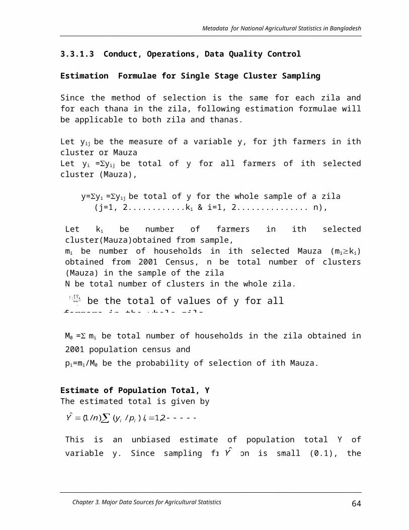
Metadata for National Agricultural Statistics in Bangladesh
Chapter 3. Major Data Sources for Agricultural Statistics 64
Therefore, coefficient of variation (c.v.) of