mediterranean and black sea commission … visits/tv08/romania.pdf · at the 15th meeting of the...
TRANSCRIPT
1
MEDITERRANEAN AND BLACK SEA HYDROGRAPHIC COMMISSION (MBSHC)
Technical Visit to ROMANIA 8-10 July 2008
REPORT
Submitted by: France (SHOM) and International Hydrographic Bureau (IHB), Monaco Related Documents: a) IHO Work Programme 2008-2012 dated May 2007, Tasks 2.2.1 and
2.3.2 b) IHB Letter CBC-WP08 dated 9 April 08 “MBSHC Technical Visits 2008” c) Romania National report to the 15th meeting of the Mediterranean and
Black Seas Hydrographic Commission (MBSHC), 22-24 October 2007, Malta
d) Draft report of the 8th meeting of the Black and Azov Seas Working Group (BASWG), 25-26 March 2008, Kiev, Ukraine.
e) SHOM’s letter N° 033 SHOM/DSPRE/REX/NP dated 18 June 2008 to the French Ambassador in Romania “Technical cooperation in hydrography and nautical cartography” – in French
Annexes Annex 1: Terms of Reference of the visiting team Annex 2: Programme of the visit Annex 3: Summary of visits Annex 4: The Romanian Hydrographic Directorate (MHD) Annex 5: Status of Hydrography in Romania Annex 6: Diagram showing the surveys carried out in recent years Annex 7: Diagram showing the paper chart scheming Annex 8: Diagram showing the ENC scheming Annex 9: S-55 update INTRODUCTION
1. At the 15th meeting of the Mediterranean and Black Seas Hydrographic Commission (MBSHC), which was
held in October 2007, it was decided that technical visits would be conducted in the countries (including Romania) where shortcomings in terms of hydrographic surveys, nautical charting or nautical information had been identified, and which had requested to be visited by experts sent by the International Hydrographic Organization.
2
2. At its 5th meeting in June 2007, the IHO Capacity Building Committee (CBC) had agreed to fund such technical visits.
3. The French Hydrographic Office (SHOM – Service Hydrographique et Océanographique de la Marine) has
offered to provide staff to accomplish the technical visit in Romania. The IHB agreed to take part in this visit and the team of international experts was eventually composed of:
- Captain Jean-Christophe Long (France), Responsible at SHOM for the Mediterranean and Black Seas;
- Ingénieur en chef Michel Huet (France), Professional Assistant (Cartography) to the IHB Directing Committee.
The terms of reference of the visiting team is provided in Annex 1.
4. Preliminary liaison. Capt. Romeo Boşneagu, Director of the Maritime Hydrographic Directorate (MHD) in Constanţa assisted with coordination of the visit and compiled the visit program. Assistance was received from the French Embassy in order to liaise with Romanian authorities in Bucharest.
The program of the visit is given at Annex 2. VISITS AND MEETINGS
Ably guided by the MHD representative the team had the opportunity to meet officials of the following ministries and institutions in Bucharest and Constanţa,
Ministry of the Interior (Bucharest)
National Centre of Geodesy, Cartography, Photogrammetry and Remote Sensing (Bucharest, attached to the Ministry of the Interior)
Ministry of Transport (Bucharest)
Naval Headquarters (Bucharest)
Ministry of the Environment (Bucharest)
Maritime Hydrographic Directorate (MHD, Constanţa, under the authority of the Naval Headquarters)
National Institute of Marine Geology and Geo-ecology (GeoEcoMar) (Constanţa, attached to the Ministry of Research)
National Marine Research and Development Institute « Grigore Antipa » (Constanţa, attached to the Ministry of Environment)
Romanian Naval Authority (Constanţa, attached to the Ministry of Transport)
Border Police (Constanţa, attached to the Ministry of the Interior)
Prefectoral and Judicial Institute (Constanţa)
Port Authority (Constanţa)
Water Authority Dobrouja – Litoral (Constanţa)
A summary record of the visits is provided at Annex 3. Of particular importance was the visit paid to MHD where the team could obtain up-to-date information on the state of the Romanian capabilities in collecting and processing hydrographic data with a view to producing nautical documentation. GEOGRAPHICAL BACKGROUND
1. Romania has a coastline that stretches over 225 km 1 of the Black Sea, between Bulgaria and Ukraine. With a total land area of 237,500 sq km and a population of 22,247,000, Romania has 4 population centers within 8 km of the coast 2. Romania claims an exclusive economic zone of 10 780 sq km.
1 https://www.cia.gov/library/publications/the-world-factbook/geos/ro.html

3
2. Offshore oil and natural gas productions are of 122,700 bbl/day (2005 est.) and 12.24 billion cu m (2007), respectively. Merchant marine comprises 19 ships (1000 GRT or over) representing 146,307 GRT/165,548 DWT. Ports and terminals are Braila, Constanţa, Galati and Tulcea. Constanţa is the most important port in the Black Sea, with traffic of 58 million tons in 2007. The main maritime traffic routes are from the Bosporus to Constanţa, Odessa and the mouth of the Danube River. 3. The Danube is a vital navigable waterway for transportation of goods across the country. Romania is facing contamination of Danube delta wetlands and coastal erosion. 4. Romania and Ukraine have a pending dispute over Ukrainian-administered Zmiyinyy / Serpilor (Snake) Island and Black Sea maritime boundary delimitation; Romania also opposes Ukraine's reopening of a navigation canal from the Danube border through Ukraine to the Black Sea. Romania jointed the European Union and the IHO in 2007.
MAIN CONCERNS OF ROMANIAN AUTHORITIES 6. Following its admission as a member state of the European Union, efforts within governmental entities are dedicated to implement European directives, especially in the field of transportation, environment and border surveillance. 6. Real time monitoring of shipping in Romanian maritime zone of interest is paramount (Safer seas, cleaner ships). 6. National legislation and administrative experience is currently non relaxing. The complex environment of the Danubian and Black Sea areas requires an increased synergy between institutions involved in maritime and hydrologic activities (as stated in IHO publication M-2). 6. International cooperation. Thanks to Romanian pro-active role in the area, cooperation within neighboring countries of the Black sea is improving (in particular in the field of cartography within the BASWG). 6. Outside the Black Sea, cooperation with intergovernmental organizations such as IHO, IMO and IALA intensifies speed and openness for change in Romania.
6. On a technical point of view, MHD has done what it could with limited assets. It is time now for a new dynamic in order to foster capabilities in the field of maritime safety information, hydrography and cartography.
2 www.world-gazetteer.com; population centers with greater than 10,000 people.
4
STATUS OF HYDROGRAPHY IN ROMANIA - COMMENTS FROM THE VISITING TEAM 1. Maritime Hydrographic Directorate (MHD). Missions of the MHD include:
Collecting, compiling and disseminating hydrographic and safety of navigation information for the maritime waters under Romanian responsibility;
Compiling and selling official nautical charts, both in paper and electronic format (ENC), and other nautical documents;
Operating and maintaining 7 major lighthouses and other lights, buoys (MHD is also the National Lighthouse Authority);
Collecting meteorological information and promulgating weather forecast for short and long term;
Maintaining navigational equipment on board of the navy vessels, as well as the lighthouse equipment;
Providing hydrographic services for private companies and local authorities on request;
Maintaining and amplifying liaisons with national / international organizations and bodies in the field of mutual interest.
A clear majority of the 160 staff members of MHD, which is a department of the Romanian Navy, is employed in tasks which are outside the hydrographic domain, e.g. maintaining aids to navigation or doing weather forecast. Roughly 20 persons are actually working on hydrographic surveying / data basing and nautical cartography. 2. Nautical Information. Collection and promulgation of nautical information (NtM, MSI) are working satisfactorily. Also GMDSS is correctly implemented. MHD has mentioned that only one NAVTEX position is currently available. 3. Hydrographic Surveys. Only ports and port approaches, and generally areas of depth less than 50 m, reasonably satisfy to present requirements for hydrographic surveys, although significant parts of those areas need re-survey at larger scale or to modern standards. The totality of Romanian waters off the 50 m depth contour need complete re-survey. The only hydrographic survey vessel operated by MHD, “C.V. Alexandru Catuneanu”, a former oceanic tug of 64.5 m length and 2,660 t displacement, is fitted properly in terms of hydrographic equipment (Multibeam echo sounder Simrad EM3000, Thales DGPS positioning system, Hypack Max 6.2, …). Further, her modernization is planned and will include the acquisition of a new multibeam E.S with improved performances. However her operational activities are limited to 40 days per year for budgetary reasons, which severely reduce the potential of MHD to undertake hydrographic surveys. 4. Nautical Charting
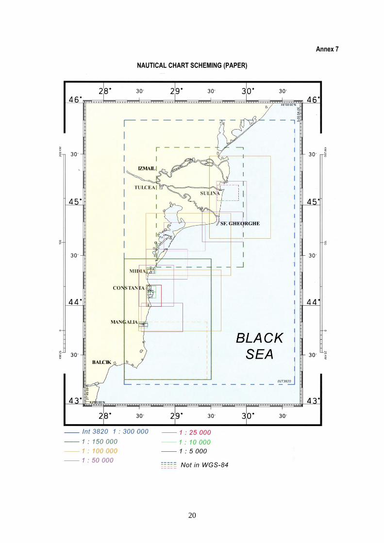
a. Paper charts. The paper chart scheming to cover Romanian waters is adequate. The selected chart scales, from 1:300,000 to 1:5,000, meet all needs of marine navigation throughout the area. Most of the 34 charts have been published over the past 5 years. However, large portions of several of these charts are still based on old surveys (see above item 3). Duplication of charts has been noted in two instances, i.e. between 1.300.01 (also INT 3820) and 1.250.01, and between 1.010.11 and 1.010.01. Also not all charts are based on WGS-84; some charts are still using the S-42 geodetic system.
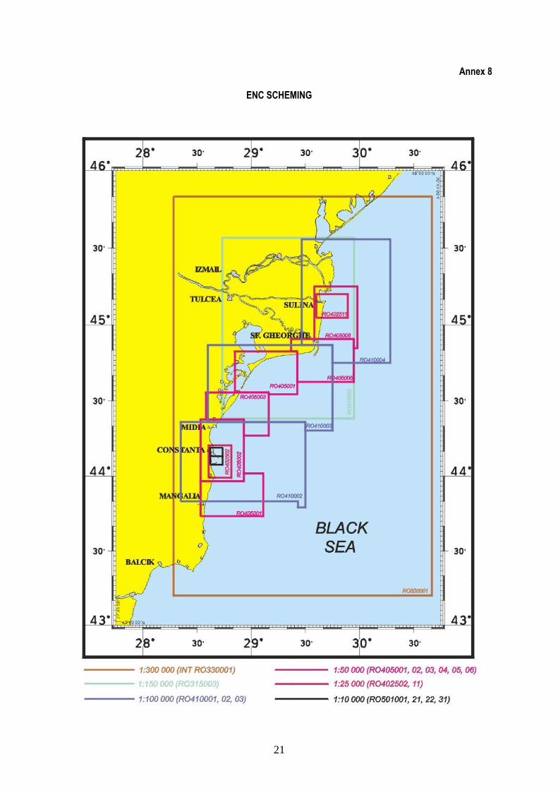
b. Electronic Navigational Charts. MHD has schemed 17 ENCs, based on existing paper charts, across the various usage bands, which seems sufficient. Of these, two ENCs are reportedly already completed and validated, and all remaining ENCs are planned for release by end 2008, which would be a remarkable achievement. MHD has signed an agreement with the UK Hydrographic Office for the distribution of Romanian ENCs. MHD has indicated its intention to propose the inclusion of several additional ENCs in the scheme. MHD has done a very good job with the production / maintenance of 34 paper charts and 17 ENCs (plus 5 nautical publications), with such a small number of qualified personnel. However, the visiting team was informed that one of the most instrumental officers in the production of Romanian ENCs has recently

5
resigned, which may complicate and slow down the current process of ENC production / validation, at least temporarily. There may be a need to better value the position of key officers at MHD. c. A bilateral cooperation with France in matter of hydrography and maritime cartography is under study. d. Coordination issues. Report in reference d)3 provides details on discussions related to responsibilities for International charts and ENCs in the Black and Azov seas. All riverains States except Russia did participate to the first meeting in March 2008 under Turkish chairmanship. Romania is ready to host the next BASWG meeting in May 2009.
5. Training. MHD’s hydrography and nautical cartography “experts” are essentially trained on-the-job. Only a few of them have followed specific training courses abroad. Hydrographic courses are not given as part of the school curriculum for the Romanian naval officers. The need for appropriate courses and a sustainable training system is vital for the future capacities of MHD. MHD has also mentioned the lack of trained personnel in the field of oceanography. 6. Annexes 4 to 8 provide details on the current status of hydrography in Romania, including nautical
information, hydrographic surveys and nautical cartography. RECOMMENDATIONS
1. National Hydrographic Committee. The visiting team has identified common hydrographic concerns that may be satisfied through the implementation of a National Hydrographic Committee, which is therefore recommended. An NHC (chaired by MHD) would facilitate team work across Romanian institutions through a better synergy, coordination, and collaboration, especially between ministries of Defense, Environment, Transport, Interior and Research. The Work of the MHD should be made visible at high government level. Foreseeable actions towards the establishment of a Romanian NHC could include:
- (2009) IHO /CBC to support the organization by Romania of a seminar in Bucharest on this theme; - (2009) France to consider assisting in setting up an NHC in Romania; - (2011) Romania to participate in an IHO Seminar for NHC Chairpersons (ref a).
2. Hydrographic Surveys. The number of days spent at sea by the single Romanian hydrographic ship “C.V. Alexandru Catuneanu” is notably insufficient (max. of 40 days per year). It is therefore essential to identify means, e.g. through internal or external funding, of increasing the number of her working days at sea up to 80/100 days per year. Priority should be given to surveying ports and port approaches (75 % in need of re-survey), then to areas with depths of less than 50 m (20 % in need of re-survey). In order to conduct shallow water surveys, there may be a need for one or two survey launches, ideally embarked on “C.V. Alexandru Catuneanu”. Cooperation with GeoEcoMar could be sought for offshore surveys with Research Vessel Mare Negrum. 3. Charting. In order to avoid duplication, it is suggested that Chart 1.250.1 at scale 1:250,000 be removed from the scheme and that only Chart 1.300.01 at scale 1:300,000, which is also INT 3820, be retained, as both charts cover almost the same area. Similarly, Chart 1.010.01 at scale 1:10,000 can be removed from the scheme as it duplicates Chart 1.010.11 at scale 1:10,000 which provides a better coverage of the port of Mangalia. It is further recommended that any future editions of the Romanian charts be based on the WGS-84 geodetic datum and that they all include a source diagram providing information on the origin of surveys (IHO Publication M-4, Specification B-290 refers). 4. Training of hydrographic and cartographic personnel. Whereas access to modern standards seems already achieved in the field of cartography, there is a need for improved competence in hydrography and ENC production. The number of well trained hydrographic and cartographic personnel must be increased. Any training
6
opportunities by IHO/CBC should be used, as well as training which could be offered by France. Below are suggested options:
- (2009) Short training periods financially supported by IHO/CBC. - (2009-2010) Long duration training courses in Brest, France in the frame of SHOM-MHD cooperation.
5. Oceanography. Challenging concerns in the field of environment require a greater knowledge of sea currents. It is recommended that MHD:
- considers carrying out current measurements in the Black Sea; - takes responsibility for Black Sea ports and Danube estuary; - considers using modeling technology in order to predict maritime impact on land; - develop staff training; - disseminates information.
Considering the need for better maritime data covering the Black Sea, transformation of the MHD into a MHOD (Maritime Hydrographic and Oceanographic Directorate), with a wider scope of responsibility, could be envisaged. 6. Marine Spatial Data Infrastructure. MHD should play a significant role in contributing to a « National Marine Spatial Data infrastructure », in connection with the ongoing activities of the IHO Marine Spatial Data infrastructure Working Group (MSDIWG) and the European Union Inspire project. It is recommended that MHD considers implementing the conclusions of the MSDIWG (June 2009). 7. Sub regional coordination through the Baltic and Azov Seas WG (BASWG). Improvement of hydrography and cartography in Romanian waters should result from continuation of MHD participation in this WG, which is therefore encouraged. This should be facilitated with the next meeting of BASWG being planned in May 2009 in Constanţa. CONCLUSIONS 1. This visit was extremely enriching, both from the diversity of points of view (about 15 professional staff from 4 different ministries) as well as the motivation of the Romanian institutions concerning maritime matters. Great attention was paid in particular to maritime safety, protection of borders and environment, as well as defense (naval) issues. 2. It should be noted that the interagency approach recommended in the IHO capacity building strategy proved being efficient and promising. Emphasis on hydrography was made in many occasions. 3. Further cooperation should take place in the coming months with France and IHO/CBC in order to address and remedy the identified shortfalls.
SIGNATURE SIGNATURE
Captain Jean-Christophe Long Ingénieur en Chef Michel Huet Distribution Capt. Hugo Gorziglia, Chairman CBC, IHB, Monaco Capt. Dr. Romeo Boşneagu, Head of MHD, Constanţa, Romania Ing. Général Gilles Bessero, General Director of SHOM, Brest, France Capt. Rachid Essoussi, MBSHC Chairman, Bizerte, Tunisia
7
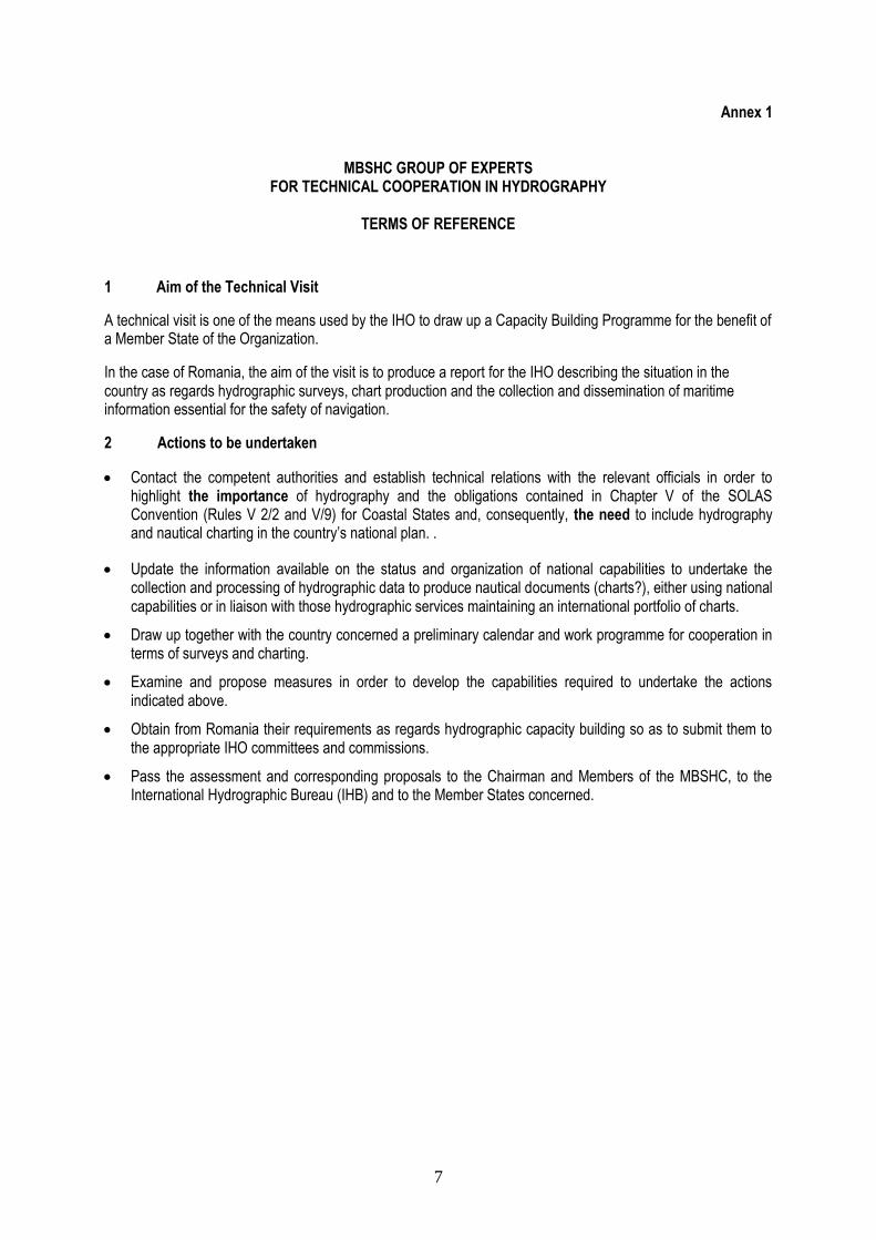
Annex 1
MBSHC GROUP OF EXPERTS
FOR TECHNICAL COOPERATION IN HYDROGRAPHY
TERMS OF REFERENCE
1 Aim of the Technical Visit
A technical visit is one of the means used by the IHO to draw up a Capacity Building Programme for the benefit of a Member State of the Organization.
In the case of Romania, the aim of the visit is to produce a report for the IHO describing the situation in the country as regards hydrographic surveys, chart production and the collection and dissemination of maritime information essential for the safety of navigation.
2 Actions to be undertaken
Contact the competent authorities and establish technical relations with the relevant officials in order to highlight the importance of hydrography and the obligations contained in Chapter V of the SOLAS Convention (Rules V 2/2 and V/9) for Coastal States and, consequently, the need to include hydrography and nautical charting in the country’s national plan. .
Update the information available on the status and organization of national capabilities to undertake the collection and processing of hydrographic data to produce nautical documents (charts?), either using national capabilities or in liaison with those hydrographic services maintaining an international portfolio of charts.
Draw up together with the country concerned a preliminary calendar and work programme for cooperation in terms of surveys and charting.
Examine and propose measures in order to develop the capabilities required to undertake the actions indicated above.
Obtain from Romania their requirements as regards hydrographic capacity building so as to submit them to the appropriate IHO committees and commissions.
Pass the assessment and corresponding proposals to the Chairman and Members of the MBSHC, to the International Hydrographic Bureau (IHB) and to the Member States concerned.
8
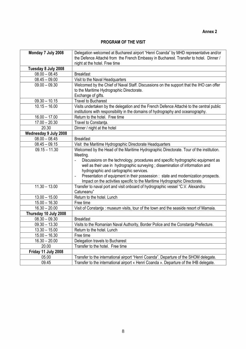
Annex 2
PROGRAM OF THE VISIT
Monday 7 July 2008
Delegation welcomed at Bucharest airport “Henri Coanda” by MHD representative and/or the Defence Attaché from the French Embassy in Bucharest. Transfer to hotel. Dinner / night at the hotel. Free time
Tuesday 8 July 2008
08.00 – 08.45 Breakfast
08.45 – 09.00 Visit to the Naval Headquarters
09.00 – 09.30 Welcomed by the Chief of Naval Staff. Discussions on the support that the IHO can offer to the Maritime Hydrographic Directorate. Exchange of gifts.
09.30 – 10.15 Travel to Bucharest
10.15 – 16.00 Visits undertaken by the delegation and the French Defence Attaché to the central public institutions with responsibility in the domains of hydrography and oceanography.
16.00 – 17.00 Return to the hotel. Free time
17.00 – 20.30 Travel to Constanţa.
20.30 Dinner / night at the hotel
Wednesday 9 July 2008
08.00 – 08.45 Breakfast
08.45 – 09.15 Visit the Maritime Hydrographic Directorate Headquarters
09.15 – 11.30 Welcomed by the Head of the Maritime Hydrographic Directorate. Tour of the institution. Meeting. - Discussions on the technology, procedures and specific hydrographic equipment as
well as their use in hydrographic surveying ; dissemination of information and hydrographic and cartographic services.
- Presentation of equipment in their possession : state and modernization prospects. Impact on the activities specific to the Maritime Hydrographic Directorate.
11.30 – 13.00 Transfer to naval port and visit onboard of hydrographic vessel “C.V. Alexandru Catuneanu”
13.00 – 15.00 Return to the hotel. Lunch
15.00 – 16.30 Free time
16.30 – 20.00 Visit of Constanţa : museum visits, tour of the town and the seaside resort of Mamaia.
Thursday 10 July 2008
08.30 – 09.30 Breakfast
09.30 – 13.30 Visits to the Romanian Naval Authority, Border Police and the Constanţa Prefecture.
13.30 – 15.00 Return to the hotel. Lunch
15.00 – 16.30 Free time
16.30 – 20.00 Delegation travels to Bucharest
20.00 Transfer to the hotel. Free time
Friday 11 July 2008
05.00 Transfer to the international airport “Henri Coanda”. Departure of the SHOM delegate.
09.45 Transfer to the international airport « Henri Coanda ». Departure of the IHB delegate.
9
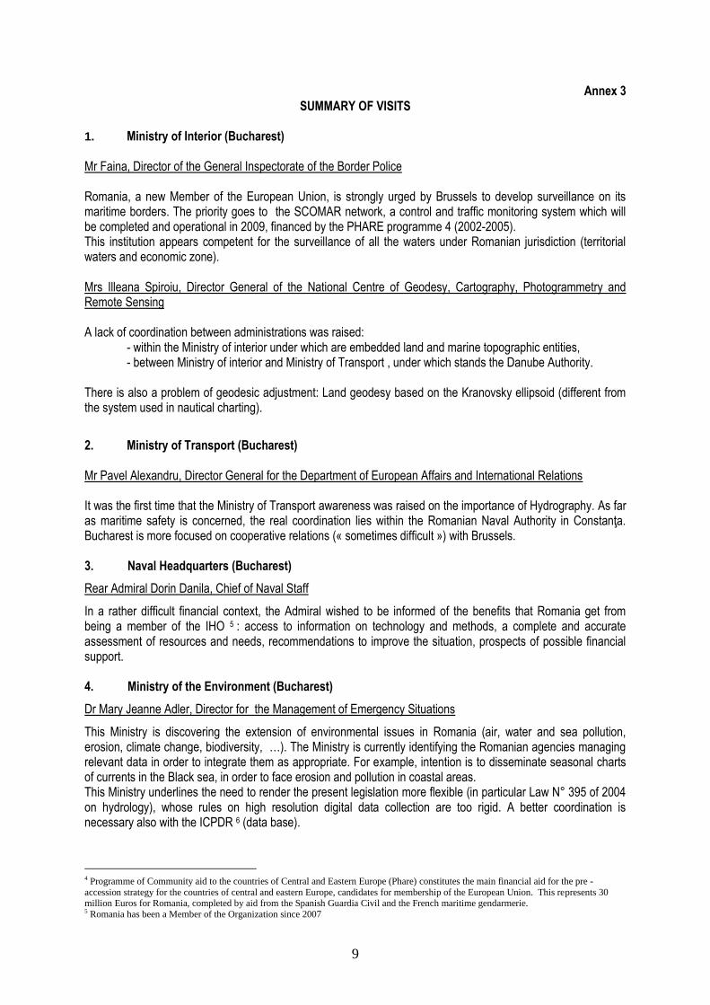
Annex 3 SUMMARY OF VISITS
1. Ministry of Interior (Bucharest) Mr Faina, Director of the General Inspectorate of the Border Police Romania, a new Member of the European Union, is strongly urged by Brussels to develop surveillance on its maritime borders. The priority goes to the SCOMAR network, a control and traffic monitoring system which will be completed and operational in 2009, financed by the PHARE programme 4 (2002-2005). This institution appears competent for the surveillance of all the waters under Romanian jurisdiction (territorial waters and economic zone).
Mrs Illeana Spiroiu, Director General of the National Centre of Geodesy, Cartography, Photogrammetry and Remote Sensing A lack of coordination between administrations was raised:
- within the Ministry of interior under which are embedded land and marine topographic entities, - between Ministry of interior and Ministry of Transport , under which stands the Danube Authority.
There is also a problem of geodesic adjustment: Land geodesy based on the Kranovsky ellipsoid (different from the system used in nautical charting).
2. Ministry of Transport (Bucharest) Mr Pavel Alexandru, Director General for the Department of European Affairs and International Relations It was the first time that the Ministry of Transport awareness was raised on the importance of Hydrography. As far as maritime safety is concerned, the real coordination lies within the Romanian Naval Authority in Constanţa. Bucharest is more focused on cooperative relations (« sometimes difficult ») with Brussels. 3. Naval Headquarters (Bucharest)
Rear Admiral Dorin Danila, Chief of Naval Staff
In a rather difficult financial context, the Admiral wished to be informed of the benefits that Romania get from being a member of the IHO 5 : access to information on technology and methods, a complete and accurate assessment of resources and needs, recommendations to improve the situation, prospects of possible financial support. 4. Ministry of the Environment (Bucharest)
Dr Mary Jeanne Adler, Director for the Management of Emergency Situations
This Ministry is discovering the extension of environmental issues in Romania (air, water and sea pollution, erosion, climate change, biodiversity, …). The Ministry is currently identifying the Romanian agencies managing relevant data in order to integrate them as appropriate. For example, intention is to disseminate seasonal charts of currents in the Black sea, in order to face erosion and pollution in coastal areas. This Ministry underlines the need to render the present legislation more flexible (in particular Law N° 395 of 2004 on hydrology), whose rules on high resolution digital data collection are too rigid. A better coordination is necessary also with the ICPDR 6 (data base).
4 Programme of Community aid to the countries of Central and Eastern Europe (Phare) constitutes the main financial aid for the pre -
accession strategy for the countries of central and eastern Europe, candidates for membership of the European Union. This represents 30 million Euros for Romania, completed by aid from the Spanish Guardia Civil and the French maritime gendarmerie. 5 Romania has been a Member of the Organization since 2007
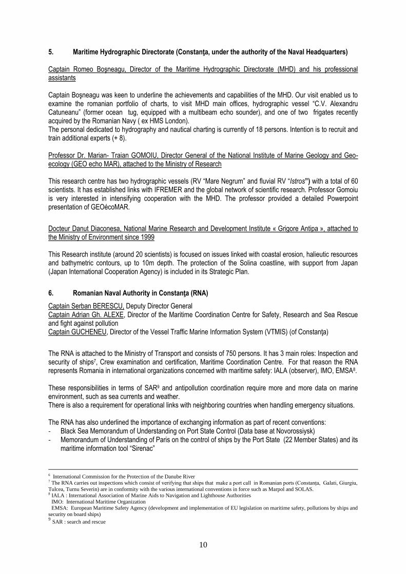
10
5. Maritime Hydrographic Directorate (Constanţa, under the authority of the Naval Headquarters) Captain Romeo Boşneagu, Director of the Maritime Hydrographic Directorate (MHD) and his professional assistants Captain Boşneagu was keen to underline the achievements and capabilities of the MHD. Our visit enabled us to examine the romanian portfolio of charts, to visit MHD main offices, hydrographic vessel “C.V. Alexandru Catuneanu” (former ocean tug, equipped with a multibeam echo sounder), and one of two frigates recently acquired by the Romanian Navy ( ex HMS London). The personal dedicated to hydrography and nautical charting is currently of 18 persons. Intention is to recruit and train additional experts (+ 8).
Professor Dr. Marian- Traian GOMOIU, Director General of the National Institute of Marine Geology and Geo-ecology (GEO echo MAR), attached to the Ministry of Research
This research centre has two hydrographic vessels (RV “Mare Negrum” and fluvial RV “Istros”) with a total of 60 scientists. It has established links with IFREMER and the global network of scientific research. Professor Gomoiu is very interested in intensifying cooperation with the MHD. The professor provided a detailed Powerpoint presentation of GEOécoMAR.
Docteur Danut Diaconesa, National Marine Research and Development Institute « Grigore Antipa », attached to the Ministry of Environment since 1999 This Research institute (around 20 scientists) is focused on issues linked with coastal erosion, halieutic resources and bathymetric contours, up to 10m depth. The protection of the Solina coastline, with support from Japan (Japan International Cooperation Agency) is included in its Strategic Plan.
6. Romanian Naval Authority in Constanţa (RNA)
Captain Serban BERESCU, Deputy Director General Captain Adrian Gh. ALEXE, Director of the Maritime Coordination Centre for Safety, Research and Sea Rescue and fight against pollution Captain GUCHENEU, Director of the Vessel Traffic Marine Information System (VTMIS) (of Constanţa)
The RNA is attached to the Ministry of Transport and consists of 750 persons. It has 3 main roles: Inspection and security of ships7, Crew examination and certification, Maritime Coordination Centre. For that reason the RNA represents Romania in international organizations concerned with maritime safety: IALA (observer), IMO, EMSA8. These responsibilities in terms of SAR9 and antipollution coordination require more and more data on marine environment, such as sea currents and weather. There is also a requirement for operational links with neighboring countries when handling emergency situations. The RNA has also underlined the importance of exchanging information as part of recent conventions: - Black Sea Memorandum of Understanding on Port State Control (Data base at Novorossiysk) - Memorandum of Understanding of Paris on the control of ships by the Port State (22 Member States) and its
maritime information tool “Sirenac”
6 International Commission for the Protection of the Danube River 7 The RNA carries out inspections which consist of verifying that ships that make a port call in Romanian ports (Constanţa, Galati, Giurgiu,
Tulcea, Turnu Severin) are in conformity with the various international conventions in force such as Marpol and SOLAS. 8 IALA : International Association of Marine Aids to Navigation and Lighthouse Authorities
IMO: International Maritime Organization EMSA: European Maritime Safety Agency (development and implementation of EU legislation on maritime safety, pollutions by ships and
security on board ships) 9 SAR : search and rescue
11
7. Border Police
Captain Laurenzo COSTACO, Chief of the local centre of operations in Constanţa.
A presentation of SCOMAR surveillance capacities and its command and control centre (under construction) was made. The current surveillance fleet (about 20 light patrol boats) will be completely modernized. Two new 60 m. corvettes (with helicopter landing pad) will bring a significant improvement, bearing in mind the rough seas encountered in the Black Sea. The acquisition of a maritime patrol aircraft is also considered. Few problems concerning migratory flows were being signaled. Main effort lies in dealing with “illegal trafficking”. Normal daily operations include 1 or 2 patrolling per day. Other boats are on stand by alert along the coast line. 8. Prefectoral and Judicial Institute of Constanţa
Mr. Danut Culetu, Prefect Mr Danut questioned the visiting team on the situation in Romania related to hydrography and cartography. He was told that the Maritime Hydrographic Directorate was already doing well as far as international standards are concerned. Nevertheless, considering current maritime issues, three main objectives involving the MHD should be considered: increase of hydrographic surveys, creation of a National hydrographic committee and development of training. The prefect then indicated that he would speak about these matters to « his friends » at the Ministry of Defense so as to plead MHD’s cause. He very much appreciated that France (SHOM) offers “robust” training courses.
Mr. Ambroziu Duma (Port Authority of Constanţa) He noted that the traffic of the port of Constanţa (operated by Port of Dubaï World) reached 58 Mt and envisaged to generate a traffic of 2 million containers per year, capable of receiving ships of 15 m draught. The buoyage of the port was taken care of by a French company, whose contract was coming to an end in 2009 (new bids/tenders to come).
Mrs. Camelia Dumitrade, Director of the Water Authority Dobrouja – Litoral
She referred to a Japanese report on the Hydrography of the Black Sea (2002).
12
Annex 4
THE MARITIME HYDROGRAPHIC DIRECTORATE (MHD)
MISSIONS
a. Collecting, compiling and disseminating hydrographic and safety of navigation information for the maritime waters under Romanian responsibility;
b. Compiling and selling official nautical charts, both in paper and electronic format (ENC), and other
nautical documents; c. Operating and maintaining 7 major lighthouses and other lights, buoys (MHD is also the National
Lighthouse Authority); d. Collecting meteorological information and promulgating weather forecast for short and long term; e. Maintaining navigational equipment on board of the navy vessels, as well as the lighthouse equipment; f. Providing hydrographic services for private companies and local authorities on request; g. Maintaining and amplifying liaisons with national / international organizations and bodies in the field of
mutual interest. ORGANISATION
MHD comprises the following 3 sections, with duties as indicated:
Hydrography Section
- Conduct hydrographic, geodetic and topographic surveys; - Carry out marine data gathering, verification and management; - Maintain and improve MHD hydrographic capabilities in order to meet Naval Forces operational
requirements in pace, crisis or war; - Collect necessary information to produce military documentation of coastal areas; - Provide hydrographic services on request; - Install, control and maintain tide gauge stations; - Operate meteorologic stations within National Meteorologic Integrate Systems (SIMIN); - Monitor the acquisition of physical and other oceanographic data for the assessment of the marine
environment; - Forecast meteorologic warnings.
Aids to Navigation Section
- Operate and maintain all aids to navigation on the Romanian coastline, i.e.:
13
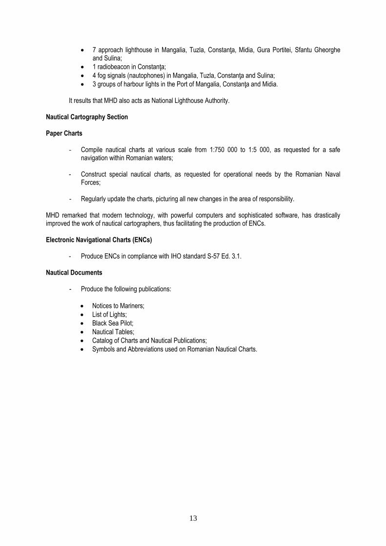
7 approach lighthouse in Mangalia, Tuzla, Constanţa, Midia, Gura Portitei, Sfantu Gheorghe and Sulina;
1 radiobeacon in Constanţa;
4 fog signals (nautophones) in Mangalia, Tuzla, Constanţa and Sulina;
3 groups of harbour lights in the Port of Mangalia, Constanţa and Midia.
It results that MHD also acts as National Lighthouse Authority.
Nautical Cartography Section
Paper Charts
- Compile nautical charts at various scale from 1:750 000 to 1:5 000, as requested for a safe navigation within Romanian waters;
- Construct special nautical charts, as requested for operational needs by the Romanian Naval
Forces; - Regularly update the charts, picturing all new changes in the area of responsibility.
MHD remarked that modern technology, with powerful computers and sophisticated software, has drastically improved the work of nautical cartographers, thus facilitating the production of ENCs. Electronic Navigational Charts (ENCs)
- Produce ENCs in compliance with IHO standard S-57 Ed. 3.1. Nautical Documents
- Produce the following publications:
Notices to Mariners;
List of Lights;
Black Sea Pilot;
Nautical Tables;
Catalog of Charts and Nautical Publications;
Symbols and Abbreviations used on Romanian Nautical Charts.

14
Annex 5
STATUS OF HYDROGRAPHY
Note: The information contained in this section has been provided by MHD (July 2008)
1. Collection and Promulgation of Nautical Information (Notices to Mariners – Maritime Safety Information):
Organization responsible : Maritime Hydrographic Directorate 10
MSI organization and GMDSS implementation are summarized in the table below:
Local Warnings : Yes
Coastal Warnings : Yes
Navarea Warnings : Yes
Information on Ports and Harbours : Yes
GMDSS Implementation
Master Plan A1 Area 11 A2 Area 12 A3 Area 13 NAVTEX SafetyNET
Yes Yes Yes Yes Yes Yes
Note: Spain, as Navarea III Coordinator, reported that 17 Navarea III Warnings were issued in 2007 and 8 in 2008 up to June. Additionally, 7 fax messages have been received regarding firing exercises, which were broadcasted as Coastal Warnings by the NAVTEX Station in Romania.
2. Hydrographic Surveying
Organization responsible : Maritime Hydrographic Directorate 2.1 Status of Hydrographic Surveys (See also Annex 6)
Within the area of the EEZ (10 780 sq km, for a length of coastline of 245 km), status is as follows:
% surveyed adequately for present requirements
% requiring re-survey at larger scale or to modern standards
% never systematically surveyed.
Ports and Port Approaches :
85 75 15
Area with depths of less than 50 m :
85 20 15
Adjacent area with depths of less than 200 m :
0 100 0
Area with depths greater than 200 m:
0 100 0
2.2 Resources available 2.2.1 Staff
10 In liaison with the Naval Authority of the Ministry of Transport 11 Sea Area A1 is within range of at least one VHF coast station (out to about 30 miles). 12 Sea Area A2 is within the coverage of MF/HF coast station (about 200 miles). 13 Sea Area A3 is within the coverage of an Inmarsat geostationary satellite.

15
Number
Training Needs (Number)
Comments
Hydrographic Surveying Specialists:
4
Multibeam E.S. course (3)
Single beam E.S. course (1)
1 MHD officer attended a multibeam sonar training
course in Stavanger, Norway, March 2007.
Technical Assistants to Specialists:
2 Multibeam E.S. course (1) Single beam E.S. course
(1) -
Other professional staff: 2 1 needs training -
Computer specialists: 2 Computer-assisted
hydrography course (2) -
Other specialised staff (Elec-tronics, communications, etc.):
1 1 needs training -
2.2.2 Platforms
1 Hydrographic Survey Vessel « C.V. Alexandru Catuneanu »
Length
Displacement
Crew
Status
O= operational
R= repairing
C= in construction
Organization
(H.O., Navy, Port Authority, Coast Guard
etc.)
L = 64,5 m
D = 2660 t
Off.- 3
P.O.- 8
N.C.O.-1 Enlisted pers. - 19
O Maritime
Hydrographic Directorate of the Romanian Navy
Note: The survey vessel “Hercules” is a former tug ocean. 2.2.3 Equipment / Software
Hydrographic Surveying
Type Equipment / Software Needs
Single beam E.S.: 1 Simrad EA 400 -
Multibeam E.S.: 1 Simrad EM 3000 Side scan
multibeam ecosounder EM 710 Low-Frq.14
Positioning
Method Equipment / Software Needs
Long-range (more than 40 kms): no yes
Medium range (5-40 kms) (includes over the horizon systems):
yes -
Short-range (inshore work): yes -
14
Already budgeted by MHD
16
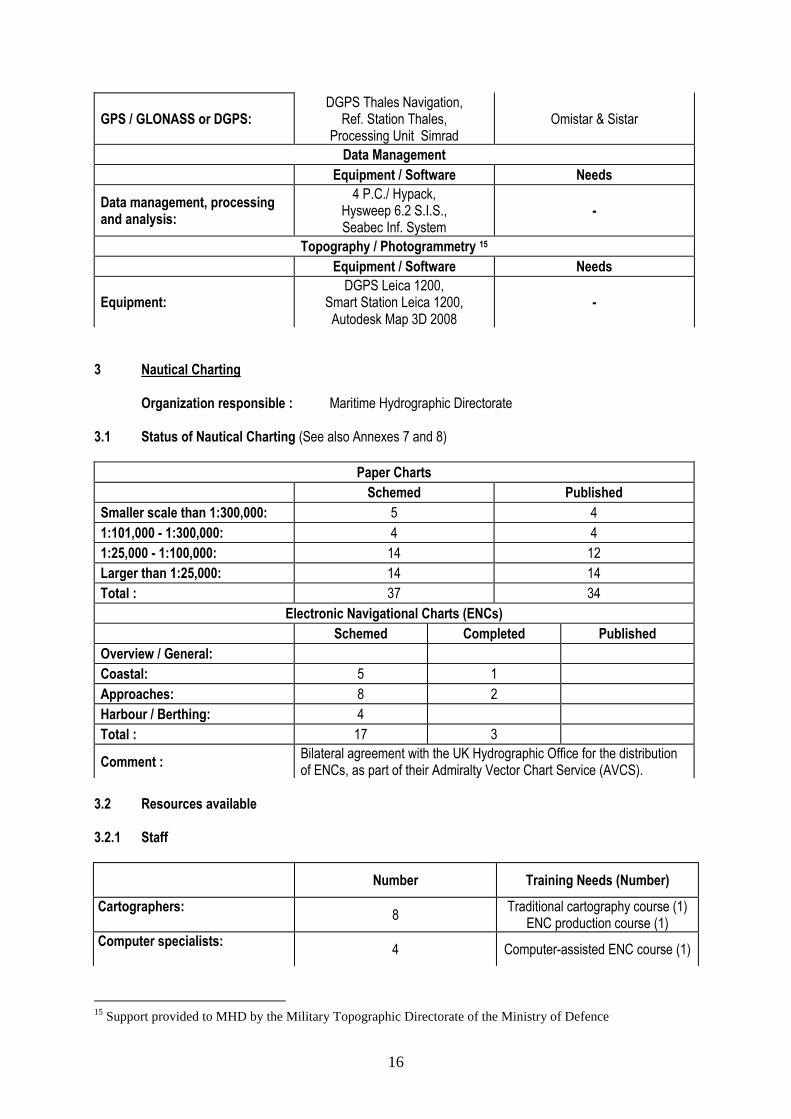
GPS / GLONASS or DGPS: DGPS Thales Navigation,
Ref. Station Thales, Processing Unit Simrad
Omistar & Sistar
Data Management
Equipment / Software Needs
Data management, processing and analysis:
4 P.C./ Hypack, Hysweep 6.2 S.I.S., Seabec Inf. System
-
Topography / Photogrammetry 15
Equipment / Software Needs
Equipment: DGPS Leica 1200,
Smart Station Leica 1200, Autodesk Map 3D 2008
-
3 Nautical Charting
Organization responsible : Maritime Hydrographic Directorate 3.1 Status of Nautical Charting (See also Annexes 7 and 8)
Paper Charts
Schemed Published
Smaller scale than 1:300,000: 5 4
1:101,000 - 1:300,000: 4 4
1:25,000 - 1:100,000: 14 12
Larger than 1:25,000: 14 14
Total : 37 34
Electronic Navigational Charts (ENCs)
Schemed Completed Published
Overview / General:
Coastal: 5 1
Approaches: 8 2
Harbour / Berthing: 4
Total : 17 3
Comment : Bilateral agreement with the UK Hydrographic Office for the distribution of ENCs, as part of their Admiralty Vector Chart Service (AVCS).
3.2 Resources available 3.2.1 Staff
Number Training Needs (Number)
Cartographers:
8 Traditional cartography course (1)
ENC production course (1)
Computer specialists:
4 Computer-assisted ENC course (1)
15
Support provided to MHD by the Military Topographic Directorate of the Ministry of Defence

17
Other professional staff:
4 -
3.2.2 Equipment / Software
Cartographic Facilities
Equipment / Software Needs
Chart compilation equipment: 5 PC -
Automation, hardware, software etc.:
1-Caris GIS-4.3.3 2-Caris GIS-4.4a
1-Autodesk Map 3D 2008 3
ENC production capabilities: 1-Caris HOM V3.2
1-dKart Inspector 5.0 2
Printing
Equipment Needs
Scribing, preparation of negatives, printing plates:
2 -
Offset equipment: Black and white press: Colour press:
- -
4 Miscellaneous 4.1 Tides / Oceanography 4.1.1 Tides / Water Level
Organization responsible : National Meteorology Administration 16
Yes / No Equipment Comments / Needs
Tides / water level measurements:
Yes 3 tide gauges Plan is to acquire 2 or 3
more tide gauges
Tide tables : No - -
4.1.2 Oceanography
Organization responsible : Maritime Hydrographic Directorate
Yes / No Equipment Comments / Needs
Oceanographic measurements:
Yes
1 currentmeter, 1 CTD probe, 1 wave
measurement device and 1 sound velocity profiler
-
4.2 Beacons and Lighthouses
Organization responsible : Maritime Hydrographic Directorate 17
16 However, MHD is responsible for the maintenance of the equipment. 17 However, the Port Authority has responsibility for the floating lights

18
Equipment Automated
Yes / No Source energy Comments / Needs
Fixed lights: Floating lights: Radionavigation facilities:
No No No
Electricity 18 Solar batteries
Electricity 18
- - -
a. Geodesy
Organization responsible : Military Topographic Directorate
National datum Equipment Documentation
available Comments / Needs
WGS - 84 - - -
2. Ships Reporting System
The status of ships reporting system is summarized in the table below.
Yes / No
Is there a mandatory reporting
requirement ? Yes / No
Are statistics about vessel traffic kept ?
Yes / No
Is there an annual report
? Yes / No
Has any of the country's ports land-based Radar + Communication with vessels entering or leaving ports ?
Yes Yes Yes Yes
Has your country a VTS ? Brief description including use or not of electronic charts.
Yes Yes Yes Yes
Has your country a communication (VHF) vessel traffic reporting system ?
Yes Yes Yes Yes
Does your country use Radar to monitoring vessel traffic ?
Yes Yes Yes Yes
Has your country a Pilotage System ?
Yes Yes Yes Yes
Is there any use of Automatic Identification Systems (AIS) in your country ?
Yes Yes Yes Yes
Are there any other Ship Reporting Systems ?
Yes Yes Yes Yes
18 Generated by diesel engine / acetylene, or obtained from the national electricity network
19
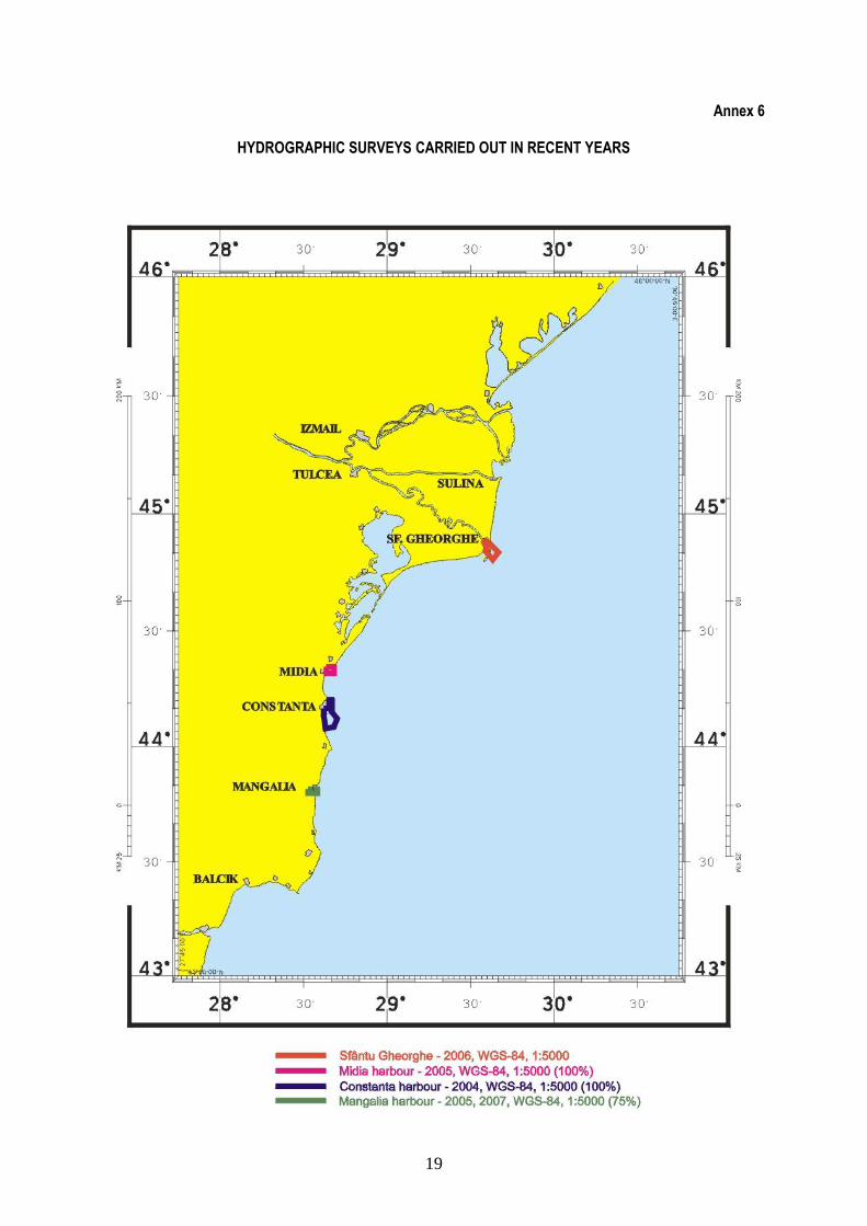
Annex 6
HYDROGRAPHIC SURVEYS CARRIED OUT IN RECENT YEARS
20
Annex 7
NAUTICAL CHART SCHEMING (PAPER)
21
Annex 8
ENC SCHEMING
22
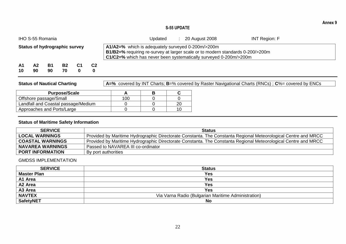
Annex 9 S-55 UPDATE
IHO S-55 Romania Updated : 20 August 2008 INT Region: F
Status of hydrographic survey A1/A2=% which is adequately surveyed 0-200m/>200m B1/B2=% requiring re-survey at larger scale or to modern standards 0-200/>200m C1/C2=% which has never been systematically surveyed 0-200m/>200m
A1 A2 B1 B2 C1 C2 10 90 90 70 0 0
Status of Nautical Charting A=% covered by INT Charts; B=% covered by Raster Navigational Charts (RNCs) ; C%= covered by ENCs
Purpose/Scale A B C
Offshore passage/Small 100 0 0
Landfall and Coastal passage/Medium 0 0 20
Approaches and Ports/Large 0 0 10
Status of Maritime Safety Information
SERVICE Status
LOCAL WARNINGS Provided by Maritime Hydrographic Directorate Constanta. The Constanta Regional Meteorological Centre and MRCC
COASTAL WARNINGS Provided by Maritime Hydrographic Directorate Constanta. The Constanta Regional Meteorological Centre and MRCC
NAVAREA WARNINGS Passed to NAVAREA III co-ordinator
PORT INFORMATION By port authorities
GMDSS IMPLEMENTATION
SERVICE Status
Master Plan Yes
A1 Area Yes
A2 Area Yes
A3 Area Yes
NAVTEX Via Varna Radio (Bulgarian Maritime Administration)
SafetyNET No