mcneil river state game sanctuary annual … areas management report adf&g/dwc/samr-2017-1...
TRANSCRIPT

Special Areas Management Report, ADF&G/DWC/SAMR-2017-1
McNeil River State Game Sanctuary Annual Management Report 2016
Thomas M. Griffin Edward W. Weiss
© 2016 ADF&G, Photo by Thomas M. Griffin
Alaska Department of Fish and Game Division of Wildlife Conservation2017


Special Areas Management Report ADF&G/DWC/SAMR-2017-1
McNeil River State Game Sanctuary Annual Management Report 2016
Thomas M. Griffin Alaska Department of Fish and Game Division of Wildlife Conservation 333 Raspberry Road Anchorage, AK 99518-1565
and
Edward W. Weiss Alaska Department of Fish and Game Division of Wildlife Conservation 333 Raspberry Road Anchorage, AK 99518-1565
© 2017 Alaska Department of Fish and Game
PREPARED BY:
Alaska Department of Fish and Game Division of Wildlife Conservation 333 Raspberry Road Anchorage, AK 99518
The State of Alaska’s wildlife refuges, sanctuaries, and critical habitat areas are managed cooperatively by the Alaska Department of Fish and Game (Divisions of Habitat and Wildlife Conservation) and the Alaska Department of Natural Resources. The McNeil River public use and viewing program, and its publications, are managed by the Lands and Refuges Program at the Alaska Department of Fish and Game, Division of Wildlife Conservation. Funding comes from appropriations made by the Alaska legislature and program receipts deposited to the State of Alaska’s Fish and Game Fund.

Special areas management reports address management activities and goals within specific refuges, critical habitat areas, and sanctuaries managed by the division. Special areas management reports are intended for biologists or other technical professionals, as well as to inform the general public about the special areas.
This publication was reviewed and approved for publication by Joe Meehan, Lands and Refuges Program Coordinator.
Special areas management reports are available from the Alaska Department of Fish and Game, Division of Wildlife Conservation, PO Box 115526, Juneau, AK 99811-5526; telephone (907) 465-4190; email: [email protected]; or website: www.adfg.alaska.gov. The report may also be accessed through most libraries, via interlibrary loan from the Alaska State Library or the Alaska Resources Library and Information Service (www.arlis.org).
This document should be cited as follows:
Griffin, T. M., and E. W. Weiss. 2017. McNeil River State Game Sanctuary annual management report 2016. Alaska Department of Fish and Game, Special Areas Management Report ADF&G/DWC/SAMR-2017-1, Anchorage.
The State of Alaska is an Affirmative Action/Equal Opportunity Employer. Contact the Division of Wildlife Conservation, Lands and Refuges Program, 333 Raspberry Road, Anchorage, AK 99518-1565; email: [email protected]; or telephone: (907) 267-2257 for questions or alternative formats of this publication.
Product names used in this publication are included for completeness but do not constitute product endorsement.
Cover Photo: Brown bear (Ursus arctos) at McNeil River State Game Sanctuary. ©2016 ADF&G, photo by Thomas M. Griffin.

Special Areas Management Report ADF&G/DWC/SAMR-2017-1 i
Table of Contents Executive Summary ....................................................................................................................... iii Introduction ..................................................................................................................................... 1 Wildlife ........................................................................................................................................... 2
Brown Bear Monitoring Program ............................................................................................... 2 Index Counts ............................................................................................................................ 2 Individual Counts .................................................................................................................... 6 Bear Use Days ......................................................................................................................... 6 Sex and Age Composition ....................................................................................................... 6 Bear Photo Identification Project ............................................................................................ 7 Other Areas .............................................................................................................................. 7
Other Wildlife ........................................................................................................................... 10 General Observations ............................................................................................................ 10
Hunting and Trapping ............................................................................................................... 11 Brown Bear ............................................................................................................................ 12 Other Species ......................................................................................................................... 12
Fisheries ........................................................................................................................................ 15 Commercial Fisheries ................................................................................................................ 15
McNeil River Drainage ......................................................................................................... 15 Mikfik Creek-Lake System ................................................................................................... 17 Chenik Creek-Lake System ................................................................................................... 17
Sport Fishing ............................................................................................................................. 18 McNeil Lagoon ...................................................................................................................... 18 Kamishak River ..................................................................................................................... 18
Fisheries Enhancement .............................................................................................................. 19 Paint River Fish Ladder ......................................................................................................... 19
Public Use and Land Management ............................................................................................... 20 McNeil River Falls-Mikfik Creek ............................................................................................. 20 Kamishak River ......................................................................................................................... 22 Chenik Lake-Creek Area ........................................................................................................... 22 Bear-Human Conflicts ............................................................................................................... 23 Land Use Permitting .................................................................................................................. 23
Fish and Wildlife Research ........................................................................................................... 25 Mikfik Creek Video Research ................................................................................................... 25 McNeil River Brown Bear and Chum Salmon Research .......................................................... 26
Sanctuary Administration and Management ................................................................................. 26 Staffing ...................................................................................................................................... 26
Volunteers.............................................................................................................................. 27 Facilities .................................................................................................................................... 27
Acknowledgments......................................................................................................................... 27 References Cited ........................................................................................................................... 27

ii Special Areas Management Report ADF&G/DWC/SAMR-2017-1
List of Figures Figure 1. Location of the McNeil River State Game Sanctuary and McNeil River State Game Refuge in southwest Alaska. ........................................................................................................... 1 Figure 2. Historic hourly index counts (annual mean of 7 highest daily counts) of brown bears at McNeil River falls, McNeil River State Game Sanctuary, Alaska, 1983–2016 (α = 0.01). ........... 5 Figure 3. Annual brown bear numbers, bear use days, and index counts compared to bear composition, McNeil River State Game Sanctuary, Alaska, 1976–2016. ...................................... 8 Figure 4. Brown bear harvest from areas surrounding the McNeil River State Game Sanctuary and McNeil River State Game Refuge, Alaska, 1980–2015 (harvest from Game Management Units/Uniform Coding Units: 9A/201, 301, 401, 501; 9B/301; and 9C/101, 201, 301, 601, 702, and 703). Even and odd regulatory years (regulatory year begins 1 July and end 30 June, e.g., regulatory year 1980 = 1 July 1980–30 June 1981) are lumped. .................................................. 13 Figure 5. McNeil River chum salmon escapement 1976–2016, McNeil River State Game Sanctuary, Alaska. ........................................................................................................................ 16
List of Tables Table 1. Historic hourly index counts of brown bears at McNeil River falls, McNeil River State Game Sanctuary, Alaska, 1993–2016. (Underlined bold numbers = 7 highest hourly counts for the season.) ...................................................................................................................................... 4 Table 2. Composition of brown bears observed at McNeil River State Game Sanctuary, Alaska, 1976–2016....................................................................................................................................... 9 Table 3. Reported harvests of selected big game and furbearer species within and around McNeil River State Game Sanctuary and McNeil River State Game Refuge, Alaska, 2000–2015. ......... 14 Table 4. Escapement estimates of salmon into Mikfik Lake and McNeil River, McNeil River State Game Sanctuary, Alaska, 2016. ........................................................................................... 17 Table 5. Visitor use and sport fish harvest reported from Kamishak River drainages, McNeil River State Game Sanctuary, Alaska, 2016. ................................................................................. 18 Table 6. Paint River fish surveys, Alaska, 2016. .......................................................................... 20 Table 7. Visitor use at McNeil River State Game Sanctuary and McNeil River State Game Refuge, Alaska, 1984–2016. ......................................................................................................... 24
Appendix
Appendix. Daily wildlife observations during 2016, McNeil River State Game Sanctuary, Alaska. .......................................................................................................................................... 29

Special Areas Management Report ADF&G/DWC/SAMR-2017-1 iii
Executive Summary The McNeil River State Game Sanctuary (MRSGS) and McNeil River State Game Refuge (MRSGR) were created by the Alaska State Legislature in 1967 and 1991, respectively. The sanctuary was established primarily to provide permanent protection for brown bears (Ursus arctos) and other fish and wildlife populations and their habitats and to maintain and enhance the unique bear-viewing opportunities within the sanctuary. The refuge was established for similar reasons and human use in the refuge is managed to maintain and enhance the bear-viewing opportunities within the adjoining sanctuary.
The sanctuary supports the largest gathering of brown bears in the world as they congregate to feed on migrating salmon. The Alaska Department of Fish and Game (ADF&G) operates a world-renowned bear-viewing program in the sanctuary at McNeil River and nearby Mikfik Creek. This report provides a summary of the status of brown bears and other fish and wildlife resources within the sanctuary and refuge, the effects of fishing and fishery enhancement activities on these resources, land status and management issues, and known public use.
Bear viewing remained good, with periods of reduced bear numbers in 2016 as indicated by all 3 data indices. Bear index count numbers at McNeil River falls, the primary bear gathering and viewing location, averaged 29 bears, lower than the 2015 average (36) and 2014 average (41.4), and below the long-term average of 40.8 bears. Staff observed 88 individual bears this season at MRSGS; expending approximately 1,469 bear use days within the sanctuary. The long-term (1976–2016) average number of individual bears annually identified is 93.7 and the long-term average of bear use days (1980–2016) is 1,198.
The bear-viewing program at MRSGS attracted 819 applicants from 17 different countries, who vied for 185 regular permits and 57 standby permits issued through a lottery. Fifty-two percent of applicants were Alaska residents and 48% were nonresidents. The 210 guided, standby, and special access permits were distributed to 60% Alaska residents and 40% nonresidents. The 175 participants in bear viewing during the 2016 season came from 9 countries, including Austria, Canada, Germany, Great Britain, Netherlands, New Zealand, Spain, Switzerland, and the United States. The MRSGS bear-viewing permit program generated approximately $68,700.00 in 2016 that was deposited into the state’s Fish and Game Fund.
The 2016 cumulative McNeil River chum salmon aerial survey escapement index was estimated at 26,262 fish. The 2016 run timing of McNeil River chum salmon was earlier than the historic average. ADF&G-Division of Commercial Fisheries (CF), continued working on a remote video project designed to estimate bear predation on chum salmon at McNeil River falls.
A total of 12 ADF&G special area permits and 16 commercial access permits were issued during 2016. These included permits issued to ADF&G, Natural Resources Conservation Service (NRCS), and Alaska Volcano Observatory for research projects; the Cook Inlet Aquaculture Association (CIAA) for fisheries enhancement work; and the commercial operators for their guide operations in the Kamishak River and Chenik Creek areas and commercial access to McNeil River camp. There were no mineral resource developments or activities permitted or reported to the department within MRSGS or MRSGR during 2016.

iv Special Areas Management Report ADF&G/DWC/SAMR-2017-1
In April 2015, CIAA stocked approximately 1.02 million unfed pink salmon fry in upper Paint River Lake. These fish came from Bruin Bay stocks and were hatched at Tutka Bay hatchery. Adult returns from this stocking were expected to return during July–August 2016. Due to technical difficulties the video camera weir was inoperable during August and parts of September. However, CIAA reported there was no evidence that any pink salmon returned to Paint River in 2016. A small number (10) of naturally colonizing chum salmon were observed passing through the ladder via the video camera weir.
♦♦♦
Special Areas Management Report ADF&G/DWC/SAMR-2017-1 1
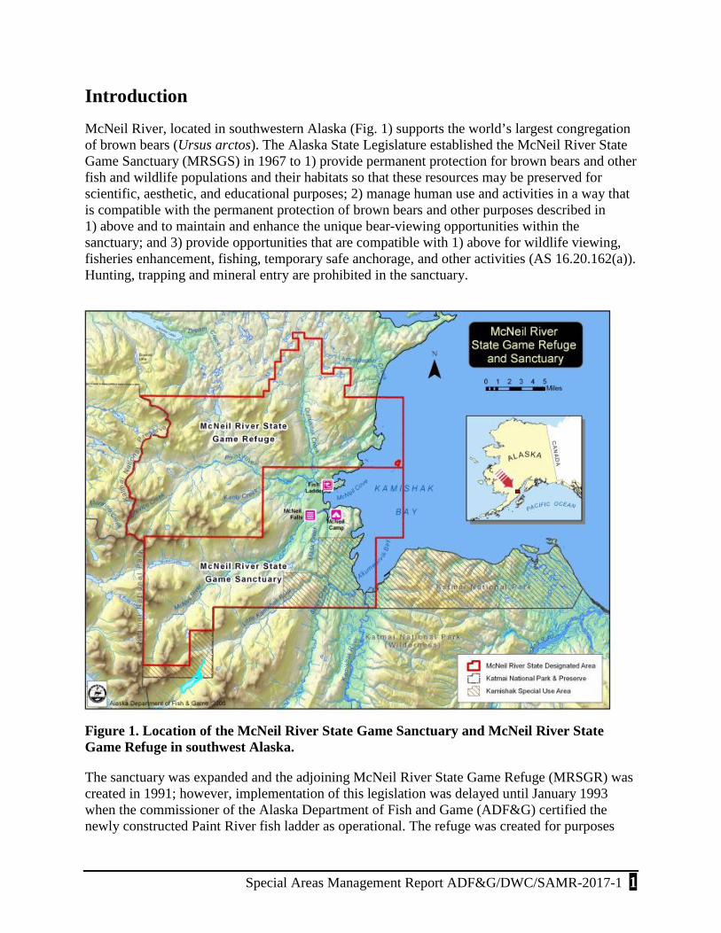
Introduction McNeil River, located in southwestern Alaska (Fig. 1) supports the world’s largest congregation of brown bears (Ursus arctos). The Alaska State Legislature established the McNeil River State Game Sanctuary (MRSGS) in 1967 to 1) provide permanent protection for brown bears and other fish and wildlife populations and their habitats so that these resources may be preserved for scientific, aesthetic, and educational purposes; 2) manage human use and activities in a way that is compatible with the permanent protection of brown bears and other purposes described in 1) above and to maintain and enhance the unique bear-viewing opportunities within the sanctuary; and 3) provide opportunities that are compatible with 1) above for wildlife viewing, fisheries enhancement, fishing, temporary safe anchorage, and other activities (AS 16.20.162(a)). Hunting, trapping and mineral entry are prohibited in the sanctuary.
Figure 1. Location of the McNeil River State Game Sanctuary and McNeil River State Game Refuge in southwest Alaska.
The sanctuary was expanded and the adjoining McNeil River State Game Refuge (MRSGR) was created in 1991; however, implementation of this legislation was delayed until January 1993 when the commissioner of the Alaska Department of Fish and Game (ADF&G) certified the newly constructed Paint River fish ladder as operational. The refuge was created for purposes

2 Special Areas Management Report ADF&G/DWC/SAMR-2017-1
similar to those of the sanctuary; however, hunting and trapping are allowed to continue in the refuge at the discretion of the Alaska Board of Game (AS 16.20.041). Additionally, human use in the refuge is managed to maintain and enhance the unique bear-viewing opportunities within the adjoining sanctuary. Mineral entry in the refuge is permitted.
This report provides a summary of the status of brown bears and other fish and wildlife resources within the sanctuary and refuge, the effects of hunting, fishing, trapping, fishery enhancement activities and resource development on these resources; and public use and management issues. A condensed version of this report is submitted annually to the Alaska State Legislature by the commissioner of the department as required by the sanctuary and refuge enabling legislation (AS 16.20.041(f) and AS 16.20.162(f), respectively).
Wildlife
BROWN BEAR MONITORING PROGRAM
MRSGS and MRSGR encompass approximately 388 mi2. The department does not conduct bear surveys or have bear use data on the entirety of the sanctuary or refuge. The majority of the brown bear monitoring and use data is connected with the bear-viewing program centered at McNeil River falls, lower McNeil River, and Mikfik Creek area. Some additional information is provided through self-reporting by commercial sport fish and bear-viewing guide services that operate within MRSGS and MRSGR. Monitoring and reporting statistics and subsequent management decisions are based on the data gathered as part of the McNeil River bear-viewing program at McNeil River falls-Mikfik Creek area.
The number of bears at McNeil River falls fluctuates daily and annually. Variability in bear use may be influenced by several factors including food availability, the strength and timing of salmon runs in McNeil River and surrounding river systems, changes in the regional bear population, as well as hunting and other human-caused mortalities. A public advisory committee assisted the department with the development of the sanctuary and refuge operational management plans in 1993. It was concluded that managers needed a consistent and reliable method for monitoring the fluctuations in the number of bears at McNeil River falls. This information allows for the proper management of the sanctuary in accordance with its legislative purposes. The department uses 3 different methods to monitor bear use at MRSGS: index counts (the average of the 7 highest hourly counts each season at McNeil River falls), individual counts (the minimum number of individual bears observed during the season), and bear use days (the sum of the number of days each individual bear was present).
Index Counts
The index count monitoring program involves counting all bears in view once each hour during the viewing day to develop an index of bear viewing quality. Historically these index counts were only done from the viewing pad at McNeil River falls each hour 15 July through 5 August. Since 2011, staff have implemented these hourly counts throughout the bear viewing day at all locations for the entire season in order to gather additional data on bear use and the quality of the bear viewing at locations in addition to the McNeil River falls viewing pad. For consistency with historical data these expanded data have thus far only been analyzed for the period 15 July–

Special Areas Management Report ADF&G/DWC/SAMR-2017-1 3
5 August. However, in future years these data can be looked at to gauge the quality of viewing during the June and August periods as well as the July periods at the falls. The number of hourly counts that occur from year to year is variable due to the changing and opportunistic nature of the daily bear-viewing schedule. In order to obtain the index, only counts between 11:00 a.m. and 8:00 p.m. are used in the analyses and cubs are excluded from the overall count numbers. (While viewing cubs actually enhances the bear-viewing experience, cubs are more prone to mortality and may not return in future years; therefore, they are not included in the index averages until they mature). The average of the 7 highest hourly counts for the season is then calculated for the index.
During 2014–2015 a review of the historic data, along with this newer data, revealed several facts that affect the index counts traditionally gathered at the falls viewing pad. For one, variations in the fish runs, as well as high water events, affect the number of bears present at the falls. Thus the 7 highest hourly counts do not always fall during the 15 July–5 August period; which can skew data towards a lower number in some years, if only considering the 15 July–5 August period. Additionally, the practice of not including cubs in these index counts and the range of viewing hours used was not consistently applied over the years. And finally, the Shewhart-CUSUM control monitoring scheme used to assess if the index number is within normal variation has not accounted for yearly variations in bear numbers.
In order to address these issues, ADF&G staff reviewed the historic data and the Shewhart-CUSUM control monitoring scheme and determined that changes were needed to account for these issues. Consequently data for 1993–2015 were reanalyzed to apply the following rules consistently from year to year and develop a more accurate model assessment of the index:
1. Hourly counts between 11:00 and 20:00 from McNeil River pad during 1 July–5 August (15 July during 1993–2004; 1 July during 2005–2015).
2. Cubs not included in analysis.
3. Seven highest hourly counts averaged for index.
4. The Shewhart-CUSUM analysis incorporates a cumulative mean value of the 7 highest counts and uses an error of 2 standard deviations as the lower limit that would indicate a potential issue with viewing at McNeil River falls.
Data presented in Table 1 and Figure 2 represent data revised after having consistently applied these rules across all years.
In 2016 the overall average of the 7 highest hourly counts (29 bears); was below the long-term average of 40.8 bears. As were all 7 of the highest hourly counts used to compute the average. As noted above, historically these highest counts are derived from data collected between 15 July and 5 August, however, during 2016 all 7 of the highest counts used in computing the index occurred outside this typical window (1, 2, 7, 8, 9, 11, and 13 July). Bear index count numbers during 2016 continued a downward trend from the higher numbers experienced in 2010 and 2011, but were still above the lower numbers seen in the previous decade. The 2016 average of 29 bears was lower than the annual averages for the past 5 years (2011–2015), however, these

4 Special Areas M
anagement R
eport AD
F&G
/DW
C/SA
MR
-2017-1
Table 1. Historic hourly index counts of brown bears at McNeil River falls, McNeil River State Game Sanctuary, Alaska, 1993–2016. (Underlined bold numbers = 7 highest hourly counts for the season.)
Date 1993 1994 1995 1996 1997 1998 1999 2000 2001 2002 2003 2004 2005 2006 2007 2008 2009 2010 2011 2012 2013 2014 2015 2016 MEANJul-01 1 13 7 18 14 38 19 27 17.13Jul-02 13 14 14 18 17 35 18 27 19.50Jul-03 3 16 16 17 20 18 30 15 24 17.67Jul-04 16 3 15 26 13 20 30 44 18 26 21.10Jul-05 20 12 4 9 15 27 14 18 28 37 17 18 18.25Jul-06 20 12 4 8 19 19 10 27 28 31 24 18.36Jul-07 22 18 16 21 27 12 13 26 33 24 29 21.91Jul-08 21 14 4 10 25 24 25 35 47 38 29 24.73Jul-09 25 15 14 26 27 41 34 48 33 33 29.60Jul-10 23 21 11 14 33 17 31 45 36 7 47 25 25.83Jul-11 15 28 18 11 17 28 27 30 37 45 7 33 30 25.08Jul-12 10 24 19 17 24 32 33 33 0 49 16 30 24 23.92Jul-13 20 28 26 20 22 25 30 40 36 50 28 28 30 29.46Jul-14 20 21 34 21 18 27 42 42 40 48 32 31 21 30.54Jul-15 34 30 41 25 34 25 30 36 19 19 31 29 25 41 54 50 48 57 40 31 23 34.38Jul-16 35 26 39 25 31 39 26 27 24 19 31 35 32 34 64 54 50 39 36 23 20 33.76Jul-17 24 40 41 32 30 40 28 32 20 21 31 32 28 35 53 42 63 44 29 31 22 34.19Jul-18 34 30 29 35 33 42 23 29 40 31 31 21 19 30 37 37 34 54 64 66 51 23 30 15 34.92Jul-19 49 44 33 49 49 52 31 33 35 31 31 25 20 33 29 38 39 70 75 62 50 25 24 14 39.21Jul-20 46 33 40 37 41 27 34 20 37 26 29 22 22 37 42 42 40 54 62 43 40 21 36 15 35.25Jul-21 38 39 28 44 40 8 32 25 39 36 21 19 11 21 40 40 21 70 65 35 42 19 32 12 32.38Jul-22 45 24 37 42 34 17 35 34 32 21 26 18 16 24 34 42 10 54 60 24 41 12 25 13 30.00Jul-23 42 40 28 43 46 28 38 33 30 33 23 15 16 31 30 41 14 50 47 32 36 11 17 8 30.50Jul-24 29 46 30 28 37 36 29 33 42 30 16 18 12 26 21 40 25 32 37 21 45 9 14 5 27.54Jul-25 18 18 38 38 40 44 26 33 33 28 18 11 2 27 29 51 40 21 39 26 35 7 14 4 26.67Jul-26 28 30 30 29 41 57 32 32 24 24 16 7 6 25 36 49 21 41 38 31 33 9 7 3 27.04Jul-27 33 38 34 32 41 48 28 23 29 20 20 6 5 31 33 34 30 62 26 20 24 8 8 4 26.54Jul-28 23 32 25 30 22 46 32 20 23 26 12 10 6 27 33 35 32 49 43 26 15 9 8 3 24.46Jul-29 25 31 11 17 25 44 36 21 20 30 14 9 6 25 29 42 33 44 45 25 11 12 7 4 23.58Jul-30 21 24 24 26 22 35 37 25 15 23 14 8 8 20 17 33 29 35 38 18 10 7 8 3 20.83Jul-31 18 19 27 22 11 30 38 16 11 25 11 10 7 20 22 35 18 31 24 19 7 7 12 3 18.46
Aug-01 13 15 22 22 17 30 36 12 7 21 9 8 12 15 30 14 23 22 14 3 4 8 3 15.65Aug-02 7 14 15 18 20 26 29 17 5 19 11 9 11 13 18 10 28 11 10 3 5 2 13.68Aug-03 18 16 21 24 22 3 15 5 8 10 16 19 8 19 7 9 5 3 6 3 11.85Aug-04 11 11 8 15 11 3 9 4 10 14 19 - 12 5 10 3 4 2 8.88Aug-05 10 14 18 4 4 8 6 5 6 7 18 9 19 9 11 1 9.31
Mean of 7 Daily Highs 41.00 38.86 34.57 41.14 42.57 47.57 36.29 33.14 38.86 31.57 30.29 21.71 24.57 32.57 36.71 43.86 37.57 61.14 61.43 53.86 50.00 41.43 35.71 29.29 39.40

Special Areas M
anagement R
eport AD
F&G
/DW
C/SA
MR
-2017-1 5
Figure 2. Historic hourly index counts (annual mean of 7 highest daily counts) of brown bears at McNeil River falls, McNeil River State Game Sanctuary, Alaska, 1983–2016 (α = 0.01).

6 Special Areas Management Report ADF&G/DWC/SAMR-2017-1
prior years were some of the higher averages recorded since 1998. Daily high index counts between 1993 and 2016 are presented in Table 1.
Individual Counts
A second method of monitoring bear use and the quality of the bear-viewing program at MRSGS is by tallying the number of individually identifiable bears (adults, subadults, and cubs) observed by sanctuary staff daily and throughout the season (Fig. 3 and Table 2). Using unique identifying characteristics such as sex, age, size and shape, maternal status, claw color, scars, coat color, and behavior, a record of individually identifiable bears visiting the sanctuary has been documented every year since 1976. Only individual bears that are known or recorded a minimum of 3 times are included in this count. Hence, this method provides an intrinsically conservative estimate. This monitoring method records the presence of an individual bear within MRSGS, if observed during viewing, on a daily basis. While it does not provide the true count of all bears present at MRSGS, it does provide an additional index in evaluating the overall bear use and the quality of the bear-viewing program.
There were 88 individual bears identified at MRSGS during the 2016 season. This is about 7% lower than the long-term (1976–2016) average of 94 bears. Since 1976 the lowest count was 58 (1976) and the highest count was 144 (1997).
Bear Use Days
The quality of the bear viewing experience is not just a matter of the number of bears that visit the area in a season, but also the number viewed on a daily basis and how many days the bears stay in the sanctuary. By summing the individual adult and subadult bears observed daily throughout the season an index of the number of bear use days is calculated. While these counts include bears within all viewing areas within MRSGS, only data from McNeil River falls, 15 June–25 August, is used for the index and historical comparison (Fig. 3). One bear or family group at McNeil River falls seen during a day is counted as 1 bear use day. This monitoring method may be less reliable than the index counts discussed above due to variability of bear identification among sanctuary staff and the variable timing of the counts. However, it can be used to further the interpretation of these other monitoring methods and it generally follows the same trends as the other methods. Bear use days are useful because they track how many days per season individual bears use the sanctuary. These data have been recorded since 1980, but no data were recorded in 1999, 2000, or 2001.
There were 896 bear use days at McNeil River falls in 2016, which is below both the long-term average (1980–2016) of 1,198 and the recent 10-year average of 1,111. The lowest count was 709 bear use days in 1980 (first year these data were collected) and the highest count was 1,863 in 1989.
Sex and Age Composition
Changes in the sex and age composition of a wildlife population can be indicative of other changes in the species’ habitat and environment. While males have typically outnumbered females at McNeil River, this difference has become more pronounced over the last 30 years.

Special Areas Management Report ADF&G/DWC/SAMR-2017-1 7
The percentage of male bears observed throughout the season has steadily increased while the number of females has slightly declined. Following a general increase in both sexes through the late 1990s; there was a general decrease in all bears after 2000. This decrease was more pronounced in the females. And in the years since 2005, while numbers of male bears have increased the overall numbers of females has remained fairly flat. This is due in part to an overall decline in maternal females which is offset by an increase in single adult females. There were 7 maternal females with a total of 15 cubs observed within the viewing areas during 2016. The historic sex and age composition of bears using the McNeil River-Mikfik Creek viewing areas during the viewing season are presented in Figure 3 and Table 2.
Bear Photo Identification Project
Sanctuary staff continued the task of photo documenting identifiable bears observed at McNeil. Digital images of individual bears and their defining characteristics were collected using a Canon EOS 7D Mark II SLR camera with a Canon 100–400 mm zoom and an EF24-105 mm lens. This photo identification project was initiated in 2007 and is intended to be a long-term project that will assist McNeil staff in the following ways: expedite and enhance the process of bear identification; improve communication among staff members; enhance the process of tabulating the number of individual bears; enhance the process of tracking the history of individual bears; assist in sharing information and tracking the movements of individuals; assist in the identification of male and female characteristics; and provide basic life history information.
Other Areas
The department currently does not conduct bear surveys or monitoring in other areas of MRSGS or MRSGR. Some information is available through opportunistic surveys, fisheries escapement videos, and commercial guide reporting from the Mikfik Lake, Paint River, Chenik Creek-Lagoon, and from the Kamishak-Little Kamishak-Strike Creek areas. Mikfik Lake observations are detailed below under Other Wildlife-General Observations; and Paint River observations are noted in the Fisheries Enhancement-Paint River Fish Ladder section below.
Kamishak River Drainage
The lower stretches of the Kamishak River, Little Kamishak River, and Strike Creek are within MRSGS. Bears fish these waters, graze in the Kamishak sedge flats, and dig clams in the Kamishak River mud flats. The department does not conduct bear surveys in these drainages. However, commercial sport fishing guide services operate in the area from approximately early July to early October and brown bears are typically observed on a daily basis. Based on reporting by 5 of the 7 guide services operating in 2016; there was a mean of 5 bears seen per day in the Kamishak-Little Kamishak-Strike Creek areas from 7 July to 1 October 2016.

8 Special Areas M
anagement R
eport AD
F&G
/DW
C/SA
MR
-2017-1
Figure 3. Annual brown bear numbers, bear use days, and index counts compared to bear composition, McNeil River State Game Sanctuary, Alaska, 1976–2016.

Special Areas M
anagement R
eport AD
F&G
/DW
C/SA
MR
-2017-1 9
Table 2. Composition of brown bears observed at McNeil River State Game Sanctuary, Alaska, 1976–2016.

10 Special Areas Management Report ADF&G/DWC/SAMR-2017-1
Chenik Creek
The department does not conduct bear surveys in the Chenik Creek area; however, a local Homer guide conducted bear viewing tours in the lower Chenik Creek-Chenik Lagoon area in 2016. He observed up to 10 individual bears 2–9 July 2016 with the following composition (including cubs): 1 maternal female with 2 yearlings, 2 subadult, 4 adult females, and 1 adult male. A commercial filming operation filming at Chenik Creek 4–12 July reported similar numbers and composition with the addition of a second maternal female with 2 cubs.
OTHER WILDLIFE
General Observations
During the 2016 season sanctuary staff recorded general wildlife observations, including birds, terrestrial mammals, and marine mammals opportunistically. Daily observations are summarized in the Appendix.
There were many bird sightings and identifications over the course of the 2016 season. Some were species that are regularly seen in MRSGS, including Wilson’s snipe, golden-crowned sparrow, savannah sparrow, bank swallow, Wilson’s warbler, yellow warbler, American widgeon, American robin, hermit thrush, Swainson’s thrush, gray-cheeked thrush, tree swallow, common redpoll, glaucous-winged gull, mew gull, brant, green-winged teal, mallard, northern shoveler, common raven, red-breasted merganser, greater yellowlegs, northern pintail, black-billed magpie, northern harrier, bald eagle, semi-palmated plover, harlequin duck, and Caspian tern. Less frequently seen birds were also observed, including, northern shrike, Bonaparte’s gull, trumpeter swan, tundra swan, belted kingfisher, double-crested cormorant, spotted sandpiper, western sandpiper, peregrine falcon, merlin, red-throated loon, whimbrel, and short-eared owl. Willow ptarmigan were again observed on the McNeil River trail, and gray-crowned rosy-finches, wandering tattlers, and a varied thrush were observed at the base of McNeil Head along the coast.
Marine mammal sightings during the 2016 season included the usual Pacific Harbor seals which are generally seen at high tide throughout the season in McNeil River lagoon, McNeil Cove, and the lower tidal areas of McNeil River and Mikfik Creek.
Other terrestrial wildlife observed this season included the following. Several gray wolves (Canis lupus) were observed in the Mikfik Creek drainage and around the spit in front of camp. Wolf tracks were often observed around the edge of the lagoon, along the Mikfik trail (at the base of the east bluff) and along the McNeil River trail. Also, several arctic ground squirrels (Spermophilus parryii), masked shrew (Sorex cinereus), and red fox (Vulpes vulpes) were observed in and around camp. As usual, numerous wood frogs (Rana sylvatica) were observed throughout the Mikfik and McNeil River viewing areas. Less common sightings of porcupine (Erethizon dorsatum), moose (Alces alces), and of a wolverine (Gulo gulo) were observed this summer as well.
In collaboration with the Threatened, Endangered, and Diversity Program of ADF&G-Division of Wildlife Conservation (DWC), MRSGS staff set up and monitored a Wildlife Acoustic,

Special Areas Management Report ADF&G/DWC/SAMR-2017-1 11
Songmeter Zero-crossing bat detector during the 2016 season. The detector records ultrasound frequencies to detect the presence of bats in the area. The detector was mounted on the west side of the cache facing the open area behind camp and was operational from 27 May through 29 August. The first bat detection was on 6 June and bat activity continued through the entire field season. The density of bat passes during this time was low. There were 60 evenings that the recorder was running but did not detect any activity. Twenty-nine evenings had less than 10 bat passes and 3 evenings had 10 or more detections. The highest activity level was 40 detections on the final night of the field season, 29 August. This, coincidentally, was also the night that several bats were visibly observed flying through camp. The month of June had 5 detections, July had 23 detections, and August had 94 detections.
When staff arrived in late May they noticed a number of dead murres along the area beaches. The murre carcasses were already in a decomposed state and were largely skeletal remains with some skin, feathers and connective tissue, but no meat, and in some cases were skulls without attendant carcasses. In attempt to provide some information on numbers involved, staff collected and recorded carcasses found during various beach walks throughout the summer. These walks were primarily short sections of the beach or lagoon right around the McNeil camp. A number of the carcasses were collected each time to avoid recounts during subsequent surveys; but there were often hundreds not collected or for which numbers were broadly estimated. In all, approximately 162 murre carcasses were collected during the course of the summer. Information collected was forwarded to the U.S. Fish and Wildlife Service to incorporate with other observations of sea bird die offs occurring in lower Cook Inlet and the Gulf of Alaska.
ADF&G-Division of Commercial Fisheries (CF) staff recorded 2,062 hours of video connected with the video monitoring of sockeye salmon escapement into Mikfik Lake. In addition to the escapement data, reviewers documented wildlife transiting the cameras view including moose, eagles, beavers (Castor canadensis), red fox, wolves, various waterfowl, and river otters (Lontra canadensis). Brown bears transited the field of view of the camera in 88 instances, an average of 1 bear per day of video operation (n = 87 d). Nearly all sightings were of individual bears, but a few sightings were of females with 1 or 2 cubs. Wolves, 2 pairs and 2 singles, were observed on 4 occasions.
HUNTING AND TRAPPING
MRSGS is closed to hunting and trapping by Alaska state statute (AS 16.20.162(b)), and MRSGR, while open to hunting and trapping of other species, has been closed to brown bear hunting by the Alaska Board of Game since July 1996. The approximately 388 mi2 that comprise MRSGS and MRSGR are part of a much larger area of approximately 5,585 mi2 in which brown bears are protected from hunting. The larger area includes Katmai National Park lands and state-owned lands south of the sanctuary (including the Kamishak Special Use Area, managed by the Alaska Department of Natural Resources) that are closed to brown bear hunting; the national park by federal regulations, and the state-owned lands by Board of Game action.
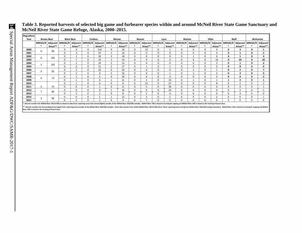
Reported harvest data from units within and surrounding the MRSGS-SGR complex for the period 2000–2015 are summarized in Table 3. Data for regulatory year (RY) 2016 (a regulatory year begins 1 July and ends 30 June, e.g., RY16 = 1 July 2016–30 June 2017) are still being gathered.

12 Special Areas Management Report ADF&G/DWC/SAMR-2017-1
Brown Bear
Brown bear hunting, as well as hunting and trapping for others species are open on lands within harvest units north and west of MRSGS and MRSGR. During alternating regulatory years brown bear hunts are open during the fall of odd-numbered years and the spring of even-numbered years. Historic levels of reported bear harvests from areas surrounding MRSGS and MRSGR are presented in Figure 4 and Table 3. The area represented includes about 2,100 mi2 currently open to hunting.
The long-term average harvest from areas surrounding MRSGS (outside the sanctuary and refuge) from RY80 through RY10 is 78 brown bears every 2 years (about 39 bears annually). Average 2-year harvest by decade was 62 in the 1980s, 77 in the 1990s, and 94 in the 2000s. For RY14–RY15, the most recent data available, the harvest in areas surrounding MRSGS and MRSGR was 93 bears.
Many brown bears have large home ranges, which include MRSGS, MRSGR, Katmai National Park, as well as other lands open to hunting north and west of the sanctuary and refuge. Data from early studies and staff observations show that some bears using MRSGS and MRSGR are subject to harvest outside the sanctuary and refuge. The effects of these harvests on bear use at McNeil River are unknown; however, at this time these harvests do not appear to affect the number of bears using the McNeil River. And based on the available information, legal hunting of bears outside the sanctuary is not a significant factor affecting the regional bear population.
Other Species
As noted above, the MRSGR portion of the MRSGS-MRSGR complex is open for the legal harvest of species, other than brown bear, through hunting or trapping. Other furbearing or big game species that may be in the area include black bear (Ursus americanus), caribou (Rangifer tarandus), moose, beaver, lynx (Lynx canadensis), marten (Martes americana), otter, wolf, wolverine, coyote (Canis latrans), red fox, mink (Neovison vison), weasel (Mustela nivalis), muskrat (Ondatra zibethicus), ground squirrel, and marmot (Marmota caligata). However, ADF&G only maintains harvest records on the first 9 of these.
Harvest reporting and sealing records indicate that hunting and trapping for species other than perhaps moose in MRSGR is almost nonexistent. A few moose are taken from the reporting unit that contains MRSGR; however, this unit also includes lands outside of the refuge.

Special Areas M
anagement R
eport AD
F&G
/DW
C/SA
MR
-2017-1 13
Figure 4. Brown bear harvest from areas surrounding the McNeil River State Game Sanctuary and McNeil River State Game Refuge, Alaska, 1980–2015 (harvest from Game Management Units/Uniform Coding Units: 9A/201, 301, 401, 501; 9B/301; and 9C/101, 201, 301, 601, 702, and 703). Even and odd regulatory years (regulatory year begins 1 July and end 30 June, e.g., regulatory year 1980 = 1 July 1980–30 June 1981) are lumped.
14 Special Areas M
anagement R
eport AD
F&G
/DW
C/SA
MR
-2017-1
Table 3. Reported harvests of selected big game and furbearer species within and around McNeil River State Game Sanctuary and McNeil River State Game Refuge, Alaska, 2000–2015.
Regualtory Year
MRSGS/R*
Adjacent Areas**
MRSGS/R*
Adjacent Areas**
MRSGS/R*
Adjacent Areas**
MRSGS/R*
Adjacent Areas**
MRSGS/R*
Adjacent Areas**
MRSGS/R*
Adjacent Areas**
MRSGS/R*
Adjacent Areas**
MRSGS/R*
Adjacent Areas**
MRSGS/R*
Adjacent Areas**
MRSGS/R*
Adjacent Areas**
2000 0 0 0 114 0 16 0 12 0 1 0 0 0 0 0 3 0 12001 0 3 0 97 1 19 0 0 0 0 0 0 0 0 0 1 0 22002 0 1 0 39 3 18 0 0 0 0 0 1 0 0 0 1 0 42003 0 7 0 53 1 14 0 9 0 3 0 6 0 10 0 10 0 202004 0 1 0 33 2 15 0 0 0 0 0 0 0 2 0 1 0 22005 0 6 0 51 2 17 0 1 0 1 0 0 0 0 0 8 0 02006 0 2 0 25 0 10 0 0 0 4 0 2 0 1 0 2 0 72007 0 2 0 0 2 16 0 0 0 1 0 1 0 3 0 3 0 42008 0 1 0 5 0 18 0 4 0 3 0 0 0 0 0 4 0 22009 0 1 0 6 1 11 0 2 0 13 0 1 0 1 1 2 0 12010 0 1 0 0 0 6 0 13 0 27 0 0 0 8 0 2 0 22011 0 0 0 1 0 11 0 5 0 38 0 0 0 0 0 4 0 12012 0 0 0 0 1 10 0 0 0 33 0 0 0 0 0 5 0 52013 0 2 0 1 0 8 0 2 0 4 0 0 0 0 0 3 0 02014 0 0 0 1 1 13 0 3 0 1 0 0 0 2 0 0 0 12015 0 3 0 1 0 4 0 7 0 0 0 0 0 0 3 0 0 0
5
7 66
* Harvest numbers for McNeil River SGS & SGR are based on data from reporting areas that extend slightly outside of the McNeil River SGS/SGR complex. McNeil River SGS is closed to hunting & trapping and McNeil River SGR is closed to the hunting of brown bear.
** Harvest numbers for Surrounding Areas largely from reporting areas outside of the McNeil River SGS/SGR complex. Some data may be from within McNeil River SGS & SGR where these reporting areas overlap the McNeil River SGS/SGR complex boundary. McNeil River SGS is closed to hunting & trapping and McNeil River SGR is closed to the hunting of brown bear.
75
3 90
Caribou MooseBrown Bear
6
WolverineBeaver Lynx Marten Otter Wolf
98
6
3
4
4
Black Bear
73
93
102
105

Special Areas Management Report ADF&G/DWC/SAMR-2017-1 15
Fisheries MRSGS and MRSGR contain several rivers and streams that support both anadromous and resident fish populations. The Kamishak River drainages support all 5 species of Pacific salmon as well as Dolly Varden trout. The McNeil River drainage contains Dolly Varden trout (Salvelinus malma), chum salmon (Onchorynchus keta), some coho salmon (O. kisutch), pink salmon, and small numbers of Chinook salmon (O. tshawytscha). The Mikfik Creek-Lake drainage contains sockeye salmon (O. nerka), Dolly Varden trout, and rainbow trout (O. mykiss). Chenik Creek-Lake system supports sockeye salmon, some coho salmon, lake trout (S. namaycush) and Dolly Varden trout. The Paint River system contains rainbow trout, Arctic grayling (Thymallus arcticus), and lake trout and has the potential for supporting a number of anadromous salmon species through fisheries enhancement. These fish resources contribute to annual sport fishing and commercial fishing effort and harvests within the lower Kamishak district.
COMMERCIAL FISHERIES
Periodic aerial surveys are flown to index the escapement of chum salmon to McNeil River and remote video is used to monitor the escapement of sockeye salmon into Mikfik Lake. In 2016, generally favorable stream conditions allowed for 4 effective aerial surveys of McNeil River and the video system at Mikfik Lake operated successfully all season. There was no commercial fishing effort targeting the Mikfik return and the McNeil River subdistrict was closed for the duration of the chum salmon run. Consequently, the entire Mikfik sockeye and McNeil chum salmon runs entered their respective freshwater drainages this season.
McNeil River Drainage
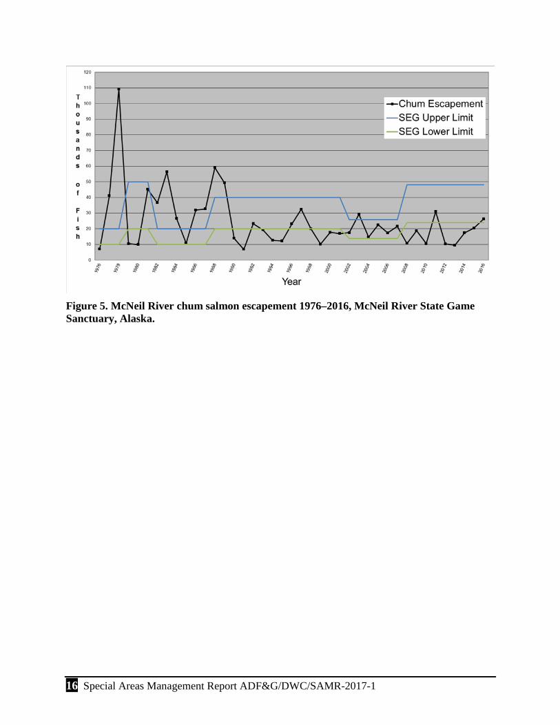
The 2016 McNeil River chum salmon aerial survey escapement index was estimated at 26,262 fish (Table 4, Fig. 5). Chum salmon were consistently seen in low-to-moderate numbers above the falls during aerial observations from 27 June through the last survey on 3 August. A peak daily aerial estimate of 10,170 chum salmon occurred on 8 July, of which 1,670 were upstream of McNeil River falls. The McNeil River subdistrict was closed and no commercial fishing for chum salmon occurred there in 2016. By comparison chum runs to some other Kamishak Bay district systems in 2016 were modest. This combined with poor pink salmon runs in other districts and areas resulted in fishing effort above that seen in many recent years and a district-wide commercial harvest of just under 11,000 chums in the Kamishak district. The 2016 run timing of McNeil River chum salmon was earlier than the historical average. Brown bears were fishing at McNeil River falls by 21 June, and staff were regularly guiding visitors to the falls and viewing 6–8 bears fishing there by 23 June.
16 Special Areas Management Report ADF&G/DWC/SAMR-2017-1
Figure 5. McNeil River chum salmon escapement 1976–2016, McNeil River State Game Sanctuary, Alaska.

Special Areas Management Report ADF&G/DWC/SAMR-2017-1 17
Table 4. Escapement estimates of salmon into Mikfik Lake and McNeil River, McNeil River State Game Sanctuary, Alaska, 2016.
Date Mikfik sockeyes cumulative total McNeil chums (daily)a
6/1/2016 0 6/8/2016 1,400
6/15/2016 4,943 6/22/2016 5,411 6/27/2016 3,830 6/29/2016 7,764 7/6/2016 9,147 7/8/2016 10,170
7/13/2016 9,431 7/14/2016 8,060 7/20/2016 9,533 7/27/2016 9,900 8/3/2016 10,180 4,861
8/10/2016 10,180 8/17/2016 10,180
Escapement index 10,180b 26,262c a Daily estimate from individual aerial surveys and considered to be conservative. b The escapement index for Mikfik sockeyes is the cumulative total from the remote video system at Mikfik Lake; data above reflects cumulative totals as of dates noted. c Escapement index for McNeil chums derived by dividing the area under the escapement curve by a 13.8-day stream life factor and then applying a run-timing expansion factor to account for fish entering the system after aerial surveys were terminated.
Mikfik Creek-Lake System
A video camera attached to a digital video recorder, used to document sockeye salmon escapement into Mikfik Lake, showed a cumulative total of 10,180 fish escaping into the lake. Significant predation by bears occurs in Mikfik Creek, so only those fish documented reaching the lake are considered escapement. The video estimate of 10,180 fish was used as the final escapement estimate. This value is within the sustainable escapement goal (SEG) range of 3,400–13,000. Post-season evaluation indicated that run timing of sockeye salmon into Mikfik Lake was fairly typical, with 75% of the escapement reaching the lake by 1 July.
The McNeil River subdistrict was open to commercial fishing for Mikfik Creek sockeye salmon from 1 June to 20 June. However, no fishing effort occurred in the McNeil River subdistrict in 2016.
Chenik Creek-Lake System
Chenik Lake, located approximately 5.5 miles north of McNeil Lagoon, is the site of another sockeye salmon stock. The stream mouth of Chenik Creek, which drains the lake, was partially

18 Special Areas Management Report ADF&G/DWC/SAMR-2017-1
blocked as a result of the 1964 earthquake. A Cook Inlet Aquaculture Association (CIAA) fishery enhancement project modified the stream mouth in 1981–1982 and again in 1986 in an effort to allow easier fish access to the creek. Hatchery-raised sockeye salmon fry were stocked into Chenik Lake annually between 1986 and 1996 (except for 1994), and the lake was also fertilized in an effort to increase sockeye numbers. Unfortunately, due to an outbreak of infectious hematopoietic necrosis virus, the return of adult sockeyes to the system dropped to very low levels between 1994 and 2002, but more recent returns resulting exclusively from natural production rebounded considerably. In fact, commercial fishing effort directed at this stock was allowed each year from 2004 through 2016, with resulting annual commercial harvests ranging from no harvest (2015) to over 171,000 fish (2008). Additionally, the established sockeye salmon SEG for Chenik Lake of 3,500–14,000 sockeye salmon has been met or exceeded each year beginning in 2003, with the 2016 escapement cumulatively estimated by remote video as 19,510 sockeye salmon. A total of 8,779 sockeye salmon were commercially harvested from the Chenik subdistrict in 2016.
SPORT FISHING
A limited amount of sport fishing occurs within MRSGS and MRSGR. This occurs primarily in the Kamishak River area (Table 5). There is also a small amount of effort in the McNeil Lagoon area associated with the bear viewing program.
McNeil Lagoon
Sporadic sport fishing occurs in McNeil Lagoon (from the end of the spit) associated with staff and visitors in camp for recreational activities. Fishing effort was low in 2016. Eighteen fish were harvested by visitors or ADF&G staff during the 2016 summer season.
Kamishak River
The only area in the sanctuary that attracts significant sport fishing interest is the Kamishak River area including the Little Kamishak River and its tributary, Strike Creek. The target species are coho, chum, and pink salmon, and Dolly Varden. Fishing activity at the Kamishak River and tributaries typically begins in mid-July and ends in mid-September. During the 2016 season, 5 of the 7 permitted lodges and transporters reported a total of 247 angler use days during 68 days within the sanctuary for sport fishing. Wildlife viewing, primarily brown bears, was also a significant part of their activities. These anglers reported catching 3,126 fish, of which 53% were Dolly Varden, 30% were coho salmon, and 14% were chum salmon. Nearly all Dolly Varden were released as were all pink and most chum salmon. Eighty-six percent of all fish caught were released.
Table 5. Visitor use and sport fish harvest reported from Kamishak River drainages, McNeil River State Game Sanctuary, Alaska, 2016.
# of Days in
sanctuary
# of Guide
use days
# of Angler
use days
# of Non-
angler days
COHO SALMON
CHUM SALMON PINK SALMON
DOLLY VARDEN Avg
bears/day Kept Released Kept Released Kept Released Kept Released
68 116 247 0 426 500 0 439 0 99 0 1,662 5

Special Areas Management Report ADF&G/DWC/SAMR-2017-1 19
FISHERIES ENHANCEMENT
Fisheries enhancement continues to play a major role in lower Cook Inlet salmon production and commercial harvests. The results of enhancement and rehabilitation of Kamishak Bay district sockeye stocks have, at times in the past, made significant contributions to commercial salmon harvests.
Paint River Fish Ladder
Paint River lakes were first stocked with sockeye salmon fry in 1986 in an effort to test the feasibility of developing a new sockeye salmon run to this salmon-barren drainage. Paint River, located approximately 2 miles north of McNeil River is blocked to upstream fish migration by a steep waterfall at tidewater. The Paint River fish ladder was envisioned to potentially provide access to unutilized salmon spawning and rearing habitat upstream of the falls. Construction of the Paint River fish ladder was completed in October 1991, and it was formally declared operational in 1993. From 1986 to 1996 (except for 1987), and also in 2002, between 0.5 million and 2.2 million sockeye salmon juveniles were stocked annually in the Paint River lakes. However, the number of returning adult sockeye salmon resulting from these stocking efforts were disappointing and only ranged from 30 (in 2000) to 2,000 (in 2005). At that time, the structure was never opened to allow fish passage upstream through the ladder. CIAA, responsible for building and operating the Paint River fish ladder, has been performing maintenance and repair improvements to the ladder since 2008. And in 2011 began opening the ladder each summer to allow for colonization by salmonids.
During 2014, CIAA obtained approximately 1.2 million pink salmon eggs from brood stock harvested in the Bruin Bay commercial fishery. After being reared and hatched over winter at Tutka Bay Lagoon Hatchery, CIAA released 1.02 million unfed pink salmon fry into ice free leads of Paint Lake during 4–5 April 2015. CIAA anticipated the return 1–2% of these fish to Paint River during July–August of the 2016 season.
In 2016, CIAA opened the Paint River fish ladder to water flow between 1 June and 26 September for potential salmon colonization and pink salmon returns. Additional visits on 27 June, 8 July, 18 July, and 2 September were made to install a new video fish enumeration system, assess water levels, conduct maintenance, conduct stop log adjustments, and download video data. The video fish enumeration system was installed and operational as of 8 July and ran uninterrupted until 26 July when it shut down due to low battery power. It was several weeks before the system could be reset and then footage was captured from 2 September to 5 September. The video system was pulled and the ladder shut down on 26 September.
No aerial surveys of Paint River were conducted by CIAA or ADF&G in 2016. Small numbers of unknown salmon, likely chum salmon, were observed in Akjemguiga Cove during approach or take off of float planes on the 27 June (n~10), 8 July (n = 500), and 18 July (n = 50) CIAA visits. Three chum salmon were observed passing through the ladder on 18 July and a total of 10 chum salmon were captured, via the video weir system, passing through the Paint River fish ladder between 7 July and 22 July. No fish were noted in the Cove or fish ladder on the other visits.

20 Special Areas Management Report ADF&G/DWC/SAMR-2017-1
Bear sign was observed at the site on 1 June and 2 September; and 2 young bears were observed on the shore of Akjemguiga Cove on 18 July. No bears were observed in the area of the fish ladder during the other visits. Observations of fish and bears in the vicinity of Paint River are summarized in Table 6.
Table 6. Paint River fish surveys, Alaska, 2016.
Survey date Fish count Observer and comments Bears
observed 6/27/16 6–10 CIAAa. Unidentified salmon in
Akjemguiga Cove 0
7/8/16 500 CIAA. Unidentified salmon in Akjemguiga Cove 0
7/18/16 50 CIAA. Unidentified salmon and 2 young bears in Akjemguiga Cove. Three chum in ladder.
2
9/2/16 0 CIAA. No salmon in ladder or Akjemguiga Cove 0
9/26/16 0 CIAA. No salmon in ladder or Akjemguiga Cove 0
a CIAA – Cook Inlet Aquaculture Association.
Public Use and Land Management To protect the bears, their habitat and the unique visitor experience, access to MRSGS is restricted requiring an access permit issued by ADF&G for entry into the sanctuary. Under regulations developed by ADF&G (5AAC 93.030) and those adopted by the Alaska Board of Game (5AAC 92.065) ADF&G-DWC uses the following types of permits to manage visitation to the sanctuary: viewing permits, special access permits, non-viewing permits, transporter permits, and commercial guide permits.
MRSGR is open to most public uses provided the activity does not damage refuge resources, disturb wildlife, or disrupt existing public uses. Allowed activities generally include legal hunting, trapping, fishing, wildlife watching, hiking, boating, snowmachining, and camping; except that MRSGR is closed to brown bear hunting. Other activities and land uses are managed through ADF&G special areas permit issued by the Division of Habitat. Land use permits are also issued by the Alaska Department of Natural Resources.
MCNEIL RIVER FALLS-MIKFIK CREEK
Public use and access to the sanctuary, with the exception of the McNeil Cove spit and beach, requires an access permit from the department (5 AAC 92.065). Since 1973, bear viewing at established sites on McNeil River and nearby Mikfik Creek has been limited to 10 people daily between 7 June and 25 August, and viewing access permits for this period are issued by lottery. Ten regular and 3 standby permits are issued for each of the established 4-day permit periods. Currently, 185 regular permits (guided viewing access permits) and 57 standby permits (camp-standby viewing access permits) are issued in the lottery. An additional 15 guided viewing

Special Areas Management Report ADF&G/DWC/SAMR-2017-1 21
permits are issued as special access permits at the commissioner’s discretion for scientific, educational, media and other purposes. The maximum number of people able to visit the sanctuary each season under the existing permit program is 257 people.
Guided viewing permits allow visitors to visit the sanctuary and the bear viewing sites in the sanctuary (McNeil River or Mikfik Creek) during a specified time period. A camp-standby viewing permit allows visitors to visit the sanctuary, view bears and wildlife in the vicinity of the campground and along a limited portion of the beach, and to go to the bear-viewing sites (McNeil River or Mikfik Creek) when there are vacancies in the guided group. Special access permits are available to individuals that have a special need to visit the sanctuary. These needs may include (but are not limited to) scientists, land managers, educators, public or artistic media representatives, film makers, or others acting in an official capacity and who would benefit professionally by visiting McNeil River. These permits are only issued to individuals whose work will benefit the McNeil River Sanctuary and/or the general efforts to conserve bears.
The lottery application fee is $25.00 per person. If selected in the lottery, each guided viewing permit holder is assessed a permit fee of $150.00 for Alaskan residents and $350.00 for non-Alaska residents. Camp-standby viewing permit holders are assessed a permit fee of $75.00 for each Alaskan resident and $175.00 for each non-Alaska resident. The special access permit application fee is $50.00 per person. If selected by the commissioner of ADF&G to receive a special access permit, there is a use fee of $150.00 for each Alaskan resident and $350.00 for each non-Alaska resident.
In 2016, ADF&G received 819 applications for McNeil River guided and standby bear viewing permits. Applications were received from 17 different countries and 52% of applicants were Alaska residents. Payments were received for 173 guided viewing access permits, 27 standby viewing access permits, and 9 special access viewing permits. There were 10 special access (science-education/commissioner) permits granted by the commissioner. Overall, 210 permits were issued and 175 permit holders (guided viewing, camp standby, and special access) visited the sanctuary (Table 7) in 2016. The 5-year annual visitation average (2012–2016) is 172. The average number of permits used each day (permittees that bear viewed) at the sanctuary in 2016 was 7.5 (out of a maximum of 10.0). There were 25 guided permit holder no shows, 8 standby permit holder no shows, and 2 special access permit holder no shows. The 175 participants in bear viewing during the 2016 season came from 9 countries, including Austria, Canada, Germany, Great Britain, Netherlands, New Zealand, Spain, Switzerland and the United States. Of the 175 bear viewing visitors to McNeil River in 2016, 55% were Alaska residents and 45% were nonresidents. Of the 210 people who purchased permits, the ratio was 60% resident to 40% nonresident.
There were a total of 929 visitor use days connected with the McNeil River bear viewing program, which included all permitted bear viewing visitors and administrative visitors. Permitted bear viewing visitors spent 902 days within the Sanctuary, logging 596 actual bear viewing days. On average there were 11.2 visitors at McNeil River camp on any day, slightly lower than both the 5-year and 10-year averages of 11.3. There was an average of 7.5 bear viewers per day, lower than the 5- and 10-year average of 7.8 and 7.7, respectively. Permitted visitors spent an average of 5.1 days each in the sanctuary and participated in the bear-viewing group an average of 3.4 days each.

22 Special Areas Management Report ADF&G/DWC/SAMR-2017-1
The 10 special access permits issued in 2016 included the following recipients: ADF&G Hunter Education, Kodiak National Wildlife Refuge Staff, Marco Polo Film Staff, Alaska Dispatch News reporter, Alaska Pacific University Staff and Student, AK Adventures, and a book author.
During 2016, 10 commercial transporter permits were issued to commercial operators for the purposes of transporting clients to the ADF&G McNeil River camp for bear viewing.
A total of $68,700.00 was generated from the 2016 McNeil River sanctuary permit program and deposited in the state’s Fish and Game Fund.
KAMISHAK RIVER
Lodges and air charter services conduct sport fishing and wildlife viewing trips in the Kamishak River drainages within MRSGS and adjacent Katmai National Park. This area is also part of the Kamishak Special Use Area, which is managed by the Department of Natural Resources. Businesses store riverboats on the lower reaches of the river and one of the businesses maintains a temporary guide camp on the lower Kamishak River; both activities require an ADF&G special area permit and an ADF&G commercial access permit. The primary management concern is the food-conditioning of Kamishak River bears, which also visit Mikfik Creek and McNeil River. Food-conditioning of bears would not be consistent with the purposes for which the sanctuary was established and would jeopardize the bear-viewing program at McNeil River.
Businesses operating in this area holding ADF&G special area and commercial access permits are required to report the number of guides, clients, fish harvested/released, as well as the number of bear observed on a data sheet titled “Annual Report for Guides, Transporters, and Lodges.”
During 2016, 7 commercial transporter permits were issued to commercial operators for the purposes of transporting clients to the Kamishak River area for sport fishing. These guide services spent 363 visitor use days in the sanctuary, which included 247 angler use days and 116 guide use days. These operators also held special area permits for the storage of boats and operations in the Kamishak River area. Their primary activity is sport fishing; however, they also engage in wildlife viewing activities, primarily viewing of brown bears.
CHENIK LAKE-CREEK AREA
The mouth of Chenik Creek is another area within MRSGS where low levels of bear viewing have occurred historically. Two commercial groups were permitted in the Chenik area in 2016. One commercial bear-viewing guide service from Homer obtained a special area permit for a temporary tent camp at Chenik Lake and brought clients to the Chenik Creek mouth area for bear viewing activities. He reported 8 guide use days and 14 visitor bear viewing (non-angler) use days. The second group involved a commercial filming company gathering footage on brown bears. They reported 9 days of use with 7 persons per day, for 63 user days. Private groups were also known to have visited the Chenik area in 2016. From the incidental observations available there were at least another 13 visitor use days from these private parties. In total there were 98 reported visitor use days at Chenik Creek.

Special Areas Management Report ADF&G/DWC/SAMR-2017-1 23
BEAR-HUMAN CONFLICTS
As detailed above there were 929 user days associated with ADF&G’s bear-viewing program at the McNeil River camp. An additional 461 user days were reported by area guides utilizing the Kamishak River and Chenik Creek areas of MRSGS and MRSGR. All 1,390 user days represent activities; primarily bear viewing and sport fishing, spent in close proximity to brown bears. Staff document adverse bear-human interactions associated with ADF&G’s bear-viewing program. Commercial sport fishing and bear viewing entities perform self-reporting to ADF&G on any adverse interactions. During the 2016 season, there were no reported adverse interactions between bears and people in MRSGS or MRSGR.
LAND USE PERMITTING
ADF&G-DWC is working on renewals of its ADF&G special area permit and Alaska Department of Natural Resources-Interagency Land Management Assignment for operation and maintenance of the McNeil River camp, trails, and bear-viewing operation. ADF&G-CF holds a special area permit for the installation and operation of a video fish escapement recorder and maintenance of the cabin at Chenik Lake. They also hold a special area permit for the installation and operation of a video fish escapement recorder at Mikfik Lake.
A total of 12 ADF&G special areas permits and 15 ADF&G commercial access permits were issued during 2016. These included the special areas and commercial access permits issued to the commercial operators in the McNeil River, Kamishak River, and Chenik Creek areas.
In addition, ADF&G issued special area permits or renewals of existing permits to the following: Alaska Volcano Observatory for maintenance of seismic monitoring station on a mountain north of Paint River within MRSGR, ADF&G-CF for escapement research recording equipment at McNeil River falls, CIAA for camping and maintenance at the Paint River fish ladder, and the U.S. Department of Agriculture’s NRCS Snotell (SNOwpack TELemetry) site at Mikfik Lake.
The Snotell site is part of the NRCS Snow Survey and Water Supply Forecasting program that collects snowpack and related climatic data throughout the United States. Snotel site 1191 was established 26 June 2012 at Mikfik Lake (latitude 59.0835, longitude 154.2777) within MRSGS. Hourly data on temperature, precipitation, winds, snow depth, and soil moisture for the site can be accessed through the NRCS website at http://www.wcc.nrcs.usda.gov/nwcc/site?sitenum=1191&state=ak.
There were no other mineral resource or development activities applied for, permitted, or reported to the department within MRSGS or MRSGR during 2016.

24 Special Areas Management Report ADF&G/DWC/SAMR-2017-1
Table 7. Visitor use at McNeil River State Game Sanctuary and McNeil River State Game Refuge, Alaska, 1984–2016.
Year# of
Applicants
# of Bear Viewing Visitors
6/7-8/25*
Bear Viewing Use Days6/7-8/25**
Total Bear Viewing Visitor
Use Days 6/7-8/25***
Total Sanctuary
Visitor Days 6/7-8/25****
Visitor Days Viewing @ McNeil Falls
7/1-8/25 (560 possible)***** Season Length
1984 992 159 574 377 6/5 - 8/271985 832 216 816 449 6/10 - 8/251986 806 255 967 430 6/9 -8/251987 1,757 252 1,054 473 6/9 - 8/231988 1,094 304 1,328 498 6/1 - 8/291989 1,306 264 1,183 488 5/22 - 8/261990 1,481 299 1,435 524 6/8 - 8/251991 1,818 249 1,415 526 6/1 - 8/271992 1,672 245 1,210 478 6/1 - 8/251993 2,150 225 1,128 516 6/7 - 8/251994 1,766 228 1,086 484 6/7 - 8/251995 1,486 212 1,074 475 6/7 - 8/251996 1,502 219 1,158 494 6/7 - 8/251997 1,474 228 1,197 489 6/7 - 8/251998 1,159 219 1,096 504 6/7 - 8/251999 1,223 208 1,122 398 6/7 - 8/252000 1,322 198 1,051 424 6/7 - 8/252001 1,329 186 1,012 437 6/7 - 8/252002 1,434 175 930 351 6/7 - 8/252003 1,314 188 995 451 6/7 - 8/252004 860 201 1,034 462 6/7 - 8/252005 960 195 983 431 6/7 - 8/252006 783 183 970 420 6/7 - 8/252007 1156 157 540 781 832 356 6/7 - 8/262008 932 167 617 863 913 413 6/7 - 8/262009 725 181 639 948 1266 452 6/7 - 8/252010 714 176 593 932 1100 433 6/7 - 8/252011 751 195 674 1017 1089 447 6/7 - 8/252012 719 180 641 969 1041 458 6/7 - 8/252013 934 156 574 842 890 388 6/7 - 8/252014 1075 171 603 882 923 424 6/7 - 8/252015 983 178 678 916 946 471 6/7 - 8/252016 819 175 596 895 929 397 6/7 - 8/25
*
**
***
*********
Sum of all Guided, Standby, & Special Access Permittees & Non-Viewing permittees (staff subs not included) each day of viewing season.
Sum of all Guided, Standby, & Special Access Permittees each day during approximate McNeil Falls season.
Sum of all Guided, Standby, & Special Access Permittees that bear viewed each day of season. (only those that viewed bears / day)
Sum of all Guided, Standby, & Special Access Permittees that visited McNeil River State Game Sanctuary.
Sum of all Guided, Standby, & Special Access Permittees in Santuary each day of season. (includes all permittees in sanctuary if viewed or not)

Special Areas Management Report ADF&G/DWC/SAMR-2017-1 25
Fish and Wildlife Research This section summarizes new or ongoing fish and wildlife research projects within MRSGS and MRSGR.
MIKFIK CREEK VIDEO RESEARCH
A remote video escapement recorder was installed at the outlet of Mikfik Lake for the 19th consecutive season. This project has proven invaluable to both in-season and post-season fisheries management and research in lower Cook Inlet, demonstrating that remote video and time-lapse recording technology has the capability to largely supplant aerial surveys as a means for collecting escapement data on small clear streams that do not warrant the expense of weirs or sonar.
When originally configured in 1998, the Mikfik video system consisted of a single remote video camera and a time-lapse videocassette recorder logging 1 frame per second onto analog VHS tapes. While this system produced images of sufficient quality to facilitate reliable fish counts, it had shortcomings. Weekly flights were necessary to refresh videotapes, the analog tapes were fragile and cumbersome to review, and tracking individual fish was difficult at 1 frame per second. The next evolution of the Mikfik system, used from 2002 through 2005, recorded up to 5 digital frames per second and stored the images on a computer hard drive. However, relatively high power consumption by the computer resulted in recording downtime and led to the development of alternative equipment. The present setup, first implemented at Mikfik Creek in 2006, uses a time-lapse digital video recorder (DVR) in place of the personal computer. The new configuration reduced the power issues that affected the computer-based version; however, harnessing adequate solar-wind power at the Mikfik Creek site was continuously challenging due to the localized geography and the resulting wind patterns. Beginning in 2009, the DVR and its accompanying power generation equipment were relocated a short distance from the camera to a more exposed site on the shore of Mikfik Lake, making power generation for this equipment far less problematic (more wind). Images were delivered to the relocated DVR via a wireless transmitter-receiver configuration, and because the power requirements of the camera and wireless transmitter were modest, power generation at the camera site was provided by a relatively simple solar panel and battery arrangement that proved very successful.
In an effort to facilitate near real-time escapement monitoring and eventually reduce the number of flights necessary to maintain the system, transmission of recorded images via satellite back to Homer on a daily basis was previously tested with mixed success. The department believes these problems can be successfully resolved and plans to continue investigating this promising technology, ultimately incorporating it into the Mikfik remote video recording system and potentially applying it to similar projects throughout the management area.
In 2016, the video system at Mikfik Creek-Lake was installed on 25 May and shut down on 19 August. The system operated continuously (~24 hr/d) and successfully recorded images approximately 100% of the time that it was programmed to operate between 25 May and 19 August (2,062 hr). The peak of the run into Mikfik Lake was similar to past years (early to mid-June). Fifty percent of the run was in Mikfik Lake by 16 June and 85% by 6 July.

26 Special Areas Management Report ADF&G/DWC/SAMR-2017-1
ADF&G-CF staff once again had to breach an active beaver dam located 1 km downstream of Mikfik Lake to allow migrating sockeye salmon to reach the lake.
A single camera mounted on the original (west bank) light pole was used to collect all video images of fish passage in 2016. Recordings were made using a time-lapse rate of 5 frames per second, which has proven to provide sufficient image quality. Fish were very easy to see, and the DVR facilitated efficient and convenient video review to estimate escapement. Upon review of the images collected at Mikfik Creek, 10,180 sockeye salmon were counted into the lake. In the past, to remain consistent with the historical Mikfik Creek database and with the methods used to derive the Mikfik sockeye salmon SEG, aerial survey data were normally used to generate the spawning escapement index. However, at the 2013 Lower Cook Inlet Board of Fisheries meeting, lower Cook Inlet staff recommended revising the Mikfik Lake sockeye salmon SEG so it’s based on remote video, the method currently used to monitor escapement (Otis et al. 2013). As a result, the remote video based estimate of 10,180 fish was used as the final escapement index in 2016. The video-based escapement goal for Mikfik Creek sockeye salmon is 3,400–13,000 fish.
One advantage of using a remote video counting tower to count salmon escapement at Mikfik Creek is the opportunity to incidentally monitor other wildlife in the area. During 2,062 hours of recorded video between 25 May and 19 August, reviewers documented 88 instances where brown bears transited the field of view of the camera, an average of 1 bear per day of video operation (n = 87 d). Nearly all sightings were of individual bears, but several sightings were of females with 1 or 2 cubs. Other wildlife species observed included moose, wolf, eagle, beaver, red fox, various waterfowl, and river otter.
MCNEIL RIVER BROWN BEAR AND CHUM SALMON RESEARCH
During 2009 and 2010, Western Washington University graduate student Ian Gill researched the fishing behavior of brown bears and bear-salmon predation at McNeil River falls (Gill and Helfield 2012). This research provided data and streamlined video sampling methodologies that allowed estimating the total number of chum salmon taken by bears at the falls; information that is also beneficial to the management of area fisheries.
ADF&G-CF Research Biologist Ted Otis, worked with Ian to use the methodology and data in developing a model to estimate bear-salmon predation on prespawning chum salmon in McNeil River. Since 2011, ADF&G-CF staff has continued the video project to estimate the number of prespawning chum salmon killed by bears at McNeil River Falls each year. The current project is being conducted in collaboration with Dr. Brad Harris, a professor at Alaska Pacific University, where one of his students is reviewing the video.
Sanctuary Administration and Management
STAFFING
Sanctuary Manager Tom Griffin completed his 17th season at McNeil River, his 7th as manager. Beth Rosenberg completed her 1st season as Assistant Manager and Ray Pohl (Wildlife Technician III) completed his 2nd season. Staff arrived at the McNeil River camp on 24 May

Special Areas Management Report ADF&G/DWC/SAMR-2017-1 27
2016 and pulled camp on 31 August 2016. We were very fortunate to have Larry Aumiller (retired 30-year MRSGS manager), Polly Hessing (retired ADF&G Biologist and previous MRSGS staff), and Tony Carnahan (ADF&G Biologist and previous MRSGS staff) to train newer staff and fill-in this year as group leaders when regular staff were on leave. In addition to their normal duties at the sanctuary, the McNeil staff completed the annual ADF&G firearms safety training in spring 2016.
Volunteers
Volunteer Mike Shields completed a trail system assessment with findings and recommendations (overview, terrain dynamics with comments and recommendations) during the first week of June before the bear viewing season.
FACILITIES
Regular maintenance items completed in 2016 included painting all building exteriors with Timberflex, resetting all outhouses (which had been knocked down due to winter storms), resetting and anchoring the majority of the geoblock trail (which had been moved and damaged due to a winter storm surge), repairing a small bridge near the McNeil trailhead, firewood collection for next season, removal of vegetation in the sauna pond, and caulking building roof seams.
As noted above a trail assessment was completed in June by Mike Shields and McNeil River staff will be implementing several of the recommended actions over the next few years as time and funding allow. The Friends of McNeil River donated a pair of Swarovski 10×42 binoculars for purposes to loan visitors, as well as, a tripod for supporting spotting scopes and cameras.
Acknowledgments Thanks to retired Sanctuary Manager Larry Aumiller, retired ADF&G Wildlife Biologist Polly Hessing, and ADF&G Wildlife Biologist Tony Carnahan who filled in during staff breaks. Chris Peterson (ADF&G-DWC) provided big game and furbearer harvest data. Glenn Hollowell and Ted Otis (ADF&G-CF) prepared the narrative on fish escapement, commercial fisheries and fish research. Lisa Ka’aihue (CIAA) and Andy Wizik (CIAA) provided information on activities at the Paint River fish ladder. Mike Bouwkamp (ADF&G-DWC) provided bear viewing applicant information. Megan Marie (ADF&G-DOH) provided special area permit information. Earl Becker (ADF&G-DWC) provided the revised bear index methodology. Laura McCarthy (ADF&G-DWC) provided formatting and editing changes and prepared this document for publishing.
References Cited Gill, I. D, and J. M. Helfield. 2012. Alternative foraging strategies among bears fishing for
salmon: A test of the dominance hypothesis. Canadian Journal of Zoology 90(6):766–775. doi:10.1139/z2012-045

28 Special Areas Management Report ADF&G/DWC/SAMR-2017-1
Otis, E. O., L. F. Fair, and J. W. Erickson. 2013. A review of escapement goals for salmon stocks in lower Cook Inlet, Alaska, 2013. Alaska Department of Fish and Game, Divisions of Sport Fish and Commercial Fisheries, Fishery Manuscript No. 13-08, Anchorage.
♦♦♦

Special Areas Management Report ADF&G/DWC/SAMR-2017-1 29
Appendix. Daily wildlife observations during 2016, McNeil River State Game Sanctuary, Alaska.
Date Comments 5/24/2016 Observed American Robins (Turdus migratorius). 5/24/2016 Observed Tree Swallows (Tachycineta bicolor). 5/24/2016 Observed Golden-crowned Sparrows (Zonotrichia atricapilla). 5/24/2016 Observed Savannah Sparrows (Passerculus sandwichensis). 5/24/2016 Observed Common Redpoll (Acanthis flammea). 5/24/2016 Observed Bald Eagle (Haliaeetus leucocephalus) mature and juvenile. 5/24/2016 Observed Arctic ground squirrel (Spermophilus parryii). 5/24/2016 Observed Harbor Seal (Phoca vitulina). 5/25/2016 Observed Northern Harrier (Circus cyaneus). 5/25/2016 Observed Green-winged Teal (Anas crecca) in the sauna pond. 5/25/2016 Observed Large Leaf Avens (Geum macrophyllum ssp. macrophyllum)
blooming. 5/25/2016 Observed Wild Geranium (Geranium erianthum) blooming. 5/25/2016 Observed Bald Eagle (Haliaeetus leucocephalus). 5/25/2016 Observed Alaska Violet (Viola langsdorfii) blooming. 5/25/2016 Observed Red-Berried Elder (Sambucus racemosa). 5/25/2016 Observed 2 Red fox (Vulpes vulpes). 5/25/2016 Observed Common Redpoll (Acanthis flammea). 5/26/2016 Observed Short-eared Owl (Asio flammeus) behind camp. 5/27/2016 Observed Caspian Tern (Sterna caspia). 5/28/2016 Observed 1 Wolverine (Gulo gulo). 5/28/2016 Observed 14+ Double-crested Cormorant (Phalacrocorax auritus) near
waterfall on McNeil Head beach walk. 5/28/2016 Observed 1 male Varied Thrush (Ixoreus naevius) along coast to McNeil
Head. 5/28/2016 Observed 1 Peregrine Falcon (Falco peregrinus) on top of McNeil
Head. 5/28/2016 Observed Wild Iris (Iris setosa), first blooming on climb up McNeil
Head. 5/28/2016 Observed Alaska Violet (Viola langsdorfii) blooming. 5/28/2016 Observed Alpine Forget-me-not (Eritrichium chamissonis) blooming. 5/28/2016 Observed Nootka Lupine (Lupinus nootkatensis) blooming. 5/28/2016 Observed Wild Geranium (Geranium erianthum) blooming. 5/28/2016 Observed Common Fireweed (Epilobium angustifolium), green, not
blooming. 5/28/2016 Observed Nagoonberry (Rubus articus) blooming. 5/28/2016 Observed Moss Campion (Silene acaulis) blooming, along coast to
McNeil Head. 5/28/2016 Observed Bog Blueberry (Vaccinium uliginesum), flower present, along
coast to McNeil Head.

30 Special Areas Management Report ADF&G/DWC/SAMR-2017-1
Date Comments 5/28/2016 Observed Wooly Lousewart (Pedicularis kanei ssp. kanei) blooming, on
climb up to McNeil Head. 5/28/2016 Observed Yellow Paintbrush (Castilleja unalaschensis) blooming. 5/28/2016 Observed Large leaf Avens (Geum macrophyllum ssp. macrophyllum)
blooming, on climb up to McNeil Head. 5/28/2016 Observed Alpine Arnica (Arnica alpina, ssp. angustifolia) blooming, on
the climb up to McNeil Head. 5/28/2016 Observed Villous Cinquefoil (Potentilla villosa) blooming, on climb up
to McNeil Head. 5/28/2016 Observed Cow Parsnip (Heracleum lanatum) green, not blooming. 5/28/2016 Observed Salmonberry (Rubus spectabilis) blooming, on climb up to
McNeil Head. 5/28/2016 Observed Dwarf Dogwood (Cornus canadensis) blooming, on climb up
to McNeil Head. 5/28/2016 Observed Starflower (Trientalis europen ssp. artica) blooming, on climb
up to McNeil Head. 5/28/2016 Observed Labrador Tea (Ledum palustris ssp. graenlandicum) on climb
up to McNeil Head. 5/28/2016 Observed Crowberry (Empetrum nigrum) on climb up to McNeil Head. 5/28/2016 Observed Chocolate Lily (Fritillaria camschatcensis) blooming, on
climb up to McNeil Head. 5/28/2016 Observed King's Crown (Sedum rosea) not blooming, on climb up to
McNeil Head. 5/28/2016 Observed Arctic Willow (Salix artica) on climb up to McNeil Head. 5/28/2016 Observed False Hellebore (Veratrum virade) not blooming, on climb up
to McNeil Head. 5/28/2016 Observed Purple Oxytrope (Oxytropis nigrescens) blooming, on climb
up to McNeil Head. 5/28/2016 Observed Mountain Avens (Dryas actopetala) blooming, on climb up to
McNeil Head. 5/30/2016 Observed 1 Trumpeter Swan (Cygnus buccinator). 5/30/2016 Observed 1 Greater Yellowlegs (Tringa melanoleuca). 5/30/2016 Observed 1 Belted Kingfisher (Ceryle alcyon). 5/30/2016 Observed 1 Northern Pintail (Anas acuta). 5/30/2016 Observed many American Robin (Turdus migratorius). 5/30/2016 Observed 12 Green-winged Teal (Anas crecca). 5/30/2016 Observed 6 Northern Shoveler (Anas clypeata). 5/30/2016 Observed many Savannah Sparrow (Passerculus sandwichensis). 5/30/2016 Observed Alaska Cotton (Eriophorum Scheuchzeri) blooming. 5/30/2016 Observed Arctic Daisy (Chrysanthemum articum ssp. articum)
blooming. 5/30/2016 Observed Beach Cinquefoil (Potentilla egedii, ssp. grandis). 5/31/2016 Observed Red-breasted Merganser (Mergus serrator) in McNeil Cove.

Special Areas Management Report ADF&G/DWC/SAMR-2017-1 31
Date Comments 6/1/2016 Observed 10 Common Merganser (Mergus merganser) in the lagoon
and Mikfik Sedge Flats on the eastside. 6/1/2016 Observed 1 Belted Kingfisher (Ceryle alcyon). 6/1/2016 Observed 10 Bald Eagle (Haliaeetus leucocephalus) in the lagoon,
mature and juvenile. 6/1/2016 Observed 1 Black-billed Magpie (Pica hudsonia). 6/1/2016 Observed many Common Redpoll (Acanthis flammea). 6/1/2016 Observed many Savannah Sparrow (Passerculus sandwichensis). 6/1/2016 Observed 1 Trumpeter Swan (Cygnus buccinator). 6/1/2016 Observed Beach Pea (Lathyrus maritimus ssp. maritimus) blooming. 6/3/2016 Observed Bald Eagle (Haliaeetus leucocephalus). 6/3/2016 Observed Black-billed Magpie (Pica hudsonia). 6/3/2016 Observed 1 Trumpeter Swan (Cygnus buccinator). 6/3/2016 Observed Masked Shrew (Sorex cinereus) on camp trail. 6/4/2016 Observed 1 Trumpeter Swan (Cygnus buccinator). 6/4/2016 Observed Wilson's Snipe (Gallinago delicata). 6/4/2016 Observed Merlin (Falco columbarius). 6/4/2016 Observed 1 Red fox (Vulpes vulpes) with 1 kit. 6/4/2016 Observed 2 bull moose (Alces alces) on bench to west of camp while
flying in to camp 6/6/2016 Observed Tall Jacob's Ladder (Polemonium acutiflorum). 6/7/2016 Observed 1 Trumpeter Swan (Cygnus buccinator), displaced, then flew
back. 6/7/2016 Observed 2 Gray Wolf (Canis lupus) 1:55-2:05p, climbed up the North
Bluff, possibly juveniles. 6/7/2016 Observed 2 Mew Gull (Larus canus). 6/8/2016 Observed 1 Mallard (Anas platyrhynchos) in sauna pond, plus 9
ducklings. 6/8/2016 Observed 2 Tundra Swan (Cygnus columbianus). 6/9/2016 Observed 2 Tundra Swan (Cygnus columbianus). 6/9/2016 Observed 4 Red-breasted Merganser (Mergus serrator). 6/9/2016 Observed 1 Greater Yellowlegs (Tringa melanoleuca). 6/9/2016 Observed 1 Black-billed Magpie (Pica hudsonia). 6/9/2016 Observed 1 Common Raven (Corvus corax). 6/9/2016 Observed 3 American Wigeon (Anas americana). 6/10/2016 Observed 1 Gray Wolf (Canis lupus) on spit and in lagoon. 6/10/2016 Observed 1 Red fox (Vulpes vulpes) in lagoon. 6/10/2016 Observed 10+ American Wigeon (Anas americana) flying over the spit. 6/10/2016 Observed 14+ Red-breasted Merganser (Mergus serrator). 6/11/2016 Observed 4 Caspian Tern (Sterna caspia). 6/12/2016 Observed 2 Wilson's Snipe (Gallinago delicata).
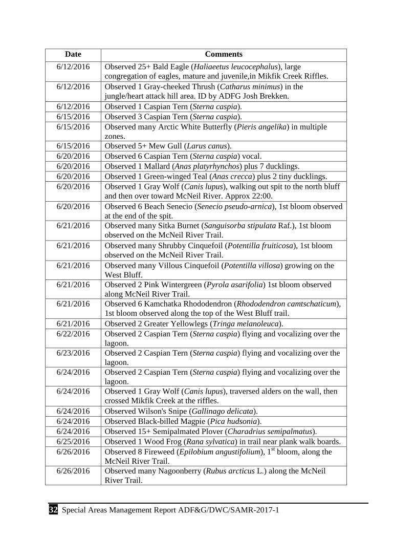
32 Special Areas Management Report ADF&G/DWC/SAMR-2017-1
Date Comments 6/12/2016 Observed 25+ Bald Eagle (Haliaeetus leucocephalus), large
congregation of eagles, mature and juvenile,in Mikfik Creek Riffles. 6/12/2016 Observed 1 Gray-cheeked Thrush (Catharus minimus) in the
jungle/heart attack hill area. ID by ADFG Josh Brekken. 6/12/2016 Observed 1 Caspian Tern (Sterna caspia). 6/15/2016 Observed 3 Caspian Tern (Sterna caspia). 6/15/2016 Observed many Arctic White Butterfly (Pieris angelika) in multiple
zones. 6/15/2016 Observed 5+ Mew Gull (Larus canus). 6/20/2016 Observed 6 Caspian Tern (Sterna caspia) vocal. 6/20/2016 Observed 1 Mallard (Anas platyrhynchos) plus 7 ducklings. 6/20/2016 Observed 1 Green-winged Teal (Anas crecca) plus 2 tiny ducklings. 6/20/2016 Observed 1 Gray Wolf (Canis lupus), walking out spit to the north bluff
and then over toward McNeil River. Approx 22:00. 6/20/2016 Observed 6 Beach Senecio (Senecio pseudo-arnica), 1st bloom observed
at the end of the spit. 6/21/2016 Observed many Sitka Burnet (Sanguisorba stipulata Raf.), 1st bloom
observed on the McNeil River Trail. 6/21/2016 Observed many Shrubby Cinquefoil (Potentilla fruiticosa), 1st bloom
observed on the McNeil River Trail. 6/21/2016 Observed many Villous Cinquefoil (Potentilla villosa) growing on the
West Bluff. 6/21/2016 Observed 2 Pink Wintergreen (Pyrola asarifolia) 1st bloom observed
along McNeil River Trail. 6/21/2016 Observed 6 Kamchatka Rhododendron (Rhododendron camtschaticum),
1st bloom observed along the top of the West Bluff trail. 6/21/2016 Observed 2 Greater Yellowlegs (Tringa melanoleuca). 6/22/2016 Observed 2 Caspian Tern (Sterna caspia) flying and vocalizing over the
lagoon. 6/23/2016 Observed 2 Caspian Tern (Sterna caspia) flying and vocalizing over the
lagoon. 6/24/2016 Observed 2 Caspian Tern (Sterna caspia) flying and vocalizing over the
lagoon. 6/24/2016 Observed 1 Gray Wolf (Canis lupus), traversed alders on the wall, then
crossed Mikfik Creek at the riffles. 6/24/2016 Observed Wilson's Snipe (Gallinago delicata). 6/24/2016 Observed Black-billed Magpie (Pica hudsonia). 6/24/2016 Observed 15+ Semipalmated Plover (Charadrius semipalmatus). 6/25/2016 Observed 1 Wood Frog (Rana sylvatica) in trail near plank walk boards. 6/26/2016 Observed 8 Fireweed (Epilobium angustifolium), 1st bloom, along the
McNeil River Trail. 6/26/2016 Observed many Nagoonberry (Rubus arcticus L.) along the McNeil
River Trail.

Special Areas Management Report ADF&G/DWC/SAMR-2017-1 33
Date Comments 6/26/2016 Observed 3 Salmonberry (Rubus spectabilis) on the Mikfik Trail at the
base of the East Bluff. 6/26/2016 Observed many Dwarf Fireweed (Epilobium latifolium L.) 1st bloom
observed on the conglomerate of the West Bluff. 6/26/2016 Observed many Yellow Monkey-Flower (Mimulus guttatu ), 1st bloom
observed on the conglomerate West Bluff. 6/26/2016 Observed 15+ Semipalmated Plover (Charadrius semipalmatus). 6/29/2016 Observed 1 Wood Frog (Rana sylvatica). 6/29/2016 Observed 1 Red Fox (Vulpes vulpes), moving around on far bank for
several hours. 6/30/2016 Observed Wood Frog (Rana sylvatica), wood frog(s) heard behind
camp. 7/2/1016 Observed 1 Wilson's Warbler (Wilsonia pusilla). 7/2/2016 Observed 1 Gray Wolf (Canis lupus), sighting of single wolf on the spit
at approx 22:00. Two wolves heard howling from upper Mikfik area, not sighted.
7/4/2016 Observed 6 Red-breasted Merganser (Mergus serrator), female with chicks in Mikfik Creek Tidal area.
7/6/2016 Observed 6 Red-breasted Merganser (Mergus serrator), female with chicks in Mikfik Creek Tidal area.
7/16/2016 Observed abundant Lyngbyei's Sedge (Carex lyngbyei) turning yellow into senescenece othroughout the Mikfik Sedge Flats.
7/17/2016 Observed Diamondleaf Willow (Salix planifolia), along camp trail turning into senescence.
7/17/2016 Observed Lyngbyei's Sedge (Carex lyngbyei) yellowing into senescence. 7/19/2016 Observed 1 Red Fox (Vulpes vulpes) walked from downstream to
upstream, behind viewing pad. 7/21/2016 Observed 1 Red Fox (Vulpes vulpes) down river and behind pad at the
falls. Caught what might have been vole or lemming.
7/21/2016 Observed 6 Red-breased Merganser (Mergus serrator) spend several hours below Lower McNeil Falls.
7/21/2016 Observed 1 Northern Shrike (Lanius excubitor) observed across channel from Enders Island in Alders (Alnus viridis ssp. sinuate).
7/23/2016 Observed 1 Gray-crowned Rosy-Finch (Leucosticte tephrocotis) feeding on conglomerate near McNeil Head along the beach.
7/23/2016 Observed 6 Common Redpoll (Acanthis flammea), observed often this summer.
7/23/2016 Observed 8 Bank Swallow (Riparia riparia) east of camp along the bank.
7/23/2016 Observed 14 Red-breasted Merganser (Mergus serrator) together swimming at the end of the spit.

34 Special Areas Management Report ADF&G/DWC/SAMR-2017-1
Date Comments 7/24/2016 Observed 1 Yellow Warbler (Setophaga petechia), female, flew into
back cabin window, no brood patch. 7/24/2016 Observed 1 Belted Kingfisher (Megaceryle alcyon) clattering, perched
near the south end of the large beach in Polly Cove. 7/24/2016 Observed 2 Black-billed Magpie (Pica hudsonia) vocalizing, chatter,
perched along the conglomerate wall in north Polly Cove. 7/25/2016 Observed 2 Wood Frog (Rana sylvatica) observed along the McNeil
River Trail in the rain. 7/28/2016 Observed 1 Glaucous-winged gull (Larus glaucescens) much vigorous
grooming; missing feathers on L cheek. 7/29/2016 Observed 1 Moose (Alces alces) noted 1 medium track on east side of
trail near Eagle Rock. 7/29/2016 Observed 1 Glaucous-winged gull (Larus glaucescens) catches & eats
large Dolly Varden (Salvelinus malma). 7/29/2016 Observed 1 Wilson's Snipe (Gallinago delicata) flushed by bear viewing
group. 7/30/2016 Observed 1 Belted Kingfisher (Megaceryle alcyon) heard and observed
flying toward willows behind Enders Island. 7/31/2016 Observed 1 Wandering Tattler (Tringa incana) foraging on near rock
and center rock; flew to far side. 8/1/2016 Observed 1 Peregrine Falcon (Falco peregrinus) flew fast and low west
to east in front of camp. 8/2/2016 Observed 1 Harbor Seal (Phoca vitulina), 1 dead adult male on lower
river island; broken nose and rib; unknown cause of death, but freshly dead.
8/2/2016 Observed 2 Whimbrel (Numenius phaeopus), flew over bear viewing group near Eagle Rock.
8/3/2016 Observed 1 Peregrine Falcon (Falco peregrinus) flew fast and low west to east in front of camp.
8/3/2016 Observed 1 Spotted Sandpiper (Actitis macularius) on conglomerate around the McNeil River Falls.
8/7/2016 Observed many Marsh Watercress (Rorippa islandica), observed by Dave Crowley.
8/7/2016 Observed 1 Northern Harrier (Circus cyaneus). 8/7/2016 Observed many Semipalmated Plover (Charadrius semipalmatus). 8/7/2016 Observed 2 Harlequin Duck (Histrionicus histrionicus), female ducks. 8/7/2016 Observed 1 Red-throated Loon (Gavia stellata). 8/7/2016 Observed many Arctic rattlebox (Rhinanthus minor). 8/7/2016 Observed Bonaparte's Gull (Chroicocephalus philadelphia). 8/8/2016 Observed 4 Harlequin Duck (Histrionicus histrionicus) flying low just
above the water up and down McNeil River. 8/8/2016 Observed 1 Spotted Sandpiper (Actitis macularius) walking on the
conglomerate rock and flying around McNeil Falls.

Special Areas Management Report ADF&G/DWC/SAMR-2017-1 35
Date Comments 8/8/2016 Observed 4 Glaucous-winged gull (Larus glaucescens) perched on the
conglomerate rock around McNeil Falls. 8/8/2016 Observed 1 Short-eared Owl (Asio flammeus) flying behind camp and
above the east side of the Mikfik Sedge Flats. 8/10/2016 Observed 1 Northern Harrier (Circus cyaneus) flying low, diving into
grasses occasionally. 8/11/2016 Observed 1 Wandering Tattler (Tringa incana) bobbing along the tide
line on McNeil Head walk. 8/11/2016 Observed 2 Trumpeter Swan (Cygnus buccinator) in the mouth of
Mikfik Creek. 8/13/2016 Observed 1 Porcupine (Erethizon dorsatum) walking along the far side
(north) of the McNeil River. 8/13/2016 Observed 1 Spotted Sandpiper (Actitis macularius). 8/16/2016 Observed 1 Northern Harrier (Circus cyaneus) flying behind camp and
above the east side of Mikfik Sedge Flats. 8/17/2016 Observed 1 Northern Harrier (Circus cyaneus), flying. 8/19/2016 Observed 1 Merlin (Falco columbarius) 08:20, flying in front of front
cabin and over beach, landed on beach snag. 8/19/2016 Observed 1 Northern Harrier (Circus cyaneus) 11:00, flying over creek
behind dunes. 8/19/2016 Observed 1 Northern Shrike (Lanius excubitor). 8/21/2016 Observed 1 Merlin (Falco columbarius) perched on the top of stove pipe
on tool shed. 8/24/2016 Observed 6 Double-crested Cormorant (Phalacrocorax auritus) on the
water in front of camp on a windy, stormy morning. 8/24/2016 Observed 2 Harlequin Duck (Histrionicus histrionicus) duck diving in
lower river. 8/27/2016 Observed 1 Porcupine (Erethizon dorsatum) exiting tidal flats for beach. 8/28/2016 Observed 1 Porcupine (Erethizon dorsatum) under back cabin and
walking on camp trails. 8/29/2016 Observed many Feltleaf Willow (Salix alaxensis) along walker creek as
you approach the East Wall in the Mikfik Sedge Flats. 8/29/2016 Observed 2 Little Brown Bat (Myotis lucifuga) in camp by wood pile,
flying around at head level.


Alaska Department of Fish and Game Division of Wildlife Conservation