mciwest-mcb campeno 3500.1 ch 1
TRANSCRIPT

UNITED STATES MARINE CORPS Marine Corps Installations West-Marine Corps Base, Camp Pendleton
RANGE AND TRAINING AREA STANDING OPERATING PROCEDURES
(MCIWEST-MCB CAMPENO 3500.1 CH 1)
Range Operations Division Assistant Chief of Staff, G-3/5
Box 555021 Camp Pendleton, California 92055-5021


UNITED STATES MARINE CORPS MARINE CORPS INSTALLATIONS WEST - MARINE CORPS BASE
BOX 5550 10 CAMP PENDLETON , CAL I FORNIA 92055 - 5010
MCIWEST - MCB CAMPENO 3500 . 1 Ch 1 G- 3/5 - ROD
JUL 0 1 2014 MCIWEST - MCB CAMPEN ORDER 3500 . 1 Ch 1
From : To :
Subj:
Encl :
Commanding General Distribution List
MARINE CORPS INSTALLATIONS WEST - MARINE CORPS BASE , CAMP PENDLETON RANGE AND TRAINING AREA STANDING OPERATING PROCEDURES
(1 ) New page inserts to MCIWEST - MCB CAMPENO 3500 . 1
1 . Situation. To transmit new page inserts to MCIWEST - MCB CAMPENO 3500 . 1 .
2 . Mission . This change incorporate s new policy regarding impact area access and the establ ishment of Confined Area Landing (CAL) Site 24 on Marine Corps Installations West - Marine Corps Base, Camp Pendleton .
3 . Execution . Remove pages lll, 4- 5 , 6- 9 , B- 1 through B- 5 , and F- 4 o f the basic Order and replace with corresponding pages in the enclosure .
4. Summary of change . The changes to Chapters 4 and 6 and Appendix B of the Orde r are specific to access to impact areas . The change to Appendix F promulgates the establishment of CAL Site 24 .
5 . Filing Instructions . File this change transmittal immediately behind the signature page of the basic Order .
ARRUDA
DISTRIBUTION : A- 3 B c
FOR OFFICIAL USE ONLY

MCIWEST-MCB
CAMPENO 3500.1
i
IDENTIFICATION
TABLE OF CONTENTS
TITLE
PAGE
Chapter 1 GENERAL . . . . . . . . . . . . . . . . . . . . . . . . 1-1
1000. Purpose and Scope . . . . . . . . . . . . . . . . . . . 1-2
1001. Battalion/Squadron Commander . . . . . . . . . . . . . 1-2
1002. Officer-in-Charge (OIC) and Range Safety Officer (RSO)
Qualifications. . . . . . . . . . . . . . . . . . . . . 1-4
1003. Officer-in-Charge (OIC) of Training . . . . . . . . . . 1-4
1004. Range Safety Officer (RSO) of Training . . . . . . . . 1-5
1005 Safety . . . . . . . . . . . . . . . . . . . . . . . . 1-7
1006. Medical Requirements. . . . . . . . . . . . . . . . . . 1-7
1007. Position Safety Officers (PSO). . . . . . . . . . . . . 1-9
1008. Range Restrictions . . . . . . . . . . . . . . . . . . 1-10
1009. Waivers to Regulations . . . . . . . . . . . . . . . . 1-11
1010. Mishap Reporting . . . . . . . . . . . . . . . . . . . 1-12
1011. MEDEVAC Procedures. . . . . . . . . . . . . . . . . . . 1-12
1012. Fire Danger Rating (FDR) . . . . . . . . . . . . . . . 1-13
1013. Controlled Burns . . . . . . . . . . . . . . . . . . . 1-15
1014. Permitted Firing Times. . . . . . . . . . . . . . . . . 1-15
1015. Camp Pendleton Military Installation Map. . . . . . . . 1-15
1016. Heat Conditions . . . . . . . . . . . . . . . . . . . . 1-15
1017. Weather Warnings . . . . . . . . . . . . . . . . . . . 1-16
Diagram 1-1 Camp Pendleton Maneuver Corridors . . . . . . . . . . . 1-3
Figure 1-1 Officer-in-Charge (OIC)/Range Safety Officer (RSO)
Appointment Requirements . . . . . . . . . . . . . . . 1-8
Figure 1-2 Medical Support Requirements for Live-Fire and Training
Areas . . . . . . . . . . . . . . . . . . . . . . . . . 1-9
Figure 1-3 MEDEVAC Planning Information . . . . . . . . . . . . . 1-13
Figure 1-4 Fire Danger Ratings . . . . . . . . . . . . . . . . . . 1-14
Chapter 2 ENVIRONMENTAL . . . . . . . . . . . . . . . . . . . . . 2-1
2000. General . . . . . . . . . . . . . . . . . . . . . . . . 2-2
2001. Environmental Constraints Applicable to all Training
Activities . . . . . . . . . . . . . . . . . . . . . . 2-2
2002. Areas Prohibited to Training for Environmental Reasons 2-3
2003. Police of Ranges and Training Areas . . . . . . . . . . 2-4
2004. Field Heads, Urinals, and Wastewater . . . . . . . . . 2-4
2005. Field Drinking Water Supply . . . . . . . . . . . . . . 2-5
2006. Operation of Vehicles . . . . . . . . . . . . . . . . . 2-5
2007. Training Area Refueling, Spill Prevention and Response 2-5
2008. Environmental Considerations and Restrictions . . . . . 2-6
Figure 2-1 Sensitive Environmental and Natural Resources in
Training Areas . . . . . . . . . . . . . . . . . . . . 2-13
Chapter 3 SCHEDULING PROCEDURES . . . . . . . . . . . . . . . . . 3-1
3000. General . . . . . . . . . . . . . . . . . . . . . . . . 3-2
3001. Scheduling Priority . . . . . . . . . . . . . . . . . . 3-2
3002. Range and Training Area Considerations. . . . . . . . . 3-4

MCIWEST-MCB
CAMPENO 3500.1
ii
IDENTIFICATION
TABLE OF CONTENTS
TITLE
PAGE
3003. Contractor Supported Ranges & Facilities. . . . . . . . 3-7
3004. Controlled Simulators and Training Devices. . . . . . . 3-7
3005. Field Mess Nights (Warrior Nights). . . . . . . . . . . 3-7
Figure 3-1 Scheduling Precedence . . . . . . . . . . . . . . . . . 3-3
Figure 3-2 Coordination Products and Time lines. . . . . . . . . . 3-6
Chapter 4
AIRSPACE AND AVIATION OPERATIONS . . . . . . . . . . . 4-1
4000. General . . . . . . . . . . . . . . . . . . . . . . . . 4-2
4001. Special Use Airspace (SUA) . . . . . . . . . . . . . . 4-2
4002. Federal Airway Structure . . . . . . . . . . . . . . . 4-4
4003. No Over Flight Areas/Noise Abatement Restrictions . . . 4-4
4004. Marine Corps Air Station (MCAS) Camp Pendleton . . . . 4-4
4005. Airspace Control Procedures . . . . . . . . . . . . . . 4-5
4006. Aviation Facilities . . . . . . . . . . . . . . . . . . 4-8
4007. General Operations . . . . . . . . . . . . . . . . . . 4-8
4008. Night Vision Goggle (NVG) Operations . . . . . . . . . 4-9
4009. Tactical Air Control Party (TACP) Operations. . . . . . 4-9
4010. Simulated Close Air Support (SIMCAS). . . . . . . . . . 4-11
4011. Aviation Ordnance Delivery Operations . . . . . . . . . 4-11
4012. Helicopter Terrain Flight (TERF) Operations . . . . . . 4-12
4013. Helicopter Outlying Landing Field (HOLF) Operations . . 4-12
4014. Parachute Airdrop Operations . . . . . . . . . . . . . 4-15
4015. Aircraft Refueling Operations . . . . . . . . . . . . . 4-16
4016. Unmanned Aerial Systems (UAS) Operations . . . . . . . 4-17
Figure 4-1 Camp Pendleton Special Use Airspace . . . . . . . . . . 4-3
Figure 4-2 Camp Pendleton Transition Routes. . . . . . . . . . . . 4-7
Table 4-1 TACP OIC & RSO Requirements . . . . . . . . . . . . . . 4-10
Chapter 5 MARITIME OPERATIONS . . . . . . . . . . . . . . . . . . 5-1
5000. General. . . . . . . . . . . . . . . . . . . . . . . . 5-2
5001. Maritime Operations and Safety . . . . . . . . . . . . 5-2
5002. Camp Pendleton Amphibious Vehicle Training Area (CPAVA) 5-2
5003. Landing Craft Air Cushion (LCAC) Transit Lane . . . . . 5-3
5004. Landing Craft Air Cushion (LCAC) Operations . . . . . 5-3
5005. Beaches . . . . . . . . . . . . . . . . . . . . . . . . 5-3
5006. Del Mar Boat Basin . . . . . . . . . . . . . . . . . . 5-4
5007. Fishing . . . . . . . . . . . . . . . . . . . . . . . 5-6
5008. Restricted Sea Areas. . . . . . . . . . . . . . . . . . 5-6
5009. Port of Refuge. . . . . . . . . . . . . . . . . . . . . 5-6
5010. Privately-Owned Boats and Small Craft . . . . . . . . . 5-6
Figure 5-1 Del Mar Boat Basin . . . . . . . . . . . . . . . . . . 5-5
Chapter 6 RANGE OPERATIONS . . . . . . . . . . . . . . . . . . . 6-1
6000. General . . . . . . . . . . . . . . . . . . . . . . . 6-2
6001. Range Access Control Features . . . . . . . . . . . . 6-2

MCIWEST-MCB CAMPENO 3500.1 Ch 1
iii
IDENTIFICATION
TITLE PAGE
6002. Procedures for Range Check-in/out . . . . . . . . . . . 6-3 6003. Authorization for Live Fire . . . . . . . . . . . . . . 6-5 6004. Bivouacking . . . . . . . . . . . . . . . . . . . . . . 6-7 6005. Conduct of Training . . . . . . . . . . . . . . . . . . 6-7 6006. Live-Firing in Training Areas . . . . . . . . . . . . . 6-9 6007. Impact Areas. . . . . . . . . . . . . . . . . . . . . . 6-9 6008. Specific Live Fire Ranges . . . . . . . . . . . . . . . 6-9 6009. Infantry Weapons. . . . . . . . . . . . . . . . . . . . 6-9 6010. Mines, Booby Traps, and Pyrotechnics . . . . . . . . . 6-9 6011. Demolitions . . . . . . . . . . . . . . . . . . . . . . 6-10 6012. Non-Lethal/Less Than Lethal Weapons . . . . . . . . . . 6-12 6013. Shoothouses . . . . . . . . . . . . . . . . . . . . . 6-12 6014. Artillery and Mortars . . . . . . . . . . . . . . . . 6-12 6015. Tanks/AAV/LAV/Armored HMMWV . . . . . . . . . . . . . . 6-14 6016. Police of Tank/LAV/AAV, and other Vehicle Crossings . . 6-15 6017. Training Area Roads . . . . . . . . . . . . . . . . . 6-15 6018. Experimental Weapons and Ordnance . . . . . . . . . . . 6-17 6019. Force on Force Training . . . . . . . . . . . . . . . . 6-17 6020. Water Training Tanks . . . . . . . . . . . . . . . . . 6-17 Chapter 7 AMMUNITION AND EXPLOSIVES . . . . . . . . . . . . . . . 7-1 7000. Transportation of Ammunition and Explosives . . . . . . 7-2 7001. Ammunition Handling and Storage . . . . . . . . . . . . 7-2 7002. Defective Ammunition . . . . . . . . . . . . . . . . . 7-4 7003. Malfunction Reports . . . . . . . . . . . . . . . . . . 7-4 7004. Explosive Ordnance Disposal (EOD) . . . . . . . . . . . 7-4 7005. Duds . . . . . . . . . . . . . . . . . . . . . . . . . 7-4 7006. Misfires and Hang Fires . . . . . . . . . . . . . . . . 7-5 7007. Riot Agents, Smoke, and Other Obscuration Material . . 7-5 7008. Nonstandard Ammunition . . . . . . . . . . . . . . . . 7-5 7009. Blank Ammunition . . . . . . . . . . . . . . . . . . . 7-6 7010. Special Effects Small Arms Marking System (SESAMS) . . 7-6 Chapter 8 LASER OPERATIONS . . . . . . . . . . . . . . . . . . . 8-1 8000. General . . . . . . . . . . . . . . . . . . . . . . . . 8-2 8001. Laser Use Aboard Camp Pendleton RTAs . . . . . . . . . 8-2 8002. Laser Systems Safety Officer (LSSO) . . . . . . . . . . 8-2 8003. Laser Safety Procedures . . . . . . . . . . 8-2 APPENDIX A DEFINITIONS . . . . . . . . . . . . . . . . . . . . . . A-1 Definitions . . . . . . . . . . . . . . . . . . . . . . A-2 APPENDIX B IMPACT AREAS . . . . . . . . . . . . . . . . . . . . . B-1 General . . . . . . . . . . . . . . . . . . . . . . . . B-2 Ranges not within Impact Areas . . . . . . . . . . . . B-3 Signs and Entry . . . . . . . . . . . . . . . . . . . . B-3 Control . . . . . . . . . . . . . . . . . . . . . . . . B-4 High Hazard Impact Area Access Worksheet . . . . . . . B-5

MCIWEST-MCB
CAMPENO 3500.1
iv
IDENTIFICATION
TABLE OF CONTENTS
TITLE
PAGE
APPENDIX C RANGE MATRIX . . . . . . . . . . . . . . . . . . . . . C-1
Range Matrix . . . . . . . . . . . . . . . . . . . . . C-2
APPENDIX D INDIRECT FIRE TRAINING AREAS . . . . . . . . . . . . . D-1
Artillery Firing Areas D-2
Mortar Firing Areas D-3
Observation Posts D-4
APPENDIX E CHLOROBENZALMALONONITRILE (CS) TRAINING CHAMBERS . . . E-1
CS Training Chambers . . . . . . . . . . . . . . . . . E-2
APPENDIX F AVIATION . . . . . . . . . . . . . . . . . . . . . . . F-1
Administrative Landing Zones . . . . . . . . . . . . . F-2
Tactical Landing Zones . . . . . . . . . . . . . . . . F-3
Confined Area Landing Sites (CALSITES) . . . . . . . . F-4
Vertical Takeoff and Landing (VTOL) Sites . . . . . . F-4
Simulated Flight Decks . . . . . . . . . . . . . . . . F-5
Aircraft Refueling Sites . . . . . . . . . . . . . . . F-5
Drop Zones . . . . . . . . . . . . . . . . . . . . . . F-6
Fixed Wing Pattern with R2503B and R2503D Active . . . F-7
Fixed Wing Pattern within R2503B (R2503D Inactive) . . F-8

MCIWEST-MCB
CAMPENO 3500.1
1-1
CHAPTER 1
GENERAL
PARAGRAPH PAGE
PURPOSE AND SCOPE.......................................1000 1-2
BATTALION/SQUADRON COMMANDER............................1001 1-2
OFFICER-IN-CHARGE (OIC) AND RANGE SAFETY
OFFICER (RSO) QUALIFICATIONS............................1002 1-4
OFFICER-IN-CHARGE (OIC) OF TRAINING.....................1003 1-4
RANGE SAFETY OFFICER (RSO) OF TRAINING..................1004 1-5
SAFETY..................................................1005 1-7
MEDICAL REQUIREMENTS....................................1006 1-7
POSITION SAFETY OFFICERS (PSO)..........................1007 1-9
RANGE RESTRICTIONS......................................1008 1-10
WAIVERS TO REGULATIONS..................................1009 1-11
MISHAP REPORTING........................................1010 1-12
MEDEVAC PROCEDURES......................................1011 1-12
FIRE DANGER RATING (FDR)................................1012 1-13
CONTROLLED BURNS........................................1013 1-15
PERMITTED FIRING TIMES..................................1014 1-15
CAMP PENDLETON MILITARY INSTALLATION MAP................1015 1-15
HEAT CONDITIONS.........................................1016 1-15
WEATHER WARNINGS........................................1017 1-16

MCIWEST-MCB
CAMPENO 3500.1
1-2
CHAPTER 1
GENERAL
1000. PURPOSE AND SCOPE
1. General. This Order prescribes the regulations and general precautions
to be taken while conducting training activities within the Marine Corps
Installations West-Marine Corps Base, Camp Pendleton, (MCIWEST-MCB CAMPEN)
California, Range Complex. The Range Complex consists of the land space
designated as ranges, aviation and ground training areas, delegated special
use airspace, and sea space identified for training within this order.
2. Purpose. In accordance with the Marine Air Ground Task Force (MAGTF)
Training Program, the primary purpose of this Order is to establish policy
which will guide and support training of operational units in those skills
required to conduct integrated MAGTF operations to facilitate the training
continuum, and ensure a safe and realistic training environment. Training of
Marine Corps units is executed on a continuum, beginning with training of
individual Marines in basic and advanced warfighting skills, continuing
through training of small units, and culminating in the MAGTF Large Scale
Exercise (LSE).
3. Maneuver Corridors. Based on the training continuum, proficiency with
the variety of military weapons and hardware used by Marines stationed at
Camp Pendleton is crucial to the readiness of the Marine Corps and the
military training mission of the Base. A key to developing weapons
proficiency is ready access to the Range and Training Areas (RTA) across the
Base’s interior, particularly those firing positions located around the
perimeter of the Zulu, Whiskey and Quebec impact areas located generally in
the center of the Base. Additionally, amphibious landing operations, with
follow on movement to critical training ranges, is fundamental to the
development of core competencies. One of the primary components of accessing
interior ranges is the availability of inland transit routes, called maneuver
corridors (Diagram 1-1). These maneuver corridors facilitate movement of
military personnel, equipment and vehicles to key locations. To support the
training continuum, especially the MAGTF LSE, the maneuver corridors must
remain relatively unrestricted by man-made constraints and/or rigid
environmental regulations.
4. Command and Control. The Range Control Facility for the MCIW-MCB CAMPEN
Range Complex is "LONGRIFLE", located aboard Marine Corps Air Station (MCAS)
Camp Pendleton in Bldg 2399. "LONGRIFLE" provides command and control of all
scheduled operations conducted within the MCIWEST-MCB CAMPEN Range Complex.
5. Warning. Failure to comply with these regulations may result in death or
injury to personnel, or damage to equipment. Noncompliance may subject the
offender to administrative or disciplinary action.
1001. BATTALION/SQUADRON COMMANDER
1. General. Ensure compliance with this Order, directives in the MCO 3570
series, applicable technical manuals (TM), field manual (FM), and Marine
Corps Warfighting Publications (MCWP), applicable Safety Of Use Memorandums
(SOUM), installation range guidance, and applicable standard operating

MCIWEST-MCB
CAMPENO 3500.1
1-3
Diagram 1-1
procedures (SOP) for safe training and firing for each weapon system within
the command.
a. Designate an Officer in Charge (OIC) and or a Range Safety Officer
(RSO) for all training events in accordance with the provisions listed in
Figure 1-1, and paragraphs 1002 and 1003 of this Order. At your discretion
RSOs for Non-Live Fire training, other than dive or parachute operations, may
be designated by company/battery commanders.
b. ORM. Develop Operational Risk Management (ORM) procedures for all
phases of training event(s). A type written ORM worksheet signed by the

MCIWEST-MCB
CAMPENO 3500.1
1-4
battalion/squadron commander, designating the OIC and RSO, must be on hand
during all training activities.
2. Briefing. Ensure all personnel within the command are briefed on
installation range procedures and safety requirements including required
personal protective equipment.
1002. OIC AND RSO QUALIFICATIONS
1. Unless specifically authorized by the Range Control Officer (RCO) or by
this Order, all personnel entering ranges and training areas must be
supervised by a MCIWEST-MCB CAMPEN qualified RSO. As discussed below, a RSO
for training safety oversight and a RSO supervising administrative activities
have different RSO training qualification requirements. In accordance with
Figure 1-1, certain training events require supervision by a MCIWEST-MCB
CAMPEN qualified OIC.
2. Training OICs and/or RSOs are required for all types of training
(maritime activity, Para Ops, convoys, Helicopter Rope Suspension Training
(HRST), gas chambers, hikes, etc.) and live fire with munitions involving
projectiles or explosives. Personnel in this category include military
personnel, law enforcement officers, civilian contractors providing military
training and civilian entities conducting live fire under a real estate
license. Qualification requirements for a Training OIC and RSO are listed in
paragraphs 1003.2 and 1004.2.
3. An administrative RSO is required for supervision of events or activities
not related to training. Personnel in this category include civilians
providing range and training area services such as construction projects,
environmental survey, or facility maintenance. An administrative RSO only
requires MCIWEST-MCB CAMPEN specific training to ensure safe transition and
operations in line with their activities.
4. Specific information regarding OIC and RSO training and qualification may
be obtained from the Range Operations Division (ROD) web site at
https://www.mciwest.usmc.mil/inst/mciwest/rpolicy/rod/default.aspx or
http://www.pendleton.marines.mil/StaffAgencies/AssistantChiefofStaffG35/Range
OperationsDivision.aspx or call commercial (760) 725-0357.
1003. OIC OF TRAINING
1. General. The OIC shall be of equivalent or senior rank to the RSO.
The OIC maintains surveillance of firing and safety within the entire surface
and vertical hazard space of the assigned range; he/she shall be physically
present at live fire events. The OIC is a supervisory position conducted by
a commissioned officer, warrant officer, staff noncommissioned officer,
noncommissioned officer or civilian equivalent. Civilian contractors shall
not perform as an OIC. The OIC may personally participate in training, as
long as the OIC can maintain control of the training event.
2. Training
a. The OIC must complete the Training and Education Command (TECOM)
Distance Learning Range Safety Course (DLRS) and the MCIWEST-MCB CAMPEN Range
Safety Certification Course (RSCC).

MCIWEST-MCB
CAMPENO 3500.1
1-5
b. Upon successful completion of the RSCC, Range Operations will enter
those names into the Range Facility Management Support System (RFMSS) data
base.
c. Both DLRS and local certification are valid for three years. DLRS
expiration date and local certification expiration date will coincide with
each other. Personnel with DLRS that expire within 90 days or less will not
be tested for local range safety certification.
3. Responsibilities
a. The OIC shall have a detailed ORM worksheet signed by the unit
commander, that covers all phases of training to be conducted, in his/her
possession at all times while training. For live fire and maneuver (LFAM)
training, an approved concept of operations, scheme of maneuver and RCO Brief
Sheet must also be in his/her possession at all times while training.
b. The OIC shall ensure all personnel wear the appropriate personal
protective equipment. Helmets and flak jackets shall be worn for any Live
event involving movement or maneuver, high explosives or grenades, machinegun,
or Close Quarters Battle in shoot houses. For all other training, either the
ORM or unit SOP will determine if helmets and flak jackets will be required.
c. The OIC shall be certified on the weapon(s) or weapons system(s)
being used and brief the RSO on the duties to be performed in support of the
training event, and clearly establish the requirement for the RSO to brief
the OIC on the safety of the facility/unit, and the readiness to commence
live-fire operations prior to the start of firing.
d. The OIC is responsible for accountability and proper use of
ammunition and explosives. OICs will account for all ammunition and
explosives on the NAVMC 11381 Expenditure Report. Refer to Chapter 7 of this
Order.
e. The OIC will verify that the RSO is qualified with the weapon(s) or
weapons system(s) being used.
f. The OIC will ensure that the RSO provides for an emergency vehicle
and medical personnel for all training events as prescribed in Figure 1-2.
g. In the event of a medical evacuation (MEDEVAC), the OIC or an
appointed representative will suspend all training, and will:
(1) Ensure first aid is rendered.
(2) Ensure LONGRIFLE is contacted and the location, nature of the
accident, and assistance required is reported. If radio communication fails,
use any means available to contact LONGRIFLE.
(3) Refer to paragraph 1011 for additional MEDEVAC information.
1004. RSO OF TRAINING
1. General. The RSO assists in maintaining surveillance of firing and
safety within the entire surface and vertical hazard space of the assigned
range; he/she shall be physically present at the training site. The RSO is a

MCIWEST-MCB
CAMPENO 3500.1
1-6
supervisory position conducted by a commissioned officer, warrant officer,
staff noncommissioned officer, noncommissioned officer, or civilian
equivalent. Civilian contractors may act as RSOs when approved by the
Commanding General. The RSO shall not personally participate in training.
THE RSO WILL NOT BE ASSIGNED OTHER DUTIES NOR FIRE A WEAPON, and will be the
last to leave the range following completion of firing and clean-up, ensuring
that the range is clear of all personnel and equipment. The RSO will ensure
that all trash and brass are removed from the range after completion of
training.
2. Training
a. The RSO must complete the TECOM DLRS and the MCIWEST-MCB CAMPEN RSCC.
b. Upon successful completion of the RSCC, Range Operations Division
(ROD) will enter those names into the RFMSS data base.
c. Both DLRS and local certification are valid for three years. DLRS
expiration date and local certification expiration date will coincide with
each other. Personnel with DLRS that expire within 90 days or less will not
be tested for local range safety certification.
3. Responsibilities
a. The RSO is responsible for the enforcement of applicable safety
regulations contained in this Order, directives in the Marine Corps Order
(MCO) 3570 series, and other applicable field, technical, and ordnance
publications. The RSO shall be qualified on the weapon(s) or weapons
system(s) being used.
b. The RSO must be able to identify the right and left lateral limits
for all live fire ranges, and that each firing position observes the proper
left and right limits for each firing lane. The RSO will ensure that no
cross firing between firing lanes occurs.
c. The RSO shall maintain communications with LONGRIFLE at all times.
When communications are lost, the RSO will cease all training until
communications are reestablished.
d. RSO’s shall conduct the check-in/check-out process for all ranges and
training areas as outlined in paragraph 6002 of this Order.
e. The RSO for rappelling/HRST training shall be a qualified Rappel/HRST
Master and be present at all times during rappel/HRST operations.
f. The RSO for assault climbing training shall be a qualified Assault
Climber/Mountain Leader and be present at all times during training.
g. The RSO for hexachloroethan ( HC) smoke, terephthalic acid (TA) smoke
and Nuclear, Biological, and Chemical (NBC) operations must be a qualified 5711/5702 or designated by the unit level commander.
h. The RSO shall ensure all weapons settings (i.e., headspace, timing,
FDC, and safety “T”) are correct.

MCIWEST-MCB
CAMPENO 3500.1
1-7
i. The RSO shall provide for an emergency vehicle and medical personnel
for all training events as prescribed in Figure 1-2.
j. The RSO for parachute and airdrop operations shall be current and
qualified Jumpmaster performing as the Drop Zone Safety Officer (DZSO); the
RSO/DZSO must be at the DZ during parachute/airdrop operations.
1005. SAFETY
1. Safety is the responsibility of every individual, at all times, and is a
key factor in successful training. Concerns for safety, however, should
never be limited to the training event itself, but should always include
associated activities as well; including any movement to and from training,
maintenance activities, bivouac operations, etc.
2. Any individual who observes an unsafe condition shall report the location
and condition immediately to LONGRIFLE. A training event or any other
activity affected by the unsafe condition shall be halted until the
unsafe condition has been corrected.
3. All members associated with the training event have the option to call
“cease-fire”. The greatest danger to life and limb is associated with live-
fire; therefore, range restrictions for various weapons/ammunition are listed
in the special instructions for each range.
4. Effects of live fire must be contained within designated impact areas and
associated surface danger zones (SDZ)/weapon danger zones (WDZ) for ranges.
If the effects of live fire are known or suspected to have been fired outside
of the SDZ/WDZ for the range, such an event must be reported to LONGRIFLE
immediately.
1006. MEDICAL REQUIREMENTS
1. Live-fire Ranges. Appropriate medical personnel (as per Figure 1-2) with
first aid equipment shall be present on all ranges, unless specifically
excluded in this Order. He/she shall not be assigned any additional duties
when live-firing is in progress. The term “live-firing” includes any caliber
of ammunition (including blanks), hand or rifle grenades, demolitions,
rockets, or any other ordnance capable of producing an explosion or high rate
of burning. Additionally, a wheeled vehicle designated as a safety vehicle
shall be located at all ranges during live-firing. Privately owned vehicles
(POV) shall not be used as safety vehicles. Whenever possible, this vehicle
should be an ambulance. At a minimum, the safety vehicle shall be capable of
accepting a litter. During Helicopter Support Team (HST) or HRST operations,
the helicopter involved in the training meets the requirements for a safety
vehicle.
2. Training Areas. Appropriate medical personnel (as per Figure 1-2) and
safety vehicle shall be present during unit training activities conducted
within training areas and beaches.
3. Range Series/Complexes. When the 116, 130, 210, 314 range series, Field
Medical Service School (FMSS), Infantry Immersion Trainer (IIT), Improvised
Explosive Device (IED) lanes and Horno or Wilcox Range complexes are used by
the same military organization, use of a single appropriate medical person

MCIWEST-MCB
CAMPENO 3500.1
1-8
(as per Figure 1-2) and safety vehicle with two-way radio communication is
authorized.
Officer-in-Charge (OIC)/ Range Safety Officer (RSO)
Appointment Requirements
EVENT OIC*1/2/5 RSO*2/3/5
OFF WO NCO OFF WO NCO
HC Smoke/Riot Control Agents (CS) *6 X X E-6 X X E-5
CBRN Confidence Training (Gas Chamber) *4 X X E-6 X X E-5
AT-4 9mm Tracer Trainer, 9mm Spotting Rifle
Shoulder Launched Multipurpose Assault Weapons
(SMAW) Not Rocket, Light Anti-Tank Weapon (LAW)
Trainer, Light Armored Vehicle (LAV) Brewster,
Practice Hand Grenades, All 40mm TP, Laser
Devices, Simulators, Trip Flares, Small Arms,
Machine Guns, .50 Cal And Below
X X E-6 X X E-5
Field Artillery X X E-7 X X E-6
LFAMs, Combined Arms Live-Fire Exercises, Aerial
Gunnery, Air Defense Weapons X X E-7 X X E-6
Aerial Gunnery & Air Defense Weapons; Flame-
Throwers; Live Hand Grenades, Grenade Launchers,
(All40mm HE); Live Mines, Demolitions; Tank &
Fighting Vehicle Cannons; Recoilless Rifles
X X E-7 X X E-6
Mortars/USMC X X E-6 X X E-5
SRC-1 ITEMS: Javelin/AT-4/Dragon/Stinger
RSO REQUIREMENTS NON WAIVERABLE X X E-7 X X E-6
Live-Fire Exercises Using Organic Weapons,
Squad Company, Battery, and Troops. Direct Fire
NON SRC-1 ITEMS: TOW, SMAW & ROCKET MISSLES
X X E-7 X X E-6
Parachute Ops/(HST) Ops/ Dive Ops (Qualified
Instructor)/Rappelling/HRST X X X X X E-4
Training Area/Bch Operations/Training Facilities
(NO Munitions) X X X X X E-4
Training Area/Bch Ops/Training Facilities
(With Munitions) X X E-6 X X E-5
Mortars U.S. Army X X E-6 X X E-6
Special Effects Small Arms Marking System
(SESAMS) X X E-7 X X E-6
Steel Reactive Targets (SRT) X X E-7 X X E-6
*1 - The OIC shall be of equivalent or senior rank to the RSO.
*2 – Marine Corps Community Services (MCCS) activities may be conducted without an OIC, corpsman
or safety vehicle as long as a qualified Camp Pendleton RSO is present and observing all
activities.
*3 - Civilian contractors may act as RSOs when approved by the Installation Commander.
*4 - OIC and RSO must have been trained in the 2-Chlorobenzylidenemalononitrile (CS) chamber within the past year. An E–4 or above [chemical, biological, radiological, and nuclear (CBRN)
MOS 5702/5711] must be present when conducting CBRN training in a gas chamber.
*5 - The OIC shall be a field grade officer and the RSO shall be an E-7 or above for all
battalion or larger live fire exercises.
*6 - When CS is used in outdoor confidence courses, the RSO must have been trained in the CS chamber within the past year. The use of a 5702 CBRN Defense Officer and 5711 CBRN Defense
Specialist is not required.
Figure 1-1

MCIWEST-MCB
CAMPENO 3500.1
1-9
Medical Support Requirements for Live Fire and Training Areas Category Description Minimum Capabilities Allowed Training
Coverage
1 Combat Life
Saver
• Patient assessment
• Basic First Aid
• Basic Airway Management
• Cardiopulmonary
resuscitation
Any training not
involving live fire.
Exceptions: Dive
Ops, Para Ops, HRST
Ops
2 Emergency
Medical
Technician
(EMT)-I
All Corpsmen
or Medics
• Patient assessment
• Advanced first aid
• Use of adjunctive
breathing aid &
administration of oxygen
• Resuscitation
• Transportation of ill &
injured persons
• Manual Defibrillation
• Endotracheal intubation
(ET)
• Esophageal-trachea airway
device (combitube)
• ET
Cat-1 Coverage
Dive Ops, Para Ops,
HRST Ops
Static Fire of Small
Arms (.50 caliber &
below)
3 EMT-II
All Corpsmen
or Medics
• All EMT-I skills
• Electrocardiogram (EKG)
monitoring
• Defibrillation &
Cardioversion
• Antishock trousers
• Intravenous infusion
• Esophageal airway
• Obtain venous blood
• 9 medications
• Laryngoscope
• Gastric suction
Cat-2 Coverage
Any High Explosives
or Demolitions
Any Fire &
Movement/Maneuver
Any Closed Quarters
Battle (CQB)/
Infantry Training
Battalion Training
Paramedic
Special Ops
Corpsmen
Medics
Independent
Duty
Technician
• All EMT-I and IIs skills
and medications
• Laryngoscope
• ET (adults, oral)
• Glucose measuring
• Valsalva’s Maneuver
• Needle thoracostomy and
cricothyroidotomy
• Nasogastric intubation
(adult)
• 21 medications
Figure 1-2
1007. POSITION SAFETY OFFICER (PSO). In addition to OIC and RSO
requirements, weapons qualified PSOs shall be assigned for all static live
fire, live fire and movement, and live fire and maneuver training as follows:
1. Vehicle weapons system. One PSO for each vehicle.
2. Crew served weapons on static range. One PSO for every two weapons.

MCIWEST-MCB
CAMPENO 3500.1
1-10
3. Crew served weapons in a Support by Fire Position. One PSO for each
weapon.
4. Dismounted personnel on static range. One PSO for every four shooters.
5. Dismounted personnel conducting LFAMs or Live Fire and Movement. One PSO
for every four shooters during day time and one PSO for every two shooters
during night time.
6. CQB. One PSO for each active team in a shoot house.
1008. RANGE RESTRICTIONS
1. General
a. Firing or bombing will be conducted on authorized ranges and LFAM
areas only. This does not prohibit the controlled use of blank ammunition or
noisemakers [small, controlled demolition charges of .25 pound of
Trinitrotoluene (TNT) or equivalent] in accordance with this Order.
b. The use of chemical ammunition will be in strict compliance with
technical manuals and directives. The use of riot agents (CS) and other
obscuration materials shall be in strict compliance with Chapter 7 of this
order.
c. Personnel not specifically scheduled to be on ranges or within
training areas are not authorized. In addition, recreational activity such
as biking, hiking or running are strictly prohibited.
2. Privately Owned Vehicles (POVs) and Privately Owned Weapons
a. POVs are prohibited on all live-fire ranges, Artillery Firing Areas
(AFAs), Mortar Firing Areas (MFAs), training areas and access roads to those
areas, unless authorized per range special instructions or approved by the
RCO. All authorized POVs shall display an issued POV Pass. Prior to being
issued a POV pass, personnel shall submit a command letter (Battalion-Level)
to the RCO justifying the need to utilize a POV in support of training.
During authorized hunting and fishing periods, the RCO may authorize hunter
POV parking along main roads in training areas. Privately owned motorcycles
are not authorized at any time.
b. Privately owned weapons are only authorized on MCCS designated
recreational ranges or during authorized hunting activities.
c. Carrying military weapons to and from any range in POVs is not
authorized without organizational commander’s approval.
d. Off road activity by POVs is strictly prohibited.
e. The use of unit All Terrain Vehicles (ATVs) must be approved by the
RCO (seven days prior to the event).
(1) All operators shall be required to have a current Base ATV Safety
Card, and all ATVs must be fitted with a spark arrestor.

MCIWEST-MCB
CAMPENO 3500.1
1-11
(2) Other than approved ATV convoy training, all ATVs must be
trailered to the training area that they are to be utilized. To be
considered for approved ATV convoy training, the unit shall submit an ATV
convoy overlay to the RCO (seven days prior to the event).
(3) ATVs are prohibited from traveling on hard surfaced roads.
f. Violations of any vehicle provisions may result in the issuance of a
traffic violation and appearance before the MCIWEST-MCB CAMPEN Magistrate and
or administrative action or disciplinary action under the Uniform Code of
Military Justice.
3. Civilians
a. Unit sponsored functions which include civilian participation or
observation requires RCO approval.
b. Department of Defense (DOD) Employees or Government Contractors
operating with-in the scope of their employment or contract are not subject
to this provision.
c. All media observation/filming requests shall come from MCIWEST-MCB
CAMPEN Public Affairs Office (PAO).
(1) PAO shall notify the Range Scheduling no later than 48 hours from
the event.
(2) All civilian media personnel shall be accompanied by PAO
personnel.
(3) All media and PAO personnel shall only observe from the unit OIC
and RSO designated viewing area.
(4) All protective equipment must be provided by the requesting unit.
d. All civilian activities requested shall be in accordance with
reference(a) and local restrictions imposed by the RCO.
4. Physical Training (PT). Unit PT in training areas shall be scheduled via
the Range Scheduling Office. This includes individual PT.
5. Alcohol. Alcohol is not allowed on ranges or in training areas unless a
waiver has been granted. In accordance with reference (k), specific waiver
requests for underage drinking must be submitted directly to the Commanding
General (CG), MCIWEST-MCB CAMPEN.
6. Camp Fires. Camp fires will not be started on any range or in any
training area except when authorized by the Assistant Chief of Staff (AC/S),
G-3/5. Cutting of trees and brush for such fires is prohibited. Fires will
be carefully extinguished prior to leaving the area. CAMP FIRES WILL NOT BE
PERMITTED WHEN THE FIRE DANGER RATING IS VERY HIGH OR EXTREME.
1009. WAIVERS TO REGULATIONS. Requests for waivers to the provisions
contained in this Order will be addressed to AC/S, G-3/5 and submitted no
less than 30 days prior to the planned event; waivers must include all

MCIWEST-MCB
CAMPENO 3500.1
1-12
required endorsements. It is recommended that waiver requests be coordinated
with the RCO prior to submission.
1010. MISHAP REPORTING. When a training mishap occurs on a range or in a
training area (i.e. vehicle roll over), the RSO shall immediately notify
LONGRIFLE by radio or telephone, to include number of personnel and equipment
involved. In addition, the Unit Commander will immediately notify the
appropriate chain of command. When ordnance material is involved, the mishap
will also be reported to the Base Explosive Safety Officer and an ordnance
malfunction report shall be filed if required.
1011. MEDEVAC PROCEDURES
1. General. LONGRIFLE must be notified of all medical emergencies occurring
within MCIWEST-MCB CAMPEN ranges, training facilities, and offshore operating
areas. If a radio is not available, contact LONGRIFLE at (760) 725-3974.
Designated medical personnel or the senior Marine on location shall determine
the extent of a medical emergency. Sound judgment will always be paramount
in any successful responses to an emergency. The MEDEVAC category shall be
relayed to LONGRIFLE. The categories or classifications are as follows:
a. Emergency/Urgent. Requires immediate response. This category
includes any injury considered to be life threatening or involving loss of
limb or eye sight if not transported in a timely manner. Evacuation method
will be determined by Emergency Medical Services (EMS). All MEDEVACs
involving maritime operations will be classified emergency/urgent.
b. Priority. Requires timely response. This category includes any
serious injury not considered to be life threatening or loss of limb or eye
sight. Evacuation method determined by EMS.
c. Routine. May or may not require transport. This category includes
minor injuries, (cuts, bruises, sprains not involving head or spinal cord
injury). MEDEVAC, if required, is accomplished via organic unit assets.
2. Coordination. LONGRIFLE will initiate emergency and priority MEDEVAC
requests with MCIWEST-MCB CAMPEN EMS, and remain the principal coordination
agency with Camp Pendleton EMS during the MEDEVAC. In order to facilitate a
timely response to training mishaps, incident details such as number of
personnel injured, extent of injuries, and vital signs should be relayed to
LONGRIFLE. The following information pertains to MEDEVAC responses.
a. EMS will determine the most effective means of evacuation.
b. Naval Hospital, Camp Pendleton is not trauma-capable. Figure 1-3 is
provided for planning purposes.
c. Camp Pendleton does not have a military MEDEVAC aircraft on standby.
In the event EMS determines an air ambulance is required, civilian services
will be utilized.
d. The Camp Pendleton Fire Department must be on-scene for the arrival
of any civilian air ambulance to ensure the victim is prepared for transport
and the landing zone is identified and marked in accordance with civilian air
ambulance requirements.

MCIWEST-MCB
CAMPENO 3500.1
1-13
e. Victim(s) should not be transported via military aircraft.
f. DURING A MEDEVAC, ALL UNITS ON BASE RANGE CONTROL SAFETY NETS SHALL
CONTINUE TO MONITOR THE NETS BUT SHALL NOT TRANSMIT UNLESS THEY REQUIRE
ADDITIONAL MEDEVAC SUPPORT.
MEDEVAC Planning Information
Name Address
Travel
Time Phone Helipad Burn/Trauma
Air Grd Yes No Yes No
U.S. Navy Hospital -
NHCP Bldg H-100 CAMPEN 3 10 760-725-1611 X X
Tri-City Medical
Center
4002 Vista Way,
Oceanside 8 20 760-940-3507 X X
Mission Viejo Medical
Center
27700 Medical
Center Rd,
Mission Viejo.
10 30 949-364-1181 X X
Scripps Memorial
Hospital, La Jolla
9888 Genesee
Avenue, La Jolla 10 40 858-626-6151 X X
Palomar Medical
Center
2185 W. Citracado
Pkwy Escondido. 10 40 442-281-5000 X X
UCSD Medical Center 200 W. Arbor
Drive, San Diego 20 60 619-543-2154 X X
Figure 1-3
1012. FIRE DANGER RATING (FDR)
1. General. FDRs and associated control measures are promulgated to reduce
the danger from wildland fires. FDRs are applicable to all organizations and
individuals at Camp Pendleton at all times. The FDRs are determined by the
Base Fire Department; restrictions are determined by the AC/S, G-3/5.
2. FDRs. FDRs and commonly employed restrictions are contained in Figure
1-4 of this order.
3. Dissemination
a. MCIWEST-MCB CAMPEN Fire Department is responsible for dissemination
of the FDR.
b. A notice reinforcing or adding additional restrictions based on the
FDR will be available on the ROD SharePoint site https://www.mciwest.usmc.
mil/inst/mciwest/rpolicy/rod/default.aspx and will be promulgated via
OPSGRAM.
4. Action
a. OICs/RSOs are responsible for ensuring the FDR restrictions are
adhered to.
b. LONGRIFLE shall notify OICs/RSOs of FDR changes as they occur.
c. In the event of a wildland fire on any range, impact, or training
area, the RSO will immediately account for personnel and relocate as
required. Notify LONGRIFLE, as soon as possible, stating the exact location
and extent of the fire, and its proximity to any personnel, equipment or

MCIWEST-MCB
CAMPENO 3500.1
1-14
property (to include targetry/equipment/signage) that may be in danger.
LONGRIFLE will then instruct the RSO as to what action to take prior to the
arrival of the Base Fire Department. The RSO shall follow the directions of
LONGRIFLE and or the Base Fire Department to ensure the safety of personnel
and equipment. UNDER NO CIRCUMSTANCES WILL ANYONE ENTER AN IMPACT AREA TO
FIGHT FIRES.
d. The RCO will monitor all range and training area fires as they occur,
and is authorized to assist the Base Fire Chief to safeguard government
property and personnel. This will include the control of firing and the
removal of units from training areas threatened by fire. Maximum effort will
be made not to interfere with scheduled training. However, safety
considerations shall take precedence.
e. Approval for using munitions not authorized during certain FDR
conditions shall be submitted to the RCO 30 days in advance.
FIRE DANGER RATINGS
FIRE DANGER
RATING
(HAZARD)
CAUTION
TO BE
EXERCISED
NECESSARY PRECAUTIONS
0 - 30
(LOW) Use normal caution. **Units SHALL adhere to restrictions promulgated by RCO.**
31 - 40
(MODERATE)
Use normal caution.
Fires will start easily.
**Units SHALL adhere to restrictions promulgated by RCO.**
41 - 60
(HIGH)
Use extra caution.
Fires will start very
easily.
The use of tracers may be temporarily suspended. Handheld
or grenade launched airborne pyrotechnics ARE NOT
authorized. For interior Training Areas - blanks & smoke
(used in an ammo can) are authorized in cleared areas. For
perimeter Training Areas (Bravo I, Bravo II, Charlie,
Delta, Echo, Foxtrot, Golf, Hotel, India, Juliet, Lima,
November and Sierra) ordnance or flame producing devices
(including smoking) ARE NOT authorized. Smoking is
permitted only in cleared areas or on fire breaks of
interior training areas. **Units SHALL adhere to any
additional restrictions promulgated by RCO.**
61 - 80
(VERY HIGH)
Use extreme caution.
Fires are very hard to
control.
All previous restrictions apply. Authorized areas for increment
burning will be identified by the RCO. Smoking is permitted only in
cleared areas or on fire breaks of interior training areas. **Units
SHALL adhere to any additional restrictions promulgated by RCO.**
81 & Higher
(EXTREME)
Flash condition. This is
the highest class of fire
danger. Fires started are
practically impossible to
extinguish and usually
continue until danger
rating conditions improve
or burn themselves out.
The utmost caution with
fire-producing agents and
devices must be exercised
at all times.
The firing of high explosives, pyrotechnics, incendiaries, or other
ammunition likely to cause fires is prohibited unless specifically
authorized by RCO. The use of any type of training/live ordnance
(to include blanks), heat or flame-producing devices (heaters,
welders, stoves, or open fires) in training areas is strictly
prohibited unless authorized by RCO. No off-road activities by
vehicles (HMMWVs, etc.) are permitted without authorization from
RCO. Firing units will exercise maximum precautions to prevent
fires from starting. Smoking shall not be permitted under any
circumstances. **Units SHALL adhere to any additional restrictions
promulgated by RCO.**
**The RCO will publish additional restrictions via the Range Control web site and OPSGRAM. Units should
refer to this guidance prior to conducting training.**
Note: Fire breaks are to remain clear to allow transition or access by CPFD personnel when responding to
fire emergencies.
Figure 1-4

MCIWEST-MCB
CAMPENO 3500.1
1-15
1013. CONTROLLED BURNS. The Base Fire Chief will conduct controlled
burning. Requests for controlled burning on ranges and in training areas
will be submitted to the RCO who will coordinate the request with the Fire
Chief and AC/S, G-3/5. The Fire Chief will coordinate with Environmental
Security.
1014. PERMITTED FIRING TIMES
1. Normal live fire times for all ranges are 0600 to 2359 daily.
2. To request extended live fire times, submit a request via RFMSS or e-mail
to the Range Scheduling Office at least five working days in advance.
1015. CAMP PENDLETON MILITARY INSTALLATION MAP. The current Camp Pendleton
1:50,000 Military Installation Map, reference (b), may be ordered directly
from National Geospatial-Intelligence Agency (NGA).
1. Unless otherwise described, all grid coordinates used in this Order
correspond to the Camp Pendleton Military Installation Map. Note: the Grid
Zone Identification and 100,000 Meter Square Identification are not listed in
grid coordinates discussed in this Order. Personnel should use the Camp
Pendleton Military Installation Map in conjunction with this Order for pre-
mission planning to confirm locations of intended operating areas.
2. Unless otherwise stated, all headings/directions used in this Order are
magnetic.
3. For access into any range or training area, a Camp Pendleton Military
Installation Map must be on hand.
1016. HEAT CONDITIONS. Atmospheric (weather) conditions should always be a
consideration during the planning and ORM phase of a training event. The
following information specific to factors associated with heat stress is
provided in support of training aboard the MCIWEST-MCB CAMPEN RTA complex.
1. Heat stress conditions specific to the RTA complex are established at the
unit level using the Wet Bulb Globe Temperature (WBGT) Index. This index
combines shade, air temperature, radiation, humidity and wind into a single
value to be used as a guide for outdoor activity. The WBGT Index should be
considered and measured when the ambient temperature for a geographic area is
forecasted to be above 80 degrees Fahrenheit (F).
2. The WBGT Index should be measured periodically and serve as an on-site,
general guideline to the unit OIC and RSO throughout the training event.
When a hazardous heat stress condition exists, every precaution should be
taken by the OIC and RSO to mitigate the hazard, to include but not limited
to: seeking shade, increased water breaks/rest periods, reduction or
cessation of activity, etc.
3. Contact LONGRIFLE immediately when an individual heat casualty is
suspected or confirmed. Any and all heat related casualties will be
considered medical emergencies, and LONGRIFLE will initiate MEDEVAC
coordination immediately upon notification.

MCIWEST-MCB
CAMPENO 3500.1
1-16
1017. WEATHER WARNINGS
1. FLOOD ALERT
a. Due to significant amounts of precipitation in the mountains around
Camp Pendleton, possible flash flooding may occur. Range Control will
monitor flood conditions set by the AC/S, G-3/5. The following Alert
Conditions apply:
(1) Alert Condition III. Rainfall is reported in Riverside or San
Diego Counties of one to two inches on wet or saturated ground; four inches
on dry ground; or local flash flood conditions.
(2) Alert Condition II. Rainfall exceeds previous condition and
visible flooding is detected upstream; or weather services forecast heavy
thunderstorms, flash flood watches, or flash flood warnings.
(3) Alert Condition I. Rainfall exceeds previous condition with
bridges, roads, or culverts overflowing with water. Upstream fire
departments are reporting local flooding.
b. Unless otherwise directed by the AC/S, G-3/5, ranges and training
areas shall be secured upon reaching Alert Condition II.
2. Thunder Storms. Range Control will monitor location of thunder storms
based on proximity to MCAS Camp Pendleton. Units should take precautionary
measures based on the following criteria.
a. THUNDERSTORM ADVISORY – Thunderstorms with the potential for
lightening are occurring or are forecasted to occur within 50 nautical mile
(NM) of MCAS Camp Pendleton.
b. THUNDERSTORM CONDITION II - Thunderstorms with the potential for
lightening are occurring or are imminent within 25 NM of MCAS Camp Pendleton.
c. THUNDERSTORM CONDITION I - Thunderstorms with the potential for
lightening are occurring or are imminent within 10 NM of MCAS Camp Pendleton.

MCIWEST-MCB
CAMPENO 3500.1
2-1
CHAPTER 2
ENVIRONMENTAL
PARAGRAPH PAGE
GENERAL..................................................2000 2-2
ENVIRONMENTAL CONSTRAINTS APPLICABLE TO ALL TRAINING
ACTIVITIES...............................................2001 2-2
AREAS PROHIBITED TO TRAINING FOR ENVIRONMENTAL REASONS...2002 2-3
POLICE OF RANGES AND TRAINING AREAS......................2003 2-4
FIELD HEADS, URINALS, AND WASTEWATER.....................2004 2-4
FIELD DRINKING WATER SUPPLY .............................2005 2-5
OPERATION OF VEHICLES....................................2006 2-5
TRAINING AREA REFUELING, SPILL PREVENTION AND RESPONSE...2007 2-5
ENVIRONMENTAL CONSIDERATIONS AND RESTRICTIONS............2008 2-6

MCIWEST-MCB
CAMPENO 3500.1
2-2
CHAPTER 2
ENVIRONMENTAL PROCEDURES
2000. GENERAL. The ranges and training areas of MCIWEST-MCB CAMPEN are
heavily used. MCIWEST-MCB CAMPEN is also the home of many endangered
species, wetlands, sensitive habitats and cultural resource sites, which are
protected by federal laws strictly enforced by local regulatory agencies. To
successfully achieve all training objectives while complying with
environmental laws and regulations, it is essential to consider environmental
concerns while planning training operations and exercises. Proper planning
will preserve all training facilities for future generations of Marines;
therefore, it is essential that training units adhere to the provisions in
this Chapter. All users of ranges and training areas are responsible for
knowing and adhering to applicable environmental laws and regulations,
including, but not limited to, the current FDR and restrictions associated
with the environmentally sensitive areas identified on both the Camp
Pendleton Military Installation Map and the most current Base Environmental
Operations Map. The Base Environmental Operations Map is a Geospatial
Information System (GIS) Map, and may be obtained through Environmental
Security (ES). Questions concerning applicable environmental regulations may
also be referred to ES [National Environmental Protection Act Branch (NEPA
Branch] at (760) 725-9759/9763.
2001. ENVIRONMENTAL CONSTRAINTS APPLICABLE TO ALL TRAINING ACTIVITIES
1. Prohibited Activities. The following activities are prohibited on all
ranges and training areas aboard MCIWEST-MCB CAMPEN:
a. Burying, dumping abandoning, or disposing of solid waste (e.g.,
trash, rubbish, or garbage), except in approved containers (i.e., dumpsters)
or at established landfills.
b. Burying, dumping, abandoning, or disposing of any type of military
munitions.
c. Unlawfully disposing hazardous waste, including unlawfully releasing
(e.g., venting, draining, or spilling) oil, fuel, and all other hazardous
substances from vehicles, equipment, storage tanks, or containers into the
air, ground, or water.
d. Removing or intentionally destroying threatened or endangered plants,
trees, brush, cactus, or any other vegetation (refer to the Base
Environmental Operations Map). Cutting or removing tree limbs or large
portions of any other plant is also prohibited. Limit camouflage material to
previously felled vegetation.
e. Contact ES prior to conducting activities involving cutting/
removing/trimming of brush, trees, cactus, or any other type of vegetation
that may be considered threatened or endangered as indicated by the Base
Environmental Operations Map; and prior to any activity involving soil
excavation, grading, filling, or digging fighting positions in or adjacent to
protected habitat areas as indicated by the Base Environmental Operations
Map.

MCIWEST-MCB
CAMPENO 3500.1
2-3
f. Killing, injuring, or harassing wildlife and livestock. Killing
poisonous snakes and other wildlife in self-defense is not prohibited. Most
snakebites on the Base have resulted from untrained individuals trying to
handle snakes. Contact LONGRIFLE for snake removal.
g. Removing (i.e., stealing), intentionally destroying, or
intentionally disturbing archaeological, Native American, and/or historical
materials, artifacts, buildings, and/or sites.
2. Earthwork. Impact berms contain lead, a toxic metal and potential
hazardous waste. Consult with ES, before beginning earthwork on or near
impact berms.
3. Violations. Violations of these provisions may result in disciplinary
action under the Uniform Code of Military Justice, or prosecution in state or
federal court. Violations of these provisions may also result in potential
adverse impacts to future training opportunities aboard the Base.
2002. AREAS PROHIBITED TO TRAINING FOR ENVIORNMENTAL REASONS
1. Prohibited Areas.
a. Designated historical/archeological sites.
b. Landfills.
c. Installation Restoration and National Priority List (NPL)
environmental clean-up areas.
d. Any area where training land restoration and erosion control work is
ongoing (usually, but not exclusively, coastal bluffs and terraces). These
areas will be marked with appropriate warning signs and fences.
e. Training in the vicinity of rivers, creeks, and natural drainage
areas may require special consideration; therefore, it is subject to the
provisions of paragraph 2007 in this Chapter. Provisions contained in the
most current Base Environmental Operations Map may also apply.
f. Avoid, to the maximum extent possible, parking vehicles or heavy
equipment under the canopies of trees. Do not dig fighting holes under the
canopies of trees. These activities damage the root systems, eventually
killing the trees.
g. Off-road vehicular traffic during periods of peak soil moisture
conditions frequently results in severe gullying and training land
degradation. This leads to decreased training opportunities and hazardous
conditions that create safety concerns. Whenever possible, vehicular traffic
shall remain on designated roads following significant rainfall.
h. The Cocklebur Sensitive Area, consisting of non-beach lands west of
the Interstate Five (I-5) Freeway from the beach access road immediately
north of Marine Corps Tactical Systems Support Activity (MCTSSA) to French
Creek Lagoon, excluding the Landing Craft Air Cushion (LCAC) Facility (598
790 to 605 795 to 595 808 to 595 805 to beginning) is off-limits.

MCIWEST-MCB
CAMPENO 3500.1
2-4
i. Areas marked with orange carsonite markers or signs, which say, “Off
Limits for Environmental Reasons,” “California Least Tern Nesting Site,” or
“Wetlands” are off-limits to training units.
2. Other restrictions. Specific operational restrictions for sensitive
areas are delineated in paragraph 2007 in this Chapter.
2003. POLICE OF RANGES AND TRAINING AREAS
1. General. Police of ranges and training areas is the responsibility of
the using unit. It is the responsibility of the OIC/RSO to ensure ranges,
training facilities, and training areas used by their units have been
properly policed. All solid waste brought to ranges, training facilities,
and training areas; including cardboard, wrapping materials, food waste,
communication wire, expended brass, and ammunition containers, shall be
removed from those areas and recycled or disposed of in approved containers
(i.e., dumpsters) or established landfills. No unit will depart their
training location until that area is in a proper state of police. An
inspection by a Camp Pendleton Range Safety Specialist may be required prior
to departure.
2. Dumpsters. Dumpsters are not provided and are not authorized at ranges
or training areas.
3. Hazardous Material. Hazardous materials (e.g., weapons cleaning gear,
paint, petroleum/oil/lubricants (POLs), etc.) used while training shall be
stored in approved, closed, leak-proof containers. All hazardous materials
shall be clearly marked, identifying the contents of the container. All
hazardous materials spills shall be reported immediately to LONGRIFLE, who
will notify the Fire Department and ES (HAZMAT). Units shall use available
resources to prevent and contain spills, at or near the source of the spill,
and submit required formal spill reports to ES.
2004. FIELD HEADS, URINALS, AND WASTEWATER
1. General. Any organization assigned to a range and/or training area shall
properly police heads in their assigned area. Trash will not be disposed of
in any head, urinal, or chemical toilet.
2. Chemical Heads. Platoon size or larger units, and stationary units,
shall use chemical heads. Chemical heads may be coordinated through Base
Property (760) 725-4532. Users shall also coordinate the planned location of
heads via the Range Scheduling Office prior to placement. This ensures
chemical heads will be clear of surface danger zones. As a last resort,
squad size or smaller units maneuvering alone may use properly constructed
straddle-trenches or cat holes to dispose of solid human waste. However,
they shall not be constructed/dug in or adjacent to watercourses. For safety
reasons, before using urinals and/or chemical heads, check them for poisonous
insects and other hazards.
3. Wastewater from temporary showers (greywater) may be discharged to land
if a local permit is obtained through ES. Provisions shall be made to ensure
that all discharged greywater percolates at the discharge site; and does not
flow to surface waters or dry watercourses. All greywater disposal shall
comply with Preventative Medicine Regulations and Standards for military
field operations.

MCIWEST-MCB
CAMPENO 3500.1
2-5
2005. FIELD DRINKING WATER SUPPLY
1. General. All connections to the water system shall be attached in such a
manner as to prevent cross-connections and back siphoning from a contaminated
source to the potable distribution system. Prevent water hoses at vehicle
filling sites from contacting any source of contamination, including the
vehicle, ground, tools, and equipment.
2. Pumping. Units shall obtain approval from the AC/S, G-F to pump water
from any lake, pond, stream, river, well, storage area, sitting irrigation
pumps, and well drilling equipment. Water drawn from the Base distribution
system for further transport and uses as potable water shall be protected
from accidental contamination. All hoses or valves marked “potable” shall be
kept scrupulously clean at all times.
3. Reports. Report all instances of water pipe breaks, valve and pipe
leaks, and other system failures to the AC/S, G-F (Emergency Maintenance
Branch) at (760)725-4683/4368.
2006. OPERATION OF VEHICLES. Whenever possible, vehicles will use secondary
[dirt or decomposed granite (DG)] roads within training areas. The speed
limit is 25 miles per hour (mph) for all areas, unless otherwise posted.
1. To the maximum extent possible, administrative vehicle traffic shall use
existing roads and paths to or within the established camp, command post, or
bivouac site.
2. Vehicles operating tactically, in support of a training objective,
may transit terrain as dictated by the scenario, providing they do not damage
threatened or endangered species habitat, or archaeological sites. Vehicles
operating in the vicinity of creeks or rivers shall use existing roads,
trails, and stream crossings. Traffic is not permitted in creek or river
beds except at established crossings. Refer to paragraph 2007 in this
Chapter for specific environmental restrictions in these areas.
3. Unit commanders are requested to use prudent judgment in the scheduling
and conduct of training and exercises that might result in heavy vehicular
traffic over recently burned terrain.
4. No off-road activities by vehicles (HMMWVs, etc.) will be permitted when
the FDR is EXTREME, without permission from LONGRIFLE prior to entering the
training area or range.
2007. TRAINING AREA REFEULING, SPILL PREVENTION AND RESPONSE. If any POL
will be stored or handled (to include six-con fuel pods, tanker trucks,
drums, and five gallon containers) 40 CFR 112.7 and the Camp Pendleton Spill
Prevention, Control, and Countermeasures (SPCC) Plan require secondary
containment. This can be met by using a POL impervious bermed liner capable
of containing the single largest container. Training units are responsible
for spill prevention and proper hazardous material storage and handling
(secondary containment), and must comply with the SPCC Plan. Units must
complete a site specific SPCC Plan and submit to ES for approval prior to
start of exercise, describing the refueling locations, methods and
responsibilities. If a hazardous material spill occurs, units will be
responsible for initial response and cleanup of the incident in accordance
with Federal, State, Base and local laws and regulations. Any spill in a

MCIWEST-MCB
CAMPENO 3500.1
2-6
training area must be immediately reported Range Control LONG RIFLE. Range
Control will then notify ES Spill Prevention Branch, and only this Branch
will make the appropriate regulatory reporting notifications for spill
incidents. Refueling is not authorized on any beach area. Current
preapproved refueling sites, which apply to both aviation and ground training
activity, are listed in Appendix F.
2008. ENVIRONMENTAL CONSIDERATIONS AND RESTRICTIONS
1. General. To comply with federal, state, and local laws for the
protection of the environment, special care must be taken when conducting
training in sensitive environmental areas. When planning training events,
consult reference (c), the Camp Pendleton Military Installation Map and the
most current Base Environmental Operations Map to determine locations of
sensitive areas, and use the guidance found in this Chapter to determine
applicable restrictions in those areas. For training events larger than a
Marine Expeditionary Unit (MEU) in size, or when operational requirements
conflict with the following guidance, exercise commanders must obtain
approval from ES.
2. Environmental Training. Training for unit S-3 and S-4 officers/staff
noncommissioned officers (SNCO) interested in specific environmental training
focused on operational planning and execution (i.e., Base Environmental
Operations Map) is provided by ES. Additional information and course
schedule are provided in reference (c), or by contacting the Environmental
Training Branch at (760) 725-7308/7309.
3. Environmental Documentation. Provided MEU and smaller size units use the
training areas and ranges for the purposes specifically outlined in this
Order, and strictly adhere to the environmental restrictions associated with
each range, submission of environmental documentation is not required.
Exercise commanders shall coordinate with ES to determine the level of
environmental documentation required for exercises larger than a MEU in size,
and when environmental restrictions in this Manual conflict with training
requirements. The following is the coordination lead time recommended for
those actions requiring formal environmental documentation from ES:
a. Company size 60 days
b. Battalion size 90 days
c. Regiment size 120 days
d. Larger than regiment 150 days
4. Wetlands. Wetlands are found throughout Camp Pendleton, typically in
valley bottoms, and are characterized by soil types, hydrology, and specific
vegetation. Their distribution is not limited to “wet” areas. Activities in
wetlands involving soil disturbance and/or fill may require a permit, and
impacts to wetlands supporting threatened or endangered species will require
special consultation and approval. Vehicles operating in the vicinity of
wetlands are authorized year round and shall remain on existing roads and
creek crossings. Troop movement on foot is authorized year round on existing
roads, trails and crossings. Off-road vehicular or foot traffic,
excavations, and/or fill occurring in wetlands must be reviewed by ES, and
receive appropriate permits prior to conducting the action.
MCIWEST-MCB
CAMPENO 3500.1
2-7
5. Vernal Pools. Vernal pools are wetlands, usually holding water for only
one to four months during late winter and spring, and are known to occur in
several training areas on Camp Pendleton. The highest densities of vernal
pools are found in the Bravo Two, Oscar One, Oscar Two, Tango, Uniform, and
Victor Training Areas; and White Beach. Many of these pools contain rare and
federally endangered plant and animal species. When operating within the
vicinity of vernal pools:
a. Foot traffic is authorized year round. Digging, including
construction of fighting positions is prohibited in vernal pools.
b. Vehicle/equipment operations near known vernal pool areas shall be
kept on existing roads, year round. Contact ES prior to conducting
activities involving soil excavation, filling, or grading.
c. Bivouac/Command Post/Field support (e.g., showers, messing, fueling,
water purification, etc.) activities shall be kept to at least 50 meters
from identified vernal pools.
6. Coastal Marshes and Lagoons
a. Vehicles must stay on existing roads and trails in the vicinity of
coastal marshes and lagoons from 1 March to 15 September. Foot traffic is
prohibited in all coastal marshes from 1 March to 15 September, and
prohibited all year in the Santa Margarita Estuary (portions of Beach Section
G or Blue Beach) and the mouth of Cocklebur Canyon (Beach Section F).
b. Vehicle operations and foot traffic in the vicinity of coastal
marshes, estuaries, and lagoons are authorized year round on existing roads,
trails and established crossings. Off-road vehicular traffic or foot
traffic, excavations, and/or fill activities needing to occur in coastal
marshes, estuaries, and lagoons must be reviewed by ES, and receive
appropriate permits and approvals prior to conducting the action.
7. Endangered Species
a. The endangered California Least Tern nests on most base beaches
between 1 March and 15 September. This bird uses coastal lagoons, mud/salt
flats, beaches, dunes, ocean, and tide line for nesting, foraging, and
resting. Training activities can disrupt nesting, frighten adult birds,
cause nest abandonment, and separate chicks from their parents.
b. The threatened Western Snowy Plover nests on most base beaches
between 1 March and 15 September. They may be present on any Camp Pendleton
beach throughout the year. This bird uses coastal lagoons, mud/salt flats,
beaches, dunes, ocean, and tide line for nesting, foraging, and resting.
Training activities can disrupt nesting, frighten adult birds, cause nest
abandonment, and separate chicks from their parents.
c. The Light-footed Clapper Rail is a secretive marsh bird. This bird
was last documented nesting at the Santa Margarita Estuary in 2003, but some
are still occasionally found using the coastal marshes of the Base.
d. The endangered Tidewater Goby is a small fish living in the shallow
water of coastal lagoons and estuaries on Camp Pendleton. These small fish
are most abundant in lagoons where fresh water flowing downstream meets the

MCIWEST-MCB
CAMPENO 3500.1
2-8
salt water from the Pacific Ocean. All coastal estuaries and lagoons aboard
Camp Pendleton provide habitat for this species, including those on Red,
Blue, and Green Beaches; and Beach Sections D and F. Activities disturbing
the waters and vegetation of coastal lagoons/estuaries, or causing sediment
to be transported into these lagoons will affect the Tidewater Goby. Any
vehicular traffic within or across a lagoon/estuary can be harmful due to the
very limited area of suitable Goby habitat within most lagoons and estuaries.
Even small POL leaks from vehicles can contaminate water enough to adversely
impact the Gobies.
e. The endangered Southern Steelhead Trout is an extremely rare fish
found in San Mateo Creek. Ocean-going steelhead can grow to 24 inches before
returning upstream to spawn during the winter rainy periods. Spawning and
rearing occurs in stream pools in the Delta Training Area and further
upstream (off the Base). Southern Steelhead Trout may be affected during
critical times in its lifecycle by activities adversely altering the estuary,
rearing pools, or flowing stream waters of San Mateo Creek.
8. Estuarine/Beach Endangered Species Management Zones. To protect the
California Least Tern, Western Snowy Plover, Light-footed Clapper Rail and
Tidewater Goby, the restrictions listed below apply when operating within the
following areas; all coastal lagoons and estuaries; marshes and salt flats
associated with San Mateo Creek, San Onofre Creek, Las Flores Creek, “Hidden
Creek” Grid Coordinates 580818, Aliso Creek, French Creek, and Cocklerburr
Creek watersheds; and the Santa Margarita Endangered Species Management Zone,
defined as the beach area extending from the south end of White Beach (594
797) to the southern end of the Santa Margarita River Estuary, delineated by
the dirt access road running seaward at the southern edge of the estuary (620
760), encompassing the Cocklebur Canyon outlet and the Santa Margarita River
Estuary, extending inland to Stuart Mesa Bridge.
a. Obtain authorization from ES before entering any lagoon or estuary,
marsh, mud/salt flat, or posted nesting area. Bivouacking and digging of
fighting positions are prohibited in the vicinity of the Estuarine/Beach
Endangered Species Management Zones during the period of 1 March to 15
September.
b. Between 1 March and 15 September, all activities involving smoke,
pyrotechnics, loud noises, blowing sand, and large groupings of personnel (14
or more) shall remain at least 300 meters away from fenced or posted nesting
areas. All other activities shall be kept at least five meters from these
areas
c. Foot traffic involving less than 14 personnel shall be kept as far
away as possible, and approach no closer than five meters to posted nesting
areas between 1 March and 15 September. Unit hikes shall remain on the hard
packed sand, as close to the ocean water edge as possible. When passing
posted nesting areas, minimize all noise.
d. Vehicle and equipment operations in the management zones shall be
kept to a minimum between 1 March and 15 September. All vehicles shall
travel on hard packed sand and shall not approach posted nesting areas or
lagoons closer than five meters. Speeds shall not exceed 25 mph. Tracked
vehicles shall travel as close to the water (upper few inches of waves) as
possible, year round, in the Santa Margarita Endangered Species Management
Zone. Vehicle operations, inside fenced areas on the edge of the bluff

MCIWEST-MCB
CAMPENO 3500.1
2-9
between Aliso and French Creeks (White Beach), are not authorized between
1 March and 15 September.
e. Engineering operations, outside of approved landing exercise support,
shall be coordinated with ES prior to the initiation of activities.
Generally, earth-moving activity at beaches is authorized only for areas of
invigorated sand at least 300 meters from posted nesting areas, unless
specifically requested and approved by ES.
f. Boat operations are not authorized in lagoons and estuaries. LCACs
shall not enter the management zones between 1 March and 15 September, except
when entering or exiting seaward; and on return, shall exit the ocean heading
directly up to the facility access ramp. Small boats may be permitted in the
Santa Margarita Estuary between 16 September and 1 March, with prior approval
from ES.
g. To the maximum extent possible, vehicles and troops accessing the
beach at White Beach during the period of 1 March and 15 September shall
follow a route along the base of the northerly bluff to maintain the maximum
distance from the tern colony.
9. Other Endangered Species
a. The Least Bell’s Vireo is a small, inconspicuous endangered bird
living in low, dense growths of willows, brush, and weeds along the drainages
on Camp Pendleton between March and September. The Vireo is known to nest in
the vicinity of the Santa Margarita river and in creek/river bottom areas in
the following training areas: Alpha Two, Alpha Three, Bravo Three, Golf,
Hotel, India, Juliett, Lima, November, Oscar One, and Oscar Two, and the
Santa Margarita River basin.
b. The Southwestern Willow Flycatcher is a small, inconspicuous
endangered bird living in taller trees, willows, brush, and weeds along the
drainage’s on Camp Pendleton between March and September. The Flycatcher is
known to nest in creek/river bottoms areas in the following training areas:
Alpha Two, Alpha Three, Bravo Three, Golf, Hotel, India, Juliett, Lima,
November, Oscar One, and Oscar Two, and the Santa Margarita River basin.
c. The endangered Arroyo Southwestern Toad is found in and around stream
and river bottoms. This toad has been found along the Santa Margarita River;
the DeLuz Roblar, San Onofre, San Mateo, Cristianitos, and Talega Creeks; and
within the Alpha One, Alpha Two, Alpha Three, Bravo One, Bravo Two, Bravo
Three, Charlie, Delta, Golf, Foxtrot, Hotel, India, Kilo Two, Oscar One,
Yankee Training Areas; and the Quebec and Whiskey Impact Areas. The adults
breed and deposit their eggs in shallow pools adjacent to streams or in slow
moving portions of the streams between February and June. Adult toads have
been found up to one kilometer from streams in many different habitats.
Toads are active at night on roads and trails near streams, especially during
wet weather in late winter and early spring.
d. For the conservation of the Least Bell’s Vireo, Southwestern Willow
Flycatcher, and the Arroyo Southwestern Toad, the following measures shall be
taken for training activities in creek/river bottom (riparian) habitat areas.

MCIWEST-MCB
CAMPENO 3500.1
2-10
(1) Extreme caution beyond that required by the FDR is necessary when
using pyrotechnics; and when conducting other activities likely to cause a
fire.
(2) Foot traffic is authorized year round on existing roads, trails,
and creek crossings. Consult with ES prior to cutting/removing vegetation.
(3) Vehicles operating in the vicinity of creeks, rivers, or
drainages shall use existing roads, trails, and established creek/river
crossings. Vehicle traffic on roads in arroyo toad habitat between 15 March
and 31 August shall be minimized to the maximum extent practical.
(4) Consult with ES prior to bivouacking, cutting/removing
vegetation, trenching, grading, filling, or conducting engineering operations
in or adjacent to creek/river bottom areas.
(5) Dust produced in or adjacent to creeks and rivers shall be
minimized to the maximum extent practical.
e. Threatened California Gnatcatchers live in open to dense coastal sage
brush areas. These small songbirds are year round residents of Camp
Pendleton. They are known to inhabit the Alpha Two, Bravo Two, Bravo Three,
India, Juliett, Kilo Two, Lima, Mike, November, Oscar One, Oscar Two, Papa
One, Papa Two, Romeo Two, Romeo Three, Tango, and Uniform Training Areas.
Fires and other activities such as crushing or removing brush negatively
affect these birds and their habitat. Activities involving loud noises,
smoke, and concentrations of personnel disrupt their behavior, particularly
during the breeding season between 1 February and 15 August. For the
conservation of this threatened species, the following measures shall be
followed for training activities in identified occupied coastal sage brush
areas:
(1) Extreme caution beyond that required by the FDR is necessary when
using pyrotechnics and when conducting other activities likely to cause a
fire.
(2) Foot traffic between 1 February and 15 August shall be kept to
existing roads, trails, and established training facilities to the maximum
extent practical. Foot traffic may be authorized in California Gnatcatcher
habitat areas between 16 August and 31 January; however, care must be
exercised to avoid crushing or otherwise destroying brush vegetation.
(3) Vehicles may leave existing roads between 1 August and 31
January, FDR permitting, and provided brush vegetation is not crushed or
removed.
(4) Bivouac/command and post/field support activities (e.g., showers,
messing, fueling, water purification, etc.) shall be kept at least 50 meters
from California Gnatcatcher habitat areas, year round.
f. Endangered Pacific Pocket Mice live in very open to relatively dense
brush areas within three miles of the coast. They have been found in the
Oscar One Training Area, immediately east of the San Onofre II Housing Area,
and State Park leased lands north of Cristianitos Road. These rodents spend
the day in burrows and come out at night to feed on seeds. Nighttime aerial
illumination can increase their susceptibility to predators between 15 March

MCIWEST-MCB
CAMPENO 3500.1
2-11
and 15 September, when they are most active above ground. Activities that
could crush the rodents in their burrows, dig them up, or bury them shall not
be permitted at sites they occupy. Soil compaction caused by vehicle
operations off existing roads and trails degrade their habitat by preventing
them from digging their burrows. Soil compaction occurs most easily between
December and June, when soil is moist. For the conservation of this
endangered rodent, units training in habitat areas shall follow the following
measures:
(1) Foot traffic is authorized, year round; however, digging,
including construction of fighting positions, shall be avoided.
(2) Vehicle/equipment operations near known habitat shall be kept on
existing roads, year round. Contact ES prior to conducting activities
involving soil excavation, filling, or grading.
(3) Bivouac/command and post/field support activities (e.g., showers,
messing, fueling, water purification, etc.) shall be kept at least 50 meters
from Pacific Pocket Mouse habitat areas, year round.
g. The endangered Stephens’ Kangaroo Rat lives in relatively open (non-
brush), weedy areas. They live in areas that frequently burn. This rodent
is known to inhabit the Bravo One, Golf, India, Juliett, Kilo Two Training
Areas; and the X-Ray, Whiskey, and Zulu Impact Areas. These rodents spend
the day in shallow burrows and come out at night to feed on weed seeds.
Activities that could crush the rodents in their burrows, dig them up, or
bury them, shall not be permitted at occupied sites. Soil compaction caused
by vehicle operations off existing roads and trails degrades their habitat by
preventing them from digging their burrows. Soil compaction occurs most
easily between December and June, when soil is moist. For the conservation
of this endangered rat, the following measures shall be followed by units
training in habitat areas.
(1) Foot traffic is authorized year round; however, digging,
including construction of fighting positions, shall be minimized.
(2) Vehicle/equipment operations near known habitat shall be kept on
existing roads, year round. Contact ES prior to conducting activities
involving soil excavation, filling, or grading.
(3) Bivouac/command and post/field support activities (e.g., showers,
messing, fueling, water purification, etc.) shall be kept at least 50 meters
from the Stephens’ Kangaroo Rate habitat areas, year round.
10. Rare Plant Species. Rare and federally listed plant sites are found
throughout Camp Pendleton, and are carefully noted on the Base Environmental
Operations Map. For the protection of identified sites, the measures listed
below shall be followed by units training in the areas.
a. Foot traffic is authorized, year round; however, digging, including
Construction of fighting positions, shall be avoided at locations of rare
plants.
b. Vehicle/equipment operations near known habitat shall be kept on
existing roads, year round. Contact ES prior to conducting activities

MCIWEST-MCB
CAMPENO 3500.1
2-12
involving soil excavation, filling, grading, off-road vehicular operations,
or vegetation cutting/removal.
c. Bivouac/command and post/field support activities (e.g., showers,
messing, fueling, water purification, etc.) shall be kept at least 50 meters
from identified rare plant sites. No cutting or trimming of rare plants is
allowed without consultation with ES.
11. Archaeological and Cultural Resources. Archaeological sites are located
throughout Camp Pendleton. Archaeological sites are the physical remains of
the lives and activities of the people who lived in the prehistoric or
historic past, and may include artifacts such as stone (arrowheads,
projectile points), human bone materials, pottery, and other physical remains
of life. Some sites are visible on the soil surface; others are visible only
after some level of ground disturbance has occurred. Since all sites and
their contents are protected under law, approval must be obtained from
Environmental Security prior to any activity adversely impacting
archaeological sites. The Base has surveyed and documented the locations of
all visible archaeological sites. For the protection of known and unknown
archaeological sites, the following measures should be taken:
a. Foot traffic is authorized, year round. Digging, including
construction of fighting positions is prohibited at known archaeological
sites.
b. Vehicle/equipment operations shall be kept on existing roads through
known archaeological sites, year round. Contact ES prior to conducting
activities involving mechanical soil excavation, filling, or grading in the
vicinity of known archaeological sites.
c. Bivouac/command and post/field support activities (e.g., showers,
messing, fueling, water purification, etc.) shall be kept at least 50 meters
from identified archaeological sites.
d. When conducting operations, if archaeological materials are
discovered on the ground or below soil surfaces:
(1) Avoid disturbing any archaeological materials.
(2) Notify ES as soon as possible (with the exact grid coordinates,
if possible, and site description).
(3) Do not remove materials shall from the area.
e. If human bone material (to include fragments) is discovered during
any operation, the area must immediately be evacuated, leaving the remains
intact. Notify LONGRIFLE as soon as possible.

MCIWEST-MCB
CAMPENO 3500.1
2-13
Sensitive Environmental and Natural Resources in Training Areas B
each
es a
nd
Trai
ning
A
reas
Leas
t B
ell’s
Vi
reo
Arr
oyo
Sout
hwes
tern
To
ad
Step
hens
’ K
anga
roo
Rat
Cal
iforn
ia
Gna
tcat
cher
Leas
t Ter
n/
Wes
tern
Sn
owy
Plov
er
Paci
fic
Pock
et
Mou
se
Rar
e Pl
ant
Site
s
Ligh
t-foo
ted
Cla
pper
Rai
l
Vern
al
Pool
s
Sout
hwes
tern
W
illow
Fl
ycat
cher
Sect. A X X X
Sect. B X X
Sect. C X X X
Sect. D X X
Sect. E X X X
Sect. F X X X X
Sect. G X X
Sect. H X
Alpha 1 X X
Alpha 2 X X X X X
Alpha 3 X X X
Bravo 1 X X X X
Bravo 2 X X X X
Bravo 3 X X X
Charlie X X
Delta X X
Echo X
Foxtrot X
India X X X X X
Golf X X X X
Kilo 1 X X X
Kilo 2 X X X X X
Juliett X X X X
Lima X X X X
Mike X X X
November X X X X
Oscar 1 X X X X X X
Oscar 2 X X X X X
Papa 1 X X X
Papa 2 X X
Papa 3 X
Romeo 1
Romeo 2 X X
Romeo 3 X X
Tango X
SEE BASE ENVIRONMENTAL OPERATIONS MAP FOR SPECIFIC LOCATIONS
Figure 2-1

MCIWEST-MCB
CAMPENO 3500.1
3-1
CHAPTER 3
SCHEDULING PROCEDURES
PARAGRAPH PAGE
GENERAL.................................................3000 3-2
SCHEDULING PRIORITY.....................................3001 3-2
RANGE AND TRAINING AREA CONSIDERATIONS..................3002 3-4
CONTRACTOR SUPPORTED RANGES & FACILITIES................3003 3-7
CONTROLLED SIMULATORS AND TRAINING DEVICES..............3004 3-7
FIELD MESS NIGHTS (WARRIOR NIGHTS) .....................3005 3-7

MCIWEST-MCB
CAMPENO 3500.1
3-2
CHAPTER 3
SCHEDULING PROCEDURES
3000. GENERAL
1. Scheduling. The Range Scheduling Office is located aboard MCAS Camp
Pendleton in Bldg 2399, and serves as the sole scheduling agency for the
MCIWEST-MCB CAMPEN Range Complex. RFMSS is the approved Marine Corps RTA
scheduling and management tool.
a. To schedule a range, training area, or maritime operating area the
Range Control Scheduling Office must receive a RFMSS data entry in accordance
with the applicable scheduling precedence as outlined in Figure 3-1.
b. The latest a scheduling request can be submitted is 1200 noon the day
prior to the event.
c. If there is a technical reason for not being able to access RFMSS, a
Training Area Request (TAR) may be submitted to the Range Scheduling Office
using the following methods; as an e-mail attachment to
[email protected];, or hand delivered to the Range Scheduling
Office. The Camp Pendleton TAR is provided on the Camp Pendleton web site
and on the ROD SharePoint site at https://pendleton.mciwest.nmci.usmc.mil/
ot/rod/default.aspx.
d. RFMSS accounts can be established by contacting the RFMSS
administrator at (760) 725-0359.
2. Canceling. Once ground ranges, training facilities, airspace, and/or sea
space have been scheduled, it is the responsibility of the unit scheduled to
use the facility to conduct its training during the allotted time period.
Should there be a requirement to modify a scheduled range time, the unit
shall notify the Range Scheduling Office via e-mail or fax. Cancellation of
scheduled events should be executed through RFMSS.
3001. SCHEDULING PRIORITY
1. Range and training facilities scheduling requests may be submitted by
requesting units as outlined in Figure 3-1.
2. Scheduling precedence is based on the priority level of each unit and the
subsequent training request submission date allowed. Priority one units may
submit a training request up to 180 days prior to the event. At 120 days
prior, Priority one and two units have equal precedence, and both units may
submit training requests; this pattern continues until 30 days prior when all
units have equal precedence. Units submitting requests prior to their
authorized training request submission date will be disapproved. In cases of
equal precedence, first come-first served applies.
3. “Priority Use” for Zulu Impact Area. To increase training efficiency,
“Priority Use” for the Zulu Impact Area will be implemented for range and
airspace utilization as follows:

MCIWEST-MCB
CAMPENO 3500.1
3-3
SCHEDULING PRECEDENCE
PRIORITY UNIT REMARKS SUBMISSION DATE
1
United States Marine Corps (USMC) Formal
Schools
School of Infantry,
Marine Corps Recruit
Depot, Weapons Field
Training Battalion,
Marine Light Attack
Helicopter Squadron 303,
FMSS, and Assault
Amphibian School
Battalion
Up to 180 Days
Prior
2
Marine Expeditionary Unit (MEU) or Large
Scale Exercises/
Division Schools/Intelligence
Battalion/Advisor Training Group/High
Mobility Artillery Rocket System
Administrative
control/operational
control units will
schedule via higher
headquarters, for
submission to Range
Scheduling
Up to 120 Days
Prior
3 USMC Active and Reserve/
Active United States Navy (USN)
Conducting Military
Training
Up to 90 Days
Prior
4 USN Reserve/United States Army Active and
Reserves/United States Air Force Active
and Reserve/
National Guard/Coast Guard
Conducting Military
Training
Up to 60 Days
Prior
5 Base Civilian Agencies/Civilian Law
Enforcement/Recreation
Non-Military Training Up to 30 Days
Prior
Figure 3-1
a. Air Priority Use (R440). Aviation operations have priority use of
the Zulu Impact Area on the first three Wednesdays and Thursdays of each
month. Ground units desiring to conduct Tactical Air Control Party (TACP) or
Joint Terminal Attack Controller (JTAC) operations shall schedule the event
on air priority days. Parachute operations will not be afforded priority on
air priority days. Air priority will not be granted for requests received
less than seven days prior.
b. Ground Priority Use. Ground operations have “Priority Use” of the
Zulu Impact Area on Monday, Tuesday, Friday, Saturday, and Sunday during the
first three weeks of the month. During the last week of the month, ground
operations have priority during the entire week. Ground priority will not be
granted for requests received less than seven days prior.
4. “Priority Use” for Whiskey Impact Area. To increase training efficiency,
“Priority Use” for the Whiskey Impact Area will be implemented for range and
airspace utilization as follows:
a. Air Priority Use (R220). Monday through Friday, 1400 – 1700 and
2000 – 2300.
b. Ground Priority Use. Monday through Friday, 0600 – 1400,
1700 – 2000, 2300 – 2400; and all day on Saturday and Sunday.
5. Non-Priority Use. “Priority Use” of the Zulu and Whiskey Impact Areas
expires seven days prior to a planned training event. Requests for non-
priority use of the Zulu or Whiskey Impact Areas may be submitted prior to
the event, but will not be approved until seven days prior to the event.

MCIWEST-MCB
CAMPENO 3500.1
3-4
6. Exceptions to “Priority Use”. For key events (e.g., Marine Corps Combat
Readiness Evaluation, Very Important Person (VIP) Demos, FIREXs, Marine
Reserve Aviation) not accommodated by “Priority Use,” units should coordinate
with the RCO as soon as possible in advance to request exemption to the
“Priority Use” policy.
3002. RANGE AND TRAINING AREA CONSIDERATIONS
1. Scheduling
a. Individual training facilities (i,e, Artillery Firing Areas (AFAs),
combat towns, confined area landing (CAL) Sites, and DZs) are not inclusive
of the training areas and must be scheduled separately.
b. Range and Training Area Capacity
(1) A maximum of five military plus three non-military units may be
scheduled in a training area, ORM dependant. Non-military units shall not be
scheduled concurrently with mechanized units or with live fire activity.
(2) Canyons (i.e. Horno, Piedra de Lumbre, San Mateo and Pulgas).
Only one military convoy and up to three non-military units may be scheduled.
(3) A maximum of three units may be scheduled on training beaches.
(4) Only one unit will be scheduled on live-fire ranges, LFAMs,
Rappel Towers, combat towns (except Kilo Two), or gas chambers with only a
single chamber.
c. Exceptions to the above capacity restrictions may be considered on a
case by case basis. Units requesting consideration must submit a detailed
plan including an overlay and ORM for consideration.
d. Units desiring co-use of a single unit capacity training facility
must receive approval by the RCO.
(1) Both units must submit a request, via email, to the RCO that
details how both units can accomplish their training safely. Both requests
must be submitted seven days prior to the start of the event; if the request
is not received prior to the deadline, co-use will automatically be denied.
Only the RCO can approve co-use.
(2) Co-use by military and civilian units/organizations shall not be
approved.
e. Civilian organizations authorized to operate on Camp Pendleton in
accordance with a real estate license must submit all their requests through
the Operations Division, AC/S, G-3/5.
2. Hikes, PT Routes and Convoys. Units requesting training areas for hikes,
PT or convoys shall submit an overlay of the proposed route to the Range
Scheduling Office at least seven days prior to the event unless the overlay
is on file with the RCO. The format for overlays can be obtained by calling
the Range Scheduling Office at (760) 725-3510 or (760) 725-4219.

MCIWEST-MCB
CAMPENO 3500.1
3-5
3. Environmental. For environmental considerations and requirements
associated with training evolutions, units must submit a Preliminary
Environmental Document (PED) to Range Training Area Management Division
(RTAMD) at (760) 725-6010 prior to scheduling.
4. Prior Coordination Requirements. The following facilities/areas require
units to make prior coordination before submitting request in RFMSS.
a. Recreational Beaches. Requests for use of Del Mar or Green Beach,
will be submitted in the same manner described above, 30 days prior to the
planned event. Approval will be on a case-by-case basis. Units must receive
approval from the AC/S, MCCS for the use of these beaches prior to submitting
a request to the Range Scheduling Office. You may contact the San Onofre
Recreation Beach Office at (760) 725-7313 or the Del Mar Recreation Beach
Office at (760) 725-2134/2313.
b. State Park Lease Areas. San Onofre State Beach and San Onofre State
Park are long-term lease areas. They are available for military training and
its use is encouraged. Requests for the use of state park lease areas shall
be made at least 30 days in advance to ensure mandatory coordination with
state park officials is conducted.
c. Field Medical Training Battalion (FMTB) Training Facility. The FMTB
Field Training Complex (to include Military Operations on Urban Terrain
(MOUT) Facility) designated for training USN medical personnel and students
is located at grid 651 782. Prior to submitting request in RFMSS, contact
the Commanding Officer (CO), FMTB at (760) 725-2559 to receive approval.
d. Cantonment/Built-up Areas. Use of munitions (e.g., blanks, pyro,
smoke, etc.) in cantonment areas must be approved by AC/S, G-3/5, as well as
the appropriate Area Commander.
e. Administrative Landing Zones (LZs). Prior to submitting request in
RFMSS for the use of administrative LZs, the unit shall be approved by the
appropriate Area Commander.
f. 53 and 62 Regimental Urban Facilities (RUF). Prior to submitting
request in RFMSS for the use of these facilities, the unit shall be approved
by the 5th Marine Regiment Commander or 1st Marine Regiment Commander as
applicable.
g. Infantry Immersion Trainer (IIT). Prior to submitting request in
RFMSS for the use of IIT, the unit shall be approved by Training Support
Division (TSD).
h. Home Station Training Lanes (HSTL). Prior to submitting request in
RFMSS for the use of HSTL for IED training, the unit shall be approved by
Marine Corps Engineer Services (MCES) at (760) 763-3634.
i. Tactical Site Exploitation (TSE). Prior to submitting request in RFMSS for the use of TSE, the unit shall be approved by AT-Solutions at
(909) 289-1517.
j. Mobile Counter IED Trainer (MCIT). Prior to submitting request in RFMSS for the use of MCIT, the unit shall be approved by AT-Solutions at
(909) 327-6431.

MCIWEST-MCB
CAMPENO 3500.1
3-6
k. R303. Prior to submitting request in RFMSS for the use of R303, the
unit shall be approved by Naval Expeditionary Medical Training Institute
(NEMTI) at (760) 725-7121.
l. R116 Complex. Prior to submitting request in RFMSS for the use of
R116 Complex, the unit shall be approved by Naval Special Warfare Center
(NSWC) at (619) 537-3458.
m. R112A. Prior to submitting request in RFMSS for the use of R112A the
unit shall be approved by the Supervisor of Security Operations for San
Onofre Nuclear Generating Station (SONGS) at (949) 368-2839 or (949) 368-
2207.
n. Airspace and Aviation Ranges/Facilities. Specifics concerning
Camp Pendleton Special Use Airspace (SUA) and aviation training activities,
ranges, and facilities are provided in Chapter 4 of this Order. It is
recommended that units schedule aviation ranges/facilities prior to
requesting aviation support.
5. Specific Training Event Requirements and Timelines. In order to safely
de-conflict activities, the following specific events require informational
products and/or additional coordination that must be received by Range
Scheduling in accordance with (IAW) the figure below. All required ranges,
training areas, airspace or facilities required for the training event must
be scheduled prior to submission.
Event Coordination Products and Time Lines
Non-
standard
LFAMs
Not in Dedicated Impact Area - 60 working days prior to training evolution, submit
all SDZs, Concept of Operations & signed ORM.
In Dedicated Impact Area - 14 working days prior to training evolution, submit all
SDZs, Concept of Operations & signed ORM.
Unmanned
Aircraft
Systems
(UAS)
Standard UAS training – Seven working days prior to event, submit UAS brief sheet.
Launch/Recovery Site needs to be scheduled separately from the Airspace
Coordination Areas (ACA).
Non-Standard UAS training – 14 working days prior to event, submit UAS brief sheet
and overlay. Launch/Recovery Site needs to be scheduled separately from the ACA.
TACP
Standard events - 14 working days prior to event, Forward Air Controller (FAC)/JTAC
will submit brief sheet. A Range Safety Specialist SHALL conduct a FACE-FACE brief
with FAC/JTAC on first day of TACP.
Non-standard events - 14 working days prior to event, FAC/JTAC will submit brief
sheet and overlay. A Range Safety Specialist SHALL conduct a FACE-FACE brief with
FAC/JTAC on first day of TACP.
Simulated
Close Air
Support
(SIMCAS)
14 working days prior to event, FAC/JTAC will submit brief sheet and overlay.
Ground
Overlays
Seven working days prior to event, submit overlays for all IED Penalty Training,
Non-Standard Hike, Unit PT, Non-Standard Convoys, Environmental Surveys and access
to the Impact Areas.
Airspace
requests
R2503A/B Five working days prior to event, submit request for activation of
airspace between the hours of 0000 and 0559
R2503C 20 working days prior to event, submit request for activation of
airspace.
R2503D 35 working days prior to event, submit request for activation of
airspace.
Figure 3-2

MCIWEST-MCB
CAMPENO 3500.1
3-7
3003. CONTRACTOR SUPPORTED RANGES & FACILITIES
1. Units desiring to train on contractor supported ranges must include
contractor times or specifically state that “no contractors” are needed in
the RFMSS request. Requests that do not include contractor times or state
“no contractors” will be disapproved. Once a request is approved, the unit
shall contact the Training Support Center (TSC) at (760) 763-8244 AT LEAST
14 WORKING DAYS PRIOR to the planned training to confirm support and program
targets. The RCO is the final approval authority on all Contract Operations
and Maintenance Training Systems (COMTS) range training scenarios, not the
contractor. TSC will reconfirm support requirements with the unit a minimum
of two working days prior to the unit actually using the range.
2. Questions and comments related to COMTS contractor ranges shall be
referred to the TSC at (760) 763-8244.
3004. CONTROLLED SIMULATORS AND TRAINING DEVICES. Requests for the
following controlled simulator or training devices can be coordinated
directly with TSD at (760) 725-4444.
1. Combat Convoy Simulator (CCS)
2. Ground Based Observation & Surveillance System (G-BOSS)
3. HUMVEE Egress Assistant Trainer (HEAT)
4. Base Training Center (Theatre)
5. MAGTF Integrated Staff Training Center (MISTC)
6. Operational Driver Simulator (ODS)
7. Supporting Arms Virtual Trainer (SAVT)
8. MRAP Egress Trainer (MET)
9. Modular Amphibious Egress Trainer (MAET)
3005. FIELD MESS NIGHTS (WARRIOR NIGHTS). Warriors Cove on Gold Beach, Deer
Park near Camp Horno and Red Beach are designated areas to conduct Field
Mess/Warrior Nights. Consumption of alcohol, use of gas grills, use of fire
pits and civilian guests are authorized with the following provisions:
1. In accordance with reference (k), request to waive the minimum age
requirement for the consumption of alcohol aboard the installation must be
made via separate correspondence.
2. Personnel Capacity
a. Warriors Cove – Company
b. Deer Park – Company
c. Red Beach – Battalion (unit must have exclusive use of Red Beach)
3. Non-participating vehicle transition via beaches is allowed 0900 to 1800.

MCIWEST-MCB
CAMPENO 3500.1
3-8
4. Fires (FDR dependant). Fire extinguishers and shovel must be posted for
fire safety measures.
a. Warriors Cove and Red Beach. Open camp fire (at or below four feet)
and grills are authorized.
b. Deer Park. Only gas grills are authorized.
5. Unit must call for and receive an inspection from Range Operations prior
to being released from the training site.
6. POV parking is authorized (in the designated parking area) as long as POL
spill requirements are adhered to.
7. Hold Harmless Agreements must be signed by all civilian participants and
retained by the host unit.
8. Swimming is not allowed at Gold Beach or Red Beach.
9. Unit must contact RCO for the beach access.

MCIWEST-MCB
CAMPEN 3500.1
4-1
CHAPTER 4
AIRSPACE AND AVIATION OPERATIONS
PARAGRAPH PAGE
GENERAL.................................................4000 4-2
SPECIAL USE AIRSPACE (SUA)..............................4001 4-2
FEDERAL AIRWAY STRUCTURE................................4002 4-4
NO OVER FLIGHT AREAS/NOISE ABATEMENT RESTRICTIONS.......4003 4-4
MARINE CORPS AIR STATION (MCAS) CAMP PENDLETON..........4004 4-4
AIRSPACE CONTROL PROCEDURES.............................4005 4-8
AVIATION FACILITIES.....................................4006 4-8
GENERAL OPERATIONS......................................4007 4-8
NIGHT VISION GOGGLE (NVG) OPERATIONS....................4008 4-9
TACTICAL AIR CONTROL PARTY (TACP) OPERATIONS............4009 4-9
SIMULATED CLOSE AIR SUPPORT (SIMCAS)....................4010 4-11
AVIATION ORDNANCE DELIVERY OPERATIONS...................4011 4-11
HELICOPTER TERRAIN FLIGHT (TERF) OPERATIONS.............4012 4-12
HELICOPTER OUTLYING LANDING FIELD (HOLF) OPERATIONS.....4013 4-12
PARACHUTE AIRDROP OPERATIONS............................4014 4-15
AIRCRAFT REFUELING OPERATIONS...........................4015 4-16
UNMANNED AERIAL SYSTEMS (UAS) OPERATIONS................4016 4-17

MCIWEST-MCB
CAMPEN 3500.1
4-2
CHAPTER 4
AIRSPACE AND AVIATION OPERATIONS
4000. GENERAL
1. This Chapter describes airspace, aviation facilities, and aviation
operations within MCIWEST-MCB CAMPEN Range Complex. Detailed procedures and
a graphic depiction of specific areas designated for aviation use can be
found in the Aviation Special Instructions on the ROD SharePoint site
https://pendleton.mciwest.nmci.usmc.mil/ot/rod/default.aspx. The
instructions in this Chapter are based upon current DOD, Department of the
Navy (DON), and Federal Aviation Administration (FAA) policies and
regulations. Nothing in these instructions shall prevent the exercise of
sound judgment to preserve lives and property, or to ensure the safety of
personnel.
2. Range Complex Air Operations. All aircraft operating within the
MCIWEST-MCB CAMPEN Range Complex airspace shall do so concurrently with other
aircraft under the provisions of "see and avoid." LONGRIFLE will provide
procedural flight following and safety alerts to participating aircraft
relative to live fire or hazardous range activity, to the maximum extent
possible. However, range and training area familiarity, a review of the
daily training schedule, and enhanced aircrew vigilance are critical to
flight safety and success while operating within the complex. Although the
requirement to "see and avoid" other aircraft rests solely with the pilot,
LONGRIFLE will provide advisories in relation to the proximity of other
observed aircraft, workload permitting. In addition, and by virtue of
MCIWEST-MCB CAMPEN's geographic location and proximity to civilian airports
and the coastline, airspace incursions by unauthorized civilian aircraft are
not uncommon. In the case of an observed airspace incursion, LONGRIFLE will
check fire those live fire ranges that may be affected, and provide
advisories to participating aircraft, as required.
4001. SUA
1. General. Restricted Area R-2503 has been established and delegated by
the FAA to support hazardous training activities at MCIWEST-MCB CAMPEN.
MCIWEST-MCB CAMPEN has been designated as the using agency for this
restricted area. Camp Pendleton maintains sole approval and scheduling
authority for all users and activities to include ground, sea, and aviation
operations taking place within this airspace.
2. The R-2503 SUA is subdivided into R-2503A, R-2503B, R-2503C and R2503D.
R-2503A overlies Camp Pendleton’s coastal area and extends offshore one
nautical mile, surface to 2,000’ mean sea level (MSL). Its eastern boundary
coincides with the western boundary of R-2503B. R-2503B is the airspace from
the surface to 15,000’ MSL overlying Camp Pendleton’s impact areas. R-2503C
overlies the northern two-thirds of R-2503B from 15,000’ MSL to 27,000’ MSL.
R-2503C is for use by artillery units only to facilitate high angle, high
altitude firing. R-2503D overlies R-2503A from 2,000 to, but not including,
11,000’ MSL. Camp Pendleton SUA is depicted in Figure 4-1.
3. The published hours of operation for R-2503A and R-2503B are 0600 to 2359
(local) daily, and other times by NOTAM (Notice to Airmen). Units desiring

MCIWEST-MCB
CAMPEN 3500.1
4-3
to conduct hazardous training activities from 0000 to 0559 must notify the
Camp Pendleton Range Scheduling Office at least five working days in advance
to extend training operations past 2359 (local time). R-2503C is an “on-
call” portion of R-2503 available 40 hours each year when activated via
NOTAM. In order to activate R-2503C, requests must be submitted to the Range
Scheduling Office at least 20 working days in advance. Designated use of
R-2503D in support of military training is limited to 20 days per year
between the hours of 0600 to 2359 hours local time, and no more than 90 days
per year between 0001 and 0559 local time. Exercise planners shall notify
the Range Scheduling Office 35 days in advance of R-2503D activation dates.
Priority use of R-2503D is for artillery firing. Non-artillery requests will
be taken on a case by case basis.
CAMP PENDLETON Special Use Airspace
1
Figure 4-1
4. Air Range Safety Certification
a. Pilots must receive an air range safety certification prior to
routine operations within MCIWEST-MCB CAMPEN SUA. Certification may be
accomplished as a squadron or on an individual basis. All pilots must be
certified annually or upon return from deployment. The certification process
will be implemented and tracked by ROD. Aircrews not in compliance with this
MCIWEST-MCB
CAMPEN 3500.1
4-4
policy must individually coordinate a one-time event brief. The one-time
event brief must be coordinated with the Range Operations Officer DSN 365-
4277 or commercial (760) 725-4277.
b. Prior to entering the MCIWEST-MCB CAMPEN SUA, aircrew will be
required to check-in with LONGRIFLE. Aircrew not listed as certified, or
having received an event brief, will be limited to transition only, and
operations within the SUA will not be authorized.
4002. FEDERAL AIRWAY STRUCTURE. Camp Pendleton’s restricted airspace and
training ranges are surrounded by highly congested airspace recognized by the
FAA as the busiest and most complex in the country. Numerous Federal Airways
surround Camp Pendleton, but are most predominant on the Western border of
the SUA (refer to Flight Information Program (FLIP)/L-3). Military users of
Camp Pendleton SUA should be extremely cautious and vigilant when operating
in the vicinity of the federal airway structures surrounding the Base.
Unintentional intrusions by civil aircraft into Camp Pendleton SUA take place
routinely. Due to these intrusions, and the high volume of traffic, both
civil and military in the area, potential for mid air collision is considered
to be high. Unauthorized civil aircraft observed within Camp Pendleton’s
restricted airspace should be reported to LONGRIFLE.
4003. NO OVER FLIGHT AREAS/NOISE ABATEMENT RESTRICTIONS
1. San Onofre Nuclear Generating Station. SONGS is located at grid
coordinate 482 925; latitude 33 22’ 10”N, longitude 117 33’ 20”W. SONGS
shall not be overflown at any time.
2. Endangered Species Nesting Areas. Refer to Chapter 2 of this Order for
restrictions.
3. A minimum altitude of 500’ above ground level (AGL) shall be maintained
when flying over non-participating personnel, housing areas, camps, San
Onofre State Beach, Capistrano TRW Complex, Golf Course, the Naval Hospital
(695 891), and the Ammunition Supply Point (596 917).
4. Aircraft shall maintain a minimum altitude of 2500 Ft AGL over the
following municipalities:
a. Oceanside
b. San Clemente
c. Fallbrook
4004. MARINE CORPS AIR STATION (MCAS) CAMP PENDLETON
1. General. MCAS Camp Pendleton airspace, facilities, support capabilities,
and hours of operation are listed in current FLIP Planning, enroute Initial
Flight Release (IFR) Supplement Publications and reference (l). Requests
involving MCAS Camp Pendleton must be coordinated and approved by the
Commanding Officer, MCAS Camp Pendleton.
2. MCAS Camp Pendleton Airspace

MCIWEST-MCB CAMPEN 3500.1 Ch 1
4-5
a. Portions of the MCAS Camp Pendleton Class D Airspace are located within the R2503A and R2503B airspace. When the Air Station is closed, the MCAS Camp Pendleton Class D airspace is inactive, and MCIWEST-MCB CAMPEN Range Control is responsible for all activity within those portions of the R-2503A and R-2503B. When the Air Station is open, aircraft must contact the MCAS Air Traffic Control Tower for clearance into the Class D airspace. b. A number of MCIWEST-MCB CAMPEN aviation training facilities are located within the MCAS Camp Pendleton Class D airspace. Aviation training facilities within the MCAS Class D Airspace shall be scheduled with the MCIWEST-MCB CAMPEN Range Scheduling Office. 4005. AIRSPACE CONTROL PROCEDURES 1. General. To operate within MCIWEST-MCB CAMPEN SUA, aircraft shall check in and out with LONGRIFLE on the primary UHF or VHF frequency. Aircraft must maintain communication with LONGRIFLE at all times while operating within Camp Pendleton airspace. All aircraft utilizing ranges will monitor the guard frequency (121.5 VHF/243.0 UHF). Alternate discrete range safety frequencies may be requested to support individual training activities. (NOTE: Due to the mountainous terrain within Camp Pendleton, some low altitude communication blind spots exist in areas around the Base. Therefore, aircraft may have to climb to obtain positive communication with LONGRIFLE). 2. Check-In/Out. Aircraft checking in with LONGRIFLE shall provide call sign, location, number and type aircraft, planned activity, and ordnance (if applicable). Aircraft/flights working with Tactical Control Agency [e.g., TACP, Air Liaison Officer (ALO), etc.] to conduct TACP, SIMCAS, or Para-drop operations will be switched to the appropriate controlling frequency. All aircraft shall check out with LONGRIFLE when departing the SUA. Aircraft checking out shall provide call sign, ordnance expended (if applicable), and departure direction. 3. Radio Frequencies. LONGRIFLE utilizes four ultra high frequency (UHF), one very high frequency (VHF), and two frequency modulation (FM) frequencies for control of operations within Camp Pendleton airspace. a. UHF – 310.3 (primary)/ 305.925/255.2/249.9 (secondary) b. VHF - 123.2 (primary) c. FM - 40.35 (primary)/ 30.35 (secondary) 4. Weather. The MCIWEST-MCB CAMPEN Range Complex SUA is a Visual Meteorological Conditions (VMC) operating area. 5. Fixed Wing Routing. Following check-in with LONGRIFLE, fixed-wing aircraft arriving for SIMCAS/TACP/Intelligence, Surveillance, and Reconnaissance (ISR) operations within Camp Pendleton Restricted Airspace will normally be directed to hold over the Case Springs area and assigned an altitude above any vertical hazards. Refer to Appendix F of this Order for the standard Fixed-Wing pattern.

MCIWEST-MCB
CAMPEN 3500.1
4-6
6. Transit Routes. Helicopter and MV-22 aircraft in conversion mode, not
engaged in specific training activities, shall transit using the routes
listed below unless otherwise coordinated with Range Control. To transition
to training facilities, aircraft should take the most direct route from the
transit routes to the training facility. Grid coordinates based on the Camp
Pendleton Military Installation Map [reference (b)] are provided for each
point. Transit routes are depicted in Figure 4-2. These routes are subject
to temporary closures when events such as artillery live fire are in
progress.
a. Offshore
(1) Route of flight. Proceed one nautical mile (NM) offshore abeam
the following check points. Call LONGRIFLE for transit to beach training
facilities. Landing lights should be on.
(2) Checkpoints. (Abeam) San Clemente Pier 429 966
San Mateo Point 439 932
Power Plant 469 912
CALSITE 20 535 877
OCN VORTAC 589 772
b. Basilone Route
(1) Route of flight. Follow Basilone Road between the intersection
of I-5 freeway to the intersection of Basilone and Roblar Roads; remain on
the right side of the road to the maximum extent possible. Due to the large
number of ranges located along Basilone Road, remain as close to the road as
possible.
(2) Checkpoints. I-5 and the Northern Base Boundary 449 952
Ammo Supply Point 604 917
Basilone/Roblar Roads 662 902
c. Case Springs Route
(1) Route of flight. Follow Talega Canyon power lines to Point
Devil, turn right to parallel power lines, proceed southeast to CALSITE 10,
CALSITE 8, and CALSITE 5.
(2) Checkpoints. LZ 64 479 017
Devil 539 040
CALSITE 10 595 018
CALSITE 8 630 986
CALSITE 5 719 959

MCIWEST-MCB
CAMPEN 3500.1
4-7
Figure 4-2

MCIWEST-MCB
CAMPEN 3500.1
4-8
7. Altitudes. Unless otherwise specified in this order or coordinated with
LONGRIFLE, aircraft operating outside established aerial gunnery ranges,
terrain flight (TERF) routes/areas and aviation training facilities shall
maintain the following altitudes:
a. Helicopters/MV-22 in conversion mode- 500’ AGL. If a higher altitude
is required for operations, aircrew should notify LONGRIFLE of their
intentions.
b. Fixed Wing Aircraft/MV-22 airplane mode- a minimum of 1500’ AGL
8. Lost Communications. Aircraft unable to maintain communications with
LONGRIFLE must depart the SUA by the most direct means using transit routes
as necessary.
4006. AVIATION FACILITIES
1. Numerous aviation facilities to include: Administrative Landing Zones,
Tactical Landing Zones, Confined Area Landing Sites, Drop Zones, simulated
flight decks, Vertical Takeoff, and Landing Sites are located throughout the
training areas. Appendix F lists the location of these aviation facilities.
Additionally, a more detailed description of these facilities can be found in
the Camp Pendleton Aviation Range and Training Inventory and on the ROD
SharePoint site at https://pendleton.mciwest.nmci.usmc.mil/ot/rod/
default.aspx
2. Administrative Landing Zones. Most cantonment and major command areas on
Camp Pendleton maintain a standard Administrative LZs for MEDEVAC, VIP,
command, or routine administrative flights. Area Commanders with designated
landing zones are responsible for the marking and maintenance. The use of
Camp Pendleton Administrative LZs shall be coordinated with the Area
Commander prior to submitting a scheduling request to the Range Scheduling
Office. Administrative LZs are not intended for routine training events.
4007. GENERAL OPERATIONS
1. Prohibitions. Aircraft are prohibited from operating and/or landing
within any impact area, range, firing line, artillery position, or mortar
position when firing is in progress, or whenever troops or ammunition occupy
the position.
2. VIP Flights. Coordination should be made with Range Scheduling by
calling (760) 725-3510 at least two working days in advance for aircraft
transporting VIPs.
3. MEDEVAC. Any aircraft engaged in an actual MEDEVAC mission shall
immediately contact LONGRIFLE stating, “This is an actual MEDEVAC mission.”
LONGRIFLE will place all applicable ranges, artillery firing areas, or mortar
positions in a check-fire status and allow the aircraft to proceed via the
most direct route to the scene. This suspension of operations will remain in
effect until the MEDEVAC aircraft commander informs LONGRIFLE that the
MEDEVAC mission is completed, and the aircraft is clear of all ranges and
impact areas.

MCIWEST-MCB
CAMPEN 3500.1
4-9
4. Special Patrol Insertion/Extraction (SPIE) Rigging/External Operations
a. Aircraft conducting SPIE rigging/external operations over Base public
roads shall provide road guards to stop traffic while the aircraft is
crossing. Operations shall not require a road to be closed for more than ten
minutes. Aircraft are prohibited from conducting external operations over
non-participating personnel or across the I-5 Freeway.
b. For all SPIE rigging operation, using units shall submit an aviation
overlay to Range Scheduling no later than seven working days from the event.
5. Chaff and Flares. Chaff and flares may be expended at or below 500’ AGL
within an impact area, and within one nautical mile offshore of Camp
Pendleton. Chaff and flares shall NOT be expended without approval from
LONGRIFLE. Aircraft shall make a range/sea sweep prior to the use of
expendables to ensure the area is clear. Flares may NOT be expended during
high wind conditions or when the FDR is EXTREME. The following locations are
approved sites for loading chaff and flares; they must be scheduled
separately:
a. LZ View Point
b. LZ Red Beach
c. CALSITE 20
d. VTOL Pad 2
4008. NIGHT VISION GOGGLE (NVG) OPERATIONS
1. General. Aircraft operating within Camp Pendleton airspace on night
vision devices shall follow the lighting configuration described below.
a. Single Aircraft Operations. Anti-collision lights shall be on;
navigation lights shall be on at the highest intensity consistent with NVG
compatibility.
b. Multiple Aircraft Operations. All aircraft in the flight shall have
navigation, anti-collision, formation and blade tip lights on at intensity
levels in keeping with safe flight. Aircraft in the flight, except the last
aircraft, may turn off the anti-collision light if deemed in the best
interests of safety by the pilot in command/flight leader. Separation
between the lead aircraft and last aircraft in the flight shall not exceed
one NM.
2. See and Avoid. The requirement to “see and avoid” shall take priority
over NVG tactical training. Modification, taping, and/or cat eyeing of
external lighting are not authorized.
4009. TACP OPERATIONS
1. General. TACP operations shall be under the positive control of a Camp
Pendleton qualified JTAC, TACP, FAC or a rotary-wing Forward Air Controller
Airborne [FAC (A)]. For information on Camp Pendleton FAC/JTAC safety
training, go to the ROD SharePoint site at https://pendleton.mciwest.nmci.
usmc.mil/ot/rod/default.aspx

MCIWEST-MCB
CAMPEN 3500.1
4-10
2. Scheduling and Coordination
a. TACP scheduling requests shall include type/number of aircraft,
ordnance, impact area, IP, mark type, and supporting facilities (e.g., MP,
AFA, etc.).
b. Standard TACP FAC brief sheets shall be submitted to the Range
Scheduling Office NLT 14 working days prior to the event. The standard FAC
brief sheet for TACP operations are located on the Range Operations
SharePoint site at https://pendleton.mciwest.nmci.usmc.mil/ot/rod/
default.aspx or hard copies are available upon request from ROD.
c. Non-standard TACP training shall be briefed to the RCO NLT 14 working
days prior to the event. The brief shall include FAC brief sheet, ORM,
Concept of Operations (CONOPS), and an overlay.
3. TACP OIC/RSO Requirements. Units shall ensure that required safety
personnel are present during training IAW with following table.
TACP OIC & RSO Requirements
Controls
OIC/RSO
FAC/JTAC/LSSO
Aircraft
With No
Ground Mark –
No Laser
Aircraft
With No
Ground Mark –
With Laser
Aircraft
With Ground
Mark – No
Laser
Aircraft
With Ground
Mark – With
Laser
FAC/JTAC Yes Yes Yes Yes
LSSO No Yes No Yes OIC
From Grd Unit No No Yes Yes
RSO
From Grd Unit No No Yes Yes
FSC
From Grd Unit No No Yes Yes
Table 4-1
4. Communication. Positive two-way communication must be established and
maintained between the aircraft, the JTAC/TACP/FAC/FAC(A), and LONGRIFLE
prior to conducting any TACP operations. Operations will be suspended if
air-ground communication is lost.
5. Ordnance. TACP operations at Camp Pendleton are limited to rotary-wing
air-to-ground ordnance delivery and fixed-wing bombing. No live ordnance
exceeding 500 pounds (MK82 series) may be dropped within the Camp Pendleton
aviation impact areas without prior approval of the AC/S, G-3/5. Maximum
ordnance authorized per each fixed-wing aircraft pass on the target is one
bomb, unless specifically authorized by the Range Control Officer. A number
of ground ranges are located along the borders of the Whiskey and Zulu Impact
Areas (as described in Appendix B). Units conducting TACP training should
expect ground ranges along the borders of the impact areas to be occupied by
other personnel. Ordnance delivery should not occur until forward of all
ground personnel and ranges. All ordnance and their effects shall impact
beyond the forward line of personnel and the forward limit of ranges along
the borders of aviation impact areas. Effects of ordnance include the
resulting fragments, debris, and components of ordnance such as shell
casings, links, expendables, chaff, and flares. (Please note “Restricted

MCIWEST-MCB
CAMPEN 3500.1
4-11
Fire Areas (RFA)” within the aviation impact areas.) At no time shall any
ordnance be released without positive target identification and marking.
Only Type 1 control may be conducted during live ordnance delivery.
6. Target Marking. All live ordnance delivery shall be marked by laser,
mortar, artillery or helicopter. Marking targets with direct fire weapons
requires prior approval by the RCO. “Talk- ons” are authorized in R440 (Zulu
Impact Area) and R220 (Whiskey Impact Area) during daylight with Marine
Aircraft Group 39 helicopters only.
7. Clearing Hot. FACs/JTACs/FAC(A)s shall not call “cleared hot” until the
FAC/JTAC/FAC(A) has the aircraft in sight, and the aircraft has cleared the
forward line of personnel and the forward limits of ranges along the borders
of aviation impact areas.
8. FAC(A) Firing Areas. Ranges 227, 407, and 407A are designated firing
areas for FAC (A) marking activities if FAC (A) aircraft do not desire to
fire from within the Zulu Impact Area. They must be scheduled through the
Range Scheduling Office prior to use. FAC (A) aircraft shall not enter these
ranges without authorization from LONGRIFLE. Aircraft shall verify to
LONGRIFLE the left and right lateral limit of the range being utilized.
9. Lasing. Lasing in support of TACP is conducted IAW Chapter 8.
10. Weather Minimums. Pilots must maintain positive identification of the
target and visual reference to the surrounding area for clearance of terrain
and other hazards.
4010. SIMULATED CLOSE AIR SUPPORT (SIMCAS). SIMCAS operations are allowed
in any training area that falls within Camp Pendleton’s restricted airspace.
All SIMCAS must be supervised by a current FAC/JTAC/FAC(A). Units desiring to
conduct SIMCAS shall submit a FAC Brief sheet and overlay of intended SIMCAS
routings and areas to the Range Control Branch NLT 14 working days prior to
the planned event. Exception will be if utilizing a scheduled ACA. SIMCAS
training may simulate type two and three controls.
4011. AVIATION ORDNANCE DELIVERY OPERATIONS. Helicopter and MV-22 Aircraft
may schedule independent aviation ordnance delivery operations within the
Zulu and Whiskey impact areas. Detailed instructions for aviation ordnance
delivery operations are located under aviation special instructions located
on the ROD SharePoint site at https://pendleton.mciwest.nmci.usmc.mil/ot/
rod/default.aspx. A number of ground ranges are located along the borders of
the Whiskey and Zulu Impact Areas (as described in Appendix B). Units
conducting aviation ordnance delivery training should expect ground ranges
along the borders of the impact areas to be occupied by other personnel.
Ordnance delivery should not occur until forward of all ground personnel and
ranges. All ordnance and their effects shall impact beyond the forward line
of personnel and the forward limit of ranges along the borders of aviation
impact areas. Effects of ordnance include the resulting fragments, debris,
and components of ordnance such as shell casings, links, expendables, chaff,
and flares. (Please note Restricted Fire Areas (RFA) within the aviation
impact areas). Non-standard aviation ordnance delivery operations shall be
briefed to the RCO NLT 14 working days prior to the event (i.e utilizing TERF
routes or non-standard holding areas).

MCIWEST-MCB
CAMPEN 3500.1
4-12
4012. HELICOPTER TERF OPERATIONS
1. General. Camp Pendleton airspace includes designated TERF routes/areas
for helicopter low altitude navigation and pilot training proficiency. TERF
operations outside established aviation ordnance delivery ranges and TERF
routes/areas are not authorized. Helicopters conducting TERF operations
along routes or in areas shall have a “high bird.”
2. Scheduling. TERF routes/areas must be scheduled through the Range
Scheduling Office prior to their use. Refer to paragraph 4004 of this order
when utilizing MIKE TERF route/area. Scheduling a TERF route does not
authorize use of the TERF Maneuver Area. Maneuver Areas shall be scheduled
separately from the TERF route.
3. TERF Routes. The following helicopter TERF routes are depicted in the
Aviation Special Instructions; they can be found at https://pendleton.
mciwest.nmci.usmc.mil/ot/rod/default.aspx:
Case Springs
DeLuz Canyon
Devils Canyon
Mike
Pulgas
4. TERF Maneuver Areas. The following helicopter TERF areas are depicted in
the Aviation Special Instructions:
Case Springs
DeLuz Canyon
Mike
Pulgas
4013. HELICOPTER OUTLYING LANDING FIELD (HOLF) OPERATIONS
1. General. The Camp Pendleton HOLF is located in San Mateo Canyon, in the
vicinity of 504 994. The HOLF provides one 3,000-foot grass runway (Rwy
22L/04R) and one 3,000-foot concrete runway (Rwy 22R/04L). The HOLF field
elevation is approximately 350’ MSL. The HOLF is uncontrolled and unlit.
2. Scheduling. 3rd Marine Aircraft Wing aircraft shall have priority use.
All requests will be made via RFMSS.
3. HOLF Transitions. The following HOLF transitions have been developed to
facilitate transition from established transit routes. Aircraft shall enter
the HOLF at 1,400’ MSL. Aircraft shall depart the HOLF at or below 900’ MSL.
a. Ocean HOLF Transition. Transit from the Offshore Route to a point on
the shoreline one NM south of SONGS (vicinity of 495 915), north to San Mateo
Road (52 Area Crossroads), and inbound to the HOLF. Caution: Cross R-207A
and R-300 at or above 1,000’ AGL.
b. Basilone HOLF Transition. Transit along the Basilone Route to San
Mateo Road (52 Area Crossroads) and inbound to the HOLF. Caution: Cross
R-207A and R-300 at or above 1,000’ AGL.

MCIWEST-MCB
CAMPEN 3500.1
4-13
c. Case Springs HOLF Transition. Transit from the Case Springs Route to
Point Yankee (vicinity of 557 035) via San Mateo Canyon, and inbound to the
HOLF.
NOTE: Unless otherwise instructed by LONGRIFLE, aircraft shall fly right
side right-of-way while flying the HOLF transitions (i.e., left to left
aircraft pass).
4. Communications Procedures. Aircraft shall employ the following
communication procedures when operating at the HOLF.
a. Aircraft shall report the following points to LONGRIFLE for
communication switch to HOLF common frequency of UHF 249.9.
(1) 52 Area Crossroads. The intersection of Basilone Road and San
Mateo Road (vicinity of 508 955).
(2) Point Yankee. Located at 557 035.
b. HOLF pattern position calls will be made as required; however, a
mandatory call shall be made on HOLF common under the conditions listed
below.
(1) When entering from an entry point, report position and
intentions.
(2) When departing the HOLF for an exit point, report intentions and
direction of departure.
(3) When abeam for landing, report abeam and intended runway.
5. Standard Operations
a. Aircraft shall operate at or below 1,400’ MSL (1,000’ AGL), unless
otherwise instructed by or coordinated with LONGRIFLE. Nominal pattern
altitude is 800’MSL when operating on Runway 22L/04R and 1,000’MSL when
operating on Runway 22R/04L. Aircraft shall remain north of the San Mateo
riverbed to remain clear of live-fire operations in the Quebec Impact Area
when active.
b. Single runway operations. Aircraft may fly a left or right pattern.
The first aircraft arriving in the pattern will establish pattern direction.
No more than three aircraft may operate at the HOLF during single runway
operations.
c. Parallel runway operations. When parallel runway operations are in
progress, aircraft at Runway 22L or 04L shall fly a left pattern, and
aircraft at Runway 22R or 04R shall fly a right pattern. No more than three
aircraft may operate at each runway, for a maximum of six aircraft at the
HOLF during parallel runway operations.
d. Runway change procedures. When prevailing conditions require a
runway change, the following procedures apply:
(1) All aircraft will land on the runway or depart the HOLF operating
area:

MCIWEST-MCB
CAMPEN 3500.1
4-14
(2) All aircraft will report, “Ready for runway change.”
(3) The aircraft closest to the new departure threshold will call for
take off on the new runway.
e. Procedures for transitioning from one parallel runway to another
parallel runway. Aircraft wishing to transition from one parallel to the
other runway may do so if they are the only aircraft in the pattern.
Aircraft desiring to transition from one parallel runway to the other while
other aircraft are operating at the HOLF shall depart the pattern and reenter
via established reporting points (52 Area Crossroads/Point Yankee).
f. Concurrent use of HOLF by MV-22 in conversion mode and rotary wing
aircraft is authorized.
g. Departure procedures. Aircraft departing the HOLF shall broadcast
intentions and ensure they give way to pattern aircraft as they effect
transition to the designated departure point (52 Area Crossroads/Point
Yankee). Aircraft departing from Runway 04L at night for 52 Area will
transit downwind, south of Camp San Mateo, and clear of the pattern before
turning toward 52 Area Crossroads.
6. Night Operations. Patterns shall be flown as described above; however,
no more than two aircraft may operate at the HOLF during single runway
operations. No more than four aircraft may operate at the HOLF during
parallel runway operations. NVG operations are authorized; however,
simultaneous night aided and unaided operations are not authorized.
7. Concurrent HOLF and Helicopter Landing Zone (HLZ) Operations. When
simultaneous operations are in progress at the HOLF and the HLZ, the
following deconfliction procedures apply.
a. Runway 22 L/R. Aircraft flying a right pattern shall remain clear
of, and give way to aircraft operating at the HLZ.
b. Runway 04R/L. Simultaneous Runway 04R/L and HLZ operations are not
authorized.
c. HLZ. HLZ Aircraft shall monitor HOLF common (UHF 249.9) when HOLF
operations are in progress. HOLF and HLZ position calls shall be made as
required. Expect HLZ aircraft to fly a northwest pattern to remain within
Base boundaries.
d. Night simultaneous HLZ/HOLF operations are not authorized.
8. Non-participating HOLF Aircraft Transit Routes. Aircraft transiting or
operating in the vicinity of the HOLF, when HOLF operations are in progress,
shall transit via Talega Canyon.
9. Concurrent HOLF/Fixed-Wing Operations. HOLF aircraft operations will be
restricted at or below 1,400’ MSL when fixed-wing aircraft are operating in
the vicinity of San Mateo Canyon. Fixed-wing aircraft will operate at or
above 2,500’ MSL.

MCIWEST-MCB
CAMPEN 3500.1
4-15
4014. PARACHUTE AIRDROP OPERATIONS
1. General. Parachute airdrop operations include dropping or releasing
personnel, cargo, or vehicles from an aircraft for descent to the ground.
Appendix F lists all certified DZs. A list of DZs and associated
capabilities is also available in the aviation special instructions located
on RODs SharePoint site at https://pendleton.mciwest.nmci.usmc.mil/ot/rod/
default.aspx.
2. Scheduling and Briefing. Units desiring to conduct parachute airdrop
operations shall schedule the airspace and the DZ required to support the
operation PRIOR to attending the Air FRAG conference. Failure to do so may
result in disapproval of a DZ request. Additionally, on Zulu Air Priority
days, parachute airdrop operations are subject to cancellation or
modification. The requesting unit shall provide Range Scheduling a DZ Brief
Sheet no later than (NLT) seven working days prior to the jump. Units
requesting to jump into non-standard drop zones shall submit a tactical DZ
survey to the RCO NLT 14 working days prior to the event. An aircrew
airspace and range safety brief is mandatory for all drop operations. POC
for briefing is the Range Operations Officer at (760) 725-4277 (DSN 365).
3. Restrictions. The following restrictions and safety precautions apply to
all parachute and paradrop operations at Camp Pendleton.
a. The RSO will suspend or cancel drop operations if, in their judgment,
wind direction or wind gusts in combination with aircraft position make the
drop unsafe.
b. During static-line parachute operations, the winds on the surface
will not exceed 13 knots, or 30 knots through the jump altitude. When
utilizing Ram-Air parachutes, either static-line deployed or manually
deployed, the winds on the surface will not exceed 18 knots; the winds
through the jump altitude are unlimited.
c. Within R-2503B, the maximum drop altitude is 15,000’ MSL; in R-2503A,
the maximum drop altitude is 2,000’ MSL. If a training requirement exists
for parachute airdrop operations above these altitudes, advanced coordination
with the Camp Pendleton Range Scheduling Office shall be made at least 10
working days prior to the desired airdrop operation.
d. All High Altitude High/Low Opening Airdrops shall be conducted in
Visual Meteorological Conditions (VMC)to include aircraft transit/pattern and jumper descent to DZ.
e. Cargo drops will not be made at an altitude above 3,000’ AGL in R-
2503B or 2,000’ MSL in R-2503A, unless coordinated with the Range Scheduling
Office at (760)725-4219/3510. A cold pass is required prior to dropping
cargo.
f. Units conducting cargo drops within dropzones that impact Major
Surface Roads (MSR) shall provide road guards to stop traffic while the A/C
is conducting its drop. Operations shall not require a road to be closed for
more than ten minutes.

MCIWEST-MCB
CAMPEN 3500.1
4-16
4. Hazards. Planning Considerations. The Unit Commander, RSO and Jump
Master (JM) perform the following actions to reduce the risks associated with
hazards:
a. Unit Commander
(1) Ensure a risk assessment analysis has been conducted to determine
the risk level for jumpers. If a high risk exists, select (if possible) an
alternate DZ that allows mission conduct at a lower risk level.
(2) Ensure a follow-on assessment has been made to determine whether
the jumpers’ risk level has changed.
b. In order to validate the DZ survey and identify any potential
hazards, the DZ Safety Officer (DZSO) shall complete a safety survey of the
DZ no less than 24 hours prior to conducting live parachute airdrop
operations. The results of the DZ assessment shall be included in the ORM
prepared by the unit conducting the parachute training.
5. Procedures. The following control procedures will apply to all parachute
airdrop operations conducted on this Base.
a. The RSO shall be physically located within the drop zone. Prior to
occupying the DZ, the RSO shall contact LONGRIFLE to receive a safety brief
and verify the DZ Brief Sheet.
b. All aircraft entering Camp Pendleton Restricted Airspace for
participation in parachute airdrop operations shall first check-in with
LONGRIFLE. All aircraft conducting parachute or airdrop operations shall
maintain constant radio contact with LONGRIFLE.
c. DZ Basilone is located within MCAS Camp Pendleton Class D Airspace.
All aircraft conducting drop operations at this site may be directed by
LONGRIFLE to contact the MCAS Camp Pendleton Air Traffic Control Tower. When
the Class D Airspace is active, the MCAS Camp Pendleton Air Traffic Control
Tower will provide clearance authority for the aircraft to begin drop
operations.
4015. AIRCRAFT REFUELING OPERATIONS
1. Sites. A list of approved aviation refueling sites is located in
Appendix F.
2. Constraints
a. Use existing access roads to all sites.
b. Use only the existing disturbed areas/hard-stand at each site. No
brush cutting or disturbance outside of the existing footprint is allowed.
c. No digging/grading is allowed at any site without approval from
Environmental Security.
d. Secondary containment for refueling operations will be constructed
using sand bags or some other implement over which impermeable material is
draped and secured.

MCIWEST-MCB
CAMPEN 3500.1
4-17
e. No dirt piles or loose soil will be left at any site for any reason.
This could present an “attractive nuisance” to the endangered Arroyo South-
western Toad and/or Pacific Pocket Mouse.
f. All sites are to be left in their original condition after each
refueling operation (no permanent tanks, containment berms, etc.).
g. Units choosing to use the designated sites will not be required to
seek additional environmental approval.
h. Units shall obtain approval from Environmental Security when
refueling sites, not listed above, are requested.
4016. UAS OPERATIONS
1. General. UAS operations at Camp Pendleton shall remain within the SUA.
ACA have been established in multiple locations within the RTA complex in
order to facilitate daily UAS operations. Any UAS operations conducted
outside of established ACAs requires coordination with the RCO at least 14
working days prior to the event. Units shall submit an aviation overlay
depicting the maneuver box, route of flight, altitudes and ingress/egress
points. Contact the Range Scheduling Office for the most current listing of
approved UAS platforms.
2. Communication. UAS operations shall not be conducted at Camp Pendleton
unless positive two-way communication is established and maintained between
the UAS operator and LONGRIFLE. The Mission Commander shall advise LONGRIFLE
prior to launching/recovering the UAS, and when training is complete. Units
conducting UAS operations shall have a radio to monitor the LONGRIFLE primary
Aviation Safety Net (UHF 310.3).
3. Weather. UAS operations shall be conducted in VMC.
4. Safety Training. All UAS operations shall be supervised by a MCIWEST-MCB
CAMPEN locally qualified UAS RSO. Following completion of the Camp Pendleton
specific UAS RSO class, the certification will remain in effect for two
years.
5. ACAs. A listing of all UAS ACA’s within the MCIWEST-MCB CAMPEN range
complex are located at: https://pendleton.mciwest. nmci.usmc.mil/ot/rod/
default.aspx

MCIWEST-MCB
CAMPENO 3500.1
5-1
CHAPTER 5
MARITIME OPERATIONS
PARAGRAPH PAGE
GENERAL.................................................5000 5-2
MARITIME OPERATIONS AND SAFETY..........................5001 5-2
CAMP PENDLETON AMPHIBIOUS VEHICLE TRAINING AREA (CPAVA).5002 5-2
LANDING CRAFT AIR CUSHION (LCAC) TRANSIT LANE...........5003 5-3
LANDING CRAFT AIR CUSHION (LCAC) OPERATIONS.............5004 5-3
BEACHES.................................................5005 5-3
DEL MAR BOAT BASIN......................................5006 5-4
FISHING.................................................5007 5-6
RESTRICTED SEA AREAS....................................5008 5-6
PORT OF REFUGE..........................................5009 5-6
PRIVATELY-OWNED BOATS AND SMALL CRAFT...................5010 5-6

MCIWEST-MCB
CAMPENO 3500.1
5-2
CHAPTER 5
MARITIME OPERATIONS
5000. GENERAL. MCIWEST-MCB CAMPEN’s proximity to the Pacific Ocean provides
a littoral training capability unlike any other DoD installation within the
CONUS. However, unlike the land-space that makes up the ranges and training
areas located throughout the installation, the Marine Corps does not own the
sea-space. Federal land and MCIWEST-MCB CAMPEN jurisdiction ends, and state
waters begin, at the mean high tide line. Therefore, the ability of the
Range Operations Division to de-conflict offshore activities is limited to
previously scheduled military or civilian units. It is not uncommon for
unscheduled, non-participating civilian vessels to navigate within published
off shore operating areas. Hence, all maritime activities conducted within
state or federal waters must be conducted in accordance with the United
States Coast Guard (USCG) navigation Rules of the Road, outlined in
Navigation Rules International Inland (USCG Commandant Instruction M16672.2D,
1999).
5001. MARITIME OPERATIONS AND SAFETY. In the case of all offshore
activities, to include the Del Mar Boat Basin, the designated RSO is
responsible for ensuring unit compliance with all communication requirements
and personnel safety provisions identified in this order, as well as, the
Marine Corps Warfighting Publications or technical manuals specific to the
intended waterborne activity.
1. Communication. Units conducting operations within the Del Mar Boat Basin
or the Camp Pendleton Amphibious Vehicle Training Area (CPAVA) shall contact
LONGRIFLE prior to going feet wet, feet dry, and in the event of a medical or
operational emergency.
2. Safety Boat/Primary Rescue Vehicle and Medical Personnel. Upon check-in
with LONGRIFLE, the RSO shall affirm the presence of a safety boat, or a
Primary Rescue Vehicle has been identified within the formation, and
appropriate medical personnel are on board with first aid equipment.
5002. CPAVA
1. The CPAVA is an ocean area adjacent to the shoreline of MCIWEST-MCB
CAMPEN used for amphibious operations and associated training. The
CPAVA is contained within the boundaries listed below.
LATITUDE NORTH LONGITUDE WEST
33° 19’ 52.537” 117° 40’ 03.513”
33° 22’ 56.588” 117° 35’ 20.333”
33° 12’ 19.898” 117° 24’ 09.943”
33° 09’ 16.267” 117° 28’ 52.943”
2. Scheduling
a. MCIWEST-MCB CAMPEN Range Operations is responsible for scheduling and
de-confliction of training in the CPAVA. Units desiring to conduct offshore
training that results in crossing the shore line of MCIWEST-MCB CAMPEN, must
schedule the beach landing site and associated training areas/facilities
through Range Operations IAW Chapter 3 of this Order.

MCIWEST-MCB
CAMPENO 3500.1
5-3
b. Units desiring to conduct hazardous activities offshore are
responsible for publication of a Notice to Mariners via coordination with the
USCG.
c. Underwater demolitions must be scheduled 30 days in advance of
operations.
5003. LCAC TRANSIT LANE. Due to the LCACs high speed of advance, a clear
LCAC Transit Lane extending 4,000 yards seaward from the Assault Craft Unit
Five (ACU-5) ramp (33-15.5N/117-26.3W) has been designated for LCAC line-up
purposes. This exclusion area (in effect, an LCAC “driveway”) is the only
safe access for LCACs departing from and returning to the ACU-5 ramp. The
LCAC Transit Lane is contained within the boundaries listed below.
LATITUDE NORTH LONGITUDE WEST
33° 15' 44" N 117° 26' 30" W
33° 15' 17" N 117° 26' 8" W
5004. LCAC OPERATIONS
1. General. LCACs are restricted in their ability to maneuver when
departing from and returning to the ACU-5 ramp. This LCAC maneuverability
restriction equates to plus or minus ten degrees from a line perpendicular to
the surf zone.
2. Anchoring. For LCAC safety purposes, it is imperative ships do not
anchor within the LCAC Transit Lane.
3. Environmental. LCAC operations ashore shall be conducted per Chapter 2
of this Manual. LCAC operations shall maintain a 1,000-foot seaward buffer
zone from the Blue Beach/White Beach least tern/snowy plover nesting areas
between 1 March and 15 September. Direct ingress from the LCAC ramp/facility
is not affected by this buffer zone.
5005. BEACHES. The CG, MCIWEST-MCB CAMPEN exercises command in all matters
pertaining to the government-owned beaches and any restricted sea areas off
the outer breakwater identified in reference (m).
Beach Name Easting Northing Latitude Longitude
State Beach A 44538 94342 33°23' 13" N 117° 35' 47" W
Green Beach 46173 93612 33° 22' 50" N 117° 34' 43" W
State Beach B 46935 93226 33° 22' 37" N 117° 34' 14" W
SONGS 47730 92538 33° 22' 15" N 117° 33' 43" W
State Beach C 48935 91867 33° 21' 53" N 117° 32' 56" W
Gold Beach 53065 88119 33° 19' 52" N 117° 30' 16" W
Red Beach 56318 84071 33° 17' 41" N 117° 28' 9" W
White Beach 56907 83243 33° 17' 15" N 117° 27' 46" W
Blue Beach 60785 77555 33° 14' 10" N 117° 25' 15" W
Del Mar Rec (N) 61682 76270 33° 13' 29" N 117° 24' 40" W
Del Mar Rec (S) 62301 75170 33° 12' 53" N 117° 24' 16" W

MCIWEST-MCB
CAMPENO 3500.1
5-4
5006. DEL MAR BOAT BASIN
1. General. The CG, MCIWEST-MCB CAMPEN exercises command in all matters
pertaining to the Del Mar Boat Basin, the adjacent government owned beaches,
channel, channel entrance, and the restricted sea areas off the Del Mar outer
breakwater.
a. In accordance with reference (m), Del Mar Boat Basin is reserved
exclusively for use by vessels owned and operated by the Federal Government.
Permission for civilian vessels or craft to enter the area must be obtained
from the enforcing agency.
b. The AC/S, G-3/5, exercises general staff cognizance over the Del Mar
Boat Basin Complex. The AC/S, G-3/5 shall resolve “Priority Use” conflicts.
All requests for use of the Del Mar Boat Basin will be addressed to the Range
Scheduling Office.
c. The maximum speed of a craft operating within the Del Mar Basin and
channel waters shall not exceed 5 mph or safe wake speed.
d. All units must gain and maintain positive communications with
LONGRIFLE prior to and during any training, testing or transition event.
2. Scheduling. Units will utilize RFMSS to schedule.
a. Scheduled as separate facilities:
(1) Quay Wall
(2) Landing Craft Unit (LCU) Sand Beach
(3) LCU Ammo Ramp
(4) Basin
b. Maximum units to be scheduled:
(1) 1 at Quay Wall
(2) 1 at LCU Sand Beach
(3) 1 at LCU Ammo Ramp
(4) 2 in Basin
c. Transitions do not require scheduling. During transition to/from the
Basin to/from open sea, units will call LONGRIFLE prior to launch/recovering
in Basin. LONGRIFLE will provide advisories of Basin activity.
d. Surface swimming is prohibited in the area starting from the LCU Sand
Beach/Quay Wall and continuing out into the channel (see Figure 5-1).

MCIWEST-MCB
CAMPENO 3500.1
5-5
Figure 5-1

MCIWEST-MCB
CAMPENO 3500.1
5-6
5007. FISHING
1. No lobster traps, commercial or otherwise, will be set within the Del Mar
Boat Basin or channel; nor within 750 feet of the jetty or groyne.
2. Commercial fishing boats will not be permitted within the Del Mar Boat
Basin Area.
3. Fishing is permitted from the North Jetty, South of Del Mar Beach and
authorized privately owned boats during daylight hours only, except when
precluded by military commitments.
4. State of California fishing regulations apply to all users. Both a state
fishing license and a Base fishing permit are required for fishing.
5. Violations of these restrictions will be reported to the Base Game Warden
at (760) 725-3360.
5008. RESTRICTED SEA AREAS
1. All navigational aids are off-limits to all personnel, except those
personnel authorized to service, inspect, and maintain them.
2. Restricted sea areas include all of the water of the Del Mar Boat Basin
entrance channel lying northerly of a line between a light on the north Del
Mar jetty at latitude 33 degrees 12’ 20”, longitude 117 degrees 24’ 0”, and a
light on the north Oceanside Harbor groyne at latitude 33 degrees 12’ 30”,
longitude 117 degrees 23’ 0” (Del Mar Recreational Beach). Restricted sea
areas are off-limits to all unauthorized personnel.
5009. PORT OF REFUGE
1. Use of the Del Mar Boat Basin and channel as a port of refuge by small
craft is authorized.
2. A vessel in distress will be provided all necessary assistance, within
the capability of the Base, to prevent loss of life or property.
5010. PRIVATELY-OWNED BOATS AND SMALL CRAFT. All authorized personnel
operating a privately-owned boat within the Del Mar Boat Basin and channel
waters will ensure boats or craft are properly outfitted and registered per
applicable U.S. documentation regulations or state registration procedures,
and reference (e).

MCIWEST-MCB
CAMPENO 3500.1
6-1
CHAPTER 6
RANGE OPERATIONS
PARAGRAPH PAGE
GENERAL................................................ 6000 6-2
RANGE ACCESS CONTROL FEATURES.......................... 6001 6-2
PROCEDURES FOR RANGE CHECK-IN/OUT...................... 6002 6-3
AUTHORIZATION FOR LIVE FIRE............................ 6003 6-5
BIVOUACKING............................................ 6004 6-7
CONDUCT OF TRAINING.................................... 6005 6-7
LIVE-FIRING IN TRAINING AREAS.......................... 6006 6-9
IMPACT AREAS........................................... 6007 6-9
SPECIFIC LIVE FIRE RANGES.............................. 6008 6-9
INFANTRY WEAPONS....................................... 6009 6-9
MINES, BOOBY TRAPS, AND PYROTECHNICS................... 6010 6-9
DEMOLITIONS............................................ 6011 6-10
NON-LETHAL/LESS THAN LETHAL WEAPONS.................... 6012 6-12
SHOOTHOUSES............................................ 6013 6-12
ARTILLERY AND MORTARS.................................. 6014 6-12
TANKS/AAV/LAV/ARMORED HMMWV............................ 6015 6-14
POLICE OF TANK/LAV/AAV, AND OTHER VEHICLE CROSSINGS.... 6016 6-15
TRAINING AREA ROADS.................................... 6017 6-15
EXPERIMENTAL WEAPONS AND ORDNANCE...................... 6018 6-17
FORCE ON FORCE TRAINING................................ 6019 6-17
WATER TRAINING TANKS................................... 6020 6-17

MCIWEST-MCB
CAMPENO 3500.1
6-2
CHAPTER 6
RANGE OPERATIONS
6000. GENERAL
1. Establishment. Ranges are established by the CG, MCIWEST-MCB CAMPEN.
When units are the primary users of a particular range, they do not inherit
title to those ranges, and possess no authority to modify the nomenclature,
purpose, or design of any range. Recommendations to improve ranges and
facilities should be submitted to the AC/S, G-3/5.
2. Maintenance. RTAMD maintains ranges.
3. Operations. ROD personnel are authorized access to all ranges and
training facilities for the purpose of inspection and investigation at all
times. These personnel will not disrupt unit training unless necessary to
perform their duties. Training units will not interfere with these personnel
in the performance of their duties, even if the range or facility is in use.
4. Targets
a. TSD provides targets for installed mechanisms on COMTS ranges and for
the Portable Infantry Target System (PITS) mechanisms.
b. Targets for artillery and aircraft will be provided by RTAMD and
positioned in the impact areas as approved by ROD.
c. Other than PITS, Regimental Enhanced Training Section (RETS) or other
targets provided by TSD or RTAMD, using units will provide their own targets.
Targets shall be placed and engaged IAW the published Special Instructions
(SPINS) for the range. Units shall observe all safety precautions and
regulations, and coordinate with the RCO. Targets will never be placed in
any dud-producing impact area without approval from the RCO and escort by
Explosive Ordnance Disposal (EOD) personnel, or other personnel designated by
the RCO.
d. All targets utilized during any live fire and movement event shall be
“knock down stay down” type targets.
e. All targets used for Enhanced Marksmanship Program (EMP)/CQB static
“Square Bay” type training shall be mounted on soft wood uprights and shall
be made from cardboard or paper.
f. Pallets shall only be used for Battlesight Zero (BZO) or 10 meter
machinegun qualifications. When engineer stakes are utilized to support
pallets, they shall be placed on the outside edges of the pallet.
6001. RANGE ACCESS CONTROL FEATURES
1. Barricades and Range Guards. Either barricades or range guards shall
block normal approaches to danger areas created by firing. The RCO shall
determine specific requirements.

MCIWEST-MCB
CAMPENO 3500.1
6-3
a. Barricades. When required, barricades shall be emplaced on all roads
and trails leading into range areas.
(1) Firing units shall ensure barricades with clearly visible signage
area in place prior to firing. Specific requirements for each range are
listed in the SPINS located on each Range.
(2) Firing units are responsible for ensuring that during hours of
darkness or limited visibility, barricades shall be lighted with chemlights
or other suitable means.
(3) In order to establish barricades on any facility other than live
fire ranges, units shall submit an overlay depicting location and type of
barricade to the RSO NLT 14 working days prior to the event. This type of
barricade shall be surface laid only and manned at all times.
b. Range Guards
(1) Range guards shall be posted in pairs with positive
communications with the RSO to prevent entry into danger areas that cannot be
observed, or which do not lie within the established impact areas. Normally,
range access roads are not within this category and do not require a range
guard, except as listed in the Special Instructions on the range or as
specified by the RCO.
(2) Artillery firing units shall post range guards on established
roads when the area “E” of the SDZ diagram (refer to directives in the MCO
3570 series) covers the road involved. Traffic on these roads shall be
halted during actual firing. Delays must not exceed 10 minutes at any one
time.
(3) OICs/RSOs may post additional range guards, as necessary, to
enhance safety. The arbitrary blocking of roads or the denial of access to
other than a danger area is not permitted.
(4) Range guards shall be provided with a means of positive
communication issued by the unit. Range guards shall also be provided with
some means of illumination for the identification of their positions during
hours of darkness.
2. Warning Flags and Warning Lights. During daylight hours, the warning
flag shall be raised whenever a unit is on any range. During hours of
darkness, a blinking red light, facing to the rear of the range, shall be in
place. LONGRIFLE will place the unit in check-fire until flags or lights are
in place. The flag is in an ammo can, along with the specific Special
Instructions, attached to a pole at each training facility. When aviation
units are conducting night live fire operations in the Zulu or Whiskey Impact
Areas, units on ranges adjacent to the Zulu and Whiskey Impact Areas shall
mark their forward position with an Infrared (IR) Strobe, IR chemlight, or a
visible light source. Once air assets know of, and have positively
identified the forward position, LONGRIFLE may contact the unit to secure the
IR light source.
6002. PROCEDURES FOR RANGE CHECK-IN/OUT
1. General. All personnel shall establish and maintain communication with
LONGRIFLE when they are in training areas, off-shore operating areas,

MCIWEST-MCB
CAMPENO 3500.1
6-4
beaches, training facilities, ranges and/or operating within Camp Pendleton
SUA. If at any time, communication with LONGRIFLE is interrupted, that unit
will immediately cease training and remain in an inactive or “check-fire”
status until positive communication has been reestablished.
a. Ammunition cans are attached to a pole at each range, rappel tower,
mortar position, and artillery firing area. In the ammunition can, the RSO
will find a red flag and the most current copy of the Special Instructions
for that range/facility. If any items are missing, the RSO shall contact
LONGRIFLE for replacement.
b. Briefs. The RSO must participate in a “Hot Brief” with LONGRIFLE via
radio on published LONGRIFLE frequencies. Only the RCO at ROD may approve
alternate communication methods. The RSO shall identify himself/herself as
the RSO, confirm numbers of participating personnel, types of weapons, types
of ammunition by DOD Identification Code (DODIC), and the presence of a
safety vehicle and appropriate medical personnel.
2. Radio Communication
a. Establishing Communication. Units shall establish communication with
LONGRIFLE before entering any training area or range. If communication
cannot be established you are not authorized to occupy any training areas or
ranges.
b. The below frequencies are approved for use by MCIWEST-MCB CAMPEN
Range Operations:
40.35 FM Primary Base Ground Safety Net
30.35 FM Alternate Base Ground Safety Net
310.3 UHF Primary Base Air Safety Net
249.9 UHF Alternate Base Air Safety Net
255.2 UHF Alternate Base Air Safety Net
305.925 UHF Alternate Base Air Safety Net
123.2 VHF Alternate Base Air Safety Net
3. Communication Procedures
a. All military units should use tactical radio gear to the maximum
extent possible.
b. Those military units that do not have tactical radio gear and
civilian organizations may use the Land Mobile Radio System (LMRS) using
commercial, off the shelf radios.
c. Any additional means of communications (i.e. cell phones) shall be
approved by the RCO.
d. A radio check with LONGRIFLE shall be made every hour on the top of
the hour for units conducting training on ranges.
e. A radio check shall be made every hour on the bottom of the hour for
units conducting training in training areas, on beaches, or on facilities.

MCIWEST-MCB
CAMPENO 3500.1
6-5
4. Call Signs
a. Units on ranges shall identify themselves by range number, rather
than unit call sign.
b. Units in training areas shall identify themselves by unit and
training area.
c. Unit nick-names (i.e. Thunder, Highlander etc.) are not authorized on
range control ground nets.
5. Administrative Traffic. Unit administrative traffic shall not be
transmitted over the Base Range Safety Nets. Units shall use other organic
communication to accomplish administrative matters.
6. Large Exercises. The procedures listed below will be in effect during
battalion size (or larger) exercises (e.g., artillery FIREXs, combined arms
exercises, amphibious operations involving air and/or live-fire etc.), where
a tactical control agency [Fire Direction Center (FDC)/Fire Support
Coordination Center (FSCC)/Direct Air Support Center (DASC)] or consolidated
operations center has been established.
a. Subordinate units shall contact LONGRIFLE for emergency notifications
(e.g., MEDEVACS, wildland fires, etc.). Subordinate units shall monitor
LONGRIFLE communications at all times.
b. The tactical control agency/consolidated operations center shall keep
LONGRIFLE advised of all subordinate unit locations and status throughout the
exercise.
c. After LONGRIFLE provides the initial approval to commence live-fire,
the tactical control agency/consolidated operations center shall keep
LONGRIFLE informed, at all times, as to which ranges, artillery positions,
and mortar positions are actually conducting live-fire operations.
d. The tactical control agency/consolidated operations center shall keep
LONGRIFLE advised of all air operations taking place.
7. Safety. If at any time, LONGRIFLE feels that a unit’s communication is
unsatisfactory, LONGRIFLE will put that unit in a “check fire”/cease training
status until satisfactory communication is re-established.
8. Radios. Each training unit shall provide its own radio equipment to
support range safety communication requirements. LONGRIFLE will not issue
communication equipment.
9. Wire Communications. Units may lay wire for temporary intra-unit
communication (field telephones) as long as the wire does not interfere with
other operations or units in the same area. All wire shall be removed from
the area when the using unit secures. Temporary or semi-permanent field wire
lines shall not be installed on Base telephone or electrical poles.
6003. AUTHORIZATION FOR LIVE FIRE
1. Live fire shall not be conducted unless it has been scheduled with the
Range Scheduling Office and authorized by LONGRIFLE.

MCIWEST-MCB
CAMPENO 3500.1
6-6
2. Once all regulations and safety requirements have been satisfied,
LONGRIFLE will authorize the unit to go hot or into a training status.
3. Helmets and flak jackets shall be worn for any live fire event involving
movement or maneuver, high explosives, grenades, machinegun, or CQB in shoot
houses. For all other training, either unit ORM or SOP will determine if
helmets and flak jackets will be required.
4. The RSO and OIC shall be physically present at the range or firing
position whenever training is in progress. If it becomes necessary to change
RSOs, both old and new RSOs must be physically present at the range or firing
position to conduct a face-to-face relief. Prior to requesting a change
over, the new OIC will conduct a joint inventory of all ammunition with the
old OIC. The new RSO/OIC will verify all safety/weapon data.
5. Securing from Training
a. The RSO is not released from his/her responsibilities until cleared
by a Range Safety Specialist, Range Inspector or the Range Landlord. RSOs
will be present with the appropriate personnel at the time of the inspection
to conduct additional police calls if required.
b. For Ranges that will be inspected the morning following night firing,
the RSO shall coordinate an inspection time with LONGRIFLE. The RSO shall
provide a point of contact (POC) and phone number.
c. Range Inspection timelines are as follows:
(1) Any standard range in the south:
(a) No earlier than 0630
(b) 1/2 hour intervals
(2) Any LFAM or Combat Town (no landlord) in the south:
(a) No earlier than 0630
(b) 1 hour intervals
(3) Any standard range in the North:
(a) No earlier than 0700
(b) 1/2 hour intervals
(4) Any LFAM or Combat Town (no landlord) in the north:
(a) No earlier than 0700
(b) 1 hour intervals
(5) For evening inspections:
(a) South standard ranges NLT than 1 hour prior to sunset

MCIWEST-MCB
CAMPENO 3500.1
6-7
(b) South LFAM and Combat Towns NLT 1 1/2 hours prior to sunset
(c) North standard ranges NLT than 1 1/2 hour prior to sunset
(d) North LFAM and Combat Towns NLT 2 1/2 hours prior to sunset
6004. BIVOUACKING
1. Permitted Areas. Bivouacking is allowed on ranges, training areas,
training beaches, Observation Posts (OPs), Mortar Firing Areas (MFAs) and in
AFAs subject to the following conditions:
a. Ranges shall not be scheduled for the purpose of bivouacking only.
b. If scheduled for the following day, units may arrive the night before
firing to occupy the range providing there is no conflict.
c. Units may bivouac after firing, provided they are clear of the range
or AFA/MFA before the arrival of the next scheduled using unit.
d. Bivouacking shall take place only behind the firing line or start
point, of the range.
e. Bivouacking in training areas shall not impede training at specific
facilities unless those facilities have also been scheduled to support the
bivouac.
f. Bivouac sites shall remain a minimum of 500 meters clear of all
aviation facilities.
g. Bivouac sites in locations within training areas or beaches shall be
marked at night.
h. A six-digit grid coordinate shall be provided to LONGRIFLE when
bivouacking in training areas or on beaches.
i. A RSO must be present.
j. The safety net shall be monitored at all times during bivouac status.
2. Environmental. Bivouacking shall comply with the provisions of Chapter 2
of this Order.
6005. CONDUCT OF TRAINING
1. General. Assignment to a training area does not include any range, AFA,
MFA, OP, CALSITE, LZ, DZ, airspace, or other training facility (including
combat towns) located within that area unless specifically requested and
approved by the Range Scheduling Office. Therefore, personnel are not
authorized access to these areas.
a. Training shall be conducted and supervised in a manner that avoids
damage to facilities and utilities located within the training areas. Units
training in the vicinity of any aviation training facility shall ensure sites
are not disturbed, no obstruction is left in the area, and no foxholes or
other entrenchments are constructed at these locations. Unless otherwise

MCIWEST-MCB
CAMPENO 3500.1
6-8
scheduled by the Range Scheduling Office and approved by LONGRIFLE, units
training in the vicinity of any aviation facility shall remain clear by not
less than 500 meters.
b. Training shall be conducted in a manner that avoids unnecessary
damage to or destruction of natural resources (refer to Chapter 2 of this
Order).
2. Housing Areas. Units using the Bravo Three, Hotel, India, Juliet, and
Oscar One Training Areas will remain clear of Base housing areas at all
times. Entry into the Juliet Training Area will not be made via any 17 Area
housing access roads.
3. Fighting Holes. All Fighting holes will be constructed IAW Chapter 2 of
this Order. All fighting holes shall be filled in upon the completion of
each training exercise.
4. Trash. All trash shall be removed from the training area or range by the
using unit. Trash will not be buried. The practice of stockpiling refuse
for removal later is not permitted.
5. Exclusive Use. Training areas are not exclusive use areas unless special
coordination with Range Scheduling has been accomplished. Exclusive use
consideration will be based upon the type and size of the requested activity.
6. Training Near the Ammunition Supply Point (ASP). The ASP is located in
the Papa Three Training Area. Activity in this area is restricted due to an
explosive arc that extends 500 meters out from the perimeter fence. Although
troops may be permitted in this area, the use of pyrotechnics of any type is
prohibited.
7. Communication Wire. Any wire strung across ravines, between poles or
trees, or at an altitude higher than 15 feet above ground level shall be
clearly marked with white engineer tape or other highly visible materials.
All communication wire laid by using units in training areas must be
retrieved prior to departure.
8. Livestock. If livestock are in a location where they interfere with
training, notify LONGRIFLE.
9. I-5 Freeway and Railroad Tracks. The I-5 Freeway, the rights-of-way
immediately adjacent to the I-5 Freeway highway, and the North County Transit
District rail-road tracks are off-limits to pedestrians, troop training, and
all vehicular traffic. Underpasses and overpasses will be used when crossing
railroad tracks or the I-5 Freeway. If it is necessary to cross the railroad
tracks at ground level, the unit shall make prior arrangements to have a
certified flagman at the railroad tracks by contacting the Camp Pendleton
Transportation Management Office (TMO) at (760) 725-8164. Units shall inform
the Range Scheduling Office when all coordination has been made. Any fees
incurred are the responsibility of the training unit. TMO’s notification
requirement is 48 hours.
10. Road Crossings. Regulations pertaining to the use of tank/Assault
Amphibious Vehicle (AAV) and other vehicle crossings are contained in
paragraph 6015 in this Chapter. Personnel formations and troop movements, of
any type, on hard-surface roads are prohibited.

MCIWEST-MCB CAMPENO 3500.1 Ch 1
6-9
6006. LIVE-FIRING IN TRAINING AREAS. Live-firing in training areas is strictly limited to established ranges, AFAs, MFAs, LFAMs, and hunting IAW reference (e). LFAM exercises shall be conducted per approved RCO briefs and this Order. 6007. IMPACT AREAS 1. Access into impact areas can only be approved by the RCO. The process for impact area access is discussed in Appendix B of this Order 2. Detailed descriptions of the R206, R207, R300, R800, Zulu, Whiskey, Quebec, Yankee, Edson Range, R409A and X-Ray Impact Areas are provided in Appendix B of this Order. 6008. SPECIFIC LIVE FIRE RANGES. Location and training capability of specific live fire ranges are located in Appendix C. 6009. INFANTRY WEAPONS 1. All weapons will be operated in strict accordance with appropriate field manuals, weapons TMs, MCWP’s, directives in the MCO 3570 series, and special instructions for specific ranges. 2. Overhead or flanking-fire is authorized only as prescribed by directives in the MCO 3570 series, appropriate firing tables and field manuals, and approved by the RCO. 6010. MINES, BOOBY TRAPS, AND PYROTECHNICS 1. General. The use of live mines and live booby traps will be confined to demonstrations of their effectiveness. Demonstrations shall be conducted in an impact area, or on an approved demolition range IAW special instructions. a. Demonstrations in impact areas shall be approved by the RCO and coordinated with EOD. Live mines shall not be placed under or near any metal object which could become a missile hazard (e.g., jeeps, 55-gallon drums, etc.). b. Practice mines and booby traps may be used in all training areas and on all demolition ranges. Their use shall be governed by the FDR (refer to Figure 1-4 of this Order). c. Live/practice mines or booby traps or any other type of explosive device shall not be left on any range or in any maneuver area. Trip flares shall be counted before issue to ensure all items issued have been retrieved on completion of the demonstration or exercise. 2. Pyrotechnics. Pyrotechnics may be used in all impact areas, training areas, and field firing ranges provided the FDR does not prohibit their use. Units shall request permission from LONGRIFLE prior to using any pyrotechnic device. a. Pyrotechnics shall be stored in small amounts, away from any firing points, either right or left of, but not directly behind the firing point. They shall be placed to minimize the possibility of ignition or explosion in case of an accident during firing.
MCIWEST-MCB
CAMPENO 3500.1
6-10
b. Use extreme care when handling pyrotechnics so they do not fall onto
shooters or other personnel, into boxes of pyrotechnics, or other ammunition.
c. Trip flares shall be fenced or guarded to prevent personnel from
approaching within five feet of each installed flare.
d. Trip flares shall be positioned so the hazard pattern or the
impacting flare does not endanger personnel.
e. Trip flares shall not be left on any range or in any area. Trip
flares shall be counted before issue to ensure all items issued are retrieved
on completion of the demonstration or exercise.
f. 40MM illum, star clusters and smoke may be used in all impact areas,
training areas and field firing ranges provided the FDR does not prohibit
their use. Units shall request permission from LONGRIFLE prior to using any
shoulder fired 40mm DODICs.
g. While conducting rehearsals and live fire with flash bangs, the RSO
shall ensure:
(1) Flash bangs shall be carried in pouches.
(2) Flash bangs will only be used inside urban structures.
(3) No flash bang shall be thrown if there is any standing water or
mud.
(4) Only one flash bang shall be thrown at a time.
(5) The maximum number of flash bangs to be thrown by an individual
thrower are two with single hearing protection and 41 with double hearing
protection, within a 24 hour period.
(6) No one shall be closer than five feet of detonation.
(7) Human target participation is not authorized.
(8) Once a pin is pulled on a flash bang, it shall not be reinserted
into the flash bang.
6011. DEMOLITIONS
1. Safety precautions shall be strictly adhered to as prescribed in
appropriate field and training manuals, MCO 3570 series, and this Order.
a. Explosives equivalent to 1/4 pound TNT (1/4 pound blocks of TNT and
C4 equivalent) net explosive weight (NEW) may be used on all ranges and
training areas.
b. Units shall submit a demolition plan no later than seven days from
the event when using 1/4 pound demolitions within the training areas
c. All personnel engaged in demolitions training are required to wear
helmets, flak jackets and hearing protection at all times.

MCIWEST-MCB
CAMPENO 3500.1
6-11
2. Demonstrations. Approval to use demolitions larger than 1/4 pound NEW
(or equivalent) for demonstrations in training areas shall be requested per
Chapter 3 of this Order.
a. Requests for approval of demonstrations shall contain the following
information.
(1) Date, time, and location of demonstration
(2) Exact placement, quantity, and composition of charges
(3) Measures for control and safety of spectators
b. Be aware of critical Base utility points that may be located
throughout training areas and could be subject to damage. Contact AC/S, G-F,
(760) 725-4820/4743 for more information to coordinate.
c. The following safety measures shall be observed when using
demolitions in conjunction with maneuvering troops during training exercises
and demonstrations.
(1) An officer or staff non-commissioned officer will be appointed as
the Demolition Control Officer.
(2) The Demolition Control Officer shall have a functional means of
communication and signal flares to halt the exercise in the event of a
malfunction or misfire.
(3) A single centralized controlling position, with a clear view of
the demolition area, shall be used and controlled by the Demolition Control
Officer.
(4) All demolition pits shall be clearly marked with engineer tape or
barbed wire. Charges shall not exceed 1/4 pound NEW explosives.
(5) Troops shall not maneuver in, through, or within the established
SDZ (for the particular exercise) of demolition pits during the hours of
darkness. Use of demolitions at night will be subject to the approval of the
RCO. The RSO shall have an unobstructed view of the demolition pit area(s)
at all times, and ensure a means of protecting the surface danger zone of
each pit.
3. Engineer Demolition
a. Engineer units are authorized to use demolition charges during the
performance of engineering work. The size and type of charge shall be
dictated by engineering safety requirements, provisions delineated in this
Order, and the MCO 3570 series.
b. Units desiring to use demolitions shall submit a request to the Range
Scheduling Office at least 90 days prior to the first day of firing. It
shall contain the location, nature of work, type and size of charge, times
and dates, and the name and telephone number of the OIC of Firing.

MCIWEST-MCB
CAMPENO 3500.1
6-12
6012. NON-LETHAL/LESS THAN LETHAL WEAPONS
1. The terms, “non-lethal” or “less than lethal” should be understood as a
function of intent. It is a goal, not a guarantee for these weapons. The
RCO must approve the concept of employment of any non-lethal weapons not
previously addressed in this Order.
2. The use of Special Effects Small Arms Marking System (SESAMS) shall be
conducted in accordance with reference (a).
6013. SHOOTHOUSES
1. OIC and RSO certification and qualification to conduct shoot house
training shall be indicated on the unit ORM.
2. Shooter Qualifications
a. All personnel conducting live fire must have completed the required
live fire qualification prior to shooting on this range.
b. “Current” qualifications must meet the following criteria:
(1) Qualification must be completed within 48 hours prior to
conducting training.
(2) Qualification must include both static and moving courses of
fire.
(3) Qualification shall be indicated as completed on unit ORM.
6014. ARTILLERY AND MORTARS
1. Procedures for Firing Artillery.
a. General. The AFAs, indicated in Appendix D, are authorized for use
by units conducting indirect-fire aboard Camp Pendleton. When firing over
training areas, roadways, maneuver units or occupied positions, ammunition
cleared for overhead-fire is required.
b. Preparation. All AFAs require reconnaissance by survey prior to
occupation and live-firing. Each AFA is marked by a sign to denote the AFA
number and a hearing hazard zone.
c. SDZ Diagram Construction and Safety Cards. All active SDZs and data
cards are on file with the RCO. Any modifications or additions shall be
submitted no less than 14 days prior to the event.
d. Target Area. The target area, as depicted in the SDZ diagram, will
be communicated to LONGRIFLE prior to the unit going into a hot status.
e. Non-Designated AFAs. Use of an AFA not designated in this Order
shall be made by a special request, accompanied by a SDZ diagram. Forward
requests to the RCO 30 days prior to the proposed firing date. Establishment
of an AFA, not described in this Order, shall also require an environmental
review. Please refer to Chapter 2 of this Order for environmental
documentation requirements.

MCIWEST-MCB
CAMPENO 3500.1
6-13
f. Special Use Airspace. Dimensions and operational characteristics of
SUA required to support artillery live-fire are discussed in detail in
Chapter 4.
g. Direct Observation. The impact of all rounds fired shall be under
direct observation by personnel or radar. The OIC shall ensure qualified
observers are present. OIC shall record and call in the location of all duds
upon completion of firing.
h. Direct Fire Procedures
(1) Direct-Fire Shoots. Direct-fire shoots shall be conducted per
current unit safety SOPs, appropriate Weapons TM and FMs.
(2) Direct-Fire Ranges. Ranges 407 and 408A are designated for
direct-fire.
i. HIMARS and Improved Conventional Munitions (ICM) firing will be
conducted in accordance with the established SDZs and Data Cards.
j. FASCAM. The firing of scatterable mine munitions is prohibited.
k. Powder Burning
(1) Powder burning may be conducted in all AFAs during FDRs of LOW,
MODERATE, and HIGH. In order to reduce the potential for costly wildland
fires when the FDR is VERY HIGH or EXTREME, burn areas will be identified by
the RCO. During all powder burning activities, the area shall be cleared to
mineral earth, no closer than 200 feet to vegetation. Powder shall be burned
in single or double rows, not to exceed 12 inches in width, and not to exceed
a total of 40 bags.
(2) Units shall have fire extinguishers, water, and shovels at the
burn site. Units shall contact LONGRIFLE for permission prior to burning.
Units shall remain at the burn site for 30 minutes after the last burn,
ensuring no fires have been started in the surrounding vegetation.
2. Procedures for Firing Infantry Mortars.
a. General. The following procedures shall be used when firing infantry
mortars aboard MCIWEST-MCB CAMPEN. MFAs and mortar positions must be
scheduled 14 days prior to training evolution. The RCO shall catalog the
authorized data cards and SDZs for MFAs and mortar positions. Information
regarding the conduct of firing is contained in the ammo can attached to a
pole at each MFA/mortar position. The location of MFAs and mortar positions
are listed in Appendix D.
b. Target Area. The target area, as depicted in the SDZ diagram, and
the maximum ordnance of the ammunition to be fired, will be communicated to
LONGRIFLE prior to the unit requesting a hot status.
c. Restrictions. Firing infantry mortars over the heads of unprotected
troops is prohibited.
d. Direct Observation. The impact of all rounds fired shall be under
direct observation by personnel. The RSO shall ensure qualified observers

MCIWEST-MCB
CAMPENO 3500.1
6-14
are present. The RSO shall record and call in the location of all duds upon
completion of firing.
e. Calculated Safety Information. The RSO shall verify to the OIC of
the firing unit lay of gun line, FDC fire control (plotting boards and/or
MBC), and each gun “SAFETY T” for each charge to be fired in that position.
After the FDC calculates the firing data from the call for fire requests, the
RSO shall check it against the appropriate “SAFETY T,” to ensure the data
placed on the mortar is safe.
f. Removal of Increments and Powder Burning
(1) Increments removed before firing shall be placed in a metal or
wooden covered container located outside the firing position at a safe
separation distance (e.g. 25m).
(2) Powder burning shall be conducted within mortar positions and
MFAs during FDRs of LOW, MODERATE and HIGH. In order to reduce the potential
for costly wildland fires when the FDR is VERY HIGH or EXTREME, burn areas
will be identified by the RCO. During all powder burning activities, powder
shall be burned in areas cleared to mineral earth, and no closer than 200
feet to vegetation. Powder shall be burned in single or double rows not to
exceed 12 inches in width with no more than 100 increments total per burn.
(3) Units shall have fire extinguishers, water and shovels at the
burn site. Units shall contact LONGRIFLE for permission prior to burning.
Units shall remain at the burn site for 30 minutes after the last burn to
ensure no fires have been started in the surrounding vegetation.
6015. TANKS/AAV/LAV/ARMORED HMMWV
1. Firing over the heads of personnel from moving vehicles is prohibited.
2. Individual vehicles shall display a red range flag while firing. While
on the firing line, each vehicle shall display a green range flag when all
weapons have been cleared. A yellow flag shall be displayed when there is a
weapon malfunction.
a. The relationship between firing points and targets must meet the
requirements listed in the MCO 3570 series.
b. Firing points will be physically marked on the ground when moving to
those positions to fire; ground marks are not required for static fire.
c. Live rounds shall not be chambered until the firing vehicle has
reached the specified point on the range designated as a firing area. Light
Armored Vehicles (LAV) in an uploaded status shall have systems in both
manual and electric-safe.
d. No weapons system shall be elevated above the line of sight to
target, unless that weapons system has been determined to be clear of
ammunition, or is required to be elevated above that line in order to be
safely cleared.
e. The clearing of any weapon shall be accomplished per the appropriate
operator’s manual.

MCIWEST-MCB
CAMPENO 3500.1
6-15
f. Prior to movement of any vehicle from designated firing areas, the
RSO shall ensure all weapons systems are clear.
6016. POLICE OF TANK/LAV/AAV, AND OTHER VEHICLE CROSSINGS
1. General. COs, OICs, or NCOICs of vehicles crossing hard-surfaced roads
shall ensure crossings are properly policed immediately after use. Proper
police includes removing soil, rocks, debris, and dunnage from the paved
surface of the road, leveling the shoulders of the road, and cleaning
drainage ditches paralleling shoulders of the road. When it is necessary for
tracked vehicles to cross wheeled vehicle access roads in training areas,
crossings shall be made at right angles to the road, at low speed, without
turns. If it is necessary for tracked vehicles to operate on these roads,
the approach shall be made at the minimum angle possible to avoid sharp turns
on the road surface. Speeds shall not exceed five miles per hour. Do not
hold up traffic for more than ten minutes.
2. Road Guards. Road guards shall be posted a safe distance on either side
of crossings to stop traffic while vehicles are crossing, and when police is
conducted. Road guards shall wear high-visibility safety vests for all
crossings, day and night. For all crossings made during periods of darkness
or limited visibility, road guards shall carry operating flashlights, turned
on, with plastic signal wands.
3. Road Use. Tracked vehicles are prohibited from using asphalt and macadam
roads, and operating on the shoulders of all roads. Old El Camino Real (569
852 to 489 925) and Roblar Road may be used, observing speed restrictions,
minimum angle turns on road surfaces, and conditions of entrance and exit.
Permission to use paved roads under unusual or emergency conditions shall be
requested from LONGRIFLE.
6017. TRAINING AREA ROADS
1. General. The speed limit on all training roads throughout Camp Pendleton
is 25 mph unless otherwise posted, or conditions dictate a lower speed to
ensure safe transit. Units should conduct route recons during the planning
phase of training to ensure conditions of the roads will safely accommodate
the movement of unit vehicles to and from scheduled training sites, and to
establish appropriate controlling/safety measures as needed. Route recons do
not need to be scheduled but must be conducted utilizing government vehicles
or previously authorized POVs (trucks only). Continuous communication must
be maintained with LONGRIFLE throughout the transit. Route recons that are
not scheduled may be impeded by training units. Range Control provides a
Roads and Rivers Report outlining conditions of major roads and rivers during
times of inclement weather. All foot and vehicle traffic must remain clear
of any fire break.
2. Roblar Road
a. Safe transit of Roblar Road requires a thorough ORM, and compliance
with all road sign instructions and speed limits.
b. Access. Unscheduled vehicular traffic transiting along Roblar Road
adjacent to Range 409A has a negative impact on Range 409A training
evolutions due to check fires to allow passage of vehicles. In order to
reduce Range 409A down time, the following Roblar Road access schedule for

MCIWEST-MCB
CAMPENO 3500.1
6-16
transition are in effect unless otherwise modified by Range Control.
TIMES SCHEDULE
0001-1000 Open for transit
1000-1800 Closed to all through traffic except for emergencies
1800-1900 Open for transit
1900-2359 Closed to all through traffic except for emergencies
c. Hiking on Roblar Road
(1) Units should follow all scheduling, communication, and safety
procedures required for all other hikes; but when on the paved portion
of Roblar Road the rules listed below shall apply.
(2) Daylight
(a) The unit shall have at least one lead and one trail vehicle.
The uphill vehicle must be at least 100 meters from the nearest Marine on
foot and the down hill vehicle must be at least 50 meters. These vehicles
will stop ALL traffic before traffic reaches the column.
(b) In addition to communication with LONGRIFLE, communications
must be established and maintained between both road guard vehicles and the
column.
(c) Vehicle traffic movement through the column will be allowed
only after communication and coordination is made between the vehicle driver
and the OIC or staff noncommissioned officer in charge (SNCOIC) of the unit
on foot.
(d) No vehicles will be allowed to pass any troops that are
moving.
(3) After sunset
(a) There will be no tactical night movements on Roblar Road.
(b) All vehicles will use headlights.
(c) Flashlights will be on and spaced throughout the column (at
least one every 10th person).
(d) Lead and trail personnel will each have BOTH a flashlight and
a reflective vest.
3. Old El Camino Real. Old El Camino Real is the asphalt paved road east of
I-5 running from SONGS to the vicinity of Pulgas Gate. This road is a
training facility and must be scheduled in RFMSS. Use of the road for convoy
operations is limited to one unit.
4. Old Highway 101. Old Highway 101 is the asphalt paved road paralleling
I-5 running from State Beach to the vicinity of Pulgas Gate. Vertical and/or
short take off and landing (V/STOL) 101 is the concrete portion of Old
Highway 101. This road is a training facility and must be scheduled in RFMSS
no later than 60 days from the event. Use of the facility is limited to one
unit.

MCIWEST-MCB
CAMPENO 3500.1
6-17
6018. EXPERIMENTAL WEAPONS AND ORDNANCE. Experimental weapons or ordnance
shall not be fired on ranges, MFAs or AFAs at Camp Pendleton without prior
approval from the RCO.
6019. FORCE ON FORCE TRAINING. No force on force training will take place
within a 24 hour period from the end of the live fire event without AC/S,
G-3/5 approval.
1. The OIC and RSO for force on force will take the following steps prior to
any force on force training:
a. Conduct a "shake down" of every participant prior to conducting the
force on force event.
b. Inspect all weapons to ensure they are in Condition Four.
c. Inspect all magazines to ensure they are empty.
2. If any live ammunition is discovered during training, OIC will cease all
activities, recover all ammunition, and reinitiate shake down procedures.
3. If additional personnel arrive after training has commenced, a shake down
must be conducted.
6020. WATER TRAINING TANKS
1. The Area Commander is responsible for maintaining the proper life-saving
and first aid equipment identified in reference (n) for military training and
reference (s) for recreational swimming, at all water training tanks.
Additionally, a primary and secondary means of communication capable of
contacting Emergency Services (911) is required. The following is a minimum
essential equipment list:
a. Rescue Tube with Shepard's Crook
b. Ring Bouy with Throw Line
c. Stretcher
d. Blankets
e. First Aid Kit Approved by Local Medical Facility
f. Drinking Water
g. Aid Cot and Pillow
h. Backboard and Splints
2. For individual aquatic PFT (i.e. lap swimming) during published or
coordinated hours of Area water training tank availability, the Area
Commander shall ensure an American Red Cross Certified Lifeguard, or a Marine
Combat Instructor Water Survival (0918 MOS) is present.
3. In the case of unit level aquatic PFT during published or coordinated
hours of Area water training tank availability, the unit level commander is

MCIWEST-MCB
CAMPENO 3500.1
6-18
responsible for ensuring one American Red Cross Certified Lifeguard, or a
Marine Combat Instructor Water Survival (0918 MOS) is present for every 10
swimmers.
4. For Marine Corps Water Survival Training, to include the Modular
Amphibious Egress Trainer (MAET) and the Shallow Water Egress Trainer (SWET)
systems located in the 52 and 62 Areas, the Unit Level Commander shall ensure
all activities are conducted IAW Reference (n), and scheduled through RFMSS.
In addition, the Unit Commander shall identify a Water Survival Safety
Officer (WSSO). The WSSO must be a SNCO (or above) and shall be identified
in writing on the ORM worksheet. In addition, the WSSO must be Training RSO
qualified. The WSSO will not personally participant in the training event,
and will be responsible for ensuring all provisions of this order are
followed, to include establishing two-way communication with MCIWEST-MCB
CAMPEN Range Control ("LONGRIFLE") when occupying the training tank.

MCIWEST-MCB
CAMPENO 3500.1
7-1
CHAPTER 7
AMMUNITION AND EXPLOSIVES
PARAGRAPH PAGE
TRANSPORTATION OF AMMUNITION AND EXPLOSIVES............ 7000 7-2
AMMUNITION HANDLING AND STORAGE........................ 7001 7-2
DEFECTIVE AMMUNITION................................... 7002 7-4
MALFUNCTION REPORTS.................................... 7003 7-4
EXPLOSIVE ORDNANCE DISPOSAL (EOD)...................... 7004 7-4
DUDS................................................... 7005 7-4
MISFIRES AND HANG FIRES................................ 7006 7-5
RIOT AGENTS, SMOKE, AND OTHER OBSCURATION MATERIALS.... 7007 7-5
NONSTANDARD AMMUNITION................................. 7008 7-5
BLANK AMMUNITION....................................... 7009 7-6
SPECIAL EFFECTS SMALL ARMS MARKING SYSTEM (SESAMS)..... 7010 7-6

MCIWEST-MCB
CAMPENO 3500.1
7-2
CHAPTER 7
AMMUNITION AND EXPLOSIVES
7000. TRANSPORTATION OF AMMUNITION AND EXPLOSIVES
1. General. References (o), (g) and (p) govern policies and procedures
associated with the use, storage, and accountability of ammunition and
explosives.
2. Qualified Drivers. Drivers of any vehicle transporting ammunition or
explosives aboard MCIWEST-MCB CAMPEN shall meet specific administrative and
medical criteria. Drivers shall also complete the Explosives Driver Course.
POC is Base Safety at 725-9065.
3. POVs. Using POVs aboard MCIWEST-MCB CAMPEN to load, store, or transport
ammunition, pyrotechnics, or explosives of any kind for military training is
prohibited. Authorized users of ranges dedicated to recreational firing, and
individuals authorized to hunt aboard Camp Pendleton, are permitted to transport
a reasonable amount of small arms ammunition when enroute to and from those
activities.
7001. AMMUNITION HANDLING AND STORAGE
1. Ammunition Handling Facilities. Operations at ammunition handling
facilities (e.g., LZ Red Beach, V/STOL Pad 1, CALSITE 21, V/STOL Pad 2 Aliso
Canyon, and LZ Viewpoint) shall be conducted in the same manner as any other
range during ammunition operations. It shall be scheduled, checked in and out
by a qualified RSO, and communication shall be established and maintained with
LONGRIFLE. Notify the Explosive Safety Office when an ammunition handling site
has been scheduled, Base Safety Center (Explosive Safety Officer) at (760) 763-
4817. All operations are subject to reference (p) and directives in the MCO
3570 series.
2. Firing Sites
a. Ammunition at firing sites shall be positioned to minimize the
possibility of accidental ignition, explosion, or detonation. Ammunition shall
be staged in a dry place; and protected from inclement weather and the direct
rays of the sun.
b. Flame producing devices or other spark-producing items must remain 25
feet from any explosive materials.
c. Precautions shall be taken to prevent ammunition from contacting the
ground or spark-producing substances (for example, placing the ammo on the
pallets provided upon delivery will prevent the ammunition from ground contact).
d. Ammunition may be pre-positioned at firing sites if approved by the
Range Control Officer and in compliance with the provisions of references (g)
and (p).
3. Ammunition Control. The following ammunition control procedures shall be
observed.

MCIWEST-MCB
CAMPENO 3500.1
7-3
a. Supervisory personnel shall be present with the vehicle/convoy
designated to pick up or return ammunition from or to the ASP.
b. All ammunition shall be delivered to the OIC of the range/firing site.
The OIC shall conduct a joint physical/visual inventory of the ammunition
received with the designated personnel delivering the ammunition. The OIC shall
compare this against what is reflected on the Standard Supply Form (DD Form
1348-1A). The OIC shall verify the lot number on every container of ammunition
to ensure it matches the lot number on the Standard Supply Form. The OIC shall
open all containers which are not factory-sealed, and physically/visually
inspect the ammunition to ensure it corresponds with the ammunition type on the
issue document.
c. The OIC shall sign for the ammunition using the Standard Supply Form.
Using NAVMC 11381 (Expenditure Report), the OIC will enter the quantity received
by DODIC, document number, and lot number. A copy of the Expenditure Report
shall remain on the range with the OIC at all times.
d. The OIC is ultimately responsible for the accountability of ammunition
and shall supervise the issue and control of the ammunition for the duration of
the exercise. The OIC shall ensure ammunition is not removed from the original
packing until just prior to firing. Ammunition not containing a factory seal
shall be expended first.
e. The OIC shall take measures to prevent ammunition from being rendered
unserviceable, in the event the exercise is terminated prematurely, by not
removing excessive quantities of ammunition from its original packaging, losing
lot number identity, burning, or otherwise destroying containers, or exposing
items to the weather, etc.
f. The OIC shall account for all ammunition as it is expended on the firing
range. Upon completion of the exercise, the OIC shall ensure all unexpended
ammunition is inventoried, verified, and annotated on the Standard Supply Form
and the Expenditure Report. If any ammunition is found missing during the
inventory, the using unit shall submit a Missing, Lost, Stolen, or Recovered
(MLSR) Report per reference (p).
g. The OIC shall complete and sign the Expenditure Report and the Standard
Supply Form prior to securing from the range, per reference (o).
h. Ammunition shall never be abandoned, destroyed, fired indiscriminately,
buried, treated, or otherwise disposed of in order to circumvent the
inconvenience of returning the items to a storage area. Units discovering
abandoned, buried, or treated ammunition shall notify LONGRIFLE immediately.
i. Ammunition that is authorized to be fired on a particular range may be
staged on that range. At a minimum there shall be two armed guards at least one
of which is an NCO. The guards shall maintain hourly radio checks with
LONGRIFLE. The range must be scheduled via Range Scheduling. The OIC shall
conduct an inventory of all ammunition prior to departing and upon returning to
the range.
j. A checklist for handling and storing ammunition and explosives on ranges
is provided on the MCIWEST-MCB CAMPEN web site and on the ROD SharePoint site at
https://pendleton.mciwest.nmci.usmc.mil/ot/rod/default.aspx. Use of the
Ammunition and Explosives Range Checklist for Range OICs is recommended.

MCIWEST-MCB
CAMPENO 3500.1
7-4
k. All Security Code One (or “Category One”) items (e.g., AT-4, LAW, etc.)
shall be positively controlled by an E-6 (or above), from ASP pick-up to
expenditure/return of unused ammunition. The E-6 (or above) shall sign, escort,
and observe use while maintaining control at all times. Any unused Category One
item shall be returned to the ASP by an E-6 (or above). Per Appendix F of
reference (h), Category One item control may be turned over to another E-6 (or
above) utilizing the DD Form 1907, Signature Tally Record, which is included
with every Category One item.
l. Blank and live ammunition shall never be co-located on any range. A
minimum of 24 hours shall pass before a unit can transition from live to any
force on force training. Refer to Chapter 6 of this Order.
m. Issuing blank and live ammunition at the same time is prohibited.
n. Storing ammunition in a billeting area is prohibited.
o. Requests for a field ASP must be submitted to the RCO at least seven
days prior to the event. A field ASP must be established any time
ammunition/explosives are stored or staged on a range or in a training area
where it is not authorized to be fired.
4. Modifications
a. Modification or “fixing” ammunition charges before shooting is not
authorized. If the charges are not fully ready to fire, return them to the
local ASP.
b. Mixing or combining DODICs into a single munition is prohibited, unless
the DODICs were designed to be integrated (e.g., CS capsules or loose CS powder
will not be introduced into smoke grenades in order to generate a smoke/CS
cloud).
7002. DEFECTIVE AMMUNITION. Defective ammunition shall not be expended. Every
round of ammunition which malfunctions, or does not fire as it is designed shall
be reported to the ASP.
7003. MALFUNCTION REPORTS. Detailed malfunction reporting requirements and
exceptions are contained in reference (i). Duds, hang fires and misfires should
be considered malfunctions for the purpose of reporting.
7004. EXPLOSIVE ORDNANCE DISPOSAL (EOD). The mission of EOD is to remove
explosive ordnance hazards posing a threat to personnel, equipment, material,
and the installation, which are beyond the capability of other MOS’ in the
Marine Corps. EOD will provide appropriate technical assistance to units
requesting assistance. EOD is not available or responsible for the routine
transportation of ammunition and explosives. EOD assistance is available on a
24-hour basis. Contact LONGRIFLE for EOD assistance.
7005. DUDS. With the exception of hand grenade ranges, duds occurring within a
dedicated impact area do not normally require an EOD response, but shall be
reported to LONGRIFLE with the approximate location. Short rounds, which place
the firing unit within the fragmentation radius of the fired munitions require
the unit to go into an immediate cease fire and contact LONGRIFLE for EOD
support. Duds found outside an impact area, or in a training area, shall be
reported to LONGRIFLE immediately. An exact, clearly marked location of the dud

MCIWEST-MCB
CAMPENO 3500.1
7-5
is required, a guide made available, and all personnel cleared of the immediate
area. Do not disturb a dud in any manner.
7006. MISFIRES AND HANG FIRES. All misfire and hang fire procedures shall be
completed on the range. If applicable procedures are unsuccessful, safeties
will be reapplied and ammunition will be returned to the ASP as grade three.
Munitions that do not qualify for grade three must be destroyed on the range by
EOD.
7007. RIOT AGENTS, SMOKE, AND OTHER OBSCURATION MATERIALS
1. General. Riot agents, smoke, and other obscuration materials shall be used
only during scheduled training, per the provisions in applicable technical
manuals and directives, and reference (q).
2. CS Training. The following procedures shall be used when CS capsules or GS
grenades are utilized anywhere on MCIWEST-MCB CAMPEN. A current list of CS
chambers may be found Appendix E. The intent to use CS shall be specified when
scheduling training areas.
a. Special Instructions. Information regarding the conduct of the
Individual Protective Equipment Confidence Exercise (IPECE) is contained in the
ammo can attached to the range pole. The ammo cans contain appropriate safety,
IPECE procedures along with RSO instructions, regulations, and a red flag.
b. Use of CS in Ranges and Training Areas. Units must provide an overlay
to Range Scheduling depicting intend area of CS employment. The RSO shall not
allow CS/HC smoke to be used:
(1) Anywhere west of the I-5 Freeway.
(2) Within 1,000 meters east of the I-5 Freeway.
(3) Within 1,000 meters of any Base boundaries.
(4) Within 500 meters of any hard-surface roads or built-up areas
anywhere aboard Camp Pendleton.
c. Weather Conditions. FDR permitting, a smoke grenade shall be used to
check wind direction and agent cloud formation when using CS outside of a
designated chamber to calculate downwind analyses.
7008. NONSTANDARD AMMUNITION. Use of nonstandard ammunition and explosive
items is prohibited on Marine Corps operational ranges without explicit approval
of the CG, Marine Corps Combat Development Command (MCCDC) (C465). The CG,
MCCDC (C465) will request and consider a technical review of nonstandard
ammunition and explosive items from CG, Marine Corps Systems Command
(MARCORSYSCOM) as required. Once the use of nonstandard ammunition and
explosives has been authorized by CG, MCCDC (C465), the Base or Station
Commander has final approval authority for their use on operational ranges.
Commander, Marine Corps Special Operations Command (MARSOC) will validate the
need and authorize the use of nonstandard ammunition by MARSOC personnel.
Base/Station Commanders will be the approval authority for the use of MARSOC
nonstandard ammunition. Authorization to store nonstandard ammunition must be
requested from Naval Ordnance Safety and Security Activity via CG, MARCORSYCOM
in accordance with reference (g).

MCIWEST-MCB
CAMPENO 3500.1
7-6
7009. BLANK AMMUNITION. The blank firing attachment (BFA) is a necessary
component for operational safety. Weapon systems for which approved BFAs are
manufactured will not be fired without the proper BFA. The distance at which
weapons can be safely fired at unprotected troops without causing injury is
somewhat reduced with the BFA. However, 5m safe separation distance will not be
reduced. This distance, with a dispersion angle of 10 degrees left and right of
the GTL, does not exclude possible injury to the unprotected eye. Hearing
protection (ear plugs) should be worn while firing blank ammunition.
7010. SESAMS. All personnel shall wear approved hearing protection during all
SESAMS training exercises. A minimum safe engagement distance of 2m (6.5ft) for
the 9mm SESAMS training system and 4m (13ft) for the 5.56mm system shall be
maintained from the muzzle.
MCIWEST-MCB
CAMPENO 3500.1
8-1
CHAPTER 8
LASER OPERATIONS
PARAGRAPH PAGE
GENERAL................................................ 8000 8-2
LASER USE ABOARD CAMP PENDLETON RTAs................... 8001 8-2
LASER SYSTEMS SAFETY OFFICER (LSSO).................... 8002 8-2
LASER SAFETY PROCEDURES................................ 8003 8-2

MCIWEST-MCB
CAMPENO 3500.1
8-2
CHAPTER 8
LASER OPERATIONS
8000. GENERAL. This Chapter applies to the use of the laser systems
specifically designed for military exempt training. Only laser systems
approved for use by the Navy Laser Safety Review Board (LSRB) are authorized
within the RTAs for Camp Pendleton. An LSRB letter specific to each system
must be on file with the RCO prior to use. A current list of approved
systems can be found in the Camp Pendleton RFMSS library.
8001. LASER USE ABOARD CAMP PENDLETON RTAs
1. All authorized ranges with associated lasing profiles and firing points
are discussed in reference (r) and individual range special instructions.
2. Units planning to use lasers aboard Camp Pendleton shall schedule Laser
Training Areas (LTAs) as outlined in Chapter 3 of this Order. All LTAs are
confined within one of five separate impact areas described in Appendix B.
8002. LASER SYSTEMS SAFETY OFFICER (LSSO). Any unit operating lasers at Camp
Pendleton shall assign an LSSO in accordance with reference (j). The LSSO
may also serve as the RSO after successful completion of the Camp Pendleton
Range Safety Certification Course. The LSSO must be listed on the Unit
Commander’s ORM.
8003. LASER SAFETY PROCEDURES
1. General. Only personnel authorized by the unit LSSO shall operate ground
lasers; and, only on approved ranges and observation posts established per
this order, and those listed in the current Laser Survey/Certification.
2. LSSO Firing Logs
a. The LSSO will provide a copy of the laser-firing log to the RCO no
later than 24 hours from the completion of the training event. The log will
contain the date, time, type of lasers, name of the operators, direction, and
distance employed.
b. Laser logs shall be maintained on any system categorized as 3b or
greater.

MCIWEST-MCB
CAMPENO 3500.1
A-1
APPENDIX A
DEFINITIONS
PAGE
DEFINITIONS.............................................................A-2

MCIWEST-MCB
CAMPENO 3500.1
A-2
APPENDIX A
DEFINITIONS
Air Sentry
An individual designated by the Officer in Charge (OIC) of
Firing to maintain surveillance of an assigned sector of
airspace to warn of the approach of aircraft.
Artillery Firing Area Area established to support artillery firing activities.
Base Marine Corps Installations West-Marine Corps Base, Camp
Pendleton (MCIWEST-MCB CAMPEN)
Cantonment
An area assigned for administrative and logistical
functions, such as housing, troop billeting, offices,
storage and maintenance areas. Normally, field training
and live-firing are not conducted within cantonment areas.
CBRN Chemical, Biological, Nuclear, Radiological.
Common Impact Area The impact area created when the surface danger zones
(SDZs) of concurrently used ranges overlap.
Confined Area Landing
Site (CALSITE)
Helicopter landing areas located in Camp Pendleton
training areas used for confined area landing practice,
external training, etc.
Consolidated Radar
Control Facility (CRCF)
MCIWEST-MCB CAMPEN and Marine Corps Air Station, Camp
Pendleton Air Traffic Control and Range Control Facility,
BLDG 2399, Marine Corps Air Station, Camp Pendleton.
Location of LONGRIFLE.
Controlled Firing Area
(CFA)
Airspace established to conduct activities that would be
hazardous to non-participating aircraft if not conducted
in a controlled environment. It is the range user’s
responsibility to provide for the safety of persons and
property on the surface and to cease firing when aircraft
transit the CFA.
Camp Pendleton
Amphibious Assault Area
(CPAAA)
An ocean area used for amphibious training activities and
exercises.
Camp Pendleton
Amphibious Vehicle
Training Area (CPAVA)
The CPAVA is an ocean area. It is adjacent to the
shoreline and used for amphibious training activities.
Dedicated Impact Area Impact area supporting live-fire of dud-producing ordnance
(e.g., Quebec, Whiskey, and Zulu Impact Areas).
Drop Zone (DZ) A tactical landing zone in which personnel or cargo
paradrops are authorized.
Dud
Ammunition of any caliber or weight that has been fired,
placed, dropped, thrown or launched, but which fails to
function as designed.
FCLP Field Carrier Landing Practice.
Field Training
Facilities
Those areas designated for a specific type of training,
normally not requiring the use of live ordnance (e.g.,
rappel towers, combat towns).
MCIWEST-MCB
CAMPENO 3500.1
A-3
Fire and Range On which troop movement and live-firing may be conducted simultaneously.
Fire Danger Rating
(FDR)
National rating based on weather conditions and fire
burning indexes describing the potential for wildland fire
ignition, rate of spread, and suppression probability.
Firing Lane
The area within which a weapon system is fired. It
consists of a start firing line, cease-firing disarm line,
and left and right limits of fire.
Firing Line or Point The location from which a weapon is fired at a target or
into an impact area.
Flat Trajectory/High
Velocity Weapons
Recoilless rifles, tank guns, LAV 25mm guns, and artillery
(when conducting direct-fire operations).
Formal School
A school or a single course conducted by a school, which
produces, as a result of its Program of Instruction (POI),
a Marine qualified in a Military Occupational Specialty
(MOS).
Forward Air
Controller(FAC)
A Naval Aviator designated to serve in the same capacity
as an OIC of Firing and/or Range Safety Officer (RSO), but
specifically for control of aircraft in support of ground
troops.
Forward Air Controller
Airborne (FAC/A)
A Naval Aviator/Flight Officer aboard an aircraft
designated to serve in the same capacity as an OIC of
Firing and/or Range Safety Officer (RSO), but specifically
for control of aircraft in support of ground troops while
airborne. On board MCIWEST-MCB CAMPEN, only rotary-wing
FAC(A)s are authorized.
Hang Fire
An undesired delay in the functioning of a firing system.
A hang fire for a rocket occurs if the rocket propellant
is ignited by the firing impulse, but the rocket fails to
exit the launcher within the expected time frame.
High Explosive Impact
Area
Impact areas specifically designed for the impact of all
types of ordnance, such as high explosive impact areas
(Quebec, Whiskey, and Zulu). These areas are also
referred to as dedicated or permanent impact areas.
Instrument Flight Rules
(IFR) Aircraft flights conducted under instrument flight rules.
Impact Area
The area into which the fire of weapons is directed. It
usually extends from the far boundary of the target line
area to the maximum range of the weapon and ammunition
fired. It is bounded on the flanks by the right and left
limits of fire established in the surface danger area
diagram for each type of weapon.
Landing Zone (LZ)
A pre-designated, numbered helicopter landing zone,
which provides major commands ready access to air
transportation and medical evacuation.

MCIWEST-MCB
CAMPENO 3500.1
A-4
Laser System Safety
Officer (LSSO)
A designated individual who has attended the Laser System
Safety Course, and has been issued an LSSO card. The
LSSO is responsible for ensuring compliance with
the Range and Training Regulations and the unit standing
operating procedures for laser operations and training.
Leased Area
Government property within the confines of MCIWEST-MCB
CAMPEN that is leased to non-military tenants, such
as the State Beach.
Live-Fire Range A range on which live-fire exercises, including the use
of some types of practice ammunition, may be conducted.
LONGRIFLE The communication call sign for Range Control.
Malfunction Failure of a munition to function in accordance with
design, intent, or expected performance.
Maneuver Area
Two or more contiguous training areas designated and
scheduled by a using unit for tactical exercises of
battalion level or higher.
Military Munitions
Rule (MMR)
Rule that identifies when conventional and chemical
military munitions are or are not considered solid
hazardous wastes.
Military Operations
Area (MOA)
An airspace assignment established to separate or
segregate certain military aircraft activities from
IFR traffic and to identify for VFR traffic where these
activities occur.
Misfire
Temporary failure or delay in the action of a primer,
igniter, or propelling charge. A DRAGON, TOW, or other
item that fails to launch, but internal components such
as thermal batteries and gyros are initiated.
Mortar Firing Area
An area established to support multiple mortar-firing
activities from a designated area to a pre-determined
target position.
Net Explosive Weight
(in pounds)(NEW)
The actual weight of explosive mixture of compound
including the TNT equivalent of other energetic material,
which is used in the determination of explosive limits and
explosive safety quantity distance (ESQD) arcs.
No Fire Area (NFA)
A designated area into which neither live-fire nor
effects of live-fire will occur. NFAs are designated by a
six-digit grid with a radius in meters.
Non-Lethal Also known as less than lethal. Pertains to training
conducted with munitions not intended to be lethal.
Notice to Airmen
(NOTAM)
A message to aircraft pilots in a specific area
warning of airspace restrictions, equipment outages, or
other factors which may affect flight activities.

MCIWEST-MCB
CAMPENO 3500.1
A-5
Notice to Mariners
(NOTMAR)
A publication to mariners and vessels warning of
conditions dangerous to navigation, such as live-firing or
amphibious exercises.
Observation Post (OP) A designated area/point from which impacting
ordnance may be observed.
Officer In Charge (OIC)
An individual designated by the Commanding Officer of
the training unit who assumes responsibility for all
aspects of training to include, but not limited to live-
fire, paradrops, or air exercises.
Overhead-Fire
The firing of projectiles over the heads of personnel, or
over areas in which the presence of personnel is
suspected (must be approved in advance by the Range
Control Officer).
Paradrop The controlled aerial delivery of personnel or
equipment by parachute.
POL Petroleum, oil, and lubricants
Position Commander Officer in command of an artillery position.
Position Safety Officer
A Position Safety Officer (PSO) is an additional safety
observer assigned by a unit to enforce proper weapons
handling and employment procedures. The PSO is assigned
by the unit conducting training and is supervised by the
RSO. A PSO should be thoroughly familiar with the weapons
system and method of employment they are directed to
supervise.
Pyrotechnics
Non-injury causing smoke or signals, either flares or
grenades. White phosphorous is not considered a
pyrotechnic.
Range
A training facility designated for live-fire, practice
firing of weapons, demolitions, flame weapons, or fire
and maneuver exercises.
Range Guard
An individual designated to maintain surveillance
over an assigned locale to prohibit unauthorized entry
into a surface danger area, and to give the alarm in the
event that entry is detected.
Range Safety Officer
(RSO)
A designated individual who has attended the Camp
Pendleton Range Safety Certification Course and has been
designated by their command to act as an RSO. The RSO
assists in enforcing all safety measures while operating
in Camp Pendleton ranges and training areas.

MCIWEST-MCB
CAMPENO 3500.1
A-6
Restricted Airspace
Airspace designated under Federal Aviation Regulations,
Part 73, within which the flight of non-participating
aircraft, while not wholly prohibited is subject to
restriction.
Special Use Airspace
(SUA)
Airspace in which aviation activities must be confined
because of their nature and where limitations may be
imposed on aircraft operations that are not a part of
those activities. Types of SUA include Restricted Areas,
CFAs, MOAs, and Warning Areas.
Surface Danger Zone
(SDZ)
The ground and airspace designated within the training
complex (to include associated safety areas) for
vertical and lateral containment of projectiles,
fragments, debris, and components resulting from the
firing, launching, or detonation of weapon systems to
include explosives and demolitions.
Survey Control Point A permanent or semi-permanent concrete or brass marker
placed to denote a topographical reference point.
TNT Equivalent
Considering the peak overpressure produced by detonation
of a given weight of TNT as 100 percent, the TNT
equivalency of an explosive is the amount of overpressure
produced by detonation of an identical quantity of
explosive compound under com-parable conditions, expressed
as a percentage.
Terrain Flight (TERF)
Route/Area
A Route/Area used for helicopter low altitude navigation
training.
Training Area All areas on Camp Pendleton outside of cantonment
and impact area boundaries.
Visual Flight Rules
(VFR)
Aircraft operations conducted under visual flight
rules.

MCIWEST-MCB CAMPENO 3500.1 Ch 1
B-1
APPENDIX B
IMPACT AREAS
PAGE
GENERAL.................................................................B-2
RANGES NOT WITHIN IMPACT AREAS..........................................B-3
SIGNS AND ENTRY.........................................................B-3
CONTROL.................................................................B-4
HIGH HAZARD IMPACT AREA ACCESS WORKSHEET................................B-5

MCIWEST-MCB CAMPENO 3500.1 Ch 1
B-2
APPENDIX B
1. GENERAL
a. Zulu Impact Area. A high hazard impact area bound by a line starting at a point near the intersection of Basilone and Range 223 Roads at grid 61797 90890, following Range 223 Road generally North to grid 61746 91503, to grid 60960 92204, to grid 60885 92213 on Range 222 Road, following the road generally West to grid 60365 92008, then generally Northwest along trail paralleling Basilone Road to intersection with Horno Canyon Road at grid 59649 92959, following Horno Canyon Road generally Northeast to grid 64982 97042, to grid 66116 96178, to grid 66159 94228, to grid 67090 93330 at the intersection of Roblar and Tower Roads, following Roblar Road generally South to 66547 91896 at intersection with Range 407 Road, following generally West along Range 407 Road to 63956 89850, continuing along unnamed trails to grid 63239 90457, to grid 62650 90855, to grid 62423 90435, to grid 62310 90152, to grid 62183 90294, to grid 62115 90234, then parallel with Basilone Road generally Northwest to the beginning. b. Whiskey Impact Area. A high hazard impact area bound by a line starting at a point near the intersection of Range 212 and Range 212A Roads at grid 54894 93950, to grid 54737 94314, to grid 53871 95285, to grid 53982 95888, following Jardine Canyon Road generally North to grid 55350 99362, then generally Northeast to intersection with Tate Road at grid 57646 01251, following Case Springs Road generally East to grid 62253 00011, then generally South parallel with firebreak to grid 62486 99228, to grid 62586 98695, following firebreak generally East to grid 64030 98171, then generally South along firebreak to intersection with Horno Canyon Road at grid 64382 96677, following Horno Canyon Road generally Southwest to a point near Basilone Road on unnamed trail at grid 59650 92958, then generally West along trail to intersection with Range 218A Road at grid 58212 93582, following Range 218A Road generally West to intersection with Range 214 Road at grid 56308 93407, following Range 214 Road generally North to grid 56433 93892, then generally Northwest along road to 56146 94097, to grid 55389 94080, then generally West along Range 212 Road to the beginning. c. Quebec Impact Area. A high hazard impact area bound by a line starting at a point at grid 53700 96000, to grid 52200 96600, to grid 51700 97500, following firebreak generally Northwest to grid 51353 97711, continuing along firebreak generally Northeast to grid 51578 97971, following firebreak generally Northwest to grid 51222 98281, to grid 51277 98583, to grid 51355 98904, to grid 51511 99091, following Range 314 Road generally Northeast to grid 51805 99306, to grid 52400 00099, to grid 55200 99400, to grid 54800 98200, to grid 54800 97200, to grid 54500 96600, to the beginning. d. Edson Range. A dedicated impact area bound by a line starting West of the 31 Area at grid 59722 81533, and running generally Northeast along South Aliso Canyon Road to a point at grid 61510 84283, to grid 61827 84393, then generally Southeast to the vicinity of the 32 Area border at grid 63723 83124, then generally along Cockleburr Canyon to the Southwest to grid 62089 80701, then generally Northwest along the Northern portion of the 31 Area behind the Edson lettered ranges to grid 60447 81197, to grid 60063 81086, to the beginning.

MCIWEST-MCB CAMPENO 3500.1 Ch 1
B-3
e. X-Ray Impact Area. A dedicated impact area bound by a line starting near Range 131 at grid 61764 84684, and running generally North behind the Range 130 Complex to grid 61343 86015, then to grid 61499 88583, then generally along the Las Flores Creek to grid 62537 89703, then generally along Basilone Road to grid 64944 89567, to grid 65746 89190, to grid 64848 87765, then West of the 33 Area to grid 65662 85013, the generally along Stage Coach Road to grid 64364 84255, then generally West to the beginning. f. 409A Impact Area. A dedicated impact area bound by a line starting at a point near the intersection of Roblar and Tower Roads at grid 67096 93329, to grid 68064 93153, to grid 68322 93339, to grid 68507 93416, to grid 68537 93462, to grid 68542 93520, to grid 68468 93662, to grid 67965 96543, to installation boundary at grid 66019 99043, to grid 64966 99009, to grid 64086 98263, following firebreak generally Southwest to grid 64028 98174, continuing generally South to intersection with Horno Ridge Road at grid 64351 96715, following Horno Ridge Road generally Northeast to grid 64982 97042, to grid 66116 96178, to grid 66159 94228, to the beginning. g. Yankee Impact Area. A dedicated impact area bound by a line starting at a point on San Mateo Canyon Road at grid 52224 00538, following San Mateo Canyon Road generally Northeast to intersection with Tate Road at grid 55648 03251, following Tate Road generally Southeast to intersection with Jardine Canyon Road at grid 57646 01251, then following Jardine Canyon Road generally Southwest to grid 55349 99360, to grid 52400 00100, to the beginning. 2. RANGES NOT WITHIN IMPACT AREAS. The following ranges (also listed in Appendix C of this Manual) are not within the boundaries of the impact areas delineated above: R-107, R-109, R-127, R-202, R-206, R-207, R-207A, R-300, R-301, R-302, R-303, R-307, and R-401. Surface impact areas associated with these ranges are depicted on the current edition of the Camp Pendleton Military Installation Map. 3. SIGNS AND ENTRY a. Signs. Impact area and range boundaries are marked with red warning signs stating, “DANGER – IMPACT AREA – KEEP OUT.” Signs are posted at approximately 200-meter intervals in prominent locations. b. Entry. (1) For access into an impact area, the unit/organization shall submit a request to the RCO no later than 30 days prior to the event. The request should include the rational for access, as well as a detailed description of the requirement. (2) Access into a high hazard impact area requires the RCO to complete a worksheet (Figure B-1) in order to determine the types of munitions, most hazardous munitions, and UXO densities expected during access. Based on the worksheet information provided by the RCO, the unit/organization requesting access shall complete an ORM worksheet, to include signature by the command, and submit to the RCO for final approval.

MCIWEST-MCB CAMPENO 3500.1 Ch 1
B-4
(3) MCIWEST-MCB CAMPEN high hazard impact area access approval will occur at the command level correlated with the following assigned Risk Assessment Code (RAC): (a) Negligible – RCO
(b) Minor – RCO (c) Moderate – Director Range Operations (d) Serious – Assistance Chief of Staff G-3/5 (e) Critical – Commanding General
(4) Access into high hazard impact areas will require escort by EOD.
(5) The unit/organization is expected to provide an after action report to the RCO to validate the impact area access risk assessment based on actual munitions encountered.
(6) For ORM planning purposes, the current impact area hazard assessment map is located at https://www.mciwest.usmc.mil/inst/mciwest/rpolicy/rod/ORM/Forms/AllItems.aspx (7) Permission to enter an impact area may be granted only by LONGRIFLE as approved by the RCO. (8) Permission to travel established roads (San Mateo Canyon, DeLuz Canyon entrance to R-409A, Aliso Canyon, or Roblar Roads) through impact areas may be granted only by LONGRIFLE. (9) Entry into the Quebec, Whiskey, and Zulu Impact Areas and Jardine Canyon for hunting is prohibited. 4. CONTROL. LONGRIFLE controls all firing on ranges, and into the designated impact areas. LONGRIFLE is located at the Consolidated Radar Control Facility (CRCF), Bldg. 2399, MCAS, Camp Pendleton. Telephone numbers are DSN 365-4604/3974 or commercial (760) 725-4604/3974.

MCIWEST-MCB CAMPENO 3500.1 Ch 1
B-5
High Hazard Impact Area Access Worksheet
****SAMPLE******** Target Insert –R226/OPA ****SAMPLE******** The Rational for Access Received request from I MEF SOTG during face to face meeting on
06 February to insert targets ISO Live Fire raid on R226. Target locations in request were forward of R225, R226 & OP A and would be used to support Sniper engagements during raid.
The Number of Personnel Required 2 Range Safety Specialists, 3 EOD Technicians and 10 to 15 personnel from supported unit.
Support Requirements 2 Range Control GOV, 2 EOD GOV, 3 Unit GOV/Tactical Vehicles. Types of Military Munitions Anticipated Small Arms, 40mm TP Most hazardous Expected 40mm TP Expected UXO Densities – 1 January 2013 to 19 February 2014 Facility DODIC Nomenclature Quantity Fired Expected
DUD Rate R225 B519 CTG 40MM PRACTICE M781 W/WO/FUZE
F/GRENADE LAUNCHE 1 0
A059 CTG 5.56MM BALL M855 F/M16A2 RIFLE 1500 NA A023 CTG.12 GAGE, SLUG LOADED,
W/PLASTIC CASE 5137 NA
A014 CTG 12 GAGE SHOTGUN NR 7 1/2 CHILLED SHOT
9880 NA
R226 AA68 CTG 5.56MM SHORT RANGE TRNG AMMO
1176 NA
AA21 CTG 9MM BLUE MARKING SESAM, (SPECIAL EFFECT SMALL
4 NA
AA12 CTG 9MM RED MARKING SESAM, (SPECIAL EFFECT SMALL A
1521 NA
A475 CTG CAL.45 BALL M1911 50001 NA A102 CTG 7.62MM BALL F/RIFLE AK47 6 NA A071 CTG 5.56MM BALL M193 F/RIFLE M16
10/CLIP 600 NA
A059 CTG 5.56MM BALL M855 F/M16A2 RIFLE 78937 NA A011 CTG 12 GAGE SHOTGUN #00 BUCKSHOT
M19 110 NA
OP A/R227 All NONE EXPECTED NA NA Sequence of Events
1. Contacted EOD to determine supportability. 2. Coordinated with I MEF SOTG to conduct target insert on 19 February at 0600. 3. All personnel and support assets will muster at R226 for safety brief and dud brief. 4. Vehicles will drive to edge of limit of penetration FOR R226, R227/OP A prior to entry into Zulu Impact
and Range Safety Spec will request entry from LONGRIFLE. 5. EOD Technician will ground guide vehicles from entry point at grid 627907 to target staging area
location at 629 909. 6. EOD Technician will conduct safety assessment of target area. 7. Once safety assessment is complete, personnel will walk to target locations 62821 90949 & 62904
90902 to insert targets. 8. Once safety assessment is complete, Range Safety Specialist will supervise target insert to ensure
targets are emplaced within approved lateral limits. 9. Upon completion of target emplacement, EOD Technician will ground guide vehicles back to exit point. 10. Upon departure of all personnel and vehicles, Range Safety Specialist will contact LONGRIFLE.
Types of Military Munitions Encountered - TBD Will be reported on extract assessment.
Figure B-1

MCIWEST-MCB
CAMPENO 3500.1
C-1
APPENDIX C
RANGE MATRIX
PAGE
RANGE MATRIX............................................................C-2

MCIWEST-MCB
CAMPENO 3500.1
C-2

MCIWEST-MCB
CAMPENO 3500.1
C-3

MCIWEST-MCB
CAMPENO 3500.1
C-4

MCIWEST-MCB
CAMPENO 3500.1
D-1
APPENDIX D
INDIRECT FIRE TRAINING AREAS
PAGE
ARTILLERY FIRING AREAS..................................................D-2
MORTAR FIRING AREAS ....................................................D-3
OBSERVATION POSTS.......................................................D-4

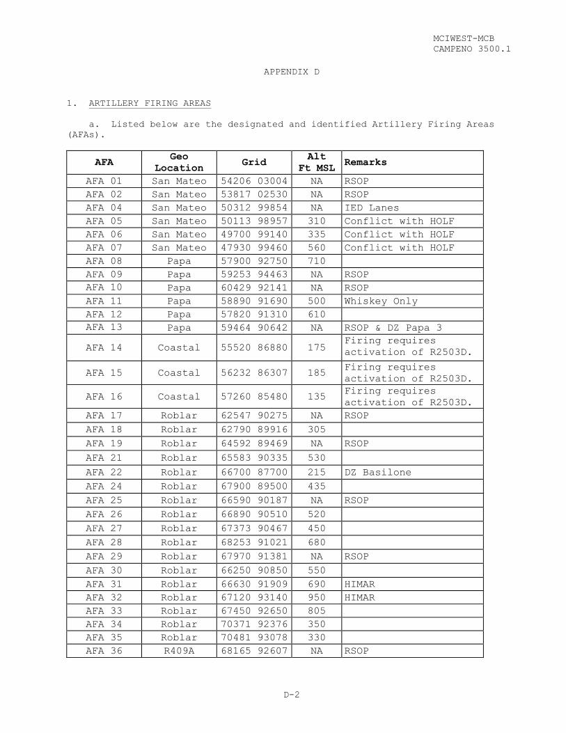
MCIWEST-MCB
CAMPENO 3500.1
D-2
APPENDIX D
1. ARTILLERY FIRING AREAS
a. Listed below are the designated and identified Artillery Firing Areas
(AFAs).
AFA Geo
Location Grid
Alt
Ft MSL Remarks
AFA 01 San Mateo 54206 03004 NA RSOP
AFA 02 San Mateo 53817 02530 NA RSOP
AFA 04 San Mateo 50312 99854 NA IED Lanes
AFA 05 San Mateo 50113 98957 310 Conflict with HOLF
AFA 06 San Mateo 49700 99140 335 Conflict with HOLF
AFA 07 San Mateo 47930 99460 560 Conflict with HOLF
AFA 08 Papa 57900 92750 710
AFA 09 Papa 59253 94463 NA RSOP
AFA 10
Papa 60429 92141 NA RSOP
AFA 11 Papa 58890 91690 500 Whiskey Only
AFA 12 Papa 57820 91310 610
AFA 13
Papa 59464 90642 NA RSOP & DZ Papa 3
AFA 14 Coastal 55520 86880 175 Firing requires
activation of R2503D.
AFA 15 Coastal 56232 86307 185 Firing requires
activation of R2503D.
AFA 16 Coastal 57260 85480 135 Firing requires
activation of R2503D.
AFA 17 Roblar 62547 90275 NA RSOP
AFA 18 Roblar 62790 89916 305
AFA 19 Roblar 64592 89469 NA RSOP
AFA 21 Roblar 65583 90335 530
AFA 22 Roblar 66700 87700 215 DZ Basilone
AFA 24 Roblar 67900 89500 435
AFA 25 Roblar 66590 90187 NA RSOP
AFA 26 Roblar 66890 90510 520
AFA 27 Roblar 67373 90467 450
AFA 28 Roblar 68253 91021 680
AFA 29 Roblar 67970 91381 NA RSOP
AFA 30 Roblar 66250 90850 550
AFA 31 Roblar 66630 91909 690 HIMAR
AFA 32 Roblar 67120 93140 950 HIMAR
AFA 33 Roblar 67450 92650 805
AFA 34 Roblar 70371 92376 350
AFA 35 Roblar 70481 93078 330
AFA 36 R409A 68165 92607 NA RSOP
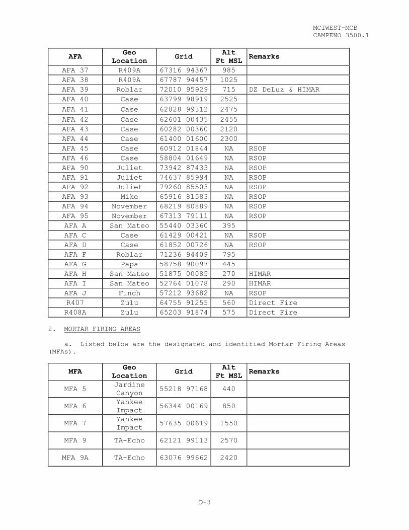
MCIWEST-MCB
CAMPENO 3500.1
D-3
AFA Geo
Location Grid
Alt
Ft MSL Remarks
AFA 37 R409A 67316 94367 985
AFA 38 R409A 67787 94457 1025
AFA 39 Roblar 72010 95929 715 DZ DeLuz & HIMAR
AFA 40 Case 63799 98919 2525
AFA 41 Case 62828 99312 2475
AFA 42 Case 62601 00435 2455
AFA 43 Case 60282 00360 2120
AFA 44 Case 61400 01600 2300
AFA 45 Case 60912 01844 NA RSOP
AFA 46 Case 58804 01649 NA RSOP
AFA 90 Juliet 73942 87433 NA RSOP
AFA 91 Juliet 74637 85994 NA RSOP
AFA 92 Juliet 79260 85503 NA RSOP
AFA 93 Mike 65916 81583 NA RSOP
AFA 94 November 68219 80889 NA RSOP
AFA 95 November 67313 79111 NA RSOP
AFA A San Mateo 55440 03360 395
AFA C Case 61429 00421 NA RSOP
AFA D Case 61852 00726 NA RSOP
AFA F Roblar 71236 94409 795
AFA G Papa 58758 90097 445
AFA H San Mateo 51875 00085 270 HIMAR
AFA I San Mateo 52764 01078 290 HIMAR
AFA J Finch 57212 93682 NA RSOP
R407 Zulu 64755 91255 560 Direct Fire
R408A Zulu 65203 91874 575 Direct Fire
2. MORTAR FIRING AREAS
a. Listed below are the designated and identified Mortar Firing Areas
(MFAs).
MFA Geo
Location Grid
Alt
Ft MSL Remarks
MFA 5 Jardine
Canyon 55218 97168 440
MFA 6 Yankee
Impact 56344 00169 850
MFA 7 Yankee
Impact 57635 00619 1550
MFA 9 TA-Echo 62121 99113 2570
MFA 9A TA-Echo 63076 99662 2420

MCIWEST-MCB
CAMPENO 3500.1
D-4
MFA 10 R409A 66473 94994 975
MFA 11 TA-Kilo 1 65133 90880 475
MFA 12 MP-1 63786 90455 500
MFA 13 R227 63137 90375 350
MFA 14 R221/222 60118 92629 675
MFA 15 LFAM 219 58878 93526 550
3. OBSERVATION POSTS
a. General. Listed below are the designated and identified Observation
Posts (OPs).
OP
LOCATIONS COORDINATES REMARKS
A 636 900 Hand-held lasers allowed
B 640 904 Hand-held lasers allowed
C 642 919 Inactive
D 643 906 Hand-held lasers allowed
E 643 921 Marking for southern AFA’s
F 666 926 Hand-held lasers allowed
I 649 968 Designation into the Zulu Impact Area is
not authorized
J 596 995 Hand-held lasers allowed
K 566 938 Inactive
M 617 989 Marking for northern AFA’s
W 545 953 Marking for northern AFA’s
NOAH 630 972 Observation of HIMAR
b. PROCEDURES FOR USE
(1) Observation Posts being utilized SOLELY for observation of indirect
fire do not require an RSO. Positive communication with the RSO of the firing
unit is required.
(2) Scheduling. OP’s shall be scheduled through the Range Scheduling
Office prior to conducting training. Scheduling requests shall be completed in
accordance with Chapter 3.


MCIWEST-MCB
CAMPENO 3500.1
D-5
(3) Temporary OP’s. Special requests to use other terrain for OP’s
shall be submitted to the Range Scheduling Office. Units shall identify the
coordinates, intended purpose, and time periods.

MCIWEST-MCB
CAMPENO 3500.1
E-1
APPENDIX E
2-CHLOROBENZALMALONONITRILE (CS)
PAGE
CS TRAINING CHAMBERS....................................................E-2
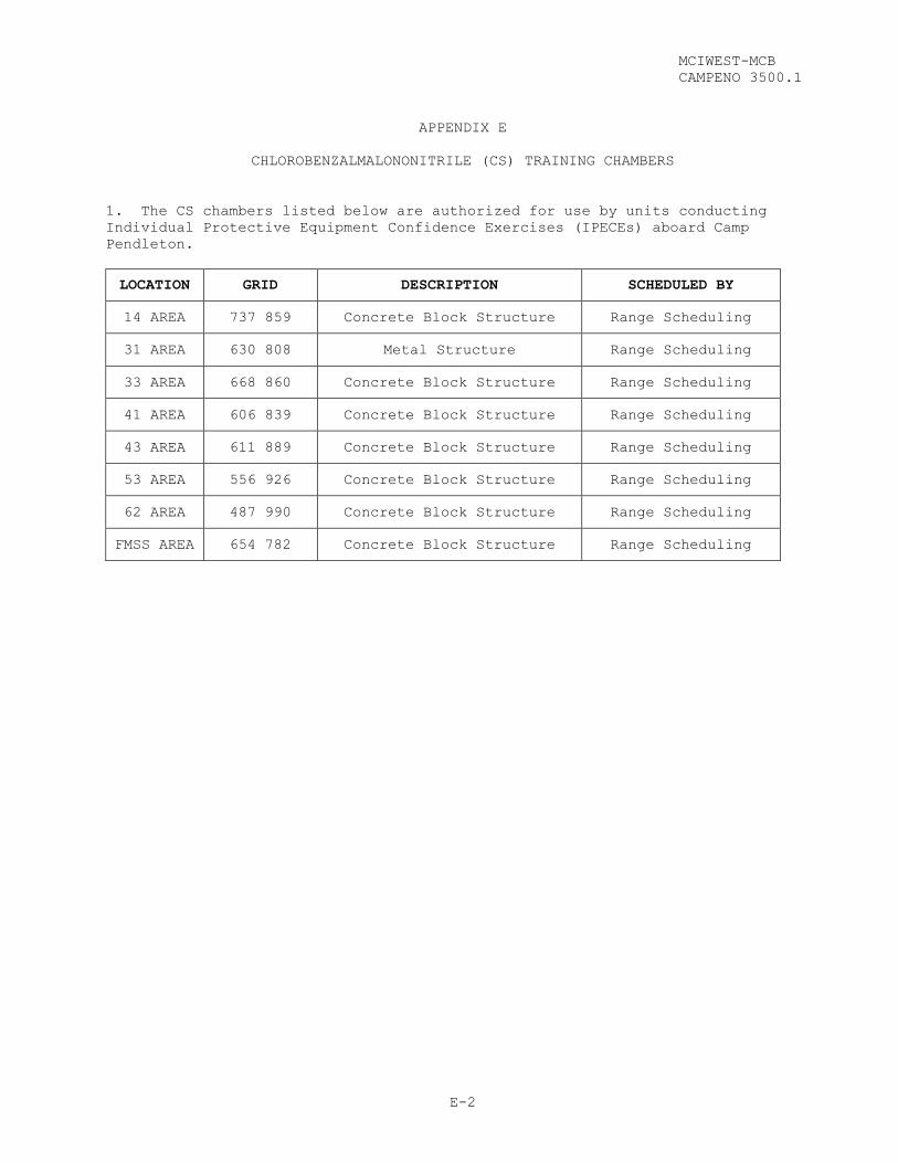
MCIWEST-MCB
CAMPENO 3500.1
E-2
APPENDIX E
CHLOROBENZALMALONONITRILE (CS) TRAINING CHAMBERS
1. The CS chambers listed below are authorized for use by units conducting
Individual Protective Equipment Confidence Exercises (IPECEs) aboard Camp
Pendleton.
LOCATION GRID DESCRIPTION SCHEDULED BY
14 AREA 737 859 Concrete Block Structure Range Scheduling
31 AREA 630 808 Metal Structure Range Scheduling
33 AREA 668 860 Concrete Block Structure Range Scheduling
41 AREA 606 839 Concrete Block Structure Range Scheduling
43 AREA 611 889 Concrete Block Structure Range Scheduling
53 AREA 556 926 Concrete Block Structure Range Scheduling
62 AREA 487 990 Concrete Block Structure Range Scheduling
FMSS AREA 654 782 Concrete Block Structure Range Scheduling

MCIWEST-MCB
CAMPENO 3500.1
F-1
APPENDIX F
AVIATION
PAGE
ADMINISTRATIVE LANDING ZONES............................................F-2
TACTICAL LANDING ZONES..................................................F-3
CONFINED AREA LANDING SITES (CALSITES)..................................F-4
VERTICAL TAKEOFF AND LANDING (VTOL) SITES...............................F-4
SIMULATED FLIGHT DECKS .................................................F-5
AIRCRAFT REFUELING SITES................................................F-5
DROP ZONES..............................................................F-6
FIXED WING PATTERN WITH R2503B AND R2503D ACTIVE........................F-7
FIXED WING PATTERN WITHIN R2503B (R2503D INACTIVE)......................F-8

MCIWEST-MCB
CAMPENO 3500.1
F-2
APPENDIX F
AVIATION
1. ADMINISTRATIVE LANDING ZONES
ADMINISTRATIVE
LANDING ZONE LOCATION DESCRIPTION
LZ-11 71211 85205 East side of 11 Area Parade field adjacent to
1stMarDiv HQ (Bldg 1133); unmarked.
LZ-16 70152 84588
H&S (MCB) Motor Pool parking lot, south of
the 13 Area BOQ (Bldg 1341); unit requesting
use shall coordinate with PMO and provide
security to ensure the area is clear of POVs
prior to operations.
LZ-21 TBD TBD
LZ-22 67825 83788 Northeast side of Bldg 22172; across from
chapel.
LZ-27 68818 89105 East side of Naval Hospital.
LZ-31 60653 80473 Blacktop in front of Edson Range Receiving
Barracks; west of Alpha Range.
LZ-33 TBD TBD
LZ-41 TBD TBD
LZ-43 62062 89616 1/4 mile northeast of gas station on east side
of Las Pulgas Road; limited to UH-1s only.
LZ-52 TBD TBD
LZ-53 55611 93752 Blacktop 1/4 mile north of ”E” Club.
LZ-62 48995 98032 100 m southwest of the rappel tower.
LZ-63 46953 99126 Located near gas station; unmarked.
LZ-64 47955 01738 North side of hardtop road; near Camp Talega
main entrance.

MCIWEST-MCB
CAMPENO 3500.1
F-3
2. TACTICAL LANDING ZONES
TACTICAL
LANDING
ZONE
LOCATION DESCRIPTION
LZ Red Beach 56590
84260
Beach area between LHA Pad and VSTOL Pad #1;
unmarked.
Beach area between LHA Pad and VSTOL Pad #1;
unmarked.
LZ Viewpoint 54447
86811 Concrete pad located on Gold Beach.
HLZ Heavy Lift
Pad
48062
99498
Hilltop adjacent to San Mateo Water Tank, lighted
pad with windsock and LPD markings.
NOTE: Aircraft shall return weights to the
designated external weight area.
LZ Horno
57702
91614 Zone is concurrent with AFA 12.
LZ Fallbrook 74813
87303 Zone is along Eastern border of Base boundary.
LZ Pelican 67905
88354
Zone is located in the middle of 25 Area Combat
Town.
LZ Toucan
68016
88148 Zone is not confined.
LZ Vulture 50967
94829 52 Area Combat Town 45m north.
LZ Cardinal 49525
96578 Zone is situated in a box canyon IVO 52 CBT.
LZ Ostrich 64168
88977
Zone is located between the 500-yard and 600-yard
firing on R-116A.
LZ Peregrine 61838
85738
Used to support training at R-130. Contact R130
Range Manager 48 hours prior to use.
LZ Eagle 61843
84679
Zone is associated with the MOUT facility (R131).
Coordinate with MOUT STAFF 24 hours prior to use.
LZ Sparrow 68166
93622 Zone is associated with R409.
LZ Turkey 68086
93685 Zone is associated with R409.
LZ Canary 62660
00454
Zone supports assault landings in the vicinity of OP
Mike (LFAM 711). Supports multiple A/C
simultaneously. LZ Gnatcatcher
63080
98680
Zone supports assault landings in the vicinity of OP
Mike (LFAM 711).
LZ Swallow 62052
99057
Zone supports the simulated or actual medical
evacuation of personnel in the vicinity of OP Mike
(LFAM 711). LZ Blue Bird
62900
99651
Zone supports assault landings in the vicinity of OP
Mike (LFAM 711).
LZ Robin 60345
00317
Zone supports assault landings in the vicinity of
R800. Supports CH-53 and smaller.
LZ Buzzard
61467
00682
Zone supports assault landings in the vicinity of
R800.
LZ Hawk 61104
01266
Zone supports assault landings in the vicinity of
R800.
LZ Falcon 60294
99921
Zone supports assault landings in the vicinity of
R800.
LZ Starling 62031
91260
Zone supports assault landings between R225 and
R223A.

MCIWEST-MCB CAMPENO 3500.1 Ch 1
F-4
3. CONFINED AREA LANDING SITES (CALSITES)
SITE COORDINATES LAT/LONG REMARKS
1 64465 81080 33° 16’05”, 117° 22’54”
2 67738 81213 33° 16’10”, 117° 20’47”
3 69931 92658 33° 22’22”, 117° 19’24”
4 70246 94112 33° 23’09”, 117° 19’12”
5 71991 95970 33° 24’10”, 117° 18’04”
7 66544 97881 33° 25’11”, 117° 21’35”
8 63080 98680 33° 25’37”/ 117° 23’50”
9 61104 01266 33° 27’00”, 117° 25’07”
10 59517 01662 33° 27’13”, 117° 26’08”
13 49549 00002 33° 26’18”, 117° 32’24”
14 48689 99782 33° 26’10”, 117° 33’07”
15 47817 99531 33° 26’02”, 117° 33’41”
16 48845 96718 33° 24’31”, 117° 33’01”
17 52251 92236 33° 22’06”, 117° 30’48”
18 57592 90383 33° 21’07”, 117° 27’21”
19 58347 88537 33° 20’07”, 117° 26’51”
20 53591 87798 33° 19’42”, 117° 29’55”
21 57614 82702 33° 16’57”, 117° 27’17”
22 55786 86418 33° 18’58”, 117° 28’30”
23 58032 83962 33° 17’38”/ 117° 27’03”
24 49950 93380 33° 22’42”/ 117° 32’17”
4. VERTICAL TAKEOFF AND LANDING (VTOL) SITES
SITE COORDINATES LAT/LONG REMARKS
VTOL Pad 1 57548 83035 33° 17’08”/117° 27’13” Constructed of AM-2 matting.
VTOL Pad 2 60078 82014 33° 16’35”/117° 25’08” Concrete pad. Pilot controlled lighting (VHF 126.2).
VSTOL 101 56064 85508 33° 18’28”/117° 28’51” Concrete pad. Active roadway (old Highway 101).


MCIWEST-MCB
CAMPENO 3500.1
F-5
5. SIMULATED FLIGHT DECKS
FACILITY DESCRIPTION COORDINATES
CALS 20 Marked to simulate LSD/LPD 53591 87798
HLZ Marked to simulate LSD/LPD 48062 99498
LHD Pad Marked to simulate LHD 56346 84646
6. AIRCRAFT REFUELING SITES
The following training facilities are approved aviation refueling sites:
SITE LOCATION ENVIRONMENTAL CONSTRAINTS
LHD 561 847 Stay on the LHD Pad; vernal pools
in close proximity.
LZ-53 555 937 Stay on landing site; rare plant
area in close proximity.
STOL-101 564 852 No special concerns.
PAD-1 574 834 Stay in the landing zone; vernal
pool in close proximity.
PAD-2 601 822 The site is near riparian habitat
and rare plant area.
AFA-22 668 880 No special concerns.
AFA-31 667 917 No special concerns.
AFA-40 638 989 No special concerns.
AFA-41 629 993 No disturbance to north;
archaeological site.
HOLF 505 995
Limited to mobile refueling
trucks. Vernal pools, Arroyo
Toad, and rare plants in area.
LZ Viewpoint 548 869
Gnatcatcher habitat nearby; no
brush removal/disturbance around
site.

MCIWEST-MCB
CAMPENO 3500.1
F-6
7. DROP ZONES
DROP ZONE COORDINATES
CENTER POINTS NOTES
DZ Deluz 72026 96001 Circular DZ 250m Radius
DZ R409A 67532 94066 1106m X 829m
DZ Basilone 66390 87508 1110m X 921m
DZ Papa 3 59404 90660 Circular DZ 375m Radius
DZ Tank Park 60001 83003 Circular DZ 350m Radius
DZ Six Three 46952 99248 Circular DZ 200m Radius Resupply Bundles
Only
DZ Ocean 55314 83458 Water DZ 3000m X 1200m
DZ Oro 53909 85531 Circular/Water DZ 500m Radius
DZ Meadows 62840 99320 Circular DZ 200m Radius

MCIWEST-MCB
CAMPENO 3500.1
F-7
8. FIXED WING PATTERN WITH R2503B AND R2503D ACTIVE
ZULU IMPACT
WHISKEY IMPACT
R-2503D(2-11K MSL)
R-2503B(SFC- 15K MSL)
Fixed WingTarget Area
OCN VORTAC
HOLF3,000’ RWY
A/C may use Clockwise or Counterclockwise Pattern
IP CASE
Lake O’Neil
MCAS Camp Pendleton
- Aircraft should contact LONGRIFLE on 310.3 at least ten minutes prior
to entering R-2503; expect to hold in clockwise/ counter-clockwise
pattern oriented on IP Case (11SMT 615005).
- Aircraft will be assigned initial altitude and hard deck to integrate
with indirect fire weapons and other aviation operations.
- Aircraft will be switched to secondary/tactical control frequency
following check-in and hot range brief.
- Aircraft conducting TACP/CAS live ordnance delivery in the Zulu Impact
Area must verify comprehension of, and operate in accordance with, the
Special Instructions for MCIWEST-MCB CAMPEN R-440 TACP.
- Aircraft must maintain radio contact with LONGRIFLE at all times for
traffic advisories and spill-out instructions as required. Aircraft
shall remain within the confines of the active portions of the R-2503
SUA throughout the training evolution.
- Aircraft shall remain above the MCAS Camp Pendleton Class D airspace.
- Absolute Fixed Wing minimum altitude in the R-2503 SUA is 1500’ AGL.
- Aircraft should contact LONGRIFLE on 310.3 prior to departing R-2503.

MCIWEST-MCB
CAMPENO 3500.1
F-8
9. FIXED WING PATTERN WITHIN R2503B (R2503D INACTIVE)
ZULU IMPACT
WHISKEY IMPACT
R-2503A(SFC-2K MSL)
R-2503B(SFC- 15K MSL)
Fixed WingTarget Area
OCN VORTAC
HOLF3,000’ RWY
A/C may use Clockwise or Counterclockwise Pattern
IP CASE
Lake O’Neil
MCAS Camp Pendleton
- Aircraft should contact LONGRIFLE on 310.3 at least ten minutes prior
to entering R-2503; expect to hold in clockwise/ counter-clockwise
pattern oriented on IP Case (11SMT 615005).
- Aircraft will be assigned initial altitude and hard deck to integrate
with indirect fire weapons and other aviation operations.
- Aircraft will be switched to secondary/tactical control frequency
following check-in and hot range brief.
- Aircraft conducting CAS/ live ordnance delivery in the Zulu Impact Area
must verify comprehension of, and operate in accordance with, the
Special Instructions for MCIWEST-MCB CAMPEN R-440 TACP.
- Aircraft must maintain radio contact with LONGRIFLE at all times for
traffic advisories and spill-out instructions as required. Aircraft
shall remain within the confines of the active portions of the R-2503
SUA throughout the training evolution.
- Aircraft shall remain above the MCAS Camp Pendleton Class D airspace.
- Absolute Fixed Wing minimum altitude in the R-2503 SUA is 1500’ AGL.
- Aircraft should contact LONGRIFLE on 310.3 prior to departing R-2503.