maps may vary, but should include objects in the area
TRANSCRIPT

P R E V I E W
© Teachers’ Curriculum Institute Geography of the United States 1
Map A Look at the area of the classroom your teacher has marked off with tape. Draw all the objects in the area, placing them as accurately as possible on Map A. When you finish your map, compare it to the maps of two or three other students. How closely does your map match the maps of other students? How could this map be drawn more accurately?
Map B Now map the same area again. Be careful to locate each object on the grid before drawing it on Map B. When you complete the map, compare it with two or three maps other students made. Is Map A or B more accurate? Why? How does a grid help us create accurate maps?
A
B
C
D
E
F
1 2 3 4 5 6 7 8 9 10
Maps may vary, but should include objects in the area marked off with tape.
Objects on map should match coordinates of actual objects in the classroom. Expect Map B to be more accurate than Map A.
ANSWER KEY

© Teachers’ Curriculum Institute
R E A D I N G N O T E S
2 Geography of the United States
Wo
rld
Map
: Co
nti
nen
ts a
nd
Oce
ans
20˚S
20˚S
0˚0˚
20˚N
20˚N
40˚N
40˚N
60˚N
60˚N
80˚N
80˚N
40˚S
40˚S
60˚S
60˚S
80˚S
80˚S
EQU
ATO
REQ
UAT
OR
PRIME MERIDIAN PRIME MERIDIAN
80˚W
80˚W
120˚
W12
0˚W
160˚
W16
0˚W
40˚W
40˚W
40˚E
40˚E
80˚E
80˚E
120˚
E12
0˚E
160˚
E16
0˚E
0˚0˚
03,
000
kilo
met
ers
01,
500
3,00
0 m
iles
N S
EW
20˚S
0˚
20˚N
40˚N
60˚N
80˚N
40˚S
60˚S
80˚S
EQU
ATO
R
PRIME MERIDIAN
80˚W
120˚
W16
0˚W
40˚W
40˚E
80˚E
120˚
E16
0˚E
0˚
SS
A5_
ISN
_1.1
Bla
ck C
yan
Mag
enta
Yel
low
S
eco
nd
Pro
of
TC
I14
27
Read Section 1, Understanding the Globe.
Answer the Challenge Questions from Handout A: Geography Challenge Questions for Key Parts of the World Map. For each Challenge Question, find the correct location(s) on the map. Make sure to:• write the question number on the location(s)• label the location(s)
2. A
ustr
alia
10. In
dian
Oc
ean
1. A
sia
7. A
ntar
ctic
a
8. A
rcti
c Oc
ean
6. A
tlan
tic
Ocea
n
3. W
este
rn
and
Nor
ther
n H
emis
pher
es
9. P
acifi
c Oc
ean
5. E
urop
e
4. E
aste
rn,
Wes
tern
, Nor
ther
n,
and
Sou
ther
n H
emis
pher
es

R E A D I N G N O T E S
© Teachers’ Curriculum Institute Geography of the United States 3
45˚S
45˚S
30˚S
30˚S
15˚S
15˚S
15˚N
15˚N
30˚N
30˚N
45˚N
45˚N
60˚N
60˚N
75˚N
75˚N 0˚0˚ 60˚S
60˚S
75˚S
75˚S
NN SS
EEWW
0˚0˚30˚W
30˚W
60˚W
60˚W
90˚W
90˚W
120˚W
120˚W
150˚W
150˚W
30˚E
30˚E
60˚E
60˚E
90˚E
90˚E
120˚E
120˚E
150˚E
150˚E
02,
500
5,00
0 ki
lom
eter
s
02,
500
5,00
0 m
iles
N S
EW
45˚S
30˚S
15˚S
15˚N
30˚N
45˚N
60˚N
75˚N 0˚ 60˚S
75˚S
0˚30˚W
60˚W
90˚W
120˚W
150˚W
30˚E
60˚E
90˚E
120˚E
150˚E
SS
A5_
ISN
_1.2
Bla
ck C
yan
Mag
enta
Yel
low
T
hir
d P
roo
fT
CI1
4 28
Wo
rld
Map
: Lat
itu
de
and
Lo
ng
itu
de
Read Section 2, Understanding Latitude and Longitude.
Answer the Challenge Questions from Handout B: Geography Challenge Questions for Latitude and Longitude. For each Challenge Question, find the correct location(s) on the map. Make sure to:• write the question number on the location(s)• label the location(s)
8. A
ustr
alia
3. In
dian
Oc
ean
5. A
sia
6. A
rcti
c Oc
ean
4. A
tlan
tic
Ocea
n
5. N
orth
A
mer
ica
10. P
acifi
c Oc
ean
5. E
urop
e
9. A
fric
a
2. P
rime
Mer
idia
n
1. E
quat
or7.
Sou
th
Am
eric
a

© Teachers’ Curriculum Institute
R E A D I N G N O T E S
4 Geography of the United States
Geo
gra
ph
ic T
erm
s
Read Section 3, Describing Water and Landforms.
Answer the Challenge Questions from Handout C: Geography Challenge Questions for Key Water and Landforms. For each Challenge Question, find the correct location(s) on the map. Make sure to:• write the question number on the location(s)• label the location(s)
2. S
ea
1. G
ulf
4. Tr
ibut
ary
11. V
alle
y11
. Val
ley
12. D
elta
9. P
lain
8. Pen
insula
5. M
ount
ains
3. L
ake
7. Is
land
6.
6.
Bay
Bay
10. M
outh
R E A D I N G N O T E S
© Teachers’ Curriculum Institute Geography of the United States 5
Phy
sica
l Fea
ture
s o
f th
e C
on
tin
enta
l Un
ited
Sta
tes
125˚
W12
5˚W
120˚
W12
0˚W
115˚
W11
5˚W
110˚
W11
0˚W
105˚
W10
5˚W
100˚
W10
0˚W
95˚W
95˚W
90˚W
90˚W
25˚N
25˚N
30˚N
30˚N
35˚N
35˚N
40˚N
40˚N
120˚
W11
5˚W
110˚
W95
˚W90
˚W85
˚W
80˚W
75˚W
25˚N
30˚N
35˚N
40˚N
N
S
EW
015
030
0 ki
lom
eter
s
015
030
0 m
iles
SS
A5_
ISN
_1.3
Bla
ck C
yan
Mag
enta
Yel
low
S
eco
nd
Pro
of
TC
I14
29
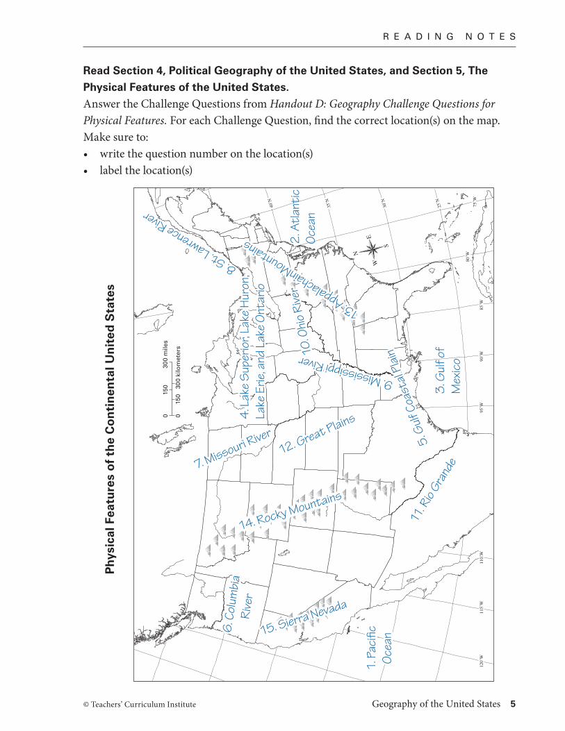
Read Section 4, Political Geography of the United States, and Section 5, The
Physical Features of the United States.
Answer the Challenge Questions from Handout D: Geography Challenge Questions for Physical Features. For each Challenge Question, find the correct location(s) on the map. Make sure to:• write the question number on the location(s)• label the location(s)
13. AppalachainMountains
13. AppalachainMountains 2. A
tlan
tic
Ocea
n
8. St. Lawrence River
10. O
hio
Rive
r10
. Ohi
o Ri
ver
12. Great Plains
12. Great Plains
6. C
olum
bia
6. C
olum
bia
Rive
rRi
ver
4. L
ake
Sup
erio
r, La
ke H
uron
, 4.
Lak
e S
uper
ior,
Lake
Hur
on,
Lake
Erie
, and
Lak
e O
ntar
ioLa
ke E
rie, a
nd L
ake
Ont
ario
9. Mississippi River
9. Mississippi River
3. G
ulf o
f M
exic
o
5. G
ulf C
oast
al P
lain
5. G
ulf C
oast
al P
lain
11. R
io Gra
nde7. Missouri River
7. Missouri River
14. Rocky Mountains
14. Rocky Mountains
15. Sierra Nevada
15. Sierra Nevada
1. P
acifi
c 1.
Pac
ific
Ocea
nOc
ean

© Teachers’ Curriculum Institute
R E A D I N G N O T E S
6 Geography of the United States
Read Section 6, Climate in the United States.
What type of climate is each place most likely to experience? Label if each place is: hot and dry, hot and humid, cold and dry, or cold and wet.
Read Section 7, Vegetation in the United States.
What type of vegetation is each place most likely to have? Label if the place has: forests, grasslands, or wetlands.
125˚W125˚W 120˚W120˚W 115˚W115˚W 110˚W110˚W 105˚W105˚W 100˚W100˚W
95˚W95˚W
90˚W90˚W
25˚N25˚N
30˚N30˚N
35˚N35˚N
40˚N40˚N
120˚W 115˚W 110˚W 95˚W 90˚W 85˚W
80˚W
75˚W
25˚N
30˚N
35˚N
40˚N
N
S
EW
0 150 300 kilometers
0 150 300 miles
SSA5_ISN_1.3Black Cyan Magenta Yellow Second ProofTCI14 29
125˚W125˚W 120˚W120˚W 115˚W115˚W 110˚W110˚W 105˚W105˚W 100˚W100˚W
95˚W95˚W90˚W90˚W
25˚N25˚N
30˚N30˚N
35˚N35˚N
40˚N40˚N
120˚W 115˚W 110˚W 95˚W 90˚W 85˚W
80˚W75˚W
25˚N
30˚N
35˚N
40˚N
N
S
EW
0 150 300 kilometers
0 150 300 miles
SSA5_ISN_1.3Black Cyan Magenta Yellow Second ProofTCI14 29
cold and wetcold and dry
grasslands
forestswetlands
hot and dryhot and humid
R E A D I N G N O T E S
© Teachers’ Curriculum Institute Geography of the United States 7
1.
2.
3.
Read Section 8, Geography Affects Where People Live.
Give one example of how each part of geography affects how people live.
Part of Geography Example
Physical Features
Climate
Vegetation
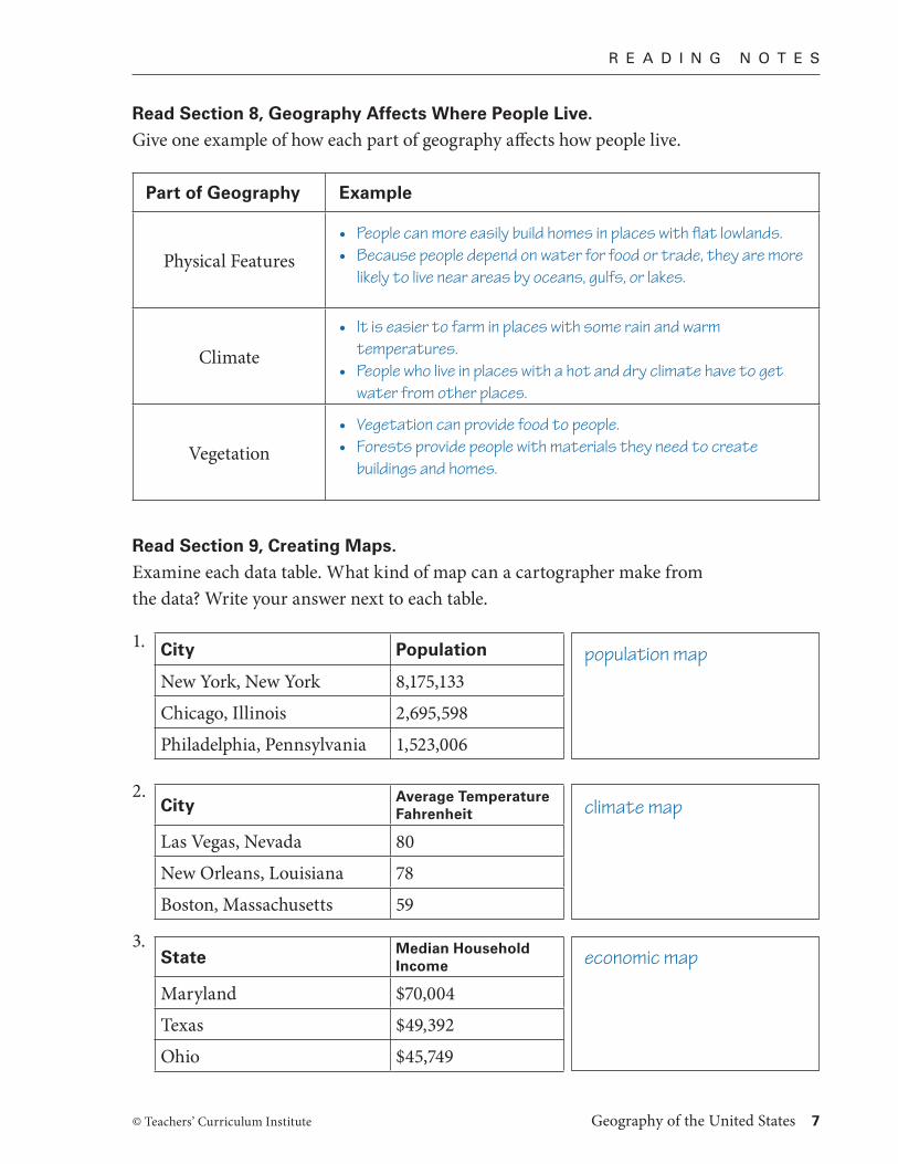
Read Section 9, Creating Maps.
Examine each data table. What kind of map can a cartographer make from the data? Write your answer next to each table.
City Population
New York, New York 8,175,133
Chicago, Illinois 2,695,598
Philadelphia, Pennsylvania 1,523,006
City Average Temperature Fahrenheit
Las Vegas, Nevada 80
New Orleans, Louisiana 78
Boston, Massachusetts 59
State Median Household Income
Maryland $70,004
Texas $49,392
Ohio $45,749
• People can more easily build homes in places with flat lowlands.• Because people depend on water for food or trade, they are more
likely to live near areas by oceans, gulfs, or lakes.
• It is easier to farm in places with some rain and warm temperatures.
• People who live in places with a hot and dry climate have to get water from other places.
• Vegetation can provide food to people.• Forests provide people with materials they need to create
buildings and homes.
population map
climate map
economic map

© Teachers’ Curriculum Institute
R E A D & D O
8 Geography of the United States
100°W100°W 80°W80°W 60°W60°W 40°W40°W
40°S40°S
20°S20°S
20°N20°N
40°N40°N
0°0°
120°W120°W
0 1,000 kilometers
0 500 1,000 miles
N
S
EW
CapeHorn
New York City
SanFrancisco
A T L A N T I CO C E A N
PA C I F I CO C E A N
PANAMA
Independence
Sacramento
100°W 80°W 60°W 40°W
40°S
20°S
20°N
40°N
0°
120°W
SSA5_ISN_1.aBlack Cyan Magenta Yellow First ProofTCI14 80
Choose a route, overland or by water, that would take someone traveling from New York to the goldfields of California in 1849. Draw their route on the map below.
Route to California

R E A D & D O
© Teachers’ Curriculum Institute Geography of the United States 9
Write a story about people traveling to the goldfields of California. Include some details about how the geographic features along the way affected their journey. You may include an illustration to show one geographic feature.
Stories will vary but should include information from the Student Text to describe the trip, particularly the geographic features.

P R O C E S S I N G
10 Geography of the United States © Teachers’ Curriculum Institute
Write questions about geography in the boxes below. You will choose your best five questions to play a Challenge Game. Your questions should be in these categories: general geographic skills, physical features, or states and capitals.
Question:
Answer:
Question:
Answer:
Question:
Answer:
Question:
Answer:
Question:
Answer:
Question:
Answer:
Question:
Answer:
Question:
Answer:
Question:
Answer:
Question:
Answer:
Questions may vary, but should align with the three categories. Answers should also be accurate.