mapping the city of senses and meanings - de boekentoren · mapping the city of senses and meanings...
TRANSCRIPT

Mapping the City of Senses and MeaningsThe Work of Three Students of Kevin Lynch at MIT in the 1960’s
Clément Orillard – [email protected] Analogous Spaces Conference – 16/05/2007
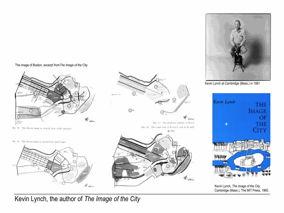
The image of Boston, excerpt fromThe Image of the City
Kevin Lynch, the author of The Image of the City
Kevin Lynch at Cambridge (Mass.) in 1981
Kevin Lynch, The Image of the City,
Cambridge (Mass.), The MIT Press, 1960.

Kevin Lynch, teacher and researcher at MIT
1. Donald Appleyard (in 1974) 2. Carl Steinitz 3. Michael Southworth
The Massachusetts Institute of Technology, Cambridge (Mass.)
Three students of Kevin Lynch:

1. Donald Appleyard: making imagibility operational

From visual sequences to mental image: the first attempts in Appleyard’s thesis
Donald Appleyard, Towards an Imageable
Structure for Residential Areas, thesis, MIT 1958

The recording system in The View from the Road
Recording of the sequences of the Northeast Expressway in
Donald Appleyard, Kevin Lynch & John R. Myer, The View from the Road,
Cambridge (Mass.), The MIT Press, 1964.

Donald Appleyard, « Boston Street System », draft, Donald Appleyard Collection,
BANC MSS 83/165c, Bancroft Library, University of California at Berkeley.
The final attempt to record the whole Boston Street System

2. Carl Steinitz or “scientifying” the method
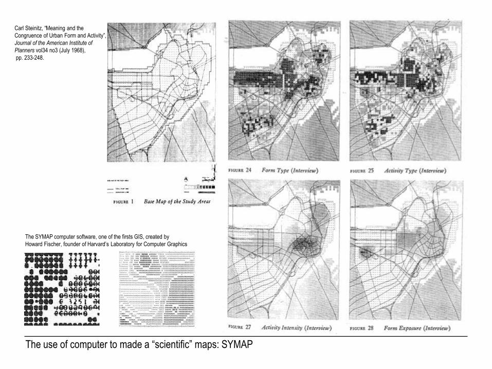
The use of computer to made a “scientific” maps: SYMAP
The SYMAP computer software, one of the firsts GIS, created by
Howard Fischer, founder of Harvard’s Laboratory for Computer Graphics
Carl Steinitz, “Meaning and the
Congruence of Urban Form and Activity”,
Journal of the American Institute of
Planners vol34 no3 (July 1968),
pp. 233-248.

Between abstraction and graphic means
Carl Steinitz, “Meaning and the
Congruence of Urban Form and Activity”,
Journal of the American Institute of
Planners vol34 no3 (July 1968),
pp. 233-248.

Steinitz as a pioneer in computerized mapping
Carl Steinitz (left), junior professor at the Graduate School of Design
with his students
The Delmarva Study, the first regional plan using a computer

3. Michael Southworth and the imagibility through other senses

Analyzing the sonic environment along a path
Michael Southworth, “The Sonic Environment of Cities”, Environment and Behavior 1:1(June 1969), pp. 49-70.

Mapping the sonic city
Michael Southworth, “The Sonic Environment of Cities”, Environment and Behavior 1:1(June 1969), pp. 49-70.

From representation to communication and detail
Stephen Carr (dir.), City Signs and Lights: A Report,
Cambridge (Mass.), The MIT Press, 1973.
Kevin Lynch and Michael Southworth, Managing the Strip,
unpublished report, 1974.