mantle-derived peridotite xenoliths from the western ... · mantle-derived peridotite xenoliths...
TRANSCRIPT

Mantle-Derived Peridotite Xenoliths from the Western Intermontane Belt,Whitesail Lake map area (NTS 093E), Western British Columbia
By N.D. Peterson1, J.K. Russell1 and J.B. Mahoney2
KEYWORDS: man tle pe trol ogy, vol ca nol ogy, peridotite,dike, man tle xe no liths, Whitesail Lake, Hazelton Group
INTRODUCTION
Re cently the Whitesail Lake map area (NTS 093E),im me di ately north and east of Bella Coola, BC has been thefo cus of re gional map ping pro grams, in clud ing the cur rentGeoscience BC funded map ping pro gram of Mahoney et al.(2006) and the map ping con ducted in 2004 un der the Rocks to Riches pro gram (Mahoney et al., 2005). The re gionalmap ping ex er cise dis cov ered a new oc cur rence of man tle-de rived peridotitic xe no liths in the BC Cor dil lera (Fig. 1).Spe cif i cally, they lo cated a mafic dike near Mt. Pres ton thatin trudes Hazelton Group rocks. The dike ap pears to post -date the re gional meta mor phism and de for ma tion re cordedby Hazelton rocks, and is there fore in ferred to be Ter tiary to Neo gene in age. The dike con tains abun dant crustal andman tle-de rived peridotite xe no liths, which are very freshand unaltered in appearance.
The peridotite xe no liths are sam ples of lithosphericman tle, and they rep re sent the only avail able means of di -rectly study ing the un der pin nings of the crust. The MountPres ton dike has sev eral at trib utes that make this par tic u larsuite of man tle xe no liths es pe cially in ter est ing. Firstly, therel a tively young age of the dike sug gests sam pling of ‘near-pres ent-day’ man tle litho sphere un der ly ing this por tion ofBrit ish Co lum bia. The im pli ca tion is that the pet ro log i cal,struc tural and geo chem i cal in sights gath ered from thesexe no liths can be re lated di rectly to large-scale geo phys i caldatasets (e.g., seis mic sur veys). Sec ondly, the Mount Pres -ton lo cal ity has a unique po si tion geo graph i cally and geo -log i cally be cause it is on the west ern mar gin of theIntermontane Belt and within 40 km of Coast Belt rocks(Fig. 2). All other oc cur rences of man tle xe no liths from thenorth ern Ca na dian Cor dil lera are sit u ated well within theIntermontane Belt (e.g., Ed wards and Rus sell, 2000). Thus, this study of these man tle xe no liths will pro vide ev i dencefor the ther mal and struc tural state of the man tle litho sphere un der ly ing the west ern mar gin of the Intermontane Belt.Fur ther more, it should pro vide con straints on the na ture of
Geo log i cal Field work 2005, Pa per 2006-1 153
1Volcanology and Petrology Laboratory, Department of Earthand Ocean Sciences, University of British Columbia,Vancouver, BC ([email protected])
2Department of Geology, University of Wisconsin at Eau Claire,Eau Claire, WI
This publication is also available, free of charge, as colourdigital files in Adobe Acrobat PDF format from the BC Ministry of Energy, Mines and Petroleum Resources internet website athttp://www.em.gov.bc.ca/Mining/Geolsurv/Publications/catalog/catfldwk.htm
Fig ure 1. Lo ca tion of area con tain ing xe no lith-bear ing dike shownagainst the dis tri bu tion of ter ranes that make up the Ca na dian Cor -dil lera (mod i fied from Wheeler and McFeely, 1991). Ter ranes arecat e go rized as pericratonic (Kootenay [KO], Cassiar [CA] andSlide Moun tain [SM]), Stikinia (Stikinia [ST], Quesnellia [QN],Cache Creek [CC] and Yu kon-Tanana [YT]) and In su lar (Al ex an -der [AX], Wrangellia [WR], Chugach [CG] and Yukatat [YA]). Ter -ranes that make up the south ern Cor di l lera in clude theCadwallader (CD), Bridge River (BR) and Methow (MT). Alsoshown are the ap prox i mate mar gin of an ces tral North Amer ica and the east ern ex tent of Cordilleran de for ma tion ex tend ing into west -ern Can ada. ‘X’ in di cates the ap prox i mate lo ca tion of KonigusCreek, the clos est man tle xe no lith – bear ing ed i fice within thenorth ern Cordilleran vol ca nic prov ince (NCVP; Ed wards and Rus -sell, 2000; Evenchick and Thorkelson, 1993). ‘Y’ in di cates theItcha Moun tains man tle xe no lith lo cal ity of Nicholls et al. (1982).Out line in di cates the area shown in Fig ure 2 (i.e., NTS sheets093D [Bella Coola] and 093E [Whitesail]).
the fun da men tal bound ary be tween the Coast andIntermontane belts in this re gion. This will com ple ment thenew BATHOLITHS geo phys i cal pro ject, which is de -signed to ex plore the crustal struc ture of the Coast Belt butwill also probe the un der ly ing mantle lithosphere(Andronicos and Ducea, 2004). The BATHOLITHSoperational area will encompass the Mt. Preston site(Fig. 2).
The pur pose of this pa per is to,
• re port on the oc cur rence and prop er ties of this youngvol ca nic dike;
• de scribe the na ture and dis tri bu tion of man tle and crustal xe no liths within the dike; and
• ex plore some of the im pli ca tions of these ob ser va tionsfor the trans port and em place ment of this man tle-de -rived magma.
154 Brit ish Co lum bia Geo log i cal Sur vey
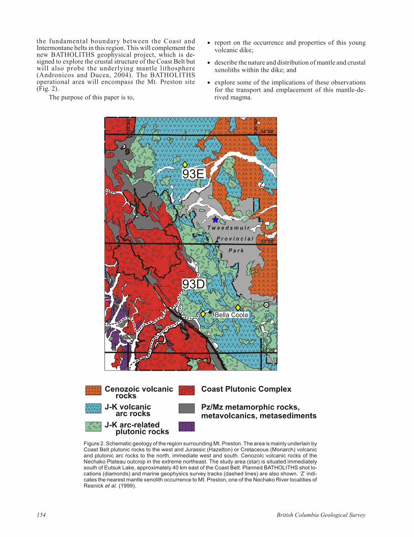
Fig ure 2. Sche matic ge ol ogy of the re gion sur round ing Mt. Pres ton. The area is mainly un der lain by Coast Belt plutonic rocks to the west and Ju ras sic (Hazelton) or Cre ta ceous (Mon arch) vol ca nicand plutonic arc rocks to the north, im me di ate west and south. Ce no zoic vol ca nic rocks of theNechako Pla teau out crop in the ex treme north east. The study area (star) is sit u ated im me di atelysouth of Eutsuk Lake, ap prox i mately 40 km east of the Coast Belt. Planned BATHOLITHS shot lo -ca tions (di a monds) and ma rine geo phys ics sur vey tracks (dashed lines) are also shown. ‘Z’ in di -cates the near est man tle xe no lith oc cur rence to Mt. Pres ton, one of the Nechako River lo cal i ties ofResnick et al. (1999).

STRATIGRAPHIC RELATIONSHIPS
The fo cus of this work is a mafic dike that strikes 145°across a sad dle on a ridge 3 km south east of the peak of Mt.Pres ton (Fig. 3a). The dike is ex posed on the ridge crest andin the south-fac ing cliff that forms the east-trending ridge.The ridge crest ex poses the top of the dike and is sit u ated2063 m above mean sea level (amsl) at Zone 9, 653722E,5898712N (NAD 27). Ex po sure be gins at the top of theridge, con tin u ing in ter mit tently down the south ern face forabout 110 m (60 m ver ti cal; Fig. 3b, c). Much of the dike iscov ered by ta lus, but the con tact be tween dike and coun tryrock is lo cally well ex posed. Where ex posed, the con tactdips steeply (be tween 50 and 64°). The dike is not ex posedon the north side of the ridge.
The coun try rock to the dike com prises in ter me di ate tofel sic, subhorizontally bed ded volcaniclastic rocks of theEarly to Mid dle Ju ras sic Hazelton Group (Fig. 3b, c;Gordee et al., 2005; Mahoney et al., 2005). The HazeltonGroup rocks are in truded by sev eral sets of mafic dikes that,
based on al ter ation and com po si tion, ap pear to beCre ta ceous or older. The man tle-xe no lith – bear ing dikecross cuts all other strati graphic units and has a fresh, lessal tered ap pear ance. A small nor mal fault, strik ing 102°,dip ping 76°S and hav ing an off set of ~1 m, cross cutsHazelton stra tig ra phy in the nearby out crop but does notcrosscut the main dike.
Ed wards and Rus sell (2000) have sum ma rized xe no -lith lo cal i ties in the north ern Cordilleran vol ca nic prov ince(NCVP). The near est xe no lith-bear ing vol ca nic site in theNCVP is Konigus Creek (Fig. 1; Evenchick andThorkelson, 1993). Sev eral other pa pers (Littlejohn andGreen wood, 1974; Nicholls et al., 1982; Ross, 1983;Mitch ell, 1987) have sum ma rized dis tri bu tions in otherparts of BC. The near est oc cur rences of man tle peridotiticxe no liths to this new lo cale are the Nechako River cen tres(NTS 093F; Resnick et al., 1999) and the Itcha Moun tainscom plex (NTS 093C; Nicholls et al., 1982; Fig. 1, 2).
Geo log i cal Field work 2005, Pa per 2006-1 155
Fig ure 3. Field pho to graphs show ing the large-scale fea tures of the mafic dike in trud ing older vol ca nic strati graphic units: a) dike (ar row)ex posed in a 300 m steep cliff face, its trace downslope high lighted by light green-grey ta lus; b) ori en ta tion of dike is ap prox i mately145°/55°W and it in trudes Hazelton vol ca nic strati graphic units that have bed ding ori en ta tions of about 115°/15°S; dike is 1 m wide at thetop of the cliff but wid ens downslope to 7 m; it ap pears to post date re gional meta mor phism and de for ma tion events that are re corded by theHazelton Group rocks; solid box de notes por tion of dike that is most en riched in man tle-de rived xe no liths (see Fig. 6); c) geo log i cal sketchmap of cliff face de picted in (b), show ing dis tri bu tion of dike and as so ci ated coun try rock out crop (black) and lay ered Hazelton Groupvolcaniclastic rocks (grey); ar eas of ta lus are de noted by white; two ap prox i mate lo ca tions of bed ding mea sure ments on Hazelton rocks areshown.

GEOLOGY
Dike
The fol low ing ob ser va tions are based on a five-dayfield map ping pro gram de signed to de lin eate the ex tent ofthe dike, its strati graphic re la tion ships and the phys i cal na -ture of its con tacts against coun try rocks, and to col lect acom pre hen sive sam ple suite of the xe no liths of man tlelitho sphere or i gin. The ex tent of the ex posed dike wasmapped to con strain the con tacts and to un der stand the dike morphology (Fig. 4).
The mafic dike var ies in thick ness, from about 1 mwhere both con tacts are vis i ble to at least 7 m. At its wid estpoint, only a sin gle con tact is ex posed (Fig. 4). The out cropis in ter mit tent due to ta lus cov er age, but vis i ble out crop ex -tends 107 m downslope, or more than 60 ver ti cal metres. Atthe low est el e va tion of the ex po sure, the dike is de fined by a large 7 m wide out crop. At higher el e va tions, it bi fur catesto form two lithologically iden ti cal, con nected dikes sep a -rated by 2–3 m of ta lus. Spe cif i cally, the body splits at2025 m el e va tion into a 1–4 m thick arm that strikes di rectly upslope (325°) to the ridge top and an other wider, shorterarm that strikes 310° up hill but ter mi nates at 2049 mabsolute elevation (Fig. 3, 4).
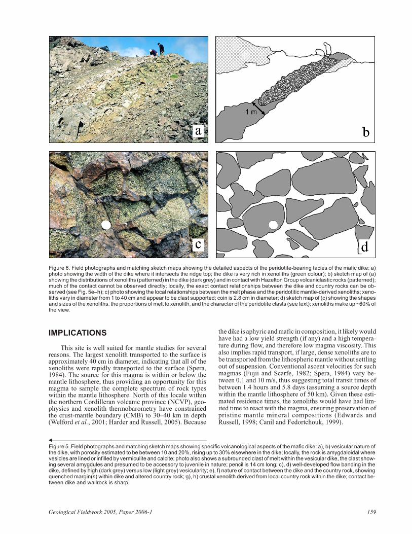
The dike is apha ni tic and grey to tan col oured on freshsur faces. Weath ered sur faces are light grey to dark brown,or some times ox i dized to a red dish brown col our. The dikeis ve sic u lar in many places, lo cally up to 30% (Fig. 5a, b),with the ves i cles vary ing from 0.5 to 10 mm in di am e ter.Flow band ing on the scale of 5–10 cm is com mon, and iscom monly ac cen tu ated by changes in vesicularity (Fig.5c, d). The larger ves i cles are some times stretched. Ves i cles are fre quently filled or coated; on the ba sis of pow der x-raydif frac tion, the min er als are vermiculite and calcite.
Lo cally, the dike has a fragmental char ac ter or ap pear -ance, with ‘clasts’ of melt vis i ble within the dike. The clastsare com monly iden ti fied by changes in col our and ves i clechar ac ter is tics (Fig. 5a, b). Clasts are only weakly ve sic u lar but are sur rounded by highly ve sic u lar ma te rial. Clasts upto 10 cm in size were ob served. The con tact be tween clastand host magma is sharp and melt ing does not ap pear tohave oc curred. How ever, the clast bound aries are lo callyac cen tu ated by ox i da tion rinds up to 1 cm in width. Thesemelt clasts constitute <1% of the dike.
Con tacts with coun try rock are abun dant and sharplyde fined. The dike of ten dis plays one or more chilled mar -gins (Fig. 5e, f). Phys i cal prop er ties such as xe no lith con -tent or vesicularity do not ap pear to change near the con tact. Wher ever con tacts are vis i ble, the coun try rock near thecon tact is par tially melted. Melt is seg re gated into patchesand lenses, which are some times ve sic u lar. Com monly thelenses im part a fo li a tion par al lel to the con tact. This con tact zone varies in width from 10–30 cm.
156 Brit ish Co lum bia Geo log i cal Sur vey
Fig ure 4. Ge ol ogy of dike (black) and coun try rock (grey) out crop,with xe no lith-rich in ter val shown as tex tured. Dike ex po sures arelim ited by ta lus cover, but in ferred con tacts against HazeltonGroup wallrocks are shown (dashed lines). The dike has an ex po -sure length of 107 m and an ap par ent thick ness rang ing from 1 to>7 m. On the ba sis of the mapped ex po sure and the tex tural fea -tures of the dike, the body is in ter preted to be a sin gle dike be low2025 m and then to bi fur cate into two main branches that ter mi nate at 2049 m and 2063 m amsl. Ab so lute el e va tions listed in boldmark a change in slope (and thus scale of el e va tion mark ers).
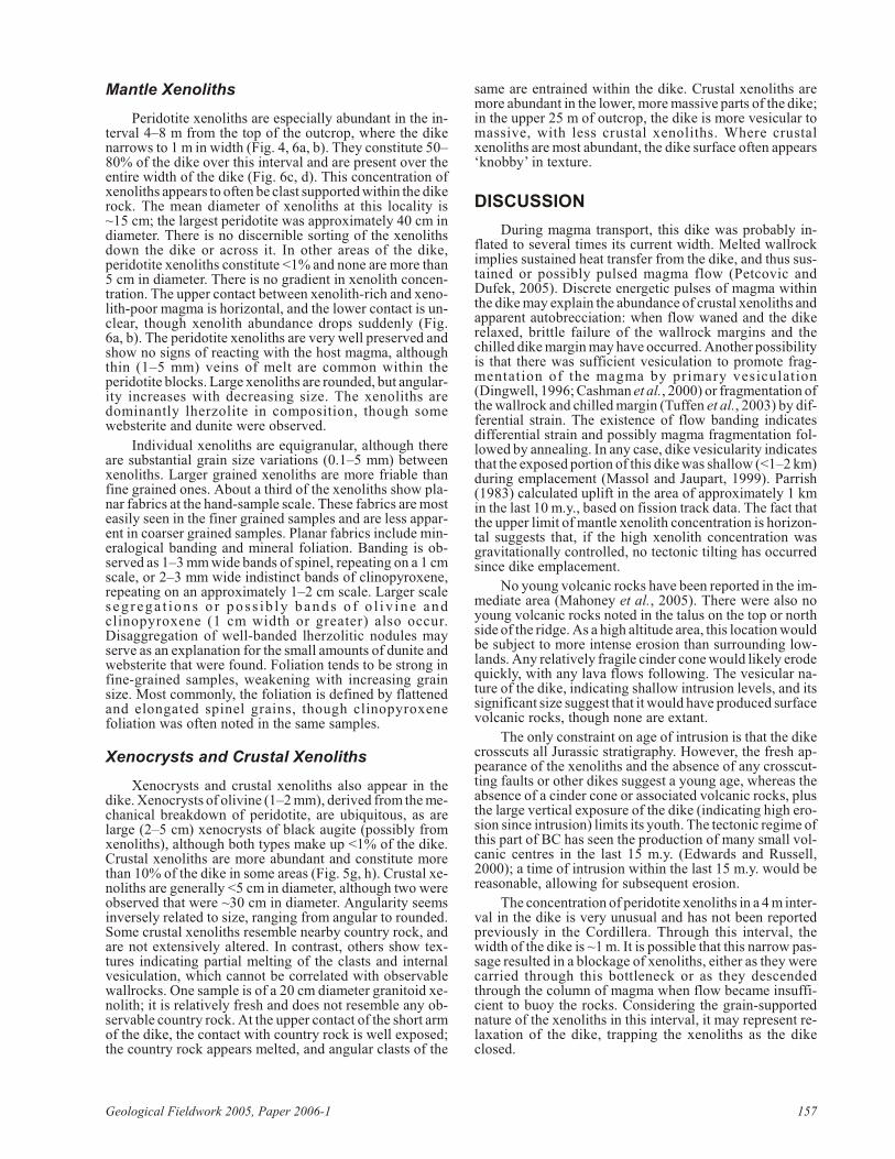
Mantle Xenoliths
Peridotite xe no liths are es pe cially abun dant in the in -ter val 4–8 m from the top of the out crop, where the dikenar rows to 1 m in width (Fig. 4, 6a, b). They con sti tute 50–80% of the dike over this in ter val and are pres ent over theen tire width of the dike (Fig. 6c, d). This con cen tra tion ofxe no liths ap pears to of ten be clast sup ported within the dike rock. The mean di am e ter of xe no liths at this lo cal ity is~15 cm; the larg est peridotite was ap prox i mately 40 cm indi am e ter. There is no dis cern ible sort ing of the xe no lithsdown the dike or across it. In other ar eas of the dike,peridotite xe no liths con sti tute <1% and none are more than5 cm in di am e ter. There is no gra di ent in xe no lith con cen -tra tion. The up per con tact be tween xe no lith-rich and xe no -lith-poor magma is hor i zon tal, and the lower con tact is un -clear, though xe no lith abun dance drops sud denly (Fig.6a, b). The peridotite xe no liths are very well pre served andshow no signs of re act ing with the host magma, al thoughthin (1–5 mm) veins of melt are com mon within theperidotite blocks. Large xe no liths are rounded, but an gu lar -ity in creases with de creas ing size. The xe no liths aredominantly lherzolite in composition, though somewebsterite and dunite were observed.
In di vid ual xe no liths are equigranular, al though thereare sub stan tial grain size vari a tions (0.1–5 mm) be tweenxe no liths. Larger grained xe no liths are more fri a ble thanfine grained ones. About a third of the xe no liths show pla -nar fab rics at the hand-sam ple scale. These fab rics are mosteas ily seen in the finer grained sam ples and are less ap par -ent in coarser grained sam ples. Pla nar fab rics in clude min -er al og i cal band ing and min eral fo li a tion. Band ing is ob -served as 1–3 mm wide bands of spinel, re peat ing on a 1 cmscale, or 2–3 mm wide in dis tinct bands of clinopyroxene,re peat ing on an ap prox i mately 1–2 cm scale. Larger scaleseg rega t ions o r pos s i b ly bands o f o l i v i ne andclinopyroxene (1 cm width or greater) also oc cur.Disaggregation of well-banded lherzolitic nod ules mayserve as an ex pla na tion for the small amounts of du nite andwebsterite that were found. Fo li a tion tends to be strong infine-grained sam ples, weak en ing with in creas ing grainsize. Most com monly, the fo li a tion is de fined by flat tenedand elon gated spinel grains, though clinopyroxenefoliation was often noted in the same samples.
Xenocrysts and Crustal Xenoliths
Xeno crysts and crustal xe no liths also ap pear in thedike. Xeno crysts of ol iv ine (1–2 mm), de rived from the me -chan i cal break down of peridotite, are ubiq ui tous, as arelarge (2–5 cm) xeno crysts of black augite (pos si bly fromxe no liths), al though both types make up <1% of the dike.Crustal xe no liths are more abun dant and con sti tute morethan 10% of the dike in some ar eas (Fig. 5g, h). Crustal xe -no liths are gen er ally <5 cm in di am e ter, al though two wereob served that were ~30 cm in di am e ter. An gu lar ity seemsin versely re lated to size, rang ing from an gu lar to rounded.Some crustal xe no liths re sem ble nearby coun try rock, andare not ex ten sively al tered. In con trast, oth ers show tex -tures in di cat ing par tial melt ing of the clasts and in ter nalvesiculation, which can not be cor re lated with ob serv ablewallrocks. One sam ple is of a 20 cm di am e ter granitoid xe -no lith; it is rel a tively fresh and does not re sem ble any ob -serv able coun try rock. At the up per con tact of the short armof the dike, the con tact with coun try rock is well ex posed;the coun try rock ap pears melted, and an gu lar clasts of the
same are en trained within the dike. Crustal xe no liths aremore abun dant in the lower, more mas sive parts of the dike;in the up per 25 m of out crop, the dike is more ve sic u lar tomas sive, with less crustal xe no liths. Where crustalxenoliths are most abundant, the dike surface often appears‘knobby’ in texture.
DISCUSSION
Dur ing magma trans port, this dike was prob a bly in -flated to sev eral times its cur rent width. Melted wallrockim plies sus tained heat trans fer from the dike, and thus sus -tained or pos si bly pulsed magma flow (Petcovic andDufek, 2005). Dis crete en er getic pulses of magma withinthe dike may ex plain the abun dance of crustal xe no liths and ap par ent autobrecciation: when flow waned and the dikere laxed, brit tle fail ure of the wallrock mar gins and thechilled dike mar gin may have oc curred. An other pos si bil ity is that there was suf fi cient vesiculation to pro mote frag -men ta tion of the magma by pri mary vesiculation(Dingwell, 1996; Cashman et al., 2000) or frag men ta tion of the wallrock and chilled mar gin (Tuffen et al., 2003) by dif -fer en tial strain. The ex is tence of flow band ing in di catesdif fer en tial strain and pos si bly magma frag men ta tion fol -lowed by an neal ing. In any case, dike vesicularity in di catesthat the ex posed por tion of this dike was shal low (<1–2 km) dur ing em place ment (Massol and Jaupart, 1999). Parrish(1983) cal cu lated up lift in the area of ap prox i mately 1 kmin the last 10 m.y., based on fis sion track data. The fact thatthe up per limit of man tle xe no lith con cen tra tion is hor i zon -tal sug gests that, if the high xe no lith con cen tra tion wasgravitationally controlled, no tectonic tilting has occurredsince dike emplacement.
No young vol ca nic rocks have been re ported in the im -me di ate area (Mahoney et al., 2005). There were also noyoung vol ca nic rocks noted in the ta lus on the top or northside of the ridge. As a high al ti tude area, this lo ca tion would be sub ject to more in tense ero sion than sur round ing low -lands. Any rel a tively frag ile cin der cone would likely erode quickly, with any lava flows fol low ing. The ve sic u lar na -ture of the dike, in di cat ing shal low in tru sion lev els, and itssig nif i cant size sug gest that it would have pro duced sur face volcanic rocks, though none are extant.
The only con straint on age of in tru sion is that the dikecross cuts all Ju ras sic stra tig ra phy. How ever, the fresh ap -pear ance of the xe no liths and the ab sence of any cross cut -ting faults or other dikes sug gest a young age, whereas theab sence of a cin der cone or as so ci ated vol ca nic rocks, plusthe large ver ti cal ex po sure of the dike (in di cat ing high ero -sion since in tru sion) lim its its youth. The tec tonic re gime of this part of BC has seen the pro duc tion of many small vol -ca nic cen tres in the last 15 m.y. (Ed wards and Rus sell,2000); a time of in tru sion within the last 15 m.y. would bereasonable, allowing for subsequent erosion.
The con cen tra tion of peridotite xe no liths in a 4 m in ter -val in the dike is very un usual and has not been re portedpre vi ously in the Cor dil lera. Through this in ter val, thewidth of the dike is ~1 m. It is pos si ble that this nar row pas -sage re sulted in a block age of xe no liths, ei ther as they werecar ried through this bot tle neck or as they de scendedthrough the col umn of magma when flow be came in suf fi -cient to buoy the rocks. Con sid er ing the grain-sup portedna ture of the xe no liths in this in ter val, it may rep re sent re -lax ation of the dike, trapping the xenoliths as the dikeclosed.
Geo log i cal Field work 2005, Pa per 2006-1 157

158 Brit ish Co lum bia Geo log i cal Sur vey
IMPLICATIONS
This site is well suited for man tle stud ies for sev eralrea sons. The larg est xe no lith trans ported to the sur face isap prox i mately 40 cm in di am e ter, in di cat ing that all of thexe no liths were rap idly trans ported to the sur face (Spera,1984). The source for this magma is within or be low theman tle litho sphere, thus pro vid ing an op por tu nity for thismagma to sam ple the com plete spec trum of rock typeswithin the man tle litho sphere. North of this lo cale withinthe north ern Cordilleran vol ca nic prov ince (NCVP), geo -phys ics and xe no lith thermobarometry have con strainedthe crust-man tle bound ary (CMB) to 30–40 km in depth(Welford et al., 2001; Harder and Rus sell, 2005). Be cause
the dike is aphyric and mafic in com po si tion, it likely would have had a low yield strength (if any) and a high tem per a -ture dur ing flow, and there fore low magma vis cos ity. Thisalso im plies rapid trans port, if large, dense xe no liths are tobe trans ported from the lithospheric man tle with out set tling out of sus pen sion. Con ven tional as cent ve loc i ties for suchmag mas (Fujii and Scarfe, 1982; Spera, 1984) vary be -tween 0.1 and 10 m/s, thus sug gest ing to tal tran sit times ofbe tween 1.4 hours and 5.8 days (as sum ing a source depthwithin the man tle litho sphere of 50 km). Given these es ti -mated res i dence times, the xe no liths would have had lim -ited time to re act with the magma, en sur ing pres er va tion ofpristine mantle mineral compositions (Edwards andRussell, 1998; Canil and Fedortchouk, 1999).
Geo log i cal Field work 2005, Pa per 2006-1 159
Fig ure 5. Field pho to graphs and match ing sketch maps show ing spe cific volcanological as pects of the mafic dike: a), b) ve sic u lar na ture ofthe dike, with po ros ity es ti mated to be be tween 10 and 20%, ris ing up to 30% else where in the dike; lo cally, the rock is amyg da loid al whereves i cles are lined or infilled by ver mic u lite and cal cite; photo also shows a subrounded clast of melt within the ve sic u lar dike, the clast show -ing sev eral amygdules and pre sumed to be ac ces sory to ju ve nile in na ture; pen cil is 14 cm long; c), d) well-de vel oped flow band ing in thedike, de fined by high (dark grey) ver sus low (light grey) vesicularity; e), f) na ture of con tact be tween the dike and the coun try rock, show ingquenched mar gin(s) within dike and al tered coun try rock; g), h) crustal xe no lith de rived from lo cal coun try rock within the dike; con tact be -tween dike and wallrock is sharp.
Fig ure 6. Field pho to graphs and match ing sketch maps show ing the de tailed as pects of the peridotite-bear ing fa cies of the mafic dike: a)photo show ing the width of the dike where it in ter sects the ridge top; the dike is very rich in xe no liths (green col our); b) sketch map of (a)show ing the dis tri bu tions of xe no liths (pat terned) in the dike (dark grey) and in con tact with Hazelton Group volcaniclastic rocks (pat terned); much of the con tact can not be ob served di rectly; lo cally, the ex act con tact re la tion ships be tween the dike and coun try rocks can be ob -served (see Fig. 5e–h); c) photo show ing the lo cal re la tion ships be tween the melt phase and the peridotitic man tle-de rived xe no liths; xe no -liths vary in di am e ter from 1 to 40 cm and ap pear to be clast sup ported; coin is 2.8 cm in di am e ter; d) sketch map of (c) show ing the shapesand sizes of the xe no liths, the pro por tions of melt to xe no lith, and the char ac ter of the peridotite clasts (see text); xe no liths make up ~60% ofthe view.

The main goal of fu ture re search is to con strain man tlelitho sphere prop er ties. To that end, the 80 man tle xe no lithscol lected from Mt. Pres ton will be ex am ined for com po si -t i o n , a s w e l l a s e q u i l i b r a t i o n T a n d P ( u s i n ggeothermobarometry). The fact that the man tle xe no lithson Mt. Pres ton are only weakly weath ered in di cates fairlyre cent ex hu ma tion and good po ten tial for pres er va tion ofman tle min eral com po si tions. Con se quently, the peridotitic sam ples will be ideal for geothermometric stud ies aimed atre cov er ing man tle equil i bra tion tem per a tures (Littlejohnand Green wood, 1974). Al though many man tle xe no lith lo -cal i ties fea ture an oma lously high con cen tra tions of xe no -liths, the host mag mas, in all like li hood, sam pled thelithospheric man tle ran domly (Ross, 1983; Harder andRus sell, 2005). Thus, geothermobarometry on a suite ofnod ules should pro vide a min i mum tem per a ture and pres -sure in ter val be tween the CMB and the asthenosphere(Ross, 1983), which constrains minimum lithosphericmantle thickness (Harder and Russell, 2005).
Vari a tions in chem i cal com po si tion (Littlejohn andGreen wood, 1974; Ross, 1983), tex ture and fab ric (Ross,1983) be tween xe no lith lo cal i ties (e.g. Ed wards and Rus -sell, 2000) al low re gional man tle prop er ties to be de ter -mined. The unique lo ca tion of the Mt. Pres ton lo cal ity isfor tu itous in this re gard. A re cently de vel oped tech niqueuses geothermobarometry along with geophysically de -rived heat-flow data to cre ate an ac cu rate geotherm and de -ter mine min i mum lithospheric man tle thick ness and depth(Rus sell and Kopylova, 1999; Rus sell et al., 2001; Harderand Rus sell, 2005). When com bined with heat-flow datafrom the BATHOLITHS seis mic sur vey, the min i mumdepth and thick ness of the man tle litho sphere will be ob -tained. Crustal xe no liths will also be ex am ined for com po -si tion, in an at tempt to cor re late them with un der ly ing stra -tig ra phy and a pos si ble source re gion for the dike magma.These re sults will be a pow er ful tool when combined withBATHOLITHS deep seismic data, which will image thoseinterfaces.
ACKNOWLEDGMENTS
This re search bene fited from the ca pa ble as sis tance ofAdam Kjos in the field. The pro ject was funded by the Nat -u ral Sci ences and En gi neer ing Re search Coun cil (NSERC) through a Col lab o ra tive Re search Op por tu ni ties (CRO)grant (BATHOLITHS: Gen er a tion and Evo lu tion of Crustin Con ti nen tal Mag matic Arcs) held by Ron Clowes andoth ers. Geoscience BC funded J.B. Mahoney. N.D. Pe ter -son was par tially funded by the Egil H. LorntzsenScholarship.
REFERENCES
Andronicos, C.L. and Ducea, M. (2004): BATHOLITHS: An in te -grated geo log i cal, geo chem i cal and geo phys i cal study of the for ma tion of con ti nents; in Geo log i cal So ci ety of Amer ica,Ab stracts with Pro grams, vol ume 36, number 5, page 343.
Canil, D. and Fedortchouk, Y. (1999): Gar net dis so lu tion and theem place ment of kimberlites; Earth and Plan e tary Sci enceLet ters, vol ume 167, pages 227–237.
Cashman, K.V., Sturtevant, B., Papale, P. and Navon, O. (2000):Mag matic frag men ta tion; in En cy clo pe dia of Vol ca noes,Sigurdsson, H., Ed i tor, Ac a demic Press, San Diego, pages421–430.
Dingwell, D.B. (1996): Vol ca nic di lemma: flow or blow? Sci ence,vol ume 273, pages 1054–1055.
Ed wards, B. and Rus sell, J.K. (1998): Time scales of mag maticpro cesses: new in sights from dy namic mod els for mag maticas sim i la tion; Ge ol ogy, vol ume 26, num ber 12, pages 1103–1106.
Ed wards, B., and Rus sell, J.K. (2000): Dis tri bu tion, na ture, and or -i gin of Neogene–Quaternary magmatism in the north ernCordilleran vol ca nic prov ince, Can ada; Geological Societyof America Bul le tin, vol ume 112, num ber 8, pages 1280–1295.
Evenchick, C.A. and Thorkelson, D.J. (1993): Ge ol ogy, SpatsiziRiver, Brit ish Co lum bia (104H); Geo log i cal Sur vey of Can -ada, Open File 2719, scale 1:250 000.
Fujii, T. and Scarfe, C.M. (1982): Pe trol ogy of ultra mafic nod ulesfrom West Ket tle River, near Kelowna, Brit ish Co lum bia;Con tri bu tions to Min er al ogy and Pe trol ogy, vol ume 80,pages 297–306.
Gordee, S.M., Mortensen, J.K., Mahoney, J.B. and Hooper, R.L.(2005): Volcanostratigraphy, lithogeochemistry and U-Pbgeo chron ol ogy of the up per Hazelton Group, west-cen tralBrit ish Co lum bia: im pli ca tions for Eskay Creek – type VMS min er al iza tion in south west Stikinia; in Geo log i cal Field -work, 2004, BC Min is try of En ergy, Mines and Pe tro leumRe sources, Pa per 2005-1, pages 311–322.
Harder, M. and Rus sell, J.K. (in press): Ther mal state of the man tle litho sphere be neath the North ern Cordilleran Vol ca nicP r o v i n c e , B r i t i s h C o l u m b i a ; L i t h o s , i n p r e s s ,doi:10.1016/j.lithos.2005.05.002.
Littlejohn, A.L. and Green wood, H.J. (1974): Lherzolite nod ulesin bas alts from Brit ish Co lum bia, Can ada; Ca na dian Jour -nal of Earth Sci ences, vol ume 11, pages 1288–1308.
Mahoney, J.B., Haggart, J.W., Hooper, R.L., Snyder, L.D. andWoodsworth, G.J. (2006): Geo log i cal set ting and min er al -iza tion po ten tial of the south west ern Whitesail Lake maparea (NTS 93E), west ern Brit ish Co lum bia: pre lim i nary as -sess ment; in Geo log i cal Field work, 2005, BC Min is try ofEn ergy, Mines and Pe tro leum Re sources, Pa per 2006-1 andGeoscience BC, Report 2006-1.
Mahoney, J.B., Hooper, R.L., Gordee, S.M., Haggart, J.W. andMortensen, J.K. (2005): Ini tial eval u a tion of bed rock ge ol -ogy and eco nomic min er al iza tion po ten tial of south ernWhitesail Lake map area (NTS 093E/02, 03), west-cen tralBrit ish Co lum bia; in Geo log i cal Field work, 2004, BC Min -is try of En ergy, Mines and Pe tro leum Re sources, Paper2005-1, pages 291–299.
Massol, H. and Jaupart, C. (1999): The gen er a tion of gasoverpressure in vol ca nic erup tions; Earth and Plan e tarySci ence Let ters, vol ume 166, pages 57–70.
Mitch ell, R.H. (1987): Man tle-de rived xe no liths in Can ada; inMan tle Xe no liths, Nixon, P.H., Ed i tor, John Wiley and Sons,New York, pages 33–40.
Nicholls, J., Stout, M.Z. and Fiesinger, D.W. (1982): Pet ro logicvari a tions in Qua ter nary vol ca nic rocks, Brit ish Co lum bia,and the na ture of the un der ly ing up per man tle; Con tri bu -tions to Min er al ogy and Pe trol ogy, vol ume 79, pages 201–218.
Parrish, R.R. (1983): Ce no zoic ther mal evo lu tion and tec ton ics ofthe Coast Moun tains of Brit ish Co lum bia: 1. Fis sion trackdat ing, ap par ent up lift rates, and pat terns of up lift; Tec ton -ics, vol ume 2, pages 601–631.
Petcovic, H.L. and Dufek, J.D. (in press): Mod el ing magma flowand cool ing in dikes: im pli ca tions for em place ment of Co -lum bia River flood bas alts; Jour nal of Geo phys i cal Re -search, Vol ume 110, B10201, doi:10.1029/2004JB003432,2005.
Resnick, J., An der son, R.G., Rus sell, J.K., Ed wards, B.R. andGrainger, N.C. (1999): Neo gene ba saltic flow rocks, xe no -liths, and re lated diabase, north ern Nechako River map area,
160 Brit ish Co lum bia Geo log i cal Sur vey

cen tral Brit ish Co lum bia; in Cur rent Re search 1999-A, Geo -log i cal Sur vey of Can ada, pages 157–167.
Ross, J.V. (1983): The na ture and rhe ol ogy of the Cordilleran up -per man tle of Brit ish Co lum bia: in fer ences from peridotitexe no liths; Tectonophysics, vol ume 100, pages 321–357.
Rus sell, J.K., Dipple, G.M. and Kopylova, M.G. (2001): Heat flowand heat pro duc tion in man tle litho sphere from the SlaveCraton; Phys ics of Earth and Plan e tary In te ri ors, vol ume123, pages 27–44.
Rus sell, J.K. and Kopylova, M.K. (1999): A steady-state con duc -tive geotherm for the north cen tral Slave, Can ada: in ver sionof pet ro log i cal data from the Je ri cho kimberlite pipe; Jour -nal of Geo phys i cal Re search, vol ume 104, pages 7089–7101.
Spera, F.J. (1984): Car bon di ox ide in petro gen esis III: role ofvolatiles in the as cent of al ka line magma with spe cial ref er -
ence to xe no lith-bear ing mafic lavas; Con tri bu tions to Min -er al ogy and Pe trol ogy, vol ume 88, pages 217–232.
Tuffen, H., Dingwell, D.B. and Pinkerton, H. (2003): Re peatedfrac ture and heal ing of silicic magma gen er ate flow band ingand earth quakes? Geology, Vol ume 31, pages 1089–1092.
Welford, J.K., Clowes, R.M., Ellis, R.M., Spence, G.D., Asudeh, I.and Hajnal, Z. (2001): Lithospheric struc ture across thecraton-Cordilleran tran si tion of north east ern Brit ish Co lum -bia; Ca na dian Jour nal of Earth Sci ences, vol ume 38, pages1169–1189.
Wheeler, J.O. and McFeely, P. (1991): Tec tonic as sem blage mapof the Ca na dian Cor dil lera and ad ja cent parts of the UnitedStates of Amer ica; Geo log i cal Sur vey of Can ada, Map1712A, scale 1:2 000 000.
Geo log i cal Field work 2005, Pa per 2006-1 161

162 Brit ish Co lum bia Geo log i cal Sur vey