man as a geomorphic agent - west virginia...
TRANSCRIPT

1
Man As a Geomorphic Agent
•• http://www.eia.doe.gov/fuelcoal.htmlhttp://www.eia.doe.gov/fuelcoal.html•• Annual coal reportAnnual coal reporthttp://http://www.eia.doe.gov/cneaf/coal/page/acr/acr_sum.htmlwww.eia.doe.gov/cneaf/coal/page/acr/acr_sum.html•• Production by100 largest minesProduction by100 largest mineshttp://www.eia.doe.gov/cneaf/coal/page/acr/table9.htmlhttp://www.eia.doe.gov/cneaf/coal/page/acr/table9.html
West Virginia Coal Association
•• http://www.eia.doe.gov/fuelcoal.htmlhttp://www.eia.doe.gov/fuelcoal.html
• Glossary of Coal Industry Terms
2
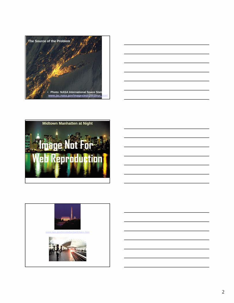
The Source of the Problem
• Photo: NASA International Space Station www.jsc.nasa.gov/images/eol/2003/nyc.html
Midtown Manhatten at Night
http://www.soulofamerica.com/images/photosnyc/Midtown_Manhat_night.jpg
Image Not For Web Reproduction
www.nps.gov/ncro/educ/park/nacc.htm
http://www.wmata.com/metrorail/Stations/station.cfm?station=82
The Source

3
Images from Hooke, R. L., 1999
Earth Movement by Humans
Earth Movement by Streams
Subsidence:Fedorko Article
“Mountain State Geologist”
Wide Opening, Close to Surface -Uniform Subsidence
(e.g. Long Wall Mining)
Narrow Opening &/or Great Depth Differential Subsidence
(e.g. Room and Pillar Mining)
Room and Pillar Mine

4
Room and Pillar Mine (UMWA)
Subsidence from Room & Pillar Mine
Monongalia Co. WV
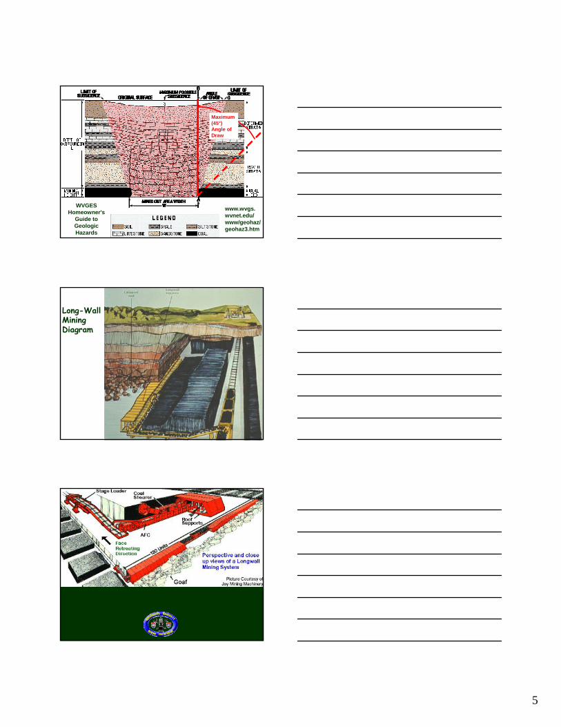
Generalized cross section of subsidence. The area on the surface affected by subsidence is usually wider than the area mined out below. The angle of draw is formed by a line from the edge of the mined area straight up to the surface (A-B), and a line from the edge of the mined area to the edge of the surface subsidence (A-C). The angle of draw does not exceed 45 degrees.
WVGES Homeowner's
Guide to Geologic Hazards
www.wvgs.wvnet.edu/www/geohaz/geohaz3.htm
Angle of Draw
5
Generalized cross section of subsidence. The area on the surface affected by subsidence is usually wider than the area mined out below. The angle of draw is formed by a line from the edge of the mined area straight up to the surface (A-B), and a line from the edge of the mined area to the edge of the surface subsidence (A-C). The angle of draw does not exceed 45 degrees.
WVGES Homeowner's
Guide to Geologic Hazards
www.wvgs.wvnet.edu/www/geohaz/geohaz3.htm
Maximum (45°) Angle of Draw
Long-WallMining Diagram

6
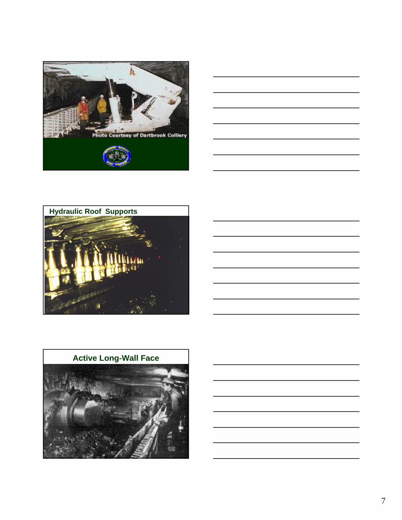
Long-Wall Miner and Hydraulic Roof Supprts
Source: WVU Longwall Mining and Ground Control Research Center
Inactive Long-Wall Face
Source: www.coalleader.com/longwall_mining.htm
7
Hydraulic Roof Supports
Active Long-Wall Face

8
Long Wall Mining
Ponding Through Long-Wall Subsidence
Long-Wall Panel
Ponding Over Long Wall Panels
Unmined Coal
Subsidence Over Long-Wall Panels

9
Channelization ofInter- Panel Highs
Unmined Coal
Remediation:
Stream “channelized” 2-3 m over unmined area, panel subsidence ponded upstream reach of the floodplain. Western Mon. Co. WV
“Cutting the Gate”
Dewatering into Old Deep Mines, Near Thomas WV
10
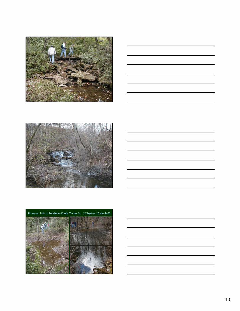
Unnamed Trib. of Pendleton Creek, Tucker Co. 12 Sept vs. 20 Nov 2003

11

12

13
Surface Mining
Surface Mining Control and Reclamation Act of 1977
(SMCRA)
Abandoned Mine Lands (AML) Program
East Tennessee: Multiple Seams, Contour Strip Mines

14
East Tennessee Strip Mine
Surface-Mine Reclamation
Approximate Original Contour(AOC)
Not “Original” Landscape!
Muddy Creek, Preston Co., WV, late 1980s

15
Muddy Creek, Preston Co., WV, 1990
Approximate Original Contour: Contour Surface Mine
AOC is much less natural in areas where the reclaimed slopes are particularly long or steep.
To reduce gully erosion, long slopes are broken up with short terraces

16
Reclamation Ziggurat
Old Sedimentation Pond
“Approximate Original Contour”
Potomac Mine, Elk Run, Grant Co. WV, June 1999
Mountain-Top Removal
Impact increases in Mountain-Top Removal and Valley Fill.
Valley Fill
AOC
Not AOC
}
}

17
Large Dragline beside Very Large Bulldozer, Hobet Mine, Boone Co. WV
• Photo Courtesy of Larry Emerson, Arch Coal, Inc.
Image Not For Web Reproduction
Large Shovel Loading Overburden on ~220 ton Rock Truck, Hobet Mine, Boone Co., W.Va.
• Photo Courtesy of Larry Emerson, Arch Coal, Inc.
Image Not For Web Reproduction
Mountain-Top Removal & Valley Fill, Kayford Mountain, 1997

18
Oh, the West Virginia hills! How unchang’d they seem to standWith their summit point’d sky-ward To the great Almighty’s land
Many changes I can seeWhich my heart with sadness fillsBut no changes can be noted in
those West Virginia hills.
Verse 3 of “West Virginia Hills”Words by Mrs. Ellen King,Music by H. E. EngleOfficial Song of the State of West Virginia
Mountain-Top Mines in WV
WVDEP Map Source:www.dep.state.wv.us/rs/mt/
Mtn-Top Mine Permit
Mtn-Top Mine Zone
Valley Fill
Linked to Mountain-Top Removal
19
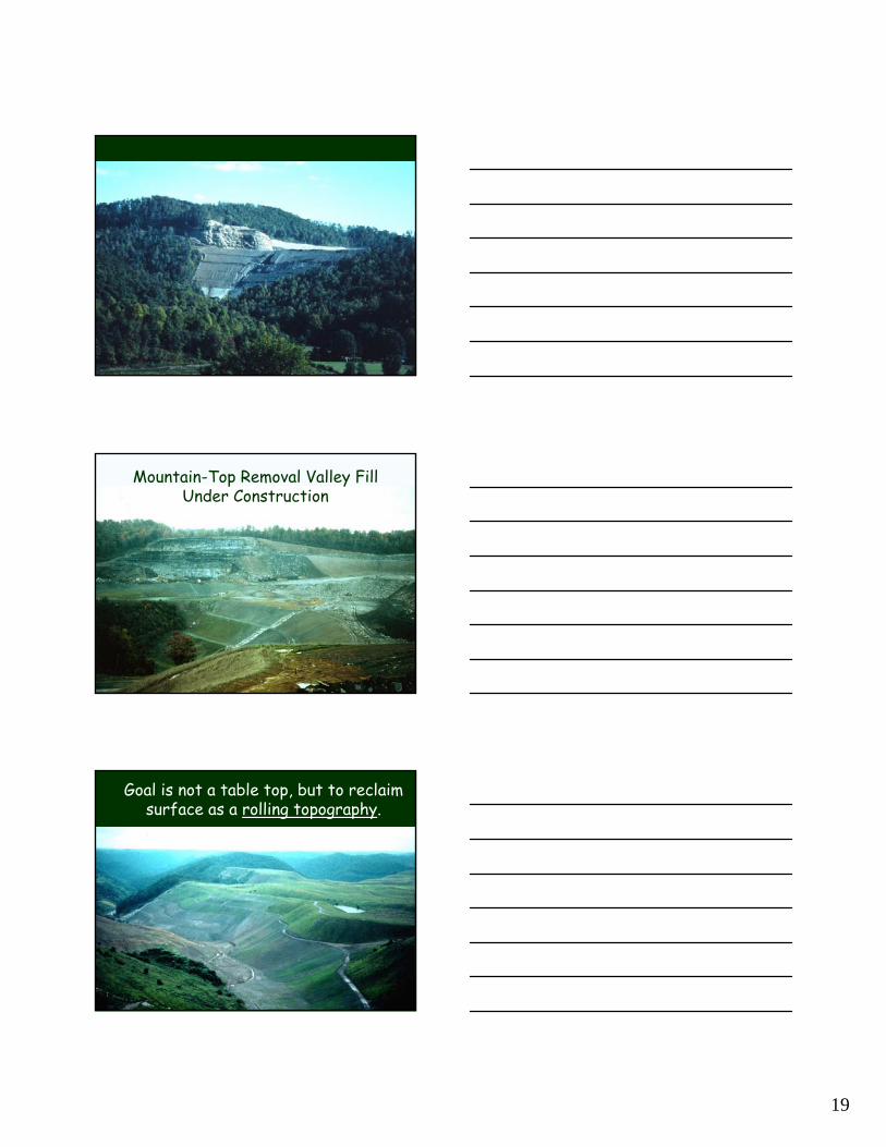
Mountain-Top Removal & Valley Fill, Fayette Co. WV
Mountain-Top Removal Valley Fill Under Construction
Goal is not a table top, but to reclaim surface as a rolling topography.
20
http://www.geocities.com/~rollinghills/valleys.html
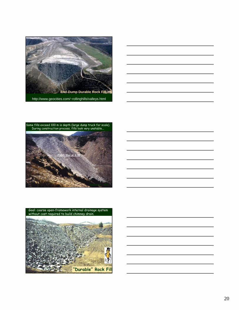
End-Dump Durable Rock Fill
Some fills exceed 100 m is depth (large dump truck for scale).During construction process, fills look very unstable...
Amherst, WV
Paper Due at 4:30
Goal: coarse open-framework internal drainage system without cost required to build chimney drain.
“Durable” Rock Fill