lynn waterfront master plan report
TRANSCRIPT

LYNN WATERFRONT MASTER PLAN REPORT
SEPTEMBER 2007
In collaboration with ZHA GEI

Tabl
e of
Con
tent
s
TABLE OF CONTENTS
EXECUTIVE SUMMARY 1
INTRODUCTION 5
GOALS OF THE STUDY 7
PROCESS 7
DEVELOPMENT CONTEXT 11
BACKGROUND 13
EXISTING CONDITIONS 13
STATE REGULATIONS 15
REGIONAL MARKET ANALYSIS 15
ENVIRONMENTAL ISSUES 17
MASTER PLAN VISION AND DEVELOPMENT OPPORTUNITIES 19
VISION FOR THE LYNN WATERFRONT 21
LYNN WATERFRONT MASTER PLAN DISTRICTS 23
DESIGN GUIDELINES 33
MARKET IMPLICATIONS 35
TRAFFIC STRATEGY 41
INFRASTRUCTURE 42
IMPLEMENTATION STRATEGY 45
PHASING 47
STATE & FEDERAL PERMITTING PROGRAMS 47
COST ESTIMATE 51
PUBLIC/PRIVATE PARTNERSHIPS AND INCENTIVES 55
ZONING STRATEGY 57

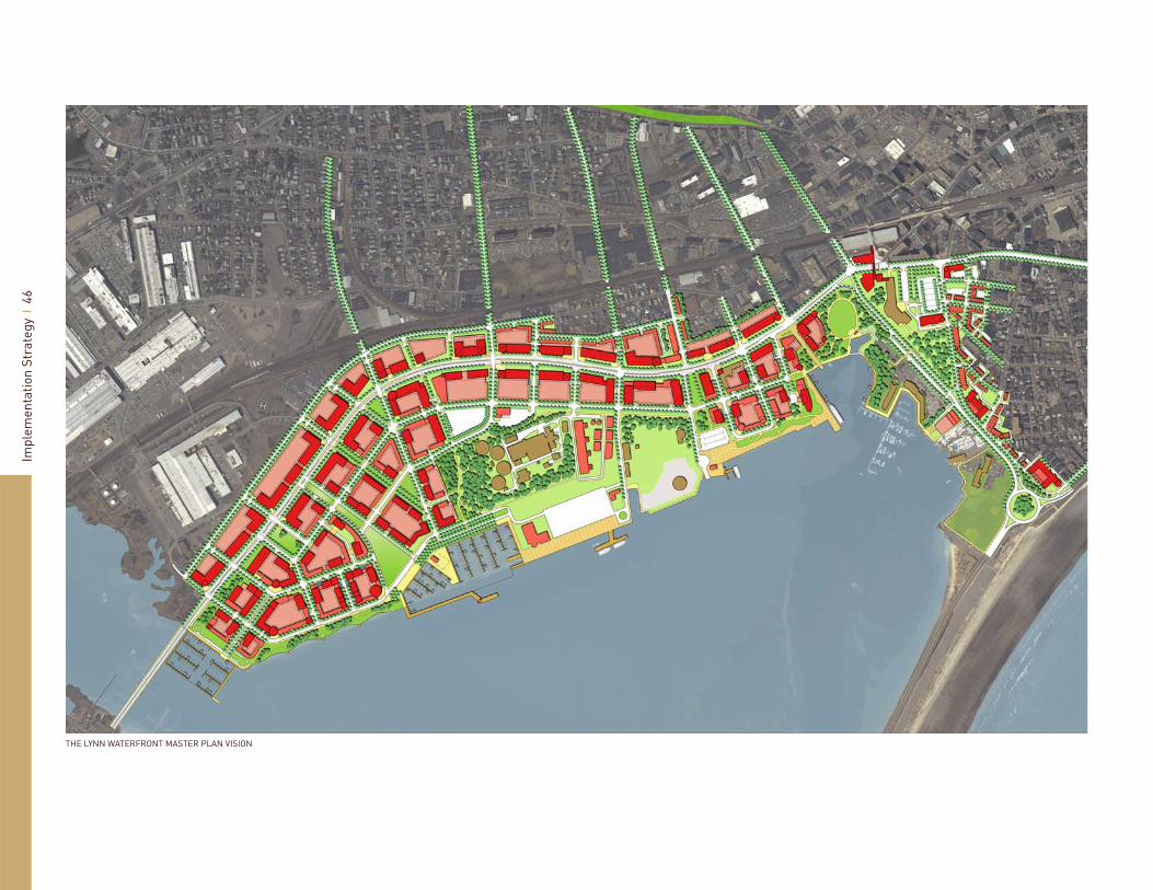
THE LYNN WATERFRONT MASTER PLAN VISION
Land of this magnitude in a strategic location along a beautiful waterfront is rare, particularly when it is located within 10 miles of downtown Boston.

Exec
utiv
e Su
mm
ary
1
EXECUTIVE SUMMARYThe focus of the Lynn Waterfront Master Plan is a 305-acre development site located in Lynn, Massachusetts. The site begins at the General Edwards Bridge and extends north to the intersection of the Lynnway and Market Street, and east along the inner harbor shoreline to the Nahant rotary. The waterfront property is an exceptional site made up of contiguous parcels of land that are severely underutilized. Land of this magnitude in a strategic location along a beautiful waterfront is rare, particularly when it is located within 10 miles of downtown Boston. Its exceptional location is an untapped asset waiting to be explored and transformed into a higher and better use neighborhood as an expression of Downtown Lynn on the water. The Lynn Waterfront Master Plan also examines lower Sagamore Hill in search of a better design concept to take advantage of its proximity to both downtown and the waterfront.
Historically, this land was utilized for a large variety of industrial uses ranging from active maritime commerce to power generation. In the last 50 years, New England experienced a signifi cant change in its light to heavy industrial capital, as most relocated out of the region. Currently, the entire site is underutilized as a waterfront location, but serves the needs of industrial facilities and accommodates regional traffi c with a mix of automobile oriented businesses, big box retail, and light industries. Existing uses include the regional sanitary sewer treatment plan, a creamery and associated cold storage, scrap iron yard, capped municipal land fi ll no longer in operation, fast food drive-thru restaurants, retail and auto body shops, car dealerships, Wal-Mart and Building 19½. As a result of the lands historical use and the continuation of many industrial uses, the land has some environmental issues that need to be addressed during future development.
Sasaki Associates Inc. was retained by the City of Lynn to develop a comprehensive conceptual Master Plan for this site and to set the necessary parameters to transform it into a vibrant place with direct linkage to the downtown and surrounding neighborhoods. Creating a signifi cant presence on the City’s waterfront is one of the main objectives of the plan. Because the land is located strategically on the Lynn Harbor and is accessible by the regional highway network and the commuter rail from Boston, it is a very valuable piece of land with great potential. The proposed mixed-use development recommended in the Master Plan will positively infl uence the area and spur future economic revitalization activity within the community at large. Implementing this project over the next few decades will raise the image of the community within the region and put the City back on the map with neighboring communities for quality of life, real estate land values and self image.
Sasaki’s team, which included ZHA for market analysis and GEI for geotechnical expertise, studied the area, location, context within the neighboring communities, the physical condition of the land, current uses, and future potential. In the analysis phase of the project, ZHA performed a detailed market study and the City hosted several informative public workshops and set up numerous key stakeholder meetings to solicit input from the community at large and interested groups. Based on the site reconnaissance and information from the community, Sasaki prepared a series of alternative development options for review by the City and community. The preferred development option was refi ned to refl ect the comments and input received and in accordance with the fi ndings of the market study for the waterfront site. Additional meetings were held with Massachusetts Coastal Zone Management, who regulates future developments through the Chapter 91 waterways licensing process, and the Massachusetts
Department of Conservation and Recreation, who controls the Lynnway. These meetings were held to promote and solicit further input and to test the proposed development limits with state agencies. Similarly, the plans were adjusted and revised based on the input received through the community process.
It is important to understand the intent of this exercise. The Master Plan was developed to synthesize the community’s aspiration and create a vision framework plan to guide future development. The Master Plan has three main components:
A. Master Plan Vision
B. Waterfront Zoning Strategy
C. Lynn Harbor Plan
The Master Plan Vision represents future land use, proposed mixed-use density, open space, development program and identifi cation of new neighborhoods. It is important to note that this plan dose not represent future development footprints. Identifying future development footprints requires additional work between the community and individual property owners, as well as all local and state governmental agencies that have jurisdiction in the area.
The proposed Waterfront Zoning Strategy needs to be reviewed further with the community and property owners to establish consensus on the appropriate regulations set forth for each area.
The Lynn Harbor Plan is a preliminary draft for preparing the offi cial Lynn Municipal Harbor Plan. The Massachusetts Coastal Zone Management and the Department of Environmental Protection require the preparation and adoption of a Municipal Harbor Plan (MHP), since a signifi cant portion of the land lies within the Chapter 91 waterways jurisdiction.

Exec
utiv
e Su
mm
ary
2
This plan is a pre-requisite for any development of the land that lies within the Chapter 91 designated area.
The Master Plan program for the Lynn Waterfront includes a diverse mix of uses. Three distinct neighborhoods were created within the Waterfront Area to create fl exibility within the development process and to create a unique identity for each area within the overall plan and the City of Lynn. A fourth neighborhood, Sagamore Hill, already exists within the study area and will be strengthen by the concept plan for lower Sagamore Hill along Carroll Parkway and Washington Street. This process allows for future adjustments to the land use mix in response to changing market conditions as development projects are implemented over the next 25 years. Once development commences, the power of the market economy will transform the area from its current uses into a waterfront community that takes advantage of its strategic location and natural assets.
Key program highlights of the Master Plan include:
Mix of residential types - 4,177,000 Sq. Ft.
Commercial / Retail - up to 1,061,000 Sq. Ft.
Offi ce space - 401,200 Sq. Ft.
Hotel - up to 304,800 Sq. Ft.
Light Industry - up to 228,730 Sq. Ft.
Port Designated Area for marine dependant use - 45 acres
Mixed-use Marina for recreational and commercial boats
Ample open park spaces for community and neighborhood recreational use
Housing demand on the north shore is diverse. Trends suggest future generations are looking into more urban living where diverse housing products are available within walking distance of downtowns and active densely populated urban areas. The availability
•
•
•
•
•
•
•
•
of public transportation, by rail or ferry, within these new neighborhoods will continue to be an important factor as cost of energy continues to rise and road congestion during peak commuting time becomes more intolerable. This site’s proximity to a major urban area, such as Boston, provides a very attractive setting for living, working, and playing. Given the size of the land, the current market conditions and the current existing uses, this site will most likely be developed in multiple phases. The exact makeup of the initial and subsequent phases is yet to be determined but the ultimate build out will be responsive to market demand and input from the City of Lynn, EDIC, and various regulatory approval agencies.
The City’s dedication and the community’s passion for this extraordinary waterfront site will have a remarkable effect on transforming the image of Lynn and its waterfront into a vibrant and diverse new urban community. This Vision Plan is the fi rst step towards the reclamation of the waterfront for the Lynn community and its future residents, workers, and visitors.

Exec
utiv
e Su
mm
ary
3
The City’s dedication and the community’s passion for this extraordinary waterfront site will have a remarkable effect on transforming the image of Lynn and its waterfront into a vibrant and diverse new urban community.
THE EXISTING LYNN WATERFRONT AS SEEN FROM POINT OF PINES, REVERE


Introduction 01

Intr
oduc
tion
6
AN AERIAL VIEW OF THE 250+ ACRE WATERFRONT SITE
The goal for the future of the Lynn waterfront is to create a mixed-use district with connections to downtown and the surrounding communities, through public and private investment.

Intr
oduc
tion
7
GOALS OF THE STUDYThe City of Lynn commissioned the Lynn Waterfront Master Plan to build on the recent successes in downtown Lynn and to create a vision for the area that would help to overcome the negative image of the waterfront. The goal for the future of the Lynn waterfront is to create a mixed-use district with connections to downtown and the surrounding communities, through public and private investment. Other objectives of the Master Plan include cleaning up and developing underutilized areas, buffer confl icting adjacent uses, and maximizing use of the state-owned pier and city owned boat ramp.
PROCESSIn June of 2006, the City of Lynn, lead by the Economic Development and Industrial Corporation, embarked on the current Master Plan to create a vision for the waterfront, identify development parameters and guidelines, defi ne community waterfront access, recommend transportation improvements, and develop a strategy for implementation.
The master plan process began in the summer of 2006 with a Steering Committee kick-off meeting, stakeholder and property owner interviews, and an analysis of the site, traffi c, market, and regulations. The analysis and some preliminary framework concepts were presented to the community in September. As a result of feedback from the presentation and further study, a series of alternatives were developed and discussed at a large public meeting in December of 2006. The alternatives explored a range of concepts for open space, street network and hierarchy, views, and waterfront edge conditions. The presentation also included an analysis of the market opportunities for the region in terms of retail, offi ce and residential potential as well as market directives for the master plan.
PUBLIC WORKSHOP, DECEMBER 2006
A RECENT DOWNTOWN LOFT CONVERSIONA NEW CAFE DOWNTOWN

Intr
oduc
tion
8
The presentations were posted onto a website dedicated to the Waterfront Master Plan and stakeholders and residents were invited to submit comments via email. During early 2007, the project team, together with the City, reviewed the public comments and established a preferred direction. This concept plan was refi ned and presented to the public again in May 2007. The presentation included the draft master plan and the market implications for residential, retail and offi ce capture. The fi scal and traffi c implications of the plan were also presented.
Over the summer, the project team prepared a zoning strategy for the waterfront area, a plan that met the regulations of Chapter 91, and a preliminary Harbor Plan for the improvements to Lynn Harbor. The master plan, zoning strategy, chapter 91 plan, and harbor plan were presented to the Economic Development Committee of the Lynn City Council in August 2007 and will be presented to the entire City Council in September for approval.
LYNN HERITAGE STATE PARK ON THE WATERFRONT
The master plan, zoning strategy, chapter 91 plan, and harbor plan were presented to the Economic Development Committee of the Lynn City Council in August 2007 and will be presented to the entire City Council in Septemberfor approval.

Intr
oduc
tion
9
The Lynn Waterfront Steering Committee met with the project team several times throughout the process and provided valuable feedback to the team for the betterment of the plan. The Lynn Waterfront Steering Committee members are:
Peter CapanoWard 6 Councilor, City of Lynn
Michael ConlonMayoral Aide, City of Lynn
Brendan CreightonSenator MeGee’s Offi ce, State of Massachusetts
James MarshMayor’s Offi ce, City of Lynn
Thomas McEnaneyCouncil Member, Seaport Advisory Council
Tom McGeeSenator, State of Massachusetts
John C. MobergerDirector of Public Facilities, Offi ce of Economic & Community Development
Jim PerryHarbormaster, City of Lynn
Paul RobertsonMember, Friends of Lynn/Nahant Beaches
Andrea ScaliseMayoral Aide, City of Lynn
Ted SmithBoard Member, EDIC
Robert StilianChairperson, Lynn Planning Board
John WalshFisherman
Steve WalshRepresentative, State of Massachusetts
Over the course of the master plan, the project team also met with numerous stakeholders, property owners, and interested developers. The stakeholders and property owners included:
National Grid
Lynn Water & Sewer Commission
Representatives of the Miles/O’Brian site
Representatives of the O’Donnell site
Representative from Building 19 site & Lowe’s
The Mayo Group
Lynn Business Partnership Executive Committee
Mayor Clancy and Senior Staff
North Shore Community College
Representative of the Christie’s Site
Lynn Housing and Neighborhood Development
Department of Conservation and Recreation
Coastal Zone Management
•
•
•
•
•
•
•
•
•
•
•
•
•

Development Context 02

Dev
elop
men
t Con
text
1
2
A VIEW OF THE WATERFRONT SITE WITH DOWNTOWN BOSTON VISIBLE IN THE DISTANCE
Dev
elop
men
t Con
text
1
3
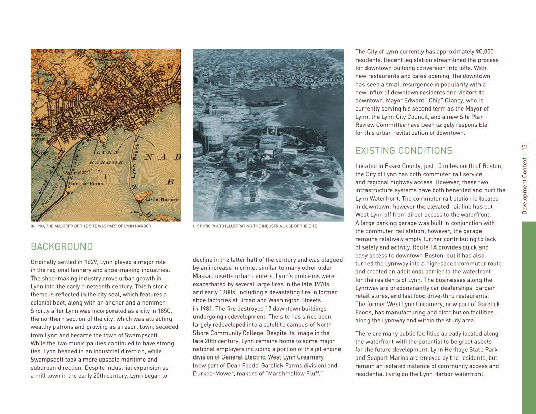
HISTORIC PHOTO ILLUSTRATING THE INDUSTRIAL USE OF THE SITEIN 1903, THE MAJORITY OF THE SITE WAS PART OF LYNN HARBOR
BACKGROUNDOriginally settled in 1629, Lynn played a major role in the regional tannery and shoe-making industries. The shoe-making industry drove urban growth in Lynn into the early nineteenth century. This historic theme is refl ected in the city seal, which features a colonial boot, along with an anchor and a hammer. Shortly after Lynn was incorporated as a city in 1850, the northern section of the city, which was attracting wealthy patrons and growing as a resort town, seceded from Lynn and became the town of Swampscott. While the two municipalities continued to have strong ties, Lynn headed in an industrial direction, while Swampscott took a more upscale maritime and suburban direction. Despite industrial expansion as a mill town in the early 20th century, Lynn began to
decline in the latter half of the century and was plagued by an increase in crime, similar to many other older Massachusetts urban centers. Lynn’s problems were exacerbated by several large fi res in the late 1970s and early 1980s, including a devastating fi re in former shoe factories at Broad and Washington Streets in 1981. The fi re destroyed 17 downtown buildings undergoing redevelopment. The site has since been largely redeveloped into a satellite campus of North Shore Community College. Despite its image in the late 20th century, Lynn remains home to some major national employers including a portion of the jet engine division of General Electric, West Lynn Creamery (now part of Dean Foods’ Garelick Farms division) and Durkee-Mower, makers of “Marshmallow Fluff.”
The City of Lynn currently has approximately 90,000 residents. Recent legislation streamlined the process for downtown building conversion into lofts. With new restaurants and cafes opening, the downtown has seen a small resurgence in popularity with a new infl ux of downtown residents and visitors to downtown. Mayor Edward “Chip” Clancy, who is currently serving his second term as the Mayor of Lynn, the Lynn City Council, and a new Site Plan Review Committee have been largely responsible for this urban revitalization of downtown.
EXISTING CONDITIONSLocated in Essex County, just 10 miles north of Boston, the City of Lynn has both commuter rail service and regional highway access. However, these two infrastructure systems have both benefi ted and hurt the Lynn Waterfront. The commuter rail station is located in downtown; however the elevated rail line has cut West Lynn off from direct access to the waterfront. A large parking garage was built in conjunction with the commuter rail station; however, the garage remains relatively empty further contributing to lack of safety and activity. Route 1A provides quick and easy access to downtown Boston, but it has also turned the Lynnway into a high-speed commuter route and created an additional barrier to the waterfront for the residents of Lynn. The businesses along the Lynnway are predominantly car dealerships, bargain retail stores, and fast food drive-thru restaurants. The former West Lynn Creamery, now part of Garelick Foods, has manufacturing and distribution facilities along the Lynnway and within the study area.
There are many public facilities already located along the waterfront with the potential to be great assets for the future development. Lynn Heritage State Park and Seaport Marina are enjoyed by the residents, but remain an isolated instance of community access and residential living on the Lynn Harbor waterfront.

Dev
elop
men
t Con
text
1
4
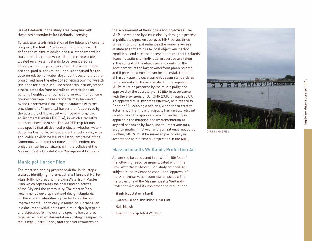
The public launching ramp at Blossom Street Extension is in the process of being resurfaced and will provide ample parking for cars and trailers, the EDIC pier at Marine Boulevard is currently used by Horizons Edge Casino Cruises, and the Massachusetts Department for Conservation and Recreation’s public fi shing pier is located at the southern end of the site.
The Clocktower Offi ce Building is a wonderful example of both the potential for offi ce along the Lynnway and the retrofi t possibilities of structures into landmark buildings. North Shore Community College is also a tremendous asset to the waterfront. The college has over 3,300 students and brings people from the area to the downtown Lynn. The college’s plans for expansion will bring even more vitality to the area and will be an important connection in bridging the gap between the downtown and the waterfront—literally.
While there are several assets currently on the waterfront, there are also many constraints that new development must keep in mind. The liquid natural gas tank is located right on the waterfront, but is only a reserve tank and therefore only used during peak periods in the winter. The Water & Sewage Treatment Plant serves the region and has onsite landfi ll capacity for the disposal of residual incinerated ash for approximately 17 more years. The Treatment Plant is researching innovative measures for wind technology and is committed to working with the new development to create a livable environment for the future residents and workers. The municipal landfi ll was capped in 1986 and only grassy hill remains. There is, however, the potential to relocate some of the landfi ll away from the water to allow for more advantageous use of the waterfront site. Power lines
currently run along an easement on the southern portion of the waterfront, then between the landfi ll and the Treatment Plant and connect to the power plant located along Marine Boulevard. National Grid recently completed an engineering study and the City of Lynn has received a grant to help pay for the relocation of the power lines from the waterfront to instead run along the GE property behind Lynnway businesses, cross over the Lynnway at Harding Street and return to the existing alignment between the landfi ll and the Treatment Plant, freeing up land along the waterfront to be redeveloped. While the power lines will soon be relocated, the Power Plant is a fi xture on the waterfront and will need to be incorporated into any future plans.
THE 6-7 LANES OF THE LYNNWAY AND CARROLL PARKWAY ARE A FORMIDABLE BARRIER TO PEDESTRIANS THE LNG TANK AND A DISTRIBUTION FACILITY ARE WINDOWLESS STRUCTURES FEET FROM THE WATER
Dev
elop
men
t Con
text
1
5
STATE REGULATIONSA signifi cant portion of the waterfront site lies within the Chapter 91 designation. Chapter 91 is a state regulation to protect and promote the public use of tidelands and other waterways. Chapter 91 preserves pedestrian access along the water’s edge in return for permission to develop non-water dependant projects on tidelands and provide facilities to enhance public use. Activities requiring authorization include structures, fi lling, dredging, change in use, structural alteration, and demolition/removal of structures.
A large portion of the central waterfront is a state Designated Port Area (DPA). There are 11 DPAs located throughout Massachusetts to promote the use and maintenance of designated areas for water-dependent industrial activities that require direct access to the waterfront. Examples of water-dependent industrial activities include marine terminals, commercial fi shing facilities, marine repair and construction, and manufacturing facilities that rely on bulk receipt of goods by waterborne transportation.
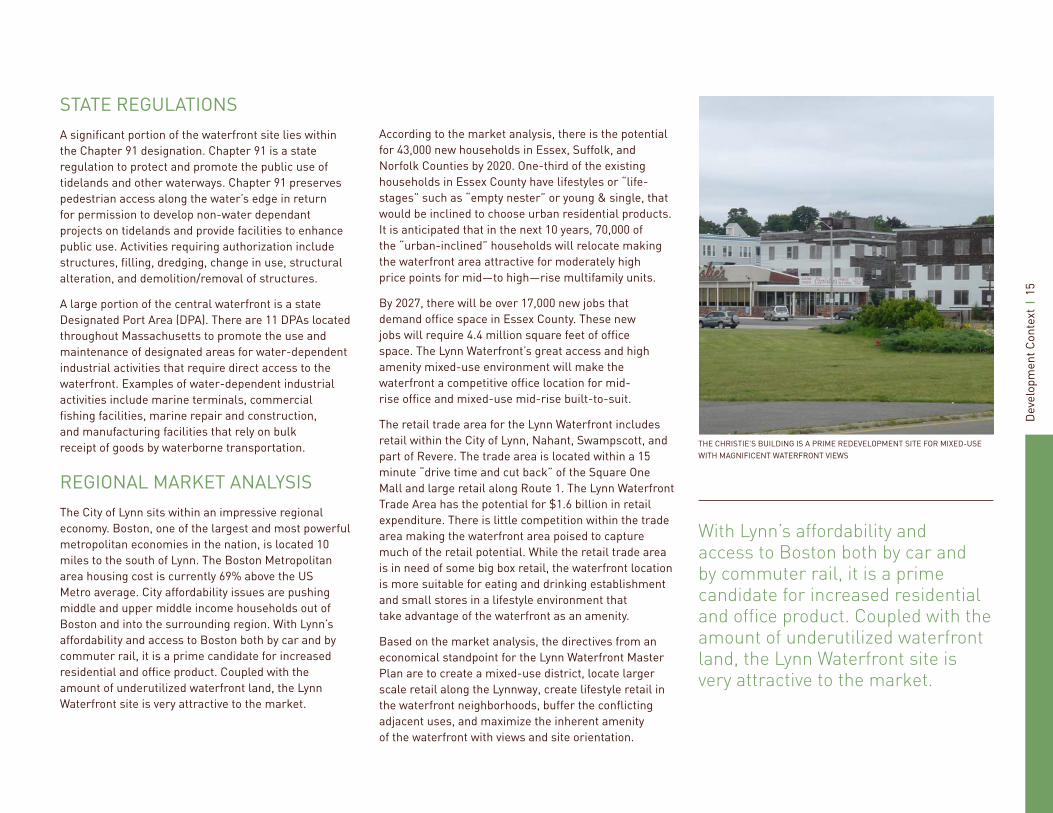
REGIONAL MARKET ANALYSISThe City of Lynn sits within an impressive regional economy. Boston, one of the largest and most powerful metropolitan economies in the nation, is located 10 miles to the south of Lynn. The Boston Metropolitan area housing cost is currently 69% above the US Metro average. City affordability issues are pushing middle and upper middle income households out of Boston and into the surrounding region. With Lynn’s affordability and access to Boston both by car and by commuter rail, it is a prime candidate for increased residential and offi ce product. Coupled with the amount of underutilized waterfront land, the Lynn Waterfront site is very attractive to the market.
THE CHRISTIE’S BUILDING IS A PRIME REDEVELOPMENT SITE FOR MIXED-USE WITH MAGNIFICENT WATERFRONT VIEWS
According to the market analysis, there is the potential for 43,000 new households in Essex, Suffolk, and Norfolk Counties by 2020. One-third of the existing households in Essex County have lifestyles or “life-stages” such as “empty nester” or young & single, that would be inclined to choose urban residential products. It is anticipated that in the next 10 years, 70,000 of the “urban-inclined” households will relocate making the waterfront area attractive for moderately high price points for mid—to high—rise multifamily units.
By 2027, there will be over 17,000 new jobs that demand offi ce space in Essex County. These new jobs will require 4.4 million square feet of offi ce space. The Lynn Waterfront’s great access and high amenity mixed-use environment will make the waterfront a competitive offi ce location for mid-rise offi ce and mixed-use mid-rise built-to-suit.
The retail trade area for the Lynn Waterfront includes retail within the City of Lynn, Nahant, Swampscott, and part of Revere. The trade area is located within a 15 minute “drive time and cut back” of the Square One Mall and large retail along Route 1. The Lynn Waterfront Trade Area has the potential for $1.6 billion in retail expenditure. There is little competition within the trade area making the waterfront area poised to capture much of the retail potential. While the retail trade area is in need of some big box retail, the waterfront location is more suitable for eating and drinking establishment and small stores in a lifestyle environment that take advantage of the waterfront as an amenity.
Based on the market analysis, the directives from an economical standpoint for the Lynn Waterfront Master Plan are to create a mixed-use district, locate larger scale retail along the Lynnway, create lifestyle retail in the waterfront neighborhoods, buffer the confl icting adjacent uses, and maximize the inherent amenity of the waterfront with views and site orientation.
With Lynn’s affordability and access to Boston both by car and by commuter rail, it is a prime candidate for increased residential and offi ce product. Coupled with the amount of underutilized waterfront land, the Lynn Waterfront site is very attractive to the market.

Dev
elop
men
t Con
text
1
6
SITES IDENTIFIED BY THE DEP AS CONTAMINATED, HOWEVER, SEVERAL HAVE ALREADY BEEN REMEDIATED
The Lynn Waterfront Area has been an active industrial and commercial area in the City of Lynn since the early 1800s.
CLEAN UP TO UNRESTRICTED USE
CLEANED UP WITH DEED RESTRICTION
ADDITIONAL WORK REQUIRED
LANDFILL
1 MAP ID FOR DEP-LISTED SITE OR LANDFILL

Dev
elop
men
t Con
text
1
7
ENVIRONMENTAL ISSUESWith new development imminent, the project team reviewed available environmental studies prepared for the properties within the Lynn Waterfront Area to evaluate the challenges to redevelopment posed by environmental degradation or contamination within the study area. The Lynn Waterfront Area has been an active industrial and commercial area in the City of Lynn since the early to mid 1800s. Historical uses of the Lynn Waterfront included a former manufactured gas plant which operated from 1853 until 1972; a wide variety of industrial and manufacturing facilities including dairy, textile, and electrical facilities; the municipal landfi ll; and the municipal wastewater treatment plant.
According to the Department of Environmental Protection’s (DEP) online contaminated sites database, there are 38 reported releases of oil and/or hazardous materials located on 21 properties within the study area. Two additional properties that could be considered contaminated that are not reported releases under the DEP Bureau of Waste Site Cleanup program include the Lynn Municipal Landfi ll and the Lynn Wastewater Treatment Landfi ll. The sites are summarized in the Technical Appendix.
There are several challenges posed by the contamination. Some of these sites will require additional investigation and cleanup activities. Although several of the sites have been closed under the MCP, the residual contamination may affect how the properties may be redeveloped. The deed restrictions on properties prohibiting residential use could be revised with additional cleanup or an appropriate engineering solution. There are many design and construction alternatives that can mitigate environmental risks or the impact of contaminated soil and groundwater to project costs and schedule.
There are many design and construction alternatives that can mitigate environmental risks or the impact of contaminated soil and groundwater to project costs and schedule.
WATERFRONT SITE WHERE ADDITIONAL REMEDIATION WORK IS REQUIRED

Master Plan Vision & Development Opportunities 03

Mas
ter
Plan
Vis
ion
20
FRAMEWORK PLAN
New Development
Lynn Commons
Downtown
NSCC Sagamore Hill
T
T
RES. / MIXED USE
GREEN SPACE
PROMENADE
CONNECTION
ROAD/RAIL
FOCAL POINT
GATEWAY
RAIL STATIONT

Mas
ter
Plan
Vis
ion
21
VISION FOR THE LYNN WATERFRONTBuilding upon Lynn’s recent success in the downtown, the waterfront plan for the 250+ acre site transforms the underutilized industrial brownfi eld land into a vibrant mixed-use district. The plan for the Lynn Waterfront connects the City with the water by overcoming visual and physical obstacles, including the Lynnway, the railroad, overhead power lines, and a municipal landfi ll. Pedestrian-oriented connections culminate in much needed public spaces along a waterfront promenade. The plan creates mixed-use neighborhoods, acknowledging the existing site constraints and building upon the unique assets. Gateway development sites announce the arrival at Lynn’s waterfront and a signature public plaza creates a focal point where downtown, North Shore Community College, the residents of Sagamore Hill and the waterfront come together.
The portion of the site designated as an industrial maritime port by the Commonwealth of Massachusetts has been incorporated into the plan to encourage the continuation of the working waterfront through commercial fi shing, boat building and repair, a marine terminal and other water-dependant industrial uses. The plan also envisions a revitalized Washington Street corridor that supports North Shore Community College and the surrounding residential neighborhood with small scale retail and restaurants, as well as creates a pedestrian focused connection between downtown and the waterfront.
The vision for the Lynn Waterfront was created as a result of feedback from the community, property owners, and stakeholders. The project team developed a set of guiding principles for the development of the master plan:
Connect the City with the waterfront•
Create connections that culminate in public spaces along waterfront promenade
Establish a unifi ed open space along the water
Create a landmark open space for celebrations
Design a mixed use neighborhood that takes advantage of views and connections
Design the new development as an extension of the existing urban fabric
Transform the Lynnway into a pedestrian friendly boulevard
Transform lower Sagamore Hill area into a vital residential neighborhood
Upgrade the traffi c system to be more pedestrian friendly
The project team sought to develop design solutions for the Lynn Waterfront Master Plan that are not only economically viable and publicly supportable, but also development that is environmentally sustainable and elevates the quality of life for users and visitors alike. The United Nations World Commission on Environment and Developments described sustainability as “development that meets the needs of the present without compromising the ability of future generations to meet their own needs.” This sense of sustainability is ingrained in the approach towards the development of the Lynn Waterfront. This perspective creates a design plan that acknowledges a strong relationship between the natural setting and proposed development, supporting the best scientifi c analysis of the environment while responding to the underlying market and economic reality. The sustainability goals for the Lynn Waterfront are to:
Create a walkable, livable community that promotes human interaction
•
•
•
•
•
•
•
•
•
Confi gure buildings on the site to minimize energy use by means of natural ventilation, daylighting and shading from vegetation.
Explore diverse transportation options
Design walking trails and bike paths that link the built environment with the natural environment
Conserve water resources through reuse, on-site treatment and reduction in peak demand
Use biofi ltration where possible to ensure groundwater recharge and to reduce out-of-basin transfer through stormwater drains
Establish a natural systems framework that preserves open space, habitat, buffers, and corridors to minimize impacts to the ecosystem.
•
•
•
•
•
•
GROUND FLOOR RETAIL ACTIVITY ADDS VITALITY

Mas
ter
Plan
Vis
ion
22
THE LYNN WATERFRONT MASTER PLAN VISION
Mas
ter
Plan
Vis
ion
23
WATERFRONT PROMENADE LINED WITH RESTAURANTS
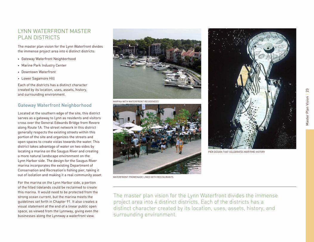
LYNN WATERFRONT MASTER PLAN DISTRICTSThe master plan vision for the Lynn Waterfront divides the immense project area into 4 distinct districts:
Gateway Waterfront Neighborhood
Marine Park Industry Center
Downtown Waterfront
Lower Sagamore Hill
Each of the districts has a distinct character created by its location, uses, assets, history, and surrounding environment.
Gateway Waterfront Neighborhood
Located at the southern edge of the site, this district serves as a gateway to Lynn as residents and visitors cross over the General Edwards Bridge from Revere along Route 1A. The street network in this district generally respects the existing streets within this portion of the site and organizes the streets and open spaces to create vistas towards the water. This district takes advantage of water on two sides by locating a marina on the Saugus River and creating a more natural landscape environment on the Lynn Harbor side. The design for the Saugus River marina incorporates the existing Department of Conservation and Recreation’s fi shing pier, taking it out of isolation and making it a real community asset.
For the marina on the Lynn Harbor side, a portion of the fi lled tidelands could be reclaimed to create this marina. It would need to be protected from the strong ocean current, but the marina meets the guidelines set forth in Chapter 91. It also creates a visual statement at the end of a linear public open space, as viewed from the Lynnway, giving even the businesses along the Lynnway a waterfront view.
•
•
•
•
MARINA WITH WATERFRONT RESIDENCES
PIER DESIGN THAT CELEBRATES MARITIME HISTORY
The master plan vision for the Lynn Waterfront divides the immense project area into 4 distinct districts. Each of the districts has a distinct character created by its location, uses, assets, history, and surrounding environment.

Mas
ter
Plan
Vis
ion
24
THE GATEWAY WATERFRONT NEIGHBORHOOD DISTRICT
The vision for this district features a variety of housing types, block confi gurations, and price ranges, with supporting retail, restaurants, and some offi ce space.

Mas
ter
Plan
Vis
ion
25
Additionally, a generous open space is created along the Lynn Harbor that allows for a variety of active and passive recreation and gives the community a place to congregate along the waters edge.
The vision for this district features a variety of housing types, block confi gurations, and price ranges, with supporting retail, restaurants, and some offi ce space. The majority of the offi ce space would be located along the Lynnway, with residential buildings making up the rest of the district. Ground fl oor retail is encouraged along the Lynnway, as well as along the waterfront and other primary streets within the district. Restaurants should be oriented towards the water with views of the ocean and Nahant.
A typical block within this district would have lower-rise residential along the waterfront, transitioning to high-rise in the middle of the district to maximize waterfront views for each development. Parking would be internal to the block and could be created with a green roof or other program to lessen the heat island effect and create a more pleasing view for the residents.
TYPICAL BLOCK PLAN 3D VIEW OF TYPICAL BLOCK
TYPICAL BLOCK SECTION
Mas
ter
Plan
Vis
ion
26
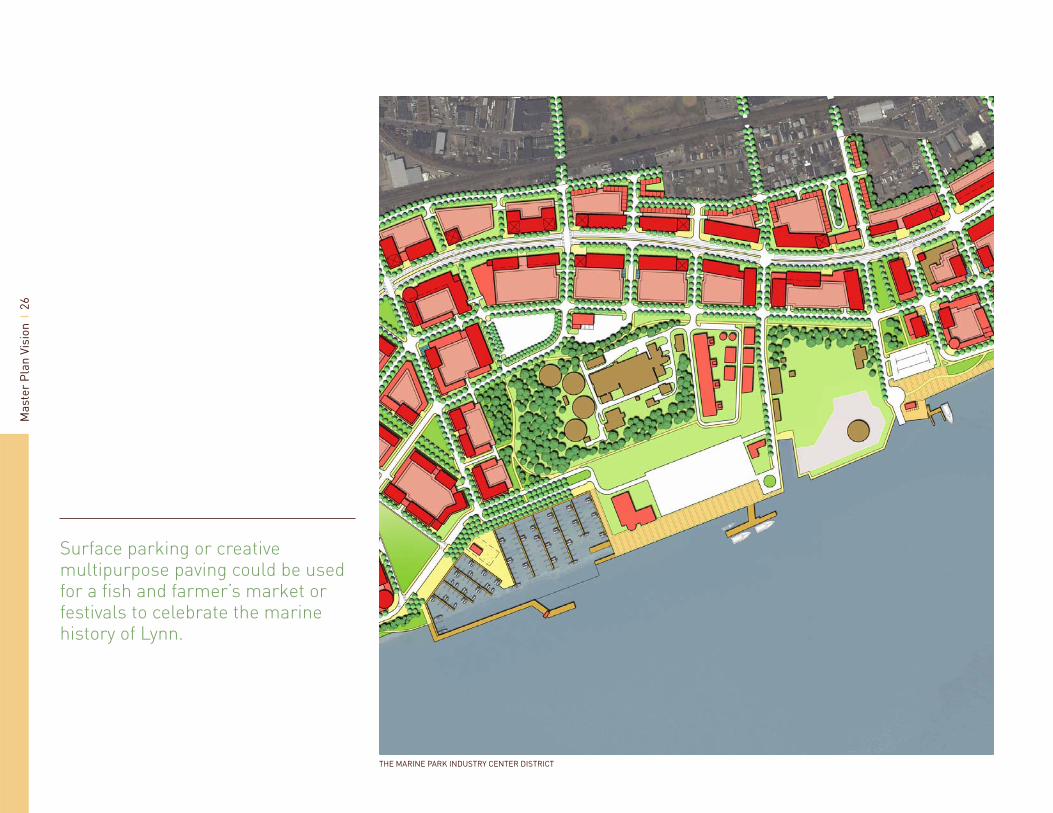
Surface parking or creative multipurpose paving could be used for a fi sh and farmer’s market or festivals to celebrate the marine history of Lynn.
THE MARINE PARK INDUSTRY CENTER DISTRICT

Mas
ter
Plan
Vis
ion
27
Marine Park Industry Center
Given the multiple constraints in this district including the State’s designated port area (DPA), the regional Water & Sewer Treatment Plan, and the liquid natural gas (LNG) reserve tank, this district is geared more towards light industry and offi ce. Since the DPA is restricted to only marine related industrial activities, the majority of this area is envisioned as a working waterfront with a range of activities including a commercial fi shing marina, boat building and boat repair, a marine terminal associated with the state-owned pier, and a passenger terminal for the proposed commuter ferry and public boat ramp.
Surface parking or creative multipurpose paving could be used for a fi sh and farmer’s market or festivals to celebrate the marine history of Lynn. A portion of the landfi ll could be relocated to create the commercial fi shing marina, again reclaiming the fi lled tidelands and creating a lasting environment that brings these water dependent uses back to the waterfront.
Along the Lynnway, offi ce buildings should be approximately 6 to 10 stories, so as not to create a canyon effect along the Lynnway. Residential uses, although not encouraged in this district, would be acceptable given the proper amount of buffer between the light industrial uses and the residential buildings. While many may not believe that it is possible to have residences anywhere near uses such as a Water and Sewer Treatment Plant, precedent shows that given a waterfront location and innovative methods of mitigation, even million dollar condo have been developed nearby, as in Chesapeake Harbor, Maryland.
MILLION DOLLAR CONDO LOCATED NEXT TO TREATMENT PLANT IN CHESAPEAKE HARBOR
THE WORKING WATERFRONT
A FISH MARKET ALONG THE WATERFRONT
Mas
ter
Plan
Vis
ion
28
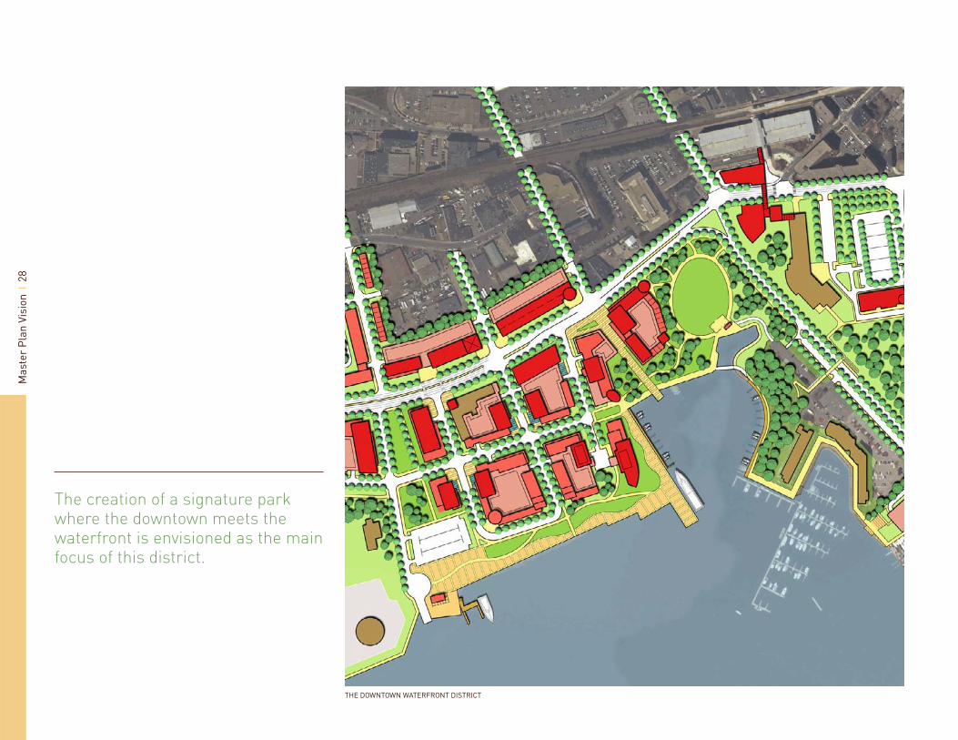
The creation of a signature park where the downtown meets the waterfront is envisioned as the main focus of this district.
THE DOWNTOWN WATERFRONT DISTRICT

Mas
ter
Plan
Vis
ion
29
Downtown Waterfront
The Downtown Waterfront District builds upon its proximity to downtown and existing assets such as the renovated Clocktower and Seaport Landing. The creation of a signature park where the downtown meets the waterfront is envisioned as the main focus of this district. While a realignment of the Lynnway into a tighter, more urban type of roadway signifi cantly enhances the size and capability of this signature open space, the vitality of this district does not hinge upon it. The plan creates a waterfront promenade with magnifi cent views of the Harbor, Nahant and even Boston in the distance. Mixed-use buildings create a dense urban neighborhood with residences, offi ces, retail and a much needed hotel in the area. Buildings should be designed with ample glass to capitalize on the views of the water and to light up the area in the evenings.
With both the commuter rail and the commuter ferry in close proximity, this district could be the classic transit-oriented development with shared parking and a real pedestrian feel. The signature open space is the perfect place for community gatherings and festivals. An amphitheater, trellis structures, a play ground, and fountains make the park a place to enjoy throughout the year regardless of scheduled events.
A DOWNTOWN AMPHITHEATER ON THE WATER
TRELLIS STRUCTURES PROVIDE SHADE AS A PARK AMENITY
CREATIVE PAVING AND LANDSCAPE DESIGN
Mas
ter
Plan
Vis
ion
30
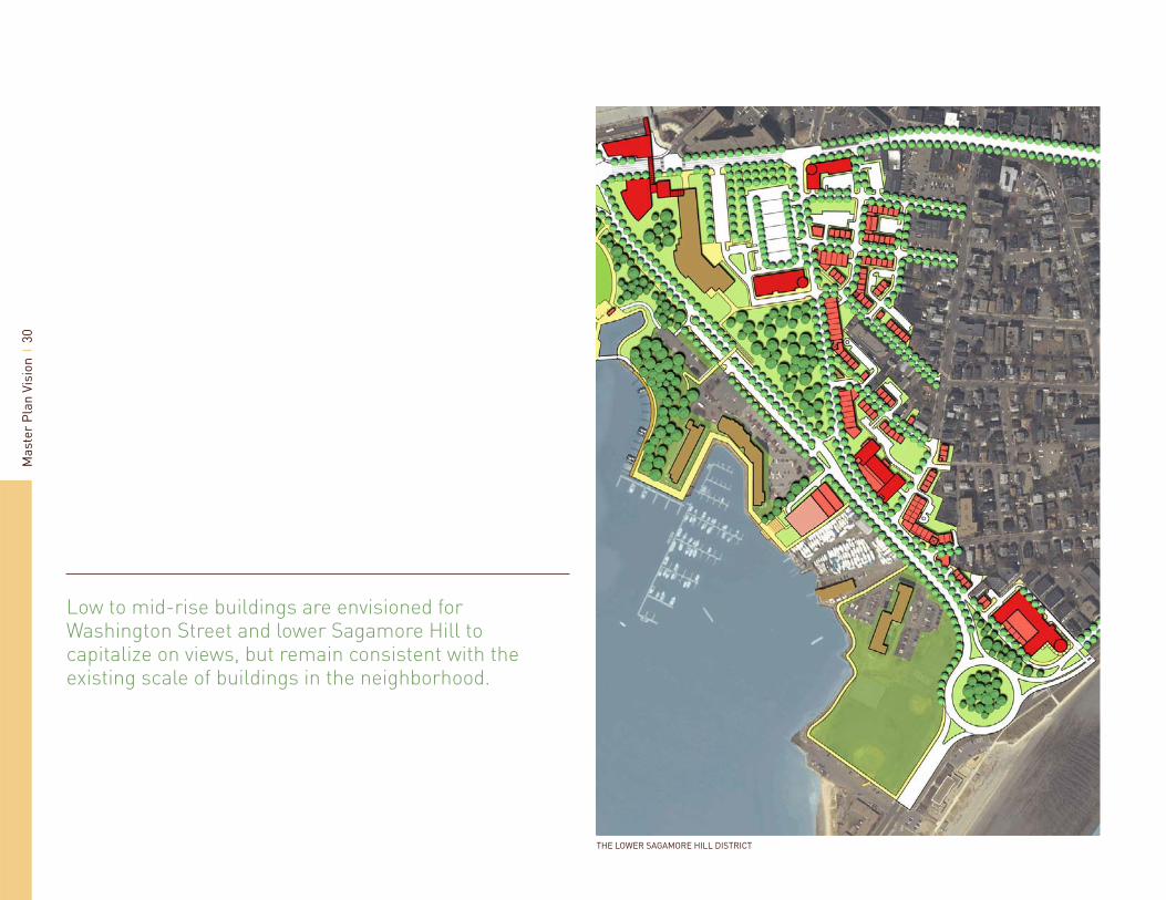
Low to mid-rise buildings are envisioned for Washington Street and lower Sagamore Hill to capitalize on views, but remain consistent with the existing scale of buildings in the neighborhood.
THE LOWER SAGAMORE HILL DISTRICT

Mas
ter
Plan
Vis
ion
31
Lower Sagamore Hill
Lower Sagamore Hill is anchored by both the existing North Shore Community College and the potential for a gateway development at the Nahant Rotary. In between, the character of Washington Street needs to be elevated to be consistent with the recent success downtown for restaurants and urban living, as well as provide support for the stable residential neighborhood found at the top of Sagamore Hill and the College.
Low to mid-rise buildings are envisioned for Washington Street and lower Sagamore Hill to capitalize on views, but remain consistent with the existing scale of buildings in the neighborhood. Along the waterfront, where there are already higher-rise buildings such as Seaport Landing and the senior housing near the rotary, buildings could be up to 10 stories, in line with other buildings along Lynn Shore Drive.
The Washington Street Corridor is envisioned as a lively extension of downtown that connects to the waterfront with ground fl oor retail and urban living above. Restaurants with views of the waterfront or retail stores that support the College, such as a bookstore or café would contribute to the revitalization of this district.
North Shore Community College is bound by the waterfront, downtown, and Sagamore Hill, making it diffi cult to place a back door. Unfortunately, since quality and consistency is currently lacking along Washington Street, the College has made recent plans to expand and will do so with a focus on the waterfront and downtown. Should they continue to grow, the master plan encourages them to also address the Sagamore Hill neighborhood with academic buildings facing onto Washington Street.
The Christie’s site is envisioned as a signature development that announces ones arrival to the Lynn Harbor and creates a presence on the Nahant Rotary with 270 degree views of Lynn Harbor, Nahant, and
Swampscott. The development should be predominantly residential, consistent with the surrounding residential neighborhood use, but have a mix of uses on the ground fl oors, accommodating to the pedestrian traffi c at the beach and eye-catching for the commuters passing by.
A PEDESTRIAN SCALE STREET WITH RETAIL AND HOUSING
GALLERY STOREFRONTS WITH HOUSING ABOVE WIDE SIDEWALKS AND LANDSCAPING CREATE A PEDESTRIAN FRIENDLY ENVIRONMENT

Mas
ter
Plan
Vis
ion
32
PARKING GARAGE IN PLAN AND SECTION ORIENT ENTRIES, RETAIL, AND SEATING TO ACTIVATE PUBLIC SPACES
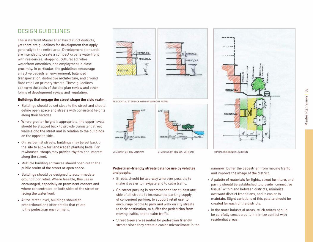
Development standards are intended to create a compact urbane waterfront with residences, shopping, cultural activities, waterfront amenities, and employment in close proximity.
Mas
ter
Plan
Vis
ion
33
STEPBACK ON THE WATERFRONTSTEPBACK ON THE LYNNWAY
DESIGN GUIDELINESThe Waterfront Master Plan has distinct districts, yet there are guidelines for development that apply generally to the entire area. Development standards are intended to create a compact urbane waterfront with residences, shopping, cultural activities, waterfront amenities, and employment in close proximity. In particular, the guidelines encourage an active pedestrian environment, balanced transportation, distinctive architecture, and ground fl oor retail on primary streets. These guidelines can form the basis of the site plan review and other forms of development review and regulation.
Buildings that engage the street shape the civic realm.
Buildings should be set close to the street and should defi ne open space and streets with consistent heights along their facades
Where greater height is appropriate, the upper levels should be stepped back to provide consistent street walls along the street and in relation to the buildings on the opposite side.
On residential streets, buildings may be set back on the site to allow for landscaped planting beds. For rowhouses, stoops may provide rhythm and interest along the street.
Multiple building entrances should open out to the public realm of the street or open space.
Buildings should be designed to accommodate ground fl oor retail. Where feasible, this use is encouraged, especially on prominent corners and where concentrated on both sides of the street or facing the waterfront.
At the street level, buildings should be proportioned and offer details that relate to the pedestrian environment.
•
•
•
•
•
•
RESIDENTIAL STEPBACK WITH OR WITHOUT RETAIL
Pedestrian-friendly streets balance use by vehicles
and people.
Streets should be two-way wherever possible to make it easier to navigate and to calm traffi c.
On-street parking is recommended for at least one-side of all streets to increase the parking supply of convenient parking, to support retail use, to encourage people to park and walk on city streets to their destination, to buffer the pedestrian from moving traffi c, and to calm traffi c.
Street trees are essential for pedestrian friendly streets since they create a cooler microclimate in the
•
•
•
summer, buffer the pedestrian from moving traffi c, and improve the image of the district.
A palette of materials for lights, street furniture, and paving should be established to provide “connective tissue” within and between districts, minimize awkward district transitions, and is easier to maintain. Slight variations of this palette should be created for each of the districts.
In the more industrial areas, truck routes should be carefully considered to minimize confl ict with residential areas.
•
•
TYPICAL RESIDENTIAL SECTION

Mas
ter
Plan
Vis
ion
34
DEVELOPMENT PLAN
The Master Plan calls for a large amount of new residential, offi ce, and retail space; however, with a 20 year full build out, the program is feasible given the regional market trends.
NO BUILD ZONE (EXCEPT FOR DPA APPROVED USES)
3-4 LEVELS (LIGHT INDUSTRIAL) 392,034 SF FOOTPRINT
3-4 LEVELS (GROUND LEVEL RETAIL, RESIDENTIAL) 433,843 SF FOOTPRINT
6-10 LEVELS (MIXED USE) 165,181 SF FOOTPRINT
6-10 LEVELS (RETAIL-GROUND LEVEL, OFFICE ABOVE) 883,887 SF FOOTPRINT
UP TO 20 LEVELS (MIXED USE) 2,313,688 SF FOOTPRINT

Mas
ter
Plan
Vis
ion
35
MARKET IMPLICATIONSAs a means of achieving the key goal of creating a vibrant mixed-use development, the market analysis focuses on the economic and fi scal implications of the Lynn Waterfront Master Plan. The Master Plan calls for a large amount of new residential, offi ce and retail space; however, with a 20 year full build out, the program is feasible given the regional market trends outlined earlier in this document.
Based on community feedback, the project team prepared a vision plan and tested it against the market analysis. A land use mix program based on the initial design was created and its feasibility was tested given the market trends among residential, offi ce, and retail land uses.
CONCEPTUAL BUILD-OUT PROGRAM, LYNN WATERFRONT PLAN
PURPLE YELLOW PINK ORANGE RED TOTAL
SQ. FT. UNITS SQ. FT. UNITS SQ. FT. UNITS SQ. FT. UNITS SQ. FT. UNITS SQ. FT. UNITS
RESIDENTIAL 0 404,920 340 183,850 150 206,146 170 2,887,480 2,410 3,682,396 3,100RETAIL 0 0 101,230 459,620 25,768 360,940 947,558OFFICE 0 0 183,850 12,884 180,470 377,204HOTEL 0 0 91,920 12,884 180,468 285,272LIGHT INDUSTRIAL 490,380 0 0 0 0 490,380TOTAL 490,380 506,150 919,240 257,682 3,609,358 5,782,810
LAND USE MIX ASSUMPTIONS, LYNN WATERFRONT PLAN
USEMIX
RESIDENTIALMIX: RETAIL MIX: OFFICE MIX: LT INDUSTRY MIX: HOTEL
PURPLE LIGHT INDUSTRIAL 0 % 0 % 0 % 100 % 0 %YELLOW RETAIL AND RESIDENTIAL 80 % 20 % 0 % 0 % 0 %PINK RETAIL AND OFFICE 20 % 50 % 20 % 0 % 10 %ORANGE MIXED-USE ZONE 80 % 10 % 5 % 0 % 5 %RED MIXED-USE ZONE 80 % 10 % 5 % 0 % 5 %
The project team created a development plan that highlights height and use for the Waterfront to maximize waterfront views, avoid canyon-like effects along open spaces, create vitality, and ensure proper transitions between districts and confl icting uses. From this diagram, land use assumptions were made for the project area and a conceptual build out program was established. Residential is the predominant land use with approximately 3,100 units assumed. Commercial uses account for approximately 1.6 million square feet. Light industrial amounts to 490,000 square feet. In total, the program incorporates approximately 5.7 million square feet of development.

Mas
ter
Plan
Vis
ion
36
The Residential Market
The Lynn Waterfront Plan’s residential program consists of moderate to high rise, multi-family residential projects. Given this product, the primary target markets for the Lynn Waterfront residential units will be young households with no children and empty nester/retiree households.
The particular market segments most likely attracted to Lynn’s Waterfront in the near term are moderate income households who demand affordable housing in the Lynn Region. These households will be attracted to Lynn for its central location, great access and its waterfront.
Claritas PRIZM data categorizes households on the basis of lifestage, lifestyle, tastes and preferences and income. Given the development program envisioned on Lynn’s Waterfront, the project team calculated the number of households in the Essex, Suffolk and Norfolk Counties that possess the following characteristics:
Urban-inclined in tastes and preferences;
Singles and couples with no or few children;
Retirees and empty nesters; and,
Moderate income (median income below $70,000 and above $45,000).
There are 202,000 such households in the Lynn region. These households are Lynn Waterfront’s “target market”. These households represent one-third of the total households in the three-county region. This share was applied to the 2010 household projection to estimate the potential market for Lynn Waterfront residential units.
The Lynn Waterfront program calls for approximately 3,100 housing units. Waterfront residential projects will have to capture approximately four percent of the potential moving market over the next ten years. Over a longer absorption period the capture rate required would be lower.
•
•
•
•
Given the demand for waterfront living, Lynn’s strategic location and access and the general lack of affordable housing options in the Boston Metropolitan Area, it is reasonable to assume that Lynn can capture 2.5 to 5 percent of the moderate income, multi-family residential market that will be moving over the next 10 to 20 years. Even though the project anticipates a 20-year build-out of the Waterfront, a lion’s share of the residential can likely be built in a 10-15 year timeframe.
The Offi ce Market
The Lynn Waterfront Plan accommodates approximately 377,000 square feet of offi ce space. Offi ce development will likely occur over a 20-year period as the attractiveness of the Waterfront as a business location evolves out of the environment created with higher density residential development.
According to economy.com employment projections, Essex County offi ce-inclined employment is projected to increase by 9,350 jobs between 2007 and 2017 and 17,480 jobs between 2007 and 2027. At 250 square feet per employee, job growth will create a demand for 2.3 million square feet of offi ce space between 2007 and 2017 and 4.4 million square feet between 2007 and 2027.
Assuming a 20-year build-out, it is reasonable to assume that the Lynn Waterfront can capture less than ten percent of this net new demand for offi ce space. It is important to note, that this analysis does not take into consideration the potential for businesses located in Norfolk and/or Suffolk County relocating to Lynn’s Waterfront because of its unique locational attributes. Lynn’s Waterfront will be a competitive location for offi ce because of its excellent access (Lynnway and transit), waterfront location, mixed-use environment and proximity to Boston.
MID-RISE MULTIFAMILY LIVING

Mas
ter
Plan
Vis
ion
37
The Retail Market
As envisioned, the retail mix on the Waterfront could incorporate an urban version of community-oriented stores like Target and Home Depot, neighborhood stores like a super market and pharmacy, eating and drinking establishments and other smaller community-oriented stores. These store types would exist in a mixed-use environment with larger format stores on the Lynnway and smaller stores and restaurants in the Waterfront neighborhoods.
For the primary trade area, the project team extrapolated Claritas’ 2011 retail expenditure projections to 2020. The primary trade area’s retail spending potential by general store type is summarized below.
RETAIL EXPENDITURE POTENTIAL: PRIMARY TRADE AREA, LYNN WATERFRONT AREA 2020
SHOPPING CENTER INCLINED STORE TYPES
LARGE FLOORPLATE STORE-TYPES $ 881,970,728
General Merchandise/Wholesale $ 325,751,000Home Improvement/ Building $ 237,228,000Food $ 318,991,728
OTHER STORES $ 491,472,000
Furniture/Home Accessories $ 68,079,000Electronics/Home Appliance $ 60,975,000Health/Personal Care $ 138,828,000Clothing $ 90,770,000Jewelry $ 19,280,000Sporting Goods, Hobby, Book, Music $ 47,063,000Miscellaneous $ 66,476,000
EATING AND DRINKING ESTABLISHMENT $ 267,140,000
Sub-Total $ 1,640,582,728OTHER RETAIL TYPES
Non-Store $ 174,151,000Automotive/Gas $ 757,235,000Sub-Total $ 931,386,000TOTAL $ 2,571,968,728
Applying average sales to the Waterfront’s conceptual retail build-out program results in $332 million in total sales. To support the retail development program will require that the Waterfront capture approximately one–fi fth of the primary trade area’s shopping center-inclined retail potential. This capture rate is reasonable given the current lack of competition within and in the immediate vicinity of the primary trade area.
RETAIL WITH OFFICE ABOVE

Mas
ter
Plan
Vis
ion
38
Economic Implications: Jobs
The project team estimated the Conceptual Build-Out Program’s development costs, construction costs, and market value by land use. The project team employed industry standards, RS Means construction cost estimates and recent work with developers in Massachusetts to develop the cost and value estimates.
Construction on Lynn’s waterfront will create employment by virtue of the land and materials required for construction. In contrast to annual “operating” impacts, which occur on an ongoing basis, “construction phase” impacts are one- time impacts. Construction costs form the bases for projecting construction jobs. As shown above, construction costs are estimated to total approximately $1.18 billion. The analysis relied on a recent IMPLAN analysis of a major Massachusetts mixed-use development to determine the construction jobs generated from Lynn Waterfront’s Conceptual Build-Out Program. The redevelopment of Lynn’s Waterfront will generate approximately 9,620 construction jobs. Development will occur in phases and, as such, these jobs will be realized over a 20-year period.
Employment ranges by retail store type. Based on the understanding of Lynn Waterfront’s position in the retail market, the project team has estimated a general mix of store-types in order to generate employment estimates. Given the store mix assumed, the retail component of the development program will support 2,180 jobs. The offi ce, hotel, and light industrial uses in the Plan will support an additional 2,740 employees. In total, the Waterfront redevelopment will support 9,920 construction jobs and 4,920 full time jobs over the next 20 years.
CONCEPTUAL BUILD-OUT PROGRAM, LYNN WATERFRONT PLAN
SQ. FT.DEVELOPMENT
COST/SF
CONSTRUCTION
COST/SF
CONSTRUCTION
COST
MARKET
VALUE/SFMKT VALUE
RESIDENTIAL 3,682,396 $ 238 $ 208 764,097,000 $ 244 $ 898,937,820RETAIL 947,558 $ 250 $ 228 215,569,000 $ 268 $ 253,611,175OFFICE 377,204 $ 280 $ 253 95,433,000 $ 298 $ 112,273,696HOTEL 285,272 $ 208 $ 181 51,492,000 $ 212 $ 60,578,302LIGHT INDUSTRIAL 490,380 $ 120 $ 108 52,961,000 $ 127 $ 62,307,106TOTAL 5,782,810 $ 1,179,552,000 $ 1,887,708,099

Mas
ter
Plan
Vis
ion
39
Fiscal Implications
The project team calculated annual fi scal impacts attributable to Lynn Waterfront’s redevelopment as envisioned in the Waterfront Plan. These preliminary calculations incorporate City revenues from real property taxes, motor vehicle excise taxes, personal property taxes and lodging taxes. The assumptions with regard to real personal property taxes are derived from interviews with City offi cials. The assumptions regarding other taxes are derived from a recent detailed Fiscal and Economic Analysis performed for another Massachusetts town.
The Waterfront Development Plan at build-out represents $1.4 billion of real property value. Values are based on development costs and industry standards with regard to return on investment. As shown in the table, waterfront development as envisioned will generate an estimated $17.8 million in annual property tax revenues.
For residential properties, automobiles comprise the primary source of personal property taxes. These taxes can be projected assuming there are 1.5 vehicles per residential unit with an average assessed value (based on State depreciation formulas) of $6,000 per vehicle. Applying these assumptions, the project’s annual vehicle excise tax revenue is approximately $697,500 per annum.
In the Town of Somerville, Massachusetts personal property value represented approximately 1.9 percent of commercial real property value. The project team has applied this ratio to estimate the personal property tax implications of waterfront redevelopment. Applying this ratio, personal property tax revenues associated with the Waterfront’s redevelopment are estimated to total $197,400 per year.
Combining the various revenue streams outlined, total annual revenues accruing to the City of Lynn as a result of the Master Plan’s implementation amount to approximately $18.7 million.
BUID-OUT PROPERTY TAX REVENUE, LYNN WATERFRONT PLAN 2007 DOLLARS
MKT VALUE % ASSESSED TAX/$1,000 ASSESSED VALUE ANNUAL PROPERTY TAX REVENUE
RESIDENTIAL $ 898,937,820 90% $ 10.41 $ 8,422,148RETAIL $ 253,611,175 90% $ 21.26 $ 4,852,596OFFICE $ 112,273,696 90% $ 21.26 $ 2,148,245HOTEL $ 60,578,302 90% $ 21.26 $ 1,159,105LIGHT INDUSTRIAL $ 62,307,106 90% $ 21.26 $ 1,192,184TOTAL $ 1,387,708,099 $ 17,774,279
Mas
ter
Plan
Vis
ion
40
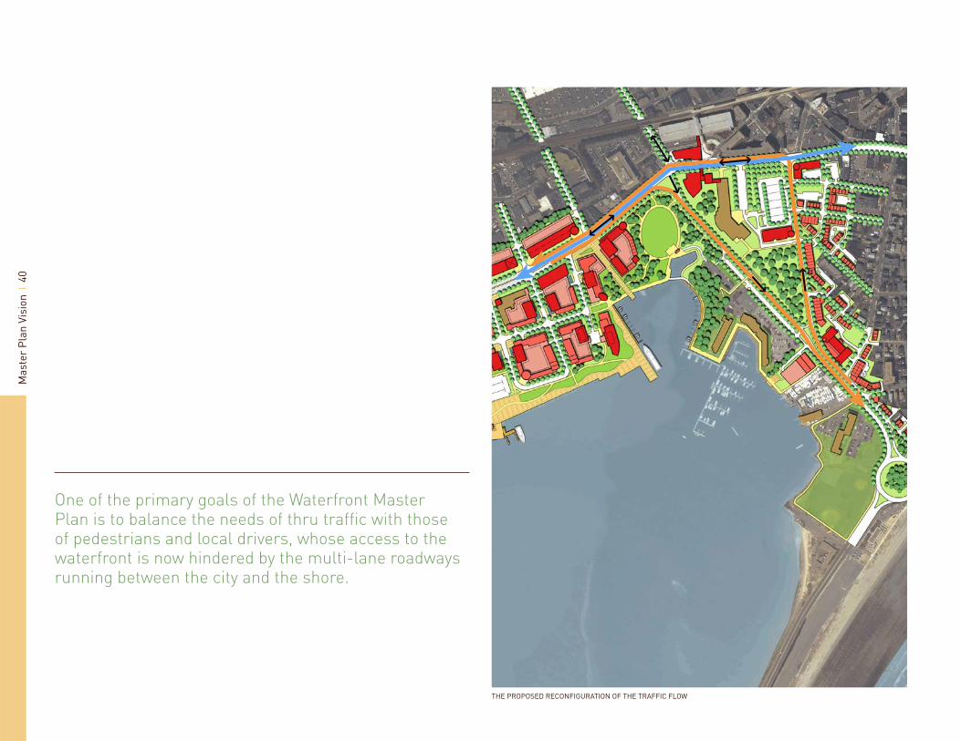
THE PROPOSED RECONFIGURATION OF THE TRAFFIC FLOW
One of the primary goals of the Waterfront Master Plan is to balance the needs of thru traffi c with those of pedestrians and local drivers, whose access to the waterfront is now hindered by the multi-lane roadways running between the city and the shore.

Mas
ter
Plan
Vis
ion
41
TRAFFIC STRATEGYAs the Lynn waterfront redevelops into a walkable urban environment, the Lynnway, Carroll Parkway and the streets which feed them will need to continue to serve a regional transportation function. One of the primary goals of the Waterfront Master Plan is to balance the needs of thru traffi c with those of pedestrians and local drivers, whose access to the waterfront is now hindered by the multi-lane roadways running between the city and the shore.
The Waterfront Master Plan asserts the importance of these roadways to the City of Lynn, both as streets for driving and as part of the urban fabric. While recognizing that Rte. 1A, Carroll Parkway and Lynn Shore Drive must continue to handle the regional traffi c that relies on them, the Master Plan does not take intersection levels of service and vehicular travel time to be the only relevant considerations in determining how traffi c should be managed. Also important are the walkability of the downtown, access to the waterfront, and the use and design of the land at the eastern end of Market Street. At present, this land is taken up by roadways (the Lynnway, Market Street Extension and Broad Street) and the vacant space between them. This area separates the downtown from the waterfront, and is a formidable barrier to bringing them together. To free up the land for reuse as a civic space, it will be necessary to simplify and consolidate the roadway system.
The alignment of the Lynnway is the main problem. Its swooping curve as it transitions to Carroll Parkway is designed to carry high volumes of thru traffi c at maximum speeds. Furthermore, an auto-oriented reconfi guration of the circulation pattern has distorted the path of Route 1A, forcing eastbound drivers to turn left onto the eastern end of Market Street and then immediately to turn right to return to Broad Street/Route 1A. This tangle of streets consumes a large
area of land, making it unattractive and inhospitable to pedestrians, and creating a no-man’s land that renders the waterfront practically inaccessible. The primary objective of roadway planning in this area is to channel vehicular traffi c into narrower streams that will be easier to cross and less land-intensive.
Because of the heavy volumes of traffi c on the Lynnway/Carroll Parkway (westbound in the AM rush hour and eastbound in the PM), and because the split between the Lynnway and Route 1A creates a queue from the Market/Broad intersection back toward the Lynnway, it is not possible simply to move the Lynnway to the north and reduce the radius of its curve as it becomes Carroll Parkway. The most feasible alternative is to split the traffi c going between the Lynnway and Lynn Shore Drive between its two directions—with eastbound
traffi c staying on the water side of North Shore Community College, and westbound traffi c shifting to the land side, via Washington Street and Broad Street.
The proposed reconfi guration of traffi c fl ow would consolidate the existing Market/Broad and Market Extension/Lynnway/Carroll Parkway intersections into one, realigning the eastern end of the Lynnway back into the original path of Route 1A (Broad Street) west of Market Street. Eastbound Lynnway traffi c would turn right at the Market/Broad/Carroll Parkway intersection, facilitated by double free-right lanes and entering Carroll Parkway under Yield-sign control but also protected by the intersection’s signal. Westbound traffi c coming from Lynn Shore Drive and the Nahant Rotary would fl ow onto Washington, which would be converted into a one-way street with two
THE INTERSECTION OF THE LYNNWAY AND MARKET STREET THREE LANES OF THE SIX LANE BARRIER BETWEEN DOWNTOWN ANDTHE WATERFRONT
Mas
ter
Plan
Vis
ion
42
lanes running northbound. At its approach to Broad Street, Washington would widen to three lanes—two left-only lanes and one allowing both left and right turns onto Broad. Westbound traffi c from Carroll Parkway would thus travel on Broad Street through the Market/Broad intersection, where the realigned Lynnway would begin. Traffi c operations would be aided by the signalization of the Lynnway/Pleasant Street intersection. This would permit left turns from the Lynnway eastbound onto Pleasant, making it possible to prohibit left turns from eastbound Lynnway onto Market during peak AM periods.
Traffi c operations analysis, using the traffi c volumes projected by the DCR study for 2011, shows that such a reconfi guration will produce acceptable levels of service at all times. The table below shows those levels of service, in the standard grading format of A (no congestion) through F (severely congested). D is generally considered to be acceptable in urban conditions.
INFRASTRUCTURE
Roads and Streets
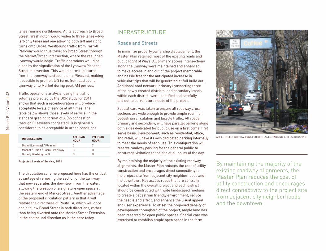
To minimize property ownership displacement, the Master Plan retained most of the existing roads and public Right of Ways. All primary access intersections along the Lynnway were maintained and enhanced to make access in and out of the project memorable and hassle free for the anticipated increase in vehicular trips that will be generated at full build out. Additional road network, primary (connecting three of the newly created districts) and secondary (roads within each district) were identifi ed and carefully laid out to serve future needs of the project.
Special care was taken to ensure all roadway cross sections are wide enough to provide ample room for pedestrian circulation and bicycle traffi c. All roads, primary and secondary, will have parallel parking along both sides dedicated for public use on a fi rst come, fi rst serve basis. Development, such as residential, offi ce, and retail, will have its own dedicated parking internally to meet the needs of each use. This confi guration will reserve roadway parking for the general public to encourage visitation to the site at all hours of the day.
By maintaining the majority of the existing roadway alignments, the Master Plan reduces the cost of utility construction and encourages direct connectivity to the project site from adjacent city neighborhoods and the downtown. Key access roads that are centrally located within the overall project and each district should be constructed with wide landscaped medians to create a pedestrian friendly environment, reduce the heat island effect, and enhance the visual appeal and user experience. To offset the proposed density of development throughout of the project, ample land has been reserved for open public spaces. Special care was exercised to establish ample open space in the form
By maintaining the majority of the existing roadway alignments, the Master Plan reduces the cost of utility construction and encourages direct connectivity to the project site from adjacent city neighborhoods and the downtown.
INTERSECTIONAM PEAK
HOUR
PM PEAK
HOUR
Broad (Lynnway) / Pleasant C CMarket / Broad / Carroll Parkway B BBroad / Washington B B B
Projected Levels of Service, 2011
The circulation scheme proposed here has the critical advantage of removing the section of the Lynnway that now separates the downtown from the water, allowing the creation of a signature open space at the eastern end of Market Street. Another advantage of the proposed circulation pattern is that it will restore the directness of Route 1A, which will once again follow Broad Street in both directions, rather than being diverted onto the Market Street Extension in the eastbound direction as is the case today.
AMPLE STREET WIDTH ALLOWS FOR BIKE LANES, PARKING, AND LANDSCAPING

Mas
ter
Plan
Vis
ion
43
of small community based pocket parks. These parks will serve the daily needs of the newly established community, as well as city residents at large.
The Master Plan proposes adding parallel parking on both the inbound and outbound sections of the Lynnway during off peak traffi c fl ow to balance the image of the Lynnway, making it a more friendly environment during non-peak times, while maintaining its use as a commuter throughway during peak times. Essentially, the three lane roadway section will be reduced to two in its respective direction after morning and before evening rush hours. This action will encourage city residents to come and visit the existing businesses and commercial establishments along both sides of the Lynnway with ample places to park. This will be good for business owners, as well as city residents and shoppers from the regional area.
Utilities
Historically, the 250 acres that constitute the waterfront project area, were used for a large variety of light to heavy industrial uses. Industrial uses require ample electrical power supply, domestic water, natural gas, and other basic utility services. Hence, there is ample residual capacity within the area to serve the needs of project build-out for the suggested program in the Master Plan. However, most of the existing utility service lines are over 50 years old and most likely will require complete overhaul and upgrade.
This Master Plan assumes that new utility service lines will be provided as part of the overall development initiative to serve the needs of the project. Furthermore, the Master Plan recommends that all utility service lines such as electrical power, cable, and telecommunication will be buried in conduits underground to avoid the unsightly telephone poles throughout of the area. Water service, sanitary sewer, storm drain and natural gas will be separate services
and extended along the public right of way. The regional sanitary sewer treatment facility has ample capacity to meet the needs of the proposed program.
The City of Lynn has a golden opportunity to make this development project an environmentally sustainable one by obligating itself and potential developers to follow the international Green Design initiative. This project could have a great and positive impact on the region and could attract national and international interest because of its unique location. By adopting low impact development techniques in lieu of standard past development practices, the City can create a unique new neighborhood unlike any other in the area by showing ultimate sensitivity to the living environment.
By reducing or eliminating direct discharge of storm water runoff to the Lynn Harbor, the water quality in the harbor will improve over the life cycle of the project. By following best water management practices, surface water runoff from street and roof drains can be cleaned and fi ltered by channeling it into the numerous neighborhood green spaces for pre-treatment. The pocket parks and all other green open spaces can be utilized to store, fi lter and cleanse the surface runoff prior to discharge into the harbor.
Green design technology is making remarkable advancement on a monthly basis. By committing to a sustainable design approach, the consumption of energy can be reduced and diversifi ed to gain the benefi ts of solar, wind, geothermal and other emerging industries. This initiative can make this project attractive and desirable to new residents and make future development sustainable for generations to come.
Creating a smart development project that uses natural energy sources to augment the high cost of imported fuel will enhance the economic rate of return on investment.
A GREEN ROOF REDUCES STORM WATER RUNOFF AND THE HEAT ISLAND EFFECT


Implementation Strategy 04
Impl
emen
tatio
n St
rate
gy
46
THE LYNN WATERFRONT MASTER PLAN VISION

Impl
emen
tatio
n St
rate
gy
47
PHASINGThe Lynn Waterfront Master Plan calls for signifi cant changes in existing uses from the current mix of heavy and light industry and automotive retail to the proposed mixed of residential, offi ce, and lifestyle retail. The plan also must take into consideration the fact that much of the land requires environmental mitigation. An undertaking of this magnitude will take several decades, if not more, to complete. Future trends, market demand, social behaviors, and community needs tend to be cyclical and will, therefore, affect the time frame of project completion.
To make the development of this land more manageable over a long period of time, the Master Plan identifi es four distinct neighborhood districts:
A. Gateway Waterfront Neighborhood
B. Marine Park Industry Center
C. Downtown Waterfront
D. Lower Sagamore Hill
Each district is large enough to be developed in multiple phases. Due to pent up demand by current ownership of the land, particularly parcels located in districts A and C mentioned above, multiple project commencement is possible and imminent. Upon the approval of the Master Plan, the recommended zoning changes, and the Municipal Harbor Management Plan, development interest will readily present itself. The approval of the Master Plan, along with its components, will clarify the intent of the City, the community, and the State regulatory agencies and pave the way to commence the work. The City of Lynn has already done a great service for the private ownership of the parcels within the project area by undertaking the initiative to prepare this master plan. The Lynn Waterfront Master Plan will serve as a framework and a guiding tool by establishing the long term vision for developing this valuable area
along the Lynn Harbor. As development commences, the Master Plan should be reviewed approximately every fi ve years to ensure it remains valid and continues to refl ect the vision of the City and the community.
The signifi cant effort the City undertook to negotiate the relocation of the overhead electrical power lines with North East Utility National Grid and securing a grant towards the cost of relocation is a clear massage to the private sector and the landowners of the City’s determination to see that the land is developed in the near future . Once the relocation of the overhead power lines is complete, the vacated land within the previous utility right of way (ROW) will create a parcel large enough to develop, increase the value of the land, and, with initiative, will pave the way to commence development in the South Waterfront Neighborhood.
It is premature at this point to arbitrarily identify which parcel should be developed fi rst, second, and third when ownership, remediation, and development interest all contribute to the timeliness of the 305-acre development. As interest continues to grow and the fi rst proponent of development emerges, market demand will incite additional development projects. To accelerate the development initiative by the private sector, however, the City may start the process by initiating some of the needed infrastructure improvements. Often, this process is referred to as a public / private partnership. The public sector starts the improvement process by investing in basic overall site cleanup and improving access to the various portions of the site, hence sending a clear message to the private sector that the City is committed to share the effort in commencing development.
STATE AND FEDERAL PERMITTING PROGRAMSDevelopment of portions of the Lynn Waterfront site are subject to state and federal permitting programs and departmental review including the Chapter 91 Licensing Program, Massachusetts Wetlands Protection Act, Massachusetts Environmental Policy Act (MEPA), Water Quality Certifi cation, Massachusetts Coastal Zone Management, and the U.S. Army Corps of Engineers. For more detailed information, please see the Lynn Waterfront Master Plan Technical Appendix.
Chapter 91
Most of the waterfront area is fi lled tidelands and therefore falls under the jurisdiction of the state’s Chapter 91 waterways licensing programs. Chapter 91 is a state regulation to protect and promote the public use of Commonwealth tidelands and other waterways. Chapter 91 preserves pedestrian access along the water’s edge in return for permission to develop non-water dependant projects on tidelands and provide facilities to enhance public use. Activities requiring authorization include structures, fi lling, dredging, change in use, structural alteration, and demolition/removal of structures. Tidelands within the master plan study area consist of both private tidelands and Commonwealth tidelands.
Licenses issued for the use of private tidelands are to be restricted to water-dependent uses and/or uses which serve a proper public purpose. Licenses issued for the use of commonwealth tidelands are to be restricted to uses which serve a proper public purpose such that the private advantages of use are merely incidental to the achievement of public purposes. The Lynn Waterfront Master Plan includes both water-dependent uses and extensive public facilities to ensure that the future

Impl
emen
tatio
n St
rate
gy
48
CHAPTER 91 LINE
DESIGNATED PORT AREA
EXISTING CHANNEL
PROPOSED CHANNEL
PROPOSED WAVE ATTENUATOR
NAVIGATION MARKET
THE CHAPTER 91 LINE, DPA, AND HARBOR PLAN
75’ WIDE
12’ DEEP
75’ WIDE
12’ DEEP
100’ WIDE
18’ DEEP
Impl
emen
tatio
n St
rate
gy
49
use of tidelands in the study area complies with these basic standards for tidelands licensing.
To facilitate its administration of the tidelands licensing program, the MADEP has issued regulations which defi ne the minimum design and use standards which must be met for a nonwater-dependent use project located on private tidelands to be considered as serving a “proper public purpose”. These standards are designed to ensure that land is conserved for the accommodation of water-dependent uses and that the project will have the effect of activating commonwealth tidelands for public use. The standards include, among others, setbacks from shorelines, restrictions on building heights, and restrictions on extent of building ground coverage. These standards may be waived by the Department if the project conforms with the provisions of a “municipal harbor plan”, approved by the secretary of the executive offi ce of energy and environmental affairs (EOEEA), in which alternative standards have been set. The MADEP regulations also specify that all licensed projects, whether water-dependent or nonwater-dependent, must comply with applicable environmental regulatory programs of the Commonwealth and that nonwater-dependent use projects must be consistent with the policies of the Massachusetts Coastal Zone Management Program.
Municipal Harbor Plan
The master planning process took the initial steps towards identifying the concept of a Municipal Harbor Plan (MHP) by creating the Lynn Waterfront Master Plan which represents the goals and objectives of the City and the community. The Master Plan recommends development and design standards for the site and identifi es a plan for Lynn Harbor improvements. Technically, a Municipal Harbor Plan is a document which sets forth a municipality’s goals and objectives for the use of a specifi c harbor area together with an implementation strategy designed to focus legal, institutional, and fi nancial resources on
the achievement of those goals and objectives. The MHP is developed by a municipality through a process of public dialogue. An approved MHP serves three primary functions: it enhances the responsiveness of state agency actions to local objectives, harbor conditions, and circumstances; it ensures that tidelands licensing actions on individual properties are taken in the context of the objectives and goals for the development of the larger waterfront planning area; and it provides a mechanism for the establishment of harbor-specifi c development/design standards as replacements for those specifi ed in the legislation. MHPs must be prepared by the municipality and approved by the secretary of EOEEA in accordance with the provisions of 301 CMR 23.00 through 23.09. An approved MHP becomes effective, with regard to Chapter 91 licensing decisions, when the secretary determines that the municipality has met all relevant conditions of the approval decision, including as applicable the adoption and implementation of any ordinances or by-laws, capital improvements, programmatic initiatives, or organizational measures. Further, MHPs must be renewed periodically in accordance with a schedule specifi ed in the MHP.
Massachusetts Wetlands Protection Act
All work to be conducted in or within 100 feet of the following resource areas located within the Lynn Waterfront Master Plan study area will be subject to the review and conditional approval of the Lynn conservation commission pursuant to the provisions of the Massachusetts Wetlands Protection Act and its implementing regulations:
Bank (coastal or inland)
Coastal Beach, including Tidal Flat
Salt Marsh
Bordering Vegetated Wetland
•
•
•
•
DCR’S FISHING PIER

Impl
emen
tatio
n St
rate
gy
50
Also, any work to be conducted within 200 feet of the bank of the Saugus River and/or within the following resource areas will be subject to such review and approval:
Land Under a Water Body (ocean or river/stream)
Land Subject to Coastal Storm Flowage (i.e., FEMA A- and V-zones)
Land Subject to Tidal Action
Massachusetts Environmental Policy Act (MEPA)
Any project which is conducted with state funds and/or requires the issuance of state permits or approvals is subject to the provisions of MEPA. Those projects which are subject to MEPA and exceed specifi c review thresholds are further subject to the review procedures specifi ed at 301 CMR 11.00. Review thresholds of particular relevance to developments within the Lynn Waterfront Master Plan study area include the following:
•
•
•
The objective of MEPA reviews is to ensure that all Commonwealth agency actions, including permitting actions, are undertaken in a manner which avoids or minimizes, to the maximum extent practicable, damage to the environment. MEPA reviews are administered by the secretary of EOEEA through the MEPA Offi ce.
Water Quality Certifi cation
Water Quality Certifi cation from the MADEP is required as a prerequisite to the issuance of a Department of the Army Permit pursuant to the Federal Clean Water Act (see Technical Appendix). The focus of this permitting program is to ensure that dredging activities and/or the discharge of dredged or fi ll materials into “the waters of the United States” do not result in violations of the Massachusetts Water Quality Standards.
REVIEW ACTION REVIEW THRESHOLDS
Environmental Notifi cation Form and Environmental Impact Report Required
New nonwater-dependent use or expansion of existing nonwater-dependent structure where the use or structure occupies one or more acres of tidelands.Creation of 10 or more acres of impervious area. Generation of 3,000 or more new average daily trips on roadways providing access to a single location.
»
»»
Environmental Notifi cation Form Required and Other Review per Discretion of Secretary of EOEEA
New nonwater-dependent use of tidelands. Creation of fi ve or more acres of impervious area. Generation of 2,000 or more new average daily trips on roadways providing access to asingle location. Generation of 1,000 or more new average daily trips on roadways providing access to a single location and construction of 150 or more new parking spaces at a single location. Construction of 300 or more new parking spaces at a single location.
»»»
»
»
THE CITY’S PUBLIC BOAT RAMP
Impl
emen
tatio
n St
rate
gy
51
Massachusetts Coastal Zone Management Consistency Statement
All projects to be conducted within the Massachusetts “coastal zone” (i.e., all lands and water extending from the three-mile ocean limit of Massachusetts’ jurisdiction to a point located 100 feet landward of the fi rst major transportation route encountered) which are subject to federal permitting and/or Massachusetts Chapter 91 licensing are assessed for their compliance with the policies of the Massachusetts Coastal Zone Management Program. Proponents of such projects are required to prepare a statement to support a fi nding that the proposed action is consistent with these policies. The MACZM reviews such statements and provides comments to the permitting/licensing agencies indicating either concurrence with or objection to the specifi c fi ndings.
An issue of particular concern to the MACZM is the preservation of “designated port areas” (DPA) within the Commonwealth for the exclusive use of maritime industrial activities and the siting of associated supporting structures and facilities. The MACZM considers the siting of facilities and uses other than those which are marine-industrial in nature within a “designated port area” to be categorically inconsistent with the policies of the Massachusetts Coastal Zone Management Program. The central waterfront portion of the Lynn Waterfront is a designated port area. After consultation with MACZM, the project team revised the master plan for consistency with the long term vision of a DPA.
Department of the Army Permit
A Department of the Army Permit from the U.S. Army Corps of Engineers (ACOE) is required pursuant to the provisions of Section 10 of the Rivers and Harbors Act of 1899 for the placement of any structure and/or the dredging of any material within the navigable waters of the United States (i.e., Lynn Harbor) and pursuant
to the provisions of Section 404 of the Federal Clean Water Act for the discharge of any dredged or fi ll material within the “waters of the United States”, including wetlands. These permit applications are subject to both interagency (e.g., U.S. Environmental Protection Agency, National Oceanic and Atmospheric Administration, U.S. Fish and Wildlife Service, etc.) and pubic review and comment. As indicated herein under Commonwealth of Massachusetts Permitting Programs, prerequisites to the issuance of Department of the Army Permits include the issuance of Water Quality Certifi cation by MADEP and a fi nding of project consistency with the policies of the Massachusetts Coastal Zone Management Program.
COST ESTIMATETo establish a preliminary order of magnitude implementation budget, the Master Planning Team prepared an initial estimate of probable cost for the project. The estimate is based on preliminary concept design drawings, with general understanding and forecasting future market targets for mixed housing products, commercial / retail, light industry and marine related features, such as marinas. There are many factors that will have signifi cant infl uence on the fi nal outcome and ultimate cost of the development at total build out. This estimate should be used as an order-of-magnitude guide only, to anticipate early expenditure, physical impact on annual budgets and project startup costs. More detailed design and planning efforts should be undertaken to develop the fi nal program, identify technical site constraints, clarify extent of environmental cleanup, and study construction sequence and challenges facing implementation from early regulatory permitting to fi nal construction bid documents. Therefore, the overall project construction cost has the potential to change signifi cantly.
The estimate is based on the following assumptions:
All costs refl ect 2007 dollars and no specifi c escalation or infl ation has been included other than straight 25% factor at the end of the spread sheet.
The cost of site cleanup for sections of the land identifi ed in the soils and geotechnical memorandum based on early review of available information (no physical testing or sampling has been done under this Master Plan study) will change signifi cantly. Once detailed exploration is conducted and specifi c site use and program is identifi ed for the land in question, the regulatory process will dictate the level of cleanup necessary, and accordingly actual project cost can be forecasted.
Street and public right of way improvement construction costs were developed based on previous project development experience of similar projects in the New England and Boston Metro area.
For the purpose of the Master Plan, it was assumed all primary utility trunk lines for sanitary sewer, domestic water supply, electrical power, cable, gas and communication will be new. The existing system is quiet old and upgrading will be necessary and prudent to meet the needs of the project in the future.
Per square foot cost for housing construction assumes “custom” level of fi nish.
Cost for retail and offi ce space assumes raw space fi nish; tenant fi t-out will be provided by tenants or through lease arrangement.
A general and modest 25% contingency has been added to the total estimate; this contingency would be used to offset cost of planning and design, permitting fees, fi nancing, and general project development refi nements. No allowance was made for infl ation and escalation.
•
•
•
•
•
•
•

Impl
emen
tatio
n St
rate
gy
52
ITEM QUANTITY UNIT UNIT COST CONSTRUCTION COST COMMENTS
GENERAL
MOBILIZATION 1 LS $150,000.00 $150,000.00 Land and waterSITE PREPARATION 315 AC $1,750.00 $551,250.00 SECURITY / FENCING / TRAILER SET UP 15,200 LF $18.00 $273,600.00 EROSION SEDIMENT CONTROL 9,900 LF $8.00 $79,200.00 Along waters edgeDEMOLITION / DISPOSAL 1 LS $2,000,000.00 $2,000,000.00 General estimate, actual cost will varySITE CLEANUP 1 LS $3,500,000.00 $3,500,000.00 General estimate, actual cost will varyCONSTRUCTION PERMIT 1 LS $95,000.00 $95,000.00 1 % of total project construction cost
TOTAL $6,649,050.00
ENVIRONMENTAL MITIGATION & CLEANUP
CATEGORY A 18 AC $1,100,000.00 $19,800,000.00 Remove and dispose off siteCATEGORY B 22 AC $550,000.00 $12,100,000.00 Process & treat on siteCAPPING 40 AC $95,000.00 $3,800,000.00 2 feet of clean fi ll / Vapor barrier
TOTAL $35,700,000.00
SEA WALL
REMOVE AND REPLACE EXISTING WALL 6,500 LF $1,850.00 $12,025,000.00 Existing timber wall is deterioratedREPAIR EXISTING RIP RAP SECTIONS 1,400 LF $350.00 $490,000.00
TOTAL $12,515,000.00
ROADS
PRIMARY 25,400 LF $480.00 $12,192,000.00 2 lanes with parallel parking and a medianSECONDARY 7,400 LF $390.00 $2,886,000.00 2 lanes with parallel parkingPEDESTRIAN TRAILS 11,800 LF $255.00 $3,009,000.00 12 feet wideRELOCATE 1A NEAR DOWNTOWN 1,400 LF $1,850.00 $2,590,000.00 Near Lynn Landing / Waterfront parkENHANCE 1A 2,300 LF $650.00 $1,495,000.00 From Downtown to RotaryENHANCE 1A FROM DOWNTOWN TO GE BRIDGE 7,600 LF $550.00 $4,180,000.00 Landscaping, parking lanes, lighting etc.BOARDWALK 6,800 LF $450.00 $3,060,000.00 Along the edgeIMPROVE WASHINGTON 1,500 LF $450.00 $675,000.00 Landscaping, lighting & widening
TOTAL $30,087,000.00
UTILITIES
POTABLE WATER 32,800 LF $75.00 $2,460,000.00 12” minimum trunk sizeSANITARY SEWER 32,800 LF $65.00 $2,132,000.00 16” & 12” linesELECTRIC 32,800 LF $42.00 $1,377,600.00 Underground distributionGAS 32,800 LF $35.00 $1,148,000.00 TELEPHONE / FIBER OPTICS / CABLE 32,800 LF $38.00 $1,246,400.00 Underground distributionSTORM WATER 32,800 LF $65.00 $2,132,000.00 BASIC
TOTAL $10,496,000.00
MARINA “A”
EXCAVATE BASIN 195,000 CY $16.00 $3,120,000.00 Assume most of the material is cleanBASIN EDGE 2,600 LF $1,450.00 $3,770,000.00 Combination of vertical and sloppedOUTER PIER / WALL 900 LF $1,500.00 $1,350,000.00 FLOATING DOCS 26,950 SF $48.00 $1,293,600.00 375 boatsANCHORING SYSTEM 125 EA $3,350.00 $418,750.00 18” diameter piles, 60’ long eachUTILITIES 375 EA $3,500.00 $1,312,500.00 Power posts and hookups

Impl
emen
tatio
n St
rate
gy
53
BOAT REPAIR EMBAYMENT 1 EA 750,000 $750,000.00 Travel liftFACILITY BUILDING 35,000 SF $250.00 $8,750,000.00 Showers, lockers, club house etc.SURFACE PARKING 175 EA $3,500.00 $612,500.00 1/2 space per boatGANGWAYS 4 EA $65,000.00 $260,000.00 One is for ADAMISCELLANEOUS 1 LS 500,000 $500,000.00
TOTAL $22,137,350.00
MARINA “B”
DREDGING 35,000 CY $22.00 $770,000.00 Assumes upland disposal on the siteNEW BULKHEAD 600 LF $1,650.00 $990,000.00 FLOATING DOCS 14,400 SF $48.00 $691,200.00 190 boatsANCHORING SYSTEM 75 EA $3,350.00 $251,250.00 UTILITIES 190 EA 3,500 $665,000.00 GANGWAYS 2 EA 55,000 $110,000.00 One is an ADA ramp
TOTAL $3,477,450.00
WATERFRONT LANDING
PARK 202,500 SF $21.00 $4,252,500.00 Soft and hardscapePEDESTRIAN PATHS 2,400 LF $275.00 $660,000.00 12 feet wideLIGHTING 45 EA $3,600.00 $162,000.00 BENCHES / FURNISHING 60 EA $1,800.00 $108,000.00 DurablePLANTING 1 LS $300,000.00 $300,000.00 Trees, shrubs & lawnAMENITY PACKAGE 1 LS $500,000.00 $500,000.00 GATEWAY FEATURE 1 LS 150,000 $150,000.00 Arbor / identity sign
TOTAL $6,132,500.00
PARKS
SOUTH WATERFRONT NEIGHBORHOOD 13.5 AC $550,000.00 $7,425,000.00 Community oriented open spacesMARINE INDUSTRY PARK 8 AC $350,000.00 $2,800,000.00 DOWNTOWN WATERFRONT 2.2 AC $950,000.00 $2,090,000.00
TOTAL $13,277,500.00
LYNNWAY, RT. 1A
VISUAL IMPROVEMENT 8,300 LF $675.00 $5,602,500.00 New lights, trees, striping, new sidewalks, etc.GATEWAY FEATURE AT GE BRIDGE 1 LS $1,500,000.00 $1,500,000.00 GATEWAY FEATURE AT NAHANT CIRCLE 1 LS $1,000,000.00 $1,000,000.00
TOTAL $8,102,500.00
VERTICAL CONSTRUCTION / TAXABLE PROPERTY
RESIDENTIAL 3,682,396 SF $208.00 $765,938,368.00 Condominium, townhouses, apartments, etc.RETAIL 947,558 SF $228.00 $216,043,224.00 Mixed product raw space fi nishOFFICE 337,204 SF $253.00 $85,312,612.00 HOTEL 285,272 SF $181.00 $51,634,232.00 4 star qualityLIGHT INDUSTRY 490,380 SF $108.00 $52,961,040.00
TOTAL $1,171,889,476.00
TOTAL PROJECT $1,320,463,826.00 2007 dollar value
CONTINGENCY $330,115,956.50 25%
GRAND TOTAL $1,650,579,782.50 Future Value (+/- 25 years)

Impl
emen
tatio
n St
rate
gy
54
A PUBLIC/PRIVATE PARTNERSHIP IS RESPONSIBLE FOR RELOCATING THE POWER LINES

Impl
emen
tatio
n St
rate
gy
55
PUBLIC/PRIVATE PARTNERSHIPSAND INCENTIVESImplementing a large scale project over several decades, such as the Lynn Waterfront Development, requires the cooperation of all involved parties. A true partnership should be fostered between the public sector and private development interests. Each will have to do its own share to begin the process of value making for each other. Often developers wait to see how much of a commitment the local governing body establishes before they agree to invest in the area. This process reduces the signifi cant risk for the private sector that is inherent in this type of development initiative.
Once the Lynn City Council approves the Master Plan for its future vision, agrees on a new zoning ordinance for the Waterfront Districts, and prepares the offi cial Municipal Harbor Plan, a clear signal will go out to all interested developers to take notice of the historic event.
The City of Lynn already embarked on this journey by consummating the agreement with the power company to relocate the over head regional utility transmission lines. By investing the fi rst dollars to undertake the engineering study and agreeing to share in the cost of relocation, the City announced its intent for their long-term commitment to improve the area. Continuation of such effort, by seeking additional grants and raising the necessary capital to begin roadway and public infrastructure improvements will open the way for the private sector involvement. Spearheading early public improvements raises the credibility of the community in the region and establishes the necessary foundation to sustain the long term development effort.
In addition to commencing the public investment process, the City should establish a clear development strategy by establishing a local review and approval committee with empowerment from City Council to
operate on its behalf to screen all initial proposals. This empowerment will allow the review Committee to negotiate, work out relevant project details, and assure the community that development initiatives are carefully screened to uphold the City’s and public’s best interest prior to presenting the project to City Council for approval. This process will streamline the effort, foster true collaboration between the public and private sector and keep the public at large informed through concise procedure. In turn, the private sector will be asked to co-share in some of the cost for improving the public realm through betterment incentives or density bonuses for proposed programs. In addition, securing local municipal approval will be essential prior to initiating required State and Federal permits.
During the Master Planning effort, the Planning team was approached by a large number of interested private businesses who had great interest in the outcome of the master plan. These organizations should be contacted to discuss the nature of their interest and to see what the City can do to assist them in initiating their projects.

Impl
emen
tatio
n St
rate
gy
56
THE LYNN WATERFRONT ZONING STRATEGY
Waterfront Zone 1
Waterfront Zone 3
Waterfront Zone 1Washington Street
Corridor Overlay
Waterfront Zone 2

Impl
emen
tatio
n St
rate
gy
57
ZONING STRATEGYAs the master planning process evolved, it was apparent that a review of the zoning ordinances for this area became necessary. The current format of the Lynn Zoning for this area is the result of modifi cations over the years with the intention of attracting development. While the intent was good, the overlay and underlying zoning needed to be reexamined to best suit the proposed development and desired outcome for the Lynn Waterfront.
As an overlay, the existing ordinance does not restrict the owners right to the underlying zoning, heavy industrial. It also does not permit many of the proposed uses such as a hotel or marina. The height allows for 20 stories on the southern half of the site, but only 10 stories closer to downtown and the MBTA commuter rail station. The off-street parking regulations are quite conservative for the proposed urban area and given the proximity of the commuter rail station. In addition, the current site plan review mainly rests with the City Council making it a laborious and unpredictable process.
The master plan recommends a new zoning district for the waterfront area and an overlay for the Washington Street Corridor. These are recommendations that are consistent with the master plan vision, but require further discussion before they are offi cially approved.
The intent of the Lynn Waterfront Zoning Strategy is to:
Facilitate the development of a mix of uses including residential, offi ce, retail, research and development, and hotels;
Increase real estate investment and maximize development;
Improve the Lynn waterfront and create new community open space;
•
•
•
Promote the accessibility within the district by improving existing and creating new roadways, pedestrian walkways and bicycle paths;
Replace vacant or underutilized land, low-density development, and incompatible uses with high-density mixed-use development;
Clean environmentally contaminated sites to a level suitable for a mix of uses including residential;
Improve utilities and infrastructure;
Create new jobs at a variety of income andskill levels;
Encourage transit-oriented development.
A Waterfront Zone Site Plan Review Committee should be established to ensure consistency with the Lynn Waterfront Master Plan. The committee should be made up of two City Councilors and fi ve representative of the City of Lynn, including city staff with planning, real estate, and engineering qualifi cations and business or resident community representation. The Waterfront Zone is divided into 3 districts that vary only slightly in use or height allowances.
Waterfront Zone 1
Zone 1 governs the southern portion of the site, as well as the area closest to downtown. This zone allows by right:
Multifamily residential, with 75% of the fi rst fl oor along primary streets and streets facing Lynn Harbor or the Saugus River dedicated to retail uses
Offi ce
Research and development
Hotel
•
•
•
•
•
•
•
•
•
Conference Center
Retail, excluding drive-through facilities
Restaurant
Yacht Club
Marina
Civic Building
Transit facility
Public park/open space
Zone 1 does not allow automobile sales, automobile repair, drive-through windows, storage facilities, adult entertainment, or check cashing stores. Existing uses are allowed to remain, but any changes to those sites that require site plan review triggers the new zoning, which defi nes permitted uses. The recommended maximum height is 240 feet or 20 stories, which is already allowed on the southern portion of the site under current zoning, but institutes a minimum height of 36 feet or 3 stories to ensure a more productive use of each parcel and create more vitality in the area.
The current maximum fl oor area ratio (FAR) is 3.0. The recommended FAR is 2.8, however, it is still possible to achieve the existing 3.0 with the addition of affordable housing, additional public open space, or a Leadership in Energy and Environmental Design (LEED) certifi ed building. The maximum block size is recommended to be 4 acres to ensure a proper road network and accessibility to the waterfront. The recommended parking ratios have been reduced and shared parking is recommended for mixed-use buildings to take advantage of differences in peak demand times for parking. The placement of ground level and parking garages encourages more lively and active street frontages for pedestrians.
•
•
•
•
•
•
•
•
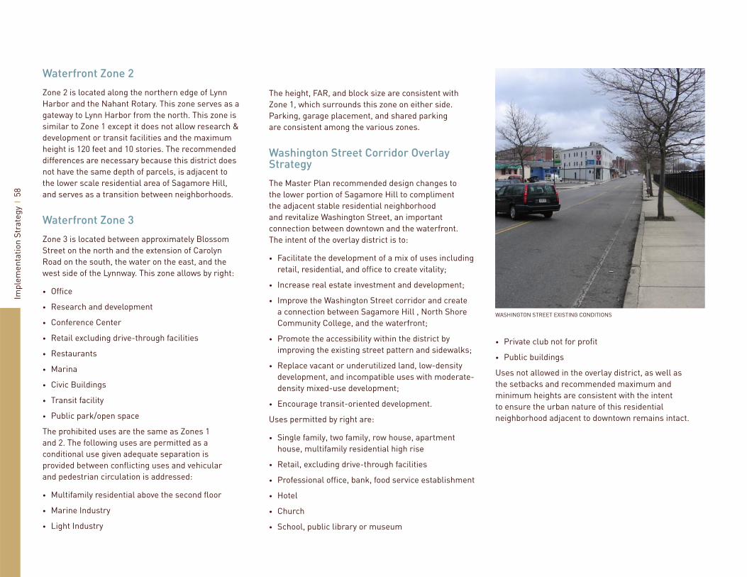
Impl
emen
tatio
n St
rate
gy
58
Waterfront Zone 2
Zone 2 is located along the northern edge of Lynn Harbor and the Nahant Rotary. This zone serves as a gateway to Lynn Harbor from the north. This zone is similar to Zone 1 except it does not allow research & development or transit facilities and the maximum height is 120 feet and 10 stories. The recommended differences are necessary because this district does not have the same depth of parcels, is adjacent to the lower scale residential area of Sagamore Hill, and serves as a transition between neighborhoods.
Waterfront Zone 3
Zone 3 is located between approximately Blossom Street on the north and the extension of Carolyn Road on the south, the water on the east, and the west side of the Lynnway. This zone allows by right:
Offi ce
Research and development
Conference Center
Retail excluding drive-through facilities
Restaurants
Marina
Civic Buildings
Transit facility
Public park/open space
The prohibited uses are the same as Zones 1 and 2. The following uses are permitted as a conditional use given adequate separation is provided between confl icting uses and vehicular and pedestrian circulation is addressed:
Multifamily residential above the second fl oor
Marine Industry
Light Industry
•
•
•
•
•
•
•
•
•
•
•
•
The height, FAR, and block size are consistent with Zone 1, which surrounds this zone on either side. Parking, garage placement, and shared parking are consistent among the various zones.
Washington Street Corridor Overlay Strategy
The Master Plan recommended design changes to the lower portion of Sagamore Hill to compliment the adjacent stable residential neighborhood and revitalize Washington Street, an important connection between downtown and the waterfront. The intent of the overlay district is to:
Facilitate the development of a mix of uses including retail, residential, and offi ce to create vitality;
Increase real estate investment and development;
Improve the Washington Street corridor and create a connection between Sagamore Hill , North Shore Community College, and the waterfront;
Promote the accessibility within the district by improving the existing street pattern and sidewalks;
Replace vacant or underutilized land, low-density development, and incompatible uses with moderate-density mixed-use development;
Encourage transit-oriented development.
Uses permitted by right are:
Single family, two family, row house, apartment house, multifamily residential high rise
Retail, excluding drive-through facilities
Professional offi ce, bank, food service establishment
Hotel
Church
School, public library or museum
•
•
•
•
•
•
•
•
•
•
•
•
Private club not for profi t
Public buildings
Uses not allowed in the overlay district, as well as the setbacks and recommended maximum and minimum heights are consistent with the intent to ensure the urban nature of this residential neighborhood adjacent to downtown remains intact.
•
•
WASHINGTON STREET EXISTING CONDITIONS

Impl
emen
tatio
n St
rate
gy
59
LAND USEPERCENTAGE OF PEAK
DEMAND FOR KEY TIMES
Weekdays Saturday - Sunday10am 1pm 5pm 8pm 10pm 10am 1pm 5pm 8pm 10pm
Residential 85 80 85 95 100 70 65 75 95 100Offi ce 100 90 50 5 5 15 15 5 0 0Retail 50 75 75 65 25 50 100 90 65 35Hotel 45 30 60 90 100 40 30 60 90 100Restaurant 20 70 70 100 95 5 45 60 100 95Marina 20 20 30 30 20 35 45 4Mixed-Use Shared Parking


