lunar red spots: stratigraphic sequence and ages of domes and
TRANSCRIPT
ClickHere
for
FullArticle
Lunar red spots: Stratigraphic sequence and ages of domes andplains in the Hansteen and Helmet regions on the lunar nearside
R. Wagner,1 J. W. Head III,2 U. Wolf,3 and G. Neukum3
Received 6 February 2009; revised 6 October 2009; accepted 15 December 2009; published 26 June 2010.
[1] Basaltic mare materials extruded between ∼ 4 Ga and ∼ 1.2 Ga ago and formed largeexpanses on the lunar nearside. In contrast to the maria, volcanic shields, domes, andcones also occur but cover only a small area of the total lunar surface. One specific typeof dome is characterized (1) by steep slopes, (2) by a high albedo similar to lunarhighlands, and (3) by a strong absorption in the ultraviolet. Because of this latter featurethey appear spectrally red and therefore were termed red spots. Their morphologysuggests that these domes were created by much more viscous, silica‐rich lava. Also, redspots which are believed to be possibly volcanic in origin are associated with light plainsmaterials. In order to constrain the formation of these presumed volcanic features incontext with the formation of the surrounding mare and highland materials, we carriedout (1) geologic and morphologic mapping of high‐resolution Lunar Orbiter IV andApollo 16 frames and (2) measurements of superimposed crater frequencies on geologicunits in order to assess stratigraphy and geological history in the following two volcanicprovinces in which red spots occur: (1) the Hansteen region, dominated by the domeHansteen a (also known as the Arrowhead), and (2) the Helmet region, dominated bylight plains, possibly of volcanic origin, such as the feature called the Helmet andDarney c, and the southern Montes Riphaeus. In the Hansteen region, the domeHansteen a postdates craters Billy (3.88 Ga) and Hansteen (3.87 Ga) but predates mostof the mare materials (3.51 Ga). Cratering model ages of the dome range from 3.74 to3.65 Ga, placing its major activity as extending into the late Imbrian. In the Helmetregion, presumed highland volcanism associated with red spots started in the Nectarianwith Darney c (3.94 Ga). Cratering model ages measured on the Helmet light plainsrange from 3.8 to 2.08 Ga. The origin of these light plains and local resurfacingprocesses in this unit, however (highland volcanism or impact), remains an openquestion. Locally, younger processes of Eratosthenian or even Copernican age, such asemplacement of mare materials or mass wasting deposits, could be dated in thehigher‐resolution Apollo 16 frame.
Citation: Wagner, R., J. W. Head III, U. Wolf, and G. Neukum (2010), Lunar red spots: Stratigraphic sequence and ages ofdomes and plains in the Hansteen and Helmet regions on the lunar nearside, J. Geophys. Res., 115, E06015,doi:10.1029/2009JE003359.
1. Introduction
[2] Basaltic volcanism has shaped large parts of the lunarnearside throughout the Nectarian into the Copernicanperiod, from ∼3.9 Ga ago until at least 1.2 Ga ago, lastingfor approximately 2.7 Ga [Hiesinger et al., 2003]. For asmall number of areas, even older (Nectarian/pre‐Nectarian)volcanic units were described by Schultz and Spudis [1983]
and Hawke et al. [2005]. During this entire time span, about30% of the lunar nearside, but only 2% of the farside, wereresurfaced by the emplacement of large volumes of low‐viscosity, low‐albedo, preferentially basaltic lava materialscreating the dark mare regions [e.g., Head, 1976; Wilhelms,1987; Head and Wilson, 1992].[3] In contrast to these vast expanses of the maria, posi-
tive surface features associated with volcanism, such asshields, domes and cones, occur but in total cover only acomparably small fraction of the lunar surface. Shields ordomes, 3 to 17 km across and up to several hundred metershigh were described and investigated in many areas withinthe mare regions [Head and Gifford, 1980]. All of theseapproximately 200 domes, which can be subdivided intoseven distinct morphological classes, are of basaltic com-position [Head and Gifford, 1980].
1Institute of Planetary Research, DLR, Berlin, Germany.2Department of Geological Sciences, Brown University, Providence,
Rhode Island, USA.3Institut für Geowissenschaften, Fachrichtung Planetologie und
Fernerkundung, Freie Universität Berlin, Berlin, Germany.
Copyright 2010 by the American Geophysical Union.0148‐0227/10/2009JE003359
JOURNAL OF GEOPHYSICAL RESEARCH, VOL. 115, E06015, doi:10.1029/2009JE003359, 2010
E06015 1 of 26

[4] A second type of domes is associated with highlandsand maria. This type is clearly distinct from the mare domesin terms of morphology and spectral properties. Domes ofthis type are characterized (1) by much steeper slopes, (2) bya high albedo similar to lunar highlands, and (3) by a strongabsorption in the ultraviolet. Because of this latter featurethey appear spectrally red and therefore where termed redspots [Malin, 1974; Wood and Head, 1975; Head andMcCord, 1978; Head et al., 1978]. Also, these domes
were created by much more viscous lava similar to, e.g.,terrestrial dacites, basaltic andesites, or rhyolites [Wilsonand Head, 2003; Hawke et al., 2003; Hagerty et al., 2006].[5] Generally, red spots show a much wider range in
morphology and occur not only as domes, but also assmooth plains, shields, or rugged patches of highlandmaterial [Bruno et al., 1991; Hawke et al., 2002, 2003].Several red spots are abundant near the mare/highlandboundary in Oceanus Procellarum, Mare Imbrium, Mare
Figure 1. Locations of the Hansteen and Helmet regions in the southern part of Oceanus Procellarum.The location of the Gruithuisen region discussed in the paper by Wagner et al. [2002] is included forreference (dashed box). Also shown are the landing site locations of Apollo 12 (Ap12) (including theSurveyor 3 (S3) landing site), Apollo 14 (Ap14), and Apollo 15 (Ap15). Part of a mosaic composed ofGalileo SSI images of the lunar nearside, obtained during its second Earth‐Moon flyby in December1992; image number PIA00405 (original mosaic in color), and image source is http://photojournal.jpl.nasa.gov.
WAGNER ET AL.: AGES OF DOMES AND PLAINS ON THE MOON E06015E06015
2 of 26
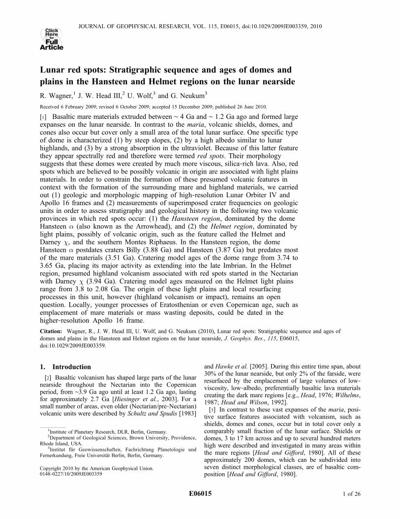
Figure
2
WAGNER ET AL.: AGES OF DOMES AND PLAINS ON THE MOON E06015E06015
3 of 26

Humorum and Mare Cognitum. The Gruithuisen and Mairandomes occur in northern Oceanus Procellarum [Head et al.,1978; Chevrel et al., 1999]. In southern Oceanus Pro-cellarum and Mare Cognitum, the following red spots areobserved [Wood and Head, 1975; Hawke et al., 2002,2003]: (1) the dome Hansteen a; (2) a feature termed theHelmet (including plains and two massifs); (3) another set ofplains, such as Darney c and t; and (4) the southern part ofMontes Riphaeus. The locations of these red spots areshown in Figures 1, 2, and 3.[6] While wide expanses of low‐silica basaltic mare lavas,
especially on the nearside, were created over several hun-dred millions of years in lunar history [e.g., Schultz and
Spudis, 1983; Wilhelms, 1987; Hiesinger et al., 2000,2003], volcanism producing lava with higher silica contentwere active at much shorter time intervals. Since these redspots will be major scientific targets in terms of volcanol-ogy, topography, and spectral behavior during ongoing andupcoming lunar missions, the motivation for the work in thispaper was to provide the time‐stratigraphic position andages of these features and of their geologic context forfurther studies, using improved higher‐resolution imagesand spectral data sets.[7] The stratigraphy and ages of the Gruithuisen domes
were discussed in an earlier paper by the authors [Wagneret al., 2002]. The work presented in this paper is focused
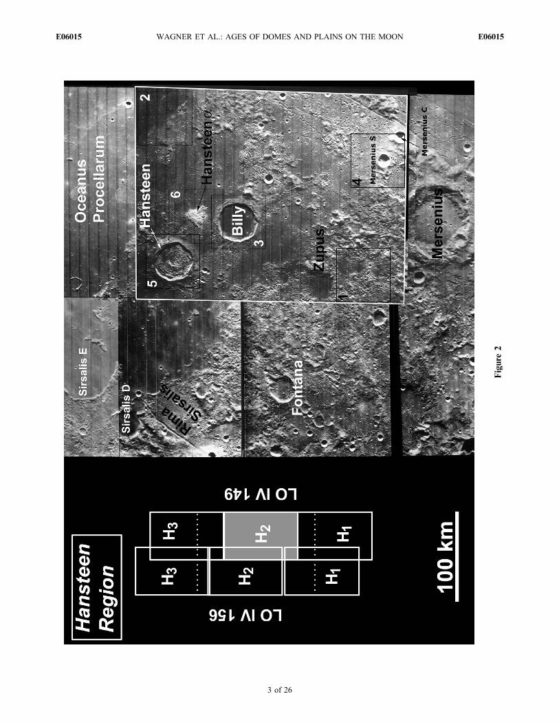
Figure 3. Mosaic of Lunar Orbiter frames of the Helmet region. Image numbers are LO IV 132 H2 andLO IV 137 H2. The numbered rectangle 7 refers to the geologic type locality of the Helmet shown inFigure 5. The Helmet imaged by the Hasselblad camera aboard Apollo 16 in Lunar Orbiter IV contextis shown in Figure 4.
Figure 2. Detail of a mosaic of the Hansteen region put together with Lunar Orbiter IV frames LO IV 149 H1‐H3 and LOIV 156 H1‐H3. Only frame LO IV 149 H2 was used for this work (indicated by a white outline in the mosaic and high-lighted by a filled rectangle in the frame location diagram on the left). Numbered rectangles with black outlines refer togeologic type localities shown in detail in Figure 5.
WAGNER ET AL.: AGES OF DOMES AND PLAINS ON THE MOON E06015E06015
4 of 26

on the red spots Hansteen a and the Helmet and theirgeologic context in southern Oceanus Procellarum and MareCognitum. The images used are high‐resolution Lunar Orbiterframes, and, additionally, Apollo Hasselblad imagery for theHelmet region. The images were photogeologically mapped,based on albedo and surface morphology. In order to derivean age sequence, the crater size distribution of craters super-imposed on the geologic units was measured. The applicationof the lunar impact chronology model by Neukum and Ivanov[1994] and Neukum et al. [2001] helps to constrain the timingand duration of volcanic events in these two areas.
2. Geographic and Geologic Setting of theHansteen and Helmet Regions
[8] Figure 1 shows a part of a global color mosaic (hererepresented in black and white) of the lunar nearside, ob-tained by the SSI camera aboard the Galileo spacecraftduring its second Earth‐Moon flyby in December 1992[e.g., Belton et al., 1994a]. The locations of the Hansteen(Ha) and Helmet (He) study areas are indicated. For refer-ence, the Gruithuisen region (Gr) (stippled) discussed byWagner et al. [2002] has also been included.
2.1. Hansteen Region
[9] The Hansteen region is situated in southern OceanusProcellarum approximately between latitude 0°S–20°S andlongitude 30°W–60°W. A mosaic of Lunar Orbiter IV high‐resolution frames of the area is shown in Figure 2. Geologictype localities discussed in section 4.1 and shown in detail inFigure 5 are indicated by black numbered rectangles inFigure 2. More than half of the area shown in Figure 2 iscovered by different units of highland (terra) materials, andthe remaining part by mare materials of Oceanus Pro-cellarum. Prominent craters in the Hansteen region areMersenius (84 km), and Sirsalis D and E (35 km, 72 km).These latter two craters are degraded and almost entirelyflooded by mare lava materials. Other prominent craters inthis region are Fontana (31 km), the heavily degraded andmare‐flooded Zupus (38 km), and Hansteen and Billy inclose proximity to the dome Hansteen a, both with adiameter of 45 km. These two craters are centered at lati-tude/longitude 11.5°S/52°W and 13.8°S/50.1°W, respec-tively. Straight rilles such as Rimae Sirsalis also occur in theHansteen region. They are graben and most likely werecreated by tectonic stresses following the formation of theProcellarum or Imbrium basin [e.g., Wilhelms, 1987;Solomon and Head, 1979, 1980].[10] The volcanic dome named Mons Hansteen or Hans-
teen a on U.S.G.S. maps is centered at latitude 12.1°S andlongitude 50°W. The feature is reminiscent of an arrowheadand therefore is often referred to as the Arrowhead [e.g.,Hawke et al., 2003]. The Hansteen a dome is about 20 to30 km across and comparable in size to the Gruithuisendomes. Hawke et al. [2003] interpreted Hansteen a to havebeen formed by extrusion of relatively viscous lava materi-als, most likely of dacitic or rhyolitic composition, at loweffusion rates.[11] From spectral data provided by Clementine it was
inferred that the dome material has a low FeO and TiO2
content [Hawke et al., 2003]. Since the two larger cratersHansteen and Billy surrounding the Hansteen dome are
enriched in these two species, they are older than the domebecause otherwise ejecta material would have been emplacedon the dome [Hawke et al., 2003]. Recent measurements ofthe Th abundance using data of the LP‐GRS instrumentconfirmed earlier findings by Hawke et al. [2003], based onmorphology and composition, that Hansteen a is composedof viscous, silicic lava material enriched in thorium[Lawrence et al., 2005; Hagerty et al., 2006].
2.2. Helmet Region
[12] The Helmet region, alternatively termed Herigoniusregion [Bruno et al., 1991], is shown in a mosaic of twoLunar Orbiter IV frames in Figure 3. The area covered inthis mosaic ranges from latitudes 8°S to 21°S and longitudes24°W to 40°W. Mare materials are the dominant geologicunit in this region [Whitford‐Stark and Head, 1980;Hiesinger et al., 2003]. The major part of the mare areas areOceanus Procellarum units. Units of Mare Cognitum arelocated in the northeastern part of the mosaic, and a part ofMare Humorum is in the southwestern part. Mare units arecharacterized by prominent wrinkle ridges and sinuousrilles, especially in Oceanus Procellarum.[13] The largest crater in this area is Gassendi (101 km
diameter) with a prominent central peak massif and floorfracture patterns. A younger, smaller crater, Gassendi A(33 km), is superimposed on its northern rim. Other promi-nent craters with diameters of several tens of kilometers(such as Lubinietzky A and E (30 and 37 km), and Aga-tharchides, 48 km) are heavily degraded and almost entirelyflooded by mare lavas.[14] Highland (terra) materials, like most large craters, are
embayed by mare lava materials. Ejecta from the Humorumbasin were interpreted to be the origin for most of the terramaterials [Titley, 1967]. Humorum, a basin of Nectarianage, centered at latitude 24°S, longitude 37°W, has a max-imum diameter of 1195 km, with the main ring representingthe crater rim at a diameter of 425 km [Pike and Spudis,1987; Wilhelms, 1987; Spudis, 1993]. Other terra units inthe Helmet region originate from Imbrium ejecta units, suchas Montes Riphaeus (see Figure 3) which are part of adegraded large crater 191 km in diameter [Hawke and Head,1977]. The southern part of Montes Riphaeus is character-ized by a strong ultraviolet absorption and hence representsa red spot [Wood and Head, 1975].[15] Several landforms, mainly plains and massifs, asso-
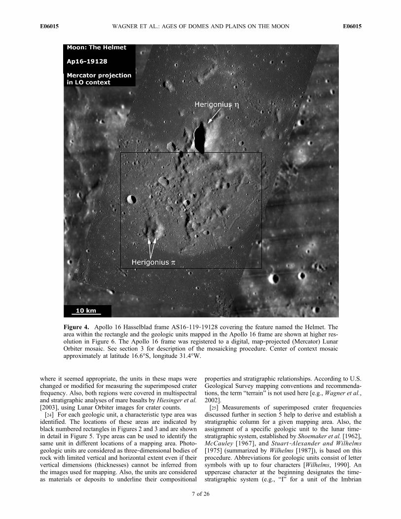
ciated with red spots in this area are shown in Figure 3. Thelargest of these is the feature named the Helmet because ofits similarity with an upside‐down helmet [e.g., Hawke etal., 2003]. The feature is indicated by a rectangle (labeled7) in Figure 3 and shown in detail in Figure 4. The Helmet,centered at latitude/longitude 17°S, 30°W and about 40 to50 km across, consists of at least three geologic units,incorporating two massifs named Herigonius h and p lessthan 10 km across [Wood and Head, 1975; Bruno et al.,1991] (see section 4.5).[16] The area southeast of Montes Riphaeus in Mare
Cognitum and north of crater Darney C (top right corner inFigure 3) features a set of plains and groups of hills. Darneyc is a light plains unit 15 to 20 km across with anapproximately elliptical outline [Wood and Head, 1975].Darney t (to the west and southwest of Darney c) is a group
WAGNER ET AL.: AGES OF DOMES AND PLAINS ON THE MOON E06015E06015
5 of 26

of hills rather than a single shield or dome [Hawke et al.,2001].
3. Image Database and Processing
[17] The Hansteen and Helmet regions were imaged athigh resolution by the camera onboard the Lunar Orbiter IVspacecraft. In addition, Apollo 16 Hasselblad images areavailable for part of the Helmet region. The Hansteen regionwas covered by frame numbers LO IV 149 and LO IV 156(H1‐H3), as shown in Figure 2. The investigation wasconfined to frame LO IV 149 H2 which encompasses themajor geologic units in that area. Latitudes of frame LO IV149 H2 range from 10°S to 20°S, and longitudes range from45°W to 53°W. The Helmet region was imaged by twoframes in the LO IV mission, 132 H2 and 137 H2 shown inFigure 3. Both frames cover an area approximately between12°S and 22°S latitude, and 29°W and 40°W longitude.[18] In some parts of the Lunar Orbiter frames, which
were used for this study, image quality is significantlyreduced. This is caused by groups of circular blemishescreated during the photographic development of the framesonboard the Lunar Orbiter spacecraft, especially in frameLO IV 149 H2. These areas were mapped as unclassifiedunits and excluded from crater counts. Another factorreducing image quality is overexposure or underexposure.Highland units in frames LO IV 132 H2 and 137 H2 suf-fered most from such overexposure, while a part of MareHumorum seen in LO IV 137 H2 is significantly under-exposed. Similarly, these areas were not used for cratercounts and mapped as unclassified units.[19] A Lunar Orbiter frame is subdivided into a number of
individual framelets from top to bottom which are separatedby horizontal stripes. A detailed description of imaging ofthe lunar surface by Lunar Orbiter and of the properties ofLunar Orbiter images is given by Mutch [1972]. It is pos-sible to scan each LO photograph and remove these stripescosmetically by image processing techniques. However, thisprocedure causes loss in image resolutions and thereforewas not applied here [e.g., Wagner et al., 2002]. Thesmallest features which can be recognized in the LO pho-tographs of the Hansteen region are on the order of 100 to200 m. Spatial resolutions of Lunar Orbiter frames can bederived from navigational data by Anderson and Miller[1971].[20] During the Apollo 16 mission in May 1972, 2808
black and white and color images were obtained with 70 mmfilm width Hasselblad Data Camera (HDC) onboard thecommand module (CM) in orbit around the Moon. TheHelmet feature was covered by the color frames AS16‐119‐19124 to AS16‐119‐19138 from Magazine 119 RR.Unfortunately, the Helmet feature was imaged under obliqueviewing angles. We chose frame AS16‐119‐19128 formapping and crater counts. The frame was taken from analtitude of 119 km, is centered at latitude 16.6°S, longitude31.4°W, and shows the entire Helmet feature.[21] Apollo Hasselblad frames are available in digital
form. The data source for the Apollo 16 frame used here iswww.lpi.usra.edu/resources/apollo/frame/?AS16‐119‐19128. In order to be used for mapping and crater counts,the Hasselblad frame was geometrically registered to aLunar Orbiter mosaic. Recently, digital Lunar Orbiter
mosaics were made available by U.S. Geological Survey andPDS on www.mapaplanet.org/explorer/moon.html [Beckeret al., 2008]. Mosaic tiles covering a specific area can bedownloaded in a specific map resolution from this site. Sucha product was used as a context for the registration of theApollo Hasselblad frame.[22] The smallest craters which can be discerned on the
two Lunar Orbiter frames LO IV 132 H2 and 137 H2 ofthe Helmet region are on the order of 200–300 m. Wetherefore chose a map resolution of 250 m/pixel for thedigital Lunar Orbiter mosaic to be downloaded. The mosaicoriginally in cylindrical equidistant (rectangular) projectionwas reprojected into a Mercator projection with the samescale. Conformal map projections preserve circular land-forms as circles and hence are generally used in cratercounts. The digital Apollo 16 Hasselblad frame was geo-metrically registered to this Lunar Orbiter mosaic. Prior tothe registration, the Lunar Orbiter mosaic was sized up to ascale of 20 m/pixel. The original (horizontal) image reso-lution of the digitized Apollo 16 frame AS16‐119‐19128 isapproximately 12 m/pixel. Because of the oblique viewingcondition, image scales at a right angle to the cameraviewing direction (horizontal scale) and in the viewingdirection (vertical scale) differ by about a factor of 1.5 to 2.To avoid negative effects, e.g., oversampling, whilestretching the image considerably in one direction due tothis scale difference, we reduced the original horizontalscale to 20 m/pixel. Even at this reduced scale, however,crater rims are still difficult to locate, especially near theresolution limit. The Mercator‐projected Apollo 16 framein the context of Lunar Orbiter is shown in Figure 4.
4. Geologic Units
4.1. Photogeologic Mapping
[23] Geologic units were compiled using (1) albedo and(2) morphology [Wilhelms, 1990; see also Wagner et al.,2002]. The Hansteen and Helmet regions are incorporatedin six geologic maps which were used as references. TheHansteen region is included in four lunar quadrangles of the1:1,000,000‐scale Lunar Base Chart series (LAC) whichabut at 16°S latitude and 50°W longitude. This intersectionpoint is located approximately 40 km south of the rim ofcrater Billy which is centrally transected by the 50°Wmeridian. These four quadrangles, clockwise from northwestto southwest, are the Grimaldi Quadrangle (LAC 74),mapped by McCauley [1973] (map I‐740), the Letronneregion (LAC 75) by Marshall [1963] (map I‐385), the MareHumorum region (LAC 93) by Titley [1967] (map I‐495),and the Byrgius Quadrangle (LAC 92) by Wilshire [1973](map I‐755). The two eastern map quadrangles (LAC 75/I‐385 and LAC 93/I‐495) of this set also include the westernpart of the Helmet region. Further, the northeastern part ofthe Helmet region is incorporated in the Riphaeus Moun-tains region (quadrangle LAC 76), mapped by Eggleton[1965] (map I‐458), and the southeastern part in the Pita-tus region (LAC 94) by Trask and Titley [1966] (map I‐485). These four quadrangles intersect at 16°S latitude and30°W longitude, a point approximately at the northeasternboundary of the Helmet feature. A further important refer-ence is the geologic map of the lunar nearside at a map scaleof 1:5,000,000 by Wilhelms and McCauley [1971]. In cases
WAGNER ET AL.: AGES OF DOMES AND PLAINS ON THE MOON E06015E06015
6 of 26
where it seemed appropriate, the units in these maps werechanged or modified for measuring the superimposed craterfrequency. Also, both regions were covered in multispectraland stratigraphic analyses of mare basalts by Hiesinger et al.[2003], using Lunar Orbiter images for crater counts.[24] For each geologic unit, a characteristic type area was
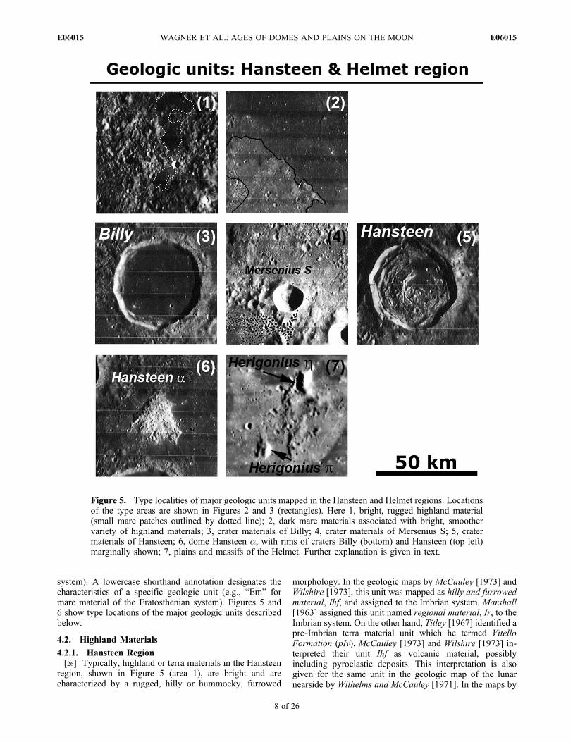
identified. The locations of these areas are indicated byblack numbered rectangles in Figures 2 and 3 and are shownin detail in Figure 5. Type areas can be used to identify thesame unit in different locations of a mapping area. Photo-geologic units are considered as three‐dimensional bodies ofrock with limited vertical and horizontal extent even if theirvertical dimensions (thicknesses) cannot be inferred fromthe images used for mapping. Also, the units are consideredas materials or deposits to underline their compositional
properties and stratigraphic relationships. According to U.S.Geological Survey mapping conventions and recommenda-tions, the term “terrain” is not used here [e.g., Wagner et al.,2002].[25] Measurements of superimposed crater frequencies
discussed further in section 5 help to derive and establish astratigraphic column for a given mapping area. Also, theassignment of a specific geologic unit to the lunar time‐stratigraphic system, established by Shoemaker et al. [1962],McCauley [1967], and Stuart‐Alexander and Wilhelms[1975] (summarized by Wilhelms [1987]), is based on thisprocedure. Abbreviations for geologic units consist of lettersymbols with up to four characters [Wilhelms, 1990]. Anuppercase character at the beginning designates the time‐stratigraphic system (e.g., “I” for a unit of the Imbrian
Figure 4. Apollo 16 Hasselblad frame AS16‐119‐19128 covering the feature named the Helmet. Thearea within the rectangle and the geologic units mapped in the Apollo 16 frame are shown at higher res-olution in Figure 6. The Apollo 16 frame was registered to a digital, map‐projected (Mercator) LunarOrbiter mosaic. See section 3 for description of the mosaicking procedure. Center of context mosaicapproximately at latitude 16.6°S, longitude 31.4°W.
WAGNER ET AL.: AGES OF DOMES AND PLAINS ON THE MOON E06015E06015
7 of 26
system). A lowercase shorthand annotation designates thecharacteristics of a specific geologic unit (e.g., “Em” formare material of the Eratosthenian system). Figures 5 and6 show type locations of the major geologic units describedbelow.
4.2. Highland Materials
4.2.1. Hansteen Region[26] Typically, highland or terra materials in the Hansteen
region, shown in Figure 5 (area 1), are bright and arecharacterized by a rugged, hilly or hummocky, furrowed
morphology. In the geologic maps by McCauley [1973] andWilshire [1973], this unit was mapped as hilly and furrowedmaterial, Ihf, and assigned to the Imbrian system. Marshall[1963] assigned this unit named regional material, Ir, to theImbrian system. On the other hand, Titley [1967] identified apre‐Imbrian terra material unit which he termed VitelloFormation (pIv). McCauley [1973] and Wilshire [1973] in-terpreted their unit Ihf as volcanic material, possiblyincluding pyroclastic deposits. This interpretation is alsogiven for the same unit in the geologic map of the lunarnearside by Wilhelms and McCauley [1971]. In the maps by
Figure 5. Type localities of major geologic units mapped in the Hansteen and Helmet regions. Locationsof the type areas are shown in Figures 2 and 3 (rectangles). Here 1, bright, rugged highland material(small mare patches outlined by dotted line); 2, dark mare materials associated with bright, smoothervariety of highland materials; 3, crater materials of Billy; 4, crater materials of Mersenius S; 5, cratermaterials of Hansteen; 6, dome Hansteen a, with rims of craters Billy (bottom) and Hansteen (top left)marginally shown; 7, plains and massifs of the Helmet. Further explanation is given in text.
WAGNER ET AL.: AGES OF DOMES AND PLAINS ON THE MOON E06015E06015
8 of 26
Marshall [1963] and Titley [1967], units Ir or pIv areinterpreted as ejecta materials from Imbrium and Humorumbasins. McCauley [1973] mapped an area south of Hansteencrater as radial outer rim material, Irr2, of crater Hansteen.In contrast, the unit in this area was mapped as undividedterra material, It, by Wilhelms and McCauley [1971]. Intotal, correlation of terra material units and comparison withterra units defined in all these maps are difficult becauseWilshire [1973] (map west of 50°W longitude) and Titley[1967] (map east of 50°W longitude) had identified com-pletely different units on either side of their common quad-rangle boundary.[27] A second variety of terra material is less rugged and
shows a slightly darker, smooth to gently sloped surface.The type area, located approximately 100 km east of craterHansteen, is shown in Figure 5 (area 2), with the boundaryto dark mare materials outlined in black. In the map byMarshall [1963], there is no difference between the twovarieties, and both were mapped as regional material, Ir.Mustard and Head [1996, and references therein] reportedthe presence of cryptomaria in southwestern Oceanus Pro-cellarum which might be a possible explanation for thelower albedo and morphology of this unit.
4.2.2. Helmet Region[28] Terra materials are less abundant in the two Lunar
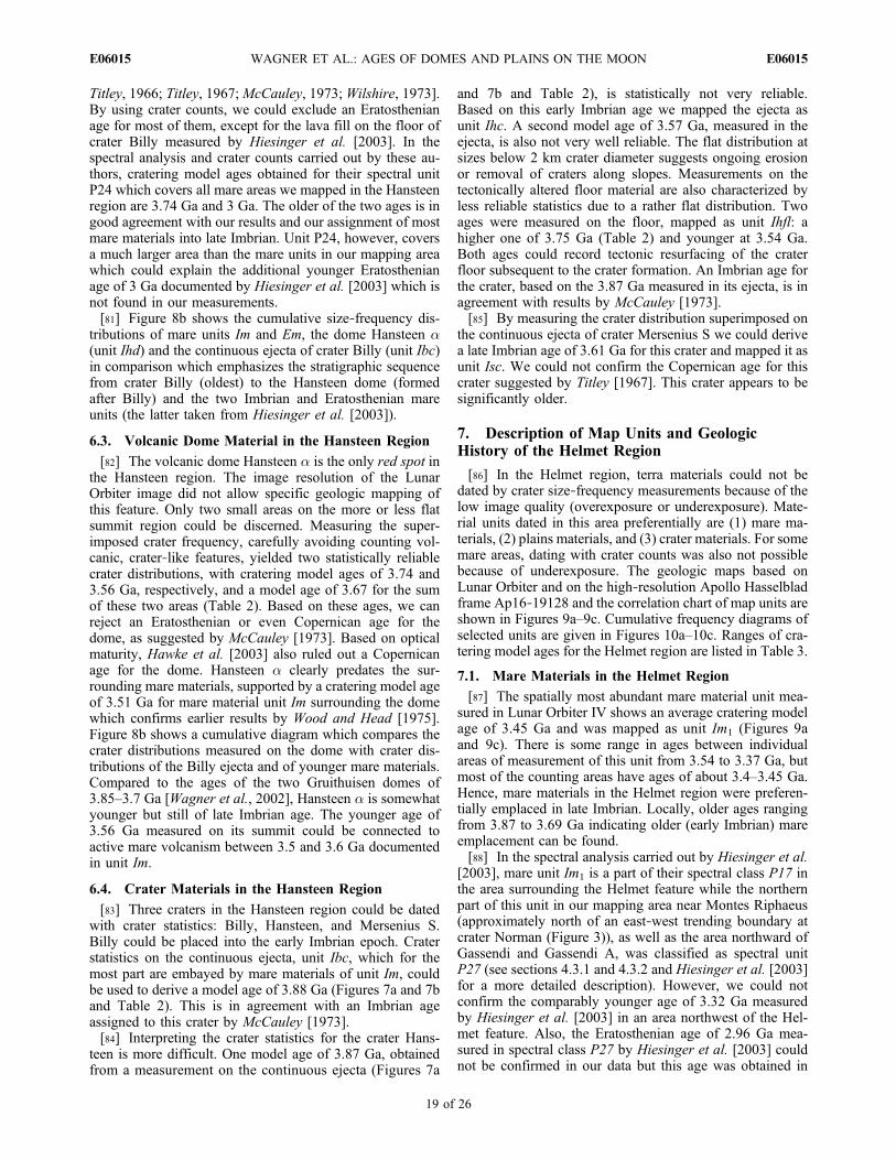
Orbiter frames covering the Helmet region (Figure 3). Theycan be mapped in the vicinity of crater Agatharchides, andeast of crater Gassendi. Due to the lower image quality, theycould not be used for crater counts and were mapped as anunclassified unit.
4.3. Mare Materials
4.3.1. Hansteen Region[29] In both the Hansteen and Helmet region, mare ma-
terials are easily distinguished by their low albedo andtopography which appears smooth at Lunar Orbiter resolu-tion. In the Hansteen region, mare materials of OceanusProcellarum embay terra units or older crater materials, likeHansteen or Billy [Whitford‐Stark and Head, 1980]. Thetype locality of mare materials, featuring linear to arcuatewrinkle ridges trending approximately north‐south, isshown in detail in Figure 5 (area 2). Mare materials also fillcrater floors, such as crater Billy (Figure 5, area 3), orheavily degraded craters (white dotted outline in Figure 5(area 1)). Some craters, e.g., Sirsalis E (Figure 2), are char-acterized by islands of crater rims embayed and breached by
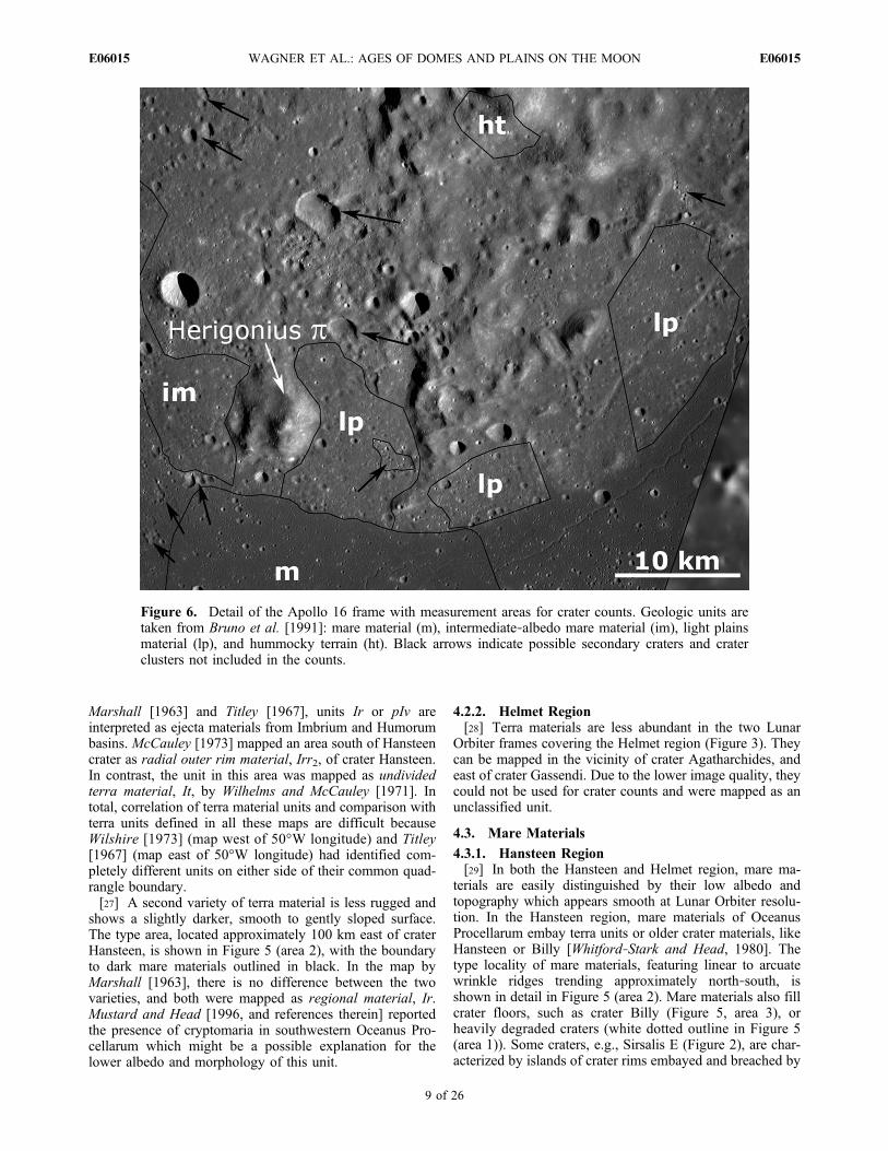
Figure 6. Detail of the Apollo 16 frame with measurement areas for crater counts. Geologic units aretaken from Bruno et al. [1991]: mare material (m), intermediate‐albedo mare material (im), light plainsmaterial (lp), and hummocky terrain (ht). Black arrows indicate possible secondary craters and craterclusters not included in the counts.
WAGNER ET AL.: AGES OF DOMES AND PLAINS ON THE MOON E06015E06015
9 of 26
mare materials which totally covered crater floor and ejecta.At smaller map scale, Wilhelms and McCauley [1971]assigned Eratosthenian ages to most of the mare materialsand mapped them as unit Em. Marshall [1963] still usedthe now obsolete chronostratigraphic Procellarian system todefine the stratigraphic position of the mare materials north-east of Billy and on the Billy crater floor (unit Pm).[30] Hiesinger et al. [2003] carried out multispectral
analyses of mare basalts using color data of the ClementineUVVIS camera which has a wavelength range from 0.4 to1 mm, and dated 60 spectrally distinct basalt materials inOceanus Procellarum by crater counts. According to theiranalysis, all mare materials in the Hansteen region (exceptthe mare fill in crater Billy) are incorporated in spectralunit P24. This unit, covered by several basalt types, suchas type hDSA and hDSP in the classification by Pieters[1978], is characterized by a high (h) UV/VIS ratio inClementine color data, a dark (D) albedo, a strong 1 mmabsorption (S), and an attenuated (A) to prominent (P) 2 mmabsorption. The mare fill of crater Billy is of spectral unitP54 in the Hiesinger et al. [2003] study and was mapped as“undivided” basalt type by Pieters [1978].4.3.2. Helmet Region[31] Mare materials of Oceanus Procellarum and Mare
Humorum are the spatially most abundant units in theHelmet region (Figure 3). Wrinkle ridges and sinuous rillesare additional characteristics seen in this area. Where nec-essary, we subdivided mare materials further according tovisible differences in crater frequency and/or differentalbedo. In the area between craters Gassendi and the Hel-met, we used the same mare unit boundaries as defined byTitley [1967]. As for mare materials in the Hansteen region,Wilhelms and McCauley [1971] assigned Eratosthenian agesto most of the mare materials (unit Em).[32] In the analysis by Hiesinger et al. [2003], mare ma-
terials in the Helmet region were classified as spectral unitsP17 and P27. Spectral unit P17, like unit P24 in theHansteen region, corresponds to an hDSP basalt type in theclassification by Pieters [1978]. Spectral unit P27 wasclassified as “undivided” by Pieters [1978].
4.4. Crater Materials
4.4.1. Hansteen Region[33] Craters of all diameters and various degrees of deg-
radation occur in both areas. Only those large enough tomeasure their superimposed frequency of smaller craters oncontinuous ejecta and/or crater floor were mapped in detail.Crater Billy (Figure 5, area 3) displays a slightly subduedrim and continuous ejecta, which are embayed by youngermare material. Also, the floor of this crater is completelyfilled with mare material. McCauley [1973] assigned anImbrian age (units Icr1 and Icw1 for rim and wall material)to this crater, while the mare fill on the crater floor wasinterpreted as Eratosthenian. The 15 km crater Mersenius S(Figure 5, area 4) also has a sharp rim crest. This crater is ofthe so‐called simple type, characterized by a bowl‐shapedinterior with little or no modification [Melosh, 1989].Continuous ejecta can be mapped outward to about onecrater diameter from the rim. According to Titley [1967],this crater is of Copernican age. Other large craters feature afresh to slightly subdued rim but a modified interior, such ascrater Hansteen (Figure 5, area 5). Some part of the floor is
tectonically deformed, indicated by concentric fractures.From analyzing floor‐fractured lunar craters, Schultz [1976]and Dombard and Gillis [2001] concluded that concentricand radial fractures on crater floors were created by sill orlaccolith intrusions beneath the crater. Another part of theHansteen floor was covered by mare material. Like Billy,Hansteen is of Imbrian age (units Icr2 and Icw2) with anEratosthenian age mare filling (unit Em) according toMcCauley [1973].4.4.2. Helmet Region[34] In the Helmet region only two craters could be
selected for age dating, Gassendi and Gassendi A. The time‐stratigraphic position of the large crater Gassendi which,like Hansteen, shows a fractured floor (Figure 3), is Imbrianor possibly pre‐Imbrian [Titley, 1967]. The stratigraphicposition of the smaller, fresh‐looking crater Gassendi A onthe northern rim of Gassendi is not quite clear. According toMarshall [1963], Gassendi A is Imbrian or Eratosthenian(unit EIr). Titley [1967] assigned a much younger Coper-nican age to this crater.
4.5. Volcanic Dome and Plains Materials
4.5.1. Hansteen Region[35] The dome Hansteen a, termed the Arrowhead, is
located close to the rims of craters Hansteen and Billy(Figure 5, area 6). Its size is comparable to the Gruithuisendomes, but, in contrast to these landforms, the Hansteendome has a flat summit region reminiscent of a mesa. Also,the summit surface as well as the flanks appear much morerugged (or “hackly,” to quote McCauley [1973]) than theGruithuisen domes. Elliptic crater‐like features occur on thesouthwestern part of the dome and were interpreted asprobable volcanic vents [McCauley, 1973]. The Hansteendome was mapped as a single dome material unit byMcCauley [1973], who interpreted it as a volcanic constructthat formed in the Eratosthenian or even Copernican period(unit designation: CEd) because the dome appears to beemplaced on top of Eratosthenian mare units. Wood andHead [1975] presented a different stratigraphic position:according to their interpretation, Hansteen a is embayed byyounger mare material around it. In the geologic map byMarshall [1963], no distinction was made between the domeand a widely abundant, more or less undivided terra unitcalled regional material (Ir) of possible impact ejecta origin.[36] Based on Clementine UVVIS images, Hansteen a is
characterized by a distinctive difference in both FeO andTiO2 content compared to surrounding mare and terra units[Hawke et al., 2003]. Mare units have high abundances inboth species (> 16% and > 4%, respectively; percentagesgiven in wt %) while ejecta of craters Billy and Hansteen arelower, but still more or less rich, in FeO and TiO2. For theHansteen dome, Hawke et al. [2003] reported much lowerFeO and TiO2 abundances (5%–9% and < 1%, respec-tively). The authors also concluded that the Hansteen domewas created by extrusion of evolved, viscous lava material.Further evidence for evolved lava material comes from dataof the Gamma Ray Spectrometer onboard the Lunar Pros-pector spacecraft. Lawrence et al. [2005] and Hagerty et al.[2006] refined earlier measurements of LP‐GRS Thoriumabundances (by, e.g., Hawke et al. [2003]) and constrainedthe Th content to approximately 20 ppm. Combining theseresults with compositional evidence by Hawke et al. [2003],
WAGNER ET AL.: AGES OF DOMES AND PLAINS ON THE MOON E06015E06015
10 of 26
Hagerty et al. [2006] were able to confirm an evolved,silicic, Th‐rich lithology for Hansteen a.4.5.2. Helmet Region[37] The landform termed the Helmet is morphologically
and geologically more complex. At Lunar Orbiter imageresolution, three distinct units were identified by Wilhelmsand McCauley [1971] and Wood and Head [1975]: bright,relatively smooth plains, bright, hummocky material, andtwo massifs termed Herigonius h and p. The type locality inframe LO IV 132 H2 is shown in Figure 5 (area 7).Wilhelmsand McCauley [1971] mapped the hummocky material ashilly and furrowed terrain (Ihf) and the light plains as anundivided terra unit (It), both units of Imbrian age. Theydesignated the northern massif on the Helmet as an Imbrian‐aged dome (Id), possibly of volcanic origin.[38] Bruno et al. [1991] conducted spectral analyses of
several lunar red spots, including the Helmet, using the2.24 m telescope of the Mauna Kea Observatory in awavelength range from 0.29 mm to 0.82 mm. We used theirgeologic map of the Helmet as a reference to map geologicunits and areas of measurements for crater counts. Theauthors identified five geologic units (craters excluded) onthe Helmet in image LO IV 132 H2: (1) dark mare materialssurrounding the Helmet feature, (2) an intermediate‐albedomare material in the eastern part of the Helmet, (3) a lightplains material unit, (4) a hummocky material unit (hum-mocky terrain in their terminology), and (5) the two massifsHerigonius h and p. For crater counts on image LO IV 132H2, we combined the light plains, hummocky material andintermediate mare as an undivided unit because the mea-surement area is small and the image quality is comparablylow (shadows and bright, almost saturated areas), which in-hibits the location of crater rims. We then used the Apollo 16high‐resolution Hasselblad image (Figure 4) and definedareas of measurement for crater counts within each of thegeologic units mapped by Bruno et al. [1991]. These areas areshown in more detail in Figure 6.[39] The spatially most abundant units on the Helmet are
light plains and hummocky material (terrain) [Wood andHead, 1975; Bruno et al., 1991]. The boundary betweenlight plains and hummocky material cannot everywhere bewell defined. We selected three areas of measurement in thelight plains unit, labeled lp in Figure 6, characterized by asmooth surface well suited for crater counts. Crater fre-quencies vary across the hummocky material, showing areaswith a high frequency of larger, kilometer‐sized craters, andareas with a low frequency of craters at all sizes. Therefore,hummocky material could consist of several units created, oraffected, by different geologic processes at different times.Two areas of measurement in the hummocky material nearthe massif Herigonius h were selected for crater countswhich are characterized by a low crater frequency, possiblyreflecting mass wasting processes along the slopes of themassif. One of these areas is shown in Figure 6 (labeled ht).In the westernmost part of the Helmet, Bruno et al. [1991]identified an intermediate‐albedo mare unit that shows agradational boundary to the surrounding darker mare ma-terials in the lower left part of the Helmet. The area ofmeasurement within this unit is labeled as im in Figure 6.Elongated craters and clusters of craters across the Helmet,indicated by black arrows in Figure 6, can be interpreted assecondary craters and were excluded from crater counts in
the Apollo 16 image as well as in the Lunar Orbiter data, asfar as they can be discerned on frame LO IV 132 H2.[40] The two massifs on the Helmet, Herigonius h and p,
are approximately north‐south elongated conical hills withsteep slopes. Herigonius p actually consists of two hills,with the eastern hill being more prominent and higher.Unlike Hansteen a or the Gruithuisen domes, the Her-igonius massifs lack a flat summit region which couldaccumulate enough craters to be used to date the domes.Some craters are present, but most of them have been lostdue to the steep slopes.[41] Spectral data obtained by Bruno et al. [1991] with the
2.24 m telescope at the Mauna Kea Observatory showed thatthe two massifs, the hummocky terrain and the light plainshave a downturn both in UV as well as in the IR, and thatthis effect is strongest for the two massifs. Therefore, theHelmet in total has the spectral signature of a red spot. Bothmassifs could be volcanic in origin, or are remnants of olderhighland material embayed by bright plains and mare ma-terials [Wilhelms and McCauley, 1971]. Bruno et al. [1991]found that the spectrum of the unit mapped as intermediate‐albedo mare is also intermediate between the spectra forlight plains and hummocky material on one hand, and thedark mare materials on the other hand.[42] Dark mare materials (labeled m in Figure 6) surround
the Helmet feature (see also description in section 4.3.1).The mare materials are generally characterized by a largernumber of small impact craters with local variations in craterdensity, although there are no clear‐cut geologic boundariesbetween areas of varying crater densities. Bruno et al.[1991] found the spectra of the mare materials to be“blue,” consistent with earlier findings [e.g., Pieters, 1978].We mapped mare materials in the Apollo 16 Hasselbladframe according to the units mapped in Lunar Orbiter con-text but used subareas within each unit for crater countsdevoid more or less of secondary craters.[43] More red spots in the Helmet region are located in
Mare Cognitum and are shown in Figure 3. Darney c is asmooth plains unit, and Darney t is a set of hills or massifs[Wilhelms and McCauley, 1971; Hawke et al., 2002]. OnlyDarney c could be used as an area of measurement for cratercounts. These features were mapped as Imbrian‐aged plains(Ip) by Wilhelms and McCauley [1971] and interpreted aspossible volcanic features. Montes Riphaeus is a 170 kmlong arc of a degraded impact structure whose southern partrepresents a red spot [Wood and Head, 1975]. Crater countscould not be carried out because the image quality in thepart of frame LO IV 132 H2 showing southern MontesRiphaeus is not sufficient.
5. Crater Size‐Frequency Distributions andDerivation of Surface Ages
[44] The method of counting craters as an important toolin planetary stratigraphy is based on the fact that the fre-quency of impact craters superimposed on a given geologicunit is directly correlated with geologic time: the higher thefrequency, the higher the age because of the longer exposuretime to the incoming flux of projectiles [e.g., Öpik, 1960;Baldwin, 1964; Neukum et al., 1975; Hartmann et al.,1981]. A crater distribution where no equilibrium has beenreached between preexisting craters on the surface and
WAGNER ET AL.: AGES OF DOMES AND PLAINS ON THE MOON E06015E06015
11 of 26

newly formed ones is in production and reflects the size‐frequency distribution of projectiles which were responsiblefor the crater production [e.g., Neukum and Dietzel, 1971;Neukum, 1983; Neukum and Ivanov, 1994]. For this caseonly, age determinations by crater frequency measurementsare possible.[45] Methods and procedures of how to use crater counts
for age dating of geologic units have been described in detailin a series of papers [e.g., Shoemaker et al., 1962; Neukumet al., 1975, 2001; Arvidson et al., 1979; Hartmann et al.,1981; Neukum, 1983; Strom and Neukum, 1988; Neukumand Ivanov, 1994]. Here, we briefly review the method(e.g., as described by Wagner et al. [2002] and Hiesingeret al. [2000, 2003]). We included an additional section(section 5.4) in this work focusing on the role of secondaryversus primary cratering at small crater sizes, by which thedating method using small craters at high spatial imageresolution could be strongly affected, primarily reviewingresults by Werner et al. [2006].
5.1. Measurement Procedure
[46] A Zeiss stereocomparator of type PS2K was used forall measurements of crater size distributions on transpar-encies with the map boundaries of the units to be counted(e.g., see description by Wagner et al. [2002]). For eachLunar Orbiter frame, the image scale can be derived fromnavigational data given by Anderson and Miller [1971].Distances are measured in micrometers and transferred tokilometers (or square kilometers for areas) using these data.[47] The crater size‐frequency distribution is measured in
two steps [Wagner et al., 2002]: In the first step, the area ofeach unit is measured by approximating its outline through apolygon with a sufficient number of anchor points, in orderto derive the area in km2. In this step, smaller areas of onegeologic unit, located within another unit (e.g., mare patchesin highland materials) can be combined into one measure-ment. Conversely, a spatially large geologic unit can besubdivided into subareas which are measured one at a timeto be summed up later. A further important feature in thisstep is the exclusion of areas within a given geologic unit,e.g., areas containing many secondary craters.[48] The second step is the measurement of crater dia-
meters. A diameter is measured either in left‐right or up‐down mode, or by placing the cursor along the points mostlikely representing the crater diameter, especially in the caseof oblong crater shapes. The maximum error in measuring acrater diameter in the Zeiss stereocomparator is on the orderof less than 2% [Neukum et al., 1975; Neukum, 1983].Crater diameters in a size‐frequency distribution are binnedin a semilogarithmic grid with 18 bin diameters in each sizerange (…, 0.1–1 km, 1–10 km, …) [Neukum et al., 1975;Arvidson et al., 1979; Neukum, 1983]. For each frequencyassociated with a specific bin diameter, a 1‐s confidenceinterval is determined. For a graphical representation ofcrater frequency in log‐log diagrams (crater frequency ver-sus crater diameter) we preferentially use the cumulativecrater size‐frequency distribution showing the frequencyequal to, or greater than, a specific crater diameter [Arvidsonet al., 1979]. In order to compare crater frequencies of dif-ferent geologic units, each frequency is taken at a givenreference diameter, generally at 1 km [e.g., Arvidson et al.,1979; Neukum, 1983; Neukum and Ivanov, 1994].
5.2. Lunar Production Distribution
[49] Lunar crater size distributions, measured on geologicunits of various ages, can be fitted by a single polynomial ofeleventh degree which represents the time‐invariant so‐called lunar production function [Neukum, 1983; Neukumand Ivanov, 1994; Neukum et al., 2001]. This polynomialhas a complex shape where the cumulative slope a varieswith diameter (Ncum ∼ D a(D)). For the cumulative craterfrequency distribution, the polynomial is described by
logðNcumÞ ¼ a0 þX
ak½logðDÞ�k k ¼ 1; . . . ; 11 ð1Þ
(note: in the work by Wagner et al. [2002], this formula wasincorrectly stated). The term a0 represents the time that haspassed since the formation of the surface on which the craterdistribution was measured. As discussed by Wagner et al.[2002], two versions of production polynomials exist forthe Moon, an older one by Neukum [1983] and Neukum andIvanov [1994], and an updated version by Neukum et al.[2001], here referred to as LPF01. The updated versionLPF01 is the current standard, was used by, e.g., Wagner etal. [2002] and Hiesinger et al. [2003] and is also used forthis work. The shape of the lunar production functionpolynomial, with a steep slope at small sizes and a wavystructure with bumps at larger sizes (>10 km) reflects thesize‐frequency distribution of Main Belt asteroids (MBAs)which are the major impactor source on inner solar systembodies [Neukum, 1983; Strom and Neukum, 1988; Neukumand Ivanov, 1994; Durda et al., 1998; Neukum et al.,2001]. The role of comets is not known but it is believedthat their contribution is less than 10%–15% on the Moonand on the terrestrial planets [Neukum et al., 2001; Ivanov etal., 2001, 2002; Hartmann and Ivanov, 2007].[50] To obtain relative ages, the lunar production function
polynomial is fitted by least squares to a crater size‐fre-quency distribution measured on a specific geologic unit.The crater retention age of the geologic unit is given by thecumulative frequency equal to, or greater than, at a referencediameter, generally 1 km (and 10 km). By fitting the lunarproduction function polynomial to a measured crater dis-tribution, a cumulative frequency at 1 km can be obtainedregardless if craters of this size are abundant on the mea-sured unit. The term crater retention age was introduced byHartmann [1966] in order to indicate that a measured craterfrequency on a given geologic unit reflects (1) both theformation time of the underlying surface and (2) partial (oreven complete) removal of craters by subsequent processes,such as erosion or degradation.
5.3. Lunar Impact Chronology Model and theDerivation of Absolute Ages
[51] A cratering chronology model for the Moon wasderived by correlating radiometric ages of rock and soilsamples collected during the Apollo and Luna missions withassociated crater frequencies of the geologic units wherethese samples were taken [e.g., Neukum, 1983; Neukum andIvanov, 1994; Neukum et al., 2001; Hiesinger et al., 2000,2003; Stöffler and Ryder, 2001; Wagner et al., 2002;Hartmann and Ivanov, 2007]. To derive absolute ages forgeologic units, we use the lunar cratering chronology model
WAGNER ET AL.: AGES OF DOMES AND PLAINS ON THE MOON E06015E06015
12 of 26
described by the following function [Neukum, 1983; Stromand Neukum, 1988; Neukum and Ivanov, 1994]:
NcumðD � 1 kmÞ ¼ 5:44� 10�14 � ½expð6:93 tÞ �1�þ 8:38� 10�4 � t ð2Þ
with cumulative frequency Ncum, crater diameter D (for areference diameter of 1 km), and time t in Ga. This equationis numerically solved for the cratering model age t. Agraphic representation of this model function (and of thelunar production function polynomial in equation (1)) can befound in the work by Wagner et al. [2002]. The left term(summand) in equation (2) represents the so‐called smoothdecay in impact (and cratering) rate, being significant at atime prior to about 3–3.3 Ga where these rates were char-acterized by an exponential dropoff in impact rate with ahalf‐life of about 100 Ma (million years). Thus, this periodis characterized by heavy bombardment, in which numerousmultiring basins such as Imbrium were formed [e.g.,Wetherill, 1975]. After about 3 to 3.3 Ga until today, theright term (summand) describing a more or less constantcratering rate dominates while the exponential term in theleft term becomes negligible. One important point in time isthe formation of the stratigraphically youngest impact basinon the Moon, Orientale. This youngest basin (or a repre-sentative geologic unit associated with it, such as the He-velius Formation) is called a marker horizon, which definesthe beginning of the decline of the heavy bombardmentperiod [Wetherill, 1975].[52] The lunar stratigraphic system is based on major
impact events which formed, from oldest to youngest, thebasins Nectaris, Imbrium and Orientale, and craters Era-tosthenes and Copernicus [Wilhelms, 1987, and referencestherein]. These events were used to define time‐stratigraphicsystems, from bottom (oldest) to top (youngest) pre‐Nec-tarian, Nectarian, Imbrian, Eratosthenian, and Copernican[e.g., Wilhelms, 1987]. The Imbrian system is further sub-divided into a lower and an upper Imbrian series, separatedby ejecta deposits and impact melt of the Orientale impactevent emplaced at the top of the lower Imbrian series[Wilhelms, 1987]. Using rock materials collected during theApollo missions, these impact events can be dated radio-metrically [e.g., Stöffler and Ryder, 2001], and the lunartime‐stratigraphic systems can be assigned chronologicperiods corresponding to the time‐stratigraphic systems,with the Imbrian period being subdivided into an early andlate Imbrian epoch (corresponding to lower and upperImbrian series) [Wilhelms, 1987]. However, there is nounique solution in deriving radiometric ages for these basins.Since Apollo rock samples show several peaks in radiometricages indicative of several impact events which were recordedin the data, there are two different ways to constrain a majorimpact event. One way is to use the youngest radiometric agein a given rock sample to characterize a major impact event[e.g., Jessberger et al., 1977; Stöffler and Ryder, 2001]. Asecond way is to use the radiometric “peak age” (i.e., the onewith the highest occurrence) measured in a rock sample todefine the major basin‐forming event because youngerevents recorded in these data could have contributed tocomplete melting and thus would have reset the radiometric
clock, in addition to the major impact [Wetherill, 1981;Neukum, 1983; Neukum and Ivanov, 1994].[53] The Nectaris basin could be dated with rock materials
collected in the Descartes region at the Apollo 16 landingsite [Stöffler and Ryder, 2001, and references therein].Radiometric ages of rocks which were interpreted as partof Nectaris continuous ejecta material range from 3.84 to4.1 Ga. Stöffler and Ryder [2001] present a best estimateof 3.92 ± 0.03 Ga for the age of the Nectaris basin. Stöffleret al. [1985] interpreted the youngest age of 3.85 ± 0.05 Gain these rock samples as age of Nectaris. Alternatively,Wetherill [1981] and Neukum and Ivanov [1994] interpreteda peak age of 4.1 ± 0.1 Ga as representative for the age of theNectaris basin.[54] Rock samples representing ejecta or impact melt
created in the Imbrium event were collected at the Apollo 14,15 and 16 landing sites [e.g., Deutsch and Stöffler, 1987;Stöffler and Ryder, 2001]. As for Nectaris, there is somecontroversy about the age of the Imbrium basin. Stöffler andRyder [2001] present two age estimates for Imbrium: 3.85 ±0.02 Ga, derived from Imbrium ejecta collected at ConeCrater at the Apollo 14 landing site (Ryder), and 3.77 ±0.02 Ga, derived from melt rocks collected at the Apollo 14and 16 landing sites (Stöffler and Ryder [see also Jessbergeret al., 1977; Deutsch and Stöffler, 1987]). Neukum [1983]and Neukum and Ivanov [1994] interpreted a peak age at3.91 ± 0.1 Ga in rock samples collected at the Apollo 15landing site as representative for the age of Imbrium.[55] Orientale is the youngest lunar multiring basin, sep-
arating the early and late Imbrian epochs [Wilhelms, 1987;Spudis, 1993]. No rock samples were collected at the Apollolanding sites that could be attributed to the Orientale impact.The age of Orientale can only be determined by cratercounts on its continuous ejecta. Wilhelms [1987] gives arange of 3.85 Ga (age of Imbrium) to 3.72 Ga (ages of lateImbrian basalt superimposed on Orientale materials) andpresents a best estimate of 3.8 Ga for the Orientale age.Stöffler and Ryder [2001] discuss the age of Orientale to beon the order of 3.75–3.72 Ga while Neukum and Ivanov[1994] derived a higher age of 3.84 Ga.[56] The beginning of the Eratosthenian period is con-
strained by ages of basalts collected at the Apollo 12 landingsite which yield ages ranging from 3.15 to 3.22 Ga on whichEratosthenes ejecta are superimposed [Shoemaker et al.,1962; Stöffler and Ryder, 2001; Hiesinger and Head,2006]. Thus, crater Eratosthenes is not the base horizonbut is interpreted as an early Eratosthenian stratigraphicmarker [Wilhelms, 1987]. There is a general agreementbetween various groups of investigators that the Eratosthe-nian period began 3.2 Ga ago [Wilhelms, 1987; Neukum andIvanov, 1994; Stöffler and Ryder, 2001].[57] The ray crater Copernicus could be dated with sam-
ples taken at the Apollo 12 landing site which is crossed bya ray interpreted as Copernicus ejecta [Wilhelms, 1987;Stöffler and Ryder, 2001]. Some doubt has been raised thatCopernicus is the source of these ejecta [Wilhelms, 1987,and references therein]. Radiometric dating of these ma-terials suggest a possible age of 0.8–0.85 ± 0.02 Ga forCopernicus [Stöffler and Ryder, 2001, and referencestherein]. A much higher age for Copernicus is obtained fromcrater counts, 1.1 Ga [Wilhelms, 1987] to 1.5 Ga [Neukumand Ivanov, 1994], and these ages are associated with the
WAGNER ET AL.: AGES OF DOMES AND PLAINS ON THE MOON E06015E06015
13 of 26
beginning of the Copernican period. As is the case ofEratosthenes, crater Copernicus is not the base horizon butrepresents a stratigraphic marker for the early Copernicanperiod [Wilhelms, 1987].[58] A further complication introduced into the correlation
of radiometric data with crater frequencies is the idea of theso‐called lunar cataclysm which was suggested for the firsttime by Tera et al. [1974]. Such a cataclysm was inferredfrom the fact that most radiometric ages of the Apollo rocksamples seem to cluster about the time when the Imbriumbasin was formed, 3.85–3.9 Ga ago. These authors con-cluded that this range of ages represented a strong peak inthe impact rate which occurred at about that time, rather thanthe impactor flux decaying smoothly and exponentiallysince 4.5 Ga. According to this view, most of the largebasins on the Moon were created roughly within 100 Ma orso. Despite the fact that the cataclysm issue has not yet beenfully solved (see, e.g., discussions by Hartmann et al.[2000] and Solomon and Head [2007]), several authors [e.g., Neukum, 1983; Hartmann, 2002], and recently Baldwin[2006], presented robust lines of evidence that such a cat-aclysm most likely has not occurred.[59] Therefore, we do not adopt the idea of a lunar cata-
clysm for the interpretation of our age data.[60] The various chronologies discussed above are sum-
marized in Table 1. In order to be consistent with argumentsgiven in our previous paper [Wagner et al., 2002], and forcomparable reasons cited by Hiesinger et al. [2003], we willuse the chronologic system by Neukum [1983] and Neukumand Ivanov [1994]. For each unit, its time‐stratigraphic andchronologic classification can be modified using Table 1.For example, a unit dated with a model age of 3.88 Gawould be assigned to the (early) Imbrian period in this paperaccording to Neukum and Ivanov [1994], but would beclassified as a unit created in the Nectarian period accordingto Wilhelms [1987] and Stöffler and Ryder [2001].[61] Taking into account all possible uncertainties inher-
ent (1) in the crater size‐frequency measurement procedure,(2) in radiometric dating of rock samples and (3) in thederivation of the lunar cratering chronology model [see, e.g.,Arvidson et al., 1979; Neukum and Ivanov, 1994; Neukum etal., 2001;Wagner et al., 2002; Hiesinger et al., 2000, 2003],the uncertainties in cratering model ages are on the order of20 to 30 Ma in the time prior to about 3.3 Ga, where thecratering rate decayed exponentially. For the time periodsince about 3.0–3.3 Ga, model age uncertainties can amountup to 100 to even 500 Ma, since there is only a minor
change of crater frequency with time, resulting in a very lowage resolution.
5.4. Secondary Cratering Issue: Are Model AgesMeasured at Small Crater Sizes Reliable?
[62] Craters produced by material ejected during a majorimpact event on a planetary surface are termed secondarycraters [e.g., Melosh, 1989]. This type of crater does notreflect the impactor size distribution and is not correlated tothe impact and cratering rate, therefore must be excludedfrom crater counts. Generally, secondary craters can bedistinguished by characteristic morphologic features. (1)Their outline is preferentially noncircular, polygonal orirregular [Pike, 1980]. (2) They are topographically shal-lower than primaries [Pike, 1980]. (3) Secondaries formclusters with herringbone or V‐shape patterns [Oberbeckand Morrison, 1973; Melosh, 1989]. (4) The majority ofsecondaries consist of smaller, subkilometer craters but theirdiameters can be up to several tens of kilometers, created bylarge blocks ejected during prominent basin impact events,such as Imbrium or Orientale [Wilhems, 1976; Wilhelms etal., 1978]. For all these cases the distinction betweenprimaries and secondaries is straightforward. This type ofsecondaries can be geologically mapped and thus beexcluded from crater counts. Material creating secondarycraters, however, can also travel large distances over aplanetary surface before reimpacting and thus could haveformed craters indistinguishable from primaries. In pub-lications on lunar crater frequency distributions dating backto the time prior to Apollo, the idea of these so‐calledbackground secondaries has been raised, meaning thatcrater frequencies and their steep (cumulative) distributionof about −3 and higher at small crater sizes is more or lessdominated by secondary craters [e.g., Shoemaker, 1965].[63] In some papers published recently, this issue has been
brought up again [e.g., Bierhaus et al., 2000a, 2000b;McEwen et al., 2003, 2005]. Bierhaus et al. [2000a, 2000b]examined images of the Galilean satellites Callisto andEuropa returned by the SSI camera during the GalileoOrbiter Tour in the Jovian system between 1996 and 2003.Europa displays a lightly cratered surface dominated bytectonic features whose largest crater has a nominal craterrim diameter of only ∼ 47 km [Turtle et al., 1999]. There areno larger impact structures or basins on this moon, thereforethe surface is relatively young compared to the denselycratered units on the two Galilean satellites Ganymede orCallisto [e.g., Neukum, 1997; Neukum et al., 1998; Schenk etal., 2004]. Bierhaus et al. [2000b, 2004, 2005] concludedthat most of the small craters on the Jovian moon Europaand also on inner solar system bodies were created bymaterial ejected during the impact events which created thelarger primary craters. Based on their results, they raiseddoubts that the majority of small craters on other planetaryor satellite surfaces were primaries and instead should besecondaries produced by major primary impact events.[64] Upon examination of Mars Orbiter Camera (MOC)
images from the rayed crater Zunil on Mars and its sur-roundings, McEwen et al. [2003, 2005] came to the con-clusion that the number of secondaries produced by Zunil‐sized craters would exceed the number of small primarycraters at sizes smaller than 1 km or so by several orders ofmagnitude. They questioned the reliability of crater counts
Table 1. Comparison of Absolute Ages for the Major Time‐Stratigraphic Systems and Chronologic Periods of Lunar Historya
Periodb NI94 W87 SR01 J77, S85, and DS87
Copernican 1.5 1.1 0.8 0.8Eratosthenian 3.2 3.2 3.15 3.2Late Imbrian 3.84 3.80 3.72–3.75? 3.72–3.77?Early Imbrian 3.91 3.85 3.85 3.77Nectarian 4.1 3.92 3.92 3.85Pre‐Nectarian >4.1 >3.92 >3.92 >3.85
aNI94, Neukum and Ivanov [1994]; W87, Wilhelms [1987]; SR01,Stöffler and Ryder [2001]; J77, Jessberger et al. [1977]; S85, Stöffler et al.[1985]; DS87, Deutsch and Stöffler [1987]. Absolute ages are given in Ga.
bItalic font represents epochs.
WAGNER ET AL.: AGES OF DOMES AND PLAINS ON THE MOON E06015E06015
14 of 26
and age determinations at crater sizes smaller than 1 km.Since their arguments and those presented by Bierhaus et al.[2004, 2005] would affect all size‐frequency measurementscarried out on high spatial resolution imagery, we brieflyreview several lines of evidence, discussed in detail byWerner [2006] and Werner et al. [2006], that (1) the steepdistribution of about −3 to −3.5 at small crater sizes is due toprimary craters preferentially and (2) counting craters atsubkilometer sizes remains a reliable tool in planetarychronology.[65] A very robust argument that the steep distribution of
small craters was preferentially caused by small primaryprojectiles was inferred from the presence of small craterson asteroids in the Main Belt, the source region of impactorson inner solar system planets and moons. The first asteroidsurfaces ever captured on images were those of 951 Gaspraand 243 Ida during the close flybys of the Galileo spacecraften route to Jupiter in 1991 and 1992 [Belton et al., 1992,1994b]. Since the average surface gravity on these irregu-larly shaped bodies is extremely low, material ejected uponan impact will not fall back to the surface to create sec-ondary craters. Neukum and Ivanov [1994] used this fact,based on crater counts on these two bodies, to corroboratethat small craters, and therefore a steep cumulative distri-bution, were caused by the preferential impacts of smallprimary projectiles. On Ida, craters below a diameter of 1km show a −2 equilibrium distribution while craters abovethis size are still in production [Chapman et al., 1996a]. Thehigh crater frequency on this asteroid reflects a high surfaceage, most likely on the order of 2 Ga [Chapman et al.,1996a]. On Gaspra, contrarily, the crater frequency ismuch lower and steep down to the smallest measurablecrater sizes, implying a production function on this body anda cratering model age of about 200 Ma, reflecting the timewhen Gaspra was created by the disruption of a larger parentbody [Neukum and Ivanov, 1994; Chapman et al., 1996b].[66] Chapman et al. [1996b] discussed the possibility that
the steep crater distribution observed on Gaspra was createdby a single, more recent (on the order of 100 Ma) impactevent while the true crater distribution reflecting theimpactor size distribution has a much shallower (less than ∼−3) cumulative slope. Recently, Bottke et al. [2007] tried tostrengthen this argument of two different crater distributionsto be found on Gaspra: one with a steep cumulative slope forfresh craters, reflecting a young resurfacing event, and onewith a much shallower slope for more degraded, older cra-ters, indicative of the original production distribution in theasteroid belt, including crater distributions measured on Ida,Mathilde, and Eros. This model neglects two importantfacts: First, a steep distribution on Gaspra was measuredincluding craters of all degradational states accumulatedsince the time when Gaspra was created [Neukum andIvanov, 1994], and second, a −2‐equilibrium distributionas the one observed for subkilometer craters on Ida [Neukumand Ivanov, 1994] can only be established over time if theoriginal production function had a cumulative slope morenegative (i.e., steeper) than −2 [Neukum and Dietzel, 1971;Chapman and McKinnon, 1986]. Therefore the steep dis-tribution on Gaspra at small sizes provides conclusive evi-dence for a steep size distribution of small impactors in theasteroid Main Belt. Furthermore, asteroid observation pro-grams showed that the size distribution of near‐Earth as-
teroids (NEA) responsible for cratering the Earth and Moonhave a size distribution more or less similar to lunar cratersize distributions, supporting a steep branch at small cratersizes due to asteroidal primary projectiles [Werner et al.,2002].[67] That small primary craters still form at recent times
on planetary surfaces could also be verified in a number ofcases.[68] 1. On Earth, fireballs hitting the atmosphere are
observed, and their occurrence and energies can be re-calculated to lunar impact conditions. Within a factor of 2,their size‐frequency distribution is consistent with the lunarcrater size‐frequency distribution at small crater sizes[Ivanov, 2006].[69] 2. On Mars, imaging the same surface area several
times within 20 years proved that small primary craters hadformed in the meantime [Malin et al., 2006]. The impact andrelated cratering rate derived from the number of thesecraters agree within a factor of about 2–3 with the ratesgiven in the model by Hartmann and Neukum [2001]. Thus,the argument by McEwen et al. [2003, 2005] that smallcraters are preferentially secondaries can be rejected becausethe present‐day formation rate of primary craters can bedocumented by planetary imagery.[70] That secondary craters would significantly impede
age dating by crater counts could be excluded by measuringthe crater frequencies near large craters, including secondarychains and clusters. For lunar and Martian crater distribu-tions, König [1977] and more recently Werner [2006] havedemonstrated that the error in age by erroneously countingsecondary craters is less than a factor of 2 (more precisely:in crater frequency at a given reference diameter). Hartmann[2005, 2007] and Hartmann et al. [2008] concluded that,after excluding all obvious secondaries from counting cra-ters superimposed on a specific geologic unit, the measuredcrater distribution might contain an admixture of secondar-ies but these are “part of the signal” which would not sig-nificantly affect the age extracted from such a count.[71] Finally, Werner [2006], Werner et al. [2006], and
Neukum et al. [2006] discussed the effects of a hypotheticalsecondary crater distribution with various cumulativeslopes. They found that in distributions measured at sizeslarger than 5 km an admixture of secondaries can be ne-glected, with the exception of basin‐forming impacts wherelarge secondary craters up to 20 km can form [Neukum,1983]. At crater sizes smaller than 1 km, which is thediameter range used for the counts presented in this work,the percentage of secondaries in a crater size‐frequencymeasurement is less than 5% which would not have a sig-nificant effect on ages. Taking all these facts into consid-eration, it is obvious that secondaries do not present aserious problem in dating geologic units via crater counts.Therefore the results discussed in this paper are deemedreliable.
6. Description of Map Units and the GeologicHistory of the Hansteen Region
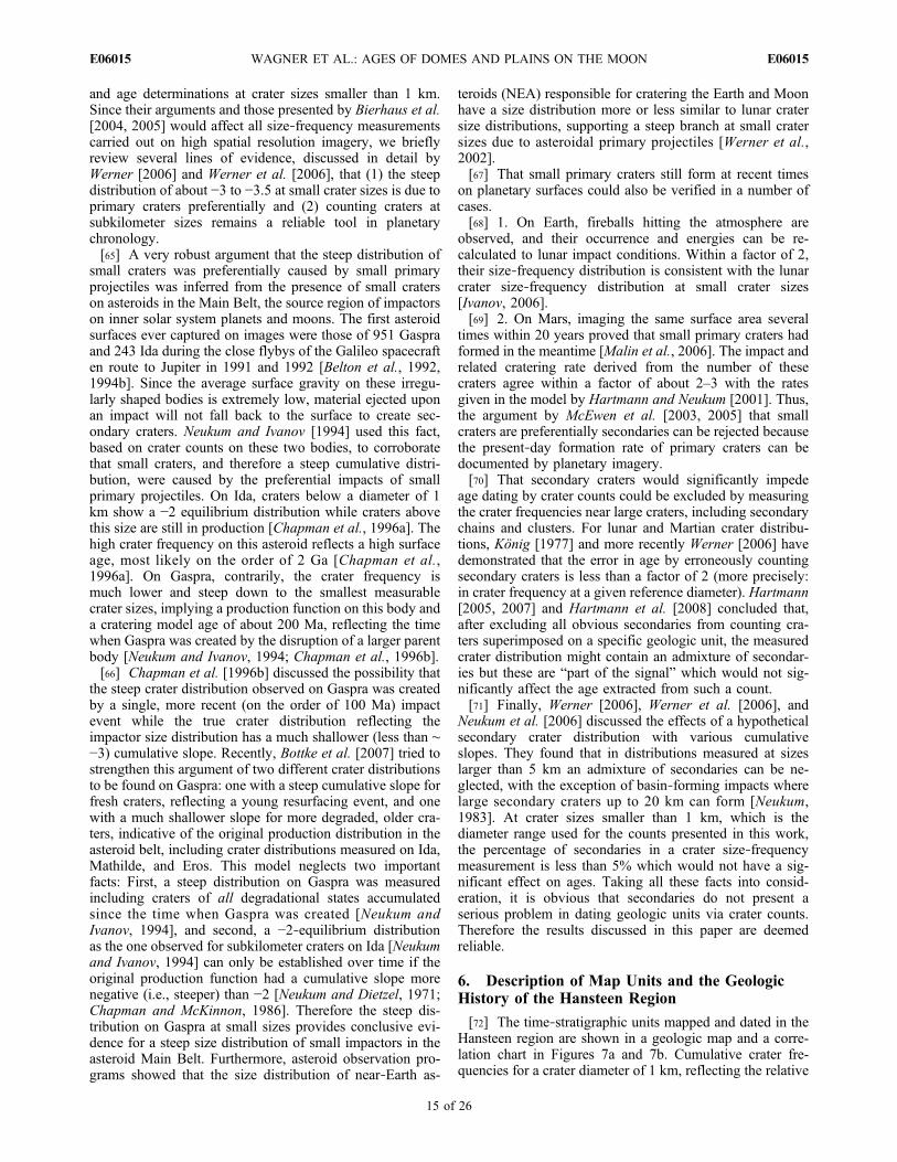
[72] The time‐stratigraphic units mapped and dated in theHansteen region are shown in a geologic map and a corre-lation chart in Figures 7a and 7b. Cumulative crater fre-quencies for a crater diameter of 1 km, reflecting the relative
WAGNER ET AL.: AGES OF DOMES AND PLAINS ON THE MOON E06015E06015
15 of 26
age of the unit, and cratering model ages, obtained for thesum of all individual areas of measurement, are listed inTable 2. Some of the units are characterized by two agessuggesting at least one event of resurfacing. For these units,both ages are given in Table 2. The correlation chart inFigure 7b qualitatively reflects the ranges of model agesmeasured in individual areas of measurements of each unit.
6.1. Terra Materials in the Hansteen Region
[73] Six measurement areas of terra materials of therock‐stratigraphic type shown in Figure 5 (area 2) range in
ages from (late) Nectarian to late Imbrian. These areaswere combined to an undivided terra material unit INt inFigures 7a and 7b which could encompass a variety ofterra materials with different origins. The unit is charac-terized by an older model age of 3.91 Ga (Table 2), with arange from 4 Ga to 3.85 Ga. Resurfacing event ages in theindividual areas range from 3.84 Ga to 3.75 Ga (3.81 Gafor the sum, as shown in Table 2). Unit INt could beassociated with cryptomaria which were spectrally identi-fied in southwestern Oceanus Procellarum and Humorumbasin [Hawke et al., 1993; Mustard and Head, 1996].
Figure 7. (a) Geologic map of the Hansteen region and (b) stratigraphic correlation chart. A moredetailed explanation of the map units and their respective cratering model ages is given in text (section 7).
WAGNER ET AL.: AGES OF DOMES AND PLAINS ON THE MOON E06015E06015
16 of 26

[74] Four areas of the rock‐stratigraphic material shown inFigure 5 (area 1) were mapped as unit Ihf, hilly and fur-rowed materials (Figures 7a and 7b) and subdivided intotwo time‐stratigraphic units. These units broadly correspondto map unit hilly and furrowed terrain, Ihf, by Wilhelms andMcCauley [1971], McCauley [1973], and Wilshire [1973].
[75] The oldest one of these units, Ihf1, is located in thesouth of the mapping area. The cratering model age is3.91 Ga (Table 2). This age is in good agreement with theage for the Imbrium event by Neukum and Ivanov [1994].Unit Ihf1 could be dominated by Imbrium basin ejecta.[76] A younger variety, Ihf2, with a model age of 3.77 Ga
(Table 2), occurs in two larger and one smaller areas south
Figure 7. (continued)
Table 2. Cumulative Crater Frequencies and Cratering Model Ages of Time‐Stratigraphic Units in theHansteen Regiona
Cumulative Crater Frequency andUncertainty (km−2)
Cratering Model Age andUncertainty (Ga)
EratosthenianEm 1.39 ± 0.25 E‐3 1.65 +0.29/−0.29
ImbrianIm 5.00 ± 0.18 E‐3 3.51 +0.01/−0.01Ihd 9.31 ± 2.20 E‐3 3.67 +0.04/−0.06Isc 7.10 ± 1.60 E‐3 3.61 +0.05/−0.07Ihfl 5.44 ± 2.10 E‐3; 1.36 ± 0.78 E‐2 3.54 +0.09/−0.22; 3.75 +0.08/−0.19Ihf2 1.49 ± 0.34 E‐2 3.77 +0.04/−0.05Ihc 5.95 ± 0.89 E‐3; 2.80 ± 0.88 E‐2 3.57 +0.04/−0.05; 3.87 +0.04/−0.06Ibc 2.84 ± 0.68 E‐2 3.88 +0.04/−0.04Ihf1 3.54 ± 0.33 E‐2 3.91 +0.01/−0.01
Imbrian/NectarianINt 1.86 ± 0.15 E‐2; 3.48 ± 0.57 E‐2 3.81 +0.01/−0.01; 3.91 +0.01/−0.01INm 2.63 ± 0.25 E‐2; 4.11 ± 1.20 E‐2 3.86 +0.01/−0.02; 3.93 +0.04/−0.06aUnits in the Hansteen region are shown in the geologic map and correlation chart in Figures 7a and 7b. In order to be
more easily readable, cumulative crater frequencies, Ncum (D ≥ 1 km) (x), and their uncertainties (y), representing the relativeage of each unit, are given in the form x ± y E‐n rather than x ± y × 10−n [see, e.g., Hiesinger et al., 2003]. Generally,individual areas of measurement of one unit have some range in ages (see text for discussion). Model ages listed in this tablewere obtained by summing up individual areas of measurement and dating the sum of the areas (except of unit Em and of thecrater materials Isc, Ihfl, Ihc, and Ibc which were dated in only one area). Two ages in a unit indicate that at least oneresurfacing event has affected its crater frequency. For assigning a specific unit to the Nectarian, Imbrian, or Eratostheniansystem (period), we used the impact event ages by Neukum and Ivanov [1994] throughout this paper (see section 5.3 andTable 1, second column). Crater frequencies and model age for unit Em are from Hiesinger et al. [2003].
WAGNER ET AL.: AGES OF DOMES AND PLAINS ON THE MOON E06015E06015
17 of 26
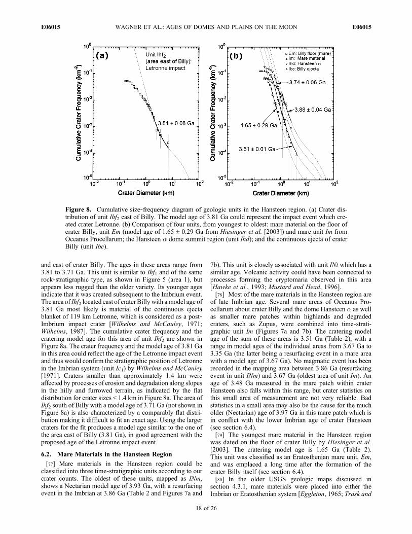
and east of crater Billy. The ages in these areas range from3.81 to 3.71 Ga. This unit is similar to Ihf1 and of the samerock‐stratigraphic type, as shown in Figure 5 (area 1), butappears less rugged than the older variety. Its younger agesindicate that it was created subsequent to the Imbrium event.The area of Ihf2 located east of crater Billy with amodel age of3.81 Ga most likely is material of the continuous ejectablanket of 119 km Letronne, which is considered as a post‐Imbrium impact crater [Wilhelms and McCauley, 1971;Wilhelms, 1987]. The cumulative crater frequency and thecratering model age for this area of unit Ihf2 are shown inFigure 8a. The crater frequency and the model age of 3.81 Gain this area could reflect the age of the Letronne impact eventand thus would confirm the stratigraphic position of Letronnein the Imbrian system (unit Ic1) by Wilhelms and McCauley[1971]. Craters smaller than approximately 1.4 km wereaffected by processes of erosion and degradation along slopesin the hilly and furrowed terrain, as indicated by the flatdistribution for crater sizes < 1.4 km in Figure 8a. The area ofIhf2 south of Billy with a model age of 3.71 Ga (not shown inFigure 8a) is also characterized by a comparably flat distri-bution making it difficult to fit an exact age. Using the largercraters for the fit produces a model age similar to the one ofthe area east of Billy (3.81 Ga), in good agreement with theproposed age of the Letronne impact event.
6.2. Mare Materials in the Hansteen Region
[77] Mare materials in the Hansteen region could beclassified into three time‐stratigraphic units according to ourcrater counts. The oldest of these units, mapped as INm,shows a Nectarian model age of 3.93 Ga, with a resurfacingevent in the Imbrian at 3.86 Ga (Table 2 and Figures 7a and
7b). This unit is closely associated with unit INt which has asimilar age. Volcanic activity could have been connected toprocesses forming the cryptomaria observed in this area[Hawke et al., 1993; Mustard and Head, 1996].[78] Most of the mare materials in the Hansteen region are
of late Imbrian age. Several mare areas of Oceanus Pro-cellarum about crater Billy and the dome Hansteen a as wellas smaller mare patches within highlands and degradedcraters, such as Zupus, were combined into time‐strati-graphic unit Im (Figures 7a and 7b). The cratering modelage of the sum of these areas is 3.51 Ga (Table 2), with arange in model ages of the individual areas from 3.67 Ga to3.35 Ga (the latter being a resurfacing event in a mare areawith a model age of 3.67 Ga). No magmatic event has beenrecorded in the mapping area between 3.86 Ga (resurfacingevent in unit INm) and 3.67 Ga (oldest area of unit Im). Anage of 3.48 Ga measured in the mare patch within craterHansteen also falls within this range, but crater statistics onthis small area of measurement are not very reliable. Badstatistics in a small area may also be the cause for the mucholder (Nectarian) age of 3.97 Ga in this mare patch which isin conflict with the lower Imbrian age of crater Hansteen(see section 6.4).[79] The youngest mare material in the Hansteen region
was dated on the floor of crater Billy by Hiesinger et al.[2003]. The cratering model age is 1.65 Ga (Table 2).This unit was classified as an Eratosthenian mare unit, Em,and was emplaced a long time after the formation of thecrater Billy itself (see section 6.4).[80] In the older USGS geologic maps discussed in
section 4.3.1, mare materials were placed into either theImbrian or Eratosthenian system [Eggleton, 1965; Trask and
Figure 8. Cumulative size‐frequency diagram of geologic units in the Hansteen region. (a) Crater dis-tribution of unit Ihf2 east of Billy. The model age of 3.81 Ga could represent the impact event which cre-ated crater Letronne. (b) Comparison of four units, from youngest to oldest: mare material on the floor ofcrater Billy, unit Em (model age of 1.65 ± 0.29 Ga from Hiesinger et al. [2003]) and mare unit Im fromOceanus Procellarum; the Hansteen a dome summit region (unit Ihd); and the continuous ejecta of craterBilly (unit Ibc).
WAGNER ET AL.: AGES OF DOMES AND PLAINS ON THE MOON E06015E06015
18 of 26
Titley, 1966; Titley, 1967;McCauley, 1973;Wilshire, 1973].By using crater counts, we could exclude an Eratosthenianage for most of them, except for the lava fill on the floor ofcrater Billy measured by Hiesinger et al. [2003]. In thespectral analysis and crater counts carried out by these au-thors, cratering model ages obtained for their spectral unitP24 which covers all mare areas we mapped in the Hansteenregion are 3.74 Ga and 3 Ga. The older of the two ages is ingood agreement with our results and our assignment of mostmare materials into late Imbrian. Unit P24, however, coversa much larger area than the mare units in our mapping areawhich could explain the additional younger Eratosthenianage of 3 Ga documented by Hiesinger et al. [2003] which isnot found in our measurements.[81] Figure 8b shows the cumulative size‐frequency dis-
tributions of mare units Im and Em, the dome Hansteen a(unit Ihd) and the continuous ejecta of crater Billy (unit Ibc)in comparison which emphasizes the stratigraphic sequencefrom crater Billy (oldest) to the Hansteen dome (formedafter Billy) and the two Imbrian and Eratosthenian mareunits (the latter taken from Hiesinger et al. [2003]).
6.3. Volcanic Dome Material in the Hansteen Region
[82] The volcanic dome Hansteen a is the only red spot inthe Hansteen region. The image resolution of the LunarOrbiter image did not allow specific geologic mapping ofthis feature. Only two small areas on the more or less flatsummit region could be discerned. Measuring the super-imposed crater frequency, carefully avoiding counting vol-canic, crater‐like features, yielded two statistically reliablecrater distributions, with cratering model ages of 3.74 and3.56 Ga, respectively, and a model age of 3.67 for the sumof these two areas (Table 2). Based on these ages, we canreject an Eratosthenian or even Copernican age for thedome, as suggested by McCauley [1973]. Based on opticalmaturity, Hawke et al. [2003] also ruled out a Copernicanage for the dome. Hansteen a clearly predates the sur-rounding mare materials, supported by a cratering model ageof 3.51 Ga for mare material unit Im surrounding the domewhich confirms earlier results by Wood and Head [1975].Figure 8b shows a cumulative diagram which compares thecrater distributions measured on the dome with crater dis-tributions of the Billy ejecta and of younger mare materials.Compared to the ages of the two Gruithuisen domes of3.85–3.7 Ga [Wagner et al., 2002], Hansteen a is somewhatyounger but still of late Imbrian age. The younger age of3.56 Ga measured on its summit could be connected toactive mare volcanism between 3.5 and 3.6 Ga documentedin unit Im.
6.4. Crater Materials in the Hansteen Region
[83] Three craters in the Hansteen region could be datedwith crater statistics: Billy, Hansteen, and Mersenius S.Billy could be placed into the early Imbrian epoch. Craterstatistics on the continuous ejecta, unit Ibc, which for themost part are embayed by mare materials of unit Im, couldbe used to derive a model age of 3.88 Ga (Figures 7a and 7band Table 2). This is in agreement with an Imbrian ageassigned to this crater by McCauley [1973].[84] Interpreting the crater statistics for the crater Hans-
teen is more difficult. One model age of 3.87 Ga, obtainedfrom a measurement on the continuous ejecta (Figures 7a
and 7b and Table 2), is statistically not very reliable.Based on this early Imbrian age we mapped the ejecta asunit Ihc. A second model age of 3.57 Ga, measured in theejecta, is also not very well reliable. The flat distribution atsizes below 2 km crater diameter suggests ongoing erosionor removal of craters along slopes. Measurements on thetectonically altered floor material are also characterized byless reliable statistics due to a rather flat distribution. Twoages were measured on the floor, mapped as unit Ihfl: ahigher one of 3.75 Ga (Table 2) and younger at 3.54 Ga.Both ages could record tectonic resurfacing of the craterfloor subsequent to the crater formation. An Imbrian age forthe crater, based on the 3.87 Ga measured in its ejecta, is inagreement with results by McCauley [1973].[85] By measuring the crater distribution superimposed on
the continuous ejecta of crater Mersenius S we could derivea late Imbrian age of 3.61 Ga for this crater and mapped it asunit Isc. We could not confirm the Copernican age for thiscrater suggested by Titley [1967]. This crater appears to besignificantly older.
7. Description of Map Units and GeologicHistory of the Helmet Region
[86] In the Helmet region, terra materials could not bedated by crater size‐frequency measurements because of thelow image quality (overexposure or underexposure). Mate-rial units dated in this area preferentially are (1) mare ma-terials, (2) plains materials, and (3) crater materials. For somemare areas, dating with crater counts was also not possiblebecause of underexposure. The geologic maps based onLunar Orbiter and on the high‐resolution Apollo Hasselbladframe Ap16‐19128 and the correlation chart of map units areshown in Figures 9a–9c. Cumulative frequency diagrams ofselected units are given in Figures 10a–10c. Ranges of cra-tering model ages for the Helmet region are listed in Table 3.
7.1. Mare Materials in the Helmet Region
[87] The spatially most abundant mare material unit mea-sured in Lunar Orbiter IV shows an average cratering modelage of 3.45 Ga and was mapped as unit Im1 (Figures 9aand 9c). There is some range in ages between individualareas of measurement of this unit from 3.54 to 3.37 Ga, butmost of the counting areas have ages of about 3.4–3.45 Ga.Hence, mare materials in the Helmet region were preferen-tially emplaced in late Imbrian. Locally, older ages rangingfrom 3.87 to 3.69 Ga indicating older (early Imbrian) mareemplacement can be found.[88] In the spectral analysis carried out by Hiesinger et al.
[2003], mare unit Im1 is a part of their spectral class P17 inthe area surrounding the Helmet feature while the northernpart of this unit in our mapping area near Montes Riphaeus(approximately north of an east‐west trending boundary atcrater Norman (Figure 3)), as well as the area northward ofGassendi and Gassendi A, was classified as spectral unitP27 (see sections 4.3.1 and 4.3.2 and Hiesinger et al. [2003]for a more detailed description). However, we could notconfirm the comparably younger age of 3.32 Ga measuredby Hiesinger et al. [2003] in an area northwest of the Hel-met feature. Also, the Eratosthenian age of 2.96 Ga mea-sured in spectral class P27 by Hiesinger et al. [2003] couldnot be confirmed in our data but this age was obtained in
WAGNER ET AL.: AGES OF DOMES AND PLAINS ON THE MOON E06015E06015
19 of 26
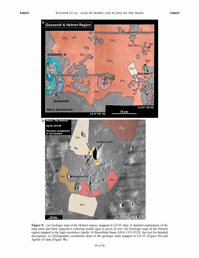
Figure 9. (a) Geologic map of the Helmet region, mapped in LO IV data. A detailed explanation of themap units and their respective cratering model ages is given in text. (b) Geologic map of the Helmetregion mapped in the high‐resolution Apollo 16 Hasselblad frame AS16‐119‐19128. See text for detaileddescription. (c) Stratigraphic correlation chart of the geologic units mapped in LO IV (Figure 9a) andApollo 16 data (Figure 9b).
WAGNER ET AL.: AGES OF DOMES AND PLAINS ON THE MOON E06015E06015
20 of 26

frame LO IV 132 H3, further to the north outside ourmapping area.[89] Two comparably small mare patches south of crater
Darney C are younger with an average model age of 3.27 Ga.This younger variety was mapped as unit Im2. The unit couldalso be mapped and dated in the higher‐resolution Apollo 16Hasselblad frame (Figure 9b) with an age of 3.28 Ga. Mostof this area is located within an unmappable part in frameLO IV 132 H2 (see Figure 9a).[90] Extrusion of mare materials in the Helmet region
continued into the Eratosthenian period. In LO IV, however,only one area could be measured with a distinct Eratosthe-nian age. This area is located west of crater Darney C, has aslightly higher albedo than other mare areas but theboundary between darker mare and this variety is not verysharp. Its northern boundary is marked by an approximatelyNE‐SW trending wrinkle ridge. The cratering model age ofthis unit Em is 3.04 Ga (Table 3).[91] Several counting areas on the Apollo 16 Hasselblad
frame also show Eratosthenian ages and could be mapped asunit Em, with an average of 2.36 Ga (Table 3). There issome range in ages from 3.06 Ga to 1.91 Ga which is theyoungest mare unit found in the Helmet area. In Figure 10a,a cumulative diagram gives the range in mare ages in theHelmet region, with a distribution and ages of 3.69 and3.47 Ga, representing a counting area of unit Im1 measuredin LO IV, and a distribution with the youngest mare age of1.91 Ga, measured in Apollo 16 data. The reason for theinconsistency in ages between measurements in LO IV dataand in the higher‐resolution Apollo 16 data most likely is dueto the fact that the higher‐resolution images allow to measurelocal resurfacing events which cannot be resolved in the LOIV data. Mapping and crater counts in more high‐resolutiondata, such as, e.g., from Lunar Reconnaissance Orbiter(LRO), are needed to verify if the mare material unit mapped
as Im1 shows mare emplacement events into, and during, theEratosthenian period on a local scale while the context marematerial unit is mostly late Imbrian.[92] The intermediate mare plains mapped by Bruno et al.
[1991] in the Helmet region could be dated and mapped asearly Imbrian unit Imi, showing an older age of 3.70 Ga anda younger resurfacing age of 3.37 Ga (Figures 9b and 9c andTable 3). The younger age of 3.37 is comparable to thelower limit given above for unit Im1 and could be related tomare emplacement forming this unit in late Imbrian. Brunoet al. [1991] discussed a resurfacing process which involvesthe emplacement of a thin layer of mare basalt on a lightplains unit which then is altered by meteorite bombardment,causing the vertical mixing of light plains material and marebasalt. However, it seems questionable that this process isvisible in the crater distribution since the resurfacing eventdocumented in the distribution affected craters at least aslarge as 400 m and smaller, hence would need a muchthicker layer of mare material.
7.2. Plains Materials and Related Unitsof the Helmet Region
[93] Darney c is a light plains unit. Measuring craters onthis feature is difficult because of the small area, yielding alow statistical certainty. The cratering model age derivedfrom measurements on this feature is 3.94 Ga, placingDarney c into the Nectarian period (pre‐Nectarian accord-ing to the chronology by Wilhelms [1987]; see Table 1).Based on the crater counts, the unit was mapped as Np,Nectarian plains material, but poor statistics have to be takeninto account. The cumulative diagram of this oldest unit inthe Helmet region in comparison to a set of younger plainsand mare materials as well as hummocky deposits is shownin Figure 10c.
Figure 9. (continued)
WAGNER ET AL.: AGES OF DOMES AND PLAINS ON THE MOON E06015E06015
21 of 26
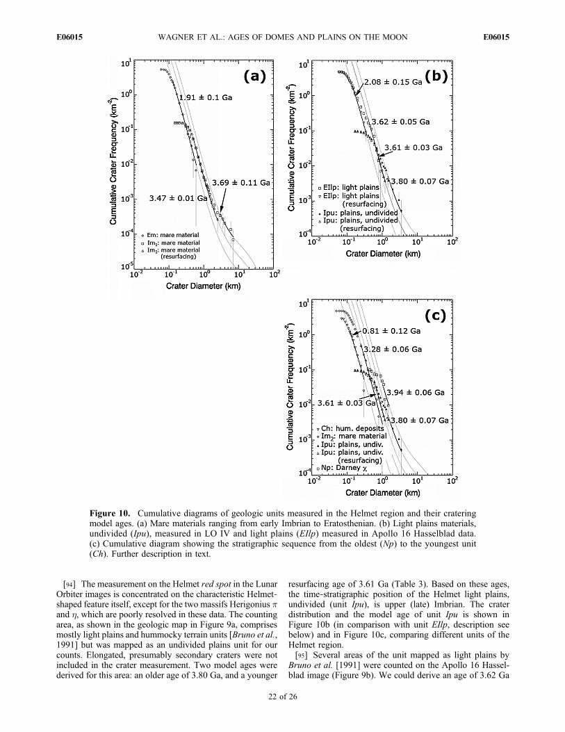
[94] The measurement on the Helmet red spot in the LunarOrbiter images is concentrated on the characteristic Helmet‐shaped feature itself, except for the two massifs Herigonius pand h, which are poorly resolved in these data. The countingarea, as shown in the geologic map in Figure 9a, comprisesmostly light plains and hummocky terrain units [Bruno et al.,1991] but was mapped as an undivided plains unit for ourcounts. Elongated, presumably secondary craters were notincluded in the crater measurement. Two model ages werederived for this area: an older age of 3.80 Ga, and a younger
resurfacing age of 3.61 Ga (Table 3). Based on these ages,the time‐stratigraphic position of the Helmet light plains,undivided (unit Ipu), is upper (late) Imbrian. The craterdistribution and the model age of unit Ipu is shown inFigure 10b (in comparison with unit EIlp, description seebelow) and in Figure 10c, comparing different units of theHelmet region.[95] Several areas of the unit mapped as light plains by
Bruno et al. [1991] were counted on the Apollo 16 Hassel-blad image (Figure 9b). We could derive an age of 3.62 Ga
Figure 10. Cumulative diagrams of geologic units measured in the Helmet region and their crateringmodel ages. (a) Mare materials ranging from early Imbrian to Eratosthenian. (b) Light plains materials,undivided (Ipu), measured in LO IV and light plains (EIlp) measured in Apollo 16 Hasselblad data.(c) Cumulative diagram showing the stratigraphic sequence from the oldest (Np) to the youngest unit(Ch). Further description in text.
WAGNER ET AL.: AGES OF DOMES AND PLAINS ON THE MOON E06015E06015
22 of 26
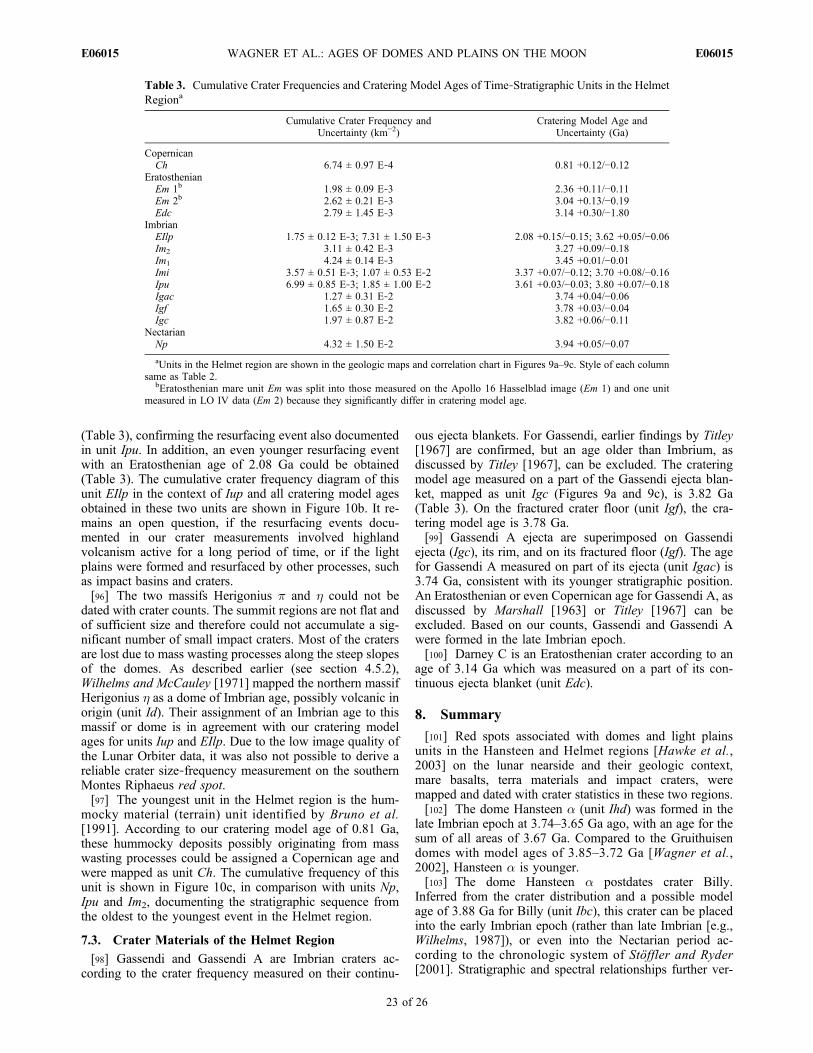
(Table 3), confirming the resurfacing event also documentedin unit Ipu. In addition, an even younger resurfacing eventwith an Eratosthenian age of 2.08 Ga could be obtained(Table 3). The cumulative crater frequency diagram of thisunit EIlp in the context of Iup and all cratering model agesobtained in these two units are shown in Figure 10b. It re-mains an open question, if the resurfacing events docu-mented in our crater measurements involved highlandvolcanism active for a long period of time, or if the lightplains were formed and resurfaced by other processes, suchas impact basins and craters.[96] The two massifs Herigonius p and h could not be
dated with crater counts. The summit regions are not flat andof sufficient size and therefore could not accumulate a sig-nificant number of small impact craters. Most of the cratersare lost due to mass wasting processes along the steep slopesof the domes. As described earlier (see section 4.5.2),Wilhelms and McCauley [1971] mapped the northern massifHerigonius h as a dome of Imbrian age, possibly volcanic inorigin (unit Id). Their assignment of an Imbrian age to thismassif or dome is in agreement with our cratering modelages for units Iup and EIlp. Due to the low image quality ofthe Lunar Orbiter data, it was also not possible to derive areliable crater size‐frequency measurement on the southernMontes Riphaeus red spot.[97] The youngest unit in the Helmet region is the hum-
mocky material (terrain) unit identified by Bruno et al.[1991]. According to our cratering model age of 0.81 Ga,these hummocky deposits possibly originating from masswasting processes could be assigned a Copernican age andwere mapped as unit Ch. The cumulative frequency of thisunit is shown in Figure 10c, in comparison with units Np,Ipu and Im2, documenting the stratigraphic sequence fromthe oldest to the youngest event in the Helmet region.
7.3. Crater Materials of the Helmet Region
[98] Gassendi and Gassendi A are Imbrian craters ac-cording to the crater frequency measured on their continu-
ous ejecta blankets. For Gassendi, earlier findings by Titley[1967] are confirmed, but an age older than Imbrium, asdiscussed by Titley [1967], can be excluded. The crateringmodel age measured on a part of the Gassendi ejecta blan-ket, mapped as unit Igc (Figures 9a and 9c), is 3.82 Ga(Table 3). On the fractured crater floor (unit Igf), the cra-tering model age is 3.78 Ga.[99] Gassendi A ejecta are superimposed on Gassendi
ejecta (Igc), its rim, and on its fractured floor (Igf). The agefor Gassendi A measured on part of its ejecta (unit Igac) is3.74 Ga, consistent with its younger stratigraphic position.An Eratosthenian or even Copernican age for Gassendi A, asdiscussed by Marshall [1963] or Titley [1967] can beexcluded. Based on our counts, Gassendi and Gassendi Awere formed in the late Imbrian epoch.[100] Darney C is an Eratosthenian crater according to an
age of 3.14 Ga which was measured on a part of its con-tinuous ejecta blanket (unit Edc).
8. Summary
[101] Red spots associated with domes and light plainsunits in the Hansteen and Helmet regions [Hawke et al.,2003] on the lunar nearside and their geologic context,mare basalts, terra materials and impact craters, weremapped and dated with crater statistics in these two regions.[102] The dome Hansteen a (unit Ihd) was formed in the
late Imbrian epoch at 3.74–3.65 Ga ago, with an age for thesum of all areas of 3.67 Ga. Compared to the Gruithuisendomes with model ages of 3.85–3.72 Ga [Wagner et al.,2002], Hansteen a is younger.[103] The dome Hansteen a postdates crater Billy.
Inferred from the crater distribution and a possible modelage of 3.88 Ga for Billy (unit Ibc), this crater can be placedinto the early Imbrian epoch (rather than late Imbrian [e.g.,Wilhelms, 1987]), or even into the Nectarian period ac-cording to the chronologic system of Stöffler and Ryder[2001]. Stratigraphic and spectral relationships further ver-
Table 3. Cumulative Crater Frequencies and Cratering Model Ages of Time‐Stratigraphic Units in the HelmetRegiona
Cumulative Crater Frequency andUncertainty (km−2)
Cratering Model Age andUncertainty (Ga)
CopernicanCh 6.74 ± 0.97 E‐4 0.81 +0.12/−0.12
EratosthenianEm 1b 1.98 ± 0.09 E‐3 2.36 +0.11/−0.11Em 2b 2.62 ± 0.21 E‐3 3.04 +0.13/−0.19Edc 2.79 ± 1.45 E‐3 3.14 +0.30/−1.80
ImbrianEIlp 1.75 ± 0.12 E‐3; 7.31 ± 1.50 E‐3 2.08 +0.15/−0.15; 3.62 +0.05/−0.06Im2 3.11 ± 0.42 E‐3 3.27 +0.09/−0.18Im1 4.24 ± 0.14 E‐3 3.45 +0.01/−0.01Imi 3.57 ± 0.51 E‐3; 1.07 ± 0.53 E‐2 3.37 +0.07/−0.12; 3.70 +0.08/−0.16Ipu 6.99 ± 0.85 E‐3; 1.85 ± 1.00 E‐2 3.61 +0.03/−0.03; 3.80 +0.07/−0.18Igac 1.27 ± 0.31 E‐2 3.74 +0.04/−0.06Igf 1.65 ± 0.30 E‐2 3.78 +0.03/−0.04Igc 1.97 ± 0.87 E‐2 3.82 +0.06/−0.11
NectarianNp 4.32 ± 1.50 E‐2 3.94 +0.05/−0.07aUnits in the Helmet region are shown in the geologic maps and correlation chart in Figures 9a–9c. Style of each column
same as Table 2.bEratosthenian mare unit Em was split into those measured on the Apollo 16 Hasselblad image (Em 1) and one unit
measured in LO IV data (Em 2) because they significantly differ in cratering model age.
WAGNER ET AL.: AGES OF DOMES AND PLAINS ON THE MOON E06015E06015
23 of 26
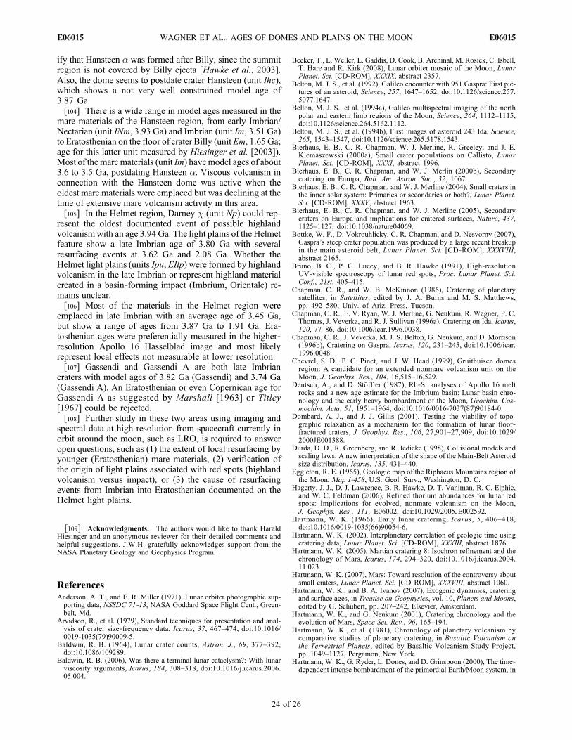
ify that Hansteen a was formed after Billy, since the summitregion is not covered by Billy ejecta [Hawke et al., 2003].Also, the dome seems to postdate crater Hansteen (unit Ihc),which shows a not very well constrained model age of3.87 Ga.[104] There is a wide range in model ages measured in the
mare materials of the Hansteen region, from early Imbrian/Nectarian (unit INm, 3.93 Ga) and Imbrian (unit Im, 3.51 Ga)to Eratosthenian on the floor of crater Billy (unit Em, 1.65 Ga;age for this latter unit measured by Hiesinger et al. [2003]).Most of the mare materials (unit Im) havemodel ages of about3.6 to 3.5 Ga, postdating Hansteen a. Viscous volcanism inconnection with the Hansteen dome was active when theoldest mare materials were emplaced but was declining at thetime of extensive mare volcanism activity in this area.[105] In the Helmet region, Darney c (unit Np) could rep-
resent the oldest documented event of possible highlandvolcanismwith an age 3.94 Ga. The light plains of the Helmetfeature show a late Imbrian age of 3.80 Ga with severalresurfacing events at 3.62 Ga and 2.08 Ga. Whether theHelmet light plains (units Ipu, EIlp) were formed by highlandvolcanism in the late Imbrian or represent highland materialcreated in a basin‐forming impact (Imbrium, Orientale) re-mains unclear.[106] Most of the materials in the Helmet region were
emplaced in late Imbrian with an average age of 3.45 Ga,but show a range of ages from 3.87 Ga to 1.91 Ga. Era-tosthenian ages were preferentially measured in the higher‐resolution Apollo 16 Hasselblad image and most likelyrepresent local effects not measurable at lower resolution.[107] Gassendi and Gassendi A are both late Imbrian
craters with model ages of 3.82 Ga (Gassendi) and 3.74 Ga(Gassendi A). An Eratosthenian or even Copernican age forGassendi A as suggested by Marshall [1963] or Titley[1967] could be rejected.[108] Further study in these two areas using imaging and
spectral data at high resolution from spacecraft currently inorbit around the moon, such as LRO, is required to answeropen questions, such as (1) the extent of local resurfacing byyounger (Eratosthenian) mare materials, (2) verification ofthe origin of light plains associated with red spots (highlandvolcanism versus impact), or (3) the cause of resurfacingevents from Imbrian into Eratosthenian documented on theHelmet light plains.
[109] Acknowledgments. The authors would like to thank HaraldHiesinger and an anonymous reviewer for their detailed comments andhelpful suggestions. J.W.H. gratefully acknowledges support from theNASA Planetary Geology and Geophysics Program.
ReferencesAnderson, A. T., and E. R. Miller (1971), Lunar orbiter photographic sup-porting data, NSSDC 71‐13, NASA Goddard Space Flight Cent., Green-belt, Md.
Arvidson, R., et al. (1979), Standard techniques for presentation and anal-ysis of crater size‐frequency data, Icarus, 37, 467–474, doi:10.1016/0019-1035(79)90009-5.
Baldwin, R. B. (1964), Lunar crater counts, Astron. J., 69, 377–392,doi:10.1086/109289.
Baldwin, R. B. (2006), Was there a terminal lunar cataclysm?: With lunarviscosity arguments, Icarus, 184, 308–318, doi:10.1016/j.icarus.2006.05.004.
Becker, T., L. Weller, L. Gaddis, D. Cook, B. Archinal, M. Rosiek, C. Isbell,T. Hare and R. Kirk (2008), Lunar orbiter mosaic of the Moon, LunarPlanet. Sci. [CD‐ROM], XXXIX, abstract 2357.
Belton, M. J. S., et al. (1992), Galileo encounter with 951 Gaspra: First pic-tures of an asteroid, Science, 257, 1647–1652, doi:10.1126/science.257.5077.1647.
Belton, M. J. S., et al. (1994a), Galileo multispectral imaging of the northpolar and eastern limb regions of the Moon, Science, 264, 1112–1115,doi:10.1126/science.264.5162.1112.
Belton, M. J. S., et al. (1994b), First images of asteroid 243 Ida, Science,265, 1543–1547, doi:10.1126/science.265.5178.1543.
Bierhaus, E. B., C. R. Chapman, W. J. Merline, R. Greeley, and J. E.Klemaszewski (2000a), Small crater populations on Callisto, LunarPlanet. Sci. [CD‐ROM], XXXI, abstract 1996.
Bierhaus, E. B., C. R. Chapman, and W. J. Merlin (2000b), Secondarycratering on Europa, Bull. Am. Astron. Soc., 32, 1067.
Bierhaus, E. B., C. R. Chapman, and W. J. Merline (2004), Small craters inthe inner solar system: Primaries or secondaries or both?, Lunar Planet.Sci. [CD‐ROM], XXXV, abstract 1963.
Bierhaus, E. B., C. R. Chapman, and W. J. Merline (2005), Secondarycraters on Europa and implications for cratered surfaces, Nature, 437,1125–1127, doi:10.1038/nature04069.
Bottke, W. F., D. Vokrouhlicky, C. R. Chapman, and D. Nesvorny (2007),Gaspra’s steep crater population was produced by a large recent breakupin the main asteroid belt, Lunar Planet. Sci. [CD‐ROM], XXXVIII,abstract 2165.
Bruno, B. C., P. G. Lucey, and B. R. Hawke (1991), High‐resolutionUV‐visible spectroscopy of lunar red spots, Proc. Lunar Planet. Sci.Conf., 21st, 405–415.
Chapman, C. R., and W. B. McKinnon (1986), Cratering of planetarysatellites, in Satellites, edited by J. A. Burns and M. S. Matthews,pp. 492–580, Univ. of Ariz. Press, Tucson.
Chapman, C. R., E. V. Ryan, W. J. Merline, G. Neukum, R. Wagner, P. C.Thomas, J. Veverka, and R. J. Sullivan (1996a), Cratering on Ida, Icarus,120, 77–86, doi:10.1006/icar.1996.0038.
Chapman, C. R., J. Veverka, M. J. S. Belton, G. Neukum, and D. Morrison(1996b), Cratering on Gaspra, Icarus, 120, 231–245, doi:10.1006/icar.1996.0048.
Chevrel, S. D., P. C. Pinet, and J. W. Head (1999), Gruithuisen domesregion: A candidate for an extended nonmare volcanism unit on theMoon, J. Geophys. Res., 104, 16,515–16,529.
Deutsch, A., and D. Stöffler (1987), Rb‐Sr analyses of Apollo 16 meltrocks and a new age estimate for the Imbrium basin: Lunar basin chro-nology and the early heavy bombardment of the Moon, Geochim. Cos-mochim. Acta, 51, 1951–1964, doi:10.1016/0016-7037(87)90184-0.
Dombard, A. J., and J. J. Gillis (2001), Testing the viability of topo-graphic relaxation as a mechanism for the formation of lunar floor‐fractured craters, J. Geophys. Res., 106, 27,901–27,909, doi:10.1029/2000JE001388.
Durda, D. D., R. Greenberg, and R. Jedicke (1998), Collisional models andscaling laws: A new interpretation of the shape of the Main‐Belt Asteroidsize distribution, Icarus, 135, 431–440.
Eggleton, R. E. (1965), Geologic map of the Riphaeus Mountains region ofthe Moon, Map I‐458, U.S. Geol. Surv., Washington, D. C.
Hagerty, J. J., D. J. Lawrence, B. R. Hawke, D. T. Vaniman, R. C. Elphic,and W. C. Feldman (2006), Refined thorium abundances for lunar redspots: Implications for evolved, nonmare volcanism on the Moon,J. Geophys. Res., 111, E06002, doi:10.1029/2005JE002592.
Hartmann, W. K. (1966), Early lunar cratering, Icarus, 5, 406–418,doi:10.1016/0019-1035(66)90054-6.
Hartmann, W. K. (2002), Interplanetary correlation of geologic time usingcratering data, Lunar Planet. Sci. [CD‐ROM], XXXIII, abstract 1876.
Hartmann, W. K. (2005), Martian cratering 8: Isochron refinement and thechronology of Mars, Icarus, 174, 294–320, doi:10.1016/j.icarus.2004.11.023.
Hartmann, W. K. (2007), Mars: Toward resolution of the controversy aboutsmall craters, Lunar Planet. Sci. [CD‐ROM], XXXVIII, abstract 1060.
Hartmann, W. K., and B. A. Ivanov (2007), Exogenic dynamics, crateringand surface ages, in Treatise on Geophysics, vol. 10, Planets and Moons,edited by G. Schubert, pp. 207–242, Elsevier, Amsterdam.
Hartmann, W. K., and G. Neukum (2001), Cratering chronology and theevolution of Mars, Space Sci. Rev., 96, 165–194.
Hartmann, W. K., et al. (1981), Chronology of planetary volcanism bycomparative studies of planetary cratering, in Basaltic Volcanism onthe Terrestrial Planets, edited by Basaltic Volcanism Study Project,pp. 1049–1127, Pergamon, New York.
Hartmann, W. K., G. Ryder, L. Dones, and D. Grinspoon (2000), The time‐dependent intense bombardment of the primordial Earth/Moon system, in
WAGNER ET AL.: AGES OF DOMES AND PLAINS ON THE MOON E06015E06015
24 of 26
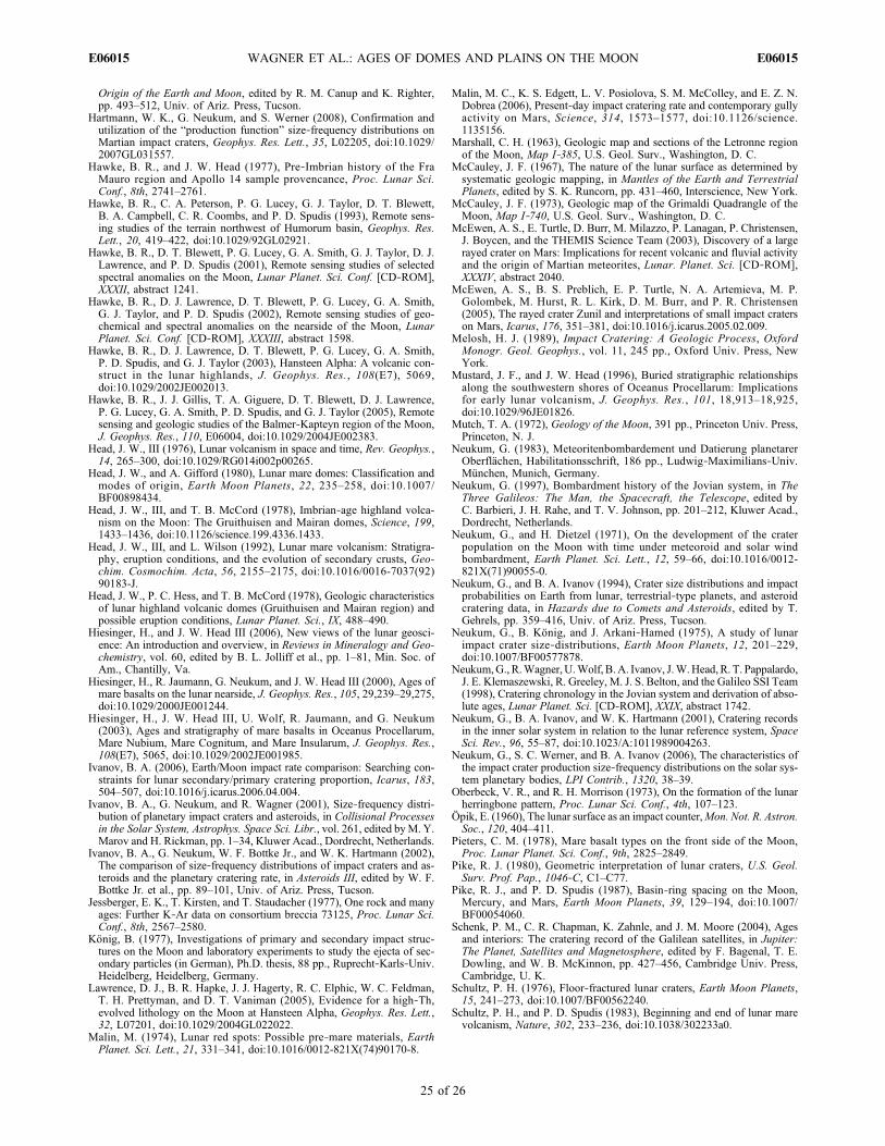
Origin of the Earth and Moon, edited by R. M. Canup and K. Righter,pp. 493–512, Univ. of Ariz. Press, Tucson.
Hartmann, W. K., G. Neukum, and S. Werner (2008), Confirmation andutilization of the “production function” size‐frequency distributions onMartian impact craters, Geophys. Res. Lett., 35, L02205, doi:10.1029/2007GL031557.
Hawke, B. R., and J. W. Head (1977), Pre‐Imbrian history of the FraMauro region and Apollo 14 sample provencance, Proc. Lunar Sci.Conf., 8th, 2741–2761.
Hawke, B. R., C. A. Peterson, P. G. Lucey, G. J. Taylor, D. T. Blewett,B. A. Campbell, C. R. Coombs, and P. D. Spudis (1993), Remote sens-ing studies of the terrain northwest of Humorum basin, Geophys. Res.Lett., 20, 419–422, doi:10.1029/92GL02921.
Hawke, B. R., D. T. Blewett, P. G. Lucey, G. A. Smith, G. J. Taylor, D. J.Lawrence, and P. D. Spudis (2001), Remote sensing studies of selectedspectral anomalies on the Moon, Lunar Planet. Sci. Conf. [CD‐ROM],XXXII, abstract 1241.
Hawke, B. R., D. J. Lawrence, D. T. Blewett, P. G. Lucey, G. A. Smith,G. J. Taylor, and P. D. Spudis (2002), Remote sensing studies of geo-chemical and spectral anomalies on the nearside of the Moon, LunarPlanet. Sci. Conf. [CD‐ROM], XXXIII, abstract 1598.
Hawke, B. R., D. J. Lawrence, D. T. Blewett, P. G. Lucey, G. A. Smith,P. D. Spudis, and G. J. Taylor (2003), Hansteen Alpha: A volcanic con-struct in the lunar highlands, J. Geophys. Res., 108(E7), 5069,doi:10.1029/2002JE002013.
Hawke, B. R., J. J. Gillis, T. A. Giguere, D. T. Blewett, D. J. Lawrence,P. G. Lucey, G. A. Smith, P. D. Spudis, and G. J. Taylor (2005), Remotesensing and geologic studies of the Balmer‐Kapteyn region of the Moon,J. Geophys. Res., 110, E06004, doi:10.1029/2004JE002383.
Head, J. W., III (1976), Lunar volcanism in space and time, Rev. Geophys.,14, 265–300, doi:10.1029/RG014i002p00265.
Head, J. W., and A. Gifford (1980), Lunar mare domes: Classification andmodes of origin, Earth Moon Planets, 22, 235–258, doi:10.1007/BF00898434.
Head, J. W., III, and T. B. McCord (1978), Imbrian‐age highland volca-nism on the Moon: The Gruithuisen and Mairan domes, Science, 199,1433–1436, doi:10.1126/science.199.4336.1433.
Head, J. W., III, and L. Wilson (1992), Lunar mare volcanism: Stratigra-phy, eruption conditions, and the evolution of secondary crusts, Geo-chim. Cosmochim. Acta, 56, 2155–2175, doi:10.1016/0016-7037(92)90183-J.
Head, J. W., P. C. Hess, and T. B. McCord (1978), Geologic characteristicsof lunar highland volcanic domes (Gruithuisen and Mairan region) andpossible eruption conditions, Lunar Planet. Sci., IX, 488–490.
Hiesinger, H., and J. W. Head III (2006), New views of the lunar geosci-ence: An introduction and overview, in Reviews in Mineralogy and Geo-chemistry, vol. 60, edited by B. L. Jolliff et al., pp. 1–81, Min. Soc. ofAm., Chantilly, Va.
Hiesinger, H., R. Jaumann, G. Neukum, and J. W. Head III (2000), Ages ofmare basalts on the lunar nearside, J. Geophys. Res., 105, 29,239–29,275,doi:10.1029/2000JE001244.
Hiesinger, H., J. W. Head III, U. Wolf, R. Jaumann, and G. Neukum(2003), Ages and stratigraphy of mare basalts in Oceanus Procellarum,Mare Nubium, Mare Cognitum, and Mare Insularum, J. Geophys. Res.,108(E7), 5065, doi:10.1029/2002JE001985.
Ivanov, B. A. (2006), Earth/Moon impact rate comparison: Searching con-straints for lunar secondary/primary cratering proportion, Icarus, 183,504–507, doi:10.1016/j.icarus.2006.04.004.
Ivanov, B. A., G. Neukum, and R. Wagner (2001), Size‐frequency distri-bution of planetary impact craters and asteroids, in Collisional Processesin the Solar System, Astrophys. Space Sci. Libr., vol. 261, edited byM. Y.Marov and H. Rickman, pp. 1–34, Kluwer Acad., Dordrecht, Netherlands.
Ivanov, B. A., G. Neukum, W. F. Bottke Jr., and W. K. Hartmann (2002),The comparison of size‐frequency distributions of impact craters and as-teroids and the planetary cratering rate, in Asteroids III, edited by W. F.Bottke Jr. et al., pp. 89–101, Univ. of Ariz. Press, Tucson.
Jessberger, E. K., T. Kirsten, and T. Staudacher (1977), One rock and manyages: Further K‐Ar data on consortium breccia 73125, Proc. Lunar Sci.Conf., 8th, 2567–2580.
König, B. (1977), Investigations of primary and secondary impact struc-tures on the Moon and laboratory experiments to study the ejecta of sec-ondary particles (in German), Ph.D. thesis, 88 pp., Ruprecht‐Karls‐Univ.Heidelberg, Heidelberg, Germany.
Lawrence, D. J., B. R. Hapke, J. J. Hagerty, R. C. Elphic, W. C. Feldman,T. H. Prettyman, and D. T. Vaniman (2005), Evidence for a high‐Th,evolved lithology on the Moon at Hansteen Alpha, Geophys. Res. Lett.,32, L07201, doi:10.1029/2004GL022022.
Malin, M. (1974), Lunar red spots: Possible pre‐mare materials, EarthPlanet. Sci. Lett., 21, 331–341, doi:10.1016/0012-821X(74)90170-8.
Malin, M. C., K. S. Edgett, L. V. Posiolova, S. M. McColley, and E. Z. N.Dobrea (2006), Present‐day impact cratering rate and contemporary gullyactivity on Mars, Science, 314, 1573–1577, doi:10.1126/science.1135156.
Marshall, C. H. (1963), Geologic map and sections of the Letronne regionof the Moon, Map I‐385, U.S. Geol. Surv., Washington, D. C.
McCauley, J. F. (1967), The nature of the lunar surface as determined bysystematic geologic mapping, in Mantles of the Earth and TerrestrialPlanets, edited by S. K. Runcorn, pp. 431–460, Interscience, New York.
McCauley, J. F. (1973), Geologic map of the Grimaldi Quadrangle of theMoon, Map I‐740, U.S. Geol. Surv., Washington, D. C.
McEwen, A. S., E. Turtle, D. Burr, M. Milazzo, P. Lanagan, P. Christensen,J. Boycen, and the THEMIS Science Team (2003), Discovery of a largerayed crater on Mars: Implications for recent volcanic and fluvial activityand the origin of Martian meteorites, Lunar. Planet. Sci. [CD‐ROM],XXXIV, abstract 2040.
McEwen, A. S., B. S. Preblich, E. P. Turtle, N. A. Artemieva, M. P.Golombek, M. Hurst, R. L. Kirk, D. M. Burr, and P. R. Christensen(2005), The rayed crater Zunil and interpretations of small impact craterson Mars, Icarus, 176, 351–381, doi:10.1016/j.icarus.2005.02.009.
Melosh, H. J. (1989), Impact Cratering: A Geologic Process, OxfordMonogr. Geol. Geophys., vol. 11, 245 pp., Oxford Univ. Press, NewYork.
Mustard, J. F., and J. W. Head (1996), Buried stratigraphic relationshipsalong the southwestern shores of Oceanus Procellarum: Implicationsfor early lunar volcanism, J. Geophys. Res., 101, 18,913–18,925,doi:10.1029/96JE01826.
Mutch, T. A. (1972), Geology of the Moon, 391 pp., Princeton Univ. Press,Princeton, N. J.
Neukum, G. (1983), Meteoritenbombardement und Datierung planetarerOberflächen, Habilitationsschrift, 186 pp., Ludwig‐Maximilians‐Univ.München, Munich, Germany.
Neukum, G. (1997), Bombardment history of the Jovian system, in TheThree Galileos: The Man, the Spacecraft, the Telescope, edited byC. Barbieri, J. H. Rahe, and T. V. Johnson, pp. 201–212, Kluwer Acad.,Dordrecht, Netherlands.
Neukum, G., and H. Dietzel (1971), On the development of the craterpopulation on the Moon with time under meteoroid and solar windbombardment, Earth Planet. Sci. Lett., 12, 59–66, doi:10.1016/0012-821X(71)90055-0.
Neukum, G., and B. A. Ivanov (1994), Crater size distributions and impactprobabilities on Earth from lunar, terrestrial‐type planets, and asteroidcratering data, in Hazards due to Comets and Asteroids, edited by T.Gehrels, pp. 359–416, Univ. of Ariz. Press, Tucson.
Neukum, G., B. König, and J. Arkani‐Hamed (1975), A study of lunarimpact crater size‐distributions, Earth Moon Planets, 12, 201–229,doi:10.1007/BF00577878.
Neukum,G., R.Wagner,U.Wolf, B.A. Ivanov, J.W.Head,R. T. Pappalardo,J. E. Klemaszewski, R. Greeley, M. J. S. Belton, and the Galileo SSI Team(1998), Cratering chronology in the Jovian system and derivation of abso-lute ages, Lunar Planet. Sci. [CD‐ROM], XXIX, abstract 1742.
Neukum, G., B. A. Ivanov, and W. K. Hartmann (2001), Cratering recordsin the inner solar system in relation to the lunar reference system, SpaceSci. Rev., 96, 55–87, doi:10.1023/A:1011989004263.
Neukum, G., S. C. Werner, and B. A. Ivanov (2006), The characteristics ofthe impact crater production size‐frequency distributions on the solar sys-tem planetary bodies, LPI Contrib., 1320, 38–39.
Oberbeck, V. R., and R. H. Morrison (1973), On the formation of the lunarherringbone pattern, Proc. Lunar Sci. Conf., 4th, 107–123.
Öpik, E. (1960), The lunar surface as an impact counter,Mon. Not. R. Astron.Soc., 120, 404–411.
Pieters, C. M. (1978), Mare basalt types on the front side of the Moon,Proc. Lunar Planet. Sci. Conf., 9th, 2825–2849.
Pike, R. J. (1980), Geometric interpretation of lunar craters, U.S. Geol.Surv. Prof. Pap., 1046‐C, C1–C77.
Pike, R. J., and P. D. Spudis (1987), Basin‐ring spacing on the Moon,Mercury, and Mars, Earth Moon Planets, 39, 129–194, doi:10.1007/BF00054060.
Schenk, P. M., C. R. Chapman, K. Zahnle, and J. M. Moore (2004), Agesand interiors: The cratering record of the Galilean satellites, in Jupiter:The Planet, Satellites and Magnetosphere, edited by F. Bagenal, T. E.Dowling, and W. B. McKinnon, pp. 427–456, Cambridge Univ. Press,Cambridge, U. K.
Schultz, P. H. (1976), Floor‐fractured lunar craters, Earth Moon Planets,15, 241–273, doi:10.1007/BF00562240.
Schultz, P. H., and P. D. Spudis (1983), Beginning and end of lunar marevolcanism, Nature, 302, 233–236, doi:10.1038/302233a0.
WAGNER ET AL.: AGES OF DOMES AND PLAINS ON THE MOON E06015E06015
25 of 26
Shoemaker, E. (1965), Preliminary analysis of the fine structure of the lunarsurface in Mare Cognitum, in Ranger VII: Part II, chap. 4, Tech. Rep.32‐700, pp. 75–134, Jet Propul. Lab., Pasadena, Calif.
Shoemaker, E. M., R. J. Hackman, and R. E. Eggleton (1962), Interplane-tary correlation of geologic time, Adv. Astronaut. Sci., 8, 70–89.
Solomon, S. C., and J. W. Head (1979), Vertical movement in mare basins:Relation to mare emplacement, basin tectonics, and lunar thermal history,J. Geophys. Res., 84, 1667–1682, doi:10.1029/JB084iB04p01667.
Solomon, S. C., and J. W. Head (1980), Lunar mascon basins: Lava filling,tectonics, and evolution of the lithosphere, Rev. Geophys., 18, 107–141,doi:10.1029/RG018i001p00107.
Solomon, S. C., and J. W. Head III (2007), If the late heavy bombardmenton the moon was a terminal cataclysm, what are some implications forMars?, Lunar Planet. Sci. [CD‐ROM], XXXVIII, abstract 1636.
Spudis, P. D. (1993), The Geology of Multi‐ring Impact Basins, CambridgePlanet. Sci. Ser., vol. 8, 263 pp., Cambridge Univ. Press, Cambridge, U. K.
Stöffler, D., and G. Ryder (2001), Stratigraphy and isotope ages of lunargeologic units: Chronological standard for the inner solar system, SpaceSci. Rev., 96, 9–54, doi:10.1023/A:1011937020193.
Stöffler, D., et al. (1985), Composition and evolution of the lunar crust inthe Descartes highlands, Apollo 16, Proc. Lunar Planet. Sci. Conf. 15th,Part 2, J. Geophys. Res., 90, suppl., C449–C506.
Strom, R. G., and G. Neukum (1988), The cratering record on Mercury andthe origin of impacting orbits, in Mercury, edited by F. Vilas, C. R.Chapman, andM. S.Matthews, pp. 336–373, Univ. of Ariz. Press, Tucson.
Stuart‐Alexander, D. E., and D. E. Wilhelms (1975), The Nectarian system:A new lunar time‐stratigraphic unit, J. Res. U.S. Geol. Surv., 3(1), 53–58.
Tera, F., D. A. Papanastassiou, and G. J. Wasserburg (1974), Isotopicevidence for a terminal lunar cataclysm, Earth Planet. Sci. Lett., 22,1–21.
Titley, S. R. (1967), Geologic map of the Mare Humorum region of theMoon, Map I‐495, U.S. Geol. Surv., Washington, D. C.
Trask, N. J., and S. R. Titley (1966), Geologic map of the Pitatus region ofthe Moon, Map I‐485, U.S. Geol. Surv., Washington, D. C.
Turtle, E. P., C. B. Phillips, G. C. Collins, A. S. McEwen, J. M. Moore,R. T. Pappalardo, P. M. Schenk, and the Galileo SSI Team (1999), Euro-pan impact crater diameters and inferred transient crater dimensions andexcavation depths, Lunar Planet. Sci. [CD‐ROM], XXX, abstract 1882.
Wagner, R., J. W. Head III, U. Wolf, and G. Neukum (2002), Stratigraphicsequence and ages of volcanic units in the Gruithuisen region of theMoon, J. Geophys. Res., 107(E11), 5104, doi:10.1029/2002JE001844.
Werner, S. C. (2006), Major aspects of the chronostratigraphy and geologicevolutionary history of Mars, Ph.D. dissertation, Freie Univ. Berlin,Berlin, Germany. (Available at http://www.diss.fu‐berlin.de/2006/33/indexe.html.)
Werner, S. C., A. W. Harris, G. Neukum, and B. A. Ivanov (2002), The near‐Earth asteroid size‐frequency distribution: A snapshot of the lunar impac-tor size‐frequency distribution, Icarus, 156, 287–290, doi:10.1006/icar.2001.6789.
Werner, S. C., B. A. Ivanov, and G. Neukum (2006), Mars: Secondarycratering—Implications for age determinations, Lunar Planet. Sci.[CD‐ROM], XXXVII, abstract 1595.
Wetherill, G. W. (1975), Late heavy bombardment of the moon and terres-trial planets, Proc. Lunar Sci. Conf., 6th, 1539–1561.
Wetherill, G. W. (1981), Nature and origin of basin‐forming projectiles, inMulti‐ring Basins: Formation and Evolution, edited by R. B. Merill andP. H. Schultz, Proc. Lunar Planet. Sci. Conf., 12th, 1–18.
Whitford‐Stark, J. L., and J. W. Head III (1980), Stratigraphy of OceanusProcellarum basalts: Sources and styles of emplacement, J. Geophys.Res., 85, 6579–6609, doi:10.1029/JB085iB11p06579.
Wilhelms, D. E. (1976), Secondary impact craters of lunar basins, Proc.Lunar Planet. Sci. Conf., 7th, 2883–2901.
Wilhelms, D. E. (1987), The Geologic History of the Moon, U.S. Geol.Surv. Prof. Pap., 1348, 302 pp.
Wilhelms, D. E. (1990), Geologic mapping, in Planetary Mapping, editedby R. Greeley and R. M. Batson, pp. 208–260, Cambridge Univ. Press,New York.
Wilhelms, D. E., and J. F. McCauley (1971), Geologic map of the near sideof the Moon, Map I‐703, U.S. Geol. Surv., Washington, D. C.
Wilhelms, D. E., V. R. Oberbeck, and H. R. Aggarwal (1978), Size‐frequency distributions of primary and secondary lunar impact craters,Proc. Lunar Sci. Conf., 9th, 3, 3735–3762.
Wilshire, H. G. (1973), Geologic map of the Byrgius Quadrangle of theMoon, Map I‐755, U.S. Geol. Surv., Washington, D. C.
Wilson, L., and J. W. Head (2003), Lunar Gruithuisen and Mairan domes:Rheology and mode of emplacement, J. Geophys. Res., 108(E2), 5012,doi:10.1029/2002JE001909.
Wood, C. A., and J. W. Head (1975), Geologic setting and provenance ofspectrally distinct pre‐mare material of possible volcanic origin, paperpresented at Conference on Origin of Mare Basalts, Lunar Sci. Inst.,Houston, Tex.
J. W. Head III, Department of Geological Sciences, Brown University,Providence, RI 02912, USA.G. Neukum and U. Wolf, Institut für Geowissenschaften, Fachrichtung
Planetologie und Fernerkundung, Freie Universität Berlin, Malteserstraße74‐100, D‐12249 Berlin, Germany.R. Wagner, Institute of Planetary Research, DLR, Rutherfordstrasse 2,
D‐12489, Berlin, Germany. ([email protected])
WAGNER ET AL.: AGES OF DOMES AND PLAINS ON THE MOON E06015E06015
26 of 26