lost hills water district service area 4 canal lining project … · 5 1 6,123.68 2,804.77 5a 1...
TRANSCRIPT
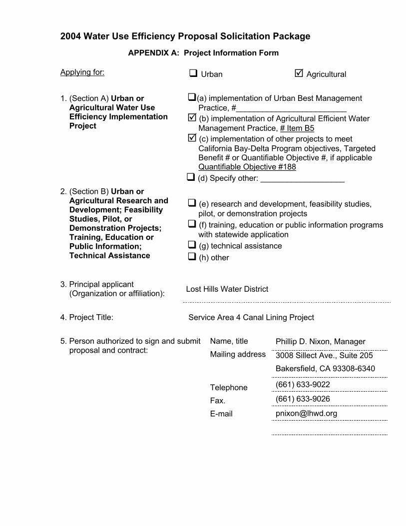
Lost Hills Water District DWR Water Use Efficiency Program Proposal
W:\Clients\Lost Hills WD - 1056B\10560403 - 2004 WUE Application\Service Area 4\Application Sections -1,2,3 for SA 4.doc
1
Lost Hills Water District Service Area 4 Canal Lining Project
Statement of Work Section 1
RELEVANCE AND IMPORTANCE
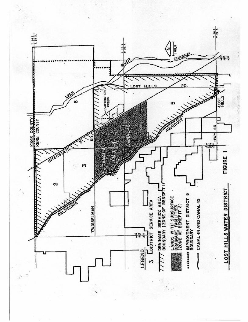
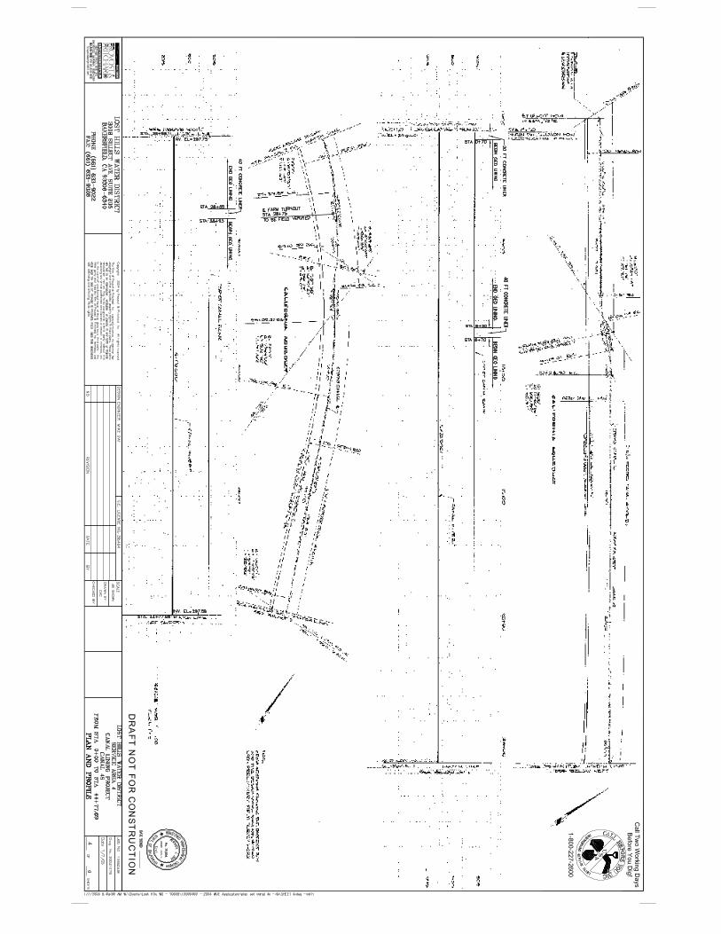
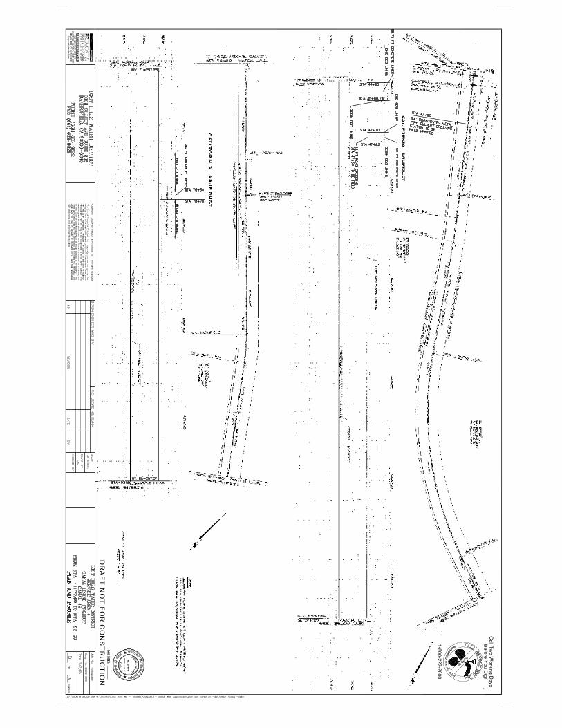
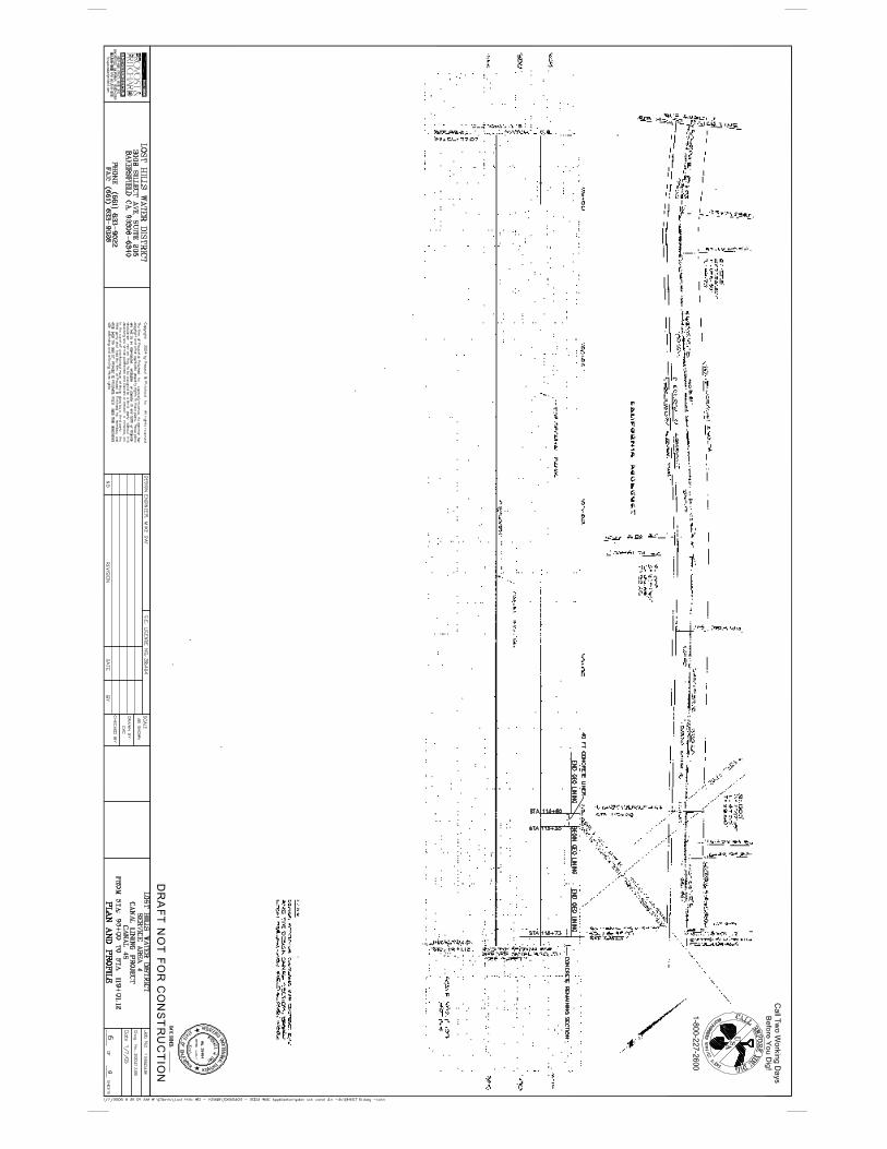
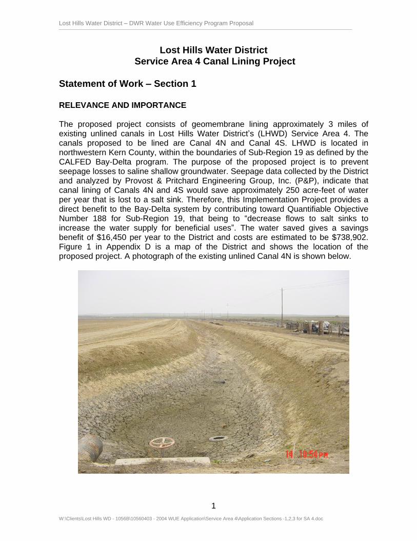
The proposed project consists of geomembrane lining approximately 3 miles of existing unlined canals in Lost Hills Water District s (LHWD) Service Area 4. The canals proposed to be lined are Canal 4N and Canal 4S. LHWD is located in northwestern Kern County, within the boundaries of Sub-Region 19 as defined by the CALFED Bay-Delta program. The purpose of the proposed project is to prevent seepage losses to saline shallow groundwater. Seepage data collected by the District and analyzed by Provost & Pritchard Engineering Group, Inc. (P&P), indicate that canal lining of Canals 4N and 4S would save approximately 250 acre-feet of water per year that is lost to a salt sink. Therefore, this Implementation Project provides a direct benefit to the Bay-Delta system by contributing toward Quantifiable Objective Number 188 for Sub-Region 19, that being to decrease flows to salt sinks to increase the water supply for beneficial uses . The water saved gives a savings benefit of $16,450 per year to the District and costs are estimated to be $738,902. Figure 1 in Appendix D is a map of the District and shows the location of the proposed project. A photograph of the existing unlined Canal 4N is shown below.

Lost Hills Water District DWR Water Use Efficiency Program Proposal
W:\Clients\Lost Hills WD - 1056B\10560403 - 2004 WUE Application\Service Area 4\Application Sections -1,2,3 for SA 4.doc
2
The District has always been concerned with seepage loss from the unlined canals and has quantified the losses by conducting pond seepage tests on these canals over the years. This has resulted in the District lining approximately 4.6 miles of canal in Service Area 2 (assisted with loan support from SWRCB and completed in 1999), approximately 1.4 miles of canal in Service Area 3, approximately 1.9 miles of canal in Service Area 5 (both assisted with funding from 2001 WUE Ag Grants and completed in 2002), and approximately 1.3 miles of canal in Service Area 7S in 2004 (assisted with funding from Sunrise Power Company).
P&P using the District s pond test results prepared annual seepage estimates for Canal 4N and Canal 4S. Making the necessary deductions for evaporation losses as estimated from evaporation pan data, these estimates indicate that by lining 3 miles of the canal, approximately 250 acre-feet of water per year could be saved that is currently lost to the shallow groundwater.
The CALFED Agricultural Water Use Efficiency Program has developed a list of Quantifiable Objectives, which are CALFED s estimates of the practical and cost-effective contribution agricultural water use efficiency can make towards goals related to water supply reliability, water quality, and ecosystem restoration. This project is consistent with one of the Quantifiable Objectives that has been completed for Sub-Region 19, Number 188. The Intended Outcome of Quantifiable Objective Number 188 is to decrease flows to salt sinks to increase the water supply for beneficial uses . In addition to the water savings benefit, there are indirect or local benefits for drainage and maintenance cost reductions. Seepage water from the canal that currently contributes to the tile drainwater discharged into the evaporation ponds will be reduced. And maintenance costs for weed control will be less after the canal is lined.
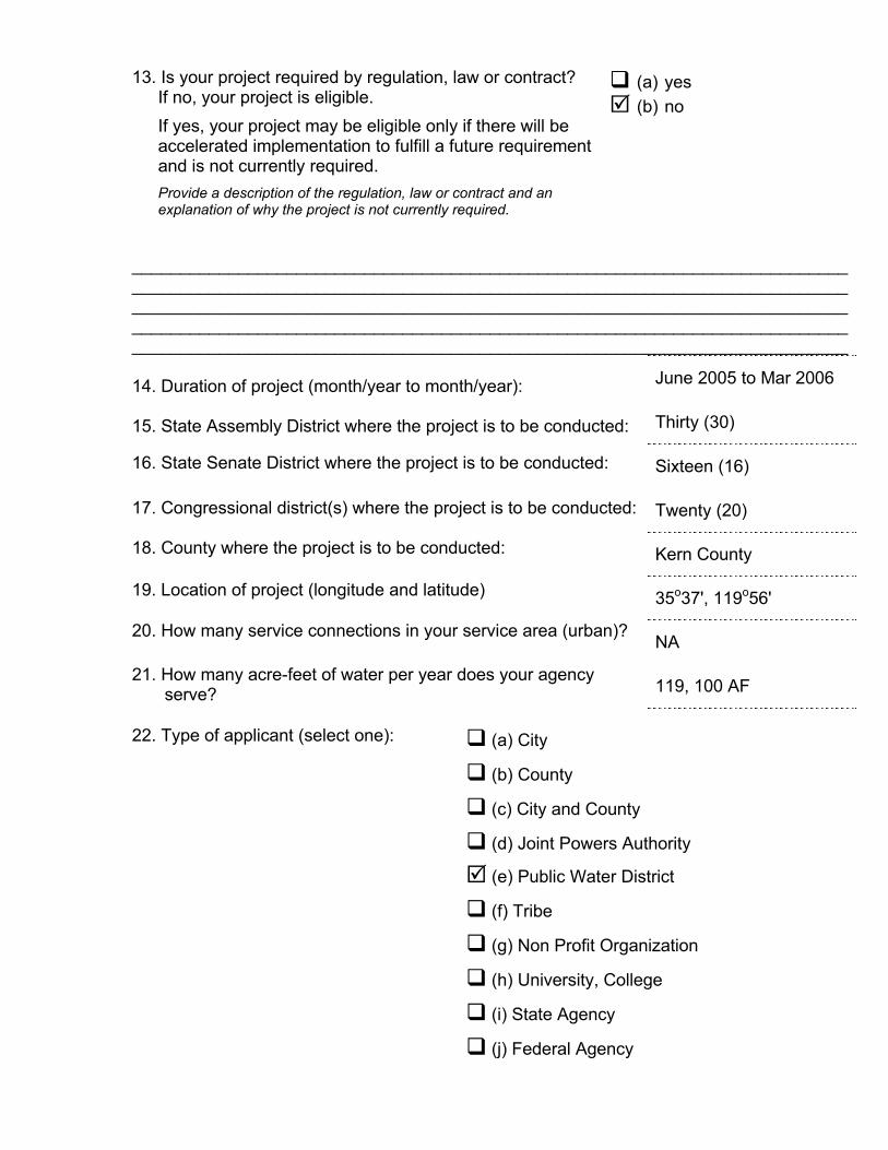
The Lost Hills Water District was formed on February 8, 1963, pursuant to Division 13 of the California Water Code, for the purpose of providing irrigation water from the California State Water Project to land within the District. A water supply contract between Lost Hills Water District and Kern County Water Agency (Agency) was executed on November 10, 1966. The Agency is an umbrella organization that is a State Water Contractor and obtains water from the State Water Project for delivery to its member units. After contract execution with the Agency, the District commenced water deliveries in 1968.
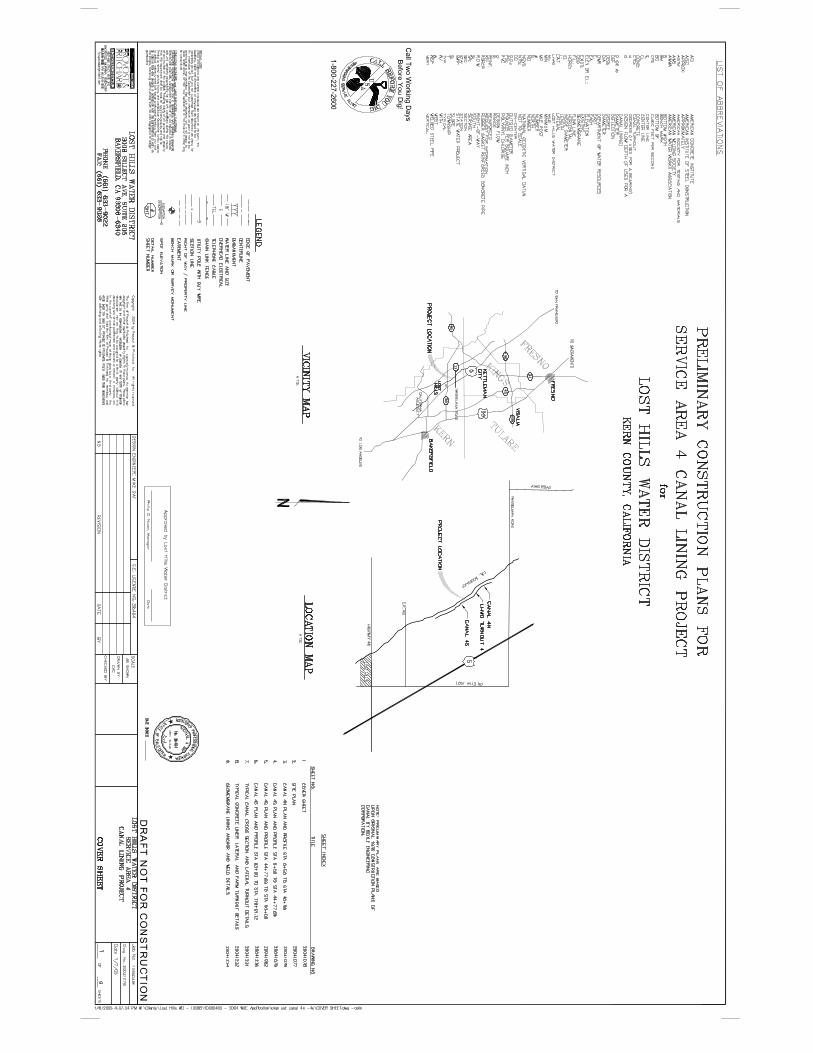
The Lost Hills Water District contains approximately 72,183 acres within its boundaries, beginning at the town of Lost Hills, California and extending north and west to the Kings-Kern County Line. The District lies in the northwest portion of Kern County in the San Joaquin Valley, just west of the Kern National Wildlife Refuge. The District is located within Sub-Region 19 as defined by the CALFED program. The California Aqueduct and Interstate 5 bisect the District diagonally. Highway 46 is located at the south end of the District. A map of the District, its service areas, and the alignment of Canals 4N and 4S is shown in Figure 1 in Appendix D.
Of the 72,183 acres in the District, 70,314 acres are farmable, although not all this acreage is currently being farmed. Approximately 38,000 acres have been farmed on
Lost Hills Water District DWR Water Use Efficiency Program Proposal
W:\Clients\Lost Hills WD - 1056B\10560403 - 2004 WUE Application\Service Area 4\Application Sections -1,2,3 for SA 4.doc
3
an annual basis over the past five years. Historically, the major crop grown within the District has been cotton, followed in acreage by barley, pistachios, almonds, grapes, olives and alfalfa as well as an assortment of vegetable and additional row crops. Growers within Lost Hills Water District utilize all three of the major irrigation system types: furrow, sprinkler and micro irrigation. A survey of the irrigation system types used in 1998 yielded the following results: micro-irrigation 17,640 acres (31%), sprinkler irrigation 23,940 acres (42%) and furrow irrigation 15,925 acres (27%). The annual crop land that is furrow irrigated has on-farm tailwater return systems installed, and all of the collected tailwater is reused on the same field or routed for use on adjacent fields.
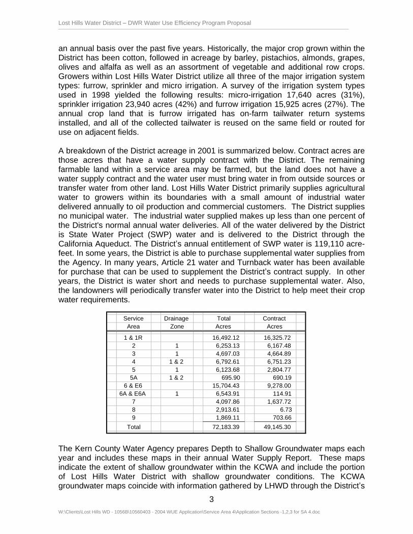
A breakdown of the District acreage in 2001 is summarized below. Contract acres are those acres that have a water supply contract with the District. The remaining farmable land within a service area may be farmed, but the land does not have a water supply contract and the water user must bring water in from outside sources or transfer water from other land. Lost Hills Water District primarily supplies agricultural water to growers within its boundaries with a small amount of industrial water delivered annually to oil production and commercial customers. The District supplies no municipal water. The industrial water supplied makes up less than one percent of the District's normal annual water deliveries. All of the water delivered by the District is State Water Project (SWP) water and is delivered to the District through the California Aqueduct. The District s annual entitlement of SWP water is 119,110 acre-feet. In some years, the District is able to purchase supplemental water supplies from the Agency. In many years, Article 21 water and Turnback water has been available for purchase that can be used to supplement the District s contract supply. In other years, the District is water short and needs to purchase supplemental water. Also, the landowners will periodically transfer water into the District to help meet their crop water requirements.
The Kern County Water Agency prepares Depth to Shallow Groundwater maps each year and includes these maps in their annual Water Supply Report. These maps indicate the extent of shallow groundwater within the KCWA and include the portion of Lost Hills Water District with shallow groundwater conditions. The KCWA groundwater maps coincide with information gathered by LHWD through the District s
Service
Drainage
Total
Contract
Area
Zone
Acres
Acres
1 & 1R
16,492.12
16,325.72
2
1
6,253.13
6,167.48
3
1
4,697.03
4,664.89
4
1 & 2
6,792.61
6,751.23
5
1
6,123.68
2,804.77
5A
1 & 2
695.90
690.19
6 & E6
15,704.43
9,278.00
6A & E6A
1
6,543.91
114.91
7
4,097.86
1,637.72
8
2,913.61
6.73
9
1,869.11
703.66
Total
72,183.39
49,145.30
Lost Hills Water District DWR Water Use Efficiency Program Proposal
W:\Clients\Lost Hills WD - 1056B\10560403 - 2004 WUE Application\Service Area 4\Application Sections -1,2,3 for SA 4.doc
4
shallow groundwater monitoring program. Much of the area east of the Aqueduct has a depth to shallow groundwater of less than 10 feet. Historical observation well data indicate that the shallow groundwater conditions are stable with only slight variations from year to year.
Water management techniques have been utilized within the District since farmed operations began in 1968. In October of 1984, the District adopted its first written water conservation plan. In December 1992, the District adopted a new comprehensive Water Management Plan to fulfill the requirements of the Agricultural Water Management Planning Act of 1986 (AB 1658). The District has recently become a member of the Agricultural Water Management Council (AWMC) and is currently preparing a new water management plan in compliance with the AWMC guidelines. It is expected that the new water management plan will be submitted to the AWMC for endorsement by March 2005. The proposed canal lining project is consistent with the District s Water Management Plan and Item B5 of the Efficient Water Management Practices identified by the AWMC, and is a direct benefit to the Bay-Delta system by contributing toward Quantifiable Objective Number 188, reducing losses to a salt sink and increasing water for beneficial use.
Statement of Work Section 2
TECHNICAL/SCIENTIFIC MERIT, FEASIBIILITY
Methods, Procedures and Facilities
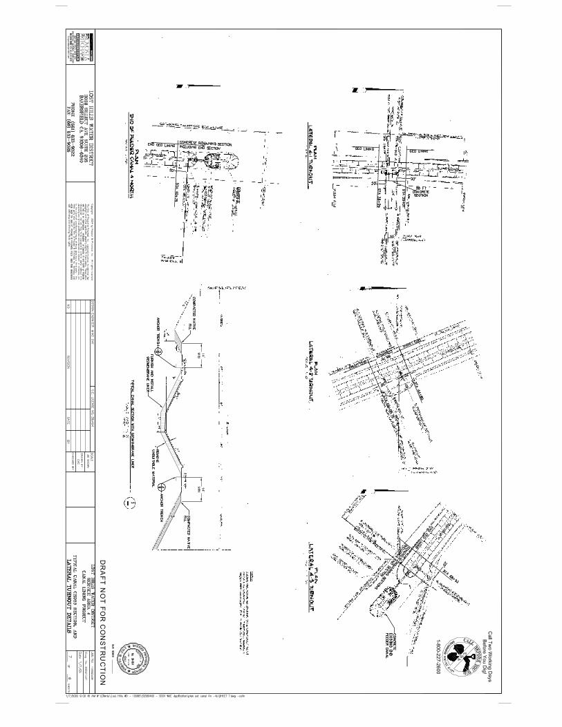
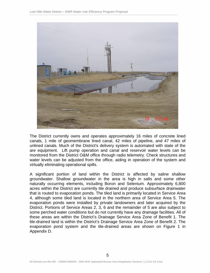
The proposed project consists of lining an existing unlined canal with geomembrane to reduce seepage losses. Lost Hills Water District has previously lined many of the unlined canals utilizing either concrete or geomembrane, the latter becoming increasingly the method of choice where suitable. Like their most recent project completed in 2004, geomembrane lining is proposed for this project because it has lower construction costs and lower seepage rates as compared with concrete. Studies indicate that geomembrane lining effectively eliminates over 90% of seepage from unlined canals and is one of the Efficient Water Management Practices identified by the Agricultural Water Management Council. According to the Bureau of Reclamation study, Canal-Lining Demonstration Project, Year 10 Final Report (2002), geomembrane lining demonstrated a favorable combination of benefit/cost ratio and pay back period compared with concrete lining. Specifically, the proposed canal lining material will be geomembrane. The geomembrane material used will exhibit exceptional flexibility, strength and durability. Replacing the canals with pipeline would be another method to reduce seepage and would also eliminate evaporation losses. However, because of the size of the canals and the delivery rates required, geomembrane lining is more cost-effective than piping the canals. A photograph of existing geomembrane lined LHWD Canal 7S is shown below.
Lost Hills Water District DWR Water Use Efficiency Program Proposal
W:\Clients\Lost Hills WD - 1056B\10560403 - 2004 WUE Application\Service Area 4\Application Sections -1,2,3 for SA 4.doc
5
The District currently owns and operates approximately 16 miles of concrete lined canals, 1 mile of geomembrane lined canal, 42 miles of pipeline, and 47 miles of unlined canals. Much of the District's delivery system is automated with state of the are equipment. Lift pump operation and canal and reservoir water levels can be monitored from the District O&M office through radio telemetry. Check structures and water levels can be adjusted from the office, aiding in operation of the system and virtually eliminating operational spills.
A significant portion of land within the District is affected by saline shallow groundwater. Shallow groundwater in the area is high in salts and some other naturally occurring elements, including Boron and Selenium. Approximately 6,800 acres within the District are currently tile drained and produce subsurface drainwater that is routed to evaporation ponds. The tiled land is primarily located in Service Area 4, although some tiled land is located in the northern area of Service Area 5. The evaporation ponds were installed by private landowners and later acquired by the District. Portions of Service Areas 2, 3, 6 and the remainder of 5 are also subject to some perched water conditions but do not currently have any drainage facilities. All of these areas are within the District s Drainage Service Area Zone of Benefit 1. The tile-drained land is within the District s Drainage Service Area Zone of Benefit 2. The evaporation pond system and the tile-drained areas are shown on Figure 1 in Appendix D.

Lost Hills Water District DWR Water Use Efficiency Program Proposal
W:\Clients\Lost Hills WD - 1056B\10560403 - 2004 WUE Application\Service Area 4\Application Sections -1,2,3 for SA 4.doc
6
When the District acquired the evaporation pond system from the landowners in 1993, the system was composed of 6 ponds totaling 660 acres. Through drainage reduction efforts, the District has reduced the size of the evaporation pond system in recent years. The District s evaporation pond system is now comprised of four interconnected evaporation ponds. During 2004 only one pond totaling 112 acres was utilized. The amount of drainwater discharged to the evaporation pond system has been reduced from a high of 3,831 acre-feet in 1989 to 685 acre-feet in 2004. The District conducts a monitoring and wildlife hazing program at the pond system to comply with the Regional Water Quality Control Board (RWQCB).
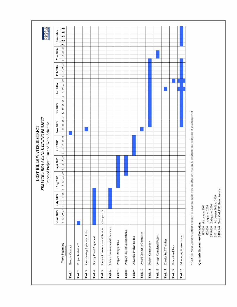
Project Plan and Work Schedule
The proposed Project Plan and Work Schedule with quarterly expenditure projections are included in Appendix D. Final design of the project could begin as soon as funding of project is announced, projected to be in May. Once a contract is executed, projected to be in December 2005, construction would begin once the irrigation season has ended and would be completed prior to the 2006 irrigation season.
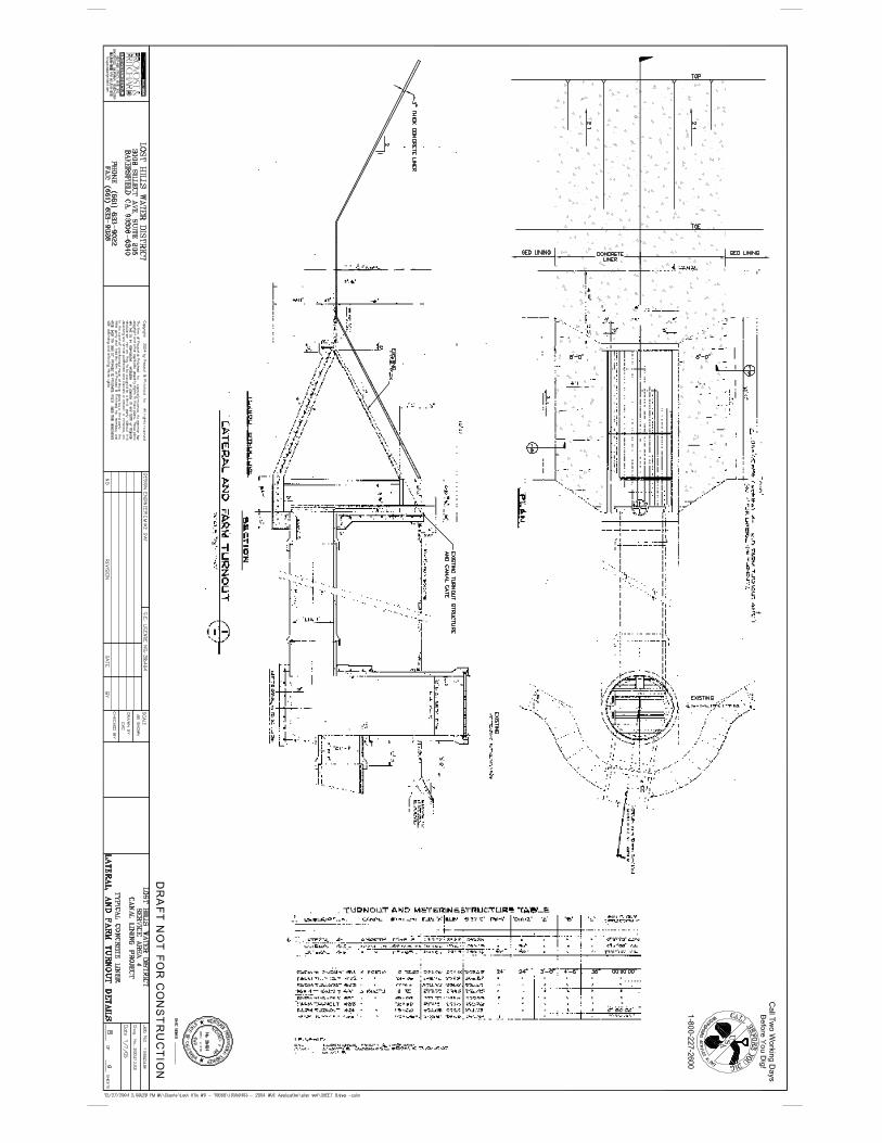
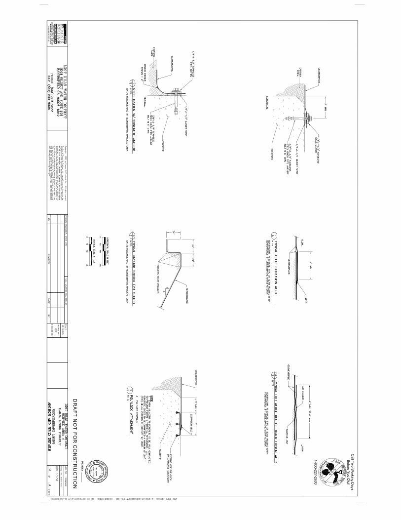
Preliminary Plans, Specifications, and Certification Statements
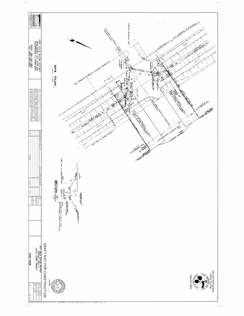
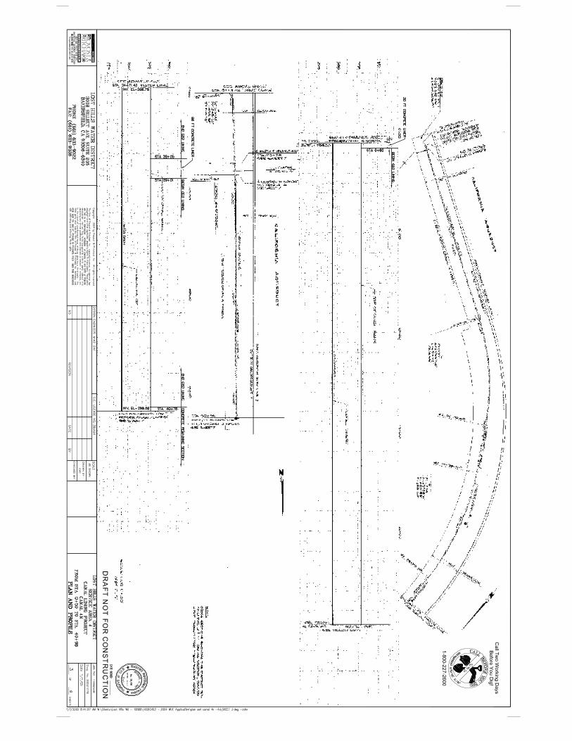
Preliminary Plans, Preliminary Specifications, and Certification Statements are included in Appendix D.
Environmental Documentation
The plan and schedule for compliance with all applicable environmental requirements is as follows: The District has performed a review of the project and concluded that it is Categorically Exempt from CEQA. A draft Notice of Exemption that will be brought to the Board of Directors for approval within a month of notification of project funding is included in Appendix D of this application.
Statement of Work Section 3
MONITORING AND ASSESSMENT
Once construction is completed on the proposed 3 mile canal lining project, the water savings will begin as soon as the project is complete and the canal put back into service. During the construction phase of the project, a daily review of compliance with the plans and specifications will be made. After construction is complete, annual seepage rates will be verified to quantify water losses as specified in the Monitoring and Verification Protocol on Canal Seepage published by the Agricultural Water Management Council. A post-project qualified pond test will be conducted on the improved section of canal in November of the first year following construction of the project. This corresponds with the end of the irrigation season which is the most appropriate time to make this assessment. By comparing this data with the pre-project pond tests on the same canal, the annual water savings can be verified and reported. Subsequent annual assessments will be based on either pond tests or published seepage coefficients used in conjunction with canal lining inspections.

Lost Hills Water District DWR Water Use Efficiency Program Proposal
W:\Clients\Lost Hills WD - 1056B\10560403 - 2004 WUE Application\Service Area 4\Application Sections -1,2,3 for SA 4.doc
7
A summary of pre-project pond test results for Canal 4N and Canal 4S is shown below:
Canal
Length
Seepage
(in/hr)
Seepage (AF/day)
Days Use
Annual Seepage
(AF/yr) 4N
4,050
0.086
0.207
188
39
4S
11,850
0.119
1.101
192
211
Total
15,900
250
There will be several ways the District will monitor the integrity of the lining and inspection for leaks. First, District staff will receive training in the methods and use of repair equipment during the construction phase of the project. Second, the ditch tender/canal operators will visually inspect the canal during daily operations and deliveries. While driving the canal banks the operators will be responsible for reporting and addressing any problems the liner may have. Third, once a year, during the fall (November, at the end of the season), when there are no deliveries and the canal is empty, District staff will do a visual inspection of the liner, and walk the length of the canal to search for any damage to the liner. Liner repairs/replacements will be made as needed to fix problem areas.
The objectives of the Canal Lining Educational Tour will be assessed by administering a survey consisting of a series of questionnaires. (Details of the Canal Lining Educational Tour are presented below in the Outreach section). Participants will complete a baseline questionnaire prior to the tour and then an exit questionnaire at its conclusion. Beyond counting the number of participants and the various organizations they represent, the survey is designed to measure and quantify the increased awareness of the emerging technologies concerning geomembrane canal lining material and methods, as well as, the increased awareness of the California Bay-Delta Program s Water Use Efficiency Program as a potential source of funding such projects. Then, for two subsequent years, the Educational Tour participants will be polled in a follow-up questionnaire to determine the number of new geomembrane canal lining projects planned or completed in the region and the number of WUE applications submitted to future Proposal Solicitation Packages.
The following is a summary of the Monitoring and Assessment plan with quantifiable indicators for measuring the project s success in water savings and other Bay-Delta system benefits.

Lost Hills Water District DWR Water Use Efficiency Program Proposal
W:\Clients\Lost Hills WD - 1056B\10560403 - 2004 WUE Application\Service Area 4\Application Sections -1,2,3 for SA 4.doc
8
GOAL INDICATOR TO BE MEASURED
1. Length of canal lined with geomembrane (miles) 2. Pre-project annual seepage loss (acre-feet) 3. Post-project annual seepage loss (acre-feet)
A. Water savings
4. Annual water savings with canal lining (acre-feet) 1. Number of hours on-site during construction for review of compliance. 2. Number of District Staff trained in maintenance and repair of canal lining 3. Number of annual canal lining inspections
B. Project sustainability
4. Number of annual canal lining repairs 1. Number of participants in Canal Lining Educational Tour 2. Number of water districts, agencies, organizations participating in Canal Lining Educational Tour 3. Educational Tour participants increased awareness of geomembrane canal lining material and methods (percent) 4. Educational Tour participants increased awareness of California Bay-Delta Program s Water Use Efficiency Program (percent) 5. Number of geomembrane canal lining projects planned or completed by participant organizations since the Canal Lining Educational Tour
C. Outreach
6. Number of new WUE applications submitted by participant organizations in Canal Lining Educational Tour
Qualifications of the Applicants and Cooperators
Resumes of Project Managers
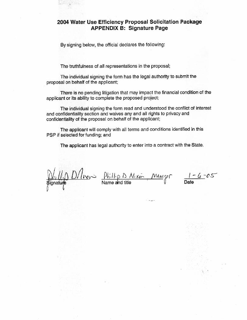
The project manager and the contact person for the applicant, Lost Hills Water District, will be the Manager of the District, Phillip D. Nixon. Mr. Nixon will provide project oversight for the canal lining project. Mr. Nixon has been the Manager of the District since 1991 and has overseen numerous construction and maintenance projects within the District that were similar in nature and scope to the proposed project, including the concrete lining of 4.6 miles of canals in Service Area 2 in 1999, 1.4 miles of canals in Service Area 3, 1.9 miles of canals in Service Area 5 in 2002, and 1.3 miles of canal in Service Area 7S in 2004. Several other projects that Mr. Nixon has overseen include: acquiring, upgrading, operating and maintaining the District s evaporation pond system; and participation in energy curtailment and reduction programs through the Independent System Operator and the California Energy Commission.
Lost Hills Water District DWR Water Use Efficiency Program Proposal
W:\Clients\Lost Hills WD - 1056B\10560403 - 2004 WUE Application\Service Area 4\Application Sections -1,2,3 for SA 4.doc
9
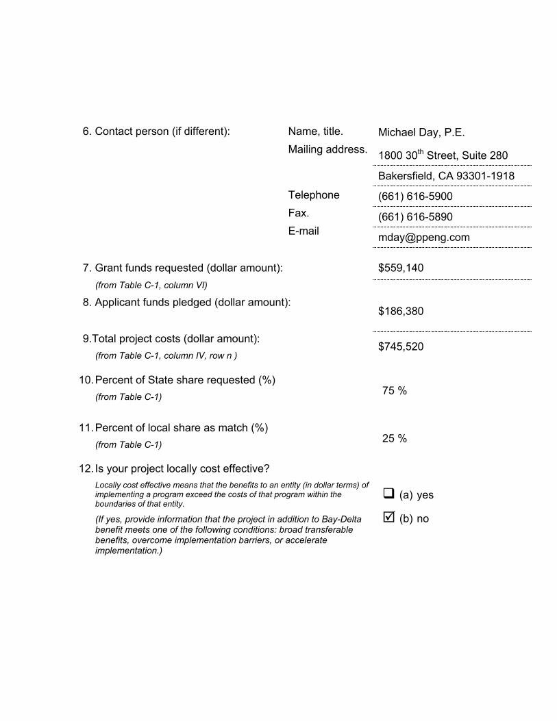
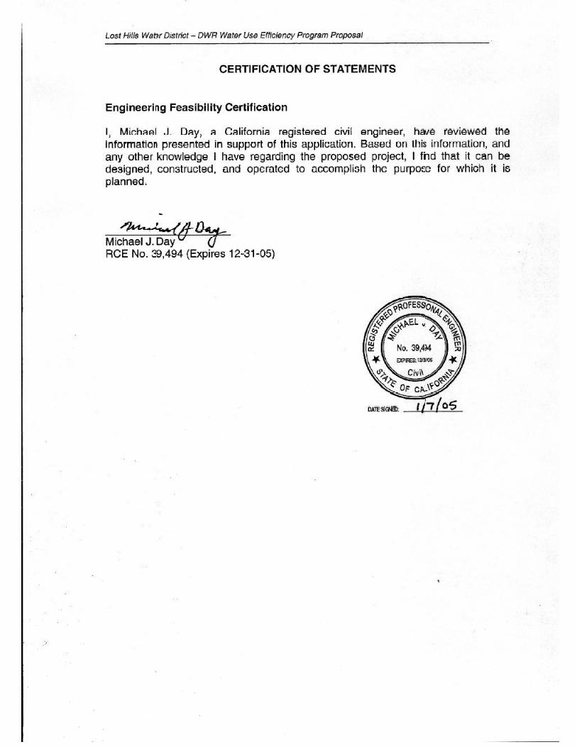
The District will utilize their consulting engineer, P&P, to design the canal lining project and oversee construction. P&P is the largest civil engineering company based in the San Joaquin Valley and has provided design and construction management services on numerous canal lining projects throughout the San Joaquin Valley, including previous canals in Lost Hills Water District. The P&P project manager will be Michael Day, who has been with P&P since February 1989. Mr. Day s resume is included in Appendix D.
Cooperators
It is not anticipated that the proposed project would require the involvement of any external cooperators. The District will contract for design services with P&P. A construction contract will be awarded after a competitive bidding process.
Previous WUE Projects
The District has participated in two previous Water Use Efficiency grant projects dealing with canal lining. Funded by WUE Ag Grants applied for in 2001, the District lined approximately 1.4 miles of canal in Service Area 3 and approximately 1.9 miles of canal in Service Area 5. Both of these construction projects were successfully completed in 2002.
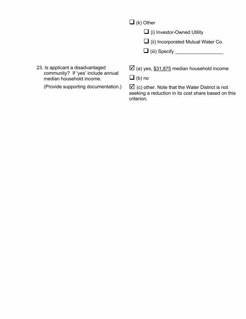
Disadvantaged Communities
On the south edge of Lost Hills Water District in Kern County is the community of Lost Hills. The annual median household income for year 2000 was reported as $31,875 (source: city-data.com). For Kern County overall, the annual median household income was $35,446 for year 1999 (source: US Census Bureau). The annual median household incomes for both Lost Hills and Kern County are less than 80 percent of the statewide annual median of $38,000 reported for 2002. While this disadvantaged status for the Lost Hills area is pointed out here for the purposes of scoring this section of the grant application, the Water District is not seeking a reduction in its cost share amount based on this criterion.
Outreach, Community Involvement, and Acceptance
Canal Lining Project Educational Tour
The emergence of geomembrane canal lining technologies as a proven alternative to traditional practices offers a timely opportunity to incorporate a Canal Lining Educational Tour as part of this project s outreach activities. Depending on specific conditions, geomembrane material and methods can outperform concrete lining and other techniques in terms of construction costs and water savings. This is documented by a handful of pilot-scale projects conducted within the state, and by the Bureau of Reclamation s recently completed long-term study, Canal-Lining Demonstration Project, Year 10 Final Report (2002).
Because exposed geomembrane lining is more susceptible to damage than concrete surfaces, certain preventive measures and repair techniques are required. One of the important findings related to exposed geomembrane linings is that irrigation districts need to become more familiar with the material and its maintenance requirements in order to realize the full potential of this alternative. From this arises two important
Lost Hills Water District DWR Water Use Efficiency Program Proposal
W:\Clients\Lost Hills WD - 1056B\10560403 - 2004 WUE Application\Service Area 4\Application Sections -1,2,3 for SA 4.doc
10
opportunities. First is to ensure Water District staff have adequate training to properly maintain the geomembrane liner. Second, is to utilize the implementation of this project to conduct a Canal Lining Educational Tour.
The objectives of the Canal Lining Educational Tour are to increase awareness of this innovative technology as a canal lining alternative and to increase awareness of the California Bay-Delta Program s Water Use Efficiency Program as a potential source of funding for such projects. It is anticipated that 20 to 40 representatives from among the region s water districts, water agencies, farming operations, and other stakeholder groups will participate in this learning event. The half-day tour will include distribution of printed materials, technical presentation, question and answer session, visits to District project sites, and survey. It is scheduled to take place during the construction phase of a new project so that participants can observe various aspects of installing the material including panel placement, field seaming, and repair techniques. A nearby geomembrane lined canal that is already built and operational will also be visited.
Training and Capacity Building
The project will be constructed by a qualified contractor after a competitive bidding process. During the construction phase, Water District canal operators will receive training on the material, methods, and equipment required to properly maintain the geomembrane liner. The number of people that will be employed by the contractor and his subcontractors is not known at this time. It is possible that the contractor and associated subcontractors will have apprentices on the job site that will receive training, however, the amount of training that will occur is unknown at this time.
Benefits to Surrounding Area
The nearest town to the proposed project is the town of Lost Hills, located near Interstate 5 and Highway 46. Lost Hills is a typical community found in western Kern County, having a predominantly Hispanic population that is dependent on the agricultural economy. The proposed project will benefit Lost Hills and the surrounding area in several ways. First, during the construction project, a general contractor and various subcontractors will have workers on the job site for several months, and it is anticipated that there will be an economic benefit from these workers purchasing goods and services in Lost Hills and the surrounding area. Secondly, the proposed project will help the landowners conserve water and reduce drainage impacts, thereby helping to maintain economic viability. Further, the project fosters the local trend by growers shifting to permanent crops from annual crops. Improved water reliability facilitates this conversion. Permanent crops are often higher paying for workers, less subject to seasonal employment, and less affected by drought. There are no known tribal entities in the Lost Hills area, so there is no opportunity to involve and extend the benefits of the project to tribal entities.
Notification of Proposal
Lost Hills Water District has discussed the project with the major landowners in Service Area 4 and they are supportive of the project. In addition, a public meeting was held August 26, 2004 to present the project, discuss it, and receive input from affected parties. The District has notified the Kern County Water Agency of its

Lost Hills Water District DWR Water Use Efficiency Program Proposal
W:\Clients\Lost Hills WD - 1056B\10560403 - 2004 WUE Application\Service Area 4\Application Sections -1,2,3 for SA 4.doc
11
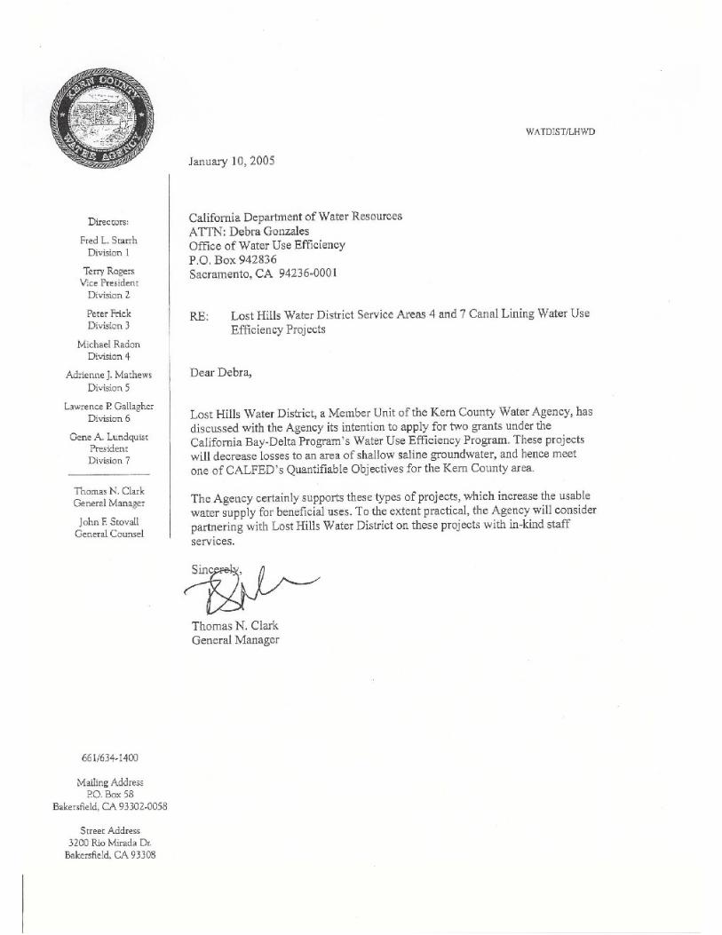
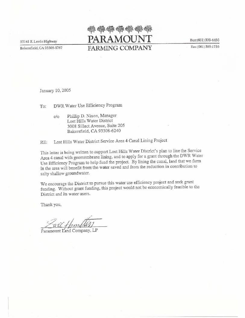
proposal to geomembrane line canals to reduce losses to salt sinks and increase the beneficial use of the water supply. Kern County Water Agency has submitted a letter of support for the proposal, which is also included in Appendix D. A letter of support from a primary landowner affected by the project is also included in Appendix D.
The results of the canal lining project and the promotion of its application will be shared with all interested parties, including the Kern County Water Agency and its members, and the Agricultural Water Management Council, of which the District is a member by virtue of membership by the Agency. It is anticipated that an article about the project would be written for publication in DWR s Water Conservation News newsletter and other appropriate publications.
Innovation
Geomembrane Canal Lining as an Emerging Technology
Traditional canal-lining methods are concrete and compacted clay. More recently results of long-term pilot projects conducted in California and elsewhere spanning from the late 1980s to the present demonstrate geomembrane lining to be a cost effective alternative. Geomembrane lining is one of the Efficient Water Management Practices identified by the Agricultural Water Management Council. The emergence of this innovative technology is bolstered by the 2002 Bureau of Reclamation study, Canal-Lining Demonstration Project, Year 10 Final Report. In it, geomembrane linings are shown to have low construction costs and high effectiveness in seepage reduction (90%) with service life extending to 20 to 25 years. Geomembrane lining has the advantage of being less expensive than concrete or imported clay, and doesn t require extensive subgrade preparation or large right-of-ways for equipment. At this particular point in the historical trajectory of canal lining developments, the emergence of geomembrane material and methods represents an innovative solution to cost effective water savings for Lost Hills Water District.
Monitoring & Assessment Plan Applied to Social Dimensions
Canal lining projects are typically considered technical and engineering improvements. The way this project is devised, it has a strong social and management component supporting sustainability and outreach. While this in itself is becoming more commonplace in improvement works, what s particularly innovative about this project is its use of a plan to monitor and assess these social dimensions, in addition to its technical ones. Hence, quantifiable indicators were developed to monitor and assess the success of training, maintenance, and outreach. This includes incorporating a written survey as part of the Canal Lining Educational Tour to measure increased awareness of emerging geomembrane technologies and of the WUE Program, and to assess the impact on development of future proposals and projects.
Benefits and Costs
Lost Hills Water District DWR Water Use Efficiency Program Proposal
W:\Clients\Lost Hills WD - 1056B\10560403 - 2004 WUE Application\Service Area 4\Application Sections -1,2,3 for SA 4.doc
12
Bay-Delta System Benefits
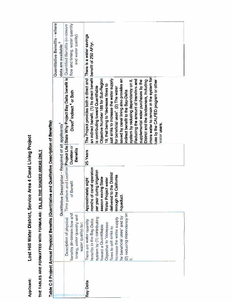
Lining Canal 4N and Canal 4S will save approximately 250 acre-feet of water per year that is lost to a salt sink. Thus, this Project provides a direct benefit to the Bay-Delta system by contributing toward Quantifiable Objective Number 188 for Sub-Region 19, that being to decrease flows to salt sinks to increase the water supply for beneficial uses .
The water saved by canal lining also provides an indirect benefit to the Bay-Delta system by reducing dependency on it. Reducing the amount of transfers and supplemental water purchases by the District and the landowners allows more water to remain in the system for use by the CALFED program or other water users.
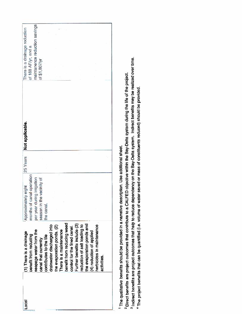
Local Benefits
In addition to water conservation, drainage reduction, and maintenance cost reduction elaborated on below, the project also has the following non-quantified benefits to the District: reduction of water and salt loading to the evaporation ponds; reduction of applied herbicides in maintenance activities; and an economic benefit to Lost Hills and the surrounding area as a result of the construction project. Project annual physical benefits are summarized in Table C-5 in Appendix C.
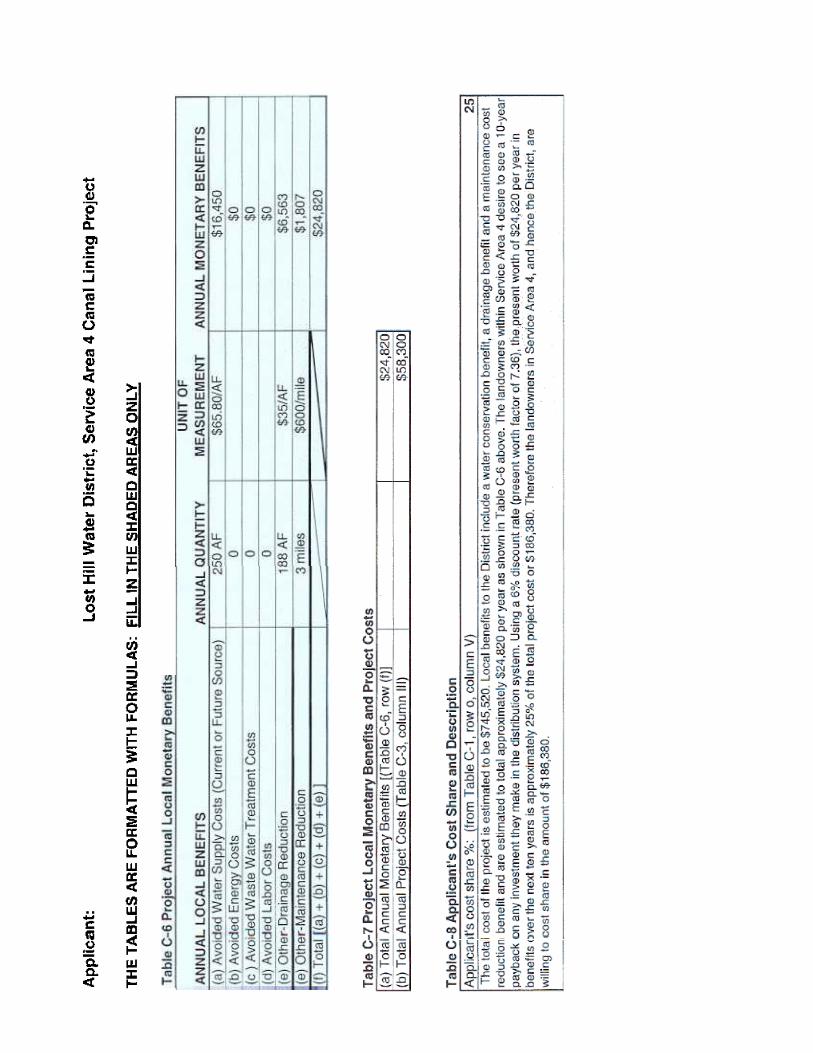
Water Conservation: The 250 acre-feet per year of water conserved has an estimated value of approximately $65.80 per acre-foot, which is the average total cost of District water in Service Area 4 in a normal water year. The water conservation benefit to the growers in Service Area 4 is therefore estimated to be $16,450 per year.
Drainage Reduction: The land in Service Area 4 is tile drained and the canal lining project will have a direct impact on drainage discharges to the evaporation ponds. The correlation between canal seepage and tile drain production is not known. However, it can be assumed that a portion of the canal seepage will ultimately be picked up by the tile drain system. For purposes of quantifying a drainage reduction benefit, it is assumed that 75% of the canal seepage becomes tile drain water. Landowners who discharge to the evaporation pond system are charged a drainage fee of $35/acre-foot by the District. The resulting drainage reduction benefit therefore is estimated to be approximately $6,563 per year (250 acre-feet x 75% x $35/acre-foot).
Maintenance Cost Reduction: Review of the District s maintenance costs have determined that the annual maintenance costs for its lined canals is approximately $600 per mile less than for unlined canals. This results in a savings of approximately $1,807 less maintenance costs per year as a result of the project versus the current unlined canals. The cost savings are primarily a reduction in weed control chemicals and the labor and equipment to apply the chemicals.

Lost Hills Water District DWR Water Use Efficiency Program Proposal
W:\Clients\Lost Hills WD - 1056B\10560403 - 2004 WUE Application\Service Area 4\Application Sections -1,2,3 for SA 4.doc
13
Project Costs and Budget Justification
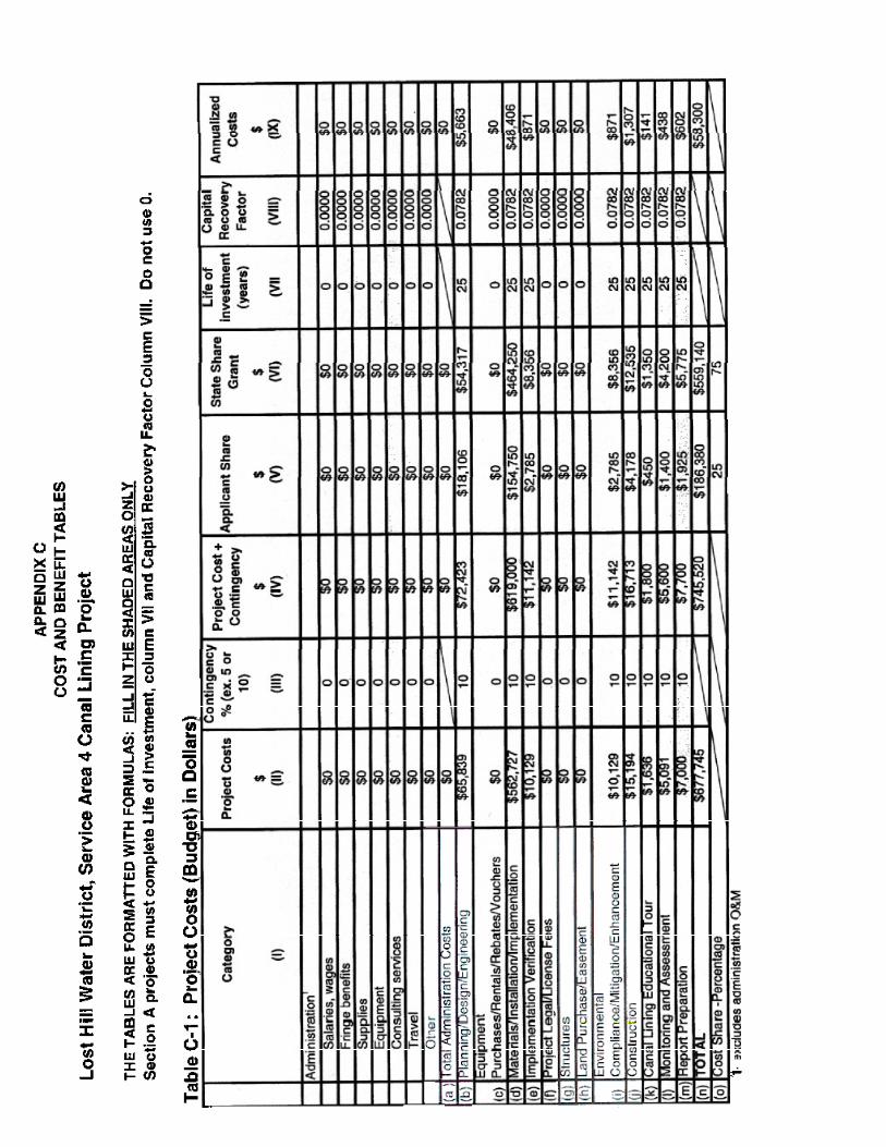
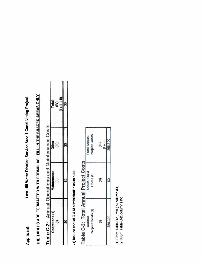
A breakdown of the budget is shown below. The total estimated project cost is $745,520. A detailed preliminary engineer s cost estimate for the Service Area 4 Canal Lining Project is included in Appendix C. It is based on recent construction projects in the area, primarily the District s canal lining projects completed in 2002 and 2004. A contingency of 10% has been added to address unforeseen costs. Consultant expenses for engineering design services, environmental compliance, surveying, legal and administrative services, construction staking and construction management are estimated to be approximately 18% of the total construction cost. It is anticipated that the District will contract for all services regarding the project, including design services, construction, and construction management. The project budget is summarized below:
Salaries & Wages None1
$ 0
Fringe Benefits None
$ 0
Travel None
$ 0
Supplies & Expendables None $ 0
Services/Consultants See below $ 0
Equipment None
$ 0
Other Direct Costs General Contractor 2
(see preliminary engineer s cost estimate in Appendix C)
Consultant Costs Engineering, Environmental, Surveying, Legal, Administration, Construction Staking, Construction Management
Educational Tour, Monitoring & Assessment, Report Preparation
$ 619,000
$ 111,420
$ 15,100
TOTAL ESTIMATED PROJECT COST
$ 745,520
1 The majority of work will be performed by contractors and consultants. Lost Hills Water District personnel involved in the project will provide these services in-kind and will not seek reimbursement for their cost of services.
2 The general contractor will be selected through a competitive bidding process. Estimated construction quantities and cost estimates are detailed in the preliminary engineer s cost estimate found in Appendix C.
Lost Hills Water District DWR Water Use Efficiency Program Proposal
W:\Clients\Lost Hills WD - 1056B\10560403 - 2004 WUE Application\Service Area 4\Application Sections -1,2,3 for SA 4.doc
14
Matching Funds Cost-Share
The total cost of the project is estimated to be $745,520. Local benefits to the District include a water conservation benefit, a drainage benefit, and a maintenance cost reduction benefit and are estimated to total approximately $24,820 per year as explained above. The landowners within Service Area 4 desire to see a 10-year payback on any investment they make in the distribution system. Using a 6% discount rate (present worth factor of 7.36), the present worth of $24,820 per year in benefits over the next ten years is approximately 25% of the total project cost or $186,380. Therefore the landowners in Service Area 4, and hence the District, are willing to cost share in the amount of $186,380. The grant amount requested from the CALFED Agricultural Water Use Efficiency Program is $559,140.