los angeles harbor/san pedro public access and urban ... urban waterfront plan proposed mitigated...
TRANSCRIPT

Exhibit 3: Initial Study and Mitigated Negative Declaration
Los Angeles Harbor/San Pedro Public Access and Urban Waterfront Plan
Proposed Mitigated Negative Declaration
Prepared for:
California Coastal Conservancy 1330 Broadway, 11th Floor
Oakland, CA 94612 Contact: Mr. Marc Beyeler
Phone: (510) 286-4172
Prepared by:
Interactive Planning and Management, LLC 112 East De La Guerra Street, No. 7
Santa Barbara, CA 93101 Contact: John C. Jostes, AICP
Phone: (805) 568-1440
April 2005

California State Coastal Conservancy Mitigated Negative Declaration
Mitigated Negative Declaration California State Coastal Conservancy
Los Angeles Harbor Area/San Pedro
Public Access and Urban Waterfront Plan
Introduction The Los Angeles Harbor Area Public Access and Urban Waterfront Plan (“the plan”), consists of the summary plan document and the supporting Coastal Trail Analysis, which identifies improvements and additions to the California Coastal Trail and a series of community gateways connecting the communities of San Pedro and Wilmington to the shoreline and waterfront areas of the greater Los Angeles Harbor area. The plan seeks to aid in completing the California Coastal Trail (CCT), by closing a gap in the CCT in the Los Angeles Harbor area. In 2003, the Coastal Conservancy completed a report on the obstacles and progress toward completing the CCT, and this report identified the Los Angeles Harbor area as a “gap” area, where the trail was not continuous and was in need of substantial additional planning and implementation actions to complete. The plan also seeks to establish better linkages between the coast and neighboring coastal communities in the Los Angeles Harbor Area. The Coastal Conservancy has been charged with connecting the California Coastal Trail with inland connecting trails, so better access to the coast is afforded to all coastal and inland communities. At the same time, community open space, park, waterfront access and recreational opportunities have been, and continue to be, extremely limited in the Los Angeles Harbor communities of San Pedro and Wilmington. The Los Angeles Harbor area communities of San Pedro, Wilmington and Harbor City are among the most low-income, park-poor areas in Los Angeles. It is estimated that nearly three-quarters of local children are not within walking distance of a park. Recognizing both regional and local needs, since 2001, staff of the Coastal Conservancy have been working with local citizens, public agency staff and elected officials, interested stakeholders, and property owners, both public and private, to promote increased public access to the waterfront and shoreline areas of the Los Angeles Harbor area, and to better connect adjacent coastal communities to the coast. The plan builds on the many community and agency planning and design concepts and projects to increase public access in the San Pedro and Wilmington waterfront areas of the Los Angeles Harbor area, from Palos Verdes Peninsula on the west, to the Los Angeles River and its terminus at San Pedro Bay in Long Beach Harbor. The plan has been developed to ensure that the Los Angeles Harbor area be planned for public use as a whole, and that local communities are re-connected to their waterfronts.
Page 1

California State Coastal Conservancy Mitigated Negative Declaration
Major Plan Elements: 1. The plan provides a Coastal Trail Analysis for the Los Angeles Harbor Area:
Identifying the status of existing conditions of trail segments and needed improvements; and
Identifying Connector and Spur trails to connect coastal and in-land areas.
2. The plan provides concept and design plans for a number of community “gateways,” connecting in-land communities to waterfront and shoreline areas and with coastal trail locations. This plan has been closely coordinated with the current San Pedro and Wilmington waterfront projects being managed by the Harbor Department of the City of Los Angeles.
3. The plan provides concept and design plans for waterfront improvement and restoration projects that encourage the conservation, restoration and enhancement of coastal natural resources.
4. Finally, the plan provides concept and design plans for several early implementation projects, including suggested projects in Wilmington, several locations in San Pedro, and at Point Fermin on the Palos Verdes Peninsula. These initial implementation project areas include the East Wilmington Greenbelt adjacent to the Wilmington waterfront; the Waterfront Gateway, linking the Cruse Ship Terminal and the newly completed first phase of the waterfront Promenade to Knoll Hill and the 110 corridor west to Gaffey Street; Beacon Street Bluffs, and San Pedro Plaza Park, extending along the central San Pedro waterfront; and the Pt. Fermin Coast, extending from Sunken City/Pacific Ave. to White Point/Shoreline Park, along Paseo Del Mar.
The plan seeks to integrate statewide objectives to provide coastal access and a continuous coastal trail, provide public access for adjacent neighborhoods and local communities as well as regional visitors, provide interpretation and environmental education, and preserve and protect coastal natural resources. The plan was prepared pursuant to the responsibilities of the California State Coastal Conservancy regarding the restoration of urban waterfront areas and the provision of coastal access and public use and enjoyment of the coast. The Coastal Conservancy has a principal role in providing for public access to and along the coast of California and providing for a continuing Coastal Trail, and for a system of public accessways. The Coastal Conservancy has a principal role in restoring the state’s urban waterfront areas.
The plan was prepared by the staff of the Coastal Conservancy, with the assistance of the staff of the Los Angeles Harbor/Watts Economic Development Corporation and with the assistance of the consultant firms of Duvivier Architects, Interactive Planning and Management, SMWM, CMG, Carl Cheng, and Mia Lehrer and Associates. Based on the assessment presented in the Initial Study, this Mitigated Negative Declaration has been prepared.
Page 2

California State Coastal Conservancy Mitigated Negative Declaration
Project Description The project entails six interrelated components, each of which is summarized below. A detailed description of the proposed project and its components is attached to this Initial Study Checklist Completing the Coastal Trail: The California Coastal Trail through the Los Angeles Harbor Area is not completed. Many segments are in need of additional improvements, and in other areas the trail needs to be formally improved. The Coastal Trail Analysis, supporting the overall Public Access and Urban Waterfront Plan, identifies many needed improvements within existing right-of-ways, and some additional coastal trail destinations, including the suggested Community Gateways described below. East Wilmington Greenbelt: This project component would expand upon existing open space areas along a former Southern Pacific railroad right of way north of Anaheim Blvd. by acquiring several vacant and industrially-developed parcels and developing passive recreation areas with improvements such as visitor information areas and displays, parking, landscaping, drinking fountains, benches, harbor viewing/overlook features, tables and related passive recreational amenities. These improvements would compliment current efforts by the City Recreation and Parks Department to construct a community recreation facility along the east side of Sanford Ave. in the vicinity of the project site. Signage and wayfinding systems would link the project site to those traveling the California Coastal Trail system which passes near the site via Anaheim Blvd. Waterfront Gateway Open Space: This component entails the acquisition of selected parcels currently in private ownership and removal of existing single and multi-family residential dwellings and a commercial billboard. The site would be re-graded and re-landscaped to provide a visual and physical linkage between the Bandini Canyon Open Space and the harbor/port to the east. Near-term improvements would include information displays, a small parking area, entry plaza, signage and wayfinding system for waterfront visitors. Harbor pedestrian linkages would be provided via First Street to Harbor Blvd. with a pedestrian/bike path linking Bandini Canyon to the Waterfront via O’Farrell Street. Over the long term, the existing pedestrian bridge that crosses Gaffey Street would be replaced with a new pedestrian bridge incorporating an overlook tower feature and an overlook tower would be installed at its easterly end to provide park users with an observation deck for harbor and port viewing. Once developed Waterfront Gateway park would provide an attractive entry point from the terminus of the Harbor freeway to the commercial and historic downtown core of San Pedro and linkage to the waterfront promenade and California Coastal Trail to the east. The Waterfront Gateway component was previously the subject of a Program EIR as a part of the Pacific Corridor Redevelopment Project Area, which is incorporated by reference hereto. Beacon Street Bluffs/San Pedro Park: Beacon Street/San Pedro Plaza Park improvements consist of new pathways, walls, stairways, lighting, irrigation and landscaping to provide a new segment of the “upper California Coastal Trail in San Pedro and physical linkages from inland communities to the Port of Los Angeles ‘Bridge to Breakwater’ promenade. This component is entirely within the public right of way/publicly owned open space and would coordinate signage and wayfinding by providing destination maps, historical markers, viewing areas and beautification efforts to link the waterfront with inland communities. Paseo Del Mar Improvements: Paseo Del Mar is designated as part of the California Coastal
Page 3

California State Coastal Conservancy Mitigated Negative Declaration
Trail. This project component entails installing landscaping improvements, parking re-striping, gateway monuments and signage, and the repair and replacement of fencing along the ocean-side of the street, as well as selected median plantings and a smart crosswalk. The segment of Paseo Del Mar within which these improvements would be made runs from Western Avenue on the west to Pacific Avenue on the east. All improvements would take place upon public property within the right of way of Paseo del Mar or adjacent public park property. Pacific Avenue Overlook/Sunken City Improvements: Improvements associated with the Pacific Avenue Overlook/Sunken City component of the project include the demolition and reconstruction of an existing paved parking lot at the southerly terminus of Pacific Avenue, installation of landscaping, signage, sidewalks, replacement fencing, public art and trail improvements to the existing informal bluff-top trail system being used by site visitors at the present time, providing a visual and pedestrian linkage to Point Fermin Park to the northwest.
Availability of Documents Copies of the Initial Study for the proposed project are on file and available for review at the following address:
California State Coastal Conservancy 1330 Broadway, 11t h F l o o r , Oakland, CA 94612
(510) 286-1015
San Pedro Regional Branch Library 931 S. Gaffey Street, San Pedro, CA 90731
Environmental Determination An Initial Study was prepared to identify the potential effects on the environment from a series of recommended implementation actions, involving public coastal access improvements and related urban waterfront, involving both development, and in limited areas, and to evaluate the significance of these effects. Based on the Initial Study, the proposed project would have less-than-significant effects or no impacts related to the following issues:
Aesthetics Agricultural Resources Air Quality Biological Resources Hydrology and Water Quality Land Use and Planning Mineral Resources Population and Housing Public Services Recreation
Page 4

California State Coastal Conservancy Mitigated Negative Declaration
Transportation/Traffic Utilities and Service Systems
The environmental assessment presented in the Initial Study identifies several environmental impacts that require mitigation measures be incorporated into the project to effectively reduce potential impacts to less-than-significant levels or avoid the impacts. Measures oriented toward geology, soils and traffic issues are intended to further mitigate impacts which are anticipated to be less than significant. These issue areas are:
Cultural Resources Geology and Soils Traffic and Circulation
Measures have been formulated to effectively mitigate all of the potentially significant environmental impacts identified in the Initial Study. Implementation of these mitigation measures would avoid potentially significant impacts identified in the Initial Study or reduce them to a less-than-significant level. The mitigation measures are presented below.
Mitigation Measures Implementation of the following mitigation measures would avoid potential impacts identified in the Initial Study or reduce them to a less-than-significant level.
Discovery of Archaeological Resources or Human Remains During Construction MMV-1. If buried cultural resources, such as chipped or ground stone, historic debris, building
foundations, or human bone, are inadvertently discovered during ground-disturbing activities at any of the four project sites, work will stop in that area and within 100 feet of the find until a qualified archaeologist can assess the significance of the find and, if necessary, develop appropriate treatment measures in consultation with the Coastal Conservancy.
If human remains of Native American origin are discovered during project
construction, compliance with state laws, which fall within the jurisdiction of the Native American Heritage Commission (Public Resource Code Sec. 5097), relating to the disposition of Native American burials will be adhered to. If any human remains are discovered or recognized in any location other than a dedicated cemetery, excavation or disturbance of the site shall stop, including any nearby area reasonably suspected to overlie adjacent human remains, until:
a. The coroner of the county has been informed and has determined that no
investigation of the cause of death is required; and b. If the remains are of Native American origin,
1. The descendants of the deceased Native Americans have made a
recommendation to the landowner or the person responsible for the
Page 5
California State Coastal Conservancy Mitigated Negative Declaration
excavation work, for means of treating or disposing of, with appropriate dignity, the human remains and any associated grave goods as provided in Public Resources Code Section 5097.98, or
2. The Native American Heritage Commission was unable to identify a
descendant or the descendant failed to make a recommendation within 24 hours after being notified by the commission.
According to California Health and Safety Code, six or more human burials at one location constitute a cemetery (Section 8100) and disturbance of Native American cemeteries is a felony (Section 7052). Section 7050.5 requires that construction or excavation be stopped in the vicinity of discovered human remains until the coroner can determine whether the remains are those of a Native American. If the remains are determined to be Native American, the coroner must contact the California Native American Heritage Commission.
Minimization of Landslide and Soils Hazards During Final Design and Construction MMVI-1. A geological engineer shall be retained to review the proposed project plans and
construction specifications and determine what measures are necessary, if any, to prevent the slope failures from being caused by the construction and use of the parking lot at the Pacific Avenue Overlook and improvements proposed for Paseo Del Mar, Waterfront Gateway components and for liquefaction potential at East Wilmington Greenbelt site. All recommended measures shall be implemented during project construction.
MMVI-2. Materials used for landings shall be permeable, allowing water to percolate naturally
into the slope. Surface drainage shall be directed towards the downslope side of any stairways or landings to prevent water from draining into and saturating the slope.
MMVI-3. Drip irrigation shall be used as needed along Paseo Del Mar and on the Pacific
Avenue Overlook/Sunken City site. MMVI-4. Care shall be taken during construction to avoid destabilizing the slope at the Pacific
Avenue Overlook/Sunken City site. Equipment and material storage, as well as construction operations, shall be carried out so that the amount of external vibration and surcharge to the bluff-top is minimized at all times.
MMVI-5. A geological engineer shall monitor construction to ensure that the slope at the
Pacific Avenue Overlook/Sunken City site is not destabilized. Alternative construction methods shall be used, if necessary, as recommended by the geological engineer, to prevent failures.
MMVI-6. The existing slope at the Pacific Avenue Overlook/Sunken City site shall be
monitored on an annual basis after the rainy season and after any significant rainfall or storm event to determine whether significant erosion has occurred near the top of the bluff, along pathways or under any viewing areas or stairs. If these occur, it is an indication that the stability of the slope is being compromised. If these occur, a
Page 6

California State Coastal Conservancy Mitigated Negative Declaration
geologic engineer shall be retained to recommend repairs to re-stabilize the slope and these recommendations shall be implemented.
MMVI-7. In conjunction with MMVI-4, care shall be taken during construction to avoid
erosion of topsoil. Specifically, best management practices related to storm water runoff and construction site management should be incorporated into the project, including the use of straw bales, waddles and other erosion reduction measures.
Consideration of roundabout to resolve minor circulation issues at the Pacific Avenue southerly terminus. MMXV.-1 Prior to project implementation, a traffic and circulation study should be completed
to evaluate the effectiveness of utilizing a roundabout at the intersection of Shepard Street and Pacific Avenue to reduce and/or eliminate potential driver confusion and safety considerations associated with the existing off-set nature of the intersection. If a roundabout is found to be an appropriate traffic control device, such an intersection improvement should be designed and implemented as a part of the proposed project.
Page 7

California State Coastal Conservancy Chapter 1. Introduction and Overview
Chapter 1 Introduction and Overview
Overview The California State Coastal Conservancy has prepared this Initial Study/Proposed Mitigated Negative Declaration (IS/MND) to evaluate the potential environmental consequences associated with the acquisition and construction of a series of coastal ‘gateways” and linkages, and improved open space associated with an initial phase of implementing improvements to the California Coastal Trail in the vicinity of the Los Angeles Harbor area within the City of Los Angeles, California. The project includes the acquisition of a number of vacant and developed parcels at the southerly terminus of the Harbor freeway (State Route 110), and the East Wilmington Greenbelt. The specific parcel numbers involved with the acquisition and development proposals are enumerated within Chapter 2, Project Description, as are conceptual site plans for shoreline and coastal access and recreation improvements. A detailed description of the project and its components are provided in Chapter 2. As part of the permitting process, the proposed project is required to undergo an environmental review pursuant to the California Environmental Quality Act (CEQA).
Authority The preparation of an IS/MND is governed by two principal sets of documents: CEQA (Public Resources Code Section 21000, et seq.) and the state CEQA Guidelines (California Code of Regulations Section 15000, et seq.). Specifically, Section 15063 of the CEQA Guidelines and Sections 15070–15075 of Article 6 guide the process for the preparation of an ND or MND. Where appropriate and supportive to an understanding of the issues, reference will be made either to the statute, the CEQA Guidelines, or appropriate case law.
This IS/MND, as required by CEQA, contains a project description, a description of the environmental setting, potential environmental impacts, mitigation measures for any significant effects, consistency with plans and policies, and names of preparers.
The mitigation measures included in this IS/MND are designed to reduce or eliminate the potentially significant environmental impacts described herein. Where a mitigation measure described in this document has been previously incorporated into the project, either as a specific feature of design or as a mitigation measure, this is noted in the discussion. Mitigation measures are structured in accordance with the criteria in Section 15370 of the state CEQA Guidelines.
Scope of the IS/MND This IS/MND evaluates the proposed project's effects on the following resource topics:
aesthetics,
agricultural resources,
air quality,
biological resources,
Los Angeles Harbor/San Pedro Public Access and Urban Waterfront Plan April 2005 Initial Study/Proposed ND – Public Review Draft 1-1

California State Coastal Conservancy Chapter 1. Introduction and Overview
cultural resources,
geology and soils,
hazards and hazardous materials,
hydrology and water quality,
land use planning,
mineral resources,
noise,
population and housing,
public services,
recreation,
transportation/traffic, and
utilities and service systems.
Impact Terminology The following terminology is used to describe the level of significance of impacts:
a finding of no impact is appropriate if the analysis concludes that the project would not affect the particular topic area in any way;
an impact is considered less than significant if the analysis concludes that it would cause no substantial adverse change to the environment and requires no mitigation;
an impact is considered less than significant with mitigation incorporated if the analysis concludes that it would cause no substantial adverse change to the environment with the inclusion of environmental commitments that have been agreed to by the applicant; and
an impact is considered potentially significant if the analysis concludes that it could have a substantial adverse effect on the environment.
Initial Study Organization The content and format of this report are designed to meet the requirements of CEQA. The report contains the following sections:
Chapter 1, "Introduction and Overview," identifies the purpose and scope of the IS/MND and the terminology used in the report.
Chapter 2, "Project Description," identifies the location, background, and planning objectives of the project and describes the proposed project in detail.
Chapter 3, "Environmental Checklist," presents the checklist responses for each resource topic. This section includes a brief setting section for each resource topic and identifies the impacts of implementing the proposed project.
Chapter 4, "Citations," identifies all printed references and individuals cited in this
Los Angeles Harbor/San Pedro Public Access and Urban Waterfront Plan April 2005 Initial Study/Proposed ND – Public Review Draft 1-2

California State Coastal Conservancy Chapter 1. Introduction and Overview
IS/MND, and a list of document preparers.
Los Angeles Harbor/San Pedro Public Access and Urban Waterfront Plan April 2005 Initial Study/Proposed ND – Public Review Draft 1-3

California State Coastal Conservancy Chapter 1. Introduction and Overview
Chapter 2 Project Description of the Plan
Introduction This draft Plan seeks to aid in completing the California Coastal Trail (CCT), by closing a gap in the CCT in the Los Angeles Harbor area. In 2003, the Coastal Conservancy completed a report on the obstacles and progress toward completing the CCT, and this report identified the Los Angeles Harbor area as a “gap” area, where the trail was not continuous and was in need of substantial additional planning and implementation actions to complete. This plan also seeks to establish better linkages between the coast and neighboring coastal communities in the Los Angeles Harbor Area. The Coastal Conservancy has been charged with connecting the California Coastal Trail with inland connecting trails, so better access to the coast is afforded to all coastal and inland communities. At the same time, community open space, park, waterfront access and recreational opportunities have been, and continue to be, extremely limited in the Los Angeles Harbor communities of San Pedro and Wilmington. The Los Angeles Harbor area communities of San Pedro, Wilmington and Harbor City are among the most low-income, park-poor areas in Los Angeles. It is estimated that nearly three-quarters of local children are not within walking distance of a park. Recognizing both regional and local needs, since 2001, staff of the Coastal Conservancy have been working with local citizens, public agency staff and elected officials, interested stakeholders, and property owners, both public and private, to promote increased public access to the waterfront and shoreline areas of the Los Angeles Harbor area, and to better connect adjacent coastal communities to the coast. This draft plan builds on the many community and agency planning and design concepts and projects to increase public access in the San Pedro and Wilmington waterfront areas of the Los Angeles Harbor area, from Palos Verdes Peninsula on the west, to the Los Angeles River and its terminus at San Pedro Bay in Long Beach Harbor. This draft plan has been developed to ensure that the Los Angeles Harbor area be planned for public use as a whole, and that local communities are re-connected to their waterfronts.
Major Plan Elements: 1. The draft plan provides a Coastal Trail Analysis for the Los Angeles Harbor Area:
Identifying the status of existing conditions of trail segments and needed
Los Angeles Harbor/San Pedro Public Access and Urban Waterfront Plan April 2005 Initial Study/Proposed ND – Public Review Draft 1-4
California State Coastal Conservancy Chapter 1. Introduction and Overview
improvements; and Identifying Connector and Spur trails to connect coastal and in-land areas.
2. The draft plan provides concept and design plans for a number of community “gateways,” connecting in-land communities to waterfront and shoreline areas and with coastal trail locations. This plan has been closely coordinated with the current San Pedro and Wilmington waterfront projects being managed by the Harbor Department of the City of Los Angeles.
3. The draft plan provides concept and design plans for waterfront improvement and restoration projects that encourage the conservation, restoration and enhancement of coastal natural resources.
4. Finally, this draft plan provides concept and design plans for several early implementation projects, including suggested projects in Wilmington, several locations in San Pedro, and at Point Fermin on the Palos Verdes Peninsula. These initial implementation project areas include the East Wilmington Greenbelt adjacent to the Wilmington waterfront; the Waterfront Gateway, linking the Cruse Ship Terminal and the newly completed first phase of the waterfront Promenade to Knoll Hill and the 110 corridor west to Gaffey Street; Beacon Street Bluffs, and San Pedro Plaza Park, extending along the central San Pedro waterfront; and the Pt. Fermin Coast, extending from Sunken City/Pacific Ave. to White Point/Shoreline Park, along Paseo Del Mar.
This draft plan seeks to integrate statewide objectives to provide coastal access and a continuous coastal trail, provide public access for adjacent neighborhoods and local communities as well as regional visitors, provide interpretation and environmental education, and preserve and protect coastal natural resources. This draft plan was prepared pursuant to the responsibilities of the California State Coastal Conservancy regarding the restoration of urban waterfront areas and the provision of coastal access and public use and enjoyment of the coast. The Coastal Conservancy has a principal role in providing for public access to and along the coast of California and providing for a continuing Coastal Trail, and for a system of public accessways. The Coastal Conservancy has a principal role in restoring the state’s urban waterfront areas.
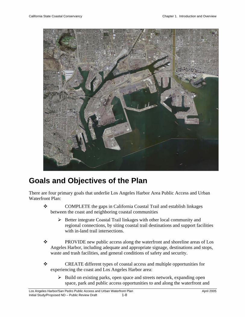
Project Location The project sites are located within the San Pedro and Wilmington neighborhoods of the City of Los Angeles, in close proximity to the Los Angeles Harbor, in the County of Los Angeles, California. Figure 1 provides an aerial photo overview of the vicinity of the project components, as they surround the Los Angeles/Long Beach Harbor area. The East Wilmington Greenbelt is located immediately north of the intersection of Sanford Ave. with Anaheim Street. in the eastern portion of the community of Wilmington. The Waterfront Gateway component is located at the terminus of the Harbor Freeway at the intersection of Gaffey Street and O’Farrell Ave. The Beacon Street/San Pedro Park
Los Angeles Harbor/San Pedro Public Access and Urban Waterfront Plan April 2005 Initial Study/Proposed ND – Public Review Draft 1-5

California State Coastal Conservancy Chapter 1. Introduction and Overview
component is located along the coastal bluffs immediately west and up-gradient from the LA Harbor/The Paseo Del Mar component is located at the extreme southwesterly end of the Palos Verdes Peninsula. The Pacific Avenue Overlook/Sunken City component is located at the southerly terminus of Pacific Avenue easterly of Pt. Fermin Park. Figures 2, 3, 4, and 5 and their accompanying maps (see end of section) provide a more detailed overview of each of the sites. The properties that are involved with the various aspects of the project are listed in Table 1, below.
Los Angeles Harbor/San Pedro Public Access and Urban Waterfront Plan April 2005 Initial Study/Proposed ND – Public Review Draft 1-6

California State Coastal Conservancy Chapter 1. Introduction and Overview
Table 1 Summary of Parcels Associated with the Proposed Projects
Project Component Parcels: East Wilmington Greenbelt 7425023001; 7425023003; 7425023006; 7425023004; 7425023005;
7425031003; 7425031004; 7425031006; 7425031008; 7425009019; 7425009020; 7425011803; 7425011004; 7425011006; 7425011804; 7425036800; 7425036005; 7425036002; 7425036006; 7425036007; 7425036008; 7425036029; 7425037050; 7425037012; 7425037040; 7425037013; 7425037040; 7425037014; 7425037007; 7425037020; 7425037019; 7425037018; 7425037017; 7425037016; 7425037015; 7425009029; 7425009032; 7425009031; 7425011804; 7425011013; 7425011008; 7425011013; 7425011023; 7425011014; 7425011015; 7425011022; 7425011018; 7425011024
Waterfront Gateway Park 7447029011; 7447029009; 7447029012; 7447029004; 7447029013; 7447031039; 7448009029; 7447029001; 7447029002; 7447029003;
Beacon Street/San Pedro Plaza Public Right of Way Paseo Del Mar Public Right of Way Pacific Avenue Overlook/ Sunken City
Public Right of Way
Figure 1 – Aerial Photo of San Pedro/Wilmington
Los Angeles Harbor/San Pedro Public Access and Urban Waterfront Plan April 2005 Initial Study/Proposed ND – Public Review Draft 1-7
California State Coastal Conservancy Chapter 1. Introduction and Overview
Goals and Objectives of the Plan There are four primary goals that underlie Los Angeles Harbor Area Public Access and Urban Waterfront Plan:
COMPLETE the gaps in California Coastal Trail and establish linkages between the coast and neighboring coastal communities
Better integrate Coastal Trail linkages with other local community and regional connections, by siting coastal trail destinations and support facilities with in-land trail intersections.
PROVIDE new public access along the waterfront and shoreline areas of Los
Angeles Harbor, including adequate and appropriate signage, destinations and stops, waste and trash facilities, and general conditions of safety and security.
CREATE different types of coastal access and multiple opportunities for
experiencing the coast and Los Angeles Harbor area:
Build on existing parks, open space and streets network, expanding open space, park and public access opportunities to and along the waterfront and
Los Angeles Harbor/San Pedro Public Access and Urban Waterfront Plan April 2005 Initial Study/Proposed ND – Public Review Draft 1-8
California State Coastal Conservancy Chapter 1. Introduction and Overview
shoreline areas and between adjacent neighborhood and downtown areas. Strengthen the physical and visual connections between communities and the
water’s edge and integrate new facilities into the existing community fabric.
PRESERVE (and enhance) the distinct character of the local communities and neighborhoods in the Los Angeles Harbor area, including important “working waterfront” areas.
Elements of the Plan: The Coastal Trail, Community Linkages, and Waterfront Gateways
This draft plan integrates statewide, regional and local goals for increased coastal access, as well as better connections between the coast and adjacent coastal communities. Implementation of coastal trail improvements to close the gap within the Los Angeles Harbor Area will establish the basis for a continuous open space network that connects points along the shoreline and the shoreline to adjacent communities. Completing the various segments of the Coastal Trail in the Los Angeles Harbor Area will connect existing fragmented open space along the waterfront and connect the coast and waterfront areas to the rest of the San Pedro and Wilmington communities. This plan contains elements that reinforce the recommendation made in the WATCH Report to provide a continuous waterfront promenade from the Vincent Thomas Bridge to Cabrillo Beach and the San Pedro Breakwater, a distance of approximately 8.5 miles through the central San Pedro waterfront. This plan also contains elements to extend the Promenade to Knoll Hill, Wilmington, Point Fermin and White Point/Shoreline Park, as part of the California Coastal Trail. This draft plan contains elements that create a strong public access and recreation, open space, and natural areas stewardship framework, defining strong public linkages to the coast, and along the coast, taking advantage of existing open spaces, parks, playgrounds, and school grounds, underutilized and/or undeveloped public spaces, as well as natural habitats. The draft plan provides a series of selective “coastal waterfront gateways” that define a sense of arrival at the coast and shoreline. A number of waterfront open space, interpretation, and access destinations are proposed to be connected together to form a better linear chain and to form a better network to in-land linkages. A system of “coastal gateways” is suggested to provide visual, vertical and lateral access to the waterfront and shoreline areas of the Los Angeles Harbor Area, providing managed and controlled, yet vastly improved, access, protecting the industrial activities of the harbor, recognizing the need for maximum safety and port security.
Los Angeles Harbor/San Pedro Public Access and Urban Waterfront Plan April 2005 Initial Study/Proposed ND – Public Review Draft 1-9

California State Coastal Conservancy Chapter 1. Introduction and Overview
This plan includes nearly a dozen and one-half recommended final project planning and implementation project areas, including five early implementation project areas. This plan provides more detail on the analysis of Coastal Trail needs and on the early implementation projects, including:
The East Wilmington Greenbelt, along the Wilmington Waterfront;
The Waterfront Gateway Project, connecting the Cruise Ship Terminal with Gaffey St. to the west;
The Beacon Street Bluffs/San Pedro Plaza Park;
The Point Fermin Coast, linking Sunken City and Pacific Ave to White Point/ Shoreline Park through Pt. Fermin Park and Paseo del Mar.
Coastal Trail Analysis The California Coastal Trail through the Los Angeles Harbor Area, extending from the Point Fermin Coast, connecting the communities of San Pedro and Wilmington, and then continuing through Long Beach Harbor and over the Los Angeles River, has not been completed to date. The trail remains incomplete, along long stretches it is still non-existent, in many instances it is discontinuous, while, finally in, other locations, the existing trail is in various degrees of disrepair, very often posing dangerous and hazardous conditions to potential users and visitors.
San Pedro: San Pedro has “historically had a tenuous relationship with its waterfront.” Many physical constraints have contributed to preventing public access to the waterfront and shoreline. At the same time, San Pedro is fortunate “to have a large area for future waterfront development, where there is an incredible opportunity to have sufficient amounts of public open space.” Existing open space along the waterfront is fragmented and not connected to the rest of San Pedro. San Pedro’s topography and pattern of urban development have limited pedestrian access to the central waterfront in the past. However, San Pedro’s major streets and overlooks can become the best “windows: to the waterfront and coastline. There are many existing opportunities for enhanced waterfront and shoreline public access. Several city streets can be promoted with improved pedestrian connections to the waterfront. Beacon Street Bluffs Park are an “underutilized open space feature” and the park provides “outstanding overlook and view opportunities of the LA Harbor development and points beyond.”
Wilmington: The Los Angeles Harbor Area community of Wilmington has been walled off its waterfront by the scale and extent of industrial and related truck and rail transportation activities which occur along the Wilmington waterfront. Wilmington is without adequate local park and recreation resources, let alone much open space or habitat resources. Some of the most important remaining public open space in
Los Angeles Harbor/San Pedro Public Access and Urban Waterfront Plan April 2005 Initial Study/Proposed ND – Public Review Draft 1-10
California State Coastal Conservancy Chapter 1. Introduction and Overview
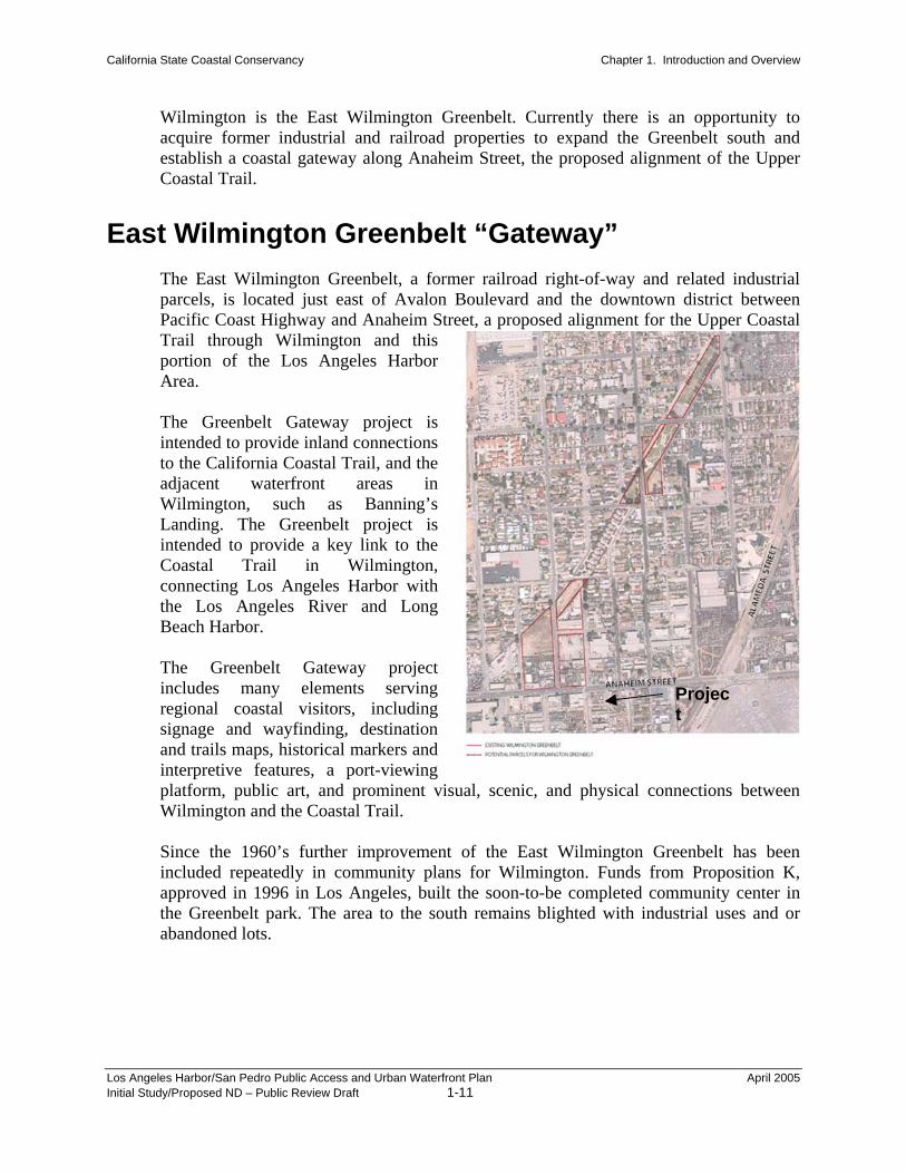
Wilmington is the East Wilmington Greenbelt. Currently there is an opportunity to acquire former industrial and railroad properties to expand the Greenbelt south and establish a coastal gateway along Anaheim Street, the proposed alignment of the Upper Coastal Trail.
East Wilmington Greenbelt “Gateway” The Ea industrial parcels,Pacific Trail thportion Area. The Gintendedto the CadjacenWilminLandingintendedCoastalconnectthe LoBeach H The Gincludesregionasignageand traiinterpreplatformWilmin Since tincludedapprovethe Greabandon
Los Angeles Harbor/Initial Study/Propose
st Wilmington Greenbelt, a former railroad right-of-way and related
is located just east of Avalon Boulevard and the downtown district between Coast Highway and Anaheim Street, a proposed alignment for the Upper Coastal rough Wilmington and this of the Los Angeles Harborreenbelt Gateway project is to provide inland connections alifornia Coastal Trail, and the t waterfront areas in gton, such as Banning’s . The Greenbelt project is to provide a key link to the
Trail in Wilmington, ing Los Angeles Harbor with s Angeles River and Long arbor.
reenbelt Gateway project many elements serving
l coastal visitors, including and wayfinding, destination ls maps, historical markers and tive features, a port-viewing , public art, and prominent visual, scenic, and physical connections between
gton and the Coastal Trail.
Project
he 1960’s further improvement of the East Wilmington Greenbelt has been repeatedly in community plans for Wilmington. Funds from Proposition K, d in 1996 in Los Angeles, built the soon-to-be completed community center in enbelt park. The area to the south remains blighted with industrial uses and or ed lots.
San Pedro Public Access and Urban Waterfront Plan April 2005 d ND – Public Review Draft 1-11

California State Coastal Conservancy Chapter 1. Introduction and Overview
Waterfront Gateway The Waterfront Gateway project is located in the harbor area extending from the Los Angeles Cruise Center west to the Gaffey Street terminus of the Harbor Freeway, the I-110. The project consists of developing new park and open space amenities and harbor-oriented visitor-serving facilities with new connections between Bandini and Peck Park Canyons and the California Coastal Trail at a location of the central San Pedro waterfront where the new Cruise Center is joined by the initial implementation of the San Pedro Waterfront Promenade. The Waterfront Gateway includes many features providing enhanced attractions for regional visitors, such as trail and street pedestrian connections, scenic and visual linkages, wayfinding, signage, and harbor, maritime and historical interpretive features. Final project tasks incFinal project tasks include final site design and engineering; additional land acquisition; as well as securing any needed approvals and permits. Major project elements will include landscaping, both native plantings and hardscape; signage and wayfinding, provision of parking; visitor information kiosk, including area maps; historical features; viewing areas; natural habitat restoration and related trails development, including connections to in-land trails. Just recently, a Conceptual Plan for Peck Park Canyon has been completed, as well as a Plan for restoring Bandini Canyon, both of which contemplate an integrated trails system. In addition, the Waterfront Gateway will provide important public visitor-serving
Los Angeles Harbor/San Pedro Public Access and Urban Waterfront Plan April 2005 Initial Study/Proposed ND – Public Review Draft 1-12

California State Coastal Conservancy Chapter 1. Introduction and Overview
facilities serving a statewide public, introducing the San Pedro waterfront and its recreational, open space, natural areas, and maritime-related educational, commercial, and industrial sites.
Los Angeles Harbor/San Pedro Public Access and Urban Waterfront Plan April 2005 Initial Study/Proposed ND – Public Review Draft 1-13

California State Coastal Conservancy Chapter 1. Introduction and Overview
The Gateway established inland connections to the California Coastal Trail and the new San Pedro Waterfront Promenade. Through coordinated signage and wayfinding, easy to find and easy to navigate destination maps, historical markers and viewing areas, as well as through restoration of the natural habitat and related trail improvements, the Waterfront Gateway will provide essential visual, scenic and physical connections between inland areas of San Pedro and the waterfront.
Los Angeles Harbor/San Pedro Public Access and Urban Waterfront Plan April 2005 Initial Study/Proposed ND – Public Review Draft 1-14

California State Coastal Conservancy Chapter 1. Introduction and Overview
Beacon Street/Bluffs: San Pedro Plaza Park The Bluffs Park project area includes the coastal bluff along Beacon Street between 7th Street and 22nd Street in central San Pedro. This project area is the current site of the City of Los Angeles Plaza Park. The proposed improvements to the Bluffs park area consist of an integrated system of improved pathways, stairways, and access facilities such as seating areas and lighting, which will provide an improved segment of the “Upper” Coastal Trail in central San Pedro, and include physical linkages from inland San Pedro to the San Pedro Waterfront Promenade, the Ports O Call, and the fishing fleet slip. The proposed improvements create a key improved segment of the California Coastal Trail along a coastal bluff park overlooking and immediately bordering the main harbor areas of San Pedro. The proposed project creates a series of physical and visual connections to the waterfront and promenade. The project establishes significant inland connections from immediately adjacent neighborhood and historic business district of the San Pedro down over the bluff park area to the “Lower” Coastal Trail and the San Pedro Waterfront Promenade, the Red Car Line, and Ports O Call.
San Pedro Plaza Park
Los Angeles Harbor/San Pedro Public Access and Urban Waterfront Plan April 2005 Initial Study/Proposed ND – Public Review Draft 1-15

California State Coastal Conservancy Chapter 1. Introduction and Overview
Point Fermin Coast: Sunken City/Pacific Avenue and Paseo Del Mar
The Point Fermin Coast, extending from Western Ave at White Point/Shoreline Park to Sunken City/Pacific Ave, is proposed to become another “Coastal Gateway,” to, and along, the California Coastal Trail. Development of a new coastal park, and new entrance to Sunken City, is proposed at the existing public parking lot at the end of Pacific Avenue. This proposed gateway would involve constructing a new coastal park, and include interpretive and informational signage and wayfinding, seating areas, coastal viewing opportunities, and a new entrance to Sunken City, immediately to the west. The entrance to Sunken City would provide an alternative coastal trail route for hikers, walkers and bicyclists to the current on-street Shepard Street/Paseo Del Mar alignment. The Sunken City improvements would include new trail, seating, signage, public art, gates, fencing, and needed public safety improvements to connect the Pacific Ave coastal park to Pt. Fermin Park. Along Paseo del Mar, from Western Avenue to Pacific Avenue, the proposed project proposes improved connections to the coast, including better signage, better pedestrian facilities, and viewpoint enhancements designating Paseo del Mar a segment of the California Coastal Trail, including clearly designated public parking areas at Gaffey St., at Milke Flores Park, at Whites Point, and at Royal Palms Park. As noted in Figure 9, the Paseo Del Mar concept envisions improvements to the roadway as well as the addition of landscaping, traffic calming measures and beautification efforts. Specifically, the project will entail trail signage, the installation of stop signs, stop sign removals, installation of a community board, new community signage and the creation of coastal access nodes.
Los Angeles Harbor/San Pedro Public Access and Urban Waterfront Plan April 2005 Initial Study/Proposed ND – Public Review Draft 1-16

California State Coastal Conservancy Chapter 1. Introduction and Overview
The Pacific Avenue Overlook and Sunken City component entails the removal of an existing surface parking lot and the creation of a new landscaped parking area with access through the Sunken City area to Point Fermin Park. Site improvements will include signage, landscaping, traffic control devices, stop signs or roundabout, as well as other wayfinding improvements designed to assist park users in making linkages to other aspects of the California Coastal trail and the resources is connected with.
Pacific Overlook/Sunken City Component
Los Angeles Harbor/San Pedro Public Access and Urban Waterfront Plan April 2005 Initial Study/Proposed ND – Public Review Draft 1-17

California State Coastal Conservancy Chapter 1. Introduction and Overview
Existing Conditions East Wilmington Greenbelt Gateway
Sanford from Anaheim to Opp is a quiet two lane road with parking on both sides. There are large vacant lots and light industrial auto repair and storage facilities near Anaheim and some single family homes near Opp. This area is to become the southern extension of the Wilmington Greenbelt, a significant local amenity that is proposed to have tot lots, basketball courts and playgrounds. Currently, a community center is being built on Sanford between Opp and I Street as part of this expansion effort. The groups involved in this open space improvement hope this new park will serve both local residents and regional visitors using the California Coastal Trail. The Greenbelt will also serve as a buffer area between residential neighborhoods in East Wilmington and port related industrial facilities and transport routes to the south. The vacant portions of the site of this open space proposal are vegetated with weeds and introduced grasses. Other areas are covered with industrial uses including a rope manufacturing business and auto recycling upholstery use. The site is surrounded by heavily urbanized uses including some residential and harbor/port-related industrial uses.
Los Angeles Harbor/San Pedro Public Access and Urban Waterfront Plan April 2005 Initial Study/Proposed ND – Public Review Draft 1-18

California State Coastal Conservancy Chapter 1. Introduction and Overview
Waterfront Gateway Component
Waterfront Gateway Park is located at the southerly terminus of the Harbor Freeway where Gaffey Street crosses over Bandini Canyon where it becomes Caltrans right of way. The project area is a mixture of vacant parcels, residential dwellings and commercial properties fronting along Gaffey Street. Bandini Canyon extends up hill to the west. Previous gas stations have been removed from corner properties. With those exceptions, the site is fully urbanized and contains non-native weeds and introduced grasses. Bandini Canyon drains through the site under the Gaffey Street bridge. Land uses The Gateway Park is a common element of two related projects now underway: the Bridge to Breakwater promenade under the jurisdiction of the Los Angeles Harbor Department and the LA Harbor Area Public Access & Urban Waterfront Plan. Further to the east, O’Farrell Street leads to the harbor and waterfront area of San Pedro.
Beacon Street/Bluffs: San Pedro Plaza Park Beacon Street run from approximately 7th Street south to 22nd Street and provides a series of views and view points between the residential uses to the west and the harbor-related industrial and commercial uses to the east. The majority of the project area is currently in public ownership and is open for passive recreational uses and harbor viewing. Beacon Street is elevated and approximately 10 - 40 feet higher than Harbor Boulevard, which provides arterial access to the port, commercial uses and ocean oriented industry along this side of the main channel. A series of stairways provide linkages between Beacon Street and Harbor Boulevard. Beacon Street has mature Canary Island Palms which serve as street trees along much of the east side of the street. A deteriorating asphalt/concrete sidewalk provides pedestrian access and is separated from Beacon Street by grass areas.
Point Fermin Coast: Paseo Del Mar, Sunken City and Pacific Avenue Overlook These two project components are located at the south and southwesterly end of the Palos Verdes Peninsula and would entail improvements to public right of way and property at the terminus of Pacific Avenue. Paseo del Mar is surrounded by open space, single family residential uses, and the Pacific Ocean as noted in Figure 6. The Pacific Avenue Overlook is also public right of way and is currently functioning as a public parking lot, closed from dusk to dawn. Adjacent to the parking lot are single and multi-family homes. Sunken City is formerly a part of a cliff-side residential neighborhood; Sunken City is now a huge abandoned site that is slowly slipping into the sea. There are still remnants of the neighborhood past; broken pieces of asphalt that were once city streets and are now canvasses for graffiti artists. While this is not officially a park, there are
Los Angeles Harbor/San Pedro Public Access and Urban Waterfront Plan April 2005 Initial Study/Proposed ND – Public Review Draft 1-19

California State Coastal Conservancy Chapter 1. Introduction and Overview
typically people strolling through the site. Access to Sunken City is from the eastern end of Paseo del Mar and from the parking lot at the end of Pacific Avenue. Pedestrian access is difficult to find at Point Fermin end of Sunken City. Pedestrian access is a hole in the fence at Pacific Avenue end of Sunken City. Bicycle access is impossible due to constrained entry points. Exotic invasive plants cover the site.
Implementation This draft plan has recommended an integrated, overall program, contained in a series of coordinated, actions, focused on a series of 5 early implementation gateway coastal trail projects. This plan has identified several specific elements that can be implemented sequentially and feasibly, with the means and capabilities of project partners. Each project seeks to meet complimentary state, regional and local goals for waterfront access (and development). Each project area and project improvement plan was chosen to create a series of linked gateways from the different harbor communities and neighborhoods to, and along, the coast. The summary matrix below provides a phased implementation plan proposed to be completed within the next decade. Several projects are proposed to be implemented in the next three years, as partnerships with local stewards organizations. The Coastal Conservancy is partnering with local project sponsors who are established in the community and have a level of capabilities to successfully carry-out individual projects and phased project elements. The Coastal Conservancy is seeking to leverage its limited funding with other funds to successfully underwrite projects at an adequate financial level. Funding for different project elements from individual sources are identified, where known. Multiple sources of funding have been identified and raised for both final project planning and initial implementation in the past two years.
Los Angeles Harbor/San Pedro Public Access and Urban Waterfront Plan April 2005 Initial Study/Proposed ND – Public Review Draft 1-20

California State Coastal Conservancy Chapter 1. Introduction and Overview
Figure 2 East Wilmington Greenbelt
PROJECT SITE
Figure 3 Waterfront Gateway Park
Los Angeles Harbor/San Pedro Public Access and Urban Waterfront Plan April 2005 Initial Study/Proposed ND – Public Review Draft 1-21

California State Coastal Conservancy Chapter 1. Introduction and Overview
PROJECT SITE
Los Angeles Harbor/San Pedro Public Access and Urban Waterfront Plan April 2005 Initial Study/Proposed ND – Public Review Draft 1-22

California State Coastal Conservancy Chapter 1. Introduction and Overview
Figure 4, Beacon Street Bluffs: San Pedro Park Plaza
PRSI
LosInit
Project Site
Figure 5, Pt. Fermin Coast/Paseo Del Mar/Sunken City/Pacific Overlook
OJECT TE
Angeles Harbor/San Pedro Public Access and Urban Waterfront Plan April 2005 ial Study/Proposed ND – Public Review Draft 1-23

California State Coastal Conservancy Chapter 1. Introduction and Overview
Figure 6: Pacific Avenue Overlook
PROJECT AREA
Los Angeles Harbor/San Pedro Public Access and Urban Waterfront Plan April 2005 Initial Study/Proposed ND – Public Review Draft 1-24

Chapter 3 Environmental Checklist and Analysis
1. Project Title: L.A. Harbor San Pedro Public Access and Urban
Waterfront Plan
2. Lead Agency Name and Address: California State Coastal Conservancy 1330 Broadway, Suite 1100 Oakland, CA 94612
3. Contact Person and Phone Number: Mr. Marc Beyeler Senior Program Manager (510) 286-4172
4. Project Location: Plan Area: Los Angeles Harbor Area Component Areas: East Wilmington Greenbelt: Sanford St./I St./Opp St. Waterfront Gateway Park: Gaffey St/O’Farrell
St./Sepulveda St. Beacon Street/Bluff: San Pedro Plaza Park: Beacon
Street from 7th Street. to 22nd Street Paseo Del Mar Improvements: Paseo Del Mar from
Western Avenue to Pacific Avenue Pacific Overlook/Sunken City: Shepard St./South
terminus of Pacific Avenue
5. Project Sponsor’s Name and Address: California State Coastal Conservancy 1330 Broadway, Suite 1100 Oakland, CA 94612 http://www.scc.ca.gov/
6. General Plan Designation: East Wilmington Greenbelt: Low Medium Multi-Family Residential, Industrial Waterfront Gateway Park: General Commercial (along Gaffey Street); Low Medium Multi-Family Residential and Low Density Residential Beacon Street/Bluff: San Pedro Plaza Park: Open
Space Paseo Del Mar: Open Space Pacific Overlook/Sunken City: Open Space
7. Zoning: East Wilmington Greenbelt: RD2, M2 Waterfront Gateway Park: C1 (Commercial); RD2, R 1Beacon Street/Bluff: San Pedro Plaza Park: OS Paseo Del Mar: OS Pacific Overlook/Sunken City: OS