london nw2 bridge), brent cross cricklewood regeneration ... bridg… · onto the new bridge. this...
TRANSCRIPT

1
LOCATION: Bridge Structure B1 (Replacement A406 Tempelhof Bridge), Brent Cross Cricklewood Regeneration Area, London NW2
REFERENCE: 15/06571/RMA Received: 27 October 2015Accepted: 27 October 2015
WARD: Childs Hill, Golders Green, West Hendon
Expiry: 26 January 2016
APPLICANT: Brent Cross Development Partners
PROPOSAL: Submission of Reserved Matters Application within Phase 1A (North) of the Brent Cross Cricklewood Regeneration Area; relating to Layout, Scale, Appearance, Access and Landscaping for Bridge Structure B1 (Replacement A406 Tempelhof Bridge). Submission is pursuant to conditions 1.2.1A, and 2.1 and for the part discharge of condition 13.1 of planning permission F/04687/13 dated 23 July 2014 for the comprehensive mixed use redevelopment of the Brent Cross Cricklewood Regeneration Area.
RECOMMENDATION
This application is recommended for APPROVAL subject to conditions and informative(s) attached in Appendix 1.

2
1. APPLICATION SUMMARY
This is a Reserved Matters Application submitted by the Brent Cross (BXC) Development Partners relating to Phase 1A (North) of the Brent Cross Cricklewood regeneration. The application seeks approval for an alternative design for Bridge Structure B1 (Replacement A406 Tempelhof Bridge) in relation to the reserved matters of scale, layout, access and appearance pursuant to Conditions 1.2.1.A, 2.1 and also seeks the part discharge of Condition 13.1 of the 2014 Section 73 planning consent for the redevelopment of the Brent Cross Cricklewood regeneration area (Planning reference F/04687/13) (the ‘s73 Permission’).
Reserved Matters for Phase 1A (North) were approved in 2015 which included infrastructure items (junction improvements, roads, bridges and the diversion of the River Brent); the central stretch of the new Central Brent Riverside Park; open space improvements to Clitterhouse Playing Fields and Claremont Park and the residential development of Plots 53 and 54 (the Brent Terrace Triangles).
Following the approval of the Phase 1A (North) Reserved Matters, the BXC Development Partners investigated alternative designs for a number of specific highway infrastructure items and as a result a further four Reserved Matters Applications (RMAs) were submitted to the London Borough of Barnet (LBB) in October 2015. Three of these RMAs were approved in 2016 and are listed below:
1. Tilling Road West Realignment and Diversion (Part 1) RMA – alternative design to the Tilling Road / Brent Terrace North junction which reduces the need for temporary tie in works to align the junction with existing Brent Terrace North (Approved: 29/02/2015; Ref: 15/06572/RMA)
2. River Bridge 1 and Central and Western River Brent Alteration & Diversion Works RMA – an alternative design for River Bridge 1 (the western element of the Western Roundabout) which lengthens the structure to improve buildability of the bridge abutments. This results in an alternative design to a small element of the Central and Western River Brent Alterations and Diversion works where it passes through the Western Roundabout (Approved: 29/02/2015; Ref: 15/06573/RMA) and
3. Central Brent Riverside Park – as a result of the above proposed alterations to River Bridge 1, alternative designs are proposed for a small section of the River Park including to Nature Park NP5 (Approved: 29/02/2015; Ref: 15/06574/RMA).
The remaining RMA relates to Bridge Structure B1 (Replacement A406 Templehof Bridge) and is the subject of this report.

3
1.1 Bridge Structure B1 (Replacement A406 Templehof Bridge)
In January 2016, Reserved Matters Ref: 15/03312/RMA approved Phase1A (North) highway infrastructure items, including Bridge Structure B1 which is a replacement for the existing Tempelhof Bridge over the A406 North Circular. The approved design consisted of two northbound and two southbound vehicular lanes (including a dedicated bus lane either direction), pedestrian footways both sides and a segregated two way cycle lane on the western side of the bridge.
Since the approval of the Phase 1A (North) RMA, the BXC Development Partners investigated an alternative design for Tempelhof Bridge and Reserved Matters were submitted to London Borough of Barnet (LBB) in October 2015. This alternative design reduced the overall width of the bridge by removing the dedicated bus lanes, leaving one vehicular lane for all traffic in each direction. Pedestrian and cyclist facilities remained unaltered. Following consultation on the application there were concerns from TfL regarding the impact on bus services from the removal of both bus lanes. The application remained undetermined and discussions continued between the BXC Development Partners and relevant highway authorities. Following detailed traffic modelling a revised design has been proposed. The proposed bridge configuration now comprises three lanes of traffic including a northbound bus lane, a footway and segregated two way cycle lane on the western side. No footway is proposed on the eastern side. To incorporate the necessary changes amended plans were submitted to the LPA on 24th November 2016 and a further round of consultation undertaken.
The width of the bridge has reduced compared to the previously approved structure by the removal of one of the dedicated bus lanes and the footway on the eastern side. The length has reduced due to moving the northern abutment south and the southern abutment north. In comparison to the approved design, the alternative bridge would approximately measure 164m in length and between 17.6m and 21.8m in width.
The BXC Development Partners have advised that the alternative Tempelhof Bridge structure can now be substantially constructed prior to the existing bridge needing to being demolished. This would enable the existing bridge to remain in operation while the new one is constructed before diverting traffic onto the new bridge. This offers potential improvements to the construction programme with a shorter period of construction taking place over the A406 North Circular and would be a deliverability benefit for the overall project.
The bridge deck level of the proposed alternative design is within the defined limit of deviation across the realigned River Brent, Prince Charles Drive and the A406 North Circular Road as identified on Parameter Plan 006 of the s73 Permission. However, the proposal is marginally (0.4m) beneath the minimum width parameters. In this respect, an application under Condition 2.4 and 2.5 has therefore been submitted to provide minor amendments to the approved parameters and controls contained within the Revised Design Specification

4
Framework (RDSF), Design and Access Statement (RDAS) and Revised Design Guideline (RDG) to reflect the revised bridge design.
As a consequence of this design, it will also be necessary to amend the definition ‘Bridge Structure (Replacement A406 Tempelhof Bridge)’ contained in the Glossary to conditions attached to the s73 Permission. This will be achieved through condition 1.30 which allows minor revisions to the Glossary agreed in writing with the Local Planning Authority (LPA).
The proposed alternative design for the bridge structure is substantially in accordance with the identified parameters and principles of the s73 Permission subject to the minor variations required under Conditions 2.4 and 2.5.
The Reserved Matters Application was submitted on 27 October 2015 to comply with the conditions and deadlines within the Section 73 planning permission and the provisions of the Section 92 of the Town & County Planning Act 1990 (as amended). Amended plans, clarifications and updates to the Reserved Matters Transport Report Addendum and EIA Addendum Further Information Report were submitted to London Borough of Barnet on 24th November 2016.
2. RELEVANT PLANNING HISTORY
2.1 Outline Consent
The principle of development at Brent Cross Cricklewood was first established by way of a site-specific Development Framework produced in April 2004 as Supplementary Planning Guidance (SPG) in accordance with the London Plan. The SPG established a vision to ‘to create a new gateway for London and a vibrant urban area for Barnet’.
The comprehensive redevelopment of the wider Brent Cross Cricklewood regeneration area was subsequently granted planning permission in outline in 2010 under planning permission C/17559/08 (the ‘2010 permission’). This permission was subsequently revised under a Section 73 planning application (F/04687/13) which was approved on 23 July 2014 (the ‘s73 Permission’) as described below:
Section 73 Planning application to develop land without complying with the conditions attached to Planning Permission Ref C/17559/08, granted on 28 October 2010 ('the 2010 Permission'), for development as described below: Comprehensive mixed use redevelopment of the Brent Cross Cricklewood Regeneration Area comprising residential uses (Use Class C2, C3 and student/special needs/sheltered housing), a full range of town centre uses including Use Classes A1 - A5, offices, industrial and other business uses within Use Classes B1 - B8, leisure uses, rail based freight facilities, waste handling facility and treatment technology,

5
petrol filling station, hotel and conference facilities, community, health and education facilities, private hospital, open space and public realm, landscaping and recreation facilities, new rail and bus stations, vehicular and pedestrian bridges, underground and multi-storey parking, works to the River Brent and Clitterhouse Stream and associated infrastructure, demolition and alterations of existing building structures, CHP/CCHP, relocated electricity substation, free standing or building mounted wind turbines, alterations to existing railway including Cricklewood railway track and station and Brent Cross London Underground station, creation of new strategic accesses and internal road layout, at grade or underground conveyor from waste handling facility to CHP/CCHP, infrastructure and associated facilities together with any required temporary works or structures and associated utilities/services required by the Development (Outline Application).
Both the 2010 and s73 Permissions were subject to Environmental Impact Assessment. Details of the permissions are provided in Appendix 2 (Relevant Planning History).
2.2 Phasing of the BXC Regeneration Scheme
The s73 permission is a multi-phase scheme. The permission proposes the phased delivery of the comprehensive development for the whole site in accordance with the planning policy.
Phase 1 is proposed to be delivered in sub phases which are divided between north and south. The land to the north of the North Circular will continue to be delivered by Hammerson and Standard Life. The land to the south of the North Circular will be delivered by a joint venture known as Brent Cross South Limited Partnership (“BXS LP”) between the Council and Argent Related (which is itself a joint venture partnership between Argent and Related Companies).
The sub phases for Phase 1 are as follows:
Phase 1A (North) – this includes all the highways infrastructure to support the northern development including the key highways infrastructure to support the Phase 1 South, such as the improvements to the southern junctions of the A5/A407 Cricklewood Lane and the A407 Cricklewood Lane/Claremont Road Junction improvements. In addition the River Brent re-routeing and Bridge works will be delivered as part of Phase 1A (North), the Clitterhouse Playing Fields Part 1 (excluding the Nature Park) and the Claremont Park Improvements, and the residential development of Plots 53 and 54 to enable the decant of the Whitefield Estate Existing Units (Part 1). The Living Bridge is included in Phase 1A (North). Under the Revised Section 106 Agreement, its delivery will be triggered by the commencement of Phase 1B (North) and its delivery will be programmed to commence

6
and be completed no later than before the occupation of Phase 1B North plots.
Phase 1A (South) – A number of highway improvements needed to support Phase 1 of the Southern Development will be provided including the Waste Handling Facility (Diverted Geron Way/A5 junction; Claremont Park Road (Part 1); and School Lane Works.
Phase 1B (North) – This includes all of the plot development on the north side with the exception of the residential development within the Brent Cross West Zone. The sub phase also includes the new bus station, reconfigured shopping centre, Brent Cross Main Square, High Street North and other northern pedestrian routes, as well as the Riverside Park, Sturgess Park Improvements and around 300 housing units. Commencement of this Sub-Phase will trigger the BXP’s obligations to deliver the Living Bridge which will link into the buildings and public realm to be provided on the Plots forming part of this Sub-Phase.
Phase 1B (South) – This includes the Market Square, the Clarefield Park Temporary Replacement Open Space, the replacement food store, the Waste Handling facility, the CHP and the new and expanded Claremont School, in addition to more than 1000 residential units.
Phase 1C – This will include the remaining plot development on the south side
2.3 Reserved Matters Applications
Previously Approved RMAsReserved Matters have been approved for all of the components of Phase 1A (North). Details are set out in Appendix 2 (Relevant Planning History) of this report. The reserved matters for Phase 1A (South) were approved in February 2016. The RMA for this sub-phase comprises two stretches of new road: Claremont Park Road and School Lane. This sub-phase connects to road infrastructure approved under Phase 1A (North) RMAs. Details are also set out in Appendix 2.
Phase 1A North Current RMAA review of the design of aspects of the approved Phase 1A (North) resulted in the Brent Cross Development Partners submitting four further reserved matters applications in October 2015 for alternative designs for specific items of infrastructure within Phase 1A (North). Three of these reserved matters applications have now been approved on 29/02/2016, and the remaining Phase 1A (North) reserved matters application is subject to this planning committee.

7
Phase Changing ApplicationsAn application under condition 4.2 of the s73 Permission was submitted in November 2016 (reference 16/7489/CON) to allow a phase change of six items of critical infrastructure from Phase 1A (North) to Phase 1B (South) thereby transferring responsibility for delivery of these infrastructure items from the Northern development partner to the Southern development partner.
These infrastructure Items include:
Claremont Avenue (up to the junction with Tempelhof Link Road and Tiling road);
Claremont Road Junction North; High Street South (East Works); Orchard Lane; Claremont Park Improvements; and Clitterhouse Playing Fields Improvements (Part 1).
The following associated applications were also submitted at the same time:
- An application under Section 96A to make non material alterations to: Condition 13.1 attached to the s73 Permission to identify the six infrastructure items as part of Phase 1B (South), rather than Phase 1A (North); Condition 14.1 attached to the s73 Permission to identify High Street South (East) being within Phase 1B (South); Condition 9 of Reserved Matters Approval Ref No: 15/00720/RMA relating to the revised delivery of Clitterhouse Playing Fields (Part 1) and Claremont Park; Conditions 20.20 and 20.26 of the s73 Permission relating to existing Clarefield Park, and inserting a new condition (Condition 20.24) relating to re-phasing of Clitterhouse Playing Fields (Part 1); and Condition 1 of Reserved Matters Approval Ref No: 15/03312/RMA and inserting new Condition 1A relating to the approved drawings associated with the re-phased items of highway infrastructure (Reference 16/7574/NMA).
- A submission under Condition 2.4 and 2.5 of the s73 Permission to make consequential changes to the approved control documents to reflect the amended design of Bridge Structure B1 and revised phasing, and amendments to definitions under Condition 1.30 attached to the s73 Permission (Reference 16/7490/CON).
- A submission under Condition 1 of the Reserved Matters approval (Ref: 15/03312/RMA) to update plans contained in Volume 4 of the submission. Amendments include alternations to the approved design to allow two way traffic flows on the Tempelhof Link Road, to accommodate the re-phasing of High Street South (East Works) and Claremont Avenue, and alterations to the Claremont Road/ Tiling Road Junction to create a signalised junction.

8
2.5 Pre-Reserved Matters Conditions
The s73 permission includes a number of Pre-Reserved Matters conditions intended to establish key principles of the forthcoming development. The majority of these require submission of reports and strategies prior to applications for reserved matters being submitted to the LPA.
Reserved Matters applications are required to accord with commitments and strategies approved under these conditions where relevant. The relevant Pre-RMA Conditions related to Phase 1A (North) of the development have previously been approved prior to the approval of the RMAs in 2015. These are set out in Appendix 2 (Relevant Planning History). It should be noted that a revised scope for the Reserved Matters Transport Report Addendum was submitted under Condition 37.1 (Ref: 15/06452/CON) and approved on 23 October 2015 to agree the methodology for specific traffic modelling to support the Reserved Matters Application.
Updates to Pre-RMA ConditionsA number of the Pre-RMA Conditions are structured such that they require subsequent RMAs to be in accordance with the documents approved under the condition. As a result of the current RMA, a review of the relevant approved Pre-RMA Conditions has been undertaken by the Development Partners planning consultants. This review has identified areas within the strategies and documents previously approved under the Pre-RMA conditions that need to be updated to ensure that they align with the alternative infrastructure designs now being proposed under these latest RMAs. A list of the current Pre-RMA conditions is also provided in Appendix 2 (Relevant Planning History)
3. DESCRIPTION OF THE SITE AND PROPOSAL
3.1 Site Description and Surroundings
The planning consent for the Brent Cross Cricklewood development relates to a 151 hectare site which is defined to the west by the Edgware Road (A5) and the Midland mainline railway line and to the east by the A41, and is bisected east to west by the A406 North Circular Road. It is adjacent to Junction 1 of the M1 (Staples Corner) and includes the existing Brent Cross Shopping Centre and Bus Station to the north of the North Circular as well as the existing Sturgess Park.
To the south of the North Circular Road the area contains the Brent South Shopping Park, existing Tesco store and Toys ‘R’ Us store, the Whitefield estate (approximately 220 units), Whitefield Secondary School, Mapledown Special School and Claremont Primary School; Hendon Leisure Centre, Brent

9
Cross London Underground Station to the east; Clarefield and Claremont Parks and Clitterhouse Playing Fields (Metropolitan Open Land); the HendonWaste Transfer Station, Claremont Way Industrial Estate and Cricklewood Railway Station to the far south. The application site includes parts of Cricklewood Lane, including the open space in front of the B & Q store.
The Templehof Bridge and the A41 flyover provide the only existing direct north-south link across the North Circular Road within the site. A section of the River Brent, contained within a concrete channel, flows east to west through the site to the south of the shopping centre.
The London Borough of Brent is located to the immediate west of the application site, on the opposite side of the A5 Edgware Road. The London Borough of Camden adjoins the site to the south at Cricklewood Town Centre.The site is dominated and constrained by the existing road network and rail infrastructure. It contains industrial land, former railway land, retail 'sheds' and large areas of surface car parking. In these parts of the site comprehensive redevelopment is required to enable the provision of a sustainable mixed use town centre and to create an acceptable residential environment.
To the north, east and south, the site is surrounded by traditional low rise suburban development, predominantly two storey semi-detached houses. These areas of existing housing - with the exception of the Whitefield Estate - are not directly subject to the proposals as they are not contained within the planning application boundary.
The application site currently has a public transport accessibility level (PTAL) varying between 1 and 5, where 1 is low and 6 is high. It includes key parts of the Transport for London Road Network (TLRN) at Hendon Way (A41) and the North Circular Road (A406).
The site is also bounded by the A5 Edgware Road, part of the Strategic Road Network (SRN). The area also includes sections of the Midland Mainline railway between London St. Pancras and the north of England, including the existing Cricklewood Station. The Edgware branch of the Northern line also runs close to the site and Brent Cross Underground Station is within the Eastern boundary of the regeneration area. Brent Cross Bus Station provides access to 18 bus routes (including Green Line). The majority of these services provide access from and through the site via the TLRN or SRN.
3.2 Site for Bridge Structure B1 (Replacement A406 Tempelhof Bridge)
The proposed replacement A406 Tempelhof Bridge will be located immediately to the east of the existing structure. It will span over the A406 North Circular, Tilling Road and the diverted River Brent. The northern end of the proposed bridge will connect to Prince Charles Drive via the western roundabout, and the southern end will connect to Tempelhof Link Road, connecting to Tilling Road (subject to the approval of the Section 96a

10
Application Ref: 16/7574/NMA), to accommodate two-way traffic flows and into future southern development proposals.
The land on the north side of the A406 North Circular comprises the car parks associated with Brent Cross Shopping Centre and Etheridge Road, which provides access to the existing Prince Charles Drive. The Holiday Inn hotel is located immediately to the east of the southern end of the bridge and the bridge will pass over the car park associated with the hotel.
3.3 Description of the proposal for the Alternative Bridge Structure B1
Bridge Structure B1 approved under Application Ref: 15/03312/RMA
Reserved matters have previously been approved for Phase 1A (North) Infrastructure (15/03312/RMA), which included Bridge Structure B1 (Replacement A406 Tempelhof Bridge), and associated works for Tempelhof Avenue. The application drawings that formed the basis of the approved application illustrated the bridge consisting of two northbound and two southbound vehicular lanes (one of which is a dedicated bus lane in each direction). The key dimensions of the bridge approved were 28m in width and 171m in length (including ramps).
Under this RMA, Bridge Structure B1 was approved to form a key north / south link across the A406 between the Prince Charles Drive western roundabout to the north and Claremont Road to the south. A segregated footway/ two way cycle lane will be provided alongside the northbound carriageway (west side of the bridge), linking with a segregated facility and toucan crossing at Claremont Avenue.
To the north of the A406, the segregated footway and two way cycle lane will adjoin with a shared footway / cycleway facility, connecting with the shopping centre car park access road and the shopping centre cycle parking provision. A toucan crossing will be provided across Tempelhof Avenue, in order to provide access to cycle parking located at the Brent Cross Shopping Centre Tempelhof Circus entrance. A pedestrian only footway will be provided alongside the southbound carriageway (east side of the bridge) between the toucan crossing across Tempelhof Avenue and High Street south (East Works).
For a full description of the overall infrastructure within Phase 1A (North) and wider context of improvements being delivered in this phase of the development please refer to committee report for application Ref: 15/03312/RMA reported to the 10th September 2015 Planning Committee.
Alternative proposal for Bridge Structure B1
Since the approval of the Infrastructure Reserved Matters for Phase 1A (North), the Brent Cross Development Partners have investigated an alternative option for the design of the replacement Tempelhof Bridge and

11
Reserves Matters were submitted to the LPA in October 2015, to comply with the conditions and deadlines within the s73 permission.
This alternative bridge design proposed to provide two lanes for all traffic, following the removal of the dedicated bus lanes. These two lanes were to be utilised by both public transport and private vehicles. As with the design approved under RMA (Ref 15/03312/RMA) a segregated footway and cycleway would be provided on the western side of the bridge and a footway provided on the eastern side. However following this submission, the Reserves Matters remained undetermined and discussions continued amongst the BXC development partners and relevant highway authorities in relation to the traffic modelling and assessment of bus services. On the basis of relevant discussions, the development partners have submitted amended plans which form part of this application.
As identified on Drawing Ref: BXCR-URS-B1-HS-AP-SE-00001_P15, the proposed alterative structure measures approximately 164m in length and between 17.6m and 21.8m in width, and will have a minimum clearance of 5.3m above public highways beneath. The amended plans submitted comprise three traffic lanes incorporating a northbound bus lane, a segregated pedestrian footway and two way cycle lanes on the eastern side. No pedestrian footway is now proposed on the eastern side of the bridge. The northern end of the proposed bridge will connect to Prince Charles Drive via the western roundabout, and the southern end will connect to Tempelhof Link Road connecting to Tilling Road (subject to the approval of the Section 96a Application Ref: 16/7574/NM) to accommodate two-way traffic flows and into Market Quarter, as the delivery of future southern proposals come forward. As a result of this design, the length and width of Bridge Structure B1 are reduced in comparison to the design approved under ref: 15/03312/RMA.
The width will reduce as a consequence of eliminating the southbound bus lane and eastern footway, and the length will reduce due to moving the northern abutment south and the southern abutment north. Overall a narrower and shorter bridge will be provided.
The application consequently is supported by the following amended /additional documents:
Application Covering Letter Explanatory Report (Volume 2, Phase 1A (North)/ Phase 1B (South)
Re-phasing, Brent Cross Cricklewood (November 2016) Reserved Matters Transport Report Phase 1A North Addendum, Phase
1A North: Infrastructure Re-Phasing Rev 3 (November 2016) Brent Cross Cricklewood: Environmental Statement (Phase 1A North
Re-Phasing Works and Tempelhof Bridge Amendments (November 2016)
Application Drawings (Please refer to Appendix 1 for further details)

12
4. MATERIAL CONSIDERATIONS
4.1 Key Relevant Planning Policy
In this case, the Development Plan comprises the London Plan (Consolidated with Further Alterations since 2011) (March 2016) at the strategic level and, at the local level, Barnet’s Local Plan (Core Strategy (2012)) and the Saved UDP Policies GCRICK and C1-C11, which apply to the application site and are supplemented by the Cricklewood, Brent Cross and West Hendon Regeneration Area Development Framework (2005).
The Council’s Development Management Policies DPD (2012) states at paragraph 1.4.3 that it will not apply to planning applications for comprehensive development in the Brent Cross unless and until the Core Strategy is reviewed in accordance with Policy CS2 and Section 20:13 of the Core Strategy.
Detailed consideration of the application against key London Plan and London Borough of Barnet policies can be found in Appendix 3 (Policy Compliance). In summary, the application is considered to be in accordance with relevant planning policies.
The application is for matters reserved following the grant of the outline planning permission and the Section 73 permission, and as such the policy considerations and principles have previously been considered and have been found to have been met.
National Planning Policy Framework
The ‘National Planning Policy Framework’ (NPPF) was published on 27 March 2012. This is a key part of Government reforms to make the planning system less complex and more accessible, and to promote sustainable growth.
In March 2014 the National Planning Practice Guidance was published (online) as a web based resource. This resource provides an additional level of detail and guidance to support the policies set out in the NPPF.
4.2 Public Consultations and Views Expressed
Public Consultation
759 local residents were consulted by letter dated 28 October 2015 allowing a five week consultation period expiring on 25th November 2015. The application was advertised in the Local Press Newspaper notice dated 28 October 2015 and 6 site notices were erected proximity to the development site on the same date. The public consultation letters allowed a 5 week period

13
to respond and 1 letter of objection was received in response to this initial consultation.
Statutory consultees and other interest groups were also consulted with regards to this planning application, and a small number of third party representations have been made.
Second re-consultation period: Following the receipt of amendments and clarifications to the updated Reserved Matters Transport Report Addendum and EIA Addendum Further Information Report, 759 local residents were re-consulted by letter dated 1 February 2016 allowing a two week re-consultation period expiring on 15 February 2016. Statutory Consultees and other interest groups were also re-consulted and no letters of objection were received.
Third re- Consultation period: Following the receipt of amended plans, amendments to the Reserved Matters Transport Report Addendum and EIA Addendum Further Information Report, 759 local residents were re-consulted 9th December 2016. The letters allowed a two week period for the re-consultation period expiring on 23rd December 2015 and 2 letters of objection were received in response to this third consultation process.
As a result of an administrative error, statutory consultees and other interest groups were later consulted on 4th January 2017 with regards to this planning application, allowing a two week consultation re-consultation period expiring on 18th January 2017.
A summary of the comments received and officer comments in response to the first and third consultation period can be found under Appendix 4 (Objections and Officer Responses) of this report. The consultation process carried out for this application is considered to be appropriate for a development of this nature. The extent of consultation exceeded the requirements of national planning legislation and the Council’s own adopted policy.
The Section 73 Permission includes a requirement under Condition 1.23 for submission of a Public Consultation Strategy This was submitted to the Council and considered under planning reference 14/07891/CON. It was approved on 31 March 2015. Details of the developer’s own consultation process are set out in the Statement of Community Involvement submitted with the previous Phase 1A (North) Reserved Matters submissions and accorded with the requirements of the approved strategy.
Consultation Responses from Statutory Consultees and Other Bodies
The application has been subject to statutory consultation and a small number of third party representations have been made. No significant issues have been raised that have not been addressed or which would move officers to recommend refusal. A summary of the comments received from statutory

14
consultees and other bodies and officer comments in response can be found under Appendix 4 (Objections and Officer Responses) of this report.
Internal Consultation responses
Traffic and Development:The comprehensive redevelopment of the Brent Cross site integrates the development with the surrounding residential streets and facilitates improved public transport, pedestrian and cycle connections throughout the local area.
The proposed alterations to the Tempelhof Bridge and the highway network to the south of the bridge have been subject to review and assessment by officers who raise no objections to the development.
The Phase 1A (North) Reserved Matters Transport Report has been based on extensive analysis, undertaken to examine the existing situation and to use suitable data to build acceptable models of the area. All assessment work is in accordance with national guidance and best practice on schemes of this nature and size, taking into Transport for London and London Borough of Barnet planning policies.
The resultant changes to vehicle trips will be satisfactorily accommodated within the transport network, provided that the proposed package of transport works is implemented, with no detrimental impact on public transport provision.
The detailed assessment of the proposals is reviewed in section 6.4 of this report.
Officers consider that the impacts of the development on the transport network have been robustly assessed, and that all appropriate mitigation measures and control mechanisms are provided for, should permission be granted. The planning conditions and obligations recommended in this report are considered to provide an effective framework of control and officers therefore recommend the scheme for approval on matters relating to highways and transport.
Environmental Health: EH officers have reviewed the details submitted for this Reserved Matters Application and have no objections.

15
5. PLANNING AND TRANSPORT ASSESSMENT
6.1 Section 73 Parameters and Controls
The Section 73 Planning Application for Brent Cross Cricklewood regeneration is an ‘hybrid’ permission; in that planning permission has been granted in outline for the majority of the proposed development. Whist detailed permission has been granted in relation to the key gateway access junctions, this application is for matters reserved.
The s73 permission defines Bridge Structure B1 (Replacement A406 Tempelhof Bridge) as follows:
“Bridge Structure B1 (Replacement A406 Templehof Bridge)” means the creation of a replacement road bridge to provide a link over the A406 to link Market Quarter and Brent Cross East and West Zones to include insofar as reasonably practicable provision for bus lanes, step free access and cycle access (without dismounting) in accordance with the parameters and principles as set out in paragraphs 4.5 and 4.6 of the DSF and the following plans:
Parameter Plan 002; 47067355-A406-12-SK-014 Rev C; 47067355-A406-12-SK-015 Rev B; 47067355-A406-12-SK-016 Rev A; 47067355-A406-12-SK-020A; and 47067355-A406-12-SK-021A.”
A series of Parameter Plans and control documents were approved under the s73 Permission to provide the framework to control and assess reserved matters. The principle controls are the Revised Development Specification and Framework (RDSF), revised Design Guidelines (RDG), revised Public Realm and Open Stage Strategy (PROSS) and a revised Design and Access Statement (RDAS). Condition 1.16 requires all Reserved Matters to be in accordance with the parameters and principles contained in the following documents:
1. The RDSF provides a detailed specification of the key components of the development (the primary structural elements of the application with regard to access, movement, scale, use, and urban structure and hierarchy) together with a framework to guide its implementation. It also specifies the parameters, principles, constraints and restrictions within which the ‘flexible’ elements of the scheme are contained. The principal aim of the document is to guide the physical aspects of the development in order to create a high quality scheme which is within the scope of what has been assessed through the Environmental Impact Assessment process;

16
2. The RDAS describes how the primary structural elements combine to establish the character and identity of the development and the way in which development zones come together to form an integrated, diverse, new town centre. It provides a general understanding of the intended character and identity of the development. Many of the aspects of the RDAS are noted to be for illustrative purposes only; and
3. The RDG are a working tool that can be used to inform the design process; shaping the way in which BXC evolves over time. It provides a thorough inventory of the key ordering elements that will combine to form the character and identity outlined in the DAS. The RDG identifies Illustrative Street Typologies which provide an illustrative guide to help the way in which streets defined in Parameter Plan 003 could be developed. These typologies are intended to provide a general guide not a detailed or fixed definition of the final condition as built and it is the over-arching character of the streetscape that is under consideration.
Principles approved under the Revised Design and Specification Framework:
The relevant Parameter Plans and supporting text approved in the RDSF in relation to Bridge Structure B1 (replacement Tempelhof Bridge) are as follows: Paragraph 4.4 of the RDSF states that bridges are to be constructed in accordance with the principles and parameters set out in the RDSF and in general conformity with the relevant Approval in Principle (AiP) plans. The parameters in the RDSF typically relate to the length, width and height of the structure, along with other key criteria e.g. piers, lifts and ramps etc. The AiP plans show the application of these parameters alongside an indicative design and other technical information. Therefore, the detailed design of the bridge must be in accordance with the parameters of the RDSF as shown on the AiP plans. The AiP plans do not control the detailed design, in this respect Bridge Structure B1 is subject to the approval of this Reserved Matters Application.
The relevant Approval in Principle plans are: 47067355-A406-12-SK-014 Rev C, 47067355-A406- 12-SK-015 Rev B, 47067355-A406-12-SK-016 Rev A, 47067355-A406-12-SK-020A and 47067355- A406-12-SK-021A, which demonstrate the proposed engineering solutions for the bridge based on the parameters set out in the RDSF
Paragraph 4.5 states that the alternative Tempelhof Bridge will have four lanes, two of which will have a public transport priority, as well as pedestrian and cyclist facilities. Though the general location of the bridge has been identified on Parameter Plan 002, the initial construction management principles are set of in Section 5.5 of the Construction Impact Assessment (BXC 21). In principle, the implementation of these works will be governed by a detailed phase delivery programme, which is subject to approval prior to

17
commencement of the relevant phase. (For further details regarding the delivery refer to Appendix 7 of the RDSF which sets out the infrastructure triggers).
Paragraph 4.6 sets parameters for the detailed design; this includes the overall length between abutments (160-200m) and width (18-34m) of the structure. Paragraph 4.6 requires that the bridge should have a minimum headroom clearance above the A406 of 5.3m and a maximum of 7m and intermediate piers as shown on the AIP plans shall be provided, none of which shall be located between individual lanes of the A406.
Parameter Plan 002 (Transport Infrastructure)
Parameter Plan 002 identifies various infrastructure elements proposed as part of the comprehensive development. This includes defining the location of existing and proposed junctions and highways, primary routes and the approximate location of secondary and tertiary routes. Building and development zone access points, vehicle and pedestrian bridges, transport interchange points and highways circulation are also identified.
With regards to Bridge Structure B1, Paragraph 12 supporting Parameter Plan 002 grants the bridge a limit of horizontal deviation of +/-15m. The main movement typology for this bridge will be vehicles, pedestrians, cyclists and public transport priority.
Parameter Plan 003 (Public Realm & Urban Structure)
The plan identifies the network of new and existing public spaces and routes between them for pedestrians and cyclists including primary circulation corridors for pedestrians and cyclists and secondary and tertiary routes.
Bridge Structure B1 is a replacement for the Tempelhof road bridge to provide a link over the A406 North Circular to connect Market Quarter and Brent Cross East and West Zones. The general location of the bridge is identified on Parameter Plans 002 and 003.
Parameter Plan 006 (Finished Site Levels)
In addition to the above parameter plans and principles, Parameter Plan 006 requires a bridge deck Level of 49.90m over the A406 North Circular Road and grants a +/-2m limit of vertical deviation to this.
Principles approved under the Revised Design and Access Statement:
Section 2.2.1 of the RDAS states that the new replaced and improved A406 Tempelhof bridge will form the primary connection between the north and south components of the scheme and is limited in its geography by the existing Holiday Inn Hotel and the need to allow head room for vehicles on the A406 below.

18
Section A3.1 of the RDAS states that the Tempelhof Bridge provides an improved vehicular and cycle connection across the A406 North Circular.
Section A3.9 of the RDAS states that Tempelhof Bridge will continue High Street South onto Tempelhof Avenue and provide a principal route for buses, cars, and cycles and pedestrians entering Brent Cross East from Cricklewood. The bridge will offer a multi modal link between north and south, comprising dedicated bus lanes, cycle routes, and pedestrian walkway.
Section A5.1 of the RDAS contains accessibility standards.
Principles approved under the Revised Design Guidelines:
Section B2.2.1 of the RDG provides an illustrative street typology for the route and identifies the A406 Bridge as being a strategic route for vehicular and public transport as well as pedestrians and cyclists.
Section B4.3.2 of the RDG contains a component schedule which provides a specification relating to types of planting, surfacing material, street furniture, public art and water features, threshold treatments, edge treatments and facilities to inform the design of routes including surface materials for bus lanes. However the component schedule does not prescribe that dedicated bus lanes must be provided but rather if they are provided it identifies the type of materials and the conditions that should be considered.
6.2 Bridge Structure B1 (Replacement A406 Tempelhof Bridge) Compliance with Parameter and Controls:
As identified on Drawing Ref: BXCR-URS-B1-HS-AP-SE-00001 _P15, which illustrates the general arrangement of Bridge Structure B1, the alternative structure will accommodate three lanes of vehicular traffic. The design incorporates two northbound lanes, one designed as a dedicated public transport route (bus lane) and one southbound lane which will be utilised by all traffic. A segregated footway and two way cycle lane will be provided on the western side of the bridge (the footways on the eastern end of the bridge will not be provided).
The route over the replacement Tempelhof Bridge is classified as a Primary Route (Main Road). Paragraph 5, supporting text for Parameter Plan 002 (which has been modified through Condition 2.4/2.5 application ref: 15/05040/CON) sets out the requirements for all Primary Routes. Tempelhof Avenue should be designed to have a maximum width of 34m and minimum 13m, of which pedestrian footways should be a minimum of 2.5m (apart from Tempelhof Link Road which is to have a minimum pedestrian width of 2m). Drawings Ref: BXC-URS-AH-RM-DR-CE-00007_P14, BXC-URSAH-RM-DR-CE-00008_P13 and BXC-URS-AH-RM-DR-CE-00014_P12, illustrate a 4m segregated footway and two way cycle lane which provides 2m for pedestrians and 2m for cyclists (1m cycle lane for each direction). The segregated pedestrian footway has been reduced by 0.5m in comparison to

19
the principles approved, and LBB Highway Officers consider this reduction acceptable.
In principle, the alternative structure designed generally complies with requirements approved under Parameter Plan 002; subject to minor variations through Conditions 2.4 and Condition 2.5. The proposed route complies with the maximum and minimum road width requirements, the main movement typology is for vehicles, pedestrians, cyclists and public transport priority and the road has been designed within the limit of deviation between +/- 35.
The length and width of the alternative Tempelhof Bridge will be reduced. The width is to be reduced as a consequence of eliminating the southbound bus lane and footway, whilst the length is reduced by moving the northern abutment south and the southern abutment north. As identified on drawing ref: BXCR-URS-B1-HS-AP-SE-00001_P15, the proposed structure measures approximately measures 164m in length and between 17.6m and 21.8m in width, and will have a minimum clearance of 5.3m above public highways beneath. Whilst the minimum clearance, location of the abutments and length of the bridge complies with paragraph 4.6 and principles approved; the width is marginally (0.4m) beneath the minimum width parameters.
It should be noted that the proposed alternative Tempelhof Bridge has a maximum longitudinal gradient of 1:20, which is generally recognised by most standards as acceptable for most users, and does not deviate from the design approved under (Ref: 15/03312/RMA). Although many wheelchair users would be unable to proceed at gradients of more than 1 in 40, it is accepted that the proposals are a significant improvement in comparison to the existing situation; where a stepped ramp is the only off carriageway connection between the north and the south of the A406 in this location. Whilst this is accepted as a significant improvement, some design guidance suggests flatter gradients to accommodate all manual wheelchair users would be more appropriate. Due to the constraints of the site including the need for adequate headroom over the A406 provision of gradients below 1 in 20 would be unviable.
At its minimum level, the bridge deck level is 50.05m over River Brent and over the A406 North Circular Road the level is 51.05m. It is considered the bridge deck level is within the defined limit of deviation specified and on Parameter Plan 006 and therefore complies with the provisions outlined in the RDSF.
Surface materials for the alternative structure will be subject to technical approval in consultation with LBB Highway Officers and Transport of London to comply with the relevant Highway Standards.
In principle, it is considered that the alternative Tempelhof Bridge will continue to form a primary connection between the northern and southern components of the development. The route will across the A406 North Circular between the Prince Charles Drive western roundabout and Claremont Road as part of the wider masterplan. With the delivery of Phase 1A (North), Tempelhof

20
Bridge will connect with Tempelhof Link Road providing a connection with the A406. Further details regarding the local transport networks and highway designs are considered separately under Section 6.4 of this report below.
The physical size of the alternative structure would be narrower than the parameters, but the design is broadly in accordance with the identified parameters and principles of the s73 Permission; subject to the minor changes required under Conditions 2.4 and 2.5.
It should be noted that there are a range of other conditions attached to the s73 Permission which require the submission and approval of further detailed information prior to the commencement of any work starting on site. These include, but are not limited to, delivery programme, drainage, construction environmental management plan, construction transport management, site waste management plan, noise and vibration monitoring, dust monitoring and control, air quality monitoring, archaeological investigation, detailed design of bridges etc.
6.3 Application under Conditions 2.4 and 2.5 for the variation to the RDSF, RDAS and RDG
Conditions 2.4 and 2.5 of the 2014 permission allow for amendments to be made to the RDSF, RDAS and RDG; to reflect or necessitate such amendments brought about through Reserved Matters Approvals, Other Matters Approvals or best practice guidance.
A separate application (Ref: 16/7490/CON) has been submitted under Conditions 2.4 and 2.5 in parallel with this reserved matters application, in order for minor updates to be made to the s73 Permission approved control documents as a consequence of the alternative design. In relation to the alternative Tempelhof Bridge RMA the application proposes the following changes:
Reducing the number of vehicular traffic lanes to provide three lanes and one public transport priority route;
Reducing the minimum bridge width parameters; Eliminating the southbound public transport priory route and footways; Reducing the minimum pedestrian footway width requirements.
In principle, the nature of the changes proposed are all considered acceptable by officers. Full details of the amendments proposed are provided in a separate report (Ref 16/7490/CON) also before Members at this planning committee. Approval of the application will ensure that the Reserved Matters Application is consistent with the section 73 approved and supporting documentation.

21
6.4 Highways Design and Transport Assessment
Tempelhof Avenue is a single carriageway with a speed limit of 30mph. The alternative design has been modified from four traffic lanes to three vehicular traffic lanes (one designed as a dedicated public transport route). As envisaged under the s73 permission and wider masterplan principles, Tempelhof Avenue will continue to provide a vital connection across the A406, forming a primary connection for private vehicles, public transport, pedestrians and cyclists traveling from the north and south between development zones Market Quarter and Brent Cross East.
With the delivery of Phase 1A (North), Tempelhof Bridge will provide a route connecting Tempelhof Link Road to the Prince Charles Drive western roundabout. A segregated footway and two way cycle lanes will be provided alongside the northbound carriageway, with a segregated facility and toucan crossing at the Tilling Road and Tempelhof Link Road junction. To the north of the A406 North Circular Road, the proposed segregated footway and cycleway will connect with a shared footway and cycleway facility, which will connect with the shopping centre car park access road. A toucan crossing will be provided across Tempelhof Avenue, in order to provide access to cycle parking provisions located at the Brent Cross Shopping Centre Tempelhof Circus entrance. A pedestrian only footway will be also provided along the southbound carriage of Tempelhof Link Road.
At such time when Phase 1B (South) comes forward and when the necessary rephrased items of critical infrastructure are delivered, the southern arm of Tempelhof Avenue will be delivered. A route will be developed to allow northbound vehicles to exit Tempelhof Avenue and follow onto Tempelhof Link Road, to either access the existing Tilling Road or continue towards High Street South (East Works). It should be noted that details of any future integration proposals will be addressed at a later stage. An application under Section 96a (ref: 16/7574/NMA – under consideration) has been submitted to the LPA, to insert a new Condition 1A to ensure details of any future highway, or junction integrations are carried out in accordance with the relevant approved plans under RMA 15/03312/RMA, unless minor variations are agreed in writing with the London Planning Authority.
To construct the alternative structure, some parking from the Holiday Inn hotel is proposed under the bridge on the southern side. To protect the bridge and highway above, the use of any space under the bridge will be controlled by, and subject to a lease from the relevant Highway Authority. These details have previously been highlighted and approved under Reserved Matters Application Ref: 15/03312/RMA.
Tempelhof Avenue and Tempelhof Link Road
Tempelhof Link Road will now provide two ways traffic flows, connecting Tempelhof Bridge to Tilling Road. Amendments have submitted under Condition 1 of the approved RMA (Ref: 15/03312/RMA) to update necessary plans contained under the submission. This includes alternations to approved

22
design to form a signalised junction with Tiling Road. With the delivery of future southern critical items of infrastructure, Tempelhof Link Road will provide connections to Claremont Avenue and High Street South (East Works). However, the development of this highway integration is subject to future discussions and is required to be agreed in writing with the LPA.
The detailed design of the highways will continue through the separate technical approval process under section 278 and 38 agreements with the relevant highway authorities. At this stage the feasibility design and junction analysis work completed to date is considered acceptable in planning terms to allow the RMA to be approved.
6.5 Phase 1A (North) Reserved Matters Transport Report
The Section 106 legal agreement (S106) that is attached to the s73 Permission along with conditions 37.5 and 37.6 requires the submission of a Reserved Matters Transport Report (RMTR), to be provided for each phase or sub-phase of the development. The report examines the detailed transport issues relating to the specific phase, whilst supporting the wider Brent Cross Cricklewood Regeneration.
The S106 agreement attached to the s73 Permission includes 29 schedules, several of which are directly transport related. Schedule 17 relates to the Matrix and Transport Reports schedule, Annex 5 of which includes the draft scope for Reserved Matter Transport Reports. The RMTR scope is also controlled through Condition 37.1 and a modified and expanded RMTR scope has been approved under this condition.
A Reserved Matters Transport Report for Sub-Phase 1A North (RMTR: SP1AN document reference No. 47065005-TPRPT-055 Rev 06, dated 15th July 2015) was approved on 10 September 2015 through the discharge of Condition 37.2 of the 2014 Section 73 permission.
To support the current RMAs for the alternative designs for the infrastructure items within Phase 1A (North), an addendum to the Phase 1A North RMTR has been submitted with the applications. The scope for the RMTR addendum was agreed with the Highways officers via an application (Ref. No. 15/06452/CON) under Condition 37.1 of the 2014 s73 permission and approved on 23 October 2015, to agree the methodology for specific traffic modelling to support the alternative Reserves Matters.
To support the alternative Tempelhof Bridge design, an updated Reserved Matters Transport Report: Infrastructure Re-phasing (Phase 1A (North) RMTR, November 2016) has been produced, which reviews the potential transport effects of the proposed amendments, including outline mitigation measures where necessary. The addendum report specifies where the alternative proposals would result in an amendment to the approved RMTR for Phase 1A (North) should those alternative proposals be implemented.

23
The traffic and transportation issues associated with an amended Tempelhof Bridge (Bridge Structure B1) design have been analysed and assessed in accordance with scopes previously agreed with the London Borough of Barnet and Transport for London (TfL).
The existing Tempelhof Bridge, which crosses the A406 North Circular Road, is part of the Transport for London Road Network (TLRN) and is used by ten bus routes that serve the existing shopping centre and bus station:
Existing peak hour bus frequencies for routes crossing Tempelhof Bridge
Peak Hour Frequency Peak Hour FrequencyBus Route Northbound Southbound
Bus Route Northbound Southbound
210 8 8 232 - 3324 3 3 266 - 8112 - 4 102 8 8142 - 5 189 8 8182 - 8 C11 8 8
In total, there are 35 and 63 buses per hour northbound and southbound respectively. Buses form 7-10% of traffic crossing the bridge in the peak hours.
This bridge will form a key north / south link across the A406 between the Prince Charles Drive western roundabout and ultimately Claremont Road. A segregated footway / cycleway will be provided alongside the northbound carriageway, which to the north of the A406, will link with a shared footway / cycleway facility connecting with the shopping centre car park access road and the shopping centre cycle parking facility.
Existing planning permission is for a four lane bridge, with a bus lane and all vehicular lane in both directions. Pedestrian facilities are provided on both sides of the bridge and a segregated cycle lane provided on the westside.
The current proposal is for the removal of the southbound bus lane and eastside pedestrian footway. The pedestrian/cycle crossing on the northern side of the bridge will be staggered, to optimise performance. The resulting layout will consist of:
Two traffic lanes (each 3.5m) A northbound bus lane (3.2m) A segregated cycle lane on the westside (2.0m) A pedestrian footway on the westside (2.0m) A eastside hard strip / verge (0.6m) A westside hard strip / verge (0.5m)
The proposed replacement bridge will form part of Barnet Council’s adopted highway.

24
Bus Flow – Tempelhof Bridge
With the regeneration of the Brent Cross area, there is calculated to be a significant increase in bus passenger demand across the bridge which will be associated with enhanced bus route provision. In the northbound direction, currently only five bus routes use Tempelhof Bridge, whilst in the future it is envisaged that provision will increase to nine routes by 2021 and 13 routes by 2031. Southbound, the existing ten routes will drop to 9 in 2021 before rising to 13 in 2031.
In 2021, at the end of Phase 1, nine bus routes will cross Tempelhof Bridge and the two way frequency of buses in the peak hour will increase to from 98 to 120 buses.
2021 Peak hour bus frequencies for routes crossing Tempelhof BridgePeak Hour Frequency Peak Hour FrequencyBus
Route Northbound SouthboundBus
Route Northbound Southbound210 8 8 232 4 4
266 8 8112 4 4 102 8 8142 5 5 189 7 7182 8 8 C11 8 8
In 2031, at end state, 13 bus routes will cross Tempelhof Bridge and the two way frequency of buses in the peak hour will increase to 160 buses.
2031 Peak hour bus frequencies for routes crossing Tempelhof BridgePeak Hour Frequency Peak Hour FrequencyBus
Route Northbound SouthboundBus
Route Northbound Southbound210 8 8 232 4 4
266 8 8112 4 4 102 8 8142 5 5 189 7 7182 8 8 C11 8 8CD1 3 3 16 9 9W1 3 3 326 5 5
Weekday bus patronage will rise significantly between 2021 and 2031, with greater demand northbound in the AM peak and southbound in the PM peak:
Predicted bus patronage on Tempelhof BridgeNorthbound Southbound
AM PM Sat AM PM Sat2021 934 868 360 751 1275 3782031 1612 1662 543 1409 1978 505

25
Strategic Traffic Modelling
The BXC S73 Consolidated Transport Assessment Main Report (BXC05) sets out the baseline traffic information upon which the development’s impacts have been assessed using the BXC Transport Model, which dates from 2006.
To provide more up to date information to support the continued development of the design, a series of traffic surveys were undertaken in 2013. The surveys provided additional information to help build an updated traffic model of the area which the development partners and the transport authorities agreed would be used as part of the detailed highway approval processes. The model, known as the BXC Detailed Design Model uses Transport for London’s latest sub regional transport model as a basis, but has a greater level of detail in the Brent Cross area.
The Detailed Design Model has been developed for detailed design purposes with an increased level of detail of both existing and forecast traffic movements on the local roads within the study. The model has been calibrated and validated in line with Transport for London. There has been a good level of agreement in the detailed design assessed by the Detail Design Model and the previous preliminary assessments of the BXC Transport Model.
The impact of the proposed highway changes on Tempelhof Bridge have been assessed via the approved Detailed Design Model.
Traffic Flow – Tempelhof Bridge
Southbound traffic flows calculated by the Detailed Design Model ‘with’ and ‘without’ the bus lane vary by a maximum of 66 and 28 passenger car units (pcus) in 2021 and 2031 respectively:
Southbound Traffic Flows (pcus) on Tempelhof BridgeWith Bus Lane No Bus Lane Absolute and (% difference)
AM PM Sat AM PM Sat AM PM Sat2021 289 475 377 355 420 362 66(23%) -55(-12%) -15(-4%)
2031 358 664 460 330 642 436 -28 (-8%) -22 (-3%) -24 (-5%)
Therefore, the removal of the bus lane has minimal impact on traffic flows on the bridge.
The rerouting of traffic on the bridge due to the combination of re-phasing and loss of the southbound bus lane is most noticeable northbound on Claremont Road in the weekday PM and Saturday peak hours where there is a reduction in traffic flow, with a corresponding increase on the A41. This is due to the A41 route up to the A406 and along Tilling Road being more attractive (in terms of time/cost) than Claremont Road. However, optimising signal timings at the Claremont Road/Tilling Road has the potential to offset this difference.
26
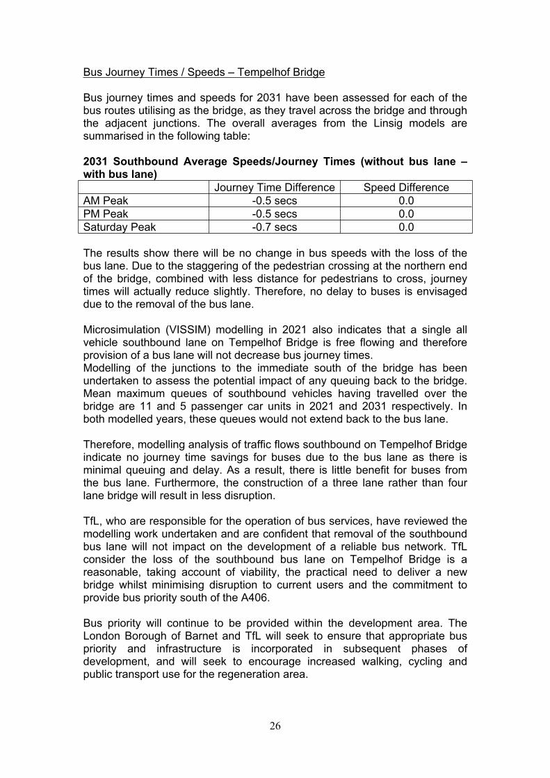
Bus Journey Times / Speeds – Tempelhof Bridge
Bus journey times and speeds for 2031 have been assessed for each of the bus routes utilising as the bridge, as they travel across the bridge and through the adjacent junctions. The overall averages from the Linsig models are summarised in the following table:
2031 Southbound Average Speeds/Journey Times (without bus lane – with bus lane)
Journey Time Difference Speed DifferenceAM Peak -0.5 secs 0.0PM Peak -0.5 secs 0.0Saturday Peak -0.7 secs 0.0
The results show there will be no change in bus speeds with the loss of the bus lane. Due to the staggering of the pedestrian crossing at the northern end of the bridge, combined with less distance for pedestrians to cross, journey times will actually reduce slightly. Therefore, no delay to buses is envisaged due to the removal of the bus lane.
Microsimulation (VISSIM) modelling in 2021 also indicates that a single all vehicle southbound lane on Tempelhof Bridge is free flowing and therefore provision of a bus lane will not decrease bus journey times.Modelling of the junctions to the immediate south of the bridge has been undertaken to assess the potential impact of any queuing back to the bridge. Mean maximum queues of southbound vehicles having travelled over the bridge are 11 and 5 passenger car units in 2021 and 2031 respectively. In both modelled years, these queues would not extend back to the bus lane.
Therefore, modelling analysis of traffic flows southbound on Tempelhof Bridge indicate no journey time savings for buses due to the bus lane as there is minimal queuing and delay. As a result, there is little benefit for buses from the bus lane. Furthermore, the construction of a three lane rather than four lane bridge will result in less disruption.
TfL, who are responsible for the operation of bus services, have reviewed the modelling work undertaken and are confident that removal of the southbound bus lane will not impact on the development of a reliable bus network. TfL consider the loss of the southbound bus lane on Tempelhof Bridge is a reasonable, taking account of viability, the practical need to deliver a new bridge whilst minimising disruption to current users and the commitment to provide bus priority south of the A406.
Bus priority will continue to be provided within the development area. The London Borough of Barnet and TfL will seek to ensure that appropriate bus priority and infrastructure is incorporated in subsequent phases of development, and will seek to encourage increased walking, cycling and public transport use for the regeneration area.

27
The aim is to provide a highway network for the long term regeneration of the area. The proposals submitted are agreed by TfL to match their requirements for providing a reliable bus network to serve the area that support increased use of buses over time and encourage a progressive mode shift.
Pedestrians
Whilst the Tempelhof Bridge will no longer provide a footway on the eastern side of the bridge, on the western side there will be segregated cycle and pedestrian facilities which are sufficient. Positive crossing provision will be provided both to the north and south of the bridge access these facilities safely. Furthermore, the adjacent pedestrian/cyclist only ‘Living Bridge’ (crossing the A406 only 100m approx. to the east) is envisaged to cater for the majority of pedestrians movements across the North Circular between Brent Cross South and the Shopping Centre to the north. This route will cater for most people wishing to access the shopping centre. The footway on the west side of the bridge will cater for those pedestrians walking from the new Thameslink Train Station to the shopping centre. On balance the proposed bridge design is considered to provide acceptable pedestrian and cycle facilities.
Access to the adjacent pedestrian/cyclist Living Bridge from the area to the south of the A406 will be via the approved infrastructure proposed to be re-phased to Phase 1B (South). The planning process will ensure access is provided once constructed. Details of 1B (South) will be accompanied with a further update to the Pedestrian and Cycling Strategy required under condition 2.8 of the Section 73 Permission.
Conclusion
Modelling undertaken identifies minimal congestion on Tempelhof Bridge. Therefore, the removal of the southbound bus lane is shown not to impact on bus journey times. TfL, who are responsible for the operation of bus services, consider the loss of the southbound bus lane on Tempelhof Bridge to be reasonable and have not objected to the application.
The London Borough of Barnet’ Highways Officers and TfL view that the proposed changes are acceptable and will continue to ensure public transport improvements and an integrated pedestrian and cycle network are progressed as each phase of development is delivered, in accord with s106 obligations.
7. ENVIRONMENTAL IMPACT ASSESSMENT
The EIA procedure in the UK is directed by the Town & Country Planning (Environmental Impact Assessment) Regulations 2011 (the ‘Regulations’), EU Directive 85/337/EEC (as amended), as well as the National Planning Practice Guidance (2014).

28
The 2014 Permission was subject to an Environmental Impact Assessment (EIA) process undertaken in line with the Regulations and was reported in the Environmental Statement (ES) dated October 2013 (BXC02).
Regulation 8 of the Regulations requires local planning authorities to consider whether or not the environmental information already before them (i.e. BXC02 submitted with hybrid application F/04687/13 and any additional environmental information) is adequate to assess the environmental effects of the development.
To demonstrate the continued acceptability of the ES associated with application F/04687/13 in the context of the detailed reserved matters applications for Phase 1A (North) an Environmental Statement Further Information Report (the ‘ES FIR’) was submitted with the previous RMAs. The ES FIR considered the impact of all relevant aspects of Phase 1A (North) including all of the Reserved Matters submissions and their individual and cumulative effects.
An ES Addendum report was submitted to accompany the current Reserved Matters Applications (RMAs) for the alternative infrastructure designs within Phase 1A (North) (hereafter referred to as ‘the October 2015 ES Addendum’).
The October 2015 ES Addendum to the Revised ES Further Information Report (Volume 3) provides, where necessary, further environmental review and assessment pursuant to the October 2013 ES and Revised ES Further Information Report June 2015, as considered necessary to inform the assessment of the alternative RMAs as submitted.
Following submission of the Reserved Matters Transport Report Phase 1A North Addendum in January 2016 the developers also submitted a Clarification Letter (dated 21 January 2016) to the October 2015 ES Addendum report which provided clarification on the EIA implications of the updated transport modelling report and the hydraulic modelling outcomes and an associated report in relation to the alternative River Bridge 1 RMA.
Following the submission of the October 2015 ES Addendum, subsequent work was undertaken by transport consultants AECOM to update the Reserved Matters Transport Report (RMTR) submitted with the RMAs to report on the outcomes of transport modelling in relation to the End State year for the Brent Cross Cricklewood development of 2031 but including the Phase 1A (North) Alternative RMAs. This information is presented in the Reserved Matters Transport Report: Sub Phase 1A North: Addendum dated January 2016 (hereafter referred to as ‘RMTR Addendum’) which replaces the RMTR Addendum submitted in October 2015 in full.
In relation to the alternative Reserved Matters, the October 2015 ES Addendum stated that the topics of air quality and noise and vibration would require review / re-assessment once the 2031 traffic data is made available. The ES Addendum Clarification Letter outlines the outcome of the review of the updated traffic data and content of the RMTR Addendum in relation to the

29
RMAs for Tempelhof Bridge and Brent Terrace North, and the outcome of the hydraulic modelling undertaken in respect of the RMA for the alternative River Bridge 1, and confirm whether the impacts previously reported in the Section 73 ES (October 2013) and Revised ES Further Information Report (June 2015) remain valid or whether any new or different impacts have been identified.
Brent Cross Cricklewood: ES Addendum Phase 1A (North) Re-phasing Works and Tempelhof Bridge Amendments (November 2016), provides information in respect of the proposed re-phasing works, the associated highway infrastructure changes, the amendments to the delivery sequencing of open spaces and the amendments to the alternative Tempelhof Bridge. This report provided further information on any likely significant environmental impacts associated with the above amendments. Elements of the ES Addendum, which relate to the design of the alternative Tempelhof Bridge, supersede those elements of the alternative Reserved Matters ES Addendum, October 2015 referenced above.
7.1 Assessment Relating to Bridge Structure B1 (Alternative Tempelhof Bridge)
For the purposes of this committee report, the assessment in relation to the alternative design for the replacement Tempelhof Bridge is set out below:
Traffic and Transport
AECOM Planning Consultants were commissioned to review the alternative design of Tempelhof Bridge, as a consequence an updated Phase 1A (North) Reserved Matters Transport Report: Infrastructure Re-phasing (Phase 1A (North) RMTR, November 2016) has been produced, which reviews the potential transport effects of the proposed amendments, including outline mitigation measures where necessary.
The DDM strategic traffic model was edited and re-run, to reflect the necessary changes from a two to three lane solution and the changes in traffic assignment and flow differences have been analysed. In general, traffic flow changes on the local network are forecast to be negligible and therefore no significant adverse change is anticipated from what has been previously assessed in relation to the approved development.
Transport for London has undertaken its own local area modelling analysis (using VISSIM), which supports the three lane alternative design and they are satisfied that the effect on journey times is satisfactory. In this respect, public transport routes and frequencies will remain unchanged from the approved development.
Air Quality
AECOM have confirmed that the changes in traffic flows on Bridge Structure B1, as a result of the alternative design are negligible (as illustrated in the

30
Phase 1A (North) RMTR, November 2016). Therefore, the proposed bridge amendments will not change the previous air quality results. As such, the air quality assessment included in the EIA Documentation remains applicable and valid for this alternative RMA.
In accordance with the conclusions of the October 2015 ES Addendum, it is therefore confirmed that the alternative proposal for Bridge Structure B1 and associated highway would not result in any new or different likely significant air quality impacts from those previously reported in the Revised ES Further Information Report (June 2015).
Noise and vibration
AECOM forecasted that the proposed amendment to Tempelhof Bridge would result in a minimal increase in traffic flow along this highway link.
However, traffic flow changes on the local highway network are forecast to be generally negligible within the updated DDM which includes the alternative design. In acoustic terms, a doubling of traffic flow (all other things being constant) would be required to result in a change, which is only just perceptible if the change is gradual. In this respect, the potential increases to road traffic noise as a result of amendments to Tempelhof Bridge are therefore likely to be negligible. Furthermore, the dominant noise source at this location is from the A406 where traffic flows are more than fourfold than on the Tempelhof Bridge Link. Road. Therefore, any change in noise levels is likely to be masked by road traffic noise emissions from the A406.
Therefore, in accordance with the conclusions of the October 2015 ES Addendum, it is confirmed that the alternative proposal for Bridge Structure B1 would not result in any new or different likely significant noise impacts from those previously reported in the Revised ES Further Information Report (June 2015). The noise impacts identified and mitigation measures reported in the EIA Documentation submitted to date remain valid for the purpose of determining this application.
7.2 EIA Statement of Conformity
In light of the review of the updated transport modelling and content of the RMTR Addendum (November 2016), and having regard to the content of the October 2015 ES Addendum; it is considered that there would be no material change to the environmental assessment (significant impacts and mitigation). As such, the alternative proposal for Tempelhof Bridge RMA is not considered to result in any new or different likely significant environmental impacts from those reported in the Section 73 ES (October 2013) and Revised ES Further Information Report (June 2015).

31
8. EQUALITY AND DIVERSITY ISSUES
Section 149 of the Equality Act 2010, which came into force on 5th April 2011, imposes important duties on public authorities in the exercise of their functions, including a duty to have regard to the need to:
“(a) eliminate discrimination, harassment, victimisation and any other conduct that is prohibited by or under this Act;
(b) advance equality of opportunity between persons who share a relevant protected characteristic and persons who do not share it;
(c) foster good relations between persons who share a relevant protected characteristic and persons who do not share it.”
For the purposes of this obligation the term “protected characteristic” includes:- age;- disability;- gender reassignment;- pregnancy and maternity;- race;- religion or belief;- sex; and- sexual orientation.
Officers have in considering this application and preparing this report had regard to the requirements of this section and have concluded that a decision to grant planning permission for this proposed development will comply with the Council’s statutory duty under this important legislation.
The site will generally be accessible by various modes of transport, including by foot, bicycle, public transport and private car, thus providing a range of transport choices for all users of the site. Access to the Riverside Park is restricted to no motor based traffic, with the exclusion of Environment Agency maintenance vehicles.
It is considered that the road network has been designed to accommodate disabled users and sufficient width footways, dropped crossing points, and suitable gradients and cross falls will be incorporated in the design, however the design organisation will need to complete a Non-Motorised User Audit as part of the next stages of detail design, which will confirm the designs acceptability for non-motorised users in detail. It should be noted that the proposed alternative Tempelhof Bridge has a maximum longitudinal gradient of 1:20, which is generally recognised by most standards as acceptable for most users, and does not deviate from the design approved under (Ref: 15/03312/RMA). Although many wheelchair users would be unable to proceed at gradients of more than 1 in 40, it is accepted that the proposals are a significant improvement in comparison to the existing situation; where a stepped ramp is the only off carriageway connection between the north and the south of the A406 in this location. Whilst this is accepted as a significant improvement, some design guidance suggests
32
flatter gradients to accommodate all manual wheelchair users would be more appropriate. Due to the constraints of the site including the need for adequate headroom over the A406 provision of gradients below 1 in 20 would be unviable.
9. CONCLUSION
Brent Cross Cricklewood is a large and complex regeneration scheme and Phase 1A (North) provides the majority of the key enabling highway infrastructure to allow development to commence both north and south of the A406 North Circular Road.
In January 2016, Reserved Matters Ref: 15/03312/RMA approved Phase1A (North) highway infrastructure items, including Bridge Structure B1 which consisted of two northbound and two southbound vehicular lanes (a dedicated bus lane either direction), pedestrian footways provided on eastern end and segregated pedestrian and cycle facilities provided on the western end of the bridge.
Since the approval of this application, the BXC Development Partners investigated an alternative design and Reserved Matters were submitted to London Borough of Barnet (LBB) in October 2015. This alternative design reduced the overall width of the bridge by removing the dedicated bus lanes, leaving one vehicular lane for all traffic in each direction. Pedestrian and cyclist facilities remained unaltered. However following consultation, the application remained undetermined and discussions continued between the BXC Development Partners, TfL and LBB highways officers. Following this engagement, amended plans have been submitted to provide for three lanes of traffic including a northbound bus lane and a segregated pedestrian and two way cycle lane (the footway on the eastern side have been removed).
The proposed alternative design for the alternative Bridge Structure B1 accords with the conditions and parameters approved in the Section 73 Permission, subject to the minor variations proposed under Conditions 2.4 and 2.5.
The detailed design of the highways will continue through the separate technical approval process under section 278 and 38 agreements with the relevant highway authorities. At this stage the feasibility design and junction analysis work completed to date is considered acceptable in planning terms to allow the RMA to be approved.
The application has been subject to statutory consultation and a small number of third party representations have been made. No significant issues have been raised that have not been addressed or which would move officers to recommend refusal.
Overall, officers find the proposals acceptable and recommend that the application is approved subject to conditions as outlined in Appendix 1 (Conditions).

33
LIST OF APPENDICES
APPENDIX 1 – CONDITIONSAPPENDIX 2 – RELEVANT PLANNING HISTORYAPPENDIX 3 – POLICY COMPLIANCEAPPENDIX 4 – OBJECTIONS AND OFFICER RESPONSES
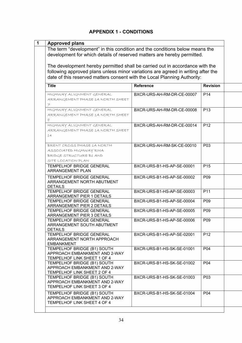
34
APPENDIX 1 - CONDITIONS
1 Approved plansThe term “development” in this condition and the conditions below means the development for which details of reserved matters are hereby permitted.
The development hereby permitted shall be carried out in accordance with the following approved plans unless minor variations are agreed in writing after the date of this reserved matters consent with the Local Planning Authority:
Title Reference Revision
HIGHWAY ALIGNMENT GENERAL ARRANGEMENT PHASE 1A NORTH SHEET 7
BXCR-URS-AH-RM-DR-CE-00007 P14
HIGHWAY ALIGNMENT GENERAL ARRANGEMENT PHASE 1A NORTH SHEET 8
BXCR-URS-AH-RM-DR-CE-00008 P13
HIGHWAY ALIGNMENT GENERAL ARRANGEMENT PHASE 1A NORTH SHEET 14
BXCR-URS-AH-RM-DR-CE-00014 P12
BRENT CROSS PHASE 1A NORTHASSOCIATED HIGHWAY RMABRIDGE STRUCTURE B1 ANDSITE LOCATION PLAN
BXCR-URS-AH-RM-SK-CE-00010 P03
TEMPELHOF BRIDGE GENERAL ARRANGEMENT PLAN
BXCR-URS-B1-HS-AP-SE-00001 P15
TEMPELHOF BRIDGE GENERAL ARRANGEMENT NORTH ABUTMENT DETAILS
BXCR-URS-B1-HS-AP-SE-00002 P09
TEMPELHOF BRIDGE GENERAL ARRANGEMENT PIER 1 DETAILS
BXCR-URS-B1-HS-AP-SE-00003 P11
TEMPELHOF BRIDGE GENERAL ARRANGEMENT PIER 2 DETAILS
BXCR-URS-B1-HS-AP-SE-00004 P09
TEMPELHOF BRIDGE GENERAL ARRANGEMENT PIER 3 DETAILS
BXCR-URS-B1-HS-AP-SE-00005 P09
TEMPELHOF BRIDGE GENERAL ARRANGEMENT SOUTH ABUTMENT DETAILS
BXCR-URS-B1-HS-AP-SE-00006 P09
TEMPELHOF BRIDGE GENERAL ARRANGEMENT NORTH APPROACH EMBANKMENT
BXCR-URS-B1-HS-AP-SE-02001 P12
TEMPELHOF BRIDGE (B1) SOUTH APPROACH EMBANKMENT AND 2-WAY TEMPELHOF LINK SHEET 1 OF 4
BXCR-URS-B1-HS-SK-SE-01001 P04
TEMPELHOF BRIDGE (B1) SOUTH APPROACH EMBANKMENT AND 2-WAY TEMPELHOF LINK SHEET 2 OF 4
BXCR-URS-B1-HS-SK-SE-01002 P04
TEMPELHOF BRIDGE (B1) SOUTH APPROACH EMBANKMENT AND 2-WAY TEMPELHOF LINK SHEET 3 OF 4
BXCR-URS-B1-HS-SK-SE-01003 P03
TEMPELHOF BRIDGE (B1) SOUTH APPROACH EMBANKMENT AND 2-WAY TEMPELHOF LINK SHEET 4 OF 4
BXCR-URS-B1-HS-SK-SE-01004 P04
35
Reason:For the avoidance of doubt and in the interests of proper planning and so as to ensure that the development is carried out fully in accordance with the application as assessed in accordance with policies CS1, CS4, CS5, of the Barnet Local Plan and policy 1.1 of the London Plan.
Informative(s):
1 The following drawings are supporting documents and should be referred to for information:
Title Reference RevisionBRENT CROSS PHASE 1A NORTH GENERAL ARRANGEMENT VISIBILITY SPLAYS SHEET 7
BXCR-URS-AH-01-DR-CE-02007 P15
BRENT CROSS PHASE 1A NORTH GENERAL ARRANGEMENT VISIBILITY SPLAYS SHEET 8
BXCR-URS-AH-01-DR-CE-02008 P11
BRENT CROSS PHASE 1A NORTH GENERAL ARRANGEMENT VISIBILITY SPLAYS SHEET 14
BXCR-URS-AH-01-DR-CE-02014 P11
BRENT CROSS PHASE 1A NORTH GENERAL ARRANGEMENT VEHICLE TRACKING SHEET 7
BXCR-URS-AH-01-DR-CE-03007 P13
BRENT CROSS PHASE 1A NORTH GENERAL ARRANGEMENT VEHICLE TRACKING SHEET 8
BXCR-URS-AH-01-DR-CE-03008 P11
BRENT CROSS PHASE 1A NORTH GENERAL ARRANGEMENT VEHICLE TRACKING SHEET 14
BXCR-URS-AH-01-DR-CE-03014 P11
BRENT CROSS GENERAL ARRANGEMENT PHASE 1A NORTH KEY PLAN
BXCR-URS-AH-RM-SK-CE-00001 P09
2 The applicant is advised that the costs of any works including reinstatement works to existing public highway associated with the approved development, or new roads proposed for adoption as public highway, will be borne by the applicants and may require entering into a Section 278 Agreement or Section 38 Agreement under the Highways Act 1980. Detailed design and construction of the associated highways works will have to be approved by the Traffic & Development Team prior to entering into the necessary Highway Agreements. For further information contact Traffic and Development Section, Development and Regulatory Services, Barnet House, 1255 High Road, Whetstone N20 0EJ.
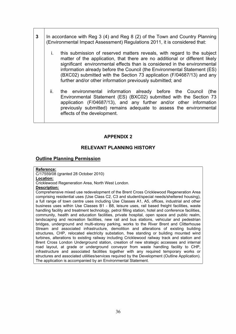
36
3 In accordance with Reg 3 (4) and Reg 8 (2) of the Town and Country Planning (Environmental Impact Assessment) Regulations 2011, it is considered that:
i. this submission of reserved matters reveals, with regard to the subject matter of the application, that there are no additional or different likely significant environmental effects than is considered in the environmental information already before the Council (the Environmental Statement (ES) (BXC02) submitted with the Section 73 application (F/04687/13) and any further and/or other information previously submitted; and
ii. the environmental information already before the Council (the Environmental Statement (ES) (BXC02) submitted with the Section 73 application (F/04687/13), and any further and/or other information previously submitted) remains adequate to assess the environmental effects of the development.
APPENDIX 2
RELEVANT PLANNING HISTORY
Outline Planning Permission
Reference: C/17559/08 (granted 28 October 2010)Location:Cricklewood Regeneration Area, North West London.Description:Comprehensive mixed use redevelopment of the Brent Cross Cricklewood Regeneration Area comprising residential uses (Use Class C2, C3 and student/special needs/sheltered housing), a full range of town centre uses including Use Classes A1, A5, offices, industrial and other business uses within Use Classes B1 - B8, leisure uses, rail based freight facilities, waste handling facility and treatment technology, petrol filling station, hotel and conference facilities, community, health and education facilities, private hospital, open space and public realm, landscaping and recreation facilities, new rail and bus stations, vehicular and pedestrian bridges, underground and multi-storey parking, works to the River Brent and Clitterhouse Stream and associated infrastructure, demolition and alterations of existing building structures, CHP, relocated electricity substation, free standing or building mounted wind turbines, alterations to existing railway including Cricklewood railway track and station and Brent Cross London Underground station, creation of new strategic accesses and internal road layout, at grade or underground conveyor from waste handling facility to CHP, infrastructure and associated facilities together with any required temporary works or structures and associated utilities/services required by the Development (Outline Application). The application is accompanied by an Environmental Statement.

37
Reference:F/04687/13 (granted 23 July 2014)Location:Brent Cross Cricklewood Regeneration Area, North West, London, NW2Description:Section 73 Planning application to develop land without complying with the conditions attached to Planning Permission Ref C/17559/08, granted on 28 October 2010 ('the 2010 Permission'), for development as described below: Comprehensive mixed use redevelopment of the Brent Cross Cricklewood Regeneration Area comprising residential uses (Use Class C2, C3 and student/special needs/sheltered housing), a full range of town centre uses including Use Classes A1 - A5, offices, industrial and other business uses within Use Classes B1 - B8, leisure uses, rail based freight facilities, waste handling facility and treatment technology, petrol filling station, hotel and conference facilities, community, health and education facilities, private hospital, open space and public realm, landscaping and recreation facilities, new rail and bus stations, vehicular and pedestrian bridges, underground and multi-storey parking, works to the River Brent and Clitterhouse Stream and associated infrastructure, demolition and alterations of existing building structures, CHP/CCHP, relocated electricity substation, free standing or building mounted wind turbines, alterations to existing railway including Cricklewood railway track and station and Brent Cross London Underground station, creation of new strategic accesses and internal road layout, at grade or underground conveyor from waste handling facility to CHP/CCHP, infrastructure and associated facilities together with any required temporary works or structures and associated utilities/services required by the Development (Outline Application). The application is accompanied by an Environmental Statement.
Phase 1A (North) Reserved Matters (Approved)
Reference: 15/00720/RMA (granted 09/06/2015)Location:Land off Brent Terrace, London, NW2 (The Brent Terrace Triangles)Description:Reserved Matters application within Phase 1a (North) of the Brent Cross Cricklewood Regeneration Scheme relating to Layout, Scale, Appearance, Access and Landscaping, for the residential development of Plots 53 and 54 comprising 47 Residential Units Submission is pursuant to conditions 1.2.1.A, 2.1 and for the part discharge of condition 13.1 of Planning Permission F/04687/13 dated 23 July 2014 for the comprehensive mixed use redevelopment of the Brent Cross Cricklewood regeneration area. Application is accompanied by an Environmental Statement Further Information Report.
Reference: 15/00769/RMA (granted 25/06/2015)Location: Clitterhouse Playing Fields And Claremont Open Space, Off Claremont RoadLondon NW2Description:Reserved Matters application within Phase 1A (North) of the Brent Cross Cricklewood Regeneration area, submitted pursuant to conditions 1.2.1.A, 2.1 and for the part discharge of condition 13.1 of Planning Permission F/04687/13 dated 23 July 2014 for the comprehensive mixed use redevelopment of Brent Cross Cricklewood, relating to Layout, Scale, Appearance, Access and Landscaping for the Open Spaces of Clitterhouse Playing Fields and Claremont Park, including the provision of a sports pavilion, maintenance store and associated car parking. Application is accompanied by an Environmental Statement Further Information Report.

38
Reference: 15/03312/RMA (Resolution to grant approved at Planning Committee 10/09/2015)Location:Brent Cross Cricklewood Regeneration Area, North West London, NW2Description:Reserved Matters application within Phase 1a (North) of the Brent Cross Cricklewood Regeneration scheme relating to Layout, Scale, Appearance, Access and Landscaping for infrastructure including roads, bridges and River Brent diversion works; Submission is pursuant to conditions 1.2.1.A, 2.1 and for the part discharge of condition 13.1 of planning permission F/04687/13 dated 23 July 2014 for the comprehensive mixed use redevelopment of the Brent Cross Cricklewood regeneration area.Application is accompanied by an Environmental Statement Further Information Report.
Reference: 15/03315/RMA (Resolution to grant approved at Planning Committee 10/09/2015)Location:Central Brent Riverside Park, Brent Cross Cricklewood, London, NW2Description:Reserved Matters application within Phase 1A (North) of the Brent Cross Cricklewood Regeneration area, submitted pursuant to conditions 1.2.1A, and 2.1 and for the part discharge of condition 13.1 of Planning Permission F/04687/13 dated 23 July 2014 for the comprehensive mixed use redevelopment of Brent Cross Cricklewood, relating to Layout, Scale, Appearance, Access and Landscaping for the Open Space of the Central Brent Riverside Park. Application is accompanied by an Environmental Statement Further Information Report.Reference: 15/05040/CON (Resolution to grant approved at Planning Committee 10/09/2015)Location:Brent Cross Cricklewood Regeneration Area, North West London, NW2Description:Submission under conditions 2.4 and 2.5 for revision of the Development Specification and Framework and Design and Access Statement attached to Section 73 permission reference F/04687/13 for the Comprehensive mixed-use redevelopment of the BXC Regeneration Area. Changes relate to the provision of Phase 1A (North) Infrastructure and Central Brent Riverside Park (Reach 2) Open Space, Landscaping, Access and Bio-diversity proposals together with minor consequential changes to the section 73 permission.Reference: 15/06572/RMA (Resolution to grant approved at Planning Committee 24/02/2016)Location:Tilling Road /Brent Terrace North Junction, Brent Cross Cricklewood Regeneration Area, London NW2 Description:Submission of Reserved Matters Application within Phase 1A (North) of the Brent Cross Cricklewood Regeneration Area; relating to Layout, Scale, Appearance, Access and Landscaping for Tilling Road West/Brent Terrace North Junction. Submission is pursuant to conditions 1.2.1A and 2.1 and for the part discharge of condition 13.1 of planning permission F/04687/13 dated 23 July 2014 for the comprehensive mixed use redevelopment of the Brent Cross Cricklewood Regeneration Area.Reference: 15/06573/RMA (Resolution to grant approved at Planning Committee 24/02/2016)Location:River Brent Bridge 1, Western And Central Part Of River Brent, Brent Cross Cricklewood Regeneration Area, London, NW2Description:Submission of Reserved Matters Application within Phase 1A (North) of the Brent Cross Cricklewood Regeneration Area; relating to Layout, Scale, Appearance, Access and Landscaping for River Brent Bridge 1 and adjacent parts of River Brent Alternation and diversion works. Submission is pursuant to conditions 1.2.1A and 2.1 and for the part discharge of condition 13.1 of planning permission F/04687/13 dated 23 July 2014 for the comprehensive mixed use redevelopment of the Brent Cross Cricklewood Regeneration Area.

39
Reference: 15/06574/RMA (Resolution to grant approved at Planning Committee 24/02/2016)Location:Central Brent Riverside Park Within The Vicinity Of River Brent Bridge 1, Brent Cross Cricklewood Regeneration Area, London, NW2Description:Submission of Reserved Matters Application within Phase 1A (North) of the Brent Cross Cricklewood Regeneration Area; relating to Layout, Scale, Appearance, Access and Landscaping for Central Brent Riverside Park within the vicinity of River Brent Bridge 1. Submission is pursuant to conditions 1.2.1A, and 2.1 and for the part discharge of condition 13.1 of planning permission F/04687/13 dated 23 July 2014 for the comprehensive mixed use redevelopment of the Brent Cross Cricklewood Regeneration Area.
Phase 1A (South) Reserved Matters
Reference: 15/06518/RMA (Resolution to grant at Planning Committee 27 January 2016)Location:Phase 1A (South), Brent Cross Cricklewood Regeneration Area, Land At Claremont Industrial Estate And Whitefield Estate, London NW2Description:Submission of Reserved Matters Application within Phase 1A (South) of the Brent Cross Cricklewood Regeneration Area; relating to Layout, Scale, Appearance, Access and Landscaping for Claremont Park Road (Part 1) and School Lane. Submission is pursuant to conditions 1.2.1.B, 2.1 and for the part discharge of condition 13.1 of planning permission F/04687/13 dated 23 July 2014 for the comprehensive mixed use redevelopment of the Brent Cross Cricklewood Regeneration Area. Application is accompanied by an Environmental Statement Compliance Note.
Pre Reserved Matters Conditions
Pre-Reserved Matters Conditions for Phase 1A North
Planning Reference
Condition Description Status
14/08105/CON15/07955/CON
Area Wide Walking and Cycling Study to address condition 1.20 of S73 Planning Application Ref: F/04687/13 approved 23/07/2014 for the Comprehensive Mixed Use redevelopment of the Brent Cross Cricklewood Area.
Approved
14/08112/CON Framework Servicing and Delivery Strategy to address condition 1.21 of S73 Planning Application Ref: F/04687/13 approved 23/07/2014 for the Comprehensive Mixed Use redevelopment of the Brent Cross Cricklewood Area.
Approved
14/08111/CON Servicing and Delivery Strategy for Sub-Phase 1A North to address condition 1.22 of S73 Planning Application Ref: F/04687/13 approved 23/07/2014 for the Comprehensive Mixed Use redevelopment of the Brent Cross Cricklewood Area.
Approved

40
14/08110/CON15/07954/CON
Pedestrian and Cycle Strategy for Phase 1A North to address condition 2.8 of S73 Planning Application Ref: F/04687/13 approved 23/07/2014 for the Comprehensive Mixed Use redevelopment of the Brent Cross Cricklewood Area
Approved
15/00667/CON Estate Management Framework to address condition 7.1 for Phase 1a (North) of S73 Planning Application Ref: F/04687/13 approved 23/07/2014 for the Comprehensive Mixed Use redevelopment of the Brent Cross Cricklewood Area
Approved
14/08109/CON Car Parking Management Strategy to address condition 11.1 of S73 Planning Application Ref: F/04687/13 approved 23/07/2014 for the Comprehensive Mixed Use redevelopment of the Brent Cross Cricklewood Area
Approved
14/08108/CON Phase Car Parking Standards and the Phase Car Parking Strategy for Sub Phase 1A North to address condition 11.2 of S73 Planning Application Ref: F/04687/13 approved 23/07/2014 for the Comprehensive Mixed Use redevelopment of the Brent Cross Cricklewood Area
Approved
14/07897/CON Existing Landscape Mitigation Measures in relation to Phase 1a North to address condition 27.1 of S73 Planning Application Ref: F/04687/13 approved 23/07/2014 for the Comprehensive Mixed Use redevelopment of the Brent Cross Cricklewood Area
Approved
14/07896/CON Tree Protection Method Statement in relation to Phase 1a North to address condition 27.2 of S73 Planning Application Ref: F/04687/13 approved 23/07/2014 for the Comprehensive Mixed Use redevelopment of the Brent Cross Cricklewood Area
Approved
15/00668/CON Acoustic Design Report to address condition 29.1 for Phase 1a (North) of S73 Planning Application Ref: F/04687/13 approved 23/07/2014 for the Comprehensive Mixed Use redevelopment of the Brent Cross Cricklewood Area
Approved
15/00812/CON15/07953/CON
Proposed Phase Transport Report for Phase 1 to address condition 37.2 of S73 Planning Application reference F/04687/13 approved 23/07/2014 for the Comprehensive Mixed Use redevelopment of the Brent Cross Cricklewood Area.
Approved
14/07402/CON A5 Corridor Study submission to address condition 2.7 of S73 planning application ref: F/04687/13 dated 23/07/2014 for the comprehensive mixed use redevelopment of the Brent Cross Cricklewood Area.
Approved
15/00660/CON Illustrative Reconciliation Plan to clear condition 1.17 for Phase 1a (North) of S73 Planning Application Ref: F/04687/13 approved 23/07/2014 for the Comprehensive Mixed Use redevelopment of the Brent Cross Cricklewood Area
Approved

41
Pre Reserved Matters Conditions Updates
16/7667/CON Update to the Pedestrian and Cycle Strategy approved under Condition 2.8 (ref: 14/08110/CON; dated 10/09/2015) and updated (under ref: 15/07954/CON; dated 29.03.2016) for Phase 1 A North of the Section 73 Planning Approval Ref: F/04687/13 approved 23/07/2014 for the comprehensive mixed use redevelopment of the Brent Cross Cricklewood regeneration area
Under consideration at the time of writing this committee report.
16/7666/CON Update to the Phase Transport Report for Phase 1 approved under Condition 37.2 (ref: 15/00812/CON; dated 10.09.2015) and updated (under ref: 15/07953/CON; dated 04.04.2016) of the Section 73 Planning Approval Ref: F/04687/13 approved 23/07/2014 for the comprehensive mixed use redevelopment of the Brent Cross Cricklewood regeneration area
Under consideration at the time of writing this committee report.
APPENDIX 3
POLICY COMPLIANCE
Analysis of compliance with the London Plan (Consolidated with Further Alterations since 2011) (March 2016) Policies
Policy Content Summary Extent of compliance and comment
Policy 1.1 (Delivering the strategic vision and objectives for London)
Strategic vision and objectives for London including managing growth and change in order to realise sustainable development and ensuring all Londoners are able to enjoy a good and improving quality of life. Improving environments which are easy, safe and convenient for everyone to access.
Compliant: As a London Plan Opportunity Area, the approved BXC scheme seeks to make the most of brownfield land to meet wider growth requirements in terms of housing, retail and commercial activities in a location accessible by a range of transport modes. The provision of the proposed infrastructure will assist in achieving the wider sustainable aims of the London Plan and provide easy, safe and convenient access for all.
Policy 2.6 (Outer London: vision and strategy)
Work to realise the full potential of outer London and enhance the quality of life for present and future residents. Understand the significant difference in the nature and quality of neighbourhoods; improvement initiatives should address these sensitively and draw upon strategic support where necessary.
Compliant: The proposed development represents one of the most important opportunity areas in outer London. The BXC Opportunity Area represents a significantly underutilised area of accessible brownfield land in need of regeneration.
42
Policy Content Summary Extent of compliance and comment
Policy 2.8 (Outer London: Transport)
Enhance accessibility by improving links to and between town centres and other key locations by different modes and promoting and realising the key improvements. Work to improve public transport access, provide improved traffic management, road improvements and address and manage local congestion
Compliant: The majority of the infrastructure improvements associated with the regeneration will be delivered during Phase 1. The roads delivered under Phase 1A North will also help facilitate southern plot and residential developments and provide a connection into the road network.
Policy 2.13 (Opportunity Areas and Intensification Areas)
Support the strategic policy directions for the opportunity areas, and where relevant, in adopted opportunity area planning frameworks
Support wider regeneration, including in particular improvements to environmental quality, and integrate development proposals to the surrounding areas especially for regeneration.
Compliant: With regards to this current Reserved Matters Application, the proposed roads will support the wider regeneration scheme.
Policy 2.14 (Areas for regeneration)
Boroughs should identify spatial areas for regeneration and spatial policies to bring together regeneration.
Compliant: The BXC site is identified as a London Plan Opportunity Area (See Policy 1.1 above) in need of comprehensive regeneration and capable of accommodating significant housing, jobs and community infrastructure.
This particular RMA provides will help facilitate the Southern development.
Policy 2.15 (Town Centres)
Development proposal should promote access by public transport walking and cycling. Promote safety and security and contribute towards an enhanced public realm and links to green infrastructure.
Compliant: The development proposal in future phases will provide a connection between the Northern and Southern elements of the regeneration including a new town centre and new Thameslink Train Station.
Policy 6.3 (Assessing effect of development of transport capacity)
Development proposals should ensure that impacts on transport capacity and the transport network, at both a corridor and local level are fully assessed. Transport assessments will be required in accordance with TfL’s Transport Assessment Best Practice Guidance for major planning applications.
Part Compliant: The RMA has is supported by the previously approved Phase Transport Report (PTR) for Phase 1 (Condition 37.2) and includes an addendum to the approved Reserved Matters Transport Report for Phase 1A (North). Both of these have been carried out in accordance with the Section 73 Planning Permission and accompanying 2014 Section 106 Agreement.

43
Policy Content Summary Extent of compliance and comment
Policy 6.7 (Better streets and surface transport)
Development proposals should promote bus networks; allocating road space and providing high level priory on existing and proposed routes. Ensuring good access to and within areas served by networks, now and in future; and ensuring direct, secure, accessible and pleasant walking routes to stops.
Compliant: The approved Phase 1A (North) provides a significant amount of new roads to facilitate existing and future bus routes, including providing connections off Prince Charles Drive to the new bus station.
Policy 6.9 (Cycling)
Proposals should identify and implement a network of cycle routes. Contribute positively to an integrated cycling network for London by providing infrastructure that is safe, comfortable, attractive, coherent, direct and adaptable and in line with the guidance set out in the London Cycle Design Standards (or subsequent revisions).
Compliant: The approved Area Wide Walking and Cycling Study (AWWCS - Condition 1.20) and the Phase 1A (North) Pedestrian and Cycle Strategy (Condition 2.8) ensured that a coherent network of cycle routes is provided on a phase by phase basis as part of the overall scheme, including as part of AWWCS appropriate links between the site and adjacent communities.
This application includes a shared footway/cycleway alongside the western side of Tempelhof Bridge.
Policy 6.10 (Walking)
Development proposals should ensure high quality pedestrian environments and emphasise the quality of the pedestrian and street space by referring to Transport for London’s Pedestrian Design Guidance. Promote the ‘Legible London’ programme to improve pedestrian way finding. Encourage the use of shared space principles, such as simplified streetscape, de-cluttering and access for all.
Compliant: A Pedestrian and Cycle Strategy (Condition 2.8) has previously been approved for Phase 1A (North).
Signing throughout the development will be provided in accordance with the guidelines set out in Legible London, and contained in the Wayfinding and Inclusive Access Strategy. A high quality public realm is proposed throughout.
Policy 6.12 (Road network capacity)
Proposals should improve the road network taking into account: where it contributes to sustainable development, regeneration and improved connectivity, the extent of any additional traffic and any effects it may have on the locality, congestion impacts, the net benefit to the environment, how conditions for pedestrians, cyclists, public transport and freight users and local residents, as well as road safety, can be improved.
Compliant: The Phase 1 impacts have been examined in the Phase Transport Report (PTR), and the reports provided a multi – modal assessment of Phase 1. The proposal for Phase 1A (North) in the wider regeneration will improve he road network and improve connectivity between the northern and southern proposals as well as improve existing facilities.

44
Analysis of the proposals compliance with Barnet’s Local Plan Polices(September 2012)
Core Strategy
Policy Content Summary Extent of Compliance and Comment
CS NPPF (National Planning Policy Framework – presumption in favour of sustainable development)
Take a positive approach to proposals which reflect the presumption in favour of sustainable development and approve applications that accord with the Local Plan, unless material considerations indicate otherwise. Where there are no policies relevant to the proposal or the relevant policies are out of date permission should be granted, unless material considerations indicate otherwise.
Compliant: the proposal is considered to constitute sustainable development in accordance with the NPPF and which complies with Local Plan taken as a whole. It is therefore recommended for approval.
CS1 (Barnet’s place shaping strategy – the three strands approach)
As part of its ‘Three Strands Approach’ the council will:
- Concentrate and consolidate growth in well located areas that provide opportunities for development, creating a high quality environment that will have positive impacts.
- Focus major growth in the most suitable locations and ensure that this delivers sustainable development, while continuing to conserve and enhance the distinctiveness of Barnet as a place to live, work and visit.
- Ensure that development funds infrastructure through Section 106 Agreements and other funding mechanisms.
- Protect and enhance Barnet’s high quality suburbs.
Compliant: As an Opportunity Area in the Mayor’s London Plan, the BXC scheme has been developed with the consideration that the site has significant capacity for new housing, commercial and other development linked to existing or potential improvements to public transport accessibility.
The proposed development relates to matters reserved following the grant of planning permission in 2014.
The majority of the infrastructure improvements associated with the scheme will be delivered during Phase 1. The roads developed under the delivery of Phase 1A (North) are designed to facilitate southern plot and residential development.
CS2 – Brent Cross - Cricklewood
The Council will seek comprehensive redevelopment of Brent Cross – Cricklewood in accordance with the London Plan, the saved UDP policies (Chapter 12) and the adopted Development Framework.
Compliant: The 2014 consent of the S73 application continues to ensure the comprehensive redevelopment of Brent Cross Cricklewood in accordance with this policy and the Saved UDP policies.
The infrastructure will be enhanced for visitors to the Brent Cross Shopping Centre and the Southern development. It will be an asset for the public and existing neighbourhoods. The infrastructure proposed under Phase 1A (North) will support the wider Brent Cross regeneration.

45
CS9 (Providing safe, efficient and effective travel)
Promote the delivery of appropriate transport infrastructure in order to support growth.
Ensure new development funds infrastructure to keep existing traffic moving and cope with new demands.
Major proposals should incorporate Transport Assessments, Travel Plans, Delivery and Servicing Plans and mitigation measures and ensure that adequate capacity and high quality safe transport facilities are delivered in line with demand.
Deliver with partners high quality public transport improvements along the A5, bus service enhancements as part of regeneration schemes, including a high quality bus station at BXC and a Rapid Transit bus service.
Compliant: The approved Phase 1A (North) provides a significant amount of new roads to facilitate existing and future bus routes. The wider development includes the provision of a new bus station and Thameslink Train Station.
This RMA has is supported by previously approved Phase Transport Report (PTR) for Phase 1 (Condition 37.2) and includes an addendum to the approved Reserved Matters Transport Report for Phase 1A (North). Both of these have been carried out in accordance with the Section 73 Planning Permission and accompanying 2014 Section 106 Agreement
Adopted UDP (May 2006) Saved Policies (May 2009) as referred to in Core Strategy Policy CS2 – Chapter 12 of the UDP: Cricklewood, Brent Cross and West Hendon Regeneration Area
GCrick Cricklewood, Brent Cross and West Hendon Regeneration Area
- The Council seeks integrated regeneration in the Cricklewood, Brent Cross and West Hendon Regeneration Area.
- All development to the highest environmental and design standards
- Aim to develop a new town centre over the plan period.
Compliant: the development is consistent with this strategic aim, falling as it does within the terms of the Section 73 Planning Permission.
C1 Comprehensive Development
- The Council seeks the comprehensive development of the regeneration area in accordance with the area framework and delivery strategy.
- Development proposals will need to meet policies of the UDP and their more detailed elaboration in the development framework.
Compliant: The scheme accords with this policy. The Phase 1A (North) proposals accord with the scope of the Section 73 Planning Permission.
C7 Transport Improvements
Transport improvements - the following should be provided through planning conditions and/or Section 106 agreements:
i. Connections and improvements to the strategic road network.
ii. Sufficient transport links to and through the development, to include at least one vehicular link across the North Circular Road (NCR) and one vehicular link crossing the railway to
Part Compliant: The RMA relates to the Tempelhof Bridge, the wider Phase 1A (North) infrastructure proposals also facilitate the new bus station in Phase 1B (North) by providing the connections off Prince Charles Drive and as explained in the various other policy sections above provides compliant facilities for pedestrians including disabled people, cyclists and bus users. The other facilities set out in policy C7 are planned to be provided as part of future phases, except for the rapid transit system which, whilst still part

46
the Edgware Road.
iii. A new integrated railway station and new integrated bus station at Cricklewood, linked by a rapid transport system to Brent Cross Bus Station and Hendon Central and/or Brent Cross Underground Stations on the Northern Line.
iv. A new bus station at Brent Cross, to north of the North Circular Road, with associated improvements to the local bus infrastructure.
v. An upgrade of the rail freight facilities.
vi. Provision of an enhanced, rail-linked waste transfer station serving North London.
vii. Priority measures for access to disabled persons, pedestrians, buses and cyclists throughout the Regeneration Area.
of the proposals, is currently unfunded.
UDP Site Specific Proposals (2006)
Parts of the BXC development site are subject to site‐specific proposals as shown in the Proposals Map (2006) (as saved). The aspirations for these sites are set out below:
Brent Cross New Town Centre (Site 31) – new town centre, comprising a mix of appropriate uses, improved public transport and pedestrian access, landscaping and diversion of the River Brent;
Cricklewood Eastern Lands (Site 37) – mixed use including residential, office, leisure, local and neighbourhood shops, education, community uses and open space;
New Railway Station Cricklewood (Site 38) – railway station and public transport interchange;
New Waste Transfer Station (Site 39) – waste handling facility.
Compliant: the proposal is consistent with the Proposals Map.

47
Cricklewood, Brent Cross, West Hendon Regeneration Area Development Framework SPD 2005.
The Cricklewood, Brent Cross and West Hendon Regeneration Area Development Framework was adopted by the council and the Mayor of London as Supplementary Planning Guidance in 2005. This Development Framework was produced in collaboration with the Mayor and the Greater London Authority, landowners and developers in order to guide and inform the design and delivery of the development with the aim of achieving high quality comprehensive redevelopment of the area around a new sustainable mixed use town centre spanning the North Circular Road.
The London Plan and the UDP saved policies combined with the Development Framework establishes a series of strategic principles for the comprehensive redevelopment of the area to create a new town centre, the overall vision for which is set out in UDP Policy GCrick.
Compliant: Compliance in relation to the proposed RMA: The parameters and principles of the BXC scheme are considered to be in accordance with the principles set out in the guidance contained in the adopted Development Framework (2005) generally and taken as a whole.
The general proposals are consistent with the vision and aims of the Development Framework.

48
APPENDIX 4 - OBJECTIONS AND OFFICER RESPONSES
First Consultation Period expiring 25th November 2015
Consultation responses from local residents
Consultation Response Officer Comments
Resident 1 Response:
Reasons for this RMA
Why is the bridge being reduced in width? Is this a cost cutting exercise by the developers?
Does reducing the construction complexity reduce the potential to the public travelling?
Can the crossing be constructed prior to the demolition of the existing bridge?
Reasons for this RMAThe reduction in width of the Tempelhof Bridge, with the removal of the southbound bus lane is proposed as the results of detailed traffic modelling of traffic flow patterns in both 2021 and 2031 that indicates the change has minimal impact.
A 2m wide footway for pedestrians on the west side of the bridge, with positive, signal controlled crossings for pedestrians to both the north and south of the bridge provides suitable and sufficient provision, resulting in the eastside footway not to be required.
In buildability terms, the construction of a three lane bridge will result in less delays and disruption to traffic and travel patterns in the area, when compared to the four lane option.
Concerns raised that if the bus lanes are removed it would reduce the speed of the bus service. Buses are the only form of public transport within this development. The 2009 Outline Permission demonstrated that there would be extra buses and bus lanes.
Traffic modelling analysis indicates that a southbound bus lane results in no significant benefit to buses. With no predicted congestion immediately south of the bridge, there are no queues and therefore buses can flow freely both with and without the lane in place.
If the number of bus lanes are reduced how will buses still have priority?
The developers have said that there would be a segregated cycleway over the bridge, is this a shared footpath? Cyclists can use the living bridge, but they can’t go north of this bridge.
TfL, who are responsible for the operation of bus services, have reviewed journey time data, both existing and predicted, with and without the bus lane and have raised no objection to the proposals.
In addition to the 2.0m footway, a 2.0m wide segregated cycle route will be provided on the west side of the bridge.
Alternative proposals for bus priority that have been considered include:
Market Square / High Street South / Tempelhof Avenue Junction Improvements – Bus priority enabling buses to get ahead of general traffic on High Street South.
Signalisation of entry into bus station Bus lane provision on Prince Charles
DriveThese were reviewed and discounted by both the London Borough of Barnet and TfL.
49
In the documentation it states ‘To accompany the modelling assessment of the alternative proposal for the removal of the bus lanes, the modelling exercise will also include a review of other potential alternative bus priority measures to ensure that the alternative proposals for the overall layout provides for the most efficient movement of buses through the affected network.’ Where are these potential alternative bus priority measures? Are they really effective? Concerns raised that the conclusions of the Phase 1 modelling impact journey time at some locations/time compared to the reserved matters application (RMA) that includes sections of bus lanes on Tempelhof Avenue. Whilst the network and the volume of both bus and general traffic will change significantly in the End-State (2031) this initial assessment of the phase 1 (2021) scheme suggests that removing the bus lanes does not have a significant impact on traffic flow volumes. Will this new proposal fulfil TfL’s requirements?
The results of the modeling work undertaken for the three lane bridge proposal meets the requirements of, and are accepted by, TfL, Bus journey times are maintained. Improvements for bus users include the provision of a new bus station at Brent Cross
How many people/residents were sent letters about this RMA? 4 applications were consulted on letter at the same time but no explanation or summary. Not all documents could be accessed.
Please see the main report for details of the number of residents consulted and re consulted. Consultation time periods comply with the statutory requirements and the consultation expiry dates are also available on the Councils website. All four RMA applications are part of Phase 1A North and were submitted within the same timeframe; therefore one consultation letter covered all four applications. The planning case officer is available (on the telephone) to discuss and explain the planning application and documentation submitted.
Consultation responses from Statutory Consultees and Other interest groups
Consultation Response Officer Comments
Transport for London
Initially objected to the alternative Tempelhof Bridge design on the following basis:
The modelling submitted assesses the 2021 scenario and not 2031 scenario. TfL would not support the approval without the correct modelling requested. TfL offered to provide assurance to this process through a technical working group.
The following technical questions were raised:
How the results changed if the entire VISSM
Concerns regarding the modelling work undertaken were identified by both Transport for London and London Borough of Barnet Highways Officers.
Further modelling work has been subsequently undertaken. This additional work, combined with retention of the northbound bus lane, which provides additional resilience for buses, has resulted in TfL removing their objection to the application.

50
model was run?
How the Toucan crossing would operate in the approved and proposed scenarios?
Operational impact of the bus stop within the traffic lane and ability to provide bus stops along this corridor Freight movements on Prince Charles Drive during peak periods. Can this be limited?
Not providing Bus lanes:
Results provided demonstrate that in the AM it shows marginal increase in general traffic journey delays (+1.23 seconds per vehicle), with benefits to buses (minus 4.67 seconds). In the PM, general traffic marginal worse (+1.83 seconds), with buses worse than that (+4.0 seconds). On Saturday, not having the bus lanes is worse for general traffic (+6.14 seconds) and for buses (+10.83 seconds). Therefore, not providing bus lanes is worse for TfL and bus users than providing then though these averages include a more complex story based on links and routes.
The route by route assessment shows during the AM peak there is a benefit to buses heading southbound; northbound, 5 routes show dis-benefit and 4 benefit. PM peak, benefits to southbound routes, northbound all routes dis-benefit including 33 seconds per bus on the 112. On Saturday, all southbound buses benefit, all northbound buses dis-benefit including 80 seconds on 266, 76 seconds on the 112 and 67 seconds on 182. London Borough of Brent
LB Brent initially objected to the application on the following grounds:
The proposed narrowing of the originally approved bridge width and omission of bus lanes would have a negative impact on bus journey times for routes serving Brent.
The detailed design also amends the outline scheme by reducing the width of the bridge from about 23.5m to about 11m to accommodate only a two-lane single carriageway road, with the previously proposed northbound and southbound bus lanes over the bridge omitted.
The VISSIM modelling for the development has been rerun for future year 2021. These do show some relatively minor improvements
With the retention of the northbound bus lane, which provides additional resilience for buses, the London Borough of Brent has removed their objection to the application.

51
to overall bus journey times at peak hours in a southbound direction, as maximum modelled queue lengths from the future signalised junctions at Market Square and Tilling Road are short enough not to extend over the bridge.
The reduction in the width of the pedestrian crossing on the northern side of the bridge would provide less crossing time for pedestrians and less delay to all traffic.
Northbound journey times for buses are shown to be much longer in the evening peak period and in the Saturday peak hour, as queues are shown extending over Templehof Bridge, meaning that buses would be caught in the queue with no bus lane provided.
The results indicate that whilst the removal of the southbound bus lane may offer little dis-benefit to buses for 2021, the northbound bus lane is of intrinsic value in allowing buses to bypass long predicted queues over the bridge from the stop line at the western roundabout.
No assessment has yet been undertaken for the end-state scenario (year 2031), which may show yet further delays.Brent Cyclists, the local group in Brent of the London Cycling Campaign
Objection regarding shared lanes between cyclists and pedestrians.
Considers the segregated cycle and pedestrian lane a positive aspect; however should provide a continuous route. Suggested Cycle Superhighway 5 across Vauxhall Bridge and through the Vauxhall Cross Gyratory, which provides a clear and wide cycling path in both directions which is segregated from pedestrians and vehicles.
The planned development provides a continuous segregated route for cyclists from the A41 and potentially Cycle Superhighway 11, though Clitterhouse Playing Fields and across Tempelhof Bridge to Brent Cross Shopping Centre. To the north of the bridge there is, as stated, shared provision for cyclist and pedestrians.
Historic England
No archaeological comments raised with regards to the detailed design
Noted
Highways England
Having considered this Reserved Matters Application, no comments have been raised
Noted
Network Rail
No objection raised NotedSport England
No objection raised Noted

52
Thames Water
No objection raised Noted
Second Consultation Period expiring 15 February 2016No objections were recevied.
Third Consultation Period expiring 23rd December 2015
Consultation responses from local residents
Consultation Response Officer Comments
Resident 1 Response:
The alternative Tempelhof Bridge was initially illustrated demonstrating four lanes of vehicular traffic, concerns raised why this design has changed.
Modelling analysis of traffic flows southbound on Tempelhof Bridge indicate minimal queues/delays resulting in little benefit for buses from the bus lane. Furthermore, the introduction of the staggered rather than straight across pedestrian crossing at the northern end of the bridge, combined with less distance for pedestrian to cross with the removal of the lane, reduces delay to all vehicles, including buses.
TfL, who are responsible for the operation of bus services also consider the loss of the southbound bus lane on Tempelhof Bridge is reasonable.
Concerns regarding funding for the Brent Cross Cricklewood Infrastructure and whether it will be funded by the developers.
This not relevant with regards to the determination of this Reserved Matters Application.
Concerns raised that developers and the LPA have failed to demonstrate economic laws or inflation for design and materials.
This not relevant with regards to the determination of this Reserved Matters Application.
In the November 2009 planning committee it was stated that Brent Council had no objections to the planning application.
Brent Council did raise objections and these were recorded in the committee report presented at the 18 and 19 November 2009 Planning and Environment Committee
Concerns raised that Brent as a highway authority will be affected by the removal of a lane of traffic on Tempelhof Avenue Bridge, and this lane cannot be added at a later date.
The impact of the proposed highway changes on Tempelhof Bridge have been assessed via a strategic traffic model. The model has identified changes in traffic flow in the 2021 weekday AM and PM peaks and the Saturday peak across the highway network adjacent to Brent Cross. The results indicate minimal changes in traffic flow within Brent in the weekday AM, PM and Saturday peak periods.

53
The response from the London Borough of Brent states ‘There would be no objections on
transportation grounds to this amendment to the proposed bridge insofar as it affects Brent’ John Fletcher (Team Leader – Development Control) Ref D91/5011EP/BXC dated 12th January 2017
Furthermore, TfL who are responsible for the operation of bus services and who have reviewed the traffic modelling undertaken, including potential delays to buses in both 2021 and 2031 with removal of the bus lane, have raised no objection to the proposals.
The western footpath on Tempelhof Avenue cannot be used if pedestrian bridges over the M1 and the A406 next to the Midland Main Line Railway are removed.
A 2.0m footway on the western side of Tempelhof Bridge is part of the design proposals.
The removal of a pavement and traffic lane does not correspond to the London Plan.
The review of the proposals submitted by TfL and council officers have taken into account the London Plan and the latest Transport for London planning guidance, including the London Cycling Design Standards. The provision of a 2.0m wide footway, a 2.0m segregated cycle lane and a northbound bus lane provide sufficient provision for pedestrians, cyclists and bus users.
The current status of Brent Cross Cricklewood is unfair under English commonLaw. Concerns raised that planning application consents and RMA consentshave been lawfully processed under statute, over the years in which the authority may have acted unfairly
All applications and approvals have been considered in accordance with the law and have not been subject to any legal challenge.
Resident 2 Response:
The RMA for 2 lanes remained undetermined could this design be presented at a later date? And if the 3 lane option is approved would there be two designs?
The ‘2 lane’ application was submitted in October 2015 as all reserved matters applications for Phase 1A (North) required submission prior to 28th October 2015, the amended 3 lane scheme is an update to this same reserved matters application. It is no longer possible to submit an RMA against this sub phase containing Tempelhof Bridge as the submission date has passed.
Public transport should be encouraged in the Brent Cross Cricklewood Regeneration; there should be dedicated bus lanes on all relevant roads, bridges and roundabouts in the development area.
Both London Borough of Barnet Highway Officers and TfL (who are responsible for the operation of bus services) consider the loss of the southbound bus lane on Tempelhof Bridge, based on the modelling work submitted, to be reasonable.

54
Concerns raised that the BXC Development Partners stated that the bridge does not require a dedicated bus lanes.
Bus lanes are proposed across the regeneration area, including in both directions on the Midland Mainline Bridge connecting the southern development to the A5 and through the southern development itself.
Concerns raised that if the developers are seeking to cost save, the Living Bridge could be delivered at a later stage, as this bridge only provides pedestrian and cycle access to the Shopping Centre. Tempelhof bridge should be built to the highest standard.
The Living Bridge is a pedestrian/cycle only bridge, encouraging these sustainable modes of travel. Modelling of the removal of the southbound bus lane on Tempelhof Bridge indicates minimal difference to bus journey times.
Amended plans submitted show the number of lanes varying across the bridge.
The proposal is for the removal of the southbound bus lane and eastside pedestrian footway. The pedestrian/cycle crossing on the northern side of the bridge will be staggered, to optimise performance. The resulting layout will consist of: Two traffic lanes (each 3.5m) A northbound bus lane (3.2m) A segregated cycle lane on the west side
(2.0m) A pedestrian footway on the west side
(2.0m) An eastside verge (0.6m)
Question raised whether cyclists and pedestrians would share the footpath space on the western side of Tempelhof bridge It would be difficult to share this space safely.
A 2.5 segregated cycle lane and a 2.0m pedestrian footway will be provided on the west side of the bridge. Therefore, cyclists and pedestrians will not share the same space.
The development partners have not conducted any end state modelling work. If there are more traffic jams there is likely to be more air pollution.
End state (2031) modelling has been undertaken and reviewed by both TfL and London Borough of Barnet officers. The results indicate no significant increase in congestion as a result of removal of the bus lane.
The is no comparison with 3 lane bridge design and the 4 lane bridge design
Modelling comparisons between the 4 lane and 3 lane options have been undertaken, assessed and agreed by TfL and London Borough of Barnet officers. Modelling analysis of traffic flows southbound on Tempelhof Bridge indicate minimal queues/delays resulting in little benefit for buses from the bus lane. Furthermore, the introduction of the staggered rather than straight across pedestrian crossing at the northern end of the bridge, combined with less distance for pedestrian to cross with the removal of the lane, reduces delay to all vehicles, including buses
Concerns raised that the reduction of Tempelhof Bridge have been lead because the following reasons:
- To reduce costs - Dedicated bus lanes are not on all bus
The Brent Cross design includes provision of bus lanes from the A5, across the Midland Mainline Bridge, through the southern development and to Tempelhof Bridge, providing a connection to Brent Cross Shopping Centre. TfL, who are responsible

55
routes. - Accurate measurements were not taken
prior to the 2010 Masterplan
for the operation of bus services, consider the loss of the southbound bus lane on Tempelhof Bridge is reasonable, taking account of the practicable need to deliver a new bridge and minimising disruption to current users of the bridge over the A406, and developer’s commitment to provide bus priority south of the A406.
Consultation responses from Statutory Consultees and Other interest groups
Consultation Response Officer Comments
Transport for London
TfL do not object to this Reserved Matters Application.
It is noted that Transport for London do not object to Barnet Council approving this application and London Borough of Barnet Highway Officers will continue to work with TfL to encourage increased walking, cycling and public transport use for the regeneration area.
London Borough of Brent
LB Brent have no objections on transportation grounds to this amendment to the proposed bridge insofar as it affects Brent; nevertheless recommended that further bus priority measures be investigated for the area.
It is noted that the London Borough of Brent do not object to the planning application. London Borough of Barnet Highway Officers will continue to work with TfL to investigate bus priority measures in the area.
Natural EnglandNo objections raised NotedLondon Borough of HaringeyNo objections raised Noted

56
SITE LOCATION PLAN: Bridge Structure B1 (Replacement A406 Tempelhof Bridge), Brent Cross Cricklewood Regeneration Area, London NW2
REFERENCE: 15/06571/RMA