brent cross cricklewood - home - brent cross london · brent cross cricklewood development partners...
TRANSCRIPT
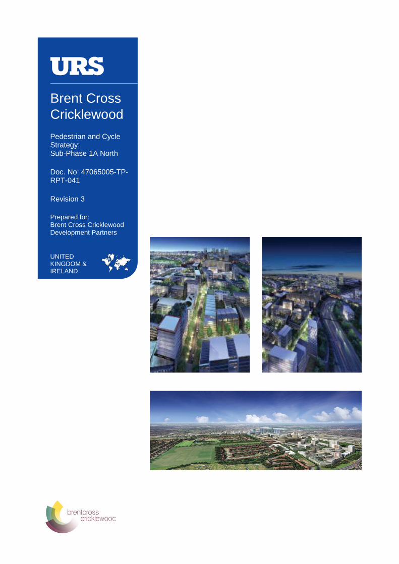
Brent Cross Cricklewood Pedestrian and Cycle Strategy: Sub-Phase 1A North
Doc. No: 47065005-TP-RPT-041
Revision 3
Prepared for: Brent Cross Cricklewood Development Partners
UNITED KINGDOM & IRELAND
Brent Cross Cricklewood Development Partners — Brent Cross Cricklewood
47065005-TP-RPT-041 Rev 03
PEDESTRIAN AND CYCLE STRATEGY: SUB-PHASE 1A NORTH
December 2014
1
Pedestrian and Cycle Strategy: Sub-Phase 1A North
Doc. No: 47065005-TP-RPT-041
URS Infrastructure & Environment (UK) Ltd
Scott House
Alençon Link
Basingstoke
Hants RG21 7PP
Telephone: +44 (0)1256 310 200
Fax: +44 (0)1256 310 201
REVISION SCHEDULE
Rev Date Details Prepared by Reviewed by Approved by
1 10-Oct- 2014 For client’s review
Kimberley Pettingill
Transport Consultant
Mark Watson
Principal Transport Consultant
Margaret Theobald
Technical Director
2 17-Nov-2014 For Authorities review
Kimberley Pettingill
Transport Consultant
Mark Watson
Principal Transport Consultant
Margaret Theobald
Technical Director
3 10-Dec-2014 For Authorities review
Kimberley Pettingill
Transport Consultant
Mark Watson
Principal Transport Consultant
Margaret Theobald
Technical Director
Brent Cross Cricklewood Development Partners — Brent Cross Cricklewood
47065005-TP-RPT-041 Rev 03
Limitations
URS Infrastructure & Environment UK Limited (“URS”) has prepared this Report for the sole use of Brent Cross Cricklewood Development Partners (“Client”) in accordance with the Agreement under which our services were performed. No other warranty, expressed or implied, is made as to the professional advice included in this Report or any other services provided by URS.
The conclusions and recommendations contained in this Report are based upon information provided by others and upon the assumption that all relevant information has been provided by those parties from whom it has been requested and that such information is accurate. Information obtained by URS has not been independently verified by URS, unless otherwise stated in the Report.
The methodology adopted and the sources of information used by URS in providing its services are outlined in this Report. The work described in this Report is based on the conditions encountered and the information. The scope of this Report and the services are accordingly factually limited by these circumstances.
Where assessments of works or costs identified in this Report are made, such assessments are based upon the information available at the time and where appropriate are subject to further investigations or information which may become available.
Certain statements made in the Report that are not historical facts may constitute estimates, projections or other forward-looking statements and even though they are based on reasonable assumptions as of the date of the Report, such forward-looking statements by their nature involve risks and uncertainties.
Copyright
© This Report is the copyright of URS Infrastructure & Environment UK Limited. Any unauthorised reproduction or usage by any person other than the addressee is strictly prohibited.
PEDESTRIAN AND CYCLE STRATEGY: SUB-PHASE 1A NORTH December 2014 2
Brent Cross Cricklewood Development Partners — Brent Cross Cricklewood
47065005-TP-RPT-041 Rev 03
TABLE OF CONTENTS 1 INTRODUCTION ................................................................ 5
1.1 Background to the Strategy ............................................ 5 1.2 Scope ................................................................................. 5
1.3 Pedestrian and Cycle Strategy: Sub-Phase 1AN Purpose and Objectives .................................................. 5
1.4 Structure of the Report .................................................... 6
2 STUDY AREA .................................................................... 7
2.1 Introduction ...................................................................... 7 3 POLICY REVIEW ............................................................... 9 4 IDENTIFICATION OF KEY DESTINATIONS AND DESIRE
LINES ............................................................................... 10
4.1 Key Destinations and Associated Desire Lines to Wider Area from BXC Site Boundary ...................................... 10
4.2 Key Destinations and Associated Desire Lines within Sub-Phase 1AN .............................................................. 10
5 SUB-PHASE 1AN PEDESTRIAN AND CYCLE STRATEGY ...................................................................... 13
5.1 Key pedestrian and cycle strategy elements and proposed provision at key infrastructure .................... 13
5.2 Pedestrian Strategy ....................................................... 17
5.3 Cycle Strategy ................................................................ 23
6 SUB-PHASE 1AN PEDESTRIAN AND CYCLE PROVISION APPRAISAL ............................................... 28
6.1 Sub-Phase 1AN Facility Appraisal ............................... 28
6.2 Facility Appraisal Process ............................................ 28 6.3 Pedestrian Footway Width and Flow Analysis ............ 32
7 CONSTRUCTION AND DELIVERY ................................ 34 8 CONSULTATION SUMMARY ......................................... 35 9 SUMMARY ....................................................................... 36
APPENDICES APPENDIX A RELEVANT PLANNING EXTRACTS AND SCOPING DOCUMENT
APPENDIX B SUB-PHASE 1A NORTH STUDY AREA PLAN APPENDIX C SUB-PHASE 1A NORTH PEDESTRIAN AND CYCLE
STRATEGY PLAN APPENDIX D SUB-PHASE 1A NORTH PEDESTRIAN AND CYCLE
STRATEGY LINKS WITH KEY DESTINATIONS PLAN APPENDIX E SUB-PHASE 1A NORTH DETAILED CYCLE
NETWORK GENERAL ARRANGEMENT PLAN APPENDIX F SUB-PHASE 1A NORTH PEDESTRIAN LINKS,
CROSSINGS AND PUBLIC SPACES PLAN APPENDIX G SUB-PHASE 1A NORTH CYCLE LINKS AND
JUNCTIONS PLAN
PEDESTRIAN AND CYCLE STRATEGY: SUB-PHASE 1A NORTH December 2014 3
Brent Cross Cricklewood Development Partners — Brent Cross Cricklewood
47065005-TP-RPT-041 Rev 03
APPENDIX H SUB-PHASE 1A NORTH BUS STOP PLAN APPENDIX I APPRAISAL OF SUB-PHASE 1A NORTH
PEDESTRIAN AND CYCLE STRATEGY
PEDESTRIAN AND CYCLE STRATEGY: SUB-PHASE 1A NORTH December 2014 4
Brent Cross Cricklewood Development Partners — Brent Cross Cricklewood
47065005-TP-RPT-041 Rev 03
1 INTRODUCTION
1.1 Background to the Strategy
There is a current planning consent in place for the regeneration of Brent Cross Cricklewood (BXC); this permission is subject to a framework of control that will ensure that the BXC development is carried out in a manner which is consistent with the transport impacts forecast within the consented BXC transport assessment (BXC05).
The Section 106 document sets out the requirement to provide a series of Reserved Matters Transport Reports (RMTR’s) and a Pedestrian and Cycle Strategy for Sub-phase 1A North (P1AN). The strategy is required to set out the details of the pedestrian and cycle links and facilities within P1AN in accordance with the consented scheme.
Schedule 17 of the Section 106 states that one of the objectives of the Phase Transport Reports (PTR’s) and RMTR’s is to ensure that a comprehensive pedestrian and cycle network is provided within the BXC site, within and between each development phase and connecting to adjacent areas as the development progresses. The relevant extracts from the Section 106 are held in Appendix A. In line with Condition 2.8 the new and improved pedestrian and cycle links and cycle parking spaces within this strategy will be implemented as part of P1AN.
It should be noted that the temporary bus station is the subject of a separate study. Details of the temporary pedestrian facilities relating to the temporary bus station will be provided within this study.
In addition to this P1AN Pedestrian and Cycling Strategy, an Area Wide Walking and Cycling Study (AWWCS) has been undertaken which examines the pedestrian and cycling links between the wider BXC site and the surrounding communities. The area wide study reviews the pedestrian and cycle connections between the development site and key destinations (such as Cricklewood Town Centre and surrounding transport connections) and local residential areas (including Dollis Hill and Hendon). The AWWCS study is intended to deliver a programme of potential schemes for improvements to pedestrian and cycle facilities adjacent to or beyond the site boundary, improving access both to and from the BXC site.
1.2 Scope
A scoping exercise was carried out with Transport for London (TfL) and London Borough of Barnet (LBB) to establish the requirements of the P1AN Pedestrian and Cycle Strategy and the specific outputs required following its completion.
A scoping report was submitted and approved by TfL and LBB in August 2014. The scoping document is held in Appendix A.
The scope sets out the proposed methodology for carrying out the P1AN Pedestrian and Cycle Strategy in line with the outline scope set out in Schedule 17 of the Section106.
1.3 Pedestrian and Cycle Strategy: Sub-Phase 1AN Purpose and Objectives
The primary objective of the P1AN pedestrian and cycle strategy is to set out the quantum and details of pedestrian and cycle links and facilities to be provided within P1AN of the development in accordance with the:
• Area Wide Walking and Cycling Study (AWWCS)
• Phase Transport Report: Phase 1
• Section 73 Consented Transport Assessment and Parameter Plans
PEDESTRIAN AND CYCLE STRATEGY: SUB-PHASE 1A NORTH December 2014 5
Brent Cross Cricklewood Development Partners — Brent Cross Cricklewood
47065005-TP-RPT-041 Rev 03
1.4 Structure of the Report
Following this section, this report includes the following:
• Section 2 outlines the study area considered within this sub-phase 1AN pedestrian and cycle strategy
• Section 3 provides a review of the planning documents considered relevant to the strategy
• Section 4 identifies the key destinations and pedestrian/cycle desire lines within sub-phase 1AN
• Section 5 outlines the pedestrian and cycle strategy for sub-phase 1AN
• Section 6 provides an appraisal of the pedestrian and cycle strategy for sub-phase 1AN and outlines the likely PERS and CERS score that each parameter would achieve
• Section 7 will outline the details for the construction and delivery of the proposed pedestrian and cycle provision during the construction of sub-phase 1AN
• Section 8 will provide details from the consultation for the sub-phase 1AN proposals
• Section 9 provides a summary of the sub-phase 1AN pedestrian and cycle strategy
PEDESTRIAN AND CYCLE STRATEGY: SUB-PHASE 1A NORTH December 2014 6
Brent Cross Cricklewood Development Partners — Brent Cross Cricklewood
47065005-TP-RPT-041 Rev 03
2 STUDY AREA
2.1 Introduction
The study area for this sub-phase 1AN pedestrian and cycle strategy is shown on the plan held in Appendix B (drawing number BXCR-ALM-ZZ-XX-DR-AR-00011) of this document.
As shown on the plan held in Appendix B, P1AN comprises:
K1 - A406 Brent Cross Ingress/Egress Junction Improvements
K2 - A41/A406 Junction Improvements
K3 - A407 Cricklewood Lane/Claremont Road Junction Improvements
K5 - A5/A407 Cricklewood Lane Junction Improvements
K6 - Claremont Avenue
K7 - Claremont Road Junction North
K9 - Tempelhof Avenue and Tempelhof Link Road
K10 - Tilling Road West Re-alignment and Diversion (Part 1)
K11 - Claremont Avenue Junction with Tilling Road
K12 - Brent Cross Pedestrian Underpass
K13 - Prince Charles Drive Diversion
K15 - Clitterhouse Playing Fields Improvements Part 1 (Excluding C. Stream Nature Park) K16 - Eastern River Brent Alteration & Diversion Works
K17 - Bridge Structure B1 (Replacement A406 Tempelhof Bridge)
K18 - River Brent Bridges (as relevant to the Eastern River Brent Alteration/Diversion Works)
K19 - M1/A406 and A5/A406 Junction Improvements
K21 - Central River Brent Alteration & Diversion Works
K22 - Bridge Structure B6 (M1 Junction 1 Pedestrian and Cycle Bridge)
K23 - River Brent Bridges (as relevant to the Central River Brent Alteration/Diversion Works)
K24 - Living Bridge
K26 - Claremont Park Improvements
K34 - Central Brent Riverside Park
K39 - Western River Brent Alterations & Diversion works
K40 - River Brent Bridges (as relevant to the Western River Brent alteration/diversion works)
K44 - High Street South "East Works"
K45 - Orchard Lane
The key pedestrian and cycle links within P1AN are as follows:
• Around BXSC connecting with surrounding networks at Shirehall lane roundabout, eastern roundabout, Sturgess Avenue, Layfield Road, western roundabout, Tempelhof Bridge, Living Bridge
• Pedestrian and cycle link alongside the River Brent between the A41 and the western roundabout
PEDESTRIAN AND CYCLE STRATEGY: SUB-PHASE 1A NORTH December 2014 7
Brent Cross Cricklewood Development Partners — Brent Cross Cricklewood
47065005-TP-RPT-041 Rev 03
• Pedestrian only link alongside River Brent Corridor from west of western roundabout
to M1 underpass
• Brentfield Gardens towards Brent Cross London Underground station (including link over A406 at Brent Cross Flyover)
• Tempelhof Bridge
• Claremont Avenue and Claremont Road
• Links onto Brent Terrace North and Brent Terrace South
• Pedestrian and cycle links on northern and southern sides of Staples Corner/M1/A406 junction and pedestrian/cycle bridge across junction
• Pedestrian links/ bridges at western extents of Staples Corner/M1/A406 junction
• Cycle and pedestrian link through Claremont Park
• Cycle and pedestrian links through Clitterhouse Playing Fields
• Cycle and pedestrian link through Sturgess Park
The identification of key destinations and desire lines is held in Section 4.
PEDESTRIAN AND CYCLE STRATEGY: SUB-PHASE 1A NORTH December 2014 8
Brent Cross Cricklewood Development Partners — Brent Cross Cricklewood
47065005-TP-RPT-041 Rev 03
3 POLICY REVIEW
Within the scoping document for the P1AN Pedestrian and Cycle Strategy a number of policy documents have been identified which directly address the provision, design, availability and quality of pedestrian and cycling infrastructure for new developments and existing urban areas. The identified documents are as follows:
The Mayors Transport Strategy (May 2010)
The Mayor’s Vision for Cycling in London (March 2013)
TfL’s Walking Good Practice (April 2012)
Legible London
Pedestrian Environment Reviews System Fact Sheet
Pedestrian Comfort Level Guidance (2010)
Delivering the Benefits of Cycling in Outer London (February 2010)
London Cycling Design Standards (2005).
All of the above planning documents (as well as the ‘London Cycle Design Standards – Draft for Consultation, June 2014’) have been reviewed in Section 2 of the Area Wide Walking and Cycling (AWWC) Study (document reference: 47065005-TP-RPT-036 Rev 02). This review has therefore not been repeated within this report.
In addition to the above, the following documents have been referred to within this strategy:
• LTN 2/95 ‘The Design of Pedestrian Crossings’
• TfL Accessible Bus Stop Design Guidance (2006)
PEDESTRIAN AND CYCLE STRATEGY: SUB-PHASE 1A NORTH December 2014 9
Brent Cross Cricklewood Development Partners — Brent Cross Cricklewood
47065005-TP-RPT-041 Rev 03
4 IDENTIFICATION OF KEY DESTINATIONS AND DESIRE LINES
4.1 Key Destinations and Associated Desire Lines to Wider Area from BXC Site Boundary
As part of the scoping process for the Area Wide Walking and Cycling (AWWC) Study, a total of 14 key origins/destinations within the wider area were identified as directly relevant to the BXC development location. These were:
• Cricklewood town centre and First Capital Connect (FCC) station
• Brent Cross LU Station
• Hendon Central LU station
• West Hendon/Hendon FCC station
• Willesden Green town centre and LU station
• Golders Green town centre and LU station
• Dollis Hill town centre and LU station
• Childs Hill town centre
• Hendon town centre
• Colindale town centre and LU station
• Kilburn town centre and Kilburn High Road London Overground (LO) station
• Neasden town centre and LU station
• Temple Fortune town centre
• West Hampstead
A total of 16 walking and 17 cycling routes (33 routes in total) were identified to the above key origins/ destinations from the development red line boundary, all of the 33 routes identified within the AWWC study were agreed with LBB and TfL. The plan held in Appendix D shows the key destinations within the wider area and the walking and cycling routes identified within the AWWC study.
4.2 Key Destinations and Associated Desire Lines within Sub-Phase 1AN
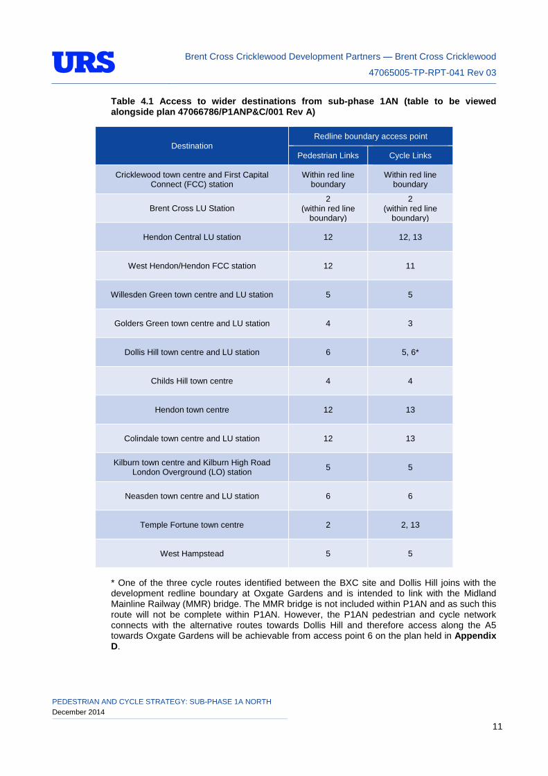
The above key destinations will continue to be directly relevant to the BXC development within P1AN. The plan held in Appendix C (drawing number BXCR-URS-ZZ-11-SK-CE-00001 Rev P05 dated 14/11/14) shows the proposed P1AN pedestrian and cycle routes and illustrates where they join the redline boundary in order to join with the wider pedestrian and cycle networks in addition to the London Cycle Network (LCN) and the Capital Ring Walk. There are a total of 13 access points into the redline boundary.
For the purposes of demonstrating that the P1AN pedestrian and cycle facilities join with the wider network, the points at which the P1AN pedestrian and cycle networks join the redline boundary have been numbered (from 1 to 13) as shown on the plan held within Appendix D (drawing number 47066786/P1ANP&C/001 Rev B). The table below shows the wider destinations that can be accessed from each pedestrian/cycle access point into P1AN.
PEDESTRIAN AND CYCLE STRATEGY: SUB-PHASE 1A NORTH December 2014 10
Brent Cross Cricklewood Development Partners — Brent Cross Cricklewood
47065005-TP-RPT-041 Rev 03
Table 4.1 Access to wider destinations from sub-phase 1AN (table to be viewed alongside plan 47066786/P1ANP&C/001 Rev A)
Destination Redline boundary access point
Pedestrian Links Cycle Links
Cricklewood town centre and First Capital Connect (FCC) station
Within red line boundary
Within red line boundary
Brent Cross LU Station 2
(within red line boundary)
2 (within red line
boundary)
Hendon Central LU station 12 12, 13
West Hendon/Hendon FCC station 12 11
Willesden Green town centre and LU station 5 5
Golders Green town centre and LU station 4 3
Dollis Hill town centre and LU station 6 5, 6*
Childs Hill town centre 4 4
Hendon town centre 12 13
Colindale town centre and LU station 12 13
Kilburn town centre and Kilburn High Road London Overground (LO) station 5 5
Neasden town centre and LU station 6 6
Temple Fortune town centre 2 2, 13
West Hampstead 5 5
* One of the three cycle routes identified between the BXC site and Dollis Hill joins with the development redline boundary at Oxgate Gardens and is intended to link with the Midland Mainline Railway (MMR) bridge. The MMR bridge is not included within P1AN and as such this route will not be complete within P1AN. However, the P1AN pedestrian and cycle network connects with the alternative routes towards Dollis Hill and therefore access along the A5 towards Oxgate Gardens will be achievable from access point 6 on the plan held in Appendix D.
PEDESTRIAN AND CYCLE STRATEGY: SUB-PHASE 1A NORTH December 2014 11
Brent Cross Cricklewood Development Partners — Brent Cross Cricklewood
47065005-TP-RPT-041 Rev 03
With the exception of the above, Table 4.1 and the associated plan demonstrate that following the implementation of P1AN the routes to the key destinations will continue to be accessible to pedestrian and cyclists. All of the routes identified within the AWWC Study will be continued into the development redline boundary following the completion of P1AN. In addition, a connection towards Cycle Super Highway 11 (CS11) will be provided via connection number 3 shown in the plan held in Appendix D. Connections to the Capital Ring Walk will be provided via connection numbers 8, 9, 11, 12 and 13.
Throughout the development of the strategy, it has been ensured that the pedestrian and cycle desire lines internal to P1AN have been catered for. This is further reviewed in Section 5.
PEDESTRIAN AND CYCLE STRATEGY: SUB-PHASE 1A NORTH December 2014 12
Brent Cross Cricklewood Development Partners — Brent Cross Cricklewood
47065005-TP-RPT-041 Rev 03
5 SUB-PHASE 1AN PEDESTRIAN AND CYCLE STRATEGY
The proposed P1AN pedestrian and cycle strategy is shown on the plan held in Appendix C (drawing number BXCR/URS/ZZ/11/SK/CE/00001 Rev P05 dated 14/11/14).
The proposed cycle facilities within sub-phase 1AN are shown on the plan held in Appendix E (drawing number BXCR-URS-ZZ/11/SK/CE/00002 P06 dated 14/11/14).
The plans provided in the above appendices have been developed following an ongoing iterative design review process (for more detail, see Section 6) during which modifications were suggested to provide enhanced pedestrian or cycle connections within the phase. Suggested improvements and amendments to the evolving design included the addition of pedestrian crossings, widening of footways, and the provision of cycle facilities such as advanced stop lines (ASLs) and feeder lanes. It is considered that all suggested improvements have been incorporated into the design where feasible.
This section outlines the key elements of the strategy initially (including proposals at key areas and key infrastructure locations). The pedestrian networks and cycle networks are then broken down into links, junctions, crossings, and public spaces in Sections 5.2 and 5.3.
5.1 Key pedestrian and cycle strategy elements and proposed provision at key infrastructure
This section outlines the key elements of the strategy including proposals at key areas and key infrastructure locations.
Gateway Junctions
The proposed pedestrian/cycle provision at the gateway junctions within P1AN is outlined below:
A41/A406 Junction
Overview - pedestrians and cyclists will remain segregated from traffic at this junction. The existing pedestrian footbridge will remain a key link over the A406 at this location. Cyclists will be required to dismount on the bridge (as they currently do) however this will not be a barrier to cyclist movement. Works will include the general refurbishment of the underpasses and bridge (lighting/painting etc. where relevant)
Access from the south – To the northeast of the junction the existing A406 westbound off slip to the east of this junction will be closed and an off-road shared footway/cycleway will be provided from Brentfield Gardens. This will create a much safer and continuous pedestrian and cycle link towards the A41/A406 junction from Brentfield Gardens/Brent Cross London Underground station. To the southeast a shared footway/cycleway will be provided on the approach to the junction alongside Tilling Road.
Access from the north – From the Shirehall Lane roundabout shared footway/cycleway facilities will be provided alongside the A41 southbound on slip and alongside Cooper Road linking with the A41 underpass. Cyclists will be required to dismount on the ramp from the A41 southbound on slip and on the approach to the bridge.
Staples Corner/ M1/ A406 Junction
Facilities will be provided to enable pedestrians and cyclists to be separated from traffic at this junction. A shared pedestrian/cycle bridge will be provided to form a key north/south link across the A406 (Bridge B6). Off-road shared footway/cycleways will be provided on the approaches to the pedestrian/cycle bridge (between the A5 and the pedestrian/cycle bridge to
PEDESTRIAN AND CYCLE STRATEGY: SUB-PHASE 1A NORTH December 2014 13
Brent Cross Cricklewood Development Partners — Brent Cross Cricklewood
47065005-TP-RPT-041 Rev 03
the north of the A406, and between the A5 and Brent Terrace North to the south of the A406). The existing footbridges will be removed as desire lines for these bridges will be no longer required.
A replacement pedestrian bridge to extend the existing bridge will be provided to the west of the pedestrian/cycle bridge (west of the rail arches) and the new ramp on the northern side of the bridge will be wider than the existing provision to benefit mobility impaired users.
Works will include the general refurbishment of the remaining existing Staples Corner footbridges (lighting/painting etc.)
Claremont Road/A407 Junction
Provision of cycle advanced stop lines (ASLs) on all junction approaches to improve the visibility of cyclists to drivers, avoid conflicts with left turning vehicles, and to allow cyclists to reach a safe position to turn right. Improvements to the footway facilities at the junction will include localised footway widening (Claremont Road arm of the junction) and the improvement of tactile paving layouts. The remaining footways at the junction will remain as existing.
A407/A5 Junction
Provision of cycle advanced stop lines (ASLs) on all junction approaches to improve the visibility of cyclists to drivers, avoid conflicts with left turning vehicles, and to allow cyclists to reach a safe position to turn right. Provision of a new signalised pelican crossing across the A407 Cricklewood Lane approach to the junction.
Other Key Infrastructure
Living Bridge
A new pedestrian and cycle bridge over the A406 (Bridge B7). This bridge will form a key north/south link across the A406 between the Brent Cross Shopping Centre/new bus station and areas to the south including Claremont Avenue and Clitterhouse playing fields.
Access to the Living Bridge from Claremont Avenue will be via a wide 16m approach which will connect with the segregated footway/cycleway provided alongside Claremont Avenue. A toucan crossing will be provided across Claremont Avenue to allow connections from Market Square/New Tempelhof Avenue and other areas to the west. Access to the Living Bridge from the north (bus station) will be via steps/lifts/escalators. The sloping southern approach to the living bridge will provide access for pedestrians and cyclists.
The effective width of the shared space path along the living bridge will vary across its length. Any narrow stretches of the Living Bridge will be short in length, with passing places provided along these sections of the route. The minimum effective width for pedestrians and cyclists is to be 7m, which is well in excess of the minimum width requirements for a shared facility.
A406 Tempelhof Bridge
This bridge (B1) will form another key north/south link across the A406 between the western roundabout and Claremont Road. A segregated footway/cycleway will be provided alongside the northbound carriageway of New Tempelhof Avenue linking with a segregated facility and toucan crossing at Claremont Avenue. To the north of the A406 the segregated footway/cycleway will link with a shared footway/cycleway facility connecting with the shopping centre car park access road and the shopping centre cycle parking provision. A toucan crossing will be provided across New Tempelhof Avenue in order to provide access to cycle parking located at the service road and the continued pedestrian/cycle route towards the BXSC car park access road. A pedestrian only footway will be provided alongside the
PEDESTRIAN AND CYCLE STRATEGY: SUB-PHASE 1A NORTH December 2014 14
Brent Cross Cricklewood Development Partners — Brent Cross Cricklewood
47065005-TP-RPT-041 Rev 03
southbound carriageway linking with Tempelhof Link Road and Market Square and a segregated footway/cycleway alongside the northbound carriageway.
River Brent Corridor
A shared footway/cycleway facility (5m wide) will be provided alongside the River Brent and will form a key east/west traffic-free connection linking the A41/A406 junction and the western roundabout. A pedestrian only link will be provided between the western roundabout and the M1/MML underpass; two river crossings will be provided along this pedestrian-only section.
Access to the River Brent Corridor in P1AN will be:
• from the car park access road (to the west of the western roundabout)
• steps/cycle rail to the east of the western roundabout
• from the Living Bridge/bus station via steps
• from the existing pedestrian path leading from the A41 underpass
• from the A41/A406 junction underpass/ pedestrian footbridge
Parks
Pedestrian and cycle links will be provided through Claremont Park, Clitterhouse Playing Fields and Sturgess Park.
Claremont Park
A shared footway/cycleway facility to be provided through park linking Claremont Avenue with Brent Terrace South. The narrowest point along the shared facility will be 4m.
Clitterhouse Playing Fields
A segregated footway/cycleway facility will be provided through Clitterhouse playing fields linking the residential area at Purbeck Drive to Claremont Avenue. The segregated facility will measure 5m in width and will be key in providing a north/south pedestrian and cycle link through the Brent Cross development site.
Sturgess Park
A shared footway/cycleway facility will be provided through the park linking the BXSC car park access road with Sturgess Avenue. This facility will measure 4.5m in width through the park.
A406 Crossings
Within P1AN there will be a total of six A406 crossings providing vital north/south connections. A summary of the bridge provision is as follows:
A406/A41 Footbridge and Underpasses
Works will include the general refurbishment of the underpasses and bridge (lighting/painting etc.). The footbridge will remain a key pedestrian/cycle link over the A406. Cyclists will be required to dismount on the bridge; however this bridge will not be a barrier to cyclist movement. Further detail is provided above.
PEDESTRIAN AND CYCLE STRATEGY: SUB-PHASE 1A NORTH December 2014 15
Brent Cross Cricklewood Development Partners — Brent Cross Cricklewood
47065005-TP-RPT-041 Rev 03
Living Bridge
The provision of a 15m wide bridge for shared use by pedestrians and cyclists. The minimum effective width (usable space for pedestrian/cycle movement) will be 7m. Further detail is provided above.
A406 Tempelhof Bridge
A segregated footway/cycleway will be provided alongside the northbound carriageway (western side) of New Tempelhof Avenue and a pedestrian only footway will be provided alongside the southbound carriageway linking with Tempelhof Link Road and Market Square. Further detail is provided above.
Pedestrian/Cycle Bridge (B6)
A shared pedestrian/cycle bridge will be provided across the Staples Corner/M1/A406 junction which will form a key north/south link across the A406.
Replacement Pedestrian-only Footbridge at Staples Corner
The existing north/south pedestrian bridge at Staples Corner (to the west of the pedestrian/cycle bridge (B6)) will be replaced and the new ramp on the northern side of the bridge will be wider than the existing provision to benefit mobility impaired users.
Existing Pedestrian-only Footbridges
Works will include the general refurbishment of the remaining existing Staples Corner footbridges (lighting/painting etc.)
Bus Stops and Coach Stops
The plan held in Appendix H identifies the location of the bus stops within the P1AN highway alignment. Through the development of the P1AN pedestrian and cycle strategy it has been ensured that all bus stops are accessible by foot. A number of existing bus stops are within the P1AN study area; however the existing pedestrian facilities to these bus stops are to remain unchanged. These bus stops are shown on the bus stop plan.
The location of the relocated coach stops are still under consideration and the final location is still to be agreed and confirmed with the local authorities. It will be ensured that suitable pedestrian linkages are provided to the agreed stops.
A41/BXSC Underpass, M1/MML Underpass, A41/A406 Junction Underpasses
Proposed improvements to the above pedestrian underpasses include general maintenance improvements such as painting and lighting improvements where required. The locations of the above underpasses are shown on the plan held in Appendix C.
Cycle Parking
A total of six public cycle parking locations have been identified within P1AN. The plan held in Appendix C (plan number BXCR/URS/ZZ/11/SK/CE/0001 Rev P05 dated 14/11/14) identifies the locations of the public cycle parking. Through the development of the P1AN pedestrian and cycle strategy it has been ensured that all cycle parking areas are easily accessed by bike.
PEDESTRIAN AND CYCLE STRATEGY: SUB-PHASE 1A NORTH December 2014 16
Brent Cross Cricklewood Development Partners — Brent Cross Cricklewood
47065005-TP-RPT-041 Rev 03
5.2 Pedestrian Strategy
The pedestrian networks have been broken down into links, crossings, and public spaces. Further details with regards to these are provided in the sections below. The pedestrian links, crossings and public spaces have been referenced as shown in the tables below. A plan illustrating the location of each feature is held in Appendix F (47066786/P1ANP+C/002 Rev B).
The reviewed pedestrian links are as shown in Table 5.1 below. The reviewed pedestrian crossings are shown in Table 5.2 and public spaces in Table 5.3.
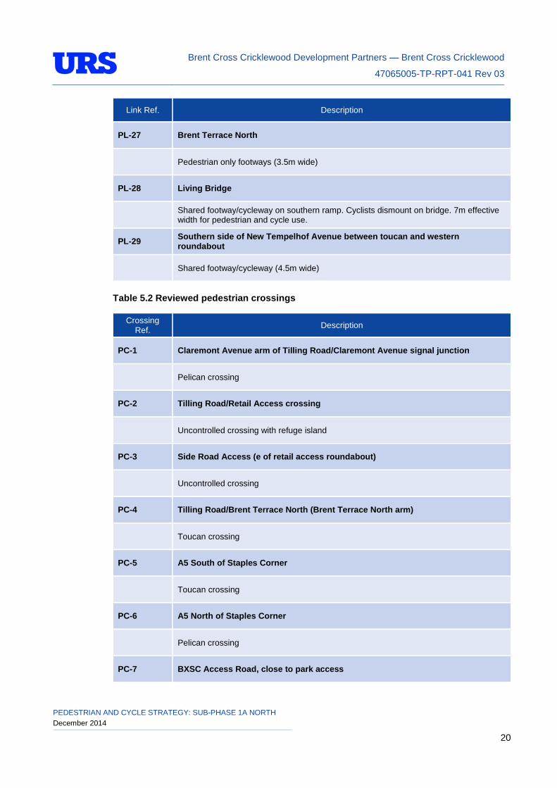
Table 5.1 Reviewed pedestrian links
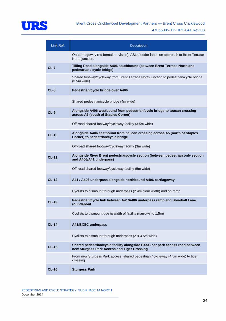
Link Ref. Description
PL-1 Brentfield Gardens to A41 underpass
Pedestrian footway from northern side of Highfield Avenue and part way along the eastern side of Brentfield Gardens (narrows to 1.5m) linking with shared footway/cycleway along eastern side of Brentfield Gardens (3-4m wide) and then the A41 underpass (2.7m wide). Closure of A406/Brentfield Gardens slip road.
PL-2 Bridge over A406/ under A41
Links with shared footway/cycleways either side of bridge. Cyclists to dismount on bridge (bridge 2.44m wide).
PL-3 A41/A406 underpass alongside westbound A406 carriageway (including shared section alongside Tilling Road)
Pedestrians only (cyclists to dismount) through underpass (2.7m wide). Shared footway / cycleway alongside part of Tilling Road (3m wide)
PL-4 Tilling Road (between Claremont Road and Claremont Avenue)
Shared facility (3.5-4m wide)
PL-5 Tilling Road (between Claremont Avenue and Brent Terrace North)
Footway along the southern side of Tilling Road. Footways at least 2.5m along link. Pedestrian refuge island provided at retail park access roundabout.
PL-6 Tilling Road alongside A406 westbound (between Brent Terrace North and pedestrian/cycle bridge)
Toucan crossing across Brent Terrace North / Tilling Road junction, shared footway/cycleway (3.5m wide) from Brent Terrace North junction to pedestrian/cycle bridge.
PL-7 Pedestrian/cycle bridge over A406 (B6)
Shared pedestrian/cycle bridge (4m wide)
PEDESTRIAN AND CYCLE STRATEGY: SUB-PHASE 1A NORTH December 2014 17
Brent Cross Cricklewood Development Partners — Brent Cross Cricklewood
47065005-TP-RPT-041 Rev 03
Link Ref. Description
PL-8 Alongside A406 westbound from pedestrian/cycle bridge to toucan crossing across A5 (south of Staples Corner)
Off-road shared footway/cycleway facility (3.5m wide)
PL-9 Staples Corner pedestrian footbridges
Pedestrian-only facility (1.83m wide bridge)
PL-10 Alongside A406 eastbound from pelican crossing across A5 (north of Staples Corner) to pedestrian/cycle bridge
Off-road shared footway/cycleway facility (3m wide)
PL-11 Pedestrian routes from M1 underpass alongside River Brent (pedestrian only section)
Footway alongside western side of Brent Park Road. Pedestrian only footpath alongside River Brent corridor (4.5m on the north side of the river and 3m on the south side). Two pedestrian-only bridges across River Brent (3.5m clear width)
PL-12 Alongside River Brent pedestrian/cycle section (between pedestrian only section and A406/A41 underpass)
Off-road shared footway/cycleway facility (5m wide)
PL-13 A41/A406 underpass alongside eastbound A406 carriageway
Pedestrians only (cyclists to dismount) through underpass (2.4m clear width).
PL-14 Pedestrian/cycle link from A41/A406 underpass to Shirehall Lane roundabout
Pedestrian only facility (cyclists to dismount on approach to roundabout due to width restrictions (narrows to 1.5m on footway))
PL-15 A41/Brent Cross pedestrian underpass
Improvements to A41/Brent Cross underpass, pedestrian only (2.9-3.5m wide). Cyclists to dismount.
PL-16 Pedestrian-only link along BXSC access road (between Spalding Road bus stop, eastern roundabout and BXSC A41 access)
Pedestrian-only footway (footways in excess of 1.8m) along southern side of Spalding Road from Spalding Road bus stop, along Spalding Road and into shopping centre site via the existing A41 pedestrian access. In addition, a pedestrian-only footway will be provided from north of the eastern roundabout to the zebra crossing across the car park access road linking with the Spalding Road footway.
PL-17 Existing pedestrian link at A41 underpass to link to A41/A406 underpass
Pedestrian-only link, existing path to be retained and a underpass to link with A41/A406 underpass (1.8m wide at narrowest point)
PEDESTRIAN AND CYCLE STRATEGY: SUB-PHASE 1A NORTH December 2014 18
Brent Cross Cricklewood Development Partners — Brent Cross Cricklewood
47065005-TP-RPT-041 Rev 03
Link Ref. Description
PL-18 Pedestrian-only link along BXSC access road between Sturgess Park access and car park access road tiger crossing (close to Layfield Road)
From Sturgess Park access, pedestrians will cross the car park access road via zebra crossings and continue westbound and southbound alongside the westbound and southbound car park access road carriageway (2m wide footways).
PL-19 Shared footway/cycleway facility along BXSC access road between new Sturgess Park access and tiger crossing (close to Layfield Road)
From new Sturgess Park access, shared pedestrian / cycleway (4.5m wide) to tiger crossing.
PL-20 Along car park access road between Layfield Road access and Western roundabout
Shared facility along car park access road between Layfield Road access and access from the western roundabout (3m wide). Pedestrian only footway provided on link from Layfield Road (2m wide footways).
PL-21 Link from car park access road to River Brent Corridor
Off-road shared footway/cycleway (4m wide)
PL-22 From tiger crossing on car park access road (close to Layfield Road access) to toucan crossing on New Tempelhof Avenue
Off-road shared footway/cycleway facility (4m wide) to toucan crossing on New Tempelhof Avenue.
PL-23 Eastern side of New Tempelhof Avenue/Tempelhof Link Road
Pedestrian only footway (2.5-4m wide)
PL-24 Western side of New Tempelhof Avenue (from toucan crossing)/southern side of Market Square
Off-road segregated footway/cycleway facility (pedestrian element 2-2.5m wide)
PL-25 Claremont Avenue between Clitterhouse playing fields access and Tilling Road (alongside southbound carriageway)
Segregated footway/cycleway from Clitterhouse playing fields to traffic signals. Shared facility provided north of this point (pedestrian elements 2.5-3.5m wide)
PL-26 Claremont Avenue between Clitterhouse playing fields access and Tilling Road (alongside northbound carriageway)
Segregated footway/cycleway from Clitterhouse playing fields to Market Square. Pedestrian only footways provided north of this point (pedestrian elements 2.5-4m wide)
PEDESTRIAN AND CYCLE STRATEGY: SUB-PHASE 1A NORTH December 2014 19
Brent Cross Cricklewood Development Partners — Brent Cross Cricklewood
47065005-TP-RPT-041 Rev 03
Link Ref. Description
PL-27 Brent Terrace North
Pedestrian only footways (3.5m wide)
PL-28 Living Bridge
Shared footway/cycleway on southern ramp. Cyclists dismount on bridge. 7m effective width for pedestrian and cycle use.
PL-29 Southern side of New Tempelhof Avenue between toucan and western roundabout
Shared footway/cycleway (4.5m wide)
Table 5.2 Reviewed pedestrian crossings
Crossing Ref. Description
PC-1 Claremont Avenue arm of Tilling Road/Claremont Avenue signal junction
Pelican crossing
PC-2 Tilling Road/Retail Access crossing
Uncontrolled crossing with refuge island
PC-3 Side Road Access (e of retail access roundabout)
Uncontrolled crossing
PC-4 Tilling Road/Brent Terrace North (Brent Terrace North arm)
Toucan crossing
PC-5 A5 South of Staples Corner
Toucan crossing
PC-6 A5 North of Staples Corner
Pelican crossing
PC-7 BXSC Access Road, close to park access
PEDESTRIAN AND CYCLE STRATEGY: SUB-PHASE 1A NORTH December 2014 20
Brent Cross Cricklewood Development Partners — Brent Cross Cricklewood
47065005-TP-RPT-041 Rev 03
Crossing
Ref. Description
Zebra crossing
PC-8 BXSC Access Road, close to Layfield Road
Tiger crossing
PC-9 Car Park access
Uncontrolled crossing
PC-10 Across New Tempelhof Avenue
Toucan crossing
PC-11 Across New Tempelhof Avenue (S of bus stops)
Uncontrolled crossing
PC-12 Across New Tempelhof Avenue at Claremont Avenue junction
Uncontrolled crossing
PC-13 Across Claremont Avenue (close to Living Bridge)
Toucan crossing
PC-14 Across School Lane at Claremont Avenue
Uncontrolled crossing with cycle give-way markings, raised junction
PC-15 All arms of Claremont Avenue/Claremont Park Road/Orchard Lane junction
Toucan crossings
PC-16 Side road access from Orchard Lane (N side of carriageway)
Uncontrolled crossing
PC-17 Signal junction at Claremont Avenue/Tempelhof Link Road
Pelican crossing
PEDESTRIAN AND CYCLE STRATEGY: SUB-PHASE 1A NORTH December 2014 21
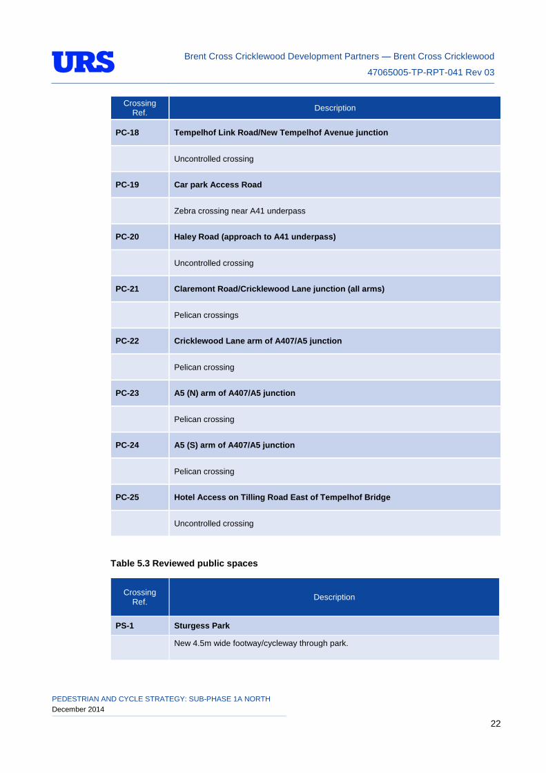
Brent Cross Cricklewood Development Partners — Brent Cross Cricklewood
47065005-TP-RPT-041 Rev 03
Crossing
Ref. Description
PC-18 Tempelhof Link Road/New Tempelhof Avenue junction
Uncontrolled crossing
PC-19 Car park Access Road
Zebra crossing near A41 underpass
PC-20 Haley Road (approach to A41 underpass)
Uncontrolled crossing
PC-21 Claremont Road/Cricklewood Lane junction (all arms)
Pelican crossings
PC-22 Cricklewood Lane arm of A407/A5 junction
Pelican crossing
PC-23 A5 (N) arm of A407/A5 junction
Pelican crossing
PC-24 A5 (S) arm of A407/A5 junction
Pelican crossing
PC-25 Hotel Access on Tilling Road East of Tempelhof Bridge
Uncontrolled crossing
Table 5.3 Reviewed public spaces
Crossing Ref. Description
PS-1 Sturgess Park
New 4.5m wide footway/cycleway through park.
PEDESTRIAN AND CYCLE STRATEGY: SUB-PHASE 1A NORTH December 2014 22
Brent Cross Cricklewood Development Partners — Brent Cross Cricklewood
47065005-TP-RPT-041 Rev 03
Crossing Ref. Description
PS-2 Clitterhouse Playing Fields
As per McGregor Smith plan (drawing number 1065-08-000, issued to URS on 18/09/14)
PS-3 Claremont Park
Shared footway/cycleway facility through park (minimum width 4m)
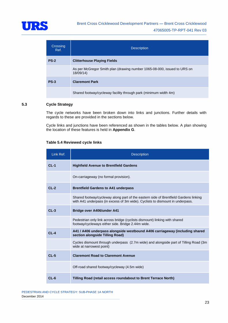
5.3 Cycle Strategy
The cycle networks have been broken down into links and junctions. Further details with regards to these are provided in the sections below.
Cycle links and junctions have been referenced as shown in the tables below. A plan showing the location of these features is held in Appendix G.
Table 5.4 Reviewed cycle links
Link Ref. Description
CL-1 Highfield Avenue to Brentfield Gardens
On-carriageway (no formal provision).
CL-2 Brentfield Gardens to A41 underpass
Shared footway/cycleway along part of the eastern side of Brentfield Gardens linking with A41 underpass (in excess of 3m wide). Cyclists to dismount in underpass.
CL-3 Bridge over A406/under A41
Pedestrian only link across bridge (cyclists dismount) linking with shared footway/cycleways either side. Bridge 2.44m wide.
CL-4 A41 / A406 underpass alongside westbound A406 carriageway (including shared section alongside Tilling Road)
Cycles dismount through underpass (2.7m wide) and alongside part of Tilling Road (3m wide at narrowest point)
CL-5 Claremont Road to Claremont Avenue
Off-road shared footway/cycleway (4.5m wide)
CL-6 Tilling Road (retail access roundabout to Brent Terrace North)
PEDESTRIAN AND CYCLE STRATEGY: SUB-PHASE 1A NORTH December 2014 23
Brent Cross Cricklewood Development Partners — Brent Cross Cricklewood
47065005-TP-RPT-041 Rev 03
Link Ref. Description
On-carriageway (no formal provision). ASLs/feeder lanes on approach to Brent Terrace North junction.
CL-7 Tilling Road alongside A406 southbound (between Brent Terrace North and pedestrian / cycle bridge)
Shared footway/cycleway from Brent Terrace North junction to pedestrian/cycle bridge (3.5m wide)
CL-8 Pedestrian/cycle bridge over A406
Shared pedestrian/cycle bridge (4m wide)
CL-9 Alongside A406 westbound from pedestrian/cycle bridge to toucan crossing across A5 (south of Staples Corner)
Off-road shared footway/cycleway facility (3.5m wide)
CL-10 Alongside A406 eastbound from pelican crossing across A5 (north of Staples Corner) to pedestrian/cycle bridge
Off-road shared footway/cycleway facility (3m wide)
CL-11 Alongside River Brent pedestrian/cycle section (between pedestrian only section and A406/A41 underpass)
Off-road shared footway/cycleway facility (5m wide)
CL-12 A41 / A406 underpass alongside northbound A406 carriageway
Cyclists to dismount through underpass (2.4m clear width) and on ramp
CL-13 Pedestrian/cycle link between A41/A406 underpass ramp and Shirehall Lane roundabout
Cyclists to dismount due to width of facility (narrows to 1.5m)
CL-14 A41/BXSC underpass
Cyclists to dismount through underpass (2.9-3.5m wide)
CL-15 Shared pedestrian/cycle facility alongside BXSC car park access road between new Sturgess Park Access and Tiger Crossing
From new Sturgess Park access, shared pedestrian / cycleway (4.5m wide) to tiger crossing
CL-16 Sturgess Park
PEDESTRIAN AND CYCLE STRATEGY: SUB-PHASE 1A NORTH December 2014 24
Brent Cross Cricklewood Development Partners — Brent Cross Cricklewood
47065005-TP-RPT-041 Rev 03
Link Ref. Description
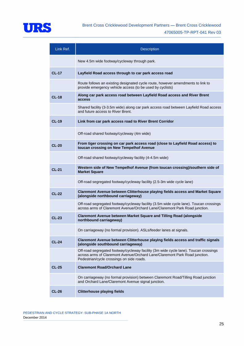
New 4.5m wide footway/cycleway through park.
CL-17 Layfield Road access through to car park access road
Route follows an existing designated cycle route, however amendments to link to provide emergency vehicle access (to be used by cyclists)
CL-18 Along car park access road between Layfield Road access and River Brent access
Shared facility (3-3.5m wide) along car park access road between Layfield Road access and future access to River Brent.
CL-19 Link from car park access road to River Brent Corridor
Off-road shared footway/cycleway (4m wide)
CL-20 From tiger crossing on car park access road (close to Layfield Road access) to toucan crossing on New Tempelhof Avenue
Off-road shared footway/cycleway facility (4-4.5m wide)
CL-21 Western side of New Tempelhof Avenue (from toucan crossing)/southern side of Market Square
Off-road segregated footway/cycleway facility (2.5-3m wide cycle lane)
CL-22 Claremont Avenue between Clitterhouse playing fields access and Market Square (alongside northbound carriageway)
Off-road segregated footway/cycleway facility (3.5m wide cycle lane). Toucan crossings across arms of Claremont Avenue/Orchard Lane/Claremont Park Road junction.
CL-23 Claremont Avenue between Market Square and Tilling Road (alongside northbound carriageway)
On carriageway (no formal provision). ASLs/feeder lanes at signals.
CL-24 Claremont Avenue between Clitterhouse playing fields access and traffic signals (alongside southbound carriageway)
Off-road segregated footway/cycleway facility (3m wide cycle lane). Toucan crossings across arms of Claremont Avenue/Orchard Lane/Claremont Park Road junction. Pedestrian/cycle crossings on side roads.
CL-25 Claremont Road/Orchard Lane
On carriageway (no formal provision) between Claremont Road/Tilling Road junction and Orchard Lane/Claremont Avenue signal junction.
CL-26 Clitterhouse playing fields
PEDESTRIAN AND CYCLE STRATEGY: SUB-PHASE 1A NORTH December 2014 25
Brent Cross Cricklewood Development Partners — Brent Cross Cricklewood
47065005-TP-RPT-041 Rev 03
Link Ref. Description
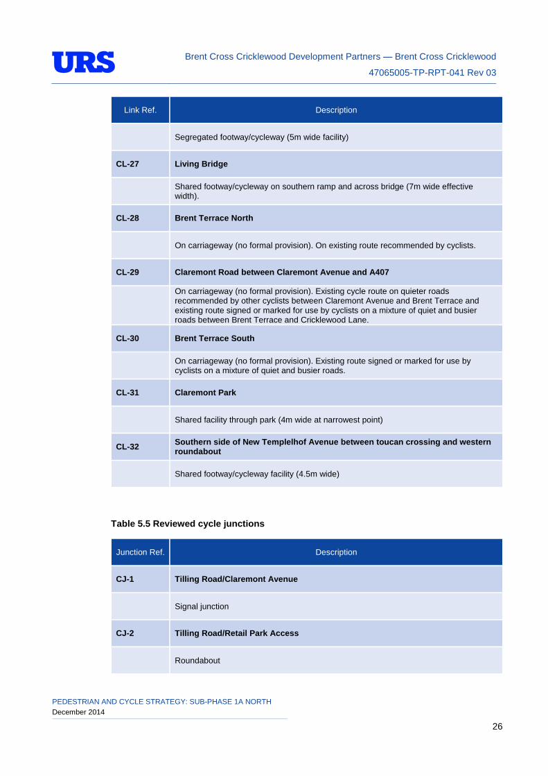
Segregated footway/cycleway (5m wide facility)
CL-27 Living Bridge
Shared footway/cycleway on southern ramp and across bridge (7m wide effective width).
CL-28 Brent Terrace North
On carriageway (no formal provision). On existing route recommended by cyclists.
CL-29 Claremont Road between Claremont Avenue and A407
On carriageway (no formal provision). Existing cycle route on quieter roads recommended by other cyclists between Claremont Avenue and Brent Terrace and existing route signed or marked for use by cyclists on a mixture of quiet and busier roads between Brent Terrace and Cricklewood Lane.
CL-30 Brent Terrace South
On carriageway (no formal provision). Existing route signed or marked for use by cyclists on a mixture of quiet and busier roads.
CL-31 Claremont Park
Shared facility through park (4m wide at narrowest point)
CL-32 Southern side of New Templelhof Avenue between toucan crossing and western roundabout
Shared footway/cycleway facility (4.5m wide)
Table 5.5 Reviewed cycle junctions
Junction Ref. Description
CJ-1 Tilling Road/Claremont Avenue
Signal junction
CJ-2 Tilling Road/Retail Park Access
Roundabout
PEDESTRIAN AND CYCLE STRATEGY: SUB-PHASE 1A NORTH December 2014 26
Brent Cross Cricklewood Development Partners — Brent Cross Cricklewood
47065005-TP-RPT-041 Rev 03
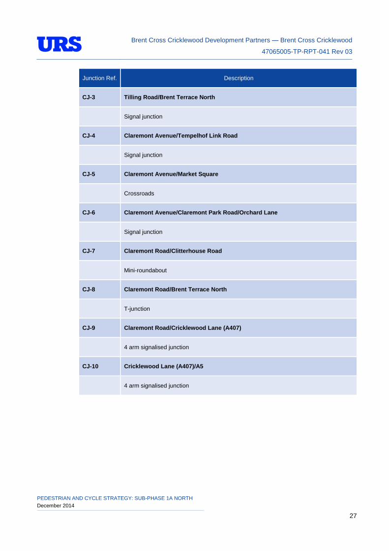
Junction Ref. Description
CJ-3 Tilling Road/Brent Terrace North
Signal junction
CJ-4 Claremont Avenue/Tempelhof Link Road
Signal junction
CJ-5 Claremont Avenue/Market Square
Crossroads
CJ-6 Claremont Avenue/Claremont Park Road/Orchard Lane
Signal junction
CJ-7 Claremont Road/Clitterhouse Road
Mini-roundabout
CJ-8 Claremont Road/Brent Terrace North
T-junction
CJ-9 Claremont Road/Cricklewood Lane (A407)
4 arm signalised junction
CJ-10 Cricklewood Lane (A407)/A5
4 arm signalised junction
PEDESTRIAN AND CYCLE STRATEGY: SUB-PHASE 1A NORTH December 2014 27
Brent Cross Cricklewood Development Partners — Brent Cross Cricklewood
47065005-TP-RPT-041 Rev 03
6 SUB-PHASE 1AN PEDESTRIAN AND CYCLE PROVISION APPRAISAL
6.1 Sub-Phase 1AN Facility Appraisal
Schedule 17 of the S106 document sets out that the benchmark for the assessed pedestrian and cycle features (i.e. links, crossings, junctions, public spaces) is to aspire to attain where reasonably practicable a score of +3 (very good provision). The pedestrian and cycle appraisal process has been an ongoing process whereby the identified potential shortfalls in provision have been continually considered and incorporated into the ongoing design process (i.e. where possible designed out) of the sub-phase 1AN pedestrian and cycle network.
A review of the proposed cycle links has also been undertaken to ensure that any provision complies with the London Cycling Design Standards (2005) publication and other policy guidance as agreed with TfL and LBB and outlined in Section 3 of this report. Any shortfalls in provision in this respect have been incorporated into the ongoing design of the P1AN pedestrian and cycle network. The review of the pedestrian crossings required reference to LTN 2/95 ‘The Design of Pedestrian Crossings’.
6.2 Facility Appraisal Process
The proposed pedestrian and cycle links have been appraised using principles from the Pedestrian Environment Review System (PERS) and Cycling Environment Review System (CERS). The scores used against each audited parameter within PERS and CERS are weighted based on importance. Those with the highest weighting factor are considered most important. Within PERS the parameters are given a weighting factor of 1 (low priority), 2 (medium priority) or 3 (high priority). Within CERS the criteria are given a weighting factor of 1 (low priority), 2 (low/medium priority), 3 (medium priority), 4 (medium/high priority) or 5 (high priority).
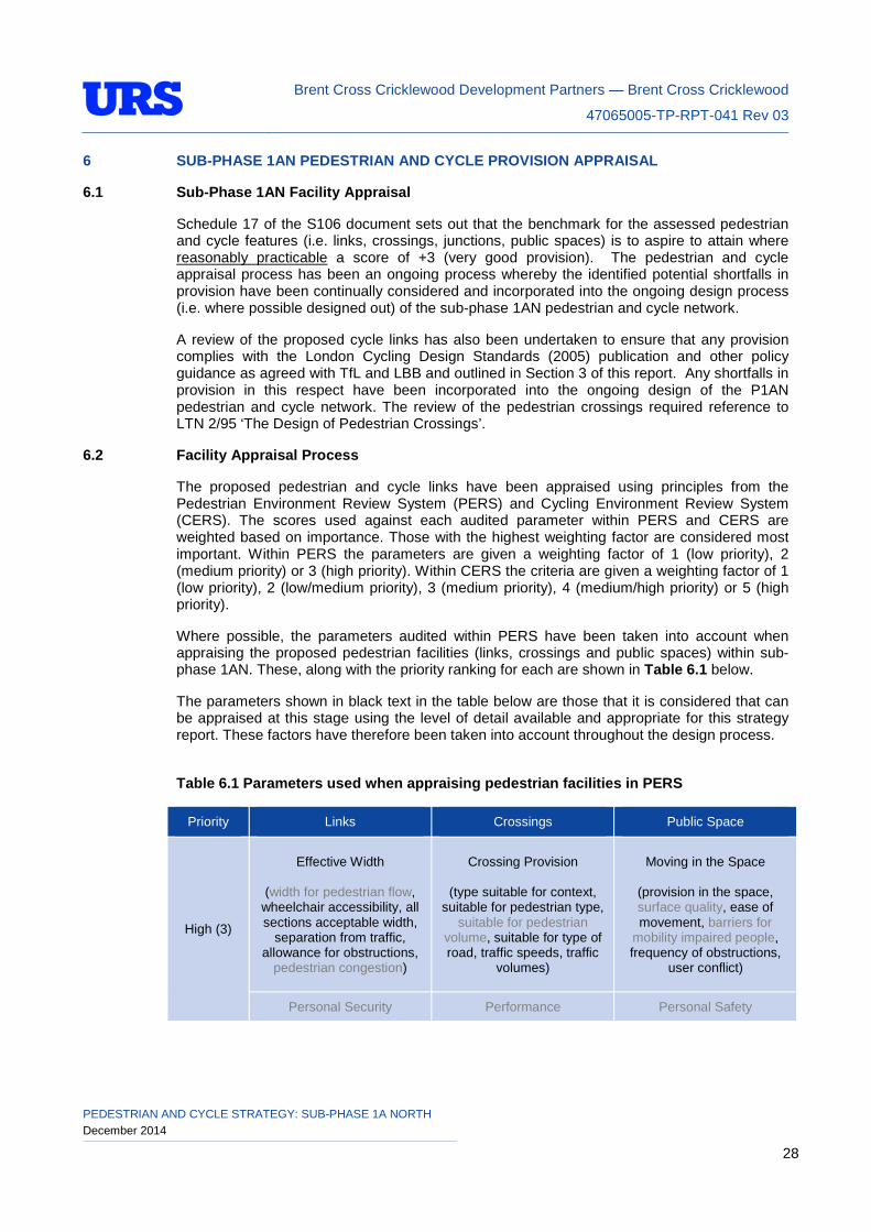
Where possible, the parameters audited within PERS have been taken into account when appraising the proposed pedestrian facilities (links, crossings and public spaces) within sub-phase 1AN. These, along with the priority ranking for each are shown in Table 6.1 below.
The parameters shown in black text in the table below are those that it is considered that can be appraised at this stage using the level of detail available and appropriate for this strategy report. These factors have therefore been taken into account throughout the design process.
Table 6.1 Parameters used when appraising pedestrian facilities in PERS
Priority Links Crossings Public Space
High (3)
Effective Width
(width for pedestrian flow, wheelchair accessibility, all sections acceptable width,
separation from traffic, allowance for obstructions,
pedestrian congestion)
Crossing Provision
(type suitable for context, suitable for pedestrian type,
suitable for pedestrian volume, suitable for type of road, traffic speeds, traffic
volumes)
Moving in the Space
(provision in the space, surface quality, ease of movement, barriers for
mobility impaired people, frequency of obstructions,
user conflict)
Personal Security Performance Personal Safety
PEDESTRIAN AND CYCLE STRATEGY: SUB-PHASE 1A NORTH December 2014 28
Brent Cross Cricklewood Development Partners — Brent Cross Cricklewood
47065005-TP-RPT-041 Rev 03
Priority Links Crossings Public Space
User Conflict
(conflicting movements, user flows, encroachment
on pedestrian space, segregation from cyclists,
bus queues an obstruction, adequate space provision)
Medium (2)
Dropped Kerbs
Deviation from the Desire Line
(deviations, serve likely
desire lines, at grade / by level change, pedestrian
priority, distance minimisation, barriers
causing deviation)
Interpreting the Space
Obstructions Delay Feeling Comfortable
Permeability
(frequency of crossing points, parked cars/ physical
barriers, traffic flow, dropped kerbs, pedestrian
barriers, sightlines)
Legibility (Sensory Impaired People)
Sense of Place Lighting Dropped Kerbs
Tactile Information
Surface Quality Colour Contrast
Surface Quality
Low (1)
Gradient
Crossing Capacity
(minimum dimension standards met, peak hour performance, pedestrian flows coped with, waiting
areas/widths, refuge capacity, width for wheelchair users) Opportunity for Activity
Legibility Legibility
Quality of the Environment Gradient
Maintenance Obstructions
Maintenance
It should be noted that this is an appraisal of the pedestrian strategy and therefore a number of parameters cannot be assessed until further detail is understood at detailed design stage (e.g. gradient, sense of place, legibility, proposed lighting levels, colour contrast, signage etc.).
PEDESTRIAN AND CYCLE STRATEGY: SUB-PHASE 1A NORTH December 2014 29
Brent Cross Cricklewood Development Partners — Brent Cross Cricklewood
47065005-TP-RPT-041 Rev 03
It is considered that those shown in grey text in the above table cannot be suitably appraised at this stage.
PERS also assesses public transport waiting areas, interchanges and routes however the level of detail required to undertake assessments of the above facilities is not available at the time of producing this report and is not considered in this phase strategy appraisal.
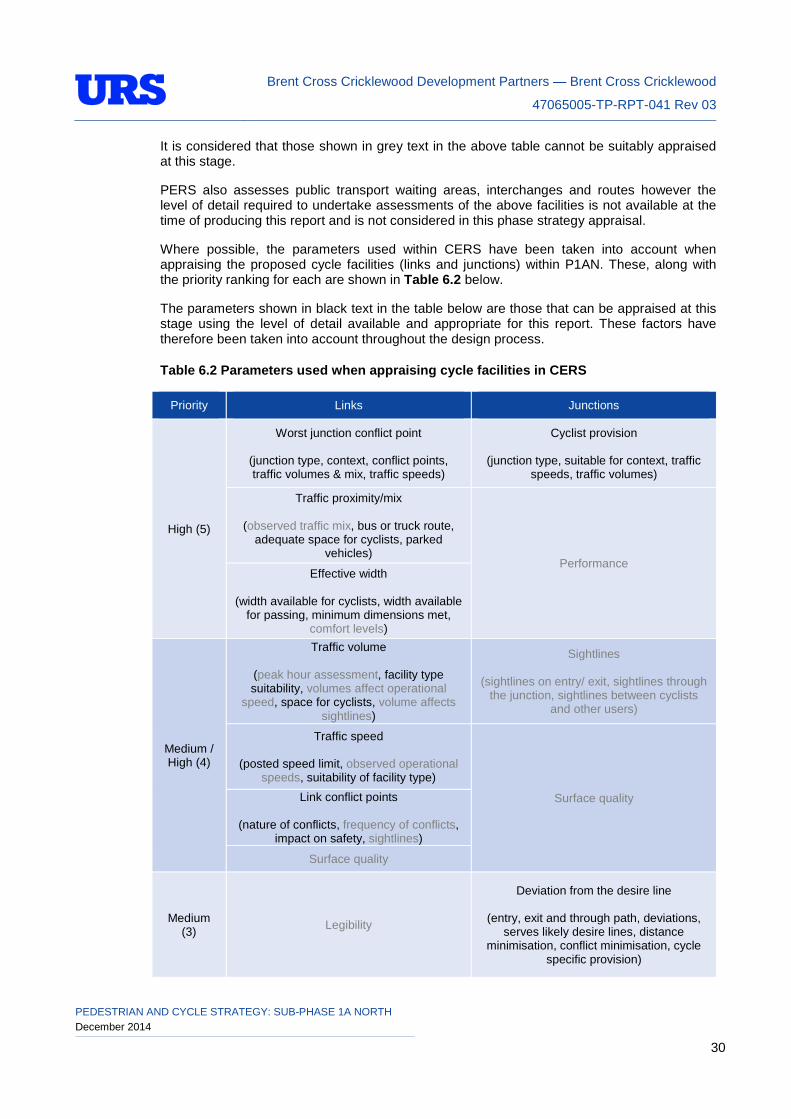
Where possible, the parameters used within CERS have been taken into account when appraising the proposed cycle facilities (links and junctions) within P1AN. These, along with the priority ranking for each are shown in Table 6.2 below.
The parameters shown in black text in the table below are those that can be appraised at this stage using the level of detail available and appropriate for this report. These factors have therefore been taken into account throughout the design process.
Table 6.2 Parameters used when appraising cycle facilities in CERS
Priority Links Junctions
High (5)
Worst junction conflict point
(junction type, context, conflict points, traffic volumes & mix, traffic speeds)
Cyclist provision
(junction type, suitable for context, traffic speeds, traffic volumes)
Traffic proximity/mix
(observed traffic mix, bus or truck route, adequate space for cyclists, parked
vehicles) Performance
Effective width
(width available for cyclists, width available for passing, minimum dimensions met,
comfort levels)
Medium / High (4)
Traffic volume
(peak hour assessment, facility type suitability, volumes affect operational
speed, space for cyclists, volume affects sightlines)
Sightlines
(sightlines on entry/ exit, sightlines through the junction, sightlines between cyclists
and other users)
Traffic speed
(posted speed limit, observed operational speeds, suitability of facility type)
Surface quality Link conflict points
(nature of conflicts, frequency of conflicts, impact on safety, sightlines)
Surface quality
Medium (3) Legibility
Deviation from the desire line
(entry, exit and through path, deviations, serves likely desire lines, distance
minimisation, conflict minimisation, cycle specific provision)
PEDESTRIAN AND CYCLE STRATEGY: SUB-PHASE 1A NORTH December 2014 30
Brent Cross Cricklewood Development Partners — Brent Cross Cricklewood
47065005-TP-RPT-041 Rev 03
Priority Links Junctions
Directness
(facility follows most direct route, alternative routes, evidence of short-cuts)
Legibility
(provision continuity, measures to improve legibility, positioning of infrastructure,
sightlines, visibility of cyclists)
Maintenance
Delay
(effect of junction type, chance of stopping, length of wait)
Overall effort Gradient
Medium / Low (2)
Continuity
(facility type, interruption to continuity, changes to context, presence of crossings) Capacity
Personal security
Lighting
Low (1) Quality of environment
Obstructions
Maintenance
It should be noted that this is an appraisal of the cycle strategy, therefore a number of parameters cannot be appraised until further detail is understood at the detailed design stage (e.g. personal security, proposed lighting levels, colour contrast etc.). It is considered that those shown in grey text in the above table cannot be suitably appraised at this stage.
CERS also assesses interchanges, cycle parking and routes however the level of detail required to undertake assessments of the above facilities is not available at the time of producing this report and is not considered in this strategy.
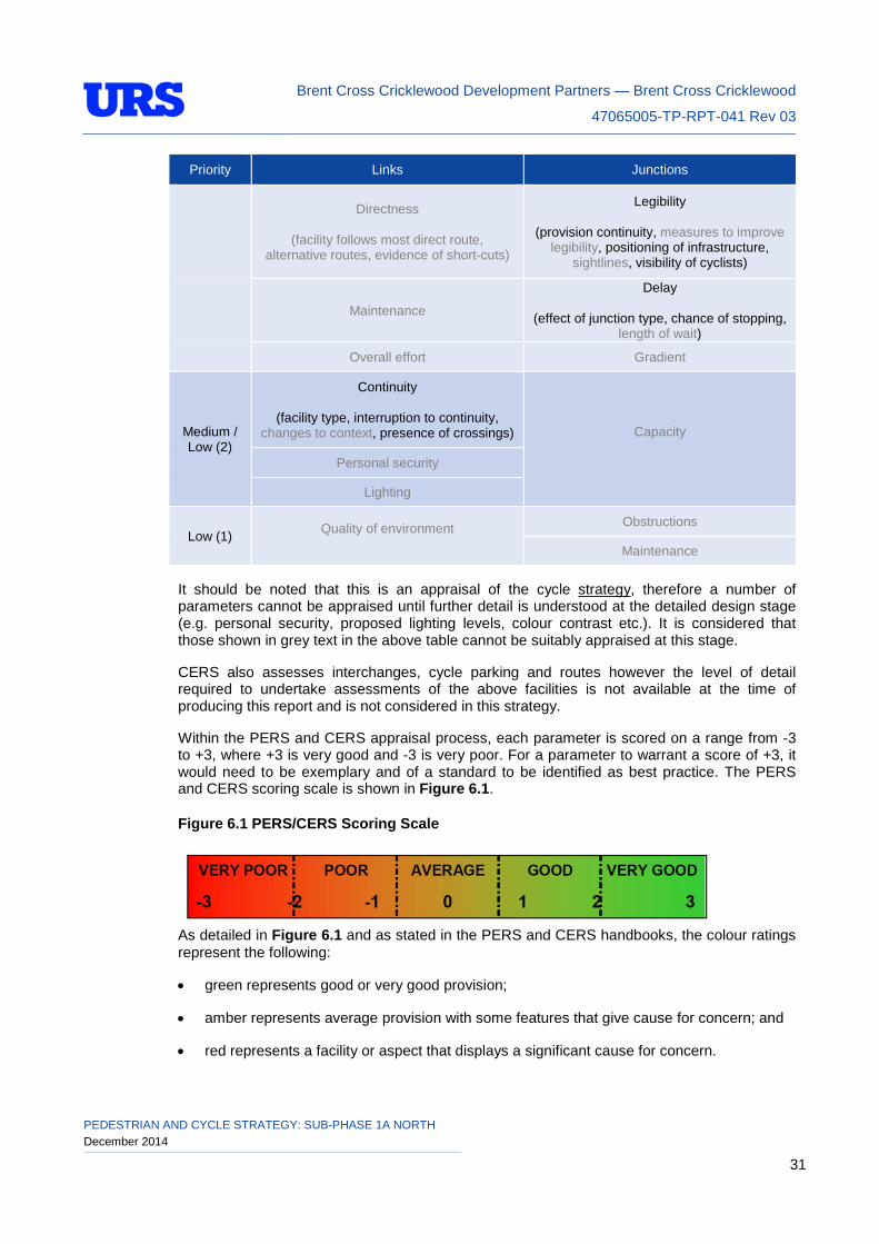
Within the PERS and CERS appraisal process, each parameter is scored on a range from -3 to +3, where +3 is very good and -3 is very poor. For a parameter to warrant a score of +3, it would need to be exemplary and of a standard to be identified as best practice. The PERS and CERS scoring scale is shown in Figure 6.1.
Figure 6.1 PERS/CERS Scoring Scale
As detailed in Figure 6.1 and as stated in the PERS and CERS handbooks, the colour ratings represent the following:
• green represents good or very good provision;
• amber represents average provision with some features that give cause for concern; and
• red represents a facility or aspect that displays a significant cause for concern.
PEDESTRIAN AND CYCLE STRATEGY: SUB-PHASE 1A NORTH December 2014 31
Brent Cross Cricklewood Development Partners — Brent Cross Cricklewood
47065005-TP-RPT-041 Rev 03
Within the PERS and CERS software scores are then weighted based on their relative importance to pedestrians and cyclists (as above).
The appraisal of the final optimised P1AN pedestrian and cycle network (Appendix C) is shown in the tables held in Appendix I. The tables demonstrate that the proposed facilities will attain the highest reasonably practicable score. In some cases, a score of +3 is not practicable; where this is the case comments with further detail have been added.
To maintain consistency of the scores given a scoring system has been used where possible. Where a scoring system has been used, this is shown at the end of each of the tables.
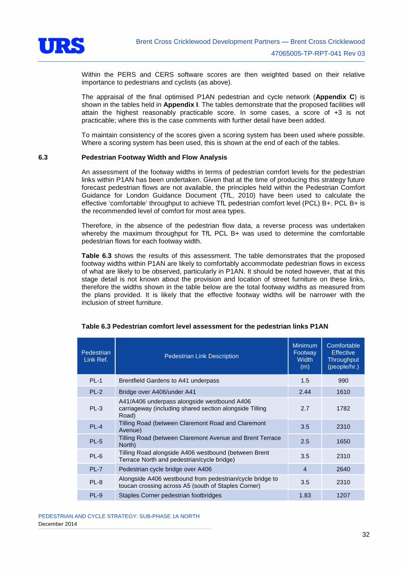
6.3 Pedestrian Footway Width and Flow Analysis
An assessment of the footway widths in terms of pedestrian comfort levels for the pedestrian links within P1AN has been undertaken. Given that at the time of producing this strategy future forecast pedestrian flows are not available, the principles held within the Pedestrian Comfort Guidance for London Guidance Document (TfL, 2010) have been used to calculate the effective ‘comfortable’ throughput to achieve TfL pedestrian comfort level (PCL) B+. PCL B+ is the recommended level of comfort for most area types.
Therefore, in the absence of the pedestrian flow data, a reverse process was undertaken whereby the maximum throughput for TfL PCL B+ was used to determine the comfortable pedestrian flows for each footway width.
Table 6.3 shows the results of this assessment. The table demonstrates that the proposed footway widths within P1AN are likely to comfortably accommodate pedestrian flows in excess of what are likely to be observed, particularly in P1AN. It should be noted however, that at this stage detail is not known about the provision and location of street furniture on these links, therefore the widths shown in the table below are the total footway widths as measured from the plans provided. It is likely that the effective footway widths will be narrower with the inclusion of street furniture.
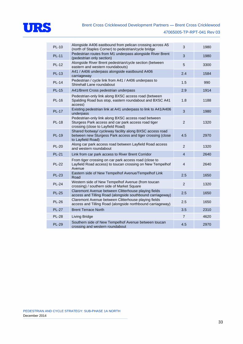
Table 6.3 Pedestrian comfort level assessment for the pedestrian links P1AN
Pedestrian Link Ref. Pedestrian Link Description
Minimum Footway
Width (m)
Comfortable Effective
Throughput (people/hr.)
PL-1 Brentfield Gardens to A41 underpass 1.5 990
PL-2 Bridge over A406/under A41 2.44 1610
PL-3 A41/A406 underpass alongside westbound A406 carriageway (including shared section alongside Tilling Road)
2.7 1782
PL-4 Tilling Road (between Claremont Road and Claremont Avenue) 3.5 2310
PL-5 Tilling Road (between Claremont Avenue and Brent Terrace North) 2.5 1650
PL-6 Tilling Road alongside A406 westbound (between Brent Terrace North and pedestrian/cycle bridge) 3.5 2310
PL-7 Pedestrian cycle bridge over A406 4 2640
PL-8 Alongside A406 westbound from pedestrian/cycle bridge to toucan crossing across A5 (south of Staples Corner) 3.5 2310
PL-9 Staples Corner pedestrian footbridges 1.83 1207
PEDESTRIAN AND CYCLE STRATEGY: SUB-PHASE 1A NORTH December 2014 32
Brent Cross Cricklewood Development Partners — Brent Cross Cricklewood
47065005-TP-RPT-041 Rev 03
PL-10 Alongside A406 eastbound from pelican crossing across A5 (north of Staples Corner) to pedestrian/cycle bridge 3 1980
PL-11 Pedestrian routes from M1 underpass alongside River Brent (pedestrian only section) 3 1980
PL-12 Alongside River Brent pedestrian/cycle section (between eastern and western roundabouts) 5 3300
PL-13 A41 / A406 underpass alongside eastbound A406 carriageway 2.4 1584
PL-14 Pedestrian / cycle link from A41 / A406 underpass to Shirehall Lane roundabout 1.5 990
PL-15 A41/Brent Cross pedestrian underpass 2.9 1914
PL-16 Pedestrian-only link along BXSC access road (between Spalding Road bus stop, eastern roundabout and BXSC A41 access)
1.8 1188
PL-17 Existing pedestrian link at A41 underpass to link to A41/A406 underpass 3 1980
PL-18 Pedestrian-only link along BXSC access road between Sturgess Park access and car park access road tiger crossing (close to Layfield Road)
2 1320
PL-19 Shared footway/ cycleway facility along BXSC access road between new Sturgess Park access and tiger crossing (close to Layfield Road)
4.5 2970
PL-20 Along car park access road between Layfield Road access and western roundabout 2 1320
PL-21 Link from car park access to River Brent Corridor 4 2640
PL-22 From tiger crossing on car park access road (close to Layfield Road access) to toucan crossing on New Tempelhof Avenue
4 2640
PL-23 Eastern side of New Tempelhof Avenue/Tempelhof Link Road 2.5 1650
PL-24 Western side of New Tempelhof Avenue (from toucan crossing) / southern side of Market Square 2 1320
PL-25 Claremont Avenue between Clitterhouse playing fields access and Tilling Road (alongside southbound carriageway) 2.5 1650
PL-26 Claremont Avenue between Clitterhouse playing fields access and Tilling Road (alongside northbound carriageway) 2.5 1650
PL-27 Brent Terrace North 3.5 2310
PL-28 Living Bridge 7 4620
PL-29 Southern side of New Tempelhof Avenue between toucan crossing and western roundabout 4.5 2970
PEDESTRIAN AND CYCLE STRATEGY: SUB-PHASE 1A NORTH December 2014 33
Brent Cross Cricklewood Development Partners — Brent Cross Cricklewood
47065005-TP-RPT-041 Rev 03
7 CONSTRUCTION AND DELIVERY
This P1AN pedestrian and cycle strategy will be reflected in the detailed design. Details of the pedestrian and cycle provision during the construction of P1AN will be provided in the construction transport management plan which is required to be submitted and approved prior to works commencing on site.
PEDESTRIAN AND CYCLE STRATEGY: SUB-PHASE 1A NORTH December 2014 34
Brent Cross Cricklewood Development Partners — Brent Cross Cricklewood
47065005-TP-RPT-041 Rev 03
8 CONSULTATION SUMMARY
Public consultation on the P1AN proposals was included in the RMA consultation undertaken in October 2014. Full results from that event will be provided in the consultation report submitted in support of the P1AN RMA.
PEDESTRIAN AND CYCLE STRATEGY: SUB-PHASE 1A NORTH December 2014 35
Brent Cross Cricklewood Development Partners — Brent Cross Cricklewood
47065005-TP-RPT-041 Rev 03
9 SUMMARY
There is a current planning consent in place for the regeneration of Brent Cross Cricklewood (BXC); this permission is subject to a framework of control that will ensure that the BXC development is carried out in a manner which is consistent with the transport impacts forecast within the consented BXC transport assessment (BXC05).
The S106 document sets out the requirement to provide a series of Reserved Matters Transport Reports (RMTR’s) and a sub-phase 1A North (P1AN) Pedestrian and Cycle Strategy. The strategy is required to set out the details of the pedestrian and cycle links and facilities within P1AN in accordance with the consented scheme.
Schedule 17 of the S106 states that one of the objectives of the Phase Transport Reports (PTR’s) and RMTR’s is to ensure that a comprehensive pedestrian and cycle network is provided within the BXC site, within and between each development phase and connecting to adjacent areas as the development progresses. In line with Condition 2.8 the new and improved pedestrian and cycle links and cycle parking spaces within this strategy will be implemented as part of P1AN.
A scoping exercise was carried out with TfL and LBB to establish the requirements of the P1AN Pedestrian and Cycle Strategy and the specific outputs required following its completion. A scoping report was submitted and approved by TfL and LBB in August 2014.
A P1AN pedestrian and cycle strategy has been developed to ensure that following the implementation of P1AN the routes to and between the key destinations surrounding the phase boundary will continue to be accessible to pedestrian and cyclists; in addition it has been ensured that the pedestrian and cycle desire lines internal to P1AN have been catered for.
The P1AN pedestrian and cycle strategy has been developed following an ongoing iterative design review process during which modifications were suggested to provide enhanced pedestrian or cycle connections within the phase. It is considered that all suggested improvements have been incorporated into the design where feasible.
This report details the key elements of the strategy (including proposals at key areas and key infrastructure locations) and provides an appraisal of the pedestrian and cycle networks (broken down into links, crossings, junctions and public spaces) using principles from the Pedestrian Environment Review System (PERS) and Cycle Environment Review System (CERS).
An assessment of the footway widths in terms of pedestrian comfort levels for the pedestrian links within P1AN has also been undertaken to demonstrate that the proposed footway widths within P1AN are likely to comfortably accommodate pedestrian flows in excess of what are likely to be observed, particularly in P1AN.
Construction and delivery details will be provided in the construction traffic management proposals.
Public consultation on the P1AN proposals was included in the RMA consultation undertaken in October 2014. Full results from that event will be provided in the consultation report.
PEDESTRIAN AND CYCLE STRATEGY: SUB-PHASE 1A NORTH December 2014 36

Intentionally left blank
Brent Cross Cricklewood Development Partners — Brent Cross Cricklewood
47065005-TP-RPT-041 Rev 03
APPENDIX A RELEVANT PLANNING EXTRACTS AND SCOPING DOCUMENT
PHASE 1A NORTH PEDESTRIAN AND CYCLE STRATEGY December 2014
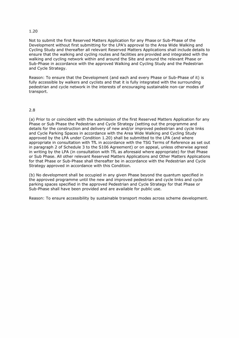
1.20
Not to submit the first Reserved Matters Application for any Phase or Sub-Phase of the
Development without first submitting for the LPA’s approval to the Area Wide Walking and
Cycling Study and thereafter all relevant Reserved Matters Applications shall include details to
ensure that the walking and cycling routes and facilities are provided and integrated with the
walking and cycling network within and around the Site and around the relevant Phase or
Sub-Phase in accordance with the approved Walking and Cycling Study and the Pedestrian
and Cycle Strategy.
Reason: To ensure that the Development (and each and every Phase or Sub-Phase of it) is
fully accessible by walkers and cyclists and that it is fully integrated with the surrounding
pedestrian and cycle network in the interests of encouraging sustainable non-car modes of
transport.
2.8
(a) Prior to or coincident with the submission of the first Reserved Matters Application for any
Phase or Sub Phase the Pedestrian and Cycle Strategy (setting out the programme and
details for the construction and delivery of new and/or improved pedestrian and cycle links
and Cycle Parking Spaces in accordance with the Area Wide Walking and Cycling Study
approved by the LPA under Condition 1.20) shall be submitted to the LPA (and where
appropriate in consultation with TfL in accordance with the TSG Terms of Reference as set out
in paragraph 2 of Schedule 3 to the S106 Agreement) or on appeal, unless otherwise agreed
in writing by the LPA (in consultation with TfL as aforesaid where appropriate) for that Phase
or Sub Phase. All other relevant Reserved Matters Applications and Other Matters Applications
for that Phase or Sub-Phase shall thereafter be in accordance with the Pedestrian and Cycle
Strategy approved in accordance with this Condition.
(b) No development shall be occupied in any given Phase beyond the quantum specified in
the approved programme until the new and improved pedestrian and cycle links and cycle
parking spaces specified in the approved Pedestrian and Cycle Strategy for that Phase or
Sub-Phase shall have been provided and are available for public use.
Reason: To ensure accessibility by sustainable transport modes across scheme development.

Brent Cross
Cricklewood
Scope of Application documents for: Phase 1A North Pedestrian and Cycle Strategy
Doc. No: 47065005-TP-RPT-010
Revision 04
Prepared for: Brent Cross Cricklewood Development Partners
UNITED KINGDOM & IRELAND
Brent Cross Cricklewood Development Partners — Brent Cross Cricklewood
47065005-TP-RPT-010 Rev 04
SCOPE OF APPLICATION DOCUMENTS FOR PHASE 1A NORTH PEDESTRIAN AND CYCLE STRATEGY
September 2014
1
Scope of Application documents for Phase 1A North Pedestrian and Cycle Strategy
Doc. No: 47065005-TP-RPT-010
URS Infrastructure & Environment (UK) Ltd
Scott House
Alençon Link
Basingstoke
Hants RG21 7PP
Telephone: +44 (0)1256 310 200
Fax: +44 (0)1256 310 201
REVISION SCHEDULE
Rev Date Details Prepared by Reviewed by Approved by
1 02-Apr-13 Draft for Discussion Beckie Chapman
Senior Consultant
Mark Watson
Principal Consultant
Margaret Theobald
Technical Director
2 03-Jul-13 Final Beckie Chapman
Senior Consultant
Mark Watson
Principal Consultant
Margaret Theobald
Technical Director
3 14-Jul-14 For Authorities review (Phase 1AN following S106 Agreement)
Paul Kirk
Transport Consultant
Mark Watson
Principal Consultant
Margaret Theobald
Technical Director
4 15-Sept-14 Final (following LBB comments)
Kimberley Pettingill
Transport Consultant
Mark Watson
Principal Consultant
Margaret Theobald
Technical Director
Brent Cross Cricklewood Development Partners — Brent Cross Cricklewood
47065005-TP-RPT-010 Rev 04
SCOPE OF APPLICATION DOCUMENTS FOR PHASE 1A NORTH PEDESTRIAN AND CYCLE STRATEGY
September 2014
2
Limitations
URS Infrastructure & Environment UK Limited (“URS”) has prepared this Report for the sole use of Brent Cross Cricklewood Development Partners (“Client”) in accordance with the Agreement under which our services were performed. No other warranty, expressed or implied, is made as to the professional advice included in this Report or any other services provided by URS.
The conclusions and recommendations contained in this Report are based upon information provided by others and upon the assumption that all relevant information has been provided by those parties from whom it has been requested and that such information is accurate. Information obtained by URS has not been independently verified by URS, unless otherwise stated in the Report.
The methodology adopted and the sources of information used by URS in providing its services are outlined in this Report. The work described in this Report is based on the conditions encountered and the information. The scope of this Report and the services are accordingly factually limited by these circumstances.
Where assessments of works or costs identified in this Report are made, such assessments are based upon the information available at the time and where appropriate are subject to further investigations or information which may become available.
Certain statements made in the Report that are not historical facts may constitute estimates, projections or other forward-looking statements and even though they are based on reasonable assumptions as of the date of the Report, such forward-looking statements by their nature involve risks and uncertainties.
Copyright
© This Report is the copyright of URS Infrastructure & Environment UK Limited. Any unauthorised reproduction or usage by any person other than the addressee is strictly prohibited.
Brent Cross Cricklewood Development Partners — Brent Cross Cricklewood
47065005-TP-RPT-010 Rev 04
SCOPE OF APPLICATION DOCUMENTS FOR PHASE 1A NORTH PEDESTRIAN AND CYCLE STRATEGY
September 2014
3
TABLE OF CONTENTS 1 INTRODUCTION ................................................................ 5
1.1 Planning Context .............................................................. 5
1.1.1 The Consented BXC TA Documents .............................. 5
1.2 S106 Agreement ............................................................... 6
1.3 Consultation ..................................................................... 6
1.4 Proposed Scope of Phase Transport Report: Phase 1AN .................................................................................... 6
1.5 Proposed Contents of Phase 1AN Pedestrian and Cycle Strategy ............................................................................. 6
1.6 Summary Table ................................................................ 7
2 STUDY AREA .................................................................... 8
2.1 Introduction ...................................................................... 8
2.2 Summary Table ................................................................ 9
3 POLICY REVIEW ............................................................. 10
3.1 Introduction .................................................................... 10
3.2 Policy Documents to be Considered ........................... 10
3.3 Summary Table .............................................................. 10
4 IDENTIFICATION OF KEY DESTINATIONS AND DESIRE LINES 11
4.1 Introduction .................................................................... 11
4.2 Summary Table .............................................................. 11
5 PHASE 1AN PEDESTRIAN AND CYCLE STRATEGY . 12
5.1 Introduction .................................................................... 12
5.2 Summary Table .............................................................. 12
6 PHASE 1AN PEDESTRIAN AND CYCLE PROVISION APPRAISAL..................................................................... 13
6.1 Introduction .................................................................... 13
6.2 Summary Table .............................................................. 13
7 OUTLINE STRATEGY MODIFICATIONS ....................... 14
7.1 Introduction .................................................................... 14
7.2 Summary Table .............................................................. 14
8 CONSTRUCTION AND DELIVERY ................................ 15
8.1 Introduction .................................................................... 15
8.2 Summary Table .............................................................. 15
9 CONSULTATION ............................................................. 16
9.1 Introduction .................................................................... 16
Brent Cross Cricklewood Development Partners — Brent Cross Cricklewood
47065005-TP-RPT-010 Rev 04
SCOPE OF APPLICATION DOCUMENTS FOR PHASE 1A NORTH PEDESTRIAN AND CYCLE STRATEGY
September 2014
4
9.2 Summary Table .............................................................. 16
10 FINAL PEDESTRIAN AND CYCLE STRATEGY ............ 17
10.1 Introduction .................................................................... 17
10.2 Summary Table .............................................................. 17
APPENDICES APPENDIX A S106 AND PLANNING CONDITION EXTRACTS
APPENDIX B DEVELOPMENT AREAS INCLUDED WITHIN PHASE 1AN
Brent Cross Cricklewood Development Partners — Brent Cross Cricklewood
47065005-TP-RPT-010 Rev 04
SCOPE OF APPLICATION DOCUMENTS FOR PHASE 1A NORTH PEDESTRIAN AND CYCLE STRATEGY
September 2014
5
1 INTRODUCTION
1.1 Planning Context
There is a current planning consent in place for the regeneration of Brent Cross Cricklewood (BXC); this permission is subject to a framework of control that will ensure that the BXC development is carried out in a manner which is consistent with the transport impacts forecast within the consented BXC transport assessment (BXC05).
The S106 document sets out the requirement to provide a series of Reserved Matters Transport Reports including the Phase 1A North (1AN) Pedestrian and Cycle Strategy. The strategy is required to set out the details for the delivery of the pedestrian and cycle links and facilities within Phase 1AN in accordance with the consented scheme.
Schedule 17 of the S106 states that one of the objectives of the Phased Transport Reports (PTR’s), Pre-Reserved Matters Transport Reports (Pre RMTR’s) and Reserved Matters Transport Reports (RMTR’s) and is to ensure that a comprehensive pedestrian and cycle network is provided within the BXC site, within and between each development phase and connecting to adjacent areas as the development progresses.
This scope sets out the proposed methodology for carrying out the Phase 1AN Pedestrian and Cycle Strategy in line with the outline scope set out in Schedule 17 of the S106.
In addition to this Phase 1AN Pedestrian and Cycling Strategy, an Area Wide Walking and Cycling Study will be undertaken which will examine the pedestrian and cycling links between the wider BXC site and the surrounding communities. The area wide study will review the pedestrian and cycle connections between the development site and key destinations (such as Cricklewood Town Centre and surrounding transport connections) and local residential areas (including Dollis Hill and Hendon). The study is anticipated to deliver a programme of potential schemes for improvements to pedestrian and cycle facilities adjacent to or beyond the site boundary, improving access both to and from the BXC site. Whilst the study has an area wide remit, the Phase 1AN Pedestrian and Cycling Strategy will need to refer to the assessment undertaken within this study and will take into account any relevant improvement measures agreed as part of the review.
As part of the development of this scope for the Phase 1AN Pedestrian and Cycle Strategy a working group has been developed including attendees from TfL, the London Borough of Barnet (LBB) and URS. This group will meet to discuss the content and assessment undertaken as part of the study.
The scope will be discussed with representatives of LBB and TfL and will be refined with the intention of issuing a final version to the stakeholders for agreement by the BXC Working Group.
As agreed in Schedule 17 of the S106 Agreement, the London Borough of Brent (LB Brent) and the London Borough of Camden (LBC) will be consulted as part of the development of the study to agree with the Development Partners (DP) their internal and other costs for the scoping exercise.
1.1.1 The Consented BXC TA Documents
A full transport assessment for the original BXC planning application was approved in October 2010 with a subsequent Section 73 application submitted in October 2013 and in January 2014 the London Borough of Barnet resolved to approve it subject to the S106 agreement.
Brent Cross Cricklewood Development Partners — Brent Cross Cricklewood
47065005-TP-RPT-010 Rev 04
SCOPE OF APPLICATION DOCUMENTS FOR PHASE 1A NORTH PEDESTRIAN AND CYCLE STRATEGY
September 2014
6
The S106 Agreement was updated and amended to reflect the S73 Consent and was signed in June 2014.
The list below provides a reference to the documents issued in support of the Section 73 application;
• BXC 05 Volume 1 Consolidated Transport Assessment Main Report
• BXC 05 Volume 2 Consolidated Transport Assessment Appendices
• BXC 05 Volume 3 Consolidated Transport Assessment Travel Plans
• BXC 05 Volume 4 Consolidated Transport Assessment Highway Engineering Proposals
• BXC 05 Volume 5 Section 73 Transport Report
• BXC 05 Volume 6 Section 73 Highway Engineering Report
It is proposed that the Phase 1AN Pedestrian and Cycle Strategy will draw on the background information and analysis provided as part of these documents where appropriate.
The scope will be discussed with representatives of LBB and TfL as appropriate and will be refined with the intention of issuing a final version to the stakeholders for agreement by LBB and TfL.
1.2 S106 Agreement
The S106 documents set out the requirements for this study and will therefore form an important reference document. The relevant sections of the S106 and planning conditions relating to the Phased Pedestrian and Cycling Strategy are included in Appendix C of this scope for ease of reference. This document has been developed based on our understanding of the requirements of the Phase 1AN Pedestrian and Cycle Strategy as described in the S106 agreement and following discussions with the London Borough of Barnet (LBB) and Transport for London (TfL).
1.3 Consultation
The scope of this report will be discussed and agreed with the LBB and TfL and submitted as a pre-RMA in order to discharge conditions as agreed in the S106 agreement.
1.4 Proposed Scope of Phase Transport Report: Phase 1AN
This section describes the scope of the Pedestrian and Cycle Strategy which will be provided in support of Phase 1AN of the BXC development.
The primary objective of the Phase 1AN Pedestrian and Cycle Strategy is to set out the quantum and details of pedestrian and cycle links and facilities to be provided within Phase 1AN of the development in accordance with the Area Wide Walking and Cycling Study, the Phase Transport Report: Phase 1 and the S73 Consent Transport Assessment.
1.5 Proposed Contents of Phase 1AN Pedestrian and Cycle Strategy
It is proposed that the following aspects will be included within the Phase 1AN Pedestrian and Cycle Strategy:
• A defined study area consistent with the extent of the Phase 1AN proposals
• A review of relevant policy and guidance for pedestrian and cycle provision
Brent Cross Cricklewood Development Partners — Brent Cross Cricklewood
47065005-TP-RPT-010 Rev 04
SCOPE OF APPLICATION DOCUMENTS FOR PHASE 1A NORTH PEDESTRIAN AND CYCLE STRATEGY
September 2014
7
• Identification of key pedestrian and cycle destinations and desire lines will be identified and mapped for the following areas to ensure consistency and continuity with future phases (as appropriate):
� Within Phase 1AN
� Future phases of the BXC development
• Details of proposed pedestrian and cycle links within Phase 1AN, providing connections within the study area and towards surrounding areas
• Further detail on the pedestrian and cycle facilities proposed within Phase 1AN (i.e. cycle parking, pedestrian waiting areas) will be identified
• Review of proposed facilities in line with PERS and CERS (TfL cycle standards)
• Identification of any potential shortfalls in pedestrian and cycle provision, (i.e. between destinations/ desire lines and what is proposed)
• Development of an outline strategy to address any identified shortfalls within the proposed pedestrian and cycle links and facilities
• Identification of temporary routes required during construction activities
• Consultation with relevant stakeholders to ensure all pertinent topics considered
• Finalised strategy and set of proposed schemes to provide pedestrian and cycle facilities and provision for Phase 1AN of the development.
The main body of the study will consist of the above sections. It is envisaged that this will be accompanied by a number of supporting appendices that will provide details of these analyses.
1.6 Summary Table
Item Description
Reference Documents
1. BXC 05
2. Schedule 17, BXC S106 Document
3. Consented Walking and Cycling Strategy
4. Area Wide Walking and Cycling Study
5. Phase 1AN masterplan and associated development schedule
6. Transport Matrix
7. TfL Cycle Guides Area 4
8. Construction programme
Interfaces
1. Interaction with other consultants within BXC consultant team
2. Input required from design team including masterplan architects
3. Input and interface with LBB, TfL, London Borough of Brent (LBBr) and London Borough of Camden (LBC)
4. Consult with TfL/LBB walking/cycling officers/local cycle groups/mobility and visually impaired groups
5. Draft Submissions for approvals provided to: LBB and TfL
Brent Cross Cricklewood Development Partners — Brent Cross Cricklewood
47065005-TP-RPT-010 Rev 04
SCOPE OF APPLICATION DOCUMENTS FOR PHASE 1A NORTH PEDESTRIAN AND CYCLE STRATEGY
September 2014
8
2 STUDY AREA
2.1 Introduction
The proposed study area will encompass the area covered by Phase 1AN of the proposed BXC development. The development areas included within Phase 1AN are shown in the drawing shown in Appendix B of this note.
It is proposed that the study area will ensure that Phase 1AN provides a comprehensive cycle and pedestrian network connecting key destinations within the phase and providing links to the strategic networks surrounding Phase 1AN and the wider development area. Links with the wider networks will be assessed in line with those set out in the Area Wide Walking and Cycling Study. The destinations identified as part of the Area Wide Walking and Cycling Study were as follows:
• Cricklewood town centre and First Capital Connect (FCC) station
• Brent Cross LU Station
• Hendon Central LU station
• West Hendon/Hendon FCC station
• Willesden Green town centre and LU station
• Golders Green town centre and LU station
• Dollis Hill town centre and LU station
• Childs Hill town centre
• Hendon town centre
• Colindale town centre and LU station
• Kilburn town centre and Kilburn High Road London Overground (LO) station
• Neasden town centre and LU station
• Temple Fortune town centre
• West Hampstead
With respect to accessibility, the proposed study area will cover all key links and desire lines to make sure that it is possible to travel safely by foot or bicycle between all parts of the sub-phase and to areas surrounding it.
In this respect routes throughout the site and connecting the site to a number of surrounding residential areas and other key transport connections (including CS11) will also be considered, as agreed with TfL and LBB as part of the scoping process. This section of the report will draw upon the Area Wide Walking and Cycle Study and will identify routes which have particular influence or importance to Phase 1AN.
In addition to reviewing the pedestrian and cycle links, the strategy will review the provision of pedestrian and cycle facilities, including cycle parking provision and the potential impact of the gateway junctions, footbridges and other infrastructure on the movement of both pedestrians and cyclists.
The study area will be confirmed with TfL and LBB prior to the commencement of the detailed assessment.
Brent Cross Cricklewood Development Partners — Brent Cross Cricklewood
47065005-TP-RPT-010 Rev 04
SCOPE OF APPLICATION DOCUMENTS FOR PHASE 1A NORTH PEDESTRIAN AND CYCLE STRATEGY
September 2014
9
2.2 Summary Table
Item Description
Issues Addressed 1. Agreement on defined locations forming the study area
Deliverables 1. Mapping identifying extent of Phase 1AN
Brent Cross Cricklewood Development Partners — Brent Cross Cricklewood
47065005-TP-RPT-010 Rev 04
SCOPE OF APPLICATION DOCUMENTS FOR PHASE 1A NORTH PEDESTRIAN AND CYCLE STRATEGY
September 2014
10
3 POLICY REVIEW
3.1 Introduction
This section will examine the latest national and pan-London transport policy and guidance with regards to the movement of and facilities for, both pedestrian and cyclists.
3.2 Policy Documents to be Considered
There will be a need to review the latest national and pan-London transport policy and guidance with regards to the movement of, and facilities for, both pedestrian and cyclists.
It is anticipated that the documents included in the policy review will be:
• The Mayors Transport Strategy (May 2010)
• The Mayor’s Vision for Cycling in London (March 2013)
• TfL’s Walking Good Practice (April 2012)
• Legible London
• Pedestrian Environment Reviews System Fact Sheet
• Pedestrian Comfort Level Guidance (2010)
• Delivering the Benefits of Cycling in Outer London (February 2010)
• London Cycling Design Standards (2005).
3.3 Summary Table
Item Description
Issues Addressed 1. Identification of framework of policy and guidance to underpin strategy
Deliverables 1. Review of relevant guidance and policy within report
Brent Cross Cricklewood Development Partners — Brent Cross Cricklewood
47065005-TP-RPT-010 Rev 04
SCOPE OF APPLICATION DOCUMENTS FOR PHASE 1A NORTH PEDESTRIAN AND CYCLE STRATEGY
September 2014
11
4 IDENTIFICATION OF KEY DESTINATIONS AND DESIRE LINES
4.1 Introduction
This section will identify and map key pedestrian and cycle destinations and associated desire lines in phase 1AN with consideration of the following as appropriate:
• Within/ throughout Phase 1AN
• Future phases of the BXC development
4.2 Summary Table
Item Description
Issues Addressed 1. Identification of key pedestrian and cycle destinations and desire lines
within BXSC, Phase 1AN and connections to the wider area
Deliverables
1. Map showing key destinations and local areas to be provided at an appropriate scale
2. Pedestrian facilities and desire line/ route plans to be provided at an appropriate scale
3. Cycling facilities and desire line/ route plans to be provided at an appropriate scale
Brent Cross Cricklewood Development Partners — Brent Cross Cricklewood
47065005-TP-RPT-010 Rev 04
SCOPE OF APPLICATION DOCUMENTS FOR PHASE 1A NORTH PEDESTRIAN AND CYCLE STRATEGY
September 2014
12
5 PHASE 1AN PEDESTRIAN AND CYCLE STRATEGY
5.1 Introduction
This section of the report will summarise the proposed provision for pedestrians and cyclists within Phase 1AN, and how this varies from the existing situation.
With respect to pedestrian facilities, this will provide details of the proposed pedestrian links and connections and will include details on footway provision, pedestrian crossing facilities and pedestrian waiting areas.
Cycle facilities will also be summarised within this section of the report. Proposed cycle routes within Phase 1AN will be identified and categorised accordingly to distinguish between designated cycle routes and other possible cycle links. In addition to cycle links, other facilities for cyclists will be set out, including cycle parking provision and crossing facilities. Linkages to CS11 will be considered.
In addition to the above, the provision for both pedestrians and cyclists at the proposed elements of key infrastructure within Phase 1AN (such as the gateway junction design, footbridges and road crossings) will also be considered/ assessed.
In combination with the study area and key destinations identified earlier in the assessment, the proposed pedestrian and cycle provision within Phase 1AN will enable the further development of potential desire lines both within Phase 1AN itself, and also to other phases and wider strategic routes.
5.2 Summary Table
Item Description
Issues Addressed 1. Details of proposed pedestrian and cycle facilities within Phase 1AN
Deliverables 1. Plans as per the above
Brent Cross Cricklewood Development Partners — Brent Cross Cricklewood
47065005-TP-RPT-010 Rev 04
SCOPE OF APPLICATION DOCUMENTS FOR PHASE 1A NORTH PEDESTRIAN AND CYCLE STRATEGY
September 2014
13
6 PHASE 1AN PEDESTRIAN AND CYCLE PROVISION APPRAISAL
6.1 Introduction
An appraisal of the proposed pedestrian and cycle provision within Phase 1AN will be reviewed in connection within the identified desire lines and key destinations.
It is proposed that the review of the proposed pedestrian links will adhere to the assessment process set out in the Pedestrian Environment Review Score (PERS) assessment criteria. As set out in Schedule 17 of the S106 document, the benchmark for the assessed links will be to aspire to attain where reasonably practicable a score of +3. In addition to the assessment of the links, a review of the provision of pedestrian crossing and waiting facilities will be reviewed to identify any potential shortfalls in the proposed provision for pedestrians within Phase 1AN.
Similarly, the proposed cycle facilities will be assessed to ensure that any potential shortfalls in provision which impact on the development of a comprehensive cycle network throughout the phase will be addressed and that connections to areas outside of the phase boundary will be achievable. The benchmark for the assessed links will be to aspire to attain where reasonably practicable a score of +3. A review of the proposed cycle links will be undertaken to ensure that any provision complies with the London Cycling Design Standards (2005) publication and other policy guidance as agreed with TfL and LBB. Assessments of the proposed cycle routes will be carried out using the Cycling Environment Review Score (CERS) assessment criteria.
6.2 Summary Table
Item Description
Issues Addressed
1. PERS and CERS reviews of proposed Phase 1AN provision
2. Identification of potential shortfalls in proposed pedestrian and/or cycle provision within Phase 1AN
Deliverables
1. PERS and CERS assessments of proposed Phase 1AN provision (RAG plans)
2. Plan identifying any areas of potential shortfall in provision
Brent Cross Cricklewood Development Partners — Brent Cross Cricklewood
47065005-TP-RPT-010 Rev 04
SCOPE OF APPLICATION DOCUMENTS FOR PHASE 1A NORTH PEDESTRIAN AND CYCLE STRATEGY
September 2014
14
7 OUTLINE STRATEGY MODIFICATIONS
7.1 Introduction
Based on the appraisal of the proposed Phase 1AN provision, this section of the report will identify any requirements to amend the proposed provision in order to improve the pedestrian and cycle facilities proposed in Phase 1AN.
Modifications may be suggested to provide enhanced pedestrian or cycle connections within the phase and to the surrounding areas to ensure that accessibility on foot and by bicycle is maximised throughout the development phase. Suggested improvements may include the extension of designated cycle routes, extensions of segregated pedestrian links and enhancements to existing proposals for pedestrian and cycle routes and/or associated facilities.
In addition to potential improvements within Phase 1AN, any shortfalls identified in connecting Phase 1AN to key destinations outside of the phase will be reviewed in line with any measures which have been identified within the Area Wide Walking and Cycling Study.
This section will also set out a baseline requirement for the detailed design of the internal infrastructure to ensure that the pedestrian and cycling networks within the development phase provide a ‘very good’ level of service in line with current guidance and best practice.
At the time of writing this scope it is proposed that in addition to the above the following infrastructure elements will be included in this review:
• Gateway junctions
• Footbridges
• Underpasses
• Internal roads.
It is proposed to provide baseline definitions for the above infrastructure proposals that will be used as the basis for the development of the detailed design for these elements. For example, one of the objectives set by TfL is that this section will set out the improvements to the gateway junction designs and/ or subsequent S278 for TLRN at the Gateway locations or other parts of the network.
7.2 Summary Table
Item Description
Issues Addressed
1. Identification of potential improvements to the proposed pedestrian and cycling provision within Phase 1AN
2. Cross reference of strategy to the Area Wide Walking and Cycling Study measures
Deliverables
1. List of potential improvements to pedestrian and cycle connections
2. Plan identifying areas of potential shortfall in provision, including plans at 1:1250 as appropriate
Brent Cross Cricklewood Development Partners — Brent Cross Cricklewood
47065005-TP-RPT-010 Rev 04
SCOPE OF APPLICATION DOCUMENTS FOR PHASE 1A NORTH PEDESTRIAN AND CYCLE STRATEGY
September 2014
15
8 CONSTRUCTION AND DELIVERY
8.1 Introduction
This section will outline the details for the construction and delivery of the proposed pedestrian and cycle provision within Phase 1AN.
This will be assessed to ensure that the delivery of the proposed improvements and facilities is provided in line with Planning Condition 2.8 which states that ‘no development shall be occupied in any given Phase beyond the quantum specified in the approved programme until the new and improved pedestrian and cycle links and cycle parking spaces specified’.
The proposed construction and delivery methodology and programme will be reviewed to ensure that a good network of walking and cycling routes will be maintained during the construction of Phase 1AN.
8.2 Summary Table
Item Description
Issues Addressed 1. Delivery of walking and cycling routes throughout construction
Deliverables 1. Construction phase/ time slice drawings with relevant temporary
pedestrian and cycle provision to be provided at an appropriate scale
Brent Cross Cricklewood Development Partners — Brent Cross Cricklewood
47065005-TP-RPT-010 Rev 04
SCOPE OF APPLICATION DOCUMENTS FOR PHASE 1A NORTH PEDESTRIAN AND CYCLE STRATEGY
September 2014
16
9 CONSULTATION
9.1 Introduction
The development of the Phase 1AN Pedestrian and Cycle Strategy will be conducted in close liaison with TfL and LBB as advised in Schedule 17 of the S106 document. It is considered that TfL cyclist and pedestrian specialists will be involved as the work progresses.
In addition to TfL and LBB it is anticipated that consultation will also be required with local cycle groups and other key stakeholders to include:
• London Cycling Campaign and Cyclists Touring Club (Barnet Branch)
• Barnet Cyclists
• Brent Cyclists
• London Borough of Brent (LB Brent)
• London Borough of Camden (LBC)
• London Mayor’s Cycling Commissioner (if considered appropriate)
• BXSC Management
The above list has been developed and agreed with LBB and TfL throughout this scoping exercise.
It is proposed that the consultation exercise will be a continuation of the consultation exercise commenced as part of the Area Wide Walking and Cycling Study. The workshop format introduced as part of the AWWC Study will be continued to generate conversation specifically regarding the proposed pedestrian and cycle provision in Phase 1AN.
Following the workshops, consultation will be managed accordingly to ensure that stakeholders’ views are recorded within the study.
9.2 Summary Table
Item Description
Issues Addressed
1. Identification of key local issues to be addressed within the assessment and best practice methods to mitigate constraints
2. Agreement of possible measures to improve provision where necessary
Deliverables 1. Consultation summary within the Phase 1AN Pedestrian and Cycle
Strategy
Brent Cross Cricklewood Development Partners — Brent Cross Cricklewood
47065005-TP-RPT-010 Rev 04
SCOPE OF APPLICATION DOCUMENTS FOR PHASE 1A NORTH PEDESTRIAN AND CYCLE STRATEGY
September 2014
17
10 FINAL PEDESTRIAN AND CYCLE STRATEGY
10.1 Introduction
This section will summarise the final Pedestrian and Cycle Strategy for Phase 1AN taking into account the outcomes of the assessment as presented in the strategy document.
It is proposed that this section will provide a concise summary of the final pedestrian and cycle provision to be provided as part of Phase 1AN of the Development, including a summary of the maintenance or diversion of routes during construction.
The final strategy will be presented in both text format and in a number of drawings and maps, including plans at 1:1250 where appropriate, to show the location of all proposed provision and facilities.
10.2 Summary Table
Item Description
Issues Addressed 1. Agreement of the final strategy for pedestrian and cyclists within
Phase 1AN
Deliverables
1. Final Phase 1AN Pedestrian and Cycle Strategy
2. Mapping and Drawings to summarise the final strategy, including drawings at 1:1250
Brent Cross Cricklewood Development Partners — Brent Cross Cricklewood
47065005-TP-RPT-010 Rev 04
SCOPE OF APPLICATION DOCUMENTS FOR PHASE 1A NORTH PEDESTRIAN AND CYCLE STRATEGY
September 2014
APPENDIX A S106 AND PLANNING CONDITION EXTRACTS

Intentionally left blank
20
supplemented by the information to be submitted in accordance with Condition 2.1).
Reason: To ensure that the LPA has clarity on the layout of key structural components within any phase (or part of) or zone, prior to considering any detailed building applications and to be consistent with the Reconciliation Mechanism described in Section 6 of the DSF.
1.18. Not to submit the first Reserved Matters Application for any Phase or Sub-Phase prior to the establishment of the Consultative Access Forum in consultation with the LPA and the GLA.
Reason: To ensure principles of inclusive access are incorporated into the detailed design of all development within the scheme on the basis of a proper and detailed consultative process.
1.19. Not to submit the first Reserved Matters Application for any Phase or Sub-Phase prior to the establishment of the Brent Cross Energy Panel in consultation with the LPA and the GLA.
Reason: To ensure principles of sustainable energy are incorporated into the detailed design of all aspects of the Development on the basis of a proper and detailed consultative process.
1.20. Not to submit the first Reserved Matters Application for any Phase or Sub-Phase of the Development without first submitting for the LPA’s approval to the Area Wide Walking and Cycling Study and thereafter all relevant Reserved Matters Applications shall include details to ensure that the walking and cycling routes and facilities are provided and integrated with the walking and cycling network within and around the Site and around the relevant Phase or Sub-Phase in accordance with the approved Walking and Cycling Study and the Pedestrian and Cycle Strategy.
Reason: To ensure that the Development (and each and every Phase or Sub-Phase of it) is fully accessible by walkers and cyclists and that it is fully integrated with the surrounding pedestrian and cycle network in the interests of encouraging sustainable non-car modes of transport.
1.21. Not to submit the first Reserved Matters Application for any Phase or Sub-Phase of the Development without first submitting for the LPA’s approval the Framework Servicing and Delivery Strategy which shall set out (in accordance with the parameters and principles set out in Schedule 26 of the S106 Agreement as abstracted from paragraph 5.3.8 of Volume 1 of the Transport Report) the Developers’ proposed approach to servicing and deliveries to the
36
2.7. Prior to or coincident with the submission of the first Other Matters Approval in respect of Phase 1 the A5 Corridor Study (including any necessary Supplementary Transport Measures required to address the detailed impacts identified in the study together with an indicative programme for carrying out such works) shall be submitted to the LPA, in consultation with the London Boroughs of Brent and Camden and the Transport Strategy Group. All other relevant Reserved Matters Applications and Other Matters Applications shall thereafter be in accordance with the A5 Corridor Study approved in accordance with this Condition (and including for the avoidance of doubt the approval of detailed delivery programmes in accordance with Condition 5 of this Permission).
Reason: To ensure the transport impacts of the scheme upon the A5 are fully evaluated and mitigated as part of the detailed design and programming of Phase 1 and the other relevant Phases of the Development.
2.8. (a) Prior to or coincident with the submission of the first Reserved Matters Application for any Phase or Sub Phase the Pedestrian and Cycle Strategy (setting out the programme and details for the construction and delivery of new and/or improved pedestrian and cycle links and Cycle Parking Spaces in accordance with the Area Wide Walking and Cycling Study approved by the LPA under Condition 1.20) shall be submitted to the LPA (and where appropriate in consultation with TfL in accordance with the TSG Terms of Reference as set out in paragraph 2 of Schedule 3 to the S106 Agreement) or on appeal, unless otherwise agreed in writing by the LPA (in consultation with TfL as aforesaid where appropriate) for that Phase or Sub Phase. All other relevant Reserved Matters Applications and Other Matters Applications for that Phase or Sub-Phase shall thereafter be in accordance with the Pedestrian and Cycle Strategy approved in accordance with this Condition.
(b) No development shall be occupied in any given Phase beyond the quantum specified in the approved programme until the new and improved pedestrian and cycle links and cycle parking spaces specified in the approved Pedestrian and Cycle Strategy for that Phase or Sub-Phase shall have been provided and are available for public use.
Reason: To ensure accessibility by sustainable transport modes across scheme development.
Brent Cross Cricklewood Development Partners — Brent Cross Cricklewood
47065005-TP-RPT-010 Rev 04
SCOPE OF APPLICATION DOCUMENTS FOR PHASE 1A NORTH PEDESTRIAN AND CYCLE STRATEGY
September 2014
APPENDIX B DEVELOPMENT AREAS INCLUDED WITHIN PHASE 1AN

Intentionally left blank
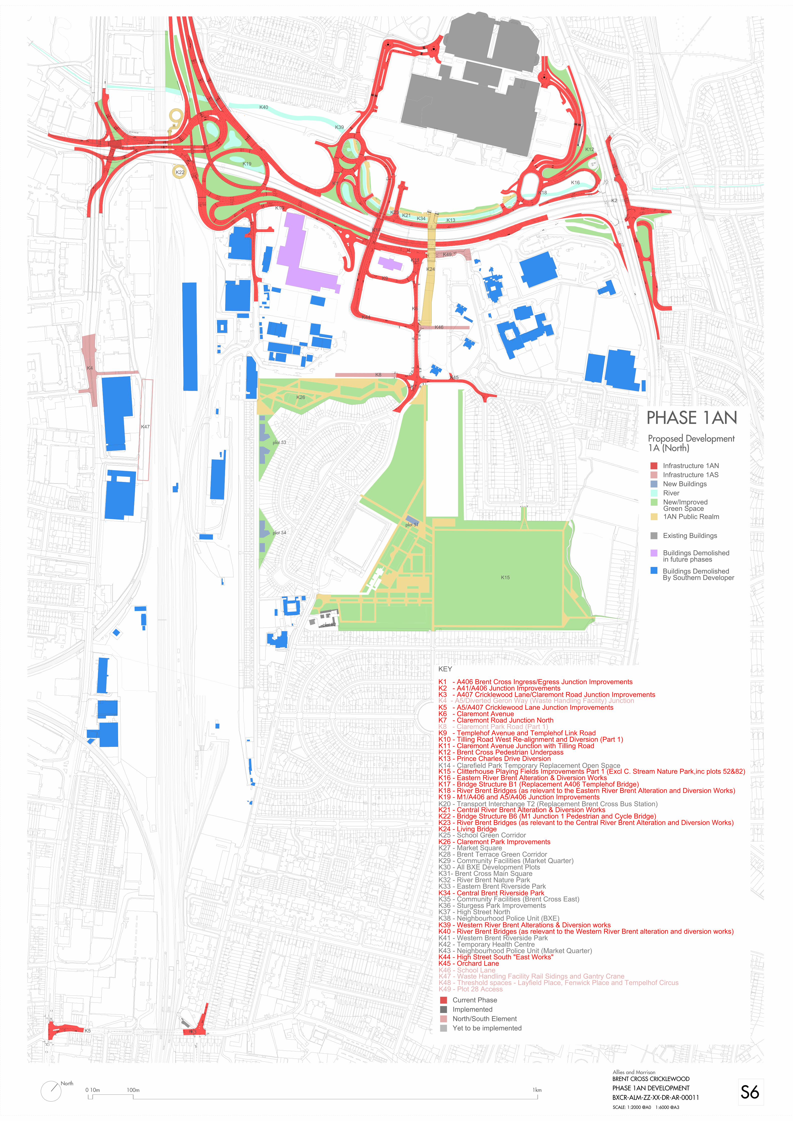

Intentionally left blank
Brent Cross Cricklewood Development Partners — Brent Cross Cricklewood
47065005-TP-RPT-041 Rev 03
APPENDIX B SUB-PHASE 1A NORTH STUDY AREA PLAN
PHASE 1A NORTH PEDESTRIAN AND CYCLE STRATEGY December 2014

Intentionally left blank


Intentionally left blank