logistics processes and motorways of the sea ii - traceca · logistics processes and motorways of...
TRANSCRIPT
Logistics Processes and Motorways of the Sea II
Master Plan Annex 6 – Part II Page 1 of 122
Logistics Processes and Motorways of the Sea II
in Armenia, Azerbaijan, Georgia, Kazakhstan, Kyrgyzstan, Moldova,
Tajikistan, Turkmenistan, Ukraine, Uzbekistan
Inception Report – Annex 4
Action Plans
July 2011
A project implemented by Egis International/Dornier Consulting
ENPI 2011/264 459
Logistics Processes and Motorways of the Sea II
in Armenia, Azerbaijan, Georgia, Kazakhstan, Kyrgyzstan, Moldova,
Tajikistan, Turkmenistan, Ukraine, Uzbekistan
LOGMOS Master Plan – Annex 6
Part II
TRACECA Inland Waterways – Danube Case Study
October 2013
This project is funded by the European Union
A project implemented by Egis International/Dornier Consulting

Logistics Processes and Motorways of the Sea II
Master Plan Annex 6 – Part II Page 1 of 122
TABLE OF CONTENTS
1 INTRODUCTION................................................................................................................................... 5
2 GENERAL PERSPECTIVE FOR EXPLOITING TRACECA INLAND WATERWAYS ........................ 8
3 EUROPEAN POLICY ......................................................................................................................... 10
4 ORGANISATION OF THE SECTOR .................................................................................................. 14
4.1 THE DANUBE COMMISSION ............................................................................................................ 14 4.2 NATIONAL TRANSPORT STRATEGIES (ROMANIA, BULGARIA) ............................................................ 15
4.2.1 Romania ............................................................................................................................ 15 4.2.1.1 Salient Facts and Figures ....................................................................................... 15 4.2.1.2 Intermodal Transport Strategy to 2020 – General Overview .................................. 16
Rail Transport .............................................................................................................. 17 Road Mode .................................................................................................................. 18
4.2.1.3 Intermodal Transport Strategy to 2020 – Intermodal Terminals ............................. 19 Existing Infrastructure ................................................................................................. 19 Proposals to Modernize Old/Build New Terminals...................................................... 19
4.2.1.4 Intermodal Transport Strategy to 2020 – Conclusions ........................................... 23 4.2.2 Bulgaria ............................................................................................................................. 27
4.2.2.1 Salient Facts and Figures ....................................................................................... 27 4.2.2.2 The Strategy for the Development of the Transport System of the Republic of
Bulgaria until 2020 – General Overview ................................................................. 27 Rail Transport .............................................................................................................. 30 Road Transport ........................................................................................................... 33
4.3 RIVER AND SEA GOVERNMENTAL AGENCIES AND NATIONAL COMPANIES MONITORING THE DANUBE IN
ROMANIA AND BULGARIA ............................................................................................................... 35 4.3.1 Romania ............................................................................................................................ 35
4.3.1.1 Romanian Naval Authority ...................................................................................... 35 4.3.1.2 National Company ‘Administration of Navigable Canals’ ....................................... 37 4.3.1.3 National Company ‘Maritime Ports Administration’ SA, Constanza Port................ 42 4.3.1.4 River Administration of the Lower Danube (AFDJ, Galati) ..................................... 44 4.3.1.5 Fluvial Danube Ports Administration, Giurgiu ......................................................... 46
4.3.2 Bulgaria ............................................................................................................................. 48 4.3.2.1 Executive Agency Maritime Administration (EAMA, Sofia) .................................... 48 4.3.2.2 Executive Agency for the Exploration and Maintenance of the Danube River
(EAEMDR, Ruse) .................................................................................................... 48 4.3.2.3 Bulgarian Ports Infrastructure Company (BPI Co.) ................................................ 51
5 PORTS IN TRACECA COUNTRIES ON THE DANUBE, TRAFFIC, ONGOING PROJECTS AND PERSPECTIVES ................................................................................................................................ 53
5.1 RIVER PORTS ................................................................................................................................ 53 5.1.1 Romania ............................................................................................................................ 53
5.1.1.1 Lower Danube ........................................................................................................ 54 5.1.1.2 Maritime Danube .................................................................................................... 58
5.1.2 Bulgaria ............................................................................................................................. 63 5.1.2.1 Ruse 63 5.1.2.2 Belene ..................................................................................................................... 66 5.1.2.3 Vidin ....................................................................................................................... 68
5.1.3 Moldova............................................................................................................................. 73 5.1.3.1 Introduction ............................................................................................................. 73

Logistics Processes and Motorways of the Sea ll
Page 2 of 122 Annex 6 – Part II Master Plan
5.1.3.2 Giurgiulesti .............................................................................................................. 75 5.1.4 Ukraine .............................................................................................................................. 79
5.1.4.1 Introduction ............................................................................................................. 79 5.1.4.2 Izmail ....................................................................................................................... 82 5.1.4.3 Reni ....................................................................................................................... 85
6 CONCLUSIONS AND RECOMMENDATIONS .................................................................................. 89
6.1 WORKING GUIDELINES ................................................................................................................... 90 6.1.1 Taking the Logistics Dimension into Due Account ........................................................... 90 6.1.2 Involving Users and Operators ......................................................................................... 90 6.1.3 Capitalizing on European Experience ............................................................................... 92 6.1.4 Developing Regional Cooperation .................................................................................... 93
6.2 POTENTIAL MARKETS, CUSTOMERS AND SERVICES ......................................................................... 95 6.2.1 Renewal of the Ro-Ro Service Bulgaria-Georgia ............................................................. 95 6.2.2 Attracting Turkish and Other Trucking Companies ........................................................... 96 6.2.3 Developing Ro-La Offer Through the Balkans .................................................................. 97 6.2.4 Container Feeder Services on the Danube ...................................................................... 97
6.3 MARITIME AND LOWER DANUBE CLUSTERS ..................................................................................... 98
7 APPENDIXES ................................................................................................................................... 103
APPENDIX 1: BYSTROE CANAL STORY .................................................................................................. 103 Historical Background ............................................................................................................... 103 Recent Developments ............................................................................................................... 104
APPENDIX 1 (CONTINUED): COMPARISON OF CHARGES THROUGH THE SULINA AND BYSTROE CANALS
(MARCH 2012) ........................................................................................................................... 106 APPENDIX 2: MODAL SPLIT OF INLAND FREIGHT TRANSPORT (1) (2) ...................................................... 108 APPENDIX 3: RAIL AND ROAD TRANSPORT IN ROMANIA ......................................................................... 109 APPENDIX 4: ROAD TRAFFIC IN ROMANIA – FORECAST 2015................................................................. 110 APPENDIX 5: ROAD, RAIL AND INLAND WATER WAY TRANSPORT IN BULGARIA ....................................... 111 APPENDIX 6: COMPARISON BETWEEN BULGARIAN RAILWAYS (BZD AND NRIC) AND OTHER RAILWAYS
COMPANIES IN THE EU (2009)..................................................................................................... 112 APPENDIX 7: DANUBE PORTS IN TRACECA COUNTRIES ...................................................................... 113 APPENDIX 8: GOODS HANDLED AT ROMANIAN LOWER DANUBE RIVER PORTS (BECHET, CALAFAT,
CALARASI, CERNAVODA, CETATE, CHICIU CALARASI, CORABIA, DRENCOVA, GIURGIU, MOLDOVA
NOUA, MOLDOVA VECHE, OLTENITA, ORSOVA, TISOVITA, TURNU SEVERIN) (IN TONNES) ............... 121 APPENDIX 9: GOODS HANDLED AT GIURGIULESTI INTERNATIONAL FREE PORT AND 2012 FORECAST (IN
TONNES) .................................................................................................................................... 122
Logistics Processes and Motorways of the Sea II
Master Plan Annex 6 – Part II Page 3 of 122
LIST OF FIGURES
Figure 1: Danube River Basin ....................................................................................................................... 6 Figure 2: TEN-T Inland Waterways and Ports in Romania and Bulgaria ..................................................... 7 Figure 3: TEN-T Inland Waterways. Priority Axis 18 .................................................................................. 10 Figure 4: Administrative Map of Danube River Basin ................................................................................. 11 Figure 5: Transport Infrastructure in Romania ............................................................................................ 16 Figure 6: TEN-T Railways. Priority Axis 22 ................................................................................................. 21 Figure 7: TEN-T Roads. Priority Axis 7 ....................................................................................................... 22 Figure 8: Transport Infrastructure in Bulgaria ............................................................................................. 27 Figure 9: Bulgarian Railroad Network ......................................................................................................... 31 Figure 10: Bulgarian Road Network ............................................................................................................ 34 Figure 11: RORIS Map ............................................................................................................................... 37 Figure 12: Danube (Blue) and the Black Sea-Danube Canal (Red) ........................................................... 37 Figure 13: Black Sea-Danube Canal at Constanza .................................................................................... 38 Figure 14: Cernavoda Lock ......................................................................................................................... 38 Figure 15: Bala Branch ............................................................................................................................... 40 Figure 16: Tavria Line Vessel ‘ALKOR’ in Service between Constanza and Dnepropetrovsk ................... 43 Figure 17: BRP Pusher with 2 x 40 TEU Barges En Route from Constanza to Belgrade .......................... 44 Figure 18: AFDJ 2680 cbm Suction Hopper Dredge ‘DUNAREA MARITIMA’ ........................................... 45 Figure 19: Traditional Sloping Quay Walls at the Port of Oltenita .............................................................. 47 Figure 20: Ice on the Danube in Galati – March 2012 ................................................................................ 50 Figure 21: Ruse-Giurgiu Friendship Bridge ................................................................................................ 50 Figure 22: Romania Main Sea and River Ports .......................................................................................... 53 Figure 23: Port of Giurgiu ............................................................................................................................ 54 Figure 24: Maritime Danube ....................................................................................................................... 58 Figure 25: Port of Braila .............................................................................................................................. 59 Figure 26: Mineralier (Ore) Port at Galati ................................................................................................... 60 Figure 27: Docuri (Docks) Port at Galati ..................................................................................................... 60 Figure 28: The Danube at Galati................................................................................................................. 61 Figure 29: Political Map of Bulgaria ............................................................................................................ 63 Figure 30: Port Ruse-West ......................................................................................................................... 64 Figure 31: Port Ruse-East Ro-Ro Terminal ................................................................................................ 65 Figure 32: Belene Island ............................................................................................................................. 66 Figure 33: Port Belene – Heavylift Dock/Unloading from Ship/Loading on Trucks of 3 Electric Motors/217 t . 67 Figure 34 and 35: Port Belene – Unloading from Ship of a Tunnel Boring Machine .................................. 67 Figure 36: Trans-European Transport Corridors through Vidin .................................................................. 68 Figure 37: Loading of New Cars on Barge ................................................................................................. 69 Figure 38: Loading of Catamaran for Passau at Vidin AutoFerryboat Terminal ......................................... 70 Figure 39: The ‘New Europe Bridge’ Vidin-Calafat ..................................................................................... 71 Figure 40: BRP Ferryboat ........................................................................................................................... 71 Figure 41: Artist Vision of the Future Layout of Vidin North Terminal ........................................................ 72 Figure 42: Transport Infrastructure of Moldova .......................................................................................... 74 Figure 43: Geographical Location of Giurgiulesti ........................................................................................ 76 Figure 44: Inauguration of the Grain Terminal ............................................................................................ 77 Figure 45: GIFP Master Plan ...................................................................................................................... 77 Figure 46: DL Feeder M/S ‘Lady Didem’ at Sulina on the 24/08/2013 ....................................................... 78 Figure 47: Danube Delta ............................................................................................................................. 79 Figure 48: Ukrainian Part of the Danube Delta ........................................................................................... 80 Figure 49: Entrance to the Bystroe Canal ................................................................................................... 81 Figure 50: Location of Izmail on the Danube .............................................................................................. 82 Figure 51: Berths and Terminals at the Port of Izmail ................................................................................ 84 Figure 52: Stevedoring of Pellets at PPK-2 ................................................................................................ 84 Figure 53: Plan of the Port of Reni.............................................................................................................. 85 Figure 54: Port of Reni (Backwater on the Left and the Danube on the Right) .......................................... 86 Figure 55: Port of Reni (Backwater)............................................................................................................ 87

Logistics Processes and Motorways of the Sea ll
Page 4 of 122 Annex 6 – Part II Master Plan
Figure 56: Location of the Notorious Kapikule-Kapitan Andreevo BCP ..................................................... 96 Figure 57: Budjak Region ........................................................................................................................... 99 Figure 58: Ferryboat Complex at Reni ...................................................................................................... 100
LIST OF TABLES
Table 1: Black Sea-Danube Canal Traffic (in tonnes) ................................................................................ 41
LIST OF TEXT BOXES
Text box 1: RORIS ...................................................................................................................................... 36

Logistics Processes and Motorways of the Sea II
Master Plan Annex 6 – Part II Page 5 of 122
1 INTRODUCTION
The 2,850 km long Danube, ‘Le roi des fleuves de l’Europe’ as Napoleon used to call it, Europe’s second longest river after the Volga, has long ago been recognized as a vital trade link between Eastern and Western Europe. Though, while large volumes are carried on other major European rivers such as the Rhine1 and the Volga, there have been a lot of obstacles in the way of developing the traffic on the Danube. Also, other European waterways flow through one or a limited number of countries while the Danube, the most international river in the world, crosses the territory of 10 nations with different cultures, political systems and sometimes conflicting interests and policies.
In recent history, the Sulina Channel fairway remained jammed from 1991 to 2004, with the wreck of the M/S ’Rostock’, a 5,657 DWT cargo vessel2. Civil wars and Serbian bridge bombings even brought the international traffic to a nearly complete stop less than 15 years ago entailing considerable negative economic effects (including bankruptcy in some cases), for a number of small shipping companies and plants of the already-ailing industry of the riparian states which remained long deprived from access to a cheap bulk commodity transport mode.
Today still, local and foreign environmental groups (including the WWF and the UN Environmental Program) remain concerned by the fact the Danube hosts fragile eco-systems, represents an important drinking water supply and is also the main sewer of many of the countries it passes. Keeping the river clean at any cost is therefore the focus of their endeavors. They accordingly oppose and repeatedly delay the implementation of many an infrastructure project much needed to regulate the flow of the river and possibly reach the objective to accommodate type VIb vessels3 all year round by 2015-2020 which would result in an uninterrupted use of the river, make inland navigation here reliable, cost effective and thus competitive versus other modes of transport.
The economic players retort it is now widely acknowledged that inland waterway transport is the most environmentally friendly mode, the environmental damage done by river regulation works and operations of vessels being minimal compared with the emissions of the road vehicles which would carry the cargo if the rivers proved unable to provide an adequate service4.
In March, 2011, the long-standing dispute between Ukraine and Romania about the Bystroe Canal rebounded (see Appendix 1), while in December 2011-January 2012 skippers from the State-owned shipping company ‘Ukrainian Danube Shipping Company’ (UDP) reported acts of piracy and theft of cargoes carried on their vessels in the maritime part of the Danube.
1 There are 5 to 8 times more cargoes (depending on the criteria used) moving on the Rhine than on the Danube.
2 Some authors contend this wreck was a deliberate political act by Russia.
3 Pushed convoys and inland waterways vessels with a draft of up to 2.5 m.
4 On average, self-propelled vessels consume up to 0.013 liter per tkm, whereas modern vessels can achieve gas oil
consumption as low as 0.0044 liter per tkm. Rail is estimated to consume on average 0.0095 l/tkm and road transport 0.0292 l/tkm (putting it in other words, with 1 liter of fuel, most vessels can carry 1 tonne of cargo over 127 km, in comparison to 97 for rail and 50 for road). Inland ships today emit 3 to 5 times less carbon than road trucks per ton-km. Smart steaming (equivalent of eco-driving) leads to carbon savings between 10 and 30% and the introduction of low-sulphur fuel in 2011 decreases pollution from ships and makes it possible to equip vessels with more energy-efficient engines and with after-treatment devices reducing pollution by 80 to 85%. On 21 January 2012, for the first time, the Central Commission for the Navigation of the Rhine has authorised the use of liquefied natural gas (LNG) – the cleanest of fossil fuels - for inland navigation. ‘Inland Waterway Freight Transport – a transport solution that works’, an EC study published in 2003, has demonstrated that inland waterway transport accounts for only 0.5% of all socio-economic costs of transport, such as accidents, air pollution, climate change etc (roads – 91.5%, air transport – 6%, rail transport – 2%).

Logistics Processes and Motorways of the Sea ll
Page 6 of 122 Annex 6 – Part II Master Plan
During the Communist era the traffic developed rapidly for the movement of bulk cargoes serving often economically unviable heavy industry, reaching a peak of 91.841 Mt in 1987. The collapse of industry in the former Eastern Bloc and civil war in Yugoslavia brought this figure down under 20 Mt in 1994. In 2011 it increased to 50.488 Mt56 as trade in Central and Eastern Europe has been growing at a fast pace during the pre-crisis period.
Nonetheless, the under-utilized Danube still holds a vast potential to carry more traffic.
Figure 1: Danube River Basin
Container services along the river started in 2005 only and the volumes carried remain modest up to this day, although the vessel size limitation does not represent a major constraint, save for the draft, the river is free flowing from the Iron Gate in the border stretch of the Danube between Serbia and Romania all the way to the Black Sea, a distance of more than 860 km, there are only 2 pairs of locks altogether on the 2 branches of the Cernavoda-Agigea Canal and, during the recent years, Constanza has established itself as a key container hub in the Black Sea.
Ro-Ro services provided with shallow catamarans have also successfully developed between Germany and Bulgaria and there is still room for further such services on various segments of the river. Other local Ro-Ro lines successfully make up for the insufficient number of bridges connecting the banks of the river between Romania and Bulgaria and the sub-standard, though rapidly improving, road network of both countries.
The transport policies of the riparian States foreseeing the evolution of Danube ports into logistics and industrial hubs with improved intermodal links should also result in attracting added-value activities and therefore more traffic to the ports provided Shippers and Shipping Companies are properly and timely involved in such major infrastructure investment projects.
The inclusion of the Danube as the 10th TEN-T European Core Corridor in October, 2011 and the EU Strategy for the Danube Region (EUSDR), adopted by the European Commission in
5 Including the Main-Danube canal opened in 1992 which connects the Danube and the Rhine, the Black Sea-
Danube Canal – also known as the Sulina Channel – and the Kylia branch which Ukraine opened fully through the much-debated Bystroe canal to provide its own fleet with a direct access to its Maritime Danube ports of Reni, Izmail and Ust-Dunaisk.
6 Contrast and compare: the yearly average Rhine traffic amounts to 330 Mt.

Logistics Processes and Motorways of the Sea II
Master Plan Annex 6 – Part II Page 7 of 122
December 2010 and endorsed by the European Council in 2011, should provide the tools necessary for creating the synergies between the Danube Region countries to address common challenges together.
Figure 2: TEN-T Inland Waterways and Ports in Romania and Bulgaria

Logistics Processes and Motorways of the Sea ll
Page 8 of 122 Annex 6 – Part II Master Plan
2 GENERAL PERSPECTIVE FOR EXPLOITING TRACECA INLAND WATERWAYS
While the potential of Danube has already been well covered by various technical studies as part of the greater Danube shipping market, the purpose of this report is to highlight its role in the transport system of the 4 TRACECA riparian countries at national level and for TRACECA in general taking into account the European experience and current trends in the region.
At 2,414 km navigable length, the Danube River plays a major role in connecting together:
Western, Central and Eastern European regions and all of them to the Black and North Sea,
Riparian countries between themselves,
At national level, the various regions of the riparian countries.
For TRACECA it represents a major part of its inland waterway network.
The Danube is classified as an international inland waterway which contributes to improved distribution of traffic flows between Western, Central and Eastern Europe on the one hand and Caucasus and Central Asia on the other hand either directly via ports on the Western and Eastern banks of the Black Sea or through the Volga-Don Complex to ports in the Caspian Sea.
The Dnepr and Danube basins are also closely inter-linked with vessels plying voyages between the two rivers. Provided adequate logistics infrastructure is developed and navigation conditions are improved, the Danube may play a role in logistics chains connected to the Mediterranean Sea as well.
The European experience demonstrates the following factors that need to be considered in view of successful development of the inland waterway potential:
Reduction in Landside Transportation Costs: container river ports located upriver close to the hinterland markets have potential of gaining market share from those ports located on the coast. This trend is a result of shippers’ quest to minimize landside transport costs by choosing ports located farther inland (Duisburg, the largest inland port in the world, in the Rhurgebiet, is handling over 1,000,000 TEU p.a. and some shipping companies ply direct short-sea container lines from Duisburg to the UK for instance).
Targeting Multi-Modal Market Shares: despite inland waterways are an absolutely vital part of the multi-modal system, specifically in the case of bulk/liquid commodities, the global trend is that they are losing market share versus the road mode. Therefore, the inland waterway system should seek its place in international container and domestic intermodal markets by providing the services required by the supply chains following the same path as modern sea ports (Liège, the first inland port in Belgium and the third in Europe, develops Trilogiport, a multi-modal platform consisting in a rail/road/water-connected container terminal (15 ha), logistics open areas and last-generation warehouses (41,7 ha), a port area (14,7 ha), an area for service activities (1,8 ha) and an area for environmental integration (25 ha). International key players in the transport and logistics industry, such as Dubai Ports World, one of the leading container terminal operators in the world, or Deutsche Lagerhaus GmbH, a leading logistics real-estate developer are closely associated and part of the venture.)
Container-on-barge Services are Viable: container-on-barge services in Europe have become an essential link in the transport of containers between hinterland markets and coastal ports (1,980,223 TEU i.e. about 14.7 Mt of cargo- moved on the Rhine alone in 2012. The growth in this transport segment has been of 90% in 10 years).
This solution could be also considered for TRACECA as well, of course bearing in mind existing technical barriers along its waterways. This is also connected to the overall containerization

Logistics Processes and Motorways of the Sea II
Master Plan Annex 6 – Part II Page 9 of 122
situation in TRACECA, since container-on-barge services require significant existing or potential volumes of international maritime containers moving between the requisite international gateway port and inland regional markets.
Reliable Scheduled Services: the conditions provided by the waterway transport system should enable regular, rapid and reliable connections. These include proper navigation environment, availability of container facilities and manageable distances. The experience in Europe shows that frequency and level of service is the most important factor for competing with road transport.
Mode Shift Policies and Mechanisms: it is the policy of the European Union to foster the modal shift from trucks to rail and waterways. For instance such traditionally external costs as emissions and traffic congestion were converted into market-based subsidies designed to take traffic off the highways and on to the waterways. Policies, incentives and subsidies would become an important tool for developing integrated logistics in TRACECA, including the utilization of the inland waterway potential in the supply chains.
Marketing, Linkage with Shippers, Carriers and Ports: marketing measures promoting certain segments of the network may be useful in targeted relationships with shippers seeking reliable/alternative mode options.
Innovations and Technology: the use, reliability and efficiency of the waterway system are enhanced through application of modern technologies and innovations.
Certainly these lessons learned cannot be put in place overnight, but they provide a vision for exploiting the potential of the inland waterway system, and sketch the steps which need to be taken.
Logistics Processes and Motorways of the Sea ll
Page 10 of 122 Annex 6 – Part II Master Plan
3 EUROPEAN POLICY
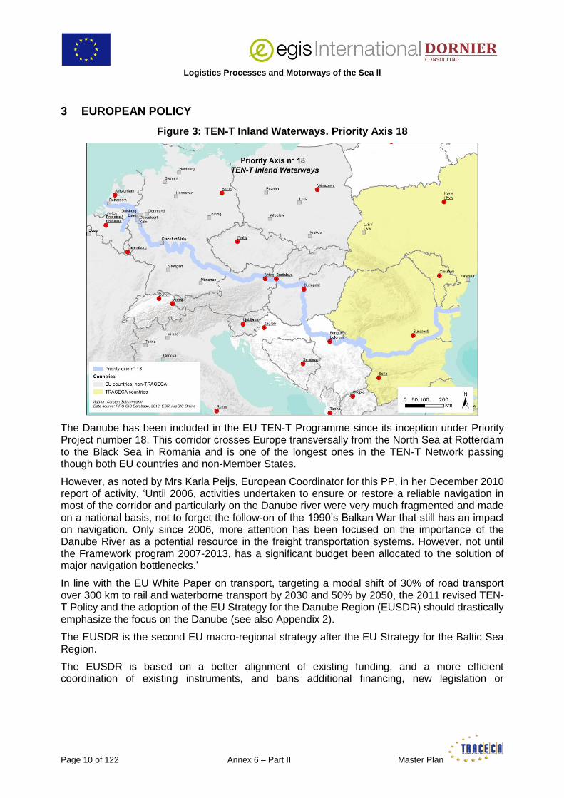
Figure 3: TEN-T Inland Waterways. Priority Axis 18
The Danube has been included in the EU TEN-T Programme since its inception under Priority Project number 18. This corridor crosses Europe transversally from the North Sea at Rotterdam to the Black Sea in Romania and is one of the longest ones in the TEN-T Network passing though both EU countries and non-Member States.
However, as noted by Mrs Karla Peijs, European Coordinator for this PP, in her December 2010 report of activity, ‘Until 2006, activities undertaken to ensure or restore a reliable navigation in most of the corridor and particularly on the Danube river were very much fragmented and made on a national basis, not to forget the follow-on of the 1990’s Balkan War that still has an impact on navigation. Only since 2006, more attention has been focused on the importance of the Danube River as a potential resource in the freight transportation systems. However, not until the Framework program 2007-2013, has a significant budget been allocated to the solution of major navigation bottlenecks.’
In line with the EU White Paper on transport, targeting a modal shift of 30% of road transport over 300 km to rail and waterborne transport by 2030 and 50% by 2050, the 2011 revised TEN-T Policy and the adoption of the EU Strategy for the Danube Region (EUSDR) should drastically emphasize the focus on the Danube (see also Appendix 2).
The EUSDR is the second EU macro-regional strategy after the EU Strategy for the Baltic Sea Region.
The EUSDR is based on a better alignment of existing funding, and a more efficient coordination of existing instruments, and bans additional financing, new legislation or

Logistics Processes and Motorways of the Sea II
Master Plan Annex 6 – Part II Page 11 of 122
institutions. Financing sources are the existing Cohesion and Structural Funds7, IPA for Western Balkans, ENPI, ETC, Sectoral EU and National Funds, IFIs (EIB, EBRD), private banks and donors.
Figure 4: Administrative Map of Danube River Basin
The EUSDR is divided in 4 pillars and 11 priority areas coordinated each by 2 countries. ‘Mobility and multimodality’ which include the themes most relevant to the LOGMOS Project Master Plan are monitored by Austria and Romania.
Source: danube-region.eu
An Action Plan has been drafted, complementing and building on already ongoing activities in the Danube Region.
As far as inland waterways are concerned, the actions and projects are in line with the goals set forth by the 2006 European Action Program for Inland Waterway Transport (NAIADES) which will finish in 2013 and its technical arm PLATINA. The ongoing revision of NAIADES by the EC should lead to the adoption of a NAIADES II Program. NAIADES addressed five essential
7
EUR 24.8 bn for transport for the programming period 2007-2013 out of which only 0.7 for the ports and inland waterways.

Logistics Processes and Motorways of the Sea ll
Page 12 of 122 Annex 6 – Part II Master Plan
areas: market development, fleet modernization, jobs and skills, awareness, building and infrastructure.
PLATINA consists of 23 partners from 9 different countries. It is led by a consortium the core of which includes Via Donau (Austria) as coordinator, Voies navigables de France (France), Bundesverband der Deutschen Binnenschiffahrt (Germany), Promotie Binnenvaart Vlaanderen (Belgium) and the Rijkswaterstaat Centre for Transport and Navigation (the Netherlands). The main objective of NAIADES through its implementation platform PLATINA is to create coherent links to exploit the full potential of inland navigation through a better coordination of national transport policies in the field of navigation in the Danube basin.
The whole EUSDR process is monitored by the Interact Program (Vienna being the focal point).
With regard to inland waterway transport, concrete infrastructure projects include, for instance:
the removal of shipwrecks, bridges debris and unexploded weapons from the riverbed which, on some stretches of the lower Danube are still hindering traffic and endangering safety of navigation especially in low water periods;
building the Danube – Bucharest Canal to connect the capital city of Romania with the river through a waterway, defend 11 localities and 30,000 ha of farming land against floods, producing power, supplying water for irrigation, providing drinking water for the neighbouring localities and for aqua-farming.
Other issues addressed are, inter alia:
implementing a transnational coordinated approach in ship waste management (EU-funded project ‘Waste management for inland navigation on the Danube’ completed in 2011 – WANDA and succeeding project CO-WANDA which started in October 2012 within the frame of the SEE Program);
supporting the Danube Commission in finalizing the endless process of reviewing the Belgrade Convention which would strengthen the role of the Danube Commission and also allow the accession of the European Commission as a member;
developing river ports into multimodal logistics centres; it is worth noticing at this stage that the Action Plan stipulates: ‘A coordinated and harmonized development concept for multimodal ports should be elaborated by Danube river basin countries and relevant stakeholders. As a basis for this activity, national port development plans shall be elaborated or reviewed with a view to their integration into local and regional development strategies’;
building on the network of Danube Waterway Administrations (NEWADA) to facilitate the coordination of activities and plans and the exchange of experiences among organizations responsible for waterway administration along the Danube;
developing container transport on the Danube to increase the use of multimodal transport by fostering a strong cooperation between ports and logistics partners of the private sector, upgrading the necessary infrastructure, establishing a network of main ports;
implementing harmonized River Information Services (RIS) for increasing the safety and environmental-friendliness of inland navigation, optimizing the efficiency of logistics operations, thus reducing overall transport costs;
establishing cooperation networks for logistics and nautical education focusing on the Danube corridor to improve education and training in the field of inland waterway transport in the Danube region (NELI).

Logistics Processes and Motorways of the Sea II
Master Plan Annex 6 – Part II Page 13 of 122
Another chapter of the Action Plan deals with rail and road transport, contemplating, for example, the construction of two new bridges linking Bechet (Romania) with Oriahovo (Bulgaria) and Calarasi (Romania) with Silistra (Bulgaria), while rail plans underline the necessity to pay special attention to the development of modern intermodal terminals connecting the Danube River with the rail network.
On the whole, specialists consider the policies of the EU and of the various promotion agencies sometimes fail Danube shipping.
The shipping companies underline navigational and RIS are prioritized while the river ageing fleet remains largely ignored and, though very important, these items should not take precedence over the vessels and port infrastructure themselves (over the past few years, the only investment in this respect has been a EUR 17 M loan by the EIB for the reconstruction and modernization of the port of Lom in Bulgaria despite a great deal of Lower Danube ports require substantial infrastructure investment).
Logistics Processes and Motorways of the Sea ll
Page 14 of 122 Annex 6 – Part II Master Plan
4 ORGANISATION OF THE SECTOR
4.1 The Danube Commission
Historical Background
The Russian Empire controlling the Sulina mouth failed to maintain adequate navigation conditions there to force vessels to use Russian Black Sea ports instead of Turkish (later Romanian) ports. In 1856, at the Treaty of Paris following the Crimean War, Western European powers established the European Commission of the Danube (ECD) with the declared aim of improving the navigation at the mouths of the Danube and the concealed motive to keep Russia away from this strategic zone (the Treaty also pushed the Russian border 20 km north of the Danube).
Following WWII, when most riparian countries became Soviet satellites, and most of the main remaining river fleet owned by, at one time, the world’ largest river shipping company, DDSG/Vienna, captured and transferred to the Soviet Danube Shipping Company (SDP), Russia finally gained full control of the Danube. USSR therefore dictated that a new Danube Commission, composed only of riparian states except for Germany and Austria8 should be established to cover the length of the Danube.
In spite of the strong protests from the West this resulted in the Convention regarding the regime of navigation on the Danube signed in Belgrade on 18 August 1948, still in force to this day. This ended Western rule and political control over this key trade route. The Commission headquarters moved to Budapest in 1954.
A restrictive cabotage agreement signed in Bratislava between the riparian national shipping companies (now mostly State-owned) followed in 1956, allowing vessels to trade only to or from their home countries. This de facto cancelled the international status of the river. Following the collapse of Soviet Union, Russia has become the only non-riparian member state of the 11-Member state Commission. The Commission, today, also includes 9 Observer States (Belgium, the Czech Republic, Cyprus, France, FYROM, Greece, Montenegro, the Netherlands and Turkey).
Present Role of the Commission
The primary tasks of the Danube Commission activity are provision and development of free navigation on the Danube for the commercial vessels flying the flag of all states in accordance with interests and sovereign rights of the member-states of the Belgrade Convention, as well as strengthening and development of economical and cultural relations of the said states among themselves and with the other countries. The official languages of the Danube Commission are Russian and French (and German since 1991).
The Danube Commission is focusing on the creation of a unified navigation system of inland waterways in Europe and gives the priority to the unification and provision of mutual recognition of the basic regulatory documents, required for the navigation on the Danube and on the other sections of the unified navigation system.
It also plays an active role in contributing to the improvement of navigation conditions and safety of navigation and creating requirements for the Danube integration into the European system in the capacity of the significant transport corridor.
8
In actual facts, Austria joined in 1960 while Germany became a full-fledged member only in 1998, at the same time as Croatia and Moldova.

Logistics Processes and Motorways of the Sea II
Master Plan Annex 6 – Part II Page 15 of 122
The Commission therefore actively cooperates with the relevant international bodies, involved in different inland waterways transport aspects, such as the UNECE, the International Sava River Basin Commission9, the Central commission for the navigation on Rhine, the European Commission, the BSEC, etc.
The Commission, which holds 2 full sessions per year, comprises a number of expert working groups addressing technical, legal and financial questions such as boat Masters’ licenses, minimum requirements for standard fairway parameters, hydro-technical and other improvements on the Danube, the impact of climate change on inland navigation, ship-generated waste, etc.
With the aim of enhancing the role of the Danube Commission in the international cooperation in the field of inland navigation, the member-states of the Belgrade Convention are also working, since 2009, on a revised, modernized version which would vest additional powers to the Commission, entrust it with new functions, as well as allow to enlarging the circle of its members. This should become possible when the ongoing process of revision will end. Presently France, Turkey and the EU have declared their intention to become the members of the new Danube Commission.
4.2 National Transport Strategies (Romania, Bulgaria)10
4.2.1 Romania
4.2.1.1 Salient Facts and Figures
The degree of urbanization in Romania (54% of a total population of 20,121 M in 2011) is significantly lower than in neighbouring countries having either a comparable density per square kilometre (68% in Hungary) or a lower one (72,5% in Bulgaria), and well below Western EU countries (74% in Germany, 77% in France). This percentage is even decreasing since 2005.
This means the population is more or less evenly distributed over the 239,000 square kilometres of the country, with only 2 cities hosting more than 300,000 people (Timisoara , Cluj-Napoca) plus the capital Bucharest, the largest city with 1,883 M (2,2 M in the LUZ area). Rural areas are said to represent 90% of the total area of the country.
The GDP per capita in PPS, which rose constantly and significantly since the beginning of the 2000’s, is stagnating at about 49% of the EU-28 average due to the global economic downturn. Yet, the unemployment rate remains rather low (7.5% of the labour force in August 2013) and markedly lower than the EU average (10.9% - id -).
In 2010 the share of road transport in Romania international trade was 70.5% for exports and 71.2% for imports, while maritime transport represented 19.5% and 15.4% respectively. The main trade partner is the EU-27 (73.5% of the country imports and 70.2% of the exports in 2012).
9 Launched in 2001 and officially established in 2005 between Bosnia and Herzegovina, the Federal Republic of Yugoslavia (now Serbia), Croatia and Slovenia to better utilize, protect and control the water resources of the river basin. The 947 km-long Sava is the second biggest catchment of Danube tributaries after the Tisza, draining an area of 97,713 square kilometres. The Commission has its Permanent Secretariat in Zagreb, Croatia. 10 The national transport strategies of Ukraine and Moldova can be read in the corresponding country profiles published in separate reports by the Consultant. The sections of these strategies specifically relevant to the Danube are reviewed together with the description of their ports in Chapter 5.

Logistics Processes and Motorways of the Sea ll
Page 16 of 122 Annex 6 – Part II Master Plan
Figure 5: Transport Infrastructure in Romania
4.2.1.2 Intermodal Transport Strategy to 2020 – General Overview
This document, drawn in 2010 and published in May, 2011, remains the most recent and relevant one for the present report, pending the Romanian General Master Plan for Transport based on an estimation of transport demand and traffic flows until 2030 (funded by the SOP 2007-2013). The Master Plan goes together with the preparation of the next EU fiscal budgetary exercise for the period 2014-2020, for which Romania has obtained in the renegotiation of the TEN-T network an increase by 40% of the railway network.
Reportedly the Master Plan should include the main principles, guidelines and recommendations of the Strategy. Discussions about the projects (among them 2-3 nodal intermodal centres) which will be retained for inclusion in this MP are scheduled for November 2013, while the final version of the MP should be published in the spring of 201411. The mapping is aligned on the latest definition of the TEN-T networks with a core network including Bucharest, Timisoara and Constanza while Iasi, Cluj, Brasov and a number of other cities will be in the comprehensive one. Work is going on regarding the choice of a methodology, prioritization of projects, location of logistics centres and funding sources (mostly provided through EU financial instruments such as the 2014-2020 Sectoral/Structural funds/CEF, etc.). It is planned to develop a National Transport Model within the MP12.
The Strategy acknowledges the fact that globalization of the economy and subsequent growth of the world trade is the key driver of the increasing demand in international transport over long
11 A tendering process was launched in April 2011 to select a consulting firm which would bring technical assistance in the elaboration of the Master Plan. The British company Aecom was retained in April 2012. The duration of the
contract is 23 months.
12 Seemingly much resembling the similar tool developed for TRACECA by the IDEA I Project.

Logistics Processes and Motorways of the Sea II
Master Plan Annex 6 – Part II Page 17 of 122
distances, based on ‘door-to-door’ services, which favour the rapid development of containerization allowing intermodal combination of different transport modes.
The Strategy is based on the development of intermodal transport which is considered as the safest and best future alternative for meeting the needs of the users and helping to solve the problems of road congestion, also contributing to preserve fair competition, mitigate the consequences of the economic crisis, and implement the EU TEN-T priorities in Romania.
This approach is better understood when reviewing the operation and present state of land transport modes which also bear on the present and future Danube operation (the provisions of the Strategy for maritime and river transport will be considered in other relevant chapters of the present report).
Rail Transport
The rail industry started being liberalized in 1998, and as of 30 September, 2010, not less than 20 private rail-freight operators were active in Romania13. The super and infra structure remain the property of the State, entrusted to CFR, the national railway company. CRF is divided in 4 sections: CFR Calatori, for passenger services; CFR Marfa, for freight transport; CFR Infrastructura, which manages the Romanian railway network infrastructure and Societatea Feroviara de Turism, or SFT, which manages scenic and tourist railways.
Still, the lack of sufficient State support to CFR and investment for the rehabilitation and up-grade of the railway infrastructure – including terminals (modernization of buildings, water and electricity supplies, access routes, platforms, storage areas, cranes and other handling equipment including loaders equipped with telescopic hydraulic spreaders for handling 40’s, IT systems, etc.) – and poor maintenance14, result in train speed restrictions, stops and delays, delays as well in handling, transferring, dispatching at the railway stations, and higher tariffs (partly deriving from too big a fragmentation of the market), pushing users to rather truck the containers and more than halving the overall cargo volumes carried by CFR Marfa within 10 years15 (see Appendix 3). In the first 6 months of 2012, CFR Marfa carried 14.8 Mt, 15.6% less than during the same period of 2011, while traffic dropped by 9.4%
The volume of containerized cargo traffic on the 10,784 km rail route (out of which 4,002 are electrified) represents, on average, only 4% of the total volume of goods transported by rail during the years 2005-2009.
13 The AFER (Romanian Rail Authority which depends from the Ministry of Transport) reports having delivered through the OLFR, its licensing division, a total of 41 licenses to national and foreign companies for the performance of carriage of goods by rail on the 31-12- 2012.
14 CFR Marfa has a rolling stock fleet of over 900 locomotives and 39,000 railcars out of which only 23,000 are functional.
15 This further entailed considerable and ongoing financial and social difficulties for CFR. The staff decreased from
45,760 employees in 2000 to 25,382 in 2010. Even so, the company (as a whole) kept on making losses which climaxed when, in the wake of the global financial crisis, CFR registered a deficit in excess of EUR 100 M during the first semester of 2010. The Ministry of Transport and Infrastructure had to set up and implement an emergency plan of rescue which cost their jobs to another 4,000 employees, notwithstanding harsh benefit cuts and sharp increases in tariffs. Up to date CFR is still applying a strict plan of cost-reduction and CFR Marfa posted a loss of ‘only’ EUR 22 M for 2011 for a turnover of EUR 261 M (the last time CFR Marfa recorded a profit was in 2007. Its cumulative losses ever since exceed EUR 270 M). Still the expectation for 2013 is a loss of some EUR 47.7 M. CFR Marfa employed 9,162 people at the end of 2012. This number was forecasted to drop to 9,053 by the end of 2013. However a further 1,500-staff layoff is now scheduled in November-December 2013 in the aftermath of CFR Marfa privatization. Trade Unions have already warned they would initiate lawsuits as this measure was not contained in the privatization plan.

Logistics Processes and Motorways of the Sea ll
Page 18 of 122 Annex 6 – Part II Master Plan
Nonetheless private rail forwarders operate some domestic and international block container trains Delamode Group – weekly Bucharest-Constanza South Port; IFB – fixed departures from/to Antwerp, Zeebrugge, Genk to/from Bucharest, Bradu de Sus, Curtici/private terminal Rail Port Arad, and Oradea with possible connections to Turkey, Greece, Hungary16.
Road Mode
The road network spans over 81,713 km out of which 16,500 km of public network. There again however, because of insufficient investment, maintenance and repair, the Romanian infrastructure, though improving rapidly, lags well behind Western and even other Central European ones, does not meet the requirements of a modern market economy and even less the needs of a country where the number of private cars has simply tripled since the Iron Curtain fell, 24 years ago17.
There are plans to build a 2,260 km motorway system, consisting of six main motorways and six bypass motorways. As of 2011, 371.5 km are built and 845 km have construction contracts under way.
Furthermore, budgetary constraints preventing a rehabilitation/modernization of the full network, and in order to avoid more damages, laws have been passed in 2010 limiting weight and dimensions allowed for freight vehicles and speed for all types of rolling crafts on a number of public roads. Simultaneously the rehabilitation program launched in 2005 is going on and the above-mentioned limits are lifted step by step.
However, 2006 forecasts for 2015 yielded a figure of 16,000 vehicles per hour on the public network near urban areas leading to congestion for freight as well as for passenger traffic (Appendix 4).
Although heavily shaken during this GFC, the growing importance of road transport in Romania clearly appears in the evolution of the modal split of freight transport (Appendix 2)18 as well as from the evolution of the national stock of freight vehicles (lorries, road tractors, semi-trailers and trailers classified as per the UNECE Glossary for Transport Statistics, 4th edition, 2009):
2006 – 422,830 units
2007 – 467,280
2008 – 612,179
2009 – 629,753
2010 – 636,07719
16 Until 2009 the traction of IFB trains in Romania was performed by CFR Marfa. Since 2010, the service is provided by ‘Logistic Services Danubius SRL’, one of the Romanian branches of DB Schenker. The average weekly frequency is 3 pairs of trans-trains with 40 containers per train. Reportedly, containers from Genk to Bucharest were previously transshipped from platforms to trucks in Oradea due to the excessive length of the rail travel within Romania. 17 This clearly reflects in the number of road fatalities which stood at 2,796 in 2009 yielding a ratio of 0,13 death for 1,000 people versus for instance 0,051 in Germany during that same year.
18 It may be reasonably assumed that the 2008 slight, then 2009 and 2010 much more significant drops in the share
of road transport are more particularly linked to the dramatic fall in the container trade at Constanza during these years (- 30,479 TEU or -2.16% in 2008 compared with 2007 and – 786,632 TEU or -57% in 2009 compared with 2008). The lesser figures for the share of road transport in 2010 and 2011 reflect the effects of the crisis in full swing. It seems that, for reasons which deserve a more detailed analysis than can be provided in this report, Romanian economy remains deeper and longer affected than those of neighbouring TRACECA countries which, as Ukraine or Georgia for instance, already stabilized or even started recovering. 19 No data available for following years.
Logistics Processes and Motorways of the Sea II
Master Plan Annex 6 – Part II Page 19 of 122
4.2.1.3 Intermodal Transport Strategy to 2020 – Intermodal Terminals
Existing Infrastructure
Currently, there are 26 railway terminals in Romania, built in the 1970-80’s, which until recently were all operated by ‘CFR Marfa’. They had total capacity of 10,500 TEU. 12 of them, with inadequate road connections, no security, limited electricity supply, out-dated handling equipment, unsafe buildings are however closed. An undetermined number of all these terminals have been transferred in 2012-2013 from CFR Marfa to CFR Infrastructure, the official aim being to modernize them and change the present concession system to have a more open competition between users20.
In addition there are 18 terminals operated by national and foreign private companies. 14 are located in river and sea ports, and geared for handling containers.
3 are situated near border crossing-points (2 in Curtici/Arad close to Hungary21 and 1 in Holboaca/Iasi, near Moldova).
The last one is in the important industrial and oil producing and refining centre of Ploiesti, 56 km North of Bucharest22 23.
Proposals to Modernize Old/Build New Terminals
Key transport corridors have been identified on the basis of an analysis of existing and future domestic and transit cargo flows:
1. Black Sea – Serbia/Hungary/Austria
20 The transfer process of part of CFR Marfa’s assets (including land) worth several million Euros in May 2013 to other public and private entities has raised strong concerns of under-estimation and non-transparency. Also CFR Marfa had a EUR 420 M debt by the end of 2011, out of which EUR 360 M to other public entities including the infrastructure manager and the state budget, the rest being delay penalties and arrears to private suppliers. Part of the public debt has been already deleted to increase the attractiveness of the company with investors in view of its privatization. The remainder owed to the state budget (about EUR 330 M) has been converted into shares.
21 One of them, the 10.3-ha Container Terminal Railport Arad in Curtici, opened in September 2009. It is a joint-
venture between Romanian Trade Trans Log SRL, MAV Kombiterminal from Hungary, the Port of Koper (Slovenia) and Slovak logistics services provider TTI. The terminal has a 60,000 TEU handling capacity. It handles:
- a weekly block-train from Koper, Slovenia since 2009,
- since October 2011,1 (now 3) block-trains per week from Worms, Germany (operator Kombiverkher). The client is Ekol, one of the biggest logistics service providers of Turkey. The trains are carrying each time 32 semitrailers, which are then running by road between Curtici and Turkey,
- since December 2011 3 (now 4) pairs of trains per week from Genk, Belgium (operator IFB),
- since December 2012 a weekly CMA-CGM container block-train from Constanza via Bucharest,
- since August 2013 a regular block-train from Trieste (the main client is DB Schenker and the cargo is breakbulk).
22 There are two projects both designed, built and managed by Belgian developer Alinso. The first one, the Alianso
Terminal for intermodal transport, a concrete platform of 9.4 ha with a railtrack of 2,200 m and a storage capacity of 4,904 TEU. It will be served by the nearly-completed A3 Bucharest-Brasov highway, the main path towards the North and West provinces and the Western EU. The second one, the Ploiesti West Park, launched in June 2009, covers an area of about 285 ha and includes standard insulated and cold storage warehouses (83,000 square meters already built rented) equipped with photovoltaic rooftops producing 6,900 MWh of green electricity and saving 11,000 t p.a. of CO2 emissions.The focus during the 1st phase of this business park/logistics centre project was on light production, logistics & semi-industrial real estate. 90 has have already been developed for reknowned companies such as Unilever, BAT, Schlumberger, Honeywell, Halliburton, Lufkin, Kuehne & Nagel.
23 Ploiesti attracts many foreign investments. Big companies such as Lukoil, Shell, Unilever, Coca-Cola, Efes Pilsener, Interbrew, BAT have manufacturing plants there. Tengelmann, a leading German retailer, has made Ploiesti its central operational base for Romania.

Logistics Processes and Motorways of the Sea ll
Page 20 of 122 Annex 6 – Part II Master Plan
by road and rail: Constanza–Bucharest–Nadlac/Curtici (main road and rail border-crossing points with Hungary both close to Arad, the county capital, a major Romanian industrial and commercial city included in the 4th Pan-European Corridor),
by inland water ways through the Black Sea-Danube Canal and the Lower Danube:
up to Giurgiu then by road/rail Giurgiu–Bucharest–Timisoara–Arad–Nadlac/Curtici,
up to Calafat then by road/rail to Nadlac/Curtici,
up to Serbian, Hungarian and Austrian river ports Budapest directly via Calafat.
2. Black Sea – Moldova/Ukraine
by road: Giurgiu–Bucharest–Albita(a border-crossing point with Moldova, 60 km South of Iasi),
by rail: Constanza–Bucharest–Albita
by inland water ways:
through the Black Sea-Danube Canal or the Sulina Canal and the Maritime Danube to Galati,
through the Maritime Danube to Giurgiulesti (Moldova)–Galati–Bulgarian river ports
This has led to the pre-selection of 3 core and a number of secondary sites where intermodal terminals should be either up-graded or built in the short-term.
3. West Romania – Recas, Timisoara area (core)
Timisoara is located on the TEN-T Railway Priority Axis number 22 Athens-Sofia-Budapest-Wien-Prague-Nuremberg/Dresden. This railway axis will link Timisoara to major nodal points in Romania: Arad to the North, near an important Romanian-Hungarian border crossing point, Craiova to the South, home to the Automobile Craiova (ex Daewoo, now Ford) factory and Calafat, on the Danube, just a few hundred meters across from Vidin on the Bulgarian bank, where the construction of the second road and rail bridge between Romania and Bulgaria has been completed and the bridge opened in June 2013 (initially planned to be completed in 2009 for a budget of EUR 226 M).

Logistics Processes and Motorways of the Sea II
Master Plan Annex 6 – Part II Page 21 of 122
Figure 6: TEN-T Railways. Priority Axis 22
Timisoara is also on the TEN-T Motorway Priority Axis number 7 Igoumenitsa/Patras–Athens–Sofia–Budapest.
As can be seen on the above and below maps, both these axes cross the Danube at the same above-mentioned Calafat–Vidin point and also have secondary branches to Constanza and the Black Sea via Bucharest. Besides, axis number 7 should link Timisoara to Pitesti, one of the main industrial centres in Romania and the heart of the automotive industry, home to automaker Automobile Dacia as well as several other automobile part manufacturers, exporting vehicles to the EU, Africa and other regions of the world.

Logistics Processes and Motorways of the Sea ll
Page 22 of 122 Annex 6 – Part II Master Plan
Figure 7: TEN-T Roads. Priority Axis 7
B. Bucharest (West) (core)
As the main conurbation and consumption centre of Romania, the capital city is a logical choice. The terminal would be built near the motorway A1 to Pitesti (TEN-T Axis 7 above) and further to Western Europe, in an area were a number of logistics providers are already established.
C. Constanza (core)
Likewise the role played by the ‘sea gate’ of Romania in the domestic economy justifies the selection. The declared ambition of Romanian Authorities to make Constanza a major hub for the trade between Asia and Europe, also calls for the establishment of an international logistics centre in this port24.
Non-core sites are:
D. Giurgiu/Oltenita
Giurgiu and Oltenita are 2 river ports, at km 493 and 430 respectively from the Danube mouth, and about 60 km each by road from Bucharest to which they are also rail-connected.
Due to this close location to the capital, Giurgiu acts as the port of Bucharest. Giurgiu is right on the Pan-European Corridor IX (Helsinki-Alexandroupolis). It is as well the Romanian end of the, so far, only bridge over the Danube with Bulgaria where it starts in Ruse.
24 The Strategy document mentions the road, rail and even air connections but, strangely enough, not the river’s, although, in the perspective above-described, the Danube, provided proper policies are implemented, is a, if not, the key asset.

Logistics Processes and Motorways of the Sea II
Master Plan Annex 6 – Part II Page 23 of 122
Oltenita is at the mouth of the 350 km-long river Arges which flows down from the Carpathian Mountains through Bucharest into the Danube and, since 1929, has been (and still is) contemplated as the natural way for digging a canal linking Bucharest to the Danube.
E. Brasov Region
Located in Transylvania, at the heart of the country, Brasov is the 8th most populated city in Romania, the metropolitan area being inhabited by some 500,000 people. It is situated on the TEN-T Railway Priority Axis number 22 Athens–Sofia–Budapest–Wien–Prague–Nuremberg/Dresden (in the furrow of Pan-European Corridor IV from Athens to Berlin via Dresden). Brasov is an industrial city (manufacturing of MAN trucks under license by local producer Roman) and renowned tourism and winter resort. There are plans to build an international 1,000,000 pax airport at nearby Ghimbav, right by the future A3 Motorway.
F. Suceava area
Suceava, an industrial and touristic 100,000-inhabitant city with road, rail and air connection, in North Romania, is located on the Pan-European Corridor IX (Helsinki-Alexandroupolis).
Further studies and surveys are planned for additional intermodal terminals at various locations over Romania in the medium, long-term range (Calafat – Craiova – Pitesti, Turda – Cluj Napoca – Dej – Targu Mures, Fagaras – Sfantu Gheorghe, Galati – Bacau – Iasi, Giurgiu/Oltenita – Bucharest – Ploiesti)25.
4.2.1.4 Intermodal Transport Strategy to 2020 – Conclusions
The Strategy details an MCA selection grid based on macro and micro analyses (the macro includes, in particular, an assessment of the consistence of the proposed terminal locations with the TEN-T Program). Those sites where investments in infra, supra-structure, utilities and equipment can be minimized are favoured.
The whole plan however rests on public planning, public funding (including, possibly, from Romanian neighbouring countries), regulations and policy incentives and subsidies (to maximise for instance the use of rail and inland waterways and, thus, also achieve a better balance between sustainable growth and environment), public management and monitoring by the Ministry of Transport and Infrastructure26.
Involving the private sector (including port and terminal operators) and attracting its financial participation through PPP (briefly referred to as a good Western European practice) is contemplated but, seemingly, as a last option, and, above all, as the final phase of an operation already decided and undertaken – unilaterally – by the public sector27 28.
25 It is worth noticing that although the link with Moldova and Ukraine is supposedly important and prospective, there is no core or secondary short-term project for an intermodal terminal at any location along the Maritime Danube, between Cernavoda and Tulcea. 26 Through a – to be established – Management Unit of Intermodal Projects composed of employees of the Ministry specialized in the transport and logistics industry. 27
Basic funding would originate from the EU grants through the Transport Sectoral Program 2007-2013 and 2014-2020 and TEN-T Program and from the Romanian State Budget.

Logistics Processes and Motorways of the Sea ll
Page 24 of 122 Annex 6 – Part II Master Plan
The same remark applies to the SWOT analysis which is made in the Strategy of the transport industry in Romania in the perspective of intermodal transport development.
The shortcomings and (standard) failures of State structures (bureaucratic procedures, lack of clear-cut responsibilities and absence of coordination between State agencies, staff insufficient vocational training, lack of planning, delays in carrying out feasibility and other studies, issuing tenders, insufficient enforcement of existing rules, etc.) and enterprises (mostly the Railways) are thoroughly described and underlined in the Strategy while, again, the possibility of fostering a close cooperation with, for instance, major international logistics providers already present in the country, to address these issues and overcome the difficulties by bringing new ideas and sharing together experience and best practices remains ignored.
It seems the globalization of the economy noted at the beginning is taken into account, but not to its full extent. In Romania in particular, where leading multinational corporations purchased chunks of the local heavy industry, the transport decision-making process (not to talk about production itself) is moving altogether from individual local sites to global company policy, outside of the country.
The set-up of a network of modern intermodal terminals at all main industrial locations over the country is regarded as a sort of panacea and the ultimate solution for the development of competitive and efficient intermodal transport in Romania. This approach, in the Consultant’s opinion, misses a few points:
It is reasonable to establish a logistics centre near an industrial zone to serve the needs of the existing manufacturing activities. Though, the plan should also include the absolute duty for the managers to attract further (light) industries and services. This needs a market-oriented/ business attitude more likely to be expected from private developers who should, therefore, be involved in the design of the logistics centre and fully associated in the decision process right from the start of the project (the Ploiesti West Park, described earlier in this report, entirely and successfully developed by a private foreign investor may serve as an illustrative example of the approach advocated here). It must be stressed that the Romanian Ministry of Transport and Infrastructure is aware about this need and seeking to establish closer links with and receive advices from the transport industry private operators.
To that effect, it therefore created in December, 2006, the Romanian Intermodal Association (RIA) which, until recently acted as an advisory body for the Ministry. The RIA, whose main duties include the support to its members in their relationship with public authorities, the networking at home and abroad with other economic players and associations, the cooperation with institutions, universities, and schools involved in the training and certification of personnel working in the transport sector, proposals of laws, regulations, technical and administrative
28
For the Programming Period 2007-2013, the Strategy document contains a proposal to hand the funds over to CFR, the national railways company, under the condition CFR signs a joint-venture contract with ‘local public authorities’, not otherwise specified. Other, non-EU, TRACECA countries have also made the choice to entrust their national railways company with the task of implementing a Logistics Master Plan. However, as seen above in this report, CFR has implemented a major restructuration program to reduce its considerable losses and indebtedness, at a significant social cost. The allocation of further, partially State but mostly EU, financial resources intended specifically for the construction of the intermodal terminals, therefore call for a careful monitoring by the competent Authorities. All the more as the very fact that money is granted to one single public operator rather than to projects which, through a transparent process, would be recognized economically viable and approved, may result in a distortion of competition with other modes of transport and with the private sector.
Last, where the choice of CFR for carrying out the modernization or construction of terminals at inland spots reachable only by road or rail may, to a certain extent, be justified, it would seem logical that sea and river ports be more directly involved where they are concerned. In all likelihood the ongoing strenuous process of privatization of CFR Marfa should lead to a revision of this approach.

Logistics Processes and Motorways of the Sea II
Master Plan Annex 6 – Part II Page 25 of 122
measures, dissemination of information throughout the Society, especially at political level, and organization of seminars and dedicated workshops to promote and develop intermodal transport in Romania, has also set itself the task of promoting the Danube as the principal traffic way to transit goods to and from central Europe.
The RIA is a member of the informal Short Sea Association. It took an active part in Romania in explaining to the users the features and targets of the EU Transport Policy and highlighting its benefits for the country, especially in the field of inland waterways.
However, the RIA mainly included public organizations/agencies such as the Maritime Ports Administration (providing its staff and management to the Association), the Administration of Navigable Canals, the Romanian Naval Authority, the Romanian Maritime Training Centre (Ceronav), few private companies (DP World, Nord Marine Shipping) all of them located, as the RIA, in Constanza, and the Administration of Giurgiu Free Zone. Efforts made to attract members from the private sector did not prove very successful so far, maybe because the emphasis was not laid enough on bringing in logistics providers and carriers (including shipping companies) to build a more representative panel.
Likewise the notion of ‘multimodal terminal’ sounds too restrictive and seems inappropriate for sites like, for instance, Constanza, which, being a seaport with a number of different terminals handling different type of cargoes/commodities (including bulk, breakbulk, container and Ro-Ro), having even several terminals for the same cargoes (containers), being connected by rail, road (and now by a motorway) with the rest of the country, by air with the rest of Europe, and through the Agigea- Cernavoda Canal to the Danube, is, already, and in every possible respect, a multimodal terminal. Albeit to a lesser extent, the same holds for Giurgiu/Oltenita and other Lower and Maritime Danube ports. Such places need to be dealt with using a different conceptual approach.
While the Strategy obviously and logically addresses first and foremost Romanian needs and issues, it overlooks its own regional dimension:
at national level: the plan is to pepper Romania with multimodal terminals which must be at least 300 km away from each other (criterion 5.3 of the MCA). Apart from the fact geography sometimes makes it simply impossible to meet such a requirement (there are only 204 km from Constanza to Bucharest and 60 km from the latter city to Giurgiu for instance) the criterion in itself is not relevant. The terminals – even though close to each other – may serve different purposes/needs/cargoes/customers. Then, they can complement each other and become part of a network where some of them would turn into local hubs and evolve into real logistics centres,
at international level: the Strategy ignores what are the plans of the neighbouring countries and how they could fit in with (or contradict) those of Romania. As an example, Giurgiu in Romania and Ruse in Bulgaria, a few hundred meters from each other across the Danube, and both part of Danube 21 Euroregion, plan to develop multi-modal platforms. Some coordination between the projects could certainly help develop synergies, avoid duplications, which may result in a destructive competition and losses for all, and would, last but not least, ensure an optimal use of public funds which, ultimately, will be, in both cases, provided by the EU for the greatest part29.
29
However the MOTI expresses now the idea that the EU Strategy for the Danube should result in an intermodal strategy for this river. The plan would be to create a joint Romanian-Bulgarian EGTC (European Grouping of Territorial Cooperation – ‘an EU legal instrument designed to facilitate and promote cross-border, transnational and interregional cooperation’) to manage this project which could start in 2016.
Logistics Processes and Motorways of the Sea ll
Page 26 of 122 Annex 6 – Part II Master Plan
It emerges from the checks the Consultant carried out recently (September 2013) that very little of what the Strategy contained has been implemented so far.
First a number of key infrastructure projects, reforms and projects30 have been heavily delayed (e.g. the A3 Bucharest – Oradea highway connecting the Romanian capital with Hungary through Transylvania31, the rail connection from Curtici on the Hungarian border to Constanza – a crucial issue for the development of the port – now scheduled for completion around 2020 only, the privatization of CFR Marfa, etc.).
The decision-making process for the Master Plan does not look as transparent as it should. The selection of certain locations for establishing road/rail terminals seems to be motivated more by the wish to rally local and regional political support than by socio-economic reasons32.
30
Tender awards are often contested (and frequently on the ground of dignity issues). As an example, the contract for the execution of works for completion of the Northern Breakwater in Constanza was finally awarded on 29 June 2013 to Dutch company Van Oord. The bids opening actually took place on February 18, 2010, but the awarding procedure was suspended due to the appeals and litigations submitted.
31 The EUR 2.2 bn contract the Romanian government signed with Bechtel was cancelled in May 2013 at a
significant cost for the Romanian State which did not fulfil its financial obligations towards the American company. An additional 8.7 km segment of the same highway was tendered in August 2012, awarded to a joint venture between Spedition UMB and Tehnostrade in April 2013 and cancelled in June with no construction works started.
32 In general the MP is not based on what has been done elsewhere in Europe (German MP, French modal MPs) and
seems to be very much limited to the Romanian domestic market not paying sufficient attention to the transit function of the country (while, on another hand, Romania still wants to make of Constanza, the ‘Rotterdam on the Black Sea’).

Logistics Processes and Motorways of the Sea II
Master Plan Annex 6 – Part II Page 27 of 122
4.2.2 Bulgaria
Figure 8: Transport Infrastructure in Bulgaria
4.2.2.1 Salient Facts and Figures
A key long-term structural feature of the country is the steady decrease in the population which from a peak of slightly over 9 M people in 1989 is down to 7.365 M as per the last (2011) census.
Most Bulgarians reside in urban areas (72.5%), Sofia, the capital city and 12-th largest city in the EU, hosting alone 1.2 M inhabitants (over 16% of the total population).
With the international economic crisis, unemployment rate jumped and represent 13% of the total labour force as of August 2013 (versus 10,9% for the EU-27).
The GDP per capita in PPS, which, as in other Eastern European countries, rose constantly and significantly since the beginning of the 2000’s, is stagnating since 2008 reaching 47% of the EU-27 average in 2012 .
The main trade partner is the EU-27 (60.79% of the country imports and 61.37% of its exports in 2012). Other, non-EU important partners include Russia, Ukraine and other CIS countries (21.48% of the imports and 3.5% of the exports), Turkey (4.22% and 8.35%) and the neighbouring countries in the Balkans (Serbia, FYROM, Albania, Croatia).
4.2.2.2 The Strategy for the Development of the Transport System of the Republic of Bulgaria until 2020 – General Overview
This document has been published in March, 2010. It underlines the importance of the transport industry for Bulgaria, representing 11.7% of the gross value added in the country and directly employing over 120,000 persons (about 6% of the country total employed labour force).

Logistics Processes and Motorways of the Sea ll
Page 28 of 122 Annex 6 – Part II Master Plan
A strong emphasis is laid upon consistency of the Strategy with the EU Transport Policy which is thoroughly reviewed and analyzed:
the White Paper on ‘European transport policy for 2010: time to decide’, published in 2001, highlighting the four pillars of the development of transport during the 10-year period:
– changing the balance between the different transport modes,
– removing bottlenecks,
– placing the users in the focus of transport policies (in terms of safety, environment, pricing and rights),
– managing the effects of globalization of transport (including the integration of the infrastructure of the new EU member states into the European transport system),
the 2006 Mid-term Review of the White Paper titled ‘Keep Europe moving – sustainable mobility for our continent’, stressing the need for political instruments which allow a shift to more environment-friendly transport modes wherever possible,
the EC Communication published on June 17, 2009, titled ‘A sustainable future for transport: towards an integrated, technology-led and user-friendly system’, containing for a part objectives which had been drafted a year earlier by the EC in a special package of initiatives, called later ‘The Greening Transport Package’, addressing the EU targets to reach by 2020 a 20% reduction of greenhouse gas emissions by 20%, 20% increase in the share of renewable energy sources and 20% reduction of energy consumption.
The ‘Greening Transport Package’ lays also the foundations for a ‘Strategy for the internalization of external costs’ based on the necessity to develop a more efficient pricing system in transport, reflecting in a better way the actual transport expenses, in order users take over the expenses they generate and do not assume directly today (such as losses of time due to road congestion, health problems caused by noise and air pollution, climate changes resulting from gas emissions), and motivate them to change their behaviour to reduce these expenses.
As well as a set of documents more specifically related to each transport mode and to the logistics sector:
2007 Communication of the Commission titled ‘Towards a European rail network for competitive freight’ followed in 2008 by a Proposal for a Regulation of the European Parliament and of the Council concerning a European rail network for competitive freight,
EC Action plan for the deployment of Intelligent Transport Systems in Europe,
2009 EC ‘Strategic goals and recommendations for the EU’s maritime transport policy until 2018’, and January 2009 ‘Communication and action plan with a view to establishing a European maritime transport space without barriers’,
‘Motorways of the Sea’ concept included in the working program of the TEN-T Network for the financial programming period 2007 – 2013 and identified as a specific activity within the Marco Polo II Program,
the EC January 2006 ‘Communication on the Promotion of Inland Waterway Transport ‘NAIADES’ an Integrated European Action Program for Inland Waterway Transport’,
the European Council assignment to the EC June 19, 2009 of the task to draft the ‘EU Strategy for the Danube Region’,
Logistics Processes and Motorways of the Sea II
Master Plan Annex 6 – Part II Page 29 of 122
the EC 2006 Communication regarding the logistics of freight transport in Europe, and the 2007 Communication, titled ‘Freight Transport Logistics Action Plan’,
the 2009 Green Paper TEN-T: ‘A policy review–Towards a better integrated trans-European transport network at the service of the common transport policy’.
The Strategy is therefore clearly aligned on EU basic principles of harmonized development of all components of the transport system, elimination of infrastructure bottlenecks, putting consumers in the policy focus and management of the consequences from globalization processes. Accordingly special attention is paid to the EU cohesion policies and integration of the Bulgarian transport network into the European system in defining investment policies.
The duties of the State and the boundaries of its scope of action in the process are also explicitly defined and delimited: the objectives must be achieved involving all the participants in the transport industry and ‘the state must relieve itself of non-inherent functions as owner and manager’.
Its functions must be limited to organization, regulation, control and research and assessment of most appropriate funding sources including PPPs.
It is correctly noted that while Bulgaria, due to its favourable geographic location, may expect to catch a significant part of the growing EU-Asia trade and enhance its function as a transit country, same will not necessarily happen if infrastructure investments are not made, adequately matching the needs of the EU and neighbouring countries. The worldwide shift from transporting large volumes of low-price bulk materials, oriented mainly to railway and waterborne transport, to smaller-volume general high-value freight, oriented towards road transport and the lessons which have to be drawn from the emergence of this long-term trend, in terms of reorganization of railway and waterborne transport, are well underlined.
The Strategy notes that because of the constantly decreasing population and the limited domestic market, a certain stability of domestic freight transport (representing over 85% of the total demand for freight transport service) as well as a relatively low level of utilization of the existing transport infrastructure should be expected (see also Appendix 5).
Consequently, infrastructure charges will result increasingly higher, rendering it necessary to rationalize the network and optimize its maintenance.
However the improvement of the navigation parameters and elimination of bottlenecks along the Bulgarian-Romanian section of the Danube should create conditions for an overall increase of transit through the country mainly from Western and Central Europe to the Middle East.
As for Romania, the regulatory framework is no issue since the harmonization of Bulgaria’s legislation with the legislation of the EU and achieving a full compliance, was the main prerequisite for Bulgaria’s accession and establishment as a full EU member state.
Transport demand growth forecasts drawn by the ‘National Transport Policy’ Directorate show that intermodal transport has the best chances for development. Though no significant changes in the modal split are expected, the improvement of rail freight transport performance and increase of freight transport along the Danube will happen at the expense of road transport.
Following a review of future development trends and a SWOT analysis of the Bulgarian transport sector, a number of strategic priorities and corresponding measures for their implementation and monitoring are specified.
Regarding the development of the logistics infrastructure, a project had been developed, before Bulgaria accession to EU-membership, with a PHARE Program financing, to carry out an analysis of logistic transport connections, measures necessary for strengthening multimodal transport and the need for building, rehabilitating or modernizing a specific type of intermodal infrastructure at certain precisely defined places.

Logistics Processes and Motorways of the Sea ll
Page 30 of 122 Annex 6 – Part II Master Plan
With the Measure number 5 relevant for the implementation of the Strategic Priority 1 (Efficient maintenance, modernization and development of the transport infrastructure), the Strategy underlines that efforts, during the coming years, will be focused on creating optimal conditions for the simultaneous development of both the transport infrastructure along the priority Trans-European axes, and of the necessary intermodal terminals, and names the following projects either for further progress or implementation:
construction of intermodal terminal in Sofia33,
construction of intermodal terminals in the cities of Ruse34 and Plovdiv,
construction of container terminals at Port Burgas – West and Port Varna – East,
design and construction of new intermodal terminals in response to emerging needs.
During the interviews and meetings with stakeholders conducted during the field-missions, the Consultant was informed that the plan, to date, includes 10 multi-modal centres (among them Vidin and Lom on the Danube in addition to Ruse) which, in a broader approach, would apparently be coupled with the same number of new industrial zones, following thus rather a logistics centre than multi-modal terminal approach.
Here again it is necessary to review the condition, operation and future of the land transport modes which, as will be seen further, entail direct consequences on the future exploitation of the Danube.
Rail Transport
The Bulgarian State Railways (BDZ EAD) is divided in 4 sections:
BDZ Putnicheski Prevozi Ltd. – responsible for the passenger services (31.36 M passengers carried in 2009,
BDZ Tovarni Prevozi Ltd. – for freight transport and rail freight forwarding with subsidiary BDZ SPED Ltd,
BDZ Traktzionen Podvizhen Sustav Ltd. – for locomotive management and servicing,
BDZ-Koncar Inc. – a joint venture between BDZ EAD and KONČAR Group from Croatia which main scope of work is locomotive repairs and modernization.
33 A first intermodal terminal has opened in 2011 at Yana, a village located 22 km West of Sofia. 34 A key element for the development of the intermodal traffic between Europe – Asia through Bulgaria as it will offer a connection between the Danube and the Black Sea by railway.
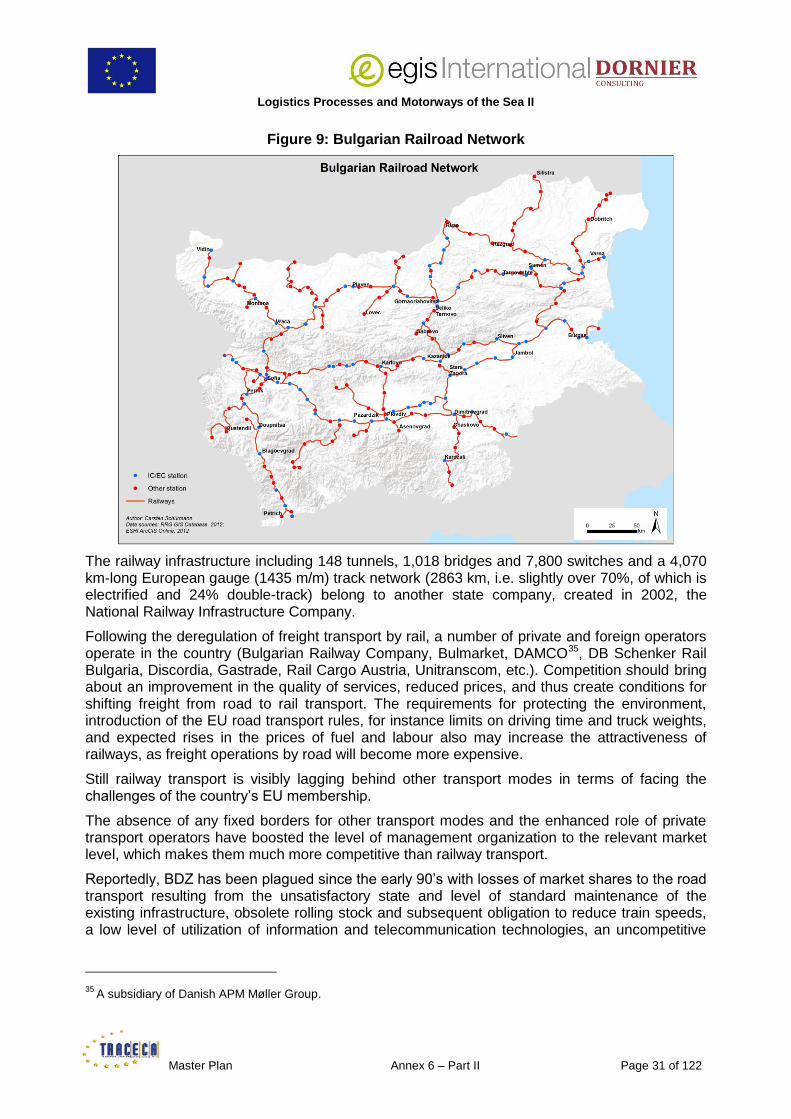
Logistics Processes and Motorways of the Sea II
Master Plan Annex 6 – Part II Page 31 of 122
Figure 9: Bulgarian Railroad Network
The railway infrastructure including 148 tunnels, 1,018 bridges and 7,800 switches and a 4,070 km-long European gauge (1435 m/m) track network (2863 km, i.e. slightly over 70%, of which is electrified and 24% double-track) belong to another state company, created in 2002, the National Railway Infrastructure Company.
Following the deregulation of freight transport by rail, a number of private and foreign operators operate in the country (Bulgarian Railway Company, Bulmarket, DAMCO35, DB Schenker Rail Bulgaria, Discordia, Gastrade, Rail Cargo Austria, Unitranscom, etc.). Competition should bring about an improvement in the quality of services, reduced prices, and thus create conditions for shifting freight from road to rail transport. The requirements for protecting the environment, introduction of the EU road transport rules, for instance limits on driving time and truck weights, and expected rises in the prices of fuel and labour also may increase the attractiveness of railways, as freight operations by road will become more expensive.
Still railway transport is visibly lagging behind other transport modes in terms of facing the challenges of the country’s EU membership.
The absence of any fixed borders for other transport modes and the enhanced role of private transport operators have boosted the level of management organization to the relevant market level, which makes them much more competitive than railway transport.
Reportedly, BDZ has been plagued since the early 90’s with losses of market shares to the road transport resulting from the unsatisfactory state and level of standard maintenance of the existing infrastructure, obsolete rolling stock and subsequent obligation to reduce train speeds, a low level of utilization of information and telecommunication technologies, an uncompetitive
35
A subsidiary of Danish APM Møller Group.

Logistics Processes and Motorways of the Sea ll
Page 32 of 122 Annex 6 – Part II Master Plan
tariff policy (yielding declining revenues – at an accelerated pace ever since the global crisis broke out – insufficient to cover the running costs and service the debt), a structural deficit of financial resources for modernization and expansion of the existing infrastructure, as well as for research and development, the absence of competent, business-oriented management, an overabundant staff 36.
Hence, Bulgarian Authorities recognize the need to review the existing transport networks, nodes and facilities, focusing on priority ones while specifying less stringent maintenance standards for second-rate facilities. A portion of the existing infrastructure of local importance (sometimes not utilized at all but still run and maintained as during communist times) should be transferred for use and maintenance to interested parties (municipalities, industrial enterprises, private business, etc.) or closed altogether in case no interest is displayed.
This should additionally have a positive environmental effect as the Bulgarian level of carbon intensity for electricity provision (579 g CO2/kWh) is well above the EU average (429 g CO2/kWh in 2010). Studies show that about 530 km of lines could be suspended for operations and dismantled with very minimal impact on people’s transport needs but significantly positive results for the State-budget.
Users met during field-missions underlined that, apart from the comparatively short distances which have to be covered in Bulgaria (Varna, the third-largest city, and major container seaport is only 470 km far from the capital), the rail offer remains uncompetitive both in terms of door-to-door transit-time and tariffs37.
Purely domestic block container train operations therefore remain an exception and difficult to make profitable38.
The measures contained in the Strategy for the Development of the Transport System of the Republic of Bulgaria until 2020, relevant for the implementation of the Strategic Priority 1 (Efficient maintenance, modernization and development of the transport infrastructure), are:
the modernization of the Sofia – Plovdiv railway line with a budget of EUR 353 M. Works have been partially carried out an should be finished during the 2014-2020 programming period,
36
In December 2011, while renegotiating the repayment of loans due to German State-owned development bank KfW, Mr. Ivaylo Moskovski, who was appointed Minister of the MTITC in May of the same year, declared: ‘We found the company in a very poor condition with about Euro 409 M in debts and unable to pay its liabilities. Amid a strike we are trying to heal the company and implement the necessary radical reforms to stabilize the company’. He also informed that the Government planned to offer BDZ’s cargo subsidiary for privatization and hoped to ensure money under the WB loans (to be signed in January 2012) after the railway transport reforms are set into operation (In August 2011, the Government of Bulgaria and the WB completed the negotiations of two loans in support of Bulgarian railway reform, namely the Specific Investment Loan to NRIC of EUR 70 M to modernize the maintenance of railway infrastructure, and the first of a series of three Development Policy Loans over the period between 2011 and 2013 of EUR 80 M each). Meantime the privatization process of BDZ Freight Services has been many times postponed and reviewed. The new government which entered office in May 2013 woved to abandon this project, stop the redundancies and rescue the company. Still the dramatic financial situation of BZD (EUR 358 M, about EUR 179 M debt at the end of July 2013, out of which around EUR 90 M overdue) which the politicians now in power had under estimated may lead them to revise their position.
37 As a result, such logistics service providers as DB Schenker, moving cargo from Western Europe by rail to Bulgaria, in order to save on costs and delivery time, unstuff the wagons in Sofia and carry the goods to final destinations by truck. 38 Western Bulgaria and the main consuming area of Sofia are also closer to the Greek port of Thessaloniki. International block train operations have started in September, 2011 between Koper, Ljubljana (the capital of Slovenia) and the Yana-Sofia Intermodal Terminal (this train is operated by Adria Kombi).

Logistics Processes and Motorways of the Sea II
Master Plan Annex 6 – Part II Page 33 of 122
the electrification and reconstruction of the Plovdiv – Svilengrad – Turkish border railway line (at an initially estimated cost of EUR 340 M and completion by 2010 now postponed to the summer of 2014),
the renewal of railway sections along the Plovdiv – Burgas railway line (pertaining to the TEN-T network), partly carried out in the present programming period and due to be completed during the next one (2014-2020),
the modernization of the Sofia – Dragoman39 railway line (pertaining to the TEN-T network) at a cost of EUR 85 M and due to be completed next year,
the modernization of the Vidin – Sofia railway line40 at an initial budget of EUR 1,324 M and completion term in 2017 (in fact the schedule of implementation has not yet been clearly defined). This would boost the use of rail transport via the recently opened Calafat-Vidin bridge.
Another project has recently come in the lime light, i.e. the modernization of the Ruse-Varna 232-km long rail track, the oldest railway line in Bulgaria during the next SOP. The indicative cost is EUR 306 M. The aim is to have freight trains steaming at up to 100 km/h (and passenger at 130 km/h), versus an average speed of 40-50 km/h at present, and thus boost the cargo traffic between the Danube and the Black Sea41.
Road Transport
As of 31 December 2012, Bulgaria had a road network 19,602 km, including 541 km of high-speed motorways.
Insufficient investments in maintenance and development of the network compounded by increased road passenger and freight traffic in the last decades have left the network in an overall dilapidated condition.
39 A Ro-La Terminal has recently been built at Dragoman, on the Bulgarian-Serbian border, for serving Serbia (there is no railway connection between Bulgaria and the FYROM, however, the Transport Ministry of FYROM announced in 2011 that it will launch the construction of a railroad track leading to the country's border with Bulgaria in 2013. Financing is provided by the EIB and EBRD). 40 As a first step of the overall modernization of the line down to Kulata on the Bulgarian-Greek border and further to the port of Thessaloniki, creating a direct link between the Danube and the Mediterranean Sea. 41
This project was presented during the First TRACECA Investment Forum in Brussels in October 2010.

Logistics Processes and Motorways of the Sea ll
Page 34 of 122 Annex 6 – Part II Master Plan
Figure 10: Bulgarian Road Network
The insufficient number of bypass roads, compelling the vehicles to pass through many urban areas and villages, the limited number of roads with more than two lanes, the weak load-carrying capacity of the pavement (which should be raised to 11.5 T/axle along the main international transport axes by 2014), a still heterogeneous stock of vehicles, contribute to deliver a road transport offer of sub-standard quality also regretfully reflected in the number of deaths per million inhabitants (Bulgaria 139 for an EU average of 78 in 2008).
According to official statements, the state of Bulgarian secondary and tertiary roads has been deteriorating since 1984 with some of them left unrepaired since 1971.
Since 2006 however, the Government has been addressing the issue within the frame of the Strategy for the Development of the Transport Infrastructure of the Republic of Bulgaria by 2015: 770 km were overhauled in 2007, another 770 km in 2008, 555 in 2009, 500 in 2010 and the plan for the years 2011-2012 was to repair another 3,100 km.
Besides 6 projected motorways totalling 720 km should be available by 2015 improving national as well as international connections:
A1 – Trakiya motorway – Sofia – Plovdiv – Stara Zagora – Karnobat – Burgas
A2 – Hemus motorway – Sofia – Yablanitsa – Shumen – Varna
A3 – Cherno More motorway – Varna to Burgas
A4 – Maritsa motorway – Parvomay to Kapitan Andreevo (Turkish border)
A5 – Lyulin motorway – Sofia to Pernik
A6 – Struma motorway – (Sofia) Pernik to Kulata (Greek border)
A1 and A2 will provide Serbia with a direct road connection to the Black Sea, while A5 and A6 represent a straight road link between the Danube at Vidin and the Mediterranean Sea at

Logistics Processes and Motorways of the Sea II
Master Plan Annex 6 – Part II Page 35 of 122
Thessaloniki, complementing the rail line following the same track and under rehabilitation, mentioned above in this report.
4.3 River and Sea Governmental Agencies and National Companies Monitoring the Danube in Romania and Bulgaria
4.3.1 Romania
4.3.1.1 Romanian Naval Authority
The Romanian Naval Authority (ANR) is the specialized agency of the Ministry of Transport for the safety of navigation including on the Danube. As such it has the following main tasks:
inspection, control and surveillance of navigation in Romanian navigable waters (VTMS, RORIS),
Port and Flag State Controls,
fulfilment of the obligations assumed from the international agreements and conventions to which Romania is part of (including corresponding implementations in the country’s legislation) and representation of Romania in international maritime organizations,
coordination of search and rescue activities in the Romanian navigable waters and actions to be taken in case of navigation accidents and casualties,
protection of navigable waters against pollution by vessels and sanctioning of offenders,
technical surveillance, certification and registration of maritime and inland water ships under Romanian flag,
assessment of competences, examinations, registration and certification of Romanian seafarers,
supervision of the compliance of the Romanian naval transports with the provisions of the ISM and ISPS Codes.

Logistics Processes and Motorways of the Sea ll
Page 36 of 122 Annex 6 – Part II Master Plan
Text box 1: RORIS
During the period October 2010 – February 2013 Romanian Naval Authority has implemented the project named ‘System for ships traffic management on Danube and information regarding inland waterway transport – RoRIS’, with European funding (POS-T). This project was the second phase of RIS implementation in Romania, the first phase took place between 2005-2006.
The RoRIS on the Danube is organized hierarchically on three levels, in accordance with the organizational structure of the Romanian Naval Authority:
- Central level at RNA headquarters in Constanza
- Regional level in Drobeta Turnu Severin, Giurgiu, Galati and Tulcea
- Local level in 22 Romanian ports along the Danube from Sulina to Moldova Veche.
Subsystems and equipments:
- Automatic Identification System - the first four AIS base stations were installed like also the network servers all during the first phase of the RoRIS implementation. Twelve new AIS base station locations and new servers in regional centres and national center were installed during the second phase of the RoRIS implementation. This new AIS network on the Danube is interconnected with the first one and is exchanging information with the Danube-Black Sea Canal AIS network and the Romanian Maritime AIS network.
- 13 new radars and CCTV traffic cameras were installed inside ports and some dangerous areas.
- The VHF radio- subsystem provide a complete coverage of Romanian Danube sector for shore-to-ship voice communication, using VOIP technology.
- Meteo stations installed in every local center.
Functionalities (RIS and others):
- Notices to skippers regarding fairway and traffic - water level, weather and ice related information and published in electronic format to the latest standards on recently finalised website of the RoRIS system: www.roris.ro.
- Electronic ship reporting - mandatory reporting obligations for inland vessels;
- Ship register and hull database;
- Seafarers (sailors) testing and register;
- Dangerous goods monitoring;
- Calamity Abatement support;
- Targets(ships) displayed on Electronic Chart Display and Information System application;
- Synthetic information and statistics;
- Interface for exchanging data with other national systems according to international standards.
The main goal of the project is the implementation of the RIS Directive (2005/44/EC).

Logistics Processes and Motorways of the Sea II
Master Plan Annex 6 – Part II Page 37 of 122
Figure 11: RORIS Map
Source: MOTI
The ANR is headquartered in Constanza and carries out its duties through all sea and river harbour master’s offices and technical inspectorates. The ANR has a close and, reportedly, very satisfactory cooperation with its counterparts in TRACECA and other Black Sea riparian countries.
4.3.1.2 National Company ‘Administration of Navigable Canals’
The National Company ‘Administration of Navigable Canals’ (ACN) is the owner and operator of the Danube-Black Sea Canal which started being constructed in 1949 and was finally completed and opened in 198442.
Figure 12: Danube (Blue) and the Black Sea-Danube Canal (Red)
This Class VI (highest class) Canal is 64 km long, 70 to 90 m large, 7 m deep, 5.5 m draft, has a 16.5 m bridge clearance. It links the river port of Cernavoda to Agigea, the Southern port of Constanza reducing the travelling distance by 400 km.
42
One of the reasons for the construction of the Canal, at the time, was to avoid the Danube Delta which is difficult to navigate (unstable mouths of the Kylia branch, shallow waters in the Sulina branch and shallow waters and sinuous course in the Sfântu Gheorghe branch).

Logistics Processes and Motorways of the Sea ll
Page 38 of 122 Annex 6 – Part II Master Plan
Figure 13: Black Sea-Danube Canal at Constanza
A northern Class V, 26.6 km long, 50 m wide, 5.5 m deep, branch, known as the Poarta Alba-Midia Navodari canal, opened in 1987, links the Canal to the main Romanian oil port of Midia (see map above).
The Canal is bound by two 310 m long, 25 m wide, 7,5 m deep locks, one in Agigea and the other one in Cernavoda while there are 2, smaller, locks on the Northern Branch at Ovidiu and Navodari, close to the port of Midia. Water-level is no problem in the Canal.
Figure 14: Cernavoda Lock
Source: ACN
Logistics Processes and Motorways of the Sea II
Master Plan Annex 6 – Part II Page 39 of 122
Apart from the Canal, ACN is also responsible for the technical operation and administration of the facilities at the settlements which have been turned into inland waterway ports (Megdidia, Basarabi, Ovidiu, Murfatlar, Luminita)43.
ACN is taking part in a number of ongoing and planned projects all financed by the EU, including the above-mentioned RORIS which is under its responsibility in the Canal.
One of the most important is the NEWADA project (2009-April 2012) and its successor NEWADA Duo launched in October 2012 which is gathering the relevant administrations of all Danube countries together. The main aim of the project is to find common solutions to keep the Danube open all around the year. NEWADA is part of the SEE Program, the lead partner is Via Donau, Vienna.
It also includes exchange of information about port facilities, navigation conditions, etc. through web portals which are also accessible on-line to users and through 4 dedicated access points (Ovidiu, Megdidia, Agigea and Cernavoda) to barge and sea-river vessel skippers.
ACN Master Plan – also EU financially supported – has three main components:
ensure the safety of navigation: the plan contemplates the building of a ship designed for measuring the depths, performing hydrographical works, and monitoring closely the 4 km section between the Danube and the Canal where is located the Cernavoda Nuclear Plant (the Canal at its mouth in the Danube has been dug 1,5 m below the Danube riverbed);
protect the environment: the water from the Canal is drunk in neighbouring localities. 12 monitoring containers laid at critical points have been modernized in 2012-2013;
maintain and modernize the infrastructure:
– new signalling equipment has been installed in 2010-2011,
– following the corresponding European Directive, a new VTMS (RORIS), is also under implementation (April 2010-April 2012) in collaboration between the ACN and the RNA,
– 3 of the 4 locks built 30 years ago together with the Canal and the Cernavoda pumping station are going to be modernized soon, a contract has been signed in the summer of 2013 for the rehabilitation of all locks except the lesser used Navodari one located on the Northern Branch of the Canal near Midia,
EUR 180 M plan is under finalization to build 4 stations for defence against flooding. The works should start in 2014 and last 4 years;
a feasibility study is under way for another project under evaluation for the modernization of the ports, platforms, dockways and waiting berths at all river ports (especially at Poarta Alba where the 1 pusher+6 barges convoys have to be dismantled to enter the smaller Northern Branch where only 1 pusher+1 barge at a time can be accommodated);
dredging works are going on at the mouth of the Canal in Cernavoda. The very first dredging operation took place in 2002-2004, 18 years after the canal opening, and a volume of 1.2 M cbm sediment were retrieved. This time, only 9 years later, ACN is planning to dig out some 0.8 M cbm meaning the speed of sedimentation is increasing. Sedimentation is the result of a lower water speed in the lock (albeit there is a 1.5 m
43 Handling operations at all river ports of the Canal are in the hands of the private sector.

Logistics Processes and Motorways of the Sea ll
Page 40 of 122 Annex 6 – Part II Master Plan
‘step’ between the riverbed and the lock to create some current). The quicker filling in turn originates from the works carried out to improve the navigation on the Danube by-redirecting the water flow between the ‘old’ and the new Danube branch few kilometres upstream the Cernavoda lock, at Bala;
the Bala Branch is a branch of the Danube located in Calarasi (Romania). Upstream of Calarasi the Danube bifurcates into two branches: the Borcea Branch to the left and the main course of the river to the right. The two branches reunite near the village of Olurgeni. The Bala Branch is a secondary branch uniting the two main branches. It leaves the main course of the Danube downstream of the village of Izvoarete and joins the Borcea Branch downstream of the village of Unirea. The distribution of the discharges of the main branch of the Danube and the Bala Branch is a main concern for the navigation on the river.
Figure 15: Bala Branch
Due to the ‘Pârjoaia Rock’, located on the right bank of the Danube, the flow is directed towards the Bala Branch and important morphologic changes of the river bed occur. At low discharges, up to 80% of the river's discharge is diverted into the Bala Branch and only 20% remains on the Danube. As a consequence, navigation on the main course of the Danube is impeded and is diverted on a route following the Bala Branch and, further downstream, the Borcea Branch. Also, low flows on the main branch of the Danube have an adverse effect on the cooling water supply of the Nuclear Power Plant of Cernavoda. Dykes and spurs are under construction to improve the situation under a 31-month contract worth EUR 38.671 M signed in 2011, financed at 85% by EU Cohesion Funds and 15% by the Romanian State Budget. An additional EUR 7.197 M 72-month contract (co-funded by the European Regional Development Fund for 71.12% and the SOPT for the rest) covers the Monitoring of the Environmental Impact of the Works for Improvement of the Navigation Conditions on the Danube between Calarasi and Braila, km 375-km 175.
Until the early 90’s the Canal mostly served the Romanian internal/domestic trade plus an about 0.5 Mt phosphate traffic from the Danube-located Chemical Industry Prahovo plant (Negotin, Serbia). After the 90’s the traffic developed from/to all riparian countries, the main carried commodity being coal from Ukraine to Eastern/Central Europe via Constanza and the Danube.

Logistics Processes and Motorways of the Sea II
Master Plan Annex 6 – Part II Page 41 of 122
Since the beginning of the 21st century the main and steadily growing commodity is raw agricultural products (especially grain) from Hungary and Serbia (from 1 Mt in 2000 to over 4 Mt in 2010) and ores from Constanza to hinterland destinations. The trade, which is served by vessels belonging to the river fleets of all riparian countries, has developed as shown in the table below, the international one exceeding now the domestic one.
Table 1: Black Sea-Danube Canal Traffic (in tonnes)
Out of which
Year International Domestic Total Grain (A)
Seeds and vegoils (B)
Total (A)+(B)
% of total trade
1991 440000 3870000 4310000
1992 853300 2836700 3690000
1993 516522 4664251 5180773
1994 366875 5999897 6366772
1995 1196753 8038971 9235724
1996 2208891 8181238 10390129
1997 1684846 9456841 11141687
1998 2569749 9695172 12264921
1999 1416594 9150302 10566896
2000 1186395 10112991 11299386
2001 1590431 8538259 10128690
2002 2823200 8339350 11162550
2003 2720047 8056252 10776299
2004 3607501 9658410 13265911
2005 4347176 10971968 15319144
2006 4302334 9097330 13399664 2804000 133900 2937900 22%
2007 3887093 8533818 12420911 1655400 250500 1905900 15%
2008 4774535 8363017 13137552 2180000 243500 2423500 18%
2009 5104389 4166344 9270733 3622000 418400 4040400 44%
2010 6332034 6026315 12358349 4377500 603900 4981400 40%
2011 4860952 6754217 11615169 3048000 472000 3520000 30.3%
2012 8433356 5288305 13722161 4686000 205000 4891000 35.65%
2013 5461076 2838885 8299961
(*)
Source: ACN – Port of Constanza
(*) 8 months

Logistics Processes and Motorways of the Sea ll
Page 42 of 122 Annex 6 – Part II Master Plan
The carriage of containers started in 2005 between Constanza and Giurgiu. During the past years Serbia and Hungary showed an interest to have the service expanded but so far there are no regular connections.
ACN is promoting the container trade by applying the lowest tariff to the carrying barges/river vessels for the use of the canal and locks (0.15 EUR cents per DWT between Cernavoda and Agigea, as for empty barges, whereas sea-river going vessels are taxed on the basis of their GRT).
4.3.1.3 National Company ‘Maritime Ports Administration’ SA, Constanza Port44
The National Company Maritime Ports Administration SA (NC MPA SA) is a joint stock company assigned by the Ministry of Transport to develop activities of national public interest in its capacity of port administration. It exerts the role of port authority for the port of Constanza, and its satellites Midia45 and Mangalia46 (respectively located 25 km North and 38 km South of Constanza).
Constanza is the biggest Romanian port, as well as the biggest EU port in the Black Sea, the 4-th largest in Europe and the biggest Black Sea port. It is located 179 nautical miles from the Bosphorus Strait. The port covers an area of 3,926 ha out of which 1,313 ha is land and the rest 2,613 ha is water.
Constanza is both a maritime and a river port linked to the Danube through the Danube–Black Sea Canal. It is also the hub port for the container feeder service performed since 2010 by ‘Tavria Line’, a shipping company of ‘Aquarelle’, the logistics arm of the Alef, Dnepropetrovsk-based, Ukrainian industrial group. This regular service, linking Constanza to Dnepropetrovsk through the Black Sea and along the Dnepr River, is performed with 2 STK Class sea-river vessels of 112 TEU nominal capacity. The volume carried ranges about 10,000 TEU p.a.
44 This section relates to the role of the port as a river port only. A full description and analysis of the facilities, maritime activities, traffic and plans of development of the port of Constanza can be found in the ‘Maritime Sector Overview’ Annex III of the LOGMOS Master Plan.
45 Midia is mainly used for the supply of crude oil for the nearby Petromidia Refinery. In 2010 the largest liquefied petroleum gas (LPG) terminal in Romania was opened in this port. 46 Mangalia is mainly used by the Constanta Shipyard.

Logistics Processes and Motorways of the Sea II
Master Plan Annex 6 – Part II Page 43 of 122
Figure 16: Tavria Line Vessel ‘ALKOR’ in Service between Constanza and Dnepropetrovsk
The container trade on the Danube from/to Constanza hovered around 10,000 TEU per year until recently47. This encouraging figure, however small compared to the total number of containers handled yearly in Constanza, tended to show the potential attractiveness of inland water way transport versus road and rail modes faced with other/new regulatory, environmental and financial challenges.
Unfortunately the repeatedly bad conditions of navigation on the middle stretch of the Danube (upstream Cernavoda) in the second half of 2011 than in 2012 and again during the first half of 2013 have exhausted the patience of the shipping lines: after a record volume of 14,160 TEU carried in 2011, the figure dropped to 6,361 in 2012 and barely reaches 515 TEU for the first eight months of 2013.
It must be underlined in all fairness that in 2012 a sizeable volume of boxes were moving along the Danube between the Moldovan port of Giurgiulesti and Constanza. The difficult conditions of navigation on the Lower Danube (however not comparable with those observed in the Middle and Upper Danube) and, above all, the repeated obstacles the Romanian Customs put in their way finally spurred the GIFP to leave the River and resort to direct, quicker, sea-transport via the Sulina Canal and then the Black Sea to Constanza.
This does not represent any modal shift, the cargo is still carried on the water. It does however represent the lost opportunity of integrating other Romanian Danube ports on the way, and especially the main industrial hubs of Galatz and Braila, into a supply chain scheme which would help them break their geographical isolation.
47 2007: 9,927, 2008: 11,555, 2009: 11,721, 2010: 10,012

Logistics Processes and Motorways of the Sea ll
Page 44 of 122 Annex 6 – Part II Master Plan
Figure 17: BRP Pusher with 2 x 40 TEU Barges En Route from Constanza to Belgrade
Source: BRP
4.3.1.4 River Administration of the Lower Danube (AFDJ, Galati)
The AFDJ functions as an autonomous state control, in charge of all technical and navigational aspects of the river (the business activity of the ports depend from another administrative body) from its point of entry in Romania (Bazias on the border with Serbia) to its mouth in the Black Sea (Sulina) on a stretch of 1,075 km.
As such its activities include the assurance of navigation conditions on Danube by means of:
dredging,
performing topo-hydrographical survey (to get acquainted with the morphological situation, the bed loads of the river, especially at the critical spots, flow and alluvium measurements, and measurements of current speed),
protecting the banks,
placing and maintaining coast and floating signalling equipments,
drawing up navigation maps,
collecting and processing hydro-meteorological data, elaborating forecasts on level variation of Danube waters on the Romanian sector,
examining and authorizing annually the pilots, issuing the pilot licenses for maritime Danube and supplying pilot service on the maritime Danube sector between Sulina roadstead and Braila and in the Danube maritime ports,
providing domestic and international towage (also for breaking ice).
The AFDJ carries out the obligations of the Romanian state according to the international conventions and agreements to which Romania is part and, accordingly, is the Romanian organization participating in the Danube Commission.
The Romanian Danube consists in 2 rather distinct segments: the river part which covers about 900 km from Serbia up to Braila and the maritime part from Braila to Sulina.
The maritime section of the Danube hosts 3 main ports (Reni in Ukraine and the 2 biggest Romanian ones on the Danube, Galatz and Braila) plus 2 secondary ports in Moldova and Ukraine (Giurgiulesti and Izmail).
Contrary to what happens on the river part, the traffic on the maritime one is not much hampered by the droughts and resulting low water levels. The available draft is 24’ for vessels up to 8,000 DWT.
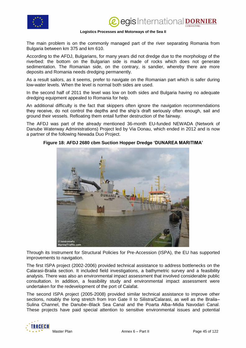
Logistics Processes and Motorways of the Sea II
Master Plan Annex 6 – Part II Page 45 of 122
The main problem is on the commonly managed part of the river separating Romania from Bulgaria between km 375 and km 610.
According to the AFDJ, Bulgarians, for many years did not dredge due to the morphology of the riverbed: the bottom on the Bulgarian side is made of rocks which does not generate sedimentation. The Romanian side, on the contrary, is sandier, whereby there are more deposits and Romania needs dredging permanently.
As a result sailors, as it seems, prefer to navigate on the Romanian part which is safer during low-water levels. When the level is normal both sides are used.
In the second half of 2011 the level was low on both sides and Bulgaria having no adequate dredging equipment appealed to Romania for help.
An additional difficulty is the fact that skippers often ignore the navigation recommendations they receive, do not control the depths and the ship’s draft seriously often enough, sail and ground their vessels. Refloating them entail further destruction of the fairway.
The AFDJ was part of the already mentioned 36-month EU-funded NEWADA (Network of Danube Waterway Administrations) Project led by Via Donau, which ended in 2012 and is now a partner of the following Newada Duo Project.
Figure 18: AFDJ 2680 cbm Suction Hopper Dredge ‘DUNAREA MARITIMA’
Through its Instrument for Structural Policies for Pre-Accession (ISPA), the EU has supported improvements to navigation.
The first ISPA project (2002-2006) provided technical assistance to address bottlenecks on the Calarasi-Braila section. It included field investigations, a bathymetric survey and a feasibility analysis. There was also an environmental impact assessment that involved considerable public consultation. In addition, a feasibility study and environmental impact assessment were undertaken for the redevelopment of the port of Calafat.
The second ISPA project (2005-2008) provided similar technical assistance to improve other sections, notably the long stretch from Iron Gate II to Silistra/Calarasi, as well as the Braila–Sulina Channel, the Danube–Black Sea Canal and the Poarta Alba–Midia Navodari Canal. These projects have paid special attention to sensitive environmental issues and potential

Logistics Processes and Motorways of the Sea ll
Page 46 of 122 Annex 6 – Part II Master Plan
downstream impacts on the ecosystem and on erosion and sedimentation patterns in the Danube Delta area.
The third ISPA project (2006-2010) implemented work to improve navigation at 3 critical points on the Calarasi-Braila section prepared by the first project (EUR 38 M plus EUR 7 M for environmental monitoring).
Within the frame of the EU Regional Policy, through the NAIADES/PLATINA action programme on the Promotion of Inland Waterway Transport, covering the period 2006-2013, funded through TEN-T and Cohesion Policy Funds, Romania should have received EUR 170 M to solve the problems of navigation bottlenecks on the Danube (the Bala Branch Project described earlier in this report being a main component of this package).
A former feasibility study of the works to be carried out48, drafted jointly with Bulgaria, was rejected for ecological concerns and the implementation actually stopped for 1.5 year owing to the objections raised by environmental NGOs. Environmental assessment, which should have been finished off in 2012, is still going on, a new analysis is under way. Reportedly the works which should have started in 2013 and been completed in 2017 should now not begin before 2016. Discussions are also going-on with Moldova to lift the bridge crossing the river at Giurgiulesti.
Negotiations have been held at trans-national level for implementing permanent night navigation on the maritime section of the Danube.
Furthermore a MoU has been signed with Bulgaria in October 2012 and a bilateral inter-ministerial committee set up. 4 Working Groups have been created to attend matters of common interest such as the navigation on the Danube, the ecological issues, the joint response to emergency situations, the joint use of maintenance equipment, etc.
One of the main tasks of the Committee will be to revise and draft a new MoA between Romania and Bulgaria concerning the maintenance of the Danube as the existing one, signed in 1955 according to the corresponding prescription of the 1948 Belgrade Convention, became obsolete49.
Finally, the AFDJ is responsible for fixing the tariffs for the use and maintenance of the Sulina Canal. They were last revised in 1988 and the estimation is they should be completely waived within 10 to 12 years.
4.3.1.5 Fluvial Danube Ports Administration, Giurgiu
The Fluvial Danube Ports Administration (CN APDF SA, in short ‘APDF’) manages all 10 large and 11 smaller river ports from Bazias where the Danube enters Romania from Serbia till Cernavoda, and serves as Port Authority for all of them, except Zimnicea and Turnu Magurele which are under the administration of Teleorman Local Council.
Directly or through concessions it provides all shipping-related services: port areas safety, security and environmental activities (ashore and on the river), pilotage, towage, mooring, stevedoring (including sorting, labelling, palletizing, packing, and containerizing), bunkering,
48
Which include building of drains, dikes, dredging, reinforcement of the banks meant as well to protect against floods.
49 The EGTC contemplated by the MOTI could be created 6 months after the signature of this MoA. This structure
could be head-quartered either in Giurgiu or in Ruse. It would consist of a group of 30 experts (15 for each country).

Logistics Processes and Motorways of the Sea II
Master Plan Annex 6 – Part II Page 47 of 122
ship waste50, garbage and sewage handling, tank degassing, ship repair, salvage and refloating, etc.
Additionally it performs repair and maintenance activities of the local water transport infrastructure including signalization51.
Figure 19: Traditional Sloping Quay Walls at the Port of Oltenita
Being managed and run as a private business (with seemingly no State-budget support), APDF developed a strong commercial identity, promoting its activities through advertising, market research, cooperation with business communities (potential customers as well as investors), development of modern IT systems and dissemination of technical and commercial information about their ports and facilities, at home and abroad.
APDF is one of the 23 partners from 6 EU and non-EU countries in the Danube Inland Harbor Development (DaHar), co-funded by the European Regional Development Fund, and carried out within the frame of the SEE. DaHar, which spans over the period April 2011- March 2014, brings together small and medium-size Danube cities, looking to enhance their economic development through a common strategy and harmonized development of their respective ports through a specialization and diversification of their multimodal functions. The overall target is to build up a logistical network of Danube cities and ports complementing the role of larger hubs.
50
Contracts have been signed in 2013 for new ship-waste management equipments financed by the EU Sectorial Transport Program.
51 A number of contracts have been signed in 2012-2013 for the rehabilitation of the port infrastructure at Oltenita
(including the building of an 80-m breakwater and replacement of 400 m sloping quaywalls by vertical ones). The works should be completed during the second half of 2014. Vertical quaywalls should also be built at Giurgiu (actually these are hollow steel structures without cement filling).
Logistics Processes and Motorways of the Sea ll
Page 48 of 122 Annex 6 – Part II Master Plan
4.3.2 Bulgaria
4.3.2.1 Executive Agency Maritime Administration (EAMA, Sofia)
The EAMA is, broadly, the equivalent of the Romanian Naval Authority, performing the usual tasks of a maritime administration with a geographical scope of activity extended to inland waterways.
These include:
monitoring the safety/security of shipping in Bulgarian sea spaces and inland waterways, at ports and on vessels,
organizing/conducting of examinations, issuing of certificates for competencies to seafarers,
conducting professional competence examinations for licensing carriers on the inland waterways,
monitoring living/working conditions of seafarers,
organizing/coordinating search and rescue operations,
supervising the protection of the marine environment/organizing fight against pollution (including on the Danube),
making proposals and participating in the planning and implementation of maritime and river infrastructure investments,
participating in the planning and implementation of concession contracts,
proposing revision of port charges tariffs.
The EAMA was the Bulgarian partner in the SEE NELI Project, which ended in March 2012, and addressed issues such as discrepancies between national educational systems in the field of inland waterway transport, lack of interaction and communication between training institutions and stakeholders in the sector, scarce or lacking e-learning services.
It also represented Bulgaria in the SEE WATERMODE Project set up to promote a better transnational coordination between policy actors and stakeholders to increase the competitiveness of the alternatives to road transport, especially highlighting the potential of the water/ground multimodal transport and logistics. The project aimed, in particular at supporting the implementation of relevant investments for the improvement of the connections between sea and river ports with their hinterland. Among other tasks, the EAMA Team had to carry out, in 2010, a census of the best developed ports and multimodal facilities in Bulgaria most relevant to achieve the goal of the project. This led to the selection of 4 sea ports and terminals, 5 river ports and terminals and 2 inland logistics centres some of which will be reviewed further down in this report.
4.3.2.2 Executive Agency for the Exploration and Maintenance of the Danube River (EAEMDR, Ruse)
The EAEMDR is responsible for the survey and maintenance of sailing conditions on the 471 km Bulgarian stretch of the Danube from the Serbian border up to Silistra on the Romanian one.
Its specific activities include:

Logistics Processes and Motorways of the Sea II
Master Plan Annex 6 – Part II Page 49 of 122
riverbed deepening52, diving, trailing and vessel lifting activities for the maintenance of the waterway, the port water pools and winter passes;
monitoring the hydro-morphological and hydrological conditions in the river, measuring and recording fluctuations in the water level, speed and direction of the current, debit of the river, erosion of the banks and islands, formation of sand mantles and icing53 54;
collecting hydro-meteorological measurements;
disseminating information regarding the condition and forecasts for the waterway, navigational routes, and weather (including storm, flood, ice warnings) to the skippers and respective authorities;
scrutinizing and approving projects for the construction of hydro-technical and other infrastructure along the river;
implementing projects on the maintenance and improvement of the navigational conditions on the Danube.
Ongoing projects are:
the last stage of the construction of a river shelter for winter camping of 39 vessels. There is no similar facility in the entire section of the river between the Black sea and Hungary. This project, which is part of the PHARE Cross-border Cooperation Bulgaria-Romania Program, should finish by the end of 2013;
the improvement of navigation conditions at 20 critical points (carried out jointly with Romania). 30-month delay having occurred, the project has been transferred to the next programming period (2014-2020). The feasibility study and environmental assessment are going on. The EU is financing 85% of the total costs which represent a EUR 136 M- allocation for Bulgaria;
the improvement of the systems for navigation and topo-hydrographic measurements on the Danube.
The EAEMDR underlines the equipment at hand is both insufficient and unsuitable to perform the duty of maintaining the river (the only available dredger is of the bucket type which is used for dredging soft soils in ports rather than riverbeds and has a small capacity). A second dredging vessel would be necessary. Unfortunately such equipment is not eligible for EU-funding and there are no plans at national level for either building or purchasing dredgers. Former proposals to that end by the MTICT were dismissed by the Ministry of Finance. Performing dredging under procurement to third parties is not a suitable solution either as the procurement procedure is complicated and difficult to put into action. Besides, it lacks flexibility in case of emergency.
52
The fairway is actually divided in 2 areas: its maintenance is under Romanian responsibility from the Iron Gates on the Serbian border until Somovit and under Bulgarian’s from Somovit to Silistra.
53 All Danube river ports in Bulgaria, from Vidin to Silistra, are located on the Lower Danube and therefore facing the
same recurring hydrological seasonal problems as their Romanian counterparts, i.e. too low a water level and icing over, both preventing navigation. Icing over is an extremely unstable phenomenon on the Danube. Too high water levels, often resulting from breaking up after the river has been icebound, also entail floods while ice floes and drifts damage and sometimes destroy wintering boats, barges, dykes and port installations.
54 Navigation has been nearly completely stopped along the Lower Danube from the 22nd of August till the 21st of December 2011 because of low water level and banned on the Bulgarian stretch from the 8th of February till the 2nd of March 2012 because of icing.

Logistics Processes and Motorways of the Sea ll
Page 50 of 122 Annex 6 – Part II Master Plan
The Agency considers the hydrological works will help solve only 80% of the existing problems due to the floating sands and fluctuation of sediments in the river.
The EAEMDR takes part and/or represents Bulgaria in the already described EU-funded NEWADA/NEWADA Duo, WANDA, NAIADES-PLATINA (including BulRIS) Projects.
It contributes to the work of, among other international organizations: the Danube Commission, the Workgroup for Inland Waterway Transport at the European Economic Commission, the Joint Bulgarian-Romanian Commission for the Danube River (meeting twice a year) at the UN in Geneva.
Figure 20: Ice on the Danube in Galati – March 2012
The EAEMDR is also participating in the Joint Bulgarian-Romanian Commission for the Ruse – Giurgiu Bridge.
Figure 21: Ruse-Giurgiu Friendship Bridge
There are 3 ferryboat services successfully operating under a regular day-only schedule between Bulgarian and Romanian river ports (Oriahovo-Bechet, Svishtov- Zimnicea, Nikopol-Turnu Magurele), a 4th one linking Silistra and Calarasi is presently suspended while the Vidin-Calafat line stopped after the opening of the 2nd bridge on the Danube between Romania and Bulgaria.
So far, the main reason for their existence was that there was one bridge only between the 2 countries. Depending thus on the origin and final destination, taking the ferryboat proved quicker and cheaper than driving to cross the bridge. For instance, the ferry between Svishtov and Zimnicea shortens the road path between Turkey and Central and Western Europe by 140 km when compared to the traditional route over the bridge, allowing a time gain of nearly 4 hours by also avoiding the traffic in and around the city of Bucharest. Today this situation did not change much, in spite of the opening of the second bridge. Stakeholders cite the bad condition of the road network in the region of Calafat and Vidin as the main reason why truck drivers still prefer to use the ‘old’ bridge or the ferry services.
Another reason is the improved enforcement of EU road regulations reducing driving-time allowances, forbidding truck driving during week-ends, imposing new overall weight and axle-load limitations, and truck/tyre higher technical standards in both Romania and Bulgaria which leads national and foreign (mostly Turkish) truckers to look for the shortest driving routes. A third one is the lower level of taxes in Bulgaria than in Romania (VAT is at 20% against 24%
Logistics Processes and Motorways of the Sea II
Master Plan Annex 6 – Part II Page 51 of 122
and Corporate tax on profits at 10% against 16%) plus the delayed VAT return in the latter country55, spurring Romanian enterprises to register in and transport their goods via Bulgaria.
Actually the two decks, one for road (two lanes) and one for railway traffic 2,223 m bridge was built by Soviet Union between 1950 and 1952 and opened in 1954. The central part of the bridge (85 m) is mobile and can be lifted for oversized boats passage. The very first capital repair (replacement of asphalt coverage and underneath superstructure) took place only in July-August 2011 by and only for the half part belonging to Bulgaria56.
Since Romania and Bulgaria became EU-members the toll tariffs have decreased (they amounted to EUR 53 for a passenger car roundtrip before 2007 and only to EUR 8 in 2012, 2 for the Bulgarian side and 6 for the Romanian one. A truck is paying EUR 37 for the Bulgarian part only). Customs controls were removed when Romania and Bulgaria joined the EU in 2007. Border controls remain until both countries join the Schengen Agreement.
Reportedly, the bridge is usually congested just before and after week-ends (on Friday evenings and Monday mornings) with about 1 hour waiting time (for all vehicles, as it seems there is no streamlining of passenger and freight vehicles) and for many more hours in case of truck overweight (although, generally, only 10-15% of the bridge throughput capacity are used). Bulgaria would like to resume the ferryboat service which ran until 2005 between Ruse and Giurgiu as a (cheaper for truckers) alternative to the bridge. Romanians are however reluctant as the Ro-Ro terminal operator in Giurgiu (Muka) went bankrupt and the facility is presently not operational.
Both Bulgarian and Romanian stakeholders in Ruse and Giurgiu consider the bridge – as it is operated presently – is becoming too small for the existing and future traffic. The Port Complex Ruse JSCo contemplated the development of a Ro-La offer to Giurgiu but the poor condition of the rail ramp there made it unfeasible. The port of Giurgiu for his part underlines the dire necessity to rehabilitate and modernize the rail link between Giurgiu and Bucharest. This project is supported by the Municipality of Giurgiu and included (but not yet selected) in the Sectorial Program 2014-2020. In actual fact this track which links Bucharest to Ruse via the Friendship bridge over the Danube has not been in use since a bridge in the section between Bucharest and Giurgiu crashed down in 1987. Trains have to go another much longer way between these two points.
4.3.2.3 Bulgarian Ports Infrastructure Company (BPI Co.)
BPI Co. Is a State company which manages the infrastructure of the public sea and river ports. Its activities include the maintenance of port water areas, access channels, piers and other port installations, preparation of port development and corresponding investment plan, as well as the monitoring and implementation of concession contracts. BPI Co. fixes the port dues tariffs (channel, light, quay, tonnage and waste management dues) and collects them.
The Bulgarian concession law, which has been regularly revised and improved since its inception, basically foresees a 35-year concession period to private sector operators with
55
According to a study carried out by Deloitte in 2013, the Romanian VAT system is considered as ‘complicated’ by 38% of the respondents and ‘extremely complicated’ by another 43%. Besides, ‘42% of the respondents who had applied for VAT reimbursement said their request have been solved within a 3 to 6 months period. While 25% of respondents faced delays longer than 6 months, 8% were reimbursed after more than a year’ (the legal term being 45 days).
56 As could be expected this poor maintenance combined with the 4,000 vehicle-a-day traffic (half of which are heavy
lorries) resulted in the collapse of part of the road and damages to the structure of the bridge and its temporary closure on the 7th of April 2013 (coincidentally another 10-m high metal bridge also built 60 years ago collapsed under a concrete-mixer truck in the Bulgarian province of Lovech just 3 days before).
Logistics Processes and Motorways of the Sea ll
Page 52 of 122 Annex 6 – Part II Master Plan
reciprocal obligations, including, for the concessionaire, the obligation to invest a pre-determined yearly amount and increase, in an also pre-determined volume, the traffic at his facility.
To complement this, a new law for PPP has been voted in 2012 which defines clearly the role and obligations of the State in the privatization process and after.

Logistics Processes and Motorways of the Sea II
Master Plan Annex 6 – Part II Page 53 of 122
5 PORTS IN TRACECA COUNTRIES ON THE DANUBE, TRAFFIC, ONGOING PROJECTS AND PERSPECTIVES
5.1 River Ports
A complete list of ports on the Danube in TRACECA countries with their main features is presented in Appendix 7. Hereafter will be reviewed those, which, in the Consultant’s opinion, present the highest potential of development.
5.1.1 Romania
It is noteworthy that, since the opening of the Canal from the Black Sea to the Danube, the trade path from and to Central Europe moved from the Danube Delta to Constanza. As a result the ports located on the Maritime Danube, downstream between Cernavoda and the mouth of the river, can develop only on the basis of their local/regional resources.
Figure 22: Romania Main Sea and River Ports
Source: Ministry of Transport and Infrastructure
Another important feature which must be remembered is that there are few big cities in Romania and only one conurbation, Bucharest. Except for the latter, catchment areas of Danube ports cover comparatively wide geographical spaces.
This can be illustrated as follows: the nearest river port from Cluj-Napoca, the 2nd -largest city (325,000 inhabitants) and a major industrial and trading centre in Northwest Romania is Orsova. Due to the condition of the road, corresponding speed limitations and the absence of by-passes compelling truck drivers to cross a number of villages and hamlets on the way, it takes 5h 21’ to cover the 351 km distance between the two locations in optimal weather and traffic conditions. Provided the provisions of the International Road Transport Agreement (AETR), which Romania ratified, are applied, the overall journey should last:
2 x 5h 21’ + 2 x 45’ pauses = 12h 12’
This is much over the maximum driving-time limit of 10h which makes the roundtrip impossible within a day (in comparison, this same roundtrip would, on average, last 2 x 4h +1 x 45’ pause = 8h 45’ in Western Europe and could therefore be performed within the standard 9h per day driving-time limit).

Logistics Processes and Motorways of the Sea ll
Page 54 of 122 Annex 6 – Part II Master Plan
The ongoing improvement of the road network is therefore of paramount importance for a smooth development of value-added trade via the river ports. Obviously the same remark holds for rail transport57.
Two other factors deserve to be considered:
first, the last missing segment of the Bucharest-Constanza motorway was opened in 2012. It can be reasonably assumed the quicker access from the port to the country’s main consuming area brought about a modal shift in favour of the road versus partly rail and mostly inland water way transport. Even, if as expected, logistics service providers start moving their activities from the capital to the port, it seems also logical to think that the cargo which, in the future, would be processed at Constanza, will then rather be trucked (or railed) than carried by water to Bucharest. On the other hand, this may create an opportunity for Constanza to become a major logistics hub for Central Europe which could foster international containerized inland water way transport;
secondly, the completion of the canal from Bucharest to the Danube, albeit a seemingly remote possibility, may bear negatively on the role of certain river ports while enhancing the river port function of Constanza.
The future of the Romanian Lower Danube ports, at least as far as container trade is concerned, thus partly depends upon a number of mid or long-term external developments.
5.1.1.1 Lower Danube
Figure 23: Port of Giurgiu
Source: APDF
Located at km 493 on the river, and 66 km from Bucharest, Giurgiu is the major Romanian port on the Lower (or Fluvial) Danube, rail and road connected (including to the Bulgarian port of Ruse on the other bank of the river, by a bridge).
The CN APDF SA is headquartered there. The port complex consists in 4 terminals, including an oil port (Giurgiu Cioroiu) and a shipyard (Basin Veriga).
57 The figures quoted in the Intermodal Transport Strategy to 2020 yield an average 24 km/h freight train speed (reportedly long cargo handling operations and filling-in of documentation at departure and arrival stations add to the total travel time which also include the delivery to/from the station from/to the shipper’s, resp. consignee’s, premises).

Logistics Processes and Motorways of the Sea II
Master Plan Annex 6 – Part II Page 55 of 122
The first commercial terminal, Giurgiu Ramadan, has a handling capacity of 435,000 t p.a. at 15 berths (including passenger station, bunkering area, Ro-Ro ramp, waiting, general cargo and grain loading berths), totalling 1,500 m. ADPF had great expectations from the container traffic. However the only container line plying a line trade between Bucharest and Constanza via the Ramadan terminal stopped its operation in 2012.
The other terminal, Canal Plantelor, has a yearly handling capacity of 1,320,000 t at 14 berths spanning over 1,390 m, mostly for grain vertical handling. The port deploys 13 cranes of a maximum lifting capacity of 16 t.
APDF, which is acting as the port manager, is displaying an intense marketing activity to attract added-value traffics to Giurgiu58 and other river ports under its control59.
For instance, most ports have Ro-Ro ramps, and APDF has been in talks with Ford (their factory ‘Automobile Craiova’ in Craiova is designed to build up to 300,000 cars a year) for export of cars by barge from Calafat (km 794) to Constanza. A similar plan has been under review for export of Dacia cars (produced in Pitesti) via Corabia (km 630) to Constanza. These projects had to be abandoned however as the logistics of the operation proved both unsatisfactory in terms of lead time and too expensive versus direct rail and truck transport from the factories to Constanza (this scheme implied the rental of at least 1 ha storage area in the port, the investment in 10-12 car-carrier trucks to bring the cars from the plants to the port and above all it required the deployment of a 4 to 600 car-barge which would sail only once a week in order to optimize the loading factor).
All these well-intent efforts are certainly commendable and hopefully will produce one day the desired outcomes. Still, a comprehensive master plan would be needed to anticipate, promote, balance and monitor efficiently the development of future container traffic at and between the various river ports, which is rather contemplated from the sole point of view of existing road and rail connections between the bank line and the hinterland, regardless of the too close vicinity of certain locations between themselves (e.g. Giurgiu, Oltenita, Cernavoda), and banking on the potential attraction of the neighbour’s trade without seemingly taking into due account the development programs of ports across the River. Ideally such a Master Plan should therefore be drawn at a regional, trans-national level.
Also, and as noted while reviewing the Romanian Intermodal Transport Strategy to 2020, there is an under-estimation of the logistics dimension of the ports and the role they (must) play in the overall supply chain to stay in the race in today’s economy. Plans for supporting the development of complementary activities directly linked with the port present and anticipated traffics are still to be drawn. At Giurgiu, warehousing, handling, sorting, palletizing, packing facilities for containerized consumer goods trade and stuffing of different kind of cargoes into containers are only and partly available in the Free Trade zone (which is managed independently from the Port) while dedicated, properly equipped storage areas and all services necessary for Ro-Ro/new car trade for instance are missing.
The capacity of the lifting gears available at all river ports on the Lower Danube represents another weak point: the maximum is 16 t which in principle is enough for handling 40’
58 Overall cargo traffic statistics at Lower Danube ports are presented in Appendix 8. Non-bulk cargo represented less than 4% of the total trade in 2010. 59
The development of container activities was also considered at Moldova Veche (Serbian border) for the attraction of cargoes from Serbia, North and West Romania and Hungary (estimated 4 M people catchment area), and Oltenita (km 430), for traffic with Bucharest and Bulgaria (estimated 3 M people catchment area). However none of these ports have proper container handling equipment.
Logistics Processes and Motorways of the Sea ll
Page 56 of 122 Annex 6 – Part II Master Plan
containers stuffed with high-value consumer goods but not for heavy containers especially for 20’s containing raw agricultural products such as grain or seeds.
It must be stressed as well that the management of river ports in Romania as well as in many other TRACECA ports along the Danube, usually overlook the fact that in order to attract container traffics it is necessary to talk not only with the traders but also with the container shipping lines to whom the equipment (the containers) belong60.
The shipping companies, ultimately, make decisions which prevent or give the possibility to perform inland carriage, be it by rail, road or waterway. In case they allow it, they may decide to do it by themselves, using sub-contractors (Carrier haulage) or leave it to the care of the consignee of the cargo (Merchant haulage).
In the latter case, the consignee is compelled to place a deposit covering the possible damages to or loss of the equipment, he is given a fixed time to bring the empty container back to the place of redelivery appointed by the shipping line, and, finally, commits to pay – usually hefty – demurrages in case this time-frame is exceeded.
To get a firm hold on container traffics and secure them, river ports must therefore establish a dialogue with container deep-sea lines and strive to induce them to take an active part in waterway inland carriage61. This, in turn, needs a good understanding of the commercial approach of containerized trade which is based on door-to-door transport offer: apart from fostering, for instance, arrangements between sea and river shipping companies for moving the boxes between sea and river ports and providing adequate port services and equipment management and control to ensure the quickest possible turnover in the safest conditions (particularly of handling and storing), river ports must also be able to offer the transport from the port to final destinations which can be reached by rail or road only.
It must be also borne in mind that container freight rates have become volatile since the beginning of the century and increasingly so since the GFC started, whereby lines cannot rely any longer on the sole import revenue to cover the empty re-positioning of the containers overseas.
Therefore it becomes an absolute necessity to implement a strong marketing policy to capture cargo-flows or even create them to ensure the re-use of the equipment. The traditional speech about ‘exports’ – or rather absence of exports – does not match today’s reality: until 2008, at a time when, again, freight levels were high, global carriers did not care too much about the imbalance of their trade in the Black Sea region, which, in its broadest sense, includes the Danube.
They even used to reject export cargoes paying too low rates or deemed ‘difficult’ (such as dangerous chemical products), or smelly (such as wet skins), or dirty (carbon black) or damaging the container wooden floor and steel walls (naphthalene), favouring rather the straight empty return to have equipment immediately available for reloading from their main and most profitable demand area (Far-East).
With the economic storm new long-term trends have emerged.
The combined effect of quickly collapsing cargo volumes and freight rates on the dominating East-West route and difficulty to delay or cancel the delivery of newbuildings ordered during the
60 The same remark applies fully to other transport operators (Railways for instance) in other TRACECA countries.
61 This is neither an easy nor a short process as Ocean Carriers usually view inland waterway carriage as time-consuming generating higher equipment (container inventory) costs as rail or truck.

Logistics Processes and Motorways of the Sea II
Master Plan Annex 6 – Part II Page 57 of 122
prosperous years has been devastating, entailing a huge vessel overcapacity, all the more as new incoming units are always larger than those they replace.
The world container ship fleet is still growing, on average, at a rate of 8 to 9% p.a., much too above the 4% growth rate of world trade. And in spite of laying-up and scrapping their older vessels and introducing the Extra Slow Steaming on long-haul routes to reduce capacity and fuel consumption, shipping companies find themselves compelled to redeploy always larger container ships in secondary shipping services/ports.
Capital and running costs having much increased whereas revenues decreased, filling boxes – practically at any rate with any type of cargo – and generating the cash-flow necessary for survival under a much harsher competition has become a strategic target for many a shipping line.
Ukrainian terminal operators have displayed a remarkably creative spirit and succeeded in containerizing goods and commodities which would have been unthinkable only 4 years ago. River ports should learn the lesson.
It should also be remembered that container trade is boundless: while vessels in a liner service always call at the same ports, boxes have no homeport.
For instance, an import, full container discharged at a Lower Danube port and delivered to an inland location further North or West in Romania may well be re-stuffed there with another cargo and railed or trucked to any place in Europe and so on and so forth until it reaches a port.
As already said, all this calls for the river ports to develop a close relationship with container shipping lines, and implement a pro-active marketing strategy and doing so timely i.e. before, under the pressure of events, the companies make strategic decisions in favour of alternative ports, routes or intermodal solutions. This implies joint efforts and thus the need for Fluvial Danube river ports in Romania to partner with Constanza in order to define a common approach and build up an integrated intermodal, door-to-door offer covering the greatest part of Romania’s territory, immediately marketable with the global carriers.
Yet, such endeavours to be reasonably successful depend on a much more important factor which is the navigability of the Danube. This is, in the end, the key issue, the condition for the sustainable development – not to say the survival – of the Danube river ports as a whole, and the one which the riparian countries should address in first priority and without parochialism.
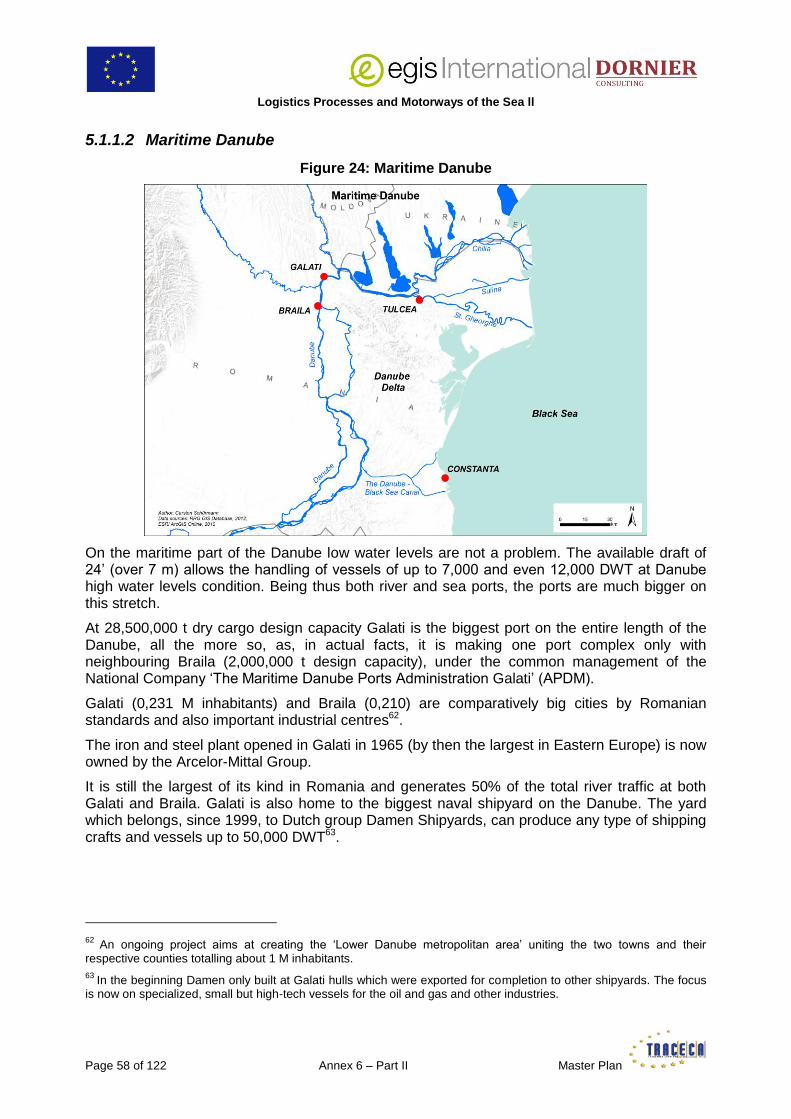
Logistics Processes and Motorways of the Sea ll
Page 58 of 122 Annex 6 – Part II Master Plan
5.1.1.2 Maritime Danube
Figure 24: Maritime Danube
On the maritime part of the Danube low water levels are not a problem. The available draft of 24’ (over 7 m) allows the handling of vessels of up to 7,000 and even 12,000 DWT at Danube high water levels condition. Being thus both river and sea ports, the ports are much bigger on this stretch.
At 28,500,000 t dry cargo design capacity Galati is the biggest port on the entire length of the Danube, all the more so, as, in actual facts, it is making one port complex only with neighbouring Braila (2,000,000 t design capacity), under the common management of the National Company ‘The Maritime Danube Ports Administration Galati’ (APDM).
Galati (0,231 M inhabitants) and Braila (0,210) are comparatively big cities by Romanian standards and also important industrial centres62.
The iron and steel plant opened in Galati in 1965 (by then the largest in Eastern Europe) is now owned by the Arcelor-Mittal Group.
It is still the largest of its kind in Romania and generates 50% of the total river traffic at both Galati and Braila. Galati is also home to the biggest naval shipyard on the Danube. The yard which belongs, since 1999, to Dutch group Damen Shipyards, can produce any type of shipping crafts and vessels up to 50,000 DWT63.
62
An ongoing project aims at creating the ‘Lower Danube metropolitan area’ uniting the two towns and their respective counties totalling about 1 M inhabitants. 63
In the beginning Damen only built at Galati hulls which were exported for completion to other shipyards. The focus is now on specialized, small but high-tech vessels for the oil and gas and other industries.

Logistics Processes and Motorways of the Sea II
Master Plan Annex 6 – Part II Page 59 of 122
Most of the big fish-factories and canneries located on the Northern part of the Danube have closed and those which survive have a very limited level of activity today64. Seemingly the 3 FEZ established in the region in the 90’s (Sulina, Galatiand Braila) did not meet much success.
Figure 25: Port of Braila
Source: APDM
The combined port facilities of Braila and Galati represent a total of 83 berths along 10,368 m of sloped and vertical quays where any type of dry bulk, general cargo and containers can be handled.
Due to the presence of heavy industrial works these ports are equipped with better lifting gears than those on the Lower Danube: floating and quay cranes up to 32 t capacity, reachstacker, heavy forklifts, etc. They also cover vast areas, 86.41 ha in total at Galati and nearly 38.96 in Braila. In addition to the usual European gauge rail connection to the rest of the country, Galatialso has a Russian gauge rail connection to Giurgiulesti in Moldova, which allows receiving and handling directly wagons from all the CIS.
The main commodities handled are coke, coal, mineral ores carried by barge from Constanza either via the Black Sea-Danube Canal and the maritime Danube or via the Black Sea and the Sulina Canal, steel scrap imported from Turkey, Cyprus via Sulina, grain shipped to Constanza by barge and steel products exported by Arcelor Mittal plant, mainly to Turkey (1 Mt out of an average pre-crisis traffic of 8 Mt p.a. at Galati65.
64 And not supported by the national market as, in the EU-27, Romania has the lowest fish consumption per capita (4 kg/year versus an average 22 kg/year). This figure is expected to remain stable at least until 2030.
65 The total traffic at the 3 main Romanian Maritime Danube ports (Galati, Braila and Tulcea) peaked at 15.264 Mt in 2007 and dropped to 7.784 in 2009. Further partial statistics show a marked recovery since 2010.
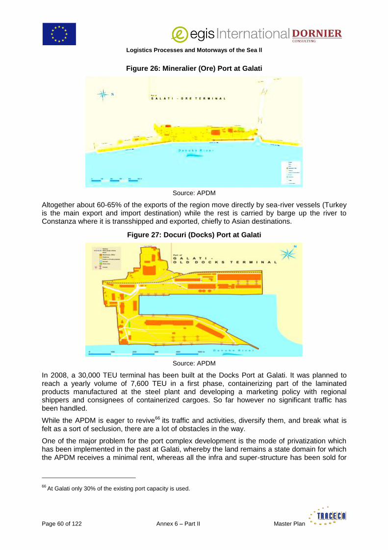
Logistics Processes and Motorways of the Sea ll
Page 60 of 122 Annex 6 – Part II Master Plan
Figure 26: Mineralier (Ore) Port at Galati
Source: APDM
Altogether about 60-65% of the exports of the region move directly by sea-river vessels (Turkey is the main export and import destination) while the rest is carried by barge up the river to Constanza where it is transshipped and exported, chiefly to Asian destinations.
Figure 27: Docuri (Docks) Port at Galati
Source: APDM
In 2008, a 30,000 TEU terminal has been built at the Docks Port at Galati. It was planned to reach a yearly volume of 7,600 TEU in a first phase, containerizing part of the laminated products manufactured at the steel plant and developing a marketing policy with regional shippers and consignees of containerized cargoes. So far however no significant traffic has been handled.
While the APDM is eager to revive66 its traffic and activities, diversify them, and break what is felt as a sort of seclusion, there are a lot of obstacles in the way.
One of the major problem for the port complex development is the mode of privatization which has been implemented in the past at Galati, whereby the land remains a state domain for which the APDM receives a minimal rent, whereas all the infra and super-structure has been sold for
66
At Galati only 30% of the existing port capacity is used.

Logistics Processes and Motorways of the Sea II
Master Plan Annex 6 – Part II Page 61 of 122
ever in full property to private operators which have, theoretically, to maintain a certain/minimum level of traffic. This, for evident reasons, does not work in practice: each port zone is in the hand of one sole operator who develops a specialized activity thus avoiding competition with the others.
To circumvent these legal and technical difficulties the APDM plans to develop a new port in Braila with a 200-m berth and another 170-m berth with silo for grain export at Galati.
Another barrier is the absence of good hinterland connections with the rest of the country. There is no international airport (the only one in Romania being Bucharest, and, seasonally Constanza), no highways, not even fast ways and the existing roads (of 7 m width) are, reportedly, poorly maintained. There are plans to up-grade the road network around Galati only. Discussions are also taking place with regard to the future Black Sea Ring layout, with supporters of a trail via Chisinau (which would by-pass the Maritime Danube and thus Galati densely populated areas) and others standing up for a road via Giurgiulesti and Galati.
Figure 28: The Danube at Galati
While talks have been going on for some time with Austrian companies, the absence of modern connecting infrastructure is quoted as one of the main reasons for the stagnation of the container terminal (another one seems to be an unsolved problem of depth at berth).
The rail tariffs for carriage on the 12-km privately-operated Russian-gauge link to Giurgiulesti are very expensive, limiting its use and there is no mechanism in place for a compulsorily coordinated approach of the regional development policy by the railway operators and the APDM.
The overall result of this situation is that Galati in particular has been losing a number of naturally ‘captive’ traffics to Constanza.
The first blow came in 1991 when the vessel ‘Rostock’ sank and partly obstructed the Sulina Canal. Its wreck was removed in 2004 only. Meantime the traffic moved to Constanza and never came back. Since then, for instance, wood exports originating from the region of Focsani in the nearby Carpathians skip the 100 km far Galati-Braila port complex (although all the equipment needed for handling such cargo is available there) to load at Constanza, 330 km away.
Romania has launched the building of the North-South Bucharest-Focsani-Iasi highway (running further to Chisinau) but the connection from Focsani to Galati remains to be approved.
At regional level, the cooperation with Giurgiulesti and Ukrainian river ports on the Maritime Danube is, for the time being, limited to technical/environmental matters (depollution and navigation) although business difficulties are similar with the Ukrainian ports and joint efforts could possibly help find common solutions.

Logistics Processes and Motorways of the Sea ll
Page 62 of 122 Annex 6 – Part II Master Plan
As other Romanian sea and river ports, the Galati-Braila port complex would like to play a role in the trade between Europe, as a whole, and Eastern destinations. At a national level, the implementation on the Maritime Danube of container feeder services from/to Constanza via the Black Sea-Danube Canal, similar to those which were operating on the Lower Danube, would be welcome. Another target is the recovery of small-medium size traffics which used to be handled at the Maritime Danube ports and shifted to Constanza after the Canal was opened.
These ideas sound realistic inasmuch as they all are based on the Danube and water transport and not on yet unapproved new road or rail links opening up the region.
In particular, developing container feeder services between Constanza and Maritime Danube ports makes sense in view of the missing or poor overland links between the two areas. Besides, it would help boosting the activity at Galati container terminal and lay the ground for promoting the containerization of export cargoes produced locally (as originally planned when the terminal was built). It would also create an opportunity to attract back trades, such as wood mentioned above, which have been lost to Constanza.
While the pre-carriage trucking cost from the producing area to Constanta is certainly much higher than to Galati, traders have no other choice – at the moment – if they export their goods in container. With boxes available at Galati they will certainly reconsider the routing of their cargo.
Achieving such goals will, as for Lower Danube ports, be possible only by establishing first a close link with the business community at large: container shipping lines, river shipping companies, Constanza container terminal operators, freight forwarders, shippers and consignees, etc. This, as already noted, means to implement a strong, coordinated marketing and promotion policy by APDM and the Galati-Braila terminal operators.
Economic studies remain to be carried out to determine the viability of diverting small-medium size traffics from Constanza to Galati – Braila. Would they yield a positive result, this, as will be examined further down this report, could represent an extra possibility to generate an export containerized cargo flow via the Sulina Canal to short-medium range destinations.
On another hand the plan to be part of the East-West trade game seems more difficult to implement. In the opinion of the Consultant, Constanza is, in all respects, in a much better position to take a leading position there and it could be a strategic mistake not to concentrate all efforts on this single spot.
Finally, the sustainable growth of traffic and development of the Danube river ports in general, depends upon Romanian Authorities laying a much greater emphasis and addressing also the crucial issue of river port hinterland connections in the region: for instance, in the absence of efficient, reliable freight trains, the new Dacia and Ford cars would be carried from the factories to the river ports by truck although the condition of the roads, their design and layout are, in general, poor and out-dated (driving for instance the 66 km from Bucharest to Giurgiu, crossing all the way through a number of built areas and villages where the maximum authorized speed is limited to 40-50 km/h , takes an hour and-a-half).
Obviously, the Ministry of Transport and Infrastructure, directly or through dedicated professional organizations, must play the key role in gathering the various stakeholders, re-assessing needs and priorities which, maybe, have not been duly or enough considered in the Intermodal Transport Strategy to 2020 and could be taken into account in the forthcoming Master Plan, shifting the river transport policy of the country and re-directing it as need to reach the above mentioned targets.
This would also enable Romanian Authorities to make sure that the funds dedicated to infrastructure investments in sea and river ports and their hinterland connections – whether provided from the State budget or the EU or other sources – are used in the most efficient and

Logistics Processes and Motorways of the Sea II
Master Plan Annex 6 – Part II Page 63 of 122
sustainable way and are beneficial for the entire communication network along the Lower and Maritime Danube.
This could constitute the very first step, on the national level, to promote Constanza as the ‘Rotterdam on the Black Sea’, bearing in mind that no single North European port reached the position it enjoys today – and Rotterdam, first and foremost – by playing a lonely game67.
5.1.2 Bulgaria
5.1.2.1 Ruse
Bulgarian river ports are situated rather far from the main cities and industrial centres. The biggest one, Ruse, is 311 km from Sofia, the capital and a metro area where over 20% of the total population of the country concentrate. Furthermore, Sofia is 301 km only from the Greek port of Thessaloniki, where deep-sea shipping services are available.
Figure 29: Political Map of Bulgaria
Likewise, Plovdiv, the second-largest city is located 325 km (4h 38’ driving) from Ruse and only 271 km (3h 27’) from the sea port of Burgas (Bulgaria’s 4th largest-city).
Moreover the condition of the rail and road infrastructure – though improving – remains altogether poor which makes cargo attraction even more difficult for river ports.
Still, it must be remembered that cities on the Danube, such as Ruse68, developed in the 19th century as major international grain trading places, which brought in wealth and industrialization
67 Rotterdam, since 2011, has been in talks to acquire a one-third stake in the overall operations of worldwide number one river port, Duisburg, to secure its base traffic. 68 For that matter the same applies to Galati, which, additionally, became the headquarters of the first Danube Commission after the Crimean War of 1854-56.

Logistics Processes and Motorways of the Sea ll
Page 64 of 122 Annex 6 – Part II Master Plan
at a time when the just-appointed capital city (Sofia became the capital of the first post-Ottoman Bulgarian State in 1879) was not much more than a big market town. Part of this industrial past is still much alive.
The Nikopol Ferry Terminal and Ruse-West terminal having been privatized, Port Complex Ruse JSCo remains with the secondary ports of Silistra (for passengers only), and Tutrakan (one general cargo berth and passenger pontoon), the passenger quay in downtown Ruse69, and the freight terminal of Ruse-East. Any type of bulk and general cargo and heavylifts can be handled at a total of 24 berths equipped with 29 cranes deploying a maximum lifting capacity of 64 t. 42 t Kalmar top-loaders equipped with hydraulic spreaders are available for handling 20’ and 40’s70.
Figure 30: Port Ruse-West
Source: Port Complex Ruse JSCo
Ruse-East includes also a Ro-Ro terminal where 2 (Danube-type) vessels can berth simultaneously. 160 trucks can be accommodated on 2 adjacent parking areas equipped with all necessary amenities for drivers.
Until 2004-2005 two regional lines were operating at this terminal, one to Giurgiu and another one to Reni (Ukraine)71. Until recently it handled a twice weekly Ro-Ro service to Passau (Germany). Today Ro-Ro traffic decreased much and became irregular.
69 Ruse is a renowned and busy tourist and cruise destination, most famous for its well-preserved Neo-Rococo and Neo-Baroque buildings from the end of the 19th and beginning of the 20th century. 70 Containers were handled at Ruse-East ever since that port was built in 1976. The activity dropped in the 1990’s and is insignificant today. 71
The service stopped mainly because of an administrative decision made by Ukrainian Authorities changing the status of Reni as an Ukrainian border-crossing point. The Bulgarian vessels which plied the service are maintained and could, reportedly, be made ready in all respects at very short notice, in case the decision would be reversed and the line could possibly resume its activities.

Logistics Processes and Motorways of the Sea II
Master Plan Annex 6 – Part II Page 65 of 122
Figure 31: Port Ruse-East Ro-Ro Terminal
Source: Port Complex Ruse JSCo
Traffic at Ruse exceeded 1 Mt in 2010 consisting for 77% in liquid and dry bulk, with a big imbalance between import (76% of the total traffic) and export (24%). Imported coal (from Ukraine) for the Ruse Iztok (Thermal) Power Plant – though declining – still represents 25% of the total traffic. In recent years there has been a significant drop in the traffic due to the bad conditions of navigation on the river: grain trade for instance shifted from river to rail transport to reach its final destination Varna.
As all other Danube ports, Ruse is endeavouring to both increase and diversify its traffics, focusing on value-added ones such as Ro-Ro and container. Some positive results could already be achieved with the food processing industry – which is well represented in the province of Ruse – for imports of grain from Hungary later re-exported (by truck) as extracts for Coca and Pepsi-Cola as well as other base foodstuff materials.
Ruse’s economy is dominated by light industry sector which, in addition to food processing, includes tailoring, textile, furniture, building and electric equipment, etc. all producing easily containerizable goods, today shipped, mostly, by truck.
Developing container and Ro-Ro services will undoubtedly bring about the triple effect of fostering a modal shift from all-road to mostly-water transport, boosting the port activity and thus the use of its under-employed facilities and, last but not least, open a wide geographical range to the local industrial production enabling to increase exports.
The plan, contained in the Strategy for the Development of the Transport System of the Republic of Bulgaria until 2020 to build an intermodal terminal in Ruse, is in line with the Port’s approach except the projected terminal would be situated in/near the marshalling yard of the railways at some distance from the berths while there is a free land plot of over 40 has available within the port.
Besides, Ruse JSCo underlines that it already acts as a logistics centre for agricultural machinery and equipment for all the Northern part of Bulgaria.
The Port Complex Ruse JSCo approached container shipping lines but so far without any success for the reasons previously explained. It must be emphasized here that a container trade along the Danube between Ruse and the Black Sea will, as for any other Bulgarian river port, necessarily start and end in Constanza depriving Varna, the closest (and biggest) Bulgarian container port, from part of a traffic which, today, is probably moving from and to this sea port by road.

Logistics Processes and Motorways of the Sea ll
Page 66 of 122 Annex 6 – Part II Master Plan
At the same time however the Port is pressing Bulgarian Authorities to launch the modernization of the 223 km Varna-Ruse rail track (the first built in the country 140 years ago) and its doubling by a Russian-gauge track allowing a swifter transfer of commodities in wagons from Russia, Ukraine and other CIS countries to Europe via the VFC, Ruse and the Danube.
5.1.2.2 Belene
Belene Island – a former labour camp – is the proposed site for Bulgaria second nuclear power plant, which has been under construction 7 km east of the town until it was interrupted in 1990 due to the severe economic crisis that followed the fall of communism in Bulgaria.
Figure 32: Belene Island
There are plans to start construction again, as a replacement for reactors 3 and 4 at Kozloduy Nuclear Power Plant (upstream on the Danube, near Oryakhovo), which Bulgaria shut down as a condition for EU membership.
A state-of-the-art, special heavylift port has been built there to that effect, owned by the National Electricity Company and currently operated by a private operator.
The port consists in a total area of 28,800 square meters out of which 21,200 square meters open storage.
Heavy units are handled at the heavy lift pier number 2 by gantry cranes developing a maximum 480 t capacity and extra long parcels at pier number 1 which is equipped with 1x16 t + 1x20 t harbour cranes with a maximum reach radius of 30 m at full capacity.
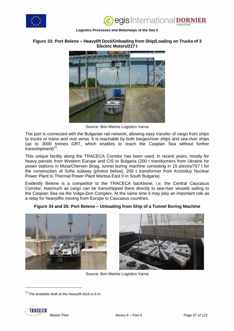
Logistics Processes and Motorways of the Sea II
Master Plan Annex 6 – Part II Page 67 of 122
Figure 33: Port Belene – Heavylift Dock/Unloading from Ship/Loading on Trucks of 3 Electric Motors/217 t
Source: Bon Marine Logistics Varna
The port is connected with the Bulgarian rail network, allowing easy transfer of cargo from ships to trucks or trains and vice versa. It is reachable by both barges/river ships and sea-river ships (up to 3000 tonnes GRT, which enables to reach the Caspian Sea without further transshipment)72.
This unique facility along the TRACECA Corridor has been used, in recent years, mostly for heavy parcels from Western Europe and CIS to Bulgaria (200 t transformers from Ukraine for power stations in Mizia/Cherven Briag, tunnel boring machine consisting in 15 pieces/757 t for the construction of Sofia subway (photos below), 200 t transformer from Kozloduy Nuclear Power Plant to Thermal Power Plant Maritsa East II in South Bulgaria).
Evidently Belene is a competitor to the TRACECA backbone, i.e. the Central Caucasus Corridor, inasmuch as cargo can be transshipped there directly to sea-river vessels sailing to the Caspian Sea via the Volga-Don Complex. At the same time it may play an important role as a relay for heavylifts moving from Europe to Caucasus countries.
Figure 34 and 35: Port Belene – Unloading from Ship of a Tunnel Boring Machine
Source: Bon Marine Logistics Varna
72
The available draft at the heavylift dock is 6 m.

Logistics Processes and Motorways of the Sea ll
Page 68 of 122 Annex 6 – Part II Master Plan
5.1.2.3 Vidin
Vidin is the westernmost Bulgarian port on the Danube.
Figure 36: Trans-European Transport Corridors through Vidin
It holds a strategic geographical position at the cross-roads of Pan European Transport Corridors IV and VII, offering the shortest route between Central Europe and Mediterranean in Northern Greece as well as from the Black Sea to Central Europe.
The port consists in 4 Terminals, 2 State-operated (South and Centre) and 2 privately-operated (Vidin North in concession to BRP (the Bulgarian River Shipping Company) since 2010, and the AutoFerryboat Terminal of RO-RO SOMAT– VIDIN).
The 2 latter will be surveyed hereunder.
AutoFerryboat Terminal
SOMAT is the Bulgarian subsidiary of leading German trucking company Willy Betz. It plies a regular service from Vidin to Passau (Germany) with barges and 4 catamarans for Ro-Ro cargoes.
Until 2010 it owned the 70 trucks ferry ‘Sredets’ which was plying a regular service from Burgas to Poti (Georgia) and Novorossiysk (Russia) carrying mostly Willy Betz trucks from Europe to the Caucasus, Iran, Russia and Central Asia. The vessel experienced engine problems and had to be scrapped. Owing to the ongoing crisis and drop in cargo volumes, and sanctions on Iran and stoppage of traffic to this country, it was decided not to replace it and the service stopped.
They did not consider using UkrFerry–NaviBulgar at the time due to the absence of regularity of the rail-ferries and lack and unpredictability of space availability.
SOMAT traffic today consists in:
loaded/empty trucks (Willy Betz’ and other companies) to/from Passau,
new Mercedes and BMW cars from Germany to Turkey,

Logistics Processes and Motorways of the Sea II
Master Plan Annex 6 – Part II Page 69 of 122
DACIA cars (coming from Romania) to Passau (which has become the West European storage and distribution centre for the Romanian car-maker),
public work equipments, cranes (Hyundai, Liebherr) from Europe,
Hyundai cars from Turkey to Western Europe,
combines/harvesters to Bulgaria from Western Europe,
wings and other equipments for windmills produced by Vestas, exported from Denmark via Passau on low-bed trailers to both Vidin and Ruse73,
and out-of-gauge cargoes carried by Turkish low-bed trucks to Germany.
The traffic is imbalanced, exports from Bulgaria exceeding by far the imports.
Willy Betz/SOMAT operating their own fleet and their own terminals, control the whole logistics chain of the cargoes they carry, ensuring a reportedly very efficient service for their clients.
Their Vidin Terminal consists in 2 areas covering 68,000 square meters in total at km 792.7 on the Danube. All surfaces are asphalted.
A – The Port
The berth, in fact a Ro-Ro ramp, is 130 m wide and allows the berthing and operation of two vessels (one barge and a catamaran) simultaneously. The whole area is guarded and surrounded by a high fence with electronic warning system. 2,000 cars can be stored in the open area adjacent to the berth. The Customs office is inside the port building where are also located a passport and visa border control office.
Figure 37: Loading of New Cars on Barge
Source: BRP
The barges (belonging to BRP) have 3 decks for cars only. Usual convoys consist in 2 barges and one pusher. The catamarans (belonging to SOMAT) have 2, one for cars and the main
73 The local car makers, Ford and Dacia, who use the barge and catamaran service for carrying their cars, are also investing in wind energy.

Logistics Processes and Motorways of the Sea ll
Page 70 of 122 Annex 6 – Part II Master Plan
deck for trucks and trailers. The catamarans have a draft of only 1.3 m whereby they experience no navigation problem even when the water-level is exceptionally low.
B – The Truck Base
The offices, workshops, parking places, warehouses, shops for truck spare parts, amenities for drivers (including a hotel) and other backyard facilities are situated a few meters away, across the E79 road leading from the city of Vidin to Vidin-North.
Figure 38: Loading of Catamaran for Passau at Vidin AutoFerryboat Terminal
Source: Port Vidin EOOD
There, SOMAT keep and maintain 280 trucks, 500 normal trailers and 98 trucks specialized for carrying cars.
They employ 27 administrative employees and over 300 truck drivers, garage mechanics, technicians, warehousemen, stevedores, etc. Willy Betz is the main client but SOMAT services also other trucking companies/truckers.
Vidin serves as their dispatching centre for the traffic between Europe, Turkey, Middle-East (Iraq and, previously, Iran) and Central Asia74 (Kazakhstan, Uzbekistan, Tajikistan, Afghanistan).
They, for instance, bring and store Hyundai cars from Turkey which they re-distribute with their own trucks all over the Balkans.
The features and organisation of the facility and its geographical location hold a very big potential.
The construction of the second bridge over the Danube between Vidin and Calafat just one km north of SOMAT facility, complemented by the ongoing road and railway infrastructure works (modernization of the Vidin – Sofia railway line, construction of the A5 ‘Lyulin’ motorway from Sofia to Pernik, and A6 ‘Struma’ motorway from Pernik to Kulata on the Greek border), represent an exceptional opportunity to increase the volume handled at SOMAT base which already offers in one single place all the professional and personal services truck drivers usually look for.
74
Willy Betz/Somat performed no less than 7,000 trips to Central Asia in 2011.

Logistics Processes and Motorways of the Sea II
Master Plan Annex 6 – Part II Page 71 of 122
Vidin North
The port is located between a dyke and the Danube, adjacent to the AutoFerryboat Terminal. At times of flooding or high waters, the river is leaking around port area, flowing underneath the dyke, which is made of plain earth, and flooding the nearby lowlands. This also undermines the quay foundations whereby the berth condition is permanently under close watch (gypsum markers have been cemented on the quay superstructure while electronic bollards have been placed for tracing the quay movements by GPS).
For this reason the port area has been built 10 m above the water level along a 250 m quay/berth of sloping type.
Figure 39: The ‘New Europe Bridge’ Vidin-Calafat
For the time being the main cargoes handled at Vidin North are bulk and breakbulk (grain, gypsum, wood, coal, etc.). The port is equipped with a crane on rail deploying a 20 t lifting capacity. 2 railway tracks along the berth allow marshalling 2 x 14 hopper trains alongside at the same time for loading grain. The railway station is located 10 km from Vidin North.
There is also a small Ro-Ro terminal where BRP operated the Vidin-Calafat ferryboat from 2010 till 2013. 4 vessels (2 x 6 and 2 x 16 TIRs operating in pairs) were plying the service according to a regular daytime only schedule deploying a total capacity of about 75,000 TIRs p.a. The service stopped when the bridge opened and the boats have been transferred to the BRP Nikopol-Turnu Magurele service.
Figure 40: BRP Ferryboat
Source: BRP
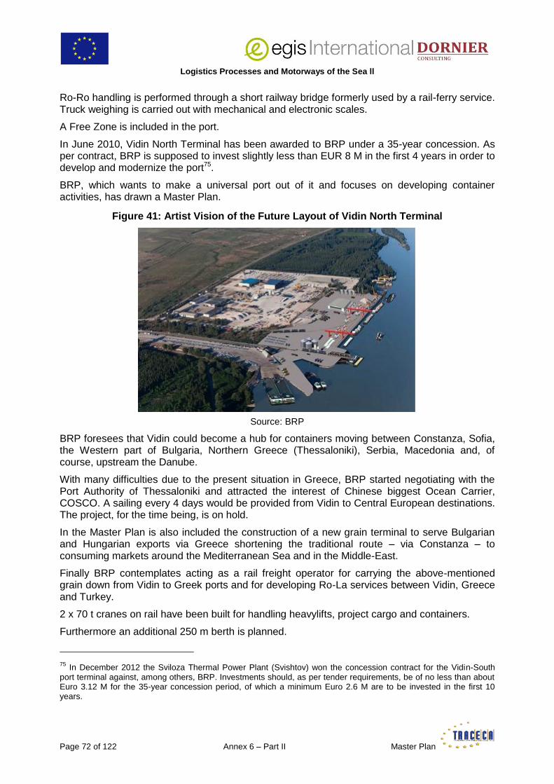
Logistics Processes and Motorways of the Sea ll
Page 72 of 122 Annex 6 – Part II Master Plan
Ro-Ro handling is performed through a short railway bridge formerly used by a rail-ferry service. Truck weighing is carried out with mechanical and electronic scales.
A Free Zone is included in the port.
In June 2010, Vidin North Terminal has been awarded to BRP under a 35-year concession. As per contract, BRP is supposed to invest slightly less than EUR 8 M in the first 4 years in order to develop and modernize the port75.
BRP, which wants to make a universal port out of it and focuses on developing container activities, has drawn a Master Plan.
Figure 41: Artist Vision of the Future Layout of Vidin North Terminal
Source: BRP
BRP foresees that Vidin could become a hub for containers moving between Constanza, Sofia, the Western part of Bulgaria, Northern Greece (Thessaloniki), Serbia, Macedonia and, of course, upstream the Danube.
With many difficulties due to the present situation in Greece, BRP started negotiating with the Port Authority of Thessaloniki and attracted the interest of Chinese biggest Ocean Carrier, COSCO. A sailing every 4 days would be provided from Vidin to Central European destinations. The project, for the time being, is on hold.
In the Master Plan is also included the construction of a new grain terminal to serve Bulgarian and Hungarian exports via Greece shortening the traditional route – via Constanza – to consuming markets around the Mediterranean Sea and in the Middle-East.
Finally BRP contemplates acting as a rail freight operator for carrying the above-mentioned grain down from Vidin to Greek ports and for developing Ro-La services between Vidin, Greece and Turkey.
2 x 70 t cranes on rail have been built for handling heavylifts, project cargo and containers.
Furthermore an additional 250 m berth is planned.
75
In December 2012 the Sviloza Thermal Power Plant (Svishtov) won the concession contract for the Vidin-South port terminal against, among others, BRP. Investments should, as per tender requirements, be of no less than about Euro 3.12 M for the 35-year concession period, of which a minimum Euro 2.6 M are to be invested in the first 10 years.

Logistics Processes and Motorways of the Sea II
Master Plan Annex 6 – Part II Page 73 of 122
The combined vicinity of Vidin-Nord and SOMAT terminals and complementarity of their activities, close connection to Macedonia, Serbia, Western Romania, Sofia and further to Northern Greece, and the decision taken by Bulgarian Authorities to establish a multi-modal centre in Vidin, represent most favourable conditions for the development of the whole complex.
Being/having been already a river feeder for major container shipping lines such as ZIM, MSC and Hapag-Lloyd, is a further asset for BRP to achieve its target to develop container activities at Vidin North.
A remaining challenge however, is to attract export cargo to balance the trade. Reportedly Serbian exporters are reluctant, for unclear reasons, to containerize their grain.
Meanwhile possibilities are limited in Vidin region: the only significant industrial plant in the neighbourhood belongs to the Ukrainian company VIDA, a manufacturer of equipment for child`s sport-playing and recreation areas, and for water parks, producing here pumps. Attracting exports from Western Bulgaria seems rather difficult, given the distances (Sofia is 217 km or 4h 15’ driving far away) and the natural attraction of Thessaloniki and even Bulgarian seaports. Central European grain put aside, Western Romania seems the more likely market to canvass.
5.1.3 Moldova
5.1.3.1 Introduction
Moldova has a 588 km network of inland navigable waterways consisting in 3 rivers: the Dniester, the Prut and a tiny section of the Danube at the mouth of the Prut River.
The Dniester and Prut are classified as waterways of international importance, according to the European Agreement on Main Inland Waterways of International Importance (Geneva, 19 January 1996), which was ratified by Moldova in December 1997. Bilateral agreements have been concluded with neighbouring Romania in 2005 and in 2006 with Ukraine. These legal instruments allow exploiting vessels, operated by the Moldovan transport agents, using waterways of Romania and Ukraine.
In 2011 the Ministry of Transport and Road Infrastructure (MTRI) closed the negotiations on the Transport Chapter of the EU-Moldova Association Agreement and made a commitment regarding the timeframe of the harmonization of the basic Transport sector legal framework with the EU legislation. The MTRI is elaborating a new maritime and inland waterways transport policy and the relevant legal framework that will aim at the implementation of the EU standards in the area. At present, the MTRI considering the harmonization of the legal framework followed by the subsequent enforcement measures requires better understanding of the principles of EU legal framework in maritime and inland waterways sectors by civil servants responsible for these questions focuses its efforts on this issue.
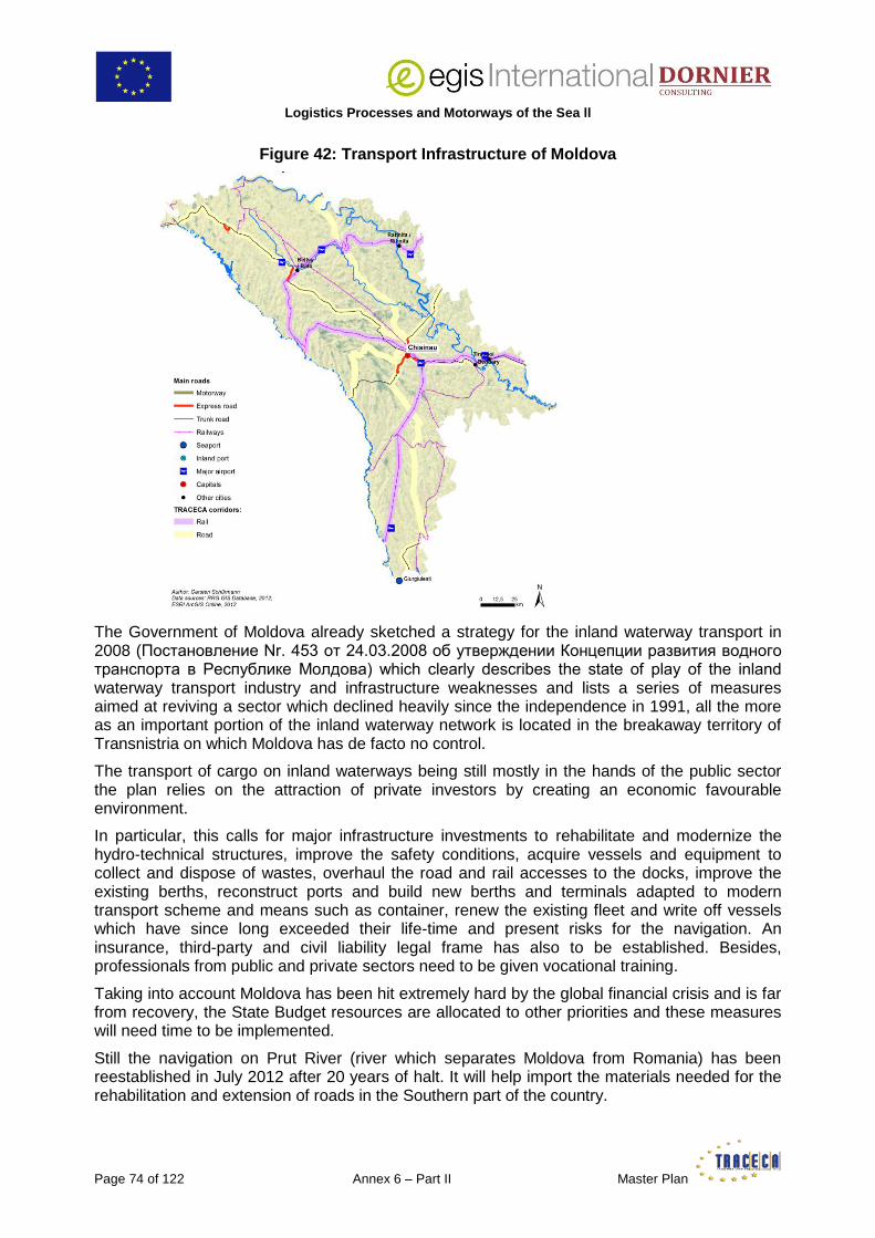
Logistics Processes and Motorways of the Sea ll
Page 74 of 122 Annex 6 – Part II Master Plan
Figure 42: Transport Infrastructure of Moldova
The Government of Moldova already sketched a strategy for the inland waterway transport in 2008 (Постановление Nr. 453 от 24.03.2008 об утверждении Концепции развития водного транспорта в Республике Молдова) which clearly describes the state of play of the inland waterway transport industry and infrastructure weaknesses and lists a series of measures aimed at reviving a sector which declined heavily since the independence in 1991, all the more as an important portion of the inland waterway network is located in the breakaway territory of Transnistria on which Moldova has de facto no control.
The transport of cargo on inland waterways being still mostly in the hands of the public sector the plan relies on the attraction of private investors by creating an economic favourable environment.
In particular, this calls for major infrastructure investments to rehabilitate and modernize the hydro-technical structures, improve the safety conditions, acquire vessels and equipment to collect and dispose of wastes, overhaul the road and rail accesses to the docks, improve the existing berths, reconstruct ports and build new berths and terminals adapted to modern transport scheme and means such as container, renew the existing fleet and write off vessels which have since long exceeded their life-time and present risks for the navigation. An insurance, third-party and civil liability legal frame has also to be established. Besides, professionals from public and private sectors need to be given vocational training.
Taking into account Moldova has been hit extremely hard by the global financial crisis and is far from recovery, the State Budget resources are allocated to other priorities and these measures will need time to be implemented.
Still the navigation on Prut River (river which separates Moldova from Romania) has been reestablished in July 2012 after 20 years of halt. It will help import the materials needed for the rehabilitation and extension of roads in the Southern part of the country.

Logistics Processes and Motorways of the Sea II
Master Plan Annex 6 – Part II Page 75 of 122
About MDL 200,000 (EUR 11,300) were spent to clean the Giurgiulesti–Cahul segment. Currently, 83 km are practicable which allows the navigation of cargo vessels with a capacity of up to 600 t. It is planned to open the navigation as far upstream as Leova Ungheni by the end of 2013. Finally the Government and the EU have recognized that inland water way transport has also another specific and very important dimension in Moldova as the main means of public transport for isolated socially vulnerable groups. It seems therefore reasonable to assume that the improvement of the carriage of passengers will constitute the priority axis of development of the inland water way transport in the near future.
5.1.3.2 Giurgiulesti
Moldova only benefits of a 300m-long waterfront on the Danube between its border with Romania on the west and its border with Ukraine on the east. During the Soviet era there was no port in Moldova as the country was connected to the Black Sea via the Ukrainian ports of Odessa, Reni and Izmail.
Small river vessels could also reach locations close to Chisinau (such as Ungheni) via the Prut tributary. During the years which followed independence in 1991 it became increasingly difficult for Moldova to carry on trading through Ukrainian ports, because of customs and border crossing obstacles and increased road transport tariffs, which led the country to decide to have its own port on the Danube.
Since the end of the 90’s the idea of constructing a river port in Giurgiulesti, at 72.2 nm from the mouth of the Danube and 226 km from the capital, Chisinau, was supported by the EU, via the EBRD.
The port is managed by the state-owned company Giurgiulesti International Free Port (GIFP) and operated by private company Danube Logistics (DL), a joint-venture between a Dutch company and the EBRD.
The territory covers an on-land area of 120 ha, 64 being reserved for future industrial activities.
Due to its location in a bend of the Danube, Giurgiulesti needs to be dredged permanently (water level in August 2013 was 2 m only). Dredging works are also ongoing toward the mouth of the Prut to extend the tiny water-front as much as possible76.
It has a rail and road connection with Romania via two bridges next to the port, above the Prut River. It has also a rail connection and several road connections with Chisinau, all in rather poor condition. This situation is however evolving rapidly thanks to various road rehabilitation EBRD-financed projects.
The up-grading and modernization of the M3 main road (including by-passes of some villages) should be completed by 2015-2016 while improvement on the rail started a few years ago77. The rehabilitation of the rail track between Giurgiulesti and Cahul was completed in September 2013 giving the possibility to launch a weekly block-container train operation between the port and the capital of Moldova.
76
The Ministry of Transport is working on legal amendments in order to clarify a number of issues with maritime regulations and align them with EU and international rules, one of them being to fix which party is responsible (including financially) for the performance of dredging operations).
77 The government in place since May 2013 decided launched a complete reform of the Moldovan State Railway
(change of management, separation of infrastructure from operations, separation of freight from passenger business, introduction of electronic accounting corresponding to international standards, tackling the issue of excess work force with the financial assistance of the EU through a 5 M Euro-grant, etc.).

Logistics Processes and Motorways of the Sea ll
Page 76 of 122 Annex 6 – Part II Master Plan
The port did not really start operating before 2006, when private investors built the oil terminal which opened in September 2007 and is now doing pretty well with high standard operating conditions and safety equipment (the port receives tankers bringing oil from various origins including Turkmenistan, via the Volga-Don Complex). The available draft is 7 m which allows the handling of vessels of up to 12,000 DWT.
Figure 43: Geographical Location of Giurgiulesti
Storage for gasoline, diesel and gas-oil is provided in 8 tanks (out of which 4 with floating roofs) representing a total volume of 63,600 cbm. Inland transport is performed by truck.
The oil terminal was followed by a road and rail-connected grain terminal which opened in September 2009. The storage capacity is 50,000 t for corn, sunflower seeds, wheat and barley. Vessels of up to 5,000 DWT can be accommodated at the 5 m-draft berth.
A dry bulk cargo terminal with a 4 ha storage area was put into operation in 2010 for handling of aggregates, slag and pet-coke mainly destined to the Lafarge cement factory in Rezina. Vessels are discharged with a floating crane at a 5 m draft berth.
The vegetable oil terminal consisting in 2 tanks with a total capacity of 6,000 t opened in November 2011 and the container and general cargo terminal with a 2 ha open storage area in January 2012. The terminal is equipped with 48 plug-in sockets for reefer containers, a 70 t mobile crane and a reachstacker.

Logistics Processes and Motorways of the Sea II
Master Plan Annex 6 – Part II Page 77 of 122
Figure 44: Inauguration of the Grain Terminal
A mixed gauge railway terminal including a 1.5 ha storage area and a grain-container stuffing facility is under construction. This will enable Giurgiulesti to be connected with both the EU and CIS railway networks.
Figure 45: GIFP Master Plan
Having first reached an agreement with MSC DL started a weekly feeder container service from/to Istanbul, the aim being to replace the current, excessively-priced container trade via the ports of Odessa region (estimated at about 15,000 TEU/year in 2010, for the whole of Moldova).
Due to the seasonality of the traffic (and too big size of the vessel) this operation did not prove economically viable and was substituted by a barge service along the Danube to Constanza. The obstacles the Romanian Customs created finally led DL to resume a direct shipping service between Giurgiulesti and Constanza sailing via the Sulina Canal and the Black Sea with a much smaller ship than the one previously deployed to Istanbul.
This strategy finally paid-off. DL succeeded in attracting all other main Ocean Carriers. Using DL service as feeder to Moldova (instead of the traditional route via Ukrainian ports) enabled them to reduce transit-times and costs which also benefited Moldovan importers and exporters.

Logistics Processes and Motorways of the Sea ll
Page 78 of 122 Annex 6 – Part II Master Plan
An 80-TEU vessel sailing twice a week from Giurgiulesti to Constanza South Container Terminal was introduced in the service in March 2013. By the end of June 2,340 full TEU had been handled at GIFP, an increase of 200% compared with the same period of 2012. In September 2013 the size of the chartered vessel was increased again to reach a weekly capacity of 240 TEU.
Figure 46: DL Feeder M/S ‘Lady Didem’ at Sulina on the 24/08/2013
The port has an advantageous free economic zone status until 2030 allowing undertaking any activities commonly performed within the country, unlike common free zones which are traditionally dedicated to import-process-export activities.
As a consequence of the development of GIFP, the Ukrainian Danube ports of Reni and Izmail have lost traffic which illustrates a lack of co-operation between two neighbouring TRACECA countries.
For the time being Giurgiulesti does not trade much with other Danube ports, except for passenger traffic, its business being focused on the Black Sea region.
Traffic data are presented in Appendix 9.
Access to the Black Sea
Between Giurgiulesti and the Black Sea vessels may use either the Sulina canal or the Danube northern branch forming the border between Romania and Ukraine.
The latter is less expensive in terms of channel dues but it is shallower (only 3 to 4 m against 6 to 7 m in the Sulina canal), a bit longer and it frequently involves troubles with Ukrainian Authorities in charge of navigation and border control.

Logistics Processes and Motorways of the Sea II
Master Plan Annex 6 – Part II Page 79 of 122
Figure 47: Danube Delta
The Sulina canal should therefore be the preferred gateway to the Black Sea, all the more as the EU recently implemented a rehabilitation programme on this canal, covering removal of shipwrecks, elimination of shoals, bank protection and upgrade of aids to navigation78.
5.1.4 Ukraine
5.1.4.1 Introduction
The ‘Transport Strategy of Ukraine for the period of up to 2020’ describes a number of very general measures to improve the conditions of navigation and operations on the inland waterways. The only one specifically related to the Danube is the completion of the dredging of the Danube-Black Sea deep-water navigation pass.
In November 2010 the Committee of the economic reforms under the President of Ukraine, presented a number of projects eligible for national status. 11 were nominated as priority projects.
One of them is the ‘Development of the Danube Corridor’ which includes the following components:
A – Implementation of the second phase of the UAH 543,5 M (equivalent of EUR 50,23 M) Project ‘Deep Water Fairway Danube – Black Sea’ Canal79.
78
Discussions with Romanian Authorities in October 2011 confirmed that the Sulina canal is now in good condition for navigation. However some deficiencies were reported on dikes which could entail risks of flooding over inhabited areas on both sides of the canal.
79 Best known as the ‘Bystroe Canal’.

Logistics Processes and Motorways of the Sea ll
Page 80 of 122 Annex 6 – Part II Master Plan
Figure 48: Ukrainian Part of the Danube Delta
The first phase approved by the Cabinet of Ministers of Ukraine in 2004 was completed in 2007. The second phase was approved in 2007 but its implementation has been repeatedly delayed ever since due to renewed international environmental concerns about the project. A comprehensive study named ‘Sustainable Navigation in Ukraine, Alternatives in and around the Ukrainian Danube Delta – September 2009’ commissioned by the WWF sums up the risks and threats for the protected Danube Biosphere Reserve linked to the Bystroe Canal Project and gives a detailed list of 7 well backed-up alternatives (see also Appendix 1).
The leading organisation in this Project is the State-enterprise ‘Delta Lotsman’80. The main identified goals and tasks of the Project are:
the prevention of further artificial hydrologic alteration of the Danube river in the Ukrainian part of its delta,
the solution of socio-economic problems and development of depressed areas of the Odessa region (districts of Ismail, Kiliya, Reni and Bolgrad)81,
the creation of conditions for modernization and construction of transport infrastructure objects on the DWF route (ship repairing facilities, ship’s supplies, tourism and other).
The total length of the fairway is 172.36 km. The works already performed and still to be carried out include:
80 This company, which is under the Ministry of Infrastructure, has the monopoly of pilotage and VTMS services at all Ukrainian sea and sea-river ports.
81 Dredging will enable bigger vessels to reach Reni and Izmail via the Bystroe Canal at a lower cost than via the Sulina Canal. Furthermore, the navigation on Bystroe Canal takes place in both upstream and downstream directions simultaneously and possible at night while it is one-track and during daylight only on the Sulina Canal.
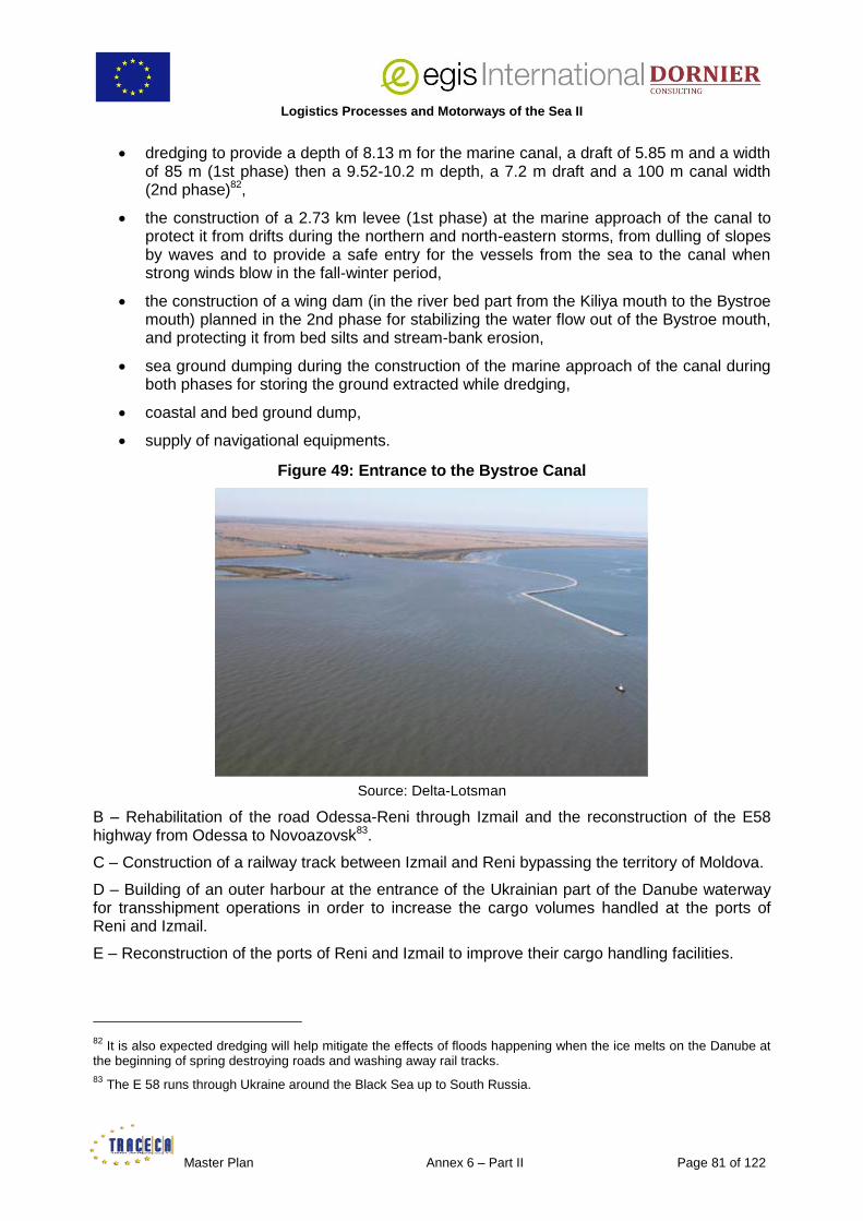
Logistics Processes and Motorways of the Sea II
Master Plan Annex 6 – Part II Page 81 of 122
dredging to provide a depth of 8.13 m for the marine canal, a draft of 5.85 m and a width of 85 m (1st phase) then a 9.52-10.2 m depth, a 7.2 m draft and a 100 m canal width (2nd phase)82,
the construction of a 2.73 km levee (1st phase) at the marine approach of the canal to protect it from drifts during the northern and north-eastern storms, from dulling of slopes by waves and to provide a safe entry for the vessels from the sea to the canal when strong winds blow in the fall-winter period,
the construction of a wing dam (in the river bed part from the Kiliya mouth to the Bystroe mouth) planned in the 2nd phase for stabilizing the water flow out of the Bystroe mouth, and protecting it from bed silts and stream-bank erosion,
sea ground dumping during the construction of the marine approach of the canal during both phases for storing the ground extracted while dredging,
coastal and bed ground dump,
supply of navigational equipments.
Figure 49: Entrance to the Bystroe Canal
Source: Delta-Lotsman
B – Rehabilitation of the road Odessa-Reni through Izmail and the reconstruction of the E58 highway from Odessa to Novoazovsk83.
C – Construction of a railway track between Izmail and Reni bypassing the territory of Moldova.
D – Building of an outer harbour at the entrance of the Ukrainian part of the Danube waterway for transshipment operations in order to increase the cargo volumes handled at the ports of Reni and Izmail.
E – Reconstruction of the ports of Reni and Izmail to improve their cargo handling facilities.
82
It is also expected dredging will help mitigate the effects of floods happening when the ice melts on the Danube at the beginning of spring destroying roads and washing away rail tracks.
83 The E 58 runs through Ukraine around the Black Sea up to South Russia.

Logistics Processes and Motorways of the Sea ll
Page 82 of 122 Annex 6 – Part II Master Plan
Considering there is no allocation of funds in the Ukrainian State-Budget for these infrastructure works, the ‘Development of the Danube Corridor’ Project remains an ambitious but rather hypothetical idea. The rehabilitation of the Odessa-Reni road, for instance, is scheduled through a concession scheme. The corresponding concession law however has not been passed or even drafted.
International financial help and therefore IFIs, Donors and the EU involvement will be necessary to achieve the much-needed goals set out by the initiators of the Project. The key players at national and regional levels (the Cabinet of Ministers, the Ministry of Infrastructure, the Odessa Oblast’ Council, the District Administrations) also need to develop a coordinated approach which seems missing at the moment.
5.1.4.2 Izmail
The State-run port of Izmail is located on the left bank of the Danube, between km 85 and 94, at the junction of the Ukrainian, Romanian and Moldovan border and at the intersection of Pan-European transport corridors № 7 and № 9.
Figure 50: Location of Izmail on the Danube
Source: Port of Izmail
It handles mostly bulk commodities (iron ore concentrate, pellets, coal, coke, fertilizers, chemical, grain, ferrous and nonferrous metals) and breakbulk cargoes packed in bags, cases, big bags, or unpacked (pulp, sawn-timber, metal scrap, steel and paper products) shipped to and from the port by rail and sea and river water mode from and to Ukrainian and foreign destinations (from Russia to Austria)84. Contrary to many other ports around the Black Sea handling dirty bulk cargoes as well, the port area is kept in perfect order and clean.
84
Iron ore from the region of Poltava and coal from the Donbass are shipped to Izmail by rail only as users find it cheaper, quicker and easier than shipping via the Dnepr.

Logistics Processes and Motorways of the Sea II
Master Plan Annex 6 – Part II Page 83 of 122
Berths and rear open storage areas are equipped with the typical East-German made portal cranes which can be seen in all former Soviet ports (‘Ganz’ – 5 t capacity, ‘Albatros’ and ‘Albrecht’ – 10 t and ‘Condor’ – 32/40 t).The port is divided in 3 non-specialized terminals (ППК 1, 2 and 3 with respectively 908.6, 860 and 1134 m length of mooring lines). A 10,500 square meters open ground has been prepared on the PPK-2 cargo handling site for container handling. The storage capacity is 416 TEU. Necessary infrastructure has been built and staff trained in accordance with relevant Customs’ procedures and requirements. The facility was commissioned on 28 August 28 2013.
The development of the port is hampered by various technical factors:
the single track rail line has a capacity of 300 wagons per day track representing a maximum of about 6.5 Mt cargo per year,
the two-lane 241 km road from Odessa to Izmail has a much basic design, crosses a number of villages and small hamlets, and is overall in a rather dilapidated condition,
the draft is limited at the berths of the PPK-2 and in the backwater at the PPK-3 for the reception and handling of sea-river vessels. However the Port is on the verge of signing a contract for dredging 100,000 cubic meters at the berths of these 2 terminals,
the draft of vessels calling at the port is also limited by the depth of the Bystroe Canal (5,85 m).
Commercially, Izmail is experiencing a serious competition from Romanian sea and river ports (Constanza, Giurgiu Galati, Braila, Tulcea). Booming Giurgiulesti also pulled over significant amounts of grain and fertilizers. Users note that the vessels’ port dues (fixed by the Ministry of Infrastructure) are 2 to 3 times higher in Izmail and other Danube ports of Ukraine than in competing foreign ports. The same goes with stevedoring tariffs which, for certain commodities, may be as much as 5 times more expensive.
The Ukrainian government however initiated recently a liberalization of stevedoring tariffs. The 2012 law of Ukraine ‘On Sea ports’ stipulates that prices for cargo handling are subject to mutual agreement between the terminal operator providing the service and the customer ordering it, therefore establishing de jure the freedom of tariffs.
In the framework of the structural reforms in the port industry the Ministry of Infrastructure, as the state body governing the port infrastructure in Ukraine, accordingly issued new rules which should entail the abolition of state regulation of tariffs for cargo handling at river ports as well as at the 18 state-owned, commercial sea ports.
Still the Ministry should take care that no unregulated, unhealthy competition develops bringing about serious socio-economic problems and address the issue of the specialization of river ports and terminals in the same way as it did with sea ports. Trying for instance to keep alive 2 ports as Izmail and Reni which are only few tenths of kilometres away from each other and struggle to attract the same cargo-flows will prove more and more difficult: when the Bystroe Canal 2nd phase will be completed Izmail will be able to receive directly bigger vessels which today steam straight to Reni via the Sulina Canal. Likewise if and when the Izmail-Reni road and railway links are finally built, Reni will be able to attract cargoes for Danube upstream destinations which are today more easily delivered to Izmail.

Logistics Processes and Motorways of the Sea ll
Page 84 of 122 Annex 6 – Part II Master Plan
Figure 51: Berths and Terminals at the Port of Izmail
Source: Port of Izmail
Izmail has a design capacity of 8.5 Mt. After a sharp drop in the late 90’s the traffic remains unstable from 2,873 Mt in 1999 to 6,881 Mt in 2008 down to 2,907 Mt in 2012 (iron ore representing about 40% and coal and coke 50% of the total traffic).
Figure 52: Stevedoring of Pellets at PPK-2
Source: Port of Izmail
Currently, the port focuses on keeping the cargo volume it is processing, considering all ports on the Maritime Danube generally depend on a limited amount of goods and compete between themselves more strongly than ever to attract them in those times of crisis.
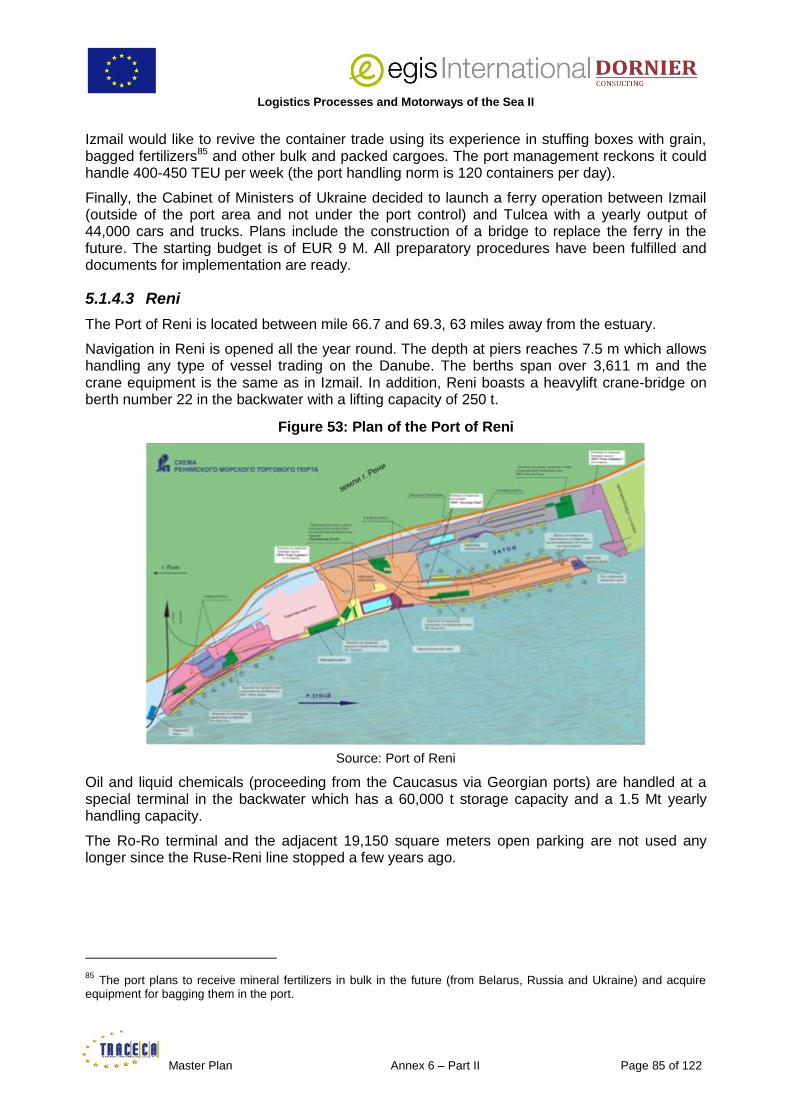
Logistics Processes and Motorways of the Sea II
Master Plan Annex 6 – Part II Page 85 of 122
Izmail would like to revive the container trade using its experience in stuffing boxes with grain, bagged fertilizers85 and other bulk and packed cargoes. The port management reckons it could handle 400-450 TEU per week (the port handling norm is 120 containers per day).
Finally, the Cabinet of Ministers of Ukraine decided to launch a ferry operation between Izmail (outside of the port area and not under the port control) and Tulcea with a yearly output of 44,000 cars and trucks. Plans include the construction of a bridge to replace the ferry in the future. The starting budget is of EUR 9 M. All preparatory procedures have been fulfilled and documents for implementation are ready.
5.1.4.3 Reni
The Port of Reni is located between mile 66.7 and 69.3, 63 miles away from the estuary.
Navigation in Reni is opened all the year round. The depth at piers reaches 7.5 m which allows handling any type of vessel trading on the Danube. The berths span over 3,611 m and the crane equipment is the same as in Izmail. In addition, Reni boasts a heavylift crane-bridge on berth number 22 in the backwater with a lifting capacity of 250 t.
Figure 53: Plan of the Port of Reni
Source: Port of Reni
Oil and liquid chemicals (proceeding from the Caucasus via Georgian ports) are handled at a special terminal in the backwater which has a 60,000 t storage capacity and a 1.5 Mt yearly handling capacity.
The Ro-Ro terminal and the adjacent 19,150 square meters open parking are not used any longer since the Ruse-Reni line stopped a few years ago.
85 The port plans to receive mineral fertilizers in bulk in the future (from Belarus, Russia and Ukraine) and acquire equipment for bagging them in the port.

Logistics Processes and Motorways of the Sea ll
Page 86 of 122 Annex 6 – Part II Master Plan
Figure 54: Port of Reni (Backwater on the Left and the Danube on the Right)
Reni has a design capacity of 14.5 Mt. The peak traffic was reached in 1989 at 10.5 Mt. Following the fall of Soviet Union and the crises in Yugoslavia, it collapsed to less than 2 Mt at the end of the 90’s. It slowly picked up again thereafter reaching 3,448 Mt in 2008 and declined again to 1,062 Mt in 2012.
Bulk cargo represents 90% of the total traffic (iron ore – over 30%, coal – more than 20%, corn – about 15%, fertilizers – 15% and liquid commodities 10 to 15%). Almost 85% of the port traffic is cargo in transit.
The only rail connection to Reni runs through Moldova over 292 km which means the port is very much dependent on the tariff policy applied by the Moldovan Railways. Besides the situation worsens at times of tense relations between Moldovan and Transnistrian Authorities leading for instance to an interruption of cargo deliveries to Reni between March and September 2006 and thereafter, to the implementation of up to EUR 1.5 per t extra-fee for transiting Transnistria86.
86
Reportedly the cargo carried to Reni represents some 60% of the total freight moved by the Moldovan Railways. In January 2012 Moldovan authorities announced they had plans for building a railway branch Marculesti-Soroca (55 km) bypassing Transnistria and shortening the path to Ukraine by nearly half (235 km). The EU, EBRD and EIB have been approached with the request to support this Euro 70 M project. At present trains in transit via Moldova enter at Ungheni, and then to reach Vinnitsa in Ukraine have to run an extra 450-km through Tiraspol and the Razdelnaya station checkpoint and finally through the northern part of Moldova. The Marculesti-Soroca stretch will connect Ungheni, Falesti, Balti, Marculesti with Soroca and Yampol (Ukraine).

Logistics Processes and Motorways of the Sea II
Master Plan Annex 6 – Part II Page 87 of 122
Figure 55: Port of Reni (Backwater)
The volume of traffic is also greatly affected by the re-orientation of cargo-flows in Ukraine and in Russia to/from ports closer to the steel-mills and mining areas due to the changing tariff policy of the railway companies and general deficit in railway wagons.
The construction of a direct railway track linking Reni directly to the Ukrainian railway network through Izmail is therefore of paramount importance for the survival and future development of the port87.
Due to this situation the port is trying to concentrate on cargo-flows moving via the Danube such as grain shipments from Hungary to Greece, metal from Austria to Russia, coal and ores from Constanza.
Empty containers are re-positioned by barge from Constanza via the Sulina Canal to the 94.36 ha Reni Free Economic Zone for stuffing Moldovan grain and shipped back full the same way down to Constanza.
Reni is also cooperating with Moldovan grain traders who, due to low water levels, load barges in Giurgulesti and send them to Reni for loading on ships.
The plans of development of the port include:
the attraction of truck traffic from/to Central and Western Europe and the renewal of Ro-Ro operations, with the upgrading, subject to State-funding, of the existing berth and ramp to receive and handle sea-going shallow-draft vessels of the Ro-8 class (33 trailer, 3/4 stern ramp) such as those belonging to CASPAR, in service between Baku and Aktau,
the revival of Ro-Ro services along the Danube88,
87 At the moment the port can unload 600 wagons/load 100 wagons per day.
88 The Ruse-Reni liner service was launched in 1993 in answer to the difficulties faced by truck drivers when crossing
Bulgaria and Romania. In those times the process of obtaining transit visas was long and expensive, Customs procedures were cumbersome and Customs officers much corrupted. This changed with the steps undertaken by Bulgaria and Romania towards the EU accession and their final accession in 2007 and the line consequently disappeared.
Logistics Processes and Motorways of the Sea ll
Page 88 of 122 Annex 6 – Part II Master Plan
expanding container activities using the existing port infrastructure and facilities to handle sea-river vessels of up to 170 TEU capacity,
boosting the development of the FEZ established for 30 years under the 2000-promulgated Law № 1605-III which would result in an increase in port traffic and diversification of the type of goods handled. 5 investment projects (carried out with domestic and foreign funds) have already been realized:
– Reconstruction of the existing cargo complex for the transshipment of coal tar and other viscous liquid cargoes (creosote oil, pyrolysis tar, pitch and bitumen, benzene) between rail cisterns and tankers (JSC ‘Ukrchem’),
– Grain complex for handling grain and fodder between hoppers and lighters including the construction of additional silos (JSC ‘Reni – Line’),
– Organization of laminated timber and lumber processing and granular fertilizer (urea, ammophos, potassium) handling (mixing, processing, packing in bags and big bags and transshipping) (PP ‘ReniLis’),
– Complex for loading, discharging and storage of liquefied hydrocarbon gases in the port of Reni (including the building of specialized river barges for the transportation of liquefied gases),
– Reconstruction of the facilities for diesel and fuel-oil bunkering operations (JSC ‘Transbunker – Danube’).
Owing to the ongoing financial crisis, other projects are pending:
‘DunayAvtoReni’: creation of an assembly line for the production of heavy and light-duty trucks,
‘DunayPromAhro’: construction of a plant for processing colza,
‘NPYK’ KorInTeh’: construction of a plant for processing used tyres,
‘Oil Refayneri Group’: construction of a terminal (including a tank farm pump station, a boiler, a railway by-pass track) for the transshipment of vegetable oils and biofuels for export by vessels,
‘Avtologistika’: construction of the afore-mentioned Ro-Ro berth, specialized terminal/bonded warehouse complex and railway line for the transshipment of up to 60,000 new cars from the EU to Ukraine, Russia and Central Asia.
Much of what has been said about the organization of work and administrative structure of Izmail also applies for Reni.
Still, the key issue affecting the operation of the port of Reni and its role in the transport corridors, including TRACECA, is the land access. The case of railroads has already been reviewed.
Regarding the motor roads, the part of the highway M-15 ‘Odessa – Reni to Bucharest’, and Ukrainian land route E-87, which pass through the city of Reni to the border with Moldova require only operational maintenance.
However, a 63 km (out of a total of 73) section of the P-33 road of national importance from Izmail to Reni has not been maintained for years.
Still some domestic and foreign trucks drive it to reach Romania and Bulgaria via Giurgiulesti and the bridge over the Danube. City streets are also in a poor condition (as well as in Izmail). Rehabilitation, in this case, has also a much important social dimension.

Logistics Processes and Motorways of the Sea II
Master Plan Annex 6 – Part II Page 89 of 122
6 CONCLUSIONS AND RECOMMENDATIONS
The present report tends to explain that a wide variety of factors, at international, regional and national levels affect the present and the future of river transport on the Danube. Development, in whichever direction, will bear also on the TRACECA Corridor as a whole: by way of example, the improvement of the navigation conditions, leading to the implementation of regular, reliable river container feeder shipping services from the Black Sea to Europe, may result in modal shifts and diversion of cargo-flows from one route to another, thus reducing the transit function of certain countries. Likewise, the enhancement of the Danube performance can entail an increase of the transit via the Volga-Don complex to the Caspian Sea, and reduce the transit cargo-flow via the Caucasus backbone central corridor accordingly.
In any case, there are lessons to learn.
The most important ones, in the Consultant’s view – applicable to all TRACECA countries – relate to approach and methodology. Mixing concrete – or melting steel for that matter – is a means and a result, definitely not the starting point of a well-thought business operation.
In other words, inasmuch as the Danube is concerned, infrastructure works are a fundamental prerequisite.
They are definitely needed along and around the river, first and foremost to prevent repeated natural disasters which often claim lives and thus to improve the socio-economic conditions of living of the riverside residents. At the same time these works aiming at securing an all-time better control of the water-flow should help stabilizing the conditions of navigation for all river-going crafts, including the merchant river fleet.
Nevertheless a strong political will and unabated support are necessary. The governments of Danube riparian countries at the highest level still have the duty to state very clearly which common goals they want to achieve and thus specify which balance they target and propose between social, environmental and economic factors. The EU has a great role to play in this respect and should perhaps be more deeply involved in such strategic decisions.
The sensitive environmental issue seems to be the stumbling block and a paralyzing factor in the proceedings. Being not a clear-cut case it should be placed in a broader perspective. Measures taken to mitigate the impact of infrastructure works for the sturgeon and other animal populations in the Danube are necessary and praiseworthy. Such questions should however not push in the background important topics such as the global necessity to foster a modal shift from land to inland waterway transport or prevent objective talks to determine whether it is safer and cleaner to produce electricity from nuclear power plants or from dams in the river.
It is clearly not up to the Consultant to make any recommendation with regard to such high-level, political matters. Yet, the uncertainty surrounding the future of the River is an element which has to be taken into account in the drafting of the Master Plan for the TRACECA Corridor.
Proposing its recommendations, the Consultant therefore assumes the above-mentioned questions have been answered.
For the river transport industry the above-mentioned works represent only a necessary and compulsory starting point of the whole development strategy.
The following is an attempt to sketch out some guidelines which might help reach commonly desired results in a quicker and more efficient way.

Logistics Processes and Motorways of the Sea ll
Page 90 of 122 Annex 6 – Part II Master Plan
6.1 Working Guidelines
6.1.1 Taking the Logistics Dimension into Due Account
In today’s economy, the wording ‘supply chain’ has replaced the simple term ‘transport’. This goes beyond vocabulary and means that, contrary to what used to happen in the past, when fully finished products were delivered straight from manufacturer to consumer, now, semi-finished products are delivered from an original manufacturer to a chain of logistics suppliers, who became part of the industrial process and do not provide only the usual transport/storage/distribution functions but also added-value services, such as quality control, sorting, labelling, packing, assembling, certification and, finally, delivering a nearly-finished product to an end manufacturer who stamps/brands/names, markets and sells.
In this context, transport, though important, tends to represent a minor part of the overall process.
The focus is on gathering of and combining at selected dedicated spots the greatest number of different but complementary services and competences providing the highest possible added-value contribution to a specific supply chain.
Best examples of the integration of logistics in the manufacturing process in the EU are found in the automotive industry which is outsourcing an increasing part of its production to 4 and 5PL, who assemble and manage the resources, capabilities, and technology of their own organizations and other organizations to design, build and run comprehensive supply chain solutions ensuring just-in-time deliveries in full interaction with the upstream suppliers and their final customers through tailor-made IT systems.
To place the logistics concept in a different perspective, where statisticians once used to divide and evaluate the economy of a country between ‘agriculture’, ‘industry’ and ‘services’ sectors, ‘logistics’, today, gather them all, ‘production’ or ‘manufacturing’ as well as ‘marketing’, ‘sale’ or ‘advertising’ being only part of a total integrated and scheduled process. This process – when efficient – entails a reduction in lead time as well as production and successive inventory costs and therefore a decrease in sale prices and a smashing (and forecasted) mass-market effect.
Therefore, Romanian and Bulgarian ‘inter’ and ‘multi’-modal terminal terminologies – already noted as too restrictive, as they address more specifically the transport rather than the industrial issue – look also somewhat out-dated and too general. They would need being reconsidered and the corresponding strategies shifted to the more modern concept of Logistics Centres, described as above, re-assessing the needs not only in terms of transport links and means but also global forecasted economic development.
Danube river ports being, with few exceptions, mostly located in non- or not much industrialized areas, their managements must realize that though necessary, berths, cranes and storages are no longer attractive enough assets and must be complemented by other services and facilities matching as closely as possible the specific needs and requirements of the customers they target for their ports. Somat Vidin Autoferyboat Terminal, for instance, represents a promising implementation of this new conceptual approach.
Inland ports have difficulties in marketing their services efficiently by themselves. They need the help of logistics integrators to build up transport chains and attract the interest of the shipping industry. Also it will be easier for them if they join forces and co-operate with seaports.
6.1.2 Involving Users and Operators
The lack of dialogue and involvement of the Users and Operators representing the private sector has been pointed out on several occasions in this report (as well as in, practically, all other reports produced by TRACECA Projects). There is a risk that national strategic plans,

Logistics Processes and Motorways of the Sea II
Master Plan Annex 6 – Part II Page 91 of 122
drawn somewhat unilaterally at technocratic level, miss the focuses of the business community. It must never be forgotten that Users and Operators are the final decision-makers in the transport process and choose the modes and corridors they consider the most efficient in all respects regardless of the policies the States implement. Besides, the decision-making process in a globalized economy migrates from the micro to the macro-economic level and from local to regional or international units outside of the countries where the decision will be applied.
Permanent consultation with the trade and the transport industry representatives allows identifying their needs and expectations, to learn in which direction they plan their development, to understand what they perceive as main barriers and obstacles in the performance of their activities, why they use certain routes and not others, etc. Such information, consolidated and regularly up-dated, can definitely help improve the design and efficiency of transport strategies and models at the national level, increase the cost-effectiveness of public infrastructure investment and thus provide for a better use of state financial resources.
The Romanian and Bulgarian Transport Strategies under review are illustrative examples of the need for a behavioural change: both detail at length the socio-economic and environmental advantages of inland waterway freight transport as compared to overland modes, but completely ignore the role and place of their own river shipping companies in the process and their possible difficulties.
There is not even the slightest mention of CNFR Navrom (52 pushers and 348 barges among a host of floating crafts of all types/10 Mt traffic p.a.), the biggest Danube shipping company, in the Romanian document.
Meanwhile the Bulgarian one briefly mentions BRP89 which, ‘competing with established world operators’ … ‘suffered a deterioration of their market positions because of the unfavourable age structure of the merchant fleet90 91without providing any hint as to how possibly remedy to this situation.
Both these companies are now private92. This does not mean they do not need (as well as other river operators) a support of their respective Authorities to deliver the service implicitly expected from them in the Strategy papers. To be able to talk about support of any type (not necessarily financing93), they need, first, to be taken into account and heard. Renewal, modernization and development of the existing river fleets to better meet the existing and future market demand
89
100 barges, 30 pushers, 3 ferryboats, 2 car-carriers (for up to 250 medium-size/280 small size cars) and 2 oil tankers. BRP carries on average about 1.4 MT per year on the Danube, 40% being export-import from/to Bulgaria and 60% international cross-trade. BRP operates, for the Bulgarian part, the Varna-Port Kavkaz rail-ferry in partnership with Navigation Maritime Bulgare. BRP was also the leading container feeder on the Danube, carrying some 4,000 TEU per year from Constanta to Belgrade.
90 Strategy for the Development of the Transport System of the Republic of Bulgaria until 2020, page 21.
91 As a matter-of-fact this does not correspond to the reality. BRP deeply modernized its fleet over the past few years
having, in particular, Caterpillar (CAT) engines supplied by Zeppelin, Germany, installed on the pushers. Zeppelin having trained BRP technical staff, BRP, in turn, is now assisting Zeppelin for servicing CAT marine and port engines in Bulgaria, Romania and Serbia.
92 Navrom has been privatized in 1998 and BRP in 2006.
93 There are, for instance, complaints about the way Ukrainian river fleets head up for the Danube in winter when the Dnepr is frozen and compete at, reportedly, unfair/dumping conditions while Danube river shipping companies are not welcome on the Dnepr (as well as on Russian rivers) and, practically, can’t trade there due to administrative hassle and other barriers imposed by local Authorities. Another reason is the high cost of port and stevedoring expenses in Ukraine and Russia. Izmail is described as the most expensive Danube port where, for instance, loading of coal cost 7 USD/t (equivalent of Euro 5.2/t) in 2012 while the average freight rate Izmail-Ruse for this very coal is only 6 USD/t equivalent of Euro 4.4/t).
Logistics Processes and Motorways of the Sea ll
Page 92 of 122 Annex 6 – Part II Master Plan
and vocational training and studies for shore and river staff to name only a few examples should represent an important component of the strategies.
Therefore freight forwarders, logistics services providers, road and rail transport operators, river and sea ports and shipping companies, terminal operators, both national and foreign, from the public and private sector, and their corresponding business associations, should be given more opportunities to have their say and make their proposals.
As repeatedly underlined, where the private sector apparently fails to understand what are the stakes, governmental agencies and state organizations (such as national private-styled companies in Romania) should, for the sake of promoting the development of the river ports they manage94, and although this may sometimes exceed the scope of their assignments, be a driving force and endorse initiatives aimed at promoting inland waterway transport, fostering, for instance, a dialogue with container shipping lines and convincing shippers and forwarders of inland waterway transport advantages.
6.1.3 Capitalizing on European Experience
The European shipping industry has gone a long way testing, experimenting and implementing different policies to promote the inland water way mode. Yet, as the figures in Appendix 2 prove, large-scale results at the EU level remain to be seen. While the demand for freight traffic has been growing steadily since 2000 (except in 2008 and 2009), rail market shares continue to dwindle and inland water way ones remain at best stable, meaning nearly all of the extra traffic is absorbed by the roads.
Still, some countries are far more advanced than others and have long ago brought a high level of support to their inland water ways system: for instance, the share of inland water way transport in total inland freight transport performance measured in tonne-kilometres grew from 10.9% in 2000 to 14.3% in 2009 in Belgium and from 32.9% to 35.1% in the Netherlands.
Such achievements are partly the result of authoritative state policies aiming at restricting the use of road transport through measures such as increased safety requirements for trucks, social measures in favour of truck drivers, tolls (such as the LKW Maut in Germany collected on all trucks over 12 t using the motorways (Autobahnen), based on the pollution class of the vehicle, its total weight, number of axles and route)95.
Apart from big public infrastructure projects such as the Seine-Nord Canal (given the status of a TEN-T Corridor) linking Paris to Antwerp and Rotterdam, they also stem from specific projects undertaken by regional governments. As examples:
the German Land of Nordrhein-Westfalen has launched many plans in favour of inland water way transport since the Federal Government commissioned the 2002 study carried out by the Planco Institute (Essen) on future prospects for the inland waterways which triggered an intense debate on necessary measures in this particular branch of the transport industry. As recently as in October 2011, having determined its container traffic would keep on increasing at a pace of 5.5% p.a. until 2025, and considering road and rail reached their maximum capacity, the Land announced a new initiative for inland shipping to bring together logistic experts and shippers to develop stronger commercial, logistical and telematic training opportunities. Despite present budgetary restrictions, it
94 As already mentioned, in Romania, the RIA could, in the future, also take an active part in organizing such meetings between stakeholders.
95 Tolls may have reverse effects: the introduction of the LKW Maut in 2005 has deterred some trucks off the Autobahnen onto other roads, resulting in additional noise and congestion on these routes.

Logistics Processes and Motorways of the Sea II
Master Plan Annex 6 – Part II Page 93 of 122
further decided to invest EUR 5.2 M the extension to the west of the Mittelland Canal, and around EUR 7 M the development of the Rhine-Herne and Datteln-Hamms canal.
In Belgium, the region of Wallonia has a specific IWT plan covering the period 2008-2013 supporting:
– the modernization of the fleet (low-emission engines, radar, GIS, RIS, autopilot equipment, telescopic bridge, steel bottoms holds, ship’s hold coating and container capacity),
– the construction of transshipment facilities (acquisition of land, infrastructure, conveyor belts),
– the implementation of regular container services.
Flanders has, among many other incentives, developed a PPP scheme for the construction of loading-unloading facilities, the Kaaimuren (quay walls) program (2005-2010 then extended to 2016), targeting to shift more than 400 Mt of freight from the roads to Flemish waterways.
Also, a specific grant program has been set up for waterway operators to invest in the refurbishment of their barges. Half of Flemish ships have been modernised under the scheme, despite the economic downturn.
The same type of programs now exists in practically all Western European countries with an IWT potential.
In the southern Netherlands, inland ports have been co-operating for years together with other logistics providers enhancing the role of IWT in empty container logistics or the transport of waste and gathering bigger consignments suitable for transport via the inland waterways by grouping together smaller orders more suited to the roads.
Another driver is the changing attitudes emerging in the shipping and logistics industry. As an example, major EU seaports find it hard to cope with the growth in container transshipment and set modal split targets for containers up to 45% by IWT, as waterways are the only way to bypass saturated land networks. Such moves are supported, at EU-level, through dedicated programs such as the INTERREG IVC Port Integration Project (2010-2012).
Rather than referring to EU directives, papers, communications and other documents as a sort of sanctified vade mecum, liaising directly with West-European public and private organizations involved in the process of promoting IWT, and accessing practical information summing up decades of accumulated experience would certainly help Romanian and Bulgarian sea and Danube river ports plan their development more efficiently, identify their synergies, draw joint plans for reaching better results for them all, learn and avoid typical mistakes, save time, and, again, ensure an optimal use of their human and financial resources.
6.1.4 Developing Regional Cooperation
The Western example also demonstrates clearly that best solutions are found and implemented when stakeholders join forces at both regional and transnational levels.
TRACECA countries on the Danube would gain cooperating together, identifying their common strengths and weaknesses, and highlighting their synergies to work out joint plans which would produce better results for them all, rather than having each one mulling possibly overlapping projects on its own.
Meetings on such technical matters as the improvement of the conditions of navigation or topo-hydrographic measurement systems are definitely necessary. However there should also be multi-lateral regular meetings of concerned stakeholders on port, fleet and commercial

Logistics Processes and Motorways of the Sea ll
Page 94 of 122 Annex 6 – Part II Master Plan
developments, transport and logistics plans and projects enabling the Governments to coordinate their strategies and spending, aligning thus better with the EUSDR approach.
Competition does exist, however not among Lower Danube countries. The real threat, for all Danube stakeholders, comes from other European regions trying to attract and divert the Danube traffic to alternative routes and modes.
Upper-Danube cargo-flows are naturally attracted to North European ports, and particularly to Hamburg, for historical, cultural, and economic reasons. Then, it must be remembered that first the UN sanctions on Serbia from 1993 till 1996, followed by the useless NATO 1999 bombing of 8 bridges in Serbia (with the clearance of the debris and reopening of the Novi Sad section completed in 2003 only), have heavily contributed to shifting a lot of cargoes (mainly, but not only, bulk) from the river to the rail.
The war was also an extraordinary stroke of luck for the sleepy North Adriatic ports.
Turkish road trucking companies willing to avoid the Balkans set up UN Ro-Ro which started plying a regular service to Trieste while other Ro-Pax services from Greece to Venice, Ancona and other Italian ports in the Adriatic Sea expanded dramatically.
Container feeder services began developing from Central Mediterranean hubs (Malta, Gioia Tauro, Taranto) to all ports from Trieste to Bar (Montenegro) for serving Central European markets. With the return of peace and stability and resurgence of economy in the Balkans, volumes rapidly increased, leading to the opening of deep-sea container lines between the Far-East and Eastern Adriatic ports.
One of the big winners, and the most commercially aggressive, is the, once very small, Slovenian port of Koper (Lula Koper). Container traffic jumped from 86,679 TEU in 2000 to 570,744 TEU in 2012 with practically no decrease between 2008 – 353,880 TEU and 2009 – 343,165 TEU (compare with Constanza figures).
Lula Koper, given its geographical position among very close competing ports (the distance to Trieste is 8 nautical miles and to Venice 60 nm only across the Adriatic sea), understood from the beginning that to attract and secure the traffic it had to develop services in addition to those a port usually offers. New block container train operations are launched every year. Koper today boasts the following connections:
SLOVENIA (Ljubljana) daily train
HUNGARY (Budapest) up to 15 trains/week
SLOVAKIA (Bratislava, Zilina, Dunajska Streda) up to13 trains/week
AUSTRIA (Graz) up to 6 trains/week
POLAND (Wroclaw) 1 train/week
ROMANIA (Arad) 1 train/week
SERBIA (Belgrade) 2 trains/week
AUSTRIA (Villach) + GERMANY (Munich) 5 trains/week
In September 2011 a weekly connection was inaugurated between Koper, Ljubljana and Yana-Sofia.
And since October 2011 a weekly service connects Koper to Vienna and Doborwa Gornicza (Poland). In March 2012 this route has been extended with a weekly service from Slawkow (Poland) across Ukraine to Bryansk (Russia).
Koper is therefore directly competing with Constanza and the Lower and Middle Danube.

Logistics Processes and Motorways of the Sea II
Master Plan Annex 6 – Part II Page 95 of 122
Generally, Adriatic ports and regions are increasingly focusing on Danube and Eastern Europe countries: within the frame of the SEE, the EU is financing the March-21012 ending Adriatic-Danube Clustering project. This included a logistics chapter where Slovenia promoted its port and the function of the country as a gate and transit path between Adriatic and Central and Eastern European regions (up to and including Romania and Bulgaria).
Last, developing TRACECA Corridor along the Danube also calls for a closer dialogue between Romanian, Bulgarian and Georgian stakeholders as a first step.
Excepting Ukraine, container traffic between the Western and Eastern banks of the Black Sea remains so far limited to the small direct trade between the 3 countries. It will remain so until block container trains start running through Caucasus then through Kazakhstan, which will unlock the possibility to handle steady significant flows of containers in transit between Europe, the Caucasus, Central Asia and Western China.
This, in turn, may represent the awaited opportunity to set up large-scale container feeder operations along the Danube via Constanza, provided navigation conditions are improved.
Taking into account on the one hand the probable resumption of the Burgas-Poti Ro-Ro service – albeit with a different operator – and, on the other hand, the fact the 3 TRACECA countries implemented or plan to launch Ro-La services, they may start working on defining the best possible (future) transit conditions for truck-flows between Europe and the Caucasus, such as simplified customs and transit formalities (based on the IRU-TIR EPD for TIR trucks, already used by Romania and Bulgaria, and on the NCTS already in use in all EU countries) or through transport rates (Arad-Tbilisi/Yerevan for instance).
In this latter respect, designing and implementing a simple commercial agreement which along an important segment of the Corridor would legally bind ports, terminals and operators of different transport modes such as railway companies and shipping lines, operationally (in terms of quality of service) and financially (in terms of competitiveness of tariffs), as currently happens anywhere else in the world, would be a major breakthrough for TRACECA.
The field-missions, meetings and interviews carried out during out during this Case Study allowed the Consultant to envisage few possible market developments which are presented hereafter.
6.2 Potential Markets, Customers and Services
In the following analysis no segregation is made between TRACECA and non-TRACECA projects as they usually mingle together.
6.2.1 Renewal of the Ro-Ro Service Bulgaria-Georgia
This has been described and commented before. The emphasis here is laid on another aspect.
A poor road network, entailing a lot of fatalities and high environmental and social nuisances has so far spurred Bulgaria to refrain from being a transit country. The important development of tourism (including an increasing third-age retirement of foreigners in the country) has probably played a role as well in the governmental policy of reducing foreign truck traffic on a number of Bulgarian roads. Nonetheless the situation has evolved: first the measures implemented years ago start to bear fruit and the motorway network is visibly and rapidly growing. Then the country still faces the problem of a decreasing population and increasing infrastructure maintenance expenses. Therefore, it can be assumed that, in order to generate additional revenues, the transit function of the country will soon be back in the limelight.
Measures favouring the flow of transit-cargo through Bulgaria would, in general, represent a major support to the development of the sea ports of Varna and Burgas and strengthen the position of the TRACECA Corridor.
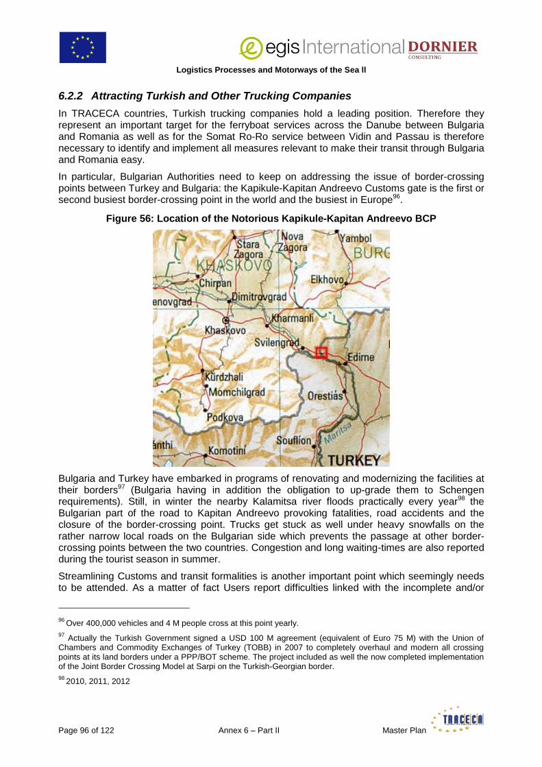
Logistics Processes and Motorways of the Sea ll
Page 96 of 122 Annex 6 – Part II Master Plan
6.2.2 Attracting Turkish and Other Trucking Companies
In TRACECA countries, Turkish trucking companies hold a leading position. Therefore they represent an important target for the ferryboat services across the Danube between Bulgaria and Romania as well as for the Somat Ro-Ro service between Vidin and Passau is therefore necessary to identify and implement all measures relevant to make their transit through Bulgaria and Romania easy.
In particular, Bulgarian Authorities need to keep on addressing the issue of border-crossing points between Turkey and Bulgaria: the Kapikule-Kapitan Andreevo Customs gate is the first or second busiest border-crossing point in the world and the busiest in Europe96.
Figure 56: Location of the Notorious Kapikule-Kapitan Andreevo BCP
Bulgaria and Turkey have embarked in programs of renovating and modernizing the facilities at their borders97 (Bulgaria having in addition the obligation to up-grade them to Schengen requirements). Still, in winter the nearby Kalamitsa river floods practically every year98 the Bulgarian part of the road to Kapitan Andreevo provoking fatalities, road accidents and the closure of the border-crossing point. Trucks get stuck as well under heavy snowfalls on the rather narrow local roads on the Bulgarian side which prevents the passage at other border-crossing points between the two countries. Congestion and long waiting-times are also reported during the tourist season in summer.
Streamlining Customs and transit formalities is another important point which seemingly needs to be attended. As a matter of fact Users report difficulties linked with the incomplete and/or
96
Over 400,000 vehicles and 4 M people cross at this point yearly. 97
Actually the Turkish Government signed a USD 100 M agreement (equivalent of Euro 75 M) with the Union of Chambers and Commodity Exchanges of Turkey (TOBB) in 2007 to completely overhaul and modern all crossing points at its land borders under a PPP/BOT scheme. The project included as well the now completed implementation of the Joint Border Crossing Model at Sarpi on the Turkish-Georgian border.
98 2010, 2011, 2012
Logistics Processes and Motorways of the Sea II
Master Plan Annex 6 – Part II Page 97 of 122
insufficient vocational training of Bulgarian Customs officers to EU Customs rules and lengthy procedures and restrictions of the Turkish Customs resulting in unnecessary delays (reportedly up to 3 days) and hassle in both countries99.
6.2.3 Developing Ro-La Offer Through the Balkans
It has been noted that both Romania and Bulgaria have taken serious steps to improve the condition and layout of their respective road networks. Rehabilitation and modernization however represent a considerable amount of work and it will take years to complete them.
It is hoped the GFC will meantime subside and the economy pick up which will result in an increased demand for freight traffic and bottlenecks and congestion on the road networks (see Appendix 4 – Road traffic in Romania, forecasts for 2015). The full implementation of EU regulations with regard to road transport and particularly the ban on truck driving during week-end will make things even worse. On its side, the trucking industry will be faced with growing costs due to longer travel-times, the possible introduction of tolls on certain roads, etc.
To anticipate such situations, it would thus be in the common interest to take measures now to operate a significant modal shift such as expanding the limited available Ro-La services through Romania and Bulgaria. It would be, for instance, reasonable for the privatized CFR Marfa to extend its Arad-Bucharest Ro-La service to Constanza. This would possibly make a shipping service between Turkey and Constanza viable (and more attractive as the unfortunate one launched by UN Ro-Ro in 2011) as it would allow trucks moving between Turkey and other European countries through Romania to benefit from a seamless transport offer from Turkey up to Hungary.
Implementing Ro-La operations between Halkali (Turkey), Sofia, Dragoman and Vidin100 would represent a major step forward for boosting the transit cargo-flow through Bulgaria and support the development of Ro-Ro services between Vidin and Central and Western Europe on the Danube.
In turn this may also benefit the sea ports and Ro-Ro services across the Black Sea along the TRACECA Corridor.
6.2.4 Container Feeder Services on the Danube
A number of studies have tried to demonstrate that Central, Western and even Northern Europe could be reached from Constanza via the Danube in no more time and at a cheaper or equivalent cost as via the traditional shipping routes across the Mediterranean and Adriatic Sea, the Atlantic Ocean and North Sea. The best reference remains the 2006 COLD (Container Liner Service Danube) Project led by Via Donau (Vienna).
The purpose here is not to discuss the merits of the study, which, anyhow, would need being up-dated.
The conclusion formed by the Consultant may be summed up as follows:
99
As recently as in May 2013 angry Bulgarian truckers organized a 2-day blockade at Kapitan Andreevo. Tensions led the government to deploy 200 gendarmes while the Bulgarian Minister of Transport had to travel to the BCP to negotiate the end of the blockade with the truck drivers after finding an agreement with the Turkish authorities on the lifting of certain restrictions.
100 Reportedly, BDZ has plans to implement Halkali-Dragoman Ro-La service.

Logistics Processes and Motorways of the Sea ll
Page 98 of 122 Annex 6 – Part II Master Plan
the success of containerized transport rests first and foremost on the quality of the service provided by container shipping lines in terms of frequency, regularity and reliability i.e. guaranteed transit-times between distant ports,
this matches the requirement for just-in-time deliveries within a supply chain,
the conditions for ensuring this quality of service on the Danube on a permanent basis are not met today due to highly fluctuating conditions of navigation resulting from the weather circumstances and corresponding hydrological situation of the river (flooding, drought, ice),
albeit congested at times, EU major North European ports are not saturated. Furthermore they are implementing solutions, such as direct delivery on block container trains as well as despatching containers by water way to inland dry ports and logistics facilities, which enable them to increase the volume of traffic they handle now. These inland outlets may even be dedicated to specific customers/trades which enhances the link between the Port and its Clients. The same applies with empty equipment, containers being left at inland depots thus freeing storage capacity in the port area,
for all the above reasons, it seems therefore doubtful the trade between the Far-East and Europe could at the moment consider changing its deep-sea routing for the route via the Danube.
This will happen only if and when:
the necessary infrastructure works have been completed and the equipment acquired, enabling to guarantee an uninterrupted navigation on the Danube, all the year round, round the clock at a guaranteed minimum draft,
sustainable alternative solutions, such as block trains between Constanza and the main inland destinations on the Danube, will be in place101,
it will become possible to ship containers on the Eurasian route via the TRACECA Corridor on block trains and container vessels through the Caspian and Black Sea all the way from Western China to Europe and back.
6.3 Maritime and Lower Danube Clusters
The 5 main ports on the Maritime Danube, Braila, Galati, Giurgiulesti, Reni and Izmail are very close to each other.
Giurgiulesti, a port built in recent years, is the most dynamic due to its strategic role as the only port of Moldova.
Reni (20,000 inhabitants) and Izmail (85,000 inhabitants) became the Soviet gates to the Danube after the region was definitively incorporated in the USSR in 1947. Until the fall of Soviet Union and crash of the cooperation between socialist countries they were important ports. After Ukraine and Moldova became independent along the administrative borders they had during Soviet times, the region where Reni and Izmail are situated, the Budjak, was practically cut from the rest of the country, linked to Ukraine by only 2 bridges, one of which can be accessed only through the territory of Moldova.
101
In 2005 when NordMarine, initiator of the first container service, started, low water problems compelled them to truck and rail containers to final destination at their own expense. This obviously resulted in heavy losses which could not be predicted and which no private company can afford to bear in the long-run.

Logistics Processes and Motorways of the Sea II
Master Plan Annex 6 – Part II Page 99 of 122
Figure 57: Budjak Region
Izmail hosts the headquarters of former-Soviet UDASCO (Ukrainian Danube Shipping Company), now renamed UDP, the biggest shipping company in Ukraine and one of the biggest on the Danube, with a fleet of over 600 floating crafts of all types from specialized pontoons for carrying super heavylifts to barges and river self-propelled vessels, sea-river and sea-going vessels including small reefers and feeders and passenger river-cruising vessels. UDP controls the Kiliya Shipbuilding/Shirepair Yard which builds barges, river vessels and coasters.
Due to its geographical position as well as for historical reasons, UDP is playing only a very little role in Ukraine international sea-borne trade. Most of its activities consist in cross-trade at sea (mostly in the Mediterranean and Black Sea), and, of course, transport on the Danube of cargoes discharged from sea-going and sea-river vessels at Reni and Izmail.
The 2 ports have inherited of an infrastructure and equipment designed for the trade of Soviet Union with the Socialist countries on the Danube102. This is somewhat over-dimensioned and under-utilized today, especially with the ongoing crisis103 104. In Reni there is a ferryboat complex where from 1993 till 2006 were handled BRP Ro-Ros plying the service to Ruse in 48-50 hours (the downstream voyage lasting from 20 to 24 hours).
102 Reni was among the 6 biggest ports of USSR. 103 Reni boasts a 250 t heavylift bridge crane. 104
Reni has a design capacity of 14.5 Mt and Izmail 8.5 Mt. In pre-crisis years about 7 Mt were handled at Izmail while turnover at Reni today barely reaches 1.5-1.7 Mt.

Logistics Processes and Motorways of the Sea ll
Page 100 of 122 Annex 6 – Part II Master Plan
Figure 58: Ferryboat Complex at Reni
Source: Commercial Sea Port of Reni
Both Izmail and Reni predominantly handle bulk (iron ore concentrate, pellets, coal, coke, fertilizers, chemical, grain) and breakbulk cargoes (metal scrap, steel and paper products). Raw and mineral oil and liquefied gas are also discharged at Reni.
While Braila and Galati may hope for better connections with the rest of Romania in the future, Reni and Izmail are and will remain geographically isolated, far away from the big Ukrainian industrial centres, cities and conurbations and commercial routes and, as already seen, scarcely linked by road and rail to the main networks.
The upgrading to highway of the dilapidated 261 km road connecting Odessa to Reni has been in the plans of UkrAvtoDor (the Ukrainian State Agency in charge of road construction and maintenance) for the past 10 years. In 2007 the Ukrainian Government has declared it a priority infrastructure investment to be completed by 2011. To date, works have not begun.
Much more than for the other Maritime Danube ports, the future of Reni and Izmail – unless the Ukrainian Government does implement some voluntary development policy in the Budjak Region – rests with and only with the River.
Other recent developments have to be considered.
Ever since their country became independent, Moldovan traders have – justly – complained that, for various unclear reasons, the cost of hauling a container from nearby Odessa port to Chisinau (177 km) was as – or more – expensive as to bring it from China to Odessa. As a result the Giurgiulesti International Free Port (GIFP) finally took the brave decision to build a container terminal (opened in late 2011), signed a feedering agreement with number 2 world container shipping line Mediterranean Shipping Company (MSC), chartered a vessel and launched in January 2012 a weekly regular service between Istanbul and Giurgiulesti to serve the Moldovan market. On her maiden voyage the vessel loaded back from Giurgiulesti to Istanbul 22 containers stuffed with Moldovan grain destined to Taiwan. Since then the pattern of the service changed many times but held.
Logistics Processes and Motorways of the Sea II
Master Plan Annex 6 – Part II Page 101 of 122
The implementation of this container operation represents a great opportunity for Maritime Danube ports to establish a regional cooperation.
As anywhere else, there should be fluctuations in the Moldovan foreign trade over the year for seasonal reasons notwithstanding the market, currency and political situation. Also, Moldovan exports are limited both in volume and variety whereby filling a vessel forth and back at each and every voyage to and from Giurgiulesti may prove difficult.
It could thus be in the advantage of the 5 ports to meet and assess what each of them could bring into the common basket to stabilize the operation and, undoubtedly, develop it further.
Based on the Moldovan example, Romanian as well as Ukrainian stakeholders could find ways to attract directly to their ports the goods consumed in their catchment areas and containerize part of their exports without resorting, as they have to do today, at probably higher costs for imports and lower revenues for exports, to the main sea ports in their respective countries (Constanza, Odessa, Iliychevsk).
In a broader perspective, this would provide a possibility for Romanian ports to start implementing gradually a Logistics Centre concept, for the Ukrainian ports to increase and diversify their traffic, for GIFP to optimize the cost-effectiveness of its operation.
Finally, this might constitute a basis for a Maritime Danube Cluster (MDC) which could be later extended to other economic areas of common interest, fostering, for instance a cooperation between local SMEs working for the shipyards located on the Maritime Danube (Sulina, Kiliya, Galati).
To achieve these targets however, a politically-supported comprehensive and objective SWOT analysis of the situation must be first carried out at national level then at regional level between the participating countries. Geopolitical changes, for instance, have not altered the conception of Ukraine with regard to its role and the role of its ports in the Danube region. As a result administrative and managerial behaviours, working procedures and business plans are still very much based on the principles and approaches of the Soviet period such as State centralized planning, decision-making and tariff-policy making notwithstanding absence of involvement and cooperation with the private sector. Even worse, the centralized system is producing counter-effective results as Reni and Izmail are now in a situation where they have to compete with each other for survival.
The successful development of Giurgiulesti may help meet the present needs and requirements of the Moldovan economy. Still, the potential for further expansion is limited both in terms of berthing and handling space as well as in terms of accessibility. It should therefore be understood by Moldovan stakeholders as a whole that to enhance the function of Moldova as a transit country and keep reaping the fruit of corresponding cargo-flows a permanent cooperation with Ukrainian stakeholders in general and the port of Reni in particular is necessary. Any decision by the Ukrainian Authorities leading to the construction of the rail link between Izmail and Reni or to the freezing of activities at Reni and concentration of resources on the development of Izmail would result in substantial financial and job losses for Moldovan Railways.
Dialogue is necessary to identify synergies and work out together solutions which will bring about a greater efficiency and also to streamline and harmonize plans of development. This, in turn, may help optimize and reduce the volume of investment necessary to make the MDC a success story.
Provided the 4 TRACECA Countries and 5 Ports express a committed interest to such a project, the support of the EU should be sought through the appropriate channels to bring a technical assistance for its implementation in the same way as for other similar projects such as, for instance, the SEE Adriatic-Danube Clustering (ADC). The direct involvement of the EU would

Logistics Processes and Motorways of the Sea ll
Page 102 of 122 Annex 6 – Part II Master Plan
help prevent the repetition of the unsuccessful implementation of various projects and aborted Danube regional cooperation fostered via the Euro-region scheme which is bitterly resented by local Authorities.
The same scheme may apply with the Lower Danube river ports (Giurgiu and Ruse to start with).
Logistics Processes and Motorways of the Sea II
Master Plan Annex 6 – Part II Page 103 of 122
7 APPENDIXES
Appendix 1: Bystroe Canal Story
Historical Background
The Danube Delta was designated an Internationally Important Wetland and UNESCO World Heritage Site in 1991, due in part to its importance to millions of migratory birds. The Bystroe Canal, in this same Danube Delta, was among the main Ukrainian waterways until 1959, when its exploitation stopped due to natural silting.
In 2003 Ukrainian authorities proposed to reopen it and started work with the intent of digging a deep-water route under their control from the Black Sea to the Danube River to reduce (their) ship transit costs105 to their own ports on the Danube.
Various international bodies and NGOs then determined that dredging the Bystroe Canal would likely have a significant negative impact on the Danube Delta ecosystem, about 80% of which is in Romania. In July, 2006, the UNECE Environmental Impact Assessment International Inquiry Commission, in accordance with the Espoo106 Convention on Environmental Impact Assessments in a Transboundary Context which was signed by 42 countries (including Ukraine) and entered in force in 1997, unanimously (including Ukraine) concluded that work on the Bystroe Canal would indeed have a significant, negative transboundary impact. The UN Commission cited the loss of floodplain habitats for spawning fish and nesting birds, the impact from the increased concentration of suspended sediments on fish downstream, and the muddier waters resulting from dumping sediment into the Black Sea. The Commission recommended steps on cooperation to assess and mitigate the environmental damage caused by the dredging.
Behind these ecological concerns however, lurked another disagreement between the two neighbours about their littoral borders, unsolved ever since Soviet Union disappeared: the status and ownership of Snake Island (Insula Serpilor in Romanian language, as shown on the map next page).
Until 1948, Snake Island was considered part of the Romanian coastal city of Sulina. In 1948, the Soviets forced the Romanian side (occupied by Soviet troops) to accept the ‘transfer’ of Snake to the Soviet Union, as well as to accept to move the Romanian border in the Danube Delta to the west, in favour of the USSR.
Romania has strongly disputed the validity of this ‘treaty’, since it was never ratified by any of the two countries, which would make Snake and Limba islands de jure Romanian territory.
Following the collapse of the Soviet Union in 1991, Ukraine inherited control over the islands and to re-enforce its claim over Snake 0.17 km2 territory, established a rural settlement there in 2007.
105 Through the (Romanian) Sulina Channel. A comparison of charges is displayed at the end of this Annex. 106
The city in Finland where the Convention was signed.

Logistics Processes and Motorways of the Sea ll
Page 104 of 122 Annex 6 – Part II Master Plan
The status of Snake Island was important for the delimitation of the continental shelf (which supposedly contains large deposits of oil and gas) and exclusive economic zones between the two countries. If Snake Island was recognized as an island, then the continental shelf around it should be considered as Ukrainian water. If not an island, but a cliff or rock, then, in accordance with international law, the maritime boundary between Romania and Ukraine should be drawn without taking into consideration the isle location.
On 16 September 2004 the Romanian side brought the case against Ukraine to the International Court of Justice in the Hague. On February 3, 2009, the court delivered its judgment, which divided the sea area of the Black Sea along a line which was between the claims of each country. The court concluded that Snake Island is not an island, therefore it ‘should have no effect on the delimitation in this case, other than that stemming from the role of the 12-nautical-mile arc of its territorial sea’.
Recent Developments
In March 2011, the Ukrainian media reported alleged plans by Romania to use their geographical position and the above-mentioned international environmental agreement to close the Bystroe Canal during the summer (an active period for sea-river transportation). They also claimed that, since 2007, when works resumed for clearing the consequences of deepening and flooding the channel, as well as strengthening the coastline, the canal had no disastrous impact on the environment.
Apart from credible environmental worries, this line of action by Romania (which neither was ever officially confirmed nor applied by Romanian Authorities) seems to have an economic ground: notwithstanding the above-mentioned (as yet unproved) fossil fuel resources, the number of vessels plying the Bystroe Canal now exceeds at times the number of vessels going via the (once monopolistic) Sulina’s one, owing, also, to the morphological features of the latter which do not allow both-way traffic all the day long.
Romania, again according to Ukrainian political circles and media, earlier claimed several small islands on the Bystroe Canal fairway and giving control over it, the largest being the uninhabited island of Maikan between Kylia and Vilkovo (see map above).
In this dispute, Romania receives – logically – the sympathetic support of the EU to which it belongs – though the EU is keen not to alienate Ukraine, a candidate to membership’s accession and whose arguments may, in the end, prove reasonable.

Logistics Processes and Motorways of the Sea II
Master Plan Annex 6 – Part II Page 105 of 122
The case remains pending at the date of writing this report (October 2013).
One thing however deserves to be highlighted: the Bystroe Canal which officially cost UAH 543 M (about EUR 50.2 M) has not been of any use to relieve the Danube Ukrainian ports severely hit by the GFC, the development of Giurgiulesti and re-orientation of cargo flows from Reni to this port, the loss by Izmail of the Poltava Mine iron ore exports to the benefit of Constanza. It could obviously not compensate the absence of – much more needed - proper hinterland connections in the region.
The two TRACECA member countries, rather than competing on access routes to the Lower Danube, and reaping comparatively small or no revenues, should develop a common marketing approach so as to, first, identify, promote and build-up a regional synergy, and, secondly take appropriate steps to attract a greater cargo-flow to the Maritime Danube supporting thus efficiently their respective shipping and local river port industry, which would also generate many more social benefits for both of them.
It has already been proven in the EU that enhancing cross-border cooperation between similar productive skills can result in sectoral cluster networks, suitable to enhance the competitiveness of an international value chain, foster the economic attractiveness of a whole transnational area and reduce regional disparities.

Logistics Processes and Motorways of the Sea ll
Page 106 of 122 Annex 6 – Part II Master Plan
Appendix 1 (continued): Comparison of Charges through the Sulina and Bystroe Canals (March 2012)
For a sea-river vessel ‘VOLGODON’ Class
DWT/GRT/NRT 5300/3998/1199
Loa/Beam/Maximum draft/ Depth moulded 131.20 m/16, 5 m/3.6 m/5.5 m
Vessel incoming in ballast/outgoing loaded at full deadweight
TRANSIT VIA TRANSIT VIA
Sulina Canal Bystroe Canal
(up to Mile 44)
EUR USD USD
1.Sulina canal dues
1. Sea Channel Dues
2,34 USD x NRT Sulina 7544 1266,84
2 x 633,42
2.Minimal Sulina canal dues ....0,09 x vessel NRT 108
2. Pilotage dues Bystroe/Mile 44
3. Sulina Harbor Master ............0,13 x vessel GRT 520 in + out
20.� Sulina Port Dues/ASPL/garbage/ mooring
/unmooring .............. Minimum 323 3206,16
2 x 1603,08
5. Sulina Clearance Forms 200 136,94
3. Information service of Delta Pilot
6. Signaling Fee/Radionav Constanza
0,03 x vessel GRT +8 Eur 120 47 4. Petties
7. Pilotage in/out (Sulina/Galati/Sulina) 3480 540 5. Agency fees
4. manoeuverings/mooring/unmooring (Galati)
Total 947,59 11347 5196,94
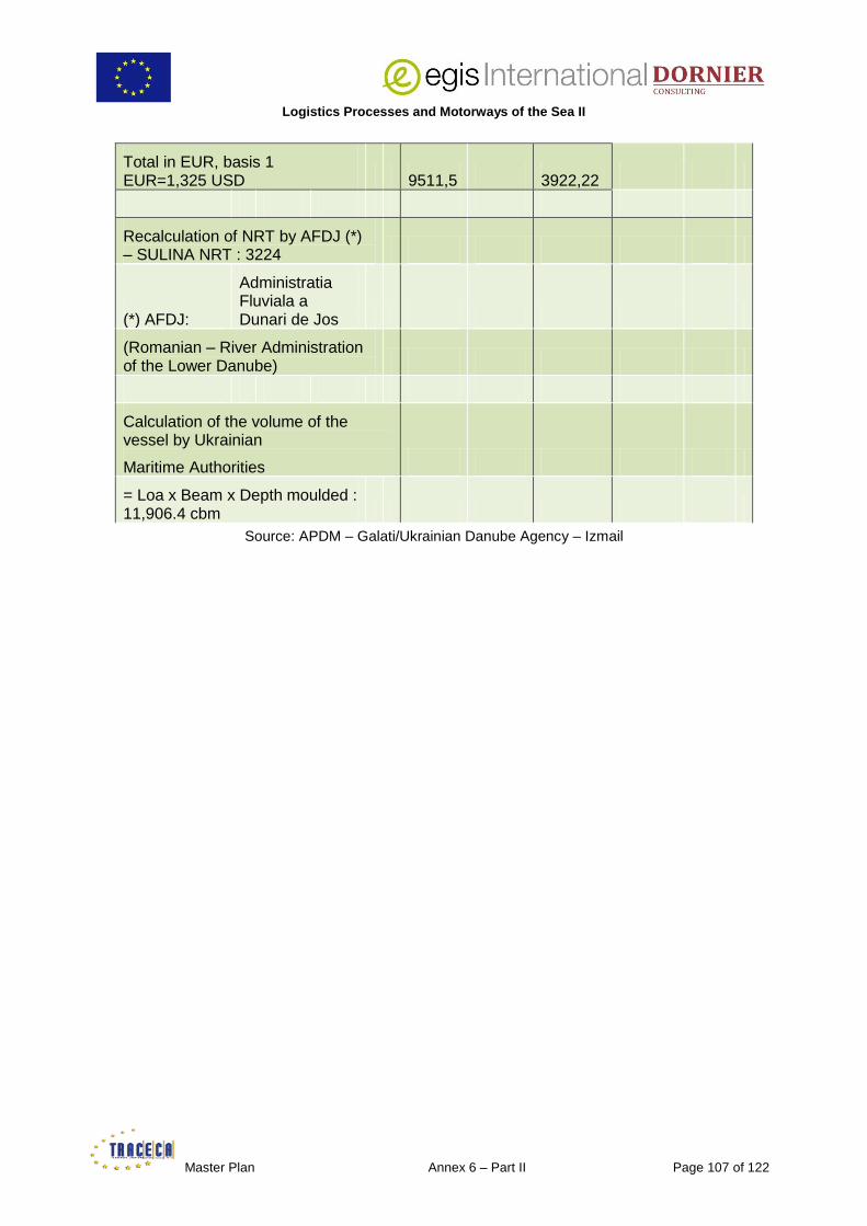
Logistics Processes and Motorways of the Sea II
Master Plan Annex 6 – Part II Page 107 of 122
Total in EUR, basis 1 EUR=1,325 USD 9511,5 3922,22
Recalculation of NRT by AFDJ (*) – SULINA NRT : 3224
(*) AFDJ:
Administratia Fluviala a Dunari de Jos
(Romanian – River Administration of the Lower Danube)
Calculation of the volume of the vessel by Ukrainian
Maritime Authorities
= Loa x Beam x Depth moulded : 11,906.4 cbm
Source: APDM – Galati/Ukrainian Danube Agency – Izmail

Logistics Processes and Motorways of the Sea ll
Page 108 of 122 Annex 6 – Part II Master Plan
Appendix 2: Modal Split of Inland Freight Transport (1) (2)
EU-27 Bulgaria Romania
Year Road Rail IWW Road Rail IWW Road Rail IWW
2000 73.7% 19.7% 6.6% 52.3% 45.2% 2.6% 42.9% 49.1% 7.9%
2001 74.8% 18.8% 6.5% 60.2% 36.7% 3.1% 49.6% 43.1% 7.3%
2002 75.3% 18.2% 6.3% 62.9% 33.1% 4.0% 57.3% 34.4% 8.2%
2003 75.7% 18.5% 5.8% 61.7% 34.3% 4.0% 62.4% 30.4% 7.1%
2004 75.9% 18.1% 5.9% 66.9% 29.2% 3.9% 60.8% 27.8% 11.4%
2005 76.4% 17.7% 5.9% 70.8% 25.4% 3.7% 67.3% 21.7% 11.0%
2006 76.2% 18.1% 5.7% 69.0% 27.1% 3.9% 70.5% 19.4% 10.0%
2007 76.2% 18.0% 5.8% 70.0% 25.1% 4.4% 71.3% 18.9% 9.4%
2008 76.2% 17.9% 5.9% 66.9% 20.5% 12.6% 70.2% 19.0% 10.4%
2009 77.5% 16.6% 6% 67.4% 11.9% 20.7% 60.0% 19.4% 20.6%
2010 76.4% 17.1% 6.5% 68.1% 10.7% 21.2% 49.2% 23.5% 27.2%
2011 75.5% 18.4% 6.2% 73.6% 11.4% 15% 50.3% 28% 21.7%
Source: Eurostat
(1) defined as the percentage of each mode (road, rail and inland waterways) in total inland freight transport performance measured in tonne-kilometres.
(2) rail and inland waterways transport are based on movements on national territory (‘territoriality principle'), regardless of the nationality of the vehicle or vessel. Road transport is based on all movements of vehicles registered in the reporting country.

Logistics Processes and Motorways of the Sea II
Master Plan Annex 6 – Part II Page 109 of 122
Appendix 3: Rail and Road Transport in Romania
Goods Carried in Thousands of Tonnes
Year 2000 2001 2002 2003 2004 2005 2006
2007 2008 2009 2010 2011 2012
CFR Marfa 71,462
71,731
68,044
68,763
62,772
55,237
51,983
49,559
44,44
29,495
31 107
na na
Private operators
0 0,8473
2,6096
2,6476
9,967
13,938
16,946
19,213
22,271
21,121
na na na
Total rail transport
71,462
72,5783
70,6536
71,4106
72,739
69,175
68,929
68,772
66,711
50,616
52,932
60,723
55,755
Road transport
262,943
268,496
267,103
275,603
294,221
306,994
340,87
356,669
364,605
293,409
174,551
183,935
188,611
Source: Ministry of Transport and Infrastructure/Eurostat
107
CFR Marfa Annual Report 2010 (No data publicly available for the following years)

Logistics Processes and Motorways of the Sea ll
Page 110 of 122 Annex 6 – Part II Master Plan
Appendix 4: Road Traffic in Romania – Forecast 2015
Source: Ministry of Transport and Infrastructure

Logistics Processes and Motorways of the Sea II
Master Plan Annex 6 – Part II Page 111 of 122
Appendix 5: Road, Rail and Inland Water Way Transport in Bulgaria
Goods Carried in Thousand Tonnes
Year 2002 2003 2004 2005 2006 2007 2008 2009 2010 2011 2012
Road Transport
Domestic trade
135,460
151,392
139,629
134,711
142,765
128,128
167,855
135,995
117,270
120,653
121,357
International trade
5,000 4,097 5,831 7,101 6,897 6,664 7,646 10,608
12,743
14,623
19,018
Total 140,460
155,489
145,460
141,812
149,662
134,792
175,501
146,602
130,013
135,276
140,375
Railway Transport
Domestic trade
15,322
15,980
15,678
15,081
16,263
15,887
14,159
9,663 9,252 10,016
8,953
International trade
3,178 4,090 4,709 5,218 5,619 6,018 5,556 3,621 3,688 4,136 3,517
Total 18,500
20,070
20,387
20,298
21,882
21,905
19,716
13,284
12,940
14,152
12,470
Inland Water Way Transport
Imports 3,011 3,265 3,580 3,054 2,258 1,974 1,832 1,682
Exports 0,384 0,682 0,839 0,934 0,708 1,115 0,835 0,805
Coastal 1,875 2,000 2,203 2,543 1,863 1,434 1,563 1,407
Total 5,270 5,947 6,622 6,531 4,829 4,523 4,230 3,894
Source: National Statistical Institute of Bulgaria
The figures compiled in this Appendix, although drawn from the same information source (the BG NSI), exceed significantly, for road and inland water way transport, the figures presented in the ‘Strategy for the Development of the Transport System of the Republic of Bulgaria until 2020’ where some statistical sections have seemingly been omitted.

Logistics Processes and Motorways of the Sea ll
Page 112 of 122 Annex 6 – Part II Master Plan
Appendix 6: Comparison between Bulgarian Railways (BZD and NRIC) and Other Railways Companies in the EU (2009)
Source: Railway PRO

Logistics Processes and Motorways of the Sea II
Master Plan Annex 6 – Part II Page 113 of 122
Appendix 7: Danube Ports in TRACECA Countries
Port Location on the Danube
Waterfront, m Depth at berth, m
Remarks
Bank km, nm
(NB1)
Total Including
Berths (NB2)
Sloping bank
Ukraine
Ust-Dunaisk Left
0 (Kiliya mouth)
– – – 11.5 – 14
No rail connection
General and bulk cargo operations
3 gantry and 8 floating cranes, max. lifting cap. 50 t
Kiliya Left
47 (Kiliya mouth)
150 150 – 4.0 No rail connection
General and bulk cargo operations
4 gantry cranes, max. lifting cap. 10 t
Izmail Left
93 (Kiliya mouth)
4,841 3,374 1,467 up to 7.5 m
Rail and road connections
General and bulk cargo operations
53 gantry, 6 mobile, 3 floating cranes, max. lifting cap. 50 t
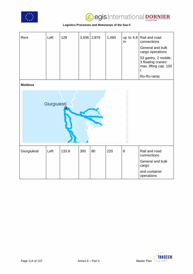
Logistics Processes and Motorways of the Sea ll
Page 114 of 122 Annex 6 – Part II Master Plan
Reni Left
128 3,936 2,876 1,060 up to 6.8 m
Rail and road connections
General and bulk cargo operations
53 gantry, 2 mobile, 3 floating cranes: max. lifting cap. 100 t
Ro-Ro ramp
Moldova
Giurgiulesti Left 133.8 300 80 220 8 Rail and road connections
General and bulk cargo
and container operations

Logistics Processes and Motorways of the Sea II
Master Plan Annex 6 – Part II Page 115 of 122
Romania
Sulina Right 0 – 1 nm 1,492 2.50 –7.30
Access by water only
No significant cargo operations
Tulcea (1) Right 38 – 40 nm
2,469 3.5 – 9 Rail and road connections
General and bulk cargo operations
8 gantry, max. lifting cap. 16 t
Galati (2) Left 78,5 nm – 157,5 km
6,793 2 – 7.3 Rail (European and Russian gauges) and road connections
General and bulk cargo and container operations
31 gantry, 10 mobile, 9 floating cranes, max. lifting cap. 63 t
Braila (3) Left 168,5 – 172 km
4,322 3.5 – 7.3 Rail and road connections
General and bulk cargo operations
12 gantry, 8 mobile, 2 floating cranes, max. lifting cap. 30
Logistics Processes and Motorways of the Sea ll
Page 116 of 122 Annex 6 – Part II Master Plan
T
Cernavoda (4) Right 294,5 – 300 km
1,469 1,430 2.5 Rail and road connections
General and bulk cargo operations
3 gantry cranes, max. lifting cap. 16 t
Calarasi (5) Borcea branch
372 – 377 km of the Danube (91 – 99 km of Borcea branch)
1,078 950 2.00 Rail and road connections
General and bulk cargo operations
1 gantry crane lifting cap.
16 t
Oltenita Left 428 – 431 km
1,227 880 2.00 Rail and road connections
General and bulk cargo and container operations
3 gantry cranes, max. lifting cap. 16 t
Giurgiu (6) Left 489 – 497 km
3,268 2,890 Rail and road connections
General and bulk cargo, Ro-Ro and container operations
13 gantry cranes, max. lifting cap. 16 t
Zimnicea Left 551 – 555 km
870 100 2.00 Ro-Ro operations
Turnu Magurele
Left 596 – 598,3 km
1,069 100 2.00 Ro-Ro operations
Corabia Left 627 – 633 km
1,491 1,150 Na Rail and road connections
1 floating crane, 10 t lifting cap.
Bechet Left 681 – 768 770 770 2.00 Road connection

Logistics Processes and Motorways of the Sea II
Master Plan Annex 6 – Part II Page 117 of 122
km only
General and bulk cargo, Ro-Ro operations
1 floating crane, 10 t lifting cap.
Rast (7) Left 737,5 – 738,5 km
159 50 Na Na
Calafat Left 793 – 796 km
700 550 2.00 Rail and road connections
General and bulk cargo, Ro-Ro and ferryboat operations
Cetate Left 810 – 813 km
800 Na Na
Gruia Left 850 – 852 km
135 Na Na
Orsova Left 853 – 957 km
1,060 100 4.00 Rail and road connections
General and bulk cargo operations
3 gantry cranes, max. lifting cap. 16 t
Drobeta Turnu Severin (8)
Left 927 – 934 km
1,400 1,400 Na Rail and road connections
General and bulk cargo operations
3 gantry cranes, max. lifting cap. 16 t
Dubova (7) Left 969 – 970 km
50 Na Na
Tisovita (7) Left 981 – 984 km
270 270 4.00 Rail and road connections
General and bulk cargo operations
2 gantry cranes, max. lifting cap. 16 t
Svinita (7) Left 994 – 996 170 30 Na Rail and road

Logistics Processes and Motorways of the Sea ll
Page 118 of 122 Annex 6 – Part II Master Plan
km connections
General and bulk cargo operations
2 gantry cranes, max. lifting cap. 16 t
Drencova Left 1,015 – 1,017 km
270 270 Na Rail and road connections
General and bulk cargo operations
2 gantry cranes, max. lifting cap. 16 t
Moldova Veche
Left 1,047 – 1,050 km
1,073 560 3.00 Road connection only
General and bulk cargo operations
3 gantry cranes, max. lifting cap. 5 t
Bazias (7) Left 1,071 –1,073 km
Na Na Na Na Road connection only
Bulgaria
Silistra Right 375 km 400 150 250 2.20 Road connection only
Passenger port
Tutrakan Right 433 km Na Na Na 1.00 Road connection only
General and bulk cargo operations

Logistics Processes and Motorways of the Sea II
Master Plan Annex 6 – Part II Page 119 of 122
1 gantry crane, lifting cap. 5 t
Ruse (9) Right 484,2 –497,63 km
5,000 2,630 2,370 3.2 Rail and road connections
General and bulk cargo, Ro-Ro, container and heavylift operations
29 gantry, 1 floating cranes, max. lifting cap. 100 t
Svishtov (10) Right 554 – 558,3 km
1,100 922 180 2.5 Road connection only
General and bulk cargo operations
11 gantry, 1 floating cranes, max. lifting cap. 20 t
Belene Right 567 km 285 285 Na 6.00 Rail and road connections
Project, general and bulk cargo, and container operations
2 gantry cranes, max. lifting cap. 480 t
Nikopol Right 597,55 –597,9 km
30 Na Na Na Ro-Ro operations
Somovit Right 608 km 400 354 354 2.2 Rail and road connections
General and bulk cargo operations
5 gantry cranes, max. lifting cap. 5 t
Oryahovo Right 678 км Na Na Na 2,0 Ro-Ro operations
Lom Right 736 – 747,8 km
1,463 Na Na 1.8 Rail and road connections
General and bulk

Logistics Processes and Motorways of the Sea ll
Page 120 of 122 Annex 6 – Part II Master Plan
cargo operations
22 gantry cranes, max. lifting cap. 20 t
Vidin (11) Right 785 – 792,7 km
1,798 Na Na Na Rail and road connections
General and bulk cargo, Ro-Ro, container and heavylift operations
NB1: distances on the Danube are measured in nautical miles from Sulina to Galati, and in kilometres from Galati to Ulm.
NB2: including passenger, waiting and specialized (bunkering, Ro-Ro ramps, bulk jetties) berths
(1) Passenger, industrial and commercial ports
(2) New Basin, Commercial, Bulk mineral ports and Docks
(3) Commercial port and Docks
(4) River and basin
(5) Commercial and industrial ports and Chiciu Zone
(6) Giurgiu Ramadan, Giurgiu Cioroiu and Canal Plantelor
(7) Not a port, only a loading facility
(8) Passenger and commercial ports
(9) Ruse Bulmarket, Ruse-East, Ruse-West, Ro-Ro Terminal Ruse, and Central Passenger Quay Ruse
(10) Including Svishtov-Siloza
(11) Vidin North, Vidin South, Vidin Centre and Auto Ferryboat terminal

Logistics Processes and Motorways of the Sea II
Master Plan Annex 6 – Part II Page 121 of 122
Appendix 8: Goods Handled at Romanian Lower Danube River Ports (Bechet, Calafat, Calarasi, Cernavoda, Cetate, Chiciu Calarasi, Corabia, Drencova, Giurgiu, Moldova Noua, Moldova Veche, Oltenita, Orsova, Tisovita, Turnu Severin) (in Tonnes)
TOTAL ALL PORTS
Commodities 2010 2011 2012
1 Grain 301,416 339,991 441,213
2 Food products and animal feed 31,430 981
3 Seeds, oils and fats 126,141 110,378 48,946
4 Wood, firewood 65,078 66,896 93,951
5 Fertilizers, natural and chemical 50,760 100,669 148,518
6 Raw mineral products (quarrying and gravel, gypsum, sulfur, clay, chalk, salt, etc.) 1,600,114 1,112,205 1,691,308
7 Iron ore, scrap 184,218 172,096 46,564
8 Solid fuels (coal, coke, etc.) 3,838 10,525 18,857
9 Oil and gas 254,515 335,133 184,446
10 Lime, cement, manufactured building materials 55,053 22,207 30,327
11 Glass, glass, ceramics 515 550
12 Metals (ferrous and non-ferrous) 3,021 5,598 29,053
13 Articles made of metal (steel) 24,045 67,568 25,660
14 Machinery, transport material 1,696 62 2,601
15 Containers 69,781 46,224 15,374
TOTAL 2,771,621 2,391,083 2,776,818
Total Number of vessels handled 2,487 2,506 2,598
Romanian 2,064 1,909 1,873
Foreign 423 597 725

Logistics Processes and Motorways of the Sea ll
Page 122 of 122 Annex 6 – Part II Master Plan
Appendix 9: Goods Handled at Giurgiulesti International Free Port and 2012 Forecast (in Tonnes)
2007 2008 2009 2010 2011 2012e
Oil Products 3,727 14,895 38,455 60,769 92,997 100,000
Vegetable Oil
- - - - 15,221 80,000
Grain - - 40,975 219,057 155,269 200,000
Aggregates 1,48 1,15 - 86,329 52,861 150,000
Pet-coke - - - - - 40,000
Slag - - - - - 25,000
General Cargo
- - - - - 15,000
Other - - - 5,056 4,693 5,000
Total 5,207 16,045 79,43 371,211 321,041 615,000
Container TEU
- - - - - 10,000