location - the council sr7 agenda package (2... · 2013-04-01 · smart growth partnership...
TRANSCRIPT
Thursday, February 28, 2013
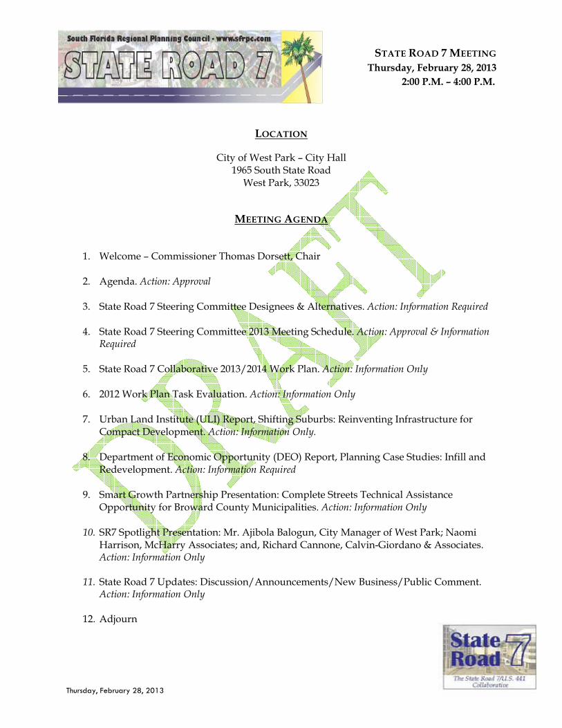
STATE ROAD 7 MEETING Thursday, February 28, 2013
2:00 P.M. – 4:00 P.M.
LOCATION
City of West Park – City Hall 1965 South State Road
West Park, 33023
MEETING AGENDA
1. Welcome – Commissioner Thomas Dorsett, Chair
2. Agenda. Action: Approval
3. State Road 7 Steering Committee Designees & Alternatives. Action: Information Required 4. State Road 7 Steering Committee 2013 Meeting Schedule. Action: Approval & Information
Required 5. State Road 7 Collaborative 2013/2014 Work Plan. Action: Information Only 6. 2012 Work Plan Task Evaluation. Action: Information Only 7. Urban Land Institute (ULI) Report, Shifting Suburbs: Reinventing Infrastructure for
Compact Development. Action: Information Only. 8. Department of Economic Opportunity (DEO) Report, Planning Case Studies: Infill and
Redevelopment. Action: Information Required 9. Smart Growth Partnership Presentation: Complete Streets Technical Assistance
Opportunity for Broward County Municipalities. Action: Information Only 10. SR7 Spotlight Presentation: Mr. Ajibola Balogun, City Manager of West Park; Naomi
Harrison, McHarry Associates; and, Richard Cannone, Calvin-Giordano & Associates. Action: Information Only
11. State Road 7 Updates: Discussion/Announcements/New Business/Public Comment.
Action: Information Only
12. Adjourn
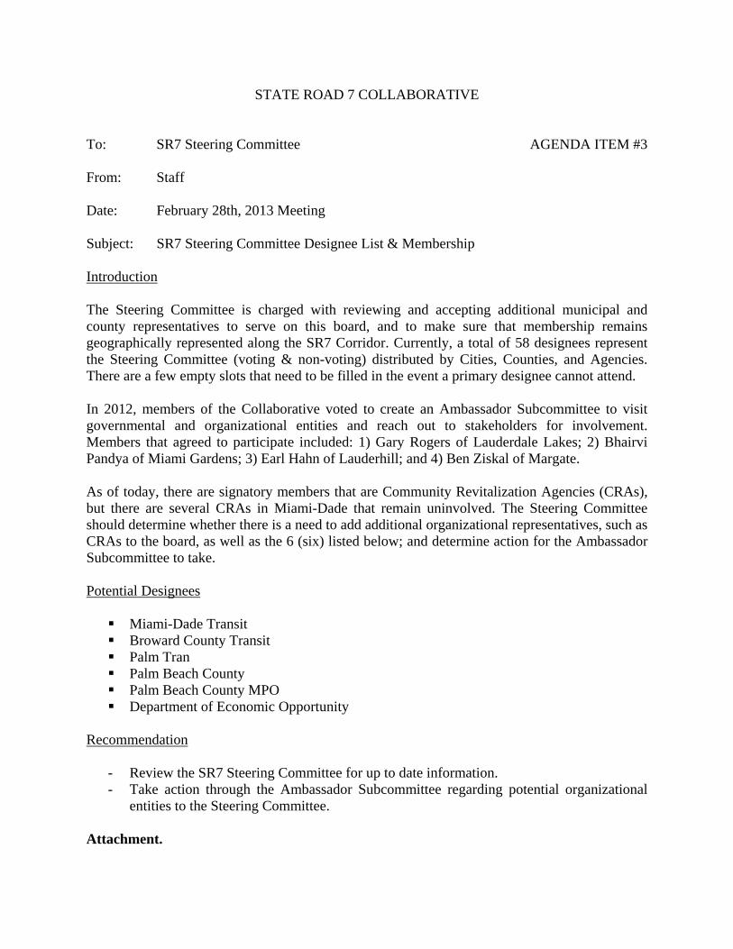
STATE ROAD 7 COLLABORATIVE To: SR7 Steering Committee AGENDA ITEM #3 From: Staff Date: February 28th, 2013 Meeting Subject: SR7 Steering Committee Designee List & Membership Introduction The Steering Committee is charged with reviewing and accepting additional municipal and county representatives to serve on this board, and to make sure that membership remains geographically represented along the SR7 Corridor. Currently, a total of 58 designees represent the Steering Committee (voting & non-voting) distributed by Cities, Counties, and Agencies. There are a few empty slots that need to be filled in the event a primary designee cannot attend. In 2012, members of the Collaborative voted to create an Ambassador Subcommittee to visit governmental and organizational entities and reach out to stakeholders for involvement. Members that agreed to participate included: 1) Gary Rogers of Lauderdale Lakes; 2) Bhairvi Pandya of Miami Gardens; 3) Earl Hahn of Lauderhill; and 4) Ben Ziskal of Margate. As of today, there are signatory members that are Community Revitalization Agencies (CRAs), but there are several CRAs in Miami-Dade that remain uninvolved. The Steering Committee should determine whether there is a need to add additional organizational representatives, such as CRAs to the board, as well as the 6 (six) listed below; and determine action for the Ambassador Subcommittee to take.
Potential Designees
Miami-Dade Transit Broward County Transit Palm Tran Palm Beach County Palm Beach County MPO Department of Economic Opportunity
Recommendation
- Review the SR7 Steering Committee for up to date information. - Take action through the Ambassador Subcommittee regarding potential organizational
entities to the Steering Committee. Attachment.
THE SR 7 /US 441 COLLABORATIVE DESIGNEES AND ALTERNATES
FEBRUARY, 2013
Page 1
CHAIR Commissioner Thomas Dorsett City of West Park 1965 South State Road 7 West Park, FL 33023 (P) 954-989-2688 X. 216 [email protected]
CO-CHAIR Gary Rogers, Executive Director City of Lauderdale Lakes Community Redevelopment Agency (CRA) 4300 NW 36th Street Lauderdale Lakes, FL 33319 (P) 954-731-4605 [email protected]
JURISDICTION DESIGNEE ALTERNATE Coral Springs Paul Carpenter, Senior Tran. Planner
Community Development 9530 W. Sample Road Coral Springs, FL 33065 (P) 954-344-1159 (F) 954-344-1181 [email protected]
Susan Hess, Director Community Development 9530 W. Sample Road Coral Springs, FL 33065 (P) 954-344-1114 (F) 954-344-1181 [email protected]
Ft. Lauderdale Commissioner Bobby DuBose 100 N. Andrews Avenue Ft. Lauderdale, FL 33301 (P) 954-828-5011 (F) 954-828-5667 [email protected]
Kevin C. Walford, Transportation Planner Planning & Zoning 290 NE 3rd Avenue Fort Lauderdale, FL 33301 (P) 954-828-5217 [email protected]
Hollywood Elizabeth Chang, Administrator Planning and Development 2600 Hollywood Boulevard Hollywood, FL 33020 (P) 954-921-3471 [email protected]
Lauderdale Lakes Commissioner Edwina Coleman 4300 NW 36th Street Lauderdale Lakes, FL 33319 (P) 954-535-2730 (F) 954-731-5857 [email protected]
Gary Rogers, Executive Director City of Lauderdale Lakes Community Redevelopment Agency (CRA) 4300 NW 36th Street Lauderdale Lakes, FL 33319 [email protected]
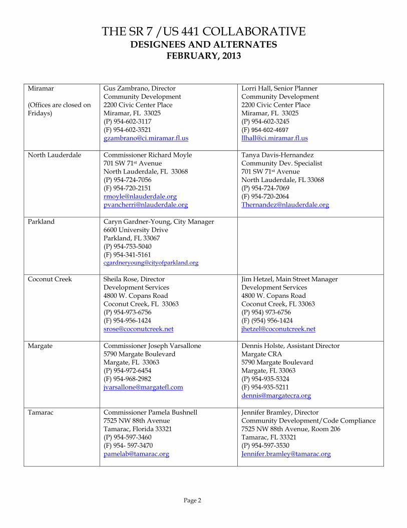
THE SR 7 /US 441 COLLABORATIVE DESIGNEES AND ALTERNATES
FEBRUARY, 2013
Page 2
Miramar (Offices are closed on Fridays)
Gus Zambrano, Director Community Development 2200 Civic Center Place Miramar, FL 33025 (P) 954-602-3117 (F) 954-602-3521 [email protected]
Lorri Hall, Senior Planner Community Development 2200 Civic Center Place Miramar, FL 33025 (P) 954-602-3245 (F) 954-602-4697 [email protected]
North Lauderdale Commissioner Richard Moyle 701 SW 71st Avenue North Lauderdale, FL 33068 (P) 954-724-7056 (F) 954-720-2151 [email protected]@nlauderdale.org
Tanya Davis-Hernandez Community Dev. Specialist 701 SW 71st Avenue North Lauderdale, FL 33068 (P) 954-724-7069 (F) 954-720-2064 [email protected]
Parkland
Caryn Gardner-Young, City Manager 6600 University Drive Parkland, FL 33067 (P) 954-753-5040 (F) 954-341-5161 [email protected]
Coconut Creek Sheila Rose, Director Development Services 4800 W. Copans Road Coconut Creek, FL 33063 (P) 954-973-6756 (F) 954-956-1424 [email protected]
Jim Hetzel, Main Street Manager Development Services 4800 W. Copans Road Coconut Creek, FL 33063 (P) 954) 973-6756 (F) (954) 956-1424 [email protected]
Margate Commissioner Joseph Varsallone 5790 Margate Boulevard Margate, FL 33063 (P) 954-972-6454 (F) 954-968-2982 [email protected]
Dennis Holste, Assistant Director Margate CRA 5790 Margate Boulevard Margate, FL 33063 (P) 954-935-5324 (F) 954-935-5211 [email protected]
Tamarac Commissioner Pamela Bushnell 7525 NW 88th Avenue Tamarac, Florida 33321 (P) 954-597-3460 (F) 954- 597-3470 [email protected]
Jennifer Bramley, Director Community Development/Code Compliance 7525 NW 88th Avenue, Room 206 Tamarac, FL 33321 (P) 954-597-3530 [email protected]
THE SR 7 /US 441 COLLABORATIVE DESIGNEES AND ALTERNATES
FEBRUARY, 2013
Page 3
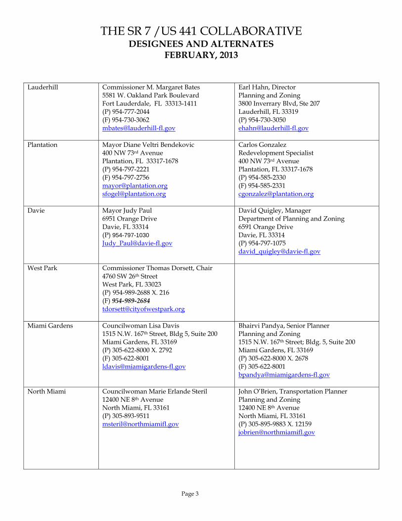
Lauderhill Commissioner M. Margaret Bates 5581 W. Oakland Park Boulevard Fort Lauderdale, FL 33313-1411 (P) 954-777-2044 (F) 954-730-3062 [email protected]
Earl Hahn, Director Planning and Zoning 3800 Inverrary Blvd, Ste 207 Lauderhill, FL 33319 (P) 954-730-3050 [email protected]
Plantation Mayor Diane Veltri Bendekovic 400 NW 73rd Avenue Plantation, FL 33317-1678 (P) 954-797-2221 (F) 954-797-2756 [email protected]@plantation.org
Carlos Gonzalez Redevelopment Specialist 400 NW 73rd Avenue Plantation, FL 33317-1678 (P) 954-585-2330 (F) 954-585-2331 [email protected]
Davie Mayor Judy Paul 6951 Orange Drive Davie, FL 33314 (P) 954-797-1030 [email protected]
David Quigley, Manager Department of Planning and Zoning 6591 Orange Drive Davie, FL 33314 (P) 954-797-1075 [email protected]
West Park Commissioner Thomas Dorsett, Chair 4760 SW 26th Street West Park, FL 33023 (P) 954-989-2688 X. 216 (F) 954-989-2684 [email protected]
Miami Gardens Councilwoman Lisa Davis 1515 N.W. 167th Street, Bldg 5, Suite 200 Miami Gardens, FL 33169 (P) 305-622-8000 X. 2792 (F) 305-622-8001 [email protected]
Bhairvi Pandya, Senior Planner Planning and Zoning 1515 N.W. 167th Street; Bldg. 5, Suite 200 Miami Gardens, FL 33169 (P) 305-622-8000 X. 2678 (F) 305-622-8001 [email protected]
North Miami Councilwoman Marie Erlande Steril 12400 NE 8th Avenue North Miami, FL 33161 (P) 305-893-9511 [email protected]
John O’Brien, Transportation Planner Planning and Zoning 12400 NE 8th Avenue North Miami, FL 33161 (P) 305-895-9883 X. 12159 [email protected]

THE SR 7 /US 441 COLLABORATIVE DESIGNEES AND ALTERNATES
FEBRUARY, 2013
Page 4
Miami Awaiting Confirmation Francisco Garcia, Planning Director 444 SW 2nd Avenue, 3rd Floor Miami, FL 33310 [email protected]
Awaiting Confirmation Rogelio Madan, Planner Department of Planning 444 SW 2nd Avenue, 3rd Floor Miami, FL 33130 (P) 305-416-1446 [email protected]
Broward County Cathy Randazzo, Director Planning and Redevelopment / Env. Protection & Growth Management 115 South Andrews Avenue Rm. 329K Fort Lauderdale, FL 33301 Phone: (954) 357-6674 Fax: (954) 357-8655 [email protected]
Enrique Zelaya, Senior Transportation Planner Planning and Redevelopment / Env. Protection & Growth Management 115 South Andrews Avenue Room 329K Fort Lauderdale, FL 33301 (P) 954-357-6635 (F) 954-357-8655 [email protected]
Miami-Dade County Eric Silva, Chief Community Planning Section Department of Planning and Zoning Stephen P. Clark Center 111 NW 1st Street, 11th Floor Miami, FL 33128 (P) 305-375-3565 [email protected]
Shailendra Singh, Urban Design Director Community Planning Section Department of Planning and Zoning Stephen P. Clark Center 111 NW 1st Street, 11th Floor Miami, FL 33128 (P) 305-375-2842 X. 4446 [email protected]

THE SR 7 /US 441 COLLABORATIVE DESIGNEES AND ALTERNATES
FEBRUARY, 2013
Page 5
EXOFFICIO DESIGNEE ALTERNATE South Florida Regional Planning Council
James F. Murley, Executive Director 3400 Hollywood Blvd, Suite 140 Hollywood, Florida 33021 (P) 954-985-4416 (F) 954-985-4417 [email protected]
Eric Swanson Program Manager 3400 Hollywood Blvd, Suite 140 Hollywood, Florida 33021 (P) 954-985-4416 (F) 954-985-4417 [email protected]
Florida Department of Transportation, District 4
Andrew Riddle, AICP Modal Development Planner 3400 W Commercial Blvd Ft. Lauderdale, FL 33309 (P) 954-777-4670 (F) 954-677-7892 [email protected]
Larry Hymowitz Mobility Projects Coordinator 3400 West Commercial Boulevard Fort Lauderdale, Florida 33309-3421 (P) 954-777-4663 (F) 954-677-7892 [email protected]
Florida Department of Transportation, District 6
Phil Steinmiller, AICP Planning Manager 1000 NW 111th Ave Miami, FL 33172 (P) 305-470-5386 [email protected]
Ken Jeffries Transportation Planner 1000 NW 111th Avenue, Room 6111-A Miami, Florida 33172 (P) 305-470-5445 [email protected]
Broward MPO Roger Del Rio, Projects Coordinator
Trade Center South 100 W. Cypress Creek Road, Suite 850 Fort Lauderdale, Florida 33309 (954) 876-0033 office [email protected]
James Cromar, Livability Planner Trade Center South 100 W. Cypress Creek Road, Suite 850 Fort Lauderdale, Florida 33309 (9) 876-0038 office [email protected]
Miami-Dade MPO Susan Schreiber Transportation Systems Analyst Stephen P. Clark Center 111 NW First Street, Suite 920 Miami, FL 33128 (P) (305) 375-4507 [email protected]
Broward Planning Council Mayor Lamar Fisher of Pompano Beach Broward County Planning Council 115 S. Andrews Avenue, Room 307 Fort Lauderdale, Florida 33301
Pete Schwartz Broward County Planning Council 115 S. Andrews Avenue, Room 307 Fort Lauderdale, Florida 33301 (P) 954-357-6695 [email protected]

THE SR 7 /US 441 COLLABORATIVE DESIGNEES AND ALTERNATES
FEBRUARY, 2013
Page 6
EXOFFICIO DESIGNEE ALTERNATE Broward County Legislative Delegation
Representative Hazel Rogers 3800 Inverrary Boulevard Suite 100-J Lauderhill, FL 33319 (P) 954-497-3367 District Secretary: Elizabeth Honorat [email protected]
Representative Dale Holness 115 S. Andrews Ave., Room 411 Fort Lauderdale, FL 33301 (P) 954-357-7009 Community Affairs Director: Lahoma Scarlette [email protected]@broward.org
Broward School Board Chris Akagbosu, Director, Growth Management Division School Board of Broward County 600 SE 3rd Avenue, 8th floor Fort Lauderdale, FL 33301 (P)754-321-2177 [email protected]
Mohammed Rasheduzzaman, AICP Planner / Facility Management 600 SE 3rd Avenue, 8th floor Fort Lauderdale, FL 33301 (P) 754-321-2177 [email protected]
NON SIGNATORY/NOTIFICATION ONLY
Seminole Tribe Richard Pereira, P.E. Transportation Director Seminole Tribe 6300 Stirling Road Hollywood, FL 33024 (P) 954-985-2300 X. 10640 [email protected]
Fred Hopkins Director of Real Estate Seminole Tribe 6300 Stirling Road Hollywood, FL 33024 (P) 954-966-6300 x. 11103 [email protected]
Greater 7th Ave. Improvement Association
Paul Bertell, President Del Rio Finance c/o Kressly Corp. 10415 NW 7th Avenue Miami, Florida 33150 Phone: 305.758.4411 Fax: 305.754.7352 [email protected]
Don Kressly Kressly Corporation 10415 NW 7th Avenue Miami, FL 33150 (P) 305-758-4411 [email protected]

STATE ROAD 7 COLLABORATIVE
To: SR7 Steering Committee AGENDA ITEM #4 From: Staff Date: February 28th, 2013 Meeting Subject: SR7 Steering Committee Meeting Schedule for 2013 Introduction The SR7 Steering Committee meeting schedule has been tentatively set for the fourth Thursday of the month (every 3rd month of the year, beginning February 2013) as proposed for the Committee’s consideration. The final Steering Committee meeting of the calendar year will be moved up a week to December 5th in observance of Thanksgiving Day. Cities that are interested in hosting a meeting of the SR7 Steering Committee or a special spotlight event of the SR7 Collaborative, please speak with Eric Swanson, SFRPC Staff, at your earliest convenience. Below please find the proposed Executive Committee schedule for 2013. Proposed Meeting Schedule for 2013
• Thursday, February 28th • Thursday, May 30th • Thursday, August 29th • Thursday, December 5th (Note: November 28th is Thanksgiving)
Recommendation
- Adopting the 2013 SR7 meeting schedule. - Decide on future meeting locations to host the SR7 Collaborative.
STATE ROAD 7 COLLABORATIVE
To: SR7 Steering Committee AGENDA ITEM #5 From: Staff Date: February 28th, 2013 Meeting Subject: 2013/2014 SR7 Collaborative Work Plan Introduction In 2011 - 2012, a subcommittee was formulated to review the SR7 Work Plan to streamline goals that were realistic over a five-year timeline and were applicable to the values of the SR7 Collaborative. The SR7 Work Plan (adopted in 2012) currently covers Strategic Planning, Intergovernmental Coordination, and Plan Implementation. Steering Committee members that took part in the review process included Commissioner Thomas Dorsett of West Park, David Quigley of Davie, and John O’Brien of North Miami. Action Staff would like Collaborative members to revisit the five-year SR7 Work Plan and provide any feedback and/or comments to existing goals and objectives. Please provide comments to staff by Wednesday, May 1st, 2013. Requested changes will be compiled and forwarded for approval at the next SR7 Steering Committee meeting, which is tentatively scheduled for Thursday, May 30th, 2013. Recommendation Review & discuss the 2012 – 2017 SR7 Work Plan and provide comment by Wednesday, May 1st, 2013. Attachment.

The State Road 7/U.S. 441 Collaborative Work Plan
I. Strategic Planning/Intergovernmental Coordination
1. Focus efforts of the Collaborative through the active participation by designees and community representatives in the subcommittees identified by the Steering Committee.
2. Expand the Collaborative to include participation from each Community
Redevelopment Agency along the Corridor.
3. Expand the Collaborative to include membership from Palm Beach County and the Palm Beach Metropolitan Planning Organization.
4. Participate in regional initiatives related to mobility and enhancing the
livability of corridor communities in South Florida.
5. Participate in meetings of the SEFTC, PTAC, SFRTA, RTTAC, Palm Tran, MDTA, and BCT concerning a regional strategy for transit.
6. Support the inclusion of plans for premium transit service along the entire
SR7/US441 corridor within the Long Range Transportation Plan (LRTP) of Palm Beach, Broward, and Miami-Dade Counties.
7. Support the development of a comprehensive regional rail strategy which
coordinates the needs of a north-south and east-west connections.
8. Sponsor transit-oriented and smart growth workshops for corridor communities and support the development of local and regional transit facilities, such as mobility hubs that encourage park and ride services.
9. Support amendments to the Palm Beach County Thoroughfare Plan, the
Broward Trafficways Plan and Miami-Dade Zoned Right-of-Way Plan that accommodate transit and transit supportive redevelopment.
10. Encourage corridor communities to adopt transit supportive land uses and land
development regulations along the State Road 7 Corridor.
11. Support the implementation of transportation enhancements and landscape median improvements.

II. Dedicated Funding/Plan Implementation 1. Participate in federal programs associated with the Sustainable Communities
inter-agency partnership of Housing and Urban Development (HUD), Environmental Protection Agency (EPA), and the Department of Transportation.
2. Enhance communication and partnerships with individual Collaborative
communities, the State of Florida and the Seminole Tribe of Florida to establish dedicated funding for plan implementation efforts.
3. Collectively support and apply for Transportation Enhancement Grants;
Transportation for Community and Systems Preservations Grants (TCSP); Florida Communities Trust (FCT) or similar grants which support State Road 7 Corridor enhancements.
4. Work with jurisdictions of Miami-Dade County on the development for a
Master Plan for Miami-Dade communities along the State Road 7 Corridor.
5. Collectively support and identify improvements to the State Road 7 Corridor in the Long-Range Transportation Plans (LRTP), the List of Unfunded Priorities, and have short range SR 7 Corridor projects reflected in the Transportation Improvement Plans (TIP).
6. Support utilization of Transportation Regional Incentive Program (TRIP)
funding for transit amenities along designated Regional Corridor, such as, the State Road 7 Corridor.
7. Support and encourage the Collaborative to update local 5-year Capital
Improvement Plans and program enhancements and improvements to the State Road 7 Corridor.
8. Participate and support the development of local Evaluation and Appraisal
Reports (EAR) consistent with the issues identified in the Strategic Master Plan for State Road 7/U.S. 441.
9. Promote the work of the State Road 7/U.S. 441 Collaborative and individual
communities through participation in local and national award programs, presentation opportunities.
10. Develop marketing strategies and tools to raise awareness of the Corridor in
order to attract development.
11. Quantify the progress of the individual Collaborative communities and the Steering Committee the State Road 7 Corridor since the completion of the Strategic Master Plan.
STATE ROAD 7 COLLABORATIVE
To: SR7 Steering Committee AGENDA ITEM #6 From: Staff Date: February 28th, 2013 Meeting Subject: 2012 SR7 Collaborative Work Plan Evaluation & Next Steps SR7 Work Plan Evaluation The SR7 Steering Committee-approved Work Plan outlines 22 (twenty-two) objectives to be performed as either part of, or concurrent with strategic planning, intergovernmental coordination and plan implementation. Many of the objectives adopted by the SR7 Steering Committee have been completed and remain on-going. Details below include a progress report of activities completed in 2012, as well as a possible major next step for 2013, re-evaluating the SR7 Corridor Master Plan. During 2012, the Collaborative: 1) was showcased in a national research publication issued by the Urban Land Institute; 2) made presentations to local, state and national economic development groups; 3) provided technical assistance to on-going studies along the Corridor; 4) held multiple public meetings and teamed up with other groups, such as the Smart Growth Partnership, Urban Land Institute and American Planning Association to spotlight redevelopment activities along the Corridor; 5) integrated the Collaborative’s successes and the overall Partnership framework in the South Florida’s Comprehensive Economic Development Strategy (CEDS), and the Sustainable Communities Initiative (Seven50); and 7) worked with the Miami-Dade Metropolitan Planning Organization to facilitate redevelopment public workshops, identifying preliminary issues, concerns and policy recommendations to local leaders along SR-7 in Miami-Dade County. Potential Next Steps (Currently Unfunded): As the SR7 Collaborative continually evolves its plan implementation and outreach strategy, re-visiting the corridor master plan is an important next step and focus to succinctly communicate the goals and intent of the SR7 Collaborative and general public. Overall objectives initially envisioned during the master plan phase of this effort should be reviewed in order to: a. Evaluate Goals/Tasks/Visions that are currently completed, pending and/or otherwise unnecessary (due to today’s changing market) to the implementation of the overall plan; b. Fund Tasks that are currently underfunded and are critical to the completion of the plan; and

c. Re-focus certain Tasks to better address municipal/segment needs. Action: Staff request that SR7 Steering Committee members decide, as deemed an objective by the SR7 Work Plan, how and if the SR7 Master Plan should be reviewed and updated or modified as appropriate, and that deliverables (including proposed implementation projects) be added or deleted as appropriate.
2
STATE ROAD 7 COLLABORATIVE
To: SR7 Steering Committee AGENDA ITEM #7 From: Staff Date: February 28th, 2013 Meeting Subject: Urban Land Institute (ULI) Report, Shifting Suburbs: Reinventing Infrastructure for
Compact Development Introduction A New Available Report Explores Infrastructure for Compact Development in the Suburbs. “For compact development to work, developers and municipalities must determine how to plan, fund, and finance the often costly and complicated infrastructure, including transit investments, structured parking, intricate street grids, sidewalks, lighting, and water, sewer, and other utility upgrades.” Shifting Suburbs examines the infrastructure approaches taken by eight suburban redevelopment case studies from across the United States, distilling winning strategies, stumbling blocks, and other lessons learned. “The report highlights suburban arterials and first-ring suburbs as areas of particular opportunity—and challenge.” The State Road 7 Collaborative was one of them. Download a free PDF of the report, and/or watch the release webinar, and learn more about the ULI Infrastructure Initiative. The report and related activities are available at the ULI website at: http://www.uli.org/infrastructure-initiative/shifting-suburbs-reinventing-infrastructure-for-compact-development/ Action Information Only. Attachment.
24 | Shifting Suburbs: Reinventing Infrastructure for Compact Development
State Road 7, Broward and Miami-Dade Counties, Florida
Lessons from State Road 7
■ A consensus vision and a master plan can help organize the infrastructure and
development efforts of multiple municipalities along commercial corridors.
■ Funding for collaborative efforts and infrastructure improvements can be drawn
from federal, state, and local sources, as well as nonprofits and foundations.
State Road 7 (SR-7) is a north–south arterial highway that runs through southeastern
Florida’s Broward and Miami-Dade Counties. Also designated U.S. Highway 441
for most of its length, the arterial is used by several popular bus routes and is frequently
congested. SR-7 is squeezed between two bodies of water—the Everglades and the
Atlantic Ocean.
SR-7 is lined with commercial strip development built in the 1960s and 1970s—aging
businesses that are having trouble competing with newer retail areas along other roads
nearby. Strong population figures, tourist activity, and a lack of available vacant land for
new development indicate strong redevelopment potential for the corridor.
In 2000, local government leaders along the 32-mile (52 km) route formed the State
Road 7/U.S. 441 Collaborative. Now stretching to 41 miles (66 km), the collaborative
is the longest revitalization effort in the country. The goal of the collaborative—which
includes all 17 of the municipalities that SR-7 traverses and is supported by the South
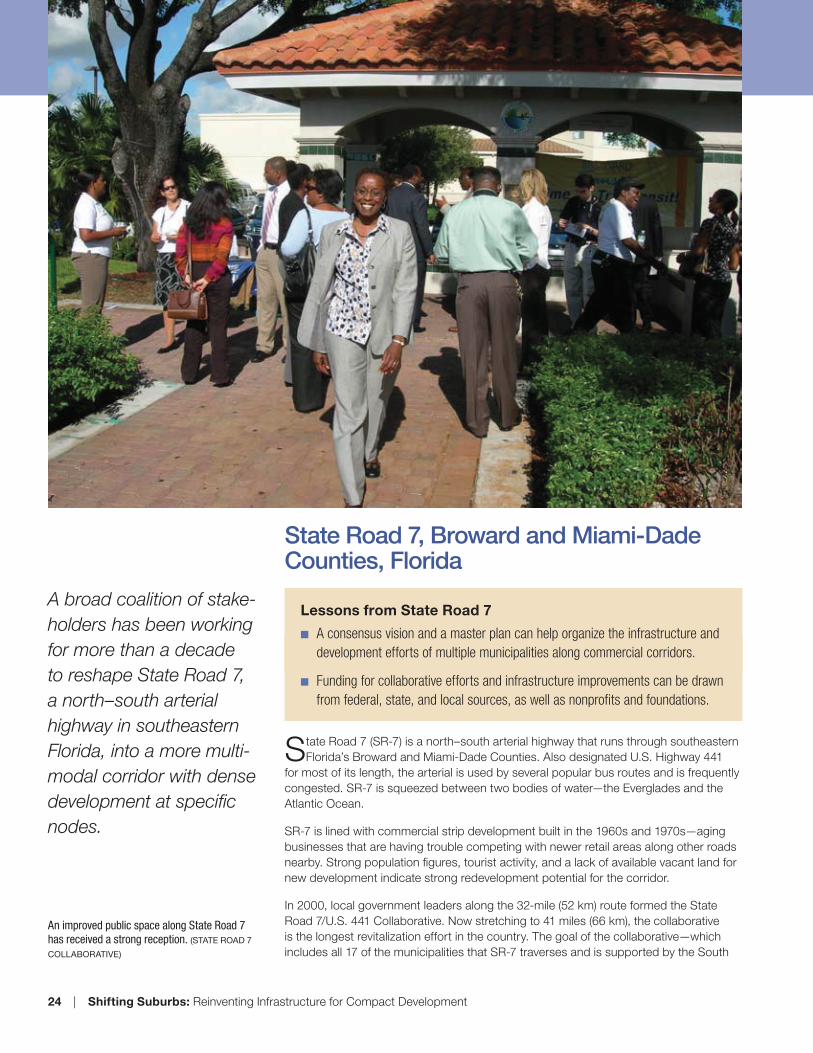
A broad coalition of stake-
holders has been working
for more than a decade
to reshape State Road 7,
a north–south arterial
highway in southeastern
Florida, into a more multi-
modal corridor with dense
development at specific
nodes.
An improved public space along State Road 7
has received a strong reception. (STATE ROAD 7
COLLABORATIVE)

Shifting Suburbs: Reinventing Infrastructure for Compact Development | 25
Florida Regional Planning Council—is to create a mixed-use, transit-oriented corridor
with high-density activity centers located at primary intersections.
The collaborative has undertaken extensive planning and community outreach activities,
funded in part by a $1.9 million grant from the U.S. Federal Highway Administration.
A ULI Advisory Services panel visited the corridor in 2004 and suggested that nodal
redevelopment take place at the highway’s major and minor intersections, with less
intensive redevelopment between those nodes. Community input, gathered through
charrettes and interviews, revealed that citizens wanted redevelopment, improved
public transit facilities and services, and new housing for all income levels, among
other goals. “The charrette and the planning process set the stage,” according to Gary
Rogers, executive director of the Lauderdale Lakes Community Redevelopment Agency
and vice chair of the SR-7 Collaborative.
A strategic master plan for Broward County was adopted in 2004, with multiple updates
since then. That plan changed the land use designation along SR-7 to “transit-oriented
corridor” and promoted smart growth principles. A right-of-way improvement plan
specifies recommended streetscape improvements, and three-dimensional site plan
regulations offer clear, concise descriptions. The hope is that with the appropriate
infrastructure and regulatory framework in place, further redevelopment—including the
addition of dense office, retail, and residential space—will occur.
Major infrastructure changes to be implemented include the widening of SR-7 to
accommodate future transportation needs in some areas, as well as street-width
DAVIE
HOLLYWOOD
MARGATE
PLANTATION
COCONUT
CREEK
CORAL SPRINGS
PARKLAND
TAMARAC
MIRAMAR
LAUDERHILL
POMPANO
BEACH
SUNRISE
PEMBROKE
PINES
FORT
LAUDERDALE
OAKLAND
PARK
DANIA BEACH
NORTH
LAUDERDALE
DEERFIELD
BEACH
LAUDERDALE
LAKES
PEMBROKE
PARK
SES
FORT
LAUDERDALE
ROYAL PALM BLVD
ATLANTIC BLVD
COMMERCIAL BLVD
HALLANDALE
I95
FLO
RID
A'S
TU
RN
PIK
E
I595
US
44
1
TAFT ST
LY
ON
SR
D
GRIFFIN RD
SR84
STIRLING RD
RO
CK
ISLA
ND
RD
SHERIDAN ST
SAMPLE RD
NW
31
ST
AV
E
PEMBROKE RD
SUNRISE BLVD
BROWARD BLVD
SAWGRASS EXPRESSWAY
UN
IVE
RS
ITY
DR
DAVIE BLVDPETERS RD
NW 62ND ST
UN
IVE
RS
ITY
DR
MIRAMAR PKY
COPANS RD
HILLSBORO BLVD
NW 44TH ST
NW
9T
HA
VE
W MCNAB RD
HOLLYWOOD BLVD
BAILEY RD
COCONUT CREEK PKY
COUNTY LINE RD
SR
7
MCNAB RD
SR
7
HALLANDALE BEACH BLVD
JOHNSON ST
0 1 2
Scale in Miles
Prepared by:
Transportation Planning Division
Department of Planning & Environmental
Protection
Broward County, Florida
(LCK - SR7_cities.apr)
BROWARD COUNTY
SR 7/US 441 CORRIDORCHARRETTE SEGMENT MAP
DAVIE
HOLLYWOOD
MARGATE
PLANTATION
COCONUT
CREEK
CORAL SPRINGS
PARKLAND
TAMARAC
MIRAMAR
LAUDERHILL
POMPANO
BEACH
SUNRISE
PEMBROKE
PINES
FORT
LAUDERDALE
OAKLAND
PARK
DANIA BEACH
NORTH
LAUDERDALE
DEERFIELD
BEACH
LAUDERDALE
LAKES
PEMBROKE
PARK
SEMINOLE
NATION
FORT
LAUDERDALE
ROYAL PALM BLVD
ATLANTIC BLVD
COMMERCIAL BLVD
HALLANDALE
I95
FLO
RID
A'S
TU
RN
PIK
E
I595
US
44
1
TAFT ST
LY
ON
S R
D
GRIFFIN RD
SR84
STIRLING RD
RO
CK
ISLA
ND
RD
SHERIDAN ST
SAMPLE RD
NW
31
ST
AV
E
PEMBROKE RD
SUNRISE BLVD
BROWARD BLVD
SAWGRASS EXPRESSWAY
UN
IVE
RS
ITY
DR
DAVIE BLVDPETERS RD
NW 62ND ST
UN
IVE
RS
ITY
DR
MIRAMAR PKY
COPANS RD
HILLSBORO BLVD
NW 44TH ST
NW
9T
H A
VE
W MCNAB RD
HOLLYWOOD BLVD
BAILEY RD
COCONUT CREEK PKY
COUNTY LINE RD
SR
7
MCNAB RD
SR
7
HALLANDALE BEACH BLVD
JOHNSON ST
FEBRUARY 2004
L E G E N D
SR 7 / US 441
Roads
SR 7 / US 441
Primary Corridor
1 Mile East / West
Boundary
Photos of existing conditions on State Road 7
show an automobile-dominated corridor with
few amenities for transit riders. (STATE ROAD 7
COLLABORATIVE)
Below left: A rendering depicts plans to redesign
the Greenway Canal in Lauderdale Lakes for
recreational use. Below: A map shows the State
Road 7 Collaborative area, which stretches 41
miles (66 km) and spans 17 municipalities. (STATE
ROAD 7 COLLABORATIVE)

26 | Shifting Suburbs: Reinventing Infrastructure for Compact Development
reductions in others, to facilitate urban-scale redevelopment and accommodate
premium transit (such as fixed rail or BRT). Pedestrian amenities, such as high-visibility
crosswalks and medians to serve as crossing oases, will also be built. Necessary sewer
infrastructure is being constructed.
Local transit service is currently provided throughout the corridor but is intended to
evolve over time. Express service overlays are being introduced through pilot programs
using bus queue jump lanes on SR-7. Eventually, a premium transit system in dedicated
lanes will be established using bus or fixed-rail transit.
Lauderdale Lakes has replaced a number of obsolete bus shelters with 12 new open-
air shelters that feature real-time arrival message displays, with another ten planned.
A weed-filled, virtually abandoned corridor along a major regional drainage canal has
been transformed into a two-mile-long (3.2 km) nonvehicular path that connects city
government facilities, commercial centers, schools, and recreational facilities.
Improvements to bus stops along the corridor offer
ample seating and shade. These photos show
conditions before and after improvements. (STATE
ROAD 7 COLLABORATIVE)
Municipalities in the State Road 7 Collaborative
have created master plans to guide future
development. (STATE ROAD 7 COLLABORATIVE)

Shifting Suburbs: Reinventing Infrastructure for Compact Development | 27
SR-7 corridor investments during the last ten years have totaled more than $165
million, including $137 million in right-of-way acquisition and construction, $10 million
in transit enhancements, $10 million in sewer line infrastructure updates, and $4 million
in bus shelter construction. Funding has been provided by the U.S. Department of
Transportation, the state, regional planning bodies, and the John D. and Catherine
T. MacArthur Foundation, as well as through local in-kind services and funding from
local governments. The Florida Department of Transportation has made a financial
commitment to supporting the state road, and the Broward County Metropolitan
Planning Organization has committed to finding funds to build transit once the feasibility
of light rail or BRT has been determined.
Redevelopment of the land along SR-7 has proved challenging, despite the adoption
of new land use and zoning standards. Challenges include land assembly and the
need to extend sewer infrastructure to places where it does not currently exist, with the
economic downturn stalling development of the Lauderdale Lakes Town Center and
other sites along the corridor. The work of reinventing SR-7 continues.
Top and bottom: Renderings show hoped-for
improvements and development in Lauderdale
Lakes, one of the State Road 7 Collaborative
communities. Below: Charrettes and public
meetings were essential to formulating plans for
the transformation of State Road 7. (STATE ROAD 7
COLLABORATIVE)

STATE ROAD 7 COLLABORATIVE
To: SR7 Steering Committee AGENDA ITEM #8 From: Staff Date: February 28th, 2013 Meeting Subject: Department of Economic Opportunity (DEO) Redevelopment & Infill Case Study
Report Introduction A Department of Economic Opportunity (DEO) drafted a report titled, “Planning Case Studies: Infill and Redevelopment” highlighting best practices from 12 cities and counties in Florida, which includes the State Road 7 Collaborative in Broward County. The report objective is to provide a resource for local governments seeking to promote infill and redevelopment in their jurisdictions. The State Road 7 Collaborative was highlighted in the report, given the leadership in infill and redevelopment and as a model for cooperative activities on a regional scale. The report is anticipated to be the first in a new series of technical assistance reports which will be posted to the DEO website. The State Road 7 Collaborative was chosen based on the degree to which comprehensive plans support infill and redevelopment and address extra jurisdictional issues. Action Staff provided initial information on the SR7 Collaborative and is seeking additional information and/or comments by Wednesday, March 5th. Staff has already requested information from several municipalities. If you have questions regarding the report, please contact Eric Swanson for more information. Other local governments in other regions across the Florida will benefit from the experiences already gained in Collaborative communities. Thank you for taking the time to review the attachment. For the full report, please see Eric Swanson for more details. Recommendation Review the DEO Report and provide feedback to staff before the deadline of Wednesday, March 5th, 2013. Attachment.
Florida Department of Economic Opportunity
planning case studies infill & redevelopment
______________________________________________________________________________
11
redevelopment incentives are identified
through the steps described below.
ü Potential infill parcels were identified
based on Department of Revenue use
codes and building values, as follows:
a.) Parcels smaller than 5,000 square
feet were excluded; b.) Agricultural
parcels were classified as vacant if the
ratio of building value to land value was
less than 1.0; c.) Non-agricultural parcels
were defined to be vacant if the
building value was less than $10,000;
and d.) Parcels in Planned
Developments were excluded because
they have specific development
programs. The vacant parcels that met
the above standards were then further
narrowed by applying the following
criteria: a.) Must be within the Urban
Service Area; b.) Must not be within a
Joint Planning Area; c.) Must be within ¼
mile of a major street; and d.) Must be
within ¼ mile of a public bus route.
ü Potential redevelopment parcels were
identified based on the following
criteria: a.) For residential parcels, the
parcel size must be at least 2.5 times the
minimum size required for the zoning
district; b.) For non-residential parcels,
the building value must equal half or less
of the land value. The underutilized
parcels that met the above standards
were then further narrowed by removing
buildings built after 1970.
ü The County then identified eight initial
infill and redevelopment areas, based
on the geographic distribution of the
parcels identified in steps 1 and 2
above.
ü The eight areas identified in the previous
step were then refined with the goal of
creating a “cohesive grouping of
parcels that appeared to have spatial
relationships.” This analysis considered
the following: a.) The proximity of the
eight areas to the boundaries of key
redevelopment districts was determined,
including community reinvestment
areas, enterprise zones, and safe
neighborhood improvement districts; b.)
Due to the potential for neighborhood
opposition, parcels were excluded if
they were part of a large grouping of
vacant or underutilized parcels within a
residential subdivision; and c.) Due to
the potential for future annexation,
parcels were excluded if they were
located within enclaves or pockets of
unincorporated land. As a result of this
process, the initial list of eight areas was
refined to five targeted infill corridors.
4.3 State Road 7/U.S. 441 Collaborative
The State Road 7/U.S. 441 Collaborative (the
Collaborative) was created in 2001 as a
regional redevelopment partnership. The
initial members included Broward County
and many of the cities abutting the State
Road 7/U.S. 441 corridor. Ex-officio
membership was also extended to various
State and regional agencies, such as the
Florida Department of Transportation and
the South Florida Regional Planning Council.
The goal of the Collaborative is to be a
catalyst for redevelopment along the State
Road 7/U.S. 441 corridor. A map of the
Corridor is provided in Attachment 5.
The scope of the Collaborative makes it a
unique regional planning effort. As noted
by the South Florida Regional Planning
Council’s report, “10 Years Down the Road”,
the Collaborative “…is the representative for
the longest and most inclusive corridor in the
country, with 32 miles of roadway and 16
municipal jurisdictions.”
The development potential within the 32
miles that is addressed by the Collaborative
is immense. The Urban Land Institute (ULI)
issued an Advisory Services Panel Report
concerning the State Road 7/U.S. 441
corridor in March 2004. The ULI report notes
that, “To summarize the estimates for long-
term development demand in the SR 7/U.S.
441 corridor: a total of 56.5 million square
feet of added space will be needed to

Florida Department of Economic Opportunity
planning case studies infill & redevelopment
______________________________________________________________________________
12
accommodate the projected demand for
urban uses by 2020; 99.3 million square feet
will be needed by 2030.” Although the
economy entered the financial crisis of 2008,
the sheer scale of this estimate indicates
tremendous potential along the corridor.
The Collaborative is an outstanding
example of infill and redevelopment
planning occurring through
intergovernmental coordination. The
timeline of this coordination is summarized
below.
ü 2001: The Collaborative was formed as a
regional partnership.
ü 2002: The Regional Plan Association and
the Lincoln Land Institute analyzed the
Corridor’s redevelopment potential in
“The Sustainable Corridor Study”.
ü 2003: The Federal Highway
Administration provided a $1.9 million
grant to fund a Corridor Strategic Master
Plan. The value of potential new
development within the Corridor was
estimated at over $17 billion.
ü 2003 to 2005: The local governments
along the Corridor adopted community
specific visions based on seven-day
planning charrettes.
ü 2005: The Collaborative and the Broward
County Planning Council jointly created
the Transit Oriented Corridor
designation, which could be adopted
by each local government on their
Future Land Use Maps.
The Collaborative is rooted in the series of
community based charrettes described
above. The charrettes formed the basis for
the Corridor Strategic Master Plan, which in
turn led to the Transit Oriented Corridor
Future Land Use Map designation. It is an
“off the shelf” planning tool designed to be
used by any of the local governments within
the Collaborative to support and facilitate
infill and redevelopment.
Obviously, the true test of success is the
degree to which infill and redevelopment
occur. A wide variety of public
improvements have occurred to
infrastructure along the Corridor. Despite
the economic downturn, private sector
investment has remained steady since 2005,
as summarized below.
ü Coconut Creek – 350,000 square feet of
commercial
ü Lauderdale Lakes – 30-acre mixed-use
project with 541 dwelling units and
18,000 square feet of retail
ü North Lauderdale – 2 residential
subdivisions (San Remo and Altis)
ü Plantation – Projects include the
following:
- 220 condominium units with 17,650
square feet of retail/office;
- 70 two-story townhomes;
- 8,850 square foot office/retail
building; and
- 7,614 square foot commercial
building.
4.4 Baldwin Park – Orlando
The land that is now home to Baldwin Park
has very deep roots in the history of
Orlando. Between World War II and the
1990s, the site was used for military purposes.
Beginning in the 1940s, it functioned as the
Orlando Army Air Station, which was
replaced by the Orlando Naval Training
Center (NTC) in the 1960s. Over 650,000
navy recruits received basic training at the
NTC.
The closure of the NTC in the 1990s left a
1,093 acre gap in Orlando’s urban fabric,
only three miles from downtown. Orlando
embraced this challenge as an opportunity,
and embarked on a redevelopment
process that culminated in the traditional
neighborhood development that is known
today as Baldwin Park.
STATE ROAD 7 COLLABORATIVE To: SR7 Steering Committee AGENDA ITEM #9 From: Staff Date: February 28th, 2013 Meeting Subject: Smart Growth Partnership’s Complete Streets Technical Assistance Opportunity for
Broward County Municipalities Introduction Pending final receipt of grant funds, the Smart Growth Partnership will move ahead to educate and assist four (4) to six (6) Broward County municipalities this year to achieve land use audits as to how each city might change their land use plans, zoning codes, comprehensive plans, etc. The Broward Regional Health Planning Council was awarded a Center for Disease Control and Prevention (CDC) grant to create healthy and safe places in Broward County. CDC awarded 61 grants nationwide to create healthy and safe places. The Broward Regional Health Planning Council formed TOUCH, Transforming our Communities Health. TOUCH is a collaboration of 20 community organizations and 10 coalitions that will support efforts to reduce health disparities and improve the health and well being of the residents of Broward County. Smart Growth Partnership is one of the community organizations involved in the TOUCH initiative. Recently, CDC selected 10 of the 61 grant initiatives for National evaluation and TOUCH was selected. All the work and initiatives being developed and achieved in Broward County will be documented on a National level. Smart Growth Partnership’s goal is to help each city in Broward County to be recognized as a Smart Growth Healthy City. The pending grant provides technical services to local cities that are committed to implementing Smart Growth and Complete Street Policies. These policies create healthy, livable, walkable communities that are being embraced throughout the country. Cities Participating In March of 2012, an application for technical assistance was distributed to each city in Broward County. Eleven cities responded and expressed a desire to implement smart growth and complete street policies by requesting technical assistance through the Smart Growth Partnership. Cities that have applied for this assistance are: Ft. Lauderdale Miramar Dania Beach Deerfield Beach
Coral Springs Pompano West Park Plantation
Lauderdale Lakes North Lauderdale Oakland Park
Type of Technical Assistance Smart Growth Partnership is providing the following four services: • Educating Staff & Community on Smart Growth & Complete Streets This assistance involves, presenting to local boards (advisory, commissions, planning) to educate on smart growth principles. It also includes staff level training, if needed to help implement and understand smart growth and complete streets policies. Smart Growth Partnership is tailoring this assistance by city to meet the specific needs of each city requesting this assistance. • Drafting Resolution to Support both Smart Growth & Complete Streets Smart Growth Partnership requested cities that did not have resolutions in support of this initiative, to adopt a resolution. Smart Growth Partnership drafted a model ordinance and has provided background information and an editable version of the resolution that can be tailored by each city. • Audit of Cities Current Policies Smart Growth Partnership is using a national audit tool, developed by Smart Growth America that will evaluate the City’s current policies (land development regulations). This audit tool will identify the rules and regulations in your City that support or block smart growth and complete street. It will also show the gaps in the regulations where a lack of standards may be hindering smart growth and complete streets development. Some examples of the documents that can be evaluated include: 1. Zoning Code/Regulations 2. Subdivision Regulations and Ordinances 3. Overlay District Regulations 4. Special Use District Regulations This tool is not intended to “grade” your city’s performance; it is intended to identify areas for improvement. The major categories being evaluated are transportation and land use. The two categories are: 1. Connectivity and Circulation: Goal is to provide a variety of transportation choices and to create walkable neighborhoods 2. Land Subdivision, Zoning and Services: Goal is to identify Smart Growth and Complete Streets Policies that be coordinated with land uses, create a range of housing types, strengthen and direct development towards existing communities, encourage compact building patterns, encourage community collaboration, foster distinctive attractive communities, make development decision predictable, fair and cost effective.

• Assistance in the Development/Adoption of new Zoning Regulations 1. Policy refinements identified in the Audit of Policies assistance The Smart Growth Partnership will provide a list of recommended policy changes that would support Smart Growth and Complete Streets Policies from an Audit. If the City desires to make the identified modifications, Smart Growth Partnership can help support staff on needed text refinements for adoption consideration. 2. Assistance in the Development of new Zoning Regulations Some cities have identified regulations that are currently in drafting/development stage or identified the need to create a new zoning category to meet mixed use standards. The technical assistance, i.e. suggested changes, for this service will be specific to each city. The Smart Growth Partnership can provide staff support by way of assistance, review and ordinance suggestions to improve staff and/or additional consultants in drafting Smart Growth and Complete Streets Policies. Smart Growth Partnership will attend, present and or support staff during hearing/adoption phase as well. Resolution Purpose & Request: Smart Growth Partnership is requesting each City in Broward County, if they do not have a resolution supporting Smart Growth Principles, to bring to the City Commission a resolution in support of the principles for Smart Growth. The purpose for this resolution is for the elected officials to support the technical assistance being provided and for Smart Growth Partnership to focus on cities that are committed to being a Smart Growth City. It is necessary for the technical assistance to be focused on cities that believe the importance of this initiative. Action: Municipalities that are interested in receiving education, advocacy and technical assistance by the Broward Smart Growth Partnership; please see Eric Swanson for further assistance.
3

STATE ROAD 7 COLLABORATIVE
To: SR7 Steering Committee AGENDA ITEM #10 From: Staff Date: February 28th, 2013 Meeting Subject: State Road 7 Spotlight: City of West Park
Introduction
The previously unincorporated neighborhoods of West Park embarked on the road to incorporation in 2004, after the Florida Legislature approved House Bill 1491, which provided for an election on November 2, 2004. Following a vote of 3,400 to 956 for incorporation, West Park was on its way to becoming Broward County’s 31st city. After the election, residents elected an interim transition committee and held a series of workshops to gain input on the level of municipal-type services to be provided. It was decided that the new municipality would be known as West Park until consensus is reached on a permanent name. On March 8, 2005, Eric H. Jones, Jr., was elected Mayor and four Commissioners were elected: Felicia M. Brunson, Thomas W. Dorsett, Sharon Fyffe and Rita (Peaches) Mack. They were sworn-in as the municipality’s first elected leaders on March 10, 2005, and have guided West Park from an unincorporated area governed by the County to a fully functioning, independent city.
Ajibola Balogun, City Manager, leads the discussion on a comprehensive overview to the various redevelopment and planning efforts pursued by the City of West Park. The breakdown of the West Park meeting presentation includes an overview of the City’s on-going community development initiatives citywide, to include: SR7 (West Park Boulevard) Redevelopment Initiatives; the McTyre Master Plan and SW 56th Avenue (Martin Luther King, Jr. Boulevard) Streetscape Enhancements. Today’s guest speakers are listed below. City of West Park Presenters: Ajibola Balogun Mr. Ajibola Balogun was appointed as the City Administrator in May 2010. He has extensive senior management experience in both the public and private sector, serving as the City Manager for the City of South Miami and Public Works Director for the cities of Opa-locka and South Miami. Mr. Balogun has also served as Project Engineer for Corzo Castella Carballo Thompson Salman, P.A., where he managed several municipal projects.
Mr. Balogun has served as a member of the Miami-Dade County Infill Development Task Force; Member of the Brownfield’s Redevelopment Program for both Miami-Dade County and the City of Opa-locka; and is a current member of the American Society of Civil Engineers. Richard Cannone Mr. Cannone has over 15 years’ experience in the field of planning and development and has served in a variety of leadership roles for Industrial Development Corporations, Non-Profit Community Development Corporations, and Municipalities as well as a Consultant for a variety of complex projects. As the Planning Administrator for Calvin, Giordano & Associates he is responsible for the preparation of comprehensive land use plan amendments for public and private clients, as well as assisting the Planning Department in representing various municipal clients of CGA and is responsible for coordinating all aspects of land development and entitlement activities. CGA clientele ranges from South Florida cities, private sector clients and Fortune 500 Companies, as well as prominent regional and national developers. Naomi Harrison Ms. Harrison has worked closely with various municipalities throughout the course of her career; varying from master plans, landscaping, beautification projects, small and large scale building construction. She also has extensive experience in educational facilities, designing and implementing school standards and overseeing school design teams for various education related projects. Her experience as a project manager is a vast one with projects ranging from planning, renovations to new facilities. She is a hands-on project manager that is involved in the project from inception to completion and prides herself on her reputation and is readily available to our clients. Action: Information Only.
2