local strategic planning statement 2020-2040
TRANSCRIPT

Local Strategic Planning Statement
2020-2040
Lockhart
Shire Council

LOCKHART SHIRE COUNCIL - LOCAL STRATEGIC PLANNING STATEMENT 2
Publish date
Version 2.0
LOCKHART SHIRE COUNCIL - LOCAL STRATEGIC PLANNING STATEMENT 3
FOREWORD The Lockhart Shire Council Local Strategic Planning Statement is a 20-year vision for the local
government area, emphasising land use, transport and environmental planning, and demonstrating
how the area will change to meet the community’s needs in 20 years’ time.
The plan draws together planning priorities identified through State, regional, district and local
strategic works, to determine the priorities for the area, and to develop actions that respond to and
build on the place and community’s strengths and potential.
In practice, the statements will shape how the Local Environmental Plan (LEP) and Development
Control Plans (DCP) evolve over time, and it will help us in monitoring and reporting on the delivery
of our actions.
For the Lockhart Shire, our desire to focus on land use planning is a means to protect our towns,
villages and important agricultural land, whilst planning for the future to provide lifestyle and
employment opportunities so that the values of our communities are realised.
LOCKHART SHIRE COUNCIL - LOCAL STRATEGIC PLANNING STATEMENT 4
CONTENTS
ABOUT THIS STATEMENT ........................................................................................................................ 5
PURPOSE OF THE STATEMENT ................................................................................................................ 5
POLICY CONTEXT ..................................................................................................................................... 6
CONSULTATION ....................................................................................................................................... 8
MONITORING AND REPORTING .............................................................................................................. 8
OUR VAST AND PRODUCTIVE ENVIRONMENT ...................................................................................... 10
OUR PLACE IN THE RIVERINA ................................................................................................................ 11
OUR COMMUNITY ................................................................................................................................. 12
OUR TOWNS AND VILLAGES ................................................................................................................. 14
LOCKHART ............................................................................................................................................. 14
THE ROCK .............................................................................................................................................. 15
YERONG CREEK...................................................................................................................................... 16
MILBRULONG ........................................................................................................................................ 17
PLEASANT HILLS .................................................................................................................................... 18
GROWING AND DIVERSIFYING THE LOCAL ECONOMY ......................................................................... 19
OUR CHALLENGES ................................................................................................................................. 21
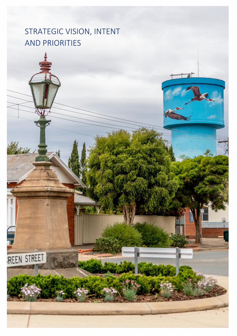
STRATEGIC VISION, INTENT AND PRIORITIES ........................................................................................ 22
OUR VISION ........................................................................................................................................... 23
OUR PLANNING PRIORITIES .................................................................................................................. 24
ACTION PLAN ........................................................................................................................................ 31
REFERENCES .......................................................................................................................................... 33
LOCKHART SHIRE COUNCIL - LOCAL STRATEGIC PLANNING STATEMENT 5
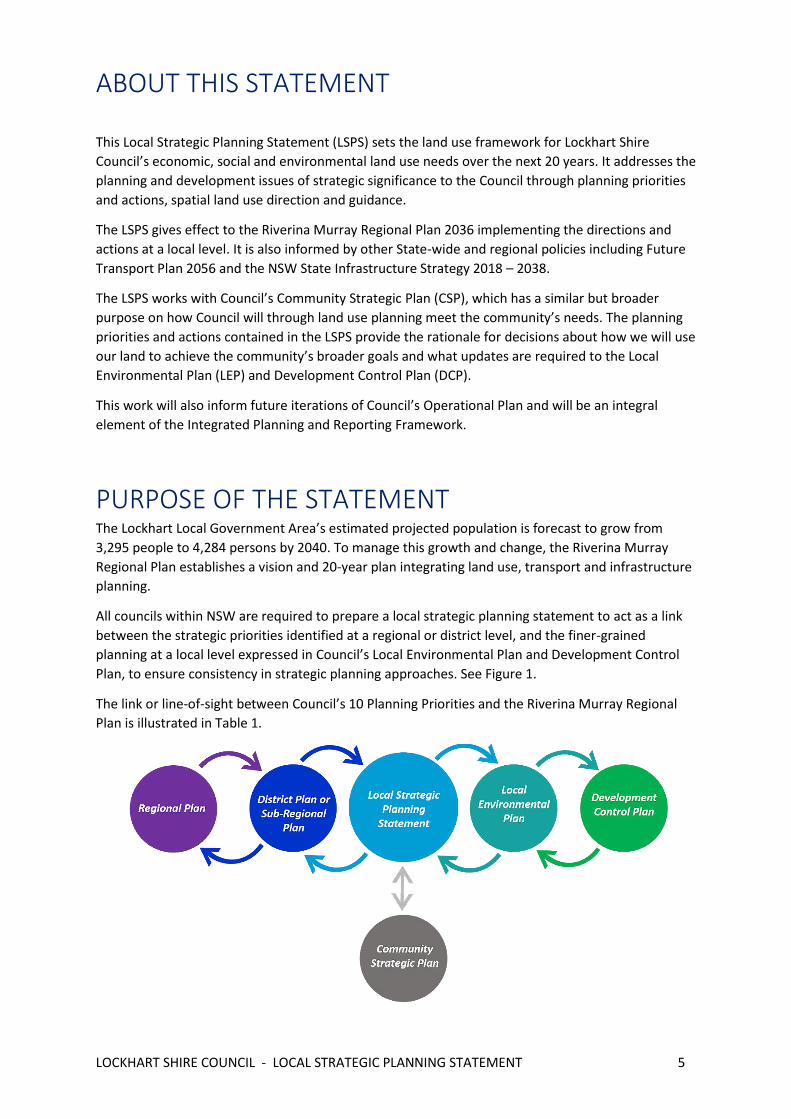
ABOUT THIS STATEMENT
This Local Strategic Planning Statement (LSPS) sets the land use framework for Lockhart Shire
Council’s economic, social and environmental land use needs over the next 20 years. It addresses the
planning and development issues of strategic significance to the Council through planning priorities
and actions, spatial land use direction and guidance.
The LSPS gives effect to the Riverina Murray Regional Plan 2036 implementing the directions and
actions at a local level. It is also informed by other State-wide and regional policies including Future
Transport Plan 2056 and the NSW State Infrastructure Strategy 2018 – 2038.
The LSPS works with Council’s Community Strategic Plan (CSP), which has a similar but broader
purpose on how Council will through land use planning meet the community’s needs. The planning
priorities and actions contained in the LSPS provide the rationale for decisions about how we will use
our land to achieve the community’s broader goals and what updates are required to the Local
Environmental Plan (LEP) and Development Control Plan (DCP).
This work will also inform future iterations of Council’s Operational Plan and will be an integral
element of the Integrated Planning and Reporting Framework.
PURPOSE OF THE STATEMENT The Lockhart Local Government Area’s estimated projected population is forecast to grow from
3,295 people to 4,284 persons by 2040. To manage this growth and change, the Riverina Murray
Regional Plan establishes a vision and 20-year plan integrating land use, transport and infrastructure
planning.
All councils within NSW are required to prepare a local strategic planning statement to act as a link
between the strategic priorities identified at a regional or district level, and the finer-grained
planning at a local level expressed in Council’s Local Environmental Plan and Development Control
Plan, to ensure consistency in strategic planning approaches. See Figure 1.
The link or line-of-sight between Council’s 10 Planning Priorities and the Riverina Murray Regional
Plan is illustrated in Table 1.
LOCKHART SHIRE COUNCIL - LOCAL STRATEGIC PLANNING STATEMENT 6
POLICY CONTEXT
This Statement has been prepared in accordance with section 3.9 of the Environmental Planning and
Assessment Act 1979 (the Act) which requires that it include or identify the following:
a. the basis for strategic planning in the area, having regard to economic, social and
environmental matters,
b. the planning priorities for the area that are consistent with any strategic plan applying to the
area and (subject to any such strategic plan) any applicable community strategic plan under section
402 of the Local Government Act 1993,
c. the actions required for achieving those planning priorities,
d. the basis on which the council is to monitor and report on the implementation of those
actions.

LOCKHART SHIRE COUNCIL - LOCAL STRATEGIC PLANNING STATEMENT 7
A growing and diverse economy A healthy environment with pristine
waterways Efficient transport and infrastructure
networks Strong, connected and healthy
communities LS
PS
Pri
ori
ty
Planning priority 1 - Protect agricultural land and grow agribusiness Planning priority 2 – Promote opportunities for local employment Planning priority 3 – Enhance tourism opportunities
Planning priority 4 - Adapt to the impacts and hazards of climate change Planning priority 5 – Protect our natural environment
Planning priority 6 - Improve access to, from and within the Lockhart Shire
Planning priority 7 – Development controls of high quality, to maintain resident amenity and promote a sense of place Planning priority 8 – Growing, active and connected communities
Riv
erin
a M
urr
ay R
egi
on
al P
lan
Dir
ect
ion
s
Direction 1 Protect the region’s diverse and productive agricultural land Direction 2 Promote and grow the agribusiness sector Direction 3 Expand advanced and value-added manufacturing Direction 4 Promote business activities in industrial and commercial areas Direction 5 Support the growth of the health and aged care sectors Direction 6 Promote the expansion of education and training opportunities Direction 7 Promote tourism opportunities Direction 11 Promote the diversification of energy supplies through renewable energy generation
Direction 15: Protect and manage the region’s many environmental assets Direction 16: Increase resilience to natural hazards and climate change
Direction 18 Enhance road and rail freight links Direction 20 Identify and protect future transport corridors
Direction 22: Promote the growth of regional cities and local centres Direction 23: Build resilience in towns and villages Direction 25: Build housing capacity to meet demand Direction 26: Provide greater housing choice Direction 27: Manage rural residential development Direction 28: Deliver healthy built environments and improved urban design Direction 29: Protect the region’s Aboriginal and historic heritage
Lock
har
t C
om
mu
nit
y St
rate
gic
Pla
n O
bje
ctiv
es
B1. Our Shire is attractive and welcoming to businesses, industry, residents and visitors B2. Our community has a robust retail offering, strong tourism sectors, and a range of job opportunities B3. We develop, attract and retain skilled individuals in our community
C1. Our environmental practices are sustainable C2. Flora and fauna are protected across the Shire. C3. Our open space and natural environment are protected for future generations
D1. Our assets and infrastructure are well planned and managed to meet the demands of the community now and in the future
A2. Our community services and facilities meet the needs of our communities A3. People of all ages, abilities, and backgrounds participate in community life

LOCKHART SHIRE COUNCIL - LOCAL STRATEGIC PLANNING STATEMENT 8
CONSULTATION
Council prepared this Statement by building upon the results of extensive engagement undertaken
in developing Council’s Community Strategic Plan, during 2016-2017, including community feedback
regarding what residents most like and dislike about Lockhart Shire, and what residents would like to
see retained and changed. The Statement will be advertised for community input, prior to its
adoption.
The NSW Department of Planning Industry and Environment have also been consulted during the
preparation of this Plan.
MONITORING AND REPORTING
This LSPS describes the long-term land use strategy for the Lockhart LGA to 2040. The statement is
intended to be a living document and should be revised on an ongoing, as-needs-basis so that the
plan remains responsive, relevant and local. To this end, it is intended that the statement will be
updated upon completion of the various actions identified throughout the document.
Revisions to the LSPS may also be required in response to significant changes within the LGA, such as
new infrastructure investment and employment opportunities or significant changes in projected
population growth.
Council will monitor and report on progress of the LSPS priorities, actions and outcomes in an annual
report. This will inform adjustments to the LSPS to ensure local planning policy is effective,
responsive and delivering on local community aspirations. A comprehensive review will be
undertaken in 2026, if not earlier.
Community feedback will be regularly sought. It is anticipated that this consultation will identify
continuous improvement opportunities and will ensure that the LSPS continues to reflect the
community’s social and economic needs as well as their vision of the future desired state of the local
area.
There will be a need to collaborate with other councils in the region due to the wider role that
Lockhart Shire’s strategic planning and decision-making plays in achieving the objectives of the
Riverina Murray Regional Plan 2036. It also recognises the potential impact that strategically
important decisions regarding critical infrastructure, environmental issues, housing, investment and
a range of other topics covered in the LSPS may have on the plans of neighbouring communities.
These valued cross boundary partnerships will also help deliver Lockhart Shire’s vision by driving
efficiencies in accessing government funding, attracting inward investment and accessing a wider
field of expertise.
Funding & Investment
Strategies and studies required by this statement will primarily be funded in future 4-year delivery
programs and annual operational plans of Council, although availability of funding via the Regional
Growth Fund and other state agency opportunities will also be explored.

LOCKHART SHIRE COUNCIL - LOCAL STRATEGIC PLANNING STATEMENT 9
Monitoring & Reporting
Council will monitor, review and report on its LSPS to ensure that its planning priorities are being
achieved, using the existing Integrated Planning & Reporting Framework (IP&R) in accordance with
the Local Government Act 1993.
LOCKHART SHIRE COUNCIL - LOCAL STRATEGIC PLANNING STATEMENT 10
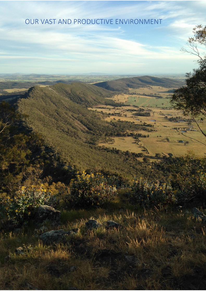
OUR VAST AND PRODUCTIVE ENVIRONMENT

LOCKHART SHIRE COUNCIL - LOCAL STRATEGIC PLANNING STATEMENT 11
OUR PLACE IN THE RIVERINA
Lockhart Shire nestles in the heart of the Riverina and is one of the region’s most productive
agricultural and pastoral areas. Of strong pioneering heritage and steeped in history, Lockhart Shire's
main towns and villages include Lockhart, The Rock, Yerong Creek, Pleasant Hills and Milbrulong.
Each community has its own unique character and history, and the Shire offers visitors a relaxed
country atmosphere steeped in history.
The Shire’s main economic drivers include a strong agricultural sector – producing quality grain,
lamb, beef and wool – supported by a number of secondary and service industries.
Lockhart is centrally situated 62kms south-west of Wagga Wagga, 62 kms southeast of Narrandera
and 105 kms north of Albury. The Rock is on the Olympic Highway 25 kms south of Wagga Wagga
with Yerong Creek another 15 kms down the Highway. Our central location provides continued
opportunities for population growth, particularly with the Wagga Wagga local government area
(LGA) having a major influence through employment and access to higher level goods and services.
There are growing numbers of residents who work in Wagga Wagga that have chosen the affordable
rural and community lifestyle offered by Lockhart or The Rock.
THE RIVERINA
THE ROCK •
YERONG CREEK •
Legend
State Main Roads National Highways Rivers
LOCKHART SHIRE COUNCIL - LOCAL STRATEGIC PLANNING STATEMENT 12
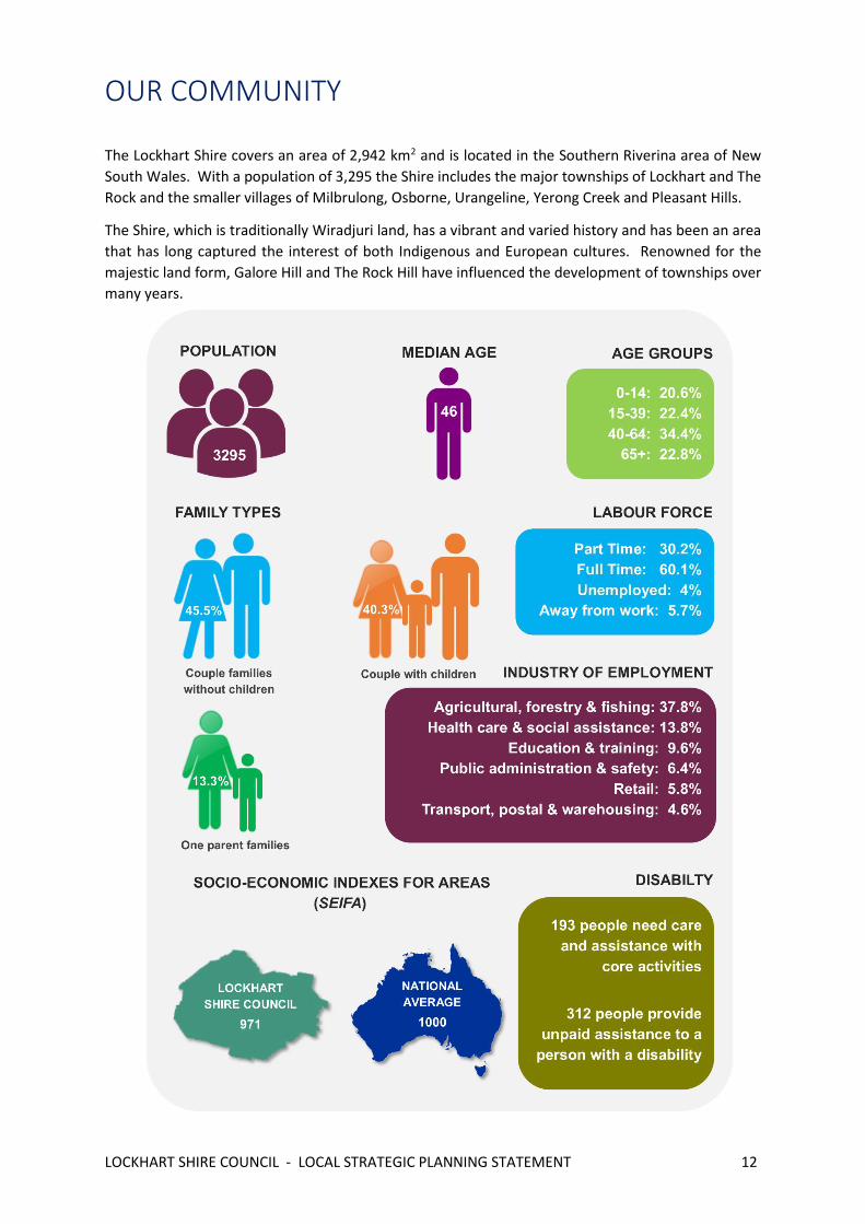
OUR COMMUNITY
The Lockhart Shire covers an area of 2,942 km2 and is located in the Southern Riverina area of New
South Wales. With a population of 3,295 the Shire includes the major townships of Lockhart and The
Rock and the smaller villages of Milbrulong, Osborne, Urangeline, Yerong Creek and Pleasant Hills.
The Shire, which is traditionally Wiradjuri land, has a vibrant and varied history and has been an area
that has long captured the interest of both Indigenous and European cultures. Renowned for the
majestic land form, Galore Hill and The Rock Hill have influenced the development of townships over
many years.

LOCKHART SHIRE COUNCIL - LOCAL STRATEGIC PLANNING STATEMENT 13
The Shire, which offers the full range of lifestyle options, has grown in popularity, both as a place to
live and as a place of business. With close proximity to the major regional centres of Wagga Wagga
and Albury, the Shire still relies on a strong primary industry supported by a number of secondary and
service industries. Tourism, especially heritage and eco-tourism, have seen good positive growth over
recent years.
Lockhart Shire is the centre of farming excellence. Fertile soils led to agriculture flourishing, firstly as
a grazing district and, with the advent of cropping, became a prosperous mixed farming area. Today,
its proud history is reflected in the agricultural initiatives and distinction for which the Shire has
become renowned. The Shire’s agriculture continues to produce quality grain, prime lamb and beef,
with the wool industry still an integral part of its agricultural diversity.
LOCKHART SHIRE COUNCIL - LOCAL STRATEGIC PLANNING STATEMENT 14
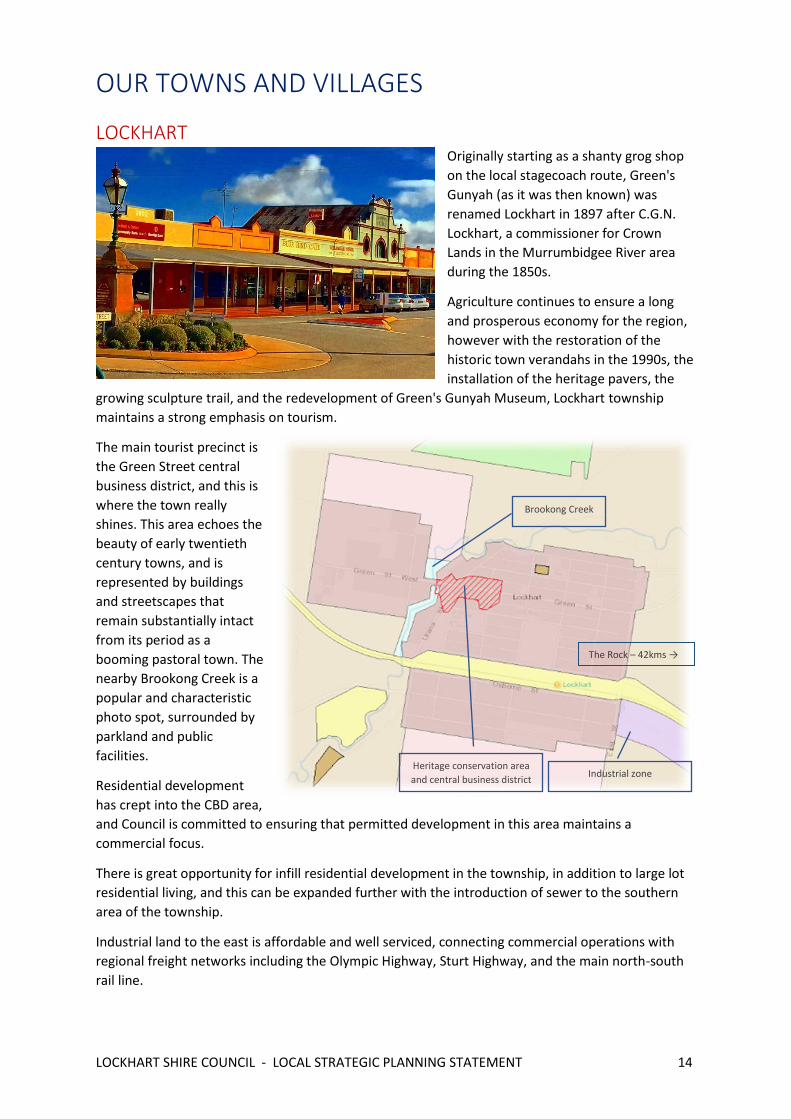
OUR TOWNS AND VILLAGES
LOCKHART Originally starting as a shanty grog shop
on the local stagecoach route, Green's
Gunyah (as it was then known) was
renamed Lockhart in 1897 after C.G.N.
Lockhart, a commissioner for Crown
Lands in the Murrumbidgee River area
during the 1850s.
Agriculture continues to ensure a long
and prosperous economy for the region,
however with the restoration of the
historic town verandahs in the 1990s, the
installation of the heritage pavers, the
growing sculpture trail, and the redevelopment of Green's Gunyah Museum, Lockhart township
maintains a strong emphasis on tourism.
The main tourist precinct is
the Green Street central
business district, and this is
where the town really
shines. This area echoes the
beauty of early twentieth
century towns, and is
represented by buildings
and streetscapes that
remain substantially intact
from its period as a
booming pastoral town. The
nearby Brookong Creek is a
popular and characteristic
photo spot, surrounded by
parkland and public
facilities.
Residential development
has crept into the CBD area,
and Council is committed to ensuring that permitted development in this area maintains a
commercial focus.
There is great opportunity for infill residential development in the township, in addition to large lot
residential living, and this can be expanded further with the introduction of sewer to the southern
area of the township.
Industrial land to the east is affordable and well serviced, connecting commercial operations with
regional freight networks including the Olympic Highway, Sturt Highway, and the main north-south
rail line.
Heritage conservation area
and central business district Industrial zone
Brookong Creek
The Rock – 42kms →

LOCKHART SHIRE COUNCIL - LOCAL STRATEGIC PLANNING STATEMENT 15
THE ROCK The railway town of The Rock is the eastern gateway to the Lockhart Shire. An easy drive along the
Olympic Highway, 25km south of Wagga Wagga and 96km north of Albury, the character of the town
is derived from its wide park-like main thoroughfare and the visual domination of The Rock Hill that
lies immediately south of the town.
In the main street (Urana Street)
kurrajong trees create an Avenue of
Honour, one for each soldier in the district
who served his country in World War 1.
This area is the centrepiece of the town,
and is surrounded by a central business
district and rail precinct, culminating to
form a unique heritage conservation area.
The Rock has access to Country Link rail
services including the XPT passenger train
service, and the Olympic Highway,
providing access to Wagga Wagga.
These key infrastructure corridors also
segregate the developed residential area
with new emerging areas, and Council is keen to explore opportunities to provide greater access and
overall connectivity to shops and key public facilities, such as The Rock Memorial Swimming Pool
complex and recreation ground.
New residential
subdivisions to the
south east would
benefit from greater
inclusion and all-ability
access, to promote
safer and more
connected
communities.
Land to the north and
south of the township is
zoned R5 large lot
residential, and is
largely undeveloped to
date. This creates a
great opportunity for
larger, lifestyle
residential blocks
within easy commuting
distance from Wagga Wagga, and at very reasonable market prices.
The popular sealed bicycle/walking path which connects the township to The Rock Nature Reserve is
a perfect segway to enhancing liveability in the town, and this can be extended to the southern area
of the township to encourage a more active and healthy community within the town.
Heritage conservation area
and historic rail station Olympic Highway, and rail line
Lockhart – 42kms
LOCKHART SHIRE COUNCIL - LOCAL STRATEGIC PLANNING STATEMENT 16
YERONG CREEK Yerong Creek is the oldest village in
the Lockhart Shire, having been
settled in the 1870’s. A small rural
village, Yerong Creek began when
settlers arrived to assist in the
construction of the rail line, which
remains operational to this day
and divides the town in two.
The town is zoned RU5 and largely
consists of residential
development characteristic of a
rural village. A small central
business district operates on the
western side of the rail line, with
the Olympic Highway running parallel, and a small public school operates on the eastern side – all
encompassed within a heritage conservation area.
Yerong Creek remains a rural town to the surrounding agricultural community, acting as a local
meeting point and for community activity via its school, recreation ground and farm produce store.
A highlight of Yerong Creek is the Chinese Crossing at Noske's Lane, a rare remaining example of
functional stone work carried out by Chinese migrants. Built in the early 1880s as a dam wall to
accumulate water for the growing of vegetables and opium, Noske’s Crossing still serves as a
carriageway across the creek.
There is significant capacity for further infill residential development within the village, and a low-
pressure sewer scheme operates to reduce hydraulic loading, thereby permitting smaller lot sizes and
greater housing density.
Rail line and Olympic
Highway dissecting the
village
Heritage conservation area
The Rock – 15kms

LOCKHART SHIRE COUNCIL - LOCAL STRATEGIC PLANNING STATEMENT 17
MILBRULONG The name Milbrulong is derived from the local Aboriginal word meaning "Rosella parrot". Milbrulong
is a village situated 15 kilometres east of Lockhart and 25 kilometres west of The Rock.
Originally located about 2 km south during
the early 1890's, the village moved north
with the establishment of the railway line
through the current location. By 1900, a
school, hotel, store and blacksmith were in
place.
Today, Milbrulong is considered by those
who love it as a very good place to live. The
historic Lutheran Church and Cemetery is
located just outside of the village, with the
Milbrulong State Forest, great for horse
riding and bird watching, nearby.
Milbrulong has ample opportunity for residential infill development. Lot sizes are large, and basic
services (water, electricity, sealed roads) are available to enjoy. Grain silos and the rail line, still used
for bulk grain haulage,
dominate the
landscape and present
a great photo
opportunity. There is
potential to expand on
previously undertaken
restoration work of
historically significant
buildings and sites in
the town, including the
old hotel and
recreation ground hall,
to enhance street
appeal.
Rail line and Grain silos
Lockhart – 12kms
LOCKHART SHIRE COUNCIL - LOCAL STRATEGIC PLANNING STATEMENT 18
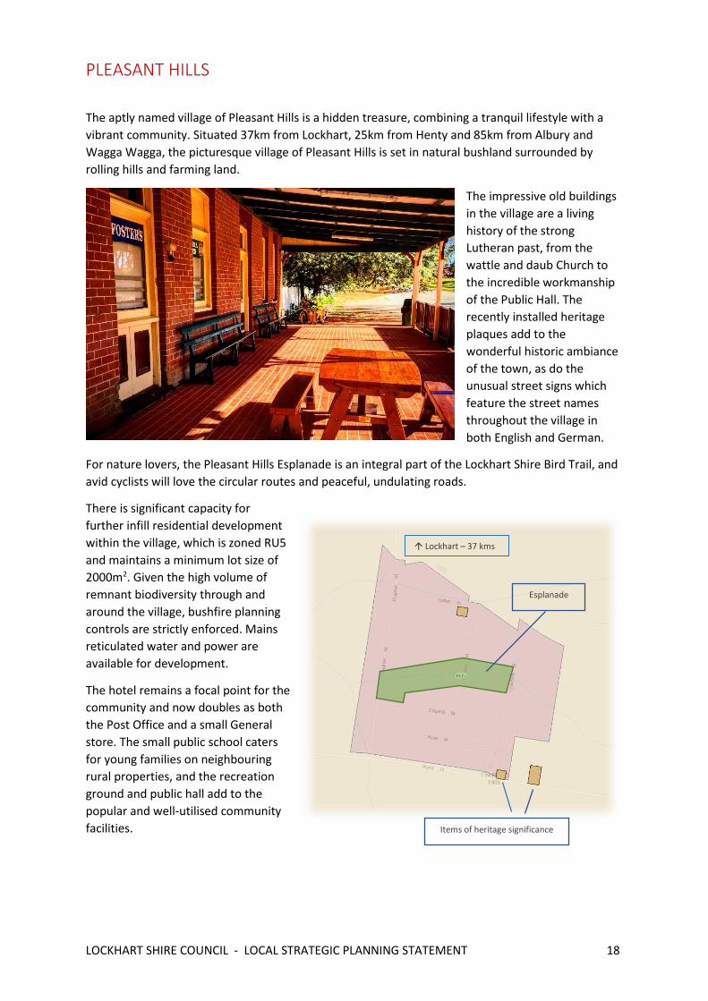
PLEASANT HILLS
The aptly named village of Pleasant Hills is a hidden treasure, combining a tranquil lifestyle with a
vibrant community. Situated 37km from Lockhart, 25km from Henty and 85km from Albury and
Wagga Wagga, the picturesque village of Pleasant Hills is set in natural bushland surrounded by
rolling hills and farming land.
The impressive old buildings
in the village are a living
history of the strong
Lutheran past, from the
wattle and daub Church to
the incredible workmanship
of the Public Hall. The
recently installed heritage
plaques add to the
wonderful historic ambiance
of the town, as do the
unusual street signs which
feature the street names
throughout the village in
both English and German.
For nature lovers, the Pleasant Hills Esplanade is an integral part of the Lockhart Shire Bird Trail, and
avid cyclists will love the circular routes and peaceful, undulating roads.
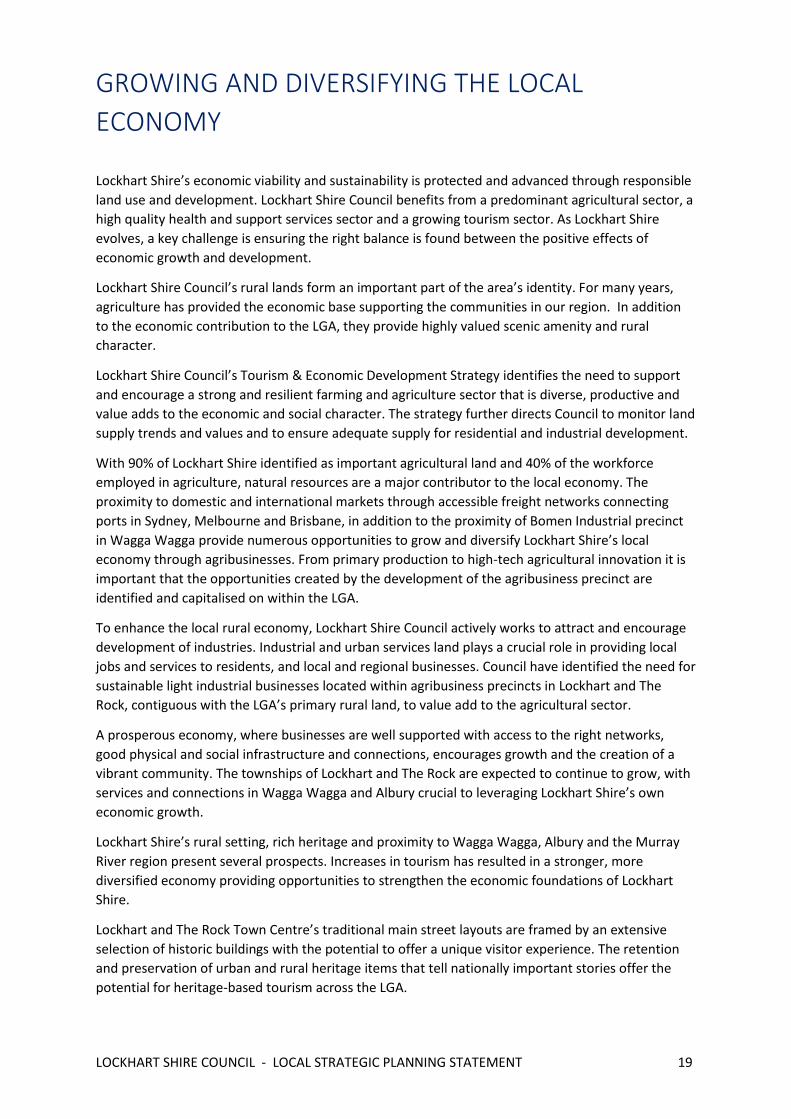
There is significant capacity for
further infill residential development
within the village, which is zoned RU5
and maintains a minimum lot size of
2000m2. Given the high volume of
remnant biodiversity through and
around the village, bushfire planning
controls are strictly enforced. Mains
reticulated water and power are
available for development.
The hotel remains a focal point for the
community and now doubles as both
the Post Office and a small General
store. The small public school caters
for young families on neighbouring
rural properties, and the recreation
ground and public hall add to the
popular and well-utilised community
facilities. Items of heritage significance
Lockhart – 37 kms
Esplanade
LOCKHART SHIRE COUNCIL - LOCAL STRATEGIC PLANNING STATEMENT 19
GROWING AND DIVERSIFYING THE LOCAL
ECONOMY
Lockhart Shire’s economic viability and sustainability is protected and advanced through responsible
land use and development. Lockhart Shire Council benefits from a predominant agricultural sector, a
high quality health and support services sector and a growing tourism sector. As Lockhart Shire
evolves, a key challenge is ensuring the right balance is found between the positive effects of
economic growth and development.
Lockhart Shire Council’s rural lands form an important part of the area’s identity. For many years,
agriculture has provided the economic base supporting the communities in our region. In addition
to the economic contribution to the LGA, they provide highly valued scenic amenity and rural
character.
Lockhart Shire Council’s Tourism & Economic Development Strategy identifies the need to support
and encourage a strong and resilient farming and agriculture sector that is diverse, productive and
value adds to the economic and social character. The strategy further directs Council to monitor land
supply trends and values and to ensure adequate supply for residential and industrial development.
With 90% of Lockhart Shire identified as important agricultural land and 40% of the workforce
employed in agriculture, natural resources are a major contributor to the local economy. The
proximity to domestic and international markets through accessible freight networks connecting
ports in Sydney, Melbourne and Brisbane, in addition to the proximity of Bomen Industrial precinct
in Wagga Wagga provide numerous opportunities to grow and diversify Lockhart Shire’s local
economy through agribusinesses. From primary production to high-tech agricultural innovation it is
important that the opportunities created by the development of the agribusiness precinct are
identified and capitalised on within the LGA.
To enhance the local rural economy, Lockhart Shire Council actively works to attract and encourage
development of industries. Industrial and urban services land plays a crucial role in providing local
jobs and services to residents, and local and regional businesses. Council have identified the need for
sustainable light industrial businesses located within agribusiness precincts in Lockhart and The
Rock, contiguous with the LGA’s primary rural land, to value add to the agricultural sector.
A prosperous economy, where businesses are well supported with access to the right networks,
good physical and social infrastructure and connections, encourages growth and the creation of a
vibrant community. The townships of Lockhart and The Rock are expected to continue to grow, with
services and connections in Wagga Wagga and Albury crucial to leveraging Lockhart Shire’s own
economic growth.
Lockhart Shire’s rural setting, rich heritage and proximity to Wagga Wagga, Albury and the Murray
River region present several prospects. Increases in tourism has resulted in a stronger, more
diversified economy providing opportunities to strengthen the economic foundations of Lockhart
Shire.
Lockhart and The Rock Town Centre’s traditional main street layouts are framed by an extensive
selection of historic buildings with the potential to offer a unique visitor experience. The retention
and preservation of urban and rural heritage items that tell nationally important stories offer the
potential for heritage-based tourism across the LGA.
LOCKHART SHIRE COUNCIL - LOCAL STRATEGIC PLANNING STATEMENT 20
Within the LGA there are areas that can develop into tourism hubs in their own right such as The
Rock Observatory, The Rock Hill, Galore Hill and the Brookong Creek precinct, whilst civic, cultural,
natural and sporting spaces provide the platform for the events sector to grow.
Lockhart Shire Council will investigate opportunities to build on these assets and promote them
widely, as well as look at opportunities for other development that support the visitor economy,
such as appropriate land zoned to permit a range of visitor accommodation, food and hospitality and
events.
LOCKHART SHIRE COUNCIL - LOCAL STRATEGIC PLANNING STATEMENT 21
OUR CHALLENGES
Sustaining a population growth is a major concern for Lockhart Shire. Our communities support large
agricultural sectors, and as agricultural technology and innovation expand we see an inevitable
reduction in the need for workers. The connection between agriculture and value-adding
opportunities, including manufacturing and processing, will become increasingly important to
support the resilience and future growth of our towns and villages, and help attract and retain
skilled professionals.
Over the next 20 years, the majority of housing is likely to be delivered in regional cities, so our
development controls must work to ensure that rural residential housing remains a popular lifestyle
option. Certainly, this type of housing has the potential to create land use conflicts with productive
agricultural land, so a consistent planning approach is required to identify suitable locations for new
rural residential development, to avoid fragmentation of productive agricultural land, potential
impacts on high environmental value assets, cultural and heritage assets or areas with important
rural landscape values. Rural residential development should not increase pressures on
infrastructure and services and should be located on land free from natural hazards, such as
bushfire. This will be a difficult task, given that risk to land and assets from bushfire needs to be
reassessed across the whole shire, as the NSW Rural Fire Service continue to learn from devastating
events. Previously considered low risk, grasslands are now a high priority for Council.
In some areas with stable or declining populations, there will still be demand for new dwellings and
for a greater variety of housing types, and these should reflect the character and heritage of the
area. Our heritage conservations areas are consistently under threat of decline, so better promotion
and targeted community education initiatives, such as advertising and access to information, may
help to increase community support for managing and protecting heritage assets.
Drought and climate change continue to put pressure on our Shire. A warmer climate in NSW will
result in less rainfall, and our natural assets and environments are not able to adapt to such rapidly
changing conditions. Loss of natural vegetation continues, equating to loss of critical habitat which
is already largely under threat. Changing farming practices are ongoing, and continued research and
development on sustainable farming practices are essential for long term survival of agriculture in
the region.
LOCKHART SHIRE COUNCIL - LOCAL STRATEGIC PLANNING STATEMENT 22
STRATEGIC VISION, INTENT
AND PRIORITIES

LOCKHART SHIRE COUNCIL - LOCAL STRATEGIC PLANNING STATEMENT 23
OUR VISION
Lockhart Shire is the true spirit of the Riverina.
A resilient and community-focused rural shire, we are keen to protect and exhibit our values and deep
connection to the land. While leveraging on the strengths of the region, we are proud of our
independence and work hard to support our continued priority of developing inclusive, active and
liveable communities.
Over the next 20 years, housing opportunities and choice will continue to be provided to cater for a
varied and changing demographic. Town and villages will represent our rural character - we enjoy wide
streets, trees and open spaces, ample parking, arts and history. Our communities will be stimulating,
accessible and resilient, connectivity in between will be seamless.
Our central business districts – places of community and prosperity – will continue to thrive and serve
our region. These areas will showcase our highly valued historical buildings and characteristic rural
features, drawing people to our Shire.
Tourism will be encouraged, as it continues to sustain the economic viability of small business within
the Shire. Nature lovers and outdoor adventurers enjoy the natural attractions at Galore Hill and The
Rock nature reserve, and our arts and sculpture trails are renowned, and reflect our love of and
reliance on the rural landscape.
Road and rail draw the region to our towns and connects us with the Riverina. Our proximity to larger
regional centres, such as Wagga Wagga, means that we have local access to high quality products and
services. Our infrastructure networks are key to preserving this connectivity, and our industrial land is
strategically placed to take advantage of regional freight networks.
Agriculture dominates our landscape and is vital to our survival. It drives our economy, supports small
business, provides research and innovation opportunities, and ties us to the region. Important
agricultural land will be prioritised and preserved, and other land uses will be carefully managed to
complement existing agricultural land use practices.
The effects of climate change and natural hazards will be managed through good planning and
infrastructure delivery, and we will continue to respect and retain our environmental heritage. Our
linear reserves and patches of remnant vegetation will be protected, and there will be an opportunity
to connect these areas through biodiversity corridors.

LOCKHART SHIRE COUNCIL - LOCAL STRATEGIC PLANNING STATEMENT 24
OUR PLANNING PRIORITIES
Planning priority 1 - Protect agricultural land and grow agribusiness
sector
Rationale
Sustainable dryland agricultural practices, commensurate with the landscape constraints and climate
conditions, have been conducted successfully through the Lockhart Shire for nearly 175 years.
Agriculture is the dominant land use within the local government area, with land consisting of gently
undulating hills to the east, and flat terrain/ floodplains to the west. Overall, Lockhart Shire is more
than 95% arable and the broad landscape defines the nature of the local area farming practices.
The Department of Planning, Industry and Environment (Agriculture) intends to prepare maps
identifying the important agricultural lands in the Lockhart area, to provide information for local,
regional and state planning, and to also guide industry, agencies and organisations to assist in their
decision making.
According to the Lockhart Shire Rural Lands Study, key trends impacting agriculture include:
- Increasing business scale;
- Drought;
- Declining terms of trade;
- Declining livestock numbers;
- Increasing crop production; and
- Growth of off-farm income.
Further to this, an emerging impact is the creation of small recreational type farming allotments
(rural residential) as a result of subdivision and vacant dwellings from consolidation of existing farm
entitlements.
In response, the Lockhart Shire Development Control Plan establishes objectives to ensure long term
viability of rural development, by promoting sustainability and clearly defined boundaries between
primary production and residential development.
The DCP also supports intensive farming practices, to maintain or enhance both agricultural
production as an economic activity, and the natural resource base (including other ecosystems
which are influenced by agricultural activities).
This planning priority reflects Lockhart’s aspirations to support its agricultural identity and to ensure
a strong local economy that leverages the favourable climate and strategic connectivity to domestic
and international markets via regional freight routes.
Action
- Introduce a Right to Farm Policy, based on the principles of the NSW Right to Farm Policy
A GROWING AND DIVERSE ECONOMY
LOCKHART SHIRE COUNCIL - LOCAL STRATEGIC PLANNING STATEMENT 25
- Manage land use conflict through use of comprehensive pre-lodgement discussions and
identification and management of risks to continued farming operations
- Review the Lockhart Shire Council Rural Lands Study 2013 to determine if all measures and
recommendations have been implemented
Planning priority 2 – Promote opportunities for local employment
Rationale
Economic diversity is critical for Lockhart Shire’s future, to strengthen the local economy, create
economic resilience and spread the benefits of growth more widely across the entire Shire. New
opportunities do diversify economic activities including health care, professional and personal
services, training, manufacturing construction retail and food services will assist Lockhart Shire to
become more resilient to economic, social and environmental shifts.
As technology and innovation expand in the agriculture sector, we see an inevitable reduction in the
need for workers. As such, there is greater reliance on other business types to drive employment
within the Shire. Intensive farming enterprises, such as pig farms and feedlots, if managed correctly,
can incentivise employment and provide important economic stimulus through local procurement of
goods and services. Intensive livestock and intensive plant agriculture are permissible with consent
on primary production land, and improved development controls are required to protect existing
farming operations and the overall rural setting.
Meanwhile, the central business districts of Lockhart and The Rock are under frequent development
pressure through residential occupation of commercial premises, with this type of development
having a serious impact on availability of retail space and shop frontage. As premises shift away from
commercial use, shop fronts and displays become less active and engaging, having a flow on effect
on overall trading and tourism. Lockhart Council has already demonstrated a desire to prohibit
further residential creep into CBD areas through introduction of controls in the DCP, and this may be
further supplemented by potential re-zoning of the CBD from residential to business.
Our industrial land at Lockhart contributes greatly to our local economy, and we strive to emulate
that at The Rock. Freight corridors are essential to the success of the agribusiness sector, and the
integration of these corridors into industrial precincts provides further opportunities to maximise
the efficiency of freight movements from the region.
Action
- Review the Lockhart DCP to improve controls for intensive farming enterprises
- Maintain development controls prohibiting residential development within the CBD areas of
Lockhart and The Rock
- Investigate rezoning of central business districts of Lockhart and The Rock from RU5 to
Business through development of a residential land study
- Preserve and explore greater connection of industrial land with regional freight networks
including road and rail
LOCKHART SHIRE COUNCIL - LOCAL STRATEGIC PLANNING STATEMENT 26
Planning priority 3 – Enhance tourism opportunities
Rationale
The Riverina Murray Region has a number of strengths that define perceptions of the tourism
product across the whole region. Lockhart Shire is centrally located in the Riverina and is bordered
by regionally significant road networks such as the Olympic Highway and Sturt Highway, both of
which have potential as an inland tourism corridor that we can draw from.
Lockhart enjoy promoting agritourism, lifestyle activities through events and festivals, recreation,
and historic heritage – all of which can help to sustain the economies of our towns and villages, and
help attract visitors in off-peak seasons.
The Green Street CBD in Lockhart, and the Urana Street avenue at The Rock, are truly unique and
major drawcards for our Shire. Heritage conservation areas preserve these built environments,
which are busy with food, people and history. In response to aging road and footpath infrastructure,
combined with the natural landform and historic flood planning constraints for both villages, Council
are keen to deliver on the actions proposed by an open space master plan for the Lockhart central
business district, which aims emphasise the CBD as a community area, facilitating the innovative
reuse of heritage buildings and providing improved pedestrian access.
While The Rock CBD benefits from a recent road, footpath and landscaping upgrade, improvements
in this area could be reflected through improved access to existing buildings and commercial
premises, as well as restoration to heritage-listed buildings and creation of greater retail space. A
master plan can assist council and the community in achieving these ambitions.
Action
- Protect and enhance the Shire’s natural attractions The Rock and Galore Hill
- Implement the open space master plan for Lockhart, to improve sociability, access, multi-
dimensional uses and activities, comfort and image of places
- Create and implement an open space master plan for The Rock
- Review and update the Section 7.12 development control plans to provide for opportunity
to fund the upgrade of community facilities
Planning priority 4 - Adapt to the impacts and hazards of climate
change
Rationale
The region’s natural environment presents a number of challenges, such as floods, bushfires, and
droughts, and these are expected to be exacerbated by climate change. The Lockhart Shire has a
A HEALTHY ENVIRONMENT WITH PRISTINE WATERWAYS
LOCKHART SHIRE COUNCIL - LOCAL STRATEGIC PLANNING STATEMENT 27
long and current history with each of these challenges, and the effects on our communities are
extensive and enduring.
Weather extremes are becoming more prevalent, with our shire suffering from drought, record-
breaking flood events, and subsequent drought. Through research, development and innovation,
agriculture is forced to respond and adapt to these extremes, and our natural environments are
susceptible to decline.
Council’s focus for the future is not just to protect, but also to actively manage and restore
environmental values and connections, support our open woodlands and grassy plains, and
contribute to healthy, engaged communities.
Council has already undertaken extensive flood planning work through the preparation of Flood
studies for both Lockhart and The Rock, following historically significant flood events in 2010 and
2012. Flood mitigation measures proposed by subsequent floodplain risk management plans have
largely been implemented, and it will be necessary to review Council’s flood study documents upon
completion of works to better inform our planning decisions.
Our bushfire prone land maps are in need of review to better reflect planning controls applied by the
NSW Rural Fire Service. As the fire risk of grasslands is re-considered, Council will be required to seek
more substantial services in residential subdivisions and infill development, particularly on the urban
fringe, as well as overall improved building design.
Action
- Re-assess all bushfire prone land mapping within the Lockhart Shire
- Continue to implement flood mitigation works to protect development in our towns and
villages
- Re-survey all flood prone lands upon completion of flood mitigation activities to ensure
adequate flood planning controls are in place
Planning priority 5 – Protect our natural environment
Rationale
The Lockhart Shire supports a wide range of environmental assets and native vegetation
communities, and while already under threat of degradation, are already protected through existing
legislation. Protecting these values is important to our Shire and the economic and environmental
wellbeing of the region. Assets identified with high environmental values are predominantly areas of
native vegetation of high conservation value, including roadside linear reserves, Galore Hill,
Flowerpot Hill and The Rock nature reserve.
Our areas of natural significance at Galore Hill and The Rock nature reserve are some of the most
impressive landmarks in the region, rising above the surrounding plains, and marking a special site of
indigenous history. Each area consists of hundreds of hectares of rare and endangered plant
communities, including herbs and orchids, and Council are determined to protect and retain these
areas to demonstrate and educate the public on what has and is being lost through drought, climate
change and broad acre agricultural activities.
LOCKHART SHIRE COUNCIL - LOCAL STRATEGIC PLANNING STATEMENT 28
To support the objectives of the Biodiversity Conservation Act 2016, Council is working to introduce
development controls which seek to minimise clearing in both rural and residential areas. Planting
and preservation of trees on residential areas improve aesthetics and help mitigate the effects of
climate change. Meanwhile, habitat protection is vital to sustaining our threatened and endangered
ecological communities, and in conjunction with Landcare networks, Council planning decisions will
seek to increase available habitat by promoting buffers along linear reserves and connections
through private land holdings.
Action
- To incorporate land and linear reserves with high conservation attributes into Council’s
planning controls biodiversity mapping
- Introduce controls for biodiversity conservation into the Lockhart Development Control Plan
Planning priority 6 - Improve access to, from and within the Lockhart
Shire
Rationale
Lockhart Shire Council maintain a local and regional road network of over 1,000 kilometres,
connecting our towns and villages, and connecting our Shire with the region. The Olympic Highway
to the east provides a significant freight path between the regional centres of Albury Wodonga and
Wagga Wagga, and when combined with the north-south inland rail corridor, access to regional
services and freight hubs is readily available.
Conversely, the Olympic Highway and the adjacent rail corridor create a feel of disconnection and a
significant barrier to active transport between The Rock CBD and residential areas in the east of the
town. An active transport plan including the residential area of The Rock will help identify potential
opportunities for improved connection between these areas, enabling greater access in the town
and promote community harmony.
Access within the Shire’s towns and villages is being continuously improved with new and wider
footpaths, however above ground stormwater management infrastructure provides challenges to
on-street parking.
Action
- Develop an active transport plan, with emphasis on connecting The Rock East with the CBD
- Encourage active transport (cycleways and walking) and links to public transport, schools,
recreation areas through development controls in the Lockhart Development Control Plan
EFFICIENT TRANSPORT AND INFRASTRUCTURE NETWORKS

LOCKHART SHIRE COUNCIL - LOCAL STRATEGIC PLANNING STATEMENT 29
- Maintain the Lockhart Shire Council Disability Access Inclusion Plan and review on regular
basis in consultation with the Community
Planning priority 7 – Development controls of high quality, to
maintain resident amenity and promote a sense of place
Rationale
Our towns and villages are the focal points for our Shire. While interconnected, each town is fiercely
independent and uniquely reputable. Our regionally influenced residential development controls are
challenged by our desire to preserve our connection to the rural landscape, and our diverse
communities – catering for the needs of children, young people, families, singles, people with
disabilities and seniors.
The Lockhart Development Control Plan aims to provide safe, healthy and socially inclusive places.
Traditionally, residential allotments in our towns and villages are large, with ample street frontage
and expansive nature strips ideal for wide footpaths and street trees. While an attractive feature and
major drawcard for residents looking for space, many infill allotments are excessively large,
occasionally leading to objectional property maintenance. Furthermore, larger residential allotments
often evolve to introduction of livestock, including sheep and horses, which detract from local
values. Development controls for future subdivisions should consider these potential ancillary uses
to residential development.
Consequently, a mix of large and small lot sizes suitable for future residential development are
sought to provide diverse housing choices and opportunities, to meet changing demographics and
population needs. Open public spaces are important in concentrated residential areas, providing an
opportunity for communal meeting points and opportunities for exercise and recreation. Such
spaces do not necessarily require extensive infrastructure such as amenities buildings and
playgrounds; instead emphasising a connection to the landscape or natural features through
creation of walking tracks and use of natural remnant vegetation as landscaping. Space procured
through Council’s voluntary purchase scheme of flood affected buildings in the Brookong Creek
precinct of Lockhart has the potential to create such a space for use by the community and visitors.
Action
- Review the Lockhart Shire Council Development Control Plan to ensure it meets the needs
and desires of our community
- In conjunction with a residential land study for Lockhart, employ market research and
community consultation to identify preferred housing choices in residential areas for a
diverse demographic
STRONG, CONNECTED AND HEALTHY COMMUNITIES
LOCKHART SHIRE COUNCIL - LOCAL STRATEGIC PLANNING STATEMENT 30
- Design an open space master plan for the Brookong Creek residential land precinct,
incorporating active transport and accessible pathways to the Lockhart CBD
Planning priority 8 – Growing, active and connected communities
Rationale
As our communities grow and diversify, Council are required to review the capacity of existing lands
and where growth is likely to and could occur. Primarily, focus will be on single dwellings with
detached sheds on residential and rural residential lands, which property owners seek beyond any
other choice. Housing options will need to be affordable to attract and cater for the Shire’s youth,
help retain young working families. Flexible and proactive development controls will respond to
support new development and will cater for a diverse demographic. New neighbourhoods shall be
environmentally sustainable, socially inclusive, easy to get to, healthy and safe.
A residential land study will help Council plan for residential growth now and into the future whilst
accommodating the different needs for rural residential and residential land uses. The Study will
explore impacts and opportunities for subdividing land and the minimum lot sizes for dwellings, the
density of dwellings in the residential areas, environmental matters and the community needs and
values.
Infrastructure needs will continue to vary between each community, and the identity of each
location must be retained and respected. The central business districts shall be more defined and
protected to provide employment opportunities, and a review of deemed appropriate land uses
within the Lockhart Shire shall be undertaken to promote and retain small business enterprises.
As our community ages, we will review the capacity of our towns access, accommodation options
and public services to support the more vulnerable. It is anticipated that a residential land study will
inform Council of the need to provide for greater housing options for older residents, including
independent living options, in light of the transition towards ageing in-place.
Action
- Deliver a residential land study for Lockhart and The Rock
- Encourage development of diverse housing and accommodation options for youth and
young families through development control plans and provision of fully serviced lots in The
Rock east
- Identify the capacity for our towns to cater for accommodation for the ageing, including
options for dependent and independent living
LOCKHART SHIRE COUNCIL - LOCAL STRATEGIC PLANNING STATEMENT 31
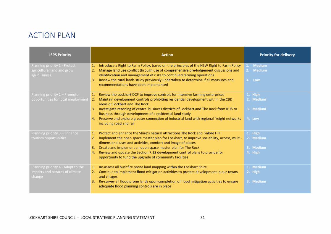
ACTION PLAN
LSPS Priority Action Priority for delivery
Planning priority 1 - Protect agricultural land and grow agribusiness
1. Introduce a Right to Farm Policy, based on the principles of the NSW Right to Farm Policy 2. Manage land use conflict through use of comprehensive pre-lodgement discussions and
identification and management of risks to continued farming operations 3. Review the rural lands study previously undertaken to determine if all measures and
recommendations have been implemented
1. Medium 2. Medium
3. Low
Planning priority 2 – Promote opportunities for local employment
1. Review the Lockhart DCP to improve controls for intensive farming enterprises 2. Maintain development controls prohibiting residential development within the CBD
areas of Lockhart and The Rock 3. Investigate rezoning of central business districts of Lockhart and The Rock from RU5 to
Business through development of a residential land study 4. Preserve and explore greater connection of industrial land with regional freight networks
including road and rail
1. High 2. Medium
3. Medium 4. Low
Planning priority 3 – Enhance tourism opportunities
1. Protect and enhance the Shire’s natural attractions The Rock and Galore Hill 2. Implement the open space master plan for Lockhart, to improve sociability, access, multi-
dimensional uses and activities, comfort and image of places 3. Create and implement an open space master plan for The Rock 4. Review and update the Section 7.12 development control plans to provide for
opportunity to fund the upgrade of community facilities
1. High 2. Medium 3. Medium 4. High
Planning priority 4 - Adapt to the impacts and hazards of climate change
1. Re-assess all bushfire prone land mapping within the Lockhart Shire 2. Continue to implement flood mitigation activities to protect development in our towns
and villages 3. Re-survey all flood prone lands upon completion of flood mitigation activities to ensure
adequate flood planning controls are in place
1. Medium 2. High 3. Medium

LOCKHART SHIRE COUNCIL - LOCAL STRATEGIC PLANNING STATEMENT 32
4. Priority Low – 1 year Medium – 2-3 years High – 5 years
Planning priority 5 – Protect our natural environment
1. To incorporate land and linear reserves with high conservation attributes into Council’s planning controls biodiversity mapping
2. Introduce controls for biodiversity conservation into the Lockhart Development Control Plan
1. Medium 2. Medium
Planning priority 6 - Improve access to, from and within the Lockhart Shire
1. Develop an active transport plan, with emphasis on connecting The Rock East with the CBD
2. Encourage active transport (cycleways and walking) and links to public transport, schools, recreation areas through development controls in the Lockhart Development Control Plan
3. Maintain Disability Access Inclusion Plan and review on regular basis in consultation with the Community
1. Low 2. Medium 3. High
Planning priority 7 – Development controls of high quality, to maintain resident amenity and promote a sense of place
1. Review the Lockhart Shire Council Development Control Plan to ensure it meets the needs and desires of our community
2. In conjunction with a residential land study for Lockhart, employ market research and community consultation to identify preferred housing choices in residential areas for a diverse demographic
3. Design an open space master plan for the Brookong Creek residential land precinct, incorporating active transport and accessible pathways to the Lockhart CBD
1. High 2. Medium 3. Low
Planning priority 8 – Growing, active and connected communities
1. Deliver a residential land study for Lockhart and The Rock 2. Encourage development of diverse housing and accommodation options for youth and
young families through development control plans and provision of fully serviced lots in The Rock east
3. Identify the capacity for our towns to cater for accommodation for the ageing, including options for dependent and independent living
1. Medium 2. Medium 3. Low
LOCKHART SHIRE COUNCIL - LOCAL STRATEGIC PLANNING STATEMENT 33
REFERENCES
Lockhart Shire Council (2017), Community Strategic Plan 2017-2027
Lockhart Shire Council (2019) Lockhart Shire Council webpage (accessed 24-10-2019) via
URL<https://www.lockhart.nsw.gov.au/>
Lockhart Shire Council (2016), Tourism and Economic Development Strategy 2016-2036
NSW Department of Planning (2017), Riverina Murray Regional Plan 2036
NSW Government (2019), Lockhart Local Environmental Plan 2012

LOCKHART SHIRE COUNCIL - LOCAL STRATEGIC PLANNING STATEMENT 34