local government spatial information management · local government spatial information management...
TRANSCRIPT
P A G E 1 7 3
L O C A L G O V E R N M E N T S P A T I A L
I N F O R M A T I O N M A N A G E M E N T
> T O O L K I T V E R S I O N 2.0
Building capacity for integrated spatial
information management solutions
J U L Y 2 0 0 7
A U S T R A L I A N L O C A L
G O V E R N M E N T A S S O C I A T I O N
A joint initiative of the Australian Local Government Association
and ANZLIC—the Spatial Information Council
M O D U L E 7
L O C A L G O V E R N M E N T S P AT I A L
I N F O R M AT I O N M A N A G E M E N T
> T O O L K I T V 2.0
M O D U L E 7
Guidelines for selecting spatial information
systems software and hardware
7
Users are directed to the
prelims of the Toolkit for
essential information,
including that addressing
copyright and liability
matters, and the ISBN.
> This is Module 7
to the L O C A L
G O V E R N M E N T
S PAT I A L
I N F O R M AT I O N
M A N A G E M E N T
T O O L K I T .
Ten detailed modules and
essential preliminary
matter to the Toolkit
are available via:
www.alga.asn.au and
www.anzlic.org.au.
> Please note in particular
the information detailed
in the prelims regarding
the use, resale and
reproduction of the
Toolkit.
Contents
Concise guide for technical managers. . . . . . . . . . . . . . . . . . . . . . . . . . . . . . . . . . . . . . . . . . . . . . . . . . 1
Module 1: Spatial information management in local government. . . . . . . . . . . . . . . . . . . . . . . . . . . 41
Module 2: An Introduction to spatial information systems. . . . . . . . . . . . . . . . . . . . . . . . . . . . . . . . . 65
Module 3: Data management principles . . . . . . . . . . . . . . . . . . . . . . . . . . . . . . . . . . . . . . . . . . . . . . . 93
Module 4: Spatial data priorities, standards and compliance . . . . . . . . . . . . . . . . . . . . . . . . . . . . . 117
Module 5: Finding and getting hold of data . . . . . . . . . . . . . . . . . . . . . . . . . . . . . . . . . . . . . . . . . . . . 137
Module 6: Project management and justification . . . . . . . . . . . . . . . . . . . . . . . . . . . . . . . . . . . . . . . 153
Module 7: Guidelines for selecting spatial information system software and hardware . . . . . . 173
P A G E 1 7 4
L O C A L G O V E R N M E N T S P AT I A L
I N F O R M AT I O N M A N A G E M E N T
> T O O L K I T V 2.0 M O D U L E 7
> M O D U L E 7
Guidelines for selecting spatial information system software and hardware
Guide for managers. . . . . . . . . . . . . . . . . . . . . . . . . . . . . . . . . . . . . . . . . . . . . . . . . . . . . . . . . . . . . 175
7.1 Introduction . . . . . . . . . . . . . . . . . . . . . . . . . . . . . . . . . . . . . . . . . . . . . . . . . . . . . . . . . . . . . . 176
7.2 Guidelines for acquisition . . . . . . . . . . . . . . . . . . . . . . . . . . . . . . . . . . . . . . . . . . . . . . . . . . . 179
7.3 Elements to consider when selecting software and hardware . . . . . . . . . . . . . . . . . . . . . 179
7.3.1 Evaluating software and hardware . . . . . . . . . . . . . . . . . . . . . . . . . . . . . . . . . . . . . 180
7.3.2 Steps in choosing software and hardware . . . . . . . . . . . . . . . . . . . . . . . . . . . . . . . 184
7.4 Checklist for selecting spatial information system software . . . . . . . . . . . . . . . . . . . . . . 187
7.5 Additional support . . . . . . . . . . . . . . . . . . . . . . . . . . . . . . . . . . . . . . . . . . . . . . . . . . . . . . . . . 188
7.5.1 GIS procurement. . . . . . . . . . . . . . . . . . . . . . . . . . . . . . . . . . . . . . . . . . . . . . . . . . . . 188
7.5.2 Choosing a GIS . . . . . . . . . . . . . . . . . . . . . . . . . . . . . . . . . . . . . . . . . . . . . . . . . . . . . 188
7.5.3 Product reviews . . . . . . . . . . . . . . . . . . . . . . . . . . . . . . . . . . . . . . . . . . . . . . . . . . . . 188
7.5.4 Software surveys. . . . . . . . . . . . . . . . . . . . . . . . . . . . . . . . . . . . . . . . . . . . . . . . . . . . 188
7.5.5 Free software viewers and data conversion tools . . . . . . . . . . . . . . . . . . . . . . . . . 188
7.5.6 Support on system upgrading . . . . . . . . . . . . . . . . . . . . . . . . . . . . . . . . . . . . . . . . . 188
7.5.7 Criteria for selecting spatial information system software. . . . . . . . . . . . . . . . . . 189
7.5.8 Tips and tricks for selecting and implementing a spatial information system . . 193
Acronyms . . . . . . . . . . . . . . . . . . . . . . . . . . . . . . . . . . . . . . . . . . . . . . . . . . . . . . . . . . . . . . . . . . . . . 195
Module 8: Raising capability for using spatial information . . . . . . . . . . . . . . . . . . . . . . . . . . . . . . . 197
Module 9: Map production guidelines . . . . . . . . . . . . . . . . . . . . . . . . . . . . . . . . . . . . . . . . . . . . . . . . 211
Module 10: Working together . . . . . . . . . . . . . . . . . . . . . . . . . . . . . . . . . . . . . . . . . . . . . . . . . . . . . . . 225
Guide for managers
Context
Councils are experiencing increased demands on their budgets to support information
technology software and hardware, including the need to establish and maintain good
databases of spatial information in digital format. Access to reliable and up-to-date
information reduces uncertainty in planning and management by helping to identify,
model and analyse situations and issues. Strategies to overcome such issues may then
be prepared and implemented, with the impacts monitored as part of an overall system.
The value of the information and the effectiveness of the decision-making and planning
processes are very closely related to the quality and completeness of the information
and the manner in which it is made available. In this respect, data access,
management, integration, analysis and communication are key components of effective
spatial information management.
For the purpose of this Toolkit, spatial information systems include geographic
information systems (GIS), image-processing applications for raster data (e.g. satellite
images and aerial photographs) and spatially enabled databases.
Module 7: Guidelines for selecting spatial information software and hardware provides
general material to assist councils in selecting appropriate software and hardware, with
an emphasis on spatial applications.
Actions
Managers need to make judgments and decisions when selecting new spatial
information systems software and hardware, upgrading existing systems or evaluating
whether to change to systems provided by different vendors. This guideline provides
information to assist in making such decisions.
When choosing spatial information systems software, managers need to ensure that
the selected software covers the range of functionality and applications required by the
council. It is important to understand the context, and not be influenced by the loudest
voice. If in doubt, get additional help.
It is also important to remember that spatial information system software and
hardware are parts of an integrated information management solution, and therefore
need to be considered in relation to other components (e.g. other software, procedures,
standards and protocols) designed to provide ready access to data and information, and
support leading practice procedures. Consequently, councils are encouraged to
purchase software products that are fully compliant with OpenGIS® specifications,
enabling them to interoperate with other council information systems.
Leading practice guidelines and standards are available to assist in the design and
evaluation of spatial information systems. Checklists and templates are included in this
guideline to assist in selecting new systems, upgrading existing systems or changing
systems providers.
P A G E 1 7 5
M O D U L E 7
L O C A L G O V E R N M E N T S P AT I A L
I N F O R M AT I O N M A N A G E M E N T
> T O O L K I T V 2.0
Acknowledgments
This module draws heavily on material from Harmon and Anderson (2003)18.
Material in this module has also been sourced from Spatial Knowledge Engineering
(SKE, Inc. www.skeinc.com); Peter Thorpe Consulting
http://www.planweb.co.uk/tip1.htm); and the Point of Beginning Magazine website
(http://www.pobonline.com). These sources are duly acknowledged.
Guide to symbols
The following symbols are used throughout the Toolkit to draw
attention to important issues and information.
Information of which readers
should take particular note
Leading practice information
Tips for readers, based on experience and
aimed at saving time and other resources
Caution—readers should take particular
care, or the issue may be complex
Capability raising—shows a signpost
to a higher capability level
Bold Text—highlights an important issue
Boxed Text—highlights issues specifically
related to ANZLIC or ALGA
7.1 Introduction
In any organisation, including councils, it is important that software and hardware are
selected and upgraded based on the range of functionality and/or applications needed
by the organisation, rather than the imperatives of an individual or a small group.
In recent years there has been a proliferation of spatial information systems software,
accompanied by an ever-increasing capacity and range of functionality, making
selection decisions more complex.
In any selection process, it is important to remember that a spatial information system
is more than a collection of software and hardware. Rather, the system is an integrated
information management solution that includes data, personnel, procedures, standards
P A G E 1 7 6
L O C A L G O V E R N M E N T S P AT I A L
I N F O R M AT I O N M A N A G E M E N T
> T O O L K I T V 2.0 M O D U L E 7
18 Harmon, J.E. and S.J. Anderson (2003), The Design and Implementation of Geographic Information Systems. Wiley, U.S.
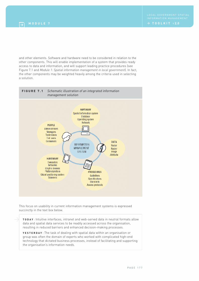
and other elements. Software and hardware need to be considered in relation to the
other components. This will enable implementation of a system that provides ready
access to data and information, and will support leading practice procedures (see
Figure 7.1 and Module 1: Spatial information management in local government). In fact,
the other components may be weighted heavily among the criteria used in selecting
a solution.
F I G U R E 7 . 1 Schematic illustration of an integrated information
management solution
P A G E 1 7 7
M O D U L E 7
L O C A L G O V E R N M E N T S P AT I A L
I N F O R M AT I O N M A N A G E M E N T
> T O O L K I T V 2.0
This focus on usability in current information management systems is expressed
succinctly in the text box below.
T O D A Y : Intuitive interfaces, intranet and web-served data in neutral formats allow
data and spatial data services to be readily accessed across the organisation,
resulting in reduced barriers and enhanced decision-making processes.
Y E S T E R D A Y : The task of dealing with spatial data within an organisation or
group was often the domain of experts who worked with complicated high-end
technology that dictated business processes, instead of facilitating and supporting
the organisation’s information needs.
>
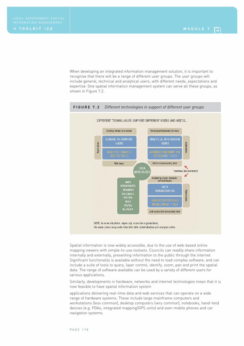
When developing an integrated information management solution, it is important to
recognise that there will be a range of different user groups. The user groups will
include general, technical and analytical users, with different needs, expectations and
expertise. One spatial information management system can serve all these groups, as
shown in Figure 7.2.
F I G U R E 7 . 2 Different technologies in support of different user groups
P A G E 1 7 8
L O C A L G O V E R N M E N T S P AT I A L
I N F O R M AT I O N M A N A G E M E N T
> T O O L K I T V 2.0 M O D U L E 7
Spatial information is now widely accessible, due to the use of web-based online
mapping viewers with simple-to-use toolsets. Councils can readily share information
internally and externally, presenting information to the public through the internet.
Significant functionality is available without the need to load complex software, and can
include a suite of tools to query, layer control, identify, zoom, pan and print the spatial
data. The range of software available can be used by a variety of different users for
various applications.
Similarly, developments in hardware, networks and internet technologies mean that it is
now feasible to have spatial information system
applications delivering real-time data and web services that can operate on a wide
range of hardware systems. These include large mainframe computers and
workstations (less common), desktop computers (very common), notebooks, hand-held
devices (e.g. PDAs, integrated mapping/GPS units) and even mobile phones and car
navigation systems.
Decisions on new systems or upgrading existing systems should always
be based on the needs of the organisation or group. When selecting
spatial information system software, councils should focus on:
> functionality and applications identified as part of a needs assessment (a
requirements analysis)
> the hardware needed to run the software
> operating systems, based on the software products and hardware, and the standards
that have been developed as part of the council’s data policy.
Ensure that the council’s spatial information system procurement
process is driven by documented and justified business needs, under a
funded and endorsed plan for system procurement and implementation.
As a guide, use the selection checklist (Section 7.4), criteria (Section
7.5.7) and tips (Section 7.5.8).
7.2 Guidelines for acquisition
Individual councils may already have specific procedures and policies for acquiring
software, hardware and communications technologies, in addition to their usual
procurement process. Useful information can also be drawn from government
departments. For example, see the Acquisition of ICT Guideline published by the Office of
Information and Communications Technology19 in the NSW Department of Commerce,
available at http://www.oit.nsw.gov.au/docs/ICTAcquisition.pdf.
7.3 Elements to consider when selecting
software and hardware
When making a purchase decision, it is worth keeping in mind a number of elements,
including the following:
> ensure that the product has a proven record in the marketplace
> avoid outdated products that are no longer supported, and/or have not adopted
recent open standards
> avoid unproven products (the ‘bleeding-edge’ technologies)
> ensure that good support mechanisms are available, including manuals, training
material, online help and technical support from vendors
> ensure that staff with appropriate skills are readily available to ensure smooth
implementation, as developing or employing specialist staff with spatial information
systems skills is expensive in terms of both cost and functionality
> ensure that the product has the appropriate functionality to suit existing and planned
needs for the council, including being sufficiently rugged for field based use as
necessary (e.g. mobile devices).
P A G E 1 7 9
M O D U L E 7
L O C A L G O V E R N M E N T S P AT I A L
I N F O R M AT I O N M A N A G E M E N T
> T O O L K I T V 2.0
1 > 2
19 Now the Government Chief Information Office.
Conduct formal, documented system audits, including user
reviews and alignment of spatial information systems to the
support of core business, when examining system development
or replacement.
The outcome of this analysis should be a structured business case justification
incorporating such elements as Total Cost of Ownership models.
7.3.1 Evaluating software and hardware
The key to selection is to fully understand user or organisational
requirements and capability and to choose a product that matches.
The main criteria for consideration when evaluating software include functionality,
performance, scalability, licensing and standards.
Functionality
Functionality is the ability of the product to perform required tasks, in a simple and
straightforward manner. Two key elements of functionality are usability and adaptability.
There have been significant recent advances in functionality, such as the development
of easy-to-use graphical user interfaces (GUIs). In early versions of spatial information
systems software, most activities were command driven, requiring users to type
commands into the system to execute tasks. Users needed to be familiar with a suite of
command functions. This partly explained the frequent isolation of GIS technical staff
within organisations.
Most software packages now incorporate a standard Windows-type GUI, with menus
and toolbars. Functionality is enhanced, with consequently reduced need for user
training and improved user access to spatial data.
The introduction of Windows-based or internet browser-based interfaces coincided with
increases both in the tools available on many systems and in system functionality. As a
result, the learning curve for users of most professional-level spatial information
systems is still quite steep. It is this factor, along with the demand by casual users for
access to spatial data on their desktops, that has seen the development of many web
map viewers with deliberately limited functionality. Those viewers, which are often low
cost or even free of charge, generally have functionality limited to more common needs,
such as simple queries and pan, zoom and layer control.
If spatial information system software is to be used by novices or those
unfamiliar with computer technology, it is important that the software
has a simple and easy to use interface.
Aside from the usability aspect, functionality also includes the ability of the software to
be customised using industry-standard programming languages. Many systems have
adopted the Visual Basic programming language as a development language.
P A G E 1 8 0
L O C A L G O V E R N M E N T S P AT I A L
I N F O R M AT I O N M A N A G E M E N T
> T O O L K I T V 2.0 M O D U L E 7
3 > 4
The degree to which spatial information systems can be customised varies from
product to product. Systems might be designed as:
> stand-alone applications designed to meet a specific need (often called ‘custom’
applications) and developed using specific programming tools
> large, professional-level spatial information system applications with internal
programming functions
> entry-level applications designed for simple viewers.
Entry-level applications cannot be customised and are effectively ‘locked’. They are
designed to do a simple task and do it well.
The key to selecting software is to fully understand user needs and
choose a product that matches those needs. To assist this process, a
list should be developed detailing the functionality required for each
user group that will be accessing and using spatial data from the system.
That information can then be used to produce a matrix, which can be
used to compare user requirements with available products for each
functionality issue.
Once user requirements are clear, each council will use its normal procurement
policies and procedures, guided by expert technical advice from sources such as the
guideline noted in Section 7.2.
Where those policies allow, it is recommended that software vendors demonstrate their
products’ ability to perform the tasks or functions required by each user group
identified in the needs assessment. Alternatively, or additionally, the council could seek
information from other groups currently using the software to meet similar needs.
Section 7.5.7 provides a draft list of criteria to consider when selecting spatial
information system software.
Performance and hardware requirements
The performance of software applications is governed by their design and engineering at
the programming stage, and the speed and configuration of the hardware and networks
they are running on. Good software applications make full use of the available hardware
resources, such as dual processors and high-end graphics cards.
Most spatial information system software offers more than simple viewing capabilities,
such as added functionality to perform overlay, analysis and modelling tasks. This
makes the software very complex, requiring large amounts of computer resources to
operate efficiently. Performance of the software application can be significantly affected
if an appropriate level of system resources is not available, so care is required to ensure
that the operating capability and capacity of the central processing unit (CPU), speed,
memory, graphics display card and disk type are optimised. The system will only
operate as efficiently as the weakest link in this framework.
Most software vendors, particularly larger companies, provide minimum and
recommended specifications for hardware and often publish them on their websites.
Performance information is also available on vendor websites for individual
components, such as graphic cards.
It should be noted that minimum specifications often refer to the absolute minimum
requirements to run the system and therefore may not yield good performance.
P A G E 1 8 1
M O D U L E 7
L O C A L G O V E R N M E N T S P AT I A L
I N F O R M AT I O N M A N A G E M E N T
> T O O L K I T V 2.0

Given that hardware technology changes rapidly, care must taken that the specifications
listed are not out of date. Most software vendors will supply up-to-date specification
recommendations on request.
Scalability
Scalability is the ability to increase the functionality and/or capacity of the spatial
information system applications by expanding, migrating, upgrading or ‘adding on’ more
or improved functions to the base implementation, in an ordered and structured
manner.
Key aspects of scalability include the following:
> scalability should match the needs and skill levels of the council and align with its
business objectives
> the system should have the ability to incorporate additional functionality that may be
required in the future
> the system should have the ability to communicate seamlessly with other programs
via connections or interfaces.
Most software vendors are constantly developing and changing their products to provide
increased functionality in a competitive market. Spatial information system software is
no exception. New releases, updates and patches are continually being released.
Many of the major spatial information systems and image-processing software
companies provide a suite of software as part of an overall family. It is possible to
purchase a base version of the software, which can then be augmented by the purchase
of additional modules, often called ‘extensions’ or ‘add-ons’, to provide increased
functionality. The ability of software vendors to offer a functionally scalable product
enables users to streamline their software purchases and installations to match their
business needs.
Most large integrated information management solutions have a number of software
products that communicate and share data. To support scalability, some software
vendors have implemented special software licensing systems in which licences can
‘float’ within a network to enable individual users to access increased functionality on a
temporary ‘as needed’ basis. These are called ‘floating’ or ‘concurrent’ licences.
Scalability also includes the capacity to increase the number of users of the base
version of the system.
Licensing
Most software programs available on the market are sold subject to licensing
agreements that detail the terms and conditions of use. There is commonly a one-off
licence fee included as part of the purchase price. Suppliers of the more popular
products also offer maintenance programs as part of the licensing agreement, entitling
users to free or reduced-cost upgrades and new versions as they become available.
In earlier releases of most programs, the standard licensing agreement licensed the
software to a particular machine. These were known as ‘single-seat’, ‘stand-alone’ or
‘per-CPU’ licences. More recently, the increasing scalability and functionality of
software has resulted in more complex licensing agreements, such as the floating or
concurrent licences noted above. Such licences commonly cover the base version and,
in some cases, extension or add-on components that can operate simultaneously on
the computer system.
P A G E 1 8 2
L O C A L G O V E R N M E N T S P AT I A L
I N F O R M AT I O N M A N A G E M E N T
> T O O L K I T V 2.0 M O D U L E 7
To achieve this functionality, some major spatial information systems and image-
processing software companies use a separate licence manager program to administer
the use of separate software applications through an organisation’s network. This
allows larger organisations with many infrequent users to use fewer licences than they
would if they were required to install a stand-alone licence on each computer.
It is recommended that the council discuss licensing requirements with
vendors to ensure that software purchases are appropriately licensed for
both immediate and planned future needs.
Standards
As discussed in Module 4: Spatial data priorities, standards and compliance, integrated
information management solutions depend on the use of standards for aspects
including metadata descriptions, file-naming and directory structure conventions, and
data storage formats.
Standards are also important in software. For example, the proposed spatial
information system should be compatible with the operating system and standards
used in the council (e.g. UNIX, Windows NT/95/98/2000/XP/Vista, MacOS, Linux).
Further, the software should be able to recognise data formats used in other computer
systems. Many spatial information system and image-processing applications have
unique file formats. This used to mean that the data exchange and transfer protocols
were necessarily precise and application-specific. More recently, most major
packages—while still having their own unique native formats for raster, vector and data
attribute information—have the ability to import, export, read and write data in many
other formats.
This is not to say that data formats are no longer important: they are, especially given
increasing interoperability. More detailed discussion on interoperability (the ability of
different computers and systems to communicate, and to share or access data) and
open data standards is in Module 4.
In local government, information management systems may include those used for:
> rating management
> document management
> financial management
> development and other application processing
> asset management
> environmental management and monitoring.
In this respect, it is important to be aware that standards groups in Australia are
currently very active in the development of standards in collaboration with their
counterparts overseas. The Open Geospatial Consortium (OGC) is one such group (see
http://www.opengeospatial.org/). The OGC is an international industry consortium,
currently comprising 339 companies, government agencies and universities,
participating in a consensus process to develop publicly available geoprocessing
specifications.
According to the OGC, open interfaces and protocols defined by OGC specifications
support interoperable solutions that ‘geo-enable’ the web, wireless and location-based
services and mainstream IT, and empower technology developers to make complex
P A G E 1 8 3
M O D U L E 7
L O C A L G O V E R N M E N T S P AT I A L
I N F O R M AT I O N M A N A G E M E N T
> T O O L K I T V 2.0
spatial information and services accessible and useful with all kinds of applications.
Most of the major spatial information system and image-processing suppliers are
members of the OGC, thereby ensuring that their software complies with industry
standards.
The work of the OGC has also played a part in the development of international
geographic information standards by the International Organization for Standardization
(ISO), published in the ISO 19000 series. Many software companies are now including
ISO standards in their products. Councils are encouraged to purchase commercial-off-
the-shelf software that is fully OpenGIS® compliant and meets the relevant ISO standards,
to enable interoperability with other council information systems at minimal cost.
Further information on the development and application of the standards in Australia is
available from ANZLIC at http://www.anzlic.org.au/publications.html. Details of national
and international standards can be found via http://www.standards.org.au. Copies of
standards can be purchased at http://www.saiglobal.com/shop.
7.3.2 Steps in choosing software and hardware
Evaluation team
The first task when choosing software for a council is to establish a tender or bid
evaluation team that represents a cross-section of technical, general and casual users
in the council. The team should include motivated staff who are able to make decisions
on behalf of the work area they are representing.
Development of a specification document
The second step involves preparation of a detailed specification document, covering
matters such as functionality, scalability, licensing requirements, performance, delivery
timeframe, maintenance and support requirements, and standards, as described in
Section 7.3.1. Consideration also needs to be given to:
> capacity building, to ensure that adequate skills are available to implement the system
> the range of products and services the system will be required to deliver or undertake.
The council should consult widely when preparing the specification
document. Valuable information can be gained from:
> other councils, particularly those of similar size or with similar
functional requirements
> relevant state or territory agencies
> industry groups
> consultants
> multiple vendors.
Note that vendors obviously have a vested interest in their products, and in some cases
this situation also applies to consultants. If engaging consultants, ensure that they are
objective and free of any vested interest. For additional information on choosing and
managing consultants, refer to Module 8: Raising capability for use of spatial information.
P A G E 1 8 4
L O C A L G O V E R N M E N T S P AT I A L
I N F O R M AT I O N M A N A G E M E N T
> T O O L K I T V 2.0 M O D U L E 7
Development of a procurement approach
Each council will have its own policies and procedures for the procurement of goods
and services. Procurement and tendering requirements should be discussed with the
council’s purchasing staff and/or senior management in the process of developing a
procurement approach. There are often clearly defined council-specific legal and
probity issues that must be addressed.
The exact method of the tendering and selection of software and
hardware will be determined by the council’s procurement policies
and procedures. The council’s purchasing section should be consulted before
embarking on a software or hardware purchasing process. It is a good idea to define
the procurement process, before the details of the system requirements are defined
in the specification.
General advice on managing complex procurement processes is available from many
sources; see, for example, the Information Paper: Practitioners’ Guide to Strategic
Procurement (non-SPCs), published by the Victorian Government Procurement Group, a
part of the Victorian Department of Treasury and Finance, and available at
http://www.vgpb.vic.gov.au/CA256C450016850B/0/4FBAC7BE2075606FCA256C850025DA
77?OpenDocument.
Factors that influence the procurement approach may include value thresholds. For
example, procurement of goods and services over a certain limit may require a certain
number of written quotations (often called a Request for Quotation, or RFQ). Higher
thresholds may trigger open tendering, with advertisements placed in newspapers or
online (often called a Request for Tender, or RFT).
Alternatively, a Request for Proposal (RFP) may be prepared. This approach is often
adopted in situations in which a number of software programs might potentially fulfil
the requirements detailed in the specification. Companies are asked to submit a
document outlining their proposed approach, experience, fees and supply timeframe. In
some cases, vendors are provided with actual council spatial data and asked to provide
working solutions to predefined issues and problems. This tests the proposed systems.
Note that there may be opportunities for collaborative purchasing
arrangements with other councils through local government
associations or other arrangements.
Development of an assessment matrix
A matrix can be developed to assess software packages against the specification. This
will provide a clear overview of the options. An example of a set of criteria used for
selecting spatial information system software is in Section 7.5.7.
In designing the assessment matrix, leave room for evaluating intangibles (for example,
see the methods used for the CB-90 process in Section 6.4.2 in Module 6). Non-cost
factors relating to functionality may include:
> availability of skilled staff in other nearby councils or state/territory agencies
> skill and availability of an in-house GIS group
> skill of the service provider.
P A G E 1 8 5
M O D U L E 7
L O C A L G O V E R N M E N T S P AT I A L
I N F O R M AT I O N M A N A G E M E N T
> T O O L K I T V 2.0

Evaluation
The procurement policies and procedures of the council will dictate the approach used
in the evaluation of the system supply options. The council may go through an intensive
formal process or use a simpler approach. For example, the council may decide to
proceed directly with a purchase, based on the assessment matrix and
recommendations from consultants or others. Alternatively, the council process may
require the recommendation of a selected option, and subsequent endorsement or
approval of that recommendation by one or more committees.
In cases where more than one company may sell the same software, it is possible to
ask them to bid on the cost of supplying the specified software. It is important to note
that installation, training requirements and ongoing technical support need to be
considered.
Some key questions to ask when evaluating vendor or company quotes
and submissions include the following:
> do they have a demonstrated understanding of the applications and
needs of local government, and of this council in particular?
> are they able to clearly articulate what they are going to do, by when,
with what and to what standard?
> do they have proven experience in providing similar services to
councils or similar organisations?
> are they able to meet the proposed timeframes?
> what allowance have they made for contingencies, in terms of time,
cost and availability of any necessary skilled staff?
> have they recommended a solution that matches the council’s budget?
Benchmarking
Benchmarking involves testing the ability of a proposed software system to perform a
number of specified tasks and then comparing the results with those from the testing
of other software systems. In such cases, data and information are often provided to
suppliers and they are given a set amount of time to undertake the tasks.
Final decision
The process used to reach a final decision will be in accord with the usual procurement
policies and procedures of the council, perhaps influenced by the complexity of software
system decisions. In some cases, a two-phased process is used, in which evaluation
team members assess the competing bids independently and then meet to reach a
collective decision. A second option is to assess the competing bids as a group and to
reach a consensus. Either way, the evaluation team should be certain that:
> the chosen system meets the specifications
> the purchase fits within the council’s short- and long-term budgets for the system
> the selection was made in accordance with the council’s procurement policies and
procedures.
P A G E 1 8 6
L O C A L G O V E R N M E N T S P AT I A L
I N F O R M AT I O N M A N A G E M E N T
> T O O L K I T V 2.0 M O D U L E 7
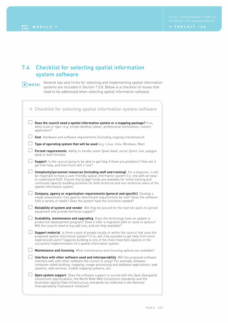
7.4 Checklist for selecting spatial information
system software
General tips and tricks for selecting and implementing spatial information
systems are included in Section 7.5.8. Below is a checklist of issues that
need to be addressed when selecting spatial information software.
P A G E 1 8 7
M O D U L E 7
L O C A L G O V E R N M E N T S P AT I A L
I N F O R M AT I O N M A N A G E M E N T
> T O O L K I T V 2.0
> Checklist for selecting spatial information system software
Does the council need a spatial information system or a mapping package? If so,what scale or type—e.g. simple desktop viewer, professional workstation, customapplication?
Cost. Hardware and software requirements (including ongoing maintenance).
Type of operating system that will be used (e.g. Linux, Unix, Windows, Mac).
Format requirements. Ability to handle raster (pixel data), vector (point, line, polygondata) or both formats.
Support. Is the council going to be able to get help if there are problems? How will itget that help, and how much will it cost?
Complexity/personnel resources (including staff and training). For a beginner, it willbe important to have a user-friendly spatial information system (i.e. one with an easy-to-understand GUI). Ensure that budget funds are available for initial training andcontinued capacity-building activities for both technical and non-technical users of thespatial information system.
Company, agency or organisation requirements (general and specific). Develop aneeds assessment. Can specific benchmark requirements be met? Does the softwarefulfil a variety of needs? Does the system have the functions needed?
Reliability of system and vendor. Will they be around for the next ten years to serviceequipment and provide technical support?
Scalability, maintenance and upgrading. Does the technology have an update orproduction development program? Does it offer a migration path or suite of options?Will the council need to buy add-ons, and are they available?
Support material. Is there a pool of people locally or within the council that uses theproposed spatial information system? If so, will it be possible to get help from moreexperienced users? Capacity building is one of the most important aspects in thesuccessful implementation of a spatial information system.
Maintenance and licensing. What maintenance and licensing options are available?
Interface with other software used and interoperability. Will the proposed softwareinterface well with other software the council is using? For example, betweencomputer-aided drafting, mapping, image-processing and database applications, websystems, web services, mobile mapping systems, etc.
Open system support. Does the software support or accord with the Open GeospatialConsortium specifications, the World Wide Web Consortium standards and theAustralian Spatial Data Infrastructure standards (as reflected in the NationalInteroperability Framework initiative)?
7.5 Additional support
Considerable resource materials exist that can support the process of selecting GIS
software. For example, many spatial information industry newsgroups and magazines
often review particular software products, in some cases providing cross-functionality
comparisons. It is important to undertake an objective process that is guided by
organisational need and not rely on vendor brochures.
The following list provides links to some available sources, but is not meant to be
exhaustive. Note: the inclusion of individual organisations does not in any way promote
a particular product.
7.5.1 GIS procurement
> Allen Ibaugh (Ed.), GIS Procurement and RFP Development, URISA, at
http://207.145.30.84/prev/store/gis_procurement_and_rfp_development_qs.htm.
7.5.2 Choosing a GIS
> Ultimate Map/GIS Directory (GIS Monitor website—links to available mapping and GIS
products): http://www.gismonitor.com/products/index.php.
7.5.3 Product reviews
> General product reviews (GeoCommunityTM website):
http://software.geocomm.com/reviews/.
7.5.4 Software surveys
> Point of Beginning GIS Software Survey 2005:
http://www.pobonline.com/POB/Protected/Files/PDF/POB0605-
GISsoftwareSurvey.pdf
> Point of Beginning GIS Software Survey 2004:
http://www.pobonline.com/POB/Protected/Files/PDF/0604surveyGIS.pdf.
Note: the 2006 software survey results and many other resources are available from
Point of Beginning at http://www.pobonline.com/.
7.5.5 Free software viewers and data conversion tools
A number of free viewers and software applications are available over the internet. Free
applications and reviews of functionality and file formats are available from:
> Grime: http://www.grime.net/gistools/
> GeoCommunityTM: http://spatialnews.geocomm.com/features/viewers2002/.
7.5.6 Support on system upgrading
> Upgrade Your GIS: Best Practices for Successful Implementation. Useful article on
considerations for upgrading decisions at the GIS Café website:
http://www.gisvisionmag.com/vision.php?article=200111%2Ffeature.html.
P A G E 1 8 8
L O C A L G O V E R N M E N T S P AT I A L
I N F O R M AT I O N M A N A G E M E N T
> T O O L K I T V 2.0 M O D U L E 7
>
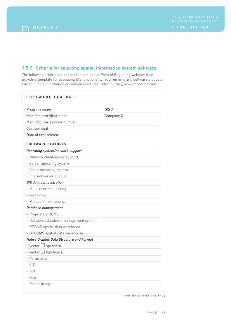
7.5.7 Criteria for selecting spatial information system software
The following criteria are based on those on the Point of Beginning website; they
provide a template for assessing GIS functionality requirements and software products.
For additional information on software features, refer to http://www.pobonline.com.
S O F T W A R E F E A T U R E S
Program name GIS X
Manufacturer/distributor Company X
Manufacturer’s phone number
Cost per seat
Date of first release
SOFTWARE FEATURES
Operating system/network support
– Network client/server support
– Server operating system
– Client operating system
– Internet server enabled
GIS data administration
– Multi-user edit locking
– Versioning
– Metadata maintenance
Database management
– Proprietary DBMS
– Relational database management system
– RDBMS spatial data warehouse
– OODBMS spatial data warehouse
Native Graphic Data Structure and Format
– Vector spaghetti
– Vector topological
– Parametric
– 3-D
– TIN
– Grid
– Raster image
P A G E 1 8 9
M O D U L E 7
L O C A L G O V E R N M E N T S P AT I A L
I N F O R M AT I O N M A N A G E M E N T
> T O O L K I T V 2.0
C O N T I N U E S O V E R T H E P A G E
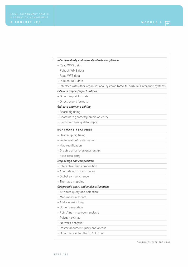
> Interoperability and open standards compliance
– Read WMS data
– Publish WMS data
– Read WFS data
– Publish WFS data
– Interface with other organisational systems (AM/FM/ SCADA/ Enterprise systems)
GIS data import/export utilities
– Direct import formats
– Direct export formats
GIS data entry and editing
– Board digitising
– Coordinate geometry/precision entry
– Electronic survey data import
S O F T W A R E F E AT U R E S
– Heads-up digitising
– Vectorisation/ rasterisation
– Map rectification
– Graphic error check/correction
– Field data entry
Map design and composition
– Interactive map composition
– Annotation from attributes
– Global symbol change
– Thematic mapping
Geographic query and analysis functions
– Attribute query and selection
– Map measurements
– Address matching
– Buffer generation
– Point/line-in-polygon analysis
– Polygon overlay
– Network analysis
– Raster document query and access
– Direct access to other GIS format
P A G E 1 9 0
L O C A L G O V E R N M E N T S P AT I A L
I N F O R M AT I O N M A N A G E M E N T
> T O O L K I T V 2.0 M O D U L E 7
C O N T I N U E S O V E R T H E P A G E
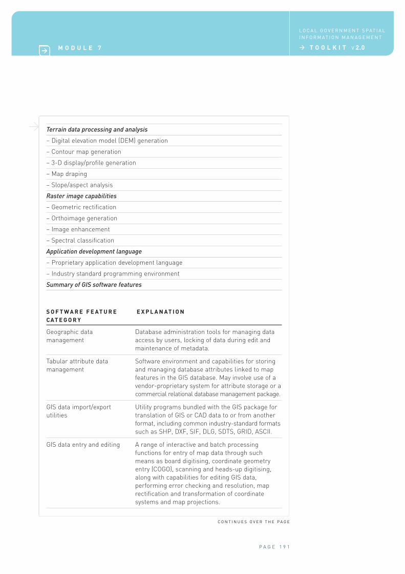
> Terrain data processing and analysis
– Digital elevation model (DEM) generation
– Contour map generation
– 3-D display/profile generation
– Map draping
– Slope/aspect analysis
Raster image capabilities
– Geometric rectification
– Orthoimage generation
– Image enhancement
– Spectral classification
Application development language
– Proprietary application development language
– Industry standard programming environment
Summary of GIS software features
P A G E 1 9 1
M O D U L E 7
L O C A L G O V E R N M E N T S P AT I A L
I N F O R M AT I O N M A N A G E M E N T
> T O O L K I T V 2.0
C O N T I N U E S O V E R T H E P A G E
S O F T W A R E F E AT U R E E X P L A N AT I O N
C AT E G O R Y
Geographic data Database administration tools for managing data
management access by users, locking of data during edit and
maintenance of metadata.
Tabular attribute data Software environment and capabilities for storing
management and managing database attributes linked to map
features in the GIS database. May involve use of a
vendor-proprietary system for attribute storage or a
commercial relational database management package.
GIS data import/export Utility programs bundled with the GIS package for
utilities translation of GIS or CAD data to or from another
format, including common industry-standard formats
such as SHP, DXF, SIF, DLG, SDTS, GRID, ASCII.
GIS data entry and editing A range of interactive and batch processing
functions for entry of map data through such
means as board digitising, coordinate geometry
entry (COGO), scanning and heads-up digitising,
along with capabilities for editing GIS data,
performing error checking and resolution, map
rectification and transformation of coordinate
systems and map projections.
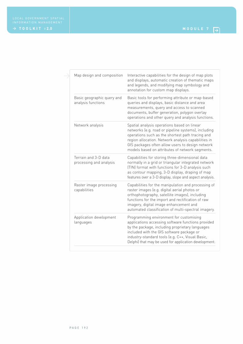
> Map design and composition Interactive capabilities for the design of map plots
and displays, automatic creation of thematic maps
and legends, and modifying map symbology and
annotation for custom map displays.
Basic geographic query and Basic tools for performing attribute or map-based
analysis functions queries and displays, basic distance and area
measurements, query and access to scanned
documents, buffer generation, polygon overlay
operations and other query and analysis functions.
Network analysis Spatial analysis operations based on linear
networks (e.g. road or pipeline systems), including
operations such as the shortest path tracing and
region allocation. Network analysis capabilities in
GIS packages often allow users to design network
models based on attributes of network segments.
Terrain and 3-D data Capabilities for storing three-dimensional data
processing and analysis normally in a grid or triangular integrated network
(TIN) format with functions for 3-D analysis such
as contour mapping, 3-D display, draping of map
features over a 3-D display, slope and aspect analysis.
Raster image processing Capabilities for the manipulation and processing of
capabilities raster images (e.g. digital aerial photos or
orthophotography, satellite images), including
functions for the import and rectification of raw
imagery, digital image enhancement and
automated classification of multi-spectral imagery.
Application development Programming environment for customising
languages applications accessing software functions provided
by the package, including proprietary languages
included with the GIS software package or
industry-standard tools (e.g. C++, Visual Basic,
Delphi) that may be used for application development.
P A G E 1 9 2
L O C A L G O V E R N M E N T S P AT I A L
I N F O R M AT I O N M A N A G E M E N T
> T O O L K I T V 2.0 M O D U L E 7
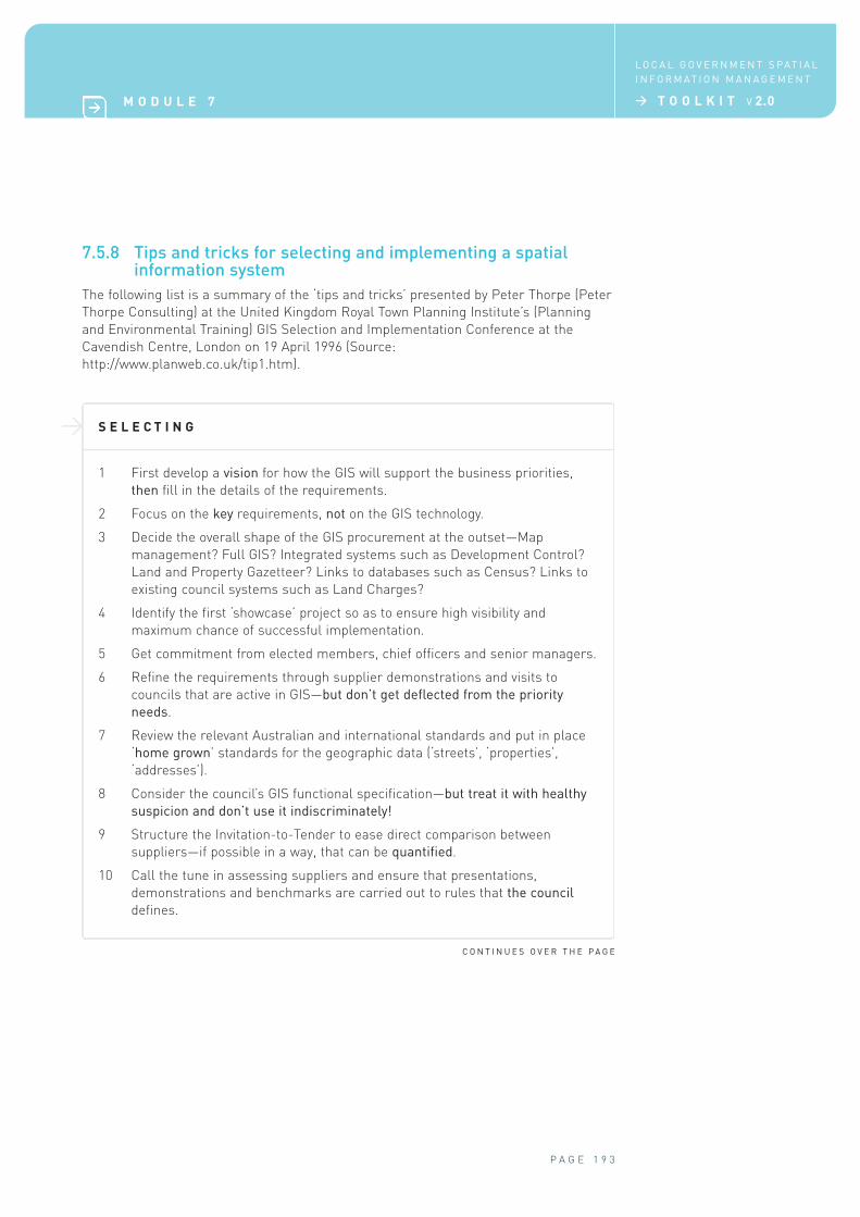
> S E L E C T I N G
1 First develop a vision for how the GIS will support the business priorities,
then fill in the details of the requirements.
2 Focus on the key requirements, not on the GIS technology.
3 Decide the overall shape of the GIS procurement at the outset—Map
management? Full GIS? Integrated systems such as Development Control?
Land and Property Gazetteer? Links to databases such as Census? Links to
existing council systems such as Land Charges?
4 Identify the first ‘showcase’ project so as to ensure high visibility and
maximum chance of successful implementation.
5 Get commitment from elected members, chief officers and senior managers.
6 Refine the requirements through supplier demonstrations and visits to
councils that are active in GIS—but don’t get deflected from the priority
needs.
7 Review the relevant Australian and international standards and put in place
‘home grown’ standards for the geographic data (‘streets’, ‘properties’,
‘addresses’).
8 Consider the council’s GIS functional specification—but treat it with healthy
suspicion and don’t use it indiscriminately!
9 Structure the Invitation-to-Tender to ease direct comparison between
suppliers—if possible in a way, that can be quantified.
10 Call the tune in assessing suppliers and ensure that presentations,
demonstrations and benchmarks are carried out to rules that the council
defines.
P A G E 1 9 3
M O D U L E 7
L O C A L G O V E R N M E N T S P AT I A L
I N F O R M AT I O N M A N A G E M E N T
> T O O L K I T V 2.0
7.5.8 Tips and tricks for selecting and implementing a spatial information system
The following list is a summary of the ‘tips and tricks’ presented by Peter Thorpe (Peter
Thorpe Consulting) at the United Kingdom Royal Town Planning Institute’s (Planning
and Environmental Training) GIS Selection and Implementation Conference at the
Cavendish Centre, London on 19 April 1996 (Source:
http://www.planweb.co.uk/tip1.htm).
C O N T I N U E S O V E R T H E P A G E
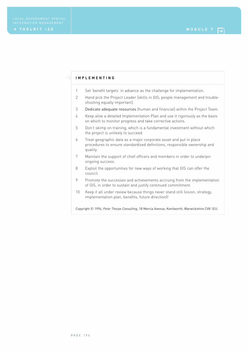
> I M P L E M E N T I N G
1 Set ‘benefit targets’ in advance as the challenge for implementation.
2 Hand pick the Project Leader (skills in GIS, people management and trouble-
shooting equally important).
3 Dedicate adequate resources (human and financial) within the Project Team.
4 Keep alive a detailed Implementation Plan and use it rigorously as the basis
on which to monitor progress and take corrective actions.
5 Don’t skimp on training, which is a fundamental investment without which
the project is unlikely to succeed.
6 Treat geographic data as a major corporate asset and put in place
procedures to ensure standardised definitions, responsible ownership and
quality.
7 Maintain the support of chief officers and members in order to underpin
ongoing success.
8 Exploit the opportunities for new ways of working that GIS can offer the
council.
9 Promote the successes and achievements accruing from the implementation
of GIS, in order to sustain and justify continued commitment.
10 Keep it all under review because things never stand still (vision, strategy,
implementation plan, benefits, future direction)!
Copyright © 1996, Peter Thorpe Consulting, 18 Mercia Avenue, Kenilworth, Warwickshire CV8 1EU.
P A G E 1 9 4
L O C A L G O V E R N M E N T S P AT I A L
I N F O R M AT I O N M A N A G E M E N T
> T O O L K I T V 2.0 M O D U L E 7
Acronyms
ACRES Australian Centre for Remote Sensing
ADAC Asset Design and As Constructed
AGD Australian Geodetic Datum
ALGA Australian Local Government Association
ANZLIC ANZLIC—the Spatial Information Council for Australia and New Zealand
ASDD Australian Spatial Data Directory
ASDI Australian Spatial Data Infrastructure
AS/NZS Australian Standard/New Zealand Standard
CAD computer assisted design, computer-aided drafting
CPU central processing unit
DSDB detail survey database
GDA94 Geocentric Datum of Australia 1994
GIS geographic information systems
GML Geography Markup Language, Generalised Markup Language
GPS global positioning system
GSDI Global Spatial Data Infrastructure
GUI graphical user interface
HTTP Hypertext Transfer Protocol
ICT information and communications technology
INCIS Integrated National Crime Information System (New Zealand)
ISO International Organization for Standardization
IT information technology
MGA Map Grid of Australia
OGC Open Geospatial Consortium
OGC-A Open Geospatial Consortium—Australasia
PRINCE Projects IN Controlled Environments
RCSC Regional Collaboration Steering Committee (Queensland)
RFP Request for Proposal
RIP raster image processor
ROC regional organisation of councils
SDE spatial database engine
SDI spatial data infrastructure
SEQ south east Queensland
SIDP Spatial Interoperability Demonstrator Project
P A G E 1 9 5
M O D U L E 7
L O C A L G O V E R N M E N T S P AT I A L
I N F O R M AT I O N M A N A G E M E N T
> T O O L K I T V 2.0
SLIP Shared Land Information Platform (Western Australia)
SOAP Simple Object Access Protocol
URL Uniform Resource Locator (website address)
VROC voluntary regional organisation of councils
WALIS Western Australian Land Information System
W3C World Wide Web Consortium
XML Extensible Markup Language
N O T E : A list of several online spatial information system, GIS, cartographic, data and IT
glossaries and dictionaries is provided at http://www.gis.com/whatisgis/glossaries.html.
An additional online glossary for definitions of many current IT-related words is
available at http://whatis.techtarget.com/.
P A G E 1 9 6
L O C A L G O V E R N M E N T S P AT I A L
I N F O R M AT I O N M A N A G E M E N T
> T O O L K I T V 2.0 M O D U L E 7