cadastre spatial information: a dependable tool for … · cadastre spatial information: a...
TRANSCRIPT

TS07A - Land Administration, Natural Disaster and Climate Change - 6540
Oluseye Thomas Dabiri
Cadastre Spatial Information: A Dependable Tool for Flood Disaster Management In Delta State of Nigeria
FIG Working Week 2013
Environment for Sustainability.
Abuja, Nigeria, 6-10 May 2013
1/10
Cadastre Spatial Information: A Dependable Tool for Flood Disaster
Management in Delta State of Nigeria
Oluseye Thomas DABIRI, Nigeria
Key words: Cadastre Spatial Information (CSI), Dependable Tool (DT), Flood Disaster
Management (FDM).
SUMMARY
Cadastre Spatial Information is a Dependable Tool for all sorts of Disaster Management when
and where it is available. Cadastre Spatial Information Management in Delta State is under
the Ministry of Lands, Survey and Urban Development (MLSUD).
This TS07A - Land Administration, Natural Disaster and Climate Changewill present Cadastre
Spatial Information tools that are easily accessible and readily available for Flood Disaster
Management in Delta State of Nigeria.

TS07A - Land Administration, Natural Disaster and Climate Change - 6540
Oluseye Thomas Dabiri
Cadastre Spatial Information: A Dependable Tool for Flood Disaster Management In Delta State of Nigeria
FIG Working Week 2013
Environment for Sustainability.
Abuja, Nigeria, 6-10 May 2013
2/10
Cadastre Spatial Information: A Dependable Tool for Flood Disaster
Management in Delta State of Nigeria
Oluseye Thomas DABIRI, Nigeria
1. INTRODUCTION
The Flood Disaster of 2012 in Nigeria was a National calamity. Delta State was one of the
worst hit; belonging to CATEGORY A on the Federal Government’s Impact Assessment
Rating (IAR). A Technical Committee on Flood Impact Assessment in Delta State was
inaugurated on October 24, 2012. From the report of the committee:
231 Communities in 12 Local Government Areas of the 25 Local Government Areas
(LGA) were adversely affected. These include:
Fig. 1: Delta state local government areas. (sources: www.deltalazio.org)
1. 118 Community Markets.
2. 743 Market Stalls.
3. 220 Primary Schools.
4. 84 Secondary Schools.
5. 4357 Fish Farms.
6. 526 Poultry Farms.
7. 58 Piggeries.
8. 5099 Houses.

TS07A - Land Administration, Natural Disaster and Climate Change - 6540
Oluseye Thomas Dabiri
Cadastre Spatial Information: A Dependable Tool for Flood Disaster Management In Delta State of Nigeria
FIG Working Week 2013
Environment for Sustainability.
Abuja, Nigeria, 6-10 May 2013
3/10
Fig.2: Fishing camp in the mangrove swamp of delta state off escarvos creek
(sources hydroark archives 2011)
Fig.3: Displaced school girls in hand pulling canoe on flooded area in bomadi local government area
of delta state 2012 (sources hydroark archives 2012)
TS07A - Land Administration, Natural Disaster and Climate Change - 6540
Oluseye Thomas Dabiri
Cadastre Spatial Information: A Dependable Tool for Flood Disaster Management In Delta State of Nigeria
FIG Working Week 2013
Environment for Sustainability.
Abuja, Nigeria, 6-10 May 2013
4/10
The Committee put the cost of Crops destroyed at 3.1Billion Nigerian Naira (NGN) at
exchange rate of 160NGN to 1USD. The committee ranked:
Ughelli North LGA.
Ughelli South LGA.
Ndokwa East LGA.
Burutu and other LGA in Delta State as worst hit.
The Committee omitted:
Aniocha South and Warri South West LGAs in their presentations even when
Refugees Centers for the flood victims were opened in these two areas.
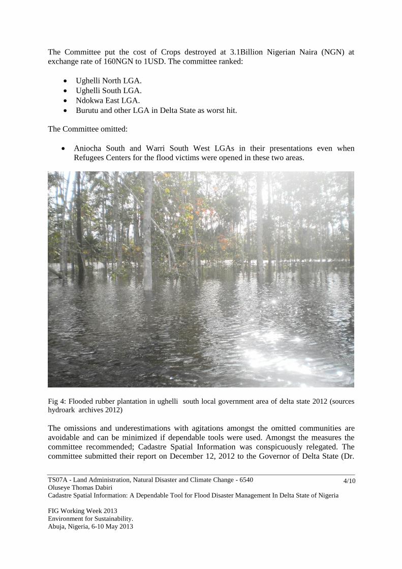
Fig 4: Flooded rubber plantation in ughelli south local government area of delta state 2012 (sources
hydroark archives 2012)
The omissions and underestimations with agitations amongst the omitted communities are
avoidable and can be minimized if dependable tools were used. Amongst the measures the
committee recommended; Cadastre Spatial Information was conspicuously relegated. The
committee submitted their report on December 12, 2012 to the Governor of Delta State (Dr.

TS07A - Land Administration, Natural Disaster and Climate Change - 6540
Oluseye Thomas Dabiri
Cadastre Spatial Information: A Dependable Tool for Flood Disaster Management In Delta State of Nigeria
FIG Working Week 2013
Environment for Sustainability.
Abuja, Nigeria, 6-10 May 2013
5/10
Emmanuel E. Uduaghan). However, the Governor brought up the issue of Cadastre Spatial
Information Attribute of enforcing the Laws of Building Permits with adequate sanctions.
2. BACKGROUND
Nigeria comprises SEVEN relief regions based on Land Units or common landform
assemblages:
A. The Creeks and Lagoons.
B. The Niger Delta.
C. The Coastal Plains.
D. The River Basin Troughs.
E. The Inselberg Landscapes.
F. The Chad Basin.
G. The Eastern Highlands.
The Niger Delta from which Delta State derives her name extends from Forcados River in
the west to the Bonny River in the east a distance of about 350Kilometers, and from the
Apex of the Delta at Aboh Town to the coastline which is about 150Kilometers. The
Niger Delta as defined has also narrow coastal strips varying in width from a few meters
to about 16kilometers. Most of the 10,000square kilometer of the Niger Delta is made up
of swamps and sand bars (Akintola 1982). Delta State falls in the regions A, B and C. (See
Fig.2). It is of relevance to see that the REGIONS A, B, AND C are partly wetlands with
estuaries of Benin River, Escarvos River, Forcados River and with River Niger
Bifurcation draining larger part of the state.

TS07A - Land Administration, Natural Disaster and Climate Change - 6540
Oluseye Thomas Dabiri
Cadastre Spatial Information: A Dependable Tool for Flood Disaster Management In Delta State of Nigeria
FIG Working Week 2013
Environment for Sustainability.
Abuja, Nigeria, 6-10 May 2013
6/10
FIG.5: NIGERIA SEVEN RELIEF REGIONS (SOURCES: NIGERIA IN MAPS:
BARBOUR K. M. ET AL 1982 - PAGE 9)
Flood disasters in Nigeria and Delta State are usually recorded during rainy seasons.
Rainfall in Nigeria is highly seasonal and latitudinal in character with well marked wet
and dry seasons such as characteristics of the MONSOON type of climate. Delta State
falls within TWO PEAK rainfall (Oguntoyinbo 1982).
The peak period coincided with the Flood period. See Figure 3 here under.
Warri and Forcados are all in Delta State where mean annual rainfall is averagely above
400cm. And the areas with the high flood impact are the areas of high rainfall.
Fig.6: Nigeria climate precipitation (sources: nigeria in maps: barbour k. m. et al 1982 - page 17)
TS07A - Land Administration, Natural Disaster and Climate Change - 6540
Oluseye Thomas Dabiri
Cadastre Spatial Information: A Dependable Tool for Flood Disaster Management In Delta State of Nigeria
FIG Working Week 2013
Environment for Sustainability.
Abuja, Nigeria, 6-10 May 2013
7/10
3. DEFINITIONS
A disaster is defined as a serious disruption of the functioning of society, causing widespread
human, materials or environmental losses, which exceed the ability of an affected society to
cope using only its resources (EEA 2006). The extent of the disaster depends on both the
intensity of the hazard and the degree of vulnerability of the society. Spatial Data Information
is one of the core subjects in disaster prevention and emergency aids provisions.
Spatial Data Information forms building units for Spatial Data Infrastructure which is a
requisite foundation for any meaningful information management for disaster preventive
measures OR for emergency management. Cadastre Spatial Information as a data
infrastructure is the primary input for general disaster management; since the impact of
disaster is usually measured on the primary loss of lives and properties.
Cadastre Data is a daily maintained record system which contains description of the physical
location and extent of a parcel of land as related to the land and information on the land
(Dashe, 1987).
Cadastre Spatial Information or Infrastructure can only be created when measurements are
made by the professionals. Cadastral Surveying is an aspect of Land Surveying; with special
interest on the art and science of Cadastre related data acquisition, data collation; data
analysis; data presentation; data management and general daily and periodic maintenance of
the Databanks or Database.
4. PERSPECTIVES
The Cadastre Data Development and its evolutionary trend in Delta State have not achieved
the ultimate purpose of serving a readily available and accessible tool for good governance
(Dabiri, 2012).
The Data here in Delta State is not yet research design based upon exploratory case studies or
factors like globalization, population, urbanization, good governance, climate change
response, environmental management, 3D visualization/analysis technologies, wireless
sensor networks, standardization and interoperability (Williamson et al., 2011).
All Data are jointly developed and managed in general manual file system for the following
activities:
To verify data brought in for issuance of Certificate of Occupancy.
To protect Government Acquired Land from encroachment.
To Plan and Manage the Urban Centers.
To control and approve building plans for the public.
To Collect Revenue for government on approval fees and taxes.
To carry out survey of the government lands and allocate same for the defined
purposes.
To give professional advice to the government.
TS07A - Land Administration, Natural Disaster and Climate Change - 6540
Oluseye Thomas Dabiri
Cadastre Spatial Information: A Dependable Tool for Flood Disaster Management In Delta State of Nigeria
FIG Working Week 2013
Environment for Sustainability.
Abuja, Nigeria, 6-10 May 2013
8/10
About 80% of daily decisions on national or local level, either in economy, finances,
taxation, demography, spatial planning, environment, hazard areas, infrastructure, housing,
cultural heritage, etc are spatially or geo – referenced.
Cadastre Spatial Information tools that are easily accessible and readily available for Flood
Disaster Management in Delta State of Nigeria is not Geo Information System (GIS) based.
Geo Information Systems can help to support all phases of emergency management, like
mitigations preparedness, response and even recovery. In the field of land information
systems, surveyors possess a sound experience in maintaining huge spatial databases at a very
high level of reliability since long ago. This knowledge can be used to support the
implementation of other but, technically spoken, similar spatial information systems which
provide an absolutely indispensable base for the effective disaster risk management.
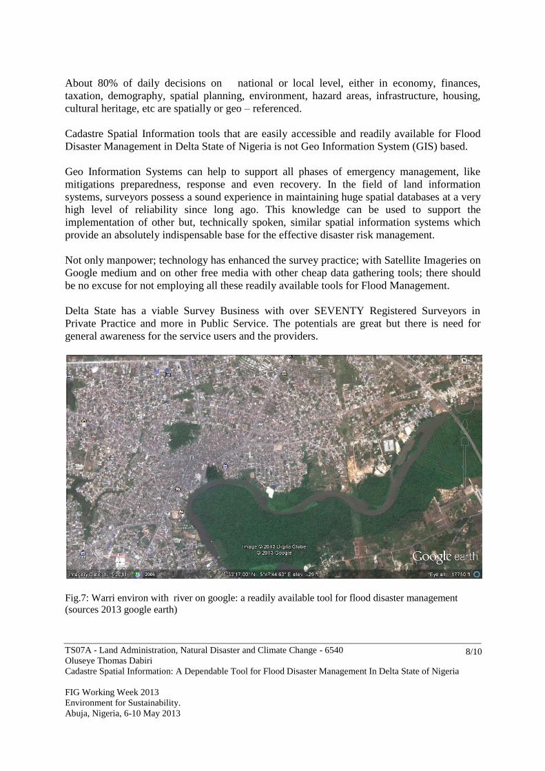
Not only manpower; technology has enhanced the survey practice; with Satellite Imageries on
Google medium and on other free media with other cheap data gathering tools; there should
be no excuse for not employing all these readily available tools for Flood Management.
Delta State has a viable Survey Business with over SEVENTY Registered Surveyors in
Private Practice and more in Public Service. The potentials are great but there is need for
general awareness for the service users and the providers.
Fig.7: Warri environ with river on google: a readily available tool for flood disaster management
(sources 2013 google earth)
TS07A - Land Administration, Natural Disaster and Climate Change - 6540
Oluseye Thomas Dabiri
Cadastre Spatial Information: A Dependable Tool for Flood Disaster Management In Delta State of Nigeria
FIG Working Week 2013
Environment for Sustainability.
Abuja, Nigeria, 6-10 May 2013
9/10
5. CONCLUSION
Cadastre Spatial Information in Delta State of Nigeria is growing with little or no nurturing by
the stakeholders.
The stakeholders are the government as service user and the professionals as service provider.
There are these usual undefined roles of cognate professionals that make the needed input for
the provision of Cadastre Spatial Information and general Infrastructure like Town Planners,
Estate Mangers, Estate Valuers, Builders, Lawyers and many other technicians and artisans.
These listed professionals usually undertake the surveyors job, and subcontract to the
surveyor or take up the job directly; rendering error laden services to the unsuspecting public.
Regulations and Laws with penal codes are there; but justice to sanction erring persons takes
longer time than expected. It is popular saying that when justice is delayed; justice can be
denied; which is the usual occurrence.
Cadastre Spatial Information of Delta State is at lower level of development. Investment in
Survey business is very low on the part of the professionals and Government. Government
and the professionals are conscious of the need for tangible investment in Spatial Information
and Infrastructure; the only impediment is the political will on the part of government.
Government makes a lot of revenue from Cadastre related taxes; but using 2.5% of such fund
to develop Cadastre Spatial Information and Infrastructure is a big challenge. Delta State
Survey firms and companies lack patronage from government and when it happens it is
irregular and too small for any meaningful positive impact.
Flood Disaster management by the state government focuses on:
Evacuations.
Setting up relief camps.
Fund raising
Fund Management Committee.
Technical committee to advice government.
All these steps are in the right direction; but the missing link is the lack of structure and
holistic approach. Technical committee was wholly academicals and political.
Professionalism was highly relegated and the technical committee left many impacted areas
uncaptured due to their limitations of not networking with the state professionals.
Flood is a natural phenomenon; with climate change challenges and lack of structure on
ground; Government will need to invest more on Cadastre Spatial Information and its
Infrastructure. Delta State Government policy of “Looking beyond Oil” is possible with
adequate budgetary provisions for the Spatial Information.

TS07A - Land Administration, Natural Disaster and Climate Change - 6540
Oluseye Thomas Dabiri
Cadastre Spatial Information: A Dependable Tool for Flood Disaster Management In Delta State of Nigeria
FIG Working Week 2013
Environment for Sustainability.
Abuja, Nigeria, 6-10 May 2013
10/10
REFERENCES
Dashe, J.D.J. (1987). Cadastral Surveying Practice in Nigeria.
Barbour, K.M., Oguntoyinbo, J.S., Onyemelukwe, J.O.C., Nwafor, J.C. (1982). Nigeria in
Maps.
FIG Publication Number 38 (2006) – Disaster Risk Management.
FIG Publication (2010) – Sydney Declaration.
Prooijen, K. V., Fredericque, B., Raymond, K., (2011). Bentley’s Support for 3D Cadastre
Development.
Williamson, I., Enemark, S., Wallace, J., Rajabifard, A. (2010). Land Administration for
Sustainable Development.
BIOGRAPHICAL NOTES
Oluseye Thomas DABIRI obtained Bsc in Geography from the Nigerian Premier University
of Ibadan in 1987. He worked in Geography Department of University of Lagos as a Graduate
Assistant on the Desertification Monitoring Project of Canadian Waterloo University
support/exchange programme from 1987 to 1988. Obtained Post Graduate Diploma in Land
Surveying from Federal School of Surveying in Oyo Town in Nigeria in 1990; became a
Registered Surveyor under Decree 44 of 1989 in 1992. Started Private Practice in 1993 in
General Cadastral Survey and Land Administration Consultancy Service in Delta State.
Presently the Founder and Managing Director of Hydroark International Limited since 2001;
one of the leading Survey Firms in Delta State and in Nigeria; member of Nigerian Institution
of Survey since 1989; member National Geographic Society since 2002; immediate Past Vice
Chairman of Nigerian Institution of Surveyor Delta State Chapter; National Internal Auditor
for the Association of Practicing Surveyors in Nigeria; Corporate Member of Nigerian
Institution of Surveyor; active member of FIG Commission 7. Member of Rotary
International. Presently the Treasurer of Nigerian Institution of Surveyors Delta State Branch.
CONTACTS
Surveyor Oluseye Thomas DABIRI,
Hydroark International Limited,
Plot 4 Mount Ebal Road,
Ekpan – Warri.
Delta State
Nigeria.
Tel. +2348036697258
Fax +2348023015904
Email: [email protected]
Web site: www.hydroark.com