littondale - yorkshire dales
TRANSCRIPT
1
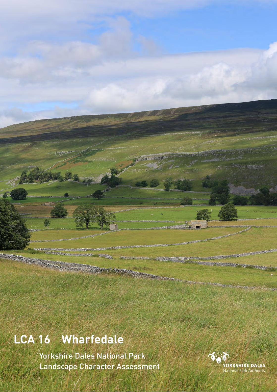
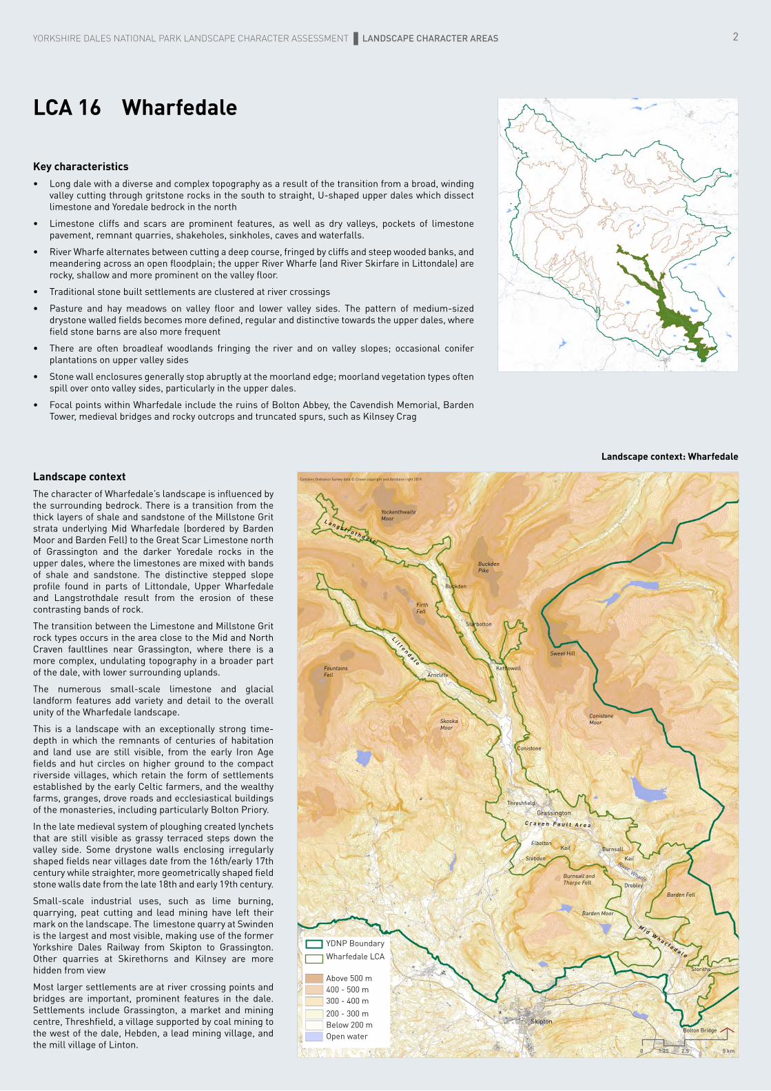
LCA 16 Wharfedale
Landscape Character AssessmentYorkshire Dales National Park
Litt
onda
le
YORKSHIRE DALES NATIONAL PARK LANDSCAPE CHARACTER ASSESSMENT LANDSCAPE CHARACTER AREAS
LCA 16 Wharfedale
Key characteristics• Long dale with a diverse and complex topography as a result of the transition from a broad, winding
valley cutting through gritstone rocks in the south to straight, U-shaped upper dales which dissect limestone and Yoredale bedrock in the north
• Limestone cliffs and scars are prominent features, as well as dry valleys, pockets of limestone pavement, remnant quarries, shakeholes, sinkholes, caves and waterfalls.
• River Wharfe alternates between cutting a deep course, fringed by cliffs and steep wooded banks, and meandering across an open floodplain; the upper River Wharfe (and River Skirfare in Littondale) are rocky, shallow and more prominent on the valley floor.
• Traditional stone built settlements are clustered at river crossings
• Pasture and hay meadows on valley floor and lower valley sides. The pattern of medium-sized drystone walled fields becomes more defined, regular and distinctive towards the upper dales, where field stone barns are also more frequent
• There are often broadleaf woodlands fringing the river and on valley slopes; occasional conifer plantations on upper valley sides
• Stone wall enclosures generally stop abruptly at the moorland edge; moorland vegetation types often spill over onto valley sides, particularly in the upper dales.
• Focal points within Wharfedale include the ruins of Bolton Abbey, the Cavendish Memorial, Barden Tower, medieval bridges and rocky outcrops and truncated spurs, such as Kilnsey Crag
Landscape context: Wharfedale
Landscape contextThe character of Wharfedale’s landscape is influenced by the surrounding bedrock. There is a transition from the thick layers of shale and sandstone of the Millstone Grit strata underlying Mid Wharfedale (bordered by Barden Moor and Barden Fell) to the Great Scar Limestone north of Grassington and the darker Yoredale rocks in the upper dales, where the limestones are mixed with bands of shale and sandstone. The distinctive stepped slope profile found in parts of Littondale, Upper Wharfedale and Langstrothdale result from the erosion of these contrasting bands of rock.
The transition between the Limestone and Millstone Grit rock types occurs in the area close to the Mid and North Craven faultlines near Grassington, where there is a more complex, undulating topography in a broader part of the dale, with lower surrounding uplands.
The numerous small-scale limestone and glacial landform features add variety and detail to the overall unity of the Wharfedale landscape.
This is a landscape with an exceptionally strong time-depth in which the remnants of centuries of habitation and land use are still visible, from the early Iron Age fields and hut circles on higher ground to the compact riverside villages, which retain the form of settlements established by the early Celtic farmers, and the wealthy farms, granges, drove roads and ecclesiastical buildings of the monasteries, including particularly Bolton Priory.
In the late medieval system of ploughing created lynchets that are still visible as grassy terraced steps down the valley side. Some drystone walls enclosing irregularly shaped fields near villages date from the 16th/early 17th century while straighter, more geometrically shaped field stone walls date from the late 18th and early 19th century.
Small-scale industrial uses, such as lime burning, quarrying, peat cutting and lead mining have left their mark on the landscape. The limestone quarry at Swinden is the largest and most visible, making use of the former Yorkshire Dales Railway from Skipton to Grassington. Other quarries at Skirethorns and Kilnsey are more hidden from view
Most larger settlements are at river crossing points and bridges are important, prominent features in the dale. Settlements include Grassington, a market and mining centre, Threshfield, a village supported by coal mining to the west of the dale, Hebden, a lead mining village, and the mill village of Linton.
Storiths
Grassington
Bolton Bridge
Burnsall
Threshfield
Kettlewell
Skipton
Barden Fell
Drebley
ElboltonKail
KailStebden
Barden Moor
Burnsall and Thorpe Fell
Conistone
Arncliffe
Conistone Moor
Sweet Hill
Buckden Pike
Firth Fell
Skoska Moor
Fountains Fell
Yockenthwaite Moor
Buckden
Starbotton
Haw Hill and Outgang Scar on west dale side near Kilnsey
YDNP BoundaryWharfedale LCA
Above 500 m400 - 500 m300 - 400 m200 - 300 mBelow 200 mOpen water
L a n g s t r o t h d a l e
L i t t o n d a l e
M i d W h a r f e d a l e
C r a v e n F a u l t A r e a
2
Wharfe
River
Contains Ordnance Survey data © Crown copyright and database right 2019
0 1.25 2.5 5 km
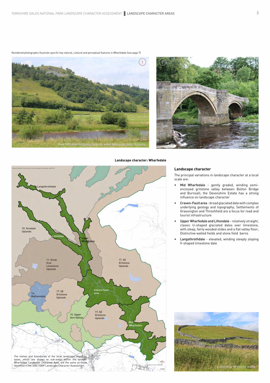
3YORKSHIRE DALES NATIONAL PARK LANDSCAPE CHARACTER ASSESSMENT LANDSCAPE CHARACTER AREAS
Landscape characterThe principal variations in landscape character at a local scale are:
• Mid Wharfedale - gently graded, winding semi-enclosed gritstone valley between Bolton Bridge and Burnsall; the Devonshire Estate has a strong influence on landscape character
• Craven-Fault area - broad glaciated dale with complex underlying geology and topography; Settlements of Grassington and Threshfield are a focus for road and tourist infrastructure
• Upper Wharfedale and Littondale - relatively straight, classic U-shaped glaciated dales over limestone, with steep, fairly wooded slides and a flat valley floor; Distinctive walled fields and stone field barns
• Langsthrothdale - elevated, winding steeply sloping V-shaped limestone dale
Barden BridgeHaw Hill and Outgang Scar on west dale side near Kilnsey
Littondale drystone walls
Landscape character: Wharfedale
Mid Wharfedale
Craven Fault area
LittondaleUpper Wharfedale
Langsthrothdale
15. Upper Aire Valleys
14. Malhamdale
17. SE Gritstone Uplands
17. SE Gritstone Uplands
17. SE Gritstone Uplands
10. Yoredale Uplands
11. Great Scar Limestone Uplands
The names and boundaries of the local landscape character areas, which are shown as sub-areas within the broader Wharfedale Landscape Character Area, are the same as those identified in the 2002 YDNP Landscape Character Assessment.
Contains Ordnance Survey data © Crown copyright and database right 2019
0 1.25 2.5 5 km
Numbered photographs illustrate specific key natural, cultural and perceptual features in Wharfedale (see page 7)
1 2

4
Distinctive landscape characterThe characteristic broad shape of the dale and overall smooth form was caused by the gouging effect of ice during repeated glacial periods 20,000 years ago. The melting of the ice sheets led to a series of retreat moraines, which were dumped across the valley, for instance at Skirfare Bridge, Mill Scar Lash and Drebley. Each is likely to have retained a temporary meltwater lake in the valley, contributing to the very flat valley floor in parts of Wharfedale. The glacial meltwaters also cut channels and gorges such as Dib Scar and Conistone Dib in the hillsides. Since the end of the Ice Age the action of the River Wharfe and its tributaries has created waterfalls, cut gorges, created river cliffs and deposited patches of sand and shingle on riversides.
Mid Wharfedale
The winding gritstone valley north of Bolton Bridge is closely surrounded by open moorlands with rocky outcrops of gritstone, such as Earl’s Seat on Barden Fell. The smooth contours of the dale are only interrupted by occasional glacial features such as the retreat moraine at Drebley and dale side moraine features at the Storiths.
The lush greens of the pastures, meadows and broadleaf woodlands within the dale contrast with the darker greens of the conifer plantations on the dale sides and the dark patchwork of seasonally changing colours, including purples, tans, browns and greys of the managed moorlands on the upper slopes. Small pockets of outcropping limestone create contrasting features such as the small limestone gorge at Troller’s Gill.
The River Wharfe alternates between flowing swiftly through narrow, shallow rocky gorges fringed by woodland to meandering across a broad pastoral floodplain. Frequent and extensive bands of ancient woodland occur on steeper rocky slopes alongside the river and defining its steep, V-shaped tributary valleys, supplemented by conifer plantations on some valley slopes.
There is a patchwork of regularly-shaped gritstone walls of the enclosure period in the centre of Mid Wharfedale near Drebley and smaller, more irregular walled fields of the medieval period to the north and south. Walls are supplemented by hedgerows and some post and rail fencing. Walled roads wind along both side of the valley, sometimes enclosed by dense woodland and sometimes offering open views.
The well-managed parklands, avenues, walls and buildings of the Devonshire Estate are a strong influence, with car parks and visitor facilities at Bolton Abbey, Bolton Bridge, Strid and Barden Tower.
Wharfedale - Craven Fault area
The local topography becomes more complex in the area surrounding the Mid and North Craven Faultlines, where the valley broadens, becoming more undulating and with a less distinct valley form. A line of distinctive conical grassy hills in this area, just south of Grassington (eg. Stebden, Elbolton and the Kail Hills) are the eroded remnants of a limestone reef and are nationally important examples of this type of formation.
This part of Wharfedale seems relatively open as the surrounding hills are more indented and lower than the areas to the north and south. The sense of openness is reinforced by a lightening in the colour of the landscape to the north, as the influence of limestone becomes apparent in the surrounding bedrock, compared to the darker colours of the gritstone landscapes to the south.
Dale sides are a mosaic of pasture and small woodlands; lines of trees define the alignment of rocky gills on the eastern fells, with a strip pattern of drystone walls between Hebden and Grass Wood. On the western side, the grassy, open reef knoll summits are interspersed by strip lynchets and stone walls that often follow the alignment of contours.
YORKSHIRE DALES NATIONAL PARK LANDSCAPE CHARACTER ASSESSMENT LANDSCAPE CHARACTER AREAS
Striking stepped slopes reveal the underlying strata of the Yoredale rocks (alternating bands of sandstone and limestone)
Wharfedale Road
Upper Langstrothdale
Bolton PrioryOutskirts of Hebden village
Junction of the Cowside Beck Valley and Littondale
The limestone cliffs of Kilnsey Crag are a prominent landmark
Traditional villages, built with local
gritstones and with buildings sited to
reflect local landform, seem in harmony with
their landscape setting
3
6
7
9
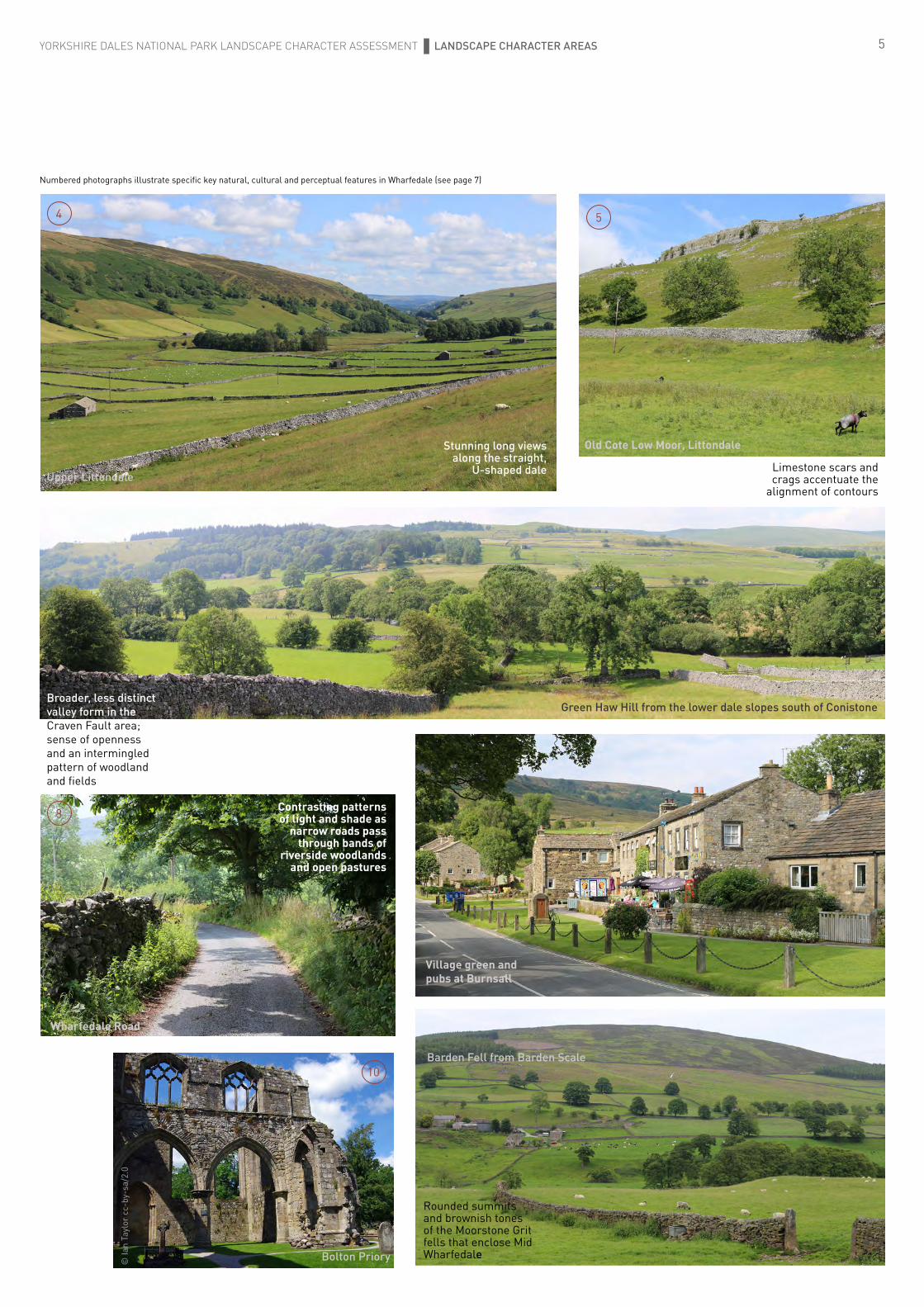
5
Green Haw Hill from the lower dale slopes south of Conistone
YORKSHIRE DALES NATIONAL PARK LANDSCAPE CHARACTER ASSESSMENT LANDSCAPE CHARACTER AREAS
Rounded summits and brownish tones of the Moorstone Grit fells that enclose Mid Wharfedale
Old Cote Low Moor, Littondale
Village green and pubs at Burnsall
Wharfedale Road
Upper Littondale
Barden Fell from Barden Scale
© Ia
n Ta
ylor
cc-
by-s
a/2.
0
Bolton Priory
Contrasting patterns of light and shade as
narrow roads pass through bands of
riverside woodlands and open pastures
Broader, less distinct valley form in the Craven Fault area; sense of openness and an intermingled pattern of woodland and fields
Limestone scars and crags accentuate the
alignment of contours
Stunning long views along the straight,
U-shaped dale
4 5
Numbered photographs illustrate specific key natural, cultural and perceptual features in Wharfedale (see page 7)
8
10

6
There are larger broadleaf woodlands and occasional small conifer plantations to the north of Grassington, including Grass Wood, the largest woodland in Wharfedale.
This is a well-settled part of Wharfedale, with gritstone villages concentrated at river crossing points. Built development is prominent on the valley slopes at Grassington and Threshfield; buildings, overhead power lines, masts, car parks, lighting and tourist infrastructure are sometimes prominent. There are important and extensive remains of the former lead mining industry on Grassington Moor and significant areas of ridge and furrow, which add texture and pattern to the landscape. Halls with parkland include Grassington Hall, Hartlington Hall and Netherside Hall.
Upper Wharfedale and Littondale
Upper Wharfedale and Littondale are steep sided, flat bottomed and relatively straight classic u-shaped glaciated dales overlying limestone bedrock. Their dale sides steepen towards the upper slopes and are frequently characterised by stepped rocky outcrops running parallel with the contours both within the dale and within the adjacent topland areas. The form of the dales, the colour contrast of the light limestone walls seen against the greens of the meadows and pastures, the unity created by the pattern of rock outcrops, dale side woodlands, settlements, drystone walls and barns, represent a classic example of Dales landscape.
Numerous small rocky gills on the steep dale sides create a notched pattern to the slope; the relative lack of tributary valleys means that there is a strongly defined valley form and long views along the dale and up side valleys to distant moor tops.
The river meanders across a generally very flat and open valley floor of walled pastures and hay meadows that abound with wildflowers in summer. The upper rocky dale sides are often wooded, with small incursions of bracken, rough grassland and grass moor vegetation; the large walled enclosures of rough grazing, grass moor and areas of limestone pavement on the toplands are visible from the valley floor and influence the dale character, however they do not dominate the dale in the way that the moorlands do in Mid Wharfedale.
Tree cover is concentrated on the steeper dale sides and often occurs in association with banded rock outcrops. Scattered trees also occur on valley floor field boundaries and trees mark the course of the river and the position of settlements.
YORKSHIRE DALES NATIONAL PARK LANDSCAPE CHARACTER ASSESSMENT LANDSCAPE CHARACTER AREAS
Upper Wharfedale from road below Knipe Scar
Settlements are on the dale floor or lower dale sides (particularly where these face south west), frequently at the point where a tributary enters the main river. They are typically associated with a historic bridge, with gritstone buildings grouped about a small green. Roads are relatively straight and tend to follow the lower dale sides.
The strong and distinctive pattern of drystone walls and associated field barns are a key feature of Upper Wharfedale and Littondale. Field shapes are a mixture of regularly shaped fields of the enclosure period and areas of narrow strip fields of medieval origin often close to settlements. These earlier fields are particularly well represented at Kettlewell, Starbotton and Buckden where the field pattern exerts a marked effect on landscape character and tends to cross the direction of slope emphasising its cross-sectional form when viewed from the valley floor. Occasionally long narrow fields follow the contours emphasising the horizontal form of the slope and elsewhere strip lynchets running along the line of slope create a pattern of light and shade up the dale side. Ridge and furrow is noticeable in some areas. There is a significant area of coaxial field systems to the north of Conistone, creating unique pattern to this part of the dale.
Field barns become more frequent towards the upper dales. In certain areas eg north of Starbotton drainage is impeded and fields within the dale bottom include areas of wetland vegetation resulting in local variation to the simple pattern of pastures and walls towards a more complex and natural character.
Langstrothdale
A winding, steeply sloping v-shaped limestone dale forming the wilder, higher reaches of upper Wharfedale. Walled sloping dale side pastures and hay meadows alternate with areas of moorland vegetation (including rough grass and bracken) extending down the dale sides. The valley becomes increasingly wild, remote, open and exposed towards its upper reaches with moorland vegetation types becoming dominant. Banded rock outcrops are a feature of the dale sides near Hubberholme; in the upper reaches rock outcrops are frequent but more irregular in pattern and areas of rough grassland and moorland vegetation are strewn with boulders and loose rock, with caves, pot holes and pockets of limestone pavement.
The fast flowing river forms the focal point of the dale, fringed by grassy banks to which trees cling, their roots exposed and undercut by the actions of water. The river flows across a stepped rocky bed, with shallow pools, small waterfalls and small historic bridges. Frequent stream gullies on the dale sides give an irregular undulating indented shape to the southern dale slopes. Ancient woodland dominated by ash, hazel and hawthorn clings to the banded rocky outcrops of the steep northern dale sides below Yockenthwaite; the upper dale is generally more open although trees often line the river banks and mark the presence of hamlets and scattered farms. Extensive and blocky conifer plantations at Langstrothdale Chase to the west of the upper valley reaches are uncharacteristic in the context of the otherwise wild open landscape of the surrounding moors and fells.
Low drystone walls enclose narrow pasture strips on the dale sides where the valley widens; elsewhere there is little or no enclosure and open moorland, rough grassland or bracken extend into the valley and down to the river. Field barns are occasional features in the lower reaches of the dale.
The minor road through the dale follows the line of the river. Occasional tracks wind up the dale sides from the road to the moor tops. A few small traditional hamlets sited facing out across the dale mostly on lower south facing dale sides have their buildings aligned with the contours, sometimes echoing the alignment of rock banding on upper valley slopes. Langstrothdale has an untouched and remote feel that is absent in other parts of Wharfedale.
The walled field pattern ‘tends to cross the direction of slope emphasising its cross-sectional form’.
12
7
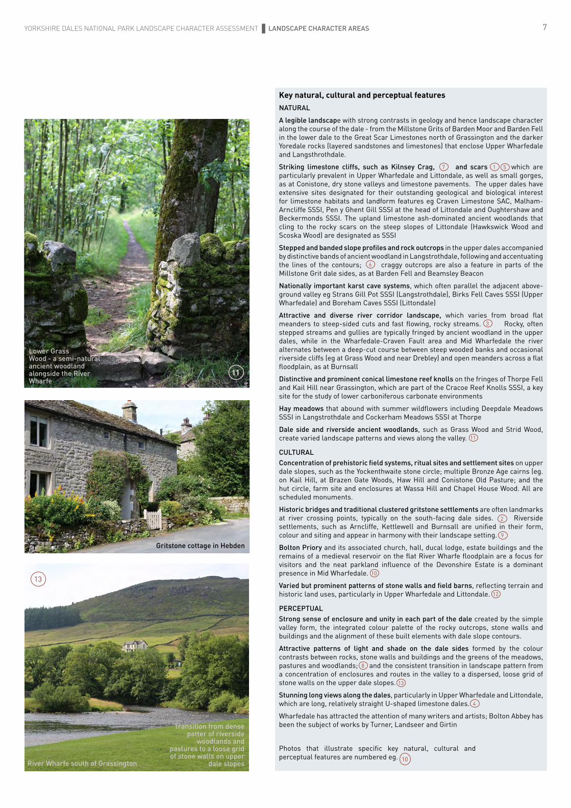
Key natural, cultural and perceptual featuresNATURAL
A legible landscape with strong contrasts in geology and hence landscape character along the course of the dale - from the Millstone Grits of Barden Moor and Barden Fell in the lower dale to the Great Scar Limestones north of Grassington and the darker Yoredale rocks (layered sandstones and limestones) that enclose Upper Wharfedale and Langsthrothdale.
Striking limestone cliffs, such as Kilnsey Crag, and scars which are particularly prevalent in Upper Wharfedale and Littondale, as well as small gorges, as at Conistone, dry stone valleys and limestone pavements. The upper dales have extensive sites designated for their outstanding geological and biological interest for limestone habitats and landform features eg Craven Limestone SAC, Malham-Arncliffe SSSI, Pen y Ghent Gill SSSI at the head of Littondale and Oughtershaw and Beckermonds SSSI. The upland limestone ash-dominated ancient woodlands that cling to the rocky scars on the steep slopes of Littondale (Hawkswick Wood and Scoska Wood) are designated as SSSI
Stepped and banded slope profiles and rock outcrops in the upper dales accompanied by distinctive bands of ancient woodland in Langstrothdale, following and accentuating the lines of the contours; craggy outcrops are also a feature in parts of the Millstone Grit dale sides, as at Barden Fell and Beamsley Beacon
Nationally important karst cave systems, which often parallel the adjacent above-ground valley eg Strans Gill Pot SSSI (Langstrothdale), Birks Fell Caves SSSI (Upper Wharfedale) and Boreham Caves SSSI (Littondale)
Attractive and diverse river corridor landscape, which varies from broad flat meanders to steep-sided cuts and fast flowing, rocky streams. Rocky, often stepped streams and gullies are typically fringed by ancient woodland in the upper dales, while in the Wharfedale-Craven Fault area and Mid Wharfedale the river alternates between a deep-cut course between steep wooded banks and occasional riverside cliffs (eg at Grass Wood and near Drebley) and open meanders across a flat floodplain, as at Burnsall
Distinctive and prominent conical limestone reef knolls on the fringes of Thorpe Fell and Kail Hill near Grassington, which are part of the Cracoe Reef Knolls SSSI, a key site for the study of lower carboniferous carbonate environments
Hay meadows that abound with summer wildflowers including Deepdale Meadows SSSI in Langstrothdale and Cockerham Meadows SSSI at Thorpe
Dale side and riverside ancient woodlands, such as Grass Wood and Strid Wood, create varied landscape patterns and views along the valley.
CULTURALConcentration of prehistoric field systems, ritual sites and settlement sites on upper dale slopes, such as the Yockenthwaite stone circle; multiple Bronze Age cairns (eg. on Kail Hill, at Brazen Gate Woods, Haw Hill and Conistone Old Pasture; and the hut circle, farm site and enclosures at Wassa Hill and Chapel House Wood. All are scheduled monuments.
Historic bridges and traditional clustered gritstone settlements are often landmarks at river crossing points, typically on the south-facing dale sides. Riverside settlements, such as Arncliffe, Kettlewell and Burnsall are unified in their form, colour and siting and appear in harmony with their landscape setting.
Bolton Priory and its associated church, hall, ducal lodge, estate buildings and the remains of a medieval reservoir on the flat River Wharfe floodplain are a focus for visitors and the neat parkland influence of the Devonshire Estate is a dominant presence in Mid Wharfedale.
Varied but prominent patterns of stone walls and field barns, reflecting terrain and historic land uses, particularly in Upper Wharfedale and Littondale.
PERCEPTUALStrong sense of enclosure and unity in each part of the dale created by the simple valley form, the integrated colour palette of the rocky outcrops, stone walls and buildings and the alignment of these built elements with dale slope contours.
Attractive patterns of light and shade on the dale sides formed by the colour contrasts between rocks, stone walls and buildings and the greens of the meadows, pastures and woodlands; and the consistent transition in landscape pattern from a concentration of enclosures and routes in the valley to a dispersed, loose grid of stone walls on the upper dale slopes.
Stunning long views along the dales, particularly in Upper Wharfedale and Littondale, which are long, relatively straight U-shaped limestone dales.
Wharfedale has attracted the attention of many writers and artists; Bolton Abbey has been the subject of works by Turner, Landseer and Girtin
YORKSHIRE DALES NATIONAL PARK LANDSCAPE CHARACTER ASSESSMENT LANDSCAPE CHARACTER AREAS
Transition from dense patter of riverside
woodlands and pastures to a loose grid of stone walls on upper
dale slopes
Gritstone cottage in Hebden
Lower Grass Wood - a semi-natural ancient woodland alongside the River Wharfe
River Wharfe south of Grassington
Photos that illustrate specific key natural, cultural and perceptual features are numbered eg. 10
3
4
7 5
6
8
9
1013
11
11
13
12
1
2

8
Special Qualities of the YDNP
YDNP Boundary
Wharfedale LCA boundary
Extent of area that forms the backdrop to views from the Wharfedale LCA
Yorkshire Dales National Park - Natural Beauty and Wildlife Special Qualities: Wharfedale
Thorpe Fell
GrassingtonThreshfield
Hebden
Burnsall
Arncliffe Kettlewell
Buckden
Starbotton
Halton Gill
A59Bolton Bridge
L a n g s t r o t h d a l e
L i t t o n d a l e
W h a r f e d a l e
U p p e r
M i d W h a r f e d a l e
C r a v e n F a u l t A r e a
Barden Fell
Strid Wood -
Storiths
Drebley
Grimwith Reservoir
Barnscar Plantation
Appletreewick MoorGrass Wood
Banded limestone scars on slopes of Littondale
Kilnsey Crag - limestone cliff
Firth Fell
Hawkswick Wood
-
Scoska Wood - upland ash
ancient woodland
Limestone scars on lower slopes of Langcliffe Moor
Cray and Crook Gill Waterfalls
HubberholmeWood
The Special Qualities of the Yorkshire Dales National Park are described in the National Park’s Management Plan 2019-24. This map shows selected special qualities (for which spatial data is available) that are found within the Wharfedale LCA.
This special qualities mapping is shown within the area that forms the backdrop to local views; it reflects the extent of visibility and the overall landscape setting for the Wharfedale LCA
Internationally important limestone features and habitats - Craven Limestone Complex SAC and Malham-Arncliffe SSSI -
Pen y Ghent Gill SSSI - limestone, acidic grassland and bog habitats
Distinctive bands of ancient woodland aligned to follow contours
Undulating glacial drift landscape
Distinctive and prominent conical reef knolls Cracoe Reef Knolls SSSI Distinctive
reef knolls
Karst cave systems - eg Boreham Caves SSSI
Decorated fossil tunnel in Strans Gill Pot cave passage - Strans Gill SSSI
Karst cave systems - eg Birks Fell Caves SSSI
Flower-rich hay meadows and pastures[Lowland meadows; Upland hay meadows]
A range of rare limestone habitats[Limestone pavements; Lowland calcareous grassland; Upland calcareous grassland]
Extensive areas of moorland[Upland heathland; Blanket bog; Lowland raised bog]
Small areas of broadleaf woodland[Deciduous woodland; ancient woodland (darker tone)]
Wildlife*
*Priority Habitats [S41 NERC Act 2010]
Cont
ains
Ord
nanc
e Su
rvey
dat
a ©
Cro
wn
copy
righ
t and
dat
abas
e ri
ght 2
019
0 1.25 2.5 5 km
Stump Cross Cavern
Yew Cogar Cave Cote Gill
Ghaistrill’s Strid
Linton Falls
Loup Scar
The Strid
Wharfe
River
Natural beautyDales with distinctive stepped profiles[Displaying outcrops of rocks from the Yoredale series]
Outstanding classic limestone scenery[Underlain by Great Scar Limestone & displaying distinctive karst character]
Extraordinary cave systems[‘Caves’ noted as ‘recognised attraction’ in YDNPA Visitor Strategy]
Spectacular waterfalls[‘Water features’ noted as ‘recognised attraction’ in YDNPA Visitor Strategy]
9Yorkshire Dales National Park - Cultural Heritage Special Qualities: Wharfedale
Grassington MoorLead Mines
New Providence Lead Mine
GrassingtonThreshfield
Hebden
Burnsall
Arncliffe
Kettlewell
Buckden
StarbottonHalton Gill
A59Bolton Bridge
L a n g s t r o t h d a l e
L i t t o n d a l e
W h a r f e d a l e
U p p e r
M i d W h a r f e d a l e
C r a v e n F a u l t A r e a
Bolton Priory
Devonshire Estate
Barden Tower
Wassa Hill hut circle & enclosures
Conistone
Chapel House Wood enclosures
Conistone Old Pastures cairn & enclosures
Brazen Gate Wood cairn
Ring Cairn on Kail Hill
Yockenthwaite stone circle
Special Qualities of the YDNP
YDNP Boundary
Wharfedale LCA boundary
Extent of area that forms the backdrop to views from the Wharfedale LCA
Cont
ains
Ord
nanc
e Su
rvey
dat
a ©
Cro
wn
copy
righ
t and
dat
abas
e ri
ght 2
019
0 1.25 2.5 5 km
Providence Lead Mine
Kettlewell Lead Mines
Wharfe
River
Cultural heritage*
A traditional pastoral landscape[Traditional stone-built field barns]
An exceptional range of archaeology[Strip lynchets & prehistoric field systems that are prominent]
Powerful reminders of periods of dominance by large estates and religious houses [Ancient & historic parklands & other ornamental landscapes]
* YDNPA Historic Environment Record
The remains of former rural industries[Sites of former lead & coal mines & lime kilns]
Historic settlements with distinctive traditional architecture [Conservation Areas ]

11
Cambridge Studio32 St Barnabas RoadCambridge CB1 2BY
telephone: 01223 229994email: [email protected]
www.sheilsflynn.com
Numbered photographs illustrate specific key natural, cultural and perceptual features in Wharfedale (see page 7)