litle atlin lake - government of yukon · atlin road map series index energy, mines and resources...
TRANSCRIPT

!5
!5
!5
!5
!5
!5
!5
!5
!5
!5
!5
!5
!5
!5
!5
!5
!5
!5
!5
!5
!5
!5
!5
!5
!5
!5
!5
!5
40
1342
8
6
4
2
12
10
16
14
22
20
18
24
30
28
26
36
34
32
YUKON
BRITISH COLUMBIA
Km4
Km6
Km1336
Km1344
Km1340
Km1346Km1338
Agay Mene Natural Environment Park
CTFN R-19B
CTF
N R
-22A
CTFN R-41B
CTFN R-28B
CTFN R-26B
CTFN S-30B1
CTFN S-391B1
CTFN S-32B1
CTFN S-95B1
CTFN S-101B1
CTFN S-47B1
CTFN S-380B1
CTFN S-386B1
CTFN S-43B1
15242
/
LITTLE ATLIN LAKE
MAP 1
JAKE'S CORNER
MAP 2
MAP 3
MAP 4
MAP 5
MAP 6
MAP 7
ATLINLAKE
Little Atlin Creek
Haunka
Cre
ek
Snafu
Lubbo
ck
River
Tarfu
Creek
TARFU LAKE
Creek
High
Creek
ATLIN
RO
AD
Legend
Legal Survey
Surveyed FN Settlement Lands
Agricultural Disposition
Agricultural Application
Land Disposition
License
Protected Area
ATLIN ROADMap Series Index
Energy, Mines and ResourcesSustainable Development DivisionLand Planning Branch
db 22 January, 2018

!5
!5
!5
!5
HWY
HW
Y
1118
1059
1031
HW
Y
1032
HW
Y
HWY
201
2-0
621
20
11
-040
0
15391
FOOTHILLSPIPELINE
R/W
CTFN S-412B1
CTFN
S-340
B1
CTFN S-46B1
CTFNS-100B1
CT
FN
S-3
0B
1
CTFN R-41B
CTFN
S-339B1
CTFN S-45B1
Alaska Highway
Tagish Road
Atlin
Road
Agay Mene NaturalEnvironment Park
Km2
Km4
Km0
Km2
/
LITTLE ATLIN
LAK
E
Little A
tlin
Cre
ek
JAKE'S CORNER
ATLIN ROAD- Map 1
Legend
Legal Survey
Surveyed FN Settlement Lands
Land Disposition
Land Application
Protected Areas
Energy, Mines and ResourcesSustainable Development DivisionLand Planning Branch
db 22 January, 2018
42290 C
LS
R
!5
!5
!5
!5
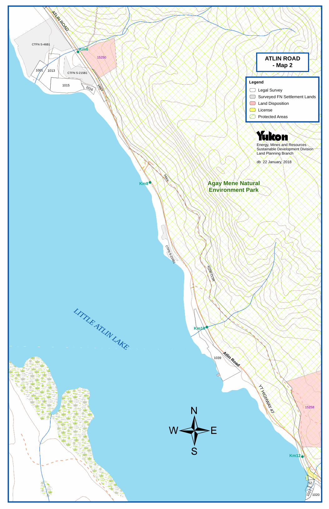
1013
52
1001
1016
1039
1020
HW
Y
1023
HW
Y
1015
15258
15250
CTFN S-46B1
CTFN S-215B1
CTFN
S-2
16B
1
Atlin Road
Agay Mene NaturalEnvironment Park
Km10
Km12
Km6
Km8
/
LITTLE ATLIN
LAK
E
ATLIN
RO
AD
YT H
IGH
WAY
#7
ATLIN ROAD- Map 2
Legend
Legal Survey
Surveyed FN Settlement Lands
Land Disposition
License
Protected Areas
Energy, Mines and ResourcesSustainable Development DivisionLand Planning Branch
db 22 January, 2018
Y.T. HIG
HW
AY
No. 7
(ATLIN
RO
AD
)
42291 C
LS
R
!5
!5
!5
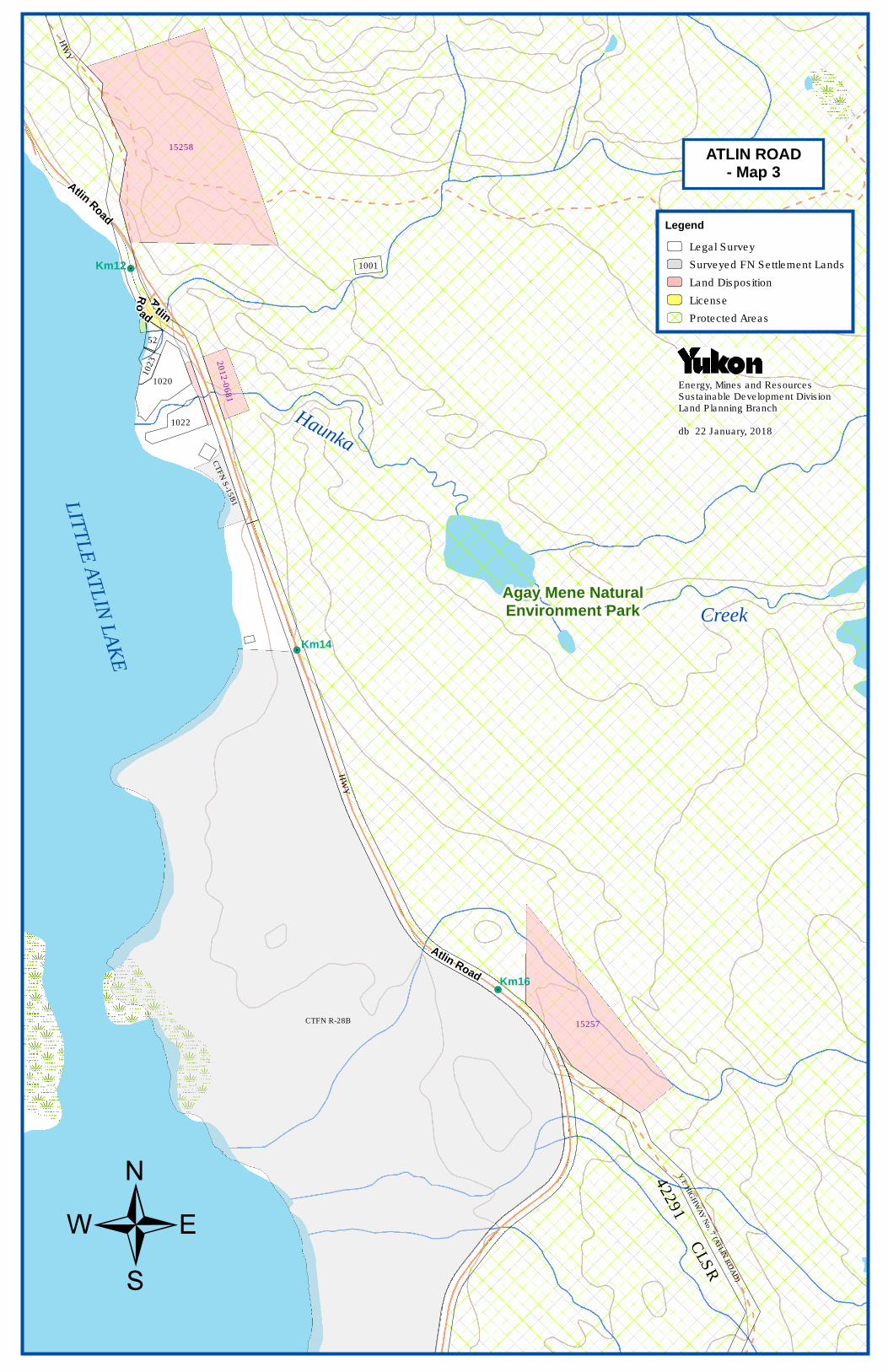
52
1020
HW
Y
1001
1022
1023
HW
Y
15258
2012-0
681
15257
Atlin
Road
A
tlin
Ro
ad
Atlin Road
CTFN
S-1
5B
1
CTFN R-28B
Agay Mene NaturalEnvironment Park
Km14
Km12
Km16
/
LIT
TL
E A
TL
IN L
AK
E
Haunka
Creek
ATLIN ROAD- Map 3
Legend
Legal Survey
Surveyed FN Settlement Lands
Land Disposition
License
Protected Areas
Energy, Mines and ResourcesSustainable Development DivisionLand Planning Branch
db 22 January, 2018

!5
!5
!5
!5
HW
Y1005A
HW
Y
15255
15254
2017-0320
Atlin Road
Sawmill Road
CTFN R-26B
CTFNS-388B1
CTFN R-21B
CT
FN
S-3
88B
2
CTFN R-28B
Agay Mene NaturalEnvironment Park
Km18
Km20
Km22
Km24
/
LIT
TLE
ATL
IN L
AK
E
Snafu Creek
ATLIN ROAD- Map 4
Legend
Legal Survey
FN_Interim_Protected_Lands
Agricultural Disposition
Agricultural Application
Land Disposition
Protected Areas
Energy, Mines and ResourcesSustainable Development DivisionLand Planning Branch
db 22 January, 2018

!5
!5
!5
1021
HW
Y
HW
Y
1015
HW
Y
10
09
-1
1009-2
15253
15252
Atlin
Road
Atlin
Ro
ad
Snafu
LakeRoad
CTFN S-16B1
CTFN R-19B
Agay Mene NaturalEnvironment Park
Km30
Km26
Km28
/Tarfu
Creek
Lubbock R
.
ATLIN ROAD- Map 5
Legend
Legal Survey
Surveyed FN Settlement Lands
Land Disposition
Protected Areas
Energy, Mines and ResourcesSustainable Development DivisionLand Planning Branch
db 22 January, 2018

!5
!5
!5
2012-1781
HW
Y
1019
HW
Y
15251
15252
CTFN S-18B1
CTFN R-52B
CTFN
S-3
82B1
CTFN R-19B
CT
FN
S-3
81B
1
Atlin
Road
TarfuLake Road
Agay Mene NaturalEnvironment Park
Km34
Km32
Km36
/Lubbock
Rive
r
ATLIN ROAD- Map 6
Energy, Mines and ResourcesSustainable Development DivisionLand Planning Branch
db 22 January, 2018
Legend
Legal Survey
Surveyed FN Settlement Lands
Agricultural Application
Land Disposition
Protected Area
!5
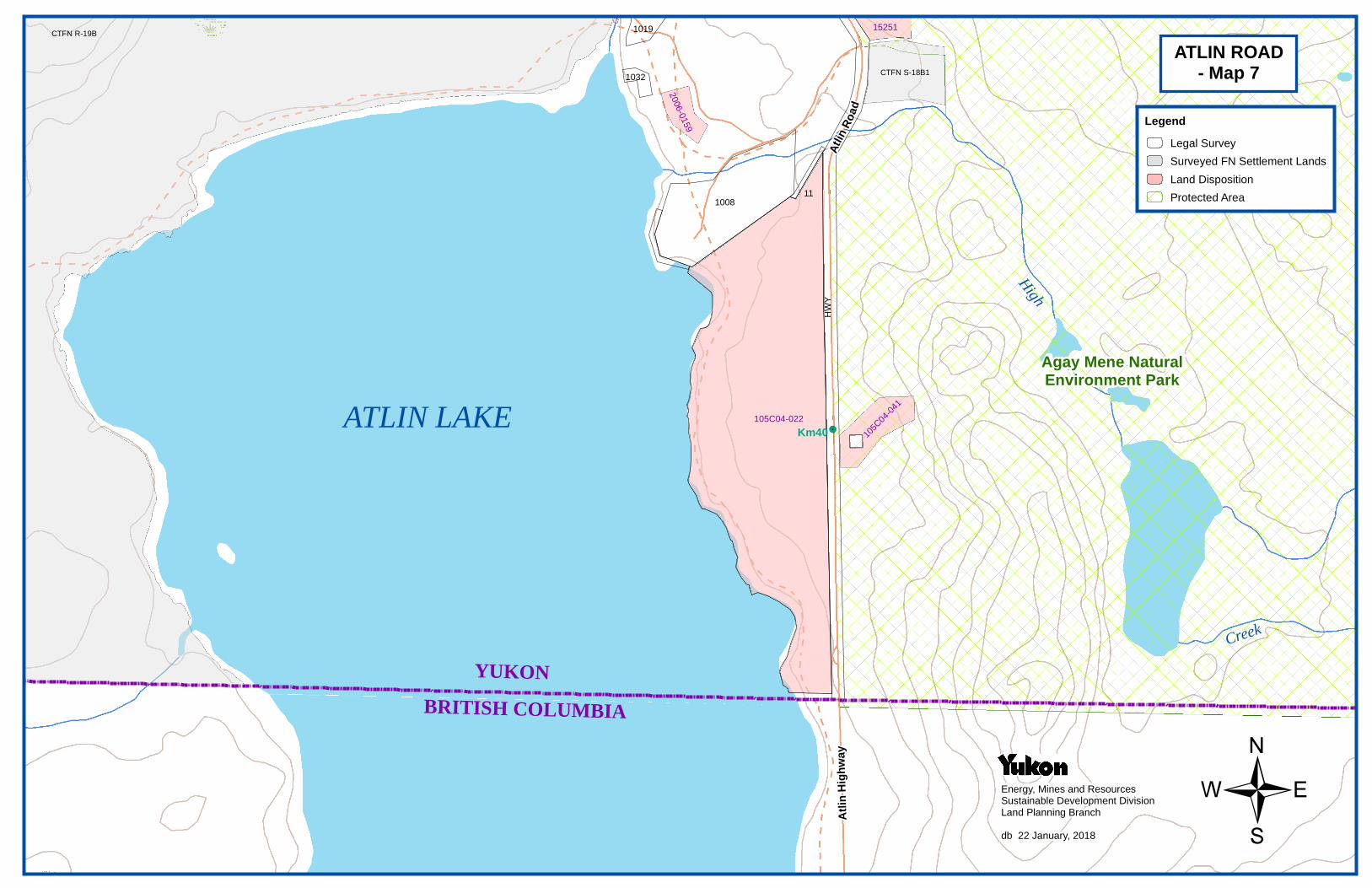
1008
HW
Y
11
1019
1032
105C
04-0
41
105C04-022
15251
2006-0
159
CTFN S-18B1
CTFN R-19B
Atl
in H
igh
way
Atlin
Ro
ad
Agay Mene NaturalEnvironment Park
Km40
/
ATLIN LAKE
Creek
High
YUKON
BRITISH COLUMBIA
Legend
Legal Survey
Surveyed FN Settlement Lands
Land Disposition
Protected Area
ATLIN ROAD- Map 7
Energy, Mines and ResourcesSustainable Development DivisionLand Planning Branch
db 22 January, 2018