line of route data section 1- 5 luton to st. pancras line speed variance for passenger and freight...
TRANSCRIPT

Line of route Data Section 1- 5
Luton to St. Pancras

AHB with telephones
Full barrier crossing with 4 barriers
Gated crossing with miniature red green lights and pedestrian gates
Occupation crossing with gates
Foot crossing with stile and clapping gate.
Station barrow crossing with white lights and telephones
345LEV
EL
061S
PC
6D
erbyshireS
treet Atlas P
age
100
Normal direction of travel
Line speed all traffic
Line worked in both directios
85100 Change in line speed
HST95 Speed for specific type of unit
778777B
777A
Junction showing point numbers and normal position of points
DY
123
4 Aspect controlled signal with sub, gallery and feather with signal number.Normal main aspect is indicated by double bar. Mileage of signal to be taken from base of post.
Red
GreenYellow
Automatic signal
Signal fitted with emergency replacement button
SPT restricted for handsignallers
SPT restricted for drivers and handsignallers
TPWS fitted
Semi-automatic signal
3 Aspect auto signal on gantry. Mileage from gantry base.
101½
101¼
101
Mileage scale -1 division = 1 chain = 22 yards
NRN channel
Engineers line referance
County
Page of map in Philips OS street atlas
Gradient Marker
100 100
MilepostsFullIntermediate
JunctionTT123
LR124
LR123
Gantry for signals in both directions. Mileage from centre line.
Bi-directional line showing normal direction of travel
60P30F
Line speed variance for passenger and freight
LN3201
Engineering publication reference
Key to Map Symols
TPWS Plus fitted
CSR
Cab Secure Radio
Crossings
Track & Signalling
0½
E
Key to Symbols Thursday, 07 February 2008 Network Rail
D.Cross mapping

Red Zone Working Prohibited
COMAH Site123m 45ch to 123m 55ch
Company concerned
Extent of area where red zone working is prohibited
Extent of area covered by COMAH contingency plan
Power Signal Box
Manual Signal Box
Ground Frame with levers
Ground Frame with buttons
Token Machine
Hot Axle Box Detector
Platform
Wheel Impact Load Detector (Wheelchex)
HABDHABD
WILDWILD
Line equipped with 3rd rail
Line equipped with 25KV OLE
Neutral Section
Line Detail
Key to Symbols Thursday, 07 February 2008 Network Rail
D.Cross mapping

Normal Structure Marker with location
details
Level Crossing Details
Non Operational Structure
Structure dealt with by other section
Operational Structure with
Company Responsible
Tags giving details of specific item
Central Networks O/H Power Lines
Cross
Structures
Viaduct.
Under Bridge
Minor under bridge (i.e. Cattle creep)Culvert
Pipes for gas, sewerage and water under lines.
Overbridge
Footbridge
Tunnel with air shaft
Pipes for gas, sewerage and water over lines.
Key to Symbols Thursday, 07 February 2008 Network Rail
D.Cross mapping

Vehicle Access Point
Foot Access
Point
HeightHeight
Vehicle access point (Showing extent of line side access)
Class A Road
Class B Road
Side Road or Country Lane
Farm Track or Unmetalled Road
River or Other Waterway
Motorway
Footpath
Foot access point. Unless otherwise stated it may be assumed that foot access can be gained from all stations or level crossings
Low Bridge height markers. Shown in text as marked on bridge
All train movements on the line are to be stopped until the Bridge has been examined and train movements permitted.
The first train on the line is to be stopped.The driver of the first train is to be instructed to proceed over the Bridge at 5 mph, and to report back to the Signaller after crossing the Bridge as to whether or not any defects in the track alignment or ride were detected crossing over the bridge or if there is any debris on the line.If no defects or debris are reported, subsequent trains on the line are authorised to cross the Bridge at 20 mph until the Bridge has been examined and train movements permitted.
The first train on the line is to be stopped.The driver of the first train is to be instructed to proceed over the Bridge at 5 mph, and to report back to the Signaller after crossing the Bridge as to whether or not any defects in the track alignment or ride were detected crossing over the Bridge or if there is any debris on the line.If no defects or debris are reported, subsequent trains on the line are authorised to cross the Bridge at Normal Speed
No action required i.e. trains on the line shall continue to run at Normal Speed.
Dispensation Bridges
U.B.RED
GREEN
AMBER
DOUBLE AMBER
(Not dispensation bridge)
Roads & Access
U.B.
Double Amber
U.B.
Amber
U.B.
No Action RequredLine speedthroughout
Key to Symbols Thursday, 07 February 2008 Network Rail
D.Cross mapping

Yards to Chains 22 01 462 21 902 41 1342 61 44 02 484 22 924 42 1364 62 66 03 506 23 946 43 1386 63 88 04 528 24 968 44 1408 64 110 05 550 25 990 45 1430 65 132 06 572 26 1012 46 1452 66 154 07 594 27 1034 47 1474 67 176 08 616 28 1056 48 1496 68 198 09 638 29 1078 49 1518 69 220 10 660 30 1100 50 1540 70 242 11 682 31 1122 51 1562 71 264 12 704 32 1144 52 1584 72 286 13 726 33 1166 53 1606 73 308 14 748 34 1188 54 1628 74 330 15 770 35 1210 55 1650 75 352 16 792 36 1232 56 1672 76 374 17 814 37 1254 57 1694 77 396 18 836 38 1276 58 1716 78 418 19 858 39 1298 59 1738 79 440 20 880 40 1320 60 1760 80
Chains to Yards 01 22 21 462 41 902 61 1342 02 44 22 484 42 924 62 1364 03 66 23 506 43 946 63 1386 04 88 24 528 44 968 64 1408 05 110 25 550 45 990 65 1430 06 132 26 572 46 1012 66 1452 07 154 27 594 47 1034 67 1474 08 176 28 616 48 1056 68 1496 09 198 29 638 49 1078 69 1518 10 220 30 660 50 1100 70 1540 11 242 31 682 51 1122 71 1562 12 264 32 704 52 1144 72 1584 13 286 33 726 53 1166 73 1606 14 308 34 748 54 1188 74 1628 15 330 35 770 55 1210 75 1650 16 352 36 792 56 1232 76 1672 17 374 37 814 57 1254 77 1694 18 396 38 836 58 1276 78 1716 19 418 39 858 59 1298 79 1738 20 440 40 880 60 1320 80 1760
10090
10090
SP
C1
Bedfordshire
Street A
tlas Page 123
LN3201
30½
30¼
30
29¾
29¼
48
47.5
47
48.5
49
WH
589
877A
30 30
WH
614
WH
587873A
873B
869
871
3
2
1 Release Lever released by WH976
Luton Up Sidings Ground Frame
29m 69ch
Luton Crescent Road SidingsNetwork Rail
HP
HP
HP
HP
WH
612876
WH
463
872BW
H101
872A879A
WH
585
12
870B
WH
302
WH
478
870AW
H476
34
5
WH
102ShuntLimit
WH
606
863B864B
864A
863A
WH
581
WH
575
WH
577
WH
5734
WH
99
WH
299
First Capital Connect Luton Airport Parkway
Station, Parkway Road, Luton, Bedfordshire.
LU1 3JW
WH
298
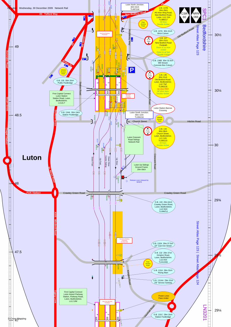
O.B. 133 29m 62chCrawley Green Road, Luton, Bedfordshire.
LU2 0QXTL099212
Luton Station Barrow Crossing
P
First Capital Connect Luton Station
Station Road, Luton, Bedfordshire.
LU12LT
29½
Luton
Church Street
Midland R
oad
Station R
oad
St. Marys Road
Guilford Street
Crescent R
oad
Park Viaduct
Chapel Viaduct
Stuart StreetD
unstable Road
Hitchin Road
Old Bedford Road
A6 Telford Way
Crawley Green Road Crawley Green Road
Street A
tlas Page 123 | S
treet Atlas P
age 124
A6
Red Zone Working Prohibited
Up Slow Only
Red Zone Working Prohibited
A6
Bridge St.
U.B. 136B 30m 32.5ch Mill Stream
Concrete Box Culvert
U.B. 137A 30m 41ch Brick Culvert
New Bedford Road
Mill
Str
eet
4
32
Centre Siding
Dow
n Fast
Up Fast
Dow
n Slow
Up Slow
Luton North Junction.30m 52chTL087218
20
30 878B
8555
5570
WH
465
20
Red Zone Working
Prohibited
5570
WH
301
20
20
20
30
15
70 85
7085
9095
9095
Luton South Junction.30m 12chTL094216
1100LE
VEL
LEVE
L250
250250
151151
209¼
½
¾
250
¼
U.B. 137B 30m 45ch
A6 Inner Ring Road,New Bedford Road,
Luton. LU1 1SATL088217All lines
Double Amber
U.B. 137 30m 41ch
New Bedford Road Footpath
Down & up slowAmber
Down & up fast Double Amber
U.B. 136 30m 31ch
Old Bedford Road,Luton, Bedfordshire.
LU2 7NZTL060216
Up slow REDAll other linesDouble Amber
O.B. 134A 30m 19chStation Footbridge
O.B. 135 30m 20ch Public Footbridge
U.B. 134 30m 08ch
Church Street, Luton, Bedfordshire.
LU1 3JGTL095215 All lines
Double Amber
Red Zone Working Prohibited ½
WH
98
U.B. 131A 29m 32chRising Main
U.B. 131AA 29m 32ch 3'6" Service Subway
Kimpton R
oad
Foot Access
Point
U.B. 132A 29m 37.5ch 18" Cast Iron Sewer
O.B. 132 29m 37chKimpton Road,
Luton, Bedfordshire.LU2 0SXTL012209
VehicleAccess Point
VehicleAccess Point
Hucklesby W
ay
Foot Access
Point
626B
625E
624C
623B623C
626B
625E
624C624B
20
877B
626B626A
625E625F
624B624A
623E623F
626B
625E
624B
624B
623E
623E
Power Lines Pass Under
Vauxh
all R
oad
1
O.B. 131C 29m 16chStation Footbridge
623C623D
623C623E
A505 W
indmill R
oadG
ypsy Lane
15' 9"4.8m
15' 6"4.73m
13' 9" 4.19m
CSR60
NRN066
8585879B880A
100100
8555
878A15
875
WH
58355
70
623D623E
95 95 85 85
01 Luton Wednesday, 30 December 2009 Network Rail
D.Cross Mapping
SP
C1
Bedfordshire
Street A
tlas Page 124 S
treet Atlas P
age 64
LN3201
29
28¾
28½
28¼
28
27¾
45
HABD
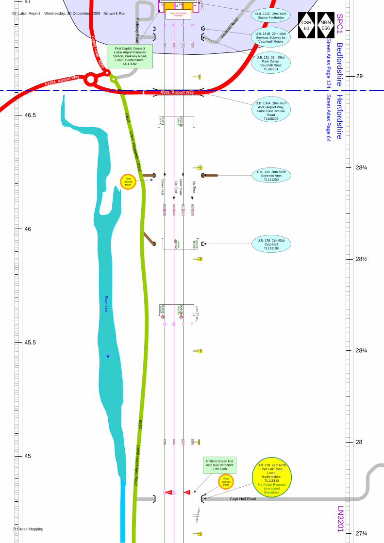
Chiltern Green Hot Axle Box Detectors
27m 67ch
45.5
46
46.5
47
O.B. 130A 28m 76chA505 Airport Way,Luton East Circular
RoadTL108203W
H297
WH
97
U.B. 130 28m 58chSoneries Arch
TL111200
WH
296
WH
96
WH
95
WH
295
U.B. 129 28m43chCopt HallTL113198
29 29¾
½¼
28 28
Red Zone Working Prohibited
4 3 2 1
Hertfordshire
Dow
n Fast
Up Fast
Dow
n Slow
Up S
low
3/4
E E
626A
625F
624A
623F
626A622B
625F621A
624A620C
623F619A
622B
621A
620C
619A
First Capital Connect Luton Airport Parkway
Station, Parkway Road, Luton, Bedfordshire.
LU1 3JW
U.B. 131B 29m 10chServices Subway for
Vauxhaull Motors
U.B. 131 29m 08chPark Corner
Vauxhall RoadTL107204
A505 Airport Way
Vauxh
all R
oad
Gypsy Lane
Lower H
arpenden Road
B653
Lower H
arpenden Road
B653P
arkway R
oad
A1081 Airport Way
A505R
iver Lea
1209
O.B. 131C 29m 16chStation Footbridge
209180
180168
95100
95100
85 85
100105
100105
HABD
CSR60
NRN066
Copt Hall Road
95 95 85 85
Foot Access
Point
Foot Access
Point
U.B. 128 27m 67chCopt Hall Road,
Luton,Bedfordshire.
TL118188No Action Requred
Line speedthroughout
02 Luton Airport Wednesday, 30 December 2009 Network Rail
D.Cross Mapping

SP
C1
Hertfordshire
Street A
tlas Page 64
LN3201
27¾
27½
27¼
26¾
26½
27
43.5
43
42.5
44
44.5
¾½
¼ 27 27
¾½
WH
94
WH
294
WH
293
WH
93
WH
292
WH
92
U.B. 124 26m 52chDunstable Branch
(Closed)Fast LinesTL127173
U.B. 124A 26m 52chDunstable Branch
(Closed)Slow LinesTL127173
WH
91
WH
291
Street A
tlas Page 64 | S
treet Atlas Page85
Street A
tlas Page 85| S
treet Atlas P
age 86
Dow
n Fast
Up Fast
Dow
n Slow
Up Slow
E E
622B
621A
620C
619A
622B
621A
620C
619A
622B
621A
620C
619A
River Lea
B653 Low
er Harpenden R
oad
The Warrens Drive
West Hyde Road
Sewage Works
Chiltern Green Road
Thrales End Lane
Coot
ers E
nd L
ane
East Hyde
B653 Lower H
arpenden Road
8575 85105105
105 105 85 85
168276
276226
226160
160286
286182
Red Zone Working Prohibited
Down Main Only
Red Zone Working Prohibited
CSR60
NRN066
River Lea
Foot Access
Point
Foot Access
Point
Foot Access
Point
Foot Access
Point
U.B. 127 27m 28chChiltern Green Road,
Luton, Bedfordshire.
TL123182Up Slow Down Slow &
Down Dast REDUp Fast Amber
V. 125 26m 66chChiltern Green Viaduct
Fast LinesTL126174
No Action RequredLine speedthroughout
V. 125A 26m 66chChiltern Green Viaduct
Slow LinesLower Harpenden Road, East Hyde,
Luton, Bedfordshire.LU2 9QBTL126174
Double Amber
U.B. 123 26m 44chThrale End Bridge
TL128170Fast Lines Amber Slow
lines Double Amber
Cooters End Lane
03 Chiltern Green Wednesday, 30 December 2009 Network Rail
D.Cross Mapping
SP
C1
Hertfordshire
Street A
tlas Page 86
LN3201
26¼
26
25¾
25½
25¼
25
42
41.5
41
40
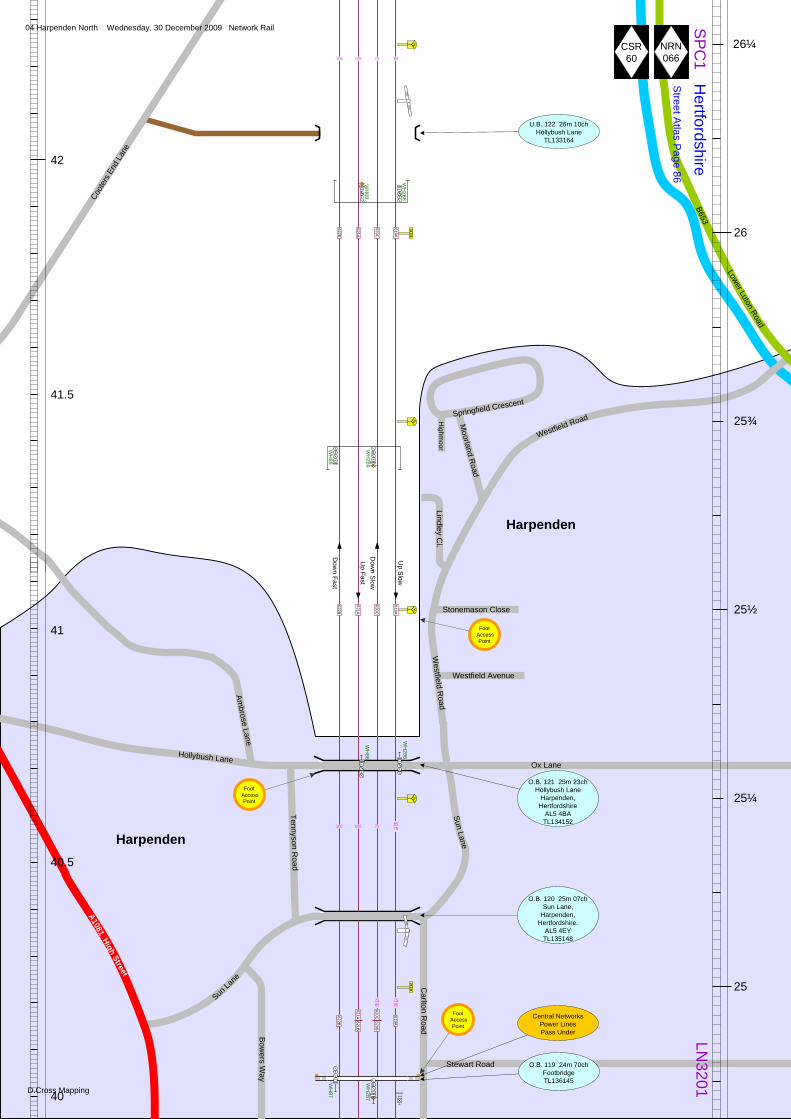
U.B. 122 26m 10chHollybush Lane
TL133164
WH
288
WH
88
26 26¾
WH
89
WH
289
½¼
25 25
WH
86
WH
286
O.B. 119 24m 70chFootbridgeTL136145W
H87
WH
287
Dow
n Fast
Up Fast
Dow
n Slow
Up S
low
Central Networks Power Lines Pass Under
O.B. 120 25m 07chSun Lane,
Harpenden,Hertfordshire.
AL5 4EYTL135148
Carlton R
oad
Stewart Road
O.B. 121 25m 23chHollybush Lane
Harpenden,Hertfordshire
AL5 4BATL134152
Coot
ers E
nd L
ane
Westfield Road
Hollybush LaneOx Lane
Sun Lane
Sun La
ne
Tennyson Road
Bow
ers Way
Harpenden
Harpenden
622B
621A
620C
619A
622B
621A
620C
619A
622B
619A
40.5
621A621B
620C620B
182206
206176
105 105 75 85
¼
857575105105
7585
7585
Lindley Cl.
Lower Luton Road
B653
Moorland R
oad
Springfield Crescent
Highm
oor
Ambrose Lane
A1081 High Street
ShuntLimit
CSR60
NRN066
Westfield R
oad
Westfield Avenue
Stonemason Close
Foot Access
Point
Foot Access
Point
Foot Access
Point
04 Harpenden North Wednesday, 30 December 2009 Network Rail
D.Cross Mapping

SP
C1
Hertfordshire
Street A
tlas Page 86
LN3201
24¾
24½
24¼
24
23¾
39
39.5
40
¾
WH
287
U.B. 118 24m 57chfast lines
Station Road, Harpenden, Hertfordshire
AL5 4SPTL137143
All lines Double Amber
U.B. 117A 24m 56chSubway
O.B. 117 24m 53chStation Footbridge
4
32
1
Harpenden Station Barrow Crossing
WH
284
WH
84
859B
859AW
H598
¼
854A
858B
858A853B
857A
852B
852A
853A
WH
565
WH
563
½ 24 24
¾R
R
Street A
tlas Page 86 | S
treet Atlas Page 107
WH
85
WH
285W
H82
WH
282
½
O.B. 112 23m 39chCross Lane, Harpenden,
Hertfordshire.AL5 1BX
TL146125
Dow
n Fast
Up Fast
Dow
n Slow
Up Slow
P
PP
First Capital Connect Harpenden Station,Station Approach
Harpenden, Hertfordshire
AL5 4SP
U.B. 118A 24m 57chslow lines
Station Road,Harpenden,
Hertfordshire.AL5 4SPTL137143
All lines Double Amber
A1081 Luton R
oad
A10
81 S
t. A
lban
s R
oad
B652 Station Road
Carlton R
oad
Milton R
oad
A1081 St. A
lbans Road
38
38.5
Southdown Road
Walkers Road Cosne M
ews
Loire Mew
s
Heath C
loseW
alkers Close
Cravells Road
St. JohnsR
oad
Eastm
oor Park
Limbrick R
oad
Grange C
ourt Road
23½ Cross Lane
Piggott
hill L
ane
Grove Road
Southdown Road
Aysgarth C
lose
Stores Pl.
Meadow W
alk
Barnfield RoadSouthdown Industrial
Estate
Longfield Road
Coleswood Road
Cranbo
urne
Driv
e
Burnsall P
l.W
ensley Cl.
ShuntLimit
622B
621B
620B
619A
622B622A
621B621C
619A619B
620B
622A
621C621D
620B620A
619B
Harpenden
Harpenden
Arden G
rove
Sout
hdow
n R
oad
B652 Station Road
Bowers way
176396
396176
854B
176200
8590
8590
110110
105110
105110
85 85
40
40
40
40 857B
40
40
110 110 90 90
Cross Lane
Station A
pproach
Crabtree Lane
Broadstone Road
12' 3"3.8m
12' 3"3.8m
Red Zone Working Prohibited
CSR60
NRN066
WH
596
Foot Access
Point
Foot Access
Point
Foot Access
Point
Foot Access
Point
U.B. 115 24m 4chSkew Bridge
Southdown Road, Harpenden,
Hertfordshire.AL5 1PGTL141134
No Action RequredLine speedthroughout
U.B. 116 24m 24chCrabtree Lane,
Harpenden, Hertfordshire.
AL5 5TB TL140137
Down slow Amber. All others Double
Amber
13' 0"3.96m
U.B. 113 23m 74chCravells Road,
Harpenden, Hertfordshire.
AL5 1BDTL142131
Down fast REDAll other lines
Amber
U.B. 114 24m 1chWalkers Road,
Harpenden, Hertfordshire.
AL5 1DWTL142133All lines
Double Amber
05 Harpenden Wednesday, 30 December 2009 Network Rail
D.Cross Mapping

Hertfordshire
Street A
tlas Page 107
LN3201
23¼
23
22¾
22½
22¼
22
37
WH
83
WH
283
23 23 22 22
WH
278
WH
78
WH
81
WH
281W
H76
WH
276
O.B. 110 23m 4chAyres End Lane
Harpenden, Hertfordshire.
AL5 1ANTL148119
Dow
n Fast
Up Fast
Dow
n Slow
Up S
low
¼
¾
½
¼
E E
37.5
36.5
36
35.5
O.B. 111 23m 27chSears Bridge
Mud LaneTL147123
SP
C1
O.B. 109 22m 20chCheapside Bridge
TL154107
Cheapside Farm
Ayres End Lane
A1081 St. A
lbans Road
A1081 H
arpenden Road
110 110 90 90
110 110 90 90
200179
179LE
VEL
LEVE
L214
214LE
VEL
LEVE
L176
622A
621D
620A
619B
622A
621D
620A
619B
622A
621D
620A
619B
CSR60
NRN066
Foot Access
Point
Foot Access
Point
06 Harpenden South Wednesday, 30 December 2009 Network Rail
D.Cross Mapping
½
SP
C1
Hertfordshire
Street A
tlas Page 107 | S
treet Atlas P
age 127
LN3201
21¾
21½
20¾
20½
34
21 21
WH
274
WH
74
WH
79
WH
279
WH
77
WH
277
WH
272
WH
72
Dow
n Fast
Up Fast
Dow
n Slow
Up Slow
¾
¼
¾
34.5
35
33.5
33 ½
St. Albans
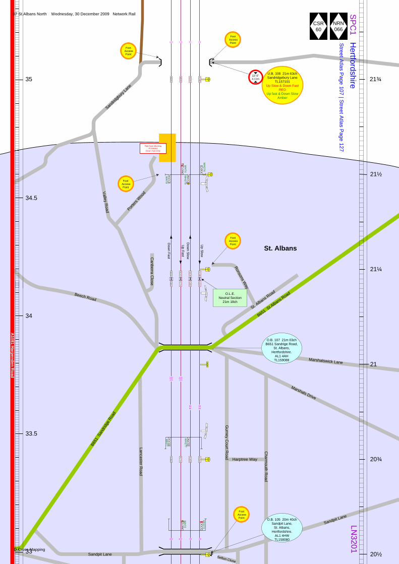
O.B. 105 20m 40chSandpit Lane,
St. Albans,Hertfordshire.
AL1 4HWTL158080
O.B. 107 21m 03chB651 Sandrige Road,
St. Albans, Hertfordshire.
AL1 4AHTL159088
21¼
21
B651
San
dridg
e Ro
adSan
dridg
bury
Lane
Valley Road
Canberra C
lose
Porters
Woo
d
Beech Road
Lancaster Road
Sandpit Lane
Harptree Way
Gurney C
ourt Road
Charm
outh Road
Marshals Drive
Marshalswick Lane
B651 St A
lbans Road
176200
200300
300176
622A
621D
620A
619B
622A
621D
620A
619B
618A
617A
616B
615A
618A
617A
616B
615A
110100
110100
9080
9080
110 110 90 90
A1081 H
arpenden Road
Sandpit Lane Sefton Close
Red Zone Working Prohibited
Down Fast Only
CSR60
NRN066
U.B. 108 21m 63chSandridgebury Lane
TL157101Up Slow & Down Fast
REDUp fast & Down Slow
Amber
13' 6"4.11m
Foot Access
Point
Foot Access
Point
Foot Access
Point
O.L.E.Neutral Section
21m 18ch
St. Albans R
oad
Ronsons Way
Foot Access
Point
Foot Access
Point
100 100 80 80
07 St.Albans North Wednesday, 30 December 2009 Network Rail
D.Cross Mapping

RR
SP
C1
Hertfordshire
Street A
tlas Page 127
LN3201
20½
20¼
20
19¾
19½
19¼
32
20 20
O.B. 104 20m 29chJennings Road
FootpathTL158078
O.B. 103 20m 17chFootpathTL157076
849848B
850
WH
75
WH
275W
H68R O.B. 101B 19m 72ch
Station Footbridge4
32
1
WH
68
WH
268
WH
75R
U.B. 100 19m 43chHatfield Line
(Disused)
U.B. 99A 19m 40ch4'6" Corporation Sewer
WH
73
WH
273
Dow
n Fast
Up Fast
Dow
n Slow
Up S
low
¼
¾
½
¼
Centre Siding
E
32.5
33
31.5
31
Lemsford R
oad
Jennings RoadEastbury Court
York Road
O.B. 101 19m 70chVictoria Street
St. Albans, Hertfordshire
AL1 3TGTL156071
Station Way
First Capital ConnectSt. Albans Station,
Station Way,St. Albans,
HertfordshireAL1 5HETL156071
WH
268R
O.B. 102 20m 05chA1057 Hatfield Road,
St. Albans,Hertfordshire.
AL1 5HETL156073
618A
617A
616B
615A
Sandpit Lane
Avenue Road
½
Gainsborough Avenue
Clarence R
oad
Blenheim
Road
O.B. 105 20m 40chSandpit Lane,
St. Albans, Hertfordshire.
AL1 4HWTL158080
Sefton Close
615A615B
616B616A
617A
615B
618A618A
617A
616A
615B
Red Zone Working Prohibited
CSR60
NRN066
8065
8065
100100
A1057 Hatfield Road
Beaconsfield R
oad
Alma Road
Ridgem
ont Road
Grovsvenor RoadA1081 London Road
B691 Victoria Street
A1081 C
hequer StreetA
1081 St. Peters Street
Stan
hope
Roa
d
Camp Road
St. Albans
ST. Albans
10095
6580
6580
95100
8090
8090
176167
167285
285177
U.B. 99 19m 14chA1081 London Road,
St Albans, Hertfordshire.
AL1 1JQTL157064
Double Amber
15
15
848A
8080100100
Foot Access
Point
Foot Access
Point
Foot Access
Point
PFoot
Access Point
Foot Access
Point
Colindale A
venue
Kenton Gardens
08 St.Albans Wednesday, 30 December 2009 Network Rail
D.Cross Mapping

SP
C1
Hertfordshire
Street A
tlas Page 142
LN3201
19
18¾
18½
18¼
18
17¾
29
19 19
18 18
WH
66
WH
266
WH
71
WH
271W
H64
WH
264
HABD HABD
Napsbury HABD
18m 0ch
U.B. 94A 17m 56ch24" CulvertTL160037
U.B. 94 17m 48chSlaughtersTL160035
Street A
tlas Page 142 | S
treet Atlas P
age 141
¾
½
¼
¾
28.5
29.5
30
30.5
St. Albans
O.B. 96A 18m 37chA414 North Orbital
TL161049
618A
617A
616A
615B
618A
617A
616A
615B
618A
617A
616A
615B
177167
167196
196163
WH
69
WH
269100110
100110
CSR60
NRN066
New
Barnes Avenue
Mile H
ouse Close
Mile House Lane
Napsbury Lane
B5378 Shenley LaneA414 North Orbital Road
The Drive
The Drive
Dow
n Fast
Up Fast
Up S
low
Dow
n Slow
A1081 London Road
U.B. 98 18m 76chMile House Bridge,Mile House Lane,
St. Albans,Hertfordshire.
AL1 1TDTL161057
Amber
Foot Access
Point
O.B. 97 18m 50chNapsbury Lane,
St. Albans,Hertfordshire.
AL1 1DUTL162052
Foot Access
Point
100 100 90 90
9090110110
Napsbury Lane
09 Napsbury Wednesday, 30 December 2009 Network Rail
D.Cross Mapping

SP
C1
Hertfordshire
Street A
tlas Page 141
LN3201
17½
17¼
17
16¾
16½
16¼
27.5
9 69
U.B. 93B 17m 26ch24" Brick Culvert
WH
62
WH
262
U.B. 93A 17m 9chM25 Motorway
TL159028
17 17
WH
67
WH
267
WH
258
WH
58
U.B. 92 16m 43chRiver ColneTL158019
WH
592 845B
845A844B
844A
WH479
Redland Roadstone Siding
WH
265
WH
65
Street A
tlas Page 141 | S
treet Atlas P
age 155
½
¼
E
E E
¾
½
¼
27
26.5
26
618A
617A
616A
615B
618A
617A
616A
615B
618A
617A
616A
615B
28
O.B. 91 16m 15chB556 Harper Lane,
Radlett,Hertfordshire.
WD7 7HUTL159013
Dow
n Fast
Up Fast
Up S
low
Dow
n Slow
CSR 60
NRN066
110 110 90 90
163193
160193
160260
LEV
EL260
B556 Harper Lane
A5183 Radlett Road
O.B. 93 16m 68chParkbury Bridge
TL158023
Old Parkbury Lane
Colney Street
Industrial Estate
Ventura Park
Handley
Page Way
M25 AnticlockwiseM25 Clockwise
10 Radlett Sidings Wednesday, 30 December 2009 Network Rail
D.Cross Mapping

SP
C1
Hertfordshire
Street A
tlas Page 155 | S
treet Atlas P
age 15616
15¾
15½
15¼
15
24
16 16 15 15
U.B.90A 15m 65ch 5' Culvert TL161008
WH
56
WH
256 U.B. 59 15m 45chParts Brook Bridge
Tykes WaterTL162003
O.B. 88 15m 37chThe Drive
Radlett, Hertfordshire WD7 7BZTL163002
WH
63
WH
263
U.B. 87 15m 21chBrook BridgeTykes WaterTQ164999
U.B.87A 15m 21ch 9" Cast Iron Sewer
O.B. 86 15m 19chStation Footbridge
4
32
1
P
O.B. 85 15m 12chShenley Hill
Radlett,Hertfordshire
WD7 7BATQ165998
WH
254R
LN3201
S.B. 84A 14m 75chTheobald Street over
Tykes Water
O.B. 84 14m 75chTheobald Street,
Radlett, Hertfordshire WD7 7LPTQ167995
U.B. 83 14m 60chTykes WaterTQ169992W
H54
WH
254
U.B. 82 14m 58chDumbletons Footpath
TQ169992¾
¼
½
¾
E
24.5
25
25.5
A5183 R
oman R
oad
Station A
pproach
Beaum
ont Gate
First Capital ConnectRadlett Station,
Station Approach, Radlet, Hertfordshire
WD7 7AP
Shenley Hill
A5183 W
atling Sreet
Beech A
venue
S.B. 88A 15m37chThe Drive over Tykes
Water
Lodge End
The Drive
Theobald Street
26
618A
617A
616A
615B
618A
617A
616A
615B615B
611A
616A612B
617A613A
618A614B
Red Zone Working Prohibited
The Avenue
The Heath
U.B. 90 15m 63chParts BridgeTL161007
CSR60
NRN066
Craig M
ount
Craigwell Avenue
Haw
thorne Rd.
Radlett P
ark Road
B462 Aldenham Road
B462 Watford RoadStation Road
Park Road
The Grove
Goodyers Avenue
Kitswell Way
Oakridge Avenue
Watling K
noll
Radlett
Radlett
110 110 90 90
LEVE
L460
460185
185149
149220
220LEV
EL
LEV
EL200
11 Radlett Station Wednesday, 30 December 2009 Network Rail
D.Cross Mapping
SP
C1
Hertfordshire
Street A
tlas Page 156
LN3201
14½
14¼
14
13¾
13½
22.5
14 14
843B
843A
840B
840A
842B
842A839B
839A838B
838A
841A
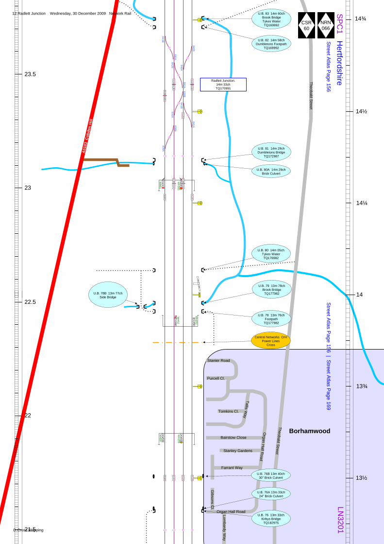
U.B. 81 14m 29chDumbletons Bridge
TQ172987
WH
61
WH
261
U.B. 80A 14m 29ch Brick Culvert
WH
52
WH
252
WH
59
WH
259
U.B. 76 13m 33chKirbys Bridge
TQ182975
U.B. 76A 13m 33ch 24" Brick Culvert
Radlett Junction.14m 33chTQ170991
½
¼
¾
½
14¾ ¾
23
23.5
22
21.5
U.B. 83 14m 60chBrook BridgeTykes WaterTQ169992
A51
83 C
obde
n H
ill
U.B. 82 14m 58chDumbletons Footpath
TQ169992
U.B. 80 14m 05chTykes WaterTQ176982
U.B. 79 13m 78chBrook BridgeTQ177982
Street A
tlas Page 156 | S
treet Atlas P
age 169
611A611B
613A613B
614B614A
613B613C
612B612A
614A
611B
614A
613C
612A
611B
40
40
40
612B
40
40
841B
30
Theobald Street
110 110 90 90
110 110 90 90
Central Networks O/H Power Lines
Cross
U.B. 76B 13m 40ch30" Brick Culvert
BorhamwoodOrgan H
all Road
Purcell Cl.
Stanier Road
Tallis Way
Tomkins Cl.
Bairstow Close
Stanley Gardens
Farrant Way
Gibsons C
l.
Organ Hall RoadLombardy W
ay
Theobald Street
200200
CSR60
NRN066
U.B. 78 13m 76chFootpath
TQ177982
U.B. 78B 13m 77chSide Bridge
12 Radlett Junction Wednesday, 30 December 2009 Network Rail
D.Cross Mapping

450235
235200
P
SP
C1
Hertfordshire
Street A
tlas Page 169
LN3201
13¼
13
12¾
12½
12¼
12
19.5
13 13 12 12
WH
48
WH
248
O.B. 71A 12m 39chAllum Lane
South footbridge
WH
46
WH
246
4
32
1
WH
57
WH
257
WH
55
WH
255
T. 68 12m 06chElstree Tunnel
Slow LinesNorth PortalTQ194957
T. 69 12m 06chElstree Tunnel
Fast LinesNorth PortalTQ194957
¼
¾
¼
Red Zone Working Prohibited
20
20.5
21
21.5
O.B. 72A 12m 41chAllum
North Footbridge
U.B. 72B 12m 41ch12" Council Sewer
½
O.B. 72 12m 40chAllum Lane,
Borehamwood,Hertfordshire.
WD6 3PJ TQ191964
O.B. 71B 12m 38chStation Footbridge
Street A
tlas Page 169 | S
treet Atlas P
age170
614A
613C
612A
611B
614A
613C
612A
611B
614A
613C
612A
611B
Red Zone Working Prohibited
NRN066
CSR 60
110 110 90 90
110100
110100
9075
9075
450400
400176
Furzehill Road
First Capital Connect Elstree & Borehamwood
StationAllum Lane,
Borehamwood,Hertfordshire.
WD6 3PJ
Holt Cl.
Park C
res.
Station R
oad
B5378 Allum LaneB5378 Shenley Road
Deacons H
ill Road
Deacons C
lose
Lombardy W
ay
Beechfield Close
U.B. 75 13m 13chMatthews Footway
Bridge
Theobald Street
U.B. 74A 13m 09ch Brick Culvert
Ashdown D
rive
Kingsley Avenue
Anthony R
oad
Red R
oadH
olme Pk
O.B. 74 12m 73chRobinsons Bridge
Gables Avenue
13 Elstree Wednesday, 30 December 2009 Network Rail
D.Cross Mapping

SP
C1
Hertfordshire
Street A
tlas Page 170
LN3201
11¾
11½
11¼
11
10¾
10½
17.5
11 11
T. 68 11m 37.5chElstree Tunnel
Slow LinesSouth PortalTQ197948
T. 69 11m 38chElstree Tunnel
Fast LinesSouth PortalTQ197948
= Air Shaft
WH
253
WH
53
O.B. 67 11m 26chM1 Motorway
TQ198946
WH
44
WH
244
¾
½
E E
¼
¾
½
18
18.5
19
17
Red Zone Working Prohibited
Red Zone Working Prohibited
U.B. 67B 11m 10chBrick Culvert
U.B. 67A 11m 10ch Brick Culvert
U.B. 66A 10m 63ch Brick Culvert
Hertfordshire Street Atlas Page 170
LondonStreet Atlas Page 10
614A
613C
612A
611B
614A
613C
612A
611B
614A
613C
612A
611B
A411 Barnet Lane
M1 Southbound
M1 N
orthbound
London Gatew
ay Services
Scratchwood
NRN 066
CSR 60
Springw
ood Crescent
Bushfield Crescent
14 Scratchwood Wednesday, 30 December 2009 Network Rail
D.Cross Mapping

SP
C1
LondonLN
3201
10¼
10
9¾
9½
9¼
9
16
10 10 9 9
WH
51
WH
42W
H251
WH
242
¼
¾
½
O.B. 63 9m 78chSelvage Lane
O.B. 62 9m 62chLilley Lane
WH
49
WH
249
WH
238
WH
38
U.B. 61A 9m 36chA5100 The Broadway
Slow Lines
U.B. 61 9m 36chA5100 The Broadway
Fast Lines
U.B. 60A 9m 35ch Brick Culvert
U.B. 60 9m 30chStation Subway
¼
U.B. 58A 9m 10chBunns Lane
Down Slow Only. 5mph exam. 20mph if no defects observed.
U.B. 58A 9m 10chBunns Lane
Up Fast Only. 5mph exam. 20mph if no defects observed.
V. 65 10m 32chDeans Brook Viaduct
15.5
15
14.5
16.5
P
O.B. 63A 10m 04chEdgware Way
First Capital Connect Mill Hill Broadway
Station.9m 28ch
Street A
tlas Page 11 | S
treet Atlas P
age 27
15' 9"4.87m
614A
613C
612A
611B
614A
613C
612A
611B
614A
613C
612A
611B
Red Zone Working Prohibited
Red Zone Working Prohibited
Graham
e Park Way
M1
Bunns Lane
A1 Watford W
ay
A1 W
atfo
rd W
ay
Mill W
ay
A5100 Hale Lane
Hale G
rove Gardens
A41 Edgware Way
Gibbs Green
A5109 Selvage Lane
A1 Barn
et Byp
ass
CSR60
NRN066
Mount G
roveB
ellamy C
loseKenilw
orth Road
15 Mill Hill Wednesday, 30 December 2009 Network Rail
D.Cross Mapping

SP
C1
LondonS
treet Atlas P
age 27
LN3201
8¾
8½
8¼
8
7¾
13
8 8¾
¼
½
¾
E
EW
H36
WH
236
WH
247
WH
47
U.B. 56 8m 57chTrinders Bridge
U.B. 55A 8m 46ch24" Culvert
Graham
e Park
OLE
Feeder Station
U.B. 54 8m 27chDunlops Bridge
837834
835
Silkstream Junction.7m 72ch
TQ222897
U.B. 53C 8M 27ch30" Brick Culvert
WH
459WH
45
WH
245W
H34
9 9
U.B. 57A 8m 73ch 24" Brick Culvert
847B
847A
WH
588
9
12.5
13.5
14
14.5
Street A
tlas Page 28 | S
treet Atlas Page 46
HendonAir Museum
U.B. 51 7m 66chHinges Bridge
Footpath subwayFast lines
O.B. 50 7m 46chHendon goods lines
U.B. 50C 7M 50chL.T. Northern lines
pass under
U.B. 50B 7m 57ch 18" pipe
Graham
e Park Way
614A
613C
612A
611B
614A
613C
612A
611B
610D
609A
608E
607A
610D
609A
608E
607A
O.B. 52A 7m 73chAerodrome Road,
London.NW4 4SSSlow LinesTQ223898
Double Amber11' 6"3.5m
O.B. 52 7m 73chAerodrome Road,
LondonNW4 4SSFast LinesTQ223898
Double Amber
11' 6"3.5m
Red Zone Working Prohibited
Down Fast only
CSR60
NRN066
Selborne Gardens
A41 W
atford Way
Aerodrome Road
Row
an Drive
M1
M1
M1
U.B. 53B 8m 6ch24" Culvert
WH
234
Avion
Cre
scen
t
Graha
me Par
k Way
U.B. 54A 8m 41ch Brick Culvert
M1Junction 2
A1 Great North Way
A1 W
atford Way
A1 Bar
net B
ypas
s
Aerodrome Road SilkstreamTQ222895
7m 1320 Yd
HingesLane FootbridgeTQ2228797m 1584yd
U.B. 51A 7m 66chHinges Bridge
Footpath subwaySlow lines
U.B. 52B 7m 73ch Culvert
16 Silkstream Junction Wednesday, 30 December 2009 Network Rail
D.Cross Mapping

SP
C1
LondonLN
3201
7¼
7
6¾
6½
6¼
11.5
¼
¾
½
¼
904B
904A
903
7 7
WH
32R
WH
232R
WH
43
WH
243
4
3 2
1
WH
474
832B
832A
U.B. 48A 7m 12ch 12" Cast iron sewer
U.B.P. 7m 15ch 24" Brick Culvert
WH
472
WH
32
WH
232
WH
43R
O.B. 47 6m 76chA504 Station Road,
BarnetLondon.
NW4 4PZ
WH
455
WH
41
WH
241
O.B. 42A 6m 21chNorth Circular Road/
Adrian Avenue, London.NW21LX
WH
466
WH
468
WH
28
WH
228
829B
828B
8
7½ ½
905A
905BU.B. 49A 7m 36chHyde footpath subway
Goods lines
11
10.5
10
12
O.B. 46 6m 58chPark Road,
BarnetLondon.
NW4 3PS
U.B. 44 6m 35chBrent Park Road,
London.NW4 3HN
U.B.P. 6m 45ch18" Cast iron sewer
U.B. 47A 6m 77ch18"Cast iron sewer
O.B. 48 6m 78chHendon Station
Footbridge
O.B. 50A 7m 42chA5150 Colindeep Lane,
London.NW4
Hendon StationFirst Capital Connect
Station Road, Barnet, London
NW4 4PT
WH
457
Street A
tlas Page 46
V. 43 6m 21chWelsh Harp Viaduct
Adrian Avenue
A406 North Circular Road
Dallas R
oad
Park Road
A5 Edgew
are Road
10' 9"3.27m
610D
609A
608E
607A
610D
609A
608E
607A
Red Zone Working Prohibited
Red Zone Working Prohibited
Up Slow Only
Red Zone Working Prohibited
20
15
829A W
20
CSR60
NRN066
Mount R
oad
Montague RoadAlgemon R
oad
Dartm
outh Road
Brent View
Road
Hendon B
roadway
The Broadway
Herbert R
oad
Perryfi el d Way
Station Road
Malcom
Crescent
Edgw
orth Close
Talbot Crescent
Edgeworth Crescent
Edgeworth Avenue
Wilberforce R
oad
Irving Way
Colin Drive
Colin G
ardens
Colin C
rescent
CrosswayEndersleigh Gardens
Grove G
dns
A5150 Colindeep Lane
A41 Watford Way
Rich
mon
d G
arde
ns
U.B. 49 7m 36chHyde footpath subway
Fast & slow lines
Barto
n Cl
ose
A41
M1
M1
M1
O.B. 50 7m 46chHendon goods lines
Tilling Road
Brent Reservoir
Cool Oak Lane
Under review as 2 possible locations REF 942
P
Irving Way
Garrick RoadRussell R
oad
17 Hendon Wednesday, 30 December 2009 Network Rail
D.Cross Mapping

¾
SP
C1
LondonS
treet Atlas P
age 68
LN3201
6
5¾
5½
5¼
5
4¾
8
6 6
5 5
824
823833
826A
WH
590822B
WH447
822A
WH
491
WH
39
WH
239W
H584
820B
820A819B
819AW
H582
WH
449
818½
¼
WH
553811810B
810A
813
814
804B
804A
Dow
n Hendon
Up H
endon
Dow
n Fast
Up Fast
Dow
n Slow
Up Slow
Up/dow
n Goods 1
Up/dow
n Goods 2
4
32
1
WH
443
WH
37
WH
237
WH
537
WH
545
806B
806A
U.B. 39D 4m 77.5ch3'6"x3' Culvert
U.B. 39C 4m 72.5ch 3' Culvert
WH
446
WH
24
WH
224
U.B. 39B 4m 64.5ch4'1" x 2'8" Sewer
U.B. 394AD 4m 60.5ch3'6"x3' Culvert
8.5
9
9.5
H466
H468
H28
H228
29B
828B
826B
Dudding H
ill
Street A
tlas Page 68| S
treet Atlas P
age 69
19B
19A
U.B. 40 5m 4.5chA407
Cricklewood Lane,London.
NW2 1HL
U.B. 41B 5m 42ch Brick Culvert
U.B. 41C 5m 48ch 30" x 12" Culvert
Brent Curve Junction.6m 4ch
TQ232867
Released by WH963
817A
817B
607K607L
Cricklewood Depot Shunt
Frame
¾
608E
609A
610D
Dow
n Reception
Cricklewood Curve Junction5m 19ch
TQ237862
607B607C
607L
607L
608E608D
807A
15' 6"4.72m
807B
809808
797B
797A796B
796A
WH
448
WH
564
607M
WH
539
800
Cricklewood Depot.
607L607M
607N607M
607N
609B
608D
607D
Brent Sidings
793B
794B
793A
794A792B
791B792A
WH
535
WH
551
607C607D
Red Zone Working Prohibited
Lichfield Road
Oak G
rove
Richborough Road
Fordwych R
oad
Westcroft C
lose
LEVE
L375
20
20
20
20
20
20
20
20
610C
9075
9075
20
45 45
20
11095
609A609B
11095610D
610C
LN3219
A5 Cricklewood Broadw
ay
Gladstone Parade
A607 Cricklewood Lane
Cla
rem
ont R
oad
Brent TerraceB
rent Terrace
Claremont Way
NRN 066
CSR59
Menelik Road
Depot Approach
Dorchester Court
Longley Way
Grafton Terrace
Midland Terrace
Johnston Terrace
Cam
pion TerraceG
eron Way
Dollis
Hill Ave
nue
Sand
crof
t Cl.
PinemartinCl.
Oxleys
Roa
d
Mount Road
Mas
cots
Cl. Br
oadf
ield
Cl. Cop
perm
ead
Cl.
Shobroke Cl.
Gladsto
ne Park
Gard
ens
Down B
rent C
urve
Up Bren
t Curv
e
WH45
3
West Hampstead
Cricklewood
Brent
3010
828A
827A
3010 827B
15WH
586
829A
20
20
20
607B
607K607L
45 45
Cricklewood Recess SidingsDepot Approach
TQ2388615m 418yd
Cricklewood Shunt FrameBrent Terrace
TQ2318685m 1498yd
Cricklewood Depot Junction5m 63ch
TQ234867
18 Cricklewood Wednesday, 30 December 2009 Network Rail
D.Cross Mapping

25
9080
40
50
SP
C1
LN3201
4½
4¼
4
3¾
3½
6.5
4 4
½
¼
¾
½
WH
35
WH
235790B
790A
O.B. 36 3m 67.5chB510 West End Lane
London.NW6 1XF
O.B. 35 3m 57.5chBOK2
Gospel Oak – Kensall Green
O.B. 34 3m 57.5chFootbridge
O.B. 37 3m 69.5chStation Footbridge
West Hampstead Station First Capital Connect
West End Lane,London.
NW6 1XF
789787B
787A783B
783A
780A
780B
779
778
772
771
6
5.5
718A718B
786B
786A784B
784A
WH
437
WH
233
774A
774B
WH
31
WH
231769A
769BW
H218
WH
18
WH
529W
H556
WH
531W
H562
WH
444
WH
22
WH
222W
H222R
Dow
n Fast
Dow
n Hendon
Dow
n Slow
Dow
n Carriage Loop
Up S
low
Up Fast
Up H
endonR
un Round
E
7
7.5
791B792A
791A
610E
610E
610E
610C
609B
608C
608C
607E
608D608C
607D607E
609B
610C
610E
610E
WH
441
WH
533W
H558
T.29 3m 34chBelsize Tunnel
1m 11ydsFast Line
North Portal
610C610B
609B609C
608C608B
607F607G
607E607F
Red Zone Working Prohibited
Red Zone Working Prohibited
4
32
1
Liddle Road
Westcroft C
lose
Westbere R
oadW
estbere Road
O.B. 39 4m 45.5chMinster Road,
London.NW2 3RB
O.B. 38 4m 34chMill Lane.London.
NW6 1NS
Street A
tlas Page
London
A5 Shoot U
p Hill
Minster Road
Mill Lane
Fordwych R
oad
Wayne Kirkum Way
Fordwych Road
Barlow Road B
rassey Road
Maygrove Road
B520 Iverson Road
T.30 3m 32chBelsize Tunnel
1m 107ydsSlow Line
North Portal
Blackburn R
oad
A41 Finchley Road
Lythos Road
Rosem
ont Road
Frognal
Netherhall Gardens
B510 West End Lane
Sum
atra Road
Ravenshaw
Street Broom
sleigh Stre
et
B510 West End Lane
Glastonbury St.
Dornfell StreetMill Lane
London
West Hampstead North Junction.4m 09ch
TQ254848
A41 Finchley Road
CSR59
NRN 066
West Hampstead South Junction.3m 53ch
TQ258848
7540/75
WH
2168540/80
EW
H1680 75
50
25
30
1540
9590
WH
33
25
15
25
25
25
75752585953030
9585
WH
439
20
195180
WH
216R
195420
LEV
EL420
WH
231BR
West Hampstead PSB
TQ2538484m 0yd
19 West Hampstead Wednesday, 30 December 2009 Network Rail
D.Cross Mapping

SP
C1
LondonLN
3201
3
2½
2¼
2
3
3.5
4
4.5
5
2 2¼
758A
WH
27R
WH
227R759A
3¼
= Air Shaft
763A
763B
765A
765B
762A
762B766
767
610B
609C
608B
607G
610B
609C
608B
607G
608B608A
610B610A
WH
29 E
WH
14
WH
227
WH
27
50
2550
7070
CSR59
NRN 066
WH
12
WH
212
WH
424
T. 24 1m 75chHampstead Tunnel
44yds
WH
214
WH
554
Kingsford Street
B517 Southampton Road
Dunboyne R
oad
B518 Mansfield R
oad
Parkhill Road
Woodland Walk
T. 30 2m 33.5chBelsize Tunnel
110ydsFast lines
South portal
O.B. 28 2m 29chB517 Southampton Rd.
LondonNW5 4JU
T.29 2m 29chBelsize Tunnel
110ydsSlow lines
South portal
B517 Agincourt Road
B518 Fleet R
oad
Garnet R
oad
Upper Parkhill Road
Lawn Road
Lawn Road
2¾
Red Zone Working Prohibited
¾
Aspen G
rove
T. 26 2m 17chLismore Circus Tunnel
110ydsNouth Portal
O.B. 25 2m 8.5chGrafton Road,
London.NW5 4BL
Street A
tlas Page 70| S
treet Atlas P
age 71
Belsize Avenue
Frognal
¼
Red Zone Working Prohibited
Netherhall Gardens
Nuttley Terrace
½
A502 Haverstock Hill
Maresfield Gardens
Daleham Gardens
Oman Road
3 3
Lyndhurst Road
Akenside Road
Rosslyn Hill
Lyndhurst Gardens
Belsize Cres.
B511 Fitzjohns Avenue
Belsize Lane
Belsize Lane
Street A
tlas Page 70
Grafton Road Mansfield Road
London
7570
40/7570
35/50
LN32
10
50
50
30
7550
Red Zone Working Prohibited
8075
40/8040/75
609C609D
40/7530/50
607G607H
235131
131326
326108
108188
188371
O.B. 27 2m 25.5chGospel Oak Grove
T. 26 2m 22chLismore Circus Tunnel
110ydsNorth Portal
371166
166201
201180
E WH
384
E
WH
184
WH
199
WH
399
E E
WH
29BR
20 Carlton Road Wednesday, 30 December 2009 Network Rail
D.Cross Mapping

20 15
10
20
SP
C1
LN3201
1¾
1½
1¼
1
0¾
0½
1
2
2.5
¼
758B
759B
756
3
WH
27R
WH
227R759A
½
4
32
1
T. 15A 0m 78chCamden Tunnel
308yd Slow Line
South PortalTQ297844
T. 15 0m 78chCamden Tunnel
308ydFast Line
South PortalTQ297844
O.B. 14 0m 75.5chAgar Grove,
London. NW1 9TLTQ297843
MC
L
3½
3¼
3
2¾
½
O.B. 20A 1m 48chStation Footbridge
¼
3 3
740A
740B
737
741A
741B
Kentish Town Junction.SPC1 1m 65chMCL 3m 58ch
TQ288853
738A
MCLT11 2m 56ch
Kings Cross TunnelNorth Portal
WH
385
736A
736B732A
732B731A
731B
Cripple Siding
Reception S
iding
Run R
ound Siding
Discharge S
idingH
PH
P
WH
217
O.B. 13 0m 64chBOK1 / CRF2North London
Lines Cross Over
U.B. 14A 14m 76ch4' Box Sewer
WH
421
¾
U.B. 21C 1m 50ch4' x 2'Culvert
U.B.21B 1m 48.5ch LT Northern Line
passes under
U.B. 21A 1m 48.5ch Sewer
O.B. 21 1m 48.5chKentish Town Road,
London.NW5 2TJ
¾
U.B. 11B 0m 52ch Sewer
U.B. 10 0m 50.5chBass’s StoresRegents Canal
TQ298837
First Capital ConnectKentish Town Station
Dow
n Fast
Up Fast
Dow
n Moorgate
754
Up M
oorgate
Up & D
own R
elief
Dow
n Moorgate
Up M
oorgate
753A
753B 607H601A
608A602B
608A603C
608A603A
609C605A
Up & D
own Slow
606D
605A
603A
603C
602A
601B
603A603B
603C603B
603B603D
601B
602A
606D606C
605A605B
730
WH
25
WH
431
WH
425
ShuntLimit
WH
8
WH
208
WH
432
WH
420
WH
25R
WH
423
WH
418E
WH
23
WH
223
WH
429
WH
21
WH
403
WH
221CTRL M
aintenance Siding
606C
605B
Aggregate Conveyor
WH
198
WH
401
WH
4
WH
204
20
5
230110
230378
701560
1560190
Red Z
one W
orkin
g
Prohib
ited
Red Zone Working Prohibited
Red Zone Working Prohibited
Red Zone Working Prohibited
Red Zone Working Prohibited
1.5
O.B. ?? ?m ??chNew Railway Bridge
Part of CTRL remodelling
U.B. 8A 0m 59.5chSewer
5
5
10
738B
50
20
WH
19
40/50
20
303040/5050
7050
60/7040/50 WH
6
5030
WH
206
30WH
428
LN3213
LondonS
treet Atlas P
age 71
CSR59
NRN 066
CSR59
CSR 58
Dock Junction North.SPC1 0m 76chMCL 2m 73ch
TQ297843
Cam
ley Street
Cedar W
ay
Regents C
analA
5202 St. Pancras Way
Baker Drive
A5202 R
oyal College Street
Agar GroveRandolph Street
Baynes Street
B512 Crowndale Road
Agar Grove
St Augustin
es Road
O.B. 17 1m 22.5chGaisford Street,
LondonNW5 2EH
T. 15 1m 12chCamden Tunnel
308yd Fast Line
North PortalTQ295847
WH
416
1 1
Up &
Dow
n Slow
Up Fast
Murray M
ewsStra
tford Villa
sMurray Street
Dow
n Fast
224378
224378
Red Zone Working Prohibited
T. 15A 1m 12chCamden Tunnel
308ydSlow Line
North PortalTQ295847
Camden Square
Camden Mews
A503 Camden Road
A503 Camden Road
Barth
olem
ew R
oad
Bartholemew Road
Gaisford Street
Caversham Road
Islip Street
A400
Kentis
h Town Road
A400 Fortress Road
B518
Hig
hgat
e R
oad
Leighton Road
Regis R
oad
50
610A606D
50
25
7060\70
WH
225
35/5030
50
3050
¾
7070
Up & D
own R
elief
Sandall R
oad
O.B. 19 1m 36.5chIslip Street,
LondonNW5 2DL
Bushby PlaceO.B. 18 1m 29chCaversham Road
London.NW5 2DR
Oseney Crescent
Granary St.
½
40/5020
5020
20 20
WH
17
WH
215
7606C
606B723A
722A7
WH
200
WH
419
Dock Junction South.0m 59ch
TQ297842
378224
190799
799146
WH
417
146235
Marigold FoodsCamley Street
0m 990yd TQ298837
Cedar Way0m 1350ydTQ297841
Regis Road1m 1067ydTQ290851
Murphys YardSanderson Close
TQ2878531m 1320yd
Sand
erso
n C
l.
Gre
enw
ood
Pl.
21 Dock Junction Wednesday, 30 December 2009 Network Rail
D.Cross Mapping

2015
2015
NRN066
SP
C1
LondonLN
3201
CSR58
0¼
00
0.52015
2015
0½
722B
U.B. 6 0m 32.5chCamley Road,London NW10
TQ298836
U.B. 1 0m 15.5chPancras RoadLondon NW12
No dispensation for small vehicles
Brill Place
Midland R
oad
St Pancras Road
A5202
Granary St.
Polygon Road
Purchese Street
Goldington St.
Chenies Place
A501 Euston Road
Pancras Road
A5202
A520
0 Y
ork
Way
Cam
ley Street
Goodsway
Grays Inn Road
Pentonville Road
Birkenhead S
treet
Crestfield S
treet
Belgrove Street
Argyle Street
Judd Street
Regents Canal
Battle Bridge Road
¼
B512 Crowndale Road
St Pancras Hotel
CTRLPlatforms 5 Onwards
Ashford ECO
12
34
U.B. ?? ?m ??chGoodsway & Pancras
Road,London NW11
London (WC)
London (NW)
London (N)
606A
606B
606B
605D
606C606B
WH
9
WH
11
311130
105130
10592
East Midlands Trains St. Pancras Station
Platforms 1-4
Street Atlas P
age 232| Street Atlas P
age 233
Kings Cross Station
723A
722A
½
WH
7W
H5
11092
713
712B
712A
714B
714A723B
HP
5020
20 20
WH
215
WH
17
40/5020
606B606A
605C605C
605D
22 St. Pancras Wednesday, 30 December 2009 Network Rail
D.Cross Mapping