like blood from a stone: teasing out social difference
TRANSCRIPT
University of South FloridaScholar Commons
Graduate Theses and Dissertations Graduate School
11-5-2015
Like Blood from a Stone: Teasing out SocialDifference from Lithic Production Debris atKolomoki (9ER1)Martin MenzUniversity of South Florida, [email protected]
Follow this and additional works at: http://scholarcommons.usf.edu/etd
Part of the History of Art, Architecture, and Archaeology Commons
This Thesis is brought to you for free and open access by the Graduate School at Scholar Commons. It has been accepted for inclusion in GraduateTheses and Dissertations by an authorized administrator of Scholar Commons. For more information, please contact [email protected].
Scholar Commons CitationMenz, Martin, "Like Blood from a Stone: Teasing out Social Difference from Lithic Production Debris at Kolomoki (9ER1)" (2015).Graduate Theses and Dissertations.http://scholarcommons.usf.edu/etd/5993
Like Blood from a Stone: Teasing out Social Difference from Lithic Production Debris at
Kolomoki (9ER1)
by
Martin W. Menz
A thesis submitted in partial fulfillment
of the requirements for the degree of
Master of Arts in Applied Anthropology
Department of Anthropology
College of Arts and Sciences
University of South Florida
Major Professor: Thomas J. Pluckhahn, Ph.D.
E. Christian Wells, Ph.D.
Sarah R. Taylor, Ph.D.
Date of Approval:
November 4, 2015
Keywords: Archaeology, Woodland Period, Communities of Practice, Lithic Analysis, Use-Wear
Analysis
Copyright © 2015, Martin W. Menz

Acknowledgments
Many thanks to my committee members for their insightful feedback and especially to
my advisor, Dr. Thomas J. Pluckhahn, who went above and beyond the requirements of a faculty
mentor in providing logistical and financial support for this research. Further thanks are due my
colleague, Shaun West, who has helped broaden the scope of our work in Kolomoki’s south
village tremendously. Finally, the Anthropology Department support staff deserves special
recognition for all the help they have provided throughout my time at USF. Finally, I would like
to thank the Society for Georgia Archaeology for their generous contribution to this research.
i
Table of Contents
List of Tables .................................................................................................................................. ii
List of Figures ................................................................................................................................ iii
Abstract .......................................................................................................................................... vi
Chapter 1 - Introduction .................................................................................................................. 1 Site Description and Previous Investigations ..................................................................... 3 Environmental Setting ........................................................................................................ 4 Cultural and Historical Setting............................................................................................ 6
Regional Distribution of Lithic Resources ......................................................................... 9 The Curse of Quartz .......................................................................................................... 12
Chapter 2 - Theoretical Perspective .............................................................................................. 18 Households as Communities of Practice........................................................................... 18
Technological Style and Materiality ................................................................................. 20 Integration, Social Difference, and Communities............................................................. 22
Summary ........................................................................................................................... 23
Chapter 3 - Methods...................................................................................................................... 25 Re-Analysis of Shovel Test Assemblage .......................................................................... 25
Use-Wear Analysis of Quartz Artifacts ............................................................................ 30 Excavation: Sampling and Analysis ................................................................................. 31
Chapter 4 - Results ........................................................................................................................ 33 Flake Attributes ................................................................................................................. 33 GIS and Distributions ....................................................................................................... 48 Quartz Use Wear ............................................................................................................... 59
Excavations and Radiocarbon Dating of the Southern Enclosure .................................... 64
Chapter 5 - Discussion .................................................................................................................. 78
Chapter 6 - Applications and Future Directions ........................................................................... 99 Applications ...................................................................................................................... 99 Future Directions ............................................................................................................ 100
Chapter 7 - Conclusion ............................................................................................................... 101
References Cited ......................................................................................................................... 104
ii
List of Tables
Table 4-1: Results of Chi-squared tests comparing categorical debitage attributes ..................... 38
Table 4-2: Summary statistics for debitage attributes by raw material ........................................ 46
Table 4-4: Results of t-tests comparing flake and platform attributes by raw material ................ 47
Table 4-3: Summary statistics for platform attributes by raw material ........................................ 47
Table 4-5: Results of Pearson's correlation of artifact classes by count ....................................... 60
Table 4-6: Results of Pearson's correlation of artifact classes by weight ..................................... 60
Table 4-7: Ceramic densities of Test Units along Kolomoki's southern village .......................... 65
Table 4-8: Lithic densities of Test Units along Kolomoki's southern village .............................. 65
Table 4-9: Artifacts recovered during systematic surface collection by provenience .................. 68
Table 4-10: Radiocarbon dates and ceramic phases from Kolomoki ........................................... 76
Table 5-1: Swift Creek as a proportion of total ceramics by Test Unit ........................................ 79
Table 5-2: Coastal Plain chert and clear quartz from Test Units .................................................. 81
Table 5-3: Swift Creek and Coastal Plain chert from excavation blocks ..................................... 81
Table 5-4: Quartz, mica, and Swift Creek ceramics per square meter of excavation ................... 88
Table 5-5: Results of correlation and linear regression for mica .................................................. 88
iii
List of Figures
Figure 1-1: Kolomoki and its location within the Southeastern U.S. ............................................. 3
Figure 1-2: Aerial view of Mounds A and D at Kolomoki ............................................................. 5
Figure 1-3: Distribution of lithic resources in Alabama, Georgia, and Florida ............................ 11
Figure 1-4: Quartz debitage from Kolomoki ................................................................................ 13
Figure 3-1: Observation sheet used for collection of debitage data.............................................. 26
Figure 3-2: Coastal Plain chert frequencies per shovel test .......................................................... 29
Figure 3-3: Quartz frequencies per shovel test ............................................................................. 29
Figure 4-1: Formal lithic artifacts by raw material ....................................................................... 35
Figure 4-2: Lithic debitage categories by raw material ................................................................ 35
Figure 4-3: Dorsal flake scars by raw material ............................................................................. 36
Figure 4-4: Dorsal cortex by raw material .................................................................................... 36
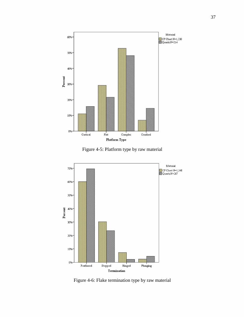
Figure 4-5: Platform type by raw material .................................................................................... 37
Figure 4-6: Flake termination type by raw material ..................................................................... 37
Figure 4-7: Histograms presenting length distributions by raw material ..................................... 39
Figure 4-8: Box plots presenting length distributions by raw material ........................................ 39
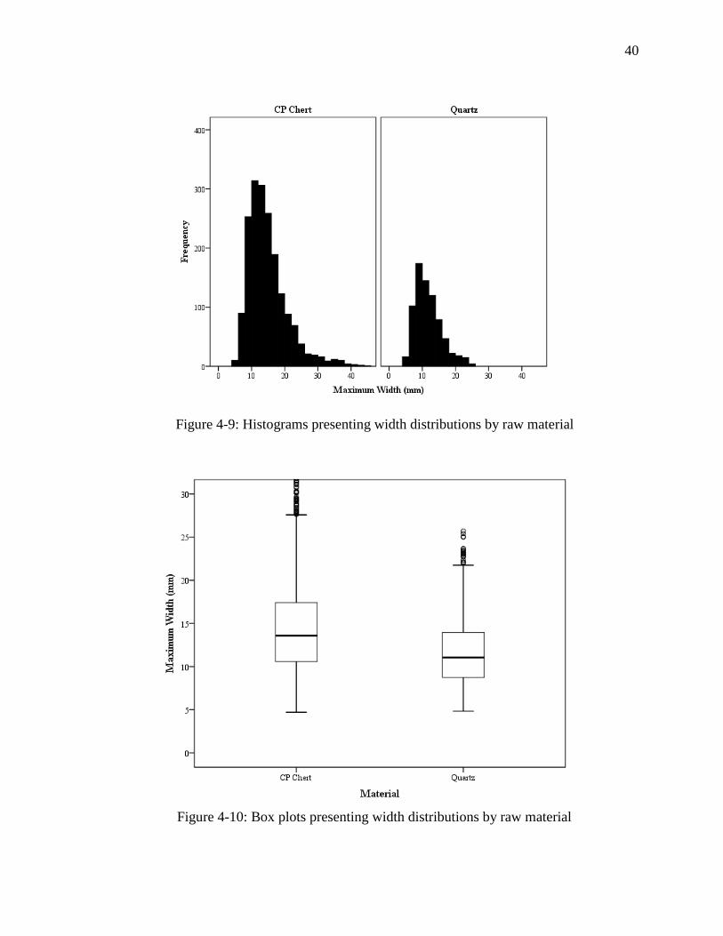
Figure 4-9: Histograms presenting width distributions by raw material ...................................... 40
Figure 4-10: Box plots presenting width distributions by raw material ....................................... 40
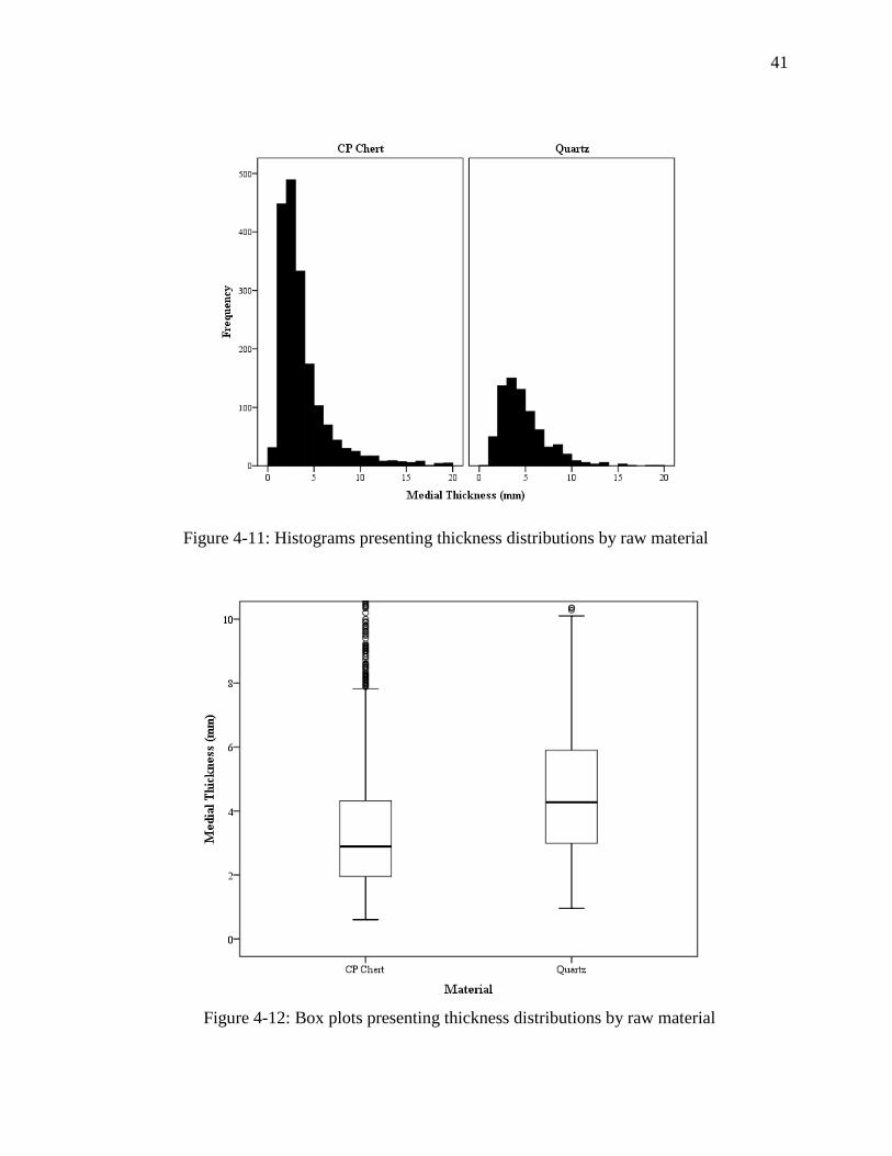
Figure 4-11: Histograms presenting thickness distributions by raw material............................... 41
Figure 4-12: Box plots presenting thickness distributions by raw material.................................. 41
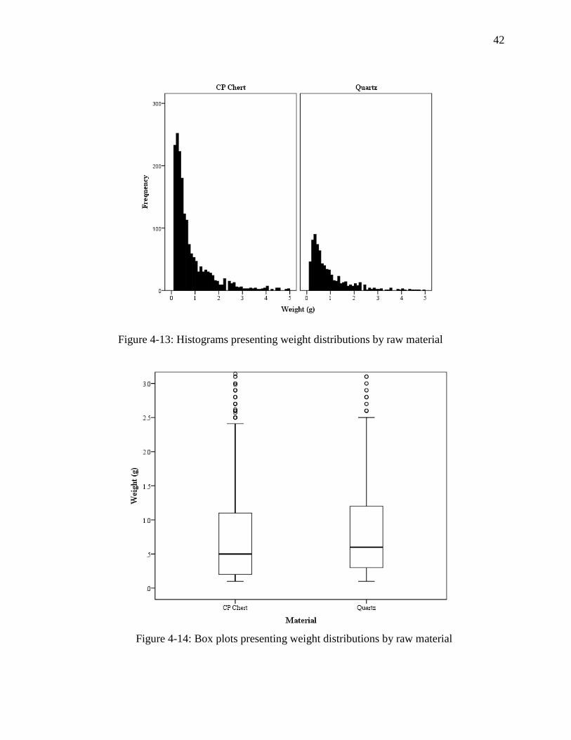
Figure 4-13: Histograms presenting weight distributions by raw material ................................... 42
iv
Figure 4-14: Box plots presenting weight distributions by raw material...................................... 42
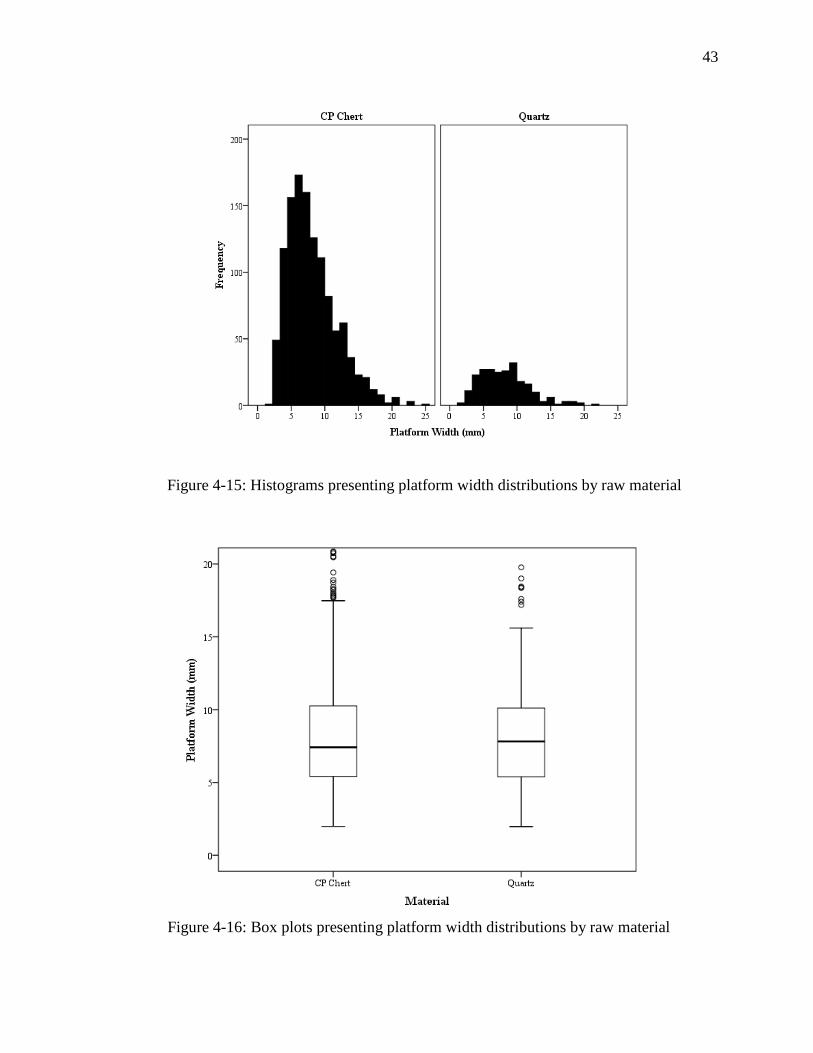
Figure 4-15: Histograms presenting platform width distributions by raw material ...................... 43
Figure 4-16: Box plots presenting platform width distributions by raw material ......................... 43
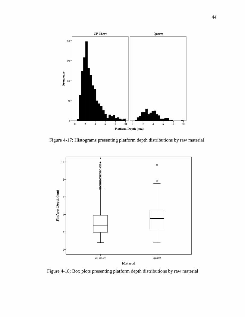
Figure 4-17: Histograms presenting platform depth distributions by raw material ...................... 44
Figure 4-18: Box plots presenting platform depth distributions by raw material ......................... 44
Figure 4-19: Density map of total ceramics by count ................................................................... 50
Figure 4-20: Density map of total ceramics by weight ................................................................. 50
Figure 4-21: Density map of Swift Creek ceramics by count ....................................................... 51
Figure 4-22: Density map of Swift Creek ceramics by weight ..................................................... 51
Figure 4-23: Mapped ratio of Coastal Plain chert to total ceramics ............................................. 52
Figure 4-24: Mapped ratio of total quartz to total ceramics ......................................................... 52
Figure 4-25: Density map of Coastal Plain chert by count ........................................................... 53
Figure 4-26: Density map of Coastal Plain chert by weight ......................................................... 53
Figure 4-27: Density map of Coastal Plain chert by weight/count ............................................... 54
Figure 4-28: Density map of total quartz by count ....................................................................... 55
Figure 4-29: Density map of total quartz by weight ..................................................................... 55
Figure 4-30: Density map of total quartz by weight/count ........................................................... 56
Figure 4-31: Density map of clear quartz by count ...................................................................... 57
Figure 4-32: Density map of clear quartz by weight .................................................................... 57
Figure 4-33: Density map of milky quartz by count ..................................................................... 58
Figure 4-34: Density map of milky quartz by weight ................................................................... 58
Figure 4-35: Grouping of lithic assemblages from shovel tests by count..................................... 61
Figure 4-36: Grouping criteria of lithic assemblages from shovel tests by count ........................ 61
v
Figure 4-37: Grouping of lithic assemblages from shovel tests by weight................................... 62
Figure 4-38: Grouping of lithic assemblages from shovel tests by weight/count......................... 62
Figure 4-39: View of weak polish and striations on quartz flake tool .......................................... 63
Figure 4-40: Location of Test Units along Kolomoki's southern village ..................................... 65
Figure 4-41: Location of surface collection grid at Kolomoki ..................................................... 67
Figure 4-42: Surface collections with piece-plotted artifacts ....................................................... 67
Figure 4-43: Complicated Stamped ceramics from surface collections ....................................... 69
Figure 4-44: Weeden Island ceramics from vicinity of Mounds F and G .................................... 69
Figure 4-45: Coastal Plain chert PP/Ks and unfinished, heat-treated biface ................................ 70
Figure 4-46: PP/Ks of Tallahatta sandstone and Ridge and Valley chert ..................................... 70
Figure 4-47: Large flakes of Coastal Plain chert .......................................................................... 71
Figure 4-48: Heat-treated chert core with large inclusion/fault .................................................... 71
Figure 4-49: Milky quartz core with a formal platform ................................................................ 72
Figure 4-50: Small triangular projectile point manufactured from milky quartz ......................... 72
Figure 4-51: A quartz "ball," or heavily battered core .................................................................. 73
Figure 4-52: Another heavily battered quartz core or "ball" ........................................................ 73
Figure 4-53: Fragments of worked quartz crystals ....................................................................... 74
Figure 4-54: Quartz hammerstone with battered ends and abraded side ...................................... 74
Figure 4-55: Plot of radiocarbon dates from Kolomoki by general provenience ......................... 77
Figure 5-1: Scatter plot of mica and quartz per sq. meter with fit line ......................................... 89
Figure 5-2: P-P plot of residuals from linear regression of mica and quartz ................................ 89
vi
Abstract
Early phases of Kolomoki’s occupation have been characterized as relatively egalitarian,
with little evidence for status differentiation. However, patterned variability in lithic raw material
use and intensity of production in domestic areas suggests heterogeneity in the community at
multiple scales. In light of Kolomoki’s emphasis on communal ceremony, internal divisions
between groups of households highlight the tension between public and private expressions of
status and social solidarity. New radiocarbon dates from the southern margins of the village have
allowed us to assess the contemporaneity of this pattern, and by extension, the chronology of
village aggregation.
1
Chapter 1 - Introduction
Large communities throughout history have incorporated diverse social groups and
contained numerous internal social divisions (Birch 2012; Boudreaux 2013; Dueppen 2012;
Eckert 2008; Gilman and Stone 2013; Hakenbeck 2007; Hayden 1996; Janusek 2002; Rautman
2014; Schachner 2010; Smith 2015; Tuzin 2001; Wilson 2008; Wilson et al. 2006). With an
extent of around one square kilometer, at least nine mounds containing tens of thousands of
cubic meters of earth, and a proposed population of several hundred people (Pluckhahn 2003),
the village and mound complex of Kolomoki certainly qualifies as one of the largest
communities of the Woodland period (ca. 1000 B.C. to A.D. 1050) in North America (Figure 1-
1). In fact, at the height of its occupation, Kolomoki may have been the “largest and most
densely settled community north of Mexico” (Pluckhahn 2003:198). However, according to
previous interpretations of Kolomoki, its grand scale belies scant evidence for social
stratification and differentiation within its village, which contains redundant artifact assemblages
and few prestige goods (Pluckhahn 2003).
In recent decades, archaeologists have begun to interrogate the assumed relationship
between monumentality, the emergence of village societies, and social hierarchy (Spielmann
2008; Saunders 2004), necessitating a more nuanced approach for understanding the social
organization of ceremonial centers and associated early aggregate villages. The lack of prestige
or elite goods from domestic contexts assigned to the principal phases of Kolomoki’s occupation
necessitates that I shift my investigation of social difference at Kolomoki from a perspective that
2
emphasizes hierarchical distinctions to one that instead privileges social difference as
represented by patterning in the residues of everyday practice. Naturally, Kolomoki’s domestic
areas constitute the most appropriate focus for this study of the everyday. I employ the household
as the theoretical unit of analysis as households constitute the primary context for economic
production and social reproduction (Cobb and Nassaney 2002; Flannery 1994; Hirth 2009;
Pluckhahn 2010a; Wesson 2008; Wilk and Rathje 1982). Based on the entwined nature of social
and economic activities within households, economic differentiation and spatial proximity form a
combined indicator for social differentiation under the assumption that social ties are stronger
between nearby households engaging in similar economic activities. Therefore, I expect social
differences within Kolomoki’s village to be represented not only by distinctions in the economic
activities of households, but by spatial clustering of those activities as well.
I focus on the spatial distribution of domestic lithic production as a means of interpreting
the social dynamics of Kolomoki’s village. Most areas of Kolomoki’s village contain the same
flakes, cores, and tools manufactured from chert and quartz, excepting the restricted distribution
of small quantities of milky quartz in the south of the village (Pluckhahn 2003:104). However,
my investigation of patterning in lithic debitage assemblages - residues of the concentration and
intensity of lithic production (sensu Costin 1991) - reveals economic and perhaps social
differentiation at multiple scales, in contrast with earlier interpretations of Kolomoki (Sears
1956; Pluckhahn 2003). Furthermore, new radiocarbon dates and ceramics from recent
excavations in the village not only suggest that these patterns in lithic production are roughly
contemporaneous, but that the aggregation of Kolomoki’s village occurred later than previously
thought (Sears 1956; Pluckhahn 2003, 2011)

3
Site Description and Previous Investigations
Kolomoki is located in Early County, Georgia near the town of Blakely, about 12
kilometers east of the Chattahoochee River. The site contains at least nine mounds, including
conical burial mounds and a massive platform mound with a height of around 17 meters
(Pluckhahn 2003; Sears 1956). The site’s core, including most of the mounds, is encircled by a
low curved ridge or embankment called the enclosure which likely served to delineate the extent
of the village (Pluckhahn 2003, see Figure 1-1). Previous archaeological investigations at
Kolomoki consisted of early work by Edward Palmer and others in the late 1800s followed by
excavations conducted under Charles Fairbanks and Robert Wauchope in the 1930s and 1940s
Figure 1-1: Kolomoki and its location within the Southeastern U.S.
4
(Fairbanks 1946; Pluckhahn 2003). William Sears excavated at the site in the late 1940s and
early 1950s, recovering caches of elaborate mortuary ceramics from the burial mounds E and D
(Sears 1956). Unfortunately, the presence of the large platform mound, Mound A, influenced
Sears to conclude that the complex was the product of a Mississippian Period occupation despite
the ubiquity of earlier Woodland Period ceramics throughout the site. Sears later revised his
ceramic chronology for Kolomoki, acknowledging the site’s Woodland Period occupation (Sears
1992).
More recent excavations by Thomas Pluckhahn in the late 1990s through the 2000s have
soundly refuted some of Sears’s earlier conclusions and refined our understanding of the
chronology and the nature of activity areas and domestic life at Kolomoki (Pluckhahn 2003,
2011). Unlike previous research, Pluckhahn’s investigations focused on off-mound areas at the
site, with special attention paid to determining the spatial extent and intensity of occupation in
Kolomoki’s village.
Environmental Setting
Kolomoki is situated along a broad, flat upland area within the Coastal Plain
physiographic province that spans from the Fall Line some 70 kilometers to the north of the site
to the Gulf Coast. The site falls within the Fall Line Hills zone of the Coastal Plain as defined by
Veatch and Stephenson (1911), an area characterized by rolling hills that grade from the
Piedmont province southward to the flat Dougherty Plain.
The surface soils at Kolomoki consist of red sandy loams and loamy sands underlain by
red clay (Pilkington 1985; Pluckhahn 2003, 2011). From the areas of highest elevation along the
southern margins of the site, the landform on which the site sits slopes gradually downward to
5
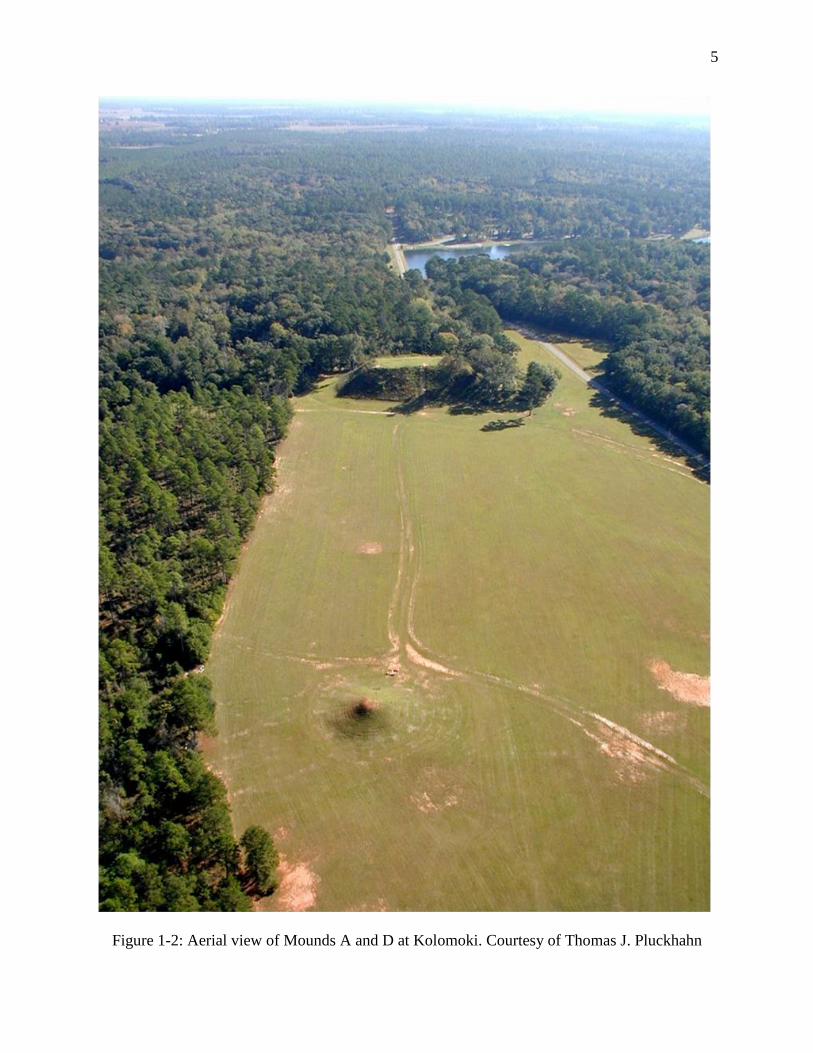
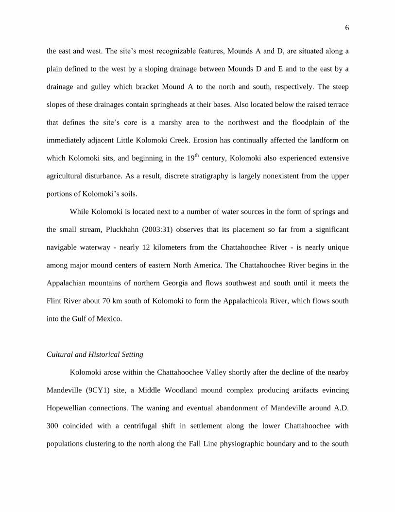
Figure 1-2: Aerial view of Mounds A and D at Kolomoki. Courtesy of Thomas J. Pluckhahn
6
the east and west. The site’s most recognizable features, Mounds A and D, are situated along a
plain defined to the west by a sloping drainage between Mounds D and E and to the east by a
drainage and gulley which bracket Mound A to the north and south, respectively. The steep
slopes of these drainages contain springheads at their bases. Also located below the raised terrace
that defines the site’s core is a marshy area to the northwest and the floodplain of the
immediately adjacent Little Kolomoki Creek. Erosion has continually affected the landform on
which Kolomoki sits, and beginning in the 19th
century, Kolomoki also experienced extensive
agricultural disturbance. As a result, discrete stratigraphy is largely nonexistent from the upper
portions of Kolomoki’s soils.
While Kolomoki is located next to a number of water sources in the form of springs and
the small stream, Pluckhahn (2003:31) observes that its placement so far from a significant
navigable waterway - nearly 12 kilometers from the Chattahoochee River - is nearly unique
among major mound centers of eastern North America. The Chattahoochee River begins in the
Appalachian mountains of northern Georgia and flows southwest and south until it meets the
Flint River about 70 km south of Kolomoki to form the Appalachicola River, which flows south
into the Gulf of Mexico.
Cultural and Historical Setting
Kolomoki arose within the Chattahoochee Valley shortly after the decline of the nearby
Mandeville (9CY1) site, a Middle Woodland mound complex producing artifacts evincing
Hopewellian connections. The waning and eventual abandonment of Mandeville around A.D.
300 coincided with a centrifugal shift in settlement along the lower Chattahoochee with
populations clustering to the north along the Fall Line physiographic boundary and to the south
7
near the confluence of the Chattahoochee and Flint rivers (Pluckhahn 2003:184). During this
shift in settlement, populations along the central portion of the valley likely consolidated and
founded Kolomoki. Reaserchers investigating Middle Woodland period sites in the Southeast
have speculated that they were linked to the power and influence of small groups or individuals
(Knight 1990:162-163). Communal ceremony and incipient status differentiation that would later
characterize Kolomoki’s development had historical precedent at Mandeville and other such sites
(Pluckhahn 2003:187).
Kolomoki’s main occupation is dated to the Middle-to-Late Woodland period with its
founding sometime around A.D. 350 and its abandonment occurring about A.D. 850 (Pluckhahn
2003:4, 2011:180). Mound construction was most intense during the first two centuries of the
site’s occupation (A.D. 350-550), thought to indicate the importance of communal ceremony at
that time (Pluckhahn 2003:183-207). It is also during these early centuries that the enclosure is
thought to have been in use; excavations producing evidence for domestic habitation thought to
date to this time are centered along this feature and the eastern portion of the site near Mound A
(Pluckhahn 2003).
The first century of Kolomoki’s occupation, Pluckhahn’s (2003) Kolomoki I phase dating
from A.D. 350-450, was characterized by the construction of early phases of Mounds D and E,
and perhaps the enclosure and Mounds G and K. Mounds E and K established an east-west axis
around which the generally circular village plan, coinciding with the enclosure, was constructed.
The great distances between these earliest constructions, demarcating the site’s extent of nearly
one square kilometer, are seen as evidence of a grand vision for the site by its founders
(Pluckhahn 2003:185). The enclosure itself also serves as a temporal marker of sorts based on its
resemblance to similar features at other Early and Middle Woodland Period sites and the
8
presence of early ceramic types along its extent (Pluckhahn 2003:185; Spielmann 2008; Squier
and Davis 1848; Wright 2014). Additionally, the circular plan of the enclosure, and perhaps by
extension the village, indicates a relatively egalitarian political ethos was present during the
period of its use (Pluckhahn 2003), though more radiocarbon dates are needed to demonstrate the
contemporaneity of sections of the village.
The second century of Kolomoki’s occupation, spanning from around A.D. 450-550,
witnessed the greatest intensity of monumental construction. It was during this phase, dubbed
Kolomoki II by Pluckhahn (2003), that Mound A was likely built. Pluckhahn estimates that
Mound A would have required the investment of 200 days of work by 200 people, probably split
between multiple construction episodes (2003:200). The massive scale of mound construction,
which would seem to implicate some form of coercion or central authority, belies the seemingly
egalitarian organization of the village during this period as represented by unexceptional
domestic assemblages, similar to the Kolomoki I phase (Pluckhahn 2003).
Mound construction and the maintenance of the circular village plan along the enclosure
is thought to have deteriorated during the final three centuries of Kolomoki’s occupation.
Coincident with this decline in communal ceremonialism at Kolomoki is a shift in settlement
along the Lower Chattahoochee towards the south. The Kolomoki III and IV phases as defined
by Pluckhahn (2003) witnessed a decline in the proportions of Swift Creek ceramics and an
increase in various Weeden Island types as well as increased evidence for differentiation in status
between households. At the time of Kolomoki’s abandonment around A.D. 850, settlement
within the lower Chattahoochee region was concentrated to the south, while the north seems to
have become largely depopulated (Pluckhahn 2003:219; White 1981). In the following centuries
of the Early Mississippian Period, however, indigenous settlement of the lower Chattahoochee
9
seems to have resumed a north-south pattern similar to that seen during Kolomoki’s Phase I and
II occupation (Blitz and Lorenz 2002, 2006).
Interestingly, Kolomoki’s placement between the northern and southern population
clusters noted above means that the site was relatively isolated with few contemporaneous
settlements nearby. Previous researchers have proposed that Kolomoki’s peculiar placement may
be due to the desire of its inhabitants to exploit productive agricultural lands in the area (Steinen
1998). Others have proposed that Kolomoki was located along a major trade corridor (Anderson
1998). Pluckhahn (2003) counters that the site’s distance from the Chattahoochee River and the
lack of sites within its immediate vicinity make these conclusions unlikely and instead proposes
that the reasons for Kolomoki’s placement were social. Pluckhahn (2003:46) hypothesizes that
Kolomoki might have served as a nexus of interaction and mediation between groups inhabiting
the northern and southern settlement clusters. If Kolomoki articulated a boundary between these
two population clusters as Pluckhahn proposes, its inhabitants would have likely included
individuals with ties to both populations; effective mediation would have precluded Kolomoki
from existing as a bounded society removed from the influence of or interaction with its
neighbors. Furthermore, while segmentary societies can be considered those in which new
identities are forged from disparate participating groups, research suggests that other identities
can be subsumed, and therefore preserved, within a larger community identity (Birch 2012;
Eckert 2008; Hakenbeck 2007; Rautman 2014; Tuzin 2001).
Regional Distribution of Lithic Resources
Whereas a great deal of attention has been paid to the site’s ceramics, consisting mostly
of Swift Creek and Weeden Island types, little work has been done concerning the site’s lithic
10
assemblage beyond seriation of the site’s projectile points, a notable exception being Pluckhahn
and Norman’s (2011) study of projectile point form. While Kolomoki’s lithics largely consist of
Coastal Plain chert and shattered quartz cobbles (Pluckhahn 2003:99-104), this study is also
concerned with the distribution of opaque milky quartz. Both clear crystal quartz and milky
quartz probably came to Kolomoki in the form of small stream-rolled cobbles transported from
the Georgia Piedmont by the nearby Chattahoochee River (Pluckhahn 2003:104). Additionally,
very small amounts of other lithic types have been recovered at Kolomoki, consisting of Knox
chert from the Ridge and Valley province of northwestern Georgia and silicified sandstones or
orthoquartzites possibly from Central Georgia (Daltonite) or the Tallahatta formation to the west
(Dunning 1964; Waggoner and Jones 2007).
Coastal Plain chert is locally available at Kolomoki with low-quality sources occurring
near the site itself and higher-quality sources within a day’s walk (Pluckhahn 2003:99). In fact,
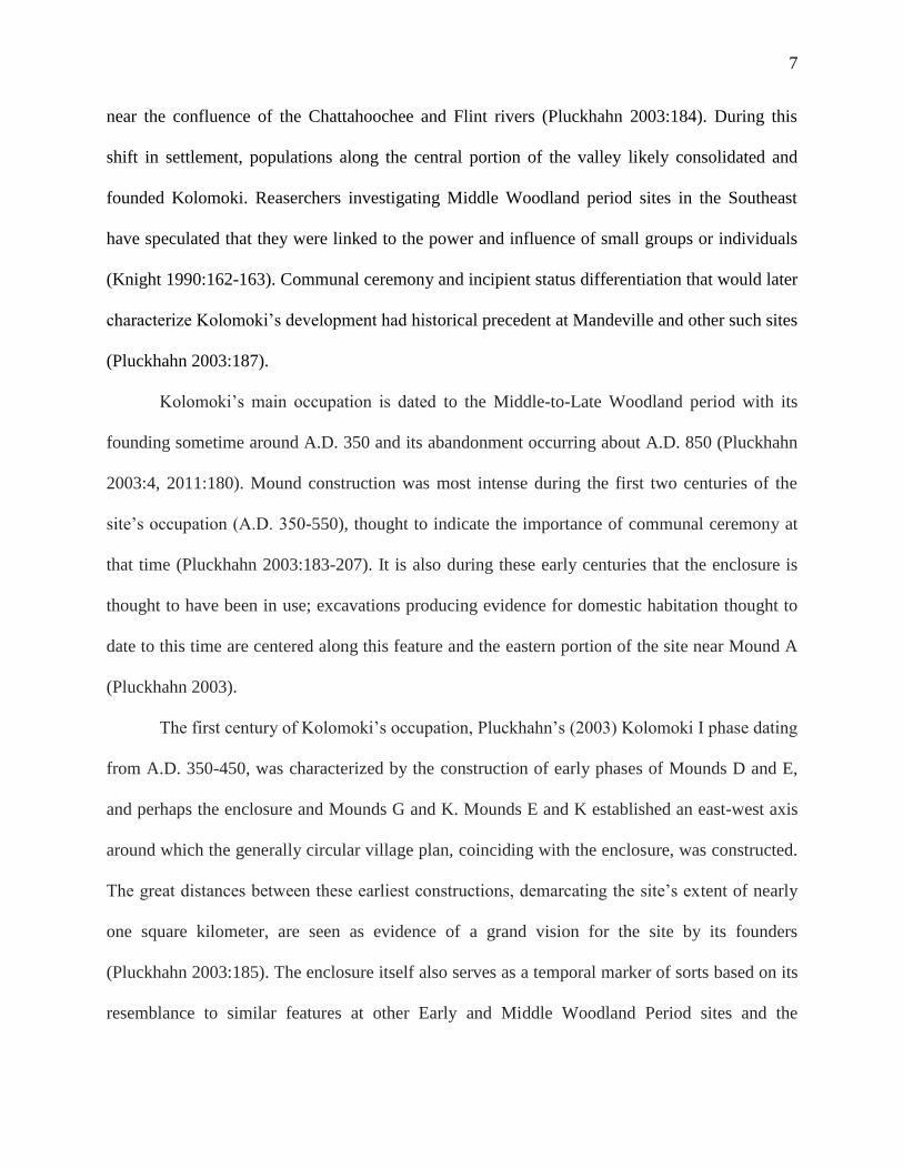
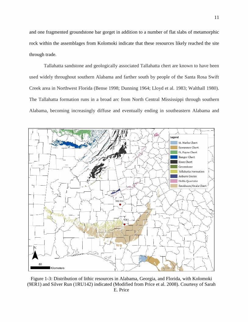
Kolomoki is placed at the northern margin of a wide chert-producing geologic formation, seen as
“Residuum/Ocala Chert” in Figure 1-3. This distribution of Coastal Plain chert overlaps with the
eastern margins of the Tallahatta formation (Svarda et al. 2010). Excavations north of Kolomoki
at the roughly contemporaneous Silver Run site in Russel County, Alabama revealed a
proliferation of debitage from extralocal lithic sources, including Hollis quartzite and Auburn
gneiss, types not seen in any significant proportion at Kolomoki (Price et al. 2008). In general,
the portion of the Chattahoochee Valley immediately north of Kolomoki to the Fall Line seems
to be relatively poor in lithic resources, necessitating that the residents of Silver Run procured
diverse lithic materials from adjacent regions, a pattern not observed at Kolomoki.
Metamorphic rocks used for the production of groundstone items recovered at Kolomoki
probably originated to the north in the Piedmont. The presence of a few groundstone plummets
11
and one fragmented groundstone bar gorget in addition to a number of flat slabs of metamorphic
rock within the assemblages from Kolomoki indicate that these resources likely reached the site
through trade.
Tallahatta sandstone and geologically associated Tallahatta chert are known to have been
used widely throughout southern Alabama and farther south by people of the Santa Rosa Swift
Creek area in Northwest Florida (Bense 1998; Dunning 1964; Lloyd et al. 1983; Walthall 1980).
The Tallahatta formation runs in a broad arc from North Central Mississippi through southern
Alabama, becoming increasingly diffuse and eventually ending in southeastern Alabama and
Figure 1-3: Distribution of lithic resources in Alabama, Georgia, and Florida, with Kolomoki
(9ER1) and Silver Run (1RU142) indicated (Modified from Price et al. 2008). Courtesy of Sarah
E. Price
12
southwestern Georgia near Kolomoki (Price et al. 2008; Savrda et al. 2010). It is presumed to be
locally available at and around Kolomoki itself (Pluckhahn 2003:104); however, orthoquartzites
such as Tallahatta sandstone or Daltonite make up only a small portion of the overall lithic
assemblage from Kolomoki.
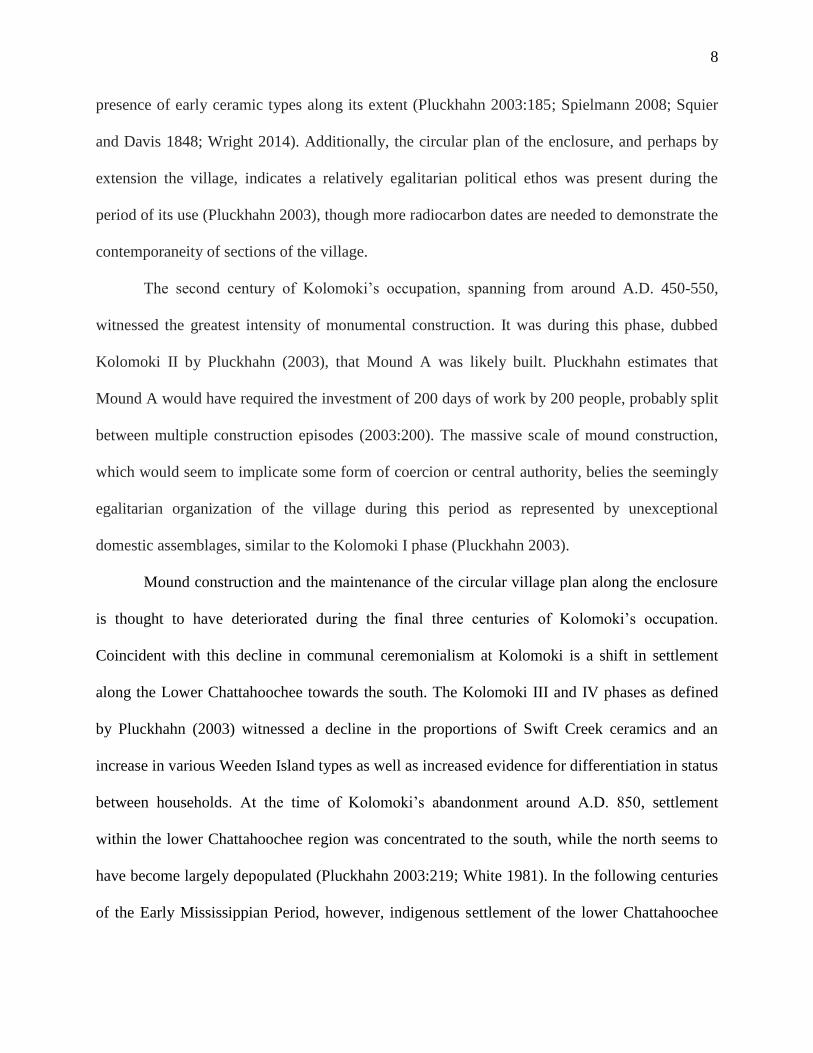
The Curse of Quartz
Quartz in archaeological contexts frequently defies characterization as a generalized tool
stone; its function is seldom crystal clear (Carr and Chase 2005; Jones et al. 1998; Keith 2010;
Pluckhahn 2003; Warren and Neighbour 2004). Kolomoki’s quartz assemblage, which makes up
about a quarter of all lithic material, contains almost no formal tools, raising questions about the
function of the thousands of quartz flakes that litter the site in both residential and near-mound
contexts. This pattern holds for contemporaneous sites elsewhere in the region, especially those
associated with Swift Creek ceramics (Jones et al. 1998; Keith 2010; Snow 1977; Williams and
Harris 1998; Williams and Shapiro 1990). A number of hypotheses have been forwarded to
explain what quartz was used for at Kolomoki and other Swift Creek sites, from their use as the
preferred material for wood engraving (Pluckhahn 2003), scarification (Benson et al. 2001),
tattooing (Keith 2010), cutting mica (Jones and Tesar 1996, Jones et al. 1998) to their use to
produce sparks or light fires during ceremonies (Jones and Tesar 1996; Jonesetal.1998; Keith
2010).
Previous researchers have tackled some of the archaeological issues that often arise when
lithic assemblages are heavy in quartz, notably in terms of technology through investigations of
reduction strategies (Potts 2012) and use-wear (Sussman 1985; Knutsson 1988). Lithic analysts
have long recognized that variable quality in available toolstones influences peoples’
13
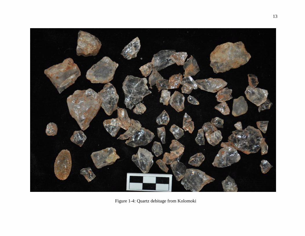
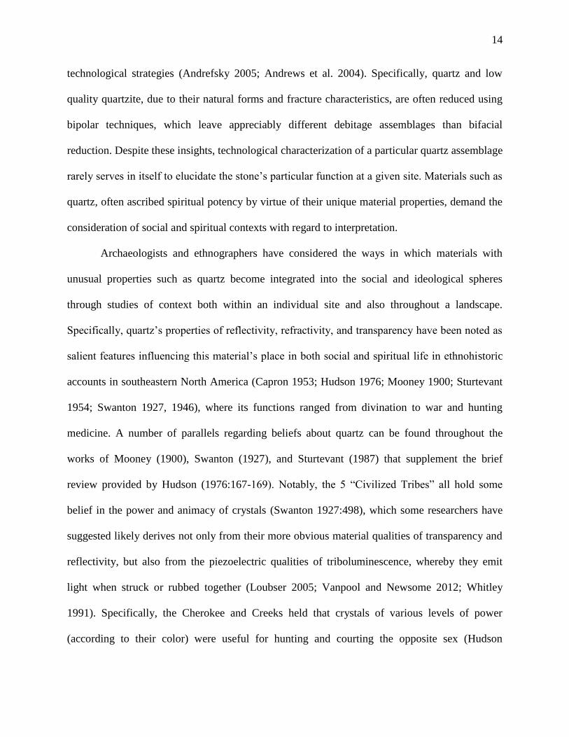
Figure 1-4: Quartz debitage from Kolomoki
14
technological strategies (Andrefsky 2005; Andrews et al. 2004). Specifically, quartz and low
quality quartzite, due to their natural forms and fracture characteristics, are often reduced using
bipolar techniques, which leave appreciably different debitage assemblages than bifacial
reduction. Despite these insights, technological characterization of a particular quartz assemblage
rarely serves in itself to elucidate the stone’s particular function at a given site. Materials such as
quartz, often ascribed spiritual potency by virtue of their unique material properties, demand the
consideration of social and spiritual contexts with regard to interpretation.
Archaeologists and ethnographers have considered the ways in which materials with
unusual properties such as quartz become integrated into the social and ideological spheres
through studies of context both within an individual site and also throughout a landscape.
Specifically, quartz’s properties of reflectivity, refractivity, and transparency have been noted as
salient features influencing this material’s place in both social and spiritual life in ethnohistoric
accounts in southeastern North America (Capron 1953; Hudson 1976; Mooney 1900; Sturtevant
1954; Swanton 1927, 1946), where its functions ranged from divination to war and hunting
medicine. A number of parallels regarding beliefs about quartz can be found throughout the
works of Mooney (1900), Swanton (1927), and Sturtevant (1987) that supplement the brief
review provided by Hudson (1976:167-169). Notably, the 5 “Civilized Tribes” all hold some
belief in the power and animacy of crystals (Swanton 1927:498), which some researchers have
suggested likely derives not only from their more obvious material qualities of transparency and
reflectivity, but also from the piezoelectric qualities of triboluminescence, whereby they emit
light when struck or rubbed together (Loubser 2005; Vanpool and Newsome 2012; Whitley
1991). Specifically, the Cherokee and Creeks held that crystals of various levels of power
(according to their color) were useful for hunting and courting the opposite sex (Hudson
15
1976:168). Due to these powers, crystals were considered dangerous to those unaccustomed or
inadequately prepared for their use. As such, they were thought to have adverse effects on men,
women, and children in their vicinity (Swanton 1927:500).
The most powerful crystals were called Ulunsuti by the Cherokee and were derived from
the transparent crest on the head of a horned serpentine monster known as the Uktena (Mooney
1900:297-298), while less powerful crystals may have come from its scales (Mooney 1900:300-
301). Similarly, the sapiya crystals (or sabia) of the Creeks were roughly analogous as hunting
medicine to horn fragments of the “horned serpent” (Swanton 1927:494), an obvious parallel to
the Cherokee Uktena. Both the Uktena and the horned serpent were said to have the power to
attract and enchant other beings. The crest of the Uktena blazed from its head to blind or confuse
humans unlucky enough to look upon it (Mooney 1900:297-298) while the horned serpent is said
to have attracted game to itself (Swanton 1927:494). The connection here is that the power of
crystals and “serpent horns” (apparently distinct from fangs) are derived from the power of the
creatures that once bore them. A further similarity within the Creek tradition between crystals
and serpent horns are their color varieties, consisting of yellow, red, blue, and white (Swanton
1927:494, 498). The exception among these colors is black, which only occur as sapiya, and are
noted to be the only sapiya lacking a crystalline luster (Swanton 1927:498). The similarity in
Creek and Cherokee understandings of crystals and the traditions regarding their origins is
worthy of note, considering these groups descend from different linguistic stocks and came into
intensive contact relatively late in history.
Among the Seminole, quartz crystal is the “Lightning Missile” of the medicine bundle, a
powerful piece of war medicine that can variably make combatants invisible or frighten the
enemy (Capron 1953:172; Sturtevant 1954:35). Capron’s Seminole informant stated that the
16
stone contained in the medicine bundle was found at the base of a tree struck by lightning, while
Sturtevant mentions one tradition which holds that it came from a “thunder-being” living
underwater. Notably, Capron (1953:168) also mentions the inclusion a horn of the “Snake King”
held in the Cow Creek medicine bundle, which Sturtevant (1954:38-39) notes was used as a
hunting charm like its Creek equivalent.
As mentioned previously, crystal quartz is found in large quantities at sites bearing Swift
Creek ceramics dating from the Middle to Late Woodland periods, considerably earlier than the
origins of most Southeastern Indian groups as we know them. Researchers studying Swift Creek
ceramics have suggested that the intricate designs present on these vessels and the overstamping
that frequently occurred during manufacture rendered designs extraordinarily complex and
sometimes nearly incomprehensible, similar to other complex designs used as “demon traps”
(Gell 1998:83-90; Wallis 2011:201-202). In some societies, it is believed that exceptionally
complicated designs captivate malicious spirits who attempt to comprehend them, rendering the
spirits harmless (Gell 1998:83-90). As discussed above, crystals and other charms acted as war
and hunt medicine due to their associations with mythical serpents and their abilities of
enchantment. If it is true that quartz was used as a tool for engraving Swift Creek design paddles
as Pluckhahn (2003) suggests, then it may be that the properties of enchantment attributed to
quartz may have been intentionally imparted onto those designs by its use.
The deposition of quartz crystals, bifaces, and flakes within graves associated with other
shamanistic paraphernalia at Hopewellian sites has led Carr and Chase (2005) to identify quartz
with ceremonial and ritual practices during the Middle Woodland period. This point is especially
important as it places quartz fairly unambiguously within the socio-symbolic realm of a culture
17
with which the people of Kolomoki, and seemingly everybody else within Middle Woodland
eastern North America, were likely acquainted.
While the attribution of socio-symbolic interpretations to quartz by archaeologists is
often informed by the lack of obvious industries involving the material, it is important to
recognize that techno-functional and socio-symbolic importance are not mutually exclusive and
are instead often associated (Binford 1962; Dobres 2000; Vanpool and Newsome 2012). Johnson
(1993) describes an assemblage of quartz crystal artifacts from the Late Archaic period Slate site
that he interprets, based on use-wear, as drills for a slate bead industry associated with Poverty
Point. Similarly, Cane (1992) provides an ethnographic account of Australian Aboriginal men
identifying specific stone tool types with symbolically-loaded tasks, namely the engraving of
cosmological designs on wooden artifacts, which impart the tools themselves with potent
meaning. In both of these cases, the singular use of the materials or tool forms in question
informs our interpretation of their symbolic value. The symbolic meaning of tools can be, and
often is, simultaneously a function of both the tools’ own material properties and the properties
of the subject materials they modify.
18
Chapter 2 - Theoretical Perspective
My analysis of lithic raw material variability and its implications for the expression of
divergent social identities at Kolomoki employs practice theory (Bourdieu 1977; Ortner 1984)
and the related concept of tradition as defined by Pauketat (2001a). Practice theory is commonly
associated with Bourdieu’s (1977) concept of habitus, which describes the structurally and
historically-dependent dispositions that constrain human action, and doxa, the perceived “self-
evident” nature of the social and natural world (164). Similarly, Pauketat’s (2001a) discussion of
tradition emphasizes an explicit focus on the interplay between practice and history: not only the
ways in which history structures practice, but how people manipulate and reinterpret history
through practice. In this sense, agency is given a privileged role in the process of making history
(Pauketat 2001a, 2001b). Within the context of lithic production, the concept of practice
encompasses all activities along the chaine operatoire (Leroi-Gourhan 1964) from raw material
selection through tool use and discard. These activities constitute learned techniques acquired
through daily interaction with individuals in a particular community of practice, or the social
field within which everyday life takes place. Thus, practice theory offers an important
perspective on the perpetuation of certain patterns along the chaine operatoire through time.
Households as Communities of Practice
Communities of practice (Lave and Wenger 1991; Minar and Crown 2001; Stark 2008;
Wendrich 2012; see Eckert 2008; Sassaman and Rudolphi 2001 for examples of archaeological
19
application) are the contexts in which habitual dispositions and techniques are learned and
elaborated upon. Paralleling Bourdieu’s (1977:33-38) definition of “practical kin,” communities
of practice facilitate learning of cultural knowledge and techniques through everyday interaction
(Eckert 2008:10) and peripheral learning through processes of observation and imitation (Lave
and Wenger 1991; Wendrich 2012:5). The household, as the basic social and subsistence unit in
many communities (Pluckhahn 2010a:332; Wilk and Rathje 1982:618), is perhaps the most
widely recognizable community of practice. Furthermore, most production including crafting in
nonmarket economies is performed in the household (Cobb and Nassaney 2002; Hirth 2009;
Pluckhahn 2010a; Spielmann 2002; Wesson 2008; Wilk and Rathje 1982), making households
the primary arenas for the transmission of technical knowledge materialized as artifacts in the
archaeological record. Patterning in the distribution of house remains and other domestic debris
provides evidence for the assessment of households as communities of practice, potentially
revealing patterns of social difference, political organization, and their change through time
(Lightfoot et al. 1998; Pluckhahn 2010a; Wesson 2008).
In a comparative study of apprenticeship in pottery production among the Dowayo of
Cameroon and San Ildefonso Pueblo in New Mexico, Wallaert (2012) describes learning of
pottery styles as both reflective and constitutive of social identities. Within the context of
marriage, for instance, female Puebloan potters apprenticed in a particular style must conform to
new stylistic impositions from the mother-in-law of her new household, though with some
deviation reflecting original ceramic traditions. In this situation, a new microstyle emerges that
blends aspects of two traditions (Wallaert 2012). Additionally, certain ceramic types may be
associated with ritual practice, or in the case of San Ildefonso Pueblo, commercial success in
marketing to collectors. Individuals apprenticed in these styles who skillfully reproduce them
20
take on the identity and accompanying prestige of ritual practitioners or renowned potters
(Wallaert 2012). Houses are difficult to identify at Kolomoki due to heavy site disturbance and
limited scope of excavations in the village. Furthermore, the house itself does not neatly correlate
to the household as a social unit, therefore the household must be considered a theoretical
construct for the purposes of this research.
Technological Style and Materiality
Variation in technological style of artifacts constitutes one line of evidence by which
archaeologists can recognize communities of practice and their corresponding boundaries
(Hegmon 1992 1998; Stark 1998, 2006). Though there has been considerable debate concerning
the causes of such variation (Sackett 1973, 1977, 1982, 1985, 1986, 1990; Wiessner 1983, 1984,
1985, 1989, 1990; Wobst 1977), archaeologists now generally recognize that interpretation must
rely on particular contexts rather than generalized conceptions of passive reproduction versus
intent (Hegmon 1992). For instance, Bowser’s (2000) ethnoarchaeological research among
Amazonian potters found that some actively employed elements of style in ceramics to
unambiguously display their political affiliations within a region containing multiple political
factions while others employed more ambiguous expressions of style to allow them the benefits
of interaction with multiple groups. An alternative interpretation of technological style is
provided by Hayden et al. (1996), who views lithic variability among domestic middens at the
Keatley Creek site in British Columbia as the result of the family groups exploiting different
areas of the surrounding landscape as part of their seasonal migrations. Hayden’s work has,
however, been challenged on the grounds that habitations and midden deposits he excavated are
not contemporaneous (Prentiss et al. 2003; Prentiss et al. 2005).

21
Distinct technological styles occur through divergence along the chaine operatoire of
artifact production (Leroi-Gourhan 1964), which may reflect the rehearsal of learned techniques
as well as culturally salient choices made within a given technological system (Dobres 2000;
Gosselain 1992, 2000; Lemmonier 1986; Mauss 1934). This relationship between culture and
artifact production means technological styles can be considered the materialization of social
identities and communities of practice (Dietler and Herbich 1998; Eckert 2008; Hegmon 1992,
1998; Stark 1998, 2006). Recent perspectives on materiality point out the influence of the
material world on human action and the structure of social interactions (Brumfiel 2004; Hodder
2012; Miller 2010; Vanpool and Newsome 2012, Wallis 2011, 2013). Within this framework,
‘stylized’ objects can be considered active participants in strategies of social boundary
maintenance and expression of identity, perhaps independent of human intent in contrast to the
conscious reproduction of emblematic styles (Wiessner 1983).
For instance, investigations of a Mission Period midden at Rancho Petaluma in California
by Silliman (2001) uncovered a large lithic assemblage, despite evidence for the relatively
extensive use of iron tools. The persistence of lithic technology within this colonial context in
which native traditions likely conflicted with the circumstances of mission-centered labor at
Rancho Petaluma is interpreted by Silliman (2001) to represent individuals seeking to re-affirm
their indigenous identities and resist pervasive Spanish influence through the practice of stone
tool production. In another example, examination of Swift Creek ceramic exchange by Wallis
(2011, 2013) indicates vessels bearing certain designs representative of a particular social or kin
group were exchanged geographically distant groups, perhaps along with marriage partners, and
eventually interred alongside individuals in burial mounds. The identification of designs with
certain groups or individuals in the context of intergroup exchange is proposed to have served as
22
markers of alliance and obligation within a social network. This association influenced practices
of mortuary deposition as individuals were buried with material reminders of their social
contacts in life (Wallis 2011).
Integration, Social Difference, and Communities
Considering difference in material remains of household practice is especially germane to
the study of large village sites such as Kolomoki, which were often composed of diverse social
groups (Birch 2012; Boudreaux 2013; Dueppen 2012; Eckert 2008; Flannery 2002; Gilman and
Stone 2013; Hakenbeck 2007; Hayden et al. 1996; Rautman 2014; Schachner 2010; Smith 2015;
Tuzin 2001; Wilson 2008; Wilson et al. 2006). Interpretations of the coalescence of such
communities frequently emphasize the importance of ritual (Kidder 2011; Sassaman 2005, 2011)
and its role in cultivating social integration (Gilman and Stone 2013; Kowalewski 2006;
Pluckhahn 2003; Tuzin 2001). However, a focus on integration may serve to obscure the
persistent importance of social differences (Pluckhahn 2007).
The tension between religious or communal identity and the social divisions that segment
communities from within are evident in a number of archaeological case studies. Using the
symmetry of Swift Creek vessels as a proxy for adherence to an integrative social strategy at
Kolomoki, Pluckhahn (2007) notes a disparity in proportions of symmetrical pottery designs
between residential and mound contexts. This pattern is interpreted as a representation of
differences in the public and private expression of social solidarity (Pluckhahn 2007). Eckert’s
(2008) work at Pottery Mound and Hummingbird Pueblo in New Mexico explores the
materialization of identity and its relation to regional demographic and ritual contexts. In the
context of integrating immigrant and indigenous populations in the Late Prehistoric Southwest,
23
she argues that stylistic differences may have emphasized social distance, even while a ceramic
glazing technology and accompanying suite of iconography was adopted to express religious
solidarity (Eckert 2008). Similarly, an investigation of the Tiwanaku polity’s formation by
Janusek (2002) revealed the presence of a number of archaeologically visible corporate groups
exercising relative autonomy in economic production, though bound by a collective, higher order
social identity represented by common religious practice.
The prevalence of communal ritual at many large village sites speaks to its necessity in
providing a constant centripetal force to check the centrifugal influence of divergent and
conflicting agendas (Kowalewski 2006; Pluckhahn 2003, 2007; Tuzin 2001). Traditions, and the
identities they inform constitute relational constructs in a constant state of negotiation (Jones
1997; Weisman 2007), making contexts of social aggregation especially fruitful for the
examination of traditional practice and the maintenance of social boundaries (Eckert 2008).
Summary
Here I have outlined a theoretical approach that draws from a number of perspectives
including communities of practice, technological style, and community aggregation to frame
questions for studying variation in lithic raw material selection and stone tool production at
Kolomoki. This approach places stylistic variation as a product of technological tradition,
learned within the context of a particular community of practice, which may communicate social
difference to reflect group identity and maintain social boundaries. Because the materialization
of identity relies on practices of provisioning and consuming, the context and intensity of the
archaeological remnants of those practices can be used to evaluate my ideas (Costin 1991).
Furthermore, the case studies I have presented illustrate how similar perspectives have been

24
employed by archaeologists previously, highlighting some of the challenges and opportunities
associated with this particular theoretical approach.
25
Chapter 3 - Methods
This project involved the re-analysis of the lithic assemblage recovered by Pluckhahn
(2003) during his shovel testing at the site, supplemented by the excavation of multiple 1-x-1 m
and 1 x 2 m Test Units along the southern portion of the enclosure. Using the data from shovel
tests, artifact distributions were mapped using ArcMap. A small use-wear study was also
performed on a sample of quartz artifacts in an attempt to discern a potential technological
function for the quartz artifacts at Kolomoki.
Re-Analysis of Shovel Test Assemblage
During his work at the site, Pluckhahn excavated 1,309 shovel tests along a 20 meter grid
across the site to determine artifact densities and distributions. Unfortunately, his categories for
lithic types were rather coarse, an issue rectified by a re-analysis of the shovel test materials. The
form used to record data on individual lithic artifacts is shown in Figure 2.1.
Analysis of previously excavated lithics consisted of recording a set of values for each
flake, including raw material, presence and percentage of dorsal cortex, presence of bulb of
percussion and/or platform, number of dorsal flake scars, weight, size, and platform size (see
Andrefsky 2005:86-112). Overall size was measured in terms of maximum length (recorded
from platform to distal end), maximum width (recorded at the widest point perpendicular to the
length axis defined above), medial thickness (measured at the midpoint). Platform size attributes
included platform width and platform thickness or depth. Following Andrefsky (2005:87), flake

26
Kolomoki Lithics Project: Style in Stone
Lithic Debris Observation Form
Observer: _________________________ Date: _________________________
Site Number: _______________________ Provenience: ___________________
FS Number: ________________________ Flake Number: _________________
Attributes:
Raw Material: ______________________ Color: ________________________
Number of Dorsal Flake Scars: 0: ___ 1: ___ 2: ___ 3+: ___
Platform/Bulb of Percussion Presence: Platform: _____ Bulb: _____
Platform Type: Cortical: ___ Flat: ___ Complex: ___ Crushed: ___ Prepared: ___
Termination: Feathered: ___ Stepped: ___ Hinged: ___ Plunging: ___
Dorsal Cortex Presence: 0% _____ 1-50% _____ 51-99% _____ 100%_____
Tool Form: ______________________________________________________________
Use Wear Presence: ___________________ Use Wear Type: _________________
Measurements:
Max Length (mm)
Max Width (mm)
Medial Thickness (mm)
Weight (g)
Platform Width (mm)
Platform Thickness (mm)
Additional Observations:
______________________________________________________________________________
______________________________________________________________________________
______________________________________________________________________________
______________________________________________________________________________
______________________________________________________________________________
Figure 3-1: Observation sheet used for collection of debitage data
27
termination was separated into four categories: feathered, which are defined as “smooth
terminations which gradually shear the flake from the objective piece; stepped, which denotes
flakes that have shattered or broken nearly perpendicular to the ventral surface; hinged, defined
as a rounded or sloped termination; and plunging, otherwise known as overshot, in which the
force of impact slopes into the objective piece, removing a large portion at the distal end.
Platform type was characterized as either cortical, or unmodified and containing some of the
parent nodule’s external surface; flat, defined as containing a single, smooth surface; complex,
which denotes a platform containing multiple facets, evidence of previous reduction of the
objective piece; crushed, in which the platform has been shattered by excessive force; and
prepared, defined by grinding along the platform (based on Andrefsky 2005:94-98). Dorsal flake
scars were identified by simple count and dorsal cortex was divided into categories of relative
percent coverage. Quartz does not always have a worn surface analogous to cortex, so I did not
expect to be able to readily define flakes according to their stage of reduction based on a
“primary, secondary, tertiary” scheme that uses presence and relative coverage of cortex. This
was also the case for Coastal Plain chert, which often contains cortex inclusions.
Based on the number of bifaces and finished projectile points/knives produced from
previous excavations at Kolomoki, compounded with the exceptionally small number of formal
quartz tools, I expected that chert and quartz were subject to different reduction strategies,
probably necessitated by the particular qualities of quartz, including small nodule size and lack
of predicTable flaking pattern (Pluckhahn 2003; Potts 2012). To determine this, I employed a
modified lithic typology based on that of Sullivan and Rozen (1985, 1989; Rozen and Sullivan
1989) that separates debitage into four categories (whole flakes, proximal flake ends, flake
fragments, and non-orienTable debris) and uses the relative proportions of these debitage
28
categories to distinguish assemblage types based on primary reduction activity. While this
typology has received criticism amongst some lithic analysts for concealing variability in lithic
assemblages and lacking explanatory utility (Amick and Mauldin 1989; Andrefsky 2005;
Prentiss 1998, 2001; though see Austin 1999 for statistical and experimental validation of the
typology), I felt its use was especially apt here for the characterization of assemblages consisting
of different raw materials presumably utilized for different purposes. This is especially true given
the typology’s ability to distinguish bipolar core reduction (Kuijt et al 1995), a strategy proposed
for Kolomoki’s quartz (Pluckhahn 2011:128).
The spatial distribution of lithic raw materials in relation to ceramic types and the
intensity of lithic production was determined using ESRI ArcMap 10.2. To facilitate comparison
of lithic and ceramic densities from shovel tests, Pluckhahn’s existing data Tables containing
ceramic counts and weights from shovel tests were merged with a spreadsheet containing the
results of my lithic analysis. The base layers for Kolomoki used in this project were produced by
Pluckhahn (2003, 2011) during his work at the site. The layers include park features, roads,
property lines, mound polygons, elevation contours, and a number of other features including the
enclosure, all of which were created with the help of aerial photographs and historic survey
maps.
Using the composite lithic and ceramic data, I produced new maps of the distribution of
lithic raw material types and certain ceramic types by count and weight using the kernel density
tool. The kernel density tool uses data points and an established search radius to interpolate a
raster layer, in this case based on the quantities and weights of individual artifact classes within
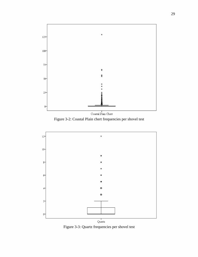
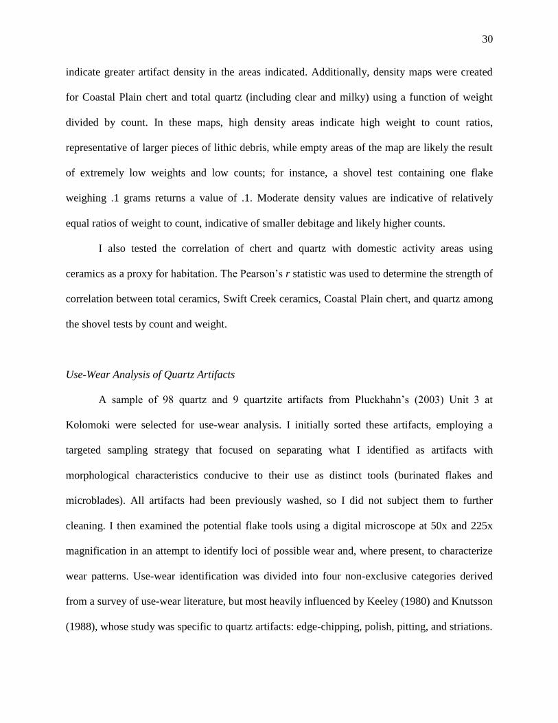
shovel tests. Lithic counts per shovel test are presented in Figures 3-2 and 3-3. The resulting
rasters represent continuous maps of the distributions of artifact classes. Higher density values
29
Figure 3-2: Coastal Plain chert frequencies per shovel test
Figure 3-3: Quartz frequencies per shovel test
30
indicate greater artifact density in the areas indicated. Additionally, density maps were created
for Coastal Plain chert and total quartz (including clear and milky) using a function of weight
divided by count. In these maps, high density areas indicate high weight to count ratios,
representative of larger pieces of lithic debris, while empty areas of the map are likely the result
of extremely low weights and low counts; for instance, a shovel test containing one flake
weighing .1 grams returns a value of .1. Moderate density values are indicative of relatively
equal ratios of weight to count, indicative of smaller debitage and likely higher counts.
I also tested the correlation of chert and quartz with domestic activity areas using
ceramics as a proxy for habitation. The Pearson’s r statistic was used to determine the strength of
correlation between total ceramics, Swift Creek ceramics, Coastal Plain chert, and quartz among
the shovel tests by count and weight.
Use-Wear Analysis of Quartz Artifacts
A sample of 98 quartz and 9 quartzite artifacts from Pluckhahn’s (2003) Unit 3 at
Kolomoki were selected for use-wear analysis. I initially sorted these artifacts, employing a
targeted sampling strategy that focused on separating what I identified as artifacts with
morphological characteristics conducive to their use as distinct tools (burinated flakes and
microblades). All artifacts had been previously washed, so I did not subject them to further
cleaning. I then examined the potential flake tools using a digital microscope at 50x and 225x
magnification in an attempt to identify loci of possible wear and, where present, to characterize
wear patterns. Use-wear identification was divided into four non-exclusive categories derived
from a survey of use-wear literature, but most heavily influenced by Keeley (1980) and Knutsson
(1988), whose study was specific to quartz artifacts: edge-chipping, polish, pitting, and striations.
31
In addition to the above sample, a small experimental sample was examined: 1 flake and
1 microblade used to cut pork and 1 burinated flake used to engrave a pine board. In each
experiment, the tool was used in a uniform repetitive motion for 5 minutes. These experimental
tools were then compared with the archaeological assemblage for the purpose of identifying
common use-wear features.
After examination with the digital microscope, a small subsample of 9 archaeological
flakes and the single experimental tool used to engrave wood were selected for examination
using a Hitachi SU70 scanning electron microscope (SEM) at the University of South Florida’s
Nanotechnology Research and Education Center. The sample size was limited by the size of the
plate onto which samples must be loaded for insertion into the SEM. The range of magnification
used for analysis ranged from 70x to 5000x. The artifacts were coated with an ionized gold-
palladium layer to aid in imaging. This coating is especially conducive to SEM imaging, but may
interfere with energy dispersive spectroscopy (EDS) due to the gold and palladium overlapping
with other elemental signatures. EDS was attempted on a single flake with a smeared soil deposit
to test the possibility that the deposit might be related to an organic residue, however, the gold-
palladium coating rendered the results inconclusive. Again, these artifacts were examined with
special attention given to the presence of edge-chipping, polish, pitting, and striation features.
Excavation: Sampling and Analysis
My colleagues and I excavated one 1-x-1 m and six 1-x-2 m Test Units, numbered Test
Unit (TU) 20 through TU 25 at various locations along the southern village. The placement of
our units was based on shovel test data, the density of surface artifacts, and geophysical
prospection carried out by fellow graduate student Shaun West (forthcoming) as well as access
32
due to certain areas being planted with crops at the time of excavation. Our recovery strategy
allowed for the comparison of these lithic and ceramic assemblages with those of the Test Units
and shovel tests excavated by Pluckhahn (2003, 2011). Units were generally excavated in 10-cm
arbitrary levels, splitting levels along stratigraphic boundaries where observed. Unit matrix was
screened using .25-inch (.64-cm) steel mesh.
Processing and analysis consisted of sorting, counting, and weighing materials by level.
Additionally, I recorded the presence of formal tools, utilized flakes, and unusual artifacts from
our excavations, identifying them macroscopically when possible. Four samples from feature
contexts within our Test Units were submitted to the University of Georgia Center for Applied
Isotope studies for radiocarbon dating. Artifacts recovered from our excavations were transferred
into acid free bags for storage. All materials from these excavations, including artifacts, field
notes, and photographs will eventually be curated at the University of Georgia.
33
Chapter 4 - Results
Flake Attributes
The characterization of the chipped-stone assemblage from shovel tests afforded by my
reanalysis is largely in agreement with Pluckhahn (2003:99-104). The assemblage was
dominated by Coastal Plain chert (N=1910), while clear (N=708) and milky (N=81) varieties of
quartz also made up significant portions. Tallahatta sandstone (N=12) and Knox or Ridge and
Valley chert (N=10) compose only minimal portions of the overall sample.
The technological characterization of the shovel test lithics reveals that Coastal Plain
chert and quartz were reduced using different strategies, with chert being employed as a more
general toolstone for the production of flake tools and bifaces, while quartz was the focus of an
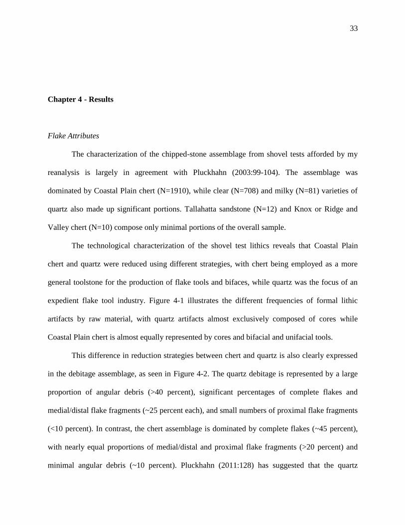
expedient flake tool industry. Figure 4-1 illustrates the different frequencies of formal lithic
artifacts by raw material, with quartz artifacts almost exclusively composed of cores while
Coastal Plain chert is almost equally represented by cores and bifacial and unifacial tools.
This difference in reduction strategies between chert and quartz is also clearly expressed
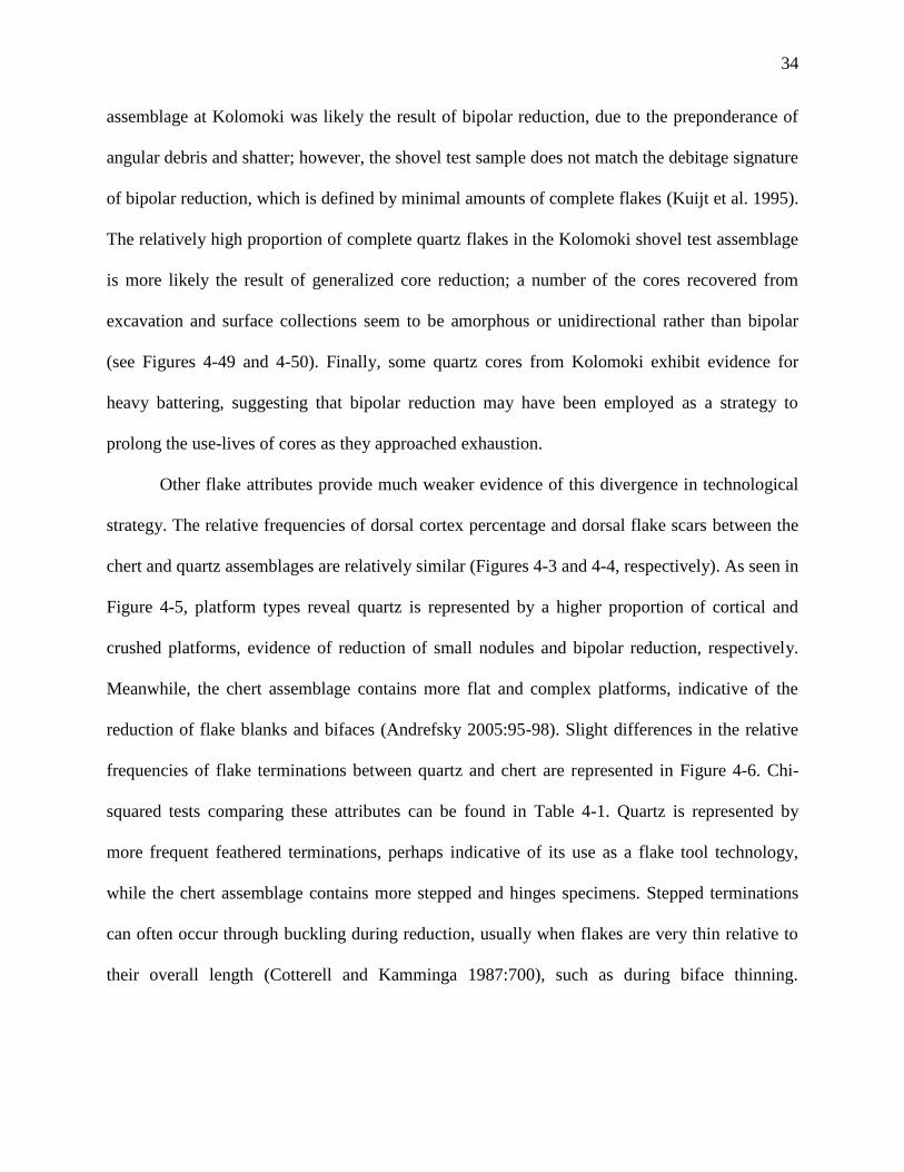
in the debitage assemblage, as seen in Figure 4-2. The quartz debitage is represented by a large
proportion of angular debris (>40 percent), significant percentages of complete flakes and
medial/distal flake fragments (~25 percent each), and small numbers of proximal flake fragments
(<10 percent). In contrast, the chert assemblage is dominated by complete flakes (~45 percent),
with nearly equal proportions of medial/distal and proximal flake fragments (>20 percent) and
minimal angular debris (~10 percent). Pluckhahn (2011:128) has suggested that the quartz
34
assemblage at Kolomoki was likely the result of bipolar reduction, due to the preponderance of
angular debris and shatter; however, the shovel test sample does not match the debitage signature
of bipolar reduction, which is defined by minimal amounts of complete flakes (Kuijt et al. 1995).
The relatively high proportion of complete quartz flakes in the Kolomoki shovel test assemblage
is more likely the result of generalized core reduction; a number of the cores recovered from
excavation and surface collections seem to be amorphous or unidirectional rather than bipolar
(see Figures 4-49 and 4-50). Finally, some quartz cores from Kolomoki exhibit evidence for
heavy battering, suggesting that bipolar reduction may have been employed as a strategy to
prolong the use-lives of cores as they approached exhaustion.
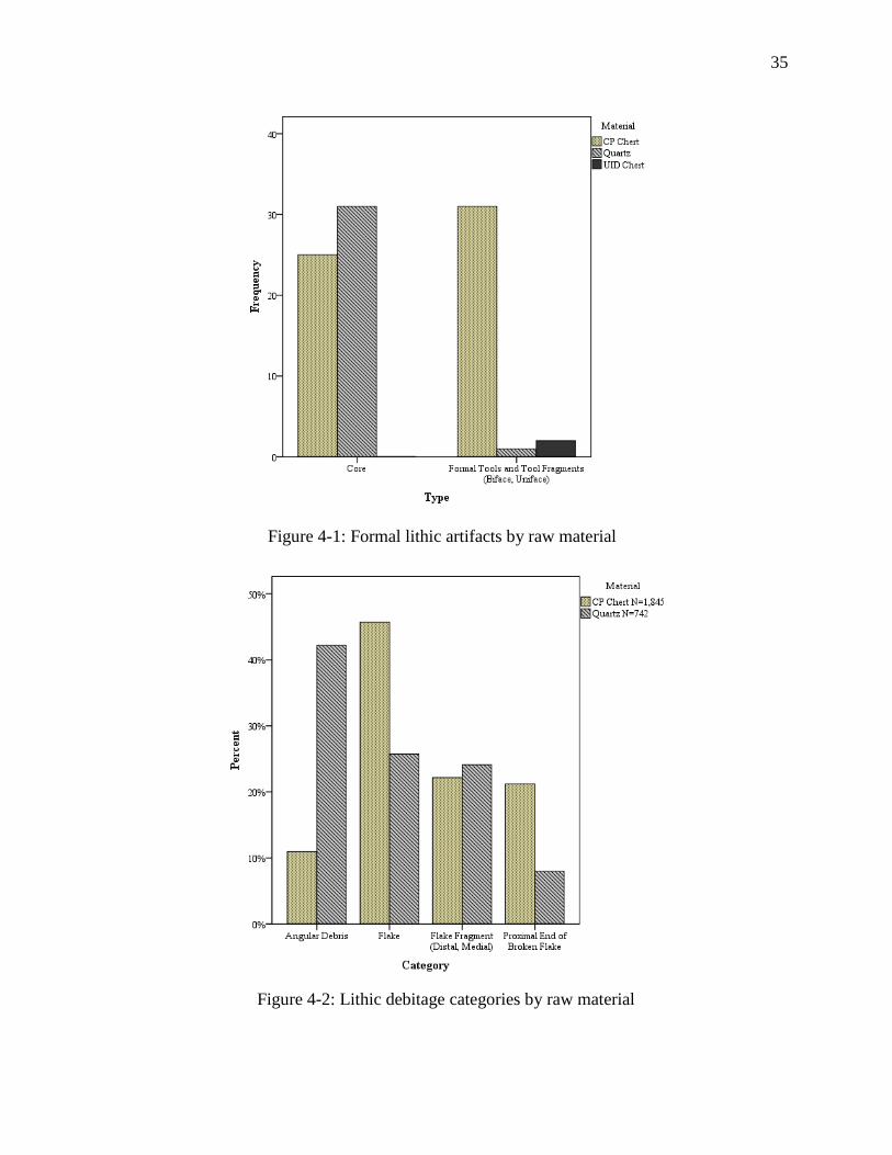
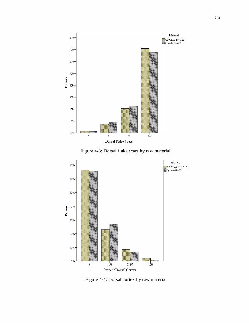
Other flake attributes provide much weaker evidence of this divergence in technological
strategy. The relative frequencies of dorsal cortex percentage and dorsal flake scars between the
chert and quartz assemblages are relatively similar (Figures 4-3 and 4-4, respectively). As seen in
Figure 4-5, platform types reveal quartz is represented by a higher proportion of cortical and
crushed platforms, evidence of reduction of small nodules and bipolar reduction, respectively.
Meanwhile, the chert assemblage contains more flat and complex platforms, indicative of the
reduction of flake blanks and bifaces (Andrefsky 2005:95-98). Slight differences in the relative
frequencies of flake terminations between quartz and chert are represented in Figure 4-6. Chi-
squared tests comparing these attributes can be found in Table 4-1. Quartz is represented by
more frequent feathered terminations, perhaps indicative of its use as a flake tool technology,
while the chert assemblage contains more stepped and hinges specimens. Stepped terminations
can often occur through buckling during reduction, usually when flakes are very thin relative to
their overall length (Cotterell and Kamminga 1987:700), such as during biface thinning.
35
Figure 4-1: Formal lithic artifacts by raw material
Figure 4-2: Lithic debitage categories by raw material
36
Figure 4-3: Dorsal flake scars by raw material
Figure 4-4: Dorsal cortex by raw material
37
Figure 4-5: Platform type by raw material
Figure 4-6: Flake termination type by raw material
38
Table 4-1: Results of Chi-squared tests comparing categorical debitage attributes
Measured flake attributes (maximum length, maximum width, medial thickness, and
weight) and platform attributes (platform width and platform depth) all had heavily rightward-
skewed distributions, which is to be expected given the reductive process of lithic production
(i.e. as reduction proceeds, flakes grow smaller and amount of flakes increases). Despite this
common trend, the difference in technological strategy noted above was present when chert and
quartz attributes were compared to one another. Figures 4-7 through 4-18 detail the distribution
of chert and quartz debitage attributes. Note that the exceptionally long rightward tails of chert
distributions have been clipped somewhat to maintain a more appropriate scale for the side-by-
side comparison of both materials. The long tails of chert distributions generally do not represent
“anomalous” cases, but instead indicate larger flakes, possibly discarded blanks, which occurred
throughout the debitage assemblage – larger angular pieces of chert were generally classified as
cores due to the presence of flake scars and platforms and were correspondingly excluded from
the debitage analysis. Distributions of debitage metrics for quartz generally contain smaller
rightward tails, indicating less large pieces of debitage. As Figures 4-15 through 4-18 show,
platform measurements for quartz have bimodal distributions, especially platform depth. These
bimodal distributions may indicate discrete stages of reduction, perhaps amorphous and bifacial
as suggested above. The summary statistics for these attributes are presented in Tables 4-2 and
Variable Chi-Squared Statistic df Sig. 2-tailed
Dorsal Scars (N) 2.065 3 .559
Dorsal Cortex 22.683 3 <.001
Platform Type 19.123 3 <.001
Termination 10.762 3 .013

39
Figure 4-8: Box plots presenting length distributions by raw material
Figure 4-7: Histograms presenting length distributions by raw material
40
Figure 4-10: Box plots presenting width distributions by raw material
Figure 4-9: Histograms presenting width distributions by raw material
41
Figure 4-12: Box plots presenting thickness distributions by raw material
Figure 4-11: Histograms presenting thickness distributions by raw material
42
Figure 4-14: Box plots presenting weight distributions by raw material
Figure 4-13: Histograms presenting weight distributions by raw material
43
Figure 4-16: Box plots presenting platform width distributions by raw material
Figure 4-15: Histograms presenting platform width distributions by raw material
44
Figure 4-18: Box plots presenting platform depth distributions by raw material
Figure 4-17: Histograms presenting platform depth distributions by raw material
45
4-3. In general, chert debitage is characterized by longer, wider, and thinner flakes, which
reflects a reduction strategy centered on the removal of relatively thin flakes with large surface
areas, such as in biface thinning, while quartz is represented by smaller, thicker debitage, mostly
in the form of angular debris. Chert debitage was, on average, heavier than quartz debitage.
Given the heavy rightward skew of all attribute distributions, medians offer better
measures of central tendency. Median quartz debitage weight was higher than median chert
weight, indicating that the majority of quartz debitage was generally heavier, probably due to
greater thickness. Comparison of platform attributes between the two materials reveals a great
degree of similarity in platform width, but a clear difference in platform depth, especially when
medians are compared. While greater overall thickness for quartz reflected the presence of large
amounts of angular debris in the assemblage, the difference in platform depth indicates that
quartz flakes were also generally thicker, further influencing the trend of heavier quartz debitage.
Table 4-4 displays the results of t-tests performed for each attribute, conducted without the
assumption of equal variance, which show significant differences between chert and quartz for
all flake attributes with the exception of platform width.
These results indicate Kolomoki’s inhabitants employed different technological strategies
for the exploitation of quartz and chert. The chert assemblage is characterized by relatively large,
thin flakes, largely tied to the production and thinning of flake blanks for bifacial tools, as well
as general flake tool and unifacial tool production, while the quartz assemblage is represented by
large quantities of cores, angular debris, and thick flakes which were probably used as expedient
tools. Given the evidence for differential use of these materials, their distributions across the site
can inform us of the spatial organization of lithic production at Kolomoki.
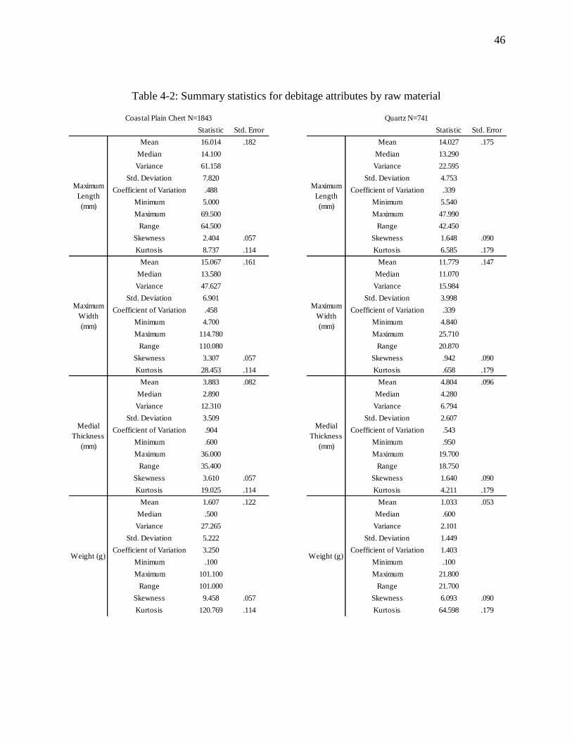
46
Table 4-2: Summary statistics for debitage attributes by raw material
Statistic Std. Error Statistic Std. Error
16.014 .182 14.027 .175
14.100 13.290
61.158 22.595
7.820 4.753
.488 .339
5.000 5.540
69.500 47.990
64.500 42.450
2.404 .057 1.648 .090
8.737 .114 6.585 .179
15.067 .161 11.779 .147
13.580 11.070
47.627 15.984
6.901 3.998
.458 .339
4.700 4.840
114.780 25.710
110.080 20.870
3.307 .057 .942 .090
28.453 .114 .658 .179
3.883 .082 4.804 .096
2.890 4.280
12.310 6.794
3.509 2.607
.904 .543
.600 .950
36.000 19.700
35.400 18.750
3.610 .057 1.640 .090
19.025 .114 4.211 .179
1.607 .122 1.033 .053
.500 .600
27.265 2.101
5.222 1.449
3.250 1.403
.100 .100
101.100 21.800
101.000 21.700
9.458 .057 6.093 .090
120.769 .114 64.598 .179
Quartz N=741
Coefficient of Variation
Coefficient of Variation
Coefficient of VariationCoefficient of Variation
Coefficient of Variation
Coefficient of Variation
Coefficient of Variation
Median
Variance
Std. Deviation
Minimum
Maximum
Range
Skewness
Kurtosis
Median
Variance
Std. Deviation
Maximum
Range
Skewness
Kurtosis
Maximum
Length
(mm)
Mean
Median
Variance
Maximum
Width
(mm)
Mean
Median
Variance
Std. Deviation
Minimum
Maximum
Range
Minimum
Maximum
Range
Skewness
Kurtosis
Coefficient of Variation
Median
Variance
Kurtosis
Weight (g)
Mean
Medial
Thickness
(mm)
Mean
Std. Deviation
Minimum
Maximum
Range
Skewness
Skewness
Kurtosis
Minimum
Std. Deviation
Minimum
Minimum
Coastal Plain Chert N=1843
Weight (g)
Mean
Medial
Thickness
(mm)
Mean
Range
Skewness
Kurtosis
Maximum
Range
Skewness
Kurtosis
Mean
Maximum
Length
(mm)
Std. Deviation
Minimum
Maximum
Range
Maximum
Median
Variance
Std. Deviation
Median
Variance
Skewness
Kurtosis
Maximum
Width
(mm)
Mean
Median
Variance
Std. Deviation
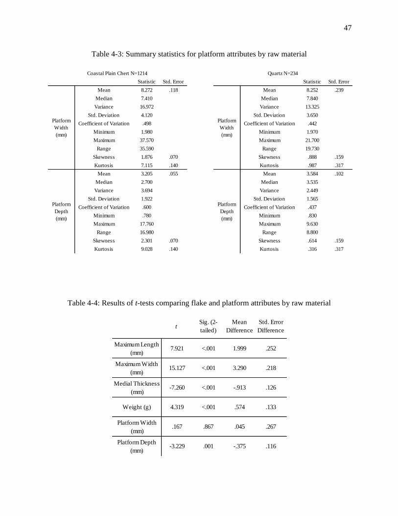
47
Table 4-4: Results of t-tests comparing flake and platform attributes by raw material
Statistic Std. Error Statistic Std. Error
8.272 .118 8.252 .239
7.410 7.840
16.972 13.325
4.120 3.650
.498 .442
1.980 1.970
37.570 21.700
35.590 19.730
1.876 .070 .888 .159
7.115 .140 .987 .317
3.205 .055 3.584 .102
2.700 3.535
3.694 2.449
1.922 1.565
.600 .437
.780 .830
17.760 9.630
16.980 8.800
2.301 .070 .614 .159
9.028 .140 .316 .317
Quartz N=234
Coefficient of Variation Coefficient of Variation
Coefficient of VariationCoefficient of Variation
Minimum
Skewness
Kurtosis
Platform
Depth
(mm)
Mean
Platform
Width
(mm)
Mean
Median
Variance
Std. Deviation
Minimum
Maximum
Maximum
Range
Skewness
Kurtosis
Median
Variance
Std. Deviation
Range
Coastal Plain Chert N=1214
Platform
Depth
(mm)
Mean
Platform
Width
(mm)
Mean
Median
Variance
Std. Deviation
Minimum
Maximum
Maximum
Range
Skewness
Kurtosis
Median
Variance
Std. Deviation
Range
Minimum
Skewness
Kurtosis
Maximum Length
(mm)7.921 <.001 1.999 .252
Maximum Width
(mm)15.127 <.001 3.290 .218
Medial Thickness
(mm)-7.260 <.001 -.913 .126
Weight (g) 4.319 <.001 .574 .133
Platform Width
(mm).167 .867 .045 .267
Platform Depth
(mm)-3.229 .001 -.375 .116
Std. Error
Differencet
Sig. (2-
tailed)
Mean
Difference
Table 4-3: Summary statistics for platform attributes by raw material
48
GIS and Distributions
Distributions of most artifact classes generally conformed to the ovular village plan
following the enclosures, as originally proposed by Pluckhahn (2003). Figures 4-19 and 4-20
detail the distribution of total ceramics by count and by weight and Figures 4-21 and 4-22
display the distribution of Swift Creek ceramics, also by count and weight. Total ceramics serves
as the best proxy for intensity of occupation at the site across all time periods - especially by
weight, due to the fragmentary nature of ceramics in non-mound areas. The low density of total
ceramics along the southwestern portion of the enclosure is conspicuous. Meanwhile, Swift
Creek ceramics, making up the majority of decorated types during early phases of occupation,
occur in low densities across the southern portions of the village, especially by weight. These
distributions indicate the southern areas of the enclosure may have been occupied late, and that
only the eastern portion saw intensive habitation. However, Pluckhahn (2011; Pluckhahn et al.
2006) recovered a relatively late date (ca. A.D.650) from a house along the northern enclosure
that produced an early ceramic assemblage with large amounts of Swift Creek ceramics,
indicating certain aspects of the site’s chronology may need to be refined.
Distributions of lithic production debris, discussed below, were considered in relation to
ceramics to determine if differences in lithic densities were independent of ceramics or if they
instead simply reflect longer duration or higher intensity of occupation. Figure 4-23 illustrates
that Coastal Plain chert debris is primarily concentrated in the northern and southwestern
sections of the village. High ratios of Coastal Plain chert to ceramics in these areas indicate that
chert production was probably not a function of higher intensity of occupation. Furthermore,
Coastal Plain chert conforms neatly with the village as idenstified by ceramic distributions,
indicating that most chert was produced and used in domestic contexts at Kolomoki. The picture
49
for quartz is somewhat different, with quartz debris scattered throughout the site (Figure 4-24).
High ratios of quartz debris, indicating quartz production and use was not associated with higher
intensity of occupation, are clustered in the northern and southwestern sections of the village,
similar to chert. However, high quartz ratios also occur in near-mound areas, especially in
association with Mounds A, D, and H. When compared, these ratio distributions indicate that the
northern and southwestern sections of Kolomoki’s village were loci of high lithic production, but
also that Coastal Plain chert was produced and used almost exclusively in domestic areas while
quartz production and use may have occurred in ceremonial as well as domestic contexts.
The distribution and intensity of reduction for Coastal Plain chert can be seen in Figures
4-25 through 4-27. These maps show that Coastal Plain chert is heavily concentrated in the
western half of the northern enclosure, both by count and weight. Figure 4-27 exhibits a spotty,
high density distribution across much of the site, indicating dispersed core reduction (moderate
to high weight/low count), while the northwestern section of the enclosure represents late stage
reduction (moderate to high weight/high count). As expected, interior areas of the site are
confined to the lowest density interval, indicative of limited lithic production (low weight/low
count).
Quartz is represented by a general trend of dispersed core reduction in most areas except
the western end of the northern enclosure, the eastern portion of the southern enclosure, and the
far west of the site near Mound E (Figures 4-28 through 4-30). The pattern of quartz reduction
along the northern enclosure seems to be a weak inverse of Coastal Plain chert, while the
distribution in the southwest forms a continuous arc of core reduction opening to the south.
When divided into clear (Figures 4-31 and 4-32) and milky (Figures 4-33 and 4-34) categories,
the distribution of quartz becomes even more interesting, with a clear restriction of milky quartz
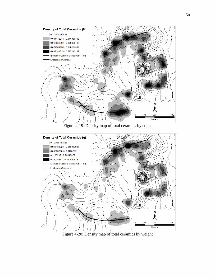
50
Figure 4-19: Density map of total ceramics by count
Figure 4-20: Density map of total ceramics by weight
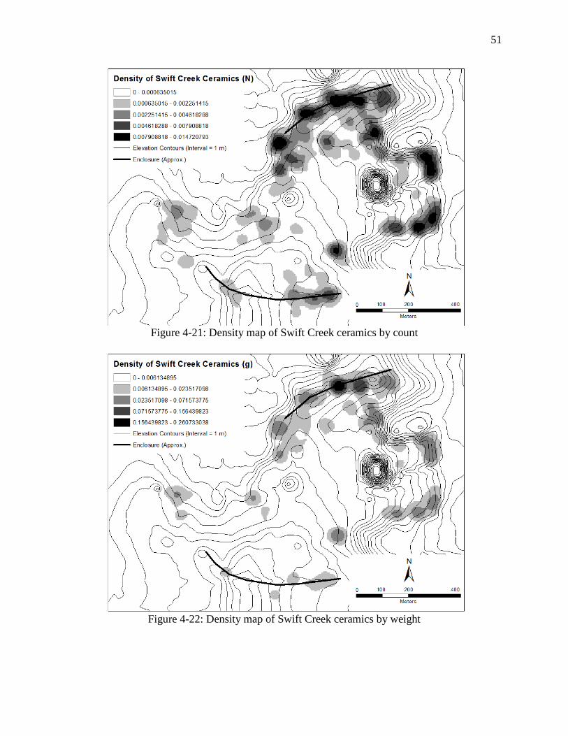
51
Figure 4-21: Density map of Swift Creek ceramics by count
Figure 4-22: Density map of Swift Creek ceramics by weight
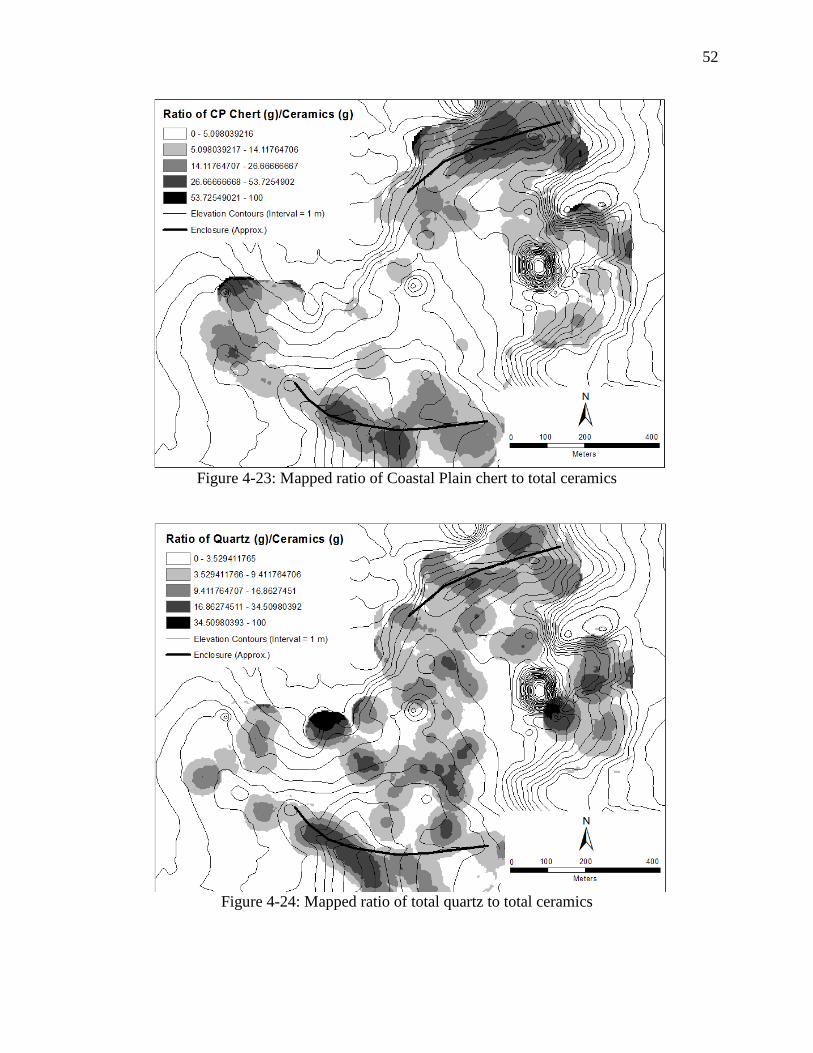
52
Figure 4-23: Mapped ratio of Coastal Plain chert to total ceramics
Figure 4-24: Mapped ratio of total quartz to total ceramics
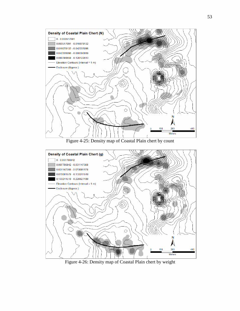
53
Figure 4-25: Density map of Coastal Plain chert by count
Figure 4-26: Density map of Coastal Plain chert by weight
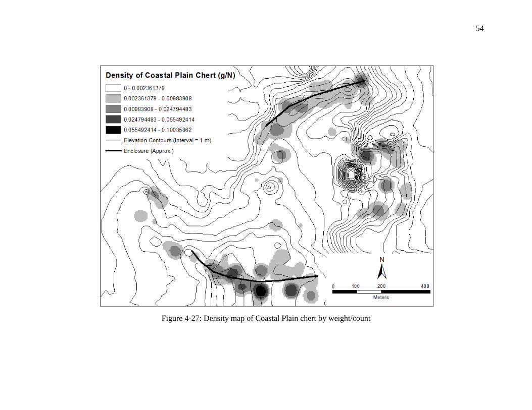
54
Figure 4-27: Density map of Coastal Plain chert by weight/count
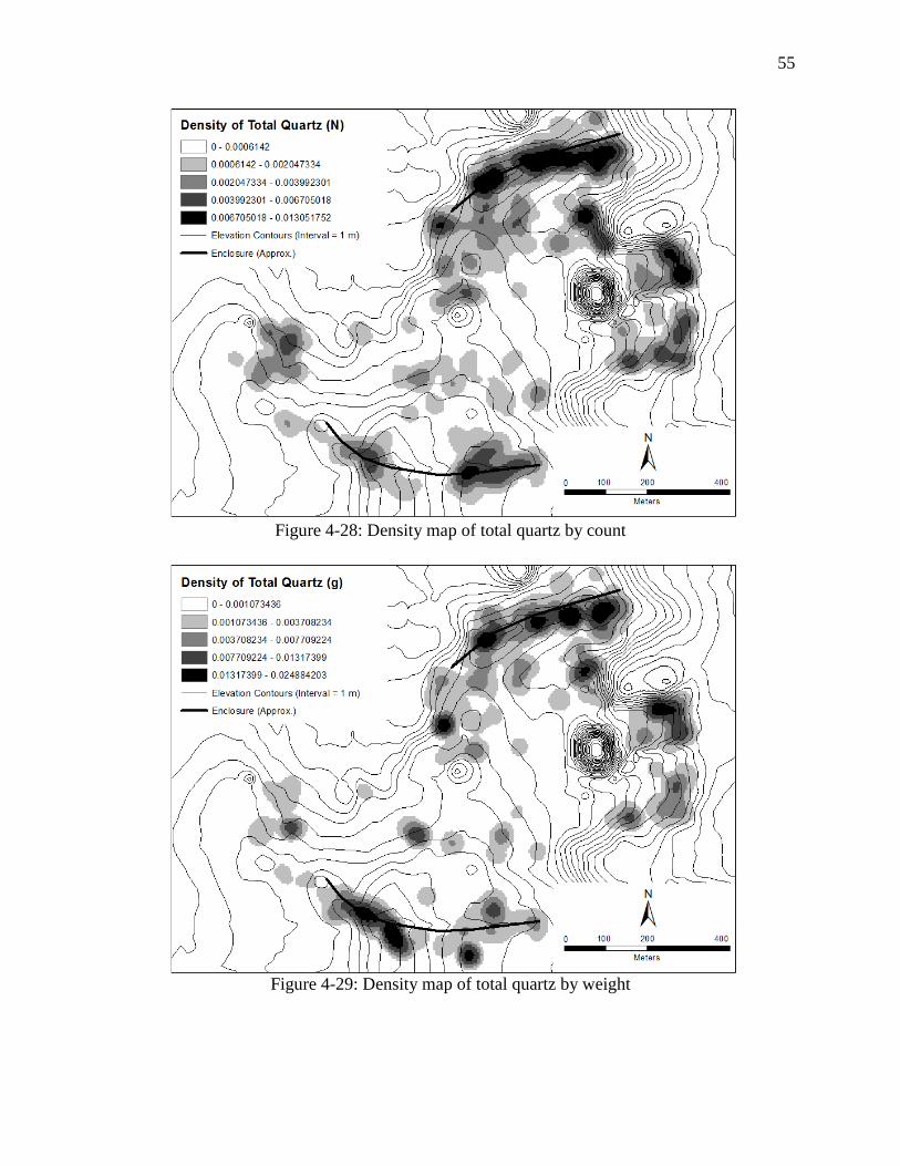
55
Figure 4-28: Density map of total quartz by count
Figure 4-29: Density map of total quartz by weight
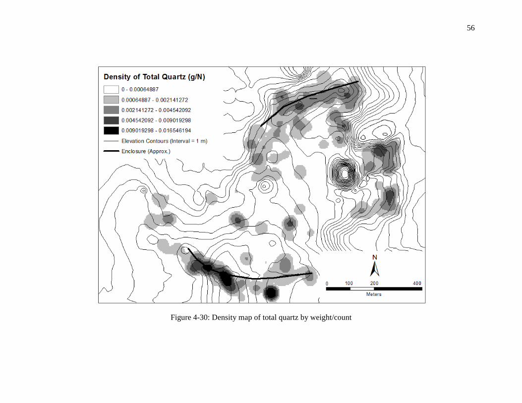
56
Figure 4-30: Density map of total quartz by weight/count
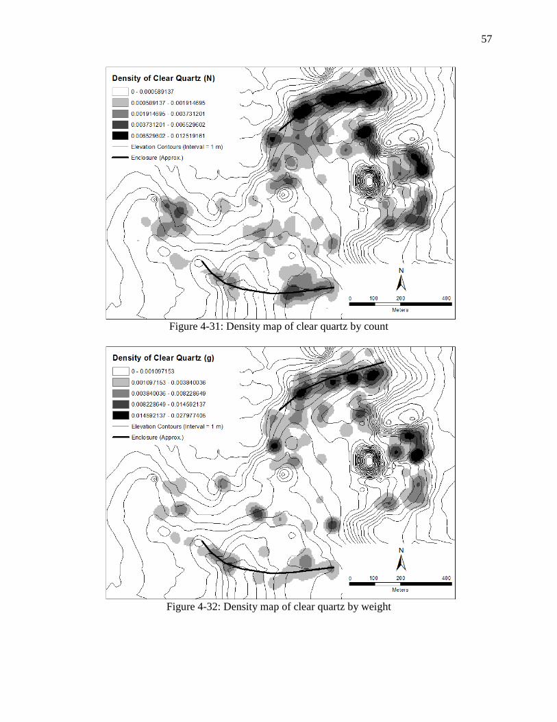
57
Figure 4-31: Density map of clear quartz by count
Figure 4-32: Density map of clear quartz by weight
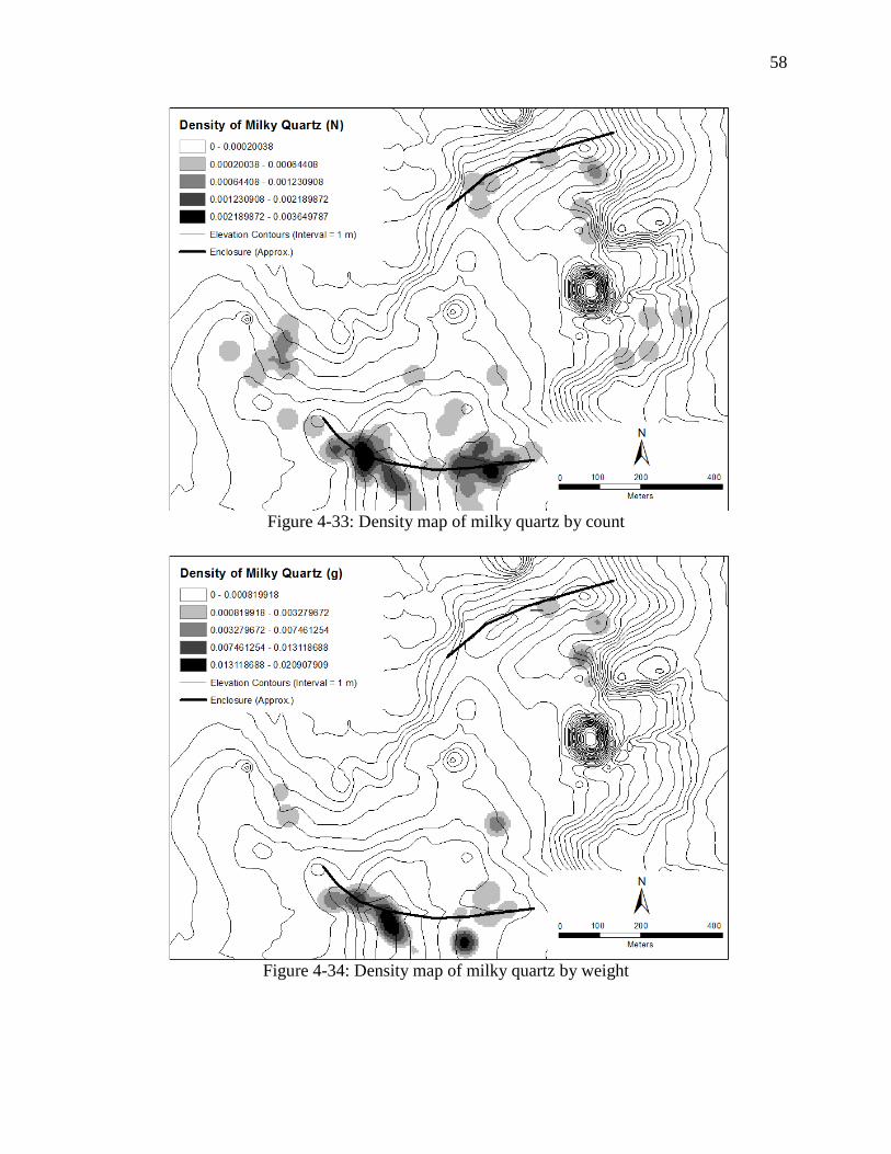
58
Figure 4-33: Density map of milky quartz by count
Figure 4-34: Density map of milky quartz by weight

59
along the southern enclosure. The highest density of milky quartz by weight corresponds to the
aforementioned arc.
Tables 4-5 and 4-6 contain the results of Pearson’s correlations testing the co-occurrence
of total ceramics, Swift Creek ceramics, Coastal Plain chert, and total quartz in shovel tests by
count and weight. Notably, while all artifact classes co-occur at statistically significant levels,
Coastal Plain chert exhibits the weakest correlation by weight and count with all other artifact
classes, reflecting its heavy concentration along the northeastern portion of the village.
Using the Grouping Analysis tool in ArcMap to perform a spatial cluster analysis
revealed a very distinct pattern in the distribution of lithic assemblages when separated by
artifact counts (Figure 4-35). Figure 4-36 presents the grouping criteria, in which presence of
milky quartz and high numbers of chert are the primary determinants of group membership.
Separations by weight and weight/count (Figures 4-37 and 4-38) did not produce spatially
discrete patterns, indicating that lithic assemblages at Kolomoki contain similar amounts of lithic
material by weight and are differentiated by intensity of reduction activities (chert) and presence
of spatially restricted materials (milky quartz).
Quartz Use Wear
Through my microscopic analysis of the quartz assemblage from Pluckhahn’s Test Unit
3, I identified probable use-wear on 3 artifacts: 1 burinated flake with deep parallel striations
running along the ventral side of the flake near the burin-like protrusion, 1 flake with light edge-
chipping and a smear of soil on the flake’s ventral side that ran generally parallel to the chipped
edge, and 1 oddly shaped core-like object with a chipped and abraded surface and chipping along
an edge produced by a hinged flake termination.
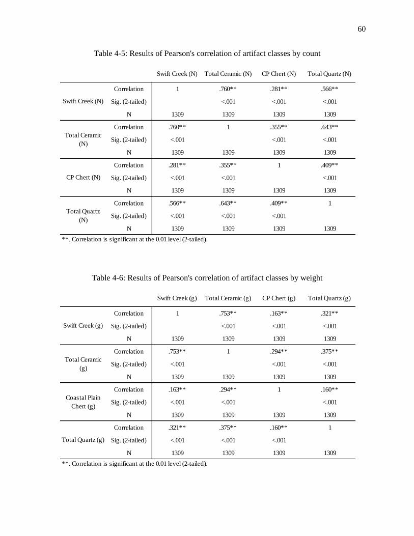
60
Table 4-5: Results of Pearson's correlation of artifact classes by count
Table 4-6: Results of Pearson's correlation of artifact classes by weight
Swift Creek (N) Total Ceramic (N) CP Chert (N) Total Quartz (N)
Correlation 1 .760** .281** .566**
Sig. (2-tailed) <.001 <.001 <.001
N 1309 1309 1309 1309
Correlation .760** 1 .355** .643**
Sig. (2-tailed) <.001 <.001 <.001
N 1309 1309 1309 1309
Correlation .281** .355** 1 .409**
Sig. (2-tailed) <.001 <.001 <.001
N 1309 1309 1309 1309
Correlation .566** .643** .409** 1
Sig. (2-tailed) <.001 <.001 <.001
N 1309 1309 1309 1309
**. Correlation is significant at the 0.01 level (2-tailed).
Swift Creek (N)
Total Ceramic
(N)
CP Chert (N)
Total Quartz
(N)
Swift Creek (g) Total Ceramic (g) CP Chert (g) Total Quartz (g)
Correlation 1 .753** .163** .321**
Sig. (2-tailed) <.001 <.001 <.001
N 1309 1309 1309 1309
Correlation .753** 1 .294** .375**
Sig. (2-tailed) <.001 <.001 <.001
N 1309 1309 1309 1309
Correlation .163** .294** 1 .160**
Sig. (2-tailed) <.001 <.001 <.001
N 1309 1309 1309 1309
Correlation .321** .375** .160** 1
Sig. (2-tailed) <.001 <.001 <.001
N 1309 1309 1309 1309
**. Correlation is significant at the 0.01 level (2-tailed).
Swift Creek (g)
Total Ceramic
(g)
Coastal Plain
Chert (g)
Total Quartz (g)
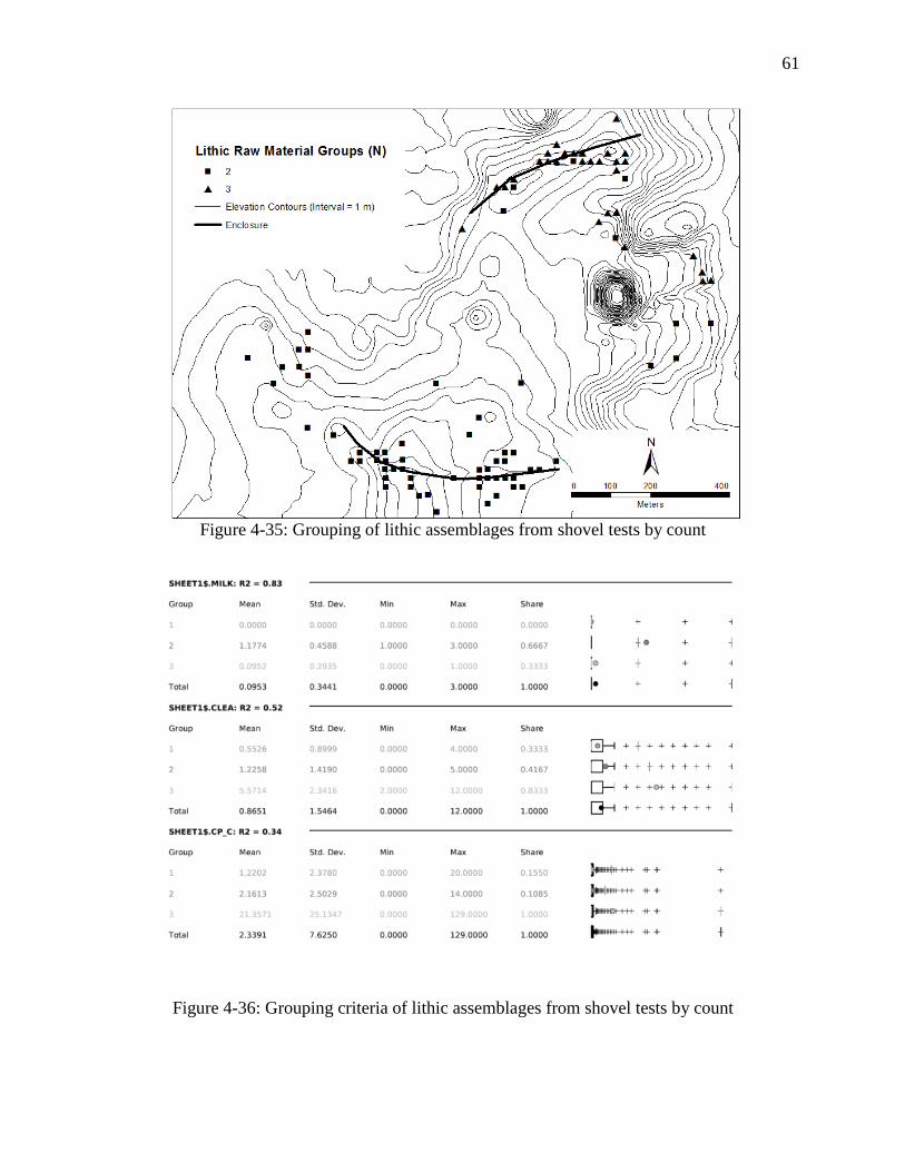
61
Figure 4-35: Grouping of lithic assemblages from shovel tests by count
Figure 4-36: Grouping criteria of lithic assemblages from shovel tests by count
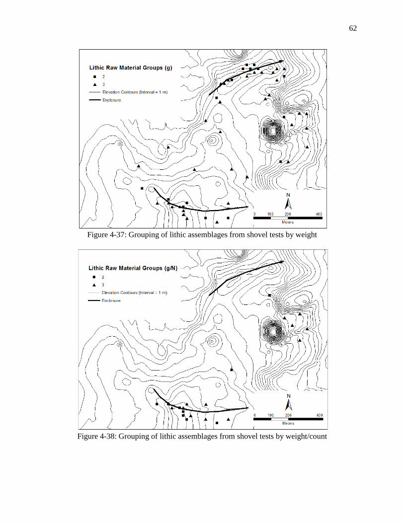
62
Figure 4-37: Grouping of lithic assemblages from shovel tests by weight
Figure 4-38: Grouping of lithic assemblages from shovel tests by weight/count
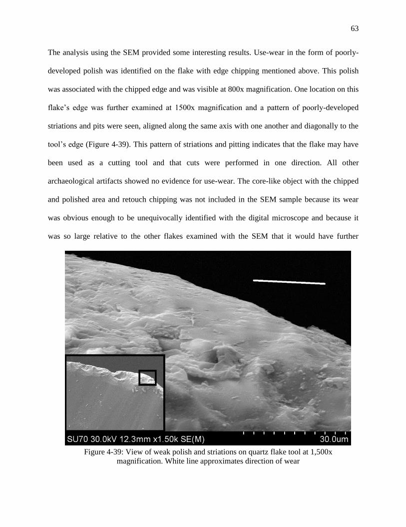
63
The analysis using the SEM provided some interesting results. Use-wear in the form of poorly-
developed polish was identified on the flake with edge chipping mentioned above. This polish
was associated with the chipped edge and was visible at 800x magnification. One location on this
flake’s edge was further examined at 1500x magnification and a pattern of poorly-developed
striations and pits were seen, aligned along the same axis with one another and diagonally to the
tool’s edge (Figure 4-39). This pattern of striations and pitting indicates that the flake may have
been used as a cutting tool and that cuts were performed in one direction. All other
archaeological artifacts showed no evidence for use-wear. The core-like object with the chipped
and polished area and retouch chipping was not included in the SEM sample because its wear
was obvious enough to be unequivocally identified with the digital microscope and because it
was so large relative to the other flakes examined with the SEM that it would have further
Figure 4-39: View of weak polish and striations on quartz flake tool at 1,500x
magnification. White line approximates direction of wear
64
reduced the already small sample. The limited presence of identifiable use-wear in this sample
indicates that quartz may not have been used, a conclusion I find unlikely. Alternatively, quartz
may have been used as expedient tools and discarded after use with no subsequent retouch or
modification. A major shortcoming of this use-wear study was an explicit focus on modified
flake tools like burinated flakes, which are notably rare at Kolomoki in general.
Excavations and Radiocarbon Dating of the Southern Enclosure
Investigations of the southern village at Kolomoki included the excavation of four 1-x-2
m Test Units (TUs 21/23-25), a 1-x-1 m Test Unit (TU 20), and a systematic surface collection
over a 120-x-60 m grid at 20 m intervals. Excavations will be reported in greater detail
elsewhere, including an additional two 1-x-2 m Test Units not seen here (West forthcoming).
Here I focus on the chronology of the southern village, illustrated by ceramic assemblages and
radiocarbon dates from feature contexts, as well as intensity of occupation, represented by
artifact densities.
Test Units were placed along the arc of relatively high surface artifact densities
corresponding to the southern portion of enclosure, with TUs 20, 21/23, and 22 sitting atop a
slightly elevated landform (Figure 4-40). The planting schedule of landowners pushed units
towards the edges of active agricultural fields. Tables 4-7 and 4-8 detail the ceramic and lithic
contents of these Test Units. Note that TUs 21/23 and 25, which contained the highest ceramic
densities and probably most accurately reflect overall ceramic assemblages in the southern
village, contain high proportions of Swift Creek ceramics. Additionally, four features (1, 2, 5,
and 7 in Test Units 21/23, 22, 24, and 25, respectively) produced charcoal suitable for AMS
radiocarbon dating.
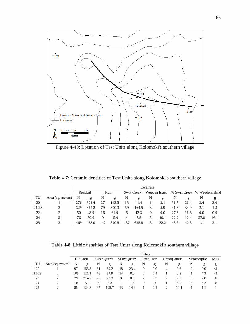
65
Figure 4-40: Location of Test Units along Kolomoki's southern village
Table 4-7: Ceramic densities of Test Units along Kolomoki's southern village
Table 4-8: Lithic densities of Test Units along Kolomoki's southern village
TU Area (sq. meters) N g N g N g N g N g N g
20 1 276 301.4 27 112.5 13 41.4 1 3.1 31.7 26.4 2.4 2.0
21/23 2 329 324.2 79 300.3 59 164.5 3 5.9 41.8 34.9 2.1 1.3
22 2 50 48.9 16 61.9 6 12.3 0 0.0 27.3 16.6 0.0 0.0
24 2 76 50.6 9 45.0 4 7.8 5 10.1 22.2 12.4 27.8 16.1
25 2 469 458.0 142 890.5 137 635.8 3 32.2 48.6 40.8 1.1 2.1
Residual Plain Swift Creek Weeden Island % Swift Creek % Weeden Island
Ceramics
Mica
TU Area (sq. meters) N g N g N g N g N g N g g
20 1 97 163.8 31 69.2 18 23.4 0 0.0 4 2.6 0 0.0 <1
21/23 2 105 121.1 76 69.9 14 8.0 2 0.4 1 0.3 1 7.3 <1
22 2 29 214.7 23 28.3 3 0.8 2 2.2 2 2.2 3 2.8 0
24 2 10 5.0 5 3.3 1 1.8 0 0.0 1 3.2 3 5.3 0
25 2 85 124.8 97 125.7 13 14.9 1 0.1 2 10.4 1 1.1 1
Lithics
Milky Quartz Other Chert Orthoquartzite MetamorphicCP Chert Clear Quartz
66
A 120-x-60 m grid for systematic surface collection was placed in a recently plowed field east of
the landform containing TUs 20, 21/23, and 22 (Figures 4-41 and 4-42). Surface collections were
conducted in a 2 m radius at 20 m intervals. Table 4-9 displays artifacts recovered by count.
Additionally, the field was surveyed for diagnostic artifacts such as pp/ks and decorated
ceramics, as well as lithic cores, which were piece-plotted using a total station (Figure 4-42).
Figures 4-43 through 4-54 present some selected artifacts from these collections. Artifact
densities, especially ceramics, were concentrated to the eastern end of the grid, in agreement
with artifact densities identified during my reanalysis of the shovel test material. Additional
diagnostic artifacts were collected from other locations along the southern village.
Four new radiocarbon dates were taken from features located in Test Units 21/23, 22, 24,
and 25 (Table 4-10 and Figure 4-55). Dates from Test Units 21/23 and 25 were recovered from a
probable post-mold containing charred cane and pine charcoal and a large pit feature,
respectively. These two dates, overlapping at roughly A.D. 680-770, place the occupation of the
southern section of Kolomoki’s village relatively late in Pluckhahn’s (2003) chronology of the
site, in the Kolomoki IV phase. However, an early date of A.D. 127-311, recovered from a large,
basin-shaped pit in Test Unit 21/23 indicates some activity in the vicinity of the southern village
very early in the site’s chronology. Notably, this date is contemporaneous with and possibly
earlier than dates recovered from the submound midden of Mound D and Test Unit 3, both
dating to Pluckhahn’s (2003) Kolomoki I phase. The presence of early activity in this area is
perhaps unsurprising. This feature is located atop the highest natural landform at Kolomoki,
which could have provided a useful vantage point during the initial layout of Kolomoki’s early
mound phases and community plan. Test Unit 21/23 also corresponds with the position of the
enclosure, perhaps indicating its early construction as Pluckhahn (2003) suggests. Finally, a very
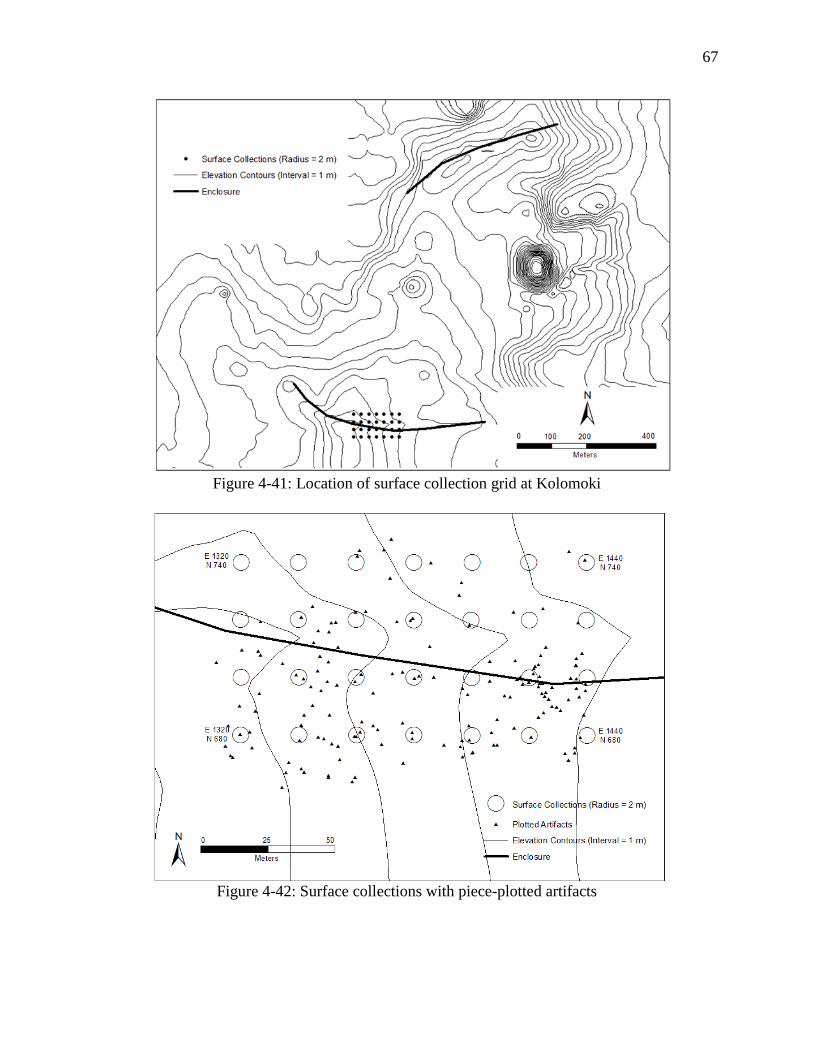
67
Figure 4-41: Location of surface collection grid at Kolomoki
Figure 4-42: Surface collections with piece-plotted artifacts
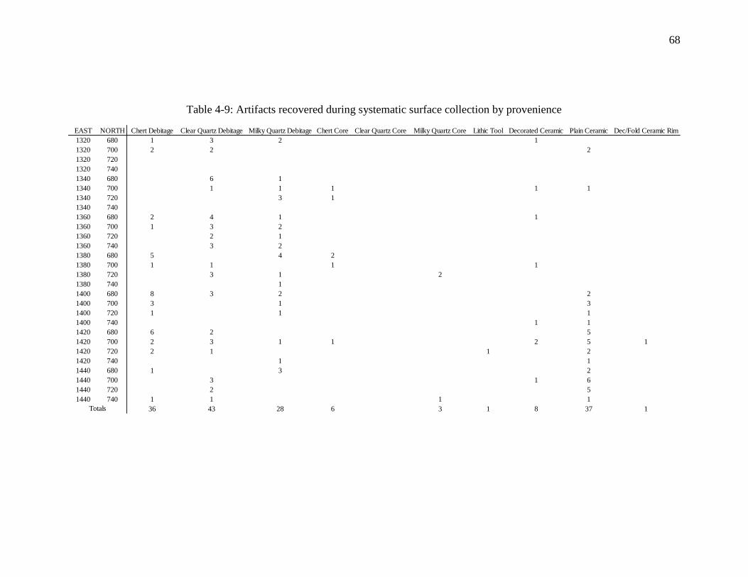
68
Table 4-9: Artifacts recovered during systematic surface collection by provenience
EAST NORTH Chert Debitage Clear Quartz Debitage Milky Quartz Debitage Chert Core Clear Quartz Core Milky Quartz Core Lithic Tool Decorated Ceramic Plain Ceramic Dec/Fold Ceramic Rim
1320 680 1 3 2 1
1320 700 2 2 2
1320 720
1320 740
1340 680 6 1
1340 700 1 1 1 1 1
1340 720 3 1
1340 740
1360 680 2 4 1 1
1360 700 1 3 2
1360 720 2 1
1360 740 3 2
1380 680 5 4 2
1380 700 1 1 1 1
1380 720 3 1 2
1380 740 1
1400 680 8 3 2 2
1400 700 3 1 3
1400 720 1 1 1
1400 740 1 1
1420 680 6 2 5
1420 700 2 3 1 1 2 5 1
1420 720 2 1 1 2
1420 740 1 1
1440 680 1 3 2
1440 700 3 1 6
1440 720 2 5
1440 740 1 1 1 1
36 43 28 6 3 1 8 37 1Totals
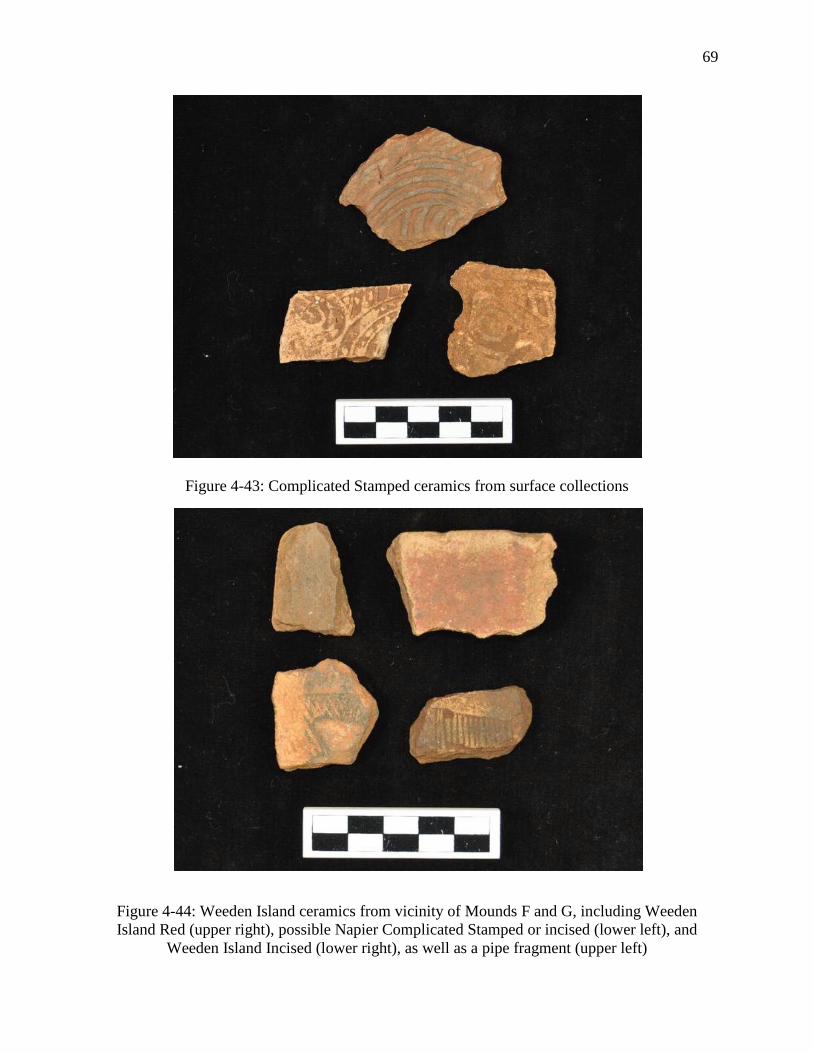
69
Figure 4-43: Complicated Stamped ceramics from surface collections
Figure 4-44: Weeden Island ceramics from vicinity of Mounds F and G, including Weeden
Island Red (upper right), possible Napier Complicated Stamped or incised (lower left), and
Weeden Island Incised (lower right), as well as a pipe fragment (upper left)
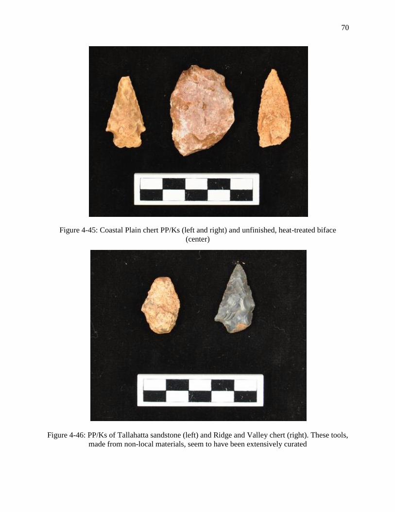
70
Figure 4-45: Coastal Plain chert PP/Ks (left and right) and unfinished, heat-treated biface
(center)
Figure 4-46: PP/Ks of Tallahatta sandstone (left) and Ridge and Valley chert (right). These tools,
made from non-local materials, seem to have been extensively curated
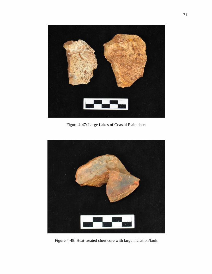
71
Figure 4-47: Large flakes of Coastal Plain chert
Figure 4-48: Heat-treated chert core with large inclusion/fault
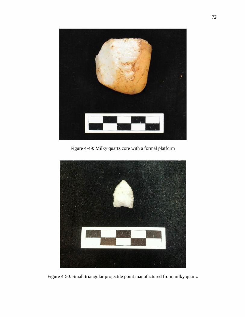
72
Figure 4-49: Milky quartz core with a formal platform
Figure 4-50: Small triangular projectile point manufactured from milky quartz
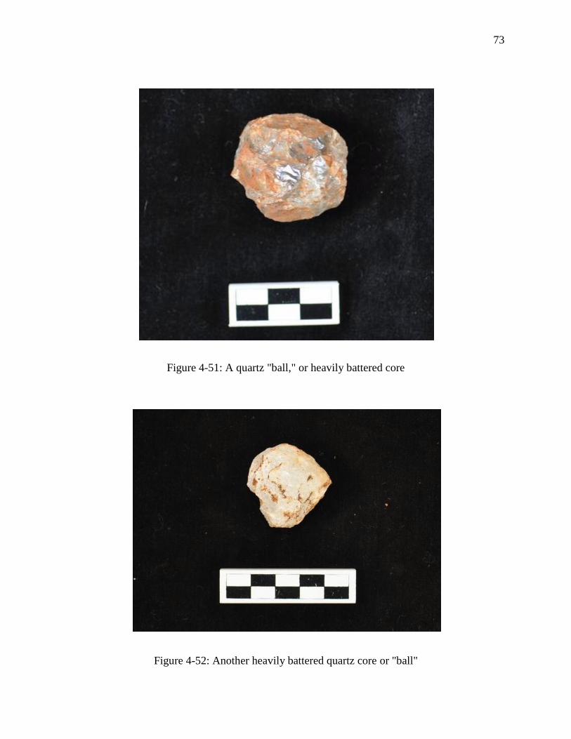
73
Figure 4-51: A quartz "ball," or heavily battered core
Figure 4-52: Another heavily battered quartz core or "ball"
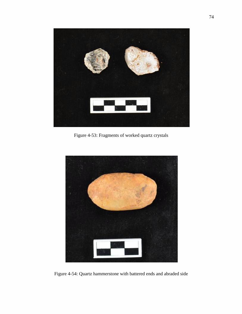
74
Figure 4-53: Fragments of worked quartz crystals
Figure 4-54: Quartz hammerstone with battered ends and abraded side

75
late date of A.D. 910-1030 was retrieved from Test Unit 24. Surface collections in the vicinity of
Test Unit 24 and Mounds F and G recovered high proportions of Weedon Island series ceramics
and a late-Woodland triangular projectile point, both of which are generally associated with later
occupation of the site.
These radiocarbon dates place the occupation of a large section of the southern village
late in the site’s chronology, in the Kolomoki IV phase, while ceramic evidence from these same
excavations place occupation in the Kolomoki I-II phases due to the high proportions of Swift
Creek ceramics (Pluckhahn 2003:20). Table 4-9 illustrates that this discrepancy is reflected in
Block A in the north of the village as well. Based on the similarity of ceramic assemblages in
conjunction with later-than-expected dates clustering around A.D. 550-750, I argue that at least
parts of the northern and southern sections of the Kolomoki’s village were occupied at roughly
the same time, with the abandonment of the Block A house and the southern village separated by
as little as one or two generations. Consequently, the economic differentiation between village
segments at Kolomoki identified by my analysis of lithic production debris was probably also
contemporaneous, rather than a result of temporal variation.
This interval of contemporaneous and relatively intensive occupation of Kolomoki’s
village occurred about two centuries after that initially proposed by Pluckhahn (2003). However,
radiocarbon dates from Test Units 21/23 and 24 indicate that the southern sections of the village
saw activity centuries earlier and later than the period of intensive village occupation. Together,
these dates suggest three episodes of activity within the southern areas of Kolomoki, coinciding
with the site’s early history and potentially its founding and initial design, the aggregation of its
large village, and a later occupation associated with the decline of Swift Creek pottery in favor of
Weedon Island series ceramics.
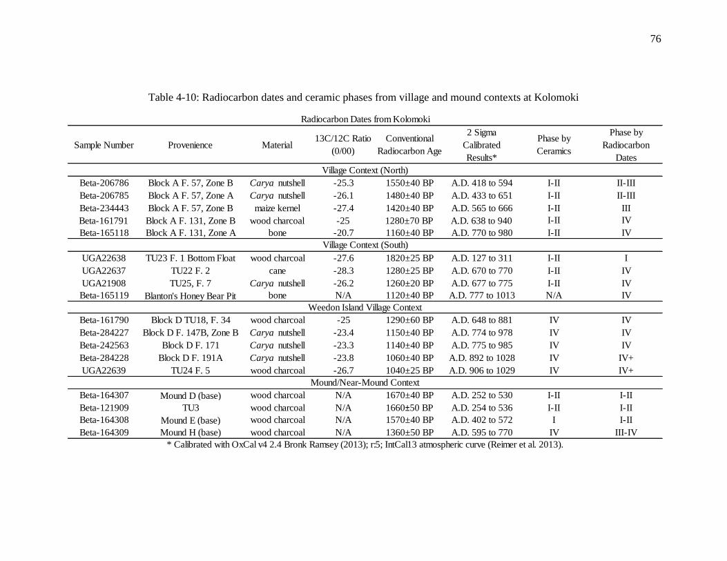
76
Table 4-10: Radiocarbon dates and ceramic phases from village and mound contexts at Kolomoki
Sample Number Provenience Material13C/12C Ratio
(0/00)
Conventional
Radiocarbon Age
2 Sigma
Calibrated
Results*
Phase by
Ceramics
Phase by
Radiocarbon
Dates
Beta-206786 Block A F. 57, Zone B Carya nutshell -25.3 1550±40 BP A.D. 418 to 594 I-II II-III
Beta-206785 Block A F. 57, Zone A Carya nutshell -26.1 1480±40 BP A.D. 433 to 651 I-II II-III
Beta-234443 Block A F. 57, Zone B maize kernel -27.4 1420±40 BP A.D. 565 to 666 I-II III
Beta-161791 Block A F. 131, Zone B wood charcoal -25 1280±70 BP A.D. 638 to 940 I-II IV
Beta-165118 Block A F. 131, Zone A bone -20.7 1160±40 BP A.D. 770 to 980 I-II IV
UGA22638 TU23 F. 1 Bottom Float wood charcoal -27.6 1820±25 BP A.D. 127 to 311 I-II I
UGA22637 TU22 F. 2 cane -28.3 1280±25 BP A.D. 670 to 770 I-II IV
UGA21908 TU25, F. 7 Carya nutshell -26.2 1260±20 BP A.D. 677 to 775 I-II IV
Beta-165119 Blanton's Honey Bear Pit bone N/A 1120±40 BP A.D. 777 to 1013 N/A IV
Beta-161790 Block D TU18, F. 34 wood charcoal -25 1290±60 BP A.D. 648 to 881 IV IV
Beta-284227 Block D F. 147B, Zone B Carya nutshell -23.4 1150±40 BP A.D. 774 to 978 IV IV
Beta-242563 Block D F. 171 Carya nutshell -23.3 1140±40 BP A.D. 775 to 985 IV IV
Beta-284228 Block D F. 191A Carya nutshell -23.8 1060±40 BP A.D. 892 to 1028 IV IV+
UGA22639 TU24 F. 5 wood charcoal -26.7 1040±25 BP A.D. 906 to 1029 IV IV+
Beta-164307 Mound D (base) wood charcoal N/A 1670±40 BP A.D. 252 to 530 I-II I-II
Beta-121909 TU3 wood charcoal N/A 1660±50 BP A.D. 254 to 536 I-II I-II
Beta-164308 Mound E (base) wood charcoal N/A 1570±40 BP A.D. 402 to 572 I I-II
Beta-164309 Mound H (base) wood charcoal N/A 1360±50 BP A.D. 595 to 770 IV III-IV
* Calibrated with OxCal v4 2.4 Bronk Ramsey (2013); r:5; IntCal13 atmospheric curve (Reimer et al. 2013).
Weedon Island Village Context
Village Context (South)
Village Context (North)
Radiocarbon Dates from Kolomoki
Mound/Near-Mound Context
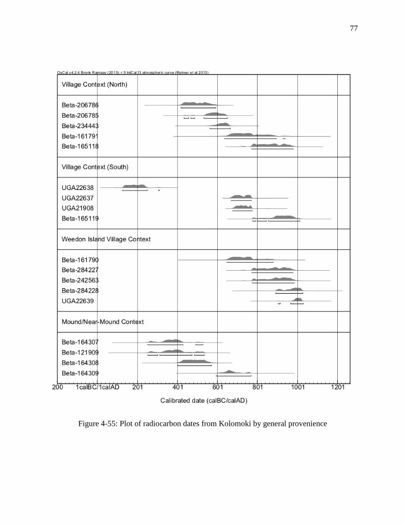
77
Figure 4-55: Plot of radiocarbon dates from Kolomoki by general provenience
78
Chapter 5 - Discussion
New radiocarbon dates and similarity in ceramic assemblages (see Table 5-1) have
established the contemporaneity of the northern and southern sections of the village at Kolomoki
at a date later than previously assumed. Furthermore, patterned distributions of lithic debris
suggest multiple social or economic divisions within the village. The presence of spatially
restricted areas of intensive lithic production, specifically the arc of quartz core reduction debris
along the southwestern portion of the enclosure and the late stage chert reduction area along the
eastern half of the northern enclosure likely represent discrete activity areas, possibly associated
with households or groups of households due to their location along the proposed village
(Pluckhahn 2003). Furthermore, the restriction of milky quartz to the southern portions of the
village, and especially to the aforementioned arc, hints at a north-south division at the site. This
dual pattern is also represented by certain aspects of mound construction and symbolism. In sum,
these features of the domestic space at Kolomoki indicate economic or social differentiation
within the village in agreement with suggestions by Pluckhahn (2003:104), but to a greater
degree than previously envisioned.
Lithic assemblages bearing spatially distinct distributions based on raw material have
been interpreted to represent different social identities (Hayden et al. 1996). Hayden and
colleagues (1996) argue this pattern at Keatley Creek in British Columbia resulted from distinct
social groups exploiting particular raw materials as they made seasonal rounds throughout
separate areas of the surrounding landscape, though recent radiocarbon dates from the site have
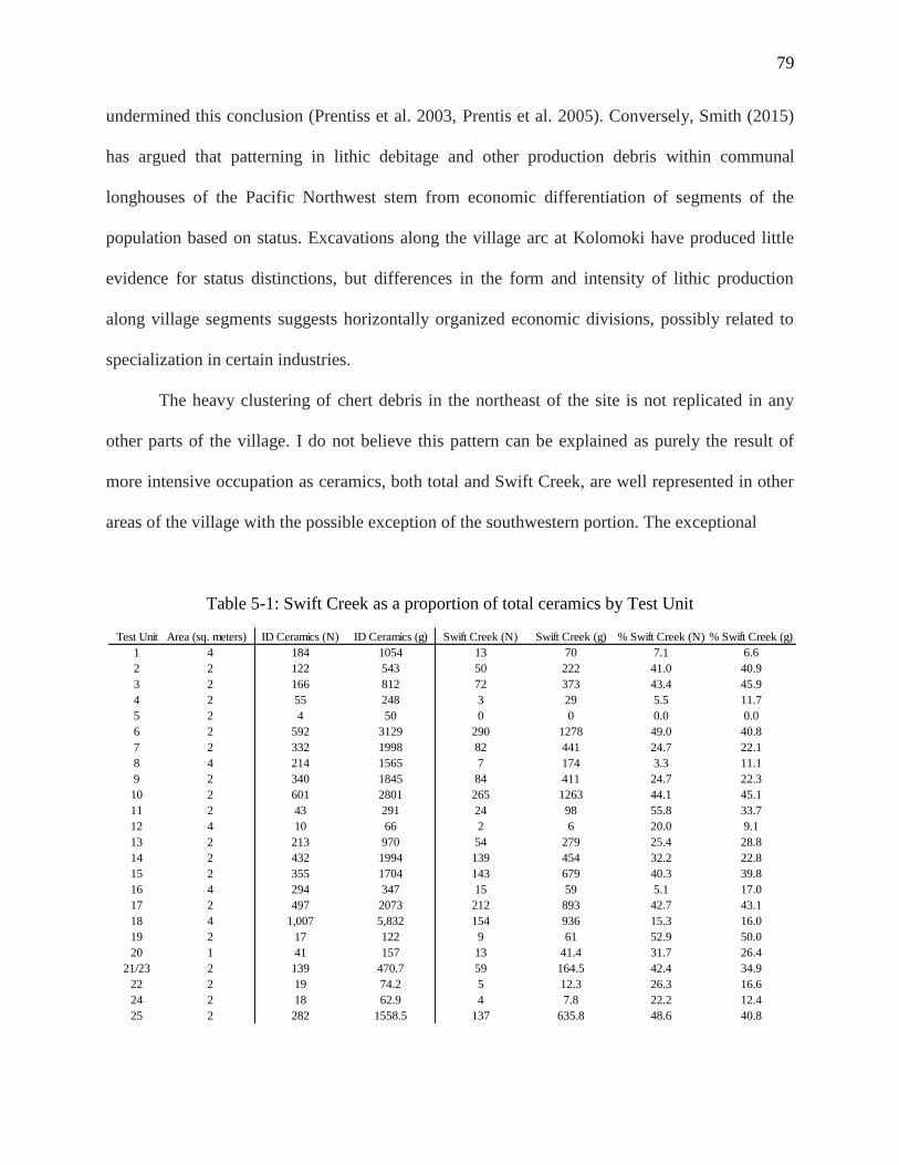
79
undermined this conclusion (Prentiss et al. 2003, Prentis et al. 2005). Conversely, Smith (2015)
has argued that patterning in lithic debitage and other production debris within communal
longhouses of the Pacific Northwest stem from economic differentiation of segments of the
population based on status. Excavations along the village arc at Kolomoki have produced little
evidence for status distinctions, but differences in the form and intensity of lithic production
along village segments suggests horizontally organized economic divisions, possibly related to
specialization in certain industries.
The heavy clustering of chert debris in the northeast of the site is not replicated in any
other parts of the village. I do not believe this pattern can be explained as purely the result of
more intensive occupation as ceramics, both total and Swift Creek, are well represented in other
areas of the village with the possible exception of the southwestern portion. The exceptional
Table 5-1: Swift Creek as a proportion of total ceramics by Test Unit
Test Unit Area (sq. meters) ID Ceramics (N) ID Ceramics (g) Swift Creek (N) Swift Creek (g) % Swift Creek (N) % Swift Creek (g)
1 4 184 1054 13 70 7.1 6.6
2 2 122 543 50 222 41.0 40.9
3 2 166 812 72 373 43.4 45.9
4 2 55 248 3 29 5.5 11.7
5 2 4 50 0 0 0.0 0.0
6 2 592 3129 290 1278 49.0 40.8
7 2 332 1998 82 441 24.7 22.1
8 4 214 1565 7 174 3.3 11.1
9 2 340 1845 84 411 24.7 22.3
10 2 601 2801 265 1263 44.1 45.1
11 2 43 291 24 98 55.8 33.7
12 4 10 66 2 6 20.0 9.1
13 2 213 970 54 279 25.4 28.8
14 2 432 1994 139 454 32.2 22.8
15 2 355 1704 143 679 40.3 39.8
16 4 294 347 15 59 5.1 17.0
17 2 497 2073 212 893 42.7 43.1
18 4 1,007 5,832 154 936 15.3 16.0
19 2 17 122 9 61 52.9 50.0
20 1 41 157 13 41.4 31.7 26.4
21/23 2 139 470.7 59 164.5 42.4 34.9
22 2 19 74.2 5 12.3 26.3 16.6
24 2 18 62.9 4 7.8 22.2 12.4
25 2 282 1558.5 137 635.8 48.6 40.8
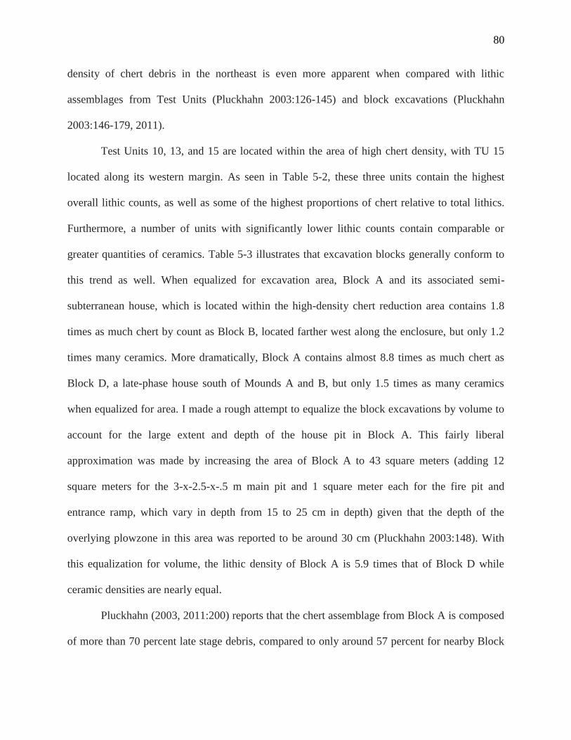
80
density of chert debris in the northeast is even more apparent when compared with lithic
assemblages from Test Units (Pluckhahn 2003:126-145) and block excavations (Pluckhahn
2003:146-179, 2011).
Test Units 10, 13, and 15 are located within the area of high chert density, with TU 15
located along its western margin. As seen in Table 5-2, these three units contain the highest
overall lithic counts, as well as some of the highest proportions of chert relative to total lithics.
Furthermore, a number of units with significantly lower lithic counts contain comparable or
greater quantities of ceramics. Table 5-3 illustrates that excavation blocks generally conform to
this trend as well. When equalized for excavation area, Block A and its associated semi-
subterranean house, which is located within the high-density chert reduction area contains 1.8
times as much chert by count as Block B, located farther west along the enclosure, but only 1.2
times many ceramics. More dramatically, Block A contains almost 8.8 times as much chert as
Block D, a late-phase house south of Mounds A and B, but only 1.5 times as many ceramics
when equalized for area. I made a rough attempt to equalize the block excavations by volume to
account for the large extent and depth of the house pit in Block A. This fairly liberal
approximation was made by increasing the area of Block A to 43 square meters (adding 12
square meters for the 3-x-2.5-x-.5 m main pit and 1 square meter each for the fire pit and
entrance ramp, which vary in depth from 15 to 25 cm in depth) given that the depth of the
overlying plowzone in this area was reported to be around 30 cm (Pluckhahn 2003:148). With
this equalization for volume, the lithic density of Block A is 5.9 times that of Block D while
ceramic densities are nearly equal.
Pluckhahn (2003, 2011:200) reports that the chert assemblage from Block A is composed
of more than 70 percent late stage debris, compared to only around 57 percent for nearby Block
81
Table 5-2: Coastal Plain chert and clear quartz as proportions of total lithics from Test Units
Table 5-3: Swift Creek and Coastal Plain chert as proportions of total ceramics and total lithics, respectively, from excavation blocks
Test Unit Area (sq. meters) Total Lithics (N) Total Lithics (g) CP Chert (N) CP Chert (g) % CP Chert (N) % CP Chert (g) % Chert Late Debris (N) Clear Quartz (N) Clear Quartz (g) % Clear Quartz (N) % Clear Quartz (g)
1 4 85 N/A 40 N/A 47.1 N/A 70.0 43 N/A 50.6 N/A
2 2 102 N/A 39 N/A 38.2 N/A 64.1 59 N/A 57.8 N/A
3 2 167 N/A 58 N/A 34.7 N/A 70.7 100 N/A 59.9 N/A
4 2 68 N/A 55 N/A 80.9 N/A 60.0 12 N/A 17.6 N/A
5 2 4 N/A 2 N/A 50.0 N/A 50.0 2 N/A 50 N/A
6 2 275 N/A 105 N/A 38.2 N/A 65.7 160 N/A 58.2 N/A
7 2 391 N/A 237 N/A 60.6 N/A 73.0 118 N/A 30.2 N/A
8 4 28 113 20 64 71.4 56.6 50.0 4 18 14.3 15.9
9 2 473 989 335 781 70.8 79.0 71.0 132 148 27.9 15.0
10 2 2,155 2,304 1,855 1,900 86.1 82.5 77.1 289 368 13.4 16.0
11 2 29 99 19 82 65.5 82.8 57.9 10 17 34.5 17.2
12 4 7 11 4 2 57.1 18.2 100.0 3 9 42.9 81.8
13 2 2,704 2,126 2,580 1,901 95.4 89.4 71.3 117 182 4.3 8.6
14 2 504 792 281 368 55.8 46.5 70.1 208 311 41.3 39.3
15 2 942 1,273 747 974 79.3 76.5 66.9 184 275 19.5 21.6
16 4 129 208 62 132 48.1 63.5 71.0 63 70 48.8 33.7
17 2 332 559 145 273 43.7 48.8 61.4 181 268 54.5 47.9
18 4 579 2,132 455 1,312 78.6 61.5 59.6 105 507 18.1 23.8
19 2 26 20 25 19 96.2 95.0 80.0 1 1 3.8 5.0
20 1 153 259.0 97 163.8 63.4 63.2 N/A 31 69.2 20.3 26.7
21/23 2 200 207.0 105 121.1 52.5 58.5 N/A 76 69.9 38 33.8
22 2 59 251.0 29 214.7 49.2 85.5 N/A 23 28.3 39 11.3
24 2 23 18.6 10 5 43.5 26.9 N/A 5 3.3 21.7 17.7
25 2 198 277.0 85 124.8 42.9 45.1 N/A 97 125.7 49 45.4
Excavation Block Area (sq. meters) ID Ceramics (N) ID Ceramics (g) Swift Creek (N) Swift Creek (g) % Swift Creek (N) % Swift Creek (g)
A 29 7,914 48,286.4 3,067 18,808.1 38.8 39.0
B 12 2,735 13,698.0 915 4078.0 33.5 29.8
D 52 9,272 50,111.4 892 4754.9 9.6 9.5
Excavation Block Area (sq. meters) Total Lithics (N) Total Lithics (g) CP Chert (N) CP Chert (g) % CP Chert (N) % CP Chert (g) % Chert Late Debris (N)
A 29 32,899 38,942.0 27,121 30,985.0 82.4 79.6 76.0
B 12 7,641 9,025.0 6,099 6,682.0 79.8 74.0 62.9
D 52 6,696 12,707.8 5,265 10,341.9 78.6 81.4 60.6
82
B and 55 percent for Block D, which he interprets as evidence for greater residential stability. In
light of the disparity between Block A and other excavations in terms of quantity of chert and the
relative proportion of late stage debris, I interpret this portion of the village as a discrete tool
production area. The association of high-intensity tool production with a house suggests a large
portion of this activity was tied to a single household or group of households; given the nearly
200 meter extent of the high-density chert distribution, I favor the later. A similar pattern in the
organization of stone tool production is described for the contemporaneous McKeithen site in
northern Florida (Johnson 1987). Johnson (1987) argues that specialized biface production
followed changes in McKeithen’s population, evident in the spatial clustering of late -stage lithic
debitage as well as heat treated and hinged flakes during the height of McKeithen’s occupation.
The distribution of quartz revealed exploitation of the material occurred throughout the
site, including village and near-mound contexts, and that production was focused on expedient
flake and core tools. A number of technological factors may have predisposed Kolomoki’s
inhabitants to use, and perhaps favor, quartz flake tools for certain activities. Quartz generally
occurs in smaller nodules than chert, therefore chert may have been reserved for flake blanks and
larger flake tools. The recovery of a Late Woodland triangular point made of milky quartz from
the surface in the vicinity of Mound G suggests that nodule and flake size was probably a
limiting factor in the use of quartz for more formal tools requiring extensive modification. Late
Woodland triangular points are much smaller than most other projectile point types, making
them possible to produce with quartz blanks unlike other, larger points. Also, due to angular
cleavage planes of individual crystals, quartz flakes and angular debris usually contain sharp
edges and protrusions uninterrupted by the cortex and fossil inclusions that characterize most
lower-quality Coastal Plain cherts (see Figures 4-39 and 4-40), making them ideal for flake tools
83
and engravers with little need for modification. The data presented in Table 5-2 show that quartz
made up a far greater proportion of the overall lithic assemblage in certain areas of the site than
originally expected, providing further contrast between the economic activities engaged in by
people living in those parts of the village and those engaging in chert tool production in the
northeast of the site. The lithic assemblages of some units exceed 50 percent quartz by count,
well above the roughly 25 percent for the shovel test assemblage.
The 200 meter arc of milky quartz debris along the southwest enclosure discussed above
conforms to a pattern suggestive of a group of households or other large activity area;
excavations along the eastern wing of the arc (West forthcoming) have produced evidence for
some degree of occupation. Notably, the southwestern portion of the site was initially sampled
though surface collections rather than shovel tests, potentially privileging the collection of cores,
though the patterning of this feature suggests it is not simply a product of survey methods. I
tentatively characterize the arc as an area of intensive quartz core reduction, but further work will
be required to corroborate my interpretation. A significant portion of the lithic assemblage from
shovel tests in the southeastern area of the village also consisted of milky quartz, though without
the formal patterning seen in the southwestern arc. As with the northeastern and southwestern
activity areas, the southeastern segment also measures roughly 200 meters.
As discussed previously, the use of milky quartz is largely restricted to the southern areas
of the site, presenting the possibility that the southwestern and southeastern portions of the
village were linked in some way, despite their relatively discrete clustering and separation from
one another. A north-south duality is present in the mound symbolism at Kolomoki: the southern
half of the summit of Mound A rises about 3 feet higher than the northern half, while the main
burial mound, Mound D contains evidence for different colored soils being used in northern and
84
southern halves of its fill (Pluckhahn 2003:89). Radiocarbon dates indicate that the village at
Kolomoki continued to be occupied after the bulk of mound construction activities ceased;
however, the village may have been organized according to the same logic of duality, perhaps
related to a reciprocal moiety that crosscut social and kin divisions, as seen in other large villages
(Tuzin 2001). For instance, Johnson (1987:40) suggests lineage or moiety organization of lithic
production at nearby McKeithen.
The northwestern portions of the village and areas east of Mound A did not exhibit any
unique patterns in their lithic or ceramic assemblages that suggest economic differentiation,
though poor preservation of organics, heavy agricultural disturbance, and erosion prevent the
identification of more ephemeral activity areas, such as those associated with working wood,
bone, or even pottery production.
The spatial organization of divergent lithic assemblages throughout the village points to
economic differentiation between discrete habitation clusters along the generalized arc of the
village outlined by the enclosure. I interpret this pattern as evidence for the presence of multiple
distinct corporate groups, possibly based on extended households, lineages, or clans within the
community at Kolomoki, as has been argued for other communities of similar scale (Birch 2012;
Flannery 2002; Gilman and Stone 2013; Hayden et al. 1996; Johnson 1987; Rautman 2014;
Schachner 2010; Smith 2015; Wilson 2008; Wilson et al. 2006). Though the definition of a
household remains somewhat fluid regarding patterns of co-residence and habitation, its function
as a society’s basic economic unit is well attested (Cobb and Nassaney 2002; Flannery 1994;
Pluckhahn 2010a; Wesson 2008; Wilk and Rathje 1982).
Pluckhahn (2011, 2015) interprets emergence of individualized household economies as a
major factor of the Late Woodland to Early Mississippian transition in the Southeast. He
85
suggests that this shift coincided with the decline of rituals organized around extended kin
groups, clans, and other corporate social formations that characterized Woodland period
ceremonialism. While the evidence presented here suggests that corporate groups at Kolomoki
experienced some degree of economic differentiation, they also probably cooperated in the
execution of communal rituals. Spielmann (2008) interprets Middle Woodland ceremony among
the Hopewell of the Ohio River Valley as similarly organized, postulating that segmented
enclosures may represent the cooperation of multiple corporate groups. Many of the dates
recovered from village contexts at Kolomoki post-date the bulk of mound construction at the
site; however, the organization of corporate residential clusters around the central mound group
reflects a shared sense of community articulated through symbolism and ceremony, a feature
commonly associated with aggregate communities (Cohen 1985; Gilman and Stone 2013;
Kowalewski 2006).
The continuing focus on communal ritual provides the context for an interpretation of
household activities that transcends concerns of subsistence. As discussed in the introduction to
this research, quartz is often viewed as a symbolically charged material (Warren and Neighbor
2004; Whitley 1991), especially in Woodland-period North America where it is associated with
Hopewell ritual deposits (Carr and Chase 2005) and Swift Creek sites (Jones et al. 1998; Keith
2010; Pluckhahn 2003; Williams and Harris 1998). The close proximity of Kolomoki to deposits
of Coastal Plain chert raises the possibility that the inclusion of quartz in village lithic
assemblages is not adequately explained purely in terms of the domestic subsistence economy,
but instead reflects the investment of Kolomoki’s inhabitants in the ritual economy associated
with communal ceremony (Spielmann 2002; Wells 2006, 2012; Macannany and Wells 2008).
Lithic flake tools commonly saw use in a variety of mortuary and ritual activities (Miller 2014;
86
Odell 1994), but the dearth of formal quartz tools like bladelets and minimal evidence for use-
wear make characterizing the function of quartz at Kolomoki difficult. Furthermore, I have
previously outlined a number of attributes that may have made quartz an attractive technological
choice in contrast to chert, though technological preference and symbolic power are not mutually
exclusive reasons for the selective use of a material. In addition to quartz, the domestic
assemblages at Kolomoki generally contain other materials commonly associated with
communal mortuary ceremony in the Woodland period, including elaborate ceramics, some
decorated using intricately carved paddles, and mica (Pluckhahn 2003, 2011; Sears 1956).
Consideration of the production of these other symbolically charged artifacts may help to
contextualize the use of quartz and Kolomoki’s ritual economy in general.
Previous work examining the production of Weeden Island ceramic types at Kolomoki
revealed limited evidence for specialization, largely restricted to prestige vessels and those from
mound contexts, while production of utilitarian vessels do not seem to have been specialized
(Laforge 2012). Pluckhahn and Cordell (2011) also interpret the production of sacred and
prestige Weeden Island wares as being specialized at the community level, evident in the wide
geographic dispersion of vessels made from clays local to Kolomoki, but again, their
interpretation of specialization in the production of utilitarian ceramics is more equivocal.
Pluckhahn (2007) has documented a similar divergence in the symmetry of Swift Creek vessel
designs from mound and non-mound contexts. Swift Creek pots from domestic contexts at
Kolomoki exhibit less symmetry in their designs than those found in or near mounds (Pluckhahn
2007). Recent work by Smith and Knight (2012, 2014) indicates that many Swift Creek paddle
designs used a number of reference points to maintain symmetry, which in addition to structuring
specific design elements, may have provided useful waypoints during the execution of the design
87
on the paddle itself. The central technological requirement for Swift Creek paddle production is
simply a blade or graver sharp enough to accurately follow a traced design, though the presence
of a corpus of design principals suggests that production of symmetrical designs may have
required specialized knowledge, if not specialized technology. Conversely, Spielmann (2009)
notes that household production of mica cut-outs among Hopewell craft producers would have
required little technical skill beyond the artistry inherent in drawing the initial design. Mica
content of excavations within the village is presented in Table 5-4. The requirement of sharp and
resilient flake tools for cutting mica and engraving paddle designs among other activities may
have precipitated the use of quartz to supplement the more generalized chert technology (see
Pluckhahn 2003:104).
I performed a linear regression to test the relationship between mica by weight (in grams)
and quartz by count from Test Units and excavation blocks. The use of counts for quartz was due
to a lack of weight data for quartz from Test Units 1-7. The results of this analysis, presented in
Table 5-5, show that quartz and mica are strongly correlated and exhibit a fairly strong positive
relationship. The linear regression model is represented by the fit line in Figure 5-1. However,
the patterned distribution of residuals presented in Figure 5-2 suggests that an additional variable
may be missing from the model which accounts for a significant portion of variation. The
addition of Swift Creek ceramics by count, another artifact class strongly correlated with quartz,
as an independent variable did not strengthen the regression model and in fact caused the
adjusted R-squared value to decrease. However, the classification of proveniences by proximity
to village or mound areas of Kolomoki strengthened the model slightly (see Table 5-5),
indicating the relationship between quartz and mica also has a spatial component.
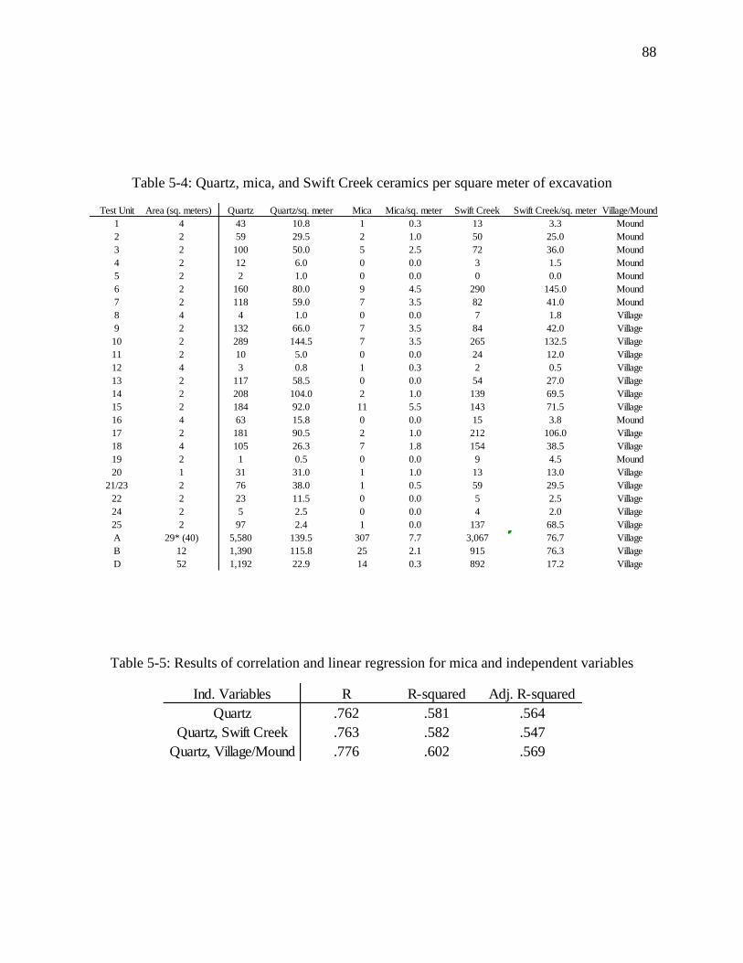
88
Table 5-4: Quartz, mica, and Swift Creek ceramics per square meter of excavation
Table 5-5: Results of correlation and linear regression for mica and independent variables
Test Unit Area (sq. meters) Quartz Quartz/sq. meter Mica Mica/sq. meter Swift Creek Swift Creek/sq. meter Village/Mound
1 4 43 10.8 1 0.3 13 3.3 Mound
2 2 59 29.5 2 1.0 50 25.0 Mound
3 2 100 50.0 5 2.5 72 36.0 Mound
4 2 12 6.0 0 0.0 3 1.5 Mound
5 2 2 1.0 0 0.0 0 0.0 Mound
6 2 160 80.0 9 4.5 290 145.0 Mound
7 2 118 59.0 7 3.5 82 41.0 Mound
8 4 4 1.0 0 0.0 7 1.8 Village
9 2 132 66.0 7 3.5 84 42.0 Village
10 2 289 144.5 7 3.5 265 132.5 Village
11 2 10 5.0 0 0.0 24 12.0 Village
12 4 3 0.8 1 0.3 2 0.5 Village
13 2 117 58.5 0 0.0 54 27.0 Village
14 2 208 104.0 2 1.0 139 69.5 Village
15 2 184 92.0 11 5.5 143 71.5 Village
16 4 63 15.8 0 0.0 15 3.8 Mound
17 2 181 90.5 2 1.0 212 106.0 Village
18 4 105 26.3 7 1.8 154 38.5 Village
19 2 1 0.5 0 0.0 9 4.5 Mound
20 1 31 31.0 1 1.0 13 13.0 Village
21/23 2 76 38.0 1 0.5 59 29.5 Village
22 2 23 11.5 0 0.0 5 2.5 Village
24 2 5 2.5 0 0.0 4 2.0 Village
25 2 97 2.4 1 0.0 137 68.5 Village
A 29* (40) 5,580 139.5 307 7.7 3,067 76.7 Village
B 12 1,390 115.8 25 2.1 915 76.3 Village
D 52 1,192 22.9 14 0.3 892 17.2 Village
Ind. Variables R R-squared Adj. R-squared
Quartz .762 .581 .564
Quartz, Swift Creek .763 .582 .547
Quartz, Village/Mound .776 .602 .569
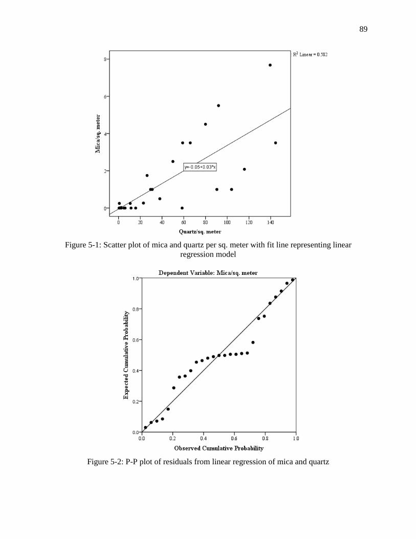
89
Figure 5-1: Scatter plot of mica and quartz per sq. meter with fit line representing linear
regression model
Figure 5-2: P-P plot of residuals from linear regression of mica and quartz
90
According to Costin (1991), the small scale of part-time household craft production is
such that specialization is not always present, especially for utilitarian items. However, even
relatively elaborate ceramics such as red-filmed Weeden Island wares and the bulk of Swift
Creek pottery were seemingly intended for utilitarian purposes and are found in domestic context
throughout Kolomoki’s village. Furthermore, the large extent of economically differentiated
village segments identified here suggests that production of formal chert tools and quartz cores
and flakes was organized beyond the household scale. This may reflect a pattern similar to the
community specialization argued by Pluckhahn and Cordell (2011) for Weeden Island ceramics,
but at the scale of large corporate groups rather than the entire village.
In the case of Kolomoki’s lithic assemblage, specialization needs to be decoupled from
its connotations of full-time production and skill represented in the creation of well-made
objects. Specialization can privilege quantity of production over quality, in which case skill
would be represented by prodigious amounts of reduction debris, such as in Kolomoki’s
northeastern village cluster. Costin (1991:16) attributes efficient, routinized production to full-
time craft producers; however, the spatial extent of economically differentiated domestic areas I
have identified suggests production involved multiple households and included more of the
population than a few full-time producers. Hirth (2009) specifically questions the validity of
part- and full-time production as useful categories for the characterization of domestic craft
production, and suggests archaeologists focus on craft production in the context of the overall
domestic economy instead of simply the amount of time spent on craft production itself.
Research on domestic craft specialization in Mesoamerica has demonstrated crafting was
generally performed as a part-time activity and served as a means of diversifying household
economies that could be intensified or scaled down in response to household needs and market
91
opportunity (Hirth 2009). Of course, Kolomoki’s domestic economies likely differed
significantly from those in Mesoamerica based on the lack of evidence for intensive agriculture
(Pluckhahn 2003:45); however, Kolomoki’s function as a regional ceremonial center probably
brought visitors from distant locations, creating the high proportion of consumers to producers
characteristic of Mesoamerican market economies (Hirth 2009:19-20).
While lithic debitage patterning indicates spatially distinct production areas, the presence
of most varieties of lithic material in domestic contexts outside specific production zones
potentially represents intergroup exchange at Kolomoki. Domestic clusters at Kolomoki may
have been economically interdependent. Alternatively, as suggested by Pluckhahn and Cordell
(2011) for Weeden Island pottery, lithic production at Kolomoki may have also been geared
towards the preparation of formal tools, flake tools, and cores as commodities for exchange
outside the community. Sears (1956:27) notes that finished projectile points at Kolomoki are
relatively scarce, which when compounded with the high density chert tool production I
identified in the northern section of the village, indicates the production of chert tools for
consumption elsewhere. Recent research suggests that projectile points become scarcer in
contexts of population increase and aggregation as subsistence regimes rely less on large game
due to increased pressure on game stocks (Arakawa et al. 2013). With this in mind, the large
amount of chert tool production debris at Kolomoki becomes even more conspicuous. The
Chattahoochee Valley north of Kolomoki is largely devoid of chert outcrops, though some has
been recovered from sites in the area as a supplement to more coarse-grained materials (Price et
al. 2008). Quartz and chert are naturally scarce in much of northwestern Florida, but quartz
occurs in assemblages from sites in the region, occasionally in association with mica debris
(Jones et al. 1998), indicating it may have been used for the production of ritual and mortuary
92
items outside Kolomoki as well. Kolomoki was ideally placed to facilitate exchange in lithic
materials to the north and south along the Chattahoochee and Apalachicola Rivers.
Economic differentiation among domestic clusters at Kolomoki may have also served to
maintain social boundaries between these groups as distinct communities of practice. In her
analysis of domestic craft specialization in the late prehistoric American Southwest, Mills (2007)
notes that diverse domestic economies associated with craft production served as a means for
social groups within aggregate villages to maintain and re-create particular identities. Household
craft production of both utilitarian and non-utilitarian items is also present at other Woodland
period civic-ceremonial centers in the Southeast such as Crystal River (Blankenship 2013;
O’neal forthcoming) and among communal longhouses of the American Northwest (Smith
2015). Whether a function of distinguishing class or other forms of social identity, the
widespread pattern of economic differentiation and particularly household craft specialization
within large prehistoric communities may be a natural outgrowth of the “coalescent society”
(Kowalewski 2006) as social groups within these aggregate societies seek to maintain or create
unique identities. Within this context, the community of practice serves as the theoretical bridge
between economic and social differentiation.
The juxtaposition of economically and socially distinct corporate groups possibly
engaged in regional exchange and communal ritual practice recalls the fundamental tension
between public expressions of social solidarity and community and private expressions of
individual and group status that have characterized recent interpretations of Kolomoki
(Pluckhahn 2003, 2007; 2010b). Local and extralocal exchange may have conferred social
prestige on commodity producers. Those same producers and ritual practitioners also stood to
gain from contributions to, and organization of, large ceremonies, as suggested for other
93
communities organized around communal ritual (Gilman and Stone 2013; Harrison 1985;
Pluckhahn 2003; Schachner 2010; Tuzin 2001). The mobilization of labor towards particular
aspects of the ritual and exchange economies by corporate groups afforded multiple paths to
social aggrandizement and may have fostered competition even as ceremonies nominally
reinforced social cohesion and integration (Pluckhahn 2003, 2007, 2010b), in essence a system
of heterarchy (Carballo et al. 2014; Crumley 1979, 1995). Wallis (2011, 2013) places
competition between corporate groups at the foreground of his interpretation of exchange in
Swift Creek ceramics, which he characterizes as representations of social identities and personae.
The exchange and burial of Swift Creek pots containing distinctive designs constituted indices of
social interactions and obligations between individuals and groups; however, these exchanges
occurred within the context of social and economic alliances and the movement of marriage
partners between groups (Wallis 2011, 2013). In light of this, recent syntheses of the Woodland
Period Southeast have perhaps incorrectly represented interpretations of communalism and
competition as mutually exclusive (Anderson and Sassaman 2012:141-142).
The reinterpreted chronology of Kolomoki’s village occupation begs the question of
association between the village and mounds. Many of the earliest features of the burial mounds
composing the central axis of the site (Mounds D, and E) were presumably constructed before
the village. Previous work at Kolomoki has detailed the chronology of mound construction and
their contents (Pluckhahn 2003; Sears 1956). Mound E is interpreted by Pluckhahn (2003:66) as
being perhaps one of the earliest constructions at Kolomoki, dated to roughly A.D. 430 to 540.
Its central interments were placed in a shaft below the base of the mound, with an arrangement of
stones surrounding the burial shaft. The remainder of the mound was subsequently constructed in
multiple stages incorporating secondary interments and a cache of pottery vessels placed on the
94
mound’s eastern side (Pluckhahn 2003; Sears 1956). Mound D, the other main burial mound
located near the center of the site, articulates with the central axis bookended by Mounds A and
E. The earliest phases of Mound D’s construction consist of a sub-mound midden dating to
around A.D. 350-420 (Pluckhahn 2003:64) and log- or rock-lined graves capped by the first
mound phase. Subsequent interments show evidence for differing forms of burial treatment,
including numerous isolated skulls and other body parts, sometimes paired with grave goods,
indicating secondary burial. Mounds D and E contain east-side pottery caches containing
elaborate effigy vessels similar to those found at other Weeden Island sites (Milanich et al.
1997). At the eastern end of the site’s central axis sits Mound A; its massive size and the
compaction of its clay layers has precluded intensive excavation, exceptions being relatively
small units by Palmer (1884) and Sears (1956). Pluckhahn (2003:58) estimates its final
construction episode as occurring A.D. 450 to 550 based on the small ceramic assemblage
recovered by Sears. Another small mound, Mound K, is interpreted by Pluckhahn (2003, 2007)
to articulate with the central axis. Excavated by Charles Fairbanks prior to its destruction, the
mound was located east of Mound A along Little Kolomoki Creek and was apparently inundated
as it was being excavated. It may have contained submound burials. A small ceramic assemblage
has led Pluckhahn (2003:72) to suggest an early date for its construction.
A secondary axis to the south consisting of mounds F, G, and H mirrors the orientation of
the central axis. Mound F, bracketing the western end of the southern axis is characterized as a
low platform mound containing late Weeden Island ceramics (Pluckhahn 2003:67). Nearby
Mound G has never been excavated due to the placement of a historic cemetery on its summit.
Pluckhahn (2003:67) suggests that Mound G may date early, within the interval of his Kolomoki
I phase (A.D. 350-450) due to its association with the enclosure, but the ceramic assemblage
95
from Unit 24 and new radiocarbon dates from the southern enclosure instead place Mound G
later in the site’s chronology. Capping the eastern end of the southern axis is Mound H, a short,
broad mound containing no burials, but a significant number of post-molds beneath the mound
and evidence of extensive burning on its summit, perhaps indicating it served as the foundation
of a charnel facility (Larson 1952). Radiocarbon dating of a submound feature has placed the
construction and use of Mound H at around A.D. 650-690 (Pluckhahn 2003:69), roughly
contemporaneous with the abandonment of the Block A house and the occupation of the southern
village arc.
The presence of a secondary mound axis in use at the time of the village’s occupation
complements the interpretation of social and economic differentiation occurring at Kolomoki
during this late interval. Mounds F and H of the secondary mound axis are offset roughly south
of Mounds E and D, respectively (Pluckhahn 2003:87), signaling that the builders of the
secondary axis intended it to articulate with the main axis in some fashion, perhaps as an
elaboration upon existing ritual space or a competing arena for ceremony. Pluckhahn (2003:88)
proposes that the southern mounds may have been placed in relation to alignments with the
central mounds and celestial events; Mounds F and D are aligned at 63 degrees, approximating
the angle of the rising sun on the summer solstice (Pluckhahn 2003:88). Inhabitants of
Kolomoki’s later village may have purposefully established the secondary mound axis with
explicit relationships to the central axis to appropriate earlier monuments as emblems of the past
into their own symbolic expression of attachment to the landscape (Clark 2004; Cobb and
Nassaney 2002; Sassaman and Heckenburger 2004; Sassaman 2005). I speculate that rituals
conducted on or near the southern mounds, especially possible charnel activity on Mound H
96
could have been related to the continuing use of Mound D for burial due to the lack of a burial
mound on the southern axis.
While the village is organized such that it is essentially bisected by the central mound
axis (Pluckhahn 2003:88), the placement of the secondary mound axis in such close proximity to
the southern section of the village hints that corporate groups or ritual practitioners in the south
may have used the mounds’ construction as a means of exercising greater control over ceremony.
Parallels can be made with Moundville, a Mississippian Period mound center in Alabama, which
contained a village consisting of spatially discrete habitation areas with corresponding sets of
earthworks, interpreted as evidence for competition between lineages and clans (Marcoux and
Wilson 2010; Wilson 2008; Wilson et al. 2006, see also Boudreaux 2013). Similarly, Martin
(2005) interprets different mortuary layouts in the Lower Illinois Valley Hopewell as
representative of conflict between ideologically opposed factions.
The abandonment of the Block A house, occupation of the southern village arc, and
construction of Mound H all curiously coincide with a major shift in settlement along the
Chattahoochee River towards the south (Pluckhahn 2003:40-46, 212-213). I find a major
settlement shift in the region reflected in the residential and ceremonial pattern of Kolomoki
unsurprising. As mentioned previously, Pluckhahn (2003:46) posits that Kolomoki marked a
social boundary between groups inhabiting opposite ends of the Lower Chattahoochee River.
Aspects of mound symbolism, village organization, and distribution of certain aspects of the
lithic assemblage reflect a north-south duality, indicating that Kolomoki may have served as a
diagram for the social arrangement of the Chattahoochee Valley. Correspondingly, a shift in
settlement along the valley would have likely led to a reorganization of the site itself and perhaps
97
vice-versa if ritual mediation between participating groups became insufficient to resolve
tensions.
The above reinterpretation of Kolomoki’s village and the social dynamics acting upon it
refines that provided by Pluckhahn (2003, 2010b) by placing greater emphasis on social
heterogeneity and a differentiated economy involving production for exchange and ritual.
Furthermore, my radiocarbon dates from the southern village have placed the chronology of
village formation at Kolomoki over a century later than previously thought. Finally, ceramic
assemblages recovered from excavations in the southern village indicate the ceramic chronology
of Kolomoki needs to be reconsidered. The early centuries of Kolomoki’s history, characterized
by massive monumental constructions, likely centered on creation of fictive kin relationships
through the communal veneration of ancestors (Hall 1979, 1997), evident in the position of the
shaft tomb under Mound E (Pluckhahn 2003). Shaft burials bear symbolic links to Southeastern
Indian beliefs in the origins of the world and the emergence of humans from within the earth
(Gibson 2004:261-263; Grantham 2002; Swanton 1927). The placement of these individuals
underneath communal mortuary facilities may represent their mythical status as founding
members of the community, venerable ancestors, and symbolic “first people” (Hall 1979, 1997).
As Pluckhahn (2003, 2010b) suggests, later phases of Kolomoki, now characterized by
the habitation of the large, arc-shaped village, witnessed greater social and economic
differentiation, perhaps related to the ritual economy of communal ceremony. Burials in
corporate mortuary facilities (Mounds D and E) along the site’s main axis may have continued
during this time, though the construction of the secondary mound axis with Mound H as a
charnel facility near the southern segments of the village articulates well with my interpretation
of increasing social distinction, competition, and elaboration of ritual. Despite this trend towards
98
increasing social differentiation, economic and status distinctions in the village seem to have
been horizontal rather than hierarchical. This is typical of early villages elsewhere (Birch 2012;
Crumley 1979, 1995; Flannery 2002; Gilman and Stone 2013; Hayden et al. 1996; Harrison
1985; Schachner 2010; Smith 2015; Tuzin 2001), and likely reflects the continued recognition of
a shared identity by the greater community. Apparently this period of habitation along the ovular
village plan was relatively short-lived; only a few generations later, the site was occupied by
dispersed, relatively autonomous households and mound construction had ceased (Pluckhahn
2011, 2015).
99
Chapter 6 - Applications and Future Directions
This reassessment of Kolomoki’s social and economic organization and chronology has
generated numerous additional questions and has potential applications outside of its
contribution to academia.
Applications
The Kolomoki Mounds State Park museum still reflects Sears’s half-century-old
interpretation of the site and is in sore need of updating. The conclusions presented here and in
forthcoming reports and publications can surely be used to provide a more contemporary
interpretation of the site’s chronology and the relationship of the village to the mounds. As a
more complete understanding of Kolomoki’s village emerges from this and subsequent research
(West forthcoming), efforts will be made to prepare alternative interpretive materials for the state
park. Unfortunately, the placement of our recent excavations on private property to the south of
the state park has precluded most public outreach activities in the field; however, the state park
and the Society for Georgia Archaeology present outlets for dissemination of this research
through public lectures and presentations. As part of the Society for Georgia Archaeology’s
generous funding for this project, they have also provided a place to publish my findings in their
journal Early Georgia, which serves an academic and avocational audience. Finally, we have
created a facebook page to further facilitate dissemination of this research and promote public
engagement.
100
Future Directions
This research has provided valuable insight into the nature of Kolomoki’s village, yet
certain questions remain for future projects. The first of these is a reassessment of the existing
ceramic chronology for Kolomoki. Excavations in the southern village have revealed that Swift
Creek pottery still composed the vast majority of decorated ceramics in some domestic contexts
after A.D. 700, well into the late phases of occupation defined by Pluckhahn (2003).
Furthermore, radiocarbon dates from the southern village where Swift Creek ceramics
predominate correspond well with the date produced by Pluckhahn’s (2003:19, 2011:179-180)
Test Unit 18, which contained lower proportions of Swift Creek pottery and numerous Weeden
Island series ceramics. I speculate that to some degree, differential patterning in Swift Creek and
Weeden Island-dominated assemblages may reflect different activities rather than different
temporal contexts. More work and more radiocarbon dates will be needed to test this hypothesis.
Additionally, my use-wear study of quartz tools was admittedly lacking in scope. A more
systematic approach to use-wear analysis of Kolomoki lithic materials could rectify this and
perhaps test my conclusions regarding lithic technological organization.
101
Chapter 7 - Conclusion
The research presented above fundamentally alters the interpretation of Kolomoki and
opens intriguing new lines of inquiry by identifying patterns of economic and social
differentiation and placing its village aggregation later in time than previously thought. My
analysis of the organization of lithic production at Kolomoki revealed evidence of economic
diversification in the form of craft production throughout the village. Discussion of economic
and social differences within Kolomoki’s village from the perspective of communities of practice
helps to integrate these two phenomena and places the household, the primary arena for situated
learning, at the center of identity formation and maintenance. Recognizing this link between
diversity in the domestic economies and social identities of Kolomoki’s residents situates this
important civic-ceremonial center within the broader context of coalescent societies
(Kowalewski 2006), allowing for Kolomoki’s inclusion in broader comparative research on the
topic.
The evidence for domestic craft production and exchange at Kolomoki also carries
implications for political organization. The identification of multiple economically and socially
differentiated domestic clusters indicates that lineages or perhaps some other form of extra-
household organization also factored in the organization of labor. Presumably, the influence of
lineages, clans, or some other social formation above the level of the household also extended to
the practice of communal ritual, given that the organization of domestic craft production also
seems to have extended to the production of mortuary items such as mica. In sum, the evidence
102
provided here paints Kolomoki as much more socially, politically, and economically diverse than
previous interpretations have recognized.
Finally, my reassessment of Kolomoki’s chronology is significant. While Sears (1956)
originally argued for the site’s Mississippian Period occupation and Pluckhahn (2003) placed the
village habitation in the late Middle Woodland Period, this project has shown that the bulk of
settlement at Kolomoki occurred in the Late Woodland Period. The Late Woodland Period in the
American Southeast is generally considered to be a time of transition between the pinnacle of
Woodland Period interaction and exchange exemplified by Hopewell expressions of the Ohio
and Mississippi Valleys and the fluorescence and spread of Mississippian cultural traits including
the corpus of iconography known as the Southeastern Ceremonial Complex (Anderson and
Sassaman 2012; Pluckhahn 2011). The occupation of a Late Woodland village of Kolomoki’s
size problematizes generalizations of the Late Woodland as a mere interval of transition between
periods of high cultural achievement and complexity.
Together, my findings and interpretation should be cause for a reconsideration of the
egalitarian social organization ascribed Woodland period societies. Political integration through
communal ritual does not necessarily require or indicate equality, and in fact the potential for
differential engagement with the economics and performance of communal ceremonies probably
points the opposite direction, a point which Pluckhahn (2003:204) acknowledged in his
interpretation of Kolomoki. This “fundamental tension” between communalism reinforced
through ritual practice and the desire for households, lineages, and other segments of Kolomoki’s
society to gain power, prestige, and influence was a central theme throughout his work
(Pluckhahn 2003, 2010b). Ultimately, however, I argue that competition and the desire for social

103
and economic distinction by segments of Kolomoki’s inhabitants was less subversive, and
instead an open fact of village life at Kolomoki.

104
References Cited
Amick, Daniel S., and Raymond P. Mauldin
1989 Comments on Sullivan and Rozen’s “Debitage Analysis and Archaeological
Interpretation. American Antiquity. 54(1): 166-168.
Anderson, David G.
1998 Swift Creek in a Regional Perspective. In A World Engraved: Archaeology of the Swift
Creek Culture. Mark Williams and Daniel T. Elliott, eds., pp. 274-300. University of
Alabama Press, Tuscaloosa.
Anderson, David G., and Kenneth E. Sassaman
2012 Recent Developments in Southeastern Archaeology: from Colonization to Complexity.
Society for American Archaeology Press, Washington, D.C.
Andrefsky, William Jr.
2005 Lithics: Macroscopic Approaches to Lithic Analysis. Second Edition. Cambridge
University Press, Cambridge.
Andrews, Bradford W., Timothy M. Murtha, Jr. and Barry Scheetz
2004 Approaching the Hatch Jasper Quarry From a Technological Perspective: A Study of
Prehistoric Stone Tool Production in Central Pennsylvania. Midcontinental Journal of
Archaeology. 29(1): 63-101
Arakawa, Fumiyasu, Christopher Nicholson, and Jeff Rasic
2013 The Consequences of Social Processes: Aggregate Populations, Projectile Point
Accumulation, and Subsistence Patterns in the American Southwest. American Antiquity.
78(1): 147-164.
Austin, Robert J.
1999 Technological Characterization of Lithic Waste-Flake Assemblages: Multivariate
Analysis of Experimental and Archaeological Data. Lithic Technology. 24(1): 53-68.
Bamforth, Douglas B.
1986 Technological Efficiency and Tool Curation. American Antiquity. 51: 38-50.
Bense, Judith A.
1998 Santa Rosa-Swift Creek in Northwest Florida. In A World Engraved: Archaeology
of the Swift Creek Culture, Mark Williams and Daniel T. Elliott., eds., pp.
222-246. University of Alabama Press, Tuscaloosa.
105
Benson, Robert W., Thomas J. Pluckhahn, and Scott Jones
2001 Phase II Test Excavations at Five Prehistoric Sites and Phase I Cultural Resources
Survey of a Service Road for the Proposed Bleckley County Public Fishing Lake, Pulaski
and Bleckley Counties, Georgia. Southeastern Archeological Services, Inc., Athens,
Georgia.
Birch, Jennifer
2012 Coalescent Communities: Settlement Aggregation and Social Integration in Iroquoian
Ontario. American Antiquity. 77(4): 646-670.
Binford, Lewis R.
1962 Archaeology as Anthropology. American Antiquity. 28(2): 217-225.
Blankenship, Beth
2013 The Hopewellian Influence at Crystal River, Florida: Testing the Marine Shell Artifact
Production Hypothesis. Graduate Theses and Dissertations, Department of Anthropology,
University of South Florida, Tampa, Florida.
Blitz, John H. and Karl G. Lorenz
2002 The Early Mississippian Frontier in the Lower Chattahoochee-Apalachicola River
Valley. Southeastern Archaeology. 21(2): 117-135
2006 The Chattahoochee Chiefdoms. University of Alabama Press, Tuscaloosa.
Boudreaux III, Edmond A.
2013 Community and Ritual within the Mississippian Center at Town Creek. American
Antiquity. 78(3): 483-501.
Bourdieu, Pierre
1977 Outline of a Theory of Practice. Cambridge University Press, Cambridge.
Bowser, Brenda J.
2000 From Pottery to Politics: An Ethnoarchaeological Study of Political Factionalism,
Ethnicity, and Domestic Pottery Style in the Ecuadorian Amazon. Journal of
Archaeological Method and Theory. 7(3): 219-248.
Brumfiel, Elizabeth M.
2004 Materiality, Feasts, and Figured Worlds in Aztec Mexico. In Rethinking
Materiality: The Engagement of Mind with the Material World, C. Gosden, C. Renfrew,
E. Demarrais, eds., pp. 225-237. McDonald Institute for Archaeological Research,
Cambridge.
Cane, Scott
1992 Aboriginal Perceptions of Their Stone Tool Technology: A Case Study. Australian
Archaeology. 35: 11-31
106
Capron, Louis
1953 The Medicine Bundles of the Florida Seminole and the Green Corn Dance. U.S.
Government Printing Office, Washington, D.C
Carballo, David M., Paul Roscoe, and Gary M. Feinman
2014 Cooperation and Collective Action in the Cultural Evolution of Complex Socieites.
Journal of Archaeological Method and Theory. 21: 98-133.
Carr, Christopher, and D. Troy Chase
2005 Gathering Hopewell: Society, Ritual, and Ritual Interaction. Kluwer Academic/Plenum
Publishers, New York.
Clark, John E.
2004 Surrounding the Sacred: Geometry and Design of Early Mound Groups as Meaning and
Function. In Signs of Power: The Rise of Cultural Complexity in the Southeast. Jon L.
Gibson and Philip J. Carr eds. pp. 164-213
Cobb, Charles R., and Michael S. Nassaney
2002 Domesticating Self and Society in the Woodland Southeast. In The Woodland Southeast,
edited by David G. Anderson and Robert C. Mainfort Jr., pp. 525-539. University of
Alabama Press: Tuscaloosa.
Cohen, Anthony P.
1985 The Symbolic Construction of Community. Routledge, London.
Costin, Cathy Lynne
1991 Craft Specialization: Issues in Defining, Documenting, and Explaining the
Organization of Production. Archaeological Method and Theory. 3: 1-56.
Cotterell, Brian and Johan Kamminga
1987 The Formation of Flakes. American Antiquity. 52: 675-708.
Crumley, Carole L.
1979 Three Locational Models: An Epistemological Assessment of Anthropology and
Archaeology. In Advances in Archaeological Method and Theory, vol. 2 edited by
M. B. Schiffer., pp. 141-173.
1995 Heterarchy and the Analysis of Complex Societies. Archaeological Papers of the
American Anthropological Association. 6: 1-5.
Dietler, Michael and Ingrid Herbich
1998 Habitus, Techniques, Style: An Integrated Approach to the Social Understanding of
Material Culture and Boundaries. In The Archaeology of Social Boundaries,
Miriam T. Stark, ed., pp. 232-263. Smithsonian Institution, Washington, D.C..
107
Dobres, Marcia-Ann
2000 Technology and Social Agency. Blackwell, Malden.
Dueppen, Stephen A.
2012 From Kin to Great House: Inequality and Communalism at Iron age Kirikongo, Burkina
Faso. American Antiquity. 77(1): 3-39.
Dunning, A. B.
1964 The Tallahatta Formation in Clarke County, Alabama. Journal of Alabama Archaeology.
10: 50-60.
Eckert, Suzanne L.
2008 Pottery and Practice: The Expression of Identity at Pottery Mound and
Hummingbird Pueblo. University of New Mexico Press, Albuquerque.
Fairbanks, Charles H.
1946 The Kolomoki Mound Group, Early County, Georgia. American Antiquity 11(4): 258-
260.
Flannery, Kent V.
2002 The Origins of the Village Revisited: From Nuclear to Extended Households. American
Antiquity. 67(3): 417-433.
Flannery, Kent V. and Joyce Marcus
1994 Early Formative Pottery of the Valley of Oaxaca. Memoirs vol. 27. Museum of
Anthropology, University of Michigan Press, Ann Arbor.
Gell, Alfred
1998 Art and Agency: An Anthropological Theory. Clarendon Press, Oxford.
Gibson, Jon L.
2004 The Power of Beneficent Obligation in first Mound-Building Societies. In Signs of
Power: The Rise of Cultural Complexity in the Southeast. Jon L. Gibson and Philip J.
Carr eds. pp. 254-269. University of Alabama Press, Tuscaloosa.
Gilman, Patricia A., and Tammy Stone
2013 The Role of Ritual Variability in Social Negotiations of Early Communities: Great Kiva
Homogeneity and Heterogeneity in the Mogollon Region of the North American
Southwest. American Antiquity. 78(4): 607-623.
Gosselain, Olivier P.
1992 Technology and Style: Potters and Pottery among Bafia of Cameroon. Man. 27: 559-586.
2000 Materializing Identities: An African Perspective. Journal of Archaeological Method
and Theory. 7(3): 187-217.
108
Grantham, Bill
2002 Creation Myths and Legends of the Creek Indians. University Press of Florida,
Gainesville
Hakenbeck, Susanne E.
2007 Situational Ethnicity and Nested Identities: New Approaches to an Old Problem.
Anglo-Saxon Studies in Archaeology and History. 14: 19-27.
Hall, Robert L.
1979 In Search of the Ideology of the Adena-Hopewell Climax. In Hopewell Archaeology: The
Chillacothe Conference, edited by D. S. Brose and N. Greber, pp. 258-265. Kent State
University Press, Kent.
1997 An Archaeology of the Soul: North American Indian Belief and Ritual. University of
Illinois Press, Urbana and Chicago.
Harrison, Simon J.
1985 Ritual Hierarchy and Secular Equality in a Sepik River Village. American
Ethnologist. 12(3): 413-426.
Hayden, Brian, Edward Bakewell, and Rob Gargett
1996 The World’s Longest-Lived Corporate Group: Lithic Analysis Reveals Prehistoric
Social Organization near Lillooet, British Columbia. American Antiquity. 61(2):
341-356.
Hegmon, Michelle
1992 Archaeological Research on Style. Annual Review of Anthropology. 21: 517-536.
1998 Technology, Style, and Social Practices: Archaeological Approaches. In The
Archaeology of Social Boundaries. Miriam T. Stark, ed., pp 264-280. Smithsonian
Institution Press, Washington, D.C.
Hirth, Kenneth G.
2009 Craft Production, Household Diversification, and Domestic Economy in Prehispanic
Mesoamerica. In Housework: Craft Production and Domestic Economy in Ancient
Mesoamerica. Kenneth G. Hirth ed., pp 13-32. Archaeological Papers of the American
Anthropological Association, No. 19. Wiley, Malden.
Hodder, Ian
2012 Entangled: An Archaeology of the Relationships between Humans and Things. Wiley-
Blackwell, Chichester.
Hudson, Charles
1976 The Southeastern Indians. University of Tennessee Press, Knoxville.
109
Janusek, John Wayne
2002 Out of Many, One: Style and Social Boundaries in Tiwanaku. Latin American Antiquity.
13: 35-61.
Johnson, Michael G.
1987 The Organization of Lithic Reduction at the North Floirda Weeden Island Period
McKeithen Site. American Antiquity. 6(1): 30-45.
Johnson, Jay K.
1993 Poverty Point Period Quartz Crystal Drill Bits from the Yazoo Basin, Mississippi.
Southeastern Archaeology. 12(1): 59-64.
Jones, Calvin B., Daniel T. Penton, and Louis D. Tesar
1998 1973 and 1994 Excavations at the Block-Sterns Site, Leon County, Florida. In A World
Engraved: Archaeology of the Swift Creek Culture. Mark Williams and Daniel T. Elliott,
eds., pp. 222-246. University of Alabama Press, Tuscaloosa.
Jones, Calvin B. and Louis D. Tesar
1996 Emergency Archaeological Salvage Excavation within the Swift Creek Subarea of the
Block-Sterns Site (8LE148), Leon County, Florida: A Public Archaeology Project.
Florida Archaeological Reports, Bureau of Archaeological Research, Division of
Historical Resources, Tallahassee, Florida.
Jones, Sian
1997 The Archaeology of Ethnicity. Routledge, London.
Keeley, Lawrence H.
1980 Experimental Determination of Stone Tool Uses: A Microwear Analysis. University of
Chicago Press, Chicago.
Keith, Scot J.
2010 Archaeological Data Recovery at the Leake Site, Bartow County, Georgia: Volume 1,
Final Report. Southern Research, Historical Preservation Consultants, Inc., Ellerslie,
Georgia. Submitted to Georgia Department of Transportation, Atlanta, Georgia.
Kidder, Tristam R.
2011 Transforming Hunter-Gatherer History at Poverty Point. In Hunter-Gatherer
Archaeology as Historical Process, Kenneth E. Sassaman and Donald H. Holly Jr, eds.,
pp. 95-119. University of Arizona Press, Tuscon.
Knight, Vernon James, Jr.
1990 Social Organization and the Evolution of Hierarchy in Southeastern Chiefdoms. Journal
of Anthropological Research. 46(1): 1-23.
110
Knutsson, Kjel
1988 Patterns of Tool Use: Scanning Electron Microscopy and Experimental Quartz Tools.
Societas Archaeologica Upsaliensis, AUN 10. Uppsala, Sweden.
Kowalewski, Stephen
2006 Coalescent Societies. In Light on the Path: The Anthropology and History of the
Southeastern Indians, Thomas J. Pluckhahn and Robbie Ethridge eds., pp. 94-122.
University of Alabama Press, Tuscaloosa.
Kuijt, Ian, William C. Prentiss, and David L. Pokotylo
1995 Bipolar Reduction: An Experimental Study of Debitage Variability. Lithic Technology.
20(2): 116-127.
Laforge, Travis
2012 Specialization in Small-Scale Societies: The Organization of Pottery Production at
Kolomoki (9ER1), Early County, Georgia. Unpublished Master’s thesis. Department of
Anthropology, University of South Florida, Tampa.
Larson, Lewis H.
1952 Unpublished Report Summarizing Excavations in Mound H, Kolomoki. On file at the
University of Georgia Laboratory of Archaeology, Athens.
Lave and Wenger
1991 Situated Learning: Legitimate Peripheral Participation. Cambridge University
Press, Cambridge.
Lemmonier, Pierre
1986 The Study of Material Culture Today: Toward an Anthropology of Technical
Systems. Journal of Anthropological Archaeology. 5:147-186.
Leroi-Gourhan
1964 Le Geste et la Parole. Tome I: Techniue et langage. Albin Michel, Paris
Lightfoot, Kent G., Antoinette Martinez, and Ann M. Schiff
1998 Daily Practice and Material Culture in Pluralistic Social Settings: An Archaeological
Study of Culture Change and Persistence from Fort Ross, California. American Antiquity.
63(2): 199-222.
Lloyd, J. R., Judith A. Bense, and J. L. Davis, Jr.
1983 Tallahatta Quartzite Quarries in the Escambia River Drainage. Journal of Alabama
Archaeology 29: 126-142.
111
Loubser, Johannes H. N.
2005 In Small Cupules Forgotten: Rock Markings, Archaeology, and Ethnography in the Deep
South. In Discovering North American Rock Art, Lawrence L. Loendorf, Christopher
Chippindale, and David S. Whitley, eds,. pp 131-160. University of Arizona Press:
Tuscon.
Marcoux, Jon Bernard, and Gregory D. Wilson
2010 Categories of Complexity and the Preclusion of Practice. In Ancient Complexities: New
Perspectives in Precolumbian North America, Susan M. Alt, ed., pp. 138-152.
University of Utah Press: Salt Lake City.
Mauss, Marcel
1934 Les techniques du corps. Journal de Psychologie, XXXII, ne, 3-4, 15 mars - 15 avril
1936.
Martin, Andrew
2005 Agents in Inter-Action: Bruno Latour and Agency. Journal of Archaeological Method
and Theory. 12(4): 283-311.
McAnany, Patricia A. and E. Christian Wells
2008 Toward a Theory of Ritual Economy: Dimensions of Ritual Economy. In Dimensions of
Ritual Economy, E. Christian Wells and Patricia McAnany, eds., pp. 1-16. Research in
Economic Anthropology, Vol 27.
Milanich, Jerald T., Ann S. Cordell, and Vernon J. Knight
1997 Archaeology of Northern Florida, A.D. 200-900: The McKeithen Weeden Island Culture.
University Press of Florida, Gainesville
Miller, Daniel
2010 Stuff. Polity Press, Cambridge
Miller, G. Logan
2014 Ritual, Craft, and Economy in Ohio Hopewell: An Examination of Two Earthworks on
the Little Miami River. Unpublished Ph.D. dissertation. Department of Anthropology,
Ohio State University, Columbus.
Mills, Barbara J.
2007 Multicrafting, Migration, and Identity in the American Southwest. In Craft Production in
Complex Societies: Multicraft and Producer Perspectives, Izumi Shimada ed., pp. 25-43.
University of Utah Press, Salt Lake City.
Minar, C. Jill and Patricia L. Crown.
2001 Learning and Craft Production: An Introduction. Journal of Anthropological
Research. 57(4): 369-380.
112
Mooney, James
1900 History, Myths, and Sacred Formulas of the Cherokees. Bright Mountain Books:
Ashville, NC.
Odell, George
1994 The Role of Stone Bladelets in Middle Woodland Society. American Antiquity. 59: 102-
120.
Ortner, Sherry B.
1984 Theory in Anthropology since the Sixties. Comparative Studies in Society and History.
26(1): 126-166.
Palmer, Edward
1884 Mercier Mounds, Early County, Georgia. Report prepared for the Bureau of Ethnology
Mound Survey, Smithsonian Institution. On file at the National Anthropological
Archives, American Museum of Natural History, Smithsonian Institution, Washington,
D.C.
Pauketat, Timothy R.
2001a A New Tradition in Archaeology. In The Archaeology of Traditions: Agency and History
before and after Columbus, edited by Timothy R. Pauketat, pp 1-16. University Press of
Florida, Gainesville
2001b Practice and History in Archaeology: An Emerging Paradigm. Anthropological Theory.
1(1): 73-98.
Pilkington, Jerry A.
1985 Soil survey of Calhoun and Early Counties, Georgia. United stetes Department of
Agriculture, Soil Conservation service, Washington, D.C.
Pluckhahn, Thomas J.
2003 Kolomoki: Settlement, Ceremony, and Status in the Deep South, A.D. 350 to 750.
University of Alabama Press, Tuscaloosa.
2007 Reflections on Paddle Stamped Pottery: Symmetry Analysis of Swift Creek Paddle
Designs. Southeastern Archaeology. 1-11.
2010a Household Archaeology in the Southeastern United States: History, Trends, and
Challenges. Journal of Archaeological Research. 18(4): 331-385.
2010b The Secular and the Sacred Revisited: The Essential Tensions of Early Village Society in
the Southeastern United States. In Becoming Villagers: Comparing Early Village
Societies, Matthew S. Bandy and Jake R. Fox, eds., pp 100-118. University of
Arizona Press: Tuscon.
113
2011 Households Making History: Household Change in the Late Woodland Period at
Kolomoki (9ER1). Department of Anthropology, University of South Florida, Tampa.
Submitted to Georgia Department of Natural Resources, Atlanta.
2015 Households Making History: An Eventful Temporality of the Late Woodland Period at
Kolomoki (9ER1). In The Archaeology of Events: Cultural Change and Continuity in the
Pre-Columbian Southeast, edited by Zackary I. Gilmore and Jason M. O’Donoughue, pp.
93-116. University of Alabama Press, Tuscaloosa.
Pluckhahn, Thomas J. and Ann S. Cordell
2011 Paste Characterization of Weeden Island Pottery from Kolomoki and its Implications for
Specialized Production. Southeastern Archaeology. 30(2): 288-310.
Pluckhahn, Thomas J., J. Matthew Compton, and Mary Theresa Bonhage-Freund
2006 Evidence of Small-Scale Feasting from the Woodland Period Site of Kolomoki, Georgia.
Journal of Field Archaeology. 31(3): 263-284.
Pluckhahn, Thomas J. and Sean P. Norman
2011 Typological, Functional, and Comparative Contextual Analyses of Woodland
Hafted Bifaces from Kolomoki (9ER1). The Florida Anthropologist. 64(3-
4): 207-240.
Potts, Tara L.
2012 Low Quality Quartz and Implications for Technological Inferences. In Contemporary
Lithic Analysis in the Southeast. Phillip J. Carr, ed. pp. 113-127. University of
Alabama Press, Tuscaloosa.
Prentiss, William C.
1998 The Reliability and Validity of a Lithic Debitage Typology: Implications for
Archaeological Interpretation. American Antiquity. 63(4): 635-650.
2001 Reliability and Validity of a “Distinctive Assemblage” Typology: Integrating Flake Size
and Completeness. In Lithic Debitage: Context, Form, Meaning, William Andrefsky Jr.,
ed., pp 147-172. University of Utah Press, Salt Lake City.
Prentiss, William C., Michael Lenert, Thomas A. Foor, Nathan B. Goodale, Trinity Schlegel
2003 Calibrated Radiocarbon Dating at Keatley Creek: The Chronology of Occupation at a
Complex Hunter-Gatherer Village. American Antiquity. 68(4): 719-735.
Prentiss, William C., Michael Lenert, Thomas A. Foor, Nathan B. Goodale
2005 The Emergence of Complex Hunter-Gatherers on the Canadian Plateau: A Response to
Hayden. American Antiquity. 70(1): 175-180.
114
Price, Sarah E., Philip J. Carr, Ashley A. Dumas, James J. Kocis, and Karen L. Leone
2008 Phase III Archaeological Testing at the Silver Run Site, Archaeological Site 1RU142,
Russel County, Alabama: Associated with Adding Lanes to US 431. Center for
Archaeological Studies, University of South Alabama, Mobile, Alabama. Submitted to
the Alabama Department of Transportation.
Rautman, Alison E.
2014 Constructing Community: The Archaeology of Early Villages in Central New Mexico.
University of Arizona Press, Tuscon.
Rozen, Kenneth C., and Alan P. Sullivan III
1989 The Nature of Lithic Reduction and Lithic Analysis: Stage Typologies Revisited.
American Antiquity. 54(1): 179-184.
Sackett, James R.
1973 Style, Function, and Artifact Variability in Paleolithic Assemblages. In The
Explanation of Culture Change, Colin Renfrew, ed., pp. 317-325. Duckworth,
London
1977 The Meaning of Style: A General Model. American Antiquity. 42: 369-380.
1982 Approaches to Style in Lithic Archaeology. Journal of Anthropological
Archaeology. 1: 59-112.
1985 Style and Ethnicity in the Kalahari: A Reply to Wiessner. American Antiquity.
50: 154-159.
1986 Isochrestism and Style: A Clarification. Journal of Anthropological Archaeology.
5: 266- 277.
1990 Style and Ethnicity in Archaeology: The Case for Isochrestism. In Uses of Style in
Archaeology, edited by M. Conkey and C. Hastorf, pp. 32-43.
Sassaman, Kenneth E.
2005 Poverty Point as Structure, Event, Process. Journal of Archaeological Method and
Theory. 12: 335-364.
2011 History and Alterity in the Eastern Archaic. In Hunter-Gatherer Archaeology as
Historical Process. Kenneth E. Sassaman and Donald H Holly Jr. eds., pp. 187-208.
University of Arizona Press, Tuscon.
Sassaman, Kenneth E. and Michael J. Heckenberger
2004 Crossing the Symbolic Rubicon in the Southeast. In Signs of Power: The Rise of Cultural
Complexity in the Southeast. Jon L. Gibson and Philip J. Carr eds. pp. 214-233.
University of Alabama Press, Tuscaloosa.
115
Sassaman, Kenneth E. and Wictoria Rudolphi
2001 Communities of Practice in the Early Pottery Traditions of the American Southeast.
Journal of Anthropological Research. 57: 407-425.
Saunders, Joe
2004 Are We Fixing to Make the Same Mistake Again? In Signs of Power: The Rise of
Cultural Complexity in the Southeast. Jon L. Gibson and Philip J. Carr eds., pp. 146-161.
University of Alabama Press, Tuscaloosa.
Schachner, Gregson
2010 Corporate Group Formation and Differentiation in Early Puebloan Villages of the
American Southwest. American Antiquity. 75(3): 473-496.
Sears, William H.
1956 Excavations at Kolomoki: Final Report. University of Georgia Press, Athens.
1992 Mea Culpa. Southeastern Archaeology. 11(1): 66-71.
Sievert, April K., and Karen Wise
2001 A Generalized Technology for a Specialized Economy: Archaic Period Chipped Stone at
Kilometer 4, Peru. In Lithic Debitage: Context, Form, Meaning, William Andrefsky Jr.,
ed., pp. 80-105. University of Utah Press: Salt Lake City.
Silliman, Stephen
2001 Agency, Practical Politics and the Archaeology of Culture Contact. Journal of
Social Archaeology. 1(2): 190-209.
Smith, Cameron M.
2015 Use-wear, Chaine Operatoire and Labour Organization among Pacific Northwest Coast
Sedentary Foragers. Antiquity. 89(345): 662-682.
Smith, Karen Y. and Fraser D. Neiman
2007 Frequency Seriation, Correspondence Analysis, and Woodland Period Ceramic
Assemblage Variation in the Deep South. Southeastern Archaeology. 26(1): 47-72.
Smith, Karen Y. and Vernon James Knight Jr.
2012 Style in Swift Creek Paddle Art. Southeastern Archaeology. 31: 143-156.
2014 Core Elements and Layout in Swift Creek Paddle Art. Southeastern Archaeology. 33: 42-
54.
Snow, Frankie
1977 An Archaeological Survey of the Ocmulgee Big Bend Region. Occasional Papers from
South Georgia No. 3. South Georgia College, Douglas.
116
Spielmann, Katherine
2002 Feasting, Craft Specialization, and the Ritual Mode of Production in Small-Scale
Societies. American Anthropologist. 104: 195-207.
2008 Crafting the Sacred: Ritual Places and Paraphernalia in Small-Scale Societies. In
Dimensions of Ritual Economy, E.C. Wells and P. McAnany, eds., pp. 37-72. Research in
Economic Anthropology Volume 27.
2009 Ohio Hopewell Ritual Craft Production. In Footprints: In the footprints of Squier and
Davis, edited by Mark Lynott, pp. 179-188. Midwest Archaeological Center, Lincoln.
Squier, Ephraim G., and Edwin H. Davis
1848 Ancient Monuments of the Mississippi Valley. Contributions to Knowledge 1.
Smithsonian Institution, Washington, D.C.
Stark, Miriam T.
1998 Technical Choices and Social Boundaries in Material Culture Patterning: An
Introduction. In The Archaeology of Social Boundaries, Miriam T. Stark, ed., pp. 1-
11. Smithsonian Institution Press, Washington, D.C.
2006 Glaze Ware Technology, The Social Lives of Pots, and Communities of Practice in the
Late Prehistoric Southwest, In The Social Life of Pots: Glaze wares and Cultural
Transformation in the Late Prehistoric Southwest, J.A. Habischt-Mauche, S. L. Eckert,
and D. Huntley, eds., pp 17-33. University of Arizona Press, Tuscon.
Steinen, Karl T.
1998 Kolomoki and the Development of Sociopolitical Organization on the Gulf Coast Plain.
In A World Engraved: Archaeology of the Swift Creek Culture. Mark Williams and
Daniel T. Elliott, eds. pp. 181-196. University of Alabama Press, Tuscaloosa.
Sullivan III, Alan P. and Kenneth C. Rozen
1985 Debitage Analysis and Archaeological Interpretation. American Antiquity. 50: 755-779.
1989 Measurement, Method, and Meaning in Lithic Analysis: Problems with Amick and
Mauldin’s Middle-Range Approach. American Antiquity. 54(1): 169-175.
Sturtevant, William C.
1954 The Medicine Bundles and Busks of the Florida Seminole. Florida Anthropologist. 7(2):
31-70.
1987 A Seminole Sourcebook. Garland Publishing, New York.
Sussman, Carole
1985 Microwear on Quartz: Fact or Fiction? World Archaeology. 17(1): 101-111.
117
Svarda, Charles E., John W. Counts, Ethan Bigham, and Samuel Martin
2010 Ichnology of Silicious Facies in the Eocene Tallahatta Formation (Eastern United States
Gulf Coastal Plain): Implications for Depositional Conditions, Storm Processes, and
Diagenesis. Palaios. 25(10): 642-655.
Swanton, John R.
1927 Religious Beliefs and Medical Practices of the Creek Indians. Forty-Second Annual
Report of the Bureau of American Ethnology, pp. 639–670. U.S. Government Printing
Office, Washington, D.C.
1946 The Indians of the Southeastern United States. United States Bureau of American
Ethnology Bulletin 137. U.S. Government Printing Office, Washington, D.C.
Tuzin, Donald F.
2001 Social Complexity in the Making: A Case Study Among the Arapesh of New
Guinea. Routledge, London
VanPool, Christine S. and Elizabeth Newsome
2012 The Spirit in the Material: A Case Study of animism in the American Southwest.
American Antiquity. 77(2): 243-262.
Veatch, O., and L. W. Stephenson
1911 Geology of the Coastal Plain. Bulletin 26. Geological Survey of Georgia, Atlanta.
Waggoner, James C. and Scott Jones
2007 Validating “Daltonite” Within Greater Classification of Lithic Resources in the Interior
Coastal Plain. Early Georgia. 35(1): 45-62
Wallaert, Helene
2012 Apprenticeship and the Confirmation of Social Boundaries. In Archaeology and
Apprenticeship: Body Knowledge, Identity, and Communities of Practice, Willeke
Wendrich, ed., pp. 1-19
Wallis, Neill J.
2011 The Swift Creek Gift: Vessel Exchange on the Atlantic Coast. University of Alabama
Press, Tuscaloosa.
2013 The Materiality of Signs: Enchainment and Animacy in Woodland Southeastern North
American Pottery. American Antiquity. 78(2): 207-226.
Walthall, John
1980 Prehistoric Indians of the Southeast: Archaeology of Alabama and the Middle South.
University of Alabama Press, Tuscaloosa.
118
Warren, Greame and Tim Neighbour
2004 Quality quartz: working stone at a Bronze Age kerbed cairn at Olcote, near Calanais, Isle
of Lewis. Norwegian Archaeological Review. 37(2): 83-94.
Weisman, Brent R.
2007 Nativism, Resistance, and Ethnogenesis of the Florida Seminole Indian Identity.
Historical Archaeology. 41(4): 198-212.
Wells, E. Christian
2006 Recent Trends in Theorizing Prehispanic Mesoamerican Economies. Journal of
Archaeological Research. 14: 265-312.
2012 Crafting and Manufacturing in Mesoamerica: Critical Engagements with Theory
and Method. In The Oxford Handbook of Mesoamerican Archaeology, D. L. Nichols and
C. A. Pool, eds., pp. 588‐598. Oxford University Press, Oxford.
Wendrich, Willeke
2012 Archaeology and Apprenticeship: Body Knowledge, Identity, and Communities of
Practice. In Archaeology and Apprenticeship: Body Knowledge, Identity, and
Communities of Practice, Willeke Wendrich, ed., pp. 1-19.
Wesson, Cameron B.
2008 Households and Hegemony: Early Creek Prestige Goods, Symbolic Capital, and Social
Power. University of Nebraska Press, Lincoln.
White, Nancy Marie
1981 Archaeological Survey at Lake Seminole. Cleveland Museum of Natural History,
Archaeological Research Report 29, Cleveland, Ohio.
Whitley, David S.
1991 Science and the Sacred: Interpretive Theory in U.S. Rock Art Research. In Theoretical
Perspectives on Rock Art Research, Knut Helskog, ed., pp. 124-151. ACRA
Wiessner, Polly
1983 Style and Social Information in Kalahari San Projectile Points. American Antiquity.
48: 253-276
1984 Reconsidering the Behavioral Basis for Style: A Case Study among the Kalahari
San. Journal of Anthropological Archaeology. 3: 190-234.
1985 Style or Isochrestic Variation? A Reply to Sackett. American Antiquity. 50(1): 160-
66.
1989 Style and Changing Relations Between the Individual and Society. In The Meaning
of Things: Material Culture and Symbolic Expression, Ian Hodder, ed., Harper Collins,
London.
119
1990 Is There a Unity to Style? In The Uses of Style in Archaeology, M. Conkey and C.
Hastorf, eds., pp. 105-112. Cambridge University Press, Cambridge.
Wilk, Richard R., and William L. Rathje
1982 Household Archaeology. The American Behavioral Scientist. 25(6): 617-639
Williams, Mark and Jennifer Freer Harris
1998 Shrines of the Prehistoric South: Patterning in Middle Woodland Mound Distribution. In
A World Engraved: Archaeology of the Swift Creek Culture. Mark Williams and Daniel
T. Elliott, eds. Pp. 222-246. University of Alabama Press, Tuscaloosa.
Williams, Mark and Gary Shapiro
1990 Archaeological Investigations at the Little River Site (9MG46). LAMAR Institute,
Watkinsville, Georgia.
Wilson, Gregory D.
2008 The Archaeology of Everyday Life at Moundville. University of Alabama Press:
Tuscaloosa.
Wilson, Gregory D., Jon Bernard Marcoux, and Brad Koldhoff
2006 Square Pegs in Round Holes: Organizational Diversity between Early Moundville and
Cahokia. In Leadership and Polity in Mississippian Society, B.M. Butler and P.D Welch,
eds., pp 43-72. Occasional Paper No. 33. Center for Archaeological Investigations,
Southern Illinois University, Carbondale.
Wobst, H. Martin
1977 Stylistic Behavior and Information Exchange. In For the Director: Research Essays
in Honor of James B. Griffin, C. E. Cleland, ed., pp. 317-342. University of Michigan
Museum of Anthropology, Anthropological Papers, Ann Arbor.
Wright, Alice P.
2014 History, Monumentality, and Interaction in the Appalachian Summit Middle Woodland.
American Antiquity. 79(2):277-294.