light list - navcen · 2018-01-18 · navigable waterwayand the direction of buoyage. a. a....
TRANSCRIPT

U.S. Department of Homeland Security
United States Coast Guard
LIGHT LIST
Volume IV
GULF OF MEXICO
Econfina River, Florida to the Rio Grande, Texas
This Light List contains a list of lights, sound signals, buoys, daybeacons, and other aids to navigation.
IMPORTANT THIS LIGHT LIST SHOULD BE CORRECTED
EACH WEEK FROM THE LOCAL NOTICES TO MARINERS OR NOTICES TO MARINERS AS APPROPRIATE.
2018
COMDTPUB P16502.4

LIM
ITS
OF
LIG
HT
LIS
TS
PU
BLIS
HE
D B
Y
U.S
. C
OA
ST
GU
AR
D
60O
40O
20O
60O
50O
50O
40O
20O
MID
WA
Y I
SL
AN
DS
VO
L.
VI
PA
CIF
IC C
OA
ST
A
ND
PA
CIF
IC I
SL
AN
DS
80O
60
O10
0O12
0O14
0O16
0O18
0O
80O
60
O10
0O12
0O14
0O16
0O18
0O
VO
L.
I A
TL
AN
TIC
CO
AS
T
(St.
Cro
ix R
ive
r, M
E t
o S
hre
wsb
ury
Riv
er,
NJ)
VO
L.
II
AT
LA
NT
IC C
OA
ST
(S
hre
wsb
ury
Riv
er,
NJ
to L
ittle
Riv
er,
SC
)
VO
L.
III
AT
LA
NT
IC C
OA
ST
(L
ittle
Riv
er,
SC
to
Eco
nfin
a R
ive
r, F
L)
VO
L.
V
MIS
SIS
SIP
PI
RIV
ER
SY
ST
EM
VO
L.
VII
G
RE
AT
LA
KE
S
HA
WA
IIA
N I
SL
AN
DS
AID
S T
O N
AV
IGA
TIO
N M
AIN
TA
INE
D B
Y U
NIT
ED
ST
AT
ES
AT
OT
HE
R
PA
CIF
IC I
SL
AN
DS
AR
E I
NC
LU
DE
D O
N T
HE
PA
CIF
IC L
IST
Aid
s m
ain
tain
ed
at
Pu
ert
o R
ico
, V
irg
in I
sla
nd
s,
an
d G
ua
nta
na
mo
Ba
y
incl
ud
ed
in V
olu
me
III
.
VO
L.
IV
GU
LF
CO
AS
T
(Eco
nfin
a R
ive
r, F
L t
o R
io G
ran
de
, T
X)

KGW KWG KWB KBW KWR KRW KRB KBR KGB KBG KGR KRG
BR "A" FI (2) 5s
FI (2) 5s
BR "C"
RW "N" Mo (A)
RW "A"
G "5"
DAYBEACON
LIGHTED UNLIGHTED
CAN
CAN
LIGHTED
AND/OR SOUND
MR SPHERICAL UNLIGHTED
AND/OR SOUND
NUN NUN DAYBEACON
LIGHTED BUOY LIGHTED BUOY
LIGHT
LIGHT
GR "U"
GREEN LIGHT ONLY
FLASHING (2)
FLASHING
OCCULTING
QUICK FLASHING
ISO
WHITE LIGHT ONLY
WHITE LIGHT ONLY
NW
W
Bn
GW
Bn
NBNGNR
BW
Bn
RW
Bn
GREEN LIGHT ONLY RED LIGHT ONLY
RW SP "B"
RW "N"
Y C "A"
Y N "C"
Y "A" Bn
Y "B" FI
FIXED
FLASHING
LIGHTED
SHAPE OPTIONAL--BUT SELECTED TO BE APPROPRIATE
FOR THE POSITION OF THE MARK IN RELATION TO THE
NAVIGABLE WATERWAY AND THE DIRECTION
OF BUOYAGE. UNLIGHTED
PLATE 1
YELLOW ONLY
GR "A" FI (2+1) G 6s
G "9" FI G 4s
"1" FI G 6s
GR C "S"
RG "B" FI (2+1) R 6s
R "8" FI R 4s
RG N "C"
R N "6"
R "2"
G C "9"
"2" FI R 6s
PORT SIDE ODD NUMBERED AIDS
ISOLATED DANGER NO NUMBERS - MAY BE LETTERED
DAYBOARDS - MAY BE LETTERED
PREFERRED CHANNEL NO NUMBERS - MAY BE LETTERED
PREFERRED CHANNEL NO NUMBERS - MAY BE LETTERED
STARBOARD SIDE EVEN NUMBERED AIDS
LATERAL SYSTEM AS SEEN ENTERING FROM SEAWARD
AIDS TO NAVIGATION HAVING NO LATERAL SIGNIFICANCE
U.S. AIDS TO NAVIGATION SYSTEM on navigable waters except Western Rivers
WHITE LIGHT ONLY MORSE CODE
Mo (A)
SAFE WATER NO NUMBERS - MAY BE LETTERED
RANGE DAYBOARDS MAY BE LETTERED
SPECIAL MARKS - MAY BE LETTERED
RED LIGHT ONLY
FLASHING (2)
FLASHING
OCCULTING
QUICK FLASHING
ISO
PREFERRED
CHANNEL TO
STARBOARD
TOPMOST BAND
GREEN
COMPOSITE GROUP FLASHING (2+1) COMPOSITE GROUP FLASHING (2+1)
PREFERRED
CHANNEL TO
PORT
TOPMOST BAND
RED
RG "G"
9
9
C
WHITE WITH BLUE BAND
MAY SHOW WHITE
REFLECTOR OR LIGHT
MOORING
BUOY
UNITEDST
ATES COAST
GUARD
1790
Aids to Navigation marking the Intracoastal Waterway (ICW) display unique yellow symbols to distinguish them from aids marking other waters. Yellow triangles e aids should be passed by keeping them on the starboard (right) hand of the vessel. Yellow squares e aids should be passed by keeping them on the port (left) hand of the vessel. A yellow horizontal band ovides no lateral information, but simply identifies aids as marking the ICW.
INFORMATION AND REGULATORY MARKERS
WHEN LIGHTED, INFORMATION AND REGULATORY
MARKS MAY DISPLAY ANY WHITE LIGHT RHYTHM
EXCEPT QUICK FLASHING, Mo(A), AND FLASHING (2)
TYPICAL INFORMATION AND REGULATORY MARKS
EXPLAINATION MAY BE PLACED
OUTSIDE THE CROSSED DIAMOND
SHAPE, SUCH AS DAM, RAPIDS,
SWIM AREA, ETC.
THE NATURE OF DANGER MAY
BE INDICATED INSIDE THE
DIAMOND SHAPE, SUCH AS ROCK,
WRECK, SHOAL, DAM, ETC.
CONTROLLED AREA
DANGERBOAT EXCLUSION AREA
TYPE OF CONTROL IS INDICATED
IN THE CIRCLE, SUCH AS SLOW,
NO WAKE, ANCHORING, ETC.
SWIM AREA NO WAKE
ROCK SLOW
BUOY USED TO DISPLAY
REGULATORY MARKERS
INFORMATION MAY SHOW WHITE LIGHT
MAY BE LETTERED
FOR DISPLAYING INFORMATION
SUCH AS DIRECTIONS, DISTANCES,
LOCATIONS, ETC.
MULLET LAKE
BLACK RIVER
LIGHT
indicat
indicat
pr

2
4
6
87
5
3
1
3
3
2
2
2
2
2 2
1
3
1
3
REGION-B - by night
Preferred ChannelSecondary Channel
VISUAL BUOYAGE GUIDEREGION B - by day
Preferred ChannelSecondary Channel

INTRACOASTAL WATERWA
FICTITIOUS NAUTICAL CHART
BR FI (2) 5s
RW Bn
G "3"
G "3"
Iso R 6s
R N "2"
R "2"
R N "2"
G C "3"
"2" Iso R 6s
"2" FI R 4s
"1" Iso G 4s
QR
"1" FI (2) G 6s
R "2" Y
RW Mo (A)
RG FI (2+1) R 6s
G "1" Iso G 4s
G "5" FI (2) G 6s
G "7" FI G 4s
G "3" FI G 6s
R "2" FI R 6s
R "6" FI (2) R 6s
R "8" FI R 4s
R "4" Oc R 6s
G C "3"
UNITE
D
STATE S C OA
ST
GU
A
RD
1 7 9 0
PLATE 3

PASSING DAYBEACON CROSSING DAYBEACON
CANLIGHTED BUOY
WHITE LIGHT ONLYMAY BE LETTERED
EXPLAINATION MAY BE PLACED OUTSIDE THE CROSSED DIAMOND SHAPE, SUCH AS DAM, RAPIDS, SWIM AREA, ETC.
THE NATURE OF DANGER MAYBE INDICATED INSIDE THEDIAMOND SHAPE, SUCH AS ROCK, WRECK, SHOAL, DAM, ETC.
BUOY USED TO DISPLAYREGULATORY MARKERS
INFORMATION
CONTROLLEDAREA
DANGER
BOATEXCLUSIONAREA
MAY SHOW WHITE LIGHT MAY BE LETTERED
TYPE OF CONTROL IS INDICATEDIN THE CIRCLE, SUCH AS SLOW,NO WAKE, ANCHORING, ETC.
S WIM
FOR DISPLAYING INFORMATIONSUCH AS DIRECTIONS, DISTANCES,LOCATIONS, ETC.
MUL L E T L A K E
B L A C K R IV E R
A R E A NO WAK E
R OC K S L OW
DA NG E R
WHITE LIGHT ONLY
NB
CNG CNR
SHAPE: OPTIONAL--BUT SELECTED TO BE APPROPRIATEFOR THE POSITION OF THE MARK IN RELATION TO THENAVIGABLE WATERWAY AND THE DIRECTION OF BUOYAGE.
A
A
UNLIGHTED
LIGHT
B
LIGHTED
PASSING DAYBEACON
LIGHTED BUOY
MAY BE LIGHTED
NUNLIGHT
TR
FIXEDFLASHING
YELLOW ONLY
INFORMATION AND REGULATORY MARKERS WHEN LIGHTED, INFORMATION AND REGULATORY MARKS
MAY DISPLAY ANY LIGHT RHYTHM EXCEPT QUICK FLASHING, Mo(a) AND FLASHING (2)
NW
C
NY
PLATE 4
GREEN OR
FLASHINGISO
WHITE LIGHTS
OR R IG HT DE S C E NDING B A NK
RED OR
FLASHING (2) ISO
WHITE LIGHTS
OR L E F T DE S C E NDING B A NKMARK JUNCTIONS AND OBSTRUCTIONS COMPOSITE GROUP FLASHING (2+1)
PR E FE RR E D C HANNE L
WHITE WITH BLUE BAND
MAY SHOW WHITE REFLECTOR OR LIGHT
MOORINGBUOY
P R E F E R R E D C HA NNE LTO S TA R B OA R D
TOPMOST BAND GREEN FI (2+1) G
JG JR
P R E F E R R E D C HA NNE LTO P OR T
TOPMOST BAND RED
FI (2+1) R
CROSSING DAYBEACON
MILE BOARD
SG
BLACK-STRIPEDWHITE BUOY
123.5MILE BOARD
176.9
Used to indicate an obstruction to navigation, extends from the nearest shore to the buoy. Thismeans "do not pass between the buoy and the nearest shore." This aid is replacing the red and white striped buoy within the USWMS, but cannot be used until all red and white striped buoys on a waterway have been replaced.
MAY SHOW WHITE REFLECTOR OR QUICK FLASHING WHITE LIGHT
INL A ND (S TAT E ) WAT E R S OB S T R UC T ION MA R K
UNIT
ED
STAT E S CO AS
TG
UA
RD
1 7 9 0
A
23
LIGHT
PORT SIDE
on the Western River System
U.S. AIDS TO NAVIGATION SYSTEM
AS SEEN ENTERING FROM SEAWARDSTARBOARD SIDE
STATE WATERS
SPECIAL MARKS--MAY BE LETTERED
DAYBOARDS HAVING NO LATERAL SIGNIFICANCE
TYPICAL INFORMATION AND REGULATORY MARKS

LUMINOUS RANGE DIAGRAMThe nominal range given in this Light List is the maximum distance agiven light can be seen when the meteorological visibility is 10 nauticalmiles. If the existing visibility is less than 10 NM, the range at whichthe light can be seen will be reduced below its nominal range. And, ifthe visibility is greater than 10 NM, the light can be seen at greaterdistances. The distance at which a light may be expected to be seenin the prevailing visibility is called its luminous range.
This diagram enables the mariner to determine the approximateluminous range of a light when the nominal range and the prevailingmeteorological visibility are known. The diagram is entered from thebottom border using the nominal range listed in column 6 of this book.The intersection of the nominal range with the appropriate visibilitycurve (or, more often, a point between two curves) yields, by movinghorizontally to the left border, the luminous range.
CAUTIONWhen using this diagram it must be
remembered that:
1. The ranges obtained are approximate.2. The transparency of the atmosphere
may vary between observer and light.3. Glare from background lighting will
reduce the range that lights are sighted.4. The rolling motion of a vessel and/or
of a lighted aid may reduce the distancethat lights can be detected or identified.
250/76.2 18.5 300/91.4 20.3 350/106.7 21.9 400/121.9 23.4 450/137.2 24.8 500/152.4 26.2 550/167.6 27.4 600/182.9 28.7 650/198.1 29.8 700/213.4 31.0 800/243.8 33.1 900/274.3 35.11000/304.8 37.0
GEOGRAPHIC RANGE TABLEThe following table gives the approximate geographic range of visibility for an object which may be seen by an observer at sea level. It is
necessary to add to the distance for the height of any object the distance corresponding to the height of the observer's eye above sea level.
Height HeightHeight DistanceDistanceDistance
Feet / Meters Feet / Meters Feet / MetersNautical Miles (NM) Nautical Miles (NM) Nautical Miles (NM)
Height of object 65 feet= 9.4 NMHeight of observer 35 feet= 6.9 NMComputed geographic visibility= 16.3 NM
5/1.5 2.6 10/3.1 3.715/4.6 4.520/6.1 5.225/7.6 5.930/9.1 6.435/10.7 6.940/12.2 7.445/13.7 7.850/15.2 8.355/16.8 8.760/18.3 9.165/19.8 9.4
70/21.3 9.8 75/22.9 10.1 80/24.4 10.5 85/25.9 10.8 90/27.4 11.1 95/29.0 11.4100/30.5 11.7110/33.5 12.3120/36.6 12.8130/39.6 13.3140/42.7 13.8150/45.7 14.3200/61.0 16.5
Example: Determine the geographic visibility of an object, with a heightabove water of 65 feet, for an observer with a height of eye of 35 feet.
Enter above table;
METEOROLOGICAL VISIBILITY(From International Visibility Code)
Code
0
1
2
3
4
5
6
7
8
9
Metric
less than 50 meters
50-200 meters
200-500 meters
500-1,000 meters
1-2 kilometers
2-4 kilometers
4-10 kilometers
10-20 kilometers
20-50 kilometers
greater than 50 km
Nautical(approximate)
less than 50 yards
50-200 yards
200-500 yards
500-1,000 yards
1,000-2,000 yards
1-2 nautical miles
2-5.5 nautical miles
5.5-11 nautical miles
11-27 nautical miles
greater than 27 nm
NOMINAL RANGE
LU
MIN
OU
S
RA
NG
EN
au
tica
l m
iles
(This
range m
ay b
e r
educed b
y the g
lare
of oth
er
lights
)
40
50
30
20
10
6
8
4
3
2
1
0.8
0.6
0.4
0.3
0.2
0.1
1 2 3 4 5 6 8 10 15 20 25 30 35 40
1
0
2
3
4
5
7
8
METEORLOGICAL VISIBILITY(From International Visibility Code)
50 yards
27 n
autical m
iles
11 nautical m
iles
5.5 nautical miles
2 nautical miles
1 nautical mile
1,000 yards
500 yards
200 yards
6
9
infin
ite v
isib
ility
Nautical MilesNOMINAL RANGE
LU
MIN
OU
S
RA
NG
E s
tatu
te m
iles
(This
range m
ay b
e r
educed b
y the g
lare
of oth
er
lights
)
40
50
30
20
10
6
8
4
3
2
1
0.8
0.6
0.4
0.3
0.2
0.11 2 3 4 5 6 8 10 15 20 25 30 40 4535
1
2
3
4
5
7
8
METEORLOGICAL VISIBILITY(From International Visibility Code)
50 yards
50 meters
1 statute mile
2 kilometers
2.5 statute miles
4 kilometers
0.5 statute mile
1 kilometers
500 yards
500 meters
200 yards
200 meters
6
infin
ite v
isib
ility
Statute Miles
0
6.5 statute miles
10 kilometers
13 statute m
iles
20 kilometers
31 s
tatu
te m
iles
50 kilo
mete
rs
9

This Page Intentionally Left Blank

TABLE OF CONTENTS
Light List Regions ......................................................................................................... Inside Front Cover
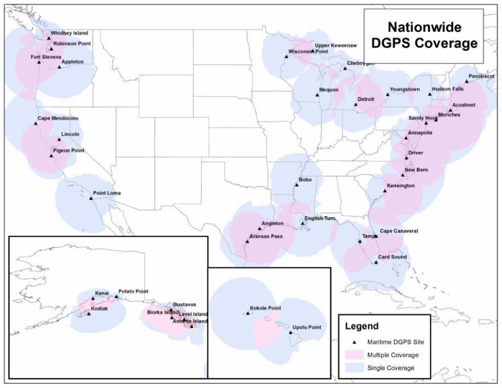
U.S. DGPS Sites .............................................................................................................................................. i
USCG Contact Information ............................................................................................................................. ii
Preface ............................................................................................................................................................ vi
Introduction ..................................................................................................................................................... vii
SEACOAST
Florida ....................................................................................................................................................................... 1
Alabama ................................................................................................................................................................... 2
Mississippi. ............................................................................................................................................................... 3
Louisiana .................................................................................................................................................................. 4
Texas ........................................................................................................................................................................ 9
BAYS, RIVERS, AND HARBORS
INDEX ................................................................................................................................................................. Index 1
CROSS REFERENCE....................................................................................................................... Cross Reference 1
Pensacola Bay ...................................................................................................................................................... 38 Mobile Bay ............................................................................................................................................................ 50 Pascagoula Harbor ............................................................................................................................................... 68 Lake Pontchartrain ................................................................................................................................................ 96 Mississippi River ................................................................................................................................................... 103 Timbalier Bay ........................................................................................................................................................ 154Vermilion Bay ........................................................................................................................................................ 177Sabine Pass ......................................................................................................................................................... 195Galveston Bay ....................................................................................................................................................... 207Matagorda Bay....................................................................................................................................................... 233Corpus Christi Bay ................................................................................................................................................. 243Intracoastal Waterway, Florida - Pensacola Bay ................................................................................................... 282Intracoastal Waterway, Louisiana – New Orleans ................................................................................................. 295Intracoastal Waterway, Louisiana – Morgan City .................................................................................................. 300Intracoastal Waterway, Texas – Sabine Neches Canal ......................................................................................... 304Intracoastal Waterway, Texas – Carlos Bay .......................................................................................................... 321Intracoastal Waterway, Texas – Laguna Madre .................................................................................................... 340

ii
COAST GUARD DISTRICT COMMANDERS
DISTRICT ADDRESS WATERS OF JURISDICTION
FIRST 408 Atlantic Avenue Boston, MA 02110-3350 Tel: (617) 223-8351
http://www.uscg.mil/d1
Maine, New Hampshire, Massachusetts, Vermont (Lake Champlain), Rhode Island, Connecticut, New York, to Shrewsbury River, New Jersey.
FIFTH Federal Building 431 Crawford Street Portsmouth, VA 23704-5004 Tel: (757) 398-6486
(757) 398-6552 http://www.uscg.mil/d5
Shrewsbury River, New Jersey to Delaware, Maryland, Virginia, District of Columbia, and North Carolina.
SEVENTH Brickell Plaza Federal Building 909 SE 1st Avenue; Rm:406 Miami, FL 33131-3050 Tel: (305) 415-6752
(305) 415-6800 http://www.uscg.mil/d7
South Carolina, Georgia, Florida to 83°50'W, and Puerto Rico and adjacent islands of the United States.
EIGHTH Hale Boggs Federal Building 500 Poydras Street New Orleans, LA 70130-3310 Tel: (504) 671-2327
(504) 671-2137 http:www.uscg.mil/d8
Florida westward from 83°50'W, Alabama, Mississippi, Louisiana, Texas, the Mississippi River System except that portion of the Illinois River north of Joliet, Illinois.
NINTH 1240 East 9th Street Cleveland, OH 44199-2060 Tel: (216) 902-6060
(216) 902-6117 http://www.uscg.mil/d9
ELEVENTH Coast Guard Island Building 50-2 Alameda, CA 94501-5100 Tel: (510) 437-2975 http://www.uscg.mil/d11
Great Lakes and St. Lawrence River above St. Regis River.
California, Nevada, Utah, Arizona.
THIRTEENTH Federal Building 915 Second Avenue 35th Floor, Rm 3510 Seattle, WA 98174-1067 Tel: (206) 220-7270
(206) 220-7004 http://www.uscg.mil/d13
Oregon, Washington, Idaho, and Montana.
FOURTEENTH Prince Kalanianaole Federal Bldg. 300 Ala Moana Blvd 9th Floor, Room 9-220 Honolulu, HI 96850-4982 Tel: (808) 535-3409
(808) 535-3414 http://www.uscg.mil/d14
SEVENTEENTH PO Box 25517 Juneau, AK 99802-5517 Tel: (907) 463-2029
(907) 463-2269 http://www.uscg.mil/d17
Hawaiian, American Samoa, Marshall, Marianas, and Caroline Islands.
Alaska.

iii
U. S. COAST GUARD EIGHTH DISTRICT UNIT LISTING
AIDS TO NAVIGATION TEAMS
ANT CORPUS CHRISTI
1201 East Navigation Blvd
Corpus Christi, TX 78402
Tel: (361) 844-6521
ANT DULAC
241 Coast Guard Rd Dulac, LA 70353 Tel: (985) 563-4473
ANT GALVESTON
3000 Fort Point Rd
Galveston, TX 77553
Tel: (409) 766-5654
ANT GULFPORT
991 23rd Rd. AveGulfport, MS 39501 Tel: (228) 575-9173
ANT MOBILE
1500 15th St. Mobile, AL 36615 Tel: (251) 441-6244
ANT MORGAN CITY 800 Youngs Rd Suite 100
Morgan City, LA 70380
Tel: (985) 384-7000
ANT NEW ORLEANS 1790 Saturn Rd.
New Orleans, LA 70129
Tel: (504) 253-4834
ANT PANAMA CITY 1700 Thomas Drive
Panama City, FL 32408-5804
Tel: (850) 234-8139
ANT PENSACOLA
21 Slemmer Ave.
Pensacola, FL 32508-7851
Tel: (850) 455-2354
ANT PORT O'CONNOR PO Box 98
Port O'Connor, TX 77982
Tel: (361) 983-4313
ANT SABINE 7034 S. First St.
Sabine Pass, TX 77655
Tel: (409) 971-2111
ANT SOUTH PADRE 1 Wallace Reed Road South
Padre Island, TX 78597
Tel: (956) 364-7433
ANT VENICE
436 Coast Guard Rd
Venice, LA 70091
Tel: (504) 534-7650

iv
BUOY TENDERS
USCGC AXE (WLIC-75310) 800 Youngs Road
Morgan City, LA 70380
Tel: (985) 385-0037
USCGC BARBARA MABRITY (WLM-559)
1500 15th St.
Mobile, AL 36615
Tel: (251) 441-6275
USCGC CLAMP (WLIC-75306) 1 Ferry Rd
Galveston, TX 77550
Tel: (409) 766-4779
USCGC CYPRESS (WLB-210)
211 South Ave. Bldg 38 Suite C
Pensacola, FL 32508
Tel: (850) 452-9044
USCGC HATCHET (WLIC-75309)
1 Ferry Road
Galveston, TX 77550
Tel: (409) 766-4776
USCGC HARRY CLAIBORNE (WLM-561)
1 Ferry Rd
Galveston, TX 77550
Tel: (409) 766-4771
USCGC MALLET (WLIC-75304)
1201 East Navigation Blvd
Corpus Christi, TX 78402-1911
Tel: (361) 844-6531
USCGC PAMLICO (WLIC-800) 1790 Saturn St.
New Orleans, LA 70129
Tel: (504) 253-2420
USCGC SAGINAW (WLIC-803)
1500 15th St.
Mobile, AL 36615
Tel: (251) 441-5197

v
USCG NAVIGATION CENTER Navigation Information Service (NIS)
The U.S. Coast Guard Navigation Center (NAVCEN) is the official government source of information for civil users of the Global Positioning System (GPS). The Navigation Information Service (NIS) is available 24 hours a day, seven days a week, for all Radio Navigation and maritime related needs via phone, fax or e-mail. The NIS provides users the ability to access real time or archived GPS, NDGPS, DGPS, and LNM information at http://www.navcen.uscg.gov, as well as subscribe to an auto- mated list service which enables users to receive GPS status messages and Notice to NAVSTAR User (NANU) messages via direct Internet e-mail.
The NAVCEN also disseminates GPS and DGPS safety advisory broadcast messages through USCG broadcast stations util- izing VHF-FM voice, HF-SSB voice, and NAVTEX broadcasts. The broadcasts provide the GPS and DGPS user in the marine environment with the current status of the navigation systems, as well as any planned/unplanned system outages that could affect GPS and DGPS navigational accuracy.
To comment on any of these services or ask questions about the service offered, contact the NAVCEN at:
Commanding Officer U.S. Coast Guard NAVCEN (NIS) MS 7310 7323 Telegraph Road Alexandria, VA 20598-7310
Phone: (703) 313-5900 FAX: (703) 313-5920 Internet: http://www.navcen.uscg.gov
This Light List is corrected through:
Eighth Coast Guard District Local Notice to Mariners No. 01/18
and through National Geospatial-Intelligence Agency (NGA) Notice to Mariners No. 01/18
The 2018 edition supersedes the 2017 edition.
RECORD OF CORRECTIONS
YEAR 2018 YEAR 2019 1........... 2........... 3........... 4........... 5........... 1........... 2........... 3........... 4........... 5...........
6........... 7........... 8........... 9........... 10......... 6........... 7........... 8........... 9........... 10.........
11......... 12......... 13......... 14......... 15......... 11......... 12......... 13......... 14......... 15.........
16......... 17......... 18......... 19......... 20......... 16......... 17......... 18......... 19......... 20.........
21......... 22......... 23......... 24......... 25......... 21......... 22......... 23......... 24......... 25.........
26......... 27......... 28......... 29......... 30......... 26......... 27......... 28......... 29......... 30.........
31......... 32......... 33......... 34......... 35......... 31......... 32......... 33......... 34......... 35.........
36......... 37......... 38......... 39......... 40......... 36......... 37......... 38......... 39......... 40.........
41......... 42......... 43......... 44......... 45......... 41......... 42......... 43......... 44......... 45.........
46......... 47......... 48......... 49......... 50......... 46......... 47......... 48......... 49......... 50.........
51......... 52......... 51......... 52.........

PREFACE
Lights and other marine aids to navigation, maintained by or under authority of the U.S. Coast Guard and located on waters used by general navigation, are described in the Light List. This volume includes aids located in Econfina River, Florida to Rio Grande, Texas.
Included are all Coast Guard aids to navigation used for general navigation such as lights, sound signals, buoys, daybeacons, and other aids to navigation. Not included are some buoys having no lateral significance, such as special purpose, anchorage, fish net, and dredging.
Aids to Navigation Link: http://www.uscgboating.org
CAUTION: Mariners attempting to pass a buoy close aboard risk collision with a yawing buoy or with the obstruction, which the buoy marks. Mariners must not rely on buoys alone for determining their positions due to factors limiting buoy reliability.
PRIVATE AIDS TO NAVIGATION Included: Class I aids to navigation on marine structures or other works which the owners are legally obligated to establish, maintain, and operate as prescribed by the Coast Guard.
Included: Class II aids to navigation exclusive of Class I, located in waters used by general navigation.
Not included: Class III aids to navigation exclusive of Class I and Class II, located in waters not ordinarily used by general navigation.
LIGHT LIST AVAILABILITYThis Light List is published annually and is intended to furnish more complete information concerning aids to navigation than can be conveniently shown on charts. This Light List is not intended to be used in place of charts or Coast Pilots. Charts should be consulted for the location of all aids to navigation. It may be dangerous to use aids to navigation without reference to charts.
This list is corrected to the date of the notices to mariners shown on the title page. Changes to aids to navigation during the year are advertised in U.S. Coast Guard Local Notices to Mariners and National Geospatial-Intelligence Agency (NGA) Notices to Mariners. Important changes to aids to navigation are also broadcast through Coast Guard or Naval radio stations and NAVTEX. Mariners should keep their Light Lists, charts and other nautical publications corrected from these notices and should consult all notices issued after the date of publication of this Light List.
The electronic version of this publication is updated monthly and is available at.http://www.navcen.uscg.gov/index.php?pageName=lightLists
Reporting Private Aids to Navigation Discrepancies D8: http://www.atlanticarea.uscg.mil/District-8/District-Divisions/Waterways/PATON/
IMPORTANT: A summary of corrections for this publication, which includes corrections from the dates shown on the title page to the date of availability, is advertised in the Local Notice to Mariners and the Notice to Mariners. These corrections must be applied in order to bring the Light List up-to-date. Additionally, this publication should be corrected weekly from the Local Notices to Mariners or the Notices to Mariners, as appropriate.
Mariners and others are requested to bring any apparent errors or omissions in these lists to the attention of:
or
Commander (dpw)Eighth Coast Guard District500 Poydras StreetNew Orleans, LA [email protected]
USCG Navigation CenterCharting BranchMS 73107323 Telegraph RoadAlexandria, VA 20598-7310Email: [email protected]
vi
A weekly- updated electronic copy of this publication is also available at:http://www.navcen.uscg.gov/index.php?pageName=lightListWeeklyUpdates
vii
INTRODUCTION
Light List Arrangement
In the context of the Light List, aids to navigation on the coasts are arranged in geographic order clockwise from north to south along to Atlantic coast, east to west along the Gulf of Mexico, and south to north along the Pacific coast. On the Great Lakes, aids to navigation are arranged from east to west and from south to north, except on Lake Michigan, which is arranged from north to south. Seacoast aids to navigation are listed first, followed by entrance and harbor aids to navigation, arranged from seaward to the head of navigation.
Names of aids to navigation are printed as follows to help distinguish at a glance the type of aid to navigation.
Seacoast/Lake coast Lights and Secondary Lights RACONS Sound Signals RIVER, HARBOR, OTHER LIGHTS, AND VIRTUAL AIS Lighted Buoys Daybeacons, Unlighted Buoys, and Virtual Automatic Identification System (V-AIS) ATON
Light List numbers are assigned to all Federal aids to navigation and many private aids to navigation for reference in the Light List. Aids to navigation are numbered by fives in accordance with their order of appearance in each volume of the Light List. Other numbers and decimal fractions are assigned where newly established aids to navigation are listed between previously numbered aids to navigation. The Light Lists are renumbered periodically to assign whole numbers to all aids to navigation.
International numbers are assigned to certain aids to navigation in cooperation with the International Hydrographic Organization. They consist of an alphabetic character followed by three or four numeric characters. A cross reference listing appears after the index.
Description of Columns
Column (1): Light List Number.
Column (2): Name and location of the aid to navigation. Note: A dash (-) is used to indicate the bold heading is part of the name of the aid to navigation. When reporting discrepancies or making references to such an aid to navigation in correspondence, the full name of the aid including the geographic heading, should be given.
Bearings are in degrees true, read clockwise from 000° through 359°.
Bearings on range lines are given in degrees and tenths or hundredths where applicable.
(C) indicates Canadian aid to navigation.
Column (3): Geographic position of the aid to navigation in latitude and longitude.
Column (4): Light characteristic for lighted aids to navigation.

viii
Column (5): Height above water from the focal plane of the fixed light to mean high water, listed in feet.
For Volume 7 (Great Lakes), height above water from the focal plane of the fixed light to low water datum, listed in feet and meters.
Column (6): Nominal range of lighted aids to navigation, in nautical miles, listed by color for sector and passing lights. Not listed for ranges, directional lights, or private aids to navigation.
Column (7): The structural characteristic of the aid to navigation, including: dayboard (if any), description of fixed structure, color and type of buoy, height of structure above ground for major lights.
Column (8): Aid remarks, sound signal characteristics, including: VHF-FM channel if remotely activated, RACON characteristic, light sector arc of visibility, radar reflector, emergency lights, seasonal remarks, and private aid to navigation identification. AIS specific information may include its unique Maritime Mobile Service Identity (MMSI), the MMSI(s) of its source AIS transmission, and the application identifier of any Application Specific Messages (ASM) it may also be transmitting.
U.S. Coast Guard Light List Distribution
U.S. regulations require that most commercial vessels maintain on board a currentlycorrected, copy or pertinent extract, of the U.S. Coast Guard Light Lists which are available for free and are updated weekly on the Coast Guard Navigation Center’s website at https://www.navcen.uscg.gov/?pageName=BulletinSubscription. Commercially printed versions are also available, but the Coast Guard does not attest to their veracity or sanction such publications.
CHARTS & PUBLICATIONS
Nautical Charts & Publications Nautical charts covering the coastal waters of the United States and its territories are published by the National Ocean Service (NOS). Up-to-date paper copies of NOS charts are available from NOS Certified Agents. A list of agents can be found at: https://www.nauticalcharts.noaa.gov/charts/noaa-raster-charts.html#paper-nautical-charts.NOS also produces Raster Navigational Charts (RNC) and Electronic Navigational Charts (ENC). RNCs can be found at https://www.nauticalcharts.noaa.gov/charts/noaa-raster-charts.html#rnc-charts.ENCs can be found at
https://www.nauticalcharts.noaa.gov/charts/noaa-enc.html.
Inland Electronic Navigational Charts (IENC) and chart books are published by the U.S. Army Corps of Engineers and are available online at http://www.agc.army.mil/Missions/Echarts.aspx. Tide Tables and Tidal Current Tables are no longer printed or distributed by NOS. NOS Tide and Tidal Current predictions are available online at http://tidesandcurrents.noaa.gov/tide_predictions.html. Commercially printed versions, using data provided by NOS, are also available. These products may be obtained from local stores that carry marine publications.

ix
Notices to Mariners
Broadcast Notices to Mariners are made by the Coast Guard through Coast Guard radio stations. These notices, which are broadcast on VHF-FM, NAVTEX, and other maritime frequencies, are warnings that contain important navigational safety information. Included are reports of discrepancies and changes to aids to navigation, the positions of ice and derelicts, and other important hydrographic information.
Radio stations broadcasting Notices to Mariners are listed in the National Ocean Service United States Coast Pilot and in the National Geospatial-Intelligence Agency publication Radio Navigational Aids (Publication No. 117). VHF-FM voice broadcast times can be found online at http://www.nws.noaa.gov/om/marine/vhfvoice.htm.
Local Notices to Mariners (U.S. regional coverage) are another means which the Coast Guard disseminates navigational information for the United States, its territories, and possessions. A Local Notice to Mariners is issued by each Coast Guard district and is used to report changes and discrepancies to aids to navigation maintained by and under the authority of the Coast Guard. The Local Notice to Mariners also contain chart and Light List corrections, proposed aids to navigation projects open for public comment, ongoing waterway projects, bridge regulation changes, marine event information, and other concerns pertinent to the mariner.
Local Notices to Mariners are essential to all navigators for the purposes of keeping charts, Light Lists, Coast Pilots, and other nautical publications up-to-date. These notices are published weekly and can be found online at http://www.navcen.uscg.gov/index.php?pageName=lnmMain. Mariners may register with the Coast Guard Navigation Center to receive automatic notifications via email when new editions of the Local Notice to Mariners are available. Register at http://www.navcen.uscg.gov/?pageName=listServerForm. Vessels operating in ports and waterways in several districts will have to obtain the Local Notice to Mariners for each district.
Notice to Mariners are prepared jointly by the National Geospatial-Intelligence Agency (NGA), the U.S. Coast Guard, and the National Ocean Service, and are published weekly by the NGA. The weekly Notice to Mariners advises mariners of important matters affecting navigational safety including new hydrographic discoveries, changes to aids to navigation, and foreign marine information. Also included are corrections to Light Lists, Coast Pilots, and Sailing Directions. This notice is intended for mariners and others who have a need for information related to oceangoing operations. Because it is intended for use by oceangoing vessels, many corrections that affect small craft navigation and associated waters are not included. Information concerning small craft is contained in the Coast Guard Local Notice to Mariners only. The weekly Notices to Marines may be found online at http://msi.nga.mil/NGAPortal/MSI.portal.
ATON DISCREPANCIES
The Coast Guard does not keep the tens of thousands of aids to navigation comprising the U.S. Aids to Navigation System under simultaneous and continuous observation. Mariners should realize that it is impossible to maintain every aid to navigation operating properly and on its assigned position at all times. Therefore, for the safety of all mariners, anyone who discovers an aid to navigation that is either off station or exhibiting characteristics other than those listed in

x
the Light Lists should promptly notify the nearest Coast Guard unit. Radio messages should be prefixed “COAST GUARD” and transmitted on VHF-FM channel 16 or directly to one of the U.S. Government radio stations listed in Chapter 3, Section 300L, Radio Navigation Aids (Publication No. 117). In addition to notifying the nearest Coast Guard unit by radio, a discrepant aid to navigation can be reported online at http://www.navcen.uscg.gov/?pageName=atonOutageReport.
U.S. AIDS TO NAVIGATION SYSTEM
GENERAL The navigable waters of the United States are marked to assist navigation using the U.S. Aids to Navigation System, a system consistent with the International Association of Marine Aids to Navigation and Lighthouse Authorities (IALA) Maritime Buoyage System. The IALA Maritime Buoyage System is followed by most of the world’s maritime nations and improves maritime safety by encouraging conformity in buoyage systems worldwide. IALA buoyage is divided into two regions made up of Region A and Region B. All navigable waters of the United States follow IALA Region B, except U.S. possessions west of the International Date Line and south of 10° north latitude, which follow Region A. Lateral aids to navigation in Region A vary from those located within Region B. Non-lateral aids to navigation in Region A are the same as those used in Region B. Appropriate nautical charts and publications should be consulted to determine whether the Region A or Region B marking schemes are in effect for a given area.
Aids to navigation are developed, established, operated, and maintained by the U.S. Coast Guard to accomplish the following:
1. Assist navigators in determining their position,2. Assist the navigator in determining a safe course,3. Warn the navigator of dangers and obstructions,4. Promote the safe and economic movement of commercial vessel traffic, and5. Promote the safe and efficient movement of military vessel traffic, and cargo of
strategic military importance.
The U.S. Aids to Navigation System is designed for use with nautical charts. Nautical charts portray the physical features of the marine environment, which include: soundings, landmarks, hazards to navigation, and aids to navigation. To best understand the purpose of a specific aid to navigation, mariners should consult the associated nautical chart, which illustrates the relationship of the aid to navigation to channel limits, obstructions, hazards to navigation, and to the aids to navigation system as a whole. Seasonal aids to navigation are placed into service, withdrawn, or changed at specified times of the year. The dates shown in the Light Lists are approximate and may vary due to adverse weather or other conditions. These aids will be changed on Electronic Navigational Charts (ENC) based on Light List dates and electronic navigation system settings.
Mariners should maintain and consult suitable publications and navigation equipment depending on the vessel’s requirements. This shipboard navigation equipment is separate from the aids to navigation system, but is often essential to its use.
The U.S. Aids to Navigation System is primarily a lateral system, which employs a simple arrangement of colors, shapes, numbers, and light characteristics to mark the limits of navigable
xi
routes. This lateral system is supplemented with non-lateral aids to navigation where appropriate.
Federal aids to navigation consist of Coast Guard operated aids to navigation. The Coast Guard establishes, maintains, and operates a system of aids to navigation consisting of visual, audible, and electronic signals designed to assist the prudent mariner in the process of navigation.
The U.S. Aids to Navigation System contains the following subsystems:
1. Intracoastal Waterway: The aids to navigation marking the Intracoastal Waterwayare arranged geographically from north to south on the Atlantic Coast and generallyeast to west on the coast of the Gulf of Mexico. Red lights (if so equipped), evennumbers, and red buoys or triangle shaped daymarks are located on thesouthbound/westbound starboard waterway boundary. Green lights (if so equipped),odd numbers, and green buoys or square shaped daymarks are on thesouthbound/westbound port waterway boundary.
2. Western Rivers: The Western Rivers System is employed on the Mississippi RiverSystem, in addition to the Tennessee-Tombigbee Waterway and the Alabama,Atchafalaya, and Apalachicola-Chattahoochee-Flint River Systems. The WesternRivers System consists of the following characteristics:
a. Buoys are not numbered.b. Numbers on beacons do not have lateral significance, but rather indicate
mileage from a fixed point (normally the river mouth).c. Diamond shaped non-lateral dayboards, red and white or green and white as
appropriate, are used to indicate where the river channel crosses from onebank to the other.
d. Lights on green aids to navigation show a single-flash characteristic, whichmay be green or white.
e. Lights on red aids to navigation show a group-flash characteristic, which maybe red or white.
f. Isolated danger marks are not used.
3. Bridge Markings: Bridges across navigable waters are marked with red, greenand/or white lights for nighttime navigation. Red lights mark piers and other parts ofthe bridge. Red lights are also placed on drawbridges to show when they are in theclosed position. Green lights are placed on drawbridges to show when they are inthe open position. The location of these lights will vary according to the bridgestructure. Green lights are also used to mark the centerline of navigable channelsthrough fixed bridges. If there are two or more channels through the bridge, thepreferred channel is also marked by three white lights in a vertical line above thegreen light.
Red and green retro-reflective panels may be used to mark bridge piers and may also be used on bridges not required to display lights. Lateral red and green lights and dayboards may mark main channels through bridges. Adjacent piers are marked with fixed yellow lights when the main channel is marked with lateral aids to navigation.

xii
Centerlines of channels through fixed bridges may be marked with a safe water mark and an occulting white light when lateral marks are used to mark main channels. The centerline of the navigable channel through the draw span of floating bridges may be marked with a special mark. The mark will be a yellow diamond with yellow retro-reflective panels and may exhibit a yellow light that displays a Morse code “B” (a long flash followed by three short flashes). AIS-ATON and RACONs may be placed on the bridge structure to mark the centerline of the navigable channel through the bridge.
Vertical clearance gauges may be installed to enhance navigation safety. The gauges are located on the right channel pier or pier protective structure facing approaching vessels. Clearance gauges indicate the vertical distance between “low steel” of the bridge channel span (in the closed to navigation position for drawbridges) and the level of the water, measured to the bottom of the foot marks, read from top to bottom.
Drawbridges equipped with radiotelephones display a blue and white sign which indicates what VHF radiotelephone channels should be used to request bridge openings.
Private aids to navigation include aids to navigation that are either operated by private persons and organizations, or that are operated by states. Private aids to navigation are classified into three categories:
1. Class I: Aids to navigation on marine structures or other works which the owners arelegally obligated to establish, maintain, and operate as prescribed by the U.S. CoastGuard.
2. Class II: Aids to navigation that, exclusive of Class I aids, are located in waters used bygeneral navigation.
3. Class III: Aids to navigation that, exclusive of Class I and Class II aids, are located inwaters not ordinarily used by general navigation.
Authorization for the establishment of a Class II or Class III private aid to navigation by the U.S. Coast Guard imposes no legal obligation that the aid actually be established and operated. It only specifies the location and operational characteristics of the aid for which the authorization was requested. Once the aid is established, however, the owner is legally obligated to maintain it in good working order and properly painted.
Lights and sound signals on oil wells or other offshore structures in navigable waters are private aids to navigation and are generally not listed in the Light List unless they are equipped with a RACON. Where space allows, the structures are shown on the appropriate nautical charts. Information concerning the location and characteristics of those structures which display lights and sound signals not located in obstruction areas are published in Local and/or weekly Notices to Mariners.
In general, during the nighttime, a series of white lights are displayed extending from the platform to the top of the derrick when drilling operations are in progress. At other times, structures are usually marked with one or more quick flashing white, red, or yellow lights, visible for at least one nautical mile during clear weather. Obstructions, which are a part of the appurtenances to the main structure, such as mooring piles, anchors, and mooring buoys, etc.,

xiii
are not normally lighted. In addition, some structures are equipped with a sound signal that produces a single two-second blast every 20 seconds.
BUOYS, BEACONS, AND AIS-ATON
The primary components of the U.S. Aids to Navigation System are buoys, beacons, and AIS- ATON.
Buoys are floating aids to navigation used extensively throughout U.S. waters. They are moored to sinkers by varying lengths of chain and may shift due to sea conditions and other causes. Buoys may also be carried away, capsized, or sunk. Prudent mariners will not rely solely on any single aid to navigation, particularly floating aids.
Buoy positions represented on nautical charts are approximate position only, due to the practical limitations of positioning and maintaining buoys and their sinkers in precise geographical locations. The position of buoys and beacons are indicated with a circle on the chart. The center of the symbol corresponds with the position of the aid.
Positions of Federal aids to navigation are verified during periodic maintenance visits. Between visits, environmental conditions, including atmospheric and sea conditions, seabed slope and composition, may shift buoys off their charted positions. Buoys may also be dragged off station, sunk, or capsized by a collision with a vessel.
Beacons are aids to navigation which are permanently fixed to the earth’s surface. They range from large lighthouses to small single-pile structures and may be located on land or in the water. Lighted beacons are called lights; unlighted beacons are called daybeacons. Lighthouses are placed on shore or on marine sites and most often do not indicate lateral significance. Lighthouses with no lateral significance exhibit a white light.
Beacons exhibit a daymark. For small structures, these are colored geometric shapes that make an aid to navigation readily visible and easily identifiable against background conditions. Generally, the daymark conveys to the mariner, during daylight hours, the same significance as the aid’s light or reflector does at night. The daymark of towers, however, consists of the structure itself. As a result, these daymarks do not infer lateral significance.
Ranges are non-lateral aids to navigation composed of two beacons, which when the structures appear to be in line, assist the mariner in maintaining a safe course. The appropriate nautical chart must be consulted when using ranges to determine whether the range marks the centerline of the navigable channel and also what section of the range may be safely traversed. Ranges typically display rectangular dayboards of various colors and are generally, but not always lighted. Ranges may display lights during daylight and at night. When lighted, ranges may display lights of any color.
Vessels should not pass fixed aids to navigation close aboard due to the danger of collision with rip-rap or structure foundations, or with the obstruction or danger being marked.
Aids to Navigation (ATON) may be enhanced by the use of an automatic identification system (AIS). AIS is a maritime navigation safety communications protocol standardized by the International Telecommunication Union and adopted by the International Maritime Organization for the broadcast or exchange of navigation information between vessels, aircraft, and shore

xiv
stations. AIS ATON can autonomously and at fixed intervals broadcast the name, position, dimensions, type, characteristics, and status from or concerning an aid to navigation. AIS ATON can be either real (physically fitted to an aid to navigation), synthetic (physically fitted somewhere other than to an aid to navigation) or virtual (physically nonexistent, but capable of being portrayed on AIS-capable displays).
Note: Physical AIS ATON can actively monitor and report the health and position status of its host; while Synthetic AIS ATON broadcasted from ashore (i.e. NAIS) can be used to electronically augment the range or portrayal (i.e., on radar and ECDIS) of an existing aid to navigation.
Although all existing AIS mobile devices can receive AIS ATON Reports and ASM messages, they may not readily appear on an AIS Minimal Keyboard Display or other shipboard navigational display systems (i.e., radar, ECDIS, ECS), which would require software updates to make these systems compliant with international navigation presentation standards (i.e., IEC 62288 (Ed. 2), IHO S-52 (Ed. 4.4.0)).
AIS ATON can also be used to broadcast both laterally (e.g., Port Hand Mark) and non-laterally significant marine safety information (e.g., environmental data, tidal information, and navigation warnings).
Note: AIS ATON stations broadcast their presence, identity (9-digit Marine Mobile Service Identity (MMSI) number), position, type, and status at least every three minutes or less via an AIS (ITU-R M.1371) message 21–AIS ATON Report. In addition to its AIS ATON Report, AIS ATON can broadcast significant marine safety information via Application Specific Messages (ASM), which are customized messages that can be used to broadcast additional aid information or other marine safety information (i.e., environmental conditions, wind speed and direction, tidal/current data, bridge air clearances, area notices, etc. They are identified by their: AIS message number (i.e. 6, 8, 25 or 26), Designated Area Code (DAC), Function Identifier (FI), and Version Number, e.g. U.S. Geographic Notice message: Msg# = 8, DAC = 367, FI = 22, Version = 2, and, denoted as 8/367.22.2.
TYPES OF SIGNALS
Lighted aids to navigation are, for the most part, equipped with daylight controls which automatically cause the light to operate during darkness and to be extinguished during daylight. These devices are not of equal sensitivity; therefore, all lights do not come on or go off at the same time. Mariners should ensure correct identification of aids to navigation during twilight periods when some lighted aids to navigation are lit while others are not.
The lighting apparatus is serviced at periodic intervals to assure reliable operation, but there is always the possibility of a light being extinguished or operating improperly. The condition of the atmosphere has a considerable effect upon the distance at which lights can be seen. Sometimes lights are obscured by fog, haze, dust, smoke, or precipitation which may be present at the light, or between the light and the observer, and which is possibly unknown by the observer. Atmospheric refraction may cause a light to be seen farther than under ordinary circumstances.
A light of low intensity will be easily obscured by unfavorable conditions of the atmosphere and little dependence can be placed on it being seen. For this reason, the intensity of a light should always be considered when expecting to sight it in reduced visibility. Haze and distance may

xv
reduce the apparent duration of the flash of a light. In some atmospheric conditions, white lights may have a reddish hue. Lights placed at high elevations are more frequently obscured by clouds, mist, and fog than those lights located at or near sea level.
In regions where ice conditions prevail in the winter, the lantern panes of lights may become covered with ice or snow, which will greatly reduce the visibility of the lights and may also cause colored lights to appear white.
The increasing use of brilliant shore lights for advertising, illuminating bridges, and other purposes, may cause marine navigational lights, particularly those in densely inhabited areas, to be outshone and difficult to distinguish from the background lighting. Mariners are requested to report such cases in order that steps may be taken to improve the conditions.
The “loom” (glow) of a powerful light is often seen beyond the limit of visibility of the actual rays of the light. The loom may sometimes appear sufficiently sharp enough to obtain a bearing. At short distances, some flashing lights may show a faint continuous light between flashes.
The distance of an observer from a light cannot be estimated by its apparent intensity. Always check the characteristics of lights in order to avoid mistaking powerful lights, visible in the distance, for nearby lights (such as those on lighted buoys) showing similar characteristics of low intensity. If lights are not sighted within a reasonable time after prediction, a dangerous situation may exist, requiring prompt resolution or action in order to ensure the safety of the vessel.
The apparent characteristic of a complex light may change with the distance of the observer. For example, a light which actually displays a characteristic of fixed white varied by flashes of alternating white and red (the rhythms having a decreasing range of visibility in the order: flashing white, flashing red, fixed white) may, when first sighted in clear weather, show as a simple flashing white light. As the vessel draws nearer, the red flash will become visible and the characteristics will appear as alternating flashing white and red. Later, the fixed white light will be seen between the flashes and the true characteristic of the light will finally be recognized as fixed white, alternating flashing white and red (F W Al WR).
If a vessel has considerable vertical motion due to pitching in heavy seas, a light sighted on the horizon may alternatively appear and disappear. This may lead the unwary to assign a false characteristic and hence, to error in its identification. The true characteristic will be evident after the distance has been sufficiently decreased or by increasing the height of eye of the observer.
Similarly, the effect of wave motion on lighted buoys may produce the appearance of incorrect light phase characteristics when certain flashes occur, but are not viewed by the mariner. In addition, buoy motion can reduce the distance at which buoy lights are detected.
Sectors of colored glass are placed in the lanterns of some lights in order to produce a system of light sectors of different colors. In general, red sectors are used to mark shoals or to warn the mariner of other obstructions to navigation or of nearby land. Such lights provide approximate bearing information, since observers may note the change of color as they cross the boundary between sectors. These boundaries are indicated in the Light List (Col. 8) and by dotted lines on charts. These bearings, as all bearings referring to lights, are given in true degrees from 000° to 359°, as observed from a vessel toward the light.

xvi
Altering course on the changing sectors of a light or using the boundaries between light sectors to determine the bearing for any purpose is not recommended. Be guided instead by the correct compass bearing to the light and do not rely on being able to accurately observe the point at which the color changes. This is difficult to determine because the edges of a colored sector cannot be cut off sharply. On either side of the line of demarcation between white, red, or green sectors, there is always a small arc of uncertain color. Moreover, when haze or smoke is present in the intervening atmosphere, a white sector might have a reddish hue.
The area in which a light can be observed is normally an arc with the light as the center and the range of visibility as the radius. However, on some bearings, the range may be reduced by obstructions. In such cases, the obstructed arc might differ with height of eye and distance. When adjoining land cuts off a light and the arc of visibility is given, the bearing on which the light disappears may vary with the distance of the vessel from which observed and with the height of eye. When the light is cut off by a sloping hill or point of land, the light may be seen over a wider arc by a vessel farther away than by one closer to the light.
The arc drawn on charts around a light is not intended to give information as to the distance at which it can be seen. The arc indicates the bearings between which the variation of visibility or obstruction of the light occurs.
Only aids to navigation with green or red lights have lateral significance and exhibit either flashing, quick flashing, group flashing, occulting, or isophase light rhythms. When proceeding in the conventional direction of buoyage, the mariner in IALA Region B, may see the following lighted aids to navigation:
Green lights on aids to navigation mark port sides of channels and locations of wrecks or obstructions that must be passed by keeping these lighted aids to navigation on the port hand of a vessel. Green lights are also used on preferred channel marks where the preferred channel is to starboard (i.e., aid to navigation left to port when proceeding in the conventional direction of buoyage). Red lights on aids to navigation mark starboard sides of channels and locations of wrecks or obstructions that must be passed by keeping these lighted aids to navigation on the starboard hand of a vessel. Red lights are also used on preferred channel marks where the preferred channel is to port (i.e., aid to navigation left to starboard when proceeding in the conventional direction of buoyage).
White and yellow lights have no lateral significance. The shapes, colors, letters, and light rhythms may determine the purpose of aids to navigation exhibiting white or yellow lights.
Most aids to navigation are fitted with retro reflective material to increase their visibility in darkness. Colored reflective material is used on aids to navigation that, if lighted, will display lights of the same color.
Preferred channel marks exhibit a composite group-flashing light rhythm of two flashes followed by a single flash.
Safe water marks exhibit a white Morse code “A” rhythm (a short flash followed by a long flash).
Isolated danger marks exhibit a white flashing (2) rhythm (two flashes repeated regularly).
Special marks exhibit yellow lights and exhibit a flashing or fixed rhythm.

Information and regulatory marks exhibit a white light with any light rhythm except quick flashing, flashing (2) and Morse code “A.”
For situations where lights require a distinct cautionary significance, as at sharp turns, sudden channel constrictions, wrecks, or obstructions, a quick flashing light rhythm will be used.
Shapes are used to provide easy identification on certain unlighted buoys and dayboards on beacons. These shapes are laterally significant only when associated with laterally significant colors.
In IALA Region B, cylindrical buoys (referred to as “can buoys”) and square dayboards mark the port side of a channel when proceeding from seaward. These aids to navigation are associated with solid green or green and red-banded marks where the topmost band is green. Conical buoys (referred to as “nun buoys”) and triangular dayboards mark the starboard side of the channel when proceeding from seaward. These aids to navigation are associated with solid red or red and green-banded marks where the topmost band is red.
Unless fitted with topmarks; lighted, sound, pillar, and spar buoys have no shape significance. Their numbers, colors, and light characteristics convey their meanings.
Dayboards throughout the U.S. Aids to Navigation System are described using standard designations that describe the appearance of each dayboard. A brief explanation of the designations and of the purpose of each type of dayboard in the system is given below, followed by a verbal description of the appearance of each dayboard type.
Designations:
1. First Letter – Shape or Purpose
C: Crossing (Western Rivers only) diamond-shaped, used to indicate the points at whichthe channel crosses the river.
J: Junction (square or triangle) used to mark (preferred channel) junctions or bifurcations in the channel, or wrecks or obstructions which may be passed on either side; color of top band has lateral significance for the preferred channel.
K: Range (rectangular) when both the front and rear range dayboards are aligned on the same bearing, the observer is on the azimuth of the range, usually used to mark the center of the channel.
M: Safe Water (octagonal) used to mark the fairway or middle of the channel.
N: No lateral significance (diamond or rectangular) used for special purpose, warning, distance, or location markers.
S: Square used to mark the port side of channels when proceeding from seaward.
T: Triangle used to mark the starboard side of channels when proceeding from seaward.
2. Second Letter – Key Color
xvii
xviii
B – Black G – Green R – Red W – White Y – Yellow
3. Third Letter – Color of Center Stripe (Range Dayboards Only)
4. Additional Information after a (-)
-I: Intracoastal Waterway; a yellow reflective horizontal band on a dayboard; indicatesthe aid to navigation marks the Intracoastal Waterway.
-SY: Intracoastal Waterway; a yellow reflective square on a dayboard; indicates the aid to navigation is a port hand mark for vessels traversing the Intracoastal Waterway. May appear on a triangular daymark where the Intracoastal Waterway coincides with a waterway having opposite conventional direction of buoyage.
-TY: Intracoastal Waterway; a yellow reflective triangle on a dayboard; indicates the aid to navigation is a starboard hand mark for vessels traversing the Intracoastal Waterway. May appear on a square daymark where the Intracoastal Waterway coincides with a waterway having opposite conventional direction of buoyage.
Descriptions:
CNG: Diamond-shaped dayboard divided into four diamond-shaped colored sectors with the sectors at the side corners white and the sectors at the top and bottom corners green, with green reflective diamonds at the top and bottom corners and white reflective diamonds in the side corners (Western Rivers only).
CNR: Diamond-shaped dayboard divided into four diamond-shaped colored sectors with the sectors at the side corners white and the sectors at the top and bottom corners red, with red reflective diamonds at the top and bottom corners and white reflective diamonds in the side corners (Western Rivers only).
JG: Dayboard bearing horizontal bands of green and red, green band topmost, with corresponding reflective borders.
JG-I: Square dayboard bearing horizontal bands of green and red, green band topmost, with corresponding reflective borders and a yellow reflective horizontal band.
JG-SY: Square dayboard bearing horizontal bands of green and red, green band topmost, with corresponding reflective borders and a yellow reflective square.
JG-TY: Square dayboard bearing horizontal bands of green and red, green band topmost, with corresponding reflective borders and a yellow reflective triangle.
JR: Dayboard bearing horizontal bands of red and green, red band topmost, with corresponding reflective borders.
JR-I: Triangular dayboard bearing horizontal bands of red and green, red band topmost, with corresponding reflective borders and a yellow reflective horizontal band.

xix
JR-SY: Triangular dayboard bearing horizontal bands of red and green, red band topmost, with corresponding reflective borders and a yellow reflective square.
JR-TY: Triangular dayboard bearing horizontal bands of red and green, red band topmost, with corresponding reflective borders and a yellow reflective triangle.
KBG: Rectangular black dayboard bearing a central green stripe.
KBG-I: Rectangular black dayboard bearing a central green stripe and a yellow reflective horizontal band.
KBR: Rectangular black dayboard bearing a central red stripe.
KBR-I: Rectangular black dayboard bearing a central red stripe and a yellow reflective horizontal band.
KBW: Rectangular black dayboard bearing a central white stripe.
KBW-I: Rectangular black dayboard bearing a central white stripe and a yellow reflective horizontal band.
KGB: Rectangular green dayboard bearing a central black stripe.
KGB-I: Rectangular green dayboard bearing a central black stripe and a yellow reflective horizontal band.
KGR: Rectangular green dayboard bearing a central red stripe.
KGR-I: Rectangular green dayboard bearing a central red stripe and a yellow reflective horizontal band.
KGW: Rectangular green dayboard bearing a central white stripe.
KGW-I: Rectangular green dayboard bearing a central white stripe and a yellow reflective horizontal band.
KRB: Rectangular red dayboard bearing a central black stripe.
KRB-I: Rectangular red dayboard bearing a central black stripe and a yellow reflective horizontal band.
KRG: Rectangular red dayboard bearing a central green stripe.
KRG-I: Rectangular red dayboard bearing a central green stripe and a yellow reflective horizontal band.
KRW: Rectangular red dayboard bearing a central white stripe.
KRW-I: Rectangular red dayboard bearing a central white stripe and a yellow reflective horizontal band.

xx
KWB: Rectangular white dayboard bearing a central black stripe.
KWB-I: Rectangular white dayboard bearing a central black stripe and a yellow reflective horizontal band.
KWG: Rectangular white dayboard bearing a central green stripe.
KWG-I: Rectangular white dayboard bearing a central green stripe and a yellow reflective horizontal band.
KWR: Rectangular white dayboard bearing a central red stripe.
KWR-I: Rectangular white dayboard bearing a central red stripe and a yellow reflective horizontal band.
MR: Octagonal dayboard bearing stripes of white and red, with a white reflective border.
MR-I: Octagonal dayboard bearing stripes of white and red, with a white reflective border and a yellow reflective horizontal band.
NB: Diamond-shaped dayboard divided into four diamond-shaped colored sectors with the sectors at the side corners white and the sectors at the top and bottom corners black, with a white reflective border.
ND: Rectangular white mileage marker with black numerals indicating the mile number (Western Rivers only).
NG: Diamond-shaped dayboard divided into four diamond-shaped colored sectors with the sectors at the side corners white and the sectors at the top and bottom corners green, with a white reflective border.
NL: Rectangular white location marker with an orange reflective border and black letters indicating the location.
NR: Diamond-shaped dayboard divided into four diamond-shaped colored sectors with the sectors at the side corners white and the sectors at the top and bottom corners red, with a white reflective border.
NW: Diamond-shaped white dayboard with an orange reflective border and black letters describing the information or regulatory nature of the mark.
NY: Diamond-shaped yellow dayboard with yellow reflective border.
SG: Square green dayboard with a green reflective border.
SG-I: Square green dayboard with a green reflective border and a yellow reflective horizontal band.
SG-SY: Square green dayboard with a green reflective border and a yellow reflective square.
SG-TY: Square green dayboard with a green reflective border and a yellow reflective triangle.

xxi
SR: Square red dayboard with a red reflective border. (IALA Region “A”)
TG: Triangular green dayboard with a green reflective border. (IALA Region “A”)
TR: Triangular red dayboard with a red reflective border.
TR-I: Triangular red dayboard with a red reflective border and a yellow reflective horizontal band.
TR-SY: Triangular red dayboard with a red reflective border and a yellow reflective square.
TR-TY: Triangular red dayboard with a red reflective border and a yellow reflective triangle. These abbreviated descriptions are used in column (7) and may also be found on the illustrations of the U.S. Aids to Navigation System.
Numbers are used to provide easy identification of aids to navigation. In IALA Region B, all solid red and solid green aids are numbered, with the exception of buoys located on the Western Rivers. Red aids to navigation have even numbers and green aids to navigation have odd numbers. The numbers for each increase from seaward when proceeding in the conventional direction of buoyage. Numbers are kept in approximate sequence on both sides of the channel by omitting numbers where necessary.
Letters may be used to augment numbers when lateral aids to navigation are added to channels with previously completed numerical sequences. Letters will increase in alphabetical order from seaward, proceeding in the conventional direction of buoyage and are added to numbers as suffixes. Letters are not used for buoys on the Western Rivers. No other aids to navigation are numbered. Preferred channel, safe water, isolated danger, special marks, and information and regulatory aids to navigation may be lettered, but not numbered.
Sound signal is a generic term used to describe aids to navigation that produce an audible signal designed to assist the mariner in periods of reduced visibility. These aids to navigation can be activated by several means (e.g., manually, remotely, or fog detector). The Coast Guard is replacing many fog detectors with mariner radio activated sound signals (MRASS). To activate, mariners key their VHF-FM radio a designated number of times on a designated VHF- FM channel. The sound signal is activated for a period of 15, 30, 45, or 60 minutes after which the activated assistance automatically turns off. In cases where a fog detector is in use, there may be a delay in the automatic activation of the signal. Additionally, fog detectors may not be capable of detecting patchy fog conditions.
Sound signals are distinguished by their tone and phase characteristics. The devices producing the sound, e.g., diaphones, diaphragm horns, sirens, whistles, bells, or gongs determine tones.
Phase characteristics are defined by the signal's sound pattern, i.e., the number of blasts and silent periods per minute and their durations. Sound signals sounded from fixed structures generally produce a specific number of blasts and silent periods each minute when operating. Sound signals installed on buoys are generally activated by the motion of the sea and therefore do not emit a regular signal characteristic. It is common, in fact, for a buoy to produce no sound signal when seas are calm.

xxii
The characteristic of a sound signal is listed in column (8) of the Light List. If the sound signal is remotely activated, column (8) will contain the VHF-FM channel and number of times the VHF- FM radio should be keyed. All waterway users equipped with a VHF-FM radio may activate the sound signal, but they are not required to do so. Unless it is specifically stated that a sound signal "Operates continuously," or the signal is a bell, gong, or whistle on a buoy, it can be assumed that the sound signal only operates during times of fog, reduced visibility, or adverse weather.
Caution: Mariners should not rely on sound signals to determine their position. Distance cannot be accurately determined by sound intensity. Occasionally, sound signals may not be heard in areas close to their location. Signals may not sound in cases where fog exists close to, but not at, the location of the sound signal.
Radar Beacons (RACONS) are radar transponders that when triggered by an X-band radar produce a coded response from its location, which is portrayed radially as a series of dots and dashes on the triggering radar. Although RACONS may be used on both laterally significant and non-laterally significant aids to navigation, their signal should just be used for identification purposes only.
RACONS have a typical output of 600 milliwatts and are considered a short range aid to navigation. Reception varies from a nominal range of 6 to 8 nautical miles when mounted on a buoy to as much as 17 nautical miles for a RACON mounted on a fixed structure. It must be understood that these nominal ranges are dependent upon many factors.
The beginning of the RACON presentation occurs about 50 yards beyond the RACON position and will persist for a number of revolutions of the radar antenna (depending on its rotation rate). Distance to the RACON can be measured to the point at which the RACON flash begins, but the figure obtained will be greater than the vessel's distance from the RACON. This is due to the slight response delay in the RACON apparatus.
Radar operators may notice some broadening or spoking of the RACON presentation when their vessel approaches closely to the source of the RACON. This effect can be minimized by adjusting the IF gain or sweep gain control of the radar. If desired, the RACON presentation can be virtually eliminated by operation of the FTC (fast time constant) controls of the radar.
Radar Reflectors are special fixtures, incorporated into both lighted and unlighted aids to navigation, to enhance the reflection of radar energy. These fixtures help radar-equipped vessels to detect buoys and beacons, which are so equipped. However, they do not positively identify a radar target as an aid to navigation.
NAVIGATION SERVICES
GLOBAL POSITIONING SYSTEM (GPS), DIFFERENTIAL GPS (DGPS), AND NATION-WIDE AUTOMATIC IDENTIFICATION SYSTEM (NAIS)
Global Positioning System (GPS) is a satellite based navigation system, operated and controlled by the Department of Defense (DOD) under U.S. Air Force management, which provides precise, worldwide, three-dimensional navigation capabilities. The system was originally designed for military application; however, it is now available to all and used almost ubiquitously. The United States is committed to maintaining the availability of at least 24

xxiii
operational GPS satellites, in six precise orbital planes, each of which complete a circular10,900 nautical mile orbit of the earth once every 12 hours. Ideally, a minimum of four satellites will be visible from any position on the earth and will provide positions with a global horizontal accuracy within 3 meters, 95% percent of the time. Whenever possible, advance notice of when GPS satellites should not be used will be provided by the DOD and made available by the U.S. Coast Guard through GPS status messages.
The Navigation Center coordinates and manages the Civil GPS Service Interface Committee (CGSIC), which comprises members from U.S. and international private, government, and industry user groups. The CGSIC is the recognized worldwide forum for effective interaction between all civil GPS users and the U.S. GPS authorities.
At least three satellites are required for a two-dimensional solution, however, GPS does not provide integrity information and mariners should exercise extreme caution when using GPS in restricted waterways.
Differential GPS (DGPS) is an augmentation to the GPS signals. Each site corrects for small variations in the signals from each satellite that is in view at that time. Satellite signals can vary due to small changes in the satellite's circuitry and orbit and from changes caused by local weather conditions. Satellite corrections are transmitted to users via radio signals in the medium frequency band (285-325 kHz) previously used for marine radiobeacons. DGPS corrections and integrity information are transmitted using Minimum Shift Keying (MSK) modulation. The modulation data rate is usually 100 or 200 bits per second (bps), but can also be 50 bps. The range of DGPS transmissions is from 40 to 300 nautical miles.
DGPS was the first Federal radionavigation system capable of providing the 10-meter navigation service required for the Harbor Entrance and Approach phase of maritime navigation. DGPS provides integrity messages for signals from the GPS satellites, as well as DGPS position corrections, and typically provides position accuracy of 1-3 meters.
Each DGPS site has two reference stations (which calculate the differential corrections), two integrity monitors (which ensure the differential corrections are accurate), a transmitter, and equipment to communicate status information to and receive commands from the control station. Each transmitter and reference station has a unique identification number that permits users to determine which site/equipment is providing their differential corrections. As distance from the transmitting site increases, the small error in the differential corrections increases. The best accuracy is achieved when using the DGPS site closest to the user.
Information regarding the location of DGPS transmitters is given on the map labeled U.S. DGPS Sites & Identification Numbers on page i. Users can access additional information and DGPS statuses, submit questions, and provide comments via the Navigation Information Service’s website or by calling the Coast Guard Navigation Center DGPS watchstander at (703) 313- 5902.
Navigation Information Service (NIS): The Coast Guard is the government interface for civil users of GPS and has established a Navigation Information Service (NIS) to meet the information needs of the civil user. The NIS is a Coast Guard entity that is manned 24 hours a day, 7 days a week, and is located at the Navigation Center (NAVCEN) in Alexandria, VA. It provides data broadcasts and on-line computer-based information services which are available 24 hours a day. The information provided includes present or future satellite outages, constellation changes, user instructions and tutorials, lists of service and receiver provides/users, and other GPS and DGPS related information.

xxiv
Navigation Center Internet Service (www) website also offers an e-mail subscription service for GPS status messages, Notice Advisory to NAVSTAR Users (NANU) messages, Local Notice to Mariners, and Coast Guard Light List.
The NAVCEN disseminates GPS and DGPS safety advisory broadcast messages through USCG broadcast stations utilizing VHF-FM voice, HF-SSB voice, and NAVTEX broadcasts. The broadcasts provide the GPS and DGPS user in the marine environment with the current status of the navigation systems, as well as any planned/unplanned system outages that could affect GPS and DGPS navigational accuracy.
Nationwide Automatic Identification System (NAIS) consists of approximately 200 VHF receiver sites located throughout the coastal continental United States, inland rivers, Alaska, Hawaii, Puerto Rico, and Guam. NAIS couples AIS technology with a comprehensive network infrastructure to achieve ship-to-shore and shore-to-ship data transmission throughout the navigable waters of the United States. The system enables AIS-equipped vessels to receive important marine information such as safety and security messages, weather alerts, and electronic aids to navigation.
NAIS is designed to collect safety and security data from AIS-equipped vessels in navigable waters of the United States and share that data with Coast Guard operators and other government and port partners. The primary goal of NAIS is to increase situational awareness through data dissemination via a network infrastructure, particularly focusing on improving maritime security, marine and navigational safety, search and rescue, and environmental protection services. Collected AIS data improves the safety of vessels and ports through collision avoidance and the safety of the nation through detection, identification, and classification of vessels. NAIS broadcasts navigation enhancing safety related messages such as Synthetic AIS ATON Reports and Application Specific Messages.
For more information see:
AIS messages at www.navcen.uscg.gov/?pageName=AISMessages,
IMO Safety of Navigation Circular 289 and 290 regarding ASM’s atwww.navcen.uscg.gov/?pageName=AISReferences,
IALA AIS ASM Catalog at www.e-navigation.nl/asm, and
USCG Special Notice 14-02 regarding eATON atwww.navcen.uscg.gov/?pageName=AISFAQ#21.
To comment on any of these services or ask questions about the service offered, contact the NAVCEN at:
Commanding Officer U.S. Coast Guard Navigation Center 7323 Telegraph Road STOP 7310 Alexandria, VA 20598-7310 Phone: (703) 313-5900 Internet: https://www.navcen.uscg.gov

xxv
ABBREVIATIONS
Various abbreviations are utilized in Broadcast Notices to Mariners, Local Notices to Mariners, on charts, and in the Light Lists. Refer to the following list.
Light Characteristics Alternating AL Characteristic CHAR Composite Group-Flashing FL (2+1) Composite Group-Occulting OC (2+1) Continuous Quick-Flashing Q Eclipse EC Fixed and Flashing FFL Fixed F Group-Flashing FL (3) Group-Occulting OC (2) Interrupted Quick-Flashing IQ Isophase ISO Morse Code MO (A) Occulting OC Single-Flashing FL
Sound Signal Characteristics Blast BL Every EV Seconds S Silent SI
Colors* Black B Blue BU Green G Orange OR Red R White W Yellow Y *NOTE: Color refers to characteristics of aidsto navigation only.
Aids to Navigation Aeronautical Radiobeacon AERO RBN Automatic Identification System AIS Daybeacon DBN Destroyed DESTR Differential GPS DGPS Discontinued DISCONTD Established ESTAB Exposed Location Buoy ELB Extinguished EXT Fog Signal Station FOG SIG Light List Number LLNR
Light LT Lighted Bell Buoy LBB Lighted Buoy LB Lighted Gong Buoy LGB Lighted Horn Buoy LHB Lighted Whistle Buoy LWB Mariner Radio Activated Sound Signal MRASS Ocean Data Acquisition System ODAS Privately Maintained PRIV MAINTD Radar Reflector RA REF Radar Responder Beacon RACON Remote Radio Activated Sound Signal RRASS Single Point Mooring Buoy SPM Sound Signal SS Temporarily Replaced by Lighted Buoy TRLB Temporarily Replaced by Unlighted Buoy TRUB Topmark TMK Virtual AIS Aid to Navigation V-AIS Whistle WHIS
Organizations Commander, Coast Guard District CCGD (#) Coast Guard CG Corps of Engineers USACE National Geospatial-Intelligence Agency NGA National Ocean Service NOS National Weather Service NWS
Vessels Aircraft A/C Fishing Vessel F/V Liquefied Natural Gas Carrier LNG Motor Vessel (includes Steam Ship, Container Ship, Cargo Vessel, Tanker etc) M/V Pleasure Craft P/C Research Vessel R/V Sailing Vessel S/V
Compass Directions
North N

South S East E West W Northeast NE Northwest NW Southeast SE Southwest SW
Months January JAN February FEB March MAR April APR May MAY June JUN July JUL August AUG September SEP October OCT November NOV December DEC
Days of the Week Monday MON Tuesday TUE Wednesday WED Thursday THU Friday FRI Saturday SAT Sunday SUN
Various Anchorage ANCH Anchorage Prohibited ANCH PROHIB Approximate APPROX Atlantic ATL Authorized AUTH Average AVG Bearing BRG Breakwater BKW Broadcast Notice to Mariners BNM Canadian Aid (C) Captain of the Port COTP Channel CHAN Code of Federal Regulations CFR Continue CONT Degrees (temp, geo, pos) DEG Diameter DIA Edition ED Effect/Effective EFF Entrance ENTR
Explosive Anchorage EXPLOS ANCH Fathom(s) FM(S) Foot/Feet FT Harbor HBR Height HT Hertz HZ Horizontal Clearance HOR CL Hour HR International Regulations for Preventing Collisions at Sea COLREGS Kilohertz KHZ Kilometer KM Knot(s) KT(S) Minute (time, geo, pos) MIN Megahertz MHZ Moderate MOD Mountain, Mount MT Nautical Mile(s) NM Notice to Mariners NTM Obstruction OBSTR Occasion/Occasionally OCCASION Operating Area OPAREA Pacific PAC Point(s) PT(S) Position POS Position Approximate PA Pressure PRES Private, Privately PRIV Prohibited PROHIB Publication PUB Range RGE Reported REP Restricted RESTR River RIV Rock RK Saint ST Second (time, geo, pos) SEC Signal Station SIG STA Station STA Statute Mile(s) SM Storm Signal Station S SIG STA Temporary TEMP Thunderstorm TSTORM Through THRU True T Uncovers, Dries UNCOV Universal Coordinate Time UTC Urgent Marine Information Broadcast UMIB Velocity VEL Vertical Clearance VERT CL Vessel Traffic Service VTS
xxvi

Visibility VIS Missouri MO Yard(s) YD Mississippi MS Warning WARN Mexico MX Weather WX Michigan MI Wreck WK Minnesota MN
Montana MT Countries and States Nebraska NE Alabama AL Nevada NV Alaska AK New Hampshire NH American Samoa AS New Jersey NJ Arizona AZ New Mexico NM Arkansas AR New York NY California CA North Carolina NC Canada CN North Dakota ND Colorado CO Northern Marianas MP Connecticut CT Ohio OH Delaware DE Oklahoma OK District of Columbia DC Oregon OR Florida FL Pennsylvania PA Georgia GA Puerto Rico PR Guam GU Rhode Island RI Hawaii HI South Carolina SC Idaho ID South Dakota SD Illinois IL Tennessee TN Indiana IN Texas TX Iowa IA United States US Kansas KS Utah UT Kentucky KY Vermont VT Louisiana LA Virgin Islands VI Maine ME Washington WA Maryland MD West Virginia WV Marshall Islands MH Wisconsin WI Massachusetts MA Wyoming WY
xxvii

GLOSSARY OF AIDS TO NAVIGATION TERMS
Adrift: Afloat and unattached in any way to the shore or seabed.
Aid to Navigation: Any device external to a vessel or aircraft specifically intended to assist navigators in determining their position or safe course, or to warn them of dangers or obstructions to navigation.
Alternating Lights: A rhythmic light showing light of alternating colors.
Arc of Visibility: The portion of the horizon over which a lighted aid to navigation is visible from seaward.
Articulated Beacon: A beacon-like buoyant structure, tethered directly to the seabed and having no watch circle. Called articulated light or articulated daybeacon,as appropriate.
Assigned Position: The latitude and
longitude position for an aid to navigation.
Beacon: A lighted or unlighted fixed aid to navigation attached directly to the earth’s surface. (Lights and daybeacons both constitute beacons.
Bearing: The horizontal direction of a line of sight between two objects on the surface of the earth.
Bell: A sound signal producing bell tones by means of a hammer actuated by electricity on fixed aids and by sea motion on buoys.
Bifurcation: The point where a channel divides when proceeding from seaward. The place where two tributaries meet.
Broadcast Notice to Mariners: A radio broadcast designed to provide important marine information.
Buoy: A floating object of defined shape and color, which is anchored at a given position and serves as an aid to navigation.
Characteristic: The audible, visual, or electronic signal displayed by an aid to navigation to assist in the identification of an aid to navigation. Characteristic refers to lights, sound signals, RACONS, and daybeacons.
Commissioned: The action of placing a previously discontinued aid to navigation back in service.
Composite Group Flashing Light: A group flashing light in which the flashes are combined in successive groups of different numbers of flashes.
Composite Group-Occulting Light: A light similar to a group occulting light except that the successive groups in a period have different numbers of eclipses.
Conventional Direction of Buoyage: Some reference direction for defining the lateral and numbering significance of an aid system. In U.S. waters, the direction of flood current provides the most common indication. For coastal marking, the conventional direction of buoyage is southerly along the East coast, northerly and westerly along the Gulf coast and northerly along the West coast.
Daybeacon: An unlighted fixed structure which is equipped with a dayboard for daytime identification.
Dayboard: The daytime identifier of an aid to navigation presenting one of several standard shapes (square, triangle, rectangle) and colors (red, green, white, orange, yellow, or black).
Daymark: The daytime identifier of an aid to navigation. (See column 7 of the Light List)
Diaphone: A sound signal which produces sound by means of a slotted piston moved back and forth by compressed air. A “two-
xxviii

xxix
tone” diaphone produces two sequential tones with a second tone of lower pitch.
Directional Light: A light illuminating a
sector or very narrow angle and intended to mark a direction to be followed.
Discontinued: To remove from operation (permanently of temporarily) a previously authorized aid to navigation.
Discrepancy: Failure of an aid to navigation to maintain its position or function as prescribed in the Light List.
Discrepancy Buoy: An easily transportable buoy used to temporarily replace an aid to navigation not watching properly.
Dolphin: A minor aid to navigation structure consisting of a number of piles driven into the seabed or riverbed in a circular pattern and drawn together with rope.
Eclipse: An interval of darkness
between appearances of a light.
Emergency Light: A light of reduced intensity displayed by certain aids to navigation when the main light is extinguished.
Establish: To place an authorized aid to
navigation in operation for the first time.
Extinguished: A lighted aid to navigation
which fails to show a light characteristic.
Fixed Light: A light showing continuously and steady, as opposed to a rhythmic light. (Do not confuse with “fixed” as used to differentiate from “floating”.)
Flash: A relatively brief appearance of a light, in comparison with the longest interval of darkness in the same characteristic.
Flash tube: An electronically controlled high- intensity discharge lamp with a very brief flash duration.
Flashing Light: A light in which the total duration of the light in each period is clearly shorter than the total duration of the darkness and in which the flashed of light are all of equal duration. (Commonly used for a single-flashing light which exhibits only single flashes which are repeated at regular intervals.)
Floating Aid to Navigation: A buoy, secured in its assigned position by a mooring.
Fog Detector: An electronic devise used to automatically determine conditions of visibility which warrant the activation of a sound signal or additional light signals.
Fog Signal: See sound signal.
Geographic Range: The greatest distance the curvature of the earth permits an object of a given height to be seen from a particular height of eye without regard to luminous intensity or visibility conditions.
Global Positioning System (GPS): A satellite based radio-navigation system providing continuous worldwide coverage. It provides navigation, position, and timing information to air, marine, and land users.
Gong: A wave actuated sound signal on buoys which uses a group of saucer-shaped bells to produce different tones.
Group Flashing Light: A flashing light in which a group of flashes, specified in number, is regularly repeated.
Group Occulting Light: An occulting light in which a group of eclipses, specified in number, regularly repeated.
Horn: A sound signal which uses electricity or compressed air to vibrate a disc diaphragm.
Inoperative: Sound signal or electronic aid to navigation out of service due to a malfunction.

xxx
Interrupted Quick Flash: A quick flashing light in which the rapid alternations are interrupted at regular intervals by eclipses of long duration.
Isolated Danger Mark: A mark erected on, or moored above or very near, an isolated danger which has navigable water all around it.
Isophase Light: A rhythmic light in which all
durations of light and darkness are equal.
Junction: The point where a channel divides when proceeding seaward. The place where a distributary departs from the main stream.
Lateral System: A system of aids to navigation in which characteristics of buoys and beacons indicate the sides of a channel or route relative to a Conventional Direction of Buoyage (usually upstream).
Light: The signal emitted by a lighted aid to navigation. The illuminating apparatus used to emit the light signal. A lighted aid to navigation on a fixed structure.
Light Sector: The arc over which a light is visible, described in degrees true, as observed from seaward towards the light. May be used to define distinctive color difference of two adjoining sectors, or an obscured sector.
Lighted Ice Buoy (LIB): A lighted buoy without a sound signal, and designed to withstand the forces of shifting and flowing ice. Used to replace a conventional buoy when that aid to navigation is endangered by ice.
Lighthouse: A lighted beacon of major
importance.
Local Notice to Mariners: A written document issued by each U.S. Coast Guard district to disseminate important information affecting aids to navigation, dredging, marine construction, special marine activities, and
bridge construction on waterways within that district.
Luminous Range: The greatest distance a
light can be expected to be seen given its nominal range and the prevailing meteorological visibility.
Mark: A visual aid to navigation. Often called navigational mark, including floating marks (buoys) and fixed marks (beacons).
Meteorological Visibility: The greatest distance at which a black object of suitable dimension could be seen and recognized against the horizon sky by day, or in case of night observations, could be seen and recognized if the general illumination were raised to the daylight level.
Mileage Number: A number assigned to aids to navigation which gives the distance in sailing miles along the river from a reference point to the aid to navigation. The number is used principally in the Mississippi River System.
Nominal Range: The maximum distance a light can be seen in clear weather (meteorological visibility of 10 nautical miles). Listed for all lighted aids to navigation except range lights, directional lights, and private aids to navigation.
Occulting Light: A light in which the total duration of light in each period is clearly longer than the total duration of the darkness and in which the intervals of darkness (occultations) are all of equal duration. Commonly used for single occulting light which exhibits only single occultations which are repeated at regular intervals.
Ocean Data Acquisition System (ODAS): Certain very large buoys in deep water for the collection of oceanographic and meteorological information. All ODAS buoys are yellow in color and display a yellow light.

xxxi
Off Shore Tower: Monitored light stations built on exposed marine sites to replace lightships.
Off Station: A floating aid to navigation that is not on its assigned position.
Passing Light: A low intensity light which may be mounted on the structure of another light to enable the mariner to keep the latter light in sight when passing out of its beam during transit.
Period: The interval of time between the commencement of two identical successive cycles of the characteristic of the light or sound signal.
Pile: A long, heavy steel, concrete or timber driven into the seabed or riverbed to serve as a support for an aid to navigation.
Port Hand Mark: A buoy or beacon which is left to the port hand when proceeding in the “Conventional Direction of Buoyage”.
Preferred Channel Mark: A lateral mark indicating a channel junction or bifurcation, or a wreck or other obstruction which after consulting a chart, may be passed on either side.
Primary Aid to Navigation: An aid to
navigation established for the purpose of making landfalls and coastwise passages from headland to headland.
Quick Light: A light exhibiting very rapid regular alternations of light and darkness, normally 60 flashes per minute.
RACON: A radar beacon which produces a coded response or radar paint, when triggered by a radar signal.
Radar: An electronic system designed to transmit radio signals and receive reflected images of those signals from a “target” in order to determine the bearing and distance to the “target”.
Radar Reflector: A special fixture fitted to or incorporated into the design of certain aids to navigation to enhance their ability to reflect radar energy. In general, these fixtures will materially improve the aid to navigation for use by vessels with radar.
Range: A line formed by the extension of a
line connecting two charted points.
Range lights: Two lights associated to form a range which often, but not necessarily, indicates the channel centerline. The front range light is the lower of the two, and nearer to the mariner using the range. The rear light is higher and further from the mariner.
Rebuilt: A fixed aid to navigation, previously destroyed, which has been restored as an aid to navigation.
Regulatory Marks: A white and orange aid to navigation with no lateral significance. Used to indicate a special meaning to the mariner, such as danger, restricted operations, or exclusion area.
Relighted: An extinguished aid to navigation returned to its advertised light characteristics.
Replaced: An aid to navigation previously off station, adrift, or missing, restored by another aid to navigation of the same type and characteristics.
Replaced (temporarily): An aid to navigation previously off station, adrift, or missing restored by another aid to navigation of a different type and/or characteristic.
Reset: A floating aid to navigation previously off station, adrift or missing, returned to its assigned position (station).
Rhythmic Light: A light showing intermittently with a regular periodicity.
Sector: See light sector.

xxxii
Setting a Buoy: The act of placing a buoy on assigned position in the water.
Siren: A sound signal which uses electricity or compressed air to actuate either a disc or a cup shaped rotor.
Skeleton Tower: A tower, usually of steel, constructed of heavy corner members and various horizontal and diagonal bracing members.
Sound Signal: A device which transmits sound, intended to provide information to mariners during periods of restricted visibility and foul weather.
Starboard Hand Mark: A buoy or beacon which is right to the starboard hand when proceeding in the Conventional Direction of Buoyage.
Topmark: One or more relatively small objects of characteristic shape and color placed on aid to identify its purpose.
Traffic Separation Scheme: Shipping corridors marked by buoys which separate incoming from outgoing vessels. Improperly called SEA LANES.
Watching Properly: An aid to navigation on its assigned position exhibiting the advertised characteristics in all respects.
Whistle: A wave actuated sound signal on buoys which produces sound by emitting compressed air through a circumferential slot into a cylindrical bell chamber.
Winter Marker: An unlighted buoy without a sound signal, used to replace a conventional buoy when an aid to navigation is endangered by ice.
Winter Light: A light which is maintained during those winter months when the regular light is extinguished. It is of lower candlepower than the regular light, but usually the same characteristic.
Withdrawn: The discontinuance of an aid to navigation or equipment on an aid to navigation during severe ice conditions or for the winter season.

CHARACTERISTICS OF LIGHTS
Illustration Type Description Abbreviation
1. FIXED.F
A light showing continuously and steadily.
2. OCCULTING.A light in which the total duration of light in a period is longer than the total duration of darkness and the intervals of darkness (eclipses) are usually of equal duration
2.1 Single-occulting. An occulting light in which an eclipse is regularly re- peated.
2.2 Group-occulting. An occulting light in which a group of eclipses, specified in numbers, is regularly repeated.
Oc
Oc (2)
2.3 Composite group-occulting. A light, similar to a group-occulting light, except that successive groups in a period have different numbers of eclipses.
3. ISOPHASE.A light in which all durations of light and darkness are equal.
Oc (2+1)
Iso
4. FLASHING.A light in which the total duration of light in a period is shorter than the total duration of darkness and the appear- ances of light (flashes) are usually of equal duration.
4.1 Single-flashing. Fl A flashing light in which a flash is regularly repeated (frequency not exceeding 30 flashes per minute).
4.2 Group-flashing. A flashing light in which a group of flashes, specified in number, is regularly repeated.
Fl ( 2 )
4.3 Composite group-flashing. A light similar to a group flashing light except that suc- cessive groups in the period have different numbers of
Fl ( 2+1 )
5. QUICK.A light in which flashes are produced at a rate of 60 flashes per minute.
5.1 Continuous quick. Q A quick light in which a flash is regularly repeated.
5.2 Interrupted quick. A quick light in which the sequence of flashes is inter- rupted by regularly repeated eclipses of constant and long duration.
6. MORSE CODE.A light in which appearances of light of two clearly different durations (dots and dashes) are grouped to represent a character or characters in the Morse code.
7. FIXED AND FLASHING.A light in which a fixed light is combined with a flashing light of higher luminous intensity.
8. ALTERNATING.A light showing different colors alternately
I Q
Mo ( A )
F Fl
Al RW
period
period
period
period
period
period
period
period
period
period
R W R W period
R W R W
xxxiii

This Page Intentionally Left Blank

INDEX
Index - 1
Acadiana Navigation Channel . .Adams Bay . . . . . . . . . . . . .Adams Bayou . . . . . . . . . . . .Algiers Alternate Route . . . . .Alligator Harbor . . . . . . . . . .Amerada Pass Channel . . . . .Amite River . . . . . . . . . . . .Anahuac Channel . . . . . . . . .Apalachee Bay . . . . . . . . . . .Apalachicola Bay . . . . . . . . . .Apalachicola River . . . . . . . . .Apalachicola River Entrance . . .Aransas Bay . . . . . . . . . . . .Aransas Bay . . . . . . . . . . . .Aransas Bay Alternate Route . .Aransas Channel . . . . . . . . . .Aransas Pass . . . . . . . . . . . .Aransas-Corpus Christi Bay Cutoff Channel . . . . . . . . .Arlington Channel . . . . . . . . .Arroyo Colorado Cutoff ChannelAtchafalaya Bay . . . . . . . . . . .Atchafalaya Channel . . . . . . . .Atchafalaya River . . . . . . . . .Avery Canal . . . . . . . . . . . .Avoca Island Cutoff Channel . .
Back Bay of Biloxi . . . . . . . .Baffin Bay . . . . . . . . . . . . . .Baffin Bay Land Cut . . . . . . .Baptiste Collette Bayou . . . . .Barataria Bay . . . . . . . . . . . .Barataria Pass . . . . . . . . . . .Barataria Waterway . . . . . . . .Bay Cove Marina to Casino Magic Marina . . . . . . . . .Bayou Aloe . . . . . . . . . . . . .Bayou Bonfouca Channel . . . . .Bayou Caddy . . . . . . . . . . . .Bayou Casotte Channel . . . . .Bayou Castine . . . . . . . . . . .Bayou Chico . . . . . . . . . . . .Bayou Coden . . . . . . . . . . . .Bayou Decade . . . . . . . . . . .Bayou Dupont Canal Weir . . .Bayou Dupre . . . . . . . . . . . .Bayou Garcon . . . . . . . . . . . .Bayou Grand Caillou . . . . . . .Bayou Grande . . . . . . . . . . .Bayou La Batre . . . . . . . . . .Bayou La Batre . . . . . . . . . .Bayou Petit Caillou Flood Canal . . . . . . . . . . . . . .Bayou Portage Channel . . . . .Bayou Rigaud . . . . . . . . . . .Bayou Rosa . . . . . . . . . . . . .Bayou Sale Channel . . . . . . .Bayou Shaffer . . . . . . . . . . . .
Bayou St John . . . . . . . . . . .Bayou St. Denis . . . . . . . . .Bayou Terre Aux Boeufs . . . .Bayou Yscloskey . . . . . . . . . .Bayport Ship Channel . . . . . .Baytown Goose Creek ChannelBaytown Marina Channel . . . .Belle Isle 340-29 Channel . . .Belle Isle 340-39 Channel . . .Belle Isle Well 38 . . . . . . .Belle Pass . . . . . . . . . . . . .Bernard Bayou . . . . . . . . . . .Big Lake . . . . . . . . . . . . . .Biloxi Channel . . . . . . . . . . .Biloxi East Channel . . . . . . .Black Bay Channel . . . . . . . .Blakeley River . . . . . . . . . . .Boggy Bayou . . . . . . . . . . . .Bolivar Peninsula . . . . . . . . .Bolivar Roads Alternate Inbound Route . . . . . . . . .Bon Secour River . . . . . . . . .Boston Bayou Channel . . . . . .Brazos River Crossing . . . . . .Brazos Santiago Pass . . . . . .Breton Sound . . . . . . . . . . . .Broadwater Beach Hotel Marina Channel . . . . . . . . . . . . .Brownsville Channel . . . . . . .
Caillou Island Channel . . . . .Calcasieu Channel . . . . . . . .Calcasieu River . . . . . . . . . .Caminada Bay . . . . . . . . . . .Caminada Bay Channel . . . . .Carrabelle Channel . . . . . . . .Carrabelle River . . . . . . . . . .Cat Island Channel . . . . . . . .Cat Island Pass . . . . . . . . . .Cedar Bayou Channel . . . . . .Chandeleur Sound . . . . . . . . .Charenton Canal Access . . . . .Chef Menteur Pass . . . . . . . .Chevron Sabine Facility Channel . . . . . . . . . . . . .Chinaman Bayou . . . . . . . . . .Chocolate Bay . . . . . . . . . . .Chocolate Bay Channel . . . . .Chocolate Bayou Channel . . . .Choctawhatchee Bay . . . . . . . .Citgo Petroleum . . . . . . . . . .Clear Creek Channel . . . . . .Clooneys Loop . . . . . . . . . . .Coon Island Channel . . . . . . .Corpus Christi Baffin Bay . . . .Corpus Christi Baffin Bay . . . .Corpus Christi Bay . . . . . . . .Corpus Christi Bay . . . . . . . .Corpus Christi Channel . . . . .
Dauphin Bay . . . . . . . . . . . .Dauphin Island Channel . . . . .Davis Bayou Channel . . . . . .Dickinson Bayou Channel . . . .Dog Keys Pass . . . . . . . . . .Dog River Channel . . . . . . . .Double Bayou Channel . . . . .Double Bayou Light 19 . . . . .Dupre Cut . . . . . . . . . . . . . .
East Atchafalaya Bay . . . . . . .East Bay . . . . . . . . . . . . . .East Bay Bayou . . . . . . . . . .East Point Channel . . . . . . . .Eden Isles Channel . . . . . . .Empire Waterway . . . . . . . . .Escambia Bay . . . . . . . . . . .Escatawpa River . . . . . . . . . .Espiritu Santo Bay - Barroom Bay Navigation . . . . . . . .Espiritu Santo Bay Ferry Channel . . . . . . . . . . . . .
Fannin Bayou . . . . . . . . . . . .Fannin Bayou Channel A . . . .Fannin Bayou Channel B . . . .Five Mile Cut . . . . . . . . . . .Fly Creek . . . . . . . . . . . . . .Fowl River . . . . . . . . . . . . .Freeport Entrance . . . . . . . . .Freshwater Bayou . . . . . . . . .Fulton Channel . . . . . . . . . . .
Galveston Bay . . . . . . . . . . .Galveston Channel . . . . . . . .Galveston Channel . . . . . . . .Galveston Inner Bar . . . . . . .Galveston Outer Bar . . . . . . .Galveston-Freeport . . . . . . . . .Galveston-Freeport Cutoff Channel . . . . . . . . . . . . .Gibbstown . . . . . . . . . . . . . .Goose Bayou Weir . . . . . . . .Goose Island Breakwater . . . .Governor Nicholls Harbor Traffic Control Light 94 . . .Grand Canal Channel . . . . . .Grand Hotel Yacht Basin . . . .Grand Island Channel . . . . . .Grand Isle Turning Basin . . . .Grand Lagoon Boat Basin Channel . . . . . . . . . . . . .Grand Lagoon Channel . . . . . .
202951573023180, 3544534940231018770116502591014753021030410
30285396803864539470.012821028155
390607535421901925018520188762047018970.01
926041010.0141150.0112380160251580216095
1030034090
110251039083901119052957765183251651010785603017975541576707665, 34315
175701020515915172501975019075
5940.011659512355107602443024880248201928519350193751697594459380895586391207571433205035880
239406805, 3377020560373952946011905
954029855, 42975
1709021200218601661016619252525951014517685246151167019840.0110815
226401737536995278203704045402195526360221702202540130.0139725291653938528305
34135715588302622085957450258451286016470
18365307803577030115109601572556658350
27980
37935
4190421042852441070457255269102057338790
2376023865, 3606536050238452383036100.01
35950353301656038815
13855, 347703291570153457515945.01
332004305
A
B
C
D
E
F
G

INDEX
Index - 2
Grand Lake . . . . . . . . . . . . .Gretna Harbor Traffic Control Light 97 . . . . . . . . . . . . .Gulf County Canal . . . . . . . .Gulf Power Electrical Tower . .Gulfport Ship Channel . . . . . .Gulfport Small Boat Harbor . . .Gulfport Yacht Basin Channel .
Harbor Towne Channel . . . . . .Harborwalk Entrance East . . . .Harborwalk Entrance West . . . .Harlingen-Port Isabel . . . . . . .Head of Passes to New Orleans . . . . . . . . . . . . .Hilton Hotel Marina Channel . .Holiday Harbor Marina Channel . . . . . . . . . . . . .Horn Island Pass . . . . . . . . .Houma Navigation Canal . . . .Houston Ship Channel . . . . . .Houston Yacht Club . . . . . . . .Huey P. Long Bridge . . . . . .
Ideal Channel . . . . . . . . . . .Indian Bayou . . . . . . . . . . . .Inner Harbor Navigation Canal .Ivanhoe Canal . . . . . . . . . . .
Jackson River . . . . . . . . . . .Jamaica Beach Village Channel . . . . . . . . . . . . .Jarboe Bayou Channel . . . . . .Jourdan River Channel . . . . . .Jug Lake . . . . . . . . . . . . . .Junction Channel . . . . . . . . . .
Krebs Lake Channel . . . . . . .Krueger Channel . . . . . . . . . .
La Grange Bayou . . . . . . . . .La Quinta Channel . . . . . . . .Lacombe Bayou . . . . . . . . . .
Laguna Madre Channel . . . . .Lake Arthur . . . . . . . . . . . . .Lake Borgne . . . . . . . . . . . .Lake Boudreaux . . . . . . . . . .Lake Cocodrie . . . . . . . . . . .Lake Decade . . . . . . . . . . . .Lake Fausse Pointe Channel . .Lake Five . . . . . . . . . . . . . .Lake La Graisse . . . . . . . . .Lake Maurepas . . . . . . . . . . .Lake Pelto . . . . . . . . . . . . .Lake Pontchartrain . . . . . . . . .Lake Pontchartrain Causeway Cut No. 2 . . . . . . . . . .Lake Pontchartrain Causeway Cut No.1 . . . . . . . . . . .Lake Salvador . . . . . . . . . . .Lake Wimico . . . . . . . . . . . .Lakewood Yacht Club Channel .Land Cut . . . . . . . . . . . . . .Land Cut-Arroyo Colorado . . . .Lavaca Bay . . . . . . . . . . . . .Lavaca Bay Channel . . . . . . .Lavaca River . . . . . . . . . . . .Lincoln Beach . . . . . . . . . . .Little Lake . . . . . . . . . . . . .Little Lake North Pass . . . . . .Little Sabine Bay . . . . . . . . .Little Wax Bayou . . . . . . . . .Lonesome Bayou . . . . . . . . .Long Beach Harbor . . . . . . . .Long Point . . . . . . . . . . . . . .Louisiana Coastal Restoration Project . . . . . . . . . . . . . .Lower Atchafalaya River . . . . .
Marianne Channel . . . . . . . . .Marina Del Sol Channel . . . .Mariners Village Marina . . . . .Matagorda Bay - Alternate Route . . . . . . . . . . . . . .Matagorda Bay . . . . . . . . . . .Matagorda Bay . . . . . . . . . . .Matagorda Marine Education Channel . . . . . . . . . . . . .Matagorda Ship Channel Entrance Light . . . . . . . . .Matagorda Ship Channel . . . . .Mc Faddin Wildlife Refuge . . .Mermentau Channel . . . . . . . .Mermentau River . . . . . . . . .Mermentau River Crossing . . .Mexico Beach Canal Entrance .Mid-Bay Marina Channel . . . . .Mississippi Fishing Reef FR-MS-04 . . . . . . . . . . . .Mississippi River - Gulf Outlet . . . . . . . . . . . . . .
Mississippi River - Gulf Outlet . . . . . . . . . . . . . .Mississippi Sound . . . . . . . . .Mobil State Lease 356-2 Channel . . . . . . . . . . . . .Mobile Bar . . . . . . . . . . . . .Mobile Bay . . . . . . . . . . . . .Mobile Channel . . . . . . . . . .Mobile Channel . . . . . . . . . .Mobile Point Light . . . . . . . .Mobile River . . . . . . . . . . . .Morgan City-Port Allen Alternate Route . . . . . . . .Mound Point . . . . . . . . . . . .
Nautical Landing Channel . . . .Navy Cove Harbor Channel . .Navy Dive School . . . . . . . .Neches River . . . . . . . . . . .New Canal . . . . . . . . . . . . .New Orleans - Port Arthur . . .New Orleans Harbor . . . . . . .New Orleans to Baton Rouge .North Bay . . . . . . . . . . . . . .North Shore Beach . . . . . . . .North Shore Channel . . . . . . .
Offatts Bayou Entrance ChannelOld East Pass Harbor Channel . . . . . . . . . . . . .Old Fort Bayou Channel . . . .Orange County Pier . . . . . . .Ott Bayou Channel . . . . . . . .Oyster Bay Channel . . . . . . .Oyster Lake . . . . . . . . . . . . .
Padre Island National Seashore . . . . . . . . . . . .Padre Isles North Channel . . .Padre Isles South Channel . . .Palacios Channel . . . . . . . . .Panacea Channel . . . . . . . . .Pascagoula Channel . . . . . . . .Pascagoula River . . . . . . . . .Pass A Loutre . . . . . . . . . . .Pass Aux Herons . . . . . . . . .Pass Christian . . . . . . . . . . .Pass Manchac South Channel .Pass Marianne . . . . . . . . . . .Pearl River . . . . . . . . . . . . .Pearl River Entrance Channel .Pend Oreille-Bay Batiste . . . .
20919
13880, 34795318035109585997510025
378036700
3677542365
1294526760
3335578551775023900, 360552690014035
267903194513835, 3476019960
30510
368802660010280182501920
826538945
315752892011090
295402107510755174753501518240195201605517440116101791511230
11280
112391684030545
264754137041480.012791527840279051107510460105053298535200125151007531000
198201924515790
344032666511200
375502792837405
27940
1385, 271102712035745206752099020950, 35295326531900
10360
11885, 34735
117057632
162806100608062556240180, 60956705
3510020060
277706055360523295111853496013850, 347651395541301100510890
36335
45909160232809130195537350
4063039985401453769521607955829512540339651018511575345051055010430, 3464015745
H
I
J
K
L
M
N
O
P
INDEX
Index - 3
Pensacola Bay . . . . . . . . . . .Pensacola Light . . . . . . . . . . .Pensacola Navy Homeport Channel . . . . . . . . . . . . .Pensacola-Mobile . . . . . . . . . .Perdido Pass . . . . . . . . . . . .Peterson Builders Turning Basin Channel . . . . . . . . .Petit Lac des Allemands . . . .Pier 77 Channel . . . . . . . . .Plantation Channel . . . . . . . . .Point Comfort Inner Channel . .Point Comfort Turning Basin . .Polynesian Isle Channel . . . .Port Arthur Canal . . . . . . . . .Port Bienville . . . . . . . . . . .Port Isabel Channel . . . . . . .Port Isabel Cutoff Channel . . .Port Isabel Small Boat Harbor Channel . . . . . . . . . . . . .Port Lavaca Channel . . . . . . .Port Lavaca Harbor of Refuge .Port Louis Channel . . . . . . . .Port Mansfield Channel . . . . .Port O' Connor Channel . . . . .Port O' Connor Landcut . . . . .Port St Joe North Channel . . .Posten Bayou Channel . . . . . .Presnells Channel . . . . . . . .Pretty Bayou Channel . . . . . .
Quarantine Bay Channel . . . . .Queen Isabella Causeway . . .
Rigolets - New Orleans . . . .Rincon Canal . . . . . . . . . . . .Robinson Bayou . . . . . . . . . .Rockport Channel . . . . . . . . .Rockport Smallboat Harbor Channel . . . . . . . . . . . . .Rollover Bay . . . . . . . . . . . .Round Island . . . . . . . . . . . .Round Island South Channel . .
S.L. 11107 Pipeline . . . . . .Sabine Bank Channel . . . . . .Sabine Pass . . . . . . . . . . . .Sabine Pass East Jetty Light .Sabine River . . . . . . . . . . . .Sabine River . . . . . . . . . . . .Sabine-Neches Canal . . . . . . .Sabine-Neches Canal . . . . . . .San Antonio Bay . . . . . . . . .
San Bernard River . . . . . . . .San Jacinto Bay Barge Channel . . . . . . . . . . . . .San Jacinto River . . . . . . . . .San Jose Island Dock ChannelSandestin Beach Channel . . . .Santa Rosa Sound . . . . . . . .Santa Rosa Sound Entrance . ..Scotts Canal Light 23 . . . . . .Scurlock Channel . . . . . . . . . .Sea Ranch Marina Channel . .Seadrift Channel . . . . . . . . . .Section Base Channel . . . . . .Section Base Magazine Area .Shell Point Channel . . . . . . .Sherman Cove Marina . . . . . .Shoal Point Bayou Channel . .South Boater Cut . . . . . . . . .South Fork Channel . . . . . . . .South Louisiana Electric Co Op . . . . . . . . . . . . . . . .South Padre Island . . . . . . . .South Pass . . . . . . . . . . . . .South Shore Harbor Marina . . .Southwest Pass - Vermilion Bay Channel . . . . . . . . . .Southwest Pass . . . . . . . . . .Southwest Pass Entrance Light.Spring Creek Channel . . . . . .St Andrew Bay . . . . . . . . . .St Andrew Bay Entrance . . . . .St George Island . . . . . . . . .St Joseph Bay Entrance . . . . .St Marks River . . . . . . . . . .St. George Sound . . . . . . . .St. Louis Bay . . . . . . . . . . .Stone Quarry Channel . . . . . .Sulphur Point . . . . . . . . . . . .Sundown Bay . . . . . . . . . . . .Sunshine Bridge Approach . . . .Sweet Lake . . . . . . . . . . . . .
Tangipahoa River . . . . . . . . .Tchefuncta River . . . . . . . . . .Tensaw River . . . . . . . . . . .Terrebonne Bay . . . . . . . . . .Texas City Channel . . . . . . .Texas City Connection Channel . . . . . . . . . . . . .The Rigolets . . . . . . . . . . . .Theodore Ship Channel . . . . .Tiger Pass . . . . . . . . . . . . .Tiki Island Channel . . . . . . . .Timbalier - Terrebonne Bay . .Timbalier Bay . . . . . . . . . . .Timbalier Island 2703 Well 1 .Timbalier Island 2703 Well 4 .Treasure Bay Casino Channel .
Treasure Island Marina Channel . . . . . . . . . . . . .Trinity Bay . . . . . . . . . . . . .Tule Lake Channel . . . . . . . .Turkey Point . . . . . . . . . . . .Two Mile Channel . . . . . . . .
U. S. Coast Guard Base . . .U.S. Air Force Instrumentation Tower . . . . .University Beach . . . . . . . . . .Upper Mud Lake . . . . . . . . .
Vermilion Bay Cutoff Channel .Via Mississippi River and Harvey Canal . . . . . . . . .Victoria Channel . . . . . . . . . .Victoria East Entrance Channel .Victoria West Entrance ChannelViola Channel . . . . . . . . . . .
Ward Cove . . . . . . . . . . . . .Waterford Harbor Channel . . . .Watergate Marina Channel . . .Weeks Bay . . . . . . . . . . . . .Weeks Island Channel . . . . . .West Black Bay Channel . . . .West Grand Lagoon Channel . .West Pass . . . . . . . . . . . . .West Pearl River . . . . . . . . .Wetappo Creek . . . . . . . . . . .Weyerhaeuser Water Intake . . .Windmark Beach . . . . . . . . . .Wolf River . . . . . . . . . . . . .Woodlawn Bayou Channel . . . .
4705140, 4715
4875330905890
290201691036215268352766027625563522780105752980029830, 42940
428052770027795113552927037905380053130382029703880
1192042860
3470529105399038985
3901535805858034335
1255522305224451105, 2244023100, 355303546022885, 357353574238355.01
27040
2510525560392903172032220
32140128852277029480382853650362518403313530970242656855
18270295101257511105
2011512685
420, 127401975105, 33353340284030201485243010270335353680, 3117038595148353535095, 3030
115601132071451701526030
261851084073351543036455171551724017110171359490
4355259902883524402855
4655
202918020800
20190
3482538090
38065
3833028895
320302662026525204352036512345437029501074030615
67853215102553730
Q
R
S
T
U
V
W

CROSS REFERENCE - INTERNATIONAL VS. U.S. LIGHT NUMBER
Inter. - U.S. Inter. - U.S. Inter. - U.S.Inter. - U.S.
Cross-Reference - 1
J3299.40 . . . . . . . . . . . .
J3299.60 . . . . . . . . . . . .
J3300.00 . . . . . . . . . . . .
J3300.10 . . . . . . . . . . . .
J3305.00 . . . . . . . . . . . .
J3306.00 . . . . . . . . . . . .
J3306.20 . . . . . . . . . . . .
J3306.30 . . . . . . . . . . . .
J3306.32 . . . . . . . . . . . .
J3306.34 . . . . . . . . . . . .
J3306.40 . . . . . . . . . . . .
J3310 . . . . . . . . . . . . .
J3311.00 . . . . . . . . . . . .
J3350.00 . . . . . . . . . . . .
J3351 . . . . . . . . . . . . .
J3352.00 . . . . . . . . . . . .
J3368.00 . . . . . . . . . . . .
J3368.10 . . . . . . . . . . . .
J3370.40 . . . . . . . . . . . .
J3371.40 . . . . . . . . . . . .
J3371.41 . . . . . . . . . . . .
J3372.40 . . . . . . . . . . . .
J3372.60 . . . . . . . . . . . .
J3373.00 . . . . . . . . . . . .
J3373.24 . . . . . . . . . . . .
J3373.26 . . . . . . . . . . . .
J3373.30 . . . . . . . . . . . .
J3373.60 . . . . . . . . . . . .
J3373.8 . . . . . . . . . . . .
J3373.90 . . . . . . . . . . . .
J3374.00 . . . . . . . . . . . .
J3374.2 . . . . . . . . . . . .
J3374.40 . . . . . . . . . . . .
J3374.60 . . . . . . . . . . . .
J3374.8 . . . . . . . . . . . .
J3375.50 . . . . . . . . . . . .
J3376.00 . . . . . . . . . . . .
J3377.00 . . . . . . . . . . . .
J3394.00 . . . . . . . . . . . .
J3396.00 . . . . . . . . . . . .
J3396.10 . . . . . . . . . . . .
J3400 . . . . . . . . . . . . .
J3400.10 . . . . . . . . . . . .
J3404.00 . . . . . . . . . . . .
J3404.10 . . . . . . . . . . . .
J3406.00 . . . . . . . . . . . .
J3406.10 . . . . . . . . . . . .
J3408.00 . . . . . . . . . . . .
J3409.00 . . . . . . . . . . . .
J3409.30 . . . . . . . . . . . .
J3409.31 . . . . . . . . . . . .
J3410 . . . . . . . . . . . . .
J3412.00 . . . . . . . . . . . .
J3413 . . . . . . . . . . . . .
J3418.00 . . . . . . . . . . . .
J3419.00 . . . . . . . . . . . .
J3420 . . . . . . . . . . . . .
J3438.00 . . . . . . . . . . . .
J3438.10 . . . . . . . . . . . .
J3438.10 . . . . . . . . . . . .
J3440.00 . . . . . . . . . . . .
J3441.00 . . . . . . . . . . . .
J3442.00 . . . . . . . . . . . .
J3443.00 . . . . . . . . . . . .
J3444.00 . . . . . . . . . . . .
J3445.00 . . . . . . . . . . . .
J3446.00 . . . . . . . . . . . .
J3447.00 . . . . . . . . . . . .
J3448.00 . . . . . . . . . . . .
J3449.00 . . . . . . . . . . . .
J3449.60 . . . . . . . . . . . .
J3450.00 . . . . . . . . . . . .
J3451.00 . . . . . . . . . . . .
J3458.00 . . . . . . . . . . . .
J3459.00 . . . . . . . . . . . .
J3460.00 . . . . . . . . . . . .
J3460.4 . . . . . . . . . . . .
J3460.42 . . . . . . . . . . . .
J3461.00 . . . . . . . . . . . .
J3462.00 . . . . . . . . . . . .
J3462.10 . . . . . . . . . . . .
J3464.00 . . . . . . . . . . . .
J3467.50 . . . . . . . . . . . .
J3468.00 . . . . . . . . . . . .
J3472.00 . . . . . . . . . . . .
J3473.00 . . . . . . . . . . . .
J3474.00 . . . . . . . . . . . .
J3475.00 . . . . . . . . . . . .
J3477.00 . . . . . . . . . . . .
J3478.00 . . . . . . . . . . . .
J3478.40 . . . . . . . . . . . .
J3479.00 . . . . . . . . . . . .
J3479.40 . . . . . . . . . . . .
J3481.00 . . . . . . . . . . . .
J3481.20 . . . . . . . . . . . .
J3482.00 . . . . . . . . . . . .
J3482.60 . . . . . . . . . . . .
J3483.00 . . . . . . . . . . . .
J3489.60 . . . . . . . . . . . .
J3490.00 . . . . . . . . . . . .
J3493.50 . . . . . . . . . . . .
J3493.51 . . . . . . . . . . . .
J3494.00 . . . . . . . . . . . .
J3497.00 . . . . . . . . . . . .
J3498.00 . . . . . . . . . . . .
J3503.00 . . . . . . . . . . . .
J3504.00 . . . . . . . . . . . .
J3504.20 . . . . . . . . . . . .
J3504.30 . . . . . . . . . . . .
J3504.50 . . . . . . . . . . . .
J3505.00 . . . . . . . . . . . .
J3506.00 . . . . . . . . . . . .
J3507.00 . . . . . . . . . . . .
J3508.00 . . . . . . . . . . . .
J3509.00 . . . . . . . . . . . .
J3509.50 . . . . . . . . . . . .
J3510.00 . . . . . . . . . . . .
J3510.10 . . . . . . . . . . . .
J3511.00 . . . . . . . . . . . .
J3512.00 . . . . . . . . . . . .
J3516.00 . . . . . . . . . . . .
J3517.00 . . . . . . . . . . . .
J3517.10 . . . . . . . . . . . .
J3517.50 . . . . . . . . . . . .
J3518.00 . . . . . . . . . . . .
J3524.20 . . . . . . . . . . . .
J3524.3 . . . . . . . . . . . .
J3525 . . . . . . . . . . . . .
J3526.20 . . . . . . . . . . . .
J3526.60 . . . . . . . . . . . .
J3527.00 . . . . . . . . . . . .
J3527.1 . . . . . . . . . . . .
J3537 . . . . . . . . . . . . .
J3538 . . . . . . . . . . . . .
J3539 . . . . . . . . . . . . .
J3541.50 . . . . . . . . . . . .
J3541.60 . . . . . . . . . . . .
J3542.00 . . . . . . . . . . . .
J3542.20 . . . . . . . . . . . .
J3543.00 . . . . . . . . . . . .
J3544.00 . . . . . . . . . . . .
J3544.10 . . . . . . . . . . . .
J3548.30 . . . . . . . . . . . .
J3548.40 . . . . . . . . . . . .
J3548.60 . . . . . . . . . . . .
J3548.80 . . . . . . . . . . . .
J3550.00 . . . . . . . . . . . .
J3550.10 . . . . . . . . . . . .
J3552.00 . . . . . . . . . . . .
J3553 . . . . . . . . . . . . .
J3553.2 . . . . . . . . . . . .
J3553.4 . . . . . . . . . . . .
J3553.6 . . . . . . . . . . . .
J3555.40 . . . . . . . . . . . .
J3558 . . . . . . . . . . . . .
J3558.10 . . . . . . . . . . . .
J3561 . . . . . . . . . . . . .
J3561.10 . . . . . . . . . . . .
J3561.40 . . . . . . . . . . . .
J3562 . . . . . . . . . . . . .
J3562.10 . . . . . . . . . . . .
J3564 . . . . . . . . . . . . .
J3564.10 . . . . . . . . . . . .
J3566.00 . . . . . . . . . . . .
J3566.10 . . . . . . . . . . . .
J3566.5 . . . . . . . . . . . .
J3567 . . . . . . . . . . . . .
J3567.2 . . . . . . . . . . . .
J3567.3 . . . . . . . . . . . .
J3567.4 . . . . . . . . . . . .
J3568 . . . . . . . . . . . . .
J3568.2 . . . . . . . . . . . .
J3568.3 . . . . . . . . . . . .
J3568.4 . . . . . . . . . . . .
J3569 . . . . . . . . . . . . .
J3569.4 . . . . . . . . . . . .
J3570 . . . . . . . . . . . . .
J3570.2 . . . . . . . . . . . .
J3571.22 . . . . . . . . . . . .
J3571.24 . . . . . . . . . . . .
J3571.26 . . . . . . . . . . . .
J3571.28 . . . . . . . . . . . .
J3571.30 . . . . . . . . . . . .
J3571.31 . . . . . . . . . . . .
J3571.32 . . . . . . . . . . . .
J3571.33 . . . . . . . . . . . .
J3571.34 . . . . . . . . . . . .
J3571.36 . . . . . . . . . . . .
J3571.40 . . . . . . . . . . . .
J3571.42 . . . . . . . . . . . .
J3571.44 . . . . . . . . . . . .
J3571.46 . . . . . . . . . . . .
1475
1480
1485
10
1830
30
40
35
45
25
2290
2560
2570
2950
2960
2965
3025
95
3165
3340
3345
3440
3450
3470
3485
3550
4325
3600
3650
3655
3660
3665
3670
3675
4135
4550
4555
4585
140
4705
4710
4780
4785
4850
4855
4920
4925
5070
4960
4980
4985
5295
5325
5415
33050
33045
33040
6080
180
6090
33950
33945
33935
33925
33895
33860
33840
33820
33800
33785
6805
33755
33745
6960
6970
6980
7025
7030
7045
6180
6190
6495
6295
6300
6305
6310
6315
6320
6325
6330
6335
6340
6430
6435
6440
6445
6450
6475
6510
6515
7335
7340
6545
6555
6560
6570
6575
6580
6585
6590
6595
6600
6605
6610
6615
6620
6640
6650
6630
6635
6660
6665
6675
6685
6695
6705
6710
7560
7600
7610
7615
7620
7260
7280
7300
7155
7205
7210
7220
33965
33970
33980
34085
34095
34105
34125
34215
34225
34295
7765
7780
7805
7815
7685
7895
7900
7960
7970
7980
7990
7995
8095
8100
8110
8115
8120
8125
8130
8135
8175
8180
8185
8190
8195
8200
8205
8210
8225
8335
8360
8375
8385
8390
8400
8405
8410
8530
8525
8420
8425
8430
8435

CROSS REFERENCE - INTERNATIONAL VS. U.S. LIGHT NUMBER
Inter. - U.S. Inter. - U.S. Inter. - U.S.Inter. - U.S.
Cross-Reference - 2
J3571.47 . . . . . . . . . . . .
J3571.48 . . . . . . . . . . . .
J3571.49 . . . . . . . . . . . .
J3571.5 . . . . . . . . . . . .
J3571.6 . . . . . . . . . . . .
J3571.7 . . . . . . . . . . . .
J3571.71 . . . . . . . . . . . .
J3571.73 . . . . . . . . . . . .
J3571.74 . . . . . . . . . . . .
J3574.00 . . . . . . . . . . . .
J3576.00 . . . . . . . . . . . .
J3576.60 . . . . . . . . . . . .
J3576.80 . . . . . . . . . . . .
J3577.00 . . . . . . . . . . . .
J3577.11 . . . . . . . . . . . .
J3577.20 . . . . . . . . . . . .
J3577.40 . . . . . . . . . . . .
J3577.60 . . . . . . . . . . . .
J3577.80 . . . . . . . . . . . .
J3577.84 . . . . . . . . . . . .
J3578.00 . . . . . . . . . . . .
J3580.00 . . . . . . . . . . . .
J3582.00 . . . . . . . . . . . .
J3586 . . . . . . . . . . . . .
J3588 . . . . . . . . . . . . .
J3590.00 . . . . . . . . . . . .
J3608.00 . . . . . . . . . . . .
J3608.10 . . . . . . . . . . . .
J3610 . . . . . . . . . . . . .
J3616.00 . . . . . . . . . . . .
J3618.00 . . . . . . . . . . . .
J3618.20 . . . . . . . . . . . .
J3618.30 . . . . . . . . . . . .
J3618.40 . . . . . . . . . . . .
J3618.50 . . . . . . . . . . . .
J3618.60 . . . . . . . . . . . .
J3618.70 . . . . . . . . . . . .
J3618.80 . . . . . . . . . . . .
J3618.90 . . . . . . . . . . . .
J3619.30 . . . . . . . . . . . .
J3624.00 . . . . . . . . . . . .
J3624.20 . . . . . . . . . . . .
J3624.40 . . . . . . . . . . . .
J3624.60 . . . . . . . . . . . .
J3626.00 . . . . . . . . . . . .
J3626.20 . . . . . . . . . . . .
J3626.40 . . . . . . . . . . . .
J3626.60 . . . . . . . . . . . .
J3626.80 . . . . . . . . . . . .
J3628.00 . . . . . . . . . . . .
J3628.10 . . . . . . . . . . . .
J3631.40 . . . . . . . . . . . .
J3632 . . . . . . . . . . . . .
J3633 . . . . . . . . . . . . .
J3650.2 . . . . . . . . . . . .
J3651.2 . . . . . . . . . . . .
J3651.24 . . . . . . . . . . . .
J3651.26 . . . . . . . . . . . .
J3661.34 . . . . . . . . . . . .
J3661.36 . . . . . . . . . . . .
J3663.4 . . . . . . . . . . . .
J3664 . . . . . . . . . . . . .
J3666.2 . . . . . . . . . . . .
J3666.4 . . . . . . . . . . . .
J3666.45 . . . . . . . . . . . .
J3666.5 . . . . . . . . . . . .
J3666.6 . . . . . . . . . . . .
J3666.8 . . . . . . . . . . . .
J3667 . . . . . . . . . . . . .
J3667.1 . . . . . . . . . . . .
J3667.14 . . . . . . . . . . . .
J3667.2 . . . . . . . . . . . .
J3667.3 . . . . . . . . . . . .
J3667.4 . . . . . . . . . . . .
J3667.6 . . . . . . . . . . . .
J3667.8 . . . . . . . . . . . .
J3668.4 . . . . . . . . . . . .
J3668.6 . . . . . . . . . . . .
J3668.7 . . . . . . . . . . . .
J3668.8 . . . . . . . . . . . .
J3669.00 . . . . . . . . . . . .
J3671.00 . . . . . . . . . . . .
J3673.00 . . . . . . . . . . . .
J3675.00 . . . . . . . . . . . .
J3692.00 . . . . . . . . . . . .
J3694.00 . . . . . . . . . . . .
J3696.00 . . . . . . . . . . . .
J3700.00 . . . . . . . . . . . .
J3702.00 . . . . . . . . . . . .
J3704.00 . . . . . . . . . . . .
J3708.10 . . . . . . . . . . . .
J3710 . . . . . . . . . . . . .
J3714.00 . . . . . . . . . . . .
J3716.00 . . . . . . . . . . . .
J3734 . . . . . . . . . . . . .
J3736 . . . . . . . . . . . . .
J3738 . . . . . . . . . . . . .
J3740 . . . . . . . . . . . . .
J3742 . . . . . . . . . . . . .
J3750 . . . . . . . . . . . . .
J3752 . . . . . . . . . . . . .
J3754 . . . . . . . . . . . . .
J3758 . . . . . . . . . . . . .
J3762 . . . . . . . . . . . . .
J3763 . . . . . . . . . . . . .
J3764 . . . . . . . . . . . . .
J3765.40 . . . . . . . . . . . .
J3766.00 . . . . . . . . . . . .
J3770.00 . . . . . . . . . . . .
J3772 . . . . . . . . . . . . .
J3774 . . . . . . . . . . . . .
J3775.00 . . . . . . . . . . . .
J3778.00 . . . . . . . . . . . .
J3779.00 . . . . . . . . . . . .
J3780 . . . . . . . . . . . . .
J3782 . . . . . . . . . . . . .
J3783 . . . . . . . . . . . . .
J3784.00 . . . . . . . . . . . .
J3784.10 . . . . . . . . . . . .
J3790.00 . . . . . . . . . . . .
J3794.00 . . . . . . . . . . . .
J3794.10 . . . . . . . . . . . .
J3796.00 . . . . . . . . . . . .
J3797.00 . . . . . . . . . . . .
J3797.20 . . . . . . . . . . . .
J3799.00 . . . . . . . . . . . .
J3800.00 . . . . . . . . . . . .
J3804.00 . . . . . . . . . . . .
J3804.20 . . . . . . . . . . . .
J3805.00 . . . . . . . . . . . .
J3806.00 . . . . . . . . . . . .
J3809 . . . . . . . . . . . . .
J3810.00 . . . . . . . . . . . .
J3814.00 . . . . . . . . . . . .
J3816.00 . . . . . . . . . . . .
J3818.00 . . . . . . . . . . . .
J3820.00 . . . . . . . . . . . .
J3822.00 . . . . . . . . . . . .
J3823.00 . . . . . . . . . . . .
J3824.00 . . . . . . . . . . . .
J3825.00 . . . . . . . . . . . .
J3826.00 . . . . . . . . . . . .
J3828.00 . . . . . . . . . . . .
J3834.00 . . . . . . . . . . . .
J3835.00 . . . . . . . . . . . .
J3836.00 . . . . . . . . . . . .
J3836.10 . . . . . . . . . . . .
J3836.20 . . . . . . . . . . . .
J3837.00 . . . . . . . . . . . .
J3838.00 . . . . . . . . . . . .
J3840.00 . . . . . . . . . . . .
J3841.00 . . . . . . . . . . . .
J3841.20 . . . . . . . . . . . .
J3842.00 . . . . . . . . . . . .
J3843.00 . . . . . . . . . . . .
J3844.00 . . . . . . . . . . . .
J3845 . . . . . . . . . . . . .
J3846.00 . . . . . . . . . . . .
J3848.00 . . . . . . . . . . . .
J3850.00 . . . . . . . . . . . .
J3850.20 . . . . . . . . . . . .
J3851.80 . . . . . . . . . . . .
J3854.00 . . . . . . . . . . . .
J3856.00 . . . . . . . . . . . .
J3858.00 . . . . . . . . . . . .
J3859.00 . . . . . . . . . . . .
J3860.00 . . . . . . . . . . . .
J3864 . . . . . . . . . . . . .
J3865.00 . . . . . . . . . . . .
J3866.00 . . . . . . . . . . . .
J3869.00 . . . . . . . . . . . .
J3870.00 . . . . . . . . . . . .
J3872.00 . . . . . . . . . . . .
J3876.00 . . . . . . . . . . . .
J3880.00 . . . . . . . . . . . .
J3881.00 . . . . . . . . . . . .
J3881.20 . . . . . . . . . . . .
J3881.40 . . . . . . . . . . . .
J3884.00 . . . . . . . . . . . .
J3888.00 . . . . . . . . . . . .
J3890.00 . . . . . . . . . . . .
J3895.00 . . . . . . . . . . . .
J3898.00 . . . . . . . . . . . .
J3900.00 . . . . . . . . . . . .
J3900.20 . . . . . . . . . . . .
J3900.40 . . . . . . . . . . . .
J3900.60 . . . . . . . . . . . .
J3901.00 . . . . . . . . . . . .
J3901.80 . . . . . . . . . . . .
J3902.00 . . . . . . . . . . . .
J3904.00 . . . . . . . . . . . .
J3905.00 . . . . . . . . . . . .
8450
8455
8470
8475
8485
8510
8515
8540
8545
8585
8700
8710
8735
8745
8325
8765
8780
8795
8805
8815
8955
8965
8970
8980
8985
8995
9675
9680
10070
34395
34390
9840
9845
9850
9855
9860
9865
9880
9885
9890
9895
9905
9910
9915
9920
9925
9930
9935
9940
9870
9875
9990
10025
10055
11690
11680
11675
11670
11705
11710
11715
11720
11730
11735
11740
11745
11750
11755
11760
11765
11770
11775
11780
11790
11795
11800
11855
11860
11870
11880
11875
12510
12540
12550
12605
12610
12620
12635
12645
12650
12660
12665
420
12730
12780
12785
12790
12795
12800
12805
12810
12815
12820
12825
12830
12835
12845
12855
12860
12870
12875
12880
12885
12895
12890
12900
12905
12910
12920
12945
12970
12975
13000
13005
13010
13015
13025
13035
13040
13050
13055
13070
13090
13100
13105
13115
13120
13135
13140
13145
13150
13155
13160
13180
13190
13195
13200
13205
13210
13215
13220
13225
13230
13235
13240
13245
13255
13260
13265
13270
13275
13295
13305
13310
13315
13330
13335
13350
13355
13370
13450
13460
13465
13475
13480
13485
13490
13495
13520
13550
13560
13580
13590
13600
13605
13610
13615
13620
13625
13630
13635
13660

CROSS REFERENCE - INTERNATIONAL VS. U.S. LIGHT NUMBER
Inter. - U.S. Inter. - U.S. Inter. - U.S.Inter. - U.S.
Cross-Reference - 3
J3906.00 . . . . . . . . . . . .
J3909.00 . . . . . . . . . . . .
J3910.00 . . . . . . . . . . . .
J3910.40 . . . . . . . . . . . .
J3911.00 . . . . . . . . . . . .
J3911.20 . . . . . . . . . . . .
J3911.50 . . . . . . . . . . . .
J3911.70 . . . . . . . . . . . .
J3912.00 . . . . . . . . . . . .
J3912.02 . . . . . . . . . . . .
J3912.04 . . . . . . . . . . . .
J3912.20 . . . . . . . . . . . .
J3913.20 . . . . . . . . . . . .
J3913.40 . . . . . . . . . . . .
J3913.44 . . . . . . . . . . . .
J3913.50 . . . . . . . . . . . .
J3913.60 . . . . . . . . . . . .
J3913.62 . . . . . . . . . . . .
J3913.64 . . . . . . . . . . . .
J3913.69 . . . . . . . . . . . .
J3913.70 . . . . . . . . . . . .
J3913.72 . . . . . . . . . . . .
J3913.74 . . . . . . . . . . . .
J3913.80 . . . . . . . . . . . .
J3913.82 . . . . . . . . . . . .
J3913.86 . . . . . . . . . . . .
J3913.88 . . . . . . . . . . . .
J3913.90 . . . . . . . . . . . .
J3914.00 . . . . . . . . . . . .
J3914.01 . . . . . . . . . . . .
J3914.06 . . . . . . . . . . . .
J3914.07 . . . . . . . . . . . .
J3914.12 . . . . . . . . . . . .
J3914.14 . . . . . . . . . . . .
J3914.16 . . . . . . . . . . . .
J3914.18 . . . . . . . . . . . .
J3914.24 . . . . . . . . . . . .
J3914.28 . . . . . . . . . . . .
J3914.29 . . . . . . . . . . . .
J3914.32 . . . . . . . . . . . .
J3914.34 . . . . . . . . . . . .
J3914.36 . . . . . . . . . . . .
J3914.37 . . . . . . . . . . . .
J3914.38 . . . . . . . . . . . .
J3914.41 . . . . . . . . . . . .
J3914.42 . . . . . . . . . . . .
J3914.43 . . . . . . . . . . . .
J3914.44 . . . . . . . . . . . .
J3914.46 . . . . . . . . . . . .
J3914.48 . . . . . . . . . . . .
J3914.50 . . . . . . . . . . . .
J3914.52 . . . . . . . . . . . .
J3914.54 . . . . . . . . . . . .
J3914.60 . . . . . . . . . . . .
J3914.64 . . . . . . . . . . . .
J3914.66 . . . . . . . . . . . .
J3914.72 . . . . . . . . . . . .
J3914.74 . . . . . . . . . . . .
J3914.76 . . . . . . . . . . . .
J3914.78 . . . . . . . . . . . .
J3914.80 . . . . . . . . . . . .
J3914.82 . . . . . . . . . . . .
J3914.88 . . . . . . . . . . . .
J3914.90 . . . . . . . . . . . .
J3914.94 . . . . . . . . . . . .
J3914.96 . . . . . . . . . . . .
J3914.98 . . . . . . . . . . . .
J3915.00 . . . . . . . . . . . .
J3915.02 . . . . . . . . . . . .
J3915.04 . . . . . . . . . . . .
J3915.06 . . . . . . . . . . . .
J3915.07 . . . . . . . . . . . .
J3915.10 . . . . . . . . . . . .
J3915.12 . . . . . . . . . . . .
J3915.16 . . . . . . . . . . . .
J3915.22 . . . . . . . . . . . .
J3915.24 . . . . . . . . . . . .
J3915.26 . . . . . . . . . . . .
J3915.28 . . . . . . . . . . . .
J3915.32 . . . . . . . . . . . .
J3915.34 . . . . . . . . . . . .
J3915.36 . . . . . . . . . . . .
J3915.38 . . . . . . . . . . . .
J3915.40 . . . . . . . . . . . .
J3915.42 . . . . . . . . . . . .
J3915.44 . . . . . . . . . . . .
J3915.46 . . . . . . . . . . . .
J3915.48 . . . . . . . . . . . .
J3915.50 . . . . . . . . . . . .
J3915.52 . . . . . . . . . . . .
J3915.53 . . . . . . . . . . . .
J3915.54 . . . . . . . . . . . .
J3915.56 . . . . . . . . . . . .
J3915.57 . . . . . . . . . . . .
J3915.58 . . . . . . . . . . . .
J3915.60 . . . . . . . . . . . .
J3915.62 . . . . . . . . . . . .
J3915.64 . . . . . . . . . . . .
J3915.66 . . . . . . . . . . . .
J3915.68 . . . . . . . . . . . .
J3915.70 . . . . . . . . . . . .
J3915.72 . . . . . . . . . . . .
J3915.74 . . . . . . . . . . . .
J3915.82 . . . . . . . . . . . .
J3915.84 . . . . . . . . . . . .
J3915.86 . . . . . . . . . . . .
J3915.88 . . . . . . . . . . . .
J3915.90 . . . . . . . . . . . .
J3915.92 . . . . . . . . . . . .
J3915.94 . . . . . . . . . . . .
J3915.96 . . . . . . . . . . . .
J3915.97 . . . . . . . . . . . .
J3915.98 . . . . . . . . . . . .
J3916.00 . . . . . . . . . . . .
J3916.02 . . . . . . . . . . . .
J3916.04 . . . . . . . . . . . .
J3916.06 . . . . . . . . . . . .
J3916.08 . . . . . . . . . . . .
J3916.10 . . . . . . . . . . . .
J3916.12 . . . . . . . . . . . .
J3916.14 . . . . . . . . . . . .
J3916.16 . . . . . . . . . . . .
J3916.18 . . . . . . . . . . . .
J3916.20 . . . . . . . . . . . .
J3916.22 . . . . . . . . . . . .
J3916.24 . . . . . . . . . . . .
J3916.26 . . . . . . . . . . . .
J3916.28 . . . . . . . . . . . .
J3916.29 . . . . . . . . . . . .
J3916.30 . . . . . . . . . . . .
J3916.32 . . . . . . . . . . . .
J3916.34 . . . . . . . . . . . .
J3916.35 . . . . . . . . . . . .
J3916.36 . . . . . . . . . . . .
J3916.38 . . . . . . . . . . . .
J3916.47 . . . . . . . . . . . .
J3916.50 . . . . . . . . . . . .
J3916.52 . . . . . . . . . . . .
J3916.54 . . . . . . . . . . . .
J3916.56 . . . . . . . . . . . .
J3916.58 . . . . . . . . . . . .
J3916.60 . . . . . . . . . . . .
J3916.61 . . . . . . . . . . . .
J3916.64 . . . . . . . . . . . .
J3916.65 . . . . . . . . . . . .
J3916.66 . . . . . . . . . . . .
J3916.68 . . . . . . . . . . . .
J3916.70 . . . . . . . . . . . .
J3916.72 . . . . . . . . . . . .
J3916.74 . . . . . . . . . . . .
J3916.75 . . . . . . . . . . . .
J3916.78 . . . . . . . . . . . .
J3916.79 . . . . . . . . . . . .
J3916.82 . . . . . . . . . . . .
J3916.84 . . . . . . . . . . . .
J3916.88 . . . . . . . . . . . .
J3916.90 . . . . . . . . . . . .
J3916.92 . . . . . . . . . . . .
J3916.93 . . . . . . . . . . . .
J3916.96 . . . . . . . . . . . .
J3917.00 . . . . . . . . . . . .
J3917.01 . . . . . . . . . . . .
J3917.02 . . . . . . . . . . . .
J3917.04 . . . . . . . . . . . .
J3917.06 . . . . . . . . . . . .
J3917.08 . . . . . . . . . . . .
J3917.10 . . . . . . . . . . . .
J3917.11 . . . . . . . . . . . .
J3917.13 . . . . . . . . . . . .
J3917.14 . . . . . . . . . . . .
J3917.18 . . . . . . . . . . . .
J3917.20 . . . . . . . . . . . .
J3917.22 . . . . . . . . . . . .
J3917.24 . . . . . . . . . . . .
J3917.30 . . . . . . . . . . . .
J3917.32 . . . . . . . . . . . .
J3917.34 . . . . . . . . . . . .
J3917.36 . . . . . . . . . . . .
J3917.38 . . . . . . . . . . . .
J3917.40 . . . . . . . . . . . .
J3917.41 . . . . . . . . . . . .
J3917.43 . . . . . . . . . . . .
J3917.44 . . . . . . . . . . . .
J3917.46 . . . . . . . . . . . .
J3917.48 . . . . . . . . . . . .
J3917.52 . . . . . . . . . . . .
J3917.58 . . . . . . . . . . . .
J3931.00 . . . . . . . . . . . .
J3932.00 . . . . . . . . . . . .
J3940.00 . . . . . . . . . . . .
J3945.00 . . . . . . . . . . . .
J3945.20 . . . . . . . . . . . .
13665
13680
13690
13695
13715
13720
13730
13735
13745
13750
13740
13755
13770
13785
13805
13825
13830
13840
13835
13855
13865
13870
13875
13885
13890
13900
13905
13910
13955
13965
13975
13985
13980
13995
14000
14005
14065
14100
14115
14120
14130
14140
14145
14150
14185
14190
14195
14200
14205
14210
14215
14220
14225
14260
14300
14305
14315
14330
14335
14340
14360
14355
14365
14370
14380
14395
14400
14410
14420
14425
14440
14455
14480
14485
14495
14510
14515
14520
14525
14535
14545
14550
14595
14605
14615
14620
14625
14630
14635
14650
14655
14670
14680
14685
14690
14695
14700
14715
14720
14725
14730
14735
14740
14760
14770
14775
14780
14785
14800
14805
14820
14825
14830
14855
14860
14865
14880
14885
14890
14895
14900
14905
14910
14925
14915
14920
14930
14935
14940
14945
14950
14955
14960
14965
14970
14990
15000
15005
15010
15015
15020
15025
15030
15045
15050
15055
15060
15065
15070
15075
15080
15090
15095
15105
15110
15115
15120
15135
15140
15165
15170
15175
15180
15185
15190
15195
15200
15205
15210
15215
15225
15230
15235
15240
15255
15260
15265
15270
15275
15280
15285
15300
15305
15310
15320
15400
15425
15900
16610
505
585
580

CROSS REFERENCE - INTERNATIONAL VS. U.S. LIGHT NUMBER
Inter. - U.S. Inter. - U.S. Inter. - U.S.Inter. - U.S.
Cross-Reference - 4
J3950 . . . . . . . . . . . . .
J3950.40 . . . . . . . . . . . .
J3951.00 . . . . . . . . . . . .
J3954.00 . . . . . . . . . . . .
J3954.10 . . . . . . . . . . . .
J3966.00 . . . . . . . . . . . .
J3967.40 . . . . . . . . . . . .
J3968 . . . . . . . . . . . . .
J3968.20 . . . . . . . . . . . .
J3968.40 . . . . . . . . . . . .
J3977.20 . . . . . . . . . . . .
J3977.30 . . . . . . . . . . . .
J3977.40 . . . . . . . . . . . .
J3978.2 . . . . . . . . . . . .
J3978.24 . . . . . . . . . . . .
J3978.40 . . . . . . . . . . . .
J3978.6 . . . . . . . . . . . .
J3978.70 . . . . . . . . . . . .
J3978.72 . . . . . . . . . . . .
J3978.74 . . . . . . . . . . . .
J3978.76 . . . . . . . . . . . .
J3978.78 . . . . . . . . . . . .
J3978.8 . . . . . . . . . . . .
J3978.82 . . . . . . . . . . . .
J3979.00 . . . . . . . . . . . .
J3979.02 . . . . . . . . . . . .
J3979.04 . . . . . . . . . . . .
J3979.06 . . . . . . . . . . . .
J3979.08 . . . . . . . . . . . .
J3979.20 . . . . . . . . . . . .
J3988 . . . . . . . . . . . . .
J3988.10 . . . . . . . . . . . .
J3988.5 . . . . . . . . . . . .
J3988.60 . . . . . . . . . . . .
J3989.00 . . . . . . . . . . . .
J3989.05 . . . . . . . . . . . .
J3989.1 . . . . . . . . . . . .
J3989.25 . . . . . . . . . . . .
J3989.3 . . . . . . . . . . . .
J3989.35 . . . . . . . . . . . .
J3989.36 . . . . . . . . . . . .
J3989.40 . . . . . . . . . . . .
J3989.41 . . . . . . . . . . . .
J3989.45 . . . . . . . . . . . .
J3989.50 . . . . . . . . . . . .
J3989.55 . . . . . . . . . . . .
J3989.60 . . . . . . . . . . . .
J3989.65 . . . . . . . . . . . .
J3989.70 . . . . . . . . . . . .
J3989.75 . . . . . . . . . . . .
J3989.80 . . . . . . . . . . . .
J3989.85 . . . . . . . . . . . .
J3989.90 . . . . . . . . . . . .
J3989.95 . . . . . . . . . . . .
J3990.00 . . . . . . . . . . . .
J3990.05 . . . . . . . . . . . .
J3990.10 . . . . . . . . . . . .
J3990.15 . . . . . . . . . . . .
J3990.20 . . . . . . . . . . . .
J3990.25 . . . . . . . . . . . .
J3990.30 . . . . . . . . . . . .
J3990.35 . . . . . . . . . . . .
J3990.40 . . . . . . . . . . . .
J3990.45 . . . . . . . . . . . .
J3990.50 . . . . . . . . . . . .
J3990.55 . . . . . . . . . . . .
J3990.60 . . . . . . . . . . . .
J3990.65 . . . . . . . . . . . .
J3990.8 . . . . . . . . . . . .
J3990.85 . . . . . . . . . . . .
J3990.90 . . . . . . . . . . . .
J3990.95 . . . . . . . . . . . .
J3991.00 . . . . . . . . . . . .
J3991.05 . . . . . . . . . . . .
J3991.06 . . . . . . . . . . . .
J3991.10 . . . . . . . . . . . .
J3991.15 . . . . . . . . . . . .
J3991.2 . . . . . . . . . . . .
J3991.25 . . . . . . . . . . . .
J3991.30 . . . . . . . . . . . .
J3991.31 . . . . . . . . . . . .
J3991.50 . . . . . . . . . . . .
J3991.55 . . . . . . . . . . . .
J3991.6 . . . . . . . . . . . .
J3991.65 . . . . . . . . . . . .
J3991.70 . . . . . . . . . . . .
J3991.75 . . . . . . . . . . . .
J3991.8 . . . . . . . . . . . .
J3991.85 . . . . . . . . . . . .
J3991.9 . . . . . . . . . . . .
J3991.91 . . . . . . . . . . . .
J3992.05 . . . . . . . . . . . .
J3992.10 . . . . . . . . . . . .
J3992.2 . . . . . . . . . . . .
J3992.25 . . . . . . . . . . . .
J3992.30 . . . . . . . . . . . .
J3992.35 . . . . . . . . . . . .
J3992.375. . . . . . . . . . .
J3992.45 . . . . . . . . . . . .
J3992.50 . . . . . . . . . . . .
J3992.55 . . . . . . . . . . . .
J3992.60 . . . . . . . . . . . .
J3992.65 . . . . . . . . . . . .
J3992.73 . . . . . . . . . . . .
J3992.74 . . . . . . . . . . . .
J3992.76 . . . . . . . . . . . .
J3992.77 . . . . . . . . . . . .
J3992.78 . . . . . . . . . . . .
J3992.80 . . . . . . . . . . . .
J3992.82 . . . . . . . . . . . .
J3992.84 . . . . . . . . . . . .
J3992.86 . . . . . . . . . . . .
J3992.90 . . . . . . . . . . . .
J3992.95 . . . . . . . . . . . .
J3993.00 . . . . . . . . . . . .
J3993.05 . . . . . . . . . . . .
J3993.10 . . . . . . . . . . . .
J3993.15 . . . . . . . . . . . .
J3993.20 . . . . . . . . . . . .
J3993.25 . . . . . . . . . . . .
J3993.30 . . . . . . . . . . . .
J3993.35 . . . . . . . . . . . .
J3993.45 . . . . . . . . . . . .
J3993.5 . . . . . . . . . . . .
J3993.55 . . . . . . . . . . . .
J3993.60 . . . . . . . . . . . .
J3993.63 . . . . . . . . . . . .
J3993.65 . . . . . . . . . . . .
J3993.67 . . . . . . . . . . . .
J3993.68 . . . . . . . . . . . .
J3993.70 . . . . . . . . . . . .
J3993.75 . . . . . . . . . . . .
J3993.80 . . . . . . . . . . . .
J3993.85 . . . . . . . . . . . .
J3993.90 . . . . . . . . . . . .
J3993.95 . . . . . . . . . . . .
J3994.00 . . . . . . . . . . . .
J3996.00 . . . . . . . . . . . .
J4000.00 . . . . . . . . . . . .
J4002.00 . . . . . . . . . . . .
J4002.10 . . . . . . . . . . . .
J4006 . . . . . . . . . . . . .
J4006.1 . . . . . . . . . . . .
J4008 . . . . . . . . . . . . .
J4008.1 . . . . . . . . . . . .
J4011 . . . . . . . . . . . . .
J4013.00 . . . . . . . . . . . .
J4017.00 . . . . . . . . . . . .
J4019.00 . . . . . . . . . . . .
J4020.00 . . . . . . . . . . . .
J4022 . . . . . . . . . . . . .
J4022.1 . . . . . . . . . . . .
J4022.2 . . . . . . . . . . . .
J4022.21 . . . . . . . . . . . .
J4022.25 . . . . . . . . . . . .
J4022.30 . . . . . . . . . . . .
J4022.35 . . . . . . . . . . . .
J4022.36 . . . . . . . . . . . .
J4022.40 . . . . . . . . . . . .
J4022.45 . . . . . . . . . . . .
J4022.46 . . . . . . . . . . . .
J4022.50 . . . . . . . . . . . .
J4022.55 . . . . . . . . . . . .
J4022.60 . . . . . . . . . . . .
J4022.65 . . . . . . . . . . . .
J4022.70 . . . . . . . . . . . .
J4022.75 . . . . . . . . . . . .
J4022.80 . . . . . . . . . . . .
J4022.85 . . . . . . . . . . . .
J4022.86 . . . . . . . . . . . .
J4022.90 . . . . . . . . . . . .
J4022.95 . . . . . . . . . . . .
J4023.00 . . . . . . . . . . . .
J4023.05 . . . . . . . . . . . .
J4023.10 . . . . . . . . . . . .
J4023.15 . . . . . . . . . . . .
J4023.20 . . . . . . . . . . . .
J4023.21 . . . . . . . . . . . .
J4023.25 . . . . . . . . . . . .
J4023.26 . . . . . . . . . . . .
J4023.30 . . . . . . . . . . . .
J4023.31 . . . . . . . . . . . .
J4023.35 . . . . . . . . . . . .
J4023.40 . . . . . . . . . . . .
J4023.45 . . . . . . . . . . . .
J4023.46 . . . . . . . . . . . .
J4023.50 . . . . . . . . . . . .
J4023.55 . . . . . . . . . . . .
J4023.63 . . . . . . . . . . . .
J4023.65 . . . . . . . . . . . .
J4023.70 . . . . . . . . . . . .
J4023.71 . . . . . . . . . . . .
17005
16995
17010
16980
16985
17955
17970
17985
17990
17995
18655
18665
18685
18705
18710
18720
18725
18735
18730
18740
18745
18750
18755
18760
18765
18815
18820
18825
18830
18835
21325
21335
21410
21415
21430
21435
21440
21450
21455
21530
21535
21540
21550
21555
21560
21565
21570
21575
21580
21595
21600
21605
21610
21615
21625
21630
21635
21640
21645
21650
21655
21660
21665
21670
21675
21680
21685
21690
21695
21700
21730
21755
21760
21740
21750
21765
21770
21775
21780
21805
21810
21855
21800
21860
21865
21870
21875
21880
21885
21905
21910
21915
21920
21925
21935
21940
21945
21950
21970
21980
21990
21995
22000
22005
22120
22035
22040
22090
22065
22075
22080
22085
22125
22130
22135
22140
22145
22150
22165
22170
22175
22180
22190
22200
22205
22210
22215
22235
22240
22245
22250
22260
22265
22280
22285
22290
22295
1095
1105
22410
22415
22475
22480
22535
22540
22575
22610
22630
22635
22780
22785
22790
22810
22820
22825
22830
22835
22840
22845
22850
22855
22860
22865
22870
22875
22885
22895
22900
22905
22910
22915
22920
22925
22930
22935
22940
22955
22965
22945
22950
22970
22975
22980
22995
23005
23010
22990
23000
23300
23305
23315
23325

CROSS REFERENCE - INTERNATIONAL VS. U.S. LIGHT NUMBER
Inter. - U.S. Inter. - U.S. Inter. - U.S.Inter. - U.S.
Cross-Reference - 5
J4023.8 . . . . . . . . . . . .
J4023.9 . . . . . . . . . . . .
J4023.95 . . . . . . . . . . . .
J4024 . . . . . . . . . . . . .
J4024.05 . . . . . . . . . . . .
J4024.1 . . . . . . . . . . . .
J4024.11 . . . . . . . . . . . .
J4024.15 . . . . . . . . . . . .
J4024.20 . . . . . . . . . . . .
J4024.25 . . . . . . . . . . . .
J4024.30 . . . . . . . . . . . .
J4024.35 . . . . . . . . . . . .
J4024.4 . . . . . . . . . . . .
J4024.45 . . . . . . . . . . . .
J4024.50 . . . . . . . . . . . .
J4024.55 . . . . . . . . . . . .
J4024.70 . . . . . . . . . . . .
J4024.75 . . . . . . . . . . . .
J4024.76 . . . . . . . . . . . .
J4024.8 . . . . . . . . . . . .
J4024.81 . . . . . . . . . . . .
J4024.85 . . . . . . . . . . . .
J4024.90 . . . . . . . . . . . .
J4025.05 . . . . . . . . . . . .
J4025.10 . . . . . . . . . . . .
J4025.2 . . . . . . . . . . . .
J4025.25 . . . . . . . . . . . .
J4025.3 . . . . . . . . . . . .
J4025.35 . . . . . . . . . . . .
J4025.4 . . . . . . . . . . . .
J4025.45 . . . . . . . . . . . .
J4025.50 . . . . . . . . . . . .
J4025.55 . . . . . . . . . . . .
J4025.60 . . . . . . . . . . . .
J4025.65 . . . . . . . . . . . .
J4025.80 . . . . . . . . . . . .
J4025.85 . . . . . . . . . . . .
J4025.90 . . . . . . . . . . . .
J4026.2 . . . . . . . . . . . .
J4032.00 . . . . . . . . . . . .
J4034.00 . . . . . . . . . . . .
J4036.00 . . . . . . . . . . . .
J4036.10 . . . . . . . . . . . .
J4037.00 . . . . . . . . . . . .
J4037.10 . . . . . . . . . . . .
J4040 . . . . . . . . . . . . .
J4040.10 . . . . . . . . . . . .
J4041.00 . . . . . . . . . . . .
J4042.00 . . . . . . . . . . . .
J4042.40 . . . . . . . . . . . .
J4043.00 . . . . . . . . . . . .
J4045.00 . . . . . . . . . . . .
J4046.00 . . . . . . . . . . . .
J4047.00 . . . . . . . . . . . .
J4047.50 . . . . . . . . . . . .
J4048.00 . . . . . . . . . . . .
J4050.90 . . . . . . . . . . . .
J4051.00 . . . . . . . . . . . .
J4051.1 . . . . . . . . . . . .
J4051.9 . . . . . . . . . . . .
J4052.00 . . . . . . . . . . . .
J4052.1 . . . . . . . . . . . .
J4052.30 . . . . . . . . . . . .
J4052.60 . . . . . . . . . . . .
J4052.61 . . . . . . . . . . . .
J4052.80 . . . . . . . . . . . .
J4052.81 . . . . . . . . . . . .
J4056 . . . . . . . . . . . . .
J4056.10 . . . . . . . . . . . .
J4058 . . . . . . . . . . . . .
J4058.10 . . . . . . . . . . . .
J4060 . . . . . . . . . . . . .
J4060.10 . . . . . . . . . . . .
J4062.00 . . . . . . . . . . . .
J4062.10 . . . . . . . . . . . .
J4064.00 . . . . . . . . . . . .
J4064.1 . . . . . . . . . . . .
J4067 . . . . . . . . . . . . .
J4067.1 . . . . . . . . . . . .
J4069 . . . . . . . . . . . . .
J4071.00 . . . . . . . . . . . .
J4071.10 . . . . . . . . . . . .
J4072.00 . . . . . . . . . . . .
J4072.10 . . . . . . . . . . . .
J4076.00 . . . . . . . . . . . .
J4076.10 . . . . . . . . . . . .
J4080.00 . . . . . . . . . . . .
J4080.10 . . . . . . . . . . . .
J4084.00 . . . . . . . . . . . .
J4086.00 . . . . . . . . . . . .
J4088.00 . . . . . . . . . . . .
J4090.00 . . . . . . . . . . . .
J4091.00 . . . . . . . . . . . .
J4092.00 . . . . . . . . . . . .
J4098.00 . . . . . . . . . . . .
J4099.00 . . . . . . . . . . . .
J4101.00 . . . . . . . . . . . .
J4103.00 . . . . . . . . . . . .
J4104.00 . . . . . . . . . . . .
J4104.10 . . . . . . . . . . . .
J4114.00 . . . . . . . . . . . .
J4116.00 . . . . . . . . . . . .
J4117.00 . . . . . . . . . . . .
J4118.00 . . . . . . . . . . . .
J4121.00 . . . . . . . . . . . .
J4122.00 . . . . . . . . . . . .
J4124.00 . . . . . . . . . . . .
J4126.00 . . . . . . . . . . . .
J4129 . . . . . . . . . . . . .
J4130.00 . . . . . . . . . . . .
J4132.00 . . . . . . . . . . . .
J4132.10 . . . . . . . . . . . .
J4132.40 . . . . . . . . . . . .
J4132.41 . . . . . . . . . . . .
J4133.00 . . . . . . . . . . . .
J4134.00 . . . . . . . . . . . .
J4138.00 . . . . . . . . . . . .
J4139.00 . . . . . . . . . . . .
J4141.00 . . . . . . . . . . . .
J4142.00 . . . . . . . . . . . .
J4142.05 . . . . . . . . . . . .
J4142.06 . . . . . . . . . . . .
J4142.10 . . . . . . . . . . . .
J4142.11 . . . . . . . . . . . .
J4142.25 . . . . . . . . . . . .
J4142.35 . . . . . . . . . . . .
J4142.36 . . . . . . . . . . . .
J4142.40 . . . . . . . . . . . .
J4142.41 . . . . . . . . . . . .
J4142.45 . . . . . . . . . . . .
J4142.46 . . . . . . . . . . . .
J4142.50 . . . . . . . . . . . .
J4142.51 . . . . . . . . . . . .
J4142.55 . . . . . . . . . . . .
J4142.65 . . . . . . . . . . . .
J4142.66 . . . . . . . . . . . .
J4142.70 . . . . . . . . . . . .
J4142.71 . . . . . . . . . . . .
J4142.85 . . . . . . . . . . . .
J4142.9 . . . . . . . . . . . .
J4143.00 . . . . . . . . . . . .
J4143.01 . . . . . . . . . . . .
J4143.05 . . . . . . . . . . . .
J4143.06 . . . . . . . . . . . .
J4143.15 . . . . . . . . . . . .
J4143.31 . . . . . . . . . . . .
J4143.35 . . . . . . . . . . . .
J4143.36 . . . . . . . . . . . .
J4143.50 . . . . . . . . . . . .
J4143.51 . . . . . . . . . . . .
J4143.56 . . . . . . . . . . . .
J4143.6 . . . . . . . . . . . .
J4143.75 . . . . . . . . . . . .
J4143.8 . . . . . . . . . . . .
J4143.85 . . . . . . . . . . . .
J4143.86 . . . . . . . . . . . .
J4143.90 . . . . . . . . . . . .
J4143.91 . . . . . . . . . . . .
J4143.95 . . . . . . . . . . . .
J4144.00 . . . . . . . . . . . .
J4144.20 . . . . . . . . . . . .
J4144.25 . . . . . . . . . . . .
J4144.3 . . . . . . . . . . . .
J4144.35 . . . . . . . . . . . .
J4144.4 . . . . . . . . . . . .
J4144.5 . . . . . . . . . . . .
J4144.55 . . . . . . . . . . . .
J4144.6 . . . . . . . . . . . .
J4144.65 . . . . . . . . . . . .
J4144.75 . . . . . . . . . . . .
J4144.9 . . . . . . . . . . . .
J4145 . . . . . . . . . . . . .
J4145.05 . . . . . . . . . . . .
J4145.1 . . . . . . . . . . . .
J4145.25 . . . . . . . . . . . .
J4148.00 . . . . . . . . . . . .
J4158 . . . . . . . . . . . . .
J4160 . . . . . . . . . . . . .
J4165 . . . . . . . . . . . . .
J4166 . . . . . . . . . . . . .
J4167 . . . . . . . . . . . . .
J4168 . . . . . . . . . . . . .
J4179.00 . . . . . . . . . . . .
J4180.00 . . . . . . . . . . . .
J4180.10 . . . . . . . . . . . .
J4181.1 . . . . . . . . . . . .
J4181.2 . . . . . . . . . . . .
J4181.30 . . . . . . . . . . . .
J4181.31 . . . . . . . . . . . .
J4181.70 . . . . . . . . . . . .
J4181.8 . . . . . . . . . . . .
J4181.90 . . . . . . . . . . . .
23335
23345
23350
23355
23360
23365
23370
23375
23380
23385
23390
23395
23400
23410
23415
23420
23425
23430
23435
23440
23445
23450
23460
23515
23520
23530
23535
23540
23545
23550
23555
23565
23570
23575
23585
23595
23600
23605
23610
23725
23720
23690
23695
23740
23745
23780
23785
23870
23880
23885
23890
35965
35970
35995
36005
36025
36145
36140
36310
36520
36515
36590
36615
36645
36650
36820
36825
26030
26035
26045
26055
26095
26105
26110
26115
26140
26145
26175
26180
26170
23905
23910
23915
23920
23970
23975
24055
24060
24025
24040
24070
24075
24090
24095
24120
24125
26350
24205
24215
24220
24245
24250
24295
24300
24315
24320
24365
24370
24385
24390
24395
24400
24430
24440
24525
24530
24545
24550
24565
24575
24585
24590
24605
24610
24595
24760
24770
24775
24780
25060
25065
25070
25075
24810
25230
25235
25240
25245
25280
25285
25320
25325
25330
25335
25305
25400
25405
25415
25465
25475
25485
25455
25505
25515
25525
25530
25535
25540
25545
25550
25695
25700
25715
25720
25725
25740
25750
25755
25760
25775
25790
25800
25810
25815
25825
26355
24645
24670
25845
25855
25865
25905
26940
26965
26975
26980
26985
27005
27010
27020
27030
27035

CROSS REFERENCE - INTERNATIONAL VS. U.S. LIGHT NUMBER
Inter. - U.S. Inter. - U.S. Inter. - U.S.Inter. - U.S.
Cross-Reference - 6
J4192.00 . . . . . . . . . . . .
J4192.10 . . . . . . . . . . . .
J4193.00 . . . . . . . . . . . .
J4193.10 . . . . . . . . . . . .
J4193.24 . . . . . . . . . . . .
J4193.32 . . . . . . . . . . . .
J4193.36 . . . . . . . . . . . .
J4193.40 . . . . . . . . . . . .
J4193.50 . . . . . . . . . . . .
J4193.70 . . . . . . . . . . . .
J4193.80 . . . . . . . . . . . .
J4194.00 . . . . . . . . . . . .
J4194.05 . . . . . . . . . . . .
J4194.15 . . . . . . . . . . . .
J4194.20 . . . . . . . . . . . .
J4194.40 . . . . . . . . . . . .
J4194.50 . . . . . . . . . . . .
J4194.55 . . . . . . . . . . . .
J4194.60 . . . . . . . . . . . .
J4194.80 . . . . . . . . . . . .
J4194.82 . . . . . . . . . . . .
J4194.84 . . . . . . . . . . . .
J4194.86 . . . . . . . . . . . .
J4194.88 . . . . . . . . . . . .
J4194.90 . . . . . . . . . . . .
J4194.92 . . . . . . . . . . . .
J4194.94 . . . . . . . . . . . .
J4194.96 . . . . . . . . . . . .
J4194.98 . . . . . . . . . . . .
J4195.00 . . . . . . . . . . . .
J4195.02 . . . . . . . . . . . .
J4195.03 . . . . . . . . . . . .
J4195.06 . . . . . . . . . . . .
J4195.08 . . . . . . . . . . . .
J4195.10 . . . . . . . . . . . .
J4195.12 . . . . . . . . . . . .
J4195.14 . . . . . . . . . . . .
J4195.16 . . . . . . . . . . . .
J4195.18 . . . . . . . . . . . .
J4195.2 . . . . . . . . . . . .
J4195.22 . . . . . . . . . . . .
J4195.24 . . . . . . . . . . . .
J4195.26 . . . . . . . . . . . .
J4195.28 . . . . . . . . . . . .
J4195.30 . . . . . . . . . . . .
J4195.32 . . . . . . . . . . . .
J4195.34 . . . . . . . . . . . .
J4195.36 . . . . . . . . . . . .
J4195.38 . . . . . . . . . . . .
J4195.40 . . . . . . . . . . . .
J4195.42 . . . . . . . . . . . .
J4195.44 . . . . . . . . . . . .
J4195.46 . . . . . . . . . . . .
J4195.48 . . . . . . . . . . . .
J4195.50 . . . . . . . . . . . .
J4195.52 . . . . . . . . . . . .
J4195.54 . . . . . . . . . . . .
J4195.56 . . . . . . . . . . . .
J4195.58 . . . . . . . . . . . .
J4195.59 . . . . . . . . . . . .
J4195.62 . . . . . . . . . . . .
J4195.63 . . . . . . . . . . . .
J4195.66 . . . . . . . . . . . .
J4195.68 . . . . . . . . . . . .
J4195.70 . . . . . . . . . . . .
J4195.72 . . . . . . . . . . . .
J4195.74 . . . . . . . . . . . .
J4195.76 . . . . . . . . . . . .
J4195.78 . . . . . . . . . . . .
J4195.80 . . . . . . . . . . . .
J4195.82 . . . . . . . . . . . .
J4195.84 . . . . . . . . . . . .
J4195.85 . . . . . . . . . . . .
J4195.88 . . . . . . . . . . . .
J4195.90 . . . . . . . . . . . .
J4195.91 . . . . . . . . . . . .
J4195.94 . . . . . . . . . . . .
J4195.96 . . . . . . . . . . . .
J4196.02 . . . . . . . . . . . .
J4196.04 . . . . . . . . . . . .
J4196.06 . . . . . . . . . . . .
J4196.12 . . . . . . . . . . . .
J4196.14 . . . . . . . . . . . .
J4196.2 . . . . . . . . . . . .
J4196.22 . . . . . . . . . . . .
J4196.23 . . . . . . . . . . . .
J4196.26 . . . . . . . . . . . .
J4196.28 . . . . . . . . . . . .
J4196.3 . . . . . . . . . . . .
J4196.40 . . . . . . . . . . . .
J4196.44 . . . . . . . . . . . .
J4196.50 . . . . . . . . . . . .
J4197.00 . . . . . . . . . . . .
J4213.00 . . . . . . . . . . . .
J4213.1 . . . . . . . . . . . .
J4213.20 . . . . . . . . . . . .
J4213.25 . . . . . . . . . . . .
J4213.26 . . . . . . . . . . . .
J4213.30 . . . . . . . . . . . .
J4213.45 . . . . . . . . . . . .
J4213.47 . . . . . . . . . . . .
J4213.49 . . . . . . . . . . . .
J4213.61 . . . . . . . . . . . .
J4213.65 . . . . . . . . . . . .
J4213.70 . . . . . . . . . . . .
J4213.75 . . . . . . . . . . . .
J4213.80 . . . . . . . . . . . .
J4213.85 . . . . . . . . . . . .
J4213.9 . . . . . . . . . . . .
J4213.95 . . . . . . . . . . . .
J4214.00 . . . . . . . . . . . .
J4214.05 . . . . . . . . . . . .
J4214.10 . . . . . . . . . . . .
J4214.18 . . . . . . . . . . . .
J4214.2 . . . . . . . . . . . .
J4214.25 . . . . . . . . . . . .
J4214.3 . . . . . . . . . . . .
J4214.31 . . . . . . . . . . . .
J4214.35 . . . . . . . . . . . .
J4214.40 . . . . . . . . . . . .
J4214.41 . . . . . . . . . . . .
J4214.45 . . . . . . . . . . . .
J4214.50 . . . . . . . . . . . .
J4214.55 . . . . . . . . . . . .
J4214.6 . . . . . . . . . . . .
J4214.65 . . . . . . . . . . . .
J4214.70 . . . . . . . . . . . .
J4214.75 . . . . . . . . . . . .
J4214.80 . . . . . . . . . . . .
J4214.85 . . . . . . . . . . . .
J4214.9 . . . . . . . . . . . .
J4215.03 . . . . . . . . . . . .
J4215.05 . . . . . . . . . . . .
J4215.10 . . . . . . . . . . . .
J4215.15 . . . . . . . . . . . .
J4215.2 . . . . . . . . . . . .
J4215.25 . . . . . . . . . . . .
J4215.26 . . . . . . . . . . . .
J4215.3 . . . . . . . . . . . .
J4215.35 . . . . . . . . . . . .
J4215.55 . . . . . . . . . . . .
J4215.56 . . . . . . . . . . . .
J4215.75 . . . . . . . . . . . .
J4215.76 . . . . . . . . . . . .
J4215.80 . . . . . . . . . . . .
J4215.81 . . . . . . . . . . . .
J4215.90 . . . . . . . . . . . .
J4215.91 . . . . . . . . . . . .
J4215.95 . . . . . . . . . . . .
J4215.96 . . . . . . . . . . . .
J4216.00 . . . . . . . . . . . .
J4216.01 . . . . . . . . . . . .
J4216.15 . . . . . . . . . . . .
J4216.16 . . . . . . . . . . . .
J4216.2 . . . . . . . . . . . .
J4216.25 . . . . . . . . . . . .
J4216.30 . . . . . . . . . . . .
J4216.35 . . . . . . . . . . . .
J4216.4 . . . . . . . . . . . .
J4216.45 . . . . . . . . . . . .
J4216.55 . . . . . . . . . . . .
J4216.57 . . . . . . . . . . . .
J4216.6 . . . . . . . . . . . .
J4216.65 . . . . . . . . . . . .
J4216.75 . . . . . . . . . . . .
J4216.80 . . . . . . . . . . . .
J4216.9 . . . . . . . . . . . .
J4216.91 . . . . . . . . . . . .
J4216.95 . . . . . . . . . . . .
J4216.96 . . . . . . . . . . . .
J4217 . . . . . . . . . . . . .
J4217.05 . . . . . . . . . . . .
J4217.2 . . . . . . . . . . . .
J4217.25 . . . . . . . . . . . .
J4217.3 . . . . . . . . . . . .
J4217.35 . . . . . . . . . . . .
J4217.40 . . . . . . . . . . . .
J4217.45 . . . . . . . . . . . .
J4217.55 . . . . . . . . . . . .
J4217.6 . . . . . . . . . . . .
J4217.65 . . . . . . . . . . . .
J4217.70 . . . . . . . . . . . .
J4217.75 . . . . . . . . . . . .
J4217.8 . . . . . . . . . . . .
J4217.85 . . . . . . . . . . . .
J4224 . . . . . . . . . . . . .
J4224.20 . . . . . . . . . . . .
J4226.50 . . . . . . . . . . . .
J4226.51 . . . . . . . . . . . .
J4226.55 . . . . . . . . . . . .
J4226.56 . . . . . . . . . . . .
J4226.60 . . . . . . . . . . . .
27120
27125
27170
27180
27165
27195
27205
27210
27215
27220
27235
27240
27245
27250
27255
27260
27265
27270
27275
27280
27285
27290
27295
27300
27305
27310
27315
27320
27325
27330
27335
27345
27355
27360
27365
27370
27375
27380
27385
27390
27395
27400
27405
27410
27415
27420
27425
27430
27435
27440
27445
27450
27455
27460
27465
27470
27475
27480
27490
27495
27510
27520
27500
27505
27530
27535
27540
27545
27550
27555
27560
27565
27580
27585
27595
27600
27615
27620
27660
27665
27670
27675
27680
27685
27690
27695
27915
27920
27925
27715
27765
37905
37910
28145
28150
28205
28305
28310
28320
28345
28350
28355
28600
28605
28610
28615
28630
28635
28640
28645
28650
28655
28665
28675
28680
28685
28620
28625
28690
28700
28710
28720
28725
28730
28735
28750
28755
28760
28765
28780
28785
28790
28795
28800
28805
28810
28770
28775
29250
29260
28835
28840
28850
28855
28860
28865
28875
28880
28885
28890
28895
28900
28910
28915
28210
28215
28245
28260
28280
28290
39620
39680
28925
28930
28945
28955
28960
28965
28970
28975
28980
28985
29000
29050
29055
29065
29070
29075
29080
29085
29090
29100
29165
29170
29175
29300
29305
29465
29470
29550
29560
29565

CROSS REFERENCE - INTERNATIONAL VS. U.S. LIGHT NUMBER
Inter. - U.S. Inter. - U.S. Inter. - U.S.Inter. - U.S.
Cross-Reference - 7
J4226.65 . . . . . . . . . . . .
J4226.75 . . . . . . . . . . . .
J4226.80 . . . . . . . . . . . .
J4226.85 . . . . . . . . . . . .
J4226.90 . . . . . . . . . . . .
J4226.91 . . . . . . . . . . . .
J4226.95 . . . . . . . . . . . .
J4226.96 . . . . . . . . . . . .
J4227.00 . . . . . . . . . . . .
J4227.05 . . . . . . . . . . . .
J4227.10 . . . . . . . . . . . .
J4227.11 . . . . . . . . . . . .
J4227.15 . . . . . . . . . . . .
J4227.20 . . . . . . . . . . . .
J4227.21 . . . . . . . . . . . .
J4227.25 . . . . . . . . . . . .
J4227.3 . . . . . . . . . . . .
J4227.35 . . . . . . . . . . . .
J4227.4 . . . . . . . . . . . .
J4227.41 . . . . . . . . . . . .
J4227.45 . . . . . . . . . . . .
J4227.50 . . . . . . . . . . . .
J4227.51 . . . . . . . . . . . .
J4227.55 . . . . . . . . . . . .
J4227.70 . . . . . . . . . . . .
J4227.80 . . . . . . . . . . . .
J4227.90 . . . . . . . . . . . .
J4227.95 . . . . . . . . . . . .
J4228 . . . . . . . . . . . . .
J4228.05 . . . . . . . . . . . .
J4228.06 . . . . . . . . . . . .
J4228.10 . . . . . . . . . . . .
J4228.15 . . . . . . . . . . . .
J4228.2 . . . . . . . . . . . .
J4228.25 . . . . . . . . . . . .
J4228.35 . . . . . . . . . . . .
J4228.40 . . . . . . . . . . . .
J4228.45 . . . . . . . . . . . .
29580
29600
29605
29855
29860
29865
29870
29875
29890
29895
29900
29905
29920
29925
29930
29935
29940
29945
29965
29970
29960
29950
29955
29985
30000
30005
30015
30020
30025
29990
29995
29815
29825
29835
29840
29850
29830
42905