life cycle management considerations of remotely sensed ... · these include atmospheric...
TRANSCRIPT
Life Cycle Management Considerations of Remotely Sensed Geospatial
Data and Documentation for Long Term Preservation
Abstract:
As geospatial missions age, one of the challenges for the usability of data is the
availability of relevant and updated metadata with sufficient documentation that can be
used by future generations of users to gain knowledge from the original data. Given that
remote sensing data undergo many intermediate processing steps, for example, an
understanding of the exact algorithms employed and the quality of that data produced,
could be key considerations for these users. As interest in global climate data is
increasing, documentation about older data, their origins, and provenance are valuable to
first time users attempting to perform historical climate research or comparative analysis
of global change. Incomplete or missing documentation could be what stands in the way
of a new researcher attempting to use the data. Therefore, preservation of documentation
and related metadata is sometimes just as critical as the preservation of the original
observational data. The Goddard Earth Sciences – Data and Information Service Center
(GES DISC), a NASA Earth science Distributed Active Archive Center (DAAC), that
falls under the management structure of the Earth Science Data and Information System
(ESDIS), is actively pursuing the preservation of all necessary artifacts needed by future
users.
In this paper we will detail the data custodial planning and the data lifecycle process
developed for content preservation, our implementation of a Preservation System to
safeguard documents and associated artifacts from legacy (older) missions, as well as
detail lessons learned regarding access rights and confidentiality of information issues.
We also elaborate on key points that made our preservation effort successful; the primary
points being: the drafting of a governing baseline for historical data preservation from
satellite missions, and using the historical baseline as a guide to content filtering of what
documents to preserve. The Preservation System currently archives documentation
content for High Resolution Dynamics Limb Sounder (HIRDLS), Upper Atmosphere
Research Satellite (UARS), Total Ozone Mapping Spectrometer (TOMS), and the 1960’s
era Nimbus mission. Documentation from other missions like the Tropical Rainfall
Measuring Mission (TRMM), the Ozone Monitoring Instrument (OMI), and the
Atmospheric Infra-Red Sounder (AIRS) are also slated to be added to this repository, as
well as the other mission datasets to be preserved at the GES DISC.
Introduction
Keeping geospatial data from becoming obsolete requires more than periodically
refreshing storage media. Media refresh is necessary to ensure data remains readable and
does not succumb to out of date storage technology; however, as data volumes have
increased, and geospatial data typically undergoes a number of processing iterations,
keeping good records and documentation about these intermediate processing steps, or
information about inputs and assumptions, could be just as important as making sure that
the bits and bytes are still readable. In the early days of space-based observations, the
geospatial community’s focus was primarily on gathering data and getting it to principal
investigators for their research. Of less concern was the planning for how the
Mohammad Khayat (Adnet Systems Inc) and Steven Kempler (NASA Goddard Space Flight Center)
https://ntrs.nasa.gov/search.jsp?R=20160002963 2018-07-11T19:12:01+00:00Z

observations might be used by future generations or ensuring that the data is useable in
the long-term. For these generations of users coming decades after the data was initially
collected, proper and complete documents are necessary to gain an understanding of what
the original data contents are, their format, the intermediate processing steps used, the
exact algorithms employed for processing, and the quality of that data. Given the
importance of historical data in climate research and comparative analysis of global
climate change over time, having such documentation for first time users of legacy data
could be the only link that prevents the collections of our “big data” turning into a big
waste or missed opportunities. Therefore, a key consideration for us as stewards of data is
to ensure that a baseline is developed for all heritage data; this baseline needs to
establishe what is the minimum necessary set of required information that must be
preserved with the data to benefit future users.
Through the Earth Observing System Data and Information System (EOSDIS) program
(Esfandiari, et. al. 2006), NASA manages data generated by its Earth Observing System
(EOS) missions, at 12 Distributed Active Archive Centers (DAACs). EOSDIS grew out
of the need to manage the end-to-end stewardship of EOS data, and broaden the access of
this data to the increasing number of disciplinary and inter-disciplinary communities.
DAACs are responsible for ensuring that data and associated documentation are available
to users who employ the data for valuable environmental and climate research both
nationally and around the globe. The GES DISC, as one of the EOSDIS DAACs, began
archiving data in the early 1990s, with data from the Upper Atmosphere Research
Satellite (UARS) and the Total Ozone Mapping Spectrometer (TOMS). GES DISC’s
archive increased as new NASA missions generated data. These include atmospheric
composition datasets from instruments on the Aura mission: High Resolution Dynamics
Limb Sounder (HIRDLS); Microwave Limb Sounder (MLS); and Ozone Monitoring
Instrument (OMI), the Aqua mission: Atmospheric Infrared Sounder (AIRS), and more
recently the Orbiting Carbon Observatory-2 (OCO-2) instrument. In addition to these,
GES DISC also archives precipitation data sets, typified by the Tropical Rainfall
Measuring Mission (TRMM) and the recently launched Global Precipitation
Measurement (GPM) mission, as well as computational and model data from the Modern
Era Retrospective-analysis for Research and Applications (MERRA). These are only
listed as a representative set of missions to show the temporal range of data and breadth
of disciplines covered [Table 1].
Table 1 –Instruments providing datasets archived at the GES DISC. Given the
range of years spanning the early years of space mission, life cycle considerations
become critical considerations in preservation of data and ensuing information.
Mission Launch Year(s) Comments Nimbus 1 through
Nimbus 7
1964-1978
Multiple Launches
Early metrological research data stored originally on
film and magnetic tapes media.
UARS 1991 Upper Atmosphere Research Satellite
TOMS 1996 Total Ozone Mapping Spectrometer
TRMM 1997 Tropical Rainfall Measuring Mission
AIRS (Aqua) 2002 Atmospheric Infra-Red Sounder
OMI (Aura) 2004 Ozone Monitoring Instrument
HIRDLS (Aura) 2004 High Resolution Dynamics Limb Sounder
GPM 2014 Global Precipitation Measurement
OCO-2 2014 Orbiting Carbon Observatory - 2
Preservation artifacts and content is not limited to just data or documents, nor is it made
up exclusively of documents created from modern word processing software or the raw
data down-linked from the satellite or instruments. Another key point to make is that
preservation artifacts also spans a wide spectrum of types ranging from conventional
print objects (books and other text objects, geospatial data, images, maps), to modern
digital objects (binary data, numeric data sets in ASCII form, video, etc.) Prelaunch
calibration data is just as important to preserve as is data from on-orbit phase. Similarly
documents describing post processing generation of higher level products are also just as
necessary. Content media could also take many forms and, for example, be in the form
of analogue film or video, as is the case for example with material from our Nimbus data
collection. In the Nimbus case, the GES DISC had to embark on an extensive media
refresh to transfer content from data on film and magnetic tapes with 1960’s era
technologies. As it is becoming harder to find magnetic tape machine readers that are
able to read these older media types or simply because of the natural degradation of the
storage media, technology refresh is critical to the survival of the original data. For these
reasons, proper data management requires that the entire lifecycle of data and information
is considered carefully from the creation phase and revisited periodically to ensure that
neither the media nor critical metadata becomes unrecoverable.
The NASA Earth Science Division (ESD) now requires all modern missions and projects
to develop a Data Management Plan (DMP) to address the management of data from the
time data is acquired to their entry into the active archive center for safekeeping as the
data is in active use by researchers. Data from NASA funded projects are to be treated
as national assets and as such the DMP ensures proper stewardship of the data while it is
in active use until plans are made to transfer them (or retire them) to a permanent archive,
such as the National Archives, when they are no longer in active use. However, given the
level of interest by climate modelers for all data from the earlier satellite based
observations, users are still demanding data from early missions like Nimbus and others
that have long since ended. DAACs are therefore facing the prospects of supporting
these data far longer than originally envisioned. Some of the older missions even predate
EOSDIS and the ESD requirements of a Data Management Plan. Basically, preservation
of data and related artifacts became a necessity given the overwhelming interest in the
data as new users become more adept at using older data creating new products using
merged data records for example from multiple instruments. Organizations with data
custodial responsibility must therefore be adaptive to respond to the changing landscape
of how their data is being utilized. Similarly, as collections grow in complexity and
volume the need to establish relationships between data objects in a repository becomes
of critical importance to get the full benefit of a structured repository.
One challenge that DAACs face is the continual evolution of their users. Traditional users
of NASA DAACs were teams of active scientists, principal investigators, or researchers
from university or governmental institutions that were well versed in remote sensing data
formats, processing algorithms and tools. Over the last couple of decades, and with the
increased accessibility to this data by the public at large using the World Wide Web
information portals, DAACs are more and more faced with the need to provide increased

tools and services to a multidisciplinary set of users that are not from the traditional earth
sciences or remote sensing background. Furthermore in a “big data” era, data scientists
are combining and fusing data from across multi-agency data archives to draw new
information from historical data or to create new climate models which were not
envisioned at the time of the initial mission concept. The GES DISC, for example,
routinely serves public users who are accessing remote sensing data for the first time as a
matter of curiosity, including students in high school or university only recently exposed
to our data. We are also faced with a user base that is increasingly more international and
from non-English speaking countries. This magnifies the importance of preserving a full
set of data documentation.
Yet another challenge is the preservation of heritage (older) missions before data
management plans became a mission requirement. In the absence of a data management
plan or a baseline standard for preservation of mission data, a significant amount of work
is necessary to identify what needs to be preserved, sorted, tagged, and deposited into
database with proper inventory. Without this ground work, we risk either omitting some
key artifact from our repository, or overburden it with storing every piece of artifact, even
those that are not useful to preserve. This filtering and identifying the minimum set of
artifacts that should be preserved is the most time consuming part of the preservation
activity for heritage missions not having the benefit of a DMP; a point we will illustrate
as we describe our preservation experience further.
To make it possible for future users to draw maximum benefit from the data we archive,
it is necessary to not only preserve the original raw and reprocessed data, but to also
ensure that all the relevant information including metadata, documentation related to
intermediate processing steps or algorithms, important calibration or model input data,
instrument design prints, etc. are also preserved as necessary. For example, that there
might be “cross-talk” between two bands of an instrument, or a calibration drift over
time, are critical information to a user trying to make use of this data years into the
future. In this paper we will describe the need for documentation preservation and detail
our experiences with preservation implementation for specific missions that the GES
DISC has undertaken; we will also detail our implementation for a documentation
preservation system and the lessons learned from our experience setting up this
repository.
The Case for Document Preservation
NASA’s earth observation missions commenced with the Television Infrared
Observation Satellite (TIROS) series in the 1960s and continued with the Nimbus and
Landsat satellite missions, followed by suites of other observatories. There are now tens
of missions that are collecting data about any number of environmental or atmospheric
related observations (see: http://science.nasa.gov/earth-science/missions/ for a full
listing). NASA’s Earth science activities have led to increasingly sophisticated satellite
instruments, much larger data volumes, more complex data structures and analyses, and a
diverse suite of data products generated with sophisticated data algorithms. NASA now
has at its disposal a huge amount of information about the state of our planet obtained
from the vantage point of polar and low earth orbit satellites. For scientists seeking to

study Earth’s changing climate, having long-term time series of data on key climate
variables is crucial. The data from these missions constitute a vital archive for Earth
science research.
As many of these NASA EOS missions reach the end of their active life or are nearing it,
DAACs are increasingly challenged to ensure that all necessary information that must be
conveyed to future users are properly preserved. In order to ensure that future users can
draw maximum benefit from this data for years to come, they will require access to
documentation about the details of the data, their formats, the processing algorithms or
information relating to provenance of the data at various steps. Failing to preserve a
document with some key information could hamper a user’s ability to understand
anomalies in the data. For example, if information about a calibration drifts of an
instrument is not properly captured and conveyed, future users could be at risk of
misinterpreting data. This failure could then hamper the data-information knowledge
chain [Figure -1] which takes away from the ability of those researchers to draw full
value from the data. However, making full use of this information is far from trivial. The
past four decades have seen a revolution in information technology as digital data
volumes have grown exponentially accompanied with a similar increase in accessibility
and interoperability. In the current realm of “big data” the complexity is growing in
volume, content, lineage among other factors and creating new professional fields where
data scientists with an interdisciplinary approach are looking to use the data for new
purposes.

The Data-Information-Knowledge Chain is a key reason that drives DAACs to invest in
developing the infrastructure to archive, and reprocess data if necessary, to account for
periodic refresh of storage media and technology, and in continually identifying what
relevant documentation, metadata or other artifacts must be preserved. Each DAAC
typically has a well documented process for “how” to ensure that the mechanics of data
storage and media refresh is performed to ensure the preservation goal. This process
addresses the question of how often to refresh storage technology and what media
technology is best suited for its mission at any given period. Answering the question of
“what” must be preserved is another key aspect of archival that requires forethought and
the development of a baseline for the minimal set that must be preserved and should be a
significant aim of a mission DMP. Developing this baseline for older legacy missions
was a significant aid in guiding the DAACs to identify the required subset of
documentation that needs to be preserved. In the next section, we will elaborate on the
baseline guidance developed by EOSDIS which will go a long way to ensuring the
Figure 1. Transition from Data-Information-Knowledge requires traceable inputs
and processes that must be preserved so that future users can understand, and
glean value from original science data.

relevance of our data well into the future for the benefit of users and as they attempt to
derive knowledge from our vast data holdings.
Data Document Preservation at NASA GES DISC
As a DAAC, the GES DISC becomes a designated archive for data generated by selected
NASA Earth observing missions. In addition to archiving data, the GES DISC seeks to
archive related information, such as algorithm processing details (like Algorithm
Theoretical Basis Documents) or interface description documents, science requirement
documents, instrument alignment data, instrument calibration data, optical or spectral
specifications related to instruments, etc. Unfortunately, on earlier missions prior to 2014,
Data Management Plans were not required, so gathering preservation worthy
documentation becomes challenging. Fortunately, for missions that the GES DISC is the
designated home DAAC for, our resident scientists have developed the experience
dealing with these assigned mission given the luxury of time to become familiar with the
data, develop necessary processing tools and write description documents that become
part of the preserved documentation suite.
For example, the HIRDLS mission that ended in 2008, did not have a Data Management
Plan (DMP) to deal with long term preservation of its documentation. As a result, the
GES DISC and the National Center of Atmospheric Research (NCAR, the HIRDLS
Principle Investigator organization) worked closely together to identify what of the many
hundreds of artifacts are worthy of long term archive rather than the impractical and
costly endeavor to archive everything. This classification and sorting, especially near the
end of a mission when human resources are being diverted to other projects, introduces
challenges that could easily be eliminated with building a data and information lifecycle
process into the mission planning from the outset.
The ESDIS Project recognized the importance of planning for preservation for legacy
missions and moved to address the lack of a unified guidance (or baseline) for missions
not having a Data Management Plan in place. The “NASA Earth Science Data
Preservation Content Specification 423-SPEC-001” (H. K. Ramapriyan, 2013) was
developed as a preservation baseline by EOSDIS with input from the various DAACs.
The process used the HIRDLS mission as a testing ground for the development of this
specification. The current version of this guidance serves as guideline that answers
“what” needs to be preserved for a legacy mission. The preservation items categorized in
this specification encompass eight different content elements as identified and
summarized in [Table 2]. The initial task of the HIRDLS long term preservation
involved the sorting of the large number of preservation artifacts and determining what is
relevant for preservation. After this determination was made, the next activity involved
classifying these items according to one of the eight preservation categories listed in
[Table 2]. [Figure-2] provides a pictorial illustration of the process used to identify, sort
and tag the many potential items that were candidates for long term preservation. As the
figure illustrates, it takes someone knowledgeable about the documents, their content, and
relevance to future users to make the determination about justification for long term
preservation. After each item is tagged and sorted according to one of the categories of
the EOSDIS baseline document, they are stores into an electronic repository that could

then be easily made searchable and accessible to external users. One of the reasons for
careful sorting and tagging is that some of the documents provided to us for preservation
might be subject restrictions because they may contain proprietary material which
complicates how we handle these documents in our repository system. The value of the
EOSDIS baseline document is in that it provides a necessary guidance for all the various
DAACs to complete this preservation activity in somewhat a consistent method and
reduce the risk that key artifacts are missed inclusion in the preservation attempt.
Table 2- The classification of objects for preservation according to the EOSDIS
baseline specification. Artifacts for preservation are classified into one of eight
categories as defined by NASA specification document 423-SPEC-001 (H. K.
Ramapriyan, 2013). Preservation Category Description
Preflight/Pre-Operations
Calibration
This element may include instrument specifications, calibration reports, and
prelaunch performance measurements.
Science Data Products This element can include data from the instrument at all processing levels from
the Level 0 raw data to Level 3 global and Level 4 model data, as well as
metadata required to allow both search and access for the data and
understanding of the data.
Science Data Product
Documentation
Many different types of information are included under this data preservation
element, including the names of science team members, product requirements,
data processing history, algorithm history, detailed algorithm descriptions, and
data quality assessment.
Figure 2- An overview of the physical objects sorting, tagging, storage process into an
archive and distribution system. Restricted documents must be clearly tagged as they
require special handling and may not be made accessible publicly.

Mission Data Calibration There are two main categories intended for preservation here. One category is
descriptions of the calibration methods used for the mission, and the second
category is the actual calibration data.
Science Data Product
Software
Data collected for this element consists of the software (both description of and
the actual code) for the generation of the data product. It is desirable to capture
as many different software versions corresponding to the corresponding data
product releases as possible
Science Data Product
Algorithm Input:
Many remote sensing algorithms require other data (ancillary data) as input to
calculate a particular data product. This information includes full descriptions
of the input data and attributes covering all input data used by the algorithm,
including primary sensor data, ancillary data, forward models (e.g. radiative
transfer models, spectral line-lists, optical models, or other model that relates
sensor observables to geophysical phenomena) and look-up tables.
Science Data Product
Validation
Data types that are classified under this element include the data collected on
validation campaigns, accuracy reports, characterization and description of the
validation process, ongoing calibration and validation results, and methods
used to maintain accurate calibration of the instruments collecting the
validation data.
Science Data Software
Tools
This often-overlooked (or undervalued) element refers to the tools (mostly
software but possibly including hardware) required to read and/or display data
collected under the other elements. Data can be in many different formats,
requiring specific tools to read and use the data. If these tools are not
preserved along with the data, having just the data becomes useless.
Preservation Implementation at the GES DISC
The GES DISC preservation focuses on archiving of binary digital data and supporting
documentation from the various NASA funded remote sensing mission or projects. Our
concept of operations for user access to documents in our repository is simple access
through our main GES DISC system mission portal pages. Users can browse through a
catalogue of available documents and download any document that is not subject to
restrictions. The first of our instrument datasets to make use of the GES DISC
preservation system is HIRDLS.
The physical objects and documents slated for preservation are typically unrestricted
documents intended for public distribution. These objects cover all aspects of a satellite
remote-sensing mission lifecycle and may include a wide range of content, as described
in [Table 2]. Occasionally however, some of the preservation artifacts may contain
specific proprietary information (such as manufacturer specific information used in
fabrication or design of instruments) or information that is restricted for distribution or
subject to the US government import and export restriction (the International Traffic in
Arms Regulations -ITAR). Those documents are tagged internally in the preservation
system as restricted and are only available to external users by directly contacting the
GES DISC User Services. The distribution of these documents is limited and subject to
verification of compliance to the applicable access regulations.
For mission data archival, the GES DISC uses an in-house developed system called the
Simple, Scalable, Script-Based, Science Product Archive (S4PA) which stores mission
data from all levels (Level 0 to Level 4, or higher) (Kempler 2009). In order to facilitate
preservation of other artifacts like documentation of various types (.doc, .pdf, .xls, etc.) or

hardcopy or film artifacts not suitable for S4PA, we embarked on an effort to setup a
document repository system that can catalogue, archive, and distribute documents with
low setup costs, but have enough flexibility to meet our evolving data center and user
needs. The GES DISC implemented its documentation and digital objects preservation
system centered on the open source product Flexible Extensible Digital Object
Repository Architecture (Fedora) Commons or Fedora, for short (S. Payette, and C.
Lagoze, 1998). Fedora grew out of research that tried to address the needs of university
and institutional libraries; these institutions have considerable needs for repository
software systems given their expanding digital archiving requirements. That Fedora has
the flexibility to address the needs of large repository systems as university libraries gave
us some confidence that as an open source system it will have a greater chance of
fulfilling our data center needs too.
We chose Fedora as a backbone of our documentation preservation system for its flexible
and extensible architecture and available support community built around the open
product. Fedora provides the capability to store and archive actual digital copies of items
designated for preservation locally on a server at the GES DISC, link to external objects
stored at other NASA DAACs, or link to external objects residing within other NASA
institutional repositories like the NASA Technical Reports Server (NTRS). Metadata
associated with the data products link the associated documentation or other reference
items to the mission data products archived in our S4PA data servers. [Figure-3] shows a
schematic relationship between the S4PA mission data archive and the Fedora Commons
document repository system. Although, the documents are kept in a separate repository
database from our S4PA data archive, Fedora easily allows the addition of internal
metadata with each artifact object code internally; these additional metadata contain the
electronic links that relate each document to the corresponding data by means of
dedicated URL links or data object identifiers (DOI) if one exists. The flexibility inherent
in the Fedora metadata language allows us to link these documents at the granularity of
an entire mission, or specific products by simply adding additional metadata descriptors
internally to our repository object identifiers internal to Fedora.

Although Fedora Commons grew out of the needs of large institutional libraries, we
found that it is very well suited for a do-it-yourself (DIY) environment of projects given
the wealth of knowledge base available in the community that supports it. With some
initial time spent to overcome the learning curve of using this software, we had little
trouble to setup a test environment to develop the operational procedures around a test
installation. Our rationale for designing the GES DISC preservation documentation
repository system based on Fedora Commons software was aided by many of the
flexibilities that were inherent in its design. The prime factor in our selection of Fedora
Commons is the open source nature of the software, eliminating a costly license purchase
or fees for projects with limited funding. it is also supported by a vibrant and active
development community, so we can easily find training and reference material for
troubleshooting guidance. Furthermore, it is scalable and easy to integrate with other
open source applications like Drupal web content management software which makes it
easy to integrate with other infrastructure systems at our data center. Also of significant
importance to us was that the digital artifacts can be easily ingested into Fedora
Commons using a batch ingest method as we typically might receive many documents for
bulk ingest into the repository. Finally it is interoperable with semantic capabilities and
with a metadata that allows for readily adding descriptors to add relational context
amongst the artifacts in the repository, or external content at other data centers.
Figure 3- The Fedora Commons based repository works to augment our S4PA archive system for mission data by hosting repository artifacts and providing a mechanism for linking these artifacts to the corresponding mission data.

Fedora provides for an expandable system built on a powerful digital object model which
contains an extensible metadata management capability with easy integration of Web
services (SOAP and REST). Each object slated for preservation is assigned a persistent
identifier or an internal document object identifier (DOI) as a unique digital identifier
within the system. Fedora also contains an internal database with an XML (eXtensible
Markup Language) like schema (called FOXML) and scripting capability which enables
ingest of large quantities of objects more efficiently. Internally Fedora uses intrinsic
System Metadata that describes the preservation items and is used only internally to
manage the items stored in the repository. Two other components of the internal object
structure are the Disseminators and Data Streams. The Data Stream constitutes the item
being preserved in the Fedora Repository and is an internal binary structures used to store
the digital objects slated for preservation. Disseminators contain the rules, restrictions,
and properties for how the preserved item is to be served and presented to the public. It
describes internally what regulates the public access and view of the Data Stream. The
object structure is further illustrated in [Figure-4] and (S. Payette, and C. Lagoze, 1998).
Figure 4 –Structure of the internal Fedora data structure with object components. The unique identifier is used as reference identification for a preservation item that is stored in the form of an internal Data Stream. The System Metadata and Disseminators are Fedora internal objects to internally store the properties and services for the preserved item.
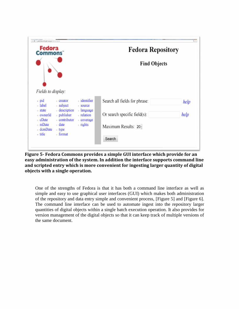
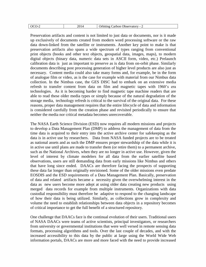
One of the strengths of Fedora is that it has both a command line interface as well as
simple and easy to use graphical user interfaces (GUI) which makes both administration
of the repository and data entry simple and convenient process, [Figure 5] and [Figure 6].
The command line interface can be used to automate ingest into the repository larger
quantities of digital objects within a single batch execution operation. It also provides for
version management of the digital objects so that it can keep track of multiple versions of
the same document.
Figure 5- Fedora Commons provides a simple GUI interface which provide for an easy administration of the system. In addition the interface supports command line and scripted entry which is more convenient for ingesting larger quantity of digital objects with a single operation.
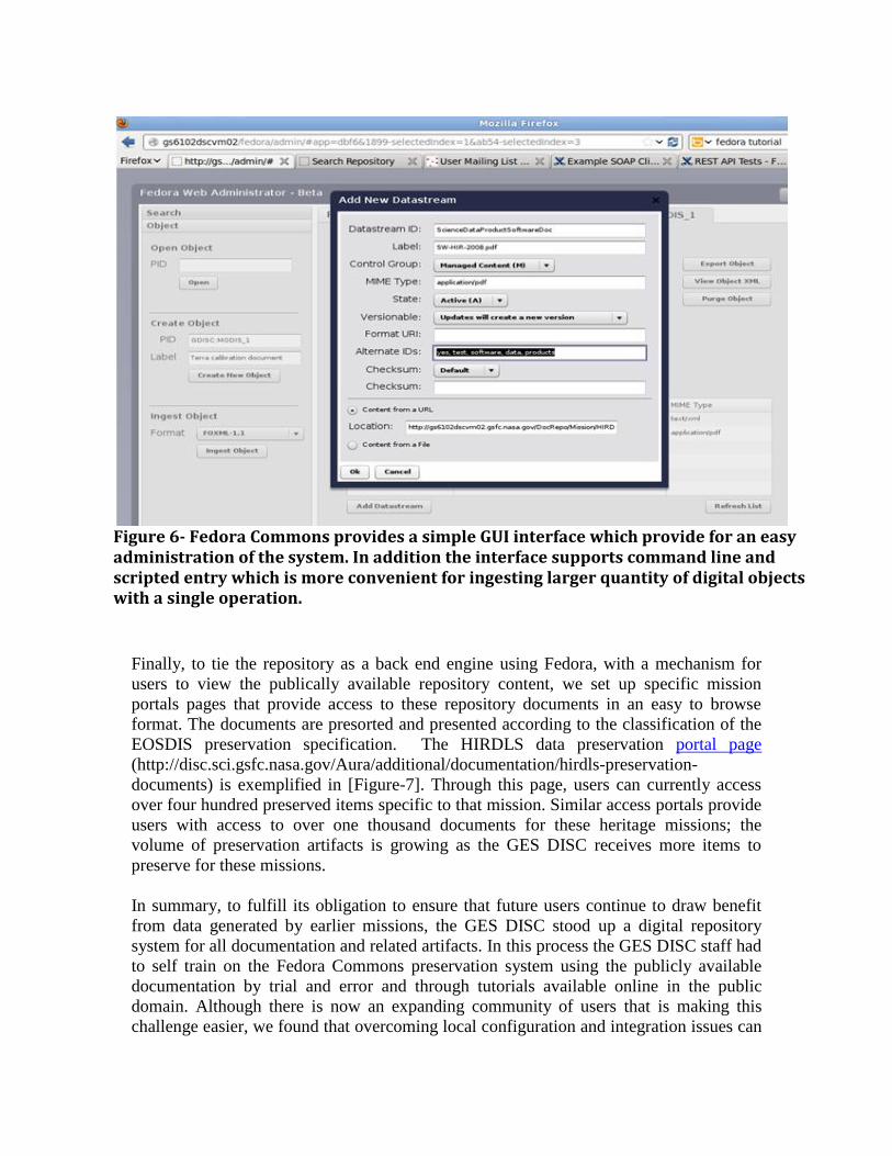
Finally, to tie the repository as a back end engine using Fedora, with a mechanism for
users to view the publically available repository content, we set up specific mission
portals pages that provide access to these repository documents in an easy to browse
format. The documents are presorted and presented according to the classification of the
EOSDIS preservation specification. The HIRDLS data preservation portal page (http://disc.sci.gsfc.nasa.gov/Aura/additional/documentation/hirdls-preservation-
documents) is exemplified in [Figure-7]. Through this page, users can currently access
over four hundred preserved items specific to that mission. Similar access portals provide
users with access to over one thousand documents for these heritage missions; the
volume of preservation artifacts is growing as the GES DISC receives more items to
preserve for these missions.
In summary, to fulfill its obligation to ensure that future users continue to draw benefit
from data generated by earlier missions, the GES DISC stood up a digital repository
system for all documentation and related artifacts. In this process the GES DISC staff had
to self train on the Fedora Commons preservation system using the publicly available
documentation by trial and error and through tutorials available online in the public
domain. Although there is now an expanding community of users that is making this
challenge easier, we found that overcoming local configuration and integration issues can
Figure 6- Fedora Commons provides a simple GUI interface which provide for an easy administration of the system. In addition the interface supports command line and scripted entry which is more convenient for ingesting larger quantity of digital objects with a single operation.

pose challenges that require iteration to resolve, so allocating extra test time for overall
project is highly recommended. Creating a dedicated prototype that could be used in a
sandbox playground setting to test document ingests and develop web interface
connectivity to portals that access Fedora was of great facility to our engineers in their
attempts to troubleshoot and eliminate configuration issues.
Conclusions and future plans
Because data from NASA’s missions are valuable scientific resources of interest to many
communities of users, data preservation efforts are intended to allow scientists to
continue to use the data well into the future. With every new generation of users comes
the possibility of new discoveries and reanalysis of data that was not envisioned earlier.
These new and innovative data exploitation methods prolongs the relevancy of heritage
missions longer that originally envisioned; it is critical, therefore, to ensure that we
understand what information is relevant and take steps to safe keep them.
In the course of performing this preservation task, we identified a number of key factors
that are important to ensure that this task is performed properly, namely: creating a
baseline for historical data to be preserved, recognizing that preservation artifacts come
Figure 7- The portal page to access and download the publicly accessible documentation for HIRDLS. Users can view the catalog of available documents from the repository and click to view or download unrestricted documents.

in many types and formats, making sure that a DMP exists, understanding the
relationship between the document or artifact types, and finally that large amount of work
is required in the judicious filtering, sorting, and tagging of documents. As
documentation constitutes an important mechanism to convey information to new users,
deciding what of the many hundreds of formal and informal documents and
communications generated in the life of a program is a key consideration and filtering
what makes the cut for preservation requires subject matter expertise. In terms of life
cycle lessons learned for data and information extraction ability in our preservation
activity, we can highlight the following as the most important ones:
Having a guidelines or baseline governing document helps sift through the many
hundreds of potential artifacts to identify what is really worthy of archival is
critical. Domain experts then use guidelines to classify each item accordingly,
deem it of no value for preservation, or extract what is worthy for preservation
into a new document among other alternate approaches.
There is a wide range of types and formats to documents, just as there is a breadth
in storage media types; this is an important aspect of data custodial preservation.
Open Source software systems could be a cost effective way for establishing an
archive system, especially one like Fedora Commons with so many built in
functionality suited for preservation; however, one must plan accordingly
allowing for sufficient time in project plans to allow for a do-it-yourself project
with low preservation budgets. Not having large license expenditures at the outset
could quickly be offset with how much longer a DIY project could take to
accomplish the task. Although we found a great large amount of online
information available in the public domain, Fedora’s wealth of functionality takes
a good bit of trial and error to setup and configure.
Lastly, understanding the legal and export limitations surrounding dissemination
of information is a complicating factor in preservation of documents. Our DAAC,
as is the case for many federal civilian agencies, provides free and unrestricted
access to the data we archive. However, this cannot be said about documents as
many of them are subject to proprietary commercial restrictions, or subject to U.S.
Department of Commerce export control regulations (ITAR). To adequately
comply with this regulation for an online repository requires technical
considerations (such as user registration and authentication) as well as additional
time and effort to understand how to comply with these regulations.
The HIRDLS prototype provided us with the initial experience to initiate a local
repository for documents and became the basis for completing the preservation activity
for the other missions at the GES DISC. We have extended these services for mission
documentations for Nimbus, the Upper Atmosphere Research Satellite (UARS), and
Total Ozone Mapping Spectrometer (TOMS). As we continue to expand our repository,
we plan to add documents for the Microwave Limb Sounder (MLS), Ozone Monitoring
Instrument (OMI), Atmospheric Infrared Sounder (AIRS), among others in the near
future. Currently, users can access over four hundred HIRDLS documents online from
our portal page. To date, over one thousand documents have been added to our repository
for the aforementioned missions and we are continually adding to this digital holding.
One of the challenges still remaining is to setup a user registration that can accommodate
the access to preserved documents. Devising an automated user registration mechanism
can take proper account of legal considerations and precautions surrounding the handling
and distributing these restricted documents. We will continue to monitor our user request
metrics to get a better handle on the level of interest for these types of documents and
what services to put in place to better serve our users.
References: 1. Esfandiari, M., H. Ramapriyan, J. Behnke, and J. , Sofinowski, 2006, E. “Evolution of the Earth
Observing System (EOS) Data and Information System (EOSDIS)”, Geoscience and Remote
Sensing Symposium. IGARSS 2006. IEEE International Conference on, pages 309 – 312,
2006,(DOI: 10.1109/IGARSS.2006.84) and https://earthdata.nasa.gov/about-eosdis
2. H. K. Ramapriyan, 2013, “NASA Earth Science Data Preservation Content Specification” NASA
Goddard Space Flight Center, EOSDIS Project Office Specification (423-SPEC-001), NASA
GSFC
https://earthdata.nasa.gov/sites/default/files/field/document/423-SPEC-
001_NASA%20ESD_Preservation_Spec_OriginalCh01_0.pdf
3. Steve Kempler, Chris Lynnes, Bruce Vollmer, Gary Alcott, and Stephen Berrick, 2009,
“Evolution of Information Management at the GSFC Earth Sciences (GES) Data and Information
Services Center (DISC)”, IEEE Transactions on Geoscience and Remote Sensing, Volume 47,
Issue 1, pages 21-28
4. Sandra Payette, and Carl Lagoze, 1998, “Flexible and Extensible Digital Object and Repository
Architecture (FEDORA)”, European Conference on Research and Advanced Technology for
Digital Libraries, Heraklion, Crete, published in Lecture Notes in Computer Science, Springer,
1998, pages 41-59
Acknowledgements
The authors wish to acknowledge extensive support for this work by the following GES DISC staff
members supporting this work: Barbara Deshong, Irina Gerasimov, James Johnson, Asghar Esfandiari, and
Michael Berganski. In addition, the GES DISC, funded by the Earth Science Data and Information System
(ESDIS) Project, is extremely appreciative of their support and guidance.