level 3 geography 91429 demonstrate understanding of a
TRANSCRIPT
1
Level 3 Geography
91429
Demonstrate understanding of a given environment(s) through selection and
application of geographic concepts and skills
Resource booklet
Refer to this booklet to answer the questions for Geography 91429.
Check that this booklet has pages 1-8 in the correct order and that none of these pages are blank
2
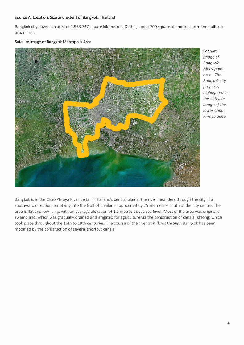
Source A: Location, Size and Extent of Bangkok, Thailand
Bangkok city covers an area of 1,568.737 square kilometres. Of this, about 700 square kilometres form the built-up
urban area.
Satellite Image of Bangkok Metropolis Area
Satellite
image of
Bangkok
Metropolis
area. The
Bangkok city
proper is
highlighted in
this satellite
image of the
lower Chao
Phraya delta.
Bangkok is in the Chao Phraya River delta in Thailand's central plains. The river meanders through the city in a
southward direction, emptying into the Gulf of Thailand approximately 25 kilometres south of the city centre. The
area is flat and low-lying, with an average elevation of 1.5 metres above sea level. Most of the area was originally
swampland, which was gradually drained and irrigated for agriculture via the construction of canals (khlong) which
took place throughout the 16th to 19th centuries. The course of the river as it flows through Bangkok has been
modified by the construction of several shortcut canals.
3
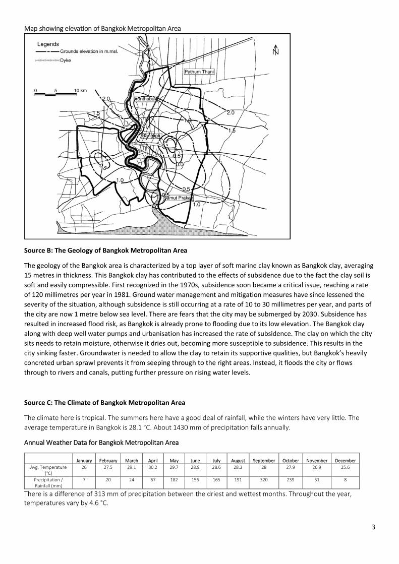
Map showing elevation of Bangkok Metropolitan Area
Source B: The Geology of Bangkok Metropolitan Area
The geology of the Bangkok area is characterized by a top layer of soft marine clay known as Bangkok clay, averaging
15 metres in thickness. This Bangkok clay has contributed to the effects of subsidence due to the fact the clay soil is
soft and easily compressible. First recognized in the 1970s, subsidence soon became a critical issue, reaching a rate
of 120 millimetres per year in 1981. Ground water management and mitigation measures have since lessened the
severity of the situation, although subsidence is still occurring at a rate of 10 to 30 millimetres per year, and parts of
the city are now 1 metre below sea level. There are fears that the city may be submerged by 2030. Subsidence has
resulted in increased flood risk, as Bangkok is already prone to flooding due to its low elevation. The Bangkok clay
along with deep well water pumps and urbanisation has increased the rate of subsidence. The clay on which the city
sits needs to retain moisture, otherwise it dries out, becoming more susceptible to subsidence. This results in the
city sinking faster. Groundwater is needed to allow the clay to retain its supportive qualities, but Bangkok’s heavily
concreted urban sprawl prevents it from seeping through to the right areas. Instead, it floods the city or flows
through to rivers and canals, putting further pressure on rising water levels.
Source C: The Climate of Bangkok Metropolitan Area
The climate here is tropical. The summers here have a good deal of rainfall, while the winters have very little. The
average temperature in Bangkok is 28.1 °C. About 1430 mm of precipitation falls annually.
Annual Weather Data for Bangkok Metropolitan Area
January February March April May June July August September October November December
Avg. Temperature (°C)
26 27.5 29.1 30.2 29.7 28.9 28.6 28.3 28 27.9 26.9 25.6
Precipitation / Rainfall (mm)
7 20 24 67 182 156 165 191 320 239 51 8
There is a difference of 313 mm of precipitation between the driest and wettest months. Throughout the year, temperatures vary by 4.6 °C.

4
Annual Average of Precipitation in Bangkok Metropolitan Area between 1965 – 2015
Year Annual Precipitation Total (mm) Year Annual Precipitation Total (mm)
1965 1675 1994 2206
1974 1394 2009 2293
1982 1945 2011 2392
1988 2050 2015 2015
Source D: Bangkok Metropolitan Flood Prone Areas
Map showing the areas at risk
of flooding during the 2011
Bangkok Flood.

5
Source E: Urbanisation
Risk of flooding in Bangkok has increased due to inadequate drainage infrastructure resulting from rapid
urbanisation. The city now relies on flood barriers and augmenting drainage from canals by pumping and building
drain tunnels, but parts of Bangkok and its suburbs are still regularly affected by flooding. Heavy downpours
resulting in urban runoff meaning the drainage systems, and runoff discharge from upstream areas are unable to
cope. As a result severe flooding affecting much of the city occurred recently in 1995 and 2011. In the latter, most of
Bangkok's northern, eastern and western districts became inundated, in some places for over two months. Global
warming poses further serious risks, and a study by the OECD has estimated that 5.138 million people in Bangkok
may be exposed to coastal flooding by 2070, the seventh highest among the world's port cities.
Population Density in the Bangkok Metropolitan Area.

6
Source F: Urban Sprawl
Map showing Urban Sprawl between 1850 – 2002.
Historical census population for Bangkok Metropolitan Area
Year Population Year Population
1919 437,294 1970 3,077,361
1929 713,384 1980 4,697,071
1937 890,453 1990 5,882,411
1947 1,178,881 2000 6,355,144 1960 2,136,435 2010 8,280,925

7
Source G: Subsidence of Bangkok and Flooding
Several factors – climate change, rising sea levels, coastal erosion, shifting clay soil – are threatening the great city on
the Chao Phraya delta, founded in 1782. The population has greatly increased, with about 10 million people now
living in the city and its suburbs. Even the weight of the skyscrapers, constantly on the rise due to population change,
is contributing to Bangkok's gradual immersion. Much of the metropolis is now below sea level and the ground is
subsiding by 1.5 to 5cm a year.
In the medium to long term more than 1 million buildings, 90% of which are residential, are under threat from the
rising sea level. In due course the ground floors of buildings could be awash with 10cm of water for part of the year,
according to the Asian Institute of Technology. In the port of Samunt Prakan, about 15 km downstream from the
capital, the residents of detached houses along the river already spend several months a year up to their ankles in
water.
Illegal tapping of groundwater is one of the causes of the capital's misfortunes, according to Jan Bojo, a World Bank
expert based there. Not all the specialists endorse this view, but they do agree the situation is bound to deteriorate
over the next few years. Smith Dharmasaroja, the head of the National Disaster Warning Centre, is predicting that by
2100 Bangkok will have become a new Atlantis. Dharmasaroja's forecasts are being taken seriously: in the 1990s he
predicted the fearful tsunami that devastated countries around the Indian Ocean in 2004.
Dharmasaroja maintains that "no decision has been taken" at government level "to stop the problem". And, he adds,
if nothing is done Bangkok could be underwater by 2030.
One of the solutions he has suggested is to build a series of dykes along the coast of the Gulf of Thailand, a scheme
that would cost over $2bn. He says work should start immediately, otherwise it will be too late to halt the chain of
events leading to disaster. "The rise in sea level is not that great and climate change only plays a fairly small part –
about one-fifth – in the current scenario," he adds. "It's pointless," he stresses, "to try to protect the coastline, which
is being eroded by three to four centimetres a year. But there are plenty of other ways of combating flooding, such
as better management of building land in the city."
Niramon Kulsrisombat, a town planner and lecturer in urban and regional planning at Chulalongkorn University,
confirms that "floods have always occurred, Bangkok having been built on sodden terrain 1.5 metres below sea
level". A network of khlongs (canals), fields and allotments used to soak up flooding, but with recent urbanisation
many buildings have taken their place and the water is trapped. "Government efforts have focused on raising
barriers 2.8 metres high along various stretches of the Chao Phraya," Kulsrisombat explains, "but this has just done
even more damage to the traditional appearance of a settlement where people lived on the water in houses on
stilts."
This subsidence is accelerated by the sheer number, size and weight of all the buildings pressing down on the land all
around Bangkok according to recent research. "There are about 700 buildings with 20 floors or more and 4,000
buildings with 8-20 floors in Bangkok," said Witthaya Kulsomboom, the head of the committee. "There are also many
electric railways. These could cause the submergence of parts of Bangkok and surrounding areas in the future."
Table showing the number of Constructed Residential Buildings (between 12-74 floors)
Year Total Number of Buildings Year Total Number of Buildings
1995 7 2011 3
1996 1 2012 5
1998 1 2013 3 1999 2 2014 4
2006 3 2015 5
2007 3 2016 3
2008 4 2017 7
2009 6 2018 4 (to date)
2010 4
8
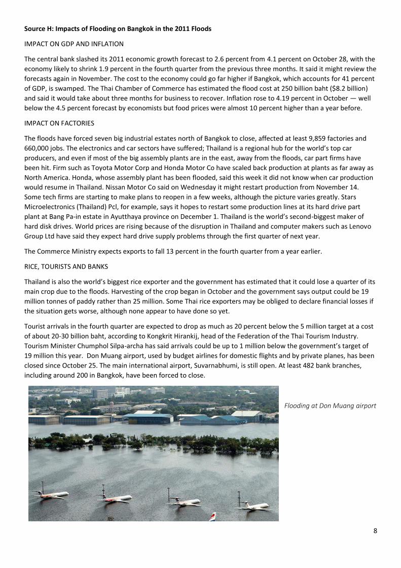
Source H: Impacts of Flooding on Bangkok in the 2011 Floods
IMPACT ON GDP AND INFLATION
The central bank slashed its 2011 economic growth forecast to 2.6 percent from 4.1 percent on October 28, with the
economy likely to shrink 1.9 percent in the fourth quarter from the previous three months. It said it might review the
forecasts again in November. The cost to the economy could go far higher if Bangkok, which accounts for 41 percent
of GDP, is swamped. The Thai Chamber of Commerce has estimated the flood cost at 250 billion baht ($8.2 billion)
and said it would take about three months for business to recover. Inflation rose to 4.19 percent in October — well
below the 4.5 percent forecast by economists but food prices were almost 10 percent higher than a year before.
IMPACT ON FACTORIES
The floods have forced seven big industrial estates north of Bangkok to close, affected at least 9,859 factories and
660,000 jobs. The electronics and car sectors have suffered; Thailand is a regional hub for the world’s top car
producers, and even if most of the big assembly plants are in the east, away from the floods, car part firms have
been hit. Firm such as Toyota Motor Corp and Honda Motor Co have scaled back production at plants as far away as
North America. Honda, whose assembly plant has been flooded, said this week it did not know when car production
would resume in Thailand. Nissan Motor Co said on Wednesday it might restart production from November 14.
Some tech firms are starting to make plans to reopen in a few weeks, although the picture varies greatly. Stars
Microelectronics (Thailand) Pcl, for example, says it hopes to restart some production lines at its hard drive part
plant at Bang Pa-in estate in Ayutthaya province on December 1. Thailand is the world’s second-biggest maker of
hard disk drives. World prices are rising because of the disruption in Thailand and computer makers such as Lenovo
Group Ltd have said they expect hard drive supply problems through the first quarter of next year.
The Commerce Ministry expects exports to fall 13 percent in the fourth quarter from a year earlier.
RICE, TOURISTS AND BANKS
Thailand is also the world’s biggest rice exporter and the government has estimated that it could lose a quarter of its
main crop due to the floods. Harvesting of the crop began in October and the government says output could be 19
million tonnes of paddy rather than 25 million. Some Thai rice exporters may be obliged to declare financial losses if
the situation gets worse, although none appear to have done so yet.
Tourist arrivals in the fourth quarter are expected to drop as much as 20 percent below the 5 million target at a cost
of about 20-30 billion baht, according to Kongkrit Hirankij, head of the Federation of the Thai Tourism Industry.
Tourism Minister Chumphol Silpa-archa has said arrivals could be up to 1 million below the government’s target of
19 million this year. Don Muang airport, used by budget airlines for domestic flights and by private planes, has been
closed since October 25. The main international airport, Suvarnabhumi, is still open. At least 482 bank branches,
including around 200 in Bangkok, have been forced to close.
Flooding at Don Muang airport

9
Sources:
Satellite Image: https://en.wikipedia.org/wiki/Bangkok#/media/File:Bangkok_satellite_city-area.jpg
Phien-wej, N.; Giao, P.H.; Nutalaya, P (2 February 2006). "Land subsidence in Bangkok, Thailand". Engineering
Geology. 82 (4): 187–201. doi:10.1016/j.enggeo.2005.10.004.
https://web.archive.org/web/20071030034936/http://edition.cnn.com/2007/TECH/science/10/22/thailand.water.risi
ng.ap/index.html
https://en.wikipedia.org/wiki/Bangkok
https://en.climate-data.org/location/6313/
https://www.channelnewsasia.com/news/asia/asia-s-future-cities-can-bangkok-turn-back-the-rising-tide-and-s-
7612754
Urban Sprawl Map: https://www.researchgate.net/figure/The-Expansion-of-Bangkok-Thailand-1850-
2002_fig15_267418628
http://www.thaitravelblogs.com/2011/10/map-of-flood-risk-areas-in-bangkok/
https://journals.openedition.org/netcom/docannexe/image/2725/img-1-small580.jpg
https://www.theguardian.com/environment/2011/sep/06/bangkok-thailand-risks-steadily-sinking
https://www.reuters.com/article/us-thailand-foods-factbox/factbox-thailands-flood-crisis-and-the-economy-
idUSTRE7A11BC20111102
https://wordlesstech.com/worst-flooding-in-thailands-history/
https://en.tutiempo.net/climate/ws-484550.html
https://weather.com/science/environment/news/bangkok-sinking-subsidence-warming-15-years
http://www.skyscrapercenter.com/quick-lists#q=&page=1&type=building&type=tower&type=supported-
tower&status=COM&functions_concatenated=residential&min_year=1885&max_year=2018®ion=0&country=0&c
ity=1471