legacy sediment: definitions and processes of episodically...
TRANSCRIPT

Anthropocene 2 (2013) 16–26
Legacy sediment: Definitions and processes of episodically producedanthropogenic sediment
L. Allan James *
Geography Department, University of South Carolina, 709 Bull Street, Columbia, SC 29208, USA
A R T I C L E I N F O
Article history:
Received 6 February 2013
Received in revised form 2 April 2013
Accepted 2 April 2013
Keywords:
Legacy sediment
Post-settlement alluvium
Human environmental impacts
Geomorphology
Rivers
A B S T R A C T
Extensive anthropogenic terrestrial sedimentary deposits are well recognized in the geologic literature
and are increasingly being referred to as legacy sediment (LS). Definitions of LS are reviewed and a broad
but explicit definition is recommended based on episodically produced anthropogenic sediment. The
phrase is being used in a variety of ways, but primarily in North America to describe post-settlement
alluvium overlying older surfaces. The role of humans may be implied by current usage, but this is not
always clear. The definition of LS should include alluvium and colluvium resulting to a substantial degree
from a range of human-induced disturbances; e.g., vegetation clearance, logging, agriculture, mining,
grazing, or urbanization. Moreover, LS should apply to sediment resulting from anthropogenic episodes
on other continents and to sediment deposited by earlier episodes of human activities.
Given a broad definition of LS, various types of LS deposits are described followed by a qualitative
description of processes governing deposition, preservation, and recruitment. LS is deposited and
preserved where sediment delivery (DS) exceeds sediment transport capacity (TC). This can be expressed
as a storage potential ratio that varies within and between basins and through time. When DS/TC < 1,
recruitment and transport of LS dominate, but if DS/TC > 1, deposition and preservation are likely. When
DS/TC� 1, abundant deposition and graded deposits are likely even without barriers or sinks. Thus,
spatial patterns of LS deposits may reveal information about past land-use history and hydrodynamics in
a catchment.
� 2013 Elsevier Ltd All rights reserved.
Contents lists available at SciVerse ScienceDirect
Anthropocene
jo ur n al ho m epag e: ww w.els evier . c om / lo cat e/an c en e
1. Introduction
Anthropogenic sediment is an extremely important element ofchange during the Anthropocene. It drives lateral, longitudinal,vertical, and temporal connectivity in fluvial systems. It providesevidence of the history and geographic locations of pastanthropogenic environmental alterations, the magnitude andcharacter of those changes, and how those changes may influencepresent and future trajectories of geomorphic response. It maycontain cultural artifacts, biological evidence of former ecosystems(pollen, macrofossils, etc.), or geochemical and mineralogicalsignals that record the sources of sediment and the character ofland use before and after contact. Rivers are often dominated bycultural constructs with extensive legacies of anthropogeomorphicand ecologic change. A growing awareness of these changes isguiding modern river scientists to question if there is such a thingas a natural river (Wohl, 2001; Wohl and Merritts, 2007).
Abbreviations: LS, legacy sediment; SDR, sediment delivery ratio; PSA, post
settlement alluvium.
* Tel.: +1 800 777 6117.
E-mail address: [email protected]
2213-3054/$ – see front matter � 2013 Elsevier Ltd All rights reserved.
http://dx.doi.org/10.1016/j.ancene.2013.04.001
Understanding anthropogeomorphic change goes well beyondan academic question because it bears upon basic decisions in riverrestoration, water quality regulations, aquatic ecosystem manage-ment, sediment budgets, flood-risk management, and long-termgeomorphic trajectories.
Recognition of the tremendous contributions of anthropogenicsediment to modern sediment budgets by early geomorphologists(Gilbert, 1917; Happ et al., 1940; Knox, 1972) led to a fundamentalreconsideration of sediment sources in many fluvial environments.Theories of sediment delivery and storage that blossomed in the1970s, coupled with the recognition of massive loadings ofanthropic sediment, lead to the inescapable conclusion that manyfluvial systems are highly dynamic and not in equilibrium withregards to a balance between sediment loads and transportcapacity (Trimble, 1977). For example, high sediment loadings instreams of the Atlantic Coastal Plain of the northeastern USA arebetter explained by recruitment of anthropogenic sediment fromfloodplains and terraces than by intensive upland land use (Walterand Merritts, 2008; Wohl and Rathburn, 2013). The awareness ofanthropogenic sediment has a long history, although the depositshave been referred to by various names. In many regions of NorthAmerica, sedimentary deposits were produced by acceleratederosion associated with intensive land clearance and agriculture

Fig. 1. Number of occurrences of ‘‘legacy pollut*’’ and ‘‘legacy contam*’’ occurring in
samples from Internet searches of scientific publications. The frequency of these
strings is much greater than ‘‘legacy sediment’’ (Table 1), and may begin slightly
earlier, but rapid growth after 2005 is common to all.
L.A. James / Anthropocene 2 (2013) 16–26 17
following EuroAmerican settlement (Happ et al., 1940; Happ,1945; Knox, 1972, 1977, 1987, 2006; Trimble, 1974; Costa, 1975;Magilligan, 1985; Jacobson and Coleman, 1986; Faulkner, 1998;Lecce and Pavlowsky, 2001; Florsheim and Mount, 2003; Jacksonet al., 2005; Walter and Merritts, 2008; Gellis et al., 2009; Merrittset al., 2011; Hupp et al., 2013). Mining also generated largesedimentation events in North America (Gilbert, 1917; Knox, 1987;James, 1989; Leigh, 1994; Lecce, 1997; Stoughton and Marcus,2000; Marcus et al., 2001; Bain and Brush, 2005; Lecce et al., 2008).These anthropogenic deposits are being increasingly referred to as‘legacy sediment’ (LS) by environmental scientists.
Anthropogenic sediment does not occur uniformly over thelandscape but collects in certain locations where it createslandforms. Types of LS deposits vary greatly from colluvial drapeson hill sides, to aprons and fans at the base of hill slopes, to a varietyof alluvial depositional features in channels, floodplains, deltas,lakes, and estuaries. (‘Colluvium’ is used broadly in this paper toinclude mass wasting as well as sheetflow and rill deposits on or atthe base of hillslopes (Fairbridge, 1968). It does not necessarilyconnote anthropogenically produced sediment (LS) as may beimplied in central Europe (Leopold and Volkel, 2007).) A typologyof LS is described based on locations and geomorphology ofdeposits. Explanations for heterogeneous spatial patterns of LSdeposits are given based on differences in sediment production,transport capacity, accommodation space in valley bottoms, andother factors that are intrinsically geomorphic. An explanation ispresented for the processes that govern sediment storagepotential, delivery ratios, and lateral, longitudinal, and temporalconnectivity. These concepts are essential to understanding whyanthropogenic sediment is located where it is, how it behaved overthe Anthropocene, and how it may behave in the future.
2. Use and definitions of ‘legacy sediment’
2.1. Increasing use
The concept of inheriting a legacy from the past is pervasive inthe environmental science literature, and LS is a logical outgrowthof that perspective. Over the first decade of the new millennium,the term, legacy sediment (LS) began to be used with increasingfrequency in a variety of contexts. A partial Internet sample ofpublished scientific papers or reports that contain the phrase
Table 1An Internet sample of studies that refer to ‘legacy sediment’.
Location Context Source
California PSA Canuel et al
Georgia PSA Schoonover
Idaho Logging, grazing, mining Goode et al.
Kentucky LU change Russo and F
Maryland PSA, Ag Allmendinge
Minnesota PSA Gran et al. (
New Hampshire PSA Pearson et a
North Carolina PSA, Ag Hupp et al.
Ohio LU change Peck et al. (
Pennsylvania PSA Walter et al
Schenk et al
South Carolina PSA James (2006
Tennessee LU change Cowan et al
Virginia PSA Ag Hupp et al.
Vermont Deforestation McBride et
Wisconsin PSA Fitzpatrick e
North America (in passim) PSA Novotny (20
California Mining James (2010
North Carolina Mining Pavlowsky e
United Kingdom LU change (post industrial) Hale et al. (
‘legacy sediment’ indicates that use of the term has proliferated,especially in the eastern USA, and across a range of disciplinesincluding geomorphology, hydrology, ecology, environmentaltoxicology, and planning (Table 1). The earliest occurrence ofthe term was in 2004 and was concerned with the effects of coppercontamination from legacy sediment on water quality (Novotny,2004). By 2007, LS had appeared in several studies of historicalalluvium in the eastern USA. The use of LS to describe historicalfloodplain alluvium increased greatly with the findings of legacymill-pond surveys in Pennsylvania, USA (Walter and Merritts,2008; Merritts et al., 2011). Although these two publications do notuse the phrase, it was used by the authors and others as early as2005 in abstracts and field trip logs in association with sedimenttrapped in legacy mill ponds. The use of ‘legacy sediment’ inpublications grew at about the same time as the use of ‘legacycontaminants’ and ‘legacy pollution.’ An Internet search ofpublications with the phrases ‘‘legacy contam*’’ and ‘‘legacypollut*’’ in Wiley Online and Science Direct indicate a much largernumber of uses of those terms than LS, but a similar—perhapsslightly earlier—timing of rapid growth (Fig. 1).
The contexts in which LS is used in publications vary widelyfrom sources of legacy contaminations in toxicological studies(Bay et al., 2012), to sediment budgets (Gellis et al., 2009), tofluvial geomorphic and ecological processes (Hupp et al., 2009).This paper examines questions of geographic location,
. (2009), Stein and Cadien (2009), Bay et al. (2012), Greenfield and Allen (2013)
et al. (2007), Neary et al. (2009), Mukundan et al. (2011)
(2012)
ox (2012)
r et al. (2007), Weber and Allen (2010), Schenk et al. (2012)
2011)
l. (2011)
(2009), Clinton (2011), Riggsbee et al. (2012)
2007)
. (2007), Galster et al. (2008), deWet et al. (2011), Schenk and Hupp (2009),
. (2012), Niemitz et al. (2013)
, 2010)
., 2013
(2013), Schenk et al. (2012)
al. (2008)
t al. (2010)
04), Trimble (2008)
)
t al. (2010)
2010)

L.A. James / Anthropocene 2 (2013) 16–2618
age, stratigraphic nomenclature, and genetic processes, in anattempt to clarify the concept of LS and avoid vague, obscure, orconflicting uses of the term. Ultimately, a definition of LS issuggested with broad applicability to sedimentary bodiesgenerated by anthropogenic depositional episodes.
2.2. Initial definitions of LS
Much usage of the term LS has gone without an explicitdefinition and relies on preconceived understandings or implica-tions that may vary between disciplines. The primary impliedmeanings apparently are the historical age or the anthropogenicorigin of the sediment. One consideration in defining LS is toexamine the etymology of legacy. ‘Legacy’ is defined by MerriamWebsters dictionary as ‘‘something transmitted by or receivedfrom an ancestor or predecessor or from the past <the legacy of theancient philosophers>’’; i.e., an inheritance. Although this leavesopen the possibility that ‘‘legacy sediment’’ simply refers tosomething from the past, all sediment results from past processes,so legacy sediment would be redundant in that sense. Thus, whenthe phrase LS is used without definition or contextual explanation,a more specific meaning is implied. In general, an anthropogenicorigin may be implicit, given the definition of legacy as something‘from an ancestor or predecessor;’ i.e., it may logically follow thathuman agency was involved. In this sense, and building uponrecent usage of the term, LS resulted, at least in part, fromanthropically accelerated sediment production. Although ‘‘legacy’’has been used in different contexts to describe naturally producedsediment; e.g., a legacy of climate change, the phrase, LS, by itselfshould be used to imply that humans played a substantial role inthe processes that generated the sediment.
Definitions that have been given for LS vary but usuallyindicate a post-colonial age of alluvium in North America (e.g.,Niemitz et al., 2013). Many questions about the specific source,physical character, extent, or location of LS have not beenaddressed. For example, does the definition of LS apply narrowlyto agriculturally derived alluvium, or does it include other landuses such as logging and mining? Does it include colluvium onhillslopes and fans? Is LS defined by its lithologic or chronologiccharacteristics? If LS is a lithologic unit, is it restricted to theanthropogenic component of the sediment or is the diluted massconsidered to be a LS deposit as a whole? Since LS is usually mixedwith sediment from other sources, what proportion of anthropo-genic sediment is required for the deposit to be considered LS? Orhow intensive must land-use change have been in how much ofthe catchment? If LS is a chronologic unit that begins with theonset of settlement, does it stop being formed with primarydeposition, or does it continue to propagate through reworking? Isthere a minimum thickness to LS or are areas of deposits includedthat pinch out laterally or longitudinally? Is there a minimumextent? Specifying answers to all of these questions is notnecessary for a broad concept of LS to be useful, but the questionsdemonstrate vagueness often associated with the present use ofthe term and the need for a definition that provides some clearconstraints.
A Legacy Sediment Workgroup—established by the Pennsylva-nia Department of Environmental Protection (PDEP) to evaluatehistorical alluvium in Pennsylvania—generated two definitions ofLS for use within the Pennsylvania regional context. The firstdefinition is listed as ‘generic’ and is more broadly applicable toother areas:
‘‘Sediment that was eroded from upland hill slopes after thearrival of early Colonial American settlers and during centuriesof intensive land uses; that was deposited in valley bottomsalong stream corridors, burying pre-settlement streams,
floodplains, wetlands, and valleys; and that altered andcontinues to impair the hydrologic, biologic, aquatic, riparian,and chemical functions of pre-settlement and modern envir-onments. Legacy sediment often accumulated behind ubiqui-tous low-head mill dams and in their slackwater environments,resulting in thick accumulations of fine-grained sediment.’’PDEP Legacy Sediment Workgroup (nd)
While appropriate for the immediate task of the PDEP todescribe historical alluvium along rivers in Pennsylvania, thisdefinition contains specific constraints that limit the definition. Amore specific ‘technical definition’ was also presented:
Legacy Sediment (n.) Sediment that (1) was eroded from uplandslopes during several centuries of intensive land clearing,agriculture, and milling (in the eastern U.S., this occurred fromthe late 17th to late 19th Centuries); (2) collected along streamcorridors and valley bottoms, burying pre-settlement streams,floodplains, wetlands, and dry valleys; and that altered thehydrologic, biologic, aquatic, riparian, and chemical functions ofpre-settlement streams and floodplains; (3) accumulatedbehind ubiquitous low-head mill dams in slackwater environ-ments, resulting in thick accumulations of fine-grained sedi-ment, which distinguishes ‘‘legacy sediment’’ from fluvialdeposits associated with meandering streams; (4) can alsoaccumulate as coarser grained, more poorly sorted colluvial(not associated with stream transport) deposits, usually atvalley margins; (5) can contain varying amounts of totalphosphorus and nitrogen, which contribute to nutrient loads indownstream waterways from bank erosion processes. . .’’ PDEPLegacy Sediment Workgroup (nd)
To interpret this definition assume that, as in dictionaries, eachnumbered item provides an alternate definition; that is, these canbe interpreted as ‘or’ rather than ‘and’ conditions. Thus, the firstpoint provides a broad category for agriculturally produced post-settlement alluvium. The second describes a set of lowland siteswhere LS is likely to be deposited, and the fourth definitionincludes colluvium. Although these definitions may work well forthe region and purposes for which they were derived, they largelyconstrain the scope of LS to sediment produced by agriculture onhill slopes and deposited in lowlands during post-Colonial time inNorth America.
2.3. A broader definition
A more general definition of LS is needed for the variousapplications of the term that are emerging in the scientificliterature. The definition should be flexible enough to includesediment produced by a range and mixture of anthropogenicactivities that may have resulted in a wide variety of depositionalsites, processes, and sedimentary structures and textures. First, thedefinition of LS should include human activities beyond agricul-tural clearance; i.e., lumbering, mining, road building, urbaniza-tion, and other land-use practices (Fig. 2). By including sedimentfrom resource extraction activities such as mining and logging, thisdefinition of LS may differ somewhat from some literal inter-pretations of post-settlement alluvium (PSA). Deposition frommining, lumbering, and other such activities may occur in extra-frontier outposts prior to or without settlement of a region, so LSmay apply to anthropogenic deposits in addition to PSA. Given thedifficulties of (1) determining the source of sedimentary materials,(2) the polygenetic histories of many deposits, and (3) complexitiesof isolating effects of climate change, thorough and preciseidentification of how sediment was produced should not be asticking point as long as it is clear that the deposit is associatedwith processes substantially accelerated by human activities. The

Fig. 2. Braid-bar terraces of Shady Creek, California. This is a small creek that
received large volumes of hydraulic gold mining sediment in the 19th century,
aggraded, then incised. The white terrace sands and gravels are a legacy of mining.
Photographed November, 2002 by author.
L.A. James / Anthropocene 2 (2013) 16–26 19
term has a logical potential to describe broad classes ofanthropogenic sediment in a variety of environments and it isincreasingly being used that way in the literature.
With regard to geomorphic forms and position on thelandscape, LS deposits may progress through facies changes fromrills and gullies, to cobble- and gravel-bed streams in steep valleys,to floodplains and channel fill along large rivers, to fine-graineddeposits in slack-water environments. Definitions that attempt toseparate one part of a facies can falter if changes are timetransgressive or if channel morphogenesis has occurred. Differentfluvial environments may dominate a site at different times duringa depositional episode resulting in strata that represent multipleenvironments. For example, a meandering channel floodplain maybe converted to a braided channel and revert back to a meanderingchannel all within a single period of settlement. A debris flow froma side valley may deposit coarse colluvium on top of laminatedoverbank silts leaving cobbles overlying fine-grained material inan historical section. Defining LS on the basis of a particular phaseor environment of deposition can be problematic. Some definitionsof LS have emphasized the impacts on modern fluvial systems(PDEP, nd; Niemitz et al., 2013). Although LS is often highlydisruptive to environmental systems (Wohl and Rathburn, 2013)and this is very important in environmental management,substantial alterations to hydrologic, biologic, aquatic, riparian,and chemical functions should not be a defining condition forsediment to be classified as LS.
These factors, together with common usage of the term, providethe basis for a definition of LS as sedimentary deposits generatedepisodically by human activities:
‘‘Legacy sediment: Earth materials—primarily alluvium [orcolluvium]—deposited following human disturbances such asdeforestation, agricultural land use, or mining. The phrase isoften used to describe post-European floodplain sediment, alsoknown as post settlement alluvium. Awareness of legacysediment has grown in response to the importance it plays insediment budgets, water quality, river restoration, toxicity,lateral channel connectivity, and geomorphic theory. . .’’ (James,2013, Glossary)
‘‘Legacy sediment is primarily alluvium [and colluvium] thatwas deposited following human disturbances in a watershed.The disturbance may have been in the form of deforestation,plowing agricultural land, mining, or other land-use changes. In
North America and Australia, legacy sediments are ubiquitousand represent episodic erosion in response to the colonizationof land by European settlers who introduced Old World land-clearance technologies (e.g. steel tools and plows pulled bydraft animals) and export economies. In these settings, legacysediments are often described as post-settlement alluvium(PSA), which may cover entire floodplains and bury the pre-settlement soil with a thick mantle of relatively young stratifiedsediment (Griffiths, 1979; Knox, 1972, 1977, 2006). (James,2010, p. 588)
These definitions refer to the entire depositional body, notsimply the anthropogenic portions of sediment within the deposit.LS deposits are deposited over a period of centuries but they aretime transgressive because initiation as well as peak rates mayoccur at different times within a basin and at largely differenttimes between regions. Production of LS may be polycyclic withmultiple events over time, such as when failed mill dams orcollapsed gully walls produce a second cycle of anthropogenicsediment. Thus, LS cascades may occur in space as reworking of LSmoves sediment down hillslopes, into channels, and onto flood-plains (Lang et al., 2003; Fuchs et al., 2011). LS may have a distinctlithology and geochemistry or it may be highly variable down-valley or between subwatersheds and indistinguishable fromunderlying sediment. Non-anthropic sediment will usually bemixed with anthropic sediment, so LS is usually diluted and rarelypurely of anthropic origin. In regions with deep LS deposits theanthropogenic proportion is likely to be high. Several studies haveshown greatly accelerated sediment deposition rates after distur-bance and relatively slow background sedimentation rates(Gilbert, 1917; Knox, 2006). Although there are importantexceptions to the assumptions of low pre-settlement and highpost-settlement sedimentation rates in North America (James,2011), pre-Columbia sediment accumulation rates were generallyan order of magnitude lower than post-settlement rates. Thus, PSAis likely to contain a high proportion of anthropogenic sediment,and the assumption of substantial proportions of anthropicsediment in such a deposit is often appropriate.
2.4. Beyond North America
The definition of LS should extend to deposits generated over awide range of geographic domains and from prehistory to recenttime. For example, vast sedimentary deposits in Australia and NewZealand have been well documented as episodic responses to land-use changes following European settlement (Brooks and Brierley,1997; Gomez et al., 2004; Brierley et al., 2005). These deposits arein many ways similar to those in North America and represent alegacy of relatively recent destructive land use superimposed onrelatively stable pre-colonial land surfaces. Moreover, LS can alsobe used to describe Old World sedimentary units that were inresponse to episodic land-use changes. Sedimentation episodeshave been documented in Eurasia for various periods of resourceextraction or settlement (Lewin et al., 1977; Lang et al., 2003;Macklin and Lewin, 2008; Houben, 2008; Lewin, 2010). Olderperiods of episodic erosion and sedimentation associated withhuman settlement in Europe have been documented as far back asthe Neolithic, Bronze Age, and Iron Age in parts of Europe andBritain (Macklin and Lewin, 2008; Dotterweich, 2008; Reiß et al.,2009; Dreibrodt et al., 2010). In some locations, multiple phases ofLS generation can be inferred from Neolithic, Roman, or latergullies that once produced sediment but have subsequently beenfilled in with younger deposits (Dotterweich, 2005; Vanwalleghemet al., 2006; Reiß et al., 2009). In short, major sedimentary depositsproduced episodically by logging, mining, domestic grazing, oragriculture in the Old or the New World can be referred to as LS.

Fig. 3. Four phases of an aggradation–degradation episode (ADE): (1) single thread
channel prior to disturbance; (2) channel and floodplain aggrade; possibly forming
forming a braided channel, in response to sediment loads in excess of transport
capacity; (3) as sediment loads return to background levels, channels rejoin and
incise down to original levels; (4) channels widen over a longer period of time. See
James and Lecce (2013) for description of ADEs.
L.A. James / Anthropocene 2 (2013) 16–2620
2.5. LS as a stratigraphic unit
From a stratigraphic perspective, LS may be described by twotypes of materials: lithostratigraphic units (LSU) or chronostrati-graphic units (CSU). A LSU is identified on the basis of distinctivelithic [or pedogenic] characteristics and conforms with the Law ofSuperposition; that is, it lies above older sediment and may beburied by younger sediment (NACSN, 2005). These are the unitsthat are mapped in the field based on their physical properties(Murphy and Salvador, 1994). A CSU serves as the referencematerial for other sediment deposited during the same period oftime. It should consist of materials of only a certain time period.Applying either classification to LS has strengths and weaknesses;problems not unique to LS. As a lithostratigraphic unit, LS generallyconforms with Steno’s Law of Superpositioning, but it may nothave common lithologic or pedogenic characteristics betweendifferent catchments or regions that distinguish it from othersediment in that catchment. Yet, LS can often be identified on thebasis of soil stratigraphy, sedimentary textures or structures,geochemistry, or fossils, and these features may be used to identifysources (fingerprinting) or to infer processes and environments offormation. As a chronostratigraphic unit, LS may be timetransgressive and vary in age across the landscape as changes inland use often varied through time. Yet, LS often represents adistinct period of human land use and settlement that can beidentified by relative dating or cultural artifacts and traced across alandscape. This can make LS an important tool for documentingAnthropocene history.
3. Implications of episodicity
Given the ubiquity of anthropogenically accelerated sedimentproduction during the late historic period, it could be argued thatall historic sediment has a component of anthropogenic inputs andshould be defined as LS. Instead, LS should be reserved for depositsthat represent substantially accelerated rates of sedimentation dueto a component of anthropogenic disturbance. Thus, LS should notbe used synonymously with ‘historical’ sediment sensu stricto,because LS carries the connotation of episodically producedanthropogenic sedimentation. This does not preclude sedimenta-tion events generated, in part, by climatic change or tectonics aslong as substantial production was generated by human activity.
During periods of intensive land use; e.g., clearance andplowing for agriculture, grazing, timbering, mining, etc., an episodeof high sediment production may result in channel aggradationdownstream. In extreme cases, aggradation may extend ontofloodplains where large volumes of anthropogenic sediment maybe stored (Fig. 3). When the intensive land-use practices cease andsediment production returns to background levels, channelsusually incise, leaving large deposits on the former floodplain asterrace deposits. Following relatively rapid channel down-cutting,lateral erosion of channels takes a much longer time to widenfloodplains and erode the stored LS (Simon and Hupp, 1986). Thus,the initial return of channels to their pre-disturbance base levelsand gradients occurs long before the erosion and reworking of LS iscomplete. Such a sequence can be described as an aggradation–
degradation episode (ADE) (James and Lecce, 2013) and representsthe passage of a bed wave and a sediment wave (James, 2010).Protracted sediment production from this long term reworkingrepresents a form of temporal connectivity in which the systemmemory of past sedimentation events is propagated into thefuture. If the floodplain had been relatively stable prior to theevent, a distinct soil may have formed on it. In many cases, the LSdeposits left behind by the ADE may be distinguished from theearlier alluvium by an abrupt contact of recent alluvium overlyinga buried soil that can be seen in bank exposures and cores (Fig. 4).
The post-settlement period in North America provides manywidespread examples of ADEs. Accelerated sediment productionbegan with land clearance, hillslope erosion, and sedimentdeliveries in small catchments early in the sequence. Later,post-settlement alluvium arrived down-valley, channels aggraded,and floodplains were buried by overbank deposition. As land-usepressures decreased in the mid-twentieth century—possibly inresponse to cessation of farming or mining or to initiation of soilconservation measures, and possibly aided by dam constructionupstream—sediment deliveries decreased, channels incised, andformer aggraded floodplains were abandoned as terraces. In manyplaces channel beds have returned to pre-settlement base levelsand are slowly widening their floodplains. LS may continue to bereworked by this process and delivered to lower positions in largebasins for many centuries. Recognition of these protractedresponses to LS is essential to an understanding of watershedsediment dynamics.
4. Types and geomorphic positions of LS deposits
The production of LS comes from a variety of sources anddeposits are located in a variety of geomorphic positions on thelandscape. LS may occur on hillslopes as colluvium, as alluvium onfloodplains and wetlands, or slack-water or deltaic deposits inlakes and estuaries (Table 2). Production of most LS begins onuplands and much of the sediment does not travel far, so colluvialdeposits can be very important. This may not be widely recognizedbecause deep and widespread colluvial deposits are largelyunexposed and may not be mapped. Colluvial deposits of LSinclude midslope drapes, aprons, and fans. Drapes of relatively thinsheetflow deposits near erosion sites can be widespread,discontinuous, or may grade down to aprons or fans. Wedge-shaped aprons are deposited by sheet wash at the base of slopes
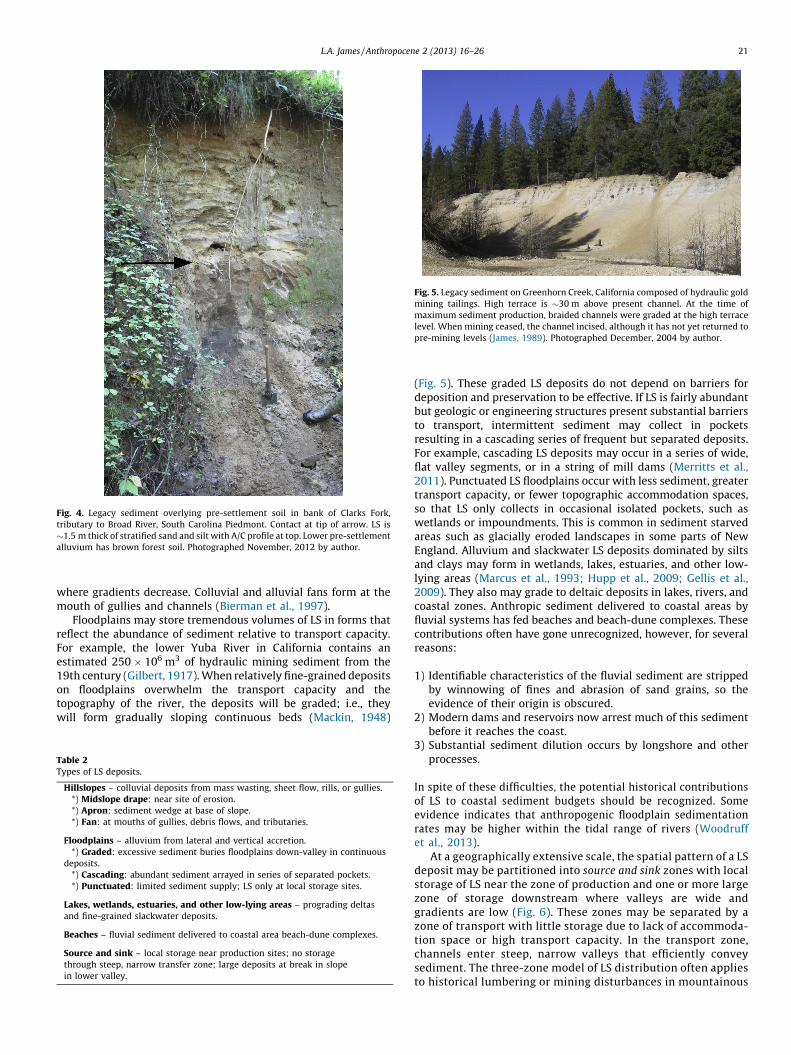
Fig. 4. Legacy sediment overlying pre-settlement soil in bank of Clarks Fork,
tributary to Broad River, South Carolina Piedmont. Contact at tip of arrow. LS is
�1.5 m thick of stratified sand and silt with A/C profile at top. Lower pre-settlement
alluvium has brown forest soil. Photographed November, 2012 by author.
Fig. 5. Legacy sediment on Greenhorn Creek, California composed of hydraulic gold
mining tailings. High terrace is �30 m above present channel. At the time of
maximum sediment production, braided channels were graded at the high terrace
level. When mining ceased, the channel incised, although it has not yet returned to
pre-mining levels (James, 1989). Photographed December, 2004 by author.
L.A. James / Anthropocene 2 (2013) 16–26 21
where gradients decrease. Colluvial and alluvial fans form at themouth of gullies and channels (Bierman et al., 1997).
Floodplains may store tremendous volumes of LS in forms thatreflect the abundance of sediment relative to transport capacity.For example, the lower Yuba River in California contains anestimated 250 � 106 m3 of hydraulic mining sediment from the19th century (Gilbert, 1917). When relatively fine-grained depositson floodplains overwhelm the transport capacity and thetopography of the river, the deposits will be graded; i.e., theywill form gradually sloping continuous beds (Mackin, 1948)
Table 2Types of LS deposits.
Hillslopes – colluvial deposits from mass wasting, sheet flow, rills, or gullies.
*) Midslope drape: near site of erosion.
*) Apron: sediment wedge at base of slope.
*) Fan: at mouths of gullies, debris flows, and tributaries.
Floodplains – alluvium from lateral and vertical accretion.
*) Graded: excessive sediment buries floodplains down-valley in continuous
deposits.
*) Cascading: abundant sediment arrayed in series of separated pockets.
*) Punctuated: limited sediment supply; LS only at local storage sites.
Lakes, wetlands, estuaries, and other low-lying areas – prograding deltas
and fine-grained slackwater deposits.
Beaches – fluvial sediment delivered to coastal area beach-dune complexes.
Source and sink – local storage near production sites; no storage
through steep, narrow transfer zone; large deposits at break in slope
in lower valley.
(Fig. 5). These graded LS deposits do not depend on barriers fordeposition and preservation to be effective. If LS is fairly abundantbut geologic or engineering structures present substantial barriersto transport, intermittent sediment may collect in pocketsresulting in a cascading series of frequent but separated deposits.For example, cascading LS deposits may occur in a series of wide,flat valley segments, or in a string of mill dams (Merritts et al.,2011). Punctuated LS floodplains occur with less sediment, greatertransport capacity, or fewer topographic accommodation spaces,so that LS only collects in occasional isolated pockets, such aswetlands or impoundments. This is common in sediment starvedareas such as glacially eroded landscapes in some parts of NewEngland. Alluvium and slackwater LS deposits dominated by siltsand clays may form in wetlands, lakes, estuaries, and other low-lying areas (Marcus et al., 1993; Hupp et al., 2009; Gellis et al.,2009). They also may grade to deltaic deposits in lakes, rivers, andcoastal zones. Anthropic sediment delivered to coastal areas byfluvial systems has fed beaches and beach-dune complexes. Thesecontributions often have gone unrecognized, however, for severalreasons:
1) Identifiable characteristics of the fluvial sediment are strippedby winnowing of fines and abrasion of sand grains, so theevidence of their origin is obscured.
2) Modern dams and reservoirs now arrest much of this sedimentbefore it reaches the coast.
3) Substantial sediment dilution occurs by longshore and otherprocesses.
In spite of these difficulties, the potential historical contributionsof LS to coastal sediment budgets should be recognized. Someevidence indicates that anthropogenic floodplain sedimentationrates may be higher within the tidal range of rivers (Woodruffet al., 2013).
At a geographically extensive scale, the spatial pattern of a LSdeposit may be partitioned into source and sink zones with localstorage of LS near the zone of production and one or more largezone of storage downstream where valleys are wide andgradients are low (Fig. 6). These zones may be separated by azone of transport with little storage due to lack of accommoda-tion space or high transport capacity. In the transport zone,channels enter steep, narrow valleys that efficiently conveysediment. The three-zone model of LS distribution often appliesto historical lumbering or mining disturbances in mountainous

Fig. 6. Conceptual model of source and sink type of LS deposits. Some local storage
occurs near sources in mountainous terrain but most storage is downstream where
valley-bottoms broaden and gradients decrease. Sources and sinks are separated by
relatively steep, narrow transport zone with negligible storage.
Adapted from James (2006).
L.A. James / Anthropocene 2 (2013) 16–2622
areas and loosely fits Schumm’s (1977) model of three zones ofthe fluvial system.
5. Processes governing LS deposition and preservation
The highly variable spatial distributions of LS often observed inNorth America call for explanation. Spatial heterogeneity reflectsthe highly irregular patterns of production, deposition, andpreservation of anthropogenic sediment. A conceptualization ofthe processes influencing sediment deposition and storage can beinstructive for understanding this variability.
5.1. Sediment production, delivery, and transport capacity
The production of sediment (erosion) on a hill slope (PS)depends on landscape sensitivity, the intensity of land use, andexternal factors. Landscape sensitivity is governed by biogeo-morphic factors, such as slope, lithology, soils, and vegetation.Land-use intensity depends on cultural and socioeconomic factors,such as population density, land-use technology, export econo-mies, and conservation practices. Exogenetic factors includeextreme meteorological events, climate change, or tectonics. Theamount of sediment that is delivered to a site (DS)—critical tounderstanding where LS may be deposited and how long it will bestored—is usually substantially different than the amount ofsediment produced on hill slopes due to storage or recruitment ofsediment in transit (Phillips, 2003). The proportion of sedimentthat is delivered is usually much less than 100% due to a dominanceof deposition and storage over recruitment. This is especially trueduring episodic events when accelerated erosion results in asurplus of sediment production beyond equilibrium loadings.
Sediment delivery depends not only on sediment production onhill slopes, but also on conditions that govern deposition andrecruitment, including transport capacity, sediment characteris-tics, and valley-bottom conditions. Many of these factors are scale-dependent and vary systematically with drainage area. Sedimentcharacteristics that influence deliveries include grain size, shape,cementation, imbrication, and armoring. Relevant valley-bottomfactors include morphology, floodplain width, position relative tochannels, geologic structure, valley gradient, base-level, history ofsea-level change, previous history of channel aggradation orincision, glacial history, and human alterations (channel-bedmining, dams, levees, etc.) (Belmont, 2011; Blum and Tornqvist,2000; Nardi et al., 2006). Storage potential also depends on local
connectivity between lateral and longitudinal linkages andblockages referred to collectively as (dis)connectivity (Fryirs,2013). Blockages consist of buffers, barriers, and blankets that limitlateral, longitudinal, and vertical connectivity, respectively. Thisprovides a means of identifying and tallying sites where storagemay accrue and of quantifying sediment storage potential anddelivery. Storage components can be classified as ‘stores;’ i.e.,relatively temporary storage components, or ‘sinks;’ i.e., relativelypersistent storage components (Fryirs, 2013). Much of thesediment within channels may be considered to be stores, whereasfloodplains are largely sinks. Contrary to common perceptions,natural floodplains are generally not flat; they contain a variety ofsmall landform features such as scroll bars, splays, abandonedchannels, natural levees, etc. (Happ et al., 1940; Wolman andLeopold, 1957; Florsheim and Mount, 2002).
Sediment transport capacity (TC) is the cumulative ability toconvey sediment over time, which can be expressed by varioushydraulic parameters such as stream power or energy of flowsavailable to carry the sediment. The applied hydraulic forces aredriven by the magnitude and frequency of flows, so they are scale-dependent and time-variant. Thus, TC is variable in space downstreamand laterally across the floodplain and is sensitive to climate andhydrologic changes to the basin. The flow regime may be influencedby human activities that alter runoff; i.e., land-use changes thatintroduce sediment may also increase flood magnitudes and TC.
5.2. Storage potential and retention time
One way to conceptualize the potential for LS storage at a site isas a storage potential ratio of sediment delivery to sedimenttransport capacity over time:
SP ¼ fDS
TC
� �(1)
where SP is storage potential. When sediment delivery is equal totransport capacity over time, then the reach is transporting theload available and the stream at that location can be considered tobe graded (Mackin, 1948) (Fig. 7). Under graded conditions, theproduct of sediment discharge and caliber should be proportionalto the water and sediment load of the stream (Lane, 1955). Ifdeliveries exceed transfer capacity (DS/TC > 1), however, somestorage is likely. If deliveries greatly exceed transport capacitythrough time (DS/TC� 1), abundant deposition and channelaggradation is likely, even without barriers or sinks (Fig. 7b). Thus,the likelihood of LS being stored at a site is a function of a variety ofprocesses and conditions governing sediment production, transport,and deposition, flow hydraulics over time, valley bottom character-istics upstream and at the site, and sediment characteristics. Theserelationships explain why thick graded LS deposits are common inthe Southern Piedmont of the USA where erosion of thick residualsoils produced large volumes of sediment, but LS deposits arepunctuated and less common in glaciated basins with thin soils. Forapplication to longer time scales, DS and TC can be defined to includevariability in exogenous variables such as climate or tectonics.
The sediment delivery ratio (SDR) is defined as the sedimentyield at a point (YS) as a proportion of the sediment producedupstream by hill-slope erosion (Roehl, 1962; Vanoni, 1975; Renfro,1975; Dickinson and Wall, 1977; Robinson, 1977):
SDR ¼ YS
PS(2)
Due to storage between hill-slope sources and floodplainsdown-valley, the SDR is usually less than one and decreasesdownvalley systematically with drainage area (Roehl, 1962;Novotny, 1980; Shen and Julien, 1993) (Fig. 8). The decrease in

Fig. 7. Triple-beam balance metaphor for sediment storage potential: (A) sediment
delivery (DS) equals transport capacity (TC) so channel is in equilibrium; i.e., no
change in storage; (B) DS > TC so net gain of sediment, aggradation, and high LS
storage potential; (C) DS < TC so net loss of sediment, degradation, and LS recruited
from reach.
Concept adapted from Lane (1955).
Fig. 8. Downstream changes in sediment deliveries due to storage in bed (A) result
in rapidly decreasing sediment delivery ratios downstream (B). G: gully; C:
colluvium; A: alluvium.
L.A. James / Anthropocene 2 (2013) 16–26 23
SDRs downvalley was conceptualized as the ‘sediment deliveryproblem’ by Walling (1983) and recently restated by Fryirs (2013).An analysis of 16,571 annual observations for 87 Mediterraneanbadland catchments varying in size over 11 orders of magnitudeindicates sediment yields are uniformly high (475 t ha�1 y�1) forsmall catchments (<10 ha) but decrease two orders of magnitudefrom drainage areas ranging from 101 to 106 ha (Nadal-Romeroet al., 2011). The preponderance of deposition in small watershedssuggests that LS deposits are most likely to be found in tributarylocations if storage sites are available, but that this sediment willbe reworked and redistributed downstream through time. A late20th century trend in some North American catchments has beenfor SDRs that were much less than one, owing to high soil erosionrates, to increase as soil conservation measures were employed. Asupland sediment production decreases, sediment yields remainconstant by recruitment of LS from channel banks and floodplains(Robinson, 1977).
The dynamics implied by sediment delivery theory have greatimport to interpretations of LS. Sediment yields in the modernworld are not static as was once assumed, but have a dynamicbehavior that is largely driven by the legacy of past sedimentationevents (Walling, 1996). Temporal variability occurs in the form of
regional differences between large basins and by variability insediment retention times within a basin. Regional differencesreflect the cultural histories of landscapes; i.e., times of settlementand intensities of land use, as well as differences in the physicalcharacteristics. Variations in sediment retention time within acatchment is one of the greatest sources of uncertainty incomputing sediment yields and sediment budgets for watersheds(Wolman, 1977; Gellis et al., 2009). Temporal connectivity is animportant element of LS and sediment delivery theory, becausepast deposits are reworked and transported downslope for longperiods of time after initial deposition. This is, in fact, why ‘legacy’is an appropriate way to describe these sediments; they are aninheritance from times past that should be reckoned with.
6. Conclusions
Numerous studies of anthropogeomorphic impacts since theNeolithic have documented sedimentation events in a variety ofgeomorphic environments. Legacy sediment (LS) is now commonlyused in geomorphic, ecological, water quality, and toxicologicalstudies to describe post-settlement alluvium on river floodplains.Most applications of LS imply or explicitly attribute the sedimentto human landscape changes, but explicit definitions have beenlacking that are sufficiently broad to apply LS to the variety ofapplications now common. The concept of LS should apply toanthropogenic sediment that was produced episodically over aperiod of decades or centuries, regardless of position on thelandscape, geomorphic process of deposition, or sedimentarycharacteristics; i.e., it may occur as hillslope colluvium, floodplainalluvium, or lacustrine and estuarine slackwater deposits. LS can bedefined with expanded geographic and temporal limits to includeepisodic human land-use activities wherever and during whateverperiod of pre-history or history in which they occurred.

L.A. James / Anthropocene 2 (2013) 16–2624
Anthropogenic sedimentation has recurred globally throughoutthe Anthropocene in response to a variety of agricultural orresource extraction activities that accelerated sediment produc-tion. Mining, intensive agriculture, and logging generated recur-rent episodes of LS production, associated with Roman outposts inEurope, and western colonization of North and South America,Australia, and other areas of Oceania. Recognition of thesewidespread and highly diverse legacies of human activities isimportant for a proper interpretation of watershed dynamics at abroad range of scales.
Legacy sediment is deposited when intensified land-use resultsin sediment deliveries greater than sediment transport capacity.This may lead to valley-bottom aggradation, which is ultimatelyfollowed by channel incision when the sediment wave passes andsediment loads decrease. This aggradation–degradation episode(ADE) tends to leave large volumes of LS in storage because verticalchannel incision occurs much more quickly than channel widen-ing. Many river systems in North America are still in the wideningphase of adjustment to an ADE. Channel beds have returned to pre-settlement elevations but LS remains stored in extensive terracedeposits. The lagged responses and prolonged sediment recruit-ment represent a temporal connectivity. Recognition of theseprocesses and the inherent imbalance in fluvial systems caused bytremendous volumes of LS storage is essential to wise policydevelopment in river science, stream restoration, aquatic ecology,and flood risk management.
Acknowledgements
I was extremely lucky to have had the opportunity to studyunder the late James C. Knox who taught me to recognizehistorical alluvium in the Driftless Area of Wisconsin, to look forit elsewhere, to appreciate its relevance to fluvial systems, to usefield, laboratory, and other investigative tools for measuring it,and to understand the processes by which it was deposited,reworked, and preserved. I am thankful to Markus Dotterweichand an anonymous reviewer for highly constructive commentson a draft of this paper. Finally, I thank Anne Chin, Anne Jefferson,and Karl Wegmann for inviting me to participate in the themesession on Geomorphology of the Anthropocene at the GeologicalSociety of America and for organizing this special issue of The
Anthropocene.
References
Allmendinger, N.E., Pizzuto, J.E., Moglen, G.E., Lewicki, M., 2007. A sediment budgetfor an urbanizing watershed, 1951–1996, Montgomery County, Maryland, USA.Journal of the American Water Resources Association 43 (6) 1483–1498.
Bain, D.J., Brush, G.S., 2005. Early chromite mining and agricultural clearance:opportunities for the investigation of agricultural sediment dynamics in theeastern Piedmont (USA). American Journal of Science 305, 957–981.
Bay, S.M., Vidal-Dorsch, D.E., Schlenk, D., Kelley, K.M., Maruya, K.A., Gully, J.R., 2012.Integrated coastal effects study: synthesis of findings. Environmental Toxicol-ogy and Chemistry 31 (12) 2711–2722.
Belmont, P., 2011. Floodplain width adjustments in response to rapid base level falland knickpoint migration. Geomorphology 128 (1-2) 92–102.
Bierman, P., Lini, A., Zehfuss, P., Church, A., Davis, P.T., Southon, J., Baldwin, L., 1997.Postglacial ponds and alluvial fans: recorders of Holocene landscape history.GSA Today 7 (10) 1–8.
Blum, M.D., Tornqvist, T.E., 2000. Fluvial responses to climate and sea-level change:a review and look forward. Sedimentology 47 (Supplement 1) 2–48.
Brierley, G.J., Brooks, A.P., Fryirs, K.A., Taylor, M.A., 2005. Did humid-temperaterivers in the old and new worlds respond differently to clearance of riparianvegetation and removal of woody debris? Progress in Physical Geography 29,27–49.
Brooks, A.P., Brierley, G.J., 1997. Geomorphic response of lower Bega River tocatchment disturbance, 1851–1926. Geomorphology 18, 291–304.
Canuel, E.A., Lerberg, E.J., Dickhut, R.M., Kuehl, S.A., Bianchi, T.S., Wakeham, S.G.,2009. Changes in sediment and organic carbon accumulation in a highly-disturbed ecosystem: the Sacramento-San Joaquin River Delta (California,USA). Marine Pollution Bulletin 59 (4–7) 154–163.
Clinton, B.D., 2011. Stream water responses to timber harvest: riparian bufferwidth effectiveness. Forest Ecology and Management 261 (6)979–988.
Costa, J.E., 1975. Effects of agriculture on erosion and sedimentation in the Pied-mont Province, Maryland. Geological Society of America Bulletin 86,1281–1286.
Cowan, E.A., Seramur, K.C., Hageman, S.J., 2013. Magnetic susceptibility measure-ments to detect coal fly ash from the Kingston Tennessee spill in Watts BarReservoir. Environmental Pollution 174, 179–188.
deWet, A., Williams, C.J., Tomlinson, J., Loy, E.C., 2011. Stream and sedimentdynamics in response to Holocene landscape changes in Lancaster County,Pennsylvania. In: Wetlands. Springer, http://dx.doi.org/10.1007/978-94-007-0551-3_3, pp. 35–65.
Dickinson, W.T., Wall, G.J., 1977. The relationship between source-area erosion andsediment yield. Hydrological Sciences Bulletin 22, 527–530.
Dotterweich, M., 2005. High resolution chronology of a 1300 year old gully systemin Northern Bavaria, Germany. Modelling longterm human-induced landscapeevolution. Holocene 15, 994–1005.
Dotterweich, M., 2008. The history of soil erosion and fluvial deposits in smallcatchments of central Europe: deciphering the long-term interaction betweenhumans and the environment – a review. Geomorphology 101 (1–2) 192–208,http://dx.doi.org/10.1016/j.geomorph.2008.05.023.
Dreibrodt, S., Lubos, C., Terhorst, B., Damm, B., Bork, H.-R., 2010. Historical soilerosion by water in Germany: scales and archives, chronology, research per-spectives. Quaternary International 222 (1–2) 80–95, http://dx.doi.org/10.1016/j.quaint.2009.06.014.
Fairbridge, R.W., 1968. Colluvium. The Encyclopedia of Geomorphology. ReinholdBook Corp., NY p. 161.
Faulkner, D.J., 1998. Spatially variable historical alluviation and channel incision inwest-central Wisconsin. Annals of the Association of American Geographers 88,666–685.
Fitzpatrick, F.A., Hansis, R.D., Carvin, R., 2010. Channel sources and storage of legacysediment in agricultural streams and implications for sediment and phospho-rous loadings and biological impairments, Driftless Area, Wisconsin. In: Ab-stract, GSA Annual Meeting. Denver October 31–November 3, 2010, Paper No.4-11.
Florsheim, J.L., Mount, J.F., 2003. Changes in lowland floodplain sedimentationprocesses: pre-disturbance to post-rehabilitation, Cosumnes River, CA. Geo-morphology 56, 305–323.
Florsheim, J.L., Mount, J.F., 2002. Restoration of floodplain topography by sand-splaycomplex formation in response to intentional levee breaches, Lower CosumnesRiver, California. Geomorphology 44, 67–94.
Fryirs, K., 2013. (Dis)Connectivity in catchment sediment cascades: a fresh look atthe sediment delivery problem. Earth Surface Processes and Landforms 38,30–46.
Fuchs, M., Will, M., Kunert, E., Kreutzer, S., Fischer, M., Reverman, R., 2011. Thetemporal and spatial quantification of Holocene sediment dynamics in ameso-scale catchment in northern Bavaria, Germany. Holocene 21 (7)1093–1104, http://dx.doi.org/10.1177/0959683611400459.
Galster, J.C., Pazzaglia, F.J., Germanoski, D., 2008. Measuring the impact of urbani-zation on channel widths using historic aerial photographs and modern sur-veys. J Am Water Res Assoc 44 (4) 948–960.
Gellis, A.C., Hupp, C.R., Pavich, M.J., Landwehr, J.M., Banks, W.S.L., Hubbard, B.E.,Langland, M.J., Ritchie, J.C., Reuter, J.M., 2009. Sources, transport, and storage ofsediment at selected sites in the Chesapeake Bay watershed. U.S. GeologicalSurvey Scientific Investigations Report 2008-5186, 95 pp.
Gilbert, G.K., 1917. Hydraulic-mining debris in the Sierra Nevada. US Geol. Surv.Prof. Paper 105. Govt Printing Office, Washington, DC.
Gomez, B., Brackley, H.L., Hicks, D.M., Neff, H., Rogers, K.M., 2004. Organic carbon infloodplain alluvium: signature of historic variations in erosion processes asso-ciated with deforestation, Waipaoa River basin, New Zealand. Journal of Geo-physical Research 109, F04011, http://dx.doi.org/10.1029/2004JF000154.
Goode, J.R., Luce, C.H., Buffington, J.M., 2012. Enhanced sediment delivery in achanging climate in semi-arid mountain basins: implications for water resourcemanagement and aquatic habitat in the northern Rocky Mountains. Geomor-phology 139–140, 1–15.
Gran, K.B., Belmont, P., Day, S.S., Finnegan, N., Jenning, C., Lauer, J.W., 2011.Landscape evolution in south-central Minnesota and the role of geomorphichistory on modern erosional processes. GSA Today 21 (9)7–9.
Greenfield, B.K., Allen, R.M., 2013. Polychlorinated biphenyl spatial patterns inSan Francisco Bay forage fish. Chemosphere 90 (5) 1693–1703.
Griffiths, G.A., 1979. Recent sedimentation history of the Waimakariri River, NewZealand. Journal of Hydrology (New Zealand) 18, 6–28.
Hale, S.E., Meynet, P., Davenport, R.J., Jones, D.M., Werner, D., 2010. Changes inpolycyclic aromatic hydrocarbon availability in River Tyne sediment followingbioremediation treatments or activated carbon amendment. Water Research 44(15) 4529–4536.
Happ, S., 1945. Sedimentation in South Carolina Piedmont valleys. American JournalScience 243, 113–126.
Happ, S.C., Rittenhouse, G., Dobson, G.C., 1940. Some principles of acceleratedstream and valley sedimentation. U.S. Dept. Agr. Tech. Bull. 695.
Houben, P., 2008. Scale linkage and contingency effects of field-scale and hillslope-scale controls of long-term soil erosion: anthropogeomorphic sediment flux inagricultural loess watersheds of Southern Germany. Geomorphology 101,172–191.

L.A. James / Anthropocene 2 (2013) 16–26 25
Hupp, C.R., Noe, G.B., Schenk, E.R., Benthem, A.J., 2013. Recent and historic sedimentdynamics along Difficult Run, a suburban Virginia Piedmont stream. Geomor-phology 180–181, 156–169.
Hupp, C.R., Pierce, A.R., Noe, G.B., 2009. Floodplain geomorphic processes andenvironmental impacts of human alteration along Coastal Plain rivers, USA.Wetlands 29 (2) 413–429.
Jackson, C.R., Martin, J.K., Leigh, D.S., West, L.T., 2005. A southeastern Piedmontwatershed sediment budget: evidence for a multi-millennial agricultural lega-cy. Journal of Soil and Water Conservation 60, 298–310.
Jacobson, R.B., Coleman, D.J., 1986. Stratigraphy and recent evolution of MarylandPiedmont floodplains. American Journal of Science 286, 617–637, http://dx.doi.org/10.2475/ajs.286.8.617.
James, L.A., 1989. Sustained storage and transport of hydraulic mining sediment inthe Bear River, California. Annals of the Association of American Geographers 79(4) 570–592.
James, L.A., 2006. Bed waves at the basin scale: implications for river managementand restoration. Earth Surface Processes and Landforms 31, 1692–1706.
James, L.A., 2010. Secular sediment waves, channel bed waves, and legacy sediment.Geography Compass 4–6, 576–598, http://dx.doi.org/10.1111/j.1759-8198.2010.00324.x.
James, L.A., 2011. Contrasting geomorphic impacts of pre- and post-Columbianland-use changes in Anglo America. Physical Geography 32 (5) 399–422, http://dx.doi.org/10.2747/0272-3646.32.5.399.
James, L.A., 2013. Impacts of early agriculture and deforestation on geomorphicsystems. In: Shroder, Jr., J., (Editor in Chief), James, L.A., Harden, C.P., Clague, J.J.(Eds.), Treatise on Geomorphology, vol. 13Academic Press, San Diego, CA, pp.48–67, Geomorphology of Human Disturbances, Climate Change, and NaturalHazards.
James, L.A., Lecce, S.A., 2013. Impacts of land-use and land-cover change on riversystems. In: Shroder, Jr., J., (Editor in chief), Wohl, E. (Eds.), Treatise onGeomorphology, vol. 9Academic Press, San Diego, CA, pp. 768–793, FluvialGeomorphology.
Knox, J.C., 1972. Valley alluviation in Southwestern Wisconsin. Annals of theAssociation of American Geographers 62, 401–410.
Knox, J.C., 1977. Human impacts on Wisconsin stream channels. Annals of theAssociation of American Geographers 77, 323–342.
Knox, J.C., 1987. Historical valley floor sedimentation in the Upper MississippiValley. Annals of the Association of American Geographers 77, 224–244.
Knox, J.C., 2006. Floodplain sedimentation in the upper Mississippi Valley: naturalversus human accelerated. Geomorphology 79, 286–310.
Lane, E.W., 1955. The importance of fluvial morphology in hydraulic engineering.American Society of Civil Engineers: Proceedings 81 (745) 1–17.
Lang, A., Bork, H.-R., Mackel, R., Preston, N., Wunderlich, J., Dikau, R., 2003. Changesin sediment flux and storage within a fluvial system: some examples from theRhine catchment. Hydrologic Processes 17, 3321–3334.
Lecce, S.A., 1997. Spatial patterns of historical overbank sedimentation and flood-plain evolution, Blue River Wisconsin. Geomorphology 18, 265–277.
Lecce, S.A., Pavlowsky, R.T., 2001. Use of mining-contaminated sediment tracers toinvestigate the timing and rates of historical flood plain sedimentation. Geo-morphology 38, 85–108.
Lecce, S.A., Pavlowsky, R.T., Schlomer, G.S., 2008. Mercury contamination of activechannel sediment and floodplain deposits from historic gold mining at GoldHill, North Carolina, USA. Environmental Geology 55, 113–121.
Leigh, D.S., 1994. Mercury contamination and floodplain sedimentation fromformer gold mines in north Georgia. Water Resources Bulletin 30 (4) 739–748.
Leopold, M., Volkel, J., 2007. Colluvium: definition, differentiation, and possiblesuitability for reconstructing Holocene climate data. Quaternary International162–163, 133–140.
Lewin, J., 2010. Medieval environmental impacts and feedbacks: the lowlandfloodplains of England and Wales. Geoarchaeology 25, 267–311, http://dx.doi.org/10.1002/gea.20308.
Lewin, J., Davies, B.E., Wolfenden, P.J., 1977. Interactions between channel changeand historic mining sediments. In: Gregory, K.J. (Ed.), River Channel Changes.Wiley, Chichester, pp. 353–367.
Mackin, J.H., 1948. Concept of the graded stream. Geological Society of AmericaBulletin 59, 463–512.
Macklin, M.G., Lewin, J., 2008. Alluvial responses to the changing Earth system.Earth Surface Processes and Landforms 33, 1374–1395.
Magilligan, F., 1985. Historical floodplain sedimentation in the Galena River Basin,Wisconsin and Illinois. Annals of the Association of American Geographers 75(4) 583–594.
Marcus, W.A., Meyer, G.A., Nimmo, D.R., 2001. Geomorphic control on long-termpersistence of mining impacts, Soda Butte Creek, Yellowstone National Park.Geology 29 (4) 355–358.
Marcus, W.A., Neilsen, C.C., Cornwell, J., 1993. Sediment budget analysis of heavymetal inputs to a Chesapeake Bay estuary. Environmental Geology and WaterSciences 22 (1) 1–9.
McBride, M., Hession, W.C., Rizzo, D.M., 2008. Riparian reforestation and channelchange: a case study of two small tributaries to Sleepers River, northeasternVermont, USA. Geomorphology 102, 445–459.
Merritts, D.J., Walter, R., Rahnis, M., et al., 2011. Anthropocene streams and base-level controls from historic dams in the unglaciated mid-Atlantic region, USA.The Philosophical Transactions of the Royal Society A 369 (1938) 976–1009.
Mukundan, R., Radcliffe, D.E., Ritchie, J.C., 2011. Channel stability and sedimentsource assessment in streams draining a Piedmont watershed in Georgia, USA.Hydrological Processes 25 (8) 1243–1253, http://dx.doi.org/10.1002/hyp.7890.
Murphy, M.A., Salvador, A. (Eds.), 1994. International Stratigraphic Guide; andabridged version. International Subcomm. on Stratigraphic Classification ofIUGS Internat. Comm. on Stratigraphy. http://www.stratigraphy.org/column.php?id=Stratigraphic_Guide (accessed 23.01.2013).
Nadal-Romero, E., Martınez-Murillo, J.F., Vanmaercke, M., Poesen, J., 2011. Scale-dependency of sediment yield from badland areas in Mediterranean environ-ments. Progress in Physical Geography 35 (3) 297–332, http://dx.doi.org/10.1177/0309133311400330.
Nardi, F., Vivoni, E.R., Grimaldi, S., 2006. Investigating a floodplain scaling relationusing a hydrogeomorphic delineation method. Water Resources Research 42 (9)W09409.
Neary, D.G., Ice, G.G., Jackson, C.R., 2009. Linkages between forest soils and waterquality and quantity. Forest Ecology and Management 258 (10) 2269–2281.
Niemitz, J., Haynes, C., Lasher, G., 2013. Legacy sediments and historic land use:chemostratigraphic evidence for excess nutrient and heavy metal sources andremobilization. Geology 41 (1) 47–50, http://dx.doi.org/10.1130/G33547.1.
North American Commission on Stratigraphic Nomenclature (NACSN), 2005. Amer-ican Association of Petroleum Geologists Bulletin 89 (11) 1547–1591.
Novotny, V., 1980. Delivery of suspended sediment and pollutants from nonpointsources during overland flow. Water Resources Research 16 (6) 1057–1065.
Novotny, V., 2004. Simplified databased total maximum daily loads, or the world islog-normal. Journal of Environmental Engineering 130 (6) 674–683, http://dx.doi.org/10.1061/(ASCE)0733-9372(2004)130:6(674), 10 p.
Pavlowsky, R.T., Lecce, S.A., Bassett, G., Martin, D.J., 2010. Legacy Hg–Cu contami-nation of active stream sediments in the Gold Hill Mining District, NorthCarolina. Southeastern Geographer 50 (4) 503–522.
Pearson, A.J., Snyder, N.P., Collins, M.J., 2011. Rates and processes of channelresponse to dam removal with a sand-filled impoundment. Water ResourcesResearch 47 (8) , http://dx.doi.org/10.1029/2010WR009733.
Peck, J.A., Mullen, A., Moore, A., Rumschlag, J.H., 2007. The legacy sediment recordwithin the Munroe Falls Dam pool, Cuyahoga River, Summit County, Ohio.Journal of Great Lakes Research 33 (Suppl. 2) 127–141.
Pennsylvania Department of Environmental Protection (PDEP), 2006. Legacy Sedi-ment Definitions.pdf. Legacy Sediment Workgroup (Chaired by Hartranft, J.,Merritts, D., Walter, R.). http://www.portal.state.pa.us/portal/server.pt/com-munity/chesapeake_bay_program/10513/workgroup_proceedings/553510(accessed 01.02.2013).
Phillips, J.D., 2003. Alluvial storage and the long-term stability of sediment yields.Basin Research 15, 153–163.
Reiß, S., Dreibrodt, S., Lubos, C.C.M., Bork, H.-R., 2009. Land use history and historicalsoil erosion at Albersdorf (northern Germany) – ceased agricultural land useafter the pre-historical period. Catena 77 (2) 107–118, http://dx.doi.org/10.1016/j.catena.2008.11.001.
Renfro, G.W., 1975. Use of erosion equations and sediment-delivery ratios forpredicting sediment yield. In: Present and Prospective Technology for Predict-ing Sediment Yields and Sources. Proc. Sediment-Yield Workshop, U.S. D. A.Sediment Laboratory, Oxford, MI, November 28–30, 1972, ARS-S-40,pp. 33–45.
Riggsbee, J.A., Wetzel, R., Doyle, M.W., 2012. Physical and plant community controlson nitrogen and phosphorus leaching from impounded riverine wetlandsfollowing dam removal. River Research and Applications 28, 1439–1450.
Robinson, A.R., 1977. Relationship Between Soil Erosion and Sediment Delivery.Present and Prospective Technology for Predicting Sediment. IAHS Publ. 122 pp.159–167.
Roehl, J.W., 1962. Sediment source areas, delivery ratios and influencing morpho-logical factors. International Association of Hydrological Sciences Publication59, 202–213.
Russo, J., Fox, J., 2012. The role of the surface fine-grained laminae in low-gradientstreams: a model approach. Geomorphology 171–172, 127–138.
Schenk, E.R., Hupp, C.R., Gellis, A., Noe, G., 2012. Developing a new stream metric forcomparing stream function using a bank–floodplain sediment budget: a casestudy of three Piedmont streams. Earth Surface Processes and Landforms,http://dx.doi.org/10.1002/esp.3314.
Schenk, E.R., Hupp, C.R., 2009. Legacy effects of colonial millponds on floodplainsedimentation, bank erosion, and channel morphology, Mid-Atlantic, USA.Journal of the American Water Resources Association 45 (3) 597–606.
Schoonover, J.E., Lockaby, B.G., Shaw, J.N., 2007. Channel morphology and sedimentorigin in streams draining the Georgia Piedmont. Journal Hydrology 342 (1–2)110–123.
Schumm, S.A., 1977. The Fluvial System. John Wiley &Sons, New York 338 pp.Shen, H.W., Julien, P.Y., 1993. Erosion and sediment transport. In: Maidment, D.R.
(Ed.), Handbook of Hydrology. McGraw-Hill, NY (Chapter 12).Simon, A., Hupp, C.R., 1986. Channel evolution in modified Tennessee channels. In:
Proc. Fourth Fed. Interagency Sedimentation Conference, Las Vegas, Nevada,24–27 March, 1986. Govt. Printing Office, Washington, DC, vol. 2, pp. 5-71–5-82.
Stein, E.D., Cadien, D.B., 2009. Ecosystem response to regulatory and managementactions: the southern California experience in long-term monitoring. MarinePollution Bulletin 59 (4–7) 91–100.
Stoughton, J., Marcus, W.A., 2000. The persistent impacts of trace metals frommining on grass communities along Soda Butte Creek, Yellowstone NationalPark. Environmental Management 25 (3) 305–320.
Trimble, S.W., 1974. Man-Induced Soil Erosion on the Southern Piedmont, 1700–1970. Soil and Water Conservation Society of America, Ankeny, IA.
Trimble, S.W., 1977. The fallacy of stream equilibrium in contemporary denudationstudies. American Journal of Science 277, 876–887.

L.A. James / Anthropocene 2 (2013) 16–2626
Trimble, S.W., Happ, S.C., Rittenhouse, G., Dobson, G.C., 2008. 1940: some principlesof accelerated stream and valley sedimentation. US Department of AgricultureTechnical Bulletin 695. Progress in Physical Geography 32 (3) 337–345, http://dx.doi.org/10.1177/0309133308091947.
Vanoni, V.A., 1975. Sedimentation Engineering. Amer. Soc. Civil Engineers. TaskComm. for Prep. of Manual on Sedimentation, 745 pp.
Vanwalleghem, T., Bork, H.R., Poesen, J., et al., 2006. Prehistoric and Roman gullyingin the European loess belt: a case study from central Belgium. Holocene 16 (3)393–401.
Walling, D.E., 1983. The sediment delivery problem. Journal of Hydrology 65,209–237.
Walling, D.E., 1996. Erosion and Sediment Yield in a Changing Environment. Geol.Soc. London, Spec. Publ. 115, http://dx.doi.org/10.1144/GSL.SP.1996.115.01.05pp. 43–56.
Walter, R., Merritts, D., Rahnis, M., 2007. Estimating Volume, Nutrient Content, andRates of Stream Bank Erosion of Legacy Sediment in the Piedmont and Valleyand Ridge Physiographic Provinces, Southeastern and Central PA. A Report tothe Pennsylvania Department of Environmental Protection.
Walter, R.C., Merritts, D.J., 2008. Natural streams and the legacy of water-poweredmills. Science 319 (5861) 299–304, http://dx.doi.org/10.1126/science.1151716.
Weber, T.C., Allen, W.L., 2010. Beyond on-site mitigation: an integrated, multi-scaleapproach to environmental mitigation and stewardship for transportationprojects. Landscape and Urban Planning 96 (4) 240–256.
Wohl, E.E., 2001. Virtual Rivers: Lessons from the Mountain Rivers of the ColoradoFront Range. Yale University Press, New Haven.
Wohl, E., Merritts, D.J., 2007. What is a natural river? Geography Compass 1, 871–900, http://dx.doi.org/10.1111/j. 1749-8198.2007.00049.x.
Wohl, E., Rathburn, S., 2013. Guest editorial: introduction to special issue on historicalrange of variability. Earth Surface Processes and Landforms 38, 213–216.
Wolman, M.G., 1977. Changing needs and opportunities in the sediment field.Water Resources Research 13 (1) 50–54.
Wolman, M.G., Leopold, L.B., 1957. River flood plains: some observations on theirformation. Washington, DC, US Geol. Survey Prof. Paper 282-C.
Woodruff, J.D., Martini, A.P., Elzidani, E.Z.H., Naughton, T.J., Kekacs, D.J., MacDonald,D.G., 2013. Off-river waterbodies on tidal rivers: human impact on rates ofinfilling and the accumulation of pollutants. Geomorphology 184, 38–50.