lecture 2: soil properties and groundwater flobaiyu/engi 9621_files/lecture 2.pdf · cec = quantity...
TRANSCRIPT

9621 – Soil Remediation Engineering
Spring 2015 Faculty of Engineering & Applied Science
Lecture 2: Soil Properties and Groundwater Flow
1

Each discipline defines soil in a different way, depending on how soil affects it
“In an engineering sense, soil is the relatively loose agglomerate of mineral and organic materials and sediments found above the bedrock.” --- R.D. Holtz and W.D. Kovacs (1981)
2.1 Soil properties
2.1.1 What is soil?
Soils equation Soil = f (parent material, climate, biota, topography, time)
2

Soil composition About 50% of the soil solid particles
45% - Minerals 5% - Organic matter
About 50% of soil should be pore space 25% - Air/Pore space 25% - Water
3 Source: Codutoet al., Geotechnical Engineering, 2011

Air
Water
Soil
Soil composition by phase: s-soil (dry) w-water a-air v-void (pores filled with water or air) V is volume M is mass
4
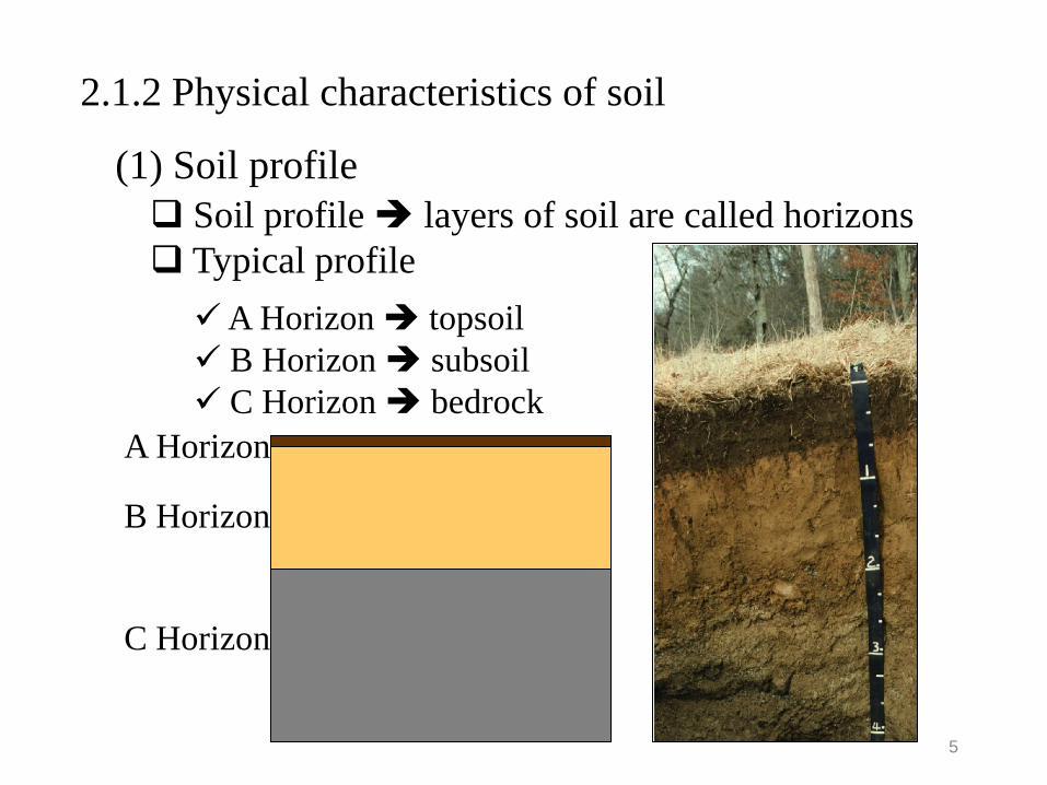
(1) Soil profile Soil profile layers of soil are called horizons Typical profile A Horizon topsoil B Horizon subsoil C Horizon bedrock
A Horizon
B Horizon
C Horizon
2.1.2 Physical characteristics of soil
5

Soil texture the way the soil “feels” depends on the amount of each size of mineral particles in the soil Sand, silt, and clay are names that describe the size of individual mineral particles in the soil
(2) Soil texture
Sand the largest particles and they fell “gritty” Silt medium sized, and they feel soft, silky or “floury” Clay the smallest sized particles, and they feel “sticky”
6

Soil texture: Relative size comparison of soil particles
7
Source: Codutoet al., Geotechnical Engineering, 2011

Soil texture triangle represents 12 textural classes
Different combinations of coarse and fine contents produce different soil textures A loam a mixture of sand, silt and clay
Soils are more cohesive when they have more fine particles Clay Soils are more loose when the have more coarse particles Sand
8
Source: Codutoet al., Geotechnical Engineering, 2011

Bulk density a measure of soil compaction soil weight per unit soil volume
To calculate bulk density:
1 cm (so, there is 1 cubic centimeter of soil)
Sample is made of solids and pore spaces 1.33 gms
Volume = 1 cm3 Weight = 1.33 g
Bulk density = WT VT
Bulk density = 1.33 1
Bulk density = 1.33 g/cm3
(3) Soil bulk density (ρd)
9

(4) Soil moisture content
Soil moisture content the quantity of water contained in a soil Volumetric moisture content, θ defined mathematically as
where VW = the volume of water VT = VS + VV = VS + VW + Va = the total volume (that is soil volume + water volume + air space)
T
w
VV
=θ
10
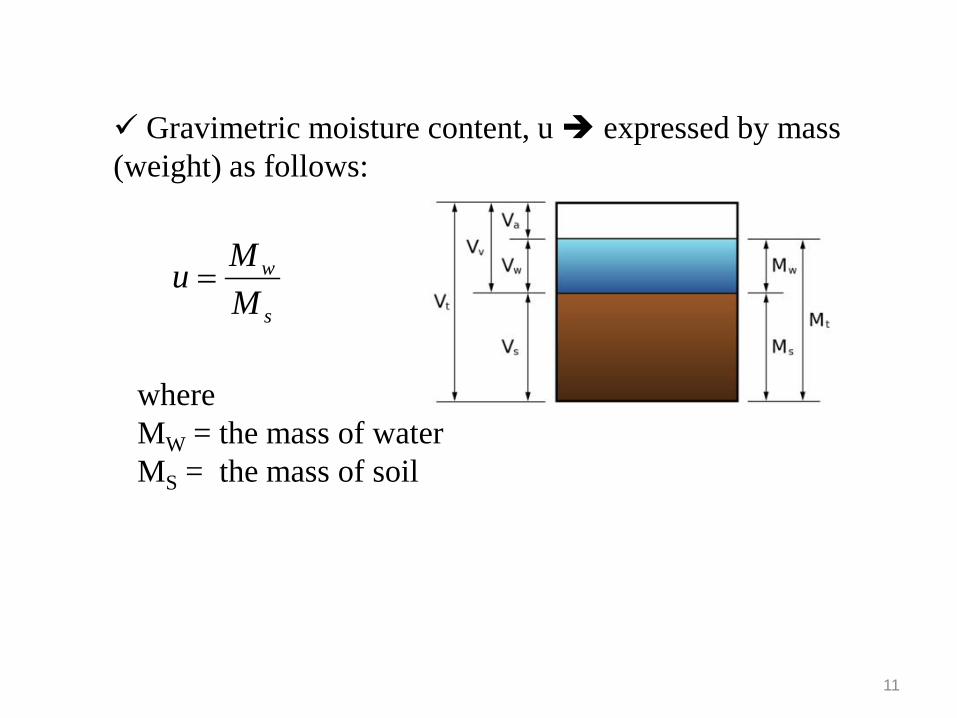
Gravimetric moisture content, u expressed by mass (weight) as follows:
where MW = the mass of water MS = the mass of soil
s
w
MMu =
11

Groundwater Soil
Soil at different moisture levels
Pore Space Water on soil particle surface Pore Spaces are filled with water
12 Source: Codutoet al., Geotechnical Engineering, 2011

(1) Soil pH or Hydrogen-ion activity Soil pH a measure of the relative amount of H+ ions indicates the acidity or the alkalinity of a solution (a soil solution) pH meter pH = -log [H+] In a soil it is driven by the ionization of soil water pH scale ranges from 0 to 14
7 is considered neutral Everything greater than 7 is considered alkaline (basic) Everything less than 7 is considered acidic
2.1.3 Chemical characteristics of soil
13

(2) Soil surface charge
Coarse-grained soil such as gravel, sand and silt are chemically inert The surface of clay minerals and organic matters (OM) in soil generally carry electro-negative charges
Clay Particle
- - - - - - - - - - -
- -
14 Source: Codutoet al., Geotechnical Engineering, 2011

Ionization on edges it is pH-dependent, similar to charge on OM just as in the case of a weak acid Isomorphous substitution in clays it is not affected by pH often referred to as permanent charges
- Substitution of Al3+ for Si4+ in the tetrahedral layer of clays - Substitution of Mg2+ for Al3+ in the octahedral layer of clay
Sources of charge on clays
15

(3) Cation exchange capacity (CEC)
CEC = quantity of exchangeable cations per unit weight of soil The capacity of a soil to adsorb and exchange cations (positively charge ions, Ca2+, Mg2+, K+, Na+, NH4
+ , Al[OH]2 +, Al3+, and H+) CEC due to the net negative charge of soil colloids (clays and organic matter) Both ionization and isomorphous substitution impart CEC to clays Total CEC of the soil is dependent upon the amount of these sources and also upon the surface area of clays exposed
16

Cation exchange the replacement of one adsorbed cation for another from solution
- - - - - -
..Na+
..Na+ [Ca2+]
- - - - - -
..Ca2+ [Na+]
[Na+]
Negatively-charged clay
Dissolved in soil solution
+ +
2XNa+ + Ca2+ XCa2+ + 2Na+
17

It is water that exists beneath the earth's surface in underground streams and aquifers It is found that underground where part/entire void spaces between particles of rock and soil, or in crevices and cracks in rock are filled with water
2.2 Groundwater flow
2.2.1 Introduction
18
(1) Groundwater
Sand and gravel Igneous rocks limestone
Intergranular Crevice Solution
2.2 Groundwater flow 2.2.1 Introduction
Source: Codutoet al., Geotechnical Engineering, 2011

Groundwater an important part of the hydrologic cycle Some of the water from melting snow/rainfall seeps into the soil and percolates into the saturated zone to become groundwater recharge Eventually, groundwater reappears above the ground into streams, rivers, marshes, lakes and oceans or as springs and flowing wells discharge
19 Source: Environment Canada, 1990

20
Groundwater contains 98.7% of the fresh water resources and is a reserve of good quality water
Percentage of population reliant on Groundwater in Canada
Groundwater and the world‘s freshwater supply
Source: Statistics Canada, 1996
Groundwater faces the threat of contamination from waste sites Properties of subsurface govern both the rate and direction of groundwater flow

(2) Vertical distribution of groundwater
Groundwater can be characterized according to its vertical distribution
21
Soil water zone extending from ground surface down through the major root zone Vadose zone extending from lower edge of soil water zone to the upper limit of capillary zone Capillary zone extending from the water table up to the limit of capillary rise
Zone of aeration consists of interstices occupied partially by water and partially by air
Zone of saturation all interstices are filled with water under hydrostatic pressure

22
Source: Bedient et al., Hydrology and Floodplain Analysis, 2007

23
(3) Aquifer A formation that contains sufficient saturated permeable material to yield significant quantities of water to wells and springs Type of aquifers Confined aquifer (artesian aquifer) groundwater is confined by a relatively impermeable stratum, or confined unit, and water is under pressure greater than atmosphere artesian wells or flowing wells Unconfined aquifer (water table aquifer) an aquifer in which the water table forms the upper boundary the water level in a well tapping an unconfined aquifer will rise only to the level of the water table within the aquifer

24
Perched aquifer a perched water table, an example where an unconfined water body sits on top of a clay lens, separated from the main aquifer formed perched aquifer Leaky aquifer upper or lower boundary is semi-pervious stratum could be confined or unconfined leaky aquifer
Piezometric surface an imaginary surface coinciding with the hydrostatic pressure level of the water in the certified aquifer elevation of the surface at a given point can be determined by finding water level in a penetrating well Water table the upper surface of the saturation zone under atmospheric pressure

25 Source: Bedient et al., Hydrology and Floodplain Analysis, 2007
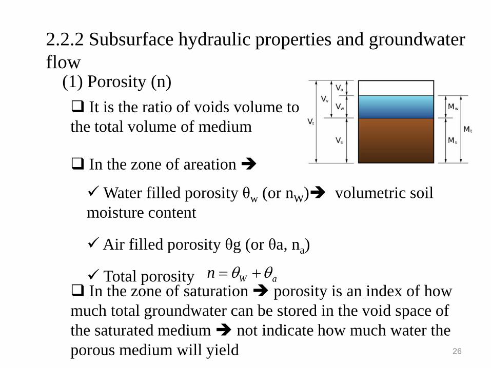
Water filled porosity θw (or nW) volumetric soil moisture content
Air filled porosity θg (or θa, na)
Total porosity
26
It is the ratio of voids volume to the total volume of medium
(1) Porosity (n)
2.2.2 Subsurface hydraulic properties and groundwater flow
In the zone of areation
aWn θθ += In the zone of saturation porosity is an index of how much total groundwater can be stored in the void space of the saturated medium not indicate how much water the porous medium will yield

Effective porosity (ne) the ratio of the volume of the void space through which flow can occur to the total volume less than total porosity n
Specific yield of an aquifer (Sy) the ratio of the volume of water that drains from saturated material due to the attraction of gravity to the total volume in most cases, ne = Sy
Specific retention of an aquifer (Sr) the ratio of volume of water that is retained against the force of gravity to the total volume
Total porosity
27
In the zone of saturation
ry SSn +=

Air
Water
Soil
28
taa VV θ=
VtWW sVVV == θ
tV nVV =
sw uMM =
tds VM ρ=
Soil composition by phase

(2) Hydraulic conductivity (K)
Hydraulic conductivity (or permeability) is defined as the property of a porous media that permits the transmission of water through it K can be obtained through using Darcy’s Law In 1856, Henri Darcy investigated the flow of water through beds of permeable sand. The followed figure shows the experimental set-up for determining head loss through the sand column Darcy experimented with different soils and with different values of L, h1, and h2. The results showed
29
LhhKA
dLdhKAQ
∆−
=−= 21

30 Head loss through a sand column (z = elevation)
Source: Zhang, Engineering Hydrology, 2003
Where, Q = volumetric flow rate or total discharge K = coefficient of permeability or hydraulic conductivity A = cross-sectional area of flow h = hydraulic head; h1 − h2 = head loss L = length of flow path; dh/dL = i = hydraulic gradient
KiALhhKA
dLdhKAQ
−=∆−
=
−=
21

31
Hydraulic conductivity a measure of the permeability of the porous media or, say, an indication of an aquifer’s ability to transmit water Its value usually depends on the size and number of pores in the soil or aquifer material It has the dimensions of length/time (L/T) or velocity, such as cm/sec, ft/day
Source: Bedient et al., Hydrology and Floodplain Analysis, 2007

32
An expression for hydraulic conductivity in terms of fluid and porous media properties
K = cd2ρg/µ Where c = a dimensionless constant d = mean grain diameter ρ = fluid density µ = fluid absolute viscosity g = gravitational acceleration
The product cd2 is a function only of the porous media ρ and µ are functions of the fluid
The intrinsic permeability k is a property of the medium (soil or rock) only, independent of fluid properties
k = cd2 and K= kρg/µ

(3) Groundwater movement velocity Darcy’s velocity (v), or discharge velocity an average discharge velocity through the entire cross section of the column v = Q/A = -Kdh/dL = -Ki Seepage velocity (vS) equals to the Darcy velocity divided by effective porosity since the actual flow is limited to the pore space only vS = v /ne = -Ki/ne Seepage velocity (vS) usually higher than the Darcy’s velocity
33
(4) Transmissivity (T) Transmissivity a measure of the water amount that can be transmitted horizontally through a unit width by the fully saturated thickness of an aquifer under a hydraulic gradient equal to 1

T = Kb Where K = hydraulic conductivity b = the saturated thickness of an aquifer
34
Example 2-1: Calculate the discharge and seepage velocities for water flowing through a pipe filled with sand with a hydraulic conductivity of 1.5 x 10⁻⁶ cm/s and a porosity of 0.2. the hydraulic gradient is 0.01 and the cross-sectional area of the pipe is 150.0 cm2.

35
2.2.3 Groundwater flow toward a pumping well (1) Steady flow to a well in a confined aquifer
When a well is pumped, water levels in its neighborhood are lowered this lowering amount at a given point defines the drawdown at that point At the given point in time, the variation of drawdown with distance from the well describes the drawdown curve (or cone of depression). The steady-state flow to a well means the variation of head occurs only in space and not in time The steady radial flow to a well fully penetrating a homogeneous confined aquifer can be expressed as

36
Radial flow to a well penetrating a confined aquifer
)/ln(2
w
w
rrhhTQ −
= π)/ln(
212
12
rrhhTQ −
= πor
Source: Bedient et al., Hydrology and Floodplain Analysis, 2007

37
(2) Steady flow to a well in a unconfined aquifer
The steady radial flow to a well fully penetrating a homogeneous unconfined aquifer can be expressed as
)/ln( 12
21
22
rrhhKQ −
= π
Source: Bedient et al., Hydrology and Floodplain Analysis, 2007

38
Example 2-2: a well is constructed to pump water from a confined aquifer. Two observation wells, OW1 and OW2, are constructed at distances of 100m and 1000m, respectively. Water is pumped from the pumping well at a rate of 0.2 m3/min. at steady state, drawdown s is observed as 2m in OW2 and 8m in OW1. Determine the hydraulic conductivity K and transmissivity T if the aquifer is 20 m thickness.