late quaternary ice sheet history of northern eurasiaoi/ag-326 2006 readings/russian arctic...late...
TRANSCRIPT

ARTICLE IN PRESS
*Correspondin
E-mail addres
0277-3791/$ - see
doi:10.1016/j.qua
Quaternary Science Reviews 23 (2004) 1229–1271
Late Quaternary ice sheet history of northern Eurasia
John Inge Svendsena,*, Helena Alexandersonb, Valery I. Astakhovc, Igor Demidovd, JulianA. Dowdeswelle, Svend Funderf, Valery Gataulling,h, Mona Henriksena, Christian Hjorti,Michael Houmark-Nielsenj, Hans W. Hubbertenk, !Olafur Ing !olfssonl, Martin Jakobssonm,
Kurt H. Kjæri, Eiliv Larsenn, Hanna Lokrantzo, Juha Pekka Lunkkap, Astrid Lys(an,Jan Mangeruda, Alexei Matiouchkovq, Andrew Murrayr, Per M .olleri, Frank Niessens,
Olga Nikolskayat, Leonid Polyakh, Matti Saarnistou, Christine Siegertk, Martin J. Siegertv,Robert F. Spielhagenw, Ruediger Steins
aBjerknes Centre for Climate Research & Department of Earth Science, University of Bergen, All!egaten 41, N-5007 Bergen, NorwaybDepartment of Physical Geography and Quaternary Geology, Stockholm University, SE-10691 Stockholm, Sweden
cGeological Faculty, St. Petersburg University, Universitetskaya 7/9, St. Petersburg 199034, Russian Federationd Institute of Geology, Karelian Branch of Russian Academy of Sciences, Pushkinskaya 11, 125610 Petrozavodsk, Russian Federation
eScott Polar Research Institute and Department of Geography, University of Cambridge, Cambridge CBZ IER, UKfGeological Museum, Øster Voldgade 5-7, DK-1350 Copenhagen K, Denmark
gOil and Gas Research Institute, Exporta Street 5, LV-1226 Riga, LatviahByrd Polar Research Center, Ohio State University, Columbus, OH 43210, USA
iQuaternary Sciences, Department of Geology, Lund University, GeoCenter II, S .olvegatan 12, SE-22362 Lund, SwedenjGeological Institute, University of Copenhagen, Øster Voldgade 10, DK-1350 Copenhagen, Denmark
kAlfred-Wegener Institut for Polar and Marine Research (AWI), Postfach 600149, 14401 Potsdam, GermanylUniversity of Iceland, Department of Geology and Geography, IS-101 Reykjav!ık, Iceland
mCenter for Coastal and Ocean Mapping, Chase Ocean Engineering Lab, University of New Hampshire, Durham, NH 03824, USAnGeological Survey of Norway, P.O. Box 3006, Lade, N-7002 Trondheim, Norway
oGeological Survey of Sweden, Box 670, SE-75128 Uppsala, Swedenp Institute of Geosciences, University of Oulu, Linnanmaa, P.O. Box 3000, FIN-90014, Finland
qVSEGEI (National Geological Institute), Sredny proezd 74, St. Petersburg 199026, Russian FederationrNordic Laboratory for Luminescence Dating, Department of Earth Sciences, Aarhus University, Ris^ National Laboratory,
DK-4000 Roskilde, DenmarksAlfred Wegener Institute for Polar and Marine Research (AWI), Columbusstrasse, D-27568 Bremerhaven, Germany
t Institute of Remote Sensing Methods for Geology (NIIKAM), Birzhevoy proezd 6, St. Petersburg 199034, Russian FederationuGeological Survey of Finland, Betonimiehenkuja 4, P.O. Box 96, Espoo, FIN-02151 Uusimaa, FinlandvBristol Glaciology Centre, School of Geographical Sciences, University of Bristol, Bristol BS8 ISS, UK
wAcademy of Sciences, Humanities and Literature Mainz and Leibniz Institute for Marine Sciences, East Coast Building,
Wischhofstr. 1-3, D-24148 Kiel, Germany
Abstract
The maximum limits of the Eurasian ice sheets during four glaciations have been reconstructed: (1) the Late Saalian (>140 ka),
(2) the Early Weichselian (100–80 ka), (3) the Middle Weichselian (60–50 ka) and (4) the Late Weichselian (25–15 ka). The
reconstructed ice limits are based on satellite data and aerial photographs combined with geological field investigations in Russia
and Siberia, and with marine seismic- and sediment core data. The Barents-Kara Ice Sheet got progressively smaller during each
glaciation, whereas the dimensions of the Scandinavian Ice Sheet increased. During the last Ice Age the Barents-Kara Ice Sheet
attained its maximum size as early as 90–80,000 years ago when the ice front reached far onto the continent. A regrowth of the ice
sheets occurred during the early Middle Weichselian, culminating about 60–50,000 years ago. During the Late Weichselian the
Barents-Kara Ice Sheet did not reach the mainland east of the Kanin Peninsula, with the exception of the NW fringe of Taimyr. A
numerical ice-sheet model, forced by global sea level and solar changes, was run through the full Weichselian glacial cycle. The
modeling results are roughly compatible with the geological record of ice growth, but the model underpredicts the glaciations in the
g author. Fax: +47-55583660.
s: [email protected] (J.I. Svendsen).
front matter r 2003 Elsevier Ltd. All rights reserved.
scirev.2003.12.008

ARTICLE IN PRESSJ.I. Svendsen et al. / Quaternary Science Reviews 23 (2004) 1229–12711230
Eurasian Arctic during the Early and Middle Weichselian. One reason for this is that the climate in the Eurasian Arctic was not as
dry then as during the Late Weichselian glacial maximum.
r 2003 Elsevier Ltd. All rights reserved.
1. Introduction
Vast areas of the northern parts of Russia and Siberiahave repeatedly been affected by major glaciationsduring the Quaternary. Ice sheets that formed overScandinavia spread eastwards across the NW RussianPlains and the White Sea area, whereas ice sheets in theBarents and Kara Sea region expanded southwards ontopresent-day land (Figs. 1–3). The timing and dimensionsof these former ice sheets have been much debated overthe past decades and, in particular, it has been difficultto form a consensus as to the extent of glaciations in theRussian Arctic during the Last Glacial Maximum(LGM). According to the most cited view, much ofnorthern Eurasia was covered by an enormous ice sheetcomplex at the LGM (Grosswald, 1993, 1998) whereas
Fig. 1. Map of northern Eurasia with adjacent seas. The areas considered in
Plateau, West Siberian Plain, Polar Urals,Yugorski Peninsula, Pechora L
Southeastern Barents Sea, Kara Sea and the Arctic Ocean. Core sites from
records are shown (Jakobsson et al., 2001; Spielhagen et al., 2004).
others visualized more localized ice caps over the ArcticIslands, the Polar Urals and the Central SiberianUplands (e.g. Velichko et al., 1997). It is now acceptedthat a sizeable ice sheet formed over the NW part of theBarents Sea shelf during the LGM (Landvik et al.,1998), but the southern and eastern extension of this icesheet has been difficult to determine. A reconstruction ofice sheet limits post-dating the last interglacial waspreviously presented in an overview paper by Svendsenet al. (1999), showing that the Barents-Kara Ice Sheetduring the LGM was smaller than expected. It is alsoevident that the glacier distribution in the EurasianArctic has been more variable through time thanpreviously thought and that the largest ice sheets existedfor a relatively short period. During the last 160,000years as many as four major glaciations have been
this study include the Taimyr Peninsula, Severnaya Zemlya, Putorana
owland, Arkhangelsk Region, Kola Peninsula, NW Russian Plain,
the Arctic Ocean that are used for comparison with the continental

ARTICLE IN PRESS
Fig. 2. Map of the area affected by the Barents-Kara Ice Sheets and by the ice caps over the Putorana Plateau. Some of the most prominent end
moraines that were originally mapped by geological surveys and institutes in Russia are marked. The inferred maximum ice sheet extent after the last
interglacial (Eemian/Kazantsevo) is marked with a red line. Middle Weichselian moraines are indicated with a green color and the LGM limit with a
yellow line. Some key sites mentioned in the text are marked with letters.
J.I. Svendsen et al. / Quaternary Science Reviews 23 (2004) 1229–1271 1231
recorded in the NW Barents Sea region, but the majorityof this time was characterized by limited ice cover(Mangerud et al., 1998, 2001).
Here we present an updated synthesis of our currentunderstanding of the chronology and dimensions of theEurasian ice sheets during the last 160,000 years. TheSaalian glacial maximum in Western and CentralEurope that occurred during marine isotope stage(MIS) 6 is here considered to be equivalent with theMoscow glaciation in European Russia, the Tazglaciation in West Siberia and the Murukta glaciationin North Central Siberia. For the last interglacial (MIS5e) and glacial (MIS 5d-2) periods we use the westernEuropean terms Eemian and Weichselian respectively,which correlates with the Mikulino and Valdai inEuropean Russia, and the Kazantsevo and Zyryankain Siberia. The Early Weichselian correlates with MIS5d-a (117–75 ka), the Middle Weichselian with MIS4-3 (75–25 ka) and the Late Weichselian with MIS 2(25–10 ka). The reconstructions are based on compre-hensive geological field investigations on the northernRussian and Siberian mainland and in the adjacent shelfseas, and are compared with data from the Arctic Ocean
and with glaciological modeling. This is a compilation ofresults that were obtained within the framework of theEuropean Science Foundation program ‘‘QuaternaryEnvironment of the Eurasian North’’ (QUEEN) duringthe period 1996–2002. Inferred ice sheet limits are drawnover the entire northern Eurasia for the last four majorglaciations: (1) the Late Saalian (before 130 ka), (2) theEarly Weichselian (c. 90–80 ka), (3) the early MiddleWeichselian (c. 60–50 ka) and (4) the Late Weichselian(20–15 ka). The empirical data are compared with theArctic Ocean record and with a model simulation of therepeated growth and decay of the Eurasian ice sheetsover the whole Weichselian period (117–10 ka). Thereconstructed ice sheet limit for the Late Saalianglaciation is mainly based on a review of earlierpublished material.
We first review the regional glacial records from thecontinent and the adjacent sea floor. The work areasinclude: Taimyr Peninsula, Severnaya Zemlya, PutoranaPlateau, West Siberian Plain, Ural Mountains, YugorskiPeninsula, Pechora Lowland, Arkhangelsk Region,Kola Peninsula, NW Russian Plain, SoutheasternBarents Sea shelf and the Kara Sea shelf (Fig. 1). We
ARTICLE IN PRESS
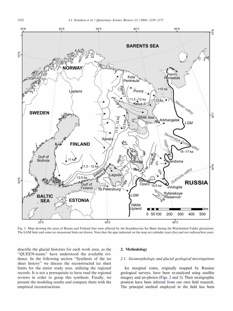
Fig. 3. Map showing the areas of Russia and Finland that were affected by the Scandinavian Ice Sheet during the Weichselian/Valdai glaciations.
The LGM limit and some ice recessional limts are drawn. Note that the ages indicated on the map are calendar years (ka) and not radiocarbon years.
J.I. Svendsen et al. / Quaternary Science Reviews 23 (2004) 1229–12711232
describe the glacial histories for each work area, as the‘‘QUEEN-teams’’ have understood the available evi-dence. In the following section ‘‘Synthesis of the icesheet history’’ we discuss the reconstructed ice sheetlimits for the entire study area, utilizing the regionalrecords. It is not a prerequisite to have read the regionalreviews in order to grasp this synthesis. Finally, wepresent the modeling results and compare them with theempirical reconstructions.
2. Methodology
2.1. Geomorphologic and glacial geological investigations
Ice marginal zones, originally mapped by Russiangeological surveys, have been re-analyzed using satelliteimagery and air-photos (Figs. 2 and 3). Their stratigraphicposition have been inferred from our own field research.The principal method employed in the field has been

ARTICLE IN PRESSJ.I. Svendsen et al. / Quaternary Science Reviews 23 (2004) 1229–1271 1233
sedimentological and structural geological documentationof Quaternary deposits exposed in natural sections. Inaddition, sediment coring of lake basins, either from thewinter ice or in open water using a raft, was undertaken. Anumber of seismic records and sediment cores from the seafloor off the mainland have been collected and interpreted.
2.2. Proxies for ice sheet fluctuations in the deep-sea
sediments
Records of ice-rafted debris (IRD), microfossils andoxygen isotope (d18O) measurements from high-resolu-tion sediment cores from the eastern and central ArcticOcean (Fig. 1) are used to detect ice sheet fluctuationson the Barents-Kara Sea shelves (Spielhagen et al.,2004). Abrupt freshwater discharges associated withdeglaciation events in the Eurasian Arctic and/ordrainage of ice dammed lakes are identified from thed18O records of plankton foraminifers. Furthermore, thecontent of planktonic foraminifers and coccolithsprovide useful information about sea ice conditionsand paleoceanographic changes in the Arctic Ocean.
2.3. Dating methods
The chronostratigraphy of the continental records is,to a large extent, based on optically stimulatedluminescence (OSL) and radiocarbon dating, and tosome extent on electron spin resonance (ESR) dating.The stratigraphic framework of the eastern and centralArctic Ocean cores is based on a variety of methods,including biostratigraphy (coccoliths), paleomagnetics,radioisotopes (14C, 10Be) and correlation with otherdated cores. Details are given in Spielhagen et al. (2004).
OSL dating has enabled us to establish a reliablechronology of sediment successions that are beyond therange of the radiocarbon method. Most OSL dates wereobtained from the Nordic Laboratory for LuminescenceDating, Ris^, Denmark. As many as around 600samples from Russia have been analyzed since 1996 aspart of the QUEEN programme. The single aliquotregenerative dose protocol applied to quartz grains wasused to estimate the equivalent dose (Murray andWintle, 2000). The samples were analyzed for naturalseries radionuclide concentrations in the laboratory,using high-resolution gamma spectrometry (Murrayet al., 1987). These concentrations were converted intodose rates using the conversion factors listed by Olleyet al. (1996). Dates from Yamal and Yugorski peninsu-las in West Siberia were obtained by using the infrared-stimulated luminescence (IRSL) and thermolumines-cence (TL) by multiple aliquot additive dose procedures(Forman, 1999). A. Molodkov at the ESR DatingLaboratory, Institute of Geology, Estonia has carriedout ESR datings on samples from the Taimyr Peninsula,using the method described by Molodkov et al. (1998).
2.4. Glaciological modeling
Numerical modeling experiments were carried outusing a model that is centered about the ice continuityequation (Mahaffy, 1976), which relates the massbalance and flow of ice to the time dependent changein ice sheet thickness. Algoritms for ice deformation,basal slip and isostasy are included, as described bySiegert et al. (1999b). The model is forced by its climateinput, which involves the air temperature and accumu-lation of ice, and their variations in time and space. Theice sheet limits are not numerically predetermined.The model uses an informal inverse approach, whereice sheet limits are forced to match geologically mappedand dated limits through adjustment of the climate. Theresult is a plausible scenario for ice and climate inthe Eurasian Arctic at the LGM. The model is forcedthrough the full Weichselian by linking climate tosolar insolation changes, so that interglacial condi-tions are associated with values at 10 ka, and LGMconditions occur with minimum insolation values in theWeichselian.
3. Regional glacial records from northern Russia, Siberia
and the adjacent continental shelves
This regional overview is, to a major extent, based onnew observations and results obtained during theQUEEN Programme (1996–2002). We have, however,also reviewed and incorporated previously publishedobservations relevant to this study. Below we summarizeour current understanding of the glacial history fortwelve key regions in northern Russia, Siberia andthe adjacent continental shelves that were affected bythe major Quaternary glaciations (Figs. 1–3). Docu-mentation of the data is given in the cited primarypublications.
3.1. Taimyr Peninsula
In some previous reconstructions the last major icesheet that reached the southernmost part of the TaimyrPeninsula was called the Murukta glaciation (Kind andLeonov, 1982; Isayeva, 1984; Arkhipov et al., 1986). Atthis time the ice sheet coalesced with large ice caps overthe Putorana Plateau and the Anabar Uplands (Figs. 2and 4). The Murukta moraines in their stratotypic areaeast of the Putorana Plateau are covered by terrestrialsediments with flora indicating environments warmerthan present, i.e. an interglacial type of climate(Bardeyeva, 1986). Even though we have not investi-gated the critical areas along the southern margin of theMurukta glaciation the stratigraphic relations suggestthat this ice sheet existed during the Late Saalian

ARTICLE IN PRESS
Fig. 4. Generalized sediment stratigraphy on Taimyr, showing the inferred relations between tills, marine sediments and the mapped ice marginal
features.
J.I. Svendsen et al. / Quaternary Science Reviews 23 (2004) 1229–12711234
(MIS 6) and that it corresponds with the Taz glaciationrecorded in West Siberia.
Along the Khatanga River, the Murukta till issometimes found directly above an interglacial marineformation containing the extinct mollusc Cyrtodaria
jenisseae (angusta) and a foraminifer complex that ischaracteristic of the Siberian Holsteinian (Gudina, 1976;Kind and Leonov, 1982). The till is overlain by marinesediments with arcto-boreal molluscs (including Arctica
islandica, Macoma balthica) and boreal foraminifers. Arelatively warm sea seems to have flooded much of theNorth Siberian Lowland during this period (Fig. 4). Inwestern and northern Taimyr, sediments from thistransgression are found over 100m a.s.l. (Kind andLeonov, 1982). Pollen spectra indicate dense forestvegetation, with spruce (Picea) and pine (Pinus) on whatis today tundra. Diatoms from these strata also reflectan interglacial type of climate. These sediments weresubsequently correlated with similar marine deposits atthe well-known Cape Karginsky section in West Siberia,which became the type locality for this interglacial.Andreyeva (1980) and Kind and Leonov (1982) there-fore called this period Karginsky, a widely used term inthe stratigraphic framework for the Late Quaternary ofSiberia. Based on several finite radiocarbon dates thesestrata were originally thought to be of intra-Weichselianage. However, subsequent investigations revealed thatthe Karginsky strata are beyond the range of theradiocarbon method (Fisher et al., 1990) and they are
now considered to be equivalent with the Kazantsevo(Eemian) interglacial (Arkhipov, 1989; Sukhorukova,1999; Astakhov, 2001).
The next ice sheet that inundated the TaimyrPeninsula left a continuous zone of wide push morainesabout 850 km long that are called the Jangoda-Syntabul-Baikuronyora ridges (Fig. 2), the JSB Line (Kind andLeonov, 1982). South of this moraine belt interglacialmarine sediments are not covered by till (Fisher et al.,1990). Most important is that in the foothills of theByrranga Mountains there are many sites whereinterglacial marine sediments are found beneath a till(Urvantsev, 1931; Sachs, 1953; Kind and Leonov, 1982)and presently we suggest that this till-covered areastretches south to, and includes, the JSB zone. Wetherefore relate these moraines to the Early Weichselianice sheet maximum. In our former reconstructions(e.g. Svendsen et al., 1999; Hjort et al., 2004) theWeichselian limit was drawn along the Sampesa ridge,some 50 km south of the JSB zone and south ofthe recently studied Lake Labaz. The upper till to thenorth of Lake Labaz contains ‘fossil’ glacial ice (Siegertet al., 1999a) and blocks of marine sediments withboreal foraminifers (Kind and Leonov, 1982), indicatingthat it postdates the Eemian transgression. However,southwest and northeast of this lake, especially onthe river Bolshaya Balakhnya, there are many sitesof interglacial marine sediments not covered bytill (e.g. Fig. 29 in Kind and Leonov, 1982; Fisher

ARTICLE IN PRESSJ.I. Svendsen et al. / Quaternary Science Reviews 23 (2004) 1229–1271 1235
et al., 1990). We therefore believe that only the northernshores of Lake Labaz should be located inside the icesheet limit.
Our recent field investigations indicate that centralTaimyr, south of the Byrranga Mountains, was affectedby a major marine inundation after the Early Weichse-lian glaciation, following the northwards receding icemargin from the JSB-line (Fig. 2). Along the LedyanayaRiver and at other sites south of the Byrrangas, M .olleret al. (1999, 2002) investigated thick deltaic marine
Fig. 5. Schematic northwest-southeast profiles across the Taimyr Peninsula s
glacial maximum (c. 90 ka), (b) the Early Weichselian glacial retreat and mari
NW Taimyr during the Early Weichselian (c. 80 ka), (d) the Middle Weichse
OSL- and ESR dates are plotted to the right.
sediments not covered by any till (Fig. 4). These marinesediments accumulated up to 100m a.s.l. and contain amollusc fauna which is not significantly different fromthe present Kara Sea assemblages, but very differentfrom the boreal Eemian mollusc fauna of Taimyr. Thehigh marine limits reflect a significant glacio-isostaticdepression when these sediments accumulated. It isinferred that the marine deltas were fed by melt-waterrivers from ice fronts located in the valleys and along thenorthern slope of the Byrranga Mountains, most likely
howing: (a) the inferred ice sheet position during the Early Weichselian
ne inundation (90–80ka), (c) the formation of ice dammed lakes on the
lian readvance (60–50 ka) and (e) the LGM (20–15 ka). Radiocarbon-,

ARTICLE IN PRESSJ.I. Svendsen et al. / Quaternary Science Reviews 23 (2004) 1229–12711236
reflecting a temporary halt of the ice front during itsrecession northwards. A series of 25 ESR dates onmolluscs from these delta sequences (Hjort et al., 2004)yield ages in the range of 96–70 ka, with a mean value of83 ka (when three outliers >110 ka are excluded). FourOSL dates from the same formation reveal ages in therange 89–73 ka (Fig. 5).
On the Chelyuskin Peninsula, the northernmostpart of Taimyr, a till covering interglacial marinedeposits reflects an ice sheet that flowed eastwardsover mountains as high as 350m a.s.l. This till iscovered by another sequence of marine sediments thatcan be traced up to 65–80m a.s.l. ESR dates (9) frommollusc shells in the interglacial sediments under the tillyielded ages between c. 150 and 110 ka. The uppermarine unit was dated to 93–80 ka, which roughlycorrelates with the Ledyanaya marine sequence south ofthe Byrrangas.
There are no indications that the areas south of theByrranga Mountains have been glaciated after the EarlyWeichselian deglaciation. A continental polar desertenvironment seems to have prevailed throughout theMiddle- and Late Weichselian (Siegert et al., 1999a;Hubberten et al., 2004). The section at Cape Sabler, onthe shore of Lake Taimyr, features one of the best-datedformations in the Russian Arctic. It is over 30m thickand includes a terrestrial–lacustrine sequence of lami-nated silts with peaty interlayers, large syngenetic icewedges and a mammoth steppe fauna and flora (e.g.Kienast et al., 2001). This formation has repeatedlyyielded finite radiocarbon dates, including values morethan 39 ka at the base, with a continuous age anddeposition record up to the Holocene (Kind andLeonov, 1982; Pavlidis et al., 1997; M .oller et al.,1999). Pre-Late Weichselian lacustrine sediments werealso found in cores from the lake bottom and from theadjacent Levinson-Lessing Lake (Ebel et al., 1999;Hahne and Melles, 1999; Niessen et al., 1999). As thepresent Lake Taimyr lays only 5m a.s.l., the relative sealevel in this region must have remained low for at leastthe last 40 ka.
North of the Byrranga Mountains there is anotherdistinct belt of ice marginal features (Fig. 2), called theNorth Taimyr ice-marginal zone (NTZ) (Kind andLeonov, 1982; Isayeva, 1984). This zone, which is acomplex of glacial, glaciofluvial and glaciolacustrinedeposits, has been investigated and mapped in detail byAlexanderson et al. (2001, 2002). The NTZ contains aseries of up to 100m high and 2 km wide morainicridges, consisting to a large extent of redeposited marinesilt. These moraines remain ice-cored but, in most areas,the active layer only rarely reaches the ice surface. Theridge system can be traced for 700–800 km, from nearthe Mikhailova Peninsula in the southwest to theTessema River in the northeast, but is most pronouncedin a c. 300 km-long zone on both sides of the Lower
Taimyra River, some 80–100 km inland from the KaraSea coast (Fig. 2). When the outermost moraines weredeposited along the NTZ the ice sheet, flowing from theKara Sea, must have crossed the 300–500m high rangeof coastal hills west of the Lower Taimyra River.Associated with this ice-marginal zone are shorelinesand glaciolacustrine sediments from two generations ofice-dammed lakes that formed in front of the BarentsKara Ice Sheet (see further discussion in Mangerud et al.,2004). OSL datings suggest that the highest lake existedduring the Early Weichselian ice recession around 80 kawhereas the lower lake system reflects a younger MiddleWeichselian ice sheet advance that terminated at theNTZ around 70–54 ka (Fig. 5) (Alexanderson et al.,2001, 2002). Thick deposits of glaciolacustrine sedimentsat the coast north of the Leningradskaya River, thathave been OSL dated to around 80–70 ka, may stemfrom the Early Weichselian deglaciation (Funder et al.,1999).
Well-developed marginal features along the NTZdefine the youngest ice limit on NW Taimyr, west andeast of the Lower Taimyra River (Fig. 2). They outline athin ice lobe terminating at altitudes below 150m a.s.l,up to 100 km inland from the coast. Around the LowerTaimyra River valley this stage is recognized bymorainic lobes that partly onlap the Middle–EarlyWeichselian moraine system. Glacially distorted sedi-ments, both marine Quaternary silt and sand andCretaceous sands characterise the area inundated bythis youngest ice advance. Remnants of glacier icecovered by a thin (c. 0.5m) meltout till are found atmany places behind the youngest ice front. Two AMSradiocarbon dates of mollusk shells (Fig. 5), sampledfrom glacially redeposited marine silt close behind theformer ice front, yield ages around 20 ka, suggesting thatthe ice sheet reached this position later than this time(Alexanderson et al., 2001). A minimum age of thedeglaciation is given by a radiocarbon age around12 ka from in situ terrestrial plant material at the presentcoast (Bolshiyanov et al., 2000). Organic materialretrieved from the sea floor off the coast has beenradiocarbon dated (conventionally, bulk sample) toaround 16 ka (Bolshiyanov et al., 1998). Based bothon the shell dates and on the especially thin meltouttill in this area, in combination with the much higherfrequency here of exposures of the underlying ice thanin other areas within the NTZ, we believe that thelowland on northernmost Taimyr was inundated by arestricted ice sheet advance from the Kara Sea shelfduring the Late Weichselian. This ice was, however,much thinner than the preceding ice sheets in thisarea, and did not manage to override the coastal hills.It did however, reverse the drainage of the LowerTaimyra River as indicated by the increased sedimenta-tion of the Taimyr lake basin around 19 ka (M .oller et al.,1999).

ARTICLE IN PRESSJ.I. Svendsen et al. / Quaternary Science Reviews 23 (2004) 1229–1271 1237
3.2. Severnaya Zemlya
The occurrence of till beds with marine mollusks andof uplifted marine sediments of Quaternary age indicatesthat ice sheets several times have covered the entireSevernaya Zemlya archipelago (Bolshiyanov and Ma-keyev, 1995; M .oller et al., in preparation). Sedimentcores recovered from Changeable Lake (6m a.s.l.) onOctober Revolution Island (Fig. 2) have providedminimum dates of the last major glaciation of thearchipelago (Raab et al., 2003). This lake is located 4 kmto the south of the Vavilov Ice Dome and occupies astructurally controlled basin. Two AMS radiocarbondates of foraminifer shells, from a thin layer of marinesediments overlying a till at the base of the coredsequence, yielded nonfinite ages. Three luminescence(OSL) dates revealed ages in the range 86–35 ka. A seriesof AMS dates on plant and insect remains indicatethat the overlying lacustrine sediments date back to atleast 30 ka.
Based on the records from Changeable Lake it isconcluded that the last major glaciation of SevernayaZemlya occurred during the Middle Weichselian, whenthe ice front terminated on the shelf (Raab et al., 2003).The deglaciation was associated with a marine trans-gression that inundated the lake basin at around60–50 ka, reflecting a strong glacioisostatic depression.Possibly, this marine inundation corresponds to raisedshorelines up to 100m a.s.l. that have been radiocarbondated to 50–21 ka (Bolshiyanov and Makeyev, 1995).
The sediment sequence from Changeable Lakeindicates that the Vavilov Ice Dome was small, orperhaps absent, during the Late Weichselian. Thisconclusion may be supported by radiocarbon dates onmammoth tusks from elsewhere on Severnaya Zemlya,indicating that mammoths were grazing close to thepresent day glaciers at around 25, 20, 19 and 11.5 ka(Makeyev et al., 1979; Bolshiyanov and Makeyev, 1995).
3.3. Putorana Plateau
At least once during the Quaternary an ice sheetadvance from the Kara Sea inundated this mountainarea (Fig. 2). The occurrence of granite erratics reflectsice flow across northern Taimyr and onto the PutoranaPlateau and a very thick shelf-centered ice sheet at thattime (Urvantsev, 1931). Even though this glacial eventis poorly dated a major glaciation is thought tohave occurred during the Saalian when the icesheet terminated far south on the adjacent lowland inWest Siberia.
Two younger moraine belts that encircle the PutoranaPlateau indicate that the glaciations were more restrictedduring the Weichselian than during the foregoingglaciation (Fig. 2). The outer moraine system in north-eastern Putorana was originally dated to the LGM on
the basis of several radiocarbon dates from beneath thecorresponding till (Isayeva et al., 1976). The same agewas suggested for the Onyoka morainic belt along thesouthern slope of the plateau (Isayeva, 1984). TheOnyoka moraines merge with the moraines trending eastwest across the Yenissei valley to the West SiberianPlain. This chain of moraines is therefore considered tobe contemporaneous with the last shelf-centered glacia-tion that inundated the West Siberian Plain, whichaccording to our interpretation occurred during theEarly Weichselian (Astakhov, 1992).
The inner system of morainic ridges, termed theNorilsk Stage, is represented by horseshoe-shaped endmoraines encircling the western ends of deep fjord-likelakes. Sachs (1953) and other geologists considered theNorilsk moraines products of alpine glaciation, whereasIsayeva (1984) thought that these spectacular featureswere deposited by outlet glaciers which drained asubstantial ice cap covering the flat plateau. A YoungerDryas age was suggested for the Norilsk Stage (Kind,1974), but more recent investigations indicate that it isolder. Pollen diagrams from long cores retrieved fromthe bottom sediments of Lake Lama, situated on theproximal side of the Norilsk moraines (Fig. 2), suggestthat lacustrine sedimentation started well before 17 ka(Hahne and Melles, 1997). Judged from seismic recordsthere are more than 20m of lacustrine sediments belowthe 19m long cored sequence. Hahne and Melles (1997)therefore assume that the youngest till in these lakebasins is of Middle Weichselian age, which implies thatthe Norilsk moraines predate the LGM. This issupported by geomorphologic observations, proposingthat the maximum extent of the LGM glaciers isrepresented by moraines higher up in the valleys(Bolshiyanov et al., 1998).
3.4. West Siberian Plain
From the distribution of tills mapped by the RussianGeological Survey, it appears that the most extensive icesheet expanded as far south as 60�N (Zarrina et al.,1961; Ganeshin, 1973). This glaciation is believed to beof Middle Quaternary age (MIS 8), based on severalESR and TL dates. This till is in places covered byanother till unit (Taz till) that terminates 100–400 km tothe north of the drift limit (Figs. 2 and 6), and isconventionally correlated to MIS 6 (Arkhipov et al.,1986; Arkhipov, 1989).
Marine sediments and tills containing remnants ofwarm-water marine fauna show that the West SiberianPlain was affected by at least two ‘‘boreal’’ transgres-sions (Zubakov, 1972). The youngest marine strata withshells of the boreal mollusks Arctica islandica andZirphaea crispata have traditionally been termed theKazantsevo formation (Sachs, 1953). Along the YenisseiRiver this marine formation has been described at

ARTICLE IN PRESS
Fig. 6. Generalized stratigraphy from the West Siberian Lowland showing the inferred relations between tills, marine sediments and the mapped ice
marginal features.
J.I. Svendsen et al. / Quaternary Science Reviews 23 (2004) 1229–12711238
altitudes from 5m a.s.l. at 67�N rising to 64m at 72�N(Sukhorukova, 1999). It is difficult, however, todetermine the upper limit of the transgression becausethe strata are often heavily glaciotectonized and coveredby till (Fig. 6). Four ESR dates from marine molluskshells gave ages in the range of 134–105 ka, suggestingthat at least some of these strata are of Eemian age(Sukhorukova, 1999). We suspect, however, that severalsequences traditionally ascribed to the Kazantsevo(Eemian) transgression may be much older.
To the north of the proposed ice-sheet limit on theWest Siberian Plain there are many sites with inter-glacial sediments of the Kazantsevo (Eemian) formationthat are covered by till (Zarrina et al., 1961; Troitsky,1975; Astakhov, 1992). We adopt the traditional view ofmany Russian geologists that the maximum ice sheetextent during the Weichselian corresponds with topo-graphically distinct ice-pushed ridges that can be tracedacross the Yenissei River valley near the Arctic Circle(Fig. 2). These ridges were formed by a lobe of theBarents-Kara Ice Sheet that flowed southwards alongthe river valley (Astakhov and Isayeva, 1988) andmerged with the Onyoka glaciation on the PutoranaPlateau (Isayeva, 1984). The southernmost ridges,described as the Yermakovo (Arkhipov et al., 1986)and Denezhkino moraines (Astakhov and Isayeva,1988), can easily be recognized from satellite images.The ice marginal zone is a hummock-and-lake landscapethat includes distinct ice-pushed ridges and prominenthill–hole pairs, locally displaying a relief of more than ahundred meters. Basal tills with blocks of fossil glacierice are exposed in sections along the Yenissei River(Kaplanskaya and Tarnogradsky, 1986; Astakhov andIsayeva, 1988). The ice limit west of the river valley isdrawn along a similar belt of glacial topography,including some large horseshoe-shaped push moraines(Zemtsov, 1976). The ice front position across the flatand swampy areas between the Ob Estuary and the Taz-
Yenissei interfluves is hardly recognizable on aerialphotographs and satellite images, but we suspect that itwas located along ice marginal features on the GydanPeninsula; the so-called Gydan Stage (Troitsky, 1975).Further to the west, the maximum ice extent after thelast interglacial probably corresponds with a west–eaststriking belt of push moraines on the southern part ofthe Yamal Peninsula (Fig. 2), merging into the SopkayMoraines on the Uralian piedmont (Astakhov, 1979,2001).
Proximal to the moraines in the Yenissei River valleythere is a plain built of glaciolacustrine varved sedimentsat altitudes up to around 60m a.s.l. (Fig. 6). A formerthermokarst sinkhole incised into this plain is filled withfrozen silt containing well-preserved logs radiocarbondated to more than 50 ka (Kind, 1974). This indicatesthat the latest ice advance in the Yenissei River valleyoccurred well before 50 ka and prior to a period whentrees were growing in the Arctic (Astakhov, 1992, 1998).Two luminescence dates obtained on ablation sedimentscapping the thick fossil glacier in the core of a marginalmoraine on the Arctic Circle yielded values 79720 and78719 ka (Kostyayev et al., 1992). Recently obtainedOSL dates from beneath and atop of a varved sequenceat the Ob River mouth and on the southwestern YamalPeninsula constrain the last ice advance in this area tothe time span 80–70 ka (Astakhov, 2004).
On the western Yamal there is a well-studied section,Marresale, which contains a thick sequence of pro-deltaic marine sediments covered by a till, the Karadiamicton (Gataullin, 1988). The till is associatedwith large-scale glaciotectonic deformation, reflectingice flow to the north. The till is covered by a well-datedsequence of undisturbed lacustrine, fluvial and aeoliansediments indicating that the last glaciation of this areatook place before 40 ka, either during the EarlyWeichselian or early Middle Weichselian (Formanet al., 1999a, 2002).

ARTICLE IN PRESSJ.I. Svendsen et al. / Quaternary Science Reviews 23 (2004) 1229–1271 1239
At several places to the north of 70�N the upper till iscovered by cold-water marine sediments (Fig. 6),indicating that a transgression inundated this northernregion after deglaciation. On the northern Gydan andYamal peninsulas there are several sites with fossilglacier ice that are directly covered by marine silt andclay containing mollusk shells of the cold water speciesPortlandia arctica or arctic foraminifers (Troitsky andKulakov, 1976; Astakhov, 1992). Unlike the Kazantse-vo formation the Portlandia strata are normally flatlying without any traces of being overridden by glacierice. These deposits, aged beyond the range of theradiocarbon method, are only found below 30–40ma.s.l. No warm-water faunas have been documentedabove the Portlandia strata (Troitsky and Kulakov,1976). It is, however, unclear whether these sedimentsaccumulated during the Early or Middle Weichselian.
In the Marresale section on western Yamal there wasa break in deposition of continental sediments duringthe LGM, at which time large ice wedges formed(Forman et al., 1999a, 2002). On eastern Yamal asimilar development was recorded in the well-datedcoastal section Syo-Yakha that displays a 20m thicksequence of icy silts of Yedoma type that accumulatedduring the period of 37–17 ka (Vasil’chuk and Vasil’-chuk, 1998). This section is pierced by two generationsof thick (syngenetic) ice wedges, which grew simulta-neously with accretion of the predominantly aeoliansediments. On the extreme north of the Gydan Peninsulathere are several finds of frozen mammoth carcasses thatwere buried in surface sediments not covered by till.Radiocarbon dates on mammoth flesh from three sitesyield ages in the range 36–30 ka (Heintz and Garutt,1965; Astakhov, 1998). These sites demonstrate thatglacier ice did not intrude into the West Siberian Arcticduring the Late Weichselian (Mangerud et al., 2002).
3.5. Ural Mountains
The occurrence of foreign boulders scattered over aflat summit more than 1000m a.s.l. show that an icesheet covered even the highest mountains in the PolarUrals at least once during the Quaternary (Yakovlev,1956). From investigations in adjacent areas it isconcluded that this event occurred prior to the lastinterglacial (see Astakhov, 2004).
Even though the Weichselian glaciations were morerestricted than in the Saalian, south flowing inland iceinundated the foothills of the Polar Urals after the lastinterglacial. Glacial striae and till fabric measurementsin these northern areas reflect an ice movement from N-NE; i.e. from the Kara Sea. Geomorphic features andthe end moraine system indicate that both flanks of thePolar Urals were bypassed by an ice sheet flowingtowards the south (Fig. 2). The well-expressed SopkayMoraines to east of the Polar Urals have been traced
from the southern part of the Yamal Peninsula andaround the northern tip of the mountain chain(Astakhov, 1979), where the ice sheet flowed up-valleyto deposit end moraines at 560m a.s.l. (Astakhov et al.,1999). Local alpine glaciers did not overrun any of thesemoraines and there is nothing to suggest that major icecaps formed over the Urals after this glaciation.However, large arched end-moraines in the foothills infront of mountain valleys to the south of the Barents-Kara Ice Sheet margin show that piedmont glaciers ofAlaskan type formed on the western flank of themountain. At the western foot of the Polar Uralsgeomorphological mapping suggests that a piedmontglacier on the river Bolshaya Usa coalesced with acontemporaneous ice lobe from the Barents-Kara IceSheet (Astakhov et al., 1999). Glaciofluvial sedimentsthat accumulated in front of this piedmont glacieryielded OSL ages in the range 82–62 ka (Dolvik et al.,2002), whereas a kame terrace that was deposited by alobe of the Barents-Kara Ice Sheet to the north of thepiedmont glacier gave somewhat higher ages (125–87 ka)for the deglaciation (Henriksen et al., 2003). We suspectthat this age difference is related to dating uncertainties,but cannot exclude the possibility that the piedmontglacier is slightly younger than the ice sheet lobe.
Ongoing investigations in the mountain valleys of thePolar Urals suggest that the glaciers there were muchsmaller during the Late Weichselian than during thepreceding Weichselian glaciations (Dolvik et al., 2002).It is concluded that only cirque glaciers or small valleyglaciers existed in the highest mountain valleys duringthe LGM. However, the exact dimensions of theseglaciers and their ages remain uncertain.
3.6. Yugorski Peninsula
The stratigraphy in the coastal cliffs of CapeShpindler, Yugorski Peninsula (Fig. 2), record twoglacial advances and two ice-free periods older than theHolocene (Lokrantz et al., 2003). During interglacialconditions, a sequence of marine to fluvial sedimentswas deposited. This was followed by a glacial eventwhen ice moved southwards from an ice-divide in theKara Sea and overrode and disturbed the underlyinginterglacial sediments. After a second period with fluvialdeposition under interstadial or interglacial condition,the area again was overrun by ice, now movingnorthward, from an inland ice divide. Infrared-stimu-lated luminescence (IRSL) dates suggest that the olderglacial event occurred during MIS 8 (300–250 ka), andthat the underlying interglacial sediments might be ofHolsteinian age (>300 ka). However, it should bementioned that only a few dates are available from thelowermost stratigraphic units and the chronology forthe pre-Weichselian strata is therefore more uncertainthan for the upper part of the sequence. The younger

ARTICLE IN PRESSJ.I. Svendsen et al. / Quaternary Science Reviews 23 (2004) 1229–12711240
glacial event recognized in the Cape Shpindler sequenceis interpreted to be of Early- to Middle Weichselian age,and possibly correlates with the last regional glaciationaround 90–80 ka. We propose that the last ice advancefrom the south over the western Yamal Peninsula(Forman et al., 1999a, 2002) correlates with the youngersouth-to-north directed glacial advance recorded in theCape Shpindler sections. Possibly glacier ice was flowingfrom the hills in the Pai-Hoi uplands on the YugorskiPeninsula, 468m a.s.l., which may have acted as an ice-sheet nucleation area during the Early Weichselianglaciation. At the onset of this glaciation ice grew on thehighlands fringing the Kara Sea Basin and latercoalesced to form a larger ice sheet in the Kara Sea.This larger ice sheet in its turn left most of the glacialfingerprinting recognized in the western Siberian record.
3.7. Pechora Lowland
As many as five tills, interbedded with marinesediments, have been recorded from boreholes in theArctic part of the Pechora Basin (Fig. 2). The thickesttill directly underlies marine sediments of assumedEemian age (Lavrushin et al., 1989). South of theoverlying Weichselian glacial deposits the surface till(Vychegda till) is conventionally correlated with theMoscow glaciation of Central Russia (Guslitser et al.,1986), which is presently thought to be of Late Saalian(MIS 6) age (Astakhov, 2004). The maximum ice sheetlimit to the east of the Russian Plain is mapped in theKama-Volga catchment close to 59�N (Krasnov, 1971).In the western part of the Pechora Lowland theVychegda till contains frequent Scandinavian erratics,
Fig. 7. Generalized stratigraphy of the Pechora Lowland and SE Barents Sea
mapped ice marginal features.
reflecting a dominant eastward ice flow across theTiman Ridge. East of the Pechora River it merges witha surface till of northeastern provenance, i.e. a till thatwas deposited from a shelf-centered ice sheet. In anexposure along the Seyda River in the northern part ofthe Pechora Lowland a series of OSL dates have beenobtained from interglacial strata below a till thatpossibly corresponds with this glaciation (Fig. 7).
After the Late Saalian glaciation the northern part ofthe Pechora Basin was inundated by the BorealTransgression (Yakovlev, 1956; Guslitser et al., 1986).Along the river Sula, a western tributary of the PechoraRiver, marine sediments with a rich mollusk fauna occur40–50m a.s.l. (Fig. 7), including boreal elements like asArctica islandica, Cerastoderma edule and Zirphaea
crispata. Palaeontologically, these strata are correlatedwith the Eemian, which is confirmed by OSL dates in therange 120–100 ka (Fig. 8) (Mangerud et al., 1999).Sediment cores recently retrieved from Lake Yamozeronear the highest part of the Timan Ridge contain c. 20mof lacustrine sediments below the Holocene strata(Henriksen et al., in preparation). Judging from thepollen stratigraphy and a series of 21 OSL dates withconsistent ages in the range 120–15 ka, the basallacustrine layers in this basin accumulated during theLate Saalian and the Eemian. There are no tills or otherglacial sediments above the Eemian strata, suggestingthat this area of the Timan Ridge remained ice freethroughout the Weichselian and up to the present.
An east–west trending belt of glacial landforms(Markhida, Harbei and Halmer moraines) was mappedabove the Eemian marine strata between the TimanRidge and the Polar Urals (Astakhov et al., 1999). The
showing the inferred relations between tills, marine sediments and the

ARTICLE IN PRESS
Fig. 8. Schematic north-south profiles across the Pechora Lowland showing: (a) the maximum extent of the Barents-Kara Ice Sheet during the Late
Saalian (160–140ka), (b) ice free forest environment with a high relative sea level during the Eemian, (c) Early Weichselian (90–80 ka) ice sheet
maximum with a proglacial lake (Lake Komi), (d) ice free conditions during the early Middle Weichselian (80–60 ka), (e) the ice sheet maximum
during the Middle Weichselian (60–50 ka) and (f) the ice front position during the Late Weichselian (LGM). Available 14C- and OSL dates are plotted
to the right.
J.I. Svendsen et al. / Quaternary Science Reviews 23 (2004) 1229–1271 1241
southern boundary of the fresh hummock-and-lakeglaciokarst landscape across the Pechora Lowland wascollectively termed the Markhida Line and was origin-ally considered to represent the same glaciation (Fig. 2).In the lowland area to the north of these moraines,
Eemian marine sediments are glaciotectonically dis-torted and covered by tills (Lavrushin et al., 1989;Mangerud et al., 1999; Astakhov and Svendsen, 2002).Astakhov et al. (1999) subdivided this ice marginal zoneinto three types of glacial landscapes according the stage

ARTICLE IN PRESSJ.I. Svendsen et al. / Quaternary Science Reviews 23 (2004) 1229–12711242
of postglacial modification: Markhida, Harbei andHalmer. The Halmer landscape on the western flankof the Polar Urals is the freshest, whereas the Markhidalandscape in the west is more eroded. The west–eastgradient in morphology is considered to be a result ofthe time-transgressive melting of stagnant glacier ice andpermafrost and is not related to age differences of themoraines. At places, the Harbei landscape is stillunderlain by glacier ice (Astakhov and Svendsen,2002). The pattern of ice-pushed morainic arcs andother directional features reflects a dominant ice flowfrom the Kara Sea shelf. The ice marginal featurestruncate the huge arcs of the Laya-Adzva and Rogovayaice pushed ridges protruding to the south (Fig. 2). Thelatter moraines are also considered to delineate aWeichselian ice sheet advance, even though a Saalianage cannot be ruled out.
The Harbei-Halmer moraines are mapped aroundthe northern tip of the Polar Urals and continue asthe Sopkay moraines on the eastern side of the Urals(Fig. 2). According to our interpretation the ice sheetthat deposited the Harbei and Halmer moraines blockedthe northbound drainage and formed a huge icedammed reservoir, named Lake Komi (Astakhov et al.,1999; Mangerud et al., 2001, 2004). The ice-dammedlake flooded the lowland areas in the Pechora Lowlandup to a level of around 100m a.s.l. (Fig. 7). Beach facieshave yielded OSL dates (29), most of which are closelygrouped in the range 100–80 ka. Excluding two outliers,the unweighted mean for the remaining 27 samples is9071.6 ka, whereas the weighted mean is 8271.2 ka.The reason for the younger weighted mean is the largerstandard deviation for the older samples than for theyounger ones (Fig. 8) (Mangerud et al., 2001; 2004).OSL dates of sediments from the oldest generation offluvial terraces (3rd terrace) that is incised into the floorof Lake Komi have yielded ages in the range 90–60 ka.The fact that normal fluvial drainage was established fora considerable period after the emptying of the ice-dammed lake indicates that the ice front withdrew far tothe north.
The Markhida Moraine, at its type locality across thePechora River valley, was deposited in front of theBarents-Kara Ice Sheet during the last shelf-centeredglaciation that affected this part of the mainland. On thebasis of several radiocarbon dates of wood extractedfrom diamictic sediments Grosswald (1993) ascribed thismorainic ridge to an Early Holocene ice advance.However, Tveranger et al. (1995) demonstrated thatthe diamictic sediments with plant remains are Holocenesolifluction deposits (flow till) and that the moraine itselfis older. Tveranger et al. (1998) later obtained a series offinite radiocarbon dates of plant material with ages inthe range 43–25 ka, from the youngest till and fromunderlying alluvial deposits in the well-studied sectionVastianski Kon section along the Pechora River,
suggesting that the last ice advance occurred duringthe Late Weichselian. In the reconstruction by Landviket al. (1998) the Markhida Moraine was thereforeconsidered to outline the LGM ice sheet margin in thispart of Russia. However, a later redating of theVastianski Kon strata yielded non-finite radiocarbonages (Mangerud et al., 1999). We therefore concludethat the previously reported finite radiocarbon datesare providing too young ages and thus that themoraine was deposited during an older ice advance(Fig. 8). This assumption was also supported by theOSL chronology.
Based mainly on geomorphological considerations itwas previously suggested that the ice sheet thatdeposited the Markhida Moraine across the PechoraRiver valley also dammed Lake Komi (Astakhov et al.,1999; Mangerud et al., 1999). However, a series of OSLdates on sediments below the till have yielded ages in therange 70–60 ka which are maximum ages for the iceadvance (Henriksen et al., 2001) (Figs. 7 and 8). Thisindicates that the Markhida Moraine at the type localityis younger than Lake Komi (dated to 90–80 ka) andprobably also younger than the Harbei-Halmer mor-aines further to the east that are believed to becontemporaneous with this ice-dammed lake (Mangerudet al., 2001). The eastern continuation of the MarkhidaMoraine is not clear, but recent geomorphologicalmapping suggests that it crosses the southern coastlineof the Barents Sea a few km to the east of the PechoraRiver mouth (Nikolskaya et al., 2002). If correct, thisimplies that in the east the ice sheet margin was locatedon the sea floor off the present coastline. Minimumdates of the glaciation that deposited the MarkhidaMoraines are provided from sections in a wave-cut cliffon the Timan Beach at the Barents Sea coast (Mangerudet al., 1999). The lower part of the section consists oflacustrine sand that interfingers with solifluction depos-its, which are covered by aeolian sand. Plant remainsfrom the lacustrine sand yield non-finite radiocarbonages and three OSL dates of the same unit producedages in the range 57–32 ka (Fig. 8). A series of OSL datesfrom the overlying sand indicate that aeolian depositionprevailed during the period 21–14 ka. Based on the landbased investigations we therefore conclude that the lastice advance that reached the Pechora Lowland culmi-nated at the Markhida Moraine around 60–50 ka andthat the ice front during the LGM did not reach thepresent day coastline.
3.8. Arkhangelsk region
According to the traditional view, the oldest Qua-ternary sediment exposed in river banks in this area is aLate Saalian till with Scandinavian erratics that wasmapped across the Timan Ridge and into the Pechorabasin where it corresponds with the Vychedga till

ARTICLE IN PRESS
Fig. 9. Generalized stratigraphy from the Arkhangelsk Region (Mezen Basin) showing the inferred relations between tills, marine sediments and the
mapped ice marginal features. Notice that there is a disagreement whether the Syurzi Moraine was deposited by a shelf-centered ice sheet
(Chebotareva, 1977; Lavrov, 1991; Mangerud et al., 2004) or a terrestrial ice cap centered over the Timan Ridge (Demidov et al., 2004).
J.I. Svendsen et al. / Quaternary Science Reviews 23 (2004) 1229–1271 1243
(Yakovlev, 1956; Andreicheva, 1992). Older deposits arefound only in boreholes well below sea level.
During the last interglacial the lowland areas alongthe coast of the White Sea and the Barents Sea wereaffected by the Boreal Transgression (Fig. 9). In thewestern part of the Arkhangelsk region these marinesediments are sandwiched between two Scandinavian tillsheets. The marine sediments have been correlated withthe Central Russian terrestrial Mikulinian (Eemian)formation by means of pollen analysis (Devyatova,1982; Molodkov, 1989; Funder et al., 2002).
The oldest dated signs of a Weichselian glaciation arefound in sediment exposures along the upper reaches ofthe River Pyoza, a tributary to the Mezen River (Figs. 2,9 and 10) (Houmark-Nielsen et al., 2001). In this area, afew (4) OSL dates from till covered proglacial sedimentshave yielded ages in the range 110–90 ka suggesting thatthe ice front was not far away (Fig. 10). However, theconfiguration of this glaciation is not clear. Normalnorthbound drainage is recorded in some fluvialsediments with similar OSL ages (Houmark-Nielsenet al., 2001) which may suggest that the area was notblocked by ice to the north at this time. The pollencomposition in peat lenses embedded in overlyingsediments reflects forest-tundra vegetation after thedeglaciation, and permafrost conditions are inferredfrom ice-wedge casts.
Possibly, the maximum ice sheet extent to the west ofthe Timan Ridge is represented by the east–westtrending belt of moraines, named Syurzi Moraines thatare mapped between the upper reaches of the riversPyoza and Mezen (Figs. 2 and 9) (Chebotareva, 1977;Lavrov, 1991; Demidov et al., 2004). The ice margin thatdeposited these moraines blocked the northbound river
drainage and terraces of proglacial ice-dammed lakesare found in the Mezen and Vashka river valleys ataltitudes around 145 and 130m a.s.l. (Lavrov, 1968,1975). Sediment cores show that the related till coversmarine sediments that accumulated during the Boreal(Eemian) Transgression, which implies that the mor-aines must be of Weichselian age (Devyatova andLoseva, 1964; Kalberg, 1968; Lavrov, 1991). The icemarginal features consist of a series of end moraine arcsopening towards the north and accordingly they wereinterpreted by previous Russian investigators as endmoraines deposited by an ice sheet flowing southwardsfrom the Barents Sea shelf (Chebotareva, 1977; Lavrov,1991). This interpretation is supported by recentgeomorphological mapping based on satellite images(Nikolskaya et al., 2002). However, Demidov et al.(2004) propose that the abovementioned moraines weredeposited by a large terrestrial ice cap that coveredmuch of the Mezen Basin (Kjær et al., 2001, 2003)(Fig. 2). This assumption is an implication of fieldinvestigations further to the north. Based on clast fabricmeasurements, glaciotectonic features and provenancestudies of exposed till beds, Houmark-Nielsen et al.(2001) and Kjær et al. (2001, 2003) infer that the oldestWeichselian till (Yolkino till) in this region wasdeposited by a glacier that flowed towards N-NW fromthe Timan Ridge at around 75–65 ka and terminated offthe present coast in the White Sea (Figs. 9 and 10). Thisinterpretation implies that a large ice cap was centeredover the Timan Ridge during the early MiddleWeichselian (75–65 ka), after the drainage of the icedammed Lake Komi (Mangerud et al., 2004). However,it is a problem that neither stratigraphic nor geomor-phological evidence for the existence of an ice cap have

ARTICLE IN PRESS
Fig. 10. Schematic profiles of the reconstructed ice sheets in the Mezen drainage basin. The figures illustrate: (a) the ice front during the Early
Weichselian glacial maximum (c. 90 ka), (b) Early Weichselian interstadial, (c) east–west profile across the inferred ice cap over the Timan Ridge (75–
65 ka), (d) an early Middle Weichselian readvance of the Barents-Kara Ice Sheet (60–50 ka) and the maximum extent of the Scandinavian Ice Sheet
during the Late Weichselian (17–16 ka). Available OSL- and 14C dates are plotted to the right.
J.I. Svendsen et al. / Quaternary Science Reviews 23 (2004) 1229–12711244
been found along the eastern flank of the Timan Ridgeand on the adjacent Pechora Lowland (Astakhov et al.,1999; Mangerud et al., 1999).
The next ice advance to affect the Arkhangelsk regionis recognized from a till (Cape Tolstik till) that wasclearly deposited from the Barents-Kara Ice Sheet
(Fig. 9). In the Cape Tolstik section at the southernshore of the Mezen Bay, this till was deposited from duenorth, i.e. from the Barents Sea shelf (Kjær et al., 2003).Furthermore, tidal sediments that cover the CapeTolstik till reveal a relatively high sea level (30–40ma.s.l.) after the ice front had receded from its Middle

ARTICLE IN PRESSJ.I. Svendsen et al. / Quaternary Science Reviews 23 (2004) 1229–1271 1245
Weichselian maximum position reflecting a significantglacioisostatic depression. Ten OSL dates have provideda mean age of around 55 ka for this depositional event(Figs. 9 and 10). A second ice advance is represented bythe Viryuga till that covers the abovementioned tidalsediments. The till was deposited by an ice sheet flowingfrom the NE towards SW, perhaps reflecting a shift ofthe major ice divide towards the east after the deglacialevent recorded by the tidal sediments. We assume thisice sheet advance culminated soon after 55 ka and thatthe southern margin corresponds with pronounced ice-pushed moraines along the northern bank of the riverPyoza, named the Pyoza Moraine (Houmark-Nielsenet al., 2001).Towards the west these marginal morainescan be traced to the lower reaches of the Mezen River,where they have been overridden by a younger advanceof the Scandinavian Ice Sheet (Fig. 2). Probably the icefront crossed the neck of the White Sea between themouth of the Mezen River and the Kola Peninsula(Demidov et al., 2004), but this assumption is contra-dicted by some OSL dates of fluvial sediments suggest-ing that there was a northbound drainage here at thistime (Fig. 10).
In the Severnaya Dvina catchment area there is anunconformity related to a low base level in the earlyMiddle Weichselian record (Lys(a et al., 2001). Duringthe Middle Weichselian peat formation and a north-bound fluvial drainage under permafrost conditionstook place around 66–61 ka (Lys(a et al., 2001). Only onetill bed has been found above strata from the lastinterglacial in this area. This till bed truncates theMiddle Weichselian fluvial succession. Ice-directionalfeatures, including clast fabrics in tills and glaciotectonicdeformations in subtill sediments, show unequivocallythat this till was deposited from the west; i.e. from theScandinavian Ice Sheet (Fig. 10). This conclusion is alsosupported by provenance studies showing that the rockdebris in the corresponding till originates from areas tothe west. The maximum position of the ice sheetadvance is recognized by well-preserved end morainesacross the upper reaches of the Severnaya Dvina andVaga river valleys (Devyatova, 1969; Atlasov et al.,1978; Arslanov et al., 1984; Larsen et al., 1999; Demidovet al., 2004). In the coastal areas along the White Sea tothe northwest of the Mezen River the same till unitoccurs stratigraphically above the early Middle Weich-selian glacial deposits. Further to the north the easternboundary of the Scandinavian Ice Sheet is not ex-pressed. As was postulated already by Ramsay (1904)we assume that the ice front crossed the lower reaches ofthe Mezen River, or at least the southern part of theMezen Bay, and that it ran along the western shore ofthe Kanin Peninsula. Probably this ice merged with theBarents-Kara Ice Sheet north of Cape Kanin. Based onOSL dates of fluvial and glaciolacustrine sedimentsbelow and above the till it is concluded that the
maximum position was attained at around 17 ka andthat deglaciation started close to 15 ka (Fig. 10) (Larsenet al., 1999).
3.9. Kola Peninsula
It is generally thought that the oldest till on the KolaPeninsula was deposited during the Moscow (LateSaalian) glaciation (cf. Lavrova, 1960; Grave et al.,1964; Armand et al., 1969). This till is in places overlainby intraglacial marine, mollusc-bearing silt and clay thatis widely distributed in lowland areas of NW Russia (cf.Apukhtin and Krasnov, 1967; Gudina and Yevzerov,1973; Ikonen and Ekman, 2001; Funder et al., 2002).These beds were deposited during the high sea-levelstage of the Boreal Transgression, which most previousinvestigators ascribe to the Mikulino (Eemian) inter-glacial.
The Weichselian (Valdaian) glacial events on the KolaPeninsula are more controversial. Many Russian work-ers claim that there are two separate Weichselian tillunits, one that was deposited during the Late Weichse-lian and another that is older (cf. Grave et al., 1964;Nikonov, 1964; Evzerov and Koshechkin, 1991). How-ever, only in the central part of the peninsula (Fig. 3),in the Khibyna-Lovozero and Kovdor areas, havetwo till beds been identified over Mikulinian (Eemian)deposits (Grave et al., 1964; Evzerov and Koshechin,1991). During our investigations in the southernand southeastern part of the peninsula we foundonly one till unit, considered to be of Late Weichselianage.
In most of the sections studied on southern coastalKola, a relatively thick glaciolacustrine unit, includingwaterlain diamicton lenses and IRD material, overliesthe Eemian marine sediments. Four OSL dates fromoverlying fluvial sediments have yielded ages in therange 90–80 ka, suggesting that an ice dammed lakeexisted at this time or shortly before. The IRD materialand lenses of waterlain diamicton within the glaciola-custrine facies indicate that an ice margin was locatednear the southern coast (Fig. 3). As there are noindications of any Early Weichselian glaciation on theKola Peninsula north of the coastal sites we believe thatthe entrance to the White Sea Basin was blocked by theBarents-Kara Ice Sheet, even though the exact ice frontposition is not yet known (cf. Mangerud et al., 2004).
OSL dates of glaciofluvial deltaic sediments from thesouthern part of the peninsula have provided ages in therange 67–60 ka suggesting that a substantial glaciationoccurred also at that time. The delta foresets indicatepaleoflow towards the south, from an ice cap thatcovered the interior of the Kola Peninsula. Possibly, thisglaciation corresponds with the first of the twoWeichselian tills reported from that area (Grave et al.,1964; Nikonov, 1964; Evzerov and Koshechkin, 1991).

ARTICLE IN PRESSJ.I. Svendsen et al. / Quaternary Science Reviews 23 (2004) 1229–12711246
It is unclear whether the Kola Peninsula remained icecovered or not throughout the Middle Weichselian.From the interior of Kola (Monchegorsk), however, anOSL date of around 35 ka was obtained from glacio-fluvial sediments covered by till, suggesting that asignificant part of the peninsula was ice-free during alater stage of the Middle Weichselian.
The distribution and stratigraphic position of theyoungest till show that the entire peninsula was icecovered during the LGM. Geomorphological andstratigraphical evidence suggests that the ScandinavianIce Sheet covered the western parts of the peninsula, andthe coastal areas along the White Sea. At this time aninactive ice dispersal centre, the Ponoy Ice Cap, waslocated over the eastern Kola Uplands. Field observa-tions show that only a thin and patchy veneer ofQuaternary sediments without any glacial landformscovers large areas in the central and eastern part of theKola Peninsula. The landscape is characterized byweathered bedrock surfaces and tors (Lavrova, 1960;Lunkka et al., 2001a; Niemel.a et al., 1993). Striatedbedrock surfaces on the north-central coast reflectglacier flow from the inland areas towards the BarentsSea, indicating that the shelf-centered ice sheet had littleinfluence on the ice flow on the Kola Peninsula.
There are two extensive belts of ice marginal ridges, theKeiva I and Keiva II moraines, on the southern andeastern parts of Kola (Lavrova, 1960; Ekman and Iljin,1991; Niemel.a et al., 1993). These end moraines reflectthe interplay between the active White Sea Basin icestream of the Scandinavian Ice Sheet in the south and theinactive Ponoy Ice Cap to the north between 16 and 12ka(Fig. 3). Keiva I is a highly discontinuous ice marginalzone and is composed of numerous end-moraine ridgesand outwash sand deposited along the margin of that
Fig. 11. Generalized profile from Finland to the NW Russian Plain showing t
marginal features.
part of the Scandinavian Ice Sheet that filled the WhiteSea basin (Lunkka et al., in preparation). Keiva II is themost prominent ridge system and can be traced parallelwith the coastline for more then 200 km along the south-eastern part of the peninsula. Unlike Keiva I, this ridgesystem is a complex glaciofluvial formation that includesesker-type ridges, outwash deltas, and interlobate forma-tions (Lunkka et al., 2001a). The final deposition of thecentral part of Keiva II took place at the margin of thePonoy Ice Cap whereas, in the east, the Keiva II ridgerepresents an interlobate formation. In this part,sediments were derived from the Scandinavian Ice Sheetin the east and from the Ponoy Ice Cap to the west. TwoOSL dates from glaciofluvial deltas associated with theKeiva II moraines yield ages of around 12ka (Varzuga)and 13ka (Strelna), suggesting that the Ponoy Ice Capmargin may have been at this position as late as duringthe Younger Dryas (Lunkka et al., 2001a).
3.10. North-western part of the Russian Plain
The extent of the Scandinavian Ice Sheet along itseastern flank is defined on the basis of geomorphologicalmapping and bore-hole data (e.g. Markov, 1961;Apukhtin and Krasnov, 1967; Malakhovsky and Mar-kov, 1969; Krasnov, 1971; Aseev, 1974; Chebotareva,1977; Atlasov et al., 1978; Ostanin et al., 1979; Gey andMalakhovsky, 1998; Gey et al., 2000; Lunkka et al.,2001b). The outermost ice sheet limit during theWeicheslian is marked by a system of pronounced icemarginal landforms that run across the NW RussianPlain from the Valdai Upland in the south to the VagaValley in the north (Krasnov, 1971). The surface tilloutside these ridges is considered to be deposited duringthe Moscow glaciation (Figs. 11 and 12), i.e. during the
he inferred relations between tills, marine sediments and the mapped ice

ARTICLE IN PRESS
Fig. 12. Schematic southeast–northwest profiles across Finland and the NW Russian Plain showing: (a) the inferred maximum position of the
Scandinavian Ice Sheets in Finland during the Early Weichselian (c. 90 ka), (b) the Middle Weichselian glaciation (c. 60 ka), (c) the maximum ice
sheet extent during the late Middle Weichselian (60–50ka) and (d) the maximum ice sheet extent during the Late Weichselian (20–18ka). Avaialable
OSL and 14C dates are plotted to the right.
J.I. Svendsen et al. / Quaternary Science Reviews 23 (2004) 1229–1271 1247
Late Saalian (e.g. Gey and Malakhovsky, 1998; Lunkkaet al., 2001b; Demidov et al., 2004). This till bed isoverlain by terrestrial Eemian sequences (cf. Grichuk,1984).
Some investigators have suggested that the Scandina-vian Ice Sheet reached the NW Russian Plain during theEarly or Middle Weichselian (cf. Apukhtin and Kras-nov, 1967; Krasnov, 1971; Arslanov et al., 1981; Zarrinaet al., 1989). However, a more recent review of availabledata lends little support to the hypothesis that the NWRussian Plain was affected by two separate Weichselianglaciations (e.g. Faustova, 1995; Demidov et al., 2004).Our investigations west of the classical Valdai Morainesand east of Lake Onega suggest that the only till post-dating the Saalian till in this region is of LateWeichselian age (Fig. 3) (Lunkka et al., 2001b). Alonga tectonic escarpment east and south of the Valdaimoraines, we investigated some well-preserved glacio-fluvial deltas and outwash plains that were previously
interpreted as ice marginal deposits from the LateWeichselian glaciation (Krasnov, 1971). However, eightOSL dates from six glaciofluvial deposits along this icemarginal zone (Bugaly, Pikalevo, Kudrino, Chagolino,Nebolchi, Vyshny-Volochek) all have ages in the range258–110 ka, suggesting that the outwash pre-dates thelast interglacial (Figs. 11 and 12). The upper parts ofthese outwash deposits are often cryoturbated andinclude fossil ice-wedges capped with aeolian sediments.A series of nine OSL dates from the aeolian sand yieldedages in the range 82–37 ka (Fig. 12). Further to the eastof the Valdai Uplands, in the Vologda and Nyandomaareas, OSL dates of cryoturbated sand covering pre-Eemian glacial sediments suggest that ice wedges weregrowing in a periglacial environment here around64–60 ka (Lunkka et al., in preparation). Based on theseobservations and on well-dated multiple till sequences inwestern Finland (e.g. H .utt et al., 1993; Nenonen, 1995),combined with stratigraphical studies in southern

ARTICLE IN PRESSJ.I. Svendsen et al. / Quaternary Science Reviews 23 (2004) 1229–12711248
Finland and Estonia (e.g. Liivrand, 1991; Hirvas et al.,1995; Nenonen, 1995), it is concluded that the Scandi-navian Ice Sheet did not reach southern Finland duringthe Early Weichselian (Figs. 11 and 12). However, thewhole of Finland and parts of Estonia were covered byice c. 60 ka, but the NW Russian Plain was not affectedby the Early and Middle Weichselian glaciations.
Numerous ice sheet limits have been proposed for theLGM by various investigators over the past decades (cf.Gey and Malakhovsky, 1998), but when consideredtogether across this large geographical area the differ-ences between the various reconstructions are relativelysmall. According to our reconstruction the ice sheetlimit during the LGM corresponds with relatively fresh-looking end moraines and hummocky landscapespreviously mapped by Markov (1961), Apukhtin andKrasnov (1967), Malakhovsky and Markov (1969),Krasnov (1971), Gey and Malakhovsky (1998). Thesebroad morainic ridges are, at places, conspicuousfeatures in an otherwise flat terrain. Major ice lobesappear to have occupied the depressions of Lake BeloyeOzero (White Lake) and Kubenskoye-Vozhe-Lacha. Incontrast to some previous reconstructions (Apukhtinand Krasnov, 1967; Krasnov, 1971), we conclude thatthe ice sheet did not reach the Rybinskoye Reservoirsoutheast of Lake Ladoga. In the Rybinskoye Reservoirarea (Mologa basin) our LGM ice sheet limit differsfrom a number of previous estimates by c. 200 km (seeGey and Malakhovsky, 1998). As a whole, our limitdepicts a slightly more restricted ice sheet extentthan shown in earlier reconstructions (Krasnov, 1971;Velichko et al., 1997).
During the LGM and just after the ice sheet hadretreated from the Kubenskoye basin, extensive lakeswere formed in front of the ice (see Mangerud et al.,2004). The water level of these lakes, reconstructed fromshorelines and deltas, was c. 130m a.s.l. Wide straitslinked these lakes and the melt water drainage was mostprobably southwards through the Sukhona river valleyand eventually into the Volga catchment.
The age of the LGM in this region is constrained by afew radiocarbon dates of sub-till sediments near the icemargin. One date of 21.4 ka was obtained from a peatlayer underneath the Late Weichselian till, in a sectionclose to Lake Kubenskoye in the Vologda District(Arslanov et al., 1970). In Byelorussia further to the SW,a date of 18.7 ka was obtained from organic richlacustrine silt covered by till (Arslanov et al., 1971;Faustova, 1984). In the Kirov-Vologda area the LateWeichselian ice sheet advance is now constrained bysome OSL dates. A sandur delta deposited in front ofthe Late Weichselian ice margin was dated to around19 ka, whereas samples of aeolian sand above glacialsediments have yielded consistent ages in the range18–15 ka (Figs. 11 and 12) (Lunkka et al., 2001b). Basedon these dates we now conclude that the maximum
position of the ice sheet advance in the Vologda areawas attained around 20–18 ka. Paleomagnetic, varvecounting and radiocarbon dates from the eastern shoreof Lake Onega indicate that this area was deglaciatedbetween 14.4 and 12.9 ka (Saarnisto and Saarinen,2001).
3.11. Southeastern Barents Sea shelf
Distal to the mouth of the Pechora River, Gataullinet al. (2001) recorded a 100–150m thick wedge ofprodeltaic marine sediments above the upper till unit(Figs. 2 and 7). A series of AMS dates of shells fromcores in these marine sediments yielded consistent agesfrom about 40 ka and onwards (Polyak et al., 2000).From the occurrence of fine-grained marine sediments atpresently shallow water depths, it is inferred that relativesea level remained at least as high as today during thisperiod (Gataullin et al., 2001).
Above the prodeltaic sediment unit there is anerosional unconformity overlain by Holocene marinesediments (Fig. 7). Stratigraphically, the unconformitycorresponds with buried beach ridges and shorelinesthat have been identified from seismic records down topresent depths of 50–70m. To the north these MiddleWeichselian marine sediments abut a younger till sheetthat can be traced into the central part of the BarentsSea Shelf. This erosional limit, termed the KolguyevLine, is believed to outline the maximum extension ofthe Barents Ice Sheet during the Late Weichselian, i.e.the LGM limit (Fig. 2) (Gataullin et al., 2001). Some50–100 km to the north of the inferred LGM limit aseries of long ice-pushed bedrock and till ridges weremapped. This ice-marginal zone is termed the Kurent-sevo Line and is correlated with the Murmansk BankMoraines, a 400 km long chain of ice-pushed ridgesnorth of the Kola Peninsula (Svendsen et al., 2004). Upto 100m thick accumulations of glaciomarine sedimentswere mapped on the distal side of the ridges along theKurentsovo Line whereas less than 10–20m was foundon the proximal side, indicating the ice front wasstationary for a considerable time. We infer that themaximum ice sheet position was attained more or lesssimultaneously with the western margin of the BarentsIce Sheet about 20–15 ka (Landvik et al., 1998). Basalradiocarbon dates from sediment cores from the CentralDeep, on the proximal side of these moraines yieldedages of 13–12.5 ka (Polyak et al., 1995).
Off the southwestern coast of Novaya Zemlya there isa pronounced thickening of glaciogenic sediments thatcircumscribe the coastline (Gataullin et al., 2001). Thisarched accumulation is considered to be the southernextension of a huge end-moraine complex that can betraced for hundreds of kilometers on the shelf to thewest of Novaya Zemlya; the Admiralty Bank Moraines(Epstein and Gataullin, 1993; Gataullin and Polyak,

ARTICLE IN PRESSJ.I. Svendsen et al. / Quaternary Science Reviews 23 (2004) 1229–1271 1249
1997). The configuration of the ice sheet that depositedthese moraines is not clear, but the orientation of theridge system points towards an ice dispersal centre thatwas localized over the northernmost part of NovayaZemlya and Franz Josef Land. Gataullin et al. (2001)and Svendsen et al. (2003) proposed that these moraineswere formed during the Younger Dryas.
3.12. Kara Sea shelf and the western margin of the
Laptev Sea
Morainic ridges show that the general glaciation limitwas located along the western Laptev Sea continentalmargin (Fig. 2) (cf. Niessen et al., 1997). On the KaraSea shelf the pre-Quaternary strata appear to be widelytruncated by glacial erosion. At places several tills and/or thick sequences of pro-deltaic sediments cover thissurface (Polyak et al., 2002; Stein et al., 2002).Evidently, the Kara Sea shelf has been repeatedlyglaciated during the Quaternary.
Land based investigations in Siberia indicate thatmajor ice domes were located over the Kara Sea shelfduring the Late Saalian and during the Early- andMiddle Weichselian, and most likely these ice sheetsreached the Arctic Ocean. These glaciations are alsoseen from a high content of IRD in sediment cores fromthe continental slope. According to Knies et al. (2000)the youngest till on the sea floor to the east of SevernayaZemlya dates from around 60 ka. The ice sheet thatdeposited the till had a grounding line at least 340mbelow the present sea level along the shelf margin. Thisdepositional event probably corresponds with stackeddebris-flow deposits, interpreted as a glaciomarinefan, that extend from the shelf edge in the VilkitskyStrait between Severnaya Zemlya and Taimyr Peninsulato the continental rise of the western Laptev Seamargin (Kleiber et al., 2001). Kleiber et al. (2001) inferthat the ice-proximal facies are associated with themaximum extent of an ice sheet over the northern KaraSea, which, according to their age model, occurredduring Middle Weichselian time (MIS 4). The generalabsence of debris-flow lobes during MIS 3 suggests thatthere was a complete deglaciation of the eastern KaraSea shelf following the early Middle Weichselianglaciation.
During the Late Weichselian the southern ice sheetlimit was evidently located on the sea floor off theSiberan mainland. In the southern Kara Sea the LGMice sheet most likely corresponded to a well-definedmorainic ridge SE of the Novaya Zemlya Through(Fig. 2) (Svendsen et al., 1999; Polyak et al., 2000).Inside the through there is only a thin (4–5m) veneerof marine sediments above the till, whereas a muchthicker accumulation (up to 100m) has been recordedcloser to the morainic ridge. Further north, the icelimit was probably localized along the eastern margin of
the Novaya Zemlya Through (Polyak et al., 2000,2002). On the northern Kara Sea shelf the ice marginis recognized from a distinct moraine that overliesthe aforementioned unconformity (Stein et al., 2002).The seafloor on the proximal side of the inferred icesheet limit is characterized by an uneven, glacialmorphology whereas to the east and south ofthe mapped boundary the erosional unconformitydefines a flat surface only covered by Holocene marinesediments.
An erosional boundary, which probably formedduring a period when the shallow part of the shelf wassubaerially exposed, is widely recognized on top ofprodeltaic marine sediments. A prominent feature to thesouth of the ice sheet limit is the presence of large (up to50m deep) channels that were probably eroded into theexposed shelf by river drainage. These channels havebeen traced across the shelf from the Ob and Yenisseiestuaries down to present water depths of 140m in thenortheastern area (Stein et al., 2002). Polyak et al. (2002)noted at least two generations of channel fills andinferred that the youngest generation overlies theregional erosional unconformity on the shelf. In frontof the channel mouths prodeltaic deposits up to 100mthick have been recorded. These deposits may haveaccumulated in a freshwater reservoir on the shelfduring the LGM, when the northbound drainagebetween Novaya Zemlya and Taimyr Peninsula wasblocked by glacier ice. Alternatively, these accumula-tions could be normal prodeltaic marine sediments thataccumulated during a period with a low sea level stand.A low relative sea level beyond the ice front at this timeis consistent with some observations further to the east.At the western Laptev Sea shelf edge, Kleiber et al.(2001) identified a prograding submarine fan with asurface 100m below the present sea level that wasinterpreted as a delta fed by fluvial input through asubaerially exposed Anabar-Khatanga paleovalley dur-ing the Late Weichselian.
4. Marine transgressions
4.1. The Boreal Transgression(s)
The last interglacial (Eemian/Mikulino/Kazantsevo)represents an important marker horizon that is used forlong distance correlation and for constraining the extentof Weichselian ice sheets. According to the conventionalview the northern rim of the Russian and Siberianmainland, from the White Sea to eastern Taimyr, wasaffected by a pronounced marine inundation at thistime; the so-called Boreal Transgression (Biske andDevyatova, 1965; Ganeshin, 1973; Troitsky, 1975;Troitsky and Kulakov, 1976). Marine sediments thataccumulated during this period have been traced up to

ARTICLE IN PRESSJ.I. Svendsen et al. / Quaternary Science Reviews 23 (2004) 1229–12711250
100m a.s.l. on the Kola Peninsula, 70m in theArkhangelsk region, 60m in the Pechora Lowland,70m in the Siberian plains and to over 100m on centralTaimyr (Figs. 4, 6, 7 and 10). The high relative sea levelis explained by a significant glacioisostatic depressioncaused by the thick ice load during the preceding LateSaalian glaciation (MIS 6). Shallow-water borealmollusks associated with the Atlantic Current and withrestricted year-round ice-free areas characterize themarine formation. In some areas the fauna indicatesthat during wintertime (January) the sea water was asmuch as 4–8�C warmer than at present. A seawaythrough Karelia connected the Barents Sea with theBaltic and North Sea for a period of 2000–2500 yearsduring an early stage of the interglacial, until isostaticuplift closed the passage at the watershed (Funderet al., 2002).
From the interglacial fauna, its stratigraphic positionbelow till and the pollen successions, previous investi-gators ascribed the Boreal strata to the Eemian ofWestern Europe (Biske and Devyatova, 1965; Troitskyand Kulakov, 1976; Devyatova, 1982). This is nowpartly supported by ESR, OSL, U/Th and amino aciddatings (Miller and Mangerud, 1985; Molodkov, 1989;Sukhorukova, 1998; Mangerud et al., 1999; Astakhovand Svendsen, 2002).
Even though several authors suggested that the LateQuaternary transgression with boreal fauna was uniquein the lowlands of the Barents and Kara Sea region(Sachs, 1953; Troitsky, 1975), this marine formation isnot readily distinguished from older (and possiblyyounger) marine events, which also produced similarassemblages. In this regard it should be mentioned thatseveral sequences on the North Siberian Lowlandconventionally labeled as sediments of the last (Kazant-sevo) interglacial, contain the extinct species Cyrtodaria
jenisseae (angusta), Astarte invocata and Astarte leffing-
welli (Kind and Leonov, 1982). Sachs (1953) contendedthat Cyrtodaria jenisseae survived until the Eemian time,although the present view finds this unlikely. Finds ofboreal marine fauna are also known from MiddlePleistocene sequences of the Yenissei River valley(Zubakov, 1972). On the Pechora Lowland a marineformation with a boreal mollusk fauna that alsoincludes Cyrtodaria angusta has been found in boreholesbelow sea level, beneath the Saalian (Vychegda) till, aswell as in natural exposures 50–70m a.s.l. (Zarkhidze,1972). Two marine formations with boreal faunadeposited by the Boreal (s. stricto) and the Northerntransgressions have been described in the Arkhangelskregion many times since the 1930s (Yakovlev, 1956;Biske and Devyatova, 1965). We therefore think it isvery likely that the glaciated areas along the Kara Seaand Barents Sea were affected by several transgressionsthat are occasionally confused in stratigraphic inter-pretations.
4.2. Marine inundation of the Siberian mainland during
the Early Weichselian
In the lowland of West Siberia and southern Taimyrthere are some thick sequences of marine sediments thattraditionally have been related to an Early–MiddleWeichselian marine event called the ‘‘Karginsky trans-gression’’ (Andreyeva, 1980; Kind and Leonov, 1982).These strata contain a typical Boreal mollusc fauna, andthe pollen composition suggests a forest environmentwhen the sediments accumulated. It has now beendemonstrated that the stratotype of the Karginskyformation in the Yenissei River valley is covered by tilland that it most likely represents the Kazantsevo(Eemian) interglacial (Arkhipov, 1989; Astakhov,2001). There is also reason to believe that some of thekey sections of boreal marine sediments on westernTaimyr that traditionally have been ascribed to theKarginsky interval belong to the Kazantsevo (Eemian)interglacial (Troitsky, 1975; Troitsky and Kulakov,1976; Sukhorukova, 1999). Therefore we do not acceptprevious descriptions of the ‘‘Karginsky formation’’ asevidence of a Weichselian marine transgression.
However, our geological observations from theTaimyr Peninsula south of the Byrranga Mountainsdo indicate that the sea flooded this region shortly afterthe last (i.e. Early Weichselian) glaciation of this area.Deltaic marine sediments and beaches, not covered bytill, show that central Taimyr was affected by a marineinundation up to a level of around 100m a.s.l. (Figs. 4and 5) (M .oller et al., 1999). The mollusc fauna fromthese strata reflect a marine environment not muchdifferent from the present conditions along the Kara Seacoast and both ESR and OSL dates from these sectionsyield younger ages (96–70 ka) than ‘‘Boreal Transgres-sion’’ sediments. We therefore conclude that the seainundated the glacioisostatic depression produced by thepreceding Early Weichselian ice sheet advance. Thismarine event may correspond with the Portlandia stratain the northern part of the West Siberian Lowland andon Yamal, that have been recorded up to around 30ma.s.l. (Troitsky and Kulakov, 1976; Astakhov, 1992)(Fig. 6). It is unclear whether the sea also at that timecovered the coastal areas along the Barents Sea coast.
4.3. Marine transgression in the Barents Sea region
during the Middle Weichselian
Tidal sediments of early Middle Weichselian age havebeen described from sediment sections near the mouthof the Mezen River in the Arkhangelsk region (Kjæret al., 2003). The marine sediments, which are sand-wiched between two till beds, have been OSL dated toaround 60–50 ka and are found up to a level of 20–30ma.s.l. (Figs. 9 and 10). Based on recent investigations wesuspect that the sediments underlying the Markhida

ARTICLE IN PRESSJ.I. Svendsen et al. / Quaternary Science Reviews 23 (2004) 1229–1271 1251
Moraine in the Pechora Lowland is also of marineorigin and not fluvial as was previously thought byMangerud et al. (1999). A series of OSL dates from thissequence yield ages in the range 70–56 ka (Figs. 7 and 8).Possibly this unit should be correlated with the tidalsediments at Mezen that has been dated to around 55 ka(Kjær et al., 2003). Marine shorelines of this age have sofar not been found on the Russian mainland to the eastof the White Sea, although some authors suggested aWeichselian transgression (e.g. Lavrushin et al., 1989).Marine terraces of Middle Weichselian age weredescribed from several of the Arctic islands in theBarents and Kara Sea region (Sachs, 1953; Bolshiyanovand Makeyev, 1995; Mangerud et al., 1998; Formanet al., 1999a, b; Zeeberg, 2001).
4.4. The Late Weichselian transgression—a marine event
confined to the northern and western sector of the Barents
Sea region
Raised shorelines of Late Weichselian age show thatthe sea inundated the lowland areas of Svalbard andFranz Josef Land immediately after deglaciation, defin-ing a glacioisostatic uplift dome centered over the NWBarents Sea (Landvik et al., 1998; Forman et al., 2004).There are also raised shorelines along the KolaPeninsula, but they probably reflect the uplift dome ofthe Scandinavian Ice Sheet.
No raised strandlines from late glacial or earlyHolocene times are proven to exist on the northernmargin of the continent east of the White Sea. From theoccurrence of ice wedges, aeolian sediments andsubmerged peat deposits it appears that sea level musthave been lower than at present during the whole theLate Weichselian and early Holocene. From the recordsin the Pechora Sea it is inferred that the relative sea levelduring this period fell to a present water depth of at least50–70m after the LGM, perhaps as late as the EarlyHolocene (Gataullin et al., 2001). On the Kara Sea shelfthe sea level was also low at this time. Fluvial channelson the seafloor indicate that the rivers Ob and Yenisseiwere flowing hundreds of kilometres further to the northat a time when much of the shelf was subaerially exposedand underlain by permafrost (Polyak et al., 2002; Steinet al., 2002). The present water depths in the mouths ofthe submerged channels in the northeastern Kara Seaindicate that the contemporaneous sea level was morethan hundred meters lower than today. Even though thepostulated river valleys are not well dated, it seems likelythat they formed either during the LGM or shortly after.During the Early Holocene the sea level was 30–50mlower than today outside the Ob and Yenissei estuaries(Stein et al., 2002). This is not much different from theLaptev Sea shelf, where Bauch et al. (2001) estimatedthat the 50m isobath was inundated a few hundred yearsafter the Holocene transition at 11.5 cal. ka.
From the available sea level data we infer that therewas no transgression above present sea level along thesouthern and eastern flanks of the Barents-Kara IceSheet in connection with the Late Weichselian glacia-tion. In the southeastern Pechora Sea there seems tohave been modest glacioisostatic uplift following degla-ciation, whereas much of the Kara Sea region may havesubsided. As will be discussed below, this pattern reflectsa more restricted ice sheet extent during the LateWeichselian, as compared to the preceding glaciations.
5. Synthesis of the ice sheet history
Judged from the geological records it appears thatmajor glaciations affected the Eurasian Arctic at leastfour times during the last 160,000 years. Based on ourinvestigations and on a review of previous work, weconclude that this happened during the Late Saalian(before 130 ka) and three times in the Weichselian; at90–80 ka, 60–50 ka, and 20–15 ka. We have drawntentative limits showing the maximum ice sheet extentfor each of these glaciations (Figs. 13–16). However, theScandinavian Ice Sheet limits outside Russia and theglacial limits in Great Britain and Ireland rely exclu-sively on published data from various sources. To alarge extent we have utilized map reconstructions ofglacial limits in different parts of Europe (e.g. Ehlersand Gibbard, 2004). The LGM limit and the Saalianmaximum (Drenthe advance) are fairly well known inmost areas of the European mainland. However, majoruncertainties exist for the Weichselian glaciations thatterminated inside the mapped LGM limit. Because ofthese uncertainties we have not drawn any limits of theice sheet over Britain prior to LGM. It should also benoted that the maximum extent during the variousglaciations was not necessary attained at the same timein various regions.
5.1. The Late Saalian glaciation (160–130 ka)
5.1.1. The ice sheet extent in northern Russia and Siberia
Astakhov (2004) discusses the Late Saalian glaciationof the Russian Arctic (Fig. 13). The only feasibleexplanation for the high Eemian sea levels along thenorthern margin of the continent is a strong glacioisosticdepression. Thus, the Boreal Transgression substanti-ates the hypothesis that a huge coherent ice sheetreached far south on the continent shortly before theEemian. It is noteworthy that the marine inundationduring this interglacial affected an area that was muchlarger than during the younger transgressions, suggest-ing that the Late Saalian ice sheet complex was moreextensive and perhaps longer lasting than those of theWeichselian.
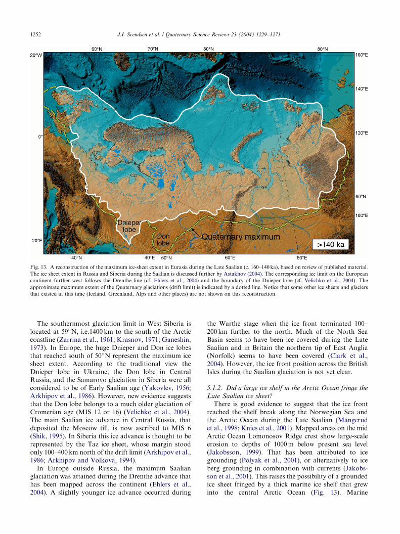
ARTICLE IN PRESS
Fig. 13. A reconstruction of the maximum ice-sheet extent in Eurasia during the Late Saalian (c. 160–140ka), based on review of published material.
The ice sheet extent in Russia and Siberia during the Saalian is discussed further by Astakhov (2004). The corresponding ice limit on the European
continent further west follows the Drenthe line (cf. Ehlers et al., 2004) and the boundary of the Dnieper lobe (cf. Velichko et al., 2004). The
approximate maximum extent of the Quaternary glaciations (drift limit) is indicated by a dotted line. Notice that some other ice sheets and glaciers
that existed at this time (Iceland, Greenland, Alps and other places) are not shown on this reconstruction.
J.I. Svendsen et al. / Quaternary Science Reviews 23 (2004) 1229–12711252
The southernmost glaciation limit in West Siberia islocated at 59�N, i.e.1400 km to the south of the Arcticcoastline (Zarrina et al., 1961; Krasnov, 1971; Ganeshin,1973). In Europe, the huge Dnieper and Don ice lobesthat reached south of 50�N represent the maximum icesheet extent. According to the traditional view theDnieper lobe in Ukraine, the Don lobe in CentralRussia, and the Samarovo glaciation in Siberia were allconsidered to be of Early Saalian age (Yakovlev, 1956;Arkhipov et al., 1986). However, new evidence suggeststhat the Don lobe belongs to a much older glaciation ofCromerian age (MIS 12 or 16) (Velichko et al., 2004).The main Saalian ice advance in Central Russia, thatdeposited the Moscow till, is now ascribed to MIS 6(Shik, 1995). In Siberia this ice advance is thought to berepresented by the Taz ice sheet, whose margin stoodonly 100–400 km north of the drift limit (Arkhipov et al.,1986; Arkhipov and Volkova, 1994).
In Europe outside Russia, the maximum Saalianglaciation was attained during the Drenthe advance thathas been mapped across the continent (Ehlers et al.,2004). A slightly younger ice advance occurred during
the Warthe stage when the ice front terminated 100–200 km further to the north. Much of the North SeaBasin seems to have been ice covered during the LateSaalian and in Britain the northern tip of East Anglia(Norfolk) seems to have been covered (Clark et al.,2004). However, the ice front position across the BritishIsles during the Saalian glaciation is not yet clear.
5.1.2. Did a large ice shelf in the Arctic Ocean fringe the
Late Saalian ice sheet?
There is good evidence to suggest that the ice frontreached the shelf break along the Norwegian Sea andthe Arctic Ocean during the Late Saalian (Mangerudet al., 1998; Knies et al., 2001). Mapped areas on the midArctic Ocean Lomonosov Ridge crest show large-scaleerosion to depths of 1000m below present sea level(Jakobsson, 1999). That has been attributed to icegrounding (Polyak et al., 2001), or alternatively to iceberg grounding in combination with currents (Jakobs-son et al., 2001). This raises the possibility of a groundedice sheet fringed by a thick marine ice shelf that grewinto the central Arctic Ocean (Fig. 13). Marine

ARTICLE IN PRESSJ.I. Svendsen et al. / Quaternary Science Reviews 23 (2004) 1229–1271 1253
sedimentation above the erosional unconformity com-menced during MIS 5e and thus places the timing for theice grounding on the Lomonosov Ridge to MIS 6(Jakobsson et al., 2001), the Late Saalian. The directionsof the mapped glaciogenic erosional features on theLomonosov Ridge and the redeposition of erodedmaterial indicate an ice flow from the Barents-KaraSea area (Polyak et al., 2001). However, these pieces ofevidence do not necessarily imply a huge coherent ArcticOcean floating ice shelf in analogy with the hypothesisby Mercer (1970) and Hughes et al. (1977). Analternative scenario may be that the Late SaalianBarents-Kara Ice Sheet produced huge deep keeledicebergs that drifted with the permanent Arctic sea iceand grounded on the Lomonosov Ridge crest. Evidencefrom deep icebergs in the Arctic Ocean has previouslybeen found on the Yermak Plateau in the form ofploughmarks mapped down to more than 850m belowthe present sea level (Vogt et al., 1994). However, theage(s) of those ploughmarks has yet to be determined.
Fig. 14. A reconstruction of the Eurasian ice sheet extent during the Early We
in European Russia, Siberia and on the adjacent sea floor is to a large extent b
and the Kola Peninsula has not yet been defined and the uncertainties are ind
Barents Sea shelf is based on various sources (cf. Mangerud et al., 1998; Svend
from Andersen and Mangerud (1989), Lundqvist (1992, 2004) and Mangeru
various sources (e.g. Hirvas, 1991; Helmens et al., 2000). The dashed line o
marginal zone (NTZ) around 80ka (cf. Fig. 5). The glacier distribution ove
areas are not shown on this reconstruction. Notice that this reconstruction is
(cf. Mangerud et al., 2004).
5.2. Early Weichselian glaciation (100–80 ka)
5.2.1. The maximum Weichselian ice sheet extent on
mainland Russia
In our reconstruction the outermost belt of topogra-phically expressive moraines between southern Taimyrand the Pechora Lowland defines the maximum ice sheetextent after the last interglacial (Figs. 2 and 14). This icesheet merged with a large ice cap covering the PutoranaPlateau in Siberia. Probably highlands and islandsfringing the Kara and Barents seas acted as ice sheetnucleation areas, growing ice caps that later onconfluenced to form a coherent Barents-Kara Ice Sheet.Inside the proposed maximum limits on the Eurasianmainland there are many sites with reported Eemianinterglacial marine sediments that are covered by tilland, in many cases, by deposits with fossil glacier ice.South of these moraines the topography is far moresubdued, and the youngest till is normally buried undernon-glacial terrestrial and, in rare cases, by interglacial
ichselian glacial maximum (90–80 ka). The reconstructed ice sheet limit
ased on this study. The ice front position between the Pechora Lowland
icated by the hatched field. The limit along the northern margin of the
sen et al., 2004). The inferred ice extent around Scandinavia is modified
d (2004). The suggested ice limit across Finnish Lapland is based on
n northern Taimyr marks the retreat stage at the North Taymyr ice-
r the British Isles, Iceland, Greenland, Alps and some other mountain
only showing the ice limit and not the corresponding ice dammed lakes

ARTICLE IN PRESSJ.I. Svendsen et al. / Quaternary Science Reviews 23 (2004) 1229–12711254
marine deposits. The ice sheet expanded far south of theByrranga Mountains, which implies that the ice wasmore than a thousand meters thick at the NW coast ofTaimyr at the glacial maximum. Both flanks of the PolarUrals were bypassed from the north by flat lobes, andfrom the elevation of lateral moraines the ice surface atthe northern tip of the Urals was around 600m.a.s.l.The ice limit corresponding to this glaciation is mappedacross the eastern part of Pechora Lowland but, as willbe discussed below, the continuation further to the westis more uncertain.
The age of this glaciation is beyond the range of theradiocarbon method. Our OSL and ESR dating resultssubstantiate the correlation of moraines between Siber-ian and European Russia. The dates obtained from thepro-glacial deltaic sediments in the Taimyr Lake basinindicate a minmum age of around 90–80ka for theglacial maximum (Fig. 5). In the Pechora Lowland alarge number (29) of OSL dates on beach sediments fromthe ice-dammed Lake Komi in front of the Barents-KaraIce Sheet gave ages in the range 100–80 ka with aweighted mean of 8271.2 ka (Fig. 8) (Mangerud et al.,2001, 2004). Mainly from these lake dates we concludethat the ice sheet blocked the northbound drainage inthat part of the continent for a short-lived period atabout 90–80 ka (MIS 5b). Fluvial terraces incised intothe floor of Lake Komi suggest that a normal fluvialdrainage was resumed not later than around 80 ka,which is a minimum age for the deglaciation.
In the Arkhangelsk region the oldest dated signs of aWeichselian glaciation are reflected in till coveredglaciofluvial and glaciolacustrine sediments along theriver Pyoza in the Mezen drainage basin that accumu-lated around 100–90 ka (Fig. 10) (Houmark-Nielsenet al., 2001). These sediments may represent the sameglacial event as discussed above, but the ice sheetconfiguration at this time remains uncertain. Mangerudet al. (2004) postulate that the ice front blocked themouth of the White Sea during the glaciation, but thisremains to be confirmed in the Arkhangelsk region.
5.2.2. The ice limit on the continental shelves
The ice sheet configuration on land implies that amajor ice dispersal center existed over the Kara Sea.Most likely the Barents-Kara Ice Sheet terminated at orclose to the northern margin of the continental shelfalong the Arctic Ocean (Fig. 14). This configuration issupported by records of ice rafted debris (IRD) insediment cores to the north of Severnaya Zemlyasuggesting that a calving ice front existed close to thisarea around 90 ka (Knies et al., 2000). As was discussedabove, data from the Pechora Lowland and the KolaPeninsula imply that the seafloor off the southernBarents Sea coast was glaciated, but the position ofthe ice limit is uncertain. It is also unclear if thesouthwestern Barents Sea was affected by this glacia-
tion. So far only one till bed has been identified abovethe last interglacial in the outer part of the Bear IslandThrough (Sættem et al., 1992; Laberg and Vorren,1995). Considering that there are hardly any data fromthe Barents Sea that can be used to define the westernice-sheet margin we have drawn the limit across the shelfbetween the Norwegian mainland and Svalbard as it wasdefined in the model simulation by Siegert et al. (2001).
Possibly, the Early Weichselian glacial maximumcorresponds with the first post-Eemian ice advance thatwas recorded on Svalbard in the NW Barents Sea(Mangerud et al., 1998). Mangerud et al. (1998)suggested, however, that this ice advance occurredduring MIS 5d (110 ka), whereas according to ourchronology the maximum extent further to the eastoccurred during MIS 5b (90 ka). This age difference maybe real, but it may also be an artifact of datinguncertainties. Considering that such a large glaciationaffected the Kara Sea and the southeastern Barents Seawe find it most likely that also this ice advance affectedthe Svalbard region.
5.2.3. A restricted ice sheet over Scandinavia
There is a general consensus that the Scandinavian IceSheet was much smaller during the Early Weichseliancompared with the Late Weichselian glacial maximum(Andersen and Mangerud, 1989; Lundqvist, 1992, 2004;Mangerud, 2004). At the peak of the first major iceadvance the ice sheet covered the Norwegian mainland,but southern Sweden remained ice-free (Fig. 14). Mainlybased on our review of published data we believe thatalso most of Finland remained ice free during the EarlyWeichselian (H .utt et al., 1993; Nenonen, 1995), but thatFinnish Lapland and the northern parts of RussianKarelia were ice covered at around 90 ka (Hirvas, 1991;Helmens et al., 2000). The eastern ice margin wasprobably located near the western coast of Finland,trending northeastwards across Finnish Lapland.
Recent investigations on the southern part of the KolaPeninsula suggest that the Scandinavian Ice Sheet waslocated close to the northwestern bay of the White SeaBasin during the Early Weichselian glaciation (Fig. 14).There is no indication that the ice sheet advanced intothe Dvina and Vaga river valleys on the eastern side ofthe White Sea, where only a Late Weichselian till havebeen found above Eemian strata (Devyatova, 1982;Larsen et al., 1999; Lys(a et al., 2001; Lunkka et al.,2001b). The same conclusion was reached for the NWRussian Plain further to the south (Lunkka et al., 2001b).
5.3. Middle Weichselian glaciation (60–50 ka)
5.3.1. A readvance of the Barents-Kara Ice Sheet onto
the mainland
A regrowth of the ice sheet occurred during MIS 4,leading to an ice advance that terminated on the Russian
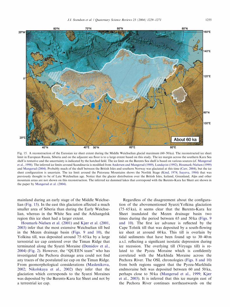
ARTICLE IN PRESS
Fig. 15. A reconstruction of the Eurasian ice sheet extent during the Middle Weichselian glacial maximum (60–50 ka). The reconstructed ice sheet
limit in European Russia, Siberia and on the adjacent sea floor is to a large extent based on this study. The ice margin across the southern Kara Sea
shelf is tentative and the uncertainty is indicated by the hatched field. The ice limit on the Barents Sea shelf is based on various sources (cf. Mangerud
et al., 1998). The inferred ice limits around Scandinavia is modified from Andersen and Mangerud (1989), Lundqvist (1992), Houmark-Nielsen (1999)
and Mangerud (2004). Probably much of the shelf between the British Isles and southern Norway was glaciated at this time (Carr, 2004), but the ice
sheet configuration is uncertain. The ice limit around the Putorana Mountains shows the Norilsk Stage (Kind, 1974; Isayeva, 1984) that was
previously thought to be of Late Weichselian age. Notice that the glacier distribution over the British Isles, Iceland, Greenland, Alps and other
mountain areas are not shown on this reconstruction. The inferred ice dammed lakes that correspond with the Barents-Kara Ice Sheet are shown in
the paper by Mangerud et al. (2004).
J.I. Svendsen et al. / Quaternary Science Reviews 23 (2004) 1229–1271 1255
mainland during an early stage of the Middle Weichse-lian (Fig. 15). In the east this glaciation affected a muchsmaller area of Siberia than during the Early Weichse-lian, whereas in the White Sea and the Arkhangelskregion this ice sheet had a larger extent.
Houmark-Nielsen et al. (2001) and Kjær et al. (2001,2003) infer that the most extensive Weichselian till bedin the Mezen drainage basin (Figs. 9 and 10), theYolkina till, was deposited around 75–65 ka by a largeterrestrial ice cap centered over the Timan Ridge thatterminated along the Syurzi Moraine (Demidov et al.,2004) (Fig. 2). However, the ‘‘QUEEN team’’ who hasinvestigated the Pechora drainage area could not findany traces of the postulated ice cap on the Timan Ridge.From geomorphological considerations (Maslenikova,2002; Nikolskaya et al., 2002) they infer that theglaciation which corresponds to the Syurzi Moraineswas deposited by the Barents-Kara Ice Sheet and not bya terrestrial ice cap.
Regardless of the disagreement about the configura-tion of the abovementioned Syurzi/Yolkina glaciation(75–65 ka), it seems clear that the Barents-Kara IceSheet inundated the Mezen drainage basin twotimes during the period between 65 and 50 ka (Figs. 9and 10). The first ice advance is reflected by theCape Tolstik till that was deposited by a south-flowingice sheet at around 60 ka. This till is overlain bytidal sediments that have been found up to 30–40ma.s.l. reflecting a significant isostatic depression duringice recession. The overlying till (Viryuga till) is re-lated to the Pyoza Moraine which is confidentlycorrelated with the Markhida Moraine across thePechora River. The OSL chronologies (Figs. 8 and 10)from both regions suggest that the Pyoza-Markhidaendmoraine belt was deposited between 60 and 50 ka,perhaps close to 50 ka (Mangerud et al., 1999; Kjæret al., 2003). It is inferred that this ice margin east ofthe Pechora River continues northeastwards on the

ARTICLE IN PRESSJ.I. Svendsen et al. / Quaternary Science Reviews 23 (2004) 1229–12711256
continental shelf, but its actual limit remains to bevalidated (Fig. 2).
In North Siberia a Middle Weichselian glaciationis associated with the North Taimyr ice-marginal zone(NTZ) (Figs. 2, 4 and 5). OSL dates from glaciolacus-trine and glaciofluvial sediments that accumulatedalong and in front of these moraines have ages in theinterval 70–54 ka (Alexanderson et al., 2001), roughlysimilar to the inferred age of the Middle Weichselianice advance in the European Arctic. We thereforepostulate that the NTZ also reflects a glacial eventaround 60 ka.
From the vast lowland areas between Taimyr and thePechora River there are no convincing geological datato suggest any Middle Weichselian ice sheet advance(Figs. 2 and 6). As discussed below we therefore thinkthat the ice margin was located somewhere on the floorof the Kara Sea (Fig. 15).
5.3.2. The ice sheet configuration on the adjacent
continental shelves
Previous investigations have concluded that Svalbardand the NW Barents Sea shelf was affected by a majorglaciation during the Middle Weichselian, culminatingaround 65–60 ka (MIS 4). The ice front at this timeterminated near the western and northern shelf margins(Mangerud et al., 1998). At about this time also thenorthern Kara Sea shelf and Severnaya Zemlya wascovered by a major ice sheet that extended to the shelfeast thereof (Knies et al., 2000; Raab et al., 2003).
The location of the ice sheet margin further south ismore problematic. We tentatively draw the southernlimit on the shallow sea floor off the coastline in WestSiberia and postulate that it crossed the coastline in thePechora Lowland where it merged with the MarkhidaMoraine (Figs. 2 and 15). Probably the ice front crossedthe entrance to the White Sea Basin (Demidov et al.,2004), which would imply that there was no ice-freecorridor on the seafloor along the Kola Peninsula. Itremains unknown if the Barents-Kara Ice Sheet mergedwith a local ice cap over the Kola Peninsula during thisglaciation (Fig. 15).
In most areas the early Middle Weichselian ice sheetadvance was followed by a comprehensive deglaciationthat started around 50 ka. Raised marine sediments ofMiddle Weichselian ages have been found on Svalbard(Mangerud et al., 1998), Severnaya Zemlya (Bolshiya-nov and Makeyev, 1995; Raab et al., 2003), NovayaZemlya (Forman et al., 1999b) and Vaigatch Island(Zeeberg, 2001) reflecting strong isostatic rebound.Radiocarbon dates of shells in sediment cores from theseafloor off the Pechora Lowland indicate that the SEpart of the Barents Sea shelf was ice free not much laterthan 40 ka (Polyak et al., 2000). Thick prodeltaicsediments of Middle Weichselian age have been mappedin front of the Pechora River (Gataullin et al., 2001).
5.3.3. Did the Scandinavian Ice Sheet reach Russia?
A regrowth of the Scandinavian Ice Sheet occurredduring the Middle Weichselian, when a major ice lobefilled the Baltic Basin and advanced to its maximumposition in southern Denmark (Houmark-Nielsen, 1989,1999). At this time the ice sheet was more extensive thanduring the Early Weichselian, and seems to have coveredmost, if not all of Finland (Fig. 15). Our fieldinvestigations suggest, however, that the Middle Weich-selian Scandinavian Ice Sheet did not reach as far east asthe Late Weichselian one. We assume that the ice limitwas located near the Finnish-Russian border. However,the Kola Peninsula was probably glaciated and theScandinavian Ice Sheet probably reached into thenorthern White Sea basin.
5.4. Late Weichselian glacial history (25–10 ka)
5.4.1. The Barents-Kara Ice Sheet—smaller than the
preceding glaciations
Previous investigations have demonstrated that amajor ice dome formed over the north-western BarentsSea shelf and eventually expanded to the western andnorthern shelf margins during the Late Weichselian(Lubinski et al., 1996; Polyak et al., 1997; Landvik et al.,1998; Kleiber et al., 2000). From the occurrence ofdebris flow sediments and glaciomarine diamictons onthe continental slope, Kleiber et al. (2000) infer that theice sheet reached the northern shelf break as early as23 ka. According to Landvik et al. (1998) the ice frontwas located along the western shelf break between 19and 15 ka.
It has been a long-standing discussion whether theBarents-Kara Ice Sheet expanded onto mainland Russiaand Siberia during the Late Weichselian. Many well-dated sedimentary sequences covering this interval aredescribed from critical areas along the northern marginof the continent (e.g. Mahaney, 1998; Vasil’chuk andVasil’chuk, 1998; Astakhov et al., 1999; Forman et al.,1999a; Mangerud et al., 1999; Alexanderson et al., 2002;M .oller et al., 1999; Raab et al., 2003; ). None of thesequences are covered by till, and yet all predate theLGM. The deposits consist mostly of aeolian orlacustrine, easily deformable soft silt and fine sand.We emphasise that these formations show no sign ofhaving been overridden by any ice sheet (Mangerudet al., 2001). At several sites, deposition of aeoliansediments and formation of ice wedges took placeduring the LGM time span. These observations implythat the Barents-Kara Ice Sheet did not cover these landareas during the LGM, with the exception of thenorthern fringe of the Taimyr Peninsula (Fig. 16)(Alexanderson et al., 2001, 2002).
Based on marine geological and geophysical data theLGM ice sheet limit has been identified on the sea flooroff the mainland (Svendsen et al., 1999, 2004; Polyak

ARTICLE IN PRESS
Fig. 16. A reconstruction of the Eurasian ice sheets at the Late Weichselian glacial maximum (LGM). The eastern limit of the Scandinavian Ice Sheet
and the southern and eastern limit of the Barents-Kara Ice Sheet are to a large extent based on our own investigations. The northern and western ice
sheet limit on the Barents Sea shelf is drawn according to the reconstruction by Landvik et al. (1998). The ice limits for the rest of Europe are taken
from various sources (e.g. Ehlers and Gibbard, 2004). The presence of restricted valley glaciers on the Putorana Mountains is indicated by hatched
lines. Notice that the glacier distribution over Iceland, Greenland, Alps and other mountain areas are not shown on this reconstruction.
J.I. Svendsen et al. / Quaternary Science Reviews 23 (2004) 1229–1271 1257
et al., 2000, 2002; Gataullin et al., 2001; Stein et al.,2002). It is assumed that the southern flank of the icesheet coalesced with the Scandianvian Ice Sheet near thenorthern tip of the Kanin Peninsula, but the exactboundary remains to be defined in the confluence zone(Fig. 16). In the Pechora Sea, further to the east, webelieve the ice front reached the Kolguev Line, whichdepicts the southern extent of the Late Weichselian tillon the Barents Sea shelf (Gataullin et al., 2001). In thesouthern Kara Sea the ice front was probably locatedalong the southern and eastern margin of the NovayaZemlya Through (Svendsen et al., 1999, 2004; Polyaket al., 2000). Further to the north the LGM limit hasbeen mapped across the shallow shelf near the southernslopes of the St. Anna Through (Polyak et al., 2002;Stein et al., 2002). In general, the area on the proximalside of the inferred ice sheet limit is characterized by arough morainic relief, whereas on the distal side theseafloor is graded and in places underlain by thicksequences of marine sediments not covered by till.Furthermore, incised river channels and the widespreadoccurrence of permafrost indicate that this area has been
subaerially exposed at a time when the sea level wasmuch lower than today.
Based on the record from Severnaya Zemlya it seemsclear that the Barents-Kara Ice Sheet did not reach thisarchipelago and that local glaciers were probably evensmaller than today (Makeyev et al., 1979; Bolshiyanovand Makeyev, 1995; Raab et al., 2003). Our investiga-tions on the mainland suggest, however, that the NWcoast of Taimyr was affected by a Late Weichselian iceadvance directed from the continental shelf (Alexander-son et al., 2002). One possible interpretation is that theadvancing ice formed part of the Barents-Kara IceSheet. In that case the ice sheet must have blocked thenorthbound drainage in West Siberia, as well as in theEuropean part of the Russian mainland (Fig. 16). Asdiscussed previously, however, aeolian sedimentationand growth of ice wedges during this time span excludethe possibiliy that a pro-glacial lake flooded the lowlandareas along the Arctic coastline. Possibly the erodedchannels on the Kara Sea shelf (Stein et al., 2002)contained rivers that flowed towards the Arctic Oceanduring most of the LGM period. The ice advance that

ARTICLE IN PRESSJ.I. Svendsen et al. / Quaternary Science Reviews 23 (2004) 1229–12711258
reached the NW-coast of Taimyr has been explained asa result of surging from the higher parts of the ice sheetat its Barents-Kara Sea interfluve north of NovayaZemlya (Alexandersson et al., 2002). Accordingly, thisevent could have been very short-lived and the icemasses may have blocked the northward flow of waterfrom the Yenissei and Ob rivers for only a brief interval.Traces of such a glacial surge from the west may actuallycorrespond with some inferred ice marginal features onthe shelf identified by Stein et al. (2002) and Polyak et al.(2002). Another, less likely possibility, is that theradiocarbon dates of the shells that were extracted fromglacial ice on Taimyr are underestimating the real age ofthe mollusks and that the last ice advance that affectedthis area occurred during the foregoing Middle Weich-selian glaciation. However, the earlier mentionedincrease of sedimentation in the Taimyr Lake basinaround 19 ka (M .oller et al. 1999) suggest reversedrainage in the lower Taimyra and thus supportsdamming of the ice sheet in the north-west.
Apparently the Barents-Kara Ice Sheet started torecede from the northwestern shelf margin at around15 ka (Landvik et al., 1998), when a distinct meltwaterevent is reflected in the oxygen isotope record (Landviket al., 1998; Kleiber et al., 2000). The last remains of theBarents-Kara Ice Sheet were localized over the northernpart of the Barents Sea region during the YoungerDryas, when isolated ice caps existed over Svalbard,Franz Josef Land and possibly Novaya Zemlya (Fig. 2)(Svendsen et al., 2004). The remaining ice caps meltedaway during the Early Holocene and during theHolocene climatic optimum the glacier coverage wasprobably significantly smaller than today (Svendsen andMangerud, 1997).
5.4.2. The Scandinavian Ice Sheet reached its maximum
extent since the Late Saalian glaciation
The investigations in the northwestern Russian Plainand in the Arkhangelsk Region reveal that themaximum extension of the Scandinavian Ice Sheet heresince the Late Saalian glaciation occurred during theLate Weichselian (LGM) (Fig. 16). The inferred ice limitis recognized from a belt of fresh-looking moraines andhummocky landscapes with frequent lakes in theVologda area east of Lake Onega (Gey and Malakhovs-ky, 1998; Lunkka et al., 2001b), and then stretch via theNyandoma upland to the Vaga and Severnaya Dvinariver valleys (Larsen et al., 1999; Demidov et al., 2004).In our opinion the ice sheet extent in the northern partof the Russian Plain was slightly more restricted thansuggested in some previous reconstructions (Apukhtinand Krasnov, 1967; Krasnov, 1971). For example,according to our ice reconstruction the ice sheet didnot reach the Rybinskoye Reservoir on the Upper Volgaand Sukhona rivers. However, the ice limit defined byLunkka et al. (2001b) broadly follows the ice marginal
landforms mapped by the Russian Geological Survey(Krasnov, 1971) from the Valdai Hills to the Vaga valleyin the north. To the north of the Dvina valley theeastern boundary of the Scandinavian Ice Sheet is not sowell expressed, and we have not been able to trace theexact position of the maximum limit here. Probably itstretched along hummocky moraine belts on the Mezenand Kuloi water divide (Lavrov, 1991) into the MezenBay and then to the northwest shore of the KaninPeninsula (Demidov et al., 2004). We conclude thatScandinavian ice filled the White Sea Basin and assumethat the ice front reached the western coast of the KaninPeninsula, where it coalesced with the Barents-Kara IceSheet on the continental shelf (Fig. 16). A separate icedispersal center that was connected with the Scandina-vian Ice Sheet, the Ponoy Ice Cap, was located on theeastern Kola Peninsula at this time.
During the LGM, large ice-dammed lakes flooded theriver valleys in front of the ice margin. In thenorthwestern Russian Plain these interconnected lakes(Lake Sukhona, Lake Mologa Sheksna, and Lake Vaga)drained via the Volga River into the Caspian Sea. In theArkhangelsk region meltwaters drained northwardsalong the ice margin, eastwards across the southernpart of the Kanin Peninsula and further eastwardsbetween the present landmass and the Barents-Kara IceSheet (Mangerud et al., 2004).
The timing of the LGM along the eastern flank of theScandinavian Ice Sheet has previously been based ononly two radiocarbon dates from organic sedimentsunderneath the till, that provided ages of around 21.4and 18.7 ka (Arslanov et al., 1970, 1971; Faustova,1984). Our OSL dates of the ice marginal deposits yieldages of around 20–18 ka on the northwestern RussianPlain (Lunkka et al., 2001b) and around 17–15 ka in theArkhangelsk area (Larsen et al., 1999). Even thoughOSL dates are not as precise as radiocarbon dates,the results obtained suggest that the maximum iceadvance occurred a few thousand years later thanalong the western margin of the Scandinavian Ice Sheetwhere the ice advance culminated at around 22 ka(Sejrup et al., 1994; Larsen et al., 1999; Mangerud,2004).
A series of radiocarbon dates from mammothbones suggests that Finland was ice-free prior to theLGM, during the period 33–25 ka (Ukkonen et al.,1999). This would imply that the front of the Scandi-navian Ice Sheet moved 1000 km southwards duringonly 7000–8000 years. Based on the dates from theice marginal zone, Lunkka et al. (2001b) estimated thatthe ice sheet advanced more than 125m per yearduring the Late Weichselian. The deglaciation seemsto have started around 17–15 ka along the entire margin,and during the Younger Dryas the ice margin waslocated at the Saulpausselk.a end moraines in Finland(Fig. 3).

ARTICLE IN PRESSJ.I. Svendsen et al. / Quaternary Science Reviews 23 (2004) 1229–1271 1259
5.5. Comparison between the Arctic Ocean record and the
reconstructed ice sheet history
A compilation of the main sedimentological andisotopic results from a transect across the eastern andcentral Arctic Ocean (Spielhagen et al., 2004) is shownin Fig. 17. In the deep sea record two main depositionalphases can be distinguished within the last 200 ka. Thefirst phase was a long-lasting period between 185 and135 ka (MIS 6) characterized by continuous high inputof ice-rafted detritus (IRD). The second phase is theinterval between 90 and 50 ka that include three separateIRD peaks. The clay mineral distribution in the layerswith a high IRD content suggests a provenance from theKara Sea or the western Laptev Sea (Spielhagen et al.,1997).
5.5.1. MIS 6 (180–130 ka)—the Late Saalian glaciation
The high IRD values during the MIS 6 correspondwith the extensive Saalian glaciation when the Barents-Kara Ice Sheet grew far onto the Eurasian continent(Fig. 17). Because the IRD-rich strata rest directly onlayers with a relatively high 10Be content, identified asrepresenting MIS 7, the enhanced IRD deposition isinferred to have started at the MIS 7/6 boundary(Spielhagen et al., 2004). We believe that most of theIRD were delivered by icebergs from the Siberian shelfmargin suggesting that this glaciation lasted as long as50,000 years, which to some extent may explain the largedimensions of the ice sheet complex. The termination ofthe high IRD input occurred at the transition to theEemian interglacial (MIS 5e) at around 130 ka andcorresponds with a strong meltwater signal, expressedby low oxygen and carbon isotope values of plankticforaminifers (Fig. 17). Considering the fact that theBarents-Kara Ice Sheet must have blocked the Ob andYenissei Rivers (among others) during the Late Saalianwe assume that the meltwater spike originated from thedrainage of a large icedammed lake south of the icesheet margin. As a matter of fact, there is evidence thatsuch a lake extended over much of southern WestSiberia during the Late Saalian (Arkhipov et al., 1995),but presently it is poorly dated.
5.5.2. MIS 5e–5c (130–95 ka)—limited ice rafting in the
Arctic Ocean
During the Eemian (MIS 5e) and the first part of theWeichselian (115–90 ka) there was a low input of IRD,similar to Holocene values (Fig. 17). The sources mayhave been local ice caps on Arctic islands. Judged fromthe lithological composition some of the IRD mayoriginate from the Canadian Arctic and/or NorthGreenland. From the high concentration of plankticforaminifers and the presence of coccoliths inthe Lomonosov Ridge cores (Spielhagen et al., 2004),it is inferred that seasonally open waters existed
in the eastern and central Arctic Ocean during MIS 5eand 5c.
5.5.3. MIS 5b (95–85 ka)—the first major ice advance
during the Early Weichselian
The influx of IRD increased markedly between 90 and80 ka (Fig. 17). This peak is not clearly visible in allsediment cores (e.g. PS51/038-4 from the Alpha Ridgeand 96/12-1pc) (Jakobsson et al., 2001), but is verypronounced in higher-resolution cores from the MorrisJesup Rise (PS2200) and from the Lomonosov Ridge(PS2185) (Spielhagen et al., 1997). In the latter core thisIRD peak occurs between two coccolith-bearing hor-izons that most likely correspond with MIS 5c and 5a,i.e. the IRD-peak dates from MIS 5b. The EarlyWeichselian ice sheet that terminated on the continentaround 90–80 ka, may be the source for this IRDhorizon. The planktic stable isotope records shows apronounced freshwater peak at this interval, butsignificantly weaker than during the Late Saaliandeglaciation (MIS6/5e). Possibly this event correspondsto the drainage of some of the ice-dammed lakes thatexisted to the south of the Early Weichselian ice sheet(Mangerud et al., 2001, 2004) and thus date the end ofthis glaciation. A weaker signal than during thepreceding deglacation may theoretically be explainedby a different routing of glacial meltwater, perhapsmuch of the water drained across the Barents Sea shelfand into the Norwegian Sea.
5.5.4. MIS 5a (85–72 ka)—another Early Weichselian
ice advance?
The sediments above the IRD layer discussed abovereflect a temporary return of planktonic foraminiferaand coccoliths, suggesting an interval with seasonallyopen waters during MIS 5a (Jakobsson et al., 2001;Spielhagen et al., 2004). Following this period there isanother phase with a high IRD input that has an agearound 78–72 ka (Fig. 17). In three cores (PS2185,PS2200, and 96/12-1pc) where this IRD peak is clearlyoutstanding, it has a very characteristic shape. The IRDinput started abruptly and decreased gradually from thepeak level. The upper part of the IRD peak is associatedwith minor meltwater spikes in the planktic isotoperecords. A high smectite content indicates a provenancefrom the Kara Sea shelf or western Laptev Sea region.The timing of this signal may correspond to the finalretreat of the Early Weichselian Barents-Kara Sea IceSheet from the NW coast of the Taimyr Peninsula andthus with emptying of the large ice-dammed lakes in thesouthern Kara Sea basin and in the West SiberianLowland.
5.5.5. MIS 4–3 (72–25 ka)—the Middle Weichselian
Following the inferred deglaciation signal at around78 ka the foraminifer abundances show an upward

ARTIC
LEIN
PRES
S
Fig. 17. Time-distance diagrams showing the growth and decay of the Eurasian ice sheets: (a) the Scandinavian Ice Sheets in Finland and Russia, (b) the Barents-Kara Ice Sheets on Svalbard in the
western Barents Sea (Mangerud et al., 1998) and (c) the fluctuations of the Barents-Kara Ice Sheets in northern Russia/Siberia (this study). (d) Curve showing the modeled volumes of the Eurasian ice
sheets (Siegert et al. 2001). Note that the model probably underestimates the volume of the Barents-Kara Ice Sheet during the Early- and Middle Weichselian glaciations. Curves showing the content
of IRD and major meltwater events determined from the oxygen isotope records (e) and the planktic foraminifer abundance (f) in cores from the Arctic Ocean (Fig. 1). The presented core data are
modified from Spielhagen et al. (2004).
J.I.
Sven
dsen
eta
l./
Qu
atern
ary
Scien
ceR
eviews
23
(2
00
4)
12
29
–1
27
11260

ARTICLE IN PRESSJ.I. Svendsen et al. / Quaternary Science Reviews 23 (2004) 1229–1271 1261
increase whereas the IRD content is decreasing (Fig. 17).There are no foraminifers in core PS2185 because ofcarbonate dissolution, but a 10Be peak in the sedimentssupports the existence of seasonally open waters andenhanced bioproduction between c. 73 and 65 ka(Spielhagen et al., 2004). Again we argue that the ArcticOcean was seasonally open at this time, providing amoisture source that could promote the build-up of theMiddle Weichselian ice sheet.
The uppermost, pronounced IRD layer in the ArcticOcean records has an age of ca. 64–50 ka (Fig. 17). Mostlikely this layer, which started abruptly at all sites,corresponds to the Middle Weichselian ice sheetadvance that has been OSL dated to around 60–50 ka.The thickness of the IRD layer is as much as 80–150 cm(40 cm in PS51/038-4), which gives a calculated averagebulk sedimentation rate of 5–10 cm/ky (Spielhagenet al., 2004). This is by far the highest sedimentationrate recorded during the last 200 ka. The end ofIRD input is associated with an outstanding meltwaterspike in the planktic isotope record at c. 50 ka. Wesuggest it reflects the drainage of the postulated ice-dammed lakes that existed to the south of the Barents-Kara Ice Sheet during the Middle Weichselian (Man-gerud et al., 2004). The IRD deposition decreasedsignificantly after this deglaciation event and thesedimentation rates during the later stage of the MiddleWeichselian remained very low. Probably most if not allof the ice sheet over the Barents-Kara sea shelves hadmelted away.
5.5.6. MIS 2 (25–10 ka)—the Late Weichselian
From the Late Weichselian there are no pronouncedIRD peaks in the deep-sea records from the central andeastern part of the Arctic Ocean (Fig. 17). However,significant peaks of IRD deposition during the LGMinterval are found in sediment cores from sites near thenorthern margin of the Barents Sea shelf (N^rgaard-Pedersen et al., 1998; Knies et al., 2001). These signalsprobably reflect that the regrowth of the Barents-KaraIce Sheet during the LGM had a spreading center in theNW Barents Sea. In a recent reconstruction of themarine conditions during the LGM, N^rgaard-Pedersenet al. (2003) proposed that a relatively thick sea ice layerexisted in the central Arctic Ocean, but relatively fewicebergs. They interpret the pole ward decrease of LGMplanktic oxygen isotope values as evidence for adecreased, but continuous river water supply to theArctic Ocean. Because the meltwater events in theeastern and central Arctic Ocean during the last glacialtermination (1) are much smaller than those at ca. 130and 50 ka (cf. Stein et al., 1994; N^rgaard-Pedersenet al., 1998, 2003), we think the marine data support theterrestrial reconstruction, suggesting only a brief glacialsurge across the northern Kara Sea during the LGM,with no large ice dammed lakes.
5.5.7. Conclusion
There is a good agreement between the signalsrecorded in the Arctic Ocean sediments and the icesheet history as inferred from the continental records.This agreement supports the proposed ice sheet synth-esis. It is noteworthy that the IRD peaks are punctuatedby periods with seasonal open water in the ArcticOcean. Possibly the Arctic Ocean during these periodsprovided the additional moisture source necessary forthe build-up of the large ice sheets which formed overthe Barents- and Kara Sea shelves.
6. Modeling results
6.1. Ice sheet reconstruction for the Late Weichselian
A numerical ice sheet model was used to reconstructthe Late Weichselian glaciation over Eurasia (Fig. 18c).Our initial results represent a ‘‘maximum-sized’’ recon-struction for the Late Weichselian, although even this isvery much smaller than the huge Arctic ice sheet ofGrosswald (1998). At 25 ka, we model the northernBarents Shelf as being covered by a relatively thin(o700m) ice sheet. The basal ice-sheet topographymanifests itself within the ice-surface morphology toform small ice domes over Severnaya Zemlya, FranzJosef Land and Novaya Zemlya, which feed ice outwardin a pseudo-radial fashion from each archipelago. Theice thickness over Severnaya Zemlya and the northernKara Sea was 100m, and 200m in the western Kara Sea.
After 22 ka, ice flowed northwards from Scandinaviainto the Barents Sea causing the marine portion of theice sheet to thicken. By 20 ka the ice flow was dominatedby a major ice sheet divide over the central part of theBarents Sea shelf. The increase in ice thickness wasmoderated by the development of ice streams within thebathymetric throughs on the western and northernshelves, which acted to drain ice from the Barents Sea.Ice also flowed eastwards across Novaya Zemlya,resulting in a continuous ice sheet over the Barentsand Kara seas. The ice thickness in the central BarentsSea was about 1000m, whilst in the south-western KaraSea it was 900m. However, the ice thickness overSevernaya Zemlya and the northern Kara Sea had onlyincreased to about 150m.
At 15 ka the maximum ice thickness over Scandinaviawas B2700m, whilst over the Barents Sea it wasbetween 1500 and 1800m. Maximum ice thicknessacross the Kara Sea varied from 1200m close to NovayaZemlya to a grounded ice margin along the eastern coastof the Kara Sea. Although the ice sheet over the centralBarents Sea continued to grow between 20 and 15 ka,the ice thickness and surface elevation over SevernayaZemlya and the northern Kara Sea remained largelyunaffected during this period. Thus, at 15 ka, the ice

ARTICLE IN PRESS
Fig. 18. Modeled ice-sheet thickness for the ‘‘maximum’’ model
reconstruction at (a) 90 ka (Early Weichselian), (b) 60 ka (early Middle
Weichselian), and (c) 15 ka (LGM). Contour interval 250m. Note that
the model reconstructions underestimate the thickness of the Barents-
Kara Ice Sheet during the pre-LGM glaciations, as inferred from the
geological observations (from Siegert et al., 2001).
J.I. Svendsen et al. / Quaternary Science Reviews 23 (2004) 1229–12711262
thickness across Severnaya Zemlya was only 200m inthe south and zero in the north.
A full series of ice-sheet sensitivity analyses wasperformed on the ice sheet over the Eurasian HighArctic. Several experiments were undertaken to examinethe sensitivity of the ice-sheet dimensions to changes insingle environmental inputs used to force the model,where all other inputs were held at standard model
values. Although the ice-sheet dimensions are mostsensitive to alterations to imposed environmental con-ditions, the experiments indicate that relatively large(710%) changes in the inputs of accumulation, icebergcalving and sea level do not adversely affect the mainresults and conclusions of this reconstruction. However,the experiments suggest that in case of extremely lowprecipitation rates on the eastern flank of the ice sheet,the modelled ice cover may appear too large in the KaraSea region. In one experiment we adjusted the model’spalaeoclimate to a situation where accumulation of icewas curtailed across the Kara Sea and SevernayaZemlya. Low temperatures (–22�C mean annual) donot permit much surface melting and so ice is allowed tobuild up slowly via (a) sea-ice thickening over the KaraSea and (b) ice flow from the Barents Sea. Under theseextreme environmental conditions, a significantly smal-ler ice mass develops over the Kara Sea with a maximumthickness of 300m at 15 ka. According to this ‘‘mini-mum-sized’’ scenario the northern Kara Sea shelf wascovered by a very thin ice sheet with a grounding line atabout 200m below modern sea level and the St. Annaand Voronin throughs between Franz Josef Land andSevernaya Zemlya remained largely free of groundedice. However, we note that instability in the ice marginalong the northern Kara Sea could lead to rapid, short-lived glaciation of these through regions. A maximumice thickness of only 50m is modeled to the south ofSevernaya Zemlya whilst in the north, similar to the‘‘maximum reconstruction’’, ice-free conditions existed.
An inverse approach to ice sheet modeling wasutilized, in which our ice sheet was forced to matchthe geological information of the ice sheet extent in theEurasian Arctic by making adjustments to the paleocli-mate forcing of the model. The existence of a thick icedome over the Barents Sea shelf during the LGM, aspredicted by the maximum size simulation, is substan-tiated by convincing geological data (Landvik et al.,1998). Thus, we think the model simulates fairly well thetrue dimensions of the Barents-Kara Ice Sheet duringthe Late Weichselian (Fig. 18). However, the minimumsized model fits better with the empirical observationsfrom the areas further to the east. This mismatch can beaccounted for by imposing a much stronger palaeocli-matic gradient across the ice sheet towards colder anddrier conditions in the east.
6.2. Time dependent ice sheet modeling for the whole
Weichselian period
We have also produced a time dependent modelreconstruction of the repeated growth and decay of theEurasian ice sheets over the whole of the Weichselianperiod back to the last (Eemian) interglacial (Figs. 17and 18). This reconstruction is based on a simple forcingfunction using the predicted solar insolation at 60�N.

ARTICLE IN PRESS
Fig. 19. The reconstructed LGM ice sheet limit (white line) from geological observations compared with a numerical model simulation (‘‘maximum
model’’ of the Eurasian ice sheets (Siegert et al., 1999b). Notice that the numerical model slightly overestimate the ice sheet extent in the Kara Sea
region.
J.I. Svendsen et al. / Quaternary Science Reviews 23 (2004) 1229–1271 1263
Two reconstructions are developed as follows. A‘‘maximum’’ reconstruction assumes that the modern-type temperature distribution across the Eurasian Arcticis reduced by 10�C at three stages during the Weichse-lian, which are related to minimum insolation level.Conversely a ‘‘minimum’’ model incorporates a reduc-tion in temperature of only 5�C in Early and MiddleWeichselian time. The growth and decay of the ice sheetis forced by the time-dependent variations in sea leveland ELA. If mean air temperature is related linearly toinsolation, the ‘‘maximum’’ model forced by the d18Osea-level function shows four distinct glacial episodes inthe Weichselian, three of which result in major expan-sions of the ice sheet at around 90, 60 and 20 ka. The‘‘minimum’’ model forced by the New Guinea sea-levelfunction, air temperature being related linearly to thissea level, predicts very little ice prior to the LateWeichselian. The ‘‘maximum’’ model also differs fromthe ‘‘minimum’’ in that the latter reconstruction accountsfor extra cold and dry conditions across the Kara Sea.
6.3. Comparison with the empirical reconstructions
In broad terms the geological evidence and thechronology of the reconstructed ice sheets comparefairly well with the ‘‘maximum’’ numerical model of the
repeated growth and decay of the Eurasian ice sheetsduring the Weichselian (Fig. 19) (Siegert et al., 2001).That model creates three major glaciations in theBarents and Kara Sea region, culminating at around90, 60 and at 20 ka (LGM). Moreover, in accordancewith our geological findings in Russia and Siberia themodel by Siegert et al. (2001) predicts that each ice sheetadvance was followed by a nearly complete deglaciationof the shelves (Fig. 17). It is noteworthy that themodeled ice volume changes also roughly parallel thegeneralized glaciation curve for Svalbard and westernScandinavia (Mangerud et al., 1998; Mangerud, 2004).
In agreement with the empirical observations the timedependent model predicts that large ice sheets existedduring the Early and Middle Weichselian, but themodeling underestimates the extension and thicknessof the ice sheets in the Barents-Kara sea region. Incontrast, during the Late Weichselian the maximummodel predicts a Barents-Kara ice sheet that is notablylarger than in our empirical reconstructions (Fig. 18),which then fit better with the ‘‘minimum’’ simulated icesheet in this particular region. However, the ‘‘minimum’’model reconstruction is hardly able to produce sizeableglaciations prior to the LGM, in any area. We thereforethink that the ‘‘maximum’’ scenarios are more consis-tent with the geological evidence for the period prior to

ARTICLE IN PRESSJ.I. Svendsen et al. / Quaternary Science Reviews 23 (2004) 1229–12711264
the Late Weichselian. A more realistic LGM scenariofor the Barents-Kara Sea region is obtained by themaximum model if the accumulation of ice is somewhatcurtailed over the Barents and Kara seas (i.e. as in the‘‘minimum’’ reconstruction).
7. Conclusions
1. A huge ice sheet complex formed over northernEurasia during the Late Saalian (160–130ka), whichwas one of the most extensive Quaternary glacia-tions in this part of the world. A large ice shelfpossibly fringed the Barents-Kara Ice Sheet at thistime and may in fact have reached into the centralArctic Ocean.
2. We have reconstructed the limits of three major icesheet advances following the last interglacial: (1)Early Weichselian (90–80 ka), (2) early MiddleWeichselian (60–50 ka) and (3) Late Weichselian(20–15 ka) (Figs. 13–16). The results reveal that theice sheet development in the more eastern part ofthe Eurasian Arctic followed a different patternthan over Fennoscandia and along the westernmargin of the Barents Sea shelf. The Barents-KaraIce Sheets were getting progressively smaller duringthe successive glaciations, whereas the dimensionsof the Scandinavian Ice Sheets increased throughtime (Fig. 17).
3. The maximum extent of the Barents-Kara Ice Sheetduring the Early Weichselian (c. 90 ka) is defined bythe southernmost belt of topographically expressedmorainic ridges mapped throughout the Arcticmainland from southern Taimyr in Siberia to thePechora Basin in the west. A major ice dome waslocated on the continental shelf in the northernKara Sea during this glacial maximum. However,this time only a restricted ice sheet existed overNorway, Sweden and parts of Finnish Lapland.
4. The Early Weichselian glaciation was followed by amajor deglaciation during a relatively warm inter-stadial around 85–75 ka (MIS 5a), when centralTaimyr was affected by a marine inundation of theglacioisostatic depressed area.
5. A regrowth of the Barents-Kara Ice Sheet occurredduring the early Middle Weichselian, leading toanother ice advance well onto the northern marginof the Eurasian mainland at around 60–50 ka. Thisice front was delineated by the North Taimyr icemarginal zone (NTZ) in North Siberia and possiblyby the Markhida-Pyoza morainic belt between thePechora and Mezen rivers in the European sectorof the Russian mainland. During this glaciation thesouthern margin of the Scandinavian Ice Sheetreached Denmark and the eastern flank covered the
whole of Finland, with an ice lobe reaching theWhite Sea Basin.
6. The glaciation around 60–50 ka was followed by amajor Middle Weichselian deglaciation and mostlikely the entire Barents-Kara Sea shelves were icefree during the interval 50–30 ka.
7. During the Late Weichselian glacial maximum(20–15 ka) the southern and eastern flanks of theBarents-Kara Ice Sheet terminated on the seafloorin the south-eastern Barents Sea and on the westernKara Sea shelf, far inside its Early Weichselianmaximum extent. On the northern Kara Sea shelf,however, the ice sheet may have advanced east-wards and temporarily inundated parts of north-westernmost Taimyr. Severnaya Zemlya was prob-ably not affected by this glaciation. In contrast tothe Barents-Kara Ice Sheet the Scandinavian IceSheet did not reach its maximum position until theLate Weichselian (LGM), when its eastern marginwas located along a morphologically distinct icemarginal zone traceable from the north-westernRussian Plain in the south to the Arkhangelskregion in the north.
8. A comparison between the reconstructed ice sheethistory and the Arcric Ocean sediment recordsshows that the large ice sheet glaciations over theKara Sea shelf, particularly their deglaciationphases, are seen as IRD layers in the deep seacores. The deglaciations are also reflected as melt-water spikes. An interesting finding is that the ArcticOcean was seasonally ice free between the major iceadvances and may thus have been an importantmoisture source for the build up of the ice sheets.
9. A time dependent glaciological model forced byglobal sea level and solar changes generatesexpansions of Eurasian ice sheets at around 90,60 and 20 ka, compatible with the geological recordof ice growth. In broad outline the glaciations canthus be explained by the interaction of marineregressions and negative insolation changes.
10. When compared with the empirical geologicalreconstruction of the Late Weichselian ice sheetsover the Eurasian High Arctic the model simula-tions indicate extremely low precipitation rates inthe Kara Sea region, deterring ice growth in themore eastern areas of the Eurasian Arctic duringthe LGM. This is in contrast to earlier Weichselianand Saalian glaciations, where enhanced precipita-tion in the east would be required to build ice sheetscompatible with the geological data.
Acknowledgements
This paper is a contribution to the European ScienceFoundation program ‘‘Quaternary Environment of the
ARTICLE IN PRESSJ.I. Svendsen et al. / Quaternary Science Reviews 23 (2004) 1229–1271 1265
Eurasian North’’ (QUEEN). Many projects and a largenumber of investigators from 10 countries have con-tributed to this synthesis. This includes the multi-national project ‘‘Ice Sheets and Climate in theEurasian Arctic at the Last Glacial Maximum’’ (Eur-asian Ice Sheets) that was financially supported by theEuropean Union (Contract no. ENV4-CT97-0563) forthe period 1998–2000. This project carried out fieldinvestigations in various areas of Russia and Siberia(Taimyr Peninsula, Pechora Lowland, ArkhangelskRegion, Kola and NW Russian Plain) as well asglaciological modelling. Several other projects, sup-ported by national research councils, universities andother research institutes have contributed to thissynthesis. The Russian–Norwegian project ‘‘Paleo En-vironment and Climate History of the Russian Arctic’’(PECHORA), funded by the Research Council ofNorway, has investigated the Pechora Lowland, PolarUrals and parts of West Siberia during a 10 years periodbetween 1993 and 2003. The co-authors under thisproject partnership include J.I. Svendsen, V.I. Asta-khov, J. Mangerud, O. Nikolskaya, M. Henriksen andA. Matioushkov. Much of the work carried out by thisRussian–Norwegian team, including the logistics, wasarranged and implemented by the Institute of RemoteSensing Methods for Geology (NIIKAM), St. Peters-burg. In collaboration with V. Gataullin and L. Polyak,University of Ohio, the PECHORA project was alsoinvolved in the complilation and interpretation ofgeological and geophysical data from the SE BarentsSea. The Swedish work on Taimyr Peninsula, thatinclude the contributions by C. Hjort, P. M .oller and H.Alexandersson, have been financially supported by theSwedish Natural Science Research Council (Contractno. G-AA/GU09362-307), the Royal Swedish Academyof Sciences and the Swedish Board for Nature Con-servancy. The logistics have to a large extent also beenfinanced by the Swedish Polar Research Secretariat,through contracts with the INTAARI Company in St.Petersburg. Their main Russian scientific counterparthas been the Arctic and Antarctic Research Institute(AARI) in St.Petersburg, with D.Y. Bolshiyanov asproject leader. Cooperation has also taken place withDanish scientists (project leader S. Funder, GeologicalMuseum, Copenhagen). Two Russian–German projects,‘‘Late Quaternary environmental evolution of CentralSiberia’’ and ‘‘System Laptev Sea 2000’’, carried outfield investigations on the Taimyr Peninsula, SevernayaZemlya and the Laptev Sea Coast. This group ofQUEEN investigators, that include the co-authors H.W.Hubberten and C. Siegert, was supported by theGerman Ministry of Education, Research and Technol-ogy (BMBF). With support from BMBF and theRussian Foundation of Basic Research, R. Stein andF. Niessen investigated the sea floor sediments in theKara Sea. R.F. Spielhagen, who analyzed sediment
cores from the Arctic Ocean, was funded by the BMBFand by the German Science Foundation through theproject ‘‘Pal.aoklimaprojekt’’ (grant Th200/39-1). Thework in the Barents and Kara seas by L.Polyak andV.Gataullin was part of the Russian–American Initia-tive on Shelf-Land Environments in the Arctic (RAISE)and was supported by the US NSF awards OPP-9818247 and OPP-0221468’’. The work in the Arkhan-gelsk region, that include contributions by E. Larsen, I.Demidov, M. Houmark-Nielsen, K.H. Kjær and A.Lys(a, were supported by the Barents Secretariat, theDanish and Norwegian research councils, the SwedishPolar Research Secretariat, the Crawford Foundation,the Geological Survey of Norway, and the De Beerscompany. The investigations on Yamal and Yugorskipeninsulas in 1997, 1998 and 1999 were carried out by aSwedish–American–Russian team, including !O. Ing-!olfsson, H. Lokrantz, V. Gataullin, M. Leibman, S.Forman and W. Manley, financed and supported invarious ways by the Swedish Natural Sciences ResearchCouncil, the US National Science Foundation, theSwedish Polar Reasearch Secretariat, the Earth Cryo-sphere Institute in Moscow, University of G .oteborg andthe University of Illinois at Chicago. The glaciologicalmodelling work, carried out by J. Dowdeswell and M.Siegert, was supported by the UK Natural EnvironmentResearch Council. The maps with the reconstructed icesheet limits were compiled by M. Jakobsson who wassupported by NOAA Grant NA97OG0241. E. Bj^rseth,University of Bergen helped with the figures. The paperwere reviewed by Jon Landvik and Horst Hagedorn. Wesincerely thank all persons and institutes who havesupported and otherwise contributed to this synthesis.
References
Alexanderson, H., Hjort, C., M .oller, P., Antonov, O., Pavlov, M.,
2001. The North Taymyr ice-marginal zone—a preliminary over-
view and dating. Global and Planetary Change 31, 427–445.
Alexanderson, H., Adrielsson, L., Hjort, C., M .oller, P., Antonov, O.,
Eriksson, S., Pavlov, M., 2002. The depositional history of the
North Taymyr ice-marginal zone, Siberia—a land system ap-
proach. Journal of Quaternary Science 17, 361–382.
Andersen, B.G., Mangerud, J., 1989. The last interglacial–glacial cycle
in Fennoscandia. Quaternary International 3/4, 21–29.
Andreicheva, L.N., 1992. Osnovnye moreny Yevropeiskogo Severo-
Vostoka Rossii i ikh litostratigraficheskoye znacheniye (Basal tills
of the European northeast of Russia and their lithostratigraphic
significance.) Nauka, St. Petersburg, 125pp (in Russian).
Andreyeva, S.M., 1980. The North Siberian Lowland in the Karginsky
time: palaeogeography radiacarbon chronology. In: Ivanova, I.K.,
Kind, N.V. (Eds.), Geokhronologia chetvertichnogo perioda.
Nauka, Moscow, pp. 183–191 (in Russian).
Apukhtin, N.I., Krasnov, I.I., 1967. Geologia chetvertichnykh
otlozheniy Severo-Zapada Evpopeiskoi chasti SSSR (Geology of
the north-western European USSR; with Map of Quaternary
deposits of the north-western European part of the USSR, scale 1:
2 500 000, 1966.) Nedra, Leningrad, 344pp (in Russian).

ARTICLE IN PRESSJ.I. Svendsen et al. / Quaternary Science Reviews 23 (2004) 1229–12711266
Arkhipov, S.A., 1989. A chronostratigraphic scale of the glacial
Pleistocene of the West Siberian North. In: Skabichevskaya, N.A.
(Ed.), Pleistotsen Sibiri. Stratigrafia i mezhregionalnye korrelatsii.
Nauka, Novosibirsk, pp. 20–30 (in Russian).
Arkhipov, S.A., Volkova, V.S., 1994. Geologicheskaya istoria, land-
shafty i klimaty pleistotsena Zapadnoi Sibiri (The Geological
History, Environments and Climates of the West Siberian
Pleistocene.) Nauka, Novosibirsk, 105pp (in Russian).
Arkhipov, S.A., Isayeva, L.L., Bespaly, V.G., Glushkova, O., 1986.
Glaciation of Siberia and North-East USSR. Quaternary Science
Reviews 5, 463–474.
Arkhipov, S.A., Ehlers, J., Johnson, R.G., Wright Jr., H.E., 1995.
Glacial drainage towards the Mediterranean during the Middle and
Late Pleistocene. Boreas 24, 196–206.
Armand, A.D., Armand, N.N., Grave, M.K., Evzerov, V.Ya.,
Lebedeva, R.M., 1969. Svodnaya stratigraficheskaya shema
chetvertichnykh (antropogenovyh) otlozhenii Kolskogo poluostro-
va v svete noveishikh dannykh (A generalized scheme of the
Quaternary (Antropogenic) deposits of the Kola Peninsula in the
light of new data.) In: Osnovnyye problemy geomorfologii i
stratigrafii antropogena Kol’skogo poluostrova. Akademii Nauk
SSSR, Kol’sk. Fil., Geol. Inst, Leningrad, 7-24 (in Russian).
Arslanov, Kh.A., Auslender, V.G., Gromova, L.I., Zubkov, A.I.,
Khomutova, V.I., 1970. Palaeogeograficheskie osobennosti i
absolyutnyi vozrast maksimalnoi stadii valdaiskogo oledenenia v
raione kubenskogo ozera (Paleogeography and absolute age of the
Valday glacial maximum near lake Kubena). Doklady, Academy of
Sciences, USSR 195, 1395–1398 (in Russian).
Arslanov, Kh.A., Voznyachuk, L.N., Velichkevich, F.Yu, Kurerova,
L.V., Petrov, G.S., 1971. Vozrast maksimalnoi stadii poslednego
oledenenia na mezhdureche Zapadnoi Dviny i Dnepra (Age of the
maximal stage of the last glaciation on the watershed of the
Zapadnaya Dvina and Dnepr rivers.) In: Bondarchuk, V.G. (Ed.),
Doklady Academii Nauk SSSR, tom. 196(1), 161–164 (in Russian).
Arslanov, Kh.A., Yevzerov, V.Ya., Tertichny, N.I., Gerasimova, S.A.,
Lokshin, N.V., 1981. On age of deposits of a boreal transgression
(Ponoi strata) in the Kola Peninsula. In: Velichko, A.A., Faustova,
M.A. (Eds.), Pleistotsenovye oledeneniya Vostochno-Yevropeiskoi
ravniny. Nauka, Moscow, pp. 28–34 (in Russian).
Arslanov, Kh.A., Levina, N.B., Ostanin, V.E., Baranova, V.N.,
Smirnova, V.M., Tertychnaya, T.V., 1984. O geokhronologii i
stratigrafii pozdnego pleistotsena i rannego golotsena basseina r.
Severnoi Dviny (On geochronology and stratigraphy of the Late
Pleistocene and Early Holocene in the basin of the Severnaya
Dvina river.) In: Vestnik Leningradskogo Gosudarstvennogo
Universiteta, Geologia, Geografia 12, 57–66 (in Russian).
Aseev, A.A., 1974. Drevnie materikovye oledenenia Evropy (Ancient
Continental Glaciations of Europe). Nauka, Moscow, 319pp
(in Russian).
Astakhov, V.I., 1979. New data on the latest activity of Kara-shelf
glaciers in West Siberia. IGCP Project 24, Report 5, 21–31.
Astakhov, V.I., 1992. The last glaciation in West Siberia. Sveriges
Geologiska Unders.okning Ser. Ca 81, 21–30.
Astakhov, V.I., 1998. The last ice sheet of the Kara Sea: terrestrial
constraints on its age. Quaternary International 45/46, 19–28.
Astakhov, V.I., 2001. The stratigraphic framework for the Upper
Pleistocene of the glaciated Russian Arctic: changing paradigms.
Global and Planetary Change 31, 283–295.
Astakhov, V.I., Late Pleistocene proglacial drainage and ice sheets in
West Siberia. Boreas, submitted.
Astakhov, V.I., 2004. Middle Pleistocene glaciations of the Russian
North. Quaternary Science Reviews, this issue (doi:10.1016/
j.quascirev.2003.12.011).
Astakhov, V.I., Isayeva, L.L., 1988. The ‘Ice Hill’: an example of
‘retarded deglaciation’ in Siberia. Quaternary Science Reviews 7,
29–40.
Astakhov, V.I., Svendsen, J.I., 2002. Age of remnants of a Pleistocene
glacier in Bol’shezemel’skaya Tundra. Doklady Earth Sciences
ISSN 1028-334X, 384 (4), 468–472. Transl. Dokl. Akad. Nauk 384
(4), 534–538.
Astakhov, V.I., Svendsen, J.I., Matiouchkov, A., Mangerud, J.,
Maslenikova, O., Tveranger, J., 1999. Marginal formations of the
last Kara and Barents ice sheets in northern European Russia.
Boreas 28, 23–45.
Atlasov, R.R., Bukreev, V.A., Levina, N.B., Ostanin, V.E., 1978.
Osobennosti reljefa kraevoi zony valdaiskogo oledeneniya na
Onego-Vazhskom mezhdurechje i v doline r. Vagi (Relief
peculiarities of terminal zone of Valdai glaciation on Onega-Vaga
waterdivide and in Vaga valley.) In: Kraevye obrazovania
materikovych oledeneniy (Terminal formation of continental
glaciations). Naukova Dumka, Kiev, pp. 30–38 (in Russian).
Bardeyeva, M.A., 1986. The key sections of Quaternary deposits in the
Central Siberian Upland. In: Velichko, A.A., Isayeva, L.L. (Eds.),
Chetvertichnye oledeneniya Srednei Sibiri. Nauka, Moscow,
pp. 35–52 (in Russian).
Bauch, H.A., Mueller-Lupp, T., Taldenkova, E., Spielhagen, R.F.,
Kassens, H., Grootes, P.M., Thiede, J., Heinemeier, J.,
Petryashov, V.V., 2001. Chronology of the holocene transgression
at the North Siberian margin. Global and Planetary Change 31,
125–139.
Biske, G.S., Devyatova, E.I., 1965. Pleistocene Transgressions in
Northern Europe Vol. 143. Trudy NIIGA, Leningrad, pp. 155–176
(in Russian, English summary).
Bolshiyanov, D.Yu., Makeyev, V.M., 1995. Archipelago of Severnaya
Zemlya: Glaciation, Environmental History. Gidrometeoizat, St.
Petersburg (in Russian).
Bolshiyanov, D.Yu., Savatyugin, L.M., Shneider, G.V., Molodkov,
A., 1998. New data about modern and ancient glaciations of the
Taimyro-Severozemlskaya region. Materialny glyatchiologiches-
kich issledovanii 85, 219–222 (in Russian).
Bolshiyanov, D.Yu., Ryazanova, M., Savilieva, L., Pushina, Z., 2000.
Peatbog at the shoreline of Cape Oskar (Taymyr Peninsula).
Quaternary Environments of the Eurasian North (QUEEN),
fourth workshop, Lund, Sweden. European Science Foundation,
Abstract volume, p. 9.
Carr, S.J., 2004. The North Sea Basin. In: Ehlers, J., Gibbard, P.L.
(Eds.), Quaternary Glaciations—Extent and Chronology. Vol. 1.
Europe. Elsevier, Amsterdam, in press.
Chebotareva, N.S. (Ed.), 1977. Struktura i dinamika poslednego
lednikovogo pokrova Evropy (English summary: Structure and
dynamics of the last ice sheet of Europe.) Nauka, Moscow, 143pp
(in Russian).
Clark, C.D., Gibbard, P.L., Rose, J., 2004. Pleistocene glacial limits in
England, Scotland and Wales. In: Ehlers, J., Gibbard, P.L. (Eds.),
Quaternary Glaciations—Extent and Chronology. Vol. 1. Europe.
Elsevier, Amsterdam, in press.
Demidov, I.N., Houmark-Nielsen, M., Kjær, K.H., Larsen, E., Lys(a,
A., Funder, S., Lunkka, J.-P., Saarnisto, M., 2004. Valdaian glacial
maxima in the Arkhangelsk district of Northwest Russia. In:
Ehlers, J., Gibbard, P.L. (Eds.), Quaternary Glaciations—Extent
and Chronology. Vol. 1. Europe. Elsevier, Amsterdam, in press.
Devyatova, E.I., 1969. Degradatsia Valdaiskogo oledenenia i pozdne-
lednikovaia istoria Baltiiskogo i Belogo morei. Arhangelskaia
oblast (Degradation of Valdai glaciation and lateglacial history of
Baltic and White Sea.) In: Poslednii lednikovyi pokrov na severo-
zapade evropeiskoi chasti SSSR. Nauka, Moscow, pp. 231–241
(in Russian).
Devyatova, E.I., 1982. Late Pleistocene Natural Environment and its
Impact on Human Population in the North-Dvina Basin and in
Karelia. (Prirodnaya Sreda Pozdniego Pleistotsena i Yeyo Vliyanie
na Razvitie Cheloveka v Severodvinskom Basseine i v Karelii).
Karelia, Petrozavodsk, 156pp (in Russian).

ARTICLE IN PRESSJ.I. Svendsen et al. / Quaternary Science Reviews 23 (2004) 1229–1271 1267
Devyatova, E.I, Loseva, E.I., 1964. Stratigraphia i palaeogeographia
chetvertichnogo perioda v basseine r. Mezeni (Stratigraphy and
palaeogeography of Quaternary period in r. Mezen basin.) Nauka,
Leningrad, 105pp (in Russian).
Dolvik, T., Hjelle, T., Mangerud, J., Matiouchkov, A., 2002.
Weichselian glaciations in the Polar Ural Moutains. Quaternary
Environment of the Eurasian North (QUEEN), sixth workshop,
Spiez, Switzerland. European Science Foundation, Abstract
volume, p. 11.
Ebel, T., Melles, M., Niessen, F., 1999. Laminated sediments from
Levinson-Lessing Lake, northern central Siberia—a 30,000 years
record of environmental history? In: Kassens, H., Bauch, H.A.,
Dmitrenko, I.A., Eicken, H., Hubberten, H.W., Melles, M.,
Thiede, J., Timokhov, L.A. (Eds.), Land–Ocean Systems
in the Siberian Arctic: Dynamics and History. Springer, Berlin,
pp. 425–435.
Ehlers, J., Gibbard, P.L. (Eds.), 2004. Quaternary Glaciations—Extent
and Chronology. Vol. 1. Europe. Elsevier, Amsterdam, in press.
Ehlers, J., Eissmann, L., Lippstreu, L., Stephan, H.J., Wansa, S., 2004.
Pleistocene glaciations of North Germany. In: Ehlers, J., Gibbard,
P.L. (Eds.), Quaternary Glaciations—Extent and Chronology. Vol.
1. Europe. Elsevier, Amsterdam, in press.
Ekman, I., Iljin, V., 1991. Deglaciation, the Younger Dryas end
moraines and their correlation in the Karelian A.S.S.R. and the
adjacent areas. In: Rainio, H., Saarnisto, M. (Eds.), Eastern
Fennoscandian End Moraines. Geological Survey of Finland,
Guide 32, pp. 73–99.
Epstein, O., Gataullin, V., 1993. Lithology and conditions of
formation of Quaternary deposits in the eastern part of the Barents
Sea (Novaya Zemlya side). Lithologia i poleznye iskopayemye 28,
84–94 (in Russian).
Evzerov, V.Ya., Koshechkin, B.I., 1991. The Quaternary stratigraphy
and chronology of the western part of the Kola Peninsula. In:
Glacial deposits and glacial history in Eastern Fennoscandia.
Apatity, Academy of Sciences, USSR, pp. 16–23.
Faustova, M.A., 1984. Late Pleistocene Glaciation of European
USSR. In: Velichko, A.A. (Ed.), Late Quaternary Environments
of the Soviet Union. University of Minnesota Press, Minneapolis,
pp. 3–12.
Faustova, M.A., 1995. Glacial stratigraphy of the Late Pleistocene in
the northwestern part of the Russian Plain. In: Ehlers, J., Kozarski,
S., Gibbard, P. (Eds.), Glacial Deposits in North-East Europe.
A.A. Balkema, Rotterdam, pp. 179–182.
Fisher, E.L., Leonov, B.N., Nikolskaya, M.Z., Petrov, O.M.,
Ratsko, A.P., Sulerzhitsky, L.D., Cherkasova, M.N., 1990.
The Late Pleistocene of the central North-Siberian lowland.
Izvestia Academy of Sciences USSR, Geography 6, 109–118
(in Russian).
Forman, S.L., 1999. Infrared and red stimulated luminescence dating
of Late Quaternary near-shore sediments from Spitsbergen,
Svalbard. Arctic Antarctic and Alpine Research 31, 34–49.
Forman, S.L., Ing!olfsson, !O., Gataullin, V., Manley, W.F., Lokrantz,
H., 1999a. Late Quaternary stratigraphy of western Yamal
Peninsula, Russia: new constraints on the configuration of the
Eurasian ice sheet. Geology 27, 807–810.
Forman, S.L., Lubinski, D.J., Zeeberg, J.J., Polyak, L., Miller, G.H.,
Matishov, G., Tarasov, G., 1999b. Postglacial emergence and Late
Quaternary glaciation on northern Novaya Zemlya, Arctic Russia.
Boreas 28, 133–145.
Forman, S.L., Ing!olfsson, O., Gataullin, V., Manley, W.F., Lokrantz,
H., 2002. Late Quaternary stratigraphy, glacial limits, and
paleoenvironments of the Marresale area, western Yamal Peninsu-
la, Russia. Quaternary Research 57, 355–370.
Forman, S.L., Lubinski, D.J., Ing !olfsson, !O., Zeeberg, J.J., Snyder,
J.A., Matishov, G.G., 2004. A review of postglacial emergence on
Svalbard, Franz Josef Land and Novaya Zemlya, northern
Eurasia. Quaternary Science Reviews, this issue (doi:10.1016/
j.quascirev.2003.12.007).
Funder, S., Demidov, I., Yelovicheva, Y., 2002. Hydrography and
mollusc faunas of the Baltic and the White Sea-North Sea seaway
in the Eemian. Palaeogeography, Palaeoclimatology, Palaeoecol-
ogy 184, 275–304.
Funder, S., Riazanova, M., Rydlevski, A., Siedenkrantz, M., 1999.
Late Quaternary events in northern Siberia—preliminary results of
field work on coastal Taymyr. In: Quaternary Environments of the
Eurasian North (QUEEN). Third Workshop. Abstract Vol. 8.
Øystese, Bergen, Norway.
Ganeshin, G.S. (Ed.), 1973. Map of Quaternary deposits of the USSR,
scale 1:2 500 000. VSEGEI, Leningrad.
Gataullin, V., 1988. Upper Quaternary deposits of the western coast of
the Yamal Peninsula, Russia. Ph.D. Thesis, All-Russian Geological
Institute, St. Petersburg, 230pp.
Gataullin, V., Polyak, L., 1997. Morainic Ridge Complex, Eastern
Barents Sea. In: Davis, T.A., et al. (Ed.), Glaciated Continental
Margins: An Atlas of Acoustic Images. Chapman & Hall, London,
pp. 82–83.
Gataullin, V., Mangerud, J., Svendsen, J.I., 2001. The extent of the
Late Weichselian ice sheet in the southeastern Barents Sea. Global
and Planetary Change 31, 453–474.
Gey, V.P., Malakhovsky, D.B., 1998. On the age and extension of the
maximum Upper Pleistocene glaciation in western Vologda area.
Izvestia, Russian Geographical Society 1, 43–53 (in Russian).
Gey, V.P., Auslender, V.G., Demidov I. N., Kiselyeva, V.B., Lunkka,
J.-P., Pleshivtseva, E.S., Saarnisto. , M., 2000. Problemy stratigrafii
chetvertichnykh otlozhenii i kraevye lednikovye obrazovania
Vologodskogo regiona (Severo-Zapad Rossii) (Problems of Qua-
ternary stratigraphy and glacial terminal formations of Vologda
region (North-West Russia).) GEOS, Moscow, 100pp (in Russian).
Grave, M.K., Gunova, V.S., Devyamova, E.I., Lavrova, M.A.,
Lebedeva, R.M., Samsonova, L.Y., Cheremisinova, Y.A., 1964.
The Mikulino Interglacial Stage in the southeastern Kola
Peninsula. In: Osnovnyye problemy geomorfologii i stratigrafii
antropogena Kol’skogo poluostrova. Academy of Sciences, USSR,
Kola Branch, Leningrad, pp. 25–26 (in Russian).
Grichuk, V.P., 1984. Late Pleistocene vegetation history. In: Velichko,
A.A. (Ed.), Late Quaternary Environments of the Soviet Union.
Longman, London, pp. 155–178.
Grosswald, M.G., 1993. Extent and melting history of the Late
Weichselian ice sheet, the Barents-Kara continental margin. In:
Peltier, R.W. (Ed.), Ice in the climate system. NATO ASI Series I:
Global Environmental Change. Springer, Berlin, pp. 1–20.
Grosswald, M.G., 1998. Late-Weichselian ice sheets in Arctic and
Pacific Siberia. Quaternary International 45/46, 3–18.
Gudina, V.I., 1976. Foraminifery, stratigrafia i paeozoogeografia
morskogo pleistotsena Severa SSSR (Foraminifers, stratigraphy
and palaeozoogeography of the marine Pleistocene in the northern
USSR). Nauka, Novosibirsk (in Russian).
Gudina, V.I., Yevzerov, V.Y., 1973. The stratigraphy and foraminifera
of the Upper Pleistocene in the Kola Peninsula. The British Library
Board 1981, p. 192 (Translated by Lees, E., Edited by Hughes, M).
Guslitser, B.I., Loseva, E.I., Lavrov, A.S.,others, 1986. Timan-
Pechora-Vychegda region. In: Krasnov, I.I., Zarrina, Ye.P.
(Eds.), Resheniye 2 Mezhvedomstvennogo stratigraficheskogo
soveshchania po chetvertichnoi sisteme Vostochno-Yevropeiskoi
platformy. VSEGEI, Leningrad (in Russian).
Hahne, J., Melles, M., 1997. Late- and post-glacial vegetation and
climate history of the southwestern Taymyr Peninsula, central
Siberia, as revealed by pollen analysis of a core from Lake Lama.
Vegetation History and Archaeobotany 6, 1–8.
Hahne, J., Melles, M., 1999. Climate and vegetation history of the
Taymyr Peninsula since Middle Weichselian time—palynological
evidence from lake sediments. In: Kassens, H., Bauch, H.A.,

ARTICLE IN PRESSJ.I. Svendsen et al. / Quaternary Science Reviews 23 (2004) 1229–12711268
Dmitrenko, I.A., Eicken, H., Hubberten, H.W., Melles, M.,
Thiede, J., Timokhov, L.A. (Eds.), Land–Ocean Systems
in the Siberian Arctic: Dynamics and history. Springer, Berlin,
pp. 407–423.
Heintz, A.E., Garutt, V.E., 1965. Determination of the absolute age of
the fossil remains of mammoth and wooly rhinoceros from
permafrost in Siberia by help of radiocarbon. Norsk Geologisk
Tidsskrift 45, 73–79 (also published in Russian. In: Doklady
Academy of Sciences, USSR 154, 1367–1370).
Helmens, K.F., R.as.anen, M.E., Johansson, P.W., Jungner, H.,
Korjonen, K., 2000. The Last Interglacial–Glacial cycle in NE
Fennoscandia: a nearly continuous record from Sokli (Finnish
Lapland). Quaternary Science Reviews 19, 1605–1623.
Henriksen, M., Mangerud, J., Maslenikova, O., Matiouchkov, A.,
Tveranger, J., 2001. Weichselian stratigraphy and glacitectonic
deformation along the lower Pechora River, Arctic Russia. Global
and Planetary Change 31, 297–319.
Henriksen, M., Mangerud, J., Matiouchkov, A., Paus, A., Svendsen,
J., 2003. Lake stratigraphy implies an 80 000 yr delayed melting of
buried dead ice in northern Russia. Journal of Quaternary Science
18, 663–679.
Hirvas, H., 1991. Pleistocene stratigraphy of Finnish Lappland.
Geological Survey of Finland Bulletin 354, 123pp.
Hirvas, H., Lintinen, P., Lunkka, J.P., Erikson, B., Gr .onlund, T.,
1995. Sedimentation and lithostratigraphy of the Vuosaari multiple
till sequence in Helsinki, southern Finland. Bulletin of the
Geological Society of Finland 67, 51–64.
Hjort, C., M .oller, P., Alexanderson, H., 2004. Weichselian glaciation
of the Taymyr Peninsula, Siberia. In: Ehlers, J., Gibbard, P.L.
(Eds.), Quaternary Glaciations—Extent and Chronology. Vol. 1.
Europe. Elsevier, Amsterdam, in press.
Houmark-Nielsen, M., 1989. The last interglacial–glacial cycle in
Denmark. Quaternary International 3/4, 31–39.
Houmark-Nielsen, M., 1999. A lithostratigraphy of Weichselian
glacial and interstadial deposits in Denmark. Bulletin of the
Geological Society of Denmark 46, 101–114.
Houmark-Nielsen, M., Demidov, I., Funder, S., Gr^sfjeld, K., Kjær,
K.H., Larsen, E., Lavrova, N., Lys(a, A., Nielsen, J.K., 2001. Early
and Middle Weichselian glaciations, ice dammmed lakes and
periglacial interstadials in northwest Russia: new evidence from
Pyoza River area. Global and Planetary Change 31, 215–237.
Hubberten, H.W., Andreev, A., Astakhov, V.I., Demidov, I.,
Dowdeswell, J.A., Henriksen, M., Hjort, C., Houmark-Nielsen,
M., Jakobsson, M., Larsen, E., Lunkka, J.P., Lys(a, A., Mangerud,
J., M .oller, P., Saarnisto, M.Schirrmeister, L., Sher, A.V., Siegert,
C., Siegert, M.J., Svendsen, J.I., 2004. The periglacial climate
and environment in northern Eurasia during the last glaciation
(LGM). Quaternary Science Reviews, this issue (doi:10.1016/
j.quascirev.2003.12.012).
Hughes, T., Denton, G.H., Grosswald, M.G., 1977. Was there a late-
Wurm Arctic ice sheet? Nature 266, 596–602.
H .utt, G., Jungner, H., Kujansuu, R., Saarnisto, M., 1993. OSL and
TL dating of buried podsols and overlying sands in Ostrobothnia,
western Finland. Journal of Quaternary Science 8, 125–132.
Ikonen, L., Ekman, I., 2001. Biostratigraphy of the Mikulino
interglacial sediments in NW Russia: the Petrozavodsk site and a
literature review. Annales Academiae Scientarum Fennicae,
Geologica—Geographica 161. Suomalainen Tiedeakatemia,
Helsinki, 90pp.
Isayeva, L.L., 1984. Late Pleistocene glaciation of North-Central
Siberia. In: Velichko, A.A. (Ed.), Late Quaternary Environments
of the Soviet Union. University of Minnesota Press, Minneapolis,
pp. 21–30.
Isayeva, L.L., Kind, N.V., Kraush, M.A., Sulerzhitsky, L.D., 1976. On
the age and structure of the marginal formations along the
northern foot of the Putorana Plateau. Bulleten Komissii po
izucheniyu chevertichnogo perioda, USSR Academy of Sciences
45, 117–123 (in Russian).
Jakobsson, M., 1999. First high-resolution chirp sonar profiles from
the central Arctic Ocean reveal erosion of Lomonosov Ridge
sediments. Marine Geology 158, 111–123.
Jakobsson, M., L^vlie, R., Arnold, E., Backman, J., Polyak, L.,
Knutsen, J.O., Musatov, E., 2001. Pleistocene stratigraphy and
paleoenvironmental variation from Lomonosov Ridge sediments,
central Arctic Ocean. Global and Planetary Change 31, 1–22.
Kalberg E.A.,1968. Gosudarstvennaya karta chetvertichnyh otlozhe-
nii. List Q-38-XXIX-XXX. Tsenogora (State map of Quaternary
deposits. Sheet Q-38-XXIX-XXX. Tsenogora. Scale 1:200000)
(in Russian).
Kaplanskaya, F.A., Tarnogradsky, V.D., 1986. Remnants of the
pleistocene ice sheets in the permafrost zone as an object for
palaeoglaciological research. Polar Geography and Geology 10,
65–72.
Kienast, F., Siegert, C., Dereviagin, A., Mai, D.H., 2001. Climatic
implications of Late Quaternary plant macrofossil assemblages
from the Taymyr Peninsula, Siberia. Global and Planetary Change
31, 265–281.
Kind, N.V., 1974. Late Quaternary geochronology according to
isotope data (Geokhronologia pozdniego antropogena po izotop-
nym dannym). Transactions of the Geological Institute of the
Academy of Science, USSR 257, p. 255 (in Russian).
Kind, N.V., Leonov, B.N. (Eds.), 1982. The Anthropogene of
Taimyr (Antropogen Taimyra.) Nauka, Moscow, 184pp (in
Russian).
Kjær, K.H., Demidov, I., Houmark-Nielsen, M., Larsen, E., 2001.
Distinguishing between tills from Valdaian ice sheets in the
Arkhangelsk region, Northwest Russia. Global and Planetary
Change 31, 201–214.
Kjær, K.H., Demidov, I.N., Larsen, E., Murray, A., Nielsen, J.K.,
2003. Mezen Bay—a key area for understanding Weichselian
glaciations in northern Russia. Journal of Quaternary Science 18,
73–93.
Kleiber, H.-P., Knies, J., Niessen, F., 2000. The Late Weichselian
glaciation of the Franz Victoria Through, northern Barents Sea: ice
sheet extent and timing. Marine Geology 168, 25–44.
Kleiber, H.-P., Niessen, F., Weiel, D., 2001. The Late Quaternary
evolution of the western Laptev Sea continental margin, Arctic
Siberia—implications from sub-bottom profiling. Global and
Planetary Change 31, 105–124.
Knies, J., Nowaczyk, N., M .uller, C., Vogt, C., Stein, R., 2000. A
multiproxy approach to reconstruct the environmental changes
along the Eurasian continental margin over the last 150 000 years.
Marine Geology 163, 317–344.
Knies, J., Kleiber, H.-P., Matthiessen, J., M .uller, C., Niessen, F.,
Stein, R., Weiel, D., 2001. Marine records indicate maximum
extent of Saalian and Weichselian ice-sheets along the northern
Eurasian margin. Global and Planetary Change 31, 45–64.
Kostyayev, A.G., Kulikov, O.A., Malayeva, Ye.M., Surkov, A.V.,
1992. RTL-age and palaeoenvironments of sediments and massive
ice in key section the ‘Ice Hill’ (Lower Yenissei). In: Murzayeva,
V.E., Punning, J.M.K., Chichagova, O.A. (Eds.), Geokhronoloh-
gia chetvertichnogo perioda. Nauka, Moscow, pp. 125–132
(in Russian).
Krasnov, I.I., 1971. Map of Quaternary deposits of the European
USSR and adjacent regions, scale 1:1 500 000. VSEGEI,
Leningrad, 16 sheets.
Laberg, J.S., Vorren, T.O., 1995. Late Weichselian submarine debris
flow deposits on the Bear Island Through Mouth Fan. Marine
Geology 127, 45–72.
Landvik, J.Y., Bondevik, S., Elverh^i, A., Fjeldskaar, W., Mangerud,
J., Salvigsen, O., Siegert, M.J., Svendsen, J.I., Vorren, T.O., 1998.
The last glacial maximum of Svalbard and the Barents Sea Area:

ARTICLE IN PRESSJ.I. Svendsen et al. / Quaternary Science Reviews 23 (2004) 1229–1271 1269
ice sheet extent and configuration. Quaternary Science Reviews 17,
43–75.
Larsen, E., Lys(a, A., Demidov, I., Funder, S., Houmark-Nielsen, M.,
Kjær, K.H., Murray, A.S., 1999. Age and extent of the
Scandinavian ice sheet in northwest Russia. Boreas 28, 115–132.
Lavrov, A.S., 1968. Late Pleistocene valley lakes in the Pechora,
Vychegda and Mezen catchments. Izvestia, Russian Geographical
Society 100 (2), 146–151 (in Russian).
Lavrov, A.S., 1975. Pleistosenovye podprudnye ozera severo-vostoka
Russkoi ravniny (Pleistocene ice-dammed lakes of the North-East
of the Russian Plain.) In: Istoria ozer v pleistosene. Tom II.,
Nauka, Leningrad, pp. 136–141 (in Russian).
Lavrov, A.S. 1991. Karta chetvertichnych otlozenii. List Mezen. Scale
1:1000 000. (Map of Quaternary deposits. Sheet Mezen.) VSEGEI,
Leningrad (in Russian).
Lavrova, M.A. 1960. Chetvertichnaya geologia Kolskogo poluostrova.
(The Quaternary geology of the Kola Peninsula.) Academy of
Sciences, USSR, Moscow-Leningrad, 234pp (in Russian).
Lavrushin, Yu.A., Chistyakova, I.A., Gaidamanchuk, A.S., Golubev,
Y.U.K., Vasilyev, V.P., 1989. The structure and composition of the
glacial paleoshelf sediments in Bolshezemelskaya Tundra. In:
Lavrushin, Yu.A. (Ed.), Litologia kainozoiskikh otlozheniy.
Geological Institute, Academy of Sciences, USSR, Moscow,
pp. 351 (in Russian).
Liivrand, E., 1991. Biostratigraphy of the Pleistocene deposits in
Estonia and correlations in the Baltic region. Stockholm Uni-
versity, Department of Quaternary Research, Report 19, 114pp.
Lokrantz, H., Ing !olfsson, !O., Forman, S.L., 2003. Glaciotectonised
Quaternary sediments At cape Shpindler, Yugorski Peninsula,
Arctic Russia: implications for glacial history, ice-movements and
Kara Sea Ice Sheet configuration. Journal of Quaternary Research
18, 527–543.
Lubinski, D.J., Korsun, S., Polyak, L., Forman, S.L., Lehman, S.J.,
Herlihy, F.A., Miller, G.H., 1996. The last deglaciation
of the Franz Victoria Through, northern Barents Sea. Boreas 25,
89–100.
Lundqvist, J., 1992. Glacial stratigraphy in Sweden. Geological Survey
of Finland, Special paper 15, 43–59.
Lundqvist, J., 2004. Glacial history of Sweden. In: Ehlers, J., Gibbard,
P.L. (Eds.), Quaternary Glaciations—Extent and Chronology. Vol.
1. Europe. Elsevier, Amsterdam, in press.
Lunkka, J.P., Saarnisto, M., Demidov, I., 2001a. The last glaciation on
the Kola Peninsula, Russia. In: European Union of Geosciences—
EUG XI Strasbourg, France, 8–12th April. Abstracts p. 219.
Lunkka, J.P., Saarnisto, M., Gey, V., Demidov, I., Kiselova, V.,
2001b. Extent and age of the Last Glacial Maximum in the
southeastern sector of the Scandinavian Ice Sheet. Global and
Planetary Change 31, 407–425.
Lys(a, A., Demidov, I., Houmark-Nielsen, M., Larsen, E., 2001. Late
Pleistocene stratigraphy and sedimentary environment of the
Arkangelsk area, northwest Russia. Global and Planetary Change
31, 179–199.
Mahaffy, M.W., 1976. A three dimensional numerical model of ice
sheets: tests on the Barnes ice cap, Northwest Territories. Journal
of Geophysical Research 81, 1056–1066.
Mahaney, W.C., 1998. Scanning electron microscopy of Pleistocene
sands from Yamal and Taz peninsulas, Ob River estuary, north-
western Siberia. Quaternary International 45/46, 49–58.
Makeyev, V.M., Arslanov, K.A., Garutt, V.Y., 1979. Age of
Severnaya Zemlja mammoths and some issues of Late Pleistocene
palaeogeography. Doklady Academy of Sciences. USSR 242,
421–424 (in Russian).
Malakhovsky, D.B., Markov K.K. (Eds.), 1969. The Geomorphology
and Quaternary Deposits of the Northwestern European USSR
(Geomorfologia i Chetvetichnye Otlozhenia Severo-Zapada Yev-
ropeiskoi Chasti SSSR.) Nauka, Leningrad, 257pp (in Russian).
Mangerud, J., 2004. Ice sheet limits on Norway and the Norwegian
continental shelf. In: Ehlers, J., Gibbard, P., (Eds.), Quaternary
Glaciations—Extent and Chronology. Vol. 1. Europe. Elsevier,
Amsterdam, in press.
Mangerud, J., Dokken, T., Hebbeln, D., Heggen, B., Ing !olfsson, O.,
Landvik, J.Y., Mejdahl, V., Svendsen, J.I., Vorren, T.O., 1998.
Fluctuations of the Svalbard-Barents Sea Ice Sheet during the last
150 000 years. Quaternary Science Reviews 17, 11–22.
Mangerud, J., Svendsen, J.I., Astakhov, V.I., 1999. Age and extent of the
Barents and Kara ice sheets in Northern Russia. Boreas 28, 46–80.
Mangerud, J., Astakhov, V.I., Murray, A., Svendsen, J.I., 2001. The
chronology of a large ice-dammed lake and the Barents-Kara Ice
Sheet advances, Northern Russia. Global and Planetary Change
31, 321–336.
Mangerud, J., Astakhov, V.I., Svendsen, J.I., 2002. The extent of the
Barents-Kara ice sheet during the Last Glacial Maximum.
Quaternary Science Reviews 21, 111–119.
Mangerud, J., Jakobsson, M., Alexanderson, H., Astakhov, V.,
Clarke, G.K.C., Henriksen, M., Hjort, C., Krinner, G., Lunkka,
J.P., M .oller, P., Murray, A., Nikolskaya, O., Saarnisto, M.,
Svendsen, J.I., 2004. Ice-dammed lakes, rerouting of the drainage
of Northern Eurasia during the last glaciation. Quaternary Science
Reviews, this issue (doi:10.1016/j.quascirev.2003.12.009).
Markov, K.K. (Ed.), 1961. The relief and Quaternary stratigraphy of
the northwestern Russian Plain (Relief i stratigrafia chetvertich-
nykh otlozheniy severo-zapada Russkoi ravniny.) Academy of
Sciences USSR, Moscow, 250 pp. (in Russian).
Maslenikova, O., 2002. New geomorphological map of the Pechora
Basin and adjacent areas. In: Quaternary Environment of the
Eurasian North (QUEEN), sixth workshop, Spiez, Switzerland.
European Science Foundation, Abstract volume, p. 34.
Mercer, J.H., 1970. A former ice sheet in the Arctic Ocean.
Palaeogeography, Paleoclimatology, Palaeoecology 8, 19–27.
Miller, G.H., Mangerud, J., 1985. Aminostratigraphy of European
marine interglacial deposits. Quaternary Science Reviews 4,
215–278.
Molodkov, A.N., 1989. Opyt ispolzovania metoda ESR-datiovania
rakovin molluskov chetvertichnykh otlozenii (An experience of
ESR-dating of mollusca shells applied for stratigraphical
schemes correlation of Quaternary deposits). In: Janshin, A.L.
(Ed.), Chetvertichnyi period. Stratigraphia. Nauka, Moscow,
pp. 204–213 (in Russian).
Molodkov, A., Dreimanis, A., Aboltins, O., Raukas, A., 1998. The
ESR age of Portlandia arctica shells from glacial deposits of
Central Latvia: an answer to a controversy on the age and genesis
of their enclosing sediments. Quaternary Science Reviews 17,
1077–1094.
M .oller, P., Bolshiyanov, D.Y., Bergsten, H., 1999. Weichselian
geology and palaeoenvironmental history of the central Taymyr
Peninsula, Siberia, indicating no glaciation during the last global
glacial maximum. Boreas 28, 92–114.
M .oller, P., Hjort, C., Alexandersson, H., 2002. Early and Middle
Weichselian glaciation history of the Taymyr Peninsula, Siberia.
Quaternary Environments of the Eurasian North (QUEEN), sixth
workshop, Spiez, Switzerland. European Science Foundation,
Abstract volume, p. 35.
Murray, A.S., Wintle, A.G., 2000. Luminescence dating of quartz
using an improved single-aliquot regenerative-dose protocol.
Radiation Measurements 32, 57–73.
Murray, A.S., Marten, R., Johnston, P., Martin, A.J., 1987. Analysis
for naturally occurring radinuclides at environmental concentra-
tions by gamma spectrometry. Journal of Radioanalytical and
Nuclear Chemistry 115, 263–288.
Nenonen, K. (Ed.), 1995. Pleistocene stratigraphy and reference
sections in southern and western Finland. Geological Survey of
Finland, Regional Office for Mid-Finland, Kuopio, 94pp.

ARTICLE IN PRESSJ.I. Svendsen et al. / Quaternary Science Reviews 23 (2004) 1229–12711270
Niemel.a, J., Ekman, I., Lukashov, A. (Eds.), 1993. Quaternary
deposits of Finland and northwestern part of Russian Federation
and their resources. Scale 1:1 000 000. Geological Survey of
Finland.
Niessen, F., Weiel, D., Ebel, T., Hahne, J., Kopsch, C., Melles, M.,
Musatov, E., Stein, R., 1997. Weichselian glaciation in central
Siberia—implications from marine and lacustrine high resolution
seismic profiles and sediment cores. EUG 9 Conferance Strasbourg,
France. Terra Nova 9, Abstract Supplement 1, p. 208.
Niessen, F., Ebel, T., Kopsch, C., Fedorov, G.B., 1999. High-
resolution seismic stratigraphy of lake sediments on the Taymyr
Peninsula, central Siberia. In: Kassens, H., Bauch, H.A., Dmi-
trenko, I.A., Eicken, H., Hubberten, H.W., Melles, M., Thiede, J.,
Timokhov, L.A. (Eds.), Land–ocean systems in the Siberian Arctic:
Dynamics and history. Springer, Berlin, pp. 437–456.
Nikolskaya, O., Astakhov, V., Mangerud, J., Matiouchkov, A.,
Svendsen, J.I., 2002. Geomorphological map of the Pechora Basin
and adjacent areas. Institute of Remote Sensing Methods for
Geology (NIIKAM). St. Petersburg, Russia.
Nikonov, A.A., 1964. Razvitiye reliefa i paleogeografia antropogena
na zapade Kolskogo poluostrova (Development of the topography
and palaeogeography of the Anthropogene in the western Kola
Peninsula.) Nauka, Leningrad, 182pp (in Russian).
N^rgaard-Pedersen, N., Spielhagen, R.F., Thiede, J., Kassens, R.,
1998. Central Arctic surface ocean environment during the past
80,000 years. Paleoceanography 13, 193–204.
N^rgaard-Pedersen, N., Spielhagen, R.F., Erlenkeuser, H., Grootes,
P.M., Heinemeier, J., Knies, J., 2003. Arctic Ocean during the Last
Glacial Maximum: Atlantic and Polar domains of surface water
mass distribution and ice cover. Paleoceanography 18 (3), 1063 doi:
10.1029/2002PA000781.
Olley, J.M., Murray, A.S., Roberst, R.G., 1996. The effects of
disequilibria in uranium and thorium decay chains on burial dose
rates in fluvial sediments. Quaternary Geochronology 15, 751–760.
Ostanin, V.Ye., Atlasov, R.R., Bukreyev, V.A., Levina, N.B., 1979.
Marginal formations and the limit of the Valdai glaciation in
the Vaga river catchment area. Vol. 1, Geomorfologia, Moscow
pp. 72–76 (in Russian).
Pavlidis, Yu.A., Dunayev, N.N., Shcherbakov, F.A., 1997. The Late
Pleistocene of the Arctic Eurasian shelves. Quaternary Interna-
tional 41/42, 3–9.
Polyak, L., Lehman, S.J., Gataullin, V., Jull, A.J.T., 1995. Two-step
deglaciation of the southeastern Barents Sea. Geology 23, 567–571.
Polyak, L., Forman, S.L., Herlihy, F.A., Ivanov, G., Krinitsky, P.,
1997. Late Weichselian deglacial history of the Svyataya (Saint)
Anna Through, northern Kara Sea, Arctic Russia. Marine Geology
143, 169–188.
Polyak, L., Gataullin, V., Okuneva, O., Stelle, V., 2000. New
constraints on the limits of the Barents-Kara ice sheet during the
Last Glacial Maximum based on borehole stratigraphy from the
Pechora Sea. Geology 28, 611–614.
Polyak, L., Edwards, M.H., Coakley, B.J., Jakobsson, M., 2001. Ice
shelves in the Pleistocene Arctic Ocean inferred from glaciogenic
deep-sea bedforms. Nature 410, 453–457.
Polyak, L., Gataullin, V., Gainanov, V., Gladysh, V., Goremykin,
Yu., 2002. Kara Sea expedition yields insight into extent of LGM
ice sheet. EOS 83, 525–529.
Raab, A., Melles, M., Berger, G.W., Hagedorn, B., Hubberten, H.-W.,
2003. Non-glacial paleoenvironment and limiting extent of
Weichselian (MIS 2-5d) ice sheets on Severnaya Zemlya (Russian
High Arctic). Quaternary Science Reviews 22, 2267–2283.
Ramsay, W., 1904. Beit.age zur geologie der recenten und pleistoc.anen
bildung der halbinsel kanin. Bulletin de Soci!ete de G!eographie de
Finlande, Fennia 21, 1–66.
Saarnisto, M., Saarinen, T., 2001. Deglaciation chronology of the
Scandinavian Ice Sheet from the Lake Onega Basin to the
Salpausselk.a End Moraines. Global and Planetary Change 31,
387–405.
Sachs, V.N., 1953. The Quaternary Period in the Soviet Arctic
(Chetvertichny period v Sovietskoi Arktike.) Leningrad-Moscow,
627pp (in Russian).
Sejrup, H.P., Haflidason, H., Aarseth, I., King, E., Forsberg, C.F.,
Long, D., Rokoengen, K., 1994. Late Weichselian glaciation
history of the northern North sea. Boreas 23, 1–13.
Shik, S.M., 1995. Pleistocene palaeogeographical events in Europe and
problems of their correlation with the events of the near the Black
Sea and the ocean. In: Svitoch, A.A. (Ed.), Korrelatsia paleogeo-
graficheskikh sobytiy: materik—shelf—okean. Moscow University,
pp. 33–38 (in Russian).
Siegert, C., Derevyagin, A.Yu., Shilova, G.N., Hermichen, W.D.,
Hiller, A., 1999a. Paleoclimatic indicators from permafrost
sequences in the eastern Taymyr Lowland. In: Kassens, H., Bauch,
H., Dmitrenko, I.A., Eicken, H., Hubberten, H.W., Melles, M.,
Thiede, J., Timokhov, L.A. (Eds.), Systems in the Siberian Arctic.
Springer, Berlin, pp. 477–499.
Siegert, M.J., Dowdeswell, J.A., Melles, M., 1999b. Late Weichselian
glaciation of the Eurasian High Arctic. Quaternary Research 52,
273–285.
Siegert, M.J., Dowdeswell, J.A., Hald, M., Svendsen, J.I., 2001.
Modelling the Eurasian Ice Sheet through a full (Weichselian)
glacial cycle. Global and Planetary Change 31, 367–385.
Spielhagen, R.F., Bonani, G., Eisenhover, A., Frank, M., Frederichs,
T., Kassens, H., Kubik, P.W., Mangini, A., Norgaard-Pedersen,
N., Nowaczyk, N., Schaper, S., Stein, R., Thiede, J.,
Tiedemann, R., Wahsner, M., 1997. Arctic Ocean evidence for
Late Quaternary initiation of northern Eurasian ice sheets.
Geology 25, 783–786.
Spielhagen, R.F., Baumann, K.H., Erlenkeuser, H., Frederichs, T.,
Nowaczyk, N.R., N^rgaard-Pedersen, N., Thiede, J., Vogt, C.,
Weiel, D., 2004. Arctic Ocean deep-sea record of Northern
Eurasian ice sheet history. Quaternary Science Reviews, this issue
(doi:10.1016/j.quascirev.2003.012.015).
Stein, R., Nam, S.I., Schubert, C., Vogt, C., F .utterer, D., Heinemeier,
J., 1994. The last deglaciation event in the eastern central Arctic
Ocean. Science 264, 692–696.
Stein, R., Niessen, F., Dittmers, K., Levitan, M., Schoster, F.,
Simstich, J., Steinke, T., Stepanets, O.V., 2002. Siberian river run-
off and Late Quaternary glaciation in the southern Kara Sea,
Arctic Ocean: prelimninary results. Polar Research 21, 315–322.
Sukhorukova, S.S., 1998. The key sequence of marine sediments and
climate fluctuations of the Kazantsevo (Eemian) interglacial
(northern Siberia). Geologia i geofizika 39, 74–84.
Sukhorukova, S.S., 1999. Late Pleistocene palaeogeography of North-
West Siberia. Antropozoikum 23, Prague, 37–42.
Svendsen, J.I., Mangerud, J., 1997. Holocene glacial and climatic
variations on Spitsbergen, Svalbard. The Holocene 7, 45–57.
Svendsen, J.I., Astakhov, V.I., Bolshiyanov, D.Yu., Demidov, I.,
Dowdeswell, J.A., Gataullin, V., Hjort, C., Hubberten, H.W.,
Larsen, E., Mangerud, J., Melles, M., M .oller, P., Saarnisto, M.,
Siegert, M.J., 1999. Maximum extent of the Eurasian ice sheets in
the Barents and Kara Sea region during the Weichselian. Boreas
28, 234–242.
Svendsen, J.I., Gataullin, V., Mangerud, J., Polyak, L., 2004. The
glacial history of the Barents and Kara Sea region. In: Ehlers, J.,
Gibbard, P. (Eds.), Quaternary Glaciations—Extent and Chronol-
ogy. Vol. 1. Europe. Elsevier, Amsterdam. in press.
Sættem, J., Poole, D.A.R., Sejrup, H.-P., Ellingsen, K.L., 1992. Glacial
geology of outer Bj^rn^yrennea, western Barents Sea. Marine
Geology 103, 15–51.
Troitsky, S.L., 1975. Sovremenny antiglatsialism (The Modern
Antiglacialism, a Critical Essay.) Nauka, Moscow, 163pp
(in Russian).

ARTICLE IN PRESSJ.I. Svendsen et al. / Quaternary Science Reviews 23 (2004) 1229–1271 1271
Troitsky, S.L., Kulakov, A.P., 1976. Sea level oscillations and
topography of the coastlands. In: Timofeyev, D.A. (Ed.). Problemy
Ekzogennogo Reliefoobrazovania Vol. 1, Nauka, Moscow,
pp. 351–426 (in Russian).
Tveranger, J., Astakhov, V., Mangerud, J., 1995. The margin of the
last Barents-Kara Ice Sheet at Markhida, northern Russia.
Quaternary Research 44, 328–340.
Tveranger, J., Astakhov, V., Mangerud, J., Svendsen, J.I., 1998.
Signature of the last shelf-centered glaciation at a key section in the
Pechora Basin, Arctic Russia. Journal of Quaternary Science 13,
189–203.
Ukkonen, P., Lunkka, J.P., Jungner, H., Donner, J., 1999. New
radiocarbon dates from Finnish mammoths indicating large ice-
free areas in Fennoscandia during the Middle Weichselian. Journal
of Quaternary Science 14, 711–714.
Urvantsev, N.N., 1931. Quaternary glaciation of Taimyr. Bulleten
Komissii po izucheniyu chetvertichnogo perioda, Moscow. 3,
23–42 (in Russian).
Vasil’chuk, Y.U.K., Vasil"chuk, A.C., 1998. 14C and 18O in Siberian
syngenetic ice-wedge complexes. Radiocarbon 40, 883–893.
Velichko, A.A., Kononov, Y.M., Faustova, M.A., 1997. The Last
Glaciation on Earth: size and volume of ice-sheets. Quaternary
International 41/42, 43–51.
Velichko, A.A., Faustova, M.A., Gribchenko, Yu.N., Pisareva, V.V.,
Sudakova, N.G., 2004. Glaciations of the East European Plain—
distribution and chronology. In: Ehlers, J., Gibbard, P.L. (Eds.),
Quaternary Glaciations—Extent and Chronology. Vol. 1. Europe.
Elsevier, Amsterdam, in press.
Vogt, P.R., Crane, K., Sundvor, E., 1994. Deep Pleistocene iceberg
plowmarks on the Yermak Plateau; sidescan and 3.5 kHz evidence
for thick calving ice fronts and a possible marine ice sheet in the
Arctic Ocean. Geology 22, 403–406.
Yakovlev, S.A., 1956. The fundamentals of the Quaternary geology of the
Russian Plains. Trudy, VSEGEII, Leningrad 17, 1–314 (in Russian).
Zarkhidze, V.S., 1972. The Padimei formation of the western and
central Timan-Uralian Region. In: Yakhimovich, V.I. (Ed.),
Voprosy stratigrafii i korrelatsii pliotsenovykh i pleistotsenovykh
otlozheniy severnoi i yuzhnoi chastei Preduralya, 1, Baskir Branch
Academy of Sciences, USSR, Ufa, pp. 56–66 (in Russian).
Zarrina, Ye.P., Krasnov, I.I., Tarnogradsky, V.D., 1961. Map of
Quaternary deposits of the West Siberian Lowland, scale 1:1 500
000. Gostoptekhizdat, Moscow, 6 sheets.
Zarrina, Y.P., Krasnov, I.I., Malakhovskiy, D.B., Spiridonova, Y.A.,
1989. Climate regime of upper Pleistocene; northwestern and
central European USSR. In: Velichko, A.A., Gurtovaya, Y.Y.,
Faustova, M.A. (Eds.), Paleoclimates and Glaciation in the
Pleistocene. Nauka, Moscow, pp. 47–58 (in Russian).
Zeeberg, J., 2001. Climate and glacial history of the Novaya Zemlya
Archipelago, Russian Arctic. Rozenberg Publishers, Amsterdam,
174pp.
Zemtsov, A.A., 1976. Geomorphology of the West Siberian Plain
(Geomorfologia Zapadno-Sibirskoi Ravniny). Tomsk University,
Tomsk, 344pp (in Russian).
Zubakov, V.A., 1972. Noveishie otlozhenia Zapadno-Sibirskoi niz-
mennosti (Recent sediments of the West Siberian Lowland.)
Leningrad, 312pp (in Russian).