langley boat harbor master plan final - · pdf filelangley boat harbor and environs master...
TRANSCRIPT

Langley Boat Harbor and Environs
Master Plan April 26, 2004
City of Langleyand the Port District of South Whidbey Island
In Association withBERGER/ABAM Engineers
Taylor Associates, Inc.

Acknowledgements
j.a. brennan associates, PLLC i Langley Boat Harbor and Environs Master Plan
PREFACE
The Langley Boat Harbor and Environs Master Plan is the result of the hard work and commitment of the officials of the City of Langley and The Port District of South Whidbey Island. The City and the Port District were assisted by property owners in the immediate vicinity, including Paul Schell and Tony Puma (Boatyard Inn), Matt Nichols (Nichols Brothers Boat Builders), Patricia Drake (since deceased) and family, Ivan and Donna Richardson, and Mrs. Jerry Riehl. Input received from the public at three well-attended public meetings also aided the City and Port in developing this Master Plan. ACKNOWLEDGEMENTS Langley Mayor and City Council Neil Colburn, Mayor Lloyd Furman, former Mayor City Council Doug Allderdice Faith Bushby Bettina Fisher
Robert Gilman Jim Recupero
Langley Planning Advisory Board Mike Hill Sandy Izett Jesse Tapp
Hal Seligson Bob Waterman
City Staff Jack Lynch, Boat Harbor Project Coordinator Pete Friedman, City Planning Official Walt Blackford, City Administrator
Lynn Hicks, former City Attorney/Administrator Ben Reams, Harbormaster
Port District of South Whidbey Island Rolfe Seitle, Chair Lynae Slinden
Gene Sears Ed Field, Port Manager
Consultants J.A. Brennan Associates, PLLC BERGER/ABAM Engineers Inc. Taylor Associates Inc.

Langley Boat Harbor and Environs Master Plan ii j.a. brennan associates, PLLC

Table of Contents
j.a. brennan associates, PLLC iii Langley Boat Harbor and Environs Master Plan
TABLE OF CONTENTS
1 Inventory of Land and Facilities ............................................................................................................1
1.1 Introduction....................................................................................................................................1
1.2 Background Information ................................................................................................................1
1.3 Site Description .............................................................................................................................2
1.4 Existing Langley Boat Harbor Condition .......................................................................................3
1.5 History of the Langley Boat Harbor...............................................................................................3 1.5.1 Timeline of Langley’s Waterfront Development ....................................................................4
2 Site Analysis and Needs Assessment ..................................................................................................5
2.1 Site Characteristics .......................................................................................................................5 2.1.1 Marina Services.....................................................................................................................5 2.1.2 Adjacent Properties and Land Uses......................................................................................7 2.1.3 Soils and Geotechnical Conditions .....................................................................................10 2.1.4 Traffic ..................................................................................................................................10 2.1.5 Access.................................................................................................................................10 2.1.6 Parking ................................................................................................................................10 2.1.7 Utilities.................................................................................................................................11
2.2 Marine Environment and Impacted Species ...............................................................................11 2.2.1 Wave and Beach Processes ...............................................................................................12
2.3 Landscape Character Types .......................................................................................................14 2.3.1 Residential...........................................................................................................................14 2.3.2 Commercial .........................................................................................................................14
2.4 Analysis of Factors Impacting Port District .................................................................................14 2.4.1 Recreation Demand Analysis..............................................................................................14 2.4.2 Community Data..................................................................................................................15 2.4.3 Boat Harbor’s Role in the Community.................................................................................15 2.4.4 Future Development of Mosquito Fleet Service and Float Plane Facility ...........................16
3 Vision and Goals .................................................................................................................................17
3.1.1 Vision Statement .................................................................................................................17 3.1.2 Project Goals and Objectives..............................................................................................17
4 Design Alternatives .............................................................................................................................22
4.1 Alternative 1: Emphasize Development Of Maximum Moorage .................................................22
4.2 Alternative 2: Modest Moorage Expansion Combined With Park And Related Improvements ..22
4.3 Upland Development...................................................................................................................22
5 Description of Master Plan for the Development of the Boat Harbor & Environs ...............................23
5.1 Marina Elements .........................................................................................................................23 5.1.1 Breakwater ..........................................................................................................................23 5.1.2 Float Alignment and Construction Material .........................................................................23 5.1.3 Fuel Dock ............................................................................................................................24 5.1.4 Small Boat Center ...............................................................................................................24 5.1.5 Dive Area.............................................................................................................................25 5.1.6 Boat Launch ........................................................................................................................25 5.1.7 Float Plane Facilities ...........................................................................................................25

Table of Contents
Langley Boat Harbor and Environs Master Plan iv j.a. brennan associates, PLLC
5.1.8 Marina Amenities.................................................................................................................25
5.2 Upland Elements.........................................................................................................................25 5.2.1 Entry Improvements ............................................................................................................25 5.2.2 Land Use (By Property).......................................................................................................25 5.2.3 Adjacent Developments ......................................................................................................26 5.2.4 Parking and Circulation .......................................................................................................26 5.2.5 Utilities.................................................................................................................................27
5.3 Expansion / Adjacent Property....................................................................................................27
5.4 Cost Estimate..............................................................................................................................27
5.5 Land Use Restrictions .................................................................................................................27
5.6 Environmental Impact .................................................................................................................27 5.6.1 Aquatic Habitat Issues ........................................................................................................27
5.7 Permitting ....................................................................................................................................28 5.7.1 Applicable Permit Verifications............................................................................................28 5.7.2 Tribal Treaty Fishing Rights ................................................................................................29
5.8 Consistency with Existing Planning Documents .........................................................................29 5.8.1 Consistency with the City of Langley’s Current Comprehensive Plan ................................29 5.8.2 Consistency with Port CIP Plan ..........................................................................................31 5.8.3 Consistency with Shoreline Master Program......................................................................31
6 The Implementation Plan ....................................................................................................................32
6.1 Steps for Completing Plan ..........................................................................................................32
6.2 Public Review Process (Hearings, Adoption, Amendments) ......................................................32
6.3 Timing..........................................................................................................................................32
7 Funding Sources .................................................................................................................................33
7.1 General City Fund .......................................................................................................................33
7.2 Real Estate Excise Tax ...............................................................................................................33
7.3 Utility Tax.....................................................................................................................................33
7.4 Capital Improvement Programs (CIP).........................................................................................33
7.5 Port District Levy .........................................................................................................................33
7.6 Special Levy ................................................................................................................................34
7.7 Revenue Bonds...........................................................................................................................34
7.8 Councilmanic Bonds ...................................................................................................................34
7.9 General Obligation Bond.............................................................................................................34
7.10 Certificates of Participation .........................................................................................................34
7.11 Conservation Futures Levy .........................................................................................................34
7.12 User Fees....................................................................................................................................34
7.13 Washington State Department of Ecology, State Revolving Fund .............................................34 7.13.1 The Centennial Clean Water Fund Program.......................................................................34 7.13.2 The Clean Water Act Section 319 Nonpoint Source Program (Section 319 Fund) ............35 7.13.3 The Washington State Water Pollution Control Revolving Loan Fund Program (SRF)......35
7.14 Interagency Committee for Outdoor Recreation Grants .............................................................35
Table of Contents
j.a. brennan associates, PLLC v Langley Boat Harbor and Environs Master Plan
7.14.1 Boating Facilities Program (BFP) Referendum 215 Funds (for Motorized boating facilities).............................................................................................................................................35
7.14.2 Washington Wildlife and Recreation Program (WWRP).....................................................36 7.14.3 Land and Water Conservation Fund (LWCF) .....................................................................36 7.14.4 Salmon Recovery Funding Board Grants (SRFB) ..............................................................36 7.14.5 Boating Infrastructure Grants (BIG) ....................................................................................36 7.14.6 Aquatic Lands Enhancement Account (ALEA) ...................................................................37
7.15 TEA-21 – Transportation Equity Act for the 21st Century............................................................37 7.15.1 Bicycle Transportation and Pedestrian Walkways ..............................................................37 7.15.2 Ferry Boat Discretionary (FBD) Program [1207].................................................................37
7.16 SDOT Airport Aid Grant Program................................................................................................37
7.17 US Army Corps of Engineers (USCOE)......................................................................................37
7.18 Economic Development Administration (EDA) Programs...........................................................38
7.19 Coastal Zone Management Grants .............................................................................................38
8 Procedure for Reviewing and Updating Plan ......................................................................................39
9 The Next Step .....................................................................................................................................40
10 Bibliography ........................................................................................................................................41
11 Appendices ......................................................................................................................................... 43

j.a. brennan associates, PLLC vi Langley Boat Harbor and Environs Master Plan
Inventory of Land and Facilities
j.a. brennan associates, PLLC 1 Langley Boat Harbor and Environs Master Plan
1 INVENTORY OF LAND AND FACILITIES
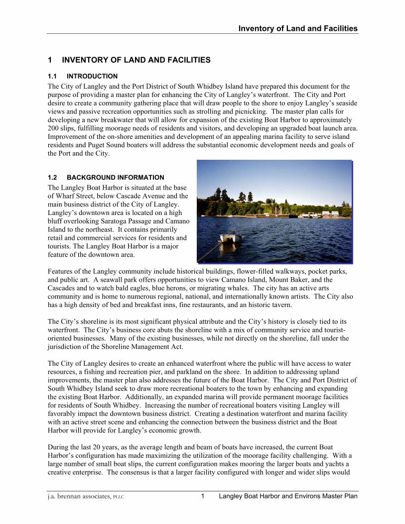
1.1 INTRODUCTION The City of Langley and the Port District of South Whidbey Island have prepared this document for the purpose of providing a master plan for enhancing the City of Langley’s waterfront. The City and Port desire to create a community gathering place that will draw people to the shore to enjoy Langley’s seaside views and passive recreation opportunities such as strolling and picnicking. The master plan calls for developing a new breakwater that will allow for expansion of the existing Boat Harbor to approximately 200 slips, fulfilling moorage needs of residents and visitors, and developing an upgraded boat launch area. Improvement of the on-shore amenities and development of an appealing marina facility to serve island residents and Puget Sound boaters will address the substantial economic development needs and goals of the Port and the City.
1.2 BACKGROUND INFORMATION The Langley Boat Harbor is situated at the base of Wharf Street, below Cascade Avenue and the main business district of the City of Langley. Langley’s downtown area is located on a high bluff overlooking Saratoga Passage and Camano Island to the northeast. It contains primarily retail and commercial services for residents and tourists. The Langley Boat Harbor is a major feature of the downtown area. Features of the Langley community include historical buildings, flower-filled walkways, pocket parks, and public art. A seawall park offers opportunities to view Camano Island, Mount Baker, and the Cascades and to watch bald eagles, blue herons, or migrating whales. The city has an active arts community and is home to numerous regional, national, and internationally known artists. The City also has a high density of bed and breakfast inns, fine restaurants, and an historic tavern. The City’s shoreline is its most significant physical attribute and the City’s history is closely tied to its waterfront. The City’s business core abuts the shoreline with a mix of community service and tourist-oriented businesses. Many of the existing businesses, while not directly on the shoreline, fall under the jurisdiction of the Shoreline Management Act. The City of Langley desires to create an enhanced waterfront where the public will have access to water resources, a fishing and recreation pier, and parkland on the shore. In addition to addressing upland improvements, the master plan also addresses the future of the Boat Harbor. The City and Port District of South Whidbey Island seek to draw more recreational boaters to the town by enhancing and expanding the existing Boat Harbor. Additionally, an expanded marina will provide permanent moorage facilities for residents of South Whidbey. Increasing the number of recreational boaters visiting Langley will favorably impact the downtown business district. Creating a destination waterfront and marina facility with an active street scene and enhancing the connection between the business district and the Boat Harbor will provide for Langley’s economic growth. During the last 20 years, as the average length and beam of boats have increased, the current Boat Harbor’s configuration has made maximizing the utilization of the moorage facility challenging. With a large number of small boat slips, the current configuration makes mooring the larger boats and yachts a creative enterprise. The consensus is that a larger facility configured with longer and wider slips would
Inventory of Land and Facilities
Langley Boat Harbor and Environs Master Plan 2 j.a. brennan associates, PLLC
attract more boaters to Langley, and thusly, more dollars to the Island economy. Additionally a larger marina would allow for an inventory of permanent moorage slips, which would fill a need for South Whidbey residents, who do not currently have an adequate or convenient supply of moorage.
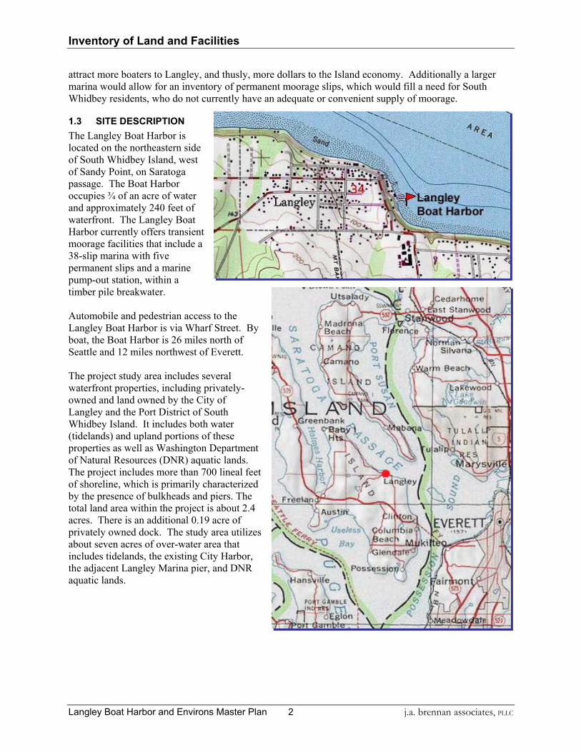
1.3 SITE DESCRIPTION The Langley Boat Harbor is located on the northeastern side of South Whidbey Island, west of Sandy Point, on Saratoga passage. The Boat Harbor occupies ¾ of an acre of water and approximately 240 feet of waterfront. The Langley Boat Harbor currently offers transient moorage facilities that include a 38-slip marina with five permanent slips and a marine pump-out station, within a timber pile breakwater. Automobile and pedestrian access to the Langley Boat Harbor is via Wharf Street. By boat, the Boat Harbor is 26 miles north of Seattle and 12 miles northwest of Everett. The project study area includes several waterfront properties, including privately-owned and land owned by the City of Langley and the Port District of South Whidbey Island. It includes both water (tidelands) and upland portions of these properties as well as Washington Department of Natural Resources (DNR) aquatic lands. The project includes more than 700 lineal feet of shoreline, which is primarily characterized by the presence of bulkheads and piers. The total land area within the project is about 2.4 acres. There is an additional 0.19 acre of privately owned dock. The study area utilizes about seven acres of over-water area that includes tidelands, the existing City Harbor, the adjacent Langley Marina pier, and DNR aquatic lands.

Inventory of Land and Facilities
j.a. brennan associates, PLLC 3 Langley Boat Harbor and Environs Master Plan
Table 1, Adjacent Properties
Property Owner Parcel Size
Nichols Brothers 1.00 acre, 0.52 upland Boatyard Inn 0.12 acre Langley Marina LLC* 0.19 acre Langley Marina Pier 0.14 acre Richardson Residence 0.20 acre Drakes Landing .05 acre Riehl Residence .04 acre City of Langley 1.08 Additional DNR Lands 7 acres
*The Langley Marina has been purchased by Paul Schell and partners.
1.4 EXISTING LANGLEY BOAT HARBOR CONDITION The existing Boat Harbor consists of a timber pile breakwater, concrete floats and access trestle. BERGER/ABAM Engineers performed a Condition Assessment of the existing Boat Harbor (See appendix for report details). In conclusion, the survey found that the structures are in good condition and can remain in service for another 10 to 15 years. Recommendations to maintain the structures’ serviceability can be found in the attached report. They are, in summary:
• Replace deteriorated 4”x 4” chinking timbers and reattach those that have come loose. • Replace the torn and missing metal pile covers. • Consider adding additional riprap where it is missing or sparse and where the cover is uneven. • Establish a regular maintenance program to inspect and repair elements of the marina • Yearly inspections and regular touch-up of deteriorated portions of the steel ‘H’ piles.
1.5 HISTORY OF THE LANGLEY BOAT HARBOR The City of Langley once functioned as an active port city, shipping the goods of the past principal industries, which included truck farming, fruit and berry crops, and timber. In the past, business between towns was conducted by boat. The stern-wheeler, Fairhaven, made a round trip from Seattle to Oak Harbor daily, with stops at Langley, in the early nineteen hundreds. While the shipping port is no longer active, the harbor area below the commercial core still remains as an active focal point of the community with a small public marina, public park, and active boatyard. In the recent past, there has been an active private marina operation (boat and fuel sales, marine supplies, etc.). In addition, there are a few residences and tourist accommodations. In 1979, The Port, City of Langley, and the Washington State IAC developed a 38 -slip transient moorage marina. The facility consisted of floating concrete finger piers anchored to treated timber pilings, all protected by a floating tire breakwater. Following the sinking of that floating breakwater, a new breakwater was completed in 1986.1 See appendix “Condition Assessment” for more detailed structural information.
Inventory of Land and Facilities
Langley Boat Harbor and Environs Master Plan 4 j.a. brennan associates, PLLC
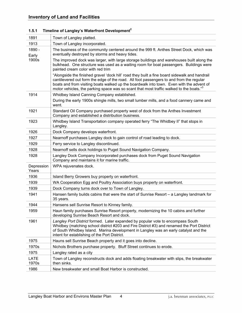
1.5.1 Timeline of Langley’s Waterfront Development2
1891 Town of Langley platted. 1913 Town of Langley incorporated.
The business of the community centered around the 999 ft. Anthes Street Dock, which was eventually destroyed by storms and heavy tides. The improved dock was larger, with large storage buildings and warehouses built along the bulkhead. One structure was used as a waiting room for boat passengers. Buildings were painted cream color with red trim
1890 - Early 1900s
“Alongside the finished gravel ‘dock hill’ road they built a fine board sidewalk and handrail cantilevered out form the edge of the road. All foot passengers to and from the regular boats and from visiting boats walked up the boardwalk into town. Even with the advent of motor vehicles, the parking space was so scant that most traffic walked to the boats.”3
1914 Whidbey Island Canning Company established. During the early 1900s shingle mills, two small lumber mills, and a food cannery came and
went. 1921 Standard Oil Company purchased property west of dock from the Anthes Investment
Company and established a distribution business. 1923 Whidbey Island Transportation company operated ferry “The Whidbey II” that stops in
Langley. 1926 Dock Company develops waterfront. 1927 Nearnoff purchases Langley dock to gain control of road leading to dock. 1929 Ferry service to Langley discontinued. 1928 Nearnoff sells dock holdings to Puget Sound Navigation Company. 1928 Langley Dock Company Incorporated purchases dock from Puget Sound Navigation
Company and maintains it for marine traffic. Depression Years
WPA rejuvenates dock.
1936 Island Berry Growers buy property on waterfront. 1939 WA Cooperation Egg and Poultry Association buys property on waterfront. 1939 Dock Company turns dock over to Town of Langley. 1941 Hansen family builds cabins that were the start of Sunrise Resort – a Langley landmark for
35 years. 1944 Hansens sell Sunrise Resort to Kinney family. 1959 Haun family purchases Sunrise Resort property, modernizing the 10 cabins and further
developing Sunrise Beach Resort and dock. 1961 Langley Port District formed. Later expanded by popular vote to encompass South
Whidbey (matching school district #203 and Fire District #3) and renamed the Port District of South Whidbey Island. Marina development in Langley was an early catalyst and the intent for establishing of the Port District.
1975 Hauns sell Sunrise Beach property and it goes into decline. 1970s Nichols Brothers purchase property. Bluff Street continues to erode. 1975 Langley rated as a city LATE 1970s
Town of Langley reconstructs dock and adds floating breakwater with slips, the breakwater then sinks.
1986 New breakwater and small Boat Harbor is constructed.

Site Analysis
j.a. brennan associates, PLLC 5 Langley Boat Harbor and Environs Master Plan
2 SITE ANALYSIS AND NEEDS ASSESSMENT
2.1 SITE CHARACTERISTICS The City of Langley covers an area of approximately 500 acres. Most of Langley is situated in a bowl-shaped depression, which is part of a small drainage basin, sloping toward a bluff overlooking Saratoga Passage. The fifty-foot-high bluff is protected in places by a seawall; where it is not, the bluff is more vulnerable to erosion. The results of bluff slides are in evidence, including the downtown area of the city. Two smaller drainage basins lie on the east end of Langley, which also slopes toward the passage. The topography ranges from sea level along Wharf Street to about 250 feet above sea level on the city's southern boundary.4 The project site is below the steep bluff between downtown and Saratoga Passage. It is limited, in terms of development, because of the gradient of the bluff. However, its locale is ideal from a recreational and commercial point-of-view because of its waterfront and short walking distance to downtown. The land portion of the project site is lineal and narrow; it spans more than 700 lineal feet of shoreline and stretches about 120’ back from the Mean Higher High Water line to the toe of the bluff. The developable portion of project site is flat, shaped by development, which includes primarily asphalt and crushed rock paving and buildings. The entire shoreline is characterized by the presence of concrete bulkheads, which give way to sandy beach along the southern portion of the site as the land turns towards the east. In and around the project site, along Saratoga Passage, the Whidbey Island shoreline undulates subtly. The Boat Harbor occupies a semi-protected portion of water, resembling a half-bay in that it is protected from southern wind and wave action by steeply rising land and a concave shoreline, but is fairly exposed to the north, however, as the land becomes convex about 900 feet north of the existing Boat Harbor. The gently sloping intertidal area is characterized generally by the presence of fine substrate material and Eelgrass beds. Three pile-supported structures protrude into the water in the project site: the Boat Harbor, the pier and building on the adjacent Langley Marina LLC property, and the Nichols’ Brothers wharf, which supports the corporation’s Freeland boat building facility.
2.1.1 Marina Services There is a continuing and growing need for additional marina space on South Whidbey Island. There are 3,130 boats ranging from 16 to 60 feet in length currently registered to Island County residents. Additionally, there are other potential users who have boats registered in other counties that are stored/moored in Island County as well as other owners whose boats are only moored elsewhere because of lack of facilities in Island County. Demand for moorage has not been formally quantified but could range from 1,500 to 2,000 vessels. The total rental moorage currently available in Island County is approximately 523 moorage slips.5 The City of Langley presently manages the Boat Harbor. (Chapter 14.01 of the City’s Municipal Code relates to the use of the Boat Harbor.)
Site Analysis
Langley Boat Harbor and Environs Master Plan 6 j.a. brennan associates, PLLC
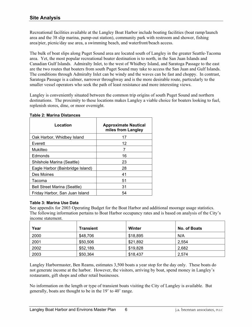
Recreational facilities available at the Langley Boat Harbor include boating facilities (boat ramp/launch area and the 38 slip marina, pump-out station), community park with restroom and shower, fishing area/pier, picnic/day use area, a swimming beach, and waterfront/beach access. The bulk of boat slips along Puget Sound area are located south of Langley in the greater Seattle-Tacoma area. Yet, the most popular recreational boater destination is to north, in the San Juan Islands and Canadian Gulf Islands. Admiralty Inlet, to the west of Whidbey Island, and Saratoga Passage to the east are the two routes that boaters from south Puget Sound may take to access the San Juan and Gulf Islands. The conditions through Admiralty Inlet can be windy and the waves can be fast and choppy. In contrast, Saratoga Passage is a calmer, narrower throughway and is the more desirable route, particularly to the smaller vessel operators who seek the path of least resistance and more interesting views. Langley is conveniently situated between the common trip origins of south Puget Sound and northern destinations. The proximity to these locations makes Langley a viable choice for boaters looking to fuel, replenish stores, dine, or moor overnight. Table 2: Marina Distances
Location Approximate Nautical miles from Langley
Oak Harbor, Whidbey Island 17 Everett 12 Mukilteo 7 Edmonds 16 Shilshole Marina (Seattle) 23 Eagle Harbor (Bainbridge Island) 28 Des Moines 41 Tacoma 51 Bell Street Marina (Seattle) 31 Friday Harbor, San Juan Island 54
Table 3: Marina Use Data See appendix for 2003 Operating Budget for the Boat Harbor and additional moorage usage statistics. The following information pertains to Boat Harbor occupancy rates and is based on analysis of the City’s income statement.
Year Transient Winter No. of Boats
2000 $48,706 $18,895 N/A 2001 $50,506 $21,892 2,554 2002 $52,189. $19,828 2,682 2003 $50,364 $18,437 2,574
Langley Harbormaster, Ben Reams, estimates 3,500 boats a year stop for the day only. These boats do not generate income at the harbor. However, the visitors, arriving by boat, spend money in Langley’s restaurants, gift shops and other retail businesses. No information on the length or type of transient boats visiting the City of Langley is available. But generally, boats are thought to be in the 19’ to 40’ range.
Site Analysis
j.a. brennan associates, PLLC 7 Langley Boat Harbor and Environs Master Plan
Table 4: Current Moorage Rates
Type of Moorage Rate Rate Number of Slips
Transient Moorage $.50/foot per night Varies, depending upon configuration
Winter Moorage $5.00/foot per month 20 slips Annual Moorage $7.00/foot per month 5/1-9/30
$5.00/foot per month 10/1-4/30 3 or 4 slips
Liveaboard Utility Fee $65.00 per month Non-Liveaboard Utility Fee $35.00 per month Transient Electric Fee $3.00 per night
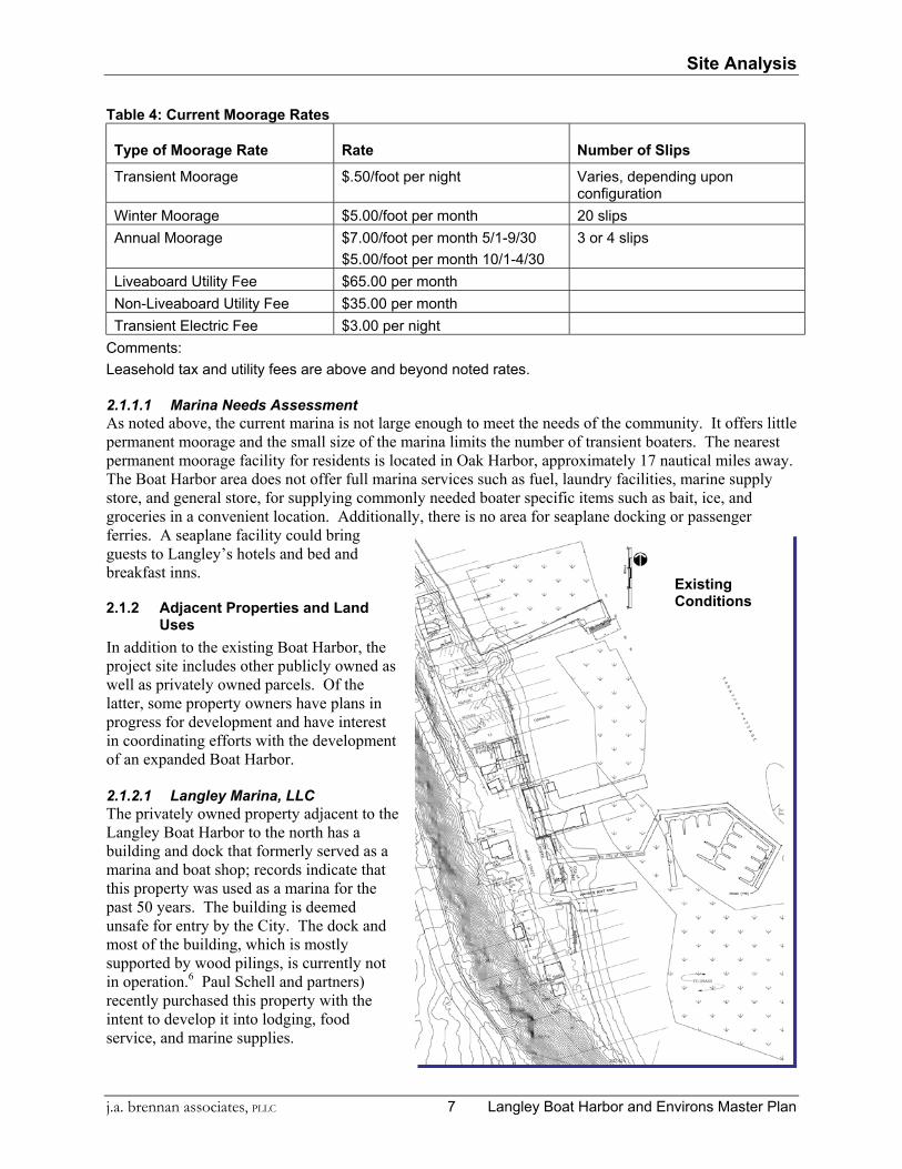
Comments: Leasehold tax and utility fees are above and beyond noted rates. 2.1.1.1 Marina Needs Assessment As noted above, the current marina is not large enough to meet the needs of the community. It offers little permanent moorage and the small size of the marina limits the number of transient boaters. The nearest permanent moorage facility for residents is located in Oak Harbor, approximately 17 nautical miles away. The Boat Harbor area does not offer full marina services such as fuel, laundry facilities, marine supply store, and general store, for supplying commonly needed boater specific items such as bait, ice, and groceries in a convenient location. Additionally, there is no area for seaplane docking or passenger ferries. A seaplane facility could bring guests to Langley’s hotels and bed and breakfast inns.
2.1.2 Adjacent Properties and Land Uses
In addition to the existing Boat Harbor, the project site includes other publicly owned as well as privately owned parcels. Of the latter, some property owners have plans in progress for development and have interest in coordinating efforts with the development of an expanded Boat Harbor. 2.1.2.1 Langley Marina, LLC The privately owned property adjacent to the Langley Boat Harbor to the north has a building and dock that formerly served as a marina and boat shop; records indicate that this property was used as a marina for the past 50 years. The building is deemed unsafe for entry by the City. The dock and most of the building, which is mostly supported by wood pilings, is currently not in operation.6 Paul Schell and partners) recently purchased this property with the intent to develop it into lodging, food service, and marine supplies.
Existing Conditions

Site Analysis
Langley Boat Harbor and Environs Master Plan 8 j.a. brennan associates, PLLC
2.1.2.2 Boat Launch The existing small boat launch is tightly situated between the marina and the parking area and is deteriorated and inefficient. The slope of the concrete ramp is too gentle to remain free of drifting sand and woody debris, which must be cleared regularly to provide safe access to the water. There is no dock at the launch area. The launch is located in a sand accretion area. 2.1.2.3 Boat Launch Needs Assessment In Island County, the number of un-registered boats has more than doubled in the last six years. Unregistered boats are those less than 16 feet in length or with engines of less than 10 horsepower. These are the class of vessel most in need of launch facilities. Boats capable of using this ramp or the Port’s other four ramps in South Whidbey are generally limited to boats under 25 feet in length. Of the larger class boats, many between 20-25 feet long, are difficult if not impossible to launch safely from existing ramps in the Port District except in the highest tides. The existing facility at Langley does not have a floating dock facility. Floating docks alongside launch ramps greatly enhance the overall safety of launch ramp sites and launching operations. They also significantly decrease the time of the typical operation thus facilitating a greater number of operations during launch hours limited by the tides.7 2.1.2.4 Phil Simon Park
Phil Simon Park is a small city park (less than 18,500 square feet) not including tidelands, and City owned greenbelt. The park consists of restroom and shower building, boat launch, parking, lawn, and a picnic table. It serves as a modest rest and waiting area for Boat Harbor users. The existing concrete bulkhead along the parking lot at Phil Simon Park is in good condition. The bulkhead is short (2-3' above grade) and stacked with woody debris waterward of the bulkhead. The deed granting the property to the City requires that the boat launch be maintained. There is no charge for
launching now but launching fees could be considered to cover maintenance costs and will be addressed in the funding sources section of this report. 2.1.2.5 Park / Recreational Facilities Needs Assessment The City of Langley and the Port District wish to provide increased opportunities for public enjoyment of the available water resources by creating additional points of access along the water. The City of Langley’s Comprehensive Plan encourages the development of a dynamic waterfront, including expanded marina facilities and increased access to the shorelines via pathways and stairways. The Port’s Six Year Comprehensive Plan also addresses development of waterfront recreational or commercial centers, fishing and docking piers, and/or associated public parks.
The Port District and the City of Langley may seek to acquire necessary property and/or rights for use in the development of waterfront recreational or commercial centers, fishing and docking piers, and/or associated public parks, in order to give the public the opportunity for recreation, swimming, picnicking, and the playing of outdoor games, and the use, for transportation or recreation, of watercraft at the City of Langley.

Site Analysis
j.a. brennan associates, PLLC 9 Langley Boat Harbor and Environs Master Plan
2.1.2.6 Nichols Brothers Boat Building The Nichols Brothers boat building operation in Freeland is supported by the company’s final commissioning operation and wharf in Langley, operating on seven parcels of waterfront property, which supply parking, one building, a dock, and dock facilities. The properties are protected with concrete bulkheads and the land is mostly asphalt and crushed rock paving. The Nichols Brothers properties are protected from wave action by a small (2’-3' above grade) timber wall. The wall appears to be in fair condition. The bulkhead is preceded water-ward by a sandy beach exposed during all but extreme high tides, with woody debris stacked against the bulkhead. During stormy weather, waves topping the bulkhead and the existing pier have been observed. The existing piling supported pier is built with concrete decking with the exception of the shoreward portion that is built with a combination of timber and concrete and has a small shed structure. Soldier piles are also installed on the north side of the Nichols dock, which serves as a limited breakwater. The existing dock is built at a low elevation and is topped by waves during storm events occurring at high tide. The Nichols Brothers are interested in a partnership arrangement where a breakwater could be installed which would serve as berthing for the company’s sea trials and outfitting as well as pleasure boat and tour boat moorage. The specific details of security and shared use of the facilities will need to be resolved. 2.1.2.7 Schell and Puma-Owned Properties Paul Schell, Tony Puma, and Richard Untermann own three properties; two on the water side of f Wharf Street in the heart of the study area. One of water side properties houses the Boatyard Inn, a four-building complex. The buildings are relatively new and attractive; the corrugated metal exteriors vary in color, and the buildings are typically two or more stories high. There is guest parking, small plantings and a view deck atop the bulkhead that serves as a public access point. The business provides a destination for potential recreationalists and Boat Harbor users. The other water side property is the Langley Marina site. The other small piece of property, across Wharf Street, is currently vacant, with the exception of boat trailers that are often stored there. The owners are working on plans to develop the site. Stakeholders believe that an elevator located on City property could improve the connection from the harbor area to downtown. Initially, the property will serve as a parking lot for the proposed development on the former Langley Marina property. 2.1.2.8 The Richardson-Owned Property The site is adjacent to the public parking area to the south. The property abuts a narrow easement and a beach, which is at the most-protected part of the half-bay and, with its gentle slopes, changes dramatically with the tides. The property, which houses the Sea Breeze vacation rental property, is for sale. The Richardson property is protected by a barely discernable timber bulkhead. A row of logs is strung in a single line along the property, but the gentle beach grades likely prevent wave run-up from entering the property. An easement has been provided through Phil Simon Park to the property. The structure is a wood-frame cabin. 2.1.2.9 The Drake Owned Property The Drake’s Landing Bed and Breakfast site is adjacent to the Phil Simon Park. 2.1.2.10 The Riehl-Owned Property The Riehl Owned property is a vacation rental house. The owner is not interested in selling at this time. An easement has been provided through Phil Simon Park to the property. 2.1.2.11 Adjacent Properties Needs Assessment The planning and development of the marina facilities at the Langley Boat Harbor should be a cooperative effort with the Port District, the City, and private property owners.

Site Analysis
Langley Boat Harbor and Environs Master Plan 10 j.a. brennan associates, PLLC
2.1.3 Soils and Geotechnical Conditions The central portion of Puget Sound, where Langley is located, has been glaciated at least four times in the past several million years. The exposed soils record the last glacial episode and preceding inter-glacial period. Overlying the inter-glacial soils and advance outwash is a layer of hardpan or basal lodgment till, which was laid down at the base of the glacial ice. Erosion over the last 12,000 years and human activities have modified the landscape to its present condition, which on the slopes is often the loose and soft soil known as colluvium. These soils tend to move downhill and accumulate at the toe. Despite the presence of shore protection (bulkheads, etc.), minor erosion and sloughing is still active on the steep slopes due to groundwater seepage. Borings taken in 1986 along the eastern side of Wharf Street, in tandem with observations of bowing trees and cracks in the street pavement, indicate that the upper 6 feet of soils is slowly moving downhill. The slope above Phil Simon Park, which is 85 to 90’ high and inclined at 38° to 45°, is covered with about a 1 to 3’ layer of colluvium. The lowest 15 feet of the slope is gentler and has a greater depth of colluvium, which historically reached the water’s edge. The 1986 study showed no signs of deep-seated slope instability and no springs or seepage was seen, but wet soils were observed, which could slough, if disturbed.8 More recently, Shannon & Wilson noted the characteristic of potential landslides in this area being initiated at the top and bottom of steep slopes and the extreme sensitive nature of construction in the vicinity of these slopes.9
2.1.4 Traffic There is no thruway at the project site. Because of the terrain, Wharf Street is the only access from downtown Langley, on top of the bluff. Sunrise Lane intersects Wharf Street in the core of the project site. Sunrise Lane starts at the intersection and travels only about 500 feet north, serving as access to the Nichols Brothers’ properties and a private lane to several houses. The traffic pattern is divided between Boat Harbor users, residents, employees of the Nichols Brothers business, and the Boatyard Inn. During peak weekends access is congested indicating that circulation improvements will be required to maintain access efficiency and to minimize impacts to neighbors.
2.1.5 Access In addition to vehicular access described above, there is a pedestrian sidewalk—which is actually a pile-supported structure next to the steeply-cut street—along Wharf Street. Within the project area, however, there is no pedestrian-designated space. Also, there is boat access to the site, either via the Boat Harbor or the boat ramp. Divers and small-boat users may also access the water in the Boat Harbor vicinity.
2.1.6 Parking Currently, limited public parking is provided. There is space for approximately 20 vehicles, including one designated disabled access stall. Four of the stalls are formalized with striping; the remainder is informal parking on gravel. This parking area is used for general beach, marina, trailer launching, and park use. Officials of the South Whidbey School District have indicated that the school district would be amenable to working with Langley to provided overflow parking on the bus barn lot, subject to the school board’s approval of any final arrangement. When the Port District and City are clear about the amount of space needed to support the preferred master plan, the school district can be approached with a specific request. The fact that the busy summer boating season coincides with the school’s summer vacation period indicates that such an arrangement could be beneficial for both organizations.

Site Analysis
j.a. brennan associates, PLLC 11 Langley Boat Harbor and Environs Master Plan
Considerations for the school district are the availability for staff parking, and the ability for the buses to park and to turn around. During the summer, the space would be more available; however, there would still need to be bus turnaround space for one or two buses. Posting of signs and enforcement of time limits would be important. Boat Harbor expansion will require additional parking, yet there is limited public space, as discussed above, in the vicinity. Creative methods of providing parking, such as joint use parking or off-site parking should be evaluated in the design of marina facilities. On-site parking facilities should provide facilities for managing the quantity and quality of stormwater run-off. Another possible option for additional parking is the Nichols Brothers’ property if an agreement if reached with the owners.
2.1.7 Utilities Public utilities traverse the project site through the right-of-way. There is water, sewer, and power available near the Boat Harbor. A storm drain system empties into the water near the walkway to the Boat Harbor.
2.2 MARINE ENVIRONMENT AND IMPACTED SPECIES The marine near shore environment around the Langley Boat Harbor currently presents a high quality intertidal and nearshore subtidal aquatic environment that likely supports a wide range of fish and invertebrate organisms. The predominant features that exist at the site are a low sloping shoreline with sandy substrate in the upper intertidal and supratidal beach. The adjacent upland riparian zone south of the site is heavily vegetated with a principally deciduous large tree cover, while the adjacent upland at the site and northward is developed with waterfront light commercial and residential buildings. The upland riparian zone is significant to the local marine ecology by providing organic detritus and insects to the water. Insects in particular are still an important food item for juvenile salmonids. The lower intertidal and subtidal at the site transitions to finer grained sand and muddy substrate with a presence of eel grass. Both the native Zostera marina and exotic Zostera japonica exist at the site. The Z. japonica lies within a band of elevations approximately +1 to -3 MLLW, while the Z. marina lies in a deeper zone to depths up to a depth of approximately -17 MLLW according to videographic surveys conducted by Jim Morris on behalf of the Island County Marine Resources Committee. A wide variety of marine organisms common to the Puget Sound can be expected to occur at the site. Two of these are the Pacific sand lance (Ammodytes hexapterus) and juvenile salmonids. Pacific sand lance is documented to spawn in the upper intertidal region of the beach at the site (Doug Thompson, Dan Pentilla, WDFW personal communication). The sand lance is an important prey fish (forage fish) for salmonids and other fish, birds, and marine mammals. The other common intertidal spawning forage fish, surf smelt does not appear to spawn at the site (Dan Pentilla, WDFW, personal communication). Juvenile salmonids can also be expected to exist at the site throughout most of the year from March through October, and inhabit the intertidal and nearshore subtidal environment at the site. The design of an expanded Boat Harbor in Langley will need to consider impacts to the near shore environment. The preferred design alternative minimizes impacts to the eel grass beds. The design of the marina facilities will need to utilize design concepts that minimize cover and allow light to penetrate.

Site Analysis
Langley Boat Harbor and Environs Master Plan 12 j.a. brennan associates, PLLC
2.2.1 Wave and Beach Processes
On June 18 and 19 Berger/ABAM Engineers performed a topside and underwater structural inspection of the Langley Boat Harbor. Incidental to this inspection, the surrounding shoreline was visited to look at local sediment transport. In addition, a recent report by Coastal Geologic Services Inc. was reviewed. This report evaluated general sediment transport along the Whidbey Island coastline near Langley. The beach to the north of the Boat Harbor trends approximately 340 degrees, north-northwest. Just south of the marina the beach turns east trending about 100 degrees to Sandy Point. High bluffs behind both beaches protect them from wind and waves from outside that 120-degree arc. Within the arc, Camano Island provides increasing protection eastward to its south tip where the fetch, the distance the wind blows over water, decreases from 4.3 miles at 340 degrees to 2.3 miles at the south tip of the island bearing 060 degrees. The only real exposure is the 40-degree arc from the south tip of Camano Island to the bluff at Sandy Point. In this arc the fetch varies from about 5.2 to 8.6 miles. (See Figure 1.) The strongest winds associated with winter storms come from the west and northwest, a direction sheltered by the bluff behind the Boat Harbor. Storm systems and the associated wind coming from the west are shunted around the Olympic Mountains to converge on central Puget Sound. In addition, local winds are funneled by local topography such as the bluffs surrounding Saratoga Passage forcing the strong winds to blow parallel to shore. Moderate winds from the north and northeast directions are subject to protection from Camano Island. The open fetch eastward arc has generally light winds. Fetch has a profound effect on the power of waves as measured by the height of the waves and their ability to move sediment. For example, wind from 340 degrees can generate wave heights of 2 feet at 30 knots and 3.5 feet at 50 knots in deep water. Where the shore of Camano Island is closer, the wind can only generate a 1.3-foot wave at 30 knots and a 2.3-foot wave at 50 knots in deep water. Wave heights increase in the surf zone. The previous analysis and assessment of coastal processes by Coastal Geologic Services Inc. discussed the local littoral transport cell and the net transport direction that is southeastward along the shore of Whidbey Island at Langley as mapped by the USGS. Local topography and changes in orientation of the shoreline strongly affect the transport. Locally, the sediment is moved rapidly southeastward by wind generated storm waves until it reaches the point north of the Boat Harbor. The Boat Harbor is in an embayment protected by the bluffs to the west and south from the influence of winter storms. (See Figure 1.)
Figure 1 – Wave and Wind Exposure at Langley Boat Harbor Beach

Site Analysis
j.a. brennan associates, PLLC 13 Langley Boat Harbor and Environs Master Plan
As the shoreline turns the corner north of the Boat Harbor, the force of the waves and the sediment transport volume markedly decreases. Only waves from the open quadrant, 340 degrees to 100 degrees, affect this beach. The pocket of the local embayment just south of the Boat Harbor where the shoreline turns eastward again is a trap for some of the finer sand, but the beach in this area appears to be stable. Further eastward along the beach in the direction of Sandy Point, as the beach is no longer in the lee of the bluff, the beach gradually becomes exposed once again to the stronger wind and waves and the eastward sediment transport strengthens. (See Figure 2) Lighter summer winds from the north and northeast with limited fetch provided by Camano Island transport the finer sediment, medium to coarse sand, southward along the local beach to the corner of this embayment and on eastward. On the day of the inspection, wind from the north-northeast generated 1.5-foot waves except at the Boat Harbor Breakwater, where reflection doubled the wave height to more than 3 feet. In the surf zone wave heights increase above the deep-water height. The usually calmer summer winds move only the finer sediments in the surf zone. On an unobstructed beach the sediment transport would be more rapid along the beach north of the bluff, would slow markedly in the embayment where the Boat Harbor is located, and slow further into the pocket of the embayment to pick up to the east along the beach toward Sandy Point. This general pattern is seen in Figure 2, an aerial photograph of the immediate area. Local structures in and outside the surf zone create wave shadows that slow or stop the local sand transport creating seaward bulges in the beach. The wave shadow created by the Boat Harbor breakwater builds the beach out at the boat launch ramp and pile supported structures to the north build the beach out in that area as well. The constant transport of sand into the marina wave shadow at the boat launch requires that the ramp be constantly cleaned to keep it operable. An option for minimizing boat launch ramp maintenance is to increase the ramp slope to make it more self-cleaning. Dredging the area around the ramp is not an option because it would require frequent maintenance dredging to maintain water depths. Increasing the ramp slope would require the sloped portion of the ramp to be moved offshore into deeper water. This could be done by filling near shore but would create a groin that would trap sediments against the easterly side of the fill and block normal sediment movement to the west. Additionally, increasing the ramp slope may only reduce the cleaning required as sediments may still build up in the lower tidal zone due to the relatively flat slope of the bay bottom and wave shadow from the breakwater. However increasing the slope will make launching easier. The proposed breakwater will also affect sediment transport. Leaving the ramp at its current location and increasing the slope may only reduce maintenance and could create new problems. The ramp is required to remain in service due to commitments (deed restriction) made at the time the City took ownership of the property from the Simons.
Figure 2 - Shoal Development in the Langley area.

Site Analysis
Langley Boat Harbor and Environs Master Plan 14 j.a. brennan associates, PLLC
A further study of erosion /accretion issues should be undertaken in order to better understand the consequences of modifications to the ramp and the impact of additional breakwaters within the project area and vicinity.
2.3 LANDSCAPE CHARACTER TYPES
2.3.1 Residential The residential landscape character type includes driveways, hedges, ornamental plantings, specimen ornamental trees, landscape walls, landscape lighting and mailboxes. These visible residential landscapes are within and beyond the Project Area.
2.3.2 Commercial The Nichols Brothers boat building operation is the most intense commercial use on the project site. It is characterized by pavement for parking and a building. The other commercial use is lodging at the Boatyard Inn, Drakes Landing, and the Sea Breeze, which are characterized by buildings, parking, and some planting. 2.3.2.1 Greenbelt (Steep Sloped Area Above Boat Harbor) The greenbelt landscape character type is comprised of primarily native trees and shrubs. It is a mixed deciduous forest with some coniferous trees interspersed. The greenbelt often includes seeps, steep slopes, and in some cases, unstable slopes. It is valuable wildlife habitat and a valued scenic resource, lending the desired natural character to the area. In many places the under story is invaded with English ivy, holly and blackberries, which require control.
2.4 ANALYSIS OF FACTORS IMPACTING PORT DISTRICT State law allows port districts to manage certain state-owned aquatic lands and improvements on behalf of the state. The legal specifics are laid out in a Port Management Agreement (PMA). A PMA serves as an agreement between DNR and a port district, authorize the port to manage some state-owned aquatic land consistent with state goals. A PMA places a port in the role of aquatic lands steward and holds a port responsible for meeting the state’s general aquatic management goals, which are to:
• Foster water-dependent uses • Ensure environmental protection • Encourage direct public use and access • Promote production on a continuing basis of renewable resources • Generate income from the use of aquatic lands in a manner consistent with the above goals
Lands that qualify for inclusion under a PMA are those abutting or “used in conjunction with and contiguous” to uplands controlled by the port (RCW 79.90.475). These include uplands owned or leased by the port, as well as lands controlled by a formal management agreement between the port and a third party.10 An alternative under consideration is for the Port District of South Whidbey to assume operation of the Langley Boat Harbor and the expanded facilities, as described in this Master Plan.
2.4.1 Recreation Demand Analysis The 2001 Statewide Boating Inventory Report sponsored by Washington State Parks, the Washington Department of Licensing, and the Washington Department of Transportation by BST Associates found the following:
• Average growth of recreational boat fleet from 1990-2000 was 1.9% • Growth per year was faster for boats over 30 feet

Site Analysis
j.a. brennan associates, PLLC 15 Langley Boat Harbor and Environs Master Plan
• Growth rate of 2.7% for 31-40 feet in length • Growth rate 10% for over 60 feet • Forecast by year 2010 is an addition of approximately 30,000 boats • Continued growth of boats over 30 feet will affect marinas (moorage, mooring buoys,
boathouses, etc) • Forecast for year 2010 is that an additional 2,000 to 8,000 slips, 1,800 – 750 dry storage spaces
are necessary to meet additional fleet requirements • Marinas are full, there have been fewer than five new marinas or major expansions in the last ten
years11
2.4.2 Community Data In recent years, Langley’s active arts community and its many galleries have attracted both day and overnight visitors. The lively art scene helps support the many local artists and merchants. Langley’s art scene, its scenic beauty, and its healthy rural character attract residents and tourists and have contributed to the community’s growth. In the past, the City has been an advocate of controlled development and growth. The essence of Langley’s vision is that it wishes to “build on and enhance its character and identity,”12 protecting its small town atmosphere, i.e., "The Village by the Sea.” Issues surrounding growth must be carefully considered by any community wishing to retain its character. The Langley Comprehensive Plans best summarizes the issues that Langley must address whenever considering future development:
Langley is also a community experiencing gradual residential and commercial growth, with tourism continuing to play an integral part in the city economy. With the growth has come increased concern over the scale and quality of growth and the increasing emphasis on a tourist economy. Residents are concerned that growth will bring changes to their livelihoods and lifestyle. Langley's small town, friendly atmosphere attracts visitors who provide economic support for the community; these same qualities attract people who establish and maintain residence in Langley. The displacement of residents as the community grows and develops, and as property values continue to be among the highest on South Whidbey, raises concerns about the financial impact on long-time residents and persons of lesser incomes. The major tourism presence can also make Langley less accessible to the resident community. The residents' vision of a community in a rural setting that includes open spaces and natural amenities could be lost before being fully realized.
The City’s Comprehensive Plan specifically addresses the need to reorient the City to “its historical waterfront character, including expansion of marina services and improved access to and along the waterfront and beach in conjunction with the Port of South Whidbey.13 Healthy community growth versus over-development must be considered whenever new development is proposed. The Port and City must carefully consider how the redevelopment of Langley’s Boat Harbor will impact the community. The benefits to the community must outweigh social and environmental costs. The new Boat Harbor must meet the needs of citizens and be the best use of land and public resources.
2.4.3 Boat Harbor’s Role in the Community Marinas often serve as focal points for communities. The movements of boats, seaplanes, and ferries create an active waterfront. Sailing regattas and bobbing fishing boats enhance the seaside milieu. Langley’s own vision is to improve its historical waterfront character. The enhanced Boat Harbor can serve as a community focal point, attracting boaters to the City and attracting visitors and residents to the waterfront. The link between the Boat Harbor and the business district can be reinforced. Improving the

Site Analysis
Langley Boat Harbor and Environs Master Plan 16 j.a. brennan associates, PLLC
connection between downtown Langley and its active waterfront can only help to further define Langley’s identity. Elements of Langley’s history can be integrated into the design of the new Boat Harbor, to tell the story of Langley’s past and to define its future, while also paying respect to the people who shaped the City. Remembering that old wharf structures were painted cream with red trim, or the onetime importance of the Sunrise Resort to the community and incorporating such elements into the design of the redeveloped Boat Harbor and environs will assist in creating a sense of place.
2.4.4 Future Development of Mosquito Fleet Service and Float Plane Facility The Mosquito Fleet, based in Everett, currently offers charter cruises between Everett and Langley. These charter cruises are recreational; the Mosquito Fleet currently has no commuter service. It is the desire of the community (see Comprehensive Plan) to accommodate water transportation services as an alternative to vehicular movement. The vision eventually includes offering commuter service to Everett/Seattle from facilities at the Boat Harbor area. The master plan for the Boat Harbor incorporates sufficient berthing capacity and harbor and navigational improvements for such water borne transportation services, including a floatplane docking area.

Vision and Goals
j.a. brennan associates, PLLC 17 Langley Boat Harbor and Environs Master Plan
3 VISION AND GOALS Following the vision of the City of Langley’s Comprehensive Plan and the Six Year Comprehensive Plan of the Port District of South Whidbey Island & Comprehensive Scheme of Harbor Improvements, the City and Port District hired J.A. Brennan Associates to complete a master plan for the Langley Boat Harbor and Environs. As part of the process of analysis, J.A. Brennan worked with the City, the Port, the public, and stakeholders to develop a vision and goals for the Boat Harbor. Through the public process, the following design principles were developed to guide the conceptual design of the Langley Boat Harbor. The design seeks to:
• Develop a sense of place and express the community’s identity • Maximize public benefit of the space • Minimize impact to the project’s neighbors • Utilize sustainable design principles • Enhance economic development opportunities
3.1.1 Vision Statement The Langley Boat Harbor & Environs should be recognized as a unique part of the South Whidbey community and a waterfront connection to Saratoga Passage. The site also serves as a gateway between Langley, South Whidbey, and other ports. The marina should provide opportunities for safe recreation, passive enjoyment and a beautiful green space that strengthens the identity of the town. It should be a central waterfront focal point and a hub that spurs desirable commercial development as foreseen in the City’s Comprehensive Plan. The waterfront district should function as an informal community gathering space, attracting tourists to Langley, providing an attractive place for strolling and serving as a destination.
3.1.2 Project Goals and Objectives These goals and objectives guided the planning and conceptual design for the Langley Marina & Environs project. If any of the specific improvements recommended in the design concept prove to be infeasible, these goals and objectives should guide the selection of alternative improvements. 3.1.2.1 Community Identity The Langley Boat Harbor & Environs serves as a hub that is a catalyst for future community waterfront development and is a focal point of the town, both now and in the future. The Boat Harbor is pivotal in defining community identity and providing a sense of place for Langley.
• Work with the community through the public process to define the community’s identity. • Provide a useful place for the local community of South Whidbey Island • Enhance economic opportunities for the City and encourage private development that provides a
public service associated with the waterfront setting • Provide boating facilities and other recreation opportunities • Create a place for community waterfront gatherings • Allow for programmed activities (i.e. community picnics, etc.) • Define space and entice people to the waterfront • Focus circulation patterns to promote social interaction • Consider the City’s Comprehensive Plan during the design process • Create a visual element or character that is unique, memorable and identifiable with the Langley
waterfront.

Vision and Goals
Langley Boat Harbor and Environs Master Plan 18 j.a. brennan associates, PLLC
3.1.2.2 Environmental Stewardship The master plan design for the Langley Boat Harbor & Environs must enhance and restore habitat for fish and wildlife.
• Emphasize an environmentally friendly development • Site marina facilities to avoid critical habitat such as eel grass beds • Improve near shore vegetation • Protect sand lance spawning areas • Minimize dock cover in sensitive areas • Avoid the use of toxic materials, i.e. creosote
3.1.2.3 Boat Harbor The Langley Boat Harbor must meet the needs of the South Whidbey Island Community and visitors.
• Create an overall balance between residents and visitors’ needs • Create an overall balance between current and future needs • Create an overall balance between transient and permanent moorage • Consider the community’s support for increasing the number of slips and providing fueling
opportunities • Consider that developing harbor would improve tourist access and bring more money to the City • Improve visibility from the City of Langley and from Saratoga Passage • Expand services catering to boaters and non-boaters • Balance expansion of transient and permanent moorage with the provisions for access and
parking • Consider slip mix in relation to current and future needs. • Considers pros and cons to providing moorage for larger vessels • Consider mix of permanent versus guest moorage • Provide moorage for live-aboard vessels at the harbor (improving security) • Provide more parking for vehicles, boats, and trails • Provide alternate parking location • Utilities (consider 50 amp service) • Maintain flexibility, rafting options • Provide quality day moorage/short term moorage facilities • Consider a fuel facility • Ease of access, consider expanded senior use • Improve winter and “shoulder season” use • Improve connection to town • Strengthen image • Enhance public access features • Allow for commercial-use docking • Improve beach access
Economic Considerations
• Design a marina that is economically viable and feasible to construct and operate from a combination of operating revenue and taxpayer support.
• Consider trends in recreational boating • Meet current boaters’ needs • Enhance tourism related business opportunities • Create opportunities for public/private development • Increase winter and shoulder season use of the marina • Consider attracting yacht clubs with group facilities

Vision and Goals
j.a. brennan associates, PLLC 19 Langley Boat Harbor and Environs Master Plan
• Take into account that yacht club business requires marketing and facilities management • Increase revenues • Continue to bring in revenue as the marina and harbor is developed
Visual Character And Continuity The master plan must create an identifiable visual and physical character for the Boat Harbor & Environs that:
• Incorporates a strong theme related to maritime use appropriate to Langley • Improves visibility of project area • Keeps the harbor area pedestrian-friendly • Creates continuity through urban design character, including shoreline, paving, architectural
elements, landscaping, lighting, markers, bollards (wood or concrete), and signs. • Creates and preserves a uniqueness of place • Creates a Northwest small-scale seaside village feel to the harbor • Strengthens the link of the harbor to the City • Has a separate identity from the downtown. The areas are linked, but separate in function
and character. • Tells the story of Langley and its harbor. • Expands views of Saratoga Passage via a floating breakwater
Vegetation and Landscaping Use landscaping to create a green space highlighting the natural environment:
• Integrate the natural greenbelt into the design • Vegetate the shoreline appropriately • Minimize landslide potential and prevent erosion • Create a functional green space
3.1.2.4 Recreational Uses Create a diversity of recreational activities for locals and visitors
• Recreational activities include boating, beachcombing, beach play, fishing, crabbing, walking, bicycling, interpretive/ educational, wildlife viewing, and habitat enhancement.
Potential Recreational Uses to Consider
• Family oriented park uses • Boating • Picnicking • Yacht club gatherings • Beach fires • Crabbing • Fishing • Beach Walks • Kite flying • Kayak rentals • Sail boat rentals • SCUBA Diving • Wind surfing • Berthing of historic or iconic vessels • Community gatherings and special events • Art shows

Vision and Goals
Langley Boat Harbor and Environs Master Plan 20 j.a. brennan associates, PLLC
3.1.2.5 Pedestrian And Bicycle Circulation Issues Potential for pedestrian and bicycle links to future and existing open space and trails.
• Create safe walkways throughout the site and link to the town. • Consider future possibility of linking to Seawall Park • Address bicycle needs at the site, such as potential bike parking
3.1.2.6 Vehicular Circulation Develop safe and efficient vehicular access.
• Balance development with parking availability i.e. guest moorage vs. permanent moorage • Provide parking facilities that don’t negatively impact the visual character of the site • Consider parking at the top of the hill for overflow • Consider boat and trailer access and parking
3.1.2.7 Historic Preservation and Education Create a design that reflects the history of the site, including the historic fishing resort. Consider way finding signage and interpretive opportunities.
• Salmon resort • Ship building • Water transport • Logging • Native American use • Fishing tradition • Provide a map highlighting tourist activities and services.
3.1.2.8 Drainage Issues Resolve drainage problems with environmentally sensitive measures.
• Create functioning surface water and storm drainage facilities. • Avoid infiltration on steep slope areas
3.1.2.9 Non-Public Uses Coordinate public and private use.
• Park land available for public use and enjoyment • Encourage private development that is water dependent • Encourage development supportive of the marina • Pursue public / private partnership opportunities • Achieve goals of the comprehensive plan
3.1.2.10 Maintenance and Life Cycle Issues Design an easy to maintain Boat Harbor and uplands the Community can be proud of
• Consider life span of existing marina. Generally 25 to 30 years (built 1986) • Consider phasing and replacement options • Consider boat launch maintenance (sand removal) • Uplands maintenance • Marina survey completed by BERGER/ABAM Engineers. Inspection of breakwater and floats.
3.1.2.11 Security Create a safe environment for residents, commercial, tourists, and marina users
• Provide paths to separate pedestrians from cars • Allow for police surveillance of the site
Vision and Goals
j.a. brennan associates, PLLC 21 Langley Boat Harbor and Environs Master Plan
• Place activity areas where these can be observed from residences • Include strategic lighting in the open space design • Seek early police department review of the preferred design concept • Consider controlled access to floats with permanent moorage
3.1.2.12 Infrastructure
• Adequate drainage • Unobtrusive utilities • Control of infiltration • Lighting that is compatible with natural and historic character
3.1.2.13 Lighting And Overhead Wires
• Design a well-lit Boat Harbor with minimal glare • Specify fixtures consistent with the desired character • Limit glare impacts for nighttime viewing • Consider under-grounding the wiring • Manage vegetation around streetlights and other utility poles • Respect the small town and natural qualities of the site

Design Alternatives
j.a. brennan associates, PLLC 22 Langley Boat Harbor and Environs Master Plan
4 DESIGN ALTERNATIVES The following two design alternatives were developed after an involved public process that considered the design principles developed for the project along with City and Port objectives and stakeholder and community needs. The range of alternatives was developed to stimulate discussion and determine community support for particular elements of the plans. Features from either alternative can be transferred to the final master plan. The alternatives are included in the appendix.
4.1 ALTERNATIVE 1: EMPHASIZE DEVELOPMENT OF MAXIMUM MOORAGE • Greater emphasis on land acquisition • Large marina expansion • Permanent moorage in range of 40% of total • Develop sling launch in place of boat ramp • Accommodate large boat moorage • Accommodate tour and related large vessel moorage • Fuel dock at entry to marina with floating barge storage, restroom and store on dock • Develop extensive parking in harbor zone, as well as shuttle to bus lot • Use floating breakwater with large footprint • Develop commercial uses in upland area • Diving reef eliminated for safety reasons
4.2 ALTERNATIVE 2: MODEST MOORAGE EXPANSION COMBINED WITH PARK AND RELATED IMPROVEMENTS
• Modest land acquisition • Modest marina expansion (accommodate up to 100 boats) (Verify) • Permanent moorage in range of 25% of total • Increase gradient of boat ramp in current location and add docking float (S) • Mix of small, medium and large boats • Minimal additional parking at Boat Harbor and, as needed, at school bus barn site • Develop moderate size breakwater (sheet pile or floating) • Fuel dock with upland fuel storage. Store and restrooms upland (At marina entry) • Emphasize enhancement of public park area, together with public access to the shoreline • Minimal commercial uses in upland area • A diving reef located at north edge of Boat Harbor area • Wharf Street Marina Project Development of DNR land in front of their property (Show
potential scheme in concept)
4.3 UPLAND DEVELOPMENT Both alternatives utilize an upland design that incorporates greater waterfront parkland, building development, Boat Harbor parking and improved pedestrian access. Alternative 1 depicts the development of extensive parking within the harbor zone and Alternative 2 proposes modest parking development, less land acquistion, and a greater emphasis on waterfront park development. The upland design aims at creating a small and active waterfront village with functional circulation and access and plentiful opportunity for enjoyment of the water.

Master Plan Description
j.a. brennan associates, PLLC 23 Langley Boat Harbor and Environs Master Plan
5 DESCRIPTION OF MASTER PLAN FOR THE DEVELOPMENT OF THE BOAT HARBOR & ENVIRONS
5.1 MARINA ELEMENTS
5.1.1 Breakwater The proposed breakwater will be a floating breakwater constructed of concrete or steel. Guide piles or anchorage systems will hold the breakwater in place and dolphins will be provided on the outside as needed to protect the breakwater from vessels moored alongside the structure. The breakwater will allow Nichols Brothers outside berthing and access for the fitting and commissioning of vessels. Moorage will be provided on the inside of the breakwater. The breakwater will also be aligned as needed to provide the maximum protection to the Boat Harbor. The breakwater could step down on the inside to allow for moorage of smaller vessels or alternatively, a mooring float could parallel the breakwater. (The master plan, including sections, and illustration is included in the appendix.)
5.1.2 Float Alignment and Construction Material The main walkway float is oriented parallel to the shore to provide slips oriented north / south to minimize crosswind influence during docking. Floats will be of concrete construction. Gangways will be made of aluminum. 5.1.2.1 Slip Number And Types Alternative 1 had 245 slips; Alternative 2 had 117 slips. Based on the mixed sentiment in the community about the scale of the expansion, we recommend that expansion be a balance between the two alternatives. We suggest a preliminary target of 200 slips for the master plan. The actual number of slips will depend on the results of the economic study to be completed at a later date. The cost of the breakwater will not increase much as the size of the marina expands and in general, the greater the number of slips, the greater the revenue without much substantial increase in capitol costs. A mix of short stay and permanent moorage will be provided. The ultimate mix may vary based on results of an economic study. Alternative 1 provided 40% permanent moorage; Alternative 2 provided 25% permanent moorage. As the amount of permanent moorage increases so does the parking demand. A greater number of parking stalls on site results in less land being available for waterfront park use; waterfront park use of the site is desired by the community. Permanent moorage is in short supply on South Whidbey Island and is desired by the local community. Merchants in Langley probably would prefer short stay moorage since it brings in more tourists. Balance is needed between short stay and permanent moorage. The master plan is based on an assumed mix of 50% permanent and 50% short stay or transient moorage. Consideration could be given to boat time-share type use in the marina, although this may not require any unique facilities. The following slip size ratio is recommended based on forecast of needed slips in Washington State 2000 – 2010.

Master Plan Description
Langley Boat Harbor and Environs Master Plan 24 j.a. brennan associates, PLLC
Table 5A: Slip Sizes Recommended by Washington State Interagency Committee for Outdoor Recreation (IAC)*
Size of Slip Number of Slips Based on State Projections For a 200 Slip Marina14
% of Total Slips
20 foot slips 27 boats 12% 30 foot slips 65 boats 33% 40 foot slips 64 boats 32% 50 foot slips 37 boats 19% Over 60 foot slips 7 boats 4% Total 200 boats total 100%
*Calculation based on IAC’s Estimates of Future Participation in Outdoor Recreation in Washington State, see endnote No. 14. Table 5B: Slip Sizes shown in Master Plan (includes existing marina)
Size of Slip Number of Slips Based on State Projections15 % of Total Slips
20 foot slips 24 boats 14% 30-32 foot slips 27 boats 16% 40-44 foot slips 62 boats 37% 50 foot slips 38 boats 23% Over 60 foot slips 16 boats 10% Total 167 boats total^ 100%
^With modification to breakwater configuration, additional boats can be accommodated. 5.1.2.2 ADA Accessible Slips States Organization for Boating Access recommends six slips for 151 – 200 slips, and 7 slips for 201-250 slips. 5.1.2.3 Float, Finger and Gangway Widths Table 6: Float, Finger and Gangway Widths
Description Width
Main Walkway Float 6-8 feet wide Finger Float 3-4 feet wide Access Gangway 4-5 feet wide North Breakwater Access Gangway Provide access for Nichols Brothers outfitting operations and
shared public access Ramp Rider ADA Accessible Gangway 4 feet wide
5.1.3 Fuel Dock Two alternatives should be considered in the design phase of the project; one would be a floating barge and the other, upland fuel storage. The master plan shows the fuel dock in the Langley Boat Harbor.
5.1.4 Small Boat Center Provide a small float with a kiosk or small boathouse on the float for rentals and potential classes. Provide a float large enough to pull out kayaks and store on the float. Provide dock space for a fleet of up

Master Plan Description
j.a. brennan associates, PLLC 25 Langley Boat Harbor and Environs Master Plan
to 30 Laser or Lido sailing boats. Consideration should be given to developing a partnership with South Whidbey Parks and Recreation Department or a private concessionaire.
5.1.5 Dive Area The existing reef would remain and would provide excellent habitat but could not be safely accessed by divers following the expansion of the Boat Harbor. Signs will need to be posted indicating that diving is not allowed in the new Boat Harbor area following expansion. It is anticipated that diving will be allowed until the Boat Harbor is expanded. A new dive area could potentially be located to the north of the project area on DNR aquatic land. Park uplands and safe access could potentially be provided in this location. A new reef would need to be provided since there is no suitable habitat in this location now. Diver groups could be invited to work to secure funding and permits for the installation of an artificial reef.
5.1.6 Boat Launch The boat launch would be reconstructed to allow easier and safer access and reduce maintenance. The ramp would be steepened to 12%, which is a typical gradient for boat launches; this would alleviate the safety and maintenance problems associated with sedimentation on the existing launch. The launch would be paved with concrete and have a concrete float. Improved back-up space will be provided.
5.1.7 Float Plane Facilities A dock for floatplanes is included in the plan.
5.1.8 Marina Amenities Fishing and crabbing pier area is to be provided at the north end, and / or to be maintained in its existing location. Fishing and crabbing would also be possible to the south end of the proposed future breakwater.
5.2 UPLAND ELEMENTS
5.2.1 Entry Improvements Clear vegetation at the top of Wharf Street and create a gateway that draws visitors into the harbor area. Consider a focal point art piece such as a lumber schooner stern section to symbolize the beginning of a journey and to celebrate the gateway to Saratoga Passage. An arrival gateway (schooner bow) could be provided on the breakwater.
5.2.2 Land Use (By Property) Property acquisition and improvements to existing public land together combine to create the Boat Harbor village and accessory accommodations for Boat Harbor use. Phased project implementation may occur as property may be acquired. Planning efforts are currently underway by some of the property-owners, which, done in conjunction with the Boat Harbor planning, can create a cohesive Boat Harbor and Environs development 5.2.2.1 Nichols Brothers’ Boat Building Site A proposal under consideration is converting the Nichols Brothers upland property from its current industrial use to a combination of parkland and parking lot, although dock access will still be needed for vessel outfitting. The Nichols Brothers do not need to load heavy equipment on the dock though the company does need a structure that will support a 30-ton crane. Some portion of the breakwater may need to allow for crane and equipment access for boat commissioning and outfitting. The park would be along the water, with a vegetative screen between it and the parking. The area is envisioned as park with

Master Plan Description
Langley Boat Harbor and Environs Master Plan 26 j.a. brennan associates, PLLC
picnic tables and a picnic shelter as well as a potential small pocket beach with enhanced natural beach area. Parking would be one-way angled parking for 15 stalls. The drop off zone would include limited time parking for four cars. Potentially, the site could be used for yacht club headquarters and meeting space and as a community gathering place, with a fish market. Restroom and shower, and laundry facilities would be included in the plans. 5.2.2.2 Central Portion of Wharf Street Wharf Street would become the central public space of the Boat Harbor village, serving vehicular and pedestrian connections between the waterfront and City. Commercial land uses abutting the street would enhance the vitality of the space. Pedestrian use could be strengthened with designated crossings as well as street trees and appropriate site furniture and lighting. In addition to the walkway that exists along Wharf Street, a potential elevator could serve Cascade Avenue atop the bluff to central Wharf Street below. Sidewalks along central Wharf Street and a waterfront path would connect pedestrians from the proposed parking at the Nichols property with the beach park south of the Boat Harbor. 5.2.2.3 Phil Simon Park Potentially, the parking area could be shifted landward, creating open space along the waterfront. The existing restroom would remain. This park would be enhanced and expanded to include an interpretive pavilion, more seating opportunities, and connect the restroom to central Wharf Street. The park, though small, could include a play structure and/or an interpretive garden, 14 parking stalls for cars and five for car and trailer. Load and unload parking spaces would range from four to six stalls.
5.2.3 Adjacent Developments 5.2.3.1 Schell and Partners’ Private Development (Former Langley Marina) Schell and partners propose new construction on this site to accommodate multiple uses -- lofts, café, marine hardware store, and additional Boatyard Inn units – and pedestrian access between the street and the pier. The architecture would embody vernacular waterfront with a warehouse aesthetic, and serve as an anchor to the Boat Harbor village. 5.2.3.2 Schell and Partners (Boatyard Inn) Schell and partners also own two properties on either side of Wharf Street in the heart of the study area. One of the properties houses the Boatyard Inn, a four building, eight-room inn. Opposite the inn is a smaller property that would initially be developed for parking. 5.2.3.3 Drakes Landing This property is not for sale. Consider future purchase if it becomes available.
5.2.4 Parking and Circulation Vehicular and pedestrian circulation will be improved to allow for convenient and safe access to the Boat Harbor from Wharf Street. In addition to the walkway that exists along Wharf Street, a potential elevator could serve Cascade Avenue atop the bluff to central Wharf Street below. Sidewalks along central Wharf Street and a waterfront path would connect pedestrians from the proposed parking at the Nichols property with the beach park south of the Boat Harbor. Vehicular circulation would be improved in terms of defining roads and parking and allowing for adequate trailer parking and turnaround space. Accommodating boats, boat trailers, and automobiles

Master Plan Description
j.a. brennan associates, PLLC 27 Langley Boat Harbor and Environs Master Plan
should be done in such a way as to make circulation as convenient as possible for pedestrians and motorists. As the design for Wharf Street develops, boat launch queuing alternatives should be considered.
5.2.5 Utilities Utilities, such as power and water will be improved to better serve the Boat Harbor. Utilities should be buried as much as possible.
5.3 EXPANSION / ADJACENT PROPERTY The Port and the City of Langley may pursue the acquisition of necessary property to implement the Boat Harbor Master Plan. Current recommendations include purchasing and/or leasing the following sites:
First Priority Nichols Brothers Second Priority Drakes Landing if for sale in future Third Priority Richardson Property
5.4 COST ESTIMATE It is anticipated that the project costs will range from $9.2 Million to $12.4 Million. The City and Port estimate the cost of the breakwater, marina and boat ramp will be $7.8 Million to 10.3 Million.* Upland improvements and park design will range from $1.4 Million and $2.1 Million. The upland improvements include the development of the Nichols’ property, the Central Wharf Street improvements, and Phil Simon Park improvements. All costs account for construction contingency and sales tax. *The cost estimate for the breakwater and floats are preliminary pre-design costs and could range from between $7.5 Million to $17 Million.
5.5 LAND USE RESTRICTIONS The plan has been developed consistent with the City’s Land Use Policies and Regulations. The City and Port will evaluate the implementation of this master plan for zoning consistency and Shoreline Substantial Development and /or Critical Areas permits, as applicable. A master use permit may be necessary. Further review will be necessary as part of the permit process.
5.6 ENVIRONMENTAL IMPACT
5.6.1 Aquatic Habitat Issues Fish and Wildlife Habitat Conservation Areas: Two eelgrass areas and one clam bed area have been identified and will be protected through the City’s Critical Areas Ordinance. Regulatory requirements with the WDFW expect all impacts to eel grass (regardless of depth and whether the impact is shading or placement of structures) to be first avoided, then minimized, and only then mitigated. An Intermediate Level survey to map the location of eel grass following the WDFW eel grass

Master Plan Description
Langley Boat Harbor and Environs Master Plan 28 j.a. brennan associates, PLLC
survey guidelines will be required for final permitting of the project (Doug Thompson, WDFW, personal communication). To protect spawning sand lance and their eggs, work in the upper intertidal area is prohibited between October 15 to March 15 (Dan Pentilla, WDFW, personal communication). To protect juvenile salmon (Washington Administrative Code 220-110) in-water construction is prohibited March 15 to June 14. Juvenile salmon, as well as many other species, will commonly focus their early nearshore rearing around eel grass. The Hydaulic Project Approval (HPA) issued by the WDFW will be the primary permit that sets limits and conditions for construction at the site. It is recommended that the project applicant coordinate early with the WDFW Habitat Biologist to fully review and understand the expected permit conditions.
5.7 PERMITTING National Environmental Policy Act (NEPA) and State Environmental Policy Act (SEPA) compliance will be completed in the next phase. Permit requirements for implementing the City and Port District Boat Harbor Master Plan include the following: The Joint Aquatic Resources Permits Application (JARPA) is used by US Army Corps of Engineers (ACOE) to coordinate the various federal, state and local jurisdiction permits that are required for work within aquatic areas and includes the below permit applications:
• ACOE National Wide Permit (NWP) or Individual Section 404 Permit • Hydraulic Project Approval, issued by the Washington Department of Fish and Wildlife • Section 401 Water Quality Certification. The Washington State Department of Ecology must
determine whether a project complies with state water quality standards before the ACOE will issue a Section 401 certification
• Services Review under ESA. The information required for an ESA evaluation must be prepared in the form of a Biological Evaluation (BA)
• Approvals for the exceedance of Water Quality Standards. A federal decision regarding consistency of the project with the Coastal Zone Management Act (CZMA) will be necessary if the project seeks federal funding. The DOE has been delegated authority to make a federal consistency determination, because the state’s Shoreline Management Act (SMA) is incorporated into the federal Coastal Zone Management plan.
• City Critical Area permit, if applicable.
5.7.1 Applicable Permit Verifications Nationwide Permit (NWP) verifications are valid for two years from date of verification (issuance) or until the NWPs are revoked or re-issued nationally by Corps headquarters (approx. every five years, the last round of NWPs were issued nationally in 2002). For example, a NWP verification issued in 2001 would have expired in 2002 because the NWPs were re-issued then, unless an extension for a specific permit was requested and granted by the ACOE.
Standard Individual Permits (IPs) and Letters of Permission (LOPs) are usually valid for 3 years, unless issued for a longer period if requested (usually up to 5 years maximum).
Construction will require additional permits – National Pollutant Discharge Elimination System (NPDES). The DOE administers the NPDES program to meet Clean Water Act requirements. Best Management practices will have to be implemented to minimize or eliminate contaminated stormwater.

Master Plan Description
j.a. brennan associates, PLLC 29 Langley Boat Harbor and Environs Master Plan
Local Building codes/ permitting will apply to structures.
5.7.2 Tribal Treaty Fishing Rights The City of Langley has included the Tulalip Tribe in the process of evaluating impacts to tribal fisheries and treaty rights. In future phases, the Port and City will continue to communicate directly with the Tulalip Community Development office to insure that Usual and Accustomed Fishing Places are not negatively impacted by the final design and development of the Langley Boat Harbor.
5.8 CONSISTENCY WITH EXISTING PLANNING DOCUMENTS
5.8.1 Consistency with the City of Langley’s Current Comprehensive Plan The Langley Boat Harbor Master Plan successfully addresses the following policies of the Langley Comprehensive Plan16, including the SMP:
• Reserves shoreline and water areas for water dependent and water oriented uses, which allow substantial numbers of people to enjoy the shoreline.
• All shoreline uses should have limited environmental impacts on existing systems. • Land uses adjacent to the shoreline jurisdiction should be planned to be compatible with
shoreline uses and avoid impacting shoreline resources. • Joint uses and activities are encouraged in proposed shoreline development. • Planning, zoning and other regulatory programs governing lands adjacent to the shoreline
jurisdictions should be consistent with the Shoreline Master Program. • The City should actively pursue public access to publicly owned tidelands and develop a
coordinated system of linked public access wherever possible. • New commercial development in the shoreline area should be limited to areas of existing or
planned commercial use consistent with the land use designations of the Langley Comprehensive Plan.
• Commercial development should be reviewed for consistency with all City development regulations.
• Commercial development at the foot of Wharf Street and along Sunrise Lane should be considered in the following order of preference: water dependent uses, water related uses, and water enjoyment uses.
• An assessment should be made of the effects of commercial structures on scenic downtown area and surrounding picturesque areas.
• Commercial developments should not be located over the water unless the use is water dependent, or, in the case of adaptive reuse or reconstruction of an existing structure(s), includes a mix of water dependent and other uses and incorporates significant public access.
• Commercial development should provide physical or visual public access to the shorelines. • All necessary facilities and utilities should be available to serve commercial development. • Commercial development in areas of steep slopes should only be allowed with appropriate
setbacks and after a geo-technical evaluation that has been deemed acceptable by the Shoreline Administrator.
• Parking facilities should be planned so that opportunities exist for shared use of the facilities depending on the hours and operating characteristics of the users.
• Parking facilities should be located away from the waters edge, include facilities to manage both the quantity and quality of storm water runoff and minimize adverse impacts resulting from light and noise.

Master Plan Description
Langley Boat Harbor and Environs Master Plan 30 j.a. brennan associates, PLLC
5.8.1.1 Marinas, Docks, Piers, and Mooring Buoys • Marinas should be designed and constructed in a manner that minimizes impacts on fish and
wildlife, littoral drift and beach resources. Appropriate state and federal guidelines should be used in the design and construction of marinas.
• Marinas should be designed to be compatible with upland properties. Compatibility means reducing the effects of noise, lights and traffic.
• Marina design and operations should include appropriate means for preventing fuel spills and for clean up in the event that spills occur.
• Marina design should incorporate methods for collecting sewage and provide vessel pump out facilities.
• Adequate fire protection should be incorporated in marina design. • Creative methods of providing parking, such as joint use parking or off-site parking should be
evaluated in the design of marina facilities. On-site parking facilities should provide facilities for managing the quantity and quality of stormwater run-off.
• The planning and development of the marina facilities should be a cooperative effort with the Port of South Whidbey, the City, and private property owners.
• Marina facilities should include public access. • Joint use piers and docks are encouraged to avoid a proliferation of such structures on the
shoreline. • Piers and docks should not restrict or impair public navigation. • The City should regulate the placement of mooring buoys and floats in order to assure proper
location to protect navigation and vessel safety and to prevent proliferation and indiscriminant placement.
• Floating docks are preferred over the construction of boathouses and other over the water structures in order to preserve views.
• Boathouses and covered moorage should not be allowed.
5.8.1.2 Water–Dependent Industry • Water dependent industries should have priority over other industrial uses. • Waterfront industrial development should be designed to allow cooperative use of docking,
parking, cargo handling, and storage facilities. • Transportation facilities intended for waterfront industrial sites and utilities serving waterfront
industry should be the minimum necessary to serve the industrial use in order to reduce pressure on waterfront sites. Pipelines carrying gas, petroleum products and other hazardous materials should avoid shoreline locations.
• Pipelines and facilities that engage in production, storage, processing, refining, and distribution of petroleum products, natural gas and other hazardous materials should incorporate facilities and procedures for preventing and cleaning-up accidental spills.
• No drilling, processing or refining of petroleum or other hazardous materials should be located within 2,000 feet of the shorelines of Langley.
5.8.1.3 Landfills
• Filling of intertidal areas is discouraged. • The use of open pile piers or similar structures is preferred over landfills in order to protect
marine resources and minimize interference with littoral drift. • When permitted, landfill should only be for water dependent uses and public access. • Shoreline fills should be designed and constructed to minimize damage to existing natural
resources. • The following factors should be evaluated for proposed landfills:
o Total water surface reduction.

Master Plan Description
j.a. brennan associates, PLLC 31 Langley Boat Harbor and Environs Master Plan
o Navigation restriction. o Impediment to water flow and circulation. o Impacts on water quality. o Destruction of habitat.
• When permitted, landfill should be the minimum necessary to accommodate the proposed use. • Dredging should only be allowed to maintain navigation. • Dredging bottom materials for the sole purpose of obtaining fill should not be allowed. • Dredging and dredge material disposal should be located and conducted in a manner that
minimizes damage to existing ecological values and natural resources. • Dredging operations should minimize interference with navigation and adverse impacts on other
shoreline uses and properties.
5.8.2 Consistency with Port CIP Plan The Port of South Whidbey Island’s Six Year Comprehensive Plan and Comprehensive Scheme of Harbor Improvements specifically identifies the Langley Boat Harbor for future development/improvement. This master plan is a first step in this process. Master plan review and approval under SEPA, if accurately reflecting elements of the future development proposal, might essentially, “pre-qualify” some components of this project.17
5.8.3 Consistency with Shoreline Master Program In 1975, the City adopted the Island County Shoreline Master Program. In 1995, the Washington State Legislature enacted ESHB 1724, later codified under RCW 36.70A.480(1). This legislation required communities planning under the Growth Management Act (GMA) to integrate their shoreline master programs with their comprehensive plans. The City of Langley adopted its GMA Comprehensive Plan in 1994 and development regulations in 1995. In 2001 the city adopted a new Shoreline Master Program specific to the city and integrated it as much as practicable with the Comprehensive Plan and development regulations. .

Implementation Plan
j.a. brennan associates, PLLC 32 Langley Boat Harbor and Environs Master Plan
6 THE IMPLEMENTATION PLAN
6.1 STEPS FOR COMPLETING PLAN 1. Acquire Funding 2. Land Acquisition 3. Develop Final Design and Construction Documents 4. Permitting 5. Construction 6. Monitoring
6.2 PUBLIC REVIEW PROCESS (HEARINGS, ADOPTION, AMENDMENTS) Specify anticipated public involvement in future phases.
6.3 TIMING Implementation of the Boat Harbor Master Plan would be phased: Phase No. 1 Boat Ramp Improvements to Phil Simon Park DNR Lease Acquisition Phase No. 2 Interim moorage float development Marine Fuel Facility Development Phase No. 3 Boat Harbor Expansion Development of the Upland Park at the Nichols Brothers site could occur in Phase 2 or 3, depending on available funding.

Funding Sources
j.a. brennan associates, PLLC 33 Langley Boat Harbor and Environs Master Plan
7 FUNDING SOURCES A number of funding sources are available for marina development, shoreline enhancement, and park and recreation facility and program expansion and development. Documentation of a number of elements is usually required for application such as a plan, capital improvement program, and evidence of support from the public and citizens in the area. Often matching funds are also a condition of application. Typically, a jurisdiction will apply to a number of funding sources for assistance to supplement local community funding resources. The following list is not exhaustive, yet it indicates the array of funding sources available for this type of project.
7.1 GENERAL CITY FUND General City Funds from the annual operating budget may be allocated to such projects.
7.2 REAL ESTATE EXCISE TAX A tax assessed on the sale of property and administered by local counties and cities. When this program is adopted, specific types of projects must be listed. For example, Langley already imposes the following real estate taxes:
Langley, WA Ordinance No. 637 imposes an additional quarter percent real estate excise tax, amends municipal code, and repeals Ords. No. 606 and 618. Passed 12-92. - FINANCE - TAXES - REAL ESTATE EXCISE TAX - (F 5.1230) Langley, WA Ordinance No. 638 imposes an excise tax on the sale of real estate, provides for the collection thereof, limits the use of the proceeds there from, and repeals Ord. No. 372. Passed 12-92. - FINANCE - TAXES - REAL ESTATE EXCISE TAX - (F 5.1230)
7.3 UTILITY TAX Cities or counties can charge a tax on the gross receipts of electric, gas, garbage, telephone, cable TV, water/sewer, and stormwater service providers. The maximum tax is 6%, unless voters approve a higher rate. Revenue can be used for capital facilities acquisition, construction and maintenance.
7.4 CAPITAL IMPROVEMENT PROGRAMS (CIP) Capital Improvement Programs include funds allocated to major capital projects. As identified in the City of Langley Comprehensive Plan capital improvement program projects may include design, engineering efforts, permitting, environmental analysis, land acquisition, construction, major maintenance, site improvements, energy conservation projects, landscaping, initial furnishings, and equipment. Improvements for the Langley Boat Harbor are specified in the Port of South Whidbey Island Capital and Transportation Improvement Program for the Six-Year Period 2001-2007. Below are the amounts included in six year CIP plan. Table 5: Scheduled Capital Improvement Dollars Year Project 2001 2002 2003 2004 2005 2006 2007 Langley Boat Harbor
$15,000 $15,000 $90,000 0 $200,000 $150,000 $250,000
7.5 PORT DISTRICT LEVY The Port District currently levies $.17 and could possible increase this to $.45.

Funding Sources
Langley Boat Harbor and Environs Master Plan 34 j.a. brennan associates, PLLC
7.6 SPECIAL LEVY A one-year special levy on property tax for construction and/or operation levied for only one year. Requires a 60% majority approval of 40% of the voters who voted at the last election. Bond Measure A bond measure is a property tax for the sale of construction bonds. The tax assessment can be levied up to 30 years. Requires a 60% majority approval of 40% of the voters who voted at the last election.
7.7 REVENUE BONDS Similar to a general obligation bond except revenue from the operation of the facility is used to pay the capital cost and debt service. Does not require a vote of the people unless required by local ordinance.
7.8 COUNCILMANIC BONDS Councilmanic bonds are a tax assessment that may be issued by the City Council. Such bonds do not require a vote of the people but must be paid out of the City's annual operating budget. The limit is based on a percentage of the total assessed valuation of the city.
7.9 GENERAL OBLIGATION BOND The Langley Comprehensive Plan notes that the City has used general obligation bonds and municipal revenue bonds infrequently. Therefore, under state debt limitations, it has debt capacity to issue bonds for new capital improvement projects. However, the city does not currently have policies in place regarding the acceptable level of debt and how that debt will be measured.
7.10 CERTIFICATES OF PARTICIPATION A lease-purchase approach in which the city sells certificates of Participation (COP's) to a lending institution. The City then pays the loan off from revenue produced by the facility or from its general operating budget. The lending institution holds title to the property until the COP's are repaid. This procedure does not require a vote of the public.
7.11 CONSERVATION FUTURES LEVY Counties can levy up to $.065 per $1,000 assessed valuation for the acquisition of shoreline and open space areas. The money cannot be used for development or maintenance.
7.12 USER FEES Cities, counties, and special purpose districts can charge fees for use of facilities or participating in programs. They are often entrance fees or registration fees. A certain level of service or development may be required to assess park and recreation fees. Moorage fees are applicable in this instance.
7.13 WASHINGTON STATE DEPARTMENT OF ECOLOGY, STATE REVOLVING FUND Cities can apply for low interest loan from the following programs:
7.13.1 The Centennial Clean Water Fund Program In 1986 the Washington State Legislature established the Water Quality Account that funds a variety of programs related to water quality. This account is financed primarily from tobacco tax revenues and may also be supplemented from the State General Fund and other funds, subject to legislative appropriation. The Centennial fund provides low-interest loans and grants to local governments and Indian Tribes for water pollution control facilities and water pollution control activities designed to prevent and control water pollution to Washington State’s surface and ground water. Ecology’s Water Quality Program has administered the Centennial fund since its inception. The Legislature directed that the Centennial fund shall be used to finance the planning,

Funding Sources
j.a. brennan associates, PLLC 35 Langley Boat Harbor and Environs Master Plan
implementation, design, acquisition, construction, and improvement of water pollution control facilities and water pollution control related activities. Ecology’s goal is to ensure that the fund is distributed among those projects that address the state’s highest priority water quality protection and water pollution control needs.
7.13.2 The Clean Water Act Section 319 Nonpoint Source Program (Section 319 Fund) The Clean Water Act (CWA) Section 319 Nonpoint Source Program provides grant funding to eligible applicants for the management of nonpoint source pollution and to improve and protect water quality. The United States Congress established the Section 319 program as part of the CWA Amendments of 1987. EPA offers Section 319 funds to states subject to an annual appropriation by the United States Congress. Examples of projects that are funded include: implementation of stream and habitat restoration; use of best management practices; stormwater pollution control; water quality monitoring; lake restoration efforts that focus on pollution prevention; and on-site management programs. In addition, the Section 319 program does not fund facilities projects.
7.13.3 The Washington State Water Pollution Control Revolving Loan Fund Program (SRF) The SRF provides low-cost financing or refinancing to local governments for projects that improve and protect the state’s water quality. Projects may include publicly owned wastewater treatment facilities, nonpoint source pollution control projects, and comprehensive estuary conservation and management programs. The United States Congress established the SRF loan program as part of the Clean Water Act (CWA) Amendments of 1987. The amendments authorized the U.S. Environmental Protection Agency (EPA) to offer yearly capitalization grants to states for establishing self-sustaining loan programs. In response, the State Legislature passed a statute in 1988, Chapter 90.50A, RCW (Water Pollution Control Facilities – Federal Capitalization Grants), which created Washington State’s SRF program.
7.14 INTERAGENCY COMMITTEE FOR OUTDOOR RECREATION GRANTS The Interagency Committee for Outdoor Recreation (IAC) administers several grant programs for outdoor recreation and habitat conservation purposes. Most grant programs require that the IAC be given assurance that the proposed project will be operated and maintained in perpetuity for the purposes for which funding is sought. Most grant programs also require that sponsors complete a systematic planning process prior to seeking IAC funding. IAC has grant limits on most of its programs and encourages and often requires sponsors to share in the project’s cost. Grants are awarded by the committee based on a public, competitive process that weighs the merits of the proposed projects against established program criteria. Funding grants range from 100% (state agencies) to 50% of total project costs. The maximum grant awards and matching fund requirements change from year to year or even within a given funding cycle depending on the amount of funds available and the number of applicants. Appropriate IAC grant programs for the Langley Boat Harbor include the Boating Facilities Program, (BFP), Washington Wildlife and Recreation Program (WWRP), Land and Water Conservation Fund (LWCF). Other grants are administered by the IAC, include the Salmon Recovery Funding Board (SRFB), Boating Infrastructure Grants (BIG), and Aquatic Lands Enhancement Account (ALEA).
7.14.1 Boating Facilities Program (BFP) Referendum 215 Funds (for Motorized boating facilities) State fund administered by the State Interagency Committee for Outdoor Recreation (IAC The BFP provides funds to acquire, develop and renovate boating facilities. Eligible projects include launch ramps, transient moorage, breakwaters, sewage pump outs, parking, and upland support. Funds are received from boating gas tax and allocated to marine related projects.

Funding Sources
Langley Boat Harbor and Environs Master Plan 36 j.a. brennan associates, PLLC
Funding is limited to up to $150,000 per project, but requires a 50% match. No more than 20% of the estimated construction cost may be used for planning.
7.14.2 Washington Wildlife and Recreation Program (WWRP) A special fund created by a coalition of recreation and wildlife groups with the intent of preserving wildlife habitats, open space and developing recreation areas. Eligible projects include local parks, water access sites, trails, critical habitat, and natural areas. Funds and grant processes are administered by the IAC to provide funding assistance for a broad range of land acquisition, protection, park development, preservation/conservation, and outdoor recreation activities. Generally a 50% local match is required for this program’s various funding categories with a maximum IAC per project contribution of $500,000 for acquisition and $300,000 for development. WWRP is a state funding sources and does not require a Corps permit, but not having a permit could affect how the project is evaluated and viewed in terms of “readiness to proceed.” This is an even year only application, generally due in May of even years. Applications for WWRP trails are only taken in even years. WWRP local parks category provides acquisition grants yearly but development grants every other year like the trails category
7.14.3 Land and Water Conservation Fund (LWCF) For fiscal year 2003, $1.9 million in funds were available in Washington State. The LWCF provides funds for the acquisition and development of public outdoor recreation areas and open space. Specific projects that are eligible for funding include picnic areas, trails, fishing access, and interpretive facilities. This is a Federal fund administered by the IAC. In order to be awarded a Land and Water Conservation Fund, an Army Corps permit must be in hand at award time (July). The National Park Services does not authorize funding to the state for projects for which a Corps permit has not been issued if one is required. This is an annual grant, which must be matched with 50% funds. Only 20% of award may be used for A&E services
7.14.4 Salmon Recovery Funding Board Grants (SRFB) The Salmon Recovery Funding Board supports salmon recovery by finding habitat protection and restoration projects and related programs and activities that produce sustainable and measurable benefits for fish and their habitat. SRFB provides funds to acquire, restore, assess and study and to plan and acquire land for salmon recovery projects. Eligible applicants, through a lead entity, are cities/towns, counties, state agencies, private landowners, conservation districts, tribes, Regional Fisheries Enhancement Groups and other on-profit organizations, and special purpose districts.
7.14.5 Boating Infrastructure Grants (BIG) Under the National Boating Infrastructure Grant Program, two types of grants are available, referred to as "Tier I" and "Tier II." Tier I grants are grants of up to $100,000; Tier II grants are those of more than $100,000. Tier II funding is available for municipalities and marinas, yacht clubs and boatyards that propose projects that meet the national objectives of the National Boating Infrastructure Grant Program. The State of Washington distributes funding to successful applicants for developing and renovating recreational boating areas and to install or upgrade transient tie-up facilities (passing through, staying 10 days or less) for recreational boats 26 feet or more in length. Examples of such facilities include mooring buoys, day-docks, transient slips, dinghy docks, restrooms, and navigational aids. Additional eligible projects include floating breakwaters, utilities, and upland improvements.

Funding Sources
j.a. brennan associates, PLLC 37 Langley Boat Harbor and Environs Master Plan
The IAC evaluates the application and after approval submits the application to the US Fish and Wildlife Service (USFWS) for review. The revenue source for BIG grants is the Federal Aquatic Resources Trust fund, administered by the USFWS. The minimum matching requirement is 25%
7.14.6 Aquatic Lands Enhancement Account (ALEA) ALEA is a federal fund administrated by the IAC. These funds are intended to assist in provision of public access to water and water-related recreation (including support activities such as parking and roads). Eligible projects include waterfront parks, public access, and environmental protection. The maximum per project is typically $80,000 with a 25% local match. This is an even year application grant, generally due June 1.
7.15 TEA-21 – TRANSPORTATION EQUITY ACT FOR THE 21ST CENTURY Administered by the State Department of Transportation and the local RTPO. These funds may be used for transportation related projects including passenger ferries and trails. Examples of available funding include:
7.15.1 Bicycle Transportation and Pedestrian Walkways Federal-aid funds may be used for bicycle and pedestrian projects. These projects are broadly eligible for all of the major funding programs where they compete with other transportation projects for available funding at the State and MPO levels.
7.15.2 Ferry Boat Discretionary (FBD) Program [1207] This program is administered by FHWA to fund the construction of ferry boats and ferry terminal facilities. For example, this fund established a new $20 million per year set-aside for NHS ferry facilities from FBD funds authorized for each of the fiscal years 1999 through 2003 as follows [1207(b)] :
7.16 SDOT AIRPORT AID GRANT PROGRAM Seaplane facilities such as docks are eligible for grants through the WSDOT Airport Aid grant Program, per Stan Allison, Grant Administrator, WSDOT Aviation Division. Any municipality or federally recognized tribe who owns an airport that is open and viable for public use is eligible for Airport Aid Grants. The maximum amount that can be granted is $250,000. $2.5 million is available for 2003-2005. Local sponsors must contribute a minimum 5% match of the entire project’s cost. Larger match amounts receive additional points when the application is scored during the WSDOT Aviation Division’s prioritization review of all grant applications.
7.17 US ARMY CORPS OF ENGINEERS (USCOE) The USCOE has two programs that may apply: Section 103 (Small Beach Protection Projects) and Section 107 (Small Navigation Projects). Section 103 of the 1962 River and Harbor Act provides for design and construction of small projects (less than $2 million federal share) to restore and protect coastal shores from erosion caused by natural wave and current action. The local match requirement is 35% of the entire project. Section 107 of the 1960 River and Harbor Act provides authority for the Corps of Engineers to develop and construct small navigation projects, such as dredging channels or constructing breakwaters and jetties for harbor projection. Local match requirements range from 10% to 50%. Federal participation may not exceed $4 million for a project in any single locality. Funding is primarily for commercial boat harbors and benefits to recreational users may not exceed 50%.

Funding Sources
Langley Boat Harbor and Environs Master Plan 38 j.a. brennan associates, PLLC
7.18 ECONOMIC DEVELOPMENT ADMINISTRATION (EDA) PROGRAMS This is a federal loan and grant program that falls into two categories: Title I and Title IX. Title I has approximately $16 to $17 million for loans to a nine state area. Projects at the $1 million level are generally fundable if they meet a strict set of criteria. Funds are based on creation of jobs, with an approximate limit of $10,000 per job created. The Title I is a grant program generally providing around 50% of the project’s coast. Title IX is a grant program generally providing an amount not to exceed 75% of the project’s cost. Both programs are similar to CERB in that they place high emphasis on local priorities (through the EDC and job creation).
7.19 COASTAL ZONE MANAGEMENT GRANTS Local jurisdictions within Washington's 15 coastal counties use CZM grants to improve local shoreline master programs, enhance public access to shorelines, provide environmental education, and conduct other shoreline related projects. The grant program was established by federal law in 1972 and is administered by the National Oceanic and Atmospheric Administration (NOAA). Approximately $400,000 dollars a year are passed through from NOAA to local governments every year. The Washington State Department of Ecology’s Shorelands and Environmental Assistance Program administer grants at the state level. Grants from the Coastal Zone Management Account pay 50% and are primarily used for planning, shoreline acquisition, and public access.

Reviewing and Updating Plan
j.a. brennan associates, PLLC 39 Langley Boat Harbor and Environs Master Plan
8 PROCEDURE FOR REVIEWING AND UPDATING PLAN This plan is a 10-year development plan. It will be up-dated in five to six year intervals.

The Next Step
j.a. brennan associates, PLLC 40 Langley Boat Harbor and Environs Master Plan
9 THE NEXT STEP Further economic data is needed to determine the financial viability of developing an enhanced Boat Harbor. A consultant will be retained to prepare an economic analysis studying the economic feasibility of developing the Boat Harbor, per the Master Plan. After ascertaining the viability of the planned development, decisions regarding the acquisition of adjacent land and tideland leases (from the Department of Natural Resources) will need to be made in a timely manner. A funding mechanism for land acquisition, design, permitting, and development will need to be established. The City and Port District should pursue state and federal grants to assist with implementation of the plan. A first step in implementation could be applying to land trusts for assistance. It may be beneficial for the City to contact the Cascade Land Conservancy for assistance in property acquisition.

Bibliography
j.a. brennan associates, PLLC 41 Langley Boat Harbor and Environs Master Plan
10 BIBLIOGRAPHY 1 Six Year Comprehensive Plan of the Port District of South Whidbey Island & Comprehensive Scheme of Harbor Improvements, Port District of South Whidbey Island. 2 Langley, the Village By the Sea, Lorna Cherry, 1986 3 Langley, the Village By the Sea, Lorna Cherry, 1986 4 City of Langley’s Comprehensive Plan, City of Langley, 5 Six Year Comprehensive Plan of the Port District of South Whidbey Island & Comprehensive Scheme of Harbor Improvements, Port District of South Whidbey Island 6 Stratum Group, Environmental Site Assessment Phase 1, Langley Marina”, 2001 7 Six Year Comprehensive Plan of the Port District of South Whidbey Island & Comprehensive Scheme of Harbor Improvements, Port District of South Whidbey Island 8 Shannon & Wilson, Inc., “Phase II Geotechnical Report, Langley Waterfront Analysis, Langley, Washington”, 1986. 9Shannon & Wilson, Inc., meeting note with Bill Laprade, 2003. 10 WPPA Environmental & Land Use Handbook 11 BST Associates, Boating Inventory Report sponsored by Washington State Parks, the Washington Department of Licensing, and the Washington Department of Transportation, 2001 12 City of Langley’s Comprehensive Plan 13 City of Langley’s Comprehensive Plan 14 BST Associates, 2001 Boating Inventory Report sponsored by Washington State Parks, the Washington Department of Licensing, and the Washington Department of Transportation 15 BST Associates, 2001 Boating Inventory Report sponsored by Washington State Parks, the Washington Department of Licensing, and the Washington Department of Transportation 16 City of Langley’s Comprehensive Plan 17 WPPA Environmental & Land Use Handbook

Langley Boat Harbor and Environs Master Plan 42 j.a. brennan associates, PLLC

Appendices
j.a. brennan associates, PLLC 43 Langley Boat Harbor and Environs Master Plan
APPENDICES Context Map Existing Boat Harbor Configuration Property Ownership Issues and Opportunities Alternative 1 Alternative 1, Section A Alternative 1, Section B Alternative 1, Section C Alternative 2 Alternative 2, Section A Alternative 2, Section B Alternative 2, Section C Master Plan Illustration – View of Langley Boat Harbor and Environs from Cascade Avenue Plan Detail: Beach at Nichols Property Section A: Parking Area and Park at Nichols Brothers Section B: Beach at Nicols Brothers Section C: Through Schell and Partners’ Property Section D: Dock Access and Waterfront Plaza Section E: Boat Ramp BERGER/ABAM Engineers’ Boat Harbor Condition Assessment Public Meeting Notes City of Langley 2003 Operating Budget for Boat Harbor City of Langley Boat Harbor Revenues City of Langley Codes, Relating to Boat Harbor Operation

Langley Boat Harbor and Environs Master Plan 44 j.a. brennan associates, PLLC