lake mendota - dane county, wisconsin€¦ · tenney beach james madison beach lot 60 boat landing...
TRANSCRIPT
!.
!.
!.
!.
!.
!.
!.!.
!.
!.
!.
!.
GovernorNelsonBoat Land ing
Gov ernorNelsonBeach
Warner Beach BoatLand ing
MapleBluffBeach
Burrow s P arkBoat Land ing
TenneyBeach
Jam esMad isonBeach
Lot 60Boat Land ing
TenneyBoat
Land ing
S pring Harb or Boat Land ing and Beach
Lake S treetBoat Land ing
Marshall P arkBoat Land ing and Mooring Area
Mend ota CountyP ark Boat Land ing
#
#
#
#
#
#
#
#
#
#
#
#
#
BB ClarkeBeach
#
#
#
Northport
Univ ersity Av e
Allen Blvd
1
1900
600
300
7500
7200
6900
6600
5700
6000
6300
510048004500
4200
3900
3600
33003000
2700
2400
2100
18001500
1200
Warner
TenneyMarshall
Lake S treet
Mend ota P ark
Jam es Mad ison
S pring Harb orUniv ersity Bay
Mid d letonRam p
GovernorNelson
")K")K
")Q
")Q
¬«113
")M
")K
")M
")Q
¬«113
89°22'0"W
89°22'0"W
89°22'30"W
89°22'30"W
89°23'0"W
89°23'0"W
89°23'30"W
89°23'30"W
89°24'0"W
89°24'0"W
89°24'30"W
89°24'30"W
89°25'0"W
89°25'0"W
89°25'30"W
89°25'30"W
89°26'0"W
89°26'0"W
89°26'30"W
89°26'30"W
89°27'0"W
89°27'0"W
89°27'30"W
89°27'30"W
89°28'0"W
89°28'0"W
89°28'30"W
89°28'30"W
89°29'0"W
89°29'0"W
89°29'30"W
89°29'30"W
89°30'0"W
89°30'0"W
43°9'0"N
43°8'30"N
43°8'30"N
43°8'0"N
43°8'0"N
43°7'30"N
43°7'30"N
43°7'0"N
43°7'0"N
43°6'30"N
43°6'30"N
43°6'0"N
43°6'0"N
43°5'30"N
43°5'30"N
43°5'0"N
43°5'0"N
43°4'30"N
43°4'30"N
!.
!.
!.
!.
!.
!.
!.!.
!.
!.
!.
!.
GovernorNelsonBoat Land ing
Gov ernorNelsonBeach
Warner Beach BoatLand ing
MapleBluffBeach
Burrow s P arkBoat Land ing
TenneyBeach
Jam esMad isonBeach
Lot 60Boat Land ing
TenneyBoat
Land ing
S pring Harb or Boat Land ing and Beach
Lake S treetBoat Land ing
Marshall P arkBoat Land ing and Mooring Area
Mend ota CountyP ark Boat Land ing
#
#
#
#
#
#
#
#
#
#
#
#
#
BB ClarkeBeach
#
#
#
Northport
Univ ersity Av e
Allen Blvd
1
1900
600
300
7500
7200
6900
6600
5700
6000
6300
510048004500
4200
3900
3600
33003000
2700
2400
2100
18001500
1200
Warner
TenneyMarshall
Lake S treet
Mend ota P ark
Jam es Mad ison
S pring Harb orUniv ersity Bay
Mid d letonRam p
GovernorNelson
")K")K
")Q
")Q
¬«113
")M
")K
")M
")Q
¬«113
89°22'0"W
89°22'0"W
89°22'30"W
89°22'30"W
89°23'0"W
89°23'0"W
89°23'30"W
89°23'30"W
89°24'0"W
89°24'0"W
89°24'30"W
89°24'30"W
89°25'0"W
89°25'0"W
89°25'30"W
89°25'30"W
89°26'0"W
89°26'0"W
89°26'30"W
89°26'30"W
89°27'0"W
89°27'0"W
89°27'30"W
89°27'30"W
89°28'0"W
89°28'0"W
89°28'30"W
89°28'30"W
89°29'0"W
89°29'0"W
89°29'30"W
89°29'30"W
89°30'0"W
89°30'0"W
43°9'0"N
43°8'30"N
43°8'30"N
43°8'0"N
43°8'0"N
43°7'30"N
43°7'30"N
43°7'0"N
43°7'0"N
43°6'30"N
43°6'30"N
43°6'0"N
43°6'0"N
43°5'30"N
43°5'30"N
43°5'0"N
43°5'0"N
43°4'30"N
43°4'30"N
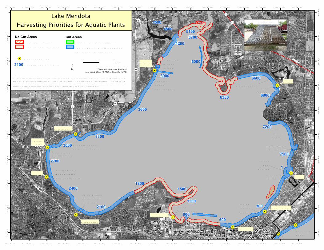
10' w id e c utter head(determ ines harv ested lane w id th)
Lake MendotaHarvesting Priorities for Aquatic Plants
Digital orthophoto from April 2014.Map updated Feb. 13, 2016 by Dane Co. LWRD.
Notes:Mapped areas are approxim ations and m ay not b e d raw n to scale. The w id th of the aquatic plant harv esters’ c utting head s (10 feet)determ ines the actual w id th of harvested lanes cut. As tim e and b ud g et perm it, harv esters cut plants for spec ial ev ents held on or inthe w ater; how ever event locations vary and are not m apped. Harvesting is not prohib ited in areas not m apped as "cut" or "no cut,"b ut they are typically not harv ested d ue to v ery m inimal nuisance plant g row th and b ud g et lim itations.
No Cut AreasMachinery HazardUnd eveloped S horeline
¹0 2,000 4,000Feet2100 P roperty Num b er Rang e
Rec reation and Nav ig ational andBeach Ac cess (P riority #2)
Cut AreasFlood Mitig ation (P riority #1)
!. Elev ator Location
")M