landslides and linear infrastructure in west-central ... · are large rock slides, some of which...
TRANSCRIPT
LANDSLIDES AND LINEAR INFRASTRUCTURE IN WEST-CENTRAL BRITISH COLUMBIA Marten Geertsema BC Forest Service, Prince George, BC Canada [email protected] James W. Schwab BC Forest Service, Smithers, BC Canada Andrée Blais-Stevens Geological Survey of Canada, Ottawa RÉSUMÉ
Les mouvements de terrain destructifs sont communs à l’ouest central de la Colombie-Britannique (C.-B.). Ces mouvements incluent des coulées et des glissements de débris, des coulées de terre et d’argiles, des chutes de blocs, des glissements et des avalanches rocheuses et des mouvements complexes impliquant la roche et le sol. Les pipelines, les lignes de transmission électrique, les routes et les chemins de fer ont tous été affectés par ces types de mouvements, perturbant le service aux communautés. Nous fournissons des exemples de mouvements destructifs, de leurs impacts, et des conditions climatiques liées aux glissements de terrain. Nous considérons également les aléas de glissements de terrain pour l'ouest central de la C.-B. sous certains scénarios du changement climatique.
ABSTRACT Destructive landslides are common in west central British Columbia (BC). Landslides include debris flows and slides, earth flows and flowslides, rock falls, slides, and avalanches, and complex landslides involving both rock and soil. Pipelines, hydro transmission lines, roads and railways have all been impacted by these landslides, disrupting service to communities. We provide examples of the destructive landslides, their impacts, and the climatic conditions associated with the failures. We also consider future landsliding potential for west central BC under climate change scenarios.
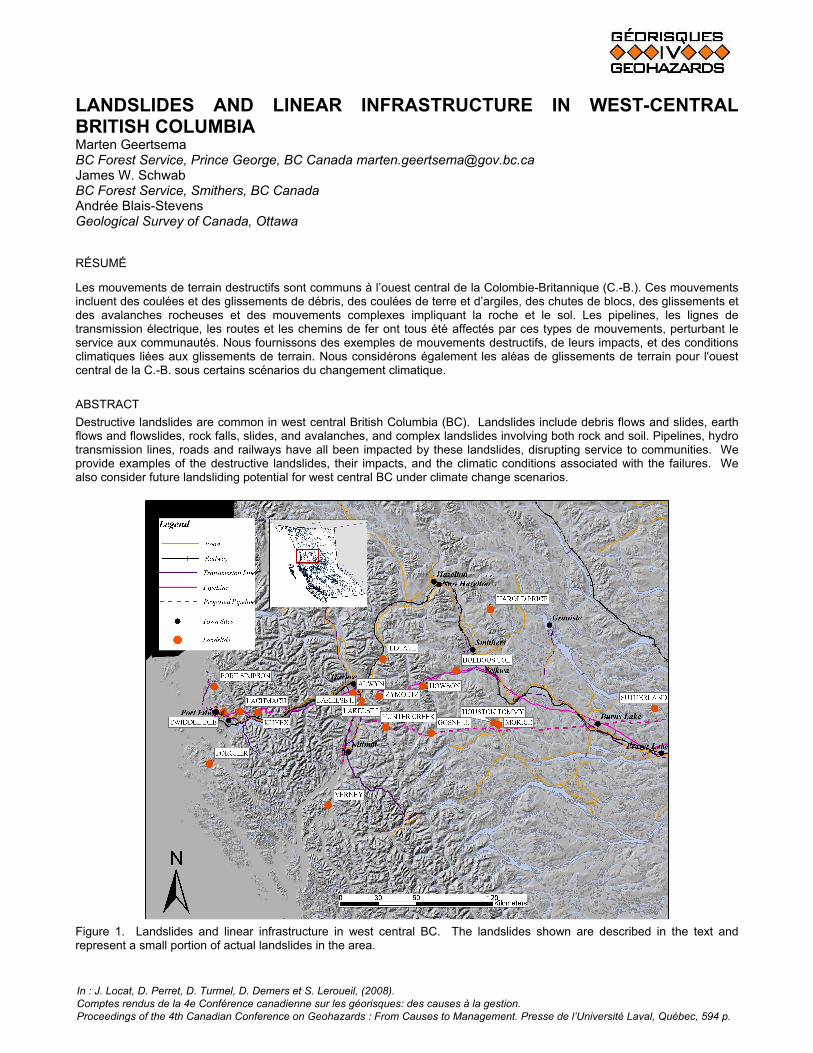
Figure 1. Landslides and linear infrastructure in west central BC. The landslides shown are described in the text and represent a small portion of actual landslides in the area.
In : J. Locat, D. Perret, D. Turmel, D. Demers et S. Leroueil, (2008). Comptes rendus de la 4e Conférence canadienne sur les géorisques: des causes à la gestion. Proceedings of the 4th Canadian Conference on Geohazards : From Causes to Management. Presse de l’Université Laval, Québec, 594 p.
1. INTRODUCTION West central British Columbia (BC) is a rugged, but sparsely populated portion of the province (Figure 1). Nevertheless the area hosts important transportation corridors, linking its communities and providing Canadian access to the Orient. Infrastructure includes roads, railways, hydro transmission lines, and hydrocarbon pipelines. The cities of Kitimat and Prince Rupert are important deep sea ports that are expected to undergo substantial growth to meet the needs of growing Asian economies. Recently, major oil pipelines have been proposed, connecting the North American network to a Pacific tidewater port at Kitimat. The purpose of this paper is to provide examples of various types of destructive landslides that impact linear infrastructure in west central BC. The list is by no means all-inclusive, and many more events have occurred that are not recorded here. We also consider the impact of projected climate change on the incidence of future landslides. 2. SETTING 2.1 Physiography The study area is located within the Coast, Hazelton and Skeena mountain ranges of northwestern British Columbia (Holland, 1976). These mountains are part of the northwest trending geological zones within the Canadian Cordillera called the Coast-Cascades Belt and the Intermontane Belt. The area consists of rugged mountains cut by deep valleys filled with glacial and post-glacial sediments. Most mountains have rounded, dome-like tops from glacial overriding with relatively uniform elevations varying between 1800-2400 m. Higher peaks, up to 2800 m, project as nunataks (Holland, 1976; Clague, 1984). 2.2 Climate and vegetation Topography strongly influences air temperature and precipitation in the area. Temperatures decrease with increasing elevation and distance inland. For example, in January, the mean coastal temperature at Prince Rupert (52 masl), is about 1.8ºC. In comparison, roughly 350 km in-land, in the Bulkley Valley at Smithers (515 masl), the mean temperature is about -10.5ºC. Moreover, mean July temperatures vary between 14-17 ºC in the valleys and decrease by several degrees in elevation (Clague, 1984). The predominant flow of moisture–laden air travels towards the east from the Pacific Ocean. Mean annual precipitation values for coastal mountains exceed 2500 mm and can be greater than 3500 mm in some areas. There is a marked decrease in precipitation towards the east. For example, in the Bulkley Valley, mean annual precipitation values range between 400-500 mm (Clague, 1984). The main valleys of the study area lie within the Coastal Western Hemlock and Sub-Boreal Spruce biogeoclimatic
zones. At higher elevations, the Mountain-Hemlock, Engelmann Spruce-Subalpine Fir and Alpine Tundra zones occur ( Meidinger and Pojar 1991). 2.3 Bedrock geology On the coast, the bedrock lies within the Coast-Cascades Belt and belongs to the Coast Plutonic Complex. It is mainly composed of Paleozoic to early Tertiary granitic rocks and Proterozoic to Paleozoic high-grade metamorphic rocks. Towards the east, the bedrock is part of the Intermontane Belt, which consists of sedimentary and volcanic rocks of Jurassic-Cretaceous age intruded by Cretaceous-early Tertiary felsitic to porphyritic plugs (Duffel and Souther 1964; Clague, 1984). 2.4 Surficial geology The surficial geology of the area was mapped and described by Clague (1984). During the last glaciation, approximately 15 ka BP, the area was covered by the Cordilleran Ice Sheet. The types of sediments deposited were mainly cobbly to bouldery tills. During glaciation, the weight of the ice sheet caused isostatic depression of the Earth’s crust. During deglaciation, (11-12ka BP), the crust slowly rebounded, but at a much slower rate than the melting of the ice sheet. This caused coastal river valleys to be inundated by marine waters. Glaciomarine sediments, mainly laminated silts and clays, were deposited as glaciers melted and retreated up the valleys. In areas where ice was at a standstill for an extended period of time (e.g., Terrace), deltaic sands and gravels were deposited. A dynamic interpretation of the kinematics of rock slides was not offered until 1932 (Heim, 1932, pp 126-136). Skermer’s translation noted “Since it is a question of finding the extreme limits of the imminent landslide, the energy line has to be drawn down from the highest point of the probable slide mass” (p. 130) However, “ the inclination of the straight line between the uppermost scarp edge and the tip of the tongue of the stationary rubble stream has long since been considered a characteristic factor for landslides”( p. 129) and ‘After several studies, I found the character of a rock avalanche could best be compared by using the angle of reach of the central stream line.” (p. 106). For the purposes of comparison, we, too, have used this angle, termed “the travel angle” by Cruden and Varnes (1996, Figure 3-7) in this paper. We remember that, in some cases, it is a conservative estimate of the peak travel angle first employed in 1911. The travel angle of the Frank Slide along profile 9 is 15.4°. 3. LANDSLIDE TYPES IMPACTING LINEAR
INFRASTRUCTURE Numerous types of landslides are common in the varied terrain of west central BC. We provide examples of a few of the landslides that have damaged linear infrastructure in the region, but also make reference to a number of significant landslides that have not damaged infrastructure. Included
M. Geertsema et al.
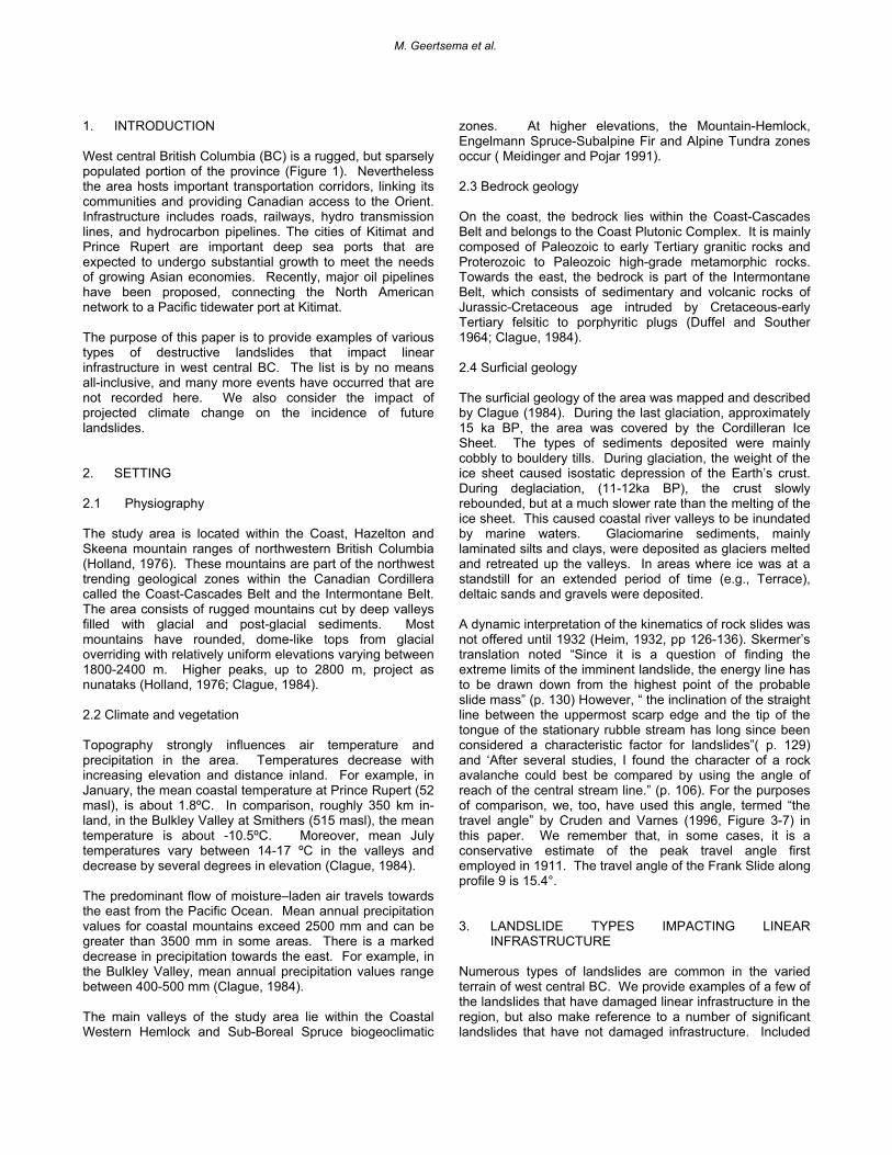
are large rock slides, some of which transformed into debris avalanches and/or flows, debris flows, debris slides, earth flows in glacial lake sediments and in fine textured colluvium, and flowslides in sensitive glaciomarine sediments. The locations of the described landslides are shown in Figure 1. The landslides damage infrastructure in two main ways. (1) Most commonly infrastructure is in the landslide runout zone and is struck by moving debris. (2) Occasionally infrastructure is placed on unstable ground and is moved suddenly or episodically as the main body (Cruden and Varnes 1996) of the landslide moves. Where rock slides, debris flows, and debris slides described here resulted in damage to infrastructure, it was always the result of the first case, where objects were struck by moving material. In contrast, earth flows and flowslides damaged infrastructure by carrying it along during movement. Landslides also can have varying causes and triggers. Examples of causes can be inherent weakness in material, valley deepening, glacial debuttressing, road construction, excavation etc. Triggers can be rainfall, snowmelt, site loading, seismic activity, etc. Shallow landslides such as debris slides and flows are often triggered by intense rainfall. Deep seated landslides such as large rock slides, earth flows and flowslides tend to have longer hydrological response times (Egginton 2005). 3.1 Rock slides Six large rock slides have occurred in west central BC since 1978, five of which occurred since 1999, and four since 2002. Three of the six rock slides severed a natural gas pipeline. All of the rock slides had relatively long runouts. The 1999 Howson rock slide (Figure 2a) occurred at 03:00 hours PDT on 11 September. The rock slide travelled 2.7 km, entraining till and colluvium. It ruptured the natural gas pipeline, and formed a lake. The initial rockslide involved 0.9 M m3 and the entrained volume is estimated to be 1.5 M m3 (Schwab et al 2003). The initial movement involved toppling and cliff collapse onto a glacier. The debris travelled over the glacier and entered a gully where it entrained soil and transformed into a debris flow. On 8 June, 2002, a rock slide involving 1.6 M m3 transformed into a debris flow, damming the Zymoetz River, and severing a natural gas pipeline (Figure 2b; Schwab et al. 2003; Boultbee et al. 2006). The landslide travelled 4.3 km. An estimated 0.5 M m3 of debris, including blocks up to 7 m in diameter, dammed the river, causing flooding 1.5 km upstream. Although the dam was overtopped almost immediately, it is still an obstruction to river flow. Access to a 3000 km2 basin was blocked for more than one year due to the flooding of a major Forest Service road.
Figure 2. Large, long runout rock slides in west central BC. See Figure 1 for locations. (A) The 1999 Howson rock slide entrained till and colluvium, severing a natural gas pipeline (1). Note the hydro transmission line (2) and the landslide dammed lake (3). (B) The 2002 Zymoetz rock slide transformed into a channelized debris flow, dammed the Zymoetz River, flooded an important Forest Service Road for more than a year, and ruptured a pipeline. The landslide traveled 4 km. (C) The 2002 Harold Price rock slide transformed into a debris avalanche and then into a channelized debris flow, traveling more than 4 km. (D) the 2002 Verney rock slide on the outer coast traveled 630 m. (E) The 2005 Sutherland rock slide transformed into a debris avalanche and traveled 1.6 km. Two other large rock slides occurred in west central BC in 2002, along with others elsewhere in the province (Geertsema et al. 2006a). The Harold Price and Verney landslides occurred near Smithers and southeast of Prince Rupert on the outer coast, respectively (Figure 1). The Harold Price landslide (Figure 2c) initiated in what appeared to be a rock glacier in a cirque basin sometime between 22 and 24 June. Interstitial ice was found in the main scarp. After travelling 1.3 km the rock slide transformed into a debris avalanche entraining till and colluvium. 2.2 km from the source the debris avalanche became channelized into a debris flow. The total travel distance of the landslide was 4 km. The volume is estimated to be 1.6 M m3. The Verney landslide (Figure 2d) is less precisely dated (Geertsema et al. 2006a). It probably initiated as a rockfall. The landslide travelled 630 m over a
Landslide and linear infrastructure in West-Central British Columbia
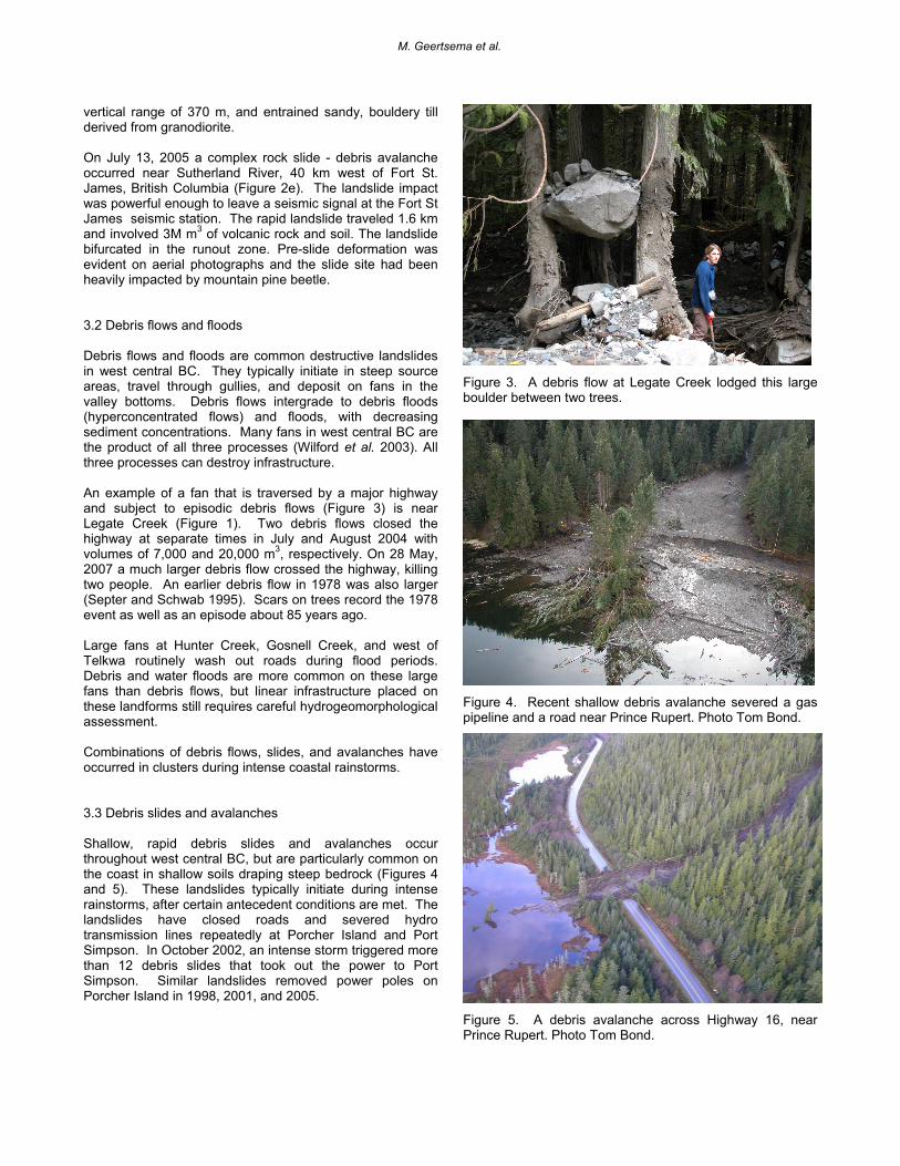
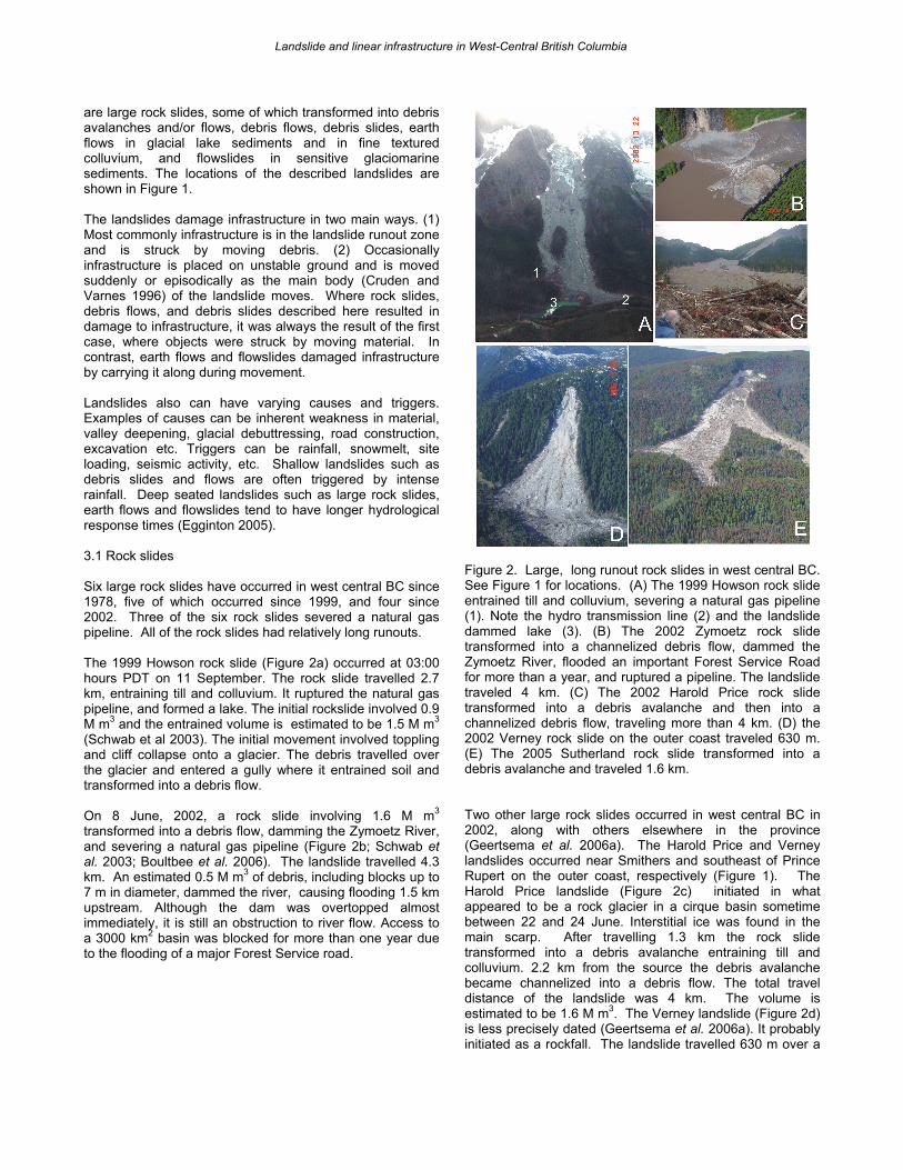
vertical range of 370 m, and entrained sandy, bouldery till derived from granodiorite. On July 13, 2005 a complex rock slide - debris avalanche occurred near Sutherland River, 40 km west of Fort St. James, British Columbia (Figure 2e). The landslide impact was powerful enough to leave a seismic signal at the Fort St James seismic station. The rapid landslide traveled 1.6 km and involved 3M m3 of volcanic rock and soil. The landslide bifurcated in the runout zone. Pre-slide deformation was evident on aerial photographs and the slide site had been heavily impacted by mountain pine beetle. 3.2 Debris flows and floods Debris flows and floods are common destructive landslides in west central BC. They typically initiate in steep source areas, travel through gullies, and deposit on fans in the valley bottoms. Debris flows intergrade to debris floods (hyperconcentrated flows) and floods, with decreasing sediment concentrations. Many fans in west central BC are the product of all three processes (Wilford et al. 2003). All three processes can destroy infrastructure. An example of a fan that is traversed by a major highway and subject to episodic debris flows (Figure 3) is near Legate Creek (Figure 1). Two debris flows closed the highway at separate times in July and August 2004 with volumes of 7,000 and 20,000 m3, respectively. On 28 May, 2007 a much larger debris flow crossed the highway, killing two people. An earlier debris flow in 1978 was also larger (Septer and Schwab 1995). Scars on trees record the 1978 event as well as an episode about 85 years ago. Large fans at Hunter Creek, Gosnell Creek, and west of Telkwa routinely wash out roads during flood periods. Debris and water floods are more common on these large fans than debris flows, but linear infrastructure placed on these landforms still requires careful hydrogeomorphological assessment. Combinations of debris flows, slides, and avalanches have occurred in clusters during intense coastal rainstorms. 3.3 Debris slides and avalanches Shallow, rapid debris slides and avalanches occur throughout west central BC, but are particularly common on the coast in shallow soils draping steep bedrock (Figures 4 and 5). These landslides typically initiate during intense rainstorms, after certain antecedent conditions are met. The landslides have closed roads and severed hydro transmission lines repeatedly at Porcher Island and Port Simpson. In October 2002, an intense storm triggered more than 12 debris slides that took out the power to Port Simpson. Similar landslides removed power poles on Porcher Island in 1998, 2001, and 2005.
Figure 3. A debris flow at Legate Creek lodged this large boulder between two trees.
Figure 4. Recent shallow debris avalanche severed a gas pipeline and a road near Prince Rupert. Photo Tom Bond.
Figure 5. A debris avalanche across Highway 16, near Prince Rupert. Photo Tom Bond.
M. Geertsema et al.
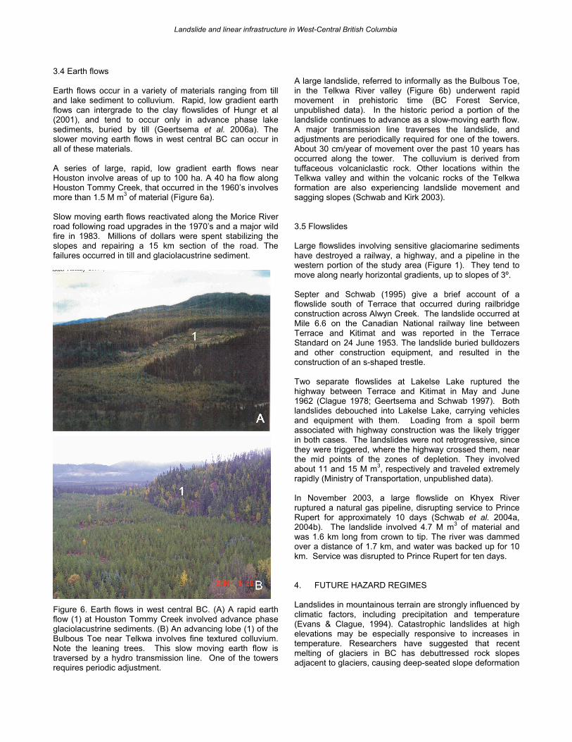
3.4 Earth flows Earth flows occur in a variety of materials ranging from till and lake sediment to colluvium. Rapid, low gradient earth flows can intergrade to the clay flowslides of Hungr et al (2001), and tend to occur only in advance phase lake sediments, buried by till (Geertsema et al. 2006a). The slower moving earth flows in west central BC can occur in all of these materials. A series of large, rapid, low gradient earth flows near Houston involve areas of up to 100 ha. A 40 ha flow along Houston Tommy Creek, that occurred in the 1960’s involves more than 1.5 M m3 of material (Figure 6a). Slow moving earth flows reactivated along the Morice River road following road upgrades in the 1970’s and a major wild fire in 1983. Millions of dollars were spent stabilizing the slopes and repairing a 15 km section of the road. The failures occurred in till and glaciolacustrine sediment.
Figure 6. Earth flows in west central BC. (A) A rapid earth flow (1) at Houston Tommy Creek involved advance phase glaciolacustrine sediments. (B) An advancing lobe (1) of the Bulbous Toe near Telkwa involves fine textured colluvium. Note the leaning trees. This slow moving earth flow is traversed by a hydro transmission line. One of the towers requires periodic adjustment.
A large landslide, referred to informally as the Bulbous Toe, in the Telkwa River valley (Figure 6b) underwent rapid movement in prehistoric time (BC Forest Service, unpublished data). In the historic period a portion of the landslide continues to advance as a slow-moving earth flow. A major transmission line traverses the landslide, and adjustments are periodically required for one of the towers. About 30 cm/year of movement over the past 10 years has occurred along the tower. The colluvium is derived from tuffaceous volcaniclastic rock. Other locations within the Telkwa valley and within the volcanic rocks of the Telkwa formation are also experiencing landslide movement and sagging slopes (Schwab and Kirk 2003). 3.5 Flowslides Large flowslides involving sensitive glaciomarine sediments have destroyed a railway, a highway, and a pipeline in the western portion of the study area (Figure 1). They tend to move along nearly horizontal gradients, up to slopes of 3º. Septer and Schwab (1995) give a brief account of a flowslide south of Terrace that occurred during railbridge construction across Alwyn Creek. The landslide occurred at Mile 6.6 on the Canadian National railway line between Terrace and Kitimat and was reported in the Terrace Standard on 24 June 1953. The landslide buried bulldozers and other construction equipment, and resulted in the construction of an s-shaped trestle. Two separate flowslides at Lakelse Lake ruptured the highway between Terrace and Kitimat in May and June 1962 (Clague 1978; Geertsema and Schwab 1997). Both landslides debouched into Lakelse Lake, carrying vehicles and equipment with them. Loading from a spoil berm associated with highway construction was the likely trigger in both cases. The landslides were not retrogressive, since they were triggered, where the highway crossed them, near the mid points of the zones of depletion. They involved about 11 and 15 M m3, respectively and traveled extremely rapidly (Ministry of Transportation, unpublished data). In November 2003, a large flowslide on Khyex River ruptured a natural gas pipeline, disrupting service to Prince Rupert for approximately 10 days (Schwab et al. 2004a, 2004b). The landslide involved 4.7 M m3 of material and was 1.6 km long from crown to tip. The river was dammed over a distance of 1.7 km, and water was backed up for 10 km. Service was disrupted to Prince Rupert for ten days. 4. FUTURE HAZARD REGIMES Landslides in mountainous terrain are strongly influenced by climatic factors, including precipitation and temperature (Evans & Clague, 1994). Catastrophic landslides at high elevations may be especially responsive to increases in temperature. Researchers have suggested that recent melting of glaciers in BC has debuttressed rock slopes adjacent to glaciers, causing deep-seated slope deformation
Landslide and linear infrastructure in West-Central British Columbia
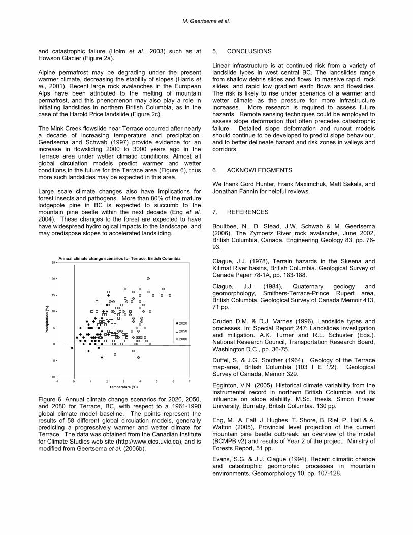
and catastrophic failure (Holm et al., 2003) such as at Howson Glacier (Figure 2a). Alpine permafrost may be degrading under the present warmer climate, decreasing the stability of slopes (Harris et al., 2001). Recent large rock avalanches in the European Alps have been attributed to the melting of mountain permafrost, and this phenomenon may also play a role in initiating landslides in northern British Columbia, as in the case of the Harold Price landslide (Figure 2c). The Mink Creek flowslide near Terrace occurred after nearly a decade of increasing temperature and precipitation. Geertsema and Schwab (1997) provide evidence for an increase in flowsliding 2000 to 3000 years ago in the Terrace area under wetter climatic conditions. Almost all global circulation models predict warmer and wetter conditions in the future for the Terrace area (Figure 6), thus more such landslides may be expected in this area. Large scale climate changes also have implications for forest insects and pathogens. More than 80% of the mature lodgepole pine in BC is expected to succumb to the mountain pine beetle within the next decade (Eng et al. 2004). These changes to the forest are expected to have have widespread hydrological impacts to the landscape, and may predispose slopes to accelerated landsliding.
Annual climate change scenarios for Terrace, British Columbia
-10
-5
0
5
10
15
20
25
-1 0 1 2 3 4 5 6 7
Temperature (ºC)
Prec
ipita
tion
(%)
2020
2050
2080
Figure 6. Annual climate change scenarios for 2020, 2050, and 2080 for Terrace, BC, with respect to a 1961-1990 global climate model baseline. The points represent the results of 58 different global circulation models, generally predicting a progressively warmer and wetter climate for Terrace. The data was obtained from the Canadian Institute for Climate Studies web site (http://www.cics.uvic.ca), and is modified from Geertsema et al. (2006b).
5. CONCLUSIONS Linear infrastructure is at continued risk from a variety of landslide types in west central BC. The landslides range from shallow debris slides and flows, to massive rapid, rock slides, and rapid low gradient earth flows and flowslides. The risk is likely to rise under scenarios of a warmer and wetter climate as the pressure for more infrastructure increases. More research is required to assess future hazards. Remote sensing techniques could be employed to assess slope deformation that often precedes catastrophic failure. Detailed slope deformation and runout models should continue to be developed to predict slope behaviour, and to better delineate hazard and risk zones in valleys and corridors. 6. ACKNOWLEDGMENTS We thank Gord Hunter, Frank Maximchuk, Matt Sakals, and Jonathan Fannin for helpful reviews. 7. REFERENCES Boultbee, N., D. Stead, J.W. Schwab & M. Geertsema (2006), The Zymoetz River rock avalanche, June 2002, British Columbia, Canada. Engineering Geology 83, pp. 76-93. Clague, J.J. (1978), Terrain hazards in the Skeena and Kitimat River basins, British Columbia. Geological Survey of Canada Paper 78-1A, pp. 183-188.
Clague, J.J. (1984), Quaternary geology and geomorphology, Smithers-Terrace-Prince Rupert area, British Columbia. Geological Survey of Canada Memoir 413, 71 pp. Cruden D.M. & D.J. Varnes (1996), Landslide types and processes. In: Special Report 247: Landslides investigation and mitigation. A.K. Turner and R.L. Schuster (Eds.). National Research Council, Transportation Research Board, Washington D.C., pp. 36-75.
Duffel, S. & J.G. Souther (1964), Geology of the Terrace map-area, British Columbia (103 I E 1/2). Geological Survey of Canada, Memoir 329.
Egginton, V.N. (2005), Historical climate variability from the instrumental record in northern British Columbia and its influence on slope stability. M.Sc. thesis. Simon Fraser University, Burnaby, British Columbia. 130 pp. Eng, M., A. Fall, J. Hughes, T. Shore, B. Riel, P. Hall & A. Walton (2005), Provincial level projection of the current mountain pine beetle outbreak: an overview of the model (BCMPB v2) and results of Year 2 of the project. Ministry of Forests Report, 51 pp.
Evans, S.G. & J.J. Clague (1994), Recent climatic change and catastrophic geomorphic processes in mountain environments. Geomorphology 10, pp. 107-128.
M. Geertsema et al.
Geertsema, M., J.J. Clague, J.W. Schwab & S.G. Evans (2006 a), An overview of recent large catastrophic landslides in northern British Columbia, Canada. Engineering Geology 83, pp.120-143. Geertsema, M., D.M. Cruden & J.W. Schwab (2006 b), A large rapid landslide in sensitive glaciomarine sediments at Mink Creek, northwestern, British Columbia, Canada. Engineering Geology 83, pp. 36-63. Geertsema, M. & J.W. Schwab (1997), Retrogressive flowslides in the Terrace-Kitimat, British Columbia area: From early post-deglaciation to present - and implications for future slides. Proceedings, 11th Vancouver Geotechnical Society Symposium, Vancouver, BC, pp. 115-133.
Geertsema, M & Torrance, J.K. (2005), Quick clay from the Mink Creek landslide near Terrace, British Columbia : Geotechnical properties, mineralogy, and geochemistry. Canadian Geotechnical Journal 42, pp. 907-918.
Harris, C., M.C.R. Davies & B. Etzelmüller (2001), The assessment of potential geotechnical hazards associated with mountain permafrost in a warming global climate. Permafrost and Periglacial Processes 12, pp. 145-156.
Holland S.S. (1976) Landforms of British Columbia. British Columbia Department of Mines and Petroleum Resources, Bulletin 48, 138 p.
Holm, K., M.J. Bovis, & M. Jakob (2004), The landslide response of alpine basins to post-Little Ice Age glacial thinning and retreat in southwestern British Columbia. Geomorphology 57, pp. 201-216.
Hungr, O. & S.G. Evans (2004), Entrainment of debris in rock avalanches; an analysis of a long run-out mechanism. Bulletin, Geological Society of America 116, pp. 1240–1252.
Hungr O., S.G. Evans, M. Bovis, & J.N. Hutchinson (2001) Review of the classification of landslides of the flow type. Environmental and Engineering Geoscience, 7:221-238.
Meidinger, D.V. & J.J. Pojar (1991), Ecosystems of British Columbia. B.C. Ministry of Forests Special Report Series, no. 6, 330 pp. Schwab, J.W., A. Blais-Stevens & M. Geertsema (2004), The Khyex River flowslide, a recent landslide near Prince Rupert, British Columbia. 57th Canadian Geotechnical Conference, Quebec City, Canada. 1C, pp. 14-21.
Schwab, J.W., M. Geertsema & A. Blais-Stevens (2004), The Khyex River landslide of November 28, 2003, Prince Rupert British Columbia, Canada. Landslides 1, pp. 243-246.
Schwab, J.W., M. Geertsema & S.G. Evans (2003), Catastrophic rock avalanches, west-central B.C., Canada. 3rd Canadian Conference on Geotechnique and Natural Hazards, Edmonton, AB, pp. 252-259. Schwab, J.W. & M. Kirk (2003), Sackungen on a forested slope, Kitnayakwa River. British Columbia Ministry of Forests, Prince Rupert Forest Region. Extension Note 47, 6 pp.
Septer, D. & J.W. Schwab (1995), Rainstorm and flood damage: Northwest British Columbia 1891-1991. B.C. Ministry of Forests, B.C. Land Management Report 31, 196 pp. Wilford, D.J., M.E. Sakals & J.L. Innes (2003), Forestry on fans; a problem analysis. Forestry Chronicle 79, pp. 291-296
Landslide and linear infrastructure in West-Central British Columbia

M. Geertsema et al.