land at chidswell interim transport assessment scoping note · scoping note project: a079758 –...
TRANSCRIPT
A079758 – Land at Chidswell, Dewsbury
1
Church Commissioners for England 21 April 2016
Scoping Note
PROJECT: A079758 – Land at Chidswell, Dewsbury
DATE: 21 April 2016
SUBJECT: Interim Transport Assessment (TA) Scoping Note
1.0 Introduction
1.1.1 WYG is retained by The Church Commissioners for England (the ‘Commissioners’) to provide
transport planning and highways consultancy advice in connection with proposals for a new
major strategic mixed-use residential and employment masterplan development at land
situated to the north-east of Chidswell, near Dewsbury, West Yorkshire (hereafter referred to
as ‘Land at Chidswell’, the ‘site’).
1.1.2 In 2013 WYG prepared a ‘Transport Feasibility Study and Sustainable Transport Strategy’
report presenting the outcomes of a comprehensive study, identifying the existing transport
characteristics of the Chidswell site and demonstrating that it is highly suitable for future
development from a transport and accessibility perspective. This work followed on from
previous technical work undertaken by Northern Transport Planning (NTP) in October 2012,
which included initial junction capacity testing.
1.1.3 More recently, WYG produced an ‘Accessibility and Connectivity Review’ technical note that
was submitted to Officers at Kirklees Council (KC) in January 2016, to support the site’s
allocation as a strategic development site, in the emerging Local Plan, as well as developing
various site access options.
1.1.4 Following recent discussions between WYG Planning colleagues and KC Officers, also in
January 2016, it is understood that KC have reviewed the abovementioned Accessibility and
Connectivity Review technical note (as part of the Client’s written representations to the
Council) and have requested further information.
1.1.5 As a result, the Council has recommended that WYG undertake an ‘Interim Transport
Assessment’ (‘Interim TA’), on behalf of the Commissioners, to further support the site’s
allocation and to provide KC Officers with sufficient technical evidence to support the
proposed site allocation at an Examination in Public (EIP), expected to take place later in
2016.
1.1.6 This Scoping Note sets out the proposed scope of the Interim TA. WYG would welcome the
opportunity to further discuss and agree the content of this Scoping Note and the proposed
scope of the Interim TA, through further engagement with KC Highways Officers, at the
earliest opportunity. WYG would also welcome the opportunity to enter into further
discussions with KC Highways Officers and their consultants, AECOM, with regards to

A079758 – Land at Chidswell, Dewsbury
2
Church Commissioners for England 21 April 2016
accessing and using the Kirklees SATURN strategic traffic model, to inform junction capacity
assessments.
1.1.7 Taking account of the recent ‘Accessibility and Connectivity Review’ technical note that
included up-to-date information with regards to baseline transport conditions, it is proposed
that the Interim TA focuses on the following key areas, some of which have not as yet been
considered in detail in the context of the current (2015) Concept Masterplan.
1.1.8 The remainder of this Scoping Note is structured as follows, which is consistent with the
proposed structure of the Interim TA:
• Site Location and Description;
• Development Proposals;
• Trip Generation Assessment;
• Traffic Assignment and Distribution;
• Traffic Modelling;
• Off-Site Highways Mitigation; and
• Sustainable Transport Strategy.
2.0 Site Location and Description
2.1.1 The site is located to the east of the A653 Leeds Road dual carriageway which is a strategic
corridor between Dewsbury and Leeds. In the immediate vicinity of the site, Leeds Road runs
in the north-south direction adjoining the A638 Wakefield Road in the south and Junction 28
(the Tingley Interchange) of the M62 Motorway to the north. In addition, the A638 Wakefield
Road links with the M1 Motorway Junction 40 to the east of the site.
2.1.2 The site extends to Hey Beck Lane to the north and Chidswell Lane to the south. Chidswell
Lane provides access back onto Leeds Road to the south-west of the site and to the B6128
Owl Lane, via Windsor Road, to the south. Owl Lane in turn connects to the A638 Wakefield
Road to the east, which connects to the M1 Junction 40, and heads towards Ossett to the
west.
2.1.3 To the east of the site there is land predominantly in agricultural uses.
2.1.4 A site location plan is provided in Figure 2.1.

A079758 – Land at Chidswell, Dewsbury
3
Church Commissioners for England 21 April 2016
Figure 2.1 Site Location Plan
3.0 Development Proposals
3.1.1 This Scoping Note has been written in the context of a Concept Masterplan for a mix of
residential and employment development, which was presented informally to KC Officers in
June 2015. It is noted that the previous three masterplan options, developed in 2012/2013,
are no longer current, nor is the KC Local Plan, referred to in the 2013 WYG ‘Transport
Feasibility Study and Sustainable Transport Strategy’ report, of which a replacement Local
Plan is currently being produced.
3.1.2 The current development parameters comprise the following, set out in Table 3.1.
Table 3.1 Concept Masterplan
Density (Dwellings per
Hectare)
Proposed Residential
Land (Hectare)
Approximate No. of
Dwellings
Proposed Employment
Land Area (Hectare)
Proposed Employment
Floor Area (m2)
35 43.37 1,535 35 122,500

A079758 – Land at Chidswell, Dewsbury
4
Church Commissioners for England 21 April 2016
3.1.3 With regards to the employment land use, it is expected that this will comprise a mix of
different Use Classes, such as Office (B1a), Light Industry (B1c), General Industry (B2) and
Storage and Distribution (B8). For the purpose of the Interim TA, it is proposed to assess a
single employment scenario, whereby the employment land use is split evenly between the
four abovementioned employment Use Classes. The proposed split between B1a, B1c, B2
and B8 Use Classes is set out in Table 3.2.
Table 3.2 Proposed Employment Split
Proposed Land Use
(Use Class)
Proposed Employment Land
Area (Hectare)
Proposed Employment Floor
Area (m2)
Proposed Employment Land
Coverage
Office (B1a) 8.75 30,625 25%
Light Industry (B1c) 8.75 30,625 25%
General Industry (B2) 8.75 30,625 25%
Storage and Distribution
(B8) 8.75 30,625 25%
Total 35.00 122,500 100%
4.0 Trip Generation Assessment
Overview
4.1.1 As part of the Interim TA, WYG will undertake a trip generation assessment using trip rates
derived from the industry-standard TRICS trip rate database. Modal splits will be derived
from Office for National Statistics (ONS) Census data for the local area (at ward level).
Following this, and given the scale of the concept masterplan, an allowance will be made for
trip internalisation (i.e. those trips which start and end within the masterplan site and
therefore will not impact on the transport networks external to the site), which is to be
agreed with KC Highways Officers.
4.1.2 For the purpose of the TRICS assessment, and the concept masterplan, it is assumed that the
residential dwelling land use will comprise a mix of privately-owned and affordable residential
dwellings. It is assumed for the purpose of the Interim TA that the mix of housing will
comprise 80% privately owned (open market) dwellings and 20% affordable dwellings,
although will need to be agreed at a later stage of the process.
4.1.3 Different trip rates and mode splits have been extracted for the private and affordable
residential land uses.
Proposed Trip Rates
4.1.4 An initial TRICS assessment has been undertaken in order to obtain trip rates for the various
proposed land uses. For the purpose of this assessment, multi-modal surveys were
interrogated within the TRICS database so that total person trips rates (by all modes) could
be extracted. The total person trips for the residential land uses is derived by multiplying the

A079758 – Land at Chidswell, Dewsbury
5
Church Commissioners for England 21 April 2016
relevant trip rate by the number of dwellings proposed; and for the employment land uses
will be derived by multiplying the relevant trip rate (per 100 square metres (m2)) by an
assumed floor area.
4.1.5 For the private and affordable residential trip rates, the following rules were applied during
the TRICS selection process:
• Survey sites located in East Midlands, West Midlands, Yorkshire & North
Lincolnshire and the North West regions only.
• Weekday (Monday – Friday) surveys only;
• Private residential survey sites ranging from 100 to 432 houses only;
• Affordable residential survey sites ranging from 15 to 280 houses only;
• Population within 1 mile restricted to 25,000 or less;
• Population within 5 miles restricted to 125,000 or less; and
• Edge of Town and Suburban Area sites only.
4.1.6 For the employment land uses, the following rules were applied during the TRICS selection
process:
• Survey sites located in East Anglia, East Midlands, West Midlands, Yorkshire &
North Lincolnshire, North West and the North regions only.
• Weekday (Monday – Friday) surveys only;
• B1 (a) Office sites ranging from 975 to 77,513m2 only;
• B1c/B2 General & Light industry sites ranging from 1,758 to 102,000m2 only;
• B8 Storage and Distribution sites ranging from 2,950 to 80,066m2 only;
• Population within 1 mile restricted to 25,000 or less;
• Population within 5 miles restricted to 125,000 or less; and
• Edge of Town and Suburban Area sites only.
4.1.7 Individual total person trip rates and trips for privately-owned and affordable dwellings, for
the AM and PM peak periods are set out in Table 4.1 and Table 4.2.
Table 4.1 Total Person Trip Rates and Person Trips (All Modes) – Residential
(Privately Owned)
Time Period Arrivals Departures Total
(Two-Way)
AM Peak Period (08:00-09:00) 0.20 0.64 0.83
PM Peak Period (17:00-18:00) 0.49 0.32 0.81
Trips (1,228 Units)
(80% of 1,535 Units)
246 786 1,019
602 393 995
Note: Arithmetic errors due to rounding.

A079758 – Land at Chidswell, Dewsbury
6
Church Commissioners for England 21 April 2016
Table 4.2 Total Person Trip Rates and Person Trips (All Modes) – Residential
(Affordable)
Time Period Arrivals Departures Total
(Two-Way)
AM Peak Period (08:00-09:00) 0.18 0.57 0.75
PM Peak Period (17:00-18:00) 0.39 0.31 0.70
Trips (307 Units)
(20% of 1,535 Units)
55 175 230
120 95 215
Note: Arithmetic errors due to rounding.
4.1.8 For the proposed employment land use, it is proposed that this could comprise a potential
mixture of four different employment uses. Therefore, the total person trip rates and trips for
the land uses; Office (B1a), Light Industry (B1c), General Industry (B2) and Storage and
Distribution (B8), are provided in Table 4.3. Agreement is sought from KC Highways Officers
on the acceptability of this.
Table 4.3 Total Person Trips Rates (All Modes) – Employment Land Uses
Employment
Land Use (Use Class)
Time Period Arrivals Departures Total
(Two-Way)
Office (B1a)
AM Peak Period
(08:00-09:00) 1.97 0.27 2.24
PM Peak Period
(17:00-18:00) 0.22 1.63 1.85
Trips (30,625m2) 441 83 686
67 499 567
Light Industry
(B1c) /
General
Industry (B2)
AM Peak Period
(08:00-09:00) 0.41 0.22 0.63
PM Peak Period
(17:00-18:00) 0.13 0.34 0.47
Trips (30,625m2) 125 67 192
40 104 144
Storage and
Distribution
(B8)
AM Peak Period
(08:00-09:00) 0.05 0.02 0.07
PM Peak Period
(17:00-18:00) 0.02 0.05 0.07
Trips (30,625m2) 15 6 21
6 15 21
Note: Arithmetic errors due to rounding.

A079758 – Land at Chidswell, Dewsbury
7
Church Commissioners for England 21 April 2016
Proposed Modal Splits
4.1.9 The modal split for the site is to be extracted from Census data, for the Dewsbury East Ward
(E05001398). The total person trips are to be applied to the modal split percentages to
determine the number of vehicle trips and other modes trips. It is proposed that different
modal splits will be applied to the residential and employment total person trips, based on
ONS Census ‘Method of Travel to Work’ resident and daytime population data respectively.
4.1.10 The residential census modal split is shown below in Table 4.4.
Table 4.4 Census Modal Split - Residential
Mode Census Modal Split
Driving a car or van 66%
Passenger in a car or van 8%
Public Transport 11%
Bicycle 12%
On foot 1%
Taxi/Other 2%
4.1.11 For the employment modal split, Census data was extracted for the Kirklees 014 ‘Middle Layer
Super Output Area’ (E02002284). Kirklees 014 was selected as the ‘Place of work’ and the
surrounding districts of Kirklees, Bradford, Leeds, Sheffield and Wakefield were selected as
the ‘Usual Residence’. The resulting employment modal spilt is shown in Table 4.5 below.
Table 4.5 Census Modal Split - Employment
Mode Census Modal Split
Driving a car or van 70%
Passenger in a car or van 10%
Public Transport 6%
Bicycle 2%
On foot 10%
Taxi/Other 2%
Residential Vehicle Trips
4.1.12 Based on the modal split shown above, the private and affordable residential elements of the
site are estimated to generate the following vehicle trips, as shown in Table 4.6.

A079758 – Land at Chidswell, Dewsbury
8
Church Commissioners for England 21 April 2016
Table 4.6 Residential Vehicle Trips
Residential Type Time Period
Arrivals Departures Total
(2-way)
Privately Owned
(1,228 Units)
AM Peak Period
(08:00-09:00) 162 519 681
PM Peak Period
(17:00-18:00) 397 259 656
Affordable
(307 Units)
AM Peak Period
(08:00-09:00) 36 116 152
PM Peak Period
(17:00-18:00) 79 63 142
Total (1,535 Units)
AM Peak Period
(08:00-09:00) 198 635 833
PM Peak Period
(17:00-18:00) 476 322 798
4.1.13 The privately owned residential element of the site is expected to generate 681 two-way
vehicles trips in the AM Peak and 656 two-way vehicle trips in the PM Peak. For the
affordable residential element of the site, this is expected to generate 152 two-way vehicle
trips in the AM Peak and 142 two-way vehicle trips in the PM Peak.
4.1.14 As a result, the overall residential element is expected to generate a total 833 two-way
vehicle trips in the AM Peak and 798 two-way vehicle trips in the PM Peak.
Employment Vehicle Trips
4.1.15 Based on the modal split shown above, the employment elements of the site are estimated to
generate the following vehicle trips (assuming the land uses are evenly split), as shown in
Table 4.7.
Table 4.7 Employment Vehicle Trips
Residential Type Time Period
Arrivals Departures Total
(2-way)
Office (B1a)
AM Peak Period
(08:00-09:00) 308 58 366
PM Peak Period
(17:00-18:00) 47 349 396
Light Industry (B1c) /
General Industry (B2)
AM Peak Period
(08:00-09:00) 88 47 135
PM Peak Period
(17:00-18:00) 28 73 101

A079758 – Land at Chidswell, Dewsbury
9
Church Commissioners for England 21 April 2016
Storage and Distribution
(B8)
AM Peak Period
(08:00-09:00) 11 4 15
PM Peak Period
(17:00-18:00) 4 11 15
Total (122,500m2)
AM Peak Period
(08:00-09:00) 407 109 516
PM Peak Period
(17:00-18:00) 79 433 512
4.1.16 The total employment element of the site has the potential to generate up to 516 two-way
vehicle trips in the AM Peak and 512 two-way vehicle trips in the PM Peak.
4.1.17 Thus, the total number of vehicle trips for the whole development has the potential to be up
to 1,349 two-way vehicle trips in the AM Peak and 1,310 two-way vehicle trips in the PM
Peak.
5.0 Traffic Assignment and Distribution
5.1.1 Following determination of the trip generation (including vehicular and non-vehicular trips) for
the proposed development, a traffic assignment and distribution exercise will be carried out.
Further to recent discussions with KC Highways Officers between January and March 2016, it
is proposed that, where possible, the Kirklees SATURN base model will be used to determine
the traffic assignment and distribution for the proposed development, based on existing
origin-destination information contained in the model for the immediate surrounding areas. If
necessary, ONS Census ‘Method of Travel to Work’ origin-destination data will be used to
supplement this. Different traffic distributors will be applied to residential and employment
trips based on resident and daytime population data respectively.
5.1.2 Traffic will be distributed onto the local and strategic highway networks via the proposed
points of access. It is proposed that the masterplan development will be accessed by four
points of access. The amount of traffic using each access will be determined by the expected
size of the junction and anticipated number of dwellings and/or quantum of employment land
use accessible via that access.
6.0 Traffic Modelling
Site Access Junctions
6.1.1 As noted above, it is proposed that there will be four points of access to the masterplan site,
including one point of access on Hey Beck Lane, two points of access on the A653 Leeds
Road, and one point of access on Chidswell Lane. WYG will undertake a junction capacity
assessment exercise to test the capacity of each access. The proposed site access junctions
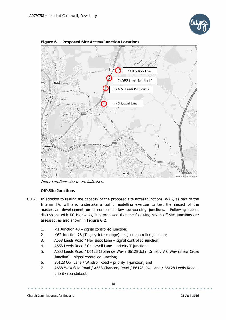
are indicatively shown in Figure 6.1.
A079758 – Land at Chidswell, Dewsbury
Church Commissioners for England
Figure 6.1 Proposed Site Access Junction Locations
Note: Locations shown are indicative
Off-Site Junctions
6.1.2 In addition to testing the capacity of the proposed site access junctions,
Interim TA, will also undertake a traffic modelling exercise to test the impact of the
masterplan development on
discussions with KC Highways, i
assessed, as also shown in
1. M1 Junction 40 –
2. M62 Junction 28
3. A653 Leeds Road / Hey
4. A653 Leeds Road / Chidswell
5. A653 Leeds Road / B6128 Challenge Way / B6128 John Ormsby V C Way (Shaw Cross
Junction) – signal controlled junction;
6. B6128 Owl Lane / Windsor Road
7. A638 Wakefield Road / A638 Chancery Road / B6128 Owl Lane / B6128 Leeds Road
priority roundabout.
Land at Chidswell, Dewsbury
10
Figure 6.1 Proposed Site Access Junction Locations
Note: Locations shown are indicative.
In addition to testing the capacity of the proposed site access junctions,
undertake a traffic modelling exercise to test the impact of the
development on a number of key surrounding junctions
discussions with KC Highways, it is proposed that the following seven off
shown in Figure 6.2.
– signal controlled junction;
(Tingley Interchange) – signal controlled junction;
A653 Leeds Road / Hey Beck Lane – signal controlled junction;
A653 Leeds Road / Chidswell Lane – priority T-junction;
A653 Leeds Road / B6128 Challenge Way / B6128 John Ormsby V C Way (Shaw Cross
signal controlled junction;
6128 Owl Lane / Windsor Road – priority T-junction; and
A638 Wakefield Road / A638 Chancery Road / B6128 Owl Lane / B6128 Leeds Road
priority roundabout.
1) Hey Beck Lane
2) A653 Leeds Rd (North)
3) A653 Leeds Rd (South)
4) Chidswell Lane
21 April 2016
In addition to testing the capacity of the proposed site access junctions, WYG, as part of the
undertake a traffic modelling exercise to test the impact of the
s. Following recent
off-site junctions are
ntrolled junction;
A653 Leeds Road / B6128 Challenge Way / B6128 John Ormsby V C Way (Shaw Cross
A638 Wakefield Road / A638 Chancery Road / B6128 Owl Lane / B6128 Leeds Road –

A079758 – Land at Chidswell, Dewsbury
Church Commissioners for England
Figure 6.2 Proposed Off
Standalone Junction Models
6.1.3 All junction capacity assessment will be by way of standalone junction models (i.e. ARCADY,
PICADY and LinSig), and
includes committed development traffic flows) from the
insufficiently robust baseline traffic data
commission a series of traffic surveys to determine current traffic conditions
including surveys of classified
undertake further investigations to determine commit
SATURN Traffic Model
6.1.4 Following a recent discussion between WYG and AECOM
AECOM is able to provide WYG with
two future year models (2020 and 2030). Following this initial discussion, it is understood
that the 2014 base model is informed by baseline traffic counts undertaken in 2014 and 2015
(with 2015 traffic flows factored back to 2014 levels), comprising a series of Automatic Traffic
Counts (ATCs) and Manual Classified Counts (MCCs) on links. It is understood that counts at
junctions were not undertaken, therefore to validate the abovementioned standalone j
5) A653 Leeds Road / B6128 Challenge Way / B6128 John Ormsby V C Way
(Shaw Cross Junction)
7) A638 Wakefield Road / A638 Chancery Road / B6128 Owl Lane /
Land at Chidswell, Dewsbury
11
Proposed Off-Site Junction Locations
Standalone Junction Models
unction capacity assessment will be by way of standalone junction models (i.e. ARCADY,
PICADY and LinSig), and, where possible, will utilise baseline traffic data (which it is assumed
includes committed development traffic flows) from the Kirklees SATURN m
baseline traffic data is contained within the model, WYG
commission a series of traffic surveys to determine current traffic conditions
classified turning counts, queue lengths and saturation flows
undertake further investigations to determine committed development traffic flows.
SATURN Traffic Model
Following a recent discussion between WYG and AECOM in April 2016, it is confirmed that
able to provide WYG with a copy of the Kirklees SATURN base model (2014) and
two future year models (2020 and 2030). Following this initial discussion, it is understood
that the 2014 base model is informed by baseline traffic counts undertaken in 2014 and 2015
flows factored back to 2014 levels), comprising a series of Automatic Traffic
Counts (ATCs) and Manual Classified Counts (MCCs) on links. It is understood that counts at
junctions were not undertaken, therefore to validate the abovementioned standalone j
1) M1 Junction 40
2) M62 Junction 28 (Tingley Interchange)
3) A653 Leeds Road / Hey Beck Lan
4) A653 Leeds Road / Chidswell Lane
6) B6128 Owl Lane / Windsor Road
Leeds Road / B6128 Challenge Way / B6128 John Ormsby V C Way
(Shaw Cross Junction)
7) A638 Wakefield Road / A638 Chancery Road / B6128 Owl Lane /
B6128 Leeds Road
21 April 2016
unction capacity assessment will be by way of standalone junction models (i.e. ARCADY,
will utilise baseline traffic data (which it is assumed
SATURN model. If
model, WYG will also need to
commission a series of traffic surveys to determine current traffic conditions (potentially
gths and saturation flows) and
ted development traffic flows.
, it is confirmed that
a copy of the Kirklees SATURN base model (2014) and
two future year models (2020 and 2030). Following this initial discussion, it is understood
that the 2014 base model is informed by baseline traffic counts undertaken in 2014 and 2015
flows factored back to 2014 levels), comprising a series of Automatic Traffic
Counts (ATCs) and Manual Classified Counts (MCCs) on links. It is understood that counts at
junctions were not undertaken, therefore to validate the abovementioned standalone junction
1) M1 Junction 40
(Tingley Interchange)
ne

A079758 – Land at Chidswell, Dewsbury
12
Church Commissioners for England 21 April 2016
models, WYG may need to commission traffic surveys at the seven off-site junction locations,
to obtain queue lengths and saturation flows. A further discussion setting out data
requirements is presented further on within this technical note.
Modelling Scenarios
6.1.5 Following recent discussions with KC Highways Officers, it proposed that WYG will test a base
year scenario, without masterplan development traffic, using baseline traffic data extracted
from the Kirklees SATURN model and/or baseline traffic survey data; and two further future
assessment year scenarios, with and without the masterplan development traffic. As noted
above, it is understood that the existing base year from the SATURN model is 2014. For the
purpose of the standalone junction models, and so that observed traffic queues and
saturation flows can be used to validate the standalone base models, it is proposed that the
base year for the standalone junction models is 2016. Baseline traffic data from 2014, as
contained in the SATURN base model, will be factored up to 2016 levels using agreed
TEMPRO traffic growth rates.
6.1.6 Should standalone junction surveys be required, for example to obtain additional classified
turning counts, queue lengths and saturation flows, these would inform the 2016 base year.
6.1.7 KC Highways has also requested that the standalone junction models are tested in two future
years. It is proposed that, given the SATURN model has future assessment years of 2020
and 2030, these years also to be used for the standalone models. WYG will seek to reach
agreement with KC Officers regarding the levels of masterplan development expected to be
delivered in the 2020 future assessment year, which is dependent on proposed ‘build-out’
rates. For the 2030 future assessment year, WYG will test the full 1,535 residential dwellings
and 122,500m2 employment land uses.
6.1.8 WYG would welcome the opportunity to reach agreement on the above with KC Highways
officers at the earliest opportunity.
Data Requirements
6.1.9 In order to carry out and complete the standalone junction modelling, as set out above, WYG
will require the following information, some of which, it is assumed, will be made available by
KC Highways Officers:
• Kirklees SATURN base model and future year models (assumed to contain junction
turning counts and link flows, plus future year committed development flows) – to be
supplied by AECOM on behalf of KC Highways;
• Kirklees SATURN model Local Model Validation Report (LMVR) – already supplied by
KC Highways;
• Signal timing data for the following signal controlled junctions to be assessed:
• M1 Junction 40 – to be supplied by KC Highways or Highways England (HE);
• M62 Junction 28 (Tingley Interchange) – to be supplied by KC Highways or HE;
• A653 Leeds Road / Hey Beck Lane – to be supplied by KC Highways; and
• A653 Leeds Road / B6128 Challenge Way / B6128 John Ormsby V C Way
(Shaw Cross Junction) – to be supplied by KC Highways.

A079758 – Land at Chidswell, Dewsbury
13
Church Commissioners for England 21 April 2016
• ‘As built’ junction layout drawings, where available – otherwise OS base mapping
together with on-site observations will be used to build standalone junction models.
7.0 Off-Site Highways Mitigation
7.1.1 Following the outcome of the above tasks, WYG will identify any potential off-site highways
improvements that will be required to mitigate the impact of the development on the
surrounding highway network, at the modelled off-site junctions, for the agreed future year.
As this will be informing an Interim TA (rather than a Final TA to accompany a planning
application) it is considered that any mitigation identified would be for information only (and
not necessarily the final mitigation) and would be to simply demonstrate that the predicted
impact of the development could be mitigated.
8.0 Sustainable Transport Strategy
8.1.1 WYG will develop the ‘sustainable transport strategy’ included in its original 2013 ‘Transport
Feasibility Study and Sustainable Transport Strategy’ report to reflect current public transport,
walking and cycling conditions and proposed improvements to transport infrastructure
(including proposed improvements to the A653 Leeds Road corridor) in future years, where
known. The purpose of this strategy would seek to identify the potential for reducing the
number of car-based trips onto the surrounding highway network through transferring trips
onto other modes, for example, to reduce the potential impact of the development on the
surrounding road networks.
9.0 Summary of Key Points
9.1.1 WYG is retained by The Church Commissioners for England (the ‘Commissioners’) to provide
transport planning and highways consultancy advice in connection with proposals for a new
major strategic mixed-use residential and employment masterplan development at land
situated to the north-east of Chidswell, near Dewsbury, West Yorkshire (‘Land at Chidswell’,
the ‘site’).
9.1.2 This Scoping Note sets out the proposed scope of an Interim TA, the purpose of which will be
to further inform KC Officers and to ensure they have sufficient technical evidence to support
the proposed site allocation at an Examination in Public (EIP), expected to take place later in
2016. WYG would welcome the opportunity to further discuss and agree the content of this
Scoping Note and the proposed scope of the Interim TA, through further engagement with KC
Highways Officers, at the earliest opportunity.
9.1.3 WYG would also welcome the opportunity to continue discussions with KC Highways Officers
and their consultants with regards to accessing and using the Kirklees SATURN strategic
traffic model, to inform junction capacity assessments.

14
Church Commissioners for England 21 April 2016