land administration and its impact on economic …...brothers ganga, jhalak and deepak and...
TRANSCRIPT

REAL ESTATE AND PLANNING, HENLEY BUSINESS SCHOOL
Land Administration and Its Impact on Economic Development
A thesis submitted to the fulfillment of the requirements for the degree of Doctor of Philosophy
Gandhi Prasad Subedi
April, 2016

i
Declaration
I confirm that this is my own work and the use of all material from other sources has been
properly and fully acknowledged.
.............................................
Gandhi Prasad Subedi
April, 2016

ii
Abstract
This thesis investigates the relationship between land administration and economic
development. More specifically, it assesses the role of land tenure security in productivity
and that of land administration services in revenue generation. The empirical part of the
study was undertaken in Nepal, Bangladesh and Thailand. A mixed method approach was
employed for data collection, analysis and interpretation. The information was gathered
using questionnaires, interviews, observations, informal discussions and documentation
analysis.
This study demonstrates that land administration plays a crucial role in providing security
of land tenure. It also evidences that the use value, collateral value and exchange value of
land is increased after registration which has benefitted the occupation, investment and
finance sectors of the case study economies. Specifically, it was found that land use
activity became more productive. With regard to financial services, banks more readily
accepted land as loan security for debt finance and did so at an interest rate that was
lower than that offered by private lenders. Land-related investment and income also
increased and these effects are found to be positively correlated with tenure security.
However, access to credit is not enough to increase investment unless it is communicated
properly.
This study demonstrates that quality of land administration services affects on tenure
security and revenue generation. Poor land administration, improper land valuation and
inefficient and unscrupulous employees threaten tenure security and reduce the amount
of revenue that can be generated from land. The establishment of land administration
systems and security of land tenure is beneficial for the government as it supports
economic development by increasing production and generating revenue to some extent.
It may also enhance efficient use of scarce resources, increase household income and play
an important role in maintaining distributive justice and reducing poverty. The findings of
this study indicate a need for further research on the contribution of land administration
in the real estate sector as well as changes to the livelihoods of civilians.

iii
Acknowledgement
At the moment of completing my dissertation, I dearly extend my thanks to everyone
who have supported financially and morally, shared information and devoted their
valuable time during my study. My first and foremost acknowledgement goes to Henley
Business School, University of Reading for providing financial support for this research
and the Government of Nepal for approving my study leave and allowing me study here. I
am also thankful to the Royal Institute of Chartered Surveyors, UK and Cushman and
Wakefield for funding my fieldwork.
I would like to express my profound gratitude to my supervisors Prof. Peter Wyatt and the
late Prof. Peter Byrne for accepting my proposal and providing an expert supervision of
my research. I am especially indebted to Prof. Wyatt for reading my numerous revisions
and guiding me throughout my study. I would like to thank him for his support in finding
funding during my stay and field work and also for giving me an opportunity to give some
tutorials to the MSc students. I highly appreciate the supervisory contribution of the late
Prof. Byrne as well.
I am thankful to the staff of Henley Business School, particularly Dr. Gianluca Marcato, Dr.
Angelique Chettiparamb, Dr. Anupam Nanda and Dr. Tommaso Gabrieli for their support
and encouragement. I am equally thankful to Ms. Mary Williams, Ms. Caroline Breede,
Ms. Katie Brincat, Ms. Helen Clark, Ms. Nicole Gilham and Mr. Phill as well.
I am highly indebted to many informants from Nepal, Bangladesh and Thailand who
shared their views without which this research could not have been completed. I would
like to express my sincere thanks to the residents of Chulachuli and Gharinda for their
warm hospitality and valuable information. I am equally indebted to those key informants
who shared their experience and knowledge from which I became able to shape my
research; particularly, Mr. Lila Mani Joshi, Mr. Jeet Bahadur Thapa, Mr. Madhu Sudan
Adhikari, Mr. Drona Pokharel, Mr. Bhesh Raj Lohani, Mr. Suvash Ghimire, Mr. Revati
Dhakal, Mr. Thakur Prasad Niraula and Mr. Kiran Bhattarai from Nepal, Mr. Shamsul Huda
and Ms. Khushi Kabir from Bangladesh and Ms. Wanna Rakayo, Ms. Somying
Soontoonwong and Mr. Teetat from Thailand.

iv
I am indebted to Assistant Prof. Masud Ibn Rahman, Head, Real Estate Department and
Prof. Rafiqul Islam, Dean, Faculty of Business and Economics, Daffodil University Dhaka
for their warm hospitality and support during my field visit in Dhaka. I would like to wish
my gratitude to those without whose support it would be very complicated to collect
required data. I am highly indebted to Prof. Arefin Siddique and Prof. Abul Bakrat for their
support. My special thanks goes to Mr. Bijaya Adhikari, Mr. Hem Sharma, Mr. Amrit
Khanal, Mr. Farhan Uddin Khan, Mr. Md. Tamzid Siddique and Mr. Kishan Neupane and
Ms. Chinnapan Charoenkalunyuta, Ms. Natchaya Patwichaichoat, Ms. Piyanute Kotsan,
Ms. Ratchanee and Mr. Gosh for their efforts and time contributed to support my field
work without which I could not carry out my fieldwork smoothly. I am also thankful to Mr.
Ganesh Bhatta, Mr. Kamal Timilsina, Mr. Shiva Lamsal, Mr. Prakash Acharya, Mr. Gopal
Giri, Mr. Ramesh Gyawali, Mr. Dina Bandhu Subedi, Mr. Pitambar Bhandari, Mr. Basu Dev
Adhikari, Mr. Suman Aryal, Mr. Rajesh Shah, Mr. Leo Dewri, Mr. Anil Chaudhari, Mr. Abu
Talib Khan, Ms. Man Rupa Rai, Mr. Dhan Bahadur Phago, Mr. Abhi Narayan Khanal and
Mr. Niraj Adhikari.
I wish to express my appreciation to Dr. Bharat Devkota for his guidance and
encouragement during my research. I am also thankful to Dr. Keshav Bhattarai, Dr.
Krishna Adhikari, Dr. Hari Timilsina, Dr. Ganga Dahal and Mr. Dinesh Gurung helped in
some ways. I would like to thank Mrs Maggie Sanderson for her help in copy-editing and
proofreading my thesis.
I am indebted to my mother Sharada and father Bhuwani Shankar for allowing me to
come to study and being a continuous source of inspiration. My sincere thanks goes to my
brothers Ganga, Jhalak and Deepak and sister-in-laws Hari, Laxmi and Shanti for taking
care of my parents and encouraging me to continue study. I am grateful to Mr. Bishwo
Adarsha Pandit, Mr. Krishna Gurung, Mr. Bhuvaneshwar Paudel, Mr. Ram Bhattarai and
Mr. Basant Thapa who always inspired me for my study.
I extend my sincere thanks to my wife Sita Subedi, for her hard work to fulfil the financial
needs and her moral support at difficult times without which this study would remain
incomplete. I highly appreciate my son Aavash and daughter Sindhiya for their affection
and patience throughout this study.

v
Table of Contents
Declaration .................................................................................................................... i
Abstract ........................................................................................................................ ii
Acknowledgement ....................................................................................................... iii
Table of Contents .......................................................................................................... v
List of Appendices ...................................................................................................... viii
List of Tables ................................................................................................................ ix
List of Figures ................................................................................................................ x
List of Boxes ................................................................................................................. xi
List of Maps ................................................................................................................. xi
List of Photos ............................................................................................................... xi
Abbreviations ............................................................................................................. xii
Glossary ..................................................................................................................... xiii
Chapter 1: Introduction ................................................................................................. 1
1.1 Introduction.................................................................................................................. 1
1.2 Research Context ......................................................................................................... 4
1.3 Research Problem, Research Aim and Rationale of Study ........................................... 7
1.3.1 Research Problem ............................................................................................. 7
1.3.2 Research Aims, Objectives and Research Questions ....................................... 9
1.3.3 Rationale and Significance of the Research ................................................... 10
1.4 Conceptual Framework .............................................................................................. 12
1.5 Research Methodology .............................................................................................. 14
1.6 Structure of the Thesis ............................................................................................... 17
Chapter 2: Land Administration and Its Interaction ...................................................... 19
2.1 Introduction................................................................................................................ 19
2.2 Land, Property Rights and Their Administration ........................................................ 19
2.2.1 Land and Property .......................................................................................... 19
2.2.2 Property Rights ............................................................................................... 23
2.2.3 Administration of Property Rights .................................................................. 25
vi
2.3 Functions and Practices of Land Administration........................................................ 28
2.3.1 Functional Components ................................................................................. 28
2.3.2 Land Administration Practices ........................................................................ 32
2.4 Land-Based Economic Development: Theoretical Underpinnings ............................ 39
2.4.1 Conceptualisation of Land in Economic and Development Theories ............ 39
2.4.2 Land Administration as a Means for Economic Development ....................... 42
2.4.3 Land Tenure Security and Economic Performance ........................................ 45
2.4.4 Implications of Theoretical and Empirical Studies ......................................... 54
2.5 Issues Under Investigation ......................................................................................... 55
2.6 Summary .................................................................................................................... 59
Chapter 3: Case Study Design and Research Methodology ........................................... 61
3.1 Introduction................................................................................................................ 61
3.2 Research Approach and Strategy of Inquiry .............................................................. 61
3.3 Case Study Areas ........................................................................................................ 67
3.4 Field Study Procedures ............................................................................................... 75
3.4.1 Logistical Arrangement, Initial Meetings and Preparation ............................ 75
3.4.2 Data Collection ............................................................................................... 78
3.4.3 Data Recording and Management ................................................................. 87
3.4.4 Data Presentation, Analysis and Interpretation ............................................. 87
3.4.5 Unit of Analysis and Measurement of Variables ............................................ 90
3.5 Research Issues .......................................................................................................... 92
3.5.1 Research Quality ............................................................................................. 92
3.5.2 Ethical Issues ................................................................................................... 93
3.5.3 Reflection on the Field Study.......................................................................... 95
3.5.4 Limitations of the Case Studies ...................................................................... 98
3.6 Summary .................................................................................................................... 98
Chapter 4: Practices of Land Administration in Nepal, Bangladesh and Thailand ........ 100
4.1 Introduction.............................................................................................................. 100
4.2 General Background ................................................................................................. 100
4.3 Land Tenure and Access to Land .............................................................................. 105
vii
4.3.1 Nepal ............................................................................................................. 105
4.3.2 Bangladesh ................................................................................................... 112
4.3.3 Thailand ........................................................................................................ 116
4.4 Land Administration System .................................................................................... 118
4.4.1 Legal Framework .......................................................................................... 118
4.4.2 Organisation Structure ................................................................................. 120
4.4.3 Land Registration .......................................................................................... 127
4.4.4 Cadastral Surveying ...................................................................................... 133
4.4.5 Property Valuation ....................................................................................... 136
4.5 Summary .................................................................................................................. 137
Chapter 5: Tenure Security and Its Economic Outcomes ............................................. 139
5.1 Introduction.............................................................................................................. 139
5.2 Land Registration and Tenure Security .................................................................... 139
5.3 Economic Outcomes of Tenure Security .................................................................. 143
5.3.1 Land Use and Economic Activities ................................................................ 143
5.3.2 Land Value .................................................................................................... 147
5.3.3 Access to Credit and Investment .................................................................. 154
5.3.4 Income .......................................................................................................... 161
5.4 Summary .................................................................................................................. 167
Chapter 6: Assessment of Land Administration Services and Their Role in Revenue Generation ............................................................................................................... 170
6.1 Introduction.............................................................................................................. 170
6.2 Effectiveness of Land Administration Services ........................................................ 170
6.2.1 Land Registration .......................................................................................... 170
6.2.2 Record Management and Information Dissemination ................................. 182
6.2.3 Land Valuation .............................................................................................. 186
6.2.4 Revenue Collection ....................................................................................... 191
6.3 Justification for Establishing Land Administration Organisations............................ 199
6.4 Summary .................................................................................................................. 202
Chapter 7: Conclusion ............................................................................................... 205
7.1 Introduction.............................................................................................................. 205

viii
7.2 Summary of Findings ................................................................................................ 205
7.2.1 Land Administration and Tenure Security .................................................... 205
7.2.2 Land Use and Economic Activities Promoted by Land Administration ........ 207
7.2.3 Role of Tenure Security on Land Value, Access to Credit, Investment and Income .......................................................................................................... 208
7.2.4 Assessment of Land Administration Services and Their Effectiveness ........ 210
7.3 Reflections on the Theoretical Framework .............................................................. 213
7.4 Contribution to Knowledge ...................................................................................... 214
7.5 Implications for Policy and Practices........................................................................ 216
7.6 Limitations of Research ............................................................................................ 217
7.7 Scope for Further Research ...................................................................................... 219
References ..................................................................................................................... 220
List of Appendices
Appendix 1: Survey Questionnaire................................................................................237
Appendix 2: Information Sheet....................................................................................241
Appendix 3: Consent Form..........................................................................................244
Appendix 4: Key Issues and Checklist for Interview.....................................................243
Appendix 5: List of Interviewee and Discussants.........................................................244
Appendix 6: Interview Protocol....................................................................................247
Appendix 7: Observation Protocol................................................................................248
Appendix 8: Land Related Laws Reviewed in the Thesis.....………………………..……….......250
ix
List of Tables
Table 3-1: Relevant situations for different research strategies ......................................... 64
Table 4-1: Selected macro indicators for Nepal, Bangladesh and Thailand ...................... 102
Table 4-2: Area under various forms of land tenure in Nepal in 1952 .............................. 108
Table 4-3: Agricultural land holdings in Nepal from 1961/62 to 2001/02 ........................ 111
Table 4-4: Status of Khas land and its distribution in Bangladesh .................................... 115
Table 4-5: Registering property in Nepal, Bangladesh and Thailand ................................ 133
Table 5-1: Property rights before and after registration of land ....................................... 140
Table 5-2: Risks on properties before and after registration of land ................................ 141
Table 5-3: Land use before and after registration as a proportion of respondents ......... 143
Table 5-4: Land related activities as a proportion of respondents ................................... 145
Table 5-5: Average land value in Nepal as a proportion of respondents .......................... 148
Table 5-6: Average land value in Bangladesh as a proportion of respondents ................. 149
Table 5-7: Correlation between tenure security and land value ....................................... 149
Table 5-8: Paired sample statistics of land value before and after registration ............... 150
Table 5-9: Paired samples test of land value before and after registration ...................... 151
Table 5-10: Minimum valuation of land before and after registration (in rupees per kattha) ............................................................................................................... 153
Table 5-11: Interest rate while borrowing from the private lenders ................................ 155
Table 5-12: Average investment in Nepal as a proportion of respondents ...................... 157
Table 5-13: Average investment in Bangladesh as a proportion of respondents ............. 158
Table 5-14: Correlation between tenure security and investment ................................... 158
Table 5-15: Paired sample statistics of investment before and after registration ............ 159
Table 5-16: Paired sample test of investment before and after registration ................... 160
Table 5-17: Average income in Nepal as a proportion of respondents............................. 162
Table 5-18: Average income per kattha in Bangladesh as a proportion of respondents .. 164
Table 5-19: Correlation between tenure security and income ......................................... 164
Table 5-20: Paired sample statistics of income before and after registration .................. 165
Table 5-21: Paired sample tests of income before and after registration ........................ 166
Table 6-1: Time taken to get land administration services in Nepal and Bangladesh ...... 176
Table 6-2: Transaction costs, Nepal ................................................................................... 179
Table 6-3: Transaction costs, Bangladesh .......................................................................... 180
x
List of Figures
Figure 1-1: Relationship between land administration and political objectives ................... 3
Figure 1-2: Conceptual framework ...................................................................................... 14
Figure 1-3: Research framework.......................................................................................... 16
Figure 2-1: Humankind-land relationship ............................................................................ 26
Figure 2-2: Land management paradigm ............................................................................ 43
Figure 3-1: Case study method ............................................................................................ 67
Figure 4-1: GDP from agricultural sector in Nepal from 1974/75 to 2003/04 .................. 103
Figure 4-2: Agriculture value added in Bangladesh from 1960 to 2013 ............................ 104
Figure 4-3: Agricultural value added in Thailand from 1975 to 2011 ................................ 105
Figure 4-4: Interrelationship among different forms of land tenure practiced in Nepal .. 109
Figure 4-5: Structure of land administration organisations of Nepal ................................ 121
Figure 4-6: Structure of land administration organisations of Bangladesh ...................... 123
Figure 4-7: Structure of land administration organisations of Thailand ........................... 126
Figure 4-8: Process of land registration in Nepal, Bangladesh and Thailand .................... 129
Figure 6-1: Registration fee collected in Nepal from 1974/75 to 2009/2010 ................... 192
Figure 6-2: Contribution of registration fee to revenue and expenditure in Nepal .......... 193
Figure 6-3: Registration fee and stamp duty collected in Bangladesh in different time periods ............................................................................................................ 195
Figure 6-4: Registration of transactions and revenue collection in Thailand from 1985 to 2010 ................................................................................................................ 196
Figure 6-5: Land tax collected in Nepal from 1974/75 to 1995/96 ................................... 198
Figure 6-6: Land tax collected in Bangladesh .................................................................... 199
Figure 7-1: Land administration and economic development .......................................... 214

xi
List of Boxes
Box 5-1: Statement on increase in land value after registration of land .......................... 152
Box 5-2: Statement of a farmer about changes on investment and income .................... 163
Box 6-1: Researcher's observation on registration process of Nepal, Bangladesh and Thailand ............................................................................................................... 172
Box 6-2: Experience of an interviewee about time taken to get services from Land Revenue Office in Nepal ...................................................................................... 177
Box 6-3: Cases comparing land value determined by the government with the market value..................................................................................................................... 188
List of Maps
Map 3-1: Map of Chulachuli VDC, Ilam, Nepal .................................................................... 70
Map 3-2: Map of Bagladesh and Tangail sub-district showing the case study area ........... 72
Map 3-3: Map of Thailand showing Nonthaburi Province, Thailand................................... 75
List of Photos
Photo 3-1: Administering survey questionnaires in Chulachuli, Nepal ............................... 83
Photo 3-2: Participating in a seminar organised by Daffodil University, Dhaka ................. 85
Photo 5-1: Tailoring training centre (left) and mushroom farming (right) in Bangladesh 146
Photo 5-2: Peasants harvesting rice (left) and ploughing land (right) in Nepal ................ 146
Photo 6-1: Clients waiting to register their land in Land Revenue Office, Ilam (lower left), Land Registry Office, Tangail (lower right) and Provincial Land Office, Pak Kret (upper both) ...................................................................................................... 173
Photo 6-2: Citizens charters at the land registries in Ilam (upper left), Tangail (upper right) and Pak Kret (middle right), sample of application in Pak Kret (middle left) and information desk in Pak Kret (lower) ................................................................ 174

xii
Abbreviations
AusAID Australian Government’s Overseas Aid Program
BDT Bangladeshi Taka
BS Bikram Sambat
CAISPSC Chulachuli Area Informal Settlement Problem Solving Committee
CARE CARE Rural Livelihoods Programme
DOLIA Department of Land Information and Archive
DOLRM Department of Land Reform and Management
FAO Food and Agriculture Organisation of the United Nations
FIG International Federation of Surveyors
FMV Fair Market Value
GDP Gross Domestic Product
GTZ German Technical Cooperation
HLCSLR High Level Commission on Scientific Land Reform
IDB Inter-American Development Bank
ISO International Organization for Standardization
LANDac Land Governance for Equitable and Sustainable Development
MOLJAPA Ministry of Law, Justice and Parliamentary Affairs
MOLRM Ministry of Land Reform and Management
NLHDA Nepal Housing and Land Developers Association
NORC National Opinion Research Center
NPR Nepali Rupees
OECD Organisation for Economic Cooperation and Development
QSR Software for Qualitative Research
REHAB Real Estate and Housing Association of Bangladesh
SPSS Statistical Package for the Social Sciences
UNCED United Nations Conference on Environment and Development
UNECE United Nations Economic Commissions for Europe
UN-HABITAT United Nations Human Settlement Programme
UNNIP United Nations Nepal International Platform
USAID United States Agency for International Development
VDC Village Development Committee
WCED World Commission on Environment and Development

xiii
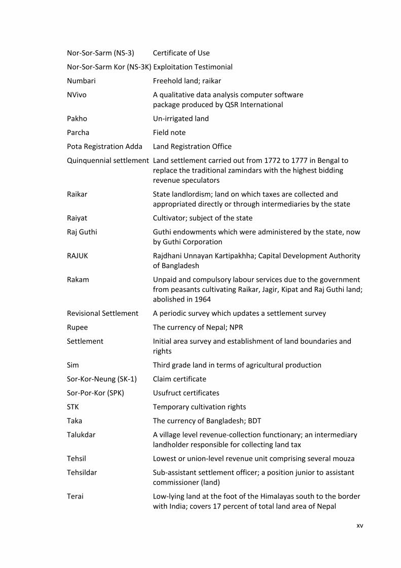
Glossary
Abal Land of the best quality in terms of agricultural production
Abusus Right to dispose
AC-Lands Office Office of the assistant commissioner of land
Ana Unit of land measurement; equals to 31.8 square meters in Nepal
Badi A tribal community living in Western Nepal
Baht The currency of Thailand
Bai-Chong (NS-2) Pre-emptive certificate
Balam Book Book recording deeds in Bangladesh; Book No. 1 of the sub-registry office in which deeds are registered
Bargadars Sharecroppers
Bhumi Land; jagga
Bigha A land measurement unit comprising 6,772.63 square meter in Nepal and 1,337.8 square meters in Bangladesh; 20 kattha
Bikram Sambat (BS) Calendar used in Nepal associated with King Bikramaditya which is 56 years, 8 months and 15 days ahead of AD
Birta Land grants made by the state to individuals; abolished in 1960
Chahar Lowest grade of land in terms of agricultural production
Chanod (NS-4) Title deed
Char Land Land left behind after a flood
Charuwa A herder who looks after landlords’ cattle
CNG A caged, motorized tricycle run from compressed natural gas
Dewani Right to collect revenue
Dhani Purja Land ownership certificate
Diara Surveys Settlement operations in an alluvial area
Doyem Second grade land in terms of agricultural production
Fructus Right to the fruits
Grundbuch Land register
Guthi An endowment of land made for any religious or philanthropic purposes; trust land
Haliya A person who ploughs the land of landlords to pay bay back his loan and interest
Haruwa A person who ploughs the land of landlords in an annual contract to pay bay back his loan and interest

xiv
Jagera Raikar lands not assigned as Jagir
Jagera Lagat A record of Jagera land
Jagga Land; bhumi
Jagir Raikar lands assigned to government employees and functionaries in lieu of their emoluments
Jhora Land cultivated by cutting bushes or forest
Kamaiya A traditional system of bonded labour practiced in Western Terai of Nepal
Kanungo Sub-assistant settlement officer or a position junior to AC- Lands based in AC-Lands office
Kattha A unit of land measurement practiced in Nepal and Bangladesh; equal to 338.63 square metres in Nepal and 66.89 square metres in Bangladesh
Khaja Lunch
Kharka Pasture land
Khas Land State land under administration of Ministry of Lands arising either from new formation or seizures in excess of 33.3 acres ceiling under land reform legislation
Khasra Operation Survey of temporarily settled areas
Khas Water Bodies State-owned water bodies
Khatiyan Records of rights
Khet Irrigated land; rice land
Kipat A system of communal land ownership prevalent among the Limbus and other Mongoloid communities in the hilly region
Lagat Land record
Lakh Unit of measurement practiced in Nepal equal to one hundred thousand
Lekhapadhi Byabasayee Deed writer (Nepal)
Mahalla An optional and non-elective unit of a city corporation or municipal corporation, for ritual and representative purposes
Mangsir A Nepali colander month from mid-November to mid-December
Mouza A revenue village, somewhat larger than several actual villages
Mutation Actions of tehsildars and AC-Lands to update record of rights reflecting changes in land rights and physical alterations
Niji Guthi Guthi endowment by individual(s)
Nor-Sor-Lor Titled public land
xv
Nor-Sor-Sarm (NS-3) Certificate of Use
Nor-Sor-Sarm Kor (NS-3K) Exploitation Testimonial
Numbari Freehold land; raikar
NVivo A qualitative data analysis computer software package produced by QSR International
Pakho Un-irrigated land
Parcha Field note
Pota Registration Adda Land Registration Office
Quinquennial settlement Land settlement carried out from 1772 to 1777 in Bengal to replace the traditional zamindars with the highest bidding revenue speculators
Raikar State landlordism; land on which taxes are collected and appropriated directly or through intermediaries by the state
Raiyat Cultivator; subject of the state
Raj Guthi Guthi endowments which were administered by the state, now by Guthi Corporation
RAJUK Rajdhani Unnayan Kartipakhha; Capital Development Authority of Bangladesh
Rakam Unpaid and compulsory labour services due to the government from peasants cultivating Raikar, Jagir, Kipat and Raj Guthi land; abolished in 1964
Revisional Settlement A periodic survey which updates a settlement survey
Rupee The currency of Nepal; NPR
Settlement Initial area survey and establishment of land boundaries and rights
Sim Third grade land in terms of agricultural production
Sor-Kor-Neung (SK-1) Claim certificate
Sor-Por-Kor (SPK) Usufruct certificates
STK Temporary cultivation rights
Taka The currency of Bangladesh; BDT
Talukdar A village level revenue-collection functionary; an intermediary landholder responsible for collecting land tax
Tehsil Lowest or union-level revenue unit comprising several mouza
Tehsildar Sub-assistant settlement officer; a position junior to assistant commissioner (land)
Terai Low-lying land at the foot of the Himalayas south to the border with India; covers 17 percent of total land area of Nepal

xvi
Thakbast Survey Demarcation survey of village and estate boundaries
Ukhada A form of landownership under which lands of zamindar or intermediary landowners used to be let out to tenants on low cash rents; abolished in 1964
Union Parishad A geopolitical subdivision of a sub-district
Upazila A geopolitical subdivision of a district; a collection of mouzas
Usus Right to use
Waqt A religious form of land tenure practiced in Bangladesh
Withholding Tax Deduction from payments made to suppliers who provide a service
Zamindar An individual responsible for land-tax collection at the village level; practiced in Nepal and in Bangladesh
Zamindari System A system of land tenure assigning the task of collecting land tax to zamindars; practiced in both Nepal and Bangladesh

1
Chapter 1: Introduction
1.1 Introduction
Accelerating the pace of economic development is one of the main political goals of
developing countries. Increasing the level of production, financing development activities,
alleviating poverty and enhancing the wellbeing of the people are their common
challenges. These challenges cannot be overcome unless their resources are mobilised
properly.
Land is a fundamental resource without which life on earth cannot exist. It provides space
and materials for the existence of all living beings. Access to land is very important for
human beings as it provides shelter and the means for their livelihood. It is in line with
the view of Simpson (1976:3) who argues, “The availability of land is the key to human
existence, and its distribution and use are of vital importance”.
The distribution and use of land are determined by land policy, which has been defined as
the rules governing access to land and the distribution of the benefits from land
(Deininger, 2003). It consists of complex socio-economic and legal prescriptions that
dictate how land and land related benefits are allocated (UNECE, 1996:58).
Land policy of a country is guided by its national political objectives. GTZ (1998) presents
(a) efficiency and promotion of economic development, (b) equality and social justice and
(c) environmental preservation and a sustainable pattern of land use as the three main
objectives that guide land policy. Similarly, van der Molen et al. (2008) believe that land
policy is concerned with the objectives of a government related to economic, social and
environmental development. In their words:
“Political objectives such as economic growth, poverty reduction, sustainable housing and agriculture, social equity and fairness, protection of vulnerable groups in society, require a policy of the government how to deal with the allocation of access to land and land related benefits.” (p.5)
Thus, land policy is a highly political document that concerns with the economy, society
and the environment. Specific tools and techniques are required for its implementation.
2
As argued by van der Molen et al. (2008), it requires intervention measures of a more
technical nature which concern the application of property rights regimes and security of
those rights, access to credit markets, regulations of land sales and rental market, and
measures to enhance sound land use planning, land reform, land taxation and
management of natural resources.
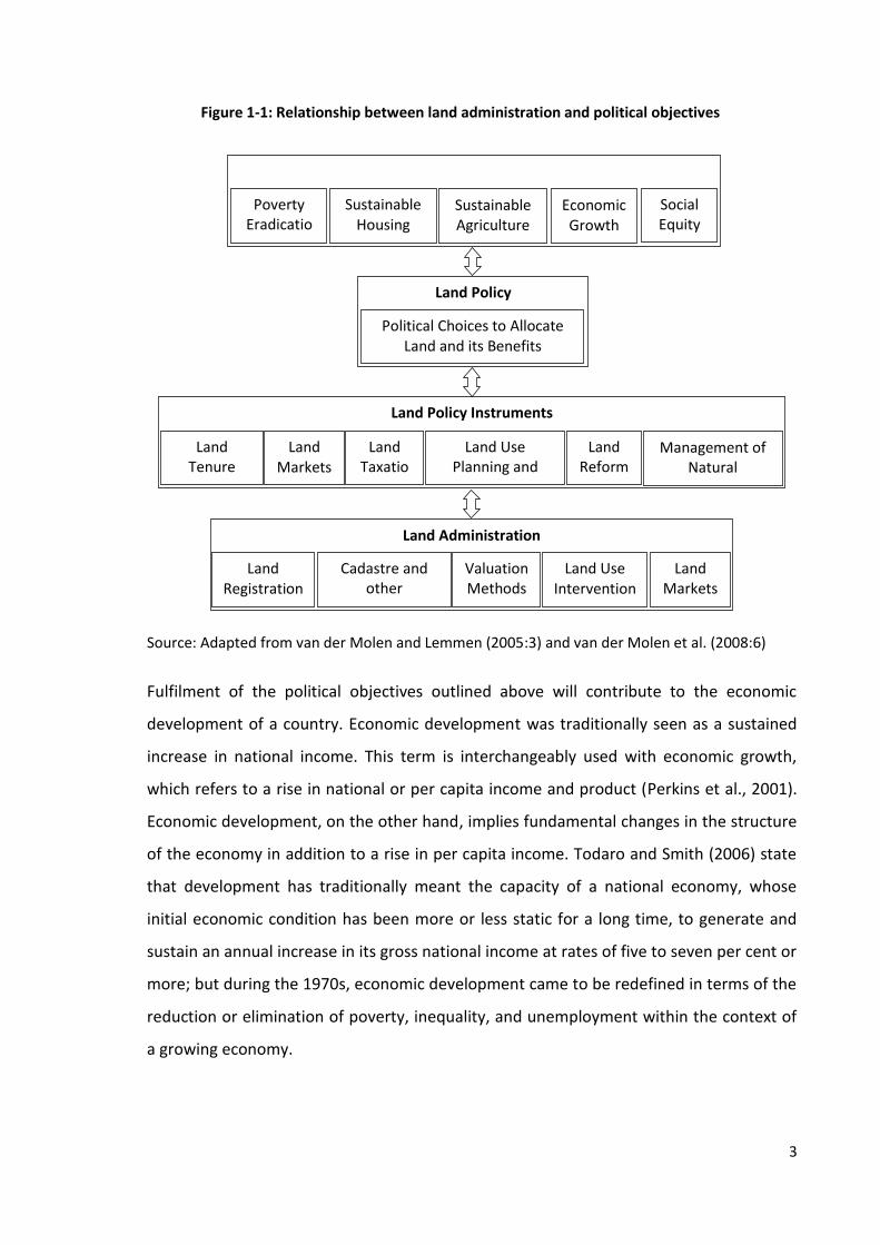
Land administration serves as a suite of tools that operationalise the instruments of land
policy. It has been defined as ‘the process of determining, recording and disseminating
information about the ownership, value and use of land when implementing land
management policies’ (UNECE, 1996:14). This definition encapsulates the relationship
between tools and policies very well (van der Molen et al., 2008). A model that depicts
the role of land administration in achieving national objectives is presented in Figure 1-1.
There is a two-way relationship between political objectives and land administration.
Land policy is formulated in accordance with national political objectives that are likely to
include the eradication of poverty, promotion of sustainable housing, sustainable
agriculture, economic growth and social equity. A government operates the instruments
of land tenure security, land market, land taxation, land use planning and development
regulation, land reform and management of natural resources to fulfil these objectives.
Land registration, cadastre and other inventories, valuation methods and land use
interventions are the land administration tools that operationalise these land policy
instruments.
3
Source: Adapted from van der Molen and Lemmen (2005:3) and van der Molen et al. (2008:6)
Fulfilment of the political objectives outlined above will contribute to the economic
development of a country. Economic development was traditionally seen as a sustained
increase in national income. This term is interchangeably used with economic growth,
which refers to a rise in national or per capita income and product (Perkins et al., 2001).
Economic development, on the other hand, implies fundamental changes in the structure
of the economy in addition to a rise in per capita income. Todaro and Smith (2006) state
that development has traditionally meant the capacity of a national economy, whose
initial economic condition has been more or less static for a long time, to generate and
sustain an annual increase in its gross national income at rates of five to seven per cent or
more; but during the 1970s, economic development came to be redefined in terms of the
reduction or elimination of poverty, inequality, and unemployment within the context of
a growing economy.
Poverty Eradicatio
n
Sustainable Housing
Sustainable Agriculture
Economic Growth
Social Equity
Land Policy
Political Choices to Allocate Land and its Benefits
Land Policy Instruments
Land Tenure Security
Land Markets
Land Taxatio
n
Land Use Planning and Development
Land Reform
Management of Natural
Resources
Land Administration
Land Registration
Valuation Methods
Land Use Intervention
Cadastre and other
Inventories
Land Markets
Figure 1-1: Relationship between land administration and political objectives

4
Recent development theories emphasise quality of life in addition to economic growth as
a determinant of development. The World Bank (1991) considers development as
providing a better quality of life. A similar view is held by Sen (1999:14) who argues,
“Economic growth cannot be sensibly treated as an end in itself. Development has to be
more concerned with enhancing the lives we lead and the freedoms we enjoy”. Similarly,
Todaro and Smith (2006) believe that any realistic analysis of development problems
necessitates the supplementation of strictly economic variables such as incomes, prices,
and saving rates with equally relevant non-economic institutional factors, including the
nature of land tenure arrangements, the influence of social and class stratifications, the
structure of credit, education and health systems, the organisation and motivation of
government bureaucracies, the machinery of public administrations, the nature of
popular attitudes toward work, leisure, and self-improvement, and the values, roles and
attitudes of political and economic elites. Likewise, Thirlwall (2011:173) considers high
investment, fast export growth, macroeconomic stability, high levels of human capital
formation and an institutional framework conducive to growth as major determinants of
rapid growth and development. He states that secured property rights and rule of the
land provide a favourable environment for economic growth. It indicates that
organisational and institutional factors also play important role in the production process.
To sum up, land administration serves as a tool to operate the instruments of land policy
which aim to fulfil the national political objectives that are likely to include the
eradication of poverty, promotion of sustainable housing, sustainable agriculture,
economic growth and social equity. Fulfilment of these objectives will contribute to the
economic development of a country. In a broader sense, economic development
comprises not only economic growth and purely economic variables but also the quality
of life and non-economic institutional factors like the nature of land tenure arrangements
that provide a favourable environment for economic growth.
1.2 Research Context
Land is a major source of wealth. It accounts for 50 to 75 per cent of the national wealth
in many developing countries (Bell, 2006). An estimated 20 per cent or more of Gross
Domestic Product (GDP) of any nation comes from land, property and construction
5
(UNECE, 1996). It provides the foundation for most economic activities. Fundamental
needs of human beings like shelter, food and clothing are fulfilled from land. Thus, the
allocation, use and management of land are vital for society.
The relationship between land and society is established through property rights. Rights
and titles to land or real property are created by the state. The state decides whether the
rights and/or titles to property may be kept personal or assigned to any person or group
of persons. Based on who hold the rights and titles, property can be categorised as state,
public, common or private. In state property, both rights and titles are vested in the state
whereas they are held by a person or a group of persons in private property. The title to
public land is kept by the state or a public agency but its rights are available to the public.
On the other hand, the rights and titles to common property are vested in a community.
The selection of property regimes mainly depends on the social, cultural and political
context of the society. For instance, the customary tenure system, which is widely
adopted in many parts of Africa, is a communal type of property. There is a private
property system in most of the Western democratic countries whereas there is state or
communal type of property regime in some countries like China, North Korea and
Vietnam.
The type of property rights depends on the type of land tenure regime. There are four
main types of land tenure regime; statutory, customary, religious and informal. The
highest level of property rights under the statutory tenure system is called freehold.
Landowners can enjoy the rights of ownership, transfer, inheritance, mortgage, lease and
use in freehold land. Customary and religious tenure have limited rights such as use
rights.
Property systems may be classified as formal or informal. In a formal property system,
property interests are legally recognized by the state but informal properties are not.
Dale and McLaughlin (1999:26) define and distinguish these two property systems as
follows:
“Formal property systems are those where property rights are explicitly acknowledged and protected by law. [...] Informal property interests are those that are recognised by the local, informal community but which are not formally acknowledged by the state.”

6
They also observe that formal property systems exist in most of the developed countries
and informal systems in most of the developing countries. In developed countries, every
unit of landed property is represented in a property document but developing countries
do not have such processes. In the words of de Soto (2001:6):
“In the West, [...] every parcel of land, every building, every piece of equipment or store of inventories is represented in a property document that is a vast hidden process that connects all these assets to the rest of the economy. [...] The Third World and former communist nations do not have such representational process”.
Thus, the representational process of land administration connects the assets of real
property to the rest of the economy. Williamson et al. (2010:98) presents five core land
administration processes common to most nations as (a) formally titling land, (b)
transferring land by agreement (buying, selling, mortgaging, and leasing), (c) transferring
land by social events (death, birth, marriage, divorce, and exclusion and inclusion among
the managing group), (d) forming new interests in the cadastre, generally new parcels or
properties (subdivision and consolidation), and (e) determining boundaries. These
processes ensure security of land tenure. Consequently, land rights can be used as a
commodity in the land market. They can also be sold, transferred and used as collateral to
obtain a loan from the bank. These processes generate money for the government in
terms of land tax and stamp duties as well. They also provide a basis for conducting
economic activities.
The process of land administration begins with the adjudication of land rights. After
adjudication, land comes under the scope of the land administration system. Many
countries have established land administration systems and have started the process of
property registration but there are still some parts of the world where land
administration institutions are not fully operational. De Soto (2001:33) projects that
around 85 per cent of urban parcels and 40 to 55 per cent of rural parcels in the Third
World and in former communist countries are held in such a way that they cannot be
used to create capital. He also estimates that out of 387 million urban dwellings, 329
million (85 per cent) are informal. Also, out of 3,926,044 hectares of land in rural areas,
1,840,049 hectares (47 per cent) is informal. This means that a formal process of land
administration has not yet begun in large parts of the developing world.
7
To summarise, the processes of land administration connect the assets of real property to
the rest of the economy. Formalisation of property rights is the initial step in these
processes. It means that real property would not be connected with the economy unless
it has been formally registered. Most developed countries have formalised their property
rights and brought them into the mainstream of their economy. However, many parts of
developing countries lack such opportunities.
1.3 Research Problem, Research Aim and Rationale of Study
1.3.1 Research Problem
The discussion in the Section 1.2 makes it clear that the process of land administration
links real property to the rest of the economy and that property which is not formalised is
not included in this process.
The early economic and development theories recognises land as a major factor of
production and an ingredient for development. It produces goods, provides a foundation
for economic activities and generates capital for investment. The role of property rights
and institutions on economic performance has been realised by the economists mainly
after 1960s. Some development theorists (for instance, Todaro and Smith, 2006; Thirlwal,
2011) have given emphasis on the rules of the land and the security of property rights in
the development process and considered them as non-economic institutional factors of
economic development.
The role of land tenure security and management of land in the development process has
also been emphasised in the recent decades, especially after 1990s. Writings of some
authors, for instance, Feder et al. (1988) and Platteau (1996) recognises land tenure
security as a supporting factor for the economic performance. According to the land
tenure theory, the process of land titling promotes economic outcomes by increasing
ability and willingness to invest and hence higher land related investment, more efficient
land use, increase in production, income and land value, reduction on transaction costs
and increase in government revenue (for instance, Platteau, 1996; Feder et al., 1988).
The Agenda 21 published by the United Nations Conference on Environment and
Development (UNCED, 1992) emphasises on the importance of land management for
8
agricultural and rural development. Likewise, the publication of de Soto's Mystery of
Capital (2000) emphasises in the formalisation of informal areas and establishment of the
land administration system in order to get benefit from land and described it as a hidden
capital. Also, van der Molen (2003) tries to link the quality of land administration services
with economic growth. Likewise, Enemark et al. (2005) develop a concept of land
management paradigm that relates the land administration functions to the sustainable
development which has been proposed as the land administration theory by Williamson
et al. (2010). The theory states that land administration functions support sustainable
development, which includes economic, social and environmental development.
Some writers argue that a good land administration is essential to obtain benefit from
land. For instance, Dale and McLaughlin (1999:5) discuss how good land administration
contributes to economic development. In their words, "[a good land administration]
provides security to investors and permits real estate to be traded in the market place. It
also allows government to raise taxes on the basis of the value of land and property".
Similarly, de Soto (2001) advocates that secure private property rights and a good land
administration system can mobilise the hidden capital from land. Likewise, Zakout et al.
(2006) opine that good land administration, coupled with secure land tenure, supports
economic growth. They consider land tenure security to be a means of linking land
administration with economic development and argue that merely secure tenure and
access to land is not enough to attain the objectives of economic growth. Rather, a good
land administration system is required to secure land tenure and hence to achieve these
goals.
The theories and arguments discussed above link land tenure security to economic
development. However, findings of the empirical studies from different parts of the world
are not the same. Some studies (for example, Feder et al., 1988; Salas et al., 1970;
Deininger and Jin, 2006) observed a positive correlation between tenure security and
production while other studies (for example, Bugri, 2008; Braselle et al., 2002; Jacoby and
Minten, 2007) found its impact to be negligible. No differences on land productivity as a
function of land rights were also observed (Ouedraogo et al., 1996). Also, a weak effect of
property rights on access to credit is observed by Markussen (2008). Some studies also
concluded that tenure security is a necessary but not sufficient condition for

9
improvement in agricultural production and environmental management (Bugri, 2008). It
is also identified (for instance, Galiani and Schargrodsky, 2010) that land titling supports
poverty reduction by means of increased physical and human capital investment but not
through access to credit. There are few studies to date that investigate the economic
impact of land tenure security in Asia, especially in the South Asia.
Also, the theory of land administration has not been tested widely. A study by van der
Molen (2003) analyses the macroeconomic effect of land administration in the
Netherlands. He calculates the added value in the field of land-based taxation, the land
market, secure tenure and land use planning resulting from secured rights through
registration and cadastre at the national level. He concludes that the presence of good
land administration is responsible for growth of 5.9 per cent of the GDP in the
Netherlands. However, he did not assess the quality of land administration and has not
fully explained the changes in economic activities and production induced by good land
administration at the local level.
Thus, there is a lack of empirical research that studies the relationship between land
administration and economic development. Theories that postulate a good land
administration, coupled with secured tenure, increases economic growth are not widely
tested. Although some studies have examined the role of tenure security on the
economy, findings from different studies are not convergent. This study aims to fill this
gap in knowledge and to investigate the role of land administration in economic
development.
1.3.2 Research Aims, Objectives and Research Questions
The overall aim of this study is to investigate the role of land administration in economic
development. It focuses on two aspects in particular. First, it aims to investigate the role
of land tenure security in productivity and, second, it aims to assess the role of land
administration services in revenue generation.
This research mainly seeks to answer how the land administration supports economic
development. The following research questions are raised in order to examine whether or

10
not the above aims and objectives are achieved and the main research question is
answered.
1. How does land administration ensure land tenure security?
2. Does land administration promotes efficient land use and land-related economic
activities?
3. Is there any relationship of land tenure security with land value, access to credit,
investment and income?
4. What is the status of service delivery in land administration organisations?
5. How does the efficiency of land administration services affect revenue
generation?
1.3.3 Rationale and Significance of the Research
The importance of land administration in society is growing because of its role in the
management of one of the world’s essential resources. Access to land and land-related
benefit is still connected with the livelihood of most of the people in the world. It is one of
the major concerns of most governments, especially in the developing world.
Formalisation of informal settlement, providing shelter for people, poverty reduction,
sustainable and productive land use and revenue generation are some of the challenges
related to land management faced by many governments. International development
organisations, academic and research institutions and researchers have undertaken wide-
ranging investigations of these issues. International organizations like the World Bank, the
Food and Agriculture Organization (FAO), the United Nations Centre for Human
Settlement (UN-HABITAT) and the Asian Development Bank have carried out research and
organised conferences and workshops to address land related problems. They have also
provided technical and financial support to many countries. Likewise, numerous
organisations are involved in the advocacy for land rights for landless people, informal
settlers and indigenous people. This highlights the importance of research related to land.
11
Thus, the discipline of land administration and property has attracted many scholars and
international organizations in recent decades in spite of the lack of research that directly
investigates the joint contribution of a good land administration and secure land tenure
on economic development. It is anticipated that due to the significance of land to society,
and also the increasing number of land disputes and problems associated with access to
land, this research will be of interest to scholars, land-related government organizations
and non-government organizations, land professionals and land rights activists. It is
believed that this research may contribute to a revision of the land policy of
governments, especially of countries facing the challenges of property formalization and
land governance. The findings of this research could be critical for those countries which
still have to establish a land administration system or improve their existing system while
deciding on investment in land administration systems and the formalisation of property
rights.
The discipline of land administration gained popularity after the publication of Land
Administration Guidelines by the United Nations in 1996 although its intellectual roots
are much older (Williamson et al., 2010). Writings of various scholars and researchers (for
example, Dowson and Sheppard, 1952; Simpson, 1976; Dale and McLaughlin, 1988 and
1999; Deininger, 2003 and Williamson et al., 2010) contributed to conceptualizing the
theory of land administration. Publications of the FAO, International Federation of
Surveyors (FIG), UN-HABITAT, and efforts by academic institutions like the Land Tenure
Centre of the University of Wisconsin-Madison, Department of Land Economy of the
University of Cambridge, International Centre for Land Policy and Training (Taiwan) and
the Faculty of Geo-Information Science and Earth Observation (The Netherlands) also
contributed to shape this discipline.
This research has selected the cases of land administration in Nepal, Bangladesh and
Thailand. It provides a comparative study of the land administration and land tenure
systems of the selected countries, which would be useful for the researchers and land
professionals of those countries. It is also expected that this research will be a good
source for scholars who do not know the local languages but are interested to learn about
the land administration systems of those countries. This research also documents the
problem of property formalization in the selected case study areas of Nepal and
12
Bangladesh, and the changes caused by formalization, and it is hoped that lessons learnt
from this study will be useful in similar case studies in other parts of the world.
1.4 Conceptual Framework
Land administration is the process of determining, recording and disseminating
information about the ownership, value and use of land (UNECE, 1996). It can be
considered to refer to those public sector activities required to support the alienation,
development, use, valuation, and transfer of land (Dale and McLaughlin, 1999:1).
The relationship between human beings and land is established through property rights.
As argued by Dale and McLaughlin (1999:1), this relationship evolved from full state
control, through communal forms of tenure, to individual property rights. Occupation and
accession were the original methods of acquiring land in a primitive society. These
properties were used commonly in the beginning. Private property rights emerged as land
became scarce and valuable.
Individualisation, titling and registration are considered as prerequisites to land
development and improvement as well as to the management of land-related conflicts
(for example, Demstez, 1967; Johnson, 1972; Alchian and Demstez, 1973; Ault and
Rutman, 1979). Platteau (1996) discusses two effects of land titling: firstly, the static
effect resulting from the chances of land consolidation and more efficient cropping
choices; and secondly, the dynamic effect resulting from increased willingness and ability
to invest. Likewise, Feder et al. (1988) highlight two sources of linkage between titles and
economic performance measured in terms of increase in income and land value, namely
the effect of titles in enhancing tenure security, and the role of titles in collateral
arrangements and facilitating access to institutional credit. They identify that security of
landownership has a substantial effect on the agricultural production in Thailand resulted
mainly from better access to long-term institutional credit and increased agricultural
productivity. Similarly, Deininger (2003:42-43) presents three main elements of tenure
security that can affect household behaviour as greater security against eviction, greater
ability to transfer land and greater access to credit. He explains:
“First, greater security against eviction, [...] will reduce the need to spend resources on defending resource rights and the probability of getting caught up in land conflicts. This is

13
likely to increase the demand for land-related investment. Second, greater ability to transfer land, [...] will increase the payoff from investments linked to the land because it will allow the person who made the investment to benefit from it even if, for some unforeseen reason, he or she will not be able to personally use the land. Third, greater tenure security can enhance access to credit, thereby increasing the value of investment undertaken in situations in which limited credit supply constrains investment.”
Thus, tenure security can increase demand for land-related investment and its pay-offs.
Better credit supply also increases the agricultural performance of farmers.
There is another view that good land administration contributes to economic
development in a number of ways. For instance, Dale and McLaughlin (1999) argues that
it provides security to investors and permits real estate to be traded in the market place,
and allows government to raise taxes on the basis of the value of land and property.
Similarly, de Soto (2001) argues that secure private property rights and a good land
administration system can mobilise the hidden capital in land. Likewise, Wyatt (2011:506)
argues, “Within a framework of national land policies, good land administration will
facilitate and stimulate the private sector real estate market”. Williamson et al. (2010)
also state that land administration functions support sustainable development, which
includes economic, social and environmental development.
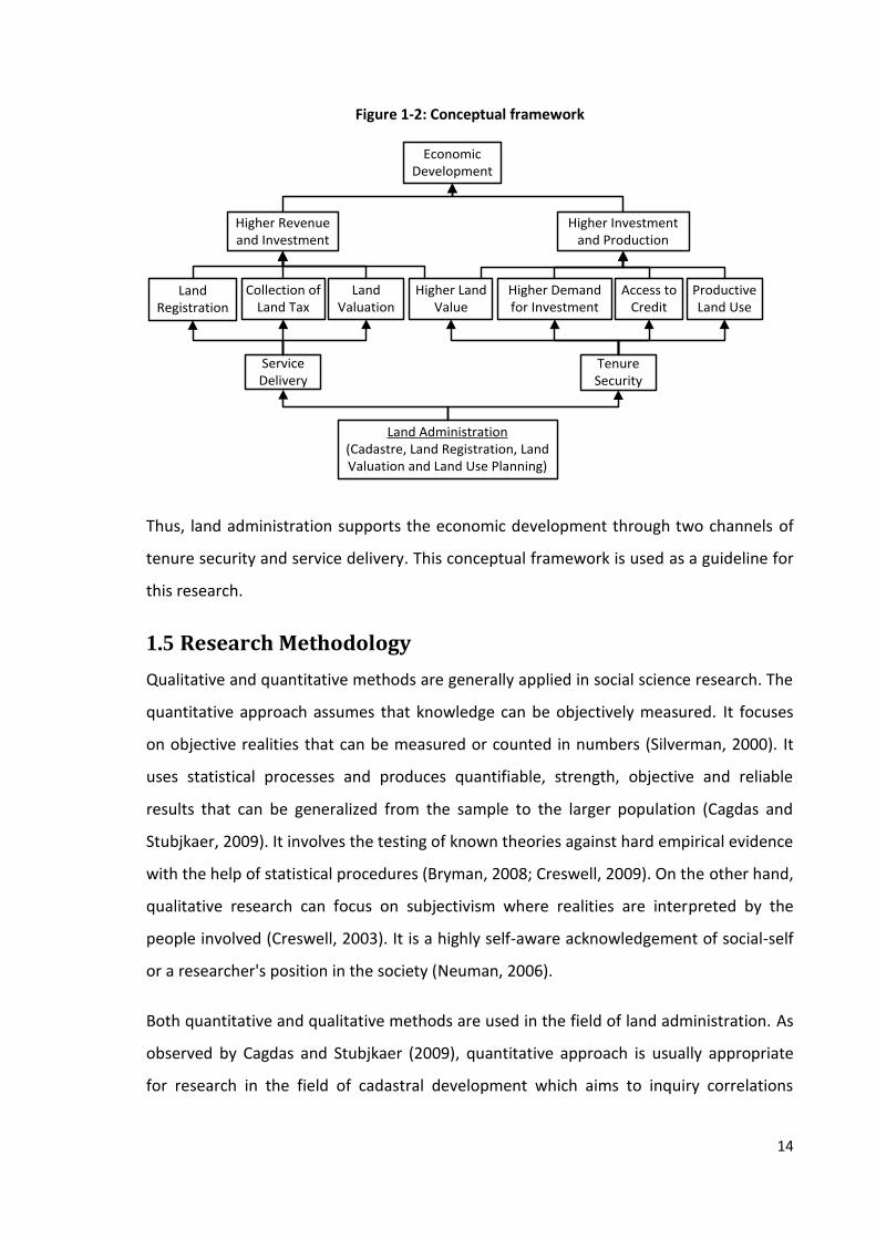
A conceptual framework is developed in Figure 1-2 based on the analysis of the theories
discussed above which visualises the relationship between land administration and
economic development. Cadastre, land registration, land use planning and land valuation
are the functional components of land administration. For the purpose of this study,
functions of these components are grouped in two categories; firstly, they ensure security
of land tenure by means of land titling. Land value, credit opportunity, investment
demand and productive land use promotes as land tenure becomes secure.
Consequently, investment and production will be increased. Secondly, land
administration provides land registration services, collects land tax and determines land
value, which generates revenue to the government. As a result, the government will have
more funds, which may be invested in development programme.
14
Figure 1-2: Conceptual framework
Access to Credit
Higher Demand for Investment
Higher Revenue and Investment
Economic Development
Land Registration
Collection of Land Tax
Land Valuation
Tenure Security
Productive Land Use
Higher Land Value
Higher Investment and Production
Service Delivery
Land Administration(Cadastre, Land Registration, Land Valuation and Land Use Planning)
Thus, land administration supports the economic development through two channels of
tenure security and service delivery. This conceptual framework is used as a guideline for
this research.
1.5 Research Methodology
Qualitative and quantitative methods are generally applied in social science research. The
quantitative approach assumes that knowledge can be objectively measured. It focuses
on objective realities that can be measured or counted in numbers (Silverman, 2000). It
uses statistical processes and produces quantifiable, strength, objective and reliable
results that can be generalized from the sample to the larger population (Cagdas and
Stubjkaer, 2009). It involves the testing of known theories against hard empirical evidence
with the help of statistical procedures (Bryman, 2008; Creswell, 2009). On the other hand,
qualitative research can focus on subjectivism where realities are interpreted by the
people involved (Creswell, 2003). It is a highly self-aware acknowledgement of social-self
or a researcher's position in the society (Neuman, 2006).
Both quantitative and qualitative methods are used in the field of land administration. As
observed by Cagdas and Stubjkaer (2009), quantitative approach is usually appropriate
for research in the field of cadastral development which aims to inquiry correlations

15
between variables or studied phenomenon and qualitative research is more appropriate
for research which aims to explore and understand nature of a being studied phenomena.
This research aims to establish a correlation between studied phenomena and to study
their nature. It consists of the study of land administration and tenure security, which
cover a wide range of issues related to economics, politics, law and public administration.
A single methodological perspective may not be sufficient to study these multi-
disciplinary issues. Quantitative data are required to examine the relationship of land
tenure security with land value, investment and income as mentioned in the third
research question. Other research questions are answered using qualitative data. Also,
each method may have weaknesses if used separately. A mixed method approach
overcomes the limitations of a single method approach and provides more
comprehensive and stronger results (Cagdas and Stubjkaer, 2009). Therefore, a mixed
method approach is applied in this research.
Various methods are applied to collect data in social science research. Brewer and Hunter
(1989) consider fieldwork, survey research, experimentation, and non-reactive research
as the principal methods employed by the social researcher. Case study is a method that
is widely used in the field of land administration research (for example, Zevenbergen,
2002; Nkwae, 2006; Rakai, 2005; Silva, 2005). It involves an empirical investigation of a
particular contemporary phenomenon within its real life context using multiple sources of
evidence (Yin, 1994). A combination of case studies and survey methods is applied in this
research to collect both qualitative and quantitative data.
The techniques of data collection also vary according to the type of research. Blaikie
(2000) listed structured observation, questionnaires, structured interviews, and content
analysis as quantitative techniques, and semi-structured and unstructured observation,
participant observation, interviews (focused, in-depth, group, oral-life histories) and
content analysis as the qualitative techniques of data collection. Similarly, Yin (2003)
observes documentation, archival records, interviews, direct observation, participant
observation and physical artefacts as data collection techniques often used in case study
research. In this research, multiple techniques of data collection are applied in order to
triangulate evidence from different sources. They are survey, interview, observation, field

16
note and documentation. The data collected from the case studies are analysed using
computer software Microsoft Office, Statistical Package for the Social Sciences (SPSS) and
NVivo1.
The research framework applied in this study is presented in Figure 1-3. The research
problem, aim and objectives of the research are defined, and the research questions are
formulated. The rationale of this study is also discussed. Proceeding that, literature
concerned with the economic aspects of land administration is analysed and a theoretical
framework is developed. This is followed by the case study design, collection of case
study evidence and its analysis. A case study report is then prepared and reflections on
the conceptual framework are discussed. Finally, a summary and conclusions are drawn
from the whole study.
Figure 1-3: Research framework
1A qualitative data analysis computer software package
Problem Definition
Analysis of Literature and Development of a Conceptual Framework
Case Study Design
Collection of Case Study Evidences
Analysis of Case Study Evidences
Preparation of Case Study Report and Reflection on Conceptual Framework
Summary and Conclusion
Case Study
17
To sum up, a mixed method approach is applied in this research and a survey within a
case study environment is selected as a strategy of inquiry. Multiple methods of data
collection including documentation, questionnaires, interviews and observations are
employed in order to triangulate data from various sources. The data collected from case
studies are analysed using qualitative and quantitative data analysis software.
1.6 Structure of the Thesis
This thesis is structured into seven chapters. Chapter One introduces the research
project. It presents the context of the research, the research problem, aim and objectives,
the rationale and significance of the research, and the conceptual framework of this
research. The methodology applied in this research is discussed in brief after that.
Chapter Two reviews the literature concerned with land administration and its
interaction. The concept of land, property rights and their administration is presented
first. It then discusses the functions and practices of land administration. After that,
theories related to land-based economic development and some empirical studies from
different parts of the world are presented and the implications of theoretical and
empirical studies are outlined. It then highlights the issues under investigation in this
research.
Chapter Three describes the case study design and methodology applied in this research
in detail. Research approaches and the strategies of inquiry are discussed first. Then a
brief description about the case study areas of Nepal and Bangladesh is presented. This
chapter also describes the procedure of the field study, which includes logistical
arrangements, and initial meetings and preparation. It also involves collection, recording
and management, presentation, analysis and interpretation of data, and units of analysis
measurement of variables. Then it discusses some issues concerned with research quality,
ethics, reflections on the field study and the limitations of the case study.
Chapter Four outlines the existing practices of land administration in the selected
countries. It presents some general background of Nepal, Bangladesh and Thailand first. It
then outlines the system of land tenure and the status of access to land in these
countries. After that it discusses the systems of land administration, which include the

18
organisational structures, registration processes, cadastral surveying and property
valuation.
Chapter Five discusses the status of land tenure security and analyses its economic
outcomes based on the data collected mainly from Nepal and Bangladesh. First it
discusses the role of land registration on tenure security. Then it examines its economic
outcomes specifically, its role on land use and economic activities, land value, access to
credit and investment, and income.
Chapter Six assesses the status of land administration services in Nepal and Bangladesh
and examines their role on revenue generation. Firstly, the effectiveness of land
administration services, especially the process of land registration, record management
and information dissemination, land valuation and revenue collection is discussed. Then
the justification for the establishment of land administration is outlined.
Chapter Seven concludes the research. A summary of findings is presented first based on
the research questions outlined in Section 1.3.2 above. It also examines the reflection of
research findings on the conceptual framework developed above. After that, the
contribution of the research to knowledge and its implications for policy and practices are
discussed. It also outlines the limitations of the research and areas for further research.

19
Chapter 2: Land Administration and Its Interaction
2.1 Introduction
The importance of land as a factor of production and an ingredient for development
highlights the role of land administration in the economic development of a country. This
chapter aims to review and analyse the literature related to land administration and its
role in economic development. A brief description of land, property rights and their
administration is presented first followed by a discussion of functional components and
practices of land administration. Then a theoretical underpinning of land-based economic
development is presented. It reviews and analyses theories related to economic
development, land administration and land tenure security. Existing studies related to the
economic aspects of land tenure security from different parts of the world are also
reviewed. Then the implications of theoretical and empirical studies are discussed
followed by the explanation on the measurement of variables.
2.2 Land, Property Rights and Their Administration
2.2.1 Land and Property
In a narrow sense, land can be considered as the surface of the earth but, in a broader
sense, it not only covers the surface of the earth, but also anything underneath and above
the surface, buildings and plants attached or fixed on the surface and the area covered by
the sea. Henssen (1989:2), following the United Nations Ad Hoc group of Experts on
Cadastral Surveying and Land Information (1985), defines land in the following way:
“Land is defined as an area of the surface of the earth together with the water, soil, rocks, minerals and hydrocarbons beneath or upon it and the air above it. It embraces all things which are related to a fixed area or point of the surface of the earth, including the areas covered by water, so including the sea."
Similarly, the Law of Property Act, 1925 of the United Kingdom includes tangible physical
property as well as intangible rights in land within the definition of land. Accordingly, land
includes land of any tenure, mines and minerals, buildings or its parts, a manor, a rent,
and an easement, right, privilege, or benefit in, over, or derived from land. Thus, land

20
includes tangible physical property on the surface of the earth or underneath and above it
as well as associated intangibles rights. It is important not only for human beings but also
for all living species. It provides the foundation for life and fundamental resources for
their livelihood.
Property is generally known as the term denoting tangible things, relationships, or rights
to the use and ownership of those things (Obeng-Odoom, 2012). It can be classified as
personal and real property. Personal property refers to movable properties, for instance a
pen, laptop or a sofa. Real property refers to land and the associated rights. Land has
unique characteristics that make it a fundamental object of property in every society
(Nichols, 1993). It is immovable, theoretically indestructible and easily recoverable.
Common law classifies land as real property to reflect this real action of recovery (Walker,
1980). This study deals with land and land-related property or real property.
Property is a social relation that defines the relationship of property holders with other
individuals regarding a piece of land. In the words of Bromley (1991:2),"Property is not an
object but rather a social relation that defines the property holders with respect to
something of value (benefit steam) against all others". It involves certain kinds of rights,
duties, powers, privileges and forbearance (Halowell, 1943 in Feder and Feeney, 1991)
that determine the relation of the property holder or owner to the rest of the society.
Different types of property regimes exist throughout the world, reflecting different kinds
of social relations regarding the real property. Macpherson (1978:4-5) classifies property
into three categories; common, individual and state. Feder and Feeny (1991) classify
property rights to land into four categories; none (or open access), communal or common
property, private and state (or crown) property. Bromley (1989) also classify property
regimes as state, private, common and none property (open access).
The classification of property can be better understood in terms of the holding of
ownership and rights. Property rights are rights of individuals created by the state. As
argued by Macpherson (1978:5), each individual has a right of non-exclusion from the use
or benefit of a property in the case of common property whereas in private property an
individual has the right to exclude others from using or obtaining benefit from it. The

21
ownership of a common or communal property is vested in the community and that of
private property is vested in an individual. If both rights and ownership of a property are
vested in the hands of the state, it is called state property. Individuals can use such
property but only in the forbearance of the state (Bromley, 1991:23). If use rights are
available to the public but its title is vested with the government or a public agency, it is
called a public property.
Public, common or communal property and open access property are sometimes referred
to as if they were the same since they prevent the existence of private property;
however, there are some significant distinctions between them. The use rights of
community or common property seem similar to that of public property but such rights
belong to a specific group of people or community, not to the general public. The title of
such property may or may not be vested in that community. The title of public property,
on the other hand, may be vested in the state or a public agency but use rights are
available to everyone. There are no exclusive and transferrable rights in an open access
property (Bromley, 1991).
There is a great debate among social scientists and philosophers about private and
common property. The debate primarily concerns whether property rights should be
provided to individuals or kept in common. Philosophers like Aristotle, Jean Bodin,
Thomas Hobbes and Jean Jacques Rousseau were in favour of private property. The
French Revolution also defended private property. Article 2 of The Declaration of the
Rights of Man and of the Citizen made on 26thAugust, 1789 (in Schlatter, 1951:205) states,
‘The aim of every political association is the preservation of the natural and
imprescriptible rights of man. These rights are liberty, property, security, and resistance
to oppression’. Similarly, the wise-use or property rights movement of America defended
the absolute ownership system and put forward the slogan, ‘it is my land, I can do what I
want with it’ and demanded that every public action that impacts on private property
rights should be compensated (Jacobs, 1998).
In the nineteenth century, David Hume and Jeremy Bentham popularised the principle of
utility. As noted by Schlatter (1951:239), Hume argued that 'private ownership and its
laws had no other origin or justification than utility'. On the other hand, social scientists
22
like Plato, Herbert Spencer, Henry George, Karl Marx, Frederic Engels and Sir Henry Maine
criticised the system of private property and advocated the common property system on
various grounds. The common property system was advocated as an ideal, attributed to
the primitive condition of mankind, held to be suitable only to man before the Fall, and
recognised as existing alongside private property in such forms as public parks, temples,
markets, streets, and common lands (Macpherson, 1978:10). As observed by Schlatter
(1951), Plato considered communism as the best scheme for managing property; Hume
considered an absolutely equal division of property as a means of the greatest happiness;
and Henry George regarded private property in land as robbery. Similarly, Marx and
Engels considered that the primitive form of common ownership was negated into private
property and argued that the inevitable ‘negation of the negation’ would be common
ownership, or socialism (Engels, 1878 cited by Schlatter, 1951). Thus, private property is
advocated on the grounds of natural law, liberty and utility, and common property from
its historic origin and management scheme.
Social scientists have also presented diverse opinion regarding the origin of property.
Occupation and accession are considered as original methods of acquiring property in
primitive society. Smith (1978 in Reeve, 1986) presents three stages of property
development: first, possessions were treated as property, then animals became objects of
property, and later land itself. He considers the move from a hunting society to a
shepherd and pastoral society as the first extension of property and the introduction of
agriculture as another major extension. He also raises the possibility of its extension with
the introduction of the commercial age. Marx and Engels followed with a similar historical
account of the development of property. As quoted by Reeve (1986:67-68), they
discussed the tribal (hunting and fishing), shepherd and agricultural arrangements in The
German Ideology. They characterised the ancient, feudal and capitalist modes of
production as private ownership whereas there is no private ownership in the future
society. According to them, the general movement is from common property through
private property and back to common property, known as ‘the law of the negation of the
negation’.
Like the diverse views presented by the social scientists, different countries have adopted
different type of property regimes. Property (real) can be privately owned in most of the
23
Western democratic countries. However, a common or state property system is in
practice in some countries influenced from socialist ideology like China, Vietnam and
North Korea. This type of system was also in practice in the former Soviet Union, however
a private property system was introduced after its dissolution in 1990s. All or some of
these categories of property regimes may exist in every country. State and publicly owned
properties are commonly found in all countries. The customary tenure system adopted by
most of the African and some Asian countries is a communal type of property.
As mentioned earlier, the choice of the property regime is made by the state. However,
selection of a particular system may affect the rights of the individual. The property
owner under a private property system can enjoy more rights than the owner of common
or customary property, which may influence the behaviour of the owner regarding his
property.
To sum up, land and land-related property are called real property. A property is a social
relation that defines the relationship of a property holder with other individuals regarding
that property. Social scientists and philosophers have diverse views on whether property
rights should be provided to individuals or kept in common. Private property is mainly
advocated on the grounds of natural law, liberty and utility, and common property is
considered as the original form of ownership and as the best scheme for managing
property in which the rights of everyone are ensured. The choice of property regime may
influence the behaviour of the property holder regarding his or her property.
2.2.2 Property Rights
A property right is the right to use a particular item of property in a particular way
(Needham, 2001:12205). In this research property rights has been regarded as the
property rights to land which define the way land is used.
A property can be used in more than one way. It indicates that more than one right can
be attached to a single property. In civil law, property is considered as having a bundle of
rights in which each stick of the bundle represents a separate kind of right. The ancient
Roman law describes ownership as consisting of usus (right to use), fructus (right to the
fruits) and abusus (right to dispose). Property having such rights is considered as absolute
24
ownership. UNECE (1996) provides a list of elements that can be involved in property
rights including occupy, enjoy and use; cultivate and use productively; restrict or exclude
others; transfer, sell, purchase, grant or loan; inherit and bequeath; develop or improve;
rent and sublet; and benefit from increased property values or rental income. The rights
can also be classified as use rights (rights to use the land for grazing, growing subsistence
crops and gathering minor forestry products), control rights (rights to make decisions how
the land should be used including deciding what crops should be planted and to benefit
financially from the sale of crop), and transfer rights (right to sell or mortgage the land, to
convey the land to others through intra-community reallocations, to transmit the land to
heirs through inheritance, and to reallocate use and control rights) (FAO, 2002).
A property right is a claim to a property that the state will agree to protect through the
assignment of duty to others who may covet or interfere with it. This implies that a
property right has no meaning without correlated duties (Bromley, 1991:2). Thus, certain
institutions are required in order to enforce those duties and allow a property owner to
exercise his or her rights. There was no need of such institutions when the population was
very low and land was abundant. However, as argued by some property right theorists,
increase in value, population pressure, market integration and technical advances
contributed to the evolution of property rights. For instance, Krier (2009) considers the
primitive society as hunter-gatherer, which changed to an agricultural society; then, with
the emergence of agriculture, the population increased enormously, leading to the
development of small, organised groups followed by the development of large, organised
nation states. He opines that property rights emerged from the combination of two
approaches as intentional design and unintentional consequences.
Similarly, Demstez (1967) argues that property rights develop to internalise externalities
when the gains of internalisation become larger than the cost. He further states that the
emergence of new private or state-owned property rights will be in response to changes
in technology and relative prices. Deininger (2003) also identifies response towards
increased payoffs from investment as a reason for the evolution of property rights.
According to him, one reason property rights evolved was to respond 'to increased pay-
offs from investment in more intensive use of land resulting from population growth or
opportunities arising from greater market integration and technical advances'.

25
The Evolutionary Theory of Land Rights proposed by Platteau (1996) states that demand
for private property rights emerges from the combined impact of population growth and
integration of the market, which has to be addressed by the state. In his words:
“A central tenet of this theory [Evolutionary Theory of Land Rights] is that under the joint impact of increasing population pressure and market integration, land rights spontaneously evolve towards rising individualisation and that this evolution eventually leads rights holders to press for the creation of duly formalised private property rights- a demand to which the state will have an incentive to respond” (p.29).
Thus, property rights emerged as the benefits of internalisation outweighed the costs due
to the change in economic values and technology. Increased pay-offs from investment
due to population growth or greater market integration and technical advances and the
imposition of property rights in developing countries from outside world are also
considered as reasons behind the emergence of property rights.
2.2.3 Administration of Property Rights
Many societies introduce individual control over land, trees, plants, and buildings when
they have or when they develop a market economy (Zevenbergen, 2002:32). However,
control of these real properties is not as easy as controlling personal or movable property
like a pen or a computer. Possession is usually enough to prove the ownership of movable
goods but land cannot be possessed in a similar manner. It is property rights that
establish a relationship between humankind and land.
The rights may not be realised unless there is some evidence to prove it. Documents
evidencing property rights should include the location and area of the land, the name of
the owner and the way he acquired such land. Land registry and cadastre document such
evidence and establish a link between humankind and land. As shown in Figure 2-1, the
land registry gives an answer to ‘who’ and ‘how’ and the cadastre gives an answer to
‘where’ and ‘how much’ (Henssen, 1989; Henssen and Williamson, 1990). Thus, the
cadastre provides information about the spatial attributes including location and area of
land, and the land registry provides information about legal attributes about the owner,
associated rights (and duties) and the means he or she acquired such rights.

26
Figure 2-1: Humankind-land relationship
Right(Title)
Human Who?
How?
Where?How much?Land
Land Registration
Cadastre
Source: Adapted from Henssen and Williamson (1990)
Land administration involves both land registration and cadastre. It comprises textual
records that define rights and/or information, and spatial records that define the extent
over which these rights and/or information apply (Burns et al., 2006:8). UNECE (1996)
defines land administration as 'the process of determining, recording and disseminating
information about the ownership, value and use of land, when implementing land
management policies'. It further states that the processes of land administration include
the determination or adjudication of rights and other attributes of the land, the survey,
and description of these, their detailed documentation and the provision of relevant
information in support of land markets. Similarly, in ISO 19152 (Geographic Information-
Land Administration Domain Model), land administration has been defined as the
‘process of determining, recording and disseminating information about the relationship
between people and land’ (ISO, 2011). Thus, land administration is a process that deals
with information about the relationship between human beings and land, as observed by
Tjia and Coetzee (2012).
Land administration as a discipline has evolved out of the cadastre and land registration
areas with their specific focus on security of land rights (Enemark et al., 2010:3). The
cadastre was developed in different European countries at different times. For instance, a
land survey in England was completed in 1086, the records of which are called the
Domesday Book. Similarly, the initial tasks of the Swedish Land Survey, established in the
early seventeenth century, was to make maps for taxation purposes and to record

27
acreages and land productivity (Larsson, 1991). In the Austro-Hungarian Empire, the
Theresian Cadastre was established in 1748 as the basis for unique valid guidelines for
land taxation (Mayrhofer, 1992 cited by Steudler, 2004) which was later developed as the
Grundbuch [land register) system. Whenever and wherever they developed, their main
purpose was to assist the collection of land tax.
Establishment of the French Cadastre by Napoleon I in 1807 is a major breakthrough in
cadastral development. The arguments behind the development of the cadastre were
very much focused on land as an asset capable of producing an income over time and
therefore being the basis of all wealth (Steudler, 2004). The revenue necessary for
administering the state should be derived from a land tax. Partly due to the dominating
position of France during that time, the French Cadastre became the model for similar
efforts in other European countries. The purpose of this cadastre according to the
directives given by Napoleon I was:
“To survey [...] more than 100 million parcels, to classify these parcels by the fertility of the soil, and to evaluate the production capacity of each one; to bring together under the name of each owner a list of the separate parcels which he owns; to determine on the basis of their total productive capacity, their total revenue and to make of this assessment a record which should thereafter serve as the basis of future assessment [...]” (Dreux, 1933 In Larsson, 1991:24).
Most of the countries in continental Europe established systematic cadastral systems
during the nineteenth century, although of widely varying quality and content. However,
the Anglo-Saxon world did not develop the French cadastre model and the word itself
was hardly known there (Larsson, 1991).
The system of land registration evolved with the development of society. Larsson
(1991:17) presents four types of transaction; oral agreement, private conveyancing,
deeds registration and title registration, which can be considered as the order of the
development of the registration system. As argued by Zevenbergen (2002), the
transactions would be based on oral agreements in a paperless and close-knit society and
societies started to use paper to ‘witness’ the transfer when writing became normal. He
further mentions that these documents witnessing a transfer are often called deeds and
traditionally used to be left in the hands of the new owner that used to be handed over to
the next new owner over and over again during transactions. He further describes the

28
system of private conveyancing developed in order to check all of those documents;
however, there were risks of losing and/or falsification of deeds while leaving them in the
hands of owners. The system of deed registration developed in order to minimise those
risks although this system does not guarantee the title. The title registration system
developed to minimise the risks of the deed registration system. It provides a guarantee
of registered transactions.
Thus, land administration involves cadastre and land registry, which establish a link
between people and land by means of rights. The main purposes of the development of
the land registration and cadastre were to collect taxes from land and to provide security
to land owners.
2.3 Functions and Practices of Land Administration
2.3.1 Functional Components
Land administration is concerned with three interdependent components; ownership,
value and use of land. Ownership refers to the possession of rights in land but does not
necessarily imply physical occupation since a leaseholder may be the actual occupant in
the case of leased property (UNECE, 2005). It should be understood as a relationship
between people concerning land (van der Molen, 2006). Value refers to the actual or
assessed capital or rental value at which the land may be sold or leased. Alternatively
value may be equated with construction costs so that the value of a building for insurance
purposes may be the cost of rebuilding if it were destroyed by fire (UNECE, 1996). Land
use may refer to the use to which the land can be put or a description of land cover (van
der Molen, 2006). It relates to the rights to use the land and the manner in which it is
used to generate income or meet social needs UNECE (2005).
Land administration serves various functions in society. Dale and McLaughlin (1988:6)
identify three main functions of land administration as regulating the development and
use of the land, gathering revenue from the land and resolving conflicts concerning the
ownership and use of the land. They classify those functions into four components;
juridical, regulatory, fiscal and information management. The juridical component
includes processes concerned with the original determination or adjudication of existing

29
land rights, the allocation of land, delimitation of parcels, demarcating boundaries on the
ground and describing them graphically, numerically or in writing. The regulatory
component includes land development and use restrictions; the fiscal component
includes revenue collection and production, and the information management
component integrates land related information collected and managed by different
agencies. Similarly, Wyatt (2011), following Burns (2007) and Enemark et al. (2005),
classifies typical land administration functions into four categories; ownership registration
and transfer, land use planning, taxation and market support. Likewise, Burns et al. (2006)
consider land administration as a system implemented by the state to record and manage
rights in land and argue that it may include the aspects of management of public land,
recording and registration of private rights in land, recording, registration and publicising
of the grants or transfers of those rights in land, management of the fiscal aspects related
to rights in land, and control of the use of land.
Thus, various authors present the functions and components of land administration in
different ways. However, the widely accepted definition of land administration given by
UNECE (1996) includes three basic elements of land administration as ownership, value
and use of land, which signifies that land registration, land valuation and land use
planning are the three components that summarise its objectives. Steudler (2004) adds
cadastral surveying and mapping as another component that provides a link to land
information, an addition that is also supported by van der Molen et al. (2008). A brief
description of these components is presented below.
Cadastral Surveying
Cadastre is an inventory of land and property information based on a survey of land
parcel boundaries (Wyatt and Ralphs, 2003). Cadastral surveying has been defined as the
definition, identification, demarcation, measuring and mapping of new or changed legal
parcel boundaries (FIG, 1995). It provides information about the location, area and
boundary of a land parcel usually in the map form.
Cadastral surveying is the initial process of land administration. Adjudication and
definition of property boundaries and their legal delineation and monumentation,
surveying relevant data and preparing descriptions of the properties are the basic

30
processes of initial property formalization and the subsequent use and transfer of formal
property (Dale and McLaughlin, 1999). These processes provide information required in
initial registration of title and delimitation and registration of boundaries. The
information thus provided can also be used in land market activities, land valuation,
taxation, planning and policy-making, and dispute resolution.
Land Registration
Land registration is one of the main functional components of land administration. It is
the process of recording legally recognised interests in land (FIG, 1995; Nichols, 1989).
These interests include rights of ownership and/or use in land (Nichols, 1989) and are
recorded in a land register (Larsson, 1991). The land registries also record charges and
liens, and provide documentary evidence for resolving land disputes.
The system of land registration provides the means for recognising formalised property
rights and regulating the character and transfer of these rights (Dale and McLaughlin,
1999). It can be classified as oral agreement, private conveyancing, registration of deeds,
and registration of titles (Larsson, 1991). The oral agreement and private conveyancing
system are less controlled by the government and less secure than the other two. In a
deed registration system, the deed itself is registered which can be considered as
evidence of a transaction but is not proof in itself. It does not provide proof of the legal
rights of the parties to conduct that transaction. However, it provides a certain level of
security to owners since a registered deed takes priority over an unregistered one. In a
title registration system, the right is registered rather than the deed. In the words of
Henssen and Williamson (1990:17), “A title registration system means that the deed is not
registered but the consequence of that transaction, that is, the right itself (=title)".
Thus, each type of registration system provides different level of security. Oral agreement
and private conveyancing are not recognised by the government and hence the
government is not liable for the security of transactions held under these systems. The
deed registration system provides a certain level of security as the registered deed takes
priority over unregistered one. The title registration system has been considered as most
secured form of land registration.

31
Land Valuation
Determination of land value is another function of the land administration organisations.
The value of land is used for many purposes including taxation, land transaction,
mortgage, investment, insurance and compensation.
Three approaches to valuation are normally applied in land valuation. They are a
comparative sales approach, an income approach and a cost approach. Computer
programmes have been developed to ease the process of valuation. Computerization can
reduce the costs of valuation to a considerable degree and make the valuation process
more transparent and less subject to undue influence from the taxpayers (Muller, 2002).
Use of geographic information systems and statistical techniques such as regression and
other automated valuation methods have lowered the cost and increased the speed of
undertaking mass valuations of real property for taxation purposes. Nevertheless,
whichever approach is applied, reliable information about land and land value factors is
required to determine value.
Land Use Planning
Land use planning is the process of allocating resources, particularly the land itself, in
order to achieve maximum efficiency while respecting the nature of the environment and
the welfare of the community (UNECE, 1996). The objective of land use planning is to
determine or to influence the use of land (Evans, 2004:75). It aims to select and put into
practice those lands that will best meet the needs of the people while safeguarding
resources for the future (FAO, 1993). It may affect society in many ways such as
availability or access to land, intervention on private property rights and change in land
value. It is strongly related to private property rights because imposing a certain land use
on private owners interferes with their rights, which may be justified on the grounds of
public interest.
Land use planning is an essential component of sustainable development. All landscapes
change over time, whether through human interference or by natural processes (Dale and
McLaughlin, 1999). These changes should be monitored and understood to ensure that
the uses to which the land is put are sustainable and that development meets the needs

32
of the present without compromising the ability of future generations to meet their own
needs (WCED, 1987).
To foster socially desirable and environmentally sustainable land use, a government has
several policy instruments available including regulations for the land market, farm
restructuring, land reform, land taxation, managing state land, land use regulation and
zoning (Deininger, 2003). Land administration systems provide reliable information for
every step of the land use planning process. They register implementation measures and
chain conditions pursuant to private law, and provide information to citizens on the legal
status of land including public orders, basic data for monitoring, control and enforcement
procedures, and information on the process of the public acquisition of land, ultimately
for expropriation purposes (van der Molen, 2008).
Thus, proper management of land is essential to ensure efficient and productive use of
land resources, environmental protection and maximum social welfare and land use
planning is one of the functional component of land administration which support to
achieve these goals.
2.3.2 Land Administration Practices
The practices of land administration differ between countries although the purpose of
their establishment is similar. Land administration organizations were traditionally
developed in order to prepare land records that could be used to collect land tax. Modern
land administration systems are not only concerned with the collection of land tax but
also include issues of management and use of land for sustainable development. The
main practices of land administration in different countries are briefly discussed below
from the political, legal, organizational, financial and technological aspects as proposed by
Bogaerts (1999).
The distribution of land and land-related benefits is determined by the land policy of a
country. It may be influenced from the political ideology adopted by that country. For
instance, Western democratic countries have provided private property rights whereas
countries like China and North Korea still adopt a state ownership system. The private
ownership of land was abolished and all private land was nationalised in the former
33
Soviet Union and Eastern European countries during the communist regimes. After the
fall of the Soviet Union and the end of communism, all of these countries de-collectivised
the land tenure pattern and restored private property rights. Colonialism also influenced
the system of land administration. In countries with a colonial background there is often a
dual land administration system; imported systems based on western models operate in
urban areas and areas formerly occupied by colonial landholders, and customary systems
operate elsewhere (Burns et al., 2006:13).
The system of land administration also depends on the nature of the legal regime
adopted by a country. In some Western societies land is considered as having bundles of
rights, each stick of which represents one form of right, such as the right to sell, build,
sub-let, take minerals, draw water, cut down trees and keep animals (Dale and Mahoney
et al., 2009). These rights can be used jointly or separately.
The type of rights offered to landowners depends mainly on the type of tenure system
adopted by the country. Many countries like Albania, Armenia, Australia, Austria, Finland,
Denmark, Germany, France, and the Netherlands have statutory land tenure systems
where the system of land tenure is guided by written laws. Freehold is the highest level of
ownership under this system. In some Canadian provinces like Alberta, British Columbia,
and Ontario fee simple ownership exists although they have the statutory tenure system.
Customary land tenure is in practice in many African countries like Surinam and Ghana
and in some Asian countries as well. Under this system, land is held, occupied or used
under customary laws and practices. Allodial right is the highest level of ownership under
customary tenure in which the land is free from any superior landlord. Other forms of
ownership can also be found in some other countries; for instance, communal land in
Belize, family land in Grenada and Saint Lucia, and Crown land in Grenada and the
Bahamas. Also, there is religious land in some countries like Pakistan. The rights are very
limited on land under informal tenure systems where people possess land without having
legal evidence of the right to do so.
A land registry registers the legal rights and rightful claimants to land but the
consequences of registration and the level of security depends on the nature of
registration. For instance, in some countries, the transfer of a property becomes legally

34
effective after it has been registered (for example, Germany, the Netherlands) whereas in
other countries the legal registration is only needed to get priority against others (for
example, France). Similarly, some countries (for example, Nepal, the Netherlands, South
Africa) are adopting a deed registration system in which the registered deeds take priority
over unregistered or subsequently registered deed but it does not prove the title.
Whereas other countries (for example, the UK and many of the Commonwealth and
central European countries) have title registration systems in which the rights are
registered in a land register and are normally warranted by the State.
A registration system can also be categorised as negative or positive. In a negative
system, rights are merely evidenced in the land registry whereas in a positive system, title
is constituted by registration, that is, registration dispossesses the previous owner and
vests the rights in the new owner. A positive system may be backed by a government
guarantee that the registered information is true (Palmer, 1996:65). The deed system is
very often characterised as negative and the title system as positive. Each system may
have its strengths and weaknesses but it is hard to say which one is better. Bogaerts and
Zevenbergen (2001) opine that there are good and bad systems in registration of deeds as
well as in registration of title and agree with the statement made by Palmer (1996:64)
that the real protection of land ownership is in the quality of information in the registers.
They also argue that the integrated system of deed registration with parcel based
cadastre in the Netherlands led to 99 per cent reliability of the cadastral system.
Cadastral systems also differ between countries. Larsson (1991:78) describes three main
goals for the establishment of cadastre; to use the system mainly for general land
information, for certain additional administrative purposes such as tax determination and
collection, and to establish a multipurpose cadastral or land information system. The
cadastre may also be classified as fiscal or legal cadastre based on the purpose of its
establishment. Most cadastres, such as the Napoleonic cadastre in Europe, were fiscal
cadastres established for collecting property tax. Such cadastres were based on a full
survey of the ownership parcels, which were then changed into legal cadastres after a few
decades (Bogaerts and Zevenbergen, 2001).
35
Land administration functions are usually administered by central and local government
and typically include a land registry, physical planning authority, land and property
management and taxation organisations. However, planning and development control
are often regarded as separate from the ‘core’ land administration functions of
identifying, registering and transferring property rights and real estate taxation (Wyatt,
2011). In many countries, the cadastral and land registration functions are operated by
different government agencies; they may be structured under different departments of
the same ministry (for example, Nepal) or even in separate ministries. On the other hand,
both land registry and cadastre are unified under a single organisation in some countries
like the Netherlands and Sweden. In much of Europe and Latin America, registry offices
and cadastral offices are separated, with the former usually linked to local courts or
administrative districts (Burns et al., 2006:9).
Centralisation and decentralisation is another criterion for comparing land administration
organisations. Most of the states of Australia have a centralised system whereas most
Asian countries have decentralised systems. Centralised systems operate successfully
because of established links through intermediaries such as lawyers, surveyors and
financial institutions, whereas decentralised systems facilitate direct access by the public
(Burns et al., 2006:9).
Land administration can be organised on different levels of government. At the national
level, a ministry usually has overall responsibility. However, in some federal countries, for
instance India, overall responsibility for land administration is vested in the state level
government. Based on the main purpose of the cadastre, this may be structured within
separate ministries such as land, finance, agriculture, physical planning or law. Some
countries avoid any discussion of ministerial responsibility and have a separate authority
directly under the responsibility of the government or the president (for example, the
Czech Republic and Moldova) (Bogaerts and Zevenbergen, 2001). In the Netherlands,
however, the cadastral system is an independent administrative body that is no longer
part of the personnel and financial organisation of the state service and carries out its
own entrepreneurial policy under the guidance of an Executive Board (Bogaerts, 1999). In
several European countries there is one provincial level cadastral office in the capital of
each province. There are only two levels of land administration organisation in some

36
countries, at the central level and at the local level (for example, Nepal). The task of land
registration, cadastral surveying and mapping, and land information dissemination are
decentralised to the local level. In Sweden, the transaction of land is registered in the
district court. Cadastral information may also be provided through municipalities, as in
the Netherlands, which gives a closer connection to the end-users (ibid). Local property
shops also provide some property information. Many countries now provide online
information and online registration of land transaction has also been introduced in some
countries (like Denmark and the Netherlands).
The process of land registration also varies among countries; however, some common
components can be found among them. Three types of professionals are usually involved
in the transfer process; a notary or lawyer, a land registrar or the land registry staff and a
surveyor. Professionals prepare documents for transfer who, in most countries, have
special licences and may have different titles like solicitor, notary and deed writer. Their
role may also be different to some extent. For example, in the Netherlands, the notaries
are appointed by the Crown and have authority to verify a client’s signature, whereas in
some countries like Nepal a simple licence holder called a deed writer prepares deeds and
documents. In Denmark, Finland and Sweden, real estate agents or conveyancers usually
prepare deeds and clients’ signatures are verified by the municipality, a witness and
banks respectively. On the other hand, in Thailand, title deeds are prepared officially and
the clients’ signatures are verified by a land officer and there is no role for notaries in the
transfer process.
The surveying responsibility is assigned to a private licensed surveyor in some countries
(for example, Denmark) whereas government surveyors carry out these works in other
countries, like the Netherlands. In Finland and Sweden cadastral survey work is
undertaken by government as well as municipalities. The timing of parcel sub-division also
differs among countries. For instance, in the Netherlands it is done after confirmation of
registration, in Denmark before registration and in Sweden and Nepal during registration.
The process of land registration is quick and straightforward in some countries whereas it
is cumbersome and lengthy in others. The World Bank has ranked the property
registration process of most countries in terms of the number of steps, duration, and

37
costs of registration. According to the Doing Business Report (World Bank, 2013), the
process of registering property is completed in 26 days in the Organisation for Economic
Cooperation and Development (OECD) region whereas it takes up to 100 days in South
Asia. Similarly, the average cost of registration is lowest in Eastern Europe and Central
Asia (2.7 per cent of property value) and is highest in Sub-Saharan Africa (9.4 per cent).
The report has ranked Georgia in first place where the registration process has only a
single procedure, usually completed within two days and only 0.1 per cent of property
value is spent during the transaction. Uzbekistan has the highest number of procedures
(15). In Kiribati, it takes up to 513 days to complete a registration process which is the
longest time required for registration. Similarly, the most costly transaction process is in
Syria where up to 27.8 per cent of the property value is spent during the transaction.
Significant investment is required to establish and operate a land administration system
and this may be financed from different sources. Bogaerts (1999) presents three basic
types of financing for a cadastral system with all kinds of variation. According to him, in
many countries, the cadastre belongs to the government and hence is financed by
government and income generated by it goes directly to the government. The second
option is a financially independent body with some supervision by the responsible
ministry, like in the Netherlands. These types of organisation are more business-like and
user-oriented. The third possibility is a fully privatised cadastral system (not the land
registration) common in the United States of America. In this country, the negative
aspects of deed registration are overcome by title insurance. The title insurance
companies are fully privatised cadastres with title plans of cadastral land parcels that
reflect the full history of such parcels. Land registration and cadastre in some countries
like Albania, Cyprus, Iceland, Malta, Nepal, Poland, and Alberta in Canada are fully funded
by the government, whereas those of Austria, Belgium, Denmark, Ireland, the
Netherlands, Slovenia, Spain, England, Wales, Northern Ireland, Scotland and some
provinces of Canada are fully financed by the customer fees. There are other countries
such as Armenia, Bosnia-Herzegovina, Croatia, the Czech Republic, Finland, Germany,
Hungary, Italy, Latvia and Lithuania that apply mixed funding models, that is, some of the
costs are funded by government and some by customer fees. In Croatia, for instance, land
38
registration is fully funded by the government whereas 95 per cent of the cadastral cost is
covered from the government fund and five per cent from customer fees.
A variety of tools and techniques are used to collect, record and disseminate land-related
data. The selection of tools and techniques affects the quality of data and services
provided by the land administration organisations. The establishment of a geodetic
reference system, surveying and mapping procedures, land information system, spatial
data infrastructure, digitisation of records, electronic data transfer, online information
system, and electronic services are the main functional areas of the land administration
system where technology matters. The establishment of a geodetic reference system, for
example, guarantees the geometrical consistency of all surveying activities within a well-
defined coordinate system. Many developed countries have established such a system;
however, some developing countries have yet to establish it. Similarly, a number of
methods are available for surveying and mapping. Larsson (1991:91) classifies such
methods into ground survey methods including a plane table, orthogonal and polar
methods, and photographic methods like aerial and satellite photography.
The use of more advanced technology such as total stations and satellite positioning
systems like Global Positioning System and notebook computers can provide efficiency
gains. The use of (geo)-information and communication technology has made surveying
work more comfortable and reliable. Updating cadastral maps in the field and sending
back the results to the database of the cadastre is now possible due to wireless
technology. However, many developing countries still use the traditional methods of
surveying and paper-based systems. Digitisation of textual records and cadastral maps,
integrating databases and establishing land information systems or spatial data
infrastructure, digitising business processes and providing electronic services are the main
challenges facing these countries.
Thus, there are different practices of land administration in different countries which can
be studied from many aspects including the nature property rights offered to the land
owners, land tenure system, organisation structure, registration system and level of
security it provides, registration procedure, cadastral system, information system and
application of technology. Countries are at different stages in the development of their

39
land administration systems. These criteria can be used to compare the status of land
administration.
2.4 Land-Based Economic Development: Theoretical
Underpinnings
This section presents the theoretical underpinnings related to land-based economic
development. It also discusses some empirical studies from different parts of the world.
After that implications from theoretical and empirical studies are drawn.
2.4.1 Conceptualisation of Land in Economic and Development
Theories
The role and conceptualisation of land and property rights has changed considerably over
time. Land and property rights were given high priority in pre-classical and classical
economic theories. The mercantilists considered land and labour as two basic elements of
production and the objects of commerce (Polanyi, 1957:69). During mercantilism, land
was an important source of wealth, as it allowed the feeding of a growing population and
served as a source of precious material (Hubacek and van den Bergh, 2006).
The Physiocrats emphasised the importance of land in the agricultural production
process. Cantillon regarded land as the only original unit of production (ibid). Quesney
also advocated the security of ownership as a means of ensuring investment in land and
its cultivation (Currie, 1981).
The classical economists considered land, labour and capital as three factors of
production. Their economic system was based on three socio-economic groups-
landowners, capitalist tenant farmers and landless labourers. Smith (1909:627)
considered the produce of the land as the principal source of the revenue and wealth of
every country.
Neo-classical economists did not pay much attention to land. Gray, Jevons, Frank Knight
and even Solow (in his later model) excluded land from the factors of production. Solow
(1956) does not include land in his production function Y= f(K, N), where K is capital, and
N is labour. In a later model, Solow (1974), inquiring about the long-term prospects for an
40
economy that uses exhaustible natural resources, gives the production function the form
Y= f(D, K, N), where, D= exhaustible natural resources. Later development reduced the
production function to only one factor: Y=f(K), that is, no fundamental distinction
between capital and labour is assumed (Hubacek and van den Bergh, 2006). Marshall
(1961) introduces organisation as a fourth factor of production, keeping land as a distinct
factor. He considers that land has a special role in the production process because of its
unique features and argues that it yields a permanent surplus, while perishable things
made by man do not. Likewise, Walras (1954) establishes a distinction between land and
other capital by defining land as natural, indestructible and in fixed supply. He saw fixity
as theoretically important since it could provide a rationale for differential ownership
conditions of land versus other forms of capital.
The role of property rights and institutions in economic performance is also emphasised
by the economists in the recent decades. The importance of property rights heightened
after the publication of Demstez paper entitled 'Toward a Theory of Property Rights in
1967. Demstez (1967) explains the evolution of property rights from the cost-benefit
principle. According to him, “[...] property rights develop to internalize externalities when
the gains of internalization become larger than the cost of internalization” (p.350). That
is, property rights would be developed when the benefits gained from it becomes larger
than that of its costs. He sought to explain why a private ownership system would come
into existence (Demstez, 2002).
North (1990) considers the total costs of production as consisting of the resource inputs
of land, labour, and capital involved both in transforming the physical attributes of a good
and in transacting it. He argues that motivation and ability of the organisation along with
the complexity of the environment determines how well the problems of coordination
and production are tackled. In his words:
“Institutions provide the structure for exchange that (together with the technology employed) determines the cost of transacting and the cost of transformation. How well institutions solve the problems of coordination and production is determined by the motivation of the players (their utility function), the complexity of the environment, and the ability of the players to decipher and order the environment (measurement and enforcement).” (p.34)

41
Development theories have also recognised the role of land ownership and property
rights in the development process. Security of property rights is an essential condition for
investment in land and real property: it has been considered as a non-economic
institutional factor of development by some development economists (for example,
Todaro and Smith, 2006; Thirlwal, 2011). Griffith-Charles (2004) considers land as one of
the primary ingredients of the development theories and many development
programmes are structured around land and property rights. She further argues:
“Development programmes structured around land [...] introduce the technology and capacities required to install or elevate land administration institutions into modern entities and attempt to establish a land market, whereby capital can be generated from land, to fund growth and development” (p.15).
It indicates that land-related development programmes are directed towards
establishment or improvement of land administration institutions and land market so that
capital required for growth and development can be generated from land.
The agendas of sustainable development and Millennium Development Goals have also
recognised the importance of land in economic development. The policies for sustainable
development contain three pillars of equal importance: protecting the natural
environment, improving the social situation for the poor, and combating poverty (FIG,
2001). The Agenda 21 of the UNCED focuses, among others, on an integrated approach to
the planning and management of land and underlines its importance for agriculture and
rural development (UNCED, 1992). It stresses the link between land management and the
protection of bio-diversity, forests and water resources, emphasises the need for reliable
information for decision-making and calls for a stronger role for non-governmental
organisations as partners in sustainable development (FIG, 2001).
The Millennium Development Goals of the United Nations of eradicating extreme poverty
and hunger, ensuring environmental sustainability and developing a global partnership
for development are related to the management and distribution of land. Land
administration plays a crucial role in achieving these goals as well. The Joint FIG and
World Bank conference on Land Governance in Support of the Millennium Development
Goals: Responding to New Challenges, 2009 concluded that effective and democratised
land governance is at the heart of delivering the global vision of our future laid out in the
42
Millennium Development Goals, and the land professionals have a vital role in
understanding and responding quickly to the ever-changing route to this vision (Enemark
et al., 2009).
Thus, land was considered as one of the major factors of production until the classical
economic period. The role of property rights, transaction costs and institutions in the
production process is recognised by economists especially after 1960s, which is also
equally applicable in the field of land management. Recent development theories
consider land as a primary ingredient for development and security of property rights as
one of the non-economic institutional factors of development. Proper management of
land is essential to tackle the global challenges of protecting the natural environment,
improving the social situation for the poor and combating poverty.
2.4.2 Land Administration as a Means for Economic Development
Land administration as a discipline gained popularity after the publication of Land
Administration Guidelines in 1996 (UNECE, 1996), though the intellectual root of the
discipline in the management of the people-to-land relationships and the specialised tool
of surveying are much older (Williamson et al., 2010:71). Writings of various scholars,
researchers and reports of international organisations and academic institutions, and
conference presentations supported to conceptualise this discipline. Williamson et al.
(2010) incorporate the views expressed in earlier literature and conceptualize the modern
theory of land administration. The cornerstone of their theory is the land management
paradigm, which asserts that proper design of land management components and their
interaction will lead to sustainable development (Figure 2-2). They argue that the land
management paradigm makes possible to design systems capable of undertaking the core
functions of land administration to achieve the goal of sustainable development. In their
words:
“The [land management] paradigm invites LAS [Land Administration System] designers to build systems capable of undertaking the core functions of tenure, value, use, and development for the purpose of specifically delivering sustainable development, in addition to implementing national land policy and producing land information. The key tenet of the paradigm is that proper design of the land management components and their interaction will lead to sustainable development.” (p.116)

43
Figure 2-2: Land management paradigm
Source: Enemark et al. (2005:53)
The structure of land management organisations may vary among countries and the
institutional arrangements may be changed over time to incorporate new policies and the
land management activities to support sustainable development within such contexts. In
the words of Enemark et al. (2005:52):
“The organisational structures for land management differ widely between countries
and regions throughout the world, and reflect local cultural and judicial settings. The
institutional arrangements may change over time to better support the
implementation of land policies and good governance. Within this country context,
land management activities may be described by three components: land policy, land
information infrastructure, and land administration functions in support of sustainable
development.”
Thus, proper design of land policy, land information infrastructure and land
administration functions (land tenure, land value, land use and land development)
supports sustainable development.
The policies of sustainable development contain three pillars of equal importance-
protecting the natural environment, improving the social situation for the poor, and
Sustainable Development
Economic, Social and Environment
Land Policy Framework
Land Information Infrastructure
Land Administration Functions
Land Tenure, Land Value, Land Use and Land Development
Country Context
Institutional Arrangement

44
combating poverty, which are often referred to as the environmental, social and
economic aspects of sustainable development (Steudler, 2004). Land policy is one of the
national policies directly related to the goals of sustainable development. As argued by
Enemark et al. (2005), it is a part of the national policy on promoting objectives including
environment sustainability, economic development, social justice and equity, and political
stability and may be associated with security of tenure, land markets, real property
taxation, sustainable management and control of land use, natural resources and the
environment, the provision of land for the poor, ethnic minorities and women, and
measures to prevent land speculation and to manage land disputes.
The Bathurst Declaration on Land Administration for Sustainable Development declares
that ‘sustainable development is not attainable without sound land administration’ (FIG,
1999). It calls for a commitment to provide effective legal security of tenure and access to
property for all men and women, including indigenous peoples and those living in poverty
or other disadvantaged groups, identifies the need for the promotion of institutional
reforms to facilitate sustainable development, and for investing in the necessary land
administration infrastructure which gives people full and equal access to land-related
economic opportunities.
The role of land administration in economic development has been emphasised by some
other writers on many grounds. For instance, de Soto (2001) considers the
representational process of recording property information connects the land assets to
the rest of the economy in Western countries; however, the poor inhabitants of the Third
World and the former communist nations lack the process to represent their property
and create capital. That is, registration of land in the Western countries has made it
possible to obtain loans using land as collateral and it has supported the economy in an
invisible way which is not the case in many developing countries the land is not registered
yet. Thus, the process of land administration has been considered as a means of
generating capital from land.
A good land administration may contribute to the economy in other ways too. Dale and
McLaughlin (1999) argue that good land administration provides security to investors and
permits real estate to be traded in the market place, allowing government to raise taxes
45
on the basis of the value of land and property. Likewise, Zakout et al. (2006) consider
secure property rights to be a means of linking land administration with economic
development and argue that secure tenure and access to land alone is not sufficient for
attaining the objectives of economic growth; however, a good land administration system
is required to protect property rights and hence achieve these goals. Similarly, van der
Molen (2003) identifies and quantifies the importance of land administration from a
macro-economic perspective. He uses the income approach to measure the contribution
of secure tenure, land market, land use planning and land taxation on gross domestic
product. The study concludes that the presence of good land administration (or security
of land tenure) is responsible for a growth of 5.9 per cent of the gross domestic product
in the Netherlands. Thus, good land administration provides security to land related
investment and income, which increases the gross domestic product of a country. It also
facilitates land transactions and generates revenue which may be utilised for
development purposes.
To sum up, the theory of land administration asserts that proper design of land
management components, that is, land policy framework, land information infrastructure
and land administration functions contribute to achieve the goals of sustainable
development, which include economic, social and environmental development in support
of the institutional arrangement of each country. The process of land administration has
been considered as a means of generating capital from land. A good land administration
supports the economy by increasing land-related investment and income and generating
more revenue for the government.
2.4.3 Land Tenure Security and Economic Performance
Definition and Conceptualization
Land tenure is the way land is held or owned by individuals or groups (Knights, 2010:19).
It defines how the land is allocated, managed, used and transferred in a society (FAO,
2002). It has also been described as a social construct that describes the relationships
between individuals and groups of individuals by which rights and obligations are defined
with respect to control and use of land (Economic Commission for Africa, 2004:21). A
more comprehensive definition is given by Dekker (2005), who considers land tenure as

46
the 'perceived institutional arrangement of rules, principles, procedures, and practices,
whereby a society or community defines control over, access to, management of,
exploitation of, and use of means of existence and production.' This definition serves as a
working definition for this research.
Different types of land tenure system exist in different parts of the world. They can be
classified as formal (freehold, leasehold, public and private rental, shared equity and
cooperative tenure), customary, religious or informal (UN-HABITAT, 2008). Formal land
tenure is documented and provides high degree of security. Customary tenure normally
includes the right to use or to dispose of use rights over land within their community. This
type of property is neither recorded nor guaranteed by law but is recognised as legitimate
by the community (United Nations, 1966). None of the legal rights are available on land
under informal tenure systems. A concept known as legitimate tenure is also emerging
which states that individuals and communities occupying land or property to fulfil their
right to adequate housing, and who have no other adequate option, have legitimate
tenure rights that should be secured and protected. This concept is underlying in the
guiding principles of the security of tenure for the urban poor and extends beyond
mainstream notions of private ownership and includes multiple tenure forms deriving
from a variety of tenure systems (Rolnik, 2013). It is in line with the voluntary guidelines
on the responsible governance of tenure (FAO, 2012:6) which proposes that 'states
should protect legitimate tenure rights, and ensures that people are not arbitrarily
evicted and that their legitimate tenure rights are not otherwise extinguished or
infringed'.
Level of land tenure security depends on the nature of tenure associated with land. The
registered freehold has been considered as the most secure form of land tenure. UN-
HABITAT (2008) presents a continuum of land tenure ranging from informal to formal
land rights, which considers perceived tenure approaches as the least secured and the
freehold as the most secured tenure. Similarly, Payne (2001:419) presents a range of
urban land tenure categories by the degree of tenure security in a hierarchical order as
pavement dwellers, squatter tenant, unregistered squatter owner, tenant in unauthorised
sub-division, regularised squatter owner, owner of unauthorised sub-division, legal owner
of unauthorised construction, tenant with contract, lease-holder and freeholder ranging
47
from low to high. Durand-Lasserve and Selod (2009) state that long-term leaseholders
and freeholders have access to the full bundle of rights. Thus, property of this type has a
high degree of security, freedom to dispose or use as collateral and maximum commercial
value. Registered leasehold may be as secure as freehold but only for a specified period of
time.
Land tenure would be secured if the landowner can own and use his land on a continuous
basis without any interference from others. The land tenure security has been
conceptualised in many ways. Van Gelder (2009) classifies the concept of land tenure
security into three categories as legal, perceived and de facto tenure security. The legal
land tenure security refers to protection and enforcement of rights or interests in land
(Shimbizi, et al., 2014) by means of known set of rules. As argued by Knights (2010), legal
system provides certain rules and norms that define the rights and obligations of
individuals, families and communities in relation to land, dictate how citizens and officials
must behave in the pursuit and enforcement of land rights, and manage how land rights
are administered and enforced and how the rules that make land tenure secured are
applied. Thus, from legal perspective, the land tenure is secured if the law protects rights
and interests in land and provisions for their invocation in case of infringement.
The de facto tenure security emphasizes on the factual situation on the ground regardless
of its legal status. It is based on the notion that the property belongs to him who has
actually controlled it. In the words of van Gelder (2009:41), “The de facto view of security
of tenure is based on the actual control of property or, in other words, the factual
situation on the ground, regardless of the legal status in which it is held.”
Some writers consider tenure security as a perception of landowner towards continuity of
his rights and eviction from outside sources. For example, Place et al. (1994) define land
tenure security as when an individual perceives that he or she has rights to a piece of land
on a continuous basis, free from imposition or interference from outside sources, and the
ability to reap the benefits of his investment. In his words:
“Land tenure security exists when an individual or group is confident that they have rights to a piece of land on a long-term basis, protected from dispossession by outsider sources, and with the ability to reap the benefits of labor and capital invested in the land, whether through direct use or upon transfer to another holder.” (p.19)

48
Likewise, Knights (2010) considers it as the degree of confidence that land users will not
be arbitrarily deprived of the bundle of rights they have over particular lands. Dekker
(2005) also regards tenure security as the perceived certainty of having rights to land for a
certain period of time. Thus, the perceived tenure security refers to the perception of a
landowner towards the risks of eviction or losing his land by third party and the ability to
reap the benefits from it.
Land tenure security has been measured in different ways. Simbizi et al. (2014) identify
three schools of thought related to land tenure security as the economic or market
oriented school, legal based school and adaptation paradigm oriented school. According
to them, these schools regard land tenure security as the individual full ownership of land
supported by titles, protection and enforcement of someone's rights or interests in land,
and transferable and legally recognized land rights and the assurance of the right holder
that his or her land rights are recognized and enforced within the community norms and
values respectively. This research aims to analyse the economic role of land tenure
security and hence views tenure security more from an economic viewpoint. The legal
viewpoint is also considered as the protection and enforcement of land rights also
matters in obtaining benefits from land.
To sum up, land tenure is a set of rules and practices that defines the method of
allocating, managing, using and transferring land in a society. Land tenure would be
secured if the landowner can own and use his land on a continuous basis without any
interference from others. The registered freehold has been considered as the most secure
form of land tenure. Registered leasehold may be as secure as freehold but only for the
specified period of time. Land tenure security can be viewed from economic, legal and
adaption viewpoints. This research mainly considers the economic aspects of tenure
security and, to some extent, the legal aspects as well.
Tenure Security and Economic Performance
Land tenure security has been considered as one of the means of improving economic
performance. Land tenure theorists, who view tenure security from the economic
perspective, associate tenure security with economic outcomes. For instance, the
Evolutionary Theory of Land Rights put forward by Platteau (1996) states that rapid

49
population growth and commercialisation of agriculture induces demands for more
specific and more secure property rights, which forces the government to launch program
of land titling. This theory presents three consequences of land titling: firstly, it enhances
land tenure security which increases agricultural production by means of increased ability
and willingness to invest and promotes efficient use of resources by means of more
efficient cropping choices, reallocation of land to the more dynamic agents and
consolidation of land holdings; secondly, it reduces public expenditure on court litigation
and provides a base for land tax revenue, resulting in positive effect on government
budget; and thirdly, land titling promotes social peace and political stability.
A causal relationship of land titling with land value and income is established by Feder et
al. (1988). They identify two sources of linkage between land titling and economic
performance, namely the effect of titles in enhancing tenure security and the role of titles
in collateral arrangements and facilitating access to institutional credit. They observe
better access to cheaper and longer-term institutional credit as the main source of
greater productivity on land. Their study shows that land price and income are increased
after land titling and a clear relationship is established between them.
Deininger (2003) also presents three main elements of tenure security that can affect
household behaviour: greater security against eviction, greater ability to transfer land,
and greater access to credit. He argues that greater security against eviction will increase
demand for land-related investment, greater ability to transfer land will increase the
payoff from land related investment and greater access to credit will increase the value of
investment in cases of limited credit supply. Similarly, de Soto (2001) argues that land
titling can contribute to the economy by generating capital from land. He advocates for
the recognition of existing land rights by means of property formalisation.
The economic theory of property rights also asserts that there is a causal relationship
between property rights and economic performance. As argued by Reeve (1986), the
economic approach to property rights aims to specify the set of such rights that provides
the greatest incentive to use resources efficiently. Posner (1973) also argues that the
function of property rights is to create incentives to use resources efficiently. A bundle of
rights is offered in the case of formally registered land, which may be regarded as such an

50
efficient set of rights. Land tenure security is associated with the property rights as the
type of rights available in a piece of land determines the level of tenure security. For
instance, the registered freehold land is considered as most secure as it offers highest
form of property rights including sale.
From the views presented above it is clear to see that the process of land titling, land
registration or property formalisation is a means of providing tenure security. The impacts
of tenure security are: (a) increase in agricultural production and land related income by
means of increased investment induced from higher ability and willingness to invest,
efficient cropping choices, relocation of land and land consolidation (b) higher land price,
(c) positive contribution on government budget by means of reduced public expenditure
on court litigation and increased government revenue and (d) promotion of social peace
and political stability. This research mainly studies the economic aspects of land titling
and focuses on its effect on land related investment, production, income, land value, land
use and revenue generation.
Some empirical studies are carried out in different parts of the world that examine the
role of secured land tenure in the economy. Most of those studies are concerned with
measuring the impact of tenure security on land value, access to credit, land related
investment, income and agricultural production. A mixed result is found from those
studies as discussed below.
A positive correlation between the degree of ownership security and farm investment per
unit of land is observed in Costa Rica by Salas et al. (1970). Similarly, Villamizar (1984)
finds substantially greater investment on titled land than on undocumented or
encroached land in three Brazilian states. Likewise, granting full legal ownership to
squatters and undocumented occupiers in the state of Maranhao in Brazil increased their
income by approximately 200 per cent (IDB, 1986). The study also found that the income
level of titled farmers in Ecuador was twice that of untitled farmers holding the same
amount of land.
A mixed result is found from studies in Africa where most of the land is still held under
the customary tenure system. Deininger and Jin (2006) identify that government action to
51
increase tenure security and transferability of land rights can significantly enhance rural
investment and productivity in Ethiopia. Similarly, Ahmed et al. (2002) observe that
sharecropping and borrowing are less technically efficient than owner-cultivation or fixed
rentals in the highlands of Ethiopia. Likewise, the Evolutionary Theory of Land Rights was
supported by empirical research from Kenya that indicated a shift from sales that were
redeemable by the original seller to sales that were increasingly irredeemable (Barrows
and Roth, 1989).
A study by the World Bank (Migot-Adholla et al., 1991) in Sub-Saharan Africa concludes
that tenure security has a positive impact on investment in the region of Anloga but a less
noticeable impact in Wassa in western Ghana, and no impact at all in Ejura in central
Ghana. Besley (1995) reworks the data collected by the World Bank on Ghana to assess
the sensitivity of the results to the estimation methodology used and concludes that such
sensitivity is considerable since the results have been simply inverted. He reaches the
opposite conclusion, that better land rights facilitate investment in Wassa but not in
Anloga. Also, a study of 36 villages in central Uganda found that investment enhances
tenure security, yet the converse relationship is not true (Baland et al., 1999). Moreover,
Bradstock (2005) identified that per capita incomes for most households has increased in
the Northern Cape Province of South Africa; however, the contribution that land tenure
has made to these increases is limited. Furthermore, survey-level evidence from 128
smallholder oil palm blocks from Papua New Guinea, Chand and Yala (2009) observes that
greater security of the proceeds of investment for an individual grower or household has
the potential to induce increased investments and effort, both of which would raise
income and farm-level productivity. They also identify that agricultural productivity can
be raised through land reform if, and only if, land tenure type has a causal impact on
farm-level productivity.
Some studies from African countries have demonstrated that land registration has had a
negligible or zero impact on investment behaviour (Ho and Spoor, 2006). For instance,
Bugri (2008) investigates the role of tenure security and the implications for agricultural
production and environmental sustainability in two districts of north-east Ghana and
concluded that tenure security is a necessary but not a sufficient condition for
improvement in agricultural production and environmental management. Likewise,

52
Jacoby and Minten (2007) observe that having a title has no significant effect on plot-
specific investment and little effect on land productivity and land value in Madagaskar.
Similarly, Brasselle et al. (2001), in their study in Houet Province in southern Burkina Faso,
also expresses doubt about the existence of a systematic influence of land tenure security
on investment. They conclude that the traditional village order provides the basic land
rights required to stimulate small-scale investment. Likewise, Ouedraogo et al. (1996)
state that land rights of farmers are generally quite stable and secure, even in the
absence of formal land titles. They conclude that farming practices do not significantly
depend on the form of land rights that cultivators possess, and no differences in land
productivity as a function of land rights were found in Burkina Faso. Berry (2009) also
mentions that privatisation may also work in the opposite direction—reinforcing
inequalities within communities, and encouraging claims to land based on origin and
indigenousness in Ghana and other West African countries.
A mixed result is also found from studies in Asian countries. The land-titling programme
of Thailand is considered to be a successful example of a land-titling project based on its
impact on agricultural productivity. Feder et al. (1988) compare the economic
performance of two groups of farmers; one without legal title operating in the forest
reserves, and another having legal titles and operating outside the forest reserve
boundaries in rural Thailand. They found that the effect of land registration on farmers’
access to credit was clearly established, as were differences in economic performance
between titled and untitled farmers. Similarly, Markussen (2008) observes that plots held
with a paper documenting ownership were found to have higher productivity and land
values than other plots in Cambodia, while property rights have weak effects on access to
credit. Also, Thu and Parera (2011) identify that intermediate levels of property rights
were the driving forces behind the thriving housing market in Ho Chi Minh City. Similarly,
Lin (1992) identifies that moving from collective to household farming led to a big
increase in agricultural productivity related to the acquisition of property and land rights
in China. However, a study by Dong (1996) observes a different result. He examined the
nature of the problems in land allocation, credit rationing and land investment in post-
1978 rural China in the context of imperfect information and multiple market failures. He
concluded that in the presence of multiple market distortions, land is unlikely to provide a

53
solution to the agricultural problems; rather, an approach that refines the existing
framework of the two-tier ownership system offers more promise.
Some studies have associated secure property rights with poverty reduction and
economic development. A study by Galiani and Schargrodsky (2010) evaluate the causal
effects of property rights on the economic development in Buenos Aires. They identify
that entitled families substantially increased housing investment, reduced household size,
and enhanced the education of their children relative to the control group. However,
these effects did not take place through improvements in access to credit. They came to
the conclusion that land titling can be an important tool for poverty reduction, albeit not
through the shortcut channel of credit access, but through the slow channel of increased
physical and human capital investment, which should help to reduce poverty in future
generations. Cotula et al. (2006) state that rural poverty is strongly associated with poor
access to land and increased land access to the poor can bring direct benefits of poverty
alleviation. They also observe that experience of several East Asian countries (South
Korea, Taiwan) shows how a reform resulting in more equitable land distribution is
fundamental in creating the basis for sustained economic development. Similarly,
Deininger and Squire (1998) identifies a positive relationship between equitably
distributed land and economic growth. Similarly, Reerink (2011), from his study about
land tenure security under different tenure arrangements among Indonesian urban poor,
identifies that landholders with formal tenure lived in somewhat more consolidated
dwellings than those with informal tenure but no significant differences were found
between formal and semi-formal landholders. He also observes that dwellers with formal
or semi-formal tenure, who enjoy a high level of perceived tenure security and/or have a
high household income tend to invest more into their housing than those with informal
tenure, who enjoy a lower level of perceived tenure security and/or have a lower income.
Likewise, Deininger (2003) observes that giving secure property rights to land can greatly
increase the net wealth of the poor and makes them less reliant on wage-labour thereby
reducing their vulnerability to shocks.
Griffith-Charles (2004) studies the role of land titling on land market and identifies that,
as posited in the Evolutionary Theory of Land Rights, the presence of a comprehensive
registration system did not induce a large volume of formal transactions. She came to the

54
conclusion that land titling and land registration are only two of several supportive factors
that create an environment in which land markets would grow.
To summarise, some of the studies discussed above observed a positive relationship
between land tenure security and economic performance, specifically, land related
investment, income and agricultural production (for instance, Salas et al., 1970;
Villamizar, 1984; IDB, 1986; Deininger and Jin, 2006; Feder et al., 1988). A positive effect
of land titling on productivity, land values and access to credit is observed by Markussen
(2008) as well. However, some studies (for instance, Bugri, 2008; Brasselle et al., 2001;
Berry, 2009) expresses doubt on the positive relationship between land tenure security
and level of economic performance. Traditional village order is found enough for basic
land rights required to stimulate investment in a study by Brasselle et al. (2001). No
differences on land productivity as a function of land rights were also observed
(Ouedraogo et al., 1996). Also, a weak effect of property rights on access to credit is
observed by Markussen (2008). Some studies also concluded that tenure security is
necessary but not sufficient condition for improvement in agricultural production and
environmental management (Bugri, 2008). It is also identified (for instance, Galiani and
Schargrodsky, 2010) that land titling support for poverty reduction by means of increased
physical and human capital investment but not through access to credit. Likewise, land
titling and land registration are found as only two of several supportive factors that create
an environment in which land markets would grow (Griffith-Charles, 2004).
2.4.4 Implications of Theoretical and Empirical Studies
Literature reviewed in the above sections of this chapter provides a theoretical
foundation for this research. Land was considered as a factor of production in the early
economic theories but the role of property rights, institutions and tenure security on
economic performance has been recognized especially after 1960s. The role of land
management for sustainable development has been emphasised after the publication of
Agenda 21 (UNCED, 1992) which has been further conceptualised by Enemark et al.
(2005) and Williamson et al. (2010).
The relationship between human beings and land is established through rights. The land
administration is a system that administers these rights. The land administration theory

55
asserts that a good land administration supports economic development by providing
tenure security, generating revenue for the government and utilising capital from land
which would otherwise remain hidden. Similarly, the land tenure theory sates that there
is a positive relationship between tenure security and level of economic performance via
increased incentives for more efficient land use and higher willingness and ability to
invest.
The theory of land administration has not been widely tested to date, although a study by
van der Molen (2003) observes a positive impact of a good land administration on the
gross domestic product of the Netherlands. On the other hand, findings from the
empirical studies examining the role of land tenure security in the economy from
different parts of the world do not reach unanimous conclusions. Moreover, land tenure
theory is not widely tested in case of South Asian countries like Nepal and Bangladesh.
Thus, this study aims to investigate the role of land administration on economic
development and fulfil the gap of knowledge in this sector.
The conceptual framework depicted in Figure 1-2 shows the relationship between land
administration and economic development, which states that land administration
supports the economic development in two ways: firstly, it ensures tenure security which
increases land related investment and income; secondly, it facilitates land market, land
taxation and land valuation which generates more revenue to the government.
2.5 Issues Under Investigation
The aim of this research is to investigate the relationship between land administration
and economic development. Five research questions are designed to meet this aim. Both
qualitative and quantitative data are required to answer these questions. The techniques
applied to investigate the underlined issues required to answer these questions are
discussed below.
The first question posed in this research is how the land administration supports the
advancement in land tenure security. This research question will be answered analysing
the role of land administration functions, specifically, the initial registration of land.
Various criteria are proposed to measure the security of land tenure. The Evolutionary

56
Theory of Land Tenure (Platteau, 1996) regards maximum tenure security as full
ownership of land supported by written evidence known as title and the land information
generated through land surveying as the part of the proof of ownership. Simbizi et al.
(2014) also consider the individual full ownership of land supported by titles as tenure
security from the economic perspective and the protection and enforcement of rights or
interests in land from the legal viewpoint. Similarly, ownership of land, degree of
exclusivity to use land, transferability of land rights, duration of land rights, and proof of
ownership are the main components of the tenure security as described by Platteau
(1996). Bruce and Migot-Adholla (1994) added the perception of the land right holder and
the bundle of rights as other components of tenure security.
Place et al. (1994) suggested three measurements of land tenure security as the breadth,
duration, and assurance of land tenure. The breadth refers to the number of the rights
and the quality thereof; the duration measures the length of the land rights; and
assurance is the certainty of the extent and the duration of land tenure, especially with
regard to the law and the law enforcement. Some researchers for instance, Ping and
Posterman (2009) and Huong (2014) apply these factors to measure the land tenure
security. Huong (2014) suggests including transferability of rights under breadth.
Likewise, Brasselle et al. (2002) propose measuring land tenure security with the help of a
discrete variable reflecting the category or bundle of rights held by each household along
two dimensions when they apply, namely, ‘the range of the rights held, distinguishing
between rights of use and rights of transfer’, and ‘the extent of autonomy afforded by the
landholder in exercising these rights, especially transfer rights’. They further define nine
types of rights that encompass rights of use and rights of transfer to assess the tenure
security as the right to (a) choose which crop to grow, (b) put one’s land into fallow and
to re-cultivate it once the fallow is over, (c) bring improvements to the land, (d) freely
dispose of crop output, (e) prevent the grazing of others’ livestock (f) lend the land along
traditional lines, (g) give, (h) bequeath, and (i) to rent the land against cash.
In this study, tenure security is measured from two angles: rights and risks, based on the
approach argued by Place et al. (1994) with some modifications in the type of rights used
by Brasselle et al. (2002). The rights include ownership, use, transfer, mortgage, and
leasing of the land. The risks include aggression or interference from other people and
57
not obtaining appropriate compensation in the case of acquisition of land by the
government. These rights and risks are employed to measure tenure security before and
after registration of land. Moreover, the effect of other land administration services, for
instance, management of land records and valuation of land as well as the behaviour of
employees will also be discussed.
This research also seeks to examine the extent to which land administration promotes
land use and land-related economic activities. A land owner can use his land mainly in
three ways as residential, agricultural and commercial. Thus, the land use type is
measured in these three ways. Also, the land related economic activities include the
activities carried out to use their land for these purposes. Construction of a new house or
renovating old house are the activities involved in using land for residential purposes.
Griffith-Charles (2004) has used eight activities to measure the investment and
improvement in land. They are (a) improvement of soils through application of organic
matter, rotation of crops, (b) tillage practices that avoid erosion, terracing on slopes, (c)
planting trees and orchards, (d) purchase farm animals, (e) installation and maintenance
of wells and/or irrigation systems, (f) purchase of agricultural machinery, (g) construction
of farm buildings, and (h) property boundary markers: fences, trees or boundary
monuments.
In this research, a list of activities are applied to measure the land related economic
activities promoted by the land administration. They are: (a) construction of a new house,
(b) renovation of the existing house, (c) land levelling, (d) construction of irrigation canal,
(e) fencing, (f) using new tools and farming techniques, (g) cash cropping, (h) planting
trees, (i) planting fruits, (j) animal husbandry, (k) using land for commercial purposes like
renting out or using the house as a shop or for a cottage industry.
This research also seeks to determine whether there is any relationship between land
tenure security and land value, investment and income. The relationship between them is
measured analysing the changes in these factors after changes in the status of tenure
security.

58
It also studies the extent to which the land administration services affect revenue
generation. Various criteria are proposed to assess the performance of land
administration organisations. Bogaerts (1999) classifies critical success factors of a well-
functioning cadastral system into five aspects: political, legal, organisational, financial and
technological. Likewise, Manthorpe (2002) classifies performance measures and
indicators used by the Land Registry of the United Kingdom as efficiency, financial, speed,
accuracy, customer satisfaction, developmental and fees. Also, the FIG Statement on
Cadastre (FIG, 1995) recognises seven criteria for measuring the actual or potential
success of cadastre as security, clarity and simplicity, timeliness, fairness, accessibility,
cost and sustainability. Similarly, Zakout et al. (2006) propose eight basic principles of
good governance in land administration as (a) efficiency, (b) effectiveness, (c)
transparency, consistency and predictability, (d) integrity and accountability, (e)
subsidiarity, autonomy and depoliticisation, (f) civic engagement and public participation,
(g) equity, fairness and impartiality, and (h) legal security and rule of law. Similarly, FAO
(2007) presents some good governance values embodying in land tenure and
administration. The values, among others, include: land administration systems should be
efficient, effective, and competent; land information should be available freely; land
administration services should be provided for all without discrimination; land services
should be provided close to the user; land registration and legal systems should provide
security of tenure; and land administration officials should behave with integrity and give
independent advice (p.10-11). Likewise, the World Bank (2013) uses number of
procedures, time and costs to evaluate the doing business of registering property.
All of the criteria presented above cannot be studied in this research because of the
limitation of time and costs. Efficiency, effectiveness and competency of land
administration services, access to land information, fairness and impartiality, integrity and
accountability and security of land tenure are the measures applied in this research to
assess the land administration services. The process of land registration is analysed from
procedure, time and costs of registering property as proposed by the World Bank (2013).
In addition to these factors, the system of land administration is assessed from the
perspective of land record management and property valuation as well.

59
The status of registration of transactions, collection of land tax and valuation of land
before and after registration is also discussed in order to measure the role of land
administration on revenue generation. National level time series data on the amount of
land tax and registration fee are also presented in order to see the overall scenario. Also,
details on the status of registration of transactions and revenue generation are collected
from the land administration organisations. Moreover, the structure of land
administration organisations and the status of land record management and
dissemination of land information are also assessed.
The effectiveness of land administration services is discussed based on the performance
of land administration organisations, amount of revenue generated from these
organisations and their capacity to generate more revenue, and the benefits they can
provide to the government, household and a society.
2.6 Summary
This chapter reviews literature related to land administration, tenure security and their
role on economic development which provide a theoretical foundation for this research.
The relationship between human beings and land is established through rights. Land
administration is a system that administers these rights. Cadastre, land registry, land
valuation and land use planning are the tools that carry out the functions of land
administration. The system of land administration may be structured and practiced in
many ways but the main purposes of its establishment are similar. Land administration
organizations were traditionally developed to prepare land records for taxation purposes
but modern land administration systems incorporate the issues of management and use
of land for sustainable development.
The issues of economic aspects of land have been discussed in some theories related to
economic development, land administration and security of land tenure. Land was
considered as one of the major factors of production until the classical economic period.
The role of property rights, transaction costs and institutions in the production process is
recognised by economists especially after 1960s. Recent economic and development
theories recognises land as a major factor of production and an ingredient for
60
development. Proper management of land is essential to tackle the global challenges of
protecting the natural environment, improving the social situation for the poor and
combating poverty.
The land administration theory asserts that a good land administration supports
economic development by providing tenure security, generating revenue for the
government and utilising capital from land which would otherwise remain hidden.
Similarly, the land tenure theory establishes a positive relationship between tenure
security and level of economic performance via increased incentives for more efficient
land use and higher willingness and ability to invest. A combined assertion drawn from
the analysis of these theories is that a proper administration of land increases production
from land by ensuring tenure security, and generates revenue allowing the government
more fund which may be used for development purposes. This assertion is not widely
tested so far. On the other hand, findings from the empirical studies shows a positive role
of land administration on economic development and some other establishes a positive
relationship between land tenure security and economic performance, specifically, land
related investment, income and agricultural production. However, some studies
expresses doubt on the positive relationship between land tenure security and level of
economic outcome. The findings from different parts of the world are not converged.
Nevertheless, none of the studies have covered the cases of South Asian countries. This
study seeks to fulfil the gap of knowledge in this field by answering five research
questions outlined in Chapter One applying the methodology developed in the next
chapter.
61
Chapter 3: Case Study Design and Research
Methodology
3.1 Introduction
This chapter explains how this research is designed and implemented. It discusses the
methodology and procedures applied. Research approaches and strategies of inquiry for
social science research are discussed first. Then, a brief introduction to the selected cases
and study areas of Nepal, Bangladesh and Thailand is presented. The next section
describes the procedures for field study including the preparatory works of logistical
arrangements, initial meetings and pilot studies. It also discusses the procedures applied
for collection, recording, management, presentation, analysis and interpretation of data.
This section also discusses the units of analysis and measurement of variables. Finally, the
issues of research quality and ethical issues are reflected on, and the limitations of the
field studies are identified.
3.2 Research Approach and Strategy of Inquiry
Knowledge comes either from existing theory or empirical studies. Observation and
explanation are two basic elements of sociological research. De Vaus (2002:9) states, “The
development of good explanations involves two related processes: theory construction
and theory testing. These two processes are not alternative ways of arriving at good
theories but represent two stages with different starting points.”
Theory construction begins with the collection of facts or observations and then
generates a theory based on the facts whereas theory-testing starts with a theory,
deduces a hypothesis from it and tests the hypothesis against the facts. In the words of de
Vaus (2001:5), “Theory building is a process in which research begins with observations
and uses inductive reasoning to derive a theory from these observations.” He further
argues, “[...] a theory testing approach begins with a theory and uses that theory to guide
which observations to make: it moves from general to particular” (p.6). Usually, the
quantitative researches adopt the deductive reasoning or theory verification approach
and the qualitative researches adopt the inductive reasoning or theory development

62
approach. However, it is rare to purely construct or test a theory. In the words of de Vaus
(2002:10), “In practice, there is a constant interplay between constructing theories and
testing them. Rarely we are purely constructing a theory or purely testing a theory.” Thus,
theory testing and theory building are both part of an ongoing process.
There are diverse views regarding the epistemological issues concerned with the question
of whether the social world can be or should be studied in the similar way of natural
sciences. Positivism is an epistemological position that advocates the application of the
methods of the natural sciences to the study of social reality and beyond (Bryman,
2008:13; 2004:11). It embraces the methods and techniques of enquiry similar to that of
natural sciences, such as surveys and experiments, and entails the conviction that valid
knowledge can be obtained from the facts objectively through the application of rigorous
scientific research methods (Bryman, 1988). In contrast, interpretivism is based on social
research focusing on how people perceive and understand their own actions and world,
and seeks to explore the deeper understandings possible from these perspectives
(Travers, 2001). This approach is associated with qualitative research. There is another
paradigm called pragmatism, which can be used in mixed method researches. Creswell
(2009:10) states that pragmatism arises out of actions, situations, and consequences
rather than antecedent conditions in which the researchers emphasise the research
problem and use all approaches available to understand the problem instead of focusing
just on methods. He further argues that it opens the door to multiple methods, different
worldviews, and different assumptions, as well as different forms of data collection and
analysis for the mixed methods researcher.
Research can be classified into three categories: quantitative, qualitative and mixed
method research. The quantitative approach assumes that knowledge can be objectively
measured and involves the testing of known theories against hard empirical evidence
with the help of statistical procedures (Bryman, 2008; Creswell, 2009). It uses statistical
processes and produces quantifiable, strong, objective and reliable results that can be
generalised from the sample to the larger population (Cagdas and Stubjkaer, 2009). From
the qualitative approach, reality can be understood by studying people’s beliefs,
perceptions and reactions to various situations (Neuman, 2007). Qualitative research
refers to the meanings, concepts, definitions, characteristics, metaphors, symbols, and

63
descriptions of things; in contrast, quantitative research refers to counts and measures of
things (Berg, 2004:3).
Qualitative and quantitative both methods may have weaknesses when used alone (Geist
and Lahman, 2008). Recognising that all methods have limitations, researchers felt that
biases inherent in any single method could neutralise or cancel the biases of other
methods (Creswell, 2009:14). Methodological triangulation reduces such biases.
Nachmias and Nachmias (1996:206) state that researchers can minimise the degree of
specificity of certain methods to particular bodies of knowledge by using two or more
methods of data collection to test hypotheses and measure variables, and consider it as
the essence of triangulation. The mixed methods approach uses both qualitative and
quantitative approaches and thereby reduces the weaknesses. As stated by Creswell and
Clark (2007), it involves the use of both approaches in tandem so that the overall strength
of a study is greater than either qualitative or quantitative research alone.
Both quantitative and qualitative approaches are applied in the field of land
administration. As observed by Cagdas and Stubjkaer (2009), the quantitative approach is
appropriate for research in the field of cadastral development which aims to investigate
the correlations between variables or studied phenomena, whereas the qualitative
approach is more appropriate for researchers who aim to explore and understand the
nature of the phenomenon being studied. This research aims to establish the correlation
between studied phenomena and study its nature as well. Similarly, the first and second
research questions posed in Chapter One require more descriptive explanations and can
be answered from qualitative data whereas quantitative are required to answer the third
research question and both qualitative and quantitative data to answer the fourth and
fifth research question. Thus, a mixed method approach is applied in this research.
There are several ways of doing social science research. Surveying and experimental
researches are commonly used strategies of inquiry in quantitative research whereas
ethnography, grounded theory, case studies, phenomenological research and narrative
research are some strategies widely applied in qualitative research (Creswell, 2009). Yin
(2003) classifies strategies of inquiries of social science research into five categories: case
study, experiments, surveys, histories, and the analysis of archival information. He states
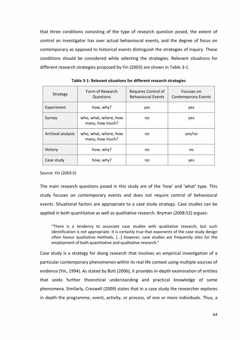
64
that three conditions consisting of the type of research question posed, the extent of
control an investigator has over actual behavioural events, and the degree of focus on
contemporary as opposed to historical events distinguish the strategies of inquiry. These
conditions should be considered while selecting the strategies. Relevant situations for
different research strategies proposed by Yin (2003) are shown in Table 3-1.
Table 3-1: Relevant situations for different research strategies
Strategy Form of Research
Questions Requires Control of Behavioural Events
Focuses on Contemporary Events
Experiment how, why? yes yes
Survey who, what, where, how many, how much?
no yes
Archival analysis who, what, where, how many, how much?
no yes/no
History how, why? no no
Case study how, why? no yes
Source: Yin (2003:5)
The main research questions posed in this study are of the 'how' and ’what’ type. This
study focuses on contemporary events and does not require control of behavioural
events. Situational factors are appropriate to a case study strategy. Case studies can be
applied in both quantitative as well as qualitative research. Bryman (2008:52) argues:
“There is a tendency to associate case studies with qualitative research, but such identification is not appropriate. It is certainly true that exponents of the case study design often favour qualitative methods, [...] however, case studies are frequently sites for the employment of both quantitative and qualitative research.”
Case study is a strategy for doing research that involves an empirical investigation of a
particular contemporary phenomenon within its real life context using multiple sources of
evidence (Yin, 1994). As stated by Bott (2006), it provides in-depth examination of entities
that seeks further theoretical understanding and practical knowledge of some
phenomena. Similarly, Creswell (2009) states that in a case study the researcher explores
in depth the programme, event, activity, or process, of one or more individuals. Thus, a

65
case study strategy is applied in this research in order to understand some phenomena in
depth.
The case study strategy has been increasingly used as a research tool (Yin, 2003:2). It is
widely used in the field of land administration research (for example, Zevenbergen, 2002;
Nkwae, 2006; Rakai, 2005; Silva, 2005). In the words of Williamson and Fourie (1998:2),
“The studies, reviews, or investigations undertaken to date by consultants such as land
surveyors, lawyers, and others working in the area of cadastral reform have often been
termed case studies”.
This study has adopted case study and survey as a strategy of inquiry. The survey strategy
is embedded within the case study. Yin (2003) points out the possibility of a quantitative
case study and a combination of survey and case study in a single research task. In his
words, “Case studies can include and even be limited to quantitative evidence" (p.14) and
"you can use multiple strategies in any given study (e.g., a survey within a case study or a
case study within a survey)" (p.9). He further argues, “When an embedded design is used,
each individual case study may in fact include the collection and analysis of highly
quantitative data, including the use of surveys within each case” (p.53).
In this research, the land administration system of Nepal, Bangladesh and Thailand are
the main cases and the property formalisation programme of Chulachuli, Nepal, surveying
settlement programme of Gharinda, Bangladesh and the land titling programme of
Thailand are the embedded cases. Both qualitative and quantitative data are required to
answer the research questions posed in this research. It seeks to answer questions about
the extent of land use and land-related economic activities promoted by land
administration, relationship of tenure security with land value, investment and income
and effectiveness of land administration services in revenue generation, which requires
the information on the changes caused by the land administration activities at the
household level. Thus, selection of multiple case studies having embedded cases indicates
that the survey within case study strategy is appropriate for this study.
Case study is often criticised for its lack of generalisability. The conclusions made from the
findings from a single case may not be applicable in other cases. Being aware of those
66
limitations, this study does not aim to generalise the findings but to contribute to the
contemporary knowledge about the role of land administration on economic
development in the selected countries. The main research question of this research is
how does land administration support economic development. This research question is
answered from the case studies of Nepal and Bangladesh as there is lack of researches
that cover these issues. Both Nepal and Bangladesh are least developing countries where
the livelihood of a vast majority of people is related to land. Moreover, recently launched
land registration programme in both countries has made possible to answer the research
questions posed in Chapter One. The case study of Thailand provides information from
the already completed research and gives an opportunity to throw light on those findings.
It helps to compare the cases of Nepal and Bangladesh. Selection of multiple cases makes
the study more robust and overcome from the limitations of case study approach.
Questionnaires and interviews are usually used to collect both types of qualitative or
quantitative data in survey research. As stated by Bryman (2008:43), survey research
comprises a cross-sectional design in relation to which data are collected, predominantly
by questionnaire or by structured interview, on more than one case and at a single point
in time in order to collect a body of quantitative or quantifiable data in connection with
two or more variables which are then examined to detect patterns of association.
Similarly, Robson (2002:230) presents three typical central features of surveys: the use of
a fixed, quantitative design, the collection of a small amount of data in standardised data
form from a relatively large number of individuals, and the selection of representative
samples of individuals from known populations.
The field of investigation consists of setting and case study. The setting is a named
context in which phenomena occur that might be studied from any number of angles; a
case is those phenomena seen from one particular theoretical angle (Hammersley and
Atkinson, 1983). Williamson and Fourie (1998) describe that while studying a cadastral
system, the entire cadastral system would be a setting and the case study would be a
particular problem area being examined in more detail. They further state that a body of
cadastral theory is already in place which needs to be recognised, interrogated, used, and
further developed. It provides the general setting of the research, and the case study
methodology would be a useful research method and tool for researchers to start doing
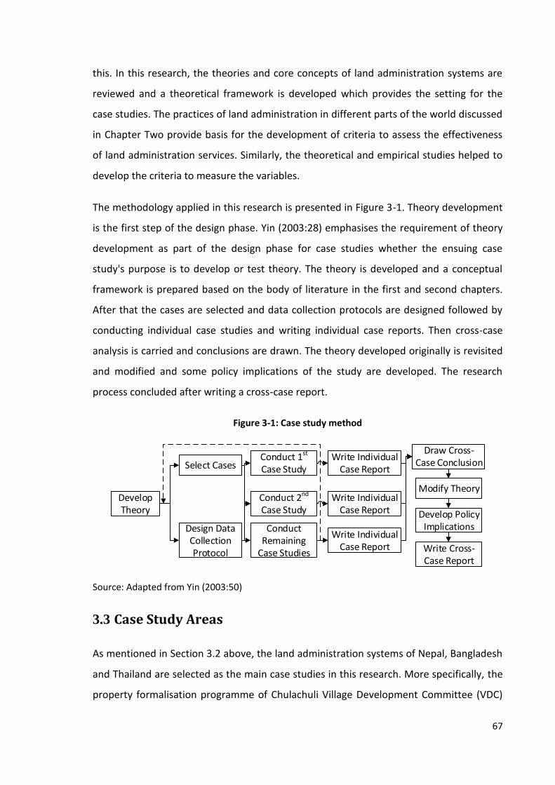
67
this. In this research, the theories and core concepts of land administration systems are
reviewed and a theoretical framework is developed which provides the setting for the
case studies. The practices of land administration in different parts of the world discussed
in Chapter Two provide basis for the development of criteria to assess the effectiveness
of land administration services. Similarly, the theoretical and empirical studies helped to
develop the criteria to measure the variables.
The methodology applied in this research is presented in Figure 3-1. Theory development
is the first step of the design phase. Yin (2003:28) emphasises the requirement of theory
development as part of the design phase for case studies whether the ensuing case
study's purpose is to develop or test theory. The theory is developed and a conceptual
framework is prepared based on the body of literature in the first and second chapters.
After that the cases are selected and data collection protocols are designed followed by
conducting individual case studies and writing individual case reports. Then cross-case
analysis is carried and conclusions are drawn. The theory developed originally is revisited
and modified and some policy implications of the study are developed. The research
process concluded after writing a cross-case report.
Figure 3-1: Case study method
Conduct 1st Case Study
Develop Theory
Select Cases
Design Data Collection Protocol
Conduct 2nd Case Study
Conduct Remaining
Case Studies
Write Individual Case Report
Write Individual Case Report
Write Individual Case Report
Draw Cross-Case Conclusion
Modify Theory
Develop Policy Implications
Write Cross-Case Report
Source: Adapted from Yin (2003:50)
3.3 Case Study Areas
As mentioned in Section 3.2 above, the land administration systems of Nepal, Bangladesh
and Thailand are selected as the main case studies in this research. More specifically, the
property formalisation programme of Chulachuli Village Development Committee (VDC)

68
in Nepal and the surveying settlement programme of Gharinda Union, Bangladesh
provide the focus of the investigation. The research questions posed in this research seek
to investigate the changes in land use, land value, investment and income promoted by
land administration which may be analysed from the study of recently launched
programme in those areas.
The land titling programme of Thailand is selected as it has been considered as one of the
successful land titling projects contributing to agricultural production and the land market
in Thailand. Information about the role of land titling in Thai economy collected from the
secondary sources (for instance, studies by Feder et. al., 1988; AusAID, 2000) provides
opportunity to compare these findings with the situation of Nepal and Bangladesh,
specifically in case of third research question posed in this research. Since there is already
some body of knowledge exist to address this research question in case of Thailand,
household level data is not collected applying a slightly different approach for data
collection. However, data required to answer other questions, especially to measure the
effectiveness of land administration services are collected from Thailand too as there is a
gap of research focusing this issue. Moreover, the selection of Thailand also makes
possible to throw light on the lessons learnt from the land titling programme in the
current scenario.
There are several reasons for selecting the case study areas. This research aims to assess
the role of land administration in economic development so that a developing country
where the role of land administration functions could be analysed would be an obvious
candidate. Both Nepal and Bangladesh are developing countries in which there are some
areas where land administration activities have been carried out recently. Most of the
people in both countries still depend on agriculture for their livelihood. Also, the
agriculture sector is one of the main contributors to their national economy. Nepal and
Bangladesh are in the same geographic region and are in a similar position of economic
development. Furthermore, the origin of the land administration systems in Nepal and
Bangladesh is similar and both countries are adopting the deed registration system. Thus,
the information collected from the study will provide the answer to the research
questions posed in Chapter One.

69
Thailand is ahead of both Nepal and Bangladesh in terms of the level of economic
development as well as the development of land administration. The contribution of
agriculture sector is still significant to the Thai economy, which was promoted after the
implementation of a twenty-year land titling programme between 1985 and 2004. It has
adopted the title registration system which provides a guarantee of registered title, unlike
in Nepal and Bangladesh. Whereas Thailand and Nepal are similarly ranked for property
registration in the ‘Doing Business Report’ published by the World Bank (Nepal is 24th and
Thailand is 29th), Bangladesh is in 177th position (World Bank, 2013). These differences
between cases provide an opportunity to analyse the role of land administration in
contrasting situations. Also, the study of multiple cases will provide more information and
draw more robust conclusion.
Chulachuli VDC of Ilam district is selected as a study area in Nepal. Ilam district is situated
on the eastern border of Nepal. Administratively, Ilam is divided into one municipality and
48 VDCs. The total area of Chulachuli VDC is 77.82 square kilometres. It lies in the south-
western part of Ilam and is bordered by Mahamai VDC to the east, Mahamai and Bajho
VDCs to the north and Jhapa district to the west and south (Map 3-1).

70
Map 3-1: Map of Chulachuli VDC, Ilam, Nepal
Source: UNNIP2 (2014)
Land surveying in Nepal was initiated from the beginning of the 20th century. However,
the systematic surveying and adjudication of land began only after the enactment of the
Land (Survey and Measurement) Act, 1963 and was completed in 2000. However, there
are still some informal settlement areas where land is yet to be formalised. The case of
property formalisation in Chulachuli VDC is selected for study in this research as it was the
only settlement recently formalised having a large population (around five thousand land
owners). It is suitable for analysing the changes in land rights, land value, investment and
income from land administration activities to answer the questions posed in this research.
Cadastral surveying and land adjudication work in Chulachuli began in the 1970s. In the
meantime, the government declared the creation of a green-belt in the Chulachuli area
and planned to evacuate the settlement from BS3 2035 [1978/79]. The government
2United Nations Nepal International Platform 3 Bikram Sambat a calendar system practiced in Nepal; ahead of 56 year, 8 months 15 days than AD
71
offered some areas of land in Prithvi Nagar, Kechana, Satasi and Jhiljhile of Jhapa and
Pathari and in the Shanishchare area of Morang district. The tenants were offered up to
one and a half bigha4 and the landowners were offered up to four bigha of land as
compensation, but landowners with more than four bigha of land were offered cash
compensation for the additional land above four bigha (CAISPSC, 2010). Sixteen
commissions were formed up until 1990 to carry out the resettlement work but all efforts
were in vain. The task of resettlement remained incomplete for several reasons. The
problems identified by the government included (a) some households and tenants could
not get compensation; (b) some households did not leave their land and resettle in
another area; (c) some households disagreed with the amount of land offered as
compensation; (d) some households got the compensation but did not evacuate the
original land; (e) some households left their original land but could not get land in the
proposed area as it was already occupied by someone else; (f) in the meantime, people
coming from other parts of the region occupied some land in the proposed resettlement
area and because of this the households which had evacuated their land in Chulachuli
could not settle there; and (g) more people migrating from hilly districts occupied the
government land in Chulachuli area (ibid). In this way, the problem of evacuation and
resettlement became complex and a source of conflict with the government.
The policy of the government changed after the restoration of democracy in 1990. The
democratic government abandoned the idea of creating a green-belt and began to
restore the rights of the people to their original land. Seven commissions were formed
between 1990 and 2007 but the problem was solved only after the formation of the 23rd
commission called the Chulachuli Area Informal Settlement Problem Solving Committee
(CAISPSC) in 2007. According to the progress report published by the committee, 5,152
people from Ward Numbers 1 to 8 have applied to register land, 4,918 of them were
successful, 3,943 title certificates were prepared and 3,815 landowners had collected
their certificates by mid-July, 2010 (CAISPSC, 2010).
4 A land measurement unit comprising 6,772.63 square meter in Nepal and 1,337.8 square meter in
Bangladesh; 20 kattha

72
In Bangladesh, Gharinda Union of Tangail district is selected as a study area. Tangail is a
district of the Dhaka Division and consists of 11 upazilas5, eight municipalities, 72 wards,
211 mahallas6, 103 union parishads7and 2,431 villages (Bangladesh Bureau of Statistics,
2011). Its area is 3,424 square kilometres. The selected study area is Suruj Village in
Gharinda Union of Tangail Sadar Upazila (Map 3-2). The total number of household in the
Gharinda Union was 5,867 and the total population was 28,315 according to the
Population Census, 2001. The total number of households of Suruj village was 878 as per
the information provided by the union office during the field study.
Map 3-2: Map of Bagladesh and Tangail sub-district showing the case study area
Source: Maps of Bangladesh (2014) (left); Islam (2014) (right)
The land tenure system of Bangladesh is mainly based on permanent settlement
originated during the British period. Various Acts and Rules proclaimed during and after
British rule shaped the rights to land of zamindars8 and tenants. Surveying settlement and
revisional settlement operations are the processes for creating cadastral maps. As
5 A geopolitical subdivision of a district; a collection of mouzas
6 An optional and non-elective unit of a city or municipal corporation, for ritual and representative purposes
7 A geopolitical subdivision of a sub-district
8 An individual responsible for land-tax collection at the village level; landlord

73
described by NORC (2009), these operations normally follow the process of systematic
land titling or adjudication. It also states that surveying settlement (or land settlement) is
the act of surveying and creating the initial cadastral map, and the revisional settlement is
the activity of resurveying settled areas to reflect changes since settlement. The revisional
settlement operations are done to update the existing cadastral records.
The process of land settlement or revisional settlement substantially follows typical
practice for land settlement activities often known as systematic titling or systematic
adjudication of titles in many countries. The surveying and settlement operations defined
the rights and obligations of zamindars and raiyats9 according to the East Bengal Tenancy
Act, 1885 (Hussain, 2012). This Act settled the general principles by which the relationship
between landlord and tenant was regulated (Kabir, 1969:13).
Various settlement operations were carried in order to update the changes of land use
and ownership. These operations were carried out sporadically at the beginning. The
district-wide surveying and settlement operations were conducted in three different
stages. As described by Hussain (2012), the first cycle began in 1888/89 and was
completed with the settlement of Dinajpur district during 1934-40. The second cycle
began with the settlement in Chittagong district in between 1923 and 1933. It was called
a revisional settlement and was undertaken on the basis of cadastral maps and records.
The state acquisition settlement operations were carried out after the proclamation of
the East Bengal State Acquisition and Tenancy Act, 1950. Another settlement operation
was launched between 1965 and 1978.
A new phase of settlement operation called zonal settlement was commenced in 1984. As
described by Hussain (2012), the operation was planned to be carried out in the entire
country simultaneously with 22 district headquarters working as operational centres.
According to him, ten zones were initially selected for operations but it was found to be
difficult to run the programme even in ten districts due to the constraints of budget and
technical manpower. The full phase operation was carried out only in five districts,
namely, Comilla, Mymensingh, Tangail, Rangpur and Bogra. Tangail was selected
9 Cultivators; subject of the state
74
randomly out of the five districts. After selection of the district, the sub-district, union and
village were selected randomly using the lottery method.
The land administration system of Thailand, specifically the land titling programme, is
selected for background study as it is considered to be one of the successful land titling
programme, having positive economic impact. A twenty-year project was implemented
throughout the country between 1985 and 2004. The main objectives of the land titling
project were to provide secure land tenure to eligible landowners, develop the long term
sustainability of the Department of Lands institutional capacity, improve land
administration service delivery, and to develop an effective national property valuation
function (World Bank, 2003). The progress of the land titling project and its effect on
revenue generation and agricultural production is discussed using data collected from
secondary sources.
The process of land registration in Thailand is also studied in this research. A Provincial
Land Office in Nonthaburi province, Pak Kret was selected for observation after
consultation with the officials of the Department of Lands. The map of Thailand
highlighting Nonthaburi province is presented in Map 3-3.

75
Map 3-3: Map of Thailand showing Nonthaburi Province, Thailand
Source: Wikipedia (2014)
The structure of the individual case study reports is the same and contains two basic
themes: economic impact of tenure security and the effectiveness of land administration
services. The case study reports of Nepal and Bangladesh are presented in the same
chapter in order to avoid duplication and to provide an opportunity to discuss issues
thematically rather than on a country-by-country basis.
3.4 Field Study Procedures
3.4.1 Logistical Arrangement, Initial Meetings and Preparation
Empirical field studies in Nepal and Bangladesh were carried out between December 2011
and April 2012. The case study area of Nepal was selected randomly based on the
available information before going to the field and that of Bangladesh was selected after
consultation with the land professionals in Dhaka. Ethical clearance was also obtained

76
from the University of Reading’s Research Ethics Committee. The field-work in Bangkok
was carried out in September 2012. The Department of Lands and the Provincial Land
Office, Nonthaburi were visited during this field-work.
A letter requesting support for the field-work was handed over to all concerned
organisations from all three countries visited during the field work. Government officers
of the concerned ministries, departments and local land registration offices were
informed about the research before starting the data collection process.
Logistical arrangements for the field work in Nepal became easier than in the other
countries since it is the home country of the researcher, and many officers working under
the Ministry of Land Reform and Management (MOLRM) were known to him. The officers
of the ministry provided information about property formalisation in Nepal and helped to
identify the probable case study areas. They also provided contact information for the
officers involved in the property formalisation process in Chulachuli, Ilam. Member
Secretary of the CAISPSC was contacted first who provided some contact information for
the committee members. Local friends of the researcher assisted in every aspect of
arrangements for the field-work including finding accommodation, hiring research
assistants and surveyors, printing questionnaires and buying logistics. The research
assistant and local surveyors also assisted in preparing and conducting the survey and
travelling to the study area.
At the beginning of the field-work, information about the property formalisation
programme was collected from the Land Administration Section of the MOLRM.
Consultations with the officials of the MOLRM, Member Secretary of CAISPSC, local Land
Revenue Officer, local land rights activists and social workers helped to know about the
case and revise the survey questionnaire. Information about the distribution of land and
the list of people acquiring land was obtained from the local land offices. A list of key
respondents for semi-structured interviews was prepared and finalised after consultation
with the supervisor.
In Bangladesh, Mr. Masud Ibn Rahman, Head of the Department of Real Estate, Daffodil
International University, Dhaka, was contacted before going to the field. The Henley

77
Business School asked him for his support during the field-work. Mr. Rahman supported
in each and every step of the field-work, including finding a translator and a field work
assistant, providing information about the land administration system of Bangladesh, and
providing contact information for the people working in the government as well as the
non-governmental sector. The University also offered office space, access to their library,
photocopying and internet facilities to the researcher. Research assistant, translator and
few Nepali students living in Dhaka provided full support in travelling and finding
accommodation.
The fieldwork in Bangladesh began with the discussion with Mr. Masud Ibn Rahaman and
Mr. Shamshul Huda, Executive Director of Association of Land Reform and Development,
soon after arriving in Dhaka. The meeting was scheduled via email before leaving for the
field-work. They provided background information about the land administration system
and contact information for some key people involved in the land rights movement and
land administration profession in Bangladesh. Discussion with the District Registrar, Land
Registry Office, Dhaka, Prof. Dr. Mizanur Rahaman, Acting Director General, Department
of Land Records and Survey and some officers of the local land offices in Tangail helped in
understanding land administration and identifying probable study areas. Gharinda union,
Tangail was selected randomly as a study area. The samples were collected from the
Suruz villages of this union. A list of landowners living in the study area was collected
from the local land office.
The field visit in Thailand was shorter than in Nepal and Bangladesh since the main
purpose of the visit was to collect secondary data about the land titling project. A friend
of the researcher from Reading, UK helped to book accommodation and provided contact
information of his colleagues in Bangkok. Likewise, one of the colleagues of the
researcher from Bangkok helped in organising the field-work, contacting land officers,
scheduling interviews and collecting secondary data. A meeting with her as well as the
Director of the Land Titling Project Office, Department of Lands, helped in listing the
names of possible interviewees and the titles of available documents. Similarly, locally
hired research assistant and translator assisted to carry out interviews, collect data and
travelling around.

78
The questionnaires (Appendix 1), information sheets (Appendix 2) and consent forms
(Appendix 3) were prepared in English first then translated and printed in local languages
Nepali and Bengali. Four surveyors in Nepal and three in Bangladesh were selected to
administer the survey questionnaires. Orientation programmes were organised in both
countries to train the surveyors in conducting surveys.
Pilot studies were carried out in both Nepal and Bangladesh in order to test the structure
and content of the survey questions so that they represent the real situation and can be
administered easily. They were tested with a few of the respondents selected randomly
from the respective study areas of Nepal and Bangladesh. The contents of the survey
questions in Bangladesh were modified slightly in order to incorporate the land tenure
system and land value in Bangladesh. The questions were then revised and finalised;
however, there was no significant change in the original questions posed by the
researcher. The pilot study helped to identify whether the survey questions could be
administered properly or not.
A checklist of key issues for interview as presented in Appendix 4 was also prepared for
each category of respondents. A mock interview was carried out with one of the
colleagues of the researcher in Kathmandu before starting the real interviews.
Appointments were made in advance with all discussants and interviewees via telephone
or email before visiting their offices.
3.4.2 Data Collection
There are many methods of data collection in social science research. Selection of data
collection methods depends on several criteria. Observation, interview, questionnaire
and documentation are the commonly used methods. Yin (2003) classifies sources of
evidence most commonly used in doing case studies into six categories: documentation,
archival records, interviews, direct observations, participant observation and physical
artefacts.
Selection of a data collection method depends primarily on the type of research
questions. The nature of required data, type of respondents and the circumstances of
data collection can also affect the choice of methods. Robson (2002:223) states, “The

79
selection of method or methods is based on what kind of information is sought, from
whom under what circumstances”. He prescribes some simple rules of thumb for
selecting methods as to (a) find out what people do in public, use direct observation, (b)
find out what they do in private, use interviews or questionnaires, (c) find out what they
think, feel and/or believe, use interviews, questionnaires or attitude scales, and (d) to
determine their abilities, or measure their intelligence or personality, use standard tests.
Using different tools to collect data from a variety of informants creates multiple sources
of evidence, forming a source of triangulation and the assessment of information from
different perspectives (Arko-Adjei, 2011). Yin (2003:98) also argues, “[...] the most
important advantage presented by using multiple sources of evidence is the development
of converging lines of inquiry, a process of triangulation […].” He further states that
triangulation increases the reliability of the data and the process of gathering it. Thus,
collection of multiple sources of evidence using multiple techniques will increase the
reliability of this research. Based on the nature of the study and the answers sought, the
multiple techniques of data collection that are applied in this research are discussed
below.
Documentation
Documents can provide large amounts of data in research. As argued by Stapsford and
Jupp (1996:138), existing sources are also important sources for research that can work
both as main and supplementary sources. Similarly, Robson (2002:349) states,
“[Documents] can provide valuable cross-validation of other measures, either in support
or disconfirmation of them”. They can be important in triangulation, especially in case
studies (Punch, 1998). Thus, various documentary data collected from various sources are
analysed in this research.
In order to analyse the practices of land administration and land tenure of the selected
countries, the respective land laws, government decisions, libraries and online sources,
together with reports of the land administration organisations were reviewed. The
minutes of the CAISPSC and records of the local government organisations were also
consulted to identify the status of land ownership. Likewise, publications of finance
80
ministries, central banks and national statistical offices were reviewed which provided
information on revenue and the gross domestic product.
Reviewing these documents helped the researcher to familiarise himself with existing
practices and case studies. The data collected from these sources are used as both main
and supplementary evidence.
Questionnaire
The questionnaire is a method of data collection used in survey research. Surveys include
cross-sectional and longitudinal studies using questionnaires or structured interviews for
data collection (Babbie, 1990). According to Robson (2002:236), most surveys involve the
use of a questionnaire. He classifies the ways of administering questionnaires into three
categories: self-completion questionnaires, face-to-face interviews and telephone
interviews. The face-to-face interview technique was adopted to administer survey
questionnaires. Application of the self-completion questionnaire technique was not
possible to apply in this research because of the chances of having illiterate respondents,
misunderstandings of questions and a low response rate. Likewise, the telephone inquiry
was also not suitable for this study because many respondents did not have a telephone.
Other techniques like internet and postal surveys were not possible as either there was
no internet access or the respondents were not familiar with computers. Thus, the face-
to-face interview was the only method suitable for this research in which the interviewer
had the chance to describe the research, clarify questions and encourage the participants
to respond’.
Structured questionnaires as shown in Appendix 1 were employed to acquire information
from the landowners of the case study areas of Nepal and Bangladesh. In Nepal, Land
Ownership Certificates were prepared in the names of 3,943 land owners from Ward
Numbers 1 to 8 of Chulachuli VDC (CAISPSC, 2010). They are considered as the population
of this study. The list of the landowners was prepared based on the decision made by the
CAISPSC, and was further verified with the records of the Land Revenue Office, Ilam. Only
395 samples were selected using a systematic random sampling method. A list of all
landowners was prepared and a number was assigned to each of them. Then a number
was selected randomly from lottery method. Including that number, each of the tenth

81
number was selected for surveying. Out of these, 381 respondents took part in the survey
but the remaining 14 of the chosen respondents could not be contacted even at the
second attempt.
In Bangladesh, Suruj village of Gharinda Union, Tangail was selected for the case study.
The surveying settlement operation in Tangail was completed in 2009. According to the
record provided by the Union office, the total population of this village is 4,448 and the
total number of households is 878. Out of them, 440 households were selected using a
systematic random sampling method from the list provided by the Union office following
the same procedure as in case of Nepal explained in above paragraph. The questionnaires
were administered to 403 respondents but the remaining 37 respondents could not be
contacted even at the second attempt. The questionnaire was revised after discussing
with the experts and reviewing information collected from the land offices. Pilot studies
were carried out in the case study areas of both countries. The questionnaire was
finalised after incorporating the feedback.
The information sought from the respondents includes general information about their
property, their feelings about the benefits of land registration, and the role of different
agencies in providing land tenure security. The respondents were also asked to provide
information about the realisation of land rights and associated risks on land they have
before and after registration. Moreover, they were asked about the differences they
observed before and after registration in terms of land use, investment, sources of
investment, interest rates, annual income, and the land value. The information sought
from them regarding land administration services included the purpose of their visit to
local land offices and time taken to accomplish their tasks, evaluation of services,
transaction costs and the role of land offices in providing land tenure security.
The field-work in Nepal was conducted between December 2011 and January 2012. Four
surveyors were selected from four different areas of Chulachuli VDC in order to
administer the survey questionnaires. One of them was a university student who had
some theoretical knowledge of data collection. The rest had already been involved in
administering survey questionnaires during the national population census. An
orientation programme was organised by the researcher to train the surveyors about the
82
surveying procedure and the ethical issues they have to consider while conducting the
survey. The ethical issues include taking consent, explaining the procedure and purpose
of the survey, uses and storage of data and procedure of approaching and responding to
the respondents, and getting their consent to fill up the questionnaire. The research
assistant provided logistical support to the surveyors and supervised and monitored their
work.
A timetable for administering the survey questionnaire was prepared based on the
availability of the time of the surveyor and the possibilities of finding the respondents at
home. At the start the researcher accompanied the surveyors. The information sheet was
handed to all the respondents and was explained by the surveyor. The respondents were
also informed that they could stop the survey at any time if they did not wish to continue.
All the respondents were requested to sign the consent form (Appendix 3) to indicate
their agreement. The survey was conducted only if they agreed to participate and signed
the consent form. Altogether 381 questionnaires were completed but the other 14
respondents had left home for employment, internal migration or study purposes and
could not be contacted. The houses of the absent respondents were visited at least one
more time for follow up. Snapshots of the administration of survey questionnaires in
Chulachuli are presented in Photo 3-1.

83
Photo 3-1: Administering survey questionnaires in Chulachuli, Nepal
In Bangladesh, three local surveyors were involved in the survey. They were recruited
from the study area based on their education and previous experience in surveys. A field
assistant and a research assistant were also involved in logistical arrangements,
supervision and monitoring of the survey which was conducted in March 2012.
Semi-structured questionnaires were also used to collect data from the mortgage banks
and financial institutions in Nepal. Nine out of 78 banks and finance companies based in
Kathmandu and two from Ilam were selected from the list provided by the central bank
randomly using a lottery method of random sampling as all of them provide mortgage
against land as a collateral. The respondents were mainly the credit officers, managers or
supervisors working in the credit section and involved in the process of mortgage
registration. The semi-structured questionnaires were administered by the researcher
following the same process as in the survey questionnaires. The information sheet was
handed over and a written consent was obtained from the respondents.
Interview, Discussion and Seminar
The interview is the most widely employed technique for data collection in qualitative
research. It can be used as a primary or only approach in a study, as in a survey or in

84
grounded theory studies, or in combination with other methods in a multi-method
approach (Robson, 2002:270). Interviews are main sources of evidence in case study
research since they study human actions and require personal views. Yin (2014:113)
observes, “Interviews are essential sources of case study evidence because most case
studies are about human affairs or actions.” He further states that interviews can also be
employed if the researcher is interested in an interviewee’s personal view (for example,
opinions, attitudes and meanings).
Interviews can be classified in many ways. A commonly used typology distinguishes
between structured, semi-structured and unstructured interviews based on the degree of
structure or standardisation of the interview (Robson, 2002:270-71). A semi-structured
interview can be applied when the researcher wants rich and detailed information with a
greater interest in the interviewee’s point of view (Bryman, 2004).
In this research, a semi-structured interview was employed to acquire in-depth
information from key informants including senior members of the association of housing
and real estate agencies, land rights activists, senior officials of the land ministries and
academics (Appendix 5). A checklist of key issues and predetermined questions was
prepared, as shown in Appendix 4, to make sure that all relevant issues were covered
during interview. The order and wording of the questions were modified as required in
order to maintain the sequence of the discussion and incorporate the likelihood of the
interviewees omitting inappropriate questions and including additional ones.
The interviews were conducted according to the interview protocol presented in
Appendix 6. At the beginning, the interviewees were informed about the purpose and
procedure of the interview by handing over an information sheet and were asked to sign
a consent form. The interviews were recorded only if a written consent for recording was
obtained from the interviewee. The main points expressed by the interviewee were also
noted down by the researcher during the interview.
Informal interview is also a type of data collection technique. Robson (2002:282)
describes in this technique how the researcher takes an opportunity as it arises to have a
chat with someone in the research setting about any relevant thing. He further observes
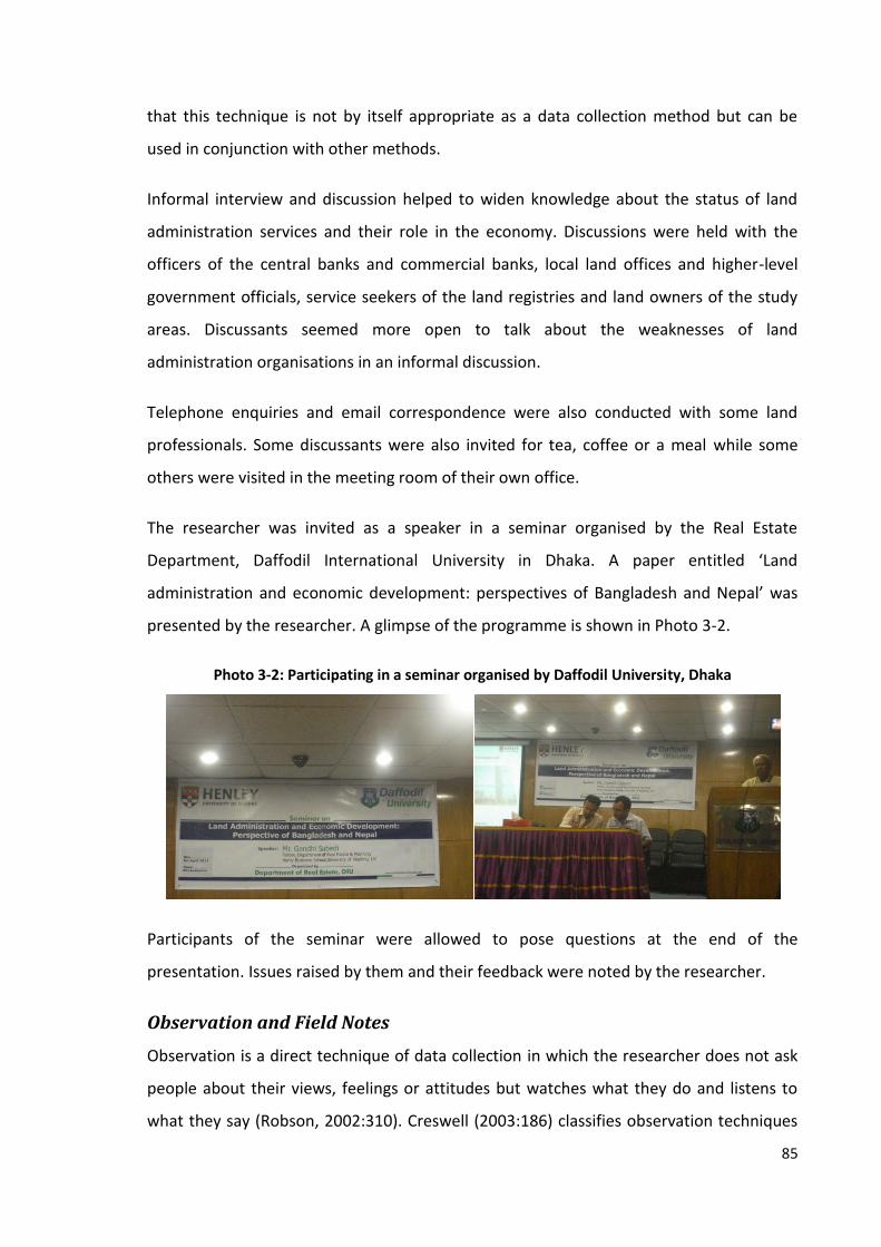
85
that this technique is not by itself appropriate as a data collection method but can be
used in conjunction with other methods.
Informal interview and discussion helped to widen knowledge about the status of land
administration services and their role in the economy. Discussions were held with the
officers of the central banks and commercial banks, local land offices and higher-level
government officials, service seekers of the land registries and land owners of the study
areas. Discussants seemed more open to talk about the weaknesses of land
administration organisations in an informal discussion.
Telephone enquiries and email correspondence were also conducted with some land
professionals. Some discussants were also invited for tea, coffee or a meal while some
others were visited in the meeting room of their own office.
The researcher was invited as a speaker in a seminar organised by the Real Estate
Department, Daffodil International University in Dhaka. A paper entitled ‘Land
administration and economic development: perspectives of Bangladesh and Nepal’ was
presented by the researcher. A glimpse of the programme is shown in Photo 3-2.
Photo 3-2: Participating in a seminar organised by Daffodil University, Dhaka
Participants of the seminar were allowed to pose questions at the end of the
presentation. Issues raised by them and their feedback were noted by the researcher.
Observation and Field Notes
Observation is a direct technique of data collection in which the researcher does not ask
people about their views, feelings or attitudes but watches what they do and listens to
what they say (Robson, 2002:310). Creswell (2003:186) classifies observation techniques
86
into four categories: complete participant, observer as participant, participant as observer
and complete observer.
A complete observer type of observation technique was employed in this research to
acquire first-hand knowledge about the land registration practices of the selected
countries. Land Revenue Office, Ilam (Nepal) and Sub- Registry Office, Tangail
(Bangladesh) were visited by the researcher to observe the process of land registration. In
Thailand, the Pak Kret Provincial Land Office in Nunthaburi province was visited which is
one of the land offices where the land records are digitised and the services are
computerised. Observation was also carried out in the study are to get some idea about
the land use and land related economic activities. An observation protocol as shown in
Appendix 7 was prepared and used during observation.
Field notes are also a source of evidence which help in recording the feelings and initial
reflections of the researcher from direct observation and experience. Bryman (2004)
suggests researchers to take notes to record their observations, feelings and initial
reflections on particular events. Field notes are also required if the interviewee or
discussants decline to record the interview or informal discussions. As stated by
Denscombe (2003), the researchers need to rely on field notes when the interviewees
decline to record the interviewees or discussions.
Field notes may be classified as jottings, diary, log and field notes (Bernard, 2000:357). In
this research, a log was used to record daily plans, schedules and the expenditure details.
Likewise, notes were used to record the feelings and reflections of the researchers as well
as the important information delivered by the interviewees or the discussants. The logs
were maintained daily whereas the notes were written down during discussions,
interviews and observation. These logs and notes were written down in notebooks and
were transcribed later. Separate notebooks were used for each case study.
To sum up, multiple techniques of data collection including documentation,
questionnaire, interview and informal discussion, observation and field notes are
employed in this research. However, the whole process of empirical data generation is led
by the survey questionnaire and semi-structured interviews.

87
3.4.3 Data Recording and Management
The data collected from different sources were recorded separately. A code list of
questionnaires was prepared and the data collected from the survey were transcribed
directly in a quantitative software SPSS after returning from the field-work. Interviews
with all of the key respondents were audio recorded since they happily agreed to record
it. Interview notes were also taken during interviews. The interviews went smoothly and
none of the respondents asked the researcher to stop recording. Verbatim records of
recorded interviews were prepared using a digital audio transcription foot pedal. Informal
interviews and discussions conducted with the government and bank officials were not
voice-recorded as they did not want to record their voices and felt more open to talk
when it was unrecorded. The researcher took notes during all of those interviews and
discussions, however. The notes taken during interviews, discussions and observation and
all of the handwritten material were transcribed daily, edited and stored in a Case Study
Database.
The data and information collected from secondary sources were also recorded in the
database. Printed and handwritten documents were typed up or scanned and kept in
separate folders. Electronic files of the secondary data were also kept separately. The files
were named clearly so that the content of the file is known.
All of the information and data were kept in the database and multiple copies of the
database were prepared and kept in separate computers at the office, at home and on an
external hard-drive. The hardcopies of the documents were also stored securely. Data
was saved in cloud sources including Drop-box and Google Drive as well.
3.4.4 Data Presentation, Analysis and Interpretation
This is an explanatory multiple case study research applying a mixed method approach.
Both quantitative and qualitative data were collected in this research. The quantitative
data were collected from survey and government documents. The data collected from the
rest of the sources are qualitative.
Selection of data analysis technique is one of the most difficult parts in a case study.
Robson (2002:473) states that a case study does not call for a particular approach to the

88
analysis of the qualitative data that it produces. Yin (2003) also argues that the analysis of
case study evidence is one of the least developed and most difficult aspects of doing case
studies. He proposes three general strategies for analysing case study evidence as relying
on theoretical propositions, setting up a framework based on rival explanations, and
developing case descriptions that can be used in practising five specific techniques:
pattern matching, explanation building, time-series analysis, logic-models, and cross-case
analysis. There are other techniques of analysing qualitative and quantitative data.
Techniques used to analyse different forms of data are discussed below.
Quantitative data collected from survey are analysed using statistical techniques. The
data were collected using structured questionnaires. A code list of the questionnaires was
prepared and then the data were entered into SPSS manually. The variables were defined
in the 'Variable View' window first and then the data were entered in the 'Data View'
window. Each column in the 'Data View' window represents a variable and each row
represents a record or case. The data were double checked with help from one of the
friends of the researcher to avoid errors while inputting. Separate case study reports are
prepared for each case study.
The questionnaire contains four types of variables: interval or ratio, ordinal, nominal and
dichotomous. Frequency tables and bar charts are used to analyse the individual variable.
Similarly, contingency tables are used to analyse bivariate analysis and correlation,
regression and paired sample t-tests for multivariate analysis based on the nature of
variables. The significance of the test was measured to a one per cent level of
significance.
Content analysis is a method applied to analyse qualitative data. It is an approach to the
analysis of documents and texts that seeks to quantify content in terms of predetermined
categories and in a systematic and replicable manner (Bryman, 2008:275). It involves
searching for underlying themes in the text material that contain information contributing
to a particular theme of the research (Gibbs, 2002). Robson (2002:352-357) suggests six
steps to carry out the content analysis: start with the research question, decide on a
sampling strategy, define the recording unit, construct categories for analysis, test the
coding on samples of text and assess reliability, and carry out the analysis.

89
Computer-assisted qualitative data analysis software called NVivo 9 produced by QSR
(Software for Qualitative Research) International was used to analyse the qualitative data.
A new project called 'Research Project' was created. Then the document containing data
collected from interview, observation, discussion and field notes were transcribed into
plain text format and imported to the project. The data collected from secondary sources
were coded manually.
The content analysis was undertaken after coding the text. The coding was carried out by
applying nodes to segments of text and the text units were selected as paragraph. The
text was coded and text units were assigned names to reflect the content of the text. The
codes applied were rights, risks, land use, land development, land value, credit,
investment, production, income, revenue, registration procedure, time, costs, land
record, land information, land valuation and employee efficiency, ethics and behaviour.
These codes were structured under thirteen free nodes as rights, risks, land use and
development, land value, credit, investment, production and income, revenue,
registration, land record and information, land valuation, other services and employee
efficiency and behaviour. These nodes were placed under nodes of specific categories
namely, legal (or tenure security), economic and system which served as categories of
analysis and also parent nodes. The nodes structured under legal or tenure security
category were rights and risks. Similarly, land use and development, land value, credit,
investment, production and income, and revenue nodes were structured under legal or
tenure security category and registration, land record and information, land valuation,
other services and employee efficiency and behaviour were organised under the system
category. The nodes incorporated references to those portions of documents in which the
code appears.
Data reduction and data display were considered as part of the analysis. Summarisation
of field notes, coding and identification of themes and patterns, production of memos
about codes and categories were the process involved. Then the coded materials and
notes were used for thematic analysis and interpretation. The data saved under nodes
were searched and compared using the NVivo search engine. The content analysis drew
upon the research questions outlined in Chapter One. The analysis of data structured
under the legal or tenure security category supported to answer the first research

90
question. Similarly, the analysis of data under the economic category supported to
answer the second and third research question and that structured under the system
category supported to answer fourth and fifth research question and also provided some
answer to the second and third research questions.
The explanation building was done after content and statistical analysis as mentioned
above in order to stipulate a presumed set of causal links about the studied phenomena.
Thematic analysis was also carried out. Case study reports were developed from the
thematic analysis and interpretation. The cross-case thematic analysis and interpretation
was carried out by producing cross-case reports. The conclusions and recommendations
were drawn based on the thematic interpretation.
3.4.5 Unit of Analysis and Measurement of Variables
A case is the unit of analysis (Lewis-Beck, 2007). The unit of analysis could be an
individual, a group, an organisation or an event such as the implementation of an
information system (Cagdas and Stubjkaer, 2009). The case study may contain more than
one case and unit of analysis. The case study having more than one case is called a
multiple-case design. If there are more than one units of analysis within a single case, it is
called an embedded case study design (Yin, 2003).
The multiple case study approach is one of the most appropriate strategies for
investigating systems containing more than one unit of analysis (Arko-Adjei, 2011:104).
The evidence from multiple cases is often considered more compelling, and the overall
study is therefore regarded as being more robust (Herriot and Firestone, 1983). The use
of multiple sources of evidence provides a rich store of information that permits the
analysis of a single issue from several perspectives, a process known as ‘triangulating
data’ (Yin, 2003).
This study is also a multiple case study having embedded units of analysis. The land
administration systems of Nepal, Bangladesh and Thailand are the individual cases and
the property formalisation programme of Chulachuli, Nepal, the surveying settlement in
Gharinda, Bangladesh and the Land Titling Programme of Thailand are the embedded
cases. Similarly, households are the units of analysis since this study is concerned with the
91
investment and income made by a household and the activities they perform on their
land. Land is another unit of analysis since the study is about the value of land. This study
also explores the personal attitude of interviewees towards land administration, which
makes an individual a unit of analysis.
This research has five research questions outlined in Section 1.3.2 and the criteria to
measure the issues under investigation are developed in Section 2.5. The role of land
administration in securing land tenure is measured from the rights and risks associated
with land before and after registration based on the criteria developed in Section 2.5. The
respondents were asked whether they have enjoyed rights of ownership, use of
production, transfer, access to credit and lease their land and have experienced any risks
of aggression and not getting adequate compensation in case of acquisition before and
after registration or not. Similarly, the changes in land use and land related activities are
measured based on the criteria developed in Section 2.5 and as shown in the survey
questionnaire presented in Appendix 1. The list was finalised after consultation with the
respondents who participated in the pilot survey and the local people met prior to
finalising the survey questionnaire.
This study also seeks to determine whether there is any relationship between land tenure
security and land value, access to credit, investment and income. Land value was
measured based on information provided by the respondent land owners. It was cross-
checked with the value determined by the government for taxation purposes and also
from the key informants. Similarly, the annual investment and income were measured
based on the information provided by the respondents. They were asked to state the
amount of investment and production in terms of cash instead of goods because a variety
of goods are produced on a small piece of land consequently the respondents may not
provide the exact amount of input and output of each and every good. Rather, it would
be easy to remember the average annual investment and income. The correlation
method is applied to test whether there is any correlation of land value, investment and
income with land tenure security using the tenure security as a dummy variable. Similarly,
a paired sample t-test was employed to test the difference between means of land value,
investment and income before and after registration of the land. The results are tested to

92
a one per cent level of significance. The status of land administration services and their
effectiveness are also measured based on the criteria developed in Section 2.5.
3.5 Research Issues
3.5.1 Research Quality
Validity, reliability and generalisability are commonly used criteria for assessing the
quality of research. Validity refers to the accuracy and trustworthiness of instruments,
data, and findings in research; reliability refers to whether or not you get the same
answer by using an instrument to measure something more than once (Bernard, 2000),
and generalisability refers to the extent to which the findings of the enquiry are more
generally applicable outside the specifics of the situation studied (Robson, 2002:93).
Yin (2003) mentions that four tests including construct validity, internal validity, external
validity and reliability are commonly used to establish the quality of any empirical social
research. Citing Kidder and Judd (1986), he states that the construct validity establishes
correct operational measures for the concepts being studied; the internal validity which is
applied only for descriptive or exploratory study, establishes a causal relationship,
whereby certain conditions are shown to lead to other conditions, as distinguished from
spurious relationships; the external validity establishes the domain to which a study's
findings can be generalised; and the reliability demonstrates that the operations of a
study like the data collection procedures can be repeated with the same results. These
four techniques are considered to make the study more trustworthy.
The themes of this research were developed based on the theoretical foundation as
discussed in the literature review. The research hypotheses were developed based on
these themes. Similarly, the survey questionnaire and the checklists for interview and
observation were also designed on the basis of the themes. The themes as well as the
issues that emerged during the empirical studies were addressed while analysing and
interpreting the data for each individual case study. Quantitative data were analysed
using statistical tools and their significance was also tested. The cross-case analysis report
was prepared which depicts whether the same logic is replicated or not.

93
Three principles of data collection proposed by Yin (2003), use of multiple sources of
evidence, creating a case study database, and maintaining a chain of evidence, were
followed in this study in order to establish the construct validity and reliability of the case
study evidence. Multiple sources of evidence including documentation, questionnaire,
interview, discussion, and field notes are the main sources of information employed in
this research, which makes the triangulation of evidence possible.
Enough attention was given to make the research more reliable from the beginning of the
case study. A case study protocol was designed which guided the entire data collection
procedure. Similarly, a case study database was prepared for each case to organise data
collected from all sources. A case plan was also prepared to organise the daily activities
and a field diary was maintained to record the reflections of the researcher. The chain of
evidence was established by linking the case study questions with the case study
protocol, case study database and case study report. Specific sources of evidence were
properly referred to while preparing the case study report. The case study reports were
submitted to a few key informants and feedback was received from them. To ensure the
reliability of the qualitative data collected from field work, complete records of all phases
of research process including the problem formulation, selection of research participants,
interview transcripts, field notes and data analysis decisions are cross-checked by the
supervisors right from the beginning to the write up of every single piece of work. The
processes and outcomes of every step of the study were shared with the supervisors and
their feedback were duly acknowledged.
Thus, selection of more than one case, formulation and adoption of case study protocol,
using multiple sources of evidence and establishing chains of evidence, thematic and
cross-case analysis, hypothesis testing of quantitative data, obtaining feedback from a
few key respondents about the case study report and sharing every details of the
processes and outcomes of the study with the supervisors are the measures that maintain
the quality of this research.
3.5.2 Ethical Issues
Ethical issues cannot be ignored as they relate directly to the integrity of a piece of
research and to the disciplines that are involved (Bryman, 2008:113). Most of the data in

94
this research were collected from primary sources. Large numbers of people and
stakeholders were consulted during the field study. A formal ethical clearance was
obtained from the Research Ethics Committee of the University of Reading before starting
the field-work.
Four types of ethical principles are proposed by Diener and Crandall (1978): whether
there is harm to participants, whether there is lack of informed consent, whether there is
invasion of privacy, and whether deception is involved; these were strictly followed in this
study. An information sheet, describing the purpose of the research, the identity of the
researcher, the process of the data collection, and the contact information of the
researcher, was handed to each respondent before starting surveys and interviews. They
were also informed about the process of their selection, likely benefits and losses and
potential harms or risks due to their participation. Moreover, they were informed that
they could stop discussion at any time in the survey or interview if they did not want to
continue.
Consent forms were also prepared and printed in local languages Nepali and Bengali.
After describing the research, the purpose and content of the consent form was explained
to the respondents. They were requested to sign the form when they clearly understood
the content and agreed to participate in the survey or interview. The consent was
obtained in advance from all the respondents. In Thailand, the English version of the
information sheet and consent form was used since only senior level government officers
and academics were interviewed and they could understand the English.
Documents collected from the field-work were stored securely. The personal opinions of
the respondents are not shared with anybody else and used only for the purpose of this
research. The confidentiality and anonymity of the participants is maintained properly.
Also, it was ensured that there would be no disadvantage to the participants because of
their participation in the research process. The respondents selected for this study were
all adult. No child or person above 80 years participated in the survey and interviews. No
animals or any other living beings were part of this study.

95
Thus, enough attention was given in order to maintain the ethical standard of this
research.
3.5.3 Reflection on the Field Study
The field studies were carried out in Nepal, the home country of the researcher, and two
other Asian countries, Bangladesh and Thailand. The main components of the field work
were to collect primary data from the landowners of the selected study areas, interview
and discuss with the government officers working in and under the land ministries, senior
executives of the real estate associations, bank officials, academics and land rights
activists. Collection of secondary data from the government organisations, national
statistical offices and central bank was also a part of the field-work.
A great difference was observed in undertaking research in home and in the other
countries. A very warm welcome was offered to the researcher in his home country while
visiting the government offices where the researcher had been employed for a long
period of time. Most of the officers working in the land administration organisations were
known to the researcher. The staffs were very excited to discuss the project and ready to
provide the required information. Some respondents of the bank, financial companies
and the real estate agencies were reluctant to discuss mortgage loans since this sector
was suffering badly from credit problems at the time of the field-work. However, when
they understood the purpose of the study and the content of the questions, they became
supportive and more open. At the end, all the respondents were happy about the
discussion.
The landowners of the study area were excited and happy that their cases had been
chosen for study. When the purpose of the research was explained to them, they felt that
their voices would now be heard in the academic sector as well. They were very eager to
see their case written in the form of a thesis. They cooperated with the researcher and
the surveyors by sharing their knowledge.
The researcher presented himself as a research student rather than an employee of the
government among the respondents to avoid bias in their answers. His personal
relationship was used to some extent to collect secondary data from the government and

96
banking sectors but not to influence the information from the respondents. Very good
support was received from the academics, land rights activists and local people in the
study area.
The situation in Bangladesh was quite different. Very warm support was received from
the academic and non-government sectors. The support from the Daffodil International
University was highly appreciated. The field-work could not have been completed without
their support. Similarly, people working in the land rights sector were also excited about
the study and eager to help the researcher. However, access for a foreigner to the
government ministries and departments was found to be very difficult. The senior officers
of the Department of Land Records and Survey were not interested in talking with the
researcher as he was a foreigner. The researcher failed to book any appointments with
the directors. Also, he did not get any access to the ministries. It was an unanticipated
challenge faced by the researcher during his field-work in Bangladesh. No information
could be collected from the central level land administration organisations consequently
the researcher had to rely on the information collected from secondary sources,
specifically in the case of the progress of the ministries. However, the officers working in
the local land registries were very cooperative. They were even excited to know from the
researcher about the land administration system and practices.
Difficulties in understanding the local language and culture, travel and transportation
were the other challenges faced by the researcher during his field-work in Bangladesh
and Thailand. Common people could not speak and understand English. The researcher
could not go outside his room and buy necessary items from the shops without the help
of a translator. Long traffic delays in Dhaka city were another problem that affected the
daily schedule of the researcher. Travelling in rickshaws and CNG10 in the afternoon was
really horrible because of the traffic and high temperatures. It was even hard to attend
two appointments in a whole day. Two and a half days holiday in a week also hampered
his work. Moreover, protest rallies, demonstrations and public strikes and the use of force
to suppress them also affected the daily schedule. The researcher had to stay inside for
10A caged, motorized tricycle run from compressed natural gas
97
four days because of the violent protests. Also, incidents of theft, robbery and kidnapping
were quite common in the city. The researcher tried to avoid all unnecessary and
unaccompanied travel for safety reasons. Despite these challenges, the field-work was
completed on time because of the huge support from research assistants and translators.
It is interesting to note that the differences in culture and religion did not have any
serious impact on the fieldwork.
The researcher did not face much challenge during the field-work in Thailand as one of his
classmates was employed in the survey department. She booked appointments with the
directors of the Department of Lands, helped in collecting data from the department and
National Statistics Office and arranged a field trip to Nonthaburi Land Office. Also, the
field-work in Thailand was much shorter than in Nepal and Bangladesh as it was only
focused on interviewing some respondents, collecting secondary data from the
government departments and visiting a land office. Access to government departments
and language remained problematic but were tackled with the help of assistants and
colleagues.
There were no major changes in the case study plan. In Nepal, the data was collected
from almost all of the expected respondents. There were minor changes in the
questionnaire designed for the survey after doing a pilot study. However, there were no
significant changes in the interview check-list. Some respondents, especially the local
Land Revenue Officers were quite busy and opted to answer their questions in writing.
Similarly, there were no major changes in the action plan prepared before going to the
field although the interviews with some respondents had to be rescheduled because of
their time constraints.
The study area in Bangladesh was selected only after discussion with local land
professionals. The questionnaire had to be modified in order to integrate with the local
system. The Ministry of Lands and Ministry of Law, Justice and Parliamentary Affairs
(MOLJAPA) could not be visited since no access was granted to the ministry compound.
However, the required information was collected from other sources. Personal
relationships of the research assistant helped in collecting data from the central bank.
98
Instruction from the supervisor was obtained from time to time which helped in
conducting the field study properly. Although there were some difficulties throughout the
field-work, the overall work remained successful.
3.5.4 Limitations of the Case Studies
Despite some limitations, overall the field-work remained successful. High-level
government officials working in the land administration organisations of Bangladesh
could not be interviewed and hence their opinions could not be included in this research.
This was because they were reluctant to provide any information to foreigners. Similarly,
the researcher could not obtain official reports on the number of transactions, revenue
collection and land valuation because these reports are not allowed to be shared with
foreigners, although the purpose of the study was clearly explained. It has limited the
analysis of these factors.
Language is one of the limitations faced by the researcher in this study. Most of the
literature about land administration systems and reports of the government of
Bangladesh and Thailand were written in Bengali and Thai respectively. It limited the
understanding about the cases to some extent. However, books and documents written
in English, online information provided in their websites and a discussion with the local
land officers helped in understanding the system of land administration and gathering the
required information.
3.6 Summary
This chapter explored the importance of the multiple case study approach for this study
and explained the rationale behind the selection of specific research techniques, including
the selection of study areas and methods of data collection and analysis. It also described
the whole process of field study, measures taken to maintain the trustworthiness of the
research, and reflections of the researcher about the field-work and its limitations.
The explanatory multiple case study method was selected for this study. Land
administration systems in Nepal, Bangladesh and Thailand provide the focus for this
study. In particular, the property formalisation programme in the informal settlement

99
area of Chulachuli VDC, Nepal, the surveying settlement in Gharinda, Bangladesh and the
land titling program in Thailand form the case studies.
This study employed multiple methods to collect the data. Survey method was applied to
collect data from the randomly selected respondents of the selected case study areas in
Nepal and Bangladesh. Some key informants were interviewed in order to get in-depth
knowledge about the land administration system of the three selected countries.
Documentation, observation, informal discussion and field notes were also techniques
employed to collect data. The data were transcribed and analysed using the quantitative
and qualitative data analysing software called SPSS and NVivo respectively. Correlation
analysis, paired sample t-test, content analysis and cross-case analysis were the
techniques employed to analyse the data.
Efforts were made to maintain research quality at each stage of the research including
the use of a mixed method approach, selection of multiple cases, use of multiple methods
for data collection, adoption of case study protocol, thematic and cross-case analysis,
hypothesis testing and obtaining feedback from respondents about the case study report.
Ethical issues were properly considered while conducting field-work and managing and
using data.

100
Chapter 4: Practices of Land Administration in Nepal,
Bangladesh and Thailand
4.1 Introduction
This chapter discusses the systems of land tenure and land administration practiced in
Nepal, Bangladesh and Thailand. It presents general background information, some
macro indicators and the GDP from agriculture sector of the selected countries first. Then
existing systems of land tenure and status of access to land in these countries are
outlined. After that the system of land administration of these countries is discussed. It
includes the legal framework, organisation structure, registration process, cadastral
surveying and property valuation.
4.2 General Background
All three countries selected for study are from the Asian continent. Nepal and Bangladesh
are situated in South Asia whereas Thailand is in South East Asia. Geographically, Nepal is
divided into three regions; Mountain, Hill and Terai11 representing 15, 68 and 17 per cent
of total area respectively. Administratively, it is divided into development regions, zone
and district. The districts are further divided into municipalities and VDCs. There are five
Development Regions, 14 zones and 75 districts, 130 municipalities and 3,633 VDCs
throughout the country (Central Bureau of Statistics, 2013).
The People’s Republic of Bangladesh was formed in 1972. It was part of India until 1947
and then part of Pakistan until it gained its independence. Administratively, it comprises
seven divisions, 64 districts, 483 sub-districts, and 4,500 union parishads, six city
corporations and 309 municipalities as on 31st December, 2010 (Bangladesh Bureau of
Statistics, 2011). Its smallest administrative unit is a village.
11 Low-lying land at the foot of the Himalayas south to the border with India; covers 17 per cent of the total
land area of Nepal

101
The Kingdom of Thailand is divided into provinces, districts, sub-districts, communes and
villages. As of 2000, there were 76 provinces, 795 districts, 81 sub-districts, 7,255
communes, and 69,866 villages (National Statistics Office, 2004).
Selected macro indicators for Nepal, Bangladesh and Thailand are presented in Table 4-1.
Bangladesh is highly populated, having a population of 160 million people. The
populations of Nepal and Thailand in 2008 were 28 and 67 million respectively. The
surface area of Nepal and Bangladesh is almost the same, but Thailand is nearly three
times larger than both of these countries. Bangladesh has a higher proportion of arable
and agricultural land than the other two countries. As shown in the table, 69 per cent of
the land area in Bangladesh is agricultural land whereas only 30 per cent and 36 per cent
of the land area in Nepal and Thailand respectively is agricultural land. The table also
shows that Thai economy is the largest compared to the other two countries. The total
GDP of Thailand in 2008 was more than 20 times higher than that of Nepal and more than
three times higher than that of Bangladesh. Agriculture is the main source of income in
Nepal where it constitutes one-third (34 per cent) of total GDP. It is the second largest
contributor to GDP in Bangladesh (19 per cent). The contribution to this sector in the Thai
economy is lower than in the other countries. In Thailand, the manufacturing and service
sectors contribute 46 per cent and 36 per cent of total GDP respectively. These sectors
share significant proportions of GDP in Bangladesh at 29 per cent and 18 per cent
respectively. The share of the service sector in Nepal is only seven per cent.
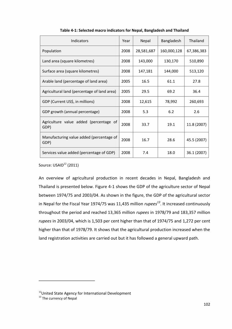
102
Table 4-1: Selected macro indicators for Nepal, Bangladesh and Thailand
Indicators Year Nepal Bangladesh Thailand
Population 2008 28,581,687 160,000,128 67,386,383
Land area (square kilometres) 2008 143,000 130,170 510,890
Surface area (square kilometres) 2008 147,181 144,000 513,120
Arable land (percentage of land area) 2005 16.5 61.1 27.8
Agricultural land (percentage of land area) 2005 29.5 69.2 36.4
GDP (Current US$, in millions) 2008 12,615 78,992 260,693
GDP growth (annual percentage) 2008 5.3 6.2 2.6
Agriculture value added (percentage of GDP)
2008 33.7 19.1 11.8 (2007)
Manufacturing value added (percentage of GDP)
2008 16.7 28.6 45.5 (2007)
Services value added (percentage of GDP) 2008 7.4 18.0 36.1 (2007)
Source: USAID12 (2011)
An overview of agricultural production in recent decades in Nepal, Bangladesh and
Thailand is presented below. Figure 4-1 shows the GDP of the agriculture sector of Nepal
between 1974/75 and 2003/04. As shown in the figure, the GDP of the agricultural sector
in Nepal for the Fiscal Year 1974/75 was 11,435 million rupees13. It increased continuously
throughout the period and reached 13,365 million rupees in 1978/79 and 183,357 million
rupees in 2003/04, which is 1,503 per cent higher than that of 1974/75 and 1,272 per cent
higher than that of 1978/79. It shows that the agricultural production increased when the
land registration activities are carried out but it has followed a general upward path.
12United State Agency for International Development 13
The currency of Nepal

103
Figure 4-1: GDP from agricultural sector in Nepal from 1974/75 to 2003/04
Source: Central Bureau of Statistics (2012)
The gross value added of the agricultural sector in Bangladesh between 1960 and 2013 is
presented in Figure 4-2. As shown in the figure, the gross value added was 11,793 million
taka14 in 1960, which increased by around 90 percent in 1972 (22,490 million taka) when
Bangladesh gained independence from Pakistan. It rose gradually with some fluctuations
to reach 154,773 in 1984 and 1,857,525 million taka in 2013 increasing 15,650 per cent,
8,159 per cent and 1,100 per cent than that of 1960, 1972 and 1984 respectively. Thus,
agricultural production has followed a general upward path during this period.
14 The currency of Bangladesh
0
20000
40000
60000
80000
100000
120000
140000
160000
180000
200000
Agr
icu
ltu
re G
DP
in M
illio
n R
up
ees
Fiscal Year
GDP from Agriculture (Agriculure, Fishery and Forestry) in Nepal From 1974/75 to 2003/04 (in Million Rupees)
Agriculture GDP
Introduction of Land Revenue Act

104
Figure 4-2: Agriculture value added in Bangladesh from 1960 to 2013
Source: World Bank (2014a)
Figure 4-3 presents GDP from the agricultural sector in Thailand between 1975 and 2011.
The agriculture GDP increased considerably except in 1993, 1999 and 2009. In comparison
to the GDP of 1985 (167,026 million baht15) it increased by 300 per cent in 2004 (668,808
million baht) and 680 per cent in 2011 (1,303,580 million baht).
15 The currency of Thailand
0 200000 400000 600000 800000
1000000 1200000 1400000 1600000 1800000 2000000
19
60
19
63
19
66
19
69
19
72
19
75
19
78
19
81
19
84
19
87
19
90
19
93
19
96
19
99
20
02
20
05
20
08
20
11
Agr
icu
ltu
ral V
alu
e A
dd
ed
in M
illio
n T
aka
Year
Agriculture Value Added in Bangladesh From 1960 to 2013 (in Million Taka)
Agriculture Value Added
Independence of Bangladesh

105
Figure 4-3: Agricultural value added in Thailand from 1975 to 2011
Source: World Bank (2014b)
The data from Nepal and Thailand presented above cover the period in which land
administration activities were mainly carried out. In Nepal, most of the land adjudication
works were carried out and the Land Revenue Act, 1978 was implemented throughout
the country. In Thailand, the 20-year land titling programme was implemented and more
than 20 million parcels were titled. The data show that the agricultural production has
followed an upward trend after the commencement of land registration activities despite
some minor fluctuations. In case of Bangladesh, it does not cover the period in which land
administration activities were carried out although, it provides a scenario of agricultural
production in recent decades.
4.3 Land Tenure and Access to Land
This section discusses the system of land tenure practiced in Nepal, Bangladesh and
Thailand and describes how the private ownership of land developed in these countries.
4.3.1 Nepal
Historically, all land in Nepal belonged to the state. Traditionally, people could enjoy
rights to use and fruit but the state owned the land. Private property rights in land
-
200,000
400,000
600,000
800,000
1,000,000
1,200,000
1,400,000
19
75
19
77
19
79
19
81
19
83
19
85
19
87
19
89
19
91
19
93
19
95
19
97
19
99
20
01
20
03
20
05
20
07
20
09
20
11
Agr
icu
ltu
ral V
alu
e A
dd
ed
in M
illio
n B
aht
Year
Agriculture Value Added in Thailand From 1975 to 2011 (in Million Baht)
Agriculture Value Added
Introduction of Land Titling Programme
106
emerged when the state began to delineate its ownership in many ways. The land tenure
system of Nepal is known as Raikar16 under which landowners can enjoy land rights
provided that they keep paying land tax to the state.
A number of secondary forms of land tenure like Birta17, Guthi18 and Jagir19 were created
when private property rights emerged (Regmi, 1999:16). The system in which members of
the royal family and soldiers were assigned income from land is known as Birta. The Birta
land was provided to priests, religious teachers, members of the nobility and the royal
family. Similarly, Guthi is used to denote an association of persons responsible for the
management of religious and philanthropic land endowments (Bose, 1961). The land
belonging to such association is known as Guthi land and the system that manages such
land is also known as Guthi tenure system. A system of providing land to government
employees and soldiers instead of cash salary known as Jagir emerged during the
unification of Nepal20. The government used to prepare the record of lands on which the
state retained its right to collect and appropriate revenue, which is known as Jagera
Lagat21.
There was another system called Rakam22, which is not any particular category of land,
but is a kind of system in which the cultivators of Raikar, Guthi or Jagir lands had to
provide unpaid labour for the performance of a specific function. The tenants used to
have a double obligation of paying in cash or in kind for cultivating land and providing
compulsory and unpaid labour on special occasions in this system. Right of use in Rakam
lands was held permanently and was inheritable provided the holder or his heirs
continued to perform specific functions (Tuladhar, 2004).
16 Lands on which taxes are collected from individual landowners
17 Land grants made by the state to individuals; abolished in 1960
18 An endowment of land made for any religious or philanthropic purposes; trust land
19 Raikar lands assigned to government employees and functionaries in lieu of their emoluments
20King Prithvi Narayan Shah (1723-1775) campaigned for unification of several kingdoms to build a strong
nation and protect from the British Empire. The campaign continued until 1814 and the land between Tista and Satlaj came under the control of Nepal which squeezed into the present shape after the Sugauli Treaty of 1816 resulted from the 1814-1816 war. 21
A record of Jagera land or land available for distribution 22
Unpaid and compulsory labour services due to the government from peasants cultivating Raikar, Jagir, Kipat and Raj Guthi land; abolished in 1964
107
A communal type of land tenure system known as Kipat23 was also in practice in the
eastern hilly region of Nepal. Only members of a Limbu community living in a specific
region could obtain ownership of Kipat land. Under this system, communal authority
superseded any claim that the state might extend on the grounds of internal sovereignty
or state landlordism (Regmi, 1999:19).
Other forms of land tenure also emerged under which land ownership was delivered to
the people. Ukhada24, Jhora25 and Kharka26 are types of land tenure that existed in
different parts of the country. The land tenure system under which the tenant could pay
the rent in terms of cash is known as Ukhada, which was in practice in Nawalparasi,
Rupandehi and Kapilbastu districts. Similarly, land cultivated by cutting bushes or forest
is known as Jhora land which was mainly practised in Jhapa, Morang and Sunsari districts.
Also, land used for pasture known as Kharka land which was practised in
Kabhrepalanchok, Sindhupalchok and Rasuwa districts.
The area of land held under different tenure systems as of 1952 is presented in Table 4-2.
Accordingly, the largest form of tenure was Raikar, which constituted half of the total
area of land. The second largest form of land tenure was Birta, which constituted 36 per
cent of land area. Guthi and Kipat land constituted two and four per cent of land area
respectively. Likewise, Jagir, Rakam and other categories of land tenure accounted for the
remaining eight per cent of land area.
23 A system of communal land ownership prevalent among the Limbus and other Mongoloid communities in
the eastern hilly region 24
A form of landownership under which lands of zamindar or intermediary landowners used to be let out to tenants on low cash rents; abolished in 1964 25
A form of land tenure in which land was cultivated by cutting bushes or forest; forest land 26
A form of land tenure where some area of land was allocated for pasture; pasture land
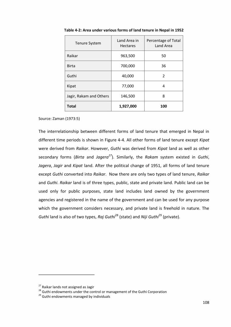
108
Table 4-2: Area under various forms of land tenure in Nepal in 1952
Tenure System Land Area in
Hectares Percentage of Total
Land Area
Raikar 963,500 50
Birta 700,000 36
Guthi 40,000 2
Kipat 77,000 4
Jagir, Rakam and Others 146,500 8
Total 1,927,000 100
Source: Zaman (1973:5)
The interrelationship between different forms of land tenure that emerged in Nepal in
different time periods is shown in Figure 4-4. All other forms of land tenure except Kipat
were derived from Raikar. However, Guthi was derived from Kipat land as well as other
secondary forms (Birta and Jagera27). Similarly, the Rakam system existed in Guthi,
Jagera, Jagir and Kipat land. After the political change of 1951, all forms of land tenure
except Guthi converted into Raikar. Now there are only two types of land tenure, Raikar
and Guthi. Raikar land is of three types, public, state and private land. Public land can be
used only for public purposes, state land includes land owned by the government
agencies and registered in the name of the government and can be used for any purpose
which the government considers necessary, and private land is freehold in nature. The
Guthi land is also of two types, Raj Guthi28 (state) and Niji Guthi29 (private).
27 Raikar lands not assigned as Jagir
28 Guthi endowments under the control or management of the Guthi Corporation
29 Guthi endowments managed by individuals

109
Figure 4-4: Interrelationship among different forms of land tenure practiced in Nepal
Land Tenure
Kipat (Communal)
Raikar (State Ownership)
Guthi (State and Private)
Raikar (Public, State and Private)
Guthi (State and Private)
Jhora
Kharka
Ukhada
Birta
Jagera
Jagir Rakam
Source: Adapted from Regmi (1999)
Land reform remains one of the means of providing land to the people after the political
changes of 1951 in Nepal. It has been a highly contested, discussed and debated issue
since then (Adhikari, 2009:100-101). The main initial efforts made by the government
between 1951 and 1961 included the formation of the Land Assessment Commission and
the Land Reform Commission, declaration of a Thirteen Point Plan and enactment of the
Land and Cultivation Record Compilation Act, 1956 and Land Related Act, 1957 (HLCSLR,
2010:8). The post-1951 land reform policy aimed at ameliorating the condition of the
peasantry and stemming the tide of social unrest (Regmi, 1999:197).
King Mahendra, who reigned from 1956 to 1972, initiated the land reform programme in
Nepal. The Bhumi Sambandhi Ain, 2021 (Land Act, 1964) was issued aiming to divert the
inactive capital and human resources from the agricultural sector to other sectors of the
economy in order to accelerate the pace of development, to uplift the living standard of
peasants and maximize agricultural production. The main provisions of the Act were to
abolish the zamindari system30, establish a maximum size of land holding, acquire land in
cases where landowners hold more than this maximum and distribute such land among
local landless people, fix the amount of rent, and protect tenancy rights. Citing Bahadur
(1972), Regmi (1999) observes that the government had identified approximately 50,000
30 A system of land tenure assigning the task of collecting land tax to landlords

110
hectares of land above the maximum ceiling out of which 22,000 hectares was
redistributed to about 10,000 peasant families by July 1972. This constituted
approximately three per cent of the cultivated area. The current provision of the Land
Act, 1964 is to allocate 50 per cent of the cultivated land to the tenants. Although the
land reform programme has been criticised on various grounds, the concentration of
landownership was broken after implementation of this programme, tenancy rights
became secured and many tenants became landowners (Regmi, 1999). Thus, land reform
has helped in establishing tenancy rights and increasing people’s access to land.
State-owned land was transferred to the people in other ways too. These included
resettlement plans, formalisation of informal settlements, redistribution of land to
landless, deprived and indigenous people, and bonded labour called Kamaiya31, Haliya32,
Haruwa33 and Charuwa34. Government initiatives for solving the landless problem and
settling people on forest land began after the political changes of 1951. Enactment of
Regional Plan (Distribution of Land of Rapti Doon) Regulation, Plan to Assess the
Agricultural Loan and Liberating Agricultural Bonded Labour, enactment of Act Related to
Land of Jhora Area, formation of Regional Settlement Committee, Zonal Settlement
Committee and High Level Commission on Improvement of Forest Area were some of
these efforts (MOLRM, 2011). Large amounts of land were distributed to common people
from different parts of the country, especially in the Terai region.
Most of the governments formed after the restoration of democracy in 1990 gave priority
to solving the problems of landless people, informal settlers and other deprived people
including freed-bonded labour. As mentioned by HLCSLR (2010), several commissions
were formed to solve the landless problem and distributed around 46,694 bighas of land
to landless people. Similarly, the government has distributed 4,607 bighas of land up to
mid-July, 2011 to 22,918 Kamaiya households, who were freed in July 2000 (MORLM,
2011).
31 A traditional system of bonded labour practiced in Western Terai of Nepal
32 A person who ploughs the land of landlords to pay back his loan and interest
33 A person who ploughs the land of landlords in an annual contract to pay back his loan and interest
34 A herder who looks after landlords’ cattle

111
The government has also formed various commissions and committees to solve the land
problems of specific areas. For instance, the Chulachuli Area Informal Settlement Problem
Solving Committee formed in 2064 (2007) to formalise property and solve land
settlement problem in Chulachuli VDC of Ilam district provided land ownership
certificates to nearly five thousand people.
Thus, the ownership of state-owned land was transferred to the general population in
many ways. The total number of landowners (including non-agricultural holdings) reached
9,024,751 by mid-July, 2011 (MOLRM, 2011). Table 4-3 presents the number of
agricultural land holdings between 1961/62 and 2001/02. The data shows that the
number of land holdings increased by 118 per cent from 1,540 thousands of 1961/62 to
3,364 thousand of 2001/02. The highest increase in number and area of land holdings is
observed between 1971/72 and 1981/82 in which period the number of land holdings
increased by 28 per cent and the area of holdings by 49 per cent. This was the period
when the activities of cadastral surveying, land adjudication and the establishment of
Land Revenue Offices were at their greatest.
Table 4-3: Agricultural land holdings in Nepal from 1961/62 to 2001/02
Census Year
Number of Land Holdings Area of Holdings
Number (in Thousands)
Percentage Change From Previous Census
Hectares (in Thousands)
Percentage Change From Previous Census
1961/62 1,540.0 - 1,685.40 -
1971/72 1,712.2 +11.2 1,654.00 -1.9
1981/82 2,194.0 +28.1 2,463.70 +48.9
1991/92 2,736.1 +24.7 2,597.40 +5.4
2001/02 3,364.1 +23.0 2,653.90 +2.2
Source: Central Bureau of Statistics (2003)
The task of determining land rights in Nepal was done by means of cadastral surveying. It
was initiated in the first half of the 20th century; however, systematic cadastral surveying
was carried out only after the enactment of the Jagga (Nap Jach) Ain, 2019 (Land Survey
and Measurement, Act, 1963). The main purpose of its enactment was to collect records
112
of landholdings for implementing the land reform programme. Initially, local landlords
were nominated as non-official agents to collect land revenue, issue receipts and
maintain ownership and transaction records on behalf of the government. The land
records and tax receipts issued by them were considered as evidence of landholding
during the adjudication of claims to land. The first stage of cadastral surveying throughout
the country was completed in 2000.
The government promulgated the Bhumi Prashsan Ain, 2024 (Land Administration Act,
1967) in order to maintain inventories of the lands, landowners and tenants in a modern
fashion to make timely improvements in the provisions pertaining to current cultivation
of the lands subject to land revenue. This Act was later repealed by the Malpot Ain, 2034
(Land Revenue Act, 1978) which was mainly promulgated to revise and integrate the
provision of collecting land tax with land cultivation. The Land Revenue Act provided for
the establishment of Land Revenue Offices and assigned authority for preparing a land
register, adjudication of land claims, registration of transactions, transfer of inherited
property, updating of land records, collection of land revenue, and the preservation of
government and public land, among others. The Land Revenue Offices also have authority
to complete the task of land adjudication initiated by the Survey Parties during their
cadastral survey in accordance with the Land (Survey and Measurement) Act, 1964. The
Land Revenue Act has also provided for the formation of a committee or commission to
solve the problems regarding the registration of land under the name of any specific
individual, class or area. The informal system of land registration became a formalised
system after the adjudication of land claims and the enactment of this Act throughout the
country.
Thus, the state-owned land in Nepal transferred to the general population after the
emergence of various tenure practices like Birta, Jagir, Ukhada and Jhora as well as after
the enactment of various forms of land reform programme.
4.3.2 Bangladesh
Historically, the King owned all land in Bangladesh. Peasants cultivated land as tenants.
The Mughal rulers changed the land tenure system substantially. At that time, most of the
land belonged to the state, although it had recognised private ownership of land by

113
selling it to individuals to some extent. Zamindars and talukdars35 were appointed to
collect land revenue from peasants. A customary land tenure system, known as raiyat,
was also practiced.
The current land tenure system of Bangladesh is mainly based on permanent settlement
and was originated during the British period. The Titular Emperor Shah Alam of Delhi
granted the dewani36 of Bengal, Bihar and Orissa to the East India Company on 12th
August 1765 (Khan, 2011). The Quinquennial Settlement37, restoration of zamindari rights
in 1778 and the Decennial Settlement of 1790-91 were the practices established by the
Company. The Decennial Settlement was turned into the Permanent Settlement
Regulation (Bengal Regulation 1 of 1793) on 22nd March 1793.
Permanent Settlement was a grand contract between the East India Company
government and the Bengal landlords as a result of which the landlords became absolute
proprietors of landed property. They had to pay a fixed amount of revenue to the
government but were free to realise any amount of rent from their tenants. The short-
term objectives of the permanent settlement regulations were to place revenue paying
on a definite footing and make revenue collection sure and certain, ensuring a minimum
revenue, relieving Company officials of revenue matters and engaging them in other
spheres of administration, and forging an alliance between the zamindar class and the
colonial rulers; the long term objective was to invest surplus capital in various sectors of
agriculture for instance, land reclamation, irrigation, drainage, improved seeds so that
increased agricultural production would yield more income to the government (Islam,
2012).
The East Bengal State Acquisition and Tenancy Act, 1950 abolished the zamindari system
by acquiring all types of intermediary rent receiving interests that existed between the
government at the top and the tenants cultivating the land at the bottom. The Act
brought tenants directly under the government. Accordingly, the tenants had to pay rent
35 Intermediary landholders responsible for collecting land tax
36Right to collect revenue
37The land settlement carried out between 1772 to 1777 to replace the traditional zamindars with the
highest bidding revenue speculators

114
to the government directly and all lands available for settlement would be settled
through a government agency, the District Collector. The rights and obligations of tenants
would be regulated by the terms of each deed of settlement enforceable through courts
of law. The Act also fixed the maximum amount of land to be held by a family or body as
100 bighas initially. The surplus land was used for settlement of landless or marginal
farmers. In 1976, the Land Development Tax Ordinance was enacted to rationalise
revenue structure and mobilise more domestic resources for development. Thus, the
system of permanent settlement remained a form of land tenure for a long period of
time, and its abolition in 1950 became a source of access to land for the tenants of what
was then East Pakistan, which became independent Bangladesh in 1971.
The government land in Bangladesh is called Khas land38. This land is described in Register
III which divides unoccupied land into three categories: those lands in which people have
common rights and therefore cannot be leased out, for example, roads, tanks for drinking
water, embankments; those plots which are available for settlements; and those which
are purchased, resumed or abandoned (Barkat et al., 2001). The East Bengal Acquisition
and Tenancy Act, 1950 and Land Reforms Action Programme, 1987 described the type of
land to be included under Khas land. Accordingly, the Khas land includes, among others,
diluviated land, newly accreted Char39 land, land in excess of the maximum agricultural
lot size, land received due to cancellation of ownership, land procured by the
government, some categories of land in Register VIII (parts I, II, and V), unutilised land
owned by government or semi-government bodies or acquired in excess of requirement,
and land surrendered to the government under any law.
The Government of Bangladesh distributed Khas land to landless people as well as
families of freedom fighters and those affected by river erosion. Barkat et al. (2001)
observe that total Khas land and Khas water bodies constitute around nine per cent of
the total area (Table 4-4). Out of a total 3.3 million acres of Khas land and Khas water
bodies40, 2.5 million acres (75 per cent) is Khas land of which around one-third, 0.8 million
38 State land; distributable to the people
39 The land left behind after a flood
40 State-owned water bodies

115
acres, is agricultural Khas land. The government has distributed only 0.3 million acres of
Khas land which is 43.5 per cent of total agricultural Khas land. Land for residential and
commercial purposes is provided through agencies including the National Housing
Authority under the Ministry of Housing and Public Works and large municipal
development agencies like Rajdhani Unnayan Kartipakhha (RAJUK).
Table 4-4: Status of Khas land and its distribution in Bangladesh
Type of Land Land Area (in Acres)
Percentage
Total area 36,961,837
Total Khas land and Khas water bodies
3,320,018 8.9% of total area
Land area 2,489,663 75% of Khas land and water bodies
Water bodies 803,309 25% of Khas land and water bodies
Non-agricultural Khas land 1,686,354 67.7% of Khas land
Agricultural Khas land 803,308 32.3% of Khas land
Distributed agricultural Khas land 349,228 43.5% of agricultural Khas land
Source: Barkat et al. (2001:86-95)
There are three common types of land tenure in Bangladesh: common law freehold, use
rights and leasehold. The freehold land offers exclusive ownership of land for an
indefinite period of time and is estimated to apply to 69 per cent of agricultural farm
landholdings in 2005 (USAID, 2011). The government land (Khas land) is distributed
mainly to landless families who can use such land for 99 years. Leasehold can be either a
cash lease or sharecropping. Cash leasing arrangements can range from one to 99 years
but the sharecropping contracts must be for five years (ibid).
The land rights in Bangladesh are determined through surveying settlement operations,
which is the initial act of surveying an area and creating the initial cadastral map. The
revisional settlement is the activity of resurveying settled areas to reflect changes since
settlement. The process of land settlement or revisional settlement follows practices for
systematic adjudication of titles. The surveying and settlement operations defined the
116
rights and obligations of zamindars and raiyats according to the Bengal Tenancy Act,
1885.
The survey and settlement operations were undertaken in different parts of the country
at different times. As described by the Asiatic Society of Bangladesh (2012), the district
wide surveying and settlement operations were initiated in three stages. The first cycle
began in 1888/89 and was completed with the settlement in Dinajpur district during
1934-40. The second cycle began in the Chittagong district (1923-33) and continued until
1950. It was called a revisional settlement and was undertaken using cadastral maps and
records. The East Bengal State Acquisition Settlement Operations were carried out after
the proclamation of the East Bengal State Acquisition and Tenancy Act, 1950 with the
abolition of the zamindari system. Another settlement operation was carried out in
between 1965 and 1978. A new scheme called zonal settlement was adopted in 1984,
which was undertaken in five districts, namely, Comilla, Mymensingh, Tangail, Rangpur
and Bogra. The surveying settlement operations recognised the ownership of land in
Bangladesh.
The indigenous people living in the Chittagong Hill Tracts who represent more than 27
groups and make up 1.5 per cent of the population of Bangladesh, commonly hold land in
indigenous areas under principles of customary law (USAID, 2011). There is also a
religious land tenure system called Waqt41 practiced in Bangladesh. However, the major
portion of land is under the statutory or legal tenure system.
4.3.3 Thailand
Historically, all land in Thailand belonged to the King. Title documents for rice land were
established in the main rice producing areas in the 1860s through to the 1880s
(Chalamwong and Feder, 1988). In 1872, King Chulongkorn introduced procedures for the
recognition of private rights to land. The land law of 1892 significantly improved security
of title, but it did not establish a centralised land registration record or a system for
clearly identifying land holdings (Feder et al., 1988:11). A titling system was introduced in
1901 based on the Torrens System of New South Wales.
41 A religious forms of land tenure practiced in Bangladesh
117
In 1954, a comprehensive land code was passed which is the basis for the legal system of
land rights in Thailand today. The Land Code, 1954 provided that a person may have title
to land where title was acquired according to law prior to the effective date of this Code
or by title deed under the provisions of this Code; and where title was acquired under any
other laws. The Land Code provided for the formation of a committee called the National
Land Allocation Committee under the Chairmanship of the Minister of Natural Resources
and Environment. The committee shall have the power and duties to develop plans and
policies regarding land allocation, approve projects relating to land allocation by public
bodies, control the allocation of land and to lay down regulations or requirements, and to
set rules or conditions in connection with land allocation.
The Land Code, 1954 also defines the power and duties of the Minister of the Interior and
the Department of Lands and provided for the issuing of land documents. Different
government agencies have authority to issue different types of land documents. As
observed by Feder et al. (1988:11), the Department of Lands can issue documents for
land that is not government property and adjudicate rights only for land that is not
designated officially as forest reserves, national parks, and so on. The Forestry
Department issues land documents for plots inside the forest reserves called STK
(temporary cultivation rights). Likewise, the Public Welfare Department and the Land
Reform Office issue land documents in specific areas.
Land documents issued from different departments are assigned with different tenure
types and land rights. Ownership or freehold, leasehold, occupancy and user rights are
the main tenure types recognised by the state. The most secure document is Chanod or
NS-4 (title deed). Nor-Sor-Sarm or NS-3 (certificate of use) and Nor-Sor-Sarm Kor or NS-3K
(exploitation testimonial) are also secure and can be used as collateral.
Thailand has the largest area of arable land of all Southeast Asian countries and is the
second biggest net food exporter after the United States. About 71 per cent of Thailand‘s
agricultural land is held in private ownership (USAID, 2011). However, most of the land
was untitled until the 1980s. A twenty-year land titling programme was implemented
between 1985 and 2004. The main objectives of the project were to provide secure land
tenure to eligible landowners, develop the long-term sustainability of the Department of

118
Lands institutional capacity, improve land administration service delivery, and to develop
an effective national property valuation function (World Bank, 2003). Up until 1984, only
4.4 million titles were registered but the number of registered titles reached nearly 27
million in 2009.
Thus, the state-owned land in all of the three countries transferred to the general
population after the emergence of various tenure practices and formalised after the
enactment of land adjudication or land titling programme. Most of the land in all
countries is now under legal tenure system although there are other tenure practices as
well.
4.4 Land Administration System
This section discusses the existing system of land administration practiced in Nepal,
Bangladesh and Thailand and provides some information to answer the fourth research
question. The legal framework and organisational structure is presented first. Then the
system of land registration, cadastral surveying and property valuation of these countries
are discussed.
4.4.1 Legal Framework
The constitutions of Nepal, Bangladesh and Thailand have provided property rights as the
fundamental rights of every citizen. Various laws and by-laws are promulgated in
accordance with the authority provided by the constitution to govern land tenure and
land administration in all of these countries. A list of the main land laws practiced in
Nepal, Bangladesh and Thailand cited in this thesis is presented in Appendix 8.
In Nepal, establishment of land administration organisations, registration of land,
collection of land, valuation of land and management of public land are provided for by
the Land Revenue Act, 1978. The Land (Survey and Measurement) Act, 1963 provided for
the survey and measurement of land and the preparation of cadastral documents.
Likewise, the Muluki Ain, 2020 (National Code, 1963) was enacted with the objective of
maintaining peace and fostering good relations among people irrespective of class, caste
or region, and incorporates procedural, criminal, civil, and penal provisions. The main
provisions of the Code concerned with land include a system of land registration, transfer

119
of ancestral property, partition, cultivation of land, land evictions, encroachment of land,
women’s property and trust land. Similarly, the main provisions of the Land Act, 1964 are
the fixing of a maximum allowable size of a land holding, registration of tenants and
recognition of tenancy rights, fixing of rent, compulsory saving programme and
establishment of a land use regulation commission. The Guthi Samsthan Ain, 2033 (Guthi
Corporation Act, 1976) has provisioned for the administration of trust land.
In Bangladesh, the Bengal Tenancy Act, 1985 made provision for the title, rights and
liabilities of zamindars, talukdars, rent receivers and raiyats. The East Bengal State
Acquisition and Tenancy Act, 1950 provisioned the acquisition of land by the state. The
zamindari system was abolished and the tenants were brought directly under the state
after enactment of this law. Similarly, the Survey Act, 1875 and the Registration Act, 1908
provisioned the survey and measurement and registration of land respectively. Likewise,
the 1882 Transfer of Property Act provided for the process of transferring land rights. The
Land Reform Ordinance, 1984 was promulgated to reform the law relating to land tenure,
land holding and land transfer with a view to maximising production and ensuring a
better relationship between land owners and bargadars (sharecroppers). The Land
Reform Board Act, 1989 and the Land Appeal Board Act, 1989 provided for the
establishment of the Land Reform Board and the Land Appeal Board and defined their
functions. Other laws relating to land management and land tenure include Non-
Agricultural Khas Land Management and Settlement Policy, 1995 and Agricultural Khas
Land Management and Settlement Policy, 1997 which determine the procedure for the
management and settlement of Khas land. Separate laws are issued to manage the
customary rights and practices of the people living in the Chittagong Hill Tracts region, the
main home of the indigenous people, including the Chittagong Hill Tracts Land Dispute
Settlement Commission Act, 2001.
The Constitution of the Kingdom of Thailand, 2007, Land Code, 1954, The Agricultural
Land Reform Act, 1975, Land Development Act, 1963 and Land Readjustment Act, 2004
are the main statutes that constitute the land regulation and governance framework in
Thailand. The constitution has provided for the adoption of a land policy including land
use, land distribution, planning and protection of land and natural resources. The Land
Code, 1954 is the basis for the legal system of land rights in Thailand today. It provides for

120
various types of land tenure and associated rights, and for the establishment of a Land
Allocation Committee. It also covers the protection of land, arrangements for the
utilisation of State land, land allocation, issuance of documents evidencing rights to land,
land surveys and land titling and registration. The Agricultural Land Reform Act of 1975
was enacted to address the issues of tenancy, landless households and allocation of state
lands. The Act created the Agricultural Land Reform Office in the Ministry of Agriculture
and Cooperatives to implement land reform programmes. The Land Development Act,
1983 provided for the establishment of a National Land Development Committee to help
improve the utilisation and productivity of the agricultural land.
Thus, the land tenure and land administration systems of Nepal, Bangladesh and Thailand
are determined by various laws and by-laws formulated in accordance with the local
requirements.
4.4.2 Organisation Structure
Various efforts were made to develop a land administration system in Nepal in the latter
half of the 19th Century. Enactment of National Code, 1854, involved chain surveys of
farm land of Terai and Hilly regions, cadastral surveying of Sindhuli district, establishment
of land office, classification of land in Abal, Doyem, Sim and Chahar42, preparation of land
records in Terai and establishment of Pota Registration Adda (Land Registration Office) in
Kathmandu, Lalitpur and Bhaktapur, which all developed a foundation for land
administration (MOLRM, 2011). Beginning of registration of deeds in the land office,
commencement of cadastral surveying in Bhaktapur district and establishment of the
Survey Party Office were other early steps in the development of land administration in
Nepal (ibid). The government tried to introduce new laws and establish new institutions
after the political changes of 1951. The institutional framework established in the 1950s
and 1960s has shaped the modern land administration system of Nepal.
Land administration functions in Nepal are structured under a single ministry called the
Ministry of Land Reform and Management. As mentioned in MOLRM (2013), the main
functions of this ministry are implementation, monitoring and evaluation of the policies,
42 First, second, third and fourth category of land respectively in accordance with agricultural production
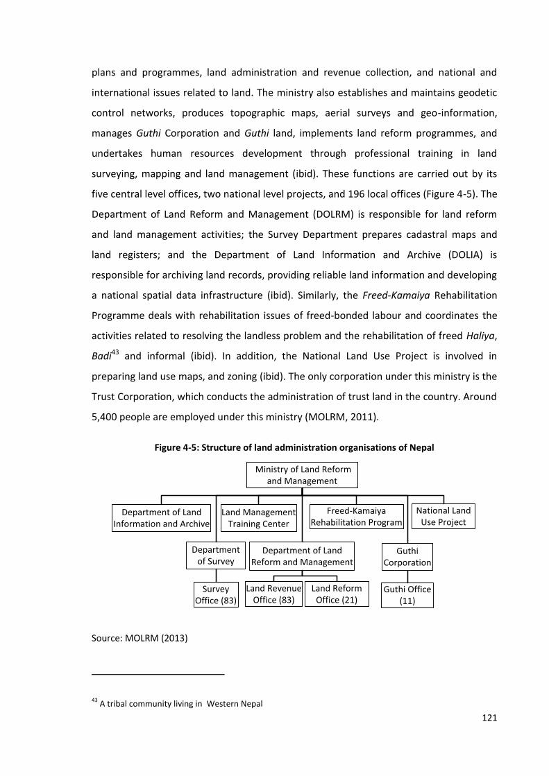
121
plans and programmes, land administration and revenue collection, and national and
international issues related to land. The ministry also establishes and maintains geodetic
control networks, produces topographic maps, aerial surveys and geo-information,
manages Guthi Corporation and Guthi land, implements land reform programmes, and
undertakes human resources development through professional training in land
surveying, mapping and land management (ibid). These functions are carried out by its
five central level offices, two national level projects, and 196 local offices (Figure 4-5). The
Department of Land Reform and Management (DOLRM) is responsible for land reform
and land management activities; the Survey Department prepares cadastral maps and
land registers; and the Department of Land Information and Archive (DOLIA) is
responsible for archiving land records, providing reliable land information and developing
a national spatial data infrastructure (ibid). Similarly, the Freed-Kamaiya Rehabilitation
Programme deals with rehabilitation issues of freed-bonded labour and coordinates the
activities related to resolving the landless problem and the rehabilitation of freed Haliya,
Badi43 and informal (ibid). In addition, the National Land Use Project is involved in
preparing land use maps, and zoning (ibid). The only corporation under this ministry is the
Trust Corporation, which conducts the administration of trust land in the country. Around
5,400 people are employed under this ministry (MOLRM, 2011).
Figure 4-5: Structure of land administration organisations of Nepal
Land Revenue Office (83)
Department of Survey
Department of Land Reform and Management
Department of Land Information and Archive
Land Management Training Center
Guthi Corporation
Land Reform Office (21)
Survey Office (83)
Guthi Office (11)
Ministry of Land Reform and Management
Freed-Kamaiya Rehabilitation Program
National Land Use Project
Source: MOLRM (2013)
43 A tribal community living in Western Nepal
122
Similarly, Land Revenue Office, Survey Office, Land Reform Office and Trust Office are
responsible for providing land administration services at the local level. The main
functions of the Land Revenue Offices are the registration of deeds, issuing ownership
certificates, adjudication of unregistered land and updating records whereas the Survey
Office deals with parcel subdivision, prepares parcel plans and maintains cadastral maps
(MOLRM, 2013). Similarly, the main functions of the Land Reform Offices are to maintain
tenancy records, the adjudication of tenancy rights and fixing rents (ibid). The Guthi
Offices maintain the records and collect land revenue from Guthi land (ibid).
Other organisations involved in land administration activities are municipalities and VDCs,
which provide personal information regarding births, deaths, marriage, divorce, migration
and relations, provide valuation reports on buildings, and collect land revenues and
property taxes. They are under the Ministry of Local Development.
In Bangladesh, measurement of land was introduced for the purpose of collecting land
revenue as in many other countries. Land administration in Bangladesh has a long history
that dates back to systems developed by the Hindu rulers of ancient India, and still carries
the heavy imprint of the elaborate system of land surveys and registration for revenue
collection purposes introduced by the British (CARE, 2003). Sultan Sher Shah (1540-45)
had introduced measurement of lands and a regular system of assessment and collection
of revenue. But the first real step towards accurate assessment based on a
comprehensive survey of land and the establishment of one uniform standard of
measurement was achieved by the Revenue and Finance Minister of Emperor Akbar,
Todar Mall (1571-82) and this was in practice until 1765 (Hussain, 2012). The Survey Act,
1875, Registration Act, 1908, Non-agricultural Khas Land Management and Settlement
Policy, 1995, and Agricultural Khas Land Management and Settlement Policy, 1997 have
provided for various issues of land management.
The Mughal rulers had appointed zamindars and talukdars to collect land revenue from
the peasants. After taking the dewani of Bengal in 1765, the East India Company
appointed some supervisors to look after the land revenue collection mechanism
(Ahmed, 2012). A Board of Revenue was set up in 1772 to control and supervise the work
of the collectors in matters relating to land administration and collection of land revenue.

123
The Board was reconstituted several times and in recent times was given the status of a
fully-fledged ministry called the Ministry of Land Administration and Land Reforms in
1973, and renamed the Ministry of Lands in 1987 (ibid). Similarly, a Board of Land
Administration was established according to the Board of Land Administration Act, 1980
which was replaced by the Land Appeal Board and Land Reform Board in 1989.
The structure of organisations directly involved in land administration activities in
Bangladesh is depicted in Figure 4-6. The Directorate of Registration is under the Ministry
of Law, Justice and Parliamentary Affairs and headed by the Inspector General-
Registration. This department records land mutations44 arising through sale, inheritance
or other forms of transfer, reports changes to the Ministry of Land, and collects the
Immovable Property Transfer Tax through Sub-Registration Offices (NORC, 2009). There
are 61 District Registrar Offices, which provide guidance to the Sub-Registration Offices
on policy and problems regarding registration, collaborate with the District Registrar
Office and Sub-Registration Offices in the collection and management of information, and
look after the complaints, operational irregularities and corruption cases involving Deeds
and Marriage Registry Staffs and Deed Writers (ibid).
Figure 4-6: Structure of land administration organisations of Bangladesh
Office of the Prime Minister
Ministry of Lands
Ministry of Law, Justice and Parliamentary Affairs
Land Appeal Board
Land Reform Board
Directorate of Registration
District Registrar
Sub-Registry Office
Land Administration Training Centre
Directorate of Land Records and Survey
Assistant Commissioner Lands-Office
Tehsil Office
Settlement Office
Source: NORC (2009)
44Actions of tehsildars and AC-Lands to update record of rights reflecting change in land rights and physical
alterations

124
The tasks of land management including management of state land, waste land, vested
and non-resident property, boundary demarcation, land revenue and settlement are the
responsibility of the Ministry of Lands. The Land Appeal Board, Land Reform Board,
Directorate of Land Records and Survey and Land Administration Training Centre are the
four central level organisations under this Ministry. The Directorate of Land Records and
Survey is the largest organisation among them and employs around 95 per cent of the
6,000 employees of the ministry. It is responsible for creating the base cadastral maps
(mouza45 or village maps) by systematic survey and titling of large areas on a continuous
and rolling basis. Land settlement and revision settlement throughout the country is
undertaken through its zonal and revisional settlement offices (NORC, 2009). Along with
the cadastral maps, the settlement survey prepares the initial khatiyan (Records of
Rights), a narrative title history of each legal property object recorded in the cadastral
maps (ibid). Other responsibilities of the Directorate of Land Records and Survey include
preparing maps of the international boundary between India and Bangladesh, preparing,
printing and reprinting mouza maps, upazila maps, district maps, and country maps of
Bangladesh, providing advice to the government on the above issues, and conducting
training for civil service officials (ibid).
The sporadic modification to the cadastral maps and Records of Rights, however, is done
by the AC-Lands Office46 and their subordinate tehsil47 level land offices, structured under
the Land Reform Board. The main duties of the AC-Lands Office relating to land include
mutation approval (sales and inheritance), administration of unoccupied state lands,
administration of the land development tax, and administration of the tehsil level offices
staffed by Assistant Land Officers (NORC, 2009). There are eight to 12 tehsil level offices
under each AC-Lands Office. The main responsibilities of the tehsil level land office
include collection of the land development tax, updating the Record of Rights subject to
the approval of AC-Lands Office by recording mutations, land surveys, supervision of Khas
land (lease terms), supervision of abandoned lands, and responding to inquiries about
land ownership, mutation, litigation, and land surveys (ibid). Thus, the Land Reform Board
45A type of administrative district comprising one or more settlements
46 Office of the Assistant Commissioner of Land
47 Lowest or union-level revenue unit comprising several mouza
125
is most involved in the land record system. It administers Khas land, and manages
abandoned and vested property, updates maps and land records between surveys, and
sets and collects the Land Development Tax (ibid). It is also formally responsible for the
implementation of land reform legislation and the implementation of tenant’s rights
(CARE, 2003). The Land Appeal Board is the highest revenue court in the land, serving as
the final arbiter in matters of Khas land, changes in records, plot demarcation and
taxation, which cannot be resolved at lower levels.
Three other ministries or cabinet level departments are involved indirectly in land
administration activities, including the Ministry of Establishment, the Prime Minister's
Cabinet Division and the Ministry of Finance; the responsibilities of these involve
management of the structure of government and the civil service, local government
administration, and taxation and revenues respectively (NORC, 2009). The Ministry of
Establishment appoints and transfers the commissioner and other administrative staff of
the AC-Lands Office. The Prime Minister’s Cabinet Office also exercises supervisory
authority over divisional and district officers.
In Thailand, the Land Code of 1954 and the Civil and Commercial Code published since
1923 provide the foundation for the development of the land administration system and
property rights. The Civil and Commercial Code covers the basis of law, obligations and
contracts, specific contracts, including transfer, sale and mortgage, property, including its
acquisition, extent and exercise of ownership, family, and succession. Similarly, the Land
Code covers the protection of land, the arrangements for the utilisation of state land,
land allocation, rights in land, issuance of documents evidencing rights in land, land
survey, registration of rights, limitations on rights for religious purposes, and limitations
of alien’s rights in land.
A number of government agencies are involved in land administration activities in
Thailand; they are the Department of Lands, Royal Forestry Department, Agricultural Land
Reform Office, Department of Cooperatives and the Department of Social Development
and Public Welfare (Figure 4-7). The Department of Lands, one of the Departments of the
Ministry of Interior, is the major provider of land administration services. It conducts its
function through 75 Provincial Land Offices, 343 branches of Provincial Land Offices, 445

126
District Land Offices and the Bangkok Metropolitan Land Office and its 16 Branch Offices
(Nanthamontry and Rakayo, 2007).
Figure 4-7: Structure of land administration organisations of Thailand
Ministry of Agriculture and Cooperatives
Agricultural Land Reform Office
Department of Social Development and
Public Welfare
Ministry of Social Development and Human Security
Department of Cooperative Promotion
Department of Lands
Provincial Land Offices (75)
Provincial Land Offices Branch (343)
District Land Offices (445)
Ministry of Interior
Bangkok Metropolitan Land Offices
Metropolitan Branch Land Offices (16)
Prime Minister’s Office
Ministry of Natural Resources and Environment
Royal Forestry Department
Department of Survey
Ministry of Defence
Source: USAID (2011); Ministry of Interior (2013)
The Department of Lands is responsible for implementing the Land Code and the
registration of land rights throughout the country. It manages two categories of land; the
titled public land called Nor-Sor-Lor48 belonging to the government agencies and for
communal purposes that guarantees public ownership over land. Another category of
land is the private land for which it can issue four forms of documents in accordance with
the Land Code, namely: the Title Deed (Chanod or NS-4), Certificate of Utilisation (Nor-
Sor-Sarm or NS-3 and Nor-Sor-Sarm Kor or NS-3K), Pre-emptive Certificate (NS-2 or Bai-
Chong), and the Claim Certificate (Sor-Kor-Neung or SK-1) (Nanthamontry and Rakayo,
2007). As observed by Feder et al. (1988), the NS-4 is the most secure, full and
unrestricted ownership title, NS-3 and NS-3K are also secure which can be sold,
transferred and mortgaged and can be converted to title deed (NS-4), and the NS-2 and
SK-1 are less secured documents which can be converted into NS-3 or NS-3K. It is
responsible for implementing the Land Code and the registration of land rights
throughout the country.
48 Titled public land
127
The Royal Thai Survey Department is under the Ministry of Defence. It is responsible for
cadastral surveying. Similarly, the Royal Forestry Department of the Ministry of Natural
Resources and Environment is responsible for undertaking surveys of national forest
reserve areas declared by the cabinet. This department can issue land documents for
plots inside the forest reserves. A programme to recognise the rights of agricultural land
holders inside forests, with five year usufruct licences for the land suitable for agriculture
was introduced by this department in 1981 (Nanthamontry and Rakayo, 2007).
There are two other agencies under the Ministry of Agriculture and Cooperatives
concerned with agricultural land: the Agricultural Land Reform Office and the Department
of Cooperative Promotion. The Agricultural Land Reform Office was created in 1975 with
the aim of distributing forest reserves to the landless and households with small
agricultural land holdings (ibid). It is mainly responsible for three activities: allocating land
to the farmers, developing the land in land reform areas and improving agricultural
production. It can issue the land use certificate called SPK (Sor- Por- Kor), which can be
inherited but not sold. The Department of Cooperative Promotion also issues usufruct
licences. The Department of Social Development and Public Welfare of the Ministry of
Social Development and Human Security also issues usufruct licences in specific areas.
Thus, the land administration functions in Nepal, Bangladesh and Thailand are organised
differently. Only one ministry is involved in land administration in Nepal whereas, at least
two ministries in Bangladesh and five ministries in Thailand are responsible for these
activities.
4.4.3 Land Registration
A typical process of land registration excluding the mortgaging process in Nepal,
Bangladesh and Thailand is shown in Figure 4-8 which is prepared based on the
information provided in respective land laws and the Doing Business Report, 2013 of the
World Bank.
In Nepal, the task of registering property is assigned to the Land Revenue Offices
according to the Article 8(1) of the Land Revenue Act, 1978. The Survey Offices provide
technical support in land administration activities. The process of land registration is

128
mainly governed by the land laws, land administration and survey directives, and decrees
issued by government departments from time to time. The Jagga Prashasan Nirdeshika,
2001 (Land Administration Directives, 2001), describes the process of registration of
deeds. The World Bank (2013) has classified the procedure for land (deed) registration in
Nepal into three steps as obtaining clearance certificate from the municipalities or VDCs,
hiring lekhapadhi byabasayee (deed writer or paralegals) and registration of deeds and
issuance of a new title certificates. It states that the seller goes to the local government
office to certify the type of road that adjoins the property and to get tax clearance
certificate. Then the seller hires deed writer to prepare a deed although the seller can
prepare the deed legally by himself.
The land administration organisations are directly involved only in the third procedure
mentioned above (Figure 4-8). As described by DOLRM (2001:55-74), once the deed is
received for registration, Land Revenue Office verifies the record and registers the
application in a daily register. In the case of parcel sub-division, the deed is sent to the
Survey Office which verifies parcel boundaries, prepares a parcel plan and submits it to
the Land Revenue Office (ibid). Then the Land Revenue Office verifies the client’s
signature and the buyer pays a registration fee after which the staffs of the Registration
Section of the Land Revenue Office sign the deed and submit it for final approval (ibid).
The Land Revenue Officer conducts a brief interview with the seller and buyer and
approves the deed (ibid). Then the Record Section updates the land records and prepares
a certificate; once the officer verifies it, the buyer receives the certificate and a copy of
the deed; another copy of will be sent to the Archive Section (ibid). In the case of a partial
parcel, an order will also be issued to the Survey Office to update the cadastral maps and
records (ibid).
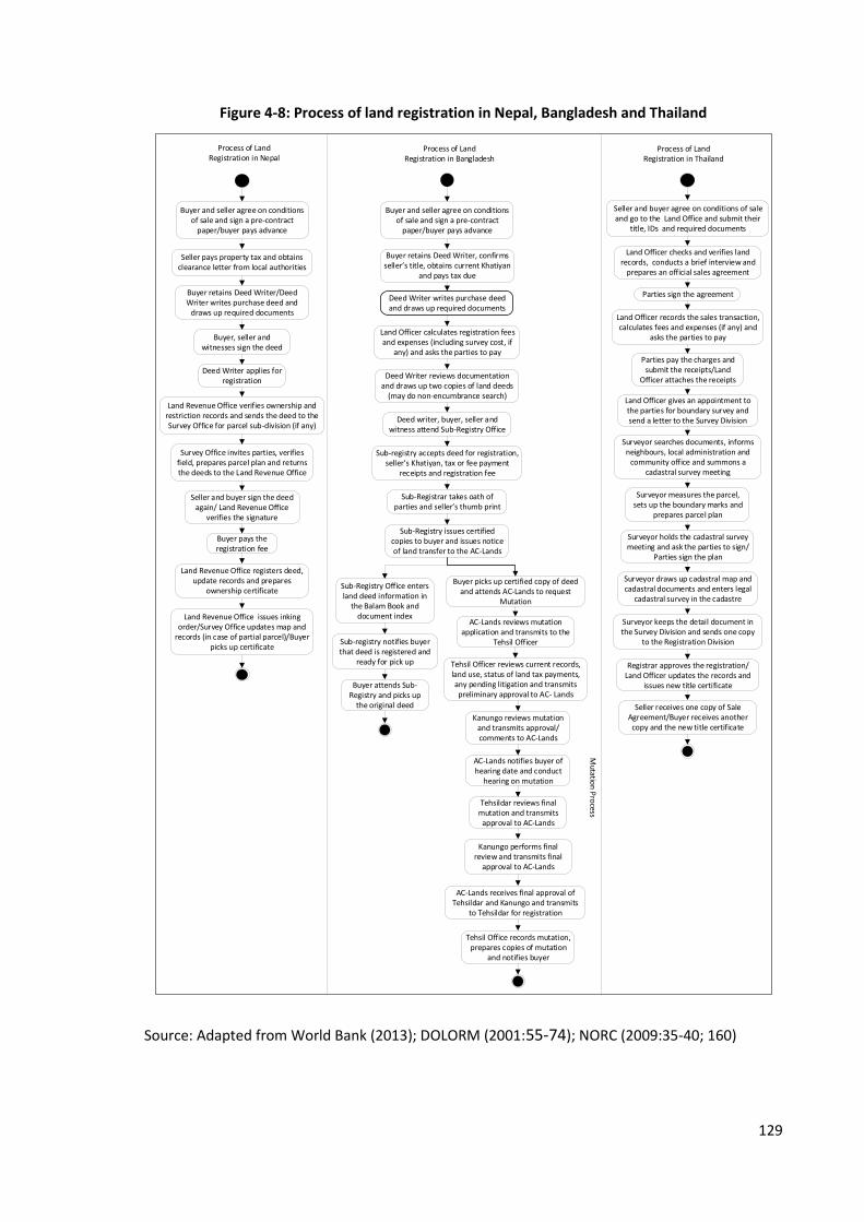
129
Figure 4-8: Process of land registration in Nepal, Bangladesh and Thailand
Land Officer checks and verifies land records, conducts a brief interview and
prepares an official sales agreement
Surveyor searches documents, informs neighbours, local administration and
community office and summons a cadastral survey meeting
Land Officer gives an appointment to the parties for boundary survey and send a letter to the Survey Division
Surveyor holds the cadastral survey meeting and ask the parties to sign/
Parties sign the plan
Surveyor keeps the detail document in the Survey Division and sends one copy
to the Registration Division
Seller and buyer agree on conditions of sale and go to the Land Office and submit their
title, IDs and required documents
Surveyor measures the parcel, sets up the boundary marks and
prepares parcel plan
Surveyor draws up cadastral map and cadastral documents and enters legal
cadastral survey in the cadastre
Parties sign the agreement
Registrar approves the registration/Land Officer updates the records and
issues new title certificate
Land Officer records the sales transaction, calculates fees and expenses (if any) and
asks the parties to pay
Parties pay the charges and submit the receipts/Land
Officer attaches the receipts
Seller receives one copy of Sale Agreement/Buyer receives another copy and the new title certificate
Buyer retains Deed Writer/Deed Writer writes purchase deed and
draws up required documents
Buyer, seller and witnesses sign the deed
Survey Office invites parties, verifies field, prepares parcel plan and returns the deeds to the Land Revenue Office
Buyer pays the registration fee
Land Revenue Office registers deed, update records and prepares
ownership certificate
Land Revenue Office issues inking order/Survey Office updates map and
records (in case of partial parcel)/Buyer picks up certificate
Seller pays property tax and obtains clearance letter from local authorities
Land Revenue Office verifies ownership and restriction records and sends the deed to the Survey Office for parcel sub-division (if any)
Deed Writer applies for registration
Seller and buyer sign the deed again/ Land Revenue Office
verifies the signature
Buyer and seller agree on conditions of sale and sign a pre-contract
paper/buyer pays advance
Process of Land Registration in Nepal
Process of Land Registration in Thailand
Buyer retains Deed Writer, confirms seller s title, obtains current Khatiyan
and pays tax due
Buyer and seller agree on conditions of sale and sign a pre-contract
paper/buyer pays advance
Sub-Registry Office enters land deed information in
the Balam Book and document index
Land Officer calculates registration fees and expenses (including survey cost, if
any) and asks the parties to pay
Deed Writer reviews documentation and draws up two copies of land deeds
(may do non-encumbrance search)
Sub-registry notifies buyer that deed is registered and
ready for pick up
Buyer attends Sub-Registry and picks up
the original deed
Sub-registry accepts deed for registration, seller s Khatiyan, tax or fee payment
receipts and registration fee
Sub-Registrar takes oath of parties and seller s thumb print
Deed writer, buyer, seller and witness attend Sub-Registry Office
Sub-Registry issues certified copies to buyer and issues notice of land transfer to the AC-Lands
AC-Lands reviews mutation application and transmits to the
Tehsil Officer
Tehsil Officer reviews current records, land use, status of land tax payments, any pending litigation and transmits preliminary approval to AC- Lands
Kanungo reviews mutation and transmits approval/comments to AC-Lands
AC-Lands notifies buyer of hearing date and conduct
hearing on mutation
Tehsildar reviews final mutation and transmits
approval to AC-Lands
Kanungo performs final review and transmits final
approval to AC-Lands
AC-Lands receives final approval of Tehsildar and Kanungo and transmits
to Tehsildar for registration
Tehsil Office records mutation, prepares copies of mutation
and notifies buyer
Buyer picks up certified copy of deed and attends AC-Lands to request
Mutation
Mutatio
n P
rocess
Process of Land Registration in Bangladesh
Deed Writer writes purchase deed and draws up required documents
Source: Adapted from World Bank (2013); DOLORM (2001:55-74); NORC (2009:35-40; 160)

130
In Bangladesh, the Registration Act, 1908 provides the legal foundation for land
registration. World Bank (2013) and NORC (2009) describe the process of land registration
in Bangladesh. The World Bank (2013) classified the process into eight steps as conducing
mutation, obtaining inspection for mutation, verification of the records of rights,
obtaining non-encumbrance certificate, preparing deed of transfer and paying stamp
duty, paying capital gain tax, value added tax and other taxes, applying for registration
and registering the change of ownership in case of Dhaka city. Similarly, NORC (2009)
explains the registration process practiced in Bangladesh into eight steps which is shown
in Figure 4-8 above and further explained below.
The process of land registration begins when the buyer and seller reach an agreement on
conditions of sale and price. As shown in Figure 4-8 and described in NORC (2009:35-40),
the buyer retains a deed writer, verifies the record of rights from the Land Office and
obtains the current khatiyan. He also pays the taxes and fees, including capital gains tax,
local government tax, value added tax and the registration fee. Then he supplies all
receipts and the certified copy of the current khatiyan to the Deed Writer and pays stamp
duty by purchasing stamped deed forms. The Deed Writer reviews the documentation
and prepares two copies of the deeds; he may also undertake a non-encumbrance search.
Once the deeds and documents are ready, the Deed Writer, seller and buyer, and the
witnesses attend the Sub-Registry Office. The Sub-Registry accepts the deeds, khatiyan
and other documents and prepares receipts showing a document registration number
and registration fee and taxes paid on the deed. After that the Sub-Registrar takes oaths
from the parties. Then the Sub-Registry Office takes the thumbprints of the seller and
issues a certified copy of the deed to the buyer and also issues a notice of land transfer to
the AC-Lands Office. The buyer then goes to the AC-Lands Office and requests a mutation.
The Sub-Registry Office, meanwhile, enters the deed in the balam book49 and notifies the
buyer when the deed is registered and ready for collection.
The task of mutation is carried by AC-Lands Office and Tehsil Office. As described in NORC
(2009:35-40; 160) and shown in Figure 4-8 above, the buyer applies in the AC-Lands
49 Book recording deeds; Book No. 1 of the Sub-Registry Office in which deeds are registered

131
Office for mutation when he receives the certified copy of the deed from the Sub-Registry
Office. He also attaches required documents including: the certified copy and a
photocopy of the deed, certified copies of the khatiyan or photocopy along with the main
copy and the approval of mutation (if applicable). The Sub-Registry Office registers the
distribution among the inheritors of the property, the latest statement of tax revenue, a
copy of the parcha (field note) of the City Survey (if applicable), a certified copy of the
lease document, a copy of the letter of permission for the government plot (in case of
land allotted by the Ministry of Housing and Public Works) and the attested copy of the
power of attorney (if applicable).
The AC-Lands Office reviews the application and then transmits it to the Tehsil Office.
After receiving an application, the Tehsil Office reviews current records, land use, status
of land tax payments, and any pending litigation and then transmits preliminary approval
to the AC-Lands Office. Then the kanungo50 reviews the mutation and transmits approval
or comments to AC-Lands Office. The AC-Lands Office notifies the buyer about the
hearing date and conducts a hearing on the mutation application and approves the
mutation; otherwise, it is transmitted to the tehsildar51 for final review and approval. If
received for final review: the tehsildar reviews the final mutation and transmits the
approval to AC-Lands Office. Then the kanungo carries out a final review and transmits
this to the AC-Lands Office. AC-Lands Office receives the final approval of mutation by the
tehisildar and kanungo and transmits this to the tehsildar for registration. Finally, the
tehsildar records the mutation in a register, prepares copies of the mutation and notifies
the buyer. The whole process of registration and mutation is thus completed.
In Thailand, when the buyer and seller agree to transact a unit of land or a building, they
go to the land office directly. As described by World Bank (2013) and as shown in Figure
4-8 above, when the buyer and seller go to the land office, the officer at the Information
Desk requests supporting documents, including their identity cards and title certificates.
Once received, he verifies the documents with the official records. If everything is
consistent, he interviews the parties, prepares an official sales agreement and asks the
50 Sub-assistant settlement officer; a position junior to assistant commissioner (land)
51 Local revenue collector

132
parties to sign. After that the officer calculates the registration fee and other charges,
including the cost of boundary survey in the case of parcel sub-division. The registration
fee, withholding tax52 and specific business taxes are payable to the Ministry of Finance
but collected by the land office.
In the case of the transaction of a whole parcel, the Land Officer attaches the receipts and
sends the application to the registration division. Then the application is submitted before
the Land Registrar for approval. If the parcel needs to be sub-divided, the Land Officer
arranges for a boundary survey to be undertaken and sends the document with a
covering letter to the Survey Division. The Survey Officer then searches the documents,
identifies the neighbours and summons them to attend the cadastral survey meeting and
informs the local administration office as well. On the day of survey, the Surveyor
measures the parcel, sets up the boundary marks and holds the cadastral meeting with
the seller, the buyer and the owners of the neighbouring parcels where a new cadastral
survey unit is formed. The Surveyor prepares a parcel plan and requests the parties to
sign. If any of the neighbours do not attend the meeting, the Survey Officer corresponds
with the local community office for further information. The Surveyor then draws up a
cadastral map and cadastral documents and enters this in the cadastral records. One copy
of the cadastral document is sent to the Registration Division and rest of them are kept in
the Survey Division. Records are updated and a title certificate is issued when the Land
Registrar approves the documents. The seller receives one copy of the sale agreement,
and the buyer receives another copy and the title certificate.
Although the purpose of registration of land is same in all of the three countries, there
are some differences in the procedures followed by their land registries. It seems the
process of Bangladesh more complicated than Thailand and Nepal. The ease of doing
business while registering property in these countries is presented in Table 4-5. In terms
of the overall ranking of registering property, Nepal and Thailand are in better position
(24 and 29 respectively) but the ranking of Bangladesh is very low (177) (World Bank,
2013). Similarly, there are eight procedures in Bangladesh whereas there are only three
52 Deduction from payments made to suppliers who provide a service

133
and two procedures in Nepal and Thailand respectively. The process of Bangladesh is
more time consuming and costly than the others; it takes up to 245 days to complete the
registration process and 6.7 per cent of property value will be spent during registration.
The process of Nepal and Thailand, on the other hand, can be completed in five and two
days and it costs 4.8 and 6.2 per cent of property value respectively.
Table 4-5: Registering property in Nepal, Bangladesh and Thailand
Indicators Nepal Bangladesh Thailand
Rank 24 177 29
Number of procedures 3 8 2
Time (days) 5 245 2
Costs (percentage of property value) 4.8 6.7 6.3
Source: World Bank (2013)
Thus, the process of land registration in Bangladesh is more complicated than in Nepal
and Thailand. Involvement in only two procedures, preparation of contract papers by the
land office, and completion of procedures within two days are the strengths of the land
registration system in Thailand. The high number of procedures and lengthy time taken
are the major weaknesses of land registration in Bangladesh.
4.4.4 Cadastral Surveying
The history of cadastral surveying in Nepal goes back to the early 17th Century; however,
systematic cadastral survey commenced in 1965. Enactment of the Land (Survey and
Measurement) Act, 1963 was the main step for starting systematic surveying which aimed
to make arrangements for the survey and measurement of lands and determining their
grade. The initial purpose of beginning systematic cadastral surveying was to support the
collection of land revenues and to provide landholding records to implement the land
reform programme introduced in 1964. The first phase of systematic surveying was
completed in BS 2055 (1998 AD) (Survey Department, 2012).
The cadastral survey in Nepal was carried out using the plain table survey method. Out of
75 districts, a local coordinate system was used in 38 districts where the maps are in free

134
sheet and not connected in the national geodetic network; mapping of the remaining 37
districts was carried out using the national geodetic network. Modern technologies like
Total Station and theodolites are being used in some places in recent surveys. As
described in FIG (2003), the current cadastral maps are prepared graphically and are
carried out at three different scales 1:500, 1:1250 and 1:2500 based on the nature of the
terrain and the value of the land. These maps are being scanned and the process of
digitisation is running in several districts. The survey also highlighted three major issues
for the cadastral system in Nepal: the edges of the maps do not match with adjacent
sheets; there is manipulation and misinterpretation of maps and existing documents, and
involvement of more than one organisation in land administration activities.
In Bangladesh, the Survey Act, 1875 enabled the government to order the surveying of
land situated in any district or its part or any track of the country, and that the boundaries
of estates, tenures, mouzas or fields be demarcated on the lands to be surveyed
whenever it should think fit. The appointment of Superintendents and Assistant
Superintendents, Collectors and Deputy Collectors, their roles and responsibilities, and
the process of surveying and boundary marking were also covered by this Act. Similarly,
the Bengal Tenancy Act, 1885 and the East Bengal State Acquisition and Tenancy Act,
1950 gave the power to a Revenue Officer to order surveys and the preparation of
Records of Rights for the provincial government in respect of all lands in any local area,
estate or tenure or part thereof if he should think it fit.
Major survey operations conducted in the territory that is now Bangladesh were the
Thakbast Survey (demarcation survey) (1845-1877), Revenue Survey (1846-1878), Khasra
Operation53 (1841-1854) and Diara Surveys54 (1862-1883). As described by Hussain
(2012), the Thakbast Survey aimed to demarcate boundaries of villages and estates.
Likewise, in the Revenue Survey, accurate maps of villages were prepared, usually to the
scale of four inches to one mile and one inch to one mile, showing topographical details
and compiling certain statistical data for general administrative purposes. The Khasra
Operations were carried out in the temporarily settled area, and also in some
53 Survey of temporarily settled areas
54 Settlement operations in alluvial area
135
permanently settled areas where it would be difficult or unduly expensive to show the
details. Similarly, the Diara Surveys were carried out in the beds of the Ganges and other
large rivers on the scale of four inches to one mile. The modern cadastral system is an
improvement on the Khasra operations because it shows the real shapes of the field
boundaries. Maps produced from the modern survey were on the scale of 16 inches to
one mile.
The system of land recording in Bangladesh is provisioned by the East Bengal State
Acquisition and Tenancy Act, 1950 and is presently administered by the Department of
Land Records and Survey and the Assistant Commissioner-Lands structure. This Act
describes the process of land settlement, which can be compared to the systematic titling
provisions of other national laws, but which is primarily tied to the process of
nationalisation of land through state acquisition (NORC, 2009). This Act also provided for
the preparation, maintenance and revision of Records of Rights. The government may
make an order to prepare a record of rights in respect of any district, part of a district or
local area, or to revise the Records of Rights prepared under the Bengal Tenancy Act,
1885 by a Revenue Officer. The Revenue Officer records the rights, publishes a draft and
considers any objections. Registrars are obliged to provide access to registered
documents to citizens to assist in their transactions (ibid).
In Thailand, the Civil and Commercial Code (1932) assigns the responsibility for all
cadastral surveys, including subdivision, for maintaining the land registers and for issuing
land title documents to the Department of Lands. The Department of Lands has carried
out cadastral surveying and mapping of land titles on the scale of 1:4000. The physical
boundaries of parcels of land in Thailand are generally defined by legal boundaries,
following the general boundary approach based on aerial photography. There are two
categories of cadastral system for land title (NS4). The first class systematic surveys are
done in urban areas where sufficient cadastral control can be provided. In this type of
survey, adjudication documents have to be signed by all adjacent owners after
completion of the adjudication process and numbered concrete blocks are placed at each
corner. The boundaries are surveyed using theodolites and chain and the cadastral map is
plotted in the computer. The second-class surveys are based on rectified photomaps at

136
1:4000 in rural areas, and on traverse and tape survey at 1:1000 in village and urban areas
(Utsenan, 2010).
The cadastral maps are scanned and digitised in Thailand. All past survey data, field books
and plans containing both dimensional information about parcel boundaries and field
data about the value and methodology applied at the time of measurement need to be
checked while resurveying which is normally done during parcel sub-division for
transactions, the adjudication process in the court about boundary disputes, or at the
request of the land owner (ibid).
To sum up, the cadastral surveying was done using traditional technology and the
cadastral maps are recorded in an analogue form in both Nepal and Bangladesh but new
technology was applied in Thailand. The process of digitization of cadastral records is
started in all of these countries.
4.4.5 Property Valuation
The Government of Nepal started to determine the minimum valuation of land for
taxation purposes since 1982. A Minimum Valuation Determining Committee would be
formed in the area of each Land Revenue Office under the chairmanship of a Chief District
Officer according to Article 8(2) of the Land Revenue Act, 1978. Other members of the
committee are the Chairman of the District Development Committee or his
representative, and Chiefs of the Survey Office, Tax Office (if any), and the Land Revenue
Office. The committee determines the valuation of land for the upcoming fiscal year by
mid-July. Factors such as financial activities, population density, topography of land,
physical facilities, agricultural production, commercial and tourist centres, education,
health, employment and security, development activities, size or shape of land, risk and
migration should be considered while determining the minimum valuation of land as per
the Neunatam Mulya Nirdharan Nirdeshika, 2059 (Directives for Determining Minimum
Valuation, 2003). The local government offices, however, prepare the valuations of
buildings.
In Bangladesh, the value of property is determined in accordance with the policy framed
by the Inspector-General of Registration as provided for in Section 69 of the Registration
137
Act, 1908. Land registration offices prepare minimum valuations of land for each mouza.
Buyers and sellers determine the value of property but the value mentioned in the
document should not be less than the market value as estimated by the land registry.
According to Section 63A of the Registration Act, if the registering officer found the value
mentioned in a deed is less than the minimum value prepared by the government, he
would ask the parties to pay the remaining duties and fees.
In Thailand, the government determines the value of land. The land value is assessed by
the Treasury Department of the Ministry of Finance every four years. This was previously
done by the Department of Lands of the Ministry of the Interior.
Thus, there is a minimum valuation system in Nepal and Bangladesh, where the valuation
determined by the government is normally less than is normally less than the market
value, unlike in Thailand.
4.5 Summary
This chapter provides general background information about Nepal, Bangladesh and
Thailand and discusses the system of land tenure and land administration of those
countries. Agriculture is one of the main source of income in Nepal and Bangladesh. The
GDP from the agricultural sector has been increased in all three countries recent decades.
In Nepal, all land traditionally belonged to the state. A communal type of system was also
in existence among the Limbu community of the Eastern region. Private ownership of
land emerged as the government granted land to the royal family and the cultivator
under different systems of tenure, including Birta, Jagir and Guthi. All of these tenure
forms were abolished and the land then either nationalised or converted into private
ownership after the political change of 1951. The land came into the formal system as the
cadastral surveying and land adjudication began in the 1960s. Private ownership of land
was also established by means of land reform, formalisation of informal settlement,
distribution of land to the landless and deprived people through land commissions,
settlement committees and forest area improvement committees.
In Bangladesh, the ownership of land, which used to be cultivated by the peasants as
tenants, was vested in the King. During the Mughal period, the ownership of land was
138
brought under the state, and zamindars and talukdars were appointed to collect land
revenues from the peasants. The current land tenure system of Bangladesh is mainly
based on permanent settlements originated during British rule under which the
ownership of land was granted to the zamindars provided that they collected the rent
from the tenants and paid it to the East India Company on a regular basis. The zamindari
system was abolished after enactment of the East Bengal State Acquisition and Tenancy
Act, 1950 after which the ultimate ownership came to the state and the tenants became
the holders of land. The survey and settlement operations were undertaken in different
stages in different parts of the country.
The functions of land administration in Nepal are organised in a single ministry whereas
cadastre and land registry are under separate ministries in Bangladesh and Thailand.
Three more ministries are authorised to provide some sorts of land certificates in
Thailand.
Thailand is adopting a title registration system and Nepal and Bangladesh are adopting
the deed registration system. In Thailand, the process of land registration is very simple
and fast although the process of parcel sub-division takes a couple of weeks. The land
registration process of Nepal can be completed within five days even in the case of partial
parcels. The process of Bangladesh, however, is more complicated and time consuming.
These processes will be further discussed in Chapter Six. The valuation of land determined
by the government authorities in Thailand is close to market value, but there is a
minimum valuation system in Nepal and Bangladesh.
139
Chapter 5: Tenure Security and Its Economic
Outcomes
5.1 Introduction
The aim of this chapter is to discuss about land tenure security and its economic
outcomes. It presents and analyses both qualitative and quantitative data collected from
Nepal, Bangladesh and Thailand applying survey, interview, observation and
documentation methods. It explores how land tenure becomes secure, how and to what
extent the security of land tenure affects land related activities, creates a favourable
environment for investment and increases production from land and provides answers to
the first, second and third research questions posed in Chapter One.
As discussed in Chapter Two, registration of land is considered as the means of providing
security of land tenure for the purpose of this research. In this chapter, the term ‘land
registration’ is commonly used to denote the act of registering land rights by means of
property formalisation in Chulachuli, Nepal and surveying settlement in Gharinda,
Bangladesh as both of these programme aimed to register land. Thus, the role of land
registration on tenure security is discussed first. After that the changes in land use and
land related economic activities promoted by the registration are discussed. Then the
changes in land value, access to credit, investment and income resulting from secured
tenure are analysed. These changes are measured by comparing the situation before and
after registration which represents the scenario of three years period. Before and after
registration means the situation prior to and after getting the land tile respectively.
5.2 Land Registration and Tenure Security
Land registration is a process of registering rights to land. In order to identify the changes
in the property rights situation, respondents were asked about the type of property rights
available to them on their land before and after registration. The results are presented in
Table 5-1. Almost all of the respondents from both countries said that they are enjoying
the rights of ownership, sale and transfer, access to bank loans, and lease and use
production after registration of land. The number of respondents who considered they
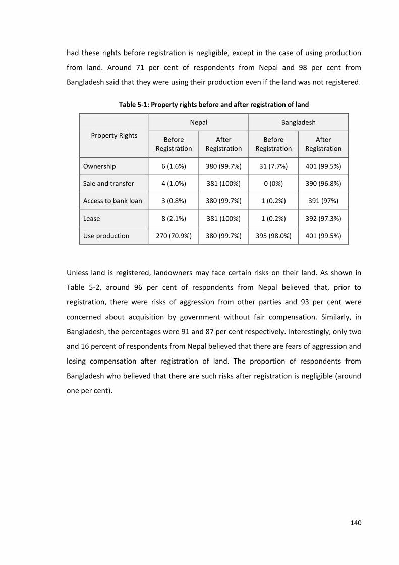
140
had these rights before registration is negligible, except in the case of using production
from land. Around 71 per cent of respondents from Nepal and 98 per cent from
Bangladesh said that they were using their production even if the land was not registered.
Table 5-1: Property rights before and after registration of land
Property Rights
Nepal Bangladesh
Before Registration
After Registration
Before Registration
After Registration
Ownership 6 (1.6%) 380 (99.7%) 31 (7.7%) 401 (99.5%)
Sale and transfer 4 (1.0%) 381 (100%) 0 (0%) 390 (96.8%)
Access to bank loan 3 (0.8%) 380 (99.7%) 1 (0.2%) 391 (97%)
Lease 8 (2.1%) 381 (100%) 1 (0.2%) 392 (97.3%)
Use production 270 (70.9%) 380 (99.7%) 395 (98.0%) 401 (99.5%)
Unless land is registered, landowners may face certain risks on their land. As shown in
Table 5-2, around 96 per cent of respondents from Nepal believed that, prior to
registration, there were risks of aggression from other parties and 93 per cent were
concerned about acquisition by government without fair compensation. Similarly, in
Bangladesh, the percentages were 91 and 87 per cent respectively. Interestingly, only two
and 16 percent of respondents from Nepal believed that there are fears of aggression and
losing compensation after registration of land. The proportion of respondents from
Bangladesh who believed that there are such risks after registration is negligible (around
one per cent).
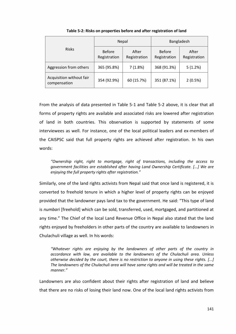
141
Table 5-2: Risks on properties before and after registration of land
Risks
Nepal Bangladesh
Before Registration
After Registration
Before Registration
After Registration
Aggression from others 365 (95.8%) 7 (1.8%) 368 (91.3%) 5 (1.2%)
Acquisition without fair compensation
354 (92.9%) 60 (15.7%) 351 (87.1%) 2 (0.5%)
From the analysis of data presented in Table 5-1 and Table 5-2 above, it is clear that all
forms of property rights are available and associated risks are lowered after registration
of land in both countries. This observation is supported by statements of some
interviewees as well. For instance, one of the local political leaders and ex-members of
the CAISPSC said that full property rights are achieved after registration. In his own
words:
“Ownership right, right to mortgage, right of transactions, including the access to government facilities are established after having Land Ownership Certificate. [...] We are enjoying the full property rights after registration.”
Similarly, one of the land rights activists from Nepal said that once land is registered, it is
converted to freehold tenure in which a higher level of property rights can be enjoyed
provided that the landowner pays land tax to the government. He said: “This type of land
is numbari [freehold] which can be sold, transferred, used, mortgaged, and partitioned at
any time.” The Chief of the local Land Revenue Office in Nepal also stated that the land
rights enjoyed by freeholders in other parts of the country are available to landowners in
Chulachuli village as well. In his words:
“Whatever rights are enjoying by the landowners of other parts of the country in accordance with law, are available to the landowners of the Chulachuli area. Unless otherwise decided by the court, there is no restriction to anyone in using these rights. [...] The landowners of the Chulachuli area will have same rights and will be treated in the same manner.”
Landowners are also confident about their rights after registration of land and believe
that there are no risks of losing their land now. One of the local land rights activists from

142
Nepal argued that they are confident that their land would not be grabbed by other
people and that reasonable compensation would be given in case of acquisition. He said:
“Before having the certificate, we were always scared of encroachment of land from other people. Landless movement used to arise here frequently and some so-called landless people used to grab the land. However, we are now free from such problems. [...] We are now confident. In the past, we had to accept whatever the government provides; now we have evidences for claiming appropriate compensation.”
Moreover, almost all of the respondents (99 per cent from Nepal and 98 per cent from
Bangladesh) opined that the property rights are secured after registration of land. The
constitutions of both Nepal and Bangladesh consider property rights as fundamental
rights and provide for fair compensation against land acquisition.
All forms of tenure security (perceived, de jure and de facto tenure security) are attained
in the registered land as almost all of the respondents have perceived that their land
rights are secured and protected by law, and they are physically controlling their land.
Although most of the respondents from both countries have replied that they had used
their produce even before registration, they did not have any legal documentation to
evidence their use right. It indicates that the landowners had control over land before
registration, that is, they did have de facto tenure security but not legal tenure security.
These findings contradict the observation of Reerink (2011) that the contribution of land
registration programme to legal tenure security is limited.
It would appear that the conditions for security of land tenure proposed by Place et al.
(1994) and Brasselle et al. (2002) presented in Chapter Two are fulfilled: land tenure is
secured after registration. Moreover, an overwhelming majority of respondents from the
case study areas of Nepal and Bangladesh (90 and 99 per cent respectively) considered
land registration as a means of providing land tenure security. It is one of the main task of
land administration organisations. Thus, land administration ensured security of land
tenure by offering rights of ownership, sale and transfer, access to bank loan, lease and
use production and safeguarding against aggression and unfair compensation to the new
land owners. It provides part of the answer to the first research question which will be
further discussed in Chapter Six.

143
5.3 Economic Outcomes of Tenure Security
5.3.1 Land Use and Economic Activities
The second research question posed in this research asks whether the land
administration promotes land use and land related economic activities. In order to
identify the changes in land use and economic activities, respondents from the case study
areas of Nepal and Bangladesh were asked how they have used their land and what type
of economic activities were undertaken on their land before and after registration. The
findings of the study are presented below.
The pattern of land use in the selected case study areas of Nepal and Bangladesh is shown
in Table 5-3. The lands of those areas were mainly used for residential and agricultural
purposes. Out of 381 respondents from Nepal and 403 from Bangladesh, the percentage
of respondents using land for shelter before registration was 91 and 89 per cent and using
for agricultural purpose was 98 and 100 per cent respectively. However, the percentage
of respondents using land for commercial purposes was negligible (four and zero per cent
respectively). A slight increase in the number of respondents using land for shelter and
commercial purposes and a decrease in the number using land for agricultural purposes is
observed after registration. Around 92 per cent and 100 per cent respondents used their
land for shelter, 89 per cent and 97 per cent used for agriculture and nine per cent and
three per cent used their land for commercial purposes from Nepal and Bangladesh
respectively after registration.
Table 5-3: Land use before and after registration as a proportion of respondents
Land Use*
Nepal Bangladesh
Before Registration
After Registration
Before Registration
After Registration
Shelter 348 (91.3%) 351 (92.1%) 360 (89.3%) 402 (99.8%)
Agriculture 375 (98.4%) 339 (89.0%) 402 (99.8%) 390 (96.8%)
Commercial (for example, renting, shops, cottage industry)
15 (3.9%) 35 (9.2%) 1 (0.2%) 13 (3.2%)
*Data are mutually inclusive.

144
Land related economic activities changed slightly after registration in both countries.
Proportions of respondents conducting different activities on their land before and after
registration are presented on Table 5-4. In this table, the value after registration
represents the net change in the number (or percentage) of respondents conducting
particular activities. In Nepal, the activities of constructing and renovating houses,
levelling land, constructing irrigation canals, using new tools and techniques for farming,
planting cash crops, trees and fruits and animal husbandry were conducted by most of
the respondents even before registration. The number of respondents conducting some
land-related activities after registration increased significantly. For instance, among those
who had not done so before, the number of respondents constructing houses increased
by eight per cent, renovating houses by 12 per cent, using new tools and techniques for
farming by 29 per cent, planting cash crops by 20 per cent and planting trees by 14 per
cent. The proportion of respondents starting other activities was also positive.
In Bangladesh, a significant proportion of the respondents among those who had not
done so before, began constructing houses (six per cent), renovating houses (12 per
cent), land levelling (24 per cent), using new tools and techniques of farming (18 per
cent), cash cropping (30 per cent), planting trees (24 per cent) and animal husbandry (28
per cent) after registration (Table 5-4). The number of respondents using their land for
commercial purposes also increased in both countries, albeit only marginally in
Bangladesh.

145
Table 5-4: Land related activities as a proportion of respondents
Land Use
Nepal Bangladesh
Before Registration
Changes After Registration*
Before Registration
Changes After Registration*
Constructing houses 325 (85.3%) 30 (7.9%) 335 (83.1%) 25 (6.2%)
Renovating houses 20 (5.2%) 47 (12.3) 25 (6.2) 50 (12.4%)
Land levelling 250 (65.6%) 31 (8.1%) 290 (72%) 95 (23.6%)
Constructing irrigation canals
278 (73.0%) 10 (2.6%) 277 (68.7%) 36 (8.9%)
Fencing 104 (27.3%) 30 (7.9%) 23 (5.7%) 54 (13.4%)
Using new tools and techniques of farming
207 (54.3%) 110 (28.9%) 75 (18.6%) 72 (17.9%)
Cash cropping 190 (49.9%) 77 (20.2%) 158 (39.2%) 121 (30.0%)
Planting trees 244 (64.0%) 54 (14.2%) 75 (18.6%) 96 (23.8%)
Planting fruits 321 (84.3%) 27 (7.1%) 25 (6.2%) 46 (11.4%)
Animal husbandry 343 (90.0%) 2 (0.5%) 239 (59.3%) 111 (27.5%)
Commercial purposes (for example, renting, shops, cottage industry)
15 (3.9%) 35 (9.2%) 1 (0.2%) 13 (3.2%)
*Denotes the number and percentage of respondents using their land for the given activities. The values after registration are mutually inclusive to the values before registration.
The data presented in Table 5-3 and Table 5-4 shows that land was mainly used for the
residential and agricultural purposes even before registration and only little was used for
commercial purposes. Increases in the proportion of respondents renovating houses, cash
cropping, planting trees and animal husbandry (in Bangladesh) and using land for
commercial activities like renting, shops and cottage industry might have been induced
from the registration of land.
The activities presented in Table 5-4 above are related to the improvement of the quality
of life, land development, cropping patterns and commercial use of land. These were
subsistence activities and aimed to fulfil the short-term needs of the landowners. One of
the respondents said: “Prior to registration, we managed to live in a small house but I
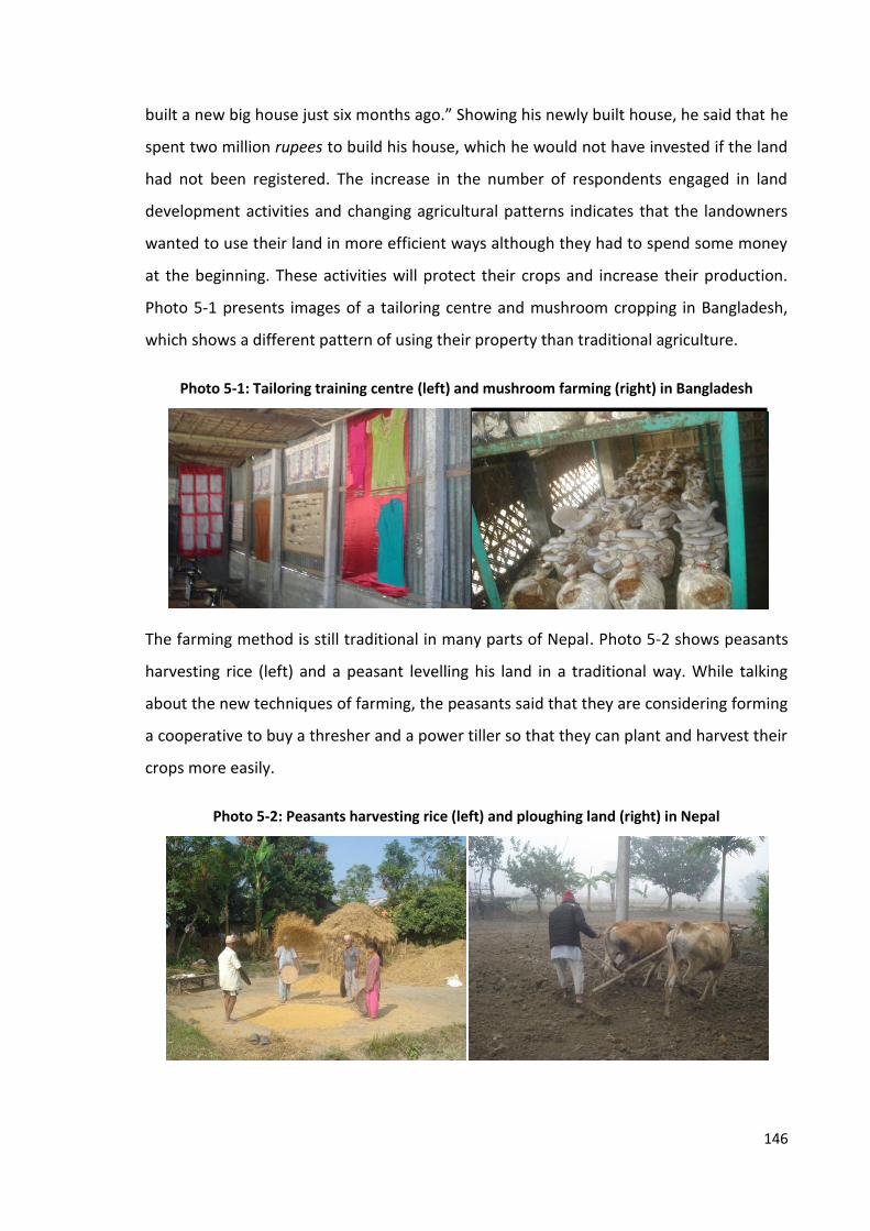
146
built a new big house just six months ago.” Showing his newly built house, he said that he
spent two million rupees to build his house, which he would not have invested if the land
had not been registered. The increase in the number of respondents engaged in land
development activities and changing agricultural patterns indicates that the landowners
wanted to use their land in more efficient ways although they had to spend some money
at the beginning. These activities will protect their crops and increase their production.
Photo 5-1 presents images of a tailoring centre and mushroom cropping in Bangladesh,
which shows a different pattern of using their property than traditional agriculture.
Photo 5-1: Tailoring training centre (left) and mushroom farming (right) in Bangladesh
The farming method is still traditional in many parts of Nepal. Photo 5-2 shows peasants
harvesting rice (left) and a peasant levelling his land in a traditional way. While talking
about the new techniques of farming, the peasants said that they are considering forming
a cooperative to buy a thresher and a power tiller so that they can plant and harvest their
crops more easily.
Photo 5-2: Peasants harvesting rice (left) and ploughing land (right) in Nepal

147
There appears to be a positive effect of land registration on improving the quality of
living, developing land for better use, investing in long-term returning activities, land
development and using land for commercial purposes. These findings support those from
other studies. For instance, Reerink (2011:221) observes that landholders with formal
tenure lived in somewhat more consolidated dwellings than those with informal tenure.
Similarly, the AusAID (2000) identifies that titled land is more likely to be improved than
untitled land in Thailand. These findings support the notion of Evolutionary Theory of
Land Tenure that land registration (titling) enhances tenure security which promotes
efficient use of resources (Platteaue, 1996) and the statement of Posner (1973) that
function of property rights is to create incentives to use resources efficiently, as discussed
in Section 2.4.3.
The evidences presented above shows a slight change in the land use pattern and in
economic activities related to improving the quality of life, land development and more
efficient cropping choices after registration of land. Thus, it can be concluded that the
land administration promotes land related economic activities to some extent which
answers the second research question.
5.3.2 Land Value
This research also seeks to identify whether there is any relationship between tenure
security and land value. The value of land in Chulachuli VDC of Nepal is presented in Table
5-5. Out of 381 respondents, 89 per cent mentioned the average land value as up to
NPR55 100,000 and 11 per cent mentioned the value as between NPR 100,001 and
200,000 per kattha before registration of land. None of them replied that their land value
was above NPR 200,000 per kattha. Land value increased considerably after registration.
As shown in the table, only three per cent of respondents considered the value of their
land to be up to NPR 100,000 after registration, but 50 per cent and 44 per cent
considered the value of their land to be between NPR 100,001 and 200,000 and between
NPR 200,001 and 300,000 per kattha respectively. The average land value before
55 Nepali Rupees

148
registration was NPR 60,700, which increased by 224 per cent to reach NPR 196,500 per
kattha respectively after registration.
Table 5-5: Average land value in Nepal as a proportion of respondents
Average Land Value per Kattha (in Rupees)
Number and Percentage of Respondents
Before Registration After Registration
1-100,000 340 (89.2%) 11 (2.9%)
100,001-200,000 41 (10.8%) 192 (50.4%)
200,001-300,000 0 (0%) 168 (44.1%)
300,001-400,000 0 (0%) 10 (2.6%)
Total 381 (100%) 381 (100%)
The average value of land in Gharinda, Bangladesh is presented in Table 5-6. As shown in
the table, out of 403 respondents, 43 and 38 per cent of respondents indicated that the
value of their land was between BDT56 50,001 and 100,000, and between BDT 100,001
and 150,000 per kattha respectively before registration of land. Only three per cent
replied that the value of land was between BDT 150,001 and 200,000 per kattha.
Likewise, 70 per cent of respondents replied that the average value of their land ranged
between BDT 200,001 and 250,000 per kattha after registration. The average land value
before registration was BDT 90,000 per kattha, which increased by 123 per cent and
reached BDT 201,000 per kattha after registration.
56 Bangladeshi Taka

149
Table 5-6: Average land value in Bangladesh as a proportion of respondents
Average Land Value per Kattha (in Taka)
Number and Percentage of Respondents
Before Registration After Registration
1-50,000 63 (15.6%) 1 (0.2%)
50,001-100,000 175 (43.4%) 5 (1.2%)
100,001-150,000 151 (37.5%) 58 (14.4%)
150,001-200,000 12 (3.0%) 59 (14.6%)
200,001-250,000 2 (0.5%) 280 (69.5%)
Total 403 (100%) 403 (100%)
A Pearson correlation coefficient was computed to assess the relationship between
tenure security and land value. There was a positive correlation between the variables,
r=0.684, n=762, p=.000 in the case of Nepal and r=0.259, n=806, p=.000 in the case of
Bangladesh (Table 5-7).
Table 5-7: Correlation between tenure security and land value
Nepal Bangladesh
Land Value Pearson Correlation 0.684*** 0.259***
Significance (2-tailed) .000 .000
n 762 806
*** Correlation is significant at the 0.01 level (2-tailed)
A paired sample t-test was also conducted to compare the land value before and after
registration. The paired sample statistics are presented in Table 5-8 and the results of the
test are presented in Table 5-9. As shown in the tables, the mean land value in case of
Nepal increased from 32,290 to 137,336 and that of Bangladesh increased from 40,349 to
69,365 after registration of land. Similarly, the t-values of land value before and after
registration are -28.238 and -17.112 in the case of Nepal and Bangladesh respectively.
The two-tailed probability (p-value) for both cases is .000 which indicates that the chance

150
that a value of t this big could occur by chance is very low. The statistics presented in
Table 5-8 and test results in Table 5-9 suggest that the land value is increased after
registration. However, the standard deviation of land value increased from 20,775 to
76,533 in Nepal and from 43,684 to 73,799 in Bangladesh after registration of land. The
standard deviation of the differences of land values before and after registration is also
very high in both countries (72,612.081 in Nepal and 34,039.399 in Bangladesh). These
results indicate that the increase in land value may not have entirely caused from the
registration of land.
Table 5-8: Paired sample statistics of land value before and after registration
Country Pair Mean Number Standard Deviation
Standard Error Mean
Nepal Land value before registration 32290 381 20775 1064
Land value after registration 137336 381 76533 3921
Bangladesh Land value before registration 40349 403 43684 2176
Land value after registration 69365 403 73799 3676

151
Table 5-9: Paired samples test of land value before and after registration
Pair
Paired Differences
t Degree of Freedom
Significance (2-tailed)
Mean Standard Deviation
Standard Error Mean
95% Confidence Interval of the Difference
Lower Upper
Nepal
Land value before registration-
land value after registration
-105045.932 72612.081 3720.030 -112360.352 -97731.511 -28.238 380 .000
Bangladesh
Land value before registration-
land value after registration
-29016.129 34039.399 1695.623 -32349.525 -25682.733 -17.112 402 .000

152
The findings from the statistical analysis are supported from other evidence as well.
Statements made by two respondents are presented in Box 5-1, which shows that the
value of land is increased by 900 and 700 per cent in the first and second cases
respectively.
The government has also increased the valuation of land used for taxation purposes after
land registration in Chulachuli, Nepal. The minimum valuations determined by the Land
Revenue Office, Ilam for the Fiscal Year 2007/08 and 2012/13 are presented in Table 5-10.
According to the data provided by the office, the land was initially classified into irrigated
and un-irrigated land, each having four categories; abal, doyem, sim, and chahar, but the
classification of land has now been changed to residential and agricultural land. Also,
there is a separate valuation for Ward Numbers 1 to 4 and 5 to 8. The valuation of
irrigated land for the Fiscal Year 2007/08 ranges from NPR 2,325 to 4,651 whereas that of
un-irrigated land ranges from NPR 1,528 to 3,853 per kattha. By 2012/13, the value of
residential land seems to have increased dramatically and reached NPR 111,540 in Ward
Numbers 1 to 4 and NPR 92,950 in Ward Numbers 5 to 8. It was increased by 2,298 and
1,898 per cent respectively than that of the highest value of land determined for 2007/08
(NPR 4,651). The value of agricultural land too increased substantially after registration.
The valuation of first category land in Ward Numbers 1 to 4 and 5 to 8 was NPR 44,616
and 31,772 per kattha, representing increases of 859 and 583 per cent respectively from
the highest category of land in the year 2007/08.
The land in this area used to be sold in around 40 thousand rupees per kattha. It is now being sold in four hundred thousand rupees.
Local political leader, Chulachuli, Nepal
It was really hard to sell a kattha of land in 50 thousand rupees in the past. I am really glad to say that one plot of land is just sold this morning in 400 thousand rupees per kattha.
Landowner, Chulachuli, Nepal
Box 5-1: Statement on increase in land value after registration of land

153
Table 5-10: Minimum valuation of land before and after registration (in rupees per kattha)
Grade of Land
Minimum Valuation per Kattha of Land (in Rupees)
Fiscal Year 2007/08 Fiscal Year 2012/13
Ward Numbers 1 to 4 Ward Numbers 5 to 8
Irrigated Land (Khet)
Un-irrigated Land (Pakho)
Residential Land
Agricultural Land
Residential Land
Agricultural Land
First 4,651 3,853 111,540 44,616 92,950 31,772
Second 3,853 3,056 92,950 31,772 65,234 20,618
Third 3,056 2,325 65,234 26,026 54,080 14,872
Fourth 2,325 1,528 54,080 20,618 44,616 9,464
Fifth Not in
Practice Not in
Practice 44,616 14,872 31,772 5,746
Source: Land Revenue Office, Ilam (2012; 2007)
The data presented above shows that the average value of land increased significantly
after registration in both Nepal and Bangladesh (224 and 123 per cent respectively). The
results of the correlation analysis show that there was a positive correlation between
tenure security and land value. Similarly, the paired sample t-test shows that there was a
significant difference in land value before and after registration. Evidences from other
sources for instance, the statements of interviewees and the valuation of land
determined by the land office also support the findings that land value is increased after
registration. Similarly, a study by AusAID (2000) shows that, in Thailand, untitled land was
43 to 80 per cent less valuable than titled land. These findings are also in line with the
findings of Feder et al. (1988) that there is a relationship between land titling and land
value in case of Thailand and that of Markussen (2008) in case of Cambodia discussed in
Section 2.4.3.
Thus, the above results established a positive correlation between land tenure security
and evidenced a significant increase in land value after registration. However, the higher
standard deviations of land value in Table 5-8 and Table 5-9 indicates more differentiated
results and show that the increase in land value may not have been entirely caused by the
registration of land.

154
5.3.3 Access to Credit and Investment
This research seeks to identify whether there is any relationship between tenure security
and land related investment. One of the questions of this research asks whether
registration of land enhances access to credit and increases land-related investment. As
discussed in Section 5.3.1 above, the number of respondents constructing or renovating
houses, improving land, changing cropping pattern and using land for commercial
purposes increased after registration. Land value also increased after registration. Unless
land is registered, landowners may not want to undertake long-term and large
investment because of the risks of losing their property at any time. They may wish to
spend to fulfil their short-term requirements but not a large amount, particularly on fixed
assets.
Access to institutional credit at a lower interest rate is one of the major benefits of land
registration as argued by the respondents. One of the respondents from Chulachuli,
Nepal said that previously they had to rely on a private lender to borrow money since
there was no chance of obtaining a loan from the banking sector, but that the situation
has now changed. In his words:
“There was no chance of getting loan from any of the government institutions prior to land registration. [...] We had to borrow personally from the private lenders who used to charge intolerable rate [dhad sekne gari]. The people had paid from 30 to 60 per cent interest to them. The situation is very different now [Ahile ta aakash patal ko farak chha]. Some people have shown interest to take loan from bank as well.”
Thus, he pointed out access to bank loan in a cheaper interest rate as one of the main
benefits of land registration. Land owners could get loan from the banking sector after
registration of land. However, it is observed that none of the land owners of the study
area of Nepal had taken any loan from the bank. When asked about the reason for this,
one of the loan officers of the Agricultural Development Bank, Ilam replied that it was
because of the confusion about their rights among the bank officials. He also informed
that the government later made it clear that the new land owners of the Chulachuli also
have equal rights to the land owners of the other freehold land and promised to start the
lending procedure if any land owners applied for. The statement of the local Land
Revenue Officer of Ilam presented in Section 5.2 above also makes it clear that the rights
to mortgage land are established after registration. In Bangladesh, most of the
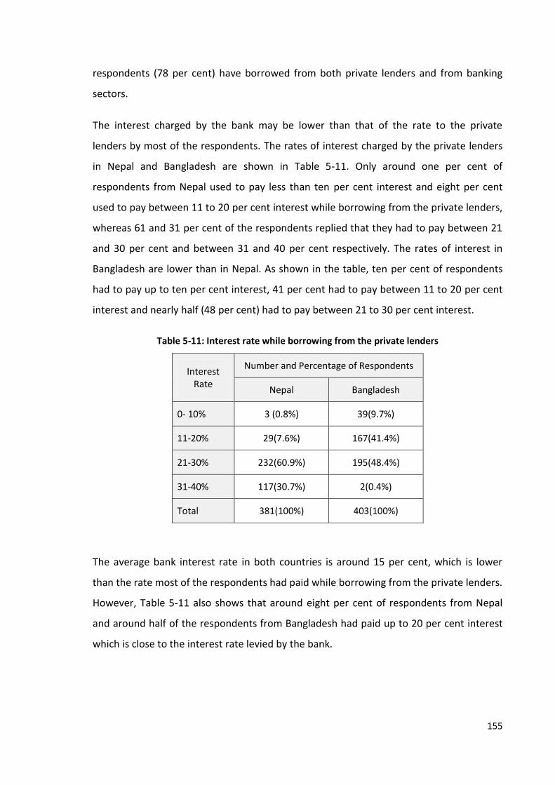
155
respondents (78 per cent) have borrowed from both private lenders and from banking
sectors.
The interest charged by the bank may be lower than that of the rate to the private
lenders by most of the respondents. The rates of interest charged by the private lenders
in Nepal and Bangladesh are shown in Table 5-11. Only around one per cent of
respondents from Nepal used to pay less than ten per cent interest and eight per cent
used to pay between 11 to 20 per cent interest while borrowing from the private lenders,
whereas 61 and 31 per cent of the respondents replied that they had to pay between 21
and 30 per cent and between 31 and 40 per cent respectively. The rates of interest in
Bangladesh are lower than in Nepal. As shown in the table, ten per cent of respondents
had to pay up to ten per cent interest, 41 per cent had to pay between 11 to 20 per cent
interest and nearly half (48 per cent) had to pay between 21 to 30 per cent interest.
Table 5-11: Interest rate while borrowing from the private lenders
Interest Rate
Number and Percentage of Respondents
Nepal Bangladesh
0- 10% 3 (0.8%) 39(9.7%)
11-20% 29(7.6%) 167(41.4%)
21-30% 232(60.9%) 195(48.4%)
31-40% 117(30.7%) 2(0.4%)
Total 381(100%) 403(100%)
The average bank interest rate in both countries is around 15 per cent, which is lower
than the rate most of the respondents had paid while borrowing from the private lenders.
However, Table 5-11 also shows that around eight per cent of respondents from Nepal
and around half of the respondents from Bangladesh had paid up to 20 per cent interest
which is close to the interest rate levied by the bank.

156
It is identified that most of the landowners from Bangladesh had taken loan from the
banking sector, keeping their land as a collateral after registration of their land. In case of
Nepal, although none of the landowners had taken any loan from the banking sector
because of the confusion, bank officials promised to start the lending procedure as the
government made it clear that loan could be granted to the new landowners from the
case study areas. These findings support the statement made by Feder et al. (1988),
Platteau (1996), de Soto (2000) and Deininger (2003) on access to credit resulted from
land titling but contests the findings of Markussen (2008) that property rights have weak
effect on access to credit. The interest rate paid by most of the respondents from Nepal
and around half of the respondents from Bangladesh to the private lenders was higher
than that of the bank rate.
The case study findings also support the contention that the amount of credit available
increases when land value increases. As informed by the respondents from the banking
sector from Nepal and Bangladesh, the valuation of land determined by the land offices
and current market value are the main determinants of the amount of potential
mortgage. The findings from Section 5.3.2 above show that both the valuation prepared
by the land offices as well as the market value is increased after registration of land. It
indicates that the amount of mortgage also increases as the land is registered. This accord
with a study of the impact of the Thailand land titling programme by AusAID (2000),
which concluded that farmers with a title deed who provided land as collateral were
offered between 52 and 521 per cent more bank credit than farmers without title in
Thailand. It shows that land can be used as collateral to borrow money from the banking
sector. The interest charged by the bank is normally lower than that of charged by private
lenders.
The respondents from both countries were also asked to indicate the amount of money
they invested on their land. Table 5-12 shows the average investment before and after
registration of land in Nepal. As shown in the table, around 95 and five per cent of
respondents invested up to NPR 5,000 and from NPR 5,001 to 10,000 per kattha
respectively before registration. The number of respondents investing up to NPR 5,000
decreased to 66 per cent and investing from NPR 5,001 to 10,000 increased to 32 per cent
after registration. The average investment per kattha before registration was NPR 2,700,

157
which increased by 59 per cent to reach NPR 4,300 after registration. The discussion on
the role of tenure security on investment will be followed.
Table 5-12: Average investment in Nepal as a proportion of respondents
Average Investment per
Kattha (in Rupees)
Number and Percentage of Respondents
Before Registration After Registration
1-5,000 363 (95.3%) 253 (66.4%)
5,001-10,000 17 (4.5%) 123 (32.3%)
10,001-15,000 1 (0.2%) 1 (0.2%)
15,001-20,000 0 (0%) 4 (1.0%)
Total 381 (100%) 381 (100%)
Respondents from Bangladesh were also asked about the amount of their investment. As
shown in Table 5-13, the majority (82 per cent) of respondents had invested up to BDT
4,000 before registration, but only 28 per cent continued to invest that amount and most
of them (62 per cent) had invested between BDT 4,001 and 8,000 after registration. The
number of respondents investing between BDT 8,001 and 12,000 also increased from
three to seven per cent. None of the respondents had invested more than BDT 12,000
taka before registration. Only three per cent of them had invested between BDT 12,001
and 16,000 and 0.5 per cent had invested BDT 16,001 to 20,000 after registration. The
average annual investment per kattha of land before registration was BDT 2,800, which
increased by 93 per cent to reach BDT 5,400 per kattha after registration.
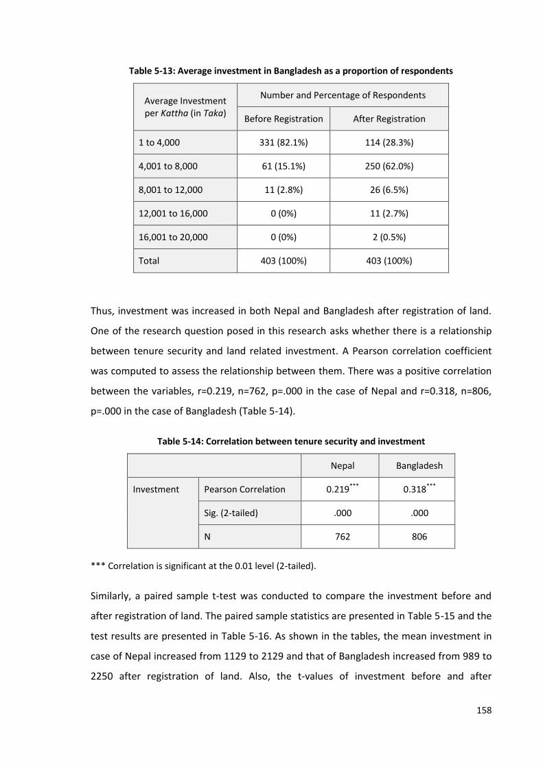
158
Table 5-13: Average investment in Bangladesh as a proportion of respondents
Average Investment per Kattha (in Taka)
Number and Percentage of Respondents
Before Registration After Registration
1 to 4,000 331 (82.1%) 114 (28.3%)
4,001 to 8,000 61 (15.1%) 250 (62.0%)
8,001 to 12,000 11 (2.8%) 26 (6.5%)
12,001 to 16,000 0 (0%) 11 (2.7%)
16,001 to 20,000 0 (0%) 2 (0.5%)
Total 403 (100%) 403 (100%)
Thus, investment was increased in both Nepal and Bangladesh after registration of land.
One of the research question posed in this research asks whether there is a relationship
between tenure security and land related investment. A Pearson correlation coefficient
was computed to assess the relationship between them. There was a positive correlation
between the variables, r=0.219, n=762, p=.000 in the case of Nepal and r=0.318, n=806,
p=.000 in the case of Bangladesh (Table 5-14).
Table 5-14: Correlation between tenure security and investment
Nepal Bangladesh
Investment Pearson Correlation 0.219*** 0.318***
Sig. (2-tailed) .000 .000
N 762 806
*** Correlation is significant at the 0.01 level (2-tailed).
Similarly, a paired sample t-test was conducted to compare the investment before and
after registration of land. The paired sample statistics are presented in Table 5-15 and the
test results are presented in Table 5-16. As shown in the tables, the mean investment in
case of Nepal increased from 1129 to 2129 and that of Bangladesh increased from 989 to
2250 after registration of land. Also, the t-values of investment before and after

159
registration are -6.591 and -17.158 in the case of Nepal and Bangladesh respectively. The
two-tailed probability (p-value) for both cases is .000 which indicates that the likelihood
that a value of t this big could occur by chance is very low. Thus, there was a significant
difference between investment before and after registration in both countries. However,
the standard deviation of investment increased from 611.724 to 3,116.044 in Nepal and
from 1304.987 to 2346.066 in Bangladesh after registration of land. The standard
deviation of the differences of investment before and after registration is also very high in
both countries (2,961.596 in Nepal and 1,475.546 in Bangladesh). These results indicate
that the increase in investment may not have entirely caused from the registration of
land.
Table 5-15: Paired sample statistics of investment before and after registration
Country Pair Mean N Standard Deviation
Standard Error Mean
Nepal Investment before registration 1129 381 611.724 31.340
Investment after registration 2129 381 3116.044 159.640
Bangladesh Investment before registration 989 403 1304.987 65.006
Investment after registration 2250 403 2346.066 116.866
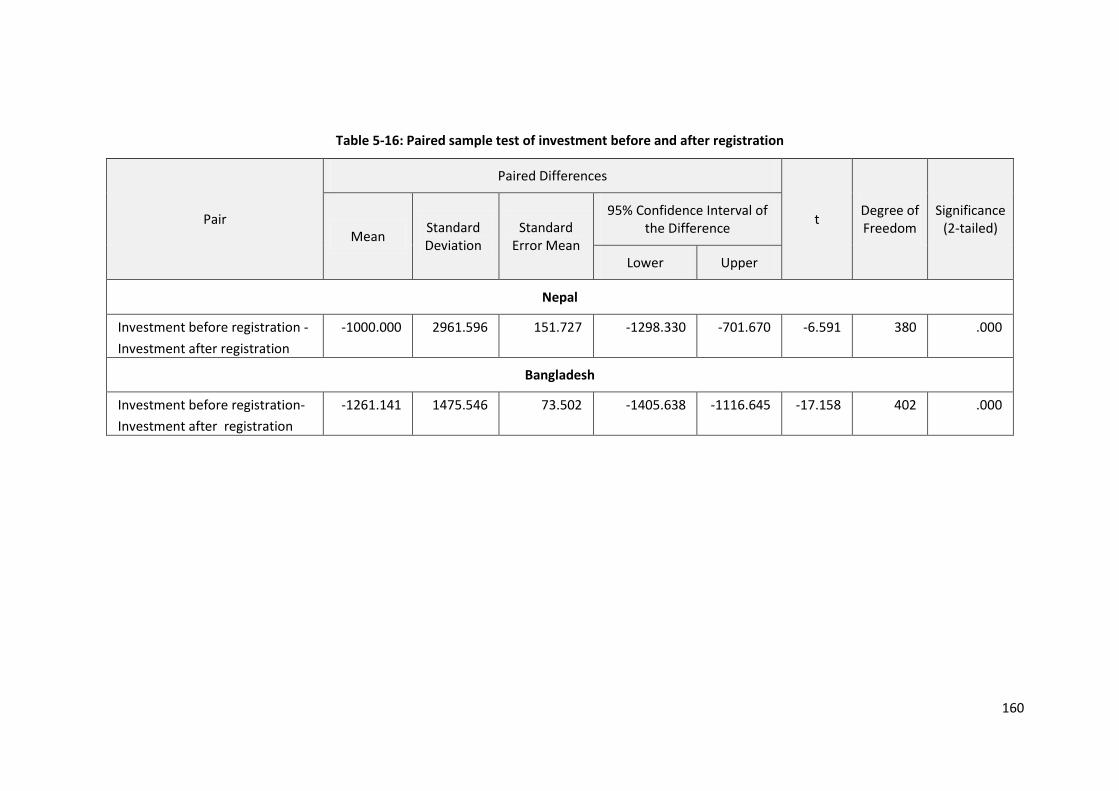
160
Table 5-16: Paired sample test of investment before and after registration
Pair
Paired Differences
t Degree of Freedom
Significance (2-tailed)
Mean Standard Deviation
Standard Error Mean
95% Confidence Interval of the Difference
Lower Upper
Nepal
Investment before registration -
Investment after registration
-1000.000 2961.596 151.727 -1298.330 -701.670 -6.591 380 .000
Bangladesh
Investment before registration-
Investment after registration
-1261.141 1475.546 73.502 -1405.638 -1116.645 -17.158 402 .000

161
The evidence presented above identified that the land related investment is increased
significantly after registration of land in both Nepal and Bangladesh (by 59 and 93 per
cent respectively). It supports the findings from Feder et al. (1988) that titled farmers in
Thailand invested more than untitled farmers. It is in line with the findings from other
studies discussed in Section 2.4.3, for instance, Salas et al. (1970) in Costa Rica, Villamizar
(1984) in Brazil, Deininger and Jin (2006) in Ethiopia. The results from the correlation
analysis identify a positive correlation between tenure security and investment. Similarly,
the results of the paired sample t-tests show a significant difference in investment before
and after registration of land. These findings indicate that land related investment is
increased after registration. However, the higher standard deviations show that the
increase in investment may not have been entirely caused by the registration of land.
It is also identified that land owners could obtain bank loans of a comparatively cheaper
interest rate than that of private lenders after registration of land. In Bangladesh, around
78 per cent of the respondents had borrowed from bank. Findings from Nepal that none
of the respondents had borrowed loan from any banks indicate that they could not
exploit this opportunity to increase investment because of the lack of proper
communication.
To sum up, this research identifies a positive correlation between tenure security and
investment and an increase in the amount of investment after registration. However, it
cannot explain whether the entire increase in investment is induced from the changes in
land tenure status or is driven by any other factors as well. Access to bank finance is not
enough to increase investment unless it is communicated properly.
5.3.4 Income
This study also analyses the affect of land tenure security on land-related income.
Average income per kattha of land before and after registration in Nepal is presented in
Table 5-17. As shown in the table, around two-thirds (66 per cent) of respondents earned
up to NPR 5,000 per kattha and around one-third (33 per cent) of them earned NPR 5,001
to 10,000 per kattha on average before registration. The percentage of respondents
earning more than NPR 10,000 was very low. However, the percentage of respondents
earning up to NPR 5,000 decreased to 42 per cent and the percentage earning between
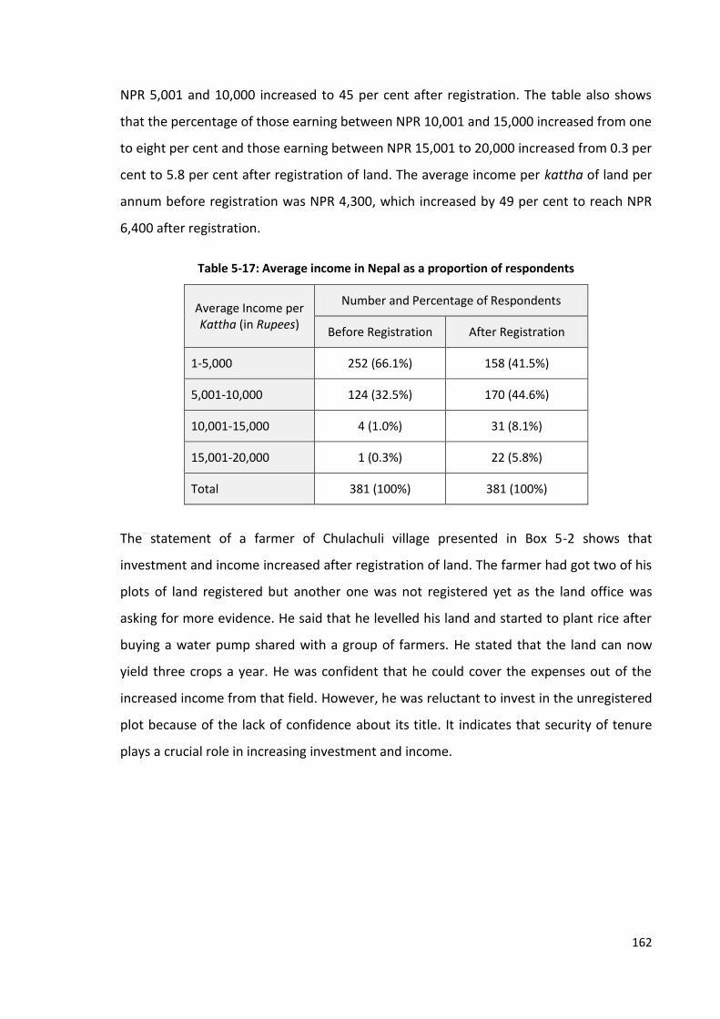
162
NPR 5,001 and 10,000 increased to 45 per cent after registration. The table also shows
that the percentage of those earning between NPR 10,001 and 15,000 increased from one
to eight per cent and those earning between NPR 15,001 to 20,000 increased from 0.3 per
cent to 5.8 per cent after registration of land. The average income per kattha of land per
annum before registration was NPR 4,300, which increased by 49 per cent to reach NPR
6,400 after registration.
Table 5-17: Average income in Nepal as a proportion of respondents
Average Income per Kattha (in Rupees)
Number and Percentage of Respondents
Before Registration After Registration
1-5,000 252 (66.1%) 158 (41.5%)
5,001-10,000 124 (32.5%) 170 (44.6%)
10,001-15,000 4 (1.0%) 31 (8.1%)
15,001-20,000 1 (0.3%) 22 (5.8%)
Total 381 (100%) 381 (100%)
The statement of a farmer of Chulachuli village presented in Box 5-2 shows that
investment and income increased after registration of land. The farmer had got two of his
plots of land registered but another one was not registered yet as the land office was
asking for more evidence. He said that he levelled his land and started to plant rice after
buying a water pump shared with a group of farmers. He stated that the land can now
yield three crops a year. He was confident that he could cover the expenses out of the
increased income from that field. However, he was reluctant to invest in the unregistered
plot because of the lack of confidence about its title. It indicates that security of tenure
plays a crucial role in increasing investment and income.

163
The amount of income earned by the respondents before and after registration of land in
Bangladesh is presented in Table 5-18. The percentage of respondents earning up to BDT
4,000 and between BDT 4,001 and 8,000 per kattha decreased from 21 to two per cent
and 67 to 16 per cent respectively, whereas that earning from BDT 8,001 to 12,000 and
BDT 12,001 to 16,000 taka increased from 10 to 43 per cent and two to 34 per cent
respectively after registration. Similarly, none of the respondents were earning more than
BDT 16,000 before registration but six per cent of them earned that amount after
registration. Average annual income per kattha of land before registration was BDT 5,700,
which increased by 95 per cent to reach BDT 11,100 after registration.
I got dhani purja [land ownership certificate] for two of these plots last year but that one [another plot] is not registered yet. I felt more secured about registered land. I am really excited ... I hired a tractor and levelled this land [registered one] last year. We [farmers] bought water pump for cultivation. The rice produced very well. I am planning to plant [rice] twice a year in this field. I can saw mustard in Mangsir (mid-November to mid-December). This land gives three crops a year [...]. I borrowed 30 thousand for land levelling and water pump which will be covered from the increased income in few years.
I will improve another plot if it is registered. But until then, I am not that much excited. I am not sure whether it will be registered or not as they asked for more evidence that I do not have. I do not want waste money. What will happen if the land office gives it to another person?
Farmer, Chulachuli village, Nepal
Box 5-2: Statement of a farmer about changes on investment and income
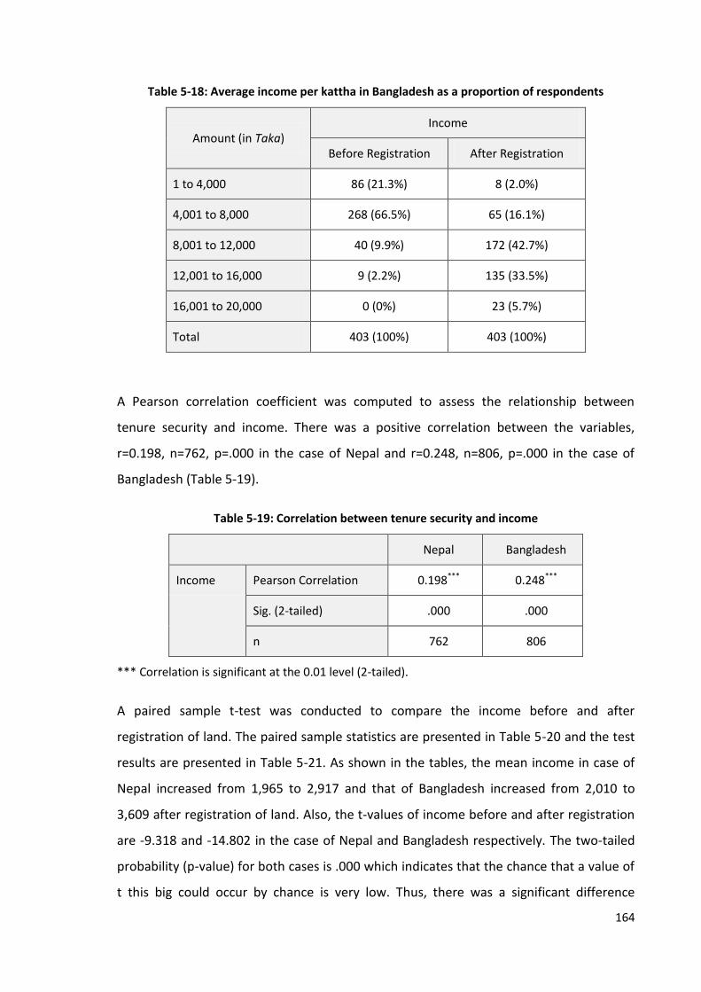
164
Table 5-18: Average income per kattha in Bangladesh as a proportion of respondents
Amount (in Taka) Income
Before Registration After Registration
1 to 4,000 86 (21.3%) 8 (2.0%)
4,001 to 8,000 268 (66.5%) 65 (16.1%)
8,001 to 12,000 40 (9.9%) 172 (42.7%)
12,001 to 16,000 9 (2.2%) 135 (33.5%)
16,001 to 20,000 0 (0%) 23 (5.7%)
Total 403 (100%) 403 (100%)
A Pearson correlation coefficient was computed to assess the relationship between
tenure security and income. There was a positive correlation between the variables,
r=0.198, n=762, p=.000 in the case of Nepal and r=0.248, n=806, p=.000 in the case of
Bangladesh (Table 5-19).
Table 5-19: Correlation between tenure security and income
Nepal Bangladesh
Income Pearson Correlation 0.198*** 0.248***
Sig. (2-tailed) .000 .000
n 762 806
*** Correlation is significant at the 0.01 level (2-tailed).
A paired sample t-test was conducted to compare the income before and after
registration of land. The paired sample statistics are presented in Table 5-20 and the test
results are presented in Table 5-21. As shown in the tables, the mean income in case of
Nepal increased from 1,965 to 2,917 and that of Bangladesh increased from 2,010 to
3,609 after registration of land. Also, the t-values of income before and after registration
are -9.318 and -14.802 in the case of Nepal and Bangladesh respectively. The two-tailed
probability (p-value) for both cases is .000 which indicates that the chance that a value of
t this big could occur by chance is very low. Thus, there was a significant difference
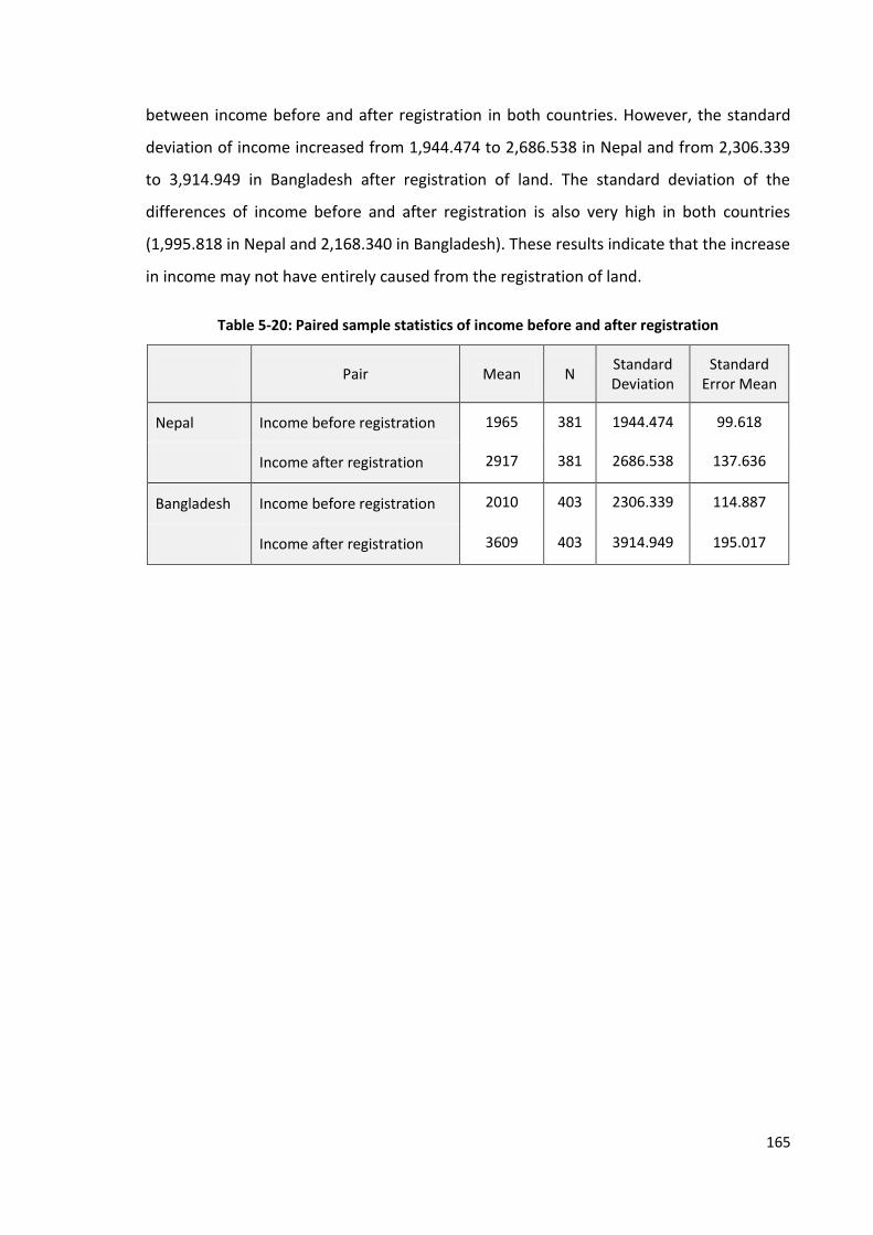
165
between income before and after registration in both countries. However, the standard
deviation of income increased from 1,944.474 to 2,686.538 in Nepal and from 2,306.339
to 3,914.949 in Bangladesh after registration of land. The standard deviation of the
differences of income before and after registration is also very high in both countries
(1,995.818 in Nepal and 2,168.340 in Bangladesh). These results indicate that the increase
in income may not have entirely caused from the registration of land.
Table 5-20: Paired sample statistics of income before and after registration
Pair Mean N Standard Deviation
Standard Error Mean
Nepal Income before registration 1965 381 1944.474 99.618
Income after registration 2917 381 2686.538 137.636
Bangladesh Income before registration 2010 403 2306.339 114.887
Income after registration 3609 403 3914.949 195.017
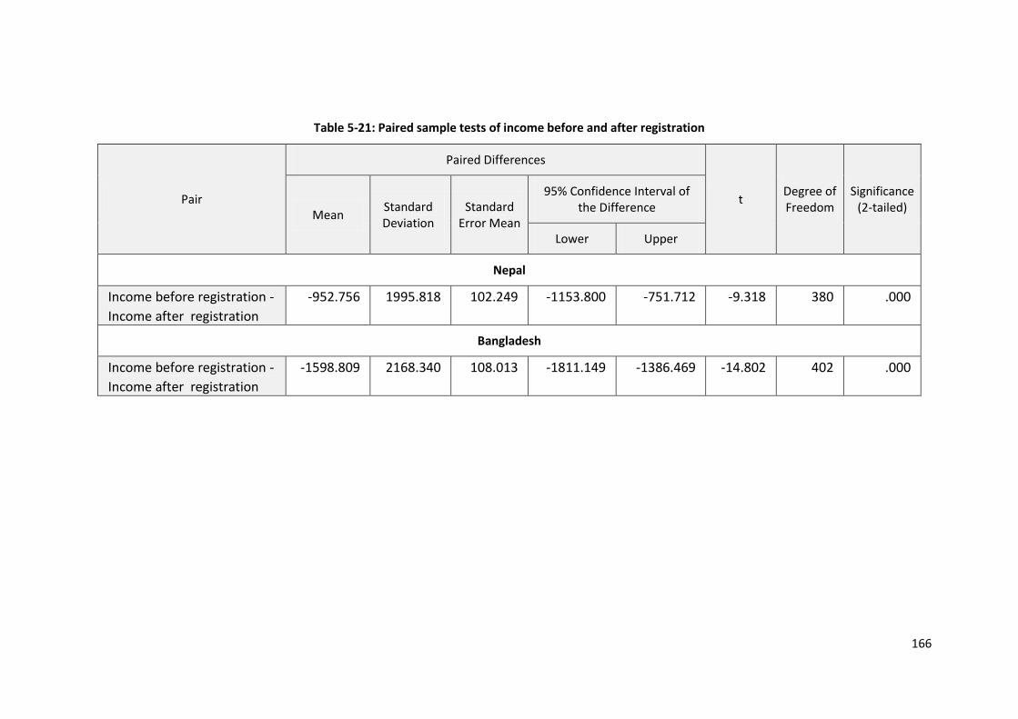
166
Table 5-21: Paired sample tests of income before and after registration
Pair
Paired Differences
t Degree of Freedom
Significance (2-tailed)
Mean Standard Deviation
Standard Error Mean
95% Confidence Interval of the Difference
Lower Upper
Nepal
Income before registration -
Income after registration
-952.756 1995.818 102.249 -1153.800 -751.712 -9.318 380 .000
Bangladesh
Income before registration -
Income after registration
-1598.809 2168.340 108.013 -1811.149 -1386.469 -14.802 402 .000

167
The evidence presented above identified that land related income is increased
significantly after registration in both Nepal and Bangladesh (by 49 and 95 per cent
respectively). It supports the statements of some land tenure theorists like Feder et al.
(1988), Platteau (1996) and Deininger (2003) and findings of IDB (1986) and Chand and
Yala (2009) discussed in Section 2.4.3. The results from the correlation analysis identifies
a positive correlation between tenure security and income. Similarly, the results of the
paired sample t-tests show a significant difference in income before and after registration
of land. A study by AusAID (2000) also identifies that overall productivity was 12 to 27 per
cent higher on titled land than on untitled land in Thailand.
Increase in land related economic activities and investment after registration support the
statement that there may be a positive relationship between land tenure security and
land related income. However, the higher standard deviations in Table 5-20 and 5-21
show that the increase in income may not have entirely caused from the registration of
land. Other factors like inflation or increase in crop price may also be responsible for the
increase in income as it was calculated from the price of the product. It provides part of
the answer for the third research question posed in Chapter One.
5.4 Summary
This chapter has explored the role of land registration in securing land tenure and also
discussed the impact of tenure security on land use, land value, access to credit,
investment and income. The rights of ownership, use of production, sale and transfer of
property, leasing and obtaining loans from the banking sector are all established after
registration of land. Although most of the respondents from both countries have replied
that they had used their produce even before registration of land, use right also became
secured only after registration. Also, the risks of aggression from other parties and
acquisition from government without fair compensation are lowered significantly. The
level of confidence of the landowners about the security of their land rights is also
increased after registration. It provides part of the answer to the first research question.
This study observed that the lands of the case study areas of Nepal and Bangladesh are
mainly used for residential and agricultural purposes. The number of landowners using
land for residential and commercial purposes is increased and the number using it for

168
agricultural purposes is decreased slightly after registration. Similarly, the number of
households engaged in constructing and renovating houses, improving their land,
changing agricultural patterns, planting long-term yielding plants and using their property
for commercial purposes is increased to some extent after registration. It shows that
there is a slight change in the land use pattern and increase in land related activities
related to improving the quality of life, land development and more efficient cropping
choices after registration of land. Thus, land administration promotes land related
economic activities to some extent by means of registration of land. It provides answer to
the second research question posed in Chapter One.
The exchange value of land is also increased by 224 and 123 per cent in Nepal and
Bangladesh respectively. A positive correlation between tenure security and land value
(r=0.684 in the case of Nepal and r=0.259 in the case of Bangladesh) is observed from the
correlation analysis. The results of the paired sample t-test also concluded that there was
a significant difference in the land value before and after registration in the case of both
Nepal {t(380)=-28.238, p=.000} and Bangladesh {t(402)=-17.112, p=.000}. Evidences from
other sources for instance, the statement of interviewees and the valuation of land
determined by the land office also confirm the increase in land value after registration.
The minimum valuation of land for the case study area of Nepal is also increased by the
government by up to 2,298 per cent. Thus, land value is increased after registration and is
positively correlated with the land tenure security, however, the higher standard
deviations suggests that tenure security may not be entirely responsible for the increase.
The ability to invest is also increased after registration as it can be used for collateral. The
interest rate in Nepal and Bangladesh was up to 40 and 30 per cent respectively when
borrowing from the private lenders. But the landowners can get loans from the banking
sector at an average interest rate of 15 per cent. Also, as discussed in the above
paragraph, the exchange value of land is increased significantly. It increases the amount
of credit available to the landowners which is mainly based on the value of land. It
demonstrates that the collateral value of land is increased after registration.
An increase in investment is also observed after registration of land. The average
investment increased by 59 and 93 per cent in Nepal and Bangladesh respectively. The
169
results of the correlation analysis show a positive correlation between tenure security
and investment (r=0.219 in the case of Nepal and r=0.318 in the case of Bangladesh).
Similarly, the results of the paired sample t-test also concluded that there was a
significant difference in the investment before and after registration in both Nepal
{t(380)=-6.591, p=.000} and Bangladesh {t(402)=-17.158, p=.000}. However, the higher
standard deviations of investment show that the increase in investment may not have
entirely caused from the registration of land. Also, findings from Nepal indicate that
access to bank finance is not enough to increase investment unless it is communicated
properly.
The land-related income is also increased after registration of land. The average income in
Nepal was increased by 49 per cent and that in Bangladesh increased by 95 per cent.
Likewise, a positive correlation between land tenure and income is also established. The
correlations are significant at one per cent level of significance (r=0.198 Nepal and
r=0.248 Bangladesh). Similarly, a significant difference in income before and after
registration is observed from the results of the paired sample t-test {t(380)=-9.318,
p=.000} for Nepal and t(402)=-14.802, p=.000 for Bangladesh). However, the higher
standard deviations of income show that the increase in income may not have entirely
caused from the registration of land.
Thus, this study identified that land value, investment and income are positively
correlated with tenure security and a significant difference in these factors is observed
after registration of land. However, the entire increase in these factors may not have
caused from the registration of land alone. It provides answer to the third research
question.

170
Chapter 6: Assessment of Land Administration
Services and Their Role in Revenue Generation
6.1 Introduction
The main purposes for establishing land administration organisations are to prepare land
records and collect revenue from land. The quality of services they offer may affect their
performance. This chapter aims to assess the status of the land administration services
and their role in revenue generation which answers the fourth and fifth research
questions. Moreover, the role of these services in providing land tenure security is also
discussed in this chapter which provide part of the answer to the first research question.
The status of land administration services is discussed first. It includes the process of land
registration, management of land records and dissemination of land information, land
valuation and collection of revenue from land. Then the justification to establish land
administration organisations is discussed.
6.2 Effectiveness of Land Administration Services
The purpose of this section is to assess the services provided by the land administration
organisations and discuss their effectiveness. The status of land registration,
dissemination of land information, land valuation and collection of land tax in Nepal and
Bangladesh is discussed. The land use and planning services are not studied here as the
land use policy is not much properly implemented so far in Nepal (Acharya, 2011) and in
Bangladesh (LANDac, 2012) and the land administration organisations are not much
involved less in these activities in both Nepal and Bangladesh.
6.2.1 Land Registration
Registration of transactions by means of deed or title is one of the main functions of land
administration organisations. It is one of the sources of revenue for the government. The
systems of land registration in Nepal, Bangladesh and Thailand were discussed in detail in
Chapter Four. This section discusses the procedure, time and costs of land registration in
Nepal and Bangladesh. Moreover, the registration process of Thailand is also discussed.
171
Procedure
The process of land registration usually includes obtaining a clearance certificate,
preparation of deeds and documents, verification of records, registration of deeds and
payment of registration fee or stamp duty, updating records and issuance of title
certificate. As discussed in Chapter Four, the registration processes in Nepal, Bangladesh
and Thailand involves three, eight and two procedures respectively.
The process of land registration in Bangladesh is found more complicated than that of
Nepal and Thailand, however, the process of Nepal is also not free from criticism. Around
90% of respondents from Nepal and Bangladesh considered the process to be very
cumbersome. Some of the key informants from Bangladesh also presented similar
opinions. For instance, a land rights campaigner from Bangladesh considered the process
of land registration and mutation as 'ridiculous'. Likewise, participants of the seminar
organised in Dhaka said that there are problems of manipulation and tempering of land
records, and corruption and bribery in the land offices. Similarly, one of the senior officers
of the Real Estate and Housing Association of Bangladesh (REHAB) regarded the process
to be very cumbersome and argued that bribing the employees can speed up the process.
He stated: “It is still pretty cumbersome although it has reduced a lot over period of time.
[...] you can speed up, if you spend some money, even bribe [...]. It takes money." He
further described how poor people suffer more than wealthier people. In his words:
“[...] Not all the parties have that money, commission [bribe]. If say, I am trying to buy land from a poor person, I can speed up the process. But one poor person selling land to another poor person, then they need a lot of money to speed up the process. They suffer actually.”
It shows that money can work as a lubricant to speed up the process of registration and
the poor are more victimised from these practices. These practices contradict the values
of integrity and impartiality of land administration officials put forward by FAO (2007) and
discussed in Chapter Two. Field observation also confirms that the process of land
registration is better organised in Thailand than in Nepal and Bangladesh. The researcher
visited the Land Revenue Office in Ilam (Nepal), the Sub-Registry Office in Tangail
(Bangladesh) and the Provincial Land Office in Pak Kret (Thailand) to observe the process
of land registration. The findings of the researcher are presented in Box 6-1. In the Pak
Kret Land Office, Thailand, the clients were warmly welcomed in the help desk and asked
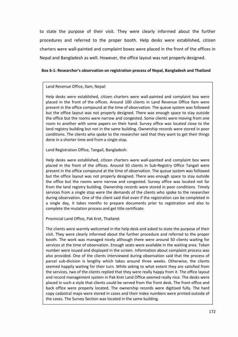
172
to state the purpose of their visit. They were clearly informed about the further
procedures and referred to the proper booth. Help desks were established, citizen
charters were wall-painted and complaint boxes were placed in the front of the offices in
Nepal and Bangladesh as well. However, the office layout was not properly designed.
Land Revenue Office, Ilam, Nepal:
Help desks were established, citizen charters were wall-painted and complaint box were placed in the front of the offices. Around 100 clients in Land Revenue Office Ilam were present in the office compound at the time of observation. The queue system was followed but the office layout was not properly designed. There was enough space to stay outside the office but the rooms were narrow and congested. Some clients were moving from one room to another with some papers on their hand. Survey office was located close to the land registry building but not in the same building. Ownership records were stored in poor conditions. The clients who spoke to the researcher said that they want to get their things done in a shorter time and from a single stop.
Land Registration Office, Tangail, Bangladesh:
Help desks were established, citizen charters were wall-painted and complaint box were placed in the front of the offices. Around 50 clients in Sub-Registry Office Tangail were present in the office compound at the time of observation. The queue system was followed but the office layout was not properly designed. There was enough space to stay outside the office but the rooms were narrow and congested. Survey office was located not far from the land registry building. Ownership records were stored in poor conditions. Timely services from a single stop were the demands of the clients who spoke to the researcher during observation. One of the client said that even if the registration can be completed in a single day, it takes months to prepare documents prior to registration and also to complete the mutation process and get title certificate.
Provincial Land Office, Pak Kret, Thailand:
The clients were warmly welcomed in the help desk and asked to state the purpose of their visit. They were clearly informed about the further procedure and referred to the proper booth. The work was managed nicely although there were around 50 clients waiting for services at the time of observation. Enough seats were available in the waiting area. Token number were issued and displayed in the screen. Information about complaint process was also provided. One of the clients interviewed during observation said that the process of parcel sub-division is lengthy which takes around three weeks. Otherwise, the clients seemed happily waiting for their turn. While asking to what extent they are satisfied from the services, two of the clients replied that they were really happy from it. The office layout and record management system in Pak Kret Land Office seemed really nice. The desks were placed in such a style that clients could be served from the front desk. The front office and back office were properly located. The ownership records were digitised fully. The hard copy cadastral maps were stored in cases and their index numbers were printed outside of the cases. The Survey Section was located in the same building.
Box 6-1: Researcher's observation on registration process of Nepal, Bangladesh and Thailand

173
Photo 6-1 depicts clients waiting in front of the land registries in all three countries, which
clearly shows how the waiting area and office layout are set up in land offices. As
mentioned in Box 6-1, the office layout and record management system in Thailand
seems better organised than that of both Nepal and Bangladesh. The clients are nicely
greeted and asked to state the purpose of their visit. When they are directed to the
designated booth, they can wait until their Token Number is displayed on a screen. There
are also queuing systems in Nepal and Bangladesh but not as well-organised and properly
implemented as in Thailand. The survey office is located in the same building in Thailand
but not in Nepal and Bangladesh, although they were not that far away.
Photo 6-1: Clients waiting to register their land in Land Revenue Office, Ilam (lower left), Land
Registry Office, Tangail (lower right) and Provincial Land Office, Pak Kret (upper both)
The way of sharing information is also better organised in Thailand than in Nepal and
Bangladesh. As stated in Box 6-1 and shown in Photo 6-2, citizens’ charters are published
in all of the offices which are clearly visible. In Thailand all required information including
the sample of the verities of documents and applications are also displayed clearly.
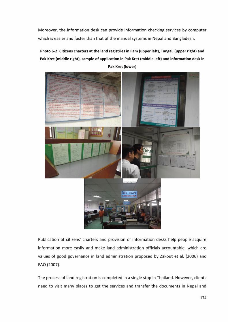
174
Moreover, the information desk can provide information checking services by computer
which is easier and faster than that of the manual systems in Nepal and Bangladesh.
Photo 6-2: Citizens charters at the land registries in Ilam (upper left), Tangail (upper right) and
Pak Kret (middle right), sample of application in Pak Kret (middle left) and information desk in
Pak Kret (lower)
Publication of citizens’ charters and provision of information desks help people acquire
information more easily and make land administration officials accountable, which are
values of good governance in land administration proposed by Zakout et al. (2006) and
FAO (2007).
The process of land registration is completed in a single stop in Thailand. However, clients
need to visit many places to get the services and transfer the documents in Nepal and
175
Bangladesh. The location of the survey section inside the land office in Thailand has
reduced the time involved in moving documents and ensured their safety. However, in
Nepal and Bangladesh, the clients or deed writers usually move the documents from one
place to another and this increases the risks of loss or falsification of documents.
Time
The time taken to complete the process of land registration also affects on the quality of
land administration services. Respondents in the case study areas in Nepal and
Bangladesh were asked about the time they had to spend while collecting the required
information, registering a deed and updating records in the land registry office. Only 79
(21 per cent) of respondents had visited the land office in Nepal while almost all of the
respondents (395 or 98 per cent) from Bangladesh had visited those offices. The data
about purpose of their visit and time taken to get the services are presented in Table 6-1.
In Nepal, 78 respondents (21 per cent) had visited to update records while only 18 (five
per cent) and 15 (four per cent) respondents respectively had visited to collect
information or documents and register deeds.
In Bangladesh, most of the respondents had visited land offices to collect documents (395
or 98 per cent) and update records (366 or 91 per cent). Among the respondents who had
visited land offices in Nepal, 78 per cent, 67 per cent and 85 per cent said that the task of
collecting the required information and documents, registering deeds and updating
records was completed within three days. The rest of the respondents replied that it
takes four to six days to complete these processes. In Bangladesh, of those respondents
who had visited land offices, 85 per cent, 72 per cent and 15 per cent respondents said
that it took up to three months to collect information and documents, register deeds and
update records respectively. Likewise, five (one per cent), zero (zero per cent) and 254
(69 per cent) of them replied the respective process can be completed within four to six
months and 13 per cent, 28 per cent and 16 per cent said that they do not know the exact
time. The data shows that getting information from land offices, registering transactions
and updating records is more time consuming in Bangladesh than Nepal.

176
Table 6-1: Time taken to get land administration services in Nepal and Bangladesh
Purpose of Visiting Land Offices
Nepal Bangladesh
Number and Percentage of
Respondents Who Had Visited Land Office*
Time Taken to Get Services (in Days)**
Number and Percentage of
Respondents Who Had Visited Land Office*
Time Taken to Get Services (in Months)**
Up to 3 days 4 to 6 days Up to 3 months 4 to 6 months Do not Know
To collect information and documents
18 (4.7%) 14 (77.8%) 4 (22.2%) 395 (98%) 337 (85.3%) 5 (1.3%) 53 (13.4%)
To register deeds 15 (3.9%) 10 (66.7%) 5 (33.3%) 176 (43.7%) 126 (71.6%) 0 (0%) 50 (28.4%)
To update records 78 (20.5%) 66 (84.6%) 11 (14.1%) 366 (90.8%) 54 (14.8%) 254 (69.4%) 59 (16.1%)
Note: *Percentage of total respondents (381 in Nepal and 403 in Bangladesh) **Percentage of respondents who had visited land office (79 from Nepal and 397 from Bangladesh); mutually inclusive

177
Some of the interviewees from Nepal also said that the process of registering transactions
could be completed within two or three days. One of the land rights activists, sharing his
own experience, described how the process could be completed even in ten minutes if
there is a personal relation with officials (Box 6-2).
He said that if all documents are ready and there is a good relationship with the officials,
it can be completed even within hours. It may not be the case for ordinary citizens
though. It indicates that the registration process in Nepal is very fast but there is lack of
impartiality in the land administration officials in some cases, which contradicts the good
governance values presented by Zakout et al. (2006) and FAO (2007).
In Bangladesh, it takes up to eight months to complete the whole process of land
registration. A land officer working in the Sub-Registry Office in Bangladesh said that the
process of merely registering deeds in the land registry can be completed in a single day;
however, it takes more time to prepare documents and update records. One of the
Managing Directors of a housing company in Bangladesh mentioned:
“It is possible for us to register a parcel of private, freehold land within one day. If the land is leasehold, we must take permission from RAJUK or ministry which takes too much time- two months or even three months. After getting their permission, we can take the registration within one or two days.”
The data presented above shows that it takes several months to complete the whole
process and issue a title certificate in Bangladesh although the land registry does not take
In some countries, it takes three months to get land certificate. But in our country it can be obtained within an hour. [...] In my own case, it took an hour. If we propose the land officer, it could be done even within ten minutes.
I had gone to the land office to make a copy of land certificate of my friend. One of the staffs asked whether he has got recommendation from VDC and other documents. My friend presented those documents before him. Then he called a deed writer. The task completed in ten minutes. However, if it was in the case of poor tenant, it might take three days. I looked at other countries, they said it takes three months and they would be happy if they could get within three months; otherwise, it might take six months as well.
Land Rights Activist, Nepal
Box 6-2: Experience of an interviewee about time taken to get services from Land Revenue
Office in Nepal

178
much time. But the process can be completed within days in Nepal. These findings
support those of the World Bank published in the Doing Business Report (World Bank,
2013). The report observes that it takes up to five days and 245 days to complete a
registration process which involves three and eight procedures in Nepal and Bangladesh
respectively. On the other hand, there is only one process in Thailand which could be
completed within two days. The process that takes several months and involves more
than five steps is considered as an indicator of problem by Zimmerman (2006). Thus, the
land registration process of Bangladesh seems more problematic than that of Nepal and
Thailand.
Costs
The cost of transactions may also affect on the effectiveness of services. Respondents
from Nepal and Bangladesh were asked about the amount of money they had to spend in
order to obtain services, apart from the legal fees or charges. The results of the survey in
Nepal are presented in Table 6-2. It costs up to two thousand rupees to collect
information or documents and register a deed as stated by 67 per cent and 73 per cent of
the respondents respectively. Likewise, it costs from NPR 2,001 to 5,000 to update
records and to pay for transportation and accommodation according to 69 per cent and
61 per cent of the respondents respectively. Similarly, more than half of the respondents
(54 per cent) opined that it costs up to NPR 2,000 for other purposes, which include the
cost of bribing employees with lunch [khaja].
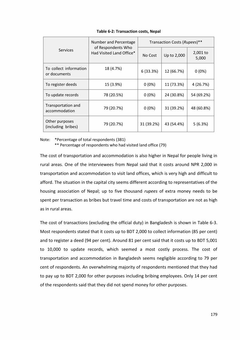
179
Table 6-2: Transaction costs, Nepal
Services
Number and Percentage of Respondents Who
Had Visited Land Office*
Transaction Costs (Rupees)**
No Cost Up to 2,000 2,001 to
5,000
To collect information or documents
18 (4.7%) 6 (33.3%) 12 (66.7%) 0 (0%)
To register deeds 15 (3.9%) 0 (0%) 11 (73.3%) 4 (26.7%)
To update records 78 (20.5%) 0 (0%) 24 (30.8%) 54 (69.2%)
Transportation and accommodation
79 (20.7%) 0 (0%) 31 (39.2%) 48 (60.8%)
Other purposes (including bribes)
79 (20.7%) 31 (39.2%) 43 (54.4%) 5 (6.3%)
Note: *Percentage of total respondents (381) ** Percentage of respondents who had visited land office (79)
The cost of transportation and accommodation is also higher in Nepal for people living in
rural areas. One of the interviewees from Nepal said that it costs around NPR 2,000 in
transportation and accommodation to visit land offices, which is very high and difficult to
afford. The situation in the capital city seems different according to representatives of the
housing association of Nepal; up to five thousand rupees of extra money needs to be
spent per transaction as bribes but travel time and costs of transportation are not as high
as in rural areas.
The cost of transactions (excluding the official duty) in Bangladesh is shown in Table 6-3.
Most respondents stated that it costs up to BDT 2,000 to collect information (85 per cent)
and to register a deed (94 per cent). Around 81 per cent said that it costs up to BDT 5,001
to 10,000 to update records, which seemed a most costly process. The cost of
transportation and accommodation in Bangladesh seems negligible according to 79 per
cent of respondents. An overwhelming majority of respondents mentioned that they had
to pay up to BDT 2,000 for other purposes including bribing employees. Only 14 per cent
of the respondents said that they did not spend money for other purposes.

180
Table 6-3: Transaction costs, Bangladesh
Transaction Costs Number and Percentage
of Respondents Who Had Visited Land Office*
Costs (in Taka)**
No Cost Up to 2,000
2,001 to 5,000
5,001 to10,000
To collect information and documents
337 (98.0%) 2(0.6%)
286 (84.9%)
29 (8.6%)
20 (5.9%)
To register deeds 176 (43.7%) 1 (0.6%)
165 (93.8%)
10 (5.7%)
0 (0%)
To update records 366 (90.8%) 2 (0.5%)
26 (7.7%)
41 (11.7%)
297 (81.1%)
Transportation and accommodation
397 (98.5%) 313
(78.8%) 84
(21.2%) 0 (0%) 0 (0%)
Other purposes (including bribes)
397 (98.5%) 57
(14.4%) 328
(82.6%) 6 (1.5%) 6 (1.5%)
Note: *Percentage of total respondents (403) ** Percentage of respondents who had visited land office (397)
Thus, transaction costs are high in both Nepal and Bangladesh. Just over half of
respondents from Nepal (52 per cent) and almost all from Bangladesh (97 per cent)
considered the cost of registering property as high. None considered the costs to be low.
Most of the respondents are in favour of reducing transaction costs, and some suggested
measures for it. In the case of Nepal, almost all (97 per cent) suggested improvements in
the service employees’ behaviour and around 95 per cent want to improve the law and
procedures. Likewise, an overwhelming majority supported the measures for an online
information system (87 per cent) and for the relocation of land offices (81 per cent).
Around 80 per cent of respondents were of the opinion that improvements in land
administration services would reduce transaction costs. In case of Bangladesh, revision of
legal provision, improvements in employee’s behaviour, restructuring of organization and
reducing the rate of registration fee are the measures suggested to reduce the
transaction costs. Most of the respondents are in favour of change in the existing legal
provision regarding the process of land registration (97%), improving behaviour of
employees (87%) and restructuring organizational framework (60%). Moreover, around
79% of the people believe that the improvements in land administration services would
contribute significantly in reducing costs.

181
The problems of bribery and malpractices are also observed in land administration
organisations which has increased the costs of transactions and threatened its security.
The problem is more acute in Bangladesh than in Nepal. As shown in Table 6-2 and Table
6-3 above, respondents had to bribe officials to obtain services. A report published by
Transparency International identified that 31 per cent and 48 per cent of respondents
respectively from Nepal and Bangladesh had paid a bribe for land services (Hardoon and
Heinrich, 2011). Similarly, bribes worth 83 billion taka were paid for land-related cases
such as registration and altering of records in 2006 in Bangladesh (Ray, 2010). It indicates
how big the problem of bribery in land offices is. One of the campaigners for the land
rights movement in Bangladesh considered the land ministry as one of the corrupt
ministries and stated that if you bribe the officials, they can even tamper with the land
records. In her words, “It [Ministry of Lands] is one of the most corrupt organisations. You
can bribe officials and tamper with the records and everything.” Similarly, one of the
university lecturers from Bangladesh said that there are no good governance values in
any sector of government in Bangladesh. He argued that land administration is one of the
most corrupt sectors in which all levels of employees are corrupt. He said:
“In the government of Bangladesh, good governance values are not at all, in all sectors. Land administration is perhaps one of the most corrupt sectors in Bangladesh. [...] Starting from the lower level up to the higher AC-Lands people are corrupt. Thus, if even the ministry is corrupt how much can we do to penetrate through the system and inject values?”
He further stated that the work may go smoothly in some cases but it is necessary to
bribe the employees in most of the cases. In his words:
“I am sorry to say we have many malpractices over there especially in the land settlement office and the government agencies. It is really hard to get proper legal support from the government until you do not have money underneath. In few cases, say, like 30 per cent cases, everything will go smoothly, if you go to the government [...]. But in most of the cases, you will have to deal with [...] some dirty deals to get proper judgement.”
These malpractices increase the costs of obtaining services from the land administration
organisations as well as defending the property.
To summarise, it is clear that the processes of land registration in both Nepal and
Bangladesh are not free from problems, more so in Bangladesh than in Nepal and
Thailand. The process of land registration is well organised in Thailand but may be
182
completed faster in Nepal. Transaction costs are high in both Nepal and Bangladesh but
the practices of bribery, forgery and corruption are found more common in Bangladesh.
These practices may limit the rights of the land owners and threaten the security of
tenure established from the registration of land as discussed in Section 5.2. Complicated
processes and high transaction costs usually discourage the formal registration of
transactions. Likewise, increased land litigation may also affect land related activities and
investment as lenders might be reluctant to accept disputed land as collateral. These are
symptoms of weak governance which may constrain economic development, reduce
public revenue, increases tenure insecurity, increases land disputes, weaken land and
credit markets and promote negative social behaviour, as observed by FAO (2007).
Service improvement is required to curb problems in land administration organisations.
One of the campaigners for the land rights movement in Bangladesh suggested reviewing
the registration process and making land information transparent and easily accessible.
Similarly, one of the representatives of the Nepal Land and Housing Developers
Association (NLHDA) suggested improving the information system, training employees
and changing their behaviour in order to reduce transaction costs. In his words, “For
improvement, all the documents need to be computerised, networking should be done
and staffs need to be trained but should be penalised if they commit corruption.”
Likewise, one of the land rights activists from Bangladesh described how administrative
reform and service to citizens had to be the main agenda and that these are completely
lacking in these organisations. In his words, “There is no agenda of reform and providing
services to the people [...]. So service to citizens should be the main agenda of each and
every organisation at every level.” Thus, reform in land administration is essential to
reduce transaction costs and to control bribery and corruption, which ultimately
enhances the security of tenure and increases its benefit.
6.2.2 Record Management and Information Dissemination
Easy access to reliable land information is the backbone of the land market. It is also a
means of securing land rights and reducing land related disputes. This section discusses
the status of management and dissemination of land information in Nepal and
Bangladesh.
183
The system of recording land information in both Nepal and Bangladesh is mainly paper-
based but the process of digitisation of land records has begun. In Nepal, most of the land
records belonging to the Land Revenue Offices are digitised and the process of land
registration is also computerised in some offices. Most of the cadastral maps and old land
documents, however, are still in analogue form. The government is planning to complete
this process throughout the country within a couple of years, as informed by the Director
of DOLIA. He also said that once the process is completed, an integrated geo-database
would be established.
The land recording system of Bangladesh is still traditional which has caused several
problems. NORC (2009:85) observes that at present the information generated by land
administration organisations is collected, stored and accessed using 19th Century
technology. It further states that the information system is entirely paper-based, difficult
to access, lacking backup in case of fire, theft or natural disasters, and prone to
tampering. Recently, the Government of Bangladesh has taken a vision of Digital
Bangladesh which aims to digitise all public records and adopt information and
communication technology in all sectors by 2021 to ensure access to information
(Planning Commission, 2012). The process of digitisation of land records has begun
accordingly. A pilot project conducting revised settlement work using modern equipment
including Global Positioning System, total station, data recorder and map processing
software has recently been completed which is expected to reduce the time required for
publication of records of rights and accurately measure the land plots. However, it may
still take years to complete the process of digitisation and establish a land information
network throughout the country.
The process of collecting land information is very complicated, especially in Bangladesh.
Most respondents from Nepal and Bangladesh considered the land information systems
to be problematic. Around 89 per cent of respondents from the case study area in Nepal
and 91 per cent in Bangladesh opined that it is difficult to produce land records on time.
Some interviewees, for instance, Managing Directors of one of the housing companies in
Bangladesh, also said that it is necessary to visit more than one office and bribe the
employees to collect land information. In his words, “It is very tough to get the

184
information [...]. We should go to different agencies and pay a lot of money. In most
cases, it is very difficult for us to find complete information.”
The current land recording and information system has caused several problems,
including falsification of documents, increase in land disputes and incidence of violence.
One of the university lecturers from Nepal mentioned that a lack of digital records causes
duplication of ownership that increases conflict in the land market. In his words, “There
are always conflicts in land market because of the duplication of ownership. This problem
is occurred because we do not have electronic database.” Similarly, one of the land rights
campaigners from Bangladesh said that the land information system is not transparent
and most of the court cases and incidents of violence are related to land. In her words:
“The land information system is not transparent and proper; this is going to lead to the worst situation possible. [...] We have enough records to show that almost 80 per cent of all the cases are somehow related to land. [...] But the large portions are false cases arising out of land- to get you off the land. They put you false cases then you spend your whole life trying to fight the cases or there may be violence, even murder because of the land.”
The land market may also suffer if the proper land information is not available. One of the
representatives of the NLHDA argued that housing projects may suffer due to the lack of
sufficient information. In his words, “[...] sometimes people may lie and we may not have
sufficient information for cross-checking. Consequently, many problems may appear after
launching a project.”
Tampering and manipulation of records is another problem found in land administration
organisations, especially in Bangladesh. One of the respondents from Bangladesh said
that even government lands could be sold if staffs are bribed. In her words, “One
researcher once tried to show that [...] he can even go and register the land of the
Parliament Building.” She also mentioned that if someone pays a bribe, he could tamper
with the records, add his name in the land ownership records, or do whatever he wants.
In her words, "[...] it is so corrupt, what they do is, they give money and they will have this
portion; the tehsildar or whatever, just write it on your name. So you will find the same
land." She further mentioned that she had hardly found any undisputed land. She said, "I
have never found the land that is clean. Any land you touch, it will have four or five
people also claiming the same land.”

185
It shows that the problem of forging land records, adding someone else's name in the
land records or multiple selling of the same piece of land in return for a bribe for
example, is one of the main problems in the land administration organisations of
Bangladesh. Moreover, poor land recording systems and a lack of transparency in land
information has increased land-related conflicts which can be verified from the fact that
up to 80 per cent of the court cases in the rural of Bangladesh areas are related to land
(Hossain, 2015:26) These are the symptoms of weak governance which restrict
development, limit revenue and increases tenure insecurity (FAO, 2007:16). Thus, both
behaviour of employees and land recording and information systems may affect the
security of tenure.
Digitisation of land records and adaptation of geo-information and communication
technology has been considered as a means of protecting valuable documents, reducing
land disputes, easing the process of disseminating land information and improving the
efficiency of land offices. In the words of one of the university lecturers from Nepal, “If
we could adopt geo-information and communication technology in the land
administration services and provide services efficiently, [...] conflicts would be
minimised.” Similarly, one of the Managing Directors of a housing company in Bangladesh
opined that real estate business would be highly professional and more developed if all
the information is available from a single source. He also informed that the REHAB is
taking some initiatives in order to improve the land recording and information systems
and to provide services from all designated offices from a single window:
“From REHAB we have taken very much initiative. We have discussed with the authority of RAJUK. We have suggested that we want the one window solution; all the departments will be seated in the same place. It will go through one table to another table. All departments will see all the information, and then they will give the clear answer.”
It is a current need and means of reducing land litigations but it may not be sufficient to
resolve all land related problems. In this regard, one of the environmental lawyers from
Bangladesh said that the land recording system should be modernised and there should
be a central database. She considered digitisation as not the only solution but a current
need, which will reduce litigation and make the life of the people easier. In her words:

186
“I would not say that digitisation is only solution, because many of our people do not have access to computer and internet but digitisation is of course a good way; at the least, it should be available and authenticated. That is most important so that people can go and find out this land belongs to this gentleman. It should be easier. Digitisation is order of the day, so it [land records] should be digitised and should be accessible. This will, in fact, reduce the lot of litigations and make our life easier.”
From the above discussion it is clear that existing system of land recording and
information system have caused several problems, including falsification of documents
and tampering and manipulation of land records, leading to an increase in land disputes
and incidences of violence, especially in Bangladesh. Digitisation of land records and
establishing integrated land information systems would protect valuable documents,
reduces land disputes, ease the process of disseminating land information and improve
the efficiency of land offices. However, it may not be enough to solve all of the problems
in the land administration organisations as many people do not have access to or
knowledge of computers. Also, the ethics, morale and efficiency of service employees
may need to be changed. These findings are in line of the findings of Akingbade
(2012:162) who reveals that corrupt practices such as forgery, multiple allocations,
bribery, fraud and white collar malpractices were reduced after the application of ArcGIS
in Nigeria, although he warns that high levels of computerisation or high-end electronic
land administration solutions are not a panacea for corruption and do not automatically
increase effectiveness in land-related public sector management.
6.2.3 Land Valuation
Valuation of land is also one of the main functions of land administration organisations.
These organisations are either directly involved in the valuation of land or support the
valuation agencies by sharing the required land information.
As discussed in Chapter Four, there is a minimum valuation system in Nepal and
Bangladesh, which is prepared by the land offices. In Nepal, the Minimum Valuation
Determining Committee formed according to the Land Revenue Act, 1978 prepares the
minimum value of land for registration purposes. In Bangladesh, the land registration
office prepares the valuation of land in accordance with the Registration Act, 1908.
Buyers and sellers determine the value of property but the value declared in the deed
should not be less than the minimum value thus determined.

187
The land value determined by the land offices does not reflect the current market price of
the land. Cases presented in Box 6-3 show that valuations undertaken by the government
are very much lower than the real price of land in both Nepal and Bangladesh. As shown
in the box, the valuation of land is even one-tenth of the actual price of land in one case
but one-third lower is common in both countries. For instance, the valuation of land in
adjacent VDC of Bhimeshwor Municipality (Nepal) is nine hundred per cent lower and
that of one plot sold in Chulachuli (Nepal) is 260 per cent lower than the market value. It
is also understood that the valuation is usually prepared adding some percentage on the
valuation of the previous year.
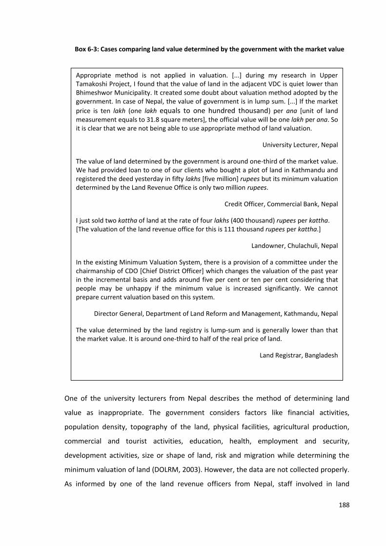
188
One of the university lecturers from Nepal describes the method of determining land
value as inappropriate. The government considers factors like financial activities,
population density, topography of the land, physical facilities, agricultural production,
commercial and tourist activities, education, health, employment and security,
development activities, size or shape of land, risk and migration while determining the
minimum valuation of land (DOLRM, 2003). However, the data are not collected properly.
As informed by one of the land revenue officers from Nepal, staff involved in land
Appropriate method is not applied in valuation. [...] during my research in Upper Tamakoshi Project, I found that the value of land in the adjacent VDC is quiet lower than Bhimeshwor Municipality. It created some doubt about valuation method adopted by the government. In case of Nepal, the value of government is in lump sum. [...] If the market
price is ten lakh (one lakh equals to one hundred thousand) per ana [unit of land measurement equals to 31.8 square meters], the official value will be one lakh per ana. So it is clear that we are not being able to use appropriate method of land valuation.
University Lecturer, Nepal
The value of land determined by the government is around one-third of the market value. We had provided loan to one of our clients who bought a plot of land in Kathmandu and registered the deed yesterday in fifty lakhs [five million] rupees but its minimum valuation determined by the Land Revenue Office is only two million rupees.
Credit Officer, Commercial Bank, Nepal
I just sold two kattha of land at the rate of four lakhs (400 thousand) rupees per kattha. [The valuation of the land revenue office for this is 111 thousand rupees per kattha.]
Landowner, Chulachuli, Nepal
In the existing Minimum Valuation System, there is a provision of a committee under the chairmanship of CDO [Chief District Officer] which changes the valuation of the past year in the incremental basis and adds around five per cent or ten per cent considering that people may be unhappy if the minimum value is increased significantly. We cannot prepare current valuation based on this system.
Director General, Department of Land Reform and Management, Kathmandu, Nepal
The value determined by the land registry is lump-sum and is generally lower than that the market value. It is around one-third to half of the real price of land.
Land Registrar, Bangladesh
Box 6-3: Cases comparing land value determined by the government with the market value

189
valuation normally prepare reports based on their experience without visiting the field
and collecting required information about the land. Similarly, one of the Land Registrars
from Bangladesh described how they use the incremental method and add some
percentage of the existing valuation to determine the value for the upcoming year. It is
also identified that there is no separate valuation agency and the valuation is prepared by
land registry staffs and no specialised property valuators are hired in the land
administration organisations.
The valuations prepared by land offices are used as a reference for other purposes
including land acquisition and mortgage calculation. Banks, finance companies, the courts
and local government offices also use this valuation as a reference while determining the
property value; however, they use their own system of valuation. As a result, the same
property is given different valuations by different organisations. The Secretary of the
MOLRM (Nepal) also described that there is no unique valuation of land and the valuation
prepared by the government is minimum. In his words: “Since there are different
valuations from the bank, insurance, municipalities and land offices, there is no actual
valuation of land. Our valuation is only the minimum.”
The existing valuation system has caused several problems. One of the Deputy Director
Generals of the Survey Department in Nepal identifies two consequences of having
multiple property valuation authorities as under-payment of tax and cases of fraud. He
said:
“In one side, the buyers used to show the land price as minimum as mentioned in the valuation of land office so that he could pay lower tax. As a result, the government is losing substantial amount of revenue. In another side, the bank and financial institutions prepare their own valuation report due to which some clever people manage to determine very high value of their property [bribing valuators] and mortgage the land but do not pay back. Then bank also suffers. It indicates that there are some problems in our valuation system.”
Similarly, one of the environmental activists from Bangladesh said that the trend of
under-valuation of property to evade tax and the rigid process of determining
compensation resulted in inadequate compensation in the case of land acquisition. In her
words:
“In the process of paying government tax, people show less value for their property. Therefore, their property is registered with the minimum value. If the government acquires

190
the land, they will pay the value that is on the face of the paper. But the actual value will definitely be few time higher than that written in the paper. That is why the people in most cases are deprived of the actual price.”
It indicates two consequences of existing valuation systems; reduction of potential
revenue due to under-payment of tax, and risk of mortgage default due to a lack of
appropriate valuation as well as unethical behaviour of staff. As the valuation prepared by
the land office is around one-third of the real market value, the government lose two-
thirds of the potential revenue which supports the observation made by FAO (2007:18)
that forged sales values reduce taxes. Likewise, land owners may be under-compensated
in the case of land acquisition and any default on land transaction. Thus, under-valuation
of land is also a reason behind under-compensation in the case of land acquisition which
contests with the findings from Chapter Five that land owners can get adequate
compensation after registration of land.
The existing valuation system has caused problems in the credit market as well. Mortgage
banks and finance companies have to work hard to calculate the value of property since
there is no authentic value. Moreover, land owners are not able to obtain an adequate
mortgage. The Chairman of NLHDA said:
“The bank considers the 30 per cent of government value and 70 per cent of market value as FMV [Fair Market Value] and invests up to 60 per cent of FMV [... which] is equal to 40 to 50 per cent of real market price.”
It means that the Loan to Value Ratio is very low in Nepal and the land owners may not
get adequate loan.
Land-related disputes have also increased due to the system of valuation. As argued by
one of the interviewees from Nepal, the system of minimum valuation has encouraged
some fraudulent people to file cases on land transactions. Many land buyers and real
estate developers are suffering from this problem. He said that normally the deed is
registered showing the minimum value but some fraudulent people used to file court
cases against the transaction. In such a case, the court normally considers the value
shown in the deed as a purchase value and the buyer might lose the remaining sum of
money he paid for the property. He further mentioned that real estate development

191
projects may collapse at any time because of unscrupulous intentions on the part of the
sellers. In his words:
“Some [landowners] used to sell land at first but file court cases and start bargaining when the developers start projects. Then the bank got confused and scares after filing a case and then asks to pay the loan immediately. Thus, due to the inappropriate valuation system, fraudulence nature of few people and the process of registration, any [development] project may be collapsed at any time. It is so vulnerable and risky.”
From the above discussion, it is clear that the existing valuation system has caused
several problems including reducing public revenue, increasing the chance of being
under-compensated in case of acquisition of land, reducing the amount of potential
mortgage and increasing land conflicts which ultimately threatens tenure security. These
findings contradict the findings from Chapter Five that land tenure would be secured after
registration of land. It indicates that system and practices of land valuation also influence
on tenure security. Improvement in the existing valuation system is one of the
requirements for both countries. It would be beneficial for both landowners and
government as it would provide more security to landowners, reduce duplications and
disputes, increase government revenue and make the land acquisition process more
transparent.
6.2.4 Revenue Collection
Land is one of the sources of revenue for most of the governments. Land tax, property
tax, registration fees and stamp duty are the main types of revenue collected from land.
The status of collection of revenue in Nepal, Bangladesh and Thailand is discussed below.
Registration Fee and Stamp Duty
In Nepal, a registration fee is collected while registering a transaction currently at the rate
of four and two per cent of property value in urban and rural areas respectively. The
amount of registration fee collected between 1974/75 and 2008/09 is presented in Figure
6-1. The amount has increased substantially during this period. Only 36 million rupees
was collected in 1974/75 which increased to 1,048 million rupees in 1995/96. Then it
follows a fluctuating path with a sharp decline in 2000/01 and 2002/03 and dropped to
608 million rupees. After 2002/03, it increased steadily and reached 5,511 million rupees
in 2009/10.
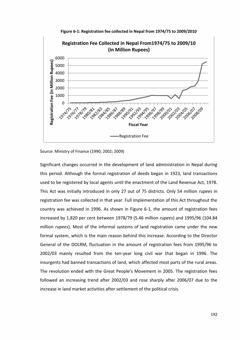
192
Figure 6-1: Registration fee collected in Nepal from 1974/75 to 2009/2010
Source: Ministry of Finance (1990; 2002; 2009)
Significant changes occurred in the development of land administration in Nepal during
this period. Although the formal registration of deeds began in 1923, land transactions
used to be registered by local agents until the enactment of the Land Revenue Act, 1978.
This Act was initially introduced in only 27 out of 75 districts. Only 54 million rupees in
registration fee was collected in that year. Full implementation of this Act throughout the
country was achieved in 1996. As shown in Figure 6-1, the amount of registration fees
increased by 1,820 per cent between 1978/79 (5.46 million rupees) and 1995/96 (104.84
million rupees). Most of the informal systems of land registration came under the new
formal system, which is the main reason behind this increase. According to the Director
General of the DOLRM, fluctuation in the amount of registration fees from 1995/96 to
2002/03 mainly resulted from the ten-year long civil war that began in 1996. The
insurgents had banned transactions of land, which affected most parts of the rural areas.
The revolution ended with the Great People’s Movement in 2005. The registration fees
followed an increasing trend after 2002/03 and rose sharply after 2006/07 due to the
increase in land market activities after settlement of the political crisis.
0
1000
2000
3000
4000
5000
6000
Re
gist
rati
on
Fee
(in
Mill
ion
Ru
pee
s)
Fiscal Year
Registration Fee Collected in Nepal From1974/75 to 2009/10 (in Million Rupees)
Registration Fee
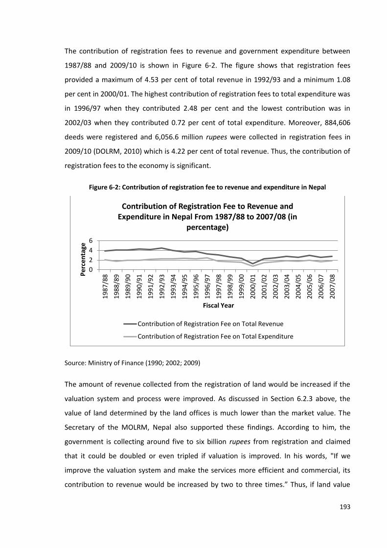
193
The contribution of registration fees to revenue and government expenditure between
1987/88 and 2009/10 is shown in Figure 6-2. The figure shows that registration fees
provided a maximum of 4.53 per cent of total revenue in 1992/93 and a minimum 1.08
per cent in 2000/01. The highest contribution of registration fees to total expenditure was
in 1996/97 when they contributed 2.48 per cent and the lowest contribution was in
2002/03 when they contributed 0.72 per cent of total expenditure. Moreover, 884,606
deeds were registered and 6,056.6 million rupees were collected in registration fees in
2009/10 (DOLRM, 2010) which is 4.22 per cent of total revenue. Thus, the contribution of
registration fees to the economy is significant.
Figure 6-2: Contribution of registration fee to revenue and expenditure in Nepal
Source: Ministry of Finance (1990; 2002; 2009)
The amount of revenue collected from the registration of land would be increased if the
valuation system and process were improved. As discussed in Section 6.2.3 above, the
value of land determined by the land offices is much lower than the market value. The
Secretary of the MOLRM, Nepal also supported these findings. According to him, the
government is collecting around five to six billion rupees from registration and claimed
that it could be doubled or even tripled if valuation is improved. In his words, "If we
improve the valuation system and make the services more efficient and commercial, its
contribution to revenue would be increased by two to three times.” Thus, if land value
0
2
4
6
19
87
/88
19
88
/89
19
89
/90
19
90
/91
19
91
/92
19
92
/93
19
93
/94
19
94
/95
19
95
/96
19
96
/97
19
97
/98
19
98
/99
19
99
/00
20
00
/01
20
01
/02
20
02
/03
20
03
/04
20
04
/05
20
05
/06
20
06
/07
20
07
/08
Per
cen
tage
Fiscal Year
Contribution of Registration Fee to Revenue and Expenditure in Nepal From 1987/88 to 2007/08 (in
percentage)
Contribution of Registration Fee on Total Revenue
Contribution of Registration Fee on Total Expenditure
194
were determined properly, around 15 billion rupees would be collected from land
registration in Nepal. Currently, the registration fee for the urban and rural sectors in
Nepal is four and two per cent respectively. Even if the current rate is halved (that is, two
per cent in the urban and one per cent in the rural areas), the government could collect
seven and half billion rupees. It may increase the burden of the tax payer to some extent,
however, it is still far below the average costs in South Asia (7.2 per cent of property
value) (World Bank, 2013).
In Bangladesh, both registration fees and stamp duty are levied at the rate of two and
three per cent of property value respectively. Also, one per cent local government tax,
two per cent capital gains tax57 and 1.5 per cent value added tax58 is collected through
transactions.
Revenue collected as registration fees and stamp duty in Bangladesh is shown in Figure
6-3. Although the amount includes revenue from other registrations and stamp duties,
the overall trend can be discerned from this figure. The revenue from registration was
1,261 million taka in 1994/95, which increased by 464 per cent and reached 7,119 million
taka in 2008/09. Similarly, the amount of stamp duty increased from 4,419 million taka in
1994/95 to 15,150 million taka in the 15-year period.
57 In the case of land above BDT 100,000 but not applicable to rural agricultural land
58Applicable in municipal corporation areas and payable by private housing and flat developers and
commercial businesses

195
Figure 6-3: Registration fee and stamp duty collected in Bangladesh in different time periods
Source: Bangladesh Bureau of Statistics (2000; 2011)
In Bangladesh, around 2.7 million deeds were registered in the Fiscal Year 2008/09, and
26,254.9 million taka was collected by the Director of Registration in total (MOLJAPA,
2013) which is around four per cent of total revenue receipts of the government (691,800
million taka). As in Nepal, valuations prepared by the government in Bangladesh are
approximately one-third of market value. Thus, revenue will be increased if the valuation
is determined properly.
Figure 6-4 presents number of title registered in the land registry and revenue collected in
Thailand in between 1985 and 2010. Registration of land transactions increased after land
titling in Thailand. In 1985, only 1.6 million transactions were registered in the land
offices. The total number of transactions reached a peak of 4.7 million in 1996, and then
fell sharply to reach the lowest level of 2.4 million in 2000. As argued by the Inspector
General of the Department of Lands of Thailand, the market volatility resulting from the
economic depression of the South East Asian Nations has affected the Thai land market
resulting in decline in the number of registered transactions. After 2000 the number
increased sharply until 2004. It reached the highest level of 5.8 million in 2010 after a
slight decline between 2005 and 2007. Similarly, revenue collected by the Land Offices
1261 1928 3438
7119
4419
6250
8120
15150
0
2000
4000
6000
8000
10000
12000
14000
16000
1994/95 1998/99 2004/05 2008/09 Re
gist
rati
on
Fee
an
d S
tam
p D
uty
(
in M
illio
n T
aka)
Fiscal Year
Registration Fee and Stamp Duty Collected in Bangladesh in Different Time Periods (in Million Taka)
Registration Fee Stamp Duty

196
from the registration of transactions increased considerably after land titling, as shown in
Figure 6-4. Around two thousand million baht was collected by land offices in 1985, which
rose to a peak of 32,188 million baht in 1996 followed by a sharp decline during the
economic crisis and reached 8,020 million baht in 2000. In 2001, around 15,375 million
baht was collected which is more than 654 per cent higher than that of 1985. The amount
of revenue then increased until 2004 followed by a continuous decline until 2009. In
2010, 38,657 million baht was collected which is 1,796 per cent higher than that of 1985.
The sharp decline in revenue in 2000 and 2009 is because of the market volatility as
described by the Inspector of the Department of Lands.
Figure 6-4: Registration of transactions and revenue collection in Thailand from 1985 to 2010
Source: Department of Lands (1985-2010)
The results from correlation analysis also show a high correlation between revenue and
number of transaction where the coefficient of determination is equal to 0.939. It
indicates that there is a positive correlation between the number of registrations and the
amount of revenue collected by the government.
0
5,000,000
10,000,000
15,000,000
20,000,000
25,000,000
30,000,000
35,000,000
40,000,000
45,000,000
1985 1987 1989 1991 1993 1995 1997 1999 2001 2003 2005 2007 2009 Tran
sact
ion
an
d R
eve
nu
e C
olle
ctio
n
(in
Th
ou
san
d B
aht)
Year
Number of Registered Transactions and Amount of Revenue Collected in Thailand (in Thousand Baht) From 1985 to 2010
Number of Registered Transactions Amount of Revenue

197
Unless the land is formalised, transactions cannot be registered in the land registry and
hence there is no chance of collecting registration fees. The Land Revenue Office source
of Ilam, Nepal informed that they had registered 80 transactions from the Chulachuli VDC
after registration of land. Similarly, while registering land in Chulachuli VDC, NPR
1,431,774 registration fees, NPR 10,000 land tax and NPR 21,138,459 as price of land was
collected from the landowners (CAISPSC, 2010). Data presented above, especially from
Nepal and Thailand show that revenue collected from the registration of transactions
increased as land administration activities began. It has shown that revenue is increased
after registration of land.
The data presented above shows that revenue collected from registration of transactions
is significant in all of the three countries. There is potential for increased revenue in Nepal
and Bangladesh if the government valuations of land were determined properly. Revenue
will also be increased if more transactions are registered.
Land Tax
Land tax was traditionally the main source of government income in Nepal and
Bangladesh. In the first budget of Nepal presented in 1952, the estimate of land tax was
9.4 million rupees, which constitutes around one-third of the total revenue estimate (30.5
million rupees) (Pant, 1956). The amount of land tax collected in Nepal between 1974/75
and 1995/96 is presented in Figure 6-5. In 1974/75, 91 million rupees was collected as
land tax, which dropped to 55 million rupees in 1978/79, and reached a peak of 101
million rupees in 1980/81. There are not many significant changes in the amount of land
tax after enactment of the Land Revenue Act in 1978 except for a sharp increase in
1980/81 and a sharp decline after 1993/94. It may have been caused by sudden policy
changes. As stated by the Director General of the DOLRM, the sharp increase in land tax
in 1980/81 was caused by the enactment of the Land Revenue Act in 1978. The decrease
in tax after 1992/93 was mainly caused by the political changes in 1990 and shifting of
authority to collect this tax to the local government offices instead of Land Revenue
Offices. Although the tax is being collected from the local offices, integrated information
could not be obtained. Thus, only the data up to 1995/96 is presented in this research.

198
Figure 6-5: Land tax collected in Nepal from 1974/75 to 1995/96
Source: Ministry of Finance (2009; 2002; 1990)
In Bangladesh, land tax has been collected for many years. Zamindars were nominated to
collect land tax on behalf of the government during the British period (1757-1947). The
government started to collect land tax directly from tenants after abolition of the
zamindary system in 1950. As mentioned by Khan (1964), 145.5 million taka was collected
as land tax in Bangladesh (East Pakistan) in 1961/62 whereas the direct tax from the
agriculture sector was 154.3 million taka. The land tax collected in three different time
periods is shown in Figure 6-6. Only 25 million taka was collected in 1972/73. The figure
also shows that 1,520 million taka was collected in 1994/95 which is 60 times higher than
that of 1972/73. Likewise, in 2008/09, 4,086 million taka was collected. Maintenance of
land records and allocation of land are the main reasons behind the increase in land tax
during this period, as described by one of the land registrar.
0
20
40
60
80
100
120
19
74
/75
19
75
/76
19
76
/77
19
77
/78
19
78
/79
19
79
/80
19
80
/81
19
81
/82
19
82
/83
19
83
/84
19
84
/85
19
85
/86
19
86
/87
19
87
/88
19
88
/89
19
89
/90
19
90
/91
19
91
/92
19
92
/93
19
93
/94
19
94
/95
19
95
/96
Lan
d T
ax (
in M
illio
n R
up
ees)
Fiscal Year
Amount of Land Tax Collected in Nepal From 1974/75 to 1995/96 (in Million Rupees)
Land Tax
Enactment of Land Revenue Act
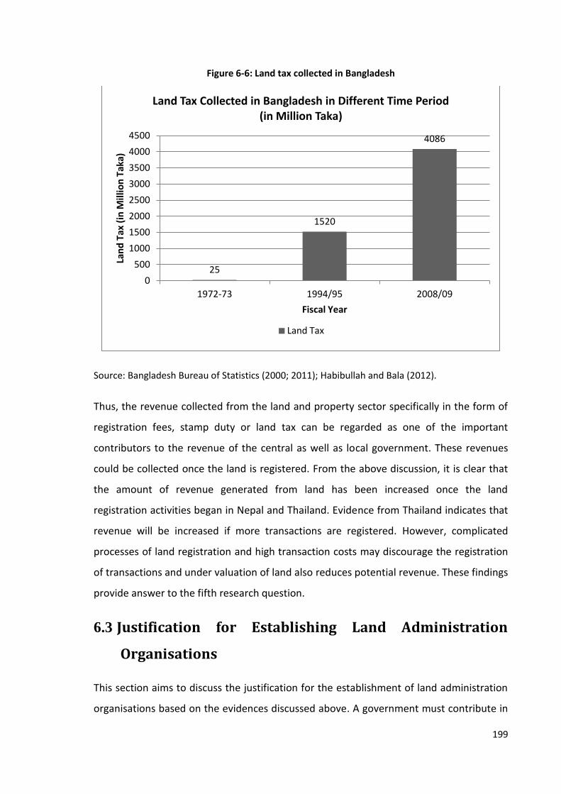
199
Figure 6-6: Land tax collected in Bangladesh
Source: Bangladesh Bureau of Statistics (2000; 2011); Habibullah and Bala (2012).
Thus, the revenue collected from the land and property sector specifically in the form of
registration fees, stamp duty or land tax can be regarded as one of the important
contributors to the revenue of the central as well as local government. These revenues
could be collected once the land is registered. From the above discussion, it is clear that
the amount of revenue generated from land has been increased once the land
registration activities began in Nepal and Thailand. Evidence from Thailand indicates that
revenue will be increased if more transactions are registered. However, complicated
processes of land registration and high transaction costs may discourage the registration
of transactions and under valuation of land also reduces potential revenue. These findings
provide answer to the fifth research question.
6.3 Justification for Establishing Land Administration
Organisations
This section aims to discuss the justification for the establishment of land administration
organisations based on the evidences discussed above. A government must contribute in
25
1520
4086
0
500
1000
1500
2000
2500
3000
3500
4000
4500
1972-73 1994/95 2008/09
Lan
d T
ax (
in M
illio
n T
aka)
Fiscal Year
Land Tax Collected in Bangladesh in Different Time Period (in Million Taka)
Land Tax

200
two ways while establishing land administration organisations. Firstly, it requires the
investment of a substantial sum of money to establish these organisations and conduct
land surveys and adjudication processes. Secondly, it needs to transfer the ownership of
land in the name of the people. These contributions can be justified by the benefits of
tenure security and the services they offer to the public, society as well as the
government.
Government would benefit in many ways from the establishment of land administration
organisations and from providing land ownership to the people. A direct benefit is an
increase in revenue and GDP. As mentioned in Section 6.2, around four per cent of total
revenue is generated by the registration fee and stamp duty in Nepal and Bangladesh. As
discussed in Section 6.2 and Chapter Five above, production and income from the
agricultural sector increased to some extent after registration of land. Increase in
agricultural production and personal income at the household level may increase the GDP
of this sector.
The real estate sector contributes around seven per cent of GDP in Nepal (Central Bureau
of Statistics, 2012). Also, around 450 billion rupees is invested in this sector annually of
which 150 billion rupees is provided from the banking sector, keeping land and houses as
collateral. A senior officer of REHAB considered real estate as the heart of the economy of
Bangladesh because of its volume and its support to the development of linkage
industries. He stated that this sector contributes around 12 to 15 per cent of total GDP,
employs almost three million people and supports the development of linkage industries
including iron and steel, concrete, cement, furniture and the ceramics industries. Land
administration organisations are the basic service providers of the real estate sector.
Thus, these organisations may also support in generating income from this sector.
Efficient use of scarce resources is another benefit for the government from the
registration of land. The state is the biggest landowner and owns most of the land of a
country. However, the government itself may not be able to use all of its land in an
efficient way. If the land is distributed to the people, it may be used more efficiently and
the productivity of the land could be increased as was found in both cases of Nepal and
Bangladesh. Access to land to the common people and the increased income in both

201
countries indicates that land registration may also contribute to achieve the goals of
distributive justice and poverty alleviation to some extent. Thus, the government may be
directly benefitted from the establishment of land administration organisations with
increased revenue and GDP and also from its support in achieving the goals of efficient
use of natural resources, sustainable development, distributive justice and poverty
alleviation.
The landowner would benefit from registration in many ways. This research has identified
that landowners have enjoyed rights to ownership, transfer, mortgage, lease and use of
land. Also, the risks of aggression and expropriation without fair compensation are
minimised. Registration of land has ensured security of land tenure and increased the
confidence of the landowner. Owners now use land in their own way provided that they
follow the responsibilities set by government.
It is also identified that tenure security has increased the incentives to invest in land
improvement. Long-term investment such as constructing houses, planting crops, or
building a factory. It increases the use value of land. Similarly, registered land possesses a
collateral value that allows landowners to access institutional credit. The results of case
studies have shown that the exchange value of land increased after registration. Thus, use
value, collateral value and exchange value of land increase as land tenure became secure.
The social value of land may also be increased since the social and power relationships of
human beings are attached to land.
Higher willingness and ability to invest increases land-related investment and production,
as discussed in Chapter Five. Increases in land value and income raise personal income,
which can support poverty alleviation to some extent. The livelihoods of landowners can
also be improved after registration of land. Thus, the landowners will benefit from many
aspects once their land is registered.
Society will also benefit from the registration of land from different perspectives. As
observed by the researcher during a field visit in Nepal, and described by the
respondents; society could not benefit from various services until the land was registered
as most of the services are attached with property. Another observation from the study is
202
that people did not have a link to the local land administration organisations prior to
registration of land, which is shown by the fact that less than a quarter of respondents
from Nepal had visited land offices. Thus, people of the informal settlement area felt
isolated from mainstream of society.
Reductions in social conflict between neighbours are further benefits from land
registration. As stated by local leaders in Nepal, the struggle for land rights lasted for
decades and many people were wounded and arrested by the police during this
movement but now, no more struggles are required and the people have now started to
think about the development of their village.
Another benefit for society is the availability of funds to run social and local development
activities. In Nepal, land revenue is collected by local VDC or Municipality offices and can
be used locally as decided by the councils concerned. It is one of the main sources of
income for them. In addition, a certain amount of revenue collected from land
registration in Nepal is provided to the District Development Committees and this is also
spent on local development activities.
Thus, the establishment of land administration organisations and the registration of land
can be justified from its benefits to the state, landowners and society as a whole.
6.4 Summary
This chapter assessed the services provided by land administration organisations and
discussed their effectiveness in revenue generation. It also discussed their role in tenure
security. The process of land registration in Thailand is better than that of Nepal and
Bangladesh. Responses to clients, information sharing mechanisms, workflow
management and office layout are found to be highly satisfactory in Thailand, unlike in
Nepal and Bangladesh. The process of land registration in Bangladesh is very complicated
and lengthy compared with that of Nepal and Thailand. It takes five and two days to
complete the process of land registration in Nepal and Thailand respectively whereas it
takes 245 days in Bangladesh.

203
Land administration organisations in both Nepal and Bangladesh are suffering from many
problems related to system and culture. The transaction cost is high in both countries.
The existing system of land recording and information system has caused several
problems, including falsification of documents and tampering and manipulation of land
records, leading to increased land disputes and incidences of violence, especially in
Bangladesh. Digitisation of land records and establishing integrated land information
systems would protect valuable documents, reduce land disputes, ease the process of
disseminating land information and improve the efficiency of land offices to some extent.
It is essential to solve some of the problems however, it may not automatically control
corruption and increase effectiveness in land administration services.
The quality of land administration services also affected the valuation of property.
Because of the lack of reliable information and specialised property valuators, the value
of land in Nepal and Bangladesh determined by the land registries is lower than the
market value of land. It has reduced the potential revenue of the government and also
increased the risk of not obtaining full compensation in case of default of transactions
and land acquisition.
This chapter revealed the amount of revenue generated from land has been increased
once the land registration activities began in Nepal and Thailand. Evidence from Thailand
indicates that revenue will be increased if more transactions are registered. However,
complicated processes of land registration and high transaction costs may discourage the
registration of transactions and under valuation of land also reduces potential revenue.
This chapter also discussed the combined effect of land tenure security and land
administration services based on the evidence analysed in Chapter Five and Section 6.2
above. From the discussion it is revealed that registration of land is essential to ensure
security of tenure but the malpractices and inefficiency in land administration services
has threatened the security even after registration of land. Thus, although land-related
economic activities, land value, investment and income increased after registration of
land, the practices of land administration may also affect on these factors indicating that
the relationship between land registration and tenure security is not quiet straight
forward. It provides answer to the first research question.
204
This chapter demonstrated that the establishment of land administration systems and the
transfer of land ownership rights to the people will be beneficial for government, the
public and for society. Increases in GDP and revenue, efficient use of scarce resources,
distributive justice, poverty alleviation and sustainable development are the main areas in
which government would benefit. It will contribute to economic development.
Landowners would be benefit from increased value (use value, collateral value and
exchange value) of land, increased production and income and improved social relations
that emerge from secured tenure. Society will also benefit from increased access to
government services, increased revenue of local government and reduced social conflicts.
205
Chapter 7: Conclusion
7.1 Introduction
This chapter summarises the major issues and findings of this research in light of the
research questions outlined in Chapter One. It includes the role of land administration on
securing land tenure, land use and economic activities promoted by land administration,
role of tenure security on land value, access to credit, investment and income and
assessment of land administration services and their effectiveness on revenue
generation. Reflections on findings related to the conceptual framework are then
examined. It also notes the contribution made by this research to the body of knowledge
on land administration and economic development. After that, the implications of this
research on policy and practice are outlined followed by a discussion on the limitations of
this research. The chapter concludes with a brief note about possible areas for further
research.
7.2 Summary of Findings
This section summarises the findings of this research in relation to the research questions
outlined in Chapter One. It integrates the research questions with the findings and
examines whether these questions are answered or not. It also analyses to what extent
the overall aims of this research have been met.
7.2.1 Land Administration and Tenure Security
One of the research question posed in this research asks how does land administration
ensure land tenure security. Chapter Two demonstrates that the relationship between
humankind and land is established through land rights, the administration of which is
undertaken by land administration organisations. The process of determining land rights
begins from cadastral surveying and adjudication of land. The survey office and land
registry carry out these tasks. They also maintain the cadastral and land ownership
records. Land transfers are registered by the land registry with technical support from the
survey office.

206
The findings of this research show that rights to ownership, sale and transfer, lease,
mortgage and use of production were not available until land was registered. Although
most of the respondents from both countries have replied that they could use whatever
they had produced even before registration of land, they did not have any legal document
to evidence their use right. There were risks of aggression from other parties concerning
land and inadequate compensation in cases of compulsory land acquisition. However,
after registration of land, landowners enjoyed a higher level of rights without any fear of
aggression or losing compensation. This indicates that the basic requirements of land
tenure security outlined in Chapter Two are met in registered land and that land tenure is
secured after registration.
The findings from the data analysed in Chapter Six, however, show that malpractices in
land administration organisations have threatened tenure security and increased the risks
of land disputes. For instance, falsification, tampering and manipulation of land
documents, bribery, corruption and favouritism are some of the problems that prevail in
the land administration organisations, especially in Bangladesh. It has increased the land
disputes, which can be verified from the fact that up to 80 per cent of the court cases in
the rural areas of Bangladesh are related to land. Similarly, under-valuation of land in
both Nepal and Bangladesh has increased the risks of not obtaining adequate
compensation in cases of compulsory land acquisition or default on land transactions.
However, these risks are minimal in Thailand where land records are secure, land
information is easily accessible, valuation of land determined by the government is close
to the market value and the title registration system provides a guarantee of registered
title.
Thus, initial registration of land or land adjudication is essential to provide security of land
tenure. However, the system of recording land information and property valuation as well
as the behaviour and competencies of employees affect the rights of landowners even
after registration. These findings reveals that land administration provides tenure security
by ensuring property rights and reducing associated risks but it cannot be sustained if
land administration practices are not good enough. Digitization of land records,
establishment of integrated information systems, provision of morale education to
employees, and monitoring and regulation of their behaviour may reduce malpractices.

207
Also, improvement in the valuation system, hiring trained property valuators or providing
valuation training to existing employees and improvement in the information systems
may help to determine the valuation properly. These efforts can help to reduce the level
of malpractices and land disputes and protect rights of landowners. It provides answers to
the first research question posed in Chapter One.
7.2.2 Land Use and Economic Activities Promoted by Land
Administration
The second question posed in this research examines the extent to which the land
administration promotes efficient land use and land-related economic activities. This
study has provided evidence that the use of land for shelter and commercial purposes
increased and that its use for agricultural purposes decreased after registration of land.
As shown in Chapter Five, the number of respondents using their land for shelter and for
commercial purposes increased after registration of land in both Nepal and Bangladesh.
Although the number of respondents using land for agricultural purposes decreased, the
cropping pattern changed slightly. The data shows that the number of respondents
starting cash cropping, planting trees and fruits, and using new tools and farming
techniques is increased in both countries. Likewise, more respondents have started
fencing and land levelling to improve their land and renovating and building houses to
improve their shelter.
Once land is registered, land administration may not directly influence land use and land
related economic activities. However, as discussed in Chapter Six, if land administration
practices are not good, landowners may not feel secure even after obtaining land title.
To conclude, as uncertainties about ownership and security of investment ended,
landowners began to use their land in an efficient and productive way. Also, land-related
economic activities increased to some extent. However, land administration practices
may affect land use and economic activities indirectly even after obtaining land title.
These findings answer the second research question and explain the extent to which land
administration promotes efficient land use and land-related economic activities.
208
7.2.3 Role of Tenure Security on Land Value, Access to Credit,
Investment and Income
This research has analysed the value of land, access to credit, investment and income
before and after registration. As discussed in Chapter Five, the average value of land in
Nepal was NPR 60,700 per kattha before registration, which increased by 224 per cent
and reached NPR 196,500 after registration. Similarly, in the case of Bangladesh, the
average land value before registration was BDT 90,000 per kattha, which increased by
123 per cent and reached BDT 201,000 after registration.
A correlation analysis shows a positive correlation between tenure security and land
value in Nepal and Bangladesh. Similarly, results of the paired samples t-test shows that
the mean value of land after registration is higher than that of before registration and
there was a significant difference between these values in case of both countries.
The valuation of land determined by the land offices for taxation purposes is also
increased after registration. The Land Revenue Office, Ilam (Nepal) has changed the
classification of land and increased its valuation in Chulachuli VDC. As discussed in
Chapter Five, the land was initially classified as irrigated or un-irrigated land, each having
four categories. But the classification has now been changed to residential and
agricultural land. This change in classification indicates the shift in land use pattern from
agriculture to other sectors. The minimum valuation determined by the Land Revenue
Office, Ilam for the Fiscal Years 2007/08 and 2012/13, which represent the situation
before and after registration, also increased significantly. The minimum valuation for
irrigated land for the Fiscal Year 2007/08 ranges from NPR 2,325 to 4,651 whereas that of
un-irrigated land ranges from NPR 1,528 to 3,853 per kattha. The valuation of residential
land increased to NPR 111,540 in Ward Numbers 1 to 4 and NPR 44,616 per kattha in
Ward Numbers 5 to 8, which is 2,298 per cent and 1,898 per cent higher than that of
2007/08 respectively. Similarly, the valuation of the first category agricultural land in
Ward Numbers 1 to 4 and 5 to 8 increased by 859 per cent and 583 per cent respectively
from that of the highest category of land in the year 2007/08.

209
Although land value and the valuation made by the government increased after
registration, the higher standard deviation of land value before and after registration
provides more differentiated results which indicates that there may be other causes
behind the increases in land value.
The status of access to credit, investment and income is also discussed in Chapter Five.
Accordingly, unless land was registered, landowners had to rely on private lenders for the
loans they require for investment, and they had to pay up to 40 per cent interest in Nepal
and 30 per cent interest in Bangladesh. When land is registered, they can use it as
collateral to obtain loans from the banking sector at an interest rate of around 15 per
cent per annum. It has increased the ability to invest. In Bangladesh, most of the
respondents (78 per cent) had borrowed from the banking sector. The land owners from
the case study area of Nepal, however, could not utilise this opportunity because of the
lack of proper communication. Thus, the access to bank credit is established after
registration of land, however, landowners are not benefitting from it as much as they
could be.
The findings from Chapter Five also show that a favourable environment for investment is
created as land tenure became secured. The slight changes in land use and cropping
patterns and land-related economic activities indicate that the willingness to invest
increased after registration of land to some extent.
The data presented in Chapter Five show that average investment per kattha of land in
Nepal before registration was NPR 2,700, which increased by 59 per cent and reached
NPR 4,300 after registration. Similarly, average annual investment per kattha of land in
Bangladesh was BDT 2,800 before registration, which increased by 93 per cent and
reached BDT 5,400 after registration. The results from both countries show that the
investment increased after registration of land. A correlation analysis shows a positive
correlation between investment and tenure security in both countries. Similarly, results of
the paired samples t-test of investment before and after registration shows a significant
difference in investment. These results suggest that there is a positive correlation
between land tenure security and investment. However, the higher standard deviations

210
of investment before and after registration show that the increase in investment may not
have entirely caused from the registration and there may be other factors behind it.
The effect of tenure security on land-related income is also analysed in this study. As
shown in Chapter Five, average annual income per kattha of land in Nepal before
registration was NPR 4,300, which increased by 49 per cent and reached NPR 6,400 after
registration. Likewise, in Bangladesh, average annual income per kattha of land before
registration was BDT 5,700, which increased by 95 per cent and reached BDT 11,100 after
registration. This indicates that income from land has been increased significantly in both
countries after registration. A correlation analysis shows a positive correlation between
income and tenure security in both countries. Similarly, results of the paired samples t-
test of income before and after registration of land shows that there was a significant
difference in income after registration compared with before registration in both
countries. However, the higher standard deviations of income before and after
registration indicate that the increase in income may not have entirely caused from the
registration of land. These results suggest that there is a positive correlation between
land tenure security and land related income although it does not prove the causal
relationship between them.
To summarise, this research revealed that land value is increased, access to credit is
promoted and investment and income are increased as the land tenure became secure;
however, it does not indicate whether there is a causal relationship of tenure security
with land value, investment and income or not. Also, access to institutional credit is not
sufficient to increase investment unless it is communicated properly. It provides answer
to the third research question.
7.2.4 Assessment of Land Administration Services and Their
Effectiveness
This study has assessed the effectiveness of land administration services and their role in
revenue generation. As discussed in Chapter Six, the process of land registration in
Thailand involves only two procedures. Response to clients, information sharing
mechanisms, workflow management and office layout are found to be highly satisfactory.

211
The clients are nicely greeted and asked to state the purpose of their visit. When they are
sent to a designated booth, they can wait until their number is displayed on the screen.
The task of registration of title is completed in one visit in Thailand.
The process of land registration in Nepal and Bangladesh is not as well organised as in
Thailand. The process involves three and eight procedures in Nepal and Bangladesh
respectively. There is a queuing system in these countries also but is not properly
followed. Clients need to visit many places to access services from land offices. The
process of land registration can be completed within a couple of days in Nepal and
Thailand. However, it takes nearly eight months to complete the process and obtain a
land certificate in Bangladesh.
This research also examined the amount of transaction costs landowners had incurred
while obtaining land administration services. As discussed in Chapter Six, the transaction
cost is high in both Nepal and Bangladesh.
Problems commonly found in the land administration organisations of Nepal and
Bangladesh included paper-based land recording systems, a lack of an integrated land
information systems, improper valuation of land and a lack of good governance values
among employees. Problems of bribery, fraud and malpractice are found to be major
problems in Bangladesh. This indicates that land administration organisations in both
countries are not free from problems; however, more problems exist in Bangladesh than
in Nepal. It answers the fourth research question of this research.
The land administration organisations generate revenue from land. The data presented in
Chapter Six shows that land tax was traditionally the main source of income in Nepal. It
had provided around one-third of the revenue of the first budget presented in 1952. The
registration of transactions in the land registry in Nepal began in 1923; but it only came
into full operation after enactment of the Land Revenue Act, 1978. In 1978/79, only 55
million rupees were collected in registration fees, but six billion rupees were collected in
2010/11. Similarly, while registering land in Chulachuli VDC, NPR 1,431,774 registration
fees, NPR 10,000 land tax and NPR 21,138,459 as price of land was collected from the
landowners. Local government organisations are now collecting the land tax.
212
In Bangladesh, the amount of land tax increased to 1,520 million taka in 1994/95 and
4,086 million taka in 2008/09. Maintenance of land records and the allocation of land are
considered as the main reasons for this change. Similarly, in 2008/09, 2.7 million deeds
were registered and 26,254.9 million taka in revenue was collected by the Director of
Registration of Bangladesh, which constituted around 3.8 per cent of the total revenue of
the government.
In Thailand, only 4.5 million plots of land were titled in 1985. The Department of Lands
had registered 1.6 million transactions and collected two million baht in revenue in 1985.
In 2010, 5.8 million transactions were registered and 38,657 million baht was collected
through registrations. This clearly indicates that revenue from land registration has
increased after land titling.
There is a minimum valuation system in both Nepal and Bangladesh. Valuations prepared
by the government are approximately one-third of market value. Lack of reliable
information about the land market and specialised manpower, as well as the use of
inappropriate methods of valuation have resulted in the under-valuation of property.
Consequently, revenue collected by the government is lower than the actual amount it
could obtain. As described in Chapter Six, 150 per cent more revenue could be collected
than it is collecting now if the valuations were undertaken properly. Even if the tax rate is
halved, around 50 per cent more revenue could be collected. The case of Bangladesh is
similar to that of Nepal. However, there is no problem of under-valuation of land in
Thailand since the land values determined by the government are close to market values.
This indicates that the practices and methods of valuation, access to information and
efficiency of employees may affect the quality of valuations, which ultimately affects
revenue.
The above discussion indicates that the amount of revenue will be increased after
registration of land. However, complicated processes of land registration and high
transaction costs may discourage the registration of transactions and under valuation of
land also reduces potential revenue. It provides answer to the fifth research question.

213
To summarise, all of the research questions posed in Chapter One are addressed through
the theoretical and empirical evidence presented above and we can conclude that an
efficient land administration supports economic development to some extent by
increasing land-related income as well as generating more revenue for the government.
Thus, the overall aim of the research to investigate the relationship between land
administration and economic development has been achieved.
7.3 Reflections on the Theoretical Framework
The main theoretical foundation for this research is derived from land administration and
land tenure theories. In addition to these theories, some concepts are also taken from the
property rights theory, economic theory and development theory as discussed in the first
and second chapters. A conceptual framework is developed in Chapter One (Figure 1-2)
based on the analysis of those theories which visualises the relationship between land
administration and economic development. Accordingly, land administration functions
support economic development through two channels: first, it ensures security of land
tenure, which promotes land value, credit opportunity, investment demand and
productive land use resulting in a higher investment and income. Second, land
administration services generate revenue for the government which may be used for
development purposes. This section discusses the findings of this study in light of this
concept.
The findings of this research have supported the conceptual framework developed in
Chapter One with some modifications, as shown in Figure 7-1. The findings are presented
in a similar diagram however, a box with a dotted line called 'Hindrances' has been added
in the middle and the box named as 'Access to Credit' in the right hand side of the figure
has been shaded. Two type of hindrances are found from this study that affect both
service delivery and tenure security and ultimately reducing the contribution of land
administration to economic development. They are: organisational culture and
organisational system. Existing malpractices of bribery, corruption and manipulation and
tampering of land records have threatened the security of tenure and increased the cost
of transactions. Likewise, existing practices of record management, property valuation
and registration have also threatened the security of tenure, reduced the amount of

214
revenue that could be generated by land administration organisations and made the
registration process more complicated. The shaded box ‘Access to Credit’ indicates that
access to credit is theoretically a means of increasing land-related investment, however,
the land owners from case study areas of Nepal could not benefit from this opportunity
because of the lack of proper communication which indicates that access to credit is not
enough to increase investment unless it is communicated properly. Despite these
contesting results, this research shows that land administration supports the economic
development via the same two channels of service delivery and tenure security as
explained in Section 1.4 and if the hindrances of organisational system and culture
prevailed in land administration organisations are overcome, the revenue generated by
land administration organisations would be increased, providing more funds to the
government.
Figure 7-1: Land administration and economic development
7.4 Contribution to Knowledge
This study has presented an original contribution to knowledge in the field of land
administration. It has opened up several new avenues to establish a relationship between
Land Valuat
ion
Collection of Land Tax
Land Registra
tion
Access to
Credit
Increase in Economic Activities
Service
Delivery
Tenure
Security
Land Administration
(Cadastre, Land Registration, Land
Valuation and Land Use Planning
Economic Developme
nt
Higher Revenue
and Investmen
t
Higher Investment and Income
Organisational System
Record management, land valuation,
registration system
Organisational Culture Bribery, corruption and manipulation
and tampering land records
Hindrances
Higher Land Value
Higher Investm
ent

215
land administration and economic development. It has confirmed that there is a lack of
research that links land administration activities with economic development. This study
has filled a gap of knowledge in this sector to some extent. The findings of this research
have enhanced the understanding of the significance of land administration institutions
and tenure security for the individual, society and the state.
This research has integrated the theories of land administration and land tenure to
observe their combined effect on economic development. It has also considered
assertions made by property rights theories, economic theories and development
theories. Moreover, it has explored the shift in national policies that focus merely on
property formalisation as a means of increasing agricultural production, and addressed
the role of governance and institutions in obtaining benefits from land.
The research confirms that land has been used more effectively as land tenure became
secure. It has shown that the pattern of land use was changed, new tools and techniques
of agriculture were applied, land was improved and land-related economic activities were
increased to some extent after registration. The research also revealed that the use value
of land increased as landowners were motivated to obtain maximum benefit from land
resulting from secure tenure.
This study has shown that land value, investment and income increased after registration
and they are positively correlated with land tenure security although it does not indicate
whether there is any causal relationship between them or not. A slight change in land use
pattern and land-related activities indicates that tenure security can create a favourable
environment for investment and encourage the land owners to some extent. The
possibility of using land as collateral has increased the ability for investment although it
has not been established as a cause for increased investment at least in case of Nepal.
This research has assessed the land administration services of Nepal, Bangladesh and
Thailand and identified that the lack of efficiency, malpractices and improper valuation
methods have threatened tenure security and reduced potential revenue. If these
problems were solved, land tenure would become more secure and the amount of
revenue would also be increased. It would provide a new way of linking land

216
administration services to tenure security and revenue generation although the
contribution has not been quantified because of the limitations of time and costs.
This study has documented the programme conducted for property formalisation in
Chulachuli VDC, Nepal, surveying settlement in Gharinda, Bangladesh and the land titling
program of Thailand and has offered readily available material for these cases. There are
many countries in the world where the system of land administration has not been fully
established. Also, there are many settlements where the properties are yet to be
registered. The findings of this research could be useful for them when deciding on
investment in a land administration system and formalisation of property rights.
Thus, this research has empirically tested the theories of land administration and land
tenure and highlighted the significance of land administration functions and tenure
security. It provides new insight into these theories from an integrated perspective of
land administration and tenure security.
7.5 Implications for Policy and Practices
This study has implications for both policy-making and implementation. The issues of the
establishment of land administration organisations and distribution and registration of
land are highly political issues. This study has provided justification for them. It has
evidenced that use value, collateral value and exchange value of land increased as the
land was registered. Land registration may promote the efficient use of scarce resources
because an individual landowner may use land more effectively than the government.
These findings will be useful in the formulation of land use and land management
policies.
The research has identified that income from land increased after registration. Increase in
income at the household level will also increase GDP and help to achieve the goal of
economic development. Formalisation of informal settlement may also help to maintain
distributive justice, reduce poverty and improve the livelihoods of people. Moreover, this
study has evidenced that revenue collected from land and the registration of transactions
constitute around four per cent of total revenue in both Nepal and Bangladesh which is a
significant income for the government. These findings will help a government while

217
deciding about the establishment of land administration systems and the formalisation of
informal areas.
It was also noted that an overwhelming majority of the people from the case study area
of Nepal had never been in the land office before registration of their land. It indicates
that recognition of informal rights is essential to bring people into the mainstream of
governance in the context of Nepal. These findings may be useful when formulating
policies for people's participation.
This research has also shown that mal-practices in land administration organisations can
increase the time and costs of obtaining those services, increase land litigation and
threaten land tenure security and reduce potential revenue to some extent. It can be
taken into consideration while formulating policy relating to land administration. These
findings have implications at the implementation level as well. The land offices can learn
from these findings and improve their service delivery mechanism. For instance, the good
practices of land registration in the Pak Kret land office in Thailand would be useful for
improving land administration systems in other land offices in Thailand as well as land
offices in Nepal, Bangladesh and many other countries.
To sum up, the findings of this study will be useful while formulating or revising national
policies relating to development, taxation, land use and management, distributive justice,
poverty alleviation and improving the livelihood of the people. These findings can also be
applicable to other parts of Nepal and Bangladesh. Nevertheless, countries like China,
Vietnam and North Korea where the ownership of land is yet to be privatised and some
countries especially in Africa, where the land tenure practices are still customary can also
learn from these findings. Lessons can also be learned for the improvement of land
administration system.
7.6 Limitations of Research
This research has explored the relationship between land administration and economic
development based on case studies of the land administration systems of Nepal,
Bangladesh and Thailand, more specifically the property formalisation programme of
Chulachuli, Nepal and the surveying settlement programme of Gharinda, Bangladesh.
218
Findings of these studies may be generalised in theoretical term (analytical
generalisation) as its results are compared with previously developed theories
particularly, land administration theory and land tenure theories. However, it cannot be
generalised to the population (statistical generalisation). Thus, these findings may not be
equally applicable in other cases.
The researcher could not get access to the land related government ministries and
departments in Bangladesh and interview the high level officers involved in land
administration. Thus, their views could not be incorporated in this research. Specifically,
the criticism made by respondents against the land administration organisations and its
staffs could not be discussed with the government officials. Also, reports published by the
ministries and departments could not be obtained and those published online were
hardly in English. Thus, some data especially about the status of registration of deeds and
collection of revenue in Bangladesh could not be included in this research. Likewise, the
amount of land tax collected in Nepal after 1995/96 could not be obtained and thus not
included in this research.
This research has investigated the relationship of land value, investment and income with
land tenure security. It has established a positive correlation between them and observed
that all land value, investment and income are increased after registration of land.
However, because of the limitations of time and cost, it could not study the role of other
factors on them, for instance, the role of inflation, demand of land and development
activities in land value; role of changes in price of input like price of seeds, fertilizer and
labor in investment; and the role of changes in crop price and production in income. Thus,
this study could not establish a causal relationship between the studied variables.
This research has assessed the effectiveness of land administration services on revenue
generation. However, the researcher identified problems in quantifying their
effectiveness. This research could not measure the loss of revenue caused by inefficient
services. Also, it was not possible to ascertain the actual number of transactions
registered in the land offices or the actual amount of revenue increased due to the good
land administration services. Likewise, the status and role of land use and planning

219
services is not studied as the land administration organisations of the selected countries
are not much involved in these activities.
The area selected for case study are rural areas where the lands are mainly used for
residential and agricultural purposes only. This research has not studied the changes
caused by the land administration activities on the urban economy and other sectors such
as the real estate and business sectors, construction or manufacturing sectors or the
industrial sector.
7.7 Scope for Further Research
The findings of this study indicate a need for further research on the economic aspects of
land administration. It would be worthwhile to investigate whether there are any other
factors that are responsible to increase in land value, investment and income other than
land tenure security so that the casual relationship between these variables could be
identified. Also, the actual change caused by effectiveness of land administration services
in revenue generation could also be an area of future research. Similarly, role of land use
and planning services in securing land tenure and generating revenue would also be
recommended for further investigation. It would also be worthwhile to look at the role of
tenure security and land administration activities on other sectors, including the real
estate and business sectors, the construction or manufacturing sectors and the industrial
sector.
This research has observed changes in land use pattern and increase in land related
economic activities, land value, investment and income after registration of land which
may have changed the livelihood of the people and supported in combating poverty to
some extent. The access to land may have played some role in providing distributive
justice as well. It would be worthwhile to look at the changes caused by the registration
of land in these sectors too. Moreover, social and environmental development are other
sectors of sustainable development that could be contributed by the land administration
functions as proposed by land administration theory and could be a subject of study.
Similarly, the role of institutions and land tenure in customary and religious land would be
another matter of investigation. Moreover, a study focusing on the significance of land
220
administration and property formalisation in countries like China and Vietnam is also
recommended for further research.
References
Adhikari, C.B. (2009). Poverty Linkages to Productive Efficiency and Access to Land:
Illustration from Nepal. Berlin: Lambert Academic Publishing.
Acharya, B.R. (2011). Land Use Issues in Nepal: A Country in Dire Need of Solutions. GIM
International. Lemmer, The Netherlands. URL: http://www.gim-
international.com/content/article/land-use-issues-in-nepal [25 September, 2015]
Ahmed, M. M., S. K. Ehui, B. Gebremedhin, S. Benin and A. Tekku (2002). Evolution and
Technical Efficiency of Land Tenure Systems in Ethiopia. International Livestock
Research Institute: Nairobi. Socio-Economic and Policy Research Working Paper 39.
Ahmed, S. (2012). Land Administration. In Banglapedia, Asiatic Society of Bangladesh.
URL: http://www.banglapedia.org/HT/L_0042.htm [5 July, 2014].
Akingbade, A. O. (2012). E-Land Administration in the Context of E-Government in Africa:
An Evaluation of Nigeria's Abuja Geographic Information System (AGIS). PhD.Thesis.
University of Twente: The Netherlands.
Alchian, A. and H. Demsetz (1973). The Property Right Paradigm. Journal of Economic
History. 33: 16-27.
Arko-Adjei, A. (2011) Adapting Land Administration to the Institutional Framework of
Customary Tenure: The Case of Peri-Urban Ghana. PhD. Thesis. Delft University of
Technology: The Netherlands.
Asiatic Society of Bangladesh (2012). Banglapedia. URL: http://www.banglapedia.org/ [12
December, 2013].
Ault, D. and G. Rutman (1979). The Development of Individual Rights to Property in Tribal
Africa. Journal of Law and Economics. 22 (1): 163-182.
AusAID (2000). Improving Access to Land and Enhancing the Security of Land Rights: A
Review of Land Titling and Land Administration Projects. The Australian Government’s
Overseas Aid Program AusAID: Canbera. Quality Assurance Series No. 20.
Babbie, E. (1990). Survey Research Methods. Belmont, California: Wadsworth.
221
Bahadur, R. (1972). A General Study on Land Reform, Land Administration and Socio-
Economic Activities. Kathmandu. Cited by Regmi, M.C. (1999). Land Ownership in
Nepal. 1st Indian Reprint ed. (Originally Published in 1977). Delhi: Adroit Publishers.
Baland, J.-M., F. Gaspart, F. Place and J.-P. Platteau (1999). Poverty, Tenure Security and
Access to Land in Central Uganda: The Role of Market and Non-Market Processes.
Bruxelles: Notre-Dame de la Paix, Sciences Economiques et Sociales.
Bangladesh Bureau of Statistics (2011). Statistical Year Book of Bangladesh, 2010. Dhaka:
Bangladesh Bureau of Statistics.
Bangladesh Bureau of Statistics (2000). Statistical Year Book of Bangladesh, 2000. Dhaka:
Bangladesh Bureau of Statistics.
Barkat, A., S. Zaman, and S. Raihan (2001). Political Economy of Khas Land in Bangladesh.
Dhaka: Association for Land Reform and Development.
Barrows, R. and M. Roth (1989). Land Tenure and Investment in African Agriculture:
Theory and Evidence. Land Tenure Centre, University of Wisconsin-Madison: Madison.
Paper No. 136.
Bell, K. C. (2006). World Bank Support for Land Administration and Management:
Responding to the Challenges of the Millennium Development Goals, in 23rd FIG
Conference, October 8-13, 2006, Munich. International Federation of Surveyors FIG.
Berg, B., L. (2004). Qualitative Research Methods for the Social Sciences. Boston: Pearson.
Bernard, H. R. (2000). Social Research Methods. California: Sage Publications.
Berry, S. (2009). Building for the Future Investment, Land Reform and the Contingencies
of Ownership in Contemporary Ghana. World Development. 37(8): 1370-1378.
Besley, T. (1995). Property Rights and Investment Incentives: Theory and Evidence from
Ghana. Journal of Political Economy. 103(5): 903-937.
Blaikie, N. (2000). Designing Social Research. Cambridge: Polity Press.
Bogaerts, T. (1999). Cadastral Systems: Critical Success Factors, in Proceedings of the
Urban Data Management Symposium. April 21-23, 1999, Venice. Delft: Urban Data
Management Society.
Bogaerts, T. and J. Zevenbergen (2001). Cadastral Systems- Alternatives. Computers,
Environment and Urban Systems. 25(4-5): 325-337.
Bose, A. N. (1961). Social and Rural Economy of Northern India. Calcutta: Firma K. L.
Mukhopadhya.

222
Bott, J. P. (2006). Case Study Method. In: Encyclopedia of Industrial and Organizational
Psychology. (S. G. Rogelberg, eds.). London: Sage Publications.
Bradstock, A. (2005). Changing Livelihoods and Land Reform: Evidence From the Northern
Cape Province of South Africa. World Development. 33(11): 1979-1992.
Brasselle, A.-S., F. Gaspart and J.-P. Platteau (2002). Land Tenure Security and Investment
Incentives: Puzzling Evidence From Burkina Faso. Journal of Development Economics.
67(2): 373-418.
Brewer, J. and A. Hunter (1989). Multi-Method Research: A Synthesis of Styles. California:
Sage Publications.
Bromley, D. W. (1991). Environment and Economy: Property Rights and Public Policy. 1st
ed. Massachussets and Oxford: Basil Blackwell.
Bromley, D. W. (1989). Economic Interests and Institutions: The Conceptual Foundations
of Public Policy. Oxford: Basil Blackwell.
Bruce, J. W. and S. E. Migot-Adholla (1994). Searching for Land Tenure Security in Africa.
Dubuque (Iowa): Kendall Hunt Publishing Co.
Bryman, A. (2008). Social Research Methods. 3rd ed. Oxford: Oxford University Press.
Bryman, A. (2004). Social Research Methods. 2nd ed. Oxford: Oxford University Press.
Bryman, A. (1988). Quantity and Quality in Social Research. London: Unwin Hyman.
Bugri, J. T. (2008). The Dynamics of Tenure Security, Agricultural Production and
Environmental Degradation in Africa: Evidence from Stakeholders in North-East
Ghana. Land Use Policy. 25(2): 271-285.
Burns, T. (2007). Land Administration Reform: Indicators of Success and Future
Challenges. The World Bank: Washington D. C. Agricultural and Rural Development
Discussion Paper 37.
Burns, T., C. Grant, K. Nettle, A.-M. A. Brits and K. Dalrymple (2006). Land Administration
Reform: Indicators of Success and Future Challenges. Land Equity International. URL:
http://www.unece.org/fileadmin/DAM/hlm/prgm/cph/experts/kyrgyzstan/document
s/Land.Admin.Reform.Final_Draft.May2007.pdf [13 June, 2014].
CAISPSC (2010). Barshik Pragati Pratibedan 2066/67[Annual Progress Report, 2009/10].
Damak (Nepal): Chulachuli Area Informal Settlement Problem Solving Committee
CAISPSC.

223
Çagdas, V. and E. Stubkjaer (2009). Doctoral Research on Cadastral Development. Land
Use Policy. 26(4): 869-889.
CARE (2003). Land Policy and Land Administration in Bangladesh: A Literature Review.
CARE Rural Livelihoods Programme: Dhaka. CARE SDU Reports and Studies.
Central Bureau of Statistics (2013). Statistical Year Book of Nepal 2013. 14th ed.
Kathmandu: Central Bureau of Statistics, Nepal.
Central Bureau of Statistics (2012). GDP Historical Series. Kathmandu: Central Bureau of
Statistics, Nepal. URL: http://cbs.gov.np/?p=114 [12 April, 2012].
Central Bureau of Statistics (2003). National Sample Census of Agriculture Nepal,
2001/02: Highlights. Kathmandu: Central Bureau of Statistics, Nepal.
Chalamwong, Y. and G. Feder (1988). The Economic Implications of Land Documents in
Rural Thailand. Agricultural Administration and Extension. 29(2): 123-133.
Chand, S. and C. Yala (2009). Land Tenure and Productivity: Farm-Level Evidence from
Papua New Guinea. Land Economics. 85(3):442-453.
Cotula, L., C. Toulmin and J. Quan (2006). Better Land Access for the Rural Poor: Lessons
From Experience and Challenges Ahead. International Institute for Environment and
Development IIED: London and Food and Agriculture Organization of the United
Nations FAO: Rome.
Creswell, J. W. (2009). Research Design: Qualitative, Quantitative and Mixed Methods
Approaches. 3rd ed. London: Sage Publications.
Creswell, J. W. (2003). Research Design: Qualitative, Quantitative and Mixed Method
Approaches. 2nd ed. California: Sage Publications.
Creswell, J. W. and V. L. P. Clark (2007). Designing and Conducting Mixed Methods
Research. 1st ed. California: Sage Publications.
Currie, J. M. (1981). The Economic Theory of Agricultural Land Tenure. Cambridge:
Cambridge University Press.
Dale, P. F. and J. D. McLaughlin (1999). Land Administration. Oxford: Oxford University
Press.
Dale, P. F. and J. D. McLaughlin (1988). Land Information Management: An Introduction
with Special Reference to Cadastral Problems in Third World. Oxford: Clarendon Press.
Dale, P. F., R. Mahoney and R. McLaren (2009). Land Markets and the Modern Economy.
The Royal Institute of Chartered Surveyors RICS: London.

224
De Soto, H. (2001). The Mystery of Capital. London: Black Swan.
De Vaus, D. (2002). Surveys in Social Research. 5th ed. London: Routledge.
De Vaus, D. (2001). Research Design in Social Research. London: Sage Publications.
Deininger, K. (2003). Land Policies for Growth and Poverty Reduction. London: The World
Bank and Oxford University Press.
Deininger, K. and S. Jin (2006). Tenure Security and Land-Related Investment: Evidence
From Ethiopia. European Economic Review. 50(5): 1245-1277.
Deininger, K. and L. Squire (1998). New Ways of Looking at Old Issues: Inequality and
Growth. Journal of Development Economics. 57(2): 259-287.
Dekker, H. A. L. (2005). In Pursuit of Land Tenure Security. Amsterdam: Amsterdam
University Press.
Demsetz, H. (2002). Toward a Theory of Property Rights II: The Competition Between
Private and Collective Ownership. The Journal of Legal Studies. 31(S2): S653-S672.
Demsetz, H. (1967). Toward a Theory of Property Rights. The American Economic Review.
57(2): 347-359.
Denscombe, M. (2003). The Good Research Guide: For Small-Scale Social Research
Projects. 2nd ed. London: Open University Press.
Department of Lands, Thailand (1985-2010). Progress Reports (1985-2010). Bangkok:
Department of Lands, Thailand.
Diener, E. and Crandall, R. (1978). Ethics in Social and Behavioural Research. Chicago:
University of Chicago Press.
DOLRM (2010). Barshik Pratibedan 2066/67 [Annual Progress Report 2009/10].
Kathmandu: Department of Land Reform and Management DOLORM, Nepal.
DOLRM (2003). Jaggako Neunatam Mulya Nirdharan Nirdeshika, 2059 [Directives for
Determining Minimum Valuation of Land, 2003]. Kathmandu: Department of Land
Reform and Management DOLORM, Nepal.
DOLRM (2001). Jagga Prashashan Nirdeshika, 2058 [Land Administration Directives,
2001]. Kathmandu: Department of Land Reform and Management DOLORM, Nepal.
Dong, X. Y. (1996). Two-Tier Land Tenure System and Sustained Economic Growth in Post-
1978 Rural China. World Development. 24(5): 915-928.
Dowson, S. E. and V. Sheppard (1952). Land Registration. London: Her Majesty’s
Stationary Office.

225
Dreux (1933). Le Cadastre et Limpot fon Cier. Paris. Cited by Larsson, G. (1991). Land
Registration and Cadastral Systems: Tools for Land Administration and Management.
Harlow: Longman Scientific and Technical.
Durand-Lasserve, A. and H. Selod (2009). The Formalisation of Urban Land Tenure in
Developing Countries. In, Urban Land Markets: Improving Land Management for
Successful Urbanization (S. V. Lall, M. Freire, B. Yuen, R. Rajack and J.-J. Helluin, eds).
Washington: Springer.
Economic Commission for Africa (2004). Land Tenure Systems and Their Impacts on Food
Security and Sustainable Development in Africa. Economic Commission for Africa:
Addis Ababa.
Enemark, S., R. McLaren and P. van der Molen (2010). Land Governance in Support of the
Millennium Development Goals- A New Agenda for Land Professionals, In FIG
Congress 2010: Facing the Challenges - Building the Capacity, April 11-16, 2010,
Sydney. International Federation of Surveyors FIG.
Enemark, S., R. Mclaren and P. van der Molen (2009). Land Governance in Support of the
Millennium Development Goals- A new Agenda for Land Professionals, in FIG/World
Bank Conference, March 9-10, 2009, Washington D. C. International Federation of
Surveyors FIG.
Enemark, S., I Williamson and J Wallace (2005). Building Modern Land Administration
System in Developed Economies. Journal of Spatial Science. 50(2): 51-68.
Engels, F. (1878). Her Eugen Duhrings’s Revolution in Science. Leipzig: Progress Publishers.
English Translation, London, 1935 ‘Dialectics, Negation of the Negation’ Cited by
Schlatter, R. (1951). Private Property: The History of an Idea. New York: Russell.
Evans, A. W. (2004). Economics and Land Use Planning. Oxford: Blackwel.
FAO (2012). Voluntary Guidelines on the Responsible Governance of Tenure of Land,
Fisheries and Forests in the Context of National Security. Food and Agricultural
Organisations of the United Nations FAO: Rome.
FAO (2007). Good Governance in Land Tenure and Administration. Food and Agricultural
Organisations of the United Nations FAO: Rome.
FAO (2002). Land Tenure and Rural Development. Food and Agricultural Organisations of
the United Nations FAO: Rome. FAO Development Series 3.

226
FAO (1993). Guidelines for Land Use Planning. Food and Agricultural Organisations of the
United Nations FAO: Rome. FAO Development Series 1.
Feder, G., T. Onchan, Y. Challamwong and C. Hongladarom (1988). Land Policies and Farm
Productivity in Thailand. Washington D. C., Baltimore and London: A World Bank
Research Publication. The John Hopkins University Press.
Feder, G. and D. Feeney (1991). Land Tenure and Property Rights: Theory and Implications
for Development Policy. World Bank Economic Review. 5(1).
FIG (2003). Cadastral Templates. International Federation of Surveyors FIG: Copenhagen.
FIG (2001). FIG Agenda 21. International Federation of Surveyors FIG: Copenhagen. FIG
Publication No. 23.
FIG (1999). The Bathurst Declaration on Land Administration for Sustainable
Development. International Federation of Surveyors FIG: Copenhagen. FIG Publication
21.
FIG (1995). FIG Statement on the Cadastre. International Federation of Surveyors FIG:
Copenhagen. FIG Publication Number 11.
Galiani, S. and E. Schargrodsky (2010). Property Rights for the Poor: Effects of Land Titling.
Journal of Public Economics. 94(9-10): 700-729.
Geist, M. R. and M. K. E. Lahman (2008). Mixed Methodology Research. In Encyclopaedia
of Counselling (F. T. L. Leong, E. M. A. and B. D. Johnson, eds.) California: Sage
Publications.
Gibbs, G. R. (2002). Qualitative Data Analysis Exploration with NVivo. Buckingham: Open
University Press.
Griffith-Charles, C. (2004). The Impact of Land Titling on Land Transaction Activity and
Registration System Sustainability: A Case Study of St. Lucia. PhD. Thesis. University of
Florida: The United States of America.
GTZ (1998). Land Tenure in Development Cooperation: Guiding Principles. German
Technical Cooperation GTZ: Eschborn (Germany).
Habibullah, M. and S. K. Bala (2012). Taxation, in Banglapedia National Encyclopedia of
Bangladesh. URL: http://www.banglapedia.org/HT/T_0100.htm [15 June, 2014].
Hallowell, A. I. (1943). The Nature and Function of Property as a Social Institution. Journal
of Legal and Political Sociology. 1: 115-38.
227
Hammersley, M. and P. Atkinson (1983). Ethnography Principles in Practice. London:
Tavistock.
Hardoon, D. and F. Heinrich (2011). Daily Lives and Corruption: Public Opinion in South
Asia. URL:
http://www.transparency.org/whatwedo/pub/daily_lives_and_corruption_public_opi
nion_in_south_asia. [14 June, 2014].
Henssen, J. L. G. (1989). Land Registration, Cadastre and the Interaction: Especially for the
Development of Countries, in 19th Convention of the International Union of Latin
Notaries, May 21-27, 1989, Amsterdam. International Office of Cadastre and Land
Records OICRF.
Henssen, J. L. G. and I. P. Williamson (1990). Land Registration, Cadastre and its
Interaction: A World Perspective, in Proceedings of 19th FIG Congress, June 10-19,
1990. International Federation of Surveyors FIG.
Herriot, R. E. and W. A. Firestone (1983). Multisite Qualitative Policy Research: Optimizing
Description and Generalizability. Educational Researcher. 12: 14-19.
HLCSLR (2010). Report of High Level Commission on Scientific Land Reform. Kathmandu:
High Level Commission on Scientific Land Reform HLCSLR, Nepal.
Ho, P. and M. Spoor (2006). Whose Land? The Political Economy of Land Titling in
Transitional Economies. Land Use Policy. 23(4): 580-587.
Hossain, M. (2015). Improving Land Administration and Management in Bangladesh.
Bangladesh Institute of Development Studies (BIDS), Dhaka. URL:
http://www.plancomm.gov.bd/wp-content/uploads/2015/02/4_Improving-Land-
Administration-and-Mangement.pdf [03 October, 2015]
Hubacek, K. and J. C. J. M. van den Bergh (2006). Changing Concepts of Land in Economic
Theory: From Single to Multi-Disciplinary Approaches. Ecological Economics. 56
(2006): 5-27.
Huong, N. L. (2014). Farmers’ Land Tenure Security in Vietnam and China: Legislative
Changes and Challenges. PhD. Thesis. University of Groningen: The Netherlands.
Hussain, T. (2012). Land Surveys, in Banglapedia National Encyclopaedia of Bangladesh.
Dhaka: The Asiatic Society of Bangladesh. URL: http://www.banglapedia.org/ [9
December, 2012].

228
IDB (1986). Jamaica Land Titling Project: Feasibility Report. Washington D.C.: Inter-
American Development Bank IDB.
Islam, N. (2014). Map of Bangladesh: Tangail Sadar Upazila. URL:
http://www.mapsofbangladesh.com/Tangail-Sadar-Upazila.php [23 April, 2014].
Islam, S. (2012). Permanent Settlement, in Banglapedia National Encyclopaedia of
Bangladesh. Dhaka: The Asiatic Society of Bangladesh. URL:
http://www.banglapedia.org/HT/P_0165.htm. [13 December, 2013].
ISO (2011). ISO/DIS 19152, Geographic Information-Land Administration Domain Model
LADM (Draft International Standardisation). Lysaker (Norway): International
Organisation for Standardisation ISO.
Jacobs, H. M. (eds.) (1998). Who Owns America? Social Conflict Over Property Rights.
Madison: University of Wisconsin Press.
Jacoby, H. G. and Bart Minten (2007). Is Land Titling in Sub-Saharan Africa Cost-Effective?
Evidence From Madagascar. The World Bank Economic Review. 21(3): 461–485.
Johnson, O. E. G. (1972). Economic Analysis: The Legal Framework and Land Tenure
Systems. Journal of Law and Economics. 15(1): 259-276.
Kabir, L. (1969). Land Laws in East Pakistan: The Bengal Tenancy Act, 1885. Dhaka: Law
House.
Khan, A. A. (2011). Land Laws of Bangladesh: With Up to Date Amendment and Latest
Decisions. 3rd ed. Dhaka: Bangladesh Law Book Company.
Khan, M. I. (1964). Direct Agricultural Taxes in East Pakistan. Pakistan Institute of
Development Economics: Karachi. Research Report Series No. 15.
Kidder, L. and C. M. Judd (1986). Research Methods in Social Relations. Chicago: Holt,
Rinehart and Winston.
Knights, R. S. (2010). Statutory Recognition of Customary Land Rights in Africa: An
Investigation into Best Practices for Law Making and Implementation. Food and
Agricultural Organisations of the United Nations FAO: Rome. FAO Legislative Study
105.
Krier, J. E. (2009). Evolutionary Theory and the Origin of Property Rights. Cornell Law
Review. 95.
LANDac (2012). Bangladesh Factsheet- 2012. Land Governance for Equitable and
Sustainable Development, LANDac. Utrecht: The Netherlands. URL:

229
http://www.landgovernance.org/assets/2014/09/Bangladesh-Factsheet-20121.pdf
URL: [15 October, 2015]
Land Revenue Office (2012). Jaggako Niunatam Mulyankan Pustika, 2064/65 [Booklet for
Minimum Valuation of Land, 2007/08]. Land Revenue Office, Ilam: Ilam (Nepal).
Land Revenue Office (2007). Jaggako Niunatam Mulyankan Pustika, 2069/70 [Booklet for
Minimum Valuation of Land, 2012/13]. Land Revenue Office, Ilam: Ilam (Nepal).
Larsson, G. (1991). Land Registration and Cadastral Systems: Tools for Land
Administration and Management. Harlow: Longman Scientific and Technical.
Lewis-Beck, M. S. (2007). Case. In: The Sage Encyclopaedia of Social Science Research
Methods (M. S. Lewis-Beck, A. Bryman, T. F. Liao, eds.). Thousand Oaks (California):
Sage Publications.
Lin, J. Y. (1992). Rural Reforms and Agricultural Growth in China. The American Economic
Review. 82(1): 34-51.
Macpherson, C. B. (eds.)(1978). Property: Mainstream and Critical Positions. Toronto:
University of Toronto Press.
Manthorpe, J. (2002). England and Wales- Benchmarking and Performance Measurement
in Her Majesty’s Land Registry. In: Benchmarking Cadastral Systems (D. Steudler and J.
Kaufman, eds.). Copenhagen: Commission 7, Cadastre and Land Management,
International Federation of Surveyors.
Maps of Bangladesh (2014): Tangail District Map. URL:
http://www.mapsofbangladesh.com/Tangail_District.php [23 April, 2014].
Markussen, T. (2008). Property Rights, Productivity, and Common Property Resources:
Insights From Rural Cambodia. World Development. 36(11): 2277-2296.
Marshall, A. (1961). Principles of Economics. Selected Excerpts. Reprint ed. (Originally
Published in 1920). London: MacMilan.
Mayrhofer, W. (1992). Quellenerläuterungen für Haus- und Familienforscher in
Oberösterreich. 2. Auflage. Cited by Steudler, D. (2004). A Framework for the
Evaluation of Land Administration Systems. PhD. Thesis. University of Melbourne:
Australia.
Migot-Adholla, S., P. Hazel, B. Blarel and F. Place (1991). Indigenous Land Rights Systems
in Sub-Saharan Africa: A Constraint on Productivity? The World Bank Economic
Review. 5 (Suppl. 1): 155-175.

230
Ministry of Finance (2009). Economic Survey 2009/10. Kathmandu: The Government of
Nepal.
Ministry of Finance (2002). Economic Survey 2002/03. Kathmandu: The Government of
Nepal.
Ministry of Finance (1990). Economic Survey, 1990/91. Kathmandu: The Government of
Nepal.
Ministry of Interior (2013). History of the Ministry of Interior (Thailand). URL:
http://www.moi.go.th/portal/page?_pageid=814,1060811,814_1060848&_dad=porta
l&_schema=PORTAL [14 July, 2013].
MOLJAPA (2013). Ministry of Law, Justice and Parliamentary Affairs, Bangladesh
MOLJAPA. URL: http://www.minlaw.gov.bd/departmentegistrstion.htm [5 August,
2013].
MOLRM (2013). Functions. Ministry of Land Reform and Management MOLRM, Nepal.
URL: http://molrm.gov.np/content.php?id=164. [13 April, 1013].
MOLRM (2011). A Brief Introduction of MOLRM and Its Organizations, and Annual
Progress Report, 2010/11. Kathmandu: Ministry of Land Reform and Management
MOLRM, Nepal.
Muller, A. (2002). Valuation, in UNECE Working Party of Land Administration Workshop
on Mass Valuation Systems of Land (Real Estate) for Taxation Purposes, June 27-28,
2002, Moscow. The World Bank. URL: http://www.oicrf.org/ [13 September, 2014].
Nachimas, C. F. and D. Nachimas (1996). Research Methods in the Social Sciences. 5th ed.
London: Arnold.
Nanthamontry, M. and W. Rakayo (2007). Two Decades of Experience of Land Titling in
Thailand, in Decision Makers Meeting: Good Administration of Land in Asia and the
Pacific, June 21-22, 2007, Tokyo.
National Statistics Office (2004). The 2000 Population and Housing Census: Preliminary
Results. Bangkok: National Statistics Office, Thailand. URL:
http://web.nso.go.th/en/census/poph/prelim_e.htm [21 July, 2014].
Needham, D.B. (2001). Property Rights. In International Encyclopedia of the Social and
Behavioral Sciences (N. J. Smelser and P. B. Baltes, eds.). Oxford: Pergamon. 2001:
12205-12208.
231
Neuman, W. L. (2007). Basics of Social Research: Quantitative and Qualitative
Approaches. 2nd ed. Boston: Pearson International Edition.
Neuman, W. L. (2006). Social Research Methods: Qualitative and Quantitative
Approaches. 6th ed. New York: Pearson.
Nichols, S. (1993). Land Registration: Managing Information for Land Administration. PhD.
Thesis. University of New Brunswick: Canada.
Nichols, S. (1989). Coastal Boundaries- Coastal. In: Survey Law in Canada. Toronto,
Carswell. pp. 167-220.
Nkwae, B. (2006). Conceptual Framework for Modelling and Analysing Periurban Land
Problems in Southern Africa. PhD. Thesis. University of New Brunswick: Canada.
NORC (2009). Diagnostic and Design for the Simplification of Land Administration in
Bangladesh. Chicago: National Opinion Research Centre NORC at the University of
Chicago.
North, D. (1990). Institutions, Institutional Change, and Economic Performance.
Cambridge: Cambridge University Press.
Obeng-Odoom, F. (2012). Land Reforms in Africa: Theory, Practice, and Outcome. Habitat
International. 36: 161-170.
Ouedraogó, R. S., J.-P. Sawadogo, V. Stamm and T. Thiombiano (1996). Tenure,
Agricultural Practices and Land Productivity in Burkina Faso: Some Recent Empirical
Results. Land Use Policy. 13(3): 229-232.
Palmer, D. W. (1996). Incentive-Based Maintenance of Land Registration Systems. PhD.
Thesis. University of Florida: The United States of America.
Pant, Y.P. (1956). Budgets in Nepal. The Economic Weekly. URL:
http://www.epw.in/system/files/pdf/1956_8/16/budgets_in_nepal.pdf) [25 July,
2013].
Payne, G. (2001). Urban Land Tenure Policy Options: Titles or Rights? Habitat
International. 25 (2001): 415-429.
Perkins, D. H., S. Radelet, D. R. Snodgrass, M. Gills and M. Roemer (2001). Economics of
Development. 5th ed. New York: W. W. Norton and Company.
Ping L. and R. L. Posterman (2009). From Collective to Household Tenure: China and
Elsewhere. In One Billion Rising: Law, Land and the Alleviation of Global Poverty (R. L.
Posterman, R. Mitchell and J. Hanstad, eds.). Leiden: Leiden University Press.

232
Place, F., M. Roth and P. Hazell (1994). Land Tenure Security and Agricultural Performance
in Africa: Overview of Research Methodology. In Searching for Land Tenure Security in
Africa (J. W. Bruce and S. Migot-Adholla, eds.). Dubuque (Iowa): Kendall/Hunt
Publishing.
Planning Commission (2012). Perspective Plan of Bangladesh, 2010-2021. Dhaka:
Government of the People’s Republic of Bangladesh.
Platteau, J.-P. (1996). The Evolutionary Theory of Land Rights as Applied to Sub-Saharan
Africa: A Critical Assessment. Development and Change. 27: 29-86.
Polyani, K. (1957). The Great Transformation. New York: Farrar and Rinehart.
Posner, R. (1973). Economic Analysis of Law. 1st ed. Boston: Little Brown.
Punch, K. F. (1998). Introduction to Social Research: Qualitative and Quantitative
Approaches. London: Sage Publications.
Rakai, M. E. T. (2005). A Neutral Framework for Modelling and Analysing Aboriginal Land
Tenure Systems. PhD. Thesis. University of New Brunswick: Canada.
Ray, A. (2010). Bangladesh Digitizing Land Records to Combat Corruption. URL:
http://globalvoicesonline.org/2010/09/19/bangladesh-digitizing-land-records-to-
combat-corruption/ [23 August, 2014].
Reerink, G. (2011). Tenure Security for Indonesia's Urban Poor: A Socio-Legal Study on
Land, Decentralisation, and the Rule of Law in Bandung. Leiden: Leiden University
Press.
Reeve, A. (1986). Property. London: MacMillan.
Regmi, M.C. (1999). Land Ownership in Nepal. 1st Indian Reprint ed. (Originally Published
in 1977). Delhi: Adroit Publishers.
Robson, C. (2002). Real World Research: A Source for Social Scientists and Practitioner- UK
Researchers. 2nd ed. Oxford: Blackwell Publisher.
Rolnik, R. (2013). Report of the Special Rapporteur on Adequate Housing as a Component
of the Right to an Adequate Standard of Living, and on the Right to Non-
Discrimination in this Context, in 25th Session of the Human Rights Council,
Washington D. C. United Nations, General Assembly, 30 December 2013. URL:
http://www.nesri.org/sites/default/files/Guiding_Principles_on_Security_of_Tenure_f
or_the_Urban_Poor_from_the_UN_Speical_Rapporteur_on_the_Right_to_Adequate_
Housing.pdf. [5 March, 2015].
233
Salas, O., F. Knight and C. Saenz (1970). Land Titling in Costa Rica: A Legal and Economic
Survey. San Jose: USAID and Law School, University of Costa Rica.
Schlatter, R. (1951). Private Property: The History of an Idea. New York: Russell.
Sen, A. (1999). Development as Freedom. Oxford: Oxford University Press.
Silva, M. A. (2005). Modelling Causes of Cadastral Development- Cases in Portugal and
Spain during the Last Two Decades. PhD. Thesis. Aalborg University: Denmark.
Silverman, D. (2000). Doing Qualitative Research: A Practical Handbook. London: Sage
Publications.
Shimbizi, M. C. D., R. M. Bennett and J. Zevenbergen (2014). Land Tenure Security:
Revisiting and Refining the Concept for Sub-Saharan Africa’s Rural Poor. Land Use
Policy. 36: 231– 238.
Simpson, S. R. (1976). Land Law and Registration. London: Surveyors Publication.
Smith, A. (1978). Lectures in Jurisprudence. (R. L. Meek, D. D. Raphael and P. G. Stein,
eds.). Oxford: Oxford University Press.
Smith, A. (1909). An Inquiry into the Nature and Causes of the Wealth of Nations. Reprint
ed. (Originally Published in 1776). New York: P. F. Collier and Sons.
Solow, R. M. (1974). Intergenerational Equity and Exhaustible Resources. The Review of
Economic Studies. 41: 29-25.
Solow, R. M. (1956). A Contribution to the Theory of Economic Growth. Quarterly Journal
of Economics. 70: 65-94.
Stapsford, R. and V. Jupp, eds. (1996). Data Collection and Analysis. London: Sage
Publications and The Open University Press.
Steudler, D. (2004). A Framework for the Evaluation of Land Administration Systems. PhD.
Thesis. University of Melbourne: Australia.
Survey Department (2012). Introduction. Survey Department, Nepal. URL:
http://www.dos.gov.np/new/index2632.html?page=intro [25 June, 2014].
Tija, D. and S. Coetzee (2012). Towards a Profile of the Land Administration Domain
Model (LADM) for South Africa, in Proceedings of Global Geospatial Conference, May
14-17, 2012, Quebec. Global Geospatial Infrastructure Association.
Thirlwall, A. P. (2011). Economics of Development. Basingstoke: Palgrave McMillan.
Thu, T. T. and R. Parera (2011). Intermediate Levels of Property Rights and the Emerging
Housing Market in Ho Chi Minh City, Vietnam. Land Use Policy. 28(1): 124-138.
234
Todaro, M. P. and S. C. Smith (2006). Economic Development. Harlow: Pearson Education
Ltd.
Travers, M. (2001). Qualitative Research Through Case Studies. London: Sage Publications.
Tuladhar, A. M. (2004). Parcel-Based Geo-Information System: Concepts and Guidelines.
PhD. Thesis. Faculty of Geo-Information Science and Earth Observation, University of
Twente: The Netherlands.
UNCED (1992). Agenda 21, in United Nations Conference on Environment and
Development, June 3-4, 1992, Rio de Janerio. United Nations Division for Sustainable
Development.
UNECE (2005). Land Administration in the UNECE Region. New York and Geneva: United
Nations Economic Commission for Europe UNECE.
UNECE (1996). Land Administration Guidelines. New York and Geneva: United Nations
Economic Commission for Europe UNECE.
UN-HABITAT (2008). Securing Land Rights for All. United Nations Human Settlements
Programme UN-HABITAT and Global Land Tenure Network: Nairobi.
United Nations (1966). Progress in Land Reform: 4th Report. New York: United Nations.
UNNIP (2014). District Map of Ilam. United Nations Nepal International Platform UNNIP.
URL: http://www.un.org.np/attachments/district-map-ilam. [27 August, 2012].
Utsenan, V. (2010). Reporting Thailand Cadastral System in Cadastre 2014 Trends, in
Annual FIG Congress on Facing the Challenges-Building the Capacity, April 11-16,
2010, Sydney. International Federation of Surveyors FIG.
USAID (2011). Land Tenure and Property Right Portal: Country Profile. USAID: Washington.
URL: http://usaidlandtenure.net/country-profiles. [13 June, 2014].
Van der Molen, P. (2008). Land Policy. In: Land Policy and Land Management. Faculty of
Geo-Information Science and Earth Observation ITC: Enschede.
Van der Molen, P. (2006). Tenure and Tools, Two Aspects of Innovative Land
Administration, in Decision Makers Meeting on Good Administration of Land: Land
Administration for Poverty Reduction and Economic Growth, December 7-8, 2006,
Windhoek (Namibia).
Van der Molen, P. (2003). Some Macroeconomic Aspects of Land Ownership, in 2nd FIG
Regional Conference, December2-5, 2003, Marrakech. International Federation of
Surveyors FIG.
235
Van der Molen, P. and C. Lemmen (2005). Unconventional Approaches to Land
Administration: A Point of View of Land Registrars and Land Surveyors, in Expert
Group Meeting on Secure Land Tenure: New Legal Framework and Tools, December 8-
9, 2005, Bangkok. United Nations Economic and Social Commission for Asia and Pacific
UNESCAP.
Van der Molen, P., E. H. Salayo and A. M. Tuladhar (2008). A Comparative Study to Land
Policy in Nine Countries in Africa and Asia, in Integrating Generations, FIG Working
Week, June 14-19, 2008, Stockholm. International Federation of Surveyors FIG.
Van Gelder, J. L. (2009). The Law and Psychology of Land Tenure Security: Evidence From
Buenos Aires. PhD. Thesis. University of Amsterdam: The Netherlands.
Villamizar, M. F. (1984). IDB Financing in Land Administration Programs, in International
Workshop on Land Tenure Administration, August 20-24, Salvador (Brazil).
Walker, D. M. (1980). Property. In: The Oxford Companion to Law. (D. M. Walker, eds.).
Oxford: Oxford University Press.
Walras, L. (1954). Elements of Pure Economics. London: George Allen and Unwin.
WCED (1987). Our Common Future. Oxford: Oxford University Press. World Commission
on Environment and Development WCED.
Wikipedia (2014). Thailand Nonthaburi Locator Map. URL:
http://en.wikipedia.org/wiki/Nonthaburi_Province#mediaviewer/File:Thailand_Nonth
aburi_locator_map.svg. [23 August, 2014].
Willaimson, I., S. Enemark, J. Wallace and A. Rajabifard (2010). Land Administration for
Sustainable Development. Redlands (California): ESRI Press Academic.
Williamson, I. and C. Fourie (1998). Using the Case Study Methodology for Cadastral
Reform. Geometica. 52(3): 283-289.
World Bank (2014a). Data: Bangladesh. URL:
http://data.worldbank.org/country/bangladesh [7 June, 2014].
World Bank (2014b). Data: Thailand. URL: http://data.worldbank.org/country/thailand [7
June, 2014].
World Bank (2013). Registering Property, in Doing Business Report. The World Bank. URL:
http://www.doingbusiness.org/ExploreTopics/RegisteringProyerty/ [14 February,
2014].

236
World Bank (2003). Implementation Completion Report. Rural Development and Natural
Resources Sector Unit, East Asia and Pacific
World Bank (1991). World Development Report, 1991. Washington DC: The World Bank.
Wyatt, P. (2011). Land Administration in a Micro-State: The Role of Land Use Planning.
Survey Review. 43: 505-522.
Wyatt, P. and M. Ralphs (2003). GIS in Land and Property Management. London and New
York: Spon Press.
Yin, R.K. (2014). Case Study Research: Design and Methods. 5th ed. California: Sage
Publications.
Yin, R. K. (2003). Case Study Research: Design and Methods. 3rd ed. California: Sage
Publications.
Yin, R. K. (1994). Case Study Research: Design and Methods. 2nd ed. California: Sage
Publications.
Zakout, W., B. Wehrmann and M. P. Torhonen (2006). Good Governance in Land
Administration: Principles and Good Practices. Washington D.C.: The World Bank and
Agricultural and Food Organisation of the United Nations FAO.
Zaman, M. A. (1973). Evaluation of Land Reform in Nepal. Rome: Agricultural and Food
Organisation of the United Nations FAO.
Zevenbergen, J. (2002). Systems of Land Registration: Aspects and Effects. PhD. Thesis.
Technical University Delft: The Netherlands.
Zimmermann, W. (2006). Good Governance in Land Administration, in Shaping the
Change, 23rd FIG Congress, October 8-13, Munich. International Federation of
Surveyors FIG.
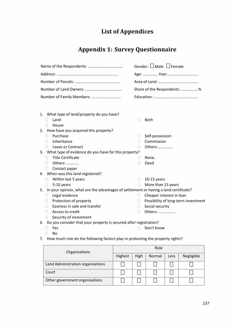
237
List of Appendices
Appendix 1: Survey Questionnaire
Name of the Respondents: …………………………..... Gender: Male Female
Address: ………….............................................. Age: …………… Year: ............................
Number of Parcels: ……………............................ Area of Land: …………..........................
Number of Land Owners: ……………………............ Share of the Respondents: …..……...…%
Number of Family Members: …………................ Education: …………..............................
1. What type of land/property do you have?
Land
House
Both
2. How have you acquired this property?
Purchase
Inheritance
Lease or Contract
Self-possession
Commission
Others:.............. 3. What type of evidence do you have for this property?
Title Certificate
Others: ...........
Contact paper
None.
Deed
4. When was this land registered?
Within last 5 years
5-10 years
10-15 years
More than 15 years 5. In your opinion, what are the advantages of settlement or having a land certificate?
Legal evidence
Protection of property
Easiness in sale and transfer
Access to credit
Security of investment
Cheaper interest in loan
Possibility of long-term investment
Social security
Others: ................
6. Do you consider that your property is secured after registration?
Yes
No
Don’t know
7. How much role do the following factors play in protecting the property rights?
Organisations Role
Highest High Normal Less Negligible
Land Administration organisations
Court
Other government organisations
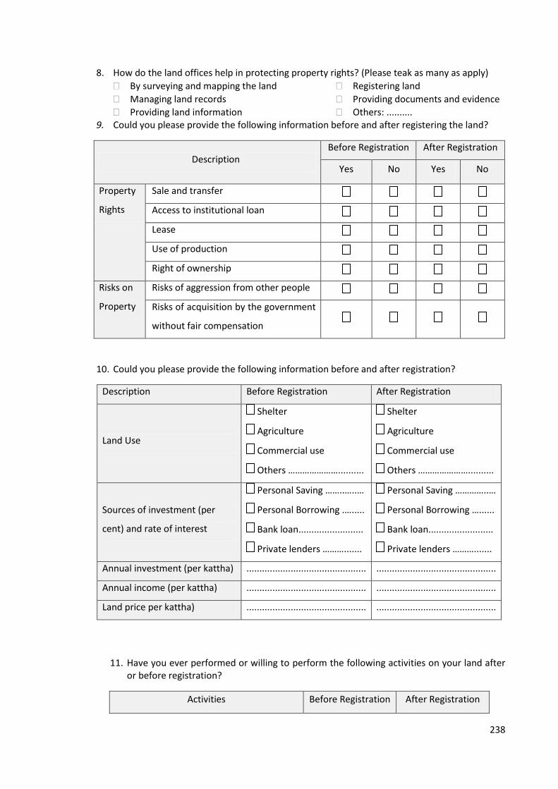
238
8. How do the land offices help in protecting property rights? (Please teak as many as apply)
By surveying and mapping the land
Managing land records
Providing land information
Registering land
Providing documents and evidence
Others: .......... 9. Could you please provide the following information before and after registering the land?
Description Before Registration After Registration
Yes No Yes No
Property
Rights
Sale and transfer
Access to institutional loan
Lease
Use of production
Right of ownership
Risks on
Property
Risks of aggression from other people
Risks of acquisition by the government
without fair compensation
10. Could you please provide the following information before and after registration?
Description Before Registration After Registration
Land Use
Shelter
Agriculture
Commercial use
Others …………………..........
Shelter
Agriculture
Commercial use
Others …………………..........
Sources of investment (per
cent) and rate of interest
Personal Saving ……..…..…
Personal Borrowing .….....
Bank loan.........................
Private lenders ……….......
Personal Saving …………..…
Personal Borrowing …......
Bank loan.........................
Private lenders ……….......
Annual investment (per kattha) .............................................. ..............................................
Annual income (per kattha) .............................................. ..............................................
Land price per kattha) .............................................. ..............................................
11. Have you ever performed or willing to perform the following activities on your land after or before registration?
Activities Before Registration After Registration
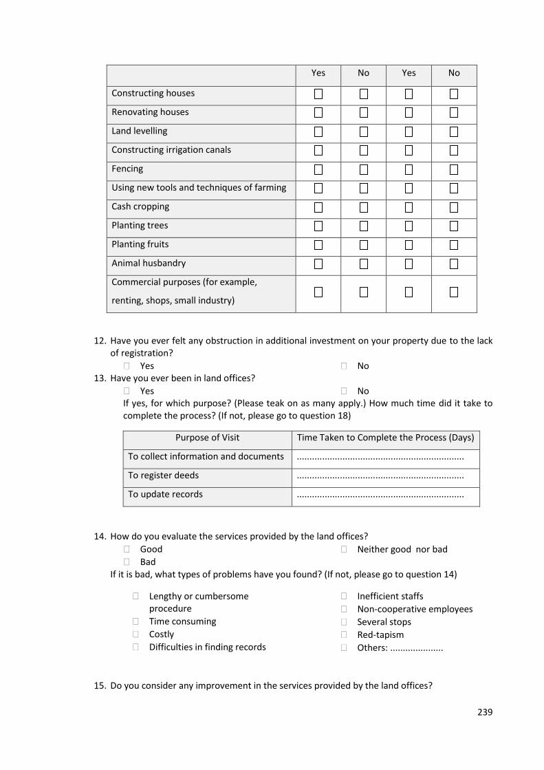
239
Yes No Yes No
Constructing houses
Renovating houses
Land levelling
Constructing irrigation canals
Fencing
Using new tools and techniques of farming
Cash cropping
Planting trees
Planting fruits
Animal husbandry
Commercial purposes (for example,
renting, shops, small industry)
12. Have you ever felt any obstruction in additional investment on your property due to the lack of registration?
Yes No 13. Have you ever been in land offices?
Yes NoIf yes, for which purpose? (Please teak on as many apply.) How much time did it take to complete the process? (If not, please go to question 18)
Purpose of Visit Time Taken to Complete the Process (Days)
To collect information and documents ..................................................................
To register deeds ..................................................................
To update records ..................................................................
14. How do you evaluate the services provided by the land offices?
Good
Bad Neither good nor bad
If it is bad, what types of problems have you found? (If not, please go to question 14)
Lengthy or cumbersome procedure
Time consuming
Costly
Difficulties in finding records
Inefficient staffs
Non-cooperative employees
Several stops
Red-tapism
Others: .....................
15. Do you consider any improvement in the services provided by the land offices?

240
Yes No
If yes, which of the following need to improve? (If not, please go to question 16)
Improvement in law and procedures
Digitisation of land records
Simplification of registration process
One stop shopping
Online information system
Making employees more efficient through training
Improving employees behaviour
Regular updating of information
Others: ………………….
16. How much money do you need to spend while getting the following services from land offices?
Job
Fee (Rupees/Taka)
Up to
1,000
1,001 to
2,000
2,001 to
5,000
5,001 to
10,000
Above
10,000
To collect information or documents
To register deeds
To update records
Transportation and accommodation
Other purposes including bribes
The cost is,
High Low Reasonable
If it is high, what should be done in order to reduce it? (Otherwise, please go to question 18.)
Improvement on law and procedures
Improvement on employee’s behaviour
Online information
Providing registration form freely
Relocating land offices
Others: ………………….
17. To what extent the improvement in land administration services would contribute to reduce the cost?
A lot Normal Negligible
18. Would you like to add anything not covered above? .………………………………………………………………………………………………………………………....…………………………….…................................................................................................................
Thank you very much for your support in filling up this questionnaire.
The End
241
Appendix 2: Information Sheet
Henley Business School
Whiteknights, Reading RG6 6UD
UK Researcher (principal): Gandhi Subedi Email: [email protected] Phone: + 44(0)118 378 6205 Phone: +447411211199 Fax: +44(0)118 975 0236 Email: [email protected] Researcher (role): Email:
Information Sheet
This interview/questionnaire is a part of my PhD study in the Henley Business School, University of Reading, UK. Topic of my research is land administration and its impact on economic development which aims to investigate the relationship between land administration and economic development.
The Land Administration System of Nepal/Bangladesh/Thailand is also a part of my study. The field work in ... includes observation of the process of land transaction in ... office, and discussion and interview with the officials of the land administration organisations, and researcher or academician working in this field. The researcher will make a note during the interview; however, the interview will be recorded if it is allowed by the respondents. Collection of secondary data and literature is also a part of the field work.
The data collected during this study will be used for the purpose of this study only and will be kept highly confidential. It will be kept in a safe place until the research project is completed and disposed properly after the completion of the project. The researcher is not offering any benefits to the respondents in return of their participation. Neither it is harmful or riskier to them.
The results of the study will contribute to my PhD study which will be published. One copy of the dissertation will be sent to the concerned department.
This project has been reviewed by the University of Reading, Research Ethics Committee and has been given a favourable opinion for conduct.
If you have any questions or complaint, please do not hesitate to contact the researcher directly in the email or mobile provided above or on the following address.
Thank you very much for your support.
Gandhi Prasad Subedi UK Address: 108 Liverpool Road, Reading, RG1 3PQ, UK Nepal Address: Bhachok-9, Kaski, Nepal Email: [email protected]
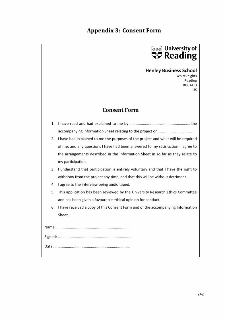
242
Appendix 3: Consent Form
Henley Business School Whiteknights
Reading RG6 6UD
UK
Consent Form
1. I have read and had explained to me by ……………………………..................………. the
accompanying Information Sheet relating to the project on ……..........……..………..
2. I have had explained to me the purposes of the project and what will be required
of me, and any questions I have had been answered to my satisfaction. I agree to
the arrangements described in the Information Sheet in so far as they relate to
my participation.
3. I understand that participation is entirely voluntary and that I have the right to
withdraw from the project any time, and that this will be without detriment.
4. I agree to the interview being audio taped.
5. This application has been reviewed by the University Research Ethics Committee
and has been given a favourable ethical opinion for conduct.
6. I have received a copy of this Consent Form and of the accompanying Information
Sheet.
Name: …………………………………………………………………..
Signed: ………………………………………………………………….
Date: …………………………………………………………………….

243
Appendix 4: Key Issues and Checklist for Interview
S. N. Key Issue Checklist
1. Land administration system
Organisation structure
Functions and role of land administration organisations
Status of cadastral survey & land adjudication
System of land registration
Strengths and weaknesses
Role of land administration in economic development
2. Status of governance Assessment of land administration services
Transparency and access to information
Problems and measures for improvement
Time, costs and procedures
Transaction costs
3. Land policy Key issues of land policy
Land policy and political objectives
4. Land tenure, property rights and access to land
Tenure system and available property rights
Status of tenure security,
Risks or threats on tenure security
Landlessness and informal settlement
Role of land administration in securing land rights
5. Land market and investment
Status of land market
Pre-requisites of efficient land market
Factors determining land related investment
Role of land administration services
6. Record management and information system
Techniques and methods applied in data collection, recording and dissemination
Status of digitisation of land records and future plan
Updating records
Time and costs of collecting information
Problems and measures for improvement
7. Property valuation System of valuation
Problems
8. Human resource Employee efficiency
Employee behaviour and ethics
Universities and training centres offering land administration related courses
Type of training and academic courses available

244
Appendix 5: List of Interviewee and Discussants
A. List of Interviewees
S. N.
Name Role and Affiliation Interview Location Interview Duration
Nepal
1. Mr. Bhesh Raj Lohani
General Secretary, Nepal Land and Housing Development Association
Respondent's Office, Kathmanu
Two Hours
2. Mr. Drona Prasad Pokharel
Director, Department of Land Information and Archive
Respondent's Office, Babar Mahal
One and Half Hours
3. Mr. Ganesh Phago Land right activist, Chulachuli, Ilam
Respondent's Home, Chulachuli
One Hour
4. Mr. Ichchha Bahadur Tamang
President, Nepal Land and Housing Development Association
Respondent's Office,, Kathmandu
One and Half Hours
5. Mr. Jagat Basnet Executive Director, Community Self-Reliance Centre
Respondent's Office, Kathmandu
One Hour
6. Mr. Jeet Bahadur Thapa
Director General, Department of Land Reform and Management
Respondent's Office, Babar Mahal
One and Half Hours
7. Mr. Lal Mani Joshi Secretary, Ministry of Land Reform and Management
Respondent's Office,
Singha Durbar
One Hour
8. Mr. Kiran Bhattarai Land Revenue Officer, Land Revenue Office, Ilam
LRO Office, Ilam Written Interview
9. Mr. Madhusudan Adhikari
Deputy Director General, Department of Survey
Respondent's Office, Min Bhawan
One and Half Hours
10. Mr. Suvash Ghimire Assistant Professor, Kathmandu University
Restaurant, Lalitpur One and Half Hours
11. Mr. Om Narayan Khanal
Local political leader; Member of Chulachuli Area Informal Settlement Problem Solving Committee
Respondent's Home, Chualachuli,
Ilam
Two Hours
12. Mr. Thakur Niraula Member Secretary, Chulachuli Area Informal Settlement Problem Solving Committee
Respondent's Office, Damak
One Hour
Bangladesh
13. Ms. Khushi Kabir Coordinator, Nijera Kori, Dhaka
Respondent's Office, Dhaka
One and Half Hours
14. Asst. Prof. Masud Head, Department of Real Respondent's Two Hours

245
Ibn Rahaman Estate, Daffodil International University, Dhaka
Office, Dhaka
15. Mr. M. A. Matin Managing Director, DLM Properties Ltd. and Visiting Asst. Prof., Daffodil International University
Respondent's Office, Dhaka
One Hour
16. Ms. Sayeda Rizawana Hasan
Director, Bangladesh Environment Lawyers’ Association (BELA)
Respondent's Office, Dhaka
One Hour
17. Mr. Shamsul Huda Executive Director, of Land Reform & Development (ALRD), Dhaka
Respondent's Office, Dhaka
Two Hours
Thailand
19. Ms. Chinnapan Charoenkalunyuta
Department of Lands, Bangkok
Restaurant, Bangkok
One and Half Hours
Dr. Perm Sark Lecturer, Mahidol University, Bangkok
RECOFTC Office, Bangkok
One and Half Hours
20. Mr. Rung-Arun Yodeam
Senior Surveyor, Survey Division, Pak Kret
Respondent's Office, Pak Kret
One Hour
21. Ms. Somying Soontornwong
Thailand Country Programme Coordinator, The Centre for People and Forest (RECOFTC), Bangkok
Respondent's Office, Bangkok
One and Half Hours
22. Prof. Sopin Department of Agricultural Economics, Kasetsart University, Bangkok
Respondent's Office, Bangkok
One and Half Hours
23. Mr. Teetat Charoenka Lunyota
Survey Engineer, Survey Office, Pak Kret
Respondent's Office, Pak Kret
One Hour
24. Ms. Wanna Rakayo Inspector, Department of Lands
Respondent's Office, Bangkok
One Hour
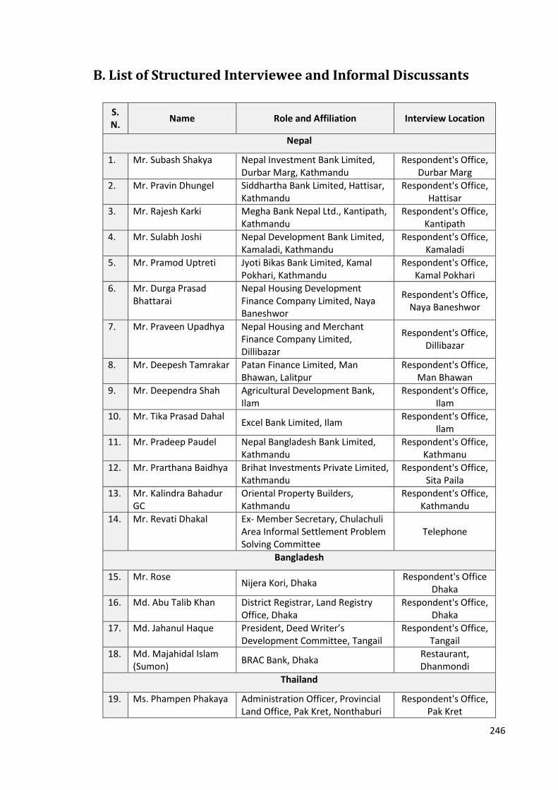
246
B. List of Structured Interviewee and Informal Discussants
S. N.
Name Role and Affiliation Interview Location
Nepal
1. Mr. Subash Shakya Nepal Investment Bank Limited, Durbar Marg, Kathmandu
Respondent's Office, Durbar Marg
2. Mr. Pravin Dhungel Siddhartha Bank Limited, Hattisar, Kathmandu
Respondent's Office, Hattisar
3. Mr. Rajesh Karki Megha Bank Nepal Ltd., Kantipath, Kathmandu
Respondent's Office, Kantipath
4. Mr. Sulabh Joshi Nepal Development Bank Limited, Kamaladi, Kathmandu
Respondent's Office, Kamaladi
5. Mr. Pramod Uptreti Jyoti Bikas Bank Limited, Kamal Pokhari, Kathmandu
Respondent's Office, Kamal Pokhari
6. Mr. Durga Prasad Bhattarai
Nepal Housing Development Finance Company Limited, Naya Baneshwor
Respondent's Office, Naya Baneshwor
7. Mr. Praveen Upadhya Nepal Housing and Merchant Finance Company Limited, Dillibazar
Respondent's Office, Dillibazar
8. Mr. Deepesh Tamrakar Patan Finance Limited, Man Bhawan, Lalitpur
Respondent's Office, Man Bhawan
9. Mr. Deependra Shah Agricultural Development Bank, Ilam
Respondent's Office, Ilam
10. Mr. Tika Prasad Dahal Excel Bank Limited, Ilam
Respondent's Office, Ilam
11. Mr. Pradeep Paudel Nepal Bangladesh Bank Limited, Kathmandu
Respondent's Office, Kathmanu
12. Mr. Prarthana Baidhya Brihat Investments Private Limited, Kathmandu
Respondent's Office, Sita Paila
13. Mr. Kalindra Bahadur GC
Oriental Property Builders, Kathmandu
Respondent's Office, Kathmandu
14. Mr. Revati Dhakal Ex- Member Secretary, Chulachuli Area Informal Settlement Problem Solving Committee
Telephone
Bangladesh
15. Mr. Rose Nijera Kori, Dhaka
Respondent's Office Dhaka
16. Md. Abu Talib Khan District Registrar, Land Registry Office, Dhaka
Respondent's Office, Dhaka
17. Md. Jahanul Haque President, Deed Writer’s Development Committee, Tangail
Respondent's Office, Tangail
18. Md. Majahidal Islam (Sumon)
BRAC Bank, Dhaka Restaurant, Dhanmondi
Thailand
19. Ms. Phampen Phakaya Administration Officer, Provincial Land Office, Pak Kret, Nonthaburi
Respondent's Office, Pak Kret
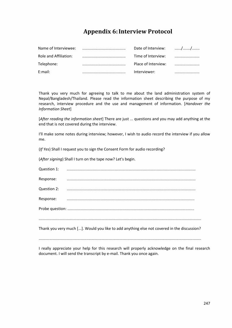
247
Appendix 6: Interview Protocol
Name of Interviewee: ........................................ Date of Interview: ....../......./.......
Role and Affiliation: ........................................ Time of Interview: .......................
Telephone: ........................................ Place of Interview: .......................
E:mail: ........................................ Interviewer: .......................
Thank you very much for agreeing to talk to me about the land administration system of Nepal/Bangladesh/Thailand. Please read the information sheet describing the purpose of my research, interview procedure and the use and management of information. [Handover the Information Sheet]
[After reading the information sheet] There are just ... questions and you may add anything at the end that is not covered during the interview.
I'll make some notes during interview; however, I wish to audio record the interview if you allow me.
(If Yes) Shall I request you to sign the Consent Form for audio recording?
(After signing) Shall I turn on the tape now? Let's begin.
Question 1: .......................................................................................................................
Response: .......................................................................................................................
Question 2: .......................................................................................................................
Response: ......................................................................................................................
Probe question: .....................................................................................................................
......................................................................................................................................................
Thank you very much [...]. Would you like to add anything else not covered in the discussion?
......................................................................................................................................................
I really appreciate your help for this research will properly acknowledge on the final research document. I will send the transcript by e-mail. Thank you once again.
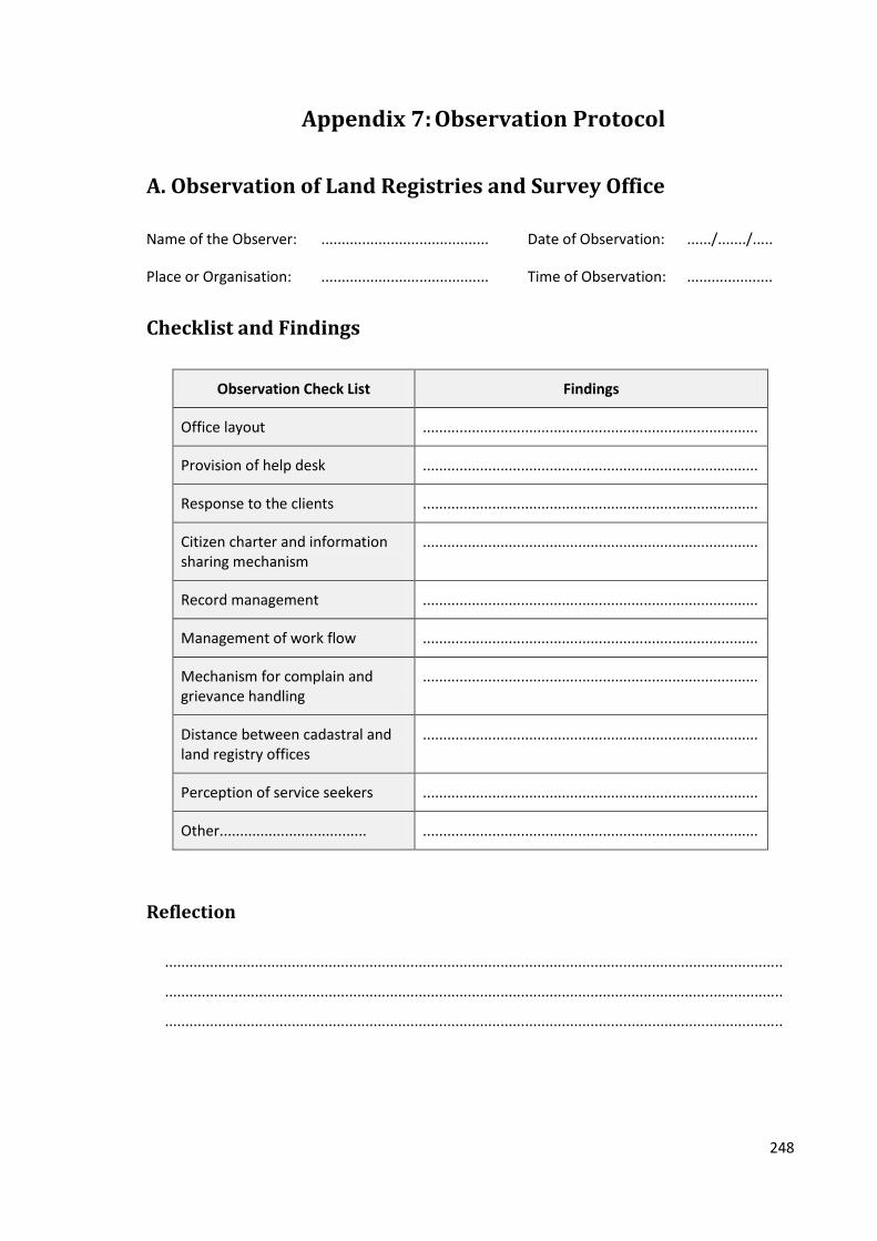
248
Appendix 7: Observation Protocol
A. Observation of Land Registries and Survey Office
Name of the Observer: ......................................... Date of Observation: ....../......./.....
Place or Organisation: ......................................... Time of Observation: .....................
Checklist and Findings
Observation Check List Findings
Office layout ..................................................................................
Provision of help desk ..................................................................................
Response to the clients ..................................................................................
Citizen charter and information sharing mechanism
..................................................................................
Record management ..................................................................................
Management of work flow ..................................................................................
Mechanism for complain and grievance handling
..................................................................................
Distance between cadastral and land registry offices
..................................................................................
Perception of service seekers ..................................................................................
Other.................................... ..................................................................................
Reflection
.......................................................................................................................................................
.......................................................................................................................................................
.......................................................................................................................................................
249
B. Observation of the Research Site
Name of the Observer: ........................................ Date of Observation: ....../......./.........
Place Observed: ........................................ Time of Observation: .........................
Checklist and Findings
Observation Check List Findings
Land use pattern ...................................................................................................
Activities ...................................................................................................
Housing pattern ...................................................................................................
Feelings of landowners ...................................................................................................
....................................... ...................................................................................................
................................... ...................................................................................................
................................... ...................................................................................................
Reflection
...............................................................................................................................................
...............................................................................................................................................
...............................................................................................................................................

250
Appendix 8: Land Related Laws Reviewed in the Thesis
Country Laws
Nepal Interim Constitution of Nepal, 1954
Land and Cultivation Record Compilation Act, 1956
Land Related Act, 1957
Birta Abolition Act, 1959
Land (Survey and Measurement) Act, 1963
National Code, 1963
Land Act, 1964
Ukhada Land Act, 1964
Land Administration Act, 1967
Act Related to Jhora (Forest) Land, 1971
Kharka Land Nationalisation Act, 1974
Guthi Corporation Act, 1976
Land Revenue Act, 1978
Land Administration Directives, 2001
Minimum Valuation Determining Directives, 2003
Interim Constitution of Nepal, 2007
Bangladesh The Survey Act, 1875
Transfer of Property Act, 1882
Bengal Tenancy Act, 1885
Registration Act, 1908
Non Agricultural Tenancy Act, 1947
Acquisition of Waste Land Act, 1950
East Bengal State Acquisition and Tenancy Act, 1950
Constitution of the People’s Republic of Bangladesh, 1972
Land Development Tax Ordinance, 1976
Board of Land Administration Act, 1980
Land Reform Ordinance, 1984
Land Appeal Board Act, 1989
Land Reform Board Act, 1989
Chittagong Hill Tract Regulation Act, 1990
Non-agricultural Khas Land Management and Settlement Policy, 1995
Agricultural Khas Land Management and Settlement Policy, 1997
Chittagong Hill Tracts Land Dispute Settlement Commission Act, 2001
Thailand Civil and Commercial Code, 1932
Land Code, 1954
Land Development Act, 1963
The Agricultural Land Reform Act, 1975
Land Readjustment Act, 2004
Constitution of the Kingdom of Thailand, 2007