land acquisition advisory committee (laac) · land acquisition advisory committee (laac) ... leroy...
TRANSCRIPT

LAND ACQUISITION ADVISORY COMMITTEE (LAAC)
Sabin Abell- City ofVero Beach Jerry Weick -Town oflndian River Shores Mike Ochsner- Town of Indian River Shores Alternate Andrea Coy - City of Sebastian
Michael Walther- IRC Chamber of Commerce [Vacant]- Development Community [Vacant]- Agricultural Interest Kevin Doty - Civic Association
Richard H. Gillmor- City of Sebastian Alternate Joel Tyson- City of Fellsmere Fernando Herrera- City of Fellsmere Alternate Francis "Bud" Oatway - Town of Orchid William Troxell- Town of Orchid Alternate Grant Withers- Indian River Land Trust
Judy Orcutt - Sierra Club Denise Waddell - Historical Representative [Vacant]- Taxpayer's Association Lois Work- Board ofRea1tors Bonnie Veron- Member at Large
Lee D. (Toni) Robinson -Indian River Land Trust Alternate Dr. Richard Baker- Pelican Island Audubon Society
Talmage Rogers, Jr. - Member at Large, Vice Chairman Leroy Smith - Member at Large
Janice Broda- Indian River Mosquito Control District, Chairman Peter O'Bryan, Non-voting Commissioner Liaison
The LAAC will be holding a meeting on WEDNESDAY, APRIL 29, 2009 at 1:30 p.m. in First Floor Conference Room B1-501 of County Administration Building B, 1800 271
h Street, Vero Beach.
AGENDA
1. Call to Order- Chairman Janice Broda
2. Approval of March 25, 2009 Meeting Minutes
3. Consideration of Draft Florida Communities Trust Cost-Share Grant Application for the Sebastian Harbor Preserve LAAC Site- Roland DeBlois
4. Other Business
5. Adjournment
cc: Joseph A. Baird Robert M. Keating Matt Sexton Indian River Land Trust
Michael C. Zito Roland DeBlois Beth Powell Scott Johnson
Marian Fell Jason Brown Press
Anyone who needs a special accommodation for this meeting may contact the County's ADA Coordinator at 226-1233, at least 48 hours in advance of the meeting. Anyone who may wish to appeal any decision that may be made at this meeting will need to ensure that a verbatim record of the proceedings is made, which includes testimony and evidence upon which the appeal is based.
F:\Community Development\Users\ROLANDILAAC\AGENDA & MINS\2009104-29-09 LAAC AGD.doc

LAND ACQUISITION ADVISORY COMMITTEE (LAAC)
The Indian River County (IRC) Land Acquisition Advisory Committee (LAAC) held a meeting on Wednesday, March 25, 2009 at 1:50 p.m. in Room "B1-501" of the County Administration Building B, 1800 2ih Street, Vero Beach, Florida. You may hear an audio of the meeting; review the agenda and the minutes on the IRC website- www.ircgov.com/Boards/LAAC/2009.
Present were members: Dr. Richard Baker, Pelican Island Audubon Society (PIAS); Bonnie Veron and Talmage Rogers, Members-at-Large; Grant Withers, Indian River Land Trust (IRL T); Judy Orcutt, Sierra Club; Councilmember William Troxell; Alternate, Town of Orchid; Janice Broda, Mosquito Control District; Joel Tyson, City of Fellsmere; and Councilmember Gerald Weick, Town of Indian River Shores.
Absent were members: Michael Walther, IRC Chamber of Commerce; Kevin Doty, Civic Association; Leroy Smith, Member-at-Large; Denise Waddell, IRC Historical Society; Councilmember Andrea Coy, City of Sebastian; Councilmember Bud Oatway, Town of Orchid; Jim Granse, Taxpayers' Association; Sabin Abell, City of Vero Beach; Lois Work, Board of Realtors; and Commissioner Peter O'Bryan, IRC Commissioner Liaison (all excused).
Also present were: Marian Fell, IRC Senior Assistant County Attorney; Roland DeBlois, IRC Chief of Environmental Planning; Beth Powell, Conservation Lands Manager; and Terri Collins-Lister, Commissioner Assistant, District 4. Others present were: Matt Sexton, The Conservation Fund; Henry Stephens, Press Journal; Ken Grudens and Ralph Monticello, IRL T; and David Cox, PIAS.
Call to Order
Chairman Broda called the meeting to order at 1:50 p.m. and introductions were made.
Approval of the January 28, 2009 Meeting Minutes
Chairman Broda requested the January 28, 2009 meeting minutes reflect the following change in the third paragraph on page 3 as follows:
"Chairman Broda asked if staff could review the project list and bring back to the next LAAC meeting, additional backup on the sites as well as look at already acquired properties for which bond funds could be used for initial improvements".
LAAC/Unapproved 1 March 25, 2009 F:\Community Development\Users\ROLAND\LAAC\AGENDA & MINS\2009\Min 03-25-09.doc

ON MOTION BY Mr. Rogers, SECONDED BY Councilmember Tyson, the members voted unanimously (9-0) to approve the minutes of the meeting of January 28, 2009 as amended.
Summary Report on Lands Acquired under the County Environmental Lands Program
Mr. Roland DeBlois, IRC Chief of Environmental Planning, went over the information contained in his memorandum regarding the Summary Report on Lands Acquired under the County Environmental Lands Program and the following attachments: Acquired Sites Purchase Information Summary Table, Environmental Lands Program Site Acreage Table and Location Maps of Acquired Properties, all of which are on file in the Commission Office.
Consideration of Staff Ranking of LAAC Sites and Imposition of an Acquisition Freeze Pending Anticipated Cost-Share Reimbursement for the Sebastian Harbor Preserve Purchase
Mr. DeBlois reviewed the information contained in his memorandum regarding the Consideration of Staff Ranking of LAAC Sites and Imposition of an Acquisition Freeze Pending Anticipated Cost-Share Reimbursement for the Sebastian Harbor Preserve Purchase, a copy of which is on file in the Commission Office. He pointed out two corrections on Attachment 4 of the draft update of the 2009 Indian River County Conservation Lands Capital Improvements: 1) Cost Estimates under the Conservation Area, Lost Tree Islands, the location should be the Town of Indian River Shores instead of Town of Orchid and 2) on the second page of Attachment 4 under Conservation Area, South Prong Preserve, the associated cost estimate should be $100,000 instead of $1,000,000.
Mr. DeBlois went over the current available monies in the Land Acquisition Fund and noted there was one active negotiation which was the Orca South Link (remainder) in the amount of $130,000.
A discussion ensued on the Sebastian Harbor Preserve application with cost share reimbursement funds of approximately $5.5 million. Mr. DeBlois stated the deadline for the submittal of the application for the funding cycle was May 2009.
Mr. Rogers referred to the LAAC Site List, Staff Draft Ranking Sheet and proposed adding 1 0 project excellence points to the already 45 points for the ORCA South Link (remainder) project and eliminate any project under 50 points.
LAAC/Unapproved 2 March 25, 2009 F:\Community Development\Users\ROLAND\LAAC\AGENDA & MINS\2009\Min 03-25-09.doc

A MOTION WAS MADE BY Mr. Rogers, SECONDED BY Mrs. Orcutt, to add 10 project excellence points to the ORCA South Link (remainder) and eliminate any project under 50 points.
UNDER DISCUSSION, Dr. Baker felt the LAAC Site List was not realistic and if projects less than 50 points were removed from the list and additional funding became available those projects eliminated would not be considered.
List. Mrs. Orcutt withdrew her second. A discussion followed on the LAAC Site
ON MOTION BY Mr. Rogers, SECONDED BY Mr. Tyson, the members voted (3-6) to award 10 project excellence points to the ORCA South Link (remainder) project and eliminate any project under 50 points. THE MOTION FAILED.
A MOTION WAS MADE BY Mr. Weick to award 10 points for the ORCA South Link (remainder) project and establish a threshold of 50 points or more. THE MOTION DIED FOR LACK OF A SECOND.
ON MOTION BY Mr. Weick, SECONDED BY Mr. Rogers, the members voted unanimously (9-0) to award 10 points to ORCA South Link (remainder) project.
A lengthy discussion ensued on the point system and excellence points. Ms. Marian Fell, IRC Senior Assistant County Attorney, went over staff's recommendation.
A MOTION WAS MADE BY Dr. Baker to award 10 excellence points to the High Pointe Scrub project. THE MOTION DIED FOR LACK OF A SECOND.
ON MOTION BY Mr. Rogers, SECONDED BY Mr. Tyson, to eliminate the Sebastian Village Scrub project from the LAAC Site List.
UNDER DISCUSSION, Dr. David Cox, PIAS, told the committee that any property which has known scrub jays located on the property brought forward for potential acquisition being on the LAAC Site List may serve the purpose for another source of funding to acquire the property. Ms. Beth Powell, IRC Conservation
LAAC/Unapproved 3 March 25, 2009 F:\Community Development\Users\ROLAND\LAAC\AGENDA & MINS\2009\Min 03-25-09.doc
Lands Manager, mentioned the Sebastian Village Scrub and High Pointe Scrub Projects would be eligible for Section 6 funding from the U.S. Fish and Wildlife for support of scrubs jays.
THE CHAIRMAN CALLED FOR THE QUESTION and the vote was 2-7 to eliminate the Sebastian Village Scrub. THE MOTION FAILED.
A discussion ensued on the properties on the LAAC Site List that could receive funding through Florida Communities Trust (FCT) or the U.S. Fish and Wildlife. Mr. DeBlois mentioned the Ten Mile Ridge Project had been recently annexed into the City of Fellsmere.
ON MOTION BY Mrs. Veron, SECONDED BY Mr. Tyson, to eliminate the Ten Mile Ridge Project.
UNDER DISCUSSION, Mr. Rogers felt the committee should approach the Anisn's on the Ten Mile Ridge to see if there was some way the property could be used as a tax offset. Dr. Baker felt before eliminating the Ten Mile Ridge Project, the County should try to get other agencies to look at the property or approach the state on the importance of some of these properties.
THE CHAIRMAN CALLED FOR THE QUESTION and the vote was 2-7 to eliminate the Ten Mile Ridge. THE MOTION FAILED.
Chairman Broda entertained a motion on staff's recommendation that the County "freeze" acquisition of new LAAC sites, with the exception of the ORCA South Link remainder that is under negotiation, pending anticipated cost-share reimbursement from the FCT for the Sebastian Harbor Preserve.
A MOTION WAS MADE BY Mrs. Orcutt, SECONDED BY Mr. Weick, the members voted unanimously (9-0) on staff's recommendation that the County "freeze" acquisition of new LAAC sites, with the exception of the ORCA South Link (remainder), the Russell Grove Conservation Area and the Soule Riverfront Parcel pending anticipated cost-share reimbursement from the Florida Communities Trust for the Sebastian Harbor Preserve.
A discussion ensued on the process for deciding how and when the initial improvements are made on acquired properties. Dr. Baker suggested the committee discuss initial improvements to already acquired properties at a future LAAC meeting.
LAAC/Unapproved 4 March 25, 2009 F:\Community Development\Users\ROLAND\LAAC\AGENDA & MINS\2009\Min 03-25-09.doc

Other Business
Mr. Anderson, a volunteer for the Captain Forster Hammock Preserve spoke on the removal of exotics and a premier citrus property next to the Preserve.
Adjournment
There being no further business, the meeting adjourned at 3:12 p.m.
LAAC/Unapproved 5 March 25, 2009 F:\Community Development\Users\ROLAND\LAAC\AGENDA & MINS\2009\Min 03-25-09.doc
INDIAN RIVER COUNTY MEMORANDUM
TO: Members of the Land Acquisition Advisory Committee
THROUGH: Robert M. Keating, AICP fl~k.._ Community Development Director
FROM: Roland M. DeBlois, AICP~\t> Chief, Environmental Planning
DATE: April22, 2009
RE: Consideration of Draft 2009 Florida Communities Trust Coast-Share Grant Application for the Sebastian Harbor Preserve LAAC Site
It is requested that the Land Acquisition Advisory Committee (LAAC) consider the following information at the LAAC meeting of April29, 2009.
DESCRIPTION & CONDITIONS
Attached, for LAAC's review, is a draft of the 2009 cycle Florida Communities Trust (FCT) cost-share grant application for the Sebastian Harbor Preserve LAAC site.
In the 2008 grant cycle, an FCT cost-share funding application for the Sebastian Harbor Preserve LAAC site was submitted to the State, but the project was not selected for funding. At that time, the Sebastian Harbor Preserve project was awarded 150 points, whereas the cut-off for funded projects was 170 points.
ANALYSIS
In the previous application, points were requested for certain criteria, but were not awarded by FCT. Those criteria, and FCT's justification for not awarding points, are summarized in the following table. The following table also explains changes made under the proposed new application to garner more points.
Criterion Number of 2008 application justification for FCT staff Change made in 2009 points points explanation for not draft application to gain
recommending points points
(l)(c)2: local 10 points Local match of 54.55% (20 points) NIA Local match of 60% (25 government funding (40-49% (requested maximum amount points) match match) allowed, $6.3 million, from FCT)
(requesting $5,544,000, 20 points from FCT- 40%) (50-59% match)
25 points (60% or more match)
1

Criterion Number of 2008 application justification for FCT staff Change made in 2009 points points explanation for not draft application to gain
recommending points points
(2)(a)3b: site will 5 points Will provide bird blind, 2 wetland All of the proposed Proposed facilities include provide 2-4 outdoor (for 2 or 3 observation boardwalks and an facilities are of the a wetland observation recreational facilities facilities); eagle nest observation platform same type, only boardwalk, eagle's nest
(total of 4) count as one facility observation platform and 10 points picnic pavilion (2 types of (for 4 or facilities - 5 points) more facilities)
(2)(t)2: site will 5 points Project site is adjacent to a canal The site is not No points requested protect an that connects to the St. Sebastian immediately (cannot be rectified) Outstanding Florida River and will prevent runoff that adjacent to the St. Water (OFW) would affect OFW of the river Sebastian River (3)(a)2: camp plan 5 points Cited Sebastian Rec. and Open Policy is written to Cited newly adopted directive for public Space Policy 7-1.1.8: Designation promote waterfront Sebastian Future Land Use acquisition of natural or Acquisition of Natural access and not Policy 1-1.7.2 that areas or open space Reservations general protection supports acquisition of
of natural areas natural areas through a through acquisition publicly funded program.
(3)(a)4: camp plan 5 points Cited various County and City The cited directives Cited new Sebastian directive for creating policies relating to establishment of did not specifically Transportation Policies new or enhanced preserve to function as wildlife provide for creating 1.6.2 and 1.6.7 that green ways, corridors, systems of parks and new or enhanced reference preparation of ecological corridors recreation, management of green ways, greenway plans and capital or recreational trail environmental lands associated ecological corridors funding priority for systems with the St, Sebastian River, or recreational trail greenways and heavy
Collier Creek and Elkcam systems recreational use areas Waterway
Project excellence Up to 10 Project has strong community No additional Expanded section to points support from the City and County; characteristics that reference that the project
project is rare in that it is teeming were not covered in resolved a land use conflict with wildlife (listed species) in a the criteria with respect to Fleming centrally located area that is easily established Street extension that was accessible by walking, bicycle or elsewhere in the previously planned car. application through the property (no
longer planned); also reference of"Sunny's Wildlife" website as an example of community interest and support of the project.
Based on a "Project Self-Score Check Sheet" (see Attachment 1 ), the draft 2009 FCT application scores 170 points, not counting up to 10 excellence points that the FCT Governing Board may award at the funding hearing. That hearing is typically held in September. Assuming that the FCT Governing Board issues 5 or 10 excellence points for the project, the project has the potential to score 175 or 180 total points. Those numbers of points generally make an application competitive for funding.
RECOMMENDATION
Staff recommends that the LAAC review the draft application, identify any potential changes, and support the application for submittal to the FCT.
2
ATTACHMENTS
1. Project Self-Score Check Sheet. 2. 2009 FCT Grant Application.
F:\COMMUNITY DEVELOPMENT\USERS\ROLAND\LAAC\SEBASTIAN HARBOR PRESERVE\FF-9 2009 FCT GRANT APP\DRAFT FCT APP LAAC REPORT FOR 04-29-09.DOC
3

Project Self-Score Check Sheet The following check sheet is a helpful optional tool that can be used prior to preparing an application to determine if a proposed project is likely to achieve a competitive evaluation score. The higher a project's evaluation score, the greater the likelihood that it will be selected for FCT funding. While self-scoring a project, if you find that most of the criteria are not being achieved, you may wish to evaluate and consider another project. If you are in doubt about the competitiveness of a proposed project based on its self-score, please contact FCT staff to discuss the project.
Instructions: Review each of the following application criteria (listed in order by criterion number) and check those that would be achieved by the proposed project. Then total the number of points to the right of each checked box to determine the estimated total project self-score.
General Criteria Section
li 10 (1)(a) E1 5 (1)(b) 0 10 (1)(c)1a 0 20 (1)(c)1b l:i 25 (1)(c)1c 0 10 (1)(c)2a 0 20 (1)(c)2b 0 25 (1)(c)2c 0 5 (1)(d)
0 5 (1)(e)
Entire site Pre-acquired within 24 months prior to application deadline. Site is part of a previously funded FCT phased project. Medium to Large Local Government to provide 40-49% match. Medium to Large Local Government to provide 50-59% match. Medium to Large Local Government to provide 60% or more match. Small Local Government or Nonprofit to provide 10-19% match. Small Local Government or Nonprofit to provide 20-29% match. Small Local Government or Nonprofit to provide 30% or more match. First application to FCT, previous project not selected for funding or nothing acquired. Site to be acquired by less than fee simple acquisition.
Outdoor Recreation, Natural and Cultural Resources Section
~5 (2)(a)1
!)Z{s (2)(a)2
f21's (2)(a)3a 0 10 (2)(a)3b 0 5 (2)(a)4
~5 (2)(a)5.a lis (2)(a)5.b
~~ (2)(b)1 (2)(b)2
lis (2)(b)3
Site will provide recreation or open space adjacent to existing publicly owned upland areas. Site will provide new or enhanced land-based trail, bike, equestrian or multi-use trail at least % mile in length. Site will provide two or three Outdoor Recreational facilities. Site will provide four or more Outdoor Recreational facilities Site will provide access facilities to existing open water shoreline or beach for recreation. Site is located within an existing Urban Service Area. Site is located in an Urban Service Area and within %-mile of commercial or industrial area. Site is accessible by existing sidewalk or will be connected by a sidewalk. Site includes or is adjacent to a local, regional or statewide land-based Recreational Trail System or the Preferred Routing for the Florida National Scenic Trail. Site will enhance a local, regional or statewide Ecological Corridor.

r/s (2)(b)4
D s (2)(b)S
lis (2)(c)1 lis (2)(c)2 D s (2)(c)3
0s (2)(d)1 D2(s (2)(d)2 BS (2)(d)3 9's (2)(d)4
~s (2)(e)1 D S (2)(e)2 D s (2)(e)3 !Sis (2)(f) 1
D s (2)(f)2 D s (2)(f)3 D s (2)(g)1
D s (2)(g)2 D s (2)(g)3
Site will further a locally adopted Ecological Corridor or Recreational Trail System plan. Site will enhance a State Designated Paddling Trail by providing facilities. Site will provide an interpretive kiosk or interpretive signs. Site will provide at least 12 educational classes or programs annually. Site will provide a staffed nature center, museum building or Neighborhood Recreation Center. Site consists of predominantly Natural Communities. Site includes a Locally Significant Natural Area, as identified by FNAI. Site provides Listed Animal Species Habitat. Site contains habitat and is located in a Strategic Habitat Conservation Area. Invasive exotic vegetation will be removed from the site. Significant portion of upland area will be planted with native vegetation. Significant portion of wetland area will be planted with native vegetation. Site will improve surface waters or correct existing flooding problems by providing stormwater facilities. Site will protect an Outstanding Florida Water. Site will protect Class I Waters or designated wellfield protection zone. Site includes Florida Master Site File feature or is within X-mile of a listed feature. Site includes a significant Florida Master Site File feature. Site includes feature listed on National Register of Historic Places.
Community Planning Section
~s (3)(a)1
~s (3)(a)2 D S (3)(a)3 ~s (3)(a)4
~s (3)(a)S
~s (3)(a)6
B's (3)(a)7 g's (3)(a)8
~s (3)(a)9
D S (3)(a)10
t»s (3)(b) 1 D s (3)(b)2
Plan directive to maintain or improve adopted recreation Level-of-Service standards. Plan directive for public acquisition of natural areas or open space. Plan directive to provide public access to water bodies and beaches. Plan directive for creating new or enhanced Greenways, Ecological Corridors or Recreational Trail Systems. Plan directive to preserve Natural Communities or Listed Animal Species Habitat. Plan directive for coordination with agencies managing natural areas or open space or furthering the completion of the Florida National Scenic Trail. Plan directive to restore degraded natural areas. Plan directive to protect or enhance surface water quality by addressing non-point pollution through enhanced stormwater treatment. Plan directive to preserve historical, cultural or archaeological resources. Plan directive for urban infill, redevelopment or downtown revitalization area. Site located in coastal high hazard area or 1 00-year floodplain. Site located in state-designated brownfield area.

D 10 (3)(c)1 Site located in designated Front Porch Florida Community. D 10 (3)(c)2 Site located in area designated an active Florida Main Street
Community. D 10 (3)(c)3 Site located in current or previously designated Waterfront Florida
Community. D 10 (3)(c)4 Site located in designated low-income community. D 10 (3)(c)5 Site located in designated Rural Area of Critical Economic Concern. D 10 (3)(c)6 Site located in locally designated Community Redevelopment Area. D 10 (3)(c)7 Site located in designated or previously designated Area of Critical
State Concern.
Project Excellence Section
ri 0-10 (4) Project Excellence (up to 10 points awarded by FCT Governing Board)
l 7 0 Estimated Project Self-Score Points
( + ':>'l>~" ID ~:tC(.W..E:t-~'"~ '(uutf'.;, ::: I 7 '5" t& I ~D)
NOTE: Please be advised that there is no set scale to determine the merits of a particular project or how likely it is to receive funding. Whether a certain project is funded by Florida Communities Trust depends on the merits of all proposals submitted during the same application cycle.
Over the past five years the funding of projects has become increasingly competitive, as can be seen in the table below:
FCT Funding Cutoff Scores
2008 170 points 2007 165 points 2006 160 points 2005 145 points 2004 130 points
Therefore, it is extremely important to choose a project site and prepare an FCT grant application that will score as high as possible.
Please contact your project evaluator with any questions you may have about your specific project or your application. If you are unsure who your project evaluator is, a staff listing is available at www.floridacommunitiestrust.org/

Florida Communities Trust Florida Forever Program
1. PROJECT NAME Sebastian Harbor Preserve (Descriptive project name)
Application Form FCT -4
2. APPLICANT NAME _..ln:.:..:d:.::i.::.an:..:.....:...;Ro:..;iv:....:e:..:..r....::C:....:o:..::u:.:..:nc.:Jtv.__ _______________ :-------------(Name of Local Government or Nonprofit Environmental Organization)
If Nonprofit Environmental Organization, also provide the required information requested on Exhibits M and N.
3. PARTNERSHIPAPPLICATION
Is this a Partnership Application between two or more Local Governments or Nonprofit Environmental Organizations? YES NO_x_ If yes, provide the name(s) of the Local Government(s) or Nonprofit Environmental Organization(s). Also, provide an application transmittal letter from the partnering agency.
4. KEY CONTACT PERSON
Note: The key contact is required to be an employee of the Local Government or designated representative of the Nonprofit Environmental Organization. Identify only one key contact person.
KeyContactName __ ~R~o~l=a~n=d ______________________ ~M~·~--------------------~D~e~B~I~o~is~ First Middle Initial Last
Title Chief, Environmental Planning & Code Enforcement Section
Department/Nonprofit Environmental Organization Indian River Countv Planning Division
Mailing Address 1801 2th Street
City ______ __,V,_,e,_,_ro~B:....:e:.:ac::cc:.:.h _________________ , FL Zip Code=-32:.;9::.::6::.;:0:...._ __
Phone Number (772) 226-1258 Fax Number (772) 978-1806
E-mail Address rdeblois@ircgov .com
Chief Administrator for the Local Government
Name _____ J~o~s~e~p~h~A~·=B=a=ir=d _______________________ _ Phone Number (772) 226-1408
Note: If the Applicant's principal office address is a post office box, a delivery address is a/so required.
Delivery Address (SAME)
City---------------------------' FL Zip Code __ _
5. PROJECT SITE LOCATION
County INDIAN RIVER Section 18 Township 31S Range 39E Note: Cite only one Section, Township and Range to indicate where all or most of the project acreage is located. Include all directional designations (Township either North or South- Range either East or West).
6. TOTAL PROJECT ACREAGE
Indicate the approximate acreage of the Project Site. _1:....:6:..::3~- Acres
Form FCT-4 (Effective 02-19-07) Page 1

7. ACQUISITION TYPE
The Applicant must fill out one or more of the following acquisition types, as appropriate.
X PRE-ACQUIRED The entire Project Site has been Pre-acquired by the Applicant through a Voluntarily-Negotiated Transaction within 24 months prior to the application deadline.
___ PARTIAL PRE-ACQUIRED A portion of the Project Site has been Pre-acquired by the Applicant through a Voluntarily-Negotiated Transaction within 24 months prior to the application deadline.
___ REIMBURSEMENT ACQUISITION The entire Project Site or the remaining un-acquired parcel(s) in the Project Site will be acquired by the Applicant through a Voluntarily-Negotiated Transaction and will be reimbursed by FCT after the Acquisition is completed.
___ JOINT ACQUISITION The entire Project Site or remaining un-acquired parcel(s) will be a Joint Acquisition with both FCT and the Applicant participating in the Acquisition process.
Number of separate ownerships to be acquired within the Project Site.
Note: For a Project Site that consists of eleven or more ownerships, the Applicant will be required to act as the lead party responsible for the Acquisition activities.
8. ESTIMATED PROJECT COSTS
Enter an amount on each line and round to the nearest hundred dollars.
a. Land purchase price (estimated or actual)
b. Acquisition costs (estimated or actual) Cost of certified survey(s), appraisal(s), appraisal review(s), title report(s), title insurance premium(s), environmental audit(s), and Applicant's acquisition agent(s) fees or commission.
c. Total Project Costs [Add a. and b.]
9. AWARD AMOUNT AND MATCH
$13,700,000
$ 160,000
$13,860,000
Dollar Amount Percentage of Award
a. FCT grant award amount (1) $5,544,000 ~ % (2 decimal places)
b. Match amount (2) $8,316,000 QQ_% (2 decimal places)
c. Total Project Costs [Add a. and b.] $1318601000 100% (Should equal 8.c above)
(1) The total amount of any Award or combination of Awards applied for by any Local Government(s) or Nonprofit Environmental Organization(s) under any Application(s) or Partnership Application(s) for any project(s) shall not exceed ten percent of the total Florida Forever Funds advertised as available for award in the Notice of Application Period announcing the cycle. In no case shall any Applicant be awarded more than $10 million during any one cycle.
(2) A 25% minimum Match is required except for Awards to counties with a population of 75,000 or fewer, municipalities with a population of 10,000 or fewer, and qualified Nonprofit Environmental Organizations. Florida Forever Funds cannot be used as Match.
[FCT Project 08-021-FF8, Page Revised 6/12/08]
Form FCT-4 (Effective 02-19-07) Page 2

10. SOURCE OF MATCH
Check the appropriate response(s) below to indicate eligible source(s) of Match:
---"X-=--- Existing or future cash from the Applicant. Value of real property owned by the Applicant in a qualified pre-acquisition. Note: Include lands within the Project Site that were Pre-acquired within 24 months prior to the application deadline that are to be used as part of the Match. Cash or grant from federal, state, regional, county, municipal, or other agency. Cash from a private Donation. Value of real property donated by the landowner in a documented bargain sale or Donation agreement.
Note: If the source of the Match is from a third party, provide documentation indicating source and amount.
11. OTHER FUNDING SOURCES
Have you applied for funding or received other grant funding for Acquisition for this project through another federal, state, regional, county, municipal, or other land acquisition program(s) or agency(s)? YES NO X If yes, provide the name(s) of the agency(s) or land acquisition program(s) to which you have applied or received funding.
If you have or will receive other grant funds for the Acquisition of the Project Site, please provide a table listing the:
N/A
Acquisition cost for the Project Site; Funds the Applicant provided towards the acquisition costs; Funds from other sources used in the Acquisition; and The appraised value of the Project Site.
12. COMMUNITY PROFILE
Provide the following information for the Local Government where the Project Site is located.
Approximately _1..,3:..:..:.5:...._ __ square miles. Population: 21,666 (City of Sebastian)
Note: Use the latest estimate of resident population from the most recent edition of Florida Estimates of Population, as published by the Population Division, Bureau of Economic and Business Research, University of Florida.
If the Project Site is located in the unincorporated county- complete the following information (use approximate percentages):
Existing land uses in the County are __ percent residential, __ percent recreation/open space, ___ percent industrial, percent commercial, and __ percent agricultural.
If the Project Site is located in an incorporated municipality- complete the following information (use approximate percentages):
The municipality is approximately 85 percent built out. Existing land uses are 60 percent residential land, _.1Q_ percent recreation/open space, 2 percent industrial, 3 percent commercial, and 17 percent vacant.
13.SUPPLEMENTAL INFORMATION
Please provide the following supplemental information:
a. The Florida House of Representatives district number that includes the Project Site: 80 b. The Florida Senate district number that includes the Project Site: -=-27.:....__ __ c. The Regional Planning Council that includes the Project Site: Treasure Coast RPC d. The Water Management District that includes the Project Site: St. Johns River WMD
Form FCT -4 (Effective 02-19-07) Page 3

OWNERSHIP AND ACQUISITION PLAN
List all property owners and parcel tax identification numbers for all parcels. If the project has been Pre-acquired, provide the closing date and a copy of the signed closing statement on Exhibit P.
An Acquisition Plan is required for Project Sites with multiple parcels or owners to identify the priority parcel(s) and the general acquisition order of other parcels to ensure that, in the event that all parcels cannot be acquired, the purposes of the project can be achieved.
List the specific order in which the parcels in the project will be acquired. Acquisition of the Project Site will begin with the priority 1 parcel(s). Parcels may be grouped by priority and more than one parcel may be categorized as priority 1, 2, 3, etc.
Requirement: Provide a willing owner letter for all parcels listed below (Exhibit 0).
Priority Owner's Name Parcel Tax ID Number Date of Closing
N/A Indian River County (pre-acquired) 31-39-18-00000-3000-00001.0 June 2007
Owner's Mailing Address Phone
-=-1=80=-1=-2=7,__th_S=t=r=ee=t:z... V..:..e=r:..:::o;..:B=e=a=c=h"-. .:...FL=3=29=6=0'----------------- (772) 567-8000
Priority Owner's Name Parcel Tax ID Number Date of Closing
Owner's Mailing Address Phone
Priority Owner's Name Parcel Tax ID Number Date of Closing
Owner's Mailing Address Phone
Priority Owner's Name Parcel Tax ID Number Date of Closing
Owner's Mailing Address Phone
Use additional pages if needed
Form FCT-4 (Effective 02-19-07) Page 4

PROJECT SUMMARY
In the space below: Provide a discussion of the purposes of the project, existing and future uses, existing and proposed physical improvements, natural and historic resources, and resource protection and enhancement activities.
Include the size of any existing or proposed buildings. Indicate if any easements, concessions, or leases exist or are proposed.
The project summary is to be no more than one page.
Purpose: Acquisition of the Sebastian Harbor Preserve property conserves native upland and wetland plant communities, including bald eagle and scrub-jay habitat. The acquisition contributes to protection of a corridor of open space in combination with the Sebastian Storm-water Park and Sebastian Scrub Conservation Area, and serves County and City of Sebastian objectives and policies with respect to wildlife habitat protection, water quality protection, open space and public passive recreational access. This is a "pre-acquired" project, in that Indian River County recently acquired the property and is now seeking a 40% cost-share reimbursement grant from the Florida Communities Trust. The acquisition helps resolve a land use conflict with respect to an eastwest connector road (Fleming Street) that was planned to run through the northern third of the property, through environmentally significant resources; those road extension plans were changed as a result of the Sebastian Harbor Preserve acquisition project.
Existing Conditions: The Sebastian Harbor Preserve is located in the "heart" of the City of Sebastian's residential community. The :!:,163 acre property consists of approximately :!:,80 acres palmetto prairie, :!:,52 acres pine flatwoods, :!:,23.3 acres freshwater marsh and :!:,7.4 acres wet prairie. In combination with the adjacent :!:,166 acre Sebastian Storm-water Park and 10 acre Sebastian Scrub Conservation Area, the Sebastian Harbor Preserve results in a 339 acre corridor of conserved green space and natural area. An active bald eagle's nest exists on the east central portion of the site. A nesting pair of Florida scrub-jays has been documented on the southwest portion of the property. Other wildlife observed on the property includes gopher tortoises, nesting ospreys, and sandhill cranes. A 50-foot wide Florida Power and Light (FPL) utility maintenance easement exists along the eastern boundary of the property. Planned trails on the property are identified as part of a green ways network in the North Indian River County Greenways Plan adopted by the Indian River County Metropolitan Planning Organization (MPO).
Proposed Use and Management: The proposed use of the property is environmental conservation, as well as passive recreation consisting of a nature trail, educational signage, an observation platform, wetland boardwalk structures and a picnic pavilion. Resource management activities will take into account an active eagle's nest that exists on the property, as well as Florida scrub-jay territory on the southwest portion of the overall property. Passive recreational access improvements will be located and designed to minimize impacts to on-site listed
species and to the site's natural resources, and will be designed for interconnection with adjacent parkland (i.e., the Sebastian Storm-water Park) and Sebastian Scrub Conservation Area).
Benefits to the Community: the project will benefit the community by providing passive recreation, wildlife viewing opportunities and green space in a residential area easily accessible by walking or by bicycle from surrounding neighborhoods.
[FCT Project 08-021-FFB, Page Revised 6/12/08]
Form FCT-4 (Effective 02-19-07) Page 5

PROJECT EVALUATION CRITERIA
Answer the following questions, as applicable to the proposed project. Where requested, provide references to the Local Comprehensive Plan, support documentation or attached Exhibits.
Note: Provide a response to each of the following criteria, either yes or no. If the answer to a criterion is checked no, move to the next question. If the answer to a criterion is checked yes, provide a response as appropriate and limit your response to no more than % page. Any criterion that is not addressed or is left blank will not be evaluated and no points will be awarded.
(1) GENERAL CRITERIA SECTION
(a) Pre-acquired project: Has the entire Project Site been Pre-acquired by the Applicant within 24 months prior to the application deadline? (1 0 points) YES _X_ NO If yes, provide a copy of the closing statement on Exhibit P.
The subject property was pre-acquired in June 2007. A copy of the closing statement is included in Exhibit P.
(b) Is the Project Site part of a Phased Project that was previously acquired with FCT funds? (5 points) YES _X_ NO If yes, identify the project number of the previously funded FCT project and describe the phased nature of the project.
In 1997, Indian River County acquired the 10 acre Sebastian Scrub Conservation Area with FCT cost-share funds. In 2000, the St. Johns River Water Management District acquired the 166 acre Sebastian Storm-water Park property, which links the Sebastian Harbor Preserve and Sebastian Scrub projects. As such, the Sebastian Harbor Preserve project is a continuing phase of a corridor of publicly acquired conservation land that started with a "first phase" of acquisition of the Sebastian Scrub with FCT funds.
(c) The Applicant is committed to providing: Check yes to only one of the following, if applicable.
(1) Local Government (medium to large): Counties with a population of more than 75,000, municipalities with a population of more than 10,000.
a. A Match of 40 to 49% of the total Project Costs. (10 points) YES NO
b. A Match of 50 to 59% of the total Project Costs. (20 points) YES NO
c. A Match of 60% or more of the total Project Costs. (25 points) YES _x_ NO
(2) Small Local Government or Nonprofit Environmental Organization: Counties with a population of 75,000 or less, municipalities with a population of 10,000 or less.
a. A Match of 10 to 19% of the total Project Costs. ( 1 0 points) YES NO
b. A Match of 20 to 29% of the total Project Costs. (20 points) YES NO
c. A Match of 30% or more of the total Project Costs. (25 points)
Form FCT-4 (Effective 02-19-07) Page 6

YES NO
(d) Is this the Applicant's first Application to FCT or has the Applicant submitted previous Application(s) none of which were funded or if funded, no parcels were ever acquired? (5 points) Note: In the case of a Partnership Application, refer to the Application Instruction Guide. YES NO X
(e) Will the project provide an alternative to the fee simple acquisition of land through the acquisition of conservation easement(s)? (5 points) YES NO X If yes, locate the proposed area to be acquired in less than fee on Exhibit D, discuss the type and purpose of the conservation easement, and provide a letter from the owner expressing his willingness to sell a conservation easement over the parcel.
(2) OUTDOOR RECREATION, NATURAL AND CULTURAL RESOURCES SECTION
This section identifies whether Acquisition of the Project Site furthers the provision of Outdoor Recreation facilities and open space and the preservation of natural and cultural resources. All proposed recreation facilities are required to be designed with as minimal disturbance as possible to natural resources on the Project Site.
(a) Outdoor Recreation and Open Space
1. Will the project provide Outdoor Recreation area or open space adjacent to existing publicly-owned upland area, such as an existing park, museum, school, library, or public affordable housing complex? (5 points) YES X NO If yes, identify adjacent existing publicly-owned upland area and locate the parcel on Exhibit K or other appropriate exhibit. Discuss how the adjacent parcel will be linked with the Project Site and how the proposed recreation or open space area will enhance the adjacent publicly-owned land.
The subject property is adjacent to the 166 acre Sebastian Storm-water Park to the south, which in turn is adjacent to the 10 acre Sebastian Scrub Conservation Area. Parking access and trails will be designed to link the Sebastian Harbor Preserve recreational improvements to Sebastian Storm-water Park improvements to provide an interconnection and opportunity to share facilities to minimize impacts to natural resources.
2. Will the project include new or enhanced land-based nature, bike, equestrian, or multi-use trail(s) that is at least X mile in length? (5 points) YES _X_ NO If yes, show the proposed trail on the conceptual site plan, Exhibit K.
Public access improvements to the Sebastian Harbor Preserve property will include nature trails in excess of % mile.
3. Will the project provide Outdoor Recreation facilities, such as a picnic pavilion, fishing pier, wildlife observation platform, playground, basketball court, volleyball court, etc.?
Check yes to only one of the following, if applicable:
a. The project includes two or three Outdoor Recreation facilities. (5 points) YES _X_ NO If yes, describe what facilities will be provided. Show the proposed facilities on the conceptual site plan, Exhibit K.
As proposed, improvements on the Sebastian Harbor Preserve project site will include an eagle nest observation platform, wetland observation platform/boardwalks, and a picnic pavilion.
b. The project includes four or more Outdoor Recreation facilities. (1 0 points) YES NO If yes, describe what facilities will be provided. Show the proposed facilities on the conceptual site plan, Exhibit K.
Form FCT-4 (Effective 02-19-07) Page 7

4. Will the project provide access facilities to an existing open water shoreline or beach, such as a fishing pier, observation platform, dock or dune walkover, and be managed for recreation uses? (5 points) YES NO X If yes, describe what shoreline access facility will be provided and discuss how it will be managed for recreation use. Show the proposed facility on the conceptual site plan, Exhibit K.
5. Will the project further Outdoor Recreation or open space in an Urban Area?
a. Is the Project Site located within an existing Urban Service Area? (5 points) YES _X_ NO If yes, describe the existing Urban Service Area. Provide maps and aerial photographs that support the response.
The project is located within the City of Sebastian, which is within the County's Urban Service Area (USA). See USA boundary map provided in the exhibits of this application.
b. Is the Project Site located within an Urban Service Area and also within% mile of a built-up commercial or industrial area? (5 points) YES_X_ NO If yes, describe the land use within ~ mile of the site. Provide maps and aerial photographs that support the response. Note: To qualify for this criterion, criterion 5.a should be answered yes.
The subject property is within Yz mile of a built-up commercial corridor along CR 512/Sebastian Boulevard to the west.
(b) Connectivity
1. Is the Project Site accessible by an existing sidewalk or will be connected to an adjacent sidewalk? (5 points) YES _X_ NO If yes, show the location of the existing or proposed sidewalks on Exhibits K and I. Discuss how the sidewalk will connect the Project Site to the surrounding neighborhood.
A sidewalk exists on Englar Drive along the south boundary of the property. Access to the Sebastian Harbor Preserve will primarily be from Englar Drive, which also interfaces with the adjacent Sebastian Storm-water Park south and adjacent to Englar Drive. As such, the existing sidewalk will serve to connect the property to the surrounding neighborhood.
2. Is the Project Site adjacent to, or does it include, a Recreational Trail that connects to an existing local, regional or statewide land-based Recreational Trail System or the Preferred Routing for the Florida National Scenic Trail? (5 points) YES _x_ NO If yes, identify the local, regional or statewide trail system and discuss how the project will enhance the system. Provide a map of the trail system and identify the location of the Project Site. Note: A Recreational Trail does not include canoe trails, sidewalks, or bike lanes on the road.
Planned recreational trails on the Sebastian Harbor Preserve property will interconnect with existing trails in the Sebastian Storm-water Park to the south. The Sebastian Harbor Preserve is also identified as part of and contributing to the greenway network of the North Indian River County Greenways Plan (see map).
3. Will the project enhance or connect a local, regional or statewide Ecological Corridor? (5 points) YES _X_ NO If yes, identify the local, regional or statewide network of Ecological Corridors and discuss how the project will enhance the network. Provide a map of the Ecological Corridor and identify the location of the Project Site.
The Sebastian Harbor Preserve enhances a local ecological corridor approximately two linear miles within the residential area of Sebastian. The property also contains scrub-jay habitat that adds to conserved "islands" of scrub extending from the North Sebastian Conservation Area to the Wabasso Scrub Conservation Area.
Form FCT-4 (Effective 02-19-07) Page 8

4. Will the project further a locally adopted Ecological Corridor or Recreational Trail System plan? (5 points) YES _X_ NO If yes, provide a copy or a portion of the locally Ecological Corridor or Recreational Trail System plan, including a map of the Ecological Corridor or Recreational Trail System, and identify the location of the Project Site.
The Sebastian Harbor Preserve is identified as part of and contributing to the greenway network of the North Indian River County Greenways Plan (see map).
5. Will the project enhance a State Designated Paddling Trail by providing facilities, including a paddling trail sign, canoe/kayak launch, and restrooms? (5 points) YES NO X If yes, include a commitment to provide paddling trail sign, canoe/kayak launch, and restrooms on the Project Site. Provide a map of the State Designated Paddling Trail and identify the location of the Project Site. Provide documentation that the trail has been designated by the Office of Greenways and Trails.
(c) Educational Opportunities
1. Will the Project Site include an interpretive kiosk or interpretive signs intended to educate visitors about the natural environment or unique history of the area? (5 points) YES _X_ NO If yes, describe the interpretive educational signs to be provided.
The project site will include interpretive education signs and a trailhead kiosk which will contain information about wildlife and natural areas on the property (i.e, Florida scrub-jay, bald eagle, osprey, sandhill crane information, as well as palustrine wetland and other native plant community profile information).
2. Will the Applicant provide at least 12 environmental or historical education classes or programs per year at the Project Site conducted by trained educator(s) or resource professional(s)? (5 points) YES _X_ NO If yes, identify who will be conducting the classes or programs; describe the classes or programs to be provided, and the frequency of the planned programs.
Conservation lands management staff of the County Parks Division will conduct or organize guided educational tours of the Sebastian Harbor Preserve property at least 12 times a year, including viewing and commentary on rare species utilizing the property (Florida scrub-jay, bald eagle, osprey, sandhill cranes, gopher tortoises).
3. Will the Project Site include a staffed nature center, museum building, or Neighborhood Recreation Center to provide year round educational classes or programming? (5 points) YES NO X If yes, describe the proposed facility, the size of the proposed facility, and who will provide the programming.
Note: The facility should be a minimum of 1, 000 square feet and no larger than 15,000 square feet.
(d) Natural and Biological Resources
1. Does the land cover on the Project Site consist of predominantly Natural Communities that have not been impacted by human disturbance or alteration? (5 points) YES _X_ NO If yes, describe the various Natural Communities on the Project Site, including the quality of the communities, and the approximate acreage of each community. Describe the extent and acreage of the disturbances or alterations on the Project Site.
Note: Predominantly natural equates to approximately 70 percent coverage.
The :±163 acre property consists of approximately :±67 acres palmetto prairie, ±52 acres pine flatwoods, :±23.3 acres freshwater marsh and :±7.4 acres wet prairie. The property is relatively undisturbed, with the exception of Melaleuca encroachment (approximately 13 acres) and an FPL utility maintenance road along the east boundary and some remnant A TV trails.
Form FCT-4 (Effective 02-19-07) Page 9

2. Does the Project Site contain a Locally Significant Natural Area as identified by the Florida Natural Areas Inventory? (5 points) YES _X_ NO If yes, provide a map and letter from the Florida Natural Areas Inventory that the Project Site contains a Locally Significant Natural Area.
FNAI has been contacted and has indicated that the Sebastian Harbor Preserve property meets criteria for a Locally Significant Natural Area (LNA), particularly relating to pine flatwoods. See map and letter from FNAI.
3. Does the Project Site contain Habitat recognized as typically suitable for one or more Listed Animal Species? (5 points) YES _X_ NO If yes, describe the Habitat on the Project Site and identify any listed species that may use the site as Habitat. Discuss the present condition of the Habitat, the approximate size of the Habitat in acres and how it will be protected and managed.
A nesting pair of federally threatened Florida-scrub jays has been documented on the southwest portion of the property. There is also an active bald eagle nest (east-central portion of the property) and osprey nest. Active gopher tortoise burrows have also been observed on site. Public access trails will be located with sensitivity, away from the location of nesting areas, so as not to disrupt the referenced species.
4. Does the Project Site contain critical habitat typically suitable for one or more Listed Animal Species and is the site located in a Strategic Habitat Conservation Area, as identified by the Florida Fish and Wildlife Conservation Commission? (5 points)
YES _X_ NO
If yes, provide a map and letter from the Florida Fish and Wildlife Conservation Commission that the Project Site contains a Strategic Habitat Conservation Area.
The project site contains habitat for the federally threatened Florid scrub-jay and the Florida Fish and Wildlife Conservation Commission has confirmed that the site contains a Strategic Habitat Conservation Area on the southwest portion of the property (see attached letter and map).
(e) Vegetative Enhancement
1. Will invasive exotic vegetation be removed from the Project Site? (5 points) YES _X_ NO If yes, describe the type and extent of the invasive exotic vegetation on the Project Site. Describe what activities are proposed for removal and to keep the site free of invasive exotic vegetation.
The project site contains approximately 13 acres of dense Melaleuca and approximately 10 acres of mixed native vegetation with Melaleuca. Cut-stump herbicide treatment and removal will be undertaken with three years of monitoring and follow-up treatment to guard against regrowth. After three years, Melaleuca will be treated and removed on an observation basis. Timing of the Melaleuca treatment and removal will be conducted so as not to interfere with on-site rare species' nesting seasons.
2. Will a significant portion of the upland area on the Project Site be planted with native vegetation? (5 points) YES NO X If yes, discuss the approximate number and types of native plants to be planted. Show the approximate area that will be planted on the conceptual site plan, Exhibit K.
3. Will a significant portion of the wetland area on the Project Site be planted with native vegetation? (5 points) YES NO X If yes, discuss the approximate number and types of native wetland vegetation to be planted. Show the approximate area that will be planted with native wetland vegetation on the conceptual site plan, Exhibit K.
(f) Water Quality
Form FCT-4 (Effective 02-19-07) Page 10

1. Will the quality of surface waters or current flooding problems occurring on adjacent land or land in close proximity to the Project Site be improved by the installation of stormwater facilities on the Project Site that provide wildlife Habitat and/or open space in a park-like setting? (5 points) YES _X_ NO If yes, discuss the existing water quality or flooding problems. Describe the proposed stormwater facilities and how they will be designed to provide wildlife Habitat and/or open space in a park-like setting. Show the proposed facilities on Exhibit K.
The north boundary of the project site abuts a ditch/canal that leads directly into the St. Sebastian River. A % acre to % acre storm water treatment/wildlife pond is proposed in this area to improve water quality that ultimately outfalls into the St. Sebastian River.
2. Will acquiring the Project Site protect an adjacent Outstanding Florida Water, as designated by the Department of Environmental Protection? (5 points) YES NO_X_ If yes, provide a map or other documentation showing that the boundary of the Project Site is located adjacent to an Outstanding Florida Water.
3. Will acquiring the Project Site protect adjacent Class I Waters, as identified by the Department of Environmental Protection, or is the Project Site in a locally designated wellfield protection zone? (5 points) YES NO X If yes, provide a map or other documentation showing that the boundary of the Project Site is located adjacent to a Class I Water or in a wei/field protection zone.
(g) Historic Resources
1. Does the Project Site contain, or is the Project Site within "!4 mile of, a site listed in the Florida Master Site File maintained by the Division of Historical Resources? (5 points) YES NO X If yes, identify the resource, show its location in relationship to the Project Site, and provide the Master Site File number.
2. Will acquiring the Project Site protect a resource that is listed in the Florida Master Site File and also recognized by a local historic board or the Division of Historical Resources as being historically significant at the local, regional or state level? (5 points) YES NO X If yes, identify the resource, its location on the Project Site and document its historical significance. Identify which governmental agency, board or expert in the field identified the resource as being significant.
3. Will acquiring the Project Site protect a resource that is listed on the National Register of Historic Places by the National Park Service? (5 points) YES NO X If yes, identify the resource, its location on the Project Site, and document the National Register listing.
(3) COMMUNITY PLANNING SECTION
(a) Comprehensive Plan Implementation
For each of the following criteria that are furthered by the Local Comprehensive Plan, cite no more than five (5) relevant objectives or policies in each response.
If the response to a criterion is no, move to the next question. If the response to a criterion is yes, cite the objective or policy number and paraphrase the plan directive, provide a brief discussion of how acquiring the site will further the cited objective or policy, and include a copy of the objective or policy in Exhibit A. If a criterion addresses specific resources or facilities, they must be present on the Project Site in order for points to be awarded.
If the Project Site is located entirely in one Local Government jurisdiction, the Local Comprehensive Plan of the jurisdiction within which the Project Site is located shall be evaluated for scoring purposes. If the Project Site is located in two or more jurisdictions, the Local Comprehensive Plan of either jurisdiction shall be compared for compatibility and evaluated for scoring purposes. If either jurisdiction's Local Comprehensive Plan is furthered then points will be awarded.
Form FCT-4 (Effective 02-19-07) Page 11

1. Will the project provide acreage or outdoor recreational facilities necessary to maintain or improve adopted levels of service standards established in the comprehensive plan for recreation or open space? (5 points) YES _X_ NO
Numeric citation and summary of objectives or policies:
Recreation & Open Space Policv 7-1.1.1, level-of-service standards for parks and recreational facilities based on an acre(s) per population ratio.
Summary of how the project furthers the objectives or policies:
The project will further the L.O.S. standard(s) by providing 163 acres of passive park and recreation for the public.
2. Will the project further comprehensive plan directives that ensure Acquisition of natural areas or open space through public Acquisition? (5 points) YES_..!_ NO Numeric citation and summary of objectives or policies:
Future Land Use Policy 1-1.7.2, support of acquisition of natural areas or open space through publicly funded programs.
Summary of how the project furthers the objectives or policies:
The project serves Future land Use Policy 1-1.7.2 in that it entails acquisition of a natural area through a publicly funded program.
3. Will the project further comprehensive plan directives to provide new or enhanced public access to existing water bodies or saltwater beaches? (5 points) YES NO X Numeric citation and summary of objectives or policies:
Summary of how the project furthers the objectives or policies:
4. Will the project further comprehensive plan directives that provide for creating new or enhanced Greenways, Ecological Corridors or Recreational Trail Systems? (5 points) YES _X_ NO Numeric citation and summary of objectives or policies:
County Conservation Policy 6. 1: establishment of preserves to function as wildlife corridors. Sebastian Transportation Policy 1.6.2: preparation of a greenways plan for bicycle and pedestrian access. Sebastian Transportation Policy 1.6.7: capital funding priority given to greenways and recreational use areas.
Summary of how the project furthers the objectives or policies:
Acquisition of the project site furthers County Conservation Policy 6.1 by establishing a preserve that enhances a wildlife corridor.
The Sebastian Harbor Preserve contains a portion of greenway identified in the North Indian River County Greenways Plan, adopted by the Indian River County Metropolitan Planning Organization (MPO) on which the City of Sebastian is represented. The project site furthers Sebastian Transportation Policies 1.6.2 and 1.6.7 by gaining a portion of an identified greenway in the City that will be enhanced and improved for bicycle and pedestrian access as a result of the acquisition.
5. Will the project further comprehensive plan directives that ensure the preservation of Natural Communities or Listed Animal Species Habitat? (5 points)
YES _X_ NO Numeric citation and summary of objectives or policies:
Conservation Objective 6-1.8, protecting fisheries, wildlife and wildlife habitat, including limiting disturbances to ... habitats of endangered or threatened species ... and coordination with Indian River County to protect fisheries and wildlife habitat.
Form FCT -4 (Effective 02-19-07) Page 12

Future Land Use Policv 1-3.6.3, protect habitats off/ora and fauna having special status.
Summary of how the project furthers the objectives or policies:
The project furthers Conservation Obj. 6-1.8 and FLU Policy 1-3.6.3 in that the project site contains Florida scrubjay and bald eagle habitat, and the City is coordinating with Indian River County (through representation on the County's Land Acquisition Advisory Committee) in the acquisition and protection resources associated with the Sebastian Harbor Preserve.
6. Will the project further comprehensive plan directives that provide for coordination between the Local Government and other federal, state and local agencies or Nonprofit Environmental Organizations in managing natural areas or open space or furthering the completion of the Florida National Scenic Trail? (5 points)
YES _X_ NO Numeric citation and summary of objectives or policies:
Future Land Use Policy1-3.6.2, intergovernmental coordination and natural resource management, City of Sebastian coordination with Indian River County, state agencies and other agencies concerned with managing natural resources. Summary of how the project furthers the objectives or policies:
The project furthers the referenced policy in that the City of Sebastian will be involved in coordinating with Indian River County in management planning of the project site, which includes management of site natural resources.
7. Will the project further comprehensive plan directives that provide for restoring or enhancing degraded natural areas such as restoration of Natural Communities, restoration of natural hydrology or removal of non-native vegetation? (5 points)
YES _x_ NO Numeric citation and summary of objectives or policies:
Conservation Policy 6-1.7.3, removal of undesirable exotic vegetation; all nuisance and invasive exotic vegetation required to be removed from development sites.
Summary of how the project furthers the objectives or policies:
Eradication of nuisance exotic Melaleuca on the Sebastian Harbor Preserve project site will further the referenced conservation policy.
8. Will the project further comprehensive plan directives that ensure the protection or enhancement of surface water quality by addressing non-point pollution through enhanced stormwater treatment? (5 points) YES _X_ NO Numeric citation and summary of objectives or policies:
Future Land Use Policy 1-3.6.4: managing storm water run-off. The developer/owner of any site shall be responsible for managing on-site run-off. Public Facilities Policy 4-3-1.2: provide adequate on-site retention and ground water recharge while directing surplus run-off to receiving waterways in a manner which prevents imbalance to their ecosystems.
Summary of how the project furthers the objectives or policies: A storm water treatment I wildlife pond is proposed along the north boundary of the project site, to serve as treatment of run-off into the north boundary ditch I canal, which leads to the St. Sebastian River. The proposed pond serves and furthers the referenced policies.
9. Will the project further comprehensive plan directives that ensure the preservation of historical, cultural or archaeological features? (5 points)
Note: The site must contain a feature or have a high probability that a feature is present on the site.
YES _X_ NO Numeric citation and summary of objectives or policies:
Form FCT-4 (Effective 02-19-07) Page 13

Future Land Use Objective 1-3.5 & Policv 1-3.5.2: protection of archaeological and historic resources and preventing adverse impact of development on historic or archaeological sites.
Summary of how the project furthers the objectives or policies:
A 1992 countywide archaeological survey indicates that the northeast corner of the project site is in an area ("zone") with high probability of having archaeological features (see supplemental exhibits). As such, the project site furthers the referenced objective and policy in conserving an area with high potential for archaeological resources that might otherwise be impacted by private development.
10. Is the Project Site located in an area that has been identified for redevelopment in the comprehensive plan and has been locally designated as an urban infill, urban redevelopment or downtown revitalization area as defined in Section 163.3164, F.S.? (5 points)
YES NO X Numeric citation and summary of objectives or policies:
Summary of how the project furthers the objectives or policies:
Form FCT-4 (Effective 02-19-07) Page 14

(b) Hazard Mitigation
1. Flood Hazard Area: Is all or a portion of the Project Site located in a coastal high hazard area or a 1 00- year floodplain? (5 points) YES _X_ NO If yes, provide a map identifying the 1 00-year flood plain or coastal high hazard area and location of the Project Site on Exhibit J.
A substantial portion of the Sebastian Harbor Preserve is within the 1 00-year flood plain (see Exhibit J).
2. Designated Brownfield Area: Will the project provide recreational opportunities or open space within a state designated brownfield area? (5 points) YES NO X If the Project Site has known contaminants, discuss how the site contamination will be remediated to allow for the provision of open space or Outdoor Recreation activities.
(c) Priority Investment Areas
Review each of the following statements and check all that apply to the project. Responses without supporting documentation will not be evaluated and points will not be awarded.
Will the Project Site provide new or enhanced Outdoor Recreation or open space within the following areas?
1. Front Porch Community: Is the Project Site located within a designated Front Porch Community? (10 points) YES NO X If yes, provide a map that identifies the boundary of the designated area and the location of the Project Site.
2. Florida Main Street Community: Is the Project Site located within an active Florida Main Street Community? (10 points) YES NO X If yes, provide a map that identifies the boundary of the designated area and the location of the Project Site.
3. Waterfront Florida Community: Is the Project Site located within a current or previously designated Waterfront Florida Community? (10 points) YES NO_X_ If yes, provide a map that identifies the boundary of the designated area and the location of the Project Site.
4. Low-income Community: Is the Project Site located within a designated Low-income Community? (10 points) YES NO X If yes, provide a map that identifies the boundary of the designated area and the location of the Project Site.
5. Rural Area of Critical Economic Concern: Is the Project Site located within a designated Rural Area of Critical Economic Concern? (10 points) YES NO X If yes, provide a map that identifies the boundary of the designated area.
6. Urban Redevelopment: Is the Project Site located wit~ in a locally designated Community Redevelopment Area, as defined in Section 163.340? (10 points) YES NO X If yes, provide a map that identifies the boundary of the designated area and the location of the Project Site.
7. Area of Critical State Concern: Is the project site located within a current or previously designated Area of Critical State Concern, pursuant to Section 380.05, F.S.? (10 points) YES NO X If yes, provide a map that identifies the boundary of the designated area.
Form FCT-4 (Effective 02-19-07) Page 15
(4) PROJECT EXCELLENCE SECTION
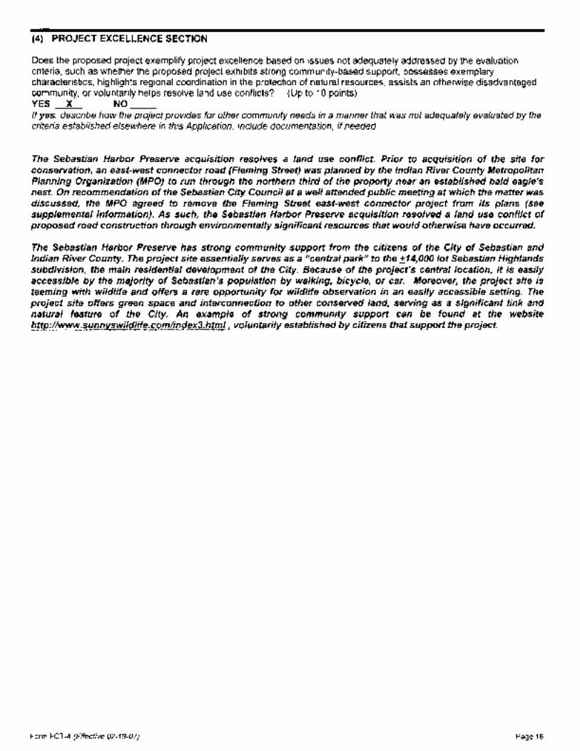
Does the proposed project exemplify project excellence based on issues not adequately addressed by the evaluation criteria, such as whether the proposed project exhibits strong community-based support, possesses exemplary characteristics, highlights regional coordination in the protection of natural resources, assists an otherwise disadvantaged community, or voluntarily helps resolve land use conflicts? (Up to 10 points) YES _X_ NO If yes, describe how the project provides for other community needs in a manner that was not adequately evaluated by the criteria established elsewhere in this Application. Include documentation, if needed.
The Sebastian Harbor Preserve acquisition resolves a land use conflict. Prior to acquisition of the site for conservation, an east-west connector road (Fleming Street) was planned by the Indian River County Metropolitan Planning Organization (MPO) to run through the northern third of the property near an established bald eagle's nest. On recommendation of the Sebastian City Council at a well attended public meeting at which the matter was discussed, the MPO agreed to remove the Fleming Street east-west connector project from its plans (see supplemental information). As such, the Sebastian Harbor Preserve acquisition resolved a land use conflict of proposed road construction through environmentally significant resources that would otherwise have occurred.
The Sebastian Harbor Preserve has strong community support from the citizens of the City of Sebastian and Indian River County. The project site essentially serves as a "central park" to the :±14,000 lot Sebastian Highlands subdivision, the main residential development of the City. Because of the project's central location, it is easily accessible by the majority of Sebastian's population by walking, bicycle, or car. Moreover, the project site is teeming with wildlife and offers a rare opportunity for wildlife observation in an easily accessible setting. The project site offers green space and interconnection to other conserved land, serving as a significant link and natural feature of the City. An example of strong community support can be found at the website http://www.sunnvswildlife.com/index3.html, voluntarily established by citizens that support the project.
Form FCT-4 (Effective 02-19-07) Page 16

REQUIRED EXHIBITS
Each of the following exhibits is required to be submitted with the grant Application. Provide a label and tab for each exhibit and please ensure that all exhibits are legible and of an appropriate scale. If two or more exhibits are consolidated, make sure this is reflected on the exhibit label. If a specific exhibit is not applicable, include an exhibit page with a statement that it is "Not Applicable." Locate the exhibits behind the project evaluation criteria section of the Application.
Exhibits
A A copy of each Local Comprehensive Plan objective and policy cited in the grant Application that applies to the Project Site. Please highlight or underline the applicable plan directive being referenced.
B. A copy of all proposed Local Comprehensive Plan amendments cited in the grant Application that apply to the Project Site.
C. A United States Geological Survey 7%-minute quadrangle map with the Project Site location clearly delineated.
D. A county property appraiser's tax map delineating the Project Site boundary, access points, names of property owners, parcel tax identification numbers, road names and ownership boundaries using an appropriate scale.
E. An aerial photograph at 1 inch= 2,000 feet or greater detail, with the Project Site boundary clearly delineated.
F. A map that depicts Natural Communities found on the Project Site, utilizing the classification system identified in the Florida Natural Areas Inventory publication "Guide to the Natural Communities of Florida" or other appropriate classification system. Clearly delineate the Project Site boundary and include the approximate acreage of each Natural Community on the Project Site.
G. A map that identifies any existing physical improvements, alterations or disturbances occurring on the Project Site, such as cleared areas, buildings, roads, fences, docks, power lines, billboards, borrow pits, etc. Clearly delineate the Project Site boundary and include the approximate acreage of improvements or disturbed areas.
Identify any existing or proposed utility, road, or other easements or rights-of-way on the Project Site.
H. A Future Land Use Map covering the Project Site and surrounding area that shows the location of the Project Site.
I. A map that identifies lands within a three-mile radius of the Project Site that are used for natural resource conservation and Outdoor Recreation, such as parks, preserves, wildlife management areas, Greenways, Recreational Trail Systems, etc. Clearly delineate the location of the Project Site on the map.
J. A map depicting the 100-year floodplain, the coastal high-hazard area or a wellfield protection zone with the Project Site boundary clearly delineated.
K. A conceptual site plan for the project that clearly delineates the Project Site boundary and shows the approximate location of all proposed facilities and improvements on the Project Site.
L. One set of labeled photographs of the Project Site, to be included in the original Application, that documents onsite features such as existing structures, disturbed areas, Natural Communities, and historical or archaeological features. Include a legend that identifies the site location and subject matter of each photograph.
Form FCT-4 (Effective 02-19-07) Page 17

M. If the Applicant is a Nonprofit Environmental Organization, evidence of status of the organization, including documentation from the Internal Revenue Service that the organization is recognized as a 501 (c)(3) organization, a copy of the Bylaws, and a copy of the Articles of Incorporation.
N. If the Applicant is a Nonprofit Environmental Organization which anticipates being designated as the management entity, the Nonprofit Environmental Organization shall provide documentation that they have funds on hand, or letters of commitment to provide the funds prior to closing on the Project Site, in an amount equal to ten percent of the Project Cost to be set aside as a management endowment fund for the Project Site.
The Nonprofit Environmental Organization shall provide a guaranty or pledge by a Local Government, the Water Management District, the Florida Division of Forestry, the Florida Fish and Wildlife Conservation Commission, or the Florida Department of Environmental Protection to act as a backup manager to take over the responsibility for management of the Project Site in the event the Nonprofit Environmental Organization is unable to.
0. Letter from the owner(s) of each parcel(s), as identified in the Application, indicating their willingness to consider an offer.
P. If a Project Site is Pre-acquired, the Applicant shall provide copies of a signed closing statement for each Preacquired parcel. If a closing statement is not available at the time of the application submittal, then a copy of the contract for each of the Pre-acquired parcels shall be provided and a copy of the closing statements shall be provided within 14 days after the application deadline.
Also, provide a statement that condemnation or threat of condemnation was not used to acquire the parcel(s).
Form FCT -4 (Effective 02-19-07) Page 18

EXHIBITS (Exhibits B, M, N and 0 not applicable)

=-··
COMPREHENSIVE PLAN: GOALS, OBJECTIVES, AND
POLICIES
Submitted to:
CITY OF SEBASTIAN CITY COUNCIL
1225 Main Street Sebastian, FL 32958
(561) 589-5330 (561) 589-5570
Prepared by:
SOLIN AND ASSOCIATES, INC. Planning Consultants
901 Douglas Avenue, Suite 207 Altamonte Springs, Florida 32714
( 407) 682-7200 ( 407) 682-7206 fax
Partners with Florida's Communities
December 1999

CITY OF SEBASTIAN CHAPTER 1: FUTURE LAND USE ELEMENT
Policy 1-3.4.4: Coordinate Hazard Mitigation Reports with Development and Redevelopment. In the , event that Sebastian is included in a Presidential Disaster Declaration, the City shall use the interagency
hazard mitigation report as the basis for prohibiting redevelopment of uses which are inconsistent with the report recommendations. Additionally, the City shall use the interagency hazard mitigation report to prevent new uses which are inconsistent with the report recommendations from locating in the area included in the Presidential Disaster Declaration. Finally, should an interagency hazard mitigation report be issued for Sebastian, the City shall consider adopting a program for eliminating existing uses which are inconsistent with the report recommendations.
OBJECTIVE 1-3.5: PROTECTION OF ARCHAEOLOGICAL AND HISTORIC RESOURCES. Beginning in January, 1998, any development which impacts a historic or archaeological site or structure identified in the adopted Comprehensive Plan shall be required to submit a site plan which illustrates how the applicant will mitigate the adverse impacts. As a minimum, the site plan shall identify precautions to be taken to prevent the following adverse impacts:
• Destruction or alteration of all or part of such site;
• Isolation from, or alteration of the surrounding environment;
• Introduction of visual, audible, or atmospheric elements that are out of character with a property or alter its setting;
• Vegetation removal shall not be permitted on a historic or archaeological site unless the vegetation to be removed is a part of a duly authorized scientific excavation, or is a part of an approved development plan;
• Transfer or sale of the site of significance without adequate conditions or restrictions regarding preservation, maintenance, use or re-use; and
• Other forms of neglect resulting in resource deterioration.
; Policy 1-3.5.1: Programming for Archaeological and Historic Sites. The City shall coordinate with the State in developing programs for implementing City and State policies for identifying, preserving, and enhancing sites of historical, and archaeological significance. Programs for identification, evaluation of relative significance, protection, preservation, and enhancement shall be promoted, utilizing available public resources at the local, State, and Federal level as well as available private sector resources.
Policy 1-3.5.2: Preventing Adverse Impact of Development on Historic or Archaeological Sites. Development activities shall include precautions necessary to prevent the following adverse impacts to historic or archaeological sites of significance: I) destruction or alteration of all or part of such site; 2) isolation from or significant alteration to its surrounding environment; 3) introduction of visible, audible, or atmospheric elements that are out of character with the property or significantly alter its setting; 4) transfer or sale of a site of significance without adequate conditions or restrictions regarding preservation, maintenance, or use; and 5) other forms of neglect resulting in its deterioration.
OBJECTIVE 1-3.6: PROTECTION OF NATURAL RESOURCES. Beginning in January 1998, the City shall maintain land development regulations which ensure that development and conservation activities shall protect natural resources as directed by the below stated policies.
Policy 1-3.6.1: Future Land Use Policies for Managing Environmentally Sensitive Lands. Policies in the Conservation Element for managing environmentally sensitive natural systems, including, but not limited to, the Indian River Lagoon, the Sebastian River, Schumann Lake, Lake Hardee, Collier Creek, the Elkcam Waterway, and other environmentally sensitive resources shall be carried out through performance standards in the land development regulations. These and other natural resources identified
_ I on the Future Land Use Map series shall be protected and/or preserved pursuant to goals, objectives, and ~policies stipulated in the Conservation Element. In addition, land development regulations provide more
Comprehensive Plan Goals, Objectives and Policies
041!7/0 l 1-29

CITY OF SEBASTIAN CHAPTER 1: FUTURE LAND USE ELEMENT
f detailed procedures and performance criteria to implement conservation and natural resource protection. / , These land development regulations shall also provide for wetland preservation consistent with the ~requirements and regulations of the St. Johns River Water Management District, FDEP, and the Corps of
Engmeers.
Policy 1-3.6.2: Intergovernmental Coordination and Natural Resource Management. The City shall coordinate with the State, the St. Johns River Water Management District, the Treasure Coast Regional Planning Council, Indian River County, state agencies, and other agencies concerned with managing natural resources. Such intergovernmental coordinating activities shall be directed toward protecting the values and functions of respective natural systems.
Policy 1-3.6.3: Protect Habitats of Flora and Fauna Having Special Status. The habitat of rare, endangered, and threatened species of flora and fauna and others having special status as identified in the Conservation Element shall be protected.
Policy 1-3.6.4: Managing Stormwater Run-off. The developer/owner of any site shall be responsible for managing on-site run-off.
Policy 1-3.6.5: Conservation of Potable Water Supply. The potable water supply shall be conserved by enforcing conservation standards to be developed as part of the Land Development Code.
OBJECTIVE 1-3.7: PREVENT PROLIFERATION OF URBAN SPRAWL AL~D DEVELOP EFFICIENT SYSTEMS FOR COORDINATING THE TIMING AND STAGING OF PUBLIC AND PRIVATE DEVELOPMENT. By December 31, 1998, the City shall have adopted land
; development regulations which include performance standards ensuring that the location, scale, timing, and design of development shall be coordinated with public facilities and services in order to prevent the proliferation of urban sprawl and achieve cost effective land development patterns. Performance standards consistent with those listed below shall also be adopted by December 31, 1998, which shall direct future development only to those areas where provision of public facilities necessary to meet levels of service standards are available concurrent with the impacts of the development.
• No premature or poorly planned conversion of rural land to other uses;
• No areas of urban development or uses which are not functionally related to land uses which predominate the adjacent area;
• No areas of urban development or uses which fail to maximize the use of existing public facilities;
• No areas of urban development or uses which fail to use areas within which public services are currently provided;
• No leapfrog/scattered development or ribbon /strip commercial development patterns; and
• Consistent with criteria in Rule 9J-5.006(5).
Policy 1-3.7.1: Development Orders and Permitting Process. Development orders and perrrtits for all future development shall be timed and staged to assure that requisite infrastructure and services are available to respective developments concurrent with the impacts of the development.
Policy 1-3.7.2: Design of Public Facilities and Utilities. Public facilities and utilities shall be located and designed to: 1) maximize the efficiency of services provided; 2) minimize related costs; and 3) minimize adverse impacts on natural systems.
Policy 1-3.7.3: Developments Not Served by Public Water and/or Wastewater Systems. All developments in areas not serviced by public water and/or wastewater systems shall be governed by applicable State laws and administrative regulations.
Comprehensive Plan Goals, Objectives and Policies
04/17/01 1-30

CITY OF SEBASTIAN CHAPTER 4: PUBLIC FACILITIES ELEMENT
Policy 4-2.3.1: Scheduling Needed Capital Improvements. The City Council shall ensure that projects required to meet projected demands through the year 1996 shall be in the Capital Improvements Element
';of this plan in accordance with the requirements of §163.3177(3), F.S.
GOAL 4-3: PROVIDE ADEQUATE DRAINAGE. PROVIDE ADEQUATE STORMWATER DRAINAGE IN ORDER TO PROTECT AGAINST FLOOD CONDITIONS AND PREVENT DEGRADATION OF QUALITY OF RECEIVING WATERS.
OBJECTIVE 4-3.1: PROTECT NATURAL DRAINAGE FEATURES. By September 1998 the City shall adopt land development regulations protecting natural drainage features and ensuring that future development utilizes stormwater management systems consistent with criteria of DEP and SJRWN.ID as well as the improvements identified in City's Stormwater Management System Conceptual Master Plan (SWCMP). As a minimum the regulations shall include the following:
• Establish a coordination mechanism with the Sebastian River Water Control District (SRWCD) for controlling the flow of water through the SRWCD's radial gate dam in order to protect the natural drainage features in Sebastian;
• Establish a buffer zone along all natural drainage features; • Maintain on-site drainage requirements to ensure that natural drainage features are not overloaded by runoff from adjacent
properties (water quantity); • Prohibit direct discharge of untreated stormwater into natural drainage features (water quality); • Existing stonnwater engineering, design and construction standards for on-site systems should be evaluated and amended as
needed; · • Existing standards for erosion and sediment controls should be evaluated and amended, if necessary; and • Periodic inspection of on-site systems shall be required to ensure continuance of system design and maintenance.
Policy 4-3.1.1: Ensure that Urban Lands Provide Adequate Drainage and Protection from Flooding /~nd Manage the Retention of Ground and Surface Water at Levels that Enhance N,:atural Storage Capacity of Watersheds and Promote Aquifer Recharge~ Promote the ecological, biological, and hydrological role that surface waters play in sustaining recharge to aquifers and supporting surface vegetation. Manage the location design and intensity of urban development in order to foster continuance of natural hydrological processes, including preserving recharge areas, promoting on-site retention of surface waters and natural return of surface water into the soil, and channelling excess stormwater volume primarily via natural grassy swales. Require the integration of natural storage areas and natural drainage courses into water management plans for new development.
Policy 4-3-1.2: Provide Adequate On-Site Retention and Ground Water Recharge while Directing the Surplus Run-off to Receiving Waterways in a Manner which Prevents Imbalance to their Ecosystems. Upon adoption of the Comprehensive Plan, the City shall continue to enforce the level of service standards identified for retention/detention in Policy 4-1.1.1. By September 1990 the City of Sebastian shall adopt amended land development regulations which shall include land use controls, such as subdivision regulations, zoning, including site plan review and performance criteria as well as special erosion controls, landscape and flood management ordinances which shall assist in implementing stormwater management and water quality controls. The programs shall be continually updated based on improved knowledge of problems, issues, and best management practices. In FY 1992-93 the City shall commence the engineered stormwater management plan which shall provide recommended regulatory measures designed to protect and preserve water quality, retard runoff, and enhance percolation. By the end of 1994, the Stormwater Management Plan shall be implemented by adopting regulatory ordinances for implementing the Plan. In addition, by the end 1994 the City shall amend the capital
.. ,nprovement schedule by incorporating capital improvement items recommended in the Stormwater L Management1Plan.
Comprehensive Plan Goals, Objectives and Policies
09/21/99 4-7
CITY OF SEBASTIAN CHAPTER 4: PUBLIC FACILITIES ELEMENT
Policy· 4-3.1.3: Pursue the Development of Adequate Off-Site Surface Water Management \Facilities. The City shall monitor at regular intervals the performance of existing off-site drainage jfacilities, evaluate existing and potential future problems or issues, and pursue the funding of necessary structural and non-structural system improvements for effective surface water management. All new developments shall provide an equitable contribution for off-site drainage improvements necessitated by the development. No new development shall be allowed which overloads existing off-site facilities or unduly increases the potential for flooding.
Policy 4-3.1.4: Coordinate Watershed Management Plans and Policies with Appropriate Public Agencies. Assure coordination of watershed management plans and policies, with appropriate local, regional, state and federal agencies, including Indian River County, the St. Johns River Water Management District, Treasure Coast Regional Planning Council, the State Department of Environmental Protection, the Agricultural Extension Service, the United States Army Corps of Engineers, and other appropriate agencies.
Policy 4-3.1.5: Buffer Zone Requirements. By December 1998 the City shall amend its land development regulations to include performance criteria which shall require that new development provide buffer zones adjacent to natural drainageways and retention areas. Such regulations shall be approved by the City Engineer prior to adoption by the City Council.
Policy 4-3.1.6: Managing Land Use in the Floodplain. By September 1990 the City shall amend its land development regulations to include performance criteria regulating development within floodplain areas. The criteria shall include refinements to the existing stormwater management and floodplain protection ordinance. By 1994 these regulations shall be reevaluated to include regulatory measures recommended in the Stormwater Management Plan scheduled for completion in FY 93-94. These regulations shall address necessary restrictions on encroachment, alteration, and compatible use of the floodplain and major drainage corridors.
Policy 4-3.1. 7: Implementing Stormwater Management Plan. The Stormwater Management Plan implementation shall commence in FY 1997-98 and shall be completed by FY 2005-06. The City has included a program and funding mechanism in the capital improvement schedule in order to ensure plan implementation.
Policy 4-3.1.8: Inspection and Maintenance of Drainage Systems. By September 1990 the City shall develop a program and schedule for the inspection and maintenance of drainage components. As part of the Stormwater Management Plan implementation program the City shall ensure that drainage system components are monitored pursuant to best management practices. The plan shall specify criteria for frequency of inspections and shall develop procedures for perpetual maintenance.
GOAL 4-4: PROTECT FUNCTIONS OF GROUNDWATER AQUIFER RECHARGE AREAS. THE FUNCTIONS OF NATURAL GROUNDWATER AQUIFER RECHARGE AREAS WITHIN THE CITY SHALL BE PROTECTED AND MAINTAINED.
OBJECTIVE 4-4.1: COORDINATE ISSUES SURROUNDING AQUIFER RECHARGE. The City shall coordinate with Indian River County and the St. Johns River Water Management District in providing for maintenance of aquifer recharge area functions. This objective shall be measured through '1.e implementation of the following policies:
Comprehensive Plan Goals, Objectives and Policies 09/21199 4-8

CITY OF SEBASTIAN CHAPTER 6: CONSERVATION ELEM:ENT Policy 6-1.6.1: Prohibition Against Mining Activities. Land development regulations shall prohibit mining of minerals, except for existing sand mining operations, based on the irretrievable losses which such intense activities may potentially impose on the CitY's fragile coastal ecosystem as documented in the Comprehensive Plan Data fuventory and Analysis.
OBJECTIVE 6-1.7: PROTECT NATIVE VEGETATION AND MARINE HABITATS. Beginning in January 1998, the City shall maintain land development regulations which include performance criteria designed to protect and retain major vegetative communities and marine habitats.
Policy 6-1.7.1: Implementing Protection of Vegetative Communities and Marine Habitats. Land development regulations, including the adopted Tree Protection and Landscape Regulations of the City's Land Development Code, shall be used in managing and protecting the impacts of development on major vegetative communities and marine habitats. These regulations shall mandate restoration in order to compensate for unauthorized removal of vegetation and to enhance stabilization of :fragile slopes and/or shorelines impacted by development.
By December 31, 1998 the City shall amend its adopted land development regulations by mandating any wetlands mitigation shall include minimum petformance standards in order to enhance regeneration of viable wetlands and wetland vegetative communities.
Policy 6-1.7.2: Preservation of Native Plant Communities. The City shall amend the adopted land development regulations to ensure compliance with Treasure Coast Regional Planning Council Regional Comprehensive Policy Plan (Policy 10.1.2.2) mandating that new development set aside, as a minimum 25 percent of each native plant community (as identified in the Comprehensive Plan Data Inventory and Analysis, Conservation Element Chapter 6).
The ordinance shall provide incentives for increased conservation of native plant communities determined by the Treasure Coast Regional Planning Council to be "regionally rare or endangered." Such an incentive program may include, for instance, an exchange which sets aside one (1) unit of "regionally rare or endangered upland" in exchange for two units of common habitat Such "set asides" of habitat shall be preserved in a viable condition with intact canopy, understory, and ground cover.
Pursuant to the Treasure Coast Regional Planning Council policy cited above, the City may require payment of a fee in lieu of the above described mandatory "set aside" of habitat. Such cash payment may be in the form of an impact fee. in lieu of habitat preservation to be accumulated from development for the purchase of upland habit preservation off-site rather than on-site. Other adjustments may only be granted where compensatory mitigation is provided through revegetation with native plant species compatible with existing plant communities.
Where payment of an impact fee in lieu of preservation is an allowable option, the impact fee paid should be at least equivalent to: (the average assessed value of one acre of the particular habitat type under consideration within the County the development occurs in) (the number of acres of that habitat type the development was required to set aside but elected to contribute toward preservation off-site). Such impact fees shall be payable to the City prior to commencement of development on-site.
POLICY 6-1.7.3: REMOVAL OF UNDESIRABLE EXOTIC VEGETATION. The City shall amend the adopted Tree Protection Ordinance to require that, prior to the issuance of a certificate of occupancy for a new development, the owner/applicant shall remove all nuisance and invasive exotic vegetation on the subject property.
Policy 6-1.7.4: Removal of Trees Causing Safety Hazard. The City shall amend its land development regulations to require that trees, such as Australian Pines, which are prone to wind damage and blockage of evacuation routes be removed from areas deemed by the City to be critical corridors for evacuation purposes. This policy shall be implemented concurrent with the above stated policy 6-1.7.2. fu addition, the City shall consider the feasibility of imitating a similar program to remove any trees on public property which impose a critical hazard to evacuation routes.
Policy 6-1.7.5: Protection of Manatee Habitats. The City shall promote protection of manatee habitats in a manner consistent with guidelines of the Marine Research fustitute of the State Department of Environmental ProtectioiL For instance, the City shall comply with the following State Guidelines: • The City of Sebastian shall assist Indian River County, the Department of Environmental Protection, the U.S. Fish and Wildlife Service, and other
State and federal agencies, in developing an area-specific manatee protection plan and marina siting plan in order to ensure long-range manatee and habitat protection. Pennit applications for all boating facilities, including single family docks and dry storage, shall be evaluated in the context of cumulative impacts on manatees and marine resources.
Comprehensive Plan Goals, Objectives and Policies 09/21/99 6-5

CITY OF SEBASTIAN . CHAPTER 6: CONSERVATION ELEMENT Construction and expansion of multi-slip docking facilities and boat ramps shall be directed to locations where there is quick access to deep, open water, where the associated increase in boat traffic will be outside the areas of high manatee concentration, and where wetlands supporting manatee habitat will not be disturbed. The City shall assist DEP in distributing State publications and educational materials on coastal and marine resource conservation, and manatees in particular, to boaters, and assist the display of such materials. Slow or idle speed zones shall be adopted, with or without channel exemptions as appropriate, in areas frequented by manatees. Enforcement of speed zones should be improved. The City shall assist DEP in protecting manatees from injury and disturbance resulting from aquatic commercial and recreational activities.
• Manatee food requirements shall be taken into account in all aquatic plant management activities where manatees may occur. The City shall assist DEP in ensuring the protection of habitat of special significance to manatees. .
OBJECTIVE 6-1.8: PROTECTING FISHERIES, WILDLIFE AND WILDLIFE HABITATS. By December 31, 1998. the City shall have adopted land development regulations which include performance criteria which limits disturbance of seagrass beds, wetlands, habitats of endangered or threatened species. The performance criteria shall protect fisheries, wildlife, and wildlife habitats from the adverse impacts of development by regulating the location, density, and intensity of those activities which cause the adverse impact The City shall enforce these land development regulations and shall coordinate with Indian River County, the SJRWMD, and the State in promoting protection of fisheries, wildlife, and wildlife habitats. In order to prevent "taking" of private property rights, the City's land development regulations shall provide for flexible development alternatives, including planned unit developments which shall mandate conservation of said resources while allowing more flexible development options on developable portions of the site. This Objective shall be measured through the implementation of the following policies.
Policy 6-1.8.1: Manage the Impacts of Development on Fisheries. The City shall incorporate procedures for coordinating with the Florida Game and Freshwater Fish Commission, and DEP, as appropriate, in reviewing the implications of development proposals, including proposed subdivisions and site plan review petitions. Such coordination shall be designed to assist in identifying potential adverse impacts of proposed development on marine habitats and fisheries. The City shall incorporate performance standards into land development regulations which are designed to preserve the water quality within the Indian River Lagoon and which protect marine grassbeds, coastal marshes, and mangroves in order to preserve marine habitats and fisheries.
Policy 6-1.8.2: Protect Wildlife and Wildlife Habitats. By September 1990 the City shall amend the land development ' regulations to incorporate provisions which restrict development activities known to adversely impact endangered, ' threatened, or rare wildlife and wildlife habitats as well as wildlife and wildlife habitats of special concern as defined in Table
VI -1 of the Conservation Element data inventory and analysis. The City shall further protect wildlife and wildlife habitats by promoting the dedication of conservation easements or reservations as specified herein in Policy 6-1.4.3.
Policy 6-1.8.3: Protection of Living Marine Resources. The City shall have adopted by December 31, 1997 land development regulations which require estuarine shoreline developments to avoid adverse impacts of development on seagrass beds and coastal marsh. Since these areas are sensitive to increased turbidity and other forms of pollution, water run-off and introduction of nutrients shall be regulated through effective water quality management criteria. Plans for development impacting marine resources shall be coordinated with state agencies having jurisdiction prior to the City granting plan approval and/or prior to release of any permit for construction. Compensatory mitigation may be permitted in cases of overriding public benefit where State agencies having appropriate.jurisdiction approve the mitigation measures proposed by the developer. Any such development shall ensure continuance and maintenance of essentially natural conditions in order to further propagation offish and wildlife as well as public recreation opportunities.
Policy 6-1.8.4: Site Plans Required For Developments in Estuarine Shoreline Areas. The City shall have adopted by December 31, 1997 land development regulations which require all applicants proposing development activities along the estuarine shoreline or within submerged areas to submit a site plan pursuant to site plan review regulations. Such site plan shall provide sufficient information describing marine life potentially impacted by proposed land uses as well as related construction activity. The plan shall stipulate assurances that the proposed project shall not adversely impact marine life or water quality. For instance, water quality control techniques such as the use of weirs for purposes of managing turbidity may be required by the City. In addition, the City shall require surveys of existing conditions, specifications of planned site improvements, and techniques to be used during construction as well as in operating and maintaining the land use in order to prevent damage to living marine organisms. Policy 6-1.8.5: Uses Within the Estuarine Shorelines. The City shall have adopted by December 31, 1997 land development regulations which prohibit any development within the wetland estuarine shoreline, other than water dependent native shoreline vegetation programs, approved pervious or elevated accessways, or other uses approved by the City pursuant
. to other City regulations shall be permitted No structures which constrict water circulation in the lagoon shall be permitted.
Comprehensive Plan Goals, Objectives and Policies 09121199 6-6

ASTIAN CHAPTER6: CONSERVATIONEL .... WIJflliM~6-1.9: PROTECT CONSERVATION LAND RESOURCES. By December 31, 1998 the CitytJ!'!ifl'-!!!ve~
adopted land development regulations which include pelfonnance criteria designed to ensure that designated conseiVation ~ land resources, are protected based on locally determined criteria which further the goals, objectives and policies of the "ConseiVation Element. This Objective shall be measured through the implementation of the following policies. ,
Map I-9 specifically includes areas reserved for conservation uses or restricted development Table 1-1 in the land use element provides a tabular summary of existing and projected future use of natural and historical resources. This table includes areas reserved for conservation uses or restricted development Table I-1, footnote #1, incorporates a list of existing land development regulations that presently regulate and shall in the future continue to regulate use of natural resources. All natural and historic resources identified in :Map I-9 and Table I-1 shall either remain undeveloped or shall undergo "restricted development." "Restricted development" shall be regulated through peifonnance criteria within the amended Land Development Regulations and through objectives and policies contained in the adopted Comprehensive Plan.
Policy 6-1.9.1: Designation of Environmentally Sensitive Areas. In Policies 6-1.8 and 6-1.9 estuarine shoreline resources, wetlands, and upland habitats are addressed including the regulatory framework through which the City intends to manage, protect and preseiVe the resources. The Future Land Use Map series identifies these environmentally sensitive systems. Other lands shall be subject to restricted development as defined in Objective 6-1.9.
OBJECTIVE 6-1.10: HAZARDOUS WASTE MANAGEMENT. The City shall coordinate with Indian River County as well as appropriate State and regional agencies in developing effective plans for managing hazardous waste (Note: No hazardous
waste pollutants or sites currently exist within the City). Beginning in January 1998, the City shall maintain land development regulations which prohibit the following land uses and activities within well:fields and aquifer recharge areas as well as any area where it would adversely impact natural resources:
a. Sanitary landfills; b. Animal feedlots; c. Incinerators d. Wastewater treatment facilities; e. Petroleum or pesticide storage facilities; f. Above-ground or below-ground pipes for pollutants or contaminants. g. All other land uses that store, handle, or generate hazardous materials or wastes. Hazardous materials or wastes, as regulated by this section shall consist
ofthe following: • Chapter 38F-41 of the Florida Administrative Code (the Florida Substance List). • Title 40 of the Code of Federal Regulations Part 261 (Identification and Listing of Hazardous Wastes). • Title 40 ofthe Code of Federal Regulations Part 302.4 (Table 302.4) (List of Hazardous Substances and Reportable Quantities). • Title 40 of the Code of Federal Regulations part 355, Appendix A and B (List of Extremely Hazardous Substances).
Policy 6-1.10.1: Managing Hazardous Waste. The City shall continue to enforce land development regulations which incorporate development restrictions directed toward preserving natural systems and accommodating only low intensity land use activities identified in the Land Use Element Therefore, the City does not anticipate that hazardous waste shall threaten the City's natural resources. Nevertheless, the City shall continue to work with the County and appropriate State and regional agencies in developing an improved areawide solid waste management program which includes more innovative solid waste management technologies that save energy and/or produce renewable energy and effectively manage hazardous waste.
OBJECTIVE 6-1.11: INTERGOVERNMENTAL COORDINATION FOR MANAGING CONSERVATION ACTIVITIES. Establish an intergovernmental coordination mechanism in order to manage natural resources and assist in implementing appropriate laws, ordinances, and plans of existing State, regional and local agencies sharing responsibilities for managing natural resources within the City.
Policy 6-1.11.1: Implementing Policies for Intergovernmental Coordination in Managing Conservation Activities. The Coastal Management Element identifies policies for coordinating planning issues surrounding natural resources within the City. These policies shall be applied in managing intergovernmental activities associated with protecting, conserving, and preserving natural resources within the City.
OBJECTIVE 6-1.12: CONTINUING EVALUATION OF THE CONSERVATION ELEMENT EFFECTIVENESS. The City shall use the following policies as criteria in evaluating the effectiveness of the Conservation Element.
Policy 6-1.12.1: Review the Impact of Changing Conditions on Conservation Policy. The City shall monitor and evaluate significant changes in the characteristics of natural resources within the City. Policy implications of such changes shall be examined and corrective measures shall be pursued. ConseiVation policies shall be refined as needed in order to remain responsive to evolving problems and issues.
Comprehensive Plan Goals, Objectives and Policies 09/21/99 6-7

I c .. .. ·\
I L/
L L t ... L_
~ ., >
cr
... "' ., <0
..c ., en
LEGEND
MAP 1-9 FUTURE LAND USE MAP SERIES
Areas Reserved for Conservation or Restricted Development
SCALE I I I I 0 114 1/2 3/4 1
U'lltiiiiiiiUf . . . . . . : :
3u<"l'l'!'!"l'''!l!t-,:!u""''.,. : f•unno''"'~~.T ; ....... i
MILE
Compiled by: City of Sebastian ancf Solin l. Associates Inc.
- Restricted Development (Crossreference Table 1-1 defintion)
- Conservation Areas
Source: Solin 8. Ac:._<uv+:~to<> r..,,.. ~~A'"'""·· -• ...,_,__ -•• ..
··~·

I'' I
TABLE 1·1 Existing and Projected Use of Natural and Historic Resources
City of Sebastian: 1990-2010
-.--i
r-i .
***************************************•************************************************************************************************************************** * Estimated Acres 1990 Estimated Acres 1995 Estimated Acres 2010 * * * 'It
~--------------------------~--- ------------·------------------ ------------------------------- * Restricted (1) Acres Restricted (2) Acres Restricted (2) Acres * * Vegetative Communities:
FLUM ;# m TOTAL Development (AC) Undeveloped Development (AC) Undeveloped Development (AC) Undeveloped * * Undvlpd. Upland Communi ties * ~etland Communities * Lakes
*Estuarine Shoreline * *Aquifer Recharge Area (4) * * 100 Year Flood Plain (5) *
(3} 1-6 1·3 1·3
1-3
1-5
1-4
482 (8) 125 272 0 104
65 (9) 0
270 (10) 75
775 415
* 357 245 237 362 120 ·"lr
272 0 272 0 272 * 104 104 104 *
65 0 65 0 65 * *
195 145 125 203 67 * *
360 436 339 465 310 * * * Historic Resources (6) 1-8 25 (11) 25 0 25 0 25 0 *
*******************************************************************************************************************************************************~··•******* *TOTAL$ 1,993 640 1,353 851 1,142 1,055 938 * **************************************************************************************************************************~***************************************
t-'
' t-' I.C
(1) All projected development within the areas noted shall be "restricted" (3) Undeveloped upland vegetation shall be preserved at Collier Place, pursuant to natural resource protection objectives and policies of the St. Sebastian PUD, the City Airport Industrial Area, and at the Municipal Comprehensive Plan and also pursuant to specific performance criteria Golf Course. Restricted development shall occur on other referenced florida which are either adopted or shall be adopted based on stipulated schedules flatwood sites. Fifty percent of all residential sites shall remain as identified in the Comprehensive Plarn objectives and policies. Adopted open space and 25~ of all non-residential sites shall remain as open space.· regulatory performance criteria incl.udes the following: This practice will promote maintenance of Upland Vegetation. a) Tree Preservation: Reference Section 20A-14, LDC; b) Flood Plain Protection and Protec:tion of Estuarine Areas and \Jetlands:
Reference Section 20A-10.2(G), LD1C; Note: No development Is permitted in wetlands, estuarine areas, excepting restricted access to shoreline resources, marinas, and other watoer related or water dependent uses all of which rrust have approval from applicable state agencies.
c) Open Space Preservation: Reference Section 20A-10.2(E), LDC; SOY. OSR for Residential and 20X for Non-Residential.
d) Protection of Shorelines through Marine District Open Space and Setback Regulations: Reference Section 20A·3.11Cd) and 20A-3.11(e),LDC;
e) Estuarine Protection and Prevention of Erosion and Sedimentation: Reference Section: 20A·10.2(K), L~C; and
f) Preservation of Surface Water Management, Yater Quality, and the "Coastal High Hazard Zone": Reference Section 20A-10.2(H), LDC.
g) Also cross reference footnote (3) and (5) which address techniques that shall be applied in preserving sur·ficial aquifer recharge areas (SARA) and native habitats respectively.
(2) Restricted developnent for 1995 and 21010 Includes a CI.IT'Irulative total for acres of natural resources which eith,er have been or are anticipated to be developed In a restricted manner pursuant to land development regulations which shall be consistent wilth all elements of the comprehensive plan. The general intent of the land development regulations shall be to preserve the function and value of all natural resources ~hile managing private property rights in a reasonable manner.
SOURCE: City of Sebastian and Sol in & Assodates, Inc. 1991.
(4) UndeveloPed aquifer recharge areas will be preserved at these sites: A. The N. FEC Corridor ~estside B. The H. FEC Corridor Eastside c. And at the following public sites:
1. Riverside Park at Main Street 2. Ashford Jordan Park 3. Ballfield Complex East of City Hall 4. Riverfront Park at CR 512 5. Riverview Park 6. Sebastian and Pelican Island Elementary Schools
Only restricted development shall(<;>ccur on the remainder of the aquifer recharge areas.
(5) Floodways shall remain undeveloped. Only restricted development shall occur on the remainder of flood plain lands.
(6) Ho data on acres comprising archaeological sites.
(7) Cross Reference Map 1·9.
(8) Some of the acreage in Vegetalve Communities Is Included in floodplain and Aquifer Recharge Areas.
(9) Estuarine areas included in \Jetland areas.
(10) Estimate (67 acres), 25~ of total will be preserved. This land area Is under restricted development.
(11) Historic Resources are of existing developed lands.

CITY OF SEBASTIAN CHAPTER 6: CONSERVATION ELEMENT Policy 6-1.12.2: Schedule, Budget and Implement Programmed Activities. The timely scheduling, programming, budgeting and implementation of programmed conservation activities identified in this Element sball be evidence of the 1City's effectiveness in carrying out a systematic program for implementing conservation goals, objectives, and policies.
Policy 6-1.12.3: Coordinate with Public and Private Sectors. While continually implementing and evaluating the Conservation Element the City shall maintain a process of intergovernmental coordination as well as coordination with private sector groups interested in conservation policy and programs. The effectiveness of this approach shall be evaluated by the success of coordination mechanisms in resolving conservation problems and issues.
Policy 6-1.12.4: Achieve Effect Resolution of Conservation Goals, Objectives and Policies. The effectiveness of the Conservation Element sball be measured by the City's success in achieving conservation goals, objectives and policies. The Conservation Element incorporates a systematic planning process for identifying conservation problems and issues and implementing corrective measures.
OBJECTIVE 6-1.13: ESTUARJNE SHORELINE PROTECTION. The City shall have adopted land development regulations which protect the water quality of the estuary by protecting the shoreline. This objective shall be implemented through the following policies.
Policy 6-1.13.1: Protection Against Potential Adverse Impact on Estuarine Shoreline. By December 31, 1997, the City shall adopt land development regulations which require applicants for development along lakes, natural waterways, or the estuarine shoreline to submit as part of the development review process plans which demonstrate how the development shall incorporate feature designed to protect against potential adverse impacts to: Shoreline vegetation and stabilization; Water quality; Native habitat; Living marine resources; and Shoreline access. No shoreline development shall be approved until the applicant has demonstrated that potentially adverse impacts shall be prevented or that compensatory mitigation shall occur.
Policy 6-1.13.2: Shoreline Vegetation and Stability. By December 31, 1997, the City shall adopt land development regulations which require a duly authorized permit to remove vegetation from a shoreline. Where the City approves shoreline alterations, the applicant shall be required to re-vegetate, stabilize, and enhance damaged estuarine shorelines by planting
,1ti.ve vegetation, including mangrove and/or appropriate native estuarine plant species which:
i. Contribute to marine productivity and water quality; ii Offer protection from erosion and flooding; and iii. Contribute to the natural soil building process.
Policy 6-1.13.3: Hardening of Shoreline. By December 31, 1997, the City shall adopt land development regulations which prohibit the hardening of the Indian River Lagoon shoreline or the shoreline of the St. Sebastian River with rip-rap, bulkheads or other similar devices, except where erosion constitutes a critical peril to upland property and the use of vegetation bas failed to stabilize the shoreline. Such shoreline hardening structures shall generally not be vertical seawalls or bulkheads. The specific location and design of such structures sball:
i. Comply with the best management principles and practices and be accomplished by use of the least envirorunentally damaging methods and designs possible;
ii. Avoid a vertical slope which generates erosive tendencies, especially to adjacent unprotected shoreline properties. Pervious interlocking tile systems, filter mats, and similar stabilization methods shall be used in lieu of vertical walls whenever feasible;
iii. Not be located waterward of the mean high water line except when it is shown to be in the public interest; iv. Approval conditioned upon receiving approval from other public agencies having jurisdiction; and v. Incorporate a program of shoreline vegetation or revegetation in order to build, enhance, and stabilize a natural shoreline.
Comprehensive Plan Goals, Objectives and Policies 09/21/99 6-8

CITY OF SEBASTIAN CHAPTER 7: RECREATION AND OPEN SPACE ELEMENT
CHAPTER 7: RECREATION AND OPEN SPACE ELEMENT (Reference §9J-5.014(3), F.A.C.)
'§7-1 RECREATION AND OPEN SPACE GOALS, OBJECTIVES AND IMPLEMENTING POLICIES. This section stipulates goals, objectives, and implementing policies for the Recreation and Open Space Element pursuant to ~163.3177(6)(e), F.S., and §9J-5.014(3), F.A.C.
GOAL 7-1: PROVIDE ADEQUATE RECREATION AND OPEN SPACE. INSURE PROVISION OF AN ADEQUATE COMPREHENSIVE SYSTEM OF PUBLIC AND PRIVATE RECREATION AND OPEN SPACE SITES WIDCH MEET THE NEEDS OF EXISTING AND PROJECTED USER GROUPS.
OBJECTIVE 7-1.1: SYSTEM OF PARKS AND RECREATION. The City shall on an annual basis and prior to adoption of the annual capital budget, review the need for new recreation sites and facilities. The analysis shall be predicated on data, standards, and policies contained in the Comprehensive Plan. The analysis shall be directed toward maintaining a system of recreational sites and facilities which is res onsive to user needs.
Policy 7-1.1.1: Level of Service Standards for Parks and Recreation Facilities. The City shall promote development of undeveloped and underdeveloped park land resources identified in the recreation and open space inventory and analysis contained in the Comprehensive Plan: Data Inventory and Analysis. The park development plans shall be programmed and scheduled in the capital improvement program and budget. System improvements, including the characteristics of sites and facilities shall be based on the level of service standards cited in Tables VII-1.1.1(1) and VII-1.1.1(2) ofthis section which are hereby adopted as the level of service standards for recreation sites and facilities. :-
TABLE Vll-1.1.1(1): LEVEL OF SERVICE STANDARDS FOR RECREATION SITES
PARK LOCATION 1,000 POPULATION AREA FACILITIES FACILITY PEOPLE SERVED
Neighborhood Neighborhood 2.0 acres up to 5,000 Minimum Play apparatus areas, recreation building, area, adjacent to of2 acres sports fields, paved multi-purpose courts, elementary schools senior citizens area, picnic area, open or when feasible free play area, and landscaping
Community Serves residents of 2.0 acres up to 25,000 Minimum All facilities found in a neighborhood a group of of20 park plus facilities to service the entire neighborhoods, acres family. Pools, softball/baseball fields, adjacent to Jr or Sr tennis courts, play areas, picnic areas, High schools when passive and active recreation areas, multi-feasible purpose courts, and recreation building,
Shoreline N/A (IJ N/A N/A N/A N/A Access
(1) Shoreline Access Standard: access pomt per 3,000 linear feet of shoreline Source: Adopted from Florida Department of Environmental Protection, Outdoor Recreation In Florida - 1994
TABLE 7-1.1.1(2): STANDARDS FOR RECREATION FACILITIES FACILITY MEDIAN STANDARD FACILITY MEDIAN STANDARD
Tennis Courts 1 Court per 2,000 pop. Golf Course 1 9-hole~ 50,000 POP.
RacquetballJHandball Courts 1 Court per 10,000pop. Boat Ramps 1 Ramp per 4, 700 pop, '3asketball Courts 1 Court per 5,000 pop. Football/Soccer Field 1 Field per 4,000 pop.
u Softball/Baseball Diamond 1 Diamond per 3,000 pop. Shuffleboard Courts 1 Court _ger 1,000 pop. Swimming Pool 1 Pool per 8,700 pop.
Source: Adopted from Flonda Department ofEnvrronmental Protection, Outdoor Recreation In Flonda- 1994
Comprehensive Plan Goals, Objectives and Policies 09/21/99 7-1
CITY OF SEBASTIAN CHAPTER 7: RECREATION AND OPEN SPACE ELEMENT Policy 7-1.1.2: Monitor and Update Recreation Demand and Supply Analysis. The City shall update on a continuing basis the recreation land and facility demand/supply analysis contained in Tables VII-2
/ 'ilD.d VII-3 of the Comprehensive Plan: Data Inventory and Analysis. The Comprehensive Plan: Data ' hventory and Analysis indicated that existing recreational lands and facilities identified in Table VII-1
satisfy the existing demand.
Policy 7-1.1.3: Mandatory Land Dedication or Fees In Lieu Thereof. The City shall enforce provisions for the mandatory dedication of land for parks and recreation or fees in lieu thereof contained in §20A-17.1(H) of the Subdivision Regulations. These regulations are intended to assure that new development provides necessary recreation lands, facilities, and/or fees in lieu thereof in order to accommodate the demands generated by new development.
Policy 7-1.1.4: Future Recreation Capital Improvements. If in the future the City identifies recreation improvements for which public funds are needed, as opposed to developer financed improvements, the City shall schedule and incorporate such projects costing $25,000.00 or more in the Capital Improvements Element.
Policy 7-1.1.5: Maintenance of Existing Recreation Land and Facilities. The City shall maintain existing recreation and facilities through the use of proper management and funding techniques. The City shall assure that recreation facilities are well managed, well maintained, and that quality recreation programs are available to all residents. This shall be partially achieved by continuing efforts toward collecting, maintaining, and updating data concerning public and private resource inventory, recreation improvement, and demand factors, and by improving design criteria and evaluation to attain a high quality park and recreation system.
Policy 7-1.1.6: Utilize Creative Concepts of Urban Design and Conservation of Environmentally Sensitive Open Space. All plans for development or redevelopment of park land resources shall incorporate creative concepts of urban design and landscape. The plans shall be designed to enhance controlled access along the shoreline of the ocean and estuary systems. Active and passive recreation areas shall be planned in a manner compatible with unique natural features of the site. Park development plans shall be designed to preserve environmentally sensitive features of the site. The design shall provide a circulation system to minimize conflict between pedestrians and vehicles. Adequate landscape and screening shall be integrated into park development plans to minimize land use conflicts, protect stability of established residential areas, and enhance community appearance.
Policy 7-1.1.7: Promote Environmental Concern as Part of Recreational Programs. The City shall promote environmental education and management as an integral part of park and recreation policies and programs. Support for cooperative programming between resource agencies and local educational advisors will provide park and recreation resources as an instrument for environmental teaching, and as a means for accomplishing this objective. The City shall promote development of nature trails at Schumann Lake Park and at Blossom Drive Park to provide opportunities for environmental education.
Policy 7-1.1.8: Designation or Acquisition of Natural Reservations. "Natural reservations" are areas designated for conservation purposes, and operated by contractual agreement with or managed by a federal, state, regional or local government or nonprofit agency such as: national parks, state parks, lands purchased under the Save Our Coast, Conservation and Recreation Lands or Save Our Rivers programs, sanctuaries, preserves, monuments, archaeological sites, historic sites, wildlife management areas, 1ational seashores, and Outstanding Florida Waters. The City has several natural reservations including
~The St. Sebastian Buffer Preserve, the AGC Industrial property, and St. Sebastian PUD.
Comprehensive Plan Goals, Objectives and Policies 09/21199 7-2

'
CITY OF SEBASTIAN CHAPTER 7: RECREATION AND OPEN SPACE ELEMENT As part ofthe City's annual review ofneeds for recreational sites and facilities (See Objective 7.1.1), the City shall consider waterfront redevelopment improvement needs, particularly the potential for new
:~ ; access points to the Indian River, including areas to support parking demands generated by shoreline ' ,, access improvements. As such land, facility, and improvement needs are identified, the City shall investigate the potential of funding such conservation programs through use of public or private not-forprofit agency resources.
OBJECTIVE 7-1.2: PROTECT OPEN SPACE SYSTEMS. Beginning in January 1998, the City shall maintain land development regulations which include performance criteria designed to protect lands designated as open space from incompatible land uses and such designated lands shall remain functionally intact.
Policy 7-1.2.1: Implementing Land Development Code. In addition to the subdivision ordinance mandatory park and recreation land and facilities regulation, the City shall enforce land development regulations which include specific open space definitions and standards addressing protection of open space, natural vegetation, landscape, and signage. Regulations shall include stipulations governing the provision and use of open space for buffering, protection of natural corridors, including drainageways, as well as other commonly accepted uses.
Policy 7-1.2.2: Standards for Review and Maintenance. Within one (I) year after the adoption of a master drainage plan, the City shall adopt criteria which shall be used to review all proposals for development in existing and proposed areas designated as open space on the master drainage plan map or map series as well as on the Future Land Use Map .
. OBJECTIVE 7-1.3: ACCESS FACU-lTIES. After January 2004, all public parks and recreational facilities shall have operational automobile, bicycle and pedestrian access facilities.
Policy 7-1.3.1: Right-of-Way Improvements. The City has established vehicle. access facilities serving all public and private recreational sites. As future roadway improvements are analyzed, the City shall provide for nonmotorized transportation needs using FDOT design standards for bicycle facilities. No new roadway improvements are currently scheduled by the City.
Policy 7-1.3.2: Design of Access Facilities. Public parks and facilities shall be designed and constructed with accessways which are compatible with the character and quality of on-site natural resources. No new land acquisitions are scheduled.
Policy 7-1.3.3: Bicycle/Pedestrian Accessways. All neighborhood parks are provided with bicycle and pedestrian accessways. In planning and designing these accessways, the City shall remove barriers limiting access to the physically handicapped.
Policy 7-1.3.4: Facilities for Handicapped and Elderly. The City shall assure that public and private facilities including recreation improvements are designed in a manner which incorporates facilities accessible to the handicapped and the elderly.
OBJECTIVE 7-1.4: ACCESS TO INDIAN RIVER LAGOON AND TRIBUTARIES. By December 31, 2001 the City shall adopt amended land development regulations which include performance criteria designed to preserve access points to the Indian River Lagoon, St. Sebastian River, and their tributaries.
Comprehensive Plan Goals, Objectives and Policies 09121199 7-3
ORDINANCE NO. 0-08-10
AN ORDINANCE OF THE CITY OF SEBASTIAN, FLORIDA, APPROVING AN AMENDMENT TO THE COMPREHENSIVE PLAN AMENDING THE COMPREHENSIVE PLAN - GOALS, OBJECTIVES & POLICIES AND DATA INVENTORY & ANALYSIS, FOR THE FOLLOWING ELEMENTS: FUTURE LAND USE, HOUSING, TRANSPORTATION, PUBLIC SCHOOL FACILITIES, CAPITAL IMPROVEMENTS AND INTERGOVERNMENTAL COORDINATION; AUTHORIZING FINDINGS AND ADMINISTRATIVE ACTIONS; PROVIDING FOR CONFLICTS; PROVIDING FOR SEVERABILITY; AND PROVIDING FOR EFFECTIVE DATE.
WHEREAS, the City Council of the City of Sebastian, Florida, desires to amend the City
of Sebastian's Comprehensive Plan; and
WHEREAS, the Pl31_1Iling and Zoning Commission of the City of Sebastian, acting as the
Local Planning Agency, held a public hearing at its October 16, 2008 meeting to consider the
Comprehensive Plan amendment and recommended that City Council adopt the same; and
WHEREAS, the City Council has provided notice of the proposed Plan Amendment and
has conducted the required public hearings to receive citizen input; and
WHEREAS, the City Council of the City of Sebastian, Florida, believes that it is in the
best interests of the health, safety, and general welfare of the community to do so; and
NOW, THEREFORE, BE IT ORDAINED BY THE CITY COUNCIL OF THE
CITY OF SEBASTIAN, INDIAN RIVER COUNTY, FLORIDA, as follows:
Section 1. COMPREHENSIVE PLAN AMENDMENT. The amendment to the
City of Sebastian Comprehensive Plan is hereby adopted amending the Goals, Objectives &
Policies and Data Inventory & Analysis for the following elements: Future Land Use, Housing,
Transportation, Public School Facilities, Capital Improvements, and Intergovernmental
Coordination, as set forth in the attached Exhibit "A".

Section 2. DESIGNATION. The Comprehensive Plan Land Use Map for the City
of Sebastian shall be amended, as set forth in the attached Exhibit "B" in accordance with the
requirements of Florida law.
Section 3. TRANSMITTAL. The City Manager is directed to transmit a certified
copy hereof to the authorities designated under Fla. Stat. 163 .3184(3) upon passage at first
reading, and proceed herewith in accordance with the provisions of Fla. Stat. Chapter 163.
Section 4. CONFLICT. All ordinances or parts of ordinances in conflict herewith
are hereby repealed.
Section 5. SEVERABILITY. In the event a court of competent jurisdiction shall
hold or determine that any part of this Ordinance is invalid or unconstitutional, the remainder of
the Ordinance shall not be affected and it shall be presumed that the City Council did not intend
to enact such invalid or unconstitutional provision. It shall further be assumed that the City
Council would have enacted the remainder of this Ordinance without said ·invalid or
unconstitutional provision, thereby causing said remainder to remain in full force and effect.
Section 6. EFFECTIVE DATE. This Ordinance shall take effect upon the
concurrence of the issuance of a Notice of Intent by the Florida Department of Community
Affairs or other final action finding the amendment herein in compliance.
PASSAGE UPON FIRST READING
The foregoing Ordinance was moved for passage upon first reading this 10th day of
December , 2008, by Councilmember Coy . The motion was seconded by
Councilmember _S_im_c_hi_· c_k _____ and, upon being put to a vote, the vote was as follows:
Mayor Richard Gillmor Vice-Mayor Jim Hill Councilmember Andrea Coy Councilmember Dale Simchick Councilmember Eugene Wolff
aye aye aye aye aye

ADOPTION
The foregoing Ordinance was moved for adoption by Councilmember ______ . The
motion was seconded by Councilmember ____________ and, upon being put to a vote,
the vote was as follows:
Mayor Richard Gillmor Vice-Mayor Jim Hill Councilmember Andrea Coy Councilmember D§tle Simchick Councilmember Eugene Wolff
The Mayor thereupon declared this Ordinance duly passed and adopted this __ day of ,200_. ------
ATTEST:
Sally A. Maio, CMC City Clerk
CITY OF SEBASTIAN, FLORIDA
By: ----------------Richard Gillmor, Mayor
Approved as to form and legality for reliance by the City of Sebastian only:
City Attorney

CITY OF SEBASTIAN COMPREHENSIVE PLAN FUTURE LAND USE ELEMENT
Policy 1-1.6.1:
Policy 1-1.6.2:
Policy 1-1.6.3:
Institutional Land Use Designation (INST). The institutional (INST) land use designation is intended to accommodate existing public and semi-public services including: governmental adm.Ullstration buildings; public schools and not-for-profit educational institutions; hospital facilities and supportive health care units; arts and cultural or civic facilities; essential public services and facilities; cemeteries; fire and emergency operation facilities; public and private parks and recreation areas; utilities; extensive open areas comprising major committed public and semi-public open spaces, including the Municipal Golf Course and airport; and other similar activities. The maximum intensity of institutional activity measured in floor to-area ratio is 0.35 FAR.
The maximum intensity of industrial activity measured in floor-to-area ratio shall be 0.6.
Support Institutional Uses. Land uses such as places of worship, cultural or civic centers, and other similar public or private not-for-profit uses may be included within this land use designation 6r within other land use designations as provided for in the zoning regulations.
Allocation of Institutional Land Use. The City shall monitor the need for increased land area for institutional uses and shall assure that the institutional land use designation on the Future Land Use Map is expanded to accommodate the development of public and semi-public facilities such as governmental administration buildings; fire, police and rescue services; educational institutions and similar public uses. In addition, the City shall use the capital improvement program and budget process to pursue advance acquisition of land required to provide recreation, conservation, and related public benefits and promote multiple use of public lands.
Objective 1-1.7: CONSERVATION LAND USE. The Conservation land use category identifies lands that are environmentally fragile natural resources for long term preservation as defined in §9]-5.003(30), F AC. The protection and preservation of conservation resources shall be achieved through the implementation of the following policies:
Policy 1-1.7.1: Conservation Designation (CON). It is the intent of the "Conservation" land use designation to provide for the long term protection and preservation of environmentally sensitive natural resource systems. If it is impractical to designate the area containing conservation resources as Conservation due to size, location, or other factors, the City shall have the option of obtaining a conservation easement from the property owner( s) to protection the area. Areas covered by a conservation easement shall be treated the same as areas designated as Conservation on the FLUM. No development is permitted within "Conservation" designated areas, except where State and/ or federal
.f.antf 1Jesi_!}n 9nnovafiom, 9nc. DRAFT I-29
CITY OF SEBASTIAN COMPREHENSIVE PLAN FUTURE LAND USE ELEMENT
Policy 1-1.7.2:
Policy 1-1.7.3:
agencies having jurisdiction allow development rights. The applicant shdi bear the burden of proof in determining that development shall not adversely impact conservation resources. Site alteration, where allowed, shall be limited to ten (1 0) percent of the entire site.
Acquisition: The City shall support the acquisition of natural areas or open space through publicly funded programs, including the acquisition and development of facilities that promote and educate the public about the economic, cultural and historic heritage of the City.
Allocation of Conservation Land Use. The City shall monitor the Future Land Use Map to ensure the application of Conservation Land Use to applicable properties.
GOAL 1-2: FUTURE ALLOCATION OF LAND USE. THE CITY SHALL ENSURE THAT TBE CHARACTER AND LOCATION OF LAND USES INCORPORATE BEST MANAGEMENT PRACTICES AND PRINCIPLES OF RESOURCE CONSERVATION, PROMOTE ORDERLY LAND USE TRANSITION, AND MINIMIZE THREATS TO HEALTH, SAFETY, AND WELFARE.
Objective 1-2.1: PLAN AND DESIGN FOR RESIDENTIAL QUALITY. Residential development shall be planned and designed to create and perpetuate stable residential neighborhood and implement policies stipulated below.
Policy 1-2.1.1: Protect Residential Areas from the Adverse Impacts of Transition in Land Use. Stable residential areas and projected future residential areas as delineated on the Land Use Map shall be protected from encroachment by incompatible nonresidential development. This objective does not preclude necessary community facilities from locating within residential areas when such activities satisfy established criteria of this plan and the City's Land Development Code.
Policy 1-2.1.2: Protect Residential from Possible Adverse Effects of Neighboring Permitted Uses. Land development regulations shall incorporate standards and/ or review criteria for mandating retention of open space and for regulating building design, including setbacks, building placement on site, and building orientation. These provisions shall be directed toward protecting privacy, as well as to preserving light, air and open space. Other reasonable design principles, including buffering standards, shall be included in the zoning code to alleviate adverse impacts of potentially incompatible neighboring uses.
Policy 1-2.1.3: Reinforce and Enhance Appearance of Residential Areas and Provide Amenities. The City, together with the private sector, shall consider enhancing preservation of open space for scenic vistas, especially along transportation corridors and along the Indian River, the
.&mi1Jeryn 9nnovafions, 9nc, DRAFT 1~30

CITY OF SEBASTIAN COMPREHENSIVE PLAN TRANSPORTATION ELEMENT
Policy 1.5.12: The City shall preserve the movement function of the major thoroughfare system by requiring development of parallel roads or cross access easements to connect developments as they are pennitted along major roads.
Objective 1.6: Multi-modal System. The City shall promote alternative modes of transportation to provide a safe and efficient multi-modal system and to provide for a possible reduction of individual motor vehicle travel.
Policy 1.6.1:
Gcy1.6.2: Policy 1.6.3:
Policy 1.6.4:
Policy 1.6.5:
Policy 1.6.6:
[ :~1.6.7: Policy 1.6.8:
Policy 1.6.9:
All major roadways shall be designed as complete transportation corridors incorporating bicycle and pedestrian features, and planning for transit features to start creating a true multi-modal system. ;]
By 2011, the City shall prepare a Greenways Plan for Bicycle and Pedestrian access.
The City should provide adequate ROW and construct bicycle ways along corridors to be specified in the Bicycle Plan.
Bike-paths shall be established linking arterial and collector streets.
Sidewalks, shall be mandatory on all new roadway construction.
a Sidewalks shall be constructed, concurrently with new non-residential development, by the developer.
b New residential developments with densities of one or more dwelling units per acre shall provide sidewalks on both sides of every street.
A Pedestrian Improvement Plan shall be prepared, adopted and implemented by 2011.
Capital funding priority will be given to Greenways,heavy recreational u::-1 areas, and along roadways between residential areas and schools. ::..J By 2011, the City shall develop standards in the land development regulations for access to bicycle and pedestrian systems (such standards shall apply to n~w developments, substantial improvements of existing developments, and to road improvements).
By 2011, the City shall review the land development regulations and address the provision of bicycle parking and circulation, pedestrian walkways, and handicap accessible facilities within new developments and existing developments undergoing substantial improvements.
DRAFT
II-40

Indian River County 2020 Comprehensive Plan
Indian River County Community Development Department 1840 25th Street, Vero Beach, Florida 32960 Ph: (561) 567-8000 Fax: (561) 567-5095

Comprehensive Plan Conservation Element
function91 value. Funds obtained from fee-in-lieu payments will be earmarked for acquisition, restoration, or management of similar wetlands elsewhere in the county.
Policy 5.6: The county shall continue to coordinate with jurisdictional regulatory agencies pertaining to wetlands by providing comments to such agencies in a timely fashion, regarding agency dredge and fill permit applications and other wetland alteration projects proposed in Indian River County.
Policy 5.7: Development densities for environmentally sensitive wetlands and shallow water habitats shall be limited to a maximum density of one (1) unit per 40 gross acres, with a development density transfer credit of one (1) unit per gross acre.
Policy 5.8: Consistent with Policy 8.1 ofthe Coastal Management Element, Indian River County will participate in the Indian River Lagoon "Blueways" Conservation and Recreation Lands (CARL) project to acquire important undeveloped estuarine wetlands bordering the IRL by providing local funding assistance, and by providing "in-kind" services, such as identifying environmentally-sensitive parcels.
OBJECTIVE 6 Upland Vegetation Communities
Sufficient upland vegetative communities to sustain viable populations of all native plant and animal species and representative stands of each habitat type in Indian River County will be preserved. Using 1990 conservation land acreage as a baseline, Indian River County shall, by 2010, preserve a minimum of 1,000 additional acres of upland native plant communities through the establishment of conservation easements and/or fee simple acquisition in partnership with other government agencies.
Policy 6 1 · The county shall continue to assist regional, state and federal agencies in the establishment of regional preserves for sand pine/xeric scrub, tropical/coastal hammock, and coastal strand, pine flatwood, and dry prairie vegetative communities by identifying lands eligible for acquisition, and by providing local cost-share funding. These preserves shall be of a sufficient size to function as "wildlife corridors" in order to maintain viable populations of endemic plant and/or animal species.
Policy 6.2: Using 1990 conservation land acreage as a baseline, the county shall, by 2000, restore and manage a minimum of 100 acres of xeric scrub vegetation, in coordination with the U.S. Fish and Wildlife Service and the Florida Game and Freshwater Fish Commission (GFC), to ensure that use and management of the property is compatible with the maintenance of viable populations of endemic plants and/or animal species. The following sites shall be included: the Wabasso Scrub Conservation Area; the North Sebastian Conservation Area; and the Sebastian Highlands Conservation Area.
Community Development Department Indian River County 96
Comprehensive Plan .. Recreation and Open Space Element POLICY 4.2': The county shall locate new park facilities in close proximitY to the population to be served based upon service radius for different park types.
POLICY 4.3: The county shall provide vehicular, pedestrian, and bicycle access consistent with the Bikeway/Sidewalk Development Plan to all county owned parks in conjunction with park development.
OBJECTIVE 5: Private Recreation Facilities
By 2010, the county will have a coordinated public and priyate recreation system that meets the county' srecreation demand.
POLICY 5.1: The county shall not duplicate recreation facilities if recreation facilities are provided by the private sector, are available to the public and are adequate to serve the target population.
POLICY 5.2: The county shall maintain land development regulations that require certain planned residential development projects to provide recreation areas and facilities that meet the county's recreation level-of-service standards.
POLICY 5.3: The county shall coordinate with private recreation providers to ensure that both private and public recreation facilities are used efficiently and economically to meet the recreation demands of county residents and visitors.
OBJECTIVE 6: Access to Natural Resources
By 2010, the number of access points to the county's major natural resources, including the Atlantic Ocean, Indian River Lagoon, St,_ Sebastian River, and freshwater lakes, will have increased by 5, from the 46 access points existing in 1996 to 51 access points.
POLICY 6.1: By 1999, the county shall complete improvements to the ocean side ofRound Island Park.
POLICY 6.2: The county shall, dependent on demand for more facilities, develop plans for phase two ofthe Treasure Shores Park.
POLICY 6.3: The county shall study the possibility of using beachfront and riverfront lands that have been acquired through the county's Environmental Lands Acquisition Program for public access to the county's major natural resources.
POLICY 6.4: The county hereby designates the Indian River Lagoon, the St. Sebastian River, and associated coastal resources as a greenway ( a.k.a. "blueway'') and waterway trail system. Consistent with Policy 8.1 ofthe Coastal Management Element, Indian River County will participate in the Indian River Lagoon ''Blueway'' Florida Forever (f.k.a. "Conservation and Recreation Lands") project to acquire and provide passive recreational access to coastal resources bordering the Indian River Lagoon by providing local funding assistance, and by providing "in-kind" services, such as identifying environmentally-sensitive parcels.
Community Development Department Supplement #7 Ordinance # 2003-027 Adopted September 2, 2003
Indian River County 48 ·

Sebastian Harbor Preserve Exhibit C - USGS Quad Map
N

INDIAN RIVER COUNTY
TAX MAP E "'·n• ~~~-·::~::· s.ct~on7 s.~ont
I ---+----·-·-i i i
David C. Nolte Property Appraiser ~
• 31&-38E i 31S·lte ] liS·31E s..:tlonU, S.C:llonU i a.ctlon17
I ' ' I
31S-39E, Section 18
D Parcel Boundaries
D Subdivision Boundaries
••• •••• •••• ••· Platted Lots
Easements
//".........._/" Conservation
/'../ Florida Power & Light
CCSL /'../ Gas Lines
,·'·,_,·' Section Lines
,,"",..,.-' Tracts &Aliquot Parts /'../ Ingress- Egress- Abnd. Streets
City Limits ..... ••••• •• /· Undefined
rzzzzzza Abandoned ROW
Subdh·No.• ].31-38-12-00005 2.31-39-07-00001 ).31-39-07-00002 4.31-39-18-00001 5.31-39-JS-00002 ().31-39-18-00003 7.31-39-18-00004 S.JJ-39-IS.OOOOS 9.31-39-18-00006
!0.31-39-JR4)007 11. 31-39-18-00008 12.31-39-18-00009 13.31-39-18-00010 14.31-39-Jl!-00{)[] ]5.31-39-19-00001 16. 31-.~9-19-00005
Subdi~·i1ionName
SEBASTIAN HIGHLANDS UNIT 14 SEBASTIAN ffiGHLANDS UNIT 15 SOUTH MOON UNDER SUB SEBASTIAN HIGHLANDS UNIT 09 SEBASTIAN HIGHLANDS UNIT 09 REPLAT SEBASTIAN HIGHLANDS UNIT 16 SEBASTIAN HIGHLANDS UNIT 09 & 16 REPLATS COLLIER CREEK ESTATES PHASE I COLLIER CREEK ESTATES PHASE 2 COLLIER CREEK ESTATES PHASE 3 COLLIER CREEK ESTATES PHASE 4 COLLIER CREEK ESTATES, PHASE 5 LAUREL RESERVE PHASE I PUD COLLIER CREEK ESTATES PHASE 6 SEBASTIAN HIGHLANDS UNIT 17 CCUNITONE
'Note: SuDdivision Number In Twn-Rng-See-Sublv formaL
INFORMATIONAL PLAT- NOT A SURVEY The information contained herein is taken from reliable sources
However, its acc::uracy is not guranteed State Plane Coordinates, Florida East Zone, NAD83 Datum
MapDate:12/13f2007

Legal Description: Please see Base tab for full legal description.
No Structure Image Found

Sketch Not Available

0 510 1,020 1,530 2,040255Feet Sebastian Harbor Preserve
Exhibit E - Aerial (2006)
ENGLAR DR.
SCH
UM
AN
N D
R.
N
--

4110
3200
6410
6410
6410
6410
6430
6430
6430
0 590 1,180 1,770 2,360295Feet Sebastian Harbor Preserve
Exhibit F - Natural Communities
ENGLAR DR.
SCH
UM
AN
N D
R.
4110 - pine flatwoods (+-52 ac.)3200 - palmetto shrub/prairie (+-80 ac.)6410 - freshwater marsh (+-23.5 ac.)6430 - wet prairie (+-7.5 ac.)

0 510 1,020 1,530 2,040255Feet Sebastian Harbor Preserve
Exhibit G - Existing Alterations/Disturbance
ENGLAR DR.
SCH
UM
AN
N D
R.
FPL powerline &maintenance easement(50' wide, +- 1 mile long)
Areas of Melaleuca growth disturbance(approximately 13 acres)

FI.ITUF:£ LAJ.
11~£;;;~! AreA-S INVENTORY
Element Occurrences
e Animals
0 Plants
8 Communities 8 Other
e Data Sensitive
.L't.,_ Point Indicates General T Vicinity of Element
U.S. Fish & Wildlife Service Scrub Jay Survey 1 992-96
Conservation Lands
Federal
State
Local
-Private
tfl State Aquatic Preserves
Land Acquisition Projects ~ Florida Forever ~ Board of Trustees Projects
l_ ---
---
NOTE
FNAI Rare Species Habitat FNAI Biodiversity Matrix Square Mile Units
County Boundary
Interstate Turnpike Major Highway Local Road Railroad [Inactive railroads shown in Gray]
Water N
W*E s
Map should not be interpreted without documents.
The infonnation on this map is taken from reliable sources. However, its accuracy is not guaranteed.
391700000500000005.0
HARBOR PRESERVE EXHIBIT J- 100 YEAR FLOODPLAIN

N
I
-==-=----== =---Feet Sebastian Harbor Preserve 0 255 510 1,020 1,530 2 '0~xhibit K -Conceptual Site Plan

1- 4 5
6
7
8
9
10
11
12
13
14
15
16
17
18
19
2022
23
24
21
0 510 1,020 1,530 2,040255Feet Sebastian Harbor Preserve
Exhibit L - Photos
ENGLAR DR.
SCH
UM
AN
N D
R.
(photo location reference map)


Phqto 5: south property line, Englar Drive
Photo 7: FPL powerline, looking north
•
Photo 6: north view from adjacent Sebastian Storm-water Park, proposed trailhead connection
Photo 8: view of palmetto/lyonia prairie
2

Photo 9: view of osprey nest near south property line
Photo 11: palmetto/lyonia prairie nearby to FPL powerline, looking north
Photo 10: north boundary drainage ditch
Photo 12: FPL powerline easement, looking south

,..·
.
.

1.()
~ -m ;; .r:: U) <IJ .:=: O:i
~
* ~
;; .r:: n.
.r:: U) <IJ .:=:

.<:: .<::
~ !:'! e m 0)
E
~ ~ :::J ~ Q) (ii .<:: a; "' Q)
E -1=
0.i "" "' "' ~ ~ .<:: .<:: (J_ (J_
.<:: .<::
!:'! !:'! m m E E
I I .<:: .<::
"' "' Q) Q)
-1= -1=
0:i c.;
"' ~ ~ .<:: .<:: (J_ (J_

A. Settlement Statement
B. Type Ol·l.oaf•
u.s. Dep•rtm•nt of Housing .nd Urbln D1valopment
OMB Approval No. 2502-02011
COnv. Unlru;.l e. FRo Number: • Lincoln Land 1 India
7. Loan Numtler: 8. Mortgage I11$Uranett Ca•e Numllllr:
G. ProP$1'¥ Locallon H. Settlement Agent So:<~ Atta~h<ld Exhibit "A'' Robert D. Schwart7., r .A.
Place of SGIIIement L Settlement Dale 2240 WoolbriJ,tht Road, Suhe 411 06/10/07 Boynton BeaQtl, Fkrrid1 33426
Oi~b~rn~~ Date: 6!19/2007
J. Sum mart of Borrower's TrallSIIctlon K. summary of hiler'$ Transaction
,00. G111111 Amount DIHI From Borrower 400. Gross Amount Due To hlt.r 101. COnlraet Sales F'rJee 13,700,000.00 401. Contract s.. Prlcll !3, 700,0CIO.OO 102. Petsonal Property 402. Personal Property
103. Satllernent Qhsl'ges 10 !xirro--Ner (li!'le 1400) ll7 000.0() 40$.
104. 404. 105. 405. Adlustmtnts fo~ itelllll paid by aaller In ;advmee Aci)UIItmllnt5 tor Items patd by seller in advanC41 106. Clty/Jown taxes 406. Cltyllow!l tax&& 107. COunty taxes 407. County taxee 1 08. A$se<setnelll$ 408. AMessments 109. 409. 110. 410. 111. 411.
112. 412.
120. Grou Amount Due From Borrowar 13.837 000.00 420. Gran .Mtaunt Duv To Sillier l:l 700..000.00 200. Amounts Paid By Or In Behalf Of Borrower 500. Rllductlol'l In Amount Du• To S.IJ.r 201. Oepositoreamesl~ 11Jtl.(l{l 501. Excess deposit (sec lnstructlone) !OO.<KI 202. Principal amot.llll of n'JWloan{$) 502. Settlement chargt!ll to seller (line 1400) 122.458.115 203. Existing loan(s) taken $Ubject to 503. ExiSting loan(s) leken $\lbjeCIIO
204. 504. Payoff til Nation~tl City MOTWI~ s 600,000.00 205. 505. 2007 Real E.~Ln~ Tw."" 10,212 . .11
206. 506. 207. 507.
205. 508. 209. 609. Adi Ulltments far Items unpaid by S 111er Adluatmontelarltems unPDid by Sellar 21 0. Clty/lown t;Jxe~~ 510. C!tvi1DWn taxes 211. County taxes 511. Counl'i_ taxon 212. Assessments 512. Assessm•n~~S 213. 513. 214. ,614. 215. 615. 21e. 516. 217. u17. 21!1. 518.
219. 519.
:220. Tolal Paid BviFor llorrow•r 100.00 520. TDUIIIteduGtlon AmDUnt 01111 S9lltr s. 732,770.46 300. Cash At 8etttoment From ar To Borrower 800. Ca•h At Settlement To or From 8tPer 301. Grossamoulllduefrom borrower(llne 12Q)_ 13 837 000.00 601. Groas amount due to seller (line 420) 13 700 000.00 302. Less amoun11$ paid bvlfor borrower (line220) 100.00 602. Less reduction amoul'lt due seller (line 620) 5.7n.770.46
303, CASH FROM BORROWER $ 13,&,16 900.00 603. CASH TO SELLER $ 7 967 :tlM4 $!!1..~&~ IHSl'RVCTIONS: ll#ll~ r~~al MIJtu ""'your prtnQipal "ltldtno:e,llle Form 2119. Sale or Exeha~ ol Principal f'(ost~ance, ~any goln. v.!lh your lnoomo tax rstum: for o111o• •·~~•ctlon&, complete lho """ii¢11blt! v.m. of Form 4794, Form ~252 and/or Soho<lllifl o (Porm 10<40). SUIISTITIJTI; 10911: The iniO<matlonco"IJI"'id In Blook& E. G, H, I •tiC! On i"" <!01 (or, W inHD1 ;s ~Siertslled, lineo40~end 401) I~ lntf!Urlanl tax lnfl>rmanon an(! IS l>elfti lumlohed lo lh& I~IRIIY..,Uo Servt<;e, If you are J'8!!<limd to IIIQ 3 retiO'n, a neoHgllll<!e pen~"Y or ~lh&r Sllnclion VIii bl! lmpMild on you 11 this ilarn I• mqulr<><~ 1o 1!0 -rled and lhG IRS dsterml- mat R hllo not bs$n "liXIftell.
I \:;)(l-hBrr- 'P CUJSl l'lC:t ~'18v\~T
Page 1 of2 Fonn HLID·1 (3186)

L.. loltllmlmt Clllflll 'l'ID. l' e.tmlM!Oft to..cl "" prt;oJ $ 0 '1ft • s Plld From
DM11011Gf~R1Mmlllt.._l llorlvRr'll ~~~-~.~~~~~~~~~~~==~------------------------------~Fwmm 7QI, ' ., MIMIMIIt ?Ga. •1111111•~ 'i'lMo_ 10 'Jho:' I Pund IU.!I!l!MlO
10(9.C!!r,_,.,. ~- $ 101)4,01u T- "'on11111Q S 1QCI,.<\MIU:Tielltl IIIOI'AIII& f. ,001, 100'1'.
1101.~-- • s
ltl1. b 1112. Ill 11~ v
t2ttt.RM:arcllrDIMel Deed$ 19.10 :~I ; Ft41NMC $ 19.10 1202.CIIviiDinlv~: C*ICIS 05900.00 : Moi'OIDe s ~.~.uo 12:01. lllllllt1DII6tlM* o..r.t • : ~ •
120Ci. ID
ISOI,CaaviCouri•Fel: II) RobcnD, Sd\Willll<.P.A 100.00 1*- il j_

SUPPLEMENTAL EXHIBITS
• Urban Service Area Boundary Map • Proximity to Commercial Use Map • FNAI Letter Verifying LNA • FFWCC Letter Verifying SHCA • North Indian River County Green ways Plan Map • Information on Sebastian Stormwater Park
(adjacent to the project site) • 1992 Countywide Archaeological Survey Excerpt:
Probability Zones Map • County Warranty Deed (Pre-Acquisition) • Survey of Project Site • City of Sebastian Letter- Removal of Fleming
Street Extension from Long Range Plans

- - Feet 0 1,7503,500 7,000 10,500 14,000
- Urban Service Area Boundary
Sebastian Harbor Preserve Exhibit - USA Boundary
N
0 1,250 2,500 3,750 5,000625Feet Sebastian Harbor Preserve
Exhibit - proximity to built-up commercial
Sebastian Blvd / CR512Commercial Corridor
US Hwy 1 / Old Dixe HwyCommercial Corridor
1/2 mile1/2 mile
1018 Thomasville Road Suite 200-C
Tallahassee, FL :'12303 650-224-8207
fax 850-681-9364 www.fnai.org
Florida Resources and Environmental
Analysis Center
Institute of Science and Public Affairs
TI1e Florida State University
Roland DeBlois Indian River County 1801 2ih Street Vero Beach, FL 32960
Dear Mr. DeBlois,
April21, 2009
Thank you for your request for information from the Florida Natural Areas Inventory (FNAI). We have compiled the following information for your project area.
Project:
Date Received:
Location:
Sebastian Harbor Preserve
April 15, 2009
Indian River County
Locally Significant Natural Area Status We have determined that this site does meet the criteria for a Locally Significant Natural Area (LNA) for purposes for Florida Communities Trust proposal evaluations. The attached table details how the site matches the FNAI criteria for LNA status.
Element Occurrences A search of our maps and database indicates that currently we have several Element Occurrences mapped within the vicinity of the study area (see enclosed map and element occurrence table). Please be advised that a lack of element occurrences in the FNAI database is not a sufficient indication of the absence of rare or endangered species on a site.
The Element Occurrences data layer includes occurrences of rare species and natural communities. The map legend indicates that some element occurrences occur in the general vicinity of the label point. This may be due to lack of precision of the source data, or an element that occurs over an extended area (such as a wide ranging species or large natural community). For animals and plants, Element Occurrences generally refer to more than a casual sighting; they usually indicate a viable population of the species. Note that some element occurrences represent historically documented observations which may no longer be extant.
Several of the species and natural communities tracked by the Inventory are considered data sensitive. Occurrence records for these elements contain information that we consider sensitive due to collection pressures, extreme rarity, or at the request of the source of the information. The Element Occurrence Record has been labeled "Data Sensitive." We request that you not publish or release specific locational data about these species or communities without consent from the Inventory. If you have any questions concerning this please do not hesitate to call.
Likely and Potential Rare Species In addition to documented occurrences, other rare species and natural communities may be identified on or near the site based on habitat models and species range models (see enclosed Biodiversity

Roland DeBlois Page 2 April21, 2009
Matrix Report). These species should be taken into consideration in field surveys, land management, and impact avoidance and mitigation.
FNAI habitat models indicate areas, which based on land cover type, offer suitable habitat for one or more rare species that is known to occur in the vicinity. Habitat models have been developed for approximately 300 of the rarest species tracked by the Inventory, including all federally listed species.
FNAI species range models indicate areas that are within the known or predicted range of a species, based on climate variables, soils, vegetation, and/or slope. Species range models have been developed for approximately 340 species, including all federally listed species.
The FNAI Biodiversity Matrix Geodatabase compiles Documented, Likely, and Potential species and natural communities for each square mile Matrix Unit statewide.
Florida Scrub-jay Survey- U.S. Fish and Wildlife Service This survey was conducted by staff and associates of the Archbold Biological Station from 1992 to 1996. An attempt was made to record all scrub-jay (Aphelocoma coerulescens) groups, although most federal lands were not officially surveyed. Each map point represents one or more groups.
This data layer indicates that there are potential scrub-jay populations on or very near your site. For additional information:
Fitzpatrick, J.W., B. Pranty, and B. Stith, 1994, Florida scrub jay statewide map, 1992-1993. U. S. Fish and Wildlife Service Report, Cooperative Agreement no. 14-16-004-91-950.
Managed Areas Portions of the site appear to be located within the Sebastian Harbor Preserve, managed by Indian River County.
The Managed Areas data layer shows public and privately managed conservation lands throughout the state. Federal, state, local, and privately managed conservation lands are included.
The Inventory always recommends that professionals familiar with Florida's flora and fauna should conduct a site-specific survey to determine the current presence or absence of rare, threatened, or endangered species.
Please visit www.fnai.org/trackinglist.cfm for county or statewide element occurrence distributions and links to more element information.
The database maintained by the Florida Natural Areas Inventory is the single most comprehensive source of information available on the locations of rare species and other significant ecological resources. However, the data are not always based on comprehensive or site-specific field surveys. Therefore, this information should not be regarded as a final statement on the biological resources of the site being considered, nor should it be substituted for on-site surveys. Inventory data are designed for the purposes of conservation planning and scientific research, and are not intended for use as the primary criteria for regulatory decisions.
Information provided by this database may not be published without prior written notification to the Florida Natural Areas Inventory, and the Inventory must be credited as an information source in these publications. FNAI data may not be resold for profit.
This report is made available at no charge due to funding from the Florida Department of Environmental Protection, Division of State Lands.

Roland DeBlois Page 3 April 21 , 2009
Thank you for your use of FNAI services. If I can be of further assistance, please give me a call at (850) 224-8207.
LindSay Horton Lindsay Horton Data Services Coordinator
Encl

locally Significant Natural Area Criteria
Date: 21-Apr-09 Site Name: Sebastian Harbor Preserve
County: Indian River Requested by: Roland DeBlois
Total Site Acres: 162
Site must meet any 1 of the 4 Criteria below to qualify as an LNA:
3. Potential Natural Areas
Minimum Acres
Needed to Qualify
4. FNAI Element Occurrences
Acres on Site
Criterion Met Notes
EO must be Srank S1-S3, AND EITHER (EO Rank A, 8, COR Grank G1-G3); AND Last Obs < 20 years
Sname State Rank EO Rank Global Rank Last Obs Date
NOTE: A// acreages for Criteria 1-3 are calculated from FNAI GIS data layers. These data are primarily based on remotely sensed information such as satellite imagery and aerial photography. FNAI makes every effort to maintain the most accurate statewide data available, but no statewide data will be 100% accurate for every site.
Documentation for LNA criteria and all data is attached to this report.
This document revised 9 September 2008.

Thomasville Road 200-C
Ta//'ahaiSSE..,, FL 32303 224-8207 681-9364 Fax
www.fnai.org
FLORIDA
1{ t:t-tVi rt:t-t A-re.t:t-5 INVENTORY
Element Occurrences
e Animals
0 Plants
0 Communities ® Other
e Data Sensitive
~__,_ Point Indicates General T Vicinity of Element
U.S. Fish & Wildlife Service Scrub Jay Survey 1992-96
Conservation Lands
Federal
State
Local
Ill Private
./Z] State Aquatic Preserves
Land Acquisition Projects
--+--
Florida Forever Board of Trustees Projects
FNAI Rare Species Habitat
FNAI Biodiversity Matrix Square Mile Units
County Boundary
Interstate
Turnpike Major Highway Local Road Railroad [Inactive railroads shown in Gray]
Water
Map should not be interpreted without accompanying documents.

1018 Thomasville Road Suite 200-C Tallahassee, FL 32303 (850) 224-8207 (850) 681-9364 Fax
"''""""''-:-.:-JI www.fnai.org
ret-t A-reet-5 NVENTORY
Map Label Scientific Name
SCRUB****133 Scrub
CONRGRAN*7 Conradina grandiflora
DS*2004 Data Sensitive Element
CONRGRAN*56 Conrad ina grandiflora
LECHCERN*105 Lechea cernua
CONRGRAN*52 Conradina grandiflora
GOPHPOL Y*803 Gopherus polyphemus
0412112009
~fori/a Natura( JireaJ 9nventory ELEMENT OCCURRENCES DOCUMENTED ON OR NEAR
Sebastian Harbor Preserve
Global State Federal State Observation Common Name Rank Rank Status Listing Date Description EO Comments
G2 S2 N N
Large-flowered G3 S3 N LT Rosemary
Data Sensitive G1 S1 LE LE
Large-flowered G3 S3 N LT Rosemary
Nodding Pinweed G3 S3 N LT
Large-flowered G3 S3 N LT Rosemary
Gopher Tortoise G3 S3 N LT
Page 1 of7
2005-03-08 2005-03-08: This community is 2005-03-08: Mostly high quality scrub with
1968-08-06
1994
1993
1987-07-26
1988
bordered by an airport to the east very little disturbance. Some areas are and route 505 to the west. There more scrubby flatwoods rather than scrub. are housing projects on both the Most of the high quality scrub consists of the southern and northern ends of vegetation that is 2-3 meters tall. Tree the property. Dirt roads are found form oaks also present in the a few areas. throughout the community with Do various storage buildi
SAND PINE WOODS DENSE SHRUB, 1 M HIGH. FREQUENT. FLOWERS PALE BLUE- MAUVE.
Data Sensitive Data Sensitive
Yellow sand scrub with oaks Plants seen in yellow sand oak scrub in dominant and scrub hickory (Carya rough by 16th and 17th hole of course. floridana) prominent.
SAND PINE/ROSEMARY SCRUB SCRUB WITH SAND PINE/MYRTLE "CHOPPED AND SLATED FOR OAK, SCRUB HICKORY IN DEVELOPMENT" (1981). WHITE SUBCANOPY.SHRUBSINCLUDE SAND. BISECTED BY RR. CHAPMANS OAK, SAND LIVE OAK, (U88CHR01 FLUS). SAW PALMETTO, C. GRANDIFLORA, H.
NASHII, P. FEAYI. SOME RED CEDAR AND WIREGRASS. SEE U92MIN01 FL FOR ADDITIONAL DESCRIPTION.2003: small population sti
SAND PINE/ROSEMARY SCRUB SCRUB WITH SAND PINE/MYRTLE "CHOPPED AND SLATED FOR OAK, SCRUB HICKORY IN DEVELOPMENT" (1981). WHITE SUBCANOPY.SHRUBSINCLUDE SAND BISECTED BY RR. CHAPMANS OAK, SAND LIVE OAK,
SAW PALMETTO, C. GRANDIFLORA, H. NASTII, P. FEAYI. SOME RED CEDAR AND WIREGRASS. SEE U92MIN01FL FOR ADDITIONAL DESCRIPTION.
1987-07-26 TALL, OLD SAND PINES WITH AT LEAST 1 BURROW OBSERVED. LOTS OF CONES. OPEN UNDERSTORY. MIXED OAK/ROSEMARY SCRUB. INCLUDES: POL YGONELLA, SILKGRASS, LECHEA CERNUA, ARISTIDA, QUERCUS MYRTIFOLIA, HICKORY, VITRIS, CONRADINA, HOG PLUM, PALAFOX, Q. GEMINATA, OPUNTIA, VACCINIUM, SMILAX, HEL

1018 Thomasville Road Suite 200-C Tallahassee, FL 32303 (850) 224-8207 (850) 681-9364 Fax
'--->---=-=:~::--:-'-' www.fnai.org
rfi,t Aref4,5 NVENTORY
Map Label Scientific Name
STERANTI*4 Sterna antillarum
NYCTNYCT*26 Nycticorax nycticorax
EGRETHUL *11 Egretta thula
RIVUMARM*17 Rivulus marmoratus
SCRUB****86 Scrub
0412112009
~forida Nafuraf 7-lreaJ' 9nvenfory ELEMENT OCCURRENCES DOCUMENTED ON OR NEAR
Sebastian Harbor Preserve
Global State Federal State Observation Common Name Rank Rank Status Listing Date Description EO Comments
Least Tern G4 S3 N LT
Black-crowned G5 S3 N N Night-heron
Snowy Egret G5 S3 N LS
Mangrove Rivulus G3 S3 c LS
G2 S2 N N
Page2 of7
1988-05-05 SPOIL ISLAND; NESTING SUBSTRATE CONSISTS OF DREDGED MATERIAL (U81 POR01 ).
1988-05-05 1988-05-05: colony site is coastal spoil islands; habitat surrounding colony is mangroves, Casuarina, Schinus, and water; nesting substrate of mangroves, Casuarina, and Schinus over high ground (U82NES01 FLUS). See U90DNR01 FLUS ford
1988-05-05 COLONY SITE IS COASTAL SPOIL ISLANDS; HABITAT SURROUNDING COLONY IS MANGROVES, CASUARINA, SCHINUS, AND WATER; NESTING SUBSTRATE OF
1976-05-20: 138 BREEDING BIRDS, INCUBATING (U81POR01). 1988-05-05: SPECIES OBSERVED ON ISLAND IR15.
1988-05-05: 2 nests observed on Island IR15 (U90DNR01 FLUS). 1977-06: Species present (4 non-breeding individuals). Not observed on survey dates in 1975, 1976, 1977-05, 1978, and 1987.
SPECIES PRESENT 1975-05-02 (DOWNY YOUNG, POP EST=2 NESTS), 1975-06-12 (DOWNY YOUNG, POP EST=2 NESTS), 1976-05-20 (INCUBATING, POP EST=7 NESTS), 1976-06-08 (INCUBATING, POP EST=25
MANGROVES, CASUARINA, AND NESTS), 1976-07-13 (FEATHERED SCHINUS OVER HIGH GROUND YOUNG, POP EST=4 NESTS), 1977-05 (U82NES01). SEE U90DNR01FL (200 NESTING FOR DESCRIPTIONS OF INDIVIDUAL ISLANDS.
1990-00-00 MANGROVE SWAMP. 15 SPECIMENS CAPTURED BETWEEN 1980 AND 1990.
1999 "SAND PINE/ROSEMARY 1999: Update to last obs date was based SCRUB." "CHOPPED & SLATED on interpretation of aerial photography FOR DEVELOPMENT." WHITE (previous value was 1987-07-26) SAND. BISECTED BY RR. (U05FNA02FLUS). SAND
PINE>ROSEMARY & MYRTLE OAK>RHYNCHOSPORA MEGALOCARPA. SCRUB HICKORY IN SUBCANOPY.SHRUBSINCLUDE CHAPMAN'S OAK, SAND LIVE 0
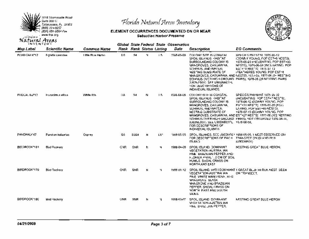
1018 Thomasville Road
~fori/a Nafurctf /lreaJ 9nvenfory Suite 200-C Tallahassee, FL 32303 (850) 224-8207 (850) 681-9364 Fax ELEMENT OCCURRENCES DOCUMENTED ON OR NEAR www.fnai.org Sebastian Harbor Preserve
rf4.-t Ate.C4.-5 VENTORY Global State Federal State Observation
Map Label Scientific Name Common Name Rank Rank Status Listing Date Description EO Comments
EGRECAER*12 Egretta caerulea Little Blue Heron G5 S4 N LS 1988-05-05 COLONY SITE IS COASTAL SPECIES PRESENT 1975-06-12 SPOIL ISLANDS; HABITAT (DOWNY YOUNG, POP EST=6 NESTS), SURROUNDING COLONY IS 1976-05-20 (INCUBATING, POP EST=30 MANGROVES, CASUARINA, NESTS), 1976-06-08 (INCUBATING, POP SCHINUS, AND WATER; EST=10 NESTS), 1976-07-13 NESTING SUBSTRATE OF (FEATHERED YOUNG, POP EST=6 MANGROVES, CASUARINA, AND NESTS), 1977-05, 1977-06 (5+ NESTING SCHINUS OVER HIGH GROUND PAIRS), 1978-05 (20 NESTING PAIRS (U82NES01). SEE U90DNR01FL FOR DESCRIPTIONS OF INDIVIDUAL ISLANDS.
EUDOALBU*13 Eudocimus albus White Ibis G5 S4 N LS 1988-05-05 COLONY SITE IS COASTAL SPECIES PRESENT 1975-05-02 SPOIL ISLANDS; HABITAT (INCUBATING, POP EST=7 NESTS), SURROUNDING COLONY IS 1975-06-12 (DOWNY YOUNG, POP MANGROVES, CASUARINA, EST=31 NESTS), 1976-05-20 (EGG SCHINUS, AND WATER; LAYING, POP EST=45 NESTS), NESTING SUBSTRATE OF 1976-07-13 (DOWNY YOUNG, POP MANGROVES, CASUARINA, AND EST=27 NESTS), 1977-06 (102 NESTING SCHINUS OVER HIGH GROUND PAIRS). NOT OBSERVED 1976-04-14, (U82NES01 ). SEE U90DNR01 FL 1976-06-08, FOR DESCRIPTIONS OF INDIVIDUAL ISLANDS.
PANDHAL1*47 Pandion haliaetus Osprey G5 S3S4 N LS* 1988-05-05 SPOIL ISLANDS; SEE U90DNR01 1988-05-05: 1 NEST OBSERVED ON FOR DESCRIPTIONS OF EACH TRANSECT ON ISLAND IR18 ISLAND. (U90DNR01 ).
BIRDROOK*181 Bird Rookery GNR SNR N N 1988-04-08 SPOIL ISLAND. DOMINANT NESTING GREAT BLUE HERON. VEGETATION-AUSTRALIAN PINE, BRAZILIAN PEPPER AND FLORIDA PRIVET. 2 CM OF SOIL HUMUS. SHOAL GRASS ON NORTH AND EAST.
BIRDROOK*179 Bird Rookery GNR SNR N N 1988-01-12 SPOIL ISLAND, WITH DOMINANT 1 GREAT BLUE HERON NEST, SEEN VEGETATION-AUSTRALIAN ON TRANSECT. PINE, WHITE MANGROVE, RED MANGROVE, BLACK MANGROVE AND BRAZILIAN PEPPER. SHOAL GRASS ON NORTH, EAST AND SOUTH SIDES.
BIRDROOK*180 Bird Rookery GNR SNR N N 1988-03-07 SPOIL ISLAND. DOMINANT NESTING GREAT BLUE HERON. VEGETATION-AUSTRALIAN PINE, BRAZILIAN PEPPER.
0412112009 Page3 of7

1018 Thomasville Road
r"fforila Natura( /{reaJ' 9nventory Suite200-C Tallahassee, FL 32303 (850) 224-8207 (850) 681-9364 Fax ELEMENT OCCURRENCES DOCUMENTED ON OR NEAR www.fnai.org Sebastian Harbor Preserve
ret-! kreet-5 INVENTORY Global State Federal State Observation
Map Label Scientific Name Common Name Rank Rank Status Listing Date Description EO Comments
BIRDROOK*182 Bird Rookery GNR SNR N N 1988-05-05 COLONY SITE IS COASTAL MULTI-SPECIES ROOKERY, 12 SPOIL ISLANDS; HABITAT SPECIES. 400+ NESTS 1975-05-02, SURROUNDING COLONY IS 450+ NESTS 1975-06-12, 7 NESTS MANGROVES, CASUARINA, 1976-04-14, 501-750 BIRDS 1976-05 SCHINUS, AND WATER; (GROUND CHECK), 251-500 BIRDS NESTING SUBSTRATE OF 1976-06-08 AND 1976-07 (GROUND MANGROVES, CASUARINA, AND CHECK), 251-500 BIRDS 1977-05, >1000 SCHINUS OVER HIGH GROUND BIRDS 1977-06 (GROUND CHECK), 501 (U82NES01). SEE U90DNR01FL FOR DESCRIPTIONS OF INDIVIDUAL ISLANDS.
ARDEALBA *237 Ardea alba Great Egret G5 S4 N N 1987-04-15 COLONY SITE IS COASTAL SPECIES PRESENT 1978-05 (20 SPOIL ISLANDS; HABITAT NESTING PAIRS), AND 1987-04-15. NOT SURROUNDING COLONY IS OBSERVED ON SURVEYDATES IN MANGROVES, CASUARINA, 1975, 1976, 1977, AND 1978-06. NOT SCHINUS, AND WATER; REPORTED 1988-05-05 (U90DNR01 ). NESTING SUBSTRATE OF MANGROVES, CASUARINA, AND SCHINUS OVER HIGH GROUND (U82NES01). SEE U90DNR01FL FOR DESCRIPTIONS OF INDIVIDUAL ISLANDS.
EGRETRIC*14 Egretta tricolor Tricolored Heron G5 S4 N LS 1988-05-05 COLONY SITE IS COASTAL SPECIES PRESENT 1975-05-02 SPOIL ISLANDS; HABITAT (DOWNY YOUNG, POP EST=37 SURROUNDING COLONY IS NESTS), 1975-06-12 (FEATHERED MANGROVES, CASUARINA, YOUNG, POP EST=93 NESTS), SCHINUS, AND WATER; 1976-05-20 (INCUBATING, POP NESTING SUBSTRATE OF EST=125 NESTS), 1976-06-08 ( MANGROVES, CASUARINA, AND INCUBATING, POP EST=50 NESTS), SCHINUS OVER HIGH GROUND 1976-07-13 (FEATHERED YOUNG, POP (U82NES01). SEE U90DNR01FL EST=57 NESTS), 1977-05 (5 FOR DESCRIPTIONS OF INDIVIDUAL ISLANDS.
MICRBRAC*4 Microphis brachyurus Opossum Pipefish G4G5 S2 sc N 1981 COASTAL STREAM SPECIMENS COLLECTED BETWEEN 1977 AND 1981.
ARDEALBA*403 Ardea alba Great Egret G5 S4 N N 1988-05-23 Spoil island in river. 1988/05/23: N.B. Peterson, DEP; Colony name in 1988 DNR data is IR18. Total (individuals?) = F (for GREG, SNEG, CAEG, LBHE, TCHE, WHIB).
NYCTNYCT*69 Nycticorax nycticorax Black-crowned G5 S3 N N 1988-05-25 spoil island in river 1988-05-25: N.B. Peterson, DEP, Night-heron observation. Colony name in 1988 DNR
data is IR15. "Total" (individuals?)= B (for LBHE, GRHE, BCNH).
0412112009 Page4of7

1018 Thomasville Road
rrforila Nctfuraf 1lreaJ 9nvenfory Suite 200-C l Tallahassee, FL 32303
(850) 224-8207 (850) 681-9364 Fax ELEMENT OCCURRENCES DOCUMENTED ON OR NEAR
' www.fnai.org Sebastian Harbor Preserve r~!A-re~5 YEN TORY Global State Federal State Observation
Map Label Scientific Name Common Name Rank Rank Status Listing Date Description EO Comments
NYCTNYCT*70 Nycticorax nycticorax Black-crowned G5 S3 N N 1988-05-23 spoil island in river 1988-05-23: N.B. Peterson, DEP, Night-heron observation. colony name in 1988 DNR
data is 'IR19'. "Total" (individuals?)= F (for CAEG, LBHE, TCHE, BCNH, WHIB, REEG).
PICOBORE*174 Picoides borealis Red-cockaded G3 S2 LE LS zz PINE. ONE ACTIVE COLONY. Woodpecker
HAEMPALL*55 Haematopus palliatus American Oystercatcher G5 S2 N LS 1992 No general description given 1992 B.R. Toland, GFC- April-June 1992 nest (unsuccessful). This site on the mudflats of Pelican Island has been used consistently since 1986. Data from FY 1992-93 Coastal Wildlife Questionnaire. Delorme page 96, site# 1 (U97GFC02FLUS).
APHECOER*119 Aphelocoma coerulescens Florida Scrub-jay G2 S2 LT LT 1981-05-12 1-3M OAK SCRUB, SCATTERED 1981-05-12: 3 SCRUB JAYS SAND AND SLASH PINES
EGRERUFE*74 Egretta rufescens Reddish Egret G4 S2 N LS 1988-05-23 Spoil island in river 1988-05-23: "Total" (individuals?)= F (for CAEG, LBHE, TCHE, BCNH, WHIB, REEG) (N.B. Peterson).
HAEMPALL*56 Haematopus palliatus American Oystercatcher G5 S2 N LS 1992 No general description given 1992 B.R. Toland, GFC- April-June 1992 nest (successful; fledged 2 young). This site has had nests since 1990. Data from FY 1992-93 Coastal Wildlife Questionnaire. Delorme page 96, site # 2.
AWAOBANA*3 Awaous banana RiverGoby G5 S1S2 N N 1955-07-21 NO DATA. 18 SPECIMENS COLLECTED (UF-044708).
SCELWOOD*271 Sceloporus woodi Florida Scrub Lizard G3 S3 N N 1986-05-13 Coastal scrub 1986-05-13: K.E. Enge, GFC, observation. See Enge et al (1986; Coop Unit Tech Rep No 26).
GOBIDORM*13 Gobiomorus dormitor Bigmouth Sleeper G4 S2 N N 1983-pre No general description given Collection reported.
SCELWOOD*11 Sceloporus woodi Florida Scrub Lizard G3 S3 N N 1968-05-02 No general description given JACKSON COLLECTED 11 SPECIMENS HERE, 1968-05-02. T. BARBOUR COLLECTED 28 SPECIMENS (MCZ-12909-37), IN 1919.
PANDHAL1*29 Pandion haliaetus Osprey G5 S3S4 N LS* 1987-07-10 No general description given ACTIVE NEST ON TREE IN MANGROVES.
GOPHPOL Y*441 Gopherus polyphemus Gopher Tortoise G3 S3 N LT 1989-06 SCRUBBY FLATWOODS BURROW PRESENT; BETTER REACHING RIVER BANK. POPULATION DATA NEEDED TO
DETERMINE SIZE OF POP. AND EXTENT OF OCCURRENCE.
0412112009 Page 5of7

1018 Thomasville Road
r"fforila Natura( 1lreaJ' Jnventory Suite 200-C I Tallahassee, FL 32303
(850) 224-8207 (850) 681-9364 Fax ELEMENT OCCURRENCES DOCUMENTED ON OR NEAR www.fnai.org Sebastian Harbor Preserve
rPvt A-re.Pv5 YEN TORY Global State Federal State Observation
Map Label Scientific Name Common Name Rank Rank Status Listing Date Description EO Comments
BIRDROOK*402 Bird Rookery GNR SNR N N 1989-04-26 ESTUARINE ISLAND IN INDIAN MULTI-SPECIES ROOKERY, 7 RIVER; NEST IN MANGROVE SPECIES. MAX. 870 NESTS 1975-05, (U780SB01 ). NESTING MAX. 180 NESTS 1976-04-14, 745 SUBSTRATE OF MANGROVES, NESTS 1976-05-20 (GROUND CHECK), PRICKLY PEAR CACTUS, 400 NESTS 1976-06-08, 63 NESTS GROUND NESTING ON HIGH 1976-07-13 (GROUND CHECK), 560+ GROUND (U82NES01). NESTING PAIRS 1977-05, 306+
NESTING PAIRS 1978-05, COLONY ACTIVE 1978
PELEOCCI*6 Pelecanus occidentalis Brown Pelican G4 S3 N LS 1989-04-26 ESTUARINE ISLAND IN INDIAN SPECIES PRESENT 1975-05 (MAX. 250 RIVER; NEST IN MANGROVE NESTS), 1976-05-20 (300 NESTS), (U780SB01 ). NESTING 1976-06-08 (150 NESTS), 1976-07-13 (25 SUBSTRATE OF MANGROVES, NESTS), 1977-05 (250+ NESTING PRICKLY PEAR CACTUS, PAIRS), 1978-05 (50++ NESTING GROUND NESTING ON HIGH PAIRS), 1978-07, 1987-04-15, GROUND (U82NES01). 1987-04-26, AND 1989-04-26.
ARDEALBA *19 Ardea alba Great Egret G5 S4 N N 1978-05 1978-05: estuarine island in Indian 1978-05: 50 nesting pairs. 1977-05: 50 River; nests in mangrove nesting pairs. 1976-07-13: 30 nesting (U780SB01FLUS). Nesting pairs. 1976-06-08: 50 nesting pairs. substrate of mangroves, prickley 1976-05-20: 50 nesting pairs. pear cactus, ground nesting on 1976-04-14: 30 nesting pairs. 1975-05: high ground (U82NES01 FLUS). Great White Hero
MYCTAMER*9 Mycteria americana Wood Stork G4 S2 LE LE 1978-05 ESTUARINE ISLAND IN INDIAN SPECIES PRESENT 1975-05 (MAX. 275 RIVER; NEST IN MANGROVE NESTS), 1976-04-14 (160 NESTS), (U780SB01 ). NESTING 1976-05-20 (250 NESTS), 1976-06-08 SUBSTRATE OF MANGROVES, (150 NESTS), 1976-07-13, 1977-05 (200 PRICKLY PEAR CACTUS, NESTING PAIRS), AND 1978-05 (200+ GROUND NESTING ON HIGH NESTING PAIRS). NOT OBSERVED GROUND (U82NES01 ). 1978-07, 1987-04-15, 1987-04-26, AND
1989-04-26. SEE
NYCTNYCT*8 Nycticorax nycticorax Black-crowned G5 S3 N N 1976-07-13 ESTUARINE ISLAND IN INDIAN SPECIES PRESENT 1975-05 Night-heron RIVER; NEST IN MANGROVE (UNKNOWN BREEDING STAGE, POP
(U780SB01 ). NESTING EST=MAX. 20 NESTS), 1976-07-13 ( SUBSTRATE OF MANGROVES, FEATHERED YOUNG, POP EST=4 PRICKLY PEAR CACTUS, NESTS). NOT OBSERVED 1976-04-14, GROUND NESTING ON HIGH 1976-05-20, 1976-06-08, 1977-05, GROUND (U82NES01 ). 1978-05, 1978-07, 1987-04-15,
1987-04-26, AND 1989-04-26.
RIVUMARM*16 Rivulus marmoratus Mangrove Rivulus G3 S3 c LS 1988-04-00 1988-04-00: mangrove swamp 20 individuals captured in April 1988 (U90TAY03FLUS). (U90TAY03FLUS).
RIVUMARM*18 Rivulus marmoratus Mangrove Rivulus G3 S3 c LS 1990-pre Mangrove swamp About ten specimens collected on (U90TAY03FLUS). unknown date.
0412112009 Page 6of7

1018 Thomasville Road Suite200-C Tallahassee, FL 32303 (850) 224-8207 (850) 681-9364 Fax
'-=~=--;··-' www.fnai.org
rCt-t A-re.t\-5 VENTORY
r"fforila Natura( 1lreaJ 9nventory ELEMENT OCCURRENCES DOCUMENTED ON OR NEAR
Sebastian Harbor Preserve
Global State Federal State Observation Map Label Scientific Name Common Name Rank Rank Status Listing Date Description EO Comments
HALILEUC*1187
HALILEUC*205
PELTPROF*6
0412112009
Haliaeetus leucocephalus Bald Eagle
Haliaeetus leucocephalus Bald Eagle
Peltotrupes profundus Florida Deepdigger Scarab Beetle
G5 S3 N
G5 S3 N
G3 S3 N
N
N
N
Page 7of7
2003
2003
2005-07-12: Source does not provide a description.
Nest status: Active, 2003, 2002, 2001, 2000; Unknown status or not assessed, 1999;(U03FWC01 FLUS)
COASTAL RIVER, FRESH TO Nest status 1999-2003: Continuously BRACKISH; WEST BANK S OF active; Status 1995-98: Active - 1998, C-541S SAND PINE SCRUB, 1996, 1995; Inactive -1997; RAMAINDER OF AREA IS XERIC (U03FWC01 FLUS). Previous data (note UPLANDS DOMINATED BY different format) NEST: 1995: SCRUBBY FLATWOODS, DRY PRODUCED 2 YOUNG; 1994: PINE FLATWOODS, DRY PRODUCED 2 YOUNG; 1993: ACTIVITY PRAIRIE AND IMPROVED UNKNOWN; 1992: GONE; 1991: PASTURE.
1962-01-24 1962-01-24: No description given 1962-01-24: One specimen was (found (B73W0001 FLUS). crawling on a lichen) collected by R.E.
Woodruff (B73W0001 FLUS).

Florida Fish and Wildlife Conservation Commission
Commissioners
Rodney Barreto Chair Miami
Kathy Barco Vice-CIV:lir Jacksonville
Ronald M. Bergeron Fort Lauderdale
Richard A. Corbett Tampa
Dwight Stephenson Delray Beac/J
Kenneth W. Wright Winter Pari<
Brian S. Yablonski Tallahassee
Executive Staff
Kenneth D. Haddad Executive Director
Nick Wiley Assistant Executive Director Karen Ventimiglia Deputy Chief of Staff
Fish and Wildlife Research Institute Information Science And Management (850) 488-0558 (850) 410-5269 FAX
Managing fish and wildlife resources for their longterm well-being and the benefit of people.
620 South Meridian Street Tallahassee, florida 32399-1600 Voice: (850) 488-4676
Hearing/speech impaired: (800) 955-8771 {T) (800) 955-8770 (V)
MyFWC.com
April 17, 2009
Mr. Roland M. DeBlois, AI CP Indian River County Environmental Planning and Code Enforcement Section 1801 27th Street Vero Beach, FL 32960-3388
Dear Mr. DeBlois:
This letter is in response to your request for information regarding the occurrence of Strategic Habitat Conservation Areas (SHCA's) on properties (Sebastian Harbor Preserve) (S18-T31S-R39E) in Indian River County, Florida. The Florida Fish and Wildlife Conservation Commission's database indicates that SHCA's for the Florida scrub jay occur within or adjacent to the property indicated by the map you provided. Maps indicating the location of SHCA's and 2003 landcover are provided.
Please note, as of August 17th, 2007, the Strategic Habitat Conservation Areas and the Biodiversity Hotspots data sets used for this request are from the 2007 Endries et al. report "Wildlife Habitat Conservation Needs in Florida: Updated Recommendations for Strategic Habitat Conservation Areas".
If you have any questions or further requests, please contact our Records Technician at (850) 488-0588 or [email protected]
Sincerely,
Jan Stearns Staff Assistant
js 2009_5270 Enclosures

Strategic Habitat Conservation Areas
Sebastian Harbor Preserve
- Strategic Habitat Conservation Area
c::J County Boundary
•-=::::::J•••====::::::~•••Miles 0 0.1 0.2 0.3 0.4
[L:2d Project Site
2009_5270

~ Project Site
Coastal Strand Sand/Beach Xeric Oak Scrub Sand Pine Scrub Sandhill Dry Prairie Mixed Pine-Hardwood Forest Hardwood Hammocks and Forest Pinelands Cabbage Palm-Live Oak Hammock Tropical Hardwood Hammock Freshwater Marsh and Wet Prairie Sawgrass Marsh
Florida Land Cover - 2003 Sebastian Harbor Preserve
-- Major Roads
Cattail Marsh Shrub Swamp Bay Swamp Cypress Swamp Cypress/Pine/Cabbage Palm Mixed Wetland Forest Hardwood Swamp Hydric Hammock Bottomland Hardwood Forest Salt Marsh Mangrove Swamp Scrub Mangrove
D County Boundary
Tidal Flat Open Water Shrub and Brushland Grassland Bare Soii!Ciearcut Improved Pasture Unimproved Pasture Other Agriculture Citrus Exotic Plants High and Low Impact Urban Extractive
--==---Miles 0 0.1 0.2
2009_5270

North Indian River County Greenways Plan -Sebastian Greenways Network
= BoatRamps Community Centers/Clubs
Historic Railroad Station
Major Shopping Centers
Picnic Area
1 ,t.
··:;.1ft
• • . . ' '-· ~'" .
·•••·• ••••••••• i.,.i~~~ ··•··· :_:. · ·, :-~' · -::-_,· ·sh~~~~~!lk ·.- · · . _.· ·:····
~ . ... = • • . 0 • • 0, .• •
• • • ,_-.i:.e
: !: :5 1~~ • • • • e • .; •·:c , •• ~9t~it •••.••••••• , ••••••• ;,, •.• ;. •••'•• ••
l Schools -Existing Shared-Use Path Existing Greenways NIRC proposed greenways
Park & Conservation Land --Existing Bike Lane -Hiking ~iver Greenway
Transit Routes "''f ..... East Coast Greenway Trail e--Multi-use • • • Off-road Multi-use
EEEEE Blueways • • • On-road Multi-use
Trail The Trans-Florida Railroad Corridor FPL Power Une Trail (Central Sebastian Corridor) Sebastian Waterfront Path (Indian River Drive and Downtown Sebastian) Fellsmere East 82nd Ave. (Connector to the Central Greenway System) Central Sebastian Trail Fellsmere Grade Blue Cypress Connector South Fellsmere
10 Historic Sebastian Walking Trail 11 CR 512(Sebastian Boulevard) 12 Roseland Road 13 CR 510 (including bridge) 14 US 1 Bike Lane Completion 15 East Coast Greenway Signage and Route
A1A 16 66th St. and Englar 17 Barber to Route 1
r<g'i'En"BA'"S"'T~IA~N!!!!!!HAR~B~O~R~PR~EbSd~~Rw~*~§.S-,W+E EXHIBIT: GREENWAY MAP s
Map P1epa!e<l by.Aha Ptanntng + Destgn & Kim ley Hom &Ar.soclatea Data.Sourees.lndtan RIVer County, State of Ftonda. ESRJ Date March, 2008
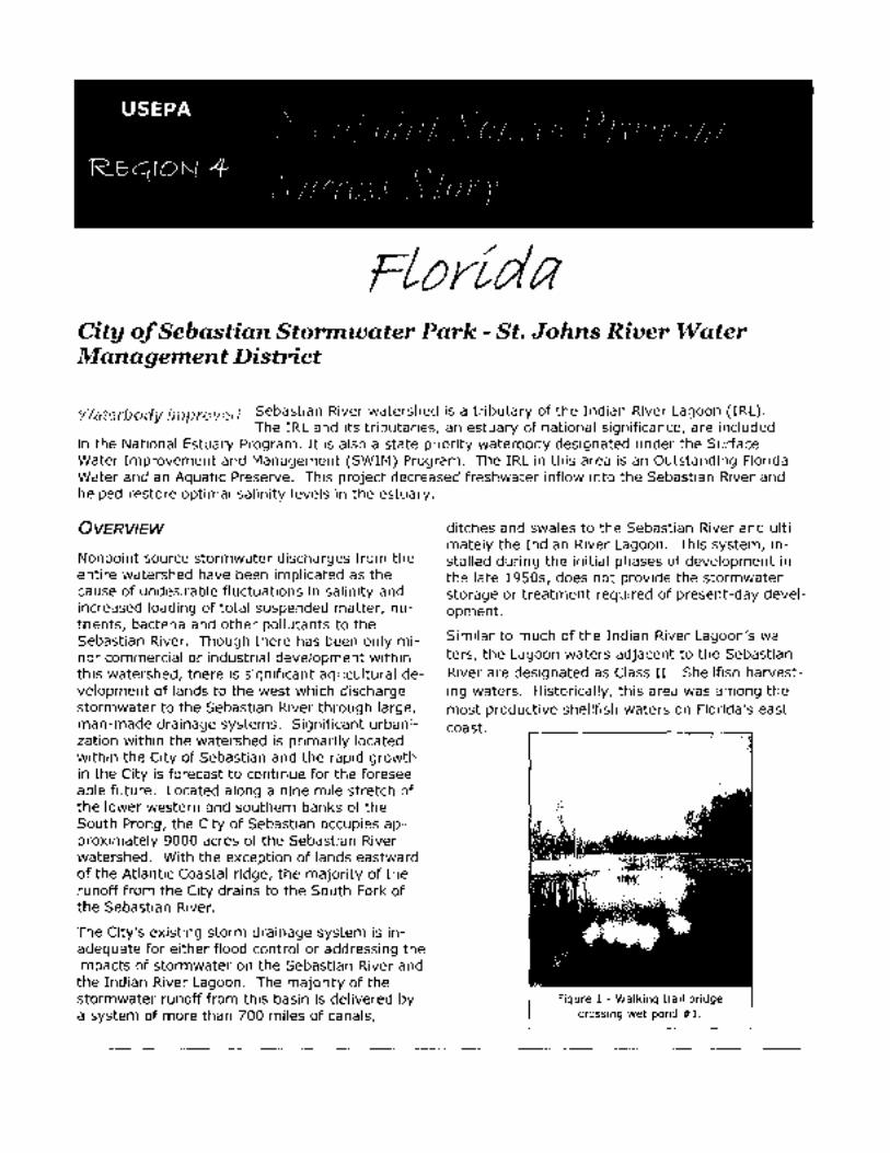
FLorida City of Sebastian Stormwater Park- St. Johns River Water Management District
WaterfJody ffnpmved Sebastian River watershed is a tributary of the Indian River Lagoon (IRL). The IRL and its tributaries, an estuary of national significance, are included
in the National Estuary Program. It is also a state priority waterbody designated under the Surface Water Improvement and Management (SWIM) Program. The IRL in this area is an Outstanding Florida Water and an Aquatic Preserve. This project decreased freshwater inflow into the Sebastian River and helped restore optimal salinity levels in the estuary.
OVERVIEW
Nonpoint source stormwater discharges from the entire watershed have been implicated as the cause of undesirable fluctuations in salinity and increased loading of total suspended matter, nutrients, bacteria and other pollutants to the Sebastian River. Though there has been only minor commercial or industrial development within this watershed, there is significant agricultural development of lands to the west which discharge stormwater to the Sebastian River through large, man-made drainage systems. Significant urbanization within the watershed is primarily located within the City of Sebastian and the rapid growth in the City is forecast to continue for the foreseeable future. Located along a nine mile stretch of the lower western and southern banks of the South Prong, the City of Sebastian occupies approximately 9000 acres of the Sebastian River watershed. With the exception of lands eastward of the Atlantic Coastal ridge, the majority of the runoff from the City drains to the South Fork of the Sebastian River.
The City's existing storm drainage system is inadequate for either flood control or addressing the impacts of stormwater on the Sebastian River and the Indian River Lagoon. The majority of the stormwater runoff from this basin is delivered by a system of more than 700 miles of canals,
ditches and swales to the Sebastian River and ultimately the Indian River Lagoon. This system, installed during the initial phases of development in the late 1950s, does not provide the stormwater storage or treatment required of present-day development.
Similar to much of the Indian River Lagoon's waters, the Lagoon waters adjacent to the Sebastian River are designated as Class II - Shellfish harvesting waters. Historically, this area was among the most productive shellfish waters on Florida's east coast.
Figure 1 - Walking trail bridge crossing wet pond #1.

Throughout the Indian River Lagoon region stormwater runoff has been linked to increases in fecal coliform bacteria levels. In accordance with state and federal guidelines to protect public heath, shellfish harvesting is suspended following storm events. Shellfish harvesting cannot resume until bacteriological levels fall to acceptable levels. Due to elevated levels of coliform bacteria, shellfish harvesting is prohibited at the confluence of the Sebastian River and the Indian River Lagoon at all times.
It has also been suggested that nonpoint source pollution is responsible for reduction of habitat within the Indian River Lagoon. There have been shifts in seagrass communities in many areas of the Indian River Lagoon, with an overall reduction in total grass bed acreage and decreases in the maximum depth of these beds. The grass beds immediately south of the Sebastian River have consistently become more fragmented over time.
HIGHLIGHTS
The 166-acre Sebastian Storm Water Park, a community multi-use amenity, is located within the City of Sebastian along the Collier Canal/ Elkcam waterway, which is a major canal system serving the City of Sebastian. The drainage area serviced by this storm water retrofit project includes over 1,400 acres of medium density residential development that drains via the canal system into the South Prong of the Sebastian River. The storm water park has been constructed to utilize a series (treatment train) of interconnected storm water best management practices to maximize pollutant removal and reduce the volume of freshwater discharges to the estuary. These project components consist of two wet-detention ponds, one dry or wetland detention area, and a large wetland impoundment storage/treatment area. Because the property is much higher in elevation than the adjacent canal water level, water from the canal is pumped up into the storm water park. The storm water park stores approximately one-inch of runoff from the drainage basin; provides greater than 21 days of residence time facilitating recharge to the aquifer; and is designed to
detain runoff equal to the mean annual storm event.
Figure 2 - Trail system from the parking lot to
grassed berm around pond #1
Park design provides multiple benefits for the community. A main benefit is the reduction of pollutants discharged to the Sebastian River and the Indian River Lagoon. In addition to the pollutant removal efficiencies of the project, the storm water park was designed to preserve existing natural oak hammock areas for passive recreation uses including hiking trails and family picnic areas throughout the park. Educational signs at the entrance to the park and along the hiking trails are designed to educate the park's visitors on stormwater runoff issues and the importance of preserving wetlands. Numerous waterfowl and migratory birds utilize the ponds and wetlands for habitat and foraging, and existing on-site populations of scrub jays and gopher tortoise can be found at the park as well.
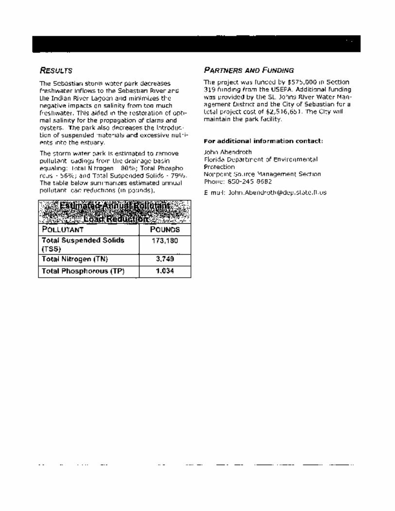
RESULTS
The Sebastian storm water park decreases freshwater inflows to the Sebastian River and the Indian River Lagoon and minimizes the negative impacts on salinity from too much freshwater. This aided in the restoration of optimal salinity for the propagation of clams and oysters. The park also decreases the introduction of suspended materials and excessive nutrients into the estuary.
The storm water park is estimated to remove pollutant loadings from the drainage basin equaling: Total Nitrogen- 80%; Total Phosphorous- 56%; and Total Suspended Solids- 79%. The table below summarizes estimated annual pollutant load reductions (in pounds).
POLLUTANT
Total Suspended Solids (TSS) Total Nitrogen (TN)
Total Phosphorous (TP)
POUNDS
173,180
3,749
1,034
PARTNERS AND FUNDING
The project was funded by $575,000 in Section 319 funding from the USEPA. Additional funding was provided by the St. Johns River Water Management District and the City of Sebastian for a total project cost of $2,516,651. The City will maintain the park facility.
For additional information contact:
John Abendroth Florida Department of Environmental Protection Nonpoint Source Management Section Phone: 850-245-8682
E-mail: [email protected]

I I I I I I I I I I II. ll II 11 ll ll I 11 IJ
AN ARCHAEOLOGICAL SURVEY OF INDIAN RIVER COUNTY, FLORIDA
by
David N. Dickel
A.H.C. Technical Report #55 July, 1992

I
' ' ' --------I I
' -• • •
FIGURE 6. PREDICTED SITE DENSITY ZONES
The levels of density were defined as follows:
A predicted or demonstrated high site density. A1 predicted high site density, but little available data.
8 predicted moderate site density. 81 predicted moderate to high site density, but little available
data. 82 predicted moderate site density, but little available data. 83 predicted moderate to high site density on numerous scattered
elevations, low density in background swamp, but little available data (much of the land in this zone is in agricultural use, but note sites in St.· Lucie County in similar but less modified environment just south of the lndian River County line).
c predicted low site density C1 predicted low site density, but little available data.
This is a summary map, please consult individual USGS scale maps and rep o r t text for de t a i 1 . P 1 ease note that i f used for planning, the boundaries are approximate, and a greater scale of reso 1 uti on may be imp 1 i ed by the 1 i nes on the map than are actually available.
Density ratings can be considered equivalent to general zone probability, or. better, as indicators of archaeological 'sensitivity'. However, although general density can equate to general probability, this is not the same as probability for every piece of land in the zone. Probability is 100% that a site will occur somewhere in zones with low site density.
106

N
H
H
t FIGURE .6.:
PR!=DICTED SITE DENSITY ZONES
..
SUPPLEMENT FOR 3(a)9 ARCHAEOLOGICAL RESOURCE PROBABILITY ZONES

1852219 RECORDED IN THE RECORDS OF JEFFREY K BARTON, CLERK CIRCUIT COURT INDIAN RIVER CO FL, BK: 2176 PG: 1829, 06/19/2007 02:12 PM DOC STAMPS D $95900.00
PREPARED BY AND RETURN TO: Robert D. Schwartz, Esq. 2240 Woolbright Road, Suit 411 Boynton Beach, Florida 33426 (561) 736-3440 Property Identification No. 31 39 18 00000 3000 00001/0
WARRANTY DEED
TillS WARRANTY DEED, executed this 1q11-1 day of :lui.)E , 2007, by LINCOLN LAND DEVELOPMENT, L.L.C., a Florida Limited Liability Company, Grantor, to INDIAN RIVER COUNTY, a Political Subdivision of the State of Florida, and whose post office address is 1840 25th Street, Vero Beach, Florida 32960, Grantee,
WITNESSETH, That the Grantor for and in consideration of the sum ofTEN AND NO/I 00 ($1 0.00) DOLLARS and other valuable consideration, receipt whereof is hereby acknowledged, hereby grants, bargains, sells, aliens, remises, releases, conveys and confmns unto the Grantee, all that certain land situate, lying and being in the County of Indian River, State of Florida, to-wit:
SEE ATTACHED EXHIBIT "A"
SUBJECT TO: Conditions, restrictions, limitations, easements and utility agreements of record, if any.
TOGETHER with all tenements, hereditaments and appurtenances thereto belonging or in anywise appertaining.
TO HAVE AND TO HOLD the same in fee simple forever.
AND the Grantor hereby covenants with said Grantee that the Grantor is lawfully seized of said land in fee simple; that the Grantor has good right and lawful authority to sell and convey said land; and will defend the same against the lawful claims of all persons whomsoever; and that said land is free of all encumbrances, except taxes accruing in the current year.
WHEREOF, the said Grantor has signed and sealed these presents the day and year first above written.
STATE OF FLORIDA COUNTY OF
PMENT, L.L.C .. ompany
s, III, Managing Member or Hugh M. , Jr., Managing Member 1682 West Hi scus Blvd. Melbourne, Florida 32901
The foregoing instrument was acknowledged before me this \.511:\ day of :TuQl:- . , 2~0~ by \-\ul0\.1 M. IS;,p.-y;; :$. , as Managing MemberofLINCOLN LAND DEVELOPMENT, L.L.C., a FlondaLumted Liability Company, who ~are personally known to me or who have produced a driver's license as identification and who did take an oath.
My Commission Expires:

·' BK: 2176 PG: 1830
Exhibit "A"
A parcel of land lying in the East 1/2 of the Northwest 1/4 and in the East 1/2 of the Southwest 1/4 of Section 18, Township 31 South, Range 39 East, being a portion of the lands as described in O.R. Book 1562, Page 2898, of the Public Records of Indian River County, Florida; said subject parcel being more fully described as follows:
Begin at the Northeast corner of said East 1/2 of the Northwest 1/4 as shown on the plat of "Laurei/ReseJVe", said plat being recorded in Plat Book 17 at Pages 45 through 50, inclusive of said Public Records; thence South 00 degrees 09 minutes 25 seconds West, along the East line of said East 1/2 of the Northwest 1/4 as established by said plat, a distance of 2653.51 feet to the Southwest corner of said plat as monumented by a four (4) inCh square concrete monument stamped "PRM LB 205" being the Northeast corner of the said East 112 of the Southwest 1/4 per said plat and also being the Northwest corner of Block 559 of the plat of NSebastian Highlands Unit-16", said plat being recorded in Plat Book 8 at Pages 45 through 45J, inclusive, of said Public Records; thence South 00 degrees 04 minutes 29 seconds West, along the East line of said East 1/2 of the Southwest 1/4 as established by said plat of Unit-16 and along the West nne of said plat of Unit-16, a distance of 1309.17 feet Point "A"; thence continue South 00 degrees 04 minutes 29 seconds West, along said East line of the East 1/2 of the Southwest 1/4 and along the West line of said plat of Unit-16, a distance of 1379.39 feet to the Southeast corner of said East 1/2 of the Southwest 1/4; thence North 89 degrees 52 minutes 00 seconds West, along the South line of said East 1/2 of the Southwest 1/4, also being the North line of the 80.00 foot wide public right of way of Englar Avenue per said plat of Unit-16, a distance of 1326.94 feet to the Southwest comer of said East 1/2 of the Southwest 1/4 per said plat of Unit-16; thence departing said South line and North right of way line, North 00 degrees 04 minutes 23 seconds East, along the West line of said East 1/2 of the Southwest 114 as established by said plat of Unit -16, also being the East line of an existing public drainage right of way which lies Easterly of Blocks 532, 523, 522 and 517 of said plat of Unit-16, a distance of 0.13 feet to an existing four (4) inch square, unstamped concrete monument; thence continue North 00 degrees 04 minutes 23 seconds East, along said West line of the East 1/2 of the Southwest 1/4 and said East of the public drainage right of way, a distance of 2672.54 feet to the Southwest comer of said East 112 of the Northwest 1/4 as established by said plat of Unit-16; thence North 00 degrees 04 minutes 31 seconds East, along the West line of said East 1/2 of the Northwest 1/4 as established by said plat of Unit-16, also being said East line of the public drainage right of way, a distance of2653.59 feet to the Northeast comer of the plat of "Collier Creek Estates, Phase One", said plat being a partial replat of said Unit-16 and being recorded in Plat Book 15 at Page 11 of said Public Records, as monumented by a four (4) inch square concrete monument stamped "P .l.S. #3435u; thence continue North 00 degrees 04 minutes 31 seconds East, along said West and East lines, a distance of 3.83 feet to the Northwest comer of said East 112 of the Northwest 1/4, also being the Northeast comer of said plat of Unit-16; thence North 89 degrees 37 minutes 02 seconds East, along the North lfne of said East 1/2 of the Northwest 1/4, a distance of 1330.82 feet to the POINT OF BEGINNING.

• . · ' . . nm H f ,,
l~ ~"U~Wl J'[ H w~;!~:t£
~t~· " ~ r ii
l~llli r ~ l i:
,l
~@~~ " !-i H a·;
u~~ i ~i i:'s !! ~ ,, ~I
~r, 1~ y B ~·
t i ~ i H ! ~
~ ' H ,, ,, ,.
' d.
B '· ~ ~ d •'
' l: ~~ q J~~i
d p ;I
mi ?. ~
,, ~l
,, !~ H ..
~; !-~ i'i ,. !lj-
~J !.! ~m i! i! 11 fiP ! HI
·r !! ;.~ . . ,. .,;~
! •' •i ~g ~.'i ~ [
I n ~: ! ~ ~
H "'i
t
f •
'" ~~ •2 ~~ "' rr '
"Ca.!JER CREE~ ESTAltS. PH.o.s( THREC IJI.II11HR[E"P.B.15 PC.56-4BA
HOlDEN -~____.....-.-. -(&O.oo'R/W>J'LAT) : -----.....__...
'S(!IAS11.<HHK;HtAil0SUilll-15' Pj.~l 0000: e, PAC( ·$-4:!-J
IJJ0.82'
IJ25.94
ENGLAR A VENUE (8000' A/W.Pl.A1)
;~! ~hi~-~ti~-
'I . ' ~
t ~ I i
~!I=! ~~I
e ~ .. <~
if
e ~~ Tli t; "' '\ "'
•,'_. ___ _
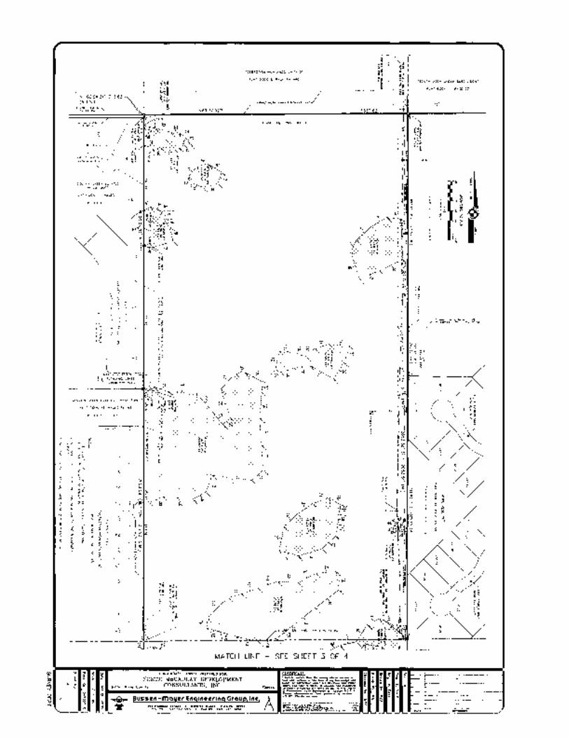
"COlLIER CREEK ESTATES. PHASE ONE"
PLAT BOOK 15, PAGES 11
~ 8"
0 ~7
I > ;,;;:
~ " ~i~
~i
r s_o:c ~;
~i~ ~ *~
~~e ~. :;:s-"'·('I
tc. '§~
·coc~::,~::: ;:~::~;:::~":REE" ~~-:h~:S~-:···: ::::·:: :::::::
~ 5 ~
I ~) }~ ..
~ ~ ~ > 0
~
~ z 0
{0
"SEBASTIAN HIGHLANDS UNIT-IS"
PLAT BOOK 8, PAGE 44-440
M. U~(- E)5, ·Nil~ • SEC. I&
MATCH LINE - SEE SHEET 3 OF 4
I I
: ~ t ~ I~ I "
~--.te.r_:-
~ I " I
I~ ~ g;

MATCH LINE - SEE SHEET 2 OF 4
"' 1111
~ ~~ ~~ ~~
.!"~ m
,. t:J >i< "' ~ ~~ ~-
"' ~ ~ --~~ ., 15
1-----1·~ I r ~ ·i ,;,..iii .1'------jn
~ " ;c
~ ~
" i::
l
.-~ ~ g~
~ g~
B ~6
~ g~ z' ,.. ~' ~g
~ ~a ~ u i\
i\ K M
~
E>
.!. ~ j~

~INE WtTL TABLE LENGTH
--+-- ~~~ -----t-- 502"04' 96.41 S85"02'13"W 90.87 N47'03'13"w 33.26 N13'37'29"E 70.47 N25'24'33" 28.61 N06"24'41"W
WElt.AN0-3 LINE TABLE UN[ BEARING LENGTH
" >3
" , " " " " 20
N61"28'39"W 76.81 N67"J2'18"W 54.35 N49'41'49"W 73.25 NS '31'39" 53.55 N50'49'58" 69,45 N41'51' S"E 67.13 ss-n5'25"E 94.63 S22"09'38"W 71.83 S20'36'53"W 77.25 S14"SS'43"E 38.46
WETLAND-S LINE TABLE BEARING LENGTH
N18 4' 1" 46.24 N 15'54" 50.71 N55"49'06"[ 68,70 N86'41'43" 91.21 N78'11"38" 73.26 N36'48'16" N85"03" 6"
1t'58'4rE 508"50'10"E 504'45'31" SST58'53" 549"01'00" 574"04'-504'30'55" S04"08'14"W S50'53'56"W N00'43'44" N 7'58'14"W 588'16' 6"W N83'46'28"W
21 N64'4 • 5"w 22 N80'37'48"W 23 2• 25 26 27 28
N81'1t'26"W N51'36'2t"YI N19'45'03"W N02'35'52"W N06'46'14" Nt7'37'01"W
WEilAN0-6 LINE TABLE
47.40 49.62 43.14 64.29
UN[ BEARING LENGTH
" "
N36 4'07"W 71.27 N44"34'19"W 113.15 ss 3' o·w 8R70 S73'12'32"W 85.14 51 '14'54"W 179.65 512'57'16" 74.28 560'48'38" 96.57 N30'39'36"[ 71.56 N53'17'31"E 72.11 N36'40"53"E
75"04'52" N09'43' 2"E
64.86 94.25
LINE
LINE
LINE
" " ,, '5
" " " 20
" 22 2J ,. 25 26 27 28 29
LINE
' 2 J
" " " " " '5
" " '8
LINE
" " ,,
WETLAN0-7 LIN[ TABLE BEARING LENGTH
N85'08'12"E 94.96 N70'09'JrE 150.23 N5015'28"E 92.81 N00'58'21"W 235.92
Y06'42"W 112.99 57 '06'57"W 153.30 S6213'11"w 77.50
WETLAND-S UN[ TABLE BEARING LENGTH
S9'1'50"E 61.35 501'45'34" 52.77 552"50'16"1'1 81.87 N50"49'14"W 35.29 N27'28'21"W 50.88 N16'25'51"( N57'40'oo·
l'tflLAN0-9 LIN[ T BEARING LENGTH
N71' 7'15" 93.09 57.3'05'20" 78.25 516"45'27"[ 82.02 51.3'45"59"£ 79.55 530' 7'28"[ 88.35 544 9'13" 79.21 s 7'10'05"( 68.66 S11'02"45"E 52.39 S34'55"03" 70.95 S03'48'36"W 94.34 507"04'22"W 117.75 50575'44"[ 121.89 518'47' 9"E 85.71 51.3'22'47'1'1 103.01 S68"07'17"w 78.90 N73"59"10"W 106.52 N26'17'.38"w 51.23 N10'40'51" 82.18 N10'08'13"E 75.57 N15'55'31"W 55 . .33 Nl,2'2.3"W 7.3.80 N16""54'19"W 82.58 N67"04'57"W 22.70 576'57'31"1'1 74.45 N48'19'54"W 92.08 N10'13"05"w 80.17 N2075'41"E 52.08 N40"05"5J"W 40.01 s 5"08'39"1'1 30.59
\',fTLAND-10 LIN[ TABLE BEARING
509'15' 1"[ 94.11 N17'11"55" N00'3J'41"W 148.61 N07'00'57"w 49.72 N8571'23"w 39.39 N64'30'47"W 74.14 554'11' s·w 58.23 SJ '4 'J3"W 104.12 577'19' S"w 84.91 564"47'33"1'1 56.79 547"46'04"1'1 71.07 517'27'05"1'1 48.13 N53"48'00"E 111.94 N79'08'5TE 99.88 N39'35'16"[ 75.20 577,5"44"E 40.84 562,8'40" 43.80 541,3"34"[ 97.73
l'.flLAN0-11 LINE TABLE BEARING LENGTH
N45'54"10" 144,73 N75"56'5B"E 70.43 N69'53"13"E 88.32 N70'35"18"£ 102.06 585'55'47"[ 106.46 N61" 6"34" 101.48 N84'56'58"( 101.15 510"05'24"[ 93.16 ss ·43'1 ·w 150.95 SSI"OJ"37"w 157.06 SSJH"JO"W 93.59 S80'20"26"W 92.47 N77'22'16"W 11.3.58 N73"49'12"W 83.03 N73'0.3"43"w 73.19 N05'45"49"[ 52.39
LINE
>0
LIN(
" , " '8
" 20
" LIN[
7 8 9
" " "
1\{TLAN0-12 LINE TABLE BEARING LENGTH
S46'38'00"W 94.82 S73"10'54"W 125.98 N72'J•f31"W 100,43 Nl0'55'07' N47"38'46' 94.39 N55"23"22"[ 92.77 N69'17'22"[ 88.60 557'20"08'[ S12'11'33"W 47.04 S05'54"08"W 52.24 S10'10'48"W 59.22
\\£TLAN0-13 LINE TABLE BEARING L(NGlH
N54"27'27"[ 570'48"41" S85'38"14'E $40"40'28"[ 539'41'55'~
N53'16"50'E Nl7'40"44"W N42'34"1.3'( 588,0'43"[ ssnJ'JO"E 502"03'23" S05'.30'51"W 504"08'43"£ S04"00"50"[ S47'33"59"W N82'53'17"w S 1" J"02"W S59'32'14"W NBS"01'25"w 568'39"24"1'1 N88'34"41"W
~
W(TLAND 14 LIN[ TABLE
68.97 48.32 15555 113.60
55.32
127.21 7803
20027 69.81 7524
148.48 7723
L(NGlH
S67'49"03"E 30 N74"40"45"E N77'46"2"( S60'.35" 5"[ N32"58"55'E 9752 N18"54"40"[ 8851 N84'51"50"W 10505 S74"58'01"W 75.87 S45'47"07"W 50.57 N73'2B'06"w 9195 N88"46"41"W ~5 90 S11'3)"2J"W 96 OJ
WETLAND 16 LINE TABLE LIN[ BEARING LENGlH
576'28"36'( 6319 576'04'47"( 7753 583"24'58'( 549'39"39' 4152 539'.36"31'[ 35.99 5741J'31"w 6165 S87'46'5J"w sa 29 S81'23'40"W 3522 N58'35'13"W 5515
" N01"55'10"w 98.71
WE llANO 17 LIN[ TABLE LINE BEARING LENGTH
N2J,2'25'[ 7014 N48"03"53"E N59'JO".J3" 9040 583'9"47'[ 68.58 503'07'43' 204 24 S53'59'24"W S57'34'35"w N1B"52"2J""w
LINE W(it.AN0-18 LINE TABLE
BEARING 568"00'28"[
LENGTH 61.36
N74'29"04"[ 78.84 Nl9'51'02"E 59.59 N60"07"29"W S78'03'50"W 51.25 539"52'05"1'1 79.09 S39'37'1B"E 32.13
YIETLAND 19 LINE TABLE LINE BEARING LENGTH
N62'35'43"W 37.25 N77'28"55"W .30.32 N64'10'58" 27.86 N12,5'09"E 14.96 566"53'55"£ 20.82 S61'49'7"E 18.57 S01"52'1B"W 33.56
tlJl:!ESo
1 SEE SHEET 1 OF 4 FOR DESCRIPTION, NOTES, LEGEND AND ADDITIONAL BOUNDARY INFORM A liON.
2 SEE SHEETS 2 & 3 Of 4 fOR THE CONTINUATION Of THE BOUNDARY SURVEY
J ALL TABLE DISTANCES ARE IN F!ET lo.ND DECIMAL FEEl.
WC:TLANO 1 ELEV. TABLE WETLAND NO [LEV.
1'11-1 22 60' Wl 2 2.16" Wl-3 .55'
22.61' Wl-5 22.68' W1-6 22.36' Wl-7 2.44'
2.36'
WETLAND 2 ELEV TABLE WETLAND NO [L[V.
W2-1 21.91' Wl-2 22.38" W2 3 21.67' W2-4 21.78" W2-5 21.68" 1'12-6 22.04' W2-7 22.13" W2-8 21 65" W2-9 21.68" W2-10 21.93"
2"217 1'12-12 2180" W2-13 21.73" W2-14 21.72"
21.46" W2-16 21 93" W2-17 22.21" W2·18 22.10" W2-19 2180" 1'12-20 1 98" W".l-21 21 78"
WElLANO 3 (L~V. TABLE WE7LAND NO. ELEV.
2.93" WJ-2 22.59" wJ-3 2 .74" wJ-4 2 .as· W3-5 2 79'
2301' 2353'
W3-8 22.77' WJ-9 23.02'
22.74'
WETLAND 5 £LEV. TABLE WETLAND NO (L(V
w5-1 2057' wS-2 20.97"
2105' w5-4 21.41' w5-s 21.32" W5-5 20.51" WS-7 20.50' w5-8 20.55" ws 9 20 38" W5-10 21 30" W5-ll 21.18' w5 1? 2166" WS-13 21 75· ws-u 2~.74"
1'15-15 2164" 1'15-16 21.14" WS-17 20.82" W5-18 2050' 1'6-19 21.02" WS-20 21 36" w5-21 21 u· ws 21 2' 38"
21\0" w5-24 20.46' w5-25 20.57" w5-25 2058"
20.55" w5-2B 2066"
WETLAND 6 ELEV. TABLE I'.£TLAN0 NO (L(V.
IY6-1 22.44" W5-2 22.19" wS-3 2255'
279' W6-4 22.35' W6-5 22.35" wS-5 2:225' ws-7 ;.>195· WS-8 1 53"
2241"
W6-l0 22.53" WS-\1 2' 81"
wETLAND 7 ELEV. TABLE WETLAND NO. [L[V.
W7-1 0. 7' W7 2 20.90' w7 3 20.40'
0.81' 1'17-5 21.37' W7 6 1.19" W7 7 21.62' w7 8 21.02·
8 EL[V. TABLE NO. ELEV.
1.98" 21.4.3' 21.73"
1.56' 21.55' 21.56'
1.70'
9 ELEV. TABLE NO. (LEV.
21.30' 1.68'
W9-3 21.05' W9--4 21.13'
0.82' 1'19-5 21.36' 1'19-7 21.05'
21.48' 1'19-9 1 • .30'
21.30' W9 11 21.38' W9-i2 1.38' 1'19-13 22.22" W9 14 1 47' 1'19-15 21.55' W9-15 21.41' W9 17 21.56" 1'19-18 1 26' W9-19 1.26' 1'19-20 21.42' 1'19-21 21.4.3' 1'19-22 21.09' W9 23 21.89' 1'19-24 21.52' 1'19-25 2t.7D'
21.37' 1.73'
W9 28 21.34' W9 29 1.24' 1'19-.30 1.05'
WETLAND 10 ELEV. TABLE wETLAND NO. ELEV.
mo 2 WlO-J WHl-• mo 5 WI0-5 mo 7 mo 8 WI0-9 Wl0-10 WlO 11 WIO 12 WIQ-13
Wl0-15 WID 16 Wl0-17
VI'ETLANO \\£lLANO
"'' 2 W11-.3 Wll-4
W11-5 W11-6 Wll-7
"" 8
W11-10
Wll-12 Wll 13 W11-14 W11-15 Wll 16
21.45' 2 .03' 22.07' ' . .05' .. ,..
J' 22.49'
2.65' 22.73' 2.57
2 .05' 2198' 2 51' 21.84' 22.61' 22.09'
21.07' 1.30'
2121' 21.12' 21.56'
151' 21.75' 21.23' 2124'
1.00' 21.09' 20.74' 097' 1.48'
W(TLANO 12 ELEV TABLE wETLAND NO [L[V
W12-1 1 66" W12-2 1.38" 1'/12 3 21.)0' W12 4 154" 1'112 5 1.95' Wl2-6 21.95' W12-7 21.78' W12-8 22.04' Wl2 9 22.07'
W12 10 1.84' W12 11 183'
wETLAND 13 ELEV TABLE wETLAND NO. [LEV.
1'113 1 20.83' W13 2 20.66' W13-3 20.06" Wl3-4 20.60" Wl3-5 0.60" W13 6 2074" 1'113-7 20.63" Wl3-8 20.6" W13-9 20.50"
0.28' 1'113-11 2053" Wl3 12 20.91" W13-13 20 23' W1.3-14 085' W13-15 20.66' Wl3-t5 2035' W13 17 20.48' W\3-18 20.46" W1.3-19 20.4.3' W13-20 20.25' Wl3 21 20.78' W13 22 20.05"
W(TlANO 14 [L(V TABLE WETLAND NO. [LEV.
W14-1 20.84" W14-2 20.90"
143'
"". W\4-5 20 81' 2065"
W\4-7 20 48" W14 8 20.27" W14 9 2173"
21.37" W14-11 0.5.3' M4-12 2125"
115ELEV.TABLE NO. [LEV
22.17" 22 31" 22.87"
3A 2264" 3B 22.52"
2232" 2245" 22.11" 22.72"
WETLAND 16 ELEV. TABLE wETLAND NO. E:tEV
2197 W16 2 2203" W16 3 2191" Wl6-4 2212" 1'116 5 221.3" W15 6 2.60' 1'116 7 2212" W15 8 22.17" W15 9 22 18" W1510 22.23"
WETLAND 17 (LEV TABLE W[ll.ANO NO ELEV
2155 W17 2 lJJ" W17 3 2133" W17 4 2UiJ" W17 5 21 77" W17-5 0 58" I
21 20" 212.3"
W(Tl.ANO 18 ELEV. TABLE wETLAND NO. EL[V.
wt8 I 21.75' W16-2 21.99' W\8 3 21.91' W18-4 1.98" Wl8-5 .0' wt8 6 2 .00' WIB-7 1.96'
19 ELEV. TABLE NO. ELEV.
1.97' 2195' 22.39'
4 1.96' W19 5 2 .05' W19-5 1.97 W19-7 1.83'
Sec.: 18
Twp.: 31 South
Rng.: 39 East
Design by : N/A
Drawn by : JLQ
Checked by : NPC
Date: JAN 20, 2005
Scale: N/A
Proj. No.: 347002-C
Sheet No.
SURVEY DEPT.

HOME OF PELICAN ISLAND i225 MAIN STREET • SEBASTIAN, FLORIDA 32958 TELEPHONE: (772) 589-5330 • FAX (772) 589-5570
May 24,2007
Gary D. Wheeler, Chairman Indian River Board of County Commissioners 1840 251
h Street Vera Beach, Florida 32960
RE: SEBASTIAN HARBOR PRESERVE PURCHASE/FLEMING STREET EXTENSION
Dear Chairman Wheeler:
At the May 8, 2007 meeting of the Indian River Board of County Commissioners, the Commission considered funding allocation options for the purchase of the Sebastian Harbor Preserve. In discussion, Commissioner Peter O'Bryan reported that the recommendation of the Land Acquisition Advisory Board was that the pwrchase be made entirely with land acquisition funds. This LAAC recommendation also requested the removal of the Fleming Street extension from the long-range plan. The other option discussed by the County Commission was purchasing the Sebastian Harbor Preserve with a hybrid approach of land acquisition funds and road impact fees to keep the Fleming Street corridor open for future development.
In determining a course of action on this question, the County Commission requested formal input from the Sebastian City Council. At the May 23, 2007 Regular Meeting of the City Council, after a lengthy, well attended meeting, the Council voted unanimously to recommend to the Indian River Board of County Commissioners to remove the Fleming Street extension from long range plans and purchase the Sebastian Harbor Preserve entirely with land acquisition funds. Upon completion of the minutes of the May 23, 2007 Regular Meeting, I will request that the Office of the City Clerk forward to you a copy of the minutes for a more formal record of the meeting proceedings.
In the interim, please accept this letter as a formal position statement by the Sebastian City Council with regard to the Sebastian Harbor Preserve and Fleming Street extension question.
Cc: Members of the Sebastian City Council Members of the Indian River County Board of County Commissioners Sally Maio, City Clerk Rich Stringer, City Attorney Joe Baird, County Administrator
.. f "7 -... _;
296


-·----- ·-· ---···· -· --------------------
SEBASTIAN CITY COUNCIL MINUTES
REGULAR MEETING WEDNESDAY, MAY 23, 2007-7:00 P.M.
CITY COUNCIL CHAMBERS 1225 MAIN STREET, SEBASTIAN, FLORIDA
1. The Mayor called the Regular Meeting to order at 7:02 p.m.
2. The Pledge of Allegiance was recited.
3. A moment of silence was held.
4. Mayor Coy read the Civility Pledge.
5. ROLLCALL
City Council Present: Mayor Andrea Coy Vice Mayor Sal Neglia Council Member AI Paternoster Council Member Dale Simchick Council Member Eugene Wolff
Staff Present: City Manager AI Minner City Attorney Rich Stringer City Clerk Sally Maio Deputy City Clerk, Jeanette Williams Airport Director Joe Griffin Building Director Wayne Eseltine City Engineer Dave Fisher Acting Public Works Director Jerry Converse Finance Director Shai Francis Growth Management Director Rebecca Grohall Police Chief Jim Davis Engineering Department Brian Grzesiak MIS Systems Analyst Barry Siepmann
I L-------------------------------------------------------------------------J

Regular City Council Meeting May23,2007 Page Eight
07.111
Ms. Simchick said Fellsmere can still keep filling out new applications but ca go through with them. The City Attorney agreed that is the case.
Mr. Wolff said it is his point of view that the City's hands are tied, t ellsmere is holding all the cards, that not all commercial or residential an ation is good, and that this is a complicated issue.
Mayor Coy said she was glad Council had an opport to buy some time, and if done properly the City can set some limits, and · as to be a cooperative effort by all of the agencies. She said she attended orkshop in Fellsmere for the local folks, and some of the residents repo their streets are not even paved yet but the new developments will be. said they were told they could request paving and then be assess .
Mr. Neglia asked if the Coun anted to go charter, would they have to bring it ey said it would have to be done by ordinance.
On MOTION by Mr aternoster, and SECOND by Mr. Neglia, Resolution No. R-07-21 was a ed on a roll call vote of 5-0.
On MOT by Mr. Paternoster, and SECOND by Mr. Neglia, Resolution No. was adopted on a roll call vote of 5-0.
ayor Coy called recess at 8:15p.m. and reconvened the meeting at 8:34p.m. All members were present.
13. NEW BUSINESS
A. Fleming Street i. Traffic Modeling Presentation by Phil Matson. IRC Traffic Engineer/MPO
Phil Matson, IRC MPO, gave a power point presentation explaining the function of the Metropolitan Planning Organization, which was first established in 1991, and noted Council Members Simchick and Paternoster are members of MPO. He stated that the Fleming Street extension is not a new plan and is included in many plans going back to, as far as he has heard, a couple of decades. He said MPO is concentrating on its major roads. He stated a Long Range plan is needed to receive funding and any changes made to the Long Range plans are subject to all requirements of plan adoption.
The City Manager said this item was requested by Council Member Simchick and this discussion has been precipitated by the Sebastian Harbor issue.
The City Attorney said the City does not have final say in this matter, only a recommendation. The City Manager clarified that this is an MPO issue, and the County is seeking Council's recommendation. He then stated the two alternatives they are seeking from Council are A) to purchase all of Sebastian Harbor with
8
.. --· .. -·-------------------------------------

Regular City Council Meeting May23,2007 Page Nine
Land Acquisition funds which can close the Fleming corridor or B) keep the Fleming corridor open with buying the portion of the corridor with impact fees and the rest of the 162 acres with Land Acquisition funds.
Mr. Wolff asked Mr. Matson asked if zero emission vehicles have been factored in this analysis, and Mr. Matson responded said this is an EPA model which takes many factors into consideration including alternative fuel vehicles.
ii. Council Member Simchick Presentation (2 Pgs City Comprehensive Plan)
Ms. Simchick said in January 2003, a grassroots effort resulted in a preserve saturated with wildlife. She said the Land Acquisition Committee strongly recommended against developing Fleming Street, explained it was surveyed last year (20 years ahead of the planned development) and if it was purchased with bond money and the City put a road through it, the City would have to buy back that land which would be difficult. She said the property is scheduled to be paid for in July. She said the County Commission is asking if the City wants the Fleming Street Extension on or off the City's comprehensive plan. She said the comprehensive plan is from 1999, and exhibited a page off the traffic element. (which is included in the agenda packet) She said the comp plan is overdue, and thanked Mr. Matson for presenting here tonight. Ms. Simchick exhibited a transportation page from the county comprehensive plan depicting Fleming Street to go from Easy Street to Schuman, not US 1, which is how it was surveyed last year. She further explained difficult considerations such as a private residence that would have to be taken by eminent domain, railroad crossing, and that it lines up with the proposed concrete plant.
She said the City should jump on the comprehensive traffic element soon to alleviate traffic, send a message to the County that the City does not want this extension on the comprehensive plan, and let them know if they need to build this road for us.
She closed by saying the funding from the Florida Communities Trust may reimburse $6.6 million of the purchase price but it could be jeopardized with the road extension through a pristine preserve and with that she introduced former County Commissioner, Grant Writer Ruth Stanbridge.
a. Ruth Stanbridge Grant Reimbursement
Ruth Stanbridge said for over 25 years she has written grants and they must be defendable, and a successful grant is one where problems have been identified and resolved, said County staff has done an excellent job in applying for and defending grants, question of constructing a future major road would be detrimental, a lack of commitment by City or County could work against approval of the grant by Florida Communities Trust, the best chance is to understand and anticipate all problems.
9

Regular City Council Meeting May 23,2007 Page Ten
Ms. Simchick added if the County received the $6.6 million back it will go back into the Land Acquisition fund to purchase another environmentally sensitive tract.
Mr. Wolff asked why Council is not hearing this from Roland DeBlois that there is a potential to skip over this project. Ms. Stanbridge said the Land Acquisition Committee has seen this twice and Mr. DeBlois has indicated that the County will have to work with Florida Communities Trust on possibly purchasing the road in the future.
She said she came tonight because Ms. Simchick asked her to be here because of her work on grants.
Mr. Wolff said it would be Mr. DeBlois' fiduciary responsibility to let the residents know this and he has not made any of these remarks in his presentations.
Mrs. Stanbridge said all details must be covered and Mr. DeBlois cannot not say that he will receive reimbursement on this project.
Mr. Neglia said if the road went through he thought it would be rated high because many roads go through preserves. He stated he is not in favor of the road, for the record. He asked why Fleming Street was not included during the Land Acquisition Committee decision. Mrs. Stan bridge said LAC did not want the road in there because it would jeopardize the reimbursement.
As the City's representative on the Land Acquisition Committee, Mayor Coy said the committee recommended the road not go through for many reasons.
Mrs. Stanbridge said one of the reasons is the eagle's nest is actually too close to get permits from U.S. Fish and Wildlife to put a road in there.
Mr. Paternoster asked when was the last time she wrote a grant for a property of this magnitude, Mrs. Stanbridge said with the Marine Resources Council for greenway along the St. Sebastian River. He asked if she was reimbursed and she said no which she attributed to the Marine Resources Council. He asked if she was actively participating in this grant and she said she was not.
Ms. Simchick said it was a surprise to find out the action of the County Commission and staff recommendation to use impact fee money for the extension, and said she would like to hear from the public.
Mayor Coy said the question in her mind is do we want to purchase with bond money or purchase the road and use bond money. She said if the City totally eliminates this out of the comprehensive plan the City may lose federal dollars for roads. She asked the City Attorney what Council is being asked to relay back to the County.
10
.------------------------------------ ---·-·· ............ ..
Regular City Council Meeting May 23,2007 Page Eleven
The City Attorney deferred to the City Manager.
The City Manager said, "Find Council's position on the purchase of the property with all Land Acquisition Committee money or divide it." He said If Council wanted to use all Land Acquisition money that would eliminate the Fleming Street extension.
Ms. Simchick said Council is supposed to consider the Fleming Street extension which affects the Preserve. She asked Mr. Matson if removing the extension from the camp plan will affect any transportation funds. Mr. Matson said there will be an incompatibility with the long range plan and the comprehensive plan that would have to be ironed out and approved by the MPO. He said if long range plans continued without the ability to handle the traffic, it would be questioned, but alternatives can be identified; however, the extension was added when the five-laning of Barber Street was dropped and there is hardly anything left to drop off. He suggested Council study it and find alternatives before taking it out.
The City Attorney said the question Council is being asked as representatives of the citizens of Sebastian is do you want to keep the Fleming extension alive as a project.
Ms. Simchick said if there was no preserve the City would want Fleming Street, the MPO wants to keep it on the plan, but the County wants to know if Council wants to keep it.
Mr. Paternoster asked where it says the decision should be made tonight.
The City Manager cited the e-mail he provided to Council before he went away. He said the information in the packet was from Council Member Simchick.
Mr. Paternoster noted there was little information in the agenda packet and said he would move to table until Council receives the information needed in their agenda packet.
Mr. Wolff said this item was brought before Council about a week before the County voted and the very question was posed to Council and there was concern if Fleming Street should be part of the purchase. The City Attorney replied it was put to a future agenda date. Mr. Wolff interjected this was about four-five months ago. Ms. Simchick remembered this and said Mayor McCollum recommended going back to the County because it is an MPO issue.
The City Attorney said the City fussed to get the extension included as a project, and previous Councils pushed the MPO to bring this up on the list in lieu of fivelaning Barber Street, but in the last year Council has heard objections with this road. He said the County has warned the City that if this road is not wanted, other avenues will have to be explored.
11

Regular City Council Meeting May23,2007 Page Twelve
On a MOTION by Mr. Paternoster and SECOND by Mr. Wolff that this item be tabled until further information is provided in agenda packets failed on a roll call vote of 2-3. (nays-Coy, Neglia, Simchick}
Mayor Coy read a paragraph of the City Manager's memorandum stating he was providing the information by e-mail and hard copy in their mailboxes. The City Manager stated for the record the memo was provided May 11 lh, 2007 and an attempt was made to leave the information for each member.
On a MOTION by Mr. Paternoster and a SECOND by Ms. Simchick, to give each speaker a two minute time limit carried on a voice vote of 5-0.
Kelly Mather, stated the City opposed Ocean Concrete by resolution and if they approve the Fleming Street extension the City will be approving Ocean Concrete.
Ray Halloran, objected to the extension of Fleming Street.
Jim Sunnycalb, 721 S. Easy Street, said he was instrumental in the purchase of the property and said the eagles nest is behind his house and will feed off the road kill that will happen.
Pat Hall, Collier Creek Estates HOA President, representing 190 residents, collectively objected to the extension of Fleming Street.
Bill Sandy, 542 Balboa Street, representing Sebastian Concerned Citizens Against the Concrete Plant, objected to the extension of Fleming Street.
Perry Pasante, Easy Street, Collier Creek Estates, has seen violations on the streets in Collier Creek Estates and urged Council not to extend the street.
Don Wright, North Fischer Circle, said Fleming Street does not change capacity and there needs to be a comprehensive look at these numbers by Sebastian and said this road will not solve traffic problems.
Jim Gallagher, 766 Holden Avenue, said he smells big money in the proposed Fleming Street extension and asked Council to vote no.
Ralph Brown, representing the owner of property in the area of the proposed extension, said the property owner is not in favor of the road and it's facilitation for the concrete plant and would like to see the City hold some public hearings in terms of what needs to be done. He recommended an overpass to Indian River Drive and asked Council to vote no.
12
------··--·----------------------------------------------------

Regular City Council Meeting May 23,2007 Page Thirteen
Louise Kautenberg, Sebastian, cited many roadways that go through national forests and preserves, said animals learn to adapt and the United States is not just for animals and plants but for the people and this roadway has been on the books long before anyone thought of a concrete plant. She said the issue is how many people will be affected and what neighborhood will be affected.
Phyllis Manzi, 7 42 Holden Avenue, said the preserve is gift, the City has a responsibility to children and grandchildren to protect the preserve. She quoted her father who said, "God will not make more land."
Norma Cox, 6308 River Run, said Natchez Trace is a recreational roadway, not much wildlife, and not an adequate comparison to the big national parks and asked Council to vote no.
AI Manzi, 742 Holden Avenue, said he doesn't see all these trips being generated from Sebastian, there is an east-west conduit on CR 512 and 510.
Ruth Sullivan, Indian River Drive, said citizens need to remember why they moved here and said the City has an opportunity with funding citizens voted for to keep the preserve pristine and undeveloped.
Damien Gilliams, 1623 US 1, said something as serious as this should have more backup to make a decision.
Judy Gallagher, Holden Avenue, said she does not see this as complicated issue and to risk losing bond money for the preserve would be ludicrous.
Robin Meyers, South Easy Street, said she was at the Indian River County meeting where the decision was made and heard NIMBY (not in my backyard) and pleaded with Council not to extend the street.
Brad White, Easy Street, thanked Council for the improvements they approved for Easy Street and allowing traffic to flow more smoothly for all residents.
Robert Johnson, Easy Street, referenced a pamphlet put out by FPL regarding management of eagle habitat and noted 40% of their deaths are because of roadways.
Richard Baker, Pelican Island Audubon Society and Chairman of Land Acquisition Committee, said the City needs to preserve what we have and will be a poster child. He suggested changing the name.
Frank Meyers, South Easy Street, asked Council to try to be good stewards.
13

Regular City Council Meeting May 23,2007 Page Fourteen
Mr. Paternoster asked when the Commission needed an answer. The City Attorney said the County Commission will need a decision in June. Mr. Paternoster asked if Council could put this off to the June 13th meeting and give the Commission a response in time and the City Attorney said yes.
Ms. Simchick said she was ready to make motion. She said the scales are different in comparing this to Yellowstone; the City has congestion that should be addressed now; and she said she is voting no to the road.
Mr. Wolff said he voted to table because it is complex and he doesn't have answers at hand. He said there seems to be strong feeling there is connection to the concrete plant, and he would be na"ive to think there might not be conspiracy but doesn't think that is the case. He said he is fiscally prudent and believe it is all our money, and would like to know more the certainty of the bond. He said the irony is most people drive by the preserve and won't have access to it and if there was a road they could get to it. He said he would have liked to see greater representation of other residents of Sebastian. He added that Ms. Simchick is right, because he battles morning traffic, and the City is in a difficult situation. He said he is not sure how the City will resolve this in future, because it will may impact Englar and Barber as opposed to citizens on Collier Creek. He said he wanted more information and thinks it is being rushed a bit, will impact a lot of folks, and thanked everyone for behaving in a civil manner.
On MOTION by Mr. Neglia and SECOND by Ms. Simchick, the extension of the meeting was approved on a voice vote of 5-0 to extend.
Mayor Coy, 501 Palm Avenue, member of Land Acquistion Committee, said this was not in her backyard, said she voted for it because it is an outstanding project. She said it was clear in the Committee's vote not to extend Fleming Street and people who wanted the road could have called ore-mailed Council.
Mr. Neglia thanked everyone who came tonight, said he was concerned about traffic going through there, asked if we are going to look at different areas and have people come and say, "Don't go through our road." In regard to the concrete plant he noted the extension was in the plan long before the concrete plant, and asked for confirmation of the grant reimbursement from Mr. Matson.
Mr. Matson said he was referring to federal highway money and he understood Roland's position is that having the road will not jeopardize the grant.
Mr. Neglia said the City will need to do something to alleviate traffic.
Ms. Simchick made a MOTION to remove the Fleming Street Extension from the comprehensive plan to keep the preserve intact.
14
Regular City Council Meeting May23, 2007 Page Fifteen
07.019 B.
The City Attorney advised her to modify the motion because to remove it from the City comprehensive plan will take a number of hearings. He advised her of the verbiage however, she began to restate her motion.
The City Manager advised that the motion should remove Fleming as well as purchase the preserve with all of the Land Acquisition money.
On MOTION by Ms. Simchick and SECOND by Mr. Wolff, recommendation to purchase the preserve with the Land Acquisition money in it's entirety and recommend removing Fleming Street from the City comprehensive plan carried on a roll call vote of s-o.
iii. Council Discussion
AN EMERGENCY ORDINANCE OF THE CITY OF SEBASTIAN, FLORIDA, A CODE SECTION 2-121 TO INCREASE SENIOR HOMESTEAD EXEMPT FOR APPLICABILITY, SEVERABILITY AND EFFECTIVE DATE.
The City Attorney read Emergency Ordinance No. 0-07 by title. The City Manager clarified the effect this will have on the City' udget.
Todd Klitinic urged approval.
Baxter Coston, 660 Balboa Street, said Co
Damien Gilliams urged approval for t
Herb Mulford said seniors can h ly afford gas, give them whatever Council can.
Mr. Wolff said people no atter what they are earning, are concerned about ard.
Mr. Neglia said it · not an easy decision but he will go along with it.
y Mr. Paternoster and SECOND by Mayor Coy, the additional as approved on roll call vote of 5-0.
The 1ty Attorney said for the record he would bring back a permanent
The City Manager said he would like to bypass item C for D.
15
. _________________________________ ____~