lake carmi phosphorus reduction action plan -...
TRANSCRIPT

August 2008
Page 1 of 20
Lake Carmi Phosphorus Reduction Action Plan. Once the target phosphorus concentration and needed loading reduction are identified,
nonpoint source control (land-use based) projects need to be identified that will
accomplish these goals. The watershed of Lake Carmi contains a wide variety of land
uses, including residential development (year-round and seasonal), agriculture, roads, and
forestry. This Action Plan is written to encompass improvements needed in all land use
types since all are sources of phosphorus. The Franklin Watershed Committee and the
Vermont Agency of natural Resources promotes the view that phosphorus reductions are
needed across the board to both address all possible sources as well as encourage the
responsibility and involvement of all land owners and users.
Some of the following Action Items are ones which can be undertaken by the existing
structure of the Franklin Watershed Committee with its existing annual budget, while
others will necessitate significant additional funds. Additionally, these latter Action Items
may require the hiring of a Lake Carmi “watershed technician” in order to undertake the
time-consuming work involved in these actions; this will also require more funding. The
Actions Items that fall into this category are so indicated in the “Schedule and Cost”
column by the term “Additional funding needed.”
Outlet and In-Lake (note “Priority” refers to how soon the activity should be done)
Action Item #1A: Investigate Outlet Structure
Activity:
Investigate the benefits of
replacing the culvert under
Dewing Shore Road, which
conveys the lake to the outlet
dam, with a structure of flow
capacity equal to that of the
dam itself.
Priority: low
Participants:
FWC, VTANR (initial
estimates)
Schedule and Cost:
2009
Initial estimates would
incur no significant costs
Action Item #1B: Investigate potential value of in-lake “alum” treatment
Activity:
Consider potential for alum
treatment (sediment phosphorus
inactivation), including if
would be feasible to apply it in
section(s) of the lake vs. a lake
wide treatment
Priority: low
Participants:
FWC, VTANR
Schedule and Cost:
2009
Initial estimates would
incur no significant costs

August 2008
Page 2 of 20
Shoreland
While overall the phosphorus contribution from the shoreland is less than the watershed
as a whole, it is still a critical area to focus on. While the impact from one shoreland
property on the lake-wide quality cannot usually be observed, it can have a significant
impact on the immediate nearshore, shallow water area. Camp owners might experience
increased attached algae growth, reduced water clarity, or increased plant growth as a
result of runoff from nearby shoreland land uses. Therefore, addressing shoreland issues
both increases the likely success of overall phosphorus reduction efforts as well as
potentially improving the conditions that lake users experience most often. In addition, on
Lake Carmi as on the rest of Vermont lakes, there is a trend toward “redevelopment” of
the shoreline whereby small camps are replaced by much larger camps or even year-
round homes, thus increasing their potential phosphorus impact on the lake.
The goals for the shoreland of Lake Carmi, in terms of reducing phosphorus runoff, are:
1. All camps minimize or eliminate runoff from developed areas (lawn, driveway,
buildings etc) to the lake.
2. All camps maximize the amount of native trees and shrubs along the shoreline.
3. All camps have well-maintained septic systems suitable for the site and amount of
use.
4. No camp owners fertilize shoreland lawns.
5. All newly developed camps or re-developed camps are designed and built to meet
the above goals.
(Note: “Priority” refers to how soon the activity should be done)
Action Item #2: Assessment of shoreline septic systems
Activity:
Phase 1: Complete a survey of
the shoreland septic systems to
determine areas that might
benefit from combined or
neighborhood septic systems or
leachfields
Phase 2: Provide technical
assistance on alternative
systems that would function in
site limitations present at
Carmi.
Priority: medium
Participants:
Phase 1: FWC, VTANR,
Town of Franklin
Phase 2: TBD
Schedule and Cost:
Phase 1: 2009
Could be done by
volunteers or summer
employees, additional
funding needed Phase 2: TBD

August 2008
Page 3 of 20
Action Item #3: Septic system maintenance and outreach
Activity:
Continue septic pump-out
program.
Provide outreach info on septic
system maintenance and
conduct outreach to camp
owners (e.g. regular tank
pumping, rental of portable
outhouses for large events,
water conservation, etc.)
Priority: High
Participants:
FWC, VTANR, others?
Schedule and Cost:
2008 and on-going
Approx $1000 per
summer at current rate.
Materials already
available.
Action Item #4: Erosion and runoff survey of shoreland properties
Activity:
Conduct runoff and erosion
surveys of shoreland Spring „08.
Provide on-site property runoff
and erosion surveys and
recommendations to interested
camp owners. Includes such
issues as shoreline erosion,
camp road and driveway erosion
and roof runoff.
Priority: High
Participants:
FWC, Town of Franklin,
VTANR
Schedule and Cost:
2008-2009:
Spring survey, FWC and
VTANR
Survey of shoreland
properties could be
conducted by a summer
employee, $7000/yr,
additional funding
needed
Action Item #5: Shoreland management outreach
Activity:
Conduct workshops and
outreach about management tips
for living on the lakeshore to
minimize phosphorus loading to
the lake. Includes such issues as
lawn fertilizers and shoreland
vegetation.
Priority: High
Participants: FWC,
VTANR, others?
Schedule and Cost:
2008 and on-going
Materials already
available, some printing
costs: $1000

August 2008
Page 4 of 20
Action Item #6: Review Shoreland Zoning for potential improvements
Activity:
Work with the Town of Franklin
to evaluate current shoreland
zoning and potentially
recommend improvements that
would result in better oversight
of shoreland use. For instance,
as camps are enlarged or
converted to year-round use,
what additional measures could
reduce their impact on the lake?
Priority: medium
Participants:
VT League of Cities and
Towns, VTANR, FWC
Schedule and Cost:
2009
No additional costs
identified at this time.
August 2008
Page 5 of 20
Watershed
The Franklin Watershed Committee recognizes that addressing watershed sources of
phosphorus will involve forming cooperative partnerships with many different
landowners and the Town of Franklin. As in most watersheds, it is not possible to point to
one source of phosphorus, fix that and be done. Rather, it will involve encouraging and
implementing many different measures with many different landowners.
The goals for the watershed of Lake Carmi, in terms of reducing phosphorus runoff, are:
1. Work with the Town of Franklin to ensure town road maintenance and
improvements are conducted so as to minimize erosion of road surface,
ditches/culverts and banks, and to cause the infiltration of a maximum amount of
road runoff.
2. Work with watershed farmland owners to ensure minimization of sediment and
phosphorus runoff.
3. Work with forestland owners to ensure minimization of sediment runoff during
forestry operations.
4. Work with residential owners to ensure minimization of sediment and phosphorus
runoff from properties.
(Note: “Priority” refers to how soon the activity should be done)
Action Item #7: Complete initial stream surveys
Activity:
Complete initial stream surveys
(north, west and southwest
sides of lake) to identify
phosphorus sources and
prioritize projects for action or
further investigation. These
surveys will be needed to
determine the need and
specifics for many of the Action
Items listed below.
Priority: High
Participants:
FWC, VTANR, others?
Schedule and Cost:
2008
Volunteers, summer 2008
Action Item #8: Conduct Stream Geomorphic Assessments
Activity:
Continue with Phase 1 and
Phase 2 assessments of streams
based on priorities established
under Action Item #7.
Priority: Medium
Participants:
FWC, VTANR, others?
Schedule and Cost:
2009
Watershed Technician
pay. Additional funding
needed.

August 2008
Page 6 of 20
Action Item #9: Establish native vegetation along streambanks.
Activity:
Reestablish woody vegetation
along prioritized sections of
Marsh Brook and other streams
as determined by stream
assessments under Action Item
#8.
Priority: Medium
Participants:
FWC, VTANR, others?
Schedule and Cost:
2009
Watershed Technician
pay. Additional funding
needed.
Action Item #10: Conduct Stream restoration or conservation projects
Activity:
Conduct stream restoration or
conservation and projects as
identified under Action Item #8.
Priority: Medium
Participants: FWC,
VTANR, others
Schedule and Cost:
2010
Unknown cost at this
time but likely
additional funding will
be needed.
Action Item #11: Wagner farm stream fencing
Activity:
Assist with the installation of
lane and stream fencing on
Chris Wagner‟s farm.
Priority: High
Participants: FWC,
DAFM
Schedule and Cost:
2008
(probably going to be
done with CREP funds)
Action Item #12: Work one-on-one with farmers to identify and enable additional
phosphorus control measures for their farms
Activity:
Identify additional BMP
measures that could be adopted
by watershed farms. Identify
funding sources to reduce or
eliminate the farmers‟ cost
share. (This item would likely
necessitate hiring an
environmental technician.)
Priority: High
Participants: FWC,
Natural Resources
Conservation Service
and District, Vt Agency
of Agriculture, Food and
Markets, Missisquoi
River Basin Association,
VTANR, VTANR
Center for Clean and
Clear
Schedule and Cost:
2009-2014
Additional funds
needed, $75,000-100,000
per year

August 2008
Page 7 of 20
Action Item #13: Investigate emerging phosphorus reduction technologies
Activity:
Keep abreast of new
phosphorus reduction
technologies such as regional
methane generators
Priority: Low
Participants:
FWC, Natural Resources
Conservation Service
and District, Vt Agency
of Agriculture, Food and
Markets
Schedule and Cost:
On-going
No direct cost
Action Item #14: Town road erosion inventory
Activity:
Conduct a watershed road
erosion inventory and prioritize
problems for correction.
Priority: High
Participants:
FWC, Town of Franklin,
VTANR, VT Better
Backroads Program
Schedule and Cost:
2008 or 2009
$3000, grants available
through Better Backroads
Program
Action Item #15: Outreach on Private Road and Driveway erosion prevention
Activity:
Conduct workshops and
inventories on private roads and
driveways to identify problems
and correction measures.
Priority: Medium
Participants:
FWC, VTANR
Schedule and Cost:
2009 and on-going
$2000/year
Additional funding
needed.
Action Item #16: Review Town Road Maintenance Practices
Activity:
Work with the Town of
Franklin to review road
maintenance practices and
incorporate ones that reduce
erosion.
Priority: Medium
Participants:
FWC, Town of Franklin,
VTANR, VT Better
Backroads Program
Schedule and Cost:
2009
No additional cost

August 2008
Page 8 of 20
Action Item #17: Outreach to watershed residents about Carmi Project and
Phosphorus reduction
Activity:
Conduct watershed-wide
(possibly town-wide) public
education campaigns to inform
landowners/citizens about the
Carmi watershed project, and
what they can do to reduce
phosphorus loading to waters.
Also, describe measures farmers
and loggers use e.g. AAPs and
AMPs.
Priority: Medium
Participants:
FWC, Town of Franklin,
VTANR, Vt Agency of
Agriculture, Food and
Markets
Schedule and Cost:
2009
$4000 for printing and
mailing Additional
funds needed.
Action Item #18: Conduct additional sampling as needed
Activity:
As stream and tributary surveys
occur, additional data needs may
be identified, such as soil
phosphorus and runoff
phosphorus sampling in order to
be better able to target remedial
projects.
Priority: Medium
Participants:
FWC, VTANR
Schedule and Cost:
TBD
Action Item #19: Land Conservation Measures
Activity:
Look for opportunities to adopt
land conservation measures
(purchase of easements, etc) to
conserve undeveloped
lakeshores and streambanks.
Priority: Medium
Participants:
FWC, VTANR, Vt
Housing and
Conservation Board,
land trusts
Schedule and Cost:
unknown

August 2008
Page 9 of 20
High Priority Actions
Action Item #3: Septic system maintenance and outreach. Continue septic pump-out
program. Provide outreach information on septic system maintenance and conduct
outreach to camp owners (e.g. regular tank pumping, rental of portable outhouses for
large events, water conservation, etc.)
Action Item #4: Erosion and runoff survey of shoreland properties. Conduct runoff
and erosion surveys of shoreland Spring „08. Provide on-site property runoff and erosion
surveys and recommendations to interested camp owners. Includes such issues as
shoreline erosion, camp road and driveway erosion and roof runoff.
Action Item #5: Shoreland management outreach. Conduct workshops and outreach
about management tips for living on the lakeshore to minimize phosphorus loading to the
lake. Includes such issues as lawn fertilizers, and shoreland vegetation.
Action Item #7: Complete initial stream surveys. Complete initial stream surveys
(north, west and southwest sides of lake) to identify phosphorus sources and prioritize
projects for action or further investigation. These surveys will be needed to determine the
need and specifics for many of the Action Items listed below.
Action Item #11: Wagner farm stream fencing. Assist with the installation of lane and
stream fencing on Chris Wagner‟s farm.
Action Item #12: Work one-on-one with farmers to identify and enable additional
phosphorus control measures for their farms. Identify additional BMP measures that
could be adopted by watershed farms. Identify funding sources to reduce or eliminate the
farmers cost share. (This item would likely necessitate hiring an environmental
technician.)
Action Item #14: Town road erosion inventory. Conduct a watershed road erosion
inventory and prioritize problems for correction.

August 2008
Page 10 of 20
Appendix A – 2007 Franklin Watershed Committee Project Descriptions
These projects were carried out by the Franklin Watershed Committee. These
descriptions are provided verbatim, and with permission, by Carmi Consulting;
Environmental Research and Design.
This report is a draft and is currently being used by the Franklin Watershed Committee to
generate support and technical assistance regarding projects that will improve water
quality in and around Lake Carmi and the Pike River watershed.
August 2008
Page 11 of 20
1.0 Summary
In 2006 a Phase 2 Geomorphic Assessment was completed in the Pike River Watershed,
in the town of Franklin, Vermont. The study of the Marsh and Dewing Brooks was
possible because of a grant from the Vermont Agency of Natural Resources (VTANR)
Water Quality Division. The grant was administered by the Frankiln Watershed
Committee. Brendan O‟Shea of Carmi Consulting was the project lead and worked
closely with Thomas Baines of North Country Consulting to complete this report and
assessment.
The goal of this study was to assess the geomorphic condition of Marsh and Dewing
Brooks and identify stream potential stressors to stream condition, including sediment
and nutrient inputs, channel constrictions and other features. Other objectives of the study
included the determination of the geomorphic condition of targeted reaches, identification
of adjustment processes, identification of current and historic watershed stressors,
evaluation of the sensitivity of the reaches, and to support selection, prioritization and
design of riparian projects that are compatible and sustainable. Projects meeting those
criteria are intended to improve water quality, wildlife habitat and reduce flood and
erosion hazard risks to infrastructure, property and the public.
Geomorphic and habitat assessments were completed for four reaches in the Pike
Watershed. A geomorphic assessment looks at four major stream channel processes,
aggredation, widening, degradation, and change in plan form. A habitat assessment has
more criteria such as bank canopy and vegetative buffer. The assessment of the Pike
River Watershed followed protocols specified by the Vermont Agency of Natural
Resources (ANR) Stream Geomorphic Assessment Phase 2 Handbook
Common stressors found in the watershed were lack of woody buffer, accelerated erosion
due to increased hydrologic pressure, undersized culverts, straightened channels and
hydraulic alteration (drainage or fill) of wetlands.
The phase 2 assessment of the Pike River and its tributaries will help the town, state and
the landowners identify areas of erosion hazard risks, sediment production and nutrient
inputs in the brooks corridor. The study also will help identify potential floodplain and
channel projects that will increase the capacity for stream corridor capture and storage of
sediment and nutrients. Conservation partners will be able to use this information to the
use of technical and financial assistance for the implementation of conservation,
restoration, and protection projects.

August 2008
Page 12 of 20
Map of Study Reaches (M4T2.3S8.02, M4T2.3S8.03, M4T2.3S2.02, M4T2.3S2.03) *Prepared by South
Mountain Research and Consulting

August 2008
Page 13 of 20
2.0 Background
Water quality and aesthetic impairments consisting of large blooms of Blue-Green Algae
have been occurring on an annual basis in Lake Carmi and the Missisquoi Bay of Lake
Champlain. The Missisquoi Bay watershed, including Lake Carmi and the Pike River, is
a focus region for major reductions in phosphorus (P) loads through a Total Maximum
Daily Load (TMDL) plan for Lake Champlain. The TMDL plan is a product of an
agreement between the state of Vermont and the US Environmental Protection Agency
(EPA). Additionally, a TMDL for Lake Carmi is under development and will be in place
later in the year. The Phase 2 Geomorphic Assessment of The Marsh and Dewing Brooks
was undertaken to assess the geomorphic condition of the stream channels and identify
potential stressors to the stream channel. Areas of streambank erosion and minimal or no
riparian buffer were identified as potential sources of nutrients and sediments. This
project supports the State of Vermont‟s Clean and Clear Action Plan. .
3.0 Assessment Methodology
Phase 2 data is used to document natural and human disturbances to the watershed and
the response and adjustment of the channel to these disturbances. The information
gathered during this Phase 2 Assessment will also aid in the understanding of the
geomorphic condition of each reach assessed.
Segmentation of some stream reaches occurred based on the protocols. Field data was
collected using a Garmin© eTrex VISTA GPS, digital camera, and various survey
equipment and techniques. Certain features such as grade controls, cross sections, bridges
and culverts were then digitized using ArcView 3x. All of this data was then uploaded
into the states Data Management System.
4.0 Phase 2 Assessment Results
The following is a brief summary of each reach, highlighting the stream channel and
riparian corridor condition and potential areas for remediation.
4.1 Marsh Brook
Phase 2 assessments were completed for two reaches along the Marsh Brook Some
common problems (stressors) contributing to the impairment/departure of reference
stream channel condition on the main stem of Marsh Brook were lack of buffer, bank
erosion, and undersized culverts.
Near reference conditions can be found in many locations along the Marsh Brook. These
areas offer woody buffer and an infrastructure free corridor. These areas provide potential

August 2008
Page 14 of 20
for conservation and protection of reference channel conditions in the Marsh Brook
watershed.. These areas also offer habitat for wildlife and an opportunity for the brook to
deposit sediment and nutrients in the floodplain corridor.
The following table (Table 1) is a brief overview of the information collected for each
reach. A more detailed description follows for each reach discussing stressors, impacts,
and possible projects.
Marsh Brook
Table 1 Results of Phase 2 Assessment, Marsh Brook Main Stem
Reach Channel
Length
Stream
Type
RGA
Score
Adjust. Stream
Type
Departure
Sensitivity CEM
M4T2.3S
8.03
3,568 B3 .76 Stable None Moderate F I
M4T2.3S
8.02
2,679 B3 .81 Stable None Moderate F I
Abbreviations RHA=Rapid Habitat Assessment; RGA=Rapid Geomorphic Assessment, CEM=Channel
Evolution Model (VT DEC)
Table 2 RGA and RHA Score Ranges
The following information will read from upstream to downstream.
M4T2.3S8.03 Segment M4T2.3S8.03 is a “B” type stream in stable condition and it begins just above
the State Park Road. A long culvert crosses under this road and where it empties, a large
scour pool has developed.
Downstream of the scour pool near reference
to reference conditions can be observed.
Excellent corridor as well as buffer exists for
almost the entire reach. Reference stream type
0.85 – 1.0 Reference Condition
0.65 – 0.84 Good Condition
0.35 – 0.64 Fair Condition
0.00 – 0.34 Poor Condition
Reference Condition of M4T2.3S8.02
Scour Pool, State Park Road
August 2008
Page 15 of 20
was observed as well as bed strata and meanders.
The next crossing downstream of State Park road is used as a VAST trail and features a
berm with two culverts. (see project #1)
M4T2.3S8.02
Segment M4T2.3S8.02 is a “B” type channel in stable condition. This reach has an
excellent corridor and excellent buffer. Alder can be found along much of its banks.
Excellent wildlife habitat exists in this area offering potential homes to such species as
Bald Eagle and Whitetail Deer.
4.2 Dewing Brook Table 3 Results of Phase 2 Assessment, Pike River Tributaries Reach Channel
Length
Stream
Type
RGA
Score
Adjust. Stream
Type
Departure
Sensitivity CEM
M4T2.3S
2.03
3,568 F4 .44 Incision Yes Extreme F II
M4T2.3S
2.02
2,679 E4 .43 Incision Yes Extreme F II
Abbreviations RHA=Rapid Habitat Assessment; RGA=Rapid Geomorphic Assessment (see Table 2
RGA score ranges), CEM= Channel Evolution Model (VT DEC) N/A= Not Assessed
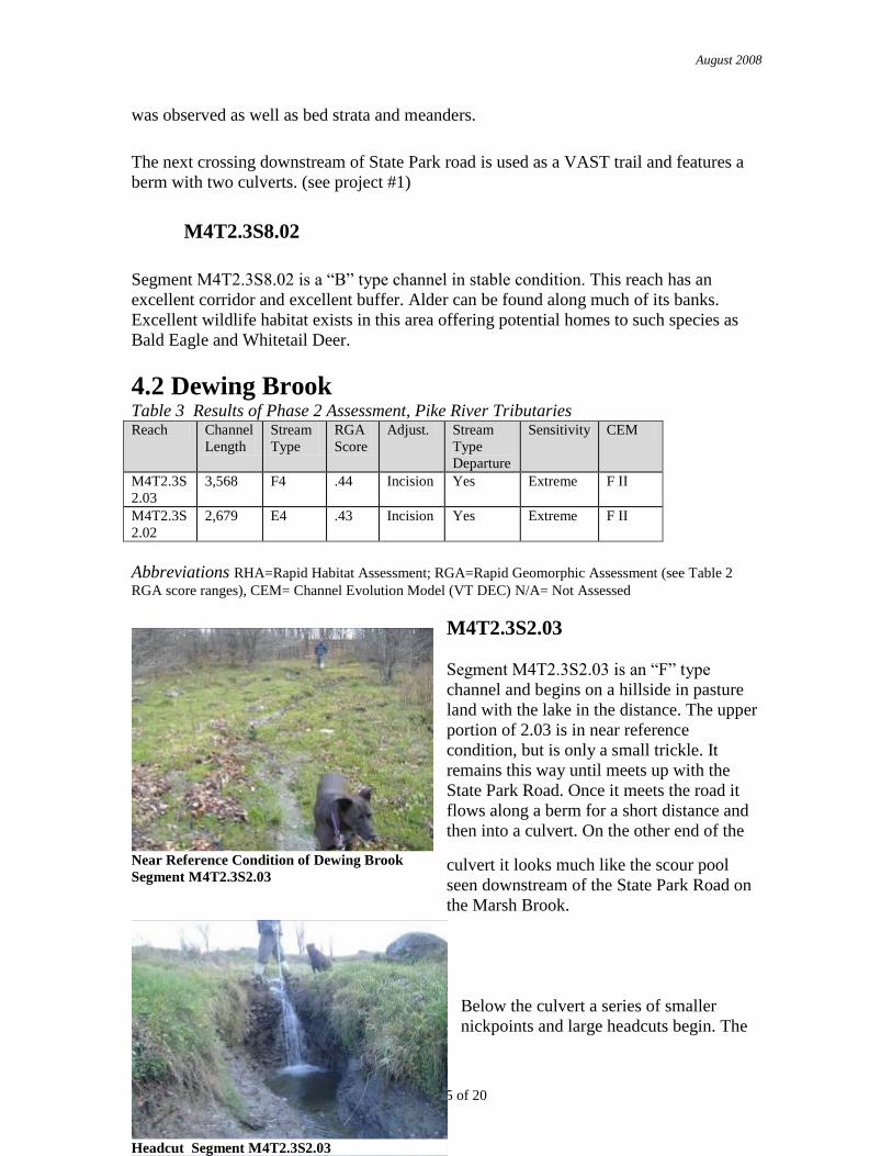
M4T2.3S2.03
Segment M4T2.3S2.03 is an “F” type
channel and begins on a hillside in pasture
land with the lake in the distance. The upper
portion of 2.03 is in near reference
condition, but is only a small trickle. It
remains this way until meets up with the
State Park Road. Once it meets the road it
flows along a berm for a short distance and
then into a culvert. On the other end of the
culvert it looks much like the scour pool
seen downstream of the State Park Road on
the Marsh Brook.
Below the culvert a series of smaller
nickpoints and large headcuts begin. The
Near Reference Condition of Dewing Brook
Segment M4T2.3S2.03
Headcut Segment M4T2.3S2.03

August 2008
Page 16 of 20
nickpoints range in size anywhere from 3 to 8 inches. The 3 larger headcuts are around 6-
8‟ drops and require active management stream management techniques (see Project #2).
These headcuts are accelerating the erosion of sediment/ nutrients and causing large paths
of scour in their wake. The buffer consists of grasses and forbs.
M4T2.3S2.02
Segment M4T2.3S2.02 is an “E” type
channel and begins just upstream of the
Dewing Shore Road. Large in stream
bars were observed upstream of the
culvert crossing underneath the Dewing
Shore Road. Downstream the channel
has been dredged and straightened.
There is no buffer in this area and stream
has undergone departure from reference.
After the brook leaves the pasture with
the straightened channel, it flows through a small wooded area, where it briefly regains
access to its floodplain, and then under a small bridge and out into the lake.
5.0 Preliminary Project Identification Using the information from these geomorphic condition studies of the Pike River
Watershed we have helped to identify sediment and nutrient production zones, transfer
zones and attenuation zones. The main goal of these assessments is to improve water
quality and habitat, to reduce risks to infrastructure and minimize production of
sediments and nutrients. This information can also now be used for development of
projects and future management of the rivers corridor.
Project #1
Marsh Brook Culvert Improvement Project 2007
Project Partners: Franklin Watershed Committee, Missisquoi River Basin Association,
VT State Park, VT DEC, Larose Family
Description: The project site is just east of the Lake Carmi fee station. An old class four road crosses
over the stream corridor and runs parallel with the brook for around 200‟. There are two
culverts at this site, one downstream, to help accommodate higher flows and one
upstream, where the brook flows during most flows. Originally, there was a bridge at this
site where the downstream culvert is. Sometime during the last 50 years, the channel was
Straightened/ Managed Channel

August 2008
Page 17 of 20
moved, the corridor filled in and the channel moved to its current location. A culvert was
later added after the road berm “blew out.” The downstream culvert is at a lower
elevation and is also downstream of a 90 degree bend in the river. Due to these factors it
is believed this lower culvert will eventually reclaim/ pirate the stream channel if left
alone. Because of all these factors, the lower culvert will be the one replaced with the
bridge.
Remediation: Trees will be planted in the small project area to soak up high flows and stabilize the soil.
A bridge will replace the lower culvert to accommodate high/ flashy flows and to allow
access for snowmobiles and tractors. Under these conditions, the channel will have more
room to accommodate large flows and have a better chance at achieving equilibrium
conditions. The upstream culvert will remain in place and still function as the main
channel for the stream during most low flows. All remediation must be the best possible
solution for all parties.
Project Support/ Progress/ Next Steps: In the summer of 2007 VYCC staff transplanted roughly 60 live trees of various heights
in the project area. This site still needs additional plantings. In the fall of 2007 a grant
from the VT DEC was granted to the Cold Hollow Career Center for their involvement in
the process of constructing the bridge. Construction of the bridge is scheduled for spring
2008.
Franklin Watershed Committee has committed to covering the remainder of the costs for
the bridge.
Site Map

August 2008
Page 18 of 20
River Management Project Review Criteria Table #1 Does the overall project or activity contribute to and accommodate the stream equilibrium conditions?
Yes, by building a bridge more floodplain will be accessible bringing the stream closer to equilibrium.
Will the project result in an overall reduction of sediment/nutrient production and an increase in sediment/nutrient storage in the watershed?
Production of sediment and nutrients will by reduced by eliminating a build up of hydraulic pressure above the culverts.
If the project is completed, is there likelihood that it will fail because of unmitigated constraints or anticipated channel adjustment processes in the river reach or in the watershed?
No, the project would not fail due to unmitigated constraints.
Will the project or management activity lead or contribute to instability in upstream or downstream reaches?
No, this project will hopefully not send headcuts migrating upstream causing instability in upstream and downstream reaches.
What is the cost and feasibility of the recommended set of practices?
The cost of the bridge is going to be around 2800 dollars. Building a bridge is very feasible.
What level of landowner participation has been obtained and what level of land use conversion would be necessary?
The Landowners are on board. No land use conversion is necessary.
How will the practices maximize the restoration and protection of the river equilibrium and minimize fluvial erosion hazards within the river corridor?
By removing culverts the river has a better chance of achieving equilibrium. There are no FEH’s in this reach at this time.
What are the potential costs and feasibility of design and permitting?
The design was provided by VAST and the necessary permits will be acquired from the State and EPA.
Are partners available to share in achieving the project objective?
Yes, partners like FWS, Cold Hollow Career Center and the Franklin Watershed Committee.
Project #2
Arrest Gullies/ Headcut
using Grade Control
Project Partners: Franklin
Watershed Committee
Example of a Drop Structure/ Grade
Control1
Description: This project focuses on headcuts/gullies existing two between the Dewing Shore Road
and State Park Road. These headcuts/gullies will be arrested using drop structures and/ or

August 2008
Page 19 of 20
grade control. Possible construction material includes pressure treated wood, natural
stone or concrete. Further site inspection will be needed to determine exact site
specifications.
Gullies/ Headcuts are caused when water runs down a trench/ ditch/ stream and scours a
deep V-shaped channel where the slope reaches the bottom of the slope. The deep trough
that occurs as a result of this process, continues to deepen and moves up-stream,
sometimes at an alarming rate, say 6 feet a year for gullies like these (estimate.) It is a
good idea to act fast when these gullies are observed because they can be remarkably
destructive and difficult to stop.
There are two major classes of gullies/ headcuts, downhill-runoff type gully or the uphill-
erosion type. The headcuts/ gullies for this project are both types. For this reach, downhill
runoff has been concentrated by grazing, compacted soils and removal of vegetation. Up-
hill erosion has been concentrated by straightened channels and culverts that have
lowered the grade of the streambed.
Benefits: A decrease in erosion will cause less sedimentation downstream in channel and in delta
(lake), requiring less ditch maintenance and improved water quality.
Project Support/ Progress/ Next Steps: The landowner has been contacted and an initial meeting was held to discuss the
information in this report. The landowner seemed receptive to remediation of the excess
sediment loss. In the next stages, if the project still meets their needs, the next step will be
to survey the property and develop site specific plans. A rough cost estimate will also
have to be developed in the next steps of this project. This project will should be funded
entirely by the Franklin Watershed Committee with possible matches from other sources.
The landowner will not be required to provide any funding. However, labor may be
donated if desired. 1
http://www.fao.org/docrep/R4082E/r4082e3d.gif
River Management Project Review Criteria Table #2
Does the overall project or activity contribute to and accommodate the stream equilibrium conditions?
Yes, The project will help work towards equilibrium conditions for the reach. However by itself, this project will not result in equilibrium condition.
Will the project result in an overall reduction of sediment/nutrient production and an increase in sediment/nutrient storage in the watershed?
Yes, this project will help reduce sediment and nutrient production but will not increase sediment and nutrient storage in the watershed.

August 2008
Page 20 of 20
If the project is completed, is there likelihood that it will fail because of unmitigated constraints or anticipated channel adjustment processes in the river reach or in the watershed?
Yes, there is a chance the project may fail. If all precautions are taken however, the structure(s) could last a long time.
Will the project or management activity lead or contribute to instability in upstream or downstream reaches?
No, the project will add to stability rather than instability.
What is the cost and feasibility of the recommended set of practices?
The cost at this point is still to be determined. Depending on what type of materials are used and other factors such as labor and fuel. The set of practices is very feasible and has been used other places around the state and country to improve water quality.
What level of landowner participation has been obtained and what level of land use conversion would be necessary?
No landowner participation has been obtained at this point. No land use conversion would be necessary.
How will the practices maximize the restoration and protection of the river equilibrium and minimize fluvial erosion hazards within the river corridor?
The practice will not effect FEH’s. This project will help move the stream back to an equilibrium condition.
Are partners available to share in achieving the project objective?
Yes, partners such as the State of Vermont Agency of Ag, DEC, FWS, and the Franklin Watershed Committee.
What are the potential costs and feasibility of design and permitting?
Permitting
Army Corps Jurisdictional? tile drains?
No Fish Issues future maintenance?
Water Quality Requirements CREP Buffer?
No Stream Alt. Permit Bank Stability
Design Survey
Drop Structure/ Grade Control tile drain locations
Potentially more than 3 structures? watershed size