kitsap county coordinated water system plan · kitsap county may 9, 2005 coordinated water system...
TRANSCRIPT

Kitsap CountyCoordinated Water
System Plan
Regional Supplement
2005 Revision

Kitsap County May 9, 2005 Coordinated Water System Plan
Regional Supplement 2005 Revision
Acknowledgements ii
Acknowledgements
An undertaking of this magnitude is not possible without the efforts of numerous individuals and groups. This plan is a project of extensive input and a compilation of the recommendations of numerous special studies and related planning efforts.
Those of us at the Kitsap County Water Utility Coordinating Committee (WUCC) and Economic and Engineering Services, Inc. (EES) would like to pay particular tribute to those agencies and individuals listed below:
Morgan Johnson, Chair Water Utility Coordinating Committee
Members of the Kitsap County Water Utility Coordinating Committee
Kitsap Public Utility District Staff, Bill Hahn coordinating
Kathleen Cahall, Water Resources Manager City of Bremerton
Mike Means, Drinking Water Program Manager Kitsap County Health District
Washington State Department of Health Staff
Denise Lahmann
Jim Rioux
Jared Davis
Karen Klocke
Washington State Department of Ecology Staff


Kitsap County May 9, 2005 Coordinated Water System Plan
Regional Supplement 2005 Revision
Table of Contents iii
Table of Contents Section Title Page Letter of Transmittal ........................................................................................................ Engineer's Certificate..................................................................................................... i Acknowledgements....................................................................................................... ii Table of Contents......................................................................................................... iii List of Exhibits........................................................................................................... viii List of Tables ............................................................................................................... ix Glossary of Acronyms and Terms ............................................................................... xi 1. Summary
1.1 Introduction........................................................................................ 1-1 1.2 Recommendations.............................................................................. 1-2
1.2.1 Management Area.................................................................. 1-2 1.2.2 Supply Area ........................................................................... 1-2 1.2.3 Interties .................................................................................. 1-2 1.2.4 Water Supply and Land Use .................................................. 1-2 1.2.5 Designated Service Area/Utility Review Procedure.............. 1-2 1.2.6 Classification of Existing Systems ........................................ 1-3 1.2.7 Satellite Management and Receivership................................ 1-4 1.2.8 Water Conservation and Monitoring ..................................... 1-5 1.2.9 Minimum Design Standards .................................................. 1-5 1.2.10 Individual Wells and Ground Water Management ................ 1-6 1.2.11 Regional Supply Strategy ...................................................... 1-6 1.2.12 Data Management .................................................................. 1-7 1.2.13 Administrative Framework .................................................... 1-7 1.2.14 Plan Implementation .............................................................. 1-8
2. Coordinated Water System Plan Process
2.1 Introduction........................................................................................ 2-1 2.2 Preliminary Assessment..................................................................... 2-1 2.3 1992 CWSP Preparation .................................................................... 2-3
2.3.1 Future Service Area ............................................................... 2-3 2.3.2 Minimum Design Standards .................................................. 2-4 2.3.3 Utility Service Review Procedure (USRP)............................ 2-4 2.3.4 Satellite Management Agency (SMA) Program ................... 2-5 2.3.5 Regional Water Supply .......................................................... 2-5 2.3.6 Water Rights .......................................................................... 2-5
2.4 Individual Water System Plans.......................................................... 2-6 2.5 Regional Supplement ......................................................................... 2-7

Kitsap County May 9, 2005 Coordinated Water System Plan
Regional Supplement 2005 Revision
Table of Contents iv
3. Water Utility Service Areas
3.1 Introduction........................................................................................ 3-1 3.2 Retail Service Area Commitments and Procedures ........................... 3-2
3.2.1 Water System Plan and Retail Service Area Agreement ....... 3-2 3.2.2 Conditions of Service by Designated Utility ......................... 3-3 3.2.3 “Timely and Reasonable Service” ......................................... 3-3 3.2.4 Interim Service Agreements .................................................. 3-6 3.2.5 Retail Service Area Adjustment ............................................ 3-6
3.3 Retail Service Area Selection Process ............................................... 3-6 3.4 Retail Service Area Agreements........................................................ 3-8
3.4.1 Form of Agreement................................................................ 3-8 3.4.2 Small Systems........................................................................ 3-9 3.4.3 Retail Service Area Recognition............................................ 3-9
3.5 Unresolved Retail Service Areas ..................................................... 3-10 3.6 Wholesale Service Areas ................................................................. 3-10 3.7 Service Area Boundary Change Procedure ..................................... 3-10
4. Minimum Design Standards
4.1 Introduction........................................................................................ 4-1 4.2 Purpose............................................................................................... 4-1 4.3 Application of Standards ................................................................... 4-1
4.3.1 Existing Water Systems ......................................................... 4-1 4.3.2 Water System Plans and Applicable Land Use Plans............ 4-2 4.3.3 Variance ................................................................................. 4-3
4.4 Standards Incorporated by Reference ................................................ 4-3 4.5 General Provisions............................................................................. 4-3
4.5.1 Source Development.............................................................. 4-3 4.5.2 Water Rights .......................................................................... 4-4 4.5.3 Water Quality......................................................................... 4-4 4.5.4 General Construction Standards ............................................ 4-4 4.5.5 Hydrostatic Pressure Test ...................................................... 4-4 4.5.6 Disinfection and Bacteriological Testing .............................. 4-5 4.5.7 Utility Interties....................................................................... 4-5 4.5.8 Flow Measurement................................................................. 4-5 4.5.9 Cross-Connection Control ..................................................... 4-5
4.6 Specific Provisions ............................................................................ 4-6 4.6.1 Pressure Requirements........................................................... 4-6 4.6.2 Pipe Sizing and Materials ...................................................... 4-6 4.6.3 Isolation Valving.................................................................... 4-6 4.6.4 Air and Air-Vacuum Relief Valves ....................................... 4-7 4.6.5 Blow-Off Valves.................................................................... 4-7 4.6.6 Pressure Reducing Stations.................................................... 4-7 4.6.7 Storage ................................................................................... 4-7 4.6.8 General Facility Placement .................................................... 4-8
Kitsap County May 9, 2005 Coordinated Water System Plan
Regional Supplement 2005 Revision
Table of Contents v
4.6.9 Pipe Cover.............................................................................. 4-8 4.6.10 Water and Sewer Line Separation Distances ......................... 4-8 4.6.11 Fire Hydrants ......................................................................... 4-8 4.6.12 Fire Hydrant Location............................................................ 4-9 4.6.13 Fire Flow Requirements......................................................... 4-9 4.6.14 Maintenance of Fire Protection Facilities.............................. 4-9
4.7 Standards Review ............................................................................. 4-9 4.8 Severability ........................................................................................ 4-9 4.9 Group B Standards............................................................................. 4-9
5. Utility Service Review Procedure 5.1 Introduction........................................................................................ 5-1 5.2 Utility Service Review Procedure...................................................... 5-2 5.3 Conforming Construction Proposals that Require Water Service ..... 5-3
5.3.1 Administration of the Review Process................................... 5-3 5.3.2 Individual Water Supply ........................................................ 5-3 5.3.3 Multi-Unit Water Supply ....................................................... 5-4 5.3.4 Proposed Construction within Designated Retail
Service Areas ......................................................................... 5-4 5.3.5 Proposed Construction in Relinquished Retail Service
Areas or Non-designated Areas ............................................. 5-5 5.3.6 New Systems.......................................................................... 5-6 5.3.7 Construction Requirements.................................................... 5-6 5.3.8 Permit and Contract Requirements ........................................ 5-6
5.4 Non-conforming Construction Proposals that Require Water Service ............................................................... 5-7
5.5 Appeals Process ................................................................................. 5-7 5.6 Special Review Considerations ......................................................... 5-7
5.6.1 Applications for Service to Non-Residential Properties ......... 5-7 5.6.2 Expansion of Small Water Systems ........................................ 5-7 5.6.3 Expansion Outside a Utility’s Designated
Retail Service Areas ................................................................ 5-8 5.6.4 Expansion Within a Utility’s Designated Retail
Service Areas........................................................................... 5-8 5.7 Receivership of Failing Systems ......................................................... 5-8
6. Satellite Management and Receivership
6.1 Introduction........................................................................................ 6-1 6.2 DOH Satellite Management Agency (SMA) Requirements.............. 6-1 6.3 Current SMA Status........................................................................... 6-2 6.4 Receivership of Failing Systems........................................................ 6-2 6.5 Implementation Responsibilities........................................................ 6-3
7. Water Supply Requirements
7.1 Introduction........................................................................................ 7-1

Kitsap County May 9, 2005 Coordinated Water System Plan
Regional Supplement 2005 Revision
Table of Contents vi
7.2 PSRC Demographic Forecasts........................................................... 7-1 7.3 Boundaries ......................................................................................... 7-2 7.4 Water System Data ............................................................................ 7-2
7.4.1 Peaking Factor ....................................................................... 7-5 7.4.2 Per Capita and per Household Water Supply
Requirement Projections........................................................ 7-5 7.4.3 Commercial/Industrial Water Supply Requirements ............ 7-6 7.4.4 Effects of Conservation.......................................................... 7-6
7.5 Summary ............................................................................................ 7-7
8. Assessment of Existing Water Systems and Water Supply 8.1 Introduction........................................................................................ 8-1 8.2 Water System Inventory .................................................................... 8-2
8.2.1 Expanding Systems................................................................ 8-3 8.2.2 Existing Facilities .................................................................. 8-3 8.2.3 Service Area Boundaries ....................................................... 8-3 8.2.4 Existing Interties .................................................................... 8-3
8.3 Water Rights ..................................................................................... 8-4 8.3.1 Types of Water Rights ........................................................... 8-4 8.3.2 Water Right Information........................................................ 8-5 8.3.3 Water Right Relinquishment.................................................. 8-6
9. Regional Water Supply Plan
9.1 Introduction........................................................................................ 9-1 9.2 Regional Water Supply Requirements............................................... 9-3 9.3 Issues Surrounding Future Water Rights ........................................... 9-3 9.3.1 Obtaining New Water Rights................................................. 9-3 9.3.2 Water Supply Reservation Procedures .................................. 9-5 9.4 Regional Water Supply Strategy........................................................ 9-6 9.5 Summary of Future Water Supply Costs ......................................... 9-10 9.6 Ground Water Supply Assessment .................................................. 9-12
10. Plan Implementation
10.1 Introduction.....................................................................................10-1 10.2 Revision Approval Process .............................................................10-1 10.3 Appeals Process ..............................................................................10-2
10.3.1 Issues Subject to Appeal and Review .................................10-3 10.3.2 Timelines and Reasonability of Service .............................10-3 10.3.3 Step 1 Review - Appeal Review Subcommittee .................10-4 10.3.4 Step 2 Review - County Commissioners Appeal................10-5 10.3.5 Step 3 Review – Review Court...........................................10-5 10.3.6 KCHD Action .....................................................................10-5 10.3.7 Appeal Process Review ......................................................10-5
10.4 Water System Plan Review and Approval......................................10-5 10.5 Data Management Program ............................................................10-6

Kitsap County May 9, 2005 Coordinated Water System Plan
Regional Supplement 2005 Revision
Table of Contents vii
10.5.1 Related County Programs ...................................................10-6 10.5.2 Water Resource Management Program ..............................10-6 10.5.3 Recommended Actions .......................................................10-7
10.6 State and County Administrative Action ........................................10-7 10.6.1 State Authority ....................................................................10-7
10.7 Coordinated Water System Plan Update.........................................10-7 10.8 Periodic Committee Review ...........................................................10-7 10.9 Environmental Document ...............................................................10-8
Appendices A. Content Requirements for Water System Plans B. Individual Water System Plans C. Signed Service Area Agreements, Related Maps, and ARCINFO Data Disks (On file at KCHD) D. Water System Workbook for New, Expanding, and Existing Group B Water Systems (On file at KCHD) E. Population and Water Demand Forecast Tables F. Regional Infrastructure G. Kitsap County Group A Public Water Systems with a Capacity Under 50 Connections H. Kitsap County Group B Public Water Systems I. Kitsap County Water System Survey Data J. Evaluation of Reuse and Desalination K. Water Resource Data Management Program L. Instream Resources Protection Program (WRIA 15) List of Exhibits
Section Title Page 1-1 Water Utility Coordinating Committee Purveyor Members.......................... 1-9 1-2 Kitsap County CWSP Programs and Activities........................................... 1-10 2-1 1986 Preliminary Assessment of Water Resources and Public Water Service
Issues in Kitsap County - Conclusions and Recommendations..................... 2-8 2-2 Kitsap County Resolution No. 77-1987 (CWSP Initiation) .......................... 2-9 2-3 Land Use Plan Designations and Vicinity Map .......................................... 2-10 2-4 Kitsap County Resolution No. 228-1990 (CWSP Procedures) ................... 2-11 2-5 Kitsap County Ordinance No. 134 (Water System
Minimum Design Standards) ....................................................................... 2-16 2-6 Water System Plan Review Process ............................................................ 2-20

Kitsap County May 9, 2005 Coordinated Water System Plan
Regional Supplement 2005 Revision
Table of Contents viii
3-1 CWSP Retail Water Service Areas ............................................................. 3-11 3-2 Interlocal Agreement for Establishing Water Utility Retail
Service Area Boundaries in Accordance with the Kitsap County Coordinated Water System Plan .................................................................. 3-12
3-3A CWSP Kitsap PUD Wholesale Water Service Area Maps.......................... 3-15 3-3B CWSP City of Bremerton Wholesale Water Service Area Maps ................ 3-16 5-1 Utility Service Review Procedure................................................................ 5-10 5-2 KCHD Form - Water Supply Application Form.......................................... 5-11 5-3 KCHD Form - Water Availability Letter..................................................... 5-12 5-4 KCHD Forms - Confirmation or Denial of Service..................................... 5-13 5-5 Regional Resource Management Issues MOU:
Memo of Understanding KPUD and Kitsap County (Receivership)........... 5-14 7-1 Forecast Analysis Zones and CWSP Sub-Areas............................................ 7-9 7-2 Urban Growth Areas .................................................................................... 7-10 7-3 Comparison of Population, Household, and Employment Growth ............. 7-11 7-4 Kitsap County Water Supply Requirement Forecast ................................... 7-11 8-1 Group A Public Water Systems with 50 or More Connections Capacity...... 8-7 8-2 Existing Interties for Group A Water Systems ............................................. 8-9 8-3 Summary of Water Rights Information ....................................................... 8-10 8-4 Summary of Ground Water Rights Information .......................................... 8-11 8-5 Summary of Surface Water Rights Information .......................................... 8-12 8-6 Summary of Number of Water Rights Records ........................................... 8-13 8-7 Summary of Ground Water Rights Annual Quantities ................................ 8-14 8-8 Summary of Surface Water Rights Annual Quantities ................................ 8-15 9-1 Comparison of Projected Kitsap County Average Day Demand
and Existing Annual Water Rights .............................................................. 9-13 9-2 Comparison of Alternative Water Supply Costs - Total 20-year Costs....... 9-14 9-3A Comparison of Conservation Program Costs............................................... 9-15 9-3B Comparison of Conservation Program Costs............................................... 9-16 9-4 Regional Transmission Systems and Reservoirs ......................................... 9-17 9-5 Ground Water Studies and Assessments Since 1984................................... 9-18 10-1 State Regulation Relating to Local Review of Plan .................................... 10-9 10-2 Appeals Process ......................................................................................... 10-10 10-3 Water Resource Related Programs, Implementing Agencies, and Associated Data .......................................... 10-11 10-4 Recommended Action Items for Water Resource Program Development 10-13 10-5 Environmental Checklist (SEPA) .............................................................. 10-14

Kitsap County May 9, 2005 Coordinated Water System Plan
Regional Supplement 2005 Revision
Table of Contents ix
List of Tables
Section Title Page 7-1 Water Supply Requirements Outside the UGA – Gallons per Capita
per Day (Including Non-Revenue Water)...................................................... 7-3 7-2 Water Supply Requirements Outside the UGA – Gallons per Capita
per Day (Including Non-Revenue Water)...................................................... 7-4 7-3 Water Supply Requirements Outside the UGA – Gallons per Capita
per Day (Including Non-Revenue Water)...................................................... 7-4 7-4 Water Supply Requirements Outside the UGA – Gallons per Capita
per Day (Including Non-Revenue Water)...................................................... 7-4 7-5 Peak Day Factors ........................................................................................... 7-5 7-6 Comparison of Per Capita and Per Household Projections (gpd).................. 7-5 7-7 Per Household Water Supply Requirements, Including Additional
Large Industry Requirements (gpd) ............................................................... 7-6 7-8 Year 2000 to 2010 Water Supply Requirements with Conservation............. 7-7 7-9 Kitsap County Average Day Water Supply Requirement Projections
(Using Per Household Projection Method) in Millions of Gallons per Day . 7-8 7-10 Kitsap County Water Supply Requirement Projections (in mgd).................. 7-8 8-1 Public Water Systems in Kitsap County, 2003.............................................. 8-1 8-2 Percent Population Served by Type of Water Supply ................................... 8-1 9-1 Comparison of Alternative Water Supply Costs.......................................... 9-11

Kitsap County May 9, 2005 Coordinated Water System Plan Regional Supplement 2005 Revision
Glossary of Acronyms and Terms xi
Glossary of Acronyms and Terms The following acronyms and definitions are for terms contained in or associated with material contained in the CWSP. Additional definitions may be found in Chapter 246-290 WAC, "Drinking Water Regulations of the State Board of Health" effective April 1999, Department of Health, Olympia, WA 98504.
Acronyms: ACOE U.S. Army Corps of Engineers Af/yr. Acre-feet per year AG Attorney General APA Aquifer Protection Areas APWA American Public Works Association ARPA Aquifer Recharge Protection Areas ASR Aquifer Storage and Recovery (or Artificial Storage and Recovery) AWWA The American Water Works Association
BA Biological Assessment (ESA related) BacT A sample for bacterial contamination BAT Best Available Technology BE Biological Evaluation (ESA related) BKCHD Bremerton-Kitsap County Health District (now Kitsap County Health District) BMP Best Management Practices BO Biological Opinion BRB Boundary Review Board
CARA Critical Aquifer Recharge Area CCC Cross Connection Control ccf One Hundred cubic feet CCWF Centennial Clean Water Fund CERCLA Comprehensive Environment Response, Compensation, and Liability Act
(Superfund related) CEU Continuing Education Unit CFR Code of Federal Regulations cfs Cubic feet per second CIP Capital Improvement Program Cl Chloride, chlorine COMPLAN Kitsap County Comprehensive Plan CWA Clean Water Act (EPA) CWSP Coordinated Water System Plan (Chapter 70.116 RCW) CWSSA Critical Water Supply Service Area (Chapter 70.116 RCW & Chapter 246-293 WAC.

Kitsap County May 9, 2005 Coordinated Water System Plan Regional Supplement 2005 Revision
Glossary of Acronyms and Terms xii
DCD Department of Community Development DNR Department of Natural Resources, State of Washington DOE Department of Ecology, State of Washington DOFW Department of Fish and Wildlife, State of Washington DOH Department of Health, State of Washington DOT/APWA Combined standards for public works construction practices of the Washington
Department of Transportation and the American Public Works Association, 1984 Edition.
Ecology Department of Ecology, State of Washington EIS Environmental Impact Statement (ESA related) EPA United States Environmental Protection Agency ERUs Equivalent Residential Units (water system capacity related) ESA Endangered Species Act or Environmentally Sensitive Area ESU Evolutionary Significant Unit (ESA related) ET Evapotranspiration
FEMA Federal Emergency Management Agency FONSI Finding of No Significant Impact
GIS Geographic Information Systems GMA Growth Management Act gpcd Gallons per capita per day gpd Gallons per day gpm Gallons per minute GPS Global Positioning System GWAC Ground Water Advisory Committee GWMA Ground Water Management Area GWMP Ground Water Management Plan GWUI Ground Water Under the Influence (of surface water)
HCA Habitat Conservation Plan HMP Habitat Management Plan
IBA Initial Basin Assessment IFIM Instream Flow Incremental Methodology IOU Independently Owned Utility IRPP Instream Flow Protection Plan
KCDCD Kitsap County Department of Community Development KCHD Kitsap County Health District (formerly Bremerton-Kitsap County Health
District)
LUD Local Utility District

Kitsap County May 9, 2005 Coordinated Water System Plan Regional Supplement 2005 Revision
Glossary of Acronyms and Terms xiii
MCL Maximum Contaminant Level MGD Million gallons per day MISF Minimum Instream Flow MOA Memorandum of Agreement MOU Memorandum of Understanding MSL Mean Sea Level MWL Municipal Water Law MWS Municipal Water Supply or Municipal Water Supplier
NMFS National Marine Fisheries Service NOAA National Oceanic and Atmospheric Administration NPDES National Pollutant Discharge Elimination System NPL National Priority List (Superfund site) NTNC Non-transient Non-Community
OFM Office of Financial Management
pH Measure of the acid \ base nature of a solution POD Point of Diversion (Water Rights) POU Place of Use or Purpose of Use (Water Rights) POW Point of Withdrawal (Water Rights) ppb Parts per billion ppm Parts per million PSCOG Puget Sound Council of Government PSWQA Puget Sound Water Quality Authority PWS Public Water System or Supply PWTF Public Works Trust Fund
Qa Water right annual allotment in acre-feet per year Qi Water right allowable instantaneous flow rate in gpm (groundwater) or cfs
(surface water)
RCRA Resource Conservation and Recovery Act (Superfund related) RCW Revised Code of Washington (law) ROE Report of Exam (water right related)
SDWA Federal Safe Drinking Water Act SEPA State Environmental Policy Act SOC Synthetic Organic Chemicals SMA Satellite Management Agency SSMP Satellite System Management Program SSWMP Surface and Storm Water Management Plan SWSMP Small Water System Management Program
TDS Total Dissolved Solids

Kitsap County May 9, 2005 Coordinated Water System Plan Regional Supplement 2005 Revision
Glossary of Acronyms and Terms xiv
TMDL Total Maximum Daily Load (CWA) TNC Transient Non-Community TOT Time of Travel TSCA Toxic Substance Control Act
UFC Uniform Fire Code UGA Urban Growth Area ULID Utility Local Improvement District USFS United States Forest Service USGS United States Geological Survey USRP Utility Service Review Procedure (See Designated Purveyor in CWSP text). USFWS United States Fish and Wildlife Service UT (or UST) Underground Storage Tanks UWIN Unique Well Identification Number
VOC Volatile Organic Chemical
WAC Washington Administrative Code or Washington Association of Counties / Cities WATERPAK Water Purveyors Association of Kitsap WEC Washington Environmental Council WHPP Wellhead Protection Program WRIA Water Resource Inventory Area WRIS Water Right Information System WSP Water System Plan WUCC Kitsap County Water Utilities Coordinating Committee WWUC Washington Water Utility Council
Terms: Classes of Public Water Systems: Currently, public water systems are classified into two categories as follows:
Group A - serving fifteen or more customers or twenty-five or more people / day for sixty or more days / year.
Group B - serving less than fifteen connections (but more than one single family residence) and less than twenty-five people for sixty days or more / year or less than fifteen connections and any number of people for less than sixty days / year.
Group A systems are divided into a series of subgroups as diagrammed in Exhibit 1 at the end of this Glossary of Acronyms and Terms section. A full description of the classes of systems is contained in WAC 246-290-010.
Previously, public water systems were classified into four categories, as shown below:
Kitsap County May 9, 2005 Coordinated Water System Plan Regional Supplement 2005 Revision
Glossary of Acronyms and Terms xv
Class 1 - serving 100 or more services Class 2 - serving between 10-99 services Class 3 - transient, non-community water system of 25 to 299 on any given day Class 4 - serving between 2-9 services
Coordination Act: Public Water System Coordination Act as per Chapter 70.116RCW.
Designated Purveyor or Designated Utility: A water purveyor or water utility system identified to provide water service to a given area. When willing to provide the service in a timely and reasonable manner, the designated purveyor is assigned an exclusive right to provide public water service to the area and is required to include the area within its approved Water System Plan.
Expanding Water Systems: Those public water systems installing additions, extensions, changes, or alterations to their existing source, transmission, storage, or distribution facilities which will enable the system to increase its existing service area in size. New individual retail or direct service connections onto an existing distribution system shall not be considered an expansion of the public water system.
Fire Flow: The rate of water delivery needed for the sole purpose of fighting fires. The fire flow volume shall be in addition to the requirements of the water system for domestic demand, and a 20-psi residual pressure should be maintained throughout the system under combined maximum demand flow conditions.
Franchise Area: Non-exclusive area in which a utility is permitted by the County to extend facilities in public rights-of-way. A franchise area is not equivalent to a service area.
Interlocal Agreement: See Service Area Agreement.
Intertie: A physical connection between individual water systems, which allows water supply to be transferred in one or both directions. An intertie can be established as a primary source, secondary or peaking supply, or emergency supply. Ordinarily, the use of an intertie is governed by a written agreement or contract between the utilities. A modification to water rights issued by Ecology may also be required.
Land Use Designation: The land use(s) allowed in a geographical area by right or permit, as provided in the Kitsap County Comprehensive Plan, Zoning Ordinance, and Sub-Area Plans.
Level of Service: Operational features, such as pressure, flow, reliability, etc., provided to the customer by the water system.
Municipal Water Law: The 2003 Municipal Water Supply – Efficiency Requirements Act (i.e., 2E2SHB 1338) is part of a multi-year effort to reform the state’s water laws. The law directs the Department of Health to adopt a new water use efficiency rule by the end of 2005. It also provides utilities with certainty and flexibility in the exercise of water rights.

Kitsap County May 9, 2005 Coordinated Water System Plan Regional Supplement 2005 Revision
Glossary of Acronyms and Terms xvi
New Construction: Any addition of supply, transmission, distribution or storage facilities, either in a new water system or an expanding water system, which provides a capability to serve additional dwelling units or other buildings.
Public Water System : Any system providing water intended for, or used for, human consumption or other domestic uses. It includes, but is not limited to, the source, treatment for purifying purposes only, storage, transmission, pumping and distribution facilities where water is furnished to any community, or number of individuals, or is made available to the public for human consumption or domestic use, but excluding water systems serving two residences or a system with four or fewer connections, all of which serve residences on the same farm.
Remote System: A public water system, located within the designated service area of a utility, that is detached / distant from the primary facilities of the utility. A remote system has its own source of supply.
Satellite System: A public water system located within that portion of the Critical Water Supply Service Area not designated as a contiguous service area for any existing utility. Multiple satellite systems may be owned and / or operated by a single utility without necessity of physical connection between systems.
Satellite System Management Agency: An organization, individual, or other entity, which is pre-qualified, as provided by DOH, to render services such as operation, maintenance, development, or management of water systems in the State of Washington.
Satellite System Management Program: A program established to provide for technical, contract, and other services to meet management needs of satellite systems.
Service Area A geographical area assigned to a water purveyor for the purpose of providing both current and future public water service. Boundaries are defined by agreements among adjacent utilities and are recorded on a set of maps on file with the Kitsap County Health District. Water service provided within designated service areas must be consistent with local land use plans.
Service Area Agreement: An interlocal agreement signed by water utilities, which identifies the service area for which the utility has retail water service responsibility.
Service Connection: A physical connection through which water may be delivered to a customer for discretionary use. Unless otherwise indicated, all such connections, whether currently in use or not, shall be considered as a service connection. The service connection defines the limit of the water utility's responsibility for system design and operation unless otherwise provided for in the water utility's condition of service policies.
Utility customers such as mobile home parks, planned unit developments, condominiums, apartment buildings, industrial /commercial sites, or other similar complexes are generally considered exterior to the water system. In such cases, the purveyor shall be required to meet
Kitsap County May 9, 2005 Coordinated Water System Plan Regional Supplement 2005 Revision
Glossary of Acronyms and Terms xvii
design standards for water systems up to the point of the service connection to the customer. Beyond that point, the applicable plumbing and building codes, fire codes, County health regulations, and local ordinances are deemed to be sufficient to protect the public health and to ensure adequate water service. These customers are not themselves considered herein as water purveyors unless specifically designated as such by DOH.
Small Water System Management Program: All non-community and community water systems not required to complete a Water System Plan must develop a Small Water System Management Program, providing information similar to that documented in a Water System Plan. Detailed requirements can be found in WAC 246-290-105.
Utility Service Review Procedure: An administrative procedure established under local agency jurisdiction to identify the water purveyor best able to serve an area where new public water service is requested. (See Designated Purveyor in the CWSP text).
Water Purveyors Association of Kitsap: An organization of the interested water purveyors of Kitsap County.
Water System Plan: A written plan prepared for a particular water system and service area, which identifies a schedule of, needed improvements, a financial program, and an operations program. A water system, which is expanding within a designated service area, may be required to include other elements in its plan. Details of Water System Plan requirements can be found in WAC 246-290-100.

Kitsap County May 9, 2005 Coordinated Water System Plan
Regional Supplement 2005 Revision
Section 1 - Summary 1-1
Section
1 Summary 1.1 Introduction
In order to preserve and protect Kitsap County’s public water supply and groundwater resources, the Kitsap County Board of Commissioners entered into Resolution 77-1987 in March 1987, see Exhibit 2-2. This resolution called for the development of a long range, comprehensive resource plan to maximize efficient and effective development of all Kitsap County public water supply systems through the coordination of resource management and planning. In response the Kitsap County Water Utility Coordinating Committee (WUCC) was established and the initial Kitsap County Water System Plan (CWSP) was completed in November 1992. The WUCC consists of representatives of each purveyor serving more than 50 customers (who chooses to participate), the county legislative authority (county commissioners), the Kitsap County Department of Community Development (KCDCD), and the Kitsap County Health District (KCHD). See Exhibit 1-1 for a list of WUCC purveyor members.
The 2005 update to the CWSP Regional Supplement, has been prepared by the WUCC. Kitsap County has designated KPUD with countywide responsibility for technical, managerial, financial, operational, and support services necessary to provide satisfactory water resource planning, development, protection, and utility service. In that capacity the KPUD has served as the lead agency in the development of this document. This CWSP Update draws on the knowledge and expertise of all WUCC member organizations; including individual studies, projects, and negotiations, all with the primary objective of providing for the public drinking water supply needs of Kitsap County while achieving coordination between water service and the Growth Management Act (GMA).
This CWSP is not a generalized planning document, but rather a detailed local and state management program developed pursuant to Chapter 70.116 RCW and Chapter 246-293 WAC. This CWSP Update provides a further refinement of process and strategy for the existing water utilities to define their role in a program to meet the County’s Comprehensive Plan. This regional water plan represents the collective views of the WUCC and integrates the documented views of other State and local governments. The CWSP, when integrated with individual water system plans (WSPs) and the GMA Comprehensive Plan, presents a significant piece of the larger resource and growth management strategy for the County’s future.
This CWSP is especially significant in that it represents a cooperative effort among WUCC members, the State Department of Health (DOH), and the State Department of Ecology (Ecology).
The CWSP provides a process and strategy for Kitsap County water utilities to define their role in a program consistent with adopted land
The CWSP Process defines the role of water utilities that is consistent with adopted land use policies and the area’s projected growth strategy.

Kitsap County May 9, 2005 Coordinated Water System Plan
Regional Supplement 2005 Revision
Section 1 - Summary 1-2
use policies and projected growth strategy of the area. The regional water supply strategy represents the collective views of the WUCC and integrates the findings of the Kitsap County Ground Water Management Plan (GWMP) and the Kitsap County Initial Basin Assessment. Although the CWSP is not the total and final water resource management plan for the area, it represents a significant piece of the larger resource and growth management plan.
1.2 Recommendations
The WUCC recommends and provides for the following:
1.2.1 Management Area
The CWSP specifically plans for the provision of public water supply throughout Kitsap County (Exhibit 2-3 shows current land use designations). The CWSP and the Public Water System Coordination Act assign responsibility for planning, designing, financing, constructing, and operating all public water systems (see WAC 246.290.02) in the designated areas.
1.2.2 Supply Area
The source of supply for the CWSP area is a combination of ground waters, and the City of Bremerton's Union River surface supply. As the primary source, ground water provides approximately 80% of the potable water for the county. The City of Bremerton’s Union River Supply is the only significant surface water supply. An evaluation is included of potential regional supplies including sources from outside the Water Resource Inventory Area (WIRA), wastewater reuse, aquifer storage and recovery, recharge enhancement, and desalinization.
1.2.3 Interties
Interties between existing water utilities will allow conjunctive use of surface and ground water, emergency supply, and wholesale delivery of supply in accordance with the CWSP.
1.2.4 Water Supply and Land Use
The CWSP has incorporated the land use and projected development program of the county and the cities to the degree that they have been documented. The plan has been updated based on county and city comprehensive plans and other ordinances developed in conjunction with the GMA.
1.2.5 Designated Service Area/Utility Review Procedure
The designated retail water service areas represent the geographical area where the identified utility has accepted responsibility to provide a "safe and adequate" water supply in a "timely and reasonable manner." The appeals process of this CWSP is the

Kitsap County May 9, 2005 Coordinated Water System Plan
Regional Supplement 2005 Revision
Section 1 - Summary 1-3
process that will be used to resolve any dispute over retail service area. A new public water system will not be permitted unless the designated water system is "unable or unwilling" to provide water service in a "timely and reasonable" manner.
Within designated retail service areas, an applicant will be referred to the designated utility to arrange for the desired level of utility service. In the event the utility cannot provide timely service to the proposed activity, it will advise the applicant of the utility's design standards and discuss the feasibility of creating a new water system to serve the project. If the applicant does not install a water system to the designated utility's standards, then the interim system must at least meet the minimum Group A or Group B standards, as prescribed by the CWSP.
As a condition of the final plat, short plat, or land use approval, where facilities less than the designated utility's design standards are utilized, the designated utility will review with the applicant the potential of paying additional costs at a later date in order to upgrade piping and other facilities to integrate the interim system with the utility. Also at the time of plat, short plat, or land use approval, the County will ensure that a covenant is entered on the title report for each parcel. The covenant will acknowledge that the owner of the parcel may be responsible for paying to upgrade interim water utility facilities to the designated utility's design standards when it is connected to the designated utility at some time in the future. This covenant will remain on the property title report until the interim system is incorporated in the designated utility’s system.
When a new system is formed, the approving agency should require a demonstration of financial viability and system capacity for system operation and management. Recommended guidelines for determining financial viability are set forth in the State Department of Health Financial Viability Manual (DOH Publication # 331-104, March 1995).
Some water purveyors provide or may in the future provide wholesale water to other water systems. Such purveyors will designate the area in which they are willing to provide wholesale water service. To maximize flexibility, wholesale water service areas may overlap, as a water system may want to have multiple outside wholesale water supplies. Wholesale water sales will be conducted based on individual agreements between the parties involved.
1.2.6 Classification of Existing Systems
DOH classifies Group-A water systems employing the following criteria:
Kitsap County May 9, 2005 Coordinated Water System Plan
Regional Supplement 2005 Revision
Section 1 - Summary 1-4
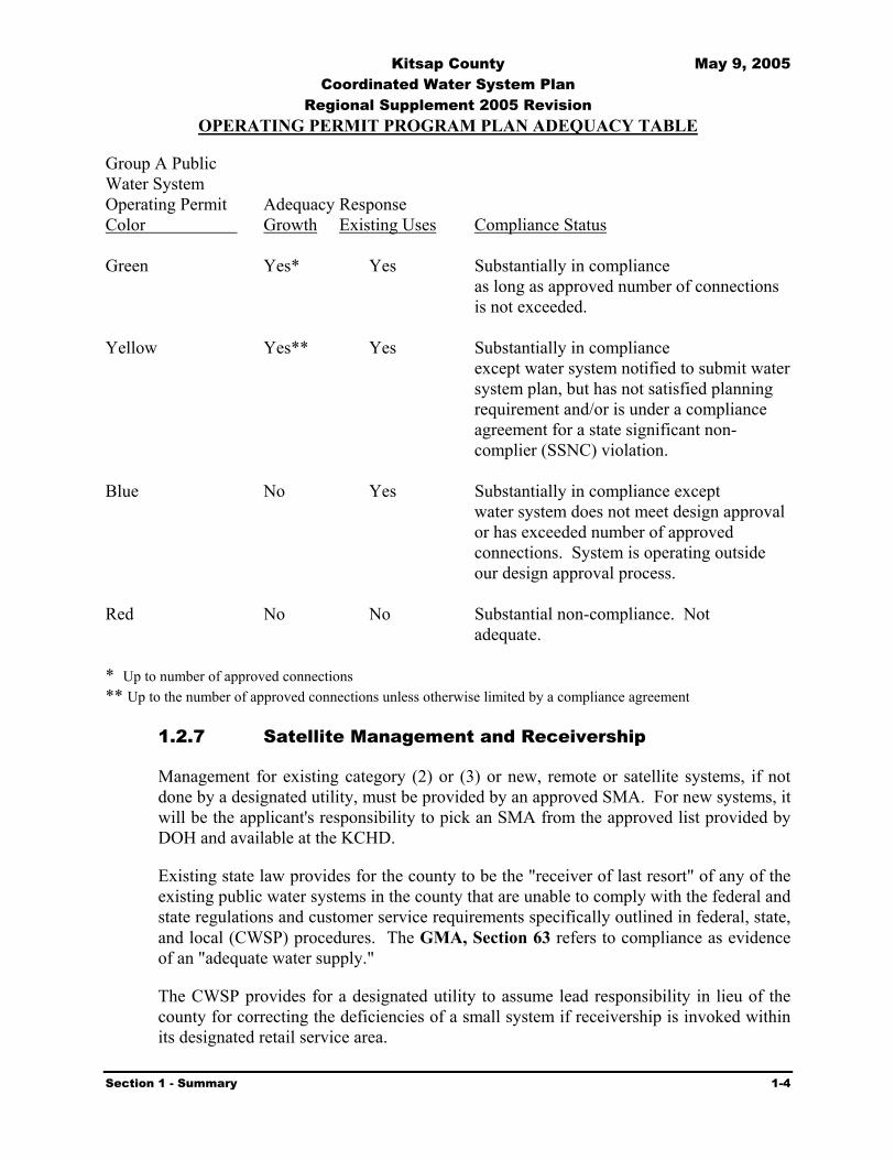
OPERATING PERMIT PROGRAM PLAN ADEQUACY TABLE
Group A Public Water System Operating Permit Adequacy Response Color Growth Existing Uses Compliance Status Green Yes* Yes Substantially in compliance
as long as approved number of connections is not exceeded.
Yellow Yes** Yes Substantially in compliance except water system notified to submit water system plan, but has not satisfied planning requirement and/or is under a compliance agreement for a state significant non-complier (SSNC) violation.
Blue No Yes Substantially in compliance except water system does not meet design approval or has exceeded number of approved connections. System is operating outside our design approval process.
Red No No Substantial non-compliance. Not
adequate.
* Up to number of approved connections ** Up to the number of approved connections unless otherwise limited by a compliance agreement
1.2.7 Satellite Management and Receivership
Management for existing category (2) or (3) or new, remote or satellite systems, if not done by a designated utility, must be provided by an approved SMA. For new systems, it will be the applicant's responsibility to pick an SMA from the approved list provided by DOH and available at the KCHD.
Existing state law provides for the county to be the "receiver of last resort" of any of the existing public water systems in the county that are unable to comply with the federal and state regulations and customer service requirements specifically outlined in federal, state, and local (CWSP) procedures. The GMA, Section 63 refers to compliance as evidence of an "adequate water supply."
The CWSP provides for a designated utility to assume lead responsibility in lieu of the county for correcting the deficiencies of a small system if receivership is invoked within its designated retail service area.

Kitsap County May 9, 2005 Coordinated Water System Plan
Regional Supplement 2005 Revision
Section 1 - Summary 1-5
If the designated utility does not assume responsibility for a receivership system, the goal of the CWSP is for an approved SMA to accept responsibility. In the event an SMA organization is not interested, KPUD will accept receivership responsibility. A Memorandum of Understanding between Kitsap County and KPUD to define this relationship was developed in May 1992. See Exhibit 5-5. This memorandum clarifies that KPUD will use its best efforts to facilitate financially feasible solutions for water systems placed into receivership.
1.2.8 Water Conservation and Monitoring
Washington State DOH Conservation and Planning Requirements (DOH publication #331-0000, March 1994) were incorporated in developing the demand forecast for the CWSP. Implementation of a joint utility based-regional water conservation program is in progress. The Water Purveyors Association of Kitsap County (WATERPAK, an association of the larger purveyors in the County) have established a task force on conservation that plans, implements, and evaluates joint conservation measures. Conservation programs are being included in the preparation or update of individual water system plans. KPUD is assigned lead responsibility for coordinating implementation of a regional program. WATERPAK, with funding assistance from KPUD, has initiated a regional component of water conservation in accordance with Chapter 246.290 WAC. The program includes evaluation of results. The Conservation Task Force of WATERPAK coordinates with the DOH Conservation Specialists in carrying out the regional conservation program. The objective of the regional conservation program is to coordinate and standardize the conservation planning requirements for individual systems. In accordance with the DOH Water System Planning Handbook, if a system can demonstrate that a regional planning organization is performing conservation measures for the individual system, the system will not be required to duplicate those measures, provided the benefits to the individual system from the regional effort equal or exceed the benefits which could reasonably be expected from implementation of the measures by the individual system. Some WATERPAK members belong to the Puget Sound Conservation Coalition and coordinate WATERPAK efforts with Coalition programs. DOH is in the process of developing rules for the implementation of conservation and efficiency standards required by the 2003 Municipal Water Supply – Efficiency Act, commonly referred to as the Municipal Water Law (MWL). When completed, those requirements will be incorporated into WATERPAK and applicable individual water system conservation programs.
1.2.9 Minimum Design Standards
The Minimum Design Standards are discussed in Section 4. They were developed by the WUCC, adopted by the Kitsap County Commissioners in the original CWSP and are applied countywide. The recommended Design Standards reference urban and rural areas and are generally consistent with the GMA criteria on infrastructure planning. County Urban growth area management boundaries are used in implementation of the standards to designate appropriate, minimum levels of service.

Kitsap County May 9, 2005 Coordinated Water System Plan
Regional Supplement 2005 Revision
Section 1 - Summary 1-6
1.2.10 Individual Wells and Ground Water Management
Water service in urban growth areas should be provided by utilities with retail service areas designated through the CWSP process. Individual wells, however, may be constructed on parcels meeting the KCHD siting criteria. As part of the well application process for parcels in retail service areas, KCHD will require the applicant to obtain a feasibility of water service statement from the applicable water purveyor. the applicant retains the permissive judgment to either drill a private well or connect to the utility. The Initial Basin Assessments for Kitsap County and WRIA 15 (Basin Assessments) found that ground water availability varies throughout the County. The Basin Assessments and the Kitsap County Ground Water Management Plan (GWMP) project that water is available for near term growth requirements. The Basin Assessments and the GWMP also recognize the need for additional data collection and analysis.
The participating WUCC utilities should continue to collect, record, analyze and utilize specified ground water, production, and customer usage data for the data management program (See Section 10 and Appendix K).
1.2.11 Regional Supply Strategy
The CWSP has developed a regional strategy for water resource management and development. Based on available data generated through the CWSP, the Kitsap GWMP, and the Basin Assessments, ground water supplies appear to provide the best near-term supply alternative. Continued development of local ground water supplies is recommended as KPUD and other purveyors continue drilling throughout the county to evaluate for long-term regional supplies. The uncertainty of water right application processing, surface/ground water continuity issues, and ESA issues cast concern on the feasibility of ground water development plans, even if significant resources are identified at a regional or sub-area level.
The proposed reliance on ground water, coupled with current uncertainties regarding water rights laws and policies, poses a dilemma for the future availability of supply. Based on the results of the GWMP, the Basin Assessments, and the conjunctive use supply strategy outlined herein, reservation of public waters, as prescribed by WAC 173-590, should be submitted to ensure the issuance of future ground water rights.
Ecology in 1992 noted that no action would be taken on water rights reservation applications until an additional regional water resource planning process was conducted. This regional planning process will need to have active involvement of all interested parties and fully consider regional alternatives. It should be noted that Kitsap County requested such an evaluation as a pilot area under the regional planning process empowered by Chapter 90.54 RCW, but was not selected. The 1998 legislature enacted guidelines for basin planning that most likely will result in coordinated planning for all of WIRA 15 (the Kitsap Peninsula). Supporting data for the Water Rights Reservation process is included in the CWSP.
A Regional Supply strategy for water resource management and development has been developed.

Kitsap County May 9, 2005 Coordinated Water System Plan
Regional Supplement 2005 Revision
Section 1 - Summary 1-7
In order to maintain the utmost flexibility in accepting regional ground water, surface water, or conjunctive use supply strategies, a regional transmission network composed of piping, pump stations, and reservoirs may be necessary. A series of interties should also be explored. Section 9 will address these possibilities. The County Comprehensive Plan, in response to the Growth Management Act, will concentrate growth around Dyes Inlet and Sinclair Inlet. Consequently, it will be necessary to develop water sources in the surrounding parts of the county and establish transmission mains to move the water to where growth is occurring.
A regional supply system to meet the growth management needs of Kitsap County for public water supply will require continuing evaluation to establish the most cost-effective program consistent with public policy.
1.2.12 Data Management
Each major local government and/or division is currently pursuing a coordinated approach to data management. This approach is designed to preclude duplications of effort, repetition of similar data collection efforts, and confusion or disagreement over facts and interpretations of scientific data.
At the state level, the Departments of Ecology, Health, Natural Resources, Wildlife, Fisheries, and Community Development are developing a uniform approach. At the county level, Kitsap County, KCHD, along with several cities, KPUD, and some water/sewer districts, have begun to develop a coordinated Geographic Information System (GIS) and data management system. It is in the best interests of the county, the cities, KCHD, and utilities to complete a joint needs assessment and then undertake a separate but coordinated local government data collection and management program. A generalized outline of the water monitoring program is contained in Appendix K.
1.2.13 Administrative Framework
Implementation of the CWSP requires participation by all members of the WUCC. The CWSP is the County’s regional public water plan. All related decisions by local or state government are guided by the plan.
The Utility Service Review Procedure (USRP), shown in Exhibit 5-1, represents how the county anticipates administering its responsibilities. The water utilities will be responsible for updating the Water System Plans for their designated areas in accordance with DOH regulations. KCHD is responsible for Service Area Coordination including Satellite Management Agencies (SMAs).
1.2.14 Plan Implementation
The following identifies the primary requirements for implementing the revisions identified in this 2004 Update to the CWSP Regional Supplement. The program is designed to be both responsive to existing needs and to place responsibility on designated

Kitsap County May 9, 2005 Coordinated Water System Plan
Regional Supplement 2005 Revision
Section 1 - Summary 1-8
agencies to establish accountability. The acceptance of accountability should be verified through appropriate intergovernmental agreements or letters of understanding.
A number of programs and activities vital to the provision of efficient and reliable utility service in Kitsap County have been identified. Most of these programs and activities are presented in Exhibit 1-2. Each water purveyor should assist in the implementation of the CWSP.
Once approved by the WUCC, this CWSP Revision will be reviewed by Kitsap County for conformance with county and other applicable plans and policies, revised if necessary, and submitted to DOH for approval pursuant to Chapter 70.116 RCW.
The WUCC and individual member agencies should assist DOH, as requested, in the resolution of unresolved retail service area conflicts to ensure that retail service areas are consistent with water utility service objectives of the county and/or city of jurisdiction.
Periodic meetings of the WUCC should be scheduled to review CWSP implementation and need for revision.
The minimum water systems standards presented in Section 4 should be reviewed as necessary by a review committee of the WUCC. Recommended revisions should be submitted by the WUCC to the County Commissioners for adoption.
The objectives and procedures outlined in the CWSP are considered to be reasonable and achievable by all properly operated water systems. Repeated failure by a system to provide safe, reliable, and minimum levels of water service, as measured by the CWSP criteria, should serve as a basis to evaluate viability of the system. The viability test described in the CWSP and specified by DOH should be applied. Non-viable systems should be candidates for receivership, voluntary transfer of ownership, or merger proceedings.
This CWSP should be revised and updated as necessary and as directed by DOH, as prescribed by Chapter 70.116 RCW.

Kitsap County May 9, 2005 Coordinated Water System Plan
Regional Supplement 2005 Revision
Section 1 - Summary 1-9
Exhibit 1-1 Water Utility Coordinating Committee Purveyor Members
System Name Mail Address City State Zip Annapolis Water District 2924 Lund Ave SE Port Orchard WA 98366Apex Water Supply P.O. Box 4520 Bremerton WA 98312Bainbridge Island, City of 7305 Hidden Cove Road Bainbridge Island WA 98110Bear Cub Water Association P.O. Box 933 Port Orchard WA 98366Bethel East PO Box 123 Port Orchard WA 98366Bill Point Water 8915 Day RD Bainbridge Island WA 98110Bremerton, City of 3027 Olympus Drive Bremerton WA 98310Cedar Glen M/H Park 16300 State Highway #305 Poulsbo WA 98370Dawn Park Water Co Inc PO Box 493 Silverdale WA 98383Emerald Heights Water 5400 Diamond DR NE Bainbridge Island WA 98110Erland Point Water Co P.O. Box 644 Silverdale WA 98383Frog Pond Waters Inc 4603 Union Bay Place NE Seattle WA 98105Glenwood Station 4978 SW Lake Flora Rd Port Orchard WA 98366Holly Water 678 Alan King Road W Seabeck WA 98380Island Lake Water Co P.O. Box 1085 Poulsbo WA 98370Island Utilities 1325 Fourth Ave, 10th Floor Seattle WA 98101Jackson Park Kitsap West M/H Park
1400 Faragut Ave 3370 SE Bielmeir RD #5
Bremerton Port Orchard
WA WA
9831498366
Kitsap Public Utility District PO Box 1989 Poulsbo WA 98370Mainland View Manor Water Sys 7277 Perimeter Road, #209 Seattle WA 98108Manchester Water District P.O. Box 98 Manchester WA 98353McCormick Woods 216Prospect St Port Orchard WA 98366Meadowmeer Water Service P.O. Box 10483 Bainbridge Island WA 98110Naval Undersea Warfare Center Bldg 825, Code 1432 Keyport WA 98345North Bainbridge Water Co P.O. Box 4766 Bainbridge Island WA 98110North Perry Ave Water Dist P.O. Box 2183 Bremerton WA 98310Olympic View Mobile Manor PO Box 82750 Kenmore WA 98028Pine Lake M/H Est 1-3 P.O. Box 44427 Tacoma WA 98444Port Madison Water Co. 15961 Eucid Ave NE Bainbridge Island WA 98310Port Orchard, City of 216 Prospect ST Port Orchard WA 98366Poulsbo, City of P.O. Box 2275 Poulsbo WA 98370Priddy Vista P.O. Box 417 Seabeck WA 98380Puget Sound Naval Shipyard 1400 Faragut Avenue Bremerton WA 98314Rocky Point Water Dist. 12 P.O. Box 4318 Bremerton WA 98312Sandy Hook Community P.O. Box 778 Poulsbo WA 98370Silverdale Water District No 16 P.O. Box 493 Silverdale WA 98383S'klallam Upper 31912 Little Boston Rd NE Kingston WA 98346S'kllalam Lower 31912 Little Boston Rd NE Kingston WA 98346South Bainbridge Water 4573 Pt. White Dr. Bainbridge Island WA 98110SUBASE Bangor SUBASE Bangor, Code 821 Silverdale WA 98315Sunnyslope Water District 5693 SW Rhododendron Drive Port Orchard WA 98366Surfrest Park Water Co. 565 Surfcrest Ave. NE Poulsbo WA 98370Tracyton Water 3027 Olympus Dr. Bremerton WA 98310Viewside Community Water P.O. Box 485 Poulsbo WA 98370WA Water Services P.O. Box 336 Gig Harbor WA 98335

Kitsap County May 9, 2005 Coordinated Water System Plan
Regional Supplement 2005 Revision
Section 1 - Summary 1-10
Exhibit 1-2 Kitsap County CWSP Programs and Activities
Programs & Activities Responsibility Program Elements Lead Support A. Plan revision adoption 1. WUCC approval WUCC Consultant 2. County certification County WUCC 3. DOH approval DOH WUCC B. Individual water system plan updates Utilities DOH C. Service Area conflict resolution KCHD WUCC D. Satellite System program 1. Statewide regulations DOH County 2. Designate agency(s) DOH KCHD 3. Implement program SMAs KCHD E. Utility Service Review Program 1. Implementation County Utilities 2. Appeal process County WUCC F. Minimum Design Standards Revision 1. WUCC Draft Changes WUCC KCHD 2. County adoption County KCHD 3. Utility implementation Utilities KCHD G. Classify systems 1. Viability Test WUCC County / DOH 2. Evaluate systems KCHD DOH H. Data Management Program KPUD Utilities I. Supply Systems 1. Continue local groundwater development Utility KCHD / DOH /
County DCD 2. Pursue groundwater test well drilling KPUD Utilities 3. Groundwater level monitoring Utilities KPUD 4. Groundwater quality monitoring Utilities KCHD 5. Monitoring results reported to database Utilities KPUD / KCHD /
County DCD 6. Evaluate Pierce/Mason Co. Supply Coordination KPUD WUCC 7. Negotiate Intertie Agreements Utilities WUCC & Construct Interties Utilities WUCC 9. Initiate Water Rights Reservation Process WUCC DOH/Ecology J. Water Conservation Program Utilities WATERPAK /
County DCD

Kitsap County May 9, 2005 Coordinated Water System Plan
Regional Supplement 2005 Revision
Section 2 - Coordinated Water System Plan Process 2-1
Section
2 Coordinated Water System Plan Process 2.1 Introduction
The Public Water System Coordination Act, enacted in 1977, modified in 1991 and 1995, and codified as Chapter 70.116 RCW, establishes a procedure for the state's water utilities to coordinate their planning and construction programs with adjacent water utilities and other local governmental activities including planning under the Growth Management Act (GMA). This Act specifies that the Department of Health (DOH) (formerly under the Department of Social and Health Services) or the county legislative authority may declare an area within a county as a Critical Water Supply Service Area (CWSSA). This declaration is based upon the findings of a Preliminary Assessment identifying problems related to inadequate water quality, unreliable service, or lack of coordinated planning.
In 1971, the State Legislature enacted the Water Resource Act, Chapter 90.54 RCW, which set forth fundamentals of water resource policy to ensure the waters of the state will be protected and fully used for the greatest benefit of the people of the state. Subsequently, "Procedures Relating to the Reservation of Water for Future Public Water Supply," Chapter 173-590 WAC, were established. These procedures are available to public water systems within a geographical area for use in reserving water rights required to meet their projected domestic needs over the next 50 years. This program is administered by the Department of Ecology (Ecology) in an effort to resolve competing water use activities within a geographical area and establish a management system that will ensure that an efficient overall water resource program is developed. The 1997 and 1998 Legislatures passed the Integrated Watershed Management amendments to Chapters 43 and 90 of the Revised Code of Washington (RCW). The resulting program is commonly referred to as “Basin Planning” and is conducted on a Water Resource Inventory Area (WIRA) or multi-WIRA basis. The amendments impact on the water reservation program is yet to be determined.
The Public Water System Coordination Act and the Water Rights Reservation processes may be used individually or in combination by the local public water utilities. Implementation of either of these laws requires that a Coordinated Water System Plan (CWSP) be prepared for the county. The Kitsap County CWSP was prepared in accordance with the requirements of both laws. It consists of a Regional Supplement together with a compilation of water system plans prepared by each expanding water utility, which are attached by reference only. This document is the first major revision to the CWSP Regional Supplement since 1992. In addition to other purposes, the current revision is designed to make the CWSP consistent with the Kitsap County and associated city comprehensive plans.
2.2 Preliminary Assessment
Kitsap County initiated action toward development of a CWSP through the joint preparation of a Preliminary Assessment by the Kitsap County Department of Community Development

Kitsap County May 9, 2005 Coordinated Water System Plan
Regional Supplement 2005 Revision
Section 2 - Coordinated Water System Plan Process 2-2
(KCDCD) and the Kitsap Public Utility District (KPUD). This report, titled "Preliminary Assessment of Water Resource and Public Water Services Issues in Kitsap County" was completed and issued on April 15, 1986. The intent was for the assessment to evaluate conditions that might require utilization of the CWSP process for water system planning and water rights reservation and preparation of a Ground Water Management Plan (GWMP). The CWSP program is administered by the DOH and the GWMP process is administered by Ecology. Efforts were made to facilitate the simultaneous initiation and coordination of both programs.
Several concerns were identified in the Preliminary Assessment. The major conclusions and recommendations of the Preliminary Assessment are extracted and reprinted as Exhibit 2-1. Among the conclusions was the realization that the proliferation of small public water systems was occurring at an alarming rate. There were 450 public water systems in the county in 1978 and 803 public water systems as of April 1986, or about eight percent of the total water systems in the state. By 1996 the number had increased to 1,096 of which 868 were group B water systems. In addition, with the exception of the City of Bremerton, most public water systems throughout the county utilize ground water supplies, however, a few small systems still depend on springs or dug wells. The reliance upon ground water supplies increased from 60 percent of the total water use in 1978 to approximately 80 percent in 1986. The rapid growth predicted for the county places increased significance on the development of reliable water supplies. Shortly before development of the Preliminary Assessment, Ecology released draft regulations for the In-stream Resources Protection Program, which severely limits the development of Olympic Peninsula surface supplies for public water use within Kitsap County. It appeared necessary to coordinate the water supply development, protection, and transmission throughout the county. Therefore, the Preliminary Assessment identified several issues most appropriately solved by implementation of the Coordination Act. Subsequently, in 1999, Ecology denied water rights applications submitted in the 1950s by KPUD and the City of Bremerton on the Duckabush and Hamma Hamma Rivers, respectively. These denials illuminate the increasing importance of countywide coordination of water supplies.
An Interlocal Agreement was prepared between the county and KPUD, establishing KPUD as the local agency responsible for development of a scope of work, obtaining grant funding for the program, and administering all activities related to this effort. Discussions were conducted among the county, KPUD, and DOH over several weeks to establish the criteria and conditions associated with the CWSP. Once project funding was secured and based on the conclusions of the Preliminary Assessment, the Kitsap County Commissioners declared all of Kitsap County a CWSSA through Resolution No. 77-1987, dated March 2, 1987 (shown in Exhibit 2-2). Exhibit 2-3 shows a vicinity map and the Kitsap County boundary, which serves as the external boundary for the CWSP.
By this action, the Public Water System Coordination Act was invoked. A Water Utility Coordinating Committee (WUCC) was formed, consisting of representatives of all purveyors with ten or more service connections, as well as representatives from Kitsap County government and DOH. All purveyors with 50 or more services were voting representatives on the WUCC. All other purveyors participated on the WUCC in an advisory capacity.
WUCC - A committee consisting of water purveyors, Kitsap County, and DOH.

Kitsap County May 9, 2005 Coordinated Water System Plan
Regional Supplement 2005 Revision
Section 2 - Coordinated Water System Plan Process 2-3
2.3 1992 CWSP Preparation
Preparation of the CWSP involved the joint efforts of participating local WUCC members, county agencies, and KPUD staff through approximately four years of meetings. In addition, special meetings were held by subcommittees of the WUCC to address issues such as facility design standards and specifications, and the appeals process.
The WUCC proposed several administrative procedures organized to provide improved coordination of new development and to restrict the proliferation of small public water systems. These procedures included the development of Future Service Area Boundaries, Minimum Design Standards, Utility Service Review Procedures, Appeals Procedures, and the Satellite System Management Agency (SSMA) program. These procedures were presented to the County Commissioners in 1988 to adopt on an interim basis while other regional supply issues were being addressed. The intent was to implement key procedures on an interim basis and identify needed modifications, additions, or deletions before acceptance of the final CWSP. A delay in the adoption of the interim procedures occurred due to several issues of significance: difficulties in the approval process; the inability to obtain water rights from Ecology; annexation conditions prescribed by some cities within their future service area; challenges to design standards; and the requirements of the 1990 Growth Management Act.
On June 4, 1990, the County Commissioners adopted Resolution No. 228-1990 and Ordinance No. 134 which put the interim procedures into effect. These documents are included as Exhibits 2-4 and 2-5, respectively. As of that date, existing water systems were considered to be utilities with a DOH approved water system plan and properties served by existing distribution systems. Developments given preliminary plat approval before June 4, 1990 with properties served by distribution systems for proposed or phased developments which submitted written information for review or received approval of their water system facilities, well site locations, plans, and specifications from DOH and/or the local health jurisdictions were also considered to be an existing water system. The interim procedures underwent slight changes based upon further review by the WUCC. The final procedures were included in the CWSP.
The following paragraphs summarize excerpts from the 1992 CWSP that describe the areas which received particular emphasis.
2.3.1 Future Service Area
Each utility was requested, through correspondence and during the WUCC meetings, to plot its existing and future service area boundaries on a map. All Group A and B water systems (previously designated as Class 1, 2, 3, and 4 systems) were contacted by letter, requesting identification of their proposed future service areas and/or their intention to expand. Future service areas were those likely to be served by the utility within the next ten years and where expansion was consistent with applicable comprehensive land use planning. The future service area boundaries of the larger Group A systems and the smaller systems with intent to expand were plotted on base maps to identify conflicting areas. Those utilities that did not identify their future service area were assumed not to
CWSP - Composed of individual system plans and a supplement of regional issues.

Kitsap County May 9, 2005 Coordinated Water System Plan
Regional Supplement 2005 Revision
Section 2 - Coordinated Water System Plan Process 2-4
be interested in expanding. For those utilities, the future service area was assumed to correspond to the existing service area. A standard agreement was formulated to allow utilities to recognize adjacent service areas by reference to service area maps.
Several overlaps in future service areas were initially identified early in the study process. All but two overlaps were resolved during preparation of the 1992 CWSP. Additional development or utility expansion within these contested overlap service areas was not allowed until the conflict was resolved. This provision did not affect the remaining non-conflict areas of the utilities. After the adoption of the CWSP, new contested overlaps occurred which were channeled through the resolution process. The combination of a utility’s existing service area (parcels with distribution mains already existing) and declared future service was referred to as the utility’s service area. That service area was shown on the service area maps without distinction as to existing or future service area delineation. The service area did not always correspond to the incorporated boundaries of government run utilities. Since development of the 1992 CWSP, an additional requirement is that water service areas support the intent of the Growth Management Act.
2.3.2 Minimum Design Standards
The standards addressed a diverse list of considerations by the utilities, including: material specifications, construction practices, distribution facilities, metered services, fire flow requirements, etc. The content and application of these standards were developed jointly through input of WUCC representatives and the county.
The standards are included in Section 4. They continue to be the minimum standards for all new water system improvement and have been adopted through ordinance on a final basis by the county and approved by DOH. A water utility may adopt these standards by reference, or may adopt more stringent standards.
The Kitsap County Health District (KCHD) also used these minimum design standards as a basis to develop revisions to standards applied to smaller systems. The small system standards apply to Group B systems, which are reviewed and approved by KCHD.
2.3.3 Utility Service Review Procedure (USRP)
The USRP was developed to identify the appropriate purveyor, both willing and capable to provide water service to new developments and expansions. This procedure utilizes the recognized service areas as a basis for assigning new applicants for development permits to water utilities. If the purveyor who is assigned the area in which a development is proposed is not able or is unwilling to provide timely and reasonable service, or if the area is a Satellite Management (undesignated) area, the closest adjacent utility with an approved water system plan becomes the preferred service provider. If adjacent and qualified utilities do not exist, the KCHD may refer a developer to an SMA. The recommended program for utility service review is outlined in Section 5.

Kitsap County May 9, 2005 Coordinated Water System Plan
Regional Supplement 2005 Revision
Section 2 - Coordinated Water System Plan Process 2-5
2.3.4 Satellite System Management Agency (SMA) Program
A long-term program for providing satellite management services to new and existing water systems was developed. This program is described in Section 6. The program applies to undesignated service areas as well as within service areas where the designated utility cannot make a direct connection and is unwilling to accept "remote" ownership or operational responsibility. SMAs must be approved by DOH.
2.3.5 Regional Water Supply
The regional supply needs of Kitsap County were evaluated in increments through the year 2040. Forecasts of future population and water demand within the area were made based upon Puget Sound Council of Governments (PSCOG) population estimates and water use data from local utilities. An assumed level of water conservation was developed and factored into the water demand forecast.
An additional water demand of approximately 18 MGD (average day use) was forecast to be required for the study area by the year 2040. This analysis assumed that existing supplies were capable of meeting the current demand. Following review of potentially available surface and ground water sources, the preferred future supply option was determined to be continued reliance on ground water developed either at regional or local well fields. The GWMP identified the potential for substantial ground water in the western and southern areas of the county. A few new wells in the southern parts of the county had not identified significant new sources of ground water. Additional ground water exploration was suggested to determine the actual availability and suitability of ground water to meet future demands.
Surface supplies have an uncertain future for Kitsap County. The City of Bremerton obtains approximately 65% of its supply from the Union River. That supply is used for city customers along with contract supplies to Puget Sound Naval Shipyard, one small water district, and surplus to the City of Port Orchard.
2.3.6 Water Rights
A thorough review of the status of existing water rights was conducted for those expanding utilities within the CWSSA. Two sources of information were compared. One source was the water right records and the water right claims registry of Ecology. The other was in-service/installed capacity information obtained from utility questionnaire responses, utility comprehensive Water System Plans, and the Water Facility Inventory records of DOH. The result was a determination of: (1) where a utility's present use did not appear to be adequately covered by water rights; and, (2) those instances where a utility held water rights for future expansion.
These determinations were used in assessing the capabilities of existing utilities to meet current and future water needs and in evaluating the data requirements for filing a petition for water right reservation.

Kitsap County May 9, 2005 Coordinated Water System Plan
Regional Supplement 2005 Revision
Section 2 - Coordinated Water System Plan Process 2-6
2.4 Individual Water System Plans
The Public Water System Coordination Act states that each purveyor within the external boundary of a CWSSA shall be responsible for preparing a Water System Plan for the purveyor's service area. This plan is to describe the utility's proposed method for serving its area. An exception to these criteria exists for non-municipally owned public water systems that existed prior to September 21, 1977, and which have met minimum State Board of Health requirements, but do not plan to extend water service beyond their existing area.
Prior to writing or revising a water system plan, purveyors should contact the Department of Health, Office of Drinking Water. The planning requirements are determined by DOH and vary for individual utilities based on size and complexity in accordance with WAC 246-290-100. The level of detail and specific requirements is determined during a pre-plan conference with DOH. A summary of the basic planning requirements is provided in Appendix A. A detailed description of planning requirements is provided in DOH’s Water System Planning Handbook (DOH Publication #331-068, April 1997). In addition to these requirements, future water system plans must address the items identified in the Municipal Water Law (MWL)1. Systems that do not require a Water System Plan are required to complete a Small Water System Management Program (SWSMP) in accordance with WAC 246-290-105. For a complete description of SWSMP content requirements, refer to the Small Water System Management Program Guide (DOH Publication 331-134).
In addition to the above requirements, all systems within a CWSSA required to submit a water system plan must, in the preparation or update of their plan, address items relating to the entire CWSSA.
Items required include:
Map of service area, Signed service area agreement, Population and water demand projections, Design standards, Implementation of minor and major regional projects, Implementation of water utility service review procedure, Implementation of a satellite system management program, and Water conservation program.
Exhibit 2-6 illustrates the procedure for the review and approval of individual water system plans by the KCHD and DOH. Currently, KCHD has responsibility for all public water systems with 25 or fewer service connections, as well as individual wells influenced by on-site wastewater regulations. The KCHD has defined that any system serving three or more residential connections is a public water system. However, a water supply that serves two lots in
1 Revised DOH guidelines regarding elements of water system planning addressed in the MWL are to be in place by the end of 2005. Until that time, the “interim” approach developed by DOH will serve as a guide to these elements of drinking water planning.

Kitsap County May 9, 2005 Coordinated Water System Plan
Regional Supplement 2005 Revision
Section 2 - Coordinated Water System Plan Process 2-7
which each lot is at least one acre or larger in size and the water source is a drilled well, is exempt from public water system requirements provided criteria specified in the KCHD Board of Health Ordinance 1999-6 is met. The procedure outlined in Exhibit 2-6 pertains only to public water systems. It is recommended as the review method for plans not yet submitted and for updates of all individual plans.
By reference, the individual water system plans are incorporated into this CWSP by Appendix B, which lists the current status of all Kitsap County Group A water systems’ individual water system plans.
2.5 Regional Supplement
The 2004 CWSP has been prepared under the provisions of WAC 246-293-220 which allows for a CWSP which consists of: (1) a compilation of water system plans approved by DOH, and (2) a supplement which addresses water purveyor concerns relating to the entire CWSSA. All completed water system plans of the individual utilities are incorporated herein by references, as Appendix B, and are kept on file at DOH and/or KCHD. The review and approval procedure for this document, the Regional Supplement, is outlined in Section 10.
KCHD is responsible for tracking the status of expanding water systems with respect to service area agreements and maintaining the official file of those agreements. KPUD, at the direction of KCHD, is responsible for updating computerized service area maps.
The original 1992 Regional Supplement is updated and amended by this 2004 document. Individual water utilities must update their plans as required by DOH. As water system plan revisions receive KCHD and /or DOH approval, they will be administratively included within the adopted CWSP.

Kitsap County May 9, 2005 Coordinated Water System Plan
Regional Supplement 2005 Revision
Section 2 - Coordinated Water System Plan Process 2-8
Exhibit 2-1
1986 PRELIMINARY ASSESSMENT OF WATER RESOURCES AND PUBLIC WATER SERVICE ISSUES IN KITSAP COUNTY
CONCLUSIONS AND RECOMMENDATIONS CONCLUSIONS The conclusions of this Preliminary Assessment are as follows: A. Preventive action for the provision of reliable service and the protection of water supplies serving
current customers is prudent and cost-effective. B. The County's Comprehensive Plan projects a continued growth in population and water demand
that will most effectively be met primarily by existing water utilities. C. The County currently has more than 800 public water systems, with coordination of utility
services only occurring between the major purveyors. D. Preliminary estimates on growth, population, and water demand exceed the anticipated available
groundwater resources. E. The DOE has released draft regulations for the Instream Resources Protection Program which
severely limit the possibility of developing an Olympic Peninsula surface supply for public water use within Kitsap County. It is necessary to coordinate the water supply development, protection, and transmission, particularly if a new surface water supply is required to meet future needs.
F. The existing County Water Plan was completed in 1970, and its findings may no longer be valid. G. With the continued growth anticipated within Kitsap County, the responsibilities for protecting
and managing the available groundwater resources consistent with County policies, must be established both for existing and future customers.
RECOMMENDATIONS It is recommended that a CWSP and GWMP be implemented throughout Kitsap County, and that a petition for the reservation of future water rights be filed on those sources identified by the study effort. It is further recommended that due to the unique geographical character of Kitsap County, subareas may be identified for more detailed analysis. It is further recommended that the Kitsap County Commissioners take the necessary action to initiate the study effort and designate the Public Utility District as the lead agency for preparation of the CWSP and GWMP. It is further recommended that a Steering Committee be established to coordinate the activities of the programs.

Kitsap County May 9, 2005 Coordinated Water System Plan
Regional Supplement 2005 Revision
Section 2 - Coordinated Water System Plan Process 2-9
Exhibit 2-2
KITSAP COUNTY RESOLUTION NO. 77-1987
WHEREAS, The Kitsap County Commissioners recognize and support the need to provide water supply and regional resource planning for the benefit of citizens throughout the County; and WHEREAS, a Preliminary Assessment, dated April 15, 1986, has been prepared for Kitsap County which addresses concerns related to public water supply service and groundwater resource availability; and WHEREAS, the Preliminary Assessment found that no significant problems exist at this time; and WHEREAS, the Preliminary Assessment recommends a long range water resource planning program to help prevent problems from arising in the future; and WHEREAS, the Preliminary Assessment recommended development of a Coordinated Water System Plan and a Ground Water Management Plan to update the County Water System Plan; and WHEREAS, development of a Ground Waster Management Plan and a Coordinated water System Plan for Kitsap County will prepare a comprehensive resource strategy for preventative measures and not in response to existing water resource problems of a critical nature; and WHEREAS, the Kitsap County Commissioners pursuant to Chapter 70.116.4 (1) RCW have the authority to invoke implementation of the Public Water System Coordination Act. BE IT THEREFORE RESOLVED by the Board of County Commissioners of Kitsap County, Washington, that the provisions of Chapter 70.116 RCE be invoked and a Coordinated Water System Plan be prepared for the entire area of Kitsap County. ADOPTED this 2nd day of March 1987. BOARD OF COUNTY COMMISSIONERS KITSAP COUNTY, WASHINGTON

Kitsap County May 9, 2005 Coordinated Water System Plan
Regional Supplement 2005 Revision
Section 2 - Coordinated Water System Plan Process 2-10
Exhibit 2-3

Kitsap County May 9, 2005 Coordinated Water System Plan
Regional Supplement 2005 Revision
Section 2 - Coordinated Water System Plan Process 2-11
Exhibit 2-4 May 15, 1990
KITSAP COUNTY RESOLUTION NO. 228-1990
A RESOLUTION ADOPTING INTERIM PROCEDURES FOR COORDINATING
WATER UTILITIES AND ESTABLISHING KITSAP COUNTY POLICIES FOR USE WHEREAS, the Kitsap County Commissioners recognize and support the need to provide water supply and regional resource planning for the benefit of citizens throughout the County; and WHEREAS, a Preliminary Assessment, dated April 15, 1986, has been prepared for Kitsap County which addresses concerns related to public water supply service and groundwater availability; and WHEREAS, the Preliminary Assessment found that although no significant problems exist at this time, it recommended a long range water resource planning program to help prevent problems from arising in the future; and WHEREAS, the Preliminary Assessment recommended development of a Coordinated Water System Plan and County Water System Plan March 1987; and WHEREAS, the update to the development of a Coordinated Water System Plan for Kitsap County will prepare a comprehensive resource strategy for preventive measures and not in response to existing water resource problems of a critical nature; and WHEREAS, the Kitsap County Commissioners pursuant to Chapter 70.116.4 (1) RCW have invoked the Public Water System Coordination Act March 1987; and WHEREAS, the Kitsap County Public Utility District was given lead agency status to prepare a Water System Coordinated Plan with recommendations from the Water Utility Coordinating Committee; and WHEREAS, interim procedures for the implementation of the Coordination Act have been forwarded to the Board of County Commissioners for their review; and WHEREAS, the Board wishes to facilitate Coordinated Water Services within the County and establish policies for implementation; and WHEREAS, compatibility of design provides efficiency of scale and opportunities for joint purchase and satellite services; and WHEREAS, service areas established by management opportunity rather than management obligation provides timely services; and

Kitsap County May 9, 2005 Coordinated Water System Plan
Regional Supplement 2005 Revision
Section 2 - Coordinated Water System Plan Process 2-12
WHEREAS, establishment of service areas and responsible management ensures the provision of quality and timely water services; and
WHEREAS, all County citizens should be ensured against inadequate water services, policies, and inequitable conditions; NOW
BE IT THEREFORE RESOLVED by the Board of County Commissioners of Kitsap County, Washington, that subject to the following purpose, goals and policies the “Interim Procedures", and "Appeals Process” attached as exhibit "A" be adopted.
Section 1. PURPOSE:
The purpose of the Coordinated Water System Program is to maximize the efficiency and effectiveness of water service delivery in the County by defining logical service areas within which utilities accept responsibility for providing service through direct connections, interim remote or satellite service which accomplish the following goals and policies:
Section 2. COORDINATED PLANNING
GOAL CP 1: To develop mutually acceptable coordinated comprehensive land use plans which will minimize conflicts between jurisdictions concerning land use approvals and water system needs. POLICY CWS 1: Kitsap County and the cities within it will identify land use conflicts within adopted land use plans and develop through memorandum of understanding coordinated comprehensive plans including mutually agreed upon urban growth areas, annexation areas, and land use regulations and standards to eliminate these conflicts by July 1, 1991. POLICY CWS 2: In the interim until coordinated plans are adopted, Kitsap County and the cities within it may approve a land use which is in conflict with the adjacent plan only after the appropriate City or County has been provided notice and reasonable opportunity for comments. POLICY CWS 3: At a minimum, the coordinated planning area should include the appropriate water service area and should be a consideration in future urban growth boundary discussions. Discussion: Coordination of comprehensive plans, land use regulations, and standards allows for discussion between Individuals, the City and County, on an area by area basis such that conflicts between jurisdiction can be resolved which are tailored to the concerns of the area.
Kitsap County May 9, 2005 Coordinated Water System Plan
Regional Supplement 2005 Revision
Section 2 - Coordinated Water System Plan Process 2-13
Section 3. SUPPLY
GOAL WS 1: To provide for an adequate supply of potable water vital to the health and well being of the people of the County.
GOAL WS 2: To develop and use efficiently the limited supply of readily available water in public water systems.
Discussion: A two year analysis of the water availability contained in the Kitsap County Groundwater Management Plan Volumes I & 11 indicated among other things that water supply was not of immediate concern but that new testing and sampling requirements may place a burden on smaller less organized systems and that satellite service options would best alleviate such problems. Concerns about water availability continue and without coordination of new projects to existing utilities the proliferation of small systems without adequate expertise threatens the capability for providing safe and healthy water service.
Section 4. DISTRIBUTION:
GOAL WD 1: To maximize efficient and effective development of the County's public water supply systems by providing a procedure to coordinate the planning of the public water supply systems.
GOAL WD 2: To facilitate Coordinated Water Services within the County.
GOAL WO 3: To ascertain cost-effective solutions to water system distribution and alternatives to proliferation.
POLICY CWS 3: The Interim Procedures shall provide designated utilities the first opportunity to provide service to new water service applicants. POLICY CWS 4: The Interim Procedures may allow a project proponent that does not desire to annex to receive service from an adjacent utility only after appeal.
POLICY CWS 5: A new utility within a utility's future service area may be formed only after successful appeal or where adjacent utilities have certified to the inability to provide service, including satellite agreements.
POLICY CWS 6: Where a new utility is required due to either inability of the designated utility or adjacent utility or successful appeal, new service areas may be established

Kitsap County May 9, 2005 Coordinated Water System Plan
Regional Supplement 2005 Revision
Section 2 - Coordinated Water System Plan Process 2-14
only by the Water Utility Coordinating Committee meeting the requirements of the adopted procedures and the applicable RCW and WAC.
Discussion: The establishment of Service Area Boundaries was coordinated with all utilities serving more than ten customers. Boundaries were established and areas of conflict resolved through a negotiated process.
Section 5. STANDARDS:
GOAL WS 1: To provide for the development of minimum planning and design standards for critical water supply service areas to insure that water systems developed in these areas are consistent with regional needs.
POLICY CWS 7: New utilities or satellite systems within a designated utility's service area would be installed to meet the designated utility's minimum design standards.
Discussion: The Water Utility Coordinating Committee met over a period of two years and discussed standards and design criteria and developed and reviewed proposed standards at work shops and public meetings held throughout the County. Pipe size was decided to be a higher priority than pipe type for example. The standards contained in the (attached) Ordinance are the result of this process.
Section 6. APPEALS:
GOAL WA 1: To provide an appeals process to settle disputes and insure fair treatment of customers within utility service areas.
POLICY CWS 8: Criteria for successful appeal may include but are not limited to matters which defeat the goals and purposes of the Coordination Act such as:
1) unreasonable cost for similar services requested; or 2) incompatible land use plan and system requirements; or
3) conditions of service excluding published rates and fees, but including annexation requirements outside of areas where there is a mutually agreed upon annexation plan; or
4) inefficient utility management or administrative procedure.
POLICY CWS 9: Appeals to the Board of County Commissioner shall first consider the record presented in the appeals process and any new material authorized may require justification. The Board of County Commissioners may remand, change, delete or modify in whole or in part any previous decision.

Kitsap County May 9, 2005 Coordinated Water System Plan
Regional Supplement 2005 Revision
Section 2 - Coordinated Water System Plan Process 2-15
Discussion: The Water System Coordination Act is intended to provide for the efficient management and development of water systems and extensions. The provision of these services or extensions should be based on availability of service and not based upon other concerns of the purveyor. ADOPTED THIS 4th day of June, 1990.
BOARD OF COUNTY COMMISSIONERS KITSAP COUNTY, WASHINGTON

Kitsap County May 9, 2005 Coordinated Water System Plan
Regional Supplement 2005 Revision
Section 2 - Coordinated Water System Plan Process 2-16
Exhibit 2-5
ORDINANCE NO. 134 AN ORDINANCE ADOPTING MINIMUM DESIGN STANDARDS
FOR PUBLIC WATER SYSTEMS AND ESTABLISHING PROCEDURES FOR IMPLEMENTATION
WHEREAS, Kitsap County has been designated a Critical Water Supply Service Area (CWSSA) pursuant to Chapter 70.116 RCW the Public Water System Coordination Act of 1977; and
WHEREAS, pursuant to said Act, a Water Utility Coordinating Committee (WUCC) has been established to develop a Coordinated Water System Plan (CWSP) for the designated area; and
WHEREAS, the WUCC has prepared and adopted Minimum Design Standards to ensure that water systems developed in the designated area consistent with regional needs; and
WHEREAS, it is necessary to establish procedures for immediate implementation of these standards;
NOW, THEREFORE, BE IT ORDAINED BY THE KITSAP COUNTY BOARD OF COUNTY COMMISSIONERS:
Section 1 - Purpose. The purpose of the Minimum Design Standards is to set a base-level of utility planning, design, and construction for public water utilities. Uniformity and consistency in the Standards will enhance reliable service and hydraulic efficiency to consumers as system interties and/or consolidation of utilities takes place.
Section 2 - Definitions. The following words or terms are defined as follows:
A. Coordinated Water System Plan (CWSP) - A plan for public water systems within a Critical Water Supply Service Area (CWSSA) which identifies the present and future needs of the systems and sets forth means for meeting those needs in the most efficient manner possible.
B. Critical Water Supply Service Area (CWSSA) - A geographical area which is characterized by a proliferation of small inadequate water systems or by water supply problems which threaten the present or future water quality or reliability of service in such a manner that efficient and orderly development
may best be achieved through coordinated planning by the water utilities in the area.
C Existing Water System - Any system or water supply intended or used for human consumption or other domestic uses including, but not limited to, source, treatment, storage, transmission and distribution facilities where water is furnished to any community, number of individuals, or is made available to

Kitsap County May 9, 2005 Coordinated Water System Plan
Regional Supplement 2005 Revision
Section 2 - Coordinated Water System Plan Process 2-17
Ordinance No. 134 Page Two
the public for human consumption or domestic use. This definition shall exclude water systems serving one single family residence, water systems existing prior to September 21, 1977, which are owner-operated and serve less than 10 single-family residences, and water systems serving no more than one industrial plant.
D. Service Area - A specific area within which direct service or retail service is planned by a public water system, as determined by written agreement between purveyors as provided in WAC 248-56-730.
E. Utility or Water Utility - Any agency or subdivision of the State or any Municipality, firm, company, mutual or cooperative association, institution,
partnership, person, or any other entity that owns or operates a public water system for wholesale or retail service, or their authorized agent.
F. Water System Plan (WSP) - A written, comprehensive water supply plan prepared for a particular water system and service area which identifies a
schedule of needed improvements, a financial program, and an operations program.
G. Water Utility Coordinating Committee (WUCC) - A committee required by WAC 248-56-500 which was established by the Kitsap County Board of
County Commissioners and composed of a representative from each purveyor serving more than 50 customers, the County legislative authority, County planning agency, and health agencies.
Section 3- Application of Standards. The Minimum Design Standards are hereby adopted and incorporated into this Ordinance by reference. Subject to the exceptions noted below, each utility is to adopt design standards as part of their water system plan. It is intended that a utility shall adopt the Minimum Design Standards contained herein or higher standards, provided such standards are not inconsistent with applicable land use plans.
Existing water systems are not required to utilize these Minimum Standards for repair or replacement of facilities so long as no expansion of service are involved. However, if existing facilities must be repaired or replaced to serve an expanded area, new construction shall meet these minimum standards.
Section 4 - Procedure for Implementation New and expanding utilities shall meet water system planning requirements using land use designations for their service area, as prescribed in the Kitsap County Comprehensive Plan, appropriate subarea plans, Zoning Code, City Comprehensive Plans, and any related interlocal agreements. Such designation shall be identified in the utility's water system plan, and shall be used to establish design requirements.

Kitsap County May 9, 2005 Coordinated Water System Plan
Regional Supplement 2005 Revision
Section 2 - Coordinated Water System Plan Process 2-18
Ordinance No. 134 Page Three
The utility shall prepare a water system plan and a program of capital improvements required to provide the anticipated level of service within their designated water service area, consistent with the appropriate land use plan. When the utility is requested to provide water service, it will identify that portion of planned capital facilities as well as other installations which are necessary to provide the service requested. As growth occurs, the full level of water service will identify that portion of planned capital facilities as well as other installations which are necessary to provide the service requested. As growth occurs, the full level of water service will eventually be provided throughout the service area of the utility in a planned, phased program which meets County requirements. In this case, the utility and developer may reach an agreement to provide the desired service through a schedule of improvements which is specified by a legally binding contract.
A phased development plan shall be consistent with current Kitsap County Ordinances, the capabilities of the utility, and future capital requirements needed for the development at its maximum potential densities. A phased development plan shall depict the capital facilities for phased construction and their conformance with the standards.
Once a water utility's plan is approved, the utility should be consulted by the land use planning agency with jurisdiction regarding any proposed land use changes which impact the required level of water service. The water service-related cost of said impacts, as determined by the utility, should be fully considered by the planning agency in acting on the proposed land change.
Section 5 - Procedure for Variance. The appropriate utility, upon petition by an applicant for water service, may approve a variance of non-health related standards if deemed justified by public interests. Upon approval, the applicant will be referred by the utility to the appropriate local fire authority and other local and State jurisdictions for further approvals, as may be required.
Section 6 - Procedure for Standards Review. The Minimum Design Standards and their implementation shall be reviewed annually by the Water and Sewer Technical Advisory Committee of the Kitsap County Department of Community Development. The Committee shall seek input from the Kitsap County Fire Marshal and the fire districts in matters related to fire protection standards. Recommendations shall be submitted to the WUCC and, if provisions are approved, they shall be forwarded to the County Commissioners for adoption.
Ordinance No. 134

Kitsap County May 9, 2005 Coordinated Water System Plan
Regional Supplement 2005 Revision
Section 2 - Coordinated Water System Plan Process 2-19
Page Four
Section 7 - Effective Date. This ordinance shall be of full force and effect immediately upon passage.
PASSED this 4th day of June, 1990.

Kitsap County May 9, 2005 Coordinated Water System Plan
Regional Supplement 2005 Revision
Section 2 - Coordinated Water System Plan Process 2-20
Exhibit 2-6 Water System Plan Review Process
Preplanning Meeting with KCHD & DOH
Utility Prepares Comprehensive Water System Plan, 6-Year Update, or change for Designated Service Area(s)
Utility Submits Plan to be Reviewed by required AuthoritiesCounty / City - New Facilities in Right-of-Way
DOH (with KCHD Assistance)
Review of Systems with >= 25 Services
DOEWater Rights Verifications
DOH Approval Based on the Provisions of:
Kitsap County Coordinated Water System Plan
Public Water System Coordination Act - 70.116 RCW
Rules and Regulations of the State Board of HealthRegarding Federal Drinking Water Act P.O. 93-523
Comprehensive Plans for Water Districts - 57.16 RCW
Applicable County and City Comprehensive Plans
State and County Government AgenciesSupport Implementation of Comprehensive Water System Plan
Deny
ApproveInconsistent

Kitsap County May 9, 2005 Coordinated Water System Plan
Regional Supplement 2005 Revision
Section 3 - Water Utility Service Areas 3-1
Section
3 Water Utility Service Areas 3.1 Introduction
The Public Water System Coordination Act (Coordination Act) requires that a procedure be established to identify the existing and future service areas of public water utilities within a Critical Water Supply Service Area (CWSSA).
There have been no major changes in the Public Water System Coordination Act laws since the 1992 Coordinated Water System Plan (CWSP) was prepared, which influence the selection of future service areas by water utilities. However, changes have occurred in the allowable levels of service within retail service areas and how disputes are settled in the event of disagreements between utilities and applicants for service requests. These changes affect the Utility Service Review Procedure (USRP), which is described in Section 5. Provisions for designating wholesale water service areas have also been included. Much of the information presented below, therefore, is a reiteration of the intent and purpose of having well-defined service areas, the related responsibilities of service areas, and the process of their selection.
The establishment of retail service area boundaries carries with it two obligations. The first obligation is that the county and state governments recognize an identified utility as the responsible agency for providing all retail public water service within a designated area. The second obligation is that the designated utility shall assume responsibility, within its service area, for planning and implementing water system development and proper utility management. The manner in which this responsibility is to be fulfilled is described in the utility's water system plan.
For those areas within the CWSSA which are in a utility’s designated retail service area, but the utility is unwilling or unable to provide timely and reasonable service, or for areas which are not within any utility's designated retail service area, the Utility Service Review Procedure (USRP), gives priority to service by an existing Group A or B system which has mains within one quarter of a mile and has an approved water system plan, or a Satellite System Management Agency (SSMA). If these service options are not available, a new utility may be formed and constructed subject to Coordinated Water System Plan (CWSP) specifications and demonstration of financial viability.
The Coordination Act provides the legal mechanism, for municipal systems and private water utilities alike, to establish an exclusive retail service area. This procedure provides the utilities with the assurance that the financial commitments associated with their capital improvement programs are protected and that their planning is consistent with State and County requirements. From the County's perspective, designated retail service areas will mean a specific utility has
Establishment of a Service Area Boundary carries two obligations for providing public water service: 1) Local governments recognize the utility as the responsible agency; 2) The utility shall assume responsibility within its area for planning, implementation, and utility management.
Kitsap County May 9, 2005 Coordinated Water System Plan
Regional Supplement 2005 Revision
Section 3 - Water Utility Service Areas 3-2
accepted responsibility for development of cost-effective and efficient service to accommodate the future growth that these areas will experience. Growth management objectives established for these areas by the County's Comprehensive Land Use Plans and Subarea Plans must be accounted for in each utility's approved plan and actual improvements.
The Coordination Act requires that retail service area boundaries be established by agreement among the purveyors based on a variety of factors. These factors include: topography, readiness and ability to serve, local franchise areas, legal water system or incorporated boundaries, future population projections, and sewer service areas. It also specifies that these retail service areas be developed in conformance with the land use policies of the County and other local governments including applicable ordinances, agreements, and guidelines.
The 1992 CWSP efforts enabled utilities to formally establish their retail service areas. Subsequently, conflicts have been resolved and adjustments have been made in previously identified boundaries. Some systems responding to growth have enlarged their boundaries. One important effort used Geographic Information System (GIS) technology to generate parcel-level accuracy for delineating retail service area boundaries.
3.2 Retail Service Area Commitments and Procedures
The designated retail service area defines the area within which current and future customers will be provided retail water service by the designated utility. An important distinction is that a utility's water facilities, such as sources of supply and reservoirs, can be located outside the utility's retail service area. These facilities can be located within another utility's retail service area, provided the facilities are not used for direct retail service to customers in that area without the written concurrence of the designated utility.
The designated retail service area is the exclusive service area of the identified utility and consists of current and future retail service areas. The current retail service area includes all parcels in the total, designated service area that can be served from existing mains by a service line connection. The future service area consists of the remaining parcels within the total, designated retail service area. As a condition of being granted a designated retail service area, the utility shall meet certain obligations and commitments, as described in the following:
3.2.1 Water System Plan and Retail Service Area Agreement
Each utility, including SSMAs, is required to prepare and submit to the Kitsap County Health District (KCHD) and/or the Department of Health (DOH) a water system plan. The plan must identify retail service area boundaries. Service area boundaries were established for Kitsap County water systems as part of the initial 1992 CWSP and have been updated periodically since then. With respect to the identification of future retail service areas, purveyors of all existing water systems in Kitsap County were asked to sign and submit service area agreements identifying existing and, if applicable, proposed future service areas. As part of the process, purveyors were asked to make a good faith effort to identify the proposed retail service areas (current and future) of adjacent water systems and to verify that no service area conflicts existed between the responding
Kitsap County May 9, 2005 Coordinated Water System Plan
Regional Supplement 2005 Revision
Section 3 - Water Utility Service Areas 3-3
purveyor and adjacent purveyors. The ultimate goal of this effort was to establish a qualified, exclusive right of retail water service within the service areas identified and approved. Agreements were developed between adjacent water systems, which included maps of both current and planned future retail service areas for each system. Water systems were given until one year after the initial CWSP was adopted to identify a future service area and declare the system to be an expanding system. The current and future areas of expanding systems were designated as the exclusive retail service area of the respective utilities. Service area claim overlaps between systems were identified and eventually resolved. Systems that did not respond were designated as non-expanding water systems. They were not required to sign an interlocal service area agreement, but were limited to providing service only to parcels adjacent to existing water mains or within the geographic section or plat the non-expanding water system was designed to serve.
3.2.2 Conditions of Service by Designated Utility
Water service can be provided by the designated utility either through direct connection to the utility's existing water system, or as a detached, remote system managed by the utility or others through agreement. In either case, the utility will identify for the applicant all of the conditions of service which must be agreed to prior to the provision of water service. The managing utility must be an approved SSMA if the system is to remain remote and detached. If remote and/or interim systems are not installed to the standards of the designated utility, the applicants will be advised of their responsibility to pay additional costs later if required to upgrade facilities to specified standards to integrate with the designated utility. The County or local jurisdictional authority is responsible to ensure that covenants explaining these potential future costs are recorded with all applicable parcels as a condition of all final plat, short plat, and land use approvals. Once the applicant agrees to these conditions, a building permit or preliminary plat approval can be issued.
The Coordination Act requires that the utility be willing to extend service in a timely and reasonable manner. The applicant is able to utilize an Appeals Process established by the CWSP if it is felt the designated utility is responding in an untimely or unreasonable manner. If service cannot be provided in a timely and reasonable manner, interim service area agreements or retail service area adjustments should be made.
3.2.3 “Timely and Reasonable Service”
An individual or developer seeking public water system service is required to receive service from the designated utility, but is entitled to appeal this requirement. The appeal will prevail if the requesting party can demonstrate that service is not being pursued in a “timely and reasonable” manner. “Timely service” is defined as receiving service within 120 days. If the extent of water service requested requires construction of major facilities such as the replacement or installation of new storage tanks, wells, booster pumps or transmission or distribution mains, the time associated with construction may be added to the 120 days. The 120-day time period shall be defined as calendar days. The time

Kitsap County May 9, 2005 Coordinated Water System Plan
Regional Supplement 2005 Revision
Section 3 - Water Utility Service Areas 3-4
period will commence after the submittal of an application and payment of fees. Construction of water facilities are subject to design review and approval both at the state and local levels, local permitting processes, construction season considerations, and are often done in conjunction with other planned infrastructure projects such as road, sewer, lights, etc. The previous activities are part of “construction time” and are in addition to the 120-day period.
A completed agreement on the provision of service that is satisfactory to both parties, must be reached within the 120-day period. A completed agreement will contain the schedule and terms of providing service within 120 days plus construction time (or a time period acceptable to both parties). The purveyor should document the record start date.
If an appeal exists, it will likely occur during the 120-day period. The appeal process as specified in the CWSP will be initiated, and will extend the 120-day period by a length of time equal to the time required to resolve the appeal.
An existing purveyor might be considered unable to provide the service in a timely manner if:
Where no infrastructure is required (other than a water service connection), the water service is not provided to the applicant within 120 days of submitting a completed agreement and payment of necessary fees to the purveyor; or
Where infrastructure installation by the purveyor is required (other than a water service connection), the water service is not provided to the applicant within 120 days (plus construction time) of final payment of applicable fees and infrastructure costs and completion of all required administrative work by the applicant; or
Where infrastructure installation by the applicant is required, the purveyor has not provided the applicant access to its system within 120 days of the applicant submitting a written request and paying applicable fees to the purveyor unless the county or a local jurisdictional authority has specified otherwise; or
The purveyor states in writing that it is unable or unwilling to provide the service; or
The purveyor and applicant are unable to achieve an agreement on the schedule and terms of provision of service within 120 days of commencement of good faith negotiations by both parties because the purveyor has been determined to be unreasonable.
Water Rights - DOH requires all projects to be supported by adequate water rights. Purveyors may not assume that water rights will eventually be issued. Water rights may take years to obtain or may be denied. Therefore, waiting for a water right permit to be issued is neither timely nor reasonable.

Kitsap County May 9, 2005 Coordinated Water System Plan
Regional Supplement 2005 Revision
Section 3 - Water Utility Service Areas 3-5
Reasonableness criteria will consist of comparison with requirements, conditions, and character of service provided by other typical purveyors in the county or city, including consideration of the regulations of controlling government authorities.
Conditions of Service – Conditions of service shall be found to be reasonable, provided that they are consistent with the conditions of service policies detailed in the utility’s DOH-approved water system plan.
An existing purveyor might be considered unable to provide service in a reasonable manner if:
The purveyor’s conditions of water service differ adversely and in an arbitrary and capricious manner from the stated conditions of service in the purveyor’s approved water system plan or small water system management program; or
The purveyor’s conditions of water service differ adversely and in an arbitrary and capricious manner from the purveyor’s acknowledged standard practice with other applicants requesting similar service.
Cost of Water Service – Cost of service specifically relates to system installation charges such as connection fees, capital facilities charges, front footage fees, and terms of developer extension agreements necessary to support requests for new water service in a utility’s designated service area. System installation charges are typically addressed and justified in a utility’s water system plan. Assuming consumer awareness and input, and adequate agency review of these elements prior to approval of the WSP, the reasonableness of cost of service should not be an issue for a given utility with an approved WSP. However, it is recognized that a utility’s cost of service may be different for specific projects, which may require that cost become a topic of concern. Therefore, in some limited and unique circumstances, cost of service can be discussed as part of an appeal.
Service Area – A utility’s service area(s) in its water system plan should be consistent with the service area(s) designated through the CWSP process.
A DOH approved water system plan- A water system that has committed to providing service for new requests for water must have an approved water system plan or have a development schedule to prepare a WSP, agreed upon by DOH.
Current operating permit status of water system – A system in a RED operating permit category cannot be expanded. A system in a BLUE operating permit category indicates that the system has yet to be evaluated for current adequacy status or its ability to expand. Systems with BLUE operating permits cannot be expanded until their adequacy for expansion has been determined. A system in a YELLOW operating permit category may or may not be considered capable of expansion, depending upon the nature of the problem(s) that caused the system to be placed in the YELLOW category. A system in the GREEN category has no restrictions on expansion up to their allowed number of connections, if a limit has been established by DOH.

Kitsap County May 9, 2005 Coordinated Water System Plan
Regional Supplement 2005 Revision
Section 3 - Water Utility Service Areas 3-6
Consistency with local land use plans and policies – Service area boundaries and utility level of service standards should be consistent with minimum design standards contained in the CWSP and be consisted with minimum level of service requirements in local jurisdictional plans and policies. Water system plans, designs, and policies should be consistent with local land use authority construction scheduling for capital improvements, financing schedules for capital improvements, and general purpose government comprehensive plans.
3.2.4 Interim Service Agreements
A utility may receive a request for service within its designated retail service area and may not be able to provide immediate service. If this occurs, interim operating services by an adjacent utility, an SSMA, or non-expanding system may be allowed providing the designated utility is in concurrence. Service may be provided either through physical connection to an adjacent utility's system or installation of a detached, remote system. The appropriate level of services shall be stipulated in a written agreement between the designated utility and the operating entity. Retail service area adjustments are not required for provision of interim services.
3.2.5 Retail Service Area Adjustment
If a utility determines that its retail service area is either too large or too small, the service area boundaries may be revised at any time. The retail service area boundary adjustment will require the agreement and signing of a revised service area agreement by all affected purveyors. Such revised agreements shall be executed by the authorized utility representative(s), approved by the County, and filed with the KCHD and KPUD for inclusion in the official CWSP file. The official maps will be updated by KPUD and provided to KCHD (see Subsection 3.7 below). The individual water utility may submit a change to its water system plan or wait until the next revision is required by DOH.
3.3 Retail Service Area Selection Process
The Coordination Act specifies that no new public water systems be created after the boundaries of the CWSSA are established unless an existing system is unable or unwilling to provide service. Existing water systems were involved in the initial development of the CWSP. The WUCC adopted the following definition of an existing public water system:
All municipal water systems; utilities with a DOH approved water system plan; properties served by existing distribution systems; and developments that have been given preliminary plat approval before June 4, 1990 with properties served by distribution systems for proposed or phased developments which have submitted written information for review or received approval
CWSSA Boundaries: No new public water systems created unless an existing system is unable/or unwilling to provide service.

Kitsap County May 9, 2005 Coordinated Water System Plan
Regional Supplement 2005 Revision
Section 3 - Water Utility Service Areas 3-7
of their water system facilities, well site location, plans, and specifications from DOH and/or the local health district.
Expanding systems have been identified and have established their existing and anticipated future retail service areas. Areas outside the retail service areas claimed by existing utilities are designated Satellite Management Areas. KCHD will refer parties interested in water service in these areas to DOH designated Satellite Management agencies for Kitsap County. KCHD will also notify water purveyors with systems that are near to the proposed project so they can evaluate the possibility of extending service from their system.
June 4, 1990, is important because that is the date the County Commissioners adopted on an interim basis, the administrative procedures to establish retail service areas. The future retail service area boundaries were a key component of those interim procedures. In fact, efforts began in 1988 to contact utilities and obtain key information and retail service area boundaries.
For purposes of soliciting system information and retail service area boundaries for the CWSP, the KCHD initially contacted existing systems and visited several of the larger Group A systems (i.e., those previously designated as Class 1 systems) to obtain data. It was agreed that other systems which conform with the definition of an existing public water system would be added to the CWSP process at a later date if they demonstrated an interest in being included prior to the submission of the draft CWSP to the County and the DOH.
All larger Group A systems (i.e., those previously designated as Class 1 and 2 utilities) were contacted by letter. They were asked to verify their existing service area, as well as provide boundaries depicting their anticipated future service area. Smaller Group A and Group B systems (i.e., those previously designated as Class 3 and 4 systems), including those with pending applications, were also contacted by letter to identify expanding systems and the location of their future service area. Systems which only intended to add additional customers up to a pre-approved limit were not considered to be expanding. However, adding customers beyond an approved limit or enlarging the geographic area of service was considered expansion. Two hundred and fifty-eight smaller Group A and Group B purveyors responded, and only sixty-nine systems indicated their intent to expand. Utilities not responding were assumed to have no desire for expansion. Approximately fifty-two systems remain as expanding systems.
Retail service areas for expanding Group A systems were computerized using AutoCAD Version 10.0 onto a master set of reproducible maps. Subsequently, the retail service maps were refined to match parcel boundaries where possible. Current retail service areas of the larger water systems are shown on Exhibit 3-1. The computerized (digital) retail service area maps are maintained in an ARC/Info format that is compatible with the County digitized mapping program. KPUD is responsible for updating the master set of retail service area maps and providing official copies to KCHD.
In addition, a computerized map and Geographic Information System (GIS) database was developed from data provided by the County showing the location to the nearest quarter-quarter section of some of the larger existing non-expanding systems, including those systems with pending applications. A complete listing of these non-expanding systems and their questionnaire

Kitsap County May 9, 2005 Coordinated Water System Plan
Regional Supplement 2005 Revision
Section 3 - Water Utility Service Areas 3-8
responses is referenced in Section 8 and is on file at the KCHD. This listing includes data as reported by the utilities. In some instances the data may be conflicting in that a system was reported to be non-expanding yet additional connections were proposed.
The retail service area maps and associated computer data are incorporated into the CWSP by reference as Appendix C, and are on file with KPUD and KCHD. Data regarding these systems are also on file at both locations.
3.4 Retail Service Area Agreements
3.4.1 Form of Agreement
Retail service Area Agreements (Agreement) were drafted and submitted to utilities along with retail service area maps as the basis for the interim procedures and retail service areas adopted on June 4, 1990 by the County Commissioners. The percentage return of signed agreements was low.
A revised Agreement format was developed for utilities to acknowledge their role and responsibilities related to systems placed in receivership. This revised agreement format was reviewed by the WUCC and forwarded to the utilities for completion and signature to indicate acceptance of their future service areas. A copy of the current Agreement format is included as Exhibit 3-2.
As retail service area boundaries have been adjusted and as part of the effort to realign retail service area boundaries to parcel boundaries, new agreements and maps have been developed and signed by the applicable water utilities. Signed Agreements are included by reference as Appendix C.
Establishment of bilateral agreements between all adjacent water systems in the county would have been extremely cumbersome. Therefore, the individual Service Area Agreement was chosen to allow each utility to obtain agreement on the boundary of its retail service area (both current and future) with all adjacent water systems, through one document. The utility also acknowledges adjacent utility boundaries by signing the agreement(s) for each adjacent utility’s service area.
To confirm designated retail service areas and establish their legal service boundary, all expanding water utilities were required to complete the Agreement and submit it to the KCHD. Each Agreement was reviewed in conjunction with individual water system plans.
Failure to file an Agreement within one year from the date of submittal of the original CWSP by the WUCC to the Kitsap County Commissioners precluded a utility from system expansions. For utilities with unresolved retail service area conflicts, expanding retail service within the contested service area is not permitted.

Kitsap County May 9, 2005 Coordinated Water System Plan
Regional Supplement 2005 Revision
Section 3 - Water Utility Service Areas 3-9
Where understandings concerning common retail service areas, joint service, transfer of service, or common boundaries require more specific terms than are provided in the standard Agreement format, the affected utilities may document the specific conditions in an attachment to their agreements. In order for these understandings to be recognized in implementing the CWSP, the utilities must place them on file with the KCHD as an attachment to the Agreements.
3.4.2 Small Systems
Many systems are recognized through this CWSP as being entitled to enlarge their systems to serve only the number of originally approved connections. In some cases, these small systems are within the current or future retail service areas of larger utilities. Expansion of the smaller systems up to the original number of approved connections is a valid element of this CWSP. Expansion beyond the limit requires approval of the KCHD as well as the encompassing designated utility. DOH approval may be required for a system serving over 25 connections or for Group A systems, which are non-transient / non-community.
Existing systems that had planned for retail service area expansion but did not document their intention through the CWSP preparation process are not precluded from seeking such recognition in the future. This could be accomplished through participation in the CWSP update process or, in the interim, through an appropriate documented request to the KCHD. Any such request should verify that the utility's expansion plans are consistent with the objectives and requirements of the CWSP and are not conflicting with those of other utilities that did participate during preparation of the CWSP. Expansion will require the concurrence of adjacent water utilities. Non-participating systems may be given a lower referral priority to proposed development within 1/4 mile of their service mains.
3.4.3 Retail Service Area Recognition
Recognition of utility retail service areas and agreements by the County shall be incorporated into the County franchise review process. If County standards are met, the existing franchise boundaries can be revised to coincide with the designated water service area boundaries of the CWSP. Also, KCHD will notify the Boundary Review Board of those utilities who have signed Retail Service Area Agreements, of the retail service area boundary of each such utility, and request these boundaries be recognized in the conduct of Boundary Review Board responsibilities.
3.5 Unresolved Retail Service Areas
Although several retail service area conflicts were originally identified during preparation of the CWSP, most conflicts have been resolved. Some of the conflicts were changed to uncontested overlaps, while others were resolved through a redefinition of future service area boundaries.
Franchise Review: County franchise process will recognize utility service areas and agreements.

Kitsap County May 9, 2005 Coordinated Water System Plan
Regional Supplement 2005 Revision
Section 3 - Water Utility Service Areas 3-10
Current areas of conflict/overlap are shown in Exhibit 3-1. Unless needed for public health reasons, proposed expansion activities or planned capital improvement will be prohibited within conflict areas until the disputes are resolved.
3.6 Wholesale Service Areas
Some water purveyors provide or may in the future provide wholesale water to other water systems. Such purveyors will designate the area in which they provide or are willing to provide wholesale water service. To maximize flexibility, wholesale water service areas may overlap, as a water system may want to have multiple outside wholesale water supplies. Exhibit 3-3 provides maps for each current wholesales service area. Wholesale water sales will be conducted based on individual agreements or contracts between the parties involved. New wholesale service areas may be created by submission of the proposal, including a wholesale service area map, to KCHD for review and the County for approval.
3.7 Service Area Boundary Change Procedure
A change in utility service area boundaries will occur when a utility wishes to expand or reduce its service area. For retail service areas, changes will be approved only if a new conflict in service areas is not created by the modification.
A revised Service Area Agreement will be required of utilities requesting boundary changes for retail service areas. A utility that desires to change its wholesale service area will submit the changed service area agreement and map(s) to KCHD for review and approval. The KCHD will review all requested adjustments in service area boundaries to ensure that utility service is consistent with the CWSP objectives. Proposed retail service area boundary changes that are not agreed on by all parties will be referred to the WUCC Appeals Committee. All service area changes will be forwarded by KCHD to the County for review to ensure the proposed areas are not inconsistent with applicable comprehensive plans, or development regulations adopted under chapter 36.70A RCW; any other applicable comprehensive plan, land use plan, or development regulation adopted by the county or a city or town; or any watershed plan approved under chapter 90.82 RCW, or a comprehensive watershed plan adopted under RCW 90.54.040 (1), if such a watershed plan has been approved for the area involved. After approved by the county KCHD will direct KPUD to incorporate all approved service area boundary changes into the official service area maps. KCHD will forward retail service area maps and agreements, signed by affected utilities and revised wholesale service area maps to DOH and other appropriate state and county agencies. Boundary changes will serve as a reference for the Utility Service Review Procedure described in Section 5.

Kitsap County May 9, 2005 Coordinated Water System Plan
Regional Supplement 2005 Revision
Section 3 - Water Utility Service Areas 3-11
Exhibit 3-1

Kitsap County May 9, 2005 Coordinated Water System Plan
Regional Supplement 2005 Revision
Section 3 - Water Utility Service Areas 3-12
Exhibit 3-2
INTERLOCAL AGREEMENT
FOR ESTABLISHING WATER UTILITY RETAIL SERVICE AREA BOUNDARIES
IN ACCORDANCE WITH THE KITSAP COUNTY
COORDINATED WATER SYSTEM PLAN
PREAMBLE This Interlocal Agreement assigns a water utility retail service area, including a planning area for future retail service that identifies the external boundary of the area for which the designated water purveyor has assumed retail water service responsibility. The responsibilities accepted by the water purveyor are outlined in the Kitsap County Coordinated Water System Plan (CWSP) and are contained in the adopted rules and regulations of the State Department of Health (DOH). This agreement does not create a new government entity nor does it give new authorities or responsibilities to the water purveyor or to the County or State regulatory agencies, but rather acknowledges the geographical area for designated service responsibilities. This agreement is in effect so long as the water utility remains as a public water system purveyor and continues to carry out the obligations inherent in the agreement or until an agreement amendment is executed. The terms used within this Agreement shall be as defined in the implementing regulations of Chapter 70.116 RCW, except as identified below. 1. Kitsap County Water Utility Retail Service Area Map shall mean the map referenced in the Interlocal Agreement as Attachment A that defines the retail water utility service area for the designated water system. 2. Retail Water Utility Service Area shall mean the designated geographical area in which a purveyor is responsible for planning and providing water service to its customers. The service area is composed of both a current and future service area as described in the CWSP. A wholesale water supplier shall not provide water to individual customers in another purveyor's retail service area except with the written concurrence of the purveyor responsible for the geographical area in question. The retail service area may be amended in accordance with the CWSP procedures and with the concurrence of the affected water purveyors. 3. Lead Agency for administering the Kitsap County water utility service area agreements and retail service area maps shall be the Kitsap County Health District (KCHD) unless otherwise established by amendment to the CWSP. The authority for this Agreement is granted by the Public Water System Coordination Act of 1977, Chapter 70.116 RCW, having been properly initiated through the provisions of RCW 70.116.040.

Kitsap County May 9, 2005 Coordinated Water System Plan
Regional Supplement 2005 Revision
Section 3 - Water Utility Service Areas 3-13
WHEREAS, Such an Agreement is required in WAC 248-56-730, Service Area Agreements-Requirements, of the Public Water System Coordination Act; and WHEREAS, Designation of retail water utility service areas, together with the cooperation of adjacent water utilities, will help assure that time, effort, and money are best used by avoiding unnecessary duplication of service; and WHEREAS, Definite future water utility retail service areas will facilitate efficient planning for, and provision of, water system improvements within Kitsap County as growth occurs; and WHEREAS, Definite retail utility service areas will help assure that water reserved for public water supply purposes within Kitsap County will be utilized in the future in an efficiently planned manner; and WHEREAS, no separate legal or administrative entity will be created by this Agreement; NOW, THEREFORE, the undersigned parties, having entered into this Agreement by their signature, concur with and will abide by the following provisions: Section 1. Water Utility Retail Service Area Boundaries The undersigned acknowledge that the Kitsap County Water Utility Retail Service Area Map(s) included as Attachment A to this Agreement, identify the current and future area of retail water utility service and planning responsibilities for the designated utility. The undersigned further acknowledge that there are no retail service area conflicts with adjacent water utilities, or, where such conflict exists, agrees that no new water service will be extended within disputed areas until such conflicts are resolved. Retail service area conflicts are noted on Attachment A. Section 2. Common Water Utility Retail Service Areas It is understood that utilities may agree to special service arrangements inside certain areas. Such common retail service areas, if they exist, are described in Attachment B to this agreement. Also included in Attachment B are copies of, or a list of, all associated resolutions, ordinances, or agreements. Section 3. Water Utility Retail Service Area Boundaries will normally be along parcel boundaries. Exceptions are noted in Attachment A. Section 4. Boundary Streets Unless separate agreements exist with adjacent water utilities, the party agrees that the utility, which is located to the north and/or east of boundary line streets between adjacent water utilities, will be entitled to provide future retail water utility service on both sides of those streets. Depth of service on boundary streets shall be limited to one platted lot or as otherwise agreed by the utilities. Existing services on boundary streets shall remain as connected unless both parties, as per Section 2, agree to transfer of service. These provisions do not disallow the placement of mains in the same street by adjacent utilities where geographic, economic, or other constraints make such placement desirable. Section 5. Boundary Adjustments If, at some time in the future, it is in the best interest of adjacent water utilities to make retail service area boundary adjustments, such modifications must be by modified water utility service area agreements executed by the involved utilities. The modified agreements must be signed and filed with KCHD and DOH. A copy will be forwarded to Kitsap Public

Kitsap County May 9, 2005 Coordinated Water System Plan
Regional Supplement 2005 Revision
Section 3 - Water Utility Service Areas 3-14
Utility District for inclusion in the countywide retail service area map. It is understood by the designated utility that it may decline to provide service within its water utility retail service area boundary, but in that case, an applicant may be referred to other adjacent utilities, or to a state certified Satellite Management Agency (SMA), or a new utility may be created. The original water utility retail service area boundary will be adjusted accordingly. Section 6. Service Extension Policies The undersigned utility agrees that in order to expand its current water utility retail service area, other than by addition of retail customers to existing water mains, or to serve in the capacity of a state certified SMA, it shall have adopted design standards and utility service extension policies. The design standards shall meet or exceed the Kitsap County Coordinated Water System Plan Minimum Standards and Specifications. Section 7. Systems Placed in Receivership State law provides that whenever an action is brought in superior court to place a public water system in receivership, the petition to the court shall name candidates for receiver who have consented to assume operation of the water system. The undersigned water utility agrees to be named as receiver in such action initiated for systems surrounded by its water utility retail service area. By this consent, the undersigned does not waive its rights to appear and participate in the court proceedings to determine acceptable conditions of receivership. This agreement by reference includes the following attachments: Attachment A: Kitsap County Water Utility Retail Service Area Map. (See Section 1) Attachment B: Common Service Area Agreement - Optional - Utility may attach copies or list such agreements if relevant. (See CWSP Section 2) IN WITNESS WHEREOF, the undersigned parties acknowledge having the authority to, and have executed this Agreement as of _________________________. ______________________________ ____________________________ Water Utility Adjacent Water Utility ______________________________ ____________________________ Representative Representative ______________________________ ____________________________ Title Title (add places for signatures as necessary to accommodate all adjacent purveyors) Receipt Acknowledged and adjacent purveyor concurrence certified: ______________________________ (KCHD) ______________________________ Date
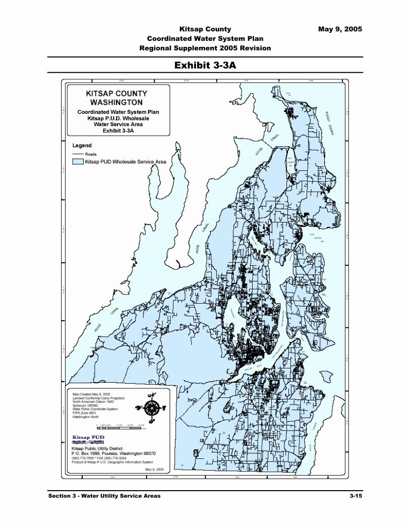
Kitsap County May 9, 2005 Coordinated Water System Plan
Regional Supplement 2005 Revision
Section 3 - Water Utility Service Areas 3-15
Exhibit 3-3A

Kitsap County May 9, 2005 Coordinated Water System Plan
Regional Supplement 2005 Revision
Section 3 - Water Utility Service Areas 3-16
Exhibit 3-3B

Kitsap County May 9, 2005 Coordinated Water System Plan
Regional Supplement 2005 Revision
Section 3 - Water Utility Service Areas 3-1
Section
3 Water Utility Service Areas 3.1 Introduction
The Public Water System Coordination Act (Coordination Act) requires that a procedure be established to identify the existing and future service areas of public water utilities within a Critical Water Supply Service Area (CWSSA).
There have been no major changes in the Public Water System Coordination Act laws since the 1992 Coordinated Water System Plan (CWSP) was prepared, which influence the selection of future service areas by water utilities. However, changes have occurred in the allowable levels of service within retail service areas and how disputes are settled in the event of disagreements between utilities and applicants for service requests. These changes affect the Utility Service Review Procedure (USRP), which is described in Section 5. Provisions for designating wholesale water service areas have also been included. Much of the information presented below, therefore, is a reiteration of the intent and purpose of having well-defined service areas, the related responsibilities of service areas, and the process of their selection.
The establishment of retail service area boundaries carries with it two obligations. The first obligation is that the county and state governments recognize an identified utility as the responsible agency for providing all retail public water service within a designated area. The second obligation is that the designated utility shall assume responsibility, within its service area, for planning and implementing water system development and proper utility management. The manner in which this responsibility is to be fulfilled is described in the utility's water system plan.
For those areas within the CWSSA which are in a utility’s designated retail service area, but the utility is unwilling or unable to provide timely and reasonable service, or for areas which are not within any utility's designated retail service area, the Utility Service Review Procedure (USRP), gives priority to service by an existing Group A or B system which has mains within one quarter of a mile and has an approved water system plan, or a Satellite System Management Agency (SSMA). If these service options are not available, a new utility may be formed and constructed subject to Coordinated Water System Plan (CWSP) specifications and demonstration of financial viability.
The Coordination Act provides the legal mechanism, for municipal systems and private water utilities alike, to establish an exclusive retail service area. This procedure provides the utilities with the assurance that the financial commitments associated with their capital improvement programs are protected and that their planning is consistent with State and County requirements. From the County's perspective, designated retail service areas will mean a specific utility has
Establishment of a Service Area Boundary carries two obligations for providing public water service: 1) Local governments recognize the utility as the responsible agency; 2) The utility shall assume responsibility within its area for planning, implementation, and utility management.

Kitsap County May 9, 2005 Coordinated Water System Plan
Regional Supplement 2005 Revision
Section 3 - Water Utility Service Areas 3-2
accepted responsibility for development of cost-effective and efficient service to accommodate the future growth that these areas will experience. Growth management objectives established for these areas by the County's Comprehensive Land Use Plans and Subarea Plans must be accounted for in each utility's approved plan and actual improvements.
The Coordination Act requires that retail service area boundaries be established by agreement among the purveyors based on a variety of factors. These factors include: topography, readiness and ability to serve, local franchise areas, legal water system or incorporated boundaries, future population projections, and sewer service areas. It also specifies that these retail service areas be developed in conformance with the land use policies of the County and other local governments including applicable ordinances, agreements, and guidelines.
The 1992 CWSP efforts enabled utilities to formally establish their retail service areas. Subsequently, conflicts have been resolved and adjustments have been made in previously identified boundaries. Some systems responding to growth have enlarged their boundaries. One important effort used Geographic Information System (GIS) technology to generate parcel-level accuracy for delineating retail service area boundaries.
3.2 Retail Service Area Commitments and Procedures
The designated retail service area defines the area within which current and future customers will be provided retail water service by the designated utility. An important distinction is that a utility's water facilities, such as sources of supply and reservoirs, can be located outside the utility's retail service area. These facilities can be located within another utility's retail service area, provided the facilities are not used for direct retail service to customers in that area without the written concurrence of the designated utility.
The designated retail service area is the exclusive service area of the identified utility and consists of current and future retail service areas. The current retail service area includes all parcels in the total, designated service area that can be served from existing mains by a service line connection. The future service area consists of the remaining parcels within the total, designated retail service area. As a condition of being granted a designated retail service area, the utility shall meet certain obligations and commitments, as described in the following:
3.2.1 Water System Plan and Retail Service Area Agreement
Each utility, including SSMAs, is required to prepare and submit to the Kitsap County Health District (KCHD) and/or the Department of Health (DOH) a water system plan. The plan must identify retail service area boundaries. Service area boundaries were established for Kitsap County water systems as part of the initial 1992 CWSP and have been updated periodically since then. With respect to the identification of future retail service areas, purveyors of all existing water systems in Kitsap County were asked to sign and submit service area agreements identifying existing and, if applicable, proposed future service areas. As part of the process, purveyors were asked to make a good faith effort to identify the proposed retail service areas (current and future) of adjacent water systems and to verify that no service area conflicts existed between the responding

Kitsap County May 9, 2005 Coordinated Water System Plan
Regional Supplement 2005 Revision
Section 3 - Water Utility Service Areas 3-3
purveyor and adjacent purveyors. The ultimate goal of this effort was to establish a qualified, exclusive right of retail water service within the service areas identified and approved. Agreements were developed between adjacent water systems, which included maps of both current and planned future retail service areas for each system. Water systems were given until one year after the initial CWSP was adopted to identify a future service area and declare the system to be an expanding system. The current and future areas of expanding systems were designated as the exclusive retail service area of the respective utilities. Service area claim overlaps between systems were identified and eventually resolved. Systems that did not respond were designated as non-expanding water systems. They were not required to sign an interlocal service area agreement, but were limited to providing service only to parcels adjacent to existing water mains or within the geographic section or plat the non-expanding water system was designed to serve.
3.2.2 Conditions of Service by Designated Utility
Water service can be provided by the designated utility either through direct connection to the utility's existing water system, or as a detached, remote system managed by the utility or others through agreement. In either case, the utility will identify for the applicant all of the conditions of service which must be agreed to prior to the provision of water service. The managing utility must be an approved SSMA if the system is to remain remote and detached. If remote and/or interim systems are not installed to the standards of the designated utility, the applicants will be advised of their responsibility to pay additional costs later if required to upgrade facilities to specified standards to integrate with the designated utility. The County or local jurisdictional authority is responsible to ensure that covenants explaining these potential future costs are recorded with all applicable parcels as a condition of all final plat, short plat, and land use approvals. Once the applicant agrees to these conditions, a building permit or preliminary plat approval can be issued.
The Coordination Act requires that the utility be willing to extend service in a timely and reasonable manner. The applicant is able to utilize an Appeals Process established by the CWSP if it is felt the designated utility is responding in an untimely or unreasonable manner. If service cannot be provided in a timely and reasonable manner, interim service area agreements or retail service area adjustments should be made.
3.2.3 “Timely and Reasonable Service”
An individual or developer seeking public water system service is required to receive service from the designated utility, but is entitled to appeal this requirement. The appeal will prevail if the requesting party can demonstrate that service is not being pursued in a “timely and reasonable” manner. “Timely service” is defined as receiving service within 120 days. If the extent of water service requested requires construction of major facilities such as the replacement or installation of new storage tanks, wells, booster pumps or transmission or distribution mains, the time associated with construction may be added to the 120 days. The 120-day time period shall be defined as calendar days. The time

Kitsap County May 9, 2005 Coordinated Water System Plan
Regional Supplement 2005 Revision
Section 3 - Water Utility Service Areas 3-4
period will commence after the submittal of an application and payment of fees. Construction of water facilities are subject to design review and approval both at the state and local levels, local permitting processes, construction season considerations, and are often done in conjunction with other planned infrastructure projects such as road, sewer, lights, etc. The previous activities are part of “construction time” and are in addition to the 120-day period.
A completed agreement on the provision of service that is satisfactory to both parties, must be reached within the 120-day period. A completed agreement will contain the schedule and terms of providing service within 120 days plus construction time (or a time period acceptable to both parties). The purveyor should document the record start date.
If an appeal exists, it will likely occur during the 120-day period. The appeal process as specified in the CWSP will be initiated, and will extend the 120-day period by a length of time equal to the time required to resolve the appeal.
An existing purveyor might be considered unable to provide the service in a timely manner if:
Where no infrastructure is required (other than a water service connection), the water service is not provided to the applicant within 120 days of submitting a completed agreement and payment of necessary fees to the purveyor; or
Where infrastructure installation by the purveyor is required (other than a water service connection), the water service is not provided to the applicant within 120 days (plus construction time) of final payment of applicable fees and infrastructure costs and completion of all required administrative work by the applicant; or
Where infrastructure installation by the applicant is required, the purveyor has not provided the applicant access to its system within 120 days of the applicant submitting a written request and paying applicable fees to the purveyor unless the county or a local jurisdictional authority has specified otherwise; or
The purveyor states in writing that it is unable or unwilling to provide the service; or
The purveyor and applicant are unable to achieve an agreement on the schedule and terms of provision of service within 120 days of commencement of good faith negotiations by both parties because the purveyor has been determined to be unreasonable.
Water Rights - DOH requires all projects to be supported by adequate water rights. Purveyors may not assume that water rights will eventually be issued. Water rights may take years to obtain or may be denied. Therefore, waiting for a water right permit to be issued is neither timely nor reasonable.

Kitsap County May 9, 2005 Coordinated Water System Plan
Regional Supplement 2005 Revision
Section 3 - Water Utility Service Areas 3-5
Reasonableness criteria will consist of comparison with requirements, conditions, and character of service provided by other typical purveyors in the county or city, including consideration of the regulations of controlling government authorities.
Conditions of Service – Conditions of service shall be found to be reasonable, provided that they are consistent with the conditions of service policies detailed in the utility’s DOH-approved water system plan.
An existing purveyor might be considered unable to provide service in a reasonable manner if:
The purveyor’s conditions of water service differ adversely and in an arbitrary and capricious manner from the stated conditions of service in the purveyor’s approved water system plan or small water system management program; or
The purveyor’s conditions of water service differ adversely and in an arbitrary and capricious manner from the purveyor’s acknowledged standard practice with other applicants requesting similar service.
Cost of Water Service – Cost of service specifically relates to system installation charges such as connection fees, capital facilities charges, front footage fees, and terms of developer extension agreements necessary to support requests for new water service in a utility’s designated service area. System installation charges are typically addressed and justified in a utility’s water system plan. Assuming consumer awareness and input, and adequate agency review of these elements prior to approval of the WSP, the reasonableness of cost of service should not be an issue for a given utility with an approved WSP. However, it is recognized that a utility’s cost of service may be different for specific projects, which may require that cost become a topic of concern. Therefore, in some limited and unique circumstances, cost of service can be discussed as part of an appeal.
Service Area – A utility’s service area(s) in its water system plan should be consistent with the service area(s) designated through the CWSP process.
A DOH approved water system plan- A water system that has committed to providing service for new requests for water must have an approved water system plan or have a development schedule to prepare a WSP, agreed upon by DOH.
Current operating permit status of water system – A system in a RED operating permit category cannot be expanded. A system in a BLUE operating permit category indicates that the system has yet to be evaluated for current adequacy status or its ability to expand. Systems with BLUE operating permits cannot be expanded until their adequacy for expansion has been determined. A system in a YELLOW operating permit category may or may not be considered capable of expansion, depending upon the nature of the problem(s) that caused the system to be placed in the YELLOW category. A system in the GREEN category has no restrictions on expansion up to their allowed number of connections, if a limit has been established by DOH.

Kitsap County May 9, 2005 Coordinated Water System Plan
Regional Supplement 2005 Revision
Section 3 - Water Utility Service Areas 3-6
Consistency with local land use plans and policies – Service area boundaries and utility level of service standards should be consistent with minimum design standards contained in the CWSP and be consisted with minimum level of service requirements in local jurisdictional plans and policies. Water system plans, designs, and policies should be consistent with local land use authority construction scheduling for capital improvements, financing schedules for capital improvements, and general purpose government comprehensive plans.
3.2.4 Interim Service Agreements
A utility may receive a request for service within its designated retail service area and may not be able to provide immediate service. If this occurs, interim operating services by an adjacent utility, an SSMA, or non-expanding system may be allowed providing the designated utility is in concurrence. Service may be provided either through physical connection to an adjacent utility's system or installation of a detached, remote system. The appropriate level of services shall be stipulated in a written agreement between the designated utility and the operating entity. Retail service area adjustments are not required for provision of interim services.
3.2.5 Retail Service Area Adjustment
If a utility determines that its retail service area is either too large or too small, the service area boundaries may be revised at any time. The retail service area boundary adjustment will require the agreement and signing of a revised service area agreement by all affected purveyors. Such revised agreements shall be executed by the authorized utility representative(s), approved by the County, and filed with the KCHD and KPUD for inclusion in the official CWSP file. The official maps will be updated by KPUD and provided to KCHD (see Subsection 3.7 below). The individual water utility may submit a change to its water system plan or wait until the next revision is required by DOH.
3.3 Retail Service Area Selection Process
The Coordination Act specifies that no new public water systems be created after the boundaries of the CWSSA are established unless an existing system is unable or unwilling to provide service. Existing water systems were involved in the initial development of the CWSP. The WUCC adopted the following definition of an existing public water system:
All municipal water systems; utilities with a DOH approved water system plan; properties served by existing distribution systems; and developments that have been given preliminary plat approval before June 4, 1990 with properties served by distribution systems for proposed or phased developments which have submitted written information for review or received approval
CWSSA Boundaries: No new public water systems created unless an existing system is unable/or unwilling to provide service.

Kitsap County May 9, 2005 Coordinated Water System Plan
Regional Supplement 2005 Revision
Section 3 - Water Utility Service Areas 3-7
of their water system facilities, well site location, plans, and specifications from DOH and/or the local health district.
Expanding systems have been identified and have established their existing and anticipated future retail service areas. Areas outside the retail service areas claimed by existing utilities are designated Satellite Management Areas. KCHD will refer parties interested in water service in these areas to DOH designated Satellite Management agencies for Kitsap County. KCHD will also notify water purveyors with systems that are near to the proposed project so they can evaluate the possibility of extending service from their system.
June 4, 1990, is important because that is the date the County Commissioners adopted on an interim basis, the administrative procedures to establish retail service areas. The future retail service area boundaries were a key component of those interim procedures. In fact, efforts began in 1988 to contact utilities and obtain key information and retail service area boundaries.
For purposes of soliciting system information and retail service area boundaries for the CWSP, the KCHD initially contacted existing systems and visited several of the larger Group A systems (i.e., those previously designated as Class 1 systems) to obtain data. It was agreed that other systems which conform with the definition of an existing public water system would be added to the CWSP process at a later date if they demonstrated an interest in being included prior to the submission of the draft CWSP to the County and the DOH.
All larger Group A systems (i.e., those previously designated as Class 1 and 2 utilities) were contacted by letter. They were asked to verify their existing service area, as well as provide boundaries depicting their anticipated future service area. Smaller Group A and Group B systems (i.e., those previously designated as Class 3 and 4 systems), including those with pending applications, were also contacted by letter to identify expanding systems and the location of their future service area. Systems which only intended to add additional customers up to a pre-approved limit were not considered to be expanding. However, adding customers beyond an approved limit or enlarging the geographic area of service was considered expansion. Two hundred and fifty-eight smaller Group A and Group B purveyors responded, and only sixty-nine systems indicated their intent to expand. Utilities not responding were assumed to have no desire for expansion. Approximately fifty-two systems remain as expanding systems.
Retail service areas for expanding Group A systems were computerized using AutoCAD Version 10.0 onto a master set of reproducible maps. Subsequently, the retail service maps were refined to match parcel boundaries where possible. Current retail service areas of the larger water systems are shown on Exhibit 3-1. The computerized (digital) retail service area maps are maintained in an ARC/Info format that is compatible with the County digitized mapping program. KPUD is responsible for updating the master set of retail service area maps and providing official copies to KCHD.
In addition, a computerized map and Geographic Information System (GIS) database was developed from data provided by the County showing the location to the nearest quarter-quarter section of some of the larger existing non-expanding systems, including those systems with pending applications. A complete listing of these non-expanding systems and their questionnaire
Kitsap County May 9, 2005 Coordinated Water System Plan
Regional Supplement 2005 Revision
Section 3 - Water Utility Service Areas 3-8
responses is referenced in Section 8 and is on file at the KCHD. This listing includes data as reported by the utilities. In some instances the data may be conflicting in that a system was reported to be non-expanding yet additional connections were proposed.
The retail service area maps and associated computer data are incorporated into the CWSP by reference as Appendix C, and are on file with KPUD and KCHD. Data regarding these systems are also on file at both locations.
3.4 Retail Service Area Agreements
3.4.1 Form of Agreement
Retail service Area Agreements (Agreement) were drafted and submitted to utilities along with retail service area maps as the basis for the interim procedures and retail service areas adopted on June 4, 1990 by the County Commissioners. The percentage return of signed agreements was low.
A revised Agreement format was developed for utilities to acknowledge their role and responsibilities related to systems placed in receivership. This revised agreement format was reviewed by the WUCC and forwarded to the utilities for completion and signature to indicate acceptance of their future service areas. A copy of the current Agreement format is included as Exhibit 3-2.
As retail service area boundaries have been adjusted and as part of the effort to realign retail service area boundaries to parcel boundaries, new agreements and maps have been developed and signed by the applicable water utilities. Signed Agreements are included by reference as Appendix C.
Establishment of bilateral agreements between all adjacent water systems in the county would have been extremely cumbersome. Therefore, the individual Service Area Agreement was chosen to allow each utility to obtain agreement on the boundary of its retail service area (both current and future) with all adjacent water systems, through one document. The utility also acknowledges adjacent utility boundaries by signing the agreement(s) for each adjacent utility’s service area.
To confirm designated retail service areas and establish their legal service boundary, all expanding water utilities were required to complete the Agreement and submit it to the KCHD. Each Agreement was reviewed in conjunction with individual water system plans.
Failure to file an Agreement within one year from the date of submittal of the original CWSP by the WUCC to the Kitsap County Commissioners precluded a utility from system expansions. For utilities with unresolved retail service area conflicts, expanding retail service within the contested service area is not permitted.

Kitsap County May 9, 2005 Coordinated Water System Plan
Regional Supplement 2005 Revision
Section 3 - Water Utility Service Areas 3-9
Where understandings concerning common retail service areas, joint service, transfer of service, or common boundaries require more specific terms than are provided in the standard Agreement format, the affected utilities may document the specific conditions in an attachment to their agreements. In order for these understandings to be recognized in implementing the CWSP, the utilities must place them on file with the KCHD as an attachment to the Agreements.
3.4.2 Small Systems
Many systems are recognized through this CWSP as being entitled to enlarge their systems to serve only the number of originally approved connections. In some cases, these small systems are within the current or future retail service areas of larger utilities. Expansion of the smaller systems up to the original number of approved connections is a valid element of this CWSP. Expansion beyond the limit requires approval of the KCHD as well as the encompassing designated utility. DOH approval may be required for a system serving over 25 connections or for Group A systems, which are non-transient / non-community.
Existing systems that had planned for retail service area expansion but did not document their intention through the CWSP preparation process are not precluded from seeking such recognition in the future. This could be accomplished through participation in the CWSP update process or, in the interim, through an appropriate documented request to the KCHD. Any such request should verify that the utility's expansion plans are consistent with the objectives and requirements of the CWSP and are not conflicting with those of other utilities that did participate during preparation of the CWSP. Expansion will require the concurrence of adjacent water utilities. Non-participating systems may be given a lower referral priority to proposed development within 1/4 mile of their service mains.
3.4.3 Retail Service Area Recognition
Recognition of utility retail service areas and agreements by the County shall be incorporated into the County franchise review process. If County standards are met, the existing franchise boundaries can be revised to coincide with the designated water service area boundaries of the CWSP. Also, KCHD will notify the Boundary Review Board of those utilities who have signed Retail Service Area Agreements, of the retail service area boundary of each such utility, and request these boundaries be recognized in the conduct of Boundary Review Board responsibilities.
3.5 Unresolved Retail Service Areas
Although several retail service area conflicts were originally identified during preparation of the CWSP, most conflicts have been resolved. Some of the conflicts were changed to uncontested overlaps, while others were resolved through a redefinition of future service area boundaries.
Franchise Review: County franchise process will recognize utility service areas and agreements.

Kitsap County May 9, 2005 Coordinated Water System Plan
Regional Supplement 2005 Revision
Section 3 - Water Utility Service Areas 3-10
Current areas of conflict/overlap are shown in Exhibit 3-1. Unless needed for public health reasons, proposed expansion activities or planned capital improvement will be prohibited within conflict areas until the disputes are resolved.
3.6 Wholesale Service Areas
Some water purveyors provide or may in the future provide wholesale water to other water systems. Such purveyors will designate the area in which they provide or are willing to provide wholesale water service. To maximize flexibility, wholesale water service areas may overlap, as a water system may want to have multiple outside wholesale water supplies. Exhibit 3-3 provides maps for each current wholesales service area. Wholesale water sales will be conducted based on individual agreements or contracts between the parties involved. New wholesale service areas may be created by submission of the proposal, including a wholesale service area map, to KCHD for review and the County for approval.
3.7 Service Area Boundary Change Procedure
A change in utility service area boundaries will occur when a utility wishes to expand or reduce its service area. For retail service areas, changes will be approved only if a new conflict in service areas is not created by the modification.
A revised Service Area Agreement will be required of utilities requesting boundary changes for retail service areas. A utility that desires to change its wholesale service area will submit the changed service area agreement and map(s) to KCHD for review and approval. The KCHD will review all requested adjustments in service area boundaries to ensure that utility service is consistent with the CWSP objectives. Proposed retail service area boundary changes that are not agreed on by all parties will be referred to the WUCC Appeals Committee. All service area changes will be forwarded by KCHD to the County for review to ensure the proposed areas are not inconsistent with applicable comprehensive plans, or development regulations adopted under chapter 36.70A RCW; any other applicable comprehensive plan, land use plan, or development regulation adopted by the county or a city or town; or any watershed plan approved under chapter 90.82 RCW, or a comprehensive watershed plan adopted under RCW 90.54.040 (1), if such a watershed plan has been approved for the area involved. After approved by the county KCHD will direct KPUD to incorporate all approved service area boundary changes into the official service area maps. KCHD will forward retail service area maps and agreements, signed by affected utilities and revised wholesale service area maps to DOH and other appropriate state and county agencies. Boundary changes will serve as a reference for the Utility Service Review Procedure described in Section 5.

Kitsap County May 9, 2005 Coordinated Water System Plan
Regional Supplement 2005 Revision
Section 3 - Water Utility Service Areas 3-11
Exhibit 3-1

Kitsap County May 9, 2005 Coordinated Water System Plan
Regional Supplement 2005 Revision
Section 3 - Water Utility Service Areas 3-12
Exhibit 3-2
INTERLOCAL AGREEMENT
FOR ESTABLISHING WATER UTILITY RETAIL SERVICE AREA BOUNDARIES
IN ACCORDANCE WITH THE KITSAP COUNTY
COORDINATED WATER SYSTEM PLAN
PREAMBLE This Interlocal Agreement assigns a water utility retail service area, including a planning area for future retail service that identifies the external boundary of the area for which the designated water purveyor has assumed retail water service responsibility. The responsibilities accepted by the water purveyor are outlined in the Kitsap County Coordinated Water System Plan (CWSP) and are contained in the adopted rules and regulations of the State Department of Health (DOH). This agreement does not create a new government entity nor does it give new authorities or responsibilities to the water purveyor or to the County or State regulatory agencies, but rather acknowledges the geographical area for designated service responsibilities. This agreement is in effect so long as the water utility remains as a public water system purveyor and continues to carry out the obligations inherent in the agreement or until an agreement amendment is executed. The terms used within this Agreement shall be as defined in the implementing regulations of Chapter 70.116 RCW, except as identified below. 1. Kitsap County Water Utility Retail Service Area Map shall mean the map referenced in the Interlocal Agreement as Attachment A that defines the retail water utility service area for the designated water system. 2. Retail Water Utility Service Area shall mean the designated geographical area in which a purveyor is responsible for planning and providing water service to its customers. The service area is composed of both a current and future service area as described in the CWSP. A wholesale water supplier shall not provide water to individual customers in another purveyor's retail service area except with the written concurrence of the purveyor responsible for the geographical area in question. The retail service area may be amended in accordance with the CWSP procedures and with the concurrence of the affected water purveyors. 3. Lead Agency for administering the Kitsap County water utility service area agreements and retail service area maps shall be the Kitsap County Health District (KCHD) unless otherwise established by amendment to the CWSP. The authority for this Agreement is granted by the Public Water System Coordination Act of 1977, Chapter 70.116 RCW, having been properly initiated through the provisions of RCW 70.116.040.

Kitsap County May 9, 2005 Coordinated Water System Plan
Regional Supplement 2005 Revision
Section 3 - Water Utility Service Areas 3-13
WHEREAS, Such an Agreement is required in WAC 248-56-730, Service Area Agreements-Requirements, of the Public Water System Coordination Act; and WHEREAS, Designation of retail water utility service areas, together with the cooperation of adjacent water utilities, will help assure that time, effort, and money are best used by avoiding unnecessary duplication of service; and WHEREAS, Definite future water utility retail service areas will facilitate efficient planning for, and provision of, water system improvements within Kitsap County as growth occurs; and WHEREAS, Definite retail utility service areas will help assure that water reserved for public water supply purposes within Kitsap County will be utilized in the future in an efficiently planned manner; and WHEREAS, no separate legal or administrative entity will be created by this Agreement; NOW, THEREFORE, the undersigned parties, having entered into this Agreement by their signature, concur with and will abide by the following provisions: Section 1. Water Utility Retail Service Area Boundaries The undersigned acknowledge that the Kitsap County Water Utility Retail Service Area Map(s) included as Attachment A to this Agreement, identify the current and future area of retail water utility service and planning responsibilities for the designated utility. The undersigned further acknowledge that there are no retail service area conflicts with adjacent water utilities, or, where such conflict exists, agrees that no new water service will be extended within disputed areas until such conflicts are resolved. Retail service area conflicts are noted on Attachment A. Section 2. Common Water Utility Retail Service Areas It is understood that utilities may agree to special service arrangements inside certain areas. Such common retail service areas, if they exist, are described in Attachment B to this agreement. Also included in Attachment B are copies of, or a list of, all associated resolutions, ordinances, or agreements. Section 3. Water Utility Retail Service Area Boundaries will normally be along parcel boundaries. Exceptions are noted in Attachment A. Section 4. Boundary Streets Unless separate agreements exist with adjacent water utilities, the party agrees that the utility, which is located to the north and/or east of boundary line streets between adjacent water utilities, will be entitled to provide future retail water utility service on both sides of those streets. Depth of service on boundary streets shall be limited to one platted lot or as otherwise agreed by the utilities. Existing services on boundary streets shall remain as connected unless both parties, as per Section 2, agree to transfer of service. These provisions do not disallow the placement of mains in the same street by adjacent utilities where geographic, economic, or other constraints make such placement desirable. Section 5. Boundary Adjustments If, at some time in the future, it is in the best interest of adjacent water utilities to make retail service area boundary adjustments, such modifications must be by modified water utility service area agreements executed by the involved utilities. The modified agreements must be signed and filed with KCHD and DOH. A copy will be forwarded to Kitsap Public
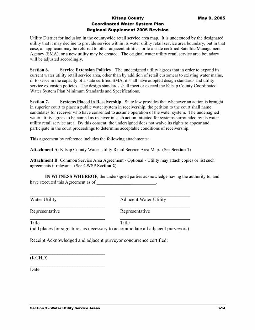
Kitsap County May 9, 2005 Coordinated Water System Plan
Regional Supplement 2005 Revision
Section 3 - Water Utility Service Areas 3-14
Utility District for inclusion in the countywide retail service area map. It is understood by the designated utility that it may decline to provide service within its water utility retail service area boundary, but in that case, an applicant may be referred to other adjacent utilities, or to a state certified Satellite Management Agency (SMA), or a new utility may be created. The original water utility retail service area boundary will be adjusted accordingly. Section 6. Service Extension Policies The undersigned utility agrees that in order to expand its current water utility retail service area, other than by addition of retail customers to existing water mains, or to serve in the capacity of a state certified SMA, it shall have adopted design standards and utility service extension policies. The design standards shall meet or exceed the Kitsap County Coordinated Water System Plan Minimum Standards and Specifications. Section 7. Systems Placed in Receivership State law provides that whenever an action is brought in superior court to place a public water system in receivership, the petition to the court shall name candidates for receiver who have consented to assume operation of the water system. The undersigned water utility agrees to be named as receiver in such action initiated for systems surrounded by its water utility retail service area. By this consent, the undersigned does not waive its rights to appear and participate in the court proceedings to determine acceptable conditions of receivership. This agreement by reference includes the following attachments: Attachment A: Kitsap County Water Utility Retail Service Area Map. (See Section 1) Attachment B: Common Service Area Agreement - Optional - Utility may attach copies or list such agreements if relevant. (See CWSP Section 2) IN WITNESS WHEREOF, the undersigned parties acknowledge having the authority to, and have executed this Agreement as of _________________________. ______________________________ ____________________________ Water Utility Adjacent Water Utility ______________________________ ____________________________ Representative Representative ______________________________ ____________________________ Title Title (add places for signatures as necessary to accommodate all adjacent purveyors) Receipt Acknowledged and adjacent purveyor concurrence certified: ______________________________ (KCHD) ______________________________ Date

Kitsap County May 9, 2005 Coordinated Water System Plan
Regional Supplement 2005 Revision
Section 3 - Water Utility Service Areas 3-15
Exhibit 3-3A

Kitsap County May 9, 2005 Coordinated Water System Plan
Regional Supplement 2005 Revision
Section 3 - Water Utility Service Areas 3-16
Exhibit 3-3B

Kitsap County May 9, 2005 Coordinated Water System Plan
Regional Supplement 2005 Revision
Section 4 - Minimum Design Standards 4-1
Section
4 Minimum Design Standards 4.1 Introduction
This section of the Coordinated Water System Plan (CWSP) provides a set of minimum design and performance specifications for new water utilities and for all existing utilities planning to install capital facilities for expansion in Kitsap County.
The Public Water Systems Coordination Act and the procedures outlined herein shall apply uniformly to all public water supply systems in Kitsap County. These standards do not supersede any other legally constituted and applicable standards that are more stringent. Group B water system standards are addressed in subsection 4.9.
4.2 Purpose
The purpose of these standards is to set a minimum level of utility planning, design, and construction for all new and expanding public water utilities throughout Kitsap County. Uniformity and consistency in standards will, in the long-term, increase system efficiency and reliability and reduce overall costs to consumers as system consolidation takes place. Reliability of water supply will also be improved.
Group A public water systems adopt minimum design standards as a part of their Water System Plan. The design standards included herein are intended as a minimum baseline supplement to those approved within individual Water System Plans. It is understood that some water systems may adopt higher standards based on individual needs. All standards must be consistent with the Kitsap County Comprehensive Plan (COMPLAN), supporting documents, as well as other local planning ordinances, agreements, and guidelines.
4.3 Application of Standards
4.3.1 Existing Water Systems
Existing water systems are not required to use these minimum standards for repair or replacement of facilities so long as no expansion of main distribution is involved. However, adherence to these standards for repair and replacement is encouraged to provide better public water service throughout the county. If existing facilities must be repaired or replaced to serve an expanded distribution area, the new construction shall meet these minimum standards.
The Design Standards do not supersede any other legally constituted and applicable standards that are more stringent.
Kitsap County May 9, 2005 Coordinated Water System Plan
Regional Supplement 2005 Revision
Section 4 - Minimum Design Standards 4-2
4.3.2 Water System Plans and Applicable Land Use Plans
New and expanding utilities shall meet water system planning requirements based on land use designations for their service area as prescribed in the COMPLAN, appropriate Sub-Area Plans, Zoning Code, City Comprehensive Plans, and any related Interlocal agreements. Land use designations shall be referenced in the utility's Water System Plan, and shall be used to establish design requirements.
Urban Growth Area (UGA) Managements Agreements are being developed to facilitate and encourage annexation and/or incorporation of urban areas over 20 year planning periods, to ensure compatibility of development within the unincorporated Urban Growth Area, and to encourage the location of urban density residential, commercial and industrial developments in areas where services can be most economically provided. The agreements will identify services to be provided in the Urban Growth Area, the responsible service purveyors, and the terms under which the services shall be provided. All service providers, including special districts should be included in Urban Growth Area planning.
As required by the state, water utilities shall prepare a water system plan which includes a program of capital improvements required to provide the anticipated level of service within their designated water service area, and which is consistent with the COMPLAN, UGA Management Agreement, and/or City Comprehensive Plan. When the water utility is requested to provide water service, it will identify that portion of planned capital facilities, as well as other infrastructure needs which are necessary to provide the service requested. As growth occurs, the full level of water service will eventually be provided throughout the service area of the utility in a planned, phased program, which meets county requirements and minimizes overall cost to the customers.
In some cases, the utility and a developer may reach an agreement to provide the desired level of service through a schedule of improvements, which is specified by a legally binding contract.
A phased development plan shall be consistent with current, applicable Kitsap County Ordinances and Codes and future capital requirements needed for projected densities. A phased development plan shall depict the capital facilities for phased construction and their conformance with these standards.
In areas defined as Urban, Commercial, Business Park, Airport, and Industrial by the county, the utility shall install a distribution system with a minimum pipe size of 6 inches. The installation schedule for fire hydrants and storage will be based on the designated water utility’s Water System Plan and the fire flow requirements established by the appropriate authority.
For areas defined as Rural, the minimum pipe size may be less than 6 inches, unless the appropriate authority requires fire
Planning agencies should notify a utility regarding any land use or fire flow changes that will impact the required level of water service.

Kitsap County May 9, 2005 Coordinated Water System Plan
Regional Supplement 2005 Revision
Section 4 - Minimum Design Standards 4-3
protection. The installation of hydrants and storage will be based on the requirements of the appropriate authority.
Once a water utility's plan is approved, the utility should be consulted by the land use planning agency with jurisdiction regarding any proposed land use changes or fire flow requirement modifications which impact the required level of water service. The water service related cost of said impacts, as determined by the utility, should be fully considered by the planning agency in acting on the proposed land use change.
4.3.3 Variance
The appropriate utility, upon petition by an applicant for water service, may approve a variance of non-health related standards included herein if deemed justified after considering appropriate aspects of public interest. Upon approval, the applicant will be referred by the utility to the appropriate local authority, and other local and state jurisdictions for further approval, as may be required.
4.4 Standards Incorporated by Reference
The standards listed below, or as they may be modified in the future by the appropriate authorities, are hereby incorporated by reference. Priority for application of these standards, in general, is in the order listed, but the most stringent applies. Except as otherwise superseded by the county standards described in subsection 4.5, these standards will apply to water system design, installation, modification, and operation.
Rules and Regulations of the State Board of Health Regarding Group A and Group B Public Water Systems (WAC 246-290, WAC 246-291 and WAC 246-293).
Minimum Standards for Construction and Maintenance of Water Wells (WAC 173-160).
Water System Design Manual, Washington State Department of Health, August 2001, or latest version.
Applicable county and city rules, regulations, ordinances, and standards.
Standard Specifications for Road, Bridge, and Municipal Construction, as published by the Washington State Department of Transportation/ in conjunction with the Washington Chapter of the American Public Works Association (DOT/APWA, latest edition).
Standards of the American Water Works Association.
4.5 General Provisions
4.5.1 Source Development
New sources must be designed to meet the Department of Ecology (Ecology) and Department of Health (DOH) regulations and design guidelines including Chapter 173-160 WAC, “Minimum Standards for Construction and Maintenance of Water Wells”

Kitsap County May 9, 2005 Coordinated Water System Plan
Regional Supplement 2005 Revision
Section 4 - Minimum Design Standards 4-4
administered by Ecology, and Chapters 246-290 WAC and 246-291 WAC "Rules and Regulations of the State Board of Health Regarding Group A and Group B Public Water System," as administered by DOH.
All test and production wells must be drilled in accordance with detailed drilling and testing specifications, which have been prepared or approved by the utility, or in accordance with the DOH Water System Design Manual.
4.5.2 Water Rights
Water rights must be obtained in accordance with state law, regulations, and procedures (Chapter 90 RCW). Copies of water rights documents, related correspondence, and other associated records will be maintained on file by the purveyor.
4.5.3 Water Quality
Water quality must be proven to conform to the Federal Safe Drinking Water Act (as amended), DOH criteria specified in Chapters 246-290 WAC and 246-291 WAC, and/or any additional requirements more stringently applied by the local health district. Each utility may reserve the right to reject any source whose raw water quality does not meet these criteria.
4.5.4 General Construction Standards
Selection of materials and construction of water system facilities in Kitsap County shall conform to the provisions of subsection 4.4, with the additional provisions:
All owners/operators of water systems having water mains in county road rights-of-way must comply with franchise requirements outlined in ordinances passed by the County Board of Commissioners authorizing such use of the road and rights-of-way. Construction within incorporated boundaries remains subject to city permitting requirements. If requirements of the franchise are more stringent than the adopted minimum standards, the franchise shall have precedence.
Water mains constructed to lie on private property shall have easements from the property owner(s) of a minimum of 15-foot width, centered on the pipeline alignment, recorded with the County Auditor prior to placing the line in service.
All projects requiring design by a registered professional engineer shall be inspected by the utility or its designated representative before closure of any excavation. The county may inspect facilities under construction at any time.
4.5.5 Hydrostatic Pressure Test
A hydrostatic pressure leakage test will be conducted on all newly constructed water mains, fire lines, fire hydrant leads, and stub-outs in accordance with DOT/APWA

Kitsap County May 9, 2005 Coordinated Water System Plan
Regional Supplement 2005 Revision
Section 4 - Minimum Design Standards 4-5
Section 7-11.3(11) or AWWA C-600 specifications, unless specified otherwise by the designated utility.
4.5.6 Disinfection and Bacteriological Testing
All pipe, reservoirs, and appurtenances shall be flushed and disinfected in accordance with the standards of DOH, AWWA C651-86 and C652-86, or DOT/APWA Section 7-11.3(12), unless specified otherwise by the designated utility.
4.5.7 Utility Interties
Interties should be established where desired, observing the requirements of RCW 90.03.383. “No intertie shall be used and/or constructed as a public water supply without department approval” per WAC 246-290-132. Planning for major water line extensions should consider specific locations, size, and alignment of potential future emergency interties with adjacent water utilities.
4.5.8 Flow Measurement
Unless otherwise directed by the designated utility, all service lines shall be installed so that each residential, commercial, institutional, and industrial structure will have a separate metered service for domestic water received from the utility. If approved by the designated utility, domestic water consumption may be measured by a master meter for service to a complex, under single ownership, and where water utility line subdivision is impractical. Service lines providing fire flow may be required by the utility to be equipped with a fire flow meter, leak detection check valve and/or appropriate cross-connection control devices as required by WAC 246-290-490.
All new ground water sources shall be provided with an access port for devices that measure depth to water and be outfitted with a flow-measuring device for total production. Installation of a production meter is also recommended for existing ground water sources and may be required by Ecology. DOH expects all Group A water systems to install a flow measurement device on all their sources and routinely record water production. All new sources for which water treatment is included shall be provided with a flow measurement device.
4.5.9 Cross-Connection Control
Where the potential of contamination of the supply exists, water services shall be equipped with appropriate cross-connection control devices in accordance with Chapters 246-290 WAC and 246-291 WAC. The designated utility and/or the county cross-connection control program shall determine the need, size, kind, and location of the device.
Group A water systems should install a flow measurement device and record water production.
Kitsap County May 9, 2005 Coordinated Water System Plan
Regional Supplement 2005 Revision
Section 4 - Minimum Design Standards 4-6
4.6 Specific Provisions
4.6.1 Pressure Requirements
New water systems and water system capital facilities installed to expand distribution shall be designed to maintain a minimum residual pressure of 30 psi at the meter, or property line if there is no meter, under maximum demand flow conditions, excluding fire demand (Chapters 246-290 WAC and 246-291 WAC). For water systems requiring fire flow capability, the design shall be adequate to maintain, under fire flow conditions, positive pressure throughout the system and a 20 psi residual pressure in mains supplying fire hydrants in use (Chapter 246-290 WAC).
4.6.2 Pipe Sizing and Materials
With the exceptions noted within this document, the minimum pipe diameter shall correspond with the following land use designations: Urban, Commercial, Business Park, Airport, and Industrial - 6-inch diameter. In areas, which are Rural, Parks, Open-space, and in other situations where fire flow is not required under Kitsap County Ordinance and where county land use designations minimize the potential future requirement for fire flow, a smaller diameter pipe may be used if hydraulically justified.
Water main size shall be adequate to deliver fire flow where required and to maintain the pressure requirement defined in subsection 4.6.1 and by Kitsap County Ordinance.
All water mains shall meet applicable engineering and health standards adopted by the State of Washington or the water purveyor, including Chapters 246-290 WAC, 246-291 WAC and 264-293 WAC.
Water mains serving fire hydrants, either as part of new construction or planned, phased improvements, shall be not less than 8 inches diameter for a dead end line, nor less than 6 inches diameter if looped. Hydrant leads extending less than 50 feet or across a street shall be of a suitable size to carry the required fire flow, but shall not be less than 6 inches diameter. In a dead end cul-de-sac, normal domestic mains may be installed from the last hydrant to remaining residences.
All pipe material shall be equal to or greater than AWWA standard specifications unless previously approved by the local Health District or DOH. All pipe material for new water systems shall be constructed with "lead-free" materials. The lead content for joint compound materials (solder and flux) used for pipe installation shall be less than 0.2 percent in order to be considered "lead-free." The lead content for all installed pipe shall be less than 8 percent in order to be considered "lead-free."
4.6.3 Isolation Valving
Valving shall be installed in a configuration, which permits isolation of lines.

Kitsap County May 9, 2005 Coordinated Water System Plan
Regional Supplement 2005 Revision
Section 4 - Minimum Design Standards 4-7
4.6.4 Air and Air-Vacuum Relief Valves
In order to minimize problems associated with air entrainment, the purveyor shall install air or combined air-vacuum relief valves at appropriate points of high elevation in the system.
4.6.5 Blow-off Valves
A blow-off assembly shall be installed on all dead end runs and at appropriate points of low elevation within the distribution system. The blow-off assembly shall be sized to achieve minimum flushing velocity and installed in the utility right-of-way except where an access and construction easement is provided in writing. In no case shall the location be such that there is a possibility of back-siphonage into the distribution system.
4.6.6 Pressure Reducing Stations
A manifold system shall be installed at pressure reducing stations that includes a redundant pressure reducing valve, a bypass valve, or other suitable device, which assures reliability and continuity of service.
4.6.7 Storage
Permanent storage facility requirements are based upon four components:
Equalizing Storage, required to supplement production from water sources during high demand periods;
Standby Storage, required as backup supply in case the largest source is out of service; and,
Fire Storage, required in order to deliver the level of fire flow service identified in the utility's approved plan (see "Fire Flow Requirements" below) for the required duration.
Dead storage, or the volume of water remaining in the facility that does not satisfy any of the first three components primarily due to elevation head not meeting the 20 psi minimum for fire or standby storage.
As a minimum, sizing of storage facilities shall be adequate to provide for equalizing storage plus the larger of standby or fire storage requirements. However, nesting of fire and standby storage must be approved on a case-by-case basis by the local fire authority. Equalizing and standby storage volumes shall be determined using the DOH Water System Design Manual. Fire storage volumes shall be determined using the fire flow and duration requirements of the applicable county or city ordinance and the utility's approved plan. Siting of storage facilities should consider locations, which provide gravity flow.
Nesting of fire and standby storage must be approved on a case-by-case basis.

Kitsap County May 9, 2005 Coordinated Water System Plan
Regional Supplement 2005 Revision
Section 4 - Minimum Design Standards 4-8
4.6.8 General Facility Placement
Below-ground facilities shall be located in accordance with the applicable city or county ordinance. Where no ordinance applies, water mains shall be installed at a location, which is compatible with the existing water system, the terrain, and the location of other utilities. In new subdivisions, wherever practical, water mains should be installed parallel to the centerline on the north or east sides of the street.
In addition, all piping, pumping, source, storage, and other facilities, shall be located on public rights-of-way, dedicated utility easements, or property owned by the purveyor. Utility easements must be a minimum of 15 feet in width, and piping shall be installed no closer than 5 feet from the easement's edge. Exceptions to this minimum easement may be approved by the operating water utility. Unrestricted access shall be provided to all public water system lines and their appurtenances and public fire hydrants that are maintained by public agencies or utilities.
4.6.9 Pipe Cover
The depth of trenching, installation of pipes, and backfill shall be such as to give a minimum cover of 36 inches over the top of the pipe. This standard shall apply to transmission, distribution, and service piping. Backfilling up to 12 inches over the top of the pipe shall be evenly and carefully placed. The remaining depth of trench is to be filled in accordance with applicable construction standards identified in General Provisions. Materials capable of damaging the pipe or its coating shall be removed from the backfill material.
4.6.10 Water and Sewer Line Separation Distances
Whenever practicable, transmission and distribution water piping shall be separated at least 10 feet horizontally from on-site waste disposal piping drain fields, and/or wastewater gravity or force mains. The bottom of the water main shall be 18 inches above the top of the sewer main. Where local conditions prevent such horizontal and/or vertical separation, closer spacing is permissible where design and construction meet the special requirements of the Department of Ecology criteria for Sewage Works Design. Storm drainage and reclaimed water irrigation piping shall be considered the equivalent of sanitary sewer for the purpose of separation from potable water mains.
4.6.11 Fire Hydrants
Fire hydrants shall be dry, barrel type, equipped with National Standard Threads or other connection devices consistent with the local fire protection authority’s requirements, and conform to AWWA Standard Specification C502 or equal, and shall be approved by the appropriate local fire authority.

Kitsap County May 9, 2005 Coordinated Water System Plan
Regional Supplement 2005 Revision
Section 4 - Minimum Design Standards 4-9
4.6.12 Fire Hydrant Location
Fire hydrants shall be located in unincorporated areas in accordance with Kitsap County Ordinance. Within city incorporated boundaries, the location specifications provided in the city fire ordinance or water system design standards shall apply.
Actual location of hydrants shall be identified in the development site plan and shall be approved by the water purveyor and Fire Marshal. Placements shall be made to provide unhindered access for fire hose connection, testing, and maintenance.
4.6.13 Fire Flow Requirements
Water supply facilities for new developments and for expanding public water systems shall be designed to meet the minimum fire flow requirements established in the latest version of Kitsap County or city ordinances.
Systems shall be deemed to be in compliance with these requirements if there is in existence a Water System Plan in accordance with WAC 246-290 which has been approved by DOH and which indicates that fire flow requirements will be met when specified improvements to the public water system are made.
4.6.14 Maintenance of Fire Protection Facilities
A written operational agreement, which identifies responsibilities for maintenance and testing of fire protection facilities should be negotiated between the applicable fire department or district and water utility.
4.7 Standards Review
The Water Utility Coordinating Committee shall review these standards and their implementation as necessary. Kitsap County Department of Community Development will designate representatives from county staff to participate in the process including input from the Kitsap County Fire Marshal and the fire districts in matters related to fire protection standards. Recommendations for change shall be submitted by the WUCC to the County Commissioners and the Washington State Department of Health Division of Drinking Water Southwest Regional Office for approval and adoption.
4.8 Severability
If any provision of these standards or their application is found to be invalid, the remainder of the standards and their implementation are not affected.
4.9 Group B Standards
All new or expanding Group B systems must adhere to applicable requirements of DOH (WAC 246-291) and the Kitsap County Health Department (KCHD). KCHD, as a part of its review authority over
DOH requires new or expanding Group B systems to adhere to WAC 246-291 requirements.

Kitsap County May 9, 2005 Coordinated Water System Plan
Regional Supplement 2005 Revision
Section 4 - Minimum Design Standards 4-10
systems having 25 or fewer service connections, distributes a design workbook to systems with nine or fewer connections. These smallest of systems must submit the design workbook after approval by either a professional engineer or Kitsap County certified Group B designer. The KCHD Water System Workbook for New, Expanding, or Existing Group B Water Systems is intended to ensure compliance with applicable Minimum Design Standards discussed in this section. The new workbook standards became effective in the spring of 1992 and are included herein by reference as Appendix D. Copies of the revised workbook may be obtained from the KCHD.

Kitsap County May 9, 2005 Coordinated Water System Plan
Regional Supplement 2005 Revision
Section 5 - Utility Service Review Procedure 5-1
Section
5 Utility Service Review Procedure 5.1 Introduction
This Kitsap County Coordinated Water System Plan (CWSP) establishes a set of administrative procedures and water resource management policies for Kitsap County water utilities. The procedures are to guide local officials, citizens, developers, and state and federal regulatory agencies in identifying and developing the necessary facilities for providing adequate water service.
Provisions of the Public Water System Coordination Act require that no new public water system be established within Kitsap County unless it is determined that existing purveyors are unable or unwilling to provide the service in a timely and reasonable manner. The Growth Management Act (GMA) mandates that each applicant for a building permit, which requires potable water, shall provide evidence of an adequate water supply for the intended use of the proposed building. This section presents the administrative procedures for reviewing development proposals and associated requests for water service throughout Kitsap County, identifying the designated purveyor who is willing and able to provide new water service, and documenting availability of water supply.
A general philosophy of the CWSP is that water utility service should not dictate growth patterns. On the contrary, land use policies should establish growth guidelines and designated water utilities should respond to, and provide service commensurate with applicable adopted land use policies.
Water system plans must address the water system facilities required to accommodate growth. Growth is projected to occur within most large Group A retail water utility service areas, based upon the County's Comprehensive Plan and city’s land use plans. Capital improvements are planned and constructed to conform to the anticipated service requirements associated with those plans.
A proposed land use change could involve a significant financial expenditure on water service infrastructure. Because water utilities must, of necessity, develop their systems to conform with applicable land use plans, any major change in land use may require substantial system improvements to serve proposed growth areas. Therefore, special review procedures will apply to applications, which propose a significant land use change.
The review procedure provided herein recognizes the retail service area boundaries established for existing utilities and the responsibilities the utilities have accepted for providing reliable service within their boundaries. These responsibilities are extended by this CWSP to include system receivership provisions of state law. These responsibilities are set forth in subsection 5.7 of these review procedures.
A general philosophy of the CWSP is that water utility service should not dictate growth patterns

Kitsap County May 9, 2005 Coordinated Water System Plan
Regional Supplement 2005 Revision
Section 5 - Utility Service Review Procedure 5-2
5.2 Utility Service Review Procedure
The Utility Service Review Procedure (USRP) identifies the utility in whose designated retail service area proposed new construction lies. It then describes, in order of priority, the available water service options. It also describes options for water service to proposed construction projects lying outside designated retail service areas.
Within the USRP process, reference to "retail service area(s)" means the specific geographical area described in the written agreement required by RCW 90.116.070(1) and WAC 246-293-250. The retail service area boundary is identified by a map attached to the agreement. The boundary includes the area within which direct, retail service connection to customers is currently available (current service area) and the area for which water service is planned (future service area), if one exists, by the designated utility.
The USRP applies to all construction proposals requiring approval by the Kitsap County Department of Community Development (KCDCD) and/or by the Kitsap County Health District (KCHD). These include: new plat or subdivision development; short plats; land use permits, changes, and approvals; rezones; issuance of residential and commercial building permits; creation of new water systems; resolution of health emergencies arising out of existing public water systems; source site inspections; and other related activities. At the time an application is submitted for permits or approvals involving water supply, or upon request, the KCDCD and KCHD will initiate and administer the review procedure. A flow chart of steps to be followed in the USRP is provided as Exhibit 5-1.
The USRP procedures are intended to identify an existing water purveyor willing and able to provide water supply facilities and to include the new construction as a customer. In effect, the result of the USRP is to assign the proposed new construction or land use to the designated water utility. In the event the designated utility is unable or unwilling to provide service, the referral process referenced in subsequent paragraphs should be followed.
Pursuant to State law, water service requests occurring within a contested retail service area or the retail service area of a utility that has not completed either its individual Water System Plan (WSP) or its Interlocal Agreement for establishing retail service area boundaries, may be denied until these issues are resolved. If the affected utilities are unable or unwilling to resolve their retail service area conflicts, the Department of Health (DOH) shall render a determination of who should provide water service following appropriate due process.
5.3 Conforming Construction Proposals that Require Water Service
When construction and associated water service applications conform with land use plans and zoning ordinances, the USRP will generally follow the sequential steps outlined in Exhibit 5-1. This procedure is described below.
The USRP identifies the utility in whose retail service area proposed construction lies, options for available water service, and options for projects proposed outside the retail service area; the result being the assignment of proposed construction or land use to the designated water utility

Kitsap County May 9, 2005 Coordinated Water System Plan
Regional Supplement 2005 Revision
Section 5 - Utility Service Review Procedure 5-3
5.3.1 Administration of the Review Process
The KCDCD and KCHD will coordinate review of all development proposals within Kitsap County, which require water service. The KCDCD will be responsible for ensuring conformance with the applicable comprehensive land use plans, zoning code, and service area agreements for future municipal annexation areas. KCDCD will review building requests for conformance with the appropriate building and fire codes, and water supply requirements. KCHD will coordinate water service requirements. A Water Supply Application Form, (current format shown in Exhibit 5-2), identifies the proposed method of water supply for the applicant.
5.3.2 Individual Water Supply
The review of applications for building permits which propose to use an individual water supply (no more than two equivalent residential units (ERUs) will be coordinated by the KCHD in the following manner.
If the proposed building is outside the designated retail service areas of existing purveyors, the applicant will be required to provide suitable evidence of the availability of an adequate water supply as required by Kitsap County Board of Health Ordinance No. 1998-6, and Section 63 of the Washington State Growth Management Act.
The Kitsap County Water Utilities Coordinating Committee (WUCC) concluded that water service in urban growth areas (UGA) should generally be provided by utilities with retail service areas designated through the CWSP process. Individual wells may be constructed on parcels in certain circumstances that meet KCHD siting criteria. The KCHD maintains a list of applicants for individual well-drilling activities.
As part of the well application process for parcels in retail service areas, KCHD will require the applicant to obtain a feasibility of water service statement from the applicable water purveyor. The applicant retains the permissive judgment to either drill a private well or connect to the utility.
Exhibit 5-3 provides a sample Water Availability Letter to be submitted to KCHD if an individual building permit applicant chooses to connect to an existing water purveyor.
5.3.3 Multi-unit Water Supply
For a project where three or more service connections are proposed (more than two ERUs), the applicant must coordinate supply needs with the designated utility, as determined by the KCHD. The KCHD will review proposed water service requests and refer applicants to a designated utility, adjacent utilities, Satellite Management Agency (SMA), or allow the creation of a new utility, as outlined in the steps below.
Individuals proposing well drilling activities in retail service areas will contact the appropriate purveyor concerning the feasibility of connecting to the water system.

Kitsap County May 9, 2005 Coordinated Water System Plan
Regional Supplement 2005 Revision
Section 5 - Utility Service Review Procedure 5-4
5.3.4 Proposed Construction within Designated Retail Service Areas
The applicant will be referred to the designated utility as indicated by the official service area maps. In response to a request for water service, the utility will give notice (within 30 days) of its intent to exercise one of the following options, in order of priority. Exhibit 5-4 is a current copy of the Confirmation or Denial of Service form used to document the options listed below:
The designated utility will provide direct service through the extension of existing mains and supply.
The designated utility is not able to provide timely and reasonable, direct service to the proposed activity, then a separate, interim system may be constructed. The applicant will be advised of the utility's design standards and, if the interim system is not built to the designated utilities standards, the potential exists for property owners to be required to pay additional costs at some future date in order to upgrade piping and other facilities for integrating the interim system with the designated utility.
Once the system is installed to the designated utility standards, the designated utility may own and operate the remote system. If ownership will be delayed, the remote system may obtain contract services for operation and management from the designated utility (if it is an approved SMA) or from another approved SMA.
If the applicant does not install a water system to the designated utility's standards, then the interim system must at least meet the minimum Group A or Group B standards as specified in the CWSP. In the event that the Group A or Group B standards are less than those of the designated utility, this fact will be noted on the Certificate of Water Availability.
As a condition of the final plat, short plat, or land use approval, where facilities less than the designated utility's design standards are utilized, it will be the responsibility of the utility to review with the applicant, the potential of paying additional costs at a later date in order to upgrade facilities and integrate the interim system with the designated utility. At the time of plat, short plat, or land use approval, it will become the County's responsibility to ensure that a covenant is entered on the title report for each parcel. The covenant will acknowledge that the owner of the parcel may be responsible for paying to upgrade interim facilities to the designated utility's design standards when it is connected to the designated utility. This covenant will remain on the property title report until the interim system is connected with the designated utility and the upgrades are accomplished.
Management for remote or satellite systems must be by an approved SMA. It will be the applicant's responsibility to pick an SMA from the approved list developed by DOH and available at the KCHD.

Kitsap County May 9, 2005 Coordinated Water System Plan
Regional Supplement 2005 Revision
Section 5 - Utility Service Review Procedure 5-5
The designated utility agrees to have direct service provided on an interim basis by an adjacent utility that has existing mains nearer to the project. The terms of the service and eventual transfer to the designated utility should be stated clearly in writing.
The designated utility denies the provision of service and therefore relinquishes that portion of its retail service area. Service options are, in this case, further described below.
5.3.5 Proposed Construction in Relinquished Retail Service Areas or Non-Designated Areas
If a designated utility relinquishes a portion of its retail service area or the development is in an undesignated (or satellite management) area, the following will occur:
The KCHD will refer the applicant to adjacent purveyors with a water main within one quarter of a mile of the site, with an approved water system plan that provides for expansion, or an SMA, that is willing and able to serve the new development.
The priority of referral is as follows: Group A adjacent utility SMA Group B adjacent utility
If responsibility is accepted by a new purveyor, retail service area boundaries will be changed and contracts established identifying the conditions and responsibilities of service.
If adjacent purveyors or an SMA does not exist or declines service, the developer may create a new system. (See below.)
5.3.6 New Systems
A new public water system will be authorized to be created only in those instances where existing purveyors are unwilling or not able to provide service. The new water purveyor will be required to submit an Interlocal Agreement, prepare an appropriate water system plan, and provide evidence of water right allocation, if required, as issued by the Department of Ecology (Ecology).
DOH has established criteria for water system financial viability for all non-municipal water systems under 1,000 services and those systems not regulated by the Washington State Utilities and Transportation Commission (UTC). This criteria is based on the system's ability to fully finance the total cost of developing, constructing, operating, and maintaining the public water system in full compliance with federal, state, and local water quality and water quantity requirements. Recommended guidelines for determining financial viability are provided in DOH’s Public Water System Financial Viability Manual.
A new public water system will be authorized to be created only in those instances where existing purveyors are unwilling or not able, to provide service.

Kitsap County May 9, 2005 Coordinated Water System Plan
Regional Supplement 2005 Revision
Section 5 - Utility Service Review Procedure 5-6
5.3.7 Construction Requirements
Proposed projects must be reviewed with the designated utility to identify the engineering, design standards, financial, managerial, and other requirements of service. Fire flow requirements for proposed projects will be determined by the appropriate city fire authority or the KCDCD, in unincorporated areas, and reviewed by the designated utility prior to its issuing a Certificate of Water Availability. Review by the designated utility will ensure the applicant and purveyor have discussed the requirements of both parties.
Prior to approval of final plats or building permits, the water facilities will be installed or bonded to meet the utility's minimum standards.
5.3.8 Permit and Contract Requirements
Prior to KCDCD's and KCHD's issuance of the required approval/permit, the applicant must obtain a signed Confirmation or Denial of Service from the designated utility, which lists the conditions of service. A current copy of this certificate is shown in Exhibit 5-4.
After the preliminary plat or other land use permits are approved, a written contract should be developed and executed between the utility and applicant to formalize the conditions of service responsibilities. Each utility may have special considerations included in its contract.
5.4 Non-Conforming Construction Proposals that require Water Service
If a construction project proposal is not in conformance with applicable land use regulations (e.g., it requires a zoning change, an alteration of applicable land use plans, an increase in fire flow, or other water utility infrastructure upgrading), then each affected utility shall be contacted by the KCDCD or local jurisdictional authority (i.e., city) and allowed to comment on the proposal prior to approval of the project and associated land use changes. By identifying new or additional utility costs associated with changes in land use or zoning or other aspects of the project, the costs of development can be integrated into the decision making process. This will allow the assignment of upgrade costs to customers benefiting from the land use change.
5.5 Appeals Process
The USRP process, described herein, gives existing systems preference for providing water service to new developments. Each service must be timely and reasonable. Issues of what constitutes appropriate conditions of service may arise between applicants for new water service and existing system operators. Other controversies may also arise over implementation requirements of the CWSP. For these reasons, an appeal procedure was developed and adopted
Kitsap County May 9, 2005 Coordinated Water System Plan
Regional Supplement 2005 Revision
Section 5 - Utility Service Review Procedure 5-7
by the Water Utility Coordinating Committee (WUCC). Since the procedure has general application to the CWSP, it is described in Section 10 - Plan Implementation.
5.6 Special Review Considerations
In the review of development proposals and associated requests for water service, the KCDCD and KCHD shall be guided by the special considerations provided below:
5.6.1 Applications for Service to Non-Residential Properties
Commercial, industrial, institutional, and other non-residential properties may require fire flow that greatly exceeds flows required for single-family housing. These flow requirements are critical to the sizing of the storage, pumping, and piping facilities. For these reasons, the KCDCD shall use the referral process described herein for all proposed, developments that require more than the lowest level of fire flow in urban growth areas and any fire flow required outside urban growth areas.
5.6.2 Expansion of Small Water Systems
During the development of the initial CWSP, an inventory of existing small systems was conducted by the KCHD. This inventory included smaller Group A and Group B systems (i.e., those previously designated as Class 3 and Class 4 systems) and systems pending county approval. Approximately 725 systems in these categories were contacted within the county. Of these, 69 systems proposed future expansion. Currently expanding systems are identified in Section 8 (Exhibit 8-1) and their retail service areas are recognized and accepted in accordance with this plan when a Interlocal Agreement has been executed. Expansion of small systems is being tracked by KCHD and DOH with respect to the number of active and approved service connections or ERUs. Expansion beyond approved capacity will not be allowed without further review by KCHD or DOH, of system capacity. Non-expanding systems may only serve parcels adjacent to the existing main (which may not be extended), and if capacity within their DOH or KCHD approved number of service connections or ERUs is available. Those parcels will constitute a non-expanding system retail service area, subject to system capacity limits.
5.6.3 Expansion Outside a Utility's Designated Retail Service Areas
A Group A or Group B system desiring to expand outside the utility's designated retail service area will be referred by the KCHD to the utility currently assigned the area in question, if applicable. If the adjacent water system agrees and if the decision is made to revise retail service areas, the system owners must submit to the KCHD revised Interlocal Agreements with revised service area maps (generated by KPUD) and follow the procedures specified in Subsection 3.6.

Kitsap County May 9, 2005 Coordinated Water System Plan
Regional Supplement 2005 Revision
Section 5 - Utility Service Review Procedure 5-8
5.6.4 Expansion Within a Utility's Designated Retail Service Areas
Utilities may add customers within their designated retail service area as system capacity permits. Adding customers beyond approved service connections or ERUs will not be allowed for an expanding utility. If the utility is not able or is unwilling to increase system capacity to serve properties within its designated retail service area, then KCHD should proceed as outlined above to assign a water service provider to the area(s) that will not be served by the existing designated utility. The CWSP places responsibility on review agencies to recognize a specific utility's retail service area. In turn, the utility is responsible for effective management within that retail service area.
5.7 Receivership of Failing Systems
The Revised Code of Washington (RCW) provides that, whenever an action is brought by the Secretary of Health or a local health officer to place a public water system in receivership, the petition to the court shall include the names of one or more suitable candidates for receiver who have consented to assume operation of the water system. If there is no other person willing and able to be named as receiver, the court shall appoint the county in which the water system is located as receiver.
Through the establishment of service area boundaries in the CWSP and the review process described above, existing utilities have accepted the lead responsibility for providing public water supply within their designed service areas and, therefore, should be proposed as the receiver for the failing system within that area. A logical extension of this responsibility is for the designated utilities to assist in correcting problems of failing systems which are surrounded by their service area and accept ownership of the systems following the upgrade of the system to the utility's standards.
Group A - Water systems with 100 or more permanent connections will be considered candidates to assume the receivership role prescribed in state law for failing systems surrounded by their designated service area. The Secretary of the Washington State Department of Health or KCHD Health Officer will advise the court of the name of the designated utility in any future petition for receivership.
KPUD has accepted responsibility for all areas not claimed by other utilities. The CWSP establishes that KPUD act as Kitsap County's agent for water systems placed into receivership that are not surrounded by other purveyors or if that purveyor refuses to accept responsibility for the system to be placed in receivership. KPUD and Kitsap County established a Memorandum of Understanding on this and other regional resource management issues on May 11, 1992. A copy of this Memorandum is enclosed as Exhibit 5-5.
Adding customers beyond approved service connections or ERUs will not be allowed for an expanding utility.

Kitsap County May 9, 2005 Coordinated Water System Plan
Regional Supplement 2005 Revision
Section 5 - Utility Service Review Procedure 5-9
Exhibit 5-1 Utility Service Review Procedure

Kitsap County May 9, 2005 Coordinated Water System Plan
Regional Supplement 2005 Revision
Section 5 - Utility Service Review Procedure 5-10
Exhibit 5-2 KITSAP COUNTY HEALTH DISTRICT
Water Supply Application Form Applicant's Name: ____________________________________________ Date: __________________ Building Site Application Designer: ______________________________________________________ Parcel Location: _____________________________________________________________________
(Legal description, if short plat, indicate number and lot). Proposed Method of Water Service:
Public Water Supply Existing: Name ____________________________________________ID No.: _____________ Water Availability Letter Attached: Yes _____ No _____ Proposed: Yes ____ No _____
Individual Supply Drilled Well: Proposed _____ Dug: Proposed _____ Existing _____ Existing _____ Spring: _____ Surface water: _____ Other: _____
The Building Site Application (BSA) has been reviewed by a representative of the Health District. A determination has been made by the Health District that soil conditions for installation of an on-site sewage system meets requirements of Chapter 246-272 WAC and Ordinance 1999-6. The BSA will be placed in pending until the following has occurred (circle one of the below):
1. Source has been developed and tested in accordance with Ordinance 1999-6. 2. Satisfactory wet weather review. 3. Receipt of recorded easements. 4. Receipt of a binding water availability letter. 5. Other _____________________________________________________________. Upon receipt of the circled item, final acceptance by this office will be granted. ________________________________________ _______________________________ Inspector's Signature Date The BSA has been reviewed by a representative of the Health District. It has been determined by the Health District that site conditions for on-site sewage are not in compliance with Chapter 246-272 WAC and or Local Ordinance 1999-6. Corrections must be made before further processing of the application can occur. The Health District will require that no action take place Exhibit 5-2 (cont.) in regards to the development of the drinking water source until it can be proven that the site is acceptable for installation of an on-site sewage system. _______________________________________ _______________________________ Inspector's Signature Date =========================================================================== This portion to be filled out once site conditions for on-site sewage are in compliance and the water supply has been developed and designed to Health District standards. A determination has been made by the Health District that this BSA is in compliance with design criteria for both on-site sewage and water supply. _________________________________________ ______________________________ Inspector's Signature Date

Kitsap County May 9, 2005 Coordinated Water System Plan
Regional Supplement 2005 Revision
Section 5 - Utility Service Review Procedure 5-11
Exhibit 5-3 Water Availability Letter
Kitsap County Health District
109 Austin Drive
Bremerton, WA 98312
WATER AVAILABILITY LETTER
For each commitment for a water hook-up, please complete the section below. This form must be completed by the water purveyor, operations manager or water commissioner. Verbal approval over the phone and completion by any other person other than the authorized personnel for the water supply will not be accepted. In lieu of this form, the water purveyor may use their own form as long as the following items are included: a property address, number of connections requested, number of connections served or committed, water system name and identification number. The Public Water System _______________________________________________, State ID No. ___________________________, is/is not capable of supplying water to (property owner) _________________________ for __________ connection(s) located at: _________________________________________________________________. (legal description, assessors account number or property address) The above Public Water Supply is approved by the Washington State Department of Health or the Kitsap County Health District for ___________ connections and currently serves _________ connections. Connection to the system must be completed within two years or this Availability Letter is void. ************************************************************************ Purveyor's Name (please print) _________________________________________ Signature _______________________________ Title ______________________ Mailing Address __________________________ Phone ____________________ __________________________ Date ______________________ This form is for the official use only of the Kitsap County Health District.

Kitsap County May 9, 2005 Coordinated Water System Plan
Regional Supplement 2005 Revision
Section 5 - Utility Service Review Procedure 5-12
Exhibit 5-4 Confirmation or Denial of Service Form
CONFIRMATION OR DENIAL OF SERVICE
KITSAP COUNTY COORDINATED UTILITIES WATER PLAN Written confirmation or denial of service including remote opportunities for a proposed development is required, in accordance with Kitsap County Resolution 305-1993 and Kitsap County Ordinance 134, from the existing water utility or qualified Satellite Management Agency (SMA) before a new water system can be formed. This form needs to be completed by the water purveyor, operations manager, water commissioners or SMA and returned to the applicant within 30 days of receiving this request. Applicant Name __________________________________________________________ Property Location ________________________________________________________ Number of Connections Requested ___________________________________________ TO BE COMPLETED BY THE PUBLIC WATER SUPPLY OR SMA Public Water System Name ____________________________, ID No. _____________ or approved Satellite System Manager Agency _________________________________ can/cannot provide the following services:
Service Yes No 1. Direct connection to existing utilities which are within 1/4 mile of your proposed development.
2. Satellite System Management is available either through: a. Direct ownership of the proposed water supply by the approved satellite system management agency.
b. Contractual agreement for management services by an approved satellite management agency.
Purveyor/Satellite System Manager Name (please print) __________________________ Signature ____________________________ Title ______________________________ Mailing Address _________________________________________________________ Date ________________________ Day Phone __________________________ z:/water/dwform/confirm.doc1/597

Kitsap County May 9, 2005 Coordinated Water System Plan
Regional Supplement 2005 Revision
Section 5 - Utility Service Review Procedure 5-13
Exhibit 5-5 Regional Resource Management Issues MOU
MEMO OF UNDERSTANDING
PUBLIC UTILITY DISTRICT NO. 1 OF KITSAP COUNTY AND
KITSAP COUNTY WHEREAS, federal and state regulations and standards regarding drinking water quality, water system operations, and water resources are imposing increased responsibilities, restrictions, obligations, and costs on water system owners and operators; and WHEREAS, the principal agency for regulating water systems in the State, the Department of Health (DOH), is in the process of implementing additional requirements including annual operating permits and financial feasibility tests to gauge the ability of water systems to operate in accordance with applicable standards; and WHEREAS, the 1990 Growth Management Act (GMA) requires the County to inventory wetlands, aquifer recharge areas and other natural resources which will place constraints on development of new sources of water; and WHEREAS, the GMA includes provisions requiring the certification of adequacy of individual and community water systems and the preparation of appropriate utility capital improvement plans; and WHEREAS, water systems that are unable to comply with state and federal standards, represent a potential threat to the public health and safety; and WHEREAS, Chapter 43.70 RCW requires that counties become the receiver of last resort for water systems within their jurisdictions, that DOH determines have not been effective in resolving deficiencies that threaten public health and safety; and WHEREAS, Kitsap County does not provide public water service; and WHEREAS, pursuant to Chapter 43.70 RCW, Kitsap County is authorized to contract to provide services to water systems in receivership; and WHEREAS, pursuant to Chapter 54.04 RCW, the purpose of the District is to conserve the water resources of the county for the benefit of the people thereof, and to supply public utility service, including water for all uses; and WHEREAS, pursuant to Chapter 54.16 RCW, the District may make surveys plans, investigations or studies for domestic and industrial water supply, and for matters and purposes reasonably incidental thereto, within and without the District, and compile comprehensive maps and plans showing the territory that can be most economically served by the various resources and utilities, the

Kitsap County May 9, 2005 Coordinated Water System Plan
Regional Supplement 2005 Revision
Section 5 - Utility Service Review Procedure 5-14
Memo of understanding Page Two natural order in which they should be developed, and how they may be joined and coordinated to make a complete and systematic whole; and WHEREAS, the District may construct, purchase, condemn and purchase, acquire, add to, maintain, conduct, and operate water systems, within or without its limits, for the purpose of furnishing the District, and the inhabitants thereof, and any other persons including public and private corporations within or without its limits, with an ample supply of water for all purposes, public and private, with full and exclusive authority to sell and regulate and control the use, distribution, and price thereof; and WHEREAS, the County and the District desire to work cooperatively because the County is the governmental agency responsible for planning and regulation of land use and the District is recognized by the County as having County-wide responsibility for technical, managerial, financial, operational, and support services needed to provide satisfactory water resource development, protection, and utility service; and WHEREAS, it may be possible for the District to cost-share expenses related to the takeover of failed systems, the District is neither legally required nor may be financially capable of absorbing all administrative and related compliance costs posed by failed systems. WHEREAS, under the GMA the County is embarking on a coordinated planning process with all jurisdictions. Growth management plans, prepared and adopted by local general purpose government pursuant to WSDCD guidelines, will designate the distribution, extent and location of various land uses, including public utilities. A capital facilities element will forecast future needs, propose locations of such facilities, and identify a six-year financing plan for funding future facilities. Capital facilities plans must be completed and adopted by June, 1993. NOW THEREFORE, BE IT AGREED AS FOLLOWS: Section 1. Goals: The goals of this agreement are to: A. Protect public health and safety through provision of water service that complies with applicable state and federal standards for water system operations, and drinking water standards. B. Ensure effective and efficient utilization of water resources. C. Support adopted land use plans and the goals of the Growth Management Act.
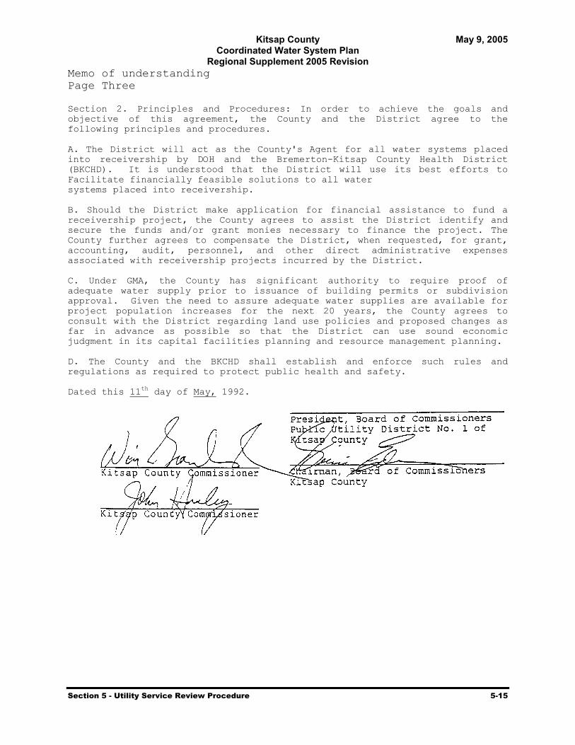
Kitsap County May 9, 2005 Coordinated Water System Plan
Regional Supplement 2005 Revision
Section 5 - Utility Service Review Procedure 5-15
Memo of understanding Page Three Section 2. Principles and Procedures: In order to achieve the goals and objective of this agreement, the County and the District agree to the following principles and procedures. A. The District will act as the County's Agent for all water systems placed into receivership by DOH and the Bremerton-Kitsap County Health District (BKCHD). It is understood that the District will use its best efforts to Facilitate financially feasible solutions to all water systems placed into receivership. B. Should the District make application for financial assistance to fund a receivership project, the County agrees to assist the District identify and secure the funds and/or grant monies necessary to finance the project. The County further agrees to compensate the District, when requested, for grant, accounting, audit, personnel, and other direct administrative expenses associated with receivership projects incurred by the District. C. Under GMA, the County has significant authority to require proof of adequate water supply prior to issuance of building permits or subdivision approval. Given the need to assure adequate water supplies are available for project population increases for the next 20 years, the County agrees to consult with the District regarding land use policies and proposed changes as far in advance as possible so that the District can use sound economic judgment in its capital facilities planning and resource management planning. D. The County and the BKCHD shall establish and enforce such rules and regulations as required to protect public health and safety. Dated this 11th day of May, 1992.

Kitsap County May 9, 2005 Coordinated Water System Plan
Regional Supplement 2005 Revision
Section 6 - Satellite Management and Receivership 6-1
Section
6 Satellite Management and Receivership
6.1 Introduction
Satellite Management and Receivership are two different management options that may be utilized separately or together in the case of a failing system.
Whenever it is not feasible to directly connect a new water service application that is in a utility’s assigned retail service area, a “remote” system may be created. This level of service constitutes a satellite management condition, which is governed by the conditions within this section. In addition, some utilities own and operate a series of water systems that are not connected and provide operation and/or ownership through satellite management.
In the event that a utility’s retail service area and role as a purveyor are relinquished due to receivership action taken by the State, then a new purveyor must be selected or assigned system management responsibilities. The role may be assumed by an established utility, a Satellite Management Agency (SMA), or a newly created public water system as described below.
6.2 DOH Satellite Management Agency (SMA) Requirements
The concept of satellite management has evolved from general guidance contained in Chapter 246-295 WAC and the State Department of Health (DOH) Satellite Management Planning Handbook (October, 1995). In general terms, the satellite management program is intended to address situations where small public water systems (e.g., Group B systems) exist or are proposed in areas remote from the supply facilities of larger systems and extension of existing facilities may not be practical in a timely and reasonable manner.
Prior to 1991, the term SMA (Satellite Management Agency) was applied loosely to those water utilities that provided service to remote systems.
In 1991, the legislature modified the Public Water System Coordination Act rules to establish criteria for designating entities as approved SMAs. The current definition of a SMA is:
A person or entity that is approved by DOH to own or operate more than one public water system on an area wide-basis, without the necessity for a physical connection between such water systems.
Currently, the laws and policies relating to the provision of satellite management services are embodied in legislation passed in 1995. In that year, the legislature passed Engrossed Second
The SMA is a program intended to address service for existing or proposed small, isolated water systems where an intertie is not timely or reasonable.

Kitsap County May 9, 2005 Coordinated Water System Plan
Regional Supplement 2005 Revision
Section 6 - Satellite Management and Receivership 6-2
Substitute Senate Bill 5448 (E2SSB 5448) which required all new public water systems to be owned or managed and operated by an ‘approved’ SMA, where one was available. SMAs must meet the requirements of WAC 246-295 to become approved. SMAs, which are not approved under WAC 246-295, cannot be on the county “approved” list and will not be given referrals of proposed systems.
DOH currently has the following policy regarding SMA service in areas having Coordinated Water System Plans (CWSP):
If a purveyor has claimed a future served area in a DOH approved Water System Plan (WSP) and identified that it may be served with a remote system, DOH will require that system, in their next WSP update, to include information about their SMA program that satisfies the approval criteria. If the system opts not to submit the SMA information, DOH will not approve the updated WSP until the service area to be served with remote systems is modified.
In regard to objections raised in association with service policies imposed by SMA entities, the appeals process specified in Section 10 will apply to resolve “timely and reasonable” disputes. In contrast, conflicts in areas not under the jurisdiction of a CWSP are resolved by court appeal. All of Kitsap County is under the jurisdiction of this CWSP.
6.3 Current SMA Status
The Kitsap County Water Utility Coordinating Committee (WUCC) developed SMA goals, application conditions, and qualification criteria. These procedures were initiated through the June 4, 1990, resolution by Kitsap County Commissioners adopting the interim CWSP administrative procedures and were reviewed and modified to reflect financial viability. Satellite management activities in Kitsap County are conducted in accordance with Chapter 246-295 WAC.
Each county is required to maintain a current list of approved SMAs for their area. The Kitsap County Health District is responsible for this activity, as well as assisting DOH in taking SMA enforcement actions and implementing the Utility Service Review Procedure. Satellite management activities in Kitsap County will be conducted in accordance with state guidelines.
All utilities are recommended to contact the DOH-Southwest Regional Planner to coordinate the requirements for their SMA approval. DOH has committed its staff to assist utilities interested in becoming a SMA.
6.4 Receivership of Failing Systems
RCW 43.70.195, enacted by the 1990 State Legislature, provides that whenever an action is brought by the Secretary of Health or a local health officer to place a public water system in
KCHD is responsible for maintaining a list of approved SMAs, as well as enforcement actions and implementing the USRP.

Kitsap County May 9, 2005 Coordinated Water System Plan
Regional Supplement 2005 Revision
Section 6 - Satellite Management and Receivership 6-3
receivership, the petition shall include the names of one or more suitable candidates for receiver who have consented to assume operation of the water system. If there is no other person or entity willing and able to be named as receiver, the court shall appoint the county in which the water system is located as receiver.
Failing systems may occur anywhere throughout the County or the CWSP study area. Therefore, it is possible to have viable utilities adjacent to or with service areas enveloping a failing system. In this event, the viable utility may be interested in expanding their service area to encompass the failing system. If a direct connection is not initially possible, then a satellite system management arrangement can occur. The CWSP is concerned that an expeditious solution be determined for failing systems. Therefore, individual WSPs are required to include, along with other DOH criteria, a statement of the utility’s policy regarding its role in assuming responsibility for any failing systems that are located within their retail service area.
The possibility also exists that approved SMAs may be interested in assuming responsibility for failing systems located in areas not adjacent to or otherwise claimed by other purveyors. In these situations, the County may contact SMAs to establish their interest in this role. In the event no existing utility is willing to accept this responsibility, the County will be designated the purveyor for receivership. Details of the ownership, management, and financing of necessary water system improvements will be specified at that time.
6.5 Implementation Responsibilities
The USRP in Section 5 outlines the referral process for approved SMAs. The Kitsap County Health District will:
Maintain the DOH list of SMAs authorized within Kitsap County, Assist the DOH in taking SMA enforcement actions, Implement the Utility Service Review Procedure.

Kitsap County May 9, 2005 Coordinated Water System Plan
Regional Supplement 2005 Revision
Section 7 - Water Supply Requirements 7-1
Section
7 Water Supply Requirements 7.1 Introduction
Projections of water supply requirements for Kitsap County (County) are presented in this Section for years 2000, 2010, 2020, and 2030, based on household and population projections provided by the Puget Sound Regional Council (PSRC). A survey of water demand and source of supply distributed by the Kitsap County Water Utility Coordinating Committee (WUCC) was essential in developing the water supply requirements for the County. Water use data obtained during the Coordinated Water System Plan (CWSP) update from multiple water systems throughout the County were used to calculate average day water supply requirements (on per capita and per household bases), and to calculate a peak day factor. County land use designations and PSRC Forecast Analysis Zone (FAZ) boundaries were used to project water supply requirements within defined areas. The PSRC FAZ boundaries are shown in Exhibit 7-1. Urban Growth Area (UGA) boundaries, used to distinguish between rural and urban water usage characteristics, are presented in Exhibit 7-2, superimposed on water service areas. Water savings due to water conservation, and supply requirement increases due to potential new industrial water demands were incorporated in the projections as well.
7.2 PSRC Demographic Forecasts
The PSRC released demographic forecasts for Kitsap County in September of 2002 that were based on year 2000 census data. The demographic forecasts for years 2000, 2010, 2020, and 2030 were made at the County, FAZ, and Traffic Analysis Zone (TAZ) levels. The population forecasts were used to project water supply requirements on a per capita basis. The household projections were used to project water supply requirements on a per household basis. The demographic categories are defined by PSRC as follows:
Population – The total number of persons residing in a FAZ.
Households – The total number of occupied housing units in a FAZ. A housing unit includes any single-family or multi-family household, such as an apartment unit.
Employment – The total number of jobs located in a FAZ, including part-time, self-employed, proprietors, and military, as well as wage and salary workers, in all industry sectors except resources (agriculture, forestry, fishing, and mining) and construction.
Exhibit 7-3 shows that all three categories are projected to increase at a similar rate through 2030. Population has a compound growth rate of 1.35 percent per year. Households have a 1.59 percent compound growth rate per year, and employment has a 1.65 percent growth rate per year.
Analyses of water supply requirements typically distinguish between single-family and multi-family household water usage characteristics. However, the water demand and supply data
Demographics: Water supply requirements for 2000-2030 are based on population and household demographic projections provided by the PSRC.

Kitsap County May 9, 2005 Coordinated Water System Plan
Regional Supplement 2005 Revision
Section 7 - Water Supply Requirements 7-2
obtained from several water systems during the survey for the CWSP update did not provide this kind of detailed water usage information. Therefore, projections were made based upon the total number of households, with no distinction being made for single-family and multi-family households. Projections for commercial, industrial, and other customer classes are reflected by the employment projections.
7.3 Boundaries
To develop the water supply requirement projections, FAZ boundaries, UGA boundaries, and subarea boundaries were identified and used to assess water demand and water use characteristics. Water supply requirements were projected for the FAZ areas. UGA boundaries were used to distinguish between rural and urban water usage characteristics in the County. The Kitsap County zoning map defines the UGA boundaries for Kingston, Poulsbo, Silverdale, Bremerton, Port Orchard, and Bainbridge Island (see Exhibit 7-2).
Where FAZ boundaries did not correlate with UGA boundaries, a percentage of the FAZ was designated as being outside the UGA and inside the UGA. This was accomplished using three approaches. Where possible, the TAZ forecasts, which project population in smaller areas than FAZs, were used to determine where the population growth was occurring. A second approach was to divide the growth based on land area that fell within or outside the UGA. The final approach was to have staff from the County planning department review the areas and comment on the percentage of growth attributed to the area within the UGA.
To analyze supply requirements on a larger scale, forecasts were summarized by dividing the County into four subareas: North Kitsap, Central Kitsap, South Kitsap, and Bainbridge Island (see Exhibit 7-1). The subarea boundaries are drawn along section lines that approximate FAZ boundaries in order to facilitate analysis with existing database formats.
7.4 Water System Data
To estimate the total forecasted water use in Kitsap County, the following methodology was used. Water production data from the last three years as reported by water systems throughout Kitsap County, was used in conjunction with the demographic forecast to project future water supply requirements. A Survey of Water Demand and Sources of Supply, dated December 10, 2001, was sent out to all Group A water systems with 50 or more connections. The level of information and data collection methods varied between water systems.
Due to the varying responses to the survey, individual water systems were chosen to represent water supply requirements inside and outside UGAs. Five water systems with complete data were chosen to represent a typical water supply requirement on a per household and per capita basis for areas outside the UGAs. Five water systems within UGAs provided complete data that was used to estimate water supply requirements inside UGAs.
Per capita water supply requirements were calculated by dividing total water supply requirements by the total number of people estimated to be served by the water system. Total water supply requirements include the following components:

Kitsap County May 9, 2005 Coordinated Water System Plan
Regional Supplement 2005 Revision
Section 7 - Water Supply Requirements 7-3
Residential demand – The amount of water sold to residential customers.
Non-residential demand – The amount of water sold to non-residential (e.g., commercial and industrial) customers. For some systems, such as the City of Bremerton, this component can be quite large (Bremerton’s non-residential use is 50% of its average day demand).
Non-revenue water – The difference between the total amount of water produced by a water system’s sources of supply and the total amount of water sold to customers. This includes water used for system flushing and maintenance, fire fighting, as well as water lost to leaks in the distribution system.
To estimate the number of people served by the water system, the total number of households reported to be served by the water system was multiplied by the average number of people per household. Based on year 2000 PSRC data, the average number of people per household in Kitsap County is 2.68.
In the analysis below, values associated with “per capita” or “per household” water use include water for other than residential purposes.
Table 7-1 summarizes per capita water supply requirements based on survey results for the representative water systems outside UGAs, for years 1998, 1999, and 2000. The per capita water supply requirements for the three years were averaged. The average of all of the water systems’ three-year average was 88 gallons per capita per day.
Table 7-1 Water Supply Requirements Outside the UGA - Gallons per Capita per Day (1)
(Including Non-Revenue Water) Water Systems 1998 1999 2000 3 Year Average
Indianola 77 74 75 75 North Peninsula 77 77 72 75 Alpinewood 100 91 93 95 Vinland 102 94 101 99 Keyport 110 91 92 98
Average 93 85 87 88 (1) Includes commercial, industrial, and other uses
Table 7-2 summarizes per capita water supply requirements for the representative water systems inside UGAs, for years 1998, 1999, and 2000. The per capita water supply requirements for the three years were averaged. The average of all of the water systems’ three-year averages was 133 gallons per capita per day.

Kitsap County May 9, 2005 Coordinated Water System Plan
Regional Supplement 2005 Revision
Section 7 - Water Supply Requirements 7-4
Table 7-2 Water Supply Requirements Inside the UGA - Gallons per Capita per Day (1)
(Including Non-Revenue Water) Water Systems 1998 1999 2000 3 Year Average
Annapolis W.D. 154 137 130 140 City of Bremerton 150 143 145 146Silverdale W.D. 126 118 124 123City of Bainbridge Island 127 159 164 150North Perry W.D. 104 110 100 105
Average 132 133 133 133(1) Includes commercial, industrial, and other uses
Per household water supply requirements were calculated by dividing the total water supply requirement by the number of households reported by the water system.
Table 7-3 summarizes per household water supply requirements for the representative water systems outside UGAs, for years 1998, 1999, and 2000. The per-household water supply requirements for the three years were averaged. The average of all of the water systems’ three-year average was 237 gallons per household per day.
Table 7-3 Water Supply Requirements Outside the UGA - Gallons per Household (1) per Day
(Including Non-Revenue Water) Water Systems 1998 1999 2000 3 Year Average
Indianola 206 197 201 201 North Peninsula 207 207 192 202 Alpinewood 269 243 250 254 Vinland 273 252 271 265 Keyport 295 243 248 262
Average 250 228 232 237 (1) A household is a single-family or multi-family living unit. Includes commercial, industrial, and other uses
Table 7-4 summarizes per household water supply requirements for the representative water systems inside UGAs, for years 1998, 1999, and 2000. The per-household water supply requirements for the three years were averaged. The average of all of the water systems’ three-year average was 356 gallons per household per day, which includes all of the various water uses and should not be confused with actual residential usage per household (or ERU).
Table 7-4 Water Supply Requirements Inside the UGA - Gallons per Household (1) per Day
(Including Non-Revenue Water) Water Systems 1998 1999 2000 3 Year Average
Annapolis W.D 413 368 349 377 City of Bremerton 402 382 389 391 Silverdale W.D. 338 316 333 329 City of Bainbridge Island 340 426 440 402 North Perry W.D. 279 296 269 281
Average 354 358 356 356 (1) A household is one single-family or multi-family living unit. Includes commercial, industrial, and other uses
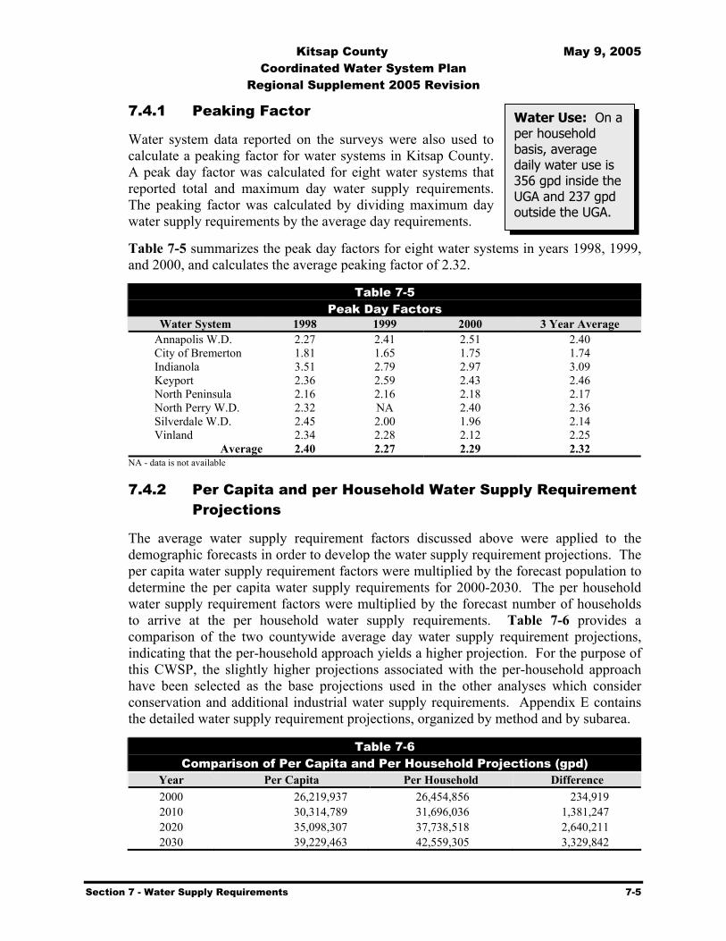
Kitsap County May 9, 2005 Coordinated Water System Plan
Regional Supplement 2005 Revision
Section 7 - Water Supply Requirements 7-5
7.4.1 Peaking Factor
Water system data reported on the surveys were also used to calculate a peaking factor for water systems in Kitsap County. A peak day factor was calculated for eight water systems that reported total and maximum day water supply requirements. The peaking factor was calculated by dividing maximum day water supply requirements by the average day requirements.
Table 7-5 summarizes the peak day factors for eight water systems in years 1998, 1999, and 2000, and calculates the average peaking factor of 2.32.
Table 7-5 Peak Day Factors
Water System 1998 1999 2000 3 Year Average Annapolis W.D. 2.27 2.41 2.51 2.40 City of Bremerton 1.81 1.65 1.75 1.74 Indianola 3.51 2.79 2.97 3.09 Keyport 2.36 2.59 2.43 2.46 North Peninsula 2.16 2.16 2.18 2.17 North Perry W.D. 2.32 NA 2.40 2.36 Silverdale W.D. 2.45 2.00 1.96 2.14 Vinland 2.34 2.28 2.12 2.25
Average 2.40 2.27 2.29 2.32 NA - data is not available
7.4.2 Per Capita and per Household Water Supply Requirement Projections
The average water supply requirement factors discussed above were applied to the demographic forecasts in order to develop the water supply requirement projections. The per capita water supply requirement factors were multiplied by the forecast population to determine the per capita water supply requirements for 2000-2030. The per household water supply requirement factors were multiplied by the forecast number of households to arrive at the per household water supply requirements. Table 7-6 provides a comparison of the two countywide average day water supply requirement projections, indicating that the per-household approach yields a higher projection. For the purpose of this CWSP, the slightly higher projections associated with the per-household approach have been selected as the base projections used in the other analyses which consider conservation and additional industrial water supply requirements. Appendix E contains the detailed water supply requirement projections, organized by method and by subarea.
Table 7-6 Comparison of Per Capita and Per Household Projections (gpd)
Year Per Capita Per Household Difference 2000 26,219,937 26,454,856 234,919 2010 30,314,789 31,696,036 1,381,247 2020 35,098,307 37,738,518 2,640,211 2030 39,229,463 42,559,305 3,329,842
Water Use: On a per household basis, average daily water use is 356 gpd inside the UGA and 237 gpd outside the UGA.

Kitsap County May 9, 2005 Coordinated Water System Plan
Regional Supplement 2005 Revision
Section 7 - Water Supply Requirements 7-6
7.4.3 Commercial/Industrial Water Supply Requirements
The water supply requirement projections are based on past water consumption rates and do not account for the possibility of a new large commercial or industrial water consumer that could potentially raise water supply requirements beyond the projected levels. In order to account for this possibility it was assumed that between 2000 and 2010, new industries with a total water supply requirement of 1.25 mgd would locate in the City of Bremerton’s service area, while an additional 0.25 mgd of new industrial demand would develop elsewhere throughout the County. Additional new industrial demands of these same amounts are estimated to develop between the years of 2010 and 2020. Further growth in industrial demand served by the City of Bremerton between 2020 and 2030 is estimated at 0.5 mgd. Table 7-7 presents the increased average day water supply requirement due to the additional large industries. It must be emphasized that these projected industrial allowances are not based on known or committed new commercial or industrial water users. They are best characterized as reasonable estimates, based on professional judgment.
Table 7-7 Per Household Water Supply Requirements, Including Additional Large Industry
Requirements (gpd)
Water Supply Requirement
Potential New Industrial Water Supply Requirement
Year Per Household Bremerton (1) County (2) Total 2000 26,454,856 ---------- -------- 26,454,856 2010 31,696,036 1,250,000 250,000 33,196,036 2020 37,738,518 2,500,000 500,000 40,738,518 2030 42,559,305 3,000,000 500,000 46,059,305
(1) Assumes new industrial water demands of 1.25 mgd by 2010, to be met by City of Bremerton. Additional new industrial demands of 1.25 mgd by 2020, and 0.5 mgd by 2030 are also assumed. This results in a cumulative increase of 3.0 mgd by 2030.
(2) Assumes new industrial water demands throughout the County of 0.25 mgd by 2010, to be met by suppliers other than City of Bremerton. Additional new industrial demands of 0.25 mgd by 2020 are also assumed. This results in a cumulative increase of 0.5 mgd by 2020 that does not increase further.
7.4.4 Effects of Conservation
Per capita water usage in Kitsap County has declined in recent years as water conservation and efficiency measures have been implemented among various water systems throughout the County. Between 1994 and 2002, average gallons per day per residence for six of the larger water purveyors declined from an average of 240 gpd to 210 gpd. WATERPAK, an organization of the larger water purveyors, has pursued an effective conservation program over the past decade. Consumption per Equivalent
Industrial Growth: Unforeseen large industrial water demands were incorporated into projections by adding 1.5 mgd by 2010, an additional 1.5 mgd by 2020, and 0.5 mgd by 2030.

Kitsap County May 9, 2005 Coordinated Water System Plan
Regional Supplement 2005 Revision
Section 7 - Water Supply Requirements 7-7
Residential Unit (ERU) has declined significantly for each system and water losses have been reduced. In most cases, larger systems have reduced water losses below ten percent of their water production, which complies with the recommended goal set by the American Water Works Association (AWWA).
This continuing water conservation effort will be modified based on requirements developed by the Washington State Department of Health (DOH) in response to conservation mandates set by the 2003 legislature in the Municipal Water Law (MWL).
The direct effect of revised conservation and water use efficiency efforts on total water supply requirements is difficult to calculate due to other factors, such as weather, which also alter water needs. For the purpose of this analysis, a one percent per year reduction in water supply requirements was assumed for years 2001 through 2010, as shown in Table 7-8. Further reductions beyond 2010 are not included, based on the assumption that the majority of conservation gains, using current technology, will likely be realized by that time.
Table 7-8 Year 2000 to 2010 Water Supply Requirements With Conservation
Year Per Household
(gpd) (1) Projected Cumulative
Savings (%)Cumulative
Savings (gpd) Adjusted Total (gpd) 2000 26,454,856 --- --- 26,454,856 2001 26,937,379 1.00% 269,374 26,668,006 2002 27,428,704 2.00% 548,574 26,880,130 2003 27,928,990 3.00% 837,870 27,091,120 2004 28,438,400 4.00% 1,137,536 27,300,864 2005 28,957,103 5.00% 1,447,855 27,509,247 2006 29,485,266 6.00% 1,769,116 27,716,150 2007 30,023,062 7.00% 2,101,614 27,921,448 2008 30,570,668 8.00% 2,445,653 28,125,014 2009 31,128,261 9.00% 2,801,544 28,326,718 2010 31,696,036 10.00% 3,169,604 28,526,432
(1) Projections between years 2000 and 2010 are based on a compound growth rate of 1.82% per year.
7.5 Summary
Table 7-9 compares water supply requirements under the following three scenarios:
without adjustments, with conservation, and with conservation and new industry water supply requirement
increases.
Conservation Effects: Incorporated into projections at 1% per year for years 2000 - 2010.
Projections: Average daily water supply requirements are projected to rise from 26.5 mgd in 2000 to 42.9 mgd in 2030.

Kitsap County May 9, 2005 Coordinated Water System Plan
Regional Supplement 2005 Revision
Section 7 - Water Supply Requirements 7-8
Without any adjustments, the total water supply requirement is projected to be 42.56 mgd by 2030. Considering the effects of conservation and additional industrial water supply requirements, the total water supply requirement in 2030 is 42.89 mgd.
Table 7-9 Kitsap County Average Day Water Supply Requirement Projections
(Using the Per Household Projection Method) In Millions of Gallons per Day
Year Without
Adjustments (1) With
Conservation (2) With Conservation
and Industrial Demand (2) (3) 2000 26.45 26.45 26.45 2010 31.70 28.53 30.03 2020 37.74 34.57 37.57 2030 42.56 39.39 42.89
(1) As projected in Table 7-6. (2) Assumes a one percent reduction per year in water supply requirements for years 2001 through 2010. (3) Assumes new industries with a water supply requirement of 1.5 mgd between years 2000 and 2010, and additional new industries with a
requirement of 1.5 mgd between years 2010 and 2020, and 0.5 mgd between years 2020 and 2030.
In consideration of the conservation ethic embraced by WATERPAK, while pragmatically recognizing the potential for future economic development in the County, the per household average day water supply requirement projection with conservation and additional industrial requirements has been selected as the forecast most appropriate for planning purposes in the context of this CWSP. Table 7-10 and Exhibit 7-4 summarize these projections for 2000-2030. Maximum day water supply requirements were calculated using the peak day factor of 2.32, presented in Table 7-5.
Table 7-10 Kitsap County Water Supply Requirement Projections
(in mgd) Year Average Day Demand (1) Maximum Day Demand (2) 2000 26.45 61.36 2010 30.03 69.67 2020 37.57 87.16 2030 42.89 99.50
(1) Based on per household approach, including conservation and additional industrial water supply requirements. (2) Based on peak day factor of 2.32.

Kitsap County May 9, 2005 Coordinated Water System Plan
Regional Supplement 2005 Revision
Section 7 - Water Supply Requirements 7-9
Exhibit 7-1

Kitsap County May 9, 2005 Coordinated Water System Plan
Regional Supplement 2005 Revision
Section 7 - Water Supply Requirements 7-10
Exhibit 7-2

Kitsap County May 9, 2005 Coordinated Water System Plan
Regional Supplement 2005 Revision
Section 7 - Water Supply Requirements 7-11
Exhibit 7-3 Comparison of Population, Household, and Employment Growth
0
50,000
100,000
150,000
200,000
250,000
300,000
350,000
400,000
1995 2000 2005 2010 2015 2020 2025 2030 2035
Year
Tota
l PopulationHouseholdsEmployment
Exhibit 7-4
Kitsap County Water Supply Requirement Forecast
0
20
40
60
80
100
120
1995 2000 2005 2010 2015 2020 2025 2030 2035
Year
Mill
ion
Gal
lons
per
Day
(MG
D)
Maximum DayAverage Day
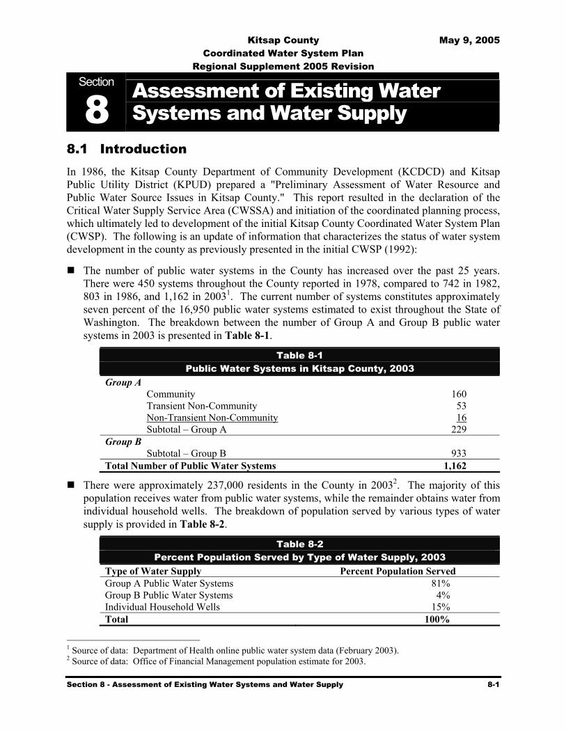
Kitsap County May 9, 2005 Coordinated Water System Plan
Regional Supplement 2005 Revision
Section 8 - Assessment of Existing Water Systems and Water Supply 8-1
Section
8 Assessment of Existing Water Systems and Water Supply
8.1 Introduction In 1986, the Kitsap County Department of Community Development (KCDCD) and Kitsap Public Utility District (KPUD) prepared a "Preliminary Assessment of Water Resource and Public Water Source Issues in Kitsap County." This report resulted in the declaration of the Critical Water Supply Service Area (CWSSA) and initiation of the coordinated planning process, which ultimately led to development of the initial Kitsap County Coordinated Water System Plan (CWSP). The following is an update of information that characterizes the status of water system development in the county as previously presented in the initial CWSP (1992):
The number of public water systems in the County has increased over the past 25 years. There were 450 systems throughout the County reported in 1978, compared to 742 in 1982, 803 in 1986, and 1,162 in 20031. The current number of systems constitutes approximately seven percent of the 16,950 public water systems estimated to exist throughout the State of Washington. The breakdown between the number of Group A and Group B public water systems in 2003 is presented in Table 8-1.
Table 8-1 Public Water Systems in Kitsap County, 2003
Group A Community 160 Transient Non-Community 53 Non-Transient Non-Community 16 Subtotal – Group A 229 Group B Subtotal – Group B 933 Total Number of Public Water Systems 1,162
There were approximately 237,000 residents in the County in 20032. The majority of this population receives water from public water systems, while the remainder obtains water from individual household wells. The breakdown of population served by various types of water supply is provided in Table 8-2.
Table 8-2 Percent Population Served by Type of Water Supply, 2003
Type of Water Supply Percent Population Served Group A Public Water Systems 81% Group B Public Water Systems 4% Individual Household Wells 15% Total 100%
1 Source of data: Department of Health online public water system data (February 2003). 2 Source of data: Office of Financial Management population estimate for 2003.

Kitsap County May 9, 2005 Coordinated Water System Plan
Regional Supplement 2005 Revision
Section 8 - Assessment of Existing Water Systems and Water Supply 8-2
Measures are in place to ensure that the public health concerns affecting citizens throughout the county are adequately monitored and mitigated. Group A water systems must comply with requirements of the Safe Drinking Water Act (SDWA) and WAC 246-290, as administered by the Department of Health (DOH). Group B water systems are also regulated under State law, but are not subject to the SDWA.
Public notification requirements ensure customers are aware of any issue concerning water quality. The consumer confidence report regulations require all water systems to notify customers about water system quality in an annual report.
All community and non-transient non-community public water systems are required to have a certified operator, according to the Final Operator Certification Rule adopted by DOH in 2001. While a “grand parenting” clause allows current operators to continue without required certification, all new operators must pass a certification exam.
Operational and maintenance problems reported by the Kitsap County Health District (KCHD) and DOH are primarily associated with Group B systems. Inadequate system operation, pressure deficiencies, delinquent water quality sampling and reporting, and lack of fire flow capabilities are frequently encountered. Other operational difficulties are a result of operating personnel lacking the proper levels of expertise. New regulations will place increased responsibility on systems to employ state certified operations personnel and to provide improved levels of reliable service, fire flow, and pressure maintenance.
The purpose of this section is to review available data regarding the ability of existing systems to provide water service within their existing and future service areas.
8.2 Water System Inventory
A detailed questionnaire on system facilities was sent to all Group A systems. This questionnaire requested data and information on comprehensive water system plan status, customers served, water sources, installed pumping/diversion capacity, water rights, water usage, system facilities, and other issues. A copy of the most recent water system comprehensive plan was requested from systems that already had not provided one to KCHD. A less detailed questionnaire was mailed to Group B water systems. The primary purpose of this latter contact was to determine which of the smaller systems proposed to expand their service areas in the future and the extent of that proposed expansion.
Concurrent with the compilation and analysis of system data, future service area boundaries were reviewed and future water demand was forecast. Once these tasks were essentially completed, an analysis was undertaken to assess the capability of the larger water systems to serve, from existing sources, the needs of current and future customers.
Water System Inventory: Based on data from surveys sent to water systems, water system plans, and the DOH water system database.

Kitsap County May 9, 2005 Coordinated Water System Plan
Regional Supplement 2005 Revision
Section 8 - Assessment of Existing Water Systems and Water Supply 8-3
8.2.1 Expanding Systems
Based upon compiled data, it was determined that the majority of the existing utilities are meeting current customer requirements for average day water supply needs. In some instances, shortages exist during the high demand, or peak day periods. The primary future water supply need appears to be in Urban Growth Areas (UGAs).
For this reason, the assessment focused on the ability of systems to meet additional demands primarily in UGAs. The ability of Group B systems to provide reliable water utility service has been a concern of the KCHD and the state. The proliferation of shallow wells associated with Group B systems is a concern because of their impact on stream flows and lack of ability to accomplish water resource management actions that are possible with larger, interconnected water systems with multiple sources.
8.2.2 Existing Facilities
Out of a total of 71 Group A water systems that were contacted in 2001, 28 (40 percent) responded to the survey regarding information about their water systems. Exhibit 8-1 provides a summary of survey and DOH data for Group A systems with a capacity of 50 or more connections. The information provided in this exhibit includes the number of approved and existing connections, amount of water rights, and source and storage capacity. Appendix G provides a summary of connection data for Group A systems serving less than 50 connections. Appendix H provides similar information for Group B systems in the county.
Additional information compiled from the survey questionnaire for Group A systems is included in Appendix I, "Group A Water Systems in Kitsap County". Appendix I provides water production, sales, and detailed storage data on large Group A water systems whom responded to the survey. A response was not received from several utilities and incomplete responses were received in many cases.
8.2.3 Service Area Boundaries
Service area boundaries have been mapped through an iterative process. In certain instances, overlaps in proposed future service areas have occurred. The uncontested future service areas are assumed to be accepted by all utilities. Where contested overlaps occur, the water requirement for the contested area is determined independently. Once a decision is made on a contested overlap area, the service responsibilities will rest with the designated utility (see Section 5).
8.2.4 Existing Interties
Exhibit 8-2 provides a listing of hydraulic interties existing between Group A water systems. Other new interties should be initiated to improve overall reliability and hydraulic efficiency, as well as to provide flexibility in supplies to meet future needs, as further discussed in Section 9.
Kitsap County May 9, 2005 Coordinated Water System Plan
Regional Supplement 2005 Revision
Section 8 - Assessment of Existing Water Systems and Water Supply 8-4
8.3 Water Rights
8.3.1 Types of Water Rights
This discussion of water rights includes only recorded rights established under the permit system as provided in the Surface Water Code of 1917 (Chapter 90.03 RCW) and the Ground Water Code of 1945 (Chapter 90.44 RCW). Three other types of water rights must also be recognized.
One type is a claim to a vested right established through actual development and use of surface water before 1917 and ground water prior to 1945. In order to retain such a right, the owner or right holder was required to file a claim under the "Registration Claims Act" of 1969 for usage that preceded the dates of the surface and ground water rights acts. Such claims are recorded in Ecology's water right claims registry. Most claims have not been evaluated as to their validity. Several factors, including use prior to 1917 for surface water and 1945 for groundwater, must be established to certify a claim’s validity. Continued, beneficial use is required to maintain each claim’s validity.
A second type is a right established under a permit exemption provision of the ground water code where not more than 5,000 gallons of ground water a day have been developed and used, observing certain restrictions. Wells for individual homes and very small systems (e.g., six or fewer homes) usually fall into this category. Some effort has been made to estimate the quantity of water withdrawn by exempt wells (i.e., Kitsap Basin (WRIA 15) Watershed Planning, Level 1 Assessment).
The third type is federal water rights for such purposes as military reservations and tribal reservations (e.g., treaty rights).
In Kitsap County, claims and exempt wells are numerous and may constitute a significant percentage of the total authorized use of ground water within the county’s geographic area. Unfortunately, the validity, and actual quantity of water used or obligated under these two types of water rights are unknown. Quantification of such rights can only be determined with certainty through a general adjudication of water rights (see RCW 90.03.110 through RCW 90.03.245, and RCW 90.44.220 and 90.44.230). Likewise, federal water rights have not been quantified.
The multitude of wells being used under claims or the exemption provision of the ground water code and federal rights must be considered in the Coordinated Water System Planning process. They will also be a factor in future ground water right application processing. The ongoing Basin Planning process under the Watershed Planning Act, Ch.90.82 RCW, may be the most appropriate forum for resolving the associated issues that develop.

Kitsap County May 9, 2005 Coordinated Water System Plan
Regional Supplement 2005 Revision
Section 8 - Assessment of Existing Water Systems and Water Supply 8-5
8.3.2 Water Right Information
Exhibit 8-3 provides a summary of water right information for Kitsap County, based primarily upon a review of Ecology water right records. The summary data includes a breakdown of the types of water right records3 (i.e., certificates, permits, claims, and applications), as well as total annual and instantaneous quantities associated with ground and surface water permits and certificates.
It is important that the water rights data shown in Exhibit 8-3 be understood to minimize the risk of misuse. The water rights do not reflect actual current usage of the water resource. They only identify the potential maximum legal appropriations that can be made under the water rights held by large Group A systems. Some of the uncertainties with water rights are as follows:
Numerous water rights still recorded are currently unused or have been totally abandoned and have never been formally relinquished. In general, non-municipal water rights that have not been put to beneficial use in the previous five years are subject to relinquishment.
Originally developed well or diversion capacities have permanently diminished to a point below the perfected water right amounts due to system deficiencies or source deterioration.
New permits have been processed instead of changing the place of use, purpose, or point of withdrawal for an existing water right, which subsequently is not used.
Permit listings reflect authorization to develop and use certain amounts of water, but the status of development is not reflected in the water right data base (e.g., a well may not be capable of producing the amount of water allowed by the permit).
Numerous water rights were issued under names other than the current holder of the right.
A number of water rights were never perfected and therefore are of questionable validity.
Many claims are redundant because they were submitted for each filing period that was opened by the legislature.
Many claims were submitted for future use, not actual use prior to the established 1917 and 1945 dates, and are therefore are not valid.
3 Source of water right data: Ecology Water Right Application Tracking System (WRATS) database (December 2001).
Water Right Information: Based on data obtained from Ecology’s Water Rights Application Tracking System Database
Water Rights Summary: Certificates: 1,254 Permits: 67 Claims: 8,236

Kitsap County May 9, 2005 Coordinated Water System Plan
Regional Supplement 2005 Revision
Section 8 - Assessment of Existing Water Systems and Water Supply 8-6
Additionally, care should be exercised in the use of the million gallons per day (MGD) conversion figures from either the instantaneous amounts (gpm or cfs) or the annual quantities (acre-feet per year (afy)). For example, in the case of instantaneous withdrawal rates, the conversion from gpm to MGD makes an assumption that all wells can be and are operated continuously for 24 hours a day, which is generally not the case. In the case of converting annual acre-feet to an average daily withdrawal rate in MGD, it should be recognized that water requirements vary throughout the year.
Exhibit 8-4 is a summary of all groundwater permits and certificates, while Exhibit 8-5 is a summary of all surface water permits and certificates, organized by subarea and purpose of use category. Some water rights are granted for multiple purposes of use. In such cases, records are categorized according to the purpose of use listed first in the Ecology database. It is also noted that not all rights have an annual quantity shown in the database. For the purposes of this summary analysis, detailed inspection of each water record and estimations of annual quantity were not made in these instances.
Exhibit 8-6 provides a graphical summary of the information portrayed in Exhibit 8-3, while Exhibits 8-7 and 8-8 provides graphical versions of the summary information provided in Exhibits 8-4 and 8-5, respectively.
8.3.3 Water Right Relinquishment
The State's relinquishment statutes cite that a water right that has been abandoned or voluntarily not used, in whole or in part, for any period of five successive years, is relinquished to the extent of such non-use and reverts to the State. However, there are exemptions to such relinquishment with definitions of sufficient cause for non-relinquishment set forth in RCW 90.14.140. The two exemptions most applicable to public water supplies relate to water rights for standby or reserve water supply or rights for municipal water supply purposes. The 2003 Legislature passed The Municipal Water Law (HB 1338) that provided a very broad definition of municipal water supplier and municipal water supply purposes. It also provided that certificates previously issued to public water suppliers were water rights in good standing, even if all of the water had not yet been put to beneficial use.
Annual Water Right Quantities: Municipal: 29,645 afy Domestic: 26,476 afy Irrigation: 3,625 afy Other Uses: 7,399 afy

Kitsap County May 9, 2005 Coordinated Water System Plan
Regional Supplement 2005 Revision
Section 8 - Assessment of Existing Water Systems and Water Supply 8-7
Exhibit 8-1 Group A Public Water Systems with 50 or More Connections Capacity
SystemName * PWS ID Number Approved Existing Qa (afy) Qi
(gpm) Qi (cfs)Source
Capacity (gpm)
Storage Capacity
(gal)
Data Source(1)
System Owner or
Op(5)
ALPINEWOOD * 018404 99 97 44.6 161 300 10,000 System WWANNAPOLIS WATER DISTRICT * 02600W 6,832 6,825 4,249.0 6,280 4,132 3,000,000 KCHDAPEX WATER SUPPLY INC * 02685J 150 125 135.0 190 177 60,000 KCHDBAINBRIDGE ISLAND, CITY OF * 97650T UND 2,232 2,564.0 3,456 0.35 1,993 2,800,000 DOHBEAR CUB WATER ASSOC 16610E 55 55 49.5 107 160 12,022 DOHBETHEL EAST 05965L 55 52 17.0 20 120 11,000 KCHD NWWBILL POINT WATER 06790L 84 84 64.2 42 66 30,000 KCHDB K S 03581D 66 61 35.0 126 180 0 System WW
BREMERTON, CITY OF - Surface Water (3) * 08200R 082734
UND 16,811 NA NA 40.00 33,240,000 System
BREMERTON, CITY OF - Ground Water - Certificates * 6,281.0 4,630 NA 13,619 System
BREMERTON, CITY OF - Ground Water Claims 6,350.0 5,100 NA System
BRIDLETREE * 083672 156 70 700.0 160 160 55,000 System KPUDBUCKLIN WATER SYSTEM 66936L 66 66 42.5 139 114 12,500 KCHD WWCEDAR GLEN MOBILE HOME PARK 11912J 135 135 31.0 100 232 32,800 KCHDCEDARBROOK * 14001T 56 34 30.0 600 120 0 System WWDRIFTWOOD COVE * 19945C 120 62 32.0 50 50 83,000 System KPUDELDORADO HILLS * 22750C 157 145 69.0 225 210 254,000 System KPUDEMERALD HEIGHTS * 23290U 90 78 90.0 150 152 66,000 KCHDERLAND POINT WATER CO * 23850K 1,001 616 1,344.0 900 0.25 500 350,000 SystemFRAGARIA LANDING * 266511 99 73 32.0 98 177 28,000 DOHFROG POND WATERS INC * 26627B 529 515 283.6 294 264 270,000 KCHDGALA PINES WATER * 270602 80 52 54.0 154 150 50,000 System KPUDGLENWOOD STATION 00561P 52 53 25.0 100 100 40,000 DOH WWHARBOR HEIGHTS 31001N 70 70 22.0 100 135 20,000 KCHD WWHINTZVILLE ACRES 10440K 60 59 32.5 105 82 11,000 KCHD WWHOLLY * 33690C 99 75 26.0 110 85 30,000 KCHDHORIZONS WEST * 343754 1,122 900 449.0 856 1,210 232,000 KCHD WWINDIAN HILLS Estates 01966V 50 48 75.0 100 110 31,700 System WWINDIANOLA (4) * 35650F 817 638 300.4 500 481 280,000 System KPUDISLAND LAKE WATER CO * 36150W 278 264 92.0 80 140 131,000 KCHDISLAND UTILITIES * 57776D 455 108 336.0 300 310 358,700 DOHKEYPORT * 38550J 827 386 858.0 650 600 400,000 System KPUDKITSAP WEST MOBILE HOME PARK 42635C 146 96 45.0 250 80 7,000 DOHLITTLE TREE 022368 54 54 36.0 100 70 30,000 DOH WWLONG LAKE VIEW ESTATES * 48031X 399 358 152.4 260 212 186,704 System KPUDMAINLAND VIEW MANOR 472480 57 53 32.5 150 150 0 DOH WWMANCHESTER STATE PARK SP5007 UND 67 NA NA INPORT 0 DOHMANCHESTER WATER DISTRICT * 507002 4,371 2,946 1,673.7 2,260 3,630 3,200,000 KCHDMARTELL MOBILE MANOR 51867D 79 79 39.5 171 140 40,000 DOHMCCORMICK WOODS * 40529X 750 607 450.0 600 1,830 570,000 KCHD COPOMEADOWMEER WATER SERVICE ASSN * 532750 335 279 150.0 250 320 235,000 KCHDMILLER BAY * 54683T 460 398 112.0 200 170 167,000 System KPUDMINTER CREEK RAPIDS * 551750 55 49 93.0 250 235 0 System WWNAV UNDERSEA WARFARE CTR KEYPORT * 90520E UND 186 NA NA 0.00 1,000 600,000 DOHNAVY YARD PARK * 43294Y 124 99 48.0 52 52 110,000 System KPUDNEWBERRY HILL * 06136C 140 40 1,720.0 1,950 100\200 749,000 System KPUD
Connections Water Rights(2)

Kitsap County May 9, 2005 Coordinated Water System Plan
Regional Supplement 2005 Revision
Section 8 - Assessment of Existing Water Systems and Water Supply 8-8
Exhibit 8-1 (cont) Group A Public Water Systems with 50 or More Connections Capacity
SystemName * PWS ID Number Approved Existing Qa (afy) Qi
(gpm) Qi (cfs)Source
Capacity (gpm)
Storage Capacity
(gal)
Data Source(1)
System Owner or
Op(5)
NORTH BAINBRIDGE * 599949 2,028 1,651 1,974.0 1,475 911 860,000 System KPUDNORTH PENINSULA * 051220 5,139 4,031 2,341.5 1,880 1,880 2,562,000 System KPUDNORTH PERRY AVENUE WATER DISTRICT * 60950M 7,520 6,046 4,089.6 4,540 3,995 4,750,000 SystemOLYMPIC VIEW MOBILE MANOR 63497U 76 76 13.0 26 70 5,480 DOHPARKVIEW TERRACE * 66215M 1,067 757 587.1 748 1,580 169,000 KCHD WWPINE LAKE MOBILE HOME EST 1 3 67397Y 82 73 48.6 112 138 5,000 KCHDPORT MADISON WATER COMPANY * 68750W 144 98 80.0 30 158 65,000 SystemPORT ORCHARD, CITY OF * 68900V UND 1,935 2,330.0 1,600 2,600 3,300,000 KCHDPOULSBO, CITY OF * 691506 UND 3,801 2,147.0 1,940 1.20 2,060 3,050,000 KCHDPRIDDY VISTA 69350E 85 80 56.0 47 123 20,000 KCHDPUGET SOUND NAVAL SHIPYARD * 03468C UND 2,918 NA NA INPORT 2,500,000 DOHROCKAWAY BEACH WATER * 734507 88 66 80.0 34 80 132,000 KCHD COBIROCKY POINT WATER DISTRICT 12 * 02052E UND 543 NA NA INPORT KCHD COBISANDY HOOK PARK COMMUNITY CLUB * 759500 146 100 80.0 160 57 94,500 KCHD NWWSCENIC BEACH STATE PARK SP780J UND 63 NA NA 65 20,000 DOHSEABECK * 031345 300 152 3,000.0 2,000 600 580,000 System KPUDSEA VIEW & OLALLA * 769209 99 66 55.0 130 130 20,000 System WWSILVERDALE WATER DIST 16 * 793006 7,731 5,172 4,664.9 4,835 0.78 6,730 5,351,000 KCHDS'KALLAM - LOWER - CWS IH650R UND 92 NA NA 36 138,000 KCHDS'KALLAM - UPPER- CWS IH466V UND 80 NA NA 179 127,000 KCHDSOUTH BAINBRIDGE WATER * 81451M 1,415 1,056 902.5 767 0.11 625 607,000 SystemSTRATTONWOOD * 84618N 99 72 40.5 160 160 30,000 KCHD WWSTRAWBERRY HILLS 84625C 94 94 83.7 125 125 80,000 System KPUDSUBASE BANGOR * 02714B UND 1,292 NA NA 3,050 3,500,000 DOHSUNNYSLOPE WATER DISTRICT * 85550H 486 399 145.6 200 270 375,000 KCHDSUQUAMISH * 864005 2,965 1,335 1,456.0 1,300 1,340 805,000 System KPUDSURFCREST Park 86450E 54 47 47.0 105 110 50,000 KCHDTAHUYEH LAKE COMMUNITY CLUB * 871166 239 221 2,000.0 334 196 125,000 KCHDVIEW SIDE COMMUNITY WATER 91850N 64 62 36.0 125 175 40,000 KCHD KPUDVINLAND * 91923K 1,489 966 704.4 890 1,530 1,112,000 System KPUDWICKS LAKE RANCHES * 967287 230 220 142.0 300 225 60,000 System WW
Totals 75 52,270 69,664 56,370 56,239 42.7 63,216 78,326,406
Notes:
(2) Data obtained from the Department of Ecology (DOE) Water Rights Application Tracking System (WRATS) December 2001 or input from individual system (#). Includes allocated amounts associated with permits and certificates. Totals are shown for systems that have multiple water rights. Data in WRATS are organized by water right owners, not by water system name. Therefore, this table may not present accurate water right information pertaining to those systems for which the owner's name differs from the water system name.
(3) The City of Bremerton also exercises surface water claims. The total Qi for these claims is 23 cfs, associated with Gorst and Anderson Creeks, which are used as emergency supplies. The City also holds an additional 2 cfs in surface water claims for Charleston Creek, which is currently not used as a source of supply.
(5) System Operator or Owner: COB-City of Bremerton, COBI-City of Bainbridge Island, COPO-City of Port Orchard, KPUD-Kitsap Public Utility District, NWW-Northwest Water, WW-Washington Water Service
* Expanding Water System
(4) The Indianola Water System also exercises ground water claims. The total Qi for these claims is 125 gpm, and the total Qa for the claims is 7.5 afy.
UND - Undetermined by DOH - System sets capacity, NA - Not Applicable
PWS = Public Water System; Qa = Annual Quantity; Qi = Instantaneous Quantity; afy = acre-feet per year; gpm = gallons per minute; cfs = cubic feet per second
(1) Data obtained from the Department of Health (DOH) Drinking Water Automated Information Network (DWAIN) (November 2001), KCHD Database , or input from individual system.
Connections Water Rights(2)

Kitsap County May 9, 2005 Coordinated Water System Plan
Regional Supplement 2005 Revision
Section 8 - Assessment of Existing Water Systems and Water Supply 8-9
Exhibit 8-2 Existing Interties for Group A Water Systems
Health System Intertie Location Size Meter Purpose ID Name With
08200R Bremerton, City of North Perry Ave Water Dist. Echo & Yoder 8" Yes Emergency
08200R Bremerton, City of Port Orchard, City of Old Clifton Rd. 12" Yes Wholesale
08200R Bremerton, City of Rocky Point Water Dist. 12
08200R Bremerton, City of Jackson Park Naval Housing
Austin Dr., Root Court
08200R Bremerton, City of Puget Sound Naval Shipyard
38550J Keyport Naval Undersea Warfare Ctr 8" Yes Emergency
90520E Naval Undersea Warfare Ctr Keyport Main Gate 8" Yes Emergency
51220 North Peninsula Brazeau Mobile Park 2" Yes Emergency 60950M North Perry Ave Water Dist Bremerton, City of Marwood Dr. 8" Yes Emergency
68900V Port Orchard City of Annapolis W. D. Mitchell-near Perry 10" No Emergency
68900V Port Orchard City of Bremerton, City of SR 16 near Anderson Hill Rd 12" Yes Surplus
691506 Poulsbo, City Of Vinland Finn Hill 12" Yes Emergency 03468C Puget Sound Naval Shipyard Bremerton, City of 02052E Rocky Point W. D. 12 Bremerton, City of
IH466V S'klallam Upper North Peninsula Hansville Hwy 6” Yes Wholesale IH650R S'kllalam Lower North Peninsula Hansville Hwy 6” Yes Wholesale
91923K Vinland Poulsbo, City Of Finn Hill Rd. 12" Yes Emergency

Kitsap County May 9, 2005 Coordinated Water System Plan
Regional Supplement 2005 Revision
Section 8 - Assessment of Existing Water Systems and Water Supply 8-10
Exhibit 8-3 Summary of Water Rights Information
North Kitsap
Bainbridge Island
Central Kitsap
South Kitsap Total
Number of Water Right Records # of Certificates 262 139 440 413 1,254 # of Permits 17 9 19 22 67 # of Claims 2,112 1,476 2,395 2,253 8,236 # of Applications 67 28 61 86 242 Summary of Permit and Certificate Quantities(1) Ground Water Rights Qa (afy) 10,965 10,282 26,649 17,044 64,940 Qa (mgd) 9.78 9.17 23.77 15.20 57.93 Qi (gpm) 12,864 11,618 26,424 23,452 74,358 Qi (mgd) 18.52 16.73 38.05 33.77 107.08 Surface Water Rights Qa (afy) 762 102 715 626 2,205 Qa (mgd) 0.68 0.09 0.64 0.56 1.97 Qi (cfs) 28.89 2.71 38.13 41.26 110.99 Qi (mgd) 0.04 0.00 0.05 0.06 0.16 Total Qa (mgd) 10.46 9.26 24.41 15.76 59.90 Qi (mgd) 18.57 16.73 38.10 33.83 107.24 Notes: Source of Data: Ecology’s Water Right Application Tracking System (WRATS) Qa = Annual Quantity Database (December 2001) Qi = Instantaneous Quantity afy = acre-feet per year cfs = cubic feet per second mgd = million gallons per day Footnote: (1) All water rights, permits, and certificates within Kitsap County, including municipal, commercial/industrial, domestic, irrigation, and rights for all other purposes of use.
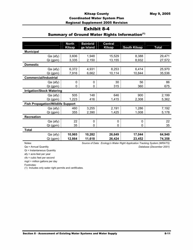
Kitsap County May 9, 2005 Coordinated Water System Plan
Regional Supplement 2005 Revision
Section 8 - Assessment of Existing Water Systems and Water Supply 8-11
Exhibit 8-4 Summary of Ground Water Rights Information(1)
North Kitsap
Bainbridge Island
Central Kitsap South Kitsap Total
Municipal Qa (afy) 3,606 1,948 15,529 8,388 29,471
Qi (gpm) 3,335 2,150 13,155 8,932 27,572 Domestic
Qa (afy) 6,372 4,931 8,253 6,414 25,970 Qi (gpm) 7,916 6,662 10,114 10,844 35,536
Commercial/Industrial Qa (afy) 0 0 30 56 86
Qi (gpm) 0 0 315 360 675 Irrigation/Stock Watering
Qa (afy) 505 148 646 900 2,199 Qi (gpm) 1,223 416 1,415 2,308 5,362
Fish Propagation/Wildlife Support Qa (afy) 460 3,255 2,191 1,286 7,192
Qi (gpm) 355 2,390 1,425 1,008 5,178 Recreation
Qa (afy) 22 0 0 0 22 Qi (gpm) 35 0 0 0 35
Total Qa (afy) 10,965 10,282 26,649 17,044 64,940
Qi (gpm) 12,864 11,618 26,424 23,452 74,358 Notes: Source of Data: Ecology’s Water Right Application Tracking System (WRATS) Qa = Annual Quantity Database (December 2001) Qi = Instantaneous Quantity afy = acre-feet per year cfs = cubic feet per second mgd = million gallons per day Footnotes: (1) Includes only water right permits and certificates.

Kitsap County May 9, 2005 Coordinated Water System Plan
Regional Supplement 2005 Revision
Section 8 - Assessment of Existing Water Systems and Water Supply 8-12
Exhibit 8-5 Summary of Surface Water Rights Information(1)
North Kitsap
Bainbridge Island
Central Kitsap
South Kitsap Total
Municipal Qa (afy) -- 0 174 -- 174Qi (cfs) 5.00 0.00 16.35 26.35 47.70
Domestic Qa (afy) 411 4 44 48 506Qi (cfs) 1.58 0.27 2.11 1.75 5.71
Commercial/Industrial Qa (afy) -- 0 0 -- 0Qi (cfs) 0.02 0.00 0.00 0.50 0.52
Irrigation/Stock Watering Qa (afy) 337 97 441 551 1,426Qi (cfs) 10.89 1.30 10.75 8.37 31.31
Fish Propagation/Wildlife Support Qa (afy) 14 1 14 27 56Qi (cfs) 10.84 0.44 7.09 3.12 21.49
Recreation Qa (afy) -- 0 42 1 43Qi (cfs) 0.15 0.00 0.70 0.32 1.17
Power Qa (afy) -- -- -- -- 0Qi (cfs) 0.41 0.70 1.13 0.85 3.09
Total Qa (afy) 762 102 715 626 2,205Qi (cfs) 28.89 2.71 8.13 41.26 110.99
Notes: Source of Data: Ecology’s Water Right Application Tracking System (WRATS)Qa = Annual Quantity Database (December 2001)Qi = Instantaneous Quantity afy = acre-feet per year cfs = cubic feet per second mgd = million gallons per day Footnote: (1) Includes only water right permits and certificates.

Kitsap County May 9, 2005 Coordinated Water System Plan
Regional Supplement 2005 Revision
Section 8 - Assessment of Existing Water Systems and Water Supply 8-13
Exhibit 8-6 Summary of Number of Water Rights Records
Source of Data: Ecology’s Water Right Application Tracking System (WRATS) database (December 2001)
North KitsapApplication 67
Permits 17
Certificates 262
Claims 2,112
Bainbridge Island
Claims 1,476
Applications 28
Permits 9
Certificates 139
Central Kitsap
Claims 2,395
Applications 61
Permits 19
Certificates 440
South Kitsap
Claims 2,253
Applications 86
Permits 22
Certif icates 413

Kitsap County May 9, 2005 Coordinated Water System Plan
Regional Supplement 2005 Revision
Section 8 - Assessment of Existing Water Systems and Water Supply 8-14
Exhibit 8-7 Summary of Ground Water Rights Annual Quantities (in acre-feet per year)
Source of Data: Ecology’s Water Right Application Tracking System (WRATS) database (December 2001)
North Kitsap
Irrigation 505 Municipal 3,606
Domestic 6,372
Other 482
Bainbridge Island
Irrigation 148
Other 3,255
Domestic 4,931
Municipal 1,948
Central Kitsap
Municipal 15,529
Domestic 8,253
Other 2,221
Irrigation 646
South Kitsap
Irrigation 900Other 1,342
Domestic 6,414
Municipal 8,388

Kitsap County May 9, 2005 Coordinated Water System Plan
Regional Supplement 2005 Revision
Section 8 - Assessment of Existing Water Systems and Water Supply 8-15
Exhibit 8-8 Summary of Surface Water Rights Annual Quantities (in acre-feet per year)
North Kitsap
Irrigation 337
Municipal 0
Domestic 411
Other 14
Bainbridge Island
Irrigation 97
Other 1Domestic 4
Municipal 0
Central Kitsap
Irrigation 441
Other 56
Domestic 44
Municipal 174
South Kitsap
Irrigation 551
Other 27 Domestic 48Municipal 0
Source of Data: Ecology’s Water Right Application Tracking System (WRATS) database (December 2001)
Kitsap County May 9, 2005 Coordinated Water System Plan
Regional Supplement 2005 Revision
Section 9 - Regional Water Supply Plan 9-1
Section
9 Regional Water Supply Plan 9.1 Introduction
It is estimated that approximately 85 percent of the population in Kitsap County is currently served by public water systems. The remaining 15 percent receives its domestic water supply from individual sources, primarily wells. Currently, public water supply system needs of approximately 27 MGD (average day) are met through a combination of surface and groundwater sources. The largest water utility, the City of Bremerton, provides about 30 percent (8 MGD) of this total from a combination of surface water (the Union River) and groundwater supplies (wells). All other large Group A water utilities rely on groundwater.
Future demands will increase significantly if the population growth projections by the State Office of Financial Management are accurate. In the 1980s and 1990s, the State's water resource management policies became increasingly complex and challenging as a result of State Supreme Court decisions, slow response by the State Legislature, as well as policy and interpretation changes by Ecology. In spring of 1990, meetings were convened to address water resource management and allocation issues having critical statewide significance. The outcome of the meetings was development of the "Chelan Agreement" which led to a series of legislation in the 1991 and 1992 legislative sessions. Among several of these legislative actions were the following key efforts:
Increased emphasis placed on water resource conservation,
Creation of a "FORUM" of representatives from the meetings' stakeholder groups to evaluate water resource issues and make consensus recommendations to the Legislature and Ecology
Establishment of one pilot area in both eastern and western Washington for development of regional water resource management plans.
The FORUM subsequently identified issues regarding seawater intrusion, minimum in-stream flow requirements, hydraulic continuity between surface and groundwater, conservation, and other matters that required reevaluation of current water law, regulations, and policy.
Realizing the need to resolve its short and long-term resource planning needs through development of a regional water resource management plan, Kitsap County requested to become the western Washington pilot area. The management plan would have addressed issues regarding supply development, water resource management, conservation, reuse, water rights issuance, identification of unused or invalid water rights and claims, interties and joint facilities, and other matters. Unfortunately, Kitsap County was not selected. In 1994, the state expanded the pilot study water management program to conduct basin assessments in 15 of the state’s Water Resource Inventory Areas (WRIAs). The assessment is the first step in developing a local water resource management plan. Again, the Kitsap WRIA (No. 15) was not chosen by the state to be funded for a basin assessment. Because of the importance of getting started on the process,

Kitsap County May 9, 2005 Coordinated Water System Plan
Regional Supplement 2005 Revision
Section 9 - Regional Water Supply Plan 9-2
Kitsap PUD funded an Initial Basin Assessment for the Kitsap County portion of WRIA 15. Under an agreement with the State Department of Ecology (Ecology), the assessment was produced, underwent a peer-review process, and was published in October 1997 (Kitsap County Initial Basin Assessment – Department of Ecology File Technical Report No. 97-004). The 1998 legislature passed The Watershed Management Act (RCW 90.12/ESHB 2514), a bill that established a program of basin planning for individual or groups of WRIAs. Basin assessment is an integral part of the process. In August 1999, Kitsap County initiated the process for WRIA 15, which includes the entire Kitsap peninsula. Initial Basin Assessments have been completed for Kitsap County and WRIA 15 (Kitsap Basin [WRIA 15] Phase II – Level 1 Assessment, Golder Associates Inc., June 21, 2002), an important step in the Basin Planning process. Follow up assessments are being conducted. The Basin Planning process is expected to take several years and the draft plan is scheduled to be completed in spring 2005. The Kitsap County CWSP will be an integral part of the process, but may have to be revised if the Basin Plan contains provisions that are not compatible.
The CWSP addresses various supply development alternatives while attempting to incorporate state and local direction on growing communities, municipal purpose, hydraulic continuity, and several other important water right policy areas. Continuation of a progressive and realistic water conservation program is included as a fundamental element of the regional water supply strategy. This section of the CWSP describes the approach for regional solutions to water resource needs and future source development options as well as the process used for consideration of environmental, economic, and other factors related to the options, alternative strategies, and recommendations.
As populations grow and population centers shift throughout the region, over time it may be necessary to develop an effective network of source, storage, transmission, and intertie piping to transport water resources to meet demand. Existing water resources throughout the county may be more effectively utilized by transferring or sharing available resources through an integrated system of mains constructed between systems. In some cases, the development of new sources may be preferable due to factors such as impact on existing sources by growth, proximity to regional transmission, and environmental impact of existing sources. In the event major supplies are developed in remote areas of the County, an effective network of transmission will be required when existing sources that are near population centers can no longer meet demand.
The recommendations in this section are based on a tiered implementation strategy to meet the future demands of Kitsap County. It is apparent that beyond the continued supply development activities of individual utilities, the implementation of a supply strategy throughout the County calls for a focused, coordinated effort. As noted earlier in Exhibit 5-5, a Memorandum of Understanding between the County and KPUD designates the District as having County-wide responsibility for technical, managerial, financial, operational, and support services needed to provide satisfactory water resource development, protection, and utility service. Therefore, it is anticipated KPUD will need to work closely with utilities throughout Kitsap County and other governmental agencies to encourage resource development to obtain adequate water supplies and water rights throughout the County.
Future water demands are to be met via a tiered implementation strategy.

Kitsap County May 9, 2005 Coordinated Water System Plan
Regional Supplement 2005 Revision
Section 9 - Regional Water Supply Plan 9-3
9.2 Regional Water Supply Requirements
Population projections and water demand forecasts for Kitsap County are described in Section 7. Exhibit 9-1 provides a comparison between these forecast demands and existing water rights within the County. Projected average day demands in year 2030 are 42.89 MGD, compared to the total annual quantity of all municipal and domestic water rights in the County (55.72 MGD), including claims used by Bremerton. However, a more meaningful comparison is made in Exhibit 9-1 between projected demands and the total annual quantity of water rights held by Group A water systems serving greater than 50 connections. This is informative as it will likely be these systems that serve the majority of population growth in the County. Based upon an estimated total annual water right quantity of 50.29 MGD for these systems1, water rights appear to be sufficient to meet demands beyond 2030. Full utilization of the existing water rights will require expansion of present source capacities and construction of integrated water delivery infrastructure. Even with implementation of such actions, there will likely be isolated areas of the County where demand will exceed local area water rights prior to 2030, and the extension of transmission lines to connect to other areas having surplus water rights would be cost-prohibitive.
The availability of water supplies beyond those represented by the existing water rights will depend on the ability of water purveyors to obtain new water rights (see Section 9.3), develop additional supplies, and build integrated water delivery infrastructure. Future population growth and related water use patterns are also controlling factors. As described in Section 7, the 2030 water demand forecast incorporates continued conservation and considers additional industrial demands. Increases in demand may vary from these projections, based upon timing of population growth, effectiveness of conservation, and extent of industrial development.
9.3 Issues Surrounding Future Water Rights
9.3.1 Obtaining New Water Rights
WAC 246-290-130 requires that no new, previously unapproved sources or modification of existing sources be approved by the Department of Health (DOH) for use as a public water supply without a water right permit from Ecology. The purpose of this requirement is to ensure that public water systems are not created or expanded without having an adequate and reliable source of supply. In the past, DOH has given approval to water system projects that were conditional upon obtaining a water right permit from Ecology. However, in many cases, projects that had received conditional approval proceeded to construction before Ecology processed the water right. This practice resulted in a number of existing systems without adequate water rights.
1 Based upon summary water right information presented in Exhibit 8-1. This may not include all water rights for Group A systems with a capacity of greater than 50 connections, since not all rights listed in Ecology’s database are able to be correlated to specific water systems and response from individual systems was not complete.
Supply vs. Demand: based on comparison of existing water rights and future demands, water rights are sufficient to meet demands beyond 2030.

Kitsap County May 9, 2005 Coordinated Water System Plan
Regional Supplement 2005 Revision
Section 9 - Regional Water Supply Plan 9-4
In November 2003, DOH established a new approach for drinking water planning documents, incorporating elements of The Municipal Water Law (MWL), passed by the 2003 Legislature. Included in this “interim”2 approach is a requirement that a system capacity determination must be made in a water system plan, which considers annual and instantaneous water right limitations, based upon an analysis of connections, population, or equivalent residential units. Water system plan approvals will be conditioned if necessary to limit expansion if water right quantities are determined to be a limiting factor for the system.
Current processing time for new water right permits is in excess of forty years. Legislative restrictions on Ecology staffing, recent court decisions, and changes in Ecology policy have greatly complicated this process. Because of legislation passed in 2001 and 2003, changes to existing water rights may be processed in a separate track from new permits and many changes to public water supply rights are no longer required. In addition, a new procedure implemented by the state legislature provides for a cost reimbursement process where applicants for Department of Ecology permits may pay for outside consultants to accomplish the bulk of permit evaluation and writing and thus avoid the delays associated with waiting for Ecology to process a permit. These provisions may speed up the new water right applications process.
Ground water withdrawals have been linked to impacts on stream flow. Because most streams in Kitsap County either are closed to further withdrawal or have set minimum in-stream flows, applications for ground water rights are affected. Future ground water rights will most likely require stream flow mitigation action for any projected impairment they may have on streams. The listing of certain salmon species on the endangered species list could further complicate the development of future water supplies. When individual water purveyors use the margins they currently have in inchoate water rights and conservation programs have maximized water savings, moratoriums on new connections will result unless the water right processing situation is resolved or alternative sources are developed. Predictions on the availability of future supplies under the current circumstances are not reliable.
Several additional factors about future water supply must be considered:
(1) Under the growth management act, it is necessary to identify, with reasonable certainty, water sources to accommodate planned future growth, particularly in the urban growth areas.
(2) The supply scenarios identified later in this section, primarily rely on groundwater development.
(3) For practical purposes, there are essentially no remaining surface waters in Kitsap County available for development of firm public water supplies (see Chapter 173-515 WAC).
2 Revised DOH guidelines regarding elements of water system planning addressed in The MWL are to be in place by the end of 2005. Until that time, the “interim” approach developed by DOH will serve as a guide to these elements of drinking water planning.
Kitsap County May 9, 2005 Coordinated Water System Plan
Regional Supplement 2005 Revision
Section 9 - Regional Water Supply Plan 9-5
(4) Even if ample groundwater is proven to be physically available in Kitsap County to satisfy the projected long-term public water supply needs, the backlog in processing water rights and uncertainty of Ecology's policy on hydraulic continuity and mitigation for impairment of instream flows, makes the availability of such groundwater for new appropriation uncertain.
(5) Alternative sources, such as reuse and desalinization, are currently significantly more expensive than groundwater to develop (see Exhibit 9-2).
9.3.2 Water Supply Reservation Procedures
The Water Resources Act of 1971, Chapter 90.54 RCW, sets forth the fundamentals of the State's water resource policies. The policies are designed to protect and fully utilize the waters to the greatest benefit of the people of the State of Washington. This Act directed Ecology to develop and implement a water resources program that provides a process for making decisions on future water resource allocations and use. Pursuant to this Act, Ecology adopted Chapter 173-590 WAC, outlining procedures for the reservation of water for future public water supply.
It is apparent that the efficient development of groundwater resources is the preferred alternative for meeting future supply requirements. The current uncertainty regarding the criteria and policies regarding hydraulic continuity between surface water and groundwater supplies, as well as other factors, may render obtaining permission to use new groundwater for future needs, difficult or impossible. To conform to the Growth Management Act (GMA) and plan for future facilities to meet projected population demands in Kitsap County, a stable water resource management strategy is critically needed.
Data required for a "Petition for Reservation of Public Waters" was originally prepared and included in the Draft for the 1992 CWSP. Ecology reviewed the draft reservation petition data but noted that public water supply reservations are defined as allocations in the Water Resources Act of 1972, Chapter 90.54 RCW. Therefore, under the Chelan Agreement, allocations of water can only be accomplished through a regional water resources management plan.
The Basin Planning Act in 1997 (SB 2514) prescribed that water resource management and planning be conducted on a Water Resource Inventory Area (WRIA) or multi-WRIA basis (Chapter 90.82 RCW). In 1999, Kitsap County initiated the Basin Planning Process, which is expected to take several years. In 2003, the legislature enacted modifications that require more detailed evaluations and provisions for future supplies for all needs. At this time, sufficient information has not been developed to obtain approval of a water supply reservation. However, as the Basin Planning Process develops, an evaluation of the advisability of initiating water supply reservations should be conducted.
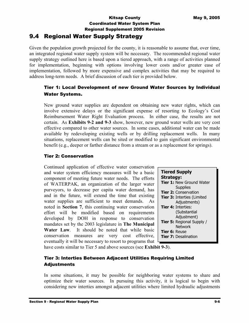
Kitsap County May 9, 2005 Coordinated Water System Plan
Regional Supplement 2005 Revision
Section 9 - Regional Water Supply Plan 9-6
9.4 Regional Water Supply Strategy
Given the population growth projected for the county, it is reasonable to assume that, over time, an integrated regional water supply system will be necessary. The recommended regional water supply strategy outlined here is based upon a tiered approach, with a range of activities planned for implementation, beginning with options involving lower costs and/or greater ease of implementation, followed by more expensive and complex activities that may be required to address long-term needs. A brief discussion of each tier is provided below.
Tier 1: Local Development of new Ground Water Sources by Individual Water Systems.
New ground water supplies are dependent on obtaining new water rights, which can involve extensive delays or the significant expense of resorting to Ecology’s Cost Reimbursement Water Right Evaluation process. In either case, the results are not certain. As Exhibits 9-2 and 9-3 show, however, new ground water wells are very cost effective compared to other water sources. In some cases, additional water can be made available by redeveloping existing wells or by drilling replacement wells. In many situations, replacement wells can be sited or modified to gain significant environmental benefit (e.g., deeper or farther distance from a stream or as a replacement for springs).
Tier 2: Conservation
Continued application of effective water conservation and water system efficiency measures will be a basic component of meeting future water needs. The efforts of WATERPAK, an organization of the larger water purveyors, to decrease per capita water demand, has and in the future, will extend the time that existing water supplies are sufficient to meet demands. As noted in Section 7, this continuing water conservation effort will be modified based on requirements developed by DOH in response to conservation mandates set by the 2003 legislature in The Municipal Water Law. It should be noted that while basic conservation measures are very cost effective, eventually it will be necessary to resort to programs that have costs similar to Tier 5 and above sources (see Exhibit 9-3).
Tier 3: Interties Between Adjacent Utilities Requiring Limited Adjustments
In some situations, it may be possible for neighboring water systems to share and optimize their water sources. In pursuing this activity, it is logical to begin with considering new interties amongst adjacent utilities where limited hydraulic adjustments
Tiered Supply Strategy: Tier 1: New Ground Water
Supplies Tier 2: Conservation Tier 3: Interties (Limited
Adjustments) Tier 4: Interties:
(Substantial Adjustment)
Tier 5: Regional Supply / Network
Tier 6: Reuse Tier 7: Desalination

Kitsap County May 9, 2005 Coordinated Water System Plan
Regional Supplement 2005 Revision
Section 9 - Regional Water Supply Plan 9-7
would be necessary. Such situations would be characterized as systems with reservoirs having similar overflow elevations and distribution systems having similar operating pressures.
Tier 4: Interties Between Adjacent Utilities Requiring More Substantial Adjustments
Once resource sharing is optimized in cases where implementation is not complex, opportunities should be investigated for interties where additional hydraulic modifications may be necessary. This may include the installation of pressure reducing valves and additional pumping facilities in situations where operating pressures between neighboring systems are incompatible.
Tier 5: Regional Source, Storage, and Transmission Network
A long-term regional strategy that has been under consideration for many years is the development of new regional ground water supplies, with a storage and transmission network to convey water throughout the County. A number of previous studies have examined the feasibility of utilizing surface waters from rivers on the Olympic Peninsula for public water supply. Water right applications were filed with the State by the City of Bremerton in 1957 for development of the Hamma Hamma River. Kitsap PUD filed for water rights on the Duckabush River in 1964. These applications were both denied by the Department of Ecology (Ecology) in 1999, and no appeals were made.
The approach to regional water supply has changed since the 1992 CWSP, when surface water sources outside of the County were seen as the best supply alternative. Now, based upon the complications surrounding the use of surface water and the recent water right application experiences of Bremerton and KPUD, new ground water supplies are viewed as more feasible than new surface water supplies. Such ground water sources would likely be developed in the Seabeck aquifer or other aquifers in the western and southwestern portions of the County.
Water from such supplies would be pumped into a regional transmission and storage network. The transmission network developed and modeled in the 1992 CWSP is still a valid approach in the context of this strategy. The analysis conducted for the 1992 CWSP indicated that water from a regional source can be delivered throughout the County using existing pipeline facilities in combination with new interties and regional reservoirs (Appendix F provides excerpts from the 1992 CWSP as a reference to this current document). Although some portions of the existing transmission grid in the County may be adequate to support a regional system, other areas may require modifications such as increasing pipe sizes, installing pumping stations, and adding new reservoirs and additional valving. Due to the diverse topography of the County, boosting of regional supplies by some individual water systems will likely be required to maintain desired system operating pressures.
The general flow of water within the envisioned regional transmission system would be north and south through the lower elevations found in the Bremerton area, with new

Kitsap County May 9, 2005 Coordinated Water System Plan
Regional Supplement 2005 Revision
Section 9 - Regional Water Supply Plan 9-8
regional pump stations and reservoirs as required to convey water throughout the County. Exhibit 9-4 provides a schematic of a potential regional transmission system, including existing transmission piping greater than 10 inches in diameter, generally based upon the work conducted during development of the 1992 CWSP. Actual details of a future transmission system would have to be worked out by the various water systems that choose to participate in component projects.
The regional transmission system takes advantage of existing pipelines as well as adding new lines to the system. At least three new regional booster stations are anticipated as a part of the regional transmission network. One station would likely be located in the Silverdale area to boost water to the northern portion of the County. Another would likely be located in North Bremerton to improve the ability to move water from south to north on the east side of Dyes Inlet. The third regional station would be used to boost water to Port Orchard.
If the regional supply strategy is to include water supply to the Gig Harbor area in Pierce County to address potential source deficiencies, a fourth booster station would be required to boost water from near Port Orchard to the vicinity of the Tacoma Narrows Airport. A new transmission line, approximately 29 miles long, would also be required to convey water from Port Orchard to the airport area.
At least six future regional storage reservoirs will be required to provide storage on a regional basis. Various overflow elevations are envisioned for these reservoirs, such that each one would feed distinct systems in various pressure zones throughout the region. Installation of pressure reducing valves at certain transmission line interties would allow for flow of water between pressure zones, aiding in the ability of the system to accommodate regional storage requirements.
This regional transmission network was analyzed in detail via computer modeling during development of the 1992 CWSP. The results documented in that effort are still considered valid and should be used to guide implementation of this regional water supply strategy.
Tier 6: Water Reuse
Water reuse is a means by which to reduce demands upon potable water supplies, as reclaimed wastewater or stormwater may be used for certain non-potable applications. Common non-potable applications of reclaimed water include land application (irrigation), commercial/industrial process and cooling water, wetland enhancement, and stream augmentation. There also exists the potential for indirect applications of such water to enhance the availability of potable water. Most often, this takes the form of aquifer recharge, either through surface percolation or direct injection.
Due to its limited history, especially in the northwest, there are still many challenges associated with water reuse. Regulations pertaining to water quality and reliability are strict, in order to ensure public health and to protect the environment. Technologies are
Kitsap County May 9, 2005 Coordinated Water System Plan
Regional Supplement 2005 Revision
Section 9 - Regional Water Supply Plan 9-9
improving at a rapid pace to provide economical treatment solutions to address these regulations. Perhaps the single most challenging issue surrounding reuse is public perception. Public acceptance of this type of water supply, given its controversial past, is crucial to successful implementation of a reclamation project. To accomplish this, the public needs to be informed and involved early in the process.
There appears to be potential for water reuse in the County. Appendix J evaluates this potential for reusing wastewater and stormwater generated in the County for various applications. The discussion focuses mainly on large-scale water reuse projects in Kitsap County which could yield significant reductions in water demand. Small scale or water reuse at an individual household level and industrial water reuse and recycling opportunities in the County are not addressed but could be pursued in the future. An evaluation of desalination is also presented in Appendix J. The focus of the appendix is to explore reuse and desalination opportunities that could be used by water systems in the County to extend the availability of ground water supplies.
Tier 7: Desalination
Desalination is another potential alternative water supply, by which seawater could be used for potable or non-potable applications. Cost and impracticability has discouraged the development of desalination in the past. However, with limited new supplies and increasing demand, desalination is now being pursued in certain areas of the country where other water supplies sources are not adequate. Large projects are underway in Florida and Southern California. Appendix J contains a more detailed review of desalination.
Costs associated with desalination vary depending on salinity, injection temperatures, recovery rates, power costs, and economy of size. The more salt that is in the water the more processing that is required and the higher the costs. Desalting seawater costs three to five times more than desalting brackish ground water. Energy costs can represent 50 to 75 percent of the desalination operating cost. In general, the colder the water being processed, the higher the energy costs. Reverse osmosis requires the least energy, which makes the process desirable for areas with limited energy resources and as energy cost in general increase. Economies of size are also important determinates in project costs. The membrane filtration process is the least dependant on economies of size.
Additional costs are associated with environmental protection. The disposal of brine, which is the output of the desalination process, has a negative effect on the environment and must be disposed of properly. Marine impacts and ground water salinity are issues associated with brine disposal which must be avoided. Associated plant modifications and mitigation measures incur additional costs.
9.5 Summary of Future Water Supply Costs
The regional water supply strategy presented in Section 9.4 is comprised of levels, or tiers, of activities arranged in order of increasing cost and implementation complexity. Tier 1 costs for
Kitsap County May 9, 2005 Coordinated Water System Plan
Regional Supplement 2005 Revision
Section 9 - Regional Water Supply Plan 9-10
new ground water wells are generally attractive when compared to other sources, but associated problems may dictate choosing a more expensive solution. In general, costs associated with Tier 2 and 3 activities (i.e., conservation and interties requiring limited adjustments) are anticipated to be small compared to activities in the higher tiers.
Initial conservation measures are generally very cost effective, and therefore assigned a high tier level (Tier 2). Costs for conservation programs typically include inexpensive water efficient hardware given free to customers (i.e. showerheads), customer rebates for more expensive water efficient hardware (i.e. toilets), labor costs for audits, marketing costs, and utility staff time. Collectively, these costs are far less than the capital improvements required of most other supply strategies. The cost effectiveness of conservation programs generally decreases over time since the most cost effective measures are implemented first, leaving lesser cost effective measures to be implemented later (see Exhibit 9-3). While WATERPAK has been active in conservation since 1993, most of the effort has been in public information and education, leaving much opportunity for cost effective conservation.
Exhibit 9-3 provides a range of cost effectiveness for various types of more expensive conservation approaches, based on conservation programs in other communities. These figures are included to provide a planning level estimate of cost effectiveness. Actual cost effectiveness in Kitsap County will vary because the details (i.e. costs and participation rate) built into these numbers may not be entirely comparable to Kitsap County. For example, costs may be different such as the dollar amount of a rebate or staff salaries. Similarly, the participation rate which is dependent on a variety of factors including housing stock age, percentage of customers with in-ground irrigation systems, program saturation rate, and program penetration rate, may be different.
Costs are not expected to be substantial for Tier 3 activities, as these would involve limited operational changes and minor capital improvements (e.g., valve modifications or replacement, short main extensions, etc) to optimize sharing of existing source and storage facilities.
Higher levels of cost will be associated with activities in Tiers 4 through 7. Tier 4 interties between adjacent utilities will require more significant system adjustments such as longer extensions of mains; installation of pressure reducing valves, booster pumping stations, and new storage; and source enhancement, as compared to simpler Tier 3 interties. In some cases, associated costs may be similar to the cost of developing and moving water from a new ground water supply (Tier 5).
In order to understand the potential cost implications of the future water supply options presented as Tiers 5, 6, and 7 (regional ground water source, reuse, and desalination), a summary of supply costs has been developed. Table 9-1 provides the capital and annual operating and maintenance costs for three forms of water supply: new ground water development (i.e., a new well), reuse facilities at an existing wastewater treatment plant, and a desalination facility. The costs reflect only source of supply, and do not include storage, transmission, and distribution components. For the purpose of comparison, each option is considered to provide 1.0 MGD of water supply.

Kitsap County May 9, 2005 Coordinated Water System Plan
Regional Supplement 2005 Revision
Section 9 - Regional Water Supply Plan 9-11
Further analysis was performed to determine the cost of supplying approximately ten percent of the additional water needs for the County for the next 20 years, employing each of these three sources of supply. Based upon the demand forecast presented in Section 7, average day demand is expected to increase by 11.12 MGD between 2000 and 2020. One MGD represents approximately ten percent of this demand increase. The cost of supplying this amount of water over 20 years is calculated as the capital cost for installation of 1.0 MGD facilities, plus 20 years of operations and maintenance costs, as shown in Table 9-1. Exhibit 9-2 provides a graphical presentation of the costs.
Table 9-1 Comparison of Alternative Water Supply Costs (1)
New Ground Water
Well (5)
Wastewater Treatment Plant Upgrade for Class A
Reuse Water (6),(7) Desalination
Facility (6), (8) Capital Cost (2) $590,0000 $2,000,000 $10,000,000
Annual O&M (3) $50,000 $150,000 $500,000
20-Year Total Cost (4) $1,590,000 $5,000,000 $20,000,000
Footnotes: (1) Costs reflect the provision of 1.0 mgd of water supply. All costs are in 2003 dollars. (2) Capital costs include costs for source of supply only. (3) Annual operations and maintenance (O&M) costs include labor, maintenance, and chemical costs where
applicable. (4) Calculated as capital cost plus 20 years of the annual O&M cost. (5) Capital cost based upon the following criteria:
a) 800 ft deep well, at a cost of approximately $300 per foot b) 150 hp pump at a cost of $125,000 c) Miscellaneous electrical, mechanical, and wellhouse costs of $225,000 d) No treatment facilities required
(6) See Appendix J for basis of cost. (7) In addition to source of supply costs, there are typically significant costs associated with the distribution of
reuse water. (8) Energy costs can represent 50 to 75 percent of desalination operating costs. In general, higher energy costs are
associated with colder water being processed.
The 20-year cost of obtaining water from a new 1.0 MGD well is estimated at $1.6 million, compared to $5.0 and $20.0 million for reuse and desalination facilities, respectively. Due to its much higher cost, in both capital construction and annual operation, desalination is unlikely to be a viable alternative for meeting substantial supply requirements for the County in the next 20 years. Reuse, however, may prove a more attractive and feasible water supply alternative in the near future if willing and interested customers are identified, and if reclaimed water suppliers and users are committed to promoting the environmental and sustainability ethic embodied by reuse. As technology advances, the costs for both reuse and desalination should decrease, making them more attractive as alternatives in future years.

Kitsap County May 9, 2005 Coordinated Water System Plan
Regional Supplement 2005 Revision
Section 9 - Regional Water Supply Plan 9-12
9.6 Ground Water Supply Assessment
Extensive work has been accomplished in assessing the ground water supply in Kitsap County. Exhibit 9-5 is a list of studies, assessments, and efforts that have been completed since 1994 and may be referenced to evaluate the potential for ground water development in various sections of the County.
KPUD initiated a county wide monitoring program in response to the Kitsap County Ground Water Management Plan (GWMP, 1991). Over thirteen years of aquifer level, precipitation, and stream flow data has been collected and analyzed by the program. A more complete explanation of the monitoring program activities are provided in Appendix K.
In conjunction with the Kitsap County Initial Basin Assessment (Ecology Open File 97-04) published October 1997, an Open file of Water Resource Information was initiated with copies being maintained at the Department of Ecology’s North West Regional Office and at Kitsap Public Utility District Headquarters in Poulsbo WA. As new documents are developed, they are added to the files.

Kitsap County May 9, 2005 Coordinated Water System Plan
Regional Supplement 2005 Revision
Section 9 - Regional Water Supply Plan 9-13
Exhibit 9-1 Comparison of Projected Kitsap County Average Day Demand and
Existing Annual Water Rights
25
30
35
40
45
50
55
60
2000 2005 2010 2015 2020 2025 2030
Year
Ave
rage
Day
Sup
ply
& D
eman
d (m
gd)
Projected County-wide Average Day Demand
Total Annual Quantity (Qa) for Water Rights of Group A Systems Serving more than 50 Connections
Total Annual Quantity (Qa) for all Municipal and Domestic Water Rights in County

Kitsap County May 9, 2005 Coordinated Water System Plan
Regional Supplement 2005 Revision
Section 9 - Regional Water Supply Plan 9-14
Exhibit 9-2 Comparison of Alternative Water Supply Costs - Total 20-year Costs
$590,000$2,000,000
$10,000,000
$1,000,000
$3,000,000
$10,000,000
$0
$5,000,000
$10,000,000
$15,000,000
$20,000,000
$25,000,000
New Ground Water Well Wastewater Treatment Plant Upgrade forClass A Reuse Water
Desalination Facility
Water Source (1 mgd)
Tota
l 20-
Year
Cos
ts
Operations/Maintenance Cost (20 Years)Capital Cost
Total = $1,590,000
Total = $5,000,000
Total = $20,000,000

Kitsap County May 9, 2005 Coordinated Water System Plan
Regional Supplement 2005 Revision
Section 9 - Regional Water Supply Plan 9-15
Exhibit 9-3A Comparison of Conservation Program Costs
* Customer
Sector Examples of measures
Savings
(mgd) Cost
Cost per 1 mgd
1 Residential Domestic
Toilet, faucet, and showerhead retrofits; efficient clothes washers 8.5 $22,000,000 $2,588,235
1 Residential Landscape
Irrigation systems and scheduling efficiencies; natural lawns and gardens 3.4 $14,000,000 $4,117,647
1 Commercial Process
Air cooling; process water and cooling tower efficiencies; laundry wash water recycling
3.9 $14,000,000 $3,589,744
1 Commercial Domestic
Low flush toilets and urinals; waterless urinals; swimming pool & hot tub efficiencies
1.3 $2,000,000 $1,538,462
1 Commercial Landscape
Weather-based irrigation; Irrigation system and scheduling efficiencies; soil moisture sensors
0.5 $2,000,000 $4,000,000
2 Residential Domestic
Residential plumbing retrofits - showerheads \ toilets 1.0 $4,307,000 $4,307,000
2 Residential Domestic
Metering with commodity rates for all connections (associated O&M $18/yr/meter)
1.0 $6,313,000 $6,313,000
2 Residential Domestic
High-efficiency washing machine rebate program - $75 1.0 $4,200,000 $4,200,000
2 Commercial Domestic
Ultra low flush toilets - $126 per unit -Commercial, Industrial, and Institutional 1.0 $4,704,000 $4,704,000
2 Residential Domestic
Ultra low flush toilets - $126 per unit - Residential 1.0 $2,940,000 $2,940,000
Source: 1. Seattle Public Utilities -Seattle-King Co. Regional Water Conservation Program Report 2002 2. Water Use Efficiency: The Costs and Water Savings Quantified - Paul Selsky-Brown and Caldwell-Sacramento-AWWA Conference 2002

Kitsap County May 9, 2005 Coordinated Water System Plan
Regional Supplement 2005 Revision
Section 9 - Regional Water Supply Plan 9-16
Exhibit 9-3B Conservation Program Cost Comparison
Conservation Program Cost Comparison Exhibit 9-3B
$0
$1,000,000
$2,000,000
$3,000,000
$4,000,000
$5,000,000
$6,000,000
$7,000,000
Res
iden
tial
plum
bing
re
trof
its
Res
iden
tial
land
scap
ing
and
Irrig
atio
n
Com
mer
cial
Proc
esse
s
Low
flus
hto
ilets
and
urin
als
Com
mer
cial
land
scap
ing
and
Irrig
atio
n
Res
iden
tial
plum
bing
retr
ofits
Met
erin
g w
ithco
mm
odity
rate
s
Was
hing
mac
hine
reba
tepr
ogra
m
Low
flus
hto
ilets
-C
omm
erci
al
Low
flus
hto
ilets
-R
esid
entia
l
Conservation Measure
Cap
ital C
ost p
erO
ne m
gd

Kitsap County May 9, 2005 Coordinated Water System Plan
Regional Supplement 2005 Revision
Section 9 - Regional Water Supply Plan 9-17
Exhibit 9-4 Regional Transmission Systems and Reservoirs

Kitsap County May 9, 2005 Coordinated Water System Plan
Regional Supplement 2005 Revision
Section 9 - Regional Water Supply Plan 9-18
Exhibit 9-5 Ground Water Studies and Assessments Since 1984
Kitsap County Initial Basin Assessment Open File Groundwater References 1994 and Later Documents
Subarea
AGI Technologies, December 12, 1994, Source of Supply and Basin Assessment for the Annapolis Basin, a part of Water Resource Inventory Area 15, for Annapolis Water District.
Manchester
AGI Technologies, February, 1997, Source of Supply and Basin Assessment for the North Perry Water District.
Manette
AGI Technologies, July 3, 1989, Groundwater Availability Study, Port Gamble, Kitsap County, Washington. Report prepared for Pope Resources, Poulsbo, Washington.
Port Gamble
AGI Technologies, October 8, 1996, Final Report Gorst Creek Basin Study Phase I. Report prepared for City of Bremerton Public Works, Bremerton, Washington.
Gorst
Becker, J.E., (Robinson and Noble) 1995A, Hydrogeological analysis of the Bangor Aquifer System, Kitsap County, Washington.
Bangor
Becker, J.E., (Robinson and Noble) 1995B, Quantitative Flow System Analysis through Numerical Modeling Techniques of the Bangor Aquifer Systems.
Bangor
Kitsap County Ground Water Management Plan (Draft) Volumes I and II, April 1991, Volumes III, May 1997, and Volume IV, April 1996.
County-wide Reference
Purdy, J.W., (Robinson and Noble), 1995a, Hydrogeologic characterization of the Seabeck Aquifer System for PUD #1 of Kitsap County.
Seabeck
Purdy, J.W., (Robinson and Noble), 1995b, Preliminary evaluation of the water resources on the Seabeck Subarea for PUD #1 of Kitsap County.
Seabeck
Purdy, J.W., (Robinson and Noble), October 1994, Interpretation of a 60-day pumping test on PUD #1 of Kitsap County's Seabeck Well 3.
Seabeck
Robinson and Noble, Inc., Public Utility District No. 1 of Kitsap County, Economic and Engineering Services, Inc., Washington State Department of Ecology, April 1996, Seabeck Aquifer Protection Plan.
Seabeck
U.S. Geological Survey. Water-Resources Investigations Report 96-4309, 1995, Ambient Quality of Groundwater in the Vicinity of Naval Submarine Base Bangor, Kitsap County, Washington.
Bangor
Becker, J.E., (Robinson and Noble, Inc.), August 1998, Aquifer Modeling and Mitigation Options for the Seabeck Aquifer System.
Seabeck
Robinson and Noble, Inc., January 1999, Aquifer Storage and Recovery Testing in the South Kingston Aquifer, for PUD No. 1 of Kitsap County.
Kingston
Kato & Warren, Inc., Robinson & Noble, Inc., December 2000, City of Bainbridge Island Level II Assessment, An Element of the Water Resources Study
Bainbridge

Kitsap County May 9, 2005 Coordinated Water System Plan
Regional Supplement 2005 Revision
Section 9 - Regional Water Supply Plan 9-19
Exhibit 9-5 (cont) Ground Water Studies and Assessments Since 1984
Kitsap County Initial Basin Assessment Open File Groundwater
References 1994 and Later Documents Subarea
Robinson and Noble, Inc., April 2001, Ridgetop Production Well 90-Day Pumping Test and Monitoring Results and Analysis for Silverdale Water District.
Bangor
Robinson and Noble, Inc., March 1999, Union Subarea Initial Basin Assessment.
Union
U.S. Geological Survey. Water-Resources Investigations Report 97-4060, 1998, Hydrogeology of Naval Submarine Base Bangor and Vicinity, Kitsap County, Washington.
Bangor
U.S. Geological Survey, 2000. Water-Resources Investigations Report 01-4110, Estimating Recharge to Groundwater from Precipitation at Naval Submarine Base Bangor and Vicinity, Kitsap County, Washington,
Bangor
Prych, E. A. 1997, Numerical Simulation of Ground-Water Flow Paths and Discharge Location at Puget Sound Naval Shipyard, Bremerton, Washington. U.S. Geological Survey, Water-Resources Investigations Report 96-4147
Gorst
Brown and Caldwell, September 17, 1998, Water Reuse Feasibility Study Final Report, prepared for the City of Bremerton.
Manette
Simulation of the Ground-Water Flow System at Naval Submarine Base Bangor and Vicinity, Kitsap County, Washington, by Marijke van Heeswijk and Daniel T. Smith, U.S. Geological Survey Water-Resources Investigations Report 02-4261.
Bangor
Golder Associates Inc. 2002. Kitsap Basin (WRIA 15) Watershed Planning Phase 2, Level 1 Assessment.
County-wide Reference
Golder Associates Inc. 2002. Kitsap Watershed Planning (WRIA 15) Instream Flow Assessment Draft Step A. Redmond, Washington.
County-wide Reference
Golder Associates Inc. 2003. WRIA 15 Instream Flow Level 2 Step B Hydraulic Continuity Draft Report
County-wide Reference
Golder Associates Inc. 2003. Kitsap Watershed Planning (WRIA 15) Storage Assessment Draft Report. Redmond, Washington.
County-wide Reference
Golder Associates Inc. 2003. Kitsap Watershed Planning (WRIA 15) Water Quality Draft Step A Report
County-wide Reference
Golder Associates Inc. 2003. Kitsap Watershed Planning (WRIA 15) Water Quality Assessment Final Report
County-wide Reference

Kitsap County May 9, 2005 Coordinated Water System Plan
Regional Supplement 2005 Revision
Section 10 - Plan Implementation 10-1
Section
10 Plan Implementation 10.1 Introduction
This revised Kitsap County Coordinated Water System Plan (CWSP) Regional Supplement was prepared to implement the various provisions of the Public Water System Coordination Act, Chapter 70.116 RCW. This Section briefly outlines the approval process for the CWSP, the process for appealing CWSP procedures, and how CWSP revisions are implemented. The section also provides the environmental review for this revision.
10.2 Revision Approval Process
As outlined in Section 2, the CWSP is presented in two parts: the Regional Supplement provisions detailed in this document for the entire County, and a compilation of individual Water System Plans (WSPs) for the various public water systems that have been approved by the Kitsap County Health District (KCHD) and the Washington State Department of Health (DOH). Completed WSPs are on file with DOH and the KCHD. The previous CWSP was completed in November 1992 and approved by DOH in August 1995. At that time, individual WSPs were required to be submitted for review within one year from the date of CWSP completion, i.e., the date the CWSP was approved by DOH. Each water utility is responsible for fulfilling its water system planning requirements. The level of effort required to update individual WSPs is based upon system size, the expansion plans of the utility, and the type of system ownership. Guidelines for preparing WSPs are available from DOH Each utility should contact DOH and establish if their individual WSP requires an update.
Preparation of the revised Regional Supplement has been the responsibility of local water utilities, acting through the Water Utility Coordinating Committee (WUCC). The WUCC identified local needs and gave direction for the development of the CWSP as it related to area-wide issues. Through the efforts of the WUCC, the procedures, regional policies, and minimum standards were completed for the CWSP.
This CWSP revision and any subsequently proposed changes, including service area changes, should be submitted by the WUCC and/or KCHD to the Kitsap County Department of Community Development (KCDCD) for appropriate internal review and forwarding to the Kitsap County Commissioners for approval. County review is to ensure there are no inconsistencies with applicable comprehensive plans, or development regulations adopted under chapter 36.70A RCW; any other applicable comprehensive plan, land use plan, or development regulation adopted by the county or a city or town; or any watershed plan approved under chapter 90.82 RCW, or a comprehensive watershed plan adopted under RCW 90.54.040 (1), if such a watershed plan has been approved for the area involved; or shoreline master programs. The County Commissioners have 60 days upon receipt of the revised CWSP to act on the document. The alternative actions the County Commissioners may take are set forth in WAC
Kitsap County May 9, 2005 Coordinated Water System Plan
Regional Supplement 2005 Revision
Section 10 - Plan Implementation 10-2
246-293-290, as shown in Exhibit 10-1. After County action, the revised CWSP will be submitted to DOH, which must also act upon adoption within 60 days.
Once assured that the local preparation and review procedures of the Act have been followed, DOH will be able to approve the document as a CWSP. It should be emphasized that DOH may approve portions of the CWSP found to be consistent with adopted plans and policies in effect at the time of their review. This will enable approval of the CWSP Regional Supplement and those completed individual WSPs. As specified in Section 2, requests for system expansion will be denied for those water utilities that have not completed their planning or service area requirements.
By reference herein, any changes requested to individual WSPs or service area boundaries prior to the next update of the CWSP can follow the administrative change procedures specified in the CWSP.
10.3 Appeals Process
The Utility Service Review Procedure (USRP) process described herein gives existing systems preference for providing retail water service to new developments. Each service must be timely and reasonable. Issues of what constitutes appropriate conditions of service may be expected to arise in the future between applicants for new water service and existing systems. For these reasons, an appeal procedure was developed and adopted by the WUCC.
The appeals process in the prior CWSP has been clarified and slightly revised in this revision. The process has been coordinated with DOH and is discussed below and illustrated in Exhibit 10-2.
It may be expected that either an applicant or a utility may raise issues of protest or interpretation regarding requirements of the “timely and reasonable” provision of service by a water system or other requirements of the CWSP.
As discussed in Section 2, the 1995 Legislature enacted E2SSB 5448. Sections of this bill pertain to the criteria for “timely and reasonable” service. One of the major changes in law defines “timely” service as 120 days, unless specified otherwise by local government. DOH has developed guidelines to assist local governments with this interpretation regarding what issues trigger the appeal process, when the 120-day period begins, and procedures of an appeals process.
In accordance with the DOH guidelines, only water service issues relating to new requests for retail water service are subject to appeal under the “timely and reasonable” criteria. Issues related to conformance with State Environmental Policy Act (SEPA), the Growth Management Act (GMA), any countywide regional planning policies, county and city land use plans, financing policies, and wholesale agreements are not subject to the CWSP appeals process.
10.3.1 Issues Subject to Appeal and Review
Only water service related issues are subject to appeal and review under this process. In most instances, such issues will be identified when the applicant requests the Certificate

Kitsap County May 9, 2005 Coordinated Water System Plan
Regional Supplement 2005 Revision
Section 10 - Plan Implementation 10-3
of Water Availability Notification Form from the water utility. Issues subject to review are limited to the following:
Interpretation and application of water utility retail service area boundaries. Proposed schedule for providing service. Conditions of service, excluding published rates and fees. Annexation provisions imposed as a condition of service; provided, however, existing
authorities of city government are not altered by the CWSP, except where an interlocal agreement exists between a city and the County or are specifically authorized by Chapter 70.116 RCW.
Design standards more stringent that the minimum design standards specified in Section 4.
Lack of response by the utility.
10.3.2 Timelines and Reasonability of Service
State law requires that no purveyor shall establish a public water system within the retail service area of another purveyor that has been assigned through the CWSP process unless the local legislative authority determines that the existing purveyors are unable to provide the service in a timely and reasonable manner.
Guidance provided by DOH regarding “timely” criteria specifies that timely service is unavailable if:
The purveyor states in writing that it is unable or unwilling to provide service; or
Within 120 days, the purveyor and applicant are unable to negotiate an agreement on the schedule and terms of providing service.
The applicant is required to make a good faith effort to contact the designated purveyor and initiate negotiations for a service agreement.
The 120-day period commences at the first meeting between the purveyor and the applicant pursuant to the USRP process described in Section 5. At the conclusion of this negotiation period, agreement to the satisfaction of both parties must be reached with written confirmation. If the applicant is unsuccessful in getting the purveyor to respond and/or meet, a certified letter to the designated purveyor requesting service will serve as evidence of the start date for the 120-day negotiation period. If an appeal is generated during the 120-day negotiation period, the procedure, discussed below, will resolve the conditions of service.
The determination of whether service is timely and reasonable shall take into consideration the guidelines developed by DOH under RCW 70.116.060(3)(b) and the guidelines in Chapter 3. If a determination is made the existing purveyor will not provide that service in a timely and reasonable manner, a new public water system may be constructed in accordance with the construction standards and specifications of this

Kitsap County May 9, 2005 Coordinated Water System Plan
Regional Supplement 2005 Revision
Section 10 - Plan Implementation 10-4
CWSP. The service area boundaries for the affected purveyors will be revised to reflect the “Appeals” decision.
10.3.3 Step 1 Review - Appeal Review Subcommittee
The applicant and utility should exhaust all local utility appeals procedures before pursuing the CWSP Appeals Process. If an applicant and a utility are unable to agree on conditions of service, either party may make a written request for review of the issues to the KCHD. The KCHD will initiate review by sending a copy of the request to the Chairperson of the WUCC. The WUCC will establish a process for review and informal resolution of appeals. The process will generally function within the following framework:
Appeal Review Subcommittee: The view of the WUCC is that the majority of such disputes can best be resolved if discussions between the parties are facilitated by persons knowledgeable as to public water system design, construction, and operation. To this end, the WUCC will form a subcommittee for purpose of peer review of appealable issues with the objective of reaching a negotiated agreement. A subcommittee of the WUCC will be appointed by the WUCC Chairperson and renewed or revised annually by the WUCC.
Membership will consist of designated utility representatives from each of the following areas (see Exhibit 7-1).
North Kitsap County Central Kitsap County South Kitsap County Bainbridge Island
The subcommittee representative from the region where an appeal exists will be allowed to participate in the discussion and evaluation of the issue, but will not be eligible to vote in any final decisions. A majority of the three remaining subcommittee members will be used to make all final decisions. In the event a subcommittee member is absent, that member is responsible for finding an alternate utility representative from the region to fill the position.
Objectives: The review process will be directed to achieving the following objectives:
Provide a forum for negotiation of the issues between the parties. Facilitate the negotiations. Ensure equitable representation between parties. Reach agreement between parties. Where parties choose not to participate in the negotiations, identify and evaluate
the facts associated with the issues.
If an applicant and a utility are unable to agree on conditions of service, either party may make a written request for review of the issues to the KCHD.

Kitsap County May 9, 2005 Coordinated Water System Plan
Regional Supplement 2005 Revision
Section 10 - Plan Implementation 10-5
Subcommittee Report: The Subcommittee will conclude its review within 45 days of receipt of the appeal by KCHD. The Subcommittee Chairperson will provide a written report to the KCHD that contains the majority view and recommendation of the voting eligible Subcommittee members. When an appeal has been resolved, the conditions of agreement will be reported. KCHD will ensure new service area maps and agreements are generated and signed by the appropriate parties if applicable. Where resolution between the parties was not achieved, the report should identify the controlling issues and the position of the parties. Parties who disagree with the decision of the subcommittee must submit their appeal in writing within 30 days of receipt of the committee report to KCHD for forwarding to the County Commissioners along with the Subcommittee recommendation for disposition of the issues. If the recommendation of the Subcommittee is not appealed within the timeframe specified, its recommendation will be implemented by KCHD.
10.3.4 Step 2 Review - County Commissioners Appeal
Upon receipt of an appeal of the report of findings and recommendations by the Subcommittee, KCHD will forward the appeal to the County Commissioners for resolution.
10.3.5 Step 3 Review - Review Court
An appeal of a decision rendered by the Board of County Commissioners may be made to Superior Court and/or other appropriate Courts.
10.3.6 KCHD Action
The KCHD will file the subcommittee report and all appeal decision records as part of the applicant’s request record.
10.3.7 Appeal Process Review
Refinement or re-direction of the process may be needed. For this reason, the WUCC may conduct an annual review of the appeals process. Based upon this review, adjustments should be made within the framework of the described appeal process. Major changes will require CWSP amendments.
10.4 Water System Plan Review and Approval
The Public Water System Coordination Act and DOH implementing regulations (Chapter 246-293 WAC) require that each water purveyor within the CWSP area prepare a WSP identifying the proposed program for compliance with and implementation of responsibilities defined in the CWSP (exemptions exist for certain, non-municipally owned systems in existence
Each water utility is responsible for fulfilling its water system planning requirements. DOH may require changes to individual WSPs if needed for consistency with this CWSP revision.

Kitsap County May 9, 2005 Coordinated Water System Plan
Regional Supplement 2005 Revision
Section 10 - Plan Implementation 10-6
as of September 21, 1977, see WAC 246-293-230). If deemed necessary by DOH, individual WSPs must also be updated to be consistent with revisions to the CWSP. Recognizing that a reasonable time must be allowed purveyors to respond to CWSP revisions, all purveyors should coordinate with DOH to determine if their WSP needs to be updated, and an appropriate schedule to do so.
By statute, DOH is responsible for WSP approval KCHD provides support to DOH for systems with 25 or fewer services. Exhibit 2-6 (presented earlier) illustrates the procedure described above for review and approval of water system plans.
10.5 Data Management Program
Data management is a necessary element of a comprehensive water resources program. Water resource data in many forms are involved in the majority of management and planning programs in Kitsap County. Watersheds and aquifers often cross jurisdictional boundaries. Many of the water resources of the County are not precisely and/or accurately characterized. Access to some existing data is limited.
A successful water resource data management program in Kitsap County needs to focus on the following goals:
Inter-Agency data coordination; Water resource data integrity; Dedicated staff and analysis systems; and, Ongoing data and system development and maintenance.
This discussion characterizes those agencies and programs specific to water supply, water resource management in Kitsap County, outlines current data collection programs, and recommends action items for improving data management. The WRIA 15 Watershed Planning process likely will address other water resource management issues and data coordination.
10.5.1 Related County Programs
Organizations in Kitsap County have several ongoing water resource-related monitoring programs. These programs have varying levels of coordination and supporting data systems that are, in some cases, manual. Exhibit 10-3 outlines water resource related programs existing within Kitsap County, including responsible agencies, and key data elements.
10.5.2 Water Resource Management Program
The information provided in Exhibit 10-3 was used to develop a data resource management program for ongoing, water resource data collection in Kitsap County. The program is outlined in Appendix K. The data management program prescribes which
The data management program prescribes which agency is responsible for certain data.

Kitsap County May 9, 2005 Coordinated Water System Plan
Regional Supplement 2005 Revision
Section 10 - Plan Implementation 10-7
agency is responsible for certain data. The evolving, distributed GIS system supported by the county, cities, and special purpose districts will be a primary repository of the data. A common base/parcel map is a key component for an inter-agency management program.
10.5.3 Recommended Actions
Based on the existing management programs in Kitsap County, and the data management program outlined above, a list of recommended actions has been developed. These recommendations are categorized by water resource management program goals, and are shown in Exhibit 10-4.
10.6 State and County Administrative Action
Implementation of this Plan will require administrative action at both the State and County level. New legislation enacted by the State Legislature must be phased into CWSP plan implementation. Program areas where new or amended laws, regulations, and/or ordinances may be necessary are as follows:
10.6.1 State Authority
The passage of The Municipal Water Law (2E2SHB 1338 in the 2003 Legislature significantly broadened the definition of municipal water suppliers and the utilization of water rights. The Departments of Health and Ecology will influence implementation of this landmark bill. Their decisions regarding the process for water right applications, place of use service areas, conservation requirements, reporting requirements, and future planning criteria will be major considerations for all water purveyors.
10.7 Coordinated Water System Plan Update
The CWSP no longer requires an update every five years. Rather, periodic updates may be initiated by the WUCC or as required at the direction of the County Commissioners or DOH. In accordance with Chapter 70.116.060(8) RCW, if DOH initiates an update or revision of the CWSP, the State shall pay for the cost of updating or revising the Plan.
10.8 Periodic Committee Review
The WUCC should continue as a standing committee and meet at least annually to review issues of regional significance and to review implementation issues regarding the CWSP. A subcommittee should be established within the WUCC with responsibility to meet at least annually to review the effectiveness of the Minimum Design Standards and recommend needed changes.
The WUCC should continue as a standing committee and meet at least annually to review issues of regional significance and to review implementation issues regarding the CWSP.

Kitsap County May 9, 2005 Coordinated Water System Plan
Regional Supplement 2005 Revision
Section 10 - Plan Implementation 10-8
10.9 Environmental Document
The State Environmental Policy Act (SEPA) of 1971, Chapter 43.21C RCW, requires that all WSPs be accompanied by an appropriate environmental document. An Environmental Checklist has been prepared for the Kitsap County CWSP Revision and its recommended activities. This Checklist is included as Exhibit 10-5.
The CWSP Regional Supplement has been prepared to establish administrative, management, and policy procedures to respond to the needs of existing and future water customers in Kitsap County. It is intended to address regional concerns within the County, which are not ordinarily included in each utility's WSP. Examples of those regional issues are: potential shared facilities, regional sources of supply, procedures for reviewing and approving future water use activities, minimum design standards, designated water utility service areas, and water utility management policies.
The CWSP Regional Supplement’s contents are referenced in the SEPA Checklist. It is anticipated that both negative and positive impacts may occur to earth, water, land use, population, public services, and utilities because of implementing the individual WSPs. The CWSP Regional Supplement Revision has been developed in accordance with Kitsap County Area Comprehensive Plans, Sub-Area Plans, and city land use documents to reflect local land use policies and requirements. Therefore, implementation of this Plan and the employment of sound engineering and construction practices during the implementation of each utility's WSP will minimize any adverse impacts.
The CWSP is consistent with the Kitsap County Planning Policy for Coordinated and Consistent Planning between the County and the Cities within Urban Growth Areas.

Kitsap County May 9, 2005 Coordinated Water System Plan
Regional Supplement 2005 Revision
Section 10 - Plan Implementation 10-9
Exhibit 10-1 State Regulation Relating to Local Review of Plan
WAC 246-293-290 COORDINATED WATER SYSTEM PLAN - LOCAL REVIEW.
(1) Prior to submission of a coordinated water system plan to the department for approval, the plan shall be reviewed by the county legislative authority(ies) in the county(ies) in which the critical water supply service area is located. County review of the coordinated water system plan shall include at least one public hearing.
(2) If no comments have been received from the county legislative authority(ies) within 60 days of receipt of the coordinated water system plan, the department may consider the plan for approval.
(3) If within 60 days of receipt of the coordinated water system plan, the county legislative authority(ies) find any segment of the plan to be inconsistent with adopted land use plans, shorelines master programs, the following shall occur:
(a) The county legislative authority(ies) shall submit written description of their determination and justification supporting their determination prior to the end of the 60 day period to the department and all affected parties.
(b) The county legislative authority(ies) shall make every effort to resolve any inconsistencies within 60 days of submittal of written justification.
(c) The department may approve those portions of the coordinated water system plan found not to be inconsistent with adopted plans and policies at any time after the initial determination by the county legislative authority(ies).
(d) If after the 60-day period established for resolution of inconsistencies an inconsistency still exists, the affected parties shall each present their final recommended alternative solution to the department. The department shall then review all alternative solutions and discuss its recommendations with the county(ies) and the water utility coordinating committee. If after two years of the declaration of the critical water supply service area the inconsistencies persist, the department may deny proposals to establish or to expand any public water system facilities, which affect that portion of the critical water supply service area being contested.

Kitsap County May 9, 2005 Coordinated Water System Plan
Regional Supplement 2005 Revision
Section 10 - Plan Implementation 10-10
Exhibit 10-2 Appeals Process
The Appeals Subcommittee is composed of designated water utility representatives from the North, Central, South, and Bainbridge Island sections of the County. Membership is renewed or revised annually. A majority vote determines Subcommittee recommendations made concerning appeals.
Appealant
Kitsap County Health District
Water Utility Coordinating Committee Appeals Subcommittee
Kitsap County Commissioners
Superior Court

Kitsap County May 9, 2005 Coordinated Water System Plan
Regional Supplement 2005 Revision
Section 10 - Plan Implementation 10-11
Exhibit 10-3 Water Resource Related Programs,
Implementing Agencies, and Associated Data
Agency Programs Data Available Actions/Data
Needed Notes
Local WATERPAK, KCHD
Conservation Water Use\ERU Water Loss
Membership in Puget Sound Conservation Coalition
WATERPAK Backflow Prevention Western WA Cross Connection Control Professionals Group
WATERPAK Emergency Response
WATERPAK, Cities
Education & Public Information
County (DCD ), Cities
Comprehensive Planning
Water quality, land use, population.
WRIA 15 Watershed Planning Process
County (Natural Resources)
Water Shed Planning Stream Data
County (Public Works), Cities
NPDES compliance WWTPs, Storm water quality
County (Public Works), Cities
Storm Water Management
KCSSWMP
KCHD Drinking water Quality Water quality and water use for public water systems
Immediate compliance and inventory data (SDWA)
KCHD Compliance w/State regs.
Well logs Unique Well ID #
Data Bank of wells being developed (KPUD)
KCHD Water systems/well sites
KCHD Monitoring Landfill ground and surface water monitoring
KPUD Monitoring Salt water intrusion
KPUD Source development
KPUD Computer mapping
KPUD Monitoring Program Groundwater levels MOUs w/KCHD
Precipitation
Stream flow Contract with County & MOU w/Suquamish Tribe to share streamflow data

Kitsap County May 9, 2005 Coordinated Water System Plan
Regional Supplement 2005 Revision
Section 10 - Plan Implementation 10-12
Exhibit 10-3 (cont)
Agency Programs Data Available Actions/Data
Needed Notes
Local (cont) Seawater intrusion
KPUD Well Database Unique Well ID # Assist KCHD Program
Water Districts Source development
Cities Source development
State
DOH Drinking water Water quality for public systems
Health District - MOU - for water use and demand
DOH Salt water intrusion Water quality and quantity correlated to location and physical characteristics
Committee w/Ecology, well drillers, KPUD, local Health Department
DOH Water Conservation
Ecology Well logs Well capacity and construction
Groundwater quality data
MOU DOH
Ecology Water rights Develop Water Production Database
Ecology Water usage Demand forecasts
Federal
EPA Drinking Water Quality (SDWA)
Surface and groundwater quality
STORET
USGS Hydrogeological Studies
Groundwater capacity and quality
WATSTORE
USGS Well Data Well inventory NWIS
Tribes Suquamish Source monitoring Stream flow and
well capacity
Point-No-Point Treaty
Stream flow data

Kitsap County May 9, 2005 Coordinated Water System Plan
Regional Supplement 2005 Revision
Section 10 - Plan Implementation 10-13
Exhibit 10-4 Recommended Action Items for Water Resource Program Development
Goal: Inter-Agency Data Coordination
Recommend Action Implementing Agency
Establish Memoranda of Understanding for Water Resource Data Development KPUD
Develop a Common Base Map County
Utilize Water Quality Data Formats employed by the EPA STORET Database County (P W – SSWMP)
Utilize Wetland Data Formats employed by National Wetland Inventory County (DCD - Water Resources)
Maintain Stream and Water Data Compatibility with DNR's Stream Type Maps and the State Classification System Defined by WAC 222-16-030
County (DCD - Water Resources)
Maintain Compatibility with Ecology's Data Reporting Requirements for Well Logs and Construction Information
KCHD
Maintain Compatibility with DOH's Water System Reporting Requirements All
Goal: Water Resource Data Integrity
Recommended Action Implementing Agency
Develop a Ground Control Network for the County County (PW)
Develop 1/2 meter or better imagery Develop a GPS Reference Station Network for Kitsap County in cooperation with existing regional efforts
County (DCD) County (PW) / KPUD
Determine Well Locations for Existing Well Logs Utilizing the County Base Map/GPS
KCHD/KPUD
Develop Surface Water Monitoring Network Utilizing County Base Map County (PW – SSWMP)
Develop Ground-Controlled Parcel Map County (DCD-GIS/IT)
Collect Digital Water Use and Water Level Data from the Purveyors KCHD / KPUD
Continue Unique Well Identification Number Program KCHD /KPUD
Identify Watershed Boundaries Using 1:100 Scale Orthophoto-Derived Contours County (P W – SSWMP)
Update Comprehensive Resource Data Using Remote Sensing (I.e., Spot or Thematic Mapper Satellite data)
County (DCD) / KPUD
Goal: Dedicated Staff and Analysis Systems
Recommended Action Implementing Agency
Develop a Countywide GIS that Allows Interactive Water Resource Data Access and Analysis
County (DCD) / KPUD
Assign Ownership and Maintenance Responsibilities Among Agencies to Maintain Data Layers/Databases
Each Agency
Train Staff as Needed Each Agency
Goal: Ongoing Data And System Development
Recommended Action Implementing Agency
Maintain Active Membership on Key Players Committee Each Agency
Develop Data and System Development Cost Sharing Program Each Agency

Kitsap County May 9, 2005 Coordinated Water System Plan
Regional Supplement 2005 Revision
Section 10 - Plan Implementation 10-14
Exhibit 10-5 Environmental Checklist
WAC 197-11-960 Environmental checklist.
ENVIRONMENTAL CHECKLIST Purpose of checklist: The State Environmental Policy Act (SEPA), chapter 43.21C RCW, requires all governmental agencies to consider the environmental impacts of a proposal before making decisions. An environmental impact statement (EIS) must be prepared for all proposals with probable significant adverse impacts on the quality of the environment. The purpose of this checklist is to provide information to help you and the agency identify impacts from your proposal (and to reduce or avoid impacts from the proposal, if it can be done) and to help the agency decide whether an EIS is required. Instructions for applicants: This environmental checklist asks you to describe some basic information about your proposal. Governmental agencies use this checklist to determine whether the environmental impacts of your proposal are significant, requiring preparation of an EIS. Answer the questions briefly, with the most precise information known, or give the best description you can. You must answer each question accurately and carefully, to the best of your knowledge. In most cases, you should be able to answer the questions from your own observations or project plans without the need to hire experts. If you really do not know the answer, or if a question does not apply to your proposal, write "do not know" or "does not apply." Complete answers to the questions now may avoid unnecessary delays later. Some questions ask about governmental regulations, such as zoning, shoreline, and landmark designations. Answer these questions if you can. If you have problems, the governmental agencies can assist you. The checklist questions apply to all parts of your proposal, even if you plan to do them over a period of time or on different parcels of land. Attach any additional information that will help describe your proposal or its environmental effects. The agency to which you submit this checklist may ask you to explain your answers or provide additional information reasonably related to determining if there may be significant adverse impact. Use of checklist for nonproject proposals: Complete this checklist for nonproject proposals, even though questions may be answered "does not apply." IN ADDITION, complete the SUPPLEMENTAL SHEET FOR NONPROJECT ACTIONS (part D). For nonproject actions, the references in the checklist to the words "project," "applicant," and "property or site" should be read as "proposal," "proposer," and "affected geographic area," respectively.

Kitsap County May 9, 2005 Coordinated Water System Plan
Regional Supplement 2005 Revision
Section 10 - Plan Implementation 10-15
Exhibit 10-5 (cont) Environmental Checklist
TO BE COMPLETED BY APPLICANT EVALUATION FOR AGENCY USE ONLY A. BACKGROUND 1. Name of proposed project, if applicable:
Kitsap County Coordinated Water System Plan Regional Supplement – 2004 Revision 2. Name of applicant: Kitsap Public Utility District No. 1 3. Address and phone number of applicant and contact person: Bill Hahn, Kitsap PUD No. 1 P.O Box 1989 Poulsbo, WA 98370 (360) 779-7656 4. Date checklist prepared: December 2, 2004 5. Agency requesting checklist: Washington State Department of Health 6. Proposed timing or schedule (including phasing, if applicable): Approval of Plan in 2005 with periodic updates at the direction of the Kitsap County Board of Commissioners or the Department of Health. 7. Do you have any plans for future additions, expansion, or further activity related to or connected with this proposal? If yes, explain.
As individual water system plans are updated, they are required to be consistent with this Plan. 8. List any environmental information you know about that has been prepared, or will be prepared, directly related to this proposal. None other than what is contained in the Plan. 9. Do you know whether applications are pending for governmental approvals of other proposals directly affecting the property covered by your proposal? If yes, explain. N/A 10. List any government approvals or permits that will be needed for your proposal, if known. A. Kitsap County Department of Community Development will review for consistency with applicable local plans.

Kitsap County May 9, 2005 Coordinated Water System Plan
Regional Supplement 2005 Revision
Section 10 - Plan Implementation 10-16
Exhibit 10-5 (cont) Environmental Checklist
TO BE COMPLETED BY APPLICANT EVALUATION FOR AGENCY USE ONLY B. Plan will be forwarded to Kitsap County Board of Commissioners for approval.
C. Upon Commission approval, forwarded on to DOH for approval. 11. Give brief, complete description of your proposal, including the proposed uses and the size of the project and site. There are several questions later in this checklist that ask you to describe certain aspects of your proposal. You do not need to repeat those answers on this page. (Lead agencies may modify this form to include additional specific information on project description.) The 2004 revision to the Kitsap County Coordinated Water System Plan Regional Supplement revises the 1992 plan, and is a detailed local and state management program developed pursuant to Chapter 70.116 RCW and Chapter 246-293 WAC. This plan provides a process and strategy for Kitsap County water utilities to define their role in a program consistent with adopted land use policies and projected growth strategy of the area. 12. Location of the proposal. Give sufficient information for a person to understand the precise location of your proposed project, including a street address, if any, and section, township, and range, if known. If a proposal would occur over a range of area, provide the range or boundaries of the site(s). Provide a legal description, site plan, vicinity map, and topographic map, if reasonably available. While you should submit any plans required by the agency, you are not required to duplicate maps or detailed plans submitted with any permit applications related to this checklist. Study area provided in the plan. B. ENVIRONMENTAL ELEMENTS 1. Earth
a. General description of the site (circle one): Flat, rolling, hilly, steep slopes, mountainous, other . . . . . .
Not Applicable
b. What is the steepest slope on the site (approximate percent slope)?
Not Applicable
c. What general types of soils are found on the site (for example, clay, sand, gravel, peat, muck)? If you know the classification of agricultural soils, specify them and note any prime farmland.
Not Applicable
d. Are there surface indications or history of unstable soils in the immediate vicinity? If so, describe.
Not Applicable

Kitsap County May 9, 2005 Coordinated Water System Plan
Regional Supplement 2005 Revision
Section 10 - Plan Implementation 10-17
Exhibit 10-5 (cont) Environmental Checklist
TO BE COMPLETED BY APPLICANT EVALUATION FOR AGENCY USE ONLY
e. Describe the purpose, type, and approximate quantities of any filling or grading proposed. Indicate source of fill.
Not Applicable
f. Could erosion occur as a result of clearing, construction, or use? If so, generally describe.
Not Applicable
g. About what percent of the site will be covered with impervious surfaces after project construction (for example, asphalt or buildings)?
Not Applicable
h. Proposed measures to reduce or control erosion, or other impacts to the earth, if any: Not Applicable
2. Air
a. What types of emissions to the air would result from the proposal (i.e., dust, automobile, odors, industrial wood smoke) during construction and when the project is completed? If any, generally describe and give approximate quantities if known.
Not Applicable
b. Are there any off-site sources of emissions or odor that may affect your proposal? If so, generally describe.
Not Applicable
c. Proposed measures to reduce or control emissions or other impacts to air, if any:
Not Applicable 3. Water
a. Surface:
1) Is there any surface water body on or in the immediate vicinity of the site (including year-round and seasonal streams, saltwater, lakes, ponds, wetlands)? If yes, describe type and provide names. If appropriate, state what stream or river it flows into.
Not Applicable 2) Will the project require any work over, in, or adjacent to (within 200 feet) the described waters?
If yes, please describe and attach available plans.
Not Applicable

Kitsap County May 9, 2005 Coordinated Water System Plan
Regional Supplement 2005 Revision
Section 10 - Plan Implementation 10-18
Exhibit 10-5 (cont) Environmental Checklist
TO BE COMPLETED BY APPLICANT EVALUATION FOR AGENCY USE ONLY
3) Estimate the amount of fill and dredge material that would be placed in or removed from surface water or wetlands and indicate the area of the site that would be affected. Indicate the source of fill material. Not Applicable
4) Will the proposal require surface water withdrawals or diversions? Give general description,
purpose, and approximate quantities if known.
Not Applicable 5) Does the proposal lie within a 100-year floodplain? If so, note location on the site plan.
Not Applicable
6) Does the proposal involve any discharges of waste materials to surface waters? If so, describe the type of waste and anticipated volume of discharge.
Not Applicable
b. Ground:
1) Will ground water be withdrawn, or will water be discharged to ground water? Give general description, purpose, and approximate quantities if known.
Not Applicable
2) Describe waste material that will be discharged into the ground from septic tanks or other sources, if any (for example: Domestic sewage; industrial, containing the following chemicals. . . ; agricultural; etc.). Describe the general size of the system, the number of such systems, the number of houses to be served (if applicable), or the number of animals or humans the system(s) are expected to serve.
Not Applicable
c. Water runoff (including stormwater):
1) Describe the source of runoff (including storm water) and method of collection and disposal, if any (include quantities, if known). Where will this water flow? Will this water flow into other waters? If so, describe.
Not Applicable
2) Could waste materials enter ground or surface waters? If so, generally describe.
Not Applicable
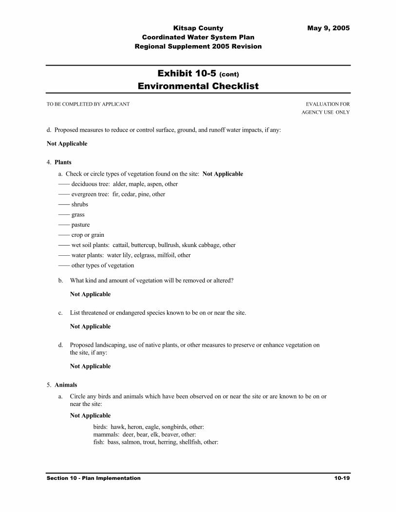
Kitsap County May 9, 2005 Coordinated Water System Plan
Regional Supplement 2005 Revision
Section 10 - Plan Implementation 10-19
Exhibit 10-5 (cont) Environmental Checklist
TO BE COMPLETED BY APPLICANT EVALUATION FOR AGENCY USE ONLY d. Proposed measures to reduce or control surface, ground, and runoff water impacts, if any:
Not Applicable 4. Plants
a. Check or circle types of vegetation found on the site: Not Applicable deciduous tree: alder, maple, aspen, other evergreen tree: fir, cedar, pine, other shrubs grass pasture crop or grain wet soil plants: cattail, buttercup, bullrush, skunk cabbage, other water plants: water lily, eelgrass, milfoil, other other types of vegetation b. What kind and amount of vegetation will be removed or altered?
Not Applicable
c. List threatened or endangered species known to be on or near the site.
Not Applicable
d. Proposed landscaping, use of native plants, or other measures to preserve or enhance vegetation on the site, if any:
Not Applicable 5. Animals
a. Circle any birds and animals which have been observed on or near the site or are known to be on or near the site:
Not Applicable birds: hawk, heron, eagle, songbirds, other: mammals: deer, bear, elk, beaver, other: fish: bass, salmon, trout, herring, shellfish, other:

Kitsap County May 9, 2005 Coordinated Water System Plan
Regional Supplement 2005 Revision
Section 10 - Plan Implementation 10-20
Exhibit 10-5 (cont) Environmental Checklist
TO BE COMPLETED BY APPLICANT EVALUATION FOR AGENCY USE ONLY
b. List any threatened or endangered species known to be on or near the site.
Not Applicable
c. Is the site part of a migration route? If so, explain. Not Applicable
d. Proposed measures to preserve or enhance wildlife, if any:
Not Applicable
6. Energy and natural resources
a. What kinds of energy (electric, natural gas, oil, wood stove, solar) will be used to meet the completed project's energy needs? Describe whether it will be used for heating, manufacturing, etc.
Not Applicable
b. Would your project affect the potential use of solar energy by adjacent properties? If so, generally describe. Not Applicable
c. What kinds of energy conservation features are included in the plans of this proposal? List other proposed measures to reduce or control energy impacts, if any:
Not Applicable
7. Environmental health
a. Are there any environmental health hazards, including exposure to toxic chemicals, risk of fire and explosion, spill, or hazardous waste, that could occur as a result of this proposal? If so, describe.
Not Applicable
1) Describe special emergency services that might be required.
Not Applicable
2) Proposed measures to reduce or control environmental health hazards, if any:
Not Applicable
b. Noise
1) What types of noise exist in the area which may affect your project (for example: traffic,
equipment, operation, other)?
Not Applicable

Kitsap County May 9, 2005 Coordinated Water System Plan
Regional Supplement 2005 Revision
Section 10 - Plan Implementation 10-21
Exhibit 10-5 (cont) Environmental Checklist
TO BE COMPLETED BY APPLICANT EVALUATION FOR AGENCY USE ONLY
2) What types and levels of noise would be created by or associated with the project on a short-
term or a long-term basis (for example: traffic, construction, operation, other)? Indicate what hours noise would come from the site.
Not Applicable
3) Proposed measures to reduce or control noise impacts, if any:
Not Applicable 8. Land and shoreline use
a. What is the current use of the site and adjacent properties?
There are multiple uses throughout Kitsap County.
b. Has the site been used for agriculture? If so, describe.
Agriculture use generally exists in rural areas.
c. Describe any structures on the site.
All types
d. Will any structures be demolished? If so, what?
Not Applicable
e. What is the current zoning classification of the site?
Varies since Coordinated Water System Plan is a county-wide plan.
f. What is the current comprehensive plan designation of the site?
Varies since Coordinated Water System Plan is a county-wide plan.
g. If applicable, what is the current shoreline master program designation of the site?
Varies
h. Has any part of the site been classified as an "environmentally sensitive" area? If so, specify.
Not Applicable
i. Approximately how many people would reside or work in the completed project?
Not Applicable

Kitsap County May 9, 2005 Coordinated Water System Plan
Regional Supplement 2005 Revision
Section 10 - Plan Implementation 10-22
Exhibit 10-5 (cont) Environmental Checklist
TO BE COMPLETED BY APPLICANT EVALUATION FOR AGENCY USE ONLY
j. Approximately how many people would the completed project displace?
Not Applicable
k. Proposed measures to avoid or reduce displacement impacts, if any:
Not Applicable
l. Proposed measures to ensure the proposal is compatible with existing and projected land uses and plans, if any:
Plan will be reviewed by Kitsap County Department of Community Development to ensure consistency with applicable comprehensive plans, land use plans, and development regulations.
9. Housing
a. Approximately how many units would be provided, if any? Indicate whether high, middle, or low-income housing.
Not Applicable
b. Approximately how many units, if any, would be eliminated? Indicate whether high, middle, or low-income housing.
Not Applicable
c. Proposed measures to reduce or control housing impacts, if any:
Not Applicable 10. Aesthetics
a. What is the tallest height of any proposed structure(s), not including antennas; what is the principal exterior building material(s) proposed?
Not Applicable
b. What views in the immediate vicinity would be altered or obstructed?
Not Applicable
c. Proposed measures to reduce or control aesthetic impacts, if any:
Not Applicable

Kitsap County May 9, 2005 Coordinated Water System Plan
Regional Supplement 2005 Revision
Section 10 - Plan Implementation 10-23
Exhibit 10-5 (cont) Environmental Checklist
TO BE COMPLETED BY APPLICANT EVALUATION FOR AGENCY USE ONLY
11. Light and glare
a. What type of light or glare will the proposal produce? What time of day would it mainly occur?
Not Applicable
b. Could light or glare from the finished project be a safety hazard or interfere with views?
Not Applicable
c. What existing off-site sources of light or glare may affect your proposal?
Not Applicable
d. Proposed measures to reduce or control light and glare impacts, if any:
Not Applicable
12. Recreation
a. What designated and informal recreational opportunities are in the immediate vicinity?
Not Applicable
b. Would the proposed project displace any existing recreational uses? If so, describe.
Not Applicable
c. Proposed measures to reduce or control impacts on recreation, including recreation opportunities to be provided by the project or applicant, if any:
Not Applicable
13. Historic and cultural preservation
a. Are there any places or objects listed on, or proposed for, national, state, or local preservation registers known to be on or next to the site? If so, generally describe.
Not Applicable
b. Generally describe any landmarks or evidence of historic, archaeological, scientific, or cultural importance known to be on or next to the site.
Not Applicable

Kitsap County May 9, 2005 Coordinated Water System Plan
Regional Supplement 2005 Revision
Section 10 - Plan Implementation 10-24
Exhibit 10-5 (cont) Environmental Checklist
TO BE COMPLETED BY APPLICANT EVALUATION FOR AGENCY USE ONLY
c. Proposed measures to reduce or control impacts, if any:
Not Applicable 14. Transportation
a. Identify public streets and highways serving the site, and describe proposed access to the existing street system. Show on site plans, if any.
Not Applicable
b. Is site currently served by public transit? If not, what is the approximate distance to the nearest transit stop?
Not Applicable
c. How many parking spaces would the completed project have? How many would the project eliminate?
Not Applicable
d. Will the proposal require any new roads or streets, or improvements to existing roads or streets, not including driveways? If so, generally describe (indicate whether public or private).
Not Applicable
e. Will the project use (or occur in the immediate vicinity of) water, rail, or air transportation? If so, generally describe.
Not Applicable
f. How many vehicular trips per day would be generated by the completed project? If known, indicate when peak volumes would occur.
Not Applicable
g. Proposed measures to reduce or control transportation impacts, if any:
Not Applicable

Kitsap County May 9, 2005 Coordinated Water System Plan
Regional Supplement 2005 Revision
Section 10 - Plan Implementation 10-25
Exhibit 10-5 (cont) Environmental Checklist
TO BE COMPLETED BY APPLICANT EVALUATION FOR AGENCY USE ONLY
15. Public services
a. Would the project result in an increased need for public services (for example: fire protection, police protection, health care, schools, other)? If so, generally describe.
Not Applicable
b. Proposed measures to reduce or control direct impacts on public services, if any.
Not Applicable 16. Utilities
a. Circle utilities currently available at the site: electricity, natural gas, water, refuse service, telephone, sanitary sewer, septic system, other.
This is a plan. Not Applicable
b. Describe the utilities that are proposed for the project, the utility providing the service, and the general construction activities on the site or in the immediate vicinity which might be needed.
This is a plan. Not Applicable C. SIGNATURE The above answers are true and complete to the best of my knowledge. I understand that the lead agency is relying on them to make its decision. Signature: Date Submitted:

Kitsap County May 9, 2005 Coordinated Water System Plan
Regional Supplement 2005 Revision
Section 10 - Plan Implementation 10-26
Exhibit 10-5 (cont) Environmental Checklist
TO BE COMPLETED BY APPLICANT EVALUATION FOR AGENCY USE ONLY D. SUPPLEMENTAL SHEET FOR NONPROJECT ACTIONS (do not use this sheet for project actions) Because these questions are very general, it may be helpful to read them in conjunction
with the list of the elements of the environment. When answering these questions, be aware of the extent the proposal or the types of
activities likely to result from the proposal, would affect the item at a greater intensity or at a faster rate than if the proposal were not implemented. Respond briefly and in general terms.
1. How would the proposal be likely to increase discharge to water; emissions to air; production, storage, or
release of toxic or hazardous substances; or production of noise? The Plan provides a framework for the water supply needs of Kitsap County while achieving coordination between water service and the Growth Management Act. The Plan provides a process and strategy for water utilities in Kitsap County, defining their role in a program consistent with adopted land use polices and projected growth strategy of an area. Proposed measures to avoid or reduce such increases are: None – as a part of this plan 2. How would the proposal be likely to affect plants, animals, fish, or marine life? The plan has no effect on these resources. Implementation of parts of the plan may have some affect. Such actions would require an individual environmental review. Proposed measures to protect or conserve plants, animals, fish, or marine life are: None 3. How would the proposal be likely to deplete energy or natural resources? The plan has no effect on these resources. Implementation of parts of the plan may have some affect. Such actions would require an individual environmental review.

Kitsap County May 9, 2005 Coordinated Water System Plan
Regional Supplement 2005 Revision
Section 10 - Plan Implementation 10-27
Exhibit 10-5 (cont) Environmental Checklist
TO BE COMPLETED BY APPLICANT EVALUATION FOR AGENCY USE ONLY Proposed measures to protect or conserve energy and natural resources are:
Implementation of a joint utility based regional water conservation plan is in progress. The Coordinated Water System Plan states that conservation programs are being included in the preparation or update of individual water system plans.
4. How would the proposal be likely to use or affect environmentally sensitive areas or areas designated (or
eligible or under study) for governmental protection; such as parks, wilderness, wild and scenic rivers, threatened or endangered species habitat, historic or cultural sites, wetlands, floodplains, or prime farmlands?
All elements of the Coordinated Water System Plan will go through a review by the Kitsap County Department of Community Development to ensure applicability with local land use plans or development regulations. In addition, specific actions proposed for implementation under the Coordinated Water System Plan are subject to environmental review. Proposed measures to protect such resources or to avoid or reduce impacts are: None 5. How would the proposal be likely to affect land and shoreline use, including whether it
would allow or encourage land or shoreline uses incompatible with existing plans?
All elements of the Coordinated Water System Plan will go through a review by the Kitsap County Department of Community Development to ensure applicability with local land use plans or development regulations. In addition, specific actions proposed for implementation under the Coordinated Water System Plan are subject to environmental review.
Proposed measures to avoid or reduce shoreline and land use impacts are:
See answer directly above. 6. How would the proposal be likely to increase demands on transportation or public
services and utilities? The Coordinated Water System Plan will be consistent with local land use plans, comprehensive plans, development regulations, and approved watershed plans. The plan will provide clarity concerning water services to specific areas.

Kitsap County May 9, 2005 Coordinated Water System Plan
Regional Supplement 2005 Revision
Section 10 - Plan Implementation 10-28
Exhibit 10-5 (cont) Environmental Checklist
TO BE COMPLETED BY APPLICANT EVALUATION FOR AGENCY USE ONLY Proposed measures to reduce or respond to such demand(s) are: None 7. Identify, if possible, whether the proposal may conflict with local, state, or federal laws or requirements for
the protection of the environment. No conflict is expected as Plan will be reviewed and/or approved by the appropriate local and state agencies.
Kitsap County May 9, 2005 Coordinated Water System Plan
Regional Supplement 2005 Revision
Appendix A – Content Requirements for Water System Plans A-1
Appendix
A Content Requirements for Water System Plans Content Description *Must Be
Submitted(X)
Chapter 1 Description of Water System Ownership and Management .........................................................................X System Background .......................................................................................X Inventory of Existing facilities ......................................................................X Related Plans (e.g., CWSP) ...........................................................................X Existing and Future Service Area and Characteristics .....................................
• Agreement ................................................................................................. • Map.........................................................................................................X
Service Area Policies (including SMA policy and conditions of service) .......
Chapter 2 Basic Planning Data Current: Population, Number of service Connections, and ERUs.................X Current Water Use and Data Reporting.........................................................X Current and Future Land Use.........................................................................X Future: Population Number of Service Connections and ERUs
(6 and 20 years)..............................................................................................X Future Water Use (Demand forecast for 6 and 20 years................................X
Chapter 3 System Analysis
System Design Standards...............................................................................X Water Quality Analysis..................................................................................X System Description and Analysis ..................................................................X • Source ......................................................................................................X • Treatment .................................................................................................... • Storage .....................................................................................................X • Distribution System/Hydraulics...............................................................X
Summary of System Deficiencies ..................................................................X Analysis of Possible Improvement Projects ..................................................X
Chapter 4 Conservation Program and Source of Supply Analysis
Conservation Program ...................................................................................X Water Right Evaluation .................................................................................X Source of Supply Analysis................................................................................ Water Supply Reliability Analysis with Water Shortage Response Plan......X Interties .............................................................................................................

Kitsap County May 9, 2005 Coordinated Water System Plan
Regional Supplement 2005 Revision
Appendix A – Content Requirements for Water System Plans A-2
Content Description *Must Be Submitted (X)
Chapter 5 Source Water Protection (Check One or Both) Wellhead Protection Program........................................................................... Watershed Control Program .............................................................................
Chapter 6 Operation and Maintenance Program Water System Management and Personnel....................................................X Operator Certification ....................................................................................X Routine Operating Procedures, Preventive
Maintenance and Record Keeping.................................................................X Water Quality Sampling Procedures (Comprehensive Monitoring Plan.......X Coliform Monitoring Plan .............................................................................X Emergency Response Program ......................................................................X Safety Procedures ..........................................................................................X Cross-connection Control Program ...............................................................X Customer Complaint Response Program.......................................................... Summary of O&M Deficiencies ....................................................................X
Chapter 7 Distribution Facilities Design and Construction Standards Standard Construction Specification for Distribution Mains ........................... Design and Construction Standards for distribution
Related Projects, including internal .................................................................. Engineering Review Procedures (i.e., Alternative Review) .............................
Chapter 8 Improvement Program Selection and Justification of Proposed Capital Improvements Projects ......... Selection and Justification of Non-Capital Projects ......................................... Improvement Schedule (6 and 20 years) .......................................................X
Chapter 9 Financial Program Identification of Cost of Capital and Non-Capital Improvements.................X Identification of Annual O&M Expenses ......................................................X Six-Year Balanced Operating Budget............................................................X Discussion of Water Rates Including Proposed
Increases and Rate Structures ........................................................................X Financial Viability Test (for systems serving less than 1000).......................... UTC Financial Viability and Feasibility Test
(for UTC regulated systems).............................................................................
Chapter 10 Miscellaneous Documents County/Adjacent Utility Correspondence......................................................X State Environmental Policy Act (SEPA) Determination .................................. Agreements ....................................................................................................... Satellite Management Program.........................................................................
*At the pre plan conference, a formal determination will be made on what must be submitted.

Kitsap County May 9, 2005 Coordinated Water System Plan
Regional Supplement 2005 Revision
Appendix B Individual Water System Plans B-1
Appendix
B Individual Water System Plans
Individual Water System Plans are on file with the Kitsap County Health District. The attached Table provides the status of plans for the larger water systems in the County.
System Name Date of Current Water
System Plan Notes
Annapolis Water District 7/8/99 Next WSP 7/8/2005 Apex Water Supply No plan on file, 130 connections Bainbridge Island, City of 6/25/97 WSP was due 6/25/2003, plan in process Bear Cub Water Association No plan on file, 55 connections Bethel East 1/29/03 SWSMP approved, no updated needed Bill Point Water No plan on file, 84 connections Bremerton, City of 12/13/00 Next WSP due 12/13/06 Bucklin Water System
2/27/95 Next WSP was due 2/27/01 and is in process. Recently purchased by Washington Water Service.
Cedar Glen M/H Park No WSP on file, 135 connections Emerald Heights Water No WSP on file, 77 connections. Erland Point Water Co 12/15/00 Next WSP due 12/15/06. Fragaria Landing 9/24/98 Next WSP due 9/25/04. Frog Pond Waters Inc 11/20/97 Next WSP was due 11/20/03. Glenwood Station No WSP on file, 59 connections. Owned by
Washington Water Service. Holly Water No WSP on file, 75 connections. Island Lake Water Co 5/11/97 WSP was due 5/22/03. Island Utilities 04/07/98 WSP was due 5/11/2003. Kitsap West M/H Park No WSP on file, 96 connections. Kitsap Public Utility District 11/15/02 Next WSP 11/15/2008. Covers all systems except
North Bainbridge (04/16/99) Manchester Water District 05/07/99 Next WSP due 5/7/05, in process. Mainland View Manor 05/01/98 Next - Washington Water Service Plan Martell Mobile Manor No WSP on file, 29 connections McCormick Woods 3/31/03 Next WSP due 3/31/09. Meadowmeer Water Service 3/2/99 Next WSP due 3/2/05 Naval Undersea Warfare Center
WSP submitted, but not approved due to lack of PE stamp. 128 connections
North Perry Ave Water Dist 12/10/01 Next WSP due 12/10.07 Northwest Water Systems SMA #119, current. Olympic View Mobile Manor None Managed by PLC. Peninsula Light Company 03/01/02 SMA Update. Water System Umbrella Plan being
prepared. Pine Lake MH Estates 4 01/01/03 Managed by PLC. SWSMP prepared by PLC. Pine Lake M/H Est 1-3 No WSP on file, 72 connections. Port Madison Water Co. No WSP on file, 99 connections. Port Orchard, City of 9/7/96 WSP was due on 9/7/02. Poulsbo, City of 5/11/01 WSP due on 5/11/07. Priddy Vista No WSP on file, 88 connections. Puget Sound Naval Shipyard 1/31/96 WSP was due on 1/31/02 Rocky Point Water District 12/9/93 WSP was due on 12/9/99.

Kitsap County May 9, 2005 Coordinated Water System Plan
Regional Supplement 2005 Revision
Appendix B Individual Water System Plans B-2
System Name Date of Current Water
System Plan Notes
Sandy Hook Community 4/28/99 WSP due on 4/28/2005. Silverdale Water District 10/12/92 WSP was due on 10/12/98, in process. S'kllalam Upper No WSP on file. S'kllalam Lower No WSP on file. South Bainbridge Water 6/10/99 WSP due 6/10/05. SUBASE Bangor No WSP on file. Sunnyslope Water District 6/24/98 WSP due on 6/24/2004. Surfcrest Park Water Co. No WSP on file Tahuyeh Lake Community Club
5/18/00 WSP due 5/18/06.
Viewside Community Water No WSP on file, 48 connections. WA Water Services 05/01/98 WSP Umbrella Plan submitted and is in process of
review by DOH.

Kitsap County May 9, 2005 Coordinated Water System Plan
Regional Supplement 2005 Revision
Appendix C – Service Area Agreements C-1
Appendix
C Signed Service Area Agreement with Related Maps and ARC-INFO Disks
On File with Kitsap County Health District

Kitsap County May 9, 2005 Coordinated Water System Plan
Regional Supplement 2005 Revision
Appendix D – Water System Workbooks for Group B Systems D-1
Appendix
D Water System Workbook for New, Expanding, and Existing Group B Water Systems
On File with Kitsap County Health District.

Kitsap County May 9, 2005 Coordinated Water System Plan
Regional Supplement 2005 Revision
Appendix E – Population and Water Demand Forecast Tables E-1
Appendix
E Population and Water Demand Forecast Tables
Per Capita - Table 1 Year 2000 Kitsap County Water Demand Projections for Inside and Outside the UGA
Population Percentage Populati6on Water Demand
FAZ Total (1) Inside UGA(2)
Outside UGA(2)
Inside UGA
Outside UGA
Inside UGA (@133
gpcpd(3))
Outside UGA (@ 88
gpcpd(4)) Total
North Kitsap Subarea Total 2,409,1309019 13,371 0% 100% 0 13,371 0 1,176,648 1,176,6489020 12,706 20% 80% 2,541 10,165 337,980 894,502 1,232,482
Bainbridge Island Subarea Total 2,700,9649913 5,409 100% 0% 5,409 0 719,397 0 719,3979914 14,899 100% 0% 14,899 0 1,981,567 0 1,981,567
Central Kitsap Subarea Total 14,473,1579005 4,613 20% 80% 923 3,690 122,706 324,755 447,4619006 8,738 0% 100% 0 8,738 0 768,944 768,9449009 4,260 0% 100% 0 4,260 0 374,880 374,8809011 7,168 100% 0% 7,168 0 953,344 0 953,3449017 3,157 40% 60% 1,263 1,894 167,952 166,690 334,6429018 14,500 90% 10% 13,050 1,450 1,735,650 127,600 1,863,2509900 6,759 100% 0% 6,759 0 898,947 0 898,9479901 7,173 80% 20% 5,738 1,435 763,207 126,245 889,4529902 23,306 100% 0% 23,306 0 3,099,698 0 3,099,6989904 9,789 95% 5% 9,300 489 1,236,840 43,072 1,279,9129908 7,253 0% 100% 0 7,253 0 638,264 638,2649909 4,275 0% 100% 0 4,275 0 376,200 376,2009915 13,941 0% 100% 0 13,941 0 1,226,808 1,226,8089916 9,935 100% 0% 9,935 0 1,321,355 0 1,321,355
South Kitsap Subarea Total 6,636,6869002 22,799 75% 25% 17,099 5,700 2,274,200 501,578 2,775,7789004 14,559 80% 20% 11,647 2,912 1,549,078 256,238 1,805,3169015 12,822 0% 100% 0 12,822 0 1,128,336 1,128,3369016 10,537 0% 100% 0 10,537 0 927,256 927,256
Total 231,969 ND ND 129,037 102,932 17,161,921 9,058,016 26,219,937 Footnotes: (1) From PSRC Kitsap County forecast including year 2000 census data. (2) Where UGA boundaries do not correspond with FAZ boundaries the percentage of households inside
the UGA was estimated based on TAZ level PSRC forecasts and input from Kitsap County staff. (3) Calculated using water system data from four representative water system inside the UGA. (4) Calculated using water system data from six representative water systems outside the UGA.

Kitsap County May 9, 2005 Coordinated Water System Plan
Regional Supplement 2005 Revision
Appendix E – Population and Water Demand Forecast Tables E-2
Per Capita - Table 2 Year 2010 Kitsap County Water Demand Projections for Inside and Outside the UGA
Population Percentage Population Water Demand
FAZ Total (1) Inside UGA(2)
Outside UGA(2)
Inside UGA
Outside UGA
Inside UGA
(@133 gpcpd(3))
Outside UGA (@ 88
gpcpd(4)) Total
North Kitsap Subarea Total 2,550,510 9019 14,400 0% 100% 0 14,400 0 1,267,200 1,267,2009020 13,230 20% 80% 2,646 10,584 351,918 931,392 1,283,310
Bainbridge Island Subarea Total 3,039,183 9913 5,584 100% 0% 5,584 0 742,672 0 742,6729914 17,267 100% 0% 17,267 0 2,296,511 0 2,296,511
Central Kitsap Subarea Total 17,572,527 9005 7,016 20% 80% 1,403 5,613 186,626 493,926 680,5529006 9,864 0% 100% 0 9,864 0 868,032 868,0329009 4,695 0% 100% 0 4,695 0 413,160 413,1609011 9,177 100% 0% 9,177 0 1,220,541 0 1,220,5419017 3,837 40% 60% 1,535 2,302 204,128 202,594 406,7229018 17,627 90% 10% 15,864 1,763 2,109,952 155,118 2,265,0709900 7,836 100% 0% 7,836 0 1,042,188 0 1,042,1889901 7,476 80% 20% 5,981 1,495 795,446 131,578 927,0249902 31,008 100% 0% 31,008 0 4,124,064 0 4,124,0649904 11,565 95% 5% 10,987 578 1,461,238 50,886 1,512,1249908 8,303 0% 100% 0 8,303 0 730,664 730,6649909 4,853 0% 100% 0 4,853 0 427,064 427,0649915 17,129 0% 100% 0 17,129 0 1,507,352 1,507,3529916 10,887 100% 0% 10,887 0 1,447,971 0 1,447,971
South Kitsap Subarea Total 7,152,569 9002 23,182 75% 25% 17,387 5,796 2,312,405 510,004 2,822,4099004 15,066 80% 20% 12,053 3,013 1,603,022 265,162 1,868,1849015 16,953 0% 100% 0 16,953 0 1,491,864 1,491,8649016 11,024 0% 100% 0 11,024 0 970,112 970,112
Total 267,979 NA NA 149,614 118,365 19,898,682 10,416,107 30,314,789Footnotes: (1) From PSRC Kitsap County forecast including year 2000 census data. (2) Where UGA boundaries do not correspond with FAZ boundaries the percentage of households inside
the UGA was estimated based on TAZ level PSRC forecasts and input from Kitsap County staff. (3) Calculated using water system data from four representative water system inside the UGA. (4) Calculated using water system data from six representative water systems outside the UGA.

Kitsap County May 9, 2005 Coordinated Water System Plan
Regional Supplement 2005 Revision
Appendix E – Population and Water Demand Forecast Tables E-3
Per Capita - Table 3 Year 2020 Kitsap County Water Demand Projections for Inside and Outside the UGA
Population Percentage Population Water Demand
FAZ Total (1) Inside UGA(2)
Outside UGA(2)
Inside UGA
Outside UGA
Inside UGA
(@133 gpcpd(3))
Outside UGA (@ 88
gpcpd(4)) Total
North Kitsap Subarea Total 2,798,915 9019 16,212 0% 100% 0 16,212 0 1,426,656 1,426,6569020 14,147 20% 80% 2,829 11,318 376,310 995,949 1,372,259
Bainbridge Island Subarea Total 3,424,351 9913 5,948 100% 0% 5,948 0 791,084 0 791,0849914 19,799 100% 0% 19,799 0 2,633,267 0 2,633,267
Central Kitsap Subarea Total 20,800,516 9005 10,159 20% 80% 2,032 8,127 270,229 715,194 985,4239006 11,273 0% 100% 0 11,273 0 992,024 992,0249009 5,240 0% 100% 0 5,240 0 461,120 461,1209011 11,431 100% 0% 11,431 0 1,520,323 0 1,520,3239017 4,468 40% 60% 1,787 2,681 237,698 235,910 473,6089018 20,052 90% 10% 18,047 2,005 2,400,224 176,458 2,576,6829900 9,012 100% 0% 9,012 0 1,198,596 0 1,198,5969901 8,202 80% 20% 6,562 1,640 872,693 144,355 1,017,0489902 39,233 100% 0% 39,233 0 5,217,989 0 5,217,9899904 13,373 95% 5% 12,704 669 1,689,679 58,841 1,748,5209908 9,077 0% 100% 0 9,077 0 798,776 798,7769909 5,697 0% 100% 0 5,697 0 501,336 501,3369915 19,571 0% 100% 0 19,571 0 1,722,248 1,722,2489916 11,931 100% 0% 11,931 0 1,586,823 0 1,586,823
South Kitsap Subarea Total 8,074,525 9002 24,636 75% 25% 18,477 6,159 2,457,441 541,992 2,999,4339004 17,039 80% 20% 13,631 3,408 1,812,950 299,886 2,112,8369015 21,542 0% 100% 0 21,542 0 1,895,696 1,895,6969016 12,120 0% 100% 0 12,120 0 1,066,560 1,066,560
Total 310,162 NA NA 173,423 136,739 23,065,306 12,033,001 35,098,307 Footnotes: (1) From PSRC Kitsap County forecast including year 2000 census data. (2) Where UGA boundaries do not correspond with FAZ boundaries the percentage of households inside
the UGA was estimated based on TAZ level PSRC forecasts and input from Kitsap County staff. (3) Calculated using water system data from four representative water system inside the UGA. (4) Calculated using water system data from six representative water systems outside the UGA.

Kitsap County May 9, 2005 Coordinated Water System Plan
Regional Supplement 2005 Revision
Appendix E – Population and Water Demand Forecast Tables E-4
Per Capita - Table 4 Year 2030 Kitsap County Water Demand Projections for Inside and Outside the UGA
Population Percentage Population Water Demand
FAZ Total (1) Inside UGA(2)
Outside UGA(2)
Inside UGA
Outside UGA
Inside UGA (@133
gpcpd(3))
Outside UGA (@ 88
gpcpd(4)) Total
North Kitsap Subarea Total 3,058,5079019 18,236 0% 100% 0 18,236 0 1,604,768 1,604,7689020 14,987 20% 80% 2,997 11,990 398,654 1,055,085 1,453,739
Bainbridge Island Subarea Total 3,749,935 9913 6,359 100% 0% 6,359 0 845,747 0 845,7479914 21,836 100% 0% 21,836 0 2,904,188 0 2,904,188
Central Kitsap Subarea Total 23,591,767 9005 13,488 20% 80% 2,698 10,790 358,781 949,555 1,308,3369006 12,689 0% 100% 0 12,689 0 1,116,632 1,116,6329009 5,707 0% 100% 0 5,707 0 502,216 502,2169011 13,669 100% 0% 13,669 0 1,817,977 0 1,817,9779017 4,862 40% 60% 1,945 2,917 258,658 256,714 515,3729018 21,553 90% 10% 19,398 2,155 2,579,894 189,666 2,769,5619900 10,084 100% 0% 10,084 0 1,341,172 0 1,341,1729901 8,793 80% 20% 7,034 1,759 935,575 154,757 1,090,3329902 46,781 100% 0% 46,781 0 6,221,873 0 6,221,8739904 14,841 95% 5% 14,099 742 1,875,160 65,300 1,940,4619908 9,539 0% 100% 0 9,539 0 839,432 839,4329909 6,604 0% 100% 0 6,604 0 581,152 581,1529915 21,333 0% 100% 0 21,333 0 1,877,304 1,877,3049916 12,556 100% 0% 12,556 0 1,669,948 0 1,669,948
South Kitsap Subarea Total 8,829,254 9002 25,594 75% 25% 19,196 6,399 2,553,002 563,068 3,116,0709004 19,156 80% 20% 15,325 3,831 2,038,198 337,146 2,375,3449015 24,864 0% 100% 0 24,864 0 2,188,032 2,188,0329016 13,066 0% 100% 0 13,066 0 1,149,808 1,149,808
Total 346,597 NA NA 193,976 152,621 25,798,828 13,430,635 39,229,463 Footnotes: (1) From PSRC Kitsap County forecast including year 2000 census data. (2) Where UGA boundaries do not correspond with FAZ boundaries the percentage of households inside
the UGA was estimated based on TAZ level PSRC forecasts and input from Kitsap County staff. (3) Calculated using water system data from four representative water system inside the UGA. (4) Calculated using water system data from six representative water systems outside the UGA.

Kitsap County May 9, 2005 Coordinated Water System Plan
Regional Supplement 2005 Revision
Appendix E – Population and Water Demand Forecast Tables E-5
Per Household - Table 1 Year 2000 Kitsap County Water Demand Projections for Inside and Outside the UGA
Households Percentage Households Water Demand
Subarea FAZ Total (1) Inside
UGA(2) Outside UGA(2)
Inside UGA
Outside UGA
Inside UGA (@356 gpHHpd(3))
Outside UGA (@237 gpHHpd(4))
Total (gpd)
North Kitsap Subarea Total 2,482,094 9019 5,071 0% 100% 0 5,071 0 1,201,827 1,201,827 9020 4,909 20% 80% 982 3,927 349,521 930,746 1,280,267
Bainbridge Island Subarea Total 2,840,524 9913 2,508 100% 0% 2,508 0 892,848 0 892,848 9914 5,471 100% 0% 5,471 0 1,947,676 0 1,947,676
Central Kitsap Subarea Total 14,676,680 9005 1,668 20% 80% 334 1,334 118,762 316,253 435,014 9006 3,050 0% 100% 0 3,050 0 722,850 722,850 9009 1,588 0% 100% 0 1,588 0 376,356 376,356 9011 2,995 100% 0% 2,995 0 1,066,220 0 1,066,220 9017 1,230 40% 60% 492 738 175,152 174,906 350,058 9018 5,451 90% 10% 4,906 545 1,746,500 129,189 1,875,689 9900 2,889 100% 0% 2,889 0 1,028,484 0 1,028,484 9901 2,554 80% 20% 2,043 511 727,379 121,060 848,439 9902 9,276 100% 0% 9,276 0 3,302,256 0 3,302,256 9904 4,471 95% 5% 4,247 224 1,512,092 52,981 1,565,074 9908 1,282 0% 100% 0 1,282 0 303,834 303,834 9909 1,494 0% 100% 0 1,494 0 354,078 354,078 9915 4,992 0% 100% 0 4,992 0 1,183,104 1,183,104 9916 3,554 100% 0% 3,554 0 1,265,224 0 1,265,224
South Kitsap Subarea Total 6,455,558 9002 8,501 75% 25% 6,376 2,125 2,269,767 503,684 2,773,451 9004 5,164 80% 20% 4,131 1,033 1,470,707 244,774 1,715,481 9015 4,651 0% 100% 0 4,651 0 1,102,287 1,102,287 9016 3,647 0% 100% 0 3,647 0 864,339 864,339
Total 86,416 NA NA 50,204 36,212 17,872,588 8,582,268 26,454,856 Footnotes: (1) From PSRC Kitsap County forecast including year 2000 census data. A household includes both multi-
family and single-family living units. A multi-family unit is defined as one living space such as an apartment.
(2) Where UGA boundaries do not correspond with FAZ boundaries the percentage of households inside the UGA was estimated based on TAZ level PSRC forecasts and input from Kitsap County staff.
(3) Calculated using water system data from four representative water system inside the UGA. (4) Calculated using water system data from six representative water systems outside the UGA.

Kitsap County May 9, 2005 Coordinated Water System Plan
Regional Supplement 2005 Revision
Appendix E – Population and Water Demand Forecast Tables E-6
Per Household - Table2 Year 2010 Kitsap County Water Demand Projections for Inside and Outside the UGA
Households Percentage Households Water Demand
Subarea FAZ Total (1) Inside
UGA(2) Outside UGA(2)
Inside UGA
Outside UGA
Inside UGA (@356
gpHHpd(3))
Outside UGA (@237
gpHHpd(4)) Total (gpd)
North Kitsap Subarea Total 2,712,6619019 5,640 0% 100% 0 5,640 0 1,336,680 1,336,6809020 5,276 20% 80% 1,055 4,221 375,651 1,000,330 1,375,981
Bainbridge Island Subarea Total 3,276,2689913 2,650 100% 0% 2,650 0 943,400 0 943,4009914 6,553 100% 0% 6,553 0 2,332,868 0 2,332,868
Central Kitsap Subarea Total 18,540,5759005 2,624 20% 80% 525 2,099 186,829 497,510 684,3399006 3,565 0% 100% 0 3,565 0 844,905 844,9059009 1,807 0% 100% 0 1,807 0 428,259 428,2599011 3,952 100% 0% 3,952 0 1,406,912 0 1,406,9129017 1,543 40% 60% 617 926 219,723 219,415 439,1389018 6,845 90% 10% 6,161 685 2,193,138 162,227 2,355,3659900 3,440 100% 0% 3,440 0 1,224,640 0 1,224,6409901 2,750 80% 20% 2,200 550 783,200 130,350 913,5509902 13,001 100% 0% 13,001 0 4,628,356 0 4,628,3569904 5,416 95% 5% 5,145 271 1,831,691 64,180 1,895,8719908 1,542 0% 100% 0 1,542 0 365,454 365,4549909 1,753 0% 100% 0 1,753 0 415,461 415,4619915 6,346 0% 100% 0 6,346 0 1,504,002 1,504,0029916 4,029 100% 0% 4,029 0 1,434,324 0 1,434,324
South Kitsap Subarea Total 7,166,5329002 8,848 75% 25% 6,636 2,212 2,362,416 524,244 2,886,6609004 5,528 80% 20% 4,422 1,106 1,574,374 262,027 1,836,4029015 6,361 0% 100% 0 6,361 0 1,507,557 1,507,5579016 3,949 0% 100% 0 3,949 0 935,913 935,913
Total 103,418 NA NA 60,386 43,032 21,497,523 10,198,513 31,696,036Footnotes: (1) From PSRC Kitsap County forecast including year 2000 census data. A household includes both multi-
family and single-family living units. A multi-family unit is defined as one living space such as an apartment.
(2) Where UGA boundaries do not correspond with FAZ boundaries the percentage of households inside the UGA was estimated based on TAZ level PSRC forecasts and input from Kitsap County staff.
(3) Calculated using water system data from four representative water system inside the UGA. (4) Calculated using water system data from six representative water systems outside the UGA.

Kitsap County May 9, 2005 Coordinated Water System Plan
Regional Supplement 2005 Revision
Appendix E – Population and Water Demand Forecast Tables E-7
Per Household - Table 3 Year 2020 Kitsap County Water Demand Projections for Inside and Outside the UGA
Households Percentage Households Water Demand
Subarea FAZ Total (1) Inside
UGA(2) Outside UGA(2)
Inside UGA
Outside UGA
Inside UGA (@356
gpHHpd(3))
Outside UGA (@237
gpHHpd(4)) Total (gpd)
North Kitsap Subarea Total 3,052,7839019 6,515 0% 100% 0 6,515 0 1,544,055 1,544,0559020 5,785 20% 80% 1,157 4,628 411,892 1,096,836 1,508,728
Bainbridge Island Subarea Total 3,768,6169913 2,873 100% 0% 2,873 0 1,022,788 0 1,022,7889914 7,713 100% 0% 7,713 0 2,745,828 0 2,745,828
Central Kitsap Subarea Total 22,630,2599005 3,904 20% 80% 781 3,123 277,965 740,198 1,018,1639006 4,190 0% 100% 0 4,190 0 993,030 993,0309009 2,069 0% 100% 0 2,069 0 490,353 490,3539011 5,039 100% 0% 5,039 0 1,793,884 0 1,793,8849017 1,842 40% 60% 737 1,105 262,301 261,932 524,2339018 7,984 90% 10% 7,186 798 2,558,074 189,221 2,747,2949900 4,039 100% 0% 4,039 0 1,437,884 0 1,437,8849901 3,098 80% 20% 2,478 620 882,310 146,845 1,029,1569902 17,060 100% 0% 17,060 0 6,073,360 0 6,073,3609904 6,383 95% 5% 6,064 319 2,158,731 75,639 2,234,3699908 1,713 0% 100% 0 1,713 0 405,981 405,9819909 2,115 0% 100% 0 2,115 0 501,255 501,2559915 7,452 0% 100% 0 7,452 0 1,766,124 1,766,1249916 4,537 100% 0% 4,537 0 1,615,172 0 1,615,172
South Kitsap Subarea Total 8,286,8619002 9,582 75% 25% 7,187 2,396 2,558,394 567,734 3,126,1289004 6,426 80% 20% 5,141 1,285 1,830,125 304,592 2,134,7179015 8,304 0% 100% 0 8,304 0 1,968,048 1,968,0489016 4,464 0% 100% 0 4,464 0 1,057,968 1,057,968
Total 123,087 NA NA 71,991 51,096 25,628,707 12,109,811 37,738,518Footnotes: (1) From PSRC Kitsap County forecast including year 2000 census data. A household includes both
multi-family and single-family living units. A multi-family unit is defined as one living space such as an apartment.
(2) Where UGA boundaries do not correspond with FAZ boundaries the percentage of households inside the UGA was estimated based on TAZ level PSRC forecasts and input from Kitsap County staff.
(3) Calculated using water system data from four representative water system inside the UGA. (4) Calculated using water system data from six representative water systems outside the UGA.

Kitsap County May 9, 2005 Coordinated Water System Plan
Regional Supplement 2005 Revision
Appendix E – Population and Water Demand Forecast Tables E-8
Per Household - Table 4 Year 2030 Kitsap County Water Demand Projections for Inside and Outside the UGA
Households Percentage Households Water Demand
Subarea FAZ Total (1) Inside
UGA(2) Outside UGA(2)
Inside UGA
Outside UGA
Inside UGA (@356
gpHHpd(3))
Outside UGA (@237
gpHHpd(4)) Total (gpd)
North Kitsap Subarea Total 3,358,9319019 7,382 0% 100% 0 7,382 0 1,749,534 1,749,5349020 6,171 20% 80% 1,234 4,937 439,375 1,170,022 1,609,397
Bainbridge Island Subarea Total 4,146,6889913 3,077 100% 0% 3,077 0 1,095,412 0 1,095,4129914 8,571 100% 0% 8,571 0 3,051,276 0 3,051,276
Central Kitsap Subarea Total 25,943,2989005 5,226 20% 80% 1,045 4,181 372,091 990,850 1,362,9419006 4,759 0% 100% 0 4,759 0 1,127,883 1,127,8839009 2,269 0% 100% 0 2,269 0 537,753 537,7539011 6,061 100% 0% 6,061 0 2,157,716 0 2,157,7169017 2,018 40% 60% 807 1,211 287,363 286,960 574,3239018 8,635 90% 10% 7,772 864 2,766,654 204,650 2,971,3049900 4,536 100% 0% 4,536 0 1,614,816 0 1,614,8169901 3,347 80% 20% 2,678 669 953,226 158,648 1,111,8739902 20,615 100% 0% 20,615 0 7,338,940 0 7,338,9409904 7,102 95% 5% 6,747 355 2,401,896 84,159 2,486,0559908 1,765 0% 100% 0 1,765 0 418,305 418,3059909 2,473 0% 100% 0 2,473 0 586,101 586,1019915 8,192 0% 100% 0 8,192 0 1,941,504 1,941,5049916 4,814 100% 0% 4,814 0 1,713,784 0 1,713,784
South Kitsap Subarea Total 9,110,388 9002 9,960 75% 25% 7,470 2,490 2,659,320 590,130 3,249,4509004 7,286 80% 20% 5,829 1,457 2,075,053 345,356 2,420,4099015 9,663 0% 100% 0 9,663 0 2,290,131 2,290,1319016 4,854 0% 100% 0 4,854 0 1,150,398 1,150,398
Total 138,776 NA NA 81,255 57,521 28,926,922 13,632,382 42,559,305Footnotes: (1) From PSRC Kitsap County forecast including year 2000 census data. A household includes both
multi-family and single-family living units. A multi-family unit is defined as one living space such as an apartment.
(2) Where UGA boundaries do not correspond with FAZ boundaries the percentage of households inside the UGA was estimated based on TAZ level PSRC forecasts and input from Kitsap County staff.
(3) Calculated using water system data from four representative water system inside the UGA. (4) Calculated using water system data from six representative water systems outside the UGA.

Kitsap County May 9, 2005 Coordinated Water System Plan
Regional Supplement 2005 Revision
Appendix F – Regional Infrastructure F-1
Appendix
F Regional Infrastructure
In the event major well fields or other jointly planned water supplies are developed for use in various areas throughout the County, an effective network of transmission and distribution piping will be required. Section 9 outlines a general backbone network of piping, storage, and booster pumping facilities, which will be needed to augment current water system mains. Details of the regional network will have to be worked out among the participating water systems and design will have to be consistent with constraints imposed by local hydraulic conditions, Department of Health guidelines, and Growth Management Act/land use policies. The recommendations in Section 9 are based on a phased implementation strategy to meet the future demands of Kitsap County.
Tier 5 addresses a regional source, storage, and transmission network. This concept was examined in the 1992 CWSP. Cited below are excerpts from that document that were referenced in developing the strategy for the 2004 CWSP. Exhibits and tables referenced below are available in the original 1992 document.
SECTION IX – REGIONAL WATER SUPPLY PLAN
7. REGIONAL SUPPLY SYSTEM
A. Transmission Network
(2) Inside-of-County Regional Supply Network
A Kitsap County regional transmission network was developed and analyzed using computer modeling. Water utilities located in Kitsap County were contacted for information about their water system components. Questionnaires were sent to 32 Class 1 water suppliers. Data requested included size and location of existing and proposed storage reservoirs and water main pipelines.
The Kentucky Pipe Analysis computer program was used to analyze the regional network. The data was entered into the analysis program using an AutoCAD interface program developed by Economic and Engineering Services, Inc. (EES). Based on the information received from the water utilities, the data input to the computer program included the size, length, and location of pipelines, and location and overflow elevation of the storage reservoirs. The pipes incorporated into the model were generally existing pipes greater than 10-inch diameter. To intertie the existing facilities throughout the County, 18-inch diameter proposed pipelines were added. Additional proposed pipes were included to form a single regional transmission network. Also, proposed regional storage

Kitsap County May 9, 2005 Coordinated Water System Plan
Regional Supplement 2005 Revision
Appendix F – Regional Infrastructure F-2
reservoirs were incorporated into the transmission network. The regional network shown on Exhibit IX-7 is the combination of existing and proposed facilities used to model the regional transmission network for Kitsap County. Pressure reducing valve locations and node elevations were determined by EES and input into the model. Pressure reducing valves were used throughout the system for proposed interties between utilities in different pressure zones. The elevations of the pipe nodes were determined using U.S. Geological Survey (USGS) maps. Lastly, the demand at each node was input into the model.
The demand on the system was the year 2040 total water requirement. Since regional network storage is to be provided, a peaking factor of 1.5 times the average day demand was selected. On this basis, the total demand in the year 2040 modeled on the system was 63 MGD. The quantity and location of demands were based on regional demand projections outlined in Section VII. The demands were broken down into 5 subareas throughout the County: Hansville-Indianola, Bainbridge Island, Poulsbo-Bremerton, West Kitsap, and South Kitsap. The Poulsbo-Bremerton demand was distributed as 60 percent from Bremerton, 30 percent from Poulsbo, and 10 percent from Silverdale. The Hansville-Indianola demand was divided equally between Hansville and Indianola. Within these subareas, demands were divided equally and applied to nodes consistently spread throughout the subarea.
Results of the computer hydraulic analysis are that water can be delivered throughout Kitsap County through a regional transmission network combining existing facilities with proposed pipeline interties and regional reservoirs. Due to the diverse topography of the region and the various pressure zones, the quantity of water demanded could be delivered to each area, but the required pressure for each individual system was not always met. In cases where required pressure was not available, the individual system would have to boost the water to the desired system pressure. Pump stations are described more fully in subsection (3).
The new regional transmission network takes advantage of existing pipelines as well as adding new lines to the system. Many of the existing lines must be increased in size to meet the design criteria. In addition, a pump station and pipeline sized to deliver 20 MGD peak day flow to the Tacoma City Airport located near the Tacoma Narrows has been included in the model. The Airport line would extend from an intertie with the regional network in the vicinity of Port Orchard and be approximately 29 miles long. The transmission line was sized to meet potential source deficiencies identified for the Gig Harbor Peninsula in the 1986 Pierce County CWSP. The year 2040 average day deficiency was reported as approximately 13 MGD. A peaking factor of 1.5 was applied to arrive at the 20 MGD design flow.

Kitsap County May 9, 2005 Coordinated Water System Plan
Regional Supplement 2005 Revision
Appendix F – Regional Infrastructure F-3
The costs for replacing existing lines and installing new lines are shown on Table IX-6A. The costs for the new line to the Tacoma Airport are shown in Table IX-6B.
The transmission lines from the surface sources described above connect with the regional transmission network near Gorst. Groundwater sources are not immediately connected to the regional network. In fact, some of the proposed well locations are miles from a regional pipeline. Costs for connecting the groundwater sources with the regional network are included in Table IX-6C. This work assumes that the pumps supplied in the wells are adequate to move water from the wells to the regional system. In addition, pipe sizes have been based on maximum velocity of 5 fps. Locations for the new wells are those generally shown on Exhibit IX-2. Some effort has been made to combine flows from multiple wells in one pipeline but no effort has been made to optimize the arrangement of lines.
Booster Stations
Four new regional booster stations are required for the in-county transmission network. Their locations are shown on Exhibit IX-7 and described below. One station is located in the Silverdale area (5.5 MGD) to boost water to the north County area. Another is located in North Bremerton (5.0 MGD) to improve the ability to move water from south to north on the east side of Dyes Inlet. The third regional station (2.0 MGD) is used to boost water to Port Orchard. The fourth station (20.0 MGD) is required to transmit water from the regional network to the Tacoma Airport. Costs for the booster stations are presented in Table IX-6D and IX-6E.
B. Regional Storage Facilities
Six future storage reservoir locations and various other potential regional reservoir locations were identified in the County as shown in Exhibit IX-7. These reservoirs were identified to provide storage on a regional basis, such that water could be supplied to a tank at a certain elevation, which would then feed distinct systems in various pressure zones within the subarea. The capacity and overflow elevation of the reservoirs would accommodate regional storage requirements. In addition, the reservoirs were sited in demand subareas where groundwater may be a potential source of supply feeding directly into the regional reservoirs.
Capacities of the new regional reservoirs were set based on the demands in each of the sub-basins. Total regional storage for each sub-basin was to be equal to 200 percent of the average 2040 deficit. Combining the storage with the transmission system capacity of 150 percent of the average demand, gives each sub-basin the equivalent of 3.5 times average day (approximately peak day) supply in transmission and storage. This calculation assumes that existing storage is able to meet existing peak day demands.
Kitsap County May 9, 2005 Coordinated Water System Plan
Regional Supplement 2005 Revision
Appendix F – Regional Infrastructure F-4
Table IX-6F list the capacity and estimated cost for each regional storage facility. Should a treatment plant be constructed to treat surface water supplies from the Olympic Peninsula, additional storage will be provided. Any storage provided in conjunction with surface water development is in addition to the quantity determined in Table IX-6F and could replace some storage identified in the Gorst area.
Table IX-6G is an overall summary of all regional network costs, including pipelines, booster pumps, and storage reservoirs.

Kitsap County May 9, 2005 Coordinated Water System Plan
Regional Supplement 2005 Revision
Appendix G – Kitsap County Group A Public Water Systems With a Capacity Under 50 Connections G-1
Appendix
G Kitsap County Group A Public Water Systems With a Capacity Under 50 Connections
PWS ID System Name Mail Address Mail City Mail State
Mail Zip
Well Pump Stor Conn
App Conn Curr Loc Road Address
00515F Agate West P.O. Box 1085 Poulsbo WA 98370 80 47 47 NK Laura Loop, 5497 018488 Al's Grocery P.O. Box 15 Olalla WA 98359 0 1 SK Olalla Valley Road
63777P Ashley Lane Water P.O. Box 1989 Poulsbo WA 98370 30 16 16 NK Lillehammer, Off Pugh Rd.
268010 Avellana Water System P.O. Box 1989 Poulsbo WA 98370 63 30,000 40 39 CK Avellana Circle
04196T Banner Estates 8100 Banner Lane SE Olalla WA 98359 50 7,500 11 11 SK Banner Lake S.E.,
8100
047258 Battle Point Park P.O. Box 10010 Bainbridge Island WA 98110 35 75,000 0 1 BI Arrow Point Drive
05950R Bethel Community Water
1530 SE Rose RD
Port Orchard WA 98367 0 14 SK Bethel Road S.E.,
6281
SP080M Blake Island State Park P.O. Box 277 Manchester WA 98353 20 20,000 0 27 SK Blake Island,
2524024
00924Q Bloedel Reserve 7571 N.E. Dolphin
Bainbridge Island WA 98110 12 10,000 7 7 BI Dolphine N.E.,
7571
877626 Blue Moon, The P.O. Box 123 Port Orchard WA 98366 12 1 1 SK Hwy 160 S.W.,
682
08176J Brazeau Mobile Home Park Po Box 123 Port
Orchard WA 98366 30 0 29 29 NK State Hwy 104 N.E., 6205
06651Y Brianwood Water P.O. Box 1989 Poulsbo WA 98370 38 32,000 34 19 CK Brian Lane
061623 Briarkirk Barn Po Box 1989 Poulsbo WA 98370 10 2 2 SK Sedgwick Road Sw, 369
09445P Burley Bible Church Water P.O. Box 10 Burley WA 98322 7 7 SK Olympic Drive
S.E., 14687 09450C Burley Water Assoc P.O. Box 392 Burley WA 98322 1,000 0 27 SK Spruce S.E., 1259
AA266D Calvary Chapel Po Box 123 Port Orchard WA 98366 25 4 1 NK Stottlemeyer RD
Ne, 23300

Kitsap County May 9, 2005 Coordinated Water System Plan
Regional Supplement 2005 Revision
Appendix G – Kitsap County Group A Public Water Systems With a Capacity Under 50 Connections G-2
PWS ID System Name Mail Address Mail City Mail State
Mail Zip
Well Pump Stor Conn
App Conn Curr Loc Road Address
10838Y Camp David P.O. Box 1989 Poulsbo WA 98370 40 22 CK Camp Lane, 3570
01323H Camp Wesley Harris 1101 Tautog Circle, Suite 313 Silverdale WA 98315-
1087 0 10 CK Seabeck Hwy
063375 Carden Country School Po Box 123 Port
Orchard WA 98366 9 300 1 1 BI Island Center RD
01461M Carousel Water System
3386 Olympiad Dr. S.E.
Port Orchard WA 98366 9 1,000 4 3 SK Carousel Lane,
5345
010867 Christian Worship Center P.O. Box 210 Seabeck WA 98380 11 2,500 3 3 CK Holly Road N.W.,
14130
12973N Church Of Nazarene 22097 Viking Way N.W. Poulsbo WA 98370 0 2 NK Viking Way,
22097
15255F Clear Creek Baptist Church P.O. Box 1415 Silverdale WA 98383 0 2 CK Clear Creek
Court, 11971
47431C Clear Creek Estates Po Box 336 Gig Harbor WA 98335 70 36 36 CK Ammon Road, 20393
13522D Clear Creek M/H Park
2958 NW Mountain View Rd, #N
Silverdale WA 98383 0 21 CK Mountain View N.E., 2958
32027B Cliftonwood Water System P.O. Box 20429 Seattle WA 98102 13 1,000 15 11 SK Feigley Road
00341X Cougar Valley Elementary P.O. Box 1989 Poulsbo WA 98370 25 62,000 1 1 CK Olympic View
Road
070220 Country Junction Store Po Box 123 Port
Orchard WA 98366 0 2 SK Mile Hill Drive, 5310
006755 Country Meadows P.O. Box 3232 Silverdale WA 98383 25 50,000 31 31 CK Odyssey Court N.W., 15990
474214 Crystal Creek Water System P.O. Box 2985 Silverdale WA 98383 50 30,000 41 41 CK Hosman Circle,
4756
165002 Crystal Springs 4500 Crystal Springs RD
Bainbridge Island WA 98110 5,000 22 19 BI Crystal Springs
Dr., 4500
055653 Day Road Industrial Park
7689 NE Day Road
Bainbridge Island WA 98110 0 4 BI Day Road, 7689

Kitsap County May 9, 2005 Coordinated Water System Plan
Regional Supplement 2005 Revision
Appendix G – Kitsap County Group A Public Water Systems With a Capacity Under 50 Connections G-3
PWS ID System Name Mail Address Mail City Mail State
Mail Zip
Well Pump Stor Conn
App Conn Curr Loc Road Address
10340E Delta Long Lake Homeown. A
5218 S.E. Delta Place
Port Orchard WA 98366 35 20 14 SK Delta Place S.E.,
5213
19050W Deseret Park Water System
3268 NE First Street Bremerton WA 98311 25 43,000 37 20 CK Rest Place N.E.,
6107
10327J Eagle Harbor Marina P.O. Box 11217 Bainbridge Island WA 98110 47 3,000 3 2 BI Ward Ave. N.E.,
5834
20809Q Eagledale Park P.O. Box 10010 Bainbridge Island WA 98110 15 0 3 BI Rose Avenue
275361 Evergreen Lutheran Church P.O. Box 740 Seabeck WA 98380 2 1 CK Seabeck Holly
Road, 3200
40201W Faith Fellowship P.O. Box 3325 Silverdale WA 98383 23 1,100 3 2 CK Newberry Hill Road, 5701
SP225X Fay Bainbridge State Park
15446 Sunrise Drive NE
Bainbridge Island WA 98110 35 315 0 35 BI Sunrise Drive
N.E., 15446
24800B Ferncliff Water Assoc 8800 Grand Ave Bainbridge
Island WA 98110 16 11,550 17 17 BI Ferncliff, 8818
SP305J Fort Ward State Park
15446 Sunrise Drive N.E.
Bainbridge Island WA 98110 122,500 0 2 BI Fort Ward Hill
63918X Foss Road Water Po Box 709 Keyport WA 98345 36 35,000 41 38 NK Treefarm Lane, 22389
45533D Four Corner Deli Mart Water
28072 State Hwy 3 NE Poulsbo WA 98370 18 2 2 NK Hwy 3, 28072
27236M Gatewood Mobile Manor
8510 174th Ave Kps Longbranch WA 98351 40 23 23 SK State Hwy 160
S.E., 6521
IH281J George Family 14401 George Lane NE Poulsbo WA 98370 8 5,100 0 18 NK George Lane Ne,
14401
362419 Glenwood Farms No. 1 (East) P.O. Box 336 Gig Harbor WA 98335 90 34 34 SK Old Farm Road
SW, 3209
362332 Glenwood Farms No. 2 (West) P.O. Box 336 Gig Harbor WA 98335 76 19 16 SK Timberwood Place
SW, 14400
28385L Golden's Mobile Home Park
8760 State Hwy 303 N Bremerton WA 98310 50 18 18 CK State Hwy 303 N.,
8760

Kitsap County May 9, 2005 Coordinated Water System Plan
Regional Supplement 2005 Revision
Appendix G – Kitsap County Group A Public Water Systems With a Capacity Under 50 Connections G-4
PWS ID System Name Mail Address Mail City Mail State
Mail Zip
Well Pump Stor Conn
App Conn Curr Loc Road Address
067703 Grace Bible Church 7070 Bethel Burley RD SE
Port Orchard WA 98367 33 1 1 SK Bethel-Burley,
7070
25341A Graham Place Water System P.O. Box 123 Port
Orchard WA 98366 26 23,000 22 15 BI Ada's Will Lane, 6515
29594N Green Mountain Acres P.O. Box 12216 Bothell WA 98365 35 5,300 29 29 CK Symes Road,
11436
033688 Green Mt. Elementary P.O. Box 1989 Poulsbo WA 98370 150 210,000 1 1 CK Boundary Trail
NW, 3860
31566E Gresham Water System P.O. Box 1600 Poulsbo WA 98370 59 23 23 NK Dove Lane NW,
24111
01832W Harbor Crest P.O. Box 1989 Poulsbo WA 98370 60 20,000 23 20 BI Harbor Crest Drive N.E.
06916W Hazel Creek Montessori P.O. Box 123 Port
Orchard WA 98366 0 2 BI Koura Road, 8903
336255 Hogans Water Po Box 123 Port Orchard WA 98366 60 16 16 CK Hogan Lane N.W.,
955
33969M Homestead Acres P.O. Box 336 Gig Harbor WA 98335 85 10,000 44 40 CK Abbey Road, 11475
340198 Hood Canal Highlands P.O. Box 336 Gig Harbor WA 98335 95 31,000 36 25 CK Honeyhill Loop
N.W. 34040C Hood Canal Vista P.O. Box 114 Seabeck WA 98380 34 3,700 35 24 CK Stavis Bay Road
23994T Hoot Ridge Po Box 123 Port Orchard WA 98366 38 18 18 CK Hoot Ridge Lane,
8981
07378R Horseshoe Lake Golf Course Po Box 235 Gig Harbor WA 98335 30 0 3 SK Sidney
34483F Horseshoe Lk County Park
1200 N.W. Fairgrounds RD Bremerton WA 98310 30 0 1 SK Sidney Road
00567T Hunt Community Water P.O. Box 20429 Seattle WA 98102 75 17,000 24 24 SK Palisades Lane,
8034 SP335A Illahee State Park 3540 Bahia Vista Bremerton WA 98310 1 1 CK Sylvan Way
35880H Inwood Beach Club 4535 SE Inwood Lane
Port Orchard WA 98366 36 32 SK Inwood Lane S.E.,
4558
36098X Island Center Comm. P.O. Box 10010 Bainbridge
Island WA 98110 3 0 1 BI Flecther Road
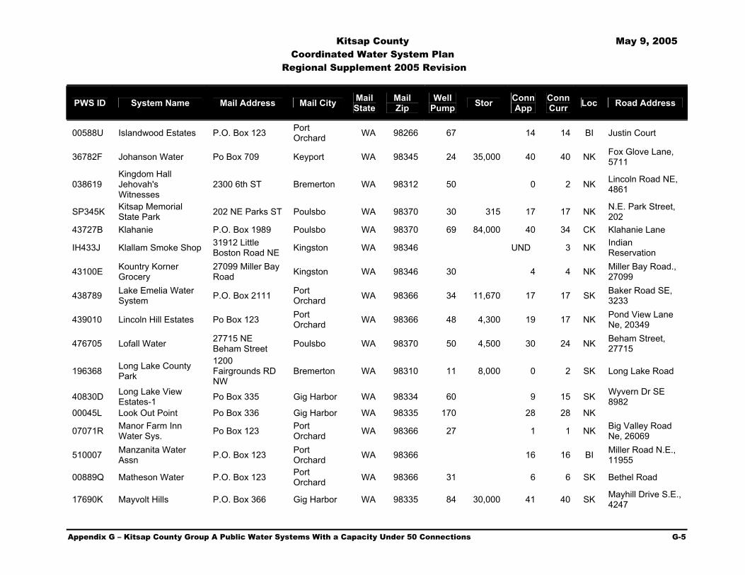
Kitsap County May 9, 2005 Coordinated Water System Plan
Regional Supplement 2005 Revision
Appendix G – Kitsap County Group A Public Water Systems With a Capacity Under 50 Connections G-5
PWS ID System Name Mail Address Mail City Mail State
Mail Zip
Well Pump Stor Conn
App Conn Curr Loc Road Address
00588U Islandwood Estates P.O. Box 123 Port Orchard WA 98266 67 14 14 BI Justin Court
36782F Johanson Water Po Box 709 Keyport WA 98345 24 35,000 40 40 NK Fox Glove Lane, 5711
038619 Kingdom Hall Jehovah's Witnesses
2300 6th ST Bremerton WA 98312 50 0 2 NK Lincoln Road NE, 4861
SP345K Kitsap Memorial State Park 202 NE Parks ST Poulsbo WA 98370 30 315 17 17 NK N.E. Park Street,
202 43727B Klahanie P.O. Box 1989 Poulsbo WA 98370 69 84,000 40 34 CK Klahanie Lane
IH433J Klallam Smoke Shop 31912 Little Boston Road NE Kingston WA 98346 UND 3 NK Indian
Reservation
43100E Kountry Korner Grocery
27099 Miller Bay Road Kingston WA 98346 30 4 4 NK Miller Bay Road.,
27099
438789 Lake Emelia Water System P.O. Box 2111 Port
Orchard WA 98366 34 11,670 17 17 SK Baker Road SE, 3233
439010 Lincoln Hill Estates Po Box 123 Port Orchard WA 98366 48 4,300 19 17 NK Pond View Lane
Ne, 20349
476705 Lofall Water 27715 NE Beham Street Poulsbo WA 98370 50 4,500 30 24 NK Beham Street,
27715
196368 Long Lake County Park
1200 Fairgrounds RD NW
Bremerton WA 98310 11 8,000 0 2 SK Long Lake Road
40830D Long Lake View Estates-1 Po Box 335 Gig Harbor WA 98334 60 9 15 SK Wyvern Dr SE
8982 00045L Look Out Point Po Box 336 Gig Harbor WA 98335 170 28 28 NK
07071R Manor Farm Inn Water Sys. Po Box 123 Port
Orchard WA 98366 27 1 1 NK Big Valley Road Ne, 26069
510007 Manzanita Water Assn P.O. Box 123 Port
Orchard WA 98366 16 16 BI Miller Road N.E., 11955
00889Q Matheson Water P.O. Box 123 Port Orchard WA 98366 31 6 6 SK Bethel Road
17690K Mayvolt Hills P.O. Box 366 Gig Harbor WA 98335 84 30,000 41 40 SK Mayhill Drive S.E., 4247

Kitsap County May 9, 2005 Coordinated Water System Plan
Regional Supplement 2005 Revision
Appendix G – Kitsap County Group A Public Water Systems With a Capacity Under 50 Connections G-6
PWS ID System Name Mail Address Mail City Mail State
Mail Zip
Well Pump Stor Conn
App Conn Curr Loc Road Address
54200N Messenger House 10861 Manitou Park Blvd.NE
Bainbridge Island WA 98110 25 2,000 1 1 BI Manitou Park
Blvd. N.E., 10861
55217L Miracle Ranch 15999 Sidney RD SW
Port Orchard WA 98366 53 13,000 29 4 SK Sidney Road
S.W., 15999
086745 Montessori Country School
10994 Arrow Point DR
Bainbridge Island WA 98110 15 1 1 BI Arrow Point Drive,
10994
77356E Morgensen/Ground Zero
3495 Dyes Inlet NW Bremerton WA 98312 14 5 5 NK Clear Creek Road,
16091
05345A Naval Hospital & Jackson Park
Public Works Dept. N8a11, Bldg 1034
Silverdale WA 98315 0 40 CK
586138 Nesika Bay Water System P.O. Box 1989 Poulsbo WA 98370 77 38 38 NK Nesika Bay
08313P Oien Construction Water System Po Box 1989 Poulsbo WA 98370 33 0 6 6 CK 16116 NW Church
RD
53425Y Olalla Food Center 12668 Olalla Valley Road Olalla WA 98359 29 0 2 SK Olalla Valley
Road, 12675
63212X Olalla Guest Lodge Inc.
12851 SE Lala Cove Lane Olalla WA 98359 25 20,000 0 1 SK Lala Cove Lane,
12851
02273Q Olalla Navy Housing 1101 Tautog Circle, Suite 313 Silverdale WA 98315-
4341 33 20,000 UND 12 SK La La Cove S.E.
63213E Olalla School 1962 Hoover Ave S.E.
Port Orchard WA 98366 25 4,800 0 1 SK Burley Olalla Rd.,
6100
63215F Olalla Water System P.O. Box 336 Gig Harbor WA 98335 30 20,000 30 25 SK Crestview S.E. , 7654
04184H Old Bangor Water District
7007 Herried RD NW Silverdale WA 98383 100 40,000 42 42 CK Herried Road,
7007
63498B Oly. View Assy Of God P.O. Box 128 Silverdale WA 98383 0 2 CK Silverday Way,
11623
63478U Olympic Circle Water
16800 Olympic Circle Dr. Silverdale WA 98383 50 12,000 14 18 CK Olympic Circle
Dr., 16758
48938P Olympic Lutherhaven Po Box 658 Silverdale WA 98383 50 0 1 CK Holly Road N.W.,
9375

Kitsap County May 9, 2005 Coordinated Water System Plan
Regional Supplement 2005 Revision
Appendix G – Kitsap County Group A Public Water Systems With a Capacity Under 50 Connections G-7
PWS ID System Name Mail Address Mail City Mail State
Mail Zip
Well Pump Stor Conn
App Conn Curr Loc Road Address
63650E Olympic View Water Assoc
13621 Olympic View RD NW Silverdale WA 98383 52 10,250 20 20 CK Olympic View
Road, 13621
66665F Pearson School 1365 NW Finn RD Poulsbo WA 98370 45 1,500 0 1 NK Central Valley
Road, 15650
47240V Pebble Ridge Water System Po Box 123 Port
Orchard WA 98366 50 30,000 42 41 SK Pebble Place SE
63210W Phelps Road Water System Po Box 709 Keyport WA 98345 29 18,500 26 23 BI Phelps Road,
13270
67390B Pilgrim Firs Church Camp Po Box 694 Port
Orchard WA 98366 43 18,000 3 2 SK Lake Flora Road S.W., 3318
37286Y Pine Road Estates P.O. Box 246 Gig Harbor WA 98335 74 20 18 SK Hunter Lane SW, 4135
67715C Pioneer Hill West 1744 Brothers Lane N.W. Poulsbo WA 98370 50 21,000 34 29 NK Brothers Lane
N.W.
169646 Place Eighteen 1081 Hildebrand, Ste. 202
Bainbridge Island WA 98110 18 18 BI Eagle Harbor
Drive, 18089
00323E Port Gamble Water Dept P.O. Box 1780 Poulsbo WA 98370 50 46,000 45 45 NK State Hwy. 104
IH019L Port Madison Bingo Hall P.O. Box 797 Suquamish WA 98392 100 10,000 0 1 NK Suquamish Way
Ne, 15347
473864 Port Orchard Market & Deli
5455 Sidney RD SE
Port Orchard WA 98366 17 1 1 SK Sidney Road
S.W., 5455
02354V Port Orchard Nazarine
4647 Sidney Road SE
Port Orchard WA 98366 0 1 SK S.E. Blueberry,
910 691527 Poulsbo Heights P.O. Box 1989 Poulsbo WA 98370 50 32 29 NK Commerce Street
07074A Poulsbo Service Center Pse
Po Box 97034 Obc 11n Poulsbo WA 98370 1 NK
69151P Poulsbo Sportsman Club P.O. Box 2468 Poulsbo WA 98370 1 1 NK Clear Creek Road
N.W., 16990
697206 Prospect Point Beach Club P.O. Box 21 Olalla WA 98359 85 17,000 46 39 SK Shoreline Drive
192460 Puddingstone P.O. Box 624 Silverdale WA 98383 50 345,000 32 31 CK Puddingstone Lane, 10210

Kitsap County May 9, 2005 Coordinated Water System Plan
Regional Supplement 2005 Revision
Appendix G – Kitsap County Group A Public Water Systems With a Capacity Under 50 Connections G-8
PWS ID System Name Mail Address Mail City Mail State
Mail Zip
Well Pump Stor Conn
App Conn Curr Loc Road Address
01031B Ravens Reach P.O. Box 123 Port Orchard WA 98366 20 23,500 16 16 BI Wimsey Ave NE,
5799
71727A Regency Park P.O. Box 336 Gig Harbor WA 98335 20 30,000 34 31 SK Regency Drive S.E., 6805
72200L Rhododendron Heights
6210 Fern Leona RD Bremerton WA 98312 72 105,000 34 34 CK Seabeck Hwy.
N.W., 3666
72210V Rhododendron M/H Park 1106 18th ST Bremerton WA 98337 49 30,000 0 14 CK Orweiler Lane Nw,
16000
66932J Rose Avenue Water Assoc.
5950 Rose Loop NE
Bainbridge Island WA 98110 14 12,000 17 17 BI Rose Ave N.E.,
5762
74743Y Royalwood P.O. Box 336 Gig Harbor WA 98335 30 20,000 42 37 SK Royalwood Court
IH7267 Sackman Community Water P.O. Box 498 Suquamish WA 98392 UND 17 NK Indian
Reservation
75607X Salsbury County Park
1200 NW Fairgrounds Rd. Bremerton WA 98310 20 0 1 NK Whitford/Shine
Street
764679 Scandialand M/H Park Po Box 123 Port
Orchard WA 98366 30 27 26 NK Central Valley Road
76925V Seavue Water System Assoc P.O. Box 155 Seabeck WA 98380 21,000 26 23 CK Seaview Drive
77640F Serenity Group Home P.O. Box 10038 Bainbridge
Island WA 98110 0 1 BI Pleasant Beach Dr., 4500
32980E Sherman Hill Water 1890 Ptartmigan Lane NW Poulsbo WA 98370 24 16 NK Ptarmigan Lane,
1932
79275E Silver Springs Estates Po Box 336 Gig Harbor WA 98335 60 23,500 41 23 NK Silver Spring Lane
18038E Silverdale Pee Wees P.O. Box 44 Silverdale WA 98383 31 0 1 SK Schold Lane N.W., 11444
239116 Sivo Acres P.O. Box 336 Gig Harbor WA 98335 25 20,000 25 24 SK Brentwood, 222 08586A Skookum Ranch Po Box 336 Gig Harbor WA 98335 70 1,000 21 20 NK Ryan Drive, 3507
80825C Snider Field P.O. Box 1476 Poulsbo WA 98370 0 1 NK ST Hwy 3 Nw, 22872
81860W South Keyport Heights
13913 S. Keyport Road Poulsbo WA 98370 60 6,000 41 41 NK South Keyport
Road

Kitsap County May 9, 2005 Coordinated Water System Plan
Regional Supplement 2005 Revision
Appendix G – Kitsap County Group A Public Water Systems With a Capacity Under 50 Connections G-9
PWS ID System Name Mail Address Mail City Mail State
Mail Zip
Well Pump Stor Conn
App Conn Curr Loc Road Address
81978D South Kitsap Little League (Southern) P.O. Box 86 Olalla WA 98359 0 1 SK Hovgaard Road
83424J Spruce Road P.O. Box 336 Gig Harbor WA 98335 60 30,000 31 28 SK Forest Glen Road, 14604
013452 ST Bedes Episcopal Church PO Box 123 Port
Orchard WA 98366 15 1 1 SK Bethel-Burley Road, 6878
83884L Stavis Creek P.O. Box 1989 Poulsbo WA 98370 75 5,000 0 21 CK Seabeck-Holly N.W., 17843
12180B Store At Central Valley
4821 Deer Creek LN Gig Harbor WA 98335 7 0 3 CK Central Valley
Road Ne., 10400
84623B Strawberry Hill Park P.O. Box 10010 Bainbridge Island WA 98110 12 4,100 0 1 BI High School Road
05982K Striebel's Corner 16095 Clear Creek Road Poulsbo WA 98370 33 1 1 NK State Hwy 104,
26605
022727 Sundquist Water System P.O. Box 123 Port
Orchard WA 98366 45 2 1 NK Sawdust Hill RD N.W., 3809
85320F Sunny Cove Water P.O. Box 336 Gig Harbor WA 98335 120 7,000 44 36 SK Olalla Valley, 9100
85640C Sunrise Beach P.O. Box 806 Kingston WA 98346 57 35,200 40 24 NK Sunrise Beach Dr., 7993
86115L Sunset Farms Po Box 123 Port Orchard WA 98366 30 11,000 18 17 CK Mountain Vista
Lane, 7505
861209 Sunset Hills Water Assoc P.O. Box 10735 Bainbridge
Island WA 98110 75 35,000 35 31 BI Sunset Loop N.E., 11641
109552 Templeton's Camp Union Grc P.O. Box 123 Port
Orchard WA 98366 80 8 8 CK Holly Road N.W., 14184
91470N Verdan Anderson Hill P.O. Box 336 Gig Harbor WA 98335 20 4,500 16 14 CK Lathrop Lane
N.W.
91921J Vinland Lutheran Church
18213 Viking Way NW Poulsbo WA 98370 0 2 NK Finn Hill Road,
2751
05369W Voyager Montessori Elementary School P.O. Box 123 Port
Orchard WA 98366 10 1 1 BI High School Rd., 8225

Kitsap County May 9, 2005 Coordinated Water System Plan
Regional Supplement 2005 Revision
Appendix G – Kitsap County Group A Public Water Systems With a Capacity Under 50 Connections G-10
PWS ID System Name Mail Address Mail City Mail State
Mail Zip
Well Pump Stor Conn
App Conn Curr Loc Road Address
02495J Ward, Sam Water System
27462 Big Valley Road N.E. Poulsbo WA 98370 31 3 3 NK Big Valley Road
N.E., 27462
39740L Wauna Easley P.O. Box 336 Gig Harbor WA 98335 46 31 25 SK 162nd ST Nw, 8211
948604 West Port Blakely 4200 Blakely Ave. NE
Bainbridge Island WA 98110 16 18 BI Blakely Avenue
N.E., 4198
01668H Western Stavis Div 2 & 3 P.O. Box 20429 Seattle WA 98102 37 23,500 33 20 CK Rogers Road
960942 Whispering Firs M/H Park PO Box 123 Port
Orchard WA 98366 70 36 36 CK Silverdale Way, 12354
968608 Wildcat Lake County Park
1200 Fairgrounds Road NW
Bremerton WA 98310 47 0 3 CK Holly Road N.W., 9205
01402L Wilderwood Development
1154 Bertha Ave NW Bremerton WA 98312 125 33,000 49 44 NK Tytler Road N.E.
47451W Wilderwood Homeowners Assoc. P.O. Box 413 Seabeck WA 98380 120 46 45 CK Holly Road
010234 Windrift P.O. Box 336 Gig Harbor WA 98335 37 24 23 SK Fairview Lake Road (Paradise, Spindrift)
98684P Wye Lake Acreages 7948 SW Alta Vista Drive
Port Orchard WA 98366 34 30,000 46 41 SK Alta Vista Drive,
7875 Footnote: (1) Data Obtained from the Kitsap County Health District (KCHD) water system database May 2004

Kitsap County May 9, 2005 Coordinated Water System Plan Regional Supplement 2005 Revision
Appendix H – Kitsap County Group B Public Water Systems H-1
Appendix
H Kitsap County Group B Water Systems
PWS ID System Name Mail Address Mail City Mail State
Mail Zip
Well Pump Stor Conn
App Conn Curr Loc Road Address
019408 A Well No. 9 15903 Vincent RD NW Poulsbo WA 98370 12 1,100 8 8 NK
Vincent Road N.W., 15903, 15913
01927B A. C. Water System 5853 N.W. Newberry Hill RD Silverdale WA 98383 34 7 7 CK Newberry Hill Road
N.W., 5835 02323K A2o Water System 16 1,000 4 2 SK La La Cove S.E. 07493U Abbey Water Po Box 1989 Poulsbo WA 98370 8 1,000 4 4 NK Lincoln Road, 3577
087179 Abbott-Dahl-Dawson-Schumaker Po Box 1116 Olalla WA 98359 32 0 4 CK Starr Road S.E.,
15010
06890Q Abc Water Well 6385 S.E. Olalla Valley RD Port Orchard WA 98367 25 0 4 CK Midland Road
03658C Adcock Water System P.O. Box 336 Gig Harbor WA 98335 32 3 3 SK S.E. Nelson Road
05386V Agate Community 16790 Agate Point RD
Bainbridge Island WA 98110 19 1,100 9 7 BI NE North Street
00707H Agate Pass Estates P.O. Box 123 Port Orchard WA 98366 33 0 6 3 NK Hwy 305
639476 Agate Point P.O. Box 11466 Bainbridge Island WA 98110 13 1,000 4 4 BI Agate Point Road
06403E Agatewood P.O. Box 1989 Poulsbo WA 98370 23 3 2 BI Agatewood Ne, 16171
01089R Agua Blair P.O. Box 1989 Poulsbo WA 98370 7 1,000 6 3 CK Klahowya Road
31947Y Ahhaws 425 Sunnyhill Road Bremerton WA 98312 30 9 7 CK Rising Hill Lane
NW
373148 Aiken Road Water System 3673 Aiken Road Port Orchard WA 98366 18 4 4 SK Aiken Road S.E.,
3657 40342K Airport Park P.O. Box 1989 Poulsbo WA 98370 40 1,000 9 9 CK Holly Road, 9060
05955B Al & Barney's Investment Water Sys.
6100 Bethel Avenue SE Port Orchard WA 98367 19 2 2 SK Bethel Avenue
S.E., 6100
00298P Alder Draw Water System
4693 Calamity Lane Bremerton WA 98312 15 4 4 CK Calamity Lane,
4695
01732R Alder Road 1404 S.W. Clifton Road Port Orchard WA 98366 29 5 4 SK Clifton Road, 1572

Kitsap County May 9, 2005 Coordinated Water System Plan Regional Supplement 2005 Revision
Appendix H – Kitsap County Group B Public Water Systems H-2
PWS ID System Name Mail Address Mail City Mail State
Mail Zip
Well Pump Stor Conn
App Conn Curr Loc Road Address
63386X Alford Homes I Water System
8483 Fernclilff Ave NE
Bainbridge Island WA 98110 12 1,100 8 8 BI Ferncliff Road,
8483
02310R Alice Kimball Water System 18 1,000 2 2 BI Manual Road NE
01735A Almquist Water 1176 NW Sherman Hill Road Poulsbo WA 98370 31 5 4 NK Sherman Hill Road
N.W., 1158
37166A Alpenschon Water System
6776 NW Puddingstone Silverdale WA 98383 21 4 4 CK Puddingstone Lane
N.W., 6776
01836Y Alpine Terrace M/H Park
7124 ST Hwy 3 SW Port Orchard WA 98366 21 0 5 SK Hwy 3 S.W., 7124
010276 Amanda Water P.O. Box 336 Gig Harbor WA 98355 37 4 6 SK Wicks Lake Road
676137 Amber Water Assoc. 4732 Taylor Ave Bainbridge Island WA 98110 4 9 9 BI Taylor Ave N.E.,
4732
02062P Amis Water 8730 Ferncliff NE Bainbridge Island WA 98110 5 0 3 BI Ferncliff Ave N.E.,
8730
43564K Amy's Acres 4380 Gunderson Rd. Poulsbo WA 98370 4 4 NK Gunderson Road,
4380
058280 Andy Parris Industrial Park 43 10 10 NK Beaver Ridge Lane
Nw, 170
436404 Archibald/Gustafsen 11720 Brian Lane NW Silverdale WA 98383 22 4 2 CK Miz Malia Lane Nw,
12343 03925E Argonaut P.O. Box 1989 Poulsbo WA 98370 35 6 2 BI Sanwick Place
63351K Arlington Water System 6818 Arlington Place S.E. Port Orchard WA 98366 42 8 8 SK Arlington, 6818
47489T Arrow Point Water 11272 Arrow Point Drive NE
Bainbridge Island WA 98110 2,300 6 3 BI Arrow Pt. Dr. N.E.,
11272
032853 Asuelo 4305 Lakeview Dr., S.E. Port Orchard WA 98366 5 4 SK Lakeview Drive
S.E., 4305 046043 Avery Water 7 2,500 9 6 NK Foss Road 00629X B.B. West Water 858 SE Wolf LN Port Orchard WA 98367 26 4 4 SK Bethel-Burley Road
03710B Backland Well System 4935 N.E. Tolo RD Bainbridge Island WA 98110 16 1,000 6 6 BI Tolo Road N.E.,
4937
58132L Bainbridge Green 8824 N.E. New London Court
Bainbridge Island WA 99110 15 1,150 8 8 BI New London Ct.
N.E.
037950 Bainbridge Is Saddle P.O. Box 10456 Bainbridge Island WA 98110 1 1 BI Day Road

Kitsap County May 9, 2005 Coordinated Water System Plan Regional Supplement 2005 Revision
Appendix H – Kitsap County Group B Public Water Systems H-3
PWS ID System Name Mail Address Mail City Mail State
Mail Zip
Well Pump Stor Conn
App Conn Curr Loc Road Address
090203 Bainbridge Island Fire Dept (Bucklin Hill)
C/O 8895 Madison Ave N
Bainbridge Island WA 98110 3 20,000 0 1 BI Bucklin Hill RD
N.E., 7934
037971 Bainbridge Island Sportsm
625 Winslow Way East
Bainbridge Island WA 98110 0 3 BI Sportsman Club
Rd., 8221
95625F Bainbridge No. 1 Po Box 2985 Silverdale WA 98383 5 8 8 BI Blakely Ave N.E., 5763
05308U Ball-Robinette Water System P.O. Box 336 Gig Harbor WA 98335 34 6 4 SK Bethel Burley,
12854
05292X Baltic Water System 31109 Baltic Ln. NE Poulsbo WA 98370 21 4 4 NK Off Baltic Ln.,
Sp#5382 03071H Bandix/Concept 30 4 4 SK Bandix
023032 Barnes Water System 24742 Pioneer Way N.W. Poulsbo WA 98370 11 500 4 4 NK Pioneer Way N.W.,
24742 00903P Bart Water 17667 Noll Rd. Poulsbo WA 98370 33 6 6 NK Noll Road 04386T Barton, William Water 5223 Hillcrest Port Orchard WA 98366 0 2 SK Hillcrest E., 5223
07436U Battle Point Water System Po Box 123 Port Orchard WA 98366 10 3,000 4 4 BI Battle Point DR Ne,
9675
04726R Bauers Water Supply 30 Leland Valley Rd. W Quilcene WA 98376 15 0 3 NK Lakeness Road
N.W., 3114
20925A Baw 24583 Waghorn RD NW Poulsbo WA 98370 25 6 6 NK Waghorn Road,
Next To 24591 06413P Bay Ridge P.O. Box Poulsbo WA 98370 25 6 4 NK Bay Ridge, 16148
60446U Bbd Water System 14739 Henderson Rd. NE
Bainbridge Island WA 98110 42 7 5 BI Henderson RD Ne,
14747
055484 Beach Head No. 2 3105 Lakeness RD Poulsbo WA 98370 32 3 3 NK Gresham Place, 28799
04084C Beach Head No.1 3105 NW Lakeness Road Poulsbo WA 98370 32 6 6 NK Gresham Place,
28799
054145 Beller Water System 1585 Minterbrook Rd. S.W. Port Orchard WA 98367 27 4 4 SK Minterbrook Road
S.W., 1585
473611 Bellingham Water System
7671 Bellingham Avenue S.E. Port Orchard WA 98366 21 4 2 SK Bellingham Ave
S.E., 7671
05703R Bennett-Suffis-Norton 11646 Arrow Point Dr.
Bainbridge Island WA 98110 0 3 BI Arrow Point Dr.,
11656
33404V Benson's Olympic Water 1
24298 Stottlemeyer Road Poulsbo WA 98370 15 1,400 9 5 NK Stottlemeyer Road
N.E., 24158
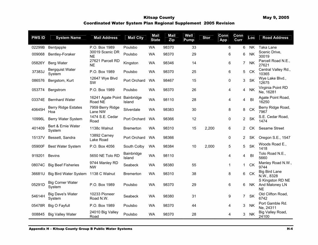
Kitsap County May 9, 2005 Coordinated Water System Plan Regional Supplement 2005 Revision
Appendix H – Kitsap County Group B Public Water Systems H-4
PWS ID System Name Mail Address Mail City Mail State
Mail Zip
Well Pump Stor Conn
App Conn Curr Loc Road Address
02299B Bentjapple P.O. Box 1989 Poulsbo WA 98370 33 6 6 NK Taka Lane
009068 Bentley-Foraker 30019 Scenic DR NE Poulsbo WA 98370 29 6 6 NK Scenic Drive,
30019
05826Y Berg Water 27621 Parcell RD NE Kingston WA 98346 14 6 7 NK Parcell Road N.E.,
27621
37383J Bergquist Water System P.O. Box 1989 Poulsbo WA 98370 25 6 5 CK Central Valley Rd.,
10365
086576 Bergstom, Kurt 12647 Wye Blvd SW Port Orchard WA 98467 15 0 3 SK Wye Lake Blvd.,
12675
053774 Bergstrom P.O. Box 1989 Poulsbo WA 98370 26 4 4 NK Virginia Point RD Ne, 16281
03374E Bernhard Water 16241 Agate Point Road NE
Bainbridge Island WA 98110 28 4 4 BI Agate Point Road,
16250
40645H Berry Ridge Estates Hoa
7959 Berry Ridge Lane NW Silverdale WA 98383 30 8 8 CK Berry Ridge Road,
7967
10996L Berry Water System 1474 S.E. Cedar Road Port Orchard WA 98366 12 0 2 SK S.E. Cedar Road,
1474
401409 Bert & Ernie Water System 1138c Walnut Bremerton WA 98310 15 2,200 6 2 CK Sesame Street
15137V Bessett, Sandra 13892 Carney Lake Road Port Orchard WA 98366 0 2 SK Oregon S.E., 1547
05900F Best Water System P.O. Box 4056 South Colby WA 98384 10 2,000 5 5 SK Woods Road E., 1418
919201 Bevins 5650 NE Tolo RD Bainbridge Island WA 98110 4 4 BI Tolo Road N.E.,
5660
08074C Big Beef Fisheries 9744 Manley RD NW Seabeck WA 98380 55 1 1 CK Manley Road N.W.,
9744
36681U Big Bird Water System 1138 C Walnut Bremerton WA 98310 38 8 6 CK Big Bird Lane N.W., 8328
05291D Big Corner Water System P.O. Box 1989 Poulsbo WA 98370 29 6 6 NK
S Kingston RD NE And Maloney LN NE
54614H Big Dave's Water System
10233 Pioneer Road N.W. Seabeck WA 98380 31 9 7 SK Old Clifton Road,
6742
05478R Big O Fayfull P.O. Box 1989 Poulsbo WA 98370 44 4 3 NK Port Gamble Rd. Ne, 24311
008845 Big Valley Water 24010 Big Valley Road Poulsbo WA 98370 28 4 3 NK Big Valley Road,
24100

Kitsap County May 9, 2005 Coordinated Water System Plan Regional Supplement 2005 Revision
Appendix H – Kitsap County Group B Public Water Systems H-5
PWS ID System Name Mail Address Mail City Mail State
Mail Zip
Well Pump Stor Conn
App Conn Curr Loc Road Address
07115D Bird Electric Light Industrial Park
22930 Stottlemeyer Road NE
Poulsbo WA 98370 6 1 NK Stottlemeyer Road N.E., 22930
026928 Black Bear Water System 30 6 0 NK Pioneer Road N.W.
47411V Blake, Ken Water System P.O. Box 4061 South Colby WA 98384 27 6 5 SK Long Lake Road
15710H Blankenbaker 2801 Montwood Lane Bremerton WA 98312 0 1 CK Newberry Hill Road
N.W., 8200 029534 Blatte Water System P.O. Box 336 Gig Harbor WA 98335 25 6 6 SK Joy Lane S.W.
11001L Blazina Water 7001 Fletcher Bay Rd. NE
Bainbridge Island WA 98110 0 2 BI Fletcher Bay Road,
6945
45355P Bliss Water System Po Box 1978 Port Orchard WA 98366 0 4 SK Long Lake Rd., 7238
04083V Blue Heron P.O. Box 1989 Poulsbo WA 98370 33 4 3 CK Seaview Drive, 14719
073757 Bms Water System Po Box 1989 Poulsbo WA 98370 27 6 3 NK Sawdust Road Ne, 1509
AA316G Bode, Off Minterbrook P.O. Box 336 Gig Harbor WA 98335 36 4 0 SK Minterbrook, 018992 Boetter Water 33 5 3 BI West Port Madison
035881 Bog Water System 9005 Klahowya Trail NW Bremerton WA 98310 3 4 CK Klahowya N.W.,
9000 02683H Bonapata P.O. Box 1989 Poulsbo WA 98370 36 4 4 NK Hauf Lane
05372J Bondale Water System Po Box 1989 Poulsbo WA 98370 10 1,000 6 5 CK Bondale Ln. NW, 6423
04940E Bonsell P.O. Box 1989 Poulsbo WA 98370 30 4 4 NK Parcells Road 07725E Booth Water 5521 17th Ave NE Seattle WA 98115 0 3 BI New Sweden Road
05481D Boquist/Wright P.O. Box 336 Gig Harbor WA 98335 31 0 6 5 SK Wiley & Gallagher Lane
03887W Borcher Water System P.O. Box 123 Port Orchard WA 98366 23 3 1 SK Long Lake Road, 2987
077388 Borcherding Water 655 NW Lofall RD Poulsbo WA 98370 6 0 2 NK Lofall Road N.W., 625
04728T Bpib 625 Winslow Way East
Bainbridge Island WA 98110 5 1,000 3 3 BI Old Mill Road,
5335
08307H Brandon Po Box 123 Port Orchard WA 98366 22 0 3 3 Lakeview Ct Nw, 4525

Kitsap County May 9, 2005 Coordinated Water System Plan Regional Supplement 2005 Revision
Appendix H – Kitsap County Group B Public Water Systems H-6
PWS ID System Name Mail Address Mail City Mail State
Mail Zip
Well Pump Stor Conn
App Conn Curr Loc Road Address
47281D Brasch Road Water 3014 S.E. Concept Lane Port Orchard WA 98366 38 12 12 SK Concept Lane,
2987
43551R Brauer Estate Water 16710 Brauer Road N.E Poulsbo WA 98370 30 6 4 NK Brauer Road N.E.,
16754
037678 Breidablik Community Hall P.O. Box 2444 Poulsbo WA 98370 12 1 1 NK Breidablik Place
NW, 26580
00052A Brickhouse Water System P.O. Box 2109 Poulsbo WA 98370 0 2 NK Hwy 3 N.E., 28389
04127H Bridgeview P.O. Box 1989 Poulsbo WA 98370 27 6 6 NK Highway 104 00434B Bridgeway Water 25 3 3 NK
580818 Brisbane Water System 2732 French RD NW Olympia WA 98502 10 1,400 6 7 SK Phillips Road, 7805
019049 Broken Head 25 4 4 CK Chalet Lane, 8016 08760Y Brookhaven P.O. Box 44427 Tacoma WA 98444 30 9 10 SK Crest Drive SE
40316V Broomgerrie P.O. Box 2468 Poulsbo WA 98370 10 1,125 9 7 BI Grand Ave N.E., 8560
20775B Brotherton Water 319 Tacoma Ave N. #704 Tacoma WA 98403 13 0 2 BI Madison Ave N.E.,
14491, 14411
43789X Brown, Ken Water System
20293 Pugh Road NE Poulsbo WA 98370 40 9 9 NK Pugh Road N.E.,
20293
60079M Browning 8191 N.E. Selfors Lane
Bainbridge Island WA 98110 3 1,100 3 3 BI Selfords Lane,
8221
08810T Brown-Lake Flora P.O. Box 309 Burley WA 98322 25 0 8 SK Lake Flora Road, 3065
08833V Brownlee Beach Tracts 29350 Beach Drive NE Poulsbo WA 98370 5 4 NK Brownlee Tract, Lot
10
088856 Brownsville Water Dist No. 1
9080 Illahee RD NE Bremerton WA 98310 0 4 CK Illahee Road N.E.,
9094 00511D Brunson Water System P.O. Box 3547 Silverdale WA 98383 10 4 4 CK Sesame St., 8550
582148 Bulman Avenue 1344 SE Saddle Club Road Port Orchard WA 98366 15 1,400 7 7 SK Bulman Road,
5385
09362J Burdick Water P.O. Box 54 Poulsbo WA 98370 9 0 2 NK Hidden Spring, 4030
016356 Burley Hills Homeowner Assn P.O. Box 1989 Poulsbo WA 98370 16 1,000 6 6 SK Swafford Lane,
1036
07434T Burnett, Bill Po Box 1989 Poulsbo WA 98370 31 0 3 2 NK Gamble Bay Road, 28595

Kitsap County May 9, 2005 Coordinated Water System Plan Regional Supplement 2005 Revision
Appendix H – Kitsap County Group B Public Water Systems H-7
PWS ID System Name Mail Address Mail City Mail State
Mail Zip
Well Pump Stor Conn
App Conn Curr Loc Road Address
194761 Burston/Farrell P.O. Box 10942 Bainbridge Island WA 98110 0 2 BI Wardwell Road,
9016
30640W Butler Water System 1730 Clear Creek Poulsbo WA 98370 0 2 CK Clear Creek Road N.W., 17030
372777 Bye Water System P.O. Box 1053 Silverdale WA 98383 10 1,000 9 7 CK Dishman Road, 9902
43522H Calkins Water 33527 Hansville RD NE Kingston WA 98346 14 0 3 NK Hansville Road Ne,
33527
04636W Camas Lane Water System P.O. Box 1989 Poulsbo WA 98370 31 9 9 SK Camas Lane, 3587
634316 Cameron, John Water 9241 Lawrence DR SE Port Orchard WA 98366 18 4 3 SK Lawrence Drive
S.E., 9241
10910E Camp Niwana 1109 Warren Ave Bremerton WA 98310 12 11,780 1 1 SK Lake Helena Road S.W., 5290
47338V Camp Water System 14095 Clear Creek RD N.W. Silverdale WA 98383 33 6 3 CK Clear Creek Road,
14095
05288R Campbell Water System P.O. Box 1989 Poulsbo WA 98370 31 6 4 NK Johnson Road
324543 Canal View 13300 Lester Road NW Silverdale WA 98383 28 6 5 CK Lester Road N.W.,
13300
02298U Cantu Lane Water System 46 6 3 CK Gold Finch Lane,
14779 369268 Canyon Creek 16862 Noll RD NE Poulsbo WA 98370 15 1,100 8 8 NK Noll Road, 16862 435484 Cardinal Lane Water 1955 Cardinal LN Poulsbo WA 98370 30 6 7 NK Indiago Lane, 1734
052899 Cardoso Water System P.O. Box 1989 Poulsbo WA 98370 25 6 6 NK Stottlemeyer RD NE
11162T Carlton, Gloria 12840 Seabeck Hwy NW Seabeck WA 98380 0 2 CK Seabeck Hwy,
12840 05387C Carole/Swink Po Box 1989 Poulsbo WA 98370 24 4 4 BI Lofgren Rd., 9977
00322X Carroll/Slimmer P.O. Box 1989 Poulsbo WA 98370 3 1 SK Phillips Road S.E., 5166
00152E Carter Water System 29439 Beach DR NE Poulsbo WA 98370 40 0 2 NK Beach Drive N.W.,
29439
398795 Cascade I 26656 Trophy Ln. Kingston WA 98346 21 4 4 NK Trophy Lane, 26632
184065 Casey Street Water Co. Llc
8815 Ferncliff Ave NE
Bainbridge Island WA 98110 12 1,400 9 8 BI Casey N.E., 1030

Kitsap County May 9, 2005 Coordinated Water System Plan Regional Supplement 2005 Revision
Appendix H – Kitsap County Group B Public Water Systems H-8
PWS ID System Name Mail Address Mail City Mail State
Mail Zip
Well Pump Stor Conn
App Conn Curr Loc Road Address
03982E Cattail Water System 16 1,000 5 2 NK Big Valley Road, 24658
11943U Cedar Lane Water 16510 Agate Point RD NE
Bainbridge Island WA 98110 0 4 BI Agate Pass Road
N.E., 16510
03248L Cedar Park Road Water System P.O. Box 336 Gig Harbor WA 98335 15 1,350 7 5 SK SE Cedar Park
Road, 15650
36897E Cedar Ponds Water System
16150 Agate Pass RD NE
Bainbridge Island WA 98110 10 1,500 6 4 BI Agate Pass Road
N.E., 16150
03259C Cedar Springs Water System
7354 Bethel-Burley Road Port Orchard WA 98366 28 1 1 SK Bethel Burley
Road, 7354
12110J Cedar Water Supply 7240 Long Lake Road, SE Port Orchard WA 98367 44 6 5 SK Cedar Road S.E.,
1251
121112 Cedar Wells 18290 Viking Way N.W. Poulsbo WA 98370 0 7 NK Hidden Springs
Lane, 4030 24400U Cedarwood 1920 Hogue Ct NE Poulsbo WA 98370 35 6 6 NK Hogue Ct Ne, 1930
19061N Central Valley Water Coop
15359 Central Valley RD NW Poulsbo WA 98370 20 0 4 CK Central Valley Rd.
N.W., 15359
30051W Central Valley Water Syst.
15239 Central Valley Rd. NW Poulsbo WA 98370 17 6 3 CK Central Valley Rd.
N.W., 15201
12210N Cessna Water 5653 N.E. Cessna Lane
Bainbridge Island WA 98110 30 4 3 BI Crystal Springs Dr.
N.E., 3674
37157K Cheryl's Well 1599 NW Mountain View Road
Silverdale WA 98383 27 5 2 CK Mt. View Road N.W., 1571
24042C Chico Heights Community P.O. Box 12216 Bothell WA 98082 31 9 9 CK Sagebrush, 3689
052857 Child's House B&B 8331 S.E. Willock Road Olalla WA 98359 16 1 1 SK Willock Road,
8331
03037K Church Road Water System P.O. Box 1989 Poulsbo WA 98370 38 6 4 CK Church Road
12975P Churchill Water Corp. 13509 Manzanita RD NE
Bainbridge Island WA 98110 3,000 0 11 BI Manzanita Road
N.E., 13569
01734T Claeys Water System P.O. Box 3904 Silverdale WA 98383 37 6 6 CK Anderson Hill Road, 6530
13340M Clark Acres Water 8787 Battle Point DR NE
Bainbridge Island WA 98110 0 5 BI Battle Point Rd.
N.E., 5591

Kitsap County May 9, 2005 Coordinated Water System Plan Regional Supplement 2005 Revision
Appendix H – Kitsap County Group B Public Water Systems H-9
PWS ID System Name Mail Address Mail City Mail State
Mail Zip
Well Pump Stor Conn
App Conn Curr Loc Road Address
133457 Clark Terrace Water P.O. Box 623 Port Orchard WA 98366 12 14,000 8 7 SK Hillcrest Dr. E., 5671
02201W Clark Water 8208 SE Overaa RD Port Orchard WA 98366 20 0 2 SK Overaa Road S.E.,
8208
65127R Clark, Richard 18106 Clear Creek Road Poulsbo WA 98370 40 8 7 NK Clear Creek Road,
18106
05177V Clauson Water System P.O. Box 1989 Poulsbo WA 98370 21 0 4 4 SK Paradise Lane, 5033
13445B Clayton Place 14421 Maple RD SE Port Orchard WA 98367 22 1,500 0 11 SK Maple Road S.E.,
14455
00435V Clear Water 5275 Old Mill Road Bainbridge Island WA 98110 5 1,000 5 4 BI Old Mill Road,
5275
60001P Clearwater Lane Assoc.
8817 Clearwater Lane Port Orchard WA 98367 27 7 7 SK Clearwater lane,
8899
136401 Clementz First Edition 5769 Blakely Avenue NE
Bainbridge Island WA 98110 6 0 4 BI Blakely Ave N.E.,
5769
138554 Clifton Water Works P.O. Box 335 Gig Harbor WA 98335 1,500 0 7 SK Old Clifton Road S.W., 1657
03376F Coldear Po Box 1989 Poulsbo WA 98370 27 0 6 5 CK
473252 Coldwater Water System
4452 Edgewood DR Bremerton WA 98310 38 6 6 NK Vincent Road
13942E Cole Water 5714 16th Ave NE Seattle WA 98105 15 1,000 4 4 NK Jefferson Place, 24480
636994 Coleman Court Water 591 NW Coleman Court Poulsbo WA 98370 35 6 5 NK Coleman Court
140534 Collett Water System 12095 Old Frontier RD Silverdale WA 98383 15 0 2 CK Westgate Road
N.W., 4142
14058P Collins Water P.O. Box 989 Silverdale WA 98383 23 0 5 CK Old Frontier Road, 11760
017442 Concept Park 9168 Genesis LN SE Port Orchard WA 98367 35 8 7 SK Genesis
14556A Conifer Crest Water 9189 NE Pioneer RD Seabeck WA 98380 0 4 CK Pioneer Road
N.W., 9189
242791 Conifer West 3060 N.W. Skiff Lane Silverdale WA 98383 30 4 4 CK Skiff Lane N.W.,
3060 191564 Cook Mountain View P.O. Box 1282 Poulsbo WA 98370 15 5 5 NK Pugh Road, 20926
14786B Cookson Well P.O. Box 591 Port Orchard WA 98366 25 6 5 SK Sidney Road S.W., 9270

Kitsap County May 9, 2005 Coordinated Water System Plan Regional Supplement 2005 Revision
Appendix H – Kitsap County Group B Public Water Systems H-10
PWS ID System Name Mail Address Mail City Mail State
Mail Zip
Well Pump Stor Conn
App Conn Curr Loc Road Address
20340F Cool Water 25 4 3 CK Hite Center Road, 15828
16690H Coon James 1450 SE Cedar RD Port Orchard WA 98366 0 2 SK Cedar Road S.E.,
1450
02037H Corbett Water System 2935 Woods Road E. Port Orchard WA 98366 10 0 2 SK Woods Road E.,
2935
01845P Corr, Eugene 4221 51st Ave NE Seattle WA 98105 56 0 2 NK Wheeler Street, 3794
585514 Cotner/Crist 17967 Noll Road NE Poulsbo WA 98370 4 2 NK Noll Road N.E.,
17965 & 17967
03720L Country Homes Water System P.O. Box 676 East Olympia WA 98540 35 9 7 SK Cynthia Lane
15487J County Line Well 4395 Huge Creek RD SW Port Orchard WA 98366 19 3 3 SK Green Leaf Lane
S.W., 15880
03001P Covenant Water System
8530 Bender Circle NE Bremerton WA 98310 8 0 2 CK Clear Creek Road
N.W., 15912 02290P Coyote Flats No. 1 P.O. Box 1989 Poulsbo WA 98370 27 6 5 SK Michigan Street 02762L Coyote Flats No. 2 P.O. Box 98 Manchester WA 98353 25 6 4 SK Michigan Street 577897 Cozy Lane No. 1 Po Box 78 Gig Harbor WA 98335 31 6 9 SK Cozy Lane, 1832
11939N Crescent Moon 2510 Winters RD Bremerton WA 98310 19 0 3 CK Winters Road, 2500
07675L Crisp 6800 Meridian RD SE Olympia WA 98513 26 5 5 SK Lake Helena
002744 Crocker Water Supply 16828 Noll RD Poulsbo WA 98370 14 3 3 NK Hwy 305 N.E., 16836
54767F Crosby No. 1 Water System
15652 Seabeck Hwy NW Seabeck WA 98380 9 8 CK Mallard Lane
06338N Damm P.O. Box 123 Port Orchard WA 98366 12 1,000 6 6 NK Lindvog Rd, 27527
63436R Davis Keith Cooperative
4731 Eagle Harbor DR NE
Bainbridge Island WA 98110 12 1,000 6 4 BI Eagle Harbor
Drive, 4731
01087Q Davis, Delbert Water 11087 N.W. Pioneer Road Seabeck WA 98380 25 6 5 CK Pioneer Road,
11087
25956X Day Road Water System 6765 NE Day RD Bainbridge
Island WA 98110 19 1,000 4 3 BI Day Road N.E., 6891
070093 Debry Downs No. 1 P.O. Box 123 Port Orchard WA 98366 25 6 BI Citation Court, 10152

Kitsap County May 9, 2005 Coordinated Water System Plan Regional Supplement 2005 Revision
Appendix H – Kitsap County Group B Public Water Systems H-11
PWS ID System Name Mail Address Mail City Mail State
Mail Zip
Well Pump Stor Conn
App Conn Curr Loc Road Address
01849R Deep Six Water System
15591 Sandy Hook RD NE Poulsbo WA 98370 27 3 3 NK Sandy Hook Road
N.E., 15591
314649 Deer Trail Water System P.O. Box 2985 Silverdale WA 98383 23 1,500 8 9 NK Noll Road, 17445
06249A Dekay Water System P.O. Box 123 Port Orchard WA 98366 32 4 4 NK Bodine RD NE
186134 Delay Water System 27411 Lindvog RD NE Kingston WA 98346 14 0 3 NK Lindvog Road,
27411 070093 Derby Downs No. 1 P.O. Box 123 Port Orchard WA 98366 32 6 2 BI Citation Ct, 10152
07010P Derby Downs No. 2 P.O. Box 123 Port Orchard WA 98366 36 6 2 BI Citation Court, 10152
03791X Devitt Well 12265 Olympic View Rd. NW Silverdale WA 98383 0 3 CK Olympic View Rd.
Nw, 12265
48795E Dewdrop Lane Water System P.O. Box 1989 Poulsbo WA 98370 35 0 9 NK Dewdrop Lane
N.W., 18225
19205E Diamond Drive Water 18365 Diamond DR N Poulsbo WA 98370 27 5 4 NK Diamond Dr. N.E.,
18365
32461T Dicken Well 6965 S.E. Buchannen Port Orchard WA 98366 18 1,000 6 4 SK Buchannen, 6961
77358F Dickey Road Water Assoc.
5486 NW Eldorado Blvd Bremerton WA 98312 31 7 7 CK Dickey Road, 8630
06495T Dickson Water Supply 7355 Bethel Burley Road SE Port Orchard WA 98367-
9523 8 0 2 SK Bethel-Burley Road, 7355
18012U Dietrichson 17169 Clear Creek RD NW Poulsbo WA 98370 15 0 2 NK Clear Creek Road,
17169 03850H Dipple Water System P.O. Box 1989 Poulsbo WA 98370 25 4 4 CK Harrington, 15531
00237M Dnm 15276 Crescent Vly DR SE Olalla WA 98359 24 4 4 SK Crescent Valley
Rd. S.E., 15276
02124U Dolphin 7099 Dolphin Dr. Bainbridge Island WA 98110 5 1,000 4 4 BI Dolphin DR N.E.,
7069
02313A Doris Street Water System P.O. Box 123 Port Orchard WA 98366 35 6 4 BI Doris Street
63790L Double Ds Water 4496 NW Cascade ST Silverdale WA 98383 5 1,150 4 4 CK Merlin Lane N.W.,
10170
19902T Dougherty Water 12983 Ironwood Road NW Poulsbo WA 98370 0 4 CK Olympic View
Road, 15281
045949 Douglas Water System 6020 Eagle Harbor Drive
Bainbridge Island WA 98110 13 1,150 5 3 BI Eagle Harbor
Drive, 6020

Kitsap County May 9, 2005 Coordinated Water System Plan Regional Supplement 2005 Revision
Appendix H – Kitsap County Group B Public Water Systems H-12
PWS ID System Name Mail Address Mail City Mail State
Mail Zip
Well Pump Stor Conn
App Conn Curr Loc Road Address
399905 Dow Water System 10667 Fairview Blvd SW Port Orchard WA 98367 25 3 4 SK Old Clifton Road,
1379
99149N Drake Water System P.O. Box 1989 Poulsbo WA 98370 30 4 2 NK Olive Drive N.E., 12201
035778 Dresel Water System 14900 Skogen Lane
Bainbridge Island WA 98110 40 8 8 BI Skogan Lane,
14900
AA238 Duarte Water System Po Box 123 Port Orchard WA 98366 25 0 5 2 SK Banner RD Se, 11685
02845R Dullum Water P.O. Box 336 Gig Harbor WA 98335 25 4 4 SK Dullum Lane, 7163
016480 Dunn/Sherman Water System
33727 Hood Canal DR NE Kingston WA 98346 22 2 2 NK Hood Canal Drive,
33727
030700 Duryea Road Water System P.O. Box 1989 Poulsbo WA 98370 30 5 2 CK Duryea Road, 8264
20772T Dyess, Carey Water System 100 Bay ST Port Orchard WA 98366 0 3 SK Bethel-Burley Rd.,
14754
053819 E.S. Woodshop P.O. Box 1989 Poulsbo WA 98370 21 6 3 NK NE State Hwy 308, 18
073670 Eagledale Marina 5842 Main Street Bainbridge Island WA 98110 0 3 BI Main Street, 5842
472778 Eagle's Rest P.O. Box 456 Olalla WA 98359 28 6 5 SK Forsman Road S.E., 13455
00686X Earthstar Water 32 6 6 SK Bachelor Flat Lane, 105
22100A Eastman Water 10899 Olallie Lane NE
Bainbridge Island WA 98110 9 2,400 3 2 BI 0.
31501A Echo Valley Water System P.O. Box 1989 Poulsbo WA 98370 21 4 4 CK Echo Valley, 9425
05346U Edquist Po Box 78 Gig Harbor WA 98335 31 0 8 SK Cozy Lane
049852 Edwards Water System 786 SE Fauna Lane Port Orchard WA 98366 27 6 6 SK Old Clifton Road
Sw, 1336
225926 Ekstedt Water 17393 Viking Way NW Poulsbo WA 98370 15 0 2 NK Viking Way, 17393
06477A Elim Lutheran Church 5911 E. Hillcrest Drive Port Orchard WA 98366 17 2 2 SK Hillcrest Drive,
5911 234502 Enetai 2012 Enetai Beach Bremerton WA 98310 7 14,000 0 14 CK Enetai Beach
00685D Erickson (Watson) Water P.O. Box 473 Olalla WA 98359 21 4 4 SK Cedar Glen Lane
S.E., 13456

Kitsap County May 9, 2005 Coordinated Water System Plan Regional Supplement 2005 Revision
Appendix H – Kitsap County Group B Public Water Systems H-13
PWS ID System Name Mail Address Mail City Mail State
Mail Zip
Well Pump Stor Conn
App Conn Curr Loc Road Address
237406 Erickson Well Assn 33459 Hansville RD NE Kingston WA 98346 0 10 NK Hansville Road
N.E., 33321
01785L Evanger Water System P.O. Box 1989 Poulsbo WA 98370 24 4 3 NK Virginia Pt. Rd. Ne, 15789
07016T Fagerud P.O. Box 123 Port Orchard WA 98366 31 6 3 SK Fagerud, 14691
00277N Family Meadows Water 9491 Bucsit Lane Bainbridge Island WA 98110 10 0 2 BI Bucsit Lane NE,
9521
02580U Feather Ridge No. 1 P.O. Box 1989 Poulsbo WA 98370 47 7 6 NK Feather Ridge Lane, 21286
032431 Feather Ridge No. 2 P.O. Box 1989 Poulsbo WA 98370 48 6 6 NK Feather Lane
247194 Feddock Water Po Box 123 Port Orchard WA 98366 30 7 7 SK Clover Valley Road, 6455
36551X Feigley Road Well No. 1
4801 Feigley RD SW Port Orchard WA 98367 10 1,100 3 1 SK Feigley Road S.W.,
4801
05844E Ferguson P.O. Box 1989 Poulsbo WA 98370 32 6 5 NK Douglas Road, 17800
63432P Fiander Water System 7628 Madrona Drive N.E.
Bainbridge Island WA 98110 8 500 2 2 BI Yeomalt Point N.E.,
11835
54840F Fille Water System Po Box 488 Keyport WA 98345 6 4 NK Rhododendron Lane N.W., 22595
472145 Finn Hill Water System 917 NW Finn Hill Rd. Poulsbo WA 98370 27 4 4 NK Finn Hill N.W., 917
01190H Finn Point 42 6 2 NK Weed Lane
23861B Fischer Water 792 NW Cedar Lane Poulsbo WA 98370 20 0 2 NK Cedar Lane N.W.,
796
359770 Fisherman's Lane Po Box 524 Silverdale WA 98383 4 4 NK Fisherman's Lane Nw, 15514
25581L Fjordland Water System
24345 Fjord Place NW Poulsbo WA 98370 40 10,000 16 14 NK Fjord Place N.W.,
24345
47284Y Fletcher Bay Water 8671 Battle Point Drive
Bainbridge Island WA 98110 5 1,100 5 5 BI Battle Point Drive
N.E., 8671
012891 Flora Water 12877 Manzanita RD
Bainbridge Island WA 98110 33 3 3 BI Manzanita Road
N.E., 12875
257555 Fochtman Water 17408 Nordic Cove Ln. N.W. Poulsbo WA 98370 6 2,500 4 2 NK Nordic Cove LN
Nw, 17408
59539T Follette Water System 25450 Chris Lane NE Kingston WA 98346 14 0 2 NK Chris Ln., 25450
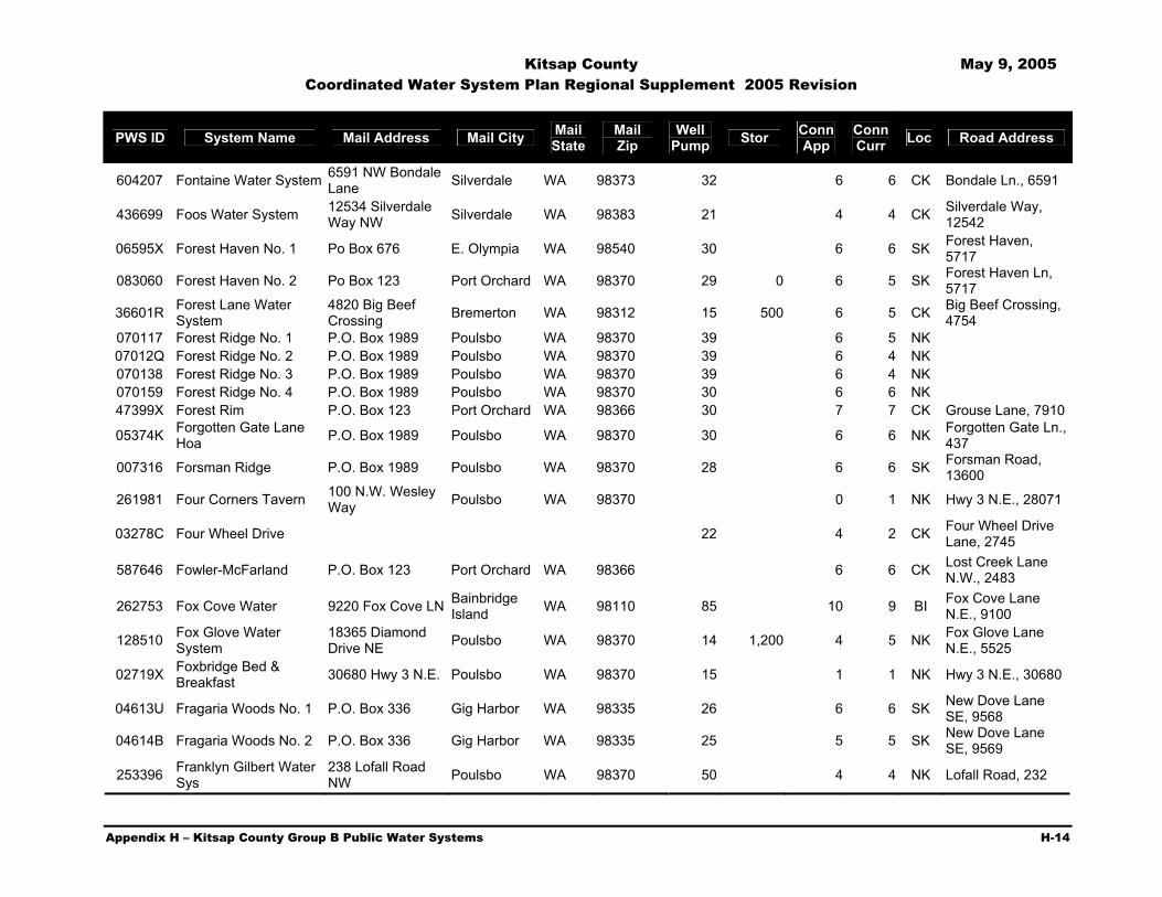
Kitsap County May 9, 2005 Coordinated Water System Plan Regional Supplement 2005 Revision
Appendix H – Kitsap County Group B Public Water Systems H-14
PWS ID System Name Mail Address Mail City Mail State
Mail Zip
Well Pump Stor Conn
App Conn Curr Loc Road Address
604207 Fontaine Water System 6591 NW Bondale Lane Silverdale WA 98373 32 6 6 CK Bondale Ln., 6591
436699 Foos Water System 12534 Silverdale Way NW Silverdale WA 98383 21 4 4 CK Silverdale Way,
12542
06595X Forest Haven No. 1 Po Box 676 E. Olympia WA 98540 30 6 6 SK Forest Haven, 5717
083060 Forest Haven No. 2 Po Box 123 Port Orchard WA 98370 29 0 6 5 SK Forest Haven Ln, 5717
36601R Forest Lane Water System
4820 Big Beef Crossing Bremerton WA 98312 15 500 6 5 CK Big Beef Crossing,
4754 070117 Forest Ridge No. 1 P.O. Box 1989 Poulsbo WA 98370 39 6 5 NK 07012Q Forest Ridge No. 2 P.O. Box 1989 Poulsbo WA 98370 39 6 4 NK 070138 Forest Ridge No. 3 P.O. Box 1989 Poulsbo WA 98370 39 6 4 NK 070159 Forest Ridge No. 4 P.O. Box 1989 Poulsbo WA 98370 30 6 6 NK 47399X Forest Rim P.O. Box 123 Port Orchard WA 98366 30 7 7 CK Grouse Lane, 7910
05374K Forgotten Gate Lane Hoa P.O. Box 1989 Poulsbo WA 98370 30 6 6 NK Forgotten Gate Ln.,
437
007316 Forsman Ridge P.O. Box 1989 Poulsbo WA 98370 28 6 6 SK Forsman Road, 13600
261981 Four Corners Tavern 100 N.W. Wesley Way Poulsbo WA 98370 0 1 NK Hwy 3 N.E., 28071
03278C Four Wheel Drive 22 4 2 CK Four Wheel Drive Lane, 2745
587646 Fowler-McFarland P.O. Box 123 Port Orchard WA 98366 6 6 CK Lost Creek Lane N.W., 2483
262753 Fox Cove Water 9220 Fox Cove LN Bainbridge Island WA 98110 85 10 9 BI Fox Cove Lane
N.E., 9100
128510 Fox Glove Water System
18365 Diamond Drive NE Poulsbo WA 98370 14 1,200 4 5 NK Fox Glove Lane
N.E., 5525
02719X Foxbridge Bed & Breakfast 30680 Hwy 3 N.E. Poulsbo WA 98370 15 1 1 NK Hwy 3 N.E., 30680
04613U Fragaria Woods No. 1 P.O. Box 336 Gig Harbor WA 98335 26 6 6 SK New Dove Lane SE, 9568
04614B Fragaria Woods No. 2 P.O. Box 336 Gig Harbor WA 98335 25 5 5 SK New Dove Lane SE, 9569
253396 Franklyn Gilbert Water Sys
238 Lofall Road NW Poulsbo WA 98370 50 4 4 NK Lofall Road, 232

Kitsap County May 9, 2005 Coordinated Water System Plan Regional Supplement 2005 Revision
Appendix H – Kitsap County Group B Public Water Systems H-15
PWS ID System Name Mail Address Mail City Mail State
Mail Zip
Well Pump Stor Conn
App Conn Curr Loc Road Address
47401L Fraser Road Water System 10600 S.E. Fraser Port Orchard WA 98366 15 1,500 7 6 SK Fraser Road,
10600 39944X Freddie Lane P.O. Box 336 Gig Harbor WA 98335 54 9 7 CK Freddie Lane, 8718
075488 Fresh Water Water System P.O. Box 123 Poulsbo WA 98370 11 1,125 3 2 NK Viking Way, 18137
265971 Friends Water Corp 9370 Friends Lane SE Port Orchard WA 98366 30 6 6 SK Friends Lane, 9340
33357K Frontier Water System Po Box 1801 Kingston WA 98346 21 4 5 NK Old Frontier Road, 11225
03306N Frontier Woods 5300 NW Newberry Hill Rd, Suite 100
Silverdale WA 98383 36 0 5 2 CK Nite Owl Lane N.W., 12501
02003N Frykholm Water P.O. Box 1989 Poulsbo WA 98370 32 5 4 NK Thorpe Road Ne, 16424
01636P Gabby Water System P.O. Box 1989 Poulsbo WA 98370 31 4 4 NK Rhododendron Lane N.W., 23014
26940M Gabe's Water Works Inc
11160 NW Holly RD Bremerton WA 98310 10 1,100 9 9 CK Holly Road N.W.,
11130
023623 Gale-Blair 625 Winslow Way East
Bainbridge Island WA 98110 25 3 3 BI Agate Point Road
N.E., 16410
31491H Galpin Water Supply P.O. Box 68 Silverdale WA 98383 34 9 9 CK Lupine Lane N.W., 4790
27282V Gazay Subdivision 23805 Bond RD NE Poulsbo WA 98370 3 3 NK Bond Road, 23805
00705F Gazay-Mushroom Lane 1275 Thompson Lane Poulsbo WA 98370 6 1,000 4 4 NK Mushroom Lane,
1019 60451H Gem Water System P.O. Box 1385 Kingston WA 98346 19 3 3 NK Ohio Ave., 26778
45453T Gen-Don Water System
16710 Agate Pass Rd. N.E.
Bainbridge Island WA 98110 24 4 4 BI Agate Pass RD Ne,
16710
275089 Gerke Water 32496 Hoffman RD N Kingston WA 98346 45 0 5 NK Hoffman Road,
32496
27509T Gerke-McClain Water 1261 SW 152nd ST Burien WA 98166 4 4 NK Hoffman Road
N.E., 32428
02543B Gibb Water System 2123 NW 201st Seattle WA 98177 10 2,464 5 3 NK Rash Road N.E., 29900
37264D Glentree Water System 9700 Glenwood RD SW Port Orchard WA 98367 20 5 5 SK Glenwood Road
S.W., 9700

Kitsap County May 9, 2005 Coordinated Water System Plan Regional Supplement 2005 Revision
Appendix H – Kitsap County Group B Public Water Systems H-16
PWS ID System Name Mail Address Mail City Mail State
Mail Zip
Well Pump Stor Conn
App Conn Curr Loc Road Address
28222C Glenwood Kourt 3048 Christmas Tree LN SW Port Orchard WA 98366 20 0 4 SK Christmas Tree
Lane, 2722
37464N Goldendale Estates 8264 Andrea Lane NW Silverdale WA 98383 31 8 8 CK Andrea Lane NW,
8051
053753 Gracey No.1 P.O. Box 1989 Poulsbo WA 98370 11 2,500 6 6 NK Stottlemeyer Rd., 24376
06598F Gracey Trails 2a P.O. Box 1989 Poulsbo WA 98370 4 3,500 5 5 NK Stottlemeyer 065990 Gracey Trails 2b P.O Box 1989 Poulsbo WA 98383 4 3,500 5 5 NK Stottlemeyer
05846F Graham Estates 5869 Crystal Springs Dr. NE
Bainbridge Island WA 98110 6 250 4 2 BI Crystal Springs
Road, 5869 AA265D Grand Fir Po Box 1989 Poulsbo WA 98370 27 0 6 3 NK Finn Hill Nw, 2675
06270E Green Gable Estates 25 4 4 NK State Hwy 104, 7366
NR270L Green Mountain Horse Camp P.O. Box 68 Enumclaw WA 98342 0 1 CK Green Mountain
076809 Green Mountain Water Po Box 123 Port Orchard WA 98366 3 3,500 4 2 CK Percheron Lane Nw, 227
01589D Green Spot Water 625 Winslow Way East
Bainbridge Island WA 98110 28 4 4 BI Green Spot Place
Ne, 9440
398017 Green Stump 11085 Courtney Lane Poulsbo WA 98370 26 4 4 NK Olympic View
Road, 10981
01783K Greene Water System 625 Winslow Way East
Bainbridge Island WA 98110 3 1,000 2 2 BI Grand Avenue Ne,
7962 Bi
60781N Greenshore Homeowners
4648 SE Greenshore Dr. Port Orchard WA 98367 7 1,100 10 10 SK Greenshore Drive
Se, 4556
01625X Greenwood Water System P.O. Box 336 Gig Harbor WA 98335 40 8 8 SK Sidney S.W.,14030
05086F Grenville/Schmitz P.O. Box 336 Gig Harbor WA 98335 28 5 4 SK Junett Lane, 3290
075298 Guillemot Cove 1200 NW Fairgrounds Road Bremerton WA 98312 30 0 3 3 CK Stavis Bay Road
Nw, 19235
08213K H.A.J. Water System P.O. Box 123 Port Orchard WA 98366 19 3 2 SK NW Old Holly Hill Rd, 24092
04466D Habnor Estates Water System P.O. Box 123 Port Orchard WA 98366 14 1,125 4 1 CK Corey Lane, 10865
010466 Hagen, Peter Road Well P.O. Box 1989 Poulsbo WA 98370 28 6 4 SK Peter Hagen Road

Kitsap County May 9, 2005 Coordinated Water System Plan Regional Supplement 2005 Revision
Appendix H – Kitsap County Group B Public Water Systems H-17
PWS ID System Name Mail Address Mail City Mail State
Mail Zip
Well Pump Stor Conn
App Conn Curr Loc Road Address
02123A Haley Water System 10580 NE Byron DR
Bainbridge Island WA 98110 10 300 4 3 BI Byron Drive, 10580
40651P Half Mile Road Water P.O. Box 1961 Silverdale WA 98383 30 4 4 CK Half Mile Road N.W., 3525
075235 Halleran Water Po Box 123 Port Orchard WA 98366 25 0 4 2 SK Nelson Road
632458 Hamilton, Earl Water 8445 N.W. Holly Road Bremerton WA 98312 25 6 2 CK Holly Road N.W.,
8445
01768M Hansen/Spellman 5560 NE Sunset Pl Bainbridge Island WA 98110 30 6 6 BI Hansen Road,
8244
31480Q Harrison Water 50 NW Green Hill Ct Bremerton WA 98310 10 0 4 CK Schold Road N.W.,
11660
47264E Hartstrom Water Supply P.O. Box 1634 Centralia WA 98531 31 6 4 CK Big Bird Drive
01047P Harvco Water 22 4 4 CK Segerman Lane, 6986
06785X Haughton Water System
7980 SE Phillips Road Port Orchard WA 98366 20 0 10 CK Phillips Rd, 7788
SE
368412 Hawk Hill Water System
23410 Rhododendron LN NW
Poulsbo WA 98370 32 8 8 NK Rhododendron Lane, 23401
02056H Hawk/Barlow 9635 NE Dronawood DR Kingston WA 98346 15 1,000 3 3 NK Wyant Road N.E.,
9605
05385B Heavenly Waters P.O. Box 1989 Poulsbo WA 98370 4 1,125 6 5 BI Silven Ave NE , 14413
33775K Hefner Water System 14644 Peacock Hill Road SE Olalla WA 98359 40 0 4 SK Peacock Hill Road
S.E., 14644
47514J Heins Water System 3380 Rova Road Poulsbo WA 98370 6 2 NK Rova Road N.E., 3380
01775B Helsene 21 4 4 NK Hansville Road, 33719
190647 Hemerick Well 15871 Peacock Hill RD SE Olalla WA 98359 0 2 SK Peacock Hill Road
S.E., 15871
63441E Hendel 321 High School Road NE #146
Bainbridge Island WA 98110 8 1,100 3 3 BI Sunset Ave. N.E.,
11673
11152J Hendrickson Water System
4945 Henderickson RD NE
Poulsbo WA 98370 15 0 5 NK Hendrickson Road, 4945

Kitsap County May 9, 2005 Coordinated Water System Plan Regional Supplement 2005 Revision
Appendix H – Kitsap County Group B Public Water Systems H-18
PWS ID System Name Mail Address Mail City Mail State
Mail Zip
Well Pump Stor Conn
App Conn Curr Loc Road Address
067914 Herbold Water System No. 1
2585 SE Bielmeier RD Port Orchard WA 98366 3 3 SK Bielmeier Road
S.E., 2585
42460A Herporusnas Water System 3019 Sawdust Hill Poulsbo WA 98370 14 0 4 NK Sawdust Hill Road
N.E., 3018
22486V Hess, Andrew J. Well 2225 Martin Ave. E. Port Orchard WA 98366 18 3 3 CK Martin Ave., E.,
2225
04121D Hidden Canyon Water System P.O. Box 1989 Poulsbo WA 98370 12 1,200 4 2 SK Long Lake Road,
8090
00911X Hidden Cove Water 7427 NE Hidden Cove RD
Bainbridge Island WA 98110 10 5,000 9 9 BI Hidden Cove Road
004412 Hidden Cove West Water Co P.O. Box 10854 Bainbridge
Island WA 98110 30 9 9 BI Hidden Cove Road Ne, 6955
009448 Hidden Heights West P.O. Box 123 Port Orchard WA 98366 24 10 8 BI Hidden Heights Lane, 14008
024247 Hidden Homesteads P.O. Box 1989 Poulsbo WA 98307 12 1,200 6 5 CK Lewis Road
086766 Hide A Way Heights Po Box 336 Gig Harbor WA 98335 8 1,400 6 6 NK Diamond Road, 18751
021364 Hideaway Heights Water 4181 Emerald RD Poulsbo WA 98370 9 1,000 4 2 NK Emerald Road,
4181
06624Q Highland No. 1 Water System P.O. Box 123 Port Orchard WA 98366 30 4 4 SK Tartan Road E.
066258 Highland No. 2 Water System P.O. Box 123 Port Orchard WA 98366 27 6 6 SK Tartan Road East
651015 Highland View Estates No. 5 450 Coleman Ct. Poulsbo WA 98370 32 4 4 NK Coleman Court
N.W., 209 Thomps
60371W Highland View Water No. 1 P.O. Box 1989 Poulsbo WA 98370 31 7 7 NK Thompson Road
N.W., 1045
32978A Hill, Peter J Water P.O. Box 1252 Poulsbo WA 98370 8 0 3 NK Virginia Loop Road,
01165A Hillside Acres Water 11240 Olympic View RD NW Silverdale WA 98383 20 1,000 4 4 CK Olympic View
Road, 11220
300214 Hilltop Water Users 11541 NE Hansen LN Kingston WA 98346 15 9 7 NK Glavin Lane, 11853
30406P Hinkley Hill Water System P.O. Box 2985 Silverdale WA 98383 21 1,400 8 9 NK Skycrest Lane,
6485
334756 Hintz Water 20 5 5 CK Seabeck Holly Road, 5325

Kitsap County May 9, 2005 Coordinated Water System Plan Regional Supplement 2005 Revision
Appendix H – Kitsap County Group B Public Water Systems H-19
PWS ID System Name Mail Address Mail City Mail State
Mail Zip
Well Pump Stor Conn
App Conn Curr Loc Road Address
03255A Hite Center Spur Water P.O. Box 1989 Poulsbo WA 98370 23 4 4 CK Hite Center Road, 16111
33635D Hoggins Water 4570 Lakeview DR SE Port Orchard WA 98366 10 0 2 CK Lakeview Drive
S.E., 4570
16342V Hokanson, Almojuela, Freeman
11170 Anderson Landing LN NW Silverdale WA 98383 27 3 3 CK Anderson Landing
LN Nw, 11170
65140N Holloway Water 4655 Calamity Lane Bremerton WA 98312 26 4 4 CK Calamity Lane,
4645
054691 Holm No. 2 Water System 6 1,150 6 6 CK Thompson Lane
N.E.
04691V Holm Water System 5 2,400 6 6 CK Thompson Lane N.E.
72234E Holman Water System 29478 Beach DR NE Poulsbo WA 98370 20 0 3 NK Beach Drive N.E.,
29478
034249 Home Water Supply 14906 Sunrise Dr. N.E.
Bainbridge Island WA 98110 10 1,100 0 4 BI Sunrise Drive N.E.,
14906
044185 Homer Wiley Water System P.O. Box 1989 Poulsbo WA 98370 24 4 2 SK Phillips Road, 6989
76729N Hood Canal Assn. 30543 State Hwy 3 NE Poulsbo WA 98370 6 3 NK Hwy 3 N.E., 30503
14766U Hooper PT Community Water
6320 Eagle Harbor DR NE
Bainbridge Island WA 98110 12 4 4 BI Eagle Harbor Drive
N.E., 6320
34194V Hoover Water 16575 Pearson PT RD NE Poulsbo WA 98370 50 6 5 NK Pearson Point
Road N.E., 16575
01425N Huckleberry Water P.O. Box 336 Gig Harbor WA 98335 38 6 5 SK Rosedale Lane S.W., 12036
34750J Hughes Well 13853 Lester RD N.W. Silverdale WA 98383 0 3 CK Lester Road N.W.,
13853
60277V Hume Water System 16290 Reitan RD Bainbridge Island WA 98110 4 4 BI Reitan Road N.E.,
16330 01591J Hunt 3 Community P.O. Box 20098 Seattle WA 98102 19 3,000 16 10 SK Promenade Lane
051283 Hunter Water P.O. Box 1989 Poulsbo WA 98370 19 3 3 NK Jefferson Beach Road, 22178
638683 Hunt-Newberry Hill P.O. Box 3863 Silverdale WA 98383 36 5 5 CK Caitlin, Off Newberry Hill
35050P Hurd Water P.O. Box 63 Olalla WA 98359 10 0 4 SK Price Road S.E., 12785

Kitsap County May 9, 2005 Coordinated Water System Plan Regional Supplement 2005 Revision
Appendix H – Kitsap County Group B Public Water Systems H-20
PWS ID System Name Mail Address Mail City Mail State
Mail Zip
Well Pump Stor Conn
App Conn Curr Loc Road Address
011784 Hurley Water System 15703 Virginia Loop RD NE Poulsbo WA 98370 0 2 NK Virgina Loop Road
N.E., 15703
586895 Hurley, James P. 22077 Clear Creek RD NW Poulsbo WA 98370 3 3 NK Clear Creek Road
N.W., 22077
209384 Hurley, Robert P.O. Box 1303 Poulsbo WA 98370 10 1,000 0 3 NK Widme Road, 18447
023074 Hutchins/Spalding 9744 Manley RD NW Seabeck WA 98380 25 6 6 CK Seabeck Hwy.,
11174
007379 Hylands Water Co. P.O. Box 1989 Poulsbo WA 98370 12 1,150 6 5 NK Highland Road, 25748
026316 Indianola Woods P.O. Box 1989 Poulsbo WA 98370 35 7 6 NK Marble Lane, 25748
35687V Ingalls Water System 6310 NE State Hwy 104 Kingston WA 98346 10 1,125 3 3 NK Hwy. 104 N.E.,
6310
35353M Iwihhy Inc 6364 NE Tara LN Bainbridge Island WA 98110 8 7 7 BI Sunset Place N.E.,
5465
08704F J&R Water System 25863 Tytler Road NE Poulsbo WA 98370 18 4 4 NK Tytler Road N.E.,
25841
314818 J.H. Water System 9552 SW Heartwood Lane Port Orchard WA 98366 30 6 5 SK Jh Road S.W., 920
36490A Jacobsen Well 2950 Snowhill Lane Poulsbo WA 98370 15 0 4 NK Snowhill Lane
43967M Jacobson/Brauer Cove P.O. Box 336 Poulsbo WA 98370 4 4 NK Jacobson Road N., 1990
36694M James Well 5802 Banner RD SE Port Orchard WA 98367 4 4 SK Banner Road S.E.,
5802
43837Q Janet's Well 11104 N.W. Holly Rd. Bremerton WA 98312 4 1,000 3 2 CK Holly Road N.W.,
11104
216250 Jason Lane Water P.O. Box 609 Port Orchard WA 98366 34 9 9 SK Jason Lane S.E., 7353
00628D Jennings Water System 19941 Nilsen Lane N.W. Poulsbo WA 98370 10 1,000 4 1 NK Nilsen Lane NW
367727 Jims Auto Wrecking 18146 9th Ave. Poulsbo WA 98370 7 0 3 NK Stottlemeyer Road N.E., 23719
367748 Joanne Lane Comm Club
1795 Joanne LN NE Bremerton WA 98311 25 4 4 CK Joanne Lane, 1795
06624Q Johnson Highland Po Box 123 Port Orchard WA 98366 30 4 2 SK Tartan Road

Kitsap County May 9, 2005 Coordinated Water System Plan Regional Supplement 2005 Revision
Appendix H – Kitsap County Group B Public Water Systems H-21
PWS ID System Name Mail Address Mail City Mail State
Mail Zip
Well Pump Stor Conn
App Conn Curr Loc Road Address
066258 Johnson Highland No. 2 Po Box 123 Port Orchard WA 98366 27 6 6 SK Tartan RD
368834 Johnson Water, Tim 7250 NW Newberry Hill Silverdale WA 98383 0 2 CK Newberry Hill Road
10864N Johnson, George 11342 Arrow Point DR NE
Bainbridge Island WA 98110 20 0 3 BI Arrow Point Drive
N.E., 11338
36844L Johnson-Kingston Terrace P.O. Box 340 Kingston WA 98346 0 6 NK Lindvog Road N.E.,
26781
08661B Johnston Well 7761 Hansen RD NE
Bainbridge Island WA 98110 22 1,100 9 9 BI Hansen Road N.E.,
7761
16566P Johnston-Vincent 380101 Hood Canal DR NE Hansville WA 98340 5 0 3 CK Holly Road, 8961
37030A Jorstad Water 5928 Long Lake Rd. S.E. Port Orchard WA 98366 0 3 SK Long Lake Road
S.E., 5940
254271 Judaro 7137 NW Quietview Lane Silverdale WA 98383 43 4 4 CK Willamette
Meridian, 9563
37104Q Judkins, Central Valley P.O. Box 234 Keyport WA 98345 0 2 NK Scandia Road N.W., 76011
65072B Jungferman Water System
19584 Stavis Bay Road Seabeck WA 98380 27 4 4 CK Stavis Bay Road,
19584 01081M Jupiter Trail 7285 Jupiter Silverdale WA 98383 12 1,100 3 3 CK Jupiter Trail, 7285
053795 Karkainen P.O. Box 1989 Poulsbo WA 98370 17 2 2 NK Virginia Point Rd. Ne, 16013
019764 Kedros Water System P.O. Box 1989 Poulsbo WA 98370 16 9 9 NK Kedros Lane, 4060
604331 Keeney Water 10044 NE Ewing ST
Bainbridge Island WA 98110 40 8 8 BI Ward Ave. N.E.,
5711
37917K Kekamek Subdivision 1753 Kekamek Drive NW Poulsbo WA 98370 12 1,100 0 4 NK Kekamek Drive
N.W., 1735
57927W Kelly Water System 650 SW Spruce RD Port Orchard WA 98366 14 1,100 6 2 SK Spruce Road S.W.,
650 017864 Kendall Water System 20829 Pugh Road Poulsbo WA 98370 29 6 4 NK Pugh Road, 20829
634060 Keyport Hills 13913 S. Keyport Road Poulsbo WA 98370 31 7 7 CK State Hwy 303
014266 Keys Water System 28835 NE Oyster PT DR Poulsbo WA 98370 24 3 2 NK Oyster PT Dr
386157 Kimball Water 6810 Sidney Road SW Port Orchard WA 98366 7 0 2 SK Sidney Road S.W.,
6820

Kitsap County May 9, 2005 Coordinated Water System Plan Regional Supplement 2005 Revision
Appendix H – Kitsap County Group B Public Water Systems H-22
PWS ID System Name Mail Address Mail City Mail State
Mail Zip
Well Pump Stor Conn
App Conn Curr Loc Road Address
38631N Kindle Ridge P.O. Box 395 Poulsbo WA 98370 35 6 9 NK Ponderosa Place, 1825
42054L King Road Water System
6606 S.E. King Road Port Orchard WA 98366 20 4 4 SK King Road S.E.,
6622
03114M King Water System P.O Box 125 Suguamish WA 98392 10 1,000 4 4 NK Port Gamble/Suquamish, 23090
023496 King, Carol/Ted Water Po Box 1989 Poulsbo WA 98370 26 6 4 BI Battle Point Road, 10717
42064V King's Glen P.O. Box 4094 South Colby WA 98408 0 8 SK King Road S.E., 6910
38624Y Kinkaid Resort Tracts 4735 NE Twin Spits RD Hansville WA 98340 9 1,500 3 3 NK Twin Spits Road
N.E., 4805
59889F Kirk Ave Water 11707 Kirk Ave. Bainbridge Island WA 98110 9 9 BI Kirk Avenue, 11701
424502 Kitsap Bait Sales 1595 SW Hwy 160 Port Orchard WA 98366 2 2 SK State Hwy 166, 1595
086890 Kitsap County Sp No. 2249 P.O. Box 173 Southworth WA 98386 0 2 SK Banner Road S.E.,
9555
426402 Kitsap Youth Home-Central
1200 Navy Yard Hwy Bremerton WA 98312 14 0 1 CK Anderson Hill Road
NW, 5100
36784H Klabon Water System P.O. Box 383 Seabeck WA 98380 13 1,000 8 8 CK Bonkla Lane N.W., 14129
01093X Klahowya 6574 Schuett LN NW Bremerton WA 98312 31 9 8 CK Schuett Lane, 6561
074339 Klahowya Homestead Po Box 123 Port Orchard WA 98366 37 0 6 5 CK Calumet Dr. Nw, 7997
042011 Klineburger Water 14406 Olympic View Loop NW Silverdale WA 98383 3 1,000 0 3 CK Olympic View
Road, 14451
63566N Klinger Water System P.O. Box 1165 Kingston WA 98346 30 4 4 NK State Hwy 104, 9343
02175M Knauss Water System 5366 Seabeck Hwy. N.W. Bremerton WA 98312 28 3 3 CK Seabeck Hwy.
N.W., 5320
36777T Knopf, Eric Water System P.O. Box 163 Poulsbo WA 98370 28 4 2 NK Hallman Road,
17280
03926Y Kolvoord P.O. Box 1989 Poulsbo WA 98370 21 4 1 NK Hudson Avenue NE, 29941

Kitsap County May 9, 2005 Coordinated Water System Plan Regional Supplement 2005 Revision
Appendix H – Kitsap County Group B Public Water Systems H-23
PWS ID System Name Mail Address Mail City Mail State
Mail Zip
Well Pump Stor Conn
App Conn Curr Loc Road Address
04881V Komichan Water System 28 6 6 CK Feather Lane
06840E Kortetz Water Supply 22650 Rhododendron Lane
Poulsbo WA 98370 15 200 0 2 NK Rhododendron Lane N.W., 22662
01701F Krick Joel 6371 Longlake RD SE Port Orchard WA 98366 0 8 SK Long Lake Road
S.E., 6371
04860U Kruger Water System 7411 SE Sedgwick RD Port Orchard WA 98366 15 1,100 4 2 SK Sedgwick Road,
7411
06702A Kudzu Water P.O. Box 123 Port Orchard WA 98366 25 4 3 15592 Stevens Road
15440W Kvinsland, Norbur & Hall
23150 Big Valley Road Poulsbo WA 98370 30 0 3 NK Big Valley Road,
24906
00538J Kwip Water Supply 13527 Wye Lake Blvd SW Port Orchard WA 98366 12 4 4 SK Wye Lake Blvd.
S.W., 13617
01074X L&M Of Glenwood 12810 Glenwood Road Port Orchard WA 98366 22 4 4 SK Glenwood Road,
12824
024941 L.C.D. Water System 25 4 4 SK View Park Road, 9238
06499V La Cachette Water P.O. Box 1989 Poulsbo WA 98370 25 1 1 CK Seabeck Hwy, 10312
43455P La La Cove 13001 La La Cove Ln. S.E. Olalla WA 98359 25 8,000 23 11 SK La La Cove Lane,
13113
32434K Lagoon Water District 4929 N.E. Tolo Road
Bainbridge Island WA 98110 5 1,000 3 3 BI Tolo Road N.E.,
4919
588017 Lakeness Community Well
3108 N.W. Lakeness Road Poulsbo WA 98370 10 1,100 6 6 NK Lakeness Road,
3108
063797 Lakeside Apartments 6650 Long Lake RD Port Orchard WA 98366 0 6 SK Long Lake Road,
6650 068282 Lamagna 26 6 4 NK NW Lutes Rd, 1836
436950 Landsworth Creek Water
11561 Clear Creek RD Silverdale WA 98383 27 4 4 CK Clear Creek Road,
11549
009279 Lane Water System 17130 Clear Creek RD NW Poulsbo WA 98370 10 0 2 NK Clear Creek Road
N.W., 17130
00531X Lang Water P.O. Box 685 Port Orchard WA 98366 13 1,400 4 3 SK East Hillcrest Dr., 5252
23910N Lang Water System 4450 Woods Road S.E. Port Orchard WA 98366 20 5 4 SK Woods Road, 4391

Kitsap County May 9, 2005 Coordinated Water System Plan Regional Supplement 2005 Revision
Appendix H – Kitsap County Group B Public Water Systems H-24
PWS ID System Name Mail Address Mail City Mail State
Mail Zip
Well Pump Stor Conn
App Conn Curr Loc Road Address
459605 Langley Water 4793 Seabeck Hwy NW Bremerton WA 98310 0 3 CK Seabeck Hwy.
N.W., 4793
01039F Larson Lane No. 1 P.O. Box 1989 Poulsbo WA 98370 29 6 4 CK Cheyney Lane, 6616
05824X Larson Lane No. 2 Water System P.O. Box 1989 Poulsbo WA 98370 28 0 6 5 CK Cheney Lane, 6466
46117H Larson Water P.O. Box 833 Seabeck WA 98380 12 4 4 CK Seabeck Hwy NW, 5757
025209 Laurelwood 30 5 4 BI Frey Ave., 5652
03464A Lavalsit Water System 27691 Lindvog RD Kingston WA 98346 10 2,500 4 3 NK Lindvog Road, 27691
46385J Lawler Water 13422 Olympic DR SE Olalla WA 98359 10 0 2 SK Olympic Drive S.E.,
13422
472860 Lawrence Dr. Water System
9373 Lawrence Dr. S.E. Port Orchard WA 98366 36 9 9 SK Lawrence Drive SE
65067N Lazy Brook Farm 7780 Sportsman Club RD NE
Bainbridge Island WA 98110 7 1,100 4 4 BI Sportsman Club
Road, 7756
68310B Lee Memorial Water Assn
3230 Point White Drive NE
Bainbridge Island WA 98110 21 6 6 BI Point White Drive
N.E., 3211
54639L Lee Water System 16443 Olympic View RD Silverdale WA 98383 3 2 CK Olympic View
Road, 16443
004686 Lee-Bo Water 20421 Pugh Rd. NE Poulsbo WA 98370 29 4 4 NK Pugh Road, 20421
02476J Leisure Land Water System 3139 21st Street Clarkston WA 99403 73 6 3 CK Aviator Lane NW,
4854 02992M Leisureland Division 1 31 6 6 CK Holly Road
43576V Lemmon Water System P.O. Box 986 Poulsbo WA 98370 22 4 4 NK Clear Creek Road N.W., 23485
46727J Lemolo Meats P.O. Box 1989 Poulsbo WA 98370 0 4 NK Lemolo Shore Drive N.E., 17158
26629C Lemolo Tracts 1670 N.E. Jacobson Road Poulsbo WA 98370 15 1,000 9 9 NK Jacobson Road
N.E., 1670
35994Y Leon's Well 1505 NW Mushroom LN Poulsbo WA 98370 22 4 3 NK Mushroom Lane,
1505 (Open Space)
06501J Lewis Water 7460 N.E. North Street
Bainbridge Island WA 98110 12 0 4 BI Agate N.E., 17026
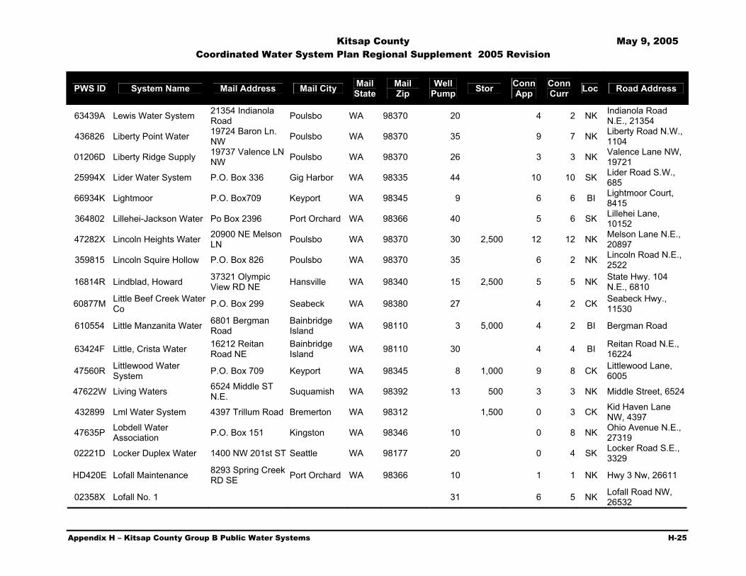
Kitsap County May 9, 2005 Coordinated Water System Plan Regional Supplement 2005 Revision
Appendix H – Kitsap County Group B Public Water Systems H-25
PWS ID System Name Mail Address Mail City Mail State
Mail Zip
Well Pump Stor Conn
App Conn Curr Loc Road Address
63439A Lewis Water System 21354 Indianola Road Poulsbo WA 98370 20 4 2 NK Indianola Road
N.E., 21354
436826 Liberty Point Water 19724 Baron Ln. NW Poulsbo WA 98370 35 9 7 NK Liberty Road N.W.,
1104
01206D Liberty Ridge Supply 19737 Valence LN NW Poulsbo WA 98370 26 3 3 NK Valence Lane NW,
19721
25994X Lider Water System P.O. Box 336 Gig Harbor WA 98335 44 10 10 SK Lider Road S.W., 685
66934K Lightmoor P.O. Box709 Keyport WA 98345 9 6 6 BI Lightmoor Court, 8415
364802 Lillehei-Jackson Water Po Box 2396 Port Orchard WA 98366 40 5 6 SK Lillehei Lane, 10152
47282X Lincoln Heights Water 20900 NE Melson LN Poulsbo WA 98370 30 2,500 12 12 NK Melson Lane N.E.,
20897
359815 Lincoln Squire Hollow P.O. Box 826 Poulsbo WA 98370 35 6 2 NK Lincoln Road N.E., 2522
16814R Lindblad, Howard 37321 Olympic View RD NE Hansville WA 98340 15 2,500 5 5 NK State Hwy. 104
N.E., 6810
60877M Little Beef Creek Water Co P.O. Box 299 Seabeck WA 98380 27 4 2 CK Seabeck Hwy.,
11530
610554 Little Manzanita Water 6801 Bergman Road
Bainbridge Island WA 98110 3 5,000 4 2 BI Bergman Road
63424F Little, Crista Water 16212 Reitan Road NE
Bainbridge Island WA 98110 30 4 4 BI Reitan Road N.E.,
16224
47560R Littlewood Water System P.O. Box 709 Keyport WA 98345 8 1,000 9 8 CK Littlewood Lane,
6005
47622W Living Waters 6524 Middle ST N.E. Suquamish WA 98392 13 500 3 3 NK Middle Street, 6524
432899 Lml Water System 4397 Trillum Road Bremerton WA 98312 1,500 0 3 CK Kid Haven Lane NW, 4397
47635P Lobdell Water Association P.O. Box 151 Kingston WA 98346 10 0 8 NK Ohio Avenue N.E.,
27319
02221D Locker Duplex Water 1400 NW 201st ST Seattle WA 98177 20 0 4 SK Locker Road S.E., 3329
HD420E Lofall Maintenance 8293 Spring Creek RD SE Port Orchard WA 98366 10 1 1 NK Hwy 3 Nw, 26611
02358X Lofall No. 1 31 6 5 NK Lofall Road NW, 26532

Kitsap County May 9, 2005 Coordinated Water System Plan Regional Supplement 2005 Revision
Appendix H – Kitsap County Group B Public Water Systems H-26
PWS ID System Name Mail Address Mail City Mail State
Mail Zip
Well Pump Stor Conn
App Conn Curr Loc Road Address
47669J Lofthus Water 15529 Washington Ave NE
Bainbridge Island WA 98110 0 2 BI Birkland, 4045
476747 Logan Water P.O. Box 188 Seabeck WA 98380 23 4,850 6 4 CK Seview Drive, 14879
009047 Lois Drive No. 1 6878 NW Lois DR Silverdale WA 98383 28 6 6 CK Lois Drive, 6889
00584R Lombard, Ray Water 5168 NW Uff Da Lane Silverdale WA 98383 40 6 6 CK Uff Da Lane, 5010
05378M Lone Eagle P.O. Box 1989 Poulsbo WA 98337 25 6 4 BI Rose Ave. NE, 5115
479208 Lone Rock Grocery 11195 Seabeck Highway NW Seabeck WA 98380 0 2 CK Seabeck Hwy,
11195
47925U Lone Rock Water Assn 11005 Warren Road NW Silverdale WA 98383 18 13 CK Warren Road N.W.,
11005
474760 Lonesome Water System
7456 Vandecar Road S.E. Port Orchard WA 98366 5 2 SK Bielmeire Road,
7495
48025Q Long Lake Manor Water P.O. Box 1165 Port Orchard WA 98366 26 6 4 SK Long Lake Road
S.E., 7242
480627 Longfellow Park 4133 Lakeview Ave N.W. Bremerton WA 98312 9 8 CK N.W. Lakeview
Place, 4125
894747 Longo, L Water 7905 Banner RD SE Port Orchard WA 98366 30 0 2 SK Banner Road, 7905
15481E Lords Property 629 N State Hwy 90 Byp 1031 Sierra Vista AZ 85635-
2257 15 0 2 SK Crescent Valley S.E., 14381
048745 Lost Creek Lane Water System P.O. Box 123 Port Orchard WA 98366 28 6 6 CK Lost Creek Lane,
2483
48375D Lots Of Bucks P.O. Box 265 Olalla WA 98359 27 0 2 SK Nelson Road S.E., 7510
324419 Ludwick Supply P.O. Box 464 Olalla WA 98359 24 5 4 SK Banner Road, 12261
48934M Luquasit Water Assn P.O. Box 1082 Silverdale WA 98383 28 8 8 CK Luquasit Trail N.W., 5971
06524L Lusby Lane Po Box 123 Port Orchard WA 98366 14 1,400 6 5 CK Lusby Lane, 16645
04729A Lustbader-Preston P.O. Box 1989 Poulsbo WA 98370 6 3,500 4 4 BI Manzanita Road Ne, 13183
63361U Lutes Road Water 1900 Lutes Road NW Poulsbo WA 98370 12 2 2 NK Lutes Road, 1910
25440X Lws System No. 1 2580 NW Sherman Hill RD Poulsbo WA 98370 15 1,000 6 5 NK Sherman Hill, 2580

Kitsap County May 9, 2005 Coordinated Water System Plan Regional Supplement 2005 Revision
Appendix H – Kitsap County Group B Public Water Systems H-27
PWS ID System Name Mail Address Mail City Mail State
Mail Zip
Well Pump Stor Conn
App Conn Curr Loc Road Address
204646 M&A Water System 7450 Nelson Road Olalla WA 98359 30 6 4 SK Nelson Road Se, 7450
63701T Mace Lake Water Po Box 523 Olalla WA 98359 25 6 6 SK Mace Lake Lane, 5192
038553 Madrona Beach Estates P.O. Box 1989 Poulsbo WA 98370 28 6 3 NK State Hwy 305 NE,
16586
50220X Madrona Water Co 7230 Madrona DR NE
Bainbridge Island WA 98110 12 10,000 14 14 BI Madrona Drive
N.E., 7268
017843 Malazzo Water System P.O. Box 336 Gig Harbor WA 98335 31 9 9 SK Wyckoff Road Sw, 440
50710A Mandak-Jackson-Hall Water P.O. Box 686 Silverdale WA 98383 15 0 3 CK Ioka Way NW,
11745
017885 Manual Road 14646 Sivertson Road
Bainbridge Island WA 98110 12 2,700 4 4 BI Carene Lane, 7500
05382T Manzanita Road 13834 Manzanita Rd. NE
Bainbridge Island WA 98110 19 3 3 BI Manzanita Rd. NE
19501R Maple Ridge 9821 Echo Valley Road NW Bremerton WA 98312 40 4 4 CK Echo Valley Road
N.W., 9821 066005 Marcad Water Po Box 1989 Poulsbo WA 98370 34 6 6 CK Old Sawmill
047910 Margo Water System Po Box 123 Port Orchard WA 98366 21 4 4 SK Oakhurst Lane, 4730
03858M Marlow Water P.O. Box 1989 Poulsbo WA 98370 35 14 10 CK Millgalde Lane
51849X Marshall Water (Fragaria)
8971 SE Fragaria RD Olalla WA 98359 0 2 SK Fragaria Road
S.E., 8725
11682Y Marshall/Field Water Syst.
3219 Point White DR NE
Bainbridge Island WA 98110 14 0 3 BI Point White Drive
N.E., 3219
00576J Martha Lane Water System
3903 NW Martha Lane Silverdale WA 98383 29 5 4 CK Martha Lane, 3877
51885W Martinson Water 13410 Phelps Road
Bainbridge Island WA 98110 0 3 BI Phelps Road N.E,
13410
015228 Masada Water System P.O. Box 1989 Poulsbo WA 98370 28 4 4 NK England Lane Nw, 1915
59966J Mason Road Water 24680 Mason Road Poulsbo WA 98370 4 4 NK Mason Road,
24700
035145 Mason Water System 8639 Olalla Valley RD SE Port Orchard WA 98366 24 0 2 SK Olalla Valley Road
S.E., 8639

Kitsap County May 9, 2005 Coordinated Water System Plan Regional Supplement 2005 Revision
Appendix H – Kitsap County Group B Public Water Systems H-28
PWS ID System Name Mail Address Mail City Mail State
Mail Zip
Well Pump Stor Conn
App Conn Curr Loc Road Address
02427R Mason, Tim Water System P.O. Box 1989 Poulsbo WA 98370 5 500 4 2 NK Weed Lane, 3193
37144R Matejka Garden Tracts P.O. Box 124 Gig Harbor WA 98335 31 6 3 SK Nelson Road S.E., 5710
00700W Mathews Water 37120 Thors Road NE Hansville WA 98340 31 9 8 NK Thors Road, 37120
523607 McFarland Well 4538 Old Mill RD NE
Bainbridge Island WA 98110 0 4 BI Old Mill Road N.E.,
4538
01781J McFarlane Water System
7266 NE Little Harbor Lane
Bainbridge Island WA 98110 12 500 4 2 BI Little Harbor Lane
NE, 7266
03277V McKeel 3702 14th Ave. NW Gig Harbor WA 98335 30 0 6 5 CK Mathisen Lane,
3750
843250 McKeever Water System
7020 N.E. Dolphin Dr.
Bainbridge Island WA 98110 6 6 BI
526656 McKenzie Water System
3175 PT White DR NE
Bainbridge Island WA 98110 0 2 BI Point White Drive
N.E., 3175
79730F Meadowview Homeowners Assc
11554 Doyle Lane N.W. Silverdale WA 98383 30 5,000 8 6 CK Doyle Lane, 11554
02639A Merlins Well P.O. Box 1989 Poulsbo WA 98370 21 4 4 CK Merlins Lane N.W., 10188
084212 Merriman Po Box 123 Port Orchard WA 98366 30 0 6 1 SK Menzies Rd, 3536
03576Q Mew Water System P.O. Box 1989 Poulsbo WA 98370 26 5 4 CK Hintzville Raod, 17825
63229T Michaelieu Water 10224 N. 40th Ave. Phoenix AZ 85051 2 2 NK Sherman Hill Road,
1283 04242K Miguelo P.O. Box 1989 Poulsbo WA 98370 27 4 4 CK Klahowya Trail
328111 Mikes Water System 23255 Rhododendron Lane NW
Poulsbo WA 98370 29 4 4 NK Rhododendron Lane, 23255
546829 Miller Bay Water System Po Box 156 Suquamish WA 98370 15 0 5 NK Sid Price Road
N.E., 6725
017318 Miller Road Water P.O. Box 138 Hansville WA 98340 20 500 9 7 NK Eagle Point Lane, 8162
55200 Minterbrook Farms P.O. Box 2 Burley WA 98322 32 0 5 SK Minterbrook Road S.W., 2033
552353 Mirical Water System 4725 Banner RD SE Port Orchard WA 98366 30 4 4 SK 4630 Arvick rd

Kitsap County May 9, 2005 Coordinated Water System Plan Regional Supplement 2005 Revision
Appendix H – Kitsap County Group B Public Water Systems H-29
PWS ID System Name Mail Address Mail City Mail State
Mail Zip
Well Pump Stor Conn
App Conn Curr Loc Road Address
552902 Misery Point Homeowners
10086 Misery PT RD Seabeck WA 98380 43 7 6 CK Misery Point Road,
10086
553505 Mission View Estates 2710 Ridge Crest DR W Bremerton WA 98312 15 5,000 0 8 CK Mission Lake Road
W, 2792
473695 Montana Well Association
10719 Old Frontier Road Silverdale WA 98383 15 1,000 4 4 CK Old Frontier Road
16911B Montgomery 8150 Willock RD Olalla WA 98359 0 2 SK Willock Road, 815019659A Moore Oak Po Box 78 Gig Harbor WA 98335 30 9 9 SK Oak Road, 890
03889X Moran Water 9396 Moran RD NE
Bainbridge Island WA 98110 3 3 BI Moran Road N.E.,
9402
031324 Morgensen/Mt View Road 30 3 3 CK Mt View Road,
1335
998506 Morris Water 66 Peter Hagan Rd. N.W. Bremerton WA 98312 0 3 CK Peter Hagen Road,
58
05845Y Morrison 280 Madison Ave N
Bainbridge Island WA 98110 7 2,500 7 5 BI Ferncliff Ave NE &
NE Yaquina Ave.
473128 Mpvk Water System P.O. Box 2985 Silverdale WA 98383 10 1,200 9 9 CK Hintzville Road N.W., 17521
57469A Mueller's Larry Water Sys
16669 Brauer RD NE Poulsbo WA 98370 0 2 NK Hallman Road
N.W., 16865
01241V Muller Water System P.O. Box 504 Poulsbo WA 98370 15 0 2 NK Clear Creek RD Nw, 17335
068261 Muller-Fladgard P.O. Box 1989 Poulsbo WA 98370 28 6 3 NK NE 360th
00433U Murphys 8125 Sportsmans Club Rd.
Bainbridge Island WA 98110 15 1,100 4 4 BI Sportsman Club
Road, 8117
576706 Murray Park Beach Club
7554 Long Lake RD SE Port Orchard WA 98366 0 7 CK Long Lake Road,
S.E., 7570
00241T Mushroom Lane Water 1915 NW Mushroom Lane Poulsbo WA 98370 30 4 4 NK Rhododendron
Blvd.
253523 Myers Well 3633 Sagebrush Lane Bremerton WA 98312 28 3 3 CK Sagebrush Lane,
3633 & 3651
10998M Nack Water System 3496 SE Olalla Burley RD Olalla WA 98359 21 1,350 8 7 SK Olalla Burley Road,
3496
032283 Nathan's P.O. Box 1989 Poulsbo WA 98370 12 1,500 3 3 NK NE Orseth Rd, 4797

Kitsap County May 9, 2005 Coordinated Water System Plan Regional Supplement 2005 Revision
Appendix H – Kitsap County Group B Public Water Systems H-30
PWS ID System Name Mail Address Mail City Mail State
Mail Zip
Well Pump Stor Conn
App Conn Curr Loc Road Address
06626R Nelson Highland Po Box 123 Port Orchard WA 98366 21 4 2 SK Moonridge Lane
06626R Nelson Highland Water System P.O. Box 123 Port Orchard WA 98366 27 4 2 SK Moonridge Lane
SE
587770 Nelson Water 20365 Pugh Rd. Poulsbo WA 98370 9 0 6 NK Pugh RD Ne, 20031
02244F Nelson, Ryan Water P.O. Box 336 Gig Harbor WA 98335 28 6 6 SK Nelson Road S.E., 4741
01515J Nelson-Bandix Road Water 641 Bay Street Port Orchard WA 98366 14 1,400 6 6 SK Bandix Road,
13311
009807 Nesika Bay No. 4 P.O. Box 1989 Poulsbo WA 98370 30 7 7 NK Lemolo Shores Drive, 15976
36491U New Haven Lane 7711 New Haven Land NW Silverdale WA 98383 21 9 7 CK New Haven Lane
N.W., 7711
064482 Newbeck Water System
5070 Tracyton Blvd. Bremerton WA 98311 33 1 1 CK Newberry Hill
Road, 8802
12877L Newberry Hill Community
8155 Berryridge Lane NW Silverdale WA 98383 9 9 CK Berry Ridge Lane
N.E., 6100
00626C Newsprings Water System P.O. Box 1989 Poulsbo WA 98337 11 1,400 6 5 CK Lakeview Ave.,
N.W., 4670
100444 Nicholson Well 3405 SE Kemp Lane Port Orchard WA 98366 20 0 2 SK Kemp Lane S.E.,
3405
016377 Nickerson, Charles Water P.O. Box 1989 Poulsbo WA 98370 12 1,050 3 3 NK Glavin Lane, 11753
36773Q Noll Road Water System P.O. Box 2985 Silverdale WA 98383 23 4 4 NK Noll Road, 19811
374213 Norris Sp 615 Water System 6523 NE My Way Bainbridge
Island WA 98110 10 2,200 4 3 BI My Way, 6529
59985J Norris Supply 6350 E Beaver CR RD Port Orchard WA 98366 0 8 SK Kimble, 4405
04605L North Kitsap Business Park 25 5 4 NK 3203 Totten Rd.,
Poulsbo
033625 North Lindvog Water System P.O. Box 1989 Poulsbo WA 98370 9 500 4 3 NK Lindvog Road Ne,
27777
608809 North Ollala Water 13737 Banner RD SE Olalla WA 98359 35 0 4 SK Banner Road S.E.,
13729

Kitsap County May 9, 2005 Coordinated Water System Plan Regional Supplement 2005 Revision
Appendix H – Kitsap County Group B Public Water Systems H-31
PWS ID System Name Mail Address Mail City Mail State
Mail Zip
Well Pump Stor Conn
App Conn Curr Loc Road Address
065233 Northslope P.O. Box 725 Seabeck WA 98380 13 1,350 6 5 CK Christine Lane, 3906
62100E Northwood P.O. Box 709 Keyport WA 98345 50 9 14 NK Lamms Lane
473719 Null Water System 9030 Elim ST Anchorage AK 99507 14 1,100 5 5 SK Bandix Road S.E., 13251
299313 Oakhurst Water Company
9245 Antrium Lane SW Port Orchard WA 98366 31 9 9 SK Oakhurst Lane
S.W., 4610
62796M Oas Water 1803 NW Pioneer Hill RD Poulsbo WA 98370 10 0 2 NK Pioneer Hill Road
N.W., 1803
003389 Olalla Gardens Water P.O. Box 975 Olalla WA 98359 40 9 4 SK Banner Road S.E., 13701
01956L Olallie Water Sysem Po Box 123 Port Orchard WA 98366 30 2 2 BI Olallie Lane
10224V Old 196 Water System 8283 N.W. Holly Road Bremerton WA 98312 24 4 4 CK Holly Road
205711 Old Frontier Road 11634 Old Frontier Rd. Silverdale WA 98383 9 0 4 CK Old Frontier Road,
11634 05785V Old Sawmill Place Po Box 78 Gig Harbor WA 98335 23 4 4 CK Old Sawmill Place
199375 Olson Springs 17390 Clear Creek Road NW Poulsbo WA 98370 0 4 NK River Lane NW,
3102
022938 Olson Water System P.O. Box 1989 Poulsbo WA 98370 20 3 3 CK Critter Creek Lane, 13633
07916Y Olson, Thomas Water Po Box 1989 Poulsbo WA 98370 35 0 5 4 NK NW Pioneer Hill Rd, 550
030552 Olympic Drive Water System
13616 Olympic Drive SE Olalla WA 98359 4 500 5 5 SK Olympic Drive,
13512
36725F Olympic Mountain Water 15174 Orweiler RD Poulsbo WA 98370 8 1,000 4 3 NK Orweiler Road,
15440
63698L Olympus Beach Water 9701 Olympus Beach Rd. NE
Bainbridge Island WA 98110 25 5,000 8 7 BI Battle Poimt Rd,
9681
02390U On A Clear Day No. 1 P.O. Box 1989 Poulsbo WA 98370 36 5 4 NK See Forever Lane Ne, 5268
02391B On A Clear Day No. 2 P.O. Box 1989 Poulsbo WA 98370 36 6 5 NK See Forever LN Ne, 5268
04465W One Mile Road P.O. Box 1989 Poulsbo WA 98370 35 6 4 CK One Mile Road, 16828
06631E O'neill 31109 Baltic Lane NE Poulsbo WA 98370 15 0 2 NK Baltic Lane N.E.,
31109
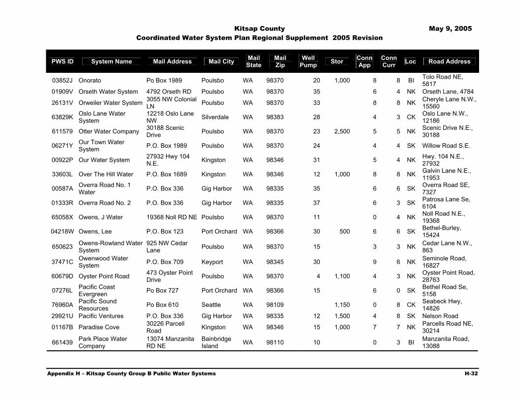
Kitsap County May 9, 2005 Coordinated Water System Plan Regional Supplement 2005 Revision
Appendix H – Kitsap County Group B Public Water Systems H-32
PWS ID System Name Mail Address Mail City Mail State
Mail Zip
Well Pump Stor Conn
App Conn Curr Loc Road Address
03852J Onorato Po Box 1989 Poulsbo WA 98370 20 1,000 8 8 BI Tolo Road NE, 5817
01909V Orseth Water System 4792 Orseth RD Poulsbo WA 98370 35 6 4 NK Orseth Lane, 4784
26131V Orweiler Water System 3055 NW Colonial LN Poulsbo WA 98370 33 8 8 NK Cheryle Lane N.W.,
15560
63829K Oslo Lane Water System
12218 Oslo Lane NW Silverdale WA 98383 28 4 3 CK Oslo Lane N.W.,
12186
611579 Otter Water Company 30188 Scenic Drive Poulsbo WA 98370 23 2,500 5 5 NK Scenic Drive N.E.,
30188
06271Y Our Town Water System P.O. Box 1989 Poulsbo WA 98370 24 4 4 SK Willow Road S.E.
00922P Our Water System 27932 Hwy 104 N.E. Kingston WA 98346 31 5 4 NK Hwy. 104 N.E.,
27932
33603L Over The Hill Water P.O. Box 1689 Kingston WA 98346 12 1,000 8 8 NK Galvin Lane N.E., 11953
00587A Overra Road No. 1 Water P.O. Box 336 Gig Harbor WA 98335 35 6 6 SK Overra Road SE,
7327
01333R Overra Road No. 2 P.O. Box 336 Gig Harbor WA 98335 37 6 3 SK Patrosa Lane Se, 6104
65058X Owens, J Water 19368 Noll RD NE Poulsbo WA 98370 11 0 4 NK Noll Road N.E., 19368
04218W Owens, Lee P.O. Box 123 Port Orchard WA 98366 30 500 6 6 SK Bethel-Burley, 15424
650623 Owens-Rowland Water System
925 NW Cedar Lane Poulsbo WA 98370 15 3 3 NK Cedar Lane N.W.,
863
37471C Owenwood Water System P.O. Box 709 Keyport WA 98345 30 9 6 NK Seminole Road,
16827
60679D Oyster Point Road 473 Oyster Point Drive Poulsbo WA 98370 4 1,100 4 3 NK Oyster Point Road,
28763
07276L Pacific Coast Evergreen Po Box 727 Port Orchard WA 98366 15 6 0 SK Bethel Road Se,
5158
76960A Pacific Sound Resources Po Box 610 Seattle WA 98109 1,150 0 8 CK Seabeck Hwy,
14826 29921U Pacific Ventures P.O. Box 336 Gig Harbor WA 98335 12 1,500 4 8 SK Nelson Road
01167B Paradise Cove 30226 Parcell Road Kingston WA 98346 15 1,000 7 7 NK Parcells Road NE,
30214
661439 Park Place Water Company
13074 Manzanita RD NE
Bainbridge Island WA 98110 10 0 3 BI Manzanita Road,
13088
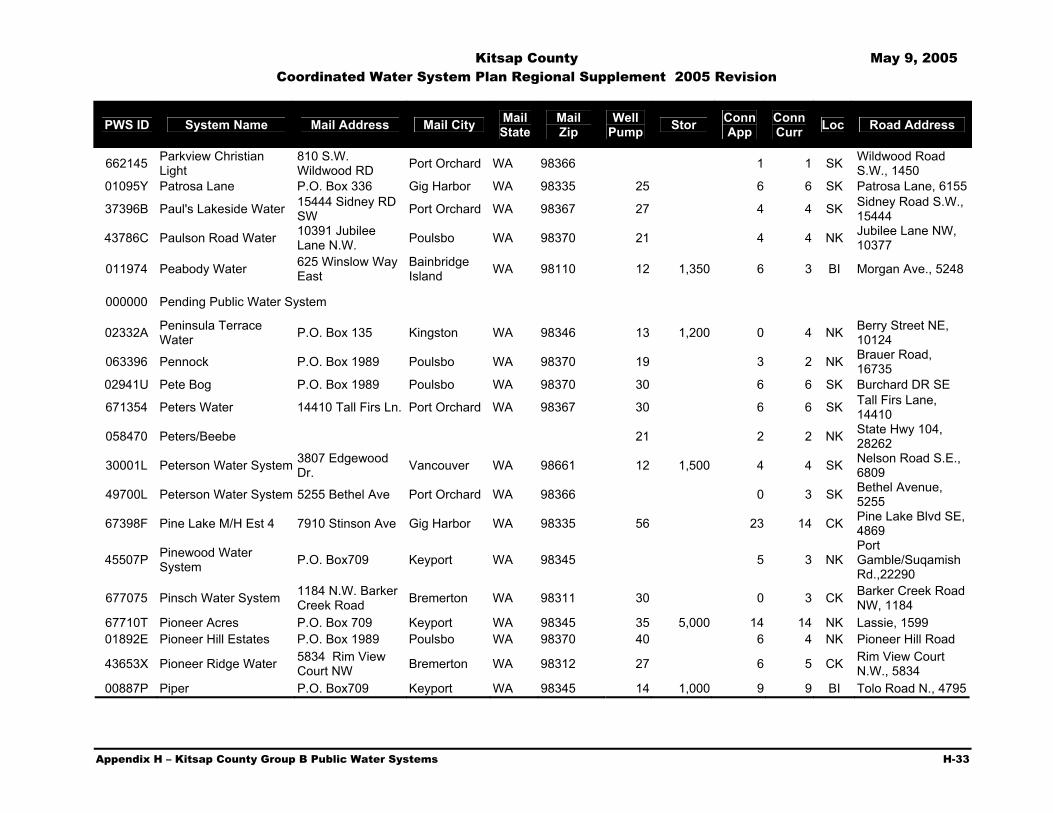
Kitsap County May 9, 2005 Coordinated Water System Plan Regional Supplement 2005 Revision
Appendix H – Kitsap County Group B Public Water Systems H-33
PWS ID System Name Mail Address Mail City Mail State
Mail Zip
Well Pump Stor Conn
App Conn Curr Loc Road Address
662145 Parkview Christian Light
810 S.W. Wildwood RD Port Orchard WA 98366 1 1 SK Wildwood Road
S.W., 1450 01095Y Patrosa Lane P.O. Box 336 Gig Harbor WA 98335 25 6 6 SK Patrosa Lane, 6155
37396B Paul's Lakeside Water 15444 Sidney RD SW Port Orchard WA 98367 27 4 4 SK Sidney Road S.W.,
15444
43786C Paulson Road Water 10391 Jubilee Lane N.W. Poulsbo WA 98370 21 4 4 NK Jubilee Lane NW,
10377
011974 Peabody Water 625 Winslow Way East
Bainbridge Island WA 98110 12 1,350 6 3 BI Morgan Ave., 5248
000000 Pending Public Water System
02332A Peninsula Terrace Water P.O. Box 135 Kingston WA 98346 13 1,200 0 4 NK Berry Street NE,
10124
063396 Pennock P.O. Box 1989 Poulsbo WA 98370 19 3 2 NK Brauer Road, 16735
02941U Pete Bog P.O. Box 1989 Poulsbo WA 98370 30 6 6 SK Burchard DR SE
671354 Peters Water 14410 Tall Firs Ln. Port Orchard WA 98367 30 6 6 SK Tall Firs Lane, 14410
058470 Peters/Beebe 21 2 2 NK State Hwy 104, 28262
30001L Peterson Water System 3807 Edgewood Dr. Vancouver WA 98661 12 1,500 4 4 SK Nelson Road S.E.,
6809
49700L Peterson Water System 5255 Bethel Ave Port Orchard WA 98366 0 3 SK Bethel Avenue, 5255
67398F Pine Lake M/H Est 4 7910 Stinson Ave Gig Harbor WA 98335 56 23 14 CK Pine Lake Blvd SE, 4869
45507P Pinewood Water System P.O. Box709 Keyport WA 98345 5 3 NK
Port Gamble/Suqamish Rd.,22290
677075 Pinsch Water System 1184 N.W. Barker Creek Road Bremerton WA 98311 30 0 3 CK Barker Creek Road
NW, 1184 67710T Pioneer Acres P.O. Box 709 Keyport WA 98345 35 5,000 14 14 NK Lassie, 1599 01892E Pioneer Hill Estates P.O. Box 1989 Poulsbo WA 98370 40 6 4 NK Pioneer Hill Road
43653X Pioneer Ridge Water 5834 Rim View Court NW Bremerton WA 98312 27 6 5 CK Rim View Court
N.W., 5834 00887P Piper P.O. Box709 Keyport WA 98345 14 1,000 9 9 BI Tolo Road N., 4795

Kitsap County May 9, 2005 Coordinated Water System Plan Regional Supplement 2005 Revision
Appendix H – Kitsap County Group B Public Water Systems H-34
PWS ID System Name Mail Address Mail City Mail State
Mail Zip
Well Pump Stor Conn
App Conn Curr Loc Road Address
65260A P-L Water System Assn
12310 Olympic View RD NW Silverdale WA 98383 9 1,250 4 4 CK Olympic View
Road, 12238
009427 Pleasant Lane Water P.O. Box 10755 Bainbridge Island WA 98110 0 3 BI Pleasant Lane
N.E., 7947
017339 Point Of View Water System P.O. Box 1989 Poulsbo WA 98370 10 1,000 9 9 CK Catherine Drive
684152 Ponderosa Water 15190 Horseshoe Ave. S.W. Port Orchard WA 98366 16 0 4 SK Lake Street S.W.
1167
82250X Port Orchard Airport Cafe
11221 Pacific Hwy S.W. Tacoma WA 98499 0 3 SK Sidney Road S.W.,
12292
68880T Port Orchard S.D.A. Church P.O. Box 95 Southworth WA 98386 20 2 1 SK Bethel Road S.E.,
5000
038574 Porta Westfalica P.O. Box 1989 Poulsbo WA 98370 32 1,300 5 5 NK Orweiler Lane N.W., 15680
00209W Potter Water Too 12339 Clear Creek Road Silverdale WA 98383 2 2 CK Clear Creek, 12339
169815 Potter, J G 12339 Clear Creek RD NW Silverdale WA 98383 0 3 CK Clear Creek Road
N.W., 12339
40433Y Poulsbo West Water System P.O. Box 1989 Poulsbo WA 98370 7 7 NK Joseph Lane N.W.
014646 Poverty Ridge P.O. Box 1989 Poulsbo WA 98370 22 3 3 SK Fraser Road, 10917
69155R Powell Water 9575 Radcliff Road Bremerton WA 98311 15 0 4 CK Radcliff Ave NE, 9575
692655 President Point Water Po Box 1973 Kingston WA 98346 15 0 4 NK Jefferson Beach RD N.E., 22306
69329A Price Water 34139 Bridgeview DR NE Kingston WA 98346 0 3 NK Sid Price Road
N.E., 6710 54626T Prince Pine Water P.O. Box 693 Silverdale WA 98383 9 9 CK Prince Pine Lane
19926C Puget Bluff Lane Water 10421 NE Puget Bluff Ln.
Bainbridge Island WA 98110 1,190 7 6 BI End Of Puget Bluff
Lane
32741N Puget Vista Water System
12878 N.E. Mary Lou Lane Kingston WA 98346 35 8 6 NK Jefferson Beach
Road, 22176
133370 Pugh C G P.O. Box 2938 La Pine OR 97739 60 9 9 NK Brite Star Lane, 4455

Kitsap County May 9, 2005 Coordinated Water System Plan Regional Supplement 2005 Revision
Appendix H – Kitsap County Group B Public Water Systems H-35
PWS ID System Name Mail Address Mail City Mail State
Mail Zip
Well Pump Stor Conn
App Conn Curr Loc Road Address
02442P Pugh Road Water System P.O. Box 1989 Poulsbo WA 98370 42 6 3 NK Pugh Road, 20256
63579F Puma Lane Water Assoc.
22383 Puma LN NE Poulsbo WA 98370 43 7 7 NK Puma Lane N.E.,
22384
02280E Purbaugh Water System Po Box 780 Silverdale WA 98383 34 5 4 NK Erickson Lane
375407 Quail Hollow Water System
8207 Graystone Way NW Silverdale WA 98383 28 4 4 CK Graystone Way
N.W., 8205 03785Q R.J. Water System 11 1,000 6 6 NK Pugh Road,
706401 Raber Additon Assoc Water P.O. Box 10273 Bainbridge
Island WA 98110 0 3 BI High School Raod N.E., 10082
054736 Rainforest Greenhouse Water System P.O. Box 336 Gig Harbor WA 98335 29 6 5 SK County Line Road,
3635
04323P Rainier Meadows P.O. Box 336 Gig Harbor WA 98335 28 6 4 SK Collins Road E, 5686
47436Y Ralston Water System 6396 Ralston Road
Bainbridge Island WA 98110 3 3 BI Ralston Lane, 6396
07520L Raven Ridge Po Box 123 Port Orchard WA 98366 30 0 5 2 BI Island Center Road, 6977
58097L Ray, Tim Water System 16341 Olympic View RD Silverdale WA 98383 3 2 CK Olympic View
Road, 16333
723754 Reade, Herman, Gordy Water
9745 Echo Valley RD NW Bremerton WA 98312 0 3 CK Echo Valley Road,
9715
129598 Redman,Rova,Anderson,Lock
24487 Johnson Rd. NW Poulsbo WA 98370 13 0 4 NK Johnson Road
N.W., 24515 075805 Reese, Roy Po Box 123 Port Orchard WA 98366 20 1,150 6 3 BI Springridge
04033K Reeves 13 500 3 3 SK Bethel-Burley Road, 8939
43927L Reindeer Lane Water System
13440 Reindeer Lane S.W. Port Orchard WA 98366 21 4 4 SK Reindeer Lane
S.W., 13440
00294M Rhododendron Acreage Tract
3278 Seabeck Hwy Bremerton WA 98312 500 9 9 CK Seabeck Highway
NW., 3300
128995 Rhododendron Water Assoc.
13567 Olympic View RD NW Silverdale WA 98383 25 6 6 CK Olympic View Road
N.W., 13545 363906 Rice Water System P.O. Box 214 Olalla WA 98359 6 6 SK Shady Glen, 13036

Kitsap County May 9, 2005 Coordinated Water System Plan Regional Supplement 2005 Revision
Appendix H – Kitsap County Group B Public Water Systems H-36
PWS ID System Name Mail Address Mail City Mail State
Mail Zip
Well Pump Stor Conn
App Conn Curr Loc Road Address
08631K Rick's Well P.O. Box 2179 Port Orchard WA 98366 10 0 2 CK Seabeck Holly Road N.W., 6610
47251M Ridge Top Water System
23351 Rhododendron Lane
Poulsbo WA 98370 27 4 4 NK Rhododendron Lane, 23379
638559 Rippy Water System P.O. Box 11183 Winslow WA 98110 39 4 3 BI Springridge Road 015207 Rita Water System P.O. Box 336 Gig Harbor WA 98335 45 8 6 SK J.H. Road 08547T Ritchie Nelson P.O. Box 336 Gig Harbor WA 98335 60 9 8 SK Nelson Road
07382X Robert Wallace Water Po Box 1989 Poulsbo WA 87370 25 4 3 CK Seabeck Hwy Nw, 10523
036252 Robinhood Terrace P.O. Box 336 Gig Harbor WA 98335 28 4 4 SK NW Lider Road, 218
37364J Rock Ridge Water System
8555 Anderson Hill Road Silverdale WA 98383 9 9 CK Anderson Hill Road
N.W., 8655
03284K Rolling Ridge Water System P.O. Box 336 Gig Harbor WA 98335 25 4 3 SK Bethel-Burley Rd.
S.E., 9266
099142 Rosario Water 4469 Sidney RD SW Port Orchard WA 98366 0 2 SK Sidney Road S.W.,
4469
02869B Rosecross Water System P.O. Box 1989 Poulsbo WA 98370 12 2,500 6 4 NK South Keyport
Road
200044 Rosettsky 1821 Rude Road Poulsbo WA 98370 27 5 5 NK Rude Road N.W., 1821
37451V Rottlers Well 12200 Old Military RD NE Poulsbo WA 98370 1,000 8 7 CK Old Military Road
N.E., 12200 07383E Roundtree Po Box 123 Port Orchard WA 98366 32 3 3 SK State Hwy 3, 11066
020025 Roundtree Water System P.O. Box 336 Gig Harbor WA 98335 25 4 4 SK Burley Road, SE
60666L Royal Heights Develop. Co.
1161 Liberty Road West Poulsbo WA 98370 24 4,000 5 4 NK Patriot Lane N.W.,
19678
74746H Roza Water System 8913 NE Wardell RD
Bainbridge Island WA 98110 0 3 BI Wardwell Road
N.E., 8913
01290M Russell Water P.O. Box 1989 Poulsbo WA 98370 25 5 5 SK Martin Avenue E., 2311
04239X Ruys Lane Water System P.O. Box 1989 Poulsbo WA 98370 25 4 3 BI Sands Road,
199312 Sanderfur Water System
5985 S.E. Burley Olalla RD Olalla WA 98359 20 0 2 SK Olalla Burley Road
S.E., 5985

Kitsap County May 9, 2005 Coordinated Water System Plan Regional Supplement 2005 Revision
Appendix H – Kitsap County Group B Public Water Systems H-37
PWS ID System Name Mail Address Mail City Mail State
Mail Zip
Well Pump Stor Conn
App Conn Curr Loc Road Address
07555Y Satterwhite Po Box 1989 Poulsbo WA 98370 30 4 3 BI Eagle Harbor Dr. NE
017463 Savage, Norm P.O. Box 1989 Poulsbo WA 98370 21 4 2 SK Baby Doll Road S.E., 1825
05092N Savante P.O. Box 1989 Poulsbo WA 98370 27 6 5 NK Babcock
76456H Sawdust Hill Water Co 1909 NE Sawdust Hill Poulsbo WA 98370 20 0 4 NK Sawdust Hill Road
N.E., 1909
01743J Scandia Court Water System P.O. Box 1989 Poulsbo WA 98370 14 2,500 6 5 NK Scandia Road,
16974
05383A Scandia Estates P.O. Box 123 Port Orchard WA 98366 33 6 5 NK Cox RD NW , 15479
76658T Schmid Water Po Box 941 Kingston WA 98346 19 24,000 21 12 NK Carmody Lane
011995 Schold - Crystal Springs
4076 Crystal Springs Drive
Bainbridge Island WA 98110 14 1,000 5 5 BI Crystal Springs
Drive, 4076
03563X Schold-Indianola Water P.O. Box 178 Indianola WA 98342 4 1,000 5 5 NK South Kingston Road, 21977
76731T Schold-Suquamish Water P.O. Box 864 Suquamish WA 98392 30 4 3 NK Totten N.E., 5787
01017X Schuster Water 5240 SW Old Clifton RD Port Orchard WA 98366 11 0 2 SK Old Clifton Road
S.W., 5240
63951B Seabeck 7 Waterworks 18531 Stavis Bay Road Seabeck WA 98380 36 6 6 CK Stavis Bay, 18526
056805 Seabeck Vista Water System P.O. Box 1989 Poulsbo WA 98379 30 6 4 CK Alpenglow Drive
00574H Seabold Acres Water Assoc.
15346 Harvey Road N.E.
Bainbridge Island WA 98110 21 4 4 BI Seabold Dr..,
6720, 6740
018950 Seabold Height Lots 10 &11 P.O. Box 2217 Poulsbo WA 98370 16 1,000 3 4 BI Agatewood, 15782
769734 Seabold Heights 6599 N.E. Hidden Cove RD
Bainbridge Island WA 98110 12 11,000 12 12 BI Manzanita Road,
13871
980334 Seabold Water Po Box 123 Port Orchard WA 98366 25 6 6 BI Harvey Road N.E., 15365
669332 Seaborne P.O. Box 123 Port Orchard WA 98366 20 700 6 4 BI Battle Point Drive, 9670
54601P Seacliff Water System 12396 NE Marine View Dr. Kingston WA 98346 12 8 NK Marine View Drive
N.E., 12388

Kitsap County May 9, 2005 Coordinated Water System Plan Regional Supplement 2005 Revision
Appendix H – Kitsap County Group B Public Water Systems H-38
PWS ID System Name Mail Address Mail City Mail State
Mail Zip
Well Pump Stor Conn
App Conn Curr Loc Road Address
37379C Seal Beach 34734 Pilot PT RD NE Kingston WA 98346 30 6 2 NK Pilot Point Road
275340 Sears Water System 7646 Spurling Lane SE Port Orchard WA 98366 4 2 SK Spurling Lane S.E.,
7646 60907Y Seatter Road/Garrison P.O. Box 905 Kingston WA 98346 40 7 5 NK Seatter Road
05842D Seattle Yacht Club 8750 Spargur Loop Road
Bainbridge Island WA 98110 12 4,000 0 4 BI Spargur Loop Road
775556 Sellers Water 4803 NW Anderson Hill RD Silverdale WA 98383 0 2 CK Anderson Hill N.W.,
4803
37481M Senyohl Water System P.O. Box 65 Seabeck WA 98380 3 3 CK Minning Ln NW ,5981
022115 Settle Water System P.O. Box 1989 Poulsbo WA 98370 30 14 14 NK Beach Drive N.E., 29695
046064 Shadowlands I P.O. Box 1989 Port Orchard WA 98366 28 6 6 NK State Hwy 3 & Scenic Drive
28251M Shady Hollow Water System
4555 Shady Hollow Lane NW Bremerton WA 98312 31 6 5 CK Shady Hollow Lane
N.W., 4690
77770C Shady Nook Trailer Park 2008 NE 20th ST Renton WA 98056 0 13 SK Bethel Road S.E.,
5191
65013A Shaffer Water 12192 N.E. Klabo Road Kingston WA 98346 26 4 4 NK Klabo Road, 12196
05843X Shapard 695 Pearl Pl Bremerton WA 98310 23 3 3 NK State Hwy 3, 31259056256 Sharon Lane P.O. Box 1989 Pousbo WA 98370 25 6 6 NK Hallman Rd, 17638
473843 Shearwater P.O. Box 336 Gig Harbor WA 98335 31 8 8 CK Shearwater Lane N.W.
009849 Sheldon P.O. Box 1989 Poulsbo WA 98370 5 1,000 4 4 NK Falkner Road N.E., 28851
521137 Shellgren-Jeffries 3132 Harold DR SE Port Orchard WA 98366 7 0 3 SK Harold Drive S.E.,
3132
038511 Shifrin Water System P.O. Box 1989 Poulsbo WA 98370 12 1,150 3 3 NK Tytler Road N.E., 26079
082122 Shobert/Berry P.O. Box 123 Port Orchard WA 98366 12 6 4 SK Bay Ridge Drive NW
00905Q Shotwell Po Box 333 Suquamish WA 98397 26 3 3 NK Stenbom Lane, 16887
17716Q Show-Me Water System
8000 N.E. Bayberry Lane Kingston WA 98346 14 1,600 8 5 NK Bayberry NE, 800

Kitsap County May 9, 2005 Coordinated Water System Plan Regional Supplement 2005 Revision
Appendix H – Kitsap County Group B Public Water Systems H-39
PWS ID System Name Mail Address Mail City Mail State
Mail Zip
Well Pump Stor Conn
App Conn Curr Loc Road Address
78928J Sicks, David 8523 NW Anderson Hill Road
Silverdale WA 98383 15 0 2 CK Wade Rd. NW, 8523
639012 Sid Price Water System P.O. Box 2468 Poulsbo WA 98370 12 1,100 3 3 NK Sid Price Road, 6737
17721D Silent Sky P.O. Box 2985 Silverdale WA 98383 12 1,200 6 7 CK Miami Beach Road, 9494
79100X Silver Beach Comm Water System P.O. Box 81 Tracyton WA 98383 40 4,500 0 12 CK Tracyton Blvd.,
8161
79388C Simonson Water 18355 Widme Road NE Keyport WA 98345 0 2 NK Widme Road N.E.,
18355
79386B Simonson, Marjorie Water 306 Hostmark ST Poulsbo WA 98370 0 2 NK Hostmark Road
N.E., 2285
79755K Skinner Water P.O. Box 53 Gorst WA 98337 16 0 4 SK Anderson Hill Rd. SW, 3807
05380R Sloman P.O. Box 1989 Poulsbo WA 98370 31 5 3 NK Virginia Point Rd., 15519
177115 Smc Water System 8000 NE Rocky Lane Kingston WA 98346 0 3 NK Big Valley Road
N.E., 24100
00396T Smith Gulch Estates P.O. Box 1994 Poulsbo WA 98370 21 4 2 NK Noll Road N.E., 16845
01973K Smith-Wales Water System
25861 West Canyon Road NW Poulsbo WA 98370 12 2 2 NK Clear Creek Road
N.W., 18589
04075M Sol Bakken Water Assoc 4761 NE Sylte RD Poulsbo WA 98370 40 9 8 NK Sylte Road, 4460
NE
81321Q Sonnabend Water 3722 NW Halfmile RD Silverdale WA 98383 0 2 CK Half Mile Road
N.W., 3722
129767 Sooner Or Later Acres 20605 Pugh RD NE Poulsbo WA 98370 43 7 7 NK Pugh Road, 20495
82180K South Olalla Water Assn Po Box 615 Olalla WA 98359 9 9 SK Roy Road S.E.,
14898
05236E South Springridge Water
7800 Springridge Road NE
Bainbridge Island WA 98110 7 1,150 7 6 BI Spring Ridge Road,
7820 03687M Southworth P.O. Box 336 Gig Harbor WA 98335 12 1,200 6 6 SK Wilson Creek Road
60229L Spellman Water System 8509 Ferncliff Ave Bainbridge
Island WA 98110 10 1,100 4 4 BI Ferncliff, 8517
17986T Springwood Lane 10010 NE Springwood Lane
Bainbridge Island WA 98110 4 4 BI Springwood NE,
9012

Kitsap County May 9, 2005 Coordinated Water System Plan Regional Supplement 2005 Revision
Appendix H – Kitsap County Group B Public Water Systems H-40
PWS ID System Name Mail Address Mail City Mail State
Mail Zip
Well Pump Stor Conn
App Conn Curr Loc Road Address
60924X Springwood No. 1 Water
9012 Springwood Ave NE
Bainbridge Island WA 98110 11 1,100 4 4 BI Springwood Road,
9022
01198M Springwood No. 2 Po Box 1989 Poulsbo WA 98370 32 7 7 BI Springwood Lane, 8993
04238D Stallion Trace 27 6 5 NK Hwy 3
83555Y Stanek Water 1383 Finn Hill Road Poulsbo WA 98370 0 3 NK Finn Hill Road
N.W., 1375
454273 Stanton Water System 9520 Ramiller Lane SE Port Orchard WA 98366 12 0 2 SK Ramiller Lane S.E.
00837D Stavis View Estates Water
6996 Cadmar Lane NW Seabeck WA 98380 62 2,000 14 10 CK Cadmar Lane NW,
6916
83891A Stead Water 2856 Woods RD SE Port Orchard WA 98366 24 0 3 SK Woods Road E.,
2856
399314 Steedman/Jankord Water Sys 4117 26th SW Seattle WA 98106 5 4 SK View Park S.E.,
9436
18051B Stenbom Water System 16940 Noll Road NE Poulsbo WA 98370 0 2 NK Noll Road N.E.,
16940 00883M Stenman Lane 34 4 4 NK Stenman Lane
37376U Stetson Acres 6569 Fletcher Bay RD
Bainbridge Island WA 98110 20 1,100 6 6 BI Fletcher Bay Road,
6565
84453V Stockwell Water 5672 SE Bulman Ave Port Orchard WA 98366 6 6 SK Bulman Ave S.E.,
5672
845340 Stone-Erickson Water 4573 Pt. White Dr. Bainbridge Island WA 98110 0 2 BI New Sweden, 5479
012514 Stottlemeyer Water System
23265 Stottlemeyer RD Poulsbo WA 98370 43 9 9 NK Stottlemeyer Road
N.E., 23255
01037E Strandskov Acres P.O. Box 1314 Poulsbo WA 98370 29 4 3 NK Kippola Road N.W.,
663484 Strauss Water System 13180 Phelps RD NE
Bainbridge Island WA 98110 10 0 2 BI Phelps Road N.E.,
13180
06341A Strawberry Water System Po Box 78 Gig Harbor WA 98335 13 2,500 6 6 BI Morgan RD NE
9069
06999H Strumland 23299 Aldo RD NW Poulsbo WA 98370 31 2,000 9 8 NK Aido Road N.W.,
23299
84683W Stuhler Water P.O. Box 336 Gig Harbor WA 98335 30 6 6 CK Lakeview Ave N.W., 4100
07188R Suldans Boat Works P.O. Box 123 Port Orchard WA 98366 24 4 4 SK 1343 SW Bay Street

Kitsap County May 9, 2005 Coordinated Water System Plan Regional Supplement 2005 Revision
Appendix H – Kitsap County Group B Public Water Systems H-41
PWS ID System Name Mail Address Mail City Mail State
Mail Zip
Well Pump Stor Conn
App Conn Curr Loc Road Address
454400 Sulu Water System 15479 Harvey Road NE
Bainbridge Island WA 98110 5 1,000 4 2 BI Harvey Road N.E.,
15479
374445 Sunny Woods Water System
7919 NE Sunny Woods Ln. Kingston WA 98346 31 9 7 NK Sunny Woods Lane
861185 Sunset Heights Water 8236 Hansen RD NE
Bainbridge Island WA 98110 6 6 BI Hansen Road,
8240
47299T Sunset Ridge Water System P.O. Box 147 Seabeck WA 98380 31 8 7 CK Hite Center Road,
16131
008486 Sunset Water District No. 1
1051 Sunset Way NE Poulsbo WA 98370 13 500 5 4 NK Sunset Way, 1051
07001Y Sunshine Well 8 160 0 2 CK Gross Road N.W., 6305,6299
IH458M Suquamish Tribal Center P.O. Box 498 Suquamish WA 98397 0 2 NK Port Madison
Indian Reservaton
86610N Swanson, L Water System
21992 Clear Creek RD NW Poulsbo WA 98370 25 6 4 NK Clear Creek Road
N.W., 21992
00132X Sww Water System 1335 SE Swofford Lane Port Orchard WA 98366 18 1,000 4 2 SK Bethel-Burley Road
S.E., 10736
86767P Szymanski Spring Creek Water
7985 Vandecar RD SE Port Orchard WA 98367 22 0 4 4 SK Spring Creek Road
S.E., 2500
86765N Szymanski-Vandercar Water
8075 Vandecar Road SE Port Orchard WA 98366 9 7 SK Vandecar Road,
8075
190837 T. C. Water 380 Kitsap Lake Road Bremerton WA 98312 10 2 2 CK Kitsap Lake Road
N.W., 380
06177X Taka Lane Water Assoc 24731 Taka LN NE Kingston WA 98346 25 1,200 9 7 NK Taka Lane N.E.,
24650
47449R Tall Firs 1138-C Walnut Bremerton WA 98310 6 6 CK Sesame Street, 8744
06082F Tanglewood Water System P.O. Box 1989 Poulsbo WA 98370 25 0 5 5 CK Seabeck Hwy
N.W., 5373
47464P Tasia Lane 2870 Wild Rhody LN NW Poulsbo WA 98370 8 8 NK Tasia Lane
009216 Taylor, Tom Water 2012 Paulson Road Poulsbo WA 98370 33 4 2 NK Paulson Road,
2012
876664 Thalberg Water System 10595 Battle Point Dr. NE
Bainbridge Island WA 98110 35 8 8 BI Battle Point Drive,
10621

Kitsap County May 9, 2005 Coordinated Water System Plan Regional Supplement 2005 Revision
Appendix H – Kitsap County Group B Public Water Systems H-42
PWS ID System Name Mail Address Mail City Mail State
Mail Zip
Well Pump Stor Conn
App Conn Curr Loc Road Address
00701D Thetford Water 17139 Scandia Ct NW Poulsbo WA 98370 18 1,000 4 2 NK Scandia Court,
17139
00730N Thompson 10632 S.E. Cisco Road Port Orchard WA 98367 9 1,400 5 5 SK Cisco Road S.E.
08389L Thon Well 6835 SW Old Clifton RD Port Orchard WA 98366 5 5 SK Old Clifton Road,
6813
60894L Three Berry Lane Po Box 533 Kingston WA 98346 23 6 6 NK Hansville Road N.E., 27865
08644C Three Brothers Water System P.O. Box 393 Olalla WA 98359 1,200 4 4 SK Nelson Road S.E.,
7681
074294 Tib-Fig P.O. Box 123 Port Orchard WA 98366 30 6 4 NK NE ST Hwy 104, 2999
02776X Toto Water 20 2 2 SK Ferate Avenue
40329N Towne-Pratt-Towne 1978 Ptarmigan Lane NW Poulsbo WA 98370 15 1,500 3 3 NK Ptarmigan Lane
N.W., 1986
003492 Traceyton Road Water P.O. Box 240 Tracyton WA 98393 34 3 2 CK Tracyton Blvd., 6382
03927F Treese, Frank Water 7382 SE King RD Port Orchard WA 98367 15 4 4 SK King Road S.E., 7370
02634Q Trillium Lane Water System 6 1,000 6 4 NK Marble Lane
65053B Trostad-Lane-Putman Water 19502 Noll RD Poulsbo WA 98370 1,150 0 4 NK Noll Road N.E.,
19502
015521 Trout Pond Water System
15588 Glenwood Road SW Port Orchard WA 98366 1,200 0 2 SK Glenwood Road
S.W., 15588
05136A Ttj 5300 NW Newberry Hill Rd, Suite 100
Silverdale WA 98383 34 6 6 CK Lois Drive
43656F Turnstone Lane 15206 NW Turnstone Lane Seabeck WA 98380 44 6 6 SK Turnstone Lane
650011 Twin Brooks 12200 Old Military Road Poulsbo WA 98370 5 3 CK Twin Brooks Ln
NE, 10380
580752 Twitch Water System 1863 NW Sherman Hill RD Poulsbo WA 98370 28 6 6 NK NW Sherman Hill
Rd. 1863 63803Y Tytler Road P.O. Box 1266 Poulsbo WA 98370 32 4 4 NK Tytler Road, 26081
47351R Union River Acres P.O. Box 1989 Poulsbo WA 98370 29 9 8 SK W. Belfair Valley Road, 9775

Kitsap County May 9, 2005 Coordinated Water System Plan Regional Supplement 2005 Revision
Appendix H – Kitsap County Group B Public Water Systems H-43
PWS ID System Name Mail Address Mail City Mail State
Mail Zip
Well Pump Stor Conn
App Conn Curr Loc Road Address
02114K Upton Water 625 Winslow Way East
Bainbridge Island WA 98110 25 1 1 BI Skogan Lane,
15168
00499F Uts Water System 4427 Trillium Lane Bremerton WA 98312 3 1,150 4 4 CK Calamity Lane Nw, 4611
58119P Uzzell Road Water P.O. Box 134 Olalla WA 98359 9 8 SK Uzzell Road, 15028
02638T Vaa Water System P.O. Box 1989 Poulsbo WA 98370 25 6 2 NK Canyon Creek Road, 25383
03737F Vanderstaay P.O. Box 98 Manchester WA 98353 28 6 4 SK Sedgwick, 7452 SE
45466L Vanderstaay, Scott Water 7135 Sidney Rd. Port Orchard WA 98366 22 5 3 SK Sidney Road, 7135
00105P Venice Water System 11906 Venice Loop
Bainbridge Island WA 98110 27 6 6 BI Venice Loop,
11905 005793 Verissimo Lane P.O. Box 123 Port Orchard WA 98366 25 4 4 CK Verrismo, 10733
33773J View Point Water Assoc P.O. Box 4848 Bremerton WA 98312 7 3,000 6 6 CK Stavis Bay Road,
19722 053732 Viking Cove P.O. Box 1989 Poulsbo WA 98370 21 4 4 NK Viking Way, 17098 63409J Viking Water System 2512 Lincoln Rd. Poulsbo WA 98370 33 4 4 NK Lincoln Hill Road
004095 Vincent Road Water Po Box709 Keyport WA 98345 25 9 9 BI Vincent Road N.E., 7245
17914Y Vincent, Jay Water 15870 Peacock Hill RD SE Olalla WA 98359 5 0 2 SK Peacock Hill Road
S.E., 15870 01223C Vinland Water P.O. Box 1989 Poulsbo WA 98370 10 1,000 4 4 NK Finn Hill
919243 Vinland Wood Water Assn P.O. Box 531 Poulsbo WA 98370 15 1,300 9 9 NK Tall Fir Ln, 3096
39792X Virginia Cove 15315 Virginia Pt. RD NE Poulsbo WA 98370 26 5 4 NK Virginia Point Road
90885Y Vyb Water Co 6967 SE 160th Olalla WA 98359 16 0 3 SK 160th S.E., 6967
920282 Waddell Water 15576 Virginia PT RD NE Poulsbo WA 98370 16 0 2 NK Virginia Point RD
N.E., 15576 049240 Wagener Po Box 1989 Poulsbo WA 98370 2 1,000 3 3 BI Agatewood, 16011
438871 Walden Water System 7973 NE Walden Lane
Bainbridge Island WA 98110 50 10,000 14 11 BI Walden Lane
92395P Walker Beach Water Assn P.O.Box 37 Port Gamble WA 98364 60 0 9 NK Wheeler N.E., 3270
92400X Walker Beach Water System Po Box 123 Port Orchard WA 98366 15 6 6 NK Wheeler Street
N.E., 3060

Kitsap County May 9, 2005 Coordinated Water System Plan Regional Supplement 2005 Revision
Appendix H – Kitsap County Group B Public Water Systems H-44
PWS ID System Name Mail Address Mail City Mail State
Mail Zip
Well Pump Stor Conn
App Conn Curr Loc Road Address
06340T Walker Mountain No. 1 P.O. Box 1989 Poulsbo WA 98370 30 6 5 NK Viking Way 05376L Wallace 5 1,000 3 3 BI Old Mill Rd.
26746F Wandling Water System
1444 NE Paulson Road Poulsbo WA 98370 20 5 1 NK Paulson Road
N.E., 1390 61081U Ward Water 1182 Suzanne Ct. Poulsbo WA 98370 24 3 3 NK Bond Road, 21530
09777W Washtex Water Supply No. 2
1893 NW Rude Road Poulsbo WA 98370 30 4 4 NK Rude Road N.W.,
1893
935951 Waters, Owen Water System P.O. Box 11692 Bainbridge
Island WA 98110 15 1,150 4 4 BI Paulanna LN Ne, 8417
314963 Waterview Acres Water System
13657 Olympic View Rd. Silverdale WA 98383 3 3 CK Olympic View
Road, 13657
03716E Watters, Ken Water 12907 Holly RD Bremerton WA 98312 20 4 4 CK Holly Road N.W., 12907
03028U Weed Lane Water 3256 Weed LN Poulsbo WA 98370 25 4 4 NK Weed Lane, 3272, 3264, 3256 & 3242
039536 Weese Water System 2530 Woods RD E Port Orchard WA 98366 0 4 SK Conwhite Lane, 8845
04703P Welch P.O. Box 1989 Poulsbo WA 98370 47 6 3 NK Heron Pond Lane
94180Q Well Pines Water System
14779 Glenwood Road SW Port Orchard WA 98367 7 6 SK Glenwood Road
S.W., 14981
14779M Well Spring Water Assoc 170 Rainier Lane Port Ludlow WA 98365 4 4 NK Sesame Street,
8323
17127Q Well's Water P.O. Box 335 Gig Harbor WA 98335 31 7 7 SK Wildwood Road S.W., 2061
369817 Wendt Water System 10971 Manitou Beach DR NW
Bainbridge Island WA 98110 30 6 5 BI Falk Road, 11000
018847 West Canyon 25419 Canyon Rd. N.W. Poulsbo WA 98370 34 6 4 NK West Canyon Road
17579K West Firs P.O. Box 590 Seabeck WA 98380 0 4 SK Glenn Firs Lane N.W., 5457
05986M West Parcells 13 1,125 6 4 NK Parcells Road
35842H West Port Madison 15425 Smoland Lane NE
Bainbridge Island WA 98110 35 6 6 BI Smoland Lane
15425
01641C West Water System 14987 Levin Road NW Poulsbo WA 98370 0 2 NK Levin Road N.W.,
14987

Kitsap County May 9, 2005 Coordinated Water System Plan Regional Supplement 2005 Revision
Appendix H – Kitsap County Group B Public Water Systems H-45
PWS ID System Name Mail Address Mail City Mail State
Mail Zip
Well Pump Stor Conn
App Conn Curr Loc Road Address
632160 Western Stavis Div. 1 P.O. Box 20098 Seattle WA 98102 25 17,500 17 11 CK Stavis Bay Road NW
040343 Westgate Road Water System
5300 NW Newberry Hill Rd, Suite 100
Silverdale WA 98383 25 4 CK Westgate
05519V Westlake Water System P.O. Box 1989 Poulsbo WA 98370 14 1,000 4 4 CK Lawstad Place,
8176
63764W Weston Water System P.O. Box 348 Wauna WA 98395 13 3 3 SK Sidney Road S.W., 15195
59991Q Weyer Lane Water System P.O. Box 336 Gig Harbor WA 98335 31 10 6 SK Weyer Lane
070539 Wheeler West 5200 Forest Glen Ln.
Bainbridge Island WA 98110 32 5 4 BI Forest Glade Lane
N.E., 5209
29695A Wildcat Lake Tracts 7420 Nikomis Lane N.W. Bremerton WA 98312 0 8 CK Wildcat Lake Road
N.W.
281249 Wildcat Lake Water P.O. Box 1989 Poulsbo WA 98370 6 6 CK Lakeview Avenue N.W., 4240
03482T Wildcat Ridge P.O. Box 1989 Poulsbo WA 98370 32 6 6 CK Wildcat Lake Road
36666W Willamette Water Assn 9789 Willamette Meridian Silverdale WA 98383 33 6 2 CK Willamette
Meridian, 9667
14551Q Willamette Water System
9587 Willamette-Meridian Silverdale WA 98383 12 0 2 CK Williamette
Merdian, 9587
97105E Willard Water Supply 1821 NW 195th St, Apt 8 Shoreline WA 98177 0 5 NK Bodine Road,
35144 01597M William Heights 25 5 5 SK Glenwood, 10696
010804 Wimbley Water P.O. Box 1989 Poulsbo WA 98370 31 3 1 NK Virginia Loop Road N.E.
023011 Windmill Heights Water 4450 NE Lincoln RD Poulsbo WA 98370 0 2 NK Lincoln Road N.E.,
4450
009237 Wise Acre P.O. Box 387 Indianola WA 98342 19 1,000 9 9 NK Midway Avenue N.E.
304014 Wolf Water System P.O. Box 2985 Silverdale WA 98383 24 4 4 SK Phillips Road, 7071
01691N Wolley Water 13043 Madrona Road SW Port Orchard WA 98366 20 0 3 SK Madrona Rd,
12898
00702X Woodhaven Farm Water
6590 Fletcher Bay Road NE
Bainbridge Island WA 98110 15 3 3 BI Fletcher Bay Road
N.E., 6590
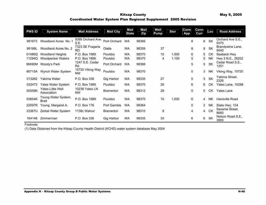
Kitsap County May 9, 2005 Coordinated Water System Plan Regional Supplement 2005 Revision
Appendix H – Kitsap County Group B Public Water Systems H-46
PWS ID System Name Mail Address Mail City Mail State
Mail Zip
Well Pump Stor Conn
App Conn Curr Loc Road Address
981673 Woodland Acres No. 1 9395 Orchard Ave. S.E. Port Orchard WA 98366 8 8 SK Orchard Ave S.E.,
9375
98168L Woodland Acres No. 2 7323 SE Fragaria RD Olalla WA 98359 37 8 9 SK Brandywine Lane,
9540 01486Q Woodland Heights P.O. Box 1989 Poulsbo WA 98370 10 1,000 6 5 CK Seabeck Hwy 11294Q Woodpecker Waters P.O. Box 1888 Poulsbo WA 98370 4 1,100 5 5 NK Hwy 3 N.E., 28202
98490M Woody's Park 1247 S.E. Cedar Rd. Port Orchard WA 98366 5 5 SK Cedar Road S.E.,
1251
66715A Wyrich Water System 15720 Viking Way NW Poulsbo WA 98370 0 3 NK Viking Way, 15720
013262 Yakima Water P.O. Box 336 Gig Harbor WA 98335 27 5 3 SK Yakima Street, 2326
032473 Yates Water System P.O. Box 1989 Poulsbo WA 98370 26 6 6 CK Yates Lane, 10298
00559K Yates-Little Well Association
10236 Yates LN NW Bremerton WA 98312 28 5 5 CK Yates Lane
03854K Young Water System, Brad P.O. Box 1989 Poulsbo WA 98370 10 1,000 6 4 NK Hansville Road
22597R Young, Margaret A. P.O. Box 176 Port Gamble WA 98364 0 2 NK State Hwy. 104
33367U Zerbal Water System 1138c Walnut Bremerton WA 98310 8 4 4 CK Sesame Street, 8660
164148 Zimmerman P.O. Box 336 Gig Harbor WA 98335 33 6 6 SK Nelson Road S.E., 3900
Footnote: (1) Data Obtained from the Kitsap County Health District (KCHD) water system database May 2004

Kitsap County May 9, 2005 Coordinated Water System Plan Regional Supplement 2005 Revision
Appendix I – Kitsap County Water System Survey Data I-1
Appendix
I Kitsap County Water System Survey Data
Survey Data - Water Production Own Source (MG)
System Name 1991 1992 1993 1994 1995 1996 1997 1998 1999 2000 Average ALPINEWOOD ANNAPOLIS WATER DISTRICT 566.98 584.37 557.98 638.47 645.53 621.70 606.77 691.05 654.59 636.01 620.34 APEX WATER SUPPLY INC B K S BAINBRIDGE ISLAND, CITY OF 1.90 2.13 1.90 2.03 2.14 2.31 2.05 2.37 2.42 2.64 2.19 BEAR CUB WATER ASSOC BETHEL EAST BILL POINT WATER BREMERTON WEST 517 ZONE, CITY OF BREMERTON, CITY OF 3,118.00 3,095.00 2,821.00 3,026.00 2,878.00 2,986.00 2,709.00 2,894.00 2,982.00 2,964.00 2,947.30 BRIDLETREE WATER CO INC 0.00 0.00 0.00 0.00 0.00 0.00 0.00 0.00 0.00 13.73 13.73 CEDAR GLEN MOBILE HOME PARK 0.00 0.00 0.00 0.00 0.00 0.00 0.00 0.00 0.00 7.94 7.94 DRIFTWOOD COVE 0.00 0.00 0.00 0.00 2.56 2.79 2.20 3.64 3.41 0.00 2.92 ELDORADO HILLS 0.00 0.00 16.25 19.50 19.41 198.00 14.72 16.22 15.59 0.00 42.81 EMERALD HEIGHTS 0.00 0.00 0.00 0.00 0.00 0.72 0.65 0.70 0.68 0.71 0.69 ERLAND POINT WATER CO FROG POND WATERS INC GALA PINES WATER 0.00 0.00 0.00 0.00 0.00 4.75 4.17 4.28 4.19 4.52 4.38 GLENWOOD STATION HARBOR HEIGHTS HINTZVILLE ACRES HOLLY HORIZONS WEST INDIANOLA WATER 0.00 0.00 33.43 39.77 40.10 38.42 41.08 41.57 40.61 44.84 39.98 ISLAND LAKE ISLAND UTILITY

Kitsap County May 9, 2005 Coordinated Water System Plan Regional Supplement 2005 Revision
Appendix I – Kitsap County Water System Survey Data I-2
Own Source (MG) System Name 1991 1992 1993 1994 1995 1996 1997 1998 1999 2000 Average
KEYPORT WATER 0.00 0.00 42.88 66.13 78.05 38.17 27.62 32.27 27.16 28.49 42.60 KITSAP WEST MOBILE HOME PARK 0.00 0.00 0.00 0.00 0.00 0.00 4.50 4.50 4.50 4.50 4.50 KRISTA FIRS 0.00 5.02 5.08 5.79 6.12 4.51 0.00 2.26 4.66 3.75 4.65 LITTLE TREE LONG LAKE VIEW EST 2 5 0.00 0.00 0.00 0.00 0.00 0.00 0.00 29.04 30.17 0.00 29.61 MAINLAND VIEW MANOR MANCHESTER STATE PARK MANCHESTER WATER DISTRICT MARTELL MOBILE MANOR MCCORMICK WOODS MEADOWMEER WATER SERVICE ASSN MILLER BAY 0.00 0.00 32.13 26.66 26.40 26.04 25.35 26.30 25.46 0.00 26.90 NAVAL UNDERSEA WARFARE CTR DIV KEYP NAVY YARD PARK 0.00 0.00 0.00 0.00 0.00 0.00 9.01 9.40 9.83 12.58 10.20 NORTH BAINBRIDGE WATER CO INC NORTH PENINSULA 0.00 0.00 0.00 0.00 0.00 177.65 208.04 218.19 229.21 232.26 213.07 NORTH PERRY AVENUE WATER DISTRICT 0.00 0.00 0.00 559.74 597.70 570.43 458.72 556.39 556.38 516.75 545.16 OLYMPIC VIEW MOBILE MANOR PARKVIEW TERRACE PINE LAKE MOBILE HOME EST 1 3 PORT GAMBLE - LOWER - CWS PORT GAMBLE - UPPER- CWS PORT MADISON WATER COMPANY PORT ORCHARD WATER DEPT POULSBO, CITY OF 378.73 280.96 274.05 284.81 359.55 348.97 353.51 325.30 308.57 326.71 324.12 PRIDDY VISTA PUGET SOUND NAVAL SHIPYARD ROCKAWAY BEACH WATER 0.00 0.00 0.00 0.00 0.00 0.00 0.00 0.00 0.08 0.07 0.07

Kitsap County May 9, 2005 Coordinated Water System Plan Regional Supplement 2005 Revision
Appendix I – Kitsap County Water System Survey Data I-3
Own Source (MG)
System Name 1991 1992 1993 1994 1995 1996 1997 1998 1999 2000 Average ROCKY POINT WATER DISTRICT 12 SANDY HOOK PARK COMMUNITY CLUB SCENIC BEACH STATE PARK SEABECK 0.00 0.00 0.00 0.00 0.00 5.35 4.76 6.65 5.85 0.00 5.65 SILVERDALE WATER DIST 16 5.88 6.68 6.31 7.12 7.91 7.89 7.65 8.47 8.02 8.51 7.44 SOUTH BAINBRIDGE WATER SYSTEM INC STRATTONWOOD STRAWBERRY HILL 0.00 0.00 0.00 0.00 0.00 3.93 10.46 12.63 11.70 0.00 9.68 SUBASE BANGOR SUNNYSLOPE WATER DISTRICT 3.01 3.41 3.16 3.81 3.88 3.49 3.97 3.87 3.87 0.00 3.61 SUQUAMISH 0.00 0.00 78.65 88.32 87.33 83.35 86.26 96.00 95.16 100.17 89.41 TAHUYEH LAKE COMMUNITY CLUB TRACYTON WATER DISTRICT VIEWSIDE COMMUNITY WATER 0.00 0.00 0.00 0.00 0.00 0.00 4.86 4.86 4.86 4.86 4.86 VINLAND 0.00 0.00 0.00 0.00 64.76 68.10 73.72 76.05 78.30 86.33 74.54 WATAUGA BEACH 0.00 0.00 0.00 0.00 0.00 0.00 0.00 8.60 7.87 9.56 8.68

Kitsap County May 9, 2005 Coordinated Water System Plan Regional Supplement 2005 Revision
Appendix I – Kitsap County Water System Survey Data I-4
Survey Data - Water Sales Annual Water Sold (MG)
System Name 1991 1992 1993 1994 1995 1996 1997 1998 1999 2000 ALPINEWOOD
SF Residential 0.00 401.35 357.74 430.44 437.81 401.48 381.30 394.95 396.93 380.81 ANNAPOLIS WATER DISTRICT MF Residential 0.00 0.00 0.00 0.00 0.00 80.96 74.49 77.78 82.12 80.95 Comm/Indust. 0.00 0.00 0.00 0.00 0.00 44.13 48.31 448.29 47.62 57.31 Irrigation 0.00 0.00 0.00 0.00 0.00 12.21 10.43 11.01 14.73 19.70 institutional 0.00 0.00 0.00 0.00 0.00 13.64 11.91 12.06 18.41 3.48 TOTAL SOLD 0.00 401.35 357.74 430.44 437.81 552.42 526.45 944.08 559.81 542.26 Wholesale 0.00 0.00 0.00 0.00 0.00 0.00 0.00 0.00 0.00 0.00 Non-revenue 0.00 0.00 0.00 0.00 0.00 29.83 26.96 29.41 32.76 30.78 Total 0.00 555.20 545.52 608.54 614.20 582.25 553.40 573.57 592.58 573.05 APEX WATER SUPPLY INC 0.00 0.00 0.00 0.00 0.00 0.00 0.00 0.00 0.00 0.00 B K S 0.00 0.00 0.00 0.00 0.00 0.00 0.00 0.00 0.00 0.00
SF Residential 70.22 77.13 74.73 102.73 91.79 92.82 86.58 97.53 98.28 107.28 BAINBRIDGE ISLAND, CITY OF MF Residential 22.47 21.53 23.32 25.85 25.93 38.84 37.30 36.13 35.78 36.61 Comm/Indust. 45.09 40.60 43.43 47.43 46.43 49.45 49.05 47.36 48.61 53.59 Irrigation 0.00 0.00 0.00 0.00 0.00 5.69 4.84 5.60 8.04 8.02 TOTAL SOLD 137.78 139.26 141.49 176.01 164.15 186.81 177.77 186.62 190.71 205.49 Wholesale 0.00 0.00 0.00 0.00 0.00 0.00 0.00 0.00 0.00 0.00 Non-revenue 52.13 73.33 48.43 13.25 49.70 43.98 26.73 50.40 51.45 58.15 Total 189.91 220.07 190.34 202.73 213.86 230.79 204.50 237.02 242.17 263.63 BEAR CUB WATER ASSOC 0.00 0.00 0.00 0.00 0.00 0.00 0.00 0.00 0.00 0.00 BETHEL EAST 0.00 0.00 0.00 0.00 0.00 0.00 0.00 0.00 0.00 0.00 BILL POINT WATER 0.00 0.00 0.00 0.00 0.00 0.00 0.00 0.00 0.00 0.00 BREMERTON WEST 517 ZONE, CITY OF 0.00 0.00 0.00 0.00 0.00 0.00 0.00 0.00 0.00 0.00

Kitsap County May 9, 2005 Coordinated Water System Plan Regional Supplement 2005 Revision
Appendix I – Kitsap County Water System Survey Data I-5
Annual Water Sold (MG)
System Name 1991 1992 1993 1994 1995 1996 1997 1998 1999 2000 SF Residential 1,054.00 902.00 854.00 929.00 891.00 878.00 853.00 906.00 879.00 867.00 BREMERTON, CITY
OF MF Residential 356.00 358.00 311.00 329.00 307.00 312.00 299.00 294.00 305.00 249.00 Comm/Indust. 458.00 414.00 352.00 369.00 360.00 355.00 332.00 288.00 351.00 321.00 Irrigation 82.00 102.00 75.00 110.00 117.00 148.00 120.00 163.00 149.00 154.00 TOTAL SOLD 1,950.00 1,776.00 1,592.00 1,737.00 1,675.00 1,693.00 1,604.00 1,651.00 1,684.00 1,591.00 Wholesale 1,336.00 1,106.00 1,052.00 1,150.00 1,050.00 1,162.00 1,180.00 1,317.00 1,011.00 1,050.00 Non-revenue 0.00 211.00 177.00 137.00 155.00 129.00 0.00 0.00 197.00 261.00 Total 3,286.00 3,093.00 2,821.00 3,024.00 2,880.00 2,984.00 2,784.00 2,968.00 2,892.00 2,947.00
SF Residential 0.00 0.00 0.00 0.00 0.00 0.00 0.00 0.00 0.00 0.00 BRIDLETREE WATER CO INC MF Residential 0.00 0.00 0.00 0.00 0.00 0.00 0.00 0.00 0.00 0.00 Comm/Indust. 0.00 0.00 0.00 0.00 0.00 0.00 0.00 0.00 0.00 0.00 Irrigation 0.00 0.00 0.00 0.00 0.00 0.00 0.00 0.00 0.00 0.00 TOTAL SOLD 0.00 0.00 0.00 0.00 0.00 0.00 0.00 0.00 0.00 5.33 Wholesale 0.00 0.00 0.00 0.00 0.00 0.00 0.00 0.00 0.00 0.00 Non-revenue 0.00 0.00 0.00 0.00 0.00 0.00 0.00 0.00 0.00 0.81 Total Production 0.00 0.00 0.00 0.00 0.00 0.00 0.00 0.00 0.00 6.14
SF Residential 0.00 0.00 0.00 0.00 0.00 0.00 0.00 0.00 0.00 0.00 CEDAR GLEN MOBILE HOME PARK MF Residential 0.00 0.00 0.00 0.00 0.00 0.00 0.00 0.00 0.00 0.00 Comm/Indust. 0.00 0.00 0.00 0.00 0.00 0.00 0.00 0.00 0.00 0.00 Irrigation 0.00 0.00 0.00 0.00 0.00 0.00 0.00 0.00 0.00 0.00 TOTAL SOLD 0.00 0.00 0.00 0.00 0.00 0.00 0.00 0.00 0.00 0.00 Wholesale 0.00 0.00 0.00 0.00 0.00 0.00 0.00 0.00 0.00 0.00 Non-revenue 0.00 0.00 0.00 0.00 0.00 0.00 0.00 0.00 0.00 0.00 Total Production 0.00 0.00 0.00 0.00 0.00 0.00 0.00 0.00 0.00 0.00 DRIFTWOOD COVE SF Residential 0.00 0.00 0.00 0.00 0.00 0.00 0.00 0.00 0.00 0.00 MF Residential 0.00 0.00 0.00 0.00 0.00 0.00 0.00 0.00 0.00 0.00 Comm/Indust. 0.00 0.00 0.00 0.00 0.00 0.00 0.00 0.00 0.00 0.00 Irrigation 0.00 0.00 0.00 0.00 0.00 0.00 0.00 0.00 0.00 0.00 TOTAL SOLD 0.00 0.00 0.00 0.00 2.40 2.54 2.95 3.53 3.23 3.42 Wholesale 0.00 0.00 0.00 0.00 0.00 0.00 0.00 0.00 0.00 0.00 Non-revenue 0.00 0.00 0.00 0.00 0.17 0.25 0.26 0.11 0.18 0.18
Total Production 0.00 0.00 0.00 0.00 2.56 2.79 3.20 3.64 3.41 3.60
0.00 0.00 0.00 0.00 0.00 0.00 0.00 0.00 0.00 0.00

Kitsap County May 9, 2005 Coordinated Water System Plan Regional Supplement 2005 Revision
Appendix I – Kitsap County Water System Survey Data I-6
Annual Water Sold (MG)
System Name 1991 1992 1993 1994 1995 1996 1997 1998 1999 2000 ELDORADO HILLS SF Residential 0.00 0.00 0.00 0.00 0.00 0.00 0.00 0.00 0.00 0.00 MF Residential 0.00 0.00 0.00 0.00 0.00 0.00 0.00 0.00 0.00 0.00 Comm/Indust. 0.00 0.00 0.00 0.00 0.00 0.00 0.00 0.00 0.00 0.00 Irrigation 0.00 0.00 0.00 0.00 0.00 0.00 0.00 0.00 0.00 0.00 TOTAL SOLD 0.00 0.00 0.00 0.00 16.16 15.31 13.50 15.43 14.03 12.81 Wholesale 0.00 0.00 0.00 0.00 0.00 0.00 0.00 0.00 0.00 0.00 Non-revenue 0.00 0.00 0.00 0.00 3.24 1.13 1.23 0.78 1.55 2.57
Total Production 0.00 0.00 0.00 0.00 19.41 16.44 14.72 16.22 15.59 15.38
0.00 0.00 0.00 0.00 0.00 0.00 0.00 0.00 0.00 0.00 EMERALD HEIGHTS SF Residential 0.00 0.00 0.00 0.00 0.00 6.38 6.50 6.35 5.45 6.73 MF Residential 0.00 0.00 0.00 0.00 0.00 0.00 0.00 0.00 0.00 0.00 Comm/Indust. 0.00 0.00 0.00 0.00 0.00 0.00 0.00 0.00 0.00 0.00 Irrigation 0.00 0.00 0.00 0.00 0.00 0.00 0.00 0.00 0.00 0.00 TOTAL SOLD 0.00 0.00 0.00 0.00 0.00 0.00 0.00 0.00 0.00 0.00 Wholesale 0.00 0.00 0.00 0.00 0.00 0.00 0.00 0.00 0.00 0.00 Non-revenue 0.00 0.00 0.00 0.00 0.00 0.00 0.00 0.00 0.00 0.00
Total Production 0.00 0.00 0.00 0.00 0.00 0.00 0.00 0.00 0.00 0.00
0.00 0.00 0.00 0.00 0.00 0.00 0.00 0.00 0.00 0.00 ERLAND POINT WATER CO 0.00 0.00 0.00 0.00 0.00 0.00 0.00 0.00 0.00 0.00 FROG POND WATERS INC 0.00 0.00 0.00 0.00 0.00 0.00 0.00 0.00 0.00 0.00 GALA PINES WATER SF Residential 0.00 0.00 0.00 0.00 0.00 0.00 0.00 0.00 0.00 0.00 MF Residential 0.00 0.00 0.00 0.00 0.00 0.00 0.00 0.00 0.00 0.00 Comm/Indust. 0.00 0.00 0.00 0.00 0.00 0.00 0.00 0.00 0.00 0.00 Irrigation 0.00 0.00 0.00 0.00 0.00 0.00 0.00 0.00 0.00 0.00 TOTAL SOLD 0.00 0.00 0.00 0.00 0.00 4.44 3.88 4.10 3.93 4.17 Wholesale 0.00 0.00 0.00 0.00 0.00 0.00 0.00 0.00 0.00 0.00 Non-revenue 0.00 0.00 0.00 0.00 0.00 0.30 0.29 0.19 0.26 0.34
Total Production 0.00 0.00 0.00 0.00 0.00 4.75 4.17 4.28 4.19 4.52

Kitsap County May 9, 2005 Coordinated Water System Plan Regional Supplement 2005 Revision
Appendix I – Kitsap County Water System Survey Data I-7
Annual Water Sold (MG)
System Name 1991 1992 1993 1994 1995 1996 1997 1998 1999 2000 GLENWOOD STATION 0.00 0.00 0.00 0.00 0.00 0.00 0.00 0.00 0.00 0.00 HARBOR HEIGHTS 0.00 0.00 0.00 0.00 0.00 0.00 0.00 0.00 0.00 0.00 HINTZVILLE ACRES 0.00 0.00 0.00 0.00 0.00 0.00 0.00 0.00 0.00 0.00 HOLLY 0.00 0.00 0.00 0.00 0.00 0.00 0.00 0.00 0.00 0.00 HORIZONS WEST 0.00 0.00 0.00 0.00 0.00 0.00 0.00 0.00 0.00 0.00 INDIANOLA WATER SF Residential 0.00 0.00 0.00 0.00 0.00 0.00 0.00 0.00 0.00 0.00 MF Residential 0.00 0.00 0.00 0.00 0.00 0.00 0.00 0.00 0.00 0.00 Comm/Indust. 0.00 0.00 0.00 0.00 0.00 0.00 0.00 0.00 0.00 0.00 Irrigation 0.00 0.00 0.00 0.00 0.00 0.00 0.00 0.00 0.00 0.00 TOTAL SOLD 0.00 0.00 29.18 36.35 36.31 36.13 37.08 38.59 37.42 41.51 Wholesale 0.00 0.00 0.00 0.00 0.00 0.00 0.00 0.00 0.00 0.00 Non-revenue 0.00 0.00 4.25 3.40 3.79 2.29 4.01 2.99 3.19 3.33 Total Production 0.00 0.00 33.43 39.77 40.10 38.42 41.08 41.57 40.61 44.84 0.00 0.00 0.00 0.00 0.00 0.00 0.00 0.00 0.00 0.00 ISLAND LAKE 0.00 0.00 0.00 0.00 0.00 0.00 0.00 0.00 0.00 0.00 ISLAND UTILITY 0.00 0.00 0.00 0.00 0.00 0.00 0.00 0.00 0.00 0.00 KEYPORT WATER SF Residential 0.00 0.00 0.00 0.00 0.00 0.00 0.00 0.00 0.00 0.00 MF Residential 0.00 0.00 0.00 0.00 0.00 0.00 0.00 0.00 0.00 0.00 Comm/Indust. 0.00 0.00 0.00 0.00 0.00 0.00 0.00 0.00 0.00 0.00 Irrigation 0.00 0.00 0.00 0.00 0.00 0.00 0.00 0.00 0.00 0.00 TOTAL SOLD 0.00 0.00 27.49 26.70 25.98 27.67 25.53 31.31 26.07 25.50 Wholesale 0.00 0.00 14.43 37.30 44.29 9.93 0.00 0.00 0.00 0.00 Non-revenue 0.00 0.00 0.96 2.12 7.78 0.56 2.09 0.96 1.09 2.99 Total Production 0.00 0.00 42.88 66.13 78.05 38.17 27.62 32.27 27.16 28.49 KITSAP WEST SF Residential 0.00 0.00 0.00 0.00 0.00 0.00 0.00 0.00 0.00 0.00 MOBILE HOME PARK MF Residential 0.00 0.00 0.00 0.00 0.00 0.00 0.00 0.00 0.00 0.00 Comm/Indust. 0.00 0.00 0.00 0.00 0.00 0.00 0.00 0.00 0.00 0.00 Irrigation 0.00 0.00 0.00 0.00 0.00 0.00 0.00 0.00 0.00 0.00 TOTAL SOLD 0.00 0.00 0.00 0.00 0.00 0.00 0.00 0.00 0.00 0.00 Wholesale 0.00 0.00 0.00 0.00 0.00 0.00 0.00 0.00 0.00 0.00 Non-revenue 0.00 0.00 0.00 0.00 0.00 0.00 0.00 0.00 0.00 0.00 Total Production 0.00 0.00 0.00 0.00 0.00 0.00 0.00 0.00 0.00 0.00

Kitsap County May 9, 2005 Coordinated Water System Plan Regional Supplement 2005 Revision
Appendix I – Kitsap County Water System Survey Data I-8
Annual Water Sold (MG)
System Name 1991 1992 1993 1994 1995 1996 1997 1998 1999 2000 KRISTA FIRS SF Residential 0.00 4.87 4.85 5.29 5.79 4.34 0.00 2.26 4.66 3.75 MF Residential 0.00 0.00 0.00 0.00 0.00 0.00 0.00 0.00 0.00 0.00 Comm/Indust. 0.00 0.15 0.23 0.50 0.33 0.18 0.00 0.00 0.00 0.00 Irrigation 0.00 0.00 0.00 0.00 0.00 0.00 0.00 0.00 0.00 0.00 TOTAL SOLD 0.00 0.00 0.00 0.00 0.00 0.00 0.00 0.00 0.00 0.00 Wholesale 0.00 0.00 0.00 0.00 0.00 0.00 0.00 0.00 0.00 0.00 Non-revenue 0.00 0.00 0.00 0.00 0.00 0.00 0.00 0.00 0.00 0.00 Total Production 0.00 5.02 5.08 5.79 6.12 4.51 0.00 2.26 4.66 3.75
LITTLE TREE 0.00 0.00 0.00 0.00 0.00 0.00 0.00 0.00 0.00 0.00
SF Residential 0.00 0.00 0.00 0.00 0.00 0.00 0.00 0.00 0.00 0.00 MF Residential 0.00 0.00 0.00 0.00 0.00 0.00 0.00 0.00 0.00 0.00
LONG LAKE VIEW EST 2 5
Comm/Indust. 0.00 0.00 0.00 0.00 0.00 0.00 0.00 0.00 0.00 0.00 Irrigation 0.00 0.00 0.00 0.00 0.00 0.00 0.00 0.00 0.00 0.00 TOTAL SOLD 0.00 0.00 0.00 0.00 0.00 0.00 0.00 30.18 28.21 29.37 Wholesale 0.00 0.00 0.00 0.00 0.00 0.00 0.00 0.00 0.00 0.00 Non-revenue 0.00 0.00 0.00 0.00 0.00 0.00 0.00 1.80 1.96 2.27 Total Production 0.00 0.00 0.00 0.00 0.00 0.00 0.00 31.99 30.17 31.64 MAINLAND VIEW MANOR 0.00 0.00 0.00 0.00 0.00 0.00 0.00 0.00 0.00 0.00 MANCHESTER STATE PARK 0.00 0.00 0.00 0.00 0.00 0.00 0.00 0.00 0.00 0.00 MANCHESTER WATER DISTRICT 0.00 0.00 0.00 0.00 0.00 0.00 0.00 0.00 0.00 0.00 MARTELL MOBILE MANOR 0.00 0.00 0.00 0.00 0.00 0.00 0.00 0.00 0.00 0.00 MCCORMICK WOODS 0.00 0.00 0.00 0.00 0.00 0.00 0.00 0.00 0.00 0.00 MEADOWMEER WATER SERVICE ASSN 0.00 0.00 0.00 0.00 0.00 0.00 0.00 0.00 0.00 0.00 MILLER BAY SF Residential 0.00 0.00 0.00 0.00 0.00 0.00 0.00 0.00 0.00 0.00 MF Residential 0.00 0.00 0.00 0.00 0.00 0.00 0.00 0.00 0.00 0.00 Comm/Indust. 0.00 0.00 0.00 0.00 0.00 0.00 0.00 0.00 0.00 0.00 Irrigation 0.00 0.00 0.00 0.00 0.00 0.00 0.00 0.00 0.00 0.00 TOTAL SOLD 0.00 0.00 0.00 0.00 25.40 24.42 24.38 25.26 24.55 25.58 Wholesale 0.00 0.00 0.00 0.00 0.00 0.00 0.00 0.00 0.00 0.00 Non-revenue 0.00 0.00 0.00 0.00 1.09 1.62 1.61 1.03 0.86 0.50 Total Production 0.00 0.00 0.00 0.00 26.49 26.04 25.99 26.29 25.46 26.68

Kitsap County May 9, 2005 Coordinated Water System Plan Regional Supplement 2005 Revision
Appendix I – Kitsap County Water System Survey Data I-9
Annual Water Sold (MG)
System Name 1991 1992 1993 1994 1995 1996 1997 1998 1999 2000 NAVAL UNDERSEA WARFARE CTR DIV KEYP 0.00 0.00 0.00 0.00 0.00 0.00 0.00 0.00 0.00 0.00 NAVY YARD PARK SF Residential 0.00 0.00 0.00 0.00 0.00 0.00 0.00 0.00 0.00 0.00 MF Residential 0.00 0.00 0.00 0.00 0.00 0.00 0.00 0.00 0.00 0.00 Comm/Indust. 0.00 0.00 0.00 0.00 0.00 0.00 0.00 0.00 0.00 0.00 Irrigation 0.00 0.00 0.00 0.00 0.00 0.00 0.00 0.00 0.00 0.00 TOTAL SOLD 0.00 0.00 0.00 0.00 0.00 0.00 0.00 0.00 9.06 8.07 Wholesale 0.00 0.00 0.00 0.00 0.00 0.00 0.00 0.00 0.00 0.00 Non-revenue 0.00 0.00 0.00 0.00 0.00 0.00 0.00 0.00 0.77 4.51 Total Production 0.00 0.00 0.00 0.00 0.00 0.00 0.00 0.00 9.83 12.58 NORTH BAINBRIDGE WATER CO INC 0.00 0.00 0.00 0.00 0.00 0.00 0.00 0.00 0.00 0.00 NORTH PENINSULA SF Residential 0.00 0.00 0.00 0.00 0.00 0.00 0.00 0.00 0.00 0.00 MF Residential 0.00 0.00 0.00 0.00 0.00 0.00 0.00 0.00 0.00 0.00 Comm/Indust. 0.00 0.00 0.00 0.00 0.00 0.00 0.00 0.00 0.00 0.00 Irrigation 0.00 0.00 0.00 0.00 0.00 0.00 0.00 0.00 0.00 0.00 TOTAL SOLD 0.00 0.00 0.00 0.00 0.00 160.16 193.68 202.95 211.74 213.70 Wholesale 0.00 0.00 0.00 0.00 0.00 0.00 0.00 0.00 0.00 0.00 Non-revenue 0.00 0.00 0.00 0.00 0.00 17.49 14.36 15.24 17.47 18.56 Total Production 0.00 0.00 0.00 0.00 0.00 177.65 208.04 218.19 299.21 232.26
SF Residential 0.00 0.00 0.00 0.00 0.00 0.00 0.00 0.00 0.00 0.00 MF Residential 0.00 0.00 0.00 0.00 0.00 0.00 0.00 0.00 0.00 0.00
NORTH PERRY AVENUE WATER DISTRICT Comm/Indust. 0.00 0.00 0.00 0.00 0.00 0.00 0.00 0.00 0.00 0.00 Irrigation 0.00 0.00 0.00 0.00 0.00 0.00 0.00 0.00 0.00 0.00 TOTAL SOLD 0.00 0.00 0.00 0.00 574.21 592.02 531.38 559.10 596.08 583.00 Wholesale 0.00 0.00 0.00 0.00 0.00 0.00 0.00 0.00 0.00 0.00 Non-revenue 0.00 0.00 0.00 0.00 23.50 -21.59 17.34 -2.71 -39.70 -21.26 Total Production 0.00 0.00 0.00 0.00 597.71 570.43 548.72 556.39 556.38 561.75 0.00 0.00 0.00 0.00 0.00 0.00 0.00 0.00 0.00 0.00 OLYMPIC VIEW MOBILE MANOR 0.00 0.00 0.00 0.00 0.00 0.00 0.00 0.00 0.00 0.00 PARKVIEW TERRACE 0.00 0.00 0.00 0.00 0.00 0.00 0.00 0.00 0.00 0.00

Kitsap County May 9, 2005 Coordinated Water System Plan Regional Supplement 2005 Revision
Appendix I – Kitsap County Water System Survey Data I-10
Annual Water Sold (MG)
System Name 1991 1992 1993 1994 1995 1996 1997 1998 1999 2000 PINE LAKE MOBILE HOME EST 1 3 0.00 0.00 0.00 0.00 0.00 0.00 0.00 0.00 0.00 0.00 PORT GAMBLE - LOWER - CWS 0.00 0.00 0.00 0.00 0.00 0.00 0.00 0.00 0.00 0.00 PORT GAMBLE - UPPER- CWS 0.00 0.00 0.00 0.00 0.00 0.00 0.00 0.00 0.00 0.00 PORT MADISON WATER COMPANY 0.00 0.00 0.00 0.00 0.00 0.00 0.00 0.00 0.00 0.00 PORT ORCHARD WATER DEPT 0.00 0.00 0.00 0.00 0.00 0.00 0.00 0.00 0.00 0.00 POULSBO, CITY OF SF Residential 0.00 0.00 86.03 111.09 114.64 129.53 113.20 113.91 0.00 121.94 MF Residential 0.00 0.00 45.38 57.98 62.36 73.84 64.51 65.67 0.00 47.81 Comm/Indust. 0.00 0.00 73.34 91.71 102.00 92.57 88.02 58.59 0.00 72.45 Irrigation 0.00 0.00 0.00 0.00 0.00 0.00 0.00 14.94 0.00 21.18
TOTAL SOLD 0.00 0.00 204.74 260.77 279.00 295.94 265.72 253.10 0.00 263.3
9 Wholesale 0.00 0.00 0.00 0.00 0.00 0.00 0.00 0.00 0.00 0.00 Non-revenue 0.00 0.00 -204.74 -260.77 -279.00 -295.94 -265.72 24.83 0.00 23.16
Total Production 0.00 0.00 0.00 0.00 0.00 0.00 0.00 277.93 0.00
286.55
PRIDDY VISTA 0.00 0.00 0.00 0.00 0.00 0.00 0.00 0.00 0.00 0.00 PUGET SOUND NAVAL SHIPYARD 0.00 0.00 0.00 0.00 0.00 0.00 0.00 0.00 0.00 0.00
SF Residential 0.00 0.00 0.00 0.00 1.01 5.01 4.94 5.61 5.48 5.66ROCKAWAY BEACH WATER MF Residential 0.00 0.00 0.00 0.00 0.00 0.00 0.00 0.00 0.00 0.00 Comm/Indust. 0.00 0.00 0.00 0.00 0.00 0.42 0.84 0.80 0.62 0.30 Irrigation 0.00 0.00 0.00 0.00 0.00 0.00 0.00 0.00 0.00 0.00 TOTAL SOLD 0.00 0.00 0.00 0.00 1.02 5.43 5.78 6.41 6.10 5.95 Wholesale 0.00 0.00 0.00 0.00 0.00 0.00 0.00 0.00 0.00 0.00 Non-revenue 0.00 0.00 0.00 0.00 0.00 0.00 0.00 0.00 1.49 0.68
Total Production 0.00 0.00 0.00 0.00 1.02 5.42 5.78 6.41 7.59 6.64
0.00 0.00 0.00 0.00 0.00 0.00 0.00 0.00 0.00 0.00 ROCKY POINT WATER DISTRICT 12 0.00 0.00 0.00 0.00 0.00 0.00 0.00 0.00 0.00 0.00 SANDY HOOK PARK COMMUNITY CLUB 0.00 0.00 0.00 0.00 0.00 0.00 0.00 0.00 0.00 0.00

Kitsap County May 9, 2005 Coordinated Water System Plan Regional Supplement 2005 Revision
Appendix I – Kitsap County Water System Survey Data I-11
Annual Water Sold (MG)
System Name 1991 1992 1993 1994 1995 1996 1997 1998 1999 2000 SCENIC BEACH STATE PARK
SF Residential 0.00 0.00 0.00 0.00 0.00 0.00 0.00 0.00 0.00 0.00
MF Residential 0.00 0.00 0.00 0.00 0.00 0.00 0.00 0.00 0.00 0.00 Comm/Indust. 0.00 0.00 0.00 0.00 0.00 0.00 0.00 0.00 0.00 0.00 Irrigation 0.00 0.00 0.00 0.00 0.00 0.00 0.00 0.00 0.00 0.00 TOTAL SOLD 0.00 0.00 0.00 0.00 0.00 0.00 0.00 0.00 0.00 0.00 Wholesale 0.00 0.00 0.00 0.00 0.00 0.00 0.00 0.00 0.00 0.00 Non-revenue 0.00 0.00 0.00 0.00 0.00 0.00 0.00 0.00 0.00 0.00
Total Production 0.00 0.00 0.00 0.00 0.00 0.00 0.00 0.00 0.00 0.00
SEABECK SF Residential 0.00 0.00 0.00 0.00 0.00 0.00 0.00 0.00 0.00 0.00
MF Residential 0.00 0.00 0.00 0.00 0.00 0.00 0.00 0.00 0.00 0.00 Comm/Indust. 0.00 0.00 0.00 0.00 0.00 0.00 0.00 0.00 0.00 0.00 Irrigation 0.00 0.00 0.00 0.00 0.00 0.00 0.00 0.00 0.00 0.00 TOTAL SOLD 0.00 0.00 0.00 0.00 5.54 4.79 4.36 6.14 5.63 6.92 Wholesale 0.00 0.00 0.00 0.00 0.00 0.00 0.00 0.00 0.00 0.00 Non-revenue 0.00 0.00 0.00 0.00 0.41 0.56 0.04 0.51 0.22 0.44
Total Production 0.00 0.00 0.00 0.00 5.96 5.35 4.76 6.65 5.85 7.36
0.00 0.00 0.00 0.00 0.00 0.00 0.00 0.00 0.00 0.00 SF Residential 0.00 326.35 303.56 388.20 396.07 397.38 394.43 443.70 413.05 430.41MF Residential 0.00 112.03 120.82 143.76 132.65 128.66 122.44 125.21 138.17 134.21SILVERDALE
WATER DIST 16 Comm/Indust. 0.00 137.65 136.56 149.74 168.49 163.47 163.21 175.58 180.45 184.30 Irrigation 0.00 36.35 28.15 28.31 43.31 41.90 38.28 51.41 42.49 49.93 TOTAL SOLD 0.00 612.38 589.09 710.02 740.52 731.41 718.35 795.90 774.15 798.85 Wholesale 0.00 0.00 0.00 0.00 0.00 0.00 0.00 0.00 0.00 0.00 Non-revenue 0.00 55.34 41.80 1.72 50.08 57.40 46.16 50.63 27.90 52.55
Total Production 0.00 667.71 630.89 711.74 790.60 788.81 764.52 846.53 802.05 851.40
#VALUE! 0.00 0.00 0.00 0.00 0.00 0.00 0.00 0.00 0.00
SOUTH BAINBRIDGE WATER SYSTEM INC 0.00 0.00 0.00 0.00 0.00 0.00 0.00 0.00 0.00 0.00
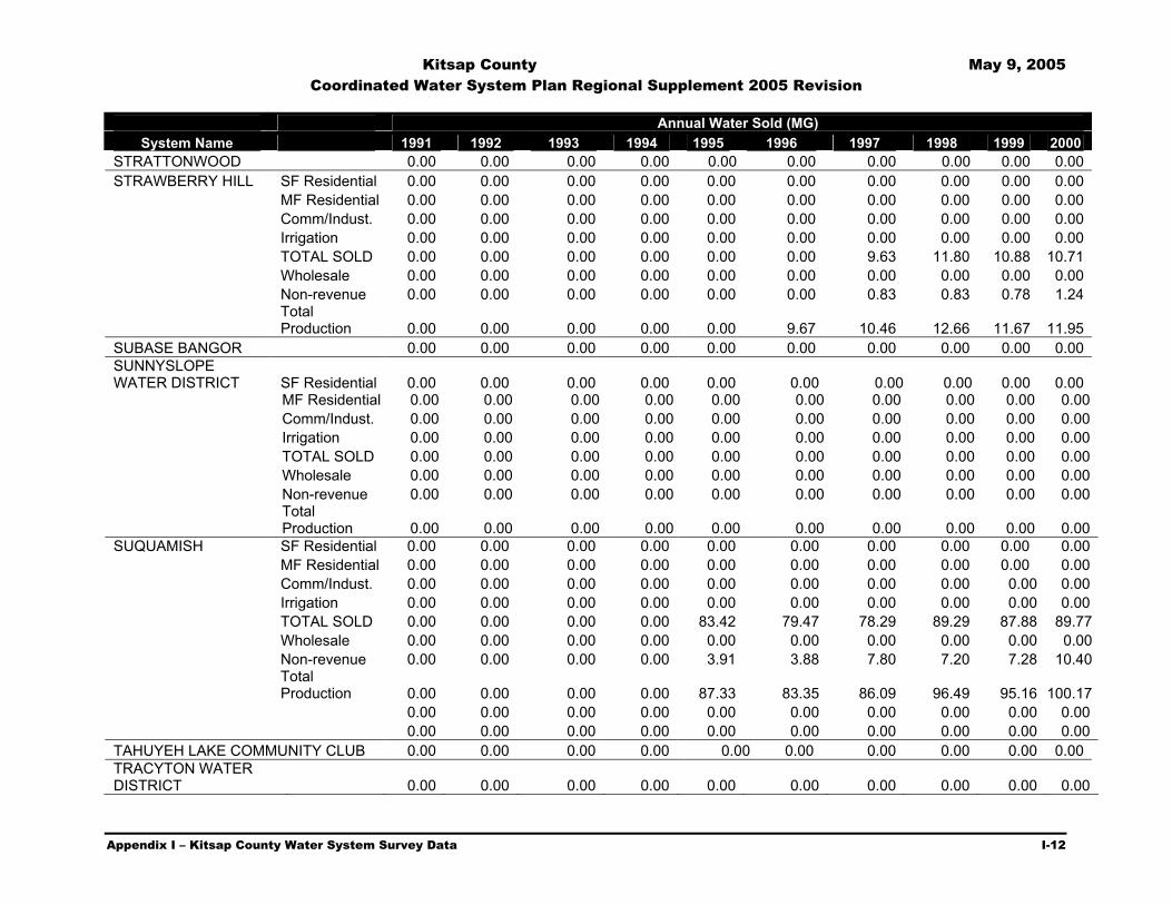
Kitsap County May 9, 2005 Coordinated Water System Plan Regional Supplement 2005 Revision
Appendix I – Kitsap County Water System Survey Data I-12
Annual Water Sold (MG) System Name 1991 1992 1993 1994 1995 1996 1997 1998 1999 2000
STRATTONWOOD 0.00 0.00 0.00 0.00 0.00 0.00 0.00 0.00 0.00 0.00 STRAWBERRY HILL SF Residential 0.00 0.00 0.00 0.00 0.00 0.00 0.00 0.00 0.00 0.00 MF Residential 0.00 0.00 0.00 0.00 0.00 0.00 0.00 0.00 0.00 0.00 Comm/Indust. 0.00 0.00 0.00 0.00 0.00 0.00 0.00 0.00 0.00 0.00 Irrigation 0.00 0.00 0.00 0.00 0.00 0.00 0.00 0.00 0.00 0.00 TOTAL SOLD 0.00 0.00 0.00 0.00 0.00 0.00 9.63 11.80 10.88 10.71 Wholesale 0.00 0.00 0.00 0.00 0.00 0.00 0.00 0.00 0.00 0.00 Non-revenue 0.00 0.00 0.00 0.00 0.00 0.00 0.83 0.83 0.78 1.24
Total Production 0.00 0.00 0.00 0.00 0.00 9.67 10.46 12.66 11.67 11.95
SUBASE BANGOR 0.00 0.00 0.00 0.00 0.00 0.00 0.00 0.00 0.00 0.00 SUNNYSLOPE WATER DISTRICT SF Residential 0.00 0.00 0.00 0.00 0.00 0.00 0.00 0.00 0.00 0.00 MF Residential 0.00 0.00 0.00 0.00 0.00 0.00 0.00 0.00 0.00 0.00 Comm/Indust. 0.00 0.00 0.00 0.00 0.00 0.00 0.00 0.00 0.00 0.00 Irrigation 0.00 0.00 0.00 0.00 0.00 0.00 0.00 0.00 0.00 0.00 TOTAL SOLD 0.00 0.00 0.00 0.00 0.00 0.00 0.00 0.00 0.00 0.00 Wholesale 0.00 0.00 0.00 0.00 0.00 0.00 0.00 0.00 0.00 0.00 Non-revenue 0.00 0.00 0.00 0.00 0.00 0.00 0.00 0.00 0.00 0.00
Total Production 0.00 0.00 0.00 0.00 0.00 0.00 0.00 0.00 0.00 0.00
SUQUAMISH SF Residential 0.00 0.00 0.00 0.00 0.00 0.00 0.00 0.00 0.00 0.00 MF Residential 0.00 0.00 0.00 0.00 0.00 0.00 0.00 0.00 0.00 0.00 Comm/Indust. 0.00 0.00 0.00 0.00 0.00 0.00 0.00 0.00 0.00 0.00 Irrigation 0.00 0.00 0.00 0.00 0.00 0.00 0.00 0.00 0.00 0.00 TOTAL SOLD 0.00 0.00 0.00 0.00 83.42 79.47 78.29 89.29 87.88 89.77 Wholesale 0.00 0.00 0.00 0.00 0.00 0.00 0.00 0.00 0.00 0.00 Non-revenue 0.00 0.00 0.00 0.00 3.91 3.88 7.80 7.20 7.28 10.40
Total Production 0.00 0.00 0.00 0.00 87.33 83.35 86.09 96.49 95.16 100.17
0.00 0.00 0.00 0.00 0.00 0.00 0.00 0.00 0.00 0.00 0.00 0.00 0.00 0.00 0.00 0.00 0.00 0.00 0.00 0.00 TAHUYEH LAKE COMMUNITY CLUB 0.00 0.00 0.00 0.00 0.00 0.00 0.00 0.00 0.00 0.00 TRACYTON WATER DISTRICT 0.00 0.00 0.00 0.00 0.00 0.00 0.00 0.00 0.00 0.00

Kitsap County May 9, 2005 Coordinated Water System Plan Regional Supplement 2005 Revision
Appendix I – Kitsap County Water System Survey Data I-13
Annual Water Sold (MG) System Name 1991 1992 1993 1994 1995 1996 1997 1998 1999 2000
SF Residential 0.00 0.00 0.00 0.00 0.00 0.00 4.77 4.77 4.77 4.77VIEWSIDE COMMUNITY WATER MF Residential 0.00 0.00 0.00 0.00 0.00 0.00 0.00 0.00 0.00 0.00 Comm/Indust. 0.00 0.00 0.00 0.00 0.00 0.00 0.00 0.00 0.00 0.00 Irrigation 0.00 0.00 0.00 0.00 0.00 0.00 0.00 0.00 0.00 0.00
TOTAL SOLD 0.00 0.00 0.00 0.00 0.00 0.00 0.00 0.00 0.00 0.00
Wholesale 0.00 0.00 0.00 0.00 0.00 0.00 0.00 0.00 0.00 0.00
Non-revenue 0.00 0.00 0.00 0.00 0.00 0.00 0.09 0.09 0.09 0.09
Total Production 0.00 0.00 0.00 0.00 0.00 0.00 4.86 4.86 4.86 4.86
VINLAND SF Residential 0.00 0.00 0.00 0.00 0.00 0.00 0.00 0.00 0.00 0.00
MF Residential 0.00 0.00 0.00 0.00 0.00 0.00 0.00 0.00 0.00 0.00
Comm/Indust. 0.00 0.00 0.00 0.00 0.00 0.00 0.00 0.00 0.00 0.00
Irrigation 0.00 0.00 0.00 0.00 0.00 0.00 0.00 0.00 0.00 0.00
TOTAL SOLD 0.00 0.00 0.00 0.00 57.91 39.98 65.49 76.05 71.68 76.46
Wholesale 0.00 0.00 0.00 0.00 0.00 0.00 0.00 0.00 0.00 0.00
Non-revenue 0.00 0.00 0.00 0.00 0.69 8.12 8.23 4.28 6.63 9.86
Total Production 0.00 0.00 0.00 0.00 64.76 68.10 73.72 80.33 78.30 86.33
0.00 0.00 0.00 0.00 0.00 0.00 0.00 0.00 0.00 0.00 0.00 0.00 0.00 0.00 0.00 0.00 0.00 0.00 0.00 0.00

Kitsap County May 9, 2005 Coordinated Water System Plan Regional Supplement 2005 Revision
Appendix I – Kitsap County Water System Survey Data I-14
Annual Water Sold (MG)
System Name 1991 1992 1993 1994 1995 1996 1997 1998 1999 2000
WATAUGA BEACH SF Residential 0.00 0.00 0.00 0.00 0.00 0.00 0.00 0.00 0.00 0.00
MF Residential 0.00 0.00 0.00 0.00 0.00 0.00 0.00 0.00 0.00 0.00
Comm/Indust. 0.00 0.00 0.00 0.00 0.00 0.00 0.00 0.00 0.00 0.00
Irrigation 0.00 0.00 0.00 0.00 0.00 0.00 0.00 0.00 0.00 0.00
TOTAL SOLD 0.00 0.00 0.00 0.00 0.00 0.00 0.00 0.00 0.00 0.00
Wholesale 0.00 0.00 0.00 0.00 0.00 0.00 0.00 0.00 0.00 0.00
Non-revenue 0.00 0.00 0.00 0.00 0.00 0.00 0.00 0.00 0.00 0.00
Total Production 0.00 0.00 0.00 0.00 0.00 0.00 0.00 0.00 0.00 0.00
0.00 0.00 0.00 0.00 0.00 0.00 0.00 0.00 0.00 0.00 0.00 0.00 0.00 0.00 0.00 0.00 0.00 0.00 0.00 0.00 TOTAL 0.00 0.00 0.00 0.00 0.00 0.00 0.00 0.00 0.00 0.00 0.00 0.00 0.00 0.00 0.00 0.00 0.00 0.00 0.00 0.00

Kitsap County May 9, 2004 Coordinated Water System Plan Regional Supplement 2005 Revision
Appendix I – Kitsap County Water System Survey Data I-15
Survey Data – Storage Total Useable Overflow
System Name Name/Location (MG) (MG) Elevation (Ft.) ALPINEWOOD
Salmonberry Ground 2.14 1.92 403Salmonberry Elevated 0.17 0.15 487
ANNAPOLIS WATER DISTRICT Powell Reservoir 0.51 0.37 314 Well #1 Aeration tank 0.10 0.05 119 Karcher Reservoir 0.01 0.01 240 Fircrest Elevated Reservoir 0.17 0.15 487 Fircrest Sandpipe 1.00 0.30 487 APEX WATER SUPPLY INC 0.00 0.00 0 B K S 0.00 0.00 0
1.0 MG High school reservoir 1.00 0.61 330BAINBRIDGE ISLAND, CITY OF 1.5 MG High school reservoir 1.50 0.00 330 0.3 MG Grand Ave 0.30 0.16 230 0.2 MG Knechtel Way 0.20 0.00 230 BEAR CUB WATER ASSOC 0.00 0.00 0 BETHEL EAST 0.00 0.00 0 BILL POINT WATER 0.00 0.00 0 BREMERTON WEST 517 ZONE, CITY OF 0.00 0.00 0
1 1,400.00 0.00 641.75BREMERTON, CITY OF 2 202.00 0.00 265 3 0.20 0.00 566.3 4 11.00 0.00 255.9 5 3.00 0.00 241.9 6 0.15 0.00 447.3 8 2.54 0.00 441 10 1.21 0.00 517.4 11 1.58 0.00 239.8 12 2.00 0.00 397 13 0.76 0.00 398 14 2.00 0.00 229.2 15 1.00 0.00 489.5 16 1.00 0.00 238.9 17 1.00 0.00 398.1 18 1.00 0.00 489.4 19 2.00 0.00 239.1 20 1.00 0.00 398.1 21 3.00 0.00 255.4 BRIDLETREE WATER CO INC Bridletree 0.55 0.00 579.5 CEDAR GLEN MOBILE HOME PARK Reservoir 0.30 0.00 0 DRIFTWOOD COVE #1 View Drive 0.83 0.00 471.5 ELDORADO HILLS #1 Brightway St. 2.54 0.00 651 EMERALD HEIGHTS
NW corner center sect. SW, SW4, NE4 33-25-2E 0.79 0.00 320.69

Kitsap County May 9, 2004 Coordinated Water System Plan Regional Supplement 2005 Revision
Appendix I – Kitsap County Water System Survey Data I-16
Total Useable Overflow System Name Name/Location (MG) (MG) Elevation (Ft.)
ERLAND POINT WATER CO 0.00 0.00 0 FROG POND WATERS INC 0.00 0.00 0 GALA PINES WATER Gala way 0.50 0.00 385 GLENWOOD STATION 0.00 0.00 0 HARBOR HEIGHTS 0.00 0.00 0 HINTZVILLE ACRES 0.00 0.00 0 HOLLY 0.00 0.00 0 HORIZONS WEST 0.00 0.00 0
#1 Division St. 0.50 0.00 260INDIANOLA WATER #2 Division St 0.50 0.00 260 #4 Division St. 1.05 0.00 260 #4 Gerald Cliff 0.30 0.00 260 #5 Chruch Camp 0.50 0.00 260 ISLAND LAKE 0.00 0.00 0 ISLAND UTILITY 0.00 0.00 0 KEYPORT WATER #1 Hwy 303 2.00 0.00 271 #2 Old military 2.00 0.00 271 KITSAP WEST MOBILE HOME PARK 0.00 0.00 0 KRISTA FIRS Krist Firs Reservoir 0.35 0.22 348 LITTLE TREE 0.00 0.00 0
#1 Ebbert 1.18 0.00 0LONG LAKE VIEW EST 2 5 #2 Ebbert 0.57 0.00 0MAINLAND VIEW MANOR 0.00 0.00 0 MANCHESTER STATE PARK 0.00 0.00 0 MANCHESTER WATER DISTRICT 5.00 2.50 430 4.50 MARTELL MOBILE MANOR 0.00 0.00 0 MCCORMICK WOODS 0.00 0.00 0 MEADOWMEER WATER SERVICE ASSN 0.00 0.00 0
#1 Sunridge Way 0.53 0.00 372MILLER BAY #2 Sunridge Way 1.14 0.00 372
NAVAL UNDERSEA WARFARE CTR DIV KEYP 0.00 0.00 0 Navy Yard #1 0.70 0.00 337NAVY YARD
PARK Navy Yard #2 0.40 0.00 337
NORTH BAINBRIDGE WATER CO INC 0.00 0.00 0 #1 Timberline 0.45 0.00 240.5NORTH
PENINSULA #2 N. Ritter 0.90 0.00 240.5 #3 S. Ritter 1.20 0.00 333 #4 S. Ritter 1.20 0.00 333 #1 Kingsview Lp 1.30 0.00 333 #2 Kingview Lp 1.90 0.00 333 #3 272nd 2.75 0.00 333 #4 S. Kingston Rd 2.50 0.00 333 #1 Hansville Hwy. 7.12 0.00 485 #1 Office 1.00 0.00 220

Kitsap County May 9, 2004 Coordinated Water System Plan Regional Supplement 2005 Revision
Appendix I – Kitsap County Water System Survey Data I-17
Total Useable Overflow System Name Name/Location (MG) (MG) Elevation (Ft.)
#2 Office 1.00 0.00 220 #3 Office 0.80 0.00 220 #4 Office 0.80 0.00 220 #1 Shorewood 0.55 0.00 220 #2 Shorewood 0.55 0.00 220 #1 Cliffside 0.80 0.00 220 #2 Cliffside 0.80 0.00 220 Kingston Farms 0.30 0.00 430
Sunset #1 0.52 0.32 490Sunset #2 2.01 1.31 490
NORTH PERRY AVENUE WATER DISTRICT Olympus #1 0.30 0.26 490 Olympus#2 1.03 0.90 490 Riddell 0.05 0.54 490 Key Port tank 0.40 0.00 315 Camtershive tank 0.50 0.00 345 Riddell Tank 0.05 0.00 577 OLYMPIC VIEW MOBILE MANOR 0.00 0.00 0 PARKVIEW TERRACE 0.00 0.00 0 PINE LAKE MOBILE HOME EST 1 3 0.00 0.00 0 PORT GAMBLE - LOWER - CWS 0.00 0.00 0 PORT GAMBLE - UPPER- CWS 0.00 0.00 0 PORT MADISON WATER COMPANY 0.00 0.00 0 PORT ORCHARD WATER DEPT 0.00 0.00 0
Finn Hill Tank 0.50 0.00 244.5POULSBO, CITY OF 4th Ave Tanks 0.13 0.00 244.5 Wilderness Park Tank 1.00 0.00 244.5 Raab Park Tank 0.15 0.00 396 Caldart Rd Tank 0.08 0.00 396 Pugh Road Tank 1.00 0.00 514 Lincoln Hill Tank 0.15 0.00 405 PRIDDY VISTA 0.00 0.00 0 PUGET SOUND NAVAL SHIPYARD 0.00 0.00 0 ROCKAWAY BEACH WATER .125 MG Creosote Reservoir 0.13 0.06 0 ROCKY POINT WATER DISTRICT 12 0.00 0.00 0 SANDY HOOK PARK COMMUNITY CLUB 0.00 0.00 0 SCENIC BEACH STATE PARK 0.00 0.00 0 SEABECK Seabeck #1 2.90 0.00 495 Seabeck #2 2.90 0.00 495
Wixson Reservoir 0.00 0.00 628.5SILVERDALE WATER DIST 16 Dickey Reservoir 0.00 502.5 Shasow Glen Reservoir 0.00 392.2 Loretta Heights Reservoir 0.00 361 Westwind Reservoir 0.00 361 Shadow Glen Reservoir 0.00 361 Eldorado Reservoir 0.00 222.2 Provost Reservoir 0.00 223 Chena Reservoir 0.00 223 Ridgetop Reservoir 0.00 344.5

Kitsap County May 9, 2004 Coordinated Water System Plan Regional Supplement 2005 Revision
Appendix I – Kitsap County Water System Survey Data I-18
Total Useable Overflow System Name Name/Location (MG) (MG) Elevation (Ft.)
0 Island Lake Reservoir 0.00 485 Island Lake Reservoir 0.00 485 Bucklin Ridge Reservoir 0.00 344.5 Spirit Ridge Reservoir 380
SOUTH BAINBRIDGE WATER SYSTEM INC 0.00 0.00 0 STRATTONWOOD 0.00 0.00 0
Strawberry Hill #1 0.40 0.00 0STRAWBERRY HILL Strawberry Hill #2 0.40 0.00 0SUBASE BANGOR 0.00 0.00 0
Reservoir #1 1.25 0.00 0SUNNYSLOPE WATER DISTRICT Reservoir #2 2.50 0.00 0SUQUAMISH #1 Pintest 1.50 0.00 303 #2 Pintest 0.70 0.00 303 #3 Pintest 1.41 0.00 380 #4 Estates 5.23 0.00 438 #5 Lincoln Rd 1.00 0.00 250 #6 Lincoln Rd 1.00 0.00 250 #7Squamish Way 1.90 0.00 250 TAHUYEH LAKE COMMUNITY CLUB 0.00 0.00 0 TRACYTON WATER DISTRICT 0.00 0.00 0 VIEWSIDE COMMUNITY WATER Source Reservoir 0.40 0.40 20ft. VINLAND #1 Pioneer Way 2.00 0.00 390 #2 Olhava 1.80 0.00 481 #3 Olhava 7.12 0.00 536
Watauga Tank #1 0.25 0.00 140WATAUGA BEACH Watauga Tank #2 0.25 0.00 140WICKS LAKE RANCHES 0.00 0.00 0 TOTAL 1,776.04

Kitsap County May 9, 2005 Coordinated Water System Plan
Regional Supplement 2005 Revision
Appendix J – Evaluation of Reuse and Desalination J-1
Appendix
J Evaluation of Reuse and Desalination
Kitsap County May 9, 2005 Coordinated Water System Plan
Regional Supplement 2005 Revision
Appendix J Section J2 – Regulatory Framework for Water Reuse Projects J1-1
Section J1 Introduction
The Kitsap County Water Utility Coordinating Committee (KCWUCC) is exploring various options for reducing potable water demand and more efficiently managing ground water resources. This appendix investigates the potential for water reuse and desalination to aid the KCWUCC in meeting these goals. These evaluations are important given the uncertainty in developing future water supplies, obtaining additional water rights, and enhancing existing well pumping capacities for sustained periods of time and with expected continued growth in the community.
The practice of water reuse, otherwise known as water reclamation, is fairly new to the Pacific Northwest region, though not to other areas such as the arid southwestern states. Reuse involves utilizing adequately treated wastewater or stormwater, typically for non-potable purposes. By using this as a source of water, the demand for potable drinking water can be reduced, providing relief for the raw water supplies in the area. Common non-potable applications of reclaimed water include land application (irrigation), commercial/industrial process and cooling water, wetland enhancement, and stream augmentation. There also exists the potential for indirect potable applications of such water. Most often, this takes the form of aquifer recharge, either through surface percolation or direct injection.
Due to its limited history, especially in the northwest, there are still many challenges associated with water reuse. Regulations pertaining to water quality and reliability are strict, in order to ensure public health and to protect the environment. Technologies are improving at a rapid pace to provide economical treatment solutions to address these regulations. Perhaps the single most challenging issue surrounding reuse is public perception. Public acceptance of this type of water supply, given its controversial past, is crucial to successful implementation of a reclamation project. To accomplish this, the public needs to be informed and involved early in the process.
Desalination is another means of providing an alternative water supply, via utilization of seawater. Cost and impracticality have discouraged the development of desalination in the past; however, there are projects underway elsewhere in the Country utilizing this technology. This appendix provides a review of water reuse regulatory and permitting requirements, potential sources and applications for water reuse, a summary of other reuse feasibility studies, an evaluation of reuse system costs, and a discussion of desalination.

Kitsap County May 9, 2005 Coordinated Water System Plan
Regional Supplement 2005 Revision
Appendix J Section J2 – Regulatory Framework for Water Reuse Projects J2-1
Section J2 Regulatory Framework
for Water Reuse Projects Current State regulations pertaining to reclaimed water were developed based on Revised Code of Washington (RCW) 90.46, which sets forth the Washington State Legislature’s finding that “to the extent reclaimed water is appropriate for beneficial uses, it should be so used to preserve potable water for drinking purposes” (RCW 90.46.005). The Washington State Departments of Health (DOH) and Ecology (Ecology) jointly review and regulate water reuse projects in order to ensure the safety of public health and the environment, while at the same time promoting responsible management of water resources. This section discusses the regulations and standards that have been developed for water reuse within Washington, the roles of DOH and Ecology, and how these items pertain to potential reuse projects in Kitsap County.
J2.1 Water Reuse Regulations and Standards
Many statutes and rules can be found in Washington State law pertaining to reclaimed water projects. A list of applicable laws and regulations is provided in Table J2-1.
In order to administer these laws, DOH and Ecology jointly published a set of guidelines for water reuse projects in September of 1997. This document, entitled Water Reclamation and Reuse Standards (Standards), defines the various degrees of wastewater effluent treatment necessary to produce usable reclaimed water and describes the requirements for application of such water.
J2.1.1 Required Levels of Treatment
The four levels of wastewater treatment required for reclaimed water are summarized in Table J2-2.
Class A reclaimed water has the most reuse potential and the least restrictions on its use. As noted in Table J2-2, the primary difference between Class A reclaimed water and the other classes is that Class A water must be coagulated and filtered. Even though it is not permitted for human consumption, Class A reclaimed water is required to be produced such that it meets most drinking water standards for raw water. With this extra element of public health protection provided, Class A is the category of reclaimed water usually required if any direct public exposure to the water is anticipated (e.g., irrigation of public parks, golf courses, etc.).

Kitsap County May 9, 2005 Coordinated Water System Plan
Regional Supplement 2005 Revision
Appendix J Section J2 – Regulatory Framework for Water Reuse Projects J2-2
Table J2-1 Laws and Regulations that Apply to Reclaimed Water Projects
Statutes (RCWs) and Rules (WACs)
Application
Chapter 90.46 RCW Reclaimed Water
This statute is the basis for permitting, standards, and legislative intent of reuse projects. A key aspect of this law is the definition section. Please refer to specific definitions for reclaimed water, ground water recharge criteria, and reclamation criteria. The statute also provides that facilities that reclaim water shall not impair existing downstream water rights (RCW 90.46.130).
Chapter 90.48 RCW Water Pollution Control
This is the main statute for Ecology’s authority to regulate domestic wastes from sewage treatment facilities.
Chapter 90.03 RCW Water Code and Chapter 90.44 RCW Regulation of Public Ground Waters
These statutes are the basis for the appropriation and beneficial uses of public waters. Use and distribution of the reclaimed water is exempt from the water rights permit requirements.
Chapter 43.20 RCW State Board of Health
This statute provides the authority for DOH to adopt rules (WACs) for sewage and drinking water systems.
Chapter 173-200 WAC Water Quality Standards for Ground Waters
This rule would apply, except as amended in Chapter 90.46 RCW, to any reclaimed water beneficial use that discharges to ground water.
Chapter 173-201A WAC Water Quality Standards for Surface Waters
This rule would apply to any reclaimed water that would discharge to surface waters of the State.
Chapter 173-216 WAC State Waste Discharge Permit Program
The rule would permit reclaimed water used for irrigation, impoundments, non-discharging wetlands (not regulated as waters of the State), and planned ground water recharge projects if no other permit existed to allow the generation of reclaimed water.
Chapter 173-220 WAC National Pollution Discharge Elimination System Program (NPDES)
This rule delegates to Ecology the NPDES permitting program from EPA and is one of the primary permits the agencies use for reclaimed water. A NPDES permit could be used for either land application of reclaimed water or certain commercial and industrial uses of reclaimed water.
Chapter 173-240 WAC Submission of Plans and Report for Construction of Wastewater Facilities
This rule governs the engineering submittal requirements for Ecology in addition to the guidance provided in the reclamation criteria.
Chapter 246-271 WAC Public Sewage
This rule covers the basic investigative powers of DOH for regulating municipal sewage system discharges and engineering documents. DOH issues approval of reclaimed water projects under this rule and the authority granted by Chapters 90.46 and 43.20 RCW.
Chapter 246-290 WAC Group A Public Water Systems
This rule establishes requirements for public water systems consistent with the Safe Drinking Water Act (SDWA) and other DOH statues and WACs. For reclaimed water projects, requirements for water system plans cross connections, design standards (distribution systems), and source protection may apply to specific projects.
Chapter 173-154 WAC Policies and Procedures
This rule establishes protection of upper aquifer zones from excessive water level declines or reductions in water quality.
Chapter 173-218 WAC Policies and Procedures
This rule establishes an underground injection control program for the injection of fluids through wells. This rule is applicable to reclaimed water that would discharge to ground water by way of an injection well.
Source: Washington State Department of Ecology, Criteria for Sewage Works Design.

Kitsap County May 9, 2005 Coordinated Water System Plan
Regional Supplement 2005 Revision
Appendix J Section J2 – Regulatory Framework for Water Reuse Projects J2-3
Table J2-2
Levels of Wastewater Treatment for Production of Reclaimed Water
Reclaimed Water Category
Coagulated / Filtered(1) Oxidized(2) Disinfected(3)
Maximum Median Total
Coliform
Maximum Total Coliform Count in
Any Sample(5)
Class A 2.2/100 mL 23/100 mL Class B 2.2/100 mL 23/100 mL Class C 23/100 mL 240/100 mL Class D 240/100 mL
(1) Coagulation refers to addition of chemicals for the purpose of destabilizing and agglomerating of suspended matter. Filtration refers to the process of passing oxidized, coagulated wastewater through filter media, such that the effluent’s average turbidity does not exceed 2 nephlometric turbidity units (NTU), determined monthly, and does not exceed 5 NTU at any time.
(2) Oxidized wastewater has a biochemical oxygen demand (BOD) that does not exceed 30 mg/L, a total suspended solids (TSS) that does not exceed 30 mg/L, and a dissolved oxygen (DO) content greater than 0 mg/L.
(3) Disinfected wastewater is wastewater in which pathogenic organisms have been destroyed. (4) As determined from the bacteriological results of the last 7 days for which analyses have been completed. (5) Maximum amount in any given sample.
For applications where there is no public exposure (e.g., irrigation of restricted areas), reclaimed water of Class B or C is suitable. Class D reclaimed water has the least stringent treatment requirements and is suitable for only a few applications, including sanitary sewer flushing and surface irrigation of specific crops.1
J2.1.2 Redundancy and Reliability Requirements
The Standards also require that redundant treatment facilities be provided in order to ensure safe and reliably treated reclaimed water. This requirement can be met by having multiple treatment units for each process or by having standby processes (e.g., a standby chlorinator in the event that a UV disinfection unit fails). Reliability requirements include having alarms connected to all treatment units, emergency storage or disposal capabilities, and back-up power supplies.
J2.1.3 Operation and Maintenance Requirements
There are numerous operation and maintenance requirements relative to reclaimed water systems listed in the Standards. Some key elements are discussed below.
“Purple Piping”
All reclaimed water piping, valves, or other appurtenances must be color coded purple, taped purple, or marked in some clear way as to identify the source of water in the pipe as not being potable.
Cross-Connection Control
No cross-connections are permitted between reclaimed water and potable water systems. If potable water is used to supplement a reclaimed water system (e.g., in an irrigation system), an approved air gap separation must be installed between the two systems.
1 Irrigation with Class D reclaimed water is allowed only for food crops, which undergo physical or chemical processing sufficient to destroy all pathogenic agents.

Kitsap County May 9, 2005 Coordinated Water System Plan
Regional Supplement 2005 Revision
Appendix J Section J2 – Regulatory Framework for Water Reuse Projects J2-4
Reduced pressure principle backflow prevention devices or air gap separations are required where both reclaimed and potable water are supplied to a reclaimed water direct aquifer injection well. The minimum pressure difference between a reclaimed water line and any nearby potable water line is 10 psi.
Water Line Separation Distances
The minimum horizontal separation distance between a reclaimed water line and a potable water line is 10 feet. When crossing, reclaimed water lines must be at least 18 inches below potable water lines, and 12 inches above sanitary sewer lines.
Operator Certification
The Standards require that a reclamation plant be staffed with qualified personnel to operate the facility effectively to achieve the required level of treatment at all times. For plants producing less than 5 million gallons per day (mgd) of Class A reclaimed water, the required classification for operators is Wastewater Plant Operator III.
Operating and Maintenance Records
Clear documentation of operation and maintenance records is required. A monthly summary must be filed with DOH and Ecology, including information such as water quality analyses, unit process and equipment breakdowns, diversions to emergency storage or disposal, and any corrective or preventive actions taken.
J2.2 Roles of Regulatory Agencies
DOH and Ecology share the responsibility of regulating reclamation projects. As set forth by RCW 90.46.030, DOH is the lead agency on projects where commercial or industrial uses of reclaimed water are involved. Similarly, RCW 90.46.040 provides Ecology the authority to be the lead agency on projects involving land application (e.g., irrigation) of reclaimed water. In the case of other applications, the project proponent must coordinate with both agencies to determine who will take the lead.
In any case, an engineering report is reviewed by both agencies and relevant permits are administered by Ecology. The requirements for the engineering report are contained within the Standards. Essentially, the report covers the details of the proposed reclamation project and explains how compliance with all applicable standards will be maintained. In addition, the report must meet the requirements for submittal of plans and reports for construction of wastewater facilities (Washington Administrative Code (WAC) 173-240-060) and applicable sections from WAC 246-290 (e.g., cross-connection control, conservation and reuse planning).
Applicable permits are discussed in Section 3, including potential requirements within the National Pollution Discharge Elimination System (NPDES) program.

Kitsap County May 9, 2005 Coordinated Water System Plan
Regional Supplement 2005 Revision
Appendix J Section J3 – Potential Permitting Requirements J3-1
Section J3 Water Reuse Permitting Requirements
A key component of successfully implementing a water reclamation project is obtaining the necessary permits. As discussed in Section 2, both the Washington State Departments of Health (DOH) and Ecology (Ecology) are involved in the review of proposed projects; however, the primary permitting authority rests with Ecology. The following is a list of potential permits and other regulatory requirements water systems may need to address in association with water reuse projects.
J3.1 Waste Discharge Permit
Satisfying State permitting requirements under the Water Pollution Control Act, this permit may be utilized for water reclamation projects. Applications covered by the permit include irrigation, impoundments, use in non-discharging wetlands, and ground water recharge projects.
J3.2 National Pollution Discharge Elimination System Program Permit
Recently, Ecology has utilized this permit, which typically applies to point source discharges (e.g., wastewater treatment plants), for reclamation projects involving land application (irrigation) and commercial/industrial uses. Upon developing a specific reuse project, the water system would need to coordinate with Ecology to determine if a National Pollution Discharge Elimination System Program Permit (NPDES) or Waste Discharge permit is more appropriate.
J3.3 Utility Permit
This permit could be required from the Washington State Department of Transportation (DOT) in order to extend a transmission main conveying reclaimed water. This is a typical permit required of construction impacting highways.
J3.4 Submission of Plans and Report for Construction of Wastewater Facilities
The requirement of an engineering report was discussed in Section 2. Such a report must be filed with both DOH and Ecology before a reclamation project may be permitted and approved.
J3.5 State Environmental Policy Act Compliance
The purpose of the State Environmental Policy Act (SEPA) is to ensure that environmental values are considered during decisions by State and local agencies. As required by WAC 197-11, environmental information must be considered before committing to a particular course of

Kitsap County May 9, 2005 Coordinated Water System Plan
Regional Supplement 2005 Revision
Appendix J Section J3 – Potential Permitting Requirements J3-2
action. This includes identifying and evaluating any possible impacts to the environment by a proposed reclamation project. Initially, this will take the form of a completed environmental checklist. This document will then be reviewed by DOH and/or Ecology. A determination of non-significance, a mitigated determination of non-significance, or a determination of significance will then be made. Based upon this decision, an Environmental Impact Statement (EIS) may be determined to be necessary. Until a specific reclamation project is developed, it is difficult to determine if an EIS will be required. If it is, extra time and expense is typically associated with such an endeavor. Staff at DOH2 has reported that for most recent reclamation projects, typically involving irrigation or use in wetlands, no EIS has been required. However, on applications that may have a more direct impact upon human health or potable water supplies (e.g., direct aquifer recharge), an EIS is more likely.
2 Based upon phone conversations with Department of Health, Office of Drinking Water staff (January 2001).

Kitsap County May 9, 2005 Coordinated Water System Plan
Regional Supplement 2005 Revision
Appendix J Section J4 –Potential Sources for Reclaimed Water J4-1
Section J4 Potential Sources for Reclaimed Water Depending on the scale of the water reclamation project, both large and small and private and public source could be used. Water reclamation on a larger scale primarily includes the use of wastewater effluent from water treatment plants. This section provides an analysis of the quantity of treated wastewater effluent in Kitsap County, as well as stormwater. Flow variations and characteristics will need to be considered on a case-by-case basis, in order to determine the available amounts of potential reclaimed water. Water quality parameters should also be analyzed to determine potential upgrades to existing treatment schemes necessary to produce usable reclaimed water.
J4.1 Wastewater Effluent The best possible source of reclaimed water may be water from wastewater treatment and reclamation plants (WWTP). Industrial wastewater is another source that could be used to potentially reduce demand on municipal systems as well as reduce the amount of water used in industrial processes.
Monthly discharge monitoring reports for year 2001 were reviewed to determine the flow characteristics of wastewater effluent, both municipal and private, in Kitsap County (County). The National Pollution Discharge Elimination System (NPDES) Permits officially authorizes discharge of the wastewater to water bodies in the County. Table J4-1 provides a summary of 2001 effluent flow characteristics from both municipal and private NPDES permits. The permit ID number, facility name, location of outflow, average maximum flow limit, and flow through conduit or treatment plant records are included in Table J4-1 below. The NPDES Permits requires wastewater effluent to be of a certain quality. Ammonia, nitrate, Biological Oxygen Demand (BOD), Total Suspended Solids (TSS), and fecal coliform may be tested and regulated under the NPDES Permits.
NPDES ID FACILITY NAME OUTFALL LOCATION
Max limit AV AV MIN AV MAX
MUNICIPAL
WA0020907 BAINBRIDGE ISLAND, CITY OF 1220 DONALD AVE BAINBRIDGE ISLAND, WA 98110 0.85 0.49 0.44 0.59
WA0029289 BREMERTON, CITY OF WASTEWATER TREATMENT PLANT BREMERTON, WA 98312 8.59 5.08 4.01 8.22WA0023264 KINGSTON STP 10878 NEW KINGSTON ROAD KINGSTON, WA 98346 0.13 0.08 0.08 0.09WAG503199 KITSAP COUNTY PUBLIC WORKS 10833 NW HOLLY RD SILVERDALE, WA 98383 ND ND ND NDWAG503151 KITSAP COUNTY PUBLIC WORKS 12299 SIDNEY ROAD SW PORT ORCHARD, WA 98366 ND ND ND ND
WAG503152 KITSAP COUNTY PUBLIC WORKS 8824 DICKEY RD NW SILVERDALE, WA 98383 ND ND ND ND
WAG503123 KITSAP COUNTY PUBLIC WORKS WEST END OF LOVGREN RD BAINBRIDGE ISLAND, WA 98110 ND ND ND NDWAG503124 KITSAP COUNTY PUBLIC WORKS ON HOLLY RD 2 MILES EAST OF SEABECK, WA ND ND ND NDWAG503125 KITSAP COUNTY PUBLIC WORKS AKA CHICO PIT BREMERTON, WA 98310 ND ND ND NDWAG503126 KITSAP COUNTY PUBLIC WORKS NE CORNER OF PIONEER WAY & PORT ORCHARD, WA ND ND ND NDWA0030520 KITSAP COUNTY PUBLIC WORKS CENTRAL KITSAP WWTP POULSBO, WA 98370 5.10 3.21 2.95 3.55WA0031445 KITSAP COUNTY SANITARY LANDFILL HANSVILLE RD HANSVILLE, WA 98340 ND ND ND ND
WA0030317 KITSAP COUNTY SEWER DIST #7 FORT WARD ESTATES, WA 98006 0.12 0.03 0.03 0.03WA0023701 MANCHESTER (KITSAP COUNTY) 8020 EAST CARAWAY ROAD 0.20 0.20 0.17 0.29
WA0020346 PORT ORCHARD, CITY OF 366 BEACH DRIVE PORT ORCHARD, WA 98366 2.38 1.45 1.34 1.60WA0023256 SUQUAMISH STP (KITSAP COUNTY) 1800 SUQUAMISH WAY NE SUQUAMISH, WA 98392 0.17 0.17 0.14 0.31
Table J4-1
Flow through conduit or treatment plant (MGD) 1
NPDES Permits In Kitsap County
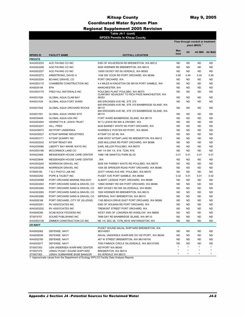
Kitsap County May 9, 2005 Coordinated Water System Plan
Regional Supplement 2005 Revision
Appendix J Section J4 –Potential Sources for Reclaimed Water J4-2
NPDES ID FACILITY NAME OUTFALL LOCATION
Max limit AV AV MIN AV MAX
PRIVATEWAG503253 ACE PAVING CO INC END OF WILKERSON RD BREMERTON, WA 98312 ND ND ND NDWAG503256 ACE PAVING CO INC 9000 WERNER RD BREMERTON, WA 98312 ND ND ND NDWAG503257 ACE PAVING CO INC 10000 DICKEY RD SILVERDALE, WA 98383 ND ND ND NDWAG503272 ARMSTRONG, DAVID H. 1436 SW COOK RD PORT ORCHARD, WA 98366 0.85 0.49 0.44 0.59WAG503254 BO-MAC GRAVEL CO PORT ORCHARD, WA ND ND ND NDWAG503115 CHAMBERS CONSTRUCTION INC 4.4 MILES N KINGSTON ON SR104 PORT GAMBLE, WA ND ND ND NDWA0025194 EPA MANCHESTER, WA ND ND ND NDWAG503179 FRED HILL MATERIALS INC POULSBO PLANT POULSBO, WA 98370 ND ND ND ND
WA0031526 GLOBAL AQUA CLAM BAYCLAM BAY ADJACENT TO RICH PASS MANCHESTER, WA 98353 ND ND ND ND
WA0031534 GLOBAL AQUA FORT WARD 600 ERICKSEN AVE NE, STE 370 ND ND ND ND
WA0031542 GLOBAL AQUA ORCHARD ROCKS600 ERICKSEN AVE NE, STE 370 BAINBRIDGE ISLAND, WA 98110 ND ND ND ND
WA0031551 GLOBAL AQUA VIKING SITE600 ERICKSEN AVE NE, STE 370 BAINBRIDGE ISLAND, WA 98110 ND ND ND ND
WA0030449 GLOBAL AQUA-USA INC FORT WARD BAINBRIDGE ISLAND, WA 98110 ND ND ND NDWAG503204 HENRIETTA B. LEWIS TRUST 50 TJ LEWIS RD NW & CROSBY, WA ND ND ND NDWAG503247 HILL, FRED 8430 BARNEY WHITE RD PORT ORCHARD, WA ND ND ND NDWAG030073 KEYPORT UNDERSEA WARREN E POSTEN KEYPORT, WA 98345 ND ND ND NDWAG030027 KITSAP MARINE INDUSTRIES KITSAP CO SD #6, WA ND ND ND NDWAG503171 KITSAP QUARRY INC 4399 WEST KITSAP LAKE RD BREMERTON, WA 98312 ND ND ND NDWAG503242 KITSAP READY MIX 2000 MULLENIX RD PORT ORCHARD, WA 98366 ND ND ND NDWAG030080 LIBERTY BAY MAINE WAYS INC EARL MILLER POULSBO, WA 98370 ND ND ND NDWAG503186 MCCORMICK LAND CO NW 1/4 SW 1/4, S19, T23N, R1E ND ND ND NDWA0023469 MESSENGER HOUSE CARE CENTER 10861 NE MANITOU PARK BLVD 0.01 0.01 0.01 0.01
WA0023649 MESSENGER HOUSE CARE CENTER , WA ND ND ND NDWAG503245 MORRISON GRAVEL INC 9200 SW PARNEY WHITE RD POULSBO, WA 98370 ND ND ND NDWAG503246 MORRISON GRAVEL INC 1004 SE SPENCER ROAD PORT ORCHARD, WA 98366 ND ND ND NDST0005185 T & C PHOTO LAB INC 20377 VIKING AVE NW, POULSBO, WA 98370 ND ND ND NDWA0022292 POPE & TALBOT INC PUGET AVE PORT GAMBLE, WA 98364 0.02 0.01 0.01 0.02WAG030089 PORT ORCHARD MARINE RAILWAY ALBERT LIESEKE PORT ORCHARD, WA 98366 ND ND ND NDWAG503263 PORT ORCHARD SAND & GRAVEL CO 12800 SIDNEY RD SW PORT ORCHARD, WA 98366 ND ND ND NDWAG503264 PORT ORCHARD SAND & GRAVEL CO 8857 DICKEY RD NW SILVERDALE, WA 98383 ND ND ND NDWAG503265 PORT ORCHARD SAND & GRAVEL CO 7000 WERNER RD BREMERTON, WA 98310 ND ND ND NDWAG503266 PORT ORCHARD SAND & GRAVEL CO IMPERIAL WAY BREMERTON, WA 98310 ND ND ND NDWA0026166 PORT ORCHARD, CITY OF (SLUDGE) 1165 BEACH DRIVE EAST PORT ORCHARD, WA 98366 ND ND ND NDWAG503251 RV ASSOCIATES INC END OF HOLMAN RD PORT ORCHARD, WA ND ND ND NDWAG503252 RV ASSOCIATES INC TREMONT STREET PORT ORCHARD, WA ND ND ND NDWA0045390 SCAB ROCK FEEDERS INC WEST END OF LONGREN RD WINSLOW, WA 98858 ND ND ND NDST0074707 SOUND PUBLISHING INC 7689 DAY RD BAINBRIDGE ISLAND, WA 98110 ND ND ND NDWAG503128 ZIMMER CONSTRUCTION CO INC NE 1/4, SEC 26, T27N_R01E WM KINGSTON, WA ND ND ND ND
WA0002062 DEFENSE, NAVYPUGET SOUND NAVAL SHIPYARD BREMERTON, WA 983145001 ND ND ND ND
WA0026026 DEFENSE, NAVY NAVAL UNDERSEA WARFARE DIV KEYPORT, WA 98345 ND ND ND NDWA0002780 DEFENSE, NAVY 467 W STREET BREMERTON, WA 983145100 ND ND ND NDWA0025577 DEFENSE, NAVY 7000 FINBACK CIRCLE SILVERDALE, WA 983157000 ND ND ND NDST0007353 USN UNDERSEA WARFARE CENTER KEYPORT WA 98345 2 2 2 2
ST0007374 USNAV PUGET SOUND SHIPYARD BREMERTON, WA 98314 2 2 2 2
ST0007363 USNAV SUBMARINE BASE BANGOR SILVERDALE WA 98315 2 2 2 2
1 Approximate values from the Department of Ecology WPLCS Facility Data Analysis Reports
US NAVY
Table J4-1 (cont)NPDES Permits In Kitsap County
Flow through conduit or treatment plant (MGD) 1

Kitsap County May 9, 2005 Coordinated Water System Plan
Regional Supplement 2005 Revision
Appendix J Section J4 –Potential Sources for Reclaimed Water J4-3
There are approximately 16 municipal WWTPs in the County but only six currently discharge a large enough quantity to be considered for a reuse project. The volumes of discharges vary with the largest effluent flows being from the Bremerton, Central Kitsap, and Port Orchard wastewater treatment plants.
Wastewater treatment plants are a good source for water reuse. The total average day wastewater effluent from WWTPs in the County is 10.71 million gallons per day (mgd) compared to the current 27 mgd average daily potable water use, based on available data. Reuse could be effective in reducing demand on public water systems but the water savings may be limited by demand for reclaimed water and high distribution costs.
Wastewater from industrial plants is another potential water source that could be reused either within the industries operations or externally to meet other water needs. Wastewater effluent flows were obtained for only a portion of the industries in the County. Based on the available data, some industrial effluent flows are highly seasonal due to industrial operations. Industrial wastewater flows are small compared to municipal flows.
J4.2 Stormwater
Stormwater is another potential source of reclaimed water. Stormwater can be utilized for reclamation purposes. However, there are two main factors that make stormwater reuse less desirable than wastewater reuse: seasonal variations in flow and the potential for highly unpredictable water quality. Water rights would also need to be obtained in order to reclaim stormwater. In general, wastewater reuse is more appropriate than stormwater reuse for the applications most likely to be implemented within the County. Improved diversion of larger quantities of storm water to recharge is a potentially attractive process that can be pursued on both a small and large project basis.
Stormwater flow is incompatible with many water reclamation options because high flows occur during winter months and low flows occur during summer months. In the summer, when reuse applications such as irrigation and cooling tower use require the greatest amounts of reclaimed water, the amount of available stormwater is at its lowest during the year. Rainfall during summer months is minimal, and any winter stormwater volumes detained are gone by mid-summer due to evaporation and infiltration. Without large storage facilities retaining winter stormwater for summer use, stormwater reuse does not provide an adequate volume of water for these applications.
Other water reclamation applications may be able to make use of the timing of stormwater flows. Direct aquifer recharge is independent of time of year, and can utilize large volumes of reclaimed water during the winter. This process is referred to as Aquifer Storage and Recovery (ASR). Stormwater reuse is attractive for this application. However, treatment requirements remain the same as those for reclaimed wastewater effluent, in order to produce high quality water for reuse. Therefore, additional infrastructure would be needed to consolidate and treat the stormwater. These capital improvements would be much greater than those needed to enhance the already existing treatment facilities associated with wastewater.

Kitsap County May 9, 2005 Coordinated Water System Plan
Regional Supplement 2005 Revision
Appendix J Section J4 –Potential Sources for Reclaimed Water J4-4
Stormwater typically contains many contaminants, originating from various sources, both natural and man-made. Many constituents of stormwater (e.g., metallic elements, oils, greases) are largely derived from vehicles. Increased attention is being focused on stormwater quality by municipalities, as it affects the water quality of surface water bodies into which it is discharged, and also presents an obstacle for potential reuse of the resource.

Kitsap County May 9, 2005 Coordinated Water System Plan
Regional Supplement 2005 Revision
Appendix J Section J5 – Options For Reclaimed Water Application J5-1
Section J5 Options for Reclaimed Water Application
There are many possible uses for reclaimed water which have political, technical, and financial implications that encourage or discourage various reclaimed water applications. The Central Puget Sound Regional Water Supply Outlook prepared by the Central Puget Sound Water Suppliers Forum divided reclaimed water applications into three categories: “Direct Potable,” “Non-Potable”, and “Indirect Potable,” reuse application. After the application category has been considered, proximity and cost are important factors when determining the feasibility of the reuse scenario. The issues surrounding the use of reclaimed water include, but are not limited to, regulatory, technical, environmental, legal, financial, public acceptance, and political issues. Some tend to drive water planning in the direction of increased use of reclaimed water, and some drive in the opposite direction. The public level of concern relative to reuse varies widely, and tends to depend on the end use of the reclaimed water.
“Direct Potable” Reuse: Although it may be technically feasible, the public currently views “direct potable” use of reclaimed water for drinking purposes skeptically. However, the public generally has little concern for using reclaimed water for other purposes such as irrigating a golf course. “Direct potable” means a “pipe-to-pipe” connection between the reclaimed water treatment facility and the potable water distribution system. Washington State regulations do not provide for “direct potable” reuse, and it is not done anywhere in the United States except in a scientific research setting.
“Non-Potable” Reuse: “Non-potable” uses have the greatest potential application to this region. The types of uses approved by the State standards include irrigation of non-food crops; irrigation of food crops; landscape irrigation; discharge to impoundments; use in fish hatchery basins and decorative fountains; flushing of sanitary sewers; street cleaning; washing of corporation yards and lots and sidewalks; dust control; dampening of soil for compaction at construction sites; landfills; water jetting for consolidation of backfill; fire fighting and protection; toilet and urinal flushing; washing aggregate and making concrete; industrial boiler feed; industrial cooling; and, industrial process. As can be seen from this list, the variety of potential uses are many and varied. Although all are considered non-potable uses, some will likely be more controversial from the public’s perspective than others.
Generic “Indirect Potable” Reuse: In “indirect potable” reuse, a highly-treated reclaimed water is intentionally introduced to a surface water or ground water system that is ultimately used as part of a municipal potable water supply. In an indirect system, the reclaimed water is blended with the natural water system and there is often a significant time delay (i.e., 12 or more months) in which the water receives additional natural treatment before the blended water is withdrawn for treatment at a potable treatment facility.
Indirect potable use refers to the “planned” and controlled use of the reclaimed water. “Unplanned” indirect potable use has been practiced for decades throughout much of the United States, including Washington, whenever treated municipal wastewater from one city is
Kitsap County May 9, 2005 Coordinated Water System Plan
Regional Supplement 2005 Revision
Appendix J Section J5 – Options For Reclaimed Water Application J5-2
discharged to a receiving stream or river and the cities downstream use the same water body as their potable water supply source. This occurs many times on most major watercourses. Indirect potable reuse is also practiced when effluent from septic tanks or other land treatment systems reaches ground water.
Some applications of indirect potable use involve a method of storage and could be used to offset pressure on existing municipal water supply sources to meet growing demands.
J5.1 Specific Application Scenarios
There are many possible application scenarios that could be implemented in the County and irrigation, wetland augmentation, and direct aquifer recharge may be good candidates. Application options vary between reuse scenarios depending on the community needs and proximity to the water source. Proximity to the water source is a key in minimizing construction costs associated with treatment and transmission of the reclaimed water. Required treatment levels for different applications are also a factor. If reclaimed water is applied in a public area the reclaimed water must be of Class A quality. This may require additional treatment modifications to an existing outflow.
J5.1.1 Irrigation
Utilizing reclaimed water for landscape irrigation purposes reduces the amount of water demand currently being met by potable water supplies. Parks, school grounds, golf courses, and agriculture are examples of areas that provide opportunities for reuse as they have significant irrigation requirements in the summer.
Enhancements to water treatment facilities may be needed in order to produce the appropriate Class of reclaimed water. For Class A specifically, the water must be coagulated, filtered, and disinfected to a greater degree. To accomplish this, the recommended approach is to provide additional facilities at the end of the existing treatment train. These additions would include an in-line coagulation/filtration system (very commonly used to meet tertiary and reuse standards) and an in-line UV disinfection unit, which, in conjunction with the current chlorination facilities, will treat water to Class A levels. If the irrigation is not used in public areas the treatment requirements may not be as stringent.
All facilities must meet requirements as set forth in the Water Reclamation and Reuse Standards (Standards). Such requirements include providing redundant treatment units and color-coding transmission piping as purple.
Costs associated with treatment, pumping, and transmission facilities will occur. Other costs such as engineering, administration, and permitting should be included and annual operation and maintenance costs considered.

Kitsap County May 9, 2005 Coordinated Water System Plan
Regional Supplement 2005 Revision
Appendix J Section J5 – Options For Reclaimed Water Application J5-3
J5.1.2 Maintenance of Existing Wetlands
This application involves the discharge of reclaimed wastewater effluent into wetlands. This is an attractive option for many municipalities, since Class C and D reclaimed water (i.e., those categories requiring the least amount of additional treatment) are often allowed in this application, assuming that there is no direct human contact with the receiving wetlands.
Capital improvements associated with this option may include necessary modifications to the existing treatment system and discharge arrangement to the wetlands.
Costs associated with this option include transmission costs, potential permitting and maintenance costs.
J5.1.3 Direct Aquifer Recharge
Application of reclaimed water will result in reducing potable water demands by non-potable uses. However, there are other applications of wastewater reuse that do not necessarily address this objective, but also warrant investigation. One of these is direct aquifer recharge, or the injection of reclaimed water into a ground water supply used to meet potable water demands. Such an application can make beneficial use of reclaimed water year-round in order to maintain or enhance the production of an aquifer.
As growth continues and pressures increase upon the aquifer, enhancement of ground water supplies may prove just as beneficial as reduction in potable water demand. In order to implement such an application of reclaimed water, requirements are greater than those associated with the wetland and irrigation. This is due to the fact that the reclaimed water is being injected directly into a potable water supply. For this reason, extra precautions are taken to ensure public health.
To address water quality issues, the Standards require that reclaimed water to be injected into potable ground water aquifers meet the criteria for primary contaminants (except nitrate), secondary contaminants, radionuclides, and carcinogens listed in WAC 173-200, as well as any other maximum contaminant levels provided in WAC 246-290. Additional requirements include:
A strict monitoring procedure outlined for coliform. The number of total coliform present in any sample must not exceed 5/100 mL. This is more stringent than the requirements for general Class reclaimed water, which must meet a 23/100 mL standard.
Turbidity must be less than or equal to 0.1 nephlometric turbidity units (NTU) (average) and 0.5 NTU (maximum).
Total nitrogen must be less than or equal to 10 mg/L as N.
Total Organic Carbon (TOC) must be less than or equal to 1.0 mg/L.

Kitsap County May 9, 2005 Coordinated Water System Plan
Regional Supplement 2005 Revision
Appendix J Section J5 – Options For Reclaimed Water Application J5-4
Furthermore, there are requirements relating to the proximity of injection points to water supply wells. The key requirement is that reclaimed water must be retained underground for a minimum of 12 months prior to being withdrawn. This is accomplished by locating the injection well outside of the one-year capture zone of any water supply well. To ensure that water quality requirements are met, two monitoring wells are required along the ground water flow path between the injection and water supply wells (one located 500 feet from the injection well, and the other at a distance of 1,000 feet).
Therefore, this application involves the following overall reclamation scheme:
All treated wastewater effluent (in summer and winter) is sent through additional treatment processes of filtration and disinfection;
Reclaimed water is pumped to the point of injection via a separate transmission main; and,
Reclaimed water is then pumped into the ground water aquifer via a direct recharge injection well. It should be noted that this application might occur year-round, as opposed to the seasonal uses associated with the other options.
Aquifer recharge may require capital improvements associated with treatment, filtration, and disinfection processes. A separate transmission main is required to convey water to the injection well because reclaimed water is not permitted to be used as (mixed with) potable water. No storage is required, as all water would be sent directly into the aquifer. Further analysis is required to determine details concerning the injection and monitoring wells.
A cost estimate should include costs for additional treatment units, pumping, transmission facilities, and injection and monitoring wells. Other costs such as engineering, administration, and permitting should be included.

Kitsap County May 9, 2005 Coordinated Water System Plan
Regional Supplement 2005 Revision
Appendix J Section J6 – Existing Water Reuse and Feasibility Studies J6-1
Section J6 Feasibility Studies
Since water reuse is a relatively new and high-cost practice there are no large-scale reuse projects and few reuse feasibility studies in Kitsap County (County). The Annapolis Water District and the City of Bremerton have conducted water reuse feasibility studies, which are summarized below. Also summarized is a reuse and storage study conducted as a part of the Water Resource Inventory Area (WRIA) 15 watershed planning effort.
J6.1 Annapolis Water District
With increasing demand and uncertainty in developing additional water rights, the Annapolis Water District had a water reuse feasibility study completed in November 1996. The wastewater treatment plant (WWTP), which discharges an average of 1.80 million gallons per day (mgd) of effluent, was identified as the reclaimed water source. After considering possible applications for the reclaimed water, aquifer recharge was determined to be the most beneficial use. The project included the construction of the reclaimed water main from the WWTP to the Salmonberry well field and the ground water recharge ponds or direct ground water injection. A secondary benefit to utilities could be the development of distribution lines that could deliver the water to large irrigators.
The reclamation scenario included the development of a water main, pump station, infiltration pond, and additional treatment for groundwater infiltration. Cost estimates developed with each step of the reclamation operation are as follows:
Reclaimed water main $720,000 Pump station $158,000 Infiltration Pond construction $334,000 Additional treatment for ground water infiltration $1,365,000 Contingencies/Tax/Field Admin./Contractor fees $1,936,000 Total $4,800,000
Annapolis Water District determined that this scenario was not feasible at this time.
J6.2 City of Bremerton
The City of Bremerton had a water reuse feasibility study conducted by Brown and Caldwell that was completed September 17, 1998. The City recognized the potential benefits to reuse for their system, which included preserving limited potable water supplies by offsetting potable water demand by non-potable applications, and reducing the total wastewater effluent discharges into Sinclair Inlet. The Bremerton WWTP was identified and the source of reclaimed water. At the time of the study the WWTP was designed for an annual average flow of 7.6 mgd and on a consistent basis 3.0 mgd of reclaimed water could be made available.

Kitsap County May 9, 2005 Coordinated Water System Plan
Regional Supplement 2005 Revision
Appendix J Section J6 – Existing Water Reuse and Feasibility Studies J6-2
Various water applications were considered and a recommended alternative was established. The alternative included treating the wastewater to Class A standards and using the water to serve non-potable uses for the Port of Bremerton, Gold Mountain Golf Course, and Pendergast Park. The reclaimed water demand for all of the uses is 477 gallons per minute (gpm) or approximately .7 mgd. The total cost to implement this alternative was estimated to be $12,700,000, with a levelized unit cost of $6.41 per hundred cubic feet (ccf).
J6.3 WRIA 15 Reuse Study
Golder Associates, Inc. conducted a reuse study and storage assessment for the WRIA 15 Planning Unit in May 2003. The purpose of the study was to investigate the potential for using reclaimed water from wastewater treatment plant outflows as a source of water that could be stored and used to replenish or augment natural freshwater systems. The study did not evaluate other uses of reclaimed water that might offset potable water demands, but focused instead upon environmental uses of reclaimed water.
The study considered upgrade needs for the four largest treatment plants within WRIA 15 (Bremerton, Central Kitsap, Port Orchard, and Gig Harbor), as well as various freshwater augmentation scenarios. Eight alternatives were evaluated, ranging in cost from approximately $5.5 million to $8.5 million, and providing between 0.5 and 2.1 mgd in reclaimed water flows.

Kitsap County May 9, 2005 Coordinated Water System Plan
Regional Supplement 2005 Revision
Appendix J Section J7 – Key Findings J7-1
Section J7 Implementation
Successful implementation of a wastewater reuse project is dependent upon a variety of factors. The key elements include coordination with regulatory agencies, obtaining necessary permits, and developing an adequate financing strategy. The roles of the Washington State Departments of Health (DOH) and Ecology (Ecology) have been described in this Section. Both agencies advocate the use of reclaimed water as part of effective water resource management and stewardship. Early and continued contact with both DOH and Ecology will aid in implementation of a proposed reuse project. The permitting requirements associated with reclamation projects have also been summarized. These requirements are applicable to most wastewater capital improvement projects and as such do not involve additional requirements or different timelines relative to reuse projects.
J7.1 Cost
The cost associated with reuse varies depending on the required treatment levels, economies of size, and required conveyance construction. A summary of water reclamation projects in western Washington shows that the capital costs for reuse projects range from $100,000 to $32,000,000, for a variety of capacities. Operation and maintenance (O&M) costs are also a factor and vary depending on the type of water reuse project. The cost per amount of water reused ranges from $15,000 to $924,000 per million gallons per day (mgd). Table J7-1 provides an example of reuse projects and associated costs in Snohomish, King, and Pierce Counties.
Based upon costs for other facilities similar to what exist in Kitsap County, and considering cost estimates presented in the City of Bremerton water reuse feasibility study, an estimated of treatment upgrade costs for a reuse facility at an existing waste water treatment plant in Kitsap County is approximately $2,000,000 per mgd of capacity. Annual O&M costs associated with operating a facility of this size are estimated to be on the order of $150,000.
J7.2 Financing
One element not discussed thus far is that of financing reuse projects. There are many options available to water systems for funding reuse projects. The following is a list of both external and internal funding opportunities, many of which have been previously utilized. Table J7-2 provides important contact information concerning the external funding sources. Either solely, or in various combinations, these sources can provide adequate funding for the types of reclamation projects described earlier in this report.

Kitsap County May 9, 2005 Coordinated Water System Plan
Regional Supplement 2005 Revision
Appendix J Section J7 – Key Findings J7-2
Table J7-1
Summary of Reclaimed Water Projects in Snohomish, King, and Pierce Counties
County Status1 Project Previous/ Current
Water Source mgd Intended Use
Snohomish In Operation WWTPs Unknown Unknown In-plant use
Snohomish In Design/ Construction
Kimberly-Clark Paper Mill City of Everett 43 Non-contact cooling in heat exchanger
Snohomish Planning/ Development
Poplar tree farm New development 1.5 Irrigation–tree farm
Snohomish Feasibility Stage Old Weyerhaeuser Mill Site New development Unknown Industrial cooling
Snohomish Feasibility Stage Everett Parks City of Everett Unknown Irrigation–golf & parks
Snohomish Feasibility Stage Nursery City of Everett Unknown Irrigation–plants
King Operational 2000 City of Snoqualmie –golf course
New development 1.5 Irrigation–golf & public landscaping
King Operational 1994 West Point treatment plant SPU 0.7 In-plant use & irrigation–public landscapes
King Operational 1996 Renton treatment plant Renton 1.3 In-plant use & irrigation–public landscapes
King Operational Fort Dent Park in Tukwila Tukwila 0.1 Irrigation–ball fields
King Planning/ Development
Lakehaven Utility District–Mirror Lake
Lakehaven Utility District
0.7–2.0 Groundwater recharge through septic systems
King Planning/ Development
Pilot satellite plant River 3 Non-potable
Pierce Operational 1984 Chambers Creek Treatment Plant
City of Tacoma 1 Non-potable, process
Pierce Planning/ Development
Chambers Creek Properties New development Unknown Irrigation–golf
Pierce Planning/ Development
Existing Orting New Cascadia
Orting New development
1 Irrigation–golf, school, parks
Pierce Planning/ Development
Crystal Mountain New development 0.1 Snowmaking & irrigation–landscape
Pierce Planning/ Development
Mt Rainier Resort-Park Junction
New development 0.1 Irrigation–golf/public landscape & HVAC
Pierce Feasibility Stage Simpson Tacoma Kraft Mill City of Tacoma 10 Non-potable
Pierce Feasibility Stage Stone Consolidated Mill6 River 5.2 Non-potable
WWTP = wastewater treatment plant ccf = 100 cubic feet mgd = million gallons per day. Footnotes: 1 In Operation = Currently Operating; In Design/Construction = Funds Committed, Construction or operation imminent; In
Planning/Development = Some thought, possible concept report; Feasibility Stage = Discussion but no detail on specifics 2 Financial calculations based on 25-year life, 6% interest rate unless otherwise noted. 3 Uses 8 mgd of reclaimed water, replaces 4 mgd potable. 4 Marginal cost only. 5 Based on capital costs only as O&M not readily available. 6 Going out of business but site could be redeveloped.
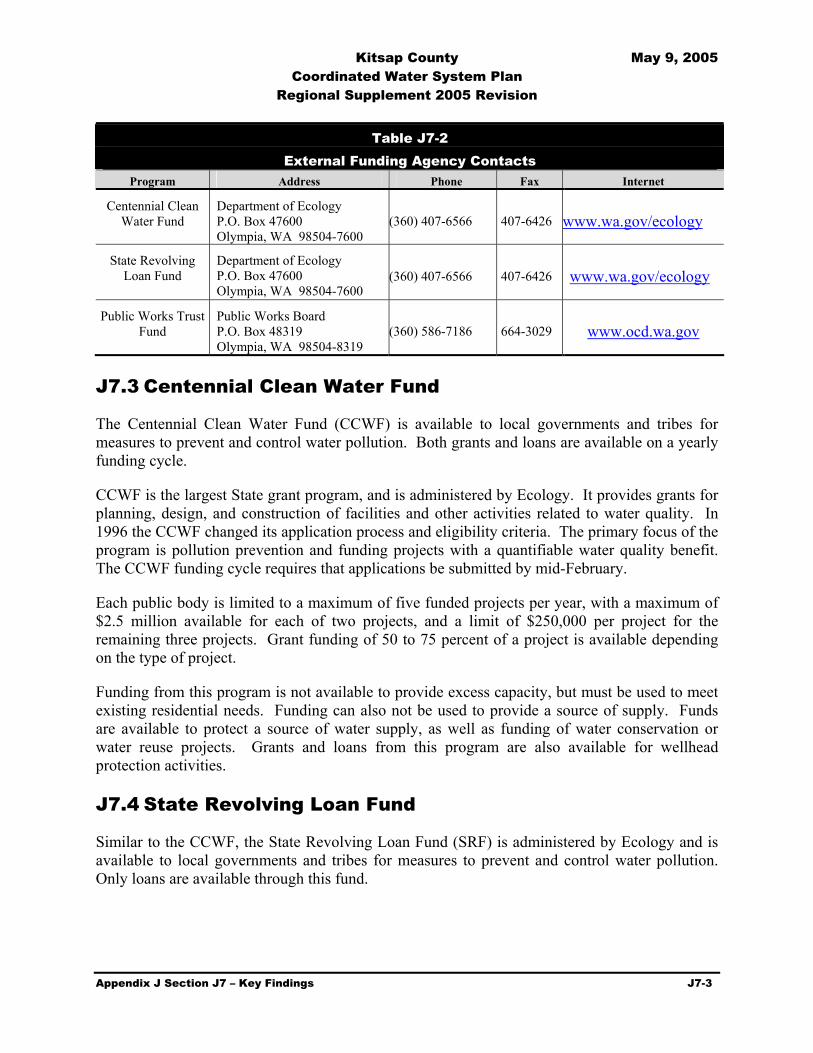
Kitsap County May 9, 2005 Coordinated Water System Plan
Regional Supplement 2005 Revision
Appendix J Section J7 – Key Findings J7-3
Table J7-2
External Funding Agency Contacts Program Address Phone Fax Internet
Centennial Clean Water Fund
Department of Ecology P.O. Box 47600 Olympia, WA 98504-7600
(360) 407-6566 407-6426 www.wa.gov/ecology
State Revolving Loan Fund
Department of Ecology P.O. Box 47600 Olympia, WA 98504-7600
(360) 407-6566 407-6426 www.wa.gov/ecology
Public Works Trust Fund
Public Works Board P.O. Box 48319 Olympia, WA 98504-8319
(360) 586-7186 664-3029 www.ocd.wa.gov
J7.3 Centennial Clean Water Fund
The Centennial Clean Water Fund (CCWF) is available to local governments and tribes for measures to prevent and control water pollution. Both grants and loans are available on a yearly funding cycle.
CCWF is the largest State grant program, and is administered by Ecology. It provides grants for planning, design, and construction of facilities and other activities related to water quality. In 1996 the CCWF changed its application process and eligibility criteria. The primary focus of the program is pollution prevention and funding projects with a quantifiable water quality benefit. The CCWF funding cycle requires that applications be submitted by mid-February.
Each public body is limited to a maximum of five funded projects per year, with a maximum of $2.5 million available for each of two projects, and a limit of $250,000 per project for the remaining three projects. Grant funding of 50 to 75 percent of a project is available depending on the type of project.
Funding from this program is not available to provide excess capacity, but must be used to meet existing residential needs. Funding can also not be used to provide a source of supply. Funds are available to protect a source of water supply, as well as funding of water conservation or water reuse projects. Grants and loans from this program are also available for wellhead protection activities.
J7.4 State Revolving Loan Fund
Similar to the CCWF, the State Revolving Loan Fund (SRF) is administered by Ecology and is available to local governments and tribes for measures to prevent and control water pollution. Only loans are available through this fund.
Kitsap County May 9, 2005 Coordinated Water System Plan
Regional Supplement 2005 Revision
Appendix J Section J7 – Key Findings J7-4
Loans are available for up to 100 percent of eligible project costs. Current terms for fiscal year 2002 are 0.5 percent interest rate for a 0- to 5-year term and 1.5 percent interest rate for a 6- to 20-year term.
J7.5 Public Works Trust Fund
The Public Works Trust Fund (PWTF) is a loan program set up by the Legislature to assist cities, towns, counties, or special districts with funding for different types of public works projects. The projects can include streets, roads, drainage systems, water systems, and sanitary sewer systems. The emphasis of allocating funds for water and sewer systems is based on replacement and/or repair of existing systems. No funds will be allocated to install a new system. Rather, funds will be granted to rehabilitate or replace an existing system serving an existing population.
The loans are issued at up to 2 percent interest rate for a maximum term of 20 years for applications requesting 95 percent funding of project. The interest rate decreases to 0.5 percent when municipalities provide 15 percent of the project funding. Debt service coverage is not imposed on the PWTF loan. As minimum qualifications, the PWTF does require that cities impose a ¼ percent excise tax on the sale of real property and that they have a well-defined capital improvement program for the utility.
J7.6 Rate Revenues
One way in which the water systems could partially fund a reuse project is by utilizing a portion of the revenue generated from water and/or wastewater rates. A more thorough analysis of rate impacts, due either to use of funds directly for such projects or for repayment of loans from external sources such as those mentioned above, would be required before a decision is made to use money generated from rates.

Kitsap County May 9, 2005 Coordinated Water System Plan
Regional Supplement 2005 Revision
Appendix J Section J8 – Key Findings J8-1
Section J8 Desalination
Desalination is another potential process for alternative water supply that uses seawater to produce fresh water for potable or non-potable applications. Cost and impracticability has discouraged the development of desalination in the past. However, with shrinking potable water supplies and increasing demand, greater evaluation and implementation of desalination is occurring. Projects are underway in areas such as Florida and Southern California. Recently, improved technology has made desalination more economical and there are more than 12,500 plants in the United States.
There are two major processes for desalination: multi-stage flash desalination (MSF) and membrane-based reverse osmosis. Electrodialysis is another process that is used to desalt brackish water. Newly designed multi-effect distillation plants are also gaining interest.
MSF is the most widely used method which involves heating saline water to high temperatures and passing it through vessels of decreasing pressures to produce the maximum amount of water vapor (fresh water). Multi-effect distillation operates at lower temperatures but uses the same process. Vapor compression distillation is generally used in combination with either process, where the heat evaporating water comes from compression of vapor, rather than the direct exchange of heat.
Reverse osmosis and electrodialysis are both membrane processes. Reverse osmosis is a pressure driven process which forces saline water through a membrane leaving salts behind. Electrodialysis is a voltage driven process and uses an electric potential to move salts selectively through a membrane, leaving fresh water behind.
Costs associated with desalination vary depending on the salinity and temperature of the injection water, recovery rates, power costs, and economy of size. The more salt that is in the water the more processing is required and costs are increased. Desalting seawater costs three to five times more than, desalting brackish water. Energy costs can represent 50 to 75 percent of the desalination operating cost. Reverse osmosis requires the least energy, which makes the process desirable for areas with limited energy resources and as energy cost in general increase. Economies of size are also important determinates in project costs. The membrane filtration is the least dependant on economies of size.
Additional costs include costs associated with environmental protection. The disposal of brine, which is the output of the desalination process, could have a negative effect on the environment and must be disposed of properly. Marine impacts and ground water salinity are issues associated with brine disposal. Many times there is a cost associated with this disposal.
Many more recent and planned desalination projects are being collocated near power generating plants to take advantage of existing cooling water systems. By using a small percentage of the power plants cooling water discharge, higher desalination plant inlet temperatures are realized and dilution of brine discharge is achieved by injection into the power plants high volume return

Kitsap County May 9, 2005 Coordinated Water System Plan
Regional Supplement 2005 Revision
Appendix J Section J8 – Key Findings J8-2
flow. Use of an existing seawater withdrawal and discharge structure saves on construction and permit costs. The higher inlet temperatures for desalination processing save on energy costs. Unfortunately, such power plants or large sea water cooling structures do not exist in or near Kitsap County and sea water temperatures in the Puget Sound region are much lower than areas where desalination plants are currently being built. These factors, plus availability of much less costly water supply alternatives, make desalination less attractive in this region compared to areas such as Florida and Southern California.
Based upon a review of professional journal articles related to desalination, combined operational and amortized capital costs for brackish water treatment plants producing between 1.06 and 10.6 million gallons per day range from $2.85 to $11.35 per million gallons (MG) of water produced. Seawater desalination plants were reported to cost $11,367 to $2,839 per MG of potable water produced.
Based upon cost figures for a desalination plant in Sand City, California, capital costs for a desalination facility in the Pacific Northwest are estimated to be approximately $10,000,000 per mgd. Annual O&M costs are estimated to be on the order of $500,000 per mgd. The significantly higher O&M costs are related primarily to power requirements.

Kitsap County May 9, 2005 Coordinated Water System Plan
Regional Supplement 2005 Revision
Appendix K – Water Resource Data Management Program K-1
Appendix
K Water Resource Data Management Program
Background
In 1987, Kitsap County secured funding from Washington State Department of Ecology for Ground Water Management Planning. In accordance with WAC 173-100-050, a Ground Water Advisory Committee, made up of local governments, tribal governments, water purveyors and others, was formed to direct this effort. In 1989, Volume I of the Kitsap County Ground Water Management Plan (GWMP) was published. The GWMP recommended a “comprehensive hydrogeologic and water quality monitoring network” be established to gather data on Kitsap County’s water resources. Under an interlocal agreement with Kitsap County, Kitsap Public Utility District (KPUD) was designated lead agency for establishing this network and began collecting hydrologic data on Kitsap County in 1990. In January 1995, KPUD signed a Memorandum of Agreement with Washington State Department of Ecology to “undertake a comprehensive watershed assessment of the surface and groundwater resources of Kitsap County”. Data collected pursuant to the GWMP was analyzed and, in 1997, results were published as the Kitsap County Initial Basin Assessment (Washington State Department of Ecology Document 97-4).
Area Description
Kitsap County encompasses approximately 400 square miles, and occupies a peninsula and several islands in Puget Sound. It is bounded on the east and north by Puget Sound and Admiralty Inlet, and on the west by Hood Canal. The county is adjoined by Pierce and Mason Counties on the south, Jefferson County on the west, and King County on the east.
The physiography and topographic characteristics of the county are similar to much of the surrounding Puget Sound area, consisting of remnants of a glacial drift plain. The surface is composed of generally flat-topped rolling hills and ridges which rise to approximately 400 to 600 feet above Mean Sea Level (MSL), and are separated by long valleys and marine embayments. The Green and Gold Mountains are a prominent group of rugged volcanic rock hills in the west-central portion of the county that rise to an elevation of approximately 1,700 feet above MSL. Much of the upland areas terminate along the coast in steep bluffs. Since the close of the last glaciation (Vashon Glaciation), the landscape has been slightly modified by stream erosion, landslides, and wave action. Upland areas occupy approximately 75 percent of the county, flat valley floors occupy about 5 percent of the county, and transitional valley slopes, sea cliffs, and the Green and Gold Mountain area occupy the remaining 20 percent.
The uplands are predominately recharge areas in which water percolates downward to water bearing strata and eventually migrates to discharge areas. Numerous surface water drainage features, such as Gorst and Big Beef Creeks, provide internal drainage for the

Kitsap County May 9, 2005 Coordinated Water System Plan
Regional Supplement 2005 Revision
Appendix K – Water Resource Data Management Program K-2
shallow ground water systems that occur within the uplands. The larger drainage features within or adjoining the county such as Liberty Bay, Sinclair and Dyes Inlets, Hood Canal, and Puget Sound, are regional discharge areas for the deep ground water that originates within the uplands.
Kitsap County has a marine climate typified by short, cool summers, and prolonged, mild, wet winters. Winter storms generally approach the county from the southwest. The southwestern portion of the county receives relatively high winter rainfall from storms that enter the area through a topographic gap between the Olympic Mountains and the Black Hills. The northern portion of the Kitsap Peninsula experiences drier winter weather because it is situated in the rain shadow of the Olympic Mountains (Kitsap County Initial Basin Assessment, 1997)
Precipitation
Precipitation varies over the county from just under 30 inches per year in the north to over 80 inches per year in the southwest. On a seasonal basis, 79 percent of the precipitation at the Bremerton Fire Station occurs in the six-month period from October through March. Additionally, total rainfall for the driest months of June, July, and August is seven percent of the annual total, at a time when water use is greatest.
Precipitation provides the input that supplies stream runoff and ground water recharge. Variation in precipitation must be taken into account when assessing trends in streamflow and ground water levels (Kitsap County Initial Basin Assessment, 1997). Section 1 of Volume I presents precipitation data from 38 stations located throughout Kitsap County.
Ground Water Level
Water level monitoring provides a basis for evaluating impacts on the ground water system that may be associated with ground water development, land use changes, and precipitation patterns. Water levels are affected primarily by climatic trends and amount of ground water withdrawal. Climatic trends include changes in precipitation and drought periods; ground water withdrawal includes water pumped from public and private wells. Data collected over the past few decades indicates that aquifer water levels primarily track rainfall over the long run. The early 1990s were dry years that caused aquifer levels to trend downward during that period. The late 1990s were exceptionally wet and aquifer levels trended up, reaching some of the highest aquifer levels on record in some areas. The most recent years have been dry and again aquifer levels have generally trended downward. Depending on the depth of the aquifer, water levels response to rainfall may be delayed many months. Ground water level trend data is required to understand seasonal variations in aquifer levels, the effects of pumping on aquifer levels, identify areas where possible overdraft (mining) of an aquifer is occurring, and to assess seawater intrusion or stream depletion.

Kitsap County May 9, 2005 Coordinated Water System Plan
Regional Supplement 2005 Revision
Appendix K – Water Resource Data Management Program K-3
Stream Flow
The GWMP concluded, “stream flow monitoring is needed throughout the county to establish baseline trends and possible impacts related to ground water development”. Maintenance of stream flows necessary to preserve instream resources is a major concern. In 1990, there was only one active stream gaging station operating in Kitsap County. Stream flow records are also useful in assessing the effects of urbanization on basin hydrology. Approximately 35 gaging stations have been established since 1990.
CWSP Resource Monitoring Program
Comprehensive water quality monitoring is accomplished under the Federal Safe Drinking Water Act (SDWA) and Clean Water Act (CWA) programs conducted in conjunction with the Washington State Departments of Ecology and Health. The components listed below make up the monitoring program, beyond SDWA and CWA requirements, that supports CWSP activities and other water resource management activities:
Precipitation Monitoring:
Quantification of precipitation is an important component of the watershed assessment process. Precipitation provides the input that supplies stream runoff and ground water recharge. Volume I of the Kitsap County Ground Water Management Plan (1989) found “very little precipitation data being collected within the county” and recommended “ongoing precipitation monitoring throughout the county to establish a database from which to better assess the spatial and temporal variations of precipitation and other water balance components”. KPUD’s precipitation monitoring network was founded based on the above recommendation. Effort was made to compile historic records and contact organizations that were recording rainfall quantities. Additional stations were then established in areas where data was lacking.
The Data Base currently contains records for 34 active and 4 inactive stations. Several of the stations are automated and record at 15-minute intervals. The majority of the stations record daily totals and utilize 4-inch diameter plastic rain gauges. Tables have been developed that show daily precipitation totals by water year and they list all the data reported to KPUD for each station. The data through 1999 has been published in a publication by KPUD titled Precipitation, Water Level, & Stream Flow Data for Kitsap County, Volume 1, February 2000, which includes tables and maps of the precipitation monitoring points.
A map of spatial distribution of precipitation was compiled for the Kitsap County Initial Basin Assessment (1997). The map shows lines of equal precipitation, called isohyetals. The map was based on data from the KPUD network, but also included data from NOAA precipitation stations from outside Kitsap County. KPUD and NOAA data was combined and normalized to produce the map, which is intended to show long-term, averaged precipitation patterns. Only some of the

Kitsap County May 9, 2005 Coordinated Water System Plan
Regional Supplement 2005 Revision
Appendix K – Water Resource Data Management Program K-4
38 stations mentioned above were used to produce the 1997 map, and therefore they are not all shown in the 1997 map. Average precipitation varies over the county from just under 30 inches per year in the north to over 80 inches per year in the south, and southwest. The accuracy of the map is believed to be relatively high in most areas, with the exception of the Green and Gold Mountains where orographic effects are significant and precipitation is believed to be higher. A station has recently been established in this area and should eliminate this data gap in the future. The map may be view on the KPUD website at: http://kpud.org/reference/documents/initialbasin/ex3-1.pdf.
In addition to precipitation that is collected by KPUD, many private and public agencies have begun collecting precipitation data or have done recent reviews. For example, James Lumber in Poulsbo, and the Port of Silverdale have web-assessable weather stations that include precipitation. The Phase 2 Level 1 Assessment completed for 2514 Basin Planning (Golder 2002) includes a review of precipitation for WRIA 15 based on PRISM modeling, and can be viewed at:
http://kitsappeninsulawatershed.org/pdf/Level_1_Assessment/Figure_4-1.pdf and http://kitsappeninsulawatershed.org/pdf/Level_1_Assessment/Figure_4-2.pdf.
Water purveyors and others that have rainfall-monitoring stations and are keeping precipitation records are encouraged to provide input to the database to improve the coverage.
Aquifer Water Level Monitoring:
Water level monitoring provides a basis for evaluating impacts on the ground water system that may be associated with ground water development, land use changes, and precipitation patterns. Ground water trends from natural processes or ground water withdrawals frequently cross water system boundaries. Coordinated monitoring and exchange of information is important to a CWSP process to anticipate problems with aquifers such at mining and seawater intrusion. Most purveyors collect water level and production data at various frequencies to meet conditions of their water rights and monitor operation and maintenance of their systems. Much of the data has not been transferred to a central location for analysis for the benefit of all CWSP members. All water purveyors are encouraged to voluntarily participate and make their data available to the Countywide Data Base for recording and review under the CWSP monitoring program. (KPUD will assist other purveyors with their monitoring efforts upon request.)
An example of aquifer level monitoring is included in a publication by KPUD titled Precipitation, Water Level, & Stream Flow Data for Kitsap County, Volume 1, February 2000. That document included water-level hydrographs for 153 wells around the county. Water purveyors including Silverdale Water District, Bremerton Utilities, and KPUD, collected most of the presented data. Production data was included with the hydrographs when provided. Most water levels are measured manually using various methods such as calibrated electric tape. An increasing

Kitsap County May 9, 2005 Coordinated Water System Plan
Regional Supplement 2005 Revision
Appendix K – Water Resource Data Management Program K-5
number of wells are equipped with data loggers that collect frequent, high-resolution data. The network includes wells that are completed over a wide range of depths for the propose of assessing trends in shallow, sea level, and deep ground water flow systems. Tables, maps, and figures of some of the wells included in the 2000 summary have been dropped from monitoring but others have taken their place as water purveyors in the county began or expanded their monitoring efforts.
The CWSP process should include a comprehensive water level monitoring and analysis program that is integrated with streamflow, precipitation, and saltwater intrusion monitoring. Minimum water-level-data collection, QA/QC and reporting for Group A systems with over 50 connections should include:
Monthly non-pumping (i.e. static) water level, and pumping water level for each source well. If multiple wells are located at the same location and are completed in the same aquifer, only one well need be sounded for non-pumping water level (pumping water levels do not aid in aquifer trend analysis but should still be collected on a monthly basis to assess well capacity or pump problems);
Measurements made with a calibrated sound device to an accuracy of 0.01 feet;
Result tabulated in a spreadsheet format with individual columns for date of reading, time of reading, water level measurement below measuring point, measurement codes (i.e., status, method, and accuracy of measurement) and comments (e.g., well off 2 hours). See following example.

Kitsap County May 9, 2005 Coordinated Water System Plan
Regional Supplement 2005 Revision
Appendix K – Water Resource Data Management Program K-6
Stream Flow Measurements:
KPUD published Precipitation, Water Level, & Stream Flow Data for Kitsap County, Volume 1, February 2000, which includes tables and graphics for 19 stream gage sites throughout the county. The number of gages will increase or decrease in the future based on basin requirements and characteristics, special requests, and funding. Individual stations were located to account for as much of the streams’ drainage as possible while avoiding tidal interference. Thirteen of these stations are equipped with continuous recording data loggers that report stage at 15-minute intervals. This produces 96 records per day. The mean daily discharge (arithmetic mean in cubic feet per second) is calculated for each set of values taken from midnight to midnight each day. Mean daily discharge is presented in graph and tabular form.
Field Methodology. The PUD follows USGS streamflow data collection methods as described in Water–Supply Paper 2175. The steps required to produce a computation of discharge record are as follows:
Seawater Intrusion (chloride) Monitoring:
Seawater intrusion is a potential future threat to Kitsap County ground water. Chloride, the predominant cation in seawater, it is easy and inexpensive to analyze for, and is the most commonly used constituent to monitor for and assess

Kitsap County May 9, 2005 Coordinated Water System Plan
Regional Supplement 2005 Revision
Appendix K – Water Resource Data Management Program K-7
seawater intrusion. The CWSP monitoring program should include a countywide, integrated network of monitoring points for seawater intrusion.
KPUD maintains a limited Chloride Monitoring Network. The network currently consists of 53 wells that are primarily owned and operated by KPUD. Samples are collected semiannually during the wet and dry periods of the year. The network does not cover some of the major groundwater withdrawal centers within Kitsap County where intrusion may be a significant threat. A white paper by KPUD (Sebren August 2002) provides a brief discussion of the KPUD network and graphics of chloride concentration over time for selected wells.
Review of historical chloride data was one of the work products accomplished for 2514 Basin Planning for WRIA 15 (Golder Associates Inc. 2003 Kitsap Watershed Planning (WRIA 15) Water Quality Technical Assessment Final Report). The focus of this report was an evaluation of aquifer susceptibility and saltwater intrusion as indicated by the distribution of nitrate and chloride. The primary data set used for the assessment was water quality compliance monitoring data for Group A and B public water systems that is routinely submitted to and compiled by WDOH. The study area covers all of WRIA 15 including all of Kitsap County and the Gig Harbor and Key Peninsulas. Distribution of chloride and nitrate are graphically depicted, filtered by aquifer depth, and general “hot spots” of high concentrations are shown and discussed. Chloride generally is higher in wells within ½ mile of the marine coast, but elevated chloride at actionable limits were not evident throughout the WRIA. Some spots with historical evidence of elevated chloride included President’s Point south of Kingston, the south Gig Harbor Peninsula, and islands south of the Gig Harbor peninsula.
A cooperative program to monitor for saltwater intrusion should have a good geographical distribution of observation wells in the Sealevel and deeper aquifers within ½ mile of saltwater, with emphasis on those areas of high groundwater withdrawal. It should also include an agreed to division of labor detailing frequency of sampling, QA/QC of data collection, database format, how the program should be funded and who should be the lead. At a minimum, data collection for chloride, QA/QC and reporting should include:
An annual sample of untreated water (raw water before chlorination) for each source well in the Sea level or deeper aquifer,
Sample analyzed by a certified lab with a reporting limit of 1 mg/l,
Tabulated results in a spreadsheet format with individual columns for date of reading, time of reading, analysis result, name of certified lab, sample ID number, operator and pertinent comment/remark (see following example). Additional columns could be added to suit the individual needs of the water system.

Kitsap County May 9, 2005 Coordinated Water System Plan
Regional Supplement 2005 Revision
Appendix K – Water Resource Data Management Program K-8
Water Production Measurements:
All water systems are required to measure and record water production data as a condition of their water rights, and submit the data to Ecology when requested. The same data is necessary for efficient CWSP review and/or update but acquiring production records has been difficult. . KPUD will maintain a database of water production by source and purveyor for Group A systems that provide their data. Group A purveyors are encouraged to provide production data, non-revenue water such as that used for flushing and fire department training that can be estimated, quantity of water delivered to customers, and per ERU usage data, for analysis to support WATERPAK conservation efforts.
Water production data should be collected and complied with the following minimums:
Monthly total production for each source well on the system, including every well in a well field,
Meters should be calibrated as needed to meet industry standards, Tabulate monthly totals in a spreadsheet format with individual columns for
date and time, meter reading, and include pertinent comments (e.g., meter turned over, meter calibrated, changed hour meter),
Other columns can be added for calculations to suit the individual needs of the water system.

Kitsap County May 9, 2005 Coordinated Water System Plan
Regional Supplement 2005 Revision
Appendix K – Water Resource Data Management Program K-9
Supporting Activities:
KPUD maintains a database and documents on local hydrogeology and water quality. KPUD catalogs the Department of Ecology Water Well Reports (well logs) for the wells in Kitsap County and upgrades the data contained in those records. From the well logs, KPUD compiles a database (Microsoft Access format) that includes location, elevation, and physical characteristics of the well, water quality and other data. All data in the KPUD database is available upon request. Certain portions of the data are available on the KPUD web site at kpud.org.

Kitsap County May 9, 2005 Coordinated Water System Plan Regional Supplement 2005 Revision
Appendix-L Instream Resources L-1
Appendix
L Instream Resource Protection Program

Kitsap County May 9, 2005 Coordinated Water System Plan Regional Supplement 2005 Revision
Appendix-L Instream Resources L-2
Chapter 173-515 WAC INSTREAM RESOURCES PROTECTION PROGRAM -- KITSAP WATER RESOURCE
INVENTORY AREA (WRIA) 15
WAC 173-515-010 General provision.
173-515-020 Purpose.
173-515-030 Establishment of instream flows.
173-515-040 Surface water closures.
173-515-050 Groundwater.
173-515-060 Lakes.
173-515-070 Exemptions.
173-515-080 Future rights.
173-515-090 Enforcement.
173-515-095 Appeals.
173-515-100 Regulation review.
WAC 173-515-010 General provision. These rules apply to waters within the Kitsap water resource inventory area (WRIA) 15 as defined in WAC 173-500-040. This chapter is promulgated pursuant to chapter 90.54 RCW (Water Resources Act of 1971), chapter 90.22 RCW (minimum water flows and levels), and in accordance with chapter 173-500 WAC (water resources management program). [Statutory Authority: Chapters 90.22 and 90.54 RCW. 81-16-003 (Order DE 80-45), § 173-515-010, filed 7/24/81.] WAC 173-515-020 Purpose. The purpose of this chapter is to retain perennial rivers, streams, and lakes in the Kitsap water resource inventory area (WRIA) 15 with instream flows and levels necessary to provide for preservation and protection of wildlife, fish, scenic, aesthetic and other environmental values, recreational and navigational values, and to preserve water quality.
[Statutory Authority: Chapters 90.22 and 90.54 RCW. 81-16-003 (Order DE 80-45), § 173-515-020, filed 7/24/81.]
WAC 173-515-030 Establishment of instream flows. (1) The following instream flows are established for each stream listed, from the point of influence of mean high tide at low flow to the stream's headwaters including tributaries except where indicated otherwise. Monitoring will take place at the control locations indicated.
INSTREAM FLOWS IN THE KITSAP WATER RESOURCE INVENTORY AREA (WRIA) 15
*WAC 173-515-040(2) closes certain streams to additional consumptive appropriations during specific time periods. These closures are indicated by asterisks in the following table. Such closures supersede the indicated instream flow. The Union River closure extends upstream to McKenna Falls (RM 6.7). **Stream numbers correlate with Plate I, instream resources protection program, Kitsap water resource inventory area (WRIA) 15.
Stream Number** Stream Name Gage Number River Mile Sec., Twp., Rge.
#7 Union River 12-0635.00 2 20,23N.,1W.
#44 Tahuya River 12-0680.00 2.5 12,22N.,3W.
#60 Rendsland Cr. near mouth 19,22N.,3W.
Month Day
cfs
cfs
cfs
––––– ––– ––– ––– ––– Jan. 1 65* 90 18 15 65* 90 18 Feb. 1 65* 90 18 15 65* 90 18 Mar. 1 59* 90 18 15 53* 90 18 Apr. 1 48* 72 18 15 44* 58 16 May 1 40* 47 13.5 15 36* 38 12 June 1 33* 31 10* 15 29* 25* 9* July 1 27* 18* 8* 15 24* 12* 7* Aug. 1 22* 8.5* 6* 15 20* 5.5* 5* Sept. 1 20* 5.5* 5* 15 20* 5.5* 5* Oct. 1 20* 7* 5* 15 20* 13* 7* Nov. 1 27* 25 9.5 15 35* 48 13 Dec. 1 47* 90 18 15 65* 90 18

Kitsap County May 9, 2005 Coordinated Water System Plan Regional Supplement 2005 Revision
Appendix-L Instream Resources L-3
Stream Number** Stream Name Gage Number River Mile Sec., Twp., Rge.
#70 Dewatto River 12-0685.00 1.5 23,23N.,3W.
#96 Anderson Cr. 0.1 17,24N.,2W.
#113 Stavis Cr. 12-0695.00 0.75 25,25N.,2W.
Month
Day
cfs
cfs
cfs
––––– ––– ––– ––– ––– Jan. 1 75 10.5 15 15 75 10.5 15 Feb. 1 75 10.5 15 15 75 10.5 15 Mar. 1 75 10.5 15 15 75 10.5 15 Apr. 1 60 10.5 14 15 49 10 13 May 1 39 9 12 15 32 8.5 11 June 1 25 8 10 15 22* 7.5 9.5 July 1 20* 7 9 15 17.5* 6.5 8 Aug. 1 15.5* 6 7.5 15 13.5* 6 7 Sept. 1 13.5* 6 7 15 13.5* 6 7 Oct. 1 13.5* 6.5 7 15 17* 7 8.5 Nov. 1 21 8 10.5 15 39 8.5 12.5 Dec. 1 75 9.5 15 15 75 10.5 15
Stream Number** Stream Name Gage Number River Mile Sec., Twp., Rge.
#121 Big Beef Cr. 12-0695.50 0.25 22,25N.,1W.
#124 Anderson Cr. near mouth 13,25N.,1W.
#192 Grover's Cr. near mouth 4,26N.,2E.
Month
Day
cfs
cfs
cfs
––––– ––– ––– ––– ––– Jan. 1 40 8 5.5 15 40 8 5.5 Feb. 1 40 8 5.5 15 40 8 5.5 Mar. 1 40 8 5.5 15 40 8 5.5 Apr. 1 31 8 5.5 15 24 6 4.5 May 1 18 4.5 4 15 14* 3.5 3.5 June 1 11* 3* 3* 15 8.5* 2* 2.5* July 1 6.5* 1.5* 2.5*
15 5* 1.5* 2* Aug. 1 4* 1* 2* 15 4* 1* 2* Sept. 1 4* 1* 2* 15 4.5* 1* 2.5* Oct. 1 5.5* 1.5* 3* 15 6* 1.5* 3.5* Nov. 1 7* 2.5* 4 15 12 4.5 4.5 Dec. 1 22 8 5.5 15 40 8 5.5
Stream Number** Stream Name Gage Number River Mile Sec., Twp., Rge.
#223 Steel Creek near mouth 14,25N.,1E.
#248 Strawberry/ Kochs/Cooks near mouth 20,25N.,1E.
#259 Dickerson Cr. Confluence with Chico Cr. 8,24N.,1E.
Month Day
cfs
cfs
cfs
––––– ––– ––– ––– ––– Jan. 1 6 7 3* 15 6 7 3* Feb. 1 6 7 3* 15 6 7 3* Mar. 1 6 7 3* 15 6 7 3* Apr. 1 6 7 2.5* 15 5 5.5 2.5* May 1 4.5 4.5 2* 15 4 3.5 2* June 1 3.5* 2.5* 1.5* 15 3* 2* 1.5* July 1 3* 1.5* 1.5* 15 2.5* 1.5* 1.5* Aug. 1 2.5* 1* 1* 15 2.5* 1* 1* Sept. 1 2.5* 1* 1* 15 3* 1* 1* Oct. 1 3.5* 1* 1* 15 4* 1.5* 1.5* Nov. 1 4.5 2.5 1.5* 15 5 4 1.5* Dec. 1 6 7 3* 15 6 7 3*
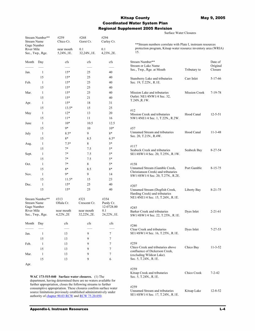
Kitsap County May 9, 2005 Coordinated Water System Plan Regional Supplement 2005 Revision
Appendix-L Instream Resources L-4
Stream Number** Stream Name Gage Number River Mile Sec., Twp., Rge.
#259 Chico Cr. near mouth 5,24N.,1E.
#268 Gorst Cr. 0.1 32,24N.,1E.
#294 Curley Cr. 0.1 4,23N.,2E.
Month
Day
cfs
cfs
cfs
––––– ––– ––– ––– ––– Jan. 1 15* 25 40 15 15* 25 40 Feb. 1 15* 25 40 15 15* 25 40 Mar. 1 15* 25 40 15 15* 21 40 Apr. 1 15* 18 31 15 13.5* 15 25 May 1 12* 13 20 15 11* 11 16 June 1 10* 10.5 12.5 15 9* 10 10* July 1 8.5* 9 8* 15 8* 8.5 6.5* Aug. 1 7.5* 8 5* 15 7* 7.5 5* Sept. 1 7* 7.5 5* 15 7* 7.5 5* Oct. 1 7* 8 5* 15 8* 8.5 8* Nov. 1 9* 9 14 15 11.5* 15 23 Dec. 1 15* 25 40 15 15* 25 40
Stream Number** Stream Name Gage Number River Mile Sec., Twp., Rge.
#313 Ollala Cr. near mouth 4,22N.,2E
#321 Crescent Cr. near mouth 32,22N.,2E.
#354 Purdy Cr. 12-0728.00 0.1 24,22N.,1E.
Month
Day
cfs
cfs
cfs
––––– ––– ––– ––– ––– Jan. 1 13 9 7 15 13 9 7 Feb. 1 13 9 7 15 13 9 7 Mar. 1 13 9 7 15 13 9 6 Apr.
WAC 173-515-040 Surface water closures. (1) The department, having determined there are no waters available for further appropriation, closes the following streams to further consumptive appropriation. These closures confirm surface water source limitations previously established administratively under authority of chapter 90.03 RCW and RCW 75.20.050.
Surface Water Closures **Stream numbers correlate with Plate I, instream resources protection program, Kitsap water resource inventory area (WRIA) 15.
Stream Number** Stream or Lake Name Sec., Twp., Rge. at Mouth
Tributary to
Date of Original Closure
Stansberry Lake and tributaries Sec. 19, T.22N., R.1E.
Carr Inlet
5-17-66
Mission Lake and tributaries Outlet: NE1/4NW1/4 Sec. 32, T.24N.,R.1W.
Mission Creek 7-19-78
#12 Mission Creek and tributaries NW1/4NE1/4 Sec. 1, T.22N., R.2W.
Hood Canal
12-5-51
#57 Unnamed Stream and tributaries Sec. 20, T.21N., R.4W.
Hood Canal
11-3-48
#117 Seabeck Creek and tributaries SE1/4SW1/4 Sec. 20, T.25N., R.1W.
Seabeck Bay
8-27-54
#158 Unnamed Stream (Gamble Creek, Christianson Creek) and tributaries SW1/4SW1/4 Sec. 20, T.27N., R.2E.
Port Gamble
8-15-75
#207 Unnamed Stream (Dogfish Creek, Harding Creek) and tributaries NE1/4NE1/4 Sec. 15, T.26N., R.1E.
Liberty Bay
8-21-75
#245 Barker Creek and tributaries SW1/4SW1/4 Sec. 22, T.25N., R.1E.
Dyes Inlet
2-21-61
#246 Clear Creek and tributaries SE1/4SW1/4 Sec. 16, T.25N., R.1E.
Dyes Inlet
7-27-53
#259 Chico Creek and tributaries above confluence of Dickerson Creek, (excluding Wildcat Lake). Sec. 5, T.24N., R.1E.
Chico Bay
11-3-52
#259 Kitsap Creek and tributaries Sec. 5, T.24N., R.1E.
Chico Creek
7-2-42
#259 Unnamed Stream and tributaries SE1/4SW1/4 Sec. 17, T.24N., R.1E.
Kitsap Lake
12-8-52

Kitsap County May 9, 2005 Coordinated Water System Plan Regional Supplement 2005 Revision
Appendix-L Instream Resources L-5
#279 Blackjack Creek and tributaries NE1/4SE1/4 Sec. 25, T.24N., R.1E.
Sinclair Inlet
4-5-60
#285 Unnamed Stream (Sullivan Creek) and tributaries NE1/4SW1/4 Sec.19, T.24N., R.2E
Sinclair Inlet
5-9-75
#294 Salmonberry Creek and tributaries NW1/4SE1/4 Sec. 18, T.23N., R.2E.
Long Lake
1-7-48
#356 Burley Creek and tributaries, SW1/4NW1/4 Sec. 12, T.22N., R.1E.
Burley Lagoon
5-10-51
#367 Minter Creek and tributaries SW1/4NE1/4 Sec. 29, T.22N., R.1E.
Henderson Bay
12-28-73
#402 Unnamed Stream (Dutcher Creek) and tributaries NE1/4NE1/4 Sec. 15, T.21N., R.1W.
Dutcher Cove
3-10-54
#510 Judd Creek and tributaries NE1/4NE1/4 Sec. 18, T.22N., R.3E.
Quartermaster Harbor
5-10-51
(2) The department has determined that (a) certain streams exhibit low summer flows and have a potential for drying up or inhibiting anadromous fish passage during critical life stages, and (b) historic flow regimes and current uses of certain other streams indicate that no water is available for additional appropriation. Based upon these determinations and in accordance with the general intent of RCW 75.20.050, the following streams are closed to further appropriation for the periods indicated:
New Surface Water Closures **Stream numbers correlate with Plate I, instream resources protection program, Kitsap water resource inventory area (WRIA) 15.
Stream Number** Stream Name Sec., Twp., Rge. at Mouth
Tributary to
Period of Closure
#7 Union River and tributaries from the mouth to McKenna Falls (R.M. 6.7) SE1/4SW1/4 Sec. 29, T.23N., R.1W.
Hood Canal
All year
#44 Tahuya River and tributaries SE1/4SE1/4 Sec. 22, T.22N., R.3W.
Hood Canal
June 15-Oct. 15
#60 Rendsland Creek and tributaries NW1/4NW1/4 Sec. 19, T.22N., R.3W.
Hood Canal
June 1-Oct. 31
#70 Dewatto River and tributaries NW1/4SE1/4 Sec. 27, T.22N., R.3W.
Hood Canal
June 15-Oct. 31
#121 Big Beef Creek and tributaries SW1/4SE1/4 Sec. 15, T.25N., R.1W.
Hood Canal
May 15-Oct. 31
#124 Anderson Creek and tributaries NW1/4NW1/4 Sec. 13, T.26N., R.1W.
Hood Canal
June 1-Oct. 31
#192 Grover's Creek and tributaries NW1/4SW1/4 Sec. 4, T.26N., R.2E.
Puget Sound
June 1-Oct. 15
#223 Unnamed Stream (Steel Creek) and tributaries SE1/4SE1/4 Sec. 14, T.25N., R.1E.
Port Orchard
June 1-Oct. 15
#248 Unnamed Stream and tributaries (Strawberry/Cook's/Koch's Creek) SE1/4NE1/4 Sec. 20, T.25N., R.1E.
Dyes Inlet
June 1-Oct. 31
#259 Dickerson Creek and tributaries SW1/4NW1/4 Sec. 7, T.24N., R.1E.
Chico Creek
All year
#259 Chico Creek and tributaries below confluence of Dickerson Creek SW1/4SW1/4 Sec. 5, T.25N., R.1E.
Chico Bay
All year
#294 Curley Creek and tributaries NE1/4NE1/4 Sec. 18, T.23N., R.2E.
Yukon Harbor
June 15-Oct. 15
#313 Olalla Creek and tributaries SE1/4NE1/4 Sec. 4, T.22N., R.2E.
Colvos Passage
June 1-Oct. 15
#321 Crescent Creek and tributaries SE1/4SW1/4 Sec. 32, T. 22N., R.2E.
Gig Harbor
June 1-Oct. 15
#354 Purdy Creek and tributaries NE1/4NW1/4 Sec. 12, T.22N., R.1E.
Henderson Bay
June 1-Oct. 31
#369 Lackey Creek and tributaries SE1/4SW1/4 Sec. 31, T.21N., R.1E.
Carr Inlet
June 1-Nov. 15
#415 Rocky Creek and tributaries SE1/4SE1/4 Sec. 27, T.22N., R.1E.
Case Inlet
June 1-Oct. 31

Kitsap County May 9, 2005 Coordinated Water System Plan Regional Supplement 2005 Revision
Appendix-L Instream Resources L-6
(3) In the Kitsap basin numerous small streams with estimated mean annual flow of 5 cfs or less have been identified as having high instream values for anadromous fish, aesthetics, water quality, and/or recreation. In accordance with the general intent of RCW 75.20.050 the department has determined that the total natural flow of these streams is required for protection and preservation of instream resources, and that no water is available for additional consumptive appropriation. The natural flow, in effect, constitutes the minimum flow for protection of the instream resources. The following streams possess such characteristics and are therefore closed year-round to further consumptive appropriation.
New Surface Water Closures **Stream numbers correlate with Plate I, instream resources protection program, Kitsap water resource inventory area (WRIA) 15.
Stream Number** Stream Name Sec., Twp., Rge. at Mouth
Tributary to
#13 Little Mission Creek and tributaries SE1/4NW1/4 Sec. 1, T.22N., R.2W.
Hood Canal
#18 Stimson Creek and tributaries NW1/4NW1/4 Sec. 11, T.22N., R.2W.
Hood Canal
#31 Unnamed Stream (Little Shoefly Creek) and tributaries SW1/4NW1/4 Sec. 17, T.22N., R.2W.
Hood Canal
#34 Shoefly Creek and tributaries SE1/4SW1/4 Sec. 18, T.22N., R.2W.
Hood Canal
#46 Caldervin Creek and tributaries NE1/4NE1/4 Sec. 28, T.21N., R.3W.
Hood Canal
#50 Hall Creek and tributaries Sec. 20, T.21N., R.3W.
Hood Canal
#52 Hoddy Creek and tributaries Sec. 20, T.21N., R.3W.
Hood Canal
#54 Fay Creek and tributaries Sec. 21, T.20N., R.3W.
Hood Canal
#55 Brown Creek and tributaries Sec. 21, T.20N., R.3W.
Hood Canal
#56 Unnamed Stream (West Creek)
Hood Canal
and tributaries Sec. 20, T.22N., R.3W. #101 Harding Creek and tributaries NW1/4SW1/4 Sec. 9, T.24N., R.2W.
Hood Canal
#164 Unnamed Stream (Little Boston Creek) and tributaries SW1/4SW1/4 Sec. 5, T.27N., R.2E.
Port Gamble
#181 Unnamed Stream and tributaries SE1/4SW1/4 Sec. 26, T.27N., R.2E.
Apple Tree Cove
#184 Unnamed Stream and tributaries NE1/4SW1/4 Sec. 36, T.27N., R.2E.
Apple Tree Cove
#190 Unnamed Stream and tributaries Sec. 9, T.26N., R.2E.
Puget Sound
#196 Cowling Creek and tributaries NW1/4NW1/4 Sec. 16, T.26N., R.2E.
Miller Bay
#198 Thompson Creek and tributaries SW1/4SE1/4 Sec. 29, T.26N., R.2E.
Port Orchard
#208 Johnson Creek and tributaries SE1/4NW1/4 Sec. 22, T.26N., R.1E.
Liberty Bay
#213 Scandia Creek and tributaries SW1/4NE1/4 Sec. 27, T.26N., R.1E.
Liberty Bay
#241 Mosher Creek and tributaries SW1/4NE1/4 Sec. 34, T.25N., R.1E.
Dyes Inlet
#272 Anderson Creek and tributaries SE1/4NE1/4 Sec. 33, T.24N., R.1E.
Sinclair Inlet
#275 Ross Creek and tributaries SE1/4SE1/4 Sec. 27, T.24N., R.1E.
Sinclair Inlet
#289 Beaver Creek and tributaries NW1/4SE1/4 Sec. 16, T.24N., R.2E.
Rich Passage
#322 North Creek and tributaries NE1/4SE1/4 Sec. 6, T.21N., R.2E.
Gig Harbor

Kitsap County May 9, 2005 Coordinated Water System Plan Regional Supplement 2005 Revision
Appendix-L Instream Resources L-7
#342 Unnamed Stream and tributaries NW1/4SE1/4 Sec. 10, T.21N., R.1E.
Henderson Bay
#343 Unnamed Stream (Meyer Creek) and tributaries SW1/4SW1/4 Sec. 2, T.21N., R.1E.
Hood Canal
#407 Unnamed Stream and tributaries SE1/4NW1/4 Sec. 2, T.21N., R.1W.
Vaughn Bay
#434 Unnamed stream and tributaries SE1/4SE1/4 Sec. 15, T.25N., R.2E.
Murden Cove
#461 Unnamed Stream and tributaries SE1/4NE1/4 Sec. 20, T.25N., R.2E.
Fletcher Bay
#514 Unnamed Stream (Fisher Creek) and tributaries SW1/4NW1/4 Sec. 19, T.22N., R.3E.
Quartermaster Harbor
#530 Jod Creek and tributaries NW1/4NW1/4 Sec. 14, T.22N., R.2E.
Colvos Passage
#540 Needle Creek and tributaries NE1/4SE1/4 Sec. 13, T.23N., R.3E.
Colvos Passage
(4) Closures listed in WAC 173-515-040 (2) and (3) will supersede low flow surface water source limitations previously imposed by administrative authority pursuant to chapter 75.20 RCW. (5) Lakes perennially tributary to closed streams are closed to further consumptive appropriation.
[Statutory Authority: Chapters 90.22 and 90.54 RCW. 81-16-003 (Order DE 80-45), § 173-515-040, filed 7/24/81.]
WAC 173-515-050 Groundwater. Future groundwater withdrawal proposals will not be affected by this chapter unless it is determined that such withdrawal would clearly have an adverse impact upon the surface water system contrary to the intent and objectives of this chapter.
[Statutory Authority: Chapters 90.22 and 90.54 RCW. 81-16-003 (Order DE 80-45), § 173-515-050, filed 7/24/81.]
WAC 173-515-060 Lakes. In future permitting actions relating to withdrawal of lake waters, lakes and ponds shall be retained substantially in their natural condition. Withdrawals of water which would conflict therewith shall be authorized only in those situations where it is clear that overriding considerations of the public interest will be served.
[Statutory Authority: Chapters 90.22 and 90.54 RCW. 81-16-003 (Order DE 80-45), § 173-515-060, filed 7/24/81.]
WAC 173-515-070 Exemptions. (1) Nothing in this chapter shall affect existing water rights, riparian, appropriative, or otherwise, existing on the effective date of this chapter, nor shall it affect existing rights relating to the operation of any navigation, hydroelectric or water storage reservoir or related facilities. (2) If, upon detailed analysis, appropriate and environmentally sound proposed storage facilities are found to be compatible with this chapter, such facilities may be approved but will be subject to the establishment of appropriate protection flows for drought or low runoff periods. (3) Domestic use for a single residence shall be exempt from the provisions of this chapter. If the cumulative effects of numerous single domestic diversions would seriously affect the quantity of water available for instream uses, then domestic in-house use shall be exempt if no alternative source is available. (4) Stockwatering use, except that related to feedlots, shall be exempt from the provisions established in this chapter. (5) Future rights for nonconsumptive uses may be granted.
[Statutory Authority: Chapters 90.22 and 90.54 RCW. 81-16-003 (Order DE 80-45), § 173-515-070, filed 7/24/81.]
WAC 173-515-080 Future rights. No right to divert or store public surface waters of the Kitsap water resource inventory area (WRIA) 15 shall hereafter be granted which shall conflict with the purpose of this chapter.
[Statutory Authority: Chapters 90.22 and 90.54 RCW. 81-16-003 (Order DE 80-45), § 173-515-080, filed 7/24/81.]
WAC 173-515-090 Enforcement. In enforcement of this chapter, the department of ecology may impose such sanctions as appropriate under authorities vested in it, including but not limited to the issuance of regulatory orders under RCW 43.27A.190 and civil penalties under RCW 90.03.600.
[Statutory Authority: Chapters 43.21B, 43.27A, 90.22 and 90.54 RCW. 88-13-037 (Order 88-11), § 173-515-090, filed 6/9/88. Statutory Authority: Chapters 90.22 and 90.54 RCW. 81-16-003 (Order DE 80-45), § 173-515-090, filed 7/24/81.]
WAC 173-515-095 Appeals. All final written decisions of the department of ecology pertaining to permits, regulatory orders, and related decisions made pursuant to this chapter shall be subject to review by the pollution control hearings board in accordance with chapter 43.21B RCW.
[Statutory Authority: Chapters 43.21B, 43.27A, 90.22 and 90.54 RCW. 88-13-037 (Order 88-11), § 173-515-095, filed 6/9/88.]
WAC 173-515-100 Regulation review. The department of ecology shall initiate a review of the rules established in this chapter whenever new information, changing conditions, or statutory modifications make it necessary to consider revisions.
[Statutory Authority: Chapters 43.21B, 43.27A, 90.22 and 90.54 RCW. 88-13-037 (Order 88-11), § 173-515-100, filed 6/9/88. Statutory Authority: Chapters 90.22 and 90.54 RCW. 81-16-003 (Order DE 80-45), § 173-515-100, filed 7/24/81.]