justice antonio t. carpio the views expressed in this ... · pdf filethe views expressed in...
TRANSCRIPT

The views expressed in this presentation are the personal opinion of the author and do not necessarily represent the position of the Philippine Government.
Justice Antonio T. Carpio
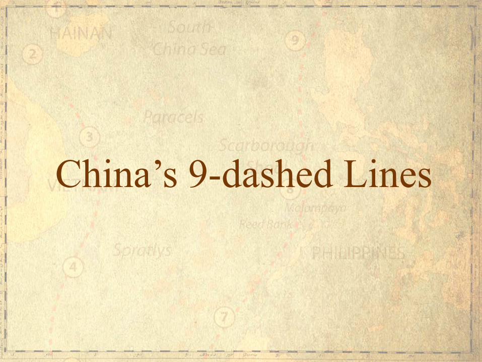
China’s 9-dashed Lines

China’s new “national boundaries” under the 9-dashed lines

Nine-dashed Lines Map Submitted by China to UN in 2009 China did not explain the legal basis for the dashes. The dashes had no fixed coordinates.

In 2013, China released a new map of China, adding a 10th dash on the eastern side of Taiwan. In its 2013 map, China claims the 10 dashed lines are its “national boundaries” without again explaining the legal basis or giving the fixed coordinates for the dashes. The 2013 China map was published by SinoMaps Press, under the jurisdiction of China’s State Bureau of Surveying and Mapping. This means the 2013 Map is an official Chinese government map. In its Note Verbale of June 7, 2013 to China, the Philippines stated it "strongly objects to the indication that the nine-dash lines are China's national boundaries in the West Philippine Sea/South China Sea.”
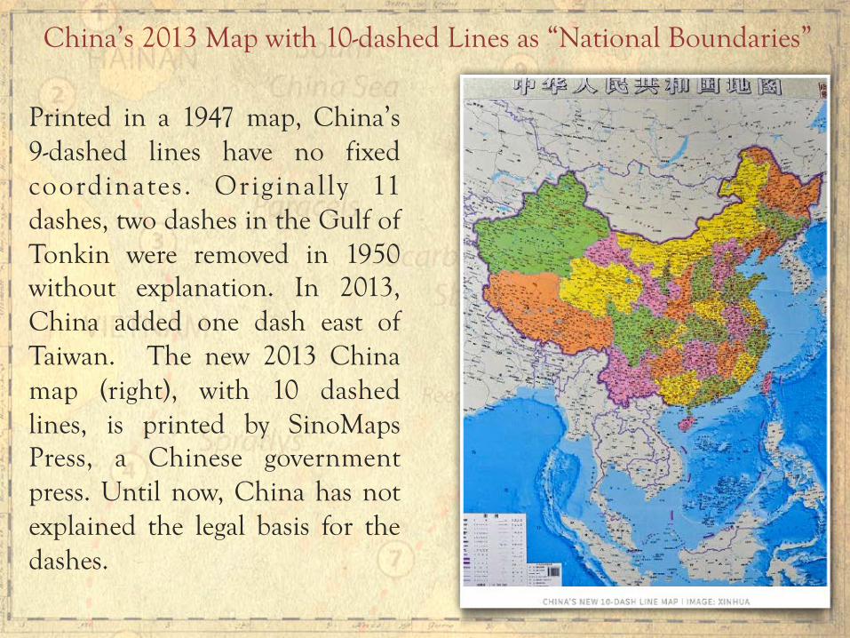
Printed in a 1947 map, China’s 9-dashed lines have no fixed coordinates. Originally 11 dashes, two dashes in the Gulf of Tonkin were removed in 1950 without explanation. In 2013, China added one dash east of Taiwan. The new 2013 China map (right), with 10 dashed lines, is printed by SinoMaps Press, a Chinese government press. Until now, China has not explained the legal basis for the dashes.
China’s 2013 Map with 10-dashed Lines as “National Boundaries”

China’s 2013 Map with 10-dashed Lines as “National Boundaries”

What is the Effect of China’s “National Boundaries” under the 9-dashed Lines?
The Philippines loses about 80% of its EEZ facing the West Philippine Sea, including the entire Reed Bank and part of the Malampaya gas field. Malaysia loses also about 80% of its EEZ in Sabah and Sarawak facing the South China Sea, as well as most of its active gas and oil fields in the same area. Vietnam loses about 50% of its total EEZ. Brunei loses about 90% of its total EEZ. Indonesia loses about 30% of its EEZ facing the South China Sea in Natuna Islands, whose surrounding waters comprise the largest gas field in Southeast Asia.
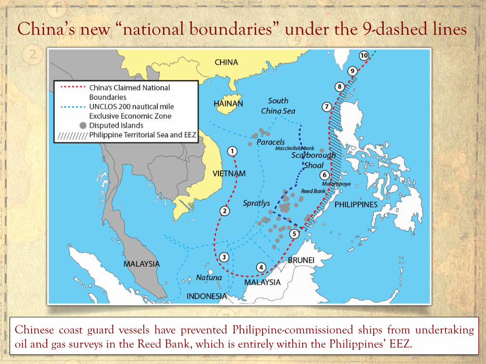
China’s new “national boundaries” under the 9-dashed lines
Chinese coast guard vessels have prevented Philippine-commissioned ships from undertaking oil and gas surveys in the Reed Bank, which is entirely within the Philippines’ EEZ.
There is a territorial dispute that is rooted in conflicting territorial claims over islands, rocks, and reefs above water at high tide. There is also a maritime dispute that is rooted in conflicting maritime claims over maritime zones. The dispute involves six countries bordering the South China Sea.
What is the dispute in the South China Sea?

China’s 9-dashed lines claim, through which China is aggressively asserting “indisputable sovereignty” to all the islands and waters enclosed by the lines, is the main driver of the South China Sea dispute. China’s 9-dashed lines claim encloses 85.7% of the entire South China Sea. This is equivalent to 3 million square kilometers out of the 3.5 million square kilometers surface area of the South China Sea.

China claims James Shoal as its southernmost border. James Shoal is fully submerged at 22 meters below the water surface, and is situated more than 950 NM from Hainan Island and more than 400 NM from Itu Aba. Under international law, a state’s border must either be a land territory, a river, or a territorial sea - which are all subject to its full sovereignty.
A state cannot appropriate as its sovereign territory a fully submerged area beyond its territorial sea. James Shoal is 80 KM from Malaysia’s coast in Bintulu, Sarawak, within Malaysia’s EEZ.
James Shoal - China’s “Southernmost” Border

Chinese Sovereignty Oath-Taking Ceremony at James Shoal in January 2014
A Chinese taskforce composed of three warships from the South China Sea Fleet of the Navy of the Chinese People’s Liberation Army (PLAN) held a sovereignty oath-taking ceremony on January 26, 2014 in the waters of James (Zengmu) Shoal off the coast of Sarawak, Borneo in the South China Sea. Photo: Xinhua
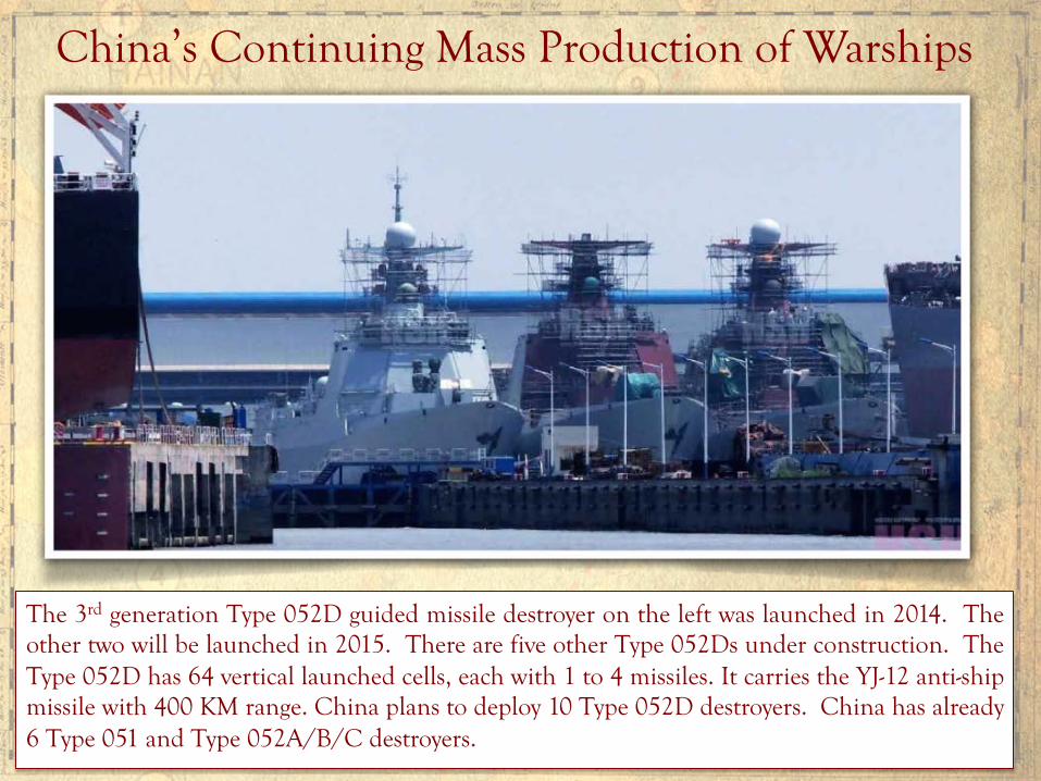
China’s Continuing Mass Production of Warships
The 3rd generation Type 052D guided missile destroyer on the left was launched in 2014. The other two will be launched in 2015. There are five other Type 052Ds under construction. The Type 052D has 64 vertical launched cells, each with 1 to 4 missiles. It carries the YJ-12 anti-ship missile with 400 KM range. China plans to deploy 10 Type 052D destroyers. China has already 6 Type 051 and Type 052A/B/C destroyers.

Type 54A Chinese Frigate Commissioned in January 2015
China has 15 Type 054 frigates, the largest number of any class of China’s warships. Five more Type 054 frigates are in production. A newer class of frigate, the Type 056, is under final development. China plans to produce 40 Type 056 frigates.
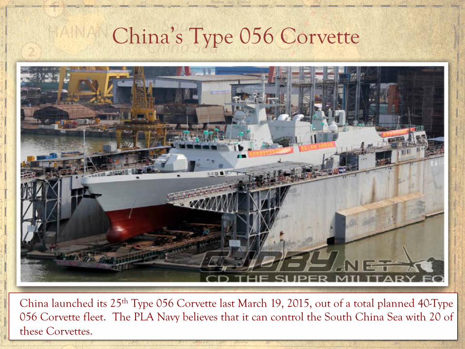
China’s Type 056 Corvette
China launched its 25th Type 056 Corvette last March 19, 2015, out of a total planned 40-Type 056 Corvette fleet. The PLA Navy believes that it can control the South China Sea with 20 of these Corvettes.
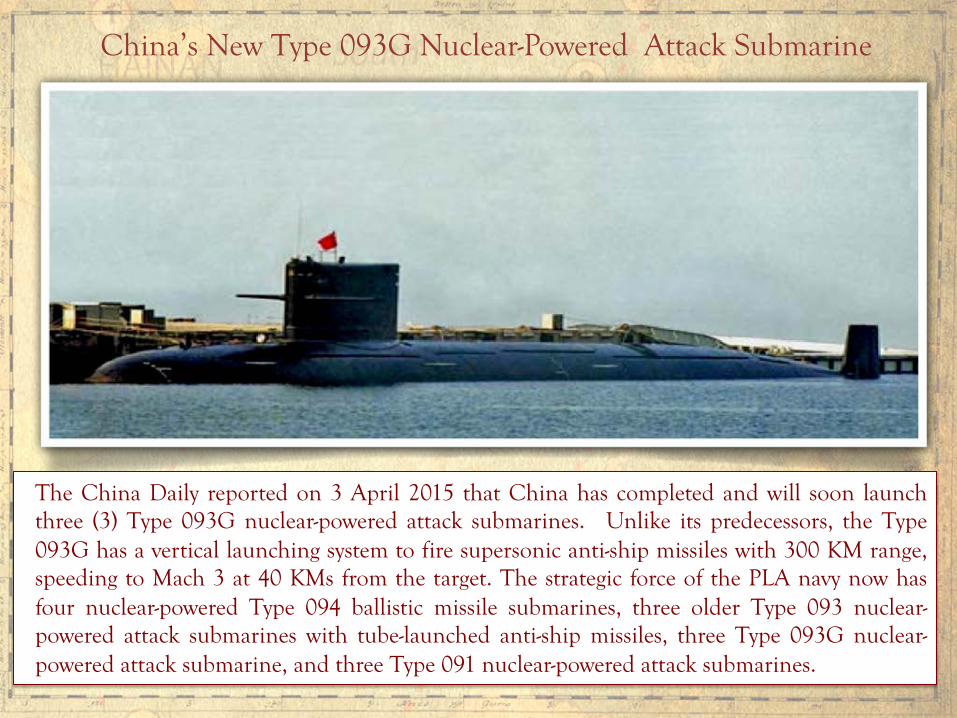
China’s New Type 093G Nuclear-Powered Attack Submarine
The China Daily reported on 3 April 2015 that China has completed and will soon launch three (3) Type 093G nuclear-powered attack submarines. Unlike its predecessors, the Type 093G has a vertical launching system to fire supersonic anti-ship missiles with 300 KM range, speeding to Mach 3 at 40 KMs from the target. The strategic force of the PLA navy now has four nuclear-powered Type 094 ballistic missile submarines, three older Type 093 nuclear-powered attack submarines with tube-launched anti-ship missiles, three Type 093G nuclear-powered attack submarine, and three Type 091 nuclear-powered attack submarines.

China’s First Aircraft Carrier - Liaoning
China plans to build three more aircraft carriers, with one already under construction.

China’s New Type 904A Supply Ship
China is building several supply ships to service its outposts in the Paracels and the Spratlys. The new Type 904A supply ship has a helipad and storage for one Z-8 heavy transport helicopter.
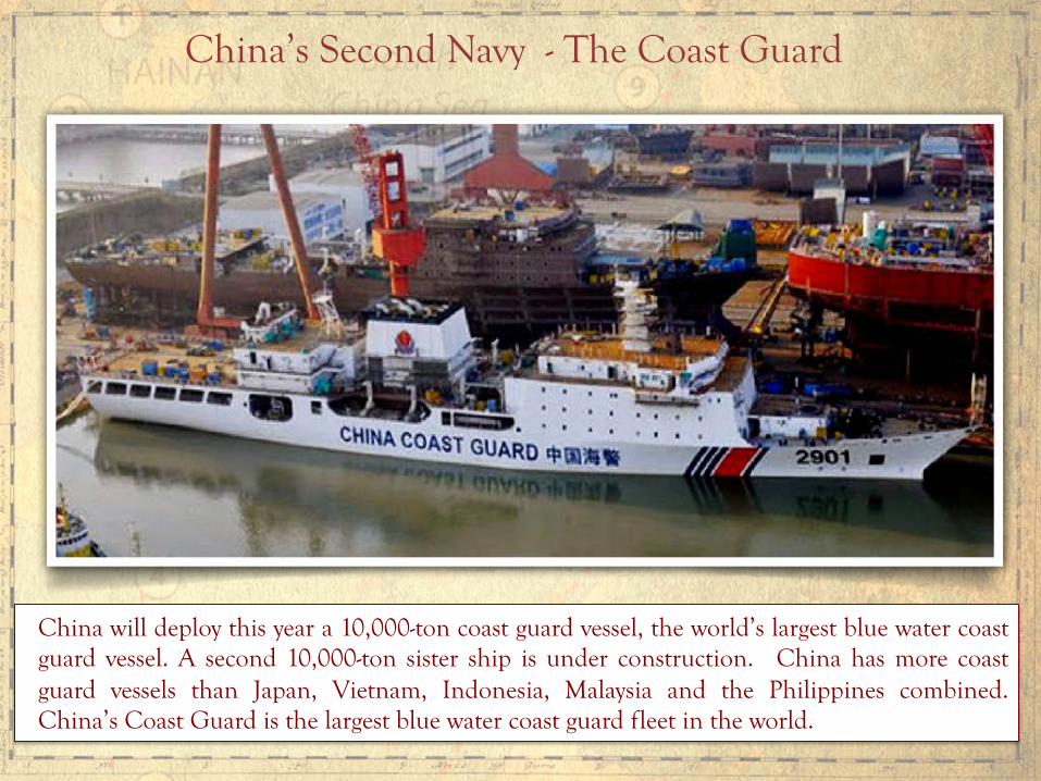
China’s Second Navy - The Coast Guard
China will deploy this year a 10,000-ton coast guard vessel, the world’s largest blue water coast guard vessel. A second 10,000-ton sister ship is under construction. China has more coast guard vessels than Japan, Vietnam, Indonesia, Malaysia and the Philippines combined. China’s Coast Guard is the largest blue water coast guard fleet in the world.

China’s new “national boundaries” under the 9-dashed lines
Under its 2015 “China Military Strategy,” China will shift from “offshore waters defense” to the combined “offshore waters defense” and “open seas protection.” The CMS states: “The traditional mentality that land outweighs the sea must be abandoned, and great importance has to be attached to managing the seas and oceans and protecting maritime rights and interests.”

A Low-Tide Elevation (LTE) is a naturally formed area of land (rock, reef, atoll or sandbar) surrounded by water, above water at low tide but submerged at high tide. An LTE is part of the submerged continental shelf. An LTE is not land or territory, and thus has no territorial sea (Art. 13, UNCLOS). An LTE beyond the territorial sea is not subject to appropriation by any State (Nicaragua v. Colombia, ICJ, 2012).
What is a Low-Tide Elevation (LTE)?
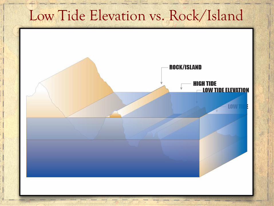
Low Tide Elevation vs. Rock/Island

The Philippine arbitration case against China is not a territorial dispute but solely a maritime dispute involving the interpretation or application of UNCLOS:
1. Whether China’s 9-dashed lines, which are not measured from land (and thus not part of China’s TS, EEZ or CS), can encroach on the 200 NM EEZ of the Philippines;
Is the Philippine arbitration case against China a territorial or a maritime dispute, or both?
2. Whether certain geologic features, namely Mischief Reef, Second Thomas Shoal, and Johnson South Reef, all within the Philippines EEZ, are LTEs and therefore form part of the submerged continental shelf of the Philippines and as such are under Philippine jurisdiction; and whether Subi Reef, outside the Philippines’ EEZ but within its continental shelf, is an LTE generating no maritime entitlements;
3. Whether certain geologic features, namely Gaven Reef* and McKennan Reef** (including Hughes Reef), are low-tide elevations which generate no maritime entitlements of their own, but their low-water line may be used to determine the baseline from which the territorial sea of Namyit Island and Sin Cowe Island, respectively, may be measured.
* 6.3 NM from Namyit Island ** 3.5 NM from Sin Cowe Island
4. Whether certain geologic features, namely, Fiery Cross Reef and Cuarteron Reef, outside the Philippines’ EEZ but within its continental shelf, are mere rocks above water at high tide that generate no EEZ;
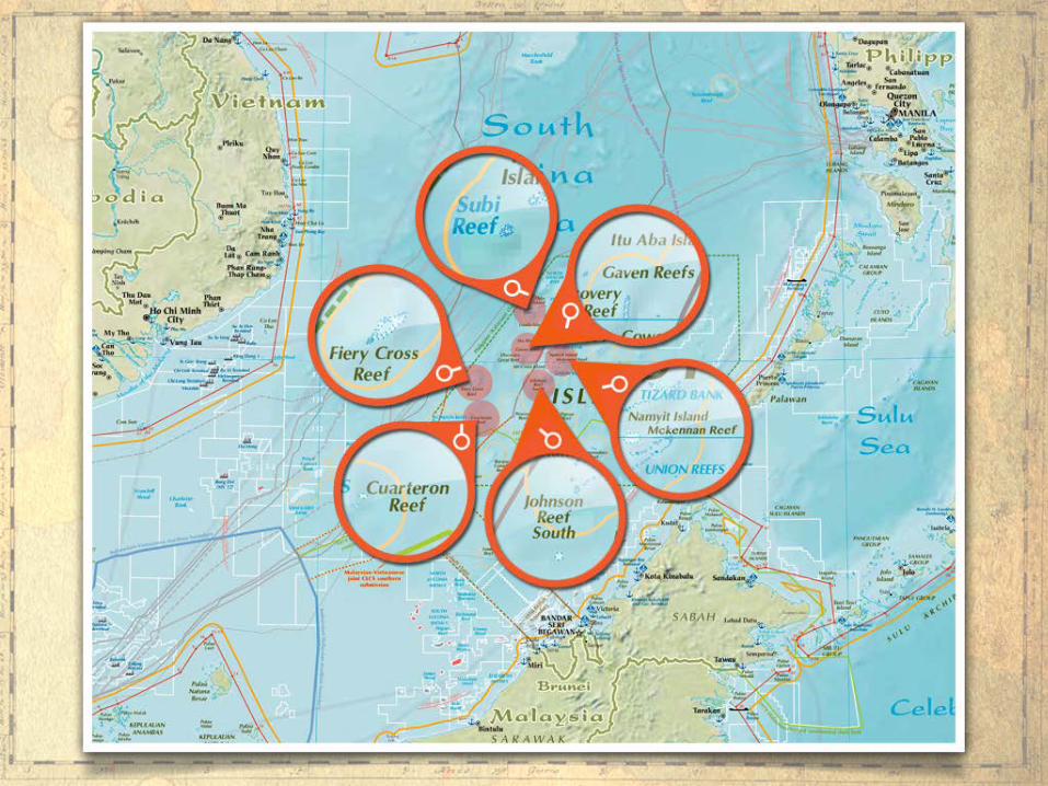
5. Whether Scarborough Shoal, whatever state owns it, is entitled to only a 12 NM territorial sea or also to a 200 NM EEZ.
All these disputes are maritime disputes involving the interpretation or application of UNCLOS.
The Philippines is not asking the tribunal to rule what state owns certain islands, or rocks above water at high tide.
The Philippines is asking the tribunal to rule what is the extent of the maritime entitlements (0, 12, or 200 NM) of certain islands or rocks, regardless of what state owns them; and whether certain geologic features are LTEs or not. All these are maritime disputes.

China has on-going reclamations on seven (7) reefs, Fiery Cross Reef, Cuarteron Reef, Gaven Reef, Johnson South Reef, McKennan Reef, Mischief Reef and Subi Reef. These are all the reefs China occupies. China explained that the reclamations are intended to “improve the living and working conditions of those stationed on the islands.” Chinese Foreign Ministry Spokeswoman Hua Chunying asserted that China was building “civil functioning facilities such as typhoon shelters, navigation aids, search-and-rescue centers, marine meteorological forecasting stations, fishing services, and civil administration offices.” The Spokeswoman, however, added that the reclamations would also be used for China's military defense. As the Chinese envoy to the U.S. Ambassador Cui Tankai explained, “Of course, there will be military facilities.” This is similar to China’s explanation in 1995 that it occupied Mischief Reef to provide a “shelter” to its fishermen, which later turned out to be a military garrison. China is now reclaiming Mischief Reef and turning it into a 500-hectare military facility.
China’s Reclamations in the Spratlys
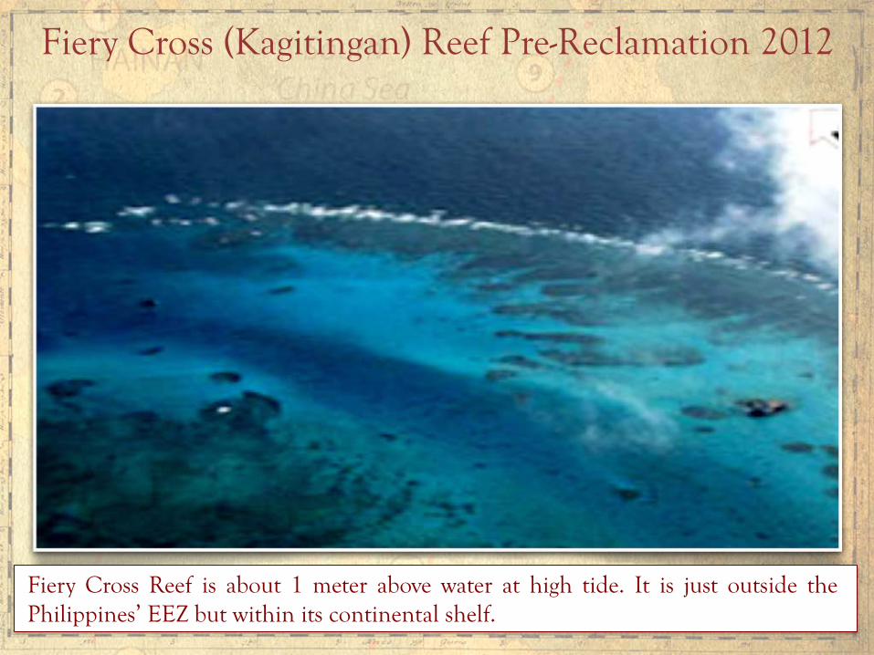
Fiery Cross (Kagitingan) Reef Pre-Reclamation 2012
Fiery Cross Reef is about 1 meter above water at high tide. It is just outside the Philippines’ EEZ but within its continental shelf.
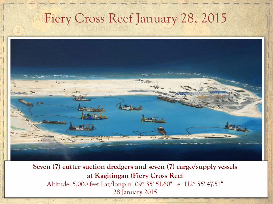
Seven (7) cutter suction dredgers and seven (7) cargo/supply vessels at Kagitingan (Fiery Cross Reef
Altitude: 5,000 feet Lat/long: n 09° 35' 51.60" e 112° 55' 47.51“ 28 January 2015
Fiery Cross Reef January 28, 2015

Fiery Cross Reef May 7, 2015

Chinese Reclamation on Fiery Cross (Kagitingan) Reef April 17, 2015
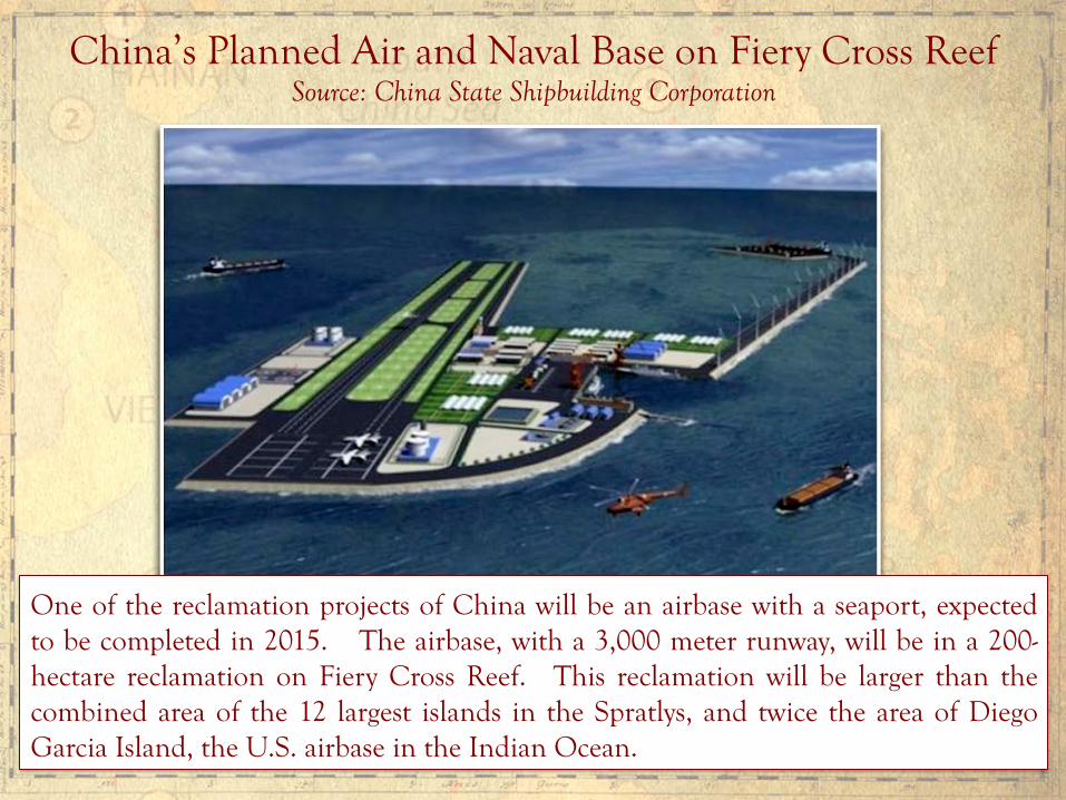
China’s Planned Air and Naval Base on Fiery Cross Reef Source: China State Shipbuilding Corporation
One of the reclamation projects of China will be an airbase with a seaport, expected to be completed in 2015. The airbase, with a 3,000 meter runway, will be in a 200-hectare reclamation on Fiery Cross Reef. This reclamation will be larger than the combined area of the 12 largest islands in the Spratlys, and twice the area of Diego Garcia Island, the U.S. airbase in the Indian Ocean.

Chinese Air & Naval Base on Fiery Cross (Kagitingan) Reef

China’s J-16 Fighter-Bomber with 3,900 KM Range
The J-16’s combat range covers the entire Philippines, Borneo and the Natuna Islands.

China’s Strategic Bomber H-6K with 7,000 KM Range
The H-6K can carry under its wing pylons six conventional or nuclear armed CJ-10A cruise missiles with 2,200 KM range. Although the H-6 was first domestically produced in 1968, this upgraded version, using composite materials, modern avionics and a powerful radar, first entered service only in October 2009.

Johnson South (Mabini) Reef Pre-Reclamation
Johnson South Reef is an LTE within the Philippines’ EEZ. [Note: Chinese, Philippine and other countries’ nautical charts designate this as an LTE. Only the U.S. nautical chart designates this as a high tide feature.]
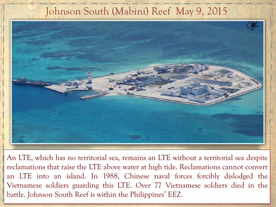
Johnson South (Mabini) Reef May 9, 2015
An LTE, which has no territorial sea, remains an LTE without a territorial sea despite reclamations that raise the LTE above water at high tide. Reclamations cannot convert an LTE into an island. In 1988, Chinese naval forces forcibly dislodged the Vietnamese soldiers guarding this LTE. Over 77 Vietnamese soldiers died in the battle. Johnson South Reef is within the Philippines’ EEZ.

McKennan (Chigua) Reef Pre-Reclamation
McKennan Reef is an LTE within the Philippines’ EEZ. It is within 12 NM of Sin Cowe Island.
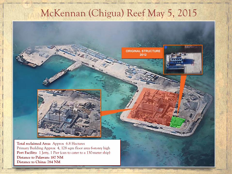
McKennan (Chigua) Reef May 5, 2015
Total reclaimed Area: Approx 6.8 Hectares Primary Building Approx 4, 128 sqm floor area 6-storey high Port Facility: 1 Jetty, 1 Pier (can to cater to a 130-meter ship) Distance to Palawan: 187 NM Distance to China: 784 NM

Gaven Reef at Start of Reclamation 2014
Gaven Reef is outside of the Philippines’ EEZ but within its continental shelf. Gaven Reef is an LTE within 12 NM of Namyit Island.

Gaven Reef May 9, 2015

Cuarteron (Calderon) Reef Pre-Reclamation
Cuarteron Reef is outside the Philippines’ EEZ but within its continental shelf. It is above water at high tide.

Cuarteron Reef May 7, 2015
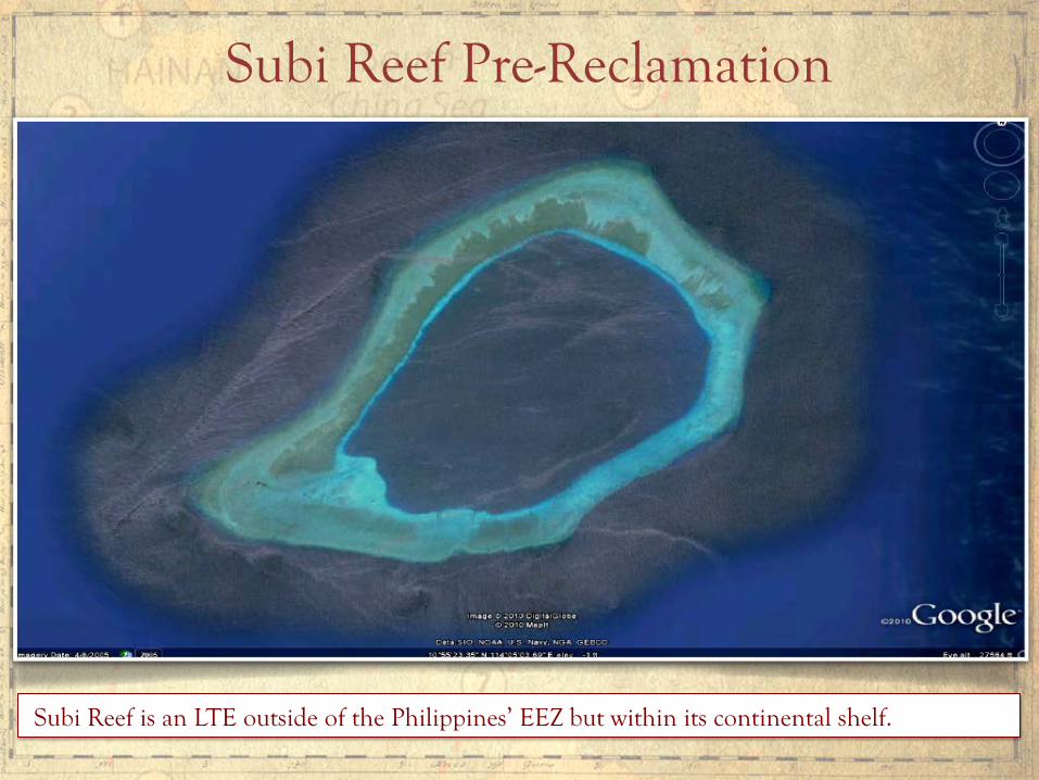
Subi Reef is an LTE outside of the Philippines’ EEZ but within its continental shelf.
Subi Reef Pre-Reclamation
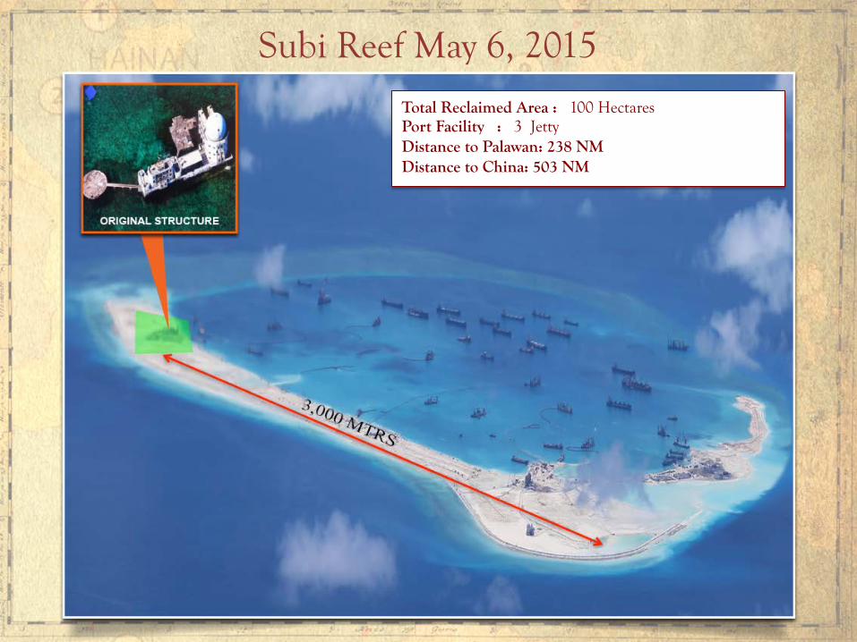
Subi Reef May 6, 2015
Total Reclaimed Area : 100 Hectares Port Facility : 3 Jetty Distance to Palawan: 238 NM Distance to China: 503 NM
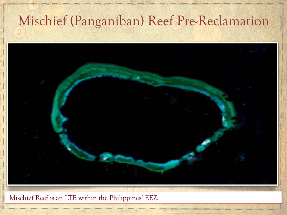
Mischief Reef is an LTE within the Philippines’ EEZ.
Mischief (Panganiban) Reef Pre-Reclamation

China’s reclamation along the left side of the reef’s ring is about 9 KMs in length. If China closes the edge of the upper reclamation and the edge of the lower reclamation running about 3.5 KM, the total reclaimed area can reach at least 500 hectares. This area is more than enough for an air and naval base, plus a garrison for thousands of marines. (Image from Center for Strategic and International Studies via Digital Globe)
Mischief Reef, January 2012 and March 2015
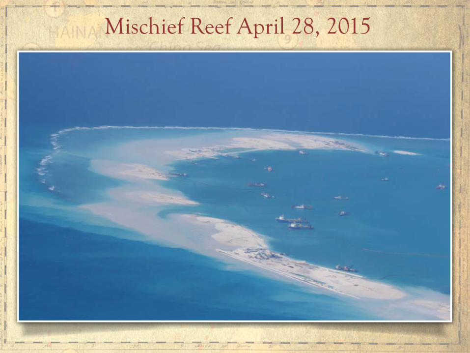
Mischief Reef April 28, 2015
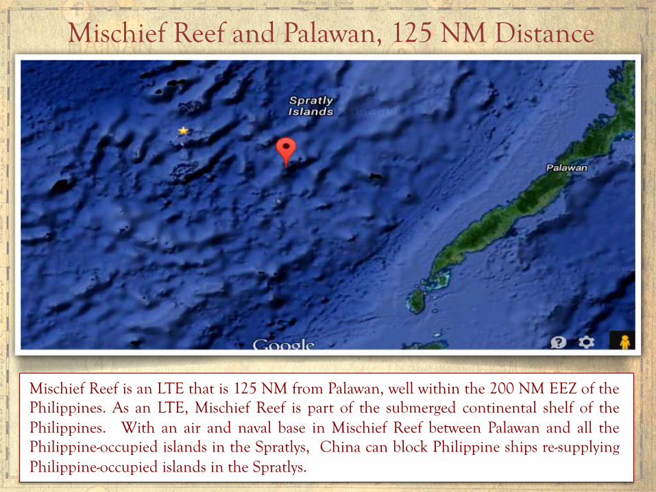
Mischief Reef is an LTE that is 125 NM from Palawan, well within the 200 NM EEZ of the Philippines. As an LTE, Mischief Reef is part of the submerged continental shelf of the Philippines. With an air and naval base in Mischief Reef between Palawan and all the Philippine-occupied islands in the Spratlys, China can block Philippine ships re-supplying Philippine-occupied islands in the Spratlys.
Mischief Reef and Palawan, 125 NM Distance
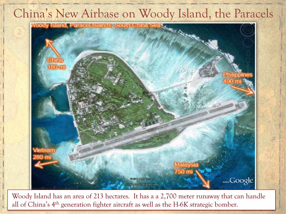
China’s New Airbase on Woody Island, the Paracels
Woody Island has an area of 213 hectares. It has a a 2,700 meter runaway that can handle all of China’s 4th generation fighter aircraft as well as the H-6K strategic bomber.
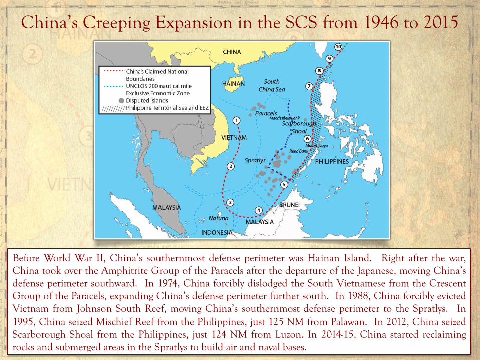
China’s Creeping Expansion in the SCS from 1946 to 2015
Before World War II, China’s southernmost defense perimeter was Hainan Island. Right after the war, China took over the Amphitrite Group of the Paracels after the departure of the Japanese, moving China’s defense perimeter southward. In 1974, China forcibly dislodged the South Vietnamese from the Crescent Group of the Paracels, expanding China’s defense perimeter further south. In 1988, China forcibly evicted Vietnam from Johnson South Reef, moving China’s southernmost defense perimeter to the Spratlys. In 1995, China seized Mischief Reef from the Philippines, just 125 NM from Palawan. In 2012, China seized Scarborough Shoal from the Philippines, just 124 NM from Luzon. In 2014-15, China started reclaiming rocks and submerged areas in the Spratlys to build air and naval bases.
Protect and Preserve the Marine Environment
Article 192 of UNCLOS mandates, “States have the obligation to protect and preserve the marine environment.”
China’s massive and wanton reclamation in the Spratlys is destroying the marine environment.
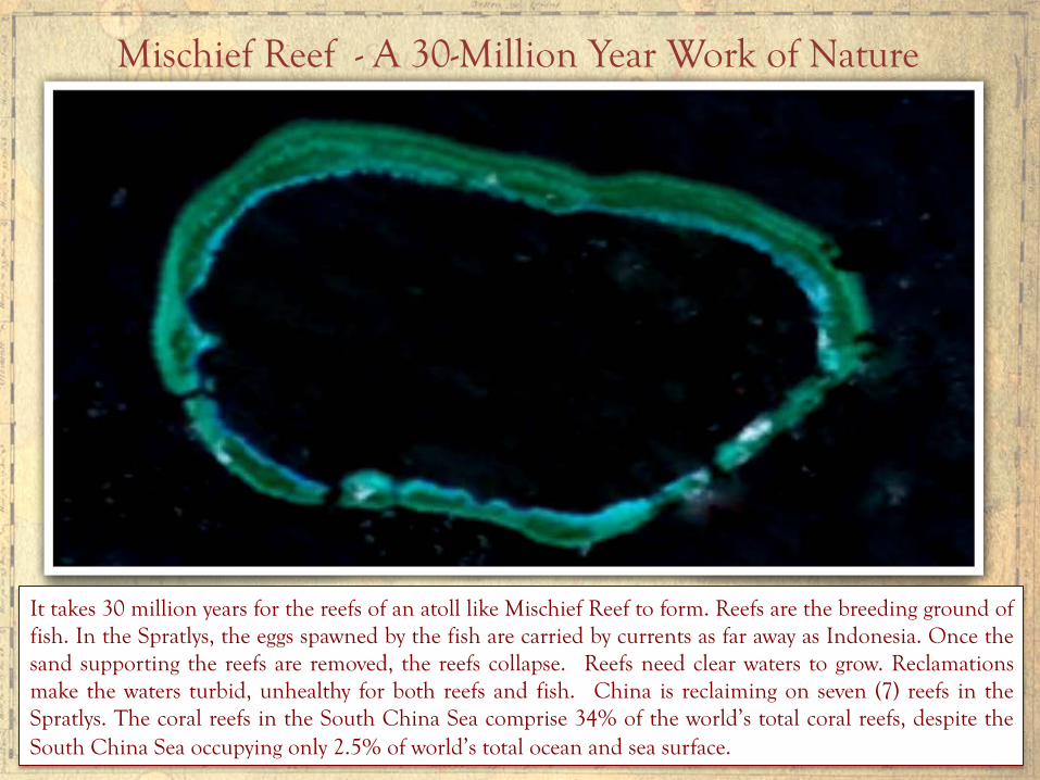
Mischief Reef - A 30-Million Year Work of Nature
It takes 30 million years for the reefs of an atoll like Mischief Reef to form. Reefs are the breeding ground of fish. In the Spratlys, the eggs spawned by the fish are carried by currents as far away as Indonesia. Once the sand supporting the reefs are removed, the reefs collapse. Reefs need clear waters to grow. Reclamations make the waters turbid, unhealthy for both reefs and fish. China is reclaiming on seven (7) reefs in the Spratlys. The coral reefs in the South China Sea comprise 34% of the world’s total coral reefs, despite the South China Sea occupying only 2.5% of world’s total ocean and sea surface.
Only the adjacent coastal state has the right to create artificial islands, or erect structures on LTEs, within its EEZ or CS (Arts. 60 & 80, UNCLOS). Thus, such artificial islands or structures put up by other states within the EEZ or CS of a coastal state are illegal under UNCLOS.
Who can create artificial islands, or erect structures on LTEs, in the EEZ or CS?
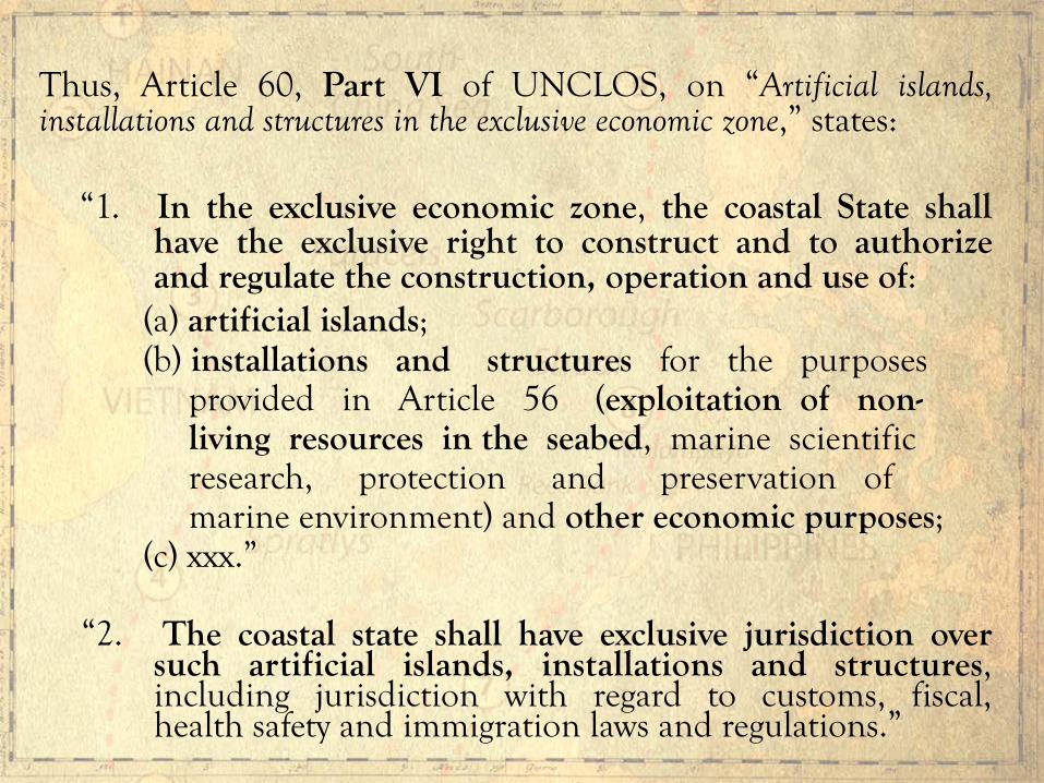
Thus, Article 60, Part VI of UNCLOS, on “Artificial islands, installations and structures in the exclusive economic zone,” states:
“1. In the exclusive economic zone, the coastal State shall have the exclusive right to construct and to authorize and regulate the construction, operation and use of:
(a) artificial islands; (b) installations and structures for the purposes provided in Article 56 (exploitation of non- living resources in the seabed, marine scientific research, protection and preservation of marine environment) and other economic purposes; (c) xxx.” “2. The coastal state shall have exclusive jurisdiction over
such artificial islands, installations and structures, including jurisdiction with regard to customs, fiscal, health safety and immigration laws and regulations.”

Article 80, Part VI of UNCLOS, on “Artificial islands, installations and structures on the continental shelf,” states:
“Article 60 applies mutatis mutandi to artificial islands, installations and structures on the continental shelf.”
Clearly, China’s reclamations on LTEs in the EEZ and continental shelf of the Philippines violate UNCLOS and are thus illegal under international law.

Article 87, Part VII Freedom of the high seas
1. The high seas are open to all States, whether coastal or land-locked. Freedom of the high seas is exercised under the conditions laid down by this Convention and by other rules of international law. It comprises, inter alia, both for coastal and land-locked States:
(a) xxx xxx (d) freedom to construct artificial islands and other
installations permitted under international law, subject to Part VI; [Note: referring to Art. 80, Part VI]
xxx.
China Cannot Invoke Freedom of the High Seas To Create Islands in High Seas

Article 87(d) applies only if a coastal state cannot claim a continental shelf beyond its EEZ because there is no natural prolongation of its continental shelf from its land mass. Even then, any artificial island or installation erected on the high seas must be for peaceful purposes only (non-military) because Article 88 of UNCLOS mandates that “the high seas shall be reserved for peaceful purposes.”

China’s new “national boundaries” under the 9-dashed lines

No. UNCLOS defines an island as a “naturally formed” area of land, surrounded by water, and above water at high tide. (Art. 121, UNCLOS) Article 60(8) of UNCLOS provides:
“8. Artificial islands, installations and structures do not possess the status of islands. They have no territorial sea of their own, and their presence does not affect the delimitation of the territorial sea, the exclusive economic zone, or the continental shelf.”
Artificial islands reclaimed from LTEs or submerged areas beyond the territorial sea are not land or island territory, and thus do not have territorial sea or territorial airspace.
Do LTEs and artificial islands acquire a maritime zone if by reclamation they are raised above water at high tide ?

Artificial islands reclaimed from LTEs beyond the territorial sea, such as Mischief Reef, Johnson South Reef and Subi Reef:
1. Are not islands or rocks above water at high tide;
2. Do not have a territorial sea;
3. Do not have territorial airspace;
4. Do not have EEZ or CS;
5. If illegally erected (as China has done), do not even have a 500-meter safety zone.

How can the Philippines establish before the Tribunal that Mischief Reef, Gaven Reef, Subi Reef and McKennan Reef are LTEs when China has already covered them with sand and these geologic features are now permanently above water at high tide? The Philippines can show that China’s own nautical charts prior to the reclamations designate these four geologic features as LTEs, just like Philippine nautical charts. The nautical charts of other countries, such as those of the United Kingdom, the United States, Japan, Russia and Vietnam are unanimous in their designations of these geologic features as LTEs .
Reclamations Tamper with the Evidence

Historic rights or historic title cannot be invoked to claim EEZs or CSs. The creation of the EEZ under UNCLOS, with “sovereign rights” (supreme rights) granted to the adjacent coastal state, extinguished all historic rights or claims by other states to the EEZ of a coastal state. The word “exclusive” in the term EEZ means the economic exploitation of the zone is exclusive to the adjacent coastal state. No one may exploit the natural resources in the EEZ without the express consent of the coastal state (Art. 77[3], UNCLOS).
Can a state claim historic rights to maritime zones?

Maritime Zones under UNCLOS

There is no legal basis whatsoever. The well-entrenched doctrine in the law of the sea is that “the land dominates the sea.” This means that for non-archipelagic states like China, all maritime zones must be “measured from baselines” “along the coast” of continental land, island or rock (Arts. 3, 57 & 76, UNCLOS). China’s 9-dashed lines are not measured from baselines along its coast, and thus do not comply with the basic requirement under UNCLOS for validly drawing maritime zones.
Is there legal basis under international law to China’s 9-dashed lines claim?
The high seas have always been part of the global commons, whether before or after UNCLOS. The high seas could not be subject to sovereignty by any state, whether before or after UNCLOS.
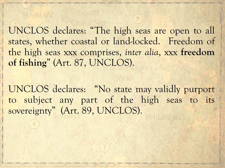
UNCLOS declares: “The high seas are open to all states, whether coastal or land-locked. Freedom of the high seas xxx comprises, inter alia, xxx freedom of fishing” (Art. 87, UNCLOS). UNCLOS declares: “No state may validly purport to subject any part of the high seas to its sovereignty” (Art. 89, UNCLOS).

China’s new “national boundaries” under the 9-dashed lines
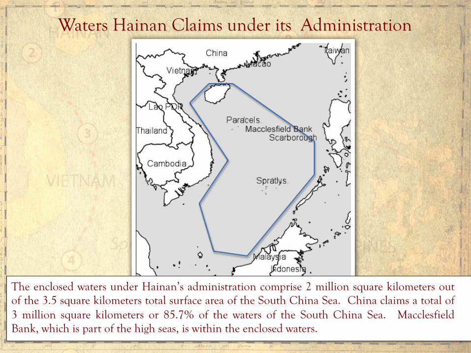
Waters Hainan Claims under its Administration
The enclosed waters under Hainan’s administration comprise 2 million square kilometers out of the 3.5 square kilometers total surface area of the South China Sea. China claims a total of 3 million square kilometers or 85.7% of the waters of the South China Sea. Macclesfield Bank, which is part of the high seas, is within the enclosed waters.
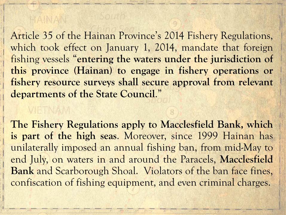
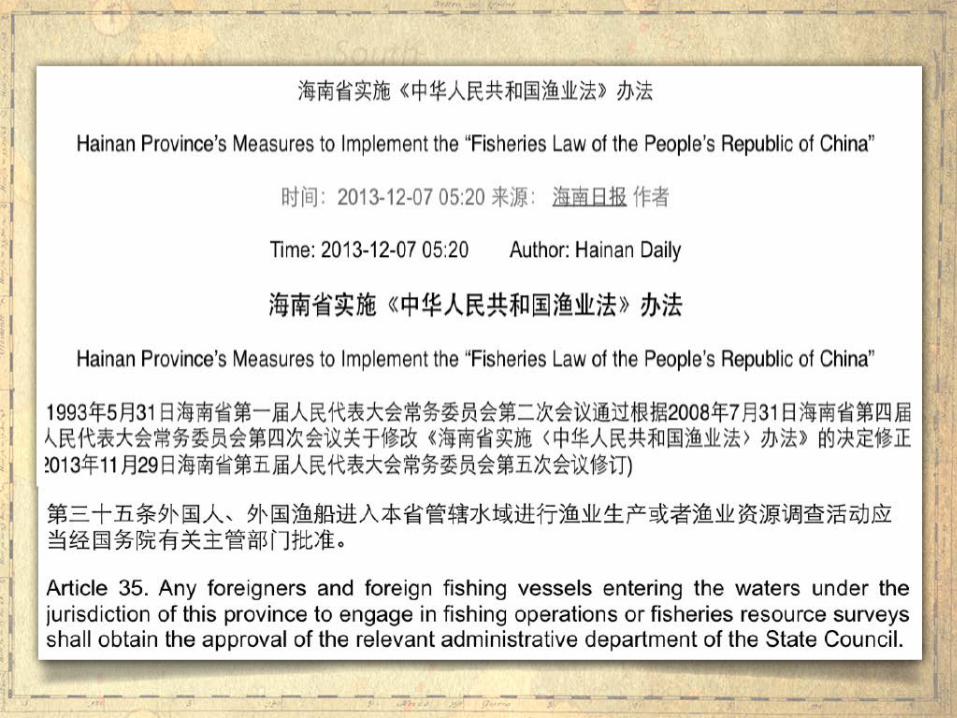
Article 35 of the Hainan Province’s 2014 Fishery Regulations, which took effect on January 1, 2014, mandate that foreign fishing vessels “entering the waters under the jurisdiction of this province (Hainan) to engage in fishery operations or fishery resource surveys shall secure approval from relevant departments of the State Council.”
The Fishery Regulations apply to Macclesfield Bank, which is part of the high seas. Moreover, since 1999 Hainan has unilaterally imposed an annual fishing ban, from mid-May to end July, on waters in and around the Paracels, Macclesfield Bank and Scarborough Shoal. Violators of the ban face fines, confiscation of fishing equipment, and even criminal charges.

By appropriating for itself the fishery resources in the high seas of the South China Sea, China is committing a grand theft of the global commons.
All states, coastal and landlocked, are interested parties in the South China Sea dispute because China is appropriating for itself the fishery resources in the high seas.
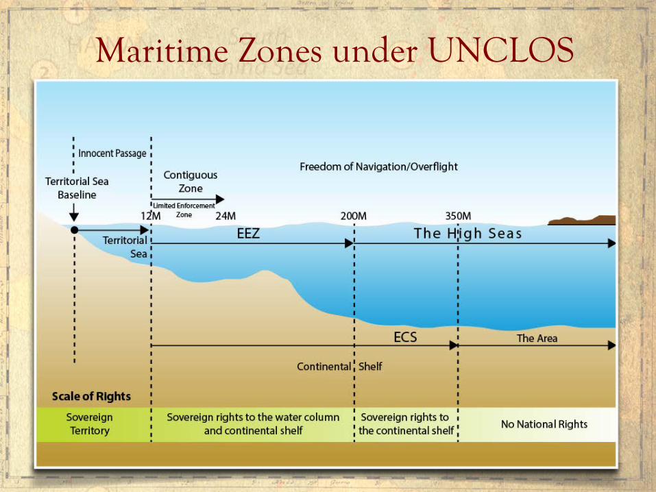
Maritime Zones under UNCLOS
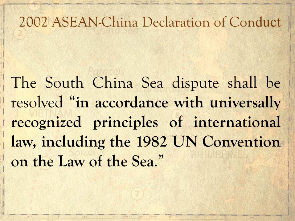
2002 ASEAN-China Declaration of Conduct
The South China Sea dispute shall be resolved “in accordance with universally recognized principles of international law, including the 1982 UN Convention on the Law of the Sea.”

After the Philippines filed in January 2013 its arbitration case against China under UNCLOS, China’s Foreign Minister Wang Yi declared that the South China Sea dispute should be resolved in accordance with “historical facts and international law.”
China Insists on Respect for Historical Facts
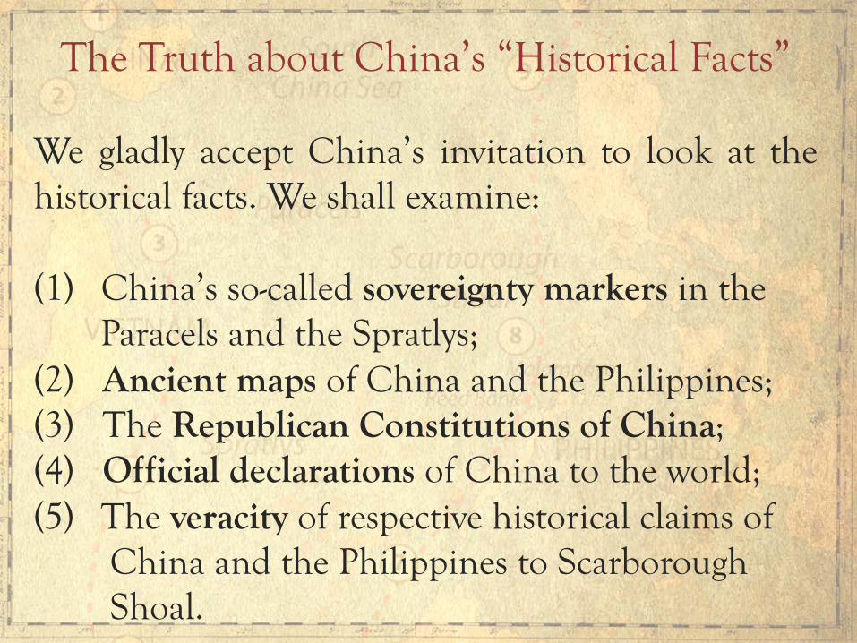
We gladly accept China’s invitation to look at the historical facts. We shall examine: (1) China’s so-called sovereignty markers in the Paracels and the Spratlys; (2) Ancient maps of China and the Philippines; (3) The Republican Constitutions of China; (4) Official declarations of China to the world; (5) The veracity of respective historical claims of China and the Philippines to Scarborough Shoal.
The Truth about China’s “Historical Facts”
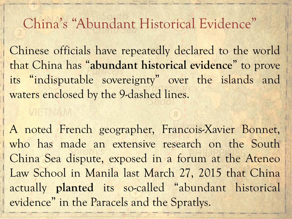
Chinese officials have repeatedly declared to the world that China has “abundant historical evidence” to prove its “indisputable sovereignty” over the islands and waters enclosed by the 9-dashed lines.
A noted French geographer, Francois-Xavier Bonnet, who has made an extensive research on the South China Sea dispute, exposed in a forum at the Ateneo Law School in Manila last March 27, 2015 that China actually planted its so-called “abundant historical evidence” in the Paracels and the Spratlys.
China’s “Abundant Historical Evidence”
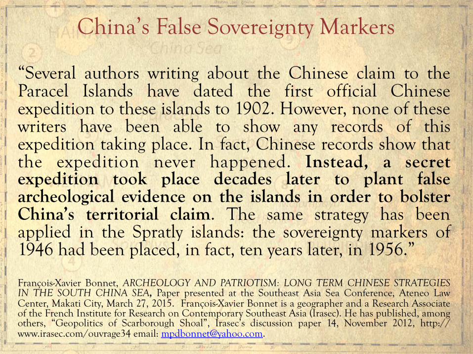
“Several authors writing about the Chinese claim to the Paracel Islands have dated the first official Chinese expedition to these islands to 1902. However, none of these writers have been able to show any records of this expedition taking place. In fact, Chinese records show that the expedition never happened. Instead, a secret expedition took place decades later to plant false archeological evidence on the islands in order to bolster China’s territorial claim. The same strategy has been applied in the Spratly islands: the sovereignty markers of 1946 had been placed, in fact, ten years later, in 1956.” François-Xavier Bonnet, ARCHEOLOGY AND PATRIOTISM: LONG TERM CHINESE STRATEGIES IN THE SOUTH CHINA SEA, Paper presented at the Southeast Asia Sea Conference, Ateneo Law Center, Makati City, March 27, 2015. François-Xavier Bonnet is a geographer and a Research Associate of the French Institute for Research on Contemporary Southeast Asia (Irasec). He has published, among others, “Geopolitics of Scarborough Shoal”, Irasec’s discussion paper 14, November 2012, http://www.irasec.com/ouvrage34 email: [email protected].
China’s False Sovereignty Markers

Chinese Sovereignty Markers
Steles from the Guangxu reign (1882-1902) on one of the Xisha Island Source: Thomas H. Hahn Docu-Images. http://hahn.zenfolio.com/xisha/h1D468115#h1d468115
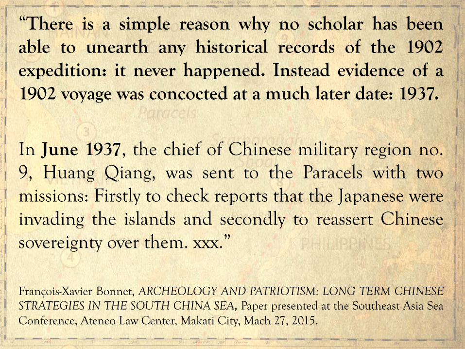
“There is a simple reason why no scholar has been able to unearth any historical records of the 1902 expedition: it never happened. Instead evidence of a 1902 voyage was concocted at a much later date: 1937.
In June 1937, the chief of Chinese military region no. 9, Huang Qiang, was sent to the Paracels with two missions: Firstly to check reports that the Japanese were invading the islands and secondly to reassert Chinese sovereignty over them. xxx.”
François-Xavier Bonnet, ARCHEOLOGY AND PATRIOTISM: LONG TERM CHINESE STRATEGIES IN THE SOUTH CHINA SEA, Paper presented at the Southeast Asia Sea Conference, Ateneo Law Center, Makati City, Mach 27, 2015.
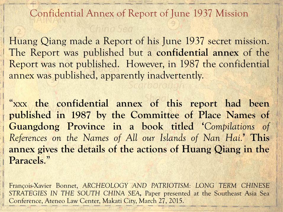
Confidential Annex of Report of June 1937 Mission Huang Qiang made a Report of his June 1937 secret mission. The Report was published but a confidential annex of the Report was not published. However, in 1987 the confidential annex was published, apparently inadvertently. “xxx the confidential annex of this report had been published in 1987 by the Committee of Place Names of Guangdong Province in a book titled ‘Compilations of References on the Names of All our Islands of Nan Hai.’ This annex gives the details of the actions of Huang Qiang in the Paracels.” François-Xavier Bonnet, ARCHEOLOGY AND PATRIOTISM: LONG TERM CHINESE STRATEGIES IN THE SOUTH CHINA SEA, Paper presented at the Southeast Asia Sea Conference, Ateneo Law Center, Makati City, March 27, 2015.

The 1987 Book That Revealed the Confidential Annex
Compilation of References of the Names of All the South Sea Islands [Nan Hai zhu dao di ming zi liao hui bian], Guangdong Map Publishing Company [Guangdong sheng di tu chu ban she], published in 1987 by the Committee of Place Names of the Guangdong Province [Guangdong sheng di ming wei yuan hui].
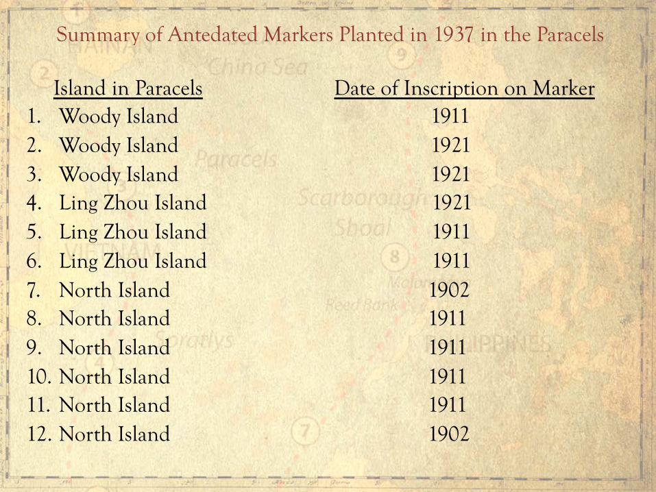
Island in Paracels Date of Inscription on Marker 1. Woody Island 1911 2. Woody Island 1921 3. Woody Island 1921 4. Ling Zhou Island 1921 5. Ling Zhou Island 1911 6. Ling Zhou Island 1911 7. North Island 1902 8. North Island 1911 9. North Island 1911 10. North Island 1911 11. North Island 1911 12. North Island 1902
Summary of Antedated Markers Planted in 1937 in the Paracels

Island in Spratlys Date of Inscription on Marker
1. West York Island December 1946
(Likas)
2. Spratly Island December 1946
Summary of Antedated Markers Planted in 1956 in the Spratlys
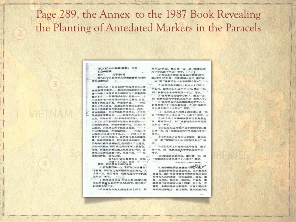
Page 289, the Annex to the 1987 Book Revealing the Planting of Antedated Markers in the Paracels

第九区行政区督察专员 黄强 民国二十六年七月卅一日
Huang Qiang Chief of No. 9 Administrative Region 31 July 1937 xxx Stone Tablets Erection Records on the Paracel Islands
One stone tablet can be found beside the old tree on the southern side of Shi Dao (Rocky Island) facing Lin Dao (Woody Island), which is 50 feet from shore. The tablet’s base was buried at a depth of 1 foot. “Commemorating the Inspection of 1911” was carved on the tablet; xxx Northwest to the well near Central Road on Lin Dao (Woody Island), around 5 feet near the well, another tablet can be found with the inscription “Commemorating the Inspection of 1921”;
Page 289, the Annex to the 1987 Book Revealing the Planting of Antedated Markers in the Paracels

At the southwest of Lin Dao (Woody Island), at the back of Guhun Temple (6 feet high and 9 feet wide), 6 feet from the temple wall, one tablet can be found with the inscription “Commemorating the Inspection of 1921”;
75 feet near the shore of the north side of Lingzhou Dao (Lingzhou Island), 62 feet to the east of a big stone, a tablet can be found with the inscription “Commemorating the Inspection of 1921”;
Page 289, the Annex to the 1987 Book Revealing the Planting of Antedated Markers in the Paracels
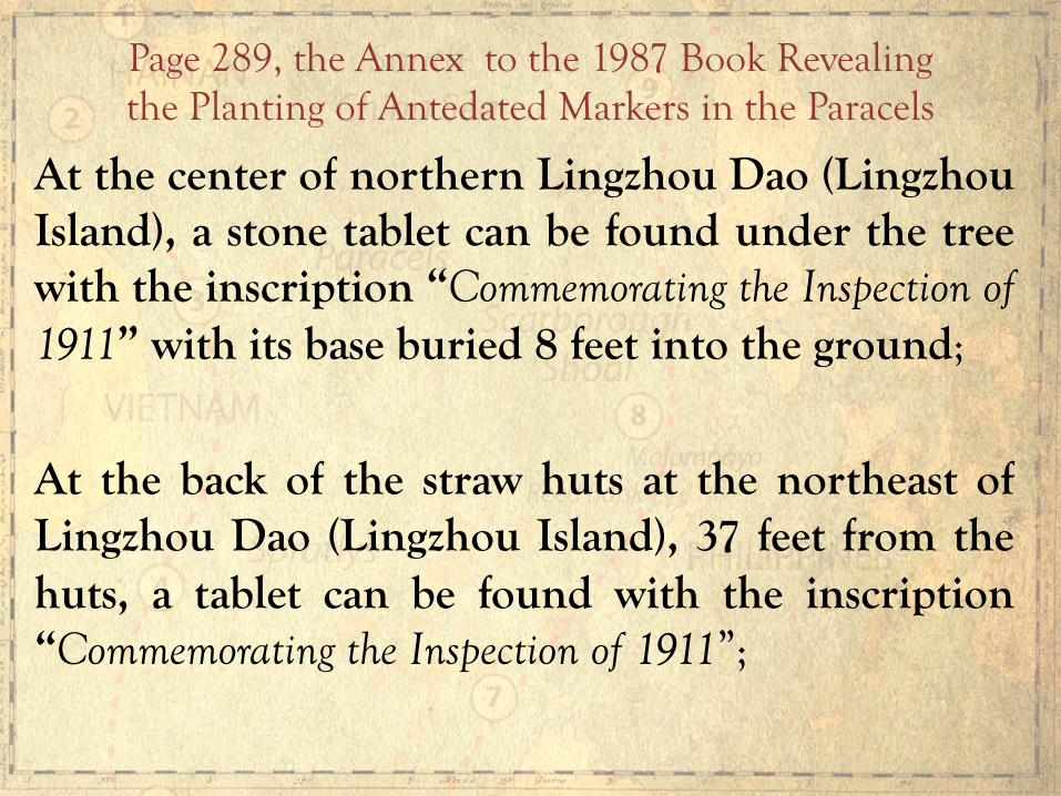
At the center of northern Lingzhou Dao (Lingzhou Island), a stone tablet can be found under the tree with the inscription “Commemorating the Inspection of 1911” with its base buried 8 feet into the ground;
At the back of the straw huts at the northeast of Lingzhou Dao (Lingzhou Island), 37 feet from the huts, a tablet can be found with the inscription “Commemorating the Inspection of 1911”;
Page 289, the Annex to the 1987 Book Revealing the Planting of Antedated Markers in the Paracels
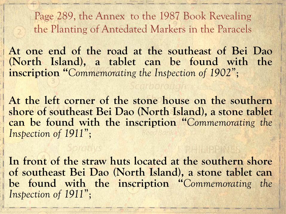
At one end of the road at the southeast of Bei Dao (North Island), a tablet can be found with the inscription “Commemorating the Inspection of 1902”; At the left corner of the stone house on the southern shore of southeast Bei Dao (North Island), a stone tablet can be found with the inscription “Commemorating the Inspection of 1911”; In front of the straw huts located at the southern shore of southeast Bei Dao (North Island), a stone tablet can be found with the inscription “Commemorating the Inspection of 1911”;
Page 289, the Annex to the 1987 Book Revealing the Planting of Antedated Markers in the Paracels

At the back of the straw huts located on the southern shore of southeast Bei Dao (North Island), a stone tablet can be found with the inscription “Commemorating the Inspection of 1911”; At the southeastern corner of Bei Dao (North Island), facing Zhong Dao (Middle Island), a stone tablet can be found with the inscription “Commemorating the Inspection of 1911”; At the northern shore of Bei Dao (North Island), a tablet can be found with the inscription “Commemorating the Inspection of 1902”.
Page 289, the Annex to the 1987 Book Revealing the Planting of Antedated Markers in the Paracels

“西月岛在太平岛的东北,距太平岛四十四海里。。。。岛上寂无人烟。。。南端有椰树数株,树旁有一石碑,刻‘西月岛’三字,字甚大,笔力有劲,右旁刻‘民国三十五年十二月立’十个小字。另外,在海边有石板架成之小庙一座,但已破旧不堪,上刻文字亦模糊不辨,也许是我早期渔民所建。”(第66页) Xiyue Dao (West York Island) is located 44 nautical miles northeast of Taiping Dao (Itu Aba Island). … No residents inhabit the island. … Several coconut trees are located at the south side of the island. Besides trees, there is a stone tablet with the inscription “Xiyue Dao (West York Island)” in three large Chinese characters with ten smaller characters on its right with the inscription “Erected on December 1946”. xxx (Page 66)
Page 291, the Annex to the 1987 Book Revealing the Planting of Antedated Markers in the Spratlys
[Lecturer’s Note: West York Island, called Likas Island by the Philippines, has an area of 18.6 hectares, the third largest island in the Spratlys. It is occupied by the Philippines.]

“(南威岛)岛的中央有石碑一具,刻‘南威岛’三字,旁注‘民国三十五年十二月立’一行字。。。岛西另有高丈土地庙一座,内有香炉一只,但无神象,想因年代湮化了”。(第72页) A stone tablet was erected at the center of Nanwei Dao (Spratly Island), with the inscription “Nanwei Dao (Spratly Island)” and “Erected on December 1946”. … Another Earth God Temple can be found in the western part of the island with only the censer (container where incense is burned) present inside. The Earth God figurine may have already eroded. (Page 72) xxx
Page 291, the Annex to the 1987 Book Revealing the Planting of Antedated Markers in the Spratlys

——见《中国南海诸群岛文献汇编之八》,张振国:《南沙行》,1957年5月成书,台湾学生书局,1975年1月版。 Zhang Zhenguo. Trip to the Spratly Islands, written in May 1957 and published in January 1975; The 8th compilation of documents on the South China Sea Islands. 编者按:据广东省接收南沙群岛专员麦蕴瑜谈,1946年太平舰和中业舰并没有到西月岛和南威岛。据此两岛石碑可能是1956年台湾省海军巡视所立。 Editors' note: According to Mai Wenyu who was assigned by the Guangdong government to retake the Spratly Islands from the Japanese invaders, Chinese navy ships did not reach Xiyue Dao (West York Island) and Nanwei Dao (Spratly Island). Thus, stone tablets on these two islands might have been erected by the Taiwanese Navy in 1956.
Page 291, the Annex to the 1987 Book Revealing the Planting of Antedated Markers in the Spratlys
Official and unofficial maps of China from 1136 during the Song Dynasty until the end of the Qing Dynasty in 1912 show that the southernmost territory of China has always been Hainan Island. Official and unofficial maps of the Philippines from 1636 until 1933 show that Scarborough Shoal has always been part of the Philippines. The first name of Scarborough Shoal is “Panacot,” which appeared in the 1734 Murillo Velarde map published in Manila.
Ancient Maps of China and the Philippines

1136 AD “Hua Yi Tu”

This map was engraved in stone in Fuchang in 1136 AD during the Song Dynasty. A stone rubbing of the map was published in 1903(?) in France. The stone map is entitled “Hua Yi Tu” or Map of China and the Barbarian Countries. The stone map is now in the Forest of Stone Steles Museum in Xi’an, China. This map shows Hainan Island as the southernmost territory of China. The annotations on the sides of this map are not part of the stone engraving. This digital reproduction is from the U.S. Library of Congress (Catalogue No.2002626771; Digital ID g7820 ct000284).
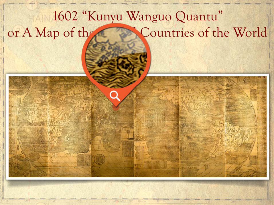
1602 “Kunyu Wanguo Quantu” or A Map of the Myriad Countries of the World
Published in Beijing in 1602 by the Ming Dynasty, this map is entitled “Kunyu Wanguo Quantu” or A Map of the Myriad Countries of the World. The Jesuit priest Matteo Ricci created this map upon request of the Ming Emperor Wanli. Ricci was assisted by Zhong Wentao, Li Zhizao, and other Chinese scholars. This map shows Hainan Island as the southernmost territory of China. This digital reproduction is from the U.S. Library of Congress (Catalogue No. 2010585650; Digital ID g3200 ex000006Za,b and g3200m gex00001).
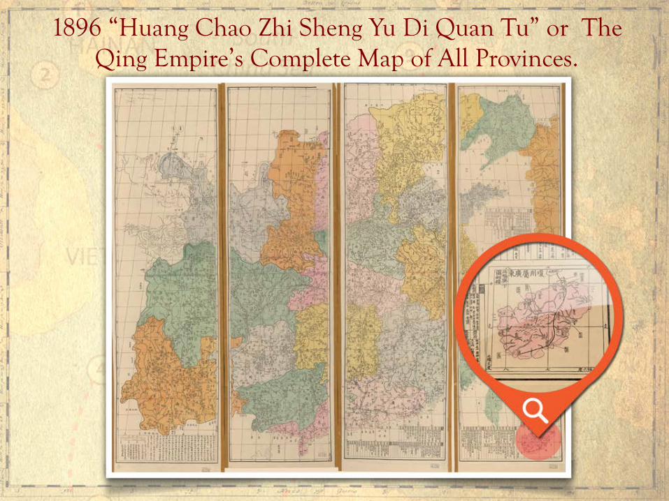
1896 “Huang Chao Zhi Sheng Yu Di Quan Tu” or The Qing Empire’s Complete Map of All Provinces.
Published in 1896 in China by Guangxu Bing Shen, this map is entitled “Huang Chao Zhi Sheng Yu Di Quan Tu” or the Qing Empire’s Complete Map of All Provinces. This map shows Hainan Island as the southernmost territory of China. This digital reproduction is from the U.S. Library of Congress (Catalogue No. gm71005083; Digital ID g7820 ct003428).
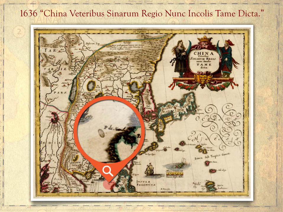
1636 “China Veteribus Sinarum Regio Nunc Incolis Tame Dicta.”
Published in Frankfurt in 1636 by map maker Matthaus Merian, this map is entitled “China Veteribus Sinarum Regio Nunc Incolis Tame Dicta.” This map shows China, Korea, Japan, Taiwan and Northern Luzon. On the western side off the coast of Central Luzon, there is an unnamed shoal below the words “P. de Mandato.” The Spanish phrase “P. de Mandato” means the point of command – which implies there was a Spanish military garrison in that coastal place. The unnamed shoal off this coastal place would later be called “Panacot” by the Jesuit Pedro Murillo Velarde. This digital reproduction is from Barry Lawrence Ruderman Antique Maps, Inc. (http://www.raremaps.com/gallery/detail/36716).
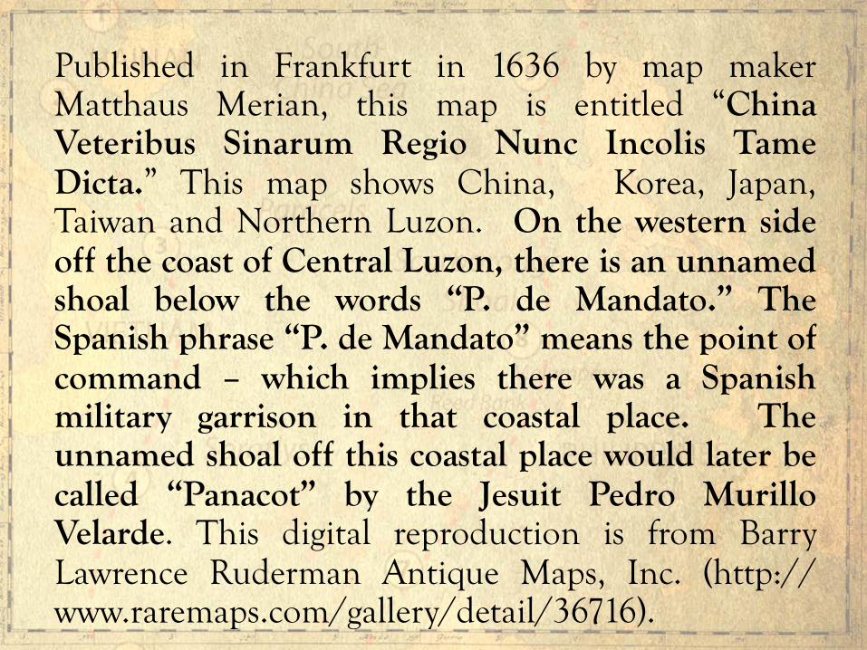
1734 Murillo Velarde Map

Published in 1734 in Manila by the Jesuit Pedro Murillo Velarde, this map is entitled “Carta Hydrographica y Chorographica de las Yslas Filipinas.” This is the oldest map that gives a name to “Panacot” shoal. Panacot is the Tagalog word for threat or danger. Prior to this 1734 map, no map had ever given a name to this shoal. Scarborough Shoal had a Tagalog name 213 years before China drew its 9-dashed lines map. The Murillo Velarde map itself names two Filipinos, Francisco Suarez who drew the map and Nicolas dela Cruz Bagay who engraved it. This map is considered the “mother of all Philippine maps.” This digital reproduction is from the U.S. Library of Congress (Catalogue No. 2013585226; Digital ID g8060 ct003137).
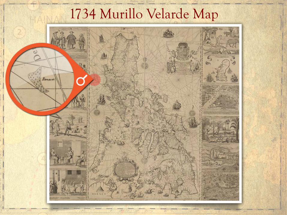
1792 “Plano de la Navigacion” Bajo de Masinloc
This is the route of the navigation taken by Alessandro Malaspina when he surveyed Scarborough Shoal on 4 May 1792 aboard the Sta. Lucia. In his Journal, Malaspina wrote: “On (this shoal) Spanish and foreign ships have been lost.”
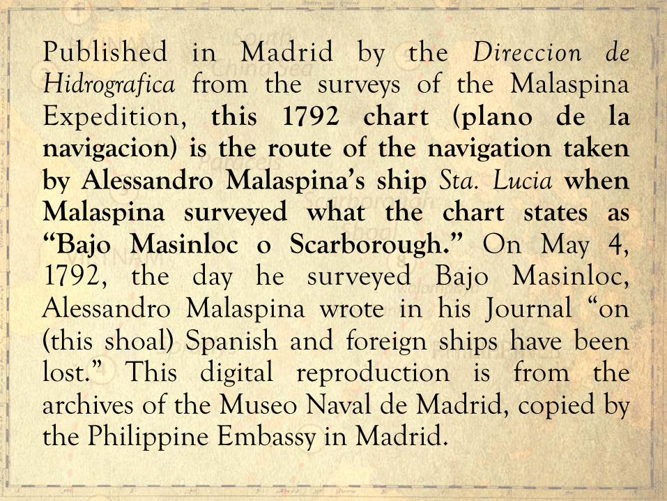
Published in Madrid by the Direccion de Hidrografica from the surveys of the Malaspina Expedition, this 1792 chart (plano de la navigacion) is the route of the navigation taken by Alessandro Malaspina’s ship Sta. Lucia when Malaspina surveyed what the chart states as “Bajo Masinloc o Scarborough.” On May 4, 1792, the day he surveyed Bajo Masinloc, Alessandro Malaspina wrote in his Journal “on (this shoal) Spanish and foreign ships have been lost.” This digital reproduction is from the archives of the Museo Naval de Madrid, copied by the Philippine Embassy in Madrid.

1867 “Carta General del Archipielago Filipino”
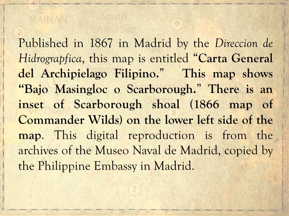
Published in 1867 in Madrid by the Direccion de Hidrograpfica, this map is entitled “Carta General del Archipielago Filipino.” This map shows “Bajo Masingloc o Scarborough.” There is an inset of Scarborough shoal (1866 map of Commander Wilds) on the lower left side of the map. This digital reproduction is from the archives of the Museo Naval de Madrid, copied by the Philippine Embassy in Madrid.

1899 “Islas Filipinas, Mapa General Observatorio de Manila.”
Published in 1899 in Washington, D.C. by the U.S. Coast and Geodetic Survey.

Published in 1899 in Washington, D.C. by the Jesuit Jose P. Algue and the U.S. Coast and Geodetic Survey, this map is entitled “Islas Filipinas – Mapa General – Observatorio de Manila.” The map shows “B. Masinloc.” This digital reproduction is from the Atlas de Filipinas, Internet Archive, Ohio State University Library, ( h t t p s : / / a r c h i v e . o r g / d e t a i l s /AtlasDeFilipinasColleccionDe30MapasTrabajadosPorDelineantes; ark:/13960/t2d804v8j).

1933 “Philippine Islands”

Published in 1933 in Manila and reissued in 1940 in Washington, D.C. by the U.S. Coast and Geodetic Survey, this map is entitled “Philippine Islands.” The map shows “Scarborough” shoal with depth soundings. This digital reproduction is from the U.S. Library of Congress (Catalogue No. 2011592026, Digital ID g8061p ct003542).
When the Qing Dynasty ended in 1912, the Chinese republicans led by Dr. Sun Yat Sen established the Republic of China. The following provisions of five (5) Constitutions of the Republic of China state:

Article 3, Chapter 1, of the Provisional Constitution of the Republic of China of March 11, 1912 states: “The territory of the Republic of China is composed of 22 provinces, Inner and Outer Mongolia, Tibet and Qinghai.” As we have seen in the 1896 map of the Qing Dynasty, one of the 22 provinces is Guangdong, which includes Hainan Island as the southernmost territory of China.
Constitution of 1912
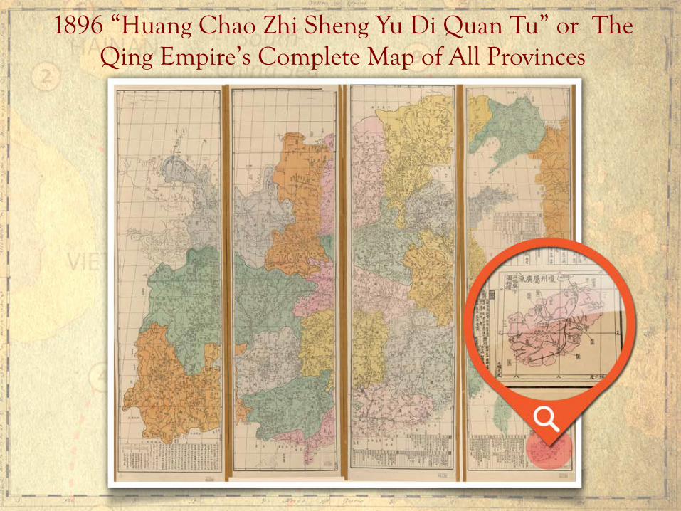
1896 “Huang Chao Zhi Sheng Yu Di Quan Tu” or The Qing Empire’s Complete Map of All Provinces

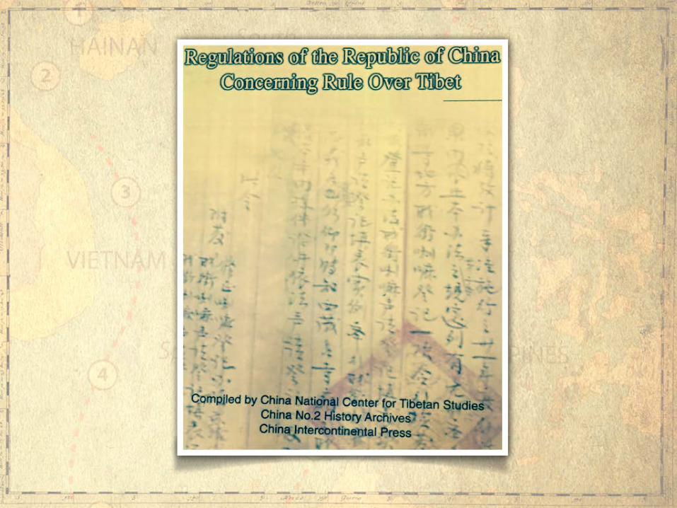
Article 3, Chapter 1 of the Constitution of the Republic of China of May 1, 1914 states: “The territory of the Republic of China continues to be the territory of the former empire.” The editorial comment in the Regulations of the Republic of China Concerning Rule over Tibet (1999) explains the words “former empire” as “referring to the Qing Dynasty.”
Constitution of 1914

“Former empire” means the Qing Dynasty
Page 3 of the Regulations state:
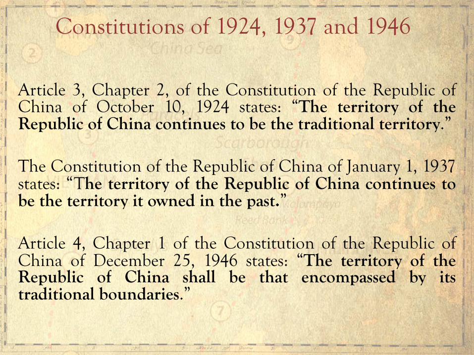
Article 3, Chapter 2, of the Constitution of the Republic of China of October 10, 1924 states: “The territory of the Republic of China continues to be the traditional territory.” The Constitution of the Republic of China of January 1, 1937 states: “The territory of the Republic of China continues to be the territory it owned in the past.” Article 4, Chapter 1 of the Constitution of the Republic of China of December 25, 1946 states: “The territory of the Republic of China shall be that encompassed by its traditional boundaries.”
Constitutions of 1924, 1937 and 1946
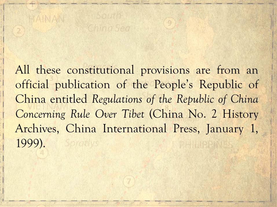
All these constitutional provisions are from an official publication of the People’s Republic of China entitled Regulations of the Republic of China Concerning Rule Over Tibet (China No. 2 History Archives, China International Press, January 1, 1999).

As late as 1932, China has been telling the world that its southernmost border was Hainan Island, but that Hainan Island included the Paracels. In a Note Verbale to the French Government on September 29, 1932 protesting the French occupation of the Paracels, the Chinese Government officially declared:
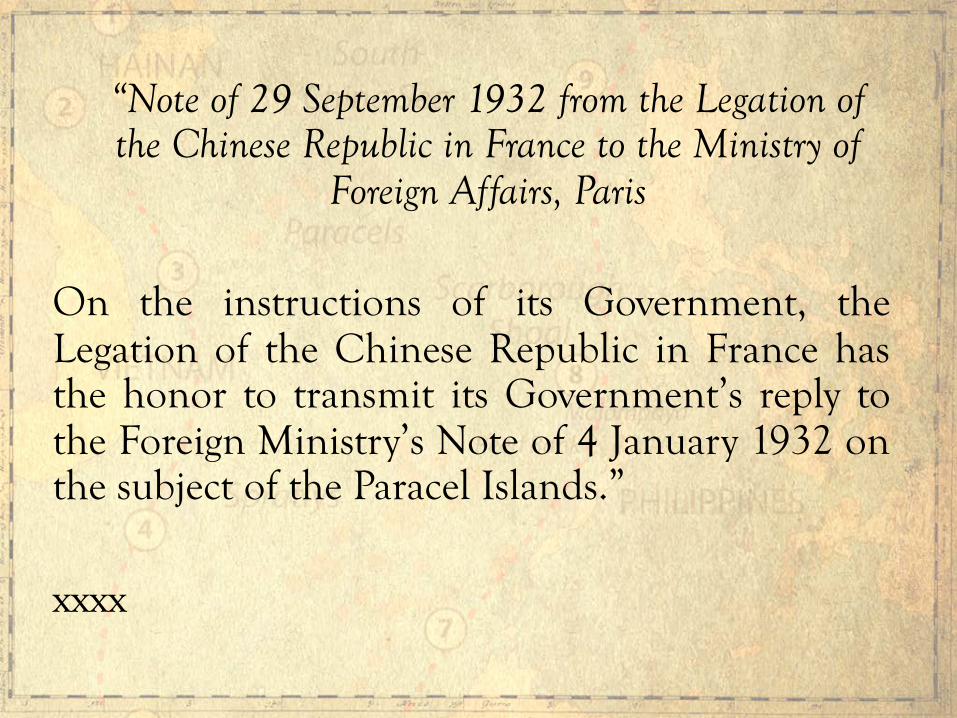
“Note of 29 September 1932 from the Legation of the Chinese Republic in France to the Ministry of
Foreign Affairs, Paris
On the instructions of its Government, the Legation of the Chinese Republic in France has the honor to transmit its Government’s reply to the Foreign Ministry’s Note of 4 January 1932 on the subject of the Paracel Islands.” xxxx
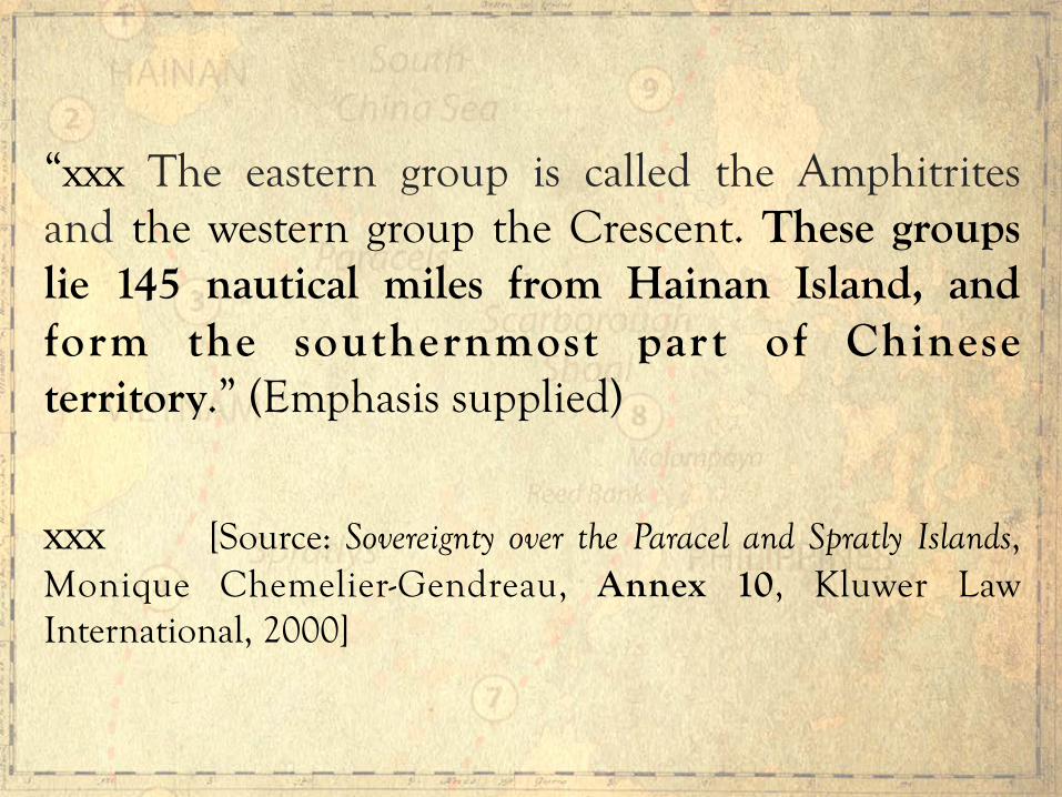
“xxx The eastern group is called the Amphitrites and the western group the Crescent. These groups lie 145 nautical miles from Hainan Island, and form the southernmost part of Chinese territory.” (Emphasis supplied)
xxx [Source: Sovereignty over the Paracel and Spratly Islands, Monique Chemelier-Gendreau, Annex 10, Kluwer Law International, 2000]
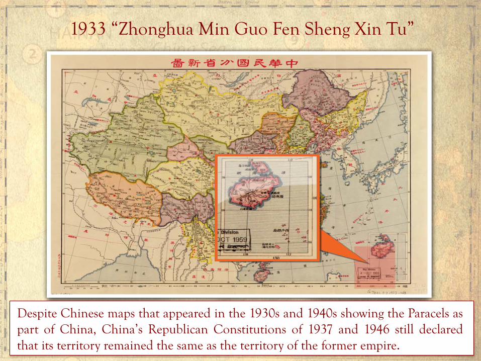
1933 “Zhonghua Min Guo Fen Sheng Xin Tu”
Despite Chinese maps that appeared in the 1930s and 1940s showing the Paracels as part of China, China’s Republican Constitutions of 1937 and 1946 still declared that its territory remained the same as the territory of the former empire.
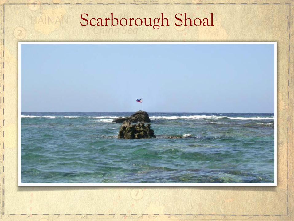
Scarborough Shoal
In China’s Manila Embassy website, China claims Scarborough Shoal because the shoal is allegedly the Nanhai Island that Guo Shoujing visited in 1279 and where he erected an astronomical observatory. The website states:

“Huangyan Island was first discovered and drew (sic) into China’s map in China’s Yuan Dynasty (1271-1368 AD). In 1279, Chinese astronomer Guo Shoujing performed surveying of the seas around China for Kublai Khan, and Huangyan Island was chosen as the point in the South China Sea.” (Emphasis supplied)
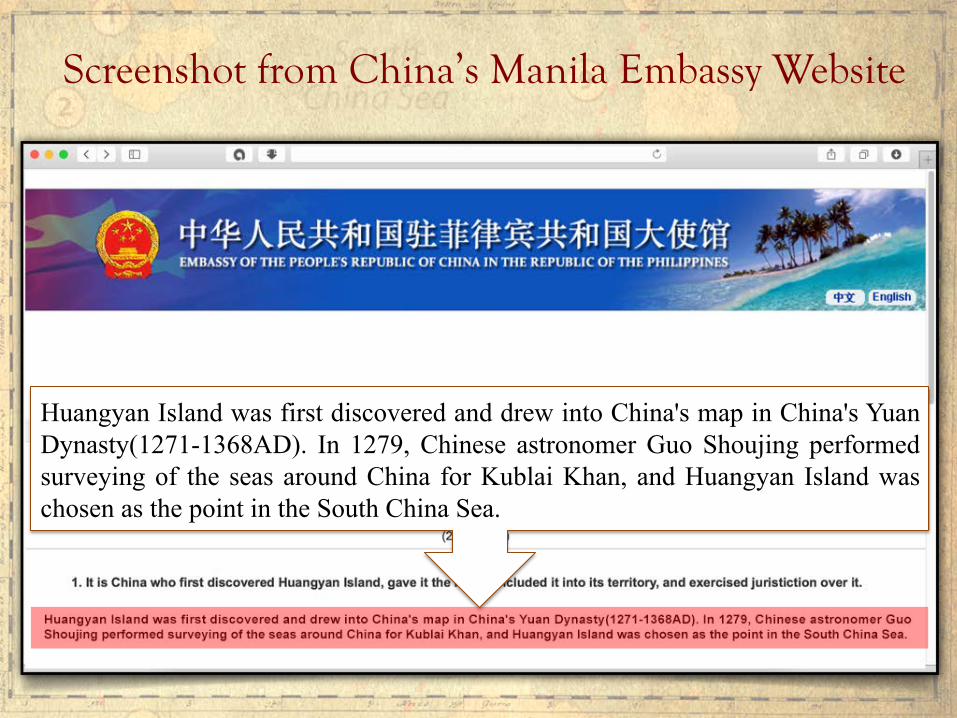
Screenshot from China’s Manila Embassy Website
Huangyan Island was first discovered and drew into China's map in China's Yuan Dynasty(1271-1368AD). In 1279, Chinese astronomer Guo Shoujing performed surveying of the seas around China for Kublai Khan, and Huangyan Island was chosen as the point in the South China Sea.
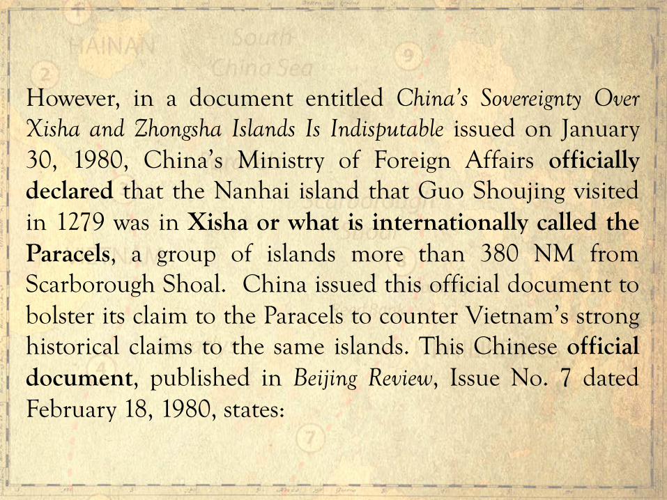
However, in a document entitled China’s Sovereignty Over Xisha and Zhongsha Islands Is Indisputable issued on January 30, 1980, China’s Ministry of Foreign Affairs officially declared that the Nanhai island that Guo Shoujing visited in 1279 was in Xisha or what is internationally called the Paracels, a group of islands more than 380 NM from Scarborough Shoal. China issued this official document to bolster its claim to the Paracels to counter Vietnam’s strong historical claims to the same islands. This Chinese official document, published in Beijing Review, Issue No. 7 dated February 18, 1980, states:

“Early in the Yuan Dynasty, an astronomical observation was carried out at 27 places throughout the country. xxx According to the official History of the Yuan Dynasty, Nanhai, Gou’s observation point, was “to the south of Zhuya” and “the result of the survey showed that the latitude of Nanhai is 15°N.” The astronomical observation point Nanhai was today’s Xisha Islands. It shows that Xisha Islands were within the bounds of China at the time of the Yuan dynasty.” (Emphasis supplied)

China’s Indisputable Sovereignty Over Xisha
And Nansha Islands
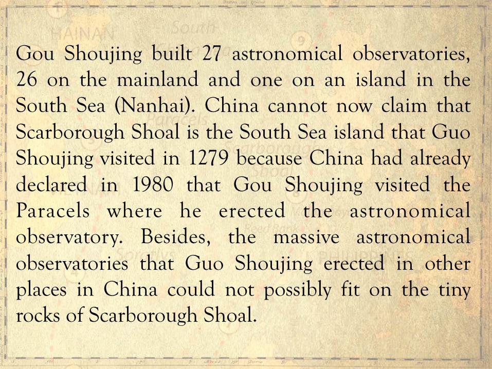
Gou Shoujing built 27 astronomical observatories, 26 on the mainland and one on an island in the South Sea (Nanhai). China cannot now claim that Scarborough Shoal is the South Sea island that Guo Shoujing visited in 1279 because China had already declared in 1980 that Gou Shoujing visited the Paracels where he erected the astronomical observatory. Besides, the massive astronomical observatories that Guo Shoujing erected in other places in China could not possibly fit on the tiny rocks of Scarborough Shoal.
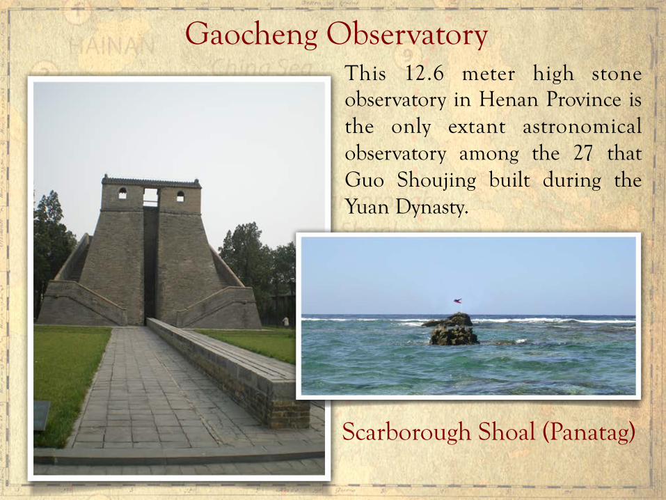
Gaocheng Observatory This 12.6 meter high stone observatory in Henan Province is the only extant astronomical observatory among the 27 that Guo Shoujing built during the Yuan Dynasty.
Scarborough Shoal (Panatag)

The biggest rock on Scarborough Shoal is just 2 to 3 meters above water at high tide, and not more than 6 to 10 people could stand on it. To be operated, the observatories of Guo Shoujing have to be manned everyday since measurements have to be taken everyday. It is physically impossible to erect, or operate, such an observatory on Scarborough Shoal.


In September 2014, Taiwan’s President Ma Ying-jeou, who belongs to the Kuomintang Party, which controlled the Chinese mainland government in 1947 that adopted the 9-dashed lines, clarified the extent of China’s claim under the lines. President Ma declared that the claim was limited only to the islands and their adjacent 3 NM (now 12 NM) territorial sea. President Ma unequivocally stated that there were “no other so-called claims to sea regions.” This express clarification from Taiwan directly contradicts China’s claim that China has “indisputable sovereignty” over all the waters enclosed within the 9-dashed lines.
Taiwan’s President Ma Ying-jeou Statement

The Original 1947 9-dashed Lines Map of China
Entitled “Location Map of the South Sea Islands”
The title of the map indicates
a claim to the islands, not the sea.
Mentioned as Zhongsha Island’s features were: Pygmy Shoal (Biwei Ansha), Engeria Bank (Yinji Tan), Learmonth Shoal (Jimeng Ansah), Paibo Ansha, Paihong Ansha, and Bengu Ansha. Hugnyan Island (Scarborough Shoal) is not mentioned.

In an October 21, 2014 interview with the New York Times, President Ma, who earned an S.J.D. from Harvard University with specialty in the Law of the Sea, stated:
“There is a basic principle in the Law of the Sea, that land dominates the sea. Thus marine claims begin with land; however, even if it is logically this way, when resolving disputes, it is not impossible to first resolve resource development issues. xxx.”
President Ma Ying-jeou: A Law of the Sea Scholar

The 1898 Treaty of Paris between Spain and the United States drew a rectangular line wherein Spain ceded to the United States all of Spain’s territories found within the treaty lines. Scarborough Shoal is outside the treaty lines. Scarborough Shoal lies outside of the treaty lines.
What is the legal basis of the Philippines’ claim to Scarborough Shoal
However, two years later, in the 1900 Treaty of Washington, Spain clarified that it had also relinquished to the United States “all title and claim of title, which (Spain) may have had at the time of the conclusion of the Treaty of Peace of Paris, to any and all islands belonging to the Philippine Archipelago, lying outside the lines” of the Treaty of Paris. Thus, Spain ceded Scarborough Shoal to the United States under the 1900 Treaty of Washington (Treaty between Spain and the United States for Cession of Outlying Islands of the Philippines, signed November 7, 1900.).

When the issue of whether Scarborough Shoal forms part of Philippine territory, Secretary Cordell Hull of the U.S. State Department stated in his Memorandum of July 27, 1938 to Harry Woodring, Secretary of War:
Because of the absence of other claims, the shoal should be regarded as included among the islands ceded to the United States by the American-Spanish Treaty of November 7, 1900*… In the absence of evidence of a superior claim to Scarborough Shoal by any other government, the Department of State would interpose no objection to the proposal of the Commonwealth Government to study the possibilities of the shoal as an aid to air and ocean navigation.
*Treaty of Washington; boldfacing supplied. Source: A CNA Occasional Paper, Philippine Claims in the South China Sea: A Legal Analysis, Mark E. Rosen, JD, LLM [citing François-Xavier Bonnet, The Geopolitics of Scarborough Shoal, available at www.irasec.com.] (2014)
In 1938 the U.S. Had Already Determined Scarborough Shoal Is Part of Philippine Territory

“xxx even assuming that the subject-matter of the arbitration did concern the interpretation or application of the Convention, it has been excluded by the 2006 declaration filed by China under Article 298 of the Convention, due to its being an integral part of the dispute of maritime delimitation between the two States.”
China’s Core Objection to the Arbitration

China correctly states that the exclusion arising from its 2006 declaration under the opt out clause [Article 298(1)(a)(i), UNCLOS] refers to a “dispute of maritime delimitation between the two States.” Article 298(1)(a)(i) expressly refers to “disputes concerning the interpretation or application of Articles 15, 74 and 83 relating to sea boundary delimitations,” or as China puts it, to “maritime delimitation between two States.” Article 15 - Delimitation of the territorial sea between States with opposite or adjacent coasts Article 74 – Delimitation of the exclusive economic zone between States with opposite or adjacent coasts Article 83 - Delimitation of the continental shelf between States with opposite or adjacent coasts
However, China does not claim that the waters enclosed by the 9-dashed lines are its territorial sea, EEZ or CS. The 9-dashed lines are not measured from baselines along China’s coast, and hence the the 9-dashed lines cannot possibly delineate China’s territorial sea, EEZ or CS. There is no overlapping TS, EEZ or CS between China’s 9-dashed lines waters and the Philippines’ TS, EEZ or CS that could be subject of the opt out clause under Article 298(1)(a) of UNCLOS.

Hence, assailing the validity of China’s 9-dashed lines under UNCLOS does not involve any sea boundary delimitation under Article 298(1)(a)(i) relating to China’s territorial sea, EEZ or CS that overlaps with the Philippines’ territorial sea, EEZ or CS. Article 309 of UNCLOS mandates that “no reservations or exceptions may be made to this Convention unless expressly permitted by other articles of this Convention.” China cannot invoke the opt out clause under Article 298(1)(a)(i) of UNCLOS. Therefore, China is bound by the compulsory dispute settlement mechanism under UNCLOS.

If UNCLOS does not apply to the South China Sea dispute, as when China’s 9-dashed lines are allowed to gobble up the EEZs of coastal states as well as the high seas, then UNCLOS, the constitution for the oceans and seas, cannot also apply to any maritime dispute in the rest of the oceans and seas of our planet. It will be the beginning of the end for UNCLOS. The rule of the naval canon will prevail in the oceans and seas of our planet, no longer the rule of law. There will be a naval arms race among coastal countries.
Why is it important to apply UNCLOS to the South China Sea dispute?
In 1609, Hugo Grotius published Mare Liberum or the Free Sea. Grotius argued that the oceans and seas belong to all mankind. Grotius articulated the position of the Netherlands. In rejoinder, John Selden wrote Mare Clausum or the Closed Sea. Selden argued that the oceans and seas are subject to appropriation and ownership by sovereign states. Selden articulated the position of England, Spain and Portugal, the naval powers of that bygone era. For over a century these two opposing ideas battled for the hearts and minds of the world. Grotius won that great battle and his idea became the foundation of the modern Law of the Sea.
The Free Sea versus the Closed Sea
Today, China has revived John Selden’s argument that a state can appropriate as its own sovereign waters an entire or almost an entire sea. At bottom, this is the core issue before the UNCLOS tribunal hearing the Philippines’ arbitration case against China. If China’s 9-dashed lines claim is allowed to stand, it will be a direct attack on the Grotian foundation of the Law of the Sea. The settled principles on freedom of navigation, freedom of over-flight, freedom to fish in the high seas, the right of coastal states to exclusive economic zones, and the common heritage of mankind, will all be in peril.
The Free Sea versus the Closed Sea Redux

Will the world community allow a single state to re-write the Law of the Sea, so it can exercise indisputable sovereignty to almost an entire sea, subject the high seas to its sovereign jurisdiction, and seize large areas of other coastal states’ EEZs, which are their legal maritime entitlements under UNCLOS?
The Grotian Question
End