jurisdictional delineation report for tie- line 649 wood-to-steel … · 2016-01-26 ·...
TRANSCRIPT
Jurisdictional Delineation Report for Tie-
Line 649 Wood-to-Steel Pole Replacement
Project
Prepared by: San Diego Gas & Electric (SDG&E)
8315 Century Park Court, CP21E
San Diego, CA 92123
Contact: Ms. Tamara Spear
April 28, 2015

THIS PAGE IS INTENTIONALLY BLANK.
Jurisdictional Delineation Report for Tie-Line 649
Wood-to-Steel Pole Replacement Project
Page ii
TABLE OF CONTENTS
Page
CHAPTER 1 - SUMMARY OF FINDINGS ............................................................................................ 1
CHAPTER 2 - PROPOSED PROJECT ................................................................................................... 2
CHAPTER 3 - REGULATORY OVERVIEW......................................................................................... 3 3.1 ACOE WETLANDS .................................................................................................................... 3
3.1.1 Regulatory Definition ...................................................................................................... 3
3.1.2 Wetland Parameters ......................................................................................................... 4
3.1.3 Atypical Situations ........................................................................................................... 5
3.1.4 Vernal Pools ..................................................................................................................... 6
3.2 ACOE NON-WETLAND WATERS ........................................................................................... 6
3.3 RWQCB JURISDICTIONAL WATERS ..................................................................................... 7
CHAPTER 4 - METHODS ........................................................................................................................ 8 4.1 VERNAL POOL BASELINE SURVEYS, 2009-2011 ................................................................ 9
4.2 2014/2105 VERNAL POOL EVALUATIONS ........................................................................... 9
CHAPTER 5 - RESULTS OF FIELD SURVEY ................................................................................... 11 5.1 VEGETATION ........................................................................................................................... 11
5.1.1 Areas Supporting Hydrophytic Vegetation .................................................................... 11
5.1.2 Areas Lacking Hydrophytic Vegetation......................................................................... 12
5.2 SOILS ......................................................................................................................................... 12
5.2.1 Soils Considered Suitable for the Formation of Vernal Pools ....................................... 13
5.2.2 Soils Not Considered Suitable for the Formation of Vernal Pools ................................ 14
5.3 HYDROLOGY ........................................................................................................................... 15
5.3.1 Otay River Floodplain .................................................................................................... 15
5.3.2 Tributaries & Natural Drainages .................................................................................... 15
5.3.3 Clay-pan Mesa Vernal Pool Complex ........................................................................... 16
5.3.4 Man-made Structures ..................................................................................................... 16
5.3.5 Swales ............................................................................................................................ 16
5.3.6 Erosional Feature ........................................................................................................... 16
5.3.7 Road Ruts ....................................................................................................................... 16
CHAPTER 6 - JURISDICTIONAL DELINEATION ........................................................................... 17 6.1 ACOE JURISDICTION ............................................................................................................. 17
6.1.1 Wetlands ........................................................................................................................ 18
6.1.2 Non-wetland Waters of the U.S. .................................................................................... 18
6.1.3 Non-Jurisdictional Features ........................................................................................... 18
6.2 CDFW JURISDICTION, SECTION 1600 OF THE CALIFORNIA DEPARTMENT OF FISH
AND GAME CODE, STREAMBED ALTERATION AGREEMENT ............................................... 19
Jurisdictional Delineation Report for Tie-Line 649
Wood-to-Steel Pole Replacement Project
Page iii
6.3 RWQCB JURISDICTION.......................................................................................................... 19
CHAPTER 7 - PERMIT AUTHORIZATION ....................................................................................... 20
CHAPTER 8 - REFERENCES CITED .................................................................................................. 21
LIST OF TABLES
Page
TABLE 1: ACREAGES OF SOIL SERIES FOUND WITHIN THE SURVEY AREA ........................... 13
TABLE 2: EXISTING JURISDICTIONAL WATERS WITHIN THE SURVEY AREA ........................ 17
ATTACHMENTS
Attachment 1: Acquatic Features Descriptions
Attachment 2: Vernal Pool Descriptions
Attachment 3: Photographic Document
Attachment 4: Figures
1: Regional Location of the TL649 Wood to Steel Project
2: USGS Map of the TL649 Wood to Steel Project
3: Aerial Photograph of the TL649 Wood to Steel Project
4: Soil Types within the TL649 Wood to Steel Project
5: Jurisdictional Resources within the TL649 Wood to Steel Project
Attachment 5: Field Data Forms
Jurisdictional Delineation Report for Tie-Line 649
Wood-to-Steel Pole Replacement Project
Page 1
Chapter 1 - Summary of Findings
RECON Environmental, Inc. (RECON) and Chambers Group, Inc. (Chambers Group) aquatic
resource specialists conducted a jurisdictional delineation along approximately seven miles of
transmission line (TL) 649 in southern San Diego County. Methods for delineating wetlands
followed guidelines set forth by the U.S. Army Corps of Engineers ([ACOE] 1987), including
the Regional Supplement to the Corps of Engineers Wetland Delineation Manual: Arid West
Region (Arid Supplement; ACOE 2008). All figures depicting the project location and results of
the survey are shown in Attachment 1.
A total of 5.55 acres of ACOE jurisdictional waters were delineated within the survey area. Of
these, 4.45 acres are considered ACOE wetland waters of the U.S. (of which 0.80 acre are vernal
pool wetlands), and 1.09 acres are considered ACOE non-wetland waters of the U.S. Although
not formally delineated, an additional 11.74 acres of San Diego Mesa Claypan vernal pool
habitat were identified to occur within the survey area and likely support jurisdictional ACOE
vernal pool wetland waters of the U.S.
California Department of Fish and Wildlife (CDFW) jurisdictional waters total 5.79 acres within
the survey area. Of these, 1.09 acres are considered CDFW unvegetated streambed and 4.70
acres are considered CDFW riparian. CDFW does not take jurisdiction over project vernal pools
via the 1600 streambed alteration program.
A total of 5.55 acres of Regional Water Quality Control Board (RWQCB) waters of the State
were delineated within the survey area. The RWQCB waters of the State include 0.80 acre of
vernal pools. Although not formally delineated, an additional 11.74 acres of San Diego Mesa
Claypan vernal pool habitat were identified to occur within the survey area and likely support
jurisdictional RWQCB waters of the State vernal pools.
Impacts to jurisdictional waters would require a Section 404 permit from ACOE, a Streambed
Alteration Agreement from CDFW, and a 401 water quality certificate from the RWQCB.
Jurisdictional Delineation Report for Tie-Line 649
Wood-to-Steel Pole Replacement Project
Page 2
Chapter 2 - Proposed Project
San Diego Gas and Electric (SDG&E) proposes to replace wooden transmission poles along
approximately seven miles of TL 649 in southern San Diego County. TL 649 is part of
SDG&E’s efforts to increase system reliability and reduce risk associated with potential fire
events. The project would fire-harden TL 649, an existing 69-kilovolt wood transmission line, by
replacing approximately 116 existing wood structures with galvanized steel poles. The new
galvanized steel poles will be directly embedded or supported by either micropile or pier
concrete foundations. The project also includes the reconductor of the associated distribution line
with 636 aluminum conductor steel support/alumaweld conductor and the use of access roads,
stringing sites, guard structures, and staging yards.
The project is located within the city of Chula Vista, the city of San Diego, and the
unincorporated San Diego County community of Otay Mesa (Figure 1). The survey area spans
various sections within Township 18 South, Range 01 West of the Imperial Beach and Otay
Mesa quadrangle U.S. Geological Survey (USGS) maps (USGS 1971, 1975; Figure 2). Within
the Imperial Beach quadrangle, the survey area spans Sections 19 and 20. Within the Otay Mesa
quadrangle, the survey area spans Sections 13, 24, and 25, as well as an unsectioned portion of
the Otay (Estudillo) Land Grant. The survey area generally follows the Otay River floodplain
and occurs within undeveloped open space, with the exception of minor agricultural uses and
development.
As the project area has the potential to contain federal and state jurisdictional waters, SDG&E
requested a jurisdictional delineation to be conducted. The purpose of this jurisdictional
delineation is to identify and map the location of jurisdictional waters to provide necessary
background information for avoidance measures by engineering and for analysis by ACOE,
CDFW, and the RWQCB if permits are required.
Jurisdictional Delineation Report for Tie-Line 649
Wood-to-Steel Pole Replacement Project
Page 3
Chapter 3 - Regulatory Overview
3.1 ACOE WETLANDS
According to the ACOE Wetland Delineation Manual, wetlands are defined as “those areas that
are inundated or saturated by surface or groundwater at a frequency and duration sufficient to
support, and that under normal circumstances, do support a prevalence of vegetation typically
adapted for life in saturated soil conditions.” Wetlands are delineated using three parameters:
hydrophytic vegetation, wetland hydrology, and hydric soils. According to ACOE, indicators for
all three parameters must be present to qualify as a wetland.
Vernal pools are defined in the Arid Supplement as “small, temporarily and seasonally ponded
depressions found in a variety of landscapes where they are usually underlain by an impermeable
layer such as a hardpan, claypan, or basalt. Vernal pools often fill and empty several times
during the rainy season.” As vernal pools are a type of wetland, they also were delineated using
the three parameters, this methods is further discussed in Section 3.1.2.
3.1.1 Regulatory Definition
In accordance with Section 404 of the Clean Water Act (CWA), ACOE regulates the discharge
of dredged or fill material into waters of the United States. The term “waters of the United
States” is defined as:
All waters currently used, or used in the past, or may be susceptible to use in interstate or
foreign commerce, including all waters subject to the ebb and flow of the tide;
All interstate waters including interstate wetlands;
All other waters such as intrastate lakes, rivers, streams (including intermittent streams),
mudflats, sandflats, wetlands, sloughs, prairie potholes, wet meadows, playa lakes, or
natural ponds; the use, degradation, or destruction of which could affect foreign
commerce including any such waters, (1) which could be used by interstate or foreign
travelers for recreational or other purposes; or (2) from which fish or shellfish are, or
could be, taken and sold in interstate or foreign commerce; or (3) which are used or could
be used for industries in interstate commerce;
All other impoundments of waters otherwise defined as waters of the United States under
the definition;
Tributaries of waters identified above;
The territorial seas; and
Wetlands adjacent to waters (other than waters that are themselves wetlands) identified in
the paragraphs above (33 Code of Federal Regulations [CFR] Part 328.3[a]).
Jurisdictional Delineation Report for Tie-Line 649
Wood-to-Steel Pole Replacement Project
Page 4
3.1.2 Wetland Parameters
Wetlands are delineated using three parameters: hydrophytic vegetation, wetland hydrology, and
hydric soils. According to ACOE, indicators for all three parameters must be present to qualify
as a wetland.
3.1.2.1 Hydrophytic Vegetation
Hydrophytic vegetation is defined as “the sum total of macrophytic plant life growing in water or
on a substrate that is at least periodically deficient in oxygen as a result of excessive water
content” (ACOE 1987). The potential wetland areas within the survey area were surveyed by
walking through the project site and making observations of those areas exhibiting characteristics
of jurisdictional waters or wetlands. Vegetation units with potential wetland areas were
examined, and data for each vegetation stratum (i.e., tree, shrub, herb, and vine) were recorded
on the datasheet provided in the Arid Supplement (ACOE 2008). The percent absolute cover of
each species present was visually estimated and recorded.
The wetland indicator status of each species recorded was determined by using the National
Wetland Plant Inventory (Lichvar, et. al. 2014). An obligate (OBL) indicator status refers to
plants that are almost always a hydrophyte and rarely in uplands. A facultative wet (FACW)
indicator status refers to plants that usually are a hydrophyte, but are occasionally found in non-
wetlands. A facultative (FAC) indicator status refers to plants that commonly occur as either a
hydrophyte or non-hydrophyte. Facultative upland (FACU) species occasionally are a
hydrophyte, but usually occur in uplands. Upland (UPL) species almost always occur in uplands,
and rarely are a hydrophyte. A not indicated (NI) status refers to species that have insufficient
data available to determine an indicator status at this time, for the local region.
Plant species nomenclature follows that contained in the Jepson Online Interchange (Jepson
Flora Project 2014). Dominant species with an indicator status of NI or not listed in the 2014 list
were evaluated as either wetland or upland indicator species based on local professional
knowledge of where the species are most often observed in habitats characteristic of southern
California.
3.1.2.2 Hydric Soils
A hydric soil is a soil that is saturated, flooded, or ponded long enough during the growing
season to develop anaerobic conditions that favor the growth and regeneration of hydrophytic
vegetation (ACOE 1987). Hydric soil indicators are formed predominantly by the accumulation
or loss of iron, manganese, sulfur, or carbon compounds (ACOE 2008). The hydric soil criterion
is considered fulfilled at a location if soils in the area can be inferred to have a high groundwater
Jurisdictional Delineation Report for Tie-Line 649
Wood-to-Steel Pole Replacement Project
Page 5
table, evidence of prolonged soil saturation exists, or any indicators suggesting a long-term
reducing environment in the upper 18 inches of the soil profile are present.
A sampling point was selected within a potential wetland area where the apparent boundary
between wetland and upland was inferred based on changes in the composition of the vegetation
and topography. The soil pit was dug to a depth of at least 18 inches or to a depth necessary to
determine soil color, evidence of soil saturation, depth to groundwater, and indicators of a
reducing soil environment (e.g., mottling, gleying, and sulfidic odor). In areas where the direct
examination of soil pits were precluded by the pretense of federally endangered species (i.e.,
fairy shrimp), hydric soils were inferred based on the presence of vegetation and hydrology
indicators (see Section 4.1.3.1, Vernal Pools, below).
3.1.2.3 Wetland Hydrology
The presence of wetland hydrology indicators confirm that inundation or saturation has occurred
on a site, but may not provide information about the timing, duration, or frequency of the event.
Hydrology features are generally the most ephemeral of the three wetland parameters (ACOE
2008).
Hydrologic information for the site was obtained by reviewing USGS topographic maps and by
directly observing hydrology indicators in the field. The wetland hydrology criterion is
considered fulfilled at a location if, based upon the conclusions inferred from the field
observations, an area has a high probability of being periodically inundated or has soils saturated
to the surface at some time during the growing season to develop anaerobic conditions in the
surface soil environment, especially the root zone (ACOE 1987). If at least one primary indicator
or at least two secondary indicators are found at a sample point, the wetland hydrology criterion
is considered fulfilled.
3.1.3 Atypical Situations
The definition of a wetland includes the phrase “under normal circumstances” because there are
situations in which one or more of the wetland parameters has been removed or altered as a
result of recent natural events or human activities (ACOE 1987). To describe these conditions,
ACOE uses definitions for atypical situations and problem areas. They are as follows:
Atypical situation: . . . refers to areas in which one or more parameters
(vegetation, soil, and/or hydrology) have been sufficiently altered by recent
human activities or natural events to preclude the presence of wetland indicators
of the parameter (ACOE 1987).
Jurisdictional Delineation Report for Tie-Line 649
Wood-to-Steel Pole Replacement Project
Page 6
Problem areas: . . . wetland types in which wetland indicators of one or more
parameters may be periodically lacking due to normal seasonal or annual
variations in environmental conditions that result from causes other than human
activities or catastrophic natural events. Representative examples of problem
areas include seasonal wetlands, wetlands on drumlins, prairie potholes, and
vegetated flats (ACOE 1987).
Atypical situations and problem areas may lack one or more of the three criteria and still may be
considered wetlands. Background information on the previous condition of the area, field
observations, and/or the identification of undisturbed reference sites adjacent to atypical sites
may indicate that the site met the wetland criteria prior to disturbance. Additional delineation
procedures would be employed if normal circumstances did not occur on a site.
Atypical situations within the survey area include unpaved access roads where intense vehicular
use has eliminated or damaged evidence of hydrophytic vegetation and hydrology indicators.
3.1.4 Vernal Pools
Vernal pools are considered “problem areas” because vegetation or hydric soils may be lacking
due to the seasonal filling and drying of vernal pools. As described in the Arid Supplement “the
species composition of some wetland plant communities in the Arid West can change in response
to seasonal weather patterns and long-term climatic fluctuations. Wetland types that are
influenced by these shifts include vernal pools, playa edges, seeps, and springs. Lack of
hydrophytic vegetation during dry periods should not immediately eliminate a site from further
consideration as a wetland.” In addition, when soil investigations are performed within vernal
pools, vernal pools may also lack hydric soil indicators as they support seasonally ponded soils,
described under problem soils as “seasonally ponded, depressional wetlands occur in basins and
valleys throughout the Arid West. Most are perched systems, with water ponding above a
restrictive soil layer, such as a hardpan or clay layer, that is at or near the surface (e.g., in
Vertisols). Some of these wetlands lack hydric soil indicators due to limited saturation depth,
saline conditions, or other factors.”
3.2 ACOE NON-WETLAND WATERS
The ACOE also requires the delineation of non-wetland jurisdictional waters of the U.S. These
waters must have strong hydrology indicators such as the presence of seasonal flows and an
ordinary high watermark. An ordinary high watermark is defined as:
. . . that line on the shore established by the fluctuations of water and indicated by
physical characteristics such as [a] clear, natural line impressed on the bank,
Jurisdictional Delineation Report for Tie-Line 649
Wood-to-Steel Pole Replacement Project
Page 7
shelving, changes in the character of soil, destruction of terrestrial vegetation, the
presence of litter and debris, or other appropriate means that consider the
characteristics of the surrounding areas (33 CFR Part 328.3).
Areas delineated as non-wetland jurisdictional waters may lack wetland vegetation or hydric soil
characteristics. Hydric soil indicators may be missing because topographic position precludes
ponding and subsequent development of hydric soils. Absence of wetland vegetation can result
from frequent scouring due to rapid water flow. These types of jurisdictional waters are
delineated by the lateral and upstream/downstream extent of the ordinary high watermark of the
particular drainage or depression.
CDFW Jurisdictional Waters
Under Sections 1600–1607 of the Fish and Game Code, CDFW regulates activities that would
divert or obstruct the natural flow or substantially change the bed, channel, or bank of any river,
stream, or lake that supports fish or wildlife. CDFW has jurisdiction over riparian habitats (e.g.,
riparian woodland) associated with watercourses. Jurisdictional waters are delineated by the
outer edge of riparian vegetation or at the top of the bank of streams or lakes, whichever is wider.
Although CDFW does not regulate vernal pools under Section 1602 of the Fish and Game Code,
CDFW will assert jurisdiction over vernal pools if California state threatened and/or endangered
species are present via the California Endangered Species Act.
3.3 RWQCB JURISDICTIONAL WATERS
RWQCB is the regional agency responsible for protecting water quality in California. The
jurisdiction of this agency includes waters of the state as mandated by both the federal CWA
Section 401 and the California Porter-Cologne Water Quality Control Act. If a potential vernal
pool meets the ACOE wetland criteria, but is considered an isolated water by the ACOE, the
RWQCB asserts jurisdiction under the Porter-Cologne Water Quality Control Act.
Jurisdictional Delineation Report for Tie-Line 649
Wood-to-Steel Pole Replacement Project
Page 8
Chapter 4 - Methods
A jurisdictional delineation, following the guidelines set forth by ACOE (1987, 2008), was
performed to gather field data at potential wetland and waters of the U.S. and State sites in the
survey area. To account for all potential project impact areas and provide a greater landscape
context to sensitive aquatic resources, the survey area includes a 150-foot buffer from the center
of the transmission line, a 20-foot buffer on either side of all access roads, and a 50-foot buffer
surrounding temporary project features such as staging yards and stringing sites (Figure 3).
RECON wetland specialists Michael Nieto, J.R. Sundberg, and Cailin O’Meara delineated
jurisdictional waters on the 336.8-acre survey area on May 14 and 22, 2014. Additional site visits
were conducted on July 28 and November 3, 2014 to assess jurisdictional waters within the
additional project areas to investigate potential vernal pools. Chambers Group wetland
specialists Ian Maunsell and Christina Congedo; ICF wetland specialist Lanika Cervantes; and
SDG&E Aquatic Resource Specialist Tamara Spear conducted an additional site visit on March
20, 2015.
Prior to conducting the field delineation, the following sources were consulted to identify land
use history and provide additional context to potentially atypical and problematic jurisdictional
wetlands within the project area, including:
USGS Otay Mesa quadrangle topographic map (USGS 1971)
USGS Imperial Beach quadrangle topographic map (USGS 1975)
Historical aerial photographs (www.historicaerials.com)
National Wetland Inventory (USFWS 2014a)
California Natural Diversity Database (CNDDB) search for sensitive vernal pool endemic
species (State of California 2014)
USFWS Critical Habitat for San Diego Fairy Shrimp (USFWS 2014b)
USFWS Critical Habitat for Spreading Navarretia (USFWS 2014b)
Draft Otay Mesa Vernal Pool HCP mapping (San Diego Association of Governments
[SANDAG] 2014)
Otay Ranch Preserve Fairy Shrimp Surveys (RECON 2013)
Transmission Construction and Maintenance (TCM) 2009 Vernal Pool Data Accuracy
Assessment Report (AECOM 2009)
Once on-site, the potential wetland sites were examined to determine the presence of any of the
three wetland parameters or drainage channels. Soil type and classification data used in the
delineation were provided by the Natural Resource Conservation Service’s web soil survey (U.S.
Department of Agriculture [USDA] 2014).
Jurisdictional Delineation Report for Tie-Line 649
Wood-to-Steel Pole Replacement Project
Page 9
Potential waters and wetland locations observed within the survey area were evaluated using the
methodology set forth in the ACOE Wetland Delineation Manual (ACOE 1987) and the Arid
Supplement (ACOE 2008). Wetland hydrology indicators included evidence of inundation,
saturation, watermarks, drift lines, and sediment deposits. Vegetation was analyzed using
dominant species’ wetland indicator status (ACOE 2014). Suspected jurisdictional areas were
evaluated for the presence of definable channels, wetland vegetation, an ordinary high water
mark, and connectivity to a traditional navigable waterway (TNW).
As the survey was conducted during a drought year, likely wetland areas without persistent
wetland vegetation were treated as “problem areas” and analysis was adjusted accordingly.
4.1 VERNAL POOL BASELINE SURVEYS, 2009-2011
Surveys assessing potential vernal pools located within the dirt access road associated with
TL649 were initially conducted by Scott McMillan with AECOM in 2009 and were recorded in
the 2009 Vernal Pool Data Accuracy Assessment Report. The 2009 effort included a detailed
assessment of vernal pool resources within and adjacent to SDG&E access roads. While faunal
diversity and hydrology were evaluated, methods for the 2009 survey report focused on use of
endemic vernal pool flora to define vernal pool basins. For the purpose of the 2009 Vernal Pool
Data Accuracy Assessment, a vernal pool was considered to be any basin area supporting at least
one indicator plant species (included in Appendix 2 of the 2009 Vernal Pool Accuracy
Assessment Report). Follow-up surveys using the same protocol were conducted by AECOM
and Chambers in 2010 and 2011. The data from these surveys, 2009-2011, was used as a
baseline for assessing vernal pools in the 2014 and 2015 vernal pool surveys.
4.2 2014/2105 VERNAL POOL EVALUATIONS
All vernal pools previously described and mapped during the 2009-2011 baseline surveys were
observed and documented. Although no formal wetland data sheets were completed for baseline
pools, conditions of known baseline vernal pools were documented and photographed as
reference sites for vernal pool evaluations.
Due to the location of most baseline pools within existing utility service roads, some baseline
pools were observed to have shifted or expanded, likely due to vehicular disturbance. Where
known vernal pools were observed to have shifted or expanded, the limits of the baseline pools
were updated to reflect the current extent of the jurisdictional area based on endemic floral
species and hydrological indicators such as surface soil crack, ponding, or saturation. The
previously described limits of 2009-2011 baseline vernal pools were not reduced in size during
the 2014 and 2015 field surveys.
Jurisdictional Delineation Report for Tie-Line 649
Wood-to-Steel Pole Replacement Project
Page 10
Following evaluation of the baseline vernal pools, the remainder of the survey area was
evaluated for basins supporting or potentially supporting vernal pool indicator species. Vernal
pools located within access roads are subject to continuous vehicular disturbance and can, in the
absence of vegetation, constitute an “atypical situation.” In addition, the surveys were conducted
after three consecutive drought years. Therefore, alternative methods described in the Arid
Supplement were used to delineate wetland areas. When endemic flora was not observed within
a basin due to presumed disturbance, presence of endemic flora was assumed if the basin was
within proximity to known/mapped vernal pool complexes.
Road ruts were differentiated from jurisdictional disturbed vernal pools if they met the following
criteria:
1) They did not occur within or adjacent to known or historic vernal pool complexes;
2) They occur within areas not typically associated with vernal pools (i.e., cut roads within
hillsides, along a hillslope);
3) They were unvegetated or dominated by upland vegetation; and
4) They were not included in the 2009 through 2011 baseline surveys (these older surveys
were conducted during normal or near normal rain seasons and therefore, vernal pool
determinations made during these previous surveys were upheld during the current field
efforts).
Soil tests pits were not dug within potential vernal pools due to the documented presence of
the federally endangered San Diego fairy shrimp (Branchinecta sandiegonensis; AECOM
2009). Hydric soils in vernal pools were inferred based on the presence of hydrology
indicators (basin). Vernal pool watersheds were visually based on changes in the local
microtopography and documented using a sub-meter global positioning system.
Jurisdictional Delineation Report for Tie-Line 649
Wood-to-Steel Pole Replacement Project
Page 11
Chapter 5 - Results of Field Survey
A description of the major vegetation units observed, soil types encountered, and a discussion of
the local hydrology in the project area are presented below. Copies of the field data forms
summarizing information on vegetation, soils, and hydrology observed at each sample site are
provided in Attachment 2.
5.1 VEGETATION
A total of thirteen vegetation communities and land cover types occur in the survey area. Of
these, five vegetation communities support hydrophytic vegetation: riparian scrub, riparian
forest, vernal pool, disturbed wetland, and meadow/seep.
5.1.1 Areas Supporting Hydrophytic Vegetation
5.1.1.1 Vernal Pool Complex (44000)
Vernal pool complex vegetation occurs within the survey area. This vegetation community was
mapped at a landscape scale and includes both vernal pool basins and associated, interstitial,
uplands within the vernal pool complex. Uplands and wetlands within a vernal pool complex are
often ecologically related (species dispersal, pollination, water quality, etc.) and are commonly
mapped as a single unit. Vernal pools are seasonally flooded depressions often associated with
hummocks or mima-mound-topography. Vernal pools often support endemic plant and animal
species adapted to extreme variability in hydrologic conditions (Oberbauer et al 2008). Plant
species present in the vernal pool complexes within the survey area include woolly marbles
(Psilocarphus brevissimus, OBL), annual beard grass (Polypogon monspeliensis, FACW), and
Italian ryegrass (Festuca perennis, FAC). Areas with this vegetation type within the project area
include the entirety of coastal mesas with mima-mound-topography and some depressions within
access roads on a clay terrace near the Otay river floodplain.
5.1.1.2 Meadow/Seep (45400)
Meadow/seep vegetation is dominated by low-growing, perennial wetland species. This
vegetation community is often found in previously disturbed areas where wetland species have
not yet fully established (Oberbauer et al 2008). Species within the emergent wetland include
Italian ryegrass, beardless wild-rye (Elymus triticoides, FAC), and common rush (Juncus effusus,
FACW).
Jurisdictional Delineation Report for Tie-Line 649
Wood-to-Steel Pole Replacement Project
Page 12
5.1.1.3 Riparian Scrub (63000)
Riparian scrub vegetation is dominated by small trees or shrubs typically in major river systems
where flood scour occurs (Oberbauer et al 2008). Typical species within the survey area include
San Diego marsh elder (Iva hayesiana, FACW), desert fragrance (Ambrosia [=Hymenoclea]
monogyra, UPL), and mule fat.
5.1.1.4 Riparian Forest (61000)
Southern willow scrub vegetation is characterized by dense willow (Salix sp.) stands and
repeated flooding (Oberbauer et al 2008). The riparian forest within the survey area is dominated
by arroyo willow (Salix lasiolepis, FACW).
5.1.1.5 Disturbed Wetland (11200)
Disturbed wetland vegetation may contain native and non-native species and occurs in perennial
or ephemeral wetlands that have been modified by human activity (Oberbauer et al 2008).
Characteristic weed species within the survey area include salt cedar (Tamarix ramosissima,
UPL) and fennel (Foeniculum vulgare, UPL). Some native species, including San Diego marsh
elder, blue elderberry (Sambucus nigra, FAC), and desert fragrance, are also present.
5.1.2 Areas Lacking Hydrophytic Vegetation
A total of 10 upland vegetation communities and land cover types occur within the survey area:
Diegan coastal sage scrub, maritime succulent scrub, valley needlegrass grassland, non-native
grassland, Tecate cypress forest, southern mixed chaparral, disturbed habitat, bare ground,
urban/developed, and landscaped/ornamental. These vegetation communities and land cover
types are generally composed of upland plant species, bare ground, and/or development, and do
not meet the hydrophytic vegetation criteria for wetlands.
5.2 SOILS
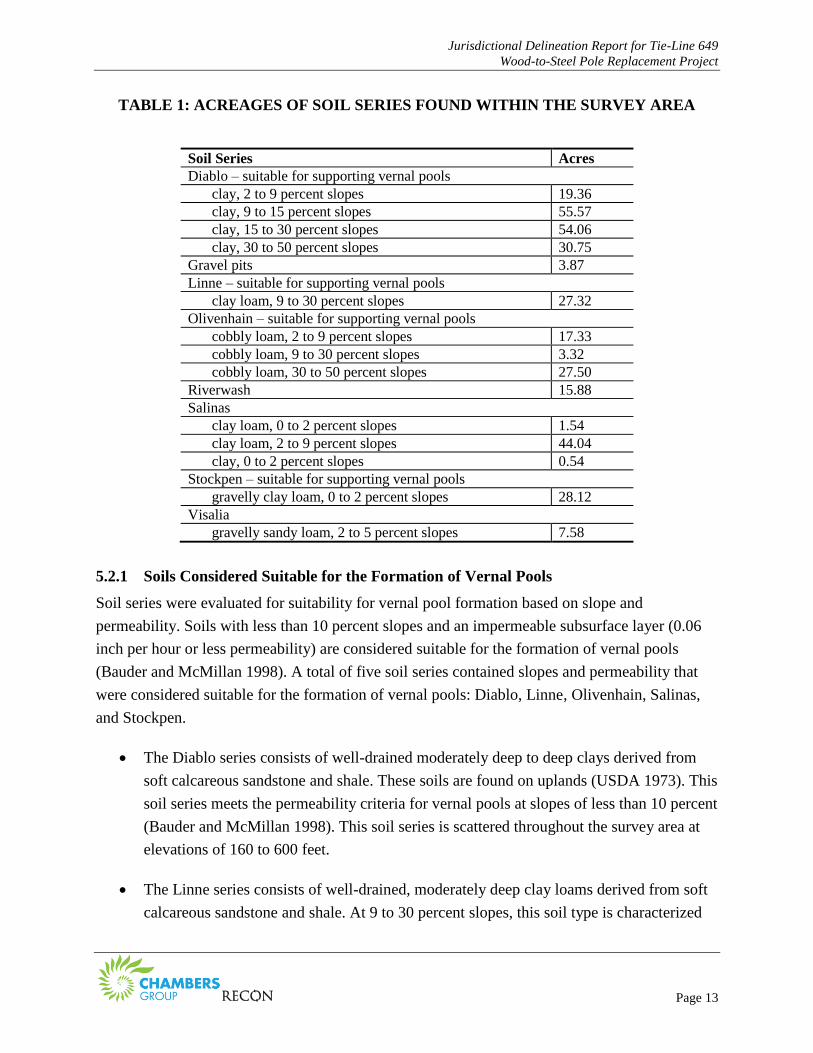
A total of eight soil series mapped by USDA (1973) occur in the survey area: Diablo, Gravel
Pits, Linne, Olivenhain, Riverwash, Salinas, Stockpen, and Visalia (Figures 4-1 through 4-18).
The acreages of these soil series are listed in Table 1.
Jurisdictional Delineation Report for Tie-Line 649
Wood-to-Steel Pole Replacement Project
Page 13
TABLE 1: ACREAGES OF SOIL SERIES FOUND WITHIN THE SURVEY AREA
Soil Series Acres
Diablo – suitable for supporting vernal pools
clay, 2 to 9 percent slopes 19.36
clay, 9 to 15 percent slopes 55.57
clay, 15 to 30 percent slopes 54.06
clay, 30 to 50 percent slopes 30.75
Gravel pits 3.87
Linne – suitable for supporting vernal pools
clay loam, 9 to 30 percent slopes 27.32
Olivenhain – suitable for supporting vernal pools
cobbly loam, 2 to 9 percent slopes 17.33
cobbly loam, 9 to 30 percent slopes 3.32
cobbly loam, 30 to 50 percent slopes 27.50
Riverwash 15.88
Salinas
clay loam, 0 to 2 percent slopes 1.54
clay loam, 2 to 9 percent slopes 44.04
clay, 0 to 2 percent slopes 0.54
Stockpen – suitable for supporting vernal pools
gravelly clay loam, 0 to 2 percent slopes 28.12
Visalia
gravelly sandy loam, 2 to 5 percent slopes 7.58
5.2.1 Soils Considered Suitable for the Formation of Vernal Pools
Soil series were evaluated for suitability for vernal pool formation based on slope and
permeability. Soils with less than 10 percent slopes and an impermeable subsurface layer (0.06
inch per hour or less permeability) are considered suitable for the formation of vernal pools
(Bauder and McMillan 1998). A total of five soil series contained slopes and permeability that
were considered suitable for the formation of vernal pools: Diablo, Linne, Olivenhain, Salinas,
and Stockpen.
The Diablo series consists of well-drained moderately deep to deep clays derived from
soft calcareous sandstone and shale. These soils are found on uplands (USDA 1973). This
soil series meets the permeability criteria for vernal pools at slopes of less than 10 percent
(Bauder and McMillan 1998). This soil series is scattered throughout the survey area at
elevations of 160 to 600 feet.
The Linne series consists of well-drained, moderately deep clay loams derived from soft
calcareous sandstone and shale. At 9 to 30 percent slopes, this soil type is characterized
Jurisdictional Delineation Report for Tie-Line 649
Wood-to-Steel Pole Replacement Project
Page 14
as rolling to hilly soil on uplands (USDA 1973). This soil type meets the permeability
criteria for vernal pools at slopes of less than 10 percent (Bauder and McMillan 1998).
This series occurs in the western and eastern portions of the survey area at elevations
from 160 to 590 feet.
The Olivenhain series consists of well-drained, moderately deep to deep cobbly loams
with very cobbly clay subsoil. This series developed in old gravelly and cobbly alluvium
and are located on dissected marine terraces. Mima mounds associated with vernal pool
complexes are known to occur in many areas where the 2 to 9 percent slopes subcategory
occurs (USDA 1973). This soil series is also known to support vernal pools in San Diego
County coastal mesas and meets the permeability criteria for vernal pools at slopes of less
than 10 percent (Bauder and McMillan 1998). This series occurs throughout the survey
area soils at elevations from 160 to 540 feet.
The Stockpen series consists of moderately well-drained, moderately deep gravelly clay
loams located on marine terraces (USDA 1973). This soil series meets the permeability
criteria for vernal pools at slopes of less than 10 percent and is known to support vernal
pools in Otay Mesa (Bauder and McMillan 1998). This soil type occurs in the
northeastern portion of the survey area at elevations of 520 to 560 feet and contains the
highest amount of vernal pools of any soil series within the survey area.
5.2.2 Soils Not Considered Suitable for the Formation of Vernal Pools
Soils with greater than 10 percent slopes and a permeable subsurface (greater than 0.06 inch per
hour) were not considered suitable for the formation of vernal pools (Bauder and McMillan
1998). A total of three soil series were not considered suitable for the formation of vernal pools:
Gravel Pits consist of areas that have been excavated for sand or gravel. The areas are
mostly on broad outwash plains and terraces of stream valleys. The gravel pits within the
survey area are likely associated with the gravel mining that occurs within the Otay River
Valley. This series occurs at elevations of 170 to 190 feet.
The Riverwash series occurs in intermittent stream channels and is typically sandy,
gravelly, or cobbly (USDA 1973). This soil type occurs in the Otay River Valley in the
central and northeastern portion of the survey area at elevations of 200 to 300 feet.
The Visalia series consists of very deep sandy loams underlain by loam and sandy loam
derived from granitic alluvium. It occurs on alluvial fans and flood plains (USDA 1973).
Jurisdictional Delineation Report for Tie-Line 649
Wood-to-Steel Pole Replacement Project
Page 15
This soil type occurs in the northeastern portion of the survey area at elevations of 280
feet.
5.3 HYDROLOGY
The project occurs within a dissected coastal mesa and canyon system on the southern bank of
the Otay River near Otay Mesa. Topography within the project area includes steep canyon
slopes, ephemeral drainages, river terraces, vegetated riparian valleys, and clay coastal mesas.
The project area generally occurs within undeveloped open space, with the exception of minor
agricultural uses within the Otay River floodplain. Coastal mesas within the project are either
developed (residential) or contain vernal pool complexes of varying size and quality. Larger
intact canyon systems within the project area (e.g., Johnson Canyon, O’Neal Canyon, Dennery
Canyon) generally contain riparian scrub vegetation, while smaller drainage systems in the area
typically contain ephemeral drainages or vegetated swales with intermittent evidence of wetland
hydrology. All drainages and wetlands in the area are within the Otay River watershed and have
direct hydrologic connectivity to the Otay River. The Otay River flows into the Pacific Ocean (a
TNW via San Diego Bay, 5.9 miles west of the project site).
Vernal pools and their associated watersheds were observed on project access roads at several
locations within the survey area. A majority of the vernal pools occur on clay mesa tops
dissected by large drainages in the eastern portion of the project area. The remaining vernal pools
occur within the access road that runs east-west on a clay river terrace on the southern bank of
the Otay River.
5.3.1 Otay River Floodplain
The survey area is located primarily on the southern bank of the Otay River floodplain. The Otay
River flows west through the survey area to the Pacific Ocean, where it empties into Egger
Highlands at the San Diego Bay National Wildlife Refuge.
5.3.2 Tributaries & Natural Drainages
The survey area contains three major tributaries to the Otay River: Dennery Canyon, O’Neal
Canyon, and Johnson Canyon. All three drainages flow north into the Otay River, a Relatively
Permanent Water (RPW), and, ultimately, the Pacific Ocean, a TNW. Various smaller unnamed
ephemeral drainages occur scattered throughout the survey area and drain north into the Otay
River. There were 21 jurisdictional features identified in the survey area. The access road
crosses through drainages at 12 of the above mentioned 21 locations.
Jurisdictional Delineation Report for Tie-Line 649
Wood-to-Steel Pole Replacement Project
Page 16
5.3.3 Clay-pan Mesa Vernal Pool Complex
The northeastern portion of the survey area is located on mesa tops dissected by drainages. The
mesa tops contain access roads with clay-pan vernal pools formed from road ruts. The roads are
further surrounded by vernal pool complexes characterized by mima-mound-topography. These
vernal pool complexes generally drain south and north into drainages associated with the Otay
River, an RPW, via subsurface flows and/or sheet flow.
5.3.4 Man-made Structures
Man-made structures within the project area include concrete brow ditches and energy
dissipaters. In the central portion of the survey area, the brow ditch and energy dissipater were
constructed to drain an upland fill slope of a freeway bridge abutment. Water conveyed by the
brow ditch and energy dissipater sheet flows across a maintained, concrete Arizona crossing onto
an existing project access road and dissipates into upland.
5.3.5 Swales
Nine swales were identified in the survey area. Water conveyed by the swales sheet flow across
existing unpaved, unculverted access roads and dissipate into upland.
5.3.6 Erosional Feature
One erosional feature occurs within the southern portion of the survey area. The erosional feature
consists of a ditch that runs parallel to the access road and drains into upland.
5.3.7 Road Ruts
Road ruts occur within the survey area on access roads that are generally flat, unpaved, and
underlain by clay soils. Rutting occurs when heavy equipment compresses and/or displaces
saturated soils to form linear cavities within the access road footprint. Locations of road ruts on
the project site were observed to change over time. Road rutting is a dynamic process and
depends on soil saturation, soil type, as well as frequency and type of vehicular traffic. Although
deep road ruts will exhibit seasonal depressional hydrology and may act as habitat for sensitive
vernal pool fauna such as fairy shrimp which can indicate seasonal ponding (i.e., be an indicator
for hydrology), they are generally not considered jurisdictional vernal pools.
Jurisdictional Delineation Report for Tie-Line 649
Wood-to-Steel Pole Replacement Project
Page 17
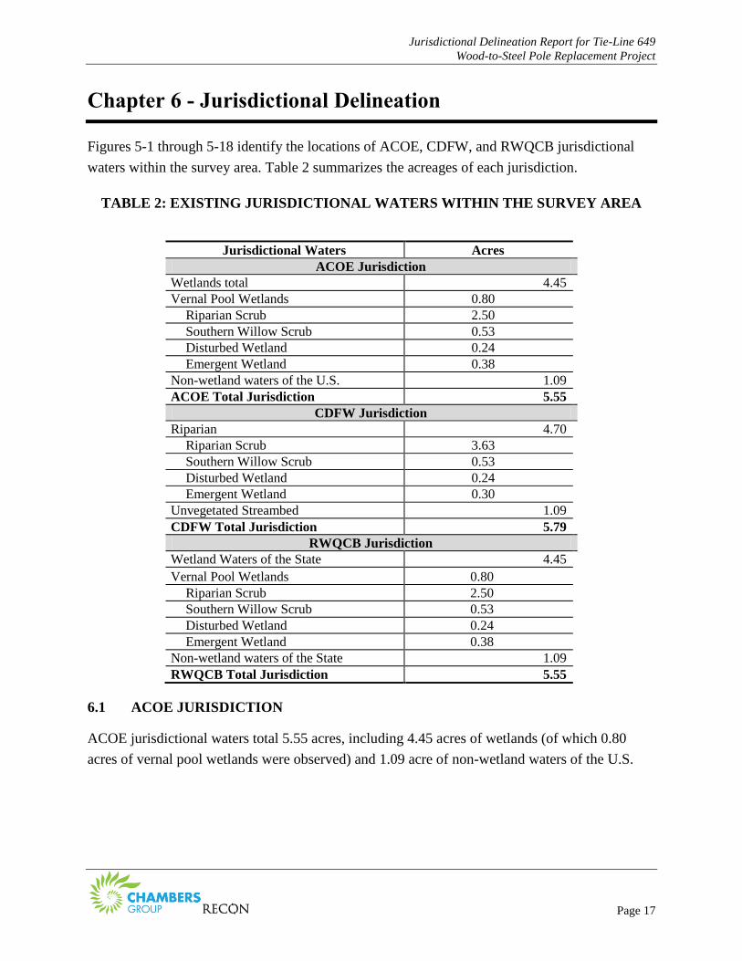
Chapter 6 - Jurisdictional Delineation
Figures 5-1 through 5-18 identify the locations of ACOE, CDFW, and RWQCB jurisdictional
waters within the survey area. Table 2 summarizes the acreages of each jurisdiction.
TABLE 2: EXISTING JURISDICTIONAL WATERS WITHIN THE SURVEY AREA
Jurisdictional Waters Acres
ACOE Jurisdiction
Wetlands total 4.45
Vernal Pool Wetlands 0.80
Riparian Scrub 2.50
Southern Willow Scrub 0.53
Disturbed Wetland 0.24
Emergent Wetland 0.38
Non-wetland waters of the U.S. 1.09
ACOE Total Jurisdiction 5.55
CDFW Jurisdiction
Riparian 4.70
Riparian Scrub 3.63
Southern Willow Scrub 0.53
Disturbed Wetland 0.24
Emergent Wetland 0.30
Unvegetated Streambed 1.09
CDFW Total Jurisdiction 5.79
RWQCB Jurisdiction
Wetland Waters of the State 4.45
Vernal Pool Wetlands 0.80
Riparian Scrub 2.50
Southern Willow Scrub 0.53
Disturbed Wetland 0.24
Emergent Wetland 0.38
Non-wetland waters of the State 1.09
RWQCB Total Jurisdiction 5.55
6.1 ACOE JURISDICTION
ACOE jurisdictional waters total 5.55 acres, including 4.45 acres of wetlands (of which 0.80
acres of vernal pool wetlands were observed) and 1.09 acre of non-wetland waters of the U.S.
Jurisdictional Delineation Report for Tie-Line 649
Wood-to-Steel Pole Replacement Project
Page 18
6.1.1 Wetlands
A total of 4.45 acres of jurisdictional wetlands were delineated within the survey area.
Jurisdictional wetlands within the survey area consist of coastal and valley freshwater marsh,
emergent wetland, southern willow scrub, disturbed wetland, and vernal pool wetlands.
6.1.1.1 Vernal Pool Wetlands
Of the 0.80 acre delineated as vernal pool wetlands, fifty-two vernal pools were identified in the
surveys and are likely considered jurisdictional by ACOE and RWQCB. Of these vernal pools,
eight are naturally occurring (i.e., not located within an access road and; therefore, undisturbed),
and the remaining disturbed vernal pools occur within existing access roads. Of these disturbed
vernal pools, six are unvegetated and thirty-eight are vegetated.
According to the CNDDB, two access roads within the project survey area (adjacent to the
Donovan state prison) occurs on a mesa top within documented occurrences of the federal and
state endangered ACOE vernal pool botanic indicator species, Otay Mesa mint (Pogogyne
nudiuscula) and San Diego button celery (Eryngium aristulatum var. parishii).
6.1.2 Non-wetland Waters of the U.S.
A total of 1.09 acres of ACOE non-wetland waters of the U.S. occur within the survey area. The
non-wetland waters consist of ephemeral drainages. These drainages contain an ordinary high
watermark and display connectivity to the Otay River, a RPW.
6.1.3 Non-Jurisdictional Features
Road ruts, swales, erosional features, and man-made features do not meet the definition of an
ACOE water of the U.S. (i.e., contain an OHWM or three parameter wetland), as they typically
dissipate within uplands and do not exhibit connectivity to a TNW. These features are also not
considered RWQCB jurisdictional as RWQCB follow ACOE guidance for delineation of waters
of the State. In addition, these features do not support a bed and bank and therefore, are not
considered jurisdictional by CDFW.
A small patch of riparian scrub was mapped on a project staging yard; however, it is only sparse
riparian vegetation that is colonizing a constructed, upland fill slope fed by irrigation runoff. This
area does not meet a three parameter wetland nor is it associated with a streambed or lake and
therefore, is likely not considered jurisdictional by ACOE, RWQCB, or CDFW.
Jurisdictional Delineation Report for Tie-Line 649
Wood-to-Steel Pole Replacement Project
Page 19
6.2 CDFW JURISDICTION, SECTION 1600 OF THE CALIFORNIA DEPARTMENT
OF FISH AND GAME CODE, STREAMBED ALTERATION AGREEMENT
CDFW jurisdiction within the survey area totals 5.79acres, which includes 1.09 acres of CDFW
streambed and 4.70 acres of CDFW riparian. CDFW streambed within the survey area consists
of unvegetated streambed. CDFW riparian includes 1.13 acres of riparian scrub not considered
jurisdictional by ACOE. The vernal pools in the project area are not within CDFW Section 1600
jurisdiction. However, CDFW does assert jurisdiction over state threatened and endangered
species that may occur within vernal pools though the California Endangered Species Act
(CESA).
6.3 RWQCB JURISDICTION
RWQCB jurisdiction within the survey area totals 5.55 acres of RWQCB waters of the state.
RWQCB waters of the state consist of unvegetated streambed, coastal and valley freshwater
marsh, emergent wetland, riparian scrub, southern willow scrub, disturbed wetland, and vernal
pools.
Jurisdictional Delineation Report for Tie-Line 649
Wood-to-Steel Pole Replacement Project
Page 20
Chapter 7 - Permit Authorization
ACOE, CDFW, and RWQCB jurisdictional waters are regulated by the federal, state, and local
government. All impacts to jurisdictional waters need to be avoided and minimized to the
greatest extent possible.
Unavoidable impacts to jurisdictional waters may be authorized by ACOE, CDFW, and ACOE
through permit authorizations from ACOE (Section 404 permit program), from CDFW through a
1602 Streambed Alteration Agreement, and from RWQCB through a 401 State Water Quality
Certification. In addition, impacts to isolated waters of the state will require a Waste Discharge
Permit from the RWQCB.
Jurisdictional Delineation Report for Tie-Line 649
Wood-to-Steel Pole Replacement Project
Page 21
Chapter 8 - References Cited
AECOM
2009 Transmission Construction and Maintenance (TCM) 2009 Vernal Pool Data Accuracy
Assessment Report. March.
Bauder, E.T. and S. McMillan
1998 Current Distribution and Historical Extent of Vernal Pools in Southern California and
Northern Baja California, Mexico. Pages 56–70 in: C.W. Witham, E.T. Bauder, D. Belk,
W.R. Ferren Jr. and R. Ornduff (Editors). Ecology, Conservation, and Management of
Vernal Pool Ecosystems—Proceedings from a 1996 Conference. California Native Plant
Society, Sacramento, California.
Bennett, A.
2013 Post-survey Notification of Wet Season Fairy Shrimp Surveys at Otay Ranch Preserve-
Salt Creek Parcels, City of Chula Vista, San Diego (RECON Number 5256). May.
California, State of
2014 California Natural Diversity Database. Accessed July 22, 2014 at
https://www.dfg.ca.gov/biogeodata/cnddb/.
Chambers Group, Inc.
2014 Draft Biological Technical Report. TL 649 Wood to Steel Pole Replacement. Otay Mesa
Substation to Border Substation, San Diego and Chula Vista, San Diego County,
California.
Environmental Law Institute (ELI)
2007 The Clean Water Act Jurisdictional Handbook. 2007 Edition. Washington D.C.
Jepson Flora Project
2014 The Jepson Online Interchange for California Floristics. University of California
Berkeley. Regents of the University of California. Accessed online on July 21, 2014 from
http://ucjepstest.berkeley.edu/interchange/.
Lichvar, R.W., M. Butterwick, N.C. Melvin, and W.N. Kirchner.
2014 The National Wetland Plant List: 2014 Update of Wetland Ratings.
Phytoneuron 2014-41: 1-42.

Jurisdictional Delineation Report for Tie-Line 649
Wood-to-Steel Pole Replacement Project
Page 22
Oberbauer, T., Kelly, M., and J. Buegge
2008 Draft Vegetation Communities of San Diego County. Based on “Preliminary
Descriptions of the Terrestrial Natural Communities of California”, Robert F. Holland,
Ph.D., October 1986.
RECON Environmental, Inc. (RECON)
2013 Post-survey Notification of Wet Season Fairy Shrimp Surveys at Otay Ranch Preserve –
Salt Creek Parcels, City of Chula Vista, San Diego County.
San Diego Association of Governments (SANDAG)
2014 DRAFT Vernal Pool Boundaries for Otay Mesa Vernal Pool HCP, received October 12.
U.S. Army Corps of Engineers (ACOE)
1987 Corps of Engineers Wetlands Delineation Manual. Technical Report Y-87-1, Department
of the Army. January.
2008 Regional Supplement to the Corps of Engineers Wetland Delineation Manual: Arid West
Region (Version 2.0). Prepared by U.S. Army Engineer Research and Development
Center. September.
2014 National Wetland Plant List, Version 3.2. Accessed July 22, 2014 at
http://wetland_plants.usace.army.mil/
U.S. Department of Agriculture (USDA)
1973 Soil Survey, San Diego Area, California. Soil Conservation Service and Forest Service.
2014 Web Soil Survey. Natural Resource Conservation Service. Accessed online July 15,
2014, at http://websoilsurvey.nrcs.usda.gov/.
U.S. Fish and Wildlife Service (USFWS)
2014a National Wetland Inventory. Accessed online October 22, 2014 at
http://www.fws.gov/wetlands/NWI/index.html.
2014b Critical Habitat Portal. Accessed online October 22, 2014 at http://ecos.fws.gov/crithab/
U.S. Geological Survey (USGS)
1971 Otay Mesa Quadrangle, 7.5-minute topographic maps. Original Print 1955. Photorevised
1971.
1975 Imperial Beach Quadrangle, 7.5-minute topographic maps. Original Print 1967.
Photorevised 1975.

ATTACHMENTS
Jurisdictional Delineation Report for Tie-Line 649
Wood-to-Steel Pole Replacement Project
Page 24
This page is intentionally blank.

ATT
AC
HM
ENT
1:
AQ
UA
TIC
FEA
TUR
ES D
ESC
RIP
TIO
NS
Jurisdictional Delineation Report for Tie-Line 649
Wood-to-Steel Pole Replacement Project
Page 2
This page is intentionally blank..
Jurisdictional Delineation Report for Tie-Line 649 Wood-to-Steel Replacement Project San Diego County, California
Chambers Group, Inc. 20775
1
Attachment 1: Aquatic Features Occurring with the TL 649 Project Area
Aquatic Feature Number
Description Location
Description Jurisdictional Determination Reasoning
Agency Jurisdiction
Sample Point
Map Page
Number Photograph
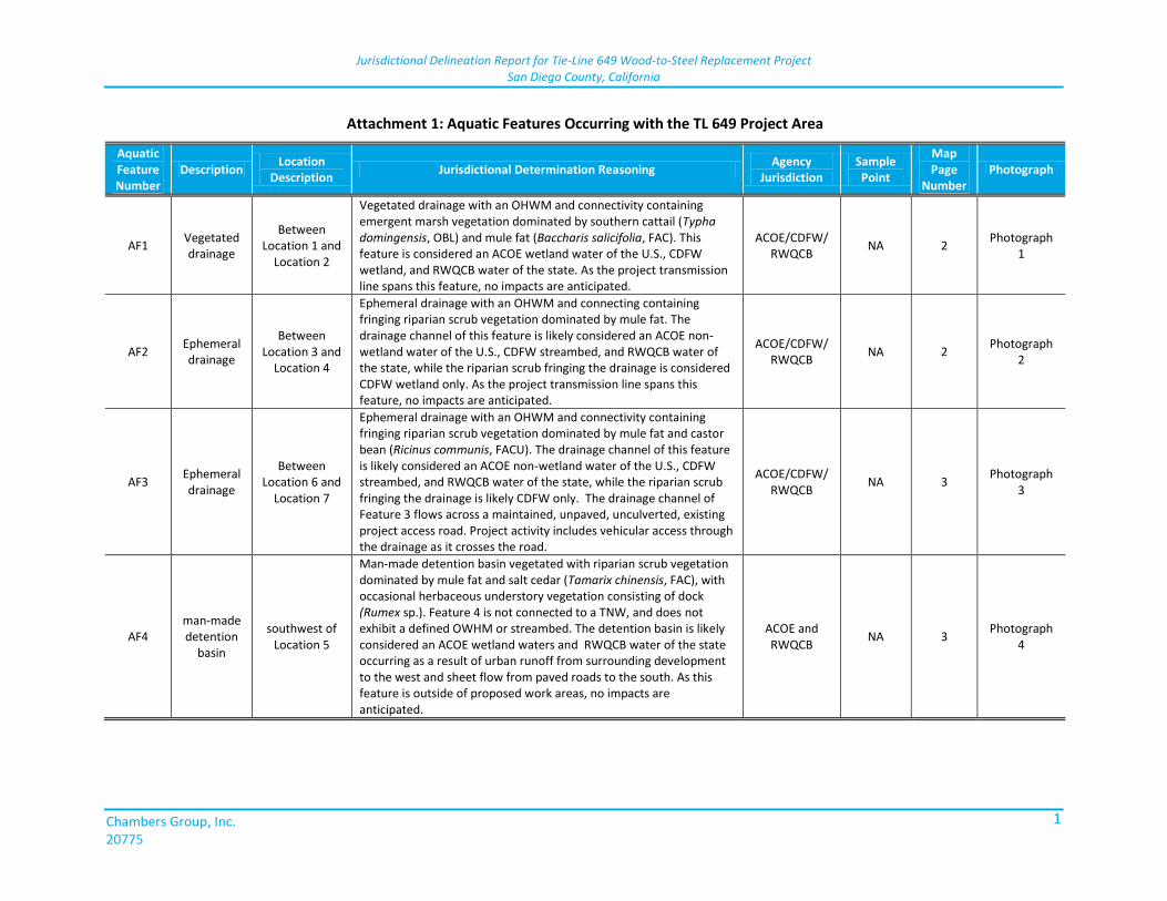
AF1 Vegetated drainage
Between Location 1 and
Location 2
Vegetated drainage with an OHWM and connectivity containing emergent marsh vegetation dominated by southern cattail (Typha domingensis, OBL) and mule fat (Baccharis salicifolia, FAC). This feature is considered an ACOE wetland water of the U.S., CDFW wetland, and RWQCB water of the state. As the project transmission line spans this feature, no impacts are anticipated.
ACOE/CDFW/ RWQCB
NA 2 Photograph
1
AF2 Ephemeral drainage
Between Location 3 and
Location 4
Ephemeral drainage with an OHWM and connecting containing fringing riparian scrub vegetation dominated by mule fat. The drainage channel of this feature is likely considered an ACOE non-wetland water of the U.S., CDFW streambed, and RWQCB water of the state, while the riparian scrub fringing the drainage is considered CDFW wetland only. As the project transmission line spans this feature, no impacts are anticipated.
ACOE/CDFW/ RWQCB
NA 2 Photograph
2
AF3 Ephemeral drainage
Between Location 6 and
Location 7
Ephemeral drainage with an OHWM and connectivity containing fringing riparian scrub vegetation dominated by mule fat and castor bean (Ricinus communis, FACU). The drainage channel of this feature is likely considered an ACOE non-wetland water of the U.S., CDFW streambed, and RWQCB water of the state, while the riparian scrub fringing the drainage is likely CDFW only. The drainage channel of Feature 3 flows across a maintained, unpaved, unculverted, existing project access road. Project activity includes vehicular access through the drainage as it crosses the road.
ACOE/CDFW/ RWQCB
NA 3 Photograph
3
AF4 man-made detention
basin
southwest of Location 5
Man-made detention basin vegetated with riparian scrub vegetation dominated by mule fat and salt cedar (Tamarix chinensis, FAC), with occasional herbaceous understory vegetation consisting of dock (Rumex sp.). Feature 4 is not connected to a TNW, and does not exhibit a defined OWHM or streambed. The detention basin is likely considered an ACOE wetland waters and RWQCB water of the state occurring as a result of urban runoff from surrounding development to the west and sheet flow from paved roads to the south. As this feature is outside of proposed work areas, no impacts are anticipated.
ACOE and RWQCB
NA 3 Photograph
4
Jurisdictional Delineation Report for Tie-Line 649 Wood-to-Steel Replacement Project San Diego County, California
Chambers Group, Inc. 20775
2
Attachment 1: Aquatic Features Occurring with the TL 649 Project Area
Aquatic Feature Number
Description Location
Description Jurisdictional Determination Reasoning
Agency Jurisdiction
Sample Point
Map Page
Number Photograph
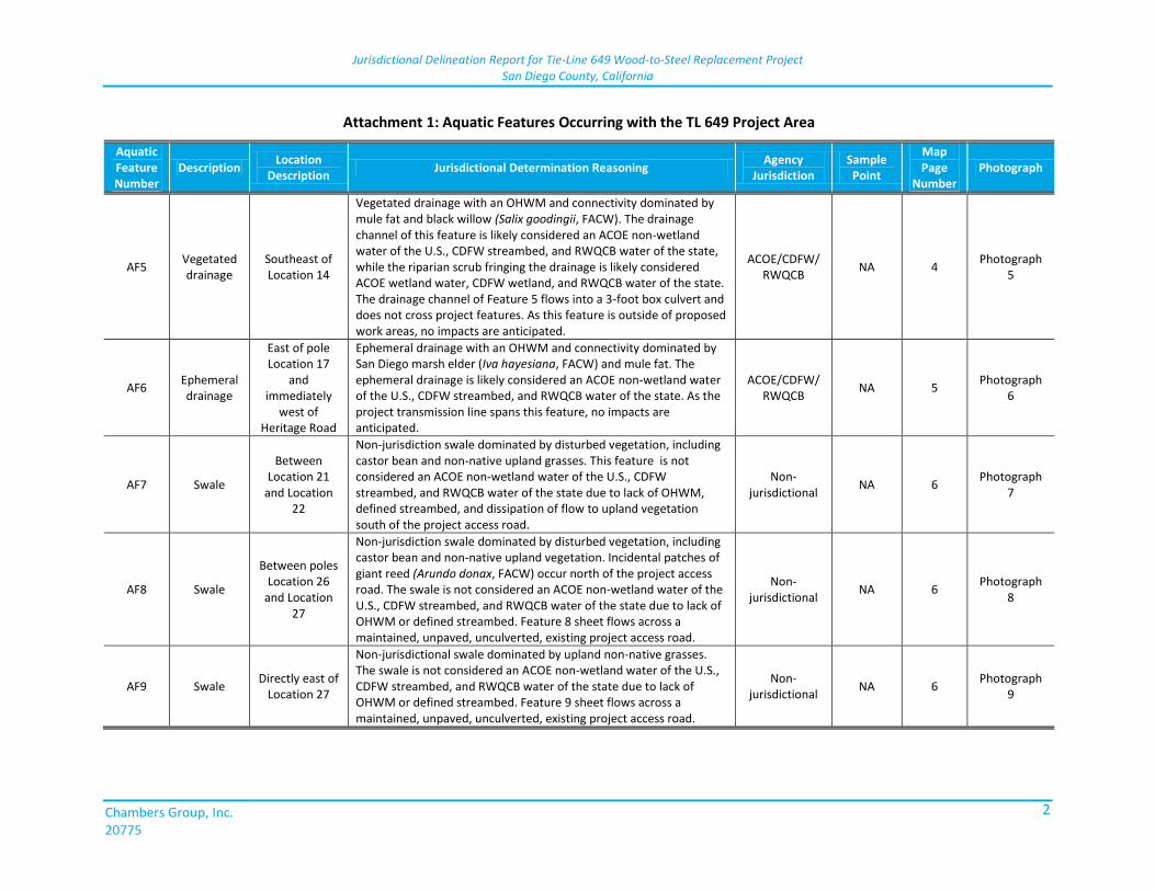
AF5 Vegetated drainage
Southeast of Location 14
Vegetated drainage with an OHWM and connectivity dominated by mule fat and black willow (Salix goodingii, FACW). The drainage channel of this feature is likely considered an ACOE non-wetland water of the U.S., CDFW streambed, and RWQCB water of the state, while the riparian scrub fringing the drainage is likely considered ACOE wetland water, CDFW wetland, and RWQCB water of the state. The drainage channel of Feature 5 flows into a 3-foot box culvert and does not cross project features. As this feature is outside of proposed work areas, no impacts are anticipated.
ACOE/CDFW/ RWQCB
NA 4 Photograph
5
AF6 Ephemeral drainage
East of pole Location 17
and immediately
west of Heritage Road
Ephemeral drainage with an OHWM and connectivity dominated by San Diego marsh elder (Iva hayesiana, FACW) and mule fat. The ephemeral drainage is likely considered an ACOE non-wetland water of the U.S., CDFW streambed, and RWQCB water of the state. As the project transmission line spans this feature, no impacts are anticipated.
ACOE/CDFW/ RWQCB
NA 5 Photograph
6
AF7 Swale
Between Location 21
and Location 22
Non-jurisdiction swale dominated by disturbed vegetation, including castor bean and non-native upland grasses. This feature is not considered an ACOE non-wetland water of the U.S., CDFW streambed, and RWQCB water of the state due to lack of OHWM, defined streambed, and dissipation of flow to upland vegetation south of the project access road.
Non-jurisdictional
NA 6 Photograph
7
AF8 Swale
Between poles Location 26
and Location 27
Non-jurisdiction swale dominated by disturbed vegetation, including castor bean and non-native upland vegetation. Incidental patches of giant reed (Arundo donax, FACW) occur north of the project access road. The swale is not considered an ACOE non-wetland water of the U.S., CDFW streambed, and RWQCB water of the state due to lack of OHWM or defined streambed. Feature 8 sheet flows across a maintained, unpaved, unculverted, existing project access road.
Non-jurisdictional
NA 6 Photograph
8
AF9 Swale Directly east of
Location 27
Non-jurisdictional swale dominated by upland non-native grasses. The swale is not considered an ACOE non-wetland water of the U.S., CDFW streambed, and RWQCB water of the state due to lack of OHWM or defined streambed. Feature 9 sheet flows across a maintained, unpaved, unculverted, existing project access road.
Non-jurisdictional
NA 6 Photograph
9
Jurisdictional Delineation Report for Tie-Line 649 Wood-to-Steel Replacement Project San Diego County, California
Chambers Group, Inc. 20775
3
Attachment 1: Aquatic Features Occurring with the TL 649 Project Area
Aquatic Feature Number
Description Location
Description Jurisdictional Determination Reasoning
Agency Jurisdiction
Sample Point
Map Page
Number Photograph
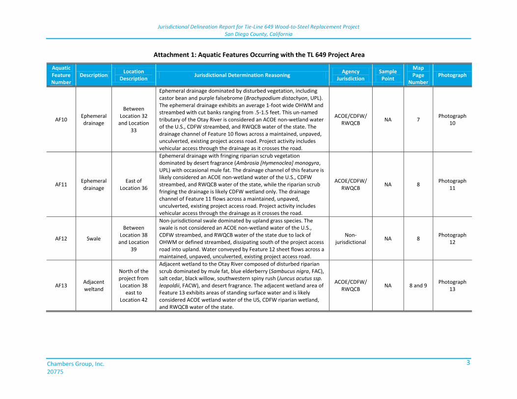
AF10 Ephemeral drainage
Between Location 32
and Location 33
Ephemeral drainage dominated by disturbed vegetation, including castor bean and purple falsebrome (Brachypodium distachyon, UPL). The ephemeral drainage exhibits an average 1-foot wide OHWM and streambed with cut banks ranging from .5-1.5 feet. This un-named tributary of the Otay River is considered an ACOE non-wetland water of the U.S., CDFW streambed, and RWQCB water of the state. The drainage channel of Feature 10 flows across a maintained, unpaved, unculverted, existing project access road. Project activity includes vehicular access through the drainage as it crosses the road.
ACOE/CDFW/ RWQCB
NA 7 Photograph
10
AF11 Ephemeral drainage
East of Location 36
Ephemeral drainage with fringing riparian scrub vegetation dominated by desert fragrance (Ambrosia [Hymenoclea] monogyra, UPL) with occasional mule fat. The drainage channel of this feature is likely considered an ACOE non-wetland water of the U.S., CDFW streambed, and RWQCB water of the state, while the riparian scrub fringing the drainage is likely CDFW wetland only. The drainage channel of Feature 11 flows across a maintained, unpaved, unculverted, existing project access road. Project activity includes vehicular access through the drainage as it crosses the road.
ACOE/CDFW/ RWQCB
NA 8 Photograph
11
AF12 Swale
Between Location 38
and Location 39
Non-jurisdictional swale dominated by upland grass species. The swale is not considered an ACOE non-wetland water of the U.S., CDFW streambed, and RWQCB water of the state due to lack of OHWM or defined streambed, dissipating south of the project access road into upland. Water conveyed by Feature 12 sheet flows across a maintained, unpaved, unculverted, existing project access road.
Non-jurisdictional
NA 8 Photograph
12
AF13 Adjacent weltand
North of the project from Location 38
east to Location 42
Adjacent wetland to the Otay River composed of disturbed riparian scrub dominated by mule fat, blue elderberry (Sambucus nigra, FAC), salt cedar, black willow, southwestern spiny rush (Juncus acutus ssp. leopoldii, FACW), and desert fragrance. The adjacent wetland area of Feature 13 exhibits areas of standing surface water and is likely considered ACOE wetland water of the US, CDFW riparian wetland, and RWQCB water of the state.
ACOE/CDFW/ RWQCB
NA 8 and 9 Photograph
13
Jurisdictional Delineation Report for Tie-Line 649 Wood-to-Steel Replacement Project San Diego County, California
Chambers Group, Inc. 20775
4
Attachment 1: Aquatic Features Occurring with the TL 649 Project Area
Aquatic Feature Number
Description Location
Description Jurisdictional Determination Reasoning
Agency Jurisdiction
Sample Point
Map Page
Number Photograph
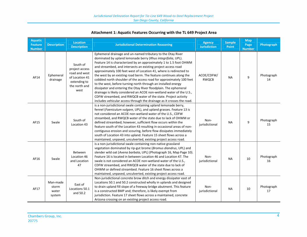
AF14 Ephemeral drainage
South of project access road and west of Location 41 extending to
the north and west
Ephemeral drainage and un-named tributary to the Otay River dominated by upland lemonade berry (Rhus integrifolia, UPL). Feature 14 is characterized by an approximately 1 to 1.5 foot OHWM and streambed, and intersects an existing project access road approximately 100 feet west of Location 41, where is redirected to the west by an existing road berm. The feature continues along the cobbled north shoulder of the access road for approximately 100 feet to the west, before turning north through an installed energy dissipater and entering the Otay River floodplain. The ephemeral drainage is likely considered an ACOE non-wetland water of the U.S., CDFW streambed, and RWQCB water of the state. Project activity includes vehicular access through the drainage as it crosses the road.
ACOE/CDFW/ RWQCB
NA 9 Photograph
14
AF15 Swale South of
Location 43
is a non-jurisdictional swale containing upland lemonade berry, fennel (Foeniculum vulgare, UPL), and upland grasses. Feature 13 is not considered an ACOE non-wetland water of the U.S., CDFW streambed, and RWQCB water of the state due to lack of OHWM or defined streambed; however, sufficient flow occurs within the feature south of the Location 43 resulting in occasional areas of non-contiguous erosion and scouring, before flow dissipates immediately south of Location 43 into upland. Feature 15 sheet flows across a maintained, unpaved, unculverted, existing project access road.
Non-jurisdictional
NA 9 Photograph
15
AF16 Swale
Between Location 46
and Location 47
is a non-jurisdictional swale containing non-native grassland vegetation dominated by rip-gut brome (Bromus diandrus, UPL) and slender wild oat (Avena barbata, UPL) (Photograph 16, Map Page 10). Feature 16 is located in between Location 46 and Location 47. The swale is not considered an ACOE non-wetland water of the U.S., CDFW streambed, and RWQCB water of the state due to lack of OHWM or defined streambed. Feature 16 sheet flows across a maintained, unpaved, unculverted, existing project access road.
Non-jurisdictional
NA 10 Photograph
16
AF17
Man-made storm water
system
East of Locations 50.1
and 50.2
Non-jurisdictional concrete brow ditch and energy dissipater east of Locations 50.1 and 50.2 constructed wholly in uplands and designed to drain upland fill slope of a freeway bridge abutment. This feature is a constructed BMP and; therefore, is likely exempt from jurisdiction. Feature 17 sheet flows across a maintained, concrete Arizona crossing on an existing project access road.
Non-jurisdictional
NA 10 Photograph
17
Jurisdictional Delineation Report for Tie-Line 649 Wood-to-Steel Replacement Project San Diego County, California
Chambers Group, Inc. 20775
5
Attachment 1: Aquatic Features Occurring with the TL 649 Project Area
Aquatic Feature Number
Description Location
Description Jurisdictional Determination Reasoning
Agency Jurisdiction
Sample Point
Map Page
Number Photograph
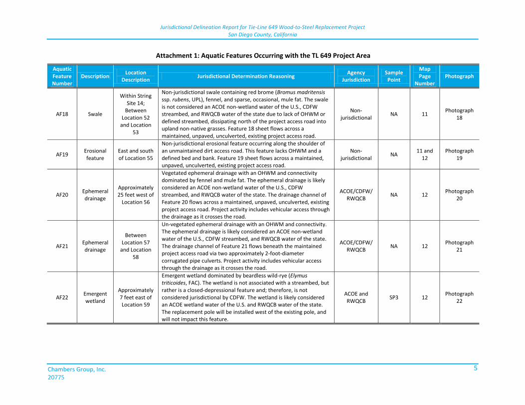
AF18 Swale
Within String Site 14;
Between Location 52
and Location 53
Non-jurisdictional swale containing red brome (Bromus madritensis ssp. rubens, UPL), fennel, and sparse, occasional, mule fat. The swale is not considered an ACOE non-wetland water of the U.S., CDFW streambed, and RWQCB water of the state due to lack of OHWM or defined streambed, dissipating north of the project access road into upland non-native grasses. Feature 18 sheet flows across a maintained, unpaved, unculverted, existing project access road.
Non-jurisdictional
NA 11 Photograph
18
AF19 Erosional feature
East and south of Location 55
Non-jurisdictional erosional feature occurring along the shoulder of an unmaintained dirt access road. This feature lacks OHWM and a defined bed and bank. Feature 19 sheet flows across a maintained, unpaved, unculverted, existing project access road.
Non-jurisdictional
NA 11 and
12 Photograph
19
AF20 Ephemeral drainage
Approximately 25 feet west of
Location 56
Vegetated ephemeral drainage with an OHWM and connectivity dominated by fennel and mule fat. The ephemeral drainage is likely considered an ACOE non-wetland water of the U.S., CDFW streambed, and RWQCB water of the state. The drainage channel of Feature 20 flows across a maintained, unpaved, unculverted, existing project access road. Project activity includes vehicular access through the drainage as it crosses the road.
ACOE/CDFW/ RWQCB
NA 12 Photograph
20
AF21 Ephemeral drainage
Between Location 57
and Location 58
Un-vegetated ephemeral drainage with an OHWM and connectivity. The ephemeral drainage is likely considered an ACOE non-wetland water of the U.S., CDFW streambed, and RWQCB water of the state. The drainage channel of Feature 21 flows beneath the maintained project access road via two approximately 2-foot-diameter corrugated pipe culverts. Project activity includes vehicular access through the drainage as it crosses the road.
ACOE/CDFW/ RWQCB
NA 12 Photograph
21
AF22 Emergent wetland
Approximately 7 feet east of Location 59
Emergent wetland dominated by beardless wild-rye (Elymus triticoides, FAC). The wetland is not associated with a streambed, but rather is a closed-depressional feature and; therefore, is not considered jurisdictional by CDFW. The wetland is likely considered an ACOE wetland water of the U.S. and RWQCB water of the state. The replacement pole will be installed west of the existing pole, and will not impact this feature.
ACOE and RWQCB
SP3 12 Photograph
22
Jurisdictional Delineation Report for Tie-Line 649 Wood-to-Steel Replacement Project San Diego County, California
Chambers Group, Inc. 20775
6
Attachment 1: Aquatic Features Occurring with the TL 649 Project Area
Aquatic Feature Number
Description Location
Description Jurisdictional Determination Reasoning
Agency Jurisdiction
Sample Point
Map Page
Number Photograph
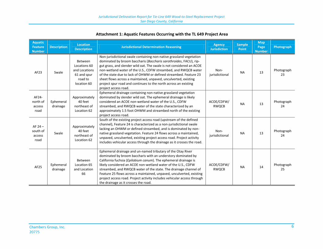
AF23 Swale
Between Locations 60
and Locations 61 and spur
road to location 60
Non-jurisdictional swale containing non-native grassland vegetation dominated by broom baccharis (Baccharis sarothroides, FACU), rip-gut grass, and slender wild oat. The swale is not considered an ACOE non-wetland water of the U.S., CDFW streambed, and RWQCB water of the state due to lack of OHWM or defined streambed. Feature 23 sheet flows across a maintained, unpaved, unculverted, existing project spur road and continues to the north across an existing project access road.
Non-jurisdictional
NA 13 Photograph
23
AF24-north of access road
Ephemeral drainage
Approximately 40 feet
northeast of Location 62
Ephemeral drainage containing non-native grassland vegetation dominated by slender wild oat. The ephemeral drainage is likely considered an ACOE non-wetland water of the U.S., CDFW streambed, and RWQCB water of the state characterized by an approximately 1.5 foot OHWM and streambed north of the existing project access road.
ACOE/CDFW/ RWQCB
NA 13 Photograph
24
AF 24 – south of access road
Swale
Approximately 40 feet
northeast of Location 62
South of the existing project access road (upstream of the defined channel), Feature 24 is characterized as a non-jurisdictional swale lacking an OHWM or defined streambed, and is dominated by non-native grassland vegetation. Feature 24 flows across a maintained, unpaved, unculverted, existing project access road. Project activity includes vehicular access through the drainage as it crosses the road.
Non-jurisdictional
NA 13 Photograph
24
AF25 Ephemeral drainage
Between Location 65
and Location 66
Ephemeral drainage and un-named tributary of the Otay River dominated by broom baccharis with an understory dominated by California fuchsia (Epilobium canum). The ephemeral drainage is likely considered an ACOE non-wetland water of the U.S., CDFW streambed, and RWQCB water of the state. The drainage channel of Feature 25 flows across a maintained, unpaved, unculverted, existing project access road. Project activity includes vehicular access through the drainage as it crosses the road.
ACOE/CDFW/ RWQCB
NA 14 Photograph
25
Jurisdictional Delineation Report for Tie-Line 649 Wood-to-Steel Replacement Project San Diego County, California
Chambers Group, Inc. 20775
7
Attachment 1: Aquatic Features Occurring with the TL 649 Project Area
Aquatic Feature Number
Description Location
Description Jurisdictional Determination Reasoning
Agency Jurisdiction
Sample Point
Map Page
Number Photograph
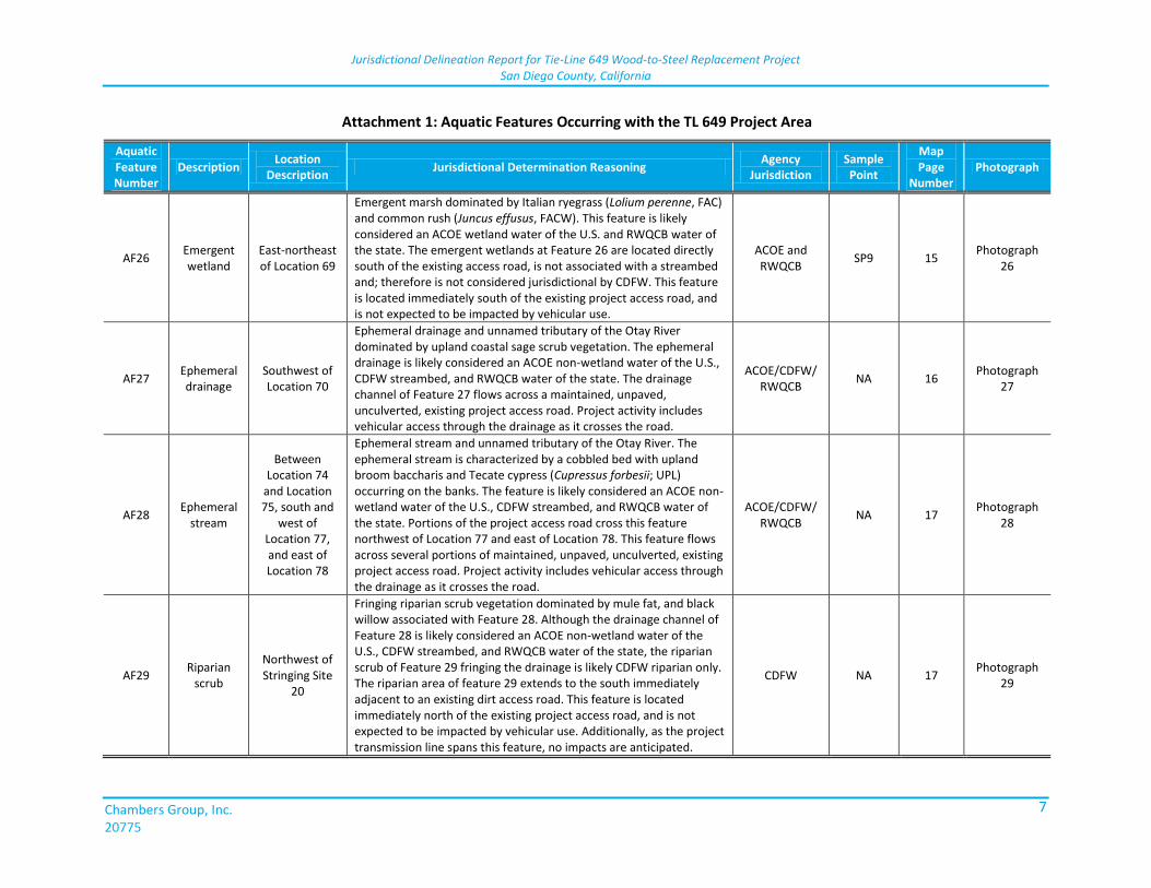
AF26 Emergent wetland
East-northeast of Location 69
Emergent marsh dominated by Italian ryegrass (Lolium perenne, FAC) and common rush (Juncus effusus, FACW). This feature is likely considered an ACOE wetland water of the U.S. and RWQCB water of the state. The emergent wetlands at Feature 26 are located directly south of the existing access road, is not associated with a streambed and; therefore is not considered jurisdictional by CDFW. This feature is located immediately south of the existing project access road, and is not expected to be impacted by vehicular use.
ACOE and RWQCB
SP9 15 Photograph
26
AF27 Ephemeral drainage
Southwest of Location 70
Ephemeral drainage and unnamed tributary of the Otay River dominated by upland coastal sage scrub vegetation. The ephemeral drainage is likely considered an ACOE non-wetland water of the U.S., CDFW streambed, and RWQCB water of the state. The drainage channel of Feature 27 flows across a maintained, unpaved, unculverted, existing project access road. Project activity includes vehicular access through the drainage as it crosses the road.
ACOE/CDFW/ RWQCB
NA 16 Photograph
27
AF28 Ephemeral
stream
Between Location 74
and Location 75, south and
west of Location 77, and east of Location 78
Ephemeral stream and unnamed tributary of the Otay River. The ephemeral stream is characterized by a cobbled bed with upland broom baccharis and Tecate cypress (Cupressus forbesii; UPL) occurring on the banks. The feature is likely considered an ACOE non-wetland water of the U.S., CDFW streambed, and RWQCB water of the state. Portions of the project access road cross this feature northwest of Location 77 and east of Location 78. This feature flows across several portions of maintained, unpaved, unculverted, existing project access road. Project activity includes vehicular access through the drainage as it crosses the road.
ACOE/CDFW/ RWQCB
NA 17 Photograph
28
AF29 Riparian
scrub
Northwest of Stringing Site
20
Fringing riparian scrub vegetation dominated by mule fat, and black willow associated with Feature 28. Although the drainage channel of Feature 28 is likely considered an ACOE non-wetland water of the U.S., CDFW streambed, and RWQCB water of the state, the riparian scrub of Feature 29 fringing the drainage is likely CDFW riparian only. The riparian area of feature 29 extends to the south immediately adjacent to an existing dirt access road. This feature is located immediately north of the existing project access road, and is not expected to be impacted by vehicular use. Additionally, as the project transmission line spans this feature, no impacts are anticipated.
CDFW NA 17 Photograph
29
Jurisdictional Delineation Report for Tie-Line 649 Wood-to-Steel Replacement Project San Diego County, California
Chambers Group, Inc. 20775
8
Attachment 1: Aquatic Features Occurring with the TL 649 Project Area
Aquatic Feature Number
Description Location
Description Jurisdictional Determination Reasoning
Agency Jurisdiction
Sample Point
Map Page
Number Photograph
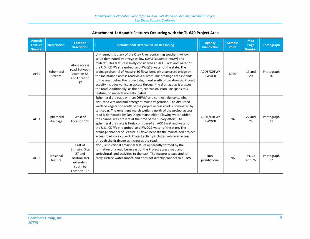
AF30 Ephemeral
stream
Along access road Between
Location 86 and Location
87
Un-named tributary of the Otay River containing southern willow scrub dominated by arroyo willow (Salix lasiolepis, FACW) and mulefat. This feature is likely considered an ACOE wetland water of the U.S., CDFW streambed, and RWQCB water of the state. The drainage channel of Feature 30 flows beneath a concrete bridge on the maintained access road via a culvert. The drainage area extends to the west below the project alignment south of Location 86. Project activity includes vehicular access through the drainage as it crosses the road. Additionally, as the project transmission line spans this feature, no impacts are anticipated.
ACOE/CDFW/ RWQCB
SP20 19 and
20 Photograph
30
AF31 Ephemeral drainage
West of Location 100
Ephemeral drainage with an OHWM and connectivity containing disturbed wetland and emergent marsh vegetation. The disturbed wetland vegetation south of the project access road is dominated by salt cedar. The emergent marsh wetland north of the project access road is dominated by San Diego marsh elder. Flowing water within the channel was present at the time of the survey effort. The ephemeral drainage is likely considered an ACOE wetland water of the U.S., CDFW streambed, and RWQCB water of the state. The drainage channel of Feature 31 flows beneath the maintained project access road via a culvert. Project activity includes vehicular access through the drainage as it crosses the road.
ACOE/CDFW/ RWQCB
NA 22 and
23 Photograph
31
AF32 Erosional feature
East of Stringing Site
27 and Location 109,
extending south to
Location 116
Non-jurisdictional erosional feature apparently formed by the formation of a road berm east of the Project access road and agricultural land activities to the east. The feature is expected to carry surface water runoff, and does not directly connect to a TNW.
Non-jurisdictional
NA 24, 25 and 26
Photograph 32

ATT
AC
HM
ENT
2:
VER
NA
L P
OO
L D
ESC
RIP
TIO
NS

This page is intentionally blank.
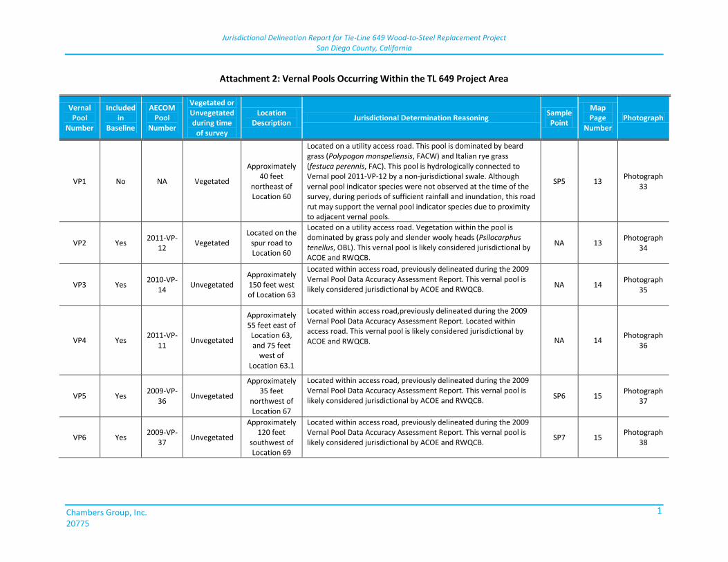
Jurisdictional Delineation Report for Tie-Line 649 Wood-to-Steel Replacement Project San Diego County, California
Chambers Group, Inc. 20775
1
Attachment 2: Vernal Pools Occurring Within the TL 649 Project Area
Vernal Pool
Number
Included in
Baseline
AECOM Pool
Number
Vegetated or Unvegetated during time
of survey
Location Description
Jurisdictional Determination Reasoning Sample Point
Map Page
Number Photograph
VP1 No NA Vegetated
Approximately 40 feet
northeast of Location 60
Located on a utility access road. This pool is dominated by beard grass (Polypogon monspeliensis, FACW) and Italian rye grass (festuca perennis, FAC). This pool is hydrologically connected to Vernal pool 2011-VP-12 by a non-jurisdictional swale. Although vernal pool indicator species were not observed at the time of the survey, during periods of sufficient rainfall and inundation, this road rut may support the vernal pool indicator species due to proximity to adjacent vernal pools.
SP5 13 Photograph
33
VP2 Yes 2011-VP-
12 Vegetated
Located on the spur road to Location 60
Located on a utility access road. Vegetation within the pool is dominated by grass poly and slender wooly heads (Psilocarphus tenellus, OBL). This vernal pool is likely considered jurisdictional by ACOE and RWQCB.
NA 13 Photograph
34
VP3 Yes 2010-VP-
14 Unvegetated
Approximately 150 feet west of Location 63
Located within access road, previously delineated during the 2009 Vernal Pool Data Accuracy Assessment Report. This vernal pool is likely considered jurisdictional by ACOE and RWQCB.
NA 14 Photograph
35
VP4 Yes 2011-VP-
11 Unvegetated
Approximately 55 feet east of Location 63, and 75 feet
west of Location 63.1
Located within access road,previously delineated during the 2009 Vernal Pool Data Accuracy Assessment Report. Located within access road. This vernal pool is likely considered jurisdictional by ACOE and RWQCB. NA 14
Photograph 36
VP5 Yes 2009-VP-
36 Unvegetated
Approximately 35 feet
northwest of Location 67
Located within access road, previously delineated during the 2009 Vernal Pool Data Accuracy Assessment Report. This vernal pool is likely considered jurisdictional by ACOE and RWQCB.
SP6 15 Photograph
37
VP6 Yes 2009-VP-
37 Unvegetated
Approximately 120 feet
southwest of Location 69
Located within access road, previously delineated during the 2009 Vernal Pool Data Accuracy Assessment Report. This vernal pool is likely considered jurisdictional by ACOE and RWQCB.
SP7 15 Photograph
38
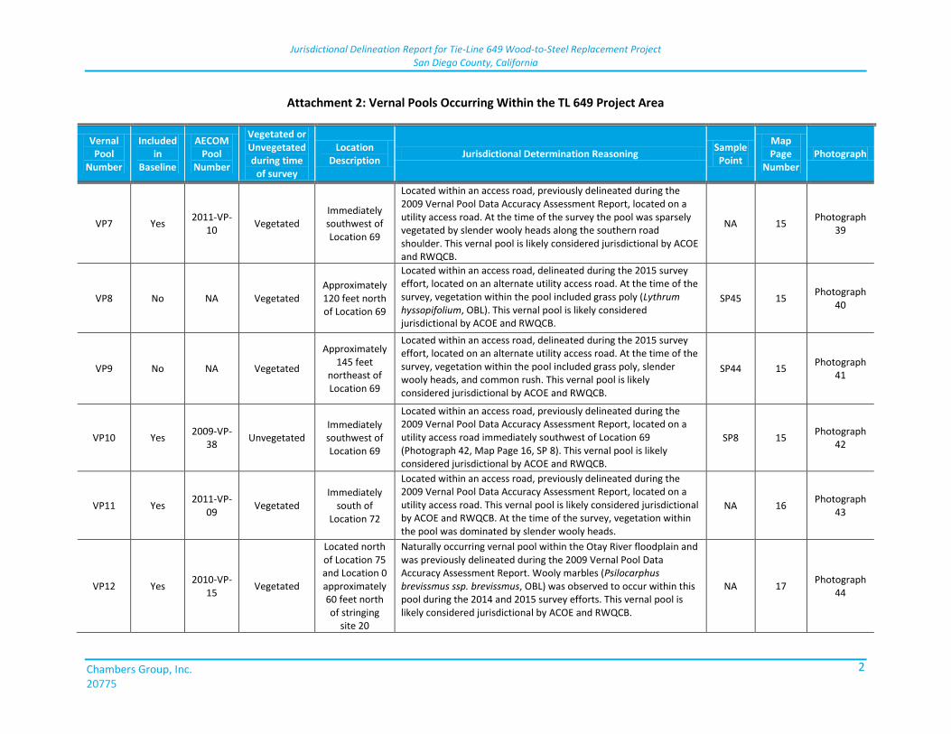
Jurisdictional Delineation Report for Tie-Line 649 Wood-to-Steel Replacement Project San Diego County, California
Chambers Group, Inc. 20775
2
Attachment 2: Vernal Pools Occurring Within the TL 649 Project Area
Vernal Pool
Number
Included in
Baseline
AECOM Pool
Number
Vegetated or Unvegetated during time
of survey
Location Description
Jurisdictional Determination Reasoning Sample Point
Map Page
Number Photograph
VP7 Yes 2011-VP-
10 Vegetated
Immediately southwest of Location 69
Located within an access road, previously delineated during the 2009 Vernal Pool Data Accuracy Assessment Report, located on a utility access road. At the time of the survey the pool was sparsely vegetated by slender wooly heads along the southern road shoulder. This vernal pool is likely considered jurisdictional by ACOE and RWQCB.
NA 15 Photograph
39
VP8 No NA Vegetated Approximately 120 feet north of Location 69
Located within an access road, delineated during the 2015 survey effort, located on an alternate utility access road. At the time of the survey, vegetation within the pool included grass poly (Lythrum hyssopifolium, OBL). This vernal pool is likely considered jurisdictional by ACOE and RWQCB.
SP45 15 Photograph
40
VP9 No NA Vegetated
Approximately 145 feet
northeast of Location 69
Located within an access road, delineated during the 2015 survey effort, located on an alternate utility access road. At the time of the survey, vegetation within the pool included grass poly, slender wooly heads, and common rush. This vernal pool is likely considered jurisdictional by ACOE and RWQCB.
SP44 15 Photograph
41
VP10 Yes 2009-VP-
38 Unvegetated
Immediately southwest of Location 69
Located within an access road, previously delineated during the 2009 Vernal Pool Data Accuracy Assessment Report, located on a utility access road immediately southwest of Location 69 (Photograph 42, Map Page 16, SP 8). This vernal pool is likely considered jurisdictional by ACOE and RWQCB.
SP8 15 Photograph
42
VP11 Yes 2011-VP-
09 Vegetated
Immediately south of
Location 72
Located within an access road, previously delineated during the 2009 Vernal Pool Data Accuracy Assessment Report, located on a utility access road. This vernal pool is likely considered jurisdictional by ACOE and RWQCB. At the time of the survey, vegetation within the pool was dominated by slender wooly heads.
NA 16 Photograph
43
VP12 Yes 2010-VP-
15 Vegetated
Located north of Location 75 and Location 0 approximately 60 feet north of stringing
site 20
Naturally occurring vernal pool within the Otay River floodplain and was previously delineated during the 2009 Vernal Pool Data Accuracy Assessment Report. Wooly marbles (Psilocarphus brevissmus ssp. brevissmus, OBL) was observed to occur within this pool during the 2014 and 2015 survey efforts. This vernal pool is likely considered jurisdictional by ACOE and RWQCB.
NA 17 Photograph
44
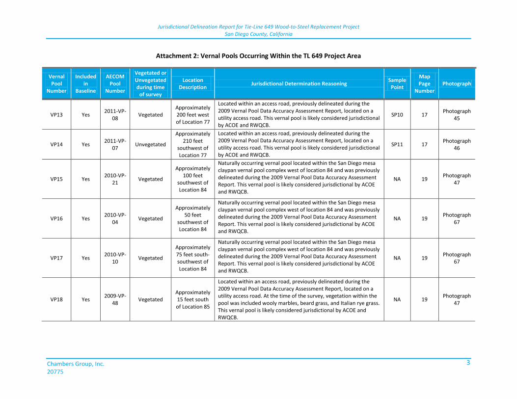
Jurisdictional Delineation Report for Tie-Line 649 Wood-to-Steel Replacement Project San Diego County, California
Chambers Group, Inc. 20775
3
Attachment 2: Vernal Pools Occurring Within the TL 649 Project Area
Vernal Pool
Number
Included in
Baseline
AECOM Pool
Number
Vegetated or Unvegetated during time
of survey
Location Description
Jurisdictional Determination Reasoning Sample Point
Map Page
Number Photograph
VP13 Yes 2011-VP-
08 Vegetated
Approximately 200 feet west of Location 77
Located within an access road, previously delineated during the 2009 Vernal Pool Data Accuracy Assessment Report, located on a utility access road. This vernal pool is likely considered jurisdictional by ACOE and RWQCB.
SP10 17 Photograph
45
VP14 Yes 2011-VP-
07 Unvegetated
Approximately 210 feet
southwest of Location 77
Located within an access road, previously delineated during the 2009 Vernal Pool Data Accuracy Assessment Report, located on a utility access road. This vernal pool is likely considered jurisdictional by ACOE and RWQCB.
SP11 17 Photograph
46
VP15 Yes 2010-VP-
21 Vegetated
Approximately 100 feet
southwest of Location 84
Naturally occurring vernal pool located within the San Diego mesa claypan vernal pool complex west of location 84 and was previously delineated during the 2009 Vernal Pool Data Accuracy Assessment Report. This vernal pool is likely considered jurisdictional by ACOE and RWQCB.
NA 19 Photograph
47
VP16 Yes 2010-VP-
04 Vegetated
Approximately 50 feet
southwest of Location 84
Naturally occurring vernal pool located within the San Diego mesa claypan vernal pool complex west of location 84 and was previously delineated during the 2009 Vernal Pool Data Accuracy Assessment Report. This vernal pool is likely considered jurisdictional by ACOE and RWQCB.
NA 19 Photograph
67
VP17 Yes 2010-VP-
10 Vegetated
Approximately 75 feet south-southwest of Location 84
Naturally occurring vernal pool located within the San Diego mesa claypan vernal pool complex west of location 84 and was previously delineated during the 2009 Vernal Pool Data Accuracy Assessment Report. This vernal pool is likely considered jurisdictional by ACOE and RWQCB.
NA 19 Photograph
67
VP18 Yes 2009-VP-
48 Vegetated
Approximately 15 feet south of Location 85
Located within an access road, previously delineated during the 2009 Vernal Pool Data Accuracy Assessment Report, located on a utility access road. At the time of the survey, vegetation within the pool was included wooly marbles, beard grass, and Italian rye grass. This vernal pool is likely considered jurisdictional by ACOE and RWQCB.
NA 19 Photograph
47
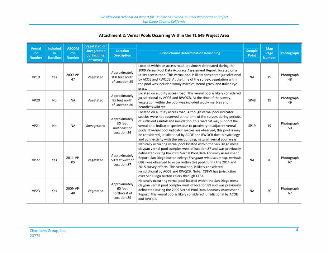
Jurisdictional Delineation Report for Tie-Line 649 Wood-to-Steel Replacement Project San Diego County, California
Chambers Group, Inc. 20775
4
Attachment 2: Vernal Pools Occurring Within the TL 649 Project Area
Vernal Pool
Number
Included in
Baseline
AECOM Pool
Number
Vegetated or Unvegetated during time
of survey
Location Description
Jurisdictional Determination Reasoning Sample Point
Map Page
Number Photograph
VP19 Yes 2009-VP-
47 Vegetated
Approximately 100 feet south of Location 85
Located within an access road, previously delineated during the 2009 Vernal Pool Data Accuracy Assessment Report, located on a utility access road. This vernal pool is likely considered jurisdictional by ACOE and RWQCB. At the time of the survey, vegetation within the pool was included wooly marbles, beard grass, and Italian rye grass.
NA 19 Photograph
48
VP20 No NA Vegetated Approximately 85 feet north of Location 86
Located on a utility access road. This vernal pool is likely considered jurisdictional by ACOE and RWQCB. At the time of the survey, vegetation within the pool was included wooly marbles and beardless wild rye.
SP48 19 Photograph
49
VP21 No NA Unvegetated
Approximately 30 feet
northeast of Location 86
Located on a utility access road. Although vernal pool indicator species were not observed at the time of the survey, during periods of sufficient rainfall and inundation, this road rut may support the vernal pool indicator species due to proximity to adjacent vernal pools. If vernal pool indicator species are observed, this pool is may be considered jurisdictional by ACOE and RWQCB due to hydrology and connectivity with the surrounding, natural, vernal pool areas.
SP19 19 Photograph
50
VP22 Yes 2011-VP-
05 Vegetated
Approximately 50 feet west of
Location 87
Naturally occurring vernal pool located within the San Diego mesa claypan vernal pool complex west of location 87 and was previously delineated during the 2009 Vernal Pool Data Accuracy Assessment Report. San Diego button celery (Eryngium aristulatum ssp. parishii; OBL) was observed to occur within this pool during the 2014 and 2015 survey efforts. This vernal pool is likely considered jurisdictional by ACOE and RWQCB. Note: CDFW has jurisdiction over San Diego button celery through CESA.
NA 20 Photograph
67
VP23 Yes 2009-VP-
40 Vegetated
Approximately 60 feet
northwest of Location 89
Naturally occurring vernal pool located within the San Diego mesa claypan vernal pool complex west of location 89 and was previously delineated during the 2009 Vernal Pool Data Accuracy Assessment Report. This vernal pool is likely considered jurisdictional by ACOE and RWQCB.
NA 20 Photograph
67
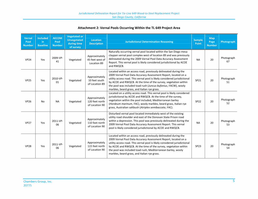
Jurisdictional Delineation Report for Tie-Line 649 Wood-to-Steel Replacement Project San Diego County, California
Chambers Group, Inc. 20775
5
Attachment 2: Vernal Pools Occurring Within the TL 649 Project Area
Vernal Pool
Number
Included in
Baseline
AECOM Pool
Number
Vegetated or Unvegetated during time
of survey
Location Description
Jurisdictional Determination Reasoning Sample Point
Map Page
Number Photograph
VP24 Yes 2009-VP-
41 Vegetated
Approximately 45 feet west of
Location 89
Naturally occurring vernal pool located within the San Diego mesa claypan vernal pool complex west of location 89 and was previously delineated during the 2009 Vernal Pool Data Accuracy Assessment Report. This vernal pool is likely considered jurisdictional by ACOE and RWQCB.
NA 20 Photograph
67
VP25 Yes 2010-VP-
01 Vegetated
Approximately 10 feet south of Location 89
Located within an access road, previously delineated during the 2009 Vernal Pool Data Accuracy Assessment Report, located on a utility access road. This vernal pool is likely considered jurisdictional by ACOE and RWQCB. At the time of the survey, vegetation within the pool was included toad rush (Juncus bufonius, FACW), wooly marbles, beard grass, and Italian rye grass.
SP21 20 Photograph
51
VP26 No NA Vegetated Approximately 120 feet north of Location 90
Located on a utility access road. This vernal pool is likely considered jurisdictional by ACOE and RWQCB. At the time of the survey, vegetation within the pool included, Mediterranean barley (Hordeum marinum, FAC), wooly marbles, beard grass, Italian rye grass, Australian saltbush (Atriplex semibaccata, FAC).
SP22 20 Photograph
52
VP27 Yes 2011-VP-
06 Vegetated
Approximately 110 feet north of Location 90
Disturbed vernal pool located immediately west of the existing utility road shoulder and east of the Donovan State Prison road within a depression. This pool was previously delineated during the 2009 Vernal Pool Data Accuracy Assessment Report. This vernal pool is likely considered jurisdictional by ACOE and RWQCB.
NA 20 Photograph
53
VP28 Yes 2011-VP-
06 Vegetated
Approximately 115 feet north of Location 90
Located within an access road, previously delineated during the 2009 Vernal Pool Data Accuracy Assessment Report, located on a utility access road. This vernal pool is likely considered jurisdictional by ACOE and RWQCB. At the time of the survey, vegetation within the pool was included toad rush, Mediterranean barley, wooly marbles, beard grass, and Italian rye grass.
SP23 20 Photograph
54
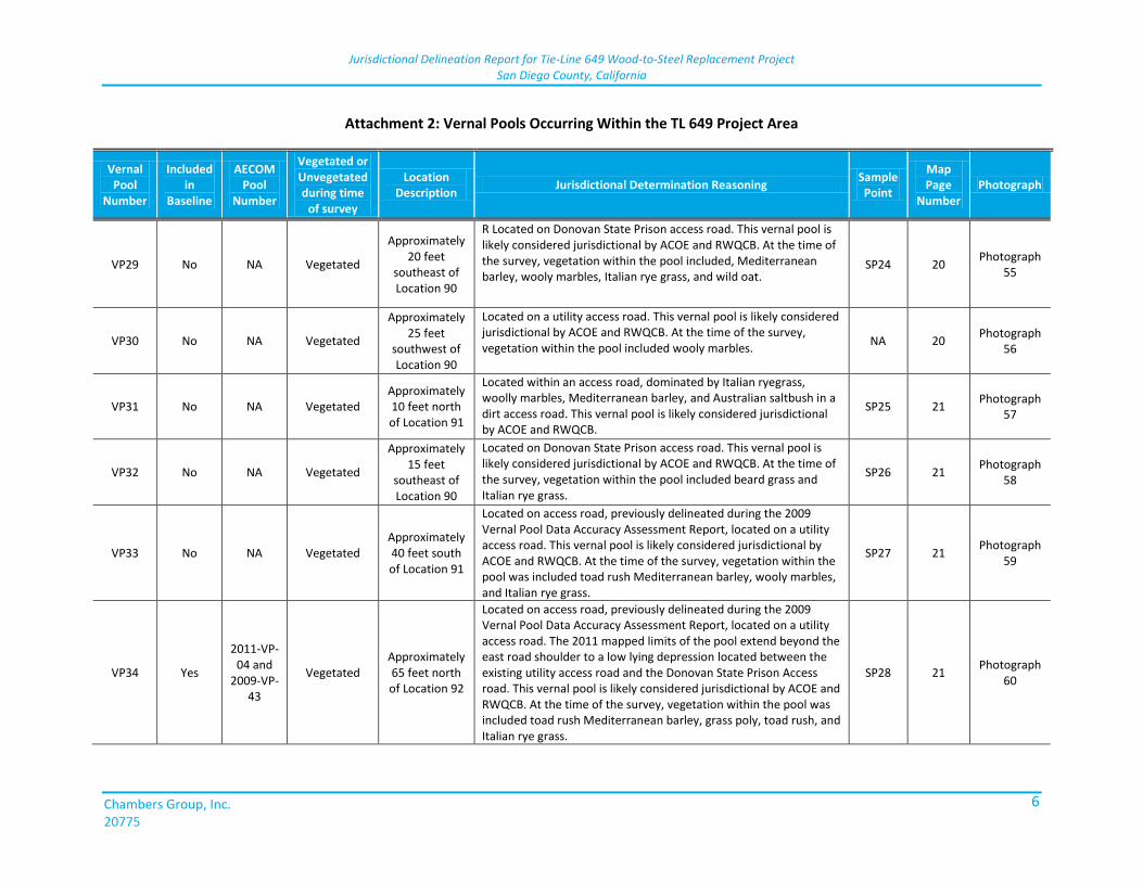
Jurisdictional Delineation Report for Tie-Line 649 Wood-to-Steel Replacement Project San Diego County, California
Chambers Group, Inc. 20775
6
Attachment 2: Vernal Pools Occurring Within the TL 649 Project Area
Vernal Pool
Number
Included in
Baseline
AECOM Pool
Number
Vegetated or Unvegetated during time
of survey
Location Description
Jurisdictional Determination Reasoning Sample Point
Map Page
Number Photograph
VP29 No NA Vegetated
Approximately 20 feet
southeast of Location 90
R Located on Donovan State Prison access road. This vernal pool is likely considered jurisdictional by ACOE and RWQCB. At the time of the survey, vegetation within the pool included, Mediterranean barley, wooly marbles, Italian rye grass, and wild oat.
SP24 20 Photograph
55
VP30 No NA Vegetated
Approximately 25 feet
southwest of Location 90
Located on a utility access road. This vernal pool is likely considered jurisdictional by ACOE and RWQCB. At the time of the survey, vegetation within the pool included wooly marbles.
NA 20 Photograph
56
VP31 No NA Vegetated Approximately 10 feet north of Location 91
Located within an access road, dominated by Italian ryegrass, woolly marbles, Mediterranean barley, and Australian saltbush in a dirt access road. This vernal pool is likely considered jurisdictional by ACOE and RWQCB.
SP25 21 Photograph
57
VP32 No NA Vegetated
Approximately 15 feet
southeast of Location 90
Located on Donovan State Prison access road. This vernal pool is likely considered jurisdictional by ACOE and RWQCB. At the time of the survey, vegetation within the pool included beard grass and Italian rye grass.
SP26 21 Photograph
58
VP33 No NA Vegetated Approximately 40 feet south of Location 91
Located on access road, previously delineated during the 2009 Vernal Pool Data Accuracy Assessment Report, located on a utility access road. This vernal pool is likely considered jurisdictional by ACOE and RWQCB. At the time of the survey, vegetation within the pool was included toad rush Mediterranean barley, wooly marbles, and Italian rye grass.
SP27 21 Photograph
59
VP34 Yes
2011-VP-04 and
2009-VP-43
Vegetated Approximately 65 feet north of Location 92
Located on access road, previously delineated during the 2009 Vernal Pool Data Accuracy Assessment Report, located on a utility access road. The 2011 mapped limits of the pool extend beyond the east road shoulder to a low lying depression located between the existing utility access road and the Donovan State Prison Access road. This vernal pool is likely considered jurisdictional by ACOE and RWQCB. At the time of the survey, vegetation within the pool was included toad rush Mediterranean barley, grass poly, toad rush, and Italian rye grass.
SP28 21 Photograph
60
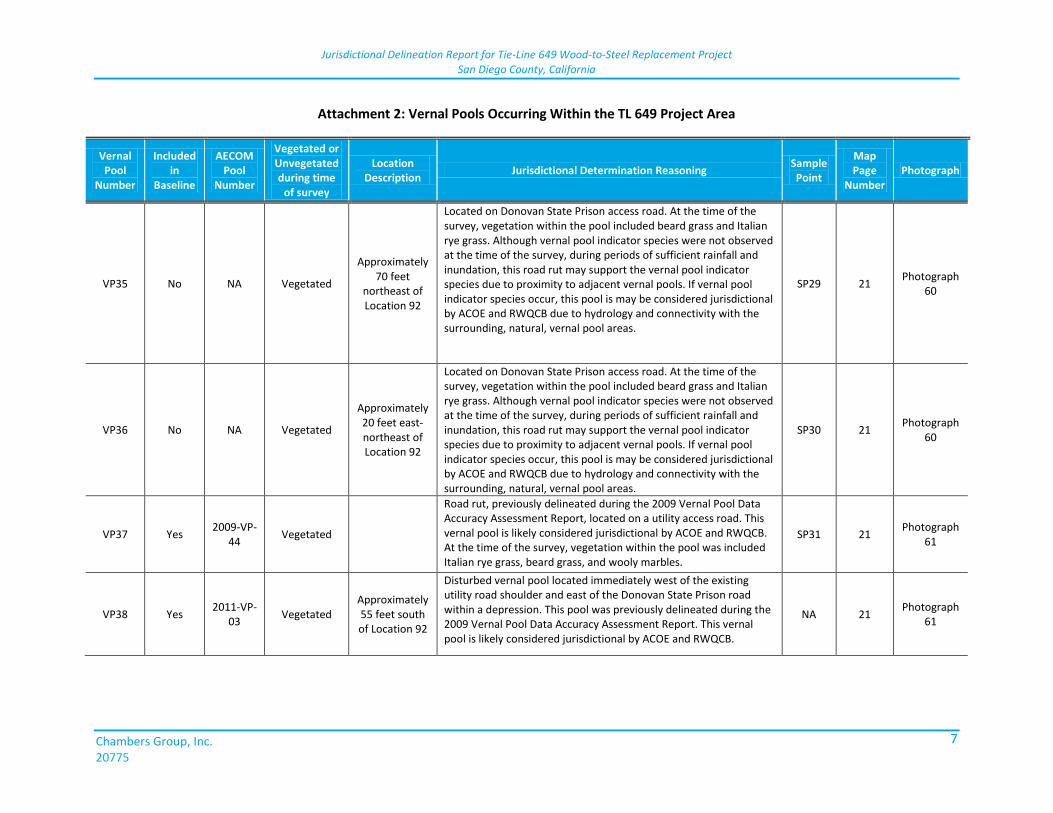
Jurisdictional Delineation Report for Tie-Line 649 Wood-to-Steel Replacement Project San Diego County, California
Chambers Group, Inc. 20775
7
Attachment 2: Vernal Pools Occurring Within the TL 649 Project Area
Vernal Pool
Number
Included in
Baseline
AECOM Pool
Number
Vegetated or Unvegetated during time
of survey
Location Description
Jurisdictional Determination Reasoning Sample Point
Map Page
Number Photograph
VP35 No NA Vegetated
Approximately 70 feet
northeast of Location 92
Located on Donovan State Prison access road. At the time of the survey, vegetation within the pool included beard grass and Italian rye grass. Although vernal pool indicator species were not observed at the time of the survey, during periods of sufficient rainfall and inundation, this road rut may support the vernal pool indicator species due to proximity to adjacent vernal pools. If vernal pool indicator species occur, this pool is may be considered jurisdictional by ACOE and RWQCB due to hydrology and connectivity with the surrounding, natural, vernal pool areas.
SP29 21 Photograph
60
VP36 No NA Vegetated
Approximately 20 feet east-northeast of Location 92
Located on Donovan State Prison access road. At the time of the survey, vegetation within the pool included beard grass and Italian rye grass. Although vernal pool indicator species were not observed at the time of the survey, during periods of sufficient rainfall and inundation, this road rut may support the vernal pool indicator species due to proximity to adjacent vernal pools. If vernal pool indicator species occur, this pool is may be considered jurisdictional by ACOE and RWQCB due to hydrology and connectivity with the surrounding, natural, vernal pool areas.
SP30 21 Photograph
60
VP37 Yes 2009-VP-
44 Vegetated
Road rut, previously delineated during the 2009 Vernal Pool Data Accuracy Assessment Report, located on a utility access road. This vernal pool is likely considered jurisdictional by ACOE and RWQCB. At the time of the survey, vegetation within the pool was included Italian rye grass, beard grass, and wooly marbles.
SP31 21 Photograph
61
VP38 Yes 2011-VP-
03 Vegetated
Approximately 55 feet south of Location 92
Disturbed vernal pool located immediately west of the existing utility road shoulder and east of the Donovan State Prison road within a depression. This pool was previously delineated during the 2009 Vernal Pool Data Accuracy Assessment Report. This vernal pool is likely considered jurisdictional by ACOE and RWQCB.
NA 21 Photograph
61
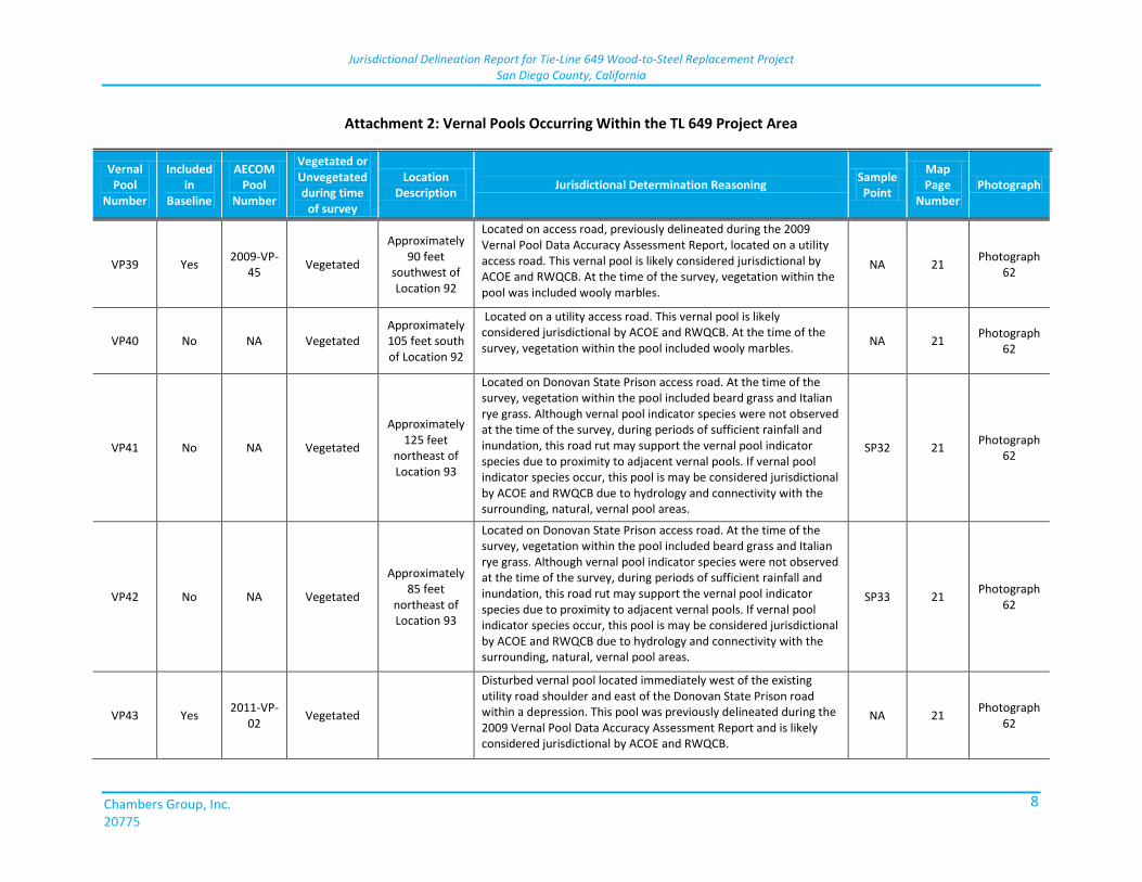
Jurisdictional Delineation Report for Tie-Line 649 Wood-to-Steel Replacement Project San Diego County, California
Chambers Group, Inc. 20775
8
Attachment 2: Vernal Pools Occurring Within the TL 649 Project Area
Vernal Pool
Number
Included in
Baseline
AECOM Pool
Number
Vegetated or Unvegetated during time
of survey
Location Description
Jurisdictional Determination Reasoning Sample Point
Map Page
Number Photograph
VP39 Yes 2009-VP-
45 Vegetated
Approximately 90 feet
southwest of Location 92
Located on access road, previously delineated during the 2009 Vernal Pool Data Accuracy Assessment Report, located on a utility access road. This vernal pool is likely considered jurisdictional by ACOE and RWQCB. At the time of the survey, vegetation within the pool was included wooly marbles.
NA 21 Photograph
62
VP40 No NA Vegetated Approximately 105 feet south of Location 92
Located on a utility access road. This vernal pool is likely considered jurisdictional by ACOE and RWQCB. At the time of the survey, vegetation within the pool included wooly marbles.
NA 21 Photograph
62
VP41 No NA Vegetated
Approximately 125 feet
northeast of Location 93
Located on Donovan State Prison access road. At the time of the survey, vegetation within the pool included beard grass and Italian rye grass. Although vernal pool indicator species were not observed at the time of the survey, during periods of sufficient rainfall and inundation, this road rut may support the vernal pool indicator species due to proximity to adjacent vernal pools. If vernal pool indicator species occur, this pool is may be considered jurisdictional by ACOE and RWQCB due to hydrology and connectivity with the surrounding, natural, vernal pool areas.
SP32 21 Photograph
62
VP42 No NA Vegetated
Approximately 85 feet
northeast of Location 93
Located on Donovan State Prison access road. At the time of the survey, vegetation within the pool included beard grass and Italian rye grass. Although vernal pool indicator species were not observed at the time of the survey, during periods of sufficient rainfall and inundation, this road rut may support the vernal pool indicator species due to proximity to adjacent vernal pools. If vernal pool indicator species occur, this pool is may be considered jurisdictional by ACOE and RWQCB due to hydrology and connectivity with the surrounding, natural, vernal pool areas.
SP33 21 Photograph
62
VP43 Yes 2011-VP-
02 Vegetated
Disturbed vernal pool located immediately west of the existing utility road shoulder and east of the Donovan State Prison road within a depression. This pool was previously delineated during the 2009 Vernal Pool Data Accuracy Assessment Report and is likely considered jurisdictional by ACOE and RWQCB.
NA 21 Photograph
62
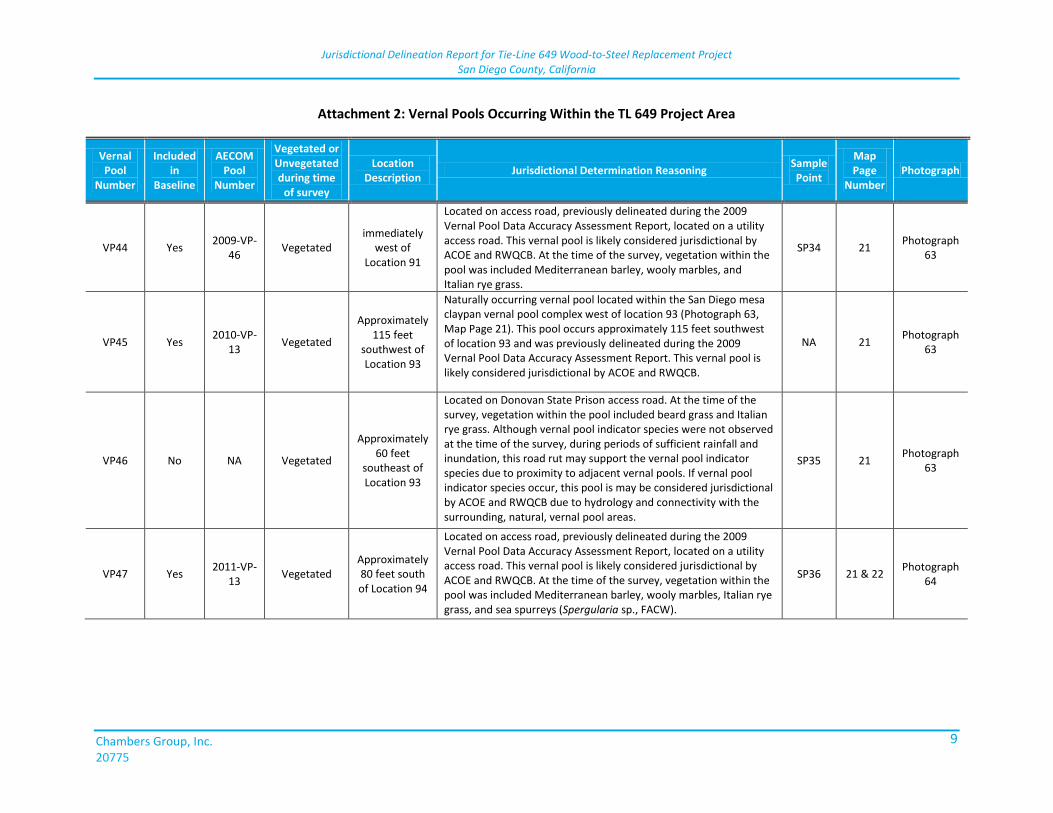
Jurisdictional Delineation Report for Tie-Line 649 Wood-to-Steel Replacement Project San Diego County, California
Chambers Group, Inc. 20775
9
Attachment 2: Vernal Pools Occurring Within the TL 649 Project Area
Vernal Pool
Number
Included in
Baseline
AECOM Pool
Number
Vegetated or Unvegetated during time
of survey
Location Description
Jurisdictional Determination Reasoning Sample Point
Map Page
Number Photograph
VP44 Yes 2009-VP-
46 Vegetated
immediately west of
Location 91
Located on access road, previously delineated during the 2009 Vernal Pool Data Accuracy Assessment Report, located on a utility access road. This vernal pool is likely considered jurisdictional by ACOE and RWQCB. At the time of the survey, vegetation within the pool was included Mediterranean barley, wooly marbles, and Italian rye grass.
SP34 21 Photograph
63
VP45 Yes 2010-VP-
13 Vegetated
Approximately 115 feet
southwest of Location 93
Naturally occurring vernal pool located within the San Diego mesa claypan vernal pool complex west of location 93 (Photograph 63, Map Page 21). This pool occurs approximately 115 feet southwest of location 93 and was previously delineated during the 2009 Vernal Pool Data Accuracy Assessment Report. This vernal pool is likely considered jurisdictional by ACOE and RWQCB.
NA 21 Photograph
63
VP46 No NA Vegetated
Approximately 60 feet
southeast of Location 93
Located on Donovan State Prison access road. At the time of the survey, vegetation within the pool included beard grass and Italian rye grass. Although vernal pool indicator species were not observed at the time of the survey, during periods of sufficient rainfall and inundation, this road rut may support the vernal pool indicator species due to proximity to adjacent vernal pools. If vernal pool indicator species occur, this pool is may be considered jurisdictional by ACOE and RWQCB due to hydrology and connectivity with the surrounding, natural, vernal pool areas.
SP35 21 Photograph
63
VP47 Yes 2011-VP-
13 Vegetated
Approximately 80 feet south of Location 94
Located on access road, previously delineated during the 2009 Vernal Pool Data Accuracy Assessment Report, located on a utility access road. This vernal pool is likely considered jurisdictional by ACOE and RWQCB. At the time of the survey, vegetation within the pool was included Mediterranean barley, wooly marbles, Italian rye grass, and sea spurreys (Spergularia sp., FACW).
SP36 21 & 22 Photograph
64
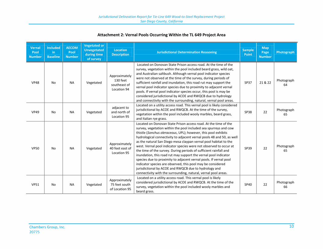
Jurisdictional Delineation Report for Tie-Line 649 Wood-to-Steel Replacement Project San Diego County, California
Chambers Group, Inc. 20775
10
Attachment 2: Vernal Pools Occurring Within the TL 649 Project Area
Vernal Pool
Number
Included in
Baseline
AECOM Pool
Number
Vegetated or Unvegetated during time
of survey
Location Description
Jurisdictional Determination Reasoning Sample Point
Map Page
Number Photograph
VP48 No NA Vegetated
Approximately 130 feet
southeast of Location 94
Located on Donovan State Prison access road. At the time of the survey, vegetation within the pool included beard grass, wild oat, and Australian saltbush. Although vernal pool indicator species were not observed at the time of the survey, during periods of sufficient rainfall and inundation, this road rut may support the vernal pool indicator species due to proximity to adjacent vernal pools. If vernal pool indicator species occur, this pool is may be considered jurisdictional by ACOE and RWQCB due to hydrology and connectivity with the surrounding, natural, vernal pool areas.
SP37 21 & 22 Photograph
64
VP49 No NA Vegetated adjacent to
and north of Location 95
Located on a utility access road. This vernal pool is likely considered jurisdictional by ACOE and RWQCB. At the time of the survey, vegetation within the pool included wooly marbles, beard grass, and Italian rye grass.
SP38 22 Photograph
65
VP50 No NA Vegetated Approximately 40 feet east of
Location 95
Located on Donovan State Prison access road. At the time of the survey, vegetation within the pool included sea spurreys and cow thistle (Sonchus oleraceous, UPL); however, this pool exhibits hydrological connectivity to adjacent vernal pools 48 and 50, as well as the natural San Diego mesa claypan vernal pool habitat to the west. Vernal pool indicator species were not observed to occur at the time of the survey. During periods of sufficient rainfall and inundation, this road rut may support the vernal pool indicator species due to proximity to adjacent vernal pools. If vernal pool indicator species are observed, this pool may be considered jurisdictional by ACOE and RWQCB due to hydrology and connectivity with the surrounding, natural, vernal pool areas.
SP39 22 Photograph
65
VP51 No NA Vegetated Approximately 75 feet south of Location 95
Located on a utility access road. This vernal pool is likely considered jurisdictional by ACOE and RWQCB. At the time of the survey, vegetation within the pool included wooly marbles and beard grass.
SP40 22 Photograph
66
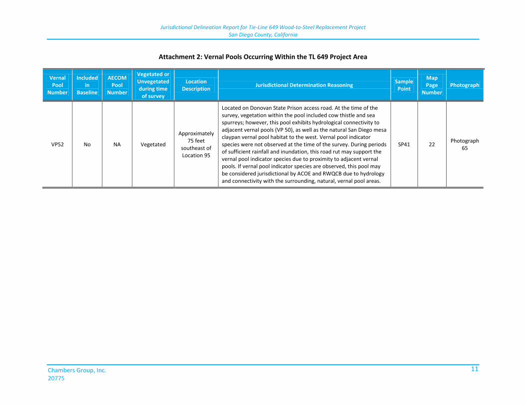
Jurisdictional Delineation Report for Tie-Line 649 Wood-to-Steel Replacement Project San Diego County, California
Chambers Group, Inc. 20775
11
Attachment 2: Vernal Pools Occurring Within the TL 649 Project Area
Vernal Pool
Number
Included in
Baseline
AECOM Pool
Number
Vegetated or Unvegetated during time
of survey
Location Description
Jurisdictional Determination Reasoning Sample Point
Map Page
Number Photograph
VP52 No NA Vegetated
Approximately 75 feet
southeast of Location 95
Located on Donovan State Prison access road. At the time of the survey, vegetation within the pool included cow thistle and sea spurreys; however, this pool exhibits hydrological connectivity to adjacent vernal pools (VP 50), as well as the natural San Diego mesa claypan vernal pool habitat to the west. Vernal pool indicator species were not observed at the time of the survey. During periods of sufficient rainfall and inundation, this road rut may support the vernal pool indicator species due to proximity to adjacent vernal pools. If vernal pool indicator species are observed, this pool may be considered jurisdictional by ACOE and RWQCB due to hydrology and connectivity with the surrounding, natural, vernal pool areas.
SP41 22 Photograph
65

ATT
AC
HM
ENT
3:
PH
OTO
GR
AP
HIC
DO
CU
MEN
TPR
OJE
CT

This page is intentionally blank.
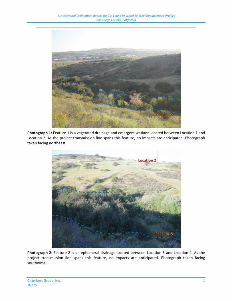
Jurisdictional Delineation Report for Tie-Line 649 Wood-to-Steel Replacement Project San Diego County, California
_____________________________________________________________________________
Chambers Group, Inc. 1 20775
Photograph 1: Feature 1 is a vegetated drainage and emergent wetland located between Location 1 and Location 2. As the project transmission line spans this feature, no impacts are anticipated. Photograph taken facing northeast
Photograph 2: Feature 2 is an ephemeral drainage located between Location 3 and Location 4. As the project transmission line spans this feature, no impacts are anticipated. Photograph taken facing southwest.
Location 2
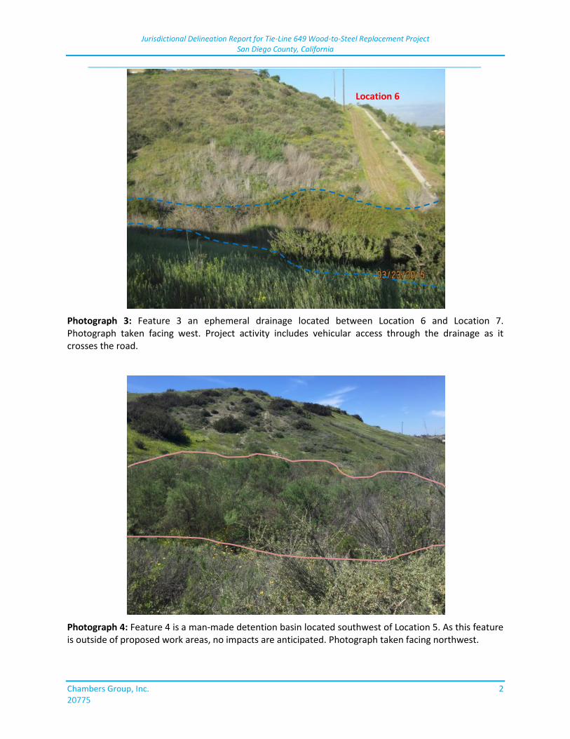
Jurisdictional Delineation Report for Tie-Line 649 Wood-to-Steel Replacement Project San Diego County, California
_____________________________________________________________________________
Chambers Group, Inc. 2 20775
Photograph 3: Feature 3 an ephemeral drainage located between Location 6 and Location 7. Photograph taken facing west. Project activity includes vehicular access through the drainage as it crosses the road.
Photograph 4: Feature 4 is a man-made detention basin located southwest of Location 5. As this feature is outside of proposed work areas, no impacts are anticipated. Photograph taken facing northwest.
Location 6
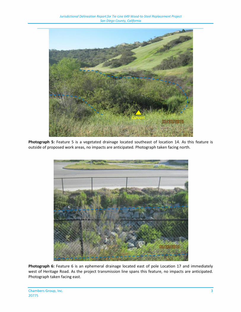
Jurisdictional Delineation Report for Tie-Line 649 Wood-to-Steel Replacement Project San Diego County, California
_____________________________________________________________________________
Chambers Group, Inc. 3 20775
Photograph 5: Feature 5 is a vegetated drainage located southeast of location 14. As this feature is outside of proposed work areas, no impacts are anticipated. Photograph taken facing north.
Photograph 6: Feature 6 is an ephemeral drainage located east of pole Location 17 and immediately west of Heritage Road. As the project transmission line spans this feature, no impacts are anticipated. Photograph taken facing east.
Culvert
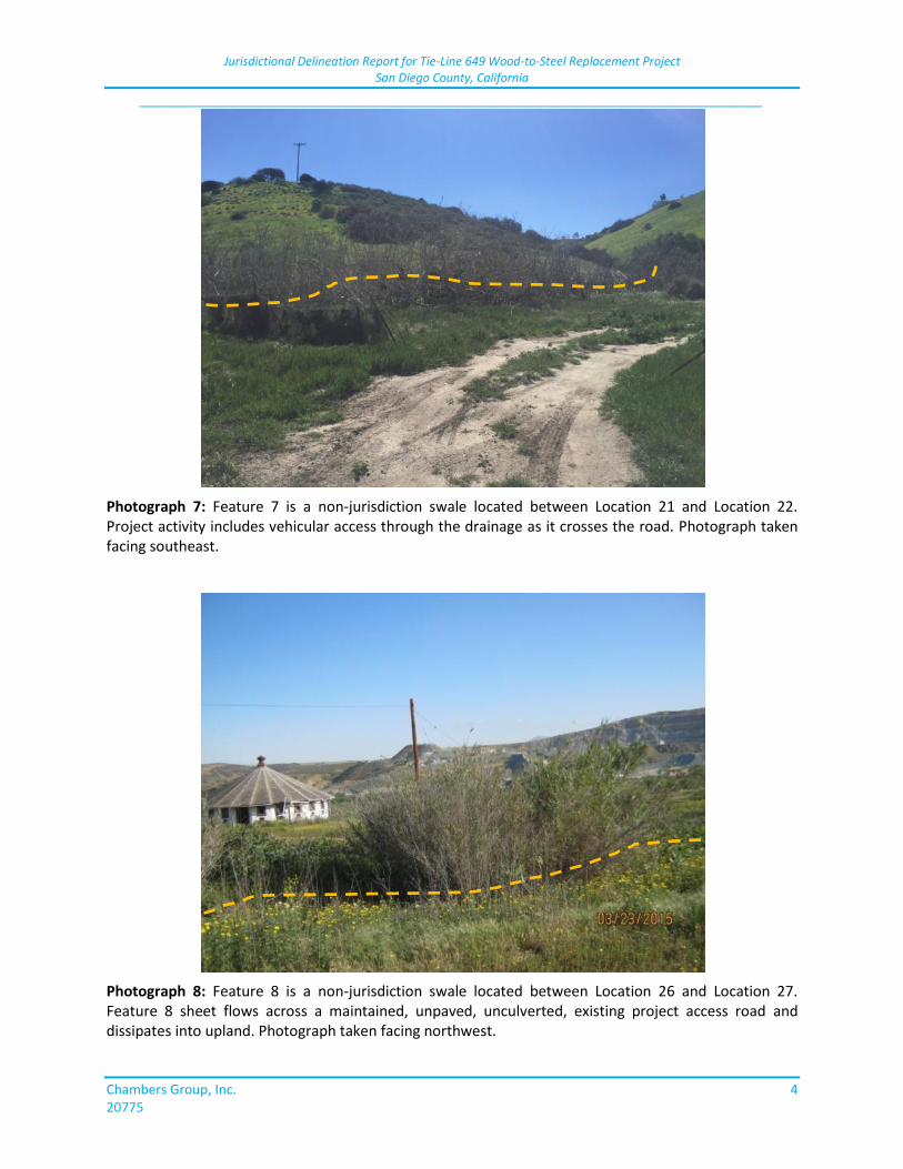
Jurisdictional Delineation Report for Tie-Line 649 Wood-to-Steel Replacement Project San Diego County, California
_____________________________________________________________________________
Chambers Group, Inc. 4 20775
Photograph 7: Feature 7 is a non-jurisdiction swale located between Location 21 and Location 22. Project activity includes vehicular access through the drainage as it crosses the road. Photograph taken facing southeast.
Photograph 8: Feature 8 is a non-jurisdiction swale located between Location 26 and Location 27. Feature 8 sheet flows across a maintained, unpaved, unculverted, existing project access road and dissipates into upland. Photograph taken facing northwest.
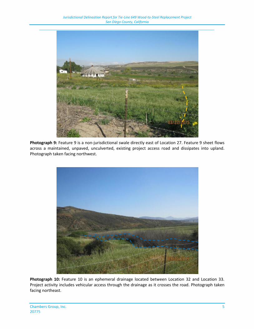
Jurisdictional Delineation Report for Tie-Line 649 Wood-to-Steel Replacement Project San Diego County, California
_____________________________________________________________________________
Chambers Group, Inc. 5 20775
Photograph 9: Feature 9 is a non-jurisdictional swale directly east of Location 27. Feature 9 sheet flows across a maintained, unpaved, unculverted, existing project access road and dissipates into upland. Photograph taken facing northwest.
Photograph 10: Feature 10 is an ephemeral drainage located between Location 32 and Location 33. Project activity includes vehicular access through the drainage as it crosses the road. Photograph taken facing northeast.
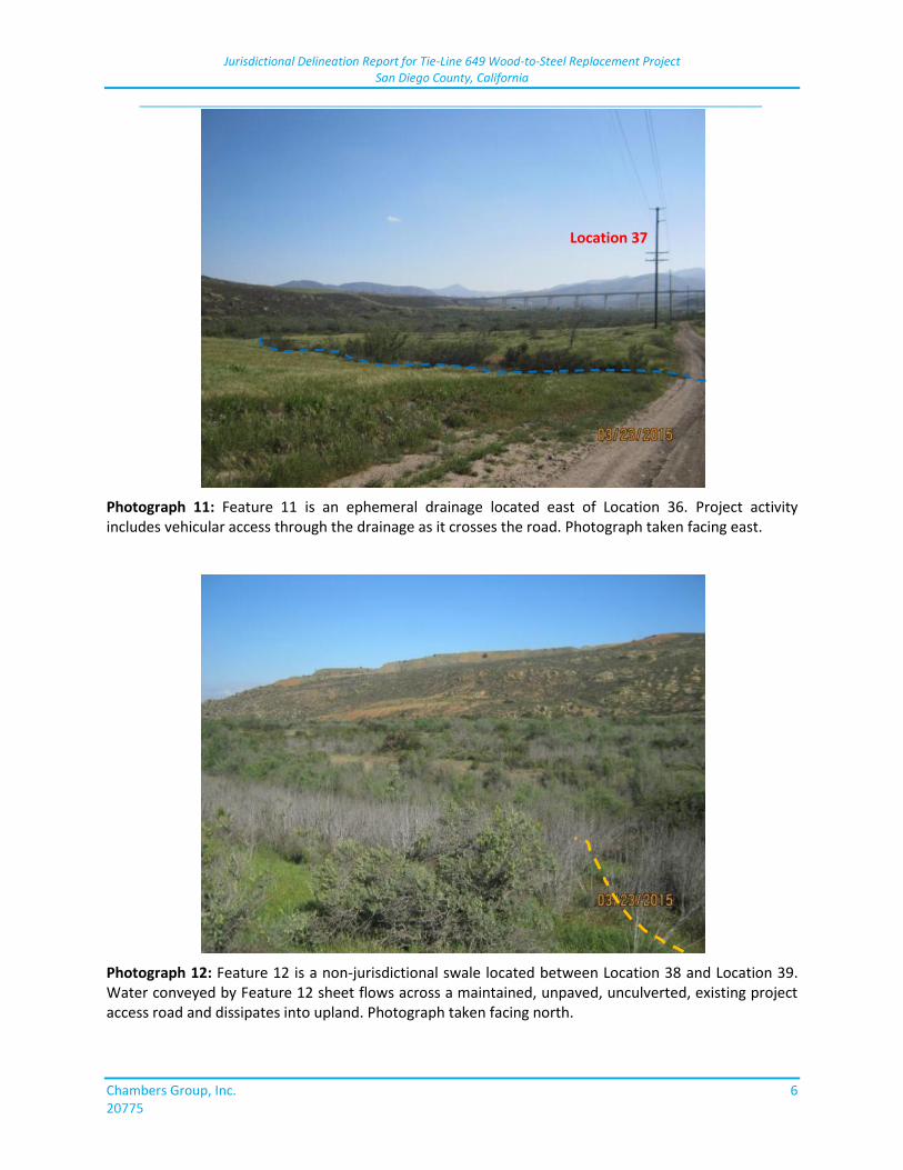
Jurisdictional Delineation Report for Tie-Line 649 Wood-to-Steel Replacement Project San Diego County, California
_____________________________________________________________________________
Chambers Group, Inc. 6 20775
Photograph 11: Feature 11 is an ephemeral drainage located east of Location 36. Project activity includes vehicular access through the drainage as it crosses the road. Photograph taken facing east.
Photograph 12: Feature 12 is a non-jurisdictional swale located between Location 38 and Location 39. Water conveyed by Feature 12 sheet flows across a maintained, unpaved, unculverted, existing project access road and dissipates into upland. Photograph taken facing north.
Location 37
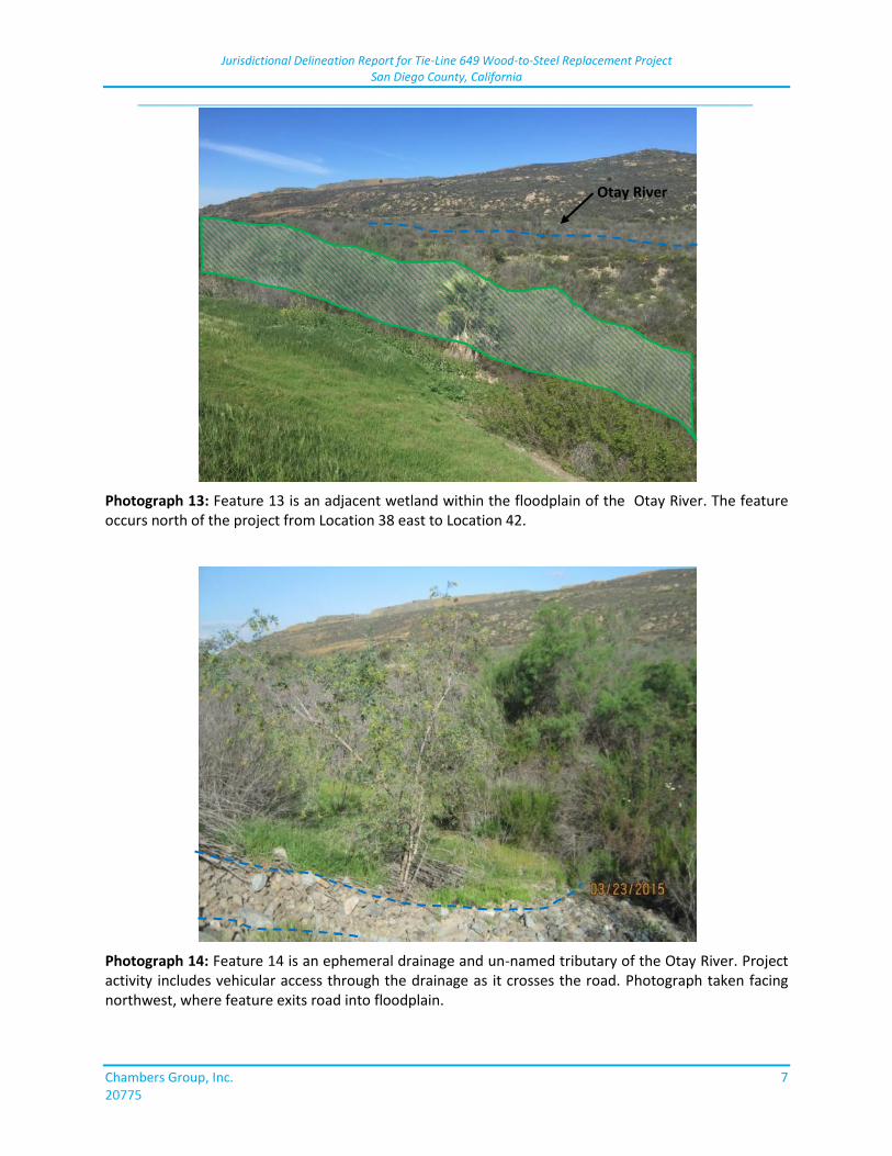
Jurisdictional Delineation Report for Tie-Line 649 Wood-to-Steel Replacement Project San Diego County, California
_____________________________________________________________________________
Chambers Group, Inc. 7 20775
Photograph 13: Feature 13 is an adjacent wetland within the floodplain of the Otay River. The feature occurs north of the project from Location 38 east to Location 42.
Photograph 14: Feature 14 is an ephemeral drainage and un-named tributary of the Otay River. Project activity includes vehicular access through the drainage as it crosses the road. Photograph taken facing northwest, where feature exits road into floodplain.
Otay River
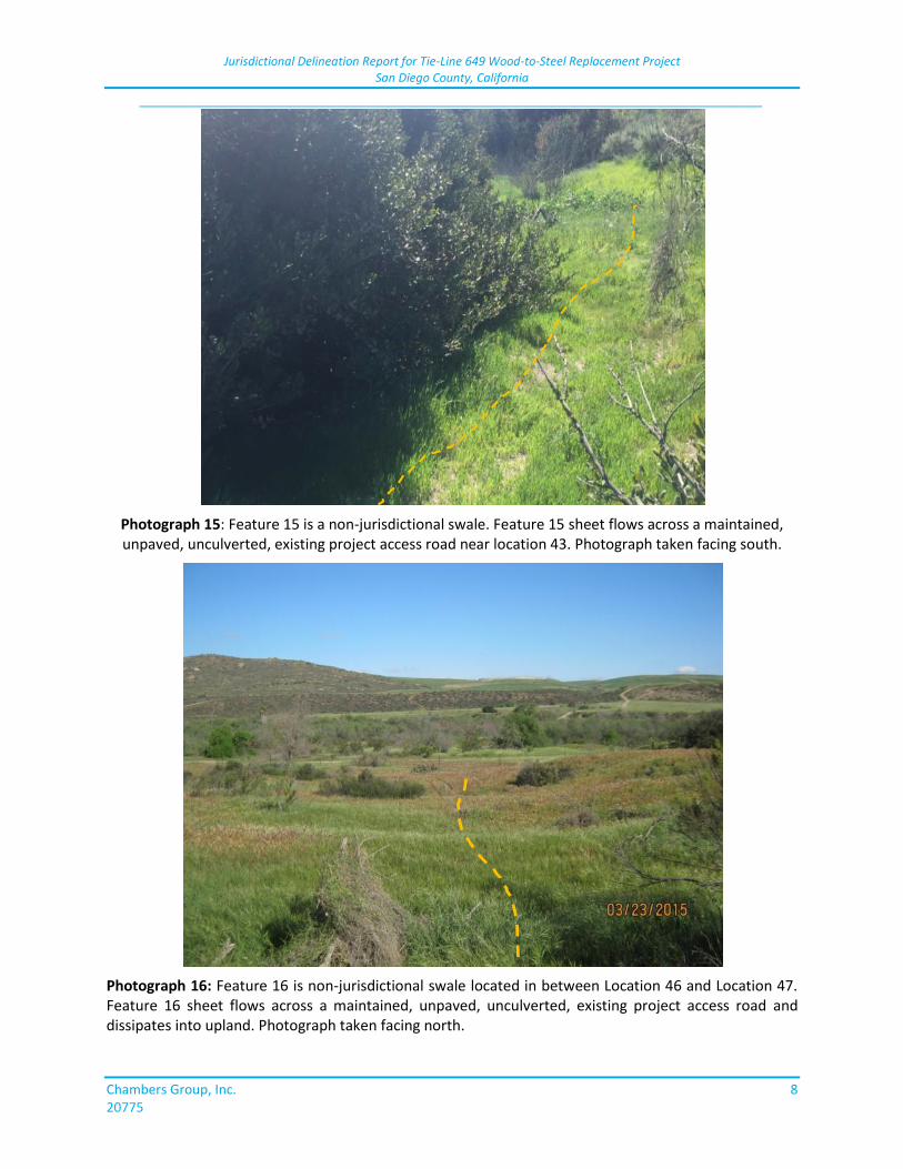
Jurisdictional Delineation Report for Tie-Line 649 Wood-to-Steel Replacement Project San Diego County, California
_____________________________________________________________________________
Chambers Group, Inc. 8 20775
Photograph 15: Feature 15 is a non-jurisdictional swale. Feature 15 sheet flows across a maintained, unpaved, unculverted, existing project access road near location 43. Photograph taken facing south.
Photograph 16: Feature 16 is non-jurisdictional swale located in between Location 46 and Location 47. Feature 16 sheet flows across a maintained, unpaved, unculverted, existing project access road and dissipates into upland. Photograph taken facing north.
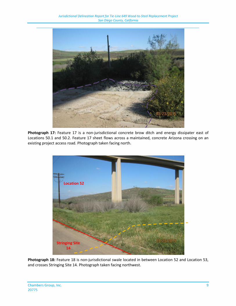
Jurisdictional Delineation Report for Tie-Line 649 Wood-to-Steel Replacement Project San Diego County, California
_____________________________________________________________________________
Chambers Group, Inc. 9 20775
Photograph 17: Feature 17 is a non-jurisdictional concrete brow ditch and energy dissipater east of Locations 50.1 and 50.2. Feature 17 sheet flows across a maintained, concrete Arizona crossing on an existing project access road. Photograph taken facing north.
Photograph 18: Feature 18 is non-jurisdictional swale located in between Location 52 and Location 53, and crosses Stringing Site 14. Photograph taken facing northwest.
Stringing Site 14
Location 52
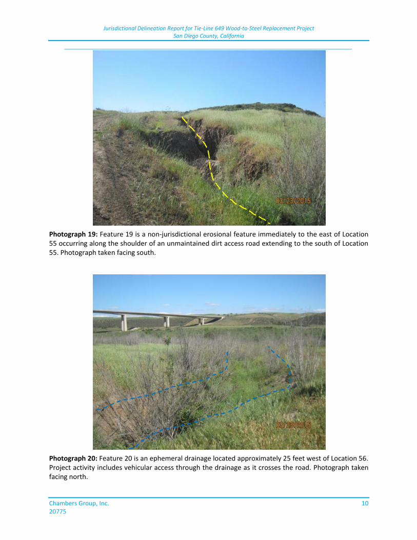
Jurisdictional Delineation Report for Tie-Line 649 Wood-to-Steel Replacement Project San Diego County, California
_____________________________________________________________________________
Chambers Group, Inc. 10 20775
Photograph 19: Feature 19 is a non-jurisdictional erosional feature immediately to the east of Location 55 occurring along the shoulder of an unmaintained dirt access road extending to the south of Location 55. Photograph taken facing south.
Photograph 20: Feature 20 is an ephemeral drainage located approximately 25 feet west of Location 56. Project activity includes vehicular access through the drainage as it crosses the road. Photograph taken facing north.
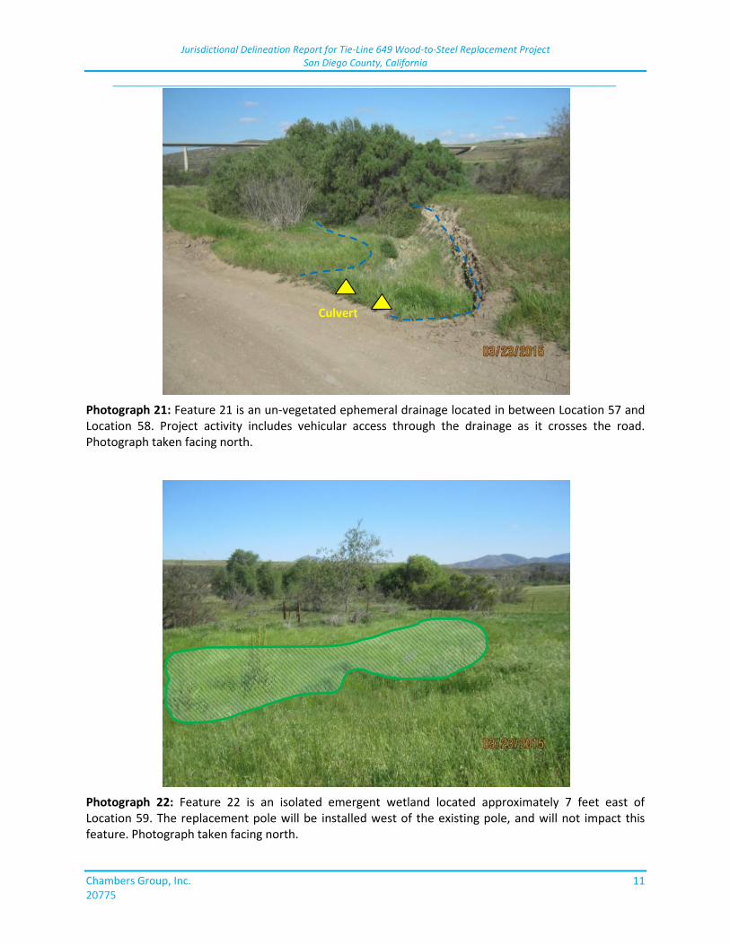
Jurisdictional Delineation Report for Tie-Line 649 Wood-to-Steel Replacement Project San Diego County, California
_____________________________________________________________________________
Chambers Group, Inc. 11 20775
Photograph 21: Feature 21 is an un-vegetated ephemeral drainage located in between Location 57 and Location 58. Project activity includes vehicular access through the drainage as it crosses the road. Photograph taken facing north.
Photograph 22: Feature 22 is an isolated emergent wetland located approximately 7 feet east of Location 59. The replacement pole will be installed west of the existing pole, and will not impact this feature. Photograph taken facing north.
Culvert
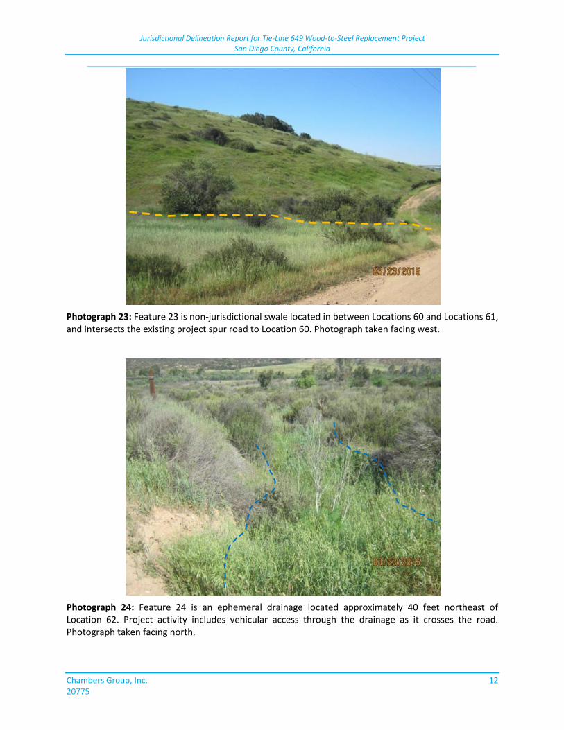
Jurisdictional Delineation Report for Tie-Line 649 Wood-to-Steel Replacement Project San Diego County, California
_____________________________________________________________________________
Chambers Group, Inc. 12 20775
Photograph 23: Feature 23 is non-jurisdictional swale located in between Locations 60 and Locations 61, and intersects the existing project spur road to Location 60. Photograph taken facing west.
Photograph 24: Feature 24 is an ephemeral drainage located approximately 40 feet northeast of Location 62. Project activity includes vehicular access through the drainage as it crosses the road. Photograph taken facing north.
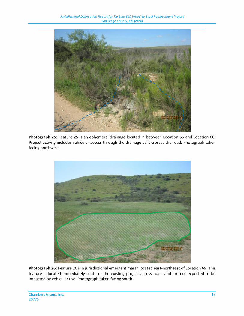
Jurisdictional Delineation Report for Tie-Line 649 Wood-to-Steel Replacement Project San Diego County, California
_____________________________________________________________________________
Chambers Group, Inc. 13 20775
Photograph 25: Feature 25 is an ephemeral drainage located in between Location 65 and Location 66. Project activity includes vehicular access through the drainage as it crosses the road. Photograph taken facing northwest.
Photograph 26: Feature 26 is a jurisdictional emergent marsh located east-northeast of Location 69. This feature is located immediately south of the existing project access road, and are not expected to be impacted by vehicular use. Photograph taken facing south.
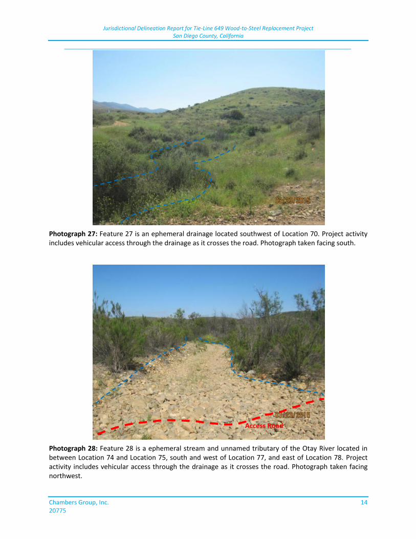
Jurisdictional Delineation Report for Tie-Line 649 Wood-to-Steel Replacement Project San Diego County, California
_____________________________________________________________________________
Chambers Group, Inc. 14 20775
Photograph 27: Feature 27 is an ephemeral drainage located southwest of Location 70. Project activity includes vehicular access through the drainage as it crosses the road. Photograph taken facing south.
Photograph 28: Feature 28 is a ephemeral stream and unnamed tributary of the Otay River located in between Location 74 and Location 75, south and west of Location 77, and east of Location 78. Project activity includes vehicular access through the drainage as it crosses the road. Photograph taken facing northwest.
Access Road
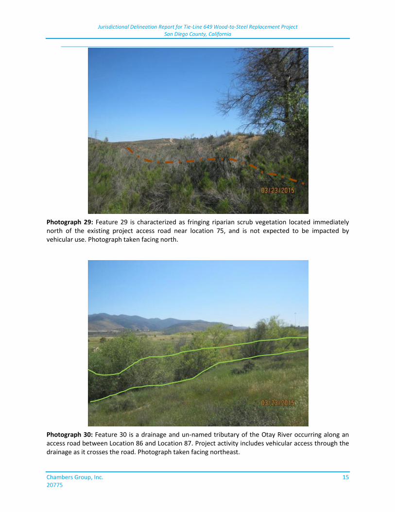
Jurisdictional Delineation Report for Tie-Line 649 Wood-to-Steel Replacement Project San Diego County, California
_____________________________________________________________________________
Chambers Group, Inc. 15 20775
Photograph 29: Feature 29 is characterized as fringing riparian scrub vegetation located immediately north of the existing project access road near location 75, and is not expected to be impacted by vehicular use. Photograph taken facing north.
Photograph 30: Feature 30 is a drainage and un-named tributary of the Otay River occurring along an access road between Location 86 and Location 87. Project activity includes vehicular access through the drainage as it crosses the road. Photograph taken facing northeast.
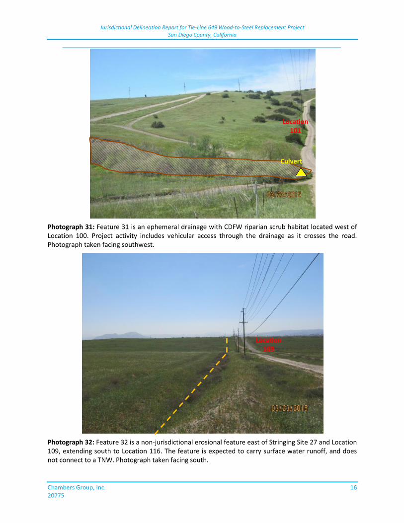
Jurisdictional Delineation Report for Tie-Line 649 Wood-to-Steel Replacement Project San Diego County, California
_____________________________________________________________________________
Chambers Group, Inc. 16 20775
Photograph 31: Feature 31 is an ephemeral drainage with CDFW riparian scrub habitat located west of Location 100. Project activity includes vehicular access through the drainage as it crosses the road. Photograph taken facing southwest.
Photograph 32: Feature 32 is a non-jurisdictional erosional feature east of Stringing Site 27 and Location 109, extending south to Location 116. The feature is expected to carry surface water runoff, and does not connect to a TNW. Photograph taken facing south.
Culvert
Location 101
Location 109
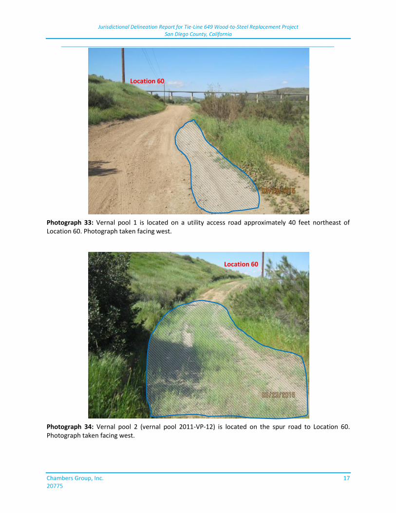
Jurisdictional Delineation Report for Tie-Line 649 Wood-to-Steel Replacement Project San Diego County, California
_____________________________________________________________________________
Chambers Group, Inc. 17 20775
Photograph 33: Vernal pool 1 is located on a utility access road approximately 40 feet northeast of Location 60. Photograph taken facing west.
Photograph 34: Vernal pool 2 (vernal pool 2011-VP-12) is located on the spur road to Location 60. Photograph taken facing west.
Location 60
Location 60
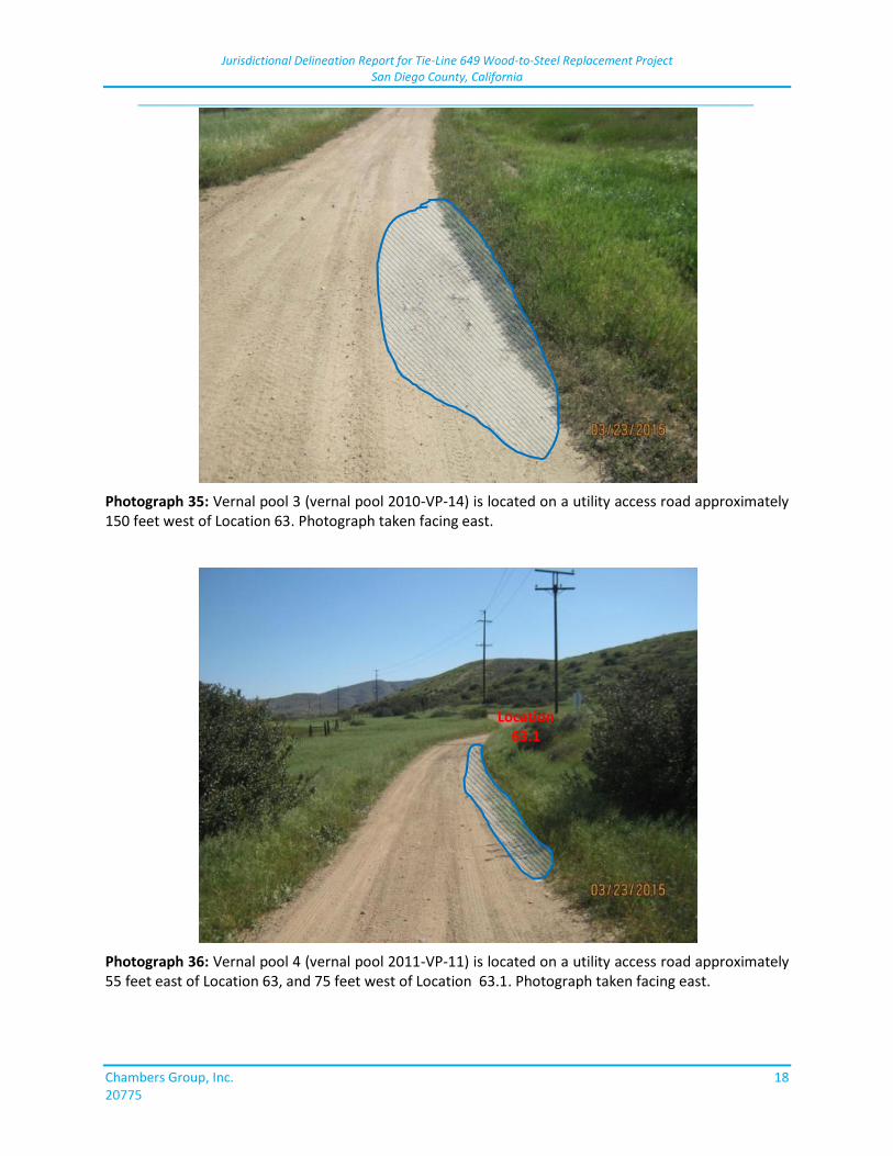
Jurisdictional Delineation Report for Tie-Line 649 Wood-to-Steel Replacement Project San Diego County, California
_____________________________________________________________________________
Chambers Group, Inc. 18 20775
Photograph 35: Vernal pool 3 (vernal pool 2010-VP-14) is located on a utility access road approximately 150 feet west of Location 63. Photograph taken facing east.
Photograph 36: Vernal pool 4 (vernal pool 2011-VP-11) is located on a utility access road approximately 55 feet east of Location 63, and 75 feet west of Location 63.1. Photograph taken facing east.
Location 63.1
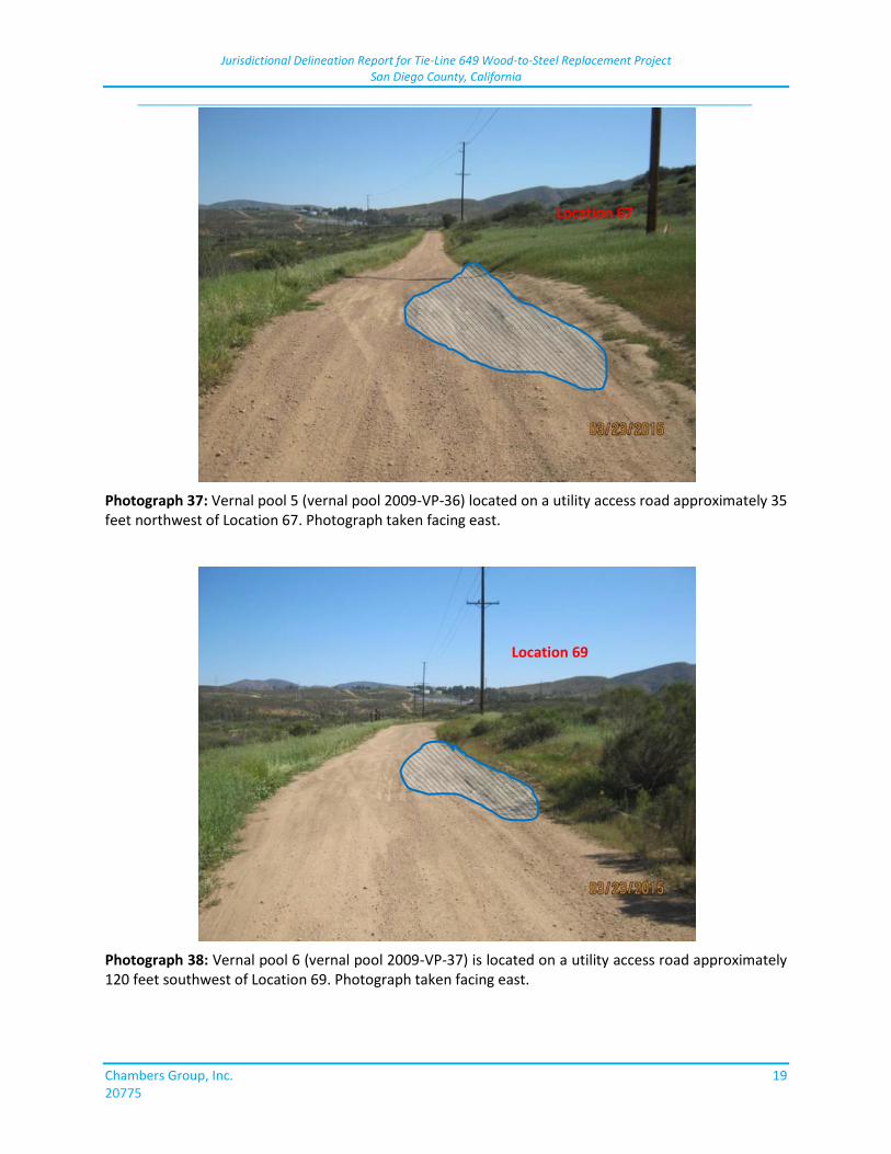
Jurisdictional Delineation Report for Tie-Line 649 Wood-to-Steel Replacement Project San Diego County, California
_____________________________________________________________________________
Chambers Group, Inc. 19 20775
Photograph 37: Vernal pool 5 (vernal pool 2009-VP-36) located on a utility access road approximately 35 feet northwest of Location 67. Photograph taken facing east.
Photograph 38: Vernal pool 6 (vernal pool 2009-VP-37) is located on a utility access road approximately 120 feet southwest of Location 69. Photograph taken facing east.
Location 67
Location 69
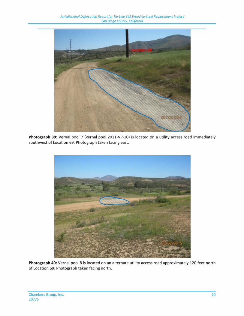
Jurisdictional Delineation Report for Tie-Line 649 Wood-to-Steel Replacement Project San Diego County, California
_____________________________________________________________________________
Chambers Group, Inc. 20 20775
Photograph 39: Vernal pool 7 (vernal pool 2011-VP-10) is located on a utility access road immediately southwest of Location 69. Photograph taken facing east.
Photograph 40: Vernal pool 8 is located on an alternate utility access road approximately 120 feet north of Location 69. Photograph taken facing north.
Location 69
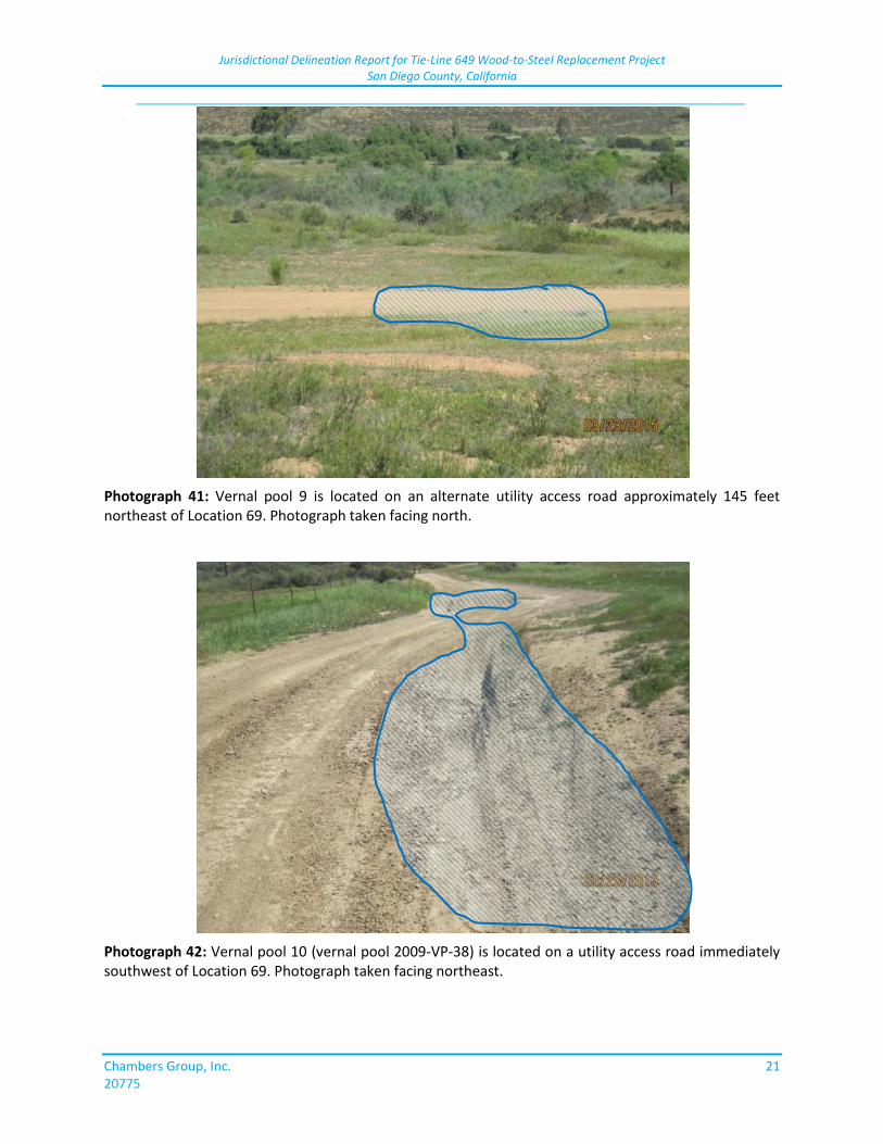
Jurisdictional Delineation Report for Tie-Line 649 Wood-to-Steel Replacement Project San Diego County, California
_____________________________________________________________________________
Chambers Group, Inc. 21 20775
Photograph 41: Vernal pool 9 is located on an alternate utility access road approximately 145 feet northeast of Location 69. Photograph taken facing north.
Photograph 42: Vernal pool 10 (vernal pool 2009-VP-38) is located on a utility access road immediately southwest of Location 69. Photograph taken facing northeast.
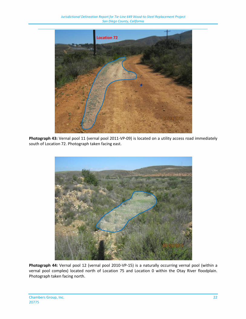
Jurisdictional Delineation Report for Tie-Line 649 Wood-to-Steel Replacement Project San Diego County, California
_____________________________________________________________________________
Chambers Group, Inc. 22 20775
Photograph 43: Vernal pool 11 (vernal pool 2011-VP-09) is located on a utility access road immediately south of Location 72. Photograph taken facing east.
Photograph 44: Vernal pool 12 (vernal pool 2010-VP-15) is a naturally occurring vernal pool (within a vernal pool complex) located north of Location 75 and Location 0 within the Otay River floodplain. Photograph taken facing north.
Location 72
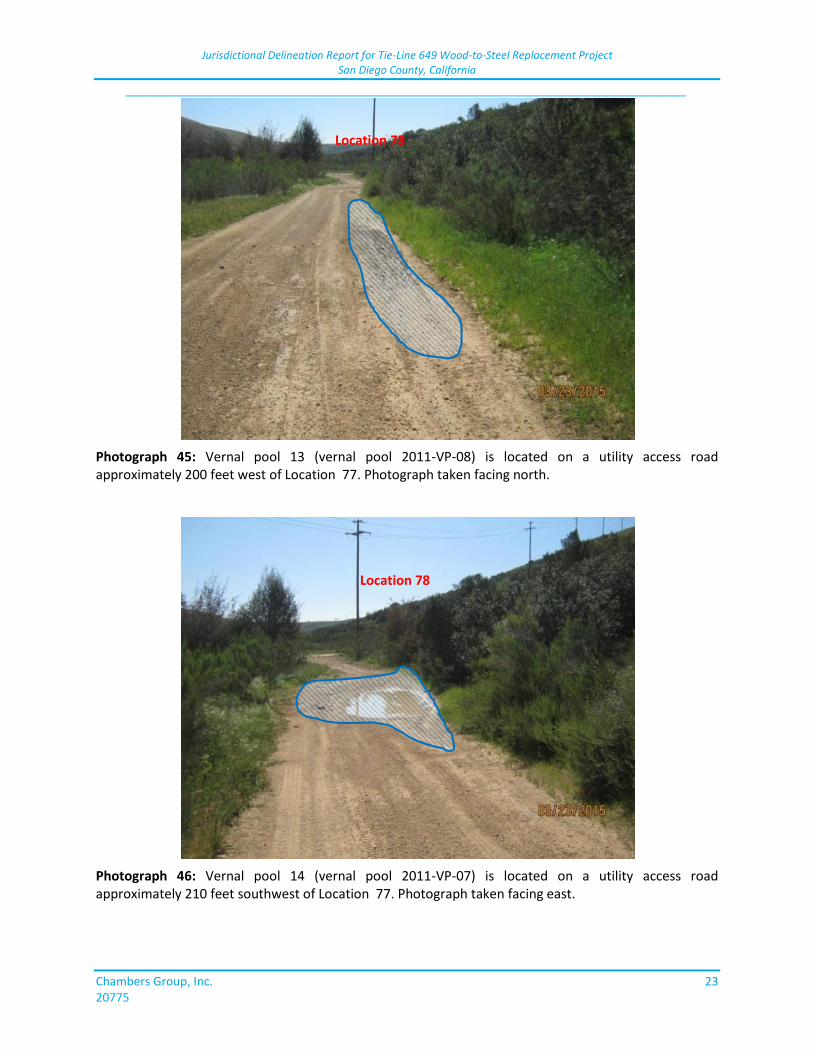
Jurisdictional Delineation Report for Tie-Line 649 Wood-to-Steel Replacement Project San Diego County, California
_____________________________________________________________________________
Chambers Group, Inc. 23 20775
Photograph 45: Vernal pool 13 (vernal pool 2011-VP-08) is located on a utility access road approximately 200 feet west of Location 77. Photograph taken facing north.
Photograph 46: Vernal pool 14 (vernal pool 2011-VP-07) is located on a utility access road approximately 210 feet southwest of Location 77. Photograph taken facing east.
Location 78
Location 78
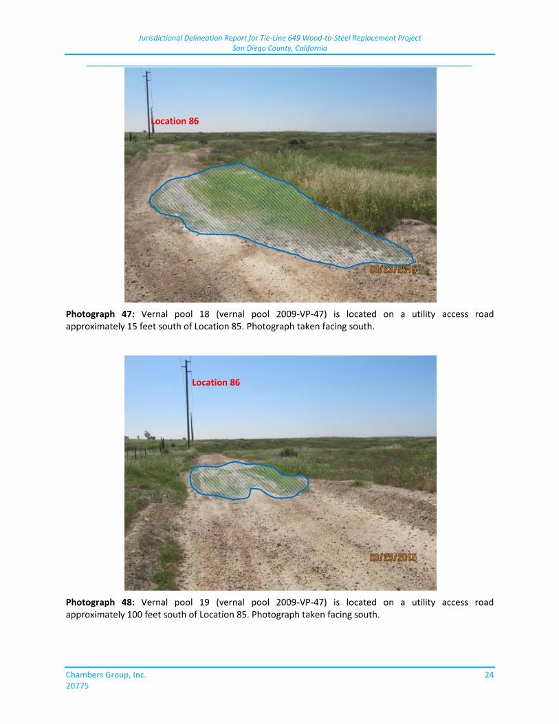
Jurisdictional Delineation Report for Tie-Line 649 Wood-to-Steel Replacement Project San Diego County, California
_____________________________________________________________________________
Chambers Group, Inc. 24 20775
Photograph 47: Vernal pool 18 (vernal pool 2009-VP-47) is located on a utility access road approximately 15 feet south of Location 85. Photograph taken facing south.
Photograph 48: Vernal pool 19 (vernal pool 2009-VP-47) is located on a utility access road approximately 100 feet south of Location 85. Photograph taken facing south.
Location 86
Location 86
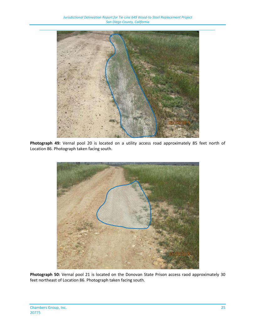
Jurisdictional Delineation Report for Tie-Line 649 Wood-to-Steel Replacement Project San Diego County, California
_____________________________________________________________________________
Chambers Group, Inc. 25 20775
Photograph 49: Vernal pool 20 is located on a utility access road approximately 85 feet north of Location 86. Photograph taken facing south.
Photograph 50: Vernal pool 21 is located on the Donovan State Prison access raod approximately 30 feet northeast of Location 86. Photograph taken facing south.
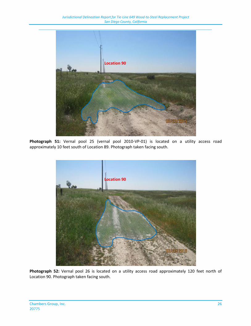
Jurisdictional Delineation Report for Tie-Line 649 Wood-to-Steel Replacement Project San Diego County, California
_____________________________________________________________________________
Chambers Group, Inc. 26 20775
Photograph 51: Vernal pool 25 (vernal pool 2010-VP-01) is located on a utility access road approximately 10 feet south of Location 89. Photograph taken facing south.
Photograph 52: Vernal pool 26 is located on a utility access road approximately 120 feet north of Location 90. Photograph taken facing south.
Location 90
Location 90
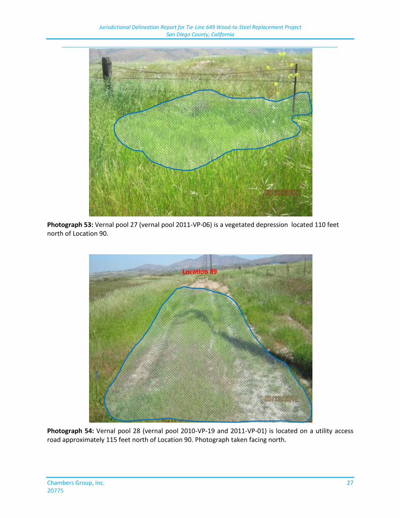
Jurisdictional Delineation Report for Tie-Line 649 Wood-to-Steel Replacement Project San Diego County, California
_____________________________________________________________________________
Chambers Group, Inc. 27 20775
Photograph 53: Vernal pool 27 (vernal pool 2011-VP-06) is a vegetated depression located 110 feet north of Location 90.
Photograph 54: Vernal pool 28 (vernal pool 2010-VP-19 and 2011-VP-01) is located on a utility access road approximately 115 feet north of Location 90. Photograph taken facing north.
Location 89
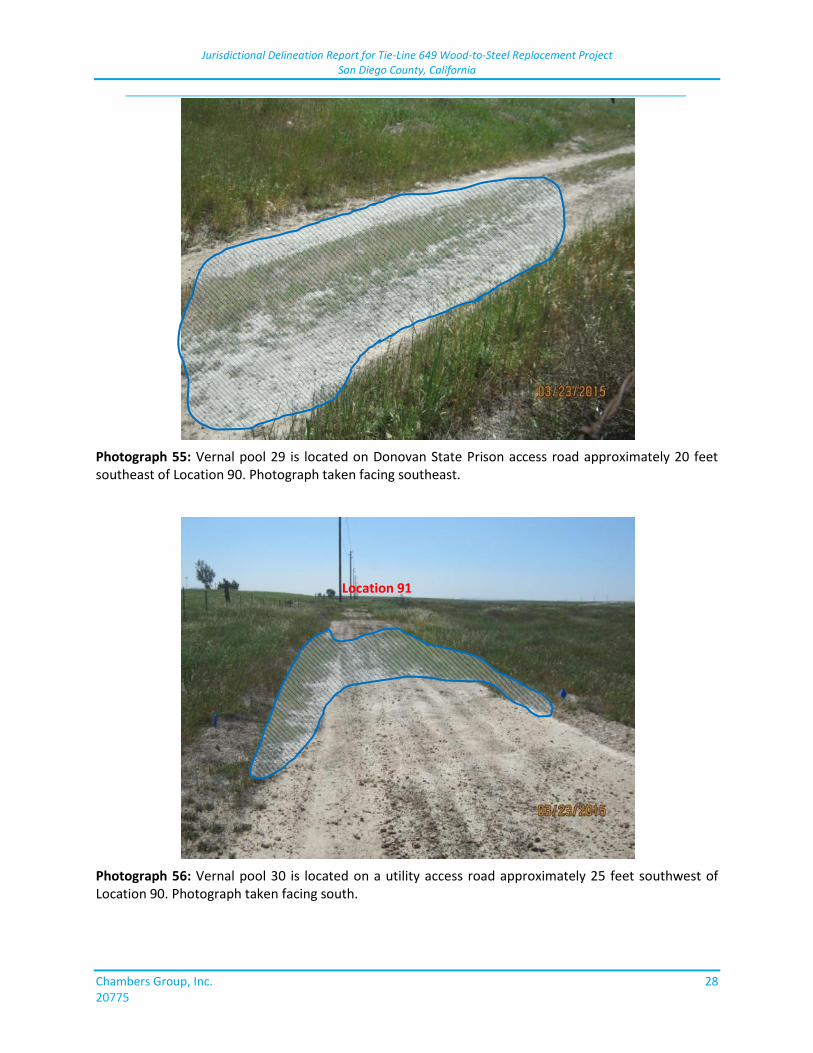
Jurisdictional Delineation Report for Tie-Line 649 Wood-to-Steel Replacement Project San Diego County, California
_____________________________________________________________________________
Chambers Group, Inc. 28 20775
Photograph 55: Vernal pool 29 is located on Donovan State Prison access road approximately 20 feet southeast of Location 90. Photograph taken facing southeast.
Photograph 56: Vernal pool 30 is located on a utility access road approximately 25 feet southwest of Location 90. Photograph taken facing south.
Location 91
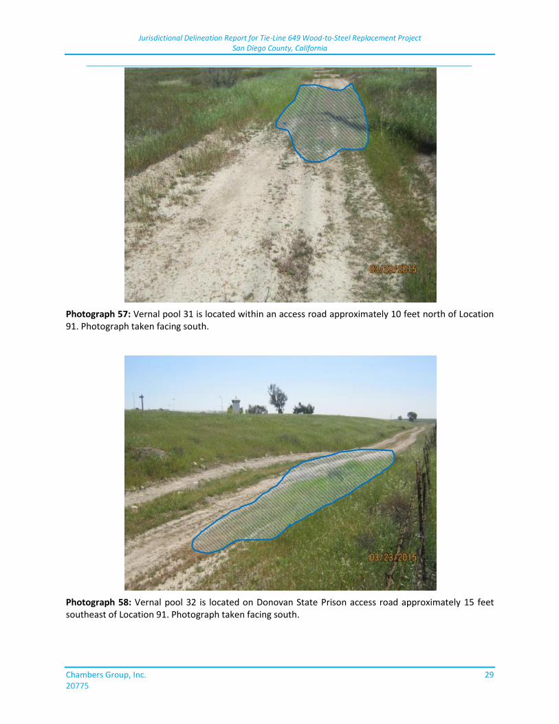
Jurisdictional Delineation Report for Tie-Line 649 Wood-to-Steel Replacement Project San Diego County, California
_____________________________________________________________________________
Chambers Group, Inc. 29 20775
Photograph 57: Vernal pool 31 is located within an access road approximately 10 feet north of Location 91. Photograph taken facing south.
Photograph 58: Vernal pool 32 is located on Donovan State Prison access road approximately 15 feet southeast of Location 91. Photograph taken facing south.
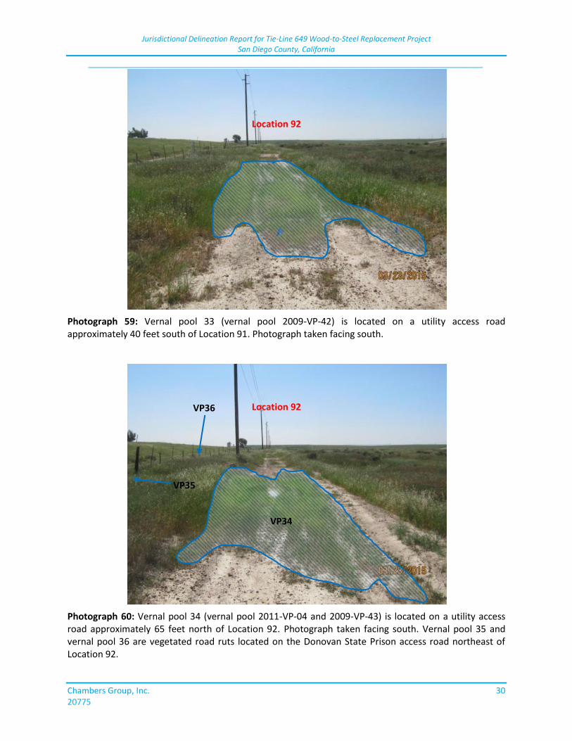
Jurisdictional Delineation Report for Tie-Line 649 Wood-to-Steel Replacement Project San Diego County, California
_____________________________________________________________________________
Chambers Group, Inc. 30 20775
Photograph 59: Vernal pool 33 (vernal pool 2009-VP-42) is located on a utility access road approximately 40 feet south of Location 91. Photograph taken facing south.
Photograph 60: Vernal pool 34 (vernal pool 2011-VP-04 and 2009-VP-43) is located on a utility access road approximately 65 feet north of Location 92. Photograph taken facing south. Vernal pool 35 and vernal pool 36 are vegetated road ruts located on the Donovan State Prison access road northeast of Location 92.
Location 92
Location 92
VP35
VP36
VP34
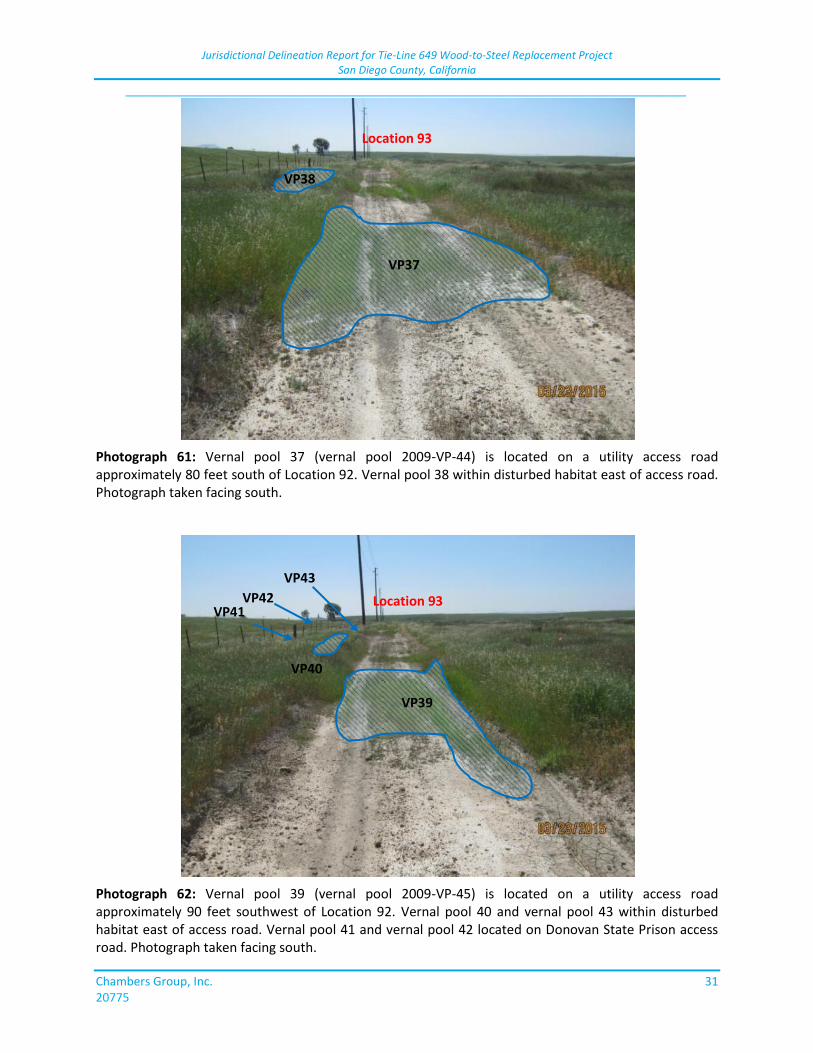
Jurisdictional Delineation Report for Tie-Line 649 Wood-to-Steel Replacement Project San Diego County, California
_____________________________________________________________________________
Chambers Group, Inc. 31 20775
Photograph 61: Vernal pool 37 (vernal pool 2009-VP-44) is located on a utility access road approximately 80 feet south of Location 92. Vernal pool 38 within disturbed habitat east of access road. Photograph taken facing south.
Photograph 62: Vernal pool 39 (vernal pool 2009-VP-45) is located on a utility access road approximately 90 feet southwest of Location 92. Vernal pool 40 and vernal pool 43 within disturbed habitat east of access road. Vernal pool 41 and vernal pool 42 located on Donovan State Prison access road. Photograph taken facing south.
Location 93
Location 93
VP37
VP38
VP39
VP40
VP41 VP42
VP43
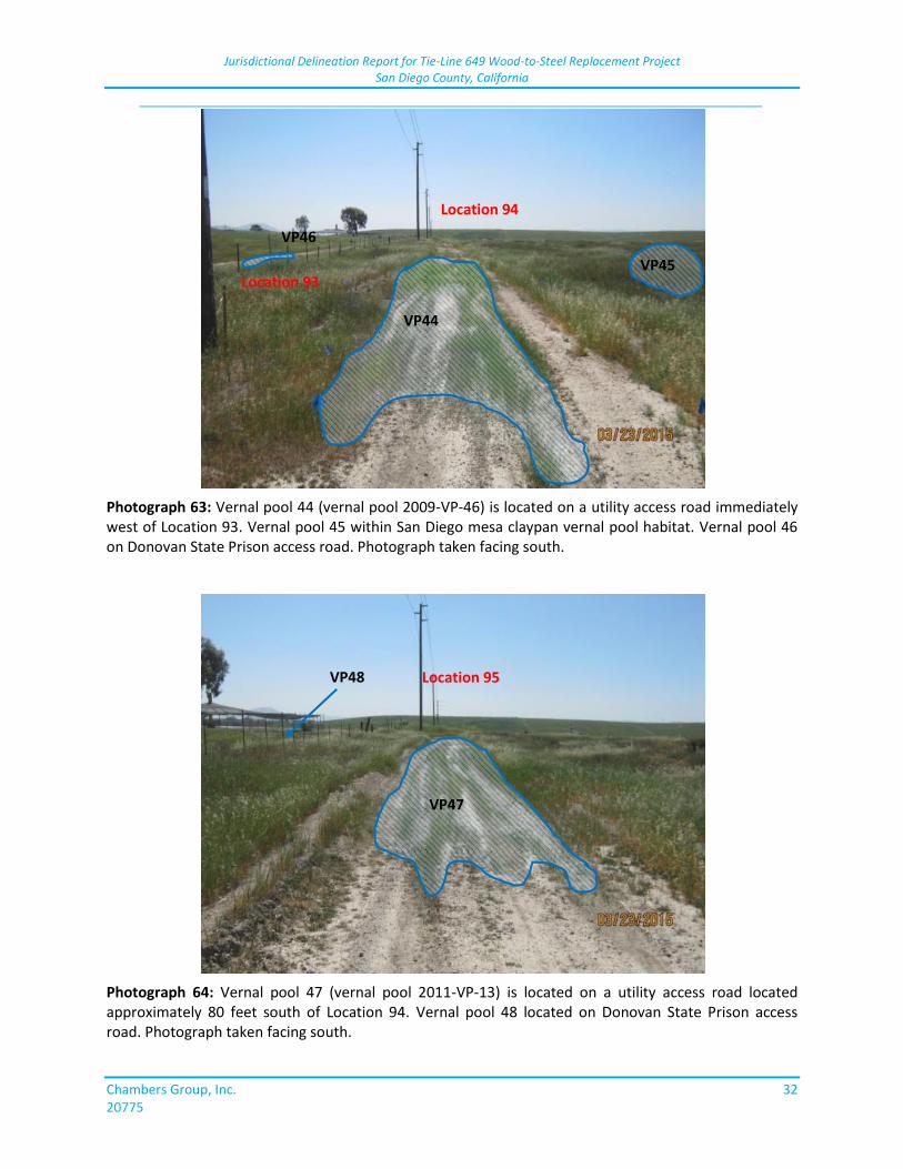
Jurisdictional Delineation Report for Tie-Line 649 Wood-to-Steel Replacement Project San Diego County, California
_____________________________________________________________________________
Chambers Group, Inc. 32 20775
Photograph 63: Vernal pool 44 (vernal pool 2009-VP-46) is located on a utility access road immediately west of Location 93. Vernal pool 45 within San Diego mesa claypan vernal pool habitat. Vernal pool 46 on Donovan State Prison access road. Photograph taken facing south.
Photograph 64: Vernal pool 47 (vernal pool 2011-VP-13) is located on a utility access road located approximately 80 feet south of Location 94. Vernal pool 48 located on Donovan State Prison access road. Photograph taken facing south.
Location 93
VP44
VP45
VP46
Location 94
Location 95 VP48
VP47
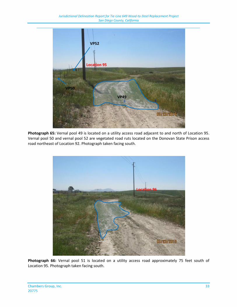
Jurisdictional Delineation Report for Tie-Line 649 Wood-to-Steel Replacement Project San Diego County, California
_____________________________________________________________________________
Chambers Group, Inc. 33 20775
Photograph 65: Vernal pool 49 is located on a utility access road adjacent to and north of Location 95. Vernal pool 50 and vernal pool 52 are vegetated road ruts located on the Donovan State Prison access road northeast of Location 92. Photograph taken facing south.
Photograph 66: Vernal pool 51 is located on a utility access road approximately 75 feet south of Location 95. Photograph taken facing south.
Location 95
Location 96
VP50
VP49
VP52
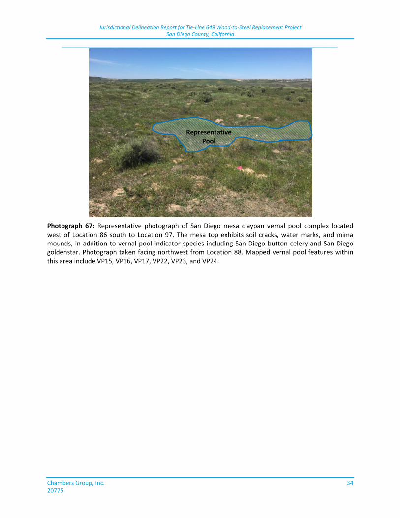
Jurisdictional Delineation Report for Tie-Line 649 Wood-to-Steel Replacement Project San Diego County, California
_____________________________________________________________________________
Chambers Group, Inc. 34 20775
Photograph 67: Representative photograph of San Diego mesa claypan vernal pool complex located west of Location 86 south to Location 97. The mesa top exhibits soil cracks, water marks, and mima mounds, in addition to vernal pool indicator species including San Diego button celery and San Diego goldenstar. Photograph taken facing northwest from Location 88. Mapped vernal pool features within this area include VP15, VP16, VP17, VP22, VP23, and VP24.
Representative Pool

ATT
AC
HM
ENT
4:
FIG
UR
ES

This page is intentionally blank.
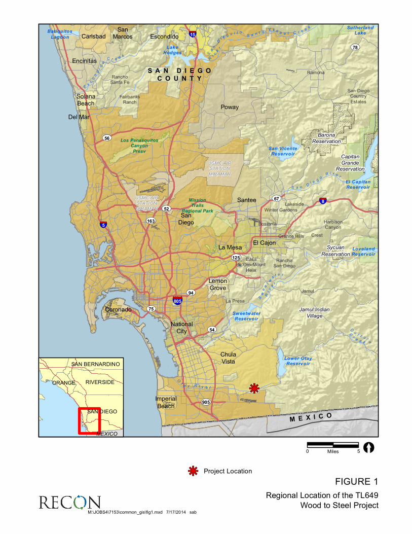
FIGURE 1
Regional Location of the TL649
Wood to Steel Project
kj
USMC AIRSTATION
MIRAMAR
USMC AIRSTATION
MIRAMAR
Los PenasquitosCanyon
Presv
MissionTrails
Regional Park
SutherlandLakeBatiquitos
Lagoon
LakeHodges
El CapitanReservoir
San VicenteReservoir
LovelandReservoir
SweetwaterReservoir
Lower OtayReservoir
SanDi e
g ui t o
R
iver
S an t
aY s a
b e l C r eek
Dul z u r
a
Cre e k
Ota y R i v e r
Es
condido
C r e ek
Sweetwa
t e r
River
S a nDi e
goR i v e r
Carlsbad
ChulaVista
Coronado
Del Mar
El Cajon
Encinitas
Escondido
Imperial
Beach
La Mesa
LemonGrove
NationalCity
Poway
SanDiego
SanMarcos
Santee
SolanaBeach
Jamul Indian
Village
Sycuan
Reservation
Capitan
GrandeReservation
Barona
Reservation
Bostonia
Casade Oro-Mount
Helix
Crest
FairbanksRanch
Granite Hills
HarbisonCanyon
Jamul
Lakeside
La Presa
Ramona
RanchoSan Diego
RanchoSanta Fe
San DiegoCountry
Estates
Winter Gardens
UV163
UV78
UV905
UV56
UV54
UV75
UV125
UV67
UV94
UV52§̈¦8
§̈¦805
§̈¦15
§̈¦5
S A N D I E G O
C O U N T Y
M E X I C O
0 5Miles [
M:\JOBS4\7153\common_gis\fig1.mxd 7/17/2014 sab
SAN DIEGO
RIVERSIDE
SAN BERNARDINO
ORANGE
MEXICO
Project Locationkj
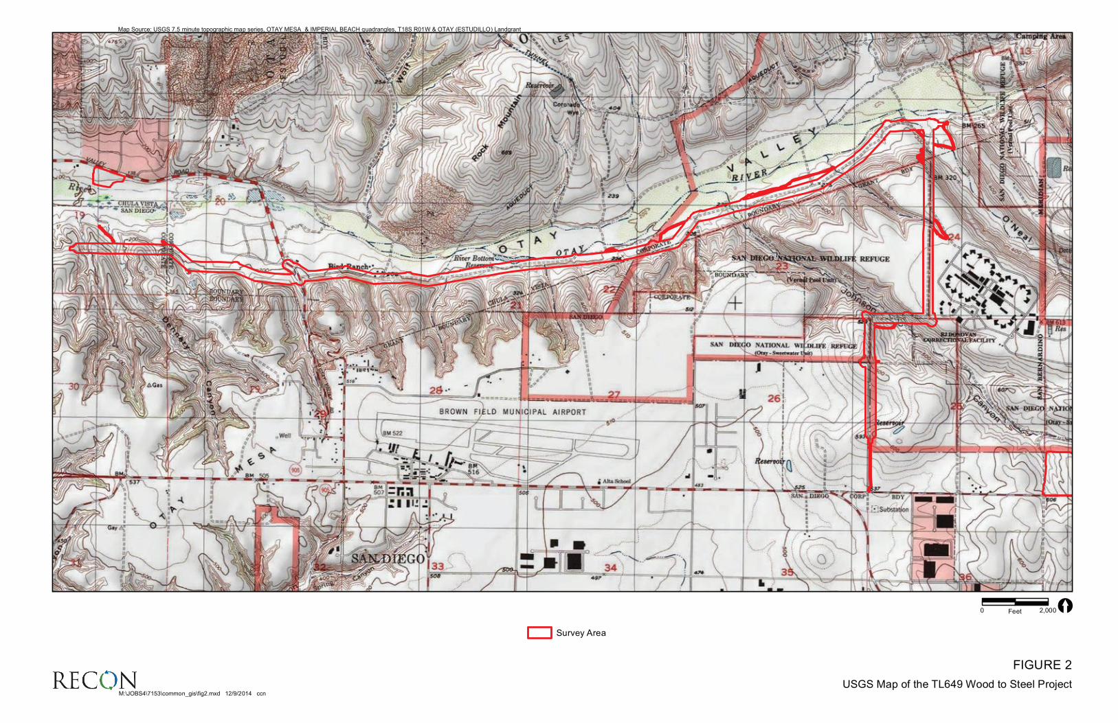
FIGURE 2
USGS Map of the TL649 Wood to Steel Project
Map Source: USGS 7.5 minute topographic map series, OTAY MESA & IMPERIAL BEACH quadrangles, T18S R01W & OTAY (ESTUDILLO) Landgrant
0 2,000Feet [
Survey Area
M:\JOBS4\7153\common_gis\fig2.mxd 12/9/2014 ccn
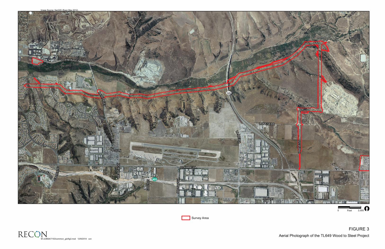
FIGURE 3
Aerial Photograph of the TL649 Wood to Steel Project
HE
RIT
AG
E
HA
RV
ES
T
BR
ITA
NN
IACA
LIE
NT
E
CA
CT
US
LAM
ED
IA
LONESTAR
DATSUN
AIRWAY
PALM
OTAY VALLEY
OTAY MESAAIRWAY
RD
HE
RIT
AG
E
OT
AY
VA
LLE
Y
UV905
UV125
HE
RIT
AG
E
HA
RV
ES
T
BR
ITA
NN
IACA
LIE
NT
E
CA
CT
US
LAM
ED
IA
LONESTAR
DATSUN
AIRWAY
PALM
OTAY VALLEY
OTAY MESAAIRWAY
RD
HE
RIT
AG
E
OT
AY
VA
LLE
Y
UV905
UV125
Image Source: SanGIS (flown May 2012)
0 2,000Feet [
Survey Area
M:\JOBS4\7153\common_gis\fig3.mxd 12/9/2014 ccn
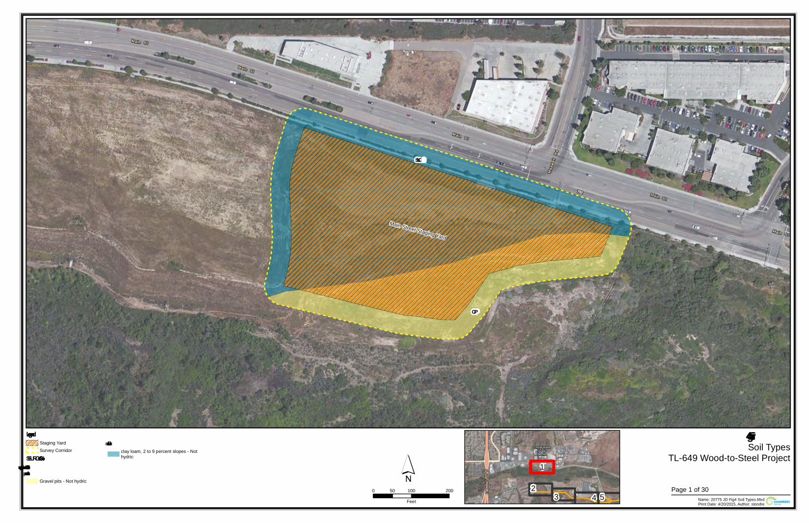
Main Street Staging Yard
SbC
GP
Figure 4Soil Types
TL-649 Wood-to-Steel Project
0 100 20050Feet Name: 20775 JD Fig4 Soil Types.Mxd
Print Date: 4/20/2015, Author: stondre
´Legend
Staging YardSurvey Corridor
SSURGO SoilsDiablo – suitable for supportingvernal pools
Gravel pits - Not hydric
Salinasclay loam, 2 to 9 percent slopes - Nothydric
23 4
1
5Page 1 of 30
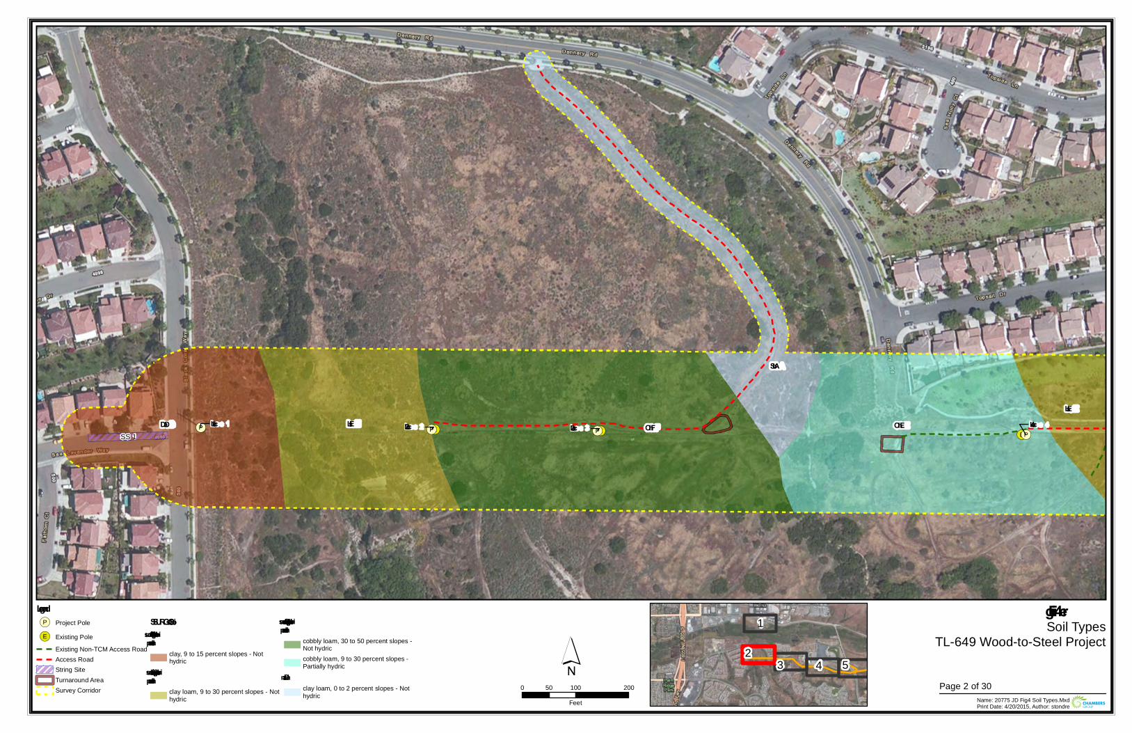
!(E !(E !(E!(E!(P
!(P!(P !(PLoc 1 Loc 4Loc 2 Loc 3
SS 1
SbA
DaD OhFLsELsE
OhE
Figu re 4Soil Types
TL-649 Wood-to-Steel Project
0 100 20050Feet Name: 20775 JD Fig4 Soil Types.Mxd
Print Date: 4/20/2015, Author: stondre
´Legend!(P Project Pole
!(E Existing PoleExisting Non-TCM Access RoadAccess RoadString SiteTurnaround AreaSurvey Corridor
SSURGO SoilsDiablo – su itable for su pportingvernal pools
clay, 9 to 15 percent slopes - Nothydric
Linne – su itable for su pportingvernal pools
clay loam, 9 to 30 percent slopes - Nothydric
Olivenhain – su itable for su pportingvernal pools
cobbly loam, 30 to 50 percent slopes -Not hydriccobbly loam, 9 to 30 percent slopes -Partially hydric
Salinasclay loam, 0 to 2 percent slopes - Nothydric
23 4
1
5Page 2 of 30
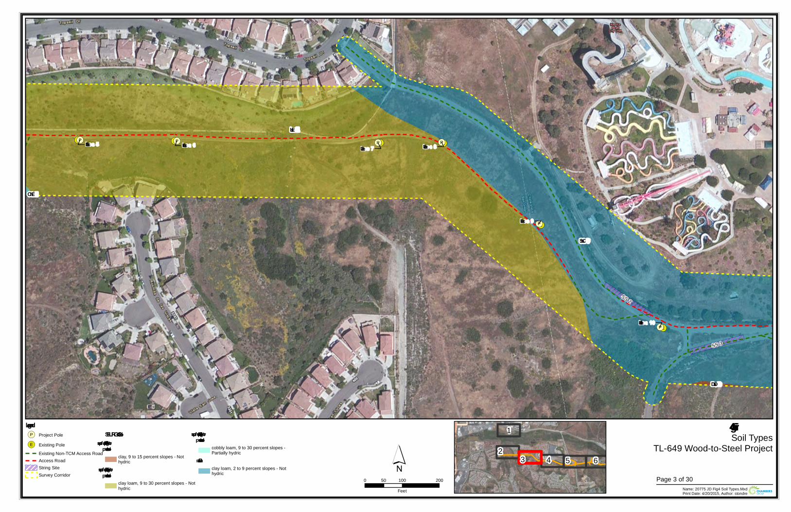
!(E!(E !(E
!(E
!(E
!(E
!(P
!(P
!(P
!(P !(P!(P
Loc 10
Loc 7
Loc 9
Loc 5 Loc 8Loc 6
SS 2
SS 3
SbC
LsE
OhE
DaD
Figure 4Soil Types
TL-649 Wood-to-Steel Project
0 100 20050Feet Name: 20775 JD Fig4 Soil Types.Mxd
Print Date: 4/20/2015, Author: stondre
´Legend!(P Project Pole
!(E Existing PoleExisting Non-TCM Access RoadAccess RoadString SiteSurvey Corridor
SSURGO SoilsDiablo – suitable for sup p ortingvernal p ools
clay, 9 to 15 percent slopes - Nothydric
Linne – suitable for sup p ortingvernal p ools
clay loam, 9 to 30 percent slopes - Nothydric
Olivenhain – suitable for sup p ortingvernal p ools
cobbly loam, 9 to 30 percent slopes -Partially hydric
Salinasclay loam, 2 to 9 percent slopes - Nothydric
23 4
1
5 6Page 3 of 30
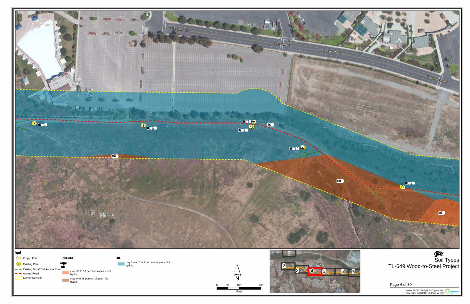
!(E
!(E !(E
!(E
!(E!(P
!(P !(P
!(P
!(P
!(P
Loc 0Loc 12 Loc 13
Loc 14
Loc 11
Loc 15
SbC
DaF
DaD
DaD
Figu re 4Soil Types
TL-649 Wood-to-Steel Project
0 100 20050Feet Name: 20775 JD Fig4 Soil Types.Mxd
Print Date: 4/20/2015, Author: stondre
´Legend!(P Project Pole
!(E Existing PoleExisting Non-TCM Access RoadAccess RoadSurvey Corridor
SSURGO SoilsDiablo – su itable for su pportingvernal pools
clay, 30 to 50 percent slopes - Nothydricclay, 9 to 15 percent slopes - Nothydric
Salinasclay loam, 2 to 9 percent slopes - Nothydric 2
3 4
1
5 6 7
Page 4 of 30
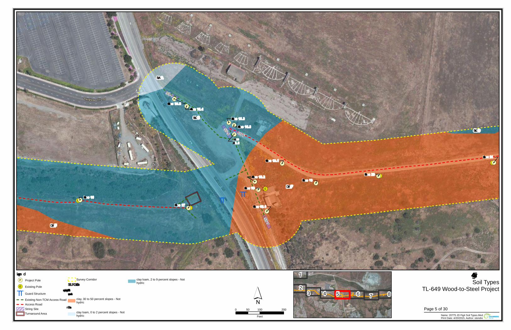
TT TT!(E
!(E
!(E
!(E
!(E!(P
!(P
!(P
!(P
!(P
!(P
!(P
!(P
!(P
!(P
!(P
!(P
!(P
!(P
Loc 18.2
Loc 16Loc 17
Loc 20
Loc 21
Loc 18.1
Loc 19Loc 18
Loc 18.5
Loc 19.1
Loc 18.3
Loc18.3
Loc 18.4
Loc 18.3SS 5
SS 4
SS 7
SS 6
SbA
SbC
SbC
DaF
DaF
Figure 4Soil Types
TL-649 Wood-to-Steel Project
0 100 20050Feet Name: 20775 JD Fig4 Soil Types.Mxd
Print Date: 4/20/2015, Author: stondre
´Legen d!(P Project Pole
!(E Existing Pole
TT Guard StructureExisting Non-TCM Access RoadAccess RoadString SiteTurnaround Area
Survey CorridorSSURGO SoilsDiablo – suitable for supportin gvern al pools
clay, 30 to 50 percent slopes - Nothydric
Salin asclay loam, 0 to 2 percent slopes - Nothydric
clay loam, 2 to 9 percent slopes - Nothydric
23 4
1
5 6 7 8
Page 5 of 30
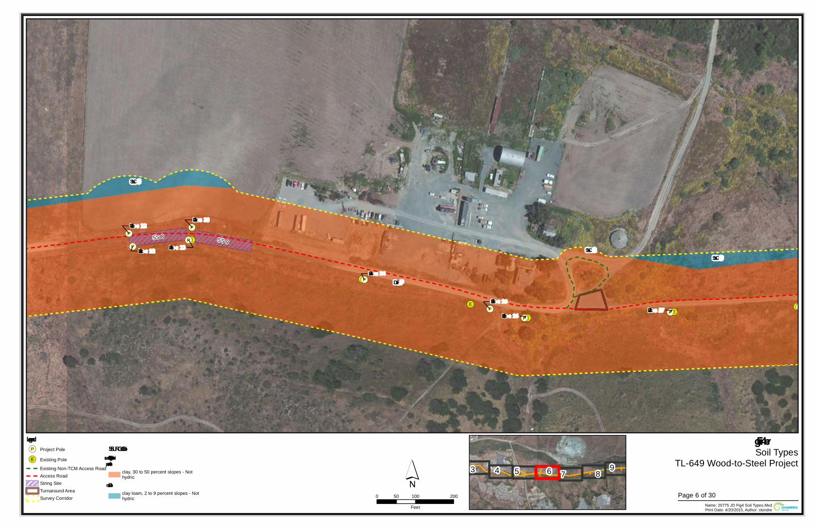
!(E
!(E
!(E
!(E
!(E
!(E
!(E!(P
!(P
!(P
!(P
!(P
!(P
!(P!(P
!(P
!(PLoc 26
Loc 25
Loc 23
Loc 27
Loc 22
Loc 22 Loc 23
Loc 24
SS 9SS 8
SbCSbC
SbC
DaF
Figu re 4Soil Types
TL-649 Wood-to-Steel Project
0 100 20050Feet Name: 20775 JD Fig4 Soil Types.Mxd
Print Date: 4/20/2015, Author: stondre
´Legend!(P Project Pole
!(E Existing PoleExisting Non-TCM Access RoadAccess RoadString SiteTurnaround AreaSurvey Corridor
SSURGO SoilsDiablo – su itable for su pportingvernal pools
clay, 30 to 50 percent slopes - Nothydric
Salinasclay loam, 2 to 9 percent slopes - Nothydric
3 4 5 6 7 8 9
Page 6 of 30
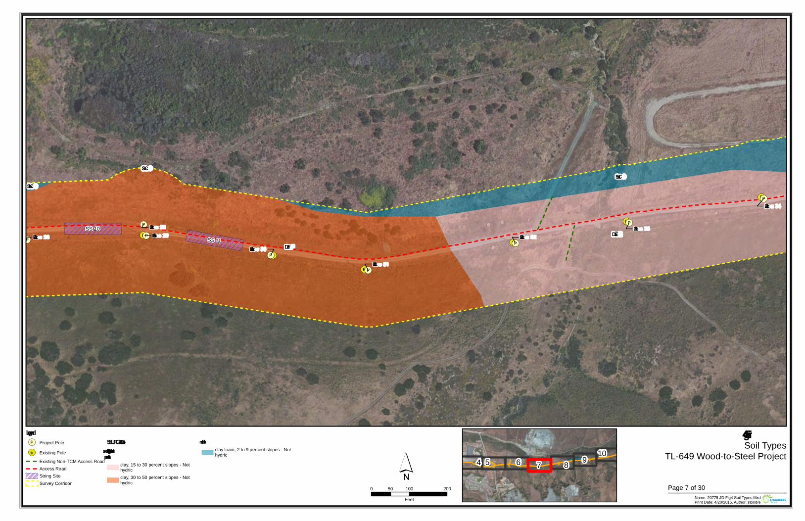
!(E
!(E
!(E
!(E!(E
!(E
!(E
!(P
!(P
!(P!(P
!(P
!(P
!(P
!(PLoc 30
Loc 34
Loc 29Loc 29
Loc 32Loc 33
Loc 31
Loc 28SS 10
SS 11
SbC
SbCSbC
DaE
DaF
Figure 4Soil Types
TL-649 Wood-to-Steel Project
0 100 20050Feet Name: 20775 JD Fig4 Soil Types.Mxd
Print Date: 4/20/2015, Author: stondre
´Legend!(P Project Pole
!(E Existing PoleExisting Non-TCM Access RoadAccess RoadString SiteSurvey Corridor
SSURGO SoilsDiablo – s uitable for s upportingvernal pools
clay, 15 to 30 percent slopes - Nothydricclay, 30 to 50 percent slopes - Nothydric
Salinasclay loam, 2 to 9 percent slopes - Nothydric
4 5 6 7 8 9 10
Page 7 of 30
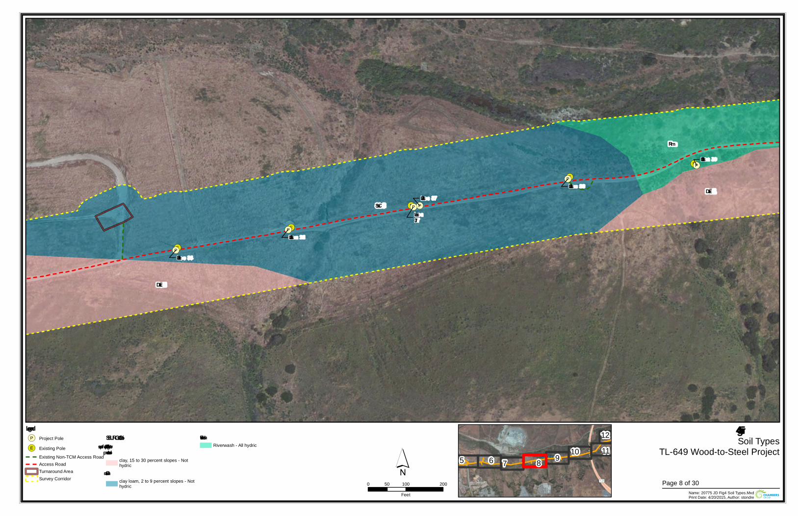
!(E
!(E
!(E
!(E
!(E
!(P
!(P
!(P
!(P
!(P
!(P
Loc 37
Loc 39
Loc37
Loc 35
Loc 36
Loc 38
Rm
SbC
DaE
DaE
Figure 4Soil Types
TL-649 Wood-to-Steel Project
0 100 20050Feet Name: 20775 JD Fig4 Soil Types.Mxd
Print Date: 4/20/2015, Author: stondre
´Legend!(P Project Pole
!(E Existing PoleExisting Non-TCM Access RoadAccess RoadTurnaround AreaSurvey Corridor
SSURGO SoilsDiablo – suitable for sup p ortingvernal p ools
clay, 15 to 30 percent slopes - Nothydric
Salinasclay loam, 2 to 9 percent slopes - Nothydric
RiverwashRiverwash - All hydric
5 6 7 8 9 10 1112
Page 8 of 30
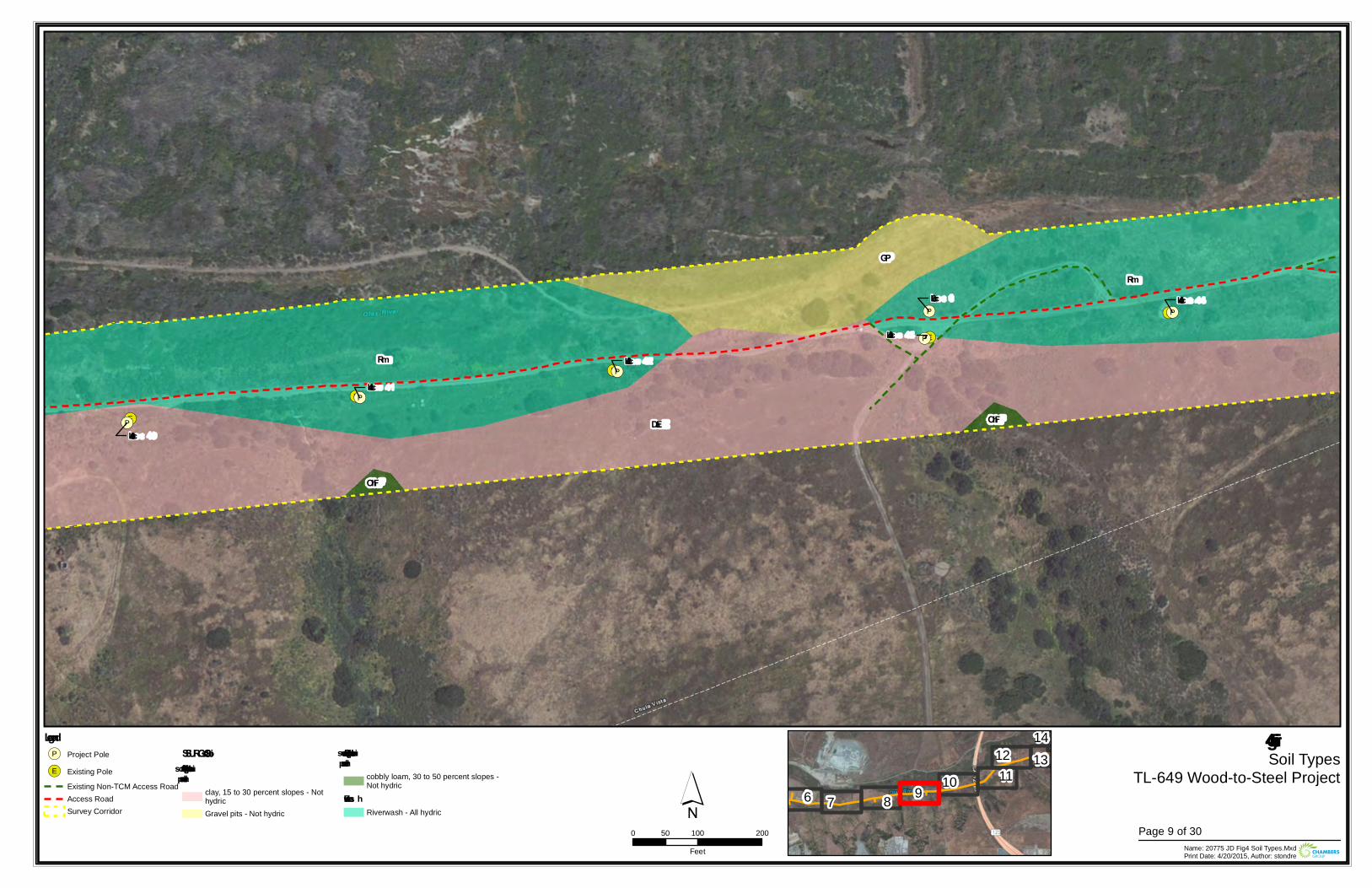
!(E
!(E
!(E
!(E
!(E
!(P
!(P
!(P
!(P
!(P
!(P
Loc 43
Loc 0
Loc 42
Loc 44
Loc 40
Loc 41
Rm
Rm
GP
DaE OhF
OhF
Figure 4Soil Types
TL-649 Wood-to-Steel Project
0 100 20050Feet Name: 20775 JD Fig4 Soil Types.Mxd
Print Date: 4/20/2015, Author: stondre
´Legend!(P Project Pole
!(E Existing PoleExisting Non-TCM Access RoadAccess RoadSurvey Corridor
SSURGO SoilsDiablo – s uitable for s upportingvernal pools
clay, 15 to 30 percent slopes - NothydricGravel pits - Not hydric
Olivenhain – s uitable for s upportingvernal pools
cobbly loam, 30 to 50 percent slopes -Not hydric
Riverwas hRiverwash - All hydric
6 7 8 9 10 1112 13
14
Page 9 of 30
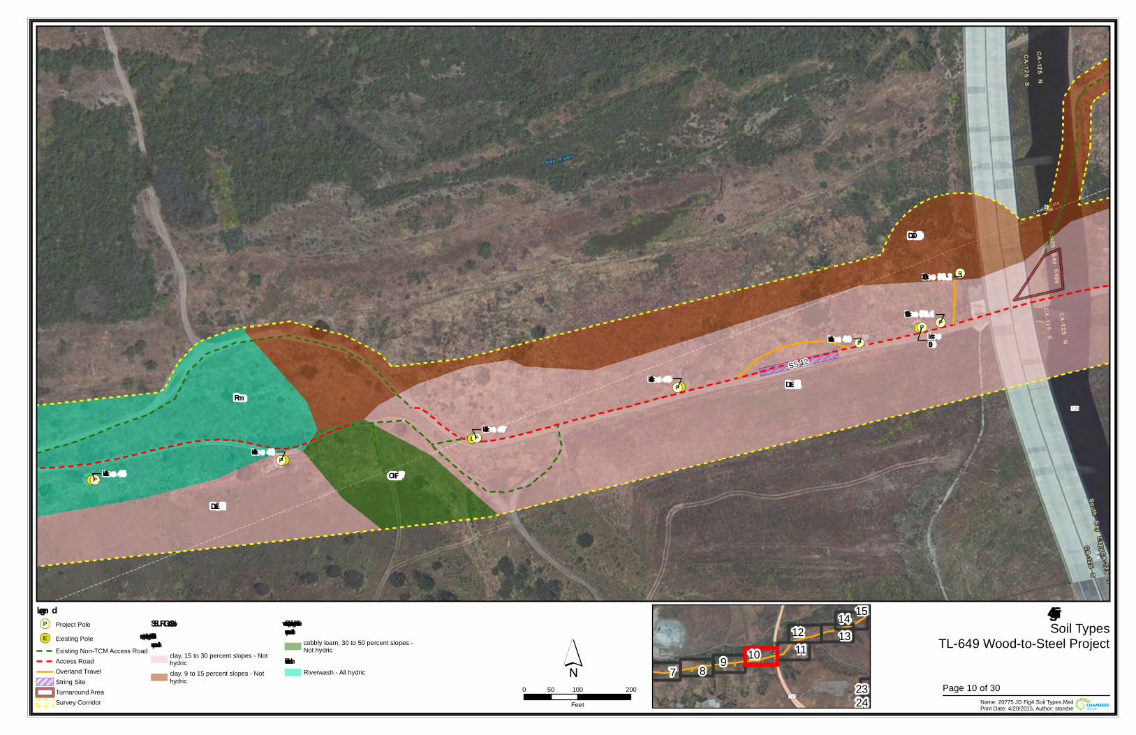
!(E
!(E
!(E
!(E
!(E
!(P
!(P
!(P
!(P
!(P
!(P
!(P
!(PLoc50
Loc 47
Loc 46
Loc 50.1
Loc 48
Loc 50.2
Loc 45
Loc 49
SS 12
Rm
DaD
DaE
OhF
DaE
Figure 4Soil Types
TL-649 Wood-to-Steel Project
0 100 20050Feet Name: 20775 JD Fig4 Soil Types.Mxd
Print Date: 4/20/2015, Author: stondre
´Legen d!(P Project Pole
!(E Existing PoleExisting Non-TCM Access RoadAccess RoadOverland TravelString SiteTurnaround AreaSurvey Corridor
SSURGO SoilsDiablo – suitable for supportin gvern al pools
clay, 15 to 30 percent slopes - Nothydricclay, 9 to 15 percent slopes - Nothydric
Oliven hain – suitable for supportin gvern al pools
cobbly loam, 30 to 50 percent slopes -Not hydric
RiverwashRiverwash - All hydric 7 8 9 10 11
12 1314 15
2324
Page 10 of 30
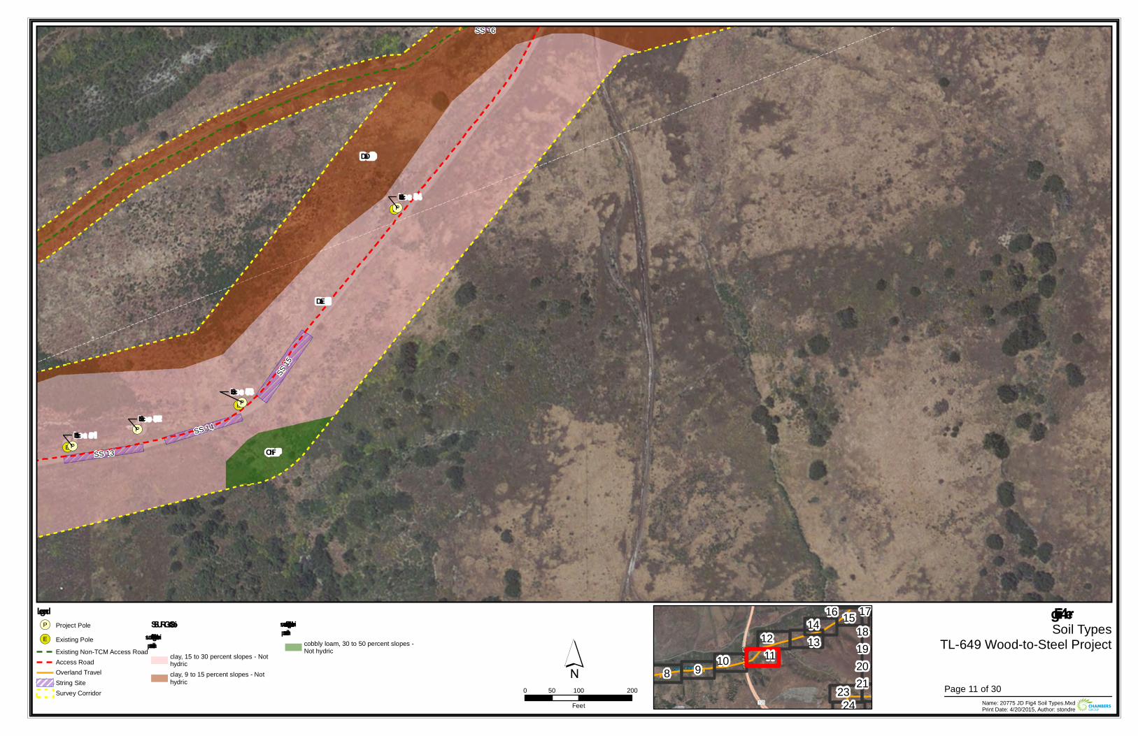
!(E
!(E
!(E
!(P
!(P
!(P
!(P
Loc 52Loc 51
Loc 54
Loc 53
SS 13
SS 15
SS 14
SS 16
DaD
DaE
OhF
Figu re 4Soil Types
TL-649 Wood-to-Steel Project
0 100 20050Feet Name: 20775 JD Fig4 Soil Types.Mxd
Print Date: 4/20/2015, Author: stondre
´Legend!(P Project Pole
!(E Existing PoleExisting Non-TCM Access RoadAccess RoadOverland TravelString SiteSurvey Corridor
SSURGO SoilsDiablo – su itable for su pportingvernal pools
clay, 15 to 30 percent slopes - Nothydricclay, 9 to 15 percent slopes - Nothydric
Olivenhain – su itable for su pportingvernal pools
cobbly loam, 30 to 50 percent slopes -Not hydric
8 9 10 1112 13
14 1516 171819202123
24Page 11 of 30
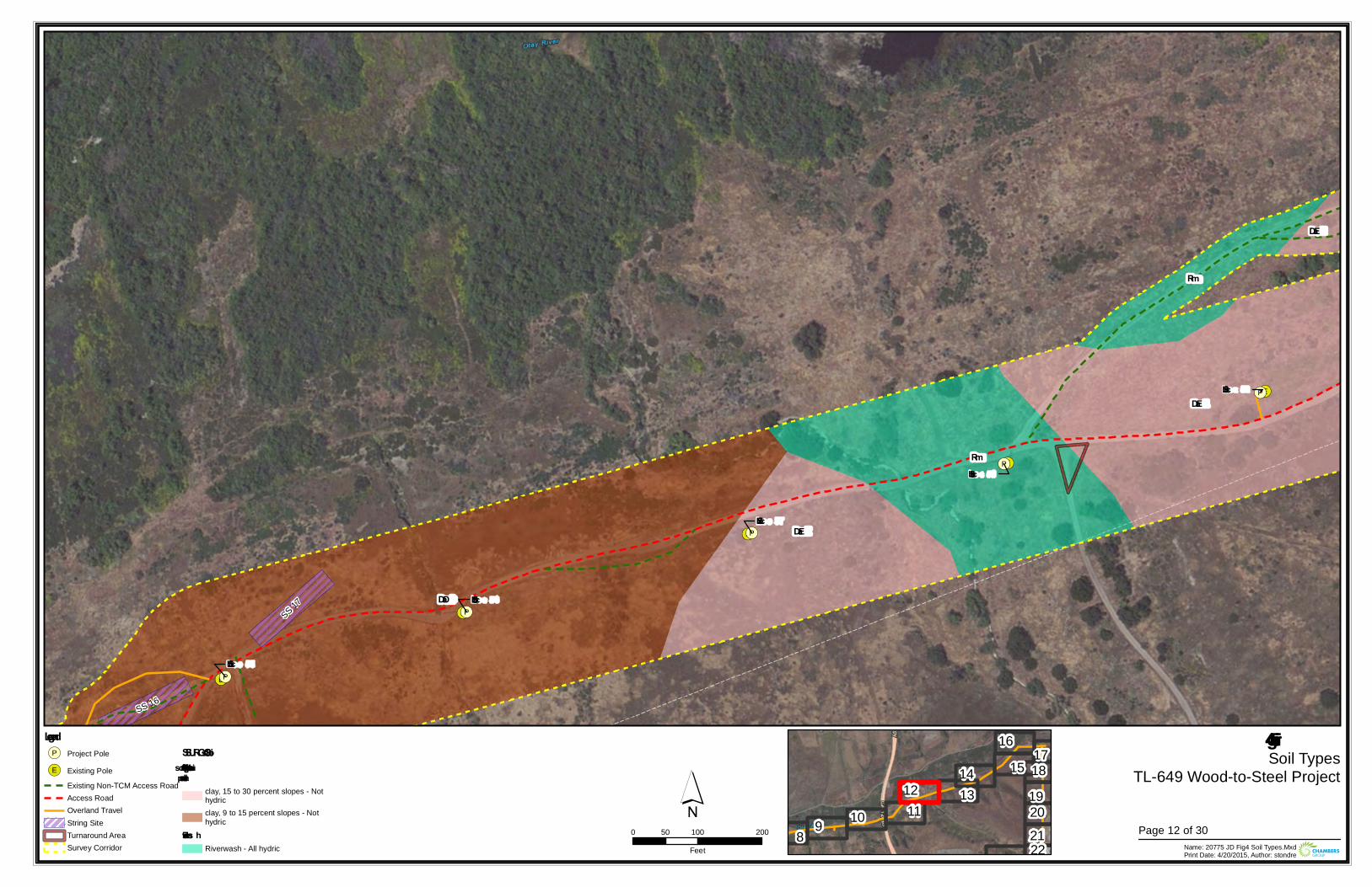
!(E
!(E
!(E
!(E
!(E
!(P
!(P
!(P
!(P
!(P
Loc 59
Loc 56
Loc 57
Loc 58
Loc 55
SS 17
SS 16
Rm
Rm
DaE
DaE
DaD
DaE
Figure 4Soil Types
TL-649 Wood-to-Steel Project
0 100 20050Feet Name: 20775 JD Fig4 Soil Types.Mxd
Print Date: 4/20/2015, Author: stondre
´Legend!(P Project Pole
!(E Existing PoleExisting Non-TCM Access RoadAccess RoadOverland TravelString SiteTurnaround AreaSurvey Corridor
SSURGO SoilsDiablo – s uitable for s upportingvernal pools
clay, 15 to 30 percent slopes - Nothydricclay, 9 to 15 percent slopes - Nothydric
Riverwas hRiverwash - All hydric
8 9 10 1112 13
14 1516
171819202122
Page 12 of 30
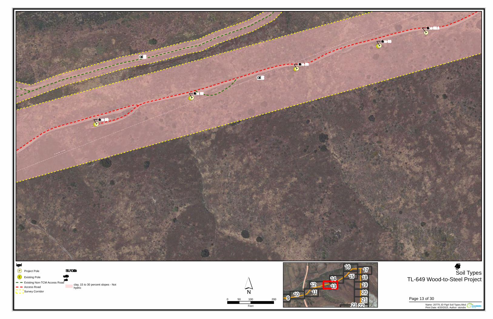
!(E
!(E
!(E
!(E
!(E
!(P
!(P
!(P
!(P
!(P
!(P
Loc 62
Loc 60
Loc 63.1
Loc 63
Loc 61
DaE
DaE
Figure 4Soil Types
TL-649 Wood-to-Steel Project
0 100 20050Feet Name: 20775 JD Fig4 Soil Types.Mxd
Print Date: 4/20/2015, Author: stondre
´Legend!(P Project Pole
!(E Existing PoleExisting Non-TCM Access RoadAccess RoadSurvey Corridor
SSURGO SoilsDiablo – suitable for supportingvernal pools
clay, 15 to 30 percent slopes - Nothydric
9 10 1112 13
14 1516 17
18192021
2223Page 13 of 30
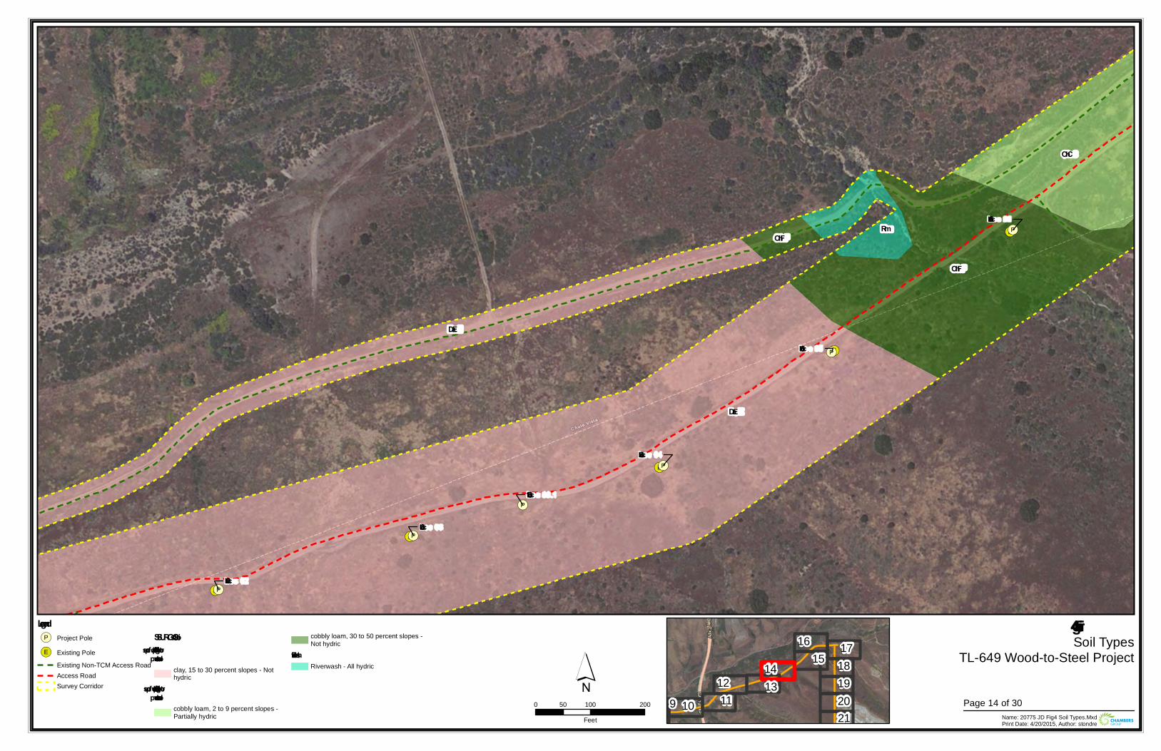
!(E
!(E
!(E
!(E
!(E
!(P
!(P
!(P
!(P
!(P
!(P
Loc 66
Loc 62
Loc 64
Loc 63.1
Loc 63
Loc 65
Rm
OhC
OhF
OhF
DaE
DaE
Figure 4Soil Types
TL-649 Wood-to-Steel Project
0 100 20050Feet Name: 20775 JD Fig4 Soil Types.Mxd
Print Date: 4/20/2015, Author: stondre
´Legend!(P Project Pole
!(E Existing PoleExisting Non-TCM Access RoadAccess RoadSurvey Corridor
SSURGO SoilsDiablo – suitable for sup p ortingvernal p ools
clay, 15 to 30 percent slopes - Nothydric
Olivenhain – suitable for sup p ortingvernal p ools
cobbly loam, 2 to 9 percent slopes -Partially hydric
cobbly loam, 30 to 50 percent slopes -Not hydric
RiverwashRiverwash - All hydric
9 10 1112 13
14 1516 17
18192021
Page 14 of 30
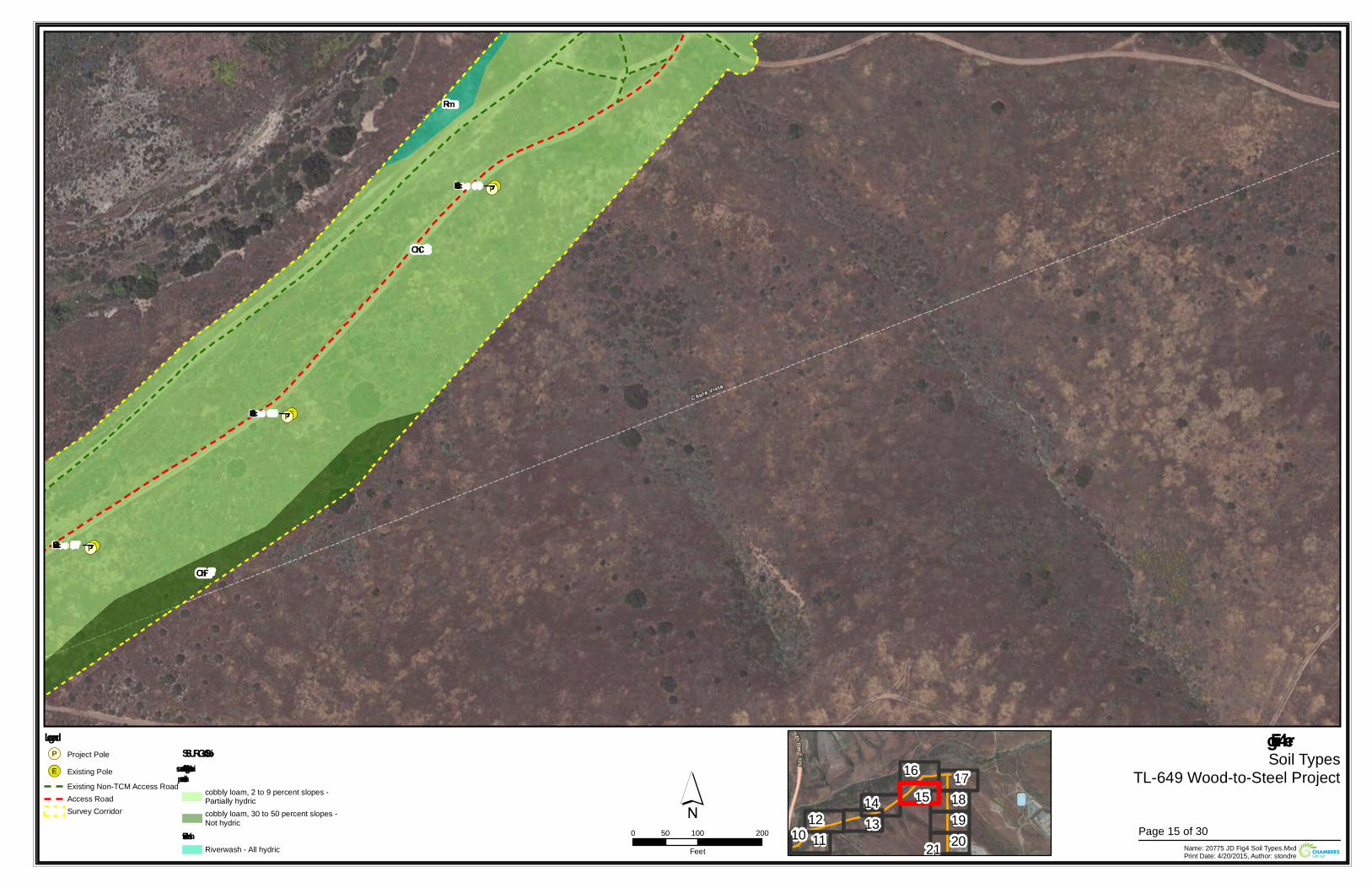
!(E
!(E
!(E
!(P
!(P
!(P
Loc 68
Loc 67
Loc 69
Rm
OhC
OhF
Figu re 4Soil Types
TL-649 Wood-to-Steel Project
0 100 20050Feet Name: 20775 JD Fig4 Soil Types.Mxd
Print Date: 4/20/2015, Author: stondre
´Legend!(P Project Pole
!(E Existing PoleExisting Non-TCM Access RoadAccess RoadSurvey Corridor
SSURGO SoilsOlivenhain – su itable for su pportingvernal pools
cobbly loam, 2 to 9 percent slopes -Partially hydriccobbly loam, 30 to 50 percent slopes -Not hydric
RiverwashRiverwash - All hydric
10 1112 13
14 1516 17
18192021
Page 15 of 30
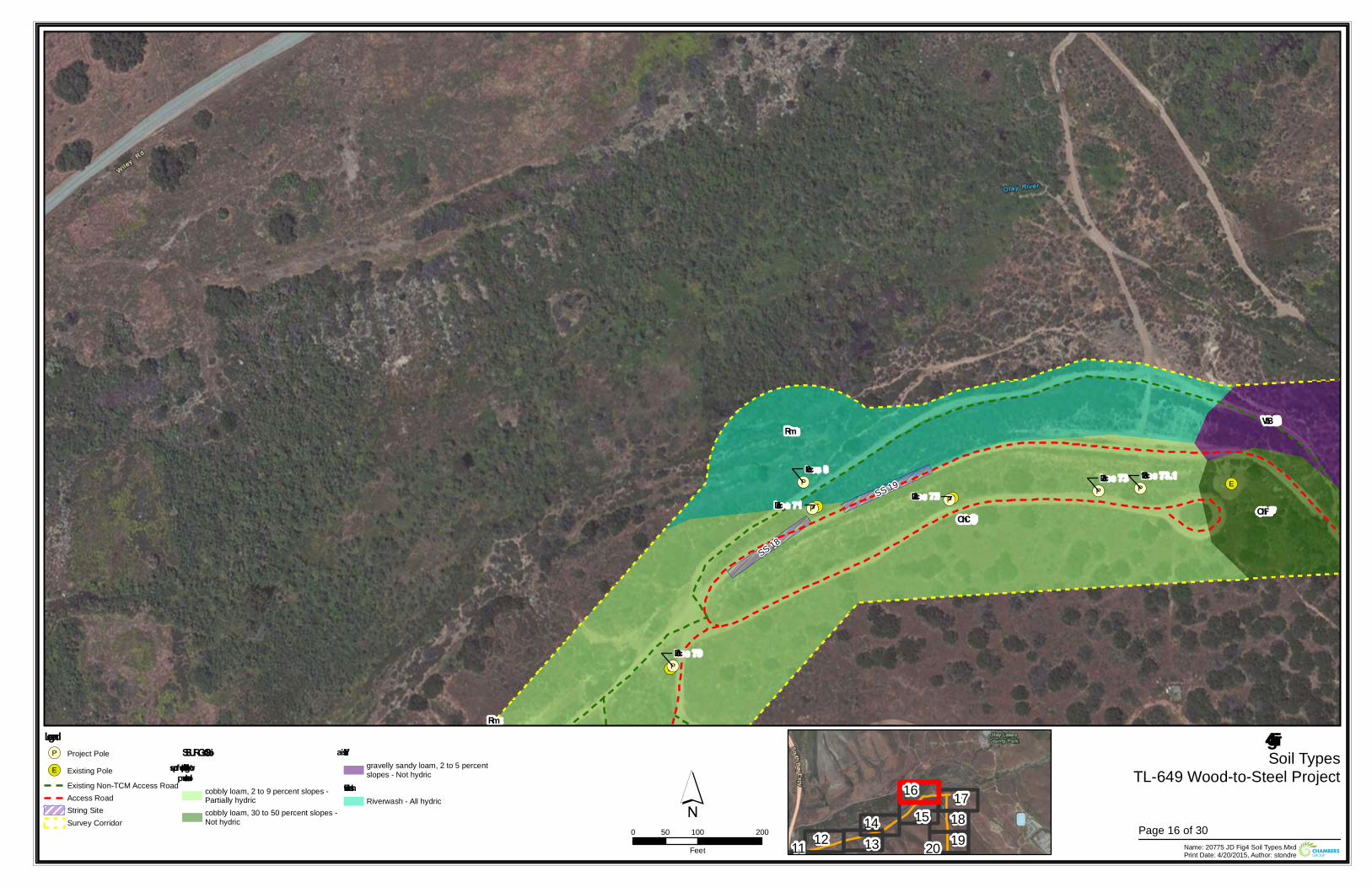
!(E
!(E
!(E!(E
!(P
!(P!(P
!(P!(P
!(P
Loc 70
Loc 73.1Loc 0
Loc 72Loc 71
Loc 73
SS 18
SS 19
Rm
RmVbB
OhC OhF
Figure 4Soil Types
TL-649 Wood-to-Steel Project
0 100 20050Feet Name: 20775 JD Fig4 Soil Types.Mxd
Print Date: 4/20/2015, Author: stondre
´Legend!(P Project Pole
!(E Existing PoleExisting Non-TCM Access RoadAccess RoadString SiteSurvey Corridor
SSURGO SoilsOlivenhain – suitable for sup p ortingvernal p ools
cobbly loam, 2 to 9 percent slopes -Partially hydriccobbly loam, 30 to 50 percent slopes -Not hydric
Visaliagravelly sandy loam, 2 to 5 percentslopes - Not hydric
RiverwashRiverwash - All hydric
11 12 1314 15
16 17181920
Page 16 of 30
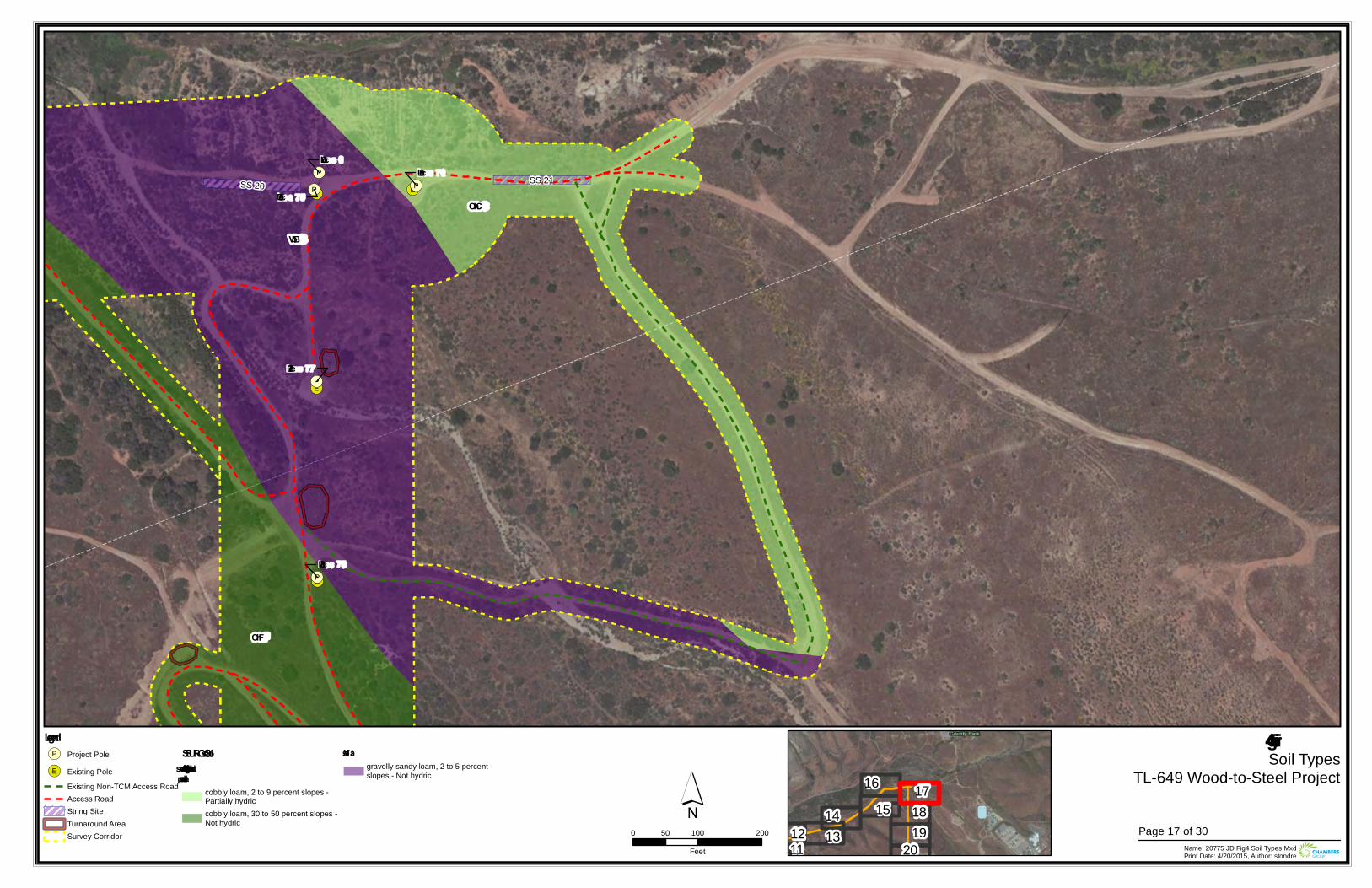
!(E!(E
!(E
!(E
!(P
!(P !(P
!(P
!(P
Loc 78
Loc 75
Loc 76
Loc 77
Loc 0SS 21SS 20
OhC
VbB
OhF
Figure 4Soil Types
TL-649 Wood-to-Steel Project
0 100 20050Feet Name: 20775 JD Fig4 Soil Types.Mxd
Print Date: 4/20/2015, Author: stondre
´Legend!(P Project Pole
!(E Existing PoleExisting Non-TCM Access RoadAccess RoadString SiteTurnaround AreaSurvey Corridor
SSURGO SoilsOlivenhain – s uitable for s upportingvernal pools
cobbly loam, 2 to 9 percent slopes -Partially hydriccobbly loam, 30 to 50 percent slopes -Not hydric
Vis aliagravelly sandy loam, 2 to 5 percentslopes - Not hydric
1112 13
14 1516 17
1819
20Page 17 of 30
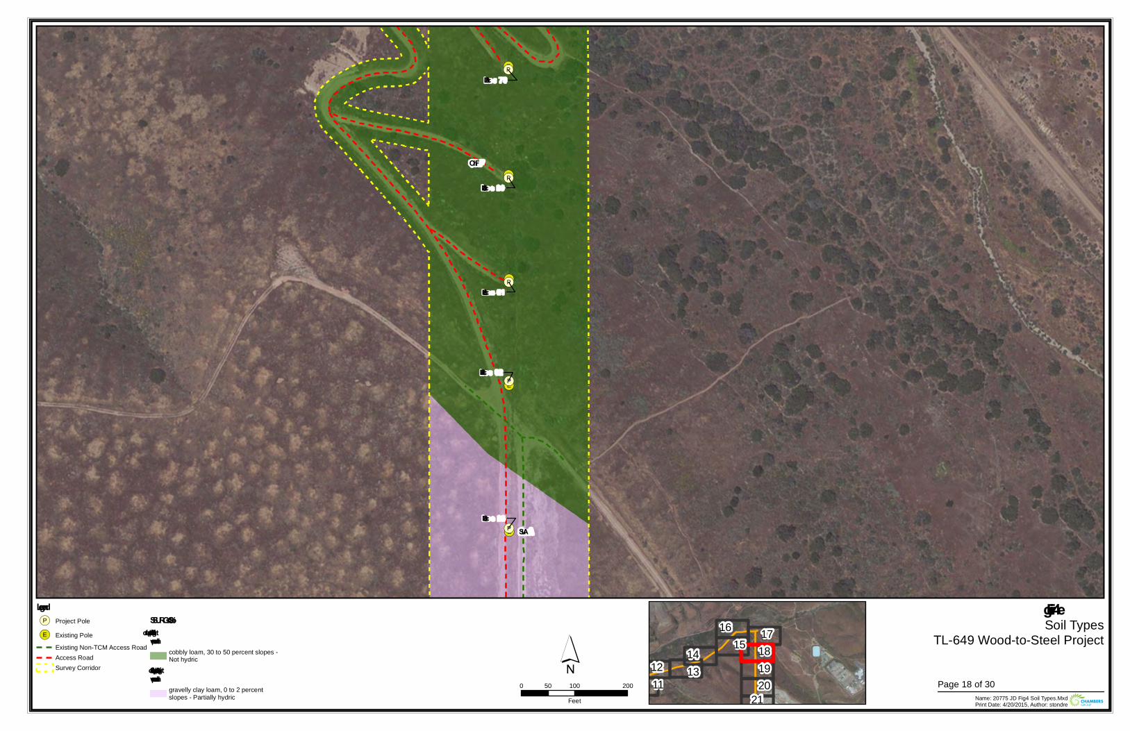
!(E
!(E
!(E
!(E
!(E
!(P
!(P
!(P
!(P
!(P
Loc 81
Loc 79
Loc 83
Loc 82
Loc 80
OhF
SuA
Figure 4Soil Types
TL-649 Wood-to-Steel Project
0 100 20050Feet Name: 20775 JD Fig4 Soil Types.Mxd
Print Date: 4/20/2015, Author: stondre
´Legend!(P Project Pole
!(E Existing PoleExisting Non-TCM Access RoadAccess RoadSurvey Corridor
SSURGO SoilsOlivenhain – suitable for supportingvernal pools
cobbly loam, 30 to 50 percent slopes -Not hydric
Stockpen – suitable for supportingvernal pools
gravelly clay loam, 0 to 2 percentslopes - Partially hydric
1112 13
14 1516 17
181920
21Page 18 of 30
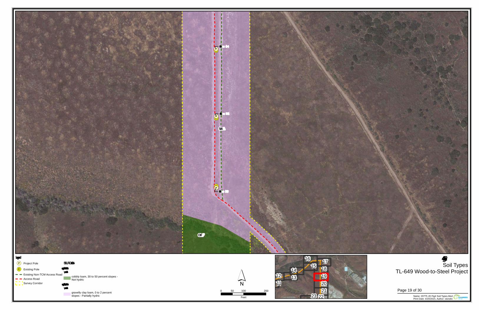
!(E
!(E
!(E
!(P
!(P
!(P
Loc 85
Loc 86
Loc 84
OhF
SuA
Figure 4Soil Types
TL-649 Wood-to-Steel Project
0 100 20050Feet Name: 20775 JD Fig4 Soil Types.Mxd
Print Date: 4/20/2015, Author: stondre
´Legend!(P Project Pole
!(E Existing PoleExisting Non-TCM Access RoadAccess RoadSurvey Corridor
SSURGO SoilsOliv enhain – suitable for supportingv ernal pools
cobbly loam, 30 to 50 percent slopes -Not hydric
Stockpen – suitable for supportingv ernal pools
gravelly clay loam, 0 to 2 percentslopes - Partially hydric
1112 13
14 1516 17
18192021
2223Page 19 of 30
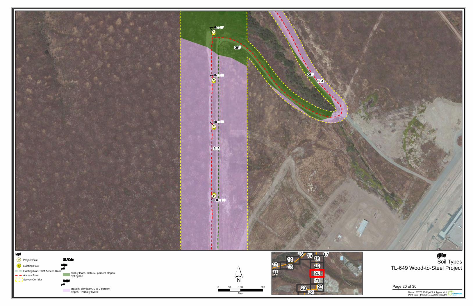
!(E
!(E
!(E
!(E
!(E
!(P
!(P
!(P
!(P
Loc 88
Loc 89
Loc 90
Loc 87
OhF
OhF
Su A
Su A
Figu re 4Soil Types
TL-649 Wood-to-Steel Project
0 100 20050Feet Name: 20775 JD Fig4 Soil Types.Mxd
Print Date: 4/20/2015, Author: stondre
´Legend!(P Project Pole
!(E Existing PoleExisting Non-TCM Access RoadAccess RoadSurvey Corridor
SSURGO SoilsOlivenhain – su itable for su pportingvernal pools
cobbly loam, 30 to 50 percent slopes -Not hydric
Stockpen – su itable for su pportingvernal pools
gravelly clay loam, 0 to 2 percentslopes - Partially hydric
1112 13
14 1516 1718192021
2223 24Page 20 of 30
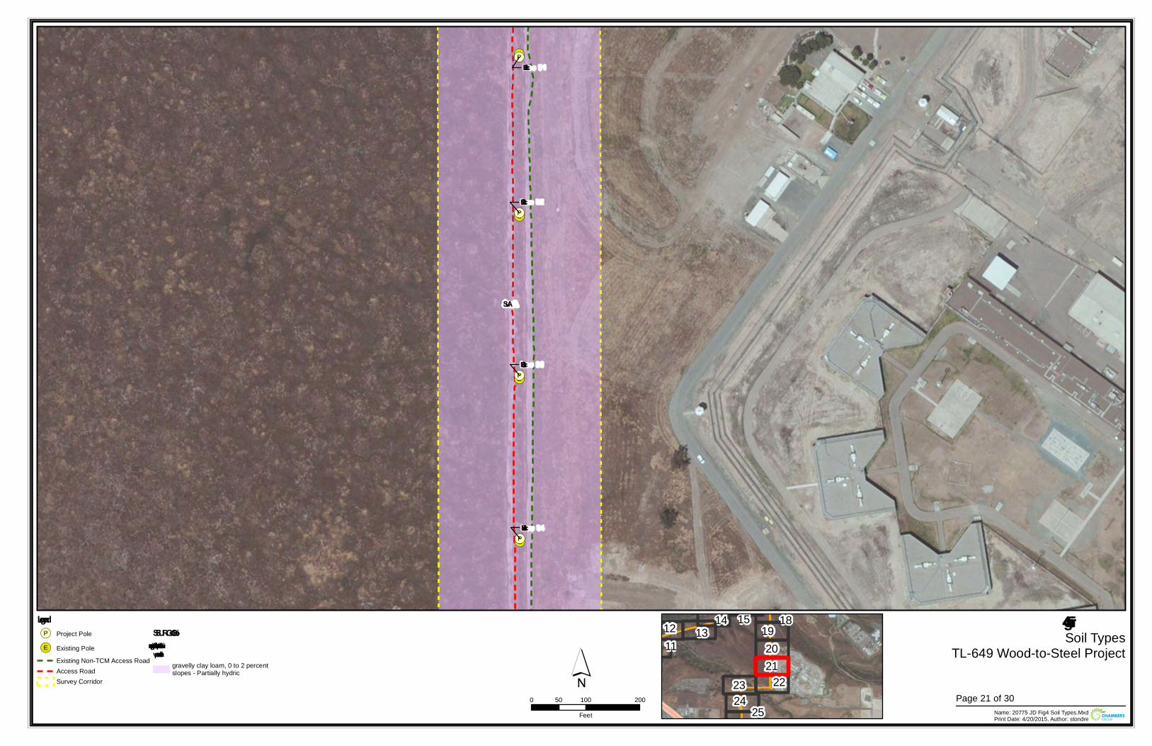
!(E
!(E
!(E
!(E
!(P
!(P
!(P
!(P
Loc 91
Loc 94
Loc 92
Loc 93
SuA
Figure 4Soil Types
TL-649 Wood-to-Steel Project
0 100 20050Feet Name: 20775 JD Fig4 Soil Types.Mxd
Print Date: 4/20/2015, Author: stondre
´Legend!(P Project Pole
!(E Existing PoleExisting Non-TCM Access RoadAccess RoadSurvey Corridor
SSURGO SoilsStockpen – suitable for supportingv ernal pools
gravelly clay loam, 0 to 2 percentslopes - Partially hydric
1112 13
14 15 18192021
222324
25Page 21 of 30
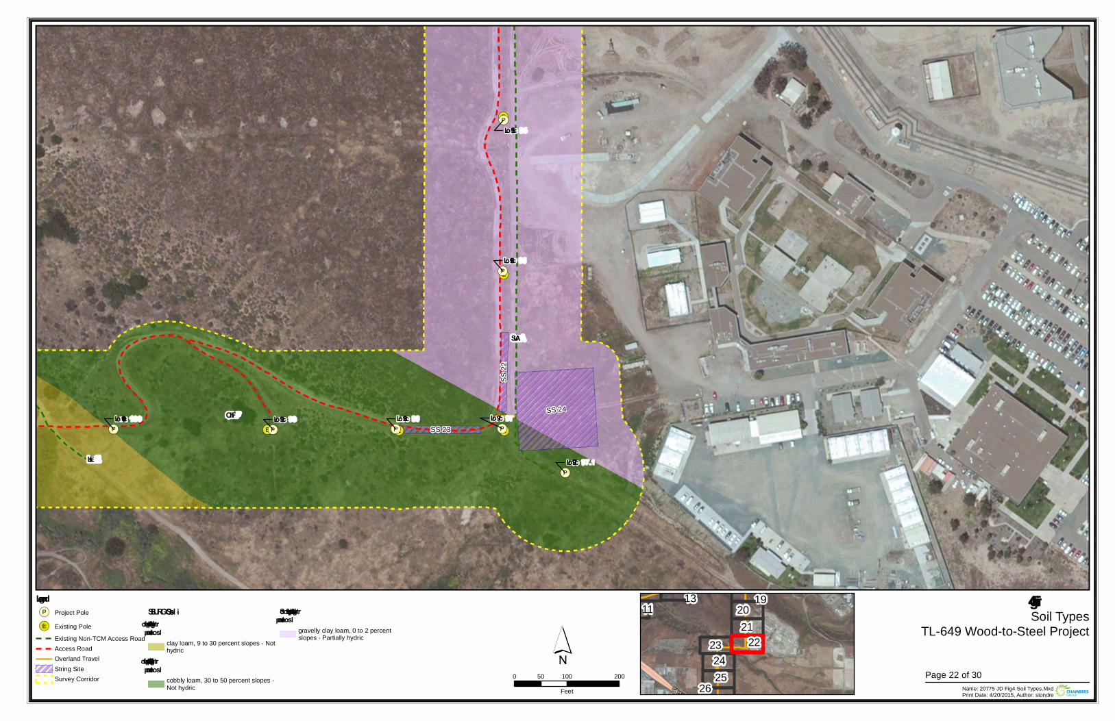
!(E!(E
!(E
!(E
!(E!(P!(P
!(P
!(P
!(P
!(P
!(P
Lo c 99Lo c 100
Lo c 97.1
Lo c 98
Lo c 95
Lo c 97
Lo c 96
SS 24
SS 22
SS 23
SuA
OhF
LsE
Figure 4Soil Types
TL-649 Wood-to-Steel Project
0 100 20050Feet Name: 20775 JD Fig4 Soil Types.Mxd
Print Date: 4/20/2015, Author: stondre
´Legend!(P Project Pole
!(E Existing PoleExisting Non-TCM Access RoadAccess RoadOverland TravelString SiteSurvey Corridor
SSURGO So ilsLinne – suitable fo r suppo rtingvernal po o ls
clay loam, 9 to 30 percent slopes - Nothydric
Olivenhain – suitable fo r suppo rtingvernal po o ls
cobbly loam, 30 to 50 percent slopes -Not hydric
Sto ckpen – suitable fo r suppo rtingvernal po o ls
gravelly clay loam, 0 to 2 percentslopes - Partially hydric
1113 1920
212223
2425
26Page 22 of 30
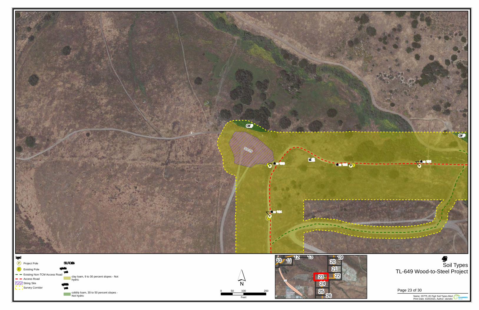
!(E!(E
!(E
!(P !(P
!(P
!(PLoc 102
Loc 101
Loc 104
Loc 103
SS 25
OhF
OhF
LsE
Figure 4Soil Types
TL-649 Wood-to-Steel Project
0 100 20050Feet Name: 20775 JD Fig4 Soil Types.Mxd
Print Date: 4/20/2015, Author: stondre
´Legend!(P Project Pole
!(E Existing PoleExisting Non-TCM Access RoadAccess RoadString SiteSurvey Corridor
SSURGO SoilsLinne – suitable for supportingv ernal pools
clay loam, 9 to 30 percent slopes - Nothydric
Oliv enhain – suitable for supportingv ernal pools
cobbly loam, 30 to 50 percent slopes -Not hydric
10 11 12 13 192021
222324
25 26Page 23 of 30
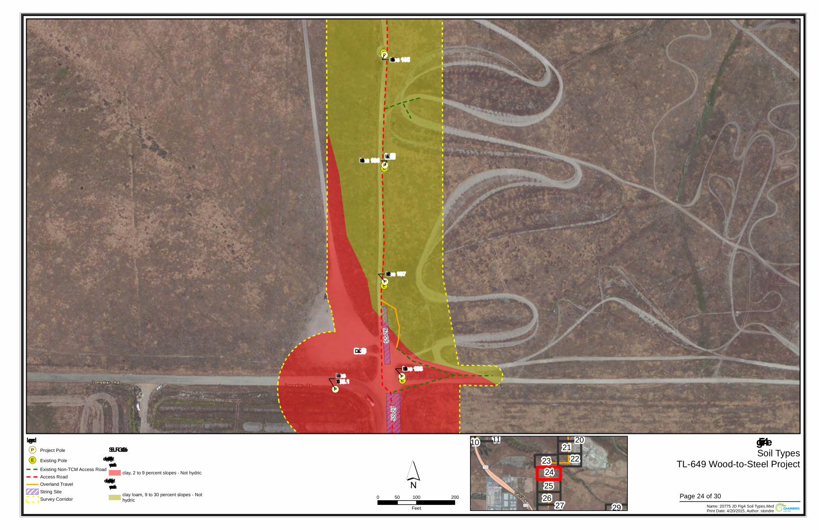
!(E
!(E
!(E
!(E
!(P
!(P
!(P
!(P
!(P
Loc 105
Loc 108
Loc 106
Loc 107
Loc108.1
SS 26
SS 27
LsE
DaC
Figure 4Soil Types
TL-649 Wood-to-Steel Project
0 100 20050Feet Name: 20775 JD Fig4 Soil Types.Mxd
Print Date: 4/20/2015, Author: stondre
´Legend!(P Project Pole
!(E Existing PoleExisting Non-TCM Access RoadAccess RoadOverland TravelString SiteSurvey Corridor
SSURGO SoilsDiablo – suitable for supportingvernal pools
clay, 2 to 9 percent slopes - Not hydricLinne – suitable for supportingvernal pools
clay loam, 9 to 30 percent slopes - Nothydric
10 11 20212223
242526 27 29
Page 24 of 30
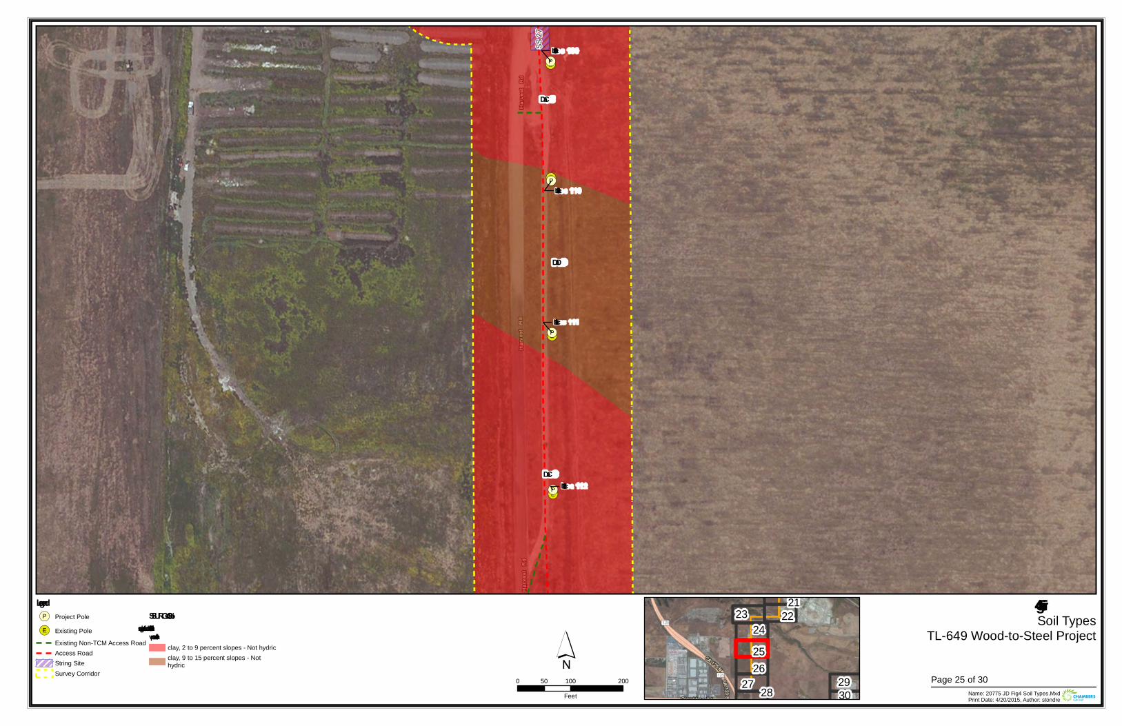
!(E
!(E
!(E
!(E!(P
!(P
!(P
!(P
Loc 109
Loc 112
Loc 110
Loc 111
SS 27
DaD
DaC
DaC
Figure 4Soil Types
TL-649 Wood-to-Steel Project
0 100 20050Feet Name: 20775 JD Fig4 Soil Types.Mxd
Print Date: 4/20/2015, Author: stondre
´Legend!(P Project Pole
!(E Existing PoleExisting Non-TCM Access RoadAccess RoadString SiteSurvey Corridor
SSURGO SoilsDiablo – suitable for supportingv ernal pools
clay, 2 to 9 percent slopes - Not hydricclay, 9 to 15 percent slopes - Nothydric
212223
242526
27 28 2930
Page 25 of 30
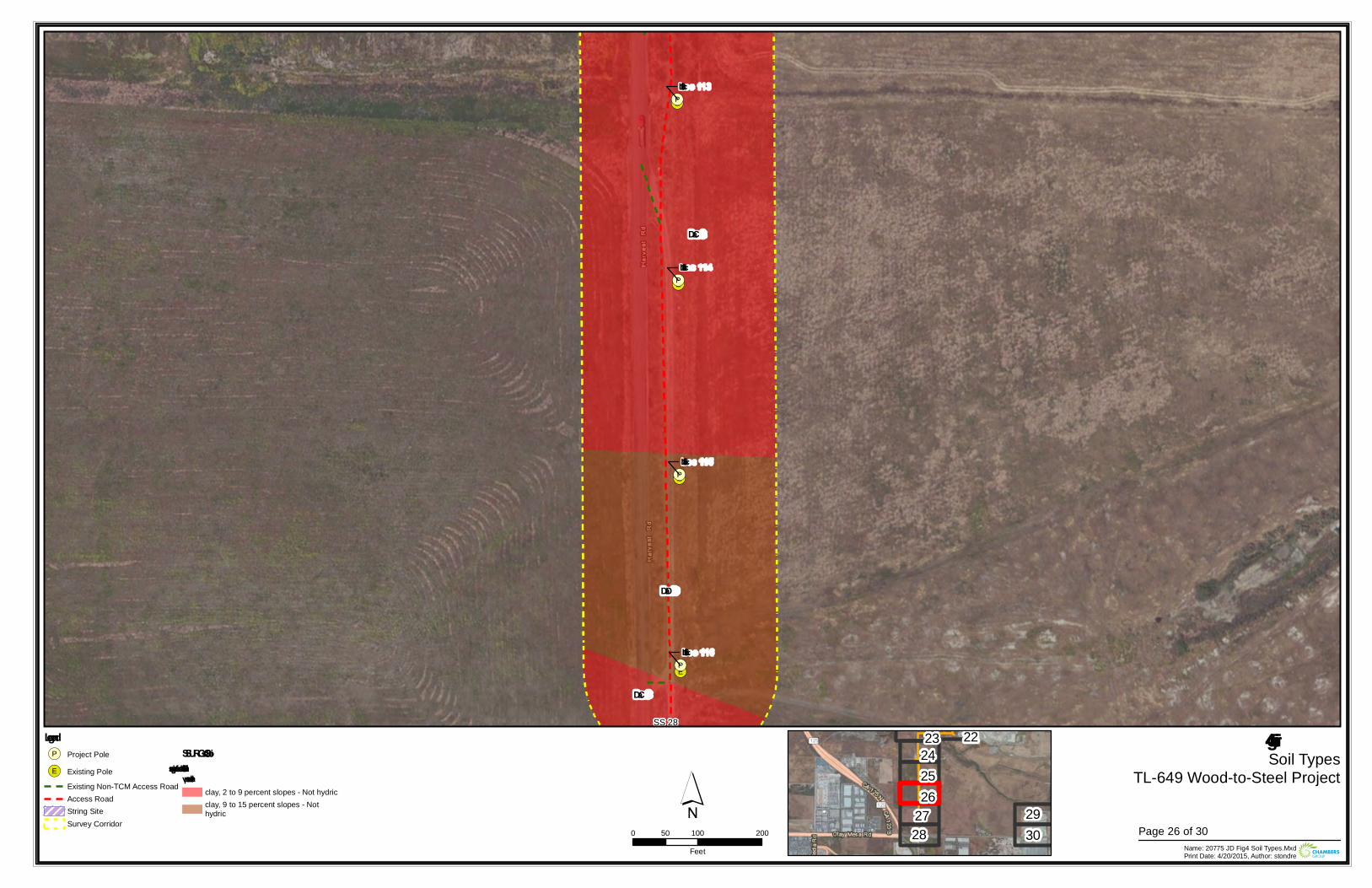
!(E
!(E
!(E
!(E!(P
!(P
!(P
!(P
Loc 115
Loc 116
Loc 113
Loc 114
SS 28
DaD
DaC
DaC
Figure 4Soil Types
TL-649 Wood-to-Steel Project
0 100 20050Feet Name: 20775 JD Fig4 Soil Types.Mxd
Print Date: 4/20/2015, Author: stondre
´Legend!(P Project Pole
!(E Existing PoleExisting Non-TCM Access RoadAccess RoadString SiteSurvey Corridor
SSURGO SoilsDiablo – suitable for supportingv ernal pools
clay, 2 to 9 percent slopes - Not hydricclay, 9 to 15 percent slopes - Nothydric
2223242526
2728
2930 Page 26 of 30
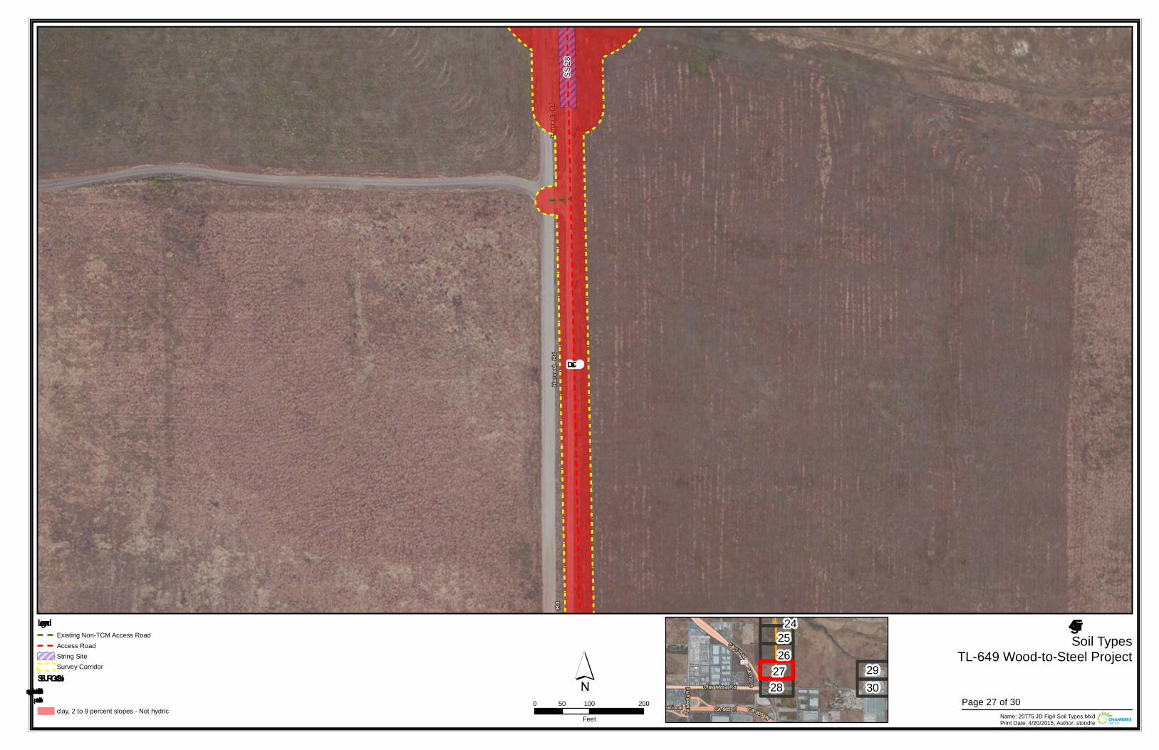
SS 28
DaC
Figure 4Soil Types
TL-649 Wood-to-Steel Project
0 100 20050Feet Name: 20775 JD Fig4 Soil Types.Mxd
Print Date: 4/20/2015, Author: stondre
´Legend
Existing Non-TCM Access RoadAccess RoadString SiteSurvey Corridor
SSURGO SoilsDiablo – suitable for supportingvernal pools
clay, 2 to 9 percent slopes - Not hydric
242526
2728
2930
Page 27 of 30
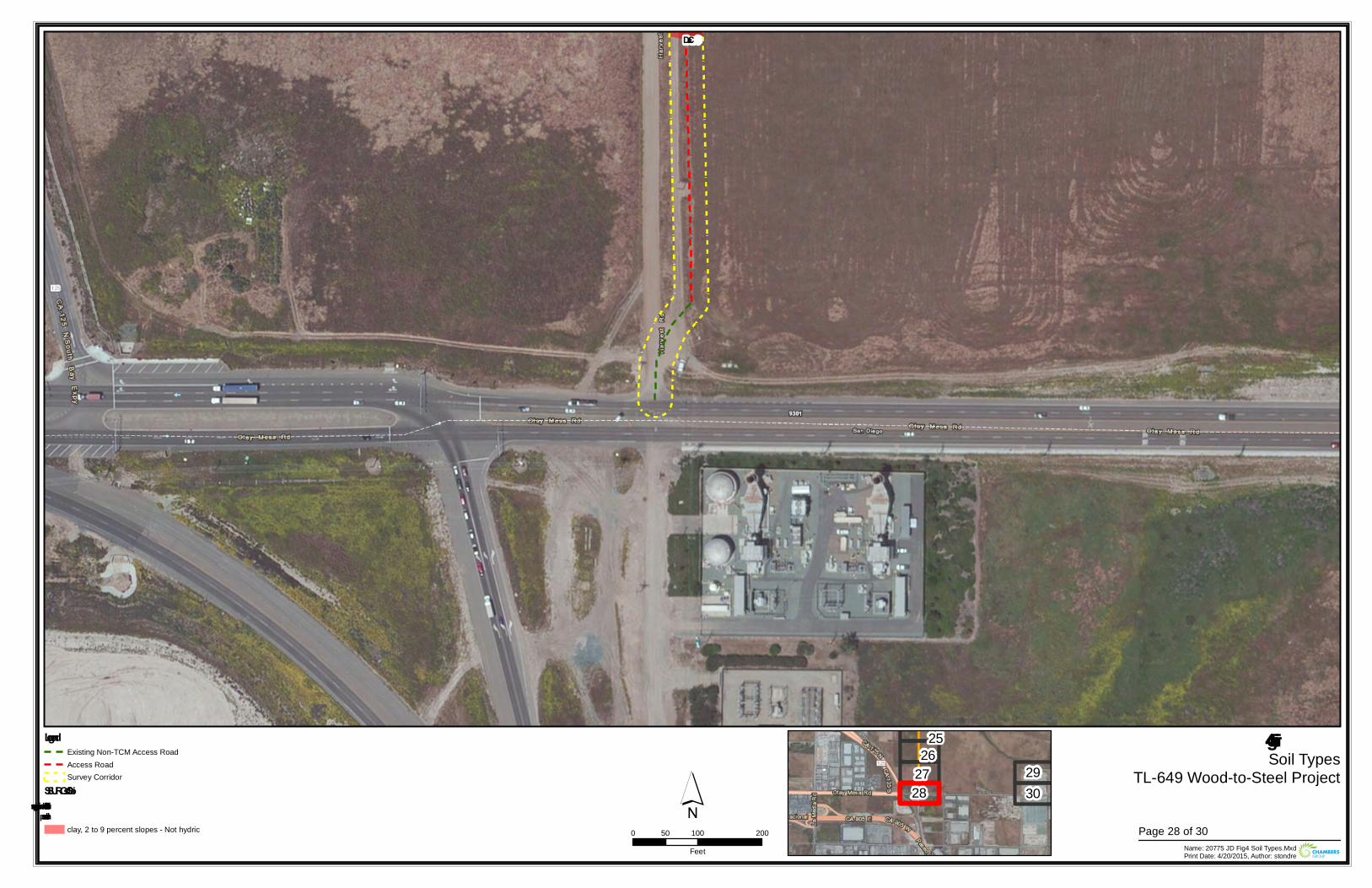
DaC
Figure 4Soil Types
TL-649 Wood-to-Steel Project
0 100 20050Feet Name: 20775 JD Fig4 Soil Types.Mxd
Print Date: 4/20/2015, Author: stondre
´Legend
Existing Non-TCM Access RoadAccess RoadSurvey Corridor
SSURGO SoilsDiablo – suitable for supportingvernal pools
clay, 2 to 9 percent slopes - Not hydric
2526
2728
2930
Page 28 of 30
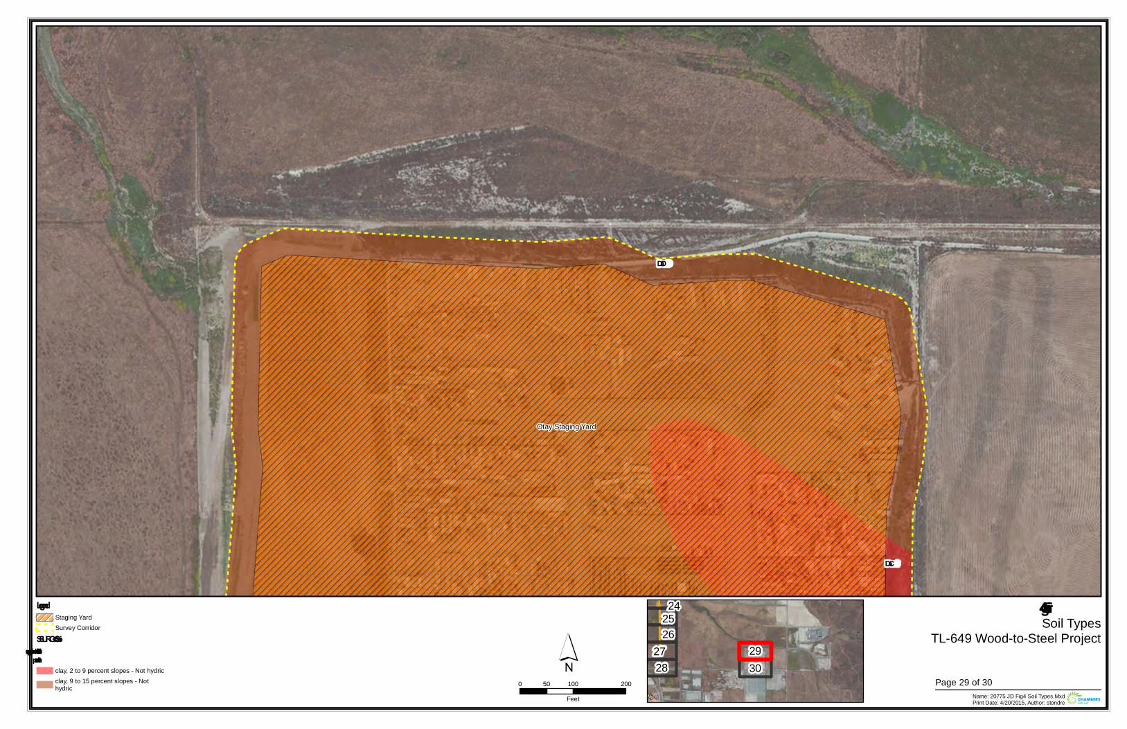
Otay Staging Yard
DaC
DaD
Figure 4Soil Types
TL-649 Wood-to-Steel Project
0 100 20050Feet Name: 20775 JD Fig4 Soil Types.Mxd
Print Date: 4/20/2015, Author: stondre
´Legend
Staging YardSurvey Corridor
SSURGO SoilsDiablo – suitable for supportingvernal pools
clay, 2 to 9 percent slopes - Not hydricclay, 9 to 15 percent slopes - Nothydric
242526
2728
2930
Page 29 of 30
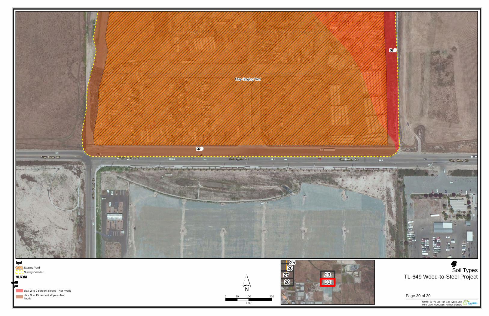
Otay Staging Yard
DaC
DaD
Figure 4Soil Types
TL-649 Wood-to-Steel Project
0 100 20050Feet Name: 20775 JD Fig4 Soil Types.Mxd
Print Date: 4/20/2015, Author: stondre
´Legend
Staging YardSurvey Corridor
SSURGO SoilsDiablo – suitable for supportingvernal pools
clay, 2 to 9 percent slopes - Not hydricclay, 9 to 15 percent slopes - Nothydric
2526
2728
2930
Page 30 of 30

Main Street Staging Yard
RR 2
RR 1
Figure 5Jurisdictional Resources
TL-649 Wood-to-Steel Project
0 100 20050Feet Name: 20775 JD Fig5 JD Resources 2015.Mxd
Print Date: 4/30/2015, Author: stondre
´Legend
Staging YardSurvey CorridorNon-jurisdictional Road Rut [BareGround]
23 4
1
5Page 1 of 30
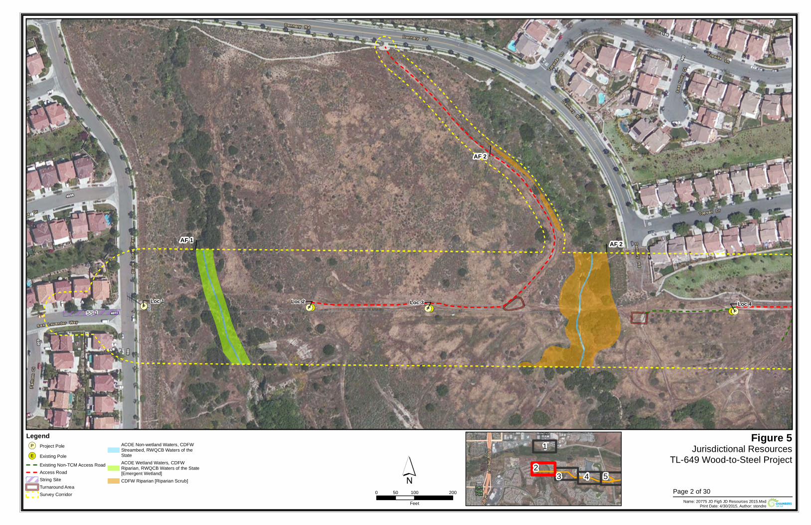
!(E !(E !(E!(E!(P
!(P!(P !(PLoc 1 Loc 4Loc 2 Loc 3
SS 1
AF 2
AF 2
AF 1
Figure 5Jurisdictional Resources
TL-649 Wood-to-Steel Project
0 100 20050Feet Name: 20775 JD Fig5 JD Resources 2015.Mxd
Print Date: 4/30/2015, Author: stondre
´Legend!(P Project Pole
!(E Existing PoleExisting Non-TCM Access RoadAccess RoadString SiteTurnaround AreaSurvey Corridor
ACOE Non-wetland Waters, CDFWStreambed, RWQCB Waters of theStateACOE Wetland Waters, CDFWRiparian, RWQCB Waters of the State[Emergent Wetland]CDFW Riparian [Riparian Scrub]
23 4
1
5Page 2 of 30
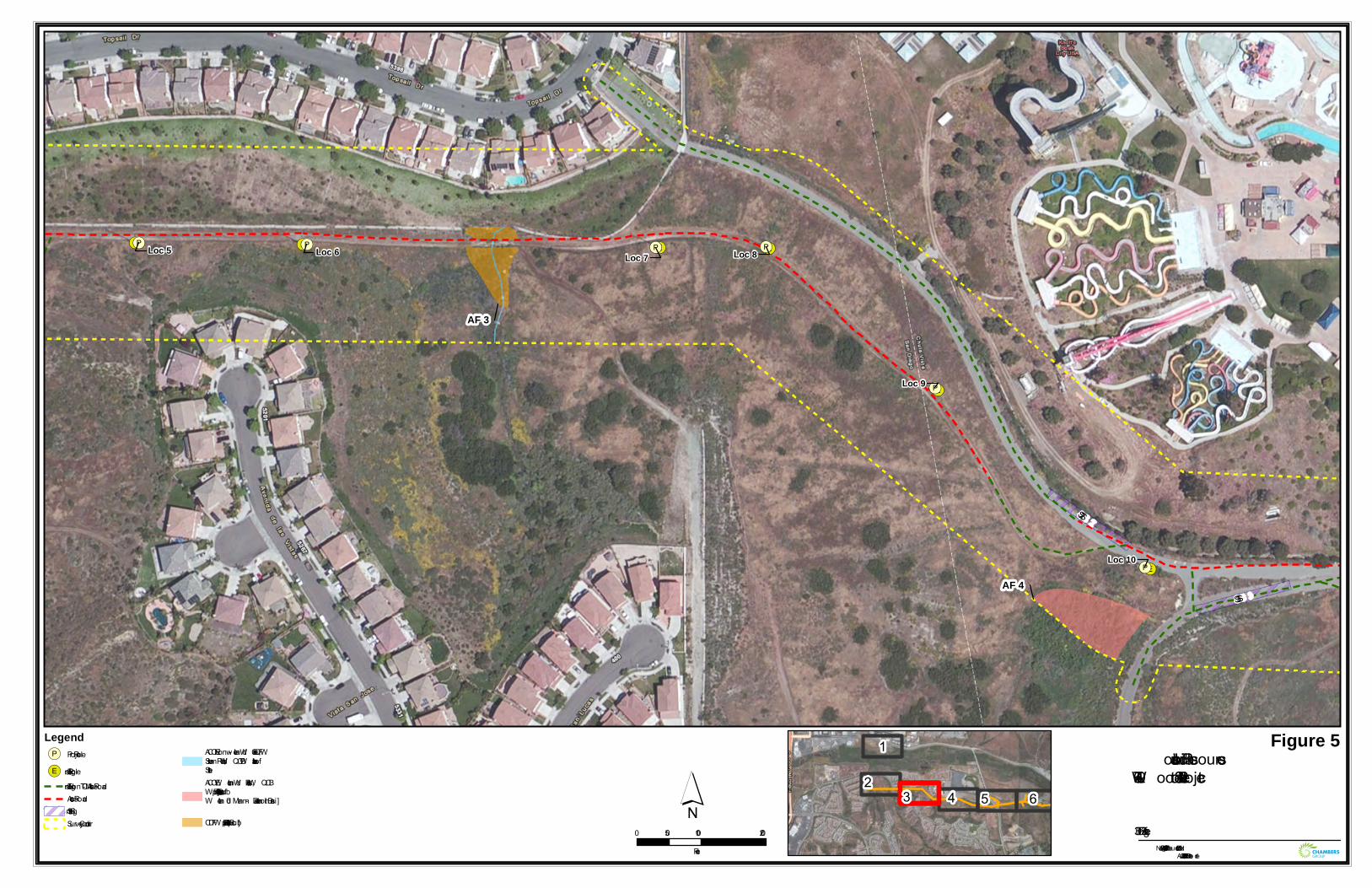
!(E!(E !(E
!(E
!(E
!(E
!(P
!(P
!(P
!(P !(P!(P
Loc 10
Loc 7
Loc 9
Loc 5 Loc 8Loc 6
SS 2
SS 3
AF 3
AF 4
Figure 5Jurisdiction al Resources
TL-649 W ood-to-Steel Project
0 100 20050Feet Nam e: 20775 JD Fig5 JD Resources 2015.Mxd
Prin t Date: 4/30/2015, Author: ston dre
´Legend!(P Project Pole
!(E Existin g PoleExistin g Non -TCM Access RoadAccess RoadStrin g SiteSurvey Corridor
ACOE Non -wetlan d W aters, CDFWStream bed, RW QCB W aters of theStateACOE W etlan d W aters, RW QCBW aters of the State [Riparian ScrubW etlan d – Man -m ade Deten tion Basin ]
CDFW Riparian [Riparian Scrub]
23 4
1
5 6Page 3 of 30
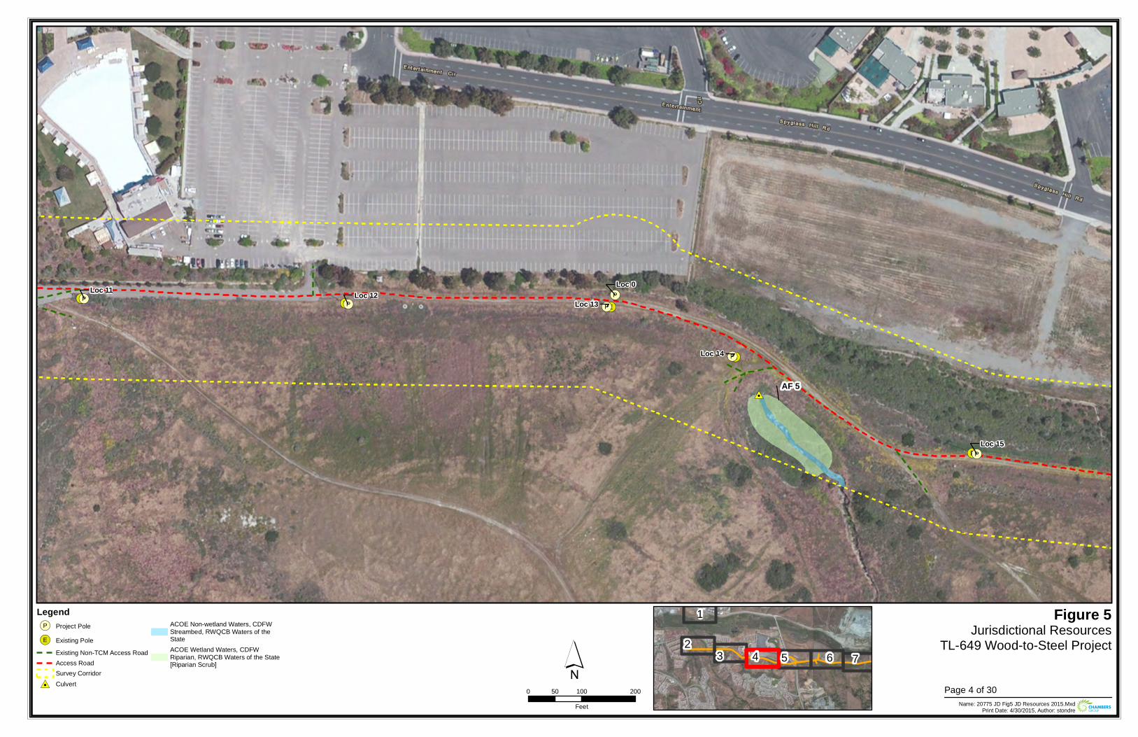
!(E
!(E !(E
!(E
!(E!(P
!(P !(P
!(P
!(P
!(P
#0
Loc 0Loc 12
Loc 13
Loc 14
Loc 11
Loc 15
AF 5
Figure 5Jurisdictional Resources
TL-649 Wood-to-Steel Project
0 100 20050Feet Name: 20775 JD Fig5 JD Resources 2015.Mxd
Print Date: 4/30/2015, Author: stondre
´Legend!(P Project Pole
!(E Existing PoleExisting Non-TCM Access RoadAccess RoadSurvey Corridor
#0 Culvert
ACOE Non-wetland Waters, CDFWStreambed, RWQCB Waters of theStateACOE Wetland Waters, CDFWRiparian, RWQCB Waters of the State[Riparian Scrub]
23 4
1
5 6 7
Page 4 of 30
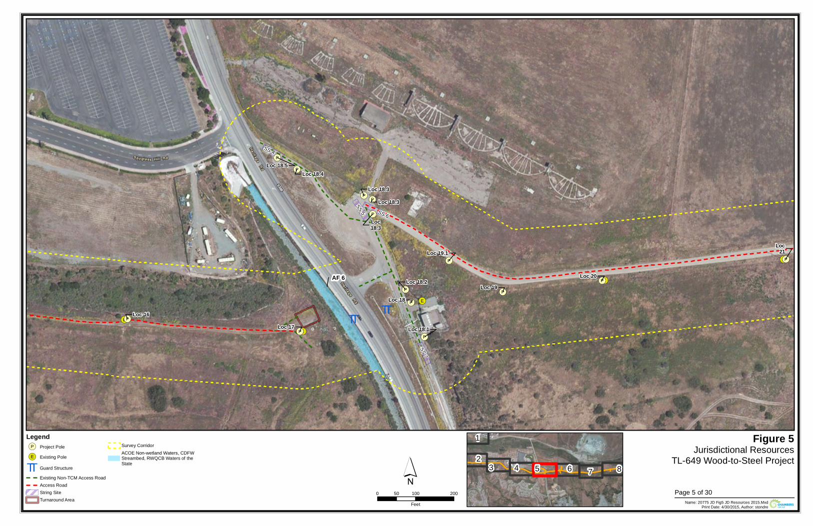
TT TT!(E
!(E
!(E
!(E
!(E!(P
!(P
!(P
!(P
!(P
!(P
!(P
!(P
!(P
!(P
!(P
!(P
!(P
!(P
Loc 18.2
Loc 16Loc 17
Loc 20
Loc21
Loc 18.1
Loc 19Loc 18
Loc 18.5
Loc 19.1
Loc 18.3
Loc18.3
Loc 18.4
Loc 18.3SS 5
SS 4
SS 7
SS 6
AF 6
Figure 5Jurisdictional Resources
TL-649 Wood-to-Steel Project
0 100 20050Feet Name: 20775 JD Fig5 JD Resources 2015.Mxd
Print Date: 4/30/2015, Author: stondre
´Legend!(P Project Pole
!(E Existing Pole
TT Guard StructureExisting Non-TCM Access RoadAccess RoadString SiteTurnaround Area
Survey CorridorACOE Non-wetland Waters, CDFWStreambed, RWQCB Waters of theState 2
3 4
1
5 6 7 8
Page 5 of 30
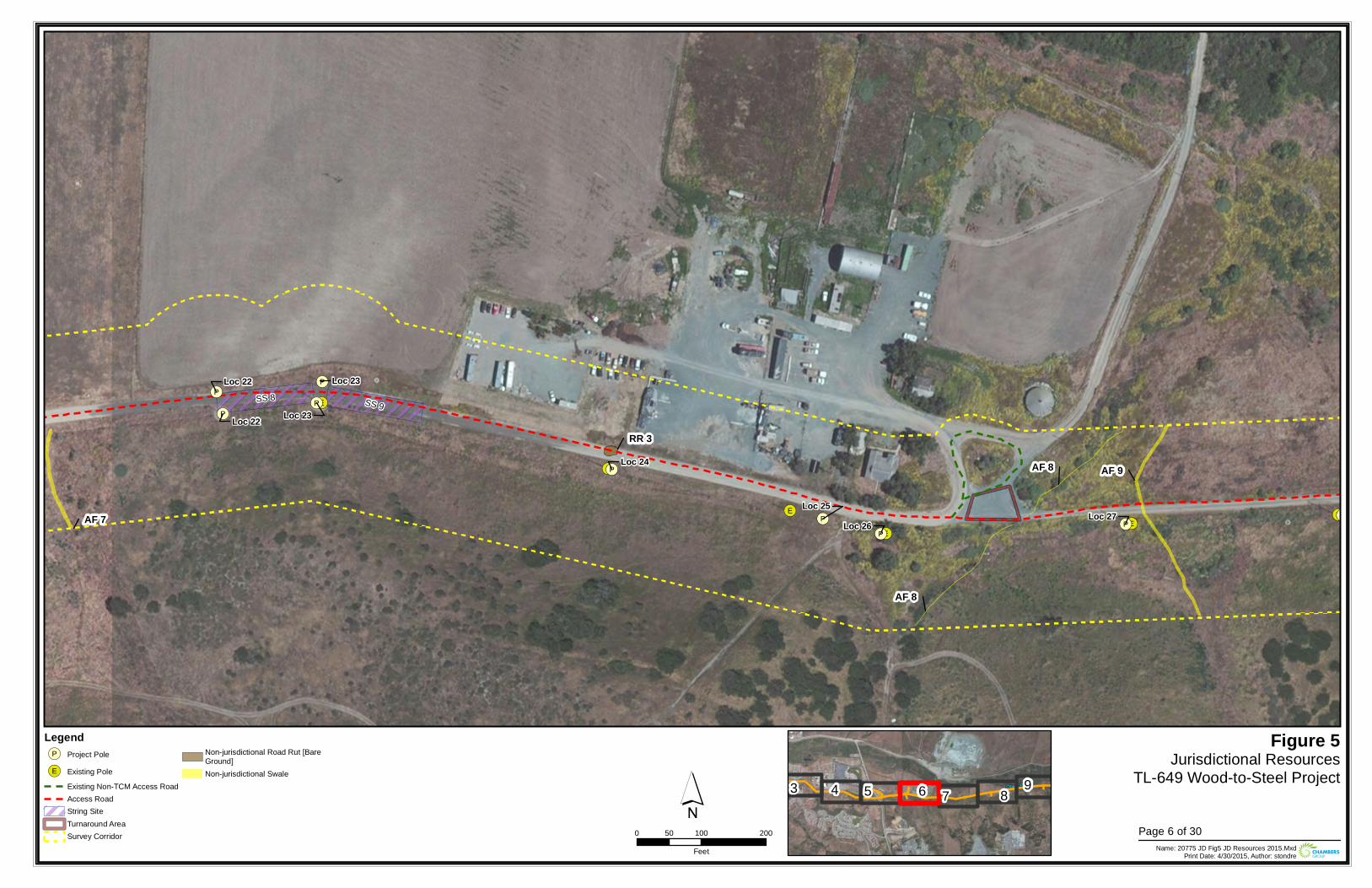
!(E
!(E
!(E
!(E
!(E
!(E
!(E!(P
!(P
!(P
!(P
!(P
!(P
!(P!(P
!(P
!(PLoc 26Loc 25
Loc 23
Loc 27
Loc 22
Loc 22 Loc 23
Loc 24
SS 9SS 8
AF 8
AF 9
RR 3
AF 8
AF 7
Figure 5Jurisdictional Resources
TL-649 Wood-to-Steel Project
0 100 20050Feet Name: 20775 JD Fig5 JD Resources 2015.Mxd
Print Date: 4/30/2015, Author: stondre
´Legend!(P Project Pole
!(E Existing PoleExisting Non-TCM Access RoadAccess RoadString SiteTurnaround AreaSurvey Corridor
Non-jurisdictional Road Rut [BareGround]Non-jurisdictional Swale
3 4 5 6 7 8 9
Page 6 of 30
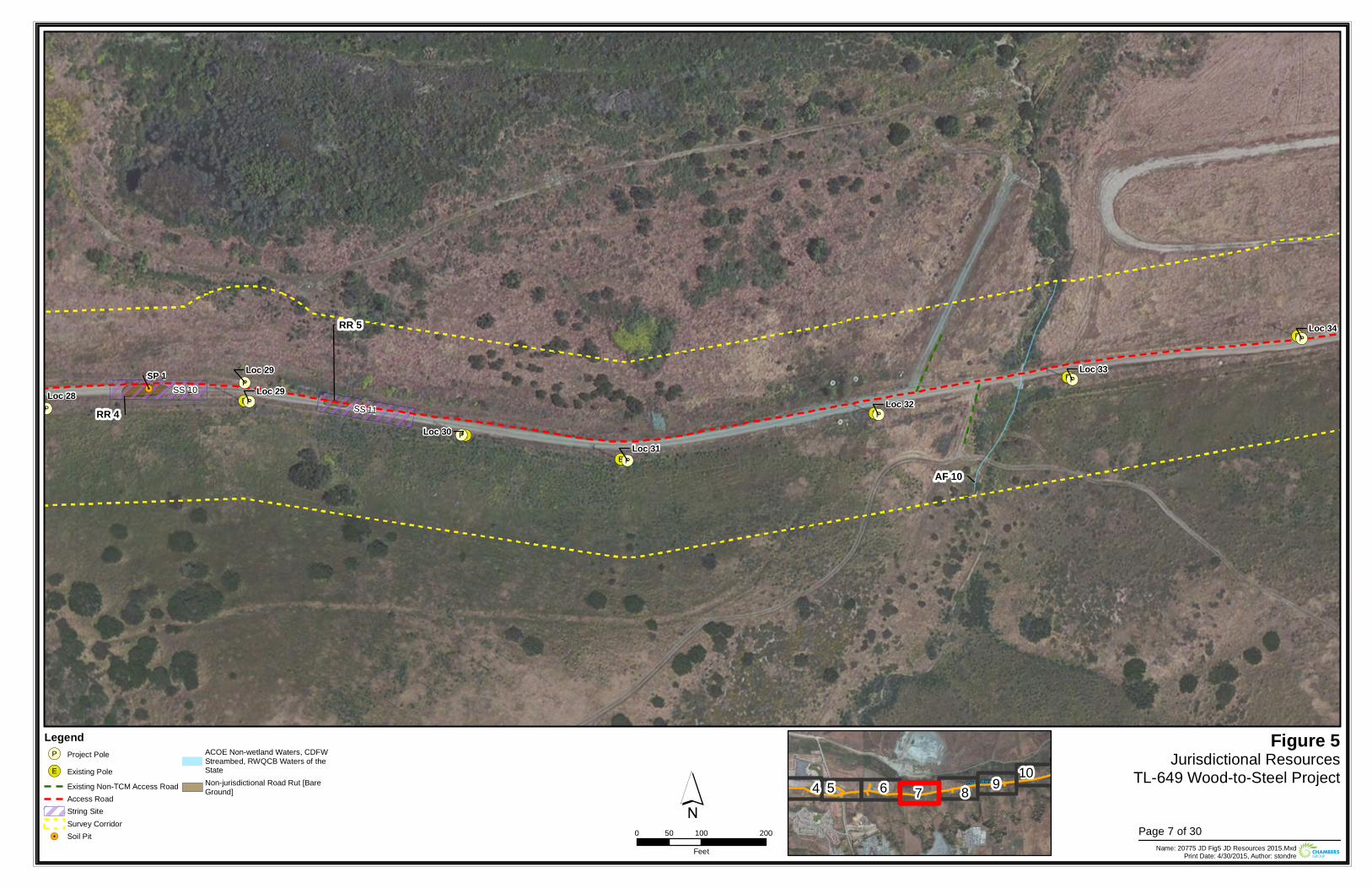
!(E
!(E
!(E
!(E!(E
!(E
!(E
!(P
!(P
!(P!(P
!(P
!(P
!(P
!(P
!.
Loc 30
Loc 34
Loc 29Loc 29
Loc 32
Loc 33
Loc 31
Loc 28 SS 10SS 11
AF 10
RR 5
RR 4
SP 1
Figure 5Jurisdictional Resources
TL-649 Wood-to-Steel Project
0 100 20050Feet Name: 20775 JD Fig5 JD Resources 2015.Mxd
Print Date: 4/30/2015, Author: stondre
´Legend!(P Project Pole
!(E Existing PoleExisting Non-TCM Access RoadAccess RoadString SiteSurvey Corridor
!. Soil Pit
ACOE Non-wetland Waters, CDFWStreambed, RWQCB Waters of theStateNon-jurisdictional Road Rut [BareGround] 4 5 6 7 8 9 10
Page 7 of 30
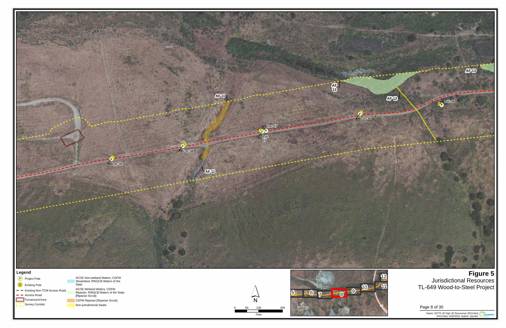
!(E
!(E
!(E
!(E
!(E
!(P
!(P
!(P
!(P
!(P
!(P
Loc 37
Loc 39
Loc37
Loc 35
Loc 36
Loc 38
AF 11
AF 11
AF 12
AF13
AF 13
Figure 5Jurisdictional Resources
TL-649 Wood-to-Steel Project
0 100 20050Feet Name: 20775 JD Fig5 JD Resources 2015.Mxd
Print Date: 4/30/2015, Author: stondre
´Legend!(P Project Pole
!(E Existing PoleExisting Non-TCM Access RoadAccess RoadTurnaround AreaSurvey Corridor
ACOE Non-wetland Waters, CDFWStreambed, RWQCB Waters of theStateACOE Wetland Waters, CDFWRiparian, RWQCB Waters of the State[Riparian Scrub]CDFW Riparian [Riparian Scrub]Non-jurisdictional Swale
5 6 7 8 9 10 1112
Page 8 of 30
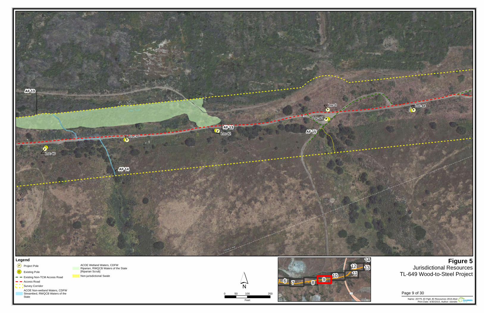
!(E
!(E
!(E
!(E
!(E
!(P
!(P
!(P
!(P
!(P
!(P
Loc 43
Loc 0
Loc 42
Loc 44
Loc 40
Loc 41
AF 14
AF 13AF 15
AF 13
Figure 5Jurisdictional Resources
TL-649 Wood-to-Steel Project
0 100 20050Feet Name: 20775 JD Fig5 JD Resources 2015.Mxd
Print Date: 4/30/2015, Author: stondre
´Legend!(P Project Pole
!(E Existing PoleExisting Non-TCM Access RoadAccess RoadSurvey CorridorACOE Non-wetland Waters, CDFWStreambed, RWQCB Waters of theState
ACOE Wetland Waters, CDFWRiparian, RWQCB Waters of the State[Riparian Scrub]Non-jurisdictional Swale
6 7 8 9 10 1112 13
14
Page 9 of 30
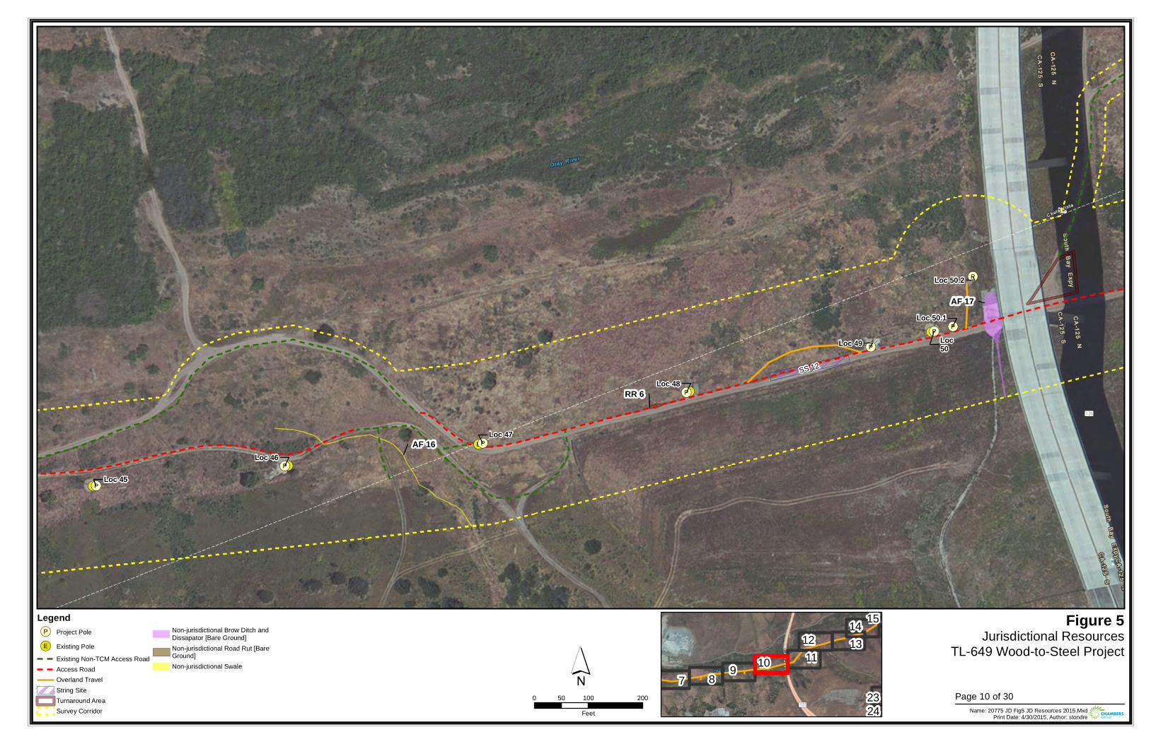
!(E
!(E
!(E
!(E
!(E
!(P
!(P
!(P
!(P
!(P
!(P
!(P
!(PLoc50
Loc 47
Loc 46
Loc 50.1
Loc 48
Loc 50.2
Loc 45
Loc 49
SS 12
AF 17
AF 16
RR 6
Figure 5Jurisdictional Resources
TL-649 Wood-to-Steel Project
0 100 20050Feet Name: 20775 JD Fig5 JD Resources 2015.Mxd
Print Date: 4/30/2015, Author: stondre
´Legend!(P Project Pole
!(E Existing PoleExisting Non-TCM Access RoadAccess RoadOverland TravelString SiteTurnaround AreaSurvey Corridor
Non-jurisdictional Brow Ditch andDissapator [Bare Ground]Non-jurisdictional Road Rut [BareGround]Non-jurisdictional Swale
7 8 9 10 1112 13
14 15
2324
Page 10 of 30
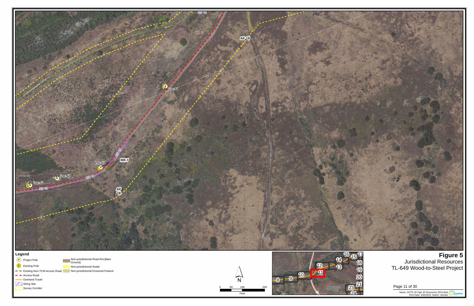
!(E
!(E
!(E
!(P
!(P
!(P
!(P
Loc 52Loc 51
Loc 54
Loc 53
SS 13
SS 15
SS 14
SS 16
AF18
AF 19
RR 7
Figure 5Jurisdictional Resources
TL-649 Wood-to-Steel Project
0 100 20050Feet Name: 20775 JD Fig5 JD Resources 2015.Mxd
Print Date: 4/30/2015, Author: stondre
´Legend!(P Project Pole
!(E Existing PoleExisting Non-TCM Access RoadAccess RoadOverland TravelString SiteSurvey Corridor
Non-jurisdictional Road Rut [BareGround]Non-jurisdictional SwaleNon-jurisdictional Erosional Feature
8 9 10 1112 13
14 1516 171819202123
24Page 11 of 30
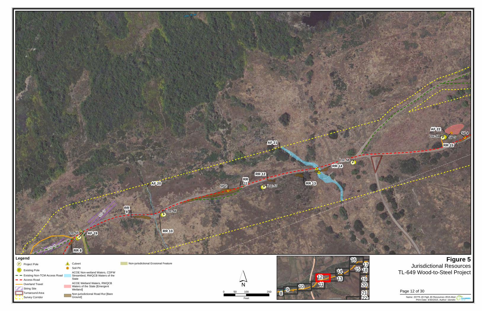
!(E
!(E
!(E
!(E
!(E
!(P
!(P
!(P
!(P
!(P
#0#0
!.
!.
!.Loc 59
Loc 56
Loc 57
Loc 58
Loc 55
SS 17
SS 16
AF 21
AF 22
AF 19
AF 20RR11
RR 15
RR 10
RR9
RR 8
RR 14
RR 13
RR 12
SP 2
SP 3SP 4
Figure 5Jurisdictional Resources
TL-649 Wood-to-Steel Project
0 100 20050Feet Name: 20775 JD Fig5 JD Resources 2015.Mxd
Print Date: 4/30/2015, Author: stondre
´Legend!(P Project Pole
!(E Existing PoleExisting Non-TCM Access RoadAccess RoadOverland TravelString SiteTurnaround AreaSurvey Corridor
#0 Culvert!. Soil Pit
ACOE Non-wetland Waters, CDFWStreambed, RWQCB Waters of theStateACOE Wetland Waters, RWQCBWaters of the State [EmergentWetland]Non-jurisdictional Road Rut [BareGround]
Non-jurisdictional Erosional Feature
8 9 10 1112 13
14 1516
171819202122
Page 12 of 30
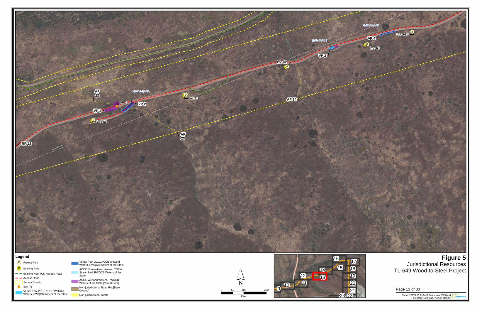
!(E
!(E
!(E
!(E
!(E
!(P
!(P
!(P
!(P
!(P
!(P
!.
2011-VP-11
2011-VP-12
2010-VP-14
Loc 62
Loc 60
Loc 63.1
Loc 63
Loc 61
AF23
AF 24AF23
RR 15
VP 1
VP 3
VP 2
VP 4
SP 5
Figure 5Jurisdictional Resources
TL-649 Wood-to-Steel Project
0 100 20050Feet Name: 20775 JD Fig5 JD Resources 2015.Mxd
Print Date: 4/30/2015, Author: stondre
´Legend!(P Project Pole
!(E Existing PoleExisting Non-TCM Access RoadAccess RoadSurvey Corridor
!. Soil PitVernal Pool-2010, ACOE WetlandWaters, RWQCB Waters of the State
Vernal Pool-2011, ACOE WetlandWaters, RWQCB Waters of the StateACOE Non-wetland Waters, CDFWStreambed, RWQCB Waters of theStateACOE Wetland Waters, RWQCBWaters of the State [Vernal Pool]Non-jurisdictional Road Rut [BareGround]Non-jurisdictional Swale
9 10 1112 13
14 1516 17
18192021
2223Page 13 of 30
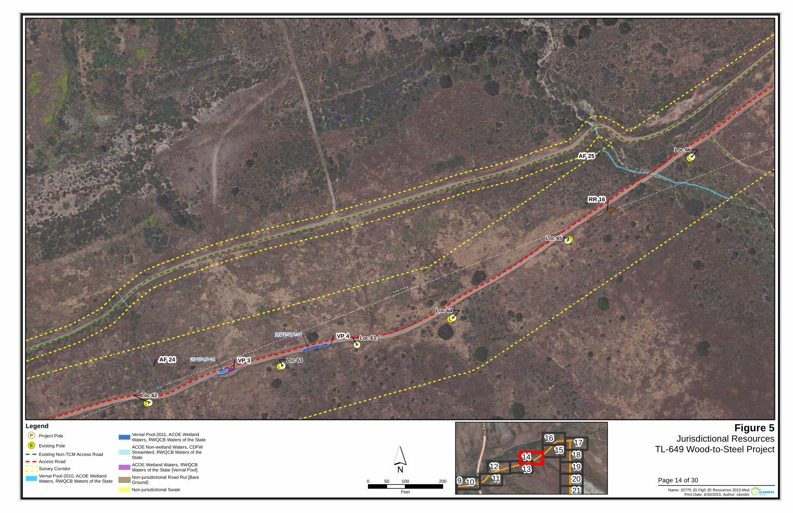
!(E
!(E
!(E
!(E
!(E
!(P
!(P
!(P
!(P
!(P
!(P
2011-VP-11
2010-VP-14
Loc 66
Loc 62
Loc 64
Loc 63.1
Loc 63
Loc 65
AF 25
RR 16
VP 3
VP 4
AF 24
Figure 5Jurisdictional Resources
TL-649 Wood-to-Steel Project
0 100 20050Feet Name: 20775 JD Fig5 JD Resources 2015.Mxd
Print Date: 4/30/2015, Author: stondre
´Legend!(P Project Pole
!(E Existing PoleExisting Non-TCM Access RoadAccess RoadSurvey CorridorVernal Pool-2010, ACOE WetlandWaters, RWQCB Waters of the State
Vernal Pool-2011, ACOE WetlandWaters, RWQCB Waters of the StateACOE Non-wetland Waters, CDFWStreambed, RWQCB Waters of theStateACOE Wetland Waters, RWQCBWaters of the State [Vernal Pool]Non-jurisdictional Road Rut [BareGround]Non-jurisdictional Swale
9 10 1112 13
14 1516 17
18192021
Page 14 of 30
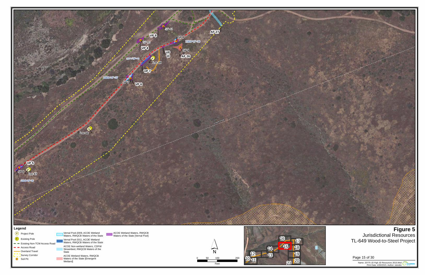
!(E
!(E
!(E
!(P
!(P
!(P
!.
!.
!.
!.
!.
!.
2009-VP-37
2009-VP-38
2011-VP-10
2009-VP-36
Loc 68
Loc 67
Loc 69AF 26
AF 27
VP 5
VP 6
VP10
VP 9
VP 8
VP 7
SP 44
SP 45
SP 6
SP 7
SP 8
SP 9
Figure 5Jurisdictional Resources
TL-649 Wood-to-Steel Project
0 100 20050Feet Name: 20775 JD Fig5 JD Resources 2015.Mxd
Print Date: 4/30/2015, Author: stondre
´Legend!(P Project Pole
!(E Existing PoleExisting Non-TCM Access RoadAccess RoadOverland TravelSurvey Corridor
!. Soil Pit
Vernal Pool-2009, ACOE WetlandWaters, RWQCB Waters of the StateVernal Pool-2011, ACOE WetlandWaters, RWQCB Waters of the StateACOE Non-wetland Waters, CDFWStreambed, RWQCB Waters of theStateACOE Wetland Waters, RWQCBWaters of the State [EmergentWetland]
ACOE Wetland Waters, RWQCBWaters of the State [Vernal Pool]
10 1112 13
14 1516 17
18192021
Page 15 of 30
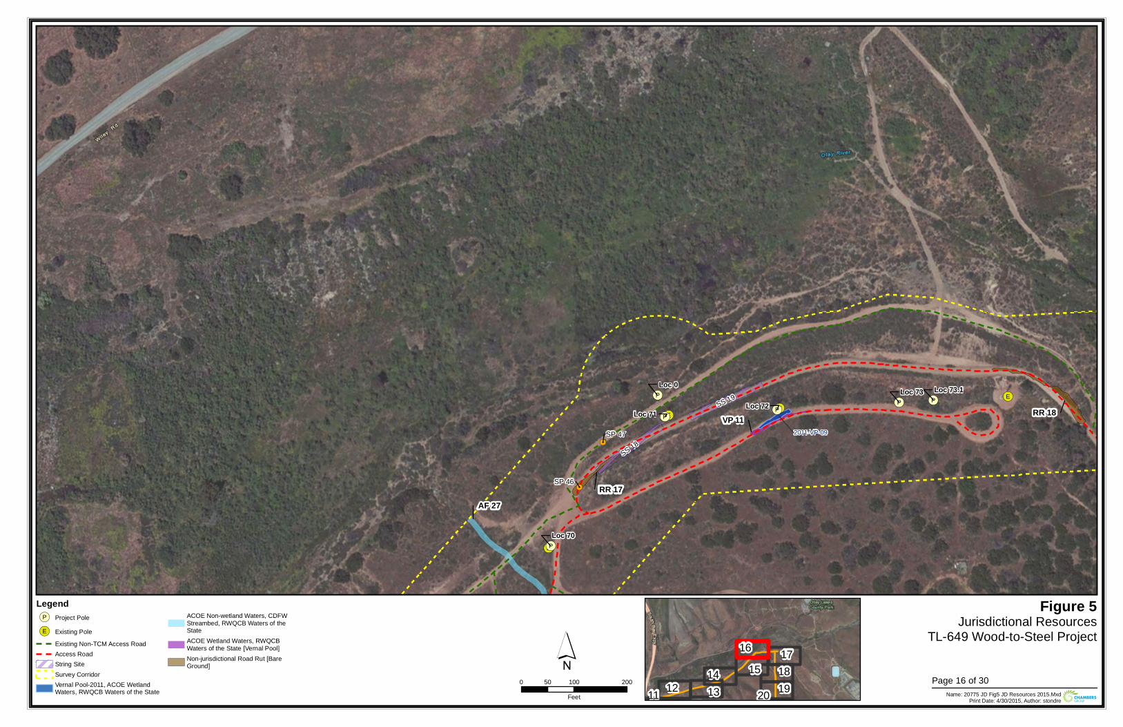
!(E
!(E
!(E!(E
!(P
!(P!(P
!(P!(P
!(P
!.
!.
2011-VP-09
Loc 70
Loc 73.1Loc 0
Loc 72Loc 71
Loc 73
SS 18
SS 19
AF 27
RR 18
RR 17
VP 11
SP 46
SP 47
Figure 5Jurisdictional Resources
TL-649 Wood-to-Steel Project
0 100 20050Feet Name: 20775 JD Fig5 JD Resources 2015.Mxd
Print Date: 4/30/2015, Author: stondre
´Legend!(P Project Pole
!(E Existing PoleExisting Non-TCM Access RoadAccess RoadString SiteSurvey CorridorVernal Pool-2011, ACOE WetlandWaters, RWQCB Waters of the State
ACOE Non-wetland Waters, CDFWStreambed, RWQCB Waters of theStateACOE Wetland Waters, RWQCBWaters of the State [Vernal Pool]Non-jurisdictional Road Rut [BareGround]
11 12 1314 15
16 17181920
Page 16 of 30
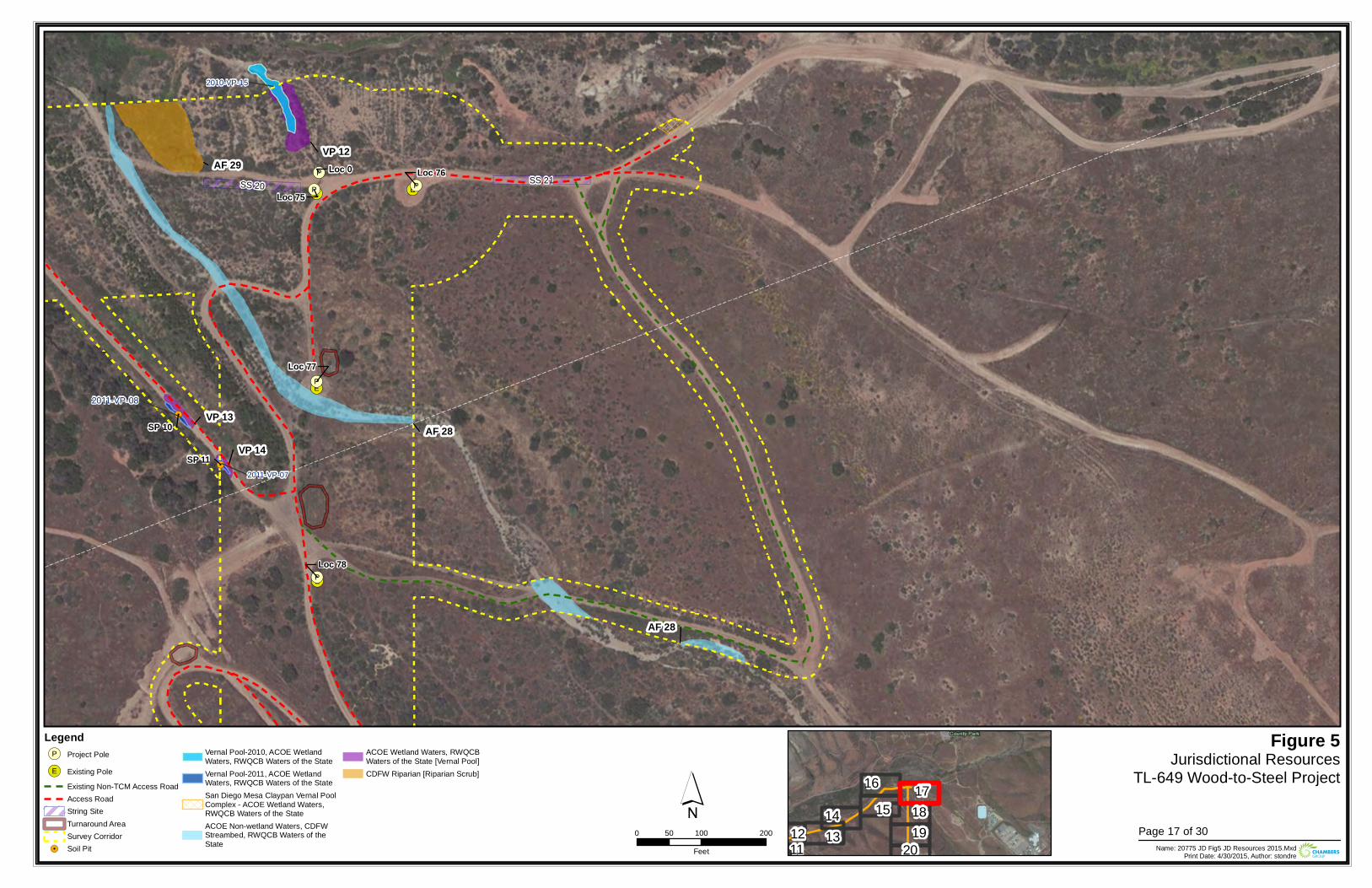
!(E!(E
!(E
!(E
!(P
!(P !(P
!(P
!(P
!.
!.
2011-VP-08
2011-VP-07
2010-VP-15
Loc 78
Loc 75
Loc 76
Loc 77
Loc 0SS 21SS 20
AF 28VP 13
VP 14
AF 29VP 12
AF 28
SP 10
SP 11
Figure 5Jurisdictional Resources
TL-649 Wood-to-Steel Project
0 100 20050Feet Name: 20775 JD Fig5 JD Resources 2015.Mxd
Print Date: 4/30/2015, Author: stondre
´Legend!(P Project Pole
!(E Existing PoleExisting Non-TCM Access RoadAccess RoadString SiteTurnaround AreaSurvey Corridor
!. Soil Pit
Vernal Pool-2010, ACOE WetlandWaters, RWQCB Waters of the StateVernal Pool-2011, ACOE WetlandWaters, RWQCB Waters of the StateSan Diego Mesa Claypan Vernal PoolComplex - ACOE Wetland Waters,RWQCB Waters of the StateACOE Non-wetland Waters, CDFWStreambed, RWQCB Waters of theState
ACOE Wetland Waters, RWQCBWaters of the State [Vernal Pool]CDFW Riparian [Riparian Scrub]
1112 13
14 1516 17
1819
20Page 17 of 30
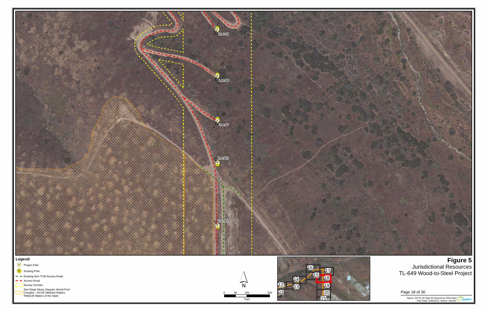
!(E
!(E
!(E
!(E
!(E
!(P
!(P
!(P
!(P
!(P
Loc 81
Loc 79
Loc 83
Loc 82
Loc 80
Figure 5Jurisdictional Resources
TL-649 Wood-to-Steel Project
0 100 20050Feet Name: 20775 JD Fig5 JD Resources 2015.Mxd
Print Date: 4/30/2015, Author: stondre
´Legend!(P Project Pole
!(E Existing PoleExisting Non-TCM Access RoadAccess RoadSurvey CorridorSan Diego Mesa Claypan Vernal PoolComplex - ACOE Wetland Waters,RWQCB Waters of the State
1112 13
14 1516 17
181920
21Page 18 of 30
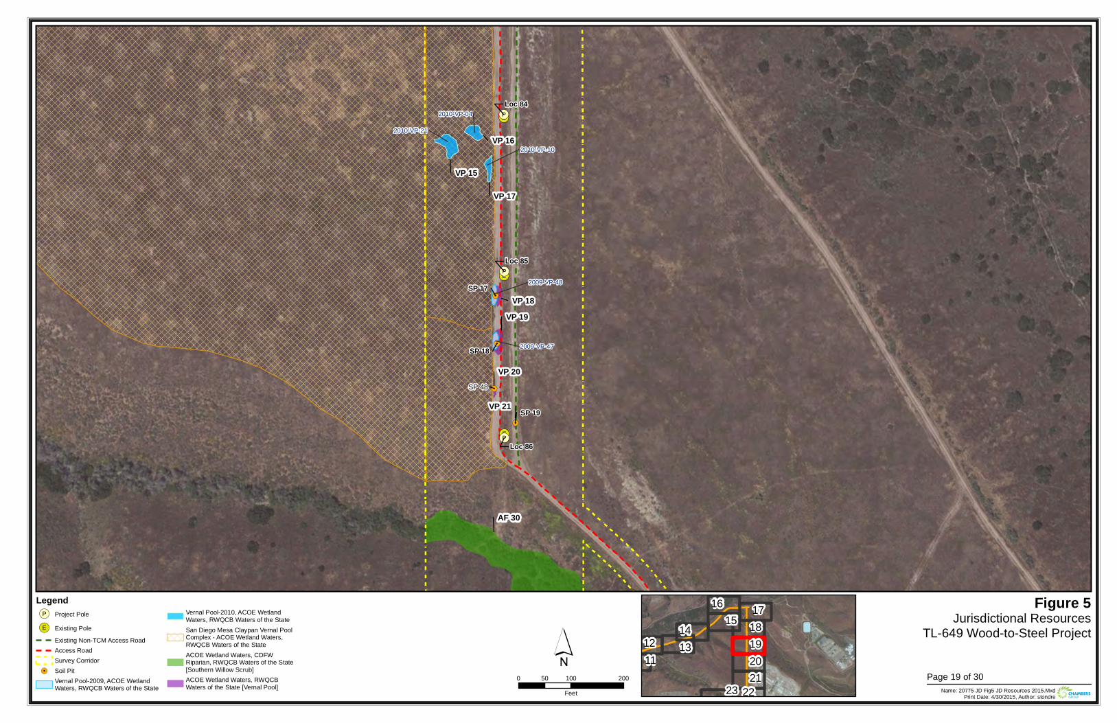
!(E
!(E
!(E
!(P
!(P
!(P
!.
!.
!.
!.
2010-VP-04
2010-VP-10
2010-VP-21
2009-VP-47
2009-VP-48
Loc 85
Loc 86
Loc 84
VP 19VP 18
VP 21
VP 20
VP 16
VP 17
VP 15
AF 30
SP 48
SP 17
SP 18
SP 19
Figure 5Jurisdictional Resources
TL-649 Wood-to-Steel Project
0 100 20050Feet Name: 20775 JD Fig5 JD Resources 2015.Mxd
Print Date: 4/30/2015, Author: stondre
´Legend!(P Project Pole
!(E Existing PoleExisting Non-TCM Access RoadAccess RoadSurvey Corridor
!. Soil PitVernal Pool-2009, ACOE WetlandWaters, RWQCB Waters of the State
Vernal Pool-2010, ACOE WetlandWaters, RWQCB Waters of the StateSan Diego Mesa Claypan Vernal PoolComplex - ACOE Wetland Waters,RWQCB Waters of the StateACOE Wetland Waters, CDFWRiparian, RWQCB Waters of the State[Southern Willow Scrub]ACOE Wetland Waters, RWQCBWaters of the State [Vernal Pool]
1112 13
14 1516 17
18192021
2223Page 19 of 30
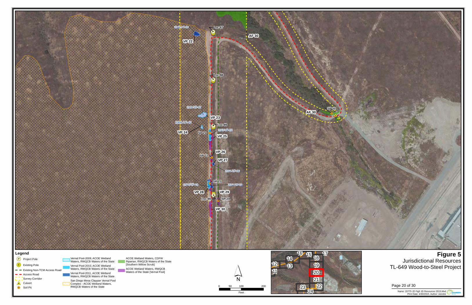
!(E
!(E
!(E
!(E
!(E
!(P
!(P
!(P
!(P
#0#0
!.
!.
!.
!.
!.
2009-VP-41
2011-VP-01
2011-VP-05
2011-VP-06
2010-VP-01
2010-VP-19
2009-VP-40
Loc 88
Loc 89
Loc 90
Loc 87
VP 25
VP 26
VP 28 VP 29
VP 30
VP 24
VP 23
VP 22
VP 27
AF 30
AF 30
SP 21
SP 22
SP 23
SP 24
SP 20
Figure 5Jurisdictional Resources
TL-649 Wood-to-Steel Project
0 100 20050Feet Name: 20775 JD Fig5 JD Resources 2015.Mxd
Print Date: 4/30/2015, Author: stondre
´Legend!(P Project Pole
!(E Existing PoleExisting Non-TCM Access RoadAccess RoadSurvey Corridor
#0 Culvert!. Soil Pit
Vernal Pool-2009, ACOE WetlandWaters, RWQCB Waters of the StateVernal Pool-2010, ACOE WetlandWaters, RWQCB Waters of the StateVernal Pool-2011, ACOE WetlandWaters, RWQCB Waters of the StateSan Diego Mesa Claypan Vernal PoolComplex - ACOE Wetland Waters,RWQCB Waters of the State
ACOE Wetland Waters, CDFWRiparian, RWQCB Waters of the State[Southern Willow Scrub]ACOE Wetland Waters, RWQCBWaters of the State [Vernal Pool] 11
12 1314 1516 1718
192021
2223 24Page 20 of 30
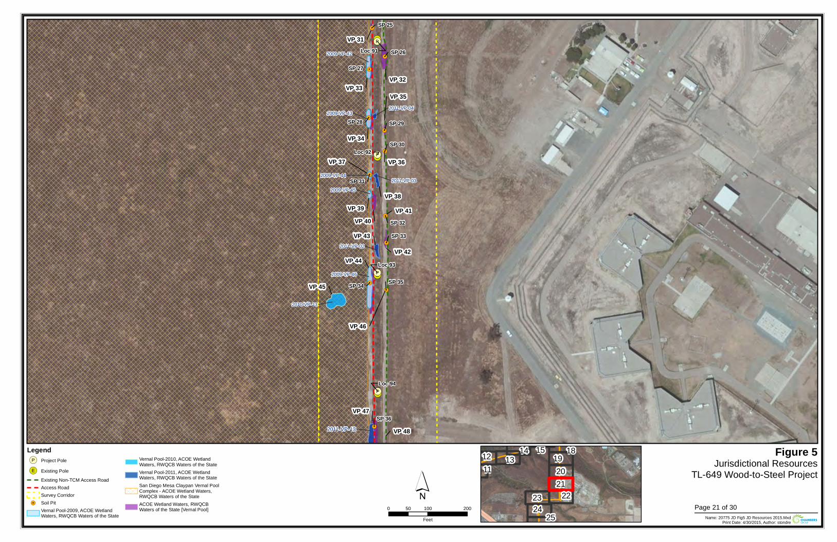
!(E
!(E
!(E
!(E
!(P
!(P
!(P
!(P
!.
!.
!.
!.
!.
!.
!.
!.
!.
!.
!.
!.2011-VP-13
2011-VP-02
2011-VP-03
2011-VP-04
2010-VP-13
2009-VP-42
2009-VP-43
2009-VP-44
2009-VP-45
2009-VP-46
Loc 91
Loc 94
Loc 92
Loc 93
VP 31
VP 32VP 33
VP 34
VP 35
VP 36
VP 41
VP 42VP 44
VP 46
VP 47
VP 48
VP 40
VP 37
VP 39
VP 45
VP 43
VP 38
SP 25
SP 26
SP 27
SP 28 SP 29
SP 30
SP 31
SP 34 SP 35
SP 33
SP 32
SP 36
Figure 5Jurisdictional Resources
TL-649 Wood-to-Steel Project
0 100 20050Feet Name: 20775 JD Fig5 JD Resources 2015.Mxd
Print Date: 4/30/2015, Author: stondre
´Legend!(P Project Pole
!(E Existing PoleExisting Non-TCM Access RoadAccess RoadSurvey Corridor
!. Soil PitVernal Pool-2009, ACOE WetlandWaters, RWQCB Waters of the State
Vernal Pool-2010, ACOE WetlandWaters, RWQCB Waters of the StateVernal Pool-2011, ACOE WetlandWaters, RWQCB Waters of the StateSan Diego Mesa Claypan Vernal PoolComplex - ACOE Wetland Waters,RWQCB Waters of the StateACOE Wetland Waters, RWQCBWaters of the State [Vernal Pool]
1112 13
14 15 18192021
222324
25Page 21 of 30
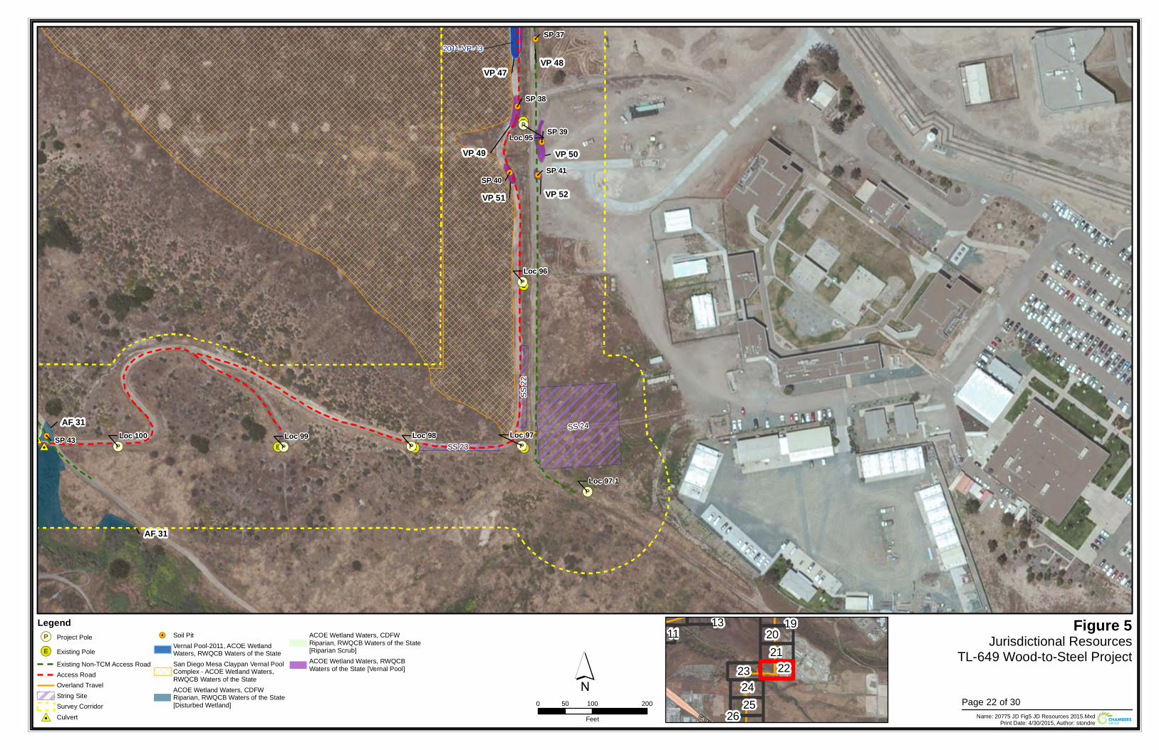
!(E!(E
!(E
!(E
!(E!(P!(P
!(P
!(P
!(P
!(P
!(P
#0#0
!.
!.
!.
!. !.
!. !.
2011-VP-13
Loc 99Loc 100
Loc 97.1
Loc 98
Loc 95
Loc 97
Loc 96
SS 24
SS 22
SS 23
AF 31
AF 31
VP 47VP 48
VP 49 VP 50
VP 51 VP 52
SP 37
SP 38
SP 39
SP 40SP 41
SP 43
Figure 5Jurisdictional Resources
TL-649 Wood-to-Steel Project
0 100 20050Feet Name: 20775 JD Fig5 JD Resources 2015.Mxd
Print Date: 4/30/2015, Author: stondre
´Legend!(P Project Pole
!(E Existing PoleExisting Non-TCM Access RoadAccess RoadOverland TravelString SiteSurvey Corridor
#0 Culvert
!. Soil PitVernal Pool-2011, ACOE WetlandWaters, RWQCB Waters of the StateSan Diego Mesa Claypan Vernal PoolComplex - ACOE Wetland Waters,RWQCB Waters of the StateACOE Wetland Waters, CDFWRiparian, RWQCB Waters of the State[Disturbed Wetland]
ACOE Wetland Waters, CDFWRiparian, RWQCB Waters of the State[Riparian Scrub]ACOE Wetland Waters, RWQCBWaters of the State [Vernal Pool]
1113 1920
212223
2425
26Page 22 of 30
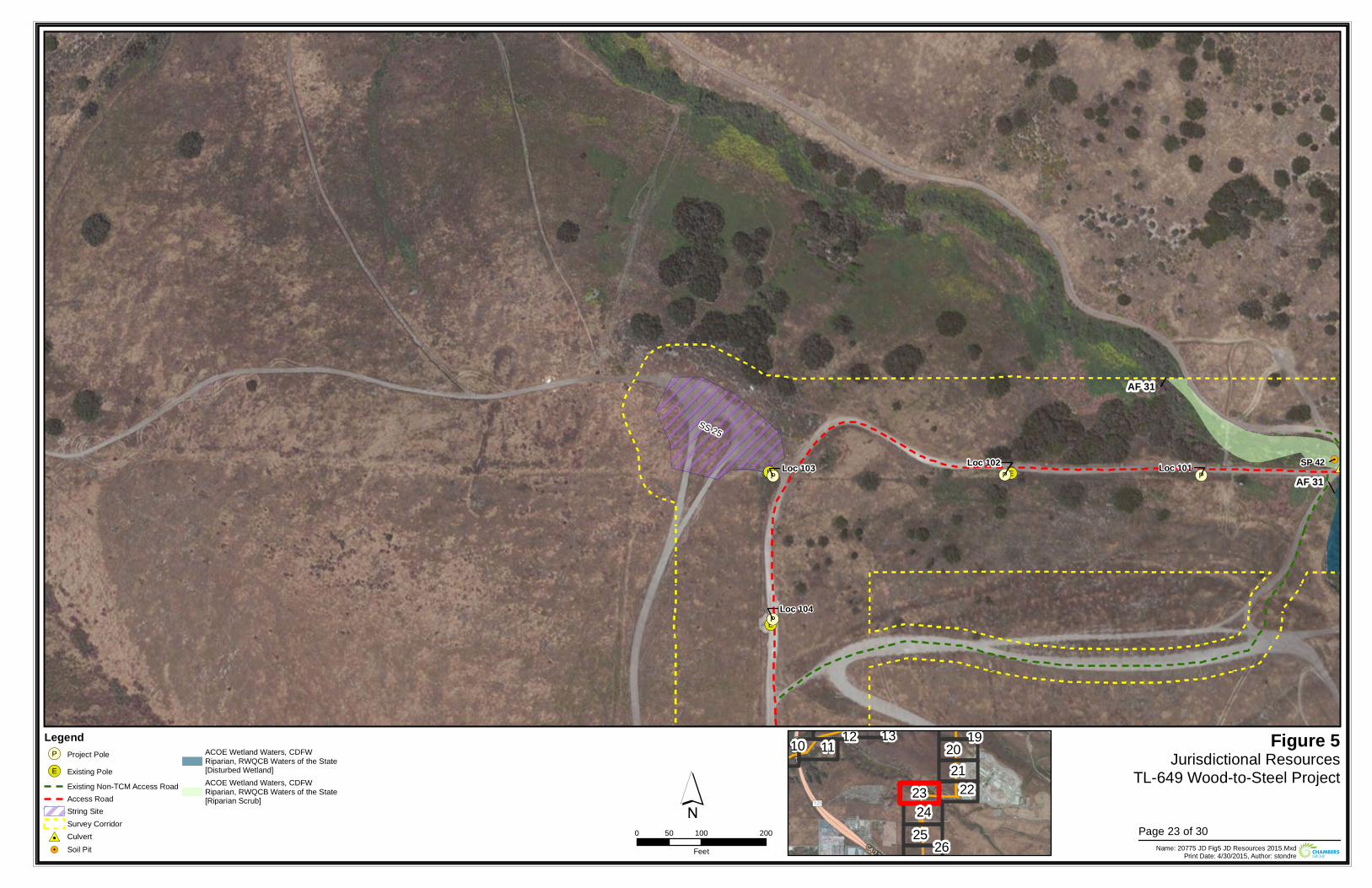
!(E!(E
!(E
!(P !(P
!(P
!(P#0#0
!. !.Loc 102 Loc 101
Loc 104
Loc 103
SS 25
AF 31
AF 31
SP 42
Figure 5Jurisdictional Resources
TL-649 Wood-to-Steel Project
0 100 20050Feet Name: 20775 JD Fig5 JD Resources 2015.Mxd
Print Date: 4/30/2015, Author: stondre
´Legend!(P Project Pole
!(E Existing PoleExisting Non-TCM Access RoadAccess RoadString SiteSurvey Corridor
#0 Culvert!. Soil Pit
ACOE Wetland Waters, CDFWRiparian, RWQCB Waters of the State[Disturbed Wetland]ACOE Wetland Waters, CDFWRiparian, RWQCB Waters of the State[Riparian Scrub]
10 11 12 13 192021
222324
25 26Page 23 of 30
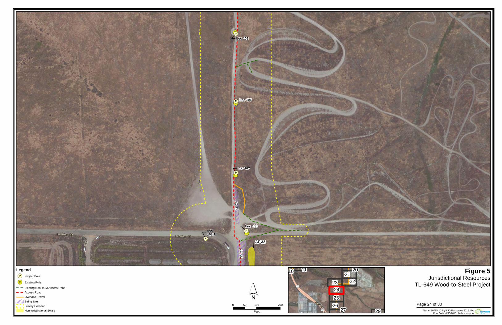
!(E
!(E
!(E
!(E
!(P
!(P
!(P
!(P
!(P
Loc 105
Loc 108
Loc 106
Loc 107
Loc108.1
SS 26
SS 27
AF 32
Figure 5Jurisdictional Resources
TL-649 Wood-to-Steel Project
0 100 20050Feet Name: 20775 JD Fig5 JD Resources 2015.Mxd
Print Date: 4/30/2015, Author: stondre
´Legend!(P Project Pole
!(E Existing PoleExisting Non-TCM Access RoadAccess RoadOverland TravelString SiteSurvey CorridorNon-jurisdictional Swale
10 11 20212223
242526 27 29
Page 24 of 30

!(E
!(E
!(E
!(E!(P
!(P
!(P
!(P
Loc 109
Loc 112
Loc 110
Loc 111
SS 27
AF 32
Figure 5Jurisdictional Resources
TL-649 Wood-to-Steel Project
0 100 20050Feet Name: 20775 JD Fig5 JD Resources 2015.Mxd
Print Date: 4/30/2015, Author: stondre
´Legend!(P Project Pole
!(E Existing PoleExisting Non-TCM Access RoadAccess RoadString SiteSurvey CorridorNon-jurisdictional Swale
212223
242526
27 28 2930
Page 25 of 30
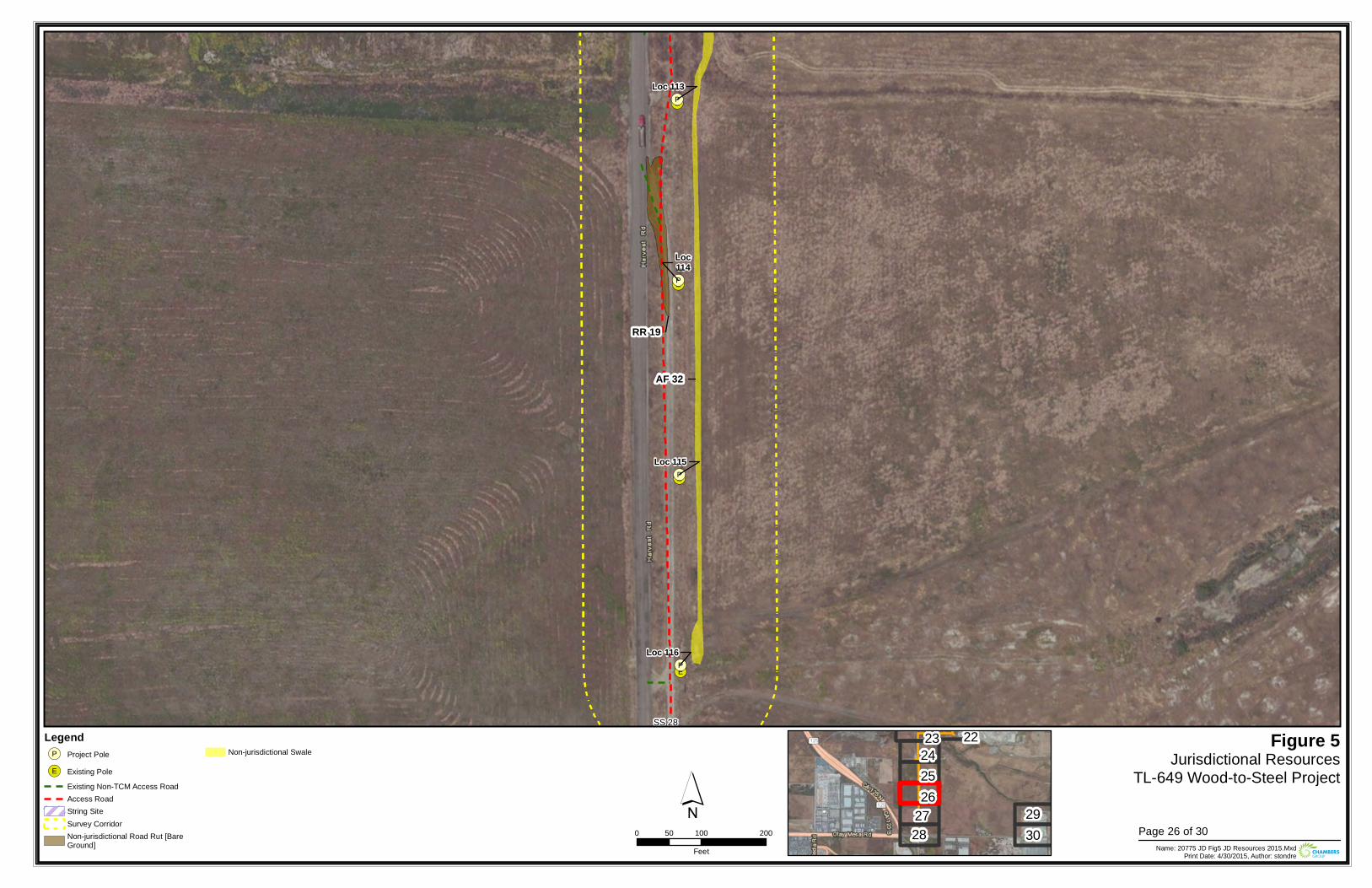
!(E
!(E
!(E
!(E!(P
!(P
!(P
!(P
Loc 115
Loc 116
Loc 113
Loc114
SS 28
AF 32
RR 19
Figure 5Jurisdictional Resources
TL-649 Wood-to-Steel Project
0 100 20050Feet Name: 20775 JD Fig5 JD Resources 2015.Mxd
Print Date: 4/30/2015, Author: stondre
´Legend!(P Project Pole
!(E Existing PoleExisting Non-TCM Access RoadAccess RoadString SiteSurvey CorridorNon-jurisdictional Road Rut [BareGround]
Non-jurisdictional Swale2223
242526
2728
2930 Page 26 of 30
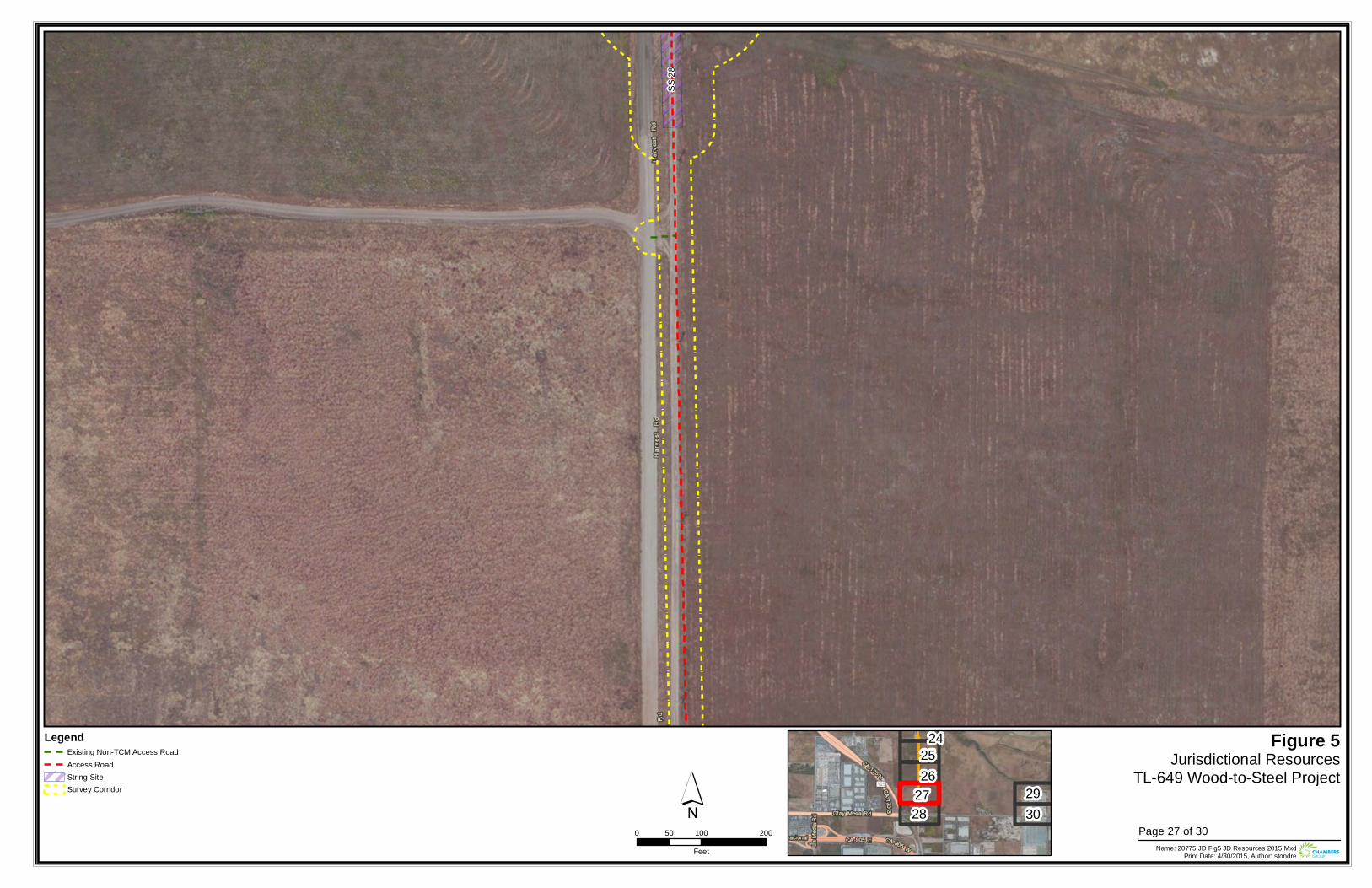
SS 28
Figure 5Jurisdictional Resources
TL-649 Wood-to-Steel Project
0 100 20050Feet Name: 20775 JD Fig5 JD Resources 2015.Mxd
Print Date: 4/30/2015, Author: stondre
´Legend
Existing Non-TCM Access RoadAccess RoadString SiteSurvey Corridor
242526
2728
2930
Page 27 of 30
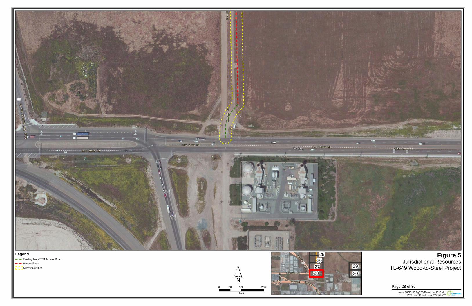
Figure 5Jurisdictional Resources
TL-649 Wood-to-Steel Project
0 100 20050Feet Name: 20775 JD Fig5 JD Resources 2015.Mxd
Print Date: 4/30/2015, Author: stondre
´Legend
Existing Non-TCM Access RoadAccess RoadSurvey Corridor
2526
2728
2930
Page 28 of 30
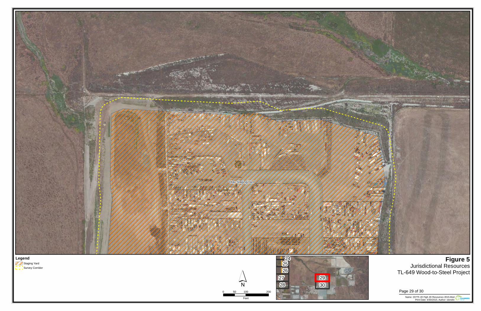
Otay Staging Yard
Figure 5Jurisdictional Resources
TL-649 Wood-to-Steel Project
0 100 20050Feet Name: 20775 JD Fig5 JD Resources 2015.Mxd
Print Date: 4/30/2015, Author: stondre
´Legend
Staging YardSurvey Corridor
242526
2728
2930
Page 29 of 30
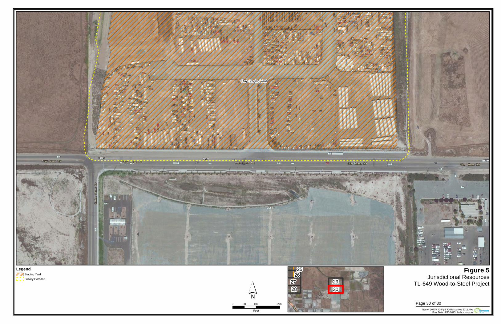
Otay Staging Yard
Figure 5Jurisdictional Resources
TL-649 Wood-to-Steel Project
0 100 20050Feet Name: 20775 JD Fig5 JD Resources 2015.Mxd
Print Date: 4/30/2015, Author: stondre
´Legend
Staging YardSurvey Corridor
2526
2728
2930
Page 30 of 30

ATT
AC
HM
ENT
5:
FIEL
D D
ATA
FO
RM
S

This page is intentionally blank.
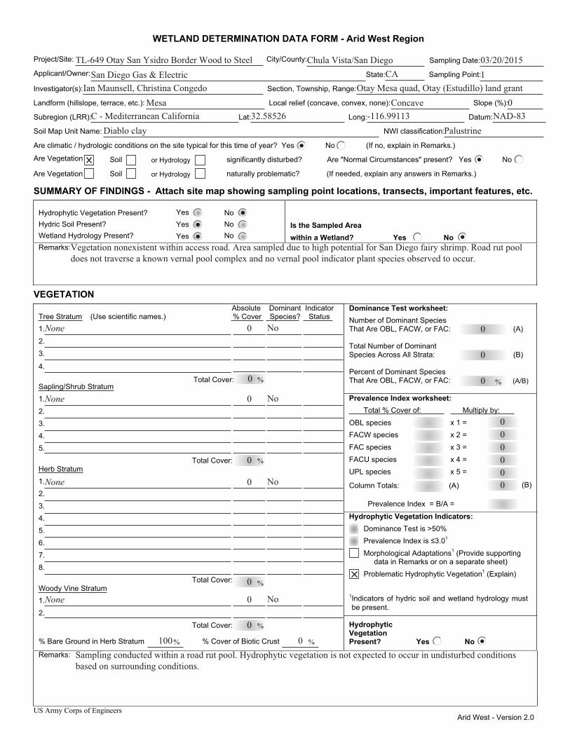
US Army Corps of Engineers Arid West - Version 2.0
WETLAND DETERMINATION DATA FORM - Arid West Region
Project/Site: City/County: Sampling Date:
Applicant/Owner: State: Sampling Point:
Investigator(s): Section, Township, Range:
Landform (hillslope, terrace, etc.): Local relief (concave, convex, none): Slope (%):
Subregion (LRR): Lat: Long: Datum:
Soil Map Unit Name: NWI classification:
Are climatic / hydrologic conditions on the site typical for this time of year? Yes No (If no, explain in Remarks.)
Are Vegetation Soil or Hydrology significantly disturbed? Are "Normal Circumstances" present? Yes No
Are Vegetation Soil or Hydrology naturally problematic? (If needed, explain any answers in Remarks.)
SUMMARY OF FINDINGS - Attach site map showing sampling point locations, transects, important features, etc.
Hydrophytic Vegetation Present? Yes No Hydric Soil Present? Yes No Wetland Hydrology Present? Yes No
Is the Sampled Area within a Wetland? Yes No
Remarks:
VEGETATION Dominance Test worksheet: Number of Dominant Species That Are OBL, FACW, or FAC: (A)
Total Number of Dominant Species Across All Strata: (B)
Percent of Dominant Species That Are OBL, FACW, or FAC: (A/B)
Prevalence Index worksheet: Total % Cover of: Multiply by:
OBL species x 1 = FACW species x 2 = FAC species x 3 = FACU species x 4 = UPL species x 5 =
Column Totals: (A) (B)
Prevalence Index = B/A =
Hydrophytic Vegetation Indicators:
Prevalence Index is ≤3.0 1
Morphological Adaptations1 (Provide supporting data in Remarks or on a separate sheet)
Problematic Hydrophytic Vegetation1 (Explain)
1Indicators of hydric soil and wetland hydrology must be present.
Absolute Dominant Indicator Tree Stratum (Use scientific names.) % Cover Species? Status 1. 2. 3.
4.
Sapling/Shrub Stratum1. 2. 3. 4. 5. Total Cover: Herb Stratum1. 2. 3. 4. 5. 6. 7. 8.
Total Cover: Woody Vine Stratum1. 2. Total Cover:
% Bare Ground in Herb Stratum % Cover of Biotic Crust
Hydrophytic Vegetation Present? Yes No
Remarks:
Dominance Test is >50%
% % Total Cover:
%
%
%
% %
TL-649 Otay San Ysidro Border Wood to Steel Chula Vista/San Diego 03/20/2015San Diego Gas & Electric 1
Ian Maunsell, Christina Congedo Otay Mesa quad, Otay (Estudillo) land grantMesa Concave 0
CA
C - Mediterranean California 32.58526 -116.99113 NAD-83Diablo clay Palustrine
0
0
0
Vegetation nonexistent within access road. Area sampled due to high potential for San Diego fairy shrimp. Road rut pool does not traverse a known vernal pool complex and no vernal pool indicator plant species observed to occur.
None 0 No
0
None No
0
0
No
0None
0
No0None
0
100 0Sampling conducted within a road rut pool. Hydrophytic vegetation is not expected to occur in undisturbed conditions based on surrounding conditions.
000000
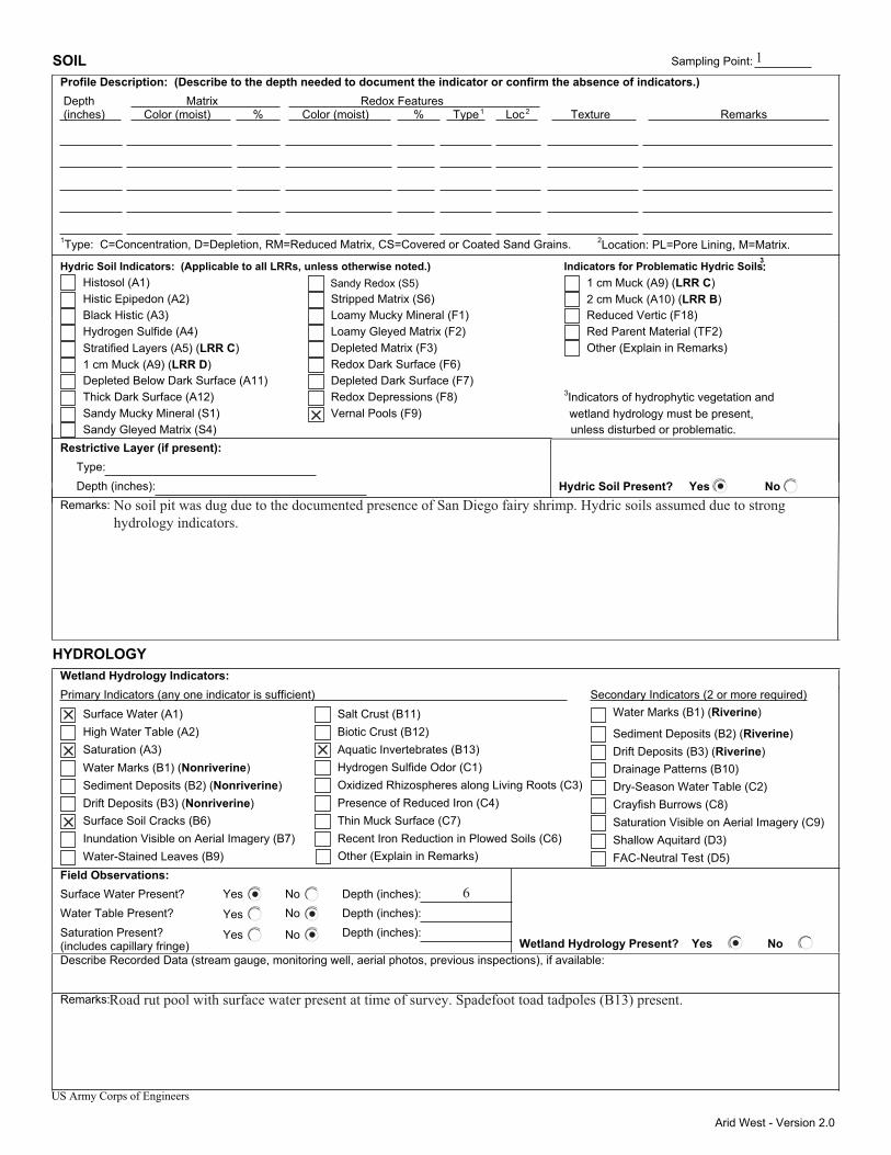
Arid West - Version 2.0
SOIL Sampling Point: Profile Description: (Describe to the depth needed to document the indicator or confirm the absence of indicators.) Depth Matrix Redox Features (inches) Color (moist) % Color (moist) % Type1 Loc2 Texture Remarks
1Type: C=Concentration, D=Depletion, RM=Reduced Matrix, CS=Covered or Coated Sand Grains. 2Location: PL=Pore Lining, M=Matrix.
Hydric Soil Indicators: (Applicable to all LRRs, unless otherwise noted.) Indicators for Problematic Hydric Soils3: Histosol (A1) Sandy Redox (S5) 1 cm Muck (A9) (LRR C) Histic Epipedon (A2) Stripped Matrix (S6) 2 cm Muck (A10) (LRR B) Black Histic (A3) Loamy Mucky Mineral (F1) Reduced Vertic (F18) Hydrogen Sulfide (A4) Loamy Gleyed Matrix (F2) Red Parent Material (TF2) Stratified Layers (A5) (LRR C) Depleted Matrix (F3) Other (Explain in Remarks) 1 cm Muck (A9) (LRR D) Redox Dark Surface (F6) Depleted Below Dark Surface (A11) Depleted Dark Surface (F7) Thick Dark Surface (A12) Redox Depressions (F8) Sandy Mucky Mineral (S1) Vernal Pools (F9)
3Indicators of hydrophytic vegetation and
Sandy Gleyed Matrix (S4) unless disturbed or problematic. Restrictive Layer (if present): Type: Depth (inches): Hydric Soil Present? Yes No Remarks:
HYDROLOGY Wetland Hydrology Indicators:
Secondary Indicators (2 or more required)Primary Indicators (any one indicator is sufficient) Water Marks (B1) (Riverine) Surface Water (A1) Salt Crust (B11)
Sediment Deposits (B2) (Riverine) High Water Table (A2) Biotic Crust (B12)
Drift Deposits (B3) (Riverine) Saturation (A3) Aquatic Invertebrates (B13) Drainage Patterns (B10) Water Marks (B1) (Nonriverine) Hydrogen Sulfide Odor (C1) Dry-Season Water Table (C2) Sediment Deposits (B2) (Nonriverine) Oxidized Rhizospheres along Living Roots (C3) Crayfish Burrows (C8) Drift Deposits (B3) (Nonriverine) Presence of Reduced Iron (C4) Saturation Visible on Aerial Imagery (C9) Surface Soil Cracks (B6) Thin Muck Surface (C7) Shallow Aquitard (D3) Inundation Visible on Aerial Imagery (B7) Recent Iron Reduction in Plowed Soils (C6) FAC-Neutral Test (D5) Water-Stained Leaves (B9)
Field Observations: Surface Water Present? Yes No Depth (inches): Water Table Present? Yes No Depth (inches): Saturation Present? Yes No Depth (inches): (includes capillary fringe) Wetland Hydrology Present? Yes No Describe Recorded Data (stream gauge, monitoring well, aerial photos, previous inspections), if available:
Remarks:
US Army Corps of Engineers
Other (Explain in Remarks)
wetland hydrology must be present,
1
No soil pit was dug due to the documented presence of San Diego fairy shrimp. Hydric soils assumed due to strong hydrology indicators.
6
Road rut pool with surface water present at time of survey. Spadefoot toad tadpoles (B13) present.
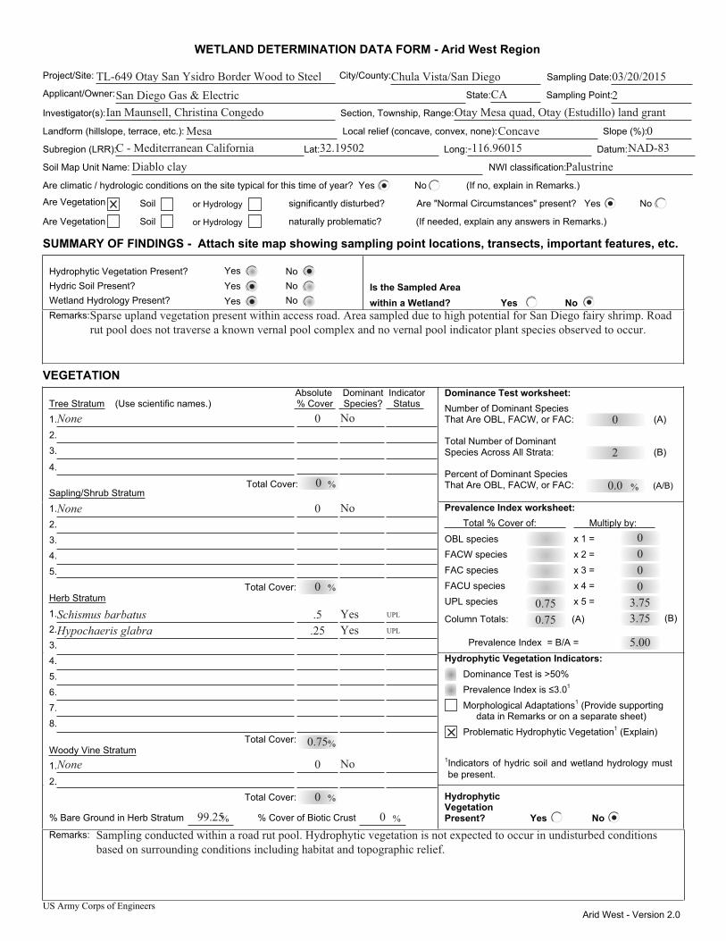
US Army Corps of Engineers Arid West - Version 2.0
WETLAND DETERMINATION DATA FORM - Arid West Region
Project/Site: City/County: Sampling Date:
Applicant/Owner: State: Sampling Point:
Investigator(s): Section, Township, Range:
Landform (hillslope, terrace, etc.): Local relief (concave, convex, none): Slope (%):
Subregion (LRR): Lat: Long: Datum:
Soil Map Unit Name: NWI classification:
Are climatic / hydrologic conditions on the site typical for this time of year? Yes No (If no, explain in Remarks.)
Are Vegetation Soil or Hydrology significantly disturbed? Are "Normal Circumstances" present? Yes No
Are Vegetation Soil or Hydrology naturally problematic? (If needed, explain any answers in Remarks.)
SUMMARY OF FINDINGS - Attach site map showing sampling point locations, transects, important features, etc.
Hydrophytic Vegetation Present? Yes No Hydric Soil Present? Yes No Wetland Hydrology Present? Yes No
Is the Sampled Area within a Wetland? Yes No
Remarks:
VEGETATION Dominance Test worksheet: Number of Dominant Species That Are OBL, FACW, or FAC: (A)
Total Number of Dominant Species Across All Strata: (B)
Percent of Dominant Species That Are OBL, FACW, or FAC: (A/B)
Prevalence Index worksheet: Total % Cover of: Multiply by:
OBL species x 1 = FACW species x 2 = FAC species x 3 = FACU species x 4 = UPL species x 5 =
Column Totals: (A) (B)
Prevalence Index = B/A =
Hydrophytic Vegetation Indicators:
Prevalence Index is ≤3.0 1
Morphological Adaptations1 (Provide supporting data in Remarks or on a separate sheet)
Problematic Hydrophytic Vegetation1 (Explain)
1Indicators of hydric soil and wetland hydrology must be present.
Absolute Dominant Indicator Tree Stratum (Use scientific names.) % Cover Species? Status 1. 2. 3.
4.
Sapling/Shrub Stratum1. 2. 3. 4. 5. Total Cover: Herb Stratum1. 2. 3. 4. 5. 6. 7. 8.
Total Cover: Woody Vine Stratum1. 2. Total Cover:
% Bare Ground in Herb Stratum % Cover of Biotic Crust
Hydrophytic Vegetation Present? Yes No
Remarks:
Dominance Test is >50%
% % Total Cover:
%
%
%
% %
TL-649 Otay San Ysidro Border Wood to Steel Chula Vista/San Diego 03/20/2015San Diego Gas & Electric 2
Ian Maunsell, Christina Congedo Otay Mesa quad, Otay (Estudillo) land grantMesa Concave 0
CA
C - Mediterranean California 32.19502 -116.96015 NAD-83Diablo clay Palustrine
0
2
0.0
0.75
Sparse upland vegetation present within access road. Area sampled due to high potential for San Diego fairy shrimp. Road rut pool does not traverse a known vernal pool complex and no vernal pool indicator plant species observed to occur.
None 0 No
0
None No
0
0
YesYes
.25.5
Hypochaeris glabraSchismus barbatus
0.75
UPL
UPL
No0None
0
99.25 0Sampling conducted within a road rut pool. Hydrophytic vegetation is not expected to occur in undisturbed conditions based on surrounding conditions including habitat and topographic relief.
0.75 3.753.75
0000
5.00

Arid West - Version 2.0
SOIL Sampling Point: Profile Description: (Describe to the depth needed to document the indicator or confirm the absence of indicators.) Depth Matrix Redox Features (inches) Color (moist) % Color (moist) % Type1 Loc2 Texture Remarks
1Type: C=Concentration, D=Depletion, RM=Reduced Matrix, CS=Covered or Coated Sand Grains. 2Location: PL=Pore Lining, M=Matrix.
Hydric Soil Indicators: (Applicable to all LRRs, unless otherwise noted.) Indicators for Problematic Hydric Soils3: Histosol (A1) Sandy Redox (S5) 1 cm Muck (A9) (LRR C) Histic Epipedon (A2) Stripped Matrix (S6) 2 cm Muck (A10) (LRR B) Black Histic (A3) Loamy Mucky Mineral (F1) Reduced Vertic (F18) Hydrogen Sulfide (A4) Loamy Gleyed Matrix (F2) Red Parent Material (TF2) Stratified Layers (A5) (LRR C) Depleted Matrix (F3) Other (Explain in Remarks) 1 cm Muck (A9) (LRR D) Redox Dark Surface (F6) Depleted Below Dark Surface (A11) Depleted Dark Surface (F7) Thick Dark Surface (A12) Redox Depressions (F8) Sandy Mucky Mineral (S1) Vernal Pools (F9)
3Indicators of hydrophytic vegetation and
Sandy Gleyed Matrix (S4) unless disturbed or problematic. Restrictive Layer (if present): Type: Depth (inches): Hydric Soil Present? Yes No Remarks:
HYDROLOGY Wetland Hydrology Indicators:
Secondary Indicators (2 or more required)Primary Indicators (any one indicator is sufficient) Water Marks (B1) (Riverine) Surface Water (A1) Salt Crust (B11)
Sediment Deposits (B2) (Riverine) High Water Table (A2) Biotic Crust (B12)
Drift Deposits (B3) (Riverine) Saturation (A3) Aquatic Invertebrates (B13) Drainage Patterns (B10) Water Marks (B1) (Nonriverine) Hydrogen Sulfide Odor (C1) Dry-Season Water Table (C2) Sediment Deposits (B2) (Nonriverine) Oxidized Rhizospheres along Living Roots (C3) Crayfish Burrows (C8) Drift Deposits (B3) (Nonriverine) Presence of Reduced Iron (C4) Saturation Visible on Aerial Imagery (C9) Surface Soil Cracks (B6) Thin Muck Surface (C7) Shallow Aquitard (D3) Inundation Visible on Aerial Imagery (B7) Recent Iron Reduction in Plowed Soils (C6) FAC-Neutral Test (D5) Water-Stained Leaves (B9)
Field Observations: Surface Water Present? Yes No Depth (inches): Water Table Present? Yes No Depth (inches): Saturation Present? Yes No Depth (inches): (includes capillary fringe) Wetland Hydrology Present? Yes No Describe Recorded Data (stream gauge, monitoring well, aerial photos, previous inspections), if available:
Remarks:
US Army Corps of Engineers
Other (Explain in Remarks)
wetland hydrology must be present,
2
No soil pit was dug due to the documented presence of San Diego fairy shrimp. Hydric soils assumed due to strong hydrology indicators.
7
Road rut pool with surface water present at time of survey. Spadefoot toad tadpoles (B13) present.
WETLAND DETERMINATION DATA FORM – Arid West Region Project/Site: TL-649 Otay-San Ysidro Border Wood to Steel City/County: Chula Vista/San Diego Sampling Date: 05/22/2014
Applicant/Owner: San Diego Gas & Electric State: CA Sampling Point: 3
Investigator(s): Michael Nieto, Cailin O'Meara Section, Township, Range: Otay Mesa quad, Otay (Estudillo) land grant
Landform (hillslope, terrace, etc.): Outer floodlplain terrace Local relief (concave, convex, none): Convex Slope (%): 0%
Subregion (LRR): LRR-C Lat: 32°35'31.14"N Long: 116°57'24.88"W Datum: NAD-83
Soil Map Unit Name: Diablo clay NWI classification: Palustrine
Are climatic / hydrologic conditions on the site typical for this time of year? Yes x No (If no, explain in Remarks.)
Are Vegetation , Soil , or Hydrology significantly disturbed? No Are "Normal Circumstances" present? Yes x No
Are Vegetation , Soil , or Hydrology naturally problematic? No (If needed, explain any answers in Remarks.)
SUMMARY OF FINDINGS – Attach site map showing sampling point locations, transects, important features, etc.
Hydrophytic Vegetation Present? Yes x No Is the Sampled Area within a Wetland?
Hydric Soil Present? Yes x No Yes x No Wetland Hydrology Present? Yes x No
Remarks: Sampling point located within emergent marsh.
VEGETATION – Use scientific names of plants. Absolute Dominant Indicator Dominance Test worksheet:
Number of Dominant Species That Are OBL, FACW, or FAC: Total Number of Dominant Species Across All Strata: Percent of Dominant Species That Are OBL, FACW, or FAC:
1
(A)
1
(B)
100% (A/B)
Tree Stratum (Plot size: ) % Cover Species? Status 1. 2. 3. 4. = Total Cover Sapling/Shrub Stratum (Plot size: ) 1. Prevalence Index worksheet:
Total % Cover of: Multiply by:
OBL species x 1 =
FACW species x 2 =
FAC species x 3 =
FACU species x 4 =
UPL species x 5 =
Column Totals: (A) (B)
Prevalence Index = B/A =
2. 3. 4. 5. = Total Cover Herb Stratum (Plot size: ) 1. Elymus triticoides 90 Yes FAC 2. Rumex crispus 2 No FAC 3. Bromus diandrus 1 N0 UPL 4. Bromus hordaceous 1 No FACU Hydrophytic Vegetation Indicators: 5. x Dominance Test is >50% 6. Prevalence Index is ≤3.01 7. Morphological Adaptations1 (Provide supporting 8. data in Remarks or on a separate sheet)
94% = Total Cover Problematic Hydrophytic Vegetation1 (Explain) Woody Vine Stratum (Plot size: ) 1. 1Indicators of hydric soil and wetland hydrology must
be present, unless disturbed or problematic. 2.
= Total Cover Hydrophytic Vegetation Present?
% Bare Ground in Herb Stratum 6% % Cover of Biotic Crust Yes x No
Remarks:
US Army Corps of Engineers Arid West – Version 2.0

SOIL Sampling Point: 3 _____________ Profile Description: (Describe to the depth needed to document the indicator or confirm the absence of indicators.) Depth Matrix Redox Features (inches) Color (moist) % Color (moist) % Type1 Loc2 Texture Remarks
0-7 5 YR 3/2 90 2.5 YR 4/6 10 C PL Silty clay loam
7-18 5 YR 2.5/1 100 - - - - Clay loam
1Type: C=Concentration, D=Depletion, RM=Reduced Matrix, CS=Covered or Coated Sand Grains. 2Location: PL=Pore Lining, RC=Root Channel, M=Matrix. Hydric Soil Indicators: (Applicable to all LRRs, unless otherwise noted.) Indicators for Problematic Hydric Soils3: Histosol (A1) Sandy Redox (S5) 1 cm Muck (A9) (LRR C) Histic Epipedon (A2) Stripped Matrix (S6) 2 cm Muck (A10) (LRR B) Black Histic (A3) Loamy Mucky Mineral (F1) Reduced Vertic (F18) Hydrogen Sulfide (A4) Loamy Gleyed Matrix (F2) Red Parent Material (TF2) Stratified Layers (A5) (LRR C) x Depleted Matrix (F3) Other (Explain in Remarks) 1 cm Muck (A9) (LRR D) Redox Dark Surface (F6) Depleted Below Dark Surface (A11) Depleted Dark Surface (F7) Thick Dark Surface (A12) Redox Depressions (F8) 3Indicators of hydrophytic vegetation and Sandy Mucky Mineral (S1) Vernal Pools (F9) wetland hydrology must be present, Sandy Gleyed Matrix (S4) unless disturbed or problematic.
Restrictive Layer (if present): Type: Depth (inches): Hydric Soil Present? Yes x No
Remarks:
HYDROLOGY Wetland Hydrology Indicators: Secondary Indicators (2 or more required) Primary Indicators (minimum of one required; check all that apply) Water Marks (B1) (Riverine) Surface Water (A1) Salt Crust (B11) Sediment Deposits (B2) (Riverine) High Water Table (A2) Biotic Crust (B12) Drift Deposits (B3) (Riverine) Saturation (A3) Aquatic Invertebrates (B13) Drainage Patterns (B10) Water Marks (B1) (Nonriverine) Hydrogen Sulfide Odor (C1) Dry-Season Water Table (C2) Sediment Deposits (B2) (Nonriverine) Oxidized Rhizospheres along Living Roots (C3) Thin Muck Surface (C7) Drift Deposits (B3) (Nonriverine) x Presence of Reduced Iron (C4) Crayfish Burrows (C8) Surface Soil Cracks (B6) Recent Iron Reduction in Tilled Soils (C6) Saturation Visible on Aerial Imagery (C9) Inundation Visible on Aerial Imagery (B7) Thin Muck Surface (C7) Shallow Aquitard (D3) Water-Stained Leaves (B9) Other (Explain in Remarks) FAC-Neutral Test (D5)
Field Observations: Surface Water Present? Yes No x Depth (inches): Water Table Present? Yes No x Depth (inches): Saturation Present? Yes No x Depth (inches): Wetland Hydrology Present? Yes x No (includes capillary fringe)
Describe Recorded Data (stream gauge, monitoring well, aerial photos, previous inspections), if available:
Remarks:
US Army Corps of Engineers Arid West – Version 2.0
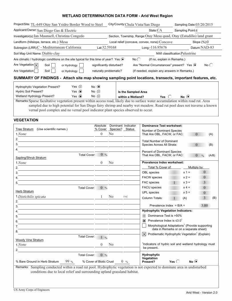
US Army Corps of Engineers Arid West - Version 2.0
WETLAND DETERMINATION DATA FORM - Arid West Region
Project/Site: City/County: Sampling Date:
Applicant/Owner: State: Sampling Point:
Investigator(s): Section, Township, Range:
Landform (hillslope, terrace, etc.): Local relief (concave, convex, none): Slope (%):
Subregion (LRR): Lat: Long: Datum:
Soil Map Unit Name: NWI classification:
Are climatic / hydrologic conditions on the site typical for this time of year? Yes No (If no, explain in Remarks.)
Are Vegetation Soil or Hydrology significantly disturbed? Are "Normal Circumstances" present? Yes No
Are Vegetation Soil or Hydrology naturally problematic? (If needed, explain any answers in Remarks.)
SUMMARY OF FINDINGS - Attach site map showing sampling point locations, transects, important features, etc.
Hydrophytic Vegetation Present? Yes No Hydric Soil Present? Yes No Wetland Hydrology Present? Yes No
Is the Sampled Area within a Wetland? Yes No
Remarks:
VEGETATION Dominance Test worksheet: Number of Dominant Species That Are OBL, FACW, or FAC: (A)
Total Number of Dominant Species Across All Strata: (B)
Percent of Dominant Species That Are OBL, FACW, or FAC: (A/B)
Prevalence Index worksheet: Total % Cover of: Multiply by:
OBL species x 1 = FACW species x 2 = FAC species x 3 = FACU species x 4 = UPL species x 5 =
Column Totals: (A) (B)
Prevalence Index = B/A =
Hydrophytic Vegetation Indicators:
Prevalence Index is ≤3.0 1
Morphological Adaptations1 (Provide supporting data in Remarks or on a separate sheet)
Problematic Hydrophytic Vegetation1 (Explain)
1Indicators of hydric soil and wetland hydrology must be present.
Absolute Dominant Indicator Tree Stratum (Use scientific names.) % Cover Species? Status 1. 2. 3.
4.
Sapling/Shrub Stratum1. 2. 3. 4. 5. Total Cover: Herb Stratum1. 2. 3. 4. 5. 6. 7. 8.
Total Cover: Woody Vine Stratum1. 2. Total Cover:
% Bare Ground in Herb Stratum % Cover of Biotic Crust
Hydrophytic Vegetation Present? Yes No
Remarks:
Dominance Test is >50%
% % Total Cover:
%
%
%
% %
TL-649 Otay San Ysidro Border Wood to Steel Chula Vista/San Diego 03/20/2015San Diego Gas & Electric 4
Ian Maunsell, Christina Congedo Otay Mesa quad, Otay (Estudillo) land grantMesa Concave 0
CA
C - Mediterranean California 32.59168 -116.95676 NAD-83Diablo clay Palustrine
0
0
0
1
Sparse facultative vegetation present within access road, likely due to surface water accumulation within road rut. Area sampled due to high potential for San Diego fairy shrimp and nearby wet meadow. Road rut pool does not traverse a known vernal pool complex and no vernal pool indicator plant species observed to occur.
None 0 No
0
None No
0
0
No
1Distichilis spicata
1
FAC
No0None
0
99 0Sampling conducted within a road rut pool. Hydrophytic vegetation is not expected to dominate area in undisturbed conditions due to local relief and surrounding upland grassland habitat.
1 300300
3.00
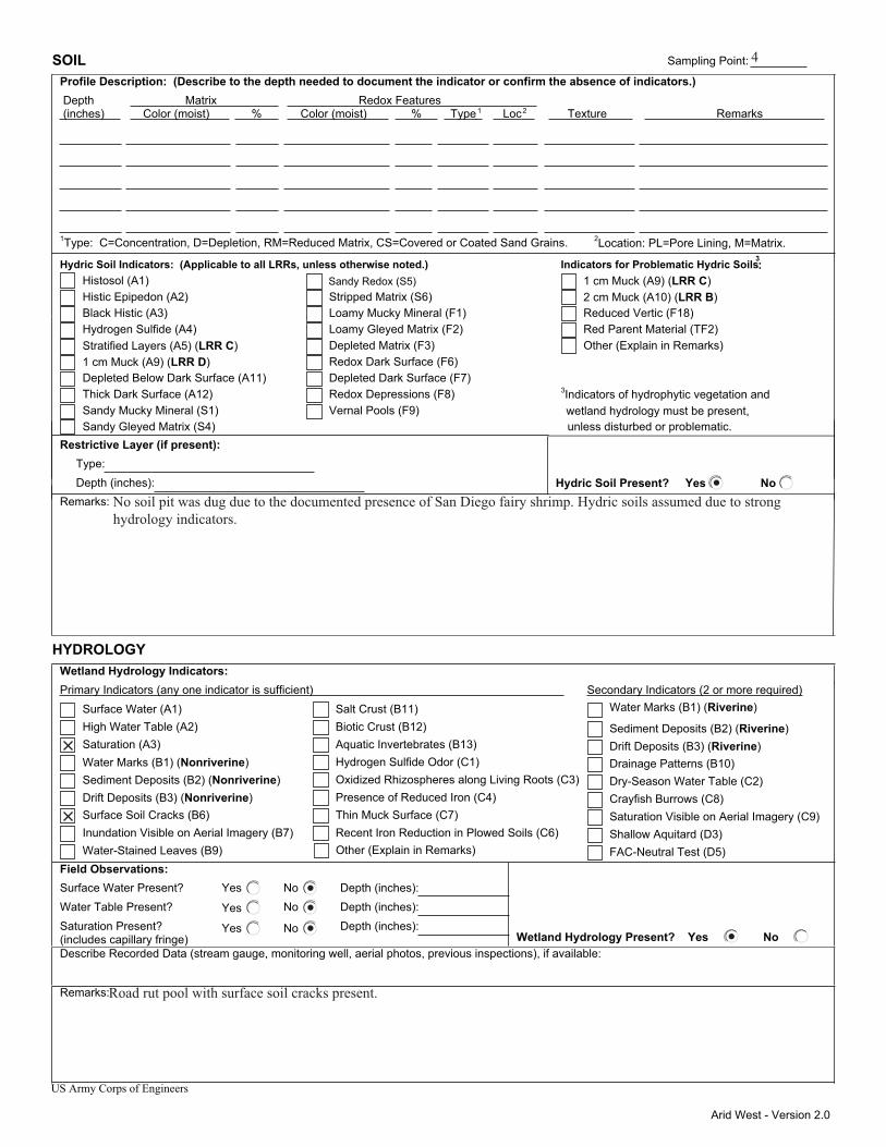
Arid West - Version 2.0
SOIL Sampling Point: Profile Description: (Describe to the depth needed to document the indicator or confirm the absence of indicators.) Depth Matrix Redox Features (inches) Color (moist) % Color (moist) % Type1 Loc2 Texture Remarks
1Type: C=Concentration, D=Depletion, RM=Reduced Matrix, CS=Covered or Coated Sand Grains. 2Location: PL=Pore Lining, M=Matrix.
Hydric Soil Indicators: (Applicable to all LRRs, unless otherwise noted.) Indicators for Problematic Hydric Soils3: Histosol (A1) Sandy Redox (S5) 1 cm Muck (A9) (LRR C) Histic Epipedon (A2) Stripped Matrix (S6) 2 cm Muck (A10) (LRR B) Black Histic (A3) Loamy Mucky Mineral (F1) Reduced Vertic (F18) Hydrogen Sulfide (A4) Loamy Gleyed Matrix (F2) Red Parent Material (TF2) Stratified Layers (A5) (LRR C) Depleted Matrix (F3) Other (Explain in Remarks) 1 cm Muck (A9) (LRR D) Redox Dark Surface (F6) Depleted Below Dark Surface (A11) Depleted Dark Surface (F7) Thick Dark Surface (A12) Redox Depressions (F8) Sandy Mucky Mineral (S1) Vernal Pools (F9)
3Indicators of hydrophytic vegetation and
Sandy Gleyed Matrix (S4) unless disturbed or problematic. Restrictive Layer (if present): Type: Depth (inches): Hydric Soil Present? Yes No Remarks:
HYDROLOGY Wetland Hydrology Indicators:
Secondary Indicators (2 or more required)Primary Indicators (any one indicator is sufficient) Water Marks (B1) (Riverine) Surface Water (A1) Salt Crust (B11)
Sediment Deposits (B2) (Riverine) High Water Table (A2) Biotic Crust (B12)
Drift Deposits (B3) (Riverine) Saturation (A3) Aquatic Invertebrates (B13) Drainage Patterns (B10) Water Marks (B1) (Nonriverine) Hydrogen Sulfide Odor (C1) Dry-Season Water Table (C2) Sediment Deposits (B2) (Nonriverine) Oxidized Rhizospheres along Living Roots (C3) Crayfish Burrows (C8) Drift Deposits (B3) (Nonriverine) Presence of Reduced Iron (C4) Saturation Visible on Aerial Imagery (C9) Surface Soil Cracks (B6) Thin Muck Surface (C7) Shallow Aquitard (D3) Inundation Visible on Aerial Imagery (B7) Recent Iron Reduction in Plowed Soils (C6) FAC-Neutral Test (D5) Water-Stained Leaves (B9)
Field Observations: Surface Water Present? Yes No Depth (inches): Water Table Present? Yes No Depth (inches): Saturation Present? Yes No Depth (inches): (includes capillary fringe) Wetland Hydrology Present? Yes No Describe Recorded Data (stream gauge, monitoring well, aerial photos, previous inspections), if available:
Remarks:
US Army Corps of Engineers
Other (Explain in Remarks)
wetland hydrology must be present,
4
No soil pit was dug due to the documented presence of San Diego fairy shrimp. Hydric soils assumed due to strong hydrology indicators.
Road rut pool with surface soil cracks present.
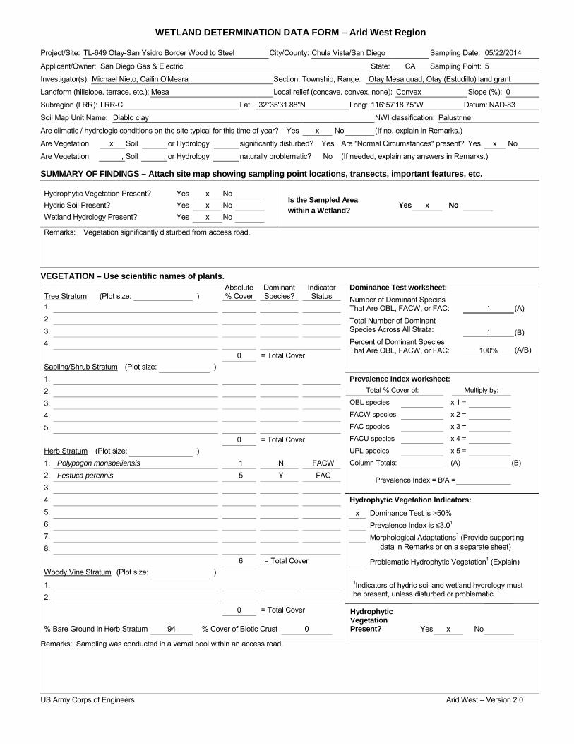
WETLAND DETERMINATION DATA FORM – Arid West Region Project/Site: TL-649 Otay-San Ysidro Border Wood to Steel City/County: Chula Vista/San Diego Sampling Date: 05/22/2014
Applicant/Owner: San Diego Gas & Electric State: CA Sampling Point: 5
Investigator(s): Michael Nieto, Cailin O'Meara Section, Township, Range: Otay Mesa quad, Otay (Estudillo) land grant
Landform (hillslope, terrace, etc.): Mesa Local relief (concave, convex, none): Convex Slope (%): 0
Subregion (LRR): LRR-C Lat: 32°35'31.88"N Long: 116°57'18.75"W Datum: NAD-83
Soil Map Unit Name: Diablo clay NWI classification: Palustrine
Are climatic / hydrologic conditions on the site typical for this time of year? Yes x No (If no, explain in Remarks.)
Are Vegetation x, Soil , or Hydrology significantly disturbed? Yes Are "Normal Circumstances" present? Yes x No
Are Vegetation , Soil , or Hydrology naturally problematic? No (If needed, explain any answers in Remarks.)
SUMMARY OF FINDINGS – Attach site map showing sampling point locations, transects, important features, etc.
Hydrophytic Vegetation Present? Yes x No Is the Sampled Area within a Wetland?
Hydric Soil Present? Yes x No Yes x No Wetland Hydrology Present? Yes x No
Remarks: Vegetation significantly disturbed from access road.
VEGETATION – Use scientific names of plants. Absolute Dominant Indicator Dominance Test worksheet:
Number of Dominant Species That Are OBL, FACW, or FAC: Total Number of Dominant Species Across All Strata: Percent of Dominant Species That Are OBL, FACW, or FAC:
1
(A)
1
(B)
100% (A/B)
Tree Stratum (Plot size: ) % Cover Species? Status 1. 2. 3. 4. 0 = Total Cover Sapling/Shrub Stratum (Plot size: ) 1. Prevalence Index worksheet:
Total % Cover of: Multiply by:
OBL species x 1 =
FACW species x 2 =
FAC species x 3 =
FACU species x 4 =
UPL species x 5 =
Column Totals: (A) (B)
Prevalence Index = B/A =
2. 3. 4. 5. 0 = Total Cover Herb Stratum (Plot size: ) 1. Polypogon monspeliensis 1 N FACW 2. Festuca perennis 5 Y FAC 3. 4. Hydrophytic Vegetation Indicators: 5. x Dominance Test is >50% 6. Prevalence Index is ≤3.01 7. Morphological Adaptations1 (Provide supporting 8. data in Remarks or on a separate sheet)
6 = Total Cover Problematic Hydrophytic Vegetation1 (Explain) Woody Vine Stratum (Plot size: ) 1. 1Indicators of hydric soil and wetland hydrology must
be present, unless disturbed or problematic. 2.
0 = Total Cover Hydrophytic Vegetation Present?
% Bare Ground in Herb Stratum 94 % Cover of Biotic Crust 0 Yes x No
Remarks: Sampling was conducted in a vernal pool within an access road.
US Army Corps of Engineers Arid West – Version 2.0

SOIL Sampling Point: 5 _____________ Profile Description: (Describe to the depth needed to document the indicator or confirm the absence of indicators.) Depth Matrix Redox Features (inches) Color (moist) % Color (moist) % Type1 Loc2 Texture Remarks
1Type: C=Concentration, D=Depletion, RM=Reduced Matrix, CS=Covered or Coated Sand Grains. 2Location: PL=Pore Lining, RC=Root Channel, M=Matrix. Hydric Soil Indicators: (Applicable to all LRRs, unless otherwise noted.) Indicators for Problematic Hydric Soils3: Histosol (A1) Sandy Redox (S5) 1 cm Muck (A9) (LRR C) Histic Epipedon (A2) Stripped Matrix (S6) 2 cm Muck (A10) (LRR B) Black Histic (A3) Loamy Mucky Mineral (F1) Reduced Vertic (F18) Hydrogen Sulfide (A4) Loamy Gleyed Matrix (F2) Red Parent Material (TF2) Stratified Layers (A5) (LRR C) Depleted Matrix (F3) Other (Explain in Remarks) 1 cm Muck (A9) (LRR D) Redox Dark Surface (F6) Depleted Below Dark Surface (A11) Depleted Dark Surface (F7) Thick Dark Surface (A12) Redox Depressions (F8) 3Indicators of hydrophytic vegetation and Sandy Mucky Mineral (S1) x Vernal Pools (F9) wetland hydrology must be present, Sandy Gleyed Matrix (S4) unless disturbed or problematic.
Restrictive Layer (if present): Type: Depth (inches): Hydric Soil Present? Yes x No
Remarks: No soil pit was dug due to the documented presence of San Diego fairy shrimp. Hydric soils were assumed due to strong hydrophytic vegetation and hydrology indicators.
HYDROLOGY Wetland Hydrology Indicators: Secondary Indicators (2 or more required) Primary Indicators (minimum of one required; check all that apply) Water Marks (B1) (Riverine) Surface Water (A1) Salt Crust (B11) Sediment Deposits (B2) (Riverine) High Water Table (A2) Biotic Crust (B12) Drift Deposits (B3) (Riverine) Saturation (A3) Aquatic Invertebrates (B13) Drainage Patterns (B10) Water Marks (B1) (Nonriverine) Hydrogen Sulfide Odor (C1) Dry-Season Water Table (C2) Sediment Deposits (B2) (Nonriverine) Oxidized Rhizospheres along Living Roots (C3) Thin Muck Surface (C7) Drift Deposits (B3) (Nonriverine) Presence of Reduced Iron (C4) Crayfish Burrows (C8) x Surface Soil Cracks (B6) Recent Iron Reduction in Tilled Soils (C6) Saturation Visible on Aerial Imagery (C9) Inundation Visible on Aerial Imagery (B7) Thin Muck Surface (C7) Shallow Aquitard (D3) Water-Stained Leaves (B9) Other (Explain in Remarks) FAC-Neutral Test (D5)
Field Observations: Surface Water Present? Yes No x Depth (inches): Water Table Present? Yes No x Depth (inches): Saturation Present? Yes No x Depth (inches): Wetland Hydrology Present? Yes x No (includes capillary fringe)
Describe Recorded Data (stream gauge, monitoring well, aerial photos, previous inspections), if available:
Remarks:
US Army Corps of Engineers Arid West – Version 2.0

WETLAND DETERMINATION DATA FORM – Arid West Region Project/Site: TL-649 Otay-San Ysidro Border Wood to Steel City/County: Chula Vista/San Diego Sampling Date: 05/22/2014
Applicant/Owner: San Diego Gas & Electric State: CA Sampling Point: 6
Investigator(s): Michael Nieto, Cailin O'Meara Section, Township, Range: Otay Mesa quad, Otay (Estudillo) land grant
Landform (hillslope, terrace, etc.): Mesa Local relief (concave, convex, none): Convex Slope (%): 0
Subregion (LRR): LRR-C Lat: 32°35'42.62"N Long: 116°56'49.16"W Datum: NAD-83
Soil Map Unit Name: Olivenhain cobbly loam NWI classification: Palustrine
Are climatic / hydrologic conditions on the site typical for this time of year? Yes x No (If no, explain in Remarks.)
Are Vegetation x, Soil , or Hydrology significantly disturbed? Yes Are "Normal Circumstances" present? Yes x No
Are Vegetation , Soil , or Hydrology naturally problematic? No (If needed, explain any answers in Remarks.)
SUMMARY OF FINDINGS – Attach site map showing sampling point locations, transects, important features, etc.
Hydrophytic Vegetation Present? Yes x No Is the Sampled Area within a Wetland?
Hydric Soil Present? Yes x No Yes No x Wetland Hydrology Present? Yes x No
Remarks: Vegetation is lacking due to disturbance from access road. Hydrophytic vegetation assumed due to prevalence of hydrophytic vegetation in nearby undisturbed vernal pools.
VEGETATION – Use scientific names of plants. Absolute Dominant Indicator Dominance Test worksheet:
Number of Dominant Species That Are OBL, FACW, or FAC: Total Number of Dominant Species Across All Strata: Percent of Dominant Species That Are OBL, FACW, or FAC:
0
(A)
0
(B)
0 (A/B)
Tree Stratum (Plot size: ) % Cover Species? Status 1. 2. 3. 4. 0 = Total Cover Sapling/Shrub Stratum (Plot size: ) 1. Prevalence Index worksheet:
Total % Cover of: Multiply by:
OBL species x 1 =
FACW species x 2 =
FAC species x 3 =
FACU species x 4 =
UPL species x 5 =
Column Totals: (A) (B)
Prevalence Index = B/A =
2. 3. 4. 5. 0 = Total Cover Herb Stratum (Plot size: ) 1. 2. 3. 4. Hydrophytic Vegetation Indicators: 5. Dominance Test is >50% 6. Prevalence Index is ≤3.01 7. Morphological Adaptations1 (Provide supporting 8. data in Remarks or on a separate sheet)
0 = Total Cover Problematic Hydrophytic Vegetation1 (Explain) Woody Vine Stratum (Plot size: ) 1. 1Indicators of hydric soil and wetland hydrology must
be present, unless disturbed or problematic. 2.
0 = Total Cover Hydrophytic Vegetation Present?
% Bare Ground in Herb Stratum 100 % Cover of Biotic Crust 0 Yes No x
Remarks: Sampling was conducted in a vernal pool within an access road. Hydrophytic vegetation assumed based on nearby undisturbed vernal pools.
US Army Corps of Engineers Arid West – Version 2.0

SOIL Sampling Point: 6 _____________ Profile Description: (Describe to the depth needed to document the indicator or confirm the absence of indicators.) Depth Matrix Redox Features (inches) Color (moist) % Color (moist) % Type1 Loc2 Texture Remarks
1Type: C=Concentration, D=Depletion, RM=Reduced Matrix, CS=Covered or Coated Sand Grains. 2Location: PL=Pore Lining, RC=Root Channel, M=Matrix. Hydric Soil Indicators: (Applicable to all LRRs, unless otherwise noted.) Indicators for Problematic Hydric Soils3: Histosol (A1) Sandy Redox (S5) 1 cm Muck (A9) (LRR C) Histic Epipedon (A2) Stripped Matrix (S6) 2 cm Muck (A10) (LRR B) Black Histic (A3) Loamy Mucky Mineral (F1) Reduced Vertic (F18) Hydrogen Sulfide (A4) Loamy Gleyed Matrix (F2) Red Parent Material (TF2) Stratified Layers (A5) (LRR C) Depleted Matrix (F3) Other (Explain in Remarks) 1 cm Muck (A9) (LRR D) Redox Dark Surface (F6) Depleted Below Dark Surface (A11) Depleted Dark Surface (F7) Thick Dark Surface (A12) Redox Depressions (F8) 3Indicators of hydrophytic vegetation and Sandy Mucky Mineral (S1) x Vernal Pools (F9) wetland hydrology must be present, Sandy Gleyed Matrix (S4) unless disturbed or problematic.
Restrictive Layer (if present): Type: Depth (inches): Hydric Soil Present? Yes x No
Remarks: No soil pit was dug due to the documented presence of San Diego fairy shrimp. Hydric soils were assumed due to strong hydrology indicators.
HYDROLOGY Wetland Hydrology Indicators: Secondary Indicators (2 or more required) Primary Indicators (minimum of one required; check all that apply) Water Marks (B1) (Riverine) Surface Water (A1) Salt Crust (B11) Sediment Deposits (B2) (Riverine) High Water Table (A2) Biotic Crust (B12) Drift Deposits (B3) (Riverine) Saturation (A3) Aquatic Invertebrates (B13) Drainage Patterns (B10) Water Marks (B1) (Nonriverine) Hydrogen Sulfide Odor (C1) Dry-Season Water Table (C2) Sediment Deposits (B2) (Nonriverine) Oxidized Rhizospheres along Living Roots (C3) Thin Muck Surface (C7) Drift Deposits (B3) (Nonriverine) Presence of Reduced Iron (C4) Crayfish Burrows (C8) x Surface Soil Cracks (B6) Recent Iron Reduction in Tilled Soils (C6) Saturation Visible on Aerial Imagery (C9) Inundation Visible on Aerial Imagery (B7) Thin Muck Surface (C7) Shallow Aquitard (D3) Water-Stained Leaves (B9) Other (Explain in Remarks) FAC-Neutral Test (D5)
Field Observations: Surface Water Present? Yes No x Depth (inches): Water Table Present? Yes No x Depth (inches): Saturation Present? Yes No x Depth (inches): Wetland Hydrology Present? Yes x No (includes capillary fringe)
Describe Recorded Data (stream gauge, monitoring well, aerial photos, previous inspections), if available:
Remarks:
US Army Corps of Engineers Arid West – Version 2.0
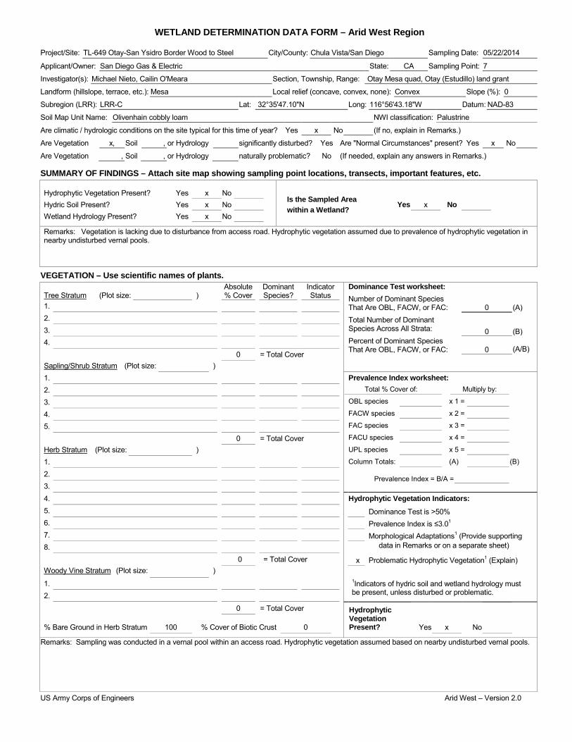
WETLAND DETERMINATION DATA FORM – Arid West Region Project/Site: TL-649 Otay-San Ysidro Border Wood to Steel City/County: Chula Vista/San Diego Sampling Date: 05/22/2014
Applicant/Owner: San Diego Gas & Electric State: CA Sampling Point: 7
Investigator(s): Michael Nieto, Cailin O'Meara Section, Township, Range: Otay Mesa quad, Otay (Estudillo) land grant
Landform (hillslope, terrace, etc.): Mesa Local relief (concave, convex, none): Convex Slope (%): 0
Subregion (LRR): LRR-C Lat: 32°35'47.10"N Long: 116°56'43.18"W Datum: NAD-83
Soil Map Unit Name: Olivenhain cobbly loam NWI classification: Palustrine
Are climatic / hydrologic conditions on the site typical for this time of year? Yes x No (If no, explain in Remarks.)
Are Vegetation x, Soil , or Hydrology significantly disturbed? Yes Are "Normal Circumstances" present? Yes x No
Are Vegetation , Soil , or Hydrology naturally problematic? No (If needed, explain any answers in Remarks.)
SUMMARY OF FINDINGS – Attach site map showing sampling point locations, transects, important features, etc.
Hydrophytic Vegetation Present? Yes x No Is the Sampled Area within a Wetland?
Hydric Soil Present? Yes x No Yes x No Wetland Hydrology Present? Yes x No
Remarks: Vegetation is lacking due to disturbance from access road. Hydrophytic vegetation assumed due to prevalence of hydrophytic vegetation in nearby undisturbed vernal pools.
VEGETATION – Use scientific names of plants. Absolute Dominant Indicator Dominance Test worksheet:
Number of Dominant Species That Are OBL, FACW, or FAC: Total Number of Dominant Species Across All Strata: Percent of Dominant Species That Are OBL, FACW, or FAC:
0
(A)
0
(B)
0 (A/B)
Tree Stratum (Plot size: ) % Cover Species? Status 1. 2. 3. 4. 0 = Total Cover Sapling/Shrub Stratum (Plot size: ) 1. Prevalence Index worksheet:
Total % Cover of: Multiply by:
OBL species x 1 =
FACW species x 2 =
FAC species x 3 =
FACU species x 4 =
UPL species x 5 =
Column Totals: (A) (B)
Prevalence Index = B/A =
2. 3. 4. 5. 0 = Total Cover Herb Stratum (Plot size: ) 1. 2. 3. 4. Hydrophytic Vegetation Indicators: 5. Dominance Test is >50% 6. Prevalence Index is ≤3.01 7. Morphological Adaptations1 (Provide supporting 8. data in Remarks or on a separate sheet)
0 = Total Cover x Problematic Hydrophytic Vegetation1 (Explain) Woody Vine Stratum (Plot size: ) 1. 1Indicators of hydric soil and wetland hydrology must
be present, unless disturbed or problematic. 2.
0 = Total Cover Hydrophytic Vegetation Present?
% Bare Ground in Herb Stratum 100 % Cover of Biotic Crust 0 Yes x No
Remarks: Sampling was conducted in a vernal pool within an access road. Hydrophytic vegetation assumed based on nearby undisturbed vernal pools.
US Army Corps of Engineers Arid West – Version 2.0

SOIL Sampling Point: 7 _____________ Profile Description: (Describe to the depth needed to document the indicator or confirm the absence of indicators.) Depth Matrix Redox Features (inches) Color (moist) % Color (moist) % Type1 Loc2 Texture Remarks
1Type: C=Concentration, D=Depletion, RM=Reduced Matrix, CS=Covered or Coated Sand Grains. 2Location: PL=Pore Lining, RC=Root Channel, M=Matrix. Hydric Soil Indicators: (Applicable to all LRRs, unless otherwise noted.) Indicators for Problematic Hydric Soils3: Histosol (A1) Sandy Redox (S5) 1 cm Muck (A9) (LRR C) Histic Epipedon (A2) Stripped Matrix (S6) 2 cm Muck (A10) (LRR B) Black Histic (A3) Loamy Mucky Mineral (F1) Reduced Vertic (F18) Hydrogen Sulfide (A4) Loamy Gleyed Matrix (F2) Red Parent Material (TF2) Stratified Layers (A5) (LRR C) Depleted Matrix (F3) Other (Explain in Remarks) 1 cm Muck (A9) (LRR D) Redox Dark Surface (F6) Depleted Below Dark Surface (A11) Depleted Dark Surface (F7) Thick Dark Surface (A12) Redox Depressions (F8) 3Indicators of hydrophytic vegetation and Sandy Mucky Mineral (S1) x Vernal Pools (F9) wetland hydrology must be present, Sandy Gleyed Matrix (S4) unless disturbed or problematic.
Restrictive Layer (if present): Type: Depth (inches): Hydric Soil Present? Yes x No
Remarks: SNo soil pit was dug due to the documented presence of San Diego fairy shrimp. Hydric soils were assumed due to strong hydrology indicators.
HYDROLOGY Wetland Hydrology Indicators: Secondary Indicators (2 or more required) Primary Indicators (minimum of one required; check all that apply) Water Marks (B1) (Riverine) Surface Water (A1) Salt Crust (B11) Sediment Deposits (B2) (Riverine) High Water Table (A2) Biotic Crust (B12) Drift Deposits (B3) (Riverine) Saturation (A3) Aquatic Invertebrates (B13) Drainage Patterns (B10) Water Marks (B1) (Nonriverine) Hydrogen Sulfide Odor (C1) Dry-Season Water Table (C2) Sediment Deposits (B2) (Nonriverine) Oxidized Rhizospheres along Living Roots (C3) Thin Muck Surface (C7) Drift Deposits (B3) (Nonriverine) Presence of Reduced Iron (C4) Crayfish Burrows (C8) x Surface Soil Cracks (B6) Recent Iron Reduction in Tilled Soils (C6) Saturation Visible on Aerial Imagery (C9) Inundation Visible on Aerial Imagery (B7) Thin Muck Surface (C7) Shallow Aquitard (D3) Water-Stained Leaves (B9) Other (Explain in Remarks) FAC-Neutral Test (D5)
Field Observations: Surface Water Present? Yes No x Depth (inches): Water Table Present? Yes No x Depth (inches): Saturation Present? Yes No x Depth (inches): Wetland Hydrology Present? Yes x No (includes capillary fringe)
Describe Recorded Data (stream gauge, monitoring well, aerial photos, previous inspections), if available:
Remarks:
US Army Corps of Engineers Arid West – Version 2.0
WETLAND DETERMINATION DATA FORM – Arid West Region Project/Site: TL-649 Otay-San Ysidro Border Wood to Steel City/County: Chula Vista/San Diego Sampling Date: 05/22/2014
Applicant/Owner: San Diego Gas & Electric State: CA Sampling Point: 8
Investigator(s): Michael Nieto, Cailin O'Meara Section, Township, Range: Otay Mesa quad, Otay (Estudillo) land grant
Landform (hillslope, terrace, etc.): Mesa Local relief (concave, convex, none): Convex Slope (%): 0
Subregion (LRR): Otay Valley Hydrologic Area Lat: 32°35'49.47"N Long: 116°56'39.63"W Datum: NAD-83
Soil Map Unit Name: Olivenhain cobbly loam NWI classification: Palustrine
Are climatic / hydrologic conditions on the site typical for this time of year? Yes x No (If no, explain in Remarks.)
Are Vegetation x, Soil , or Hydrology significantly disturbed? Yes Are "Normal Circumstances" present? Yes x No
Are Vegetation , Soil , or Hydrology naturally problematic? No (If needed, explain any answers in Remarks.)
SUMMARY OF FINDINGS – Attach site map showing sampling point locations, transects, important features, etc.
Hydrophytic Vegetation Present? Yes x No Is the Sampled Area within a Wetland?
Hydric Soil Present? Yes x No Yes x No Wetland Hydrology Present? Yes x No
Remarks: Vegetation is lacking due to disturbance from access road. Hydrophytic vegetation assumed due to prevalence of hydrophytic vegetation in nearby undisturbed vernal pools.
VEGETATION – Use scientific names of plants. Absolute Dominant Indicator Dominance Test worksheet:
Number of Dominant Species That Are OBL, FACW, or FAC: Total Number of Dominant Species Across All Strata: Percent of Dominant Species That Are OBL, FACW, or FAC:
0
(A)
0
(B)
0 (A/B)
Tree Stratum (Plot size: ) % Cover Species? Status 1. 2. 3. 4. 0 = Total Cover Sapling/Shrub Stratum (Plot size: ) 1. Prevalence Index worksheet:
Total % Cover of: Multiply by:
OBL species x 1 =
FACW species x 2 =
FAC species x 3 =
FACU species x 4 =
UPL species x 5 =
Column Totals: (A) (B)
Prevalence Index = B/A =
2. 3. 4. 5. 0 = Total Cover Herb Stratum (Plot size: ) 1. 2. 3. 4. Hydrophytic Vegetation Indicators: 5. Dominance Test is >50% 6. Prevalence Index is ≤3.01 7. Morphological Adaptations1 (Provide supporting 8. data in Remarks or on a separate sheet)
0 = Total Cover x Problematic Hydrophytic Vegetation1 (Explain) Woody Vine Stratum (Plot size: ) 1. 1Indicators of hydric soil and wetland hydrology must
be present, unless disturbed or problematic. 2.
0 = Total Cover Hydrophytic Vegetation Present?
% Bare Ground in Herb Stratum 100 % Cover of Biotic Crust 0 Yes x No
Remarks: Sampling was conducted in a vernal pool within an access road. Hydrophytic vegetation assumed based on nearby undisturbed vernal pools.
US Army Corps of Engineers Arid West – Version 2.0

SOIL Sampling Point: 8 _____________ Profile Description: (Describe to the depth needed to document the indicator or confirm the absence of indicators.) Depth Matrix Redox Features (inches) Color (moist) % Color (moist) % Type1 Loc2 Texture Remarks
1Type: C=Concentration, D=Depletion, RM=Reduced Matrix, CS=Covered or Coated Sand Grains. 2Location: PL=Pore Lining, RC=Root Channel, M=Matrix. Hydric Soil Indicators: (Applicable to all LRRs, unless otherwise noted.) Indicators for Problematic Hydric Soils3: Histosol (A1) Sandy Redox (S5) 1 cm Muck (A9) (LRR C) Histic Epipedon (A2) Stripped Matrix (S6) 2 cm Muck (A10) (LRR B) Black Histic (A3) Loamy Mucky Mineral (F1) Reduced Vertic (F18) Hydrogen Sulfide (A4) Loamy Gleyed Matrix (F2) Red Parent Material (TF2) Stratified Layers (A5) (LRR C) Depleted Matrix (F3) Other (Explain in Remarks) 1 cm Muck (A9) (LRR D) Redox Dark Surface (F6) Depleted Below Dark Surface (A11) Depleted Dark Surface (F7) Thick Dark Surface (A12) Redox Depressions (F8) 3Indicators of hydrophytic vegetation and Sandy Mucky Mineral (S1) x Vernal Pools (F9) wetland hydrology must be present, Sandy Gleyed Matrix (S4) unless disturbed or problematic.
Restrictive Layer (if present): Type: Depth (inches): Hydric Soil Present? Yes x No
Remarks: No soil pit was dug due to the documented presence of San Diego fairy shrimp. Hydric soils were assumed due to strong hydrology indicators.
HYDROLOGY Wetland Hydrology Indicators: Secondary Indicators (2 or more required) Primary Indicators (minimum of one required; check all that apply) Water Marks (B1) (Riverine) Surface Water (A1) Salt Crust (B11) Sediment Deposits (B2) (Riverine) High Water Table (A2) Biotic Crust (B12) Drift Deposits (B3) (Riverine) Saturation (A3) Aquatic Invertebrates (B13) Drainage Patterns (B10) Water Marks (B1) (Nonriverine) Hydrogen Sulfide Odor (C1) Dry-Season Water Table (C2) Sediment Deposits (B2) (Nonriverine) Oxidized Rhizospheres along Living Roots (C3) Thin Muck Surface (C7) Drift Deposits (B3) (Nonriverine) Presence of Reduced Iron (C4) Crayfish Burrows (C8) x Surface Soil Cracks (B6) Recent Iron Reduction in Tilled Soils (C6) Saturation Visible on Aerial Imagery (C9) Inundation Visible on Aerial Imagery (B7) Thin Muck Surface (C7) Shallow Aquitard (D3) Water-Stained Leaves (B9) Other (Explain in Remarks) FAC-Neutral Test (D5)
Field Observations: Surface Water Present? Yes No x Depth (inches): Water Table Present? Yes No x Depth (inches): Saturation Present? Yes No x Depth (inches): Wetland Hydrology Present? Yes x No (includes capillary fringe)
Describe Recorded Data (stream gauge, monitoring well, aerial photos, previous inspections), if available:
Remarks:
US Army Corps of Engineers Arid West – Version 2.0
WETLAND DETERMINATION DATA FORM – Arid West Region Project/Site: TL-649 Otay-San Ysidro Border Wood to Steel City/County: Chula Vista/San Diego Sampling Date: 05/22/2014
Applicant/Owner: San Diego Gas & Electric State: CA Sampling Point: 9
Investigator(s): Michael Nieto, Cailin O'Meara Section, Township, Range: Otay Mesa quad, Otay (Estudillo) land grant
Landform (hillslope, terrace, etc.): Terrace Local relief (concave, convex, none): Convex Slope (%): 0
Subregion (LRR): LRR-C Lat: 32°35'48.12"N Long: 116°56'40.19"W Datum: NAD-83
Soil Map Unit Name: Olivenhain cobbly loam NWI classification: Palustrine
Are climatic / hydrologic conditions on the site typical for this time of year? Yes x No (If no, explain in Remarks.)
Are Vegetation , Soil , or Hydrology significantly disturbed? No Are "Normal Circumstances" present? Yes x No
Are Vegetation , Soil , or Hydrology naturally problematic? No (If needed, explain any answers in Remarks.)
SUMMARY OF FINDINGS – Attach site map showing sampling point locations, transects, important features, etc.
Hydrophytic Vegetation Present? Yes x No Is the Sampled Area within a Wetland?
Hydric Soil Present? Yes x No Yes x No Wetland Hydrology Present? Yes x No
Remarks: Sampling point is located within emergent marsh.
VEGETATION – Use scientific names of plants. Absolute Dominant Indicator Dominance Test worksheet:
Number of Dominant Species That Are OBL, FACW, or FAC: Total Number of Dominant Species Across All Strata: Percent of Dominant Species That Are OBL, FACW, or FAC:
1
(A)
1
(B)
100% (A/B)
Tree Stratum (Plot size: ) % Cover Species? Status 1. 2. 3. 4. = Total Cover Sapling/Shrub Stratum (Plot size: ) 1. Prevalence Index worksheet:
Total % Cover of: Multiply by:
OBL species x 1 =
FACW species x 2 =
FAC species x 3 =
FACU species x 4 =
UPL species x 5 =
Column Totals: (A) (B)
Prevalence Index = B/A =
2. 3. 4. 5. = Total Cover Herb Stratum (Plot size: ) 1. Juncus effusus 65 Yes FACW 2. Bromus madritensis 2 No UPL 3. Bromus diandrus 1 No UPL 4. Hydrophytic Vegetation Indicators: 5. x Dominance Test is >50% 6. Prevalence Index is ≤3.01 7. Morphological Adaptations1 (Provide supporting 8. data in Remarks or on a separate sheet)
68% = Total Cover Problematic Hydrophytic Vegetation1 (Explain) Woody Vine Stratum (Plot size: ) 1. 1Indicators of hydric soil and wetland hydrology must
be present, unless disturbed or problematic. 2.
= Total Cover Hydrophytic Vegetation Present?
% Bare Ground in Herb Stratum 32% % Cover of Biotic Crust Yes x No
Remarks:
US Army Corps of Engineers Arid West – Version 2.0
SOIL Sampling Point: 9 _____________ Profile Description: (Describe to the depth needed to document the indicator or confirm the absence of indicators.) Depth Matrix Redox Features (inches) Color (moist) % Color (moist) % Type1 Loc2 Texture Remarks
0 5 YR 3/1 98 2.5 YR 4/8 2 C PL Silty clay loam See remarks below
1Type: C=Concentration, D=Depletion, RM=Reduced Matrix, CS=Covered or Coated Sand Grains. 2Location: PL=Pore Lining, RC=Root Channel, M=Matrix. Hydric Soil Indicators: (Applicable to all LRRs, unless otherwise noted.) Indicators for Problematic Hydric Soils3: Histosol (A1) Sandy Redox (S5) 1 cm Muck (A9) (LRR C) Histic Epipedon (A2) Stripped Matrix (S6) 2 cm Muck (A10) (LRR B) Black Histic (A3) Loamy Mucky Mineral (F1) Reduced Vertic (F18) Hydrogen Sulfide (A4) Loamy Gleyed Matrix (F2) Red Parent Material (TF2) Stratified Layers (A5) (LRR C) x Depleted Matrix (F3) Other (Explain in Remarks) 1 cm Muck (A9) (LRR D) Redox Dark Surface (F6) Depleted Below Dark Surface (A11) Depleted Dark Surface (F7) Thick Dark Surface (A12) Redox Depressions (F8) 3Indicators of hydrophytic vegetation and Sandy Mucky Mineral (S1) Vernal Pools (F9) wetland hydrology must be present, Sandy Gleyed Matrix (S4) unless disturbed or problematic.
Restrictive Layer (if present): Type: Depth (inches): Hydric Soil Present? Yes x No
Remarks: Rocky substrate precludes digging. Redoximorphic concentrations observed on clay lining rocks and roots. Hydric soils assumed due to presence of redoximorphic features on soil surface, as well as strong hydrophytic vegetation and hydrology indicators.
HYDROLOGY Wetland Hydrology Indicators: Secondary Indicators (2 or more required) Primary Indicators (minimum of one required; check all that apply) Water Marks (B1) (Riverine) Surface Water (A1) Salt Crust (B11) Sediment Deposits (B2) (Riverine) High Water Table (A2) Biotic Crust (B12) Drift Deposits (B3) (Riverine) Saturation (A3) Aquatic Invertebrates (B13) Drainage Patterns (B10) Water Marks (B1) (Nonriverine) Hydrogen Sulfide Odor (C1) Dry-Season Water Table (C2) Sediment Deposits (B2) (Nonriverine) x Oxidized Rhizospheres along Living Roots (C3) Thin Muck Surface (C7) Drift Deposits (B3) (Nonriverine) x Presence of Reduced Iron (C4) Crayfish Burrows (C8) Surface Soil Cracks (B6) Recent Iron Reduction in Tilled Soils (C6) Saturation Visible on Aerial Imagery (C9) Inundation Visible on Aerial Imagery (B7) Thin Muck Surface (C7) Shallow Aquitard (D3) Water-Stained Leaves (B9) Other (Explain in Remarks) FAC-Neutral Test (D5)
Field Observations: Surface Water Present? Yes No x Depth (inches): Water Table Present? Yes No x Depth (inches): Saturation Present? Yes No x Depth (inches): Wetland Hydrology Present? Yes x No (includes capillary fringe)
Describe Recorded Data (stream gauge, monitoring well, aerial photos, previous inspections), if available:
Remarks:
US Army Corps of Engineers Arid West – Version 2.0

WETLAND DETERMINATION DATA FORM – Arid West Region Project/Site: TL-649 Otay-San Ysidro Border Wood to Steel City/County: Chula Vista/San Diego Sampling Date: 05/22/2014
Applicant/Owner: San Diego Gas & Electric State: CA Sampling Point: 10
Investigator(s): Michael Nieto, Cailin O'Meara Section, Township, Range: Otay Mesa quad, Otay (Estudillo) land grant
Landform (hillslope, terrace, etc.): Mesa Local relief (concave, convex, none): Convex Slope (%): 0
Subregion (LRR): LRR-C Lat: 32°35'49.84"N Long: 116°56'23.42"W Datum: NAD-83
Soil Map Unit Name: Olivenhain cobbly loam NWI classification: Palustrine
Are climatic / hydrologic conditions on the site typical for this time of year? Yes x No (If no, explain in Remarks.)
Are Vegetation x, Soil , or Hydrology significantly disturbed? Yes Are "Normal Circumstances" present? Yes x No
Are Vegetation , Soil , or Hydrology naturally problematic? No (If needed, explain any answers in Remarks.)
SUMMARY OF FINDINGS – Attach site map showing sampling point locations, transects, important features, etc.
Hydrophytic Vegetation Present? Yes x No Is the Sampled Area within a Wetland?
Hydric Soil Present? Yes x No Yes x No Wetland Hydrology Present? Yes x No
Remarks: Vegetation significantly disturbed from access road.
VEGETATION – Use scientific names of plants. Absolute Dominant Indicator Dominance Test worksheet:
Number of Dominant Species That Are OBL, FACW, or FAC: Total Number of Dominant Species Across All Strata: Percent of Dominant Species That Are OBL, FACW, or FAC:
2
(A)
2
(B)
100% (A/B)
Tree Stratum (Plot size: ) % Cover Species? Status 1. 2. 3. 4. 0 = Total Cover Sapling/Shrub Stratum (Plot size: ) 1. Prevalence Index worksheet:
Total % Cover of: Multiply by:
OBL species x 1 =
FACW species x 2 =
FAC species x 3 =
FACU species x 4 =
UPL species x 5 =
Column Totals: (A) (B)
Prevalence Index = B/A =
2. 3. 4. 5. 0 = Total Cover Herb Stratum (Plot size: ) 1. Polypogon monspeliensis 2 Y FACW 2. 3. 4. Hydrophytic Vegetation Indicators: 5. x Dominance Test is >50% 6. Prevalence Index is ≤3.01 7. Morphological Adaptations1 (Provide supporting 8. data in Remarks or on a separate sheet)
2 = Total Cover Problematic Hydrophytic Vegetation1 (Explain) Woody Vine Stratum (Plot size: ) 1. 1Indicators of hydric soil and wetland hydrology must
be present, unless disturbed or problematic. 2.
0 = Total Cover Hydrophytic Vegetation Present?
% Bare Ground in Herb Stratum 98 % Cover of Biotic Crust 0 Yes x No
Remarks: Sampling was conducted in a vernal pool within an access road.
US Army Corps of Engineers Arid West – Version 2.0

SOIL Sampling Point: 10 ____________ Profile Description: (Describe to the depth needed to document the indicator or confirm the absence of indicators.) Depth Matrix Redox Features (inches) Color (moist) % Color (moist) % Type1 Loc2 Texture Remarks
1Type: C=Concentration, D=Depletion, RM=Reduced Matrix, CS=Covered or Coated Sand Grains. 2Location: PL=Pore Lining, RC=Root Channel, M=Matrix. Hydric Soil Indicators: (Applicable to all LRRs, unless otherwise noted.) Indicators for Problematic Hydric Soils3: Histosol (A1) Sandy Redox (S5) 1 cm Muck (A9) (LRR C) Histic Epipedon (A2) Stripped Matrix (S6) 2 cm Muck (A10) (LRR B) Black Histic (A3) Loamy Mucky Mineral (F1) Reduced Vertic (F18) Hydrogen Sulfide (A4) Loamy Gleyed Matrix (F2) Red Parent Material (TF2) Stratified Layers (A5) (LRR C) Depleted Matrix (F3) Other (Explain in Remarks) 1 cm Muck (A9) (LRR D) Redox Dark Surface (F6) Depleted Below Dark Surface (A11) Depleted Dark Surface (F7) Thick Dark Surface (A12) Redox Depressions (F8) 3Indicators of hydrophytic vegetation and Sandy Mucky Mineral (S1) x Vernal Pools (F9) wetland hydrology must be present, Sandy Gleyed Matrix (S4) unless disturbed or problematic.
Restrictive Layer (if present): Type: Depth (inches): Hydric Soil Present? Yes x No
Remarks: No soil pit was dug due to the documented presence of San Diego fairy shrimp. Hydric soils were assumed due to strong hydrophytic vegetation and hydrology indicators.
HYDROLOGY Wetland Hydrology Indicators: Secondary Indicators (2 or more required) Primary Indicators (minimum of one required; check all that apply) Water Marks (B1) (Riverine) Surface Water (A1) Salt Crust (B11) Sediment Deposits (B2) (Riverine) High Water Table (A2) x Biotic Crust (B12) Drift Deposits (B3) (Riverine) Saturation (A3) Aquatic Invertebrates (B13) Drainage Patterns (B10) Water Marks (B1) (Nonriverine) Hydrogen Sulfide Odor (C1) Dry-Season Water Table (C2) Sediment Deposits (B2) (Nonriverine) Oxidized Rhizospheres along Living Roots (C3) Thin Muck Surface (C7) Drift Deposits (B3) (Nonriverine) Presence of Reduced Iron (C4) Crayfish Burrows (C8) x Surface Soil Cracks (B6) Recent Iron Reduction in Tilled Soils (C6) Saturation Visible on Aerial Imagery (C9) Inundation Visible on Aerial Imagery (B7) Thin Muck Surface (C7) Shallow Aquitard (D3) Water-Stained Leaves (B9) Other (Explain in Remarks) FAC-Neutral Test (D5)
Field Observations: Surface Water Present? Yes No x Depth (inches): Water Table Present? Yes No x Depth (inches): Saturation Present? Yes No x Depth (inches): Wetland Hydrology Present? Yes x No (includes capillary fringe)
Describe Recorded Data (stream gauge, monitoring well, aerial photos, previous inspections), if available:
Remarks:
US Army Corps of Engineers Arid West – Version 2.0

WETLAND DETERMINATION DATA FORM – Arid West Region Project/Site: TL-649 Otay-San Ysidro Border Wood to Steel City/County: Chula Vista/San Diego Sampling Date: 05/22/2014
Applicant/Owner: San Diego Gas & Electric State: CA Sampling Point: 11
Investigator(s): Michael Nieto, Cailin O'Meara Section, Township, Range: Otay Mesa quad, Otay (Estudillo) land grant
Landform (hillslope, terrace, etc.): Mesa Local relief (concave, convex, none): Convex Slope (%): 0
Subregion (LRR): LRR-C Lat: 32°35'49.61"N Long: 116°56'23.30"W Datum: NAD-83
Soil Map Unit Name: Olivenhain cobbly loam NWI classification: Palustrine
Are climatic / hydrologic conditions on the site typical for this time of year? Yes x No (If no, explain in Remarks.)
Are Vegetation x, Soil , or Hydrology significantly disturbed? Yes Are "Normal Circumstances" present? Yes x No
Are Vegetation , Soil , or Hydrology naturally problematic? (If needed, explain any answers in Remarks.)
SUMMARY OF FINDINGS – Attach site map showing sampling point locations, transects, important features, etc.
Hydrophytic Vegetation Present? Yes x No Is the Sampled Area within a Wetland?
Hydric Soil Present? Yes x No Yes x No Wetland Hydrology Present? Yes x No
Remarks: Vegetation is lacking due to disturbance from access road. Hydrophytic vegetation assumed due to prevalence of hydrophytic vegetation in nearby undisturbed vernal pools.
VEGETATION – Use scientific names of plants. Absolute Dominant Indicator Dominance Test worksheet:
Number of Dominant Species That Are OBL, FACW, or FAC: Total Number of Dominant Species Across All Strata: Percent of Dominant Species That Are OBL, FACW, or FAC:
0
(A)
0
(B)
0 (A/B)
Tree Stratum (Plot size: ) % Cover Species? Status 1. 2. 3. 4. 0 = Total Cover Sapling/Shrub Stratum (Plot size: ) 1. Prevalence Index worksheet:
Total % Cover of: Multiply by:
OBL species x 1 =
FACW species x 2 =
FAC species x 3 =
FACU species x 4 =
UPL species x 5 =
Column Totals: (A) (B)
Prevalence Index = B/A =
2. 3. 4. 5. 0 = Total Cover Herb Stratum (Plot size: ) 1. 2. 3. 4. Hydrophytic Vegetation Indicators: 5. Dominance Test is >50% 6. Prevalence Index is ≤3.01 7. Morphological Adaptations1 (Provide supporting 8. data in Remarks or on a separate sheet)
0 = Total Cover x Problematic Hydrophytic Vegetation1 (Explain) Woody Vine Stratum (Plot size: ) 1. 1Indicators of hydric soil and wetland hydrology must
be present, unless disturbed or problematic. 2.
0 = Total Cover Hydrophytic Vegetation Present?
% Bare Ground in Herb Stratum 100 % Cover of Biotic Crust 0 Yes No x
Remarks: Sampling was conducted in a vernal pool within an access road. Hydrophytic vegetation assumed based on nearby undisturbed vernal pools.
US Army Corps of Engineers Arid West – Version 2.0

SOIL Sampling Point: 11 ____________ Profile Description: (Describe to the depth needed to document the indicator or confirm the absence of indicators.) Depth Matrix Redox Features (inches) Color (moist) % Color (moist) % Type1 Loc2 Texture Remarks
1Type: C=Concentration, D=Depletion, RM=Reduced Matrix, CS=Covered or Coated Sand Grains. 2Location: PL=Pore Lining, RC=Root Channel, M=Matrix. Hydric Soil Indicators: (Applicable to all LRRs, unless otherwise noted.) Indicators for Problematic Hydric Soils3: Histosol (A1) Sandy Redox (S5) 1 cm Muck (A9) (LRR C) Histic Epipedon (A2) Stripped Matrix (S6) 2 cm Muck (A10) (LRR B) Black Histic (A3) Loamy Mucky Mineral (F1) Reduced Vertic (F18) Hydrogen Sulfide (A4) Loamy Gleyed Matrix (F2) Red Parent Material (TF2) Stratified Layers (A5) (LRR C) Depleted Matrix (F3) Other (Explain in Remarks) 1 cm Muck (A9) (LRR D) Redox Dark Surface (F6) Depleted Below Dark Surface (A11) Depleted Dark Surface (F7) Thick Dark Surface (A12) Redox Depressions (F8) 3Indicators of hydrophytic vegetation and Sandy Mucky Mineral (S1) x Vernal Pools (F9) wetland hydrology must be present, Sandy Gleyed Matrix (S4) unless disturbed or problematic.
Restrictive Layer (if present): Type: Depth (inches): Hydric Soil Present? Yes x No
Remarks: No soil pit was dug due to the documented presence of San Diego fairy shrimp. Hydric soils were assumed due to strong hydrology indicators.
HYDROLOGY Wetland Hydrology Indicators: Secondary Indicators (2 or more required) Primary Indicators (minimum of one required; check all that apply) Water Marks (B1) (Riverine) Surface Water (A1) Salt Crust (B11) Sediment Deposits (B2) (Riverine) High Water Table (A2) Biotic Crust (B12) Drift Deposits (B3) (Riverine) Saturation (A3) Aquatic Invertebrates (B13) Drainage Patterns (B10) Water Marks (B1) (Nonriverine) Hydrogen Sulfide Odor (C1) Dry-Season Water Table (C2) Sediment Deposits (B2) (Nonriverine) Oxidized Rhizospheres along Living Roots (C3) Thin Muck Surface (C7) Drift Deposits (B3) (Nonriverine) Presence of Reduced Iron (C4) Crayfish Burrows (C8) x Surface Soil Cracks (B6) Recent Iron Reduction in Tilled Soils (C6) Saturation Visible on Aerial Imagery (C9) Inundation Visible on Aerial Imagery (B7) Thin Muck Surface (C7) Shallow Aquitard (D3) Water-Stained Leaves (B9) Other (Explain in Remarks) FAC-Neutral Test (D5)
Field Observations: Surface Water Present? Yes No x Depth (inches): Water Table Present? Yes No x Depth (inches): Saturation Present? Yes No x Depth (inches): Wetland Hydrology Present? Yes x No (includes capillary fringe)
Describe Recorded Data (stream gauge, monitoring well, aerial photos, previous inspections), if available:
Remarks: Wetland hydrology is present.
US Army Corps of Engineers Arid West – Version 2.0
WETLAND DETERMINATION DATA FORM – Arid West Region Project/Site: TL-649 Otay-San Ysidro Border Wood to Steel City/County: Chula Vista/San Diego Sampling Date: 05/22/2014
Applicant/Owner: San Diego Gas & Electric State: CA Sampling Point: 12
Investigator(s): Michael Nieto, Cailin O'Meara Section, Township, Range: Otay Mesa quad, Otay (Estudillo) land grant
Landform (hillslope, terrace, etc.): Vernal pool Local relief (concave, convex, none): Convex Slope (%): 0
Subregion (LRR): LRR-C Lat: 32°35'56.00"N Long: 116°56'11.41"W Datum: NAD-83
Soil Map Unit Name: Olivenhain cobbly loam NWI classification: Palustrine
Are climatic / hydrologic conditions on the site typical for this time of year? Yes x No (If no, explain in Remarks.)
Are Vegetation x, Soil , or Hydrology significantly disturbed? Yes Are "Normal Circumstances" present? Yes x No
Are Vegetation , Soil , or Hydrology naturally problematic? No (If needed, explain any answers in Remarks.)
SUMMARY OF FINDINGS – Attach site map showing sampling point locations, transects, important features, etc.
Hydrophytic Vegetation Present? Yes x No Is the Sampled Area within a Wetland?
Hydric Soil Present? Yes x No Yes x No Wetland Hydrology Present? Yes x No
Remarks: Vegetation is mostly non-native due to disturbance from access road. Hydrophytic vegetation assumed due to prevalence of hydrophytic vegetation in nearby undisturbed vernal pools.
VEGETATION – Use scientific names of plants. Absolute Dominant Indicator Dominance Test worksheet:
Number of Dominant Species That Are OBL, FACW, or FAC: Total Number of Dominant Species Across All Strata: Percent of Dominant Species That Are OBL, FACW, or FAC:
1
(A)
3
(B)
33% (A/B)
Tree Stratum (Plot size: ) % Cover Species? Status 1. 2. 3. 4. = Total Cover Sapling/Shrub Stratum (Plot size: ) 1. Prevalence Index worksheet:
Total % Cover of: Multiply by:
OBL species 0 x 1 = 0
FACW species 1 x 2 = 2
FAC species 0 x 3 = 0
FACU species 1 x 4 = 4
UPL species 2 x 5 = 10
Column Totals: 4 (A) 16 (B)
Prevalence Index = B/A = 4
2. 3. 4. 5. = Total Cover Herb Stratum (Plot size: ) 1. Schismus barbatus 2 Yes UPL 2. Psilocarphus brevissimus var. brevissimus 1 Yes FACW 3. Erodium cicutarium 1 Yes FACU 4. Deinandra fasciculata 0.5 No FACU Hydrophytic Vegetation Indicators: 5. Dominance Test is >50% 6. Prevalence Index is ≤3.01 7. Morphological Adaptations1 (Provide supporting 8. data in Remarks or on a separate sheet)
10 = Total Cover x Problematic Hydrophytic Vegetation1 (Explain) Woody Vine Stratum (Plot size: ) 1. 1Indicators of hydric soil and wetland hydrology must
be present, unless disturbed or problematic. 2.
= Total Cover Hydrophytic Vegetation Present?
% Bare Ground in Herb Stratum % Cover of Biotic Crust Yes x No
Remarks: Sampling was conducted in a vernal pool within an access road. Hydrophytic vegetation assumed based on nearby undisturbed vernal pools.
US Army Corps of Engineers Arid West – Version 2.0

SOIL Sampling Point: 12 ____________ Profile Description: (Describe to the depth needed to document the indicator or confirm the absence of indicators.) Depth Matrix Redox Features (inches) Color (moist) % Color (moist) % Type1 Loc2 Texture Remarks
1Type: C=Concentration, D=Depletion, RM=Reduced Matrix, CS=Covered or Coated Sand Grains. 2Location: PL=Pore Lining, RC=Root Channel, M=Matrix. Hydric Soil Indicators: (Applicable to all LRRs, unless otherwise noted.) Indicators for Problematic Hydric Soils3: Histosol (A1) Sandy Redox (S5) 1 cm Muck (A9) (LRR C) Histic Epipedon (A2) Stripped Matrix (S6) 2 cm Muck (A10) (LRR B) Black Histic (A3) Loamy Mucky Mineral (F1) Reduced Vertic (F18) Hydrogen Sulfide (A4) Loamy Gleyed Matrix (F2) Red Parent Material (TF2) Stratified Layers (A5) (LRR C) Depleted Matrix (F3) Other (Explain in Remarks) 1 cm Muck (A9) (LRR D) Redox Dark Surface (F6) Depleted Below Dark Surface (A11) Depleted Dark Surface (F7) Thick Dark Surface (A12) Redox Depressions (F8) 3Indicators of hydrophytic vegetation and Sandy Mucky Mineral (S1) x Vernal Pools (F9) wetland hydrology must be present, Sandy Gleyed Matrix (S4) unless disturbed or problematic.
Restrictive Layer (if present): Type: Depth (inches): Hydric Soil Present? Yes x No
Remarks: No soil pit was dug due to the documented presence of San Diego fairy shrimp. Hydric soils were assumed due to strong hydrology indicators.
HYDROLOGY Wetland Hydrology Indicators: Secondary Indicators (2 or more required) Primary Indicators (minimum of one required; check all that apply) Water Marks (B1) (Riverine) Surface Water (A1) Salt Crust (B11) Sediment Deposits (B2) (Riverine) High Water Table (A2) Biotic Crust (B12) Drift Deposits (B3) (Riverine) Saturation (A3) Aquatic Invertebrates (B13) Drainage Patterns (B10) Water Marks (B1) (Nonriverine) Hydrogen Sulfide Odor (C1) Dry-Season Water Table (C2) Sediment Deposits (B2) (Nonriverine) Oxidized Rhizospheres along Living Roots (C3) Thin Muck Surface (C7) Drift Deposits (B3) (Nonriverine) Presence of Reduced Iron (C4) Crayfish Burrows (C8) x Surface Soil Cracks (B6) Recent Iron Reduction in Tilled Soils (C6) Saturation Visible on Aerial Imagery (C9) Inundation Visible on Aerial Imagery (B7) Thin Muck Surface (C7) Shallow Aquitard (D3) Water-Stained Leaves (B9) Other (Explain in Remarks) FAC-Neutral Test (D5)
Field Observations: Surface Water Present? Yes No x Depth (inches): Water Table Present? Yes No x Depth (inches): Saturation Present? Yes No x Depth (inches): Wetland Hydrology Present? Yes x No (includes capillary fringe)
Describe Recorded Data (stream gauge, monitoring well, aerial photos, previous inspections), if available:
Remarks:
US Army Corps of Engineers Arid West – Version 2.0
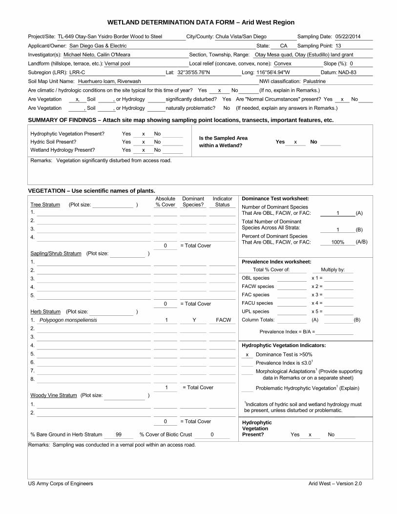
WETLAND DETERMINATION DATA FORM – Arid West Region Project/Site: TL-649 Otay-San Ysidro Border Wood to Steel City/County: Chula Vista/San Diego Sampling Date: 05/22/2014
Applicant/Owner: San Diego Gas & Electric State: CA Sampling Point: 13
Investigator(s): Michael Nieto, Cailin O'Meara Section, Township, Range: Otay Mesa quad, Otay (Estudillo) land grant
Landform (hillslope, terrace, etc.): Vernal pool Local relief (concave, convex, none): Convex Slope (%): 0
Subregion (LRR): LRR-C Lat: 32°35'55.76"N Long: 116°56'4.94"W Datum: NAD-83
Soil Map Unit Name: Huerhuero loam, Riverwash NWI classification: Palustrine
Are climatic / hydrologic conditions on the site typical for this time of year? Yes x No (If no, explain in Remarks.)
Are Vegetation x, Soil , or Hydrology significantly disturbed? Yes Are "Normal Circumstances" present? Yes x No
Are Vegetation , Soil , or Hydrology naturally problematic? No (If needed, explain any answers in Remarks.)
SUMMARY OF FINDINGS – Attach site map showing sampling point locations, transects, important features, etc.
Hydrophytic Vegetation Present? Yes x No Is the Sampled Area within a Wetland?
Hydric Soil Present? Yes x No Yes x No Wetland Hydrology Present? Yes x No
Remarks: Vegetation significantly disturbed from access road.
VEGETATION – Use scientific names of plants. Absolute Dominant Indicator Dominance Test worksheet:
Number of Dominant Species That Are OBL, FACW, or FAC: Total Number of Dominant Species Across All Strata: Percent of Dominant Species That Are OBL, FACW, or FAC:
1
(A)
1
(B)
100% (A/B)
Tree Stratum (Plot size: ) % Cover Species? Status 1. 2. 3. 4. 0 = Total Cover Sapling/Shrub Stratum (Plot size: ) 1. Prevalence Index worksheet:
Total % Cover of: Multiply by:
OBL species x 1 =
FACW species x 2 =
FAC species x 3 =
FACU species x 4 =
UPL species x 5 =
Column Totals: (A) (B)
Prevalence Index = B/A =
2. 3. 4. 5. 0 = Total Cover Herb Stratum (Plot size: ) 1. Polypogon monspeliensis 1 Y FACW 2. 3. 4. Hydrophytic Vegetation Indicators: 5. x Dominance Test is >50% 6. Prevalence Index is ≤3.01 7. Morphological Adaptations1 (Provide supporting 8. data in Remarks or on a separate sheet)
1 = Total Cover Problematic Hydrophytic Vegetation1 (Explain) Woody Vine Stratum (Plot size: ) 1. 1Indicators of hydric soil and wetland hydrology must
be present, unless disturbed or problematic. 2.
0 = Total Cover Hydrophytic Vegetation Present?
% Bare Ground in Herb Stratum 99 % Cover of Biotic Crust 0 Yes x No
Remarks: Sampling was conducted in a vernal pool within an access road.
US Army Corps of Engineers Arid West – Version 2.0

SOIL Sampling Point: 13 ____________ Profile Description: (Describe to the depth needed to document the indicator or confirm the absence of indicators.) Depth Matrix Redox Features (inches) Color (moist) % Color (moist) % Type1 Loc2 Texture Remarks
1Type: C=Concentration, D=Depletion, RM=Reduced Matrix, CS=Covered or Coated Sand Grains. 2Location: PL=Pore Lining, RC=Root Channel, M=Matrix. Hydric Soil Indicators: (Applicable to all LRRs, unless otherwise noted.) Indicators for Problematic Hydric Soils3: Histosol (A1) Sandy Redox (S5) 1 cm Muck (A9) (LRR C) Histic Epipedon (A2) Stripped Matrix (S6) 2 cm Muck (A10) (LRR B) Black Histic (A3) Loamy Mucky Mineral (F1) Reduced Vertic (F18) Hydrogen Sulfide (A4) Loamy Gleyed Matrix (F2) Red Parent Material (TF2) Stratified Layers (A5) (LRR C) Depleted Matrix (F3) Other (Explain in Remarks) 1 cm Muck (A9) (LRR D) Redox Dark Surface (F6) Depleted Below Dark Surface (A11) Depleted Dark Surface (F7) Thick Dark Surface (A12) Redox Depressions (F8) 3Indicators of hydrophytic vegetation and Sandy Mucky Mineral (S1) x Vernal Pools (F9) wetland hydrology must be present, Sandy Gleyed Matrix (S4) unless disturbed or problematic.
Restrictive Layer (if present): Type: Depth (inches): Hydric Soil Present? Yes x No
Remarks: No soil pit was dug due to the documented presence of San Diego fairy shrimp. Hydric soils were assumed due to strong hydrophytic vegetation and hydrology indicators.
HYDROLOGY Wetland Hydrology Indicators: Secondary Indicators (2 or more required) Primary Indicators (minimum of one required; check all that apply) Water Marks (B1) (Riverine) Surface Water (A1) Salt Crust (B11) Sediment Deposits (B2) (Riverine) High Water Table (A2) x Biotic Crust (B12) Drift Deposits (B3) (Riverine) Saturation (A3) Aquatic Invertebrates (B13) Drainage Patterns (B10) Water Marks (B1) (Nonriverine) Hydrogen Sulfide Odor (C1) Dry-Season Water Table (C2) Sediment Deposits (B2) (Nonriverine) Oxidized Rhizospheres along Living Roots (C3) Thin Muck Surface (C7) Drift Deposits (B3) (Nonriverine) Presence of Reduced Iron (C4) Crayfish Burrows (C8) x Surface Soil Cracks (B6) Recent Iron Reduction in Tilled Soils (C6) Saturation Visible on Aerial Imagery (C9) Inundation Visible on Aerial Imagery (B7) Thin Muck Surface (C7) Shallow Aquitard (D3) Water-Stained Leaves (B9) Other (Explain in Remarks) FAC-Neutral Test (D5)
Field Observations: Surface Water Present? Yes No x Depth (inches): Water Table Present? Yes No x Depth (inches): Saturation Present? Yes No x Depth (inches): Wetland Hydrology Present? Yes x No (includes capillary fringe)
Describe Recorded Data (stream gauge, monitoring well, aerial photos, previous inspections), if available:
Remarks:
US Army Corps of Engineers Arid West – Version 2.0
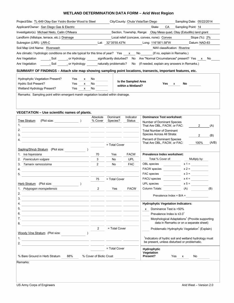
WETLAND DETERMINATION DATA FORM – Arid West Region Project/Site: TL-649 Otay-San Ysidro Border Wood to Steel City/County: Chula Vista/San Diego Sampling Date: 05/22/2014
Applicant/Owner: San Diego Gas & Electric State: CA Sampling Point: 14
Investigator(s): Michael Nieto, Cailin O'Meara Section, Township, Range: Otay Mesa quad, Otay (Estudillo) land grant
Landform (hillslope, terrace, etc.): Drainage Local relief (concave, convex, none): Convex Slope (%): 2%
Subregion (LRR): LRR-C Lat: 32°35'55.43"N Long: 116°56'1.58"W Datum: NAD-83
Soil Map Unit Name: Riverwash NWI classification: Riverine
Are climatic / hydrologic conditions on the site typical for this time of year? Yes x No (If no, explain in Remarks.)
Are Vegetation , Soil , or Hydrology significantly disturbed? No Are "Normal Circumstances" present? Yes x No
Are Vegetation , Soil , or Hydrology naturally problematic? No (If needed, explain any answers in Remarks.)
SUMMARY OF FINDINGS – Attach site map showing sampling point locations, transects, important features, etc.
Hydrophytic Vegetation Present? Yes x No Is the Sampled Area within a Wetland?
Hydric Soil Present? Yes x No Yes x No Wetland Hydrology Present? Yes x No
Remarks: Sampling point within emergent marsh vegetation located within drainage.
VEGETATION – Use scientific names of plants. Absolute Dominant Indicator Dominance Test worksheet:
Number of Dominant Species That Are OBL, FACW, or FAC: Total Number of Dominant Species Across All Strata: Percent of Dominant Species That Are OBL, FACW, or FAC:
2
(A)
2
(B)
100% (A/B)
Tree Stratum (Plot size: ) % Cover Species? Status 1. 2. 3. 4. = Total Cover Sapling/Shrub Stratum (Plot size: ) 1. Iva hayesiana 70 Yes FACW Prevalence Index worksheet:
Total % Cover of: Multiply by:
OBL species x 1 =
FACW species x 2 =
FAC species x 3 =
FACU species x 4 =
UPL species x 5 =
Column Totals: (A) (B)
Prevalence Index = B/A =
2. Foeniculum vulgare 3 No UPL 3. Tamarix ramossisima 2 No FAC 4. 5. 75 = Total Cover Herb Stratum (Plot size: ) 1. Polypogon monspeliensis 2 Yes FACW 2. 3. 4. Hydrophytic Vegetation Indicators: 5. x Dominance Test is >50% 6. Prevalence Index is ≤3.01 7. Morphological Adaptations1 (Provide supporting 8. data in Remarks or on a separate sheet)
2 = Total Cover Problematic Hydrophytic Vegetation1 (Explain) Woody Vine Stratum (Plot size: ) 1. 1Indicators of hydric soil and wetland hydrology must
be present, unless disturbed or problematic. 2.
= Total Cover Hydrophytic Vegetation Present?
% Bare Ground in Herb Stratum 88% % Cover of Biotic Crust Yes x No
Remarks:
US Army Corps of Engineers Arid West – Version 2.0

SOIL Sampling Point: 14 ____________ Profile Description: (Describe to the depth needed to document the indicator or confirm the absence of indicators.) Depth Matrix Redox Features (inches) Color (moist) % Color (moist) % Type1 Loc2 Texture Remarks
0-1.5 4/3 7.5 YR 100 - - - - Silty clay loam -
2-15 4/2 10 YR 97 5 YR 5/6 3 C PL Silty clay Organic material present in layer
1Type: C=Concentration, D=Depletion, RM=Reduced Matrix, CS=Covered or Coated Sand Grains. 2Location: PL=Pore Lining, RC=Root Channel, M=Matrix. Hydric Soil Indicators: (Applicable to all LRRs, unless otherwise noted.) Indicators for Problematic Hydric Soils3: Histosol (A1) Sandy Redox (S5) 1 cm Muck (A9) (LRR C) Histic Epipedon (A2) Stripped Matrix (S6) 2 cm Muck (A10) (LRR B) Black Histic (A3) Loamy Mucky Mineral (F1) Reduced Vertic (F18) Hydrogen Sulfide (A4) Loamy Gleyed Matrix (F2) Red Parent Material (TF2) Stratified Layers (A5) (LRR C) x Depleted Matrix (F3) Other (Explain in Remarks) 1 cm Muck (A9) (LRR D) Redox Dark Surface (F6) Depleted Below Dark Surface (A11) Depleted Dark Surface (F7) Thick Dark Surface (A12) Redox Depressions (F8) 3Indicators of hydrophytic vegetation and Sandy Mucky Mineral (S1) Vernal Pools (F9) wetland hydrology must be present, Sandy Gleyed Matrix (S4) unless disturbed or problematic.
Restrictive Layer (if present): Type: Depth (inches): Hydric Soil Present? Yes x No
Remarks:
HYDROLOGY Wetland Hydrology Indicators: Secondary Indicators (2 or more required) Primary Indicators (minimum of one required; check all that apply) Water Marks (B1) (Riverine) Surface Water (A1) Salt Crust (B11) Sediment Deposits (B2) (Riverine) High Water Table (A2) Biotic Crust (B12) x Drift Deposits (B3) (Riverine) Saturation (A3) Aquatic Invertebrates (B13) Drainage Patterns (B10) Water Marks (B1) (Nonriverine) Hydrogen Sulfide Odor (C1) Dry-Season Water Table (C2) Sediment Deposits (B2) (Nonriverine) x Oxidized Rhizospheres along Living Roots (C3) Thin Muck Surface (C7) Drift Deposits (B3) (Nonriverine) Presence of Reduced Iron (C4) Crayfish Burrows (C8) x Surface Soil Cracks (B6) Recent Iron Reduction in Tilled Soils (C6) Saturation Visible on Aerial Imagery (C9) Inundation Visible on Aerial Imagery (B7) Thin Muck Surface (C7) Shallow Aquitard (D3) Water-Stained Leaves (B9) Other (Explain in Remarks) FAC-Neutral Test (D5)
Field Observations: Surface Water Present? Yes No x Depth (inches): Water Table Present? Yes No x Depth (inches): Saturation Present? Yes No x Depth (inches): Wetland Hydrology Present? Yes x No (includes capillary fringe)
Describe Recorded Data (stream gauge, monitoring well, aerial photos, previous inspections), if available:
Remarks:
US Army Corps of Engineers Arid West – Version 2.0
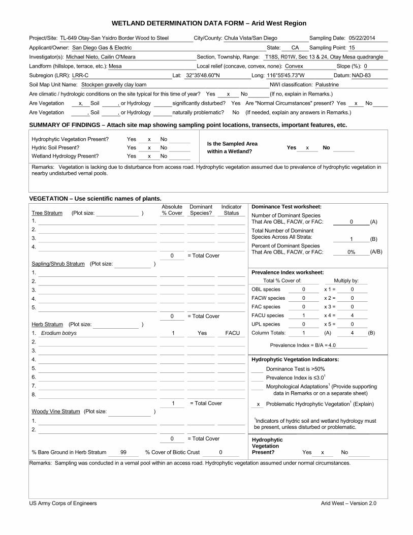
WETLAND DETERMINATION DATA FORM – Arid West Region Project/Site: TL-649 Otay-San Ysidro Border Wood to Steel City/County: Chula Vista/San Diego Sampling Date: 05/22/2014
Applicant/Owner: San Diego Gas & Electric State: CA Sampling Point: 15
Investigator(s): Michael Nieto, Cailin O'Meara Section, Township, Range: T18S, R01W, Sec 13 & 24, Otay Mesa quadrangle
Landform (hillslope, terrace, etc.): Mesa Local relief (concave, convex, none): Convex Slope (%): 0
Subregion (LRR): LRR-C Lat: 32°35'48.60"N Long: 116°55'45.73"W Datum: NAD-83
Soil Map Unit Name: Stockpen gravelly clay loam NWI classification: Palustrine
Are climatic / hydrologic conditions on the site typical for this time of year? Yes x No (If no, explain in Remarks.)
Are Vegetation x, Soil , or Hydrology significantly disturbed? Yes Are "Normal Circumstances" present? Yes x No
Are Vegetation , Soil , or Hydrology naturally problematic? No (If needed, explain any answers in Remarks.)
SUMMARY OF FINDINGS – Attach site map showing sampling point locations, transects, important features, etc.
Hydrophytic Vegetation Present? Yes x No Is the Sampled Area within a Wetland?
Hydric Soil Present? Yes x No Yes x No Wetland Hydrology Present? Yes x No
Remarks: Vegetation is lacking due to disturbance from access road. Hydrophytic vegetation assumed due to prevalence of hydrophytic vegetation in nearby undisturbed vernal pools.
VEGETATION – Use scientific names of plants. Absolute Dominant Indicator Dominance Test worksheet:
Number of Dominant Species That Are OBL, FACW, or FAC: Total Number of Dominant Species Across All Strata: Percent of Dominant Species That Are OBL, FACW, or FAC:
0
(A)
1
(B)
0% (A/B)
Tree Stratum (Plot size: ) % Cover Species? Status 1. 2. 3. 4. 0 = Total Cover Sapling/Shrub Stratum (Plot size: ) 1. Prevalence Index worksheet:
Total % Cover of: Multiply by:
OBL species 0 x 1 = 0
FACW species 0 x 2 = 0
FAC species 0 x 3 = 0
FACU species 1 x 4 = 4
UPL species 0 x 5 = 0
Column Totals: 1 (A) 4 (B)
Prevalence Index = B/A = 4.0
2. 3. 4. 5. 0 = Total Cover Herb Stratum (Plot size: ) 1. Erodium botrys 1 Yes FACU 2. 3. 4. Hydrophytic Vegetation Indicators: 5. Dominance Test is >50% 6. Prevalence Index is ≤3.01 7. Morphological Adaptations1 (Provide supporting 8. data in Remarks or on a separate sheet)
1 = Total Cover x Problematic Hydrophytic Vegetation1 (Explain) Woody Vine Stratum (Plot size: ) 1. 1Indicators of hydric soil and wetland hydrology must
be present, unless disturbed or problematic. 2.
0 = Total Cover Hydrophytic Vegetation Present?
% Bare Ground in Herb Stratum 99 % Cover of Biotic Crust 0 Yes x No
Remarks: Sampling was conducted in a vernal pool within an access road. Hydrophytic vegetation assumed under normal circumstances.
US Army Corps of Engineers Arid West – Version 2.0

SOIL Sampling Point: 15 ____________ Profile Description: (Describe to the depth needed to document the indicator or confirm the absence of indicators.) Depth Matrix Redox Features (inches) Color (moist) % Color (moist) % Type1 Loc2 Texture Remarks
1Type: C=Concentration, D=Depletion, RM=Reduced Matrix, CS=Covered or Coated Sand Grains. 2Location: PL=Pore Lining, RC=Root Channel, M=Matrix. Hydric Soil Indicators: (Applicable to all LRRs, unless otherwise noted.) Indicators for Problematic Hydric Soils3: Histosol (A1) Sandy Redox (S5) 1 cm Muck (A9) (LRR C) Histic Epipedon (A2) Stripped Matrix (S6) 2 cm Muck (A10) (LRR B) Black Histic (A3) Loamy Mucky Mineral (F1) Reduced Vertic (F18) Hydrogen Sulfide (A4) Loamy Gleyed Matrix (F2) Red Parent Material (TF2) Stratified Layers (A5) (LRR C) Depleted Matrix (F3) Other (Explain in Remarks) 1 cm Muck (A9) (LRR D) Redox Dark Surface (F6) Depleted Below Dark Surface (A11) Depleted Dark Surface (F7) Thick Dark Surface (A12) Redox Depressions (F8) 3Indicators of hydrophytic vegetation and Sandy Mucky Mineral (S1) x Vernal Pools (F9) wetland hydrology must be present, Sandy Gleyed Matrix (S4) unless disturbed or problematic.
Restrictive Layer (if present): Type: Depth (inches): Hydric Soil Present? Yes x No
Remarks: No soil pit was dug due to the documented presence of San Diego fairy shrimp. Hydric soils were assumed due to strong hydrology indicators.
HYDROLOGY Wetland Hydrology Indicators: Secondary Indicators (2 or more required) Primary Indicators (minimum of one required; check all that apply) Water Marks (B1) (Riverine) Surface Water (A1) Salt Crust (B11) Sediment Deposits (B2) (Riverine) High Water Table (A2) Biotic Crust (B12) Drift Deposits (B3) (Riverine) Saturation (A3) Aquatic Invertebrates (B13) Drainage Patterns (B10) Water Marks (B1) (Nonriverine) Hydrogen Sulfide Odor (C1) Dry-Season Water Table (C2) Sediment Deposits (B2) (Nonriverine) Oxidized Rhizospheres along Living Roots (C3) Thin Muck Surface (C7) Drift Deposits (B3) (Nonriverine) Presence of Reduced Iron (C4) Crayfish Burrows (C8) x Surface Soil Cracks (B6) Recent Iron Reduction in Tilled Soils (C6) Saturation Visible on Aerial Imagery (C9) Inundation Visible on Aerial Imagery (B7) Thin Muck Surface (C7) Shallow Aquitard (D3) Water-Stained Leaves (B9) Other (Explain in Remarks) FAC-Neutral Test (D5)
Field Observations: Surface Water Present? Yes No x Depth (inches): Water Table Present? Yes No x Depth (inches): Saturation Present? Yes No x Depth (inches): Wetland Hydrology Present? Yes x No (includes capillary fringe)
Describe Recorded Data (stream gauge, monitoring well, aerial photos, previous inspections), if available:
Remarks:
US Army Corps of Engineers Arid West – Version 2.0
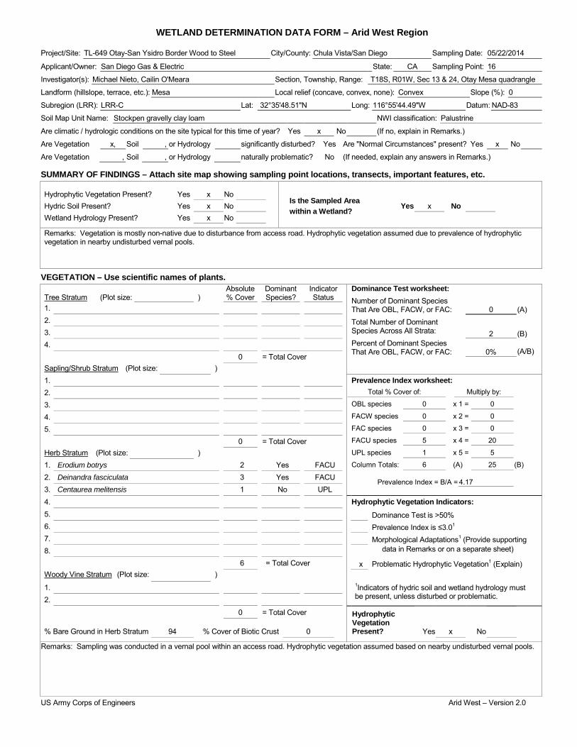
WETLAND DETERMINATION DATA FORM – Arid West Region Project/Site: TL-649 Otay-San Ysidro Border Wood to Steel City/County: Chula Vista/San Diego Sampling Date: 05/22/2014
Applicant/Owner: San Diego Gas & Electric State: CA Sampling Point: 16
Investigator(s): Michael Nieto, Cailin O'Meara Section, Township, Range: T18S, R01W, Sec 13 & 24, Otay Mesa quadrangle
Landform (hillslope, terrace, etc.): Mesa Local relief (concave, convex, none): Convex Slope (%): 0
Subregion (LRR): LRR-C Lat: 32°35'48.51"N Long: 116°55'44.49"W Datum: NAD-83
Soil Map Unit Name: Stockpen gravelly clay loam NWI classification: Palustrine
Are climatic / hydrologic conditions on the site typical for this time of year? Yes x No (If no, explain in Remarks.)
Are Vegetation x, Soil , or Hydrology significantly disturbed? Yes Are "Normal Circumstances" present? Yes x No
Are Vegetation , Soil , or Hydrology naturally problematic? No (If needed, explain any answers in Remarks.)
SUMMARY OF FINDINGS – Attach site map showing sampling point locations, transects, important features, etc.
Hydrophytic Vegetation Present? Yes x No Is the Sampled Area within a Wetland?
Hydric Soil Present? Yes x No Yes x No Wetland Hydrology Present? Yes x No
Remarks: Vegetation is mostly non-native due to disturbance from access road. Hydrophytic vegetation assumed due to prevalence of hydrophytic vegetation in nearby undisturbed vernal pools.
VEGETATION – Use scientific names of plants. Absolute Dominant Indicator Dominance Test worksheet:
Number of Dominant Species That Are OBL, FACW, or FAC: Total Number of Dominant Species Across All Strata: Percent of Dominant Species That Are OBL, FACW, or FAC:
0
(A)
2
(B)
0% (A/B)
Tree Stratum (Plot size: ) % Cover Species? Status 1. 2. 3. 4. 0 = Total Cover Sapling/Shrub Stratum (Plot size: ) 1. Prevalence Index worksheet:
Total % Cover of: Multiply by:
OBL species 0 x 1 = 0
FACW species 0 x 2 = 0
FAC species 0 x 3 = 0
FACU species 5 x 4 = 20
UPL species 1 x 5 = 5
Column Totals: 6 (A) 25 (B)
Prevalence Index = B/A = 4.17
2. 3. 4. 5. 0 = Total Cover Herb Stratum (Plot size: ) 1. Erodium botrys 2 Yes FACU 2. Deinandra fasciculata 3 Yes FACU 3. Centaurea melitensis 1 No UPL 4. Hydrophytic Vegetation Indicators: 5. Dominance Test is >50% 6. Prevalence Index is ≤3.01 7. Morphological Adaptations1 (Provide supporting 8. data in Remarks or on a separate sheet)
6 = Total Cover x Problematic Hydrophytic Vegetation1 (Explain) Woody Vine Stratum (Plot size: ) 1. 1Indicators of hydric soil and wetland hydrology must
be present, unless disturbed or problematic. 2.
0 = Total Cover Hydrophytic Vegetation Present?
% Bare Ground in Herb Stratum 94 % Cover of Biotic Crust 0 Yes x No
Remarks: Sampling was conducted in a vernal pool within an access road. Hydrophytic vegetation assumed based on nearby undisturbed vernal pools.
US Army Corps of Engineers Arid West – Version 2.0

SOIL Sampling Point: 16 ____________ Profile Description: (Describe to the depth needed to document the indicator or confirm the absence of indicators.) Depth Matrix Redox Features (inches) Color (moist) % Color (moist) % Type1 Loc2 Texture Remarks
1Type: C=Concentration, D=Depletion, RM=Reduced Matrix, CS=Covered or Coated Sand Grains. 2Location: PL=Pore Lining, RC=Root Channel, M=Matrix. Hydric Soil Indicators: (Applicable to all LRRs, unless otherwise noted.) Indicators for Problematic Hydric Soils3: Histosol (A1) Sandy Redox (S5) 1 cm Muck (A9) (LRR C) Histic Epipedon (A2) Stripped Matrix (S6) 2 cm Muck (A10) (LRR B) Black Histic (A3) Loamy Mucky Mineral (F1) Reduced Vertic (F18) Hydrogen Sulfide (A4) Loamy Gleyed Matrix (F2) Red Parent Material (TF2) Stratified Layers (A5) (LRR C) Depleted Matrix (F3) Other (Explain in Remarks) 1 cm Muck (A9) (LRR D) Redox Dark Surface (F6) Depleted Below Dark Surface (A11) Depleted Dark Surface (F7) Thick Dark Surface (A12) Redox Depressions (F8) 3Indicators of hydrophytic vegetation and Sandy Mucky Mineral (S1) x Vernal Pools (F9) wetland hydrology must be present, Sandy Gleyed Matrix (S4) unless disturbed or problematic.
Restrictive Layer (if present): Type: Depth (inches): Hydric Soil Present? Yes x No
Remarks: No soil pit was dug due to the documented presence of San Diego fairy shrimp. Hydric soils were assumed due to strong hydrology indicators.
HYDROLOGY Wetland Hydrology Indicators: Secondary Indicators (2 or more required) Primary Indicators (minimum of one required; check all that apply) Water Marks (B1) (Riverine) Surface Water (A1) Salt Crust (B11) Sediment Deposits (B2) (Riverine) High Water Table (A2) Biotic Crust (B12) Drift Deposits (B3) (Riverine) Saturation (A3) Aquatic Invertebrates (B13) Drainage Patterns (B10) Water Marks (B1) (Nonriverine) Hydrogen Sulfide Odor (C1) Dry-Season Water Table (C2) Sediment Deposits (B2) (Nonriverine) Oxidized Rhizospheres along Living Roots (C3) Thin Muck Surface (C7) Drift Deposits (B3) (Nonriverine) Presence of Reduced Iron (C4) Crayfish Burrows (C8) x Surface Soil Cracks (B6) Recent Iron Reduction in Tilled Soils (C6) Saturation Visible on Aerial Imagery (C9) Inundation Visible on Aerial Imagery (B7) Thin Muck Surface (C7) Shallow Aquitard (D3) Water-Stained Leaves (B9) Other (Explain in Remarks) FAC-Neutral Test (D5)
Field Observations: Surface Water Present? Yes No x Depth (inches): Water Table Present? Yes No x Depth (inches): Saturation Present? Yes No x Depth (inches): Wetland Hydrology Present? Yes x No (includes capillary fringe)
Describe Recorded Data (stream gauge, monitoring well, aerial photos, previous inspections), if available:
Remarks:
US Army Corps of Engineers Arid West – Version 2.0

WETLAND DETERMINATION DATA FORM – Arid West Region Project/Site: TL-649 Otay-San Ysidro Border Wood to Steel City/County: Chula Vista/San Diego Sampling Date: 05/22/2014
Applicant/Owner: San Diego Gas & Electric State: CA Sampling Point: 17
Investigator(s): Michael Nieto, Cailin O'Meara Section, Township, Range: T18S, R01W, Sec. 24, Otay Mesa quadrangle
Landform (hillslope, terrace, etc.): Vernal pool Local relief (concave, convex, none): Convex Slope (%): 0
Subregion (LRR): LRR-C Lat: 32°35'29.19"N Long: 116°56'21.86"W Datum: NAD-83
Soil Map Unit Name: Stockpen gravelly clay loam NWI classification: Palustrine
Are climatic / hydrologic conditions on the site typical for this time of year? Yes x No (If no, explain in Remarks.)
Are Vegetation x, Soil , or Hydrology significantly disturbed? Yes Are "Normal Circumstances" present? Yes x No
Are Vegetation , Soil , or Hydrology naturally problematic? No (If needed, explain any answers in Remarks.)
SUMMARY OF FINDINGS – Attach site map showing sampling point locations, transects, important features, etc.
Hydrophytic Vegetation Present? Yes x No Is the Sampled Area within a Wetland?
Hydric Soil Present? Yes x No Yes x No Wetland Hydrology Present? Yes x No
Remarks: Vegetation significantly disturbed from access road.
VEGETATION – Use scientific names of plants. Absolute Dominant Indicator Dominance Test worksheet:
Number of Dominant Species That Are OBL, FACW, or FAC: Total Number of Dominant Species Across All Strata: Percent of Dominant Species That Are OBL, FACW, or FAC:
2
(A)
2
(B)
100% (A/B)
Tree Stratum (Plot size: ) % Cover Species? Status 1. 2. 3. 4. = Total Cover Sapling/Shrub Stratum (Plot size: ) 1. Prevalence Index worksheet:
Total % Cover of: Multiply by:
OBL species x 1 =
FACW species x 2 =
FAC species x 3 =
FACU species x 4 =
UPL species x 5 =
Column Totals: (A) (B)
Prevalence Index = B/A =
2. 3. 4. 5. = Total Cover Herb Stratum (Plot size: ) 1. Psilocarphus brevissimus var. brevissimus 8 Yes FACW 2. Polypogon monspeliensis 3 Yes FACW 3. Festuca perennis 2 No FAC 4. Hydrophytic Vegetation Indicators: 5. x Dominance Test is >50% 6. Prevalence Index is ≤3.01 7. Morphological Adaptations1 (Provide supporting 8. data in Remarks or on a separate sheet)
13 = Total Cover Problematic Hydrophytic Vegetation1 (Explain) Woody Vine Stratum (Plot size: ) 1. 1Indicators of hydric soil and wetland hydrology must
be present, unless disturbed or problematic. 2.
= Total Cover Hydrophytic Vegetation Present?
% Bare Ground in Herb Stratum % Cover of Biotic Crust Yes x No
Remarks: Sampling was conducted in a vernal pool within an access road.
US Army Corps of Engineers Arid West – Version 2.0

SOIL Sampling Point: 17 ____________ Profile Description: (Describe to the depth needed to document the indicator or confirm the absence of indicators.) Depth Matrix Redox Features (inches) Color (moist) % Color (moist) % Type1 Loc2 Texture Remarks
1Type: C=Concentration, D=Depletion, RM=Reduced Matrix, CS=Covered or Coated Sand Grains. 2Location: PL=Pore Lining, RC=Root Channel, M=Matrix. Hydric Soil Indicators: (Applicable to all LRRs, unless otherwise noted.) Indicators for Problematic Hydric Soils3: Histosol (A1) Sandy Redox (S5) 1 cm Muck (A9) (LRR C) Histic Epipedon (A2) Stripped Matrix (S6) 2 cm Muck (A10) (LRR B) Black Histic (A3) Loamy Mucky Mineral (F1) Reduced Vertic (F18) Hydrogen Sulfide (A4) Loamy Gleyed Matrix (F2) Red Parent Material (TF2) Stratified Layers (A5) (LRR C) Depleted Matrix (F3) Other (Explain in Remarks) 1 cm Muck (A9) (LRR D) Redox Dark Surface (F6) Depleted Below Dark Surface (A11) Depleted Dark Surface (F7) Thick Dark Surface (A12) Redox Depressions (F8) 3Indicators of hydrophytic vegetation and Sandy Mucky Mineral (S1) x Vernal Pools (F9) wetland hydrology must be present, Sandy Gleyed Matrix (S4) unless disturbed or problematic.
Restrictive Layer (if present): Type: Depth (inches): Hydric Soil Present? Yes x No
Remarks: No soil pit was dug due to the documented presence of San Diego fairy shrimp. Hydric soils were assumed due to strong hydrophytic vegetation and hydrology indicators.
HYDROLOGY Wetland Hydrology Indicators: Secondary Indicators (2 or more required) Primary Indicators (minimum of one required; check all that apply) Water Marks (B1) (Riverine) Surface Water (A1) Salt Crust (B11) Sediment Deposits (B2) (Riverine) High Water Table (A2) Biotic Crust (B12) Drift Deposits (B3) (Riverine) Saturation (A3) Aquatic Invertebrates (B13) Drainage Patterns (B10) Water Marks (B1) (Nonriverine) Hydrogen Sulfide Odor (C1) Dry-Season Water Table (C2) Sediment Deposits (B2) (Nonriverine) Oxidized Rhizospheres along Living Roots (C3) Thin Muck Surface (C7) Drift Deposits (B3) (Nonriverine) Presence of Reduced Iron (C4) Crayfish Burrows (C8) x Surface Soil Cracks (B6) Recent Iron Reduction in Tilled Soils (C6) Saturation Visible on Aerial Imagery (C9) Inundation Visible on Aerial Imagery (B7) Thin Muck Surface (C7) Shallow Aquitard (D3) Water-Stained Leaves (B9) Other (Explain in Remarks) FAC-Neutral Test (D5)
Field Observations: Surface Water Present? Yes No x Depth (inches): Water Table Present? Yes No x Depth (inches): Saturation Present? Yes No x Depth (inches): Wetland Hydrology Present? Yes x No (includes capillary fringe)
Describe Recorded Data (stream gauge, monitoring well, aerial photos, previous inspections), if available:
Remarks:
US Army Corps of Engineers Arid West – Version 2.0

WETLAND DETERMINATION DATA FORM – Arid West Region Project/Site: TL-649 Otay-San Ysidro Border Wood to Steel City/County: Chula Vista/San Diego Sampling Date: 05/22/2014
Applicant/Owner: San Diego Gas & Electric State: CA Sampling Point: 18
Investigator(s): Michael Nieto, Cailin O'Meara Section, Township, Range: T18S, R01W, Sec. 24, Otay Mesa quadrangle
Landform (hillslope, terrace, etc.): Mesa Local relief (concave, convex, none): Convex Slope (%): 0
Subregion (LRR): LRR-C Lat: 32°35'28.64"N Long: 116°56'21.94"W Datum: NAD-83
Soil Map Unit Name: Stockpen gravelly clay loam NWI classification: Palustrine
Are climatic / hydrologic conditions on the site typical for this time of year? Yes x No (If no, explain in Remarks.)
Are Vegetation x, Soil , or Hydrology significantly disturbed? Yes Are "Normal Circumstances" present? Yes x No
Are Vegetation , Soil , or Hydrology naturally problematic? No (If needed, explain any answers in Remarks.)
SUMMARY OF FINDINGS – Attach site map showing sampling point locations, transects, important features, etc.
Hydrophytic Vegetation Present? Yes x No Is the Sampled Area within a Wetland?
Hydric Soil Present? Yes x No Yes x No Wetland Hydrology Present? Yes x No
Remarks: Vegetation significantly disturbed from access road.
VEGETATION – Use scientific names of plants. Absolute Dominant Indicator Dominance Test worksheet:
Number of Dominant Species That Are OBL, FACW, or FAC: Total Number of Dominant Species Across All Strata: Percent of Dominant Species That Are OBL, FACW, or FAC:
2
(A)
2
(B)
100% (A/B)
Tree Stratum (Plot size: ) % Cover Species? Status 1. 2. 3. 4. = Total Cover Sapling/Shrub Stratum (Plot size: ) 1. Prevalence Index worksheet:
Total % Cover of: Multiply by:
OBL species x 1 =
FACW species x 2 =
FAC species x 3 =
FACU species x 4 =
UPL species x 5 =
Column Totals: (A) (B)
Prevalence Index = B/A =
2. 3. 4. 5. = Total Cover Herb Stratum (Plot size: ) 1. Psilocarphus brevissimus var. brevissimus 3 Yes FACW 2. Polypogon monspeliensis 3 Yes FACW 3. Festuca perennis 1 No FAC 4. Hydrophytic Vegetation Indicators: 5. x Dominance Test is >50% 6. Prevalence Index is ≤3.01 7. Morphological Adaptations1 (Provide supporting 8. data in Remarks or on a separate sheet)
7 = Total Cover Problematic Hydrophytic Vegetation1 (Explain) Woody Vine Stratum (Plot size: ) 1. 1Indicators of hydric soil and wetland hydrology must
be present, unless disturbed or problematic. 2.
= Total Cover Hydrophytic Vegetation Present?
% Bare Ground in Herb Stratum % Cover of Biotic Crust Yes x No
Remarks: Sampling was conducted in a vernal pool within an access road.
US Army Corps of Engineers Arid West – Version 2.0

SOIL Sampling Point: 18 ____________ Profile Description: (Describe to the depth needed to document the indicator or confirm the absence of indicators.) Depth Matrix Redox Features (inches) Color (moist) % Color (moist) % Type1 Loc2 Texture Remarks
1Type: C=Concentration, D=Depletion, RM=Reduced Matrix, CS=Covered or Coated Sand Grains. 2Location: PL=Pore Lining, RC=Root Channel, M=Matrix. Hydric Soil Indicators: (Applicable to all LRRs, unless otherwise noted.) Indicators for Problematic Hydric Soils3: Histosol (A1) Sandy Redox (S5) 1 cm Muck (A9) (LRR C) Histic Epipedon (A2) Stripped Matrix (S6) 2 cm Muck (A10) (LRR B) Black Histic (A3) Loamy Mucky Mineral (F1) Reduced Vertic (F18) Hydrogen Sulfide (A4) Loamy Gleyed Matrix (F2) Red Parent Material (TF2) Stratified Layers (A5) (LRR C) Depleted Matrix (F3) Other (Explain in Remarks) 1 cm Muck (A9) (LRR D) Redox Dark Surface (F6) Depleted Below Dark Surface (A11) Depleted Dark Surface (F7) Thick Dark Surface (A12) Redox Depressions (F8) 3Indicators of hydrophytic vegetation and Sandy Mucky Mineral (S1) x Vernal Pools (F9) wetland hydrology must be present, Sandy Gleyed Matrix (S4) unless disturbed or problematic.
Restrictive Layer (if present): Type: Depth (inches): Hydric Soil Present? Yes x No
Remarks: No soil pit was dug due to the documented presence of San Diego fairy shrimp. Hydric soils were assumed due to strong hydrophytic vegetation and hydrology indicators.
HYDROLOGY Wetland Hydrology Indicators: Secondary Indicators (2 or more required) Primary Indicators (minimum of one required; check all that apply) Water Marks (B1) (Riverine) Surface Water (A1) Salt Crust (B11) Sediment Deposits (B2) (Riverine) High Water Table (A2) Biotic Crust (B12) Drift Deposits (B3) (Riverine) Saturation (A3) Aquatic Invertebrates (B13) Drainage Patterns (B10) Water Marks (B1) (Nonriverine) Hydrogen Sulfide Odor (C1) Dry-Season Water Table (C2) Sediment Deposits (B2) (Nonriverine) Oxidized Rhizospheres along Living Roots (C3) Thin Muck Surface (C7) Drift Deposits (B3) (Nonriverine) Presence of Reduced Iron (C4) Crayfish Burrows (C8) x Surface Soil Cracks (B6) Recent Iron Reduction in Tilled Soils (C6) Saturation Visible on Aerial Imagery (C9) Inundation Visible on Aerial Imagery (B7) Thin Muck Surface (C7) Shallow Aquitard (D3) Water-Stained Leaves (B9) Other (Explain in Remarks) FAC-Neutral Test (D5)
Field Observations: Surface Water Present? Yes No x Depth (inches): Water Table Present? Yes No x Depth (inches): Saturation Present? Yes No x Depth (inches): Wetland Hydrology Present? Yes x No (includes capillary fringe)
Describe Recorded Data (stream gauge, monitoring well, aerial photos, previous inspections), if available:
Remarks:
US Army Corps of Engineers Arid West – Version 2.0

WETLAND DETERMINATION DATA FORM – Arid West Region Project/Site: TL-649 Otay-San Ysidro Border Wood to Steel City/County: Chula Vista/San Diego Sampling Date: 05/22/2014
Applicant/Owner: San Diego Gas & Electric State: CA Sampling Point: 19
Investigator(s): Michael Nieto, Cailin O'Meara Section, Township, Range: T18S, R01W, Sec. 24, Otay Mesa quadrangle
Landform (hillslope, terrace, etc.): Mesa Local relief (concave, convex, none): Convex Slope (%): 0
Subregion (LRR): LRR-C Lat: 32°35'28.30"N Long: 116°56'21.89"W Datum: NAD-83
Soil Map Unit Name: SStockpen gravelly clay loam NWI classification: Palustrine
Are climatic / hydrologic conditions on the site typical for this time of year? Yes x No (If no, explain in Remarks.)
Are Vegetation x, Soil , or Hydrology significantly disturbed? Yes Are "Normal Circumstances" present? Yes x No
Are Vegetation , Soil , or Hydrology naturally problematic? No (If needed, explain any answers in Remarks.)
SUMMARY OF FINDINGS – Attach site map showing sampling point locations, transects, important features, etc.
Hydrophytic Vegetation Present? Yes x No Is the Sampled Area within a Wetland?
Hydric Soil Present? Yes x No Yes x No Wetland Hydrology Present? Yes x No
Remarks: Vegetation is lacking due to disturbance from access road. Hydrophytic vegetation assumed due to prevalence of hydrophytic vegetation in nearby undisturbed vernal pools.
VEGETATION – Use scientific names of plants. Absolute Dominant Indicator Dominance Test worksheet:
Number of Dominant Species That Are OBL, FACW, or FAC: Total Number of Dominant Species Across All Strata: Percent of Dominant Species That Are OBL, FACW, or FAC:
0
(A)
0
(B)
0 (A/B)
Tree Stratum (Plot size: ) % Cover Species? Status 1. 2. 3. 4. 0 = Total Cover Sapling/Shrub Stratum (Plot size: ) 1. Prevalence Index worksheet:
Total % Cover of: Multiply by:
OBL species x 1 =
FACW species x 2 =
FAC species x 3 =
FACU species x 4 =
UPL species x 5 =
Column Totals: (A) (B)
Prevalence Index = B/A =
2. 3. 4. 5. 0 = Total Cover Herb Stratum (Plot size: ) 1. 2. 3. 4. Hydrophytic Vegetation Indicators: 5. Dominance Test is >50% 6. Prevalence Index is ≤3.01 7. Morphological Adaptations1 (Provide supporting 8. data in Remarks or on a separate sheet)
0 = Total Cover x Problematic Hydrophytic Vegetation1 (Explain) Woody Vine Stratum (Plot size: ) 1. 1Indicators of hydric soil and wetland hydrology must
be present, unless disturbed or problematic. 2.
0 = Total Cover Hydrophytic Vegetation Present?
% Bare Ground in Herb Stratum 100 % Cover of Biotic Crust 0 Yes No x
Remarks: Sampling was conducted in a vernal pool within an access road. Hydrophytic vegetation assumed based on nearby undisturbed vernal pools.
US Army Corps of Engineers Arid West – Version 2.0

SOIL Sampling Point: 19 ____________ Profile Description: (Describe to the depth needed to document the indicator or confirm the absence of indicators.) Depth Matrix Redox Features (inches) Color (moist) % Color (moist) % Type1 Loc2 Texture Remarks
1Type: C=Concentration, D=Depletion, RM=Reduced Matrix, CS=Covered or Coated Sand Grains. 2Location: PL=Pore Lining, RC=Root Channel, M=Matrix. Hydric Soil Indicators: (Applicable to all LRRs, unless otherwise noted.) Indicators for Problematic Hydric Soils3: Histosol (A1) Sandy Redox (S5) 1 cm Muck (A9) (LRR C) Histic Epipedon (A2) Stripped Matrix (S6) 2 cm Muck (A10) (LRR B) Black Histic (A3) Loamy Mucky Mineral (F1) Reduced Vertic (F18) Hydrogen Sulfide (A4) Loamy Gleyed Matrix (F2) Red Parent Material (TF2) Stratified Layers (A5) (LRR C) Depleted Matrix (F3) Other (Explain in Remarks) 1 cm Muck (A9) (LRR D) Redox Dark Surface (F6) Depleted Below Dark Surface (A11) Depleted Dark Surface (F7) Thick Dark Surface (A12) Redox Depressions (F8) 3Indicators of hydrophytic vegetation and Sandy Mucky Mineral (S1) x Vernal Pools (F9) wetland hydrology must be present, Sandy Gleyed Matrix (S4) unless disturbed or problematic.
Restrictive Layer (if present): Type: Depth (inches): Hydric Soil Present? Yes x No
Remarks: No soil pit was dug due to the documented presence of San Diego fairy shrimp. Hydric soils were assumed due to strong hydrophytic vegetation and hydrology indicators.
HYDROLOGY Wetland Hydrology Indicators: Secondary Indicators (2 or more required) Primary Indicators (minimum of one required; check all that apply) Water Marks (B1) (Riverine) Surface Water (A1) Salt Crust (B11) Sediment Deposits (B2) (Riverine) High Water Table (A2) Biotic Crust (B12) Drift Deposits (B3) (Riverine) Saturation (A3) Aquatic Invertebrates (B13) Drainage Patterns (B10) Water Marks (B1) (Nonriverine) Hydrogen Sulfide Odor (C1) Dry-Season Water Table (C2) Sediment Deposits (B2) (Nonriverine) Oxidized Rhizospheres along Living Roots (C3) Thin Muck Surface (C7) Drift Deposits (B3) (Nonriverine) Presence of Reduced Iron (C4) Crayfish Burrows (C8) x Surface Soil Cracks (B6) Recent Iron Reduction in Tilled Soils (C6) Saturation Visible on Aerial Imagery (C9) Inundation Visible on Aerial Imagery (B7) Thin Muck Surface (C7) Shallow Aquitard (D3) Water-Stained Leaves (B9) Other (Explain in Remarks) FAC-Neutral Test (D5)
Field Observations: Surface Water Present? Yes No x Depth (inches): Water Table Present? Yes No x Depth (inches): Saturation Present? Yes No x Depth (inches): Wetland Hydrology Present? Yes x No (includes capillary fringe)
Describe Recorded Data (stream gauge, monitoring well, aerial photos, previous inspections), if available:
Remarks:
US Army Corps of Engineers Arid West – Version 2.0
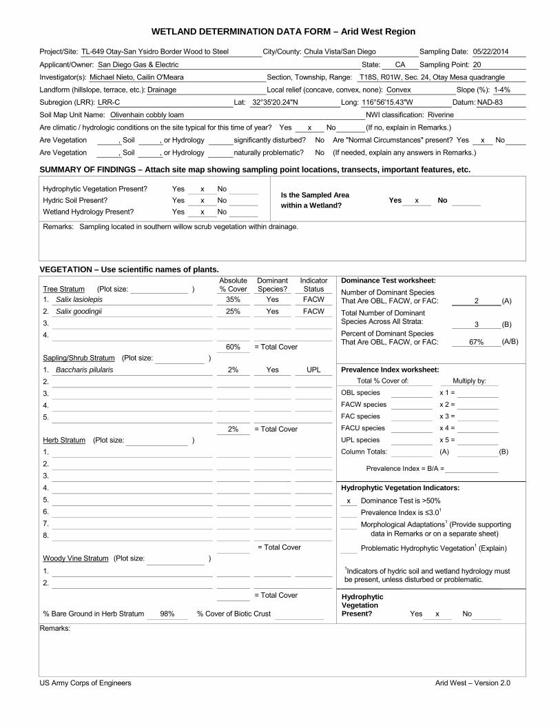
WETLAND DETERMINATION DATA FORM – Arid West Region Project/Site: TL-649 Otay-San Ysidro Border Wood to Steel City/County: Chula Vista/San Diego Sampling Date: 05/22/2014
Applicant/Owner: San Diego Gas & Electric State: CA Sampling Point: 20
Investigator(s): Michael Nieto, Cailin O'Meara Section, Township, Range: T18S, R01W, Sec. 24, Otay Mesa quadrangle
Landform (hillslope, terrace, etc.): Drainage Local relief (concave, convex, none): Convex Slope (%): 1-4%
Subregion (LRR): LRR-C Lat: 32°35'20.24"N Long: 116°56'15.43"W Datum: NAD-83
Soil Map Unit Name: Olivenhain cobbly loam NWI classification: Riverine
Are climatic / hydrologic conditions on the site typical for this time of year? Yes x No (If no, explain in Remarks.)
Are Vegetation , Soil , or Hydrology significantly disturbed? No Are "Normal Circumstances" present? Yes x No
Are Vegetation , Soil , or Hydrology naturally problematic? No (If needed, explain any answers in Remarks.)
SUMMARY OF FINDINGS – Attach site map showing sampling point locations, transects, important features, etc.
Hydrophytic Vegetation Present? Yes x No Is the Sampled Area within a Wetland?
Hydric Soil Present? Yes x No Yes x No Wetland Hydrology Present? Yes x No
Remarks: Sampling located in southern willow scrub vegetation within drainage.
VEGETATION – Use scientific names of plants. Absolute Dominant Indicator Dominance Test worksheet:
Number of Dominant Species That Are OBL, FACW, or FAC: Total Number of Dominant Species Across All Strata: Percent of Dominant Species That Are OBL, FACW, or FAC:
2
(A)
3
(B)
67% (A/B)
Tree Stratum (Plot size: ) % Cover Species? Status 1. Salix lasiolepis 35% Yes FACW 2. Salix goodingii 25% Yes FACW 3. 4. 60% = Total Cover Sapling/Shrub Stratum (Plot size: ) 1. Baccharis pilularis 2% Yes UPL Prevalence Index worksheet:
Total % Cover of: Multiply by:
OBL species x 1 =
FACW species x 2 =
FAC species x 3 =
FACU species x 4 =
UPL species x 5 =
Column Totals: (A) (B)
Prevalence Index = B/A =
2. 3. 4. 5. 2% = Total Cover Herb Stratum (Plot size: ) 1. 2. 3. 4. Hydrophytic Vegetation Indicators: 5. x Dominance Test is >50% 6. Prevalence Index is ≤3.01 7. Morphological Adaptations1 (Provide supporting 8. data in Remarks or on a separate sheet)
= Total Cover Problematic Hydrophytic Vegetation1 (Explain) Woody Vine Stratum (Plot size: ) 1. 1Indicators of hydric soil and wetland hydrology must
be present, unless disturbed or problematic. 2.
= Total Cover Hydrophytic Vegetation Present?
% Bare Ground in Herb Stratum 98% % Cover of Biotic Crust Yes x No
Remarks:
US Army Corps of Engineers Arid West – Version 2.0

SOIL Sampling Point: 20 ____________ Profile Description: (Describe to the depth needed to document the indicator or confirm the absence of indicators.) Depth Matrix Redox Features (inches) Color (moist) % Color (moist) % Type1 Loc2 Texture Remarks
1Type: C=Concentration, D=Depletion, RM=Reduced Matrix, CS=Covered or Coated Sand Grains. 2Location: PL=Pore Lining, RC=Root Channel, M=Matrix. Hydric Soil Indicators: (Applicable to all LRRs, unless otherwise noted.) Indicators for Problematic Hydric Soils3: Histosol (A1) Sandy Redox (S5) 1 cm Muck (A9) (LRR C) Histic Epipedon (A2) Stripped Matrix (S6) 2 cm Muck (A10) (LRR B) Black Histic (A3) Loamy Mucky Mineral (F1) Reduced Vertic (F18) Hydrogen Sulfide (A4) Loamy Gleyed Matrix (F2) Red Parent Material (TF2) Stratified Layers (A5) (LRR C) Depleted Matrix (F3) Other (Explain in Remarks) 1 cm Muck (A9) (LRR D) Redox Dark Surface (F6) Depleted Below Dark Surface (A11) Depleted Dark Surface (F7) Thick Dark Surface (A12) Redox Depressions (F8) 3Indicators of hydrophytic vegetation and Sandy Mucky Mineral (S1) Vernal Pools (F9) wetland hydrology must be present, Sandy Gleyed Matrix (S4) unless disturbed or problematic.
Restrictive Layer (if present): Type: Rocky conglomerate Depth (inches): Hydric Soil Present? Yes x No
Remarks: Rocky conglomerate precludes digging. Hydric soils assumed based on strong hydrophytic vegetation and hydrology indicators.
HYDROLOGY Wetland Hydrology Indicators: Secondary Indicators (2 or more required) Primary Indicators (minimum of one required; check all that apply) Water Marks (B1) (Riverine) x Surface Water (A1) Salt Crust (B11) Sediment Deposits (B2) (Riverine) High Water Table (A2) Biotic Crust (B12) x Drift Deposits (B3) (Riverine) Saturation (A3) Aquatic Invertebrates (B13) Drainage Patterns (B10) Water Marks (B1) (Nonriverine) Hydrogen Sulfide Odor (C1) Dry-Season Water Table (C2) Sediment Deposits (B2) (Nonriverine) Oxidized Rhizospheres along Living Roots (C3) Thin Muck Surface (C7) Drift Deposits (B3) (Nonriverine) Presence of Reduced Iron (C4) Crayfish Burrows (C8) Surface Soil Cracks (B6) Recent Iron Reduction in Tilled Soils (C6) Saturation Visible on Aerial Imagery (C9) Inundation Visible on Aerial Imagery (B7) Thin Muck Surface (C7) Shallow Aquitard (D3) Water-Stained Leaves (B9) Other (Explain in Remarks) FAC-Neutral Test (D5)
Field Observations: Surface Water Present? Yes x No Depth (inches): 4 Water Table Present? Yes x No Depth (inches): 0 Saturation Present? Yes x No Depth (inches): 0 Wetland Hydrology Present? Yes x No (includes capillary fringe)
Describe Recorded Data (stream gauge, monitoring well, aerial photos, previous inspections), if available:
Remarks:
US Army Corps of Engineers Arid West – Version 2.0
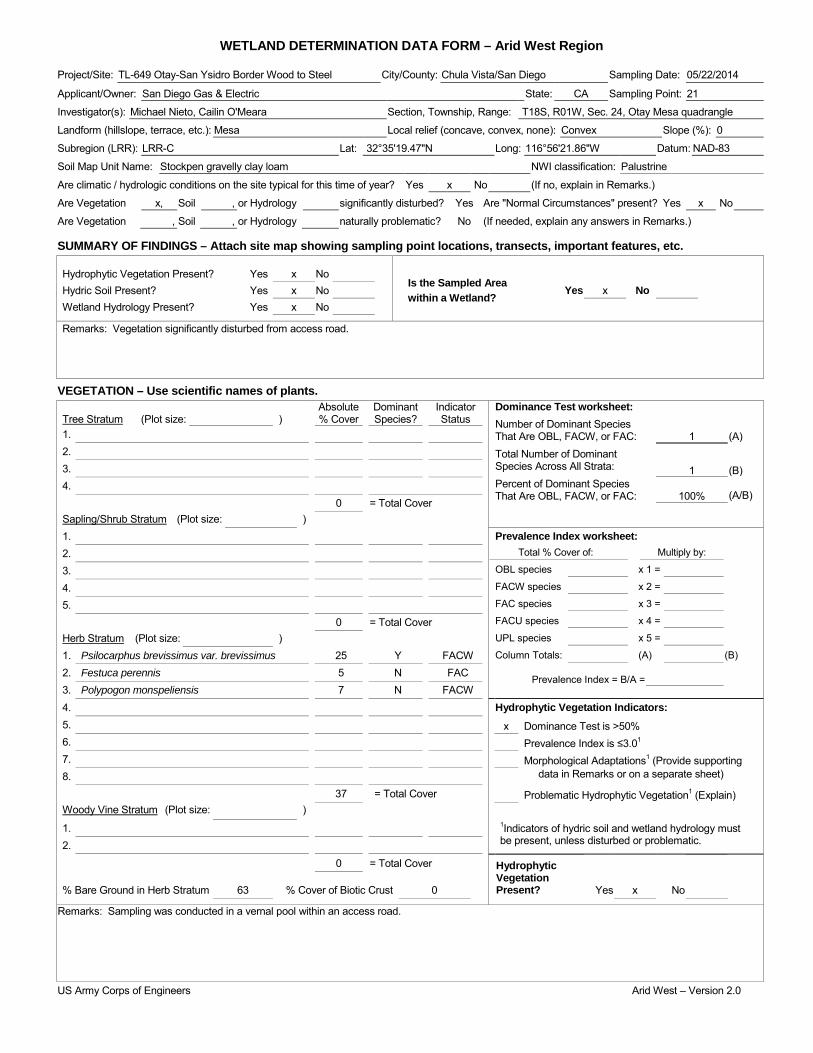
WETLAND DETERMINATION DATA FORM – Arid West Region Project/Site: TL-649 Otay-San Ysidro Border Wood to Steel City/County: Chula Vista/San Diego Sampling Date: 05/22/2014
Applicant/Owner: San Diego Gas & Electric State: CA Sampling Point: 21
Investigator(s): Michael Nieto, Cailin O'Meara Section, Township, Range: T18S, R01W, Sec. 24, Otay Mesa quadrangle
Landform (hillslope, terrace, etc.): Mesa Local relief (concave, convex, none): Convex Slope (%): 0
Subregion (LRR): LRR-C Lat: 32°35'19.47"N Long: 116°56'21.86"W Datum: NAD-83
Soil Map Unit Name: Stockpen gravelly clay loam NWI classification: Palustrine
Are climatic / hydrologic conditions on the site typical for this time of year? Yes x No (If no, explain in Remarks.)
Are Vegetation x, Soil , or Hydrology significantly disturbed? Yes Are "Normal Circumstances" present? Yes x No
Are Vegetation , Soil , or Hydrology naturally problematic? No (If needed, explain any answers in Remarks.)
SUMMARY OF FINDINGS – Attach site map showing sampling point locations, transects, important features, etc.
Hydrophytic Vegetation Present? Yes x No Is the Sampled Area within a Wetland?
Hydric Soil Present? Yes x No Yes x No Wetland Hydrology Present? Yes x No
Remarks: Vegetation significantly disturbed from access road.
VEGETATION – Use scientific names of plants. Absolute Dominant Indicator Dominance Test worksheet:
Number of Dominant Species That Are OBL, FACW, or FAC: Total Number of Dominant Species Across All Strata: Percent of Dominant Species That Are OBL, FACW, or FAC:
1
(A)
1
(B)
100% (A/B)
Tree Stratum (Plot size: ) % Cover Species? Status 1. 2. 3. 4. 0 = Total Cover Sapling/Shrub Stratum (Plot size: ) 1. Prevalence Index worksheet:
Total % Cover of: Multiply by:
OBL species x 1 =
FACW species x 2 =
FAC species x 3 =
FACU species x 4 =
UPL species x 5 =
Column Totals: (A) (B)
Prevalence Index = B/A =
2. 3. 4. 5. 0 = Total Cover Herb Stratum (Plot size: ) 1. Psilocarphus brevissimus var. brevissimus 25 Y FACW 2. Festuca perennis 5 N FAC 3. Polypogon monspeliensis 7 N FACW 4. Hydrophytic Vegetation Indicators: 5. x Dominance Test is >50% 6. Prevalence Index is ≤3.01 7. Morphological Adaptations1 (Provide supporting 8. data in Remarks or on a separate sheet)
37 = Total Cover Problematic Hydrophytic Vegetation1 (Explain) Woody Vine Stratum (Plot size: ) 1. 1Indicators of hydric soil and wetland hydrology must
be present, unless disturbed or problematic. 2.
0 = Total Cover Hydrophytic Vegetation Present?
% Bare Ground in Herb Stratum 63 % Cover of Biotic Crust 0 Yes x No
Remarks: Sampling was conducted in a vernal pool within an access road.
US Army Corps of Engineers Arid West – Version 2.0

SOIL Sampling Point: 21 ____________ Profile Description: (Describe to the depth needed to document the indicator or confirm the absence of indicators.) Depth Matrix Redox Features (inches) Color (moist) % Color (moist) % Type1 Loc2 Texture Remarks
1Type: C=Concentration, D=Depletion, RM=Reduced Matrix, CS=Covered or Coated Sand Grains. 2Location: PL=Pore Lining, RC=Root Channel, M=Matrix. Hydric Soil Indicators: (Applicable to all LRRs, unless otherwise noted.) Indicators for Problematic Hydric Soils3: Histosol (A1) Sandy Redox (S5) 1 cm Muck (A9) (LRR C) Histic Epipedon (A2) Stripped Matrix (S6) 2 cm Muck (A10) (LRR B) Black Histic (A3) Loamy Mucky Mineral (F1) Reduced Vertic (F18) Hydrogen Sulfide (A4) Loamy Gleyed Matrix (F2) Red Parent Material (TF2) Stratified Layers (A5) (LRR C) Depleted Matrix (F3) Other (Explain in Remarks) 1 cm Muck (A9) (LRR D) Redox Dark Surface (F6) Depleted Below Dark Surface (A11) Depleted Dark Surface (F7) Thick Dark Surface (A12) Redox Depressions (F8) 3Indicators of hydrophytic vegetation and Sandy Mucky Mineral (S1) x Vernal Pools (F9) wetland hydrology must be present, Sandy Gleyed Matrix (S4) unless disturbed or problematic.
Restrictive Layer (if present): Type: Depth (inches): Hydric Soil Present? Yes x No
Remarks: No soil pit was dug due to the documented presence of San Diego fairy shrimp. Hydric soils were assumed due to strong hydrophytic vegetation and hydrology indicators.
HYDROLOGY Wetland Hydrology Indicators: Secondary Indicators (2 or more required) Primary Indicators (minimum of one required; check all that apply) Water Marks (B1) (Riverine) Surface Water (A1) Salt Crust (B11) Sediment Deposits (B2) (Riverine) High Water Table (A2) Biotic Crust (B12) Drift Deposits (B3) (Riverine) Saturation (A3) Aquatic Invertebrates (B13) Drainage Patterns (B10) Water Marks (B1) (Nonriverine) Hydrogen Sulfide Odor (C1) Dry-Season Water Table (C2) Sediment Deposits (B2) (Nonriverine) Oxidized Rhizospheres along Living Roots (C3) Thin Muck Surface (C7) Drift Deposits (B3) (Nonriverine) Presence of Reduced Iron (C4) Crayfish Burrows (C8) x Surface Soil Cracks (B6) Recent Iron Reduction in Tilled Soils (C6) Saturation Visible on Aerial Imagery (C9) Inundation Visible on Aerial Imagery (B7) Thin Muck Surface (C7) Shallow Aquitard (D3) Water-Stained Leaves (B9) Other (Explain in Remarks) FAC-Neutral Test (D5)
Field Observations: Surface Water Present? Yes No x Depth (inches): Water Table Present? Yes No x Depth (inches): Saturation Present? Yes No x Depth (inches): Wetland Hydrology Present? Yes x No (includes capillary fringe)
Describe Recorded Data (stream gauge, monitoring well, aerial photos, previous inspections), if available:
Remarks:
US Army Corps of Engineers Arid West – Version 2.0

WETLAND DETERMINATION DATA FORM – Arid West Region Project/Site: TL-649 Otay-San Ysidro Border Wood to Steel City/County: Chula Vista/San Diego Sampling Date: 05/22/2014
Applicant/Owner: San Diego Gas & Electric State: CA Sampling Point: 22
Investigator(s): Michael Nieto, Cailin O'Meara Section, Township, Range: T18S, R01W, Sec. 24, Otay Mesa quadrangle
Landform (hillslope, terrace, etc.): Mesa Local relief (concave, convex, none): Convex Slope (%): 0
Subregion (LRR): LRR-C Lat: 32°35'18.27"N Long: 116°56'21.86"W Datum: NAD-83
Soil Map Unit Name: Stockpen gravelly clay loam NWI classification: Palustrine
Are climatic / hydrologic conditions on the site typical for this time of year? Yes x No (If no, explain in Remarks.)
Are Vegetation x, Soil , or Hydrology significantly disturbed? Yes Are "Normal Circumstances" present? Yes x No
Are Vegetation , Soil , or Hydrology naturally problematic? No (If needed, explain any answers in Remarks.)
SUMMARY OF FINDINGS – Attach site map showing sampling point locations, transects, important features, etc.
Hydrophytic Vegetation Present? Yes x No Is the Sampled Area within a Wetland?
Hydric Soil Present? Yes x No Yes x No Wetland Hydrology Present? Yes x No
Remarks: Vegetation significantly disturbed from access road.
VEGETATION – Use scientific names of plants. Absolute Dominant Indicator Dominance Test worksheet:
Number of Dominant Species That Are OBL, FACW, or FAC: Total Number of Dominant Species Across All Strata: Percent of Dominant Species That Are OBL, FACW, or FAC:
3
(A)
3
(B)
100% (A/B)
Tree Stratum (Plot size: ) % Cover Species? Status 1. 2. 3. 4. 0 = Total Cover Sapling/Shrub Stratum (Plot size: ) 1. Prevalence Index worksheet:
Total % Cover of: Multiply by:
OBL species x 1 =
FACW species x 2 =
FAC species x 3 =
FACU species x 4 =
UPL species x 5 =
Column Totals: (A) (B)
Prevalence Index = B/A =
2. 3. 4. 5. 0 = Total Cover Herb Stratum (Plot size: ) 1. Psilocarphus brevissimus var. brevissimus 2 Y FACW 2. Festuca perennis 3 Y FAC 3. Polypogon monspeliensis 5 Y FACW 4. Atriplex semibaccata 2 N FAC Hydrophytic Vegetation Indicators: 5. x Dominance Test is >50% 6. Prevalence Index is ≤3.01 7. Morphological Adaptations1 (Provide supporting 8. data in Remarks or on a separate sheet)
20 = Total Cover Problematic Hydrophytic Vegetation1 (Explain) Woody Vine Stratum (Plot size: ) 1. 1Indicators of hydric soil and wetland hydrology must
be present, unless disturbed or problematic. 2.
0 = Total Cover Hydrophytic Vegetation Present?
% Bare Ground in Herb Stratum 80 % Cover of Biotic Crust 0 Yes x No
Remarks: Sampling was conducted in a vernal pool within an access road.
US Army Corps of Engineers Arid West – Version 2.0

SOIL Sampling Point: 22 ____________ Profile Description: (Describe to the depth needed to document the indicator or confirm the absence of indicators.) Depth Matrix Redox Features (inches) Color (moist) % Color (moist) % Type1 Loc2 Texture Remarks
1Type: C=Concentration, D=Depletion, RM=Reduced Matrix, CS=Covered or Coated Sand Grains. 2Location: PL=Pore Lining, RC=Root Channel, M=Matrix. Hydric Soil Indicators: (Applicable to all LRRs, unless otherwise noted.) Indicators for Problematic Hydric Soils3: Histosol (A1) Sandy Redox (S5) 1 cm Muck (A9) (LRR C) Histic Epipedon (A2) Stripped Matrix (S6) 2 cm Muck (A10) (LRR B) Black Histic (A3) Loamy Mucky Mineral (F1) Reduced Vertic (F18) Hydrogen Sulfide (A4) Loamy Gleyed Matrix (F2) Red Parent Material (TF2) Stratified Layers (A5) (LRR C) Depleted Matrix (F3) Other (Explain in Remarks) 1 cm Muck (A9) (LRR D) Redox Dark Surface (F6) Depleted Below Dark Surface (A11) Depleted Dark Surface (F7) Thick Dark Surface (A12) Redox Depressions (F8) 3Indicators of hydrophytic vegetation and Sandy Mucky Mineral (S1) x Vernal Pools (F9) wetland hydrology must be present, Sandy Gleyed Matrix (S4) unless disturbed or problematic.
Restrictive Layer (if present): Type: Depth (inches): Hydric Soil Present? Yes x No
Remarks: No soil pit was dug due to the documented presence of San Diego fairy shrimp. Hydric soils were assumed due to strong hydrophytic vegetation and hydrology indicators.
HYDROLOGY Wetland Hydrology Indicators: Secondary Indicators (2 or more required) Primary Indicators (minimum of one required; check all that apply) Water Marks (B1) (Riverine) Surface Water (A1) Salt Crust (B11) Sediment Deposits (B2) (Riverine) High Water Table (A2) Biotic Crust (B12) Drift Deposits (B3) (Riverine) Saturation (A3) Aquatic Invertebrates (B13) Drainage Patterns (B10) Water Marks (B1) (Nonriverine) Hydrogen Sulfide Odor (C1) Dry-Season Water Table (C2) Sediment Deposits (B2) (Nonriverine) Oxidized Rhizospheres along Living Roots (C3) Thin Muck Surface (C7) Drift Deposits (B3) (Nonriverine) Presence of Reduced Iron (C4) Crayfish Burrows (C8) x Surface Soil Cracks (B6) Recent Iron Reduction in Tilled Soils (C6) Saturation Visible on Aerial Imagery (C9) Inundation Visible on Aerial Imagery (B7) Thin Muck Surface (C7) Shallow Aquitard (D3) Water-Stained Leaves (B9) Other (Explain in Remarks) FAC-Neutral Test (D5)
Field Observations: Surface Water Present? Yes No x Depth (inches): Water Table Present? Yes No x Depth (inches): Saturation Present? Yes No x Depth (inches): Wetland Hydrology Present? Yes x No (includes capillary fringe)
Describe Recorded Data (stream gauge, monitoring well, aerial photos, previous inspections), if available:
Remarks:
US Army Corps of Engineers Arid West – Version 2.0

WETLAND DETERMINATION DATA FORM – Arid West Region Project/Site: TL-649 Otay-San Ysidro Border Wood to Steel City/County: Chula Vista/San Diego Sampling Date: 05/22/2014
Applicant/Owner: San Diego Gas & Electric State: CA Sampling Point: 23
Investigator(s): Michael Nieto, Cailin O'Meara Section, Township, Range: T18S, R01W, Sec. 24, Otay Mesa quadrangle
Landform (hillslope, terrace, etc.): Mesa Local relief (concave, convex, none): Convex Slope (%): 0
Subregion (LRR): LRR-C Lat: 32°35'18.95"N Long: 116°56'21.85"W Datum: NAD-83
Soil Map Unit Name: Stockpen gravelly clay loam NWI classification: Palustrine
Are climatic / hydrologic conditions on the site typical for this time of year? Yes x No (If no, explain in Remarks.)
Are Vegetation x, Soil , or Hydrology significantly disturbed? Yes Are "Normal Circumstances" present? Yes x No
Are Vegetation , Soil , or Hydrology naturally problematic? No (If needed, explain any answers in Remarks.)
SUMMARY OF FINDINGS – Attach site map showing sampling point locations, transects, important features, etc.
Hydrophytic Vegetation Present? Yes x No Is the Sampled Area within a Wetland?
Hydric Soil Present? Yes x No Yes x No Wetland Hydrology Present? Yes x No
Remarks: Vegetation significantly disturbed from access road.
VEGETATION – Use scientific names of plants. Absolute Dominant Indicator Dominance Test worksheet:
Number of Dominant Species That Are OBL, FACW, or FAC: Total Number of Dominant Species Across All Strata: Percent of Dominant Species That Are OBL, FACW, or FAC:
3
(A)
3
(B)
100% (A/B)
Tree Stratum (Plot size: ) % Cover Species? Status 1. 2. 3. 4. 0 = Total Cover Sapling/Shrub Stratum (Plot size: ) 1. Prevalence Index worksheet:
Total % Cover of: Multiply by:
OBL species x 1 =
FACW species x 2 =
FAC species x 3 =
FACU species x 4 =
UPL species x 5 =
Column Totals: (A) (B)
Prevalence Index = B/A =
2. 3. 4. 5. 0 = Total Cover Herb Stratum (Plot size: ) 1. Psilocarphus brevissimus var. brevissimus 3 Y FACW 2. Festuca perennis 5 Y FAC 3. Polypogon monspeliensis 5 Y FACW 4. Avena barbata 1 N UPL Hydrophytic Vegetation Indicators: 5. x Dominance Test is >50% 6. Prevalence Index is ≤3.01 7. Morphological Adaptations1 (Provide supporting 8. data in Remarks or on a separate sheet)
14 = Total Cover Problematic Hydrophytic Vegetation1 (Explain) Woody Vine Stratum (Plot size: ) 1. 1Indicators of hydric soil and wetland hydrology must
be present, unless disturbed or problematic. 2.
0 = Total Cover Hydrophytic Vegetation Present?
% Bare Ground in Herb Stratum 86 % Cover of Biotic Crust 0 Yes x No
Remarks: Sampling was conducted in a vernal pool within an access road.
US Army Corps of Engineers Arid West – Version 2.0

SOIL Sampling Point: 23 ____________ Profile Description: (Describe to the depth needed to document the indicator or confirm the absence of indicators.) Depth Matrix Redox Features (inches) Color (moist) % Color (moist) % Type1 Loc2 Texture Remarks
1Type: C=Concentration, D=Depletion, RM=Reduced Matrix, CS=Covered or Coated Sand Grains. 2Location: PL=Pore Lining, RC=Root Channel, M=Matrix. Hydric Soil Indicators: (Applicable to all LRRs, unless otherwise noted.) Indicators for Problematic Hydric Soils3: Histosol (A1) Sandy Redox (S5) 1 cm Muck (A9) (LRR C) Histic Epipedon (A2) Stripped Matrix (S6) 2 cm Muck (A10) (LRR B) Black Histic (A3) Loamy Mucky Mineral (F1) Reduced Vertic (F18) Hydrogen Sulfide (A4) Loamy Gleyed Matrix (F2) Red Parent Material (TF2) Stratified Layers (A5) (LRR C) Depleted Matrix (F3) Other (Explain in Remarks) 1 cm Muck (A9) (LRR D) Redox Dark Surface (F6) Depleted Below Dark Surface (A11) Depleted Dark Surface (F7) Thick Dark Surface (A12) Redox Depressions (F8) 3Indicators of hydrophytic vegetation and Sandy Mucky Mineral (S1) x Vernal Pools (F9) wetland hydrology must be present, Sandy Gleyed Matrix (S4) unless disturbed or problematic.
Restrictive Layer (if present): Type: Depth (inches): Hydric Soil Present? Yes x No
Remarks: No soil pit was dug due to the documented presence of San Diego fairy shrimp. Hydric soils were assumed due to strong hydrophytic vegetation and hydrology indicators.
HYDROLOGY Wetland Hydrology Indicators: Secondary Indicators (2 or more required) Primary Indicators (minimum of one required; check all that apply) Water Marks (B1) (Riverine) Surface Water (A1) Salt Crust (B11) Sediment Deposits (B2) (Riverine) High Water Table (A2) x Biotic Crust (B12) Drift Deposits (B3) (Riverine) Saturation (A3) Aquatic Invertebrates (B13) Drainage Patterns (B10) Water Marks (B1) (Nonriverine) Hydrogen Sulfide Odor (C1) Dry-Season Water Table (C2) Sediment Deposits (B2) (Nonriverine) Oxidized Rhizospheres along Living Roots (C3) Thin Muck Surface (C7) Drift Deposits (B3) (Nonriverine) Presence of Reduced Iron (C4) Crayfish Burrows (C8) x Surface Soil Cracks (B6) Recent Iron Reduction in Tilled Soils (C6) Saturation Visible on Aerial Imagery (C9) Inundation Visible on Aerial Imagery (B7) Thin Muck Surface (C7) Shallow Aquitard (D3) Water-Stained Leaves (B9) Other (Explain in Remarks) FAC-Neutral Test (D5)
Field Observations: Surface Water Present? Yes No x Depth (inches): Water Table Present? Yes No x Depth (inches): Saturation Present? Yes No x Depth (inches): Wetland Hydrology Present? Yes x No (includes capillary fringe)
Describe Recorded Data (stream gauge, monitoring well, aerial photos, previous inspections), if available:
Remarks:
US Army Corps of Engineers Arid West – Version 2.0
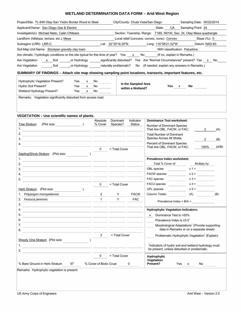
WETLAND DETERMINATION DATA FORM – Arid West Region Project/Site: TL-649 Otay-San Ysidro Border Wood to Steel City/County: Chula Vista/San Diego Sampling Date: 05/22/2014
Applicant/Owner: San Diego Gas & Electric State: CA Sampling Point: 24
Investigator(s): Michael Nieto, Cailin O'Meara Section, Township, Range: T18S, R01W, Sec. 24, Otay Mesa quadrangle
Landform (hillslope, terrace, etc.): Mesa Local relief (concave, convex, none): Convex Slope (%): 0
Subregion (LRR): LRR-C Lat: 32°35'16.20"N Long: 116°56'21.52"W Datum: NAD-83
Soil Map Unit Name: Stockpen gravelly clay loam NWI classification: Palustrine
Are climatic / hydrologic conditions on the site typical for this time of year? Yes x No (If no, explain in Remarks.)
Are Vegetation x, Soil , or Hydrology significantly disturbed? Yes Are "Normal Circumstances" present? Yes x No
Are Vegetation , Soil , or Hydrology naturally problematic? No (If needed, explain any answers in Remarks.)
SUMMARY OF FINDINGS – Attach site map showing sampling point locations, transects, important features, etc.
Hydrophytic Vegetation Present? Yes x No Is the Sampled Area within a Wetland?
Hydric Soil Present? Yes x No Yes x No Wetland Hydrology Present? Yes x No
Remarks: Vegetation significantly disturbed from access road.
VEGETATION – Use scientific names of plants. Absolute Dominant Indicator Dominance Test worksheet:
Number of Dominant Species That Are OBL, FACW, or FAC: Total Number of Dominant Species Across All Strata: Percent of Dominant Species That Are OBL, FACW, or FAC:
2
(A)
2
(B)
100% (A/B)
Tree Stratum (Plot size: ) % Cover Species? Status 1. 2. 3. 4. 0 = Total Cover Sapling/Shrub Stratum (Plot size: ) 1. Prevalence Index worksheet:
Total % Cover of: Multiply by:
OBL species x 1 =
FACW species x 2 =
FAC species x 3 =
FACU species x 4 =
UPL species x 5 =
Column Totals: (A) (B)
Prevalence Index = B/A =
2. 3. 4. 5. 0 = Total Cover Herb Stratum (Plot size: ) 1. Polypogon monspeliensis 2 Y FACW 2. Festuca perennis 1 Y FAC 3. 4. Hydrophytic Vegetation Indicators: 5. x Dominance Test is >50% 6. Prevalence Index is ≤3.01 7. Morphological Adaptations1 (Provide supporting 8. data in Remarks or on a separate sheet)
3 = Total Cover Problematic Hydrophytic Vegetation1 (Explain) Woody Vine Stratum (Plot size: ) 1. 1Indicators of hydric soil and wetland hydrology must
be present, unless disturbed or problematic. 2.
0 = Total Cover Hydrophytic Vegetation Present?
% Bare Ground in Herb Stratum 97 % Cover of Biotic Crust 0 Yes x No
Remarks: Hydrophytic vegetation is present.
US Army Corps of Engineers Arid West – Version 2.0

SOIL Sampling Point: 24 ____________ Profile Description: (Describe to the depth needed to document the indicator or confirm the absence of indicators.) Depth Matrix Redox Features (inches) Color (moist) % Color (moist) % Type1 Loc2 Texture Remarks
1Type: C=Concentration, D=Depletion, RM=Reduced Matrix, CS=Covered or Coated Sand Grains. 2Location: PL=Pore Lining, RC=Root Channel, M=Matrix. Hydric Soil Indicators: (Applicable to all LRRs, unless otherwise noted.) Indicators for Problematic Hydric Soils3: Histosol (A1) Sandy Redox (S5) 1 cm Muck (A9) (LRR C) Histic Epipedon (A2) Stripped Matrix (S6) 2 cm Muck (A10) (LRR B) Black Histic (A3) Loamy Mucky Mineral (F1) Reduced Vertic (F18) Hydrogen Sulfide (A4) Loamy Gleyed Matrix (F2) Red Parent Material (TF2) Stratified Layers (A5) (LRR C) Depleted Matrix (F3) Other (Explain in Remarks) 1 cm Muck (A9) (LRR D) Redox Dark Surface (F6) Depleted Below Dark Surface (A11) Depleted Dark Surface (F7) Thick Dark Surface (A12) Redox Depressions (F8) 3Indicators of hydrophytic vegetation and Sandy Mucky Mineral (S1) x Vernal Pools (F9) wetland hydrology must be present, Sandy Gleyed Matrix (S4) unless disturbed or problematic.
Restrictive Layer (if present): Type: Depth (inches): Hydric Soil Present? Yes x No
Remarks: No soil pit was dug due to the documented presence of San Diego fairy shrimp. Hydric soils were assumed due to strong hydrophytic vegetation and hydrology indicators.
HYDROLOGY Wetland Hydrology Indicators: Secondary Indicators (2 or more required) Primary Indicators (minimum of one required; check all that apply) Water Marks (B1) (Riverine) Surface Water (A1) Salt Crust (B11) Sediment Deposits (B2) (Riverine) High Water Table (A2) Biotic Crust (B12) Drift Deposits (B3) (Riverine) Saturation (A3) Aquatic Invertebrates (B13) Drainage Patterns (B10) Water Marks (B1) (Nonriverine) Hydrogen Sulfide Odor (C1) Dry-Season Water Table (C2) Sediment Deposits (B2) (Nonriverine) Oxidized Rhizospheres along Living Roots (C3) Thin Muck Surface (C7) Drift Deposits (B3) (Nonriverine) Presence of Reduced Iron (C4) Crayfish Burrows (C8) x Surface Soil Cracks (B6) Recent Iron Reduction in Tilled Soils (C6) Saturation Visible on Aerial Imagery (C9) Inundation Visible on Aerial Imagery (B7) Thin Muck Surface (C7) Shallow Aquitard (D3) Water-Stained Leaves (B9) Other (Explain in Remarks) FAC-Neutral Test (D5)
Field Observations: Surface Water Present? Yes No x Depth (inches): Water Table Present? Yes No x Depth (inches): Saturation Present? Yes No x Depth (inches): Wetland Hydrology Present? Yes x No (includes capillary fringe)
Describe Recorded Data (stream gauge, monitoring well, aerial photos, previous inspections), if available:
Remarks:
US Army Corps of Engineers Arid West – Version 2.0

WETLAND DETERMINATION DATA FORM – Arid West Region Project/Site: TL-649 Otay-San Ysidro Border Wood to Steel City/County: Chula Vista/San Diego Sampling Date: 05/22/2014
Applicant/Owner: San Diego Gas & Electric State: CA Sampling Point: 25
Investigator(s): Michael Nieto, Cailin O'Meara Section, Township, Range: T18S, R01W, Sec. 24, Otay Mesa quadrangle
Landform (hillslope, terrace, etc.): Mesa Local relief (concave, convex, none): Convex Slope (%): 0
Subregion (LRR): LRR-C Lat: 32°35'13.55"N Long: 116°56'21.84"W Datum: NAD-83
Soil Map Unit Name: Stockpen gravelly clay loam NWI classification: Palustrine
Are climatic / hydrologic conditions on the site typical for this time of year? Yes Yes No (If no, explain in Remarks.)
Are Vegetation x, Soil , or Hydrology significantly disturbed? Yes Are "Normal Circumstances" present? Yes x No
Are Vegetation , Soil , or Hydrology naturally problematic? No (If needed, explain any answers in Remarks.)
SUMMARY OF FINDINGS – Attach site map showing sampling point locations, transects, important features, etc.
Hydrophytic Vegetation Present? Yes x No Is the Sampled Area within a Wetland?
Hydric Soil Present? Yes x No Yes x No Wetland Hydrology Present? Yes x No
Remarks: Vegetation significantly disturbed from access road.
VEGETATION – Use scientific names of plants. Absolute Dominant Indicator Dominance Test worksheet:
Number of Dominant Species That Are OBL, FACW, or FAC: Total Number of Dominant Species Across All Strata: Percent of Dominant Species That Are OBL, FACW, or FAC:
3
(A)
3
(B)
100% (A/B)
Tree Stratum (Plot size: ) % Cover Species? Status 1. 2. 3. 4. 0 = Total Cover Sapling/Shrub Stratum (Plot size: ) 1. Prevalence Index worksheet:
Total % Cover of: Multiply by:
OBL species x 1 =
FACW species x 2 =
FAC species x 3 =
FACU species x 4 =
UPL species x 5 =
Column Totals: (A) (B)
Prevalence Index = B/A =
2. 3. 4. 5. 0 = Total Cover Herb Stratum (Plot size: ) 1. Psilocarphus brevissimus var. brevissimus 5 Y FACW 2. Festuca perennis 5 Y FAC 3. Polypogon monspeliensis 7 Y FACW 4. Atriplex semibaccata 3 N FAC Hydrophytic Vegetation Indicators: 5. x Dominance Test is >50% 6. Prevalence Index is ≤3.01 7. Morphological Adaptations1 (Provide supporting 8. data in Remarks or on a separate sheet)
20 = Total Cover Problematic Hydrophytic Vegetation1 (Explain) Woody Vine Stratum (Plot size: ) 1. 1Indicators of hydric soil and wetland hydrology must
be present, unless disturbed or problematic. 2.
0 = Total Cover Hydrophytic Vegetation Present?
% Bare Ground in Herb Stratum 80 % Cover of Biotic Crust 0 Yes x No
Remarks: Sampling was conducted in a vernal pool within an access road.
US Army Corps of Engineers Arid West – Version 2.0

SOIL Sampling Point: 25 ____________ Profile Description: (Describe to the depth needed to document the indicator or confirm the absence of indicators.) Depth Matrix Redox Features (inches) Color (moist) % Color (moist) % Type1 Loc2 Texture Remarks
1Type: C=Concentration, D=Depletion, RM=Reduced Matrix, CS=Covered or Coated Sand Grains. 2Location: PL=Pore Lining, RC=Root Channel, M=Matrix. Hydric Soil Indicators: (Applicable to all LRRs, unless otherwise noted.) Indicators for Problematic Hydric Soils3: Histosol (A1) Sandy Redox (S5) 1 cm Muck (A9) (LRR C) Histic Epipedon (A2) Stripped Matrix (S6) 2 cm Muck (A10) (LRR B) Black Histic (A3) Loamy Mucky Mineral (F1) Reduced Vertic (F18) Hydrogen Sulfide (A4) Loamy Gleyed Matrix (F2) Red Parent Material (TF2) Stratified Layers (A5) (LRR C) Depleted Matrix (F3) Other (Explain in Remarks) 1 cm Muck (A9) (LRR D) Redox Dark Surface (F6) Depleted Below Dark Surface (A11) Depleted Dark Surface (F7) Thick Dark Surface (A12) Redox Depressions (F8) 3Indicators of hydrophytic vegetation and Sandy Mucky Mineral (S1) x Vernal Pools (F9) wetland hydrology must be present, Sandy Gleyed Matrix (S4) unless disturbed or problematic.
Restrictive Layer (if present): Type: Depth (inches): Hydric Soil Present? Yes x No
Remarks: No soil pit was dug due to the documented presence of San Diego fairy shrimp. Hydric soils were assumed due to strong hydrophytic vegetation and hydrology indicators.
HYDROLOGY Wetland Hydrology Indicators: Secondary Indicators (2 or more required) Primary Indicators (minimum of one required; check all that apply) Water Marks (B1) (Riverine) Surface Water (A1) Salt Crust (B11) Sediment Deposits (B2) (Riverine) High Water Table (A2) Biotic Crust (B12) Drift Deposits (B3) (Riverine) Saturation (A3) Aquatic Invertebrates (B13) Drainage Patterns (B10) Water Marks (B1) (Nonriverine) Hydrogen Sulfide Odor (C1) Dry-Season Water Table (C2) Sediment Deposits (B2) (Nonriverine) Oxidized Rhizospheres along Living Roots (C3) Thin Muck Surface (C7) Drift Deposits (B3) (Nonriverine) Presence of Reduced Iron (C4) Crayfish Burrows (C8) x Surface Soil Cracks (B6) Recent Iron Reduction in Tilled Soils (C6) Saturation Visible on Aerial Imagery (C9) Inundation Visible on Aerial Imagery (B7) Thin Muck Surface (C7) Shallow Aquitard (D3) Water-Stained Leaves (B9) Other (Explain in Remarks) FAC-Neutral Test (D5)
Field Observations: Surface Water Present? Yes No x Depth (inches): Water Table Present? Yes No x Depth (inches): Saturation Present? Yes No x Depth (inches): Wetland Hydrology Present? Yes x No (includes capillary fringe)
Describe Recorded Data (stream gauge, monitoring well, aerial photos, previous inspections), if available:
Remarks:
US Army Corps of Engineers Arid West – Version 2.0

WETLAND DETERMINATION DATA FORM – Arid West Region Project/Site: TL-649 Otay-San Ysidro Border Wood to Steel City/County: Chula Vista/San Diego Sampling Date: 05/22/2014
Applicant/Owner: San Diego Gas & Electric State: CA Sampling Point: 26
Investigator(s): Michael Nieto, Cailin O'Meara Section, Township, Range: T18S, R01W, Sec. 24, Otay Mesa quadrangle
Landform (hillslope, terrace, etc.): Mesa Local relief (concave, convex, none): Convex Slope (%): 0
Subregion (LRR): Otay Valley Hydrologic Area Lat: 32°35'12.91"N Long: 116°56'21.45"W Datum: NAD-83
Soil Map Unit Name: Stockpen gravelly clay loam NWI classification: Palustrine
Are climatic / hydrologic conditions on the site typical for this time of year? Yes x No (If no, explain in Remarks.)
Are Vegetation x, Soil , or Hydrology significantly disturbed? Yes Are "Normal Circumstances" present? Yes x No
Are Vegetation , Soil , or Hydrology naturally problematic? No (If needed, explain any answers in Remarks.)
SUMMARY OF FINDINGS – Attach site map showing sampling point locations, transects, important features, etc.
Hydrophytic Vegetation Present? Yes x No Is the Sampled Area within a Wetland?
Hydric Soil Present? Yes x No Yes x No Wetland Hydrology Present? Yes x No
Remarks: Vegetation significantly disturbed from access road.
VEGETATION – Use scientific names of plants. Absolute Dominant Indicator Dominance Test worksheet:
Number of Dominant Species That Are OBL, FACW, or FAC: Total Number of Dominant Species Across All Strata: Percent of Dominant Species That Are OBL, FACW, or FAC:
2
(A)
2
(B)
100% (A/B)
Tree Stratum (Plot size: ) % Cover Species? Status 1. 2. 3. 4. 0 = Total Cover Sapling/Shrub Stratum (Plot size: ) 1. Prevalence Index worksheet:
Total % Cover of: Multiply by:
OBL species x 1 =
FACW species x 2 =
FAC species x 3 =
FACU species x 4 =
UPL species x 5 =
Column Totals: (A) (B)
Prevalence Index = B/A =
2. 3. 4. 5. 0 = Total Cover Herb Stratum (Plot size: ) 1. Polypogon monspeliensis 1 Y FACW 2. Festuca perennis 1 Y FAC 3. 4. Hydrophytic Vegetation Indicators: 5. x Dominance Test is >50% 6. Prevalence Index is ≤3.01 7. Morphological Adaptations1 (Provide supporting 8. data in Remarks or on a separate sheet)
2 = Total Cover Problematic Hydrophytic Vegetation1 (Explain) Woody Vine Stratum (Plot size: ) 1. 1Indicators of hydric soil and wetland hydrology must
be present, unless disturbed or problematic. 2.
0 = Total Cover Hydrophytic Vegetation Present?
% Bare Ground in Herb Stratum 98 % Cover of Biotic Crust 0 Yes x No
Remarks: Sampling was conducted in a vernal pool within an access road.
US Army Corps of Engineers Arid West – Version 2.0

SOIL Sampling Point: 26 ____________ Profile Description: (Describe to the depth needed to document the indicator or confirm the absence of indicators.) Depth Matrix Redox Features (inches) Color (moist) % Color (moist) % Type1 Loc2 Texture Remarks
1Type: C=Concentration, D=Depletion, RM=Reduced Matrix, CS=Covered or Coated Sand Grains. 2Location: PL=Pore Lining, RC=Root Channel, M=Matrix. Hydric Soil Indicators: (Applicable to all LRRs, unless otherwise noted.) Indicators for Problematic Hydric Soils3: Histosol (A1) Sandy Redox (S5) 1 cm Muck (A9) (LRR C) Histic Epipedon (A2) Stripped Matrix (S6) 2 cm Muck (A10) (LRR B) Black Histic (A3) Loamy Mucky Mineral (F1) Reduced Vertic (F18) Hydrogen Sulfide (A4) Loamy Gleyed Matrix (F2) Red Parent Material (TF2) Stratified Layers (A5) (LRR C) Depleted Matrix (F3) Other (Explain in Remarks) 1 cm Muck (A9) (LRR D) Redox Dark Surface (F6) Depleted Below Dark Surface (A11) Depleted Dark Surface (F7) Thick Dark Surface (A12) Redox Depressions (F8) 3Indicators of hydrophytic vegetation and Sandy Mucky Mineral (S1) x Vernal Pools (F9) wetland hydrology must be present, Sandy Gleyed Matrix (S4) unless disturbed or problematic.
Restrictive Layer (if present): Type: Depth (inches): Hydric Soil Present? Yes x No
Remarks: No soil pit was dug due to the documented presence of San Diego fairy shrimp. Hydric soils were assumed due to strong hydrophytic vegetation and hydrology indicators.
HYDROLOGY Wetland Hydrology Indicators: Secondary Indicators (2 or more required) Primary Indicators (minimum of one required; check all that apply) Water Marks (B1) (Riverine) Surface Water (A1) Salt Crust (B11) Sediment Deposits (B2) (Riverine) High Water Table (A2) Biotic Crust (B12) Drift Deposits (B3) (Riverine) Saturation (A3) Aquatic Invertebrates (B13) Drainage Patterns (B10) Water Marks (B1) (Nonriverine) Hydrogen Sulfide Odor (C1) Dry-Season Water Table (C2) Sediment Deposits (B2) (Nonriverine) Oxidized Rhizospheres along Living Roots (C3) Thin Muck Surface (C7) Drift Deposits (B3) (Nonriverine) Presence of Reduced Iron (C4) Crayfish Burrows (C8) x Surface Soil Cracks (B6) Recent Iron Reduction in Tilled Soils (C6) Saturation Visible on Aerial Imagery (C9) Inundation Visible on Aerial Imagery (B7) Thin Muck Surface (C7) Shallow Aquitard (D3) Water-Stained Leaves (B9) Other (Explain in Remarks) FAC-Neutral Test (D5)
Field Observations: Surface Water Present? Yes No x Depth (inches): Water Table Present? Yes No x Depth (inches): Saturation Present? Yes No x Depth (inches): Wetland Hydrology Present? Yes x No (includes capillary fringe)
Describe Recorded Data (stream gauge, monitoring well, aerial photos, previous inspections), if available:
Remarks: Wetland hydrology is present.
US Army Corps of Engineers Arid West – Version 2.0

WETLAND DETERMINATION DATA FORM – Arid West Region Project/Site: TL-649 Otay-San Ysidro Border Wood to Steel City/County: Chula Vista/San Diego Sampling Date: 05/22/2014
Applicant/Owner: San Diego Gas & Electric State: CA Sampling Point: 27
Investigator(s): Michael Nieto, Cailin O'Meara Section, Township, Range: T18S, R01W, Sec. 24, Otay Mesa quadrangle
Landform (hillslope, terrace, etc.): Mesa Local relief (concave, convex, none): Convex Slope (%): 0
Subregion (LRR): LRR-C Lat: 32°35'12.42"N Long: 116°56'21.89"W Datum: NAD-83
Soil Map Unit Name: Stockpen gravelly clay loam NWI classification: Palustrine
Are climatic / hydrologic conditions on the site typical for this time of year? Yes x No (If no, explain in Remarks.)
Are Vegetation x, Soil , or Hydrology significantly disturbed? Yes Are "Normal Circumstances" present? Yes x No
Are Vegetation , Soil , or Hydrology naturally problematic? No (If needed, explain any answers in Remarks.)
SUMMARY OF FINDINGS – Attach site map showing sampling point locations, transects, important features, etc.
Hydrophytic Vegetation Present? Yes x No Is the Sampled Area within a Wetland?
Hydric Soil Present? Yes x No Yes x No Wetland Hydrology Present? Yes x No
Remarks: Vegetation significantly disturbed from access road.
VEGETATION – Use scientific names of plants. Absolute Dominant Indicator Dominance Test worksheet:
Number of Dominant Species That Are OBL, FACW, or FAC: Total Number of Dominant Species Across All Strata: Percent of Dominant Species That Are OBL, FACW, or FAC:
3
(A)
3
(B)
100% (A/B)
Tree Stratum (Plot size: ) % Cover Species? Status 1. 2. 3. 4. 0 = Total Cover Sapling/Shrub Stratum (Plot size: ) 1. Prevalence Index worksheet:
Total % Cover of: Multiply by:
OBL species x 1 =
FACW species x 2 =
FAC species x 3 =
FACU species x 4 =
UPL species x 5 =
Column Totals: (A) (B)
Prevalence Index = B/A =
2. 3. 4. 5. 0 = Total Cover Herb Stratum (Plot size: ) 1. Psilocarphus brevissimus var. brevissimus 12 Y FACW 2. Festuca perennis 6 Y FAC 3. Polypogon monspeliensis 12 Y FACW 4. Hydrophytic Vegetation Indicators: 5. x Dominance Test is >50% 6. Prevalence Index is ≤3.01 7. Morphological Adaptations1 (Provide supporting 8. data in Remarks or on a separate sheet)
30 = Total Cover Problematic Hydrophytic Vegetation1 (Explain) Woody Vine Stratum (Plot size: ) 1. 1Indicators of hydric soil and wetland hydrology must
be present, unless disturbed or problematic. 2.
0 = Total Cover Hydrophytic Vegetation Present?
% Bare Ground in Herb Stratum 70 % Cover of Biotic Crust 0 Yes x No
Remarks: Sampling was conducted in a vernal pool within an access road.
US Army Corps of Engineers Arid West – Version 2.0

SOIL Sampling Point: 27 ____________ Profile Description: (Describe to the depth needed to document the indicator or confirm the absence of indicators.) Depth Matrix Redox Features (inches) Color (moist) % Color (moist) % Type1 Loc2 Texture Remarks
1Type: C=Concentration, D=Depletion, RM=Reduced Matrix, CS=Covered or Coated Sand Grains. 2Location: PL=Pore Lining, RC=Root Channel, M=Matrix. Hydric Soil Indicators: (Applicable to all LRRs, unless otherwise noted.) Indicators for Problematic Hydric Soils3: Histosol (A1) Sandy Redox (S5) 1 cm Muck (A9) (LRR C) Histic Epipedon (A2) Stripped Matrix (S6) 2 cm Muck (A10) (LRR B) Black Histic (A3) Loamy Mucky Mineral (F1) Reduced Vertic (F18) Hydrogen Sulfide (A4) Loamy Gleyed Matrix (F2) Red Parent Material (TF2) Stratified Layers (A5) (LRR C) Depleted Matrix (F3) Other (Explain in Remarks) 1 cm Muck (A9) (LRR D) Redox Dark Surface (F6) Depleted Below Dark Surface (A11) Depleted Dark Surface (F7) Thick Dark Surface (A12) Redox Depressions (F8) 3Indicators of hydrophytic vegetation and Sandy Mucky Mineral (S1) x Vernal Pools (F9) wetland hydrology must be present, Sandy Gleyed Matrix (S4) unless disturbed or problematic.
Restrictive Layer (if present): Type: Depth (inches): Hydric Soil Present? Yes x No
Remarks: No soil pit was dug due to the documented presence of San Diego fairy shrimp. Hydric soils were assumed due to strong hydrophytic vegetation and hydrology indicators.
HYDROLOGY Wetland Hydrology Indicators: Secondary Indicators (2 or more required) Primary Indicators (minimum of one required; check all that apply) Water Marks (B1) (Riverine) Surface Water (A1) Salt Crust (B11) Sediment Deposits (B2) (Riverine) High Water Table (A2) Biotic Crust (B12) Drift Deposits (B3) (Riverine) Saturation (A3) Aquatic Invertebrates (B13) Drainage Patterns (B10) Water Marks (B1) (Nonriverine) Hydrogen Sulfide Odor (C1) Dry-Season Water Table (C2) Sediment Deposits (B2) (Nonriverine) Oxidized Rhizospheres along Living Roots (C3) Thin Muck Surface (C7) Drift Deposits (B3) (Nonriverine) Presence of Reduced Iron (C4) Crayfish Burrows (C8) x Surface Soil Cracks (B6) Recent Iron Reduction in Tilled Soils (C6) Saturation Visible on Aerial Imagery (C9) Inundation Visible on Aerial Imagery (B7) Thin Muck Surface (C7) Shallow Aquitard (D3) Water-Stained Leaves (B9) Other (Explain in Remarks) FAC-Neutral Test (D5)
Field Observations: Surface Water Present? Yes No x Depth (inches): Water Table Present? Yes No x Depth (inches): Saturation Present? Yes No x Depth (inches): Wetland Hydrology Present? Yes x No (includes capillary fringe)
Describe Recorded Data (stream gauge, monitoring well, aerial photos, previous inspections), if available:
Remarks:
US Army Corps of Engineers Arid West – Version 2.0

WETLAND DETERMINATION DATA FORM – Arid West Region Project/Site: TL-649 Otay-San Ysidro Border Wood to Steel City/County: Chula Vista/San Diego Sampling Date: 05/22/2014
Applicant/Owner: San Diego Gas & Electric State: CA Sampling Point: 28
Investigator(s): Michael Nieto, Cailin O'Meara Section, Township, Range: T18S, R01W, Sec. 24, Otay Mesa quadrangle
Landform (hillslope, terrace, etc.): Mesa Local relief (concave, convex, none): Convex Slope (%): 0
Subregion (LRR): LRR-C Lat: 32°35'11.74"N Long: 116°56'21.93"W Datum: NAD-83
Soil Map Unit Name: Stockpen gravelly clay loam NWI classification: Palustrine
Are climatic / hydrologic conditions on the site typical for this time of year? Yes x No (If no, explain in Remarks.)
Are Vegetation x, Soil , or Hydrology significantly disturbed? Yes Are "Normal Circumstances" present? Yes x No
Are Vegetation , Soil , or Hydrology naturally problematic? No (If needed, explain any answers in Remarks.)
SUMMARY OF FINDINGS – Attach site map showing sampling point locations, transects, important features, etc.
Hydrophytic Vegetation Present? Yes x No Is the Sampled Area within a Wetland?
Hydric Soil Present? Yes x No Yes x No Wetland Hydrology Present? Yes x No
Remarks: Vegetation significantly disturbed from access road.
VEGETATION – Use scientific names of plants. Absolute Dominant Indicator Dominance Test worksheet:
Number of Dominant Species That Are OBL, FACW, or FAC: Total Number of Dominant Species Across All Strata: Percent of Dominant Species That Are OBL, FACW, or FAC:
2
(A)
2
(B)
100% (A/B)
Tree Stratum (Plot size: ) % Cover Species? Status 1. 2. 3. 4. 0 = Total Cover Sapling/Shrub Stratum (Plot size: ) 1. Prevalence Index worksheet:
Total % Cover of: Multiply by:
OBL species x 1 =
FACW species x 2 =
FAC species x 3 =
FACU species x 4 =
UPL species x 5 =
Column Totals: (A) (B)
Prevalence Index = B/A =
2. 3. 4. 5. 0 = Total Cover Herb Stratum (Plot size: ) 1. Salsola tragus 1 N FACU 2. Festuca perennis 10 Y FAC 3. Polypogon monspeliensis 20 Y FACW 4. Hydrophytic Vegetation Indicators: 5. x Dominance Test is >50% 6. Prevalence Index is ≤3.01 7. Morphological Adaptations1 (Provide supporting 8. data in Remarks or on a separate sheet)
31 = Total Cover Problematic Hydrophytic Vegetation1 (Explain) Woody Vine Stratum (Plot size: ) 1. 1Indicators of hydric soil and wetland hydrology must
be present, unless disturbed or problematic. 2.
0 = Total Cover Hydrophytic Vegetation Present?
% Bare Ground in Herb Stratum 69 % Cover of Biotic Crust 0 Yes x No
Remarks: Sampling was conducted in a vernal pool within an access road.
US Army Corps of Engineers Arid West – Version 2.0

SOIL Sampling Point: 28 ____________ Profile Description: (Describe to the depth needed to document the indicator or confirm the absence of indicators.) Depth Matrix Redox Features (inches) Color (moist) % Color (moist) % Type1 Loc2 Texture Remarks
1Type: C=Concentration, D=Depletion, RM=Reduced Matrix, CS=Covered or Coated Sand Grains. 2Location: PL=Pore Lining, RC=Root Channel, M=Matrix. Hydric Soil Indicators: (Applicable to all LRRs, unless otherwise noted.) Indicators for Problematic Hydric Soils3: Histosol (A1) Sandy Redox (S5) 1 cm Muck (A9) (LRR C) Histic Epipedon (A2) Stripped Matrix (S6) 2 cm Muck (A10) (LRR B) Black Histic (A3) Loamy Mucky Mineral (F1) Reduced Vertic (F18) Hydrogen Sulfide (A4) Loamy Gleyed Matrix (F2) Red Parent Material (TF2) Stratified Layers (A5) (LRR C) Depleted Matrix (F3) Other (Explain in Remarks) 1 cm Muck (A9) (LRR D) Redox Dark Surface (F6) Depleted Below Dark Surface (A11) Depleted Dark Surface (F7) Thick Dark Surface (A12) Redox Depressions (F8) 3Indicators of hydrophytic vegetation and Sandy Mucky Mineral (S1) x Vernal Pools (F9) wetland hydrology must be present, Sandy Gleyed Matrix (S4) unless disturbed or problematic.
Restrictive Layer (if present): Type: Depth (inches): Hydric Soil Present? Yes x No
Remarks: No soil pit was dug due to the documented presence of San Diego fairy shrimp. Hydric soils were assumed due to strong hydrophytic vegetation and hydrology indicators.
HYDROLOGY Wetland Hydrology Indicators: Secondary Indicators (2 or more required) Primary Indicators (minimum of one required; check all that apply) Water Marks (B1) (Riverine) Surface Water (A1) Salt Crust (B11) Sediment Deposits (B2) (Riverine) High Water Table (A2) Biotic Crust (B12) Drift Deposits (B3) (Riverine) Saturation (A3) Aquatic Invertebrates (B13) Drainage Patterns (B10) Water Marks (B1) (Nonriverine) Hydrogen Sulfide Odor (C1) Dry-Season Water Table (C2) Sediment Deposits (B2) (Nonriverine) Oxidized Rhizospheres along Living Roots (C3) Thin Muck Surface (C7) Drift Deposits (B3) (Nonriverine) Presence of Reduced Iron (C4) Crayfish Burrows (C8) x Surface Soil Cracks (B6) Recent Iron Reduction in Tilled Soils (C6) Saturation Visible on Aerial Imagery (C9) Inundation Visible on Aerial Imagery (B7) Thin Muck Surface (C7) Shallow Aquitard (D3) Water-Stained Leaves (B9) Other (Explain in Remarks) FAC-Neutral Test (D5)
Field Observations: Surface Water Present? Yes No x Depth (inches): Water Table Present? Yes No x Depth (inches): Saturation Present? Yes No x Depth (inches): Wetland Hydrology Present? Yes x No (includes capillary fringe)
Describe Recorded Data (stream gauge, monitoring well, aerial photos, previous inspections), if available:
Remarks:
US Army Corps of Engineers Arid West – Version 2.0

WETLAND DETERMINATION DATA FORM – Arid West Region Project/Site: TL-649 Otay-San Ysidro Border Wood to Steel City/County: Chula Vista/San Diego Sampling Date: 05/22/2014
Applicant/Owner: San Diego Gas & Electric State: CA Sampling Point: 29
Investigator(s): Michael Nieto, Cailin O'Meara Section, Township, Range: T18S, R01W, Sec. 24, Otay Mesa quadrangle
Landform (hillslope, terrace, etc.): Mesa Local relief (concave, convex, none): Convex Slope (%): 0
Subregion (LRR): LRR-C Lat: 32°35'11.05"N Long: 116°56'21.43"W Datum: NAD-83
Soil Map Unit Name: Stockpen gravelly clay loam NWI classification: Palustrine
Are climatic / hydrologic conditions on the site typical for this time of year? Yes x No (If no, explain in Remarks.)
Are Vegetation x, Soil , or Hydrology significantly disturbed? Yes Are "Normal Circumstances" present? Yes x No
Are Vegetation , Soil , or Hydrology naturally problematic? No (If needed, explain any answers in Remarks.)
SUMMARY OF FINDINGS – Attach site map showing sampling point locations, transects, important features, etc.
Hydrophytic Vegetation Present? Yes x No Is the Sampled Area within a Wetland?
Hydric Soil Present? Yes x No Yes x No Wetland Hydrology Present? Yes x No
Remarks: Vegetation significantly disturbed from access road.
VEGETATION – Use scientific names of plants. Absolute Dominant Indicator Dominance Test worksheet:
Number of Dominant Species That Are OBL, FACW, or FAC: Total Number of Dominant Species Across All Strata: Percent of Dominant Species That Are OBL, FACW, or FAC:
2
(A)
2
(B)
100% (A/B)
Tree Stratum (Plot size: ) % Cover Species? Status 1. 2. 3. 4. 0 = Total Cover Sapling/Shrub Stratum (Plot size: ) 1. Prevalence Index worksheet:
Total % Cover of: Multiply by:
OBL species x 1 =
FACW species x 2 =
FAC species x 3 =
FACU species x 4 =
UPL species x 5 =
Column Totals: (A) (B)
Prevalence Index = B/A =
2. 3. 4. 5. 0 = Total Cover Herb Stratum (Plot size: ) 1. Salsola tragus 1 N FACU 2. Festuca perennis 5 Y FAC 3. Polypogon monspeliensis 7 Y FACW 4. Hydrophytic Vegetation Indicators: 5. x Dominance Test is >50% 6. Prevalence Index is ≤3.01 7. Morphological Adaptations1 (Provide supporting 8. data in Remarks or on a separate sheet)
13 = Total Cover Problematic Hydrophytic Vegetation1 (Explain) Woody Vine Stratum (Plot size: ) 1. 1Indicators of hydric soil and wetland hydrology must
be present, unless disturbed or problematic. 2.
0 = Total Cover Hydrophytic Vegetation Present?
% Bare Ground in Herb Stratum 87 % Cover of Biotic Crust 0 Yes x No
Remarks: Sampling was conducted in a vernal pool within an access road.
US Army Corps of Engineers Arid West – Version 2.0

SOIL Sampling Point: 29 ____________ Profile Description: (Describe to the depth needed to document the indicator or confirm the absence of indicators.) Depth Matrix Redox Features (inches) Color (moist) % Color (moist) % Type1 Loc2 Texture Remarks
1Type: C=Concentration, D=Depletion, RM=Reduced Matrix, CS=Covered or Coated Sand Grains. 2Location: PL=Pore Lining, RC=Root Channel, M=Matrix. Hydric Soil Indicators: (Applicable to all LRRs, unless otherwise noted.) Indicators for Problematic Hydric Soils3: Histosol (A1) Sandy Redox (S5) 1 cm Muck (A9) (LRR C) Histic Epipedon (A2) Stripped Matrix (S6) 2 cm Muck (A10) (LRR B) Black Histic (A3) Loamy Mucky Mineral (F1) Reduced Vertic (F18) Hydrogen Sulfide (A4) Loamy Gleyed Matrix (F2) Red Parent Material (TF2) Stratified Layers (A5) (LRR C) Depleted Matrix (F3) Other (Explain in Remarks) 1 cm Muck (A9) (LRR D) Redox Dark Surface (F6) Depleted Below Dark Surface (A11) Depleted Dark Surface (F7) Thick Dark Surface (A12) Redox Depressions (F8) 3Indicators of hydrophytic vegetation and Sandy Mucky Mineral (S1) x Vernal Pools (F9) wetland hydrology must be present, Sandy Gleyed Matrix (S4) unless disturbed or problematic.
Restrictive Layer (if present): Type: Depth (inches): Hydric Soil Present? Yes x No
Remarks: No soil pit was dug due to the documented presence of San Diego fairy shrimp. Hydric soils were assumed due to strong hydrophytic vegetation and hydrology indicators.
HYDROLOGY Wetland Hydrology Indicators: Secondary Indicators (2 or more required) Primary Indicators (minimum of one required; check all that apply) Water Marks (B1) (Riverine) Surface Water (A1) Salt Crust (B11) Sediment Deposits (B2) (Riverine) High Water Table (A2) Biotic Crust (B12) Drift Deposits (B3) (Riverine) Saturation (A3) Aquatic Invertebrates (B13) Drainage Patterns (B10) Water Marks (B1) (Nonriverine) Hydrogen Sulfide Odor (C1) Dry-Season Water Table (C2) Sediment Deposits (B2) (Nonriverine) Oxidized Rhizospheres along Living Roots (C3) Thin Muck Surface (C7) Drift Deposits (B3) (Nonriverine) Presence of Reduced Iron (C4) Crayfish Burrows (C8) x Surface Soil Cracks (B6) Recent Iron Reduction in Tilled Soils (C6) Saturation Visible on Aerial Imagery (C9) Inundation Visible on Aerial Imagery (B7) Thin Muck Surface (C7) Shallow Aquitard (D3) Water-Stained Leaves (B9) Other (Explain in Remarks) FAC-Neutral Test (D5)
Field Observations: Surface Water Present? Yes No x Depth (inches): Water Table Present? Yes No x Depth (inches): Saturation Present? Yes No x Depth (inches): Wetland Hydrology Present? Yes x No (includes capillary fringe)
Describe Recorded Data (stream gauge, monitoring well, aerial photos, previous inspections), if available:
Remarks:
US Army Corps of Engineers Arid West – Version 2.0

WETLAND DETERMINATION DATA FORM – Arid West Region Project/Site: TL-649 Otay-San Ysidro Border Wood to Steel City/County: Chula Vista/San Diego Sampling Date: 05/22/2014
Applicant/Owner: San Diego Gas & Electric State: CA Sampling Point: 30
Investigator(s): Michael Nieto, Cailin O'Meara Section, Township, Range: T18S, R01W, Sec. 24, Otay Mesa quadrangle
Landform (hillslope, terrace, etc.): Mesa Local relief (concave, convex, none): Convex Slope (%): 0
Subregion (LRR): LRR-C Lat: 32°35'10.63"N Long: 116°56'21.48"W Datum: NAD-83
Soil Map Unit Name: Stockpen gravelly clay loam NWI classification: Palustrine
Are climatic / hydrologic conditions on the site typical for this time of year? Yes x No (If no, explain in Remarks.)
Are Vegetation x, Soil , or Hydrology significantly disturbed? Yes Are "Normal Circumstances" present? Yes x No
Are Vegetation , Soil , or Hydrology naturally problematic? No (If needed, explain any answers in Remarks.)
SUMMARY OF FINDINGS – Attach site map showing sampling point locations, transects, important features, etc.
Hydrophytic Vegetation Present? Yes x No Is the Sampled Area within a Wetland?
Hydric Soil Present? Yes x No Yes x No Wetland Hydrology Present? Yes x No
Remarks: Vegetation significantly disturbed from access road.
VEGETATION – Use scientific names of plants. Absolute Dominant Indicator Dominance Test worksheet:
Number of Dominant Species That Are OBL, FACW, or FAC: Total Number of Dominant Species Across All Strata: Percent of Dominant Species That Are OBL, FACW, or FAC:
2
(A)
2
(B)
100% (A/B)
Tree Stratum (Plot size: ) % Cover Species? Status 1. 2. 3. 4. 0 = Total Cover Sapling/Shrub Stratum (Plot size: ) 1. Prevalence Index worksheet:
Total % Cover of: Multiply by:
OBL species x 1 =
FACW species x 2 =
FAC species x 3 =
FACU species x 4 =
UPL species x 5 =
Column Totals: (A) (B)
Prevalence Index = B/A =
2. 3. 4. 5. 0 = Total Cover Herb Stratum (Plot size: ) 1. Polypogon monspeliensis 2 Y FACW 2. Festuca perennis 2 Y FAC 3. 4. Hydrophytic Vegetation Indicators: 5. x Dominance Test is >50% 6. Prevalence Index is ≤3.01 7. Morphological Adaptations1 (Provide supporting 8. data in Remarks or on a separate sheet)
4 = Total Cover Problematic Hydrophytic Vegetation1 (Explain) Woody Vine Stratum (Plot size: ) 1. 1Indicators of hydric soil and wetland hydrology must
be present, unless disturbed or problematic. 2.
0 = Total Cover Hydrophytic Vegetation Present?
% Bare Ground in Herb Stratum 96 % Cover of Biotic Crust 0 Yes x No
Remarks: Sampling was conducted in a vernal pool within an access road.
US Army Corps of Engineers Arid West – Version 2.0
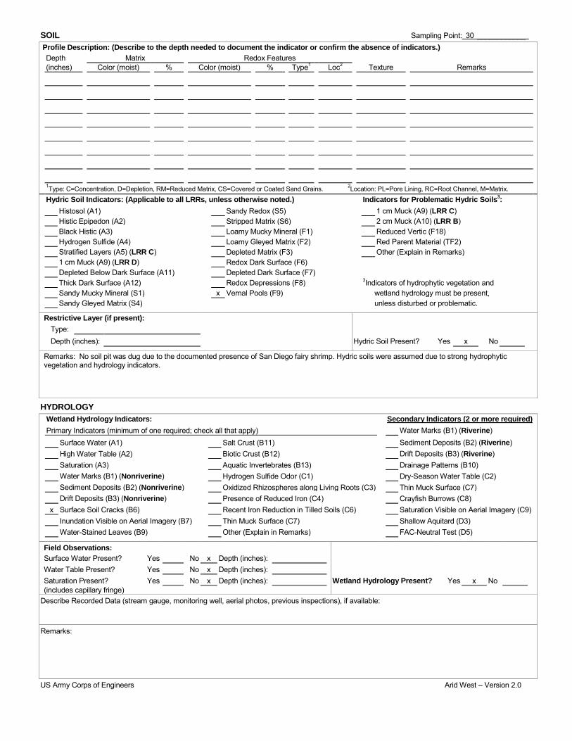
SOIL Sampling Point: 30 ____________ Profile Description: (Describe to the depth needed to document the indicator or confirm the absence of indicators.) Depth Matrix Redox Features (inches) Color (moist) % Color (moist) % Type1 Loc2 Texture Remarks
1Type: C=Concentration, D=Depletion, RM=Reduced Matrix, CS=Covered or Coated Sand Grains. 2Location: PL=Pore Lining, RC=Root Channel, M=Matrix. Hydric Soil Indicators: (Applicable to all LRRs, unless otherwise noted.) Indicators for Problematic Hydric Soils3: Histosol (A1) Sandy Redox (S5) 1 cm Muck (A9) (LRR C) Histic Epipedon (A2) Stripped Matrix (S6) 2 cm Muck (A10) (LRR B) Black Histic (A3) Loamy Mucky Mineral (F1) Reduced Vertic (F18) Hydrogen Sulfide (A4) Loamy Gleyed Matrix (F2) Red Parent Material (TF2) Stratified Layers (A5) (LRR C) Depleted Matrix (F3) Other (Explain in Remarks) 1 cm Muck (A9) (LRR D) Redox Dark Surface (F6) Depleted Below Dark Surface (A11) Depleted Dark Surface (F7) Thick Dark Surface (A12) Redox Depressions (F8) 3Indicators of hydrophytic vegetation and Sandy Mucky Mineral (S1) x Vernal Pools (F9) wetland hydrology must be present, Sandy Gleyed Matrix (S4) unless disturbed or problematic.
Restrictive Layer (if present): Type: Depth (inches): Hydric Soil Present? Yes x No
Remarks: No soil pit was dug due to the documented presence of San Diego fairy shrimp. Hydric soils were assumed due to strong hydrophytic vegetation and hydrology indicators.
HYDROLOGY Wetland Hydrology Indicators: Secondary Indicators (2 or more required) Primary Indicators (minimum of one required; check all that apply) Water Marks (B1) (Riverine) Surface Water (A1) Salt Crust (B11) Sediment Deposits (B2) (Riverine) High Water Table (A2) Biotic Crust (B12) Drift Deposits (B3) (Riverine) Saturation (A3) Aquatic Invertebrates (B13) Drainage Patterns (B10) Water Marks (B1) (Nonriverine) Hydrogen Sulfide Odor (C1) Dry-Season Water Table (C2) Sediment Deposits (B2) (Nonriverine) Oxidized Rhizospheres along Living Roots (C3) Thin Muck Surface (C7) Drift Deposits (B3) (Nonriverine) Presence of Reduced Iron (C4) Crayfish Burrows (C8) x Surface Soil Cracks (B6) Recent Iron Reduction in Tilled Soils (C6) Saturation Visible on Aerial Imagery (C9) Inundation Visible on Aerial Imagery (B7) Thin Muck Surface (C7) Shallow Aquitard (D3) Water-Stained Leaves (B9) Other (Explain in Remarks) FAC-Neutral Test (D5)
Field Observations: Surface Water Present? Yes No x Depth (inches): Water Table Present? Yes No x Depth (inches): Saturation Present? Yes No x Depth (inches): Wetland Hydrology Present? Yes x No (includes capillary fringe)
Describe Recorded Data (stream gauge, monitoring well, aerial photos, previous inspections), if available:
Remarks:
US Army Corps of Engineers Arid West – Version 2.0

WETLAND DETERMINATION DATA FORM – Arid West Region Project/Site: TL-649 Otay-San Ysidro Border Wood to Steel City/County: Chula Vista/San Diego Sampling Date: 05/22/2014
Applicant/Owner: San Diego Gas & Electric State: CA Sampling Point: 31
Investigator(s): Michael Nieto, Cailin O'Meara Section, Township, Range: T18S, R01W, Sec. 24, Otay Mesa quadrangle
Landform (hillslope, terrace, etc.): Mesa Local relief (concave, convex, none): Convex Slope (%): 0
Subregion (LRR): LRR-C Lat: 32°35'9.75"N Long: 116°56'21.86"W Datum: NAD-83
Soil Map Unit Name: Stockpen gravelly clay loam NWI classification: Palustrine
Are climatic / hydrologic conditions on the site typical for this time of year? Yes x No (If no, explain in Remarks.)
Are Vegetation x, Soil , or Hydrology significantly disturbed? Yes Are "Normal Circumstances" present? Yes x No
Are Vegetation , Soil , or Hydrology naturally problematic? No (If needed, explain any answers in Remarks.)
SUMMARY OF FINDINGS – Attach site map showing sampling point locations, transects, important features, etc.
Hydrophytic Vegetation Present? Yes x No Is the Sampled Area within a Wetland?
Hydric Soil Present? Yes x No Yes x No Wetland Hydrology Present? Yes x No
Remarks: Vegetation significantly disturbed from access road.
VEGETATION – Use scientific names of plants. Absolute Dominant Indicator Dominance Test worksheet:
Number of Dominant Species That Are OBL, FACW, or FAC: Total Number of Dominant Species Across All Strata: Percent of Dominant Species That Are OBL, FACW, or FAC:
1
(A)
1
(B)
100% (A/B)
Tree Stratum (Plot size: ) % Cover Species? Status 1. 2. 3. 4. 0 = Total Cover Sapling/Shrub Stratum (Plot size: ) 1. Prevalence Index worksheet:
Total % Cover of: Multiply by:
OBL species x 1 =
FACW species x 2 =
FAC species x 3 =
FACU species x 4 =
UPL species x 5 =
Column Totals: (A) (B)
Prevalence Index = B/A =
2. 3. 4. 5. 0 = Total Cover Herb Stratum (Plot size: ) 1. Psilocarphus brevissimus var. brevissimus 3 N FACW 2. Festuca perennis 5 N FAC 3. Polypogon monspeliensis 15 Y FACW 4. Atriplex semibaccata 5 N FAC Hydrophytic Vegetation Indicators: 5. x Dominance Test is >50% 6. Prevalence Index is ≤3.01 7. Morphological Adaptations1 (Provide supporting 8. data in Remarks or on a separate sheet)
28 = Total Cover Problematic Hydrophytic Vegetation1 (Explain) Woody Vine Stratum (Plot size: ) 1. 1Indicators of hydric soil and wetland hydrology must
be present, unless disturbed or problematic. 2.
0 = Total Cover Hydrophytic Vegetation Present?
% Bare Ground in Herb Stratum 72 % Cover of Biotic Crust 0 Yes x No
Remarks: Sampling was conducted in a vernal pool within an access road.
US Army Corps of Engineers Arid West – Version 2.0

SOIL Sampling Point: 31 ____________ Profile Description: (Describe to the depth needed to document the indicator or confirm the absence of indicators.) Depth Matrix Redox Features (inches) Color (moist) % Color (moist) % Type1 Loc2 Texture Remarks
1Type: C=Concentration, D=Depletion, RM=Reduced Matrix, CS=Covered or Coated Sand Grains. 2Location: PL=Pore Lining, RC=Root Channel, M=Matrix. Hydric Soil Indicators: (Applicable to all LRRs, unless otherwise noted.) Indicators for Problematic Hydric Soils3: Histosol (A1) Sandy Redox (S5) 1 cm Muck (A9) (LRR C) Histic Epipedon (A2) Stripped Matrix (S6) 2 cm Muck (A10) (LRR B) Black Histic (A3) Loamy Mucky Mineral (F1) Reduced Vertic (F18) Hydrogen Sulfide (A4) Loamy Gleyed Matrix (F2) Red Parent Material (TF2) Stratified Layers (A5) (LRR C) Depleted Matrix (F3) Other (Explain in Remarks) 1 cm Muck (A9) (LRR D) Redox Dark Surface (F6) Depleted Below Dark Surface (A11) Depleted Dark Surface (F7) Thick Dark Surface (A12) Redox Depressions (F8) 3Indicators of hydrophytic vegetation and Sandy Mucky Mineral (S1) x Vernal Pools (F9) wetland hydrology must be present, Sandy Gleyed Matrix (S4) unless disturbed or problematic.
Restrictive Layer (if present): Type: Depth (inches): Hydric Soil Present? Yes x No
Remarks: No soil pit was dug due to the documented presence of San Diego fairy shrimp. Hydric soils were assumed due to strong hydrophytic vegetation and hydrology indicators.
HYDROLOGY Wetland Hydrology Indicators: Secondary Indicators (2 or more required) Primary Indicators (minimum of one required; check all that apply) Water Marks (B1) (Riverine) Surface Water (A1) Salt Crust (B11) Sediment Deposits (B2) (Riverine) High Water Table (A2) Biotic Crust (B12) Drift Deposits (B3) (Riverine) Saturation (A3) Aquatic Invertebrates (B13) Drainage Patterns (B10) Water Marks (B1) (Nonriverine) Hydrogen Sulfide Odor (C1) Dry-Season Water Table (C2) Sediment Deposits (B2) (Nonriverine) Oxidized Rhizospheres along Living Roots (C3) Thin Muck Surface (C7) Drift Deposits (B3) (Nonriverine) Presence of Reduced Iron (C4) Crayfish Burrows (C8) x Surface Soil Cracks (B6) Recent Iron Reduction in Tilled Soils (C6) Saturation Visible on Aerial Imagery (C9) Inundation Visible on Aerial Imagery (B7) Thin Muck Surface (C7) Shallow Aquitard (D3) Water-Stained Leaves (B9) Other (Explain in Remarks) FAC-Neutral Test (D5)
Field Observations: Surface Water Present? Yes No x Depth (inches): Water Table Present? Yes No x Depth (inches): Saturation Present? Yes No x Depth (inches): Wetland Hydrology Present? Yes x No (includes capillary fringe)
Describe Recorded Data (stream gauge, monitoring well, aerial photos, previous inspections), if available:
Remarks:
US Army Corps of Engineers Arid West – Version 2.0

WETLAND DETERMINATION DATA FORM – Arid West Region Project/Site: TL-649 Otay-San Ysidro Border Wood to Steel City/County: Chula Vista/San Diego Sampling Date: 05/22/2014
Applicant/Owner: San Diego Gas & Electric State: CA Sampling Point: 32
Investigator(s): Michael Nieto, Cailin O'Meara Section, Township, Range: T18S, R01W, Sec. 24, Otay Mesa quadrangle
Landform (hillslope, terrace, etc.): Vernal pool Local relief (concave, convex, none): Convex Slope (%): 0
Subregion (LRR): LRR-C Lat: 32°35'8.95"N Long: 116°56'21.49"W Datum: NAD-83
Soil Map Unit Name: Stockpen gravelly clay loam NWI classification: Palustrine
Are climatic / hydrologic conditions on the site typical for this time of year? Yes x No (If no, explain in Remarks.)
Are Vegetation x, Soil , or Hydrology significantly disturbed? Yes Are "Normal Circumstances" present? Yes x No
Are Vegetation , Soil , or Hydrology naturally problematic? No (If needed, explain any answers in Remarks.)
SUMMARY OF FINDINGS – Attach site map showing sampling point locations, transects, important features, etc.
Hydrophytic Vegetation Present? Yes x No Is the Sampled Area within a Wetland?
Hydric Soil Present? Yes x No Yes x No Wetland Hydrology Present? Yes x No
Remarks: Vegetation significantly disturbed from access road.
VEGETATION – Use scientific names of plants. Absolute Dominant Indicator Dominance Test worksheet:
Number of Dominant Species That Are OBL, FACW, or FAC: Total Number of Dominant Species Across All Strata: Percent of Dominant Species That Are OBL, FACW, or FAC:
2
(A)
2
(B)
100% (A/B)
Tree Stratum (Plot size: ) % Cover Species? Status 1. 2. 3. 4. = Total Cover Sapling/Shrub Stratum (Plot size: ) 1. Prevalence Index worksheet:
Total % Cover of: Multiply by:
OBL species x 1 =
FACW species x 2 =
FAC species x 3 =
FACU species x 4 =
UPL species x 5 =
Column Totals: (A) (B)
Prevalence Index = B/A =
2. 3. 4. 5. = Total Cover Herb Stratum (Plot size: ) 1. Polypogon monspeliensis 5 Yes FACW 2. Festuca perennis 2 Yes FAC 3. 4. Hydrophytic Vegetation Indicators: 5. x Dominance Test is >50% 6. Prevalence Index is ≤3.01 7. Morphological Adaptations1 (Provide supporting 8. data in Remarks or on a separate sheet)
7 = Total Cover Problematic Hydrophytic Vegetation1 (Explain) Woody Vine Stratum (Plot size: ) 1. 1Indicators of hydric soil and wetland hydrology must
be present, unless disturbed or problematic. 2.
= Total Cover Hydrophytic Vegetation Present?
% Bare Ground in Herb Stratum % Cover of Biotic Crust Yes x No
Remarks: Sampling was conducted in a vernal pool within an access road.
US Army Corps of Engineers Arid West – Version 2.0

SOIL Sampling Point: 30 ____________ Profile Description: (Describe to the depth needed to document the indicator or confirm the absence of indicators.) Depth Matrix Redox Features (inches) Color (moist) % Color (moist) % Type1 Loc2 Texture Remarks
1Type: C=Concentration, D=Depletion, RM=Reduced Matrix, CS=Covered or Coated Sand Grains. 2Location: PL=Pore Lining, RC=Root Channel, M=Matrix. Hydric Soil Indicators: (Applicable to all LRRs, unless otherwise noted.) Indicators for Problematic Hydric Soils3: Histosol (A1) Sandy Redox (S5) 1 cm Muck (A9) (LRR C) Histic Epipedon (A2) Stripped Matrix (S6) 2 cm Muck (A10) (LRR B) Black Histic (A3) Loamy Mucky Mineral (F1) Reduced Vertic (F18) Hydrogen Sulfide (A4) Loamy Gleyed Matrix (F2) Red Parent Material (TF2) Stratified Layers (A5) (LRR C) Depleted Matrix (F3) Other (Explain in Remarks) 1 cm Muck (A9) (LRR D) Redox Dark Surface (F6) Depleted Below Dark Surface (A11) Depleted Dark Surface (F7) Thick Dark Surface (A12) Redox Depressions (F8) 3Indicators of hydrophytic vegetation and Sandy Mucky Mineral (S1) x Vernal Pools (F9) wetland hydrology must be present, Sandy Gleyed Matrix (S4) unless disturbed or problematic.
Restrictive Layer (if present): Type: Depth (inches): Hydric Soil Present? Yes x No
Remarks: No soil pit was dug due to the documented presence of San Diego fairy shrimp. Hydric soils were assumed due to strong hydrophytic vegetation and hydrology indicators.
HYDROLOGY Wetland Hydrology Indicators: Secondary Indicators (2 or more required) Primary Indicators (minimum of one required; check all that apply) Water Marks (B1) (Riverine) Surface Water (A1) Salt Crust (B11) Sediment Deposits (B2) (Riverine) High Water Table (A2) Biotic Crust (B12) Drift Deposits (B3) (Riverine) Saturation (A3) Aquatic Invertebrates (B13) Drainage Patterns (B10) Water Marks (B1) (Nonriverine) Hydrogen Sulfide Odor (C1) Dry-Season Water Table (C2) Sediment Deposits (B2) (Nonriverine) Oxidized Rhizospheres along Living Roots (C3) Thin Muck Surface (C7) Drift Deposits (B3) (Nonriverine) Presence of Reduced Iron (C4) Crayfish Burrows (C8) x Surface Soil Cracks (B6) Recent Iron Reduction in Tilled Soils (C6) Saturation Visible on Aerial Imagery (C9) Inundation Visible on Aerial Imagery (B7) Thin Muck Surface (C7) Shallow Aquitard (D3) Water-Stained Leaves (B9) Other (Explain in Remarks) FAC-Neutral Test (D5)
Field Observations: Surface Water Present? Yes No x Depth (inches): Water Table Present? Yes No x Depth (inches): Saturation Present? Yes No x Depth (inches): Wetland Hydrology Present? Yes x No (includes capillary fringe)
Describe Recorded Data (stream gauge, monitoring well, aerial photos, previous inspections), if available:
Remarks:
US Army Corps of Engineers Arid West – Version 2.0

WETLAND DETERMINATION DATA FORM – Arid West Region Project/Site: TL-649 Otay-San Ysidro Border Wood to Steel City/County: Chula Vista/San Diego Sampling Date: 05/22/2014
Applicant/Owner: San Diego Gas & Electric State: CA Sampling Point: 33
Investigator(s): Michael Nieto, Cailin O'Meara Section, Township, Range: T18S, R01W, Sec. 24, Otay Mesa quadrangle
Landform (hillslope, terrace, etc.): Mesa Local relief (concave, convex, none): Convex Slope (%): 0
Subregion (LRR): LRR-C Lat: 32°35'8.33"N Long: 116°56'21.44"W Datum: NAD-83
Soil Map Unit Name: Stockpen gravelly clay loam NWI classification: Palustrine
Are climatic / hydrologic conditions on the site typical for this time of year? Yes x No (If no, explain in Remarks.)
Are Vegetation x, Soil , or Hydrology significantly disturbed? Yes Are "Normal Circumstances" present? Yes x No
Are Vegetation , Soil , or Hydrology naturally problematic? No (If needed, explain any answers in Remarks.)
SUMMARY OF FINDINGS – Attach site map showing sampling point locations, transects, important features, etc.
Hydrophytic Vegetation Present? Yes x No Is the Sampled Area within a Wetland?
Hydric Soil Present? Yes x No Yes x No Wetland Hydrology Present? Yes x No
Remarks: Vegetation significantly disturbed from access road.
VEGETATION – Use scientific names of plants. Absolute Dominant Indicator Dominance Test worksheet:
Number of Dominant Species That Are OBL, FACW, or FAC: Total Number of Dominant Species Across All Strata: Percent of Dominant Species That Are OBL, FACW, or FAC:
2
(A)
2
(B)
100% (A/B)
Tree Stratum (Plot size: ) % Cover Species? Status 1. 2. 3. 4. = Total Cover Sapling/Shrub Stratum (Plot size: ) 1. Prevalence Index worksheet:
Total % Cover of: Multiply by:
OBL species x 1 =
FACW species x 2 =
FAC species x 3 =
FACU species x 4 =
UPL species x 5 =
Column Totals: (A) (B)
Prevalence Index = B/A =
2. 3. 4. 5. = Total Cover Herb Stratum (Plot size: ) 1. Polypogon monspeliensis 7 Yes FACW 2. Festuca perennis 2 Yes FAC 3. 4. Hydrophytic Vegetation Indicators: 5. x Dominance Test is >50% 6. Prevalence Index is ≤3.01 7. Morphological Adaptations1 (Provide supporting 8. data in Remarks or on a separate sheet)
9 = Total Cover Problematic Hydrophytic Vegetation1 (Explain) Woody Vine Stratum (Plot size: ) 1. 1Indicators of hydric soil and wetland hydrology must
be present, unless disturbed or problematic. 2.
= Total Cover Hydrophytic Vegetation Present?
% Bare Ground in Herb Stratum 92% % Cover of Biotic Crust Yes x No
Remarks: Sampling was conducted in a vernal pool within an access road.
US Army Corps of Engineers Arid West – Version 2.0

SOIL Sampling Point: 33 ____________ Profile Description: (Describe to the depth needed to document the indicator or confirm the absence of indicators.) Depth Matrix Redox Features (inches) Color (moist) % Color (moist) % Type1 Loc2 Texture Remarks
1Type: C=Concentration, D=Depletion, RM=Reduced Matrix, CS=Covered or Coated Sand Grains. 2Location: PL=Pore Lining, RC=Root Channel, M=Matrix. Hydric Soil Indicators: (Applicable to all LRRs, unless otherwise noted.) Indicators for Problematic Hydric Soils3: Histosol (A1) Sandy Redox (S5) 1 cm Muck (A9) (LRR C) Histic Epipedon (A2) Stripped Matrix (S6) 2 cm Muck (A10) (LRR B) Black Histic (A3) Loamy Mucky Mineral (F1) Reduced Vertic (F18) Hydrogen Sulfide (A4) Loamy Gleyed Matrix (F2) Red Parent Material (TF2) Stratified Layers (A5) (LRR C) Depleted Matrix (F3) Other (Explain in Remarks) 1 cm Muck (A9) (LRR D) Redox Dark Surface (F6) Depleted Below Dark Surface (A11) Depleted Dark Surface (F7) Thick Dark Surface (A12) Redox Depressions (F8) 3Indicators of hydrophytic vegetation and Sandy Mucky Mineral (S1) x Vernal Pools (F9) wetland hydrology must be present, Sandy Gleyed Matrix (S4) unless disturbed or problematic.
Restrictive Layer (if present): Type: Depth (inches): Hydric Soil Present? Yes x No
Remarks: No soil pit was dug due to the documented presence of San Diego fairy shrimp. Hydric soils were assumed due to strong hydrophytic vegetation and hydrology indicators.
HYDROLOGY Wetland Hydrology Indicators: Secondary Indicators (2 or more required) Primary Indicators (minimum of one required; check all that apply) Water Marks (B1) (Riverine) Surface Water (A1) Salt Crust (B11) Sediment Deposits (B2) (Riverine) High Water Table (A2) Biotic Crust (B12) Drift Deposits (B3) (Riverine) Saturation (A3) Aquatic Invertebrates (B13) Drainage Patterns (B10) Water Marks (B1) (Nonriverine) Hydrogen Sulfide Odor (C1) Dry-Season Water Table (C2) Sediment Deposits (B2) (Nonriverine) Oxidized Rhizospheres along Living Roots (C3) Thin Muck Surface (C7) Drift Deposits (B3) (Nonriverine) Presence of Reduced Iron (C4) Crayfish Burrows (C8) x Surface Soil Cracks (B6) Recent Iron Reduction in Tilled Soils (C6) Saturation Visible on Aerial Imagery (C9) Inundation Visible on Aerial Imagery (B7) Thin Muck Surface (C7) Shallow Aquitard (D3) Water-Stained Leaves (B9) Other (Explain in Remarks) FAC-Neutral Test (D5)
Field Observations: Surface Water Present? Yes No x Depth (inches): Water Table Present? Yes No x Depth (inches): Saturation Present? Yes No x Depth (inches): Wetland Hydrology Present? Yes x No (includes capillary fringe)
Describe Recorded Data (stream gauge, monitoring well, aerial photos, previous inspections), if available:
Remarks:
US Army Corps of Engineers Arid West – Version 2.0

WETLAND DETERMINATION DATA FORM – Arid West Region Project/Site: TL-649 Otay-San Ysidro Border Wood to Steel City/County: Chula Vista/San Diego Sampling Date: 05/22/2014
Applicant/Owner: San Diego Gas & Electric State: CA Sampling Point: 34
Investigator(s): Michael Nieto, Cailin O'Meara Section, Township, Range: T18S, R01W, Sec. 24, Otay Mesa quadrangle
Landform (hillslope, terrace, etc.): Mesa Local relief (concave, convex, none): Convex Slope (%): 0
Subregion (LRR): LRR-C Lat: 32°35'9.75"N Long: 116°56'21.86"W Datum: NAD-83
Soil Map Unit Name: Stockpen gravelly clay loam NWI classification: Palustrine
Are climatic / hydrologic conditions on the site typical for this time of year? Yes x No (If no, explain in Remarks.)
Are Vegetation x, Soil , or Hydrology significantly disturbed? Yes Are "Normal Circumstances" present? Yes x No
Are Vegetation , Soil , or Hydrology naturally problematic? No (If needed, explain any answers in Remarks.)
SUMMARY OF FINDINGS – Attach site map showing sampling point locations, transects, important features, etc.
Hydrophytic Vegetation Present? Yes x No Is the Sampled Area within a Wetland?
Hydric Soil Present? Yes x No Yes x No Wetland Hydrology Present? Yes x No
Remarks: Vegetation significantly disturbed from access road.
VEGETATION – Use scientific names of plants. Absolute Dominant Indicator Dominance Test worksheet:
Number of Dominant Species That Are OBL, FACW, or FAC: Total Number of Dominant Species Across All Strata: Percent of Dominant Species That Are OBL, FACW, or FAC:
3
(A)
3
(B)
100% (A/B)
Tree Stratum (Plot size: ) % Cover Species? Status 1. 2. 3. 4. 0 = Total Cover Sapling/Shrub Stratum (Plot size: ) 1. Prevalence Index worksheet:
Total % Cover of: Multiply by:
OBL species x 1 =
FACW species x 2 =
FAC species x 3 =
FACU species x 4 =
UPL species x 5 =
Column Totals: (A) (B)
Prevalence Index = B/A =
2. 3. 4. 5. 0 = Total Cover Herb Stratum (Plot size: ) 1. Psilocarphus brevissimus var. brevissimus 3 No FACW 2. Festuca perennis 5 Yes FAC 3. Polypogon monspeliensis 10 Yes FACW 4. Atriplex semibaccata 5 Yes FAC Hydrophytic Vegetation Indicators: 5. x Dominance Test is >50% 6. Prevalence Index is ≤3.01 7. Morphological Adaptations1 (Provide supporting 8. data in Remarks or on a separate sheet)
23 = Total Cover Problematic Hydrophytic Vegetation1 (Explain) Woody Vine Stratum (Plot size: ) 1. 1Indicators of hydric soil and wetland hydrology must
be present, unless disturbed or problematic. 2.
0 = Total Cover Hydrophytic Vegetation Present?
% Bare Ground in Herb Stratum 77 % Cover of Biotic Crust 0 Yes x No
Remarks: Sampling was conducted in a vernal pool within an access road.
US Army Corps of Engineers Arid West – Version 2.0

SOIL Sampling Point: 31 ____________ Profile Description: (Describe to the depth needed to document the indicator or confirm the absence of indicators.) Depth Matrix Redox Features (inches) Color (moist) % Color (moist) % Type1 Loc2 Texture Remarks
1Type: C=Concentration, D=Depletion, RM=Reduced Matrix, CS=Covered or Coated Sand Grains. 2Location: PL=Pore Lining, RC=Root Channel, M=Matrix. Hydric Soil Indicators: (Applicable to all LRRs, unless otherwise noted.) Indicators for Problematic Hydric Soils3: Histosol (A1) Sandy Redox (S5) 1 cm Muck (A9) (LRR C) Histic Epipedon (A2) Stripped Matrix (S6) 2 cm Muck (A10) (LRR B) Black Histic (A3) Loamy Mucky Mineral (F1) Reduced Vertic (F18) Hydrogen Sulfide (A4) Loamy Gleyed Matrix (F2) Red Parent Material (TF2) Stratified Layers (A5) (LRR C) Depleted Matrix (F3) Other (Explain in Remarks) 1 cm Muck (A9) (LRR D) Redox Dark Surface (F6) Depleted Below Dark Surface (A11) Depleted Dark Surface (F7) Thick Dark Surface (A12) Redox Depressions (F8) 3Indicators of hydrophytic vegetation and Sandy Mucky Mineral (S1) x Vernal Pools (F9) wetland hydrology must be present, Sandy Gleyed Matrix (S4) unless disturbed or problematic.
Restrictive Layer (if present): Type: Depth (inches): Hydric Soil Present? Yes x No
Remarks: No soil pit was dug due to the documented presence of San Diego fairy shrimp. Hydric soils were assumed due to strong hydrophytic vegetation and hydrology indicators.
HYDROLOGY Wetland Hydrology Indicators: Secondary Indicators (2 or more required) Primary Indicators (minimum of one required; check all that apply) Water Marks (B1) (Riverine) Surface Water (A1) Salt Crust (B11) Sediment Deposits (B2) (Riverine) High Water Table (A2) Biotic Crust (B12) Drift Deposits (B3) (Riverine) Saturation (A3) Aquatic Invertebrates (B13) Drainage Patterns (B10) Water Marks (B1) (Nonriverine) Hydrogen Sulfide Odor (C1) Dry-Season Water Table (C2) Sediment Deposits (B2) (Nonriverine) Oxidized Rhizospheres along Living Roots (C3) Thin Muck Surface (C7) Drift Deposits (B3) (Nonriverine) Presence of Reduced Iron (C4) Crayfish Burrows (C8) x Surface Soil Cracks (B6) Recent Iron Reduction in Tilled Soils (C6) Saturation Visible on Aerial Imagery (C9) Inundation Visible on Aerial Imagery (B7) Thin Muck Surface (C7) Shallow Aquitard (D3) Water-Stained Leaves (B9) Other (Explain in Remarks) FAC-Neutral Test (D5)
Field Observations: Surface Water Present? Yes No x Depth (inches): Water Table Present? Yes No x Depth (inches): Saturation Present? Yes No x Depth (inches): Wetland Hydrology Present? Yes x No (includes capillary fringe)
Describe Recorded Data (stream gauge, monitoring well, aerial photos, previous inspections), if available:
Remarks:
US Army Corps of Engineers Arid West – Version 2.0
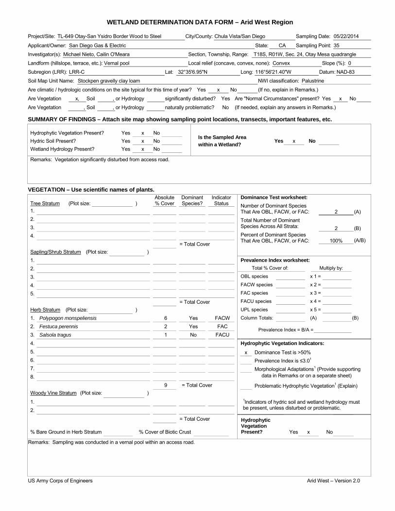
WETLAND DETERMINATION DATA FORM – Arid West Region Project/Site: TL-649 Otay-San Ysidro Border Wood to Steel City/County: Chula Vista/San Diego Sampling Date: 05/22/2014
Applicant/Owner: San Diego Gas & Electric State: CA Sampling Point: 35
Investigator(s): Michael Nieto, Cailin O'Meara Section, Township, Range: T18S, R01W, Sec. 24, Otay Mesa quadrangle
Landform (hillslope, terrace, etc.): Vernal pool Local relief (concave, convex, none): Convex Slope (%): 0
Subregion (LRR): LRR-C Lat: 32°35'6.95"N Long: 116°56'21.40"W Datum: NAD-83
Soil Map Unit Name: Stockpen gravelly clay loam NWI classification: Palustrine
Are climatic / hydrologic conditions on the site typical for this time of year? Yes x No (If no, explain in Remarks.)
Are Vegetation x, Soil , or Hydrology significantly disturbed? Yes Are "Normal Circumstances" present? Yes x No
Are Vegetation , Soil , or Hydrology naturally problematic? No (If needed, explain any answers in Remarks.)
SUMMARY OF FINDINGS – Attach site map showing sampling point locations, transects, important features, etc.
Hydrophytic Vegetation Present? Yes x No Is the Sampled Area within a Wetland?
Hydric Soil Present? Yes x No Yes x No Wetland Hydrology Present? Yes x No
Remarks: Vegetation significantly disturbed from access road.
VEGETATION – Use scientific names of plants. Absolute Dominant Indicator Dominance Test worksheet:
Number of Dominant Species That Are OBL, FACW, or FAC: Total Number of Dominant Species Across All Strata: Percent of Dominant Species That Are OBL, FACW, or FAC:
2
(A)
2
(B)
100% (A/B)
Tree Stratum (Plot size: ) % Cover Species? Status 1. 2. 3. 4. = Total Cover Sapling/Shrub Stratum (Plot size: ) 1. Prevalence Index worksheet:
Total % Cover of: Multiply by:
OBL species x 1 =
FACW species x 2 =
FAC species x 3 =
FACU species x 4 =
UPL species x 5 =
Column Totals: (A) (B)
Prevalence Index = B/A =
2. 3. 4. 5. = Total Cover Herb Stratum (Plot size: ) 1. Polypogon monspeliensis 6 Yes FACW 2. Festuca perennis 2 Yes FAC 3. Salsola tragus 1 No FACU 4. Hydrophytic Vegetation Indicators: 5. x Dominance Test is >50% 6. Prevalence Index is ≤3.01 7. Morphological Adaptations1 (Provide supporting 8. data in Remarks or on a separate sheet)
9 = Total Cover Problematic Hydrophytic Vegetation1 (Explain) Woody Vine Stratum (Plot size: ) 1. 1Indicators of hydric soil and wetland hydrology must
be present, unless disturbed or problematic. 2.
= Total Cover Hydrophytic Vegetation Present?
% Bare Ground in Herb Stratum % Cover of Biotic Crust Yes x No
Remarks: Sampling was conducted in a vernal pool within an access road.
US Army Corps of Engineers Arid West – Version 2.0

SOIL Sampling Point: 35 ____________ Profile Description: (Describe to the depth needed to document the indicator or confirm the absence of indicators.) Depth Matrix Redox Features (inches) Color (moist) % Color (moist) % Type1 Loc2 Texture Remarks
1Type: C=Concentration, D=Depletion, RM=Reduced Matrix, CS=Covered or Coated Sand Grains. 2Location: PL=Pore Lining, RC=Root Channel, M=Matrix. Hydric Soil Indicators: (Applicable to all LRRs, unless otherwise noted.) Indicators for Problematic Hydric Soils3: Histosol (A1) Sandy Redox (S5) 1 cm Muck (A9) (LRR C) Histic Epipedon (A2) Stripped Matrix (S6) 2 cm Muck (A10) (LRR B) Black Histic (A3) Loamy Mucky Mineral (F1) Reduced Vertic (F18) Hydrogen Sulfide (A4) Loamy Gleyed Matrix (F2) Red Parent Material (TF2) Stratified Layers (A5) (LRR C) Depleted Matrix (F3) Other (Explain in Remarks) 1 cm Muck (A9) (LRR D) Redox Dark Surface (F6) Depleted Below Dark Surface (A11) Depleted Dark Surface (F7) Thick Dark Surface (A12) Redox Depressions (F8) 3Indicators of hydrophytic vegetation and Sandy Mucky Mineral (S1) x Vernal Pools (F9) wetland hydrology must be present, Sandy Gleyed Matrix (S4) unless disturbed or problematic.
Restrictive Layer (if present): Type: Depth (inches): Hydric Soil Present? Yes x No
Remarks: No soil pit was dug due to the documented presence of San Diego fairy shrimp. Hydric soils were assumed due to strong hydrophytic vegetation and hydrology indicators.
HYDROLOGY Wetland Hydrology Indicators: Secondary Indicators (2 or more required) Primary Indicators (minimum of one required; check all that apply) Water Marks (B1) (Riverine) Surface Water (A1) Salt Crust (B11) Sediment Deposits (B2) (Riverine) High Water Table (A2) Biotic Crust (B12) Drift Deposits (B3) (Riverine) Saturation (A3) Aquatic Invertebrates (B13) Drainage Patterns (B10) Water Marks (B1) (Nonriverine) Hydrogen Sulfide Odor (C1) Dry-Season Water Table (C2) Sediment Deposits (B2) (Nonriverine) Oxidized Rhizospheres along Living Roots (C3) Thin Muck Surface (C7) Drift Deposits (B3) (Nonriverine) Presence of Reduced Iron (C4) Crayfish Burrows (C8) x Surface Soil Cracks (B6) Recent Iron Reduction in Tilled Soils (C6) Saturation Visible on Aerial Imagery (C9) Inundation Visible on Aerial Imagery (B7) Thin Muck Surface (C7) Shallow Aquitard (D3) Water-Stained Leaves (B9) Other (Explain in Remarks) FAC-Neutral Test (D5)
Field Observations: Surface Water Present? Yes No x Depth (inches): Water Table Present? Yes No x Depth (inches): Saturation Present? Yes No x Depth (inches): Wetland Hydrology Present? Yes x No (includes capillary fringe)
Describe Recorded Data (stream gauge, monitoring well, aerial photos, previous inspections), if available:
Remarks:
US Army Corps of Engineers Arid West – Version 2.0

WETLAND DETERMINATION DATA FORM – Arid West Region Project/Site: TL-649 Otay-San Ysidro Border Wood to Steel City/County: Chula Vista/San Diego Sampling Date: 05/22/2014
Applicant/Owner: San Diego Gas & Electric State: CA Sampling Point: 36
Investigator(s): Michael Nieto, Cailin O'Meara Section, Township, Range: T18S, R01W, Sec. 24, Otay Mesa quadrangle
Landform (hillslope, terrace, etc.): Mesa Local relief (concave, convex, none): Convex Slope (%): 0
Subregion (LRR): LRR-C Lat: 32°35'3.64"N Long: 116°56'21.84"W Datum: NAD-83
Soil Map Unit Name: Stockpen gravelly clay loam NWI classification: Palustrine
Are climatic / hydrologic conditions on the site typical for this time of year? Yes x No (If no, explain in Remarks.)
Are Vegetation x, Soil , or Hydrology significantly disturbed? Yes Are "Normal Circumstances" present? Yes x No
Are Vegetation , Soil , or Hydrology naturally problematic? No (If needed, explain any answers in Remarks.)
SUMMARY OF FINDINGS – Attach site map showing sampling point locations, transects, important features, etc.
Hydrophytic Vegetation Present? Yes x No Is the Sampled Area within a Wetland?
Hydric Soil Present? Yes x No Yes x No Wetland Hydrology Present? Yes x No
Remarks: Vegetation significantly disturbed from access road.
VEGETATION – Use scientific names of plants. Absolute Dominant Indicator Dominance Test worksheet:
Number of Dominant Species That Are OBL, FACW, or FAC: Total Number of Dominant Species Across All Strata: Percent of Dominant Species That Are OBL, FACW, or FAC:
3
(A)
3
(B)
100% (A/B)
Tree Stratum (Plot size: ) % Cover Species? Status 1. 2. 3. 4. = Total Cover Sapling/Shrub Stratum (Plot size: ) 1. Prevalence Index worksheet:
Total % Cover of: Multiply by:
OBL species x 1 =
FACW species x 2 =
FAC species x 3 =
FACU species x 4 =
UPL species x 5 =
Column Totals: (A) (B)
Prevalence Index = B/A =
2. 3. 4. 5. = Total Cover Herb Stratum (Plot size: ) 1. Festuca perennis 5 Yes FAC 2. Polypogon monspeliensis 5 Yes FACW 3. Spergularia sp. 3 Yes FACW 4. Psilocarphus brevissimus var. brevissimus 2 No FACW Hydrophytic Vegetation Indicators: 5. x Dominance Test is >50% 6. Prevalence Index is ≤3.01 7. Morphological Adaptations1 (Provide supporting 8. data in Remarks or on a separate sheet)
15 = Total Cover Problematic Hydrophytic Vegetation1 (Explain) Woody Vine Stratum (Plot size: ) 1. 1Indicators of hydric soil and wetland hydrology must
be present, unless disturbed or problematic. 2.
= Total Cover Hydrophytic Vegetation Present?
% Bare Ground in Herb Stratum % Cover of Biotic Crust Yes x No
Remarks: Sampling was conducted in a vernal pool within an access road.
US Army Corps of Engineers Arid West – Version 2.0

SOIL Sampling Point: 36 ____________ Profile Description: (Describe to the depth needed to document the indicator or confirm the absence of indicators.) Depth Matrix Redox Features (inches) Color (moist) % Color (moist) % Type1 Loc2 Texture Remarks
1Type: C=Concentration, D=Depletion, RM=Reduced Matrix, CS=Covered or Coated Sand Grains. 2Location: PL=Pore Lining, RC=Root Channel, M=Matrix. Hydric Soil Indicators: (Applicable to all LRRs, unless otherwise noted.) Indicators for Problematic Hydric Soils3: Histosol (A1) Sandy Redox (S5) 1 cm Muck (A9) (LRR C) Histic Epipedon (A2) Stripped Matrix (S6) 2 cm Muck (A10) (LRR B) Black Histic (A3) Loamy Mucky Mineral (F1) Reduced Vertic (F18) Hydrogen Sulfide (A4) Loamy Gleyed Matrix (F2) Red Parent Material (TF2) Stratified Layers (A5) (LRR C) Depleted Matrix (F3) Other (Explain in Remarks) 1 cm Muck (A9) (LRR D) Redox Dark Surface (F6) Depleted Below Dark Surface (A11) Depleted Dark Surface (F7) Thick Dark Surface (A12) Redox Depressions (F8) 3Indicators of hydrophytic vegetation and Sandy Mucky Mineral (S1) x Vernal Pools (F9) wetland hydrology must be present, Sandy Gleyed Matrix (S4) unless disturbed or problematic.
Restrictive Layer (if present): Type: Depth (inches): Hydric Soil Present? Yes x No
Remarks: No soil pit was dug due to the documented presence of San Diego fairy shrimp. Hydric soils were assumed due to strong hydrophytic vegetation and hydrology indicators.
HYDROLOGY Wetland Hydrology Indicators: Secondary Indicators (2 or more required) Primary Indicators (minimum of one required; check all that apply) Water Marks (B1) (Riverine) Surface Water (A1) Salt Crust (B11) Sediment Deposits (B2) (Riverine) High Water Table (A2) Biotic Crust (B12) Drift Deposits (B3) (Riverine) Saturation (A3) Aquatic Invertebrates (B13) Drainage Patterns (B10) Water Marks (B1) (Nonriverine) Hydrogen Sulfide Odor (C1) Dry-Season Water Table (C2) Sediment Deposits (B2) (Nonriverine) Oxidized Rhizospheres along Living Roots (C3) Thin Muck Surface (C7) Drift Deposits (B3) (Nonriverine) Presence of Reduced Iron (C4) Crayfish Burrows (C8) x Surface Soil Cracks (B6) Recent Iron Reduction in Tilled Soils (C6) Saturation Visible on Aerial Imagery (C9) Inundation Visible on Aerial Imagery (B7) Thin Muck Surface (C7) Shallow Aquitard (D3) Water-Stained Leaves (B9) Other (Explain in Remarks) FAC-Neutral Test (D5)
Field Observations: Surface Water Present? Yes No x Depth (inches): Water Table Present? Yes No x Depth (inches): Saturation Present? Yes No x Depth (inches): Wetland Hydrology Present? Yes x No (includes capillary fringe)
Describe Recorded Data (stream gauge, monitoring well, aerial photos, previous inspections), if available:
Remarks:
US Army Corps of Engineers Arid West – Version 2.0
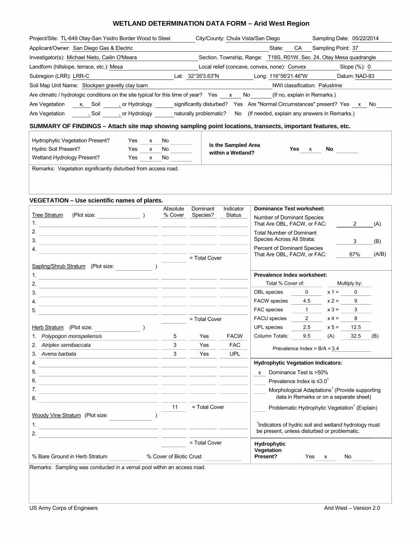
WETLAND DETERMINATION DATA FORM – Arid West Region Project/Site: TL-649 Otay-San Ysidro Border Wood to Steel City/County: Chula Vista/San Diego Sampling Date: 05/22/2014
Applicant/Owner: San Diego Gas & Electric State: CA Sampling Point: 37
Investigator(s): Michael Nieto, Cailin O'Meara Section, Township, Range: T18S, R01W, Sec. 24, Otay Mesa quadrangle
Landform (hillslope, terrace, etc.): Mesa Local relief (concave, convex, none): Convex Slope (%): 0
Subregion (LRR): LRR-C Lat: 32°35'3.63"N Long: 116°56'21.46"W Datum: NAD-83
Soil Map Unit Name: Stockpen gravelly clay loam NWI classification: Palustrine
Are climatic / hydrologic conditions on the site typical for this time of year? Yes x No (If no, explain in Remarks.)
Are Vegetation x, Soil , or Hydrology significantly disturbed? Yes Are "Normal Circumstances" present? Yes x No
Are Vegetation , Soil , or Hydrology naturally problematic? No (If needed, explain any answers in Remarks.)
SUMMARY OF FINDINGS – Attach site map showing sampling point locations, transects, important features, etc.
Hydrophytic Vegetation Present? Yes x No Is the Sampled Area within a Wetland?
Hydric Soil Present? Yes x No Yes x No Wetland Hydrology Present? Yes x No
Remarks: Vegetation significantly disturbed from access road.
VEGETATION – Use scientific names of plants. Absolute Dominant Indicator Dominance Test worksheet:
Number of Dominant Species That Are OBL, FACW, or FAC: Total Number of Dominant Species Across All Strata: Percent of Dominant Species That Are OBL, FACW, or FAC:
2
(A)
3
(B)
67% (A/B)
Tree Stratum (Plot size: ) % Cover Species? Status 1. 2. 3. 4. = Total Cover Sapling/Shrub Stratum (Plot size: ) 1. Prevalence Index worksheet:
Total % Cover of: Multiply by:
OBL species 0 x 1 = 0
FACW species 4.5 x 2 = 9
FAC species 1 x 3 = 3
FACU species 2 x 4 = 8
UPL species 2.5 x 5 = 12.5
Column Totals: 9.5 (A) 32.5 (B)
Prevalence Index = B/A = 3.4
2. 3. 4. 5. = Total Cover Herb Stratum (Plot size: ) 1. Polypogon monspeliensis 5 Yes FACW 2. Atriplex semibaccata 3 Yes FAC 3. Avena barbata 3 Yes UPL 4. Hydrophytic Vegetation Indicators: 5. x Dominance Test is >50% 6. Prevalence Index is ≤3.01 7. Morphological Adaptations1 (Provide supporting 8. data in Remarks or on a separate sheet)
11 = Total Cover Problematic Hydrophytic Vegetation1 (Explain) Woody Vine Stratum (Plot size: ) 1. 1Indicators of hydric soil and wetland hydrology must
be present, unless disturbed or problematic. 2.
= Total Cover Hydrophytic Vegetation Present?
% Bare Ground in Herb Stratum % Cover of Biotic Crust Yes x No
Remarks: Sampling was conducted in a vernal pool within an access road.
US Army Corps of Engineers Arid West – Version 2.0

SOIL Sampling Point: 37 ____________ Profile Description: (Describe to the depth needed to document the indicator or confirm the absence of indicators.) Depth Matrix Redox Features (inches) Color (moist) % Color (moist) % Type1 Loc2 Texture Remarks
1Type: C=Concentration, D=Depletion, RM=Reduced Matrix, CS=Covered or Coated Sand Grains. 2Location: PL=Pore Lining, RC=Root Channel, M=Matrix. Hydric Soil Indicators: (Applicable to all LRRs, unless otherwise noted.) Indicators for Problematic Hydric Soils3: Histosol (A1) Sandy Redox (S5) 1 cm Muck (A9) (LRR C) Histic Epipedon (A2) Stripped Matrix (S6) 2 cm Muck (A10) (LRR B) Black Histic (A3) Loamy Mucky Mineral (F1) Reduced Vertic (F18) Hydrogen Sulfide (A4) Loamy Gleyed Matrix (F2) Red Parent Material (TF2) Stratified Layers (A5) (LRR C) Depleted Matrix (F3) Other (Explain in Remarks) 1 cm Muck (A9) (LRR D) Redox Dark Surface (F6) Depleted Below Dark Surface (A11) Depleted Dark Surface (F7) Thick Dark Surface (A12) Redox Depressions (F8) 3Indicators of hydrophytic vegetation and Sandy Mucky Mineral (S1) x Vernal Pools (F9) wetland hydrology must be present, Sandy Gleyed Matrix (S4) unless disturbed or problematic.
Restrictive Layer (if present): Type: Depth (inches): Hydric Soil Present? Yes x No
Remarks: No soil pit was dug due to the documented presence of San Diego fairy shrimp. Hydric soils were assumed due to strong hydrophytic vegetation and hydrology indicators.
HYDROLOGY Wetland Hydrology Indicators: Secondary Indicators (2 or more required) Primary Indicators (minimum of one required; check all that apply) Water Marks (B1) (Riverine) Surface Water (A1) Salt Crust (B11) Sediment Deposits (B2) (Riverine) High Water Table (A2) Biotic Crust (B12) Drift Deposits (B3) (Riverine) Saturation (A3) Aquatic Invertebrates (B13) Drainage Patterns (B10) Water Marks (B1) (Nonriverine) Hydrogen Sulfide Odor (C1) Dry-Season Water Table (C2) Sediment Deposits (B2) (Nonriverine) Oxidized Rhizospheres along Living Roots (C3) Thin Muck Surface (C7) Drift Deposits (B3) (Nonriverine) Presence of Reduced Iron (C4) Crayfish Burrows (C8) x Surface Soil Cracks (B6) Recent Iron Reduction in Tilled Soils (C6) Saturation Visible on Aerial Imagery (C9) Inundation Visible on Aerial Imagery (B7) Thin Muck Surface (C7) Shallow Aquitard (D3) Water-Stained Leaves (B9) Other (Explain in Remarks) FAC-Neutral Test (D5)
Field Observations: Surface Water Present? Yes No x Depth (inches): Water Table Present? Yes No x Depth (inches): Saturation Present? Yes No x Depth (inches): Wetland Hydrology Present? Yes x No (includes capillary fringe)
Describe Recorded Data (stream gauge, monitoring well, aerial photos, previous inspections), if available:
Remarks:
US Army Corps of Engineers Arid West – Version 2.0
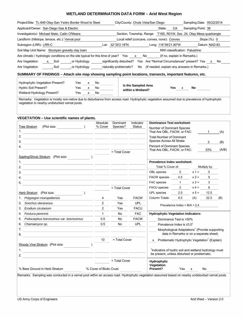
WETLAND DETERMINATION DATA FORM – Arid West Region Project/Site: TL-649 Otay-San Ysidro Border Wood to Steel City/County: Chula Vista/San Diego Sampling Date: 05/22/2014
Applicant/Owner: San Diego Gas & Electric State: CA Sampling Point: 38
Investigator(s): Michael Nieto, Cailin O'Meara Section, Township, Range: T18S, R01W, Sec. 24, Otay Mesa quadrangle
Landform (hillslope, terrace, etc.): Vernal pool Local relief (concave, convex, none): Convex Slope (%): 0
Subregion (LRR): LRR-C Lat: 32°35'2.18"N Long: 116°56'21.90"W Datum: NAD-83
Soil Map Unit Name: Stockpen gravelly clay loam NWI classification: Palustrine
Are climatic / hydrologic conditions on the site typical for this time of year? Yes x No (If no, explain in Remarks.)
Are Vegetation x, Soil , or Hydrology significantly disturbed? Yes Are "Normal Circumstances" present? Yes x No
Are Vegetation , Soil , or Hydrology naturally problematic? No (If needed, explain any answers in Remarks.)
SUMMARY OF FINDINGS – Attach site map showing sampling point locations, transects, important features, etc.
Hydrophytic Vegetation Present? Yes x No Is the Sampled Area within a Wetland?
Hydric Soil Present? Yes x No Yes x No Wetland Hydrology Present? Yes x No
Remarks: Vegetation is mostly non-native due to disturbance from access road. Hydrophytic vegetation assumed due to prevalence of hydrophytic vegetation in nearby undisturbed vernal pools.
VEGETATION – Use scientific names of plants. Absolute Dominant Indicator Dominance Test worksheet:
Number of Dominant Species That Are OBL, FACW, or FAC: Total Number of Dominant Species Across All Strata: Percent of Dominant Species That Are OBL, FACW, or FAC:
1
(A)
3
(B)
33% (A/B)
Tree Stratum (Plot size: ) % Cover Species? Status 1. 2. 3. 4. = Total Cover Sapling/Shrub Stratum (Plot size: ) 1. Prevalence Index worksheet:
Total % Cover of: Multiply by:
OBL species 0 x 1 = 0
FACW species 4.5 x 2 = 9
FAC species 1 x 3 = 3
FACU species 2 x 4 = 8
UPL species 2.5 x 5 = 12.5
Column Totals: 9.5 (A) 32.5 (B)
Prevalence Index = B/A = 3.4
2. 3. 4. 5. = Total Cover Herb Stratum (Plot size: ) 1. Polypogon monspeliensis 4 Yes FACW 2. Sonchus oleraceous 2 Yes UPL 3. Erodium cicutarium 2 Yes FACU 4. Festuca perennis 1 No FAC Hydrophytic Vegetation Indicators: 5. Psilocarphus brevissimus var. brevissimus 0.5 No FACW Dominance Test is >50% 6. Chamaesyce sp. 0.5 No UPL Prevalence Index is ≤3.01 7. Morphological Adaptations1 (Provide supporting 8. data in Remarks or on a separate sheet)
10 = Total Cover x Problematic Hydrophytic Vegetation1 (Explain) Woody Vine Stratum (Plot size: ) 1. 1Indicators of hydric soil and wetland hydrology must
be present, unless disturbed or problematic. 2.
= Total Cover Hydrophytic Vegetation Present?
% Bare Ground in Herb Stratum % Cover of Biotic Crust Yes x No
Remarks: Sampling was conducted in a vernal pool within an access road. Hydrophytic vegetation assumed based on nearby undisturbed vernal pools.
US Army Corps of Engineers Arid West – Version 2.0

SOIL Sampling Point: 38 ____________ Profile Description: (Describe to the depth needed to document the indicator or confirm the absence of indicators.) Depth Matrix Redox Features (inches) Color (moist) % Color (moist) % Type1 Loc2 Texture Remarks
1Type: C=Concentration, D=Depletion, RM=Reduced Matrix, CS=Covered or Coated Sand Grains. 2Location: PL=Pore Lining, RC=Root Channel, M=Matrix. Hydric Soil Indicators: (Applicable to all LRRs, unless otherwise noted.) Indicators for Problematic Hydric Soils3: Histosol (A1) Sandy Redox (S5) 1 cm Muck (A9) (LRR C) Histic Epipedon (A2) Stripped Matrix (S6) 2 cm Muck (A10) (LRR B) Black Histic (A3) Loamy Mucky Mineral (F1) Reduced Vertic (F18) Hydrogen Sulfide (A4) Loamy Gleyed Matrix (F2) Red Parent Material (TF2) Stratified Layers (A5) (LRR C) Depleted Matrix (F3) Other (Explain in Remarks) 1 cm Muck (A9) (LRR D) Redox Dark Surface (F6) Depleted Below Dark Surface (A11) Depleted Dark Surface (F7) Thick Dark Surface (A12) Redox Depressions (F8) 3Indicators of hydrophytic vegetation and Sandy Mucky Mineral (S1) x Vernal Pools (F9) wetland hydrology must be present, Sandy Gleyed Matrix (S4) unless disturbed or problematic.
Restrictive Layer (if present): Type: Depth (inches): Hydric Soil Present? Yes x No
Remarks: No soil pit was dug due to the documented presence of San Diego fairy shrimp. Hydric soils were assumed due to strong hydrology indicators.
HYDROLOGY Wetland Hydrology Indicators: Secondary Indicators (2 or more required) Primary Indicators (minimum of one required; check all that apply) Water Marks (B1) (Riverine) Surface Water (A1) Salt Crust (B11) Sediment Deposits (B2) (Riverine) High Water Table (A2) Biotic Crust (B12) Drift Deposits (B3) (Riverine) Saturation (A3) Aquatic Invertebrates (B13) Drainage Patterns (B10) Water Marks (B1) (Nonriverine) Hydrogen Sulfide Odor (C1) Dry-Season Water Table (C2) Sediment Deposits (B2) (Nonriverine) Oxidized Rhizospheres along Living Roots (C3) Thin Muck Surface (C7) Drift Deposits (B3) (Nonriverine) Presence of Reduced Iron (C4) Crayfish Burrows (C8) x Surface Soil Cracks (B6) Recent Iron Reduction in Tilled Soils (C6) Saturation Visible on Aerial Imagery (C9) Inundation Visible on Aerial Imagery (B7) Thin Muck Surface (C7) Shallow Aquitard (D3) Water-Stained Leaves (B9) Other (Explain in Remarks) FAC-Neutral Test (D5)
Field Observations: Surface Water Present? Yes No x Depth (inches): Water Table Present? Yes No x Depth (inches): Saturation Present? Yes No x Depth (inches): Wetland Hydrology Present? Yes x No (includes capillary fringe)
Describe Recorded Data (stream gauge, monitoring well, aerial photos, previous inspections), if available:
Remarks:
US Army Corps of Engineers Arid West – Version 2.0
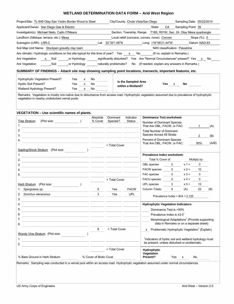
WETLAND DETERMINATION DATA FORM – Arid West Region Project/Site: TL-649 Otay-San Ysidro Border Wood to Steel City/County: Chula Vista/San Diego Sampling Date: 05/22/2014
Applicant/Owner: San Diego Gas & Electric State: CA Sampling Point: 39
Investigator(s): Michael Nieto, Cailin O'Meara Section, Township, Range: T18S, R01W, Sec. 24, Otay Mesa quadrangle
Landform (hillslope, terrace, etc.): Mesa Local relief (concave, convex, none): Convex Slope (%): 0
Subregion (LRR): LRR-C Lat: 32°35'1.06"N Long: 116°56'21.44"W Datum: NAD-83
Soil Map Unit Name: Stockpen gravelly clay loam NWI classification: Palustrine
Are climatic / hydrologic conditions on the site typical for this time of year? Yes x No (If no, explain in Remarks.)
Are Vegetation x, Soil , or Hydrology significantly disturbed? Yes Are "Normal Circumstances" present? Yes x No
Are Vegetation , Soil , or Hydrology naturally problematic? No (If needed, explain any answers in Remarks.)
SUMMARY OF FINDINGS – Attach site map showing sampling point locations, transects, important features, etc.
Hydrophytic Vegetation Present? Yes x No Is the Sampled Area within a Wetland?
Hydric Soil Present? Yes x No Yes x No Wetland Hydrology Present? Yes x No
Remarks: Vegetation is mostly non-native due to disturbance from access road. Hydrophytic vegetation assumed due to prevalence of hydrophytic vegetation in nearby undisturbed vernal pools.
VEGETATION – Use scientific names of plants. Absolute Dominant Indicator Dominance Test worksheet:
Number of Dominant Species That Are OBL, FACW, or FAC: Total Number of Dominant Species Across All Strata: Percent of Dominant Species That Are OBL, FACW, or FAC:
1
(A)
2
(B)
50% (A/B)
Tree Stratum (Plot size: ) % Cover Species? Status 1. 2. 3. 4. = Total Cover Sapling/Shrub Stratum (Plot size: ) 1. Prevalence Index worksheet:
Total % Cover of: Multiply by:
OBL species 0 x 1 = 0
FACW species 5 x 2 = 10
FAC species 0 x 3 = 0
FACU species 0 x 4 = 0
UPL species 3 x 5 = 15
Column Totals: 8 (A) 25 (B)
Prevalence Index = B/A = 3.125
2. 3. 4. 5. = Total Cover Herb Stratum (Plot size: ) 1. Spergularia sp. 5 Yes FACW 2. Sonchus oleraceous 3 Yes UPL 3. 4. Hydrophytic Vegetation Indicators: 5. Dominance Test is >50% 6. Prevalence Index is ≤3.01 7. Morphological Adaptations1 (Provide supporting 8. data in Remarks or on a separate sheet)
8 = Total Cover x Problematic Hydrophytic Vegetation1 (Explain) Woody Vine Stratum (Plot size: ) 1. 1Indicators of hydric soil and wetland hydrology must
be present, unless disturbed or problematic. 2.
= Total Cover Hydrophytic Vegetation Present?
% Bare Ground in Herb Stratum % Cover of Biotic Crust Yes x No
Remarks: Sampling was conducted in a vernal pool within an access road. Hydrophytic vegetation assumed under normal circumstances.
US Army Corps of Engineers Arid West – Version 2.0

SOIL Sampling Point: 39 ____________ Profile Description: (Describe to the depth needed to document the indicator or confirm the absence of indicators.) Depth Matrix Redox Features (inches) Color (moist) % Color (moist) % Type1 Loc2 Texture Remarks
1Type: C=Concentration, D=Depletion, RM=Reduced Matrix, CS=Covered or Coated Sand Grains. 2Location: PL=Pore Lining, RC=Root Channel, M=Matrix. Hydric Soil Indicators: (Applicable to all LRRs, unless otherwise noted.) Indicators for Problematic Hydric Soils3: Histosol (A1) Sandy Redox (S5) 1 cm Muck (A9) (LRR C) Histic Epipedon (A2) Stripped Matrix (S6) 2 cm Muck (A10) (LRR B) Black Histic (A3) Loamy Mucky Mineral (F1) Reduced Vertic (F18) Hydrogen Sulfide (A4) Loamy Gleyed Matrix (F2) Red Parent Material (TF2) Stratified Layers (A5) (LRR C) Depleted Matrix (F3) Other (Explain in Remarks) 1 cm Muck (A9) (LRR D) Redox Dark Surface (F6) Depleted Below Dark Surface (A11) Depleted Dark Surface (F7) Thick Dark Surface (A12) Redox Depressions (F8) 3Indicators of hydrophytic vegetation and Sandy Mucky Mineral (S1) x Vernal Pools (F9) wetland hydrology must be present, Sandy Gleyed Matrix (S4) unless disturbed or problematic.
Restrictive Layer (if present): Type: Depth (inches): Hydric Soil Present? Yes x No
Remarks: No soil pit was dug due to the documented presence of San Diego fairy shrimp. Hydric soils were assumed due to strong hydrology indicators.
HYDROLOGY Wetland Hydrology Indicators: Secondary Indicators (2 or more required) Primary Indicators (minimum of one required; check all that apply) Water Marks (B1) (Riverine) Surface Water (A1) Salt Crust (B11) Sediment Deposits (B2) (Riverine) High Water Table (A2) Biotic Crust (B12) Drift Deposits (B3) (Riverine) Saturation (A3) Aquatic Invertebrates (B13) Drainage Patterns (B10) Water Marks (B1) (Nonriverine) Hydrogen Sulfide Odor (C1) Dry-Season Water Table (C2) Sediment Deposits (B2) (Nonriverine) Oxidized Rhizospheres along Living Roots (C3) Thin Muck Surface (C7) Drift Deposits (B3) (Nonriverine) Presence of Reduced Iron (C4) Crayfish Burrows (C8) x Surface Soil Cracks (B6) Recent Iron Reduction in Tilled Soils (C6) Saturation Visible on Aerial Imagery (C9) Inundation Visible on Aerial Imagery (B7) Thin Muck Surface (C7) Shallow Aquitard (D3) Water-Stained Leaves (B9) Other (Explain in Remarks) FAC-Neutral Test (D5)
Field Observations: Surface Water Present? Yes No x Depth (inches): Water Table Present? Yes No x Depth (inches): Saturation Present? Yes No x Depth (inches): Wetland Hydrology Present? Yes x No (includes capillary fringe)
Describe Recorded Data (stream gauge, monitoring well, aerial photos, previous inspections), if available:
Remarks:
US Army Corps of Engineers Arid West – Version 2.0
WETLAND DETERMINATION DATA FORM – Arid West Region Project/Site: TL-649 Otay-San Ysidro Border Wood to Steel City/County: Chula Vista/San Diego Sampling Date: 05/22/2014
Applicant/Owner: San Diego Gas & Electric State: CA Sampling Point: 40
Investigator(s): Michael Nieto, Cailin O'Meara Section, Township, Range: T18S, R01W, Sec. 24, Otay Mesa quadrangle
Landform (hillslope, terrace, etc.): Mesa Local relief (concave, convex, none): Convex Slope (%): 0
Subregion (LRR): LRR-C Lat: 32°35'0.63"N Long: 116°56'22.05"W Datum: NAD-83
Soil Map Unit Name: Stockpen gravelly clay loam NWI classification: Palustrine
Are climatic / hydrologic conditions on the site typical for this time of year? Yes x No (If no, explain in Remarks.)
Are Vegetation x, Soil , or Hydrology significantly disturbed? Yes Are "Normal Circumstances" present? Yes x No
Are Vegetation , Soil , or Hydrology naturally problematic? No (If needed, explain any answers in Remarks.)
SUMMARY OF FINDINGS – Attach site map showing sampling point locations, transects, important features, etc.
Hydrophytic Vegetation Present? Yes x No Is the Sampled Area within a Wetland?
Hydric Soil Present? Yes x No Yes x No Wetland Hydrology Present? Yes x No
Remarks: Vegetation significantly disturbed from access road.
VEGETATION – Use scientific names of plants. Absolute Dominant Indicator Dominance Test worksheet:
Number of Dominant Species That Are OBL, FACW, or FAC: Total Number of Dominant Species Across All Strata: Percent of Dominant Species That Are OBL, FACW, or FAC:
2
(A)
2
(B)
100% (A/B)
Tree Stratum (Plot size: ) % Cover Species? Status 1. 2. 3. 4. = Total Cover Sapling/Shrub Stratum (Plot size: ) 1. Prevalence Index worksheet:
Total % Cover of: Multiply by:
OBL species x 1 =
FACW species x 2 =
FAC species x 3 =
FACU species x 4 =
UPL species x 5 =
Column Totals: (A) (B)
Prevalence Index = B/A =
2. 3. 4. 5. = Total Cover Herb Stratum (Plot size: ) 1. Psilocarphus brevissimus var. brevissimus 3 Yes FACW 2. Polypogon monspeliensis 2 Yes FACW 3. Erodium botrys 1 No FACU 4. Sonchus oleraceous 0.5 No UPL Hydrophytic Vegetation Indicators: 5. x Dominance Test is >50% 6. Prevalence Index is ≤3.01 7. Morphological Adaptations1 (Provide supporting 8. data in Remarks or on a separate sheet)
6.5 = Total Cover Problematic Hydrophytic Vegetation1 (Explain) Woody Vine Stratum (Plot size: ) 1. 1Indicators of hydric soil and wetland hydrology must
be present, unless disturbed or problematic. 2.
= Total Cover Hydrophytic Vegetation Present?
% Bare Ground in Herb Stratum % Cover of Biotic Crust Yes x No
Remarks: Sampling was conducted in a vernal pool within an access road.
US Army Corps of Engineers Arid West – Version 2.0

SOIL Sampling Point: 40 ____________ Profile Description: (Describe to the depth needed to document the indicator or confirm the absence of indicators.) Depth Matrix Redox Features (inches) Color (moist) % Color (moist) % Type1 Loc2 Texture Remarks
1Type: C=Concentration, D=Depletion, RM=Reduced Matrix, CS=Covered or Coated Sand Grains. 2Location: PL=Pore Lining, RC=Root Channel, M=Matrix. Hydric Soil Indicators: (Applicable to all LRRs, unless otherwise noted.) Indicators for Problematic Hydric Soils3: Histosol (A1) Sandy Redox (S5) 1 cm Muck (A9) (LRR C) Histic Epipedon (A2) Stripped Matrix (S6) 2 cm Muck (A10) (LRR B) Black Histic (A3) Loamy Mucky Mineral (F1) Reduced Vertic (F18) Hydrogen Sulfide (A4) Loamy Gleyed Matrix (F2) Red Parent Material (TF2) Stratified Layers (A5) (LRR C) Depleted Matrix (F3) Other (Explain in Remarks) 1 cm Muck (A9) (LRR D) Redox Dark Surface (F6) Depleted Below Dark Surface (A11) Depleted Dark Surface (F7) Thick Dark Surface (A12) Redox Depressions (F8) 3Indicators of hydrophytic vegetation and Sandy Mucky Mineral (S1) x Vernal Pools (F9) wetland hydrology must be present, Sandy Gleyed Matrix (S4) unless disturbed or problematic.
Restrictive Layer (if present): Type: Depth (inches): Hydric Soil Present? Yes x No
Remarks: No soil pit was dug due to the documented presence of San Diego fairy shrimp. Hydric soils were assumed due to strong hydrophytic vegetation and hydrology indicators.
HYDROLOGY Wetland Hydrology Indicators: Secondary Indicators (2 or more required) Primary Indicators (minimum of one required; check all that apply) Water Marks (B1) (Riverine) Surface Water (A1) Salt Crust (B11) Sediment Deposits (B2) (Riverine) High Water Table (A2) Biotic Crust (B12) Drift Deposits (B3) (Riverine) Saturation (A3) Aquatic Invertebrates (B13) Drainage Patterns (B10) Water Marks (B1) (Nonriverine) Hydrogen Sulfide Odor (C1) Dry-Season Water Table (C2) Sediment Deposits (B2) (Nonriverine) Oxidized Rhizospheres along Living Roots (C3) Thin Muck Surface (C7) Drift Deposits (B3) (Nonriverine) Presence of Reduced Iron (C4) Crayfish Burrows (C8) x Surface Soil Cracks (B6) Recent Iron Reduction in Tilled Soils (C6) Saturation Visible on Aerial Imagery (C9) Inundation Visible on Aerial Imagery (B7) Thin Muck Surface (C7) Shallow Aquitard (D3) Water-Stained Leaves (B9) Other (Explain in Remarks) FAC-Neutral Test (D5)
Field Observations: Surface Water Present? Yes No x Depth (inches): Water Table Present? Yes No x Depth (inches): Saturation Present? Yes No x Depth (inches): Wetland Hydrology Present? Yes x No (includes capillary fringe)
Describe Recorded Data (stream gauge, monitoring well, aerial photos, previous inspections), if available:
Remarks:
US Army Corps of Engineers Arid West – Version 2.0
WETLAND DETERMINATION DATA FORM – Arid West Region Project/Site: TL-649 Otay-San Ysidro Border Wood to Steel City/County: Chula Vista/San Diego Sampling Date: 05/22/2014
Applicant/Owner: San Diego Gas & Electric State: CA Sampling Point: 41
Investigator(s): Michael Nieto, Cailin O'Meara Section, Township, Range: T18S, R01W, Sec. 24, Otay Mesa quadrangle
Landform (hillslope, terrace, etc.): Mesa Local relief (concave, convex, none): Convex Slope (%): 0
Subregion (LRR): LRR-C Lat: 32°35'18.95"N Long: 116°56'21.86"W Datum: NAD-83
Soil Map Unit Name: Stockpen gravelly clay loam NWI classification: Palustrine
Are climatic / hydrologic conditions on the site typical for this time of year? Yes x No (If no, explain in Remarks.)
Are Vegetation x, Soil , or Hydrology x significantly disturbed? Yes Are "Normal Circumstances" present? Yes x No
Are Vegetation , Soil , or Hydrology naturally problematic? No (If needed, explain any answers in Remarks.)
SUMMARY OF FINDINGS – Attach site map showing sampling point locations, transects, important features, etc.
Hydrophytic Vegetation Present? Yes x No Is the Sampled Area within a Wetland?
Hydric Soil Present? Yes x No Yes x No Wetland Hydrology Present? Yes x No
Remarks: Vegetation and hydrology altered due to disturbance from access road. Hydrophytic vegetation and hydrology assumed due to prevalence of hydrophytic vegetation and hydrology indicators in nearby undisturbed vernal pools.
VEGETATION – Use scientific names of plants. Absolute Dominant Indicator Dominance Test worksheet:
Number of Dominant Species That Are OBL, FACW, or FAC: Total Number of Dominant Species Across All Strata: Percent of Dominant Species That Are OBL, FACW, or FAC:
0
(A)
1
(B)
0% (A/B)
Tree Stratum (Plot size: ) % Cover Species? Status 1. 2. 3. 4. = Total Cover Sapling/Shrub Stratum (Plot size: ) 1. Prevalence Index worksheet:
Total % Cover of: Multiply by:
OBL species 0 x 1 = 0
FACW species 0 x 2 = 0
FAC species 0 x 3 = 0
FACU species 0 x 4 = 0
UPL species 9 x 5 = 45
Column Totals: 9 (A) 45 (B)
Prevalence Index = B/A = 5
2. 3. 4. 5. = Total Cover Herb Stratum (Plot size: ) 1. Sonchus oleraceous 9 Yes UPL 2. 3. 4. Hydrophytic Vegetation Indicators: 5. Dominance Test is >50% 6. Prevalence Index is ≤3.01 7. Morphological Adaptations1 (Provide supporting 8. data in Remarks or on a separate sheet)
9 = Total Cover x Problematic Hydrophytic Vegetation1 (Explain) Woody Vine Stratum (Plot size: ) 1. 1Indicators of hydric soil and wetland hydrology must
be present, unless disturbed or problematic. 2.
= Total Cover Hydrophytic Vegetation Present?
% Bare Ground in Herb Stratum 91% % Cover of Biotic Crust Yes x No
Remarks: Sampling was conducted in a vernal pool within an access road. Hydrophytic vegetation assumed based on nearby undisturbed vernal pools.
US Army Corps of Engineers Arid West – Version 2.0
SOIL Sampling Point: 41 ____________ Profile Description: (Describe to the depth needed to document the indicator or confirm the absence of indicators.) Depth Matrix Redox Features (inches) Color (moist) % Color (moist) % Type1 Loc2 Texture Remarks
1Type: C=Concentration, D=Depletion, RM=Reduced Matrix, CS=Covered or Coated Sand Grains. 2Location: PL=Pore Lining, RC=Root Channel, M=Matrix. Hydric Soil Indicators: (Applicable to all LRRs, unless otherwise noted.) Indicators for Problematic Hydric Soils3: Histosol (A1) Sandy Redox (S5) 1 cm Muck (A9) (LRR C) Histic Epipedon (A2) Stripped Matrix (S6) 2 cm Muck (A10) (LRR B) Black Histic (A3) Loamy Mucky Mineral (F1) Reduced Vertic (F18) Hydrogen Sulfide (A4) Loamy Gleyed Matrix (F2) Red Parent Material (TF2) Stratified Layers (A5) (LRR C) Depleted Matrix (F3) Other (Explain in Remarks) 1 cm Muck (A9) (LRR D) Redox Dark Surface (F6) Depleted Below Dark Surface (A11) Depleted Dark Surface (F7) Thick Dark Surface (A12) Redox Depressions (F8) 3Indicators of hydrophytic vegetation and Sandy Mucky Mineral (S1) x Vernal Pools (F9) wetland hydrology must be present, Sandy Gleyed Matrix (S4) unless disturbed or problematic.
Restrictive Layer (if present): Type: Depth (inches): Hydric Soil Present? Yes x No
Remarks: No soil pit was dug due to the documented presence of San Diego fairy shrimp. Hydric soils were assumed due to strong hydrology and hydrophytic indicators in nearby vernal pools.
HYDROLOGY Wetland Hydrology Indicators: Secondary Indicators (2 or more required) Primary Indicators (minimum of one required; check all that apply) Water Marks (B1) (Riverine) Surface Water (A1) Salt Crust (B11) Sediment Deposits (B2) (Riverine) High Water Table (A2) Biotic Crust (B12) Drift Deposits (B3) (Riverine) Saturation (A3) Aquatic Invertebrates (B13) Drainage Patterns (B10) Water Marks (B1) (Nonriverine) Hydrogen Sulfide Odor (C1) Dry-Season Water Table (C2) Sediment Deposits (B2) (Nonriverine) Oxidized Rhizospheres along Living Roots (C3) Thin Muck Surface (C7) Drift Deposits (B3) (Nonriverine) Presence of Reduced Iron (C4) Crayfish Burrows (C8) Surface Soil Cracks (B6) Recent Iron Reduction in Tilled Soils (C6) Saturation Visible on Aerial Imagery (C9) Inundation Visible on Aerial Imagery (B7) Thin Muck Surface (C7) Shallow Aquitard (D3) Water-Stained Leaves (B9) Other (Explain in Remarks) FAC-Neutral Test (D5)
Field Observations: Surface Water Present? Yes No x Depth (inches): Water Table Present? Yes No x Depth (inches): Saturation Present? Yes No x Depth (inches): Wetland Hydrology Present? Yes x No (includes capillary fringe)
Describe Recorded Data (stream gauge, monitoring well, aerial photos, previous inspections), if available:
Remarks: Soil surface is disturbed from access road. Hydrology assumed due to basin topography suitable for ponding and strong hydrology indicators (surface soil cracks) in nearby vernal pools
US Army Corps of Engineers Arid West – Version 2.0
WETLAND DETERMINATION DATA FORM – Arid West Region Project/Site: TL-649 Otay-San Ysidro Border Wood to Steel City/County: Chula Vista/San Diego Sampling Date: 05/22/2014
Applicant/Owner: San Diego Gas & Electric State: CA Sampling Point: 42
Investigator(s): Michael Nieto, Cailin O'Meara Section, Township, Range: T18S, R01W, Sec. 25, Otay Mesa quadrangle
Landform (hillslope, terrace, etc.): Drainage Local relief (concave, convex, none): Convex Slope (%): 1-3
Subregion (LRR): LRR-C Lat: 32°34'56.01"N Long: 116°56'32.61"W Datum: NAD-83
Soil Map Unit Name: Linne clay loam NWI classification: Palustrine
Are climatic / hydrologic conditions on the site typical for this time of year? Yes x No (If no, explain in Remarks.)
Are Vegetation , Soil , or Hydrology significantly disturbed? No Are "Normal Circumstances" present? Yes x No
Are Vegetation , Soil , or Hydrology naturally problematic? No (If needed, explain any answers in Remarks.)
SUMMARY OF FINDINGS – Attach site map showing sampling point locations, transects, important features, etc.
Hydrophytic Vegetation Present? Yes x No Is the Sampled Area within a Wetland?
Hydric Soil Present? Yes x No Yes x No Wetland Hydrology Present? Yes x No
Remarks: Sampling point within emergent marsh vegetation located within drainage.
VEGETATION – Use scientific names of plants. Absolute Dominant Indicator Dominance Test worksheet:
Number of Dominant Species That Are OBL, FACW, or FAC: Total Number of Dominant Species Across All Strata: Percent of Dominant Species That Are OBL, FACW, or FAC:
4
(A)
5
(B)
80% (A/B)
Tree Stratum (Plot size: ) % Cover Species? Status 1. 2. 3. 4. = Total Cover Sapling/Shrub Stratum (Plot size: ) 1. Juncus acutus 20 Yes FACW Prevalence Index worksheet:
Total % Cover of: Multiply by:
OBL species x 1 =
FACW species x 2 =
FAC species x 3 =
FACU species x 4 =
UPL species x 5 =
Column Totals: (A) (B)
Prevalence Index = B/A =
2. Baccharis salicifolia 15 Yes FAC 3. Iva hayesiana 12 Yes FACW 4. Tamarix ramossisima 2 No FAC 5. 49 = Total Cover Herb Stratum (Plot size: ) 1. Polypogon monspeliensis 0.5 Yes FACW 2. Heliotropum curassavicum 2 Yes FACU 3. 4. Hydrophytic Vegetation Indicators: 5. x Dominance Test is >50% 6. Prevalence Index is ≤3.01 7. Morphological Adaptations1 (Provide supporting 8. data in Remarks or on a separate sheet)
2.5 = Total Cover Problematic Hydrophytic Vegetation1 (Explain) Woody Vine Stratum (Plot size: ) 1. 1Indicators of hydric soil and wetland hydrology must
be present, unless disturbed or problematic. 2.
= Total Cover Hydrophytic Vegetation Present?
% Bare Ground in Herb Stratum 87.5% % Cover of Biotic Crust Yes x No
Remarks:
US Army Corps of Engineers Arid West – Version 2.0

SOIL Sampling Point: 42 ____________ Profile Description: (Describe to the depth needed to document the indicator or confirm the absence of indicators.) Depth Matrix Redox Features (inches) Color (moist) % Color (moist) % Type1 Loc2 Texture Remarks
1Type: C=Concentration, D=Depletion, RM=Reduced Matrix, CS=Covered or Coated Sand Grains. 2Location: PL=Pore Lining, RC=Root Channel, M=Matrix. Hydric Soil Indicators: (Applicable to all LRRs, unless otherwise noted.) Indicators for Problematic Hydric Soils3: Histosol (A1) Sandy Redox (S5) 1 cm Muck (A9) (LRR C) Histic Epipedon (A2) Stripped Matrix (S6) 2 cm Muck (A10) (LRR B) Black Histic (A3) Loamy Mucky Mineral (F1) Reduced Vertic (F18) Hydrogen Sulfide (A4) Loamy Gleyed Matrix (F2) Red Parent Material (TF2) Stratified Layers (A5) (LRR C) Depleted Matrix (F3) Other (Explain in Remarks) 1 cm Muck (A9) (LRR D) Redox Dark Surface (F6) Depleted Below Dark Surface (A11) Depleted Dark Surface (F7) Thick Dark Surface (A12) Redox Depressions (F8) 3Indicators of hydrophytic vegetation and Sandy Mucky Mineral (S1) Vernal Pools (F9) wetland hydrology must be present, Sandy Gleyed Matrix (S4) unless disturbed or problematic.
Restrictive Layer (if present): Type: Rocky conglomerate Depth (inches): Hydric Soil Present? Yes x No
Remarks: Rocky conglomerate precludes digging. Hydric soils assumed based on strong hrophytic vegetation and hydrology indicators.
HYDROLOGY Wetland Hydrology Indicators: Secondary Indicators (2 or more required) Primary Indicators (minimum of one required; check all that apply) Water Marks (B1) (Riverine) Surface Water (A1) x Salt Crust (B11) Sediment Deposits (B2) (Riverine) High Water Table (A2) Biotic Crust (B12) x Drift Deposits (B3) (Riverine) Saturation (A3) Aquatic Invertebrates (B13) Drainage Patterns (B10) Water Marks (B1) (Nonriverine) Hydrogen Sulfide Odor (C1) Dry-Season Water Table (C2) Sediment Deposits (B2) (Nonriverine) Oxidized Rhizospheres along Living Roots (C3) Thin Muck Surface (C7) Drift Deposits (B3) (Nonriverine) Presence of Reduced Iron (C4) Crayfish Burrows (C8) Surface Soil Cracks (B6) Recent Iron Reduction in Tilled Soils (C6) Saturation Visible on Aerial Imagery (C9) Inundation Visible on Aerial Imagery (B7) Thin Muck Surface (C7) Shallow Aquitard (D3) Water-Stained Leaves (B9) Other (Explain in Remarks) FAC-Neutral Test (D5)
Field Observations: Surface Water Present? Yes No x Depth (inches): Water Table Present? Yes No x Depth (inches): Saturation Present? Yes No x Depth (inches): Wetland Hydrology Present? Yes x No (includes capillary fringe)
Describe Recorded Data (stream gauge, monitoring well, aerial photos, previous inspections), if available:
Remarks:
US Army Corps of Engineers Arid West – Version 2.0
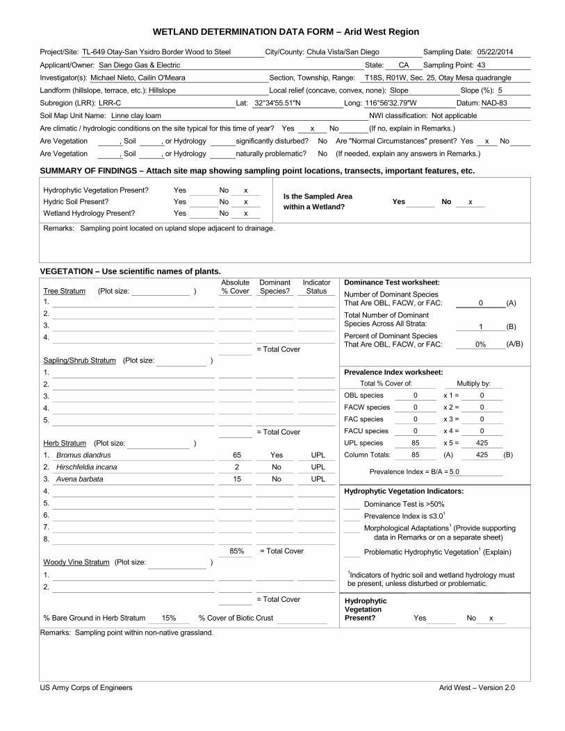
WETLAND DETERMINATION DATA FORM – Arid West Region Project/Site: TL-649 Otay-San Ysidro Border Wood to Steel City/County: Chula Vista/San Diego Sampling Date: 05/22/2014
Applicant/Owner: San Diego Gas & Electric State: CA Sampling Point: 43
Investigator(s): Michael Nieto, Cailin O'Meara Section, Township, Range: T18S, R01W, Sec. 25, Otay Mesa quadrangle
Landform (hillslope, terrace, etc.): Hillslope Local relief (concave, convex, none): Slope Slope (%): 5
Subregion (LRR): LRR-C Lat: 32°34'55.51"N Long: 116°56'32.79"W Datum: NAD-83
Soil Map Unit Name: Linne clay loam NWI classification: Not applicable
Are climatic / hydrologic conditions on the site typical for this time of year? Yes x No (If no, explain in Remarks.)
Are Vegetation , Soil , or Hydrology significantly disturbed? No Are "Normal Circumstances" present? Yes x No
Are Vegetation , Soil , or Hydrology naturally problematic? No (If needed, explain any answers in Remarks.)
SUMMARY OF FINDINGS – Attach site map showing sampling point locations, transects, important features, etc.
Hydrophytic Vegetation Present? Yes No x Is the Sampled Area within a Wetland?
Hydric Soil Present? Yes No x Yes No x Wetland Hydrology Present? Yes No x
Remarks: Sampling point located on upland slope adjacent to drainage.
VEGETATION – Use scientific names of plants. Absolute Dominant Indicator Dominance Test worksheet:
Number of Dominant Species That Are OBL, FACW, or FAC: Total Number of Dominant Species Across All Strata: Percent of Dominant Species That Are OBL, FACW, or FAC:
0
(A)
1
(B)
0% (A/B)
Tree Stratum (Plot size: ) % Cover Species? Status 1. 2. 3. 4. = Total Cover Sapling/Shrub Stratum (Plot size: ) 1. Prevalence Index worksheet:
Total % Cover of: Multiply by:
OBL species 0 x 1 = 0
FACW species 0 x 2 = 0
FAC species 0 x 3 = 0
FACU species 0 x 4 = 0
UPL species 85 x 5 = 425
Column Totals: 85 (A) 425 (B)
Prevalence Index = B/A = 5.0
2. 3. 4. 5. = Total Cover Herb Stratum (Plot size: ) 1. Bromus diandrus 65 Yes UPL 2. Hirschfeldia incana 2 No UPL 3. Avena barbata 15 No UPL 4. Hydrophytic Vegetation Indicators: 5. Dominance Test is >50% 6. Prevalence Index is ≤3.01 7. Morphological Adaptations1 (Provide supporting 8. data in Remarks or on a separate sheet)
85% = Total Cover Problematic Hydrophytic Vegetation1 (Explain) Woody Vine Stratum (Plot size: ) 1. 1Indicators of hydric soil and wetland hydrology must
be present, unless disturbed or problematic. 2.
= Total Cover Hydrophytic Vegetation Present?
% Bare Ground in Herb Stratum 15% % Cover of Biotic Crust Yes No x
Remarks: Sampling point within non-native grassland.
US Army Corps of Engineers Arid West – Version 2.0

SOIL Sampling Point: 43 ____________ Profile Description: (Describe to the depth needed to document the indicator or confirm the absence of indicators.) Depth Matrix Redox Features (inches) Color (moist) % Color (moist) % Type1 Loc2 Texture Remarks
0-16 7.5 YR 4/3 100 - - - - Sandy loam -
1Type: C=Concentration, D=Depletion, RM=Reduced Matrix, CS=Covered or Coated Sand Grains. 2Location: PL=Pore Lining, RC=Root Channel, M=Matrix. Hydric Soil Indicators: (Applicable to all LRRs, unless otherwise noted.) Indicators for Problematic Hydric Soils3: Histosol (A1) Sandy Redox (S5) 1 cm Muck (A9) (LRR C) Histic Epipedon (A2) Stripped Matrix (S6) 2 cm Muck (A10) (LRR B) Black Histic (A3) Loamy Mucky Mineral (F1) Reduced Vertic (F18) Hydrogen Sulfide (A4) Loamy Gleyed Matrix (F2) Red Parent Material (TF2) Stratified Layers (A5) (LRR C) Depleted Matrix (F3) Other (Explain in Remarks) 1 cm Muck (A9) (LRR D) Redox Dark Surface (F6) Depleted Below Dark Surface (A11) Depleted Dark Surface (F7) Thick Dark Surface (A12) Redox Depressions (F8) 3Indicators of hydrophytic vegetation and Sandy Mucky Mineral (S1) Vernal Pools (F9) wetland hydrology must be present, Sandy Gleyed Matrix (S4) unless disturbed or problematic.
Restrictive Layer (if present): Type: Depth (inches): Hydric Soil Present? Yes No x
Remarks: No hydric soil indicators observed.
HYDROLOGY Wetland Hydrology Indicators: Secondary Indicators (2 or more required) Primary Indicators (minimum of one required; check all that apply) Water Marks (B1) (Riverine) Surface Water (A1) Salt Crust (B11) Sediment Deposits (B2) (Riverine) High Water Table (A2) Biotic Crust (B12) Drift Deposits (B3) (Riverine) Saturation (A3) Aquatic Invertebrates (B13) Drainage Patterns (B10) Water Marks (B1) (Nonriverine) Hydrogen Sulfide Odor (C1) Dry-Season Water Table (C2) Sediment Deposits (B2) (Nonriverine) Oxidized Rhizospheres along Living Roots (C3) Thin Muck Surface (C7) Drift Deposits (B3) (Nonriverine) Presence of Reduced Iron (C4) Crayfish Burrows (C8) Surface Soil Cracks (B6) Recent Iron Reduction in Tilled Soils (C6) Saturation Visible on Aerial Imagery (C9) Inundation Visible on Aerial Imagery (B7) Thin Muck Surface (C7) Shallow Aquitard (D3) Water-Stained Leaves (B9) Other (Explain in Remarks) FAC-Neutral Test (D5)
Field Observations: Surface Water Present? Yes No x Depth (inches): Water Table Present? Yes No x Depth (inches): Saturation Present? Yes No x Depth (inches): Wetland Hydrology Present? Yes No x (includes capillary fringe)
Describe Recorded Data (stream gauge, monitoring well, aerial photos, previous inspections), if available:
Remarks: No wetland hydrology indicators observed.
US Army Corps of Engineers Arid West – Version 2.0
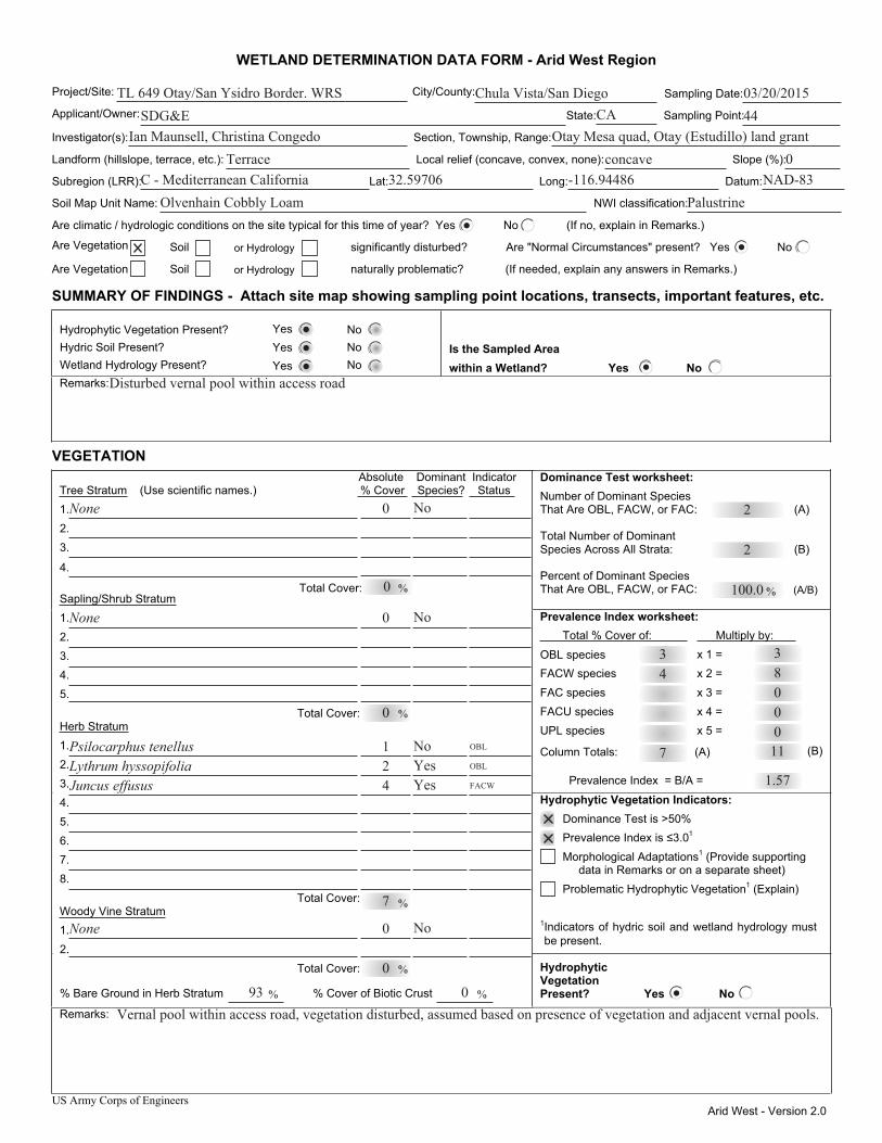
US Army Corps of Engineers Arid West - Version 2.0
WETLAND DETERMINATION DATA FORM - Arid West Region
Project/Site: City/County: Sampling Date:
Applicant/Owner: State: Sampling Point:
Investigator(s): Section, Township, Range:
Landform (hillslope, terrace, etc.): Local relief (concave, convex, none): Slope (%):
Subregion (LRR): Lat: Long: Datum:
Soil Map Unit Name: NWI classification:
Are climatic / hydrologic conditions on the site typical for this time of year? Yes No (If no, explain in Remarks.)
Are Vegetation Soil or Hydrology significantly disturbed? Are "Normal Circumstances" present? Yes No
Are Vegetation Soil or Hydrology naturally problematic? (If needed, explain any answers in Remarks.)
SUMMARY OF FINDINGS - Attach site map showing sampling point locations, transects, important features, etc.
Hydrophytic Vegetation Present? Yes No Hydric Soil Present? Yes No Wetland Hydrology Present? Yes No
Is the Sampled Area within a Wetland? Yes No
Remarks:
VEGETATION Dominance Test worksheet: Number of Dominant Species That Are OBL, FACW, or FAC: (A)
Total Number of Dominant Species Across All Strata: (B)
Percent of Dominant Species That Are OBL, FACW, or FAC: (A/B)
Prevalence Index worksheet: Total % Cover of: Multiply by:
OBL species x 1 = FACW species x 2 = FAC species x 3 = FACU species x 4 = UPL species x 5 =
Column Totals: (A) (B)
Prevalence Index = B/A =
Hydrophytic Vegetation Indicators:
Prevalence Index is ≤3.0 1
Morphological Adaptations1 (Provide supporting data in Remarks or on a separate sheet)
Problematic Hydrophytic Vegetation1 (Explain)
1Indicators of hydric soil and wetland hydrology must be present.
Absolute Dominant Indicator Tree Stratum (Use scientific names.) % Cover Species? Status 1. 2. 3.
4.
Sapling/Shrub Stratum1. 2. 3. 4. 5. Total Cover: Herb Stratum1. 2. 3. 4. 5. 6. 7. 8.
Total Cover: Woody Vine Stratum1. 2. Total Cover:
% Bare Ground in Herb Stratum % Cover of Biotic Crust
Hydrophytic Vegetation Present? Yes No
Remarks:
Dominance Test is >50%
% % Total Cover:
%
%
%
% %
TL 649 Otay/San Ysidro Border. WRS Chula Vista/San Diego 03/20/2015SDG&E 44
Ian Maunsell, Christina Congedo Otay Mesa quad, Otay (Estudillo) land grantTerrace concave 0
CA
C - Mediterranean California 32.59706 -116.94486 NAD-83Olvenhain Cobbly Loam Palustrine
2
2
100.0
43
Disturbed vernal pool within access road
None 0 No
0
None No
0
0
NoYesYes
421
Juncus effususLythrum hyssopifolia Psilocarphus tenellus
7
OBL
OBL
FACW
No0None
0
93 0Vernal pool within access road, vegetation disturbed, assumed based on presence of vegetation and adjacent vernal pools.
7 1100083
1.57
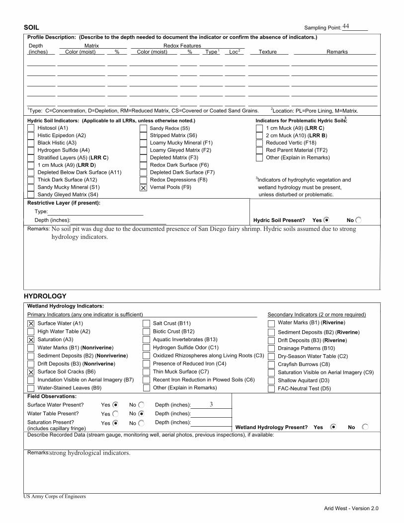
Arid West - Version 2.0
SOIL Sampling Point: Profile Description: (Describe to the depth needed to document the indicator or confirm the absence of indicators.) Depth Matrix Redox Features (inches) Color (moist) % Color (moist) % Type1 Loc2 Texture Remarks
1Type: C=Concentration, D=Depletion, RM=Reduced Matrix, CS=Covered or Coated Sand Grains. 2Location: PL=Pore Lining, M=Matrix.
Hydric Soil Indicators: (Applicable to all LRRs, unless otherwise noted.) Indicators for Problematic Hydric Soils3: Histosol (A1) Sandy Redox (S5) 1 cm Muck (A9) (LRR C) Histic Epipedon (A2) Stripped Matrix (S6) 2 cm Muck (A10) (LRR B) Black Histic (A3) Loamy Mucky Mineral (F1) Reduced Vertic (F18) Hydrogen Sulfide (A4) Loamy Gleyed Matrix (F2) Red Parent Material (TF2) Stratified Layers (A5) (LRR C) Depleted Matrix (F3) Other (Explain in Remarks) 1 cm Muck (A9) (LRR D) Redox Dark Surface (F6) Depleted Below Dark Surface (A11) Depleted Dark Surface (F7) Thick Dark Surface (A12) Redox Depressions (F8) Sandy Mucky Mineral (S1) Vernal Pools (F9)
3Indicators of hydrophytic vegetation and
Sandy Gleyed Matrix (S4) unless disturbed or problematic. Restrictive Layer (if present): Type: Depth (inches): Hydric Soil Present? Yes No Remarks:
HYDROLOGY Wetland Hydrology Indicators:
Secondary Indicators (2 or more required)Primary Indicators (any one indicator is sufficient) Water Marks (B1) (Riverine) Surface Water (A1) Salt Crust (B11)
Sediment Deposits (B2) (Riverine) High Water Table (A2) Biotic Crust (B12)
Drift Deposits (B3) (Riverine) Saturation (A3) Aquatic Invertebrates (B13) Drainage Patterns (B10) Water Marks (B1) (Nonriverine) Hydrogen Sulfide Odor (C1) Dry-Season Water Table (C2) Sediment Deposits (B2) (Nonriverine) Oxidized Rhizospheres along Living Roots (C3) Crayfish Burrows (C8) Drift Deposits (B3) (Nonriverine) Presence of Reduced Iron (C4) Saturation Visible on Aerial Imagery (C9) Surface Soil Cracks (B6) Thin Muck Surface (C7) Shallow Aquitard (D3) Inundation Visible on Aerial Imagery (B7) Recent Iron Reduction in Plowed Soils (C6) FAC-Neutral Test (D5) Water-Stained Leaves (B9)
Field Observations: Surface Water Present? Yes No Depth (inches): Water Table Present? Yes No Depth (inches): Saturation Present? Yes No Depth (inches): (includes capillary fringe) Wetland Hydrology Present? Yes No Describe Recorded Data (stream gauge, monitoring well, aerial photos, previous inspections), if available:
Remarks:
US Army Corps of Engineers
Other (Explain in Remarks)
wetland hydrology must be present,
44
No soil pit was dug due to the documented presence of San Diego fairy shrimp. Hydric soils assumed due to strong hydrology indicators.
3
strong hydrological indicators.

US Army Corps of Engineers Arid West - Version 2.0
WETLAND DETERMINATION DATA FORM - Arid West Region
Project/Site: City/County: Sampling Date:
Applicant/Owner: State: Sampling Point:
Investigator(s): Section, Township, Range:
Landform (hillslope, terrace, etc.): Local relief (concave, convex, none): Slope (%):
Subregion (LRR): Lat: Long: Datum:
Soil Map Unit Name: NWI classification:
Are climatic / hydrologic conditions on the site typical for this time of year? Yes No (If no, explain in Remarks.)
Are Vegetation Soil or Hydrology significantly disturbed? Are "Normal Circumstances" present? Yes No
Are Vegetation Soil or Hydrology naturally problematic? (If needed, explain any answers in Remarks.)
SUMMARY OF FINDINGS - Attach site map showing sampling point locations, transects, important features, etc.
Hydrophytic Vegetation Present? Yes No Hydric Soil Present? Yes No Wetland Hydrology Present? Yes No
Is the Sampled Area within a Wetland? Yes No
Remarks:
VEGETATION Dominance Test worksheet: Number of Dominant Species That Are OBL, FACW, or FAC: (A)
Total Number of Dominant Species Across All Strata: (B)
Percent of Dominant Species That Are OBL, FACW, or FAC: (A/B)
Prevalence Index worksheet: Total % Cover of: Multiply by:
OBL species x 1 = FACW species x 2 = FAC species x 3 = FACU species x 4 = UPL species x 5 =
Column Totals: (A) (B)
Prevalence Index = B/A =
Hydrophytic Vegetation Indicators:
Prevalence Index is ≤3.0 1
Morphological Adaptations1 (Provide supporting data in Remarks or on a separate sheet)
Problematic Hydrophytic Vegetation1 (Explain)
1Indicators of hydric soil and wetland hydrology must be present.
Absolute Dominant Indicator Tree Stratum (Use scientific names.) % Cover Species? Status 1. 2. 3.
4.
Sapling/Shrub Stratum1. 2. 3. 4. 5. Total Cover: Herb Stratum1. 2. 3. 4. 5. 6. 7. 8.
Total Cover: Woody Vine Stratum1. 2. Total Cover:
% Bare Ground in Herb Stratum % Cover of Biotic Crust
Hydrophytic Vegetation Present? Yes No
Remarks:
Dominance Test is >50%
% % Total Cover:
%
%
%
% %
TL 649 Otay/San Ysidro Border. WRS Chula Vista/San Diego 03/20/2015SDG&E 45
Ian Maunsell, Christina Congedo Otay Mesa quad, Otay (Estudillo) land grantterrace concave 0
CA
C - Mediterranean California 32.59687 -116.94510 NAD-83Olvenhain Cobbly Loam Palustrine
1
1
100.0
6
Disturbed vernal pool within access road
None o No
0
None No
0
0
YesNo
15
Lythrum hyssopifolia Triglochin scilloides
6
OBL
OBL
No0None
0
93 0Vernal pool within access road, vegetation disturbed, assumed based on presence of vegetation and adjacent vernal pools.
6 600006
1.00

Arid West - Version 2.0
SOIL Sampling Point: Profile Description: (Describe to the depth needed to document the indicator or confirm the absence of indicators.) Depth Matrix Redox Features (inches) Color (moist) % Color (moist) % Type1 Loc2 Texture Remarks
1Type: C=Concentration, D=Depletion, RM=Reduced Matrix, CS=Covered or Coated Sand Grains. 2Location: PL=Pore Lining, M=Matrix.
Hydric Soil Indicators: (Applicable to all LRRs, unless otherwise noted.) Indicators for Problematic Hydric Soils3: Histosol (A1) Sandy Redox (S5) 1 cm Muck (A9) (LRR C) Histic Epipedon (A2) Stripped Matrix (S6) 2 cm Muck (A10) (LRR B) Black Histic (A3) Loamy Mucky Mineral (F1) Reduced Vertic (F18) Hydrogen Sulfide (A4) Loamy Gleyed Matrix (F2) Red Parent Material (TF2) Stratified Layers (A5) (LRR C) Depleted Matrix (F3) Other (Explain in Remarks) 1 cm Muck (A9) (LRR D) Redox Dark Surface (F6) Depleted Below Dark Surface (A11) Depleted Dark Surface (F7) Thick Dark Surface (A12) Redox Depressions (F8) Sandy Mucky Mineral (S1) Vernal Pools (F9)
3Indicators of hydrophytic vegetation and
Sandy Gleyed Matrix (S4) unless disturbed or problematic. Restrictive Layer (if present): Type: Depth (inches): Hydric Soil Present? Yes No Remarks:
HYDROLOGY Wetland Hydrology Indicators:
Secondary Indicators (2 or more required)Primary Indicators (any one indicator is sufficient) Water Marks (B1) (Riverine) Surface Water (A1) Salt Crust (B11)
Sediment Deposits (B2) (Riverine) High Water Table (A2) Biotic Crust (B12)
Drift Deposits (B3) (Riverine) Saturation (A3) Aquatic Invertebrates (B13) Drainage Patterns (B10) Water Marks (B1) (Nonriverine) Hydrogen Sulfide Odor (C1) Dry-Season Water Table (C2) Sediment Deposits (B2) (Nonriverine) Oxidized Rhizospheres along Living Roots (C3) Crayfish Burrows (C8) Drift Deposits (B3) (Nonriverine) Presence of Reduced Iron (C4) Saturation Visible on Aerial Imagery (C9) Surface Soil Cracks (B6) Thin Muck Surface (C7) Shallow Aquitard (D3) Inundation Visible on Aerial Imagery (B7) Recent Iron Reduction in Plowed Soils (C6) FAC-Neutral Test (D5) Water-Stained Leaves (B9)
Field Observations: Surface Water Present? Yes No Depth (inches): Water Table Present? Yes No Depth (inches): Saturation Present? Yes No Depth (inches): (includes capillary fringe) Wetland Hydrology Present? Yes No Describe Recorded Data (stream gauge, monitoring well, aerial photos, previous inspections), if available:
Remarks:
US Army Corps of Engineers
Other (Explain in Remarks)
wetland hydrology must be present,
45
hydric soils assumed based on ponded surface water, soil pit not dug due to presence of fairy shrimp.
strong hydrological indicators.
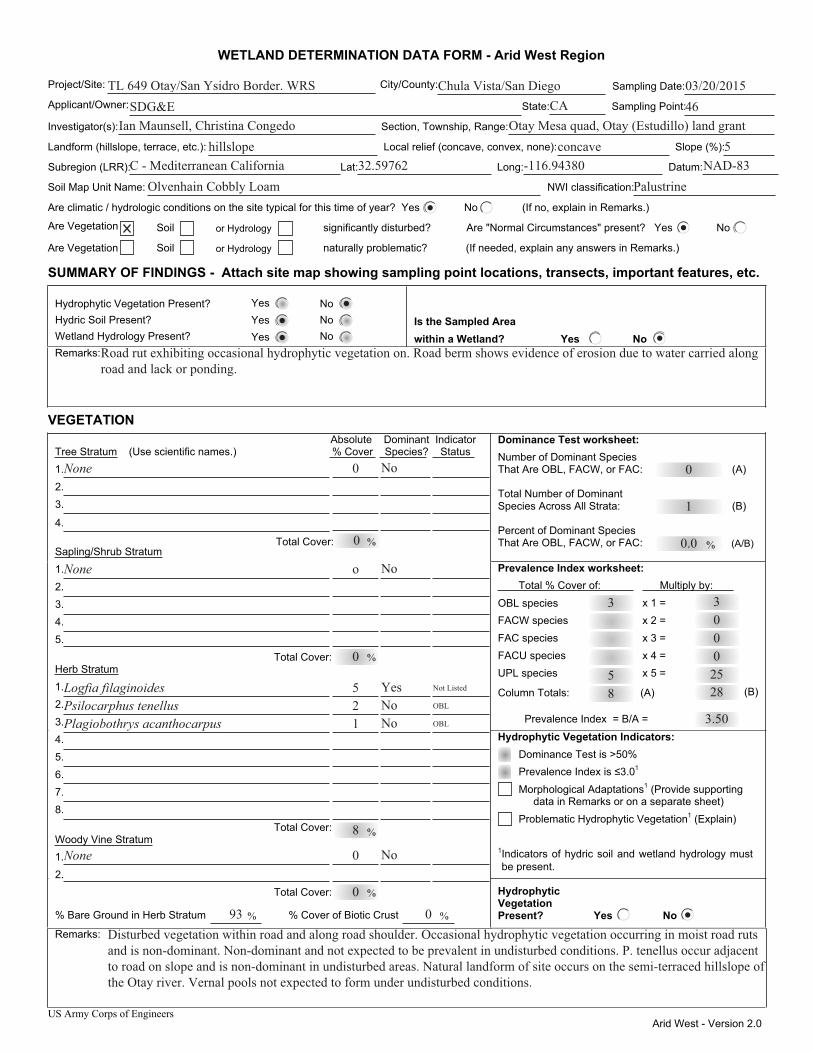
US Army Corps of Engineers Arid West - Version 2.0
WETLAND DETERMINATION DATA FORM - Arid West Region
Project/Site: City/County: Sampling Date:
Applicant/Owner: State: Sampling Point:
Investigator(s): Section, Township, Range:
Landform (hillslope, terrace, etc.): Local relief (concave, convex, none): Slope (%):
Subregion (LRR): Lat: Long: Datum:
Soil Map Unit Name: NWI classification:
Are climatic / hydrologic conditions on the site typical for this time of year? Yes No (If no, explain in Remarks.)
Are Vegetation Soil or Hydrology significantly disturbed? Are "Normal Circumstances" present? Yes No
Are Vegetation Soil or Hydrology naturally problematic? (If needed, explain any answers in Remarks.)
SUMMARY OF FINDINGS - Attach site map showing sampling point locations, transects, important features, etc.
Hydrophytic Vegetation Present? Yes No Hydric Soil Present? Yes No Wetland Hydrology Present? Yes No
Is the Sampled Area within a Wetland? Yes No
Remarks:
VEGETATION Dominance Test worksheet: Number of Dominant Species That Are OBL, FACW, or FAC: (A)
Total Number of Dominant Species Across All Strata: (B)
Percent of Dominant Species That Are OBL, FACW, or FAC: (A/B)
Prevalence Index worksheet: Total % Cover of: Multiply by:
OBL species x 1 = FACW species x 2 = FAC species x 3 = FACU species x 4 = UPL species x 5 =
Column Totals: (A) (B)
Prevalence Index = B/A =
Hydrophytic Vegetation Indicators:
Prevalence Index is ≤3.0 1
Morphological Adaptations1 (Provide supporting data in Remarks or on a separate sheet)
Problematic Hydrophytic Vegetation1 (Explain)
1Indicators of hydric soil and wetland hydrology must be present.
Absolute Dominant Indicator Tree Stratum (Use scientific names.) % Cover Species? Status 1. 2. 3.
4.
Sapling/Shrub Stratum1. 2. 3. 4. 5. Total Cover: Herb Stratum1. 2. 3. 4. 5. 6. 7. 8.
Total Cover: Woody Vine Stratum1. 2. Total Cover:
% Bare Ground in Herb Stratum % Cover of Biotic Crust
Hydrophytic Vegetation Present? Yes No
Remarks:
Dominance Test is >50%
% % Total Cover:
%
%
%
% %
TL 649 Otay/San Ysidro Border. WRS Chula Vista/San Diego 03/20/2015SDG&E 46
Ian Maunsell, Christina Congedo Otay Mesa quad, Otay (Estudillo) land granthillslope concave 5
CA
C - Mediterranean California 32.59762 -116.94380 NAD-83Olvenhain Cobbly Loam Palustrine
0
1
0.0
5
3
Road rut exhibiting occasional hydrophytic vegetation on. Road berm shows evidence of erosion due to water carried along road and lack or ponding.
None 0 No
0
None No
o
0
YesNoNo
125
Plagiobothrys acanthocarpus Psilocarphus tenellus Logfia filaginoides
8
Not Listed
OBL
OBL
No0None
0
93 0Disturbed vegetation within road and along road shoulder. Occasional hydrophytic vegetation occurring in moist road ruts and is non-dominant. Non-dominant and not expected to be prevalent in undisturbed conditions. P. tenellus occur adjacent to road on slope and is non-dominant in undisturbed areas. Natural landform of site occurs on the semi-terraced hillslope of the Otay river. Vernal pools not expected to form under undisturbed conditions.
8 28250003
3.50
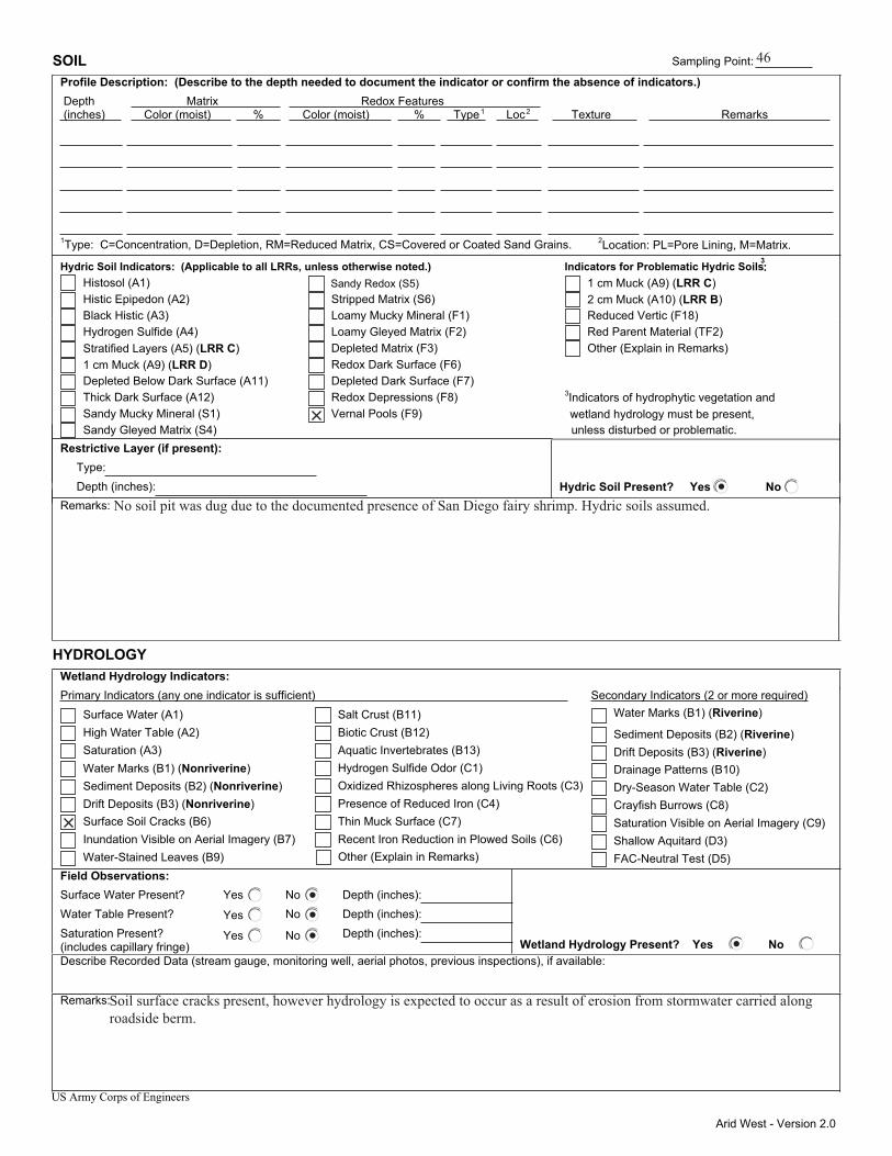
Arid West - Version 2.0
SOIL Sampling Point: Profile Description: (Describe to the depth needed to document the indicator or confirm the absence of indicators.) Depth Matrix Redox Features (inches) Color (moist) % Color (moist) % Type1 Loc2 Texture Remarks
1Type: C=Concentration, D=Depletion, RM=Reduced Matrix, CS=Covered or Coated Sand Grains. 2Location: PL=Pore Lining, M=Matrix.
Hydric Soil Indicators: (Applicable to all LRRs, unless otherwise noted.) Indicators for Problematic Hydric Soils3: Histosol (A1) Sandy Redox (S5) 1 cm Muck (A9) (LRR C) Histic Epipedon (A2) Stripped Matrix (S6) 2 cm Muck (A10) (LRR B) Black Histic (A3) Loamy Mucky Mineral (F1) Reduced Vertic (F18) Hydrogen Sulfide (A4) Loamy Gleyed Matrix (F2) Red Parent Material (TF2) Stratified Layers (A5) (LRR C) Depleted Matrix (F3) Other (Explain in Remarks) 1 cm Muck (A9) (LRR D) Redox Dark Surface (F6) Depleted Below Dark Surface (A11) Depleted Dark Surface (F7) Thick Dark Surface (A12) Redox Depressions (F8) Sandy Mucky Mineral (S1) Vernal Pools (F9)
3Indicators of hydrophytic vegetation and
Sandy Gleyed Matrix (S4) unless disturbed or problematic. Restrictive Layer (if present): Type: Depth (inches): Hydric Soil Present? Yes No Remarks:
HYDROLOGY Wetland Hydrology Indicators:
Secondary Indicators (2 or more required)Primary Indicators (any one indicator is sufficient) Water Marks (B1) (Riverine) Surface Water (A1) Salt Crust (B11)
Sediment Deposits (B2) (Riverine) High Water Table (A2) Biotic Crust (B12)
Drift Deposits (B3) (Riverine) Saturation (A3) Aquatic Invertebrates (B13) Drainage Patterns (B10) Water Marks (B1) (Nonriverine) Hydrogen Sulfide Odor (C1) Dry-Season Water Table (C2) Sediment Deposits (B2) (Nonriverine) Oxidized Rhizospheres along Living Roots (C3) Crayfish Burrows (C8) Drift Deposits (B3) (Nonriverine) Presence of Reduced Iron (C4) Saturation Visible on Aerial Imagery (C9) Surface Soil Cracks (B6) Thin Muck Surface (C7) Shallow Aquitard (D3) Inundation Visible on Aerial Imagery (B7) Recent Iron Reduction in Plowed Soils (C6) FAC-Neutral Test (D5) Water-Stained Leaves (B9)
Field Observations: Surface Water Present? Yes No Depth (inches): Water Table Present? Yes No Depth (inches): Saturation Present? Yes No Depth (inches): (includes capillary fringe) Wetland Hydrology Present? Yes No Describe Recorded Data (stream gauge, monitoring well, aerial photos, previous inspections), if available:
Remarks:
US Army Corps of Engineers
Other (Explain in Remarks)
wetland hydrology must be present,
46
No soil pit was dug due to the documented presence of San Diego fairy shrimp. Hydric soils assumed.
Soil surface cracks present, however hydrology is expected to occur as a result of erosion from stormwater carried along roadside berm.
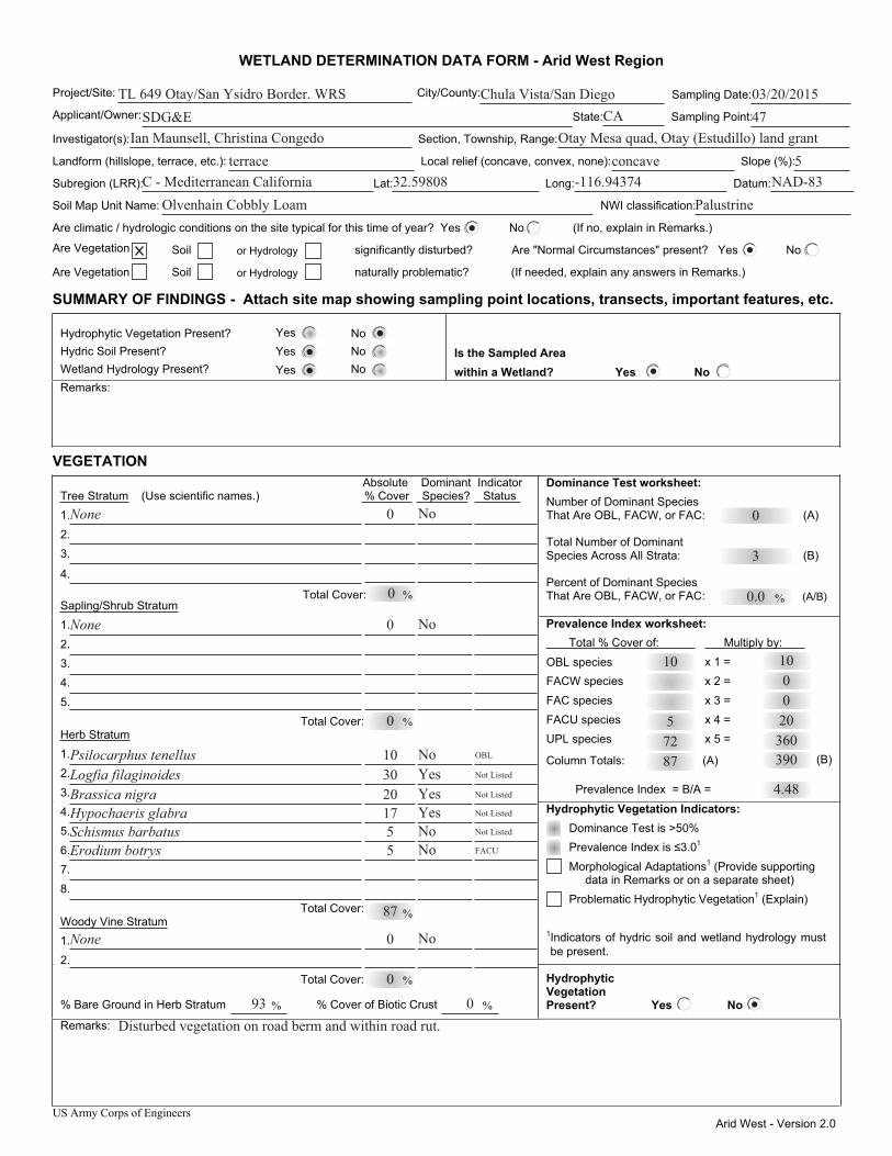
US Army Corps of Engineers Arid West - Version 2.0
WETLAND DETERMINATION DATA FORM - Arid West Region
Project/Site: City/County: Sampling Date:
Applicant/Owner: State: Sampling Point:
Investigator(s): Section, Township, Range:
Landform (hillslope, terrace, etc.): Local relief (concave, convex, none): Slope (%):
Subregion (LRR): Lat: Long: Datum:
Soil Map Unit Name: NWI classification:
Are climatic / hydrologic conditions on the site typical for this time of year? Yes No (If no, explain in Remarks.)
Are Vegetation Soil or Hydrology significantly disturbed? Are "Normal Circumstances" present? Yes No
Are Vegetation Soil or Hydrology naturally problematic? (If needed, explain any answers in Remarks.)
SUMMARY OF FINDINGS - Attach site map showing sampling point locations, transects, important features, etc.
Hydrophytic Vegetation Present? Yes No Hydric Soil Present? Yes No Wetland Hydrology Present? Yes No
Is the Sampled Area within a Wetland? Yes No
Remarks:
VEGETATION Dominance Test worksheet: Number of Dominant Species That Are OBL, FACW, or FAC: (A)
Total Number of Dominant Species Across All Strata: (B)
Percent of Dominant Species That Are OBL, FACW, or FAC: (A/B)
Prevalence Index worksheet: Total % Cover of: Multiply by:
OBL species x 1 = FACW species x 2 = FAC species x 3 = FACU species x 4 = UPL species x 5 =
Column Totals: (A) (B)
Prevalence Index = B/A =
Hydrophytic Vegetation Indicators:
Prevalence Index is ≤3.0 1
Morphological Adaptations1 (Provide supporting data in Remarks or on a separate sheet)
Problematic Hydrophytic Vegetation1 (Explain)
1Indicators of hydric soil and wetland hydrology must be present.
Absolute Dominant Indicator Tree Stratum (Use scientific names.) % Cover Species? Status 1. 2. 3.
4.
Sapling/Shrub Stratum1. 2. 3. 4. 5. Total Cover: Herb Stratum1. 2. 3. 4. 5. 6. 7. 8.
Total Cover: Woody Vine Stratum1. 2. Total Cover:
% Bare Ground in Herb Stratum % Cover of Biotic Crust
Hydrophytic Vegetation Present? Yes No
Remarks:
Dominance Test is >50%
% % Total Cover:
%
%
%
% %
TL 649 Otay/San Ysidro Border. WRS Chula Vista/San Diego 03/20/2015SDG&E 47
Ian Maunsell, Christina Congedo Otay Mesa quad, Otay (Estudillo) land grantterrace concave 5
CA
C - Mediterranean California 32.59808 -116.94374 NAD-83Olvenhain Cobbly Loam Palustrine
0
3
0.0
725
10
None 0 No
0
None No
0
0
NoYesYesYesNoNo
517203010
Schismus barbatusHypochaeris glabraBrassica nigraLogfia filaginoides Psilocarphus tenellus
5 Erodium botrys
87
OBL
Not Listed
Not Listed
Not Listed
Not Listed
FACU
No0None
0
93 0Disturbed vegetation on road berm and within road rut.
87 390360200010
4.48
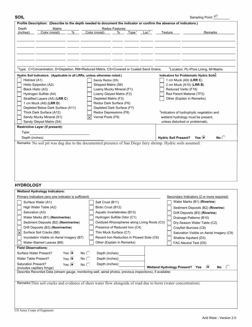
Arid West - Version 2.0
SOIL Sampling Point: Profile Description: (Describe to the depth needed to document the indicator or confirm the absence of indicators.) Depth Matrix Redox Features (inches) Color (moist) % Color (moist) % Type1 Loc2 Texture Remarks
1Type: C=Concentration, D=Depletion, RM=Reduced Matrix, CS=Covered or Coated Sand Grains. 2Location: PL=Pore Lining, M=Matrix.
Hydric Soil Indicators: (Applicable to all LRRs, unless otherwise noted.) Indicators for Problematic Hydric Soils3: Histosol (A1) Sandy Redox (S5) 1 cm Muck (A9) (LRR C) Histic Epipedon (A2) Stripped Matrix (S6) 2 cm Muck (A10) (LRR B) Black Histic (A3) Loamy Mucky Mineral (F1) Reduced Vertic (F18) Hydrogen Sulfide (A4) Loamy Gleyed Matrix (F2) Red Parent Material (TF2) Stratified Layers (A5) (LRR C) Depleted Matrix (F3) Other (Explain in Remarks) 1 cm Muck (A9) (LRR D) Redox Dark Surface (F6) Depleted Below Dark Surface (A11) Depleted Dark Surface (F7) Thick Dark Surface (A12) Redox Depressions (F8) Sandy Mucky Mineral (S1) Vernal Pools (F9)
3Indicators of hydrophytic vegetation and
Sandy Gleyed Matrix (S4) unless disturbed or problematic. Restrictive Layer (if present): Type: Depth (inches): Hydric Soil Present? Yes No Remarks:
HYDROLOGY Wetland Hydrology Indicators:
Secondary Indicators (2 or more required)Primary Indicators (any one indicator is sufficient) Water Marks (B1) (Riverine) Surface Water (A1) Salt Crust (B11)
Sediment Deposits (B2) (Riverine) High Water Table (A2) Biotic Crust (B12)
Drift Deposits (B3) (Riverine) Saturation (A3) Aquatic Invertebrates (B13) Drainage Patterns (B10) Water Marks (B1) (Nonriverine) Hydrogen Sulfide Odor (C1) Dry-Season Water Table (C2) Sediment Deposits (B2) (Nonriverine) Oxidized Rhizospheres along Living Roots (C3) Crayfish Burrows (C8) Drift Deposits (B3) (Nonriverine) Presence of Reduced Iron (C4) Saturation Visible on Aerial Imagery (C9) Surface Soil Cracks (B6) Thin Muck Surface (C7) Shallow Aquitard (D3) Inundation Visible on Aerial Imagery (B7) Recent Iron Reduction in Plowed Soils (C6) FAC-Neutral Test (D5) Water-Stained Leaves (B9)
Field Observations: Surface Water Present? Yes No Depth (inches): Water Table Present? Yes No Depth (inches): Saturation Present? Yes No Depth (inches): (includes capillary fringe) Wetland Hydrology Present? Yes No Describe Recorded Data (stream gauge, monitoring well, aerial photos, previous inspections), if available:
Remarks:
US Army Corps of Engineers
Other (Explain in Remarks)
wetland hydrology must be present,
47
No soil pit was dug due to the documented presence of San Diego fairy shrimp. Hydric soils assumed.
Thin soil cracks and evidence of sheet water flow alongside of road due to berm (water concentration).
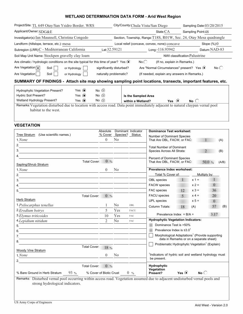
US Army Corps of Engineers Arid West - Version 2.0
WETLAND DETERMINATION DATA FORM - Arid West Region
Project/Site: City/County: Sampling Date:
Applicant/Owner: State: Sampling Point:
Investigator(s): Section, Township, Range:
Landform (hillslope, terrace, etc.): Local relief (concave, convex, none): Slope (%):
Subregion (LRR): Lat: Long: Datum:
Soil Map Unit Name: NWI classification:
Are climatic / hydrologic conditions on the site typical for this time of year? Yes No (If no, explain in Remarks.)
Are Vegetation Soil or Hydrology significantly disturbed? Are "Normal Circumstances" present? Yes No
Are Vegetation Soil or Hydrology naturally problematic? (If needed, explain any answers in Remarks.)
SUMMARY OF FINDINGS - Attach site map showing sampling point locations, transects, important features, etc.
Hydrophytic Vegetation Present? Yes No Hydric Soil Present? Yes No Wetland Hydrology Present? Yes No
Is the Sampled Area within a Wetland? Yes No
Remarks:
VEGETATION Dominance Test worksheet: Number of Dominant Species That Are OBL, FACW, or FAC: (A)
Total Number of Dominant Species Across All Strata: (B)
Percent of Dominant Species That Are OBL, FACW, or FAC: (A/B)
Prevalence Index worksheet: Total % Cover of: Multiply by:
OBL species x 1 = FACW species x 2 = FAC species x 3 = FACU species x 4 = UPL species x 5 =
Column Totals: (A) (B)
Prevalence Index = B/A =
Hydrophytic Vegetation Indicators:
Prevalence Index is ≤3.0 1
Morphological Adaptations1 (Provide supporting data in Remarks or on a separate sheet)
Problematic Hydrophytic Vegetation1 (Explain)
1Indicators of hydric soil and wetland hydrology must be present.
Absolute Dominant Indicator Tree Stratum (Use scientific names.) % Cover Species? Status 1. 2. 3.
4.
Sapling/Shrub Stratum1. 2. 3. 4. 5. Total Cover: Herb Stratum1. 2. 3. 4. 5. 6. 7. 8.
Total Cover: Woody Vine Stratum1. 2. Total Cover:
% Bare Ground in Herb Stratum % Cover of Biotic Crust
Hydrophytic Vegetation Present? Yes No
Remarks:
Dominance Test is >50%
% % Total Cover:
%
%
%
% %
TL 649 Otay/San Ysidro Border. WRS Chula Vista/San Diego 03/20/2015SDG&E 48
Ian Maunsell, Christina Congedo T18S, R01W, Sec. 24, Otay Mesa quadranglemesa concave 0
CA
C - Mediterranean California 32.59121 -116.93942 NAD-83Stockpen gravelly clay loam Palustrine
1
2
50.0
512
1
Vegetation disturbed due to location with access road. Data point immediately adjacent to natural claypan vernal pool habitat to the west.
None 0 No
0
None No
0
0
NoYesYesNo
21051
Lepidium nitidumElymus triticoidesErodium botrysPsilocarphus tenellus
18
OBL
FACU
FAC
FAC
No0None
0
93 0Disturbed vernal pool occurring within access road. Vegetation assumed due to adjacent undisturbed vernal pools and strong hydrological indicators.
18 570203601
3.17
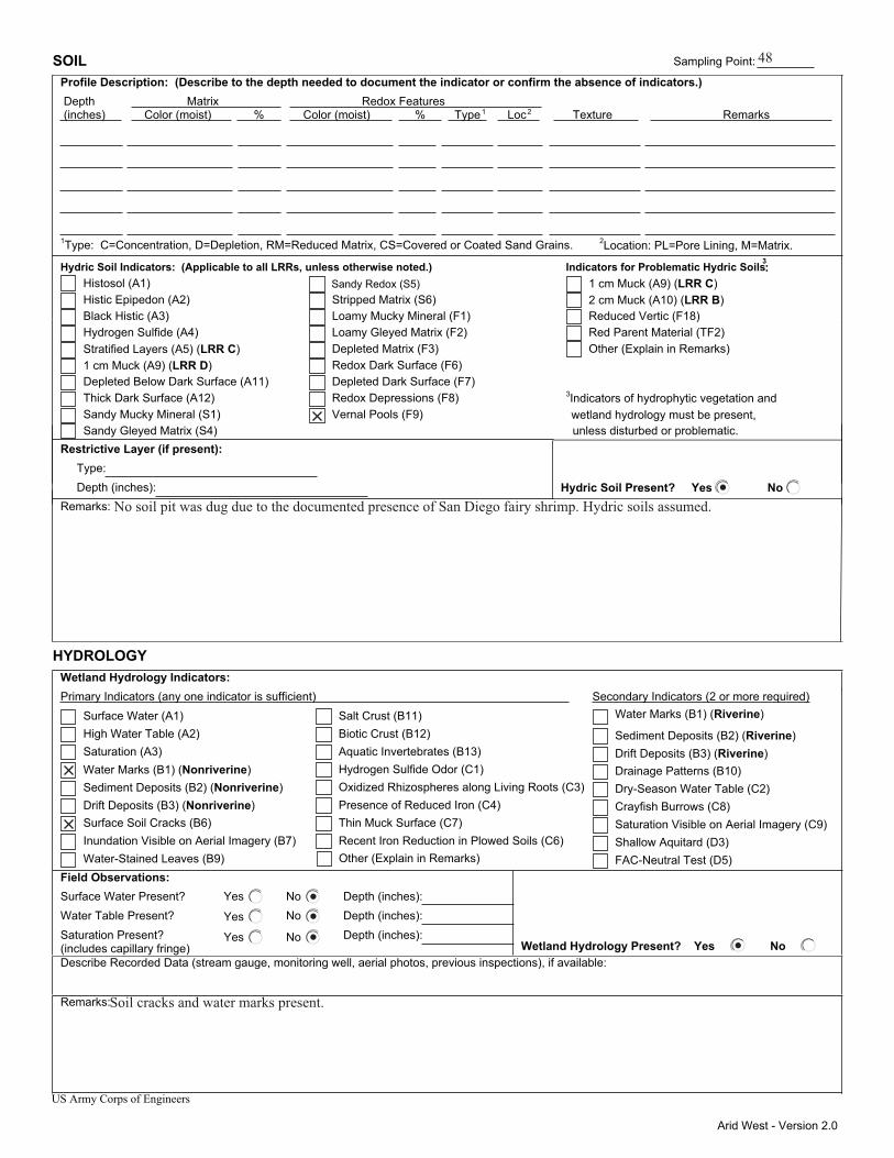
Arid West - Version 2.0
SOIL Sampling Point: Profile Description: (Describe to the depth needed to document the indicator or confirm the absence of indicators.) Depth Matrix Redox Features (inches) Color (moist) % Color (moist) % Type1 Loc2 Texture Remarks
1Type: C=Concentration, D=Depletion, RM=Reduced Matrix, CS=Covered or Coated Sand Grains. 2Location: PL=Pore Lining, M=Matrix.
Hydric Soil Indicators: (Applicable to all LRRs, unless otherwise noted.) Indicators for Problematic Hydric Soils3: Histosol (A1) Sandy Redox (S5) 1 cm Muck (A9) (LRR C) Histic Epipedon (A2) Stripped Matrix (S6) 2 cm Muck (A10) (LRR B) Black Histic (A3) Loamy Mucky Mineral (F1) Reduced Vertic (F18) Hydrogen Sulfide (A4) Loamy Gleyed Matrix (F2) Red Parent Material (TF2) Stratified Layers (A5) (LRR C) Depleted Matrix (F3) Other (Explain in Remarks) 1 cm Muck (A9) (LRR D) Redox Dark Surface (F6) Depleted Below Dark Surface (A11) Depleted Dark Surface (F7) Thick Dark Surface (A12) Redox Depressions (F8) Sandy Mucky Mineral (S1) Vernal Pools (F9)
3Indicators of hydrophytic vegetation and
Sandy Gleyed Matrix (S4) unless disturbed or problematic. Restrictive Layer (if present): Type: Depth (inches): Hydric Soil Present? Yes No Remarks:
HYDROLOGY Wetland Hydrology Indicators:
Secondary Indicators (2 or more required)Primary Indicators (any one indicator is sufficient) Water Marks (B1) (Riverine) Surface Water (A1) Salt Crust (B11)
Sediment Deposits (B2) (Riverine) High Water Table (A2) Biotic Crust (B12)
Drift Deposits (B3) (Riverine) Saturation (A3) Aquatic Invertebrates (B13) Drainage Patterns (B10) Water Marks (B1) (Nonriverine) Hydrogen Sulfide Odor (C1) Dry-Season Water Table (C2) Sediment Deposits (B2) (Nonriverine) Oxidized Rhizospheres along Living Roots (C3) Crayfish Burrows (C8) Drift Deposits (B3) (Nonriverine) Presence of Reduced Iron (C4) Saturation Visible on Aerial Imagery (C9) Surface Soil Cracks (B6) Thin Muck Surface (C7) Shallow Aquitard (D3) Inundation Visible on Aerial Imagery (B7) Recent Iron Reduction in Plowed Soils (C6) FAC-Neutral Test (D5) Water-Stained Leaves (B9)
Field Observations: Surface Water Present? Yes No Depth (inches): Water Table Present? Yes No Depth (inches): Saturation Present? Yes No Depth (inches): (includes capillary fringe) Wetland Hydrology Present? Yes No Describe Recorded Data (stream gauge, monitoring well, aerial photos, previous inspections), if available:
Remarks:
US Army Corps of Engineers
Other (Explain in Remarks)
wetland hydrology must be present,
48
No soil pit was dug due to the documented presence of San Diego fairy shrimp. Hydric soils assumed.
Soil cracks and water marks present.