appendix d focused biological survey and … biological survey and jurisdictional delineation for...
TRANSCRIPT

Appendix D Focused Biological Survey
and Jurisdictional Delineation for Offsite Improvements

FOCUSED BIOLOGICAL SURVEY ANDGENERAL BIOLOGICAL RESOURCES ASSESSMENT
FOR OFFSITE IMPROVEMENTS ASSOCIATED WITH THEHACIENDA AT FAIRVIEW VALLEY PROJECT
TOWN OF APPLE VALLEY SPHERE OF INFLUENCEUSGS – FAIRVIEW VALLEY QUADRANGLE, 7.5-MINUTE SERIES
TOWNSHIP 5 NORTH, RANGE 2 WEST, SECTIONS 9, 14, 15, AND 23AND TOWNSHIP 6 NORTH, RANGE 2 WEST, SECTION 32
SAN BERNARDINO COUNTY, CALIFORNIA
Prepared for:
Strata Equity Group, Inc.4370 La Jolla Village Drive, Suite 960
San Diego, California 92122(858) 546-0900
Prepared by:
Tom Dodson & Associates2150 North Arrowhead Avenue
San Bernardino, California 92405(909) 882-3612
Report Text Revised February 2009
Surveys Conducted October 2008

Strata Equity Group, Inc. Focused Biological Survey andOffsite Improvements Hacienda at Fairview Valley General Biological Resources Assessment
SEI-347/2008 Bio Survey (rev3) TOM DODSON & ASSOCIATES-ii-
TABLE OF CONTENTS
I. Certification . . . . . . . . . . . . . . . . . . . . . . . . . . . . . . . . . . . . . . . . . . . . . . . . . . . . . . 1
II. Executive Summary . . . . . . . . . . . . . . . . . . . . . . . . . . . . . . . . . . . . . . . . . . . . . . . 2
III. Project and Property Description . . . . . . . . . . . . . . . . . . . . . . . . . . . . . . . . . . . . . 5
IV. Focused Study / Species of Concern . . . . . . . . . . . . . . . . . . . . . . . . . . . . . . . . . . 7
V. Methodology . . . . . . . . . . . . . . . . . . . . . . . . . . . . . . . . . . . . . . . . . . . . . . . . . . . . . 16
VI. General Biological Survey Results . . . . . . . . . . . . . . . . . . . . . . . . . . . . . . . . . . . . 18
VII. Rare, Endangered, or Sensitive Species and Habitat Results . . . . . . . . . . . . . . . 20
VIII. Impacts and Recommendations . . . . . . . . . . . . . . . . . . . . . . . . . . . . . . . . . . . . . . 21
IX Proposed Mitigation Measures . . . . . . . . . . . . . . . . . . . . . . . . . . . . . . . . . . . . . . . 23
X. References . . . . . . . . . . . . . . . . . . . . . . . . . . . . . . . . . . . . . . . . . . . . . . . . . . . . . . 26
TABLES
Table 1 CNDDB Search
FIGURES
Figure 1 Overall USGS Quadrangle Location MapFigure 2 Regional LocationFigure 3 Vicinity MapFigure 4 Conceptual Offsite Improvement LocationsFigure 5 Project Site & Study LocationFigure 6 Study Results
SITE PHOTOS
Photo 1 Overall Environmental Setting Photo 2 Looking east along Cahuilla Road Photo 3 General location for the proposed Detention Basin (DB) No. 3Photo 4 Looking west along Cahuilla Road near intersection with Chicago RoadPhoto 5 Looking northwest along Chicago Road south of Cahuilla RoadPhoto 6 Looking northeast along Chicago Road south of Cahuilla RoadPhoto 7 General locations for DB Nos. 4 and 5 and proposed Reservoir No. 2Photo 8 General location for DB No. 1 and proposed Reservoir No. 1Photo 9 Example of degraded habitat conditions found within portions of the survey areaPhoto 10 Example of high quality habitat conditions found within portions of the survey area

Strata Equity Group, Inc. Focused Biological Survey andOffsite Improvements Hacienda at Fairview Valley General Biological Resources Assessment
SEI-347/2008 Bio Survey (rev3) TOM DODSON & ASSOCIATES-1-
I. CERTIFICATION
CERTIFICATION: “I hereby certify that the statements furnished above and in the attached exhibitspresent the data and information required for this biological evaluation, and that the facts,statements, and information presented are true and correct to the best of my knowledge and belief.Fieldwork conducted for this assessment was performed by me or under my direct supervision. Icertify that I have not signed a non-disclosure or consultant confidentiality agreement with theproject applicant or applicant’s representative and that I have no financial interest in the project.”
DATE: February 24, 2009 SIGNED:Shay Lawrey (Report Author)
Strata Equity Group, Inc. Focused Biological Survey andOffsite Improvements Hacienda at Fairview Valley General Biological Resources Assessment
SEI-347/2008 Bio Survey (rev3) TOM DODSON & ASSOCIATES-2-
II. EXECUTIVE SUMMARY
Tom Dodson and Associates (TDA) was contracted by Strata Equity Group, Inc. (Strata) to assessthe biological resources and potential impacts relative to the proposed conceptual offsiteimprovements associated with a residential development called the Hacienda at Fairview Valley.The potential offsite infrastructure locations assessed are conceptual at this time and are includedas part of the specific plan application. Exact locations will be finalized during the tentative tractmap application process with San Bernardino County. Biological surveys are expected to beperformed by biologists approved by the County of San Bernardino. TDA is on the approvedCounty of San Bernardino list of biologists.
The potential offsite improvements consist of seven (7) detention basins, two (2) water reservoirareas with access roads, and storm drain installation in conjunction with road improvements alongCahuilla Road and Chicago Road. The offsite improvements bordering the development aregenerally located northeast of the Town of Apple Valley in Fairview Valley, in a bajada nestledbetween Fairview Mountain, Sidewinder Mountain, and the Granite Mountains (see Figures 1through 4).
A California Natural Diversity Data Base (CNDDB) search was completed for the U.S. GeologicalSurvey (USGS) – Fairview Valley Quadrangle, 7.5 Minute Series (topographic), as well as thesurrounding quads: Turtle Valley, Stoddard Wells, West Ord Mountain, White Horse Mountain,Lucerne Valley, Fifteenmile Valley, Apple Valley South, and Apple Valley North. According to theCNDDB, 23 sensitive species have been documented within these nine USGS quadrangles.
For the proposed road improvements and offsite facilities, two types of biological assessments(focused survey and constraints analysis) were performed. Focused surveys were not appropriatefor the detention basin and reservoir site locations because they are preliminary and not finalizedat this time. Instead, a general biological constraints analysis was conducted for the detentionbasin and reservoir site locations. Focused surveys for burrowing owl and desert tortoise werehowever, conducted for the road improvements along Cahuilla Road and Chicago Road becausethe action area is specified.
TDA biologist, Shay Lawrey, conducted the initial site assessment and constraints analysis of thedetention basin and reservoir site locations on September 20, 2008.
S. Lawrey and Craig Lawrey completed the focused surveys along Cahuilla Road and ChicagoRoad on October 3, 4, 5 and 12, 2008. The purpose of the focused surveys was to determine thepresence or absence of burrowing owl, desert tortoise, or any other sensitive species within oradjacent to the proposed road improvements.
They conducted the focused burrowing owl surveys in accordance with the “Burrowing Owl SurveyProtocol and Mitigation Guidelines” prepared by the California Burrowing Owl Consortium on April1993 and the October 17, 1995 California Department of Fish and Game (CDFG) staff report onBurrowing Owl Mitigation. The protocol survey identities a four phased process with Phase IVbeing the report. The first phase is a Habitat Assessment. This phase calls for the identificationof burrowing owl habitat onsite. If it is determined that borrowing owl habitat is observed, thenPhase II is conducted. Phase II is a 100% coverage survey of the site plus a transect on adjacent

Strata Equity Group, Inc. Focused Biological Survey andOffsite Improvements Hacienda at Fairview Valley General Biological Resources Assessment
SEI-347/2008 Bio Survey (rev3) TOM DODSON & ASSOCIATES-3-
properties when possible. If burrows are present then Phase III is conducted which include owlsurveys, census and mapping. If no owls are found then a winter survey is required.
Evidence of burrowing owl was found east of Chicago Road. Two burrows were found in thesoutheastern quarter of the proposed road improvements that had white wash, castings, andfeathers near the burrow entrances. One burrowing owl individual was seen near one of theburrows during the surveys.
The project site is located within the range of the state and federally listed threatened deserttortoise, and patches of well suited desert tortoise habitat occur in area. S. Lawrey and C. Lawreyconducted the focused desert tortoise surveys along Cahuilla Road and Chicago Road on October3, 4, 5 and 12, 2008. It is noted that the surveys were conducted outside of the spring time whentortoise activity is apparent. However, desert tortoise can be active in the fall and desert tortoisesign, such as scat, tracks, scuts, remains, and burrows, would persist beyond the active season.Additionally, TDA biologists conducted 100 % coverage desert tortoise surveys in 2005 and 2007for the development project associated with these road improvements along Cahuilla Road andChicago Road. The 2005 and 2007 desert tortoise surveys were conducted in the Spring seasonand the conditions during the 2005 survey of were ideal with abundant rain the previous year. Thesurveyors did not detect any desert tortoise or their sign (i.e., burrows, scat, scutes or tracks) duringthe course of the 2005 and 2007 surveys. Any such sign would indicate presence of deserttortoise.
Although the land surrounding the road improvements along Cahuilla Road and Chicago Roadcontains suitable habitat for desert tortoise, no evidence of desert tortoise or desert tortoise signwas found. There are also no current published data showing that desert tortoise occupy land inthe area of the road improvements. Therefore, the location of the road improvements is notconsidered to be occupied by desert tortoise at this time.
The general biological survey and constraints analysis of the detention basin and reservoir sitesidentified a few potential biological issues that will require further investigation once the actual sitelocations have been identified and surveyed in. Of particular note, a number of native springs aremapped in the local area and the southerly offsite facility locations are proposed near one of thesesprings. At the time of survey, wetland habitat was not apparent, but the surveys were conductedduring the dry season and the timing is not considered appropriate to identify wetland habitatboundaries. In order to properly and clearly define the boundaries of the spring wetland habitat,delineation surveys would need to be conducted in the early spring.
The spring habitat is considered sensitive and poses a constraint to development of the detentionbasins and reservoir sites. Additionally, jurisdictional waters were identified as a potential issue thatwill require further investigation. With the exception of Reservoir No. 1 and Detention Basin Nos. 2and 3, the proposed offsite facility locations occur near jurisdictional, blueline streams. Dependingon the potential area of impact relative to jurisdictional limits, these water courses may poseanother constraint. If there are impacts to the spring habitat or stream courses associated with theconstruction, maintenance, and operation of the offsite facilities, then regulatory approvals wouldbe required. In order to identify potential impacts to jurisdictional waters or wetlands, a delineationshould be conducted during the appropriate season.
Strata Equity Group, Inc. Focused Biological Survey andOffsite Improvements Hacienda at Fairview Valley General Biological Resources Assessment
SEI-347/2008 Bio Survey (rev3) TOM DODSON & ASSOCIATES-4-
Finally, the overall project area provides habitat for a variety of birds, some of which are appropriateprey species of prairie falcon (Falco mexicanus). One prairie falcon was observed flying over thesite during the surveys. There is a high potential for this species to utilize the habitat in the projectvicinity for foraging. The surrounding rugged topography indicates that prairie falcon may residein the area, using the rocky surroundings for roosting or nesting. The rocky terrain providesappropriate habitat capable of supporting prairie falcon nesting. Although there was no evidenceof prairie falcon territories near any of the offsite facility locations, focused surveys may bewarranted if impacts to the rocky habitat are proposed in the future as part of the installation of thereservoirs.

Strata Equity Group, Inc. Focused Biological Survey andOffsite Improvements Hacienda at Fairview Valley General Biological Resources Assessment
SEI-347/2008 Bio Survey (rev3) TOM DODSON & ASSOCIATES-5-
III. PROJECT AND PROPERTY DESCRIPTION
The proposed offsite improvements are associated with a residential development called theHacienda at Fairview Valley. The potential offsite improvements consist of seven (7) detentionbasins, two (2) water reservoir areas with access roads, and storm drain installation and roadimprovements along Cahuilla Road and Chicago Road. Detention Basins Nos. 1 and 2 andReservoir No. 1 are proposed to be located in Township 6 North, Range 2 West, Section 32;Detention Basin No. 4 is proposed to be located in Township 5 North, Range 2 West, Section 9;and Detention Basin Nos. 5-7, Reservoir No. 2 and access roads are proposed to be located inTownship 5 North, Range 2 West, Sections 15, 14, 23. The storm drain and road improvementsalong Cahuilla Road and Chicago Road are specifically located in Township 5 North, Range 2 Weston the line of Sections 10 and 11, San Bernardino County, California. Refer to site photos withinthis report for images of characteristic biological resources.
The potential offsite infrastructure locations assessed are conceptual at this time and are includedas part of the specific plan application. Exact locations will be finalized during the tentative tractmap application process with San Bernardino County. Biological surveys are expected to beperformed by biologists approved by the County of San Bernardino.
All conceptual offsite infrastructure locations are managed by the Bureau of Land Management(BLM), except for DB-2. Water reservoirs (R-1 and R-2) need to be located at a higher elevationthan the homes they serve. These offsite locations are selected to minimize visual impacts toexisting and future residents and to achieve the required elevation. The stormwater and waterquality basins (DB) are the most technically feasible and cost effective. Debris/Detention basinsof this type belong in natural constrictions or lowpoints in the topography. The offsite roadwayimprovements are required to connect Villages C and D of the community. These roadways willbe designed within existing road easements for Cahuilla Road and Chicago Road.
The project site can be found on 2007 Thomas Guide page 4298, Section G2. The proposed offsiteimprovements bordering the Hacienda at Fairview Valley development are generally locatednortheast of the Town of Apple Valley in Fairview Valley, in a bajada nestled between FairviewMountain, Sidewinder Mountain, and the Granite Mountains (see Figures 1 through 4). The totalarea of disturbance proposed by the detention basins and reservoirs is 34.5 acres and the totalarea of disturbance proposed for the road improvements is 12.4 acres.
The topography within the study area ranges between 3,080 to 4,000 feet above mean sea level.The soils in the project area primarily consist of Cajon sand, Cajon-Wasco cool complex, andHelendale sand. The local climatic conditions in the project area are characterized by hot summers,mild winters, infrequent rainfall, and dry humidity. The average annual temperature is 62°F, rangingbetween 9-112°F. The rainy season begins in November and continues through March, with thequantity and frequency of rain varying from year to year. The average annual rainfall isapproximately 4.5 inches with a range of 1.1 to 11.2 inches.
The primary vegetation community along Cahuilla Road and Chicago Road is Mojave creosotebush scrub, dominated by creosote bush (Larrea tridentata) Joshua tree (Yucca brevifolia),burrobrush (Hymenoclea salsola), and California buckwheat (Eriogonum fasciculatum). Mojavecreosote bush scrub accounts for over 90% of the vegetative cover. Along the road edges,interspersed within the Mojave creosote bush scrub are patches of bare ground, disturbed ground

Strata Equity Group, Inc. Focused Biological Survey andOffsite Improvements Hacienda at Fairview Valley General Biological Resources Assessment
SEI-347/2008 Bio Survey (rev3) TOM DODSON & ASSOCIATES-6-
near the houses, and sparse habitat patches dominated by non-native species. There are highlevels of on going disturbance ongoing along Cahuilla Road and Chicago Road. There areresidential structures and old trash dumps as well as off-road-vehicle (ORV) use, feral dogs, andrecent dumping. The land uses in the vicinity of project are rural residential.
There is very little evidence of disturbance in the vicinity of the detention basin and reservoir sites.These sites are dominated by native shrubs, primarily Larrea tridentata (creosote bush) Joshuatree, Hymenoclea salsola (burrobrush), and Eriogonum fasciculatum (California buckwheat). Thereare jurisdictional stream courses and natural springs located near some of the proposed offsitefacilities.

Strata Equity Group, Inc. Focused Biological Survey andOffsite Improvements Hacienda at Fairview Valley General Biological Resources Assessment
SEI-347/2008 Bio Survey (rev3) TOM DODSON & ASSOCIATES-7-
IV. FOCUSED STUDY / SPECIES OF CONCERN
Background information was gathered prior to visiting this site in order to determine what specieswould be expected in this area. This background check included a search of the California NaturalDiversity Data Base (CNDDB), and a review of previously conducted biological surveys. TheCNDDB search was completed for the USGS – Fairview Valley Quadrangle, 7.5 Minute Series(topographic), as well as the surrounding quads: Turtle Valley, Stoddard Wells, West OrdMountain, White Horse Mountain, Lucerne Valley, Fifteenmile Valley, Apple Valley South, andApple Valley North. According to the CNDDB, 23 sensitive species have been documented withinthese nine USGS Quadrangles. Please refer to Table 1 for a complete list of the speciesoccurrence potential on the property. The table includes the habitat requirements of each speciesand the potential of their occurrence on the site. The occurrence potential is based on siteconditions and species range.
Special status species are native species that have been afforded special legal or managementprotection because of concern for their continued existence. There are several categories ofprotection at both federal and state levels, depending on the magnitude of threat to the continuedexistence and existing knowledge of population levels. The U.S. Fish and Wildlife Service(USFWS) administers the federal Endangered Species Act (ESA) of 1973. The ESA provides alegal mechanism for listing species as either threatened or endangered, and a process of protectionfor those species listed. Section 9 of the ESA prohibits "take" of threatened or endangered species.The term "take" means to harass, harm, pursue, hunt, shoot, wound, kill, trap, capture or collect,or to attempt to engage in such conduct. "Take" can include adverse modification of habitats usedby a threatened or endangered species during any portion of its life history. Under the regulationsof the ESA, the USFWS may authorize "take" when it is incidental to, but not the purpose of, anotherwise lawful act. Take authorization can be obtained under Section 7 or Section 10 of the act.
Migratory Bird Treaty Act: The Migratory Bird Treaty Act protects all native breeding birds, whetheror not they are considered sensitive by resource agencies.
The California Department of Fish and Game (CDFG) administers the California EndangeredSpecies Act (CESA). The State of California considers an endangered species one whoseprospects of survival and reproduction are in immediate jeopardy. A threatened species is onepresent in such small numbers throughout its range that it is likely to become an endangeredspecies in the near future in the absence of special protection or management; and a rare speciesis one present in such small numbers throughout its range that it may become endangered if itspresent environment worsens. Rare species applies only to California native plants. Further, allraptors and their nests are protected under 3503.5 of the California Fish and Game Code.
Species of Special Concern is an informal designation used by CDFG for some declining wildlifespecies that are not proposed for listing as threatened or endangered, such as the burrowing owl.This designation does not provide legal protection, but signifies that these species are recognizedas sensitive by CDFG.
Other applicable regulations include the County of San Bernardino native plant protectionordinance. The protected native plant species (e.g., Joshua trees) are identified in Section 89.0420of the San Bernardino County Government Code. If the project proposes to remove any of these
Strata Equity Group, Inc. Focused Biological Survey andOffsite Improvements Hacienda at Fairview Valley General Biological Resources Assessment
SEI-347/2008 Bio Survey (rev3) TOM DODSON & ASSOCIATES-8-
native plant species, the project proponent shall comply with Section 89.0420 of the San BernardinoCounty Code regarding the harvesting of desert native plants.
Flora
The eleven plant species identified to have a potential to occur within the vicinity of the project areainclude Shockley's rock cress (Arabis shockleyi), Cushenbury milk-vetch (Astragalus albens), Alkalimariposa lily (Calochortus striatus), Booth's evening-primrose (Camissonia boothii ssp. boothii),Desert springparsley (Cymopterus deserticola), Barstow woolly sunflower (Eriophyllum moha-vense), Parish's phacelia (Phacelia Parishii), Parish's popcorn-flower (Plagiobothrys parishii),Parish's alkali grass (Puccinellia parishii), Latimer's woodland-gilia (Saltugilia latimeri), Salt Springcheckerbloom (Sidalcea neomexicana).
Shockley's rock cress (A. shockleyi) is an herbaceous perennial in the Brassicaceae plant family.It occurs in southeastern California, southern Nevada, and western Utah. It occurs in the875-2205m elevational range in Pinyon and juniper woodland on ridges, rocky outcrops andopenings on limestone or quartzite. A. Shockleyi does not have federal or state status but is ranked2.2 by CNPS. As a list 2 species it meet the definitions of Sec. 1901, Chapter 10 (Native PlantProtection Act) or Secs. 2062 and 2067 (California Endangered Species Act) of the CaliforniaDepartment of Fish and Game Code, and is eligible for state listing. As for all botanical specieslisted in this section, it is mandatory that sensitive species be fully considered during preparationof environmental documents relating to CEQA.
Cushenbury milk-vetch (A. albens) is an herbaceous perennial in the Fabaceae plant family. Itis a California endemic that occurs in the 1095-2000m range. A. albens a limestone endemic whichoccurs on sandy or stony flats, rocky hillsides, canyon, washes, or fans on granite or mixedgranitic-calcareous debris associated with Joshua tree woodland, mojavean desert scrub or pinyonand juniper woodland. A. albens is federally listed as endangered, has no state listing and is ranked1.B by CNPS. As 1.B species it meet the definitions of Sec. 1901, Chapter 10 (Native PlantProtection Act) or Secs. 2062 and 2067 (California Endangered Species Act) of the CaliforniaDepartment of Fish and Game Code, and are eligible for state listing.
Alkali mariposa lily (C. striatus) is an herbaceous perennial in the Liliaceae plant family. It occursin southern California and southern Nevada in the 90-1595m elevation range. It is associated withchaparral, chenopod scrub, mojavean desert scrub, alkaline meadows and ephemeral washcommunities, but it is primarily an alkaline meadow species. C. striatus does not have federal orstate status but is ranked 1.B2 by CNPS. As a list 1.B species it meet the definitions of Sec. 1901,Chapter 10 (Native Plant Protection Act) or Secs. 2062 and 2067 (California Endangered SpeciesAct) of the California Department of Fish and Game Code, and is eligible for state listing.
Booth's evening-primrose (C. boothii ssp. boothii) is an annual species in the Onagraceae plantfamily that occurs throughout the western United States and into Mexico. In California it occurs900-2400m elevation on sandy flats and steep, loose slopes associated with Joshua tree woodlandor pinyon-juniper woodland. C. boothii ssp. boothii does not have federal or state status but isranked 2.3 by CNPS. As a list 2 species it meet the definitions of Sec. 1901, Chapter 10 (NativePlant Protection Act) or Secs. 2062 and 2067 (California Endangered Species Act) of the CaliforniaDepartment of Fish and Game Code, and is eligible for state listing.

Strata Equity Group, Inc. Focused Biological Survey andOffsite Improvements Hacienda at Fairview Valley General Biological Resources Assessment
SEI-347/2008 Bio Survey (rev3) TOM DODSON & ASSOCIATES-9-
Desert springparsley (C. deserticola) is an herbaceous perennial in the Apiaceae plant family.It is a western Mojave desert endemic occurring between 625-910m elevation. It is associated withfine to coarse, loose, sandy soil of flats in old dune areas with well-drained sand in Joshua treewoodland and mojavean desert scrub. C. deserticola does not have federal or state status but isranked 1.B2 by CNPS. As a list 1.B species it meet the definitions of Sec. 1901, Chapter 10 (NativePlant Protection Act) or Secs. 2062 and 2067 (California Endangered Species Act) of the CaliforniaDepartment of Fish and Game Code, and is eligible for state listing.
Barstow woolly sunflower (E. mohavense) is an annual in the Asteraceae plant family. It is acentral Mojave desert endemic occurring between 500-900m elevation. It is associated with open,silty or sandy areas or margins of playas in desert chenopod scrub and mojavean desert scrub.E. mohavense does not have federal or state status but is ranked 1.B2 by CNPS. As a list 1.Bspecies it meet the definitions of Sec. 1901, Chapter 10 (Native Plant Protection Act) or Secs. 2062and 2067 (California Endangered Species Act) of the California Department of Fish and GameCode, and is eligible for state listing.
Parish's phacelia (P. parishii) is an annual in the Hydrophyllaceae plant family. It occurs in SanBernardino county, California, southern Nevada, and western Arizona at elevations of 535-1200m.It is associated alkaline flats and slopes, clay soils and playas in Mojavean desert scrub. P. parishiidoes not have federal or state status but is ranked 1.B2 by CNPS. As a list 1.B species it meet thedefinitions of Sec. 1901, Chapter 10 (Native Plant Protection Act) or Secs. 2062 and 2067(California Endangered Species Act) of the California Department of Fish and Game Code, and iseligible for state listing.
Parish's popcorn-flower (P. parishii) is an annual in the Hydrophyllaceae (formerly Boraginaceae)plant family. It is a Mojave desert endemic that occurs at 750-1400m elevation. It is associated withalkaline soils and mesic sites in Great basin scrub and Joshua tree woodlands. P. parishii does nothave federal or state status but is ranked 1.B1 by CNPS. As a list 1.B species it meet the definitionsof Sec. 1901, Chapter 10 (Native Plant Protection Act) or Secs. 2062 and 2067 (CaliforniaEndangered Species Act) of the California Department of Fish and Game Code, and is eligible forstate listing.
Parish's alkali grass (P. parishii) is an annual species in the Poaceae plant family. It is occurs inCalifornia, Arizona and New Mexico at 695-1000m elevations within desert meadows and seeps.P. parishii is associated with alkali springs and seeps in Joshua tree woodland. P. parishii doesnot have federal or state status but is ranked 1.B1 by CNPS. As a list 1.B species it meet thedefinitions of Sec. 1901, Chapter 10 (Native Plant Protection Act) or Secs. 2062 and 2067(California Endangered Species Act) of the California Department of Fish and Game Code, and iseligible for state listing.
Latimer's woodland-gilia (S. latimeri) is an annual in the Polemoniaceae plant family. It occursonly in California at the elevation 400-1900m. It is associated with sandy or rocky substrates inchaparral and mojavean desert scrub. S. latimeri does not have federal or state status but isranked 1.B2 by CNPS. As a list 1.B species it meet the definitions of Sec. 1901, Chapter 10 (NativePlant Protection Act) or Secs. 2062 and 2067 (California Endangered Species Act) of the CaliforniaDepartment of Fish and Game Code, and is eligible for state listing. The genus Saltugilia wasrecently segregated from the genus Gilia and S. latimeri was even more recently isolated fromS. australis. The site was within the elevational range described for the species. The key
Strata Equity Group, Inc. Focused Biological Survey andOffsite Improvements Hacienda at Fairview Valley General Biological Resources Assessment
SEI-347/2008 Bio Survey (rev3) TOM DODSON & ASSOCIATES-10-
characteristic separating out the genus Saltugilia is a glabrous corolla with yellow spots in the tubewhile distinguishing characteristic that distinguishes S. latimeri from S. australis is a higher densityof glands on the calyx as well as persistent pink or lavender in the corolla color.
Salt Spring checkerbloom (S. neomexicana) is an herbaceous perennial in the Malvaceae plantfamily that occurs throughout western North America at 0-1500m elevation. It is associated withalkali playas and brackish marshes in chaparral, coastal scrub, lower montane coniferous forestand mojavean desert scrub. S. neomexicana does not have federal or state status but is ranked 2.2by CNPS. As a list 2 species it meet the definitions of Sec. 1901, Chapter 10 (Native PlantProtection Act) or Secs. 2062 and 2067 (California Endangered Species Act) of the CaliforniaDepartment of Fish and Game Code, and is eligible for state listing.
Fauna
The nine species of special status animal species identified to have a potential to occur within thevicinity of the project area include pallid San Diego pocket mouse (Chaetodipus fallax pallidus),Townsend’s big-eared bat (Corynorhinus townsendii), western mastiff bat (Eumops perotiscalifornicus), Mohave ground squirrel (Spermophilus mohavensis), desert tortoise (G. agassizii),burrowing owl (A. cunicularia), prairie falcon (Falco mexicanus), Bendire’s thrasher (Toxostomabendirei), and Le Conte’s thrasher (Toxostoma lecontei).
Burrowing owl (A. cunicularia) is a state Species of Special Concern. This owl is a mottledbrownish and sand colored, dove sized raptor, with large yellow eyes, a rounded head lacking eartufts, white eyebrows, and long legs compared to other owl species. It is a ground dwelling owltypically found in arid prairies, fields, and open areas where vegetation is sparse and low to theground. The burrowing owl is heavily dependent upon the presence of mammal burrows,commonly ground squirrel, in its habitat to provide shelter from predators, inclement weather, andto provide a nesting place (Coulombe 1971). They are also known to make use of human-createdstructures such as cement culverts and pipes for burrows.
Burrowing owls spend a great deal of time standing on dirt mounds at the entrance to a burrow, orperched on a fence post or other low to the ground perch from which they hunt for prey. Burrowingowls frequently hunt by hovering in place above the ground and dropping on their prey from above.Burrowing owls feed primarily on insects, such as grasshoppers, June beetles and moths, but willalso take small rodents, birds and reptiles. They are active during the day and night, but areconsidered a crepuscular owl; generally observed in the early morning hours or at twilight. Thebreeding season for the burrowing owl is February 1 through August 31. Up to 11, but typically 7 to9 eggs are laid in a burrow, abandoned pipe, or other subterranean hollow where incubation iscomplete in 28-30 days. Young burrowing owls fledge in 44 days. The burrowing owl is considereda migratory species in portions of its range, which includes western North America from Canadato Mexico, and east to Texas and Louisiana. Burrowing owl populations in California areconsidered to be sedentary or locally migratory.
Throughout its range it is vulnerable to habitat loss, predation, vehicular collisions, destruction ofburrow sites and poisoning of ground squirrels (Grinnell and Miller 1944, Zarn 1974, Remsen 1978).Burrowing owls have disappeared from significant portions of their range in the last 15 years andoverall nearly 60% of the breeding groups of owls known to have existed in California during the1980s had disappeared by the early 1990s (Burrowing Owl Consortium 1993). The burrowing owl

Strata Equity Group, Inc. Focused Biological Survey andOffsite Improvements Hacienda at Fairview Valley General Biological Resources Assessment
SEI-347/2008 Bio Survey (rev3) TOM DODSON & ASSOCIATES-11-
is not listed under the state or federal Endangered Species Act. The burrowing owl is a migratorybird protected by the international treaty under the Migratory Bird Treaty Act of 1918 and by Statelaw under the California Fish and Game Code (CDFG Code #3513 & #3503.5).
Desert tortoise (G. agassizii) is listed under both state and federal law as a threatened species.Throughout its range it is threatened by habitat loss, domestic grazing, predation, collections, andincreased mortality rates (Feldmeth et al. 1990). Critical habitat for the desert tortoise wasdesignated on February 8, 1994 (FR 59 5820 5866). The project site is not located withindesignated critical habitat.
The desert tortoise is typically found in creosote bush scrub. They are most often found on levelground where the substrate is firm but not too rocky. Tortoise burrows are typically found at thebase of shrubs, in the sides of washes and in hillsides. Recent activity at tortoise burrows may beindicated by footprints, fresh dirt on the apron of the burrow, fresh scat, crushed vegetation orrecently exposed roots in the burrow wall. Tortoise scat is very distinctive and may remain on thedesert floor for many years. General estimates of the age of tortoise scat can be made based uponsun bleaching and moisture levels. Home ranges for desert tortoise vary, depending upon the sizeand sex of a tortoise as well as the availability of food and shelter. According to the CDFG,information on the western Mojave population of desert tortoise, home range typically varies from5 to 38 acres. Neonatal tortoises can travel up to 3-5 km after hatching (Becky Jones, CDFGpersonal communications). Because a single tortoise may have many burrows distributedthroughout its home range, it is not possible to predict exact numbers of individuals on a site basedupon burrow numbers.
In 1992 the U.S. Bureau of Land Management issued the California Statewide Desert TortoiseManagement Policy which included categorizing habitat into three levels of classification. Themanagement goal for Category I areas is to maintain stable, viable populations and to increase thepopulation where possible. The management goal for Category II areas is to maintain stable, viablepopulations. The management goal for Category III areas is to limit population declines to theextent feasible. The entire project occurs in desert tortoise habitat designated as Class II.
Prairie falcon (F. mexicanus) is a medium to large bird with wingspans approaching 3.5 feet (106.7cm). The female tends to be considerably larger than the male, in some cases a full one-thirdbigger. Adult prairie falcons are a pale brown to sandy brown across the top of their wings andback. The head is streaked with light areas around the face. A faint dark mustache appears oneither side of the bill. Underneath the birds are creamy white with brown spotting or streaking onthe breast and belly. Falcons all have slender bodies, long tails and characteristic long, pointedwings. Prairie falcons can be abundant when suitable habitats for nesting and foraging are present. They do migrate in the spring and fall, but some birds may reside in the area the entire year.Prairie falcons prefer rough broken terrain, which is where they establish nesting territories.Nesting occurs in mid-April through July. Their nests are often found in rock crevices andsometimes in vacated stick nests left by other birds.
The prairie falcon is a locally common bird. These falcons prey chiefly on small birds andmammals, and on a variety of reptiles and insects. Prairie falcons hunt using low, rapid, searchingflight, usually capturing prey on or near the ground. The prairie falcon, as do other species offalcons, swoops down upon its prey from behind. A similar species, the peregrine falcon, has beenclocked at speeds of over 90 mph in their descents upon prey. Prairie falcons nest primarily on cliff

Strata Equity Group, Inc. Focused Biological Survey andOffsite Improvements Hacienda at Fairview Valley General Biological Resources Assessment
SEI-347/2008 Bio Survey (rev3) TOM DODSON & ASSOCIATES-12-
ledges, but may also nest on low ridges. All birds of prey are protected by law. It is illegal to harmthem or to disturb their nests. It is also against the law to have in your possession any artifactsfrom birds of prey, such as feathers, talons or preserved specimens. Injured hawks and owlsshould be reported to the Department of Game, Fish and Game or the U.S. Fish and WildlifeService. Officials will arrange for birds that can be saved to be cared for at rehabilitation centers.
Mohave ground squirrel (S. mohavensis) (MGS) is endemic to 2 million hectares in the westernMojave Desert. It typically inhabits sandy soils of alkali sink and creosote bush scrub habitat. MGSare listed as threatened by CDFG due to habitat loss, fragmentation, and deterioration (Brooks andMatchett 2002). CDFG does not designate critical habitat.
MGS measure about 9 inches from nose to tip of tail, forage on leaves and seeds, andaestivate/hibernate for long periods of the year. Aestivation (reduction of body temperature, heartrate, and metabolism) begins usually in the early summer when vegetation begins to dry up. MGSreanimate after winter rains have produced new vegetative growth, generally in February. Malesmay travel up to a mile per day in search of mates after they have emerged from aestivation in thespring. Litters of 6-9 young are born by the end of March; young are weaned by early May anddisperse within a few weeks. Young often establish home ranges adjacent to the maternal homerange; however some young will disperse up to 4 miles. When winter rains fail, MGS do notreproduce and can enter dormancy as early as April. As a result, MGS numbers decline after a lowrainfall year, and two successive years of drought can lead to the extinction of local populations.Young can recolonize suitable habitat rapidly after good reproductive seasons (Leitner 1999).
In the Coso Grazing Exclosure Monitoring Study (CEGMS, Leitner and Leitner 1998) severalindividuals survived until 5 years of age, the maximum lifespan recorded for this species. Ingeneral, the majority of juveniles do not survive to reach one year of age. Evidence fromradiotelemetery and weight gain patterns suggest that juvenile survivorship is low because ofpredation and the frequent failure of juveniles to accumulate sufficient fat reserves for their firstseason of dormancy. However, once individual ground squirrels successfully reach yearling statusand become established in a home range, survivorship tends to be high. (CGEMS, p.28)
Plants documented as forage for MGS include: fiddleneck (Amsinckia tessellata), wolfberry (Lyciumandersonii), Joshua tree (Yucca brevifolia), winterfat (Krascheninnikovia (formerly Eurotia) lanata),spiny hopsage (Grayia spinosa), allscale (Atriplex canescens and A. polycarpa), desert holly(Atriplex hymenelytra), coreopsis (Coreopsis sp.), Russian thistle (Salsola tragus), and the seedsof Joshua tree (Y. brevifolia). It is suspected that MGS forage on the plant species with the highestwater content available at the time.
Pallid San Diego pocket mouse (Chaetodipus fallax pallidus) (formerly known as northwesternSan Diego pocket mouse) is considered a moderately sized pocket mouse, ranging in length from170 to 200 mm and weighing from 17 to 22 grams. There is very little difference in size betweenmales and females. Both are colored a dark brown on top and white underneath, with spines thatare black on the rump and white on the hips. The tail length is shorter than the body by about20 mm, it has a darkly colored dorsal crest and is light below. This appearance is very similar toChaetodipus californicus that also occupy the same general habitat except that C. fallax has shorterears, usually shorter than 9 mm. San Diego pocket mice are homeothermic endotherms withhypsodont and lophodont teeth. The northwestern San Diego pocket mouse inhabits coastal sagescrub, sage scrub/grassland ecotones, and chaparral communities. It inhabits open, sandy areas

Strata Equity Group, Inc. Focused Biological Survey andOffsite Improvements Hacienda at Fairview Valley General Biological Resources Assessment
SEI-347/2008 Bio Survey (rev3) TOM DODSON & ASSOCIATES-13-
of both the Upper and Lower Sonoran life-zones of southwestern California and northern BajaCalifornia. The San Diego pocket mouse generally exhibits a strong microhabitat affinity formoderately gravelly and rocky substrates (Bleich 1973; Price and Waser 1984), and to a lesserextent, shrubby areas (MWD and RCHCA 1995). In western Riverside County, the San Diegopocket mouse also commonly is found in disturbed grassland and open sage scrub vegetation withsandy-loam to loam soils.
Like other desert-adapted heteromyid rodents, the San Diego pocket mouse primarily is a granivore(seed eater). Arid grassland and desert environments support a surprising diversity of coexistingrodent granivores. The diversity and number of coexisting species vary depending on localconditions and the requirements of the constituent species. Pocket mice and other heteromyidrodents dig burrows, which moves the soils and provides habitat and refugia for other species,including other rodents, reptiles, amphibians, birds and invertebrates. The San Diego pocketmouse appears to be sensitive to habitat fragmentation and degradation. Bolger et al. (1997)studied rodent diversity and abundance in isolated habitat fragments of varying size and age in SanDiego County. The San Diego pocket mouse tended to occur in habitat patches with 90-100percent shrub cover, with only two of eight occupied patches having shrub cover of 50 percent and75 percent. This species is still relatively common in sage scrub, chaparral, and grassland habitats.
Western mastiff bat (E. perotis californicus) is the biggest North American bat, with a body lengthof 5.5 to 7.5" and a wingspan of over 22". Fur is dark brown, kind of thin, hairs white at base. Hashuge ears, joined at base and extending out over forehead like a bonnet. They occur in twopopulations. One population is from the southwestern United States to central Mexico and thesecond is located in the central and northern portions of South America (Harvey and other 1999).Western mastiff bat is found in desert scrub, chaparral, mixed conifer forest, giant sequoia forests,and montane meadows (Philpott 1997). In the southwestern United States, day roosts aregenerally found in areas with rugged, rocky canyons and cliffs (Best and others 1996). Crevicesin granitic rocks and consolidated sandstone are a common roosting substrate (Best and others1996). These bats will also roost in building crevices—as nearly as many day roosts are known inbuildings as in natural crevices (Barbour and Davis 1969). Western mastiff bats are insectivorousand feed primarily on moths (Philpott 1997). They forage in broad open areas including dry desertwashes, floodplains, chaparral, oak woodland, open ponderosa pine forest, grassland, montanemeadows, and agricultural areas.
Townsend’s big-eared bat (C. twonsendii) sports prominent ears that look almost like wings.Townsend’s big-eared bat largely preys on moths over open pasture and forest canopy. Forfemales, foraging increases during pregnancy and lactation, from one or two foraging bouts pernight to three, and the distance traveled also increases, from 1.0 km to more than 4.0 km per night.Females form maternity groups in the spring, in caves and shelters, where they give birth to a singlepup. In addition to winter hibernation, these bats also experience daily periods of torpor duringcooler weather, a sleeplike state of reduced motor and metabolic activity. Townsend’s big-earedbat occurs in the western United States, northward to British Columbia, as far east as the RockyMountain States from Idaho to Texas, including Kansas and Oklahoma, and there are alsopopulations in Arkansas, Missouri, Kentucky, Virginia, and West Virginia.
Townsend's big-eared bats are found throughout western North America, from British Columbiasouth to Oaxaca, Mexico, with two endangered subspecies in isolated areas in the Ozark andCentral Appalachian regions of the United States. Their most typical habitat is arid western desert

Strata Equity Group, Inc. Focused Biological Survey andOffsite Improvements Hacienda at Fairview Valley General Biological Resources Assessment
SEI-347/2008 Bio Survey (rev3) TOM DODSON & ASSOCIATES-14-
scrub and pine forest regions. These agile fliers venture out to forage only after dark, using theirkeen echolocation to hunt moths and other insects. In the spring and summer, females formmaternity colonies in mines, caves, or buildings, while males roost individually. In winter, these batshibernate in caves and abandoned mines. They are extremely sensitive to disturbance at theirroosting sites and have suffered severe population declines throughout much of the United States.
Bendire’s thrasher (T. bendirei) is 23-28 cm (9 to 11 inches) in length, with a long tail and a shortbill. It is colored grayish-brown on its upperparts and has paler underparts with faint dark streaks.The eyes are bright yellow, and the tips of the tail are tipped with white. Because of its similarcoloration to the Curve-billed Thrasher, the two birds are very easy to mistake for one another. TheBendire's thrasher's shorter beak is a distinguishing feature when comparing mature birds, but itis still easy to misidentify an adult Bendire's thrasher as a young Curve-billed Thrasher as its beakhas not grown to its mature length. The Bendire's thrasher lives in the brush-filled deserts andvalleys and drylands of the south-western United States, mainly along the southern border thatArizona and New Mexico shares with Mexico (the Madrean sky islands, mountain range sky islandsof the northern Mexican range: Sierra Madre Occidental).
The Bendire's thrasher constructs a cup-shaped nest from twigs, lining the interior with grass stemsand rootlets. It is usually placed in a cactus or an otherwise thorny desert shrub or tree. Thefemale lays three or four eggs, which are pale green to blue in color, and speckled with brown andpurple. Bendire's thrasher, like the majority of thrashers, feed on small ground-dwelling insects.
Le Conte’s thrasher (T. lecontei) is a permanent resident of the deserts of the southwestern U.S.and northwestern Mexico. An uncommon and hard-to-find bird, it characteristically exists only inlow densities; in good habitat for the bird there may be only 10 adults per square kilometer. Itstypical habitat is sparsely vegetated desert flats, dunes, or gently rolling topography with a highproportion of species of saltbush or shadscale and cholla cactus. Most of the shrubs are below2.5 m in height. A requirement is that there be accumulated leaf letter under plants since the birdfeeds almost entirely on arthropods taking shelter in this litter during the day. It also consumesplant seeds and opportunistically takes small snakes, lizards, and bird’s eggs. All its basic waterrequirements are met through its diet, as it lives in an environment where surface water is onlyrarely available.
As a nest site, it prefers cholla cactus or thick, dense and thorny desert shrubs in deep shade fromoverhanging branches. Though the extent of its known range has not changed since the late19th Century, much of its U.S. habitat within that range has been lost to development, resulting ingreat reductions locally in its numbers. One threat is degradation and destruction of habitat by ATVuse; ATVs crush vegetation and destroy underlying litter and soil surface, making the areaunsuitable for the thrasher.
FOCUSED STUDY
Focused botanical surveys were not conducted for the offsite road improvements or facilitiesbecause botanical surveys need to be conducted in the spring time. None of the sensitive botanicalelements listed above were found during the focused springtime botanical surveys conducted byC.J. Fotheringham in 2005 and 2007 for the Hacienda at Fairview Valley development project. Assuch, it is not likely that they occur in the vicinity of the offsite road improvements along CahuillaRoad and Chicago Road.

Strata Equity Group, Inc. Focused Biological Survey andOffsite Improvements Hacienda at Fairview Valley General Biological Resources Assessment
SEI-347/2008 Bio Survey (rev3) TOM DODSON & ASSOCIATES-15-
According to the West Mojave Plan Environmental Impact Report/Environmental ImpactStatements, Map 3-15, and according to the Mohave ground squirrel (MGS) Partnership Workshop,the subject property is located outside, to the north, of the MGS range. Therefore, no protocolsurveys were conducted and it is assumed that the site is not occupied by this species.
Focused surveys were conducted for the proposed road improvements along Cahuilla Road andChicago Road for desert tortoise and burrowing owl.
Strata Equity Group, Inc. Focused Biological Survey andOffsite Improvements Hacienda at Fairview Valley General Biological Resources Assessment
SEI-347/2008 Bio Survey (rev3) TOM DODSON & ASSOCIATES-16-
V. METHODOLOGY
For the proposed road improvements and offsite facilities, two types of biological assessments(focused survey and constraints analysis) were performed. Focused surveys were not appropriatefor the detention basin and reservoir site locations because they are preliminary and not specificat this time. The potential offsite infrastructure locations assessed are conceptual at this time andare included as part of the specific plan application. Exact locations will be finalized during thetentative tract map application process with San Bernardino County. Biological surveys areexpected to be performed by biologists approved by the County of San Bernardino. Instead, ageneral biological constraints analysis was conducted for the detention basin and reservoir sitelocations. Focused surveys for burrowing owl (Athene cunicularia) and desert tortoise (Gopherusagassizii) were however, conducted for the road improvements along Cahuilla Road and ChicagoRoad because the action area is specified.
TDA biologist, S. Lawrey, conducted the initial site assessment and constraints analysis of thedetention basin and reservoir site locations on September 20, 2008. General habitat conditions andcharacteristics were noted for the constraints analysis aspect of the offsite detention basins,reservoirs and access roads.
Burrowing owl surveys
S. Lawrey and C. Lawrey completed the focused burrowing owl surveys along Cahuilla Road andChicago Road on October 3, 4, 5 and 12, 2008. The surveyors conducted the focused burrowingowl surveys in accordance with the “Burrowing Owl Survey Protocol and Mitigation Guidelines”prepared by the California Burrowing Owl Consortium on April 1993 and the October 17, 1995CDFG staff report on Burrowing Owl Mitigation. The protocol consists of four phases, a habitatassessment, burrow survey, owl survey and census and report. If it is determined that there isborrowing owl habitat, then a 100% coverage survey. The site was surveyed at 30 meter (~100foot) intervals. The bases of perennial shrubs were checked for burrows and signs. Natural andnon-natural substrates were examined for potential burrow sites. All burrows encountered wereexamined for shape, scat, pellets, and tracks. Burrowing owl burrow locations were marked usinga handheld Magellan Explorist 600 GPS unit (Global Position System). Habitat characteristics werephoto documented and all species encountered were recorded. Date, time, and weather conditionswere also logged.
Desert tortoise surveys
The desert tortoise surveys consisted of 100-percent coverage with transects spaced 30-feet apartand zone of influence transects set at 100, 200, 400, 600, and 1200-foot intervals. Surveytransects were conducted to 1,200 feet where possible. Transects did not go through occupiedresidential property. It is noted that the surveys were conducted outside of the spring time whentortoise activity is most apparent. However, desert tortoise can be active in the fall and deserttortoise sign, such as scat, tracks, scuts, remains, and burrows, would persist beyond the activeseason. Additionally, TDA biologists conducted 100% coverage desert tortoise surveys in 2005 and2007 for the development project associated with these road improvements along Cahuilla Roadand Chicago Road. The 2005 and 2007 desert tortoise surveys were conducted in the Springseason and the conditions during the 2005 survey of were ideal with abundant rain the previousyear. Based on the assumption that sign would be evident at the time of survey, it was determined

Strata Equity Group, Inc. Focused Biological Survey andOffsite Improvements Hacienda at Fairview Valley General Biological Resources Assessment
SEI-347/2008 Bio Survey (rev3) TOM DODSON & ASSOCIATES-17-
appropriate to survey in the Fall. Further desert tortoise surveys will be required at future stagesof this project, such as regulatory permitting. These additional surveys shall be conducted inaccordance with the USFWS protocols prior to any ground disturbing activities associated with theproject.

Strata Equity Group, Inc. Focused Biological Survey andOffsite Improvements Hacienda at Fairview Valley General Biological Resources Assessment
SEI-347/2008 Bio Survey (rev3) TOM DODSON & ASSOCIATES-18-
VI. GENERAL BIOLOGICAL SURVEY RESULTS
According to the CNDDB, 23 sensitive species have been documented within the USGS – FairviewValley, Turtle Valley, Stoddard Wells, West Ord Mountain, White Horse Mountain, Lucerne Valley,Fifteenmile Valley, Apple Valley South, and Apple Valley North Quadrangles (refer to Table 1).
The eleven plant species identified to have a potential to occur within the vicinity of the project areainclude Shockley's rock cress (Arabis shockleyi), Cushenbury milk-vetch (Astragalus albens), alkalimariposa lily (Calochortus striatus), Booth's evening-primrose (Camissonia boothii ssp. boothii),desert springparsley (Cymopterus deserticola), Barstow woolly sunflower (Eriophyllum mohavense),Parish's phacelia (Phacelia Parishii), Parish's popcorn-flower (Plagiobothrys Parishii), Parish's alkaligrass (Puccinellia parishii), Latimer's woodland-gilia (Saltugilia latimeri), Salt Spring checkerbloom(Sidalcea neomexicana).
The nine species of special status animal species identified to have a potential to occur within thevicinity of the project area include pallid San Diego pocket mouse (Chaetodipus fallax apllidus),Townsend’s big-eared bat (Corynorhinus twonsendii), western mastiff bat (Eumops perotiscalifornicus), Mohave ground squirrel (Spermophilus mohavensis), desert tortoise (G. agassizii),burrowing owl (A. cunicularia), prairie falcon (Falco mexicanus), Bendire’s thrasher (Toxostomabendirei), and Le Conte’s thrasher (Toxostoma lecontei).
When the locations of the detention basins and reservoirs have been determined a spring timebotanical survey and jurisdictional delineation shall be conducted. Furthermore, it would beappropriate to conduct focused avian surveys for burrowing owl, prairie falcon, Bendire’s thrasherand Le Conte’s thrasher.
The vicinity of the detention basin and reservoir sites primarily consists of rugged foothills,containing Mojave creosote bush scrub habitat, primarily consisting of creosote bush, rabbit brush,burrobrush, and a variety of cactus species. Other habitat features include rock outcrops, desertdry washes and dirt roads. The habitat quality within the survey area of the detention basin andreservoir sites is near pristine, with very little evidence of disturbance. Natural springs are mappednear the vicinity of the southerly detention basins and Reservoir No. 2. At the time of survey,wetland habitat was not apparent. Natural spring habitat, particularly in the Mojave Desert, isconsidered unique and sensitive and is capable of supporting a variety of locally rare flora andfauna. They provide water which is a limiting resource for many terrestrial animals and aquatic lifeforms. The water provided by the springs, draws a variety of unique insects, birds and mammals.They also provide refugia for neotropical migrant bird species, many of which are uncommon.
During the surveys, the general weather conditions were clear and breezy. Temperatures rangedbetween 69° and 83°F. Common wildlife observed during the survey include coyote (Canis latrans),California jack-rabbit (Lepus californicus), pocket gopher (Thommomys bottae), raven (Corvuscorax), mourning dove (Zenaida macroura), and side-blotched lizard (Uta stansburiana). Theoverall project area provides habitat for a variety of birds, some of which are appropriate preyspecies of prairie falcon. One prairie falcon was observed flying over the site during the surveys.There is a high potential for this species to utilize the site for foraging. The surrounding ruggedtopography indicates that prairie falcon may reside in the area, using the rocky surroundings forroosting or nesting. The rocky terrain provides appropriate habitat capable of supporting prairie

Strata Equity Group, Inc. Focused Biological Survey andOffsite Improvements Hacienda at Fairview Valley General Biological Resources Assessment
SEI-347/2008 Bio Survey (rev3) TOM DODSON & ASSOCIATES-19-
falcon nesting. There was no evidence of a prairie falcon territory near any of the offsite facilitylocations.

Strata Equity Group, Inc. Focused Biological Survey andOffsite Improvements Hacienda at Fairview Valley General Biological Resources Assessment
SEI-347/2008 Bio Survey (rev3) TOM DODSON & ASSOCIATES-20-
VII. RARE, ENDANGERED, OR SENSITIVE SPECIESAND HABITAT RESULTS
The primary vegetation community along Cahuilla Road and Chicago Road is Mojave creosotebush scrub, dominated by creosote bush (Larrea tridentata) Joshua tree (Yucca brevifolia),burrobrush (Hymenoclea salsola), and California buckwheat (Eriogonum fasciculatum). Mojavecreosote bush scrub accounts for over 90% of the vegetative cover. Along the road edges,interspersed within the Mojave creosote bush scrub are patches of bare ground, disturbed groundnear the houses, and sparse habitat patches dominated by non-native species. There are highlevels of on going disturbance ongoing along Cahuilla Road and Chicago Road. There areresidential structures and old trash dumps as well as off-road-vehicle (ORV) use, feral dogs, andrecent dumping. The land uses in the vicinity of project are rural residential.
During the surveys, the general weather conditions were clear and breezy. Temperatures rangedbetween 69° and 83°F. This temperature range provides suitable conditions for burrowing owl andtortoise activity.
Burrowing Owl Surveys
Evidence of burrowing owl was found east of Chicago Road. Two burrows were found in thesoutheastern quarter of the proposed road improvements that had white wash, castings, andfeathers near the burrow entrances. One burrowing owl individual was seen near one of theburrows during the surveys.
Desert Tortoise Surveys
Although the land surrounding the road improvements along Cahuilla Road and Chicago Roadcontains suitable habitat for desert tortoise, no evidence of desert tortoise or desert tortoise sign(i.e., burrows, scat, scutes or tracks) was found. Any such sign would indicate presence of deserttortoise.

Strata Equity Group, Inc. Focused Biological Survey andOffsite Improvements Hacienda at Fairview Valley General Biological Resources Assessment
SEI-347/2008 Bio Survey (rev3) TOM DODSON & ASSOCIATES-21-
VIII. IMPACTS AND RECOMMENDATIONS
1. There are possible impacts to sensitive species or unique species either listed or proposedby a Federal or State agency. Habitat that supports a variety of cactus species andjurisdictional waters may be impacted. There is a potential for the loss of sensitive specieshabitats and foraging grounds. This project may disrupt the integrity or continuity of animportant habitat or habitat/wildlife corridor relative to burrowing owl and other avianspecies. A total of two burrowing owl burrows and one burrowing owl individual wasencountered during the surveys along the southeast quarter of Chicago Road. Burrowingowls nest and roost in modified, expanded burrows originally created by fossorial animalsincluding ground squirrels. They are also known to make use of human-created structuressuch as cement culverts and pipes for burrows. It is recommended that the projectproponent come to a collective agreement with the CDFG on the appropriate mitigation andavoidance measures. These measures may include phasing of project construction,passive relocation, and habitat conservation. Passive relocation would include constructingartificial burrows away from the action area and allowing the owl to relocate.
2. Following project approval, but prior to construction, 30 day pre-construction surveys shouldbe conducted to ensure that burrowing owls have not established nesting territories withinthe project construction action and staging areas.
3. Following project approval, but prior to construction, 30 day pre-construction surveys shouldbe conducted to ensure that a desert tortoise has not wandered into the area slated forconstruction.
4. Joshua trees and other cactus species occur within the study area. The County of SanBernardino has a native plant protection ordinance that identifies Joshua trees and othercactus species as sensitive species in Section 89.0420 of the San Bernardino CountyGovernment Code. The project proponent should make an effort to avoid or minimize theprojects effect on sensitive plant species. If the project proposes to remove any of nativeplant species listed as sensitive in Section 89.0420 of the San Bernardino County Code, theproject proponent shall comply with the regulations set forth in the Code regarding theharvesting of desert native plants.
All impacts to plants (including Joshua tree and cactus) protected or regulated by the StateDesert Native Plants Act (i.e., Food and Agricultural Code 80001 et seq.) and/or by Section89.0420 of the San Bernardino County Government Code must be addressed prior to theissuance of any development permit or land use application approval. The projectproponent will have to follow the guidelines of the cities or County should removal of Joshuatrees and other cacti be necessary.
5. There are a number of natural springs mapped outside of the Hacienda at Fairview Valleyproject area and the southerly potential offsite facility locations are proposed near two ofthese springs. Natural spring habitat is considered unique and sensitive and is capable ofsupporting a variety of locally rare flora and fauna. They provide water which is a limitingresource to many terrestrial animals and aquatic life forms. The water provided by thesprings draws a variety of unique insects, birds and mammals. They also provide refugiafor neotrpical migrant bird species, many of which are uncommon.

Strata Equity Group, Inc. Focused Biological Survey andOffsite Improvements Hacienda at Fairview Valley General Biological Resources Assessment
SEI-347/2008 Bio Survey (rev3) TOM DODSON & ASSOCIATES-22-
In order to properly and clearly define the boundaries of the spring wetland habitat,delineation surveys would need to be conducted in the early spring prior to tentative tractmap approval. The general biological surveys and constraints analysis conducted for thedetention basin and reservoir sites noted springs mapped in the vicinity of the southerlysites, but could not identify them in the field. The surveys were conducted during the dryseason and the timing is not considered appropriate to identify wetland habitat boundaries.Natural spring habitat is considered sensitive and poses a potential constraint.Furthermore, with the exception of Reservoir No. 1 and Detention Basin No. 2, the proposedoffsite facility locations occur near jurisdictional, blue-line streams. Depending on thepotential area of impact relative to jurisdictional limits, these water courses may poseanother constraint. If there are impacts to the spring habitat or stream courses associatedwith the construction, maintenance and operation of the offsite facilities, then regulatoryapprovals will be required. In order to identify potential impacts to jurisdictional waters orwetlands, a delineation should be conducted during the appropriate season.
It is recommended that following selection of specific detention basin and reservoir sites,a delineation be conducted to identify potential impacts or to map and document that therewill be no impacts. Once the delineation is complete the placement of the offsite facilitiescould confirm avoidance of any significant adverse impacts. A visible barrier should beplaced around all sensitive areas such as natural spring habitat and jurisdictional watersprior to construction to prevent accidental intrusion. Further, construction near sensitivewetland/spring habitat should occur outside of the bird nesting season if the spring habitatareas cannot be avoided.

Strata Equity Group, Inc. Focused Biological Survey andOffsite Improvements Hacienda at Fairview Valley General Biological Resources Assessment
SEI-347/2008 Bio Survey (rev3) TOM DODSON & ASSOCIATES-23-
IX. PROPOSED MITIGATION MEASURES
Botanical Resources
Aside from various cactus species, no sensitive plant species were found during the surveys .However, in the event that one of the sensitive plant species identified in the CNDDB is positivelyidentified on site, during construction, the plant will be flagged and avoided until the CDFG isnotified and takes their opportunity to salvage the plant.
As required by the San Bernardino County plant protection Ordinance and the CDFG, the projectproponents should develop a cactus relocation plan to off set impacts to Joshua trees and othercactus species that may need to be removed as part of this project. This plan will identify thenumber and species of cactus to be protected in place or removed and relocated.
Desert Tortoise
The desert tortoise occurs in several desert plant communities, including creosote scrub, saltbushscrub and Joshua tree woodland. This species is known to construct burrows with firm soil, usually(but not always) at the base of scrubs (e.g. creosote bush) or in the banks of washes. Although nodesert tortoise were detected during survey, habitat on site is suitable for this species.
Within 30 days of the start of any land disturbance activities, a qualified and authorized biologistshould survey the site to determine if desert tortoise are present. If a desert tortoise or sign ofdesert tortoise is encountered then project proponent will contact the USFWS and CDFG to obtainthe required take authorization for the project. In this scenario, it is likely that protocol surveyswould need to be done to identify any additional tortoise activity on site.
Following the pre-construction survey, a qualified biologist will make a determination: (1) if abiological monitor should be present at the site during all land disturbance activities; (2) if deserttortoise fencing needs to be installed around the perimeter of the construction work zone; or (3) ifno further action is required.
If a desert tortoise is encountered during construction, no person including the biologist will touchthe animal. Instead, the biologist will observe the area to see if the desert tortoise has anestablished burrow or if it is just wandering through the site. If it is clearly just moving through thesite, all construction activity near the tortoise will cease until it is safely out of the area. Thebiologist will contact the USFWS and CDFG to coordinate with them for further instruction. At thattime it may be appropriate to erect exclusionary fencing to prevent the re-entry of the desert tortoiseback into the site. If the biologist finds that the desert tortoise is residing in a burrow on site, thenall construction must cease until the USFWS and CDFG have issued take authority to relocate thetortoise out of the area. In this case, land disturbance activities shall not commence until thebiologist has implemented the required measures according to the CDFG and USFWS to clear thesite for construction.
The biologist/monitor should remain on-call during construction activities. If a desert tortoise isencountered during construction following the initial phases of ground disturbance, constructionactivities shall be halted in the vicinity of the find and the biologist/monitor called to the site. Thecontractor shall implement the recommendations of the biologist/monitor.

Strata Equity Group, Inc. Focused Biological Survey andOffsite Improvements Hacienda at Fairview Valley General Biological Resources Assessment
SEI-347/2008 Bio Survey (rev3) TOM DODSON & ASSOCIATES-24-
Burrowing Owl
The burrowing owl is a state Species of Special Concern. The burrowing owl is typically found ingrassland, scrubland and desert habitats with numerous small mammal burrows (Coulombe 1971).Burrowing owls nest and roost in modified, expanded burrows originally created by fossorialanimals including ground squirrels, desert tortoise, and badgers. They are also known to make useof human-created structures such as cement culverts and pipes for burrows. A modest number ofburrowing owl were encountered on site during the surveys.
Within 30 days of the start of any land disturbance activities, a qualified biologist should survey thesite to determine if burrowing owls are present and nesting in the construction area. If burrowingowl are encountered and determined to be nesting, land disturbance activities shall not commenceuntil the biologist has implemented the required measures according to the CDFG to clear the sitefor construction. One such measure may be to passively relocate the owls once the young havefledged the nest. This type of relocation requires the construction of artificial burrows in the nearvicinity and collapsing of the old burrows once the owls have clearly flushed out of the site.
If burrowing owls are encountered during construction, construction activities shall be halted in thevicinity of the find and the biologist/monitor called to the site. The contractor shall implement therecommendations of the biologist/monitor.
Nesting Birds
The State of California prohibits the take of active bird nests. To avoid an illegal take of active birdnests, any grubbing, brushing or tree removal will be conducted outside of the State identifiednesting season (nesting season is February 15 through September 1). Alternatively, the site willbe evaluated by a qualified biologist prior to initiation of ground disturbance to determine thepresence or absence of nesting birds. If an active nest is located in the project construction areait will be flagged and a 300 foot buffer placed around it. No activity will occur within the 300 footbuffer until the young have fledged the nest.
Habitat
All personnel associated with the construction on the site shall attend a worker education class.This class should include general information regarding all sensitive species and their habitatknown to occur in the near vicinity of the project. Particular attention should be made to the variouscactus species, habitat types on site, mohave ground squirrel, desert tortoise, and burrowing owl.The class should provide relevant information regarding the Federal and State laws and workerresponsibilities when working in mohave desert habitat.
All project activities will be limited to a well-defined area. Prior to grading and construction activitiesthe limits of disturbance will be clearly marked with flagging, stakes, or fencing. Impacts to anyjurisdictional waters, will require permits from the regulatory agencies. For permanent impacts tojurisdictional waters the project proponent may purchase in lieu fee credits in a 1:1 ratio from a bankapproved by the Army Corps of Engineers (ACOE), CDFG, and Regional Water Quality ControlBoard (RWQCB). Temporary impacts to jurisdictional waters will be mitigated in a 1:1 ratio throughon site habitat restoration. The exact details of this restoration will be outlined in the Habitat

Strata Equity Group, Inc. Focused Biological Survey andOffsite Improvements Hacienda at Fairview Valley General Biological Resources Assessment
SEI-347/2008 Bio Survey (rev3) TOM DODSON & ASSOCIATES-25-
Mitigation and Monitoring Program document as required by the ACOE, RWQCB, and CDFG andwill be negotiated at the time of permitting.

Strata Equity Group, Inc. Focused Biological Survey andOffsite Improvements Hacienda at Fairview Valley General Biological Resources Assessment
SEI-347/2008 Bio Survey (rev3) TOM DODSON & ASSOCIATES-26-
X. REFERENCES
Berry, K. H., T. Shields, A. P. Woodman, T. Campbell, J. Roberson, K. Bohuski, and A. Karl.1986. Changes in desert tortoise populations at the Desert Tortoise Research NaturalArea between 1979 and 1985. Proc. Desert Tortoise Council Symp. 1986:100–123.
Brooks, M. 1995. Benefits of protective fencing to plant and rodent communities of the westernMojave Desert, California. Environ. Manage. 19(1):65–74.
Burt, William H. and Richard P. Grossenheider 1980. Peterson Field Guides: A field guide tothe Mammal: North America north of Mexico, third edition. Houghton Mifflin Company,New York.
CalFlora: Information on California plants for education, research and conservation. [webapplication]. 2000. Berkeley, California: The CalFlora Database [a non-profit organization].Available: http://www.calflora.org
California Burrowing Owl Consortium, 1993. Burrowing Owl Survey Protocol and MitigationGuidelines.
California Natural Diversity Data Base (CNDDB). 2008. Annotated record search for specialanimals, plants and natural communities – Fairview Valley, Turtle Valley, Stoddard Wells,West Ord Mountain, White Horse Mountain, Lucerne Valley, Fifteenmile Valley, AppleValley South, and Apple Valley North Quadrangles. Natural Heritage Division,Sacramento, California.
California Department of Fish and Game. MO73, August 5, 2004.http://www.dfg.ca.gov/whdab/html/M073.html
Coulombe, H.N. 1971. Behavior and population ecology of the burrowing owl, Speotytocunicularia, in the Imperial Valley of California. Condor 73: 162-176.
Ehrlich, PR, Dobkin, DS, and Wheye, D. 1992. Birds in Jeopardy. Stanford University Press,Stanford, California.
Garrett, K., and J. Dunn. 1981. Birds of Southern California: status and distribution. LosAngeles Audubon Society, Los Angeles, California.
Goodlett, G. O. and G. C. Goodlett. 1993. Studies of unauthorized off-highway vehicle activity inthe Rand Mountains and Fremont Valley, Kern County. Proc. Desert Tortoise CouncilSymp. 1993:163–187.
Hall, E.R. 1981. The Mammals of North America. Second Edition. Volumes I and II. John Wiley& Sons, New York.
Hickman, J. C. (ed.). 1993. The Jepson Manual. Higher Plants of California. University ofCalifornia Press, Berkeley and Los Angeles, California. 1400 pp.

Strata Equity Group, Inc. Focused Biological Survey andOffsite Improvements Hacienda at Fairview Valley General Biological Resources Assessment
SEI-347/2008 Bio Survey (rev3) TOM DODSON & ASSOCIATES-27-
Holland, Robert F., Ph.D. 1986. Preliminary Descriptions of the Terrestrial Natural Communitiesof California. California Department of Fish and Game Nongame Heritage Program (nowNatural Heritage Division), Sacramento. October.
Holland, V.L. and Keil, David J. 1990. California Vegetation, 4th ed. El Corral Publications, SanLuis Obispo, California.
Jennings, W. B. 1993. Foraging ecology and habitat utilization of the desert tortoise (Gopherusagassizii) at the Desert Tortoise Research Natural Area, eastern Kern County, California.Report for the U. S. Bureau of Land Management, Contract No. B950-C2-0014, Riverside,California. 101 pp.
Mohave Ground Squirrel, eNature.com, August 5, 2004.http://enature.com/fieldguide/showSpeciesIMG.asp?imageID=18805
Munz, P.A. 1974. A Flora of Southern California. 1,086 pp.
National Geographic Society 1999. Field guide to the birds of North America, third edition. National Geographic Society, Washington, D.C.
Phil Leitner. Mohave Ground Squirrel, © 1999. August 5, 2004. http://www.tortoise-tracks.org/denizens/mgs.html
Skinner, M.W. and B. M. Pavlik, eds. 1994. Inventory of Rare and Endangered Vascular Plantsof California, 5th edition. California Native Plant Society, Sacramento, California.
Stebbins, Robert C. 1985. A Field Guide to Western Reptiles and Amphibians. HoughtonMifflin, Boston, Massachusetts.
U.S. Bureau of Land Management. 1980. The California Desert Conservation Area Plan. U.S.Bureau of Land Management, Riverside, California. 173 pp.
U.S. Bureau of Land Management and California Department of Fish and Game. 1988. A SikesAct Management Plan for the Desert Tortoise Research Natural Area and Area of CriticalEnvironmental Concern. U.S. Bureau of Land Management, Ridgecrest, California. 43 pp.+ unpaginated appendices.
U.S. Fish and Wildlife Service. 1994. The desert tortoise (Mojave population) recovery plan.U.S. Fish and Wildlife Service, Region 1, Lead Region, Portland, Oregon. 73 pp. +appendices.
U.S. Department of Agriculture. 1971. Soil Survey of Western San Bernardino Area, California. Soil Conservation Service, Washington, D.C.
Western Bat Working Group website accessed July 30, 2007. Available at:http://wbwg.org/species_accounts/species_accounts.html

Strata Equity Group, Inc. Focused Biological Survey andOffsite Improvements Hacienda at Fairview Valley General Biological Resources Assessment
SEI-347/2008 Bio Survey (rev3) TOM DODSON & ASSOCIATES-28-
Williams. D.F. 1986. Mammalian Species of Special Concern in California. State of CaliforniaDepartment of Fish and Game. 112 pp.
Woodbury, A.M. and R. Hardy. 1948. Studies of the desert tortoise, Gopherus agassizi. Ecol.Monogr. 18:146–200.
Zarn, M. 1974. Burrowing Owl, Report No. 11. Habitat management series for unique orendangered species. Bureau of Land Management, Denver. 25pp.
California Fish and Game Code 3503 and 3503.5 state: 3503: It is unlawful to take, possess or needlessly destroy the nest or eggs of any bird
except as otherwise provided by this code or any regulation made pursuantthereto.
3503.5: It is unlawful to take, possess, or destroy any birds in the orders Falconiformesor Strigiformes (birds-of-prey) or to take, possess, or destroy the nest or eggsof any such bird except as otherwise provided by this code or any regulationadopted pursuant thereto.

Strata Equity Group, Inc. Focused Biological Survey andOffsite Improvements Hacienda at Fairview Valley General Biological Resources Assessment
SEI-347/2008 Bio Survey (rev3) TOM DODSON & ASSOCIATES
TABLES

Table 1: CNDDB SEARCH
SCIENTIFIC NAME COMMON NAME STATUS Fed/State
CDFG STATUS
GENERAL HABITAT MICROHABITAT
Arabis shockleyi Shockley's rock cress NONE/NONE PINYON AND JUNIPER WOODLAND. ON RIDGES, ROCKY OUTCROPS AND OPENINGS ON LIMESTONE OR QUARTZITE; USUALLY IN PINYON OR P-J SERIES. 875-2205M.
Astragalus albens Cushenbury milk-vetch ENDANGERED / NONE
JOSHUA TREE WOODLAND, MOJAVEAN DESERT SCRUB, PINYON AND JUNIPER WOODLAND.
SANDY OR STONY FLATS, ROCKY HILLSIDES, CYN WASHES, & FANS, ON GRANITE OR MIXED GRANITIC-CALCAREOUS DEBRIS. 1095-2000M.
Athene cunicularia burrowing owl NONE/NONE SC OPEN, DRY ANNUAL OR PERENIAL GRASSLANDS, DESERTS & SCRUBLANDS CHARACTERIZED BY LOW-GROWING VEGETATION.
SUBTERRANEAN NESTER, DEPENDENT UPON BURROWING MAMMALS, MOST NOTABLY, THE CALIFORNIA GROUND SQUIRREL.
Calochortus striatus alkali mariposa-lily NONE/NONE CHAPARRAL, CHENOPOD SCRUB, MOJAVEAN DESERT SCRUB, MEADOWS.
ALKALINE MEADOWS AND EPHEMERAL WASHES. 90-1595M.
Camissonia boothii ssp. boothii
Booth's evening-primrose NONE/NONE JOSHUA TREE WOODLAND, PINYON-JUNIPER WOODLAND.
900-2400M.
Canbya candida white pygmy-poppy NONE/NONE JOSHUA TREE WOODLAND, MOJAVEAN DESERT SCRUB.
SANDY PLACES. 725-1250M.
Chaetodipus fallax pallidus pallid San Diego pocket mouse
NONE/NONE SC DESERT BORDER AREAS IN EASTERN SAN DIEGO CO. IN DESERT WASH, DESERT SCRUB, DESERT SUCCULENT SCRUB, PINYON-JUNIPER, ETC.
SANDY HERBACEOUS AREAS, USUALLY IN ASSOCIATION WITH ROCKS OR COARSE GRAVEL.
Corynorhinus townsendii Townsend's big-eared bat NONE/NONE SC THROUGHOUT CALIFORNIA IN A WIDE VARIETY OF HABITATS. MOST COMMON IN MESIC SITES.
ROOSTS IN THE OPEN, HANGING FROM WALLS & CEILINGS. ROOSTING SITES LIMITING. EXTREMELY SENSITIVE TO HUMAN DISTURBANCE.
Cymopterus deserticola desert cymopterus NONE/NONE JOSHUA TREE WOODLAND, MOJAVEAN DESERT SCRUB. MOST OCCURRENCES LOCATED NEAR OR IN EDWARDS AFB.
ON FINE TO COARSE, LOOSE, SANDY SOIL OF FLATS IN OLD DUNE AREAS WITH WELL-DRAINED SAND. 625-910M.
Eriophyllum mohavense Barstow woolly sunflower NONE/NONE DESERT CHENOPOD SCRUB, MOJAVEAN DESERT SCRUB, DESERT PLAYAS.
MOSTLY IN OPEN, SILTY OR SANDY AREAS W/SALTBUSH SCRUB, OR CREO. BUSH SCRUB. BARREN RIDGES OR MARGINS OF PLAYAS. 500-900M
Eumops perotis californicus western mastiff bat NONE/NONE SC MANY OPEN, SEMI-ARID TO ARID HABITATS, INCLUDING CONIFER & DECIDUOUS WOODLANDS, COASTAL SCRUB, GRASSLANDS, CHAPARRAL ETC
ROOSTS IN CREVICES IN CLIFF FACES, HIGH BUILDINGS, TREES & TUNNELS.
Falco mexicanus prairie falcon NONE/NONE INHABITS DRY, OPEN TERRAIN, EITHER LEVEL OR HILLY.
BREEDING SITES LOCATED ON CLIFFS. FORAGES FAR AFIELD, EVEN TO MARSHLANDS AND OCEAN SHORES.

Table 1: CNDDB SEARCH
SCIENTIFIC NAME COMMON NAME STATUS Fed/State
CDFG STATUS
GENERAL HABITAT MICROHABITAT
Gopherus agassizii desert tortoise THREATENED/ THREATENED
MOST COMMON IN DESERT SCRUB, DESERT WASH, AND JOSHUA TREE HABITATS; OCCURS IN ALMOST EVERY DESERT HABITAT.
REQUIRE FRIABLE SOIL FOR BURROW AND NEST CONSTRUCTION. CREOSOTE BUSH HABITAT WITH LG ANNUAL WILDFLOWER BLOOMS PREFERRED.
Lasionycteris noctivagans silver-haired bat NONE/NONE PRIMARILY A COASTAL & MONTANE FOREST DWELLER FEEDING OVER STREAMS, PONDS & OPEN BRUSHY AREAS.
ROOSTS IN HOLLOW TREES, BENEATH EXFOLIATING BARK, ABANDONED WOODPECKER HOLES & RARELY UNDER ROCKS. NEEDS DRINKING WATER.
Phacelia parishii Parish's phacelia NONE/NONE MOJAVEAN DESERT SCRUB, PLAYAS. ALKALINE FLATS AND SLOPES OR ON CLAY SOILS. 535-1200M.
Phrynosoma coronatum (blainvillii population)
coast (San Diego) horned lizard
NONE/NONE SC INHABITS COASTAL SAGE SCRUB AND CHAPARRAL IN ARID AND SEMI-ARID CLIMATE CONDIT
PREFERS FRIABLE, ROCKY, OR SHALLOW SANDY SOILS.
Plagiobothrys parishii Parish's popcorn-flower NONE/NONE GREAT BASIN SCRUB, JOSHUA TREE WOODLAND.
ALKALINE SOILS; MESIC SITES. 750-1400M.
Puccinellia parishii Parish's alkali grass NONE/NONE MEADOWS AND SEEPS. ALKALI SPRINGS AND SEEPS IN DESERTS. 695-1000M.
Saltugilia latimeri Latimer's woodland-gilia NONE/NONE CHAPARRAL, MOJAVEAN DESERT SCRUB.
ROCKY OR SANDY SUBSTRATE. 400-1900M.
Sidalcea neomexicana Salt Spring checkerbloom NONE/NONE ALKALI PLAYAS, BRACKISH MARSHES, CHAPARRAL, COASTAL SCRUB, LOWER MONTANE CONIFEROUS FOREST, MOJAVEAN DESERT SCRUB.
ALKALI SPRINGS AND MARSHES. 0-1500M.
Spermophilus mohavensis Mohave ground squirrel NONE/THREATENED
OPEN DESERT SCRUB, ALKALI SCRUB & JOSHUA TREE WOODLAND. ALSO FEEDS IN ANNUAL GRASSLANDS. RESTRICTED TO MOJAVE DESERT.
PREFERS SANDY TO GRAVELLY SOILS, AVOIDS ROCKY AREAS. USES BURROWS AT BASE OF SHRUBS FOR COVER. NESTS ARE IN BURROWS.
Toxostoma bendirei Bendire's thrasher NONE/NONE SC MIGRATORY; LOCAL SPRING/SUMMER RESIDENT IN FLAT AREAS OF DESERT SUCCULENT SHRUB/JOSHUA TREE HABITATS IN MOJAVE DESERT.
NESTS IN CHOLLA, YUCCA, PALOVERDE, THORNY SHRUB, OR SMALL TREE, USUALLY 0.5 TO 20 FEET ABOVE GROUND.
Toxostoma lecontei Le Conte's thrasher NONE/NONE SC DESERT RESIDENT; PRIMARILY OF OPEN DESERT WASH, DESERT SCRUB, ALKALI DESERT SCRUB, AND DESERT SUCCULENT SCRUB HABITATS.
COMMONLY NESTS IN A DENSE, SPINY SHRUB OR DENSELY BRANCHED CACTUS IN DESERT WASH HABITAT, USUALLY 2-8 FEET ABOVE GROUND.
Yellow color suitable habitatGrey color marginally suitable habitatGreen color present onsiteSC Special Concern

Table 1: CNDDB SEARCH
SCIENTIFIC NAME COMMON NAME STATUS Fed/State
CDFG STATUS
GENERAL HABITAT MICROHABITAT
Coding and Terms E= Endangered T= Threatened SC= Species of Concern N= None
R= Rare C= Candidate PE= Proposed Endangered N / A = Not Applicable Federal Species of Concern: "taxa for which the U.S. Fish and Wildlife Service has information that indicates proposing to list the taxa as endangered or threatened is possibly appropriate, but for which substantial data on the biological vulnerability and threats are not currently known or on file to support the immediate preparation of rules." (Arnold). All of these species have a limited range. State Species of Special Concern: An administrative designation given to vertebrate species that appear to be vulnerable to extinction because of declining populations, limited acreages, and/or continuing threats. Raptor and owls are protected under section 3502.5 of the California Fish and Game code: “It is unlawful to take, posses or destroy any birds in the orders Falconiformes or Strigiformes or to take, possess or destroy the nest or eggs of any such bird.” State Plant Rankings: S1 - less than 6 element occurrences, or less than 1,000 individuals, or less than 2,000 acres S2 - 6 to 20 element occurrences, or between 1,000 and 3,000 individuals, or between 2,000 and 10,000 acres S3 - 21 to 100 element occurrences, or between 3,000 and 10,000 individuals, or between 10,000 and 50,000 acres S4 - No Threat Rank S5 - No Threat Rank .1 - very threatened SH - all sites in California are historical .2 - threatened .3 - no current threats known
CNPS Plant Rankings: 1A- presumed extinct in California 1B - Rare, Threatened or Endangered in California and elsewhere 2 - Rare, Threatened or Endangered in California but more common elsewhere 3 - Plants for which more information is needed 4 - Plants with a limited distribution

Strata Equity Group, Inc. Focused Biological Survey andOffsite Improvements Hacienda at Fairview Valley General Biological Resources Assessment
SEI-347/2008 Bio Survey (rev3) TOM DODSON & ASSOCIATES
FIGURES

Strata Equity Group, Inc. Focused Biological Survey and Offsite Improvements Hacienda at Fairview Valley General Biological Resources Assessment
SEI-3472008 Bio Survey (rev3) TOM DODSON & ASSOCIATES
FIGURE 1. OVERALL USGS QUADRANGLE LOCATION MAP
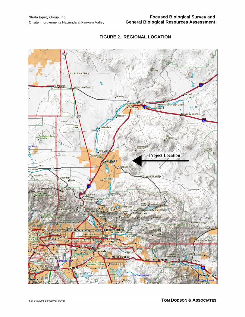
Strata Equity Group, Inc. Focused Biological Survey and Offsite Improvements Hacienda at Fairview Valley General Biological Resources Assessment
SEI-3472008 Bio Survey (rev3) TOM DODSON & ASSOCIATES
FIGURE 2. REGIONAL LOCATION

Strata Equity Group, Inc. Focused Biological Survey and Offsite Improvements Hacienda at Fairview Valley General Biological Resources Assessment
SEI-3472008 Bio Survey (rev3) TOM DODSON & ASSOCIATES
FIGURE 3. VICINITY MAP

Strata Equity Group, Inc. Focused Biological Survey and Offsite Improvements Hacienda at Fairview Valley General Biological Resources Assessment
SEI-3472008 Bio Survey (rev2) TOM DODSON & ASSOCIATES
FIGURE 4. CONCEPTUAL OFFSITE IMPROVEMENTS LOCATIONS

Strata Equity Group, Inc. Focused Biological Survey and Offsite Improvements Hacienda at Fairview Valley General Biological Resources Assessment
SEI-3472008 Bio Survey (rev3) TOM DODSON & ASSOCIATES
FIGURE 5. PROJECT SITE & STUDY LOCATIONS
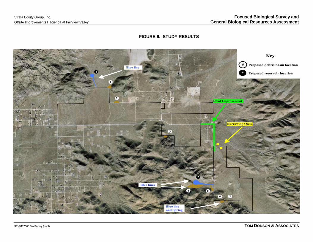
Strata Equity Group, Inc. Focused Biological Survey and Offsite Improvements Hacienda at Fairview Valley General Biological Resources Assessment
SEI-3472008 Bio Survey (rev3) TOM DODSON & ASSOCIATES
FIGURE 6. STUDY RESULTS

Strata Equity Group, Inc. Focused Biological Survey andOffsite Improvements Hacienda at Fairview Valley General Biological Resources Assessment
SEI-347/2008 Bio Survey (rev3) TOM DODSON & ASSOCIATES
SITE PHOTOS

Strata Equity Group, Inc. Focused Biological Survey and
Offsite Improvements Hacienda at Fairview Valley General Biological Resources Assessment
SEI-3472008 Bio Survey (rev3) TOM DODSON & ASSOCIATES
Photo 1. Showing overall environmental setting in a vicinity area view from Joshua Road, looking east, towards the project site.
Photo 2. Looking east along Cahuilla Road near intersection with Laguna Seca Road

Strata Equity Group, Inc. Focused Biological Survey and
Offsite Improvements Hacienda at Fairview Valley General Biological Resources Assessment
SEI-3472008 Bio Survey (rev3) TOM DODSON & ASSOCIATES
Photo 3. Looking south from Cahuilla Road towards the general location for the proposed Detention Basin (DB) No. 3.
Photo 4. Looking west along Cahuilla Road near intersection with Chicago Road.

Strata Equity Group, Inc. Focused Biological Survey and
Offsite Improvements Hacienda at Fairview Valley General Biological Resources Assessment
SEI-3472008 Bio Survey (rev3) TOM DODSON & ASSOCIATES
Photo 5. Looking northwest along Chicago Road south of Cahuilla Road.
Photo 6. Looking northeast along Chicago Road south of Cahuilla Road.

Strata Equity Group, Inc. Focused Biological Survey and
Offsite Improvements Hacienda at Fairview Valley General Biological Resources Assessment
SEI-3472008 Bio Survey (rev3) TOM DODSON & ASSOCIATES
Photo 7. Looking southwest from Chicago Road towards the general locations for the proposed DB Nos. 4 and 5 and proposed Reservoir No. 2.
Photo 8. Looking north from south of Cahuilla Road towards the general location for the proposed DB No. 1 and proposed Reservoir No. 1.

Strata Equity Group, Inc. Focused Biological Survey and
Offsite Improvements Hacienda at Fairview Valley General Biological Resources Assessment
SEI-3472008 Bio Survey (rev3) TOM DODSON & ASSOCIATES
Photo 9. Example of degraded habitat conditions found within portions of the survey area of Cahuilla Road and Chicago Road.
Photo 10. Example of high quality habitat conditions found within portions of the survey area of Cahuilla Road and Chicago Road.