journal of hydrology - nasa swot - home · 2017-01-19 · the csk constellation, two visit...
TRANSCRIPT

Journal of Hydrology 495 (2013) 252–266
Contents lists available at SciVerse ScienceDirect
Journal of Hydrology
journal homepage: www.elsevier .com/locate / jhydrol
Scheduling satellite-based SAR acquisition for sequential assimilationof water level observations into flood modelling
0022-1694 � 2013 The Authors. Published by Elsevier B.V.http://dx.doi.org/10.1016/j.jhydrol.2013.03.050
⇑ Corresponding author. Address: ESSC, Harry Pitt Building, 3 Earley Gate,University of Reading, Whiteknights Campus, RG6 6AH, Reading, UK. Tel.: +44118 378 7722; fax: +44 118 378 6413.
E-mail address: [email protected] (J. García-Pintado).
Open access under CC BY license.
Javier García-Pintado a,b,⇑, Jeff C. Neal c, David C. Mason a,b, Sarah L. Dance a,b, Paul D. Bates c
a School of Mathematical and Physical Sciences, University of Reading, UKb National Centre for Earth Observation, University of Reading, Reading, UKc School of Geographical Sciences, University of Bristol, Bristol, UK
a r t i c l e i n f o
Article history:Received 27 July 2012Received in revised form 10 December 2012Accepted 30 March 2013Available online 13 April 2013This manuscript was handled byKonstantine P. Georgakakos, Editor-in-Chief,with the assistance of Ehab A. Meselhe,Associate Editor
Keywords:Data assimilationRemote sensingSynthetic Aperture RadarFlood forecastingUrban floodParameter estimation
s u m m a r y
Satellite-based Synthetic Aperture Radar (SAR) has proved useful for obtaining information on floodextent, which, when intersected with a Digital Elevation Model (DEM) of the floodplain, provides waterlevel observations that can be assimilated into a hydrodynamic model to decrease forecast uncertainty.With an increasing number of operational satellites with SAR capability, information on the relationshipbetween satellite first visit and revisit time and forecast performance is required to optimise the opera-tional scheduling of satellite imagery. By using an Ensemble Transform Kalman Filter (ETKF) and a syn-thetic analysis with the 2D hydrodynamic model LISFLOOD-FP based on a real flooding case affecting anurban area (summer 2007, Tewkesbury, Southwest UK), we evaluate the sensitivity of the forecast per-formance to visit parameters. We emulate a generic hydrologic–hydrodynamic modelling cascade byimposing a bias and spatiotemporal correlations to the inflow error ensemble into the hydrodynamicdomain. First, in agreement with previous research, estimation and correction for this bias leads to a clearimprovement in keeping the forecast on track. Second, imagery obtained early in the flood is shown tohave a large influence on forecast statistics. Revisit interval is most influential for early observations.The results are promising for the future of remote sensing-based water level observations for real-timeflood forecasting in complex scenarios.
� 2013 The Authors. Published by Elsevier B.V. Open access under CC BY license.
1. Introduction focused on assimilating SAR-derived WLOs into hydrodynamic
Hydrodynamic simulation is a basic tool used by most real-timeflood forecasting systems. Remote sensing has proved useful forobtaining water level observations (WLOs) during flood events. Inthe UK, as in many other places, a difficulty for flood observationis that standard gauges are typically sited only every �20 km, sogive little information on the spatial variations in the flood level,which may be particularly important in urban areas. Much morespatial information is contained in the flood extents captured in sa-tellite Synthetic Aperture Radar (SAR) images. SAR is generallyused for flood detection rather than visible-band sensors becauseof its all-weather day-night capability. Distributed water levelsmay be estimated indirectly along the flood extents in SAR imagesby intersecting the extents with a floodplain Digital ElevationModel (DEM) (Horritt et al., 2003; Lane et al., 2003; Raclot, 2006;Schumann et al., 2007). Consequently, a number of studies have
forecasting models (e.g., Neal et al., 2009; Hostache et al., 2010;Matgen et al., 2010; Giustarini et al., 2011). Specifically, Nealet al. (2009) analysed how dense a gauge network would need tobe to match the performance of SAR-derived WLOs in a data assim-ilation context.
In the future, an alternative will be direct space-borne WLOs athigh resolution using NASA/CNES’s Surface Water and OceanTopography (SWOT) mission, which will use Ka-band radar inter-ferometry to measure surface water levels to 10 cm accuracy onrivers �100 m wide. However, as SWOT is not scheduled for launchuntil 2020 and will not measure levels for floods less than 100 mwide, the water levels from SAR flood boundaries should continueto be an important source of data for assimilation into models,especially in the near future (Mason et al., 2012b).
Data assimilation is an iterative approach to the problem ofestimating the state of a dynamical system using both currentand past observations of the system together with a model forthe system’s time evolution. Within Data Assimilation (DA), theensemble Kalman Filter (EnKF) is becoming a method of choicefor large-scale data assimilation systems, along with variationalmethods, in a number of Earth science disciplines. For hydrody-namic experiments, e.g., Andreadis et al. (2007), Durand et al.(2008), Biancamaria et al. (2011) succesfully assimilated virtual

J. García-Pintado et al. / Journal of Hydrology 495 (2013) 252–266 253
observations of the proposed SWOT mission with simulations fromthe LISFLOOD-FP hydraulic model (Bates and De Roo, 2000). Specif-ically, the studies by Andreadis et al. (2007), Biancamaria et al.(2011) were based on the square root implementation of the anal-ysis scheme proposed by Evensen (2004). In variational techniques,Lai and Monnier (2009) used 4D-var to assimilate spatially distrib-uted water levels into a shallow-water flood model. Alternatively,Matgen et al. (2010), Giustarini et al. (2011) evaluated the perfor-mance of assimilation schemes based on the Particle Filter (PF),which does not require the Gaussian distribution of error assumedby the EnKF and variational methods. These two studies used SAR-derived WLOs, the former with synthetic and the latter with tworeal observations (ERS-2 and ENVISAT). However, their studies,both in a 19-km reach of the Alzette River, used the 1-D HEC-RAS hydrodynamic model within a single transect and one up-stream boundary condition. With their model setup, the problemhad a state vector length n = 144, and they used 64 particles to ap-proach the PF problem. While Matgen et al. (2010) comment thattheir methodology can be extended to rivers with more complexgeometry (which would need a 2-D model), they do not considerthe issue of increase in dimensionality. As an example, the problemin the present study includes a number of distributed boundaryconditions and affects rural and urban areas. To adequately repre-sent the geometry, we consider 664 � 408 = 270,902 pixels withina rectangular domain. Just considering flooded cells in the model,the maximum extent of the flooded area is about 15,200 pixels.The state vector length is thus more than 100 times bigger thatin these two studies. The feasibility of the ensemble Kalman filterwith ensemble sizes much smaller than the state dimension hasbeen demonstrated in operational numerical weather prediction(e.g., Houtekamer and Mitchell, 2005), and has some theoreticaljustification (e.g.,Furrer and Bengtsson, 2007). Conversely, as, dis-cussed by Snyder et al. (2008), there are results showing that thestandard particle filter must have an ensemble size exponentiallylarge in the variance of the observation log likelihood or the filterwill suffer from a ‘‘collapse’’. Thus, despite current research to im-prove the PF efficiency for large dimensional problems, it remainsunclear whether it will be a viable alternative in a near future forthese operational flooding problems in areas with high human oreconomical risk.
Both EnKF and PF are Monte Carlo-based filters that require anumber of ensembles of model runs to represent the forecastuncertainty. 2-D hydrodynamic models for simulating floods areexpensive to run in ensemble mode with the result that, in opera-tional cases, watershed scale hydrodynamic modelling is currentlyprohibitive, and thus the hydrodynamic model must either be re-stricted to a computationally feasible domain or use a lower reso-lution, which may not be adequate. In order to increase forecastlead times, within a modelling cascade, a low resolution hydrologicmodel can be used for obtaining the watershed response to rainfall,and this response can be used as input flow boundary conditionsfor the hydrodynamic model.
For ensemble simulations, the spread of the hydrologic modelresponses represents the hydrologic forecast uncertainty. Also,the ensemble mean will differ from the true watershed response.This difference will take the form of a time-correlated mean error,which will be considered a bias if it remains stationary during thetime span of the simulations. The evolution of this mean error willbe a function of the various errors inherent in the data (mostlyrainfall) and the hydrologic model. This mean error in the inputto the hydrodynamic domain tends to offset the benefit of theDA within the hydrodynamic model.
It has been shown that the persistence of DA improvement onhydrodynamic model simulations is limited if DA is just used forupdating the state vector (water stage), as the errors in upstreamboundary conditions can have a dominating effect on the flooded
area within a short time after the assimilation step. To tackle thisproblem, some studies have proposed to estimate and correct theerror in upstream inflows (Andreadis et al., 2007; Matgen et al.,2010), with different approaches. In general, DA can be used toestimate uncertain model parameters. From a DA point of view, in-put flow boundary conditions, as well as friction in land and chan-nels, can be considered as parameters to be estimated; theirdifference, as mentioned above, being that inflow errors have amuch higher variability in time than friction parameters can have.
Satellite-based SAR acquisitions have an undeniable cost towater authorities and risk management services. Although it ispossible to obtain a sequence of SAR images of a flood using datafrom several different uncoordinated satellites, the only satelliteconstellation currently available to provide image sequences isthe COSMO-SkyMed (CSK) constellation, which has sufficientlyhigh resolution (up to 1 m) to image flooding in urban areas. COS-MO-SkyMed is an Italian Space Agency constellation with four sat-ellites in sun-synchronous orbit with a 97.9� inclination. In adecision-making scenario (an imminently forecasted flood), forthe CSK constellation, two visit parameters must be taken into ac-count; the first visit time (the time of the first SAR image acquisi-tion) and the revisit time (the time between two consecutiveacquisitions over the same target). CSK offers 12 h and 24 h revisittimes. Too late a first visit may miss important information forforecasting purposes, while one that is too early may provide littleinformation or be prematurely scheduled without any further flooddevelopment, so incurring unnecessary costs.
We are interested in maximising the capability of remotely-sensed WLOs to decrease the forecast uncertainty. Here we evalu-ate the influence of the time of the first visit and revisit time on theerror characteristics of the flood event. We assume that the differ-ence in time between the acquisition of the CSK image and thetime at which its WLOs are available to the user (the informationage) is negligible. In practice the event sequence is not currentlynear real-time for high resolution SARs, though may become soin the near future. Operational considerations concerned withacquiring high resolution satellite SAR images of a developing floodand extracting WLOs in near real-time have been considered inMason et al. (2012a,b). CSK is likely to be followed by other con-stellations with lower information ages (e.g., Sentinel-1). The aimof this paper is to be generic, so that the issue of information ageshould be an additional consideration for the particular satelliteconcerned.
This study builds upon previous analyses of remotely-sensedWLO DA. Our main goal is to evaluate the sensitivity of the fore-casting and DA performance to a number of realistic hypotheticalvisit scenarios using satellite-based SAR WLOs. For this, we use areal flood in an urban area and real inflow measurements as basescenario, but employ a controlled identical twin experiment forthe study. Firstly, we obtain a family of three curves that showmean forecast statistics (Root Mean Square Error) for the eventas a function of visit times. Each curve represents a revisit time(Dta = 12 h, 24 h, and 48 h), and is built up by successively delayingthe time of the first visit but keeping a common last visit time (at alate stage within the flood event). Secondly, for a selected revisit/DA time (Dta = 24 h) we simulate a budget-limited scenario, bysuccessively delaying a fixed number of SAR overpasses As a DAtechnique, we use an Ensemble Transform Kalman Filter (ETKF)and conduct parameter (inflow errors) estimation through aug-mentation of the state vector. We expand the discussion by high-lighting related issues, such as the importance of inflow errorestimation and the evolution of the correct spread, that should de-serve further consideration in operational environments withsequential DA.
The rest of this paper is organised as follows: In Section 2, wedescribe the experimental design, the study domain, the hydrody-

254 J. García-Pintado et al. / Journal of Hydrology 495 (2013) 252–266
namic model, the generation of synthetic satellite observations, theensemble filter, the generation of inflow boundary condition er-rors, and the applied verification methods. In Section 3, we presentand discuss the results, describing the influence of updating the in-flow boundary conditions during the assimilation process, the evo-lution of the ensemble during the sequential assimilation, and thesensitivity to first visit and revisit times. Conclusions are providedin Section 4.
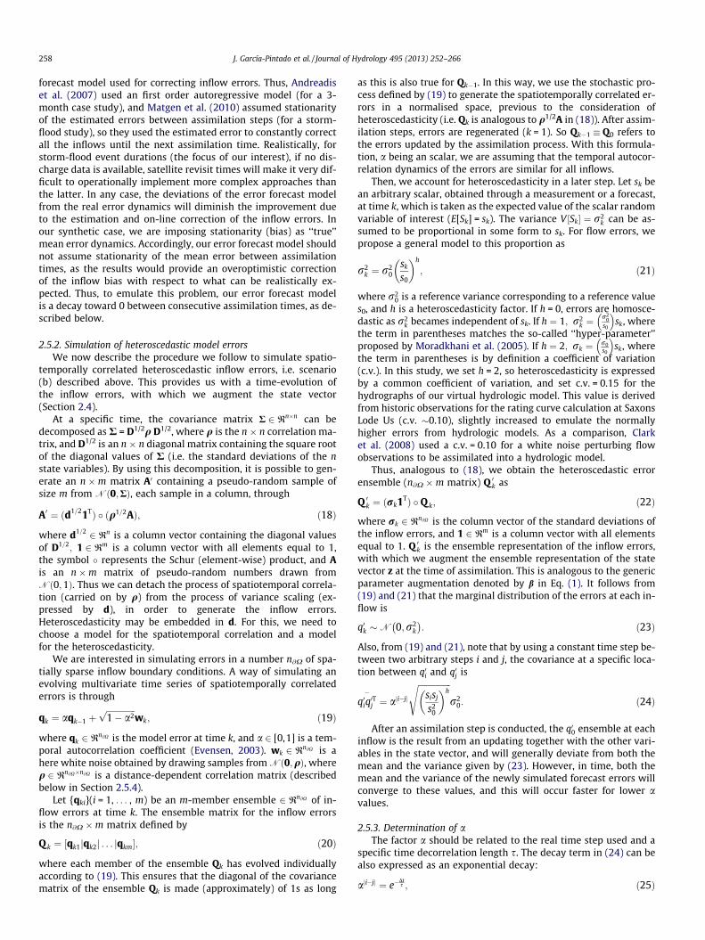
Fig. 1. Study domain. OSGB 1936 British National Grid projection; coordinates inmeters. Grey labels indicate major rivers (thick black lines). The red polygonsurrounds the Tewkesbury urban area. Orange labels/dots refer to inflow boundaryconditions, some of them on smaller tributaries (thin black lines). The orange line tothe South indicates a time-varying stage boundary condition. Green labels/dotsshow locations with available stage observations for the event, from which we justuse their locations as a reference in the current study. The background is the 75 mresolution DEM used for the model, based on upscaling the NEXTMAP British digitalterrain model.
2. Methods
2.1. Experimental design
We use an identical twin experiment with a hydrodynamicmodel grounded in a real flood event. In this study, we assume thatfriction is known and constant (e.g., through prior model calibra-tion), but that inflows are poorly known and their errors are esti-mated and corrected by the filter. For this, we choose pre-calibrated friction parameters for the floodplain and channels,and a set of measured inflow/stage boundary conditions to simu-late a ‘‘true’’ event. Then, we obtain synthetic SAR-type WLOs fromthis ‘‘truth’’, and for the same period we corrupt the inflow bound-ary conditions to generate an ensemble of inflows with added er-rors. As we assume that measured inflows are the truth, togenerate the ensemble of inflows, we first impose a stationarymean error as a multiplicative bias on this truth. Then, the biasedinflow time series are further corrupted by spatiotemporallly-cor-related errors to generate the ensemble of inflows into the studydomain. This is described in Section 2.5. The inflow ensemble isused for generating an open-loop simulation, without DA, and forall the simulations assimilating the synthetic WLOs under variousSAR visit scenarios.
Within ensemble Kalman filters and several contexts, it hasbeen shown that as the size of the ensembles increases, correla-tions are estimated more accurately (e.g., Houtekamer and Mitch-ell, 2001). Note that ensemble Kalman filtering quantifiesuncertainty only in the space spanned by the ensemble. If compu-tational resources restrict the number of ensemble members m tobe much smaller than the number of model variables n, this can bea severe limitation. Here, for our �1.5 � 104 effective state vectorlength (pixels within the flooded area), we arbitrarily set theensemble size m = 210 as a relatively big one in comparison withthat from typical operational applications with high computationaldemand, as is this case. The size of m was chosen to keep reason-able computing times given available computing resources. In thisstudy, we do not conduct any test of the forecast-error covariancesensitivity to the ensemble size, and we do not use localisation.Nevertheless, we investigate the ensemble reliability for the cho-sen size (see Section 3). We assume that the system can be repre-sented on a discrete grid and, for the purposes of this study only,that the system model is ‘‘perfect’’, i.e. it gives an exact descriptionof the true behaviour of the system.
2.2. Study domain and hydrodynamic model
This study focuses on the area of the lower Severn and Avon riv-ers in South West United Kingdom, over a 30.6 � 49.8 km2
(1524 km2) domain. The case study is 1-in-150-year flood eventthat took place in July 2007 in the area. It resulted in substantialflooding of urban and rural areas, with about 15_00 homes in Tew-kesbury being flooded (Mason et al., 2010; Schumann et al., 2011).Tewkesbury lies at the confluence of the Severn, flowing from theNorthwest, and the Avon, flowing in from the Northeast. Fig. 1 de-picts the domain for the current study. The peak of the flood(> 550 m3 s�1 at Saxons Lode Us) occurred on July 22, and the river
did not return to bank-full until July 31 (� 350 m 3 s�1 at SaxonsLode Us).
We set up time-varying boundary conditions from real mea-surements of seven input flows and one downstream stage timeseries (see Fig. 1). The three boundary conditions with highest in-flows were Bewdley (peak inflow Qp = 300 m3 s�1) in the Severn,Evesham (Qp = 465 m3 s�1) in the Avon, and Knightsford Bridge(Qp = 315 m3 s�1) in the Teme. The Severn also had inflows fromKidder Callows (Qp = 33 m3 s�1) and Hardford Hill (Qp = 36 m3 s�1),prior to its junction with the Teme. The Avon also had a sharp,short duration, inflow from Hinton (Qp = 85 m3 s�1), and from Bes-ford Bridge (Qp = 315 m3 s�1), downstream. The Supplementarymaterial includes plots for all hydrographs.
The simulation interval goes from 2007-07-19 13:00:00 UTC to2007-08-01 19:15:00 UTC, and all time series have a 150 temporalresolution. The area is modelled by the flood inundation model LIS-FLOOD-FP, a coupled 1D/2D hydraulic model based on a raster grid(Bates and De Roo, 2000). It predicts water depth in each grid cellat each time step. After each assimilation step, the model is re-ini-tialized with the updated state vector (water stage). LISFLOOD-FPhas several formulations. Here, we apply the so-call ‘‘sub-grid’’ ap-proach described by Neal et al. (2012). This scheme uses a compu-tationally efficient finite difference numerical scheme adapted

J. García-Pintado et al. / Journal of Hydrology 495 (2013) 252–266 255
from the reach scale inundation model of Bates et al. (2010), andutilises gridded river network data, assuming a rectangular chan-nel geometry. This is a scheme that considers the diffusion and lo-cal inertial term of the 1D shallow water equations as a means ofincreasing stable time steps. These 1D equations are solved foreach face of a 2D grid cell to provide a 2D solution that is decou-pled in x and y. Neal et al. (2012) analyse the scheme for an appli-cation in the River Niger Inland delta regarding the simulation ofwater surface elevation, inundation and wave propagation. LIS-FLOOD-FP is here applied to the domain with 75 m pixel resolu-tion. Thus, the domain is 408 � 664 = 270,912 pixels, but themaximum extent of the flooded area is about 15,200 pixels. Thesource digital terrain model (DTM) was the NEXTMap British digi-tal terrain model dataset (5 � 5 m resolution), derived from air-borne Interferometric Synthetic Aperture Radar (IFSAR), whichwas upscaled by explicitly removing channel depth, later parame-trized into the sub-grid geometry. To describe the channel geome-try, we used the power law relationship d = kwc between thechannel width (w) and depth (d), where we used the parametersk = 0.30, and c = 0.78. For the main rivers, we estimated meanchannel widths from field campaigns, and calibrated k and c usingwithin bank water level dynamics measured by the availablegauges, using the same method as Neal et al. (2012). Width valueswere w = 20, 35, 50, and 60 m for the Teme, Avon, Severn upstreamof its junction with the Avon, and Severn downstream from thisjunction, respectively. For smaller tributaries we kept the same kand c values, and assigned widths in 5–15 m on the basis of drain-age areas obtained from the DTM. These seemed reasonable whencross-checked with field observations. Simulations are run with aninitial time step of 20 s, which is internally adapted for every timestep by the model to optimise calculations. The 15 min input timeseries are linearly interpolated in time within the model to beadapted to the internal time step. The Manning friction parametersused for the channels and floodplain are nch = 0.035 and nfp = 0.06,respectively.
2.3. Virtual satellite observations
Distributed water levels may be estimated indirectly along theflood extents in SAR images by intersecting the extents with thefloodplain topography. The WLOs are produced as a continuousline along the boundary of a flood extent, and it is necessary to se-lect a subset of level observations at individual points along theboundary for assimilation, because errors in adjacent levels alongthe flood extent will be strongly correlated (Mason et al., 2012b;Stephens et al., 2012). In theory, this is a tractable problem as cor-related errors could be included into the assimilation procedurethrough a correct specification of the non-diagonal values in theobservation error covariance matrix R. However, in practice it isextremely difficult to correctly estimate these covariances, and ifthey are not correctly specified the filter will deviate from the opti-mal; e.g., the updated state will be excessively biased towards theobservations if their error covariances are underestimated or as-sumed zero (Stewart et al., 2008). It is more straightforward to fil-ter out observations so that just a subset with uncorrelated errorsis assimilated. In the terminology of DA, this is commonly knownas ‘‘thinning’’.
In our synthetic experiment, we obtained, every 12 h, the grid-ded stages of the ‘‘true’’ simulation of the flood event. Note againthat in real cases, satellite-based SAR samples only provide waterelevations along the flood edge. Then, we used the thinning proce-dure described by Mason et al. (2012b), which itself is based onOchotta et al. (2005). This uses a Moran’s I test to ensure that thesamples remaining after thinning have no spatial autocorrelationat the 5% significance level, so that zero covariance can be assumedbetween observations. We assumed a standard deviation for the
thinned set of WLOs of 0.25 m, with zero mean bias. This is themean error in the estimate of water surface height at the final sam-pling points. These values are realistic as they were obtained fromWLOs extracted from real high resolution SAR images of flood ex-tents observed over this domain, and the absence of bias was val-idated with DEM-independent gauge-based WLOs (Mason et al.,2012b). The standard deviation includes components due to uncer-tainties both in the position of the SAR flood waterline and in theDEM. Height errors due to waterline position uncertainty were re-duced by selecting waterline samples in flooded areas on low DEMslopes. The base Dt = 12 h WLO dataset was used to create the var-ious first-visit-time and revisit-time (Dta = 12 h, 24 h, and 48 h)scenarios.
2.4. Ensemble filter
Unknown parameters can be estimated as part of the dataassimilation by using state space augmentation (Friedland, 1969).As the model state is augmented with model parameters, correla-tions develop between the parameters and the model variables. Indata assimilation schemes using such an approach, the analysis up-dates an augmented state vector,
x ¼zb
� �; ð1Þ
where z is the ns-dimensional model state and b is a genericnb-dimensional vector of parameters. Thus x is the augmentedn-dimensional state vector, with n = ns + nb. Here, we follow thisapproach with an ensemble representation, where our parametersare the inflow errors at the assimilation time. Then, in our case, aftereach assimilation step, the updated z (an ensemble of water stagegrids) evolves by integrating each member of the ensemble forwardin time with the LISFLOOD-FP model, and, independently, theupdated ensemble of inflow errors evolves in time according toour error forecast model (described in Section 2.5.2).
The Kalman filter equations (Kalman, 1960) to update the statevector in a linear system are:
xa ¼ xf þ Kðy �Hxf Þ; ð2ÞPa ¼ ðI� KHÞPf ; ð3Þ
where the forecast (prior) and analysis (posterior) quantities are de-noted by the superscripts f and a, respectively; y 2 Rp is the vectorof observations; H is the p � n observation matrix (or ‘‘observation’’or ‘‘forward’’ operator) mapping the state vector to the observationspace; P is the n � n state error covariance matrix; I is the n � nidentity matrix; and K is the n � p Kalman gain matrix:
K ¼ Pf HTðHPf HT þ RÞ�1; ð4Þ
where the superscript ‘‘T’’ denotes matrix transposition, and R is thep � p observation error covariance matrix.
The Ensemble Kalman Filter (EnKF) was introduced by Evensen(1994). It makes it possible to apply the Kalman filter to high-dimensional discrete systems, when the explicit storage andmanipulation of the system state error covariance is impossibleor impractical. The EnKF methods may be characterised by theapplication of the analysis equations given by the Kalman filterto an ensemble of forecasts.
Let {xi}(i = 1, . . . , m) be an m-member ensemble 2 Rn. Theensemble mean is the vector defined by
�x ¼ 1m
Xm
i¼1
xi: ð5Þ
The ensemble perturbation matrix for the augmented state isthe n �m matrix defined by

256 J. García-Pintado et al. / Journal of Hydrology 495 (2013) 252–266
X ¼ 1ffiffiffiffiffiffiffiffiffiffiffiffiffim� 1p ½x1 � �xjx2 � �xj . . . jxm � �x�: ð6Þ
The ensemble covariance matrix P is typically assumed to be carriedby the ensemble by means of the relation
P ¼ XXT ¼ 1m� 1
Xm
i¼1
ðxi � �xÞðxi � �xÞT: ð7Þ
In addition to linear problems, the EnKF-based methods havebeen applied to nonlinear problems, as is our case. In general, the(possibly nonlinear) observation operator H maps state variablesx to observed variables y:
y ¼ HðxtÞ þ �; ð8Þ
where the superscript t denotes the true state, and � results from acombination of instrument error and representation error. Thecovariance h ��Ti is the abovementioned R.
Within the EnKF methods, the Ensemble Square Root Filters(ESRFs) is a family in which both the ensemble mean and theensemble perturbations are updated explicitly, so that the analysiserror covariance matches the theoretical value given by the Kal-man filter (Tippett et al., 2003). The ETKF is a specific formulationwithin the ESRF. The ensemble mean is updated by using the anal-ysis Eq. (2), and the ensemble perturbations are updated by anensemble m �m transform matrix T:
Xa ¼ Xf T; ð9Þ
such that the analysed covariance matrix obtained from Xa using (9)matches the theoretical value (3):
Xf TðXf TÞT ¼ ðI� KHÞXf ðXf ÞT: ð10Þ
The forecast ensemble perturbation matrix, for a linear H, isYf = HXf. By defining the matrix
D ¼ Yf ðYf ÞT þ R; ð11Þ
and using (4) and (10) can be rearranged as
TTT ¼ I� ðYf ÞTD�1Yf ; ð12Þ
whose right-hand side may be rewritten using the Sherman–Morri-son–Woodbury identity (Tippett et al., 2003, Eq. (15)) as
I� ðYf ÞTD�1Yf ¼ ðIþ ðYf ÞTR�1Yf Þ�1: ð13Þ
Since (I + (Yf)TR�1Yf) is a symmetric positive definite matrix,whose eigenvectors are equivalent to the eigenvectors of(Yf)TR�1Yf,
TTT ¼ CðIþ CÞ�1CT; ð14Þ¼ ðCðIþ CÞ�1=2ÞðCðIþ CÞ�1=2ÞT; ð15Þ
where the columns in C contain the orthonormal eigenvectors of(Yf)TR�1Yf, and the diagonal matrix C contains the correspondingeigenvalues. This provides the solution
T ¼ CðIþ CÞ�1=2; ð16Þ
which is the ‘‘one-sided’’ solution given by Bishop et al. (2001).Clearly, any orthogonal matrix U (i.e. UUT = I) can be attached tothe right-hand side of (14) to provide an alternative solution. Spe-cifically, being C orthogonal, one solution is
T ¼ CðIþ CÞ�1=2CT; ð17Þ
which is called the ‘‘symmetric solution’’ by Ott et al. (2004) or the‘‘spherical simplex’’ solution by Wang et al. (2004), and is alsoequivalent to the Local Ensemble Transform Kalman Filter (LETKF)solution given by Hunt et al. (2007) in the case without localisation.
The solution (17) is unbiased (Livings et al., 2008; Sakov and Oke,2008), and is the solution adopted in this study.
The state space of our model is a water stage grid. We simplyuse a linear mapping H from the state space into the SAR-derivedWLOs by locating the inundated, and with ‘‘running water’’, gridpoint closest to each individual observation. Thus, for each obser-vation, the stage of this closest grid point is mapped, with a weightequal to 1, while remaining grid points have a weight equal to 0. His thus a sparse matrix containing 1s and 0s. The ‘‘running water’’criterion refers to pixels whose water depth is above a threshold(1 mm in this study) considered as surface depression storage, be-low which water is not routed, and the pixel becames hydraulicallydisconnected from the main flooded area.
2.5. Ensemble generation
2.5.1. Perturbation to model inputsThe performance of most ensemble forecasts is influenced by
the quality of the ensemble generation method, the forecast model,and also the analysis scheme. The perturbation of the forcing datato generate an ensemble of forecasted model state vectors is a keyfeature in the EnKF family. Here we assume that the model is freeof structural errors and parameter uncertainty, so that all modelerrors arise from forcing data, i.e. input flow boundary conditions.At gauged points, errors in streamflows stem both from measure-ment errors in water level measurements and uncertainties inthe rating curves (stage-flow relationships). It is acknowledgedthat errors in flow measurements are heteroscedastic (propor-tional to flow), and a number of approaches have been proposedto generate the error ensemble for the inflow boundary conditionsinto hydrodynamic models. On the other hand, errors attributed tomissing lateral flow inputs through the domain boundary, not ac-counted for in the point flow boundary conditions, are not neces-sarily related to flow measurements.
For DA studies, several authors have perturbed the input forcingof a hydrologic model to obtain an ensemble of inflows into thehydrodynamic domain. In this way, Andreadis et al. (2007) usedthe VIC model with perturbed precipitation fields, and included anegative bias of 25% to the VIC simulated flows. Similarly, Matgenet al. (2010), Giustarini et al. (2011) used the CLM hydrologic mod-el, the former including a positive 25% bias to the CLM generatedhydrographs, and the latter without adding any bias. Biancamariaet al. (2011) used Empirical Orthogonal Functions (EOFs), followingthe methodology developed by Auclair et al. (2003), to perturb themost statistically significant modes of precipitation and tempera-ture fields as input to the ISBA model, whose ensemble hydrographoutput drove the hydrodynamic model LISFLOOD-FP. However, thestatistics of the final inflow perturbations into the hydrodynamicmodel are not evident in these studies. For studies focused on DAwithin the hydrodynamic model it is useful to have a clear viewof final inflow perturbations, as it is the errors in the hydrodynamicmodel and their value relative to the observation errors that deter-mine the weight given to observations in the DA analysis.
In essence, from the point of view of the generation of the in-flows for hydrodynamic models, and domains with a number oftributaries and boundary conditions, we could pose two generalscenarios: (a) input flows from real gauge observations and (b) in-put flows forecast by a hydrologic model. In both cases, the errorevolution at each inflow will have some degree of temporal auto-correlation. On the other hand, scenario (a) should not show a sig-nificant correlation, if any, between the errors at the various gaugelocations, as errors in stage measurements and uncertainties in rat-ing curves are normally independent between sites. In contrast,scenario (b) will generally introduce a, normally high, spatial cor-relation between the errors at the various inflows. The degree ofthis spatial correlation will be highly dependent on the perturba-

J. García-Pintado et al. / Journal of Hydrology 495 (2013) 252–266 257
tion of the forcing—chiefly precipitation fields—onto the hydrologicmodel, and the hydrologic model structure and parameters. Forcomplex hydrodynamic domains, this distinction is key, as it willgovern the development of the correlations in the state vector,and the general DA behaviour. Existing spatial correlation betweenboundary errors in different tributaries may well lead to one WLO(either from remote sensing or a standard gauge) at the head of onetributary to influence the error estimation at the others. This maybe, especially for sparse observations (as is common for stagegauges), a positive DA outcome in linked hydrologic–hydrody-namic models as, in general, it will make the observations moreinfluential in both correcting the hydrodynamic state and, possibly,correcting the hydrologic model errors. However, for scenario (a), ifspatial correlations between inflow errors are erroneously as-sumed, or are developed as spurious in Monte Carlo-based meth-ods (e.g., due to limited ensemble size), the DA updates couldlead to biased error estimates.
In the current study, we evaluate a flood scenario with availablereal inflow measurements at the major tributaries. With this data-set, scenario (a) can be simulated by generating spatially-indepen-dent time-autocorrelated (and heteroscedastic) random errors toperturb measured inflows, and scenario (b) can be simulated byincorporating a spatiotemporal autocorrelation into the heteros-cedastic errors.
With the number of operational gauges actually declining in theworld (Vörösmarty et al., 2001), and considering that a linkedhydrologic–hydrodynamic model should lead to increased floodforecast lead times, we choose scenario (b) for the remainder ofthis study. This approach has an advantage over selecting a specifichydrologic model in that it can be regarded as using a ‘‘generic’’hydrologic model whose influence in generating inflow boundaryconditions is explicitly modelled and known. This clarifies theanalysis for our study.
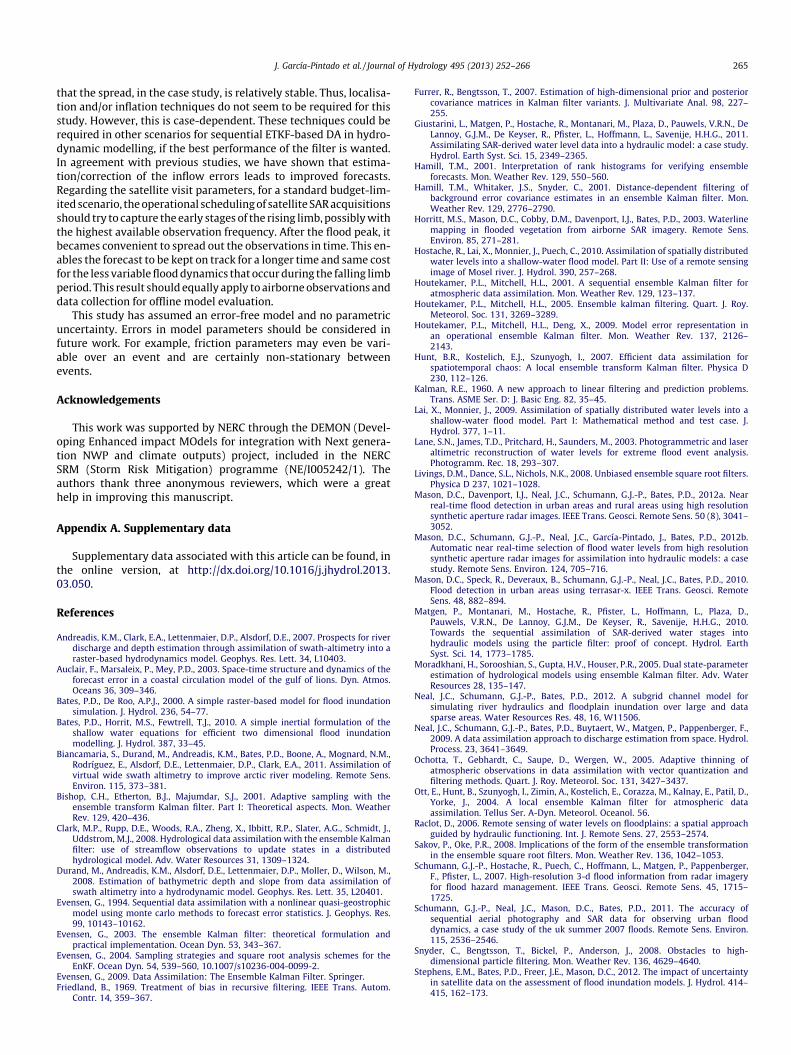
Below, within Section 2.5.2, we detail how we simulate the in-flow ensembles with random errors. As an example of the differ-ence between the scenarios (a and b) when used with the
Fig. 2. Spatial covariance developed after five daily (Dta = 24 h) SAR assimilation steps betthe Severn river, and water stage in the domain, for (a) no spatial covariance in the timeand (b) Gaussian-decay spatial covariance present (representing hydrologic model-dh = 62,000 m for (b).
described ETKF, Fig. 2 shows, for the study domain, the covariancebetween the inflow errors at Bewdley and water stage in the do-main, after 5 forecast/DA steps, for both scenarios, for a revisit timeDta = 24 h. In both simulations the state vector is augmented withthe inflow errors, which are updated every DA step. Clearly, for thecase (b) where a spatial covariance is imposed between the errorsat the various inflows, a positive cross-covariance develops notonly between the state variable (stage) at the various tributaries,but also between inflow errors and stages at locations which arequite separate. In both cases the covariance is propagated in theflow direction downstream (for a sub-critical flow the covariancecould also propagate upstream), while the covariance developmentis counterbalanced by the effect of the temporal decorrelation inthe errors.
In real cases, the temporal characteristics of the errors in anensemble of hydrologic model forecasts are not known. Here wesimulate these errors by imposing a deterministic error, as a mul-tiplicative bias (20%) to all flow measurements, and then by addingspatiotemporally correlated random errors to perturb the biasedmean input flow to obtain the input inflow ensemble, which drivesthe hydrodynamic model. The imposed bias is reasonable givenknowledge of real world discharge errors. It is noted that a biasis a particular case of error dynamics between the true hydrographand the mean of the hydrograph ensemble that could be generatedby a hydrologic model. In the real and general case, this mean errorwill not be stationary in time. Previous studies have indicated thatthe improvement in forecasting skills due to assimilation of obser-vations may have a short time span in hydrodynamic domains, asthe inflow errors propagate downstream counterbalancing theimprovement. So, the inflow errors estimated at the assimilationtime can be used to correct boundary inflows until the next assim-ilation time, increasing the persistence of error reductions betweentimes of observations (e.g., Andreadis et al., 2007; Matgen et al.,2010). In real cases, the assumptions one can make about the evo-lution of this error between consecutive assimilation steps, as wellas the available information, should lead the design of the error
ween errors at the inflow boundary condition at Bewdley (red circle), at the North of-correlated inflow errors (representing measurement-driven hydrodynamic model)riven hydrodynamic model). See details in Section 2.5. s = 3 days for both, and
258 J. García-Pintado et al. / Journal of Hydrology 495 (2013) 252–266
forecast model used for correcting inflow errors. Thus, Andreadiset al. (2007) used an first order autoregressive model (for a 3-month case study), and Matgen et al. (2010) assumed stationarityof the estimated errors between assimilation steps (for a storm-flood study), so they used the estimated error to constantly correctall the inflows until the next assimilation time. Realistically, forstorm-flood event durations (the focus of our interest), if no dis-charge data is available, satellite revisit times will make it very dif-ficult to operationally implement more complex approaches thanthe latter. In any case, the deviations of the error forecast modelfrom the real error dynamics will diminish the improvement dueto the estimation and on-line correction of the inflow errors. Inour synthetic case, we are imposing stationarity (bias) as ‘‘true’’mean error dynamics. Accordingly, our error forecast model shouldnot assume stationarity of the mean error between assimilationtimes, as the results would provide an overoptimistic correctionof the inflow bias with respect to what can be realistically ex-pected. Thus, to emulate this problem, our error forecast modelis a decay toward 0 between consecutive assimilation times, as de-scribed below.
2.5.2. Simulation of heteroscedastic model errorsWe now describe the procedure we follow to simulate spatio-
temporally correlated heteroscedastic inflow errors, i.e. scenario(b) described above. This provides us with a time-evolution ofthe inflow errors, with which we augment the state vector(Section 2.4).
At a specific time, the covariance matrix R 2 Rn�n can bedecomposed as R = D1/2q D1/2, where q is the n � n correlation ma-trix, and D1/2 is an n � n diagonal matrix containing the square rootof the diagonal values of R (i.e. the standard deviations of the nstate variables). By using this decomposition, it is possible to gen-erate an n �m matrix A0 containing a pseudo-random sample ofsize m from Nð0;RÞ, each sample in a column, through
A0 ¼ ðd1=21TÞ � ðq1=2AÞ; ð18Þ
where d1=2 2 Rn is a column vector containing the diagonal valuesof D1=2; 1 2 Rm is a column vector with all elements equal to 1,the symbol � represents the Schur (element-wise) product, and Ais an n �m matrix of pseudo-random numbers drawn fromNð0;1Þ. Thus we can detach the process of spatiotemporal correla-tion (carried on by q) from the process of variance scaling (ex-pressed by d), in order to generate the inflow errors.Heteroscedasticity may be embedded in d. For this, we need tochoose a model for the spatiotemporal correlation and a modelfor the heteroscedasticity.
We are interested in simulating errors in a number n@X of spa-tially sparse inflow boundary conditions. A way of simulating anevolving multivariate time series of spatiotemporally correlatederrors is through
qk ¼ aqk�1 þffiffiffiffiffiffiffiffiffiffiffiffiffiffi1� a2p
wk; ð19Þ
where qk 2 Rn@X is the model error at time k, and a 2 [0,1] is a tem-poral autocorrelation coefficient (Evensen, 2003). wk 2 Rn@X is ahere white noise obtained by drawing samples from Nð0;qÞ, whereq 2 Rn@X�n@X is a distance-dependent correlation matrix (describedbelow in Section 2.5.4).
Let {qki}(i = 1, . . . , m) be an m-member ensemble 2 Rn@X of in-flow errors at time k. The ensemble matrix for the inflow errorsis the n@X �m matrix defined by
Q k ¼ ½qk1jqk2j . . . jqkm�; ð20Þ
where each member of the ensemble Qk has evolved individuallyaccording to (19). This ensures that the diagonal of the covariancematrix of the ensemble Qk is made (approximately) of 1s as long
as this is also true for Qk�1. In this way, we use the stochastic pro-cess defined by (19) to generate the spatiotemporally correlated er-rors in a normalised space, previous to the consideration ofheteroscedasticity (i.e. Qk is analogous to q1/2A in (18)). After assim-ilation steps, errors are regenerated (k = 1). So Qk�1 � Q0 refers tothe errors updated by the assimilation process. With this formula-tion, a being an scalar, we are assuming that the temporal autocor-relation dynamics of the errors are similar for all inflows.
Then, we account for heteroscedasticity in a later step. Let sk bean arbitrary scalar, obtained through a measurement or a forecast,at time k, which is taken as the expected value of the scalar randomvariable of interest (E[Sk] = sk). The variance V ½Sk� ¼ r2
k can be as-sumed to be proportional in some form to sk. For flow errors, wepropose a general model to this proportion as
r2k ¼ r2
0sk
s0
� �h
; ð21Þ
where r20 is a reference variance corresponding to a reference value
s0, and h is a heteroscedasticity factor. If h = 0, errors are homosce-dastic as r2
k becames independent of sk. If h ¼ 1; r2k ¼
r20
s0
� �sk, where
the term in parentheses matches the so-called ‘‘hyper-parameter’’proposed by Moradkhani et al. (2005). If h ¼ 2; rk ¼ r0
s0
� �sk, where
the term in parentheses is by definition a coefficient of variation(c.v.). In this study, we set h = 2, so heteroscedasticity is expressedby a common coefficient of variation, and set c.v. = 0.15 for thehydrographs of our virtual hydrologic model. This value is derivedfrom historic observations for the rating curve calculation at SaxonsLode Us (c.v. �0.10), slightly increased to emulate the normallyhigher errors from hydrologic models. As a comparison, Clarket al. (2008) used a c.v. = 0.10 for a white noise perturbing flowobservations to be assimilated into a hydrologic model.
Thus, analogous to (18), we obtain the heteroscedastic errorensemble (n@X �m matrix) Q 0k as
Q 0k ¼ ðrk1TÞ � Q k; ð22Þ
where rk 2 Rn@X is the column vector of the standard deviations ofthe inflow errors, and 1 2 Rm is a column vector with all elementsequal to 1. Q 0k is the ensemble representation of the inflow errors,with which we augment the ensemble representation of the statevector z at the time of assimilation. This is analogous to the genericparameter augmentation denoted by b in Eq. (1). It follows from(19) and (21) that the marginal distribution of the errors at each in-flow is
q0k �N 0;r2k
: ð23Þ
Also, from (19) and (21), note that by using a constant time step be-tween two arbitrary steps i and j, the covariance at a specific loca-tion between q0i and q0j is
q0iq0Tj
�¼ aji�jj
ffiffiffiffiffiffiffiffiffiffiffiffiffiffiffiffisisj
s20
� �hs
r20: ð24Þ
After an assimilation step is conducted, the q00 ensemble at eachinflow is the result from an updating together with the other vari-ables in the state vector, and will generally deviate from both themean and the variance given by (23). However, in time, both themean and the variance of the newly simulated forecast errors willconverge to these values, and this will occur faster for lower avalues.
2.5.3. Determination of aThe factor a should be related to the real time step used and a
specific time decorrelation length s. The decay term in (24) can bealso expressed as an exponential decay:
aji�jj ¼ e�Dts ; ð25Þ

J. García-Pintado et al. / Journal of Hydrology 495 (2013) 252–266 259
which relates a and s, and clarifies that, disregarding the heteros-cedastic variance term in (24), the covariance in time between q0iand q0j is damped by a ratio e�1 over a time period Dtij = s (see Even-sen, 2003). For a specific time step k of length Dtk, then
ak ¼ e�Dtks ; ð26Þ
which allows one to use (19) for any time step length by subtitutinga by the corresponding ak, and, instead of (24), the error covariance,at each inflow, between any two time steps (i, j) is more genericallyexpressed as
q0iq0Tj
�¼
ffiffiffiffiffiffiffiffiffiffiffiffiffiffiffiffisisj
s20
� �hs
r20
Yj
k¼iþ1
ak: ð27Þ
2.5.4. Spatial correlation model for inflow errorsThe spatial correlation matrix q, for generation of the white
noise wk in (19), can be created by any procedure which considersthat correlation in inflow errors is dependent on the distance be-tween the locations of the point inflow boundary conditions. Herewe chose the Gaussian-decay correlation model
qij ¼ e�12
dijh
2
; ð28Þ
where the subscripts i and j refer to any two boundary conditions,qij 2 [0,1] is the corresponding spatial correlation and element inq,dij is the distance between the corresponding locations, and h isa spatial correlation coefficient.
2.5.5. Selection of s and h and inflow error estimationAs abovementioned (Section 2.5.1), the true dynamics of the
mean error of measured or forecasted inflows are unknown in realcases. In this synthetic study we impose a deterministic stationarybias as a ‘‘true’’ mean error evolution, and we approach the DAproblem as if we did not know about this error evolution to evalu-ate how it influences the forecast, and how DA is able to partiallysolve for it. To emulate errors from a ‘‘generic’’ hydrologic model,we first imposed a positive 20% bias on measured inflows. Thenwe perturbed the biased inflows with spatiotemporally correlatederrors to generate the inflow ensemble. Generally, errors in precip-itation inputs, and hydrologic model parameters and structurescan generate a wide range of possible spatiotemporal correlationsin the simulated hydrographs. Thus, two single values of s and hcannot embrace all possible situations. Here, our parameters forthe error forecast model were s = 3 days and h = 62,000 m (e.g.,the spatial correlation for the inflow errors between Bewdley andEvesham is 0.8). Despite being arbitrary, we chose these valuesas we believe they are representative of a relatively normal situa-tion with a spatially distributed or semidistributed model, makinguse of continuous rainfall field inputs, and having undergone a cer-tain degree of calibration with previous events. Fig. S1, in the Sup-plementary material, shows a hypothetical example of the errorforecast evolution, after one assimilation step, for two values ofs. In this study, as we have imposed a stationary bias in the truemean error, higher values of s, will lead to better results, as theywill exert a more persistent correction of the bias. So, the inten-tional mismatch between the error forecast model and the station-ary bias serves to emulate the lack of knowledge of the mean errorevolution in real cases. On the other hand, for a real case, the errorforecast model should try to approach the real error dynamics;either by the parsimonious assumption of stationarity (e.g., Matgenet al., 2010), or by more complex models.
2.6. Verification methods
To assess the strength and weaknesses of the forecasts, we usestandard verification methods. The Root Mean Square Error (RMSE)is used as measurement of overall accuracy. The Brier Skill Score(BSS) is used to evaluate the forecast relative to a standard, whichis chosen to represent an unskilled forecast. In our case, the un-skilled forecast is the open loop simulation. The vectorized formof the BSS is
BSS ¼ 1� ðfs � oÞ2�
ðfr � oÞ2� ; ð29Þ
where fs is the evaluated forecast state vector, fr, is the referenceforecast (open loop) vector, o is the actual outcome vector (here,the truth), and the overline denotes the average. The BSS2(�1,1], where BSS = 0 indicates no skill when compared to thereference forecast, and BSS = 1 is a perfect score.
Finally, we use rank histograms for determining the reliabilityof ensemble forecasts and for diagnosis of errors in its mean andspread. A flat rank histogram is usually taken as a sign of reliability.A detailed interpretation of rank histograms for verifying ensembleforecasts is given by Hamill (2001).
3. Results and discussion
3.1. Updating inflow boundary conditions
Our results indicate that the improvement in forecasting skilldue to assimilation of observations may have a short time spanin hydrodynamic domains, as the inflow errors propagate down-stream counterbalancing the improvement. This is in agreementwith previous studies (e.g., Andreadis et al., 2007; Matgen et al.,2010; Giustarini et al., 2011). However, it is also important, in thiscontext, to evaluate how the inflows are corrected at the boundaryconditions themselves, as this is an indicator of the capability ofthe data assimilation scheme to obtain inflow time series thatcan be used as surrogate observations to feed back into an inversehydrodynamic-hydrologic DA modelling cascade.
Fig. 3 compares the evolution of the inflow ensemble at the up-stream boundary condition at Bewdley and the forecasted floodstage at a dowstream location (Worcester) when inflow errorsare not estimated and corrected by the assimilation against thecase when they are corrected. Simulations refer to a SAR assimila-tion revisit time Dta = 24 h. If inflows are not updated they are sim-ilar to an open loop without DA, so the DA-bias line overlies theinput bias one (Fig. 3a). If inflow errors are also estimated and cor-rected according to the used error forecast model, each sequentialassimilation pushes the inflows used by the model toward thetruth (Fig. 3b). In both cases, the DA process does a good job in cor-recting the forecast toward the truth at Worcester. For eachensemble, this is clarified by the upper plots at Worcester, whichshow the evolution of the standard deviation (DA-SDev lines)and the mean bias (DA-bias lines) between the forecast and thetruth. However, if the biases in the inflow (here mostly influencedby Bewdley at the North) are not corrected they have a control ef-fect that, after any assimilation update, causes the forecast to driftaway from the truth, leading to an early overestimation of the floodstage. A similar effect was shown by Matgen et al. (2010). The casewith inflow updating keeps the forecast on track very close to thetruth. Curves at the other inflows and sampled forecast locationsshow similar effects (see Figs. S2–S15; Supplementary material).The speed at which the updated inflows drift away from the truthwhen they are updated is related to the lack of match between theused error forecast model (with s = 3) and the imposed stationary

Fig. 3. Evolution of the inflow at Bewdley (a), and corresponding forecast at Worcester (c), without attempting to estimate/correct the errors in the inflow boundaryconditions. Inflow (b) and forecast (d) are as (a and c), respectively, but estimating and correcting the inflow errors by augmentation of the state vector. For each ensemble atWorcester, upper summary plots show the standard deviation of the ensemble (DA-SDev), and the bias between the mean of the ensemble and the truth (DA-bias). For theinflow at Bewdley, the input bias is also shown. Vertical lines indicate satellite overpass/DA times (D ta = 24 h).
260 J. García-Pintado et al. / Journal of Hydrology 495 (2013) 252–266
bias. As described in Section 2.5, in this case, higher s values wouldresult in a more persistent propagation of the errors estimated atthe assimilation time, giving an improved mean inflow error esti-mation and correction in time with the forecast. In the remainderof this paper we use simulations with updating of the inflow errors,as this leads to a clear forecast improvement. However, we keeps = 3 to emulate the fact that any error forecast model that couldbe chosen for real cases (e.g., a stationary bias model as Matgenet al., 2010) will always fail to completely match the true (non-sta-tionary) inflow error evolution. Here we assumed that frictionparameters are known. In real cases, if friction in the channelsand floodplain are considered to be uncertain, an attempt may bedone to estimate them simultaneously by additional augmentationof the state vector. Generally, with additional parameters to beestimated, the filter would benefit from larger ensemble sizes. Esti-mation of friction, however, is beyond the scope of this study.
3.2. Ensemble properties
The use of a finite ensemble size to approximate the errorcovariance matrix introduces sampling errors that are seen as spu-rious correlations. With each spurious update there is an associ-ated reduction of ensemble variance. This ensemble collapseproblem is present in all EnKF applications and can lead to filterdivergence (Evensen, 2009). To the authors’ knowledge, there isno published study that evaluates the problem of ensemble col-
lapse for hydrologic or hydrodynamic studies using sequentialEnKF-based DA. Let us conduct a quick examination of the proper-ties of the ensemble, taking as an example a simulation withDta = 24 h revisit time, starting on the 20th of July, before the floodgoes out of bank. Fig. 4 shows the evolution of the rank histogramsevaluated with the forecasted ensemble at each assimilation time.To build the histograms, at least 5 �m locations as evenly distrib-uted as possible within the flooded area were taken at each visittime. These locations were used to sample from the truth andthe forecasted ensemble, and the truth was ranked within theensemble. In general, rank histograms in Fig. 4 appear differentfrom uniform and the density concentrates around values lowerthan the rank mean as a result of the bias imposed on the simu-lated inflows. Clearly, the spread starts being too high, resultingfrom the coefficient of variation (c.v. = 0.15) we gave to the inflowerrors in relation with the observation errors, representing thelower trust we have in the hydrologic model output. After that,as the event evolves, the variance decreases and the spread be-comes more adequate. Nevertheless, the ensemble collapse is mod-erate, and the ensemble remains relatively stable along with thesequential assimilation steps. This indicates that the ensemble sizeis enough, in general terms, for the case study. Here we use anensemble size m = 210 for a state vector length of the orderOð104Þ. This is relatively high as compared with some availablestudies oriented to operational uses. For example, Houtekameret al. (2009) used m = 64 for a Numerical Weather Predictions

0.000.050.100.150.200.250.30
2007−07−20p(
rank
)2007−07−21 2007−07−22 2007−07−23 2007−07−24
0.000.050.100.150.200.250.30
2007−07−25
p(ra
nk)
2007−07−26 2007−07−27 2007−07−28 2007−07−29
0 50 100 150 200
0.000.050.100.150.200.250.30
2007−07−30
Rank
p(ra
nk)
0 50 100 150 200
2007−07−31
Rank0 50 100 150 200
2007−08−01
RankJul 21 Jul 26 Jul 31
0
100
200
300
400
Inflow hydrographs
Time
Flow
[m
3 s−1]
Fig. 4. Evolution of the rank histogram evaluated for the forecast ensemble at each assimilation time for the Dta = 24 h revisit time simulation. The subplot at the lower-rightcorner is included as a reference indicating the corresponding assimilation times in relation with the various true inflow boundary conditions.
J. García-Pintado et al. / Journal of Hydrology 495 (2013) 252–266 261
(NWP) model with a state vector length of the order Oð107Þ. Note,however, that these highly-dimensional operational NWP prob-lems use methods, known as inflation and localisation, for mini-mising the impact of the spurious updates (e.g., Houtekamer andMitchell, 2001; Hamill et al., 2001). Localisation reduces the prob-lems generated by reduced ensemble sizes by decreasing theweight, through several approaches, given to observations far fromthe estimated state variable (as the subspace in which the analysisis conducted is reduced). Inflation may be applied to either thebackground covariance or the analysis covariance during eachassimilation cycle, and several multiplicative and additive inflationtechniques have been proposed. For example, see the review inHunt et al. (2007). In our study, despite ensemble collapse beingslight, an attempt could have been made to further compensateit through inflation or localisation. However, the spread is influ-enced by the assimilation interval and the start time of the assim-ilation (first visit). Thus we kept the same coefficient of variation asa general adequate value and did not apply any inflation/localisa-tion in order to make comparison among several visit scenariosstraightforward.
3.3. Sensitivity to First visit and revisit times
In a, normally budget-limited, operational context the decisionto task a satellite to acquire SAR images needs to take into accountthe first visit and revisit times. Here we focus on these parameters.There are now a number of sensors acquiring SAR data (RADARSAT,TerraSAR-X, ALOS PALSAR, Cosmo-Skymed, etc.), controlled by anumber of different space agencies. Issues such as the differencein time between the acquisition of the SAR images and the timeat which they are available to the user (the information age) shouldbe considered for any current or future satellite mission. Note alsothat the assimilation strategy may well include satellite informa-tion from different satellites, not pertaining to the same constella-tion. These operational issues, as well as issues of data quality
specific to each sensor are beyond the scope of this paper, whichaims to be relatively generic. Fig. 5 shows the RMSE of the ensem-ble mean with respect to the synthetic truth, evaluated at specificlocations. Each plot shows a family of three curves, which refer tothe revisit/DA times Dta = 12 h, 24 h, and 48 h. For each curve, eachpoint represents the RMSE for the assimilation scenario whose firstvisit is at the point time, and the RMSE is calculated between themean of the ensemble and the truth over the entire time window.For example, for all Dta = 24 h curves in all Fig. 5 plots, the firstpoint results from the simulation referred to by Fig. 3b andFig. 3d. Note that the later a first visit occurs the less visit/DA stepsare conducted, and all the statistics necessarily converge towardsthose from an open loop simulation. It is noted that satellite-basedSAR acquisitions provide reliable water elevation only at locationswhen the flow is overbank. So, at the start of the rising limb, whenflow is still within the river banks, it is highly unlikey to get valu-able remote sensing observations. The RMSE shown at the two in-flow boundary conditions, Bewdley and Evesham, indicates howstate vector augmentation with boundary inflows is able to esti-mate and correct the inflow error. The forecast stage at Worcesteris mostly controlled by the inflow at Bewdley, but also has somecontributions from Kidder Callows and Hardford Hill. Just afterthe junction between the Teme and the Severn, Kempsey also in-cludes the inflow from Knightsford Bridge. The forecast at Bredondepends on inflows from the Avon and its tributaries, i.e. Evesham,Hinton and Besford Bridge inflows.
Generally, for inflows and stage, the improvement due to thedecrease of the revisit time is most clear when assimilation startsat an early stage of the flood event. After the peak stage is reached,from 22th July onwards, the curves have mostly converged. Also,for each D ta curve, the increase in the RMSE at the forecastedstages is very sharp just before the peak stage is reached, that is,when variation in stage is higher. This indicates that the early sa-tellite overpasses on the rising limb, provided WLOs can be ex-tracted from them, are the most useful.

Jul 22 Jul 24 Jul 26 Jul 28 Jul 30 Aug 01
10
15
20
25
30
35
40
RM
SE [m
3 s−1
]bewdley_q :: first visit and revisit time
50
100
150
200
250
300
350
Flow [m
3 s−1]
12h
24h
48h
15
20
25
30
35evesham_q :: first visit and revisit time
0
100
200
300
400
500
12h
24h
48h
0.05
0.10
0.15
worcester_h :: first visit and revisit time
RM
SE [m
]
12
13
14
15
16
17
18
Stage [m]
12h24h
48h
0.04
0.06
0.08
0.10
0.12
0.14
bredon_h :: first visit and revisit time
8
9
10
11
12
13
14
12h
24h48h
0.02
0.04
0.06
0.08
0.10
0.12
0.14
0.16
kempsey_h :: first visit and revisit time
Time of the first visit/DA
RM
SE [m
]
10
11
12
13
14
15
16
12h
24h
48h 0.05
0.10
0.15
mythe_bridge_h :: first visit and revisit time
Time of the first visit/DA
7
8
9
10
11
12
13
14
12h24h
48h
RM
SE [m
3 s−1
]R
MSE
[m]
RM
SE [m
]
Jul 20 Jul 22 Jul 24 Jul 26 Jul 28 Jul 30 Aug 01
Jul 20 Jul 22 Jul 24 Jul 26 Jul 28 Jul 30 Aug 01 Jul 20 Jul 22 Jul 24 Jul 26 Jul 28 Jul 30 Aug 01
Jul 20 Jul 22 Jul 24 Jul 26 Jul 28 Jul 30 Aug 01
Jul 20 Jul 22 Jul 24 Jul 26 Jul 28 Jul 30 Aug 01
Flow [m
3 s−1]
Stage [m]
Stage [m]
Stage [m]
Fig. 5. RMSE for inflows at the two boundary conditions with the highest inflow (Bewdley at the Severn, and Evesham at the Avon), and forecasted stage at four gauges:Worcester, at the river Severn; Kempsey, just after the junction between the Teme and the Severn; Bredon, in the Avon; and Mythe Bridge, in the Severn by Tewkesbury. Trueinflow/stage at the corresponding location is shown as a reference. Curves are calculated for revisit times Dta = 12 h, 24 h, and 48 h. Each point in each curve denotes the firstvisit time and the corresponding RMSE over the entire window.
262 J. García-Pintado et al. / Journal of Hydrology 495 (2013) 252–266
If the observations are too early in relation to the arrival of flow,they do not provide useful information. However, an early overpassmay simultaneously have observations of very low usefulness atdownstream areas and much more valuable observations upstreamif the flow is significant. For example, the assimilation of the 20thJuly overpass WLOs has a negligible benefit for the forecast atMythe Bridge for the Dta = 12 h and 24 h revisit times. This isshown as the corresponding simulations with 21th as first visit
have very similar RMSE values. Later, the 21th overpass has a verysignificant influence on the RMSE at Mythe Bridge, despite the flowbeing still very low at that point at the overpass time. But this isbecause at that time, upstream flow is much higher (e.g., aroundBewdley). The benefit of assimilating upstream observations atthat time is propagated downstream and has time to be highlyinfluential at Mythe Bridge. On the other hand, at the same loca-tion, for the Dta = 48 h revisit time, a first visit at 20th July is very

J. García-Pintado et al. / Journal of Hydrology 495 (2013) 252–266 263
useful. But again this is not because of the observations aroundMythe Bridge at that time, but because the benefit of observationsbeing assimilated upstream has time to reach this point before thenext first visit time is evaluated for this curve (22nd July). The re-visit scenario curves have generally converged after the 22nd–23thJuly, which implies that the differences in the RMSE between thestarting points for the three curves result from the improvementowing to the increased observation frequency during the risinglimb. Interestingly, for the inflow at Evesham and the stage fore-cast at Bredon, when the first visit time is between the 22nd andthe 30th July the curves with Dta = 48 h, show better statistics thanthose with higher observation frequencies. While the differencesare not big, these are related to the dynamics of the inflow at Eve-sham, which includes a secondary peak during the 26th–28th July.Minor modifications in the spread and the covariance create thesedifferences.
The improvement in the forecast with respect to the open loopis indicated by Fig. 6, which shows the evolution of the Brier SkillScore (BSS) for the simulation with Dta = 24 h revisit time startingfrom the 20th of July. Fig. 6 corresponds to the simulation repre-sented by the first point in the Dta = 24 h curves in Fig. 5, and alsoreferred to by Fig. 3b and d). The BSS evolution is calculated againstthe open loop for forecast times t + 6 h, t + 12 h, and t + 24 h, wheret refers to revisit times. The BSS is calculated for the seven inflowboundary conditions (Fig. 6a), and for the forecast stages at theten reference gauge locations (Fig. 6b). Note that after each asimi-lation step, the updated inflow boundary conditions evolve with-out using the hydrodynamic model, but according to thecorrections made by the assimilation and the error forecast modelto the inflows with imposed biases. Thus Fig. 6a mostly displaysthe inversion capability of the filter; but this capability is alsoinfluenced by the model structure, which develops the covariancesbetween the inflows and the state vector (stage), used by the filterwhen SAR WLOs are assimilated.
For both inflows and forecasted stages, the BSS is very highthroughout all the simulation. As expected, the BSS is generallybetter for the t + 6 h forecast time, as the inflow corrections arepartially lost for increasing forecast times, when the updated in-flows drift back to the biased inflows, as shown by Fig. 3b. Still,the BSS for inflows has a very mild and stable decreasing trendalong the simulations. This seems to match the decreasing trendin spread indicated by the rank histograms. For the forecast stage,disregarding the 20th July forecast when flows are still very lowand some observations are too early to be useful, the minimum
0.3
0.4
0.5
0.6
0.7
0.8
0.9
1.0
Time
Brie
r Ski
ll Sc
ore
[ ]
7
8
9
10
11
12
13
14
t+06t+12
t+24
a b
Jul 20 Jul 22 Jul 24 Jul 26 Jul 28 Jul 30 Aug 01
Stage [m]
Fig. 6. Brier Skill Scores (BSSs) for the Dta = 24 h revisit time, starting the 20th of July, stimes t + 6 h, t + 12 h, and t + 24 h. BSS is calculated at (a) the seven inflow boundary condat Saxons Lode US gauge is shown in both subplots as a reference.
values, given for the 25th and 26th July, are still very high(�0.85 to 0.90). After that there is a recovery in the BSS. At the startof the simulation the inflow-stage covariance (e.g., Fig. 2b) fadesfaster downstream from the inflows than at a later time, and so thisresults in the updating for inflows being more influenced by theearly local observations. As the flood event evolves, so do thecovariances, and more SAR WLOs generally farther from theboundary conditions are affecting inflow updatings. So, some non-linearities, and perhaps the development of spurious correlations,are likely affecting the updatings for the lower BSS values.
Finally, a budget-limited scenario is shown by Fig. 7, which con-siders 5 satellite overpasses with Dta = 24 h revisit time and suc-cessively delayed by one day. The RMSE is also calculated overthe entire window. The RMSE patterns are very similar to thosein Fig. 5, with generally increasing RMSE as the observations aredelayed. This indicates that even considering a fixed number of sa-tellite overpasses, the benefit of the DA still propagates down-stream after all observations are completed. This is a similareffect to that shown by Biancamaria et al. (2011), which evaluateda number of synthetic SWOT orbit scenarios with partial coverageon an Artic river, and indicated that those orbits that observed theupstream part of the river compared positively against thoseobserving the downstream area, the reason being that the correc-tions propagate downstream. Still, the simulations with earlyobservations have a higher RMSE than those with the same firstvisit time and Dta = 24 h in Fig. 5, as the cessation of observationsmoves the forecast back towards the open loop. The effect thatobservations that are too early do not provided very useful infor-mation is now well shown by the RMSE evolution at Mythe Bridge,where substitution of the 20th July overpass by the 25th July one(i.e. 1-day delay of the 5 visits) reduces the RMSE. One extra 1-day delay misses the rising limb and results in the largest increasein RMSE among the simulations.
As a summary, at the early stages of the flood event, the forecastwithin highly variable flood dynamics benefits from increasedobservation frequencies (Dta = 12 h revisit time). After the floodpeak, as the event proceeds with smoother flood dynamics, thesensitivity to the revisit time is drastically reduced so it becamesadequate to decrease the observation frequency. This provides alonger time coverage of the event for the same cost.
Here we chose to use the ETKF, which has received a strongattention in recent theoretical and practical studies (e.g., Bishopet al., 2001; Hunt et al., 2007; Livings et al., 2008; Sakov andOke, 2008). Very likely, results from SAR-based WLO assimilation
Jul 22 Jul 24 Jul 26 Jul 28 Jul 30 Aug 01
0.3
0.4
0.5
0.6
0.7
0.8
0.9
1.0
Time
Brie
r Ski
ll Sc
ore
[ ]
7
8
9
10
11
12
13
14
t+06
t+12
t+24
Stage [m]
Jul 20
imulation evaluated against the open loop. At each ta, the BSS is shown for forecastitions, and (b) at the forecasted stages at the 10 reference gauge locations. True stage

Jul 20 Jul 22 Jul 24 Jul 26 Jul 28 Jul 30 Aug 01
20
25
30
35
bewdley_q :: first visit and revisit timeR
MSE
[m3
s− 1]
50
100
150
200
250
300
350
24h
a
Jul 20 Jul 22 Jul 24 Jul 26 Jul 28 Jul 30 Aug 01
15
20
25
30
evesham_q :: first visit and revisit time
RM
SE [m
3s−1
]
0
100
200
300
400
500
24h
b
Jul 20 Jul 22 Jul 24 Jul 26 Jul 28 Jul 30 Aug 01
0.10
0.12
0.14
0.16
0.18worcester_h :: first visit and revisit time
RM
SE [m
]
12
13
14
15
16
17
18
24h
c
Jul 20 Jul 22 Jul 24 Jul 26 Jul 28 Jul 30 Aug 01
0.06
0.08
0.10
0.12
0.14
bredon_h :: first visit and revisit time
RM
SE [m
]
8
9
10
11
12
13
14
24h
d
Jul 20 Jul 22 Jul 24 Jul 26 Jul 28 Jul 30 Aug 01
0.08
0.10
0.12
0.14
kempsey_h :: first visit and revisit time
Time of the first visit/DA
RM
SE [m
]
10
11
12
13
14
15
16
24h
e
Jul 20 Jul 22 Jul 24 Jul 26 Jul 28 Jul 30 Aug 01
0.04
0.06
0.08
0.10
0.12
0.14
0.16
0.18
mythe_bridge_h :: first visit and revisit time
Time of the first visit/DA
RM
SE [m
]
7
8
9
10
11
12
13
14
24h
f
Flow [m
3 s−1]
Flow [m
3 s−1]
Stage [m]
Stage [m]
Stage [m]
Stage [m]
Fig. 7. As Fig. 5 for Dta = 24 h revisit time, but for five SAR overpasses successively delayed by one hour. Each blue point denotes the first visit time, and the correspondingRMSE over the entire window. As an example, for the first and last first visit time, all visits/DA times are shown as grey points.
264 J. García-Pintado et al. / Journal of Hydrology 495 (2013) 252–266
are filter-dependent. A comparative study could shed light on thecomplexity of the implementation of the various available filtersfor data assimilation versus the efficiency for assimilating SAR-based WLOs in inundation problems.
4. Conclusions
This study focuses on the problem of scheduling satellite-basedSAR acquisitions for sequential assimilation of SAR-derived WLOs
into operational flood modelling. In particular, the interest is onareas of human or economic risk, thus involving urban areas whichrequire detailed 2D flood modelling. For this study, we have usedan ETKF and the 2D hydrodynamic model LISFLOOD-FP with asynthetic analysis based on a real flooding case around theSevern–Avon river junction in Southwest UK. We have touched ona number of related issues. Firstly, we have provided a clarificationof the correlations originating from generic hydrologic–hydrodynamic modelling cascades. Secondly, our results indicate
J. García-Pintado et al. / Journal of Hydrology 495 (2013) 252–266 265
that the spread, in the case study, is relatively stable. Thus, localisa-tion and/or inflation techniques do not seem to be required for thisstudy. However, this is case-dependent. These techniques could berequired in other scenarios for sequential ETKF-based DA in hydro-dynamic modelling, if the best performance of the filter is wanted.In agreement with previous studies, we have shown that estima-tion/correction of the inflow errors leads to improved forecasts.Regarding the satellite visit parameters, for a standard budget-lim-ited scenario, the operational scheduling of satellite SAR acquisitionsshould try to capture the early stages of the rising limb, possibly withthe highest available observation frequency. After the flood peak, itbecames convenient to spread out the observations in time. This en-ables the forecast to be kept on track for a longer time and same costfor the less variable flood dynamics that occur during the falling limbperiod. This result should equally apply to airborne observations anddata collection for offline model evaluation.
This study has assumed an error-free model and no parametricuncertainty. Errors in model parameters should be considered infuture work. For example, friction parameters may even be vari-able over an event and are certainly non-stationary betweenevents.
Acknowledgements
This work was supported by NERC through the DEMON (Devel-oping Enhanced impact MOdels for integration with Next genera-tion NWP and climate outputs) project, included in the NERCSRM (Storm Risk Mitigation) programme (NE/I005242/1). Theauthors thank three anonymous reviewers, which were a greathelp in improving this manuscript.
Appendix A. Supplementary data
Supplementary data associated with this article can be found, inthe online version, at http://dx.doi.org/10.1016/j.jhydrol.2013.03.050.
References
Andreadis, K.M., Clark, E.A., Lettenmaier, D.P., Alsdorf, D.E., 2007. Prospects for riverdischarge and depth estimation through assimilation of swath-altimetry into araster-based hydrodynamics model. Geophys. Res. Lett. 34, L10403.
Auclair, F., Marsaleix, P., Mey, P.D., 2003. Space-time structure and dynamics of theforecast error in a coastal circulation model of the gulf of lions. Dyn. Atmos.Oceans 36, 309–346.
Bates, P.D., De Roo, A.P.J., 2000. A simple raster-based model for flood inundationsimulation. J. Hydrol. 236, 54–77.
Bates, P.D., Horrit, M.S., Fewtrell, T.J., 2010. A simple inertial formulation of theshallow water equations for efficient two dimensional flood inundationmodelling. J. Hydrol. 387, 33–45.
Biancamaria, S., Durand, M., Andreadis, K.M., Bates, P.D., Boone, A., Mognard, N.M.,Rodríguez, E., Alsdorf, D.E., Lettenmaier, D.P., Clark, E.A., 2011. Assimilation ofvirtual wide swath altimetry to improve arctic river modeling. Remote Sens.Environ. 115, 373–381.
Bishop, C.H., Etherton, B.J., Majumdar, S.J., 2001. Adaptive sampling with theensemble transform Kalman filter. Part I: Theoretical aspects. Mon. WeatherRev. 129, 420–436.
Clark, M.P., Rupp, D.E., Woods, R.A., Zheng, X., Ibbitt, R.P., Slater, A.G., Schmidt, J.,Uddstrom, M.J., 2008. Hydrological data assimilation with the ensemble Kalmanfilter: use of streamflow observations to update states in a distributedhydrological model. Adv. Water Resources 31, 1309–1324.
Durand, M., Andreadis, K.M., Alsdorf, D.E., Lettenmaier, D.P., Moller, D., Wilson, M.,2008. Estimation of bathymetric depth and slope from data assimilation ofswath altimetry into a hydrodynamic model. Geophys. Res. Lett. 35, L20401.
Evensen, G., 1994. Sequential data assimilation with a nonlinear quasi-geostrophicmodel using monte carlo methods to forecast error statistics. J. Geophys. Res.99, 10143–10162.
Evensen, G., 2003. The ensemble Kalman filter: theoretical formulation andpractical implementation. Ocean Dyn. 53, 343–367.
Evensen, G., 2004. Sampling strategies and square root analysis schemes for theEnKF. Ocean Dyn. 54, 539–560, 10.1007/s10236-004-0099-2.
Evensen, G., 2009. Data Assimilation: The Ensemble Kalman Filter. Springer.Friedland, B., 1969. Treatment of bias in recursive filtering. IEEE Trans. Autom.
Contr. 14, 359–367.
Furrer, R., Bengtsson, T., 2007. Estimation of high-dimensional prior and posteriorcovariance matrices in Kalman filter variants. J. Multivariate Anal. 98, 227–255.
Giustarini, L., Matgen, P., Hostache, R., Montanari, M., Plaza, D., Pauwels, V.R.N., DeLannoy, G.J.M., De Keyser, R., Pfister, L., Hoffmann, L., Savenije, H.H.G., 2011.Assimilating SAR-derived water level data into a hydraulic model: a case study.Hydrol. Earth Syst. Sci. 15, 2349–2365.
Hamill, T.M., 2001. Interpretation of rank histograms for verifying ensembleforecasts. Mon. Weather Rev. 129, 550–560.
Hamill, T.M., Whitaker, J.S., Snyder, C., 2001. Distance-dependent filtering ofbackground error covariance estimates in an ensemble Kalman filter. Mon.Weather Rev. 129, 2776–2790.
Horritt, M.S., Mason, D.C., Cobby, D.M., Davenport, I.J., Bates, P.D., 2003. Waterlinemapping in flooded vegetation from airborne SAR imagery. Remote Sens.Environ. 85, 271–281.
Hostache, R., Lai, X., Monnier, J., Puech, C., 2010. Assimilation of spatially distributedwater levels into a shallow-water flood model. Part II: Use of a remote sensingimage of Mosel river. J. Hydrol. 390, 257–268.
Houtekamer, P.L., Mitchell, H.L., 2001. A sequential ensemble Kalman filter foratmospheric data assimilation. Mon. Weather Rev. 129, 123–137.
Houtekamer, P.L., Mitchell, H.L., 2005. Ensemble kalman filtering. Quart. J. Roy.Meteorol. Soc. 131, 3269–3289.
Houtekamer, P.L., Mitchell, H.L., Deng, X., 2009. Model error representation inan operational ensemble Kalman filter. Mon. Weather Rev. 137, 2126–2143.
Hunt, B.R., Kostelich, E.J., Szunyogh, I., 2007. Efficient data assimilation forspatiotemporal chaos: A local ensemble transform Kalman filter. Physica D230, 112–126.
Kalman, R.E., 1960. A new approach to linear filtering and prediction problems.Trans. ASME Ser. D: J. Basic Eng. 82, 35–45.
Lai, X., Monnier, J., 2009. Assimilation of spatially distributed water levels into ashallow-water flood model. Part I: Mathematical method and test case. J.Hydrol. 377, 1–11.
Lane, S.N., James, T.D., Pritchard, H., Saunders, M., 2003. Photogrammetric and laseraltimetric reconstruction of water levels for extreme flood event analysis.Photogramm. Rec. 18, 293–307.
Livings, D.M., Dance, S.L., Nichols, N.K., 2008. Unbiased ensemble square root filters.Physica D 237, 1021–1028.
Mason, D.C., Davenport, I.J., Neal, J.C., Schumann, G.J.-P., Bates, P.D., 2012a. Nearreal-time flood detection in urban areas and rural areas using high resolutionsynthetic aperture radar images. IEEE Trans. Geosci. Remote Sens. 50 (8), 3041–3052.
Mason, D.C., Schumann, G.J.-P., Neal, J.C., García-Pintado, J., Bates, P.D., 2012b.Automatic near real-time selection of flood water levels from high resolutionsynthetic aperture radar images for assimilation into hydraulic models: a casestudy. Remote Sens. Environ. 124, 705–716.
Mason, D.C., Speck, R., Deveraux, B., Schumann, G.J.-P., Neal, J.C., Bates, P.D., 2010.Flood detection in urban areas using terrasar-x. IEEE Trans. Geosci. RemoteSens. 48, 882–894.
Matgen, P., Montanari, M., Hostache, R., Pfister, L., Hoffmann, L., Plaza, D.,Pauwels, V.R.N., De Lannoy, G.J.M., De Keyser, R., Savenije, H.H.G., 2010.Towards the sequential assimilation of SAR-derived water stages intohydraulic models using the particle filter: proof of concept. Hydrol. EarthSyst. Sci. 14, 1773–1785.
Moradkhani, H., Sorooshian, S., Gupta, H.V., Houser, P.R., 2005. Dual state-parameterestimation of hydrological models using ensemble Kalman filter. Adv. WaterResources 28, 135–147.
Neal, J.C., Schumann, G.J.-P., Bates, P.D., 2012. A subgrid channel model forsimulating river hydraulics and floodplain inundation over large and datasparse areas. Water Resources Res. 48, 16, W11506.
Neal, J.C., Schumann, G.J.-P., Bates, P.D., Buytaert, W., Matgen, P., Pappenberger, F.,2009. A data assimilation approach to discharge estimation from space. Hydrol.Process. 23, 3641–3649.
Ochotta, T., Gebhardt, C., Saupe, D., Wergen, W., 2005. Adaptive thinning ofatmospheric observations in data assimilation with vector quantization andfiltering methods. Quart. J. Roy. Meteorol. Soc. 131, 3427–3437.
Ott, E., Hunt, B., Szunyogh, I., Zimin, A., Kostelich, E., Corazza, M., Kalnay, E., Patil, D.,Yorke, J., 2004. A local ensemble Kalman filter for atmospheric dataassimilation. Tellus Ser. A-Dyn. Meteorol. Oceanol. 56.
Raclot, D., 2006. Remote sensing of water levels on floodplains: a spatial approachguided by hydraulic functioning. Int. J. Remote Sens. 27, 2553–2574.
Sakov, P., Oke, P.R., 2008. Implications of the form of the ensemble transformationin the ensemble square root filters. Mon. Weather Rev. 136, 1042–1053.
Schumann, G.J.-P., Hostache, R., Puech, C., Hoffmann, L., Matgen, P., Pappenberger,F., Pfister, L., 2007. High-resolution 3-d flood information from radar imageryfor flood hazard management. IEEE Trans. Geosci. Remote Sens. 45, 1715–1725.
Schumann, G.J.-P., Neal, J.C., Mason, D.C., Bates, P.D., 2011. The accuracy ofsequential aerial photography and SAR data for observing urban flooddynamics, a case study of the uk summer 2007 floods. Remote Sens. Environ.115, 2536–2546.
Snyder, C., Bengtsson, T., Bickel, P., Anderson, J., 2008. Obstacles to high-dimensional particle filtering. Mon. Weather Rev. 136, 4629–4640.
Stephens, E.M., Bates, P.D., Freer, J.E., Mason, D.C., 2012. The impact of uncertaintyin satellite data on the assessment of flood inundation models. J. Hydrol. 414–415, 162–173.

266 J. García-Pintado et al. / Journal of Hydrology 495 (2013) 252–266
Stewart, L.M., Dance, S.L., Nichols, N.K., 2008. Correlated observation errors in dataassimilation. Int. J. Numer. Methods Fluids 56, 1521–1527.
Tippett, M.K., Anderson, J.L., Bishop, C.H., Hamill, T.M., Whitaker, J.S., 2003.Ensemble square root filters. Mon. Weather Rev. 131, 1485–1490.
Vörösmarty, C., Askew, A., Grabs, W., Barry, R.G., Birkett, C., Dell, P., Goodison,B., Hall, A., Jenne, R., Kitaev, L., Landwehr, J., Keeler, M., Leavesley, G.,
Schaake, Strzepek, K., Sundarvel, S.S., Takeuchi, K., Webster, F., Group,T.A.H., 2001. Global water data: a newly endangered species. EOS Trans.AGU 82, 54–58.
Wang, X., Bishop, C.H., Julier, S.J., 2004. Which is better, an ensemble of positive–negative pairs or a centered spherical simplex ensemble? Mon. Weather Rev.132, 1590–1605.