iuss salinization conference september 20-22, 2009 ...members.iif.hu/tot3700/abstr/tt2009.pdf ·...
TRANSCRIPT

IUSS Salinization Conference
September 20-22, 2009, Budapest
Program and Presentations
Edited by Tibor Tóth
RISSAC-MTA TAKI, Budapest
2009
ISBN 978-963-88438-8-3

ii
PROGRAM OF THE CONFERENCE
2009 September 20th
Sunday. Field trip to Eastern Hungary with
bus
07:00 Departure from the parking lot of Nyugati pályaudvar Railway Station,
Budapest, VI. Teréz krt. 55-57.
09:30 - 10.00 Visit of Karcagpuszta Experimental Drainage Field
10.00 - 10.30 Visit of Lysimeter Station of Karcag Research Institute
10.30 - 12.00 Salt-affected soil profiles
12.00 - 13.00 Lunch
13.00 - 14.00 Travel to Hortobágy National Park
14.00 - 16.00 Visit of Hortobágy National Park
18:30 Arrival to the parking lot of Nyugati pályaudvar Railway Station, Budapest VI.
Teréz krt. 55-57.

iii
2009 September 21st Monday. Conference sessions at Geological
Institute of Hungary, Budapest XIV. Stefánia út 14.
10:00 - 11:20 Opening Session Hydrophysical conditions in saline and sodic areas
-10:00 - 10:40 VÁRALLYAY, György Salinity/sodicity as environmental
stresses in the Carpathian Basin
-10:40 - 11:00 VAN DER ZEE, S. E. A. T. M., S. H. H. SHAH, R. W.
VERVOORT An ecohydrological approach to salinity and sodicity problems in
natural and agro-ecosystems
-11:00-11:20 CHERNOUSENKO, Galina I. Salt-affected soils in the permafrost
zone of Central Yakutia
11:20 - 11:50 Coffee break
11:50 - 12:50 Session Advanced mapping of salt-affected soils
-11:50 - 12:10 RUKHOVICH, Dmitry I., Polina V. KOROLEVA, Yekaterina V.
VIL'CHEVSKAY Natalia V. KALININA, , Svetlana V. RUKHOVICH, Elena
B. DOLININA Methodology of the analysis of the maps of soil salinity to judge
the dynamics of salinization-desalinization processes
-12:10 - 12:30 MARLET, Serge, Fethi BOUKSILA, Wafa GHAZOUANI, Insaf
MEKKI Multi-scale analysis of soil salinization. A Case study from an oasis in
Tunisia
-12:30 – 12:50 DAKAK, Houria,Brahim SOUDI, Ahmed DOUAIK, Aicha
BENMOHAMMADI, Mohamed BADRAOUI, Fatima-Zohra CHERKAOUI
Mapping the risk of soil salinization: application of electromagnetic induction and
non-parametric geostatistics
12:50 - 13:50 Lunch break
13:50 - 14:50 Session Remote sensing of salt-affected soils
-13:50 - 14:10 KOKOEVA, G., S. MAMYTKANOV Integrating remote sensing,
cartographical and GPS-based ground data for salt-affected soils identification,
case study: Talas Valley (Kyrgyzstan)
-14:10 - 14:30 KONYUSHKOVA, Mariya V. Large-scale mapping of solonetzic
complexes in the Northern Caspian Lowland using automated interpretation of
Quickbird images
-14:30 - 14:50 TAZEH, M., R. TAGHIZADEH MEHRJARDI, Sh. MAHMOODI
Application of remote sensing to soil salinity mapping in the arid region (Iran)
14:50 - 15:20 Coffee break

iv
15:20 - 16:20 Session Groundwater problems and effects
-15:20 - 15:40 HANSON, Blaine, Don MAY, Jirka ŠIMŮNEK, Jan HOPMANS
Salinity control under saline shallow ground water conditions of the San Joaquin
Valley, California
-15:40 - 16:00 KERÉK, Barbara, László KUTI, Ubul FÜGEDI Groundwater
under salt affected soils
-16:00 - 16:20 LAHLOU, Mouanis, Brahim SOUDI Diagnosis and control of
salinity and nitrate pollution in Mediterranean irrigated agriculture. The case of
Beni Amir (TADLA – Morocco)
16:20 - 17:20 Poster session
-AMEZKETA, E., V. URDANOZ, I. BARINAGARREMENTERIA, L.
ALBIZUA, J. DEL VALLE DE LERSUNDI Relating remote sensing data to
apparent soil electrical conductivity for assessing soil salinity in agricultural
and natural fields
-BAKACSI, Zsófia, Tibor TÓTH The effect of changing sampling strategy on
salt-affected soil profile data evaluation
-BALOG, Kitti, Andrea FARSANG Secondary salinization caused by used
thermal water seeping
-BARNA, Gyöngyi, János RAKONCZAI Temporal changes of salt affected
soils of Szabadkígyósi puszta
-DEMIRKIRAN, Ali Rıza Studies on the prevention of salinization of peat soils
-EL-GHAMRY, A. M., A. A. MOSA, A., G. A. K. REHAM Evaluating the
ability of hyper accumulator plants for the reclamation of salt affected soils
-FEDOTOVA, A. V., L. V. YAKOVLEVA New approach to the ecological
standardization of saline soils
-GALLALI, Tahar Saline water irrigation effect on soil organic carbon
sequestration
-HARMAT, Adrienn, Katalin BAA, András MAKÓ Environmental impact of
thermal water release on surface water at Kis-Balaton reservoir, in Hungary
-HOLTHUSEN, Dörthe, Stephan PETH, Rainer HORN Impact of different salts
on the microstructural soil stability for various textures measured with a
rheological test
-KHAKIPOUR, Nazanin Production of auxin hormone by fluorescent
Pseudomonas

v
-KHITROV, Nikolai, Yuri TCHEVERDIN Regeneration and evolution of
solonetz properties in soils of Kamennaya steppe for the second half or the 20th
century
-MATUS, G., O. VALKÓ, P. TÖRÖK, M. PAPP, E. VIDA, A. KELEMEN, T.
MIGLÉCZ, B. TATÁR, S. KÉKI, T. TÓTH Using propagule mimics to model
seed bank formation in salinized soils
-NOVÁK, Tibor, Kirsten BECKER, Luise GIANI Modification of solonetz soil
profile characteristics caused by organic matter influx on the livestock resting
sites of Hortobágy, Hungary
-RATHORE, Shabnam, Karl STAHR, Boris VASHEV Monitoring and
assessment of coastal saline soils in southern region (Badin) Pakistan
-SZALAI, Zoltán, Gergely JAKAB, Klaudia KISS, Katalin FEHÉR Vegetation
induced patterns of soil redox conditions and dissolved iron
-YAKOVLEVA, L. V., A. V. FEDOTOVA Soil salinization in the Volga delta
landscapes
19:00 - 21:00 Conference dinner
vi
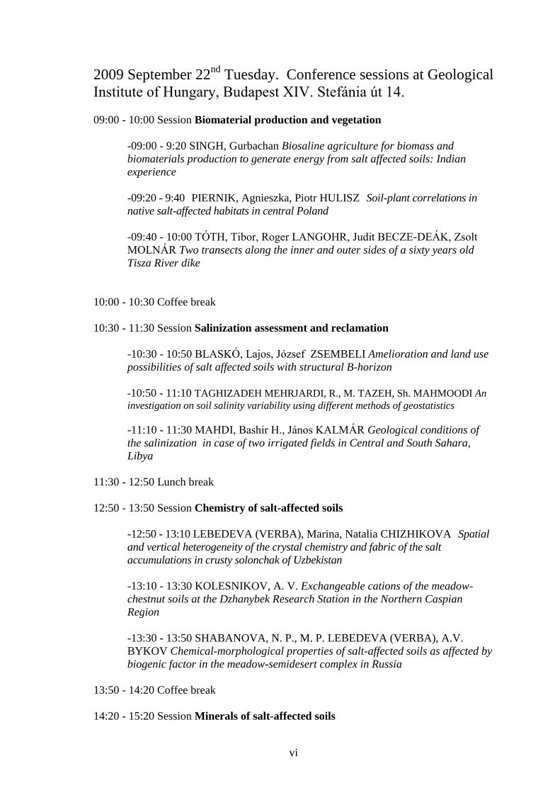
2009 September 22nd
Tuesday. Conference sessions at Geological
Institute of Hungary, Budapest XIV. Stefánia út 14.
09:00 - 10:00 Session Biomaterial production and vegetation
-09:00 - 9:20 SINGH, Gurbachan Biosaline agriculture for biomass and
biomaterials production to generate energy from salt affected soils: Indian
experience
-09:20 - 9:40 PIERNIK, Agnieszka, Piotr HULISZ Soil-plant correlations in
native salt-affected habitats in central Poland
-09:40 - 10:00 TÓTH, Tibor, Roger LANGOHR, Judit BECZE-DEÁK, Zsolt
MOLNÁR Two transects along the inner and outer sides of a sixty years old
Tisza River dike
10:00 - 10:30 Coffee break
10:30 - 11:30 Session Salinization assessment and reclamation
-10:30 - 10:50 BLASKÓ, Lajos, József ZSEMBELI Amelioration and land use
possibilities of salt affected soils with structural B-horizon
-10:50 - 11:10 TAGHIZADEH MEHRJARDI, R., M. TAZEH, Sh. MAHMOODI An
investigation on soil salinity variability using different methods of geostatistics
-11:10 - 11:30 MAHDI, Bashir H., János KALMÁR Geological conditions of
the salinization in case of two irrigated fields in Central and South Sahara,
Libya
11:30 - 12:50 Lunch break
12:50 - 13:50 Session Chemistry of salt-affected soils
-12:50 - 13:10 LEBEDEVA (VERBA), Marina, Natalia CHIZHIKOVA Spatial
and vertical heterogeneity of the crystal chemistry and fabric of the salt
accumulations in crusty solonchak of Uzbekistan
-13:10 - 13:30 KOLESNIKOV, A. V. Exchangeable cations of the meadow-
chestnut soils at the Dzhanybek Research Station in the Northern Caspian
Region
-13:30 - 13:50 SHABANOVA, N. P., M. P. LEBEDEVA (VERBA), A.V.
BYKOV Chemical-morphological properties of salt-affected soils as affected by
biogenic factor in the meadow-semidesert complex in Russia
13:50 - 14:20 Coffee break
14:20 - 15:20 Session Minerals of salt-affected soils
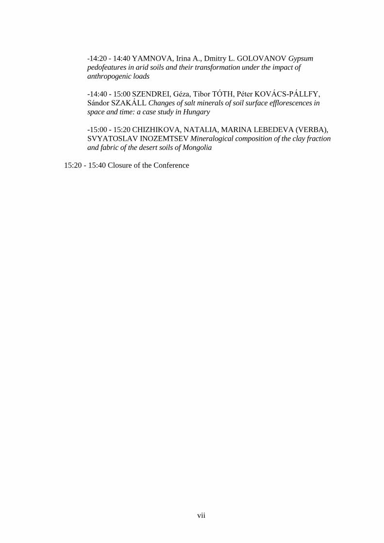
vii
-14:20 - 14:40 YAMNOVA, Irina A., Dmitry L. GOLOVANOV Gypsum
pedofeatures in arid soils and their transformation under the impact of
anthropogenic loads
-14:40 - 15:00 SZENDREI, Géza, Tibor TÓTH, Péter KOVÁCS-PÁLLFY,
Sándor SZAKÁLL Changes of salt minerals of soil surface efflorescences in
space and time: a case study in Hungary
-15:00 - 15:20 CHIZHIKOVA, NATALIA, MARINA LEBEDEVA (VERBA),
SVYATOSLAV INOZEMTSEV Mineralogical composition of the clay fraction
and fabric of the desert soils of Mongolia
15:20 - 15:40 Closure of the Conference

viii
ABSTRACTS OF PRESENTATIONS
ix
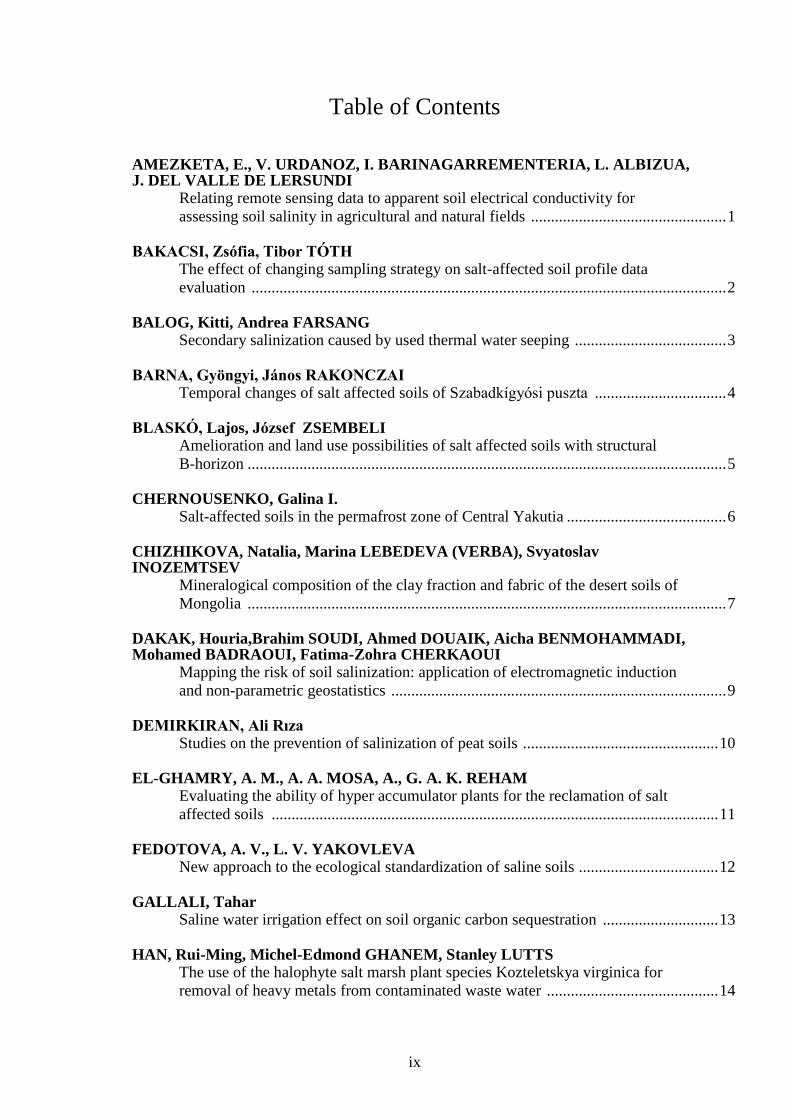
Table of Contents
AMEZKETA, E., V. URDANOZ, I. BARINAGARREMENTERIA, L. ALBIZUA, J. DEL VALLE DE LERSUNDI
Relating remote sensing data to apparent soil electrical conductivity for
assessing soil salinity in agricultural and natural fields ................................................. 1
BAKACSI, Zsófia, Tibor TÓTH
The effect of changing sampling strategy on salt-affected soil profile data
evaluation ....................................................................................................................... 2
BALOG, Kitti, Andrea FARSANG
Secondary salinization caused by used thermal water seeping ...................................... 3
BARNA, Gyöngyi, János RAKONCZAI
Temporal changes of salt affected soils of Szabadkígyósi puszta ................................. 4
BLASKÓ, Lajos, József ZSEMBELI
Amelioration and land use possibilities of salt affected soils with structural
B-horizon ........................................................................................................................ 5
CHERNOUSENKO, Galina I.
Salt-affected soils in the permafrost zone of Central Yakutia ........................................ 6
CHIZHIKOVA, Natalia, Marina LEBEDEVA (VERBA), Svyatoslav INOZEMTSEV
Mineralogical composition of the clay fraction and fabric of the desert soils of
Mongolia ........................................................................................................................ 7
DAKAK, Houria,Brahim SOUDI, Ahmed DOUAIK, Aicha BENMOHAMMADI, Mohamed BADRAOUI, Fatima-Zohra CHERKAOUI
Mapping the risk of soil salinization: application of electromagnetic induction
and non-parametric geostatistics .................................................................................... 9
DEMIRKIRAN, Ali Rıza
Studies on the prevention of salinization of peat soils ................................................. 10
EL-GHAMRY, A. M., A. A. MOSA, A., G. A. K. REHAM
Evaluating the ability of hyper accumulator plants for the reclamation of salt
affected soils ................................................................................................................ 11
FEDOTOVA, A. V., L. V. YAKOVLEVA
New approach to the ecological standardization of saline soils ................................... 12
GALLALI, Tahar
Saline water irrigation effect on soil organic carbon sequestration ............................. 13
HAN, Rui-Ming, Michel-Edmond GHANEM, Stanley LUTTS
The use of the halophyte salt marsh plant species Kozteletskya virginica for
removal of heavy metals from contaminated waste water ........................................... 14

x
HANSON, Blaine, Don MAY, Jirka ŠIMŮNEK, Jan HOPMANS Salinity control under saline shallow ground water conditions of the San Joaquin
Valley, California ......................................................................................................... 15
HARMAT, Adrienn, Katalin BAA, András MAKÓ
Environmental impact of thermal water release on surface water at Kis-Balaton
reservoir, in Hungary ................................................................................................... 16
HOLTHUSEN, Dörthe, Stephan PETH, Rainer HORN
Impact of different salts on the microstructural soil stability for various textures
measured with a rheological test .................................................................................. 17
HUSEYNOVA, S. M., M. P. BABAYEV, F. M. RAMAZANOVA
Biogenity of the irrigated meadow grey soils of Azerbaijan dry subtropics ............... 18
KERÉK, Barbara, László KUTI, Ubul FÜGEDI
Groundwater under salt affected soils .......................................................................... 21
KHAKIPOUR, Nazanin
Production of auxin hormone by fluorescent Pseudomonas ........................................ 22
KHITROV, Nikolai, Yuri TCHEVERDIN
Regeneration and evolution of solonetz properties in soils of Kamennaya steppe
for the second half or the 20th century ........................................................................ 23
KOKOEVA, G., S. MAMYTKANOV
Integrating remote sensing, cartographical and GPS-based ground data for salt-
affected soils identification, case study: Talas Valley (Kyrgyzstan) ........................... 24
KOLESNIKOV, A. V.
Exchangeable cations of the meadow-chestnut soils at the Dzhanybek Research
Station in the Northern Caspian Region ...................................................................... 25
KONYUSHKOVA, Mariya V.
Large-scale mapping of solonetzic complexes in the Northern Caspian Lowland
using automated interpretation of Quickbird images ................................................... 26
LAHLOU, Mouanis, Brahim SOUDI
Diagnosis and control of salinity and nitrate pollution in Mediterranean irrigated
agriculture. The case of Beni Amir (TADLA – Morocco) .......................................... 27
LEBEDEVA (VERBA), Marina, Natalia CHIZHIKOVA
Spatial and vertical heterogeneity of the crystal chemistry and fabric of the salt
accumulations in crusty solonchak of Uzbekistan ....................................................... 28
MAHDI, Bashir H., János KALMÁR
Geological conditions of the salinization in case of two irrigated fields in
Central and South Sahara, Libya .................................................................................. 29
MARLET, Serge, Fethi BOUKSILA, Wafa GHAZOUANI, Insaf MEKKI
Multi-scale analysis of soil salinization.
A Case study from an oasis in Tunisia ......................................................................... 30

xi
MATUS, G., O. VALKÓ, P. TÖRÖK, M. PAPP, E. VIDA, A. KELEMEN, T. MIGLÉCZ, B. TATÁR, S. KÉKI, T. TÓTH
Using propagule mimics to model seed bank formation in salinized soils .................. 31
NOVÁK, Tibor, Kirsten BECKER, Luise GIANI
Modification of solonetz soil profile characteristics caused by organic matter
influx on the livestock resting sites of Hortobágy, Hungary ....................................... 32
PIERNIK, Agnieszka, Piotr HULISZ
Soil-plant correlations in native salt-affected habitats in central Poland ..................... 33
RATHORE, Shabnam, Karl STAHR, Boris VASHEV
Monitoring and assessment of coastal saline soils in southern region (Badin)
Pakistan ........................................................................................................................ 34
RUKHOVICH, Dmitry I., Polina V. KOROLEVA, Yekaterina V. VIL'CHEVSKAY Natalia V. KALININA, , Svetlana V. RUKHOVICH, Elena B. DOLININA
Methodology of the analysis of the maps of soil salinity to judge the dynamics of
salinization-desalinization processes ........................................................................... 35
SHABANOVA, N. P., M. P. LEBEDEVA (VERBA), A.V. BYKOV
Chemical-morphological properties of salt-affected soils as affected by biogenic
factor in the meadow-semidesert complex in Russia ................................................... 36
SINGH, Gurbachan
Biosaline agriculture for biomass and biomaterials production to generate energy
from salt affected soils: Indian experience .................................................................. 37
SZALAI, Zoltán, Gergely JAKAB, Klaudia KISS, Katalin FEHÉR
Vegetation induced patterns of soil redox conditions and dissolved iron .................... 38
SZENDREI, Géza, Tibor TÓTH, Péter KOVÁCS-PÁLLFY, Sándor SZAKÁLL
Changes of salt minerals of soil surface efflorescences in space and time: a case
study in Hungary .......................................................................................................... 39
TAGHIZADEH MEHRJARDI, R., M. TAZEH, Sh. MAHMOODI
An investigation on soil salinity variability using different methods of geostatistics .................................................................................................................. 40
TAZEH, M., R. TAGHIZADEH MEHRJARDI, Sh. MAHMOODI
Application of remote sensing to soil salinity mapping in the arid region
(Iran) ............................................................................................................................. 41
TÓTH, Tibor, Roger LANGOHR, Judit BECZE-DEÁK, Zsolt MOLNÁR
Two transects along the inner and outer sides of a sixty years old Tisza River dike ............................................................................................................................... 42
VAN DER ZEE, S. E. A. T. M., S. H. H. SHAH, R. W. VERVOORT
An ecohydrological approach to salinity and sodicity problems in natural and
agro-ecosystems ........................................................................................................... 43

xii
VÁRALLYAY, György Salinity/sodicity as environmental stresses in the Carpathian Basin ........................... 44
YAKOVLEVA, L. V., A. V. FEDOTOVA
Soil salinization in the Volga delta landscapes ............................................................ 45
YAMNOVA, Irina A., Dmitry L. GOLOVANOV
Gypsum pedofeatures in arid soils and their transformation under the impact of
anthropogenic loads ..................................................................................................... 46

1
Relating remote sensing data to apparent soil electrical conductivity
for assessing soil salinity in agricultural and natural fields
E. AMEZKETA*1, V. URDANOZ
1, I. BARINAGARREMENTERIA
1, L. ALBIZUA
1,
J. DEL VALLE DE LERSUNDI2
1Tracasa, C/ Cabárceno, 6; 31621, Sarriguren (Navarra). Spain
2Sección de Evaluación de Recursos Agrarios, DDRyMA, Gob. Navarra, Ctra. Sadar
s/n, Edificio “El Sario”, 3º dcha, 31006 Pamplona (Navarra). Spain
*Corresponding author’s e-mail: [email protected]
Identifying soil salinity/salinization over large areas from only on-site measurements of
apparent electrical conductivity (ECa) is a demanding task. We evaluated the potential
of combining remote sensing and ground geophysical data for reducing field work in
identifying salt-affected soils. A comparison between ECa data collected in fields with a
Mobile Georeferenced Electromagnetic Sensor (MGES) and the spectral variability of
these fields in the satellite images was performed. Seven fields including the most
representative landcovers/land uses of our dry-land saline area (barley, wheat, fallow
and natural saline vegetation; Navarra, Spain) were selected for the study, four of them
in saline areas and the other three in non-saline areas. Four spectral indices were
evaluated as potential indicators of soil salinity. Two of them (Normalized Difference
Vegetation Index_NDVI and Soil Adapted Vegetation Index_SAVI), as indicators of
the growth of vegetation/crops, could reflect, indirectly, salts in subsurface soil solution.
Then, they were evaluated for the fields with crops or vegetation. In the case of the
SAVI index, the influence of soil properties on the vegetation index is reduced. The
other two indices (soil-related indices such as ASTER and Salinity Index_SI), according
to bibliography, could reflect salts in the surface of bare soils. Then, they were
evaluated for bare soils. High values of NDVI and SAVI are associated with large
ground-covering vegetation (in saline cropping fields this could be associated with low
levels of soil salinity), while high values of ASTER and SI seems to be associated with
high levels of soil salinity. Landsat 5/7 images from 2008 (five) and 2009 (four) were
used to obtain the four spectral indices. Field survey with MGES was conducted on
March 16th
and 17th
2009, when the soils’ water content was close to field capacity.
Field conditions in 2009 were obtained from visual observations of the fields (most of
them were under cropping), whereas their conditions in 2008 were deduced from the
satellite images (at the dates of the images, most of the fields did not have crops, being
apparently with stubble or bare). To ensure that soil-related indices were applied to bare
soils, those indices were applied to fields and dates in which NDVI maximum values
were lower than 0.2. Comparison between spectral indices and ECa data was performed
at pixel level (pixel grids coincide in both types of data), after removing the fields’
borders pixels. Most of the correlations between ECa and the spectral indices were non-
significant (p>0.05) in the non-saline soils, whereas some moderate and significant (r up
to 0.60; p<0.05) correlations were found for the saline soils. The best correlations with
ECa were obtained with the vegetation indices (negative relationships indicating that the
higher the salinity levels are, the lower the vegetation indices), while the relationships
with the soil-related indices were quite inconsistent. Correlations of ECa with the
vegetation indices were slightly improved when performed with the index corrected
with SAVI. Further research is needed to see if those indices are useful on a wider range
of fields.
Key words: Salt-affected soils, spectral indices of soil salinity, MGES, geophysical data

2
The effect of changing sampling strategy on salt-affected soil profile
data evaluation
Zsófia BAKACSI*, Tibor TÓTH
Research Institute for Soil Science and Agricultural Chemistry of the Hungarian
Academy of Sciences
*Corresponding author’s e-mail: [email protected]
The Hungarian Soil Monitoring system has been in existence since 1992, and
characterizes 1236 soil sampling sites, representing different land use categories. From
the beginning till 2000, concerning the Hungarian genetic soil classification system, the
applied systematic sampling focused on the genetic soil horizons. This sampling
strategy fully accepted the genetic based soil stratification, and each sample represented
a genetic soil horizon. The resulted profile-data were available for detecting the changes
in soil properties, but the claim to spatial correlation and international harmonization
called for a new concept of sampling. According to the new method the sampling area
enlarged, and focused not only the profile, but for a 50 m circle around the profile. The
average samples are collected from nine boreholes, equidistantly in 0-30 cm, 30-60 cm
and 60-90 cm depth intervals. In the year of the changes, because of the comparability
and continuity, all the profiles were sampled with both of the methods (by horizons and
equidistantly). This paper focuses on the effect of the methodological change for the
salt-affected soil profile data evaluation in a dataset for the period 1992-2003.
Assumed that the characteristic salt profile was well described with the genetic soil data
set, we studied whether the new dataset originating from the equidistant sampling shows
the same salt profile or not. We divided the salt content data of the upper three soil
horizons in 10 groups, according to the genetic types and/or subtypes of salt affected
soils -determined in the Hungarian Soil Monitoring system- and compared the measured
salt content data according to their sampling strategy. In the genetic based dataset the
three horizons are separated sharply, and -with few exceptions- the lowest salt content
occurs in the surface-subsurface layer and the salt content increases with the depth. In
the equidistant based dataset the separated horizons “moved” closer to each other, the
difference between the salt content of the layers decreased. In some cases the earlier
order of salt content changed and the second and third layer has the same salt content
value. Using the equidistant method, as a result of the overlapping sampling, the effect
of the salt-content changes in the genetic soil horizons is less clear.
In each soil type or subtype that we analysed the differences between the two groups of
dataset by the Kruskal-Wallis test, and in some cases the expectation for the continuity
of the 1992-2003 dataset seems not to be fulfilled.
Key words: sampling strategy, salt-affected soils

3
Secondary salinization caused by used thermal water seeping
Kitti BALOG*, Andrea FARSANG
University of Szeged, Faculty of Science, Department of Physical Geography and
Geoinformatics, Hungary, 6722, Szeged, Egyetem str. 2-6. POB 653
*Corresponding author’s e-mail: [email protected], [email protected]
In our work we present problems connected to thermal water utilization and disposal. In
Hungary thermal water utilization is widespread, because its exploitation is possible on
the 70 % of the area of the country. This hot water of very diverse application can be
used for balneological purpose, drinking water, mineral water, agricultural, industrial or
municipal heating and hot water supply. After usage the thermal water is flowing in
ground channels, and infiltrates into the soil and/or reach the receptive flow, in general
a river. Via a few study cases, e.g. Cserkeszőlő, Tiszakécske, we are going to show
negative effect of this treatment from pedological viewpoint.
In the course of our work we have determined main risk contaminants in sewage
thermal water. Then on different genetic soil types (meadow chernozem and sandy soil)
and various utilization cases (balneological and energetical) we have investigated
effects of used thermal water flowing in channels. The questions are as follows: can
used thermal water leaking cause secondary salt accumulation and salinization, perhaps
any other contaminations in the soil? How can it appear in different genetic soil types?
Can contaminant seep to the groundwater or reach the receptive flow?
Our results show secondary/anthropogenic salt accumulation near to the channels. High
amount of salts is typical of ground water on sandy soil site due to thermal water
leaking into groundwater that enhances the salt content. Hence, salts can transport and
accumulate into the lower soil horizons from which these salts are not able to remove,
because sandy soil does not have capillary lift. It is a site having clay and mould in
Cserkeszőlő where contaminants and salts dissolved in thermal water can adsorb on
colloid surfaces, so can not contaminate ground water. Infiltration is lower, therefore
soil retain both water and dissolved salts. Hereby, salt content of the groundwater has
not increased by thermal water, but in soil we can find salt accumulation level. Two out
of ions originating from thermal water have key role in the evolution of secondary
salinization and accumulation processes: in general Na+, but in some cases Mg
2+ also
accompany the former element and together induce physical soil degradation.
In accordance with the above-mentioned it can be claimed that in the case of used
thermal water seeping we have to pay more attention to the high concentration of
different salts, domination of Na+ ions, since they can generate physical and chemical
problems in surrounding soils, reducing productivity of the nearby arable lands.
Key words: thermal water, infiltration, secondary salt accumulation and salinization

4
Temporal changes of salt affected soils of Szabadkígyósi puszta
Gyöngyi BARNA*, János RAKONCZAI
University of Szeged, Faculty of Science, Department of Physical Geography and
Geoinformatics, Hungary, 6722, Szeged, Egyetem str. 2-6. POB 653
*Corresponding author’s e-mail: [email protected]
During the last few decades visible landscape changes can be seen in the Szabadkígyósi
puszta which is an ancient saline steppe in south-east Hungary, part of the Körös-Maros
National Park and Natura2000 according to Bird Directive. In 1979 overall
geomorphology, soil and botanic experiments were carried out and we have repeated
them since 2005. Based on our surveys, this process can be demonstrated with the
change of specific soil data: total salt content significantly decreased, Calcium took the
role of the previously characteristic Sodium ion and humus content increased.
Alteration of hydrological conditions generated changes in the mineral composition and
chemical parameters of the soil, simultaneously, with which the vegetation of the area
transformed too (species preferring saline and wet habitats appear). As a result of these
factors the appearance of the landscape has significantly changed.
Key words: salt affected soils, temporal changes in landscape, soil and vegetation

5
Amelioration and land use possibilities of salt affected soils with structural B-
horizon
Lajos BLASKÓ*, József ZSEMBELI
Karcag Research Institute of Debrecen University H-5300 Karcag, Kisújszállási u. 166.
Salt affected soils (SAS) cover about 1 million ha in Hungary. SAS with structural B-
horizon („meadow solonetz soils”) represent the most widespread group of them. About
50 percent of these soils have been reclaimed and used as arable land until now. The
practice of reclamation of SAS is two centuries old. A book by Tessedik (1804) was the
first guide on this topic. In spite of this long history and the results the reevaluation of
the research is important because of the changing economical and ecological situation.
For a well established land use decision – among others – the following questions must
be answered:
What is the main trend of natural soil forming processes?
What is the degree of the soil quality changes for shorter and longer term after
amelioration?
What are the most effective means of soil improvement?
What are the most suitable cultivated crops on the improved SAS?
As a contribution to a proper answer of the above questions, the main research results of
the Karcag Research Institute on the topic of salinization and amelioration of SAS are
summarized. This paper is based on the research results achieved by the following
facilities:
Lysimeter experiment: the investigations are being made in containers filled with
meadow solonetz soil originating from Karcag-puszta large scale experimental field.
The amelioration possibilities of salt affected soils are investigated at Karcag-puszta
long term experiment.
The salt content of salt affected soil in a lysimeter experiment was decreasing both in
drained and non drained soil. From the soil drained with a tube the leaching was two
times greater. The greater decrease of salt content was at groundwater table of 120 cm.
Leaching depended on weather conditions as well. In dry years salt accumulation, in wet
years leaching was the dominant process.
On the bases of the results of the investigations carried out at the Karcag-puszta
Experimental Site the following statements can be made:
Solonetz soils with A-horizon deeper than 20 cm can be used as grain producing fields,
but without subsurface drainage they are not suitable for crops with deeper root system
even in case of chemical soil-amelioration.
Chemical reclamation of sodic soils with deeper leached upper horizon must be
preferred if drainage can not be applied. According to our results a 10 cm increase of
the fertile top layer can be expected in these soils in a ten-year-long period.
Key words: salt affected soils, land use

6
Salt-affected soils in the permafrost zone of Central Yakutia
Galina I. CHERNOUSENKO
V.V. Dokuchaev Soil Science Institute, Russian Academy of Agricultural Sciences,
Pyzhevskiy per. 7/2, Moscow, 119017 Russia
Contact e-mail: [email protected]
Yakutia occupies 3 103 200 km2 in the permafrost zone of Central and East Siberia. The
permafrost thickness in Central Yakutia is about 400 m. Salt-affected soils occupy only
0.13% of the total area of Yakutia. In the agricultural zone of Central Yakutia, their role
is more significant: 421 600 ha (38.4%), including 56 600 ha (50.3%) of cropland. They
are developed in thermokarst depressions (alases) within the ancient alluvial plain and
on river floodplains and low terraces in the area of 60º–64º N and 120º–135º E. This is
the area of sharply continental and arid climate. Annual precipitation is about 200–250
mm, and the potential evaporation reaches 350–450 mm/yr. The mean January
temperature is –43.2ºC, and the mean July temperature is 18–19ºC.
The chemistry and genesis of salinization in river valleys and alases of Yakutia are
different. In alases within the ancient alluvial plain, the accumulation of salts took place
in the Early Pleistocene with water flows from the adjacent denuded plateaus composed
of the Palaeozoic calcareous rocks with interlayers of gypsum and soluble salts. In the
middle Pleistocene, these salts were immobilized in the frozen deposits of the Ice
Complex. Permafrost in this area contains 0.1–0.3% of salts with a predominance of
sulphates and bicarbonates of sodium and magnesium. The development of thermokarst
is accompanied by the release of relict salts from thawing rocks and their concentration
in the water of thermokarst lakes upon drying of the latter. At a certain stage of lake
drying, the talik zone beneath it is subjected to freezing. The migration of water to the
freezing front results in the development of hydrolaccoliths (pingo). The freezing is
accompanied by the differentiation of salts due to the precipitation of calcium and
magnesium carbonates, so that sodium salts remain in the solution. In mature alases, an
association of specific alas soils is formed, including salt-affected soda-sulphate and
soda-saline solonchaks, solonetzes, and mucky gley solonchakous soils.
Within river valleys, salt-affected soils—solonchaks, solonetzes, and various variants of
solonchakous soils (meadow-chernozemic, meadow alluvial, and meadow-swampy
alluvial soils) occur on floodplains and on the first and second terraces. The chloride-
sulphate and sulphate-chloride salinization predominates; in some soils, soda is also
present. River valleys are the areas of recent salt accumulation. Salts are delivered with
floodwater; partly, they originate from anthropogenic wastes. Several factors favour soil
salinization: (a) the lack of drainage because of the presence of permafrost; (b)
evaporative concentration of flood water under arid climate conditions (the moistening
factor is 0.44); (c) the presence of mesodepressions, in which the stagnation and
evaporation of flood water occurs, (d) the widespread development of technogenic
cryopegs in the alluvial deposits of the Lena River terraces with the salt content of 3–25
g/l and with a predominance of sulphates and chlorides of magnesium and sodium; and
(e) the presence of outcrops of saline Lower Cambrian rocks at the flanks of the valley.
Thus, the geography and genesis of salt-affected soils in Central Yakutia are related to
the local climatic, palaeohydrological, lithological and geomorphic conditions and to
the presence of permafrost.
Key words: soil genesis, soil geography, salt-affected soils, permafrost zone, Yakutia

7
Mineralogical composition of the clay fraction and fabric of the desert
soils of Mongolia
Natalia CHIZHIKOVA, Marina LEBEDEVA (VERBA)*, Svyatoslav INOZEMTSEV
V.V. Dokuchaev Soil Science Institute, 119017 Moscow, Pyzhevskiy 7
*Corresponding author’s e-mail: [email protected]
Lately, due to global problem of desertification there is urgent need to diagnose the soil
formation within the desert zone as necessitated by a search of indicators of this adverse
phenomenon, and soil indicators in particular. The study of zonality of desert soils in
Mongolia allowed recognizing the following soil types – brown, pale-brown, gray-
brown and extreme arid ones (Evstifiev, 1976). The strongly saline soils are usually
confined to paleogenic deposits of Cretaceous period (Pankova, 1992).
The objective of this research is to study peculiar mineralogical composition of clay
fractions and the specific features of micro-and sub-micromorphological fabric of desert
soils. Mineralogical composition of the clay fraction (<1 micrometer) in desert soils is
extremely diverse what is characteristic of such an orographically and geologically
complicated country as Mongolia. The parent materials reveal peculiar associations of
minerals; each of them is confined to definite types of deposits. In proluvial deposits of
Quarternary magnesium-iron chlorites and hydromicas of two types (biotite and
muscovite) are dominant, and also fine-dispersed quartz and an admixture of kaolinite
are present. In more arid regions this mineral association is enriched with some amounts
of palygorskite. The paleogenic salt-and gypsum-bearing deposits of Cretaceous display
a monomineral palygorskite or smectite composition. A number of deposits
characterized by more complicated genesis has a polymineral composition:
palygorskite-smectite or chlorite-smectite. An analysis of the mineralogical composition
of aeolian sediments shows that they are palygorskite-hydromica by nature.
The pattern and degree of structural differentiation of the upper soil horizons are quite
different in different soil-geobotanical subzones of the desert. The higher is the climate
aridity, the more distinctly are manifested such morphological features of arid soil
formation as desert rind, clearly recognized crust and subcrust horizons (vesicular
porosity in the first and micro-layered structure of the second horizons) and solonized
surface caused by aeolian factor (Golovanov, 2005). The amorphous minerals occur in
the upper soil horizons what is fixed by X-ray analysis showing a decrease in the
intensity of mineral reflexes, low orientation of layered silicates due to a great amount
of X-ray-amorphous components. The amorphization process in the mineral part of soils
is conditioned by the fact that the minerals are destroyed without any intermediate
transformation stage. The structure and amount of palygorskite are changed in the clay
fraction to a considerable extent; smectite is destroyed to a lesser extent. In soils
developed on parent materials of Quarternary the clay fraction reveals a higher amount
of hydromicas and chlorites. The mineral distribution throughout the soil profile well
agrees with structural peculiarities of dominant minerals. When the hydromicas of
biotite type are dominant, the genetic horizons are recognized in the soil profile more
distinctly as compared to those where micas-hydromicas of dioctahedric type are
prevailing. In all the gypsum-bearing horizons the structure of minerals displays
different stages of disarrangement. At the micromorphological level the above horizons
reveal a salt destruction of clay paleocutans. Thus, with increasing climate aridity the
diversity of soil-forming deposits is increasing as well and different criteria appear to

8
diagnose elementary soil formation processes in desert automorphic soils developed on
deposits, which are different in their salinization.
The research was supported by the Russian Foundation for Basic Studies (project 08-
04-01333).
Key words: salinization of desert soils, mineralogical composition, micro-and
submicrofabric

9
Mapping the risk of soil salinization: application of electromagnetic
induction and non-parametric geostatistics
Houria DAKAK*12
, Brahim SOUDI3, Ahmed DOUAIK
1, Aicha BENMOHAMMADI
2,
Mohamed BADRAOUI1, Fatima-Zohra CHERKAOUI
4
1: National Institute of Agricultural Research (INRA), Avenue de la Victoire, BP 415,
Rabat, Morocco ;
2: UFR ST 11/DOC/K, Department of Earth Sciences, Ibn Tofail University, Kenitra,
Morocco ;
3: Department of Soil Science, Hassan II Institute of Agricultural Sciences and
Veterinary Medicine, Rabat, Morocco.
4: Regional Office of Agricultural Development of Tadla (ORMVAT), Fqih Ben Saleh,
Morocco.
For a better management of salt-affected soils, the knowledge of the magnitude, the
spatial extent and the evolution with time of soil salinity is required. Soil salinity is
determined, conventionally, by measuring the electrical conductivity of a saturated past
extract (ECe). However, given the spatio-temporal variability of the salinity, numerous
samples are necessary, which makes the conventional procedure laborious and
expensive. As an alternative, the apparent electrical conductivity of soil (ECa) can be
measured in the field by the use of the electromagnetic induction (EMI). This procedure
is fast and allows making an extensive sampling in space and monitoring in time. The
study area covers 2060 ha in the irrigation district of Tadla, central Morocco. Twelve
samples were taken for the determination of ECe while about hundred ECa
measurements were realized with the EM38 instrument of Geonics. The pairs of ECe-
ECa values allowed establishing the calibration equation permitting to convert the ECa
into ECe values. This equation was used to convert the other ECa values for which there
was no measure of ECe. Then, geostatistics was used for the establishment of the maps
of the risk of soil salinization. First of all, a threshold for risk of soil salinization was
determined and indicators were built. Then, the spatial variability of these indicators
was described and modeled using the variogram. Finally, the maps were generated
based on a non-parametric method of geostatistical interpolation, i.e., indicator kriging.
The results showed that the study area presents various degrees of soil salinization risk.
In the centre of this area, the risk is low; the major part of the study area has a moderate
risk while the south and northwestern parts have a high risk. In conclusion, the
combined use of the electrical conductivity, electromagnetic induction and geostatistics
allowed establishing a reliable soil salinization risk map. This information could serve
as a basis for any rehabilitation effort of salt-affected soils, in the future, according to
their actual risk of salinization and not by considering the average risk of the whole
study area.
Keywords. Electrical conductivity, indicator kriging, salinization risk, variogram.
10
Studies on the prevention of salinization of peat soils
Ali Rıza DEMIRKIRAN
Kahramanmaras Sutcu Imam University, Agricultural Faculty, Soil Science,
Kahramanmaras, Turkey, 46100
Contact e-mail: [email protected], [email protected]
The addition of organic matter, such as peat, intends to optimize the production of
plants, including crops, flowers, and young tree saplings and to maintaining soil
fertility. It is also important to prevent soil salinization and high soil pH levels in the
soil. Peat organic matters have been used as nutrient sources since ancient times; and
the use of organic matter also contributes to good soil till and structure, but many peat
soils have salts and it can cause salinization. Different materials and methods can be
used to minimize the risk of salinization. Our invention seeks to provide a multi-step
process in which the quality of peats and their effifcient application to farmland is
maximized, so that peat organic matter will be provide as much benefit as can
reasonably be achieved for the farmland.

11
Evaluating the ability of hyper accumulator plants for the reclamation
of salt affected soils
A. M. EL-GHAMRY*, A. A. MOSA, A., G. A. K. REHAM
Soils Dept., Faculty of Agriculture, Mansoura University, Egypt
Reclamation of salt affected soils requires huge amounts of water for alleviation of soil
salinity, but the problem is the supplies of good-quality water are falling short of
demand for intensive irrigated agriculture in many arid and semi-arid regions. The
judicious selection of salt tolerant plants, which are able to grow successfully on saline
soils to remove enough amounts of salts to reduce salinity may improve or bring easily
such soils under cultivation, among these plants kochia and barnyard grass could be
ideal plants.
For this purpose two pot experiments were conducted at the experimental greenhouse of
the Faculty of Agriculture, Mansoura University, Egypt, to estimate the ability of kochia
(Kochia scoparia) and barnyard grass (Echinochloa crusgalli) on salt affected soils
reclamation. Soil salinity was decreased after cultivation of kochia and barnyard grass
under both clayey and sandy soil conditions, and kochia was more efficient in
decreasing soil salinity as compared with barnyard grass. Soluble cations (Na+, K
+,
Ca++
, and Mg++
), and anions (CO3-, Cl
-, and SO4
=) were decreased after cultivation of
kochia and barnyard grass under clayey and sandy soils, whereas (HCO3-) anions were
increased. Nutrients concentration in kochia and barnyard grass were varied according
to soil salinity in both soil types, and it is cleared that concentrations of N, P, K, Ca and
Mg were decreased, whereas Na was increased.
Keyword: Kochia , Barnyard grass, Salt affected soils, Reclamation

12
New approach to the ecological standardization of saline soils
A.V.FEDOTOVA*, L. V. YAKOVLEVA
Astrakhan State University 20a, Tatichev st, Astrakhan, 414056 Russia
The new approach to an ecological standardization of soil is proposed, where the main
criteria for the assessment of the condition of saline soils are the physical properties of
soil. The quality of soil is defined as "ability of soil to execute its functions" (Karlen,
1997). The disruption of ecological functions of saline soils is due to the
disruption/change of their physical properties. In spite of quite a number of works and
broad popularity of the studies about the standardization of soil, including different
degree of salinity, there is no description of the role and quantitative standard of the
disruption of physical function of soil (the filtration ability, hydrotermic processes,
water - and salt transport and others) up to now.
For the first time the system of scientifically based classifying features and standards of
assessment of the physical processes, defining “biospherical functions” of saline soils
and the quantitative standard of their breaches is worked out. The development of the
evaluation criteria of the physical foundation of “biospherical function” of the saline
soils, in the processes of water- and salt transport, water, air and thermal diffusion rates,
permits, besides the assessments of the condition, to forecast further evolution of saline
soils and their role in the biosphere.
For the first time the proposed approach will permit the assessment of the ecological
importance of saline soils in the ecological functioning of salt-affected territories and
their role in the soil-related processes which affect the “biospherical functions”. This
will in turn permit to assess the intensity of the soil degradation processes, and the
direction of the evolution of saline soils.
Keywords: ecological standardization, salinity, physical properties
13
Saline water irrigation effect on soil organic carbon sequestration
Tahar GALLALI
UR Pedology 04/UR/10-02. Faculty of Science. Campus Universitaire. Tunis 2092.
Tunisia
Contact e-mail: [email protected]
In arid zones, low precipitation combined with very high evapo-transpirations are
expressed, on a pedogenetic level, by organic matter-depleted soils. The use of
irrigation to compensate the high water demand does only aggravate the organic stock.
In fact, the highly mineralised water induces a solubilisation of the SOM as fulvates or
even as sodium humates.
In this paper, we propose to study the balance of organic matter in terms of increased
salinization. This is an open field experiment undertaken in the alluvial plain of the
Medjerda Valley (Northern Tunisia) on a clay- silty soil with irrigation waters varying
from freshwater (EC = 0,3-0,5 mmhos /cm at 25°C, SAR= 1,1-1,6) to mineralized
waters (EC= 4,7-5,4 mmhos/cm at 25°C, SAR= 7,0- 9,0). After twenty-five years
experiments, the organic matter balance carried out on 1.5 m soil depths is established
as follows: -Organic Carbon: 148.5 Tons/ha in the freshwaters irrigated soils against 139.6 Tons/ha
in saltwater irrigated soil.
-Organic nitrogen: 18.1 Tons/ha against 16.8 Tons/ha respectively.
In effect, the increase in salinity results on one hand, in less important long-term
organic restitutions, and on the other hand, by an increased solubilisation as hydro-
soluble carbon.
Key words: Salinization, organic matter, arid zone, Tunisia.

14
The use of the halophyte salt marsh plant species Kozteletskya virginica
for removal of heavy metals from contaminated waste water
Rui-Ming HAN, Michel-Edmond GHANEM, Stanley LUTTS*
Groupe de Recherche en Physiologie végétale (GRPV), Université catholique de
Louvain, 5 (Bte 13) Place Croix du Sud, 1348 Louvain-la-Neuve, Belgium.
*Corresponding author’s e-mail: [email protected]
Metals are ubiquitous environmental pollutants that can arise from a variety of sources
in an industrialized society. Salt marshes are among the most productive natural
ecosystems of the world but are often considered sinks for pollutants. The capability of
salt marsh plants to accumulate heavy metals is advantageous as it reduces the level of
those metals in sediments and water and they could thus be used in either
phytoextraction or phytostabilization processes. Kozteletzkya virginica (L.) Presl is a
perennial dicot native to brackish portion of tidal marshes of the mid-Atlantic in United
States and is considered as an obligate wetland species. It contains high amounts of
mucilage consisting mainly in polysaccharide. Although such kind of polymer was
reported to sequester both monovalent and divalent cations in some plant species, these
properties were never analyzed in K. virginica. Moreover, chloride salinity has been
reported to interact with heavy metal absorption but this aspect was never considered in
this species.
Plants were grown in hydroponic system in the presence or absence of 100 mM NaCl
and regularly harvested for growth parameter assessment and mucilage analysis by gas
chromatography-mass spectrometry methods. Qualitative and quantitative data from
control and salt-treated plants were compared. Salt treatment stimulated shoot growth
and induced a gradient of growing mucilage content from the roots to the leaves, as well
as mucilaginous precipitates on the leaf surface. Mucopolysaccharides were detected in
the xylem vessels. Mucilage composition drastically differed between organs but salt
stress had only a marginal impact on the composition. A high proportion of rhamnose
and uronic acid in stem mucilage suggest that those pectic polysaccharides could be
involved in Na+ fixation but only a minor fraction of accumulated sodium appeared to
be tightly bound to mucilage.
The plant was able to cope with 10 µM Cd2+
, 10 µM Cu2+
and 100 µM Zn2+
in the
nutrient solution and to accumulate up to 0.2% Cd2+
, 0.25% Cu2+
and 0.6% Zn2+
in the
roots (on a dry weight basis). Heavy metals also accumulated in the shoots, although to
a lower extent (0.07%, 0.02% and 0.08% for Cd2+
, Cu2+
and Zn2+
, respectively). The
presence of heavy metals in the leaf tissues decreased osmotic potential and stomatal
conductance but had only a minor impact on net photosynthesis. The presence of NaCl
in the heavy-metals containing nutrient solution reduced pollutant accumulation in
relation to a salt-induced decrease in heavy metal bioavailability. Since NaCl increased
plant growth, the total amount of pollutant removed from the solution was however
higher in the presence of salt than in its absence. A consistent portion of heavy metal
was bound to mucilage which remained similar whatever the salinity level, thus
suggesting that Na+
and heavy metals are fixed at different binding sites. It is concluded
that K. virginica is a promising species for phytoextraction and rhizofiltration purposes.
Key words: halophyte, heavy metals, phytoremediation, pollution, salinity
15
Salinity control under saline shallow ground water conditions of the
San Joaquin Valley, California
Blaine HANSON*
1, Don MAY
1, Jirka ŠIMŮNEK
2, Jan HOPMANS
1
1Dept. of Land, Air and Water Resources, University of California, Davis, CA, USA
2Dept. of Environmental Sciences, University of California, Riverside, CA, USA
*Corresponding author’s email: [email protected]
Shallow saline ground water conditions have caused soil salinity problems along the
west side of the San Joaquin Valley, California. Subsurface drainage systems cannot be
used to control soil salinity and water table levels because even after more than 30 years
of research, no suitable method of drainage water disposal exists. Thus, improved
irrigation practices must be used for salinity control.
Research has shown that under furrow, border, and sprinkle irrigation, soil salinity near
the ground surface depends mainly on the salinity of the irrigation water, but soil
salinity at deeper depths increases as the ground water salinity increases. Soil salinity
increases during the crop season. A pre-plant irrigation in the early spring is used to
leach salts that accumulated during the previous year. About 25 mm of water per 30 cm
of soil depth in addition to that needed to replenish the soil moisture depletion are
needed to reduce the soil salinity and to prevent ground water intrusion into the root
zone.
Field studies have shown drip irrigation of processing tomatoes under shallow saline
ground water conditions to be highly profitable compared to furrow and sprinkle
irrigation, As a result, drip irrigation has increased in the saline soils of the valley.
These studies revealed that soil salinity in the soil profile depended on the amount of
applied irrigation water and its salinity and depth to the shallow ground water and its
salinity. Highly concentrated or localized leaching occurred near the drip line with the
zone of highly leached soil increasing as applied water increased. Yield also increased
as applied water increased due to both the larger volume of low salt soil and higher soil
moisture content near the drip line. A seasonal water application about equal to the
seasonal crop evapotranspiration provided sufficient localized leaching, yet prevented
intrusion of saline ground water into the root zone. However, it was found that the water
balance approach underestimated leaching fractions under drip irrigation.
The HYDRUS-2D computer simulation model revealed a leaching fraction of about
25% for a water application amount equal to seasonal evaporation, whereas the water
balance frequently showed no leaching. Simulated salt patterns around drip lines were
similar to those found in the field studies. Reclamation of drip-irrigated saline soil
occurred faster for relatively large applications applied two to three times per week
compared to smaller applications applied daily. The initial soil salinity conditions
affected the rate of reclamation.
Both field and simulation studies indicate that subsurface drainage systems and drainage
water disposal facilities may not be needed under properly managed drip irrigation.
Key words: soil salinity, drip irrigation, ground water

16
Environmental impact of thermal water release on surface water at
Kis-Balaton reservoir, in Hungary
Adrienn HARMAT*, Katalin BAA, András MAKÓ
Department of Plant Production and Soil Science, Georgikon Faculty, University of
Pannonia
*Corresponding author’s e-mail: [email protected]
The two major direct and indirect receptive medium of percolating water that arises in
the course of the utilization of thermal water are soil and surface water (desiccating
lakes, natural streams). The high total salt and sodium content of percolating water
arose in the course of plant operation may cause the direct and indirect damage of
ground water and surface water. Percolating to the ground it may change the physical
and chemical features of the soil. The resulting environmental damage can be very
serious if it takes place in an important sensitive area.
We examine the environmental effects of percolating water emitted by Zalakaros
Thermal Spa at our university since 2003. The surface streams of the sample field are
collected and led by Kiskomáromi-channel to the most significant nature reserve of the
Kis-Balaton reservoir. To our current survey we marked out six sampling and checking
points in the territory of Kis-Balaton Minor and along receptive channels. We took
water samples once per month, on the same days and we determined the most important
water quality parameters on the basis of Hungarian standards. We present the total salt,
sodium and chloride ion content of the analysed water samples and their spatial and
time changes in our poster.
Key words: environmental impact of thermal water, Kis-Balaton reservoir
17
Impact of different salts on the microstructural soil stability for
various textures measured with a rheological test
Dörthe HOLTHUSEN*, Stephan PETH, Rainer HORN
Institute for Plant Nutrition and Soil Science, Christian-Albrechts-University zu Kiel,
Hermann-Rodewald-Str. 2, D-24118 Kiel, Germany, tel. ++49 431 880 4079
*Corresponding author’s e-mail: [email protected].
In humid climates salinity due to fertilization is seldom a threatening problem for
agriculturally used soils. However, the advantages of fertilizers are not only restricted to
their contribution to soil fertility. Rheological examinations showed a positive effect of
fertilizers, as for instance, potassium depletion decreased microstructural stability. To
distinguish between the effects and interferences of different nutrients on soil stability
we measured the impact of several salts in varying concentrations with a method useful
to determine microstructural strengthening of soils from the micro-aggregate down to
the particle to particle level. We conducted an amplitude sweep test with a plate-plate
system, where the lower plate is fixed whereas the upper plate is oscillating with an
increasing deflection angle. The soil sample between the two plates is exposed to
deforming forces and reacts with a defined resistance, recordable via the torque. The
rheological parameters storage modulus G’ and loss modulus G” can be derived, which
represent the elastic and the viscous or plastic behaviour of the sample, respectively.
During the amplitude sweep test the ratio of storage and loss modulus is changing. At
the beginning, the deformation caused by a small deflection is reversible and G’ is
exceeding G”. This range therefore is called linear viscoelastic (LVE) range. Further
increase of the deformation, given by increasing deflection, causes both G’ and G” to
decrease. The deformation is no longer reversible, but still the behaviour of the sample
is mainly elastic. As the loss modulus G” is decreasing to a lesser extent than G’ the two
moduli will intersect at a specific deformation value. The intersection point is referred
to as the yield point indicating a structural breakdown of the sample and subsequent
yielding. To identify the influence of a factor, the end of the LVE range and the yield
point are used as characteristic values.
To detect the impact of salt, soil specimen of defined bulk density were prepared of
different textures and saturated with solutions of different salts in varying
concentrations, namely potassium, sodium and magnesium chlorides and sulphates. The
samples then were rheologically measured with a rheometer MCR 300 (Anton Paar,
Stuttgart, Germany) and the parameters described above derived. Considering the
influence of the kind of cation, potassium showed the most distinct effect. Compared to
samples saturated with deionized water, a molar concentration of 0.25 M potassium
chloride doubled the stress necessary to exceed the yield point. Further increase of the
concentration led to even higher stress values. Sodium chloride instead decreased the
stress values and therefore the microstructural stability. Only very high concentrations
of 1 M caused the yield point to reach a level similar to that of pure water. Magnesium
chloride showed a slight tendency to increase stability with increasing concentration.
The anion also had an effect as sulphates generally caused lower values and therefore
lower microstructural stability than chlorides.
The results are evidence for the sensitivity of the method to salt influences on the
stability of soil samples on the microscale. In our investigations potassium showed a
stabilising effect whereas sodium destabilised the soil.
Keywords: amplitude sweep test, rheology, microstructure, soil stability, shear strength

18
Biogenity of the irrigated meadow grey soils of Azerbaijan dry
subtropics
S. M. HUSEYNOVA, M. P. BABAYEV, F. M. RAMAZANOVA
Institute of Soil Science and Agrochemistry of the Azerbaijan National Academy of
Sciences
The process of biogenic transformations of soils is closely associated with organic
matters (vegetative residuals, etc.) and microbiological activities (Agayev U. 1975;
Gresta J., Olszowskij. 1999). The role of the soil microflora in the current soil processes
taking place in the irrigated meadow grey soils is barely studied.
In this connection, the study of the microflora and the state of the mineral part (sulphate,
alkaline-earth metal carbonate, solubility of which depends on the partial pressure of
CO2) of the irrigated meadow grey soils in Azerbaijan arid zone under fodder crops is
actual.
The purpose of the research is to study biogenic transformations of mobile forms of the
mineral fraction of soils under fodder crops subject to species of plants and types of
their sowings, numbers of microorganisms and particular physiological groups.
The researches were conducted in the territory of Azerbaijan Shirvan steppe (2000-
2007). According to the data obtained from climatologists, agroecologists, physico-
geographists, the climate of the territory has some features of the Mediterranean climate
(Salayev, etc., 2004). The climate is warm, the average temperature in January is 0.2-
2.20
C, in July – 27.7-28.90
C; the accumulated temperatures make >100
C – 4349-44720
C; the annual precipitation is 263-300 mm (Salayev M., Babayev M., Jafarova Ch.,
Hasanov V., 2004).
Soil characteristics are the following meadow grey, low-humic (1.3-2.3%), carbonate,
solonetzic, clayey, clayey loam. Soil exchange capacity is high (25-30 mg-equiv.) with
an increasing fraction of Mg and Na cations among absorbed bases; the ratio of Ca:Mg
is narrower (1-2). The soil develops in leaching irrigation regime. The ground waters
depth is from 2.5 to 3.1m. The ratio of C:N with regard to virgin lands is larger 8-10.
Water pH is 8.0-8.2.
Agrotechnology is standard. 20 t/ha of organic (in autumn while ploughing) and mineral
fertilizers (N90P120K60 kg/ha of an active substance, fractionally – 20% in autumn before
sowing, 50%- in spring during a tillering phase, 30%- during a budding and booting
phase) was introduced. Variants for the experiment: virgin lands, lucerne (12 kg/ha),
sainfoin (80 kg/ha), rye (180 kg/ha), rye (40 kg/ha) +vetch (60 kg/ha) + rape (4 kg/ha).
The type of sowing: for lucerne, sainfoin, rye – full sowing, for rye +vetch (full sowing)
+ rape (full and cross sowing). Watering: 1 after sowing (280 m3/ha) and 3 irrigations
during vegetation period (per 350-400 m3/ha).
Soil samples for microbiological analysis were taken seasonally from the depth of 0-25,
25-55, 55-100 cm from under each variant. Group analysis of the soil microflora was
performed by the method of Valkov V.F., Kazeev K. (1999).
Solonetzic meadow grey soils of Shirvan steppe in their natural state are characterized
by low biogenity. Long-term researches indicate that sowing of fodder crops (vegetative
residuals remaining in the soil contain 1.0-2.16% of N, 0.20-0.69% of P2O5, 0.56-2.62%
of K2O) favours the improvement of properties of the meadow grey soils. However, the
influence of each crop or type of sowing differs. It was established that the sowing of
lucerne, sainfoin, rye+vetch+rape are most effective: salt sum is decreasing from 0.23 to
0.11%, the content of the absorbed Ca is increasing from 79 to 81%, the content of Mg
19
and Na is decreasing up to 6-8% and 1-1.8%, the indices of pH environment and total
alkalinity decreased to the side of soil neutralization (pH 7.8-8.4), the content of
calcium carbonate increased (6.2-7.9%).
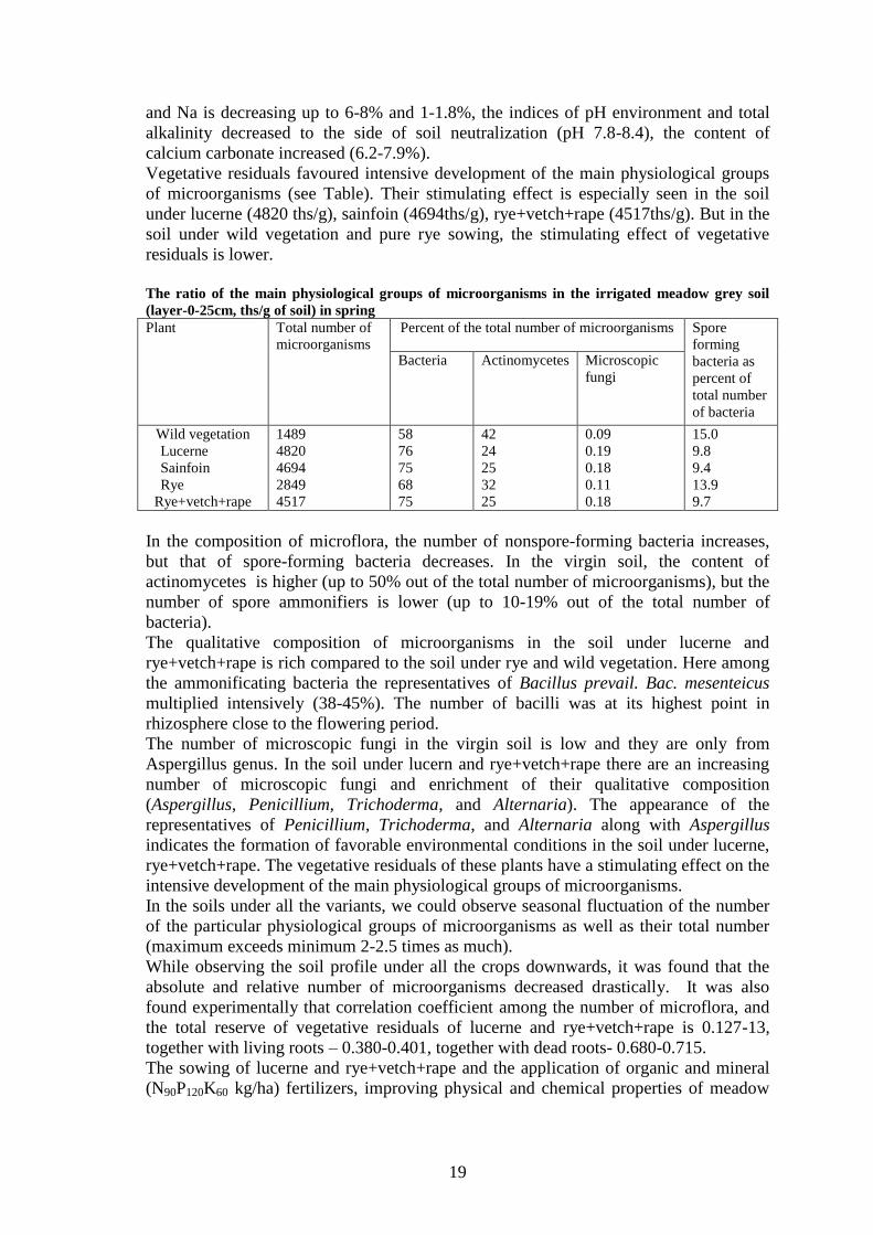
Vegetative residuals favoured intensive development of the main physiological groups
of microorganisms (see Table). Their stimulating effect is especially seen in the soil
under lucerne (4820 ths/g), sainfoin (4694ths/g), rye+vetch+rape (4517ths/g). But in the
soil under wild vegetation and pure rye sowing, the stimulating effect of vegetative
residuals is lower.
The ratio of the main physiological groups of microorganisms in the irrigated meadow grey soil
(layer-0-25cm, ths/g of soil) in spring
Plant Total number of
microorganisms
Percent of the total number of microorganisms Spore
forming
bacteria as
percent of
total number
of bacteria
Bacteria Actinomycetes Microscopic
fungi
Wild vegetation
Lucerne
Sainfoin
Rye
Rye+vetch+rape
1489
4820
4694
2849
4517
58
76
75
68
75
42
24
25
32
25
0.09
0.19
0.18
0.11
0.18
15.0
9.8
9.4
13.9
9.7
In the composition of microflora, the number of nonspore-forming bacteria increases,
but that of spore-forming bacteria decreases. In the virgin soil, the content of
actinomycetes is higher (up to 50% out of the total number of microorganisms), but the
number of spore ammonifiers is lower (up to 10-19% out of the total number of
bacteria).
The qualitative composition of microorganisms in the soil under lucerne and
rye+vetch+rape is rich compared to the soil under rye and wild vegetation. Here among
the ammonificating bacteria the representatives of Bacillus prevail. Bac. mesenteicus
multiplied intensively (38-45%). The number of bacilli was at its highest point in
rhizosphere close to the flowering period.
The number of microscopic fungi in the virgin soil is low and they are only from
Aspergillus genus. In the soil under lucern and rye+vetch+rape there are an increasing
number of microscopic fungi and enrichment of their qualitative composition
(Aspergillus, Penicillium, Trichoderma, and Alternaria). The appearance of the
representatives of Penicillium, Trichoderma, and Alternaria along with Aspergillus
indicates the formation of favorable environmental conditions in the soil under lucerne,
rye+vetch+rape. The vegetative residuals of these plants have a stimulating effect on the
intensive development of the main physiological groups of microorganisms.
In the soils under all the variants, we could observe seasonal fluctuation of the number
of the particular physiological groups of microorganisms as well as their total number
(maximum exceeds minimum 2-2.5 times as much).
While observing the soil profile under all the crops downwards, it was found that the
absolute and relative number of microorganisms decreased drastically. It was also
found experimentally that correlation coefficient among the number of microflora, and
the total reserve of vegetative residuals of lucerne and rye+vetch+rape is 0.127-13,
together with living roots – 0.380-0.401, together with dead roots- 0.680-0.715.
The sowing of lucerne and rye+vetch+rape and the application of organic and mineral
(N90P120K60 kg/ha) fertilizers, improving physical and chemical properties of meadow

20
grey soils, favours soil desalinization, the growth of microflora number, and the
increase in soil fertility.
References: Agayev U.B. ( 1975): The influence of cultivation on morphological, physico-mechanical
and chemical properties of light-chestnut soils in Kirovbad massif / area. // Report. Conference on
cultivation and recultivation of soils of Transcaucasia, Kirovbad, p.46. Babayev M.P., Ramazanova
F.M. (2004): The soil protective role of fodder crops in the irrigated soils of Azerbaijan dry subtropics. //
Report. Forum “Let’s preserve the planet Earth”, St. Petersburg, p.317. Gresta J., Olszowskij. (1999):
The effect of fertilization on the biological activity of the soil of former open casts/ Ecol. Pol. Vol. 22, №
2. Valkov V.F., Kazeev K.SH., Kolesnikov S.I., (1999): The methodology of the research of soil
biological activity by the North Caucasus example.//The scientific idea of the Caucasus, Rostov-on-Don,
№ 1, pp.32-37. Salayev M.E., Babayev M.P., Jafarova Ch., Hasanov V. (2004): Morphogenetic
profiles of Azerbaijan soil // “Elm” Publishers, Baku, pp. 155-159.

21
Groundwater under salt affected soils
Barbara KERÉK*, László KUTI, Ubul FÜGEDI
Department of Environmental Geology, Geological Institute of Hungary
*Corresponding author’s e-mail: [email protected]
The project on studying changes in groundwater chemistry started in 1995 at the
Nyírőlapos model area, Hortobágy. After the first results, it became clear that the
regular observations have to be extended to other model areas. Between 1995 and 2004
new observation wells were located in different parts of the Great Hungarian Plain (in
two bigger salt-affected plains: Hortobágy and Apajpuszta; others in the smaller saline
lakes at Fülöpszállás, Fülöpháza, Bugac, Csólyospálos, in the Danube-Tisza Interfluve).
At some locations the observation is available from different depths at the same place.
Wells are monthly sampled and groundwater level, conductivity and pH are measured in
the field. Water samples are filtered and conserved, then they are analysed in the Water
chemistry Laboratory of the Geological Institute of Hungary. Total water analysis (Na,
K, Ca, Mg, Fe, Mn, NH4, Cl, SO4, HCO3, NO3, NO2, hardness, alkalinity, total soluble
salt content), and microelement determination (Cr, Zn, Co, Ni, Ba, AL, Cu, Sr, Mo, B,
Pb, Cd, Li) are completed on every water samples. Based on our results, in some
extremely salt affected areas not just the concentration of the groundwater changes, but
its chemical composition too.
Precipitation has a great importance in the changes of the salt content in the
groundwater. Rainwater, fallen on the surface, infiltrate into the geological media and
going through the layers above the groundwater, can dissolve significant amount of
soluble salt and transport them to deeper layers. Poorly permeable layers on the surface
hinder or slow down the filtration of precipitation into the groundwater, so the leaching
effect of percolating rainwater cannot or just partly can predominate. Evaporation
clearly increases salt concentration in groundwater, and if the groundwater becomes
saturated in any compound, its precipitation alters the chemical composition of the
groundwater.
Changes in groundwater chemistry could also be caused by lateral water movements
and inflow. Groundwater level above see level in wells at Nyírőlapos-model area shows
that lateral groundwater flow has to be taken into account even in absolutely flat areas.
The flow direction can sometimes reverse. The groundwaters of the areas close to each
other have different chemical composition and concentration, so they can be mixed up
by lateral water flow.
The composition of the groundwater is influenced by meteorological factors, the
thickness-, the rock development-, and the quality of the layers above the groundwater
level. These factors influence the chemistry of the infiltrating rainwater and the
chemical composition of the groundwater changes, too.
Key words: groundwater, salt affected soils, changes in chemical composition

22
Production of auxin hormone by fluorescent Pseudomonas
Nazanin KHAKIPOUR
Islamic Azad University- Savadkooh Branch
Contact e-mail: [email protected]
Plant growth promoting rhizobacteria (PGPR) are considered to promote plant growth
directly or indirectly. Pseudomonas bacteria, specially P. fluorescens and P. putida are
the most important kinds of PGPR. Production of auxin is one of the main reasons to
promote yield because of inoculation with this bacteria. In this research fifty strains of
Fluorescent pseudomonads belong to microbial bank of Soil and Water Research
Institute, isolated from Iran soils, selected and evaluated about secretion of auxin
compounds.
In HPLC device,72% of the strains exuded at least one type of indolic auxin
composites.The amount of exuded IAA by P. fluorescens strains was varied from zero
to 31.6 mg/l while it was producing from zero to 24.08 mg/l in P. putida.
The amount of exuded IAM by P. fluorescens and P. putida was between 0-16.2 mg/l
and 0-17.2mg/l, respectively. Also these strains exuded 0-7.2 mg/l ILA for P.
fluorescens and 0-10 mg/l for P. putida.
Neither of experimental strains exuded the IBA. The results showed that 65% of the
studied P. fluorescens used IAM pathway to synthesize IAA and 35% used the IAM and
IPyA path, while 48% of the P. putida through IAM, 41% through both paths and 7%
used the only IPyA path towards IAA synthesize. But 78% of the strains studied in
spectrophotometery exuded auxins with their amounts were producing between 0-7.09
mg/l for P. fluorescens and 0-4.40 mg/l for P. putida strains.
Key words: Auxin, Pseudomonas, HPLC, Colorimetric Method.
23
Regeneration and evolution of solonetz properties in soils of
Kamennaya steppe for the second half or the 20th
century
Nikolai KHITROV*1, Yuri TCHEVERDIN
2
1V.V. Dokuchaev Soil Science Institute, 119017 Moscow, Pyzhevskiy 7, Russia;
2V.V. Dokuchaev Institute of Agriculture in Central Chernozem Region, Talovsky
district, Voronezh region, Russia
*Corresponding author’s e-mail: [email protected]
In the context of intensive human interventions on soils and expecting global climate
changes the concern has been growing about the study of soil processes that take place
in soils, determine the trend in their development or maintain the available quasi-
stationary status of these soils now.
The aim of this paper is to show the investigation results obtained in the study of
spontaneous regeneration and evolution of solonetz properties in soils of solonetz
complexes after stopping their amelioration and annual ploughing. The objects of
research are the soils of two solonetz experimental stations located in Kamennaya
Steppe (Talovsky district, Voronezh region, Russia). Before trial establishment in the
1950s the soil cover was represented by a combination of ordinary and broken-up
chernozems on convex relief elements, solonetzic chernozems on gentle sloping
hollows, meadow-steppe chernozemic sodium-sulfate solonetzes and leached (non-
solonetzic) chernozems on hollow bottoms. Within 1952-1954 the ameliorative
measures have being taken in different combinations: (1) ploughing at a depth of 30-40
cm, (2) gypsum application (10 t/ha), (3) fertilization (40 t/ha of manure) and (4) earth
mulching – creating a humus horizon of 20 cm thick.
As seen from the long-term observations, within the second half of the 20th
century the
soils retained physico-chemical conditions for the development of the solonetz process
(low concentration of salts combined with exchangeable sodium above 5-10% of CEC)
in the presence of the groundwater table at a depth of 1-1.5 m, the salt content (1.4-2.2
g/l) and the sulfate-hydrocarbonate-sodium composition with soda in ground waters. 55
years later the present soil-forming factors continue to maintain and support the soil
processes in chernozems and solonetzes taken place before their amelioration and
ploughing. After stopping the effects of human activities they enable to be conducive to
regeneration of morphological differentiation of solonetzes into eluvial and solonetz
illuvial horizons. At present, the humus horizon of chernozem that has been created
above the solonetz soil as resulted from earth mulching reveals morphological and
physico-chemical solonetz properties under hydromorphic conditions (prismatic
structure, skeletal grains, humus-clayey pendant cutans, alkaline pH, a higher
concentration of sodium salts in the soil solution, accumulation of exchangeable
sodium).
The work was supported by the Russian Foundation for Basic Research (project No. 08-
04-01195).
Key words: solonetz, solonetz process, amelioration, spontaneous regeneration

24
Integrating remote sensing, cartographical and GPS-based ground
data for salt-affected soils identification, case study: Talas Valley
(Kyrgyzstan)
G. KOKOEVA*1, S. MAMYTKANOV
2
1Free University Brussels (Belgium)
2Republican Soil-Agrochemical Station (Kyrgyzstan)
*Contact e-mail: [email protected], [email protected]
The natural environment of Kyrgyzstan and climatic conditions, where evaporation rate
during the summer period is much higher than the rainfall rate, in combinations with
human-induced processes, such as intensive or inappropriate irrigation and poor water
management have led to the extension of salt-affected soils. Soil salinity has reduced
soil quality, by affecting agricultural crops decreased its production and leads to the
abandonment of agricultural lands in Kyrgyzstan. Between 1985 and 1990, the area of
salt-affected soils in Kyrgyzstan increased from 666 300 to 1170 300 ha (Mamytov,
1995).
Monitoring and mapping of soil salinity is one of the main challenges in Kyrgyzstan.
The traditional method is time consuming and requires considerable resources for field
sampling and laboratory analysis. The availability of multispectral satellite data of
Landsat series allows for wider opportunities of using Remote Sensing and GIS
techniques for salt-affected soils monitoring and enables us to detect temporal changes
for over 40 years. The objective of this study is to identify salt-affected soils by
integrating satellite derived data with existing soil maps and GPS-based ground-
collected data. In order to achieve this goal, the Normalized Difference Vegetation
Index (NDVI), the Transformed Vegetation Index (TVI), the Salinity Index (SI) and the
brightness parameter of Tasseled Cap transformation have been applied to distinguish
salt-affected soils from none-affected bare and vegetation-covered soils. The best
algorithms of a supervised classification have been chosen on the basis of overall
accuracy and Khat statistics of classification. In order to achieve this goal, the best
algorithms of a supervised classification have been chosen on the basis of overall
accuracy and Khat statistics. The extraction of relevant geomorphologic parameters
from SRTM data plays also a significant role in soil salinity identification.

25
Exchangeable cations of the meadow-chestnut soils at the Dzhanybek
Research Station in the Northern Caspian Region
A. V. KOLESNIKOV
Institute of Forest Research, Russian Academy of Sciences, 143030, Sovetskaya str., 21,
Uspenskoe, Odintsovsky district, Moscow region, Russia.
Contact e-mail: [email protected], [email protected]
The predominance of exchangeable Ca2+
, Mg2+
, and Na+ in soils of arid regions is a
well-known fact. The relationship between these cations in the soil adsorption complex
(SAC) is determined by the content and chemical composition of soluble salts in the soil
solution and by the values of the selectivity factors. This general regularity is well seen
in the studied soils of solonetzic complexes in the semidesert zone of the northern
Caspian region. The soil cover differentiation is related to the microtopography:
microhighs are occupied by solonchakous solonetzes, and microlows are occupied by
nonsaline meadow chestnut soils. In the solonchakous solonetzes, the portion of
exchangeable Na+ reaches 30 – 40% of the cation exchange capacity (CEC); in the
meadow-chestnut soils, it does not exceed 1 – 2% of the CEC.
The studies of the composition of the SAC in the soils of solonetzic complexes at the
Dzhanybek Research Station were mainly focused on the solonchakous solonetzes, as
the high percentage of exchangeable sodium in them was one of the factors exerting a
negative effect on forest shelterbelts and crops grown in the course of the agroforest
amelioration of this area. The SAC of meadow-chestnut soils was studied to a lesser
extent.
Our work is aimed at studying the composition of the SAC and the nature of the CEC in
the meadow chestnut soils located in the microlows under virgin herbaceous vegetation
and in the analogous soils located under artificially planted forest shelterbelts
Taking into account that the main carriers of exchangeable cations are the organic
matter and clay minerals, the humus content, particle-size distribution, and the
mineralogical composition of the clay and fine silt fractions were determined. We made
approximate calculations to estimate the contribution of these factors to the value of the
effective CEC in the soils. The activity of Na+ and the salt reserves were determined to
characterize the level of the soil salinity
The meadow-chestnut soils of the Dzhanybek Research Station are characterized by the
eluvial-illuvial textural differentiation of the solonetzic type. It is supposed that
solonetzic process took place in these soils at the earlier stages of their development.
Later, the excessive salts and the adsorbed sodium were removed from these soils by the
fresh water supplied with the snowmelt.
In the virgin and ameliorated meadow-chestnut soils, the portions of exchangeable
calcium and magnesium in the CEC reach 70–80 and 13–30%, respectively. The
composition of exchangeable cations remains relatively stable in the entire profile. The
exchangeable sodium percentage is less than 1%, and there are no indications of the
current activity of solonetzic process in the profiles of meadow-chestnut soils.
The research was supported by the Russian Foundation for Basic Studies (project 09-
04-00030).
Key words: salt-affected soils, soil salinization, soil adsorption complex, cation
exchange in soils.
26
Large-scale mapping of solonetzic complexes in the Northern Caspian
Lowland using automated interpretation of Quickbird images
Mariya V. KONYUSHKOVA
V.V. Dokuchaev Soil Science Institute, Russian Academy of Agricultural Sciences,
Pyzhevskiy per. 7/2, Moscow, 119017 Russia
Contact e-mail: [email protected]
The goal of this study was to develop a procedure for large-scale mapping of solonetzic
complexes using automated interpretation of very-high-resolution space-borne images.
Solonetzic complexes are widespread in the northern part of the Caspian Lowland. They
include the soils with different degrees of salinization: strongly saline Solonetzes (SN),
slightly saline light chestnut soils (Kastanozems, KS) and nonsaline Chernozem-like
(CL) soils replacing one another at distances of about 5–30 m. Dark-coloured CL
occupy microlows with a relative depth of 10–30 cm, SN occur on microhighs, and KS
occupy slopes. The portion of SN in the soil complexes varies from 25 to 75%.
Earlier, large-scale soil maps of solonetzic complexes were developed on the basis of
detailed surveys at key plots with a further extrapolation of the obtained data. The
reliability of such extrapolation is low, because the proportions between different soils
in the complexes may change considerably at distances of about 500 m. High-resolution
(<5 m) space-borne images allow us to obtain more accurate large-scale maps.
However, their visual interpretation is an extremely labour-consuming process. A
semiautomated mapping of solonetzic complexes with the use of 2.4-m resolution
multispectral Quickbird imagery was set as the goal of this study.
The test area at the Dzhanybek Research Station is 65 km2; one-third of it is occupied
by shelterbelts and fallow land. Our approach was developed for virgin soils and natural
pastures. The computer-based image analysis was performed with the help of ILWIS
Academic 3.4 Open GIS. The major results are outlined below.
I. The use of a supervised classification (discriminant analysis) made it possible to
delineate the areas of CL soils on the basis of the NDVI values and brightness values in
the near-infrared band with high level of cross validation (88%). An automated
separation of the remaining two soil types by this method proved to be of poor quality.
A map of soil areas with different portions of CL soils was obtained at this stage.
II. To estimate the portions of SN and KS, a visual interpretation of the image was
performed for 20 test plots (200x200 m). The portions of different soils in the
complexes were tightly interrelated. Two groups of test plots with different portions of
CL were specified: (1) CL 0–15% and (2) CL 15–30%. No complexes containing >30%
of CL were identified. In group 1, the portions of KS and CL were interrelated: K1(%)
= –4.17CL(%) + 86.8 (R2=0.94). In group 2, the area of K1 is about 20% (15–25%).
III. These regularities were used to develop the soil map of the test polygon (scale
1:25000) with the following mapping units (solonetzic complexes): (1) CL 0-5%, КS
70-80%, SN 20-30%; (2) CL 5-10%, KS 50-70%, SN 30-40%; (3) CL 10-15%, KS 35-
50%, CN 40-50%; (4) CL 15-30%, KS 15-25%, SN 50-75%.
Thus, this method ensured an automated delineation of the areas with CL with high
(90%) reliability, on the basis of statistically reliable (R2=0.94) relationships, the
portions of SN and KS were determined in each mapping area. This study was
supported by the Russian Foundation for Basic Research, project no. 07-04-00136a).
Key words: Solonetzic soil complexes, Caspian Lowland, Quickbird imagery, image
interpretation, large-scale soil mapping.

27
Diagnosis and control of salinity and nitrate pollution in
Mediterranean irrigated agriculture. The case of Beni Amir (TADLA –
Morocco)
Mouanis LAHLOU*, Brahim SOUDI
Institute of Agronomy and Veterinary Hassan II. Morocco
Agricultural productivity may be constrained by limited water resources and soil and
water quality degradation. In Moroccan conditions, the main degradation processes
occurring under intensive cultivation in the irrigation schemes are: (i) soil salinization,
and alkalinization, soil compaction and (“on-site” impacts) and increased salt and
nitrate loads in irrigation return flows (IRF) (“off-site” impacts) and groundwater nitrate
pollution. A subsequent revision of agricultural practices should be established and an
Integrated Agro – Environmental Management of these constrains is essential.
In order to reinforce scientific, technical and socio-economic investigations and findings
on salt and nitrogen contamination and on pollution control measures in Mediterranean
irrigated agriculture, seven research partners and ten stakeholders in six countries have
collaborated during four years (2006-2009) in the framework of a project called
“QUALIWATER: Diagnosis and Control of Salinity and Nitrate Pollution in
Mediterranean Irrigated Agriculture INCO-CT-2005-015031”.
In Morocco the Academic institutions are represented by the “Institute of Agronomy
and Veterinary Medicine Hassan II”, and stakeholder by the “Regional Office of
Agricultural Development-Tadla” where hydraulic unit covering 2600 ha was selected
as study area. The result of the two hydrological years 2007 and 2008 show that the
District Irrigation Efficiency was about 56% and 52% respectively in 2007 and 2008;
the Water Use Efficiency is about 60% and 59% respectively in 2007 and 2008; the
mass of salts that percolate to the water table (Mg/ha) is about 5.3 and 4.8 respectively
in 2007 and 2008; and the mass of NO3-N that percolate to the water table (Kg/ha) is
about 137 and 117 respectively in 2007 and 2008.
In addition a simulation studies has been carried using a set of calibrated and validated
water, salt and nitrogen models to analyze the effectiveness of best management
alternatives for off-site pollution control.

28
Spatial and vertical heterogeneity of the crystal chemistry and fabric
of the salt accumulations in crusty solonchak of Uzbekistan
Marina LEBEDEVA (VERBA)*1
, Natalia CHIZHIKOVA1
1V.V. Dokuchaev Soil Science Institute, 119017 Moscow, Pyzhevskiy 7
*Corresponding author’s e-mail: [email protected]
The studies of mineral associations in salt crusts have been performed in many parts of
the world (Mermut, 1986; Mees and Stoops, 1991). In this paper, we consider the
results of special investigation into the composition and properties of different types of
salt accumulations sampled from the surface salt crust of a crusty solonchak in
Uzbekistan. The main goals of our study were to (1) typify the morphologically
different parts of the salt crust, (2) determine the chemical properties of different types
of salt accumulations, (3) determine the mineral composition of salt crusts using
mineralogical and submicromorphological analyses, and (4) give a comprehensive
characterization of the diversity of crystal chemistry features of salt minerals. The soil
profiles were dug in the dry delta of the Zeravshan River in Uzbekistan. The mean
annual air temperature is +15.1°C; the mean January temperature is –0.6ºC, and the
mean July temperature is +29.6ºC. The annual precipitation averages 125 mm, with
only 2.0 mm in June–August. Morphologically different parts of the salt crust were
sampled hermetically sealed in glass tubes. The particular minerals were diagnosed with
a help of X-ray diffraction and thermogravimetric (TG) methods using an XZG-4a
diffractometer (Carl Zeiss Jena, Germany) and a Q-1500 D derivatograph (F. Paulek &t
K˚). The samples were also analyzed under a scanning electron microscope (SEM); Х-
ray diffraction patterns of separate crystals were obtained using a Camebax (Cameca,
France) microprobe. The analysis of water extracts (1:5) from salts crusts was
performed to determine the chemical type of salinity. The surface salt crust of the crusty
solonchak can be differentiated into three major morphological types. Chemical
analyses of water extracts from these types of the crust suggest that all of them consist
of a mixture of sodium and magnesium sulfates and chlorides with somewhat different
Cl/SO4 ratios. The specificity of the predominant first type of the crust consists of its
high alkalinity (both total and bicarbonate), which is absent in the other two types
confined to microhollows and microelevations of the surface. The appearance of high
alkalinity in the first type of the crust might be related to the activity of microbiota
concentrated in certain microzones in the lower crust layer. Micromorphological and
mineralogical investigations showed that each morphological type of the salt crust is
characterized by its own paragenetic association of mineral salts with a predominance
of sodium and magnesium sulfates: thenardite, mirabilite, and bloedite (astrakhanite);
more careful examinations with the use of TG and SEM techniques have shown the
presence of glauberite, polyhalite, and gypsum. Different morphological forms of
thenardite and mirabilite have been registered. The possibility of the presence of small
amounts of trona cannot be excluded judging from chemical data, though we failed to
detect this mineral by mineralogical methods. It is important that only a combination of
different investigation techniques makes it possible to identify different minerals of salts
in their mixture and suggest a reliable interpretation of the obtained data. The research
was supported by the Russian Foundation for Basic Studies (project 08-04-01333; 08-
04-90266Uzb.).
Key words: salt minerals, micromorphological and mineralogical investigations.

29
Geological conditions of the salinization in case of two irrigated fields
in Central and South Sahara, Libya
Bashir H. MAHDI1, János KALMÁR*
2
1Industrial Research Institute, Tripoli, Libya
2Geological Institute of Hungary, Stefánia út 14, Budapest, Hungary
Presenting the environmental problems of the mapped Saharian region, two significative
areas were studied: the first area, situated in Wāw al Kabir oasis (NG 33-12 sheet) and
the second one, near to Rabiyanah village (NG 34-15 sheet). Both areas are located in
the driest zone of the African continent, consequently plant production is possible only
by irrigation, in so called Agricultural Projects.
In Wāw al Kabir, an ancient Islamic eremite site, during a long historical time the sandy
soil was irrigated from 5-8 m deep wells, using with care the groundwater found in
disaggregated Paleogene rocks and in the gravels from the base of the Quaternary
deposits, with ~2000 mg/l total salinity. Boring a few hydrogeological wells, an artesian
water, below 500 mg/l was obtained, but because of the accidental mixing with
groundwater in the northern part of the oasis, in a few years the soil became saline, with
2-5% NaCl.
In Rabiyana, a large Pleistocene proluvial fan, with silty-sandy or clayey-silty deposits
were irrigated with low saline (500-700 mg/l.) water from the Cretaceous aquifer.
Unfortunately, the clay retained more and more salts, resulting, after 15 years of
irrigation, the total salinization of the soil, with 2-10 mm thick halite lenses, in which all
of vegetation has disappeared.
The paper is illustrated with tables and graphics of analytical data, with X-ray diagrams
and optic and SEM micrographs of the salinized soil samples as well.

30
Multi-scale analysis of soil salinization. A Case study from an oasis in
Tunisia
Serge MARLET*1, Fethi BOUKSILA
2, Wafa GHAZOUANI
1,2, Insaf MEKKI
2
1Centre de Coopération Internationale en Recherches Agronomiques pour le
Développement, UMR Gestion de l’Eau, Acteurs, Usages, TA C-90/02, 34398
Montpellier Cedex 5, France 2National Research Institute in Rural Engineering, Water and Forestry, 17 rue Hedi
Karray, BP 10, 2080 Ariana, Tunisia
*Corresponding author’s e-mail: [email protected]
Soil salinization results from a combination of hydrological processes operating at
different time and space scales. Thus effective salinity control measures should
recognize the natural processes that operate in irrigated systems as well as on-farm
processes, and understand how they affect the long-term quality of soil and water
resources.
A multiscale analysis was developed and applied in Fatnassa oasis (Nefzaoua, Tunisia).
The approach combined a water and salt balance model at irrigation scheme and yearly
time scales, spatial variability of the shallow groundwater, and the influence of the
shallow groundwater and some farmers’ practices on soil salinity at field scale. The salt
balance model accounts for input by irrigation, export by drainage and groundwater
flow, the influence of biogeochemical processes and variations in the resident amount of
salt for each chemical component in the soil and shallow groundwater. The groundwater
was monitored and sampled from a network of 27 observation wells. Soil salinity was
calculated from electro-magnetic conductivity (EM38) on 416 fields.
From a salt input of 39 Mg ha-1
year-1
by irrigation, 21 Mg ha-1
year-1
(54%) and 10 Mg
ha-1
year-1
(26%) were exported by groundwater flow and drainage, respectively. 7Mg
ha-1
year-1
(18%) were removed from groundwater by geochemical processes, while a
non significant 2 Mg ha-1
year-1
were estimated to have been stored in the soil and
shallow groundwater where the residence time was only 2.7 years. The current
extension of date palm plantations and salinization of groundwater resources are
expected to significantly increase the salinity hazard while the degradation of the
drainage system is of lesser impact. Groundwater salinity ranged between 5.8 and 18.5
dS.m-1
. Whereas salinity increased with the decrease in groundwater depth, their spatial
distributions were partly different and evidence for dissimilar causes between
waterlogging and salinity. They pointed out a need for reinforcing drainage in the lower
part of the oasis. Soil salinity ranged between 3.7 and 46.2 dS.m-1
. This resulted from a
combination of the groundwater depth and salinity, the yearly irrigation amount and the
magnitude and frequency of sand application by the farmers.
The results did not show any rapid salinization process but a progressive evolution of
salinity depending on the management of soil and water both at the irrigation scheme
and the farmers’fields scales. The farmers can, to certain extent, control salinity at field
scale but don’t clearly grasp the root causes of salinization related to the current
extension of date palm plantations and salinization of groundwater resources. The
combination of various approaches was essential to identify measures for controlling
salinity in the long term.
Key words: salinity, irrigation, drainage, oasis, Tunisia
31
Using propagule mimics to model seed bank formation in salinized
soils
G. MATUS*
1, O. VALKÓ
1,2, P. TÖRÖK
2, M. PAPP.
1, E. VIDA
1,2, A. KELEMEN
2, T.
MIGLÉCZ2, B.
TATÁR
1, S.
KÉKI
3, T.
TÓTH
4
1Dept. of Botany,
2Dept. of Ecology,
3Dept. of Applied Chemistry, University of
Debrecen; 4Research Institute for Soil Science and Agricultural Chemistry, HAS
Studying soil seed banks is among the research highlights in plant ecology, especially in
ecological restoration. Several attempts were made to reveal correlation between size
and shape vs. vertical distribution of seeds in the soil. Based on empirical data from
natural seed banks, the generally accepted assumption among plant ecologists is that
species with small and spherical seeds are more likely to build up dense and deeply
penetrating soil seed banks than species with large and flattened seeds. It was, however,
not known how long does it take for a seed to travel to certain depths in the soil.
Without this information the vertical distribution and seed age can hardly be compared.
The aim of our study was to provide a reference by giving statistical description of the
movement of non-decomposing propagule mimics, the size and density of which falls
into the range of naturally occurring Central-European plant species. Granules made of
high-density polyethylene (HDPE, specific gravity ρ=0.95) and of different sizes and
shapes were applied as propagule mimics. The selected study sites are located in the
Bihar Plain in the vicinity of Derecske (East-Hungary). on meadow solonetz soils of
silty loam texture covered with differently degraded stands of traditionally managed
pastures (Achilleo-Festucetum pseudovinae and Cynodonti-Poetum angustifoliae). The
impact of grazing (cattle and/or sheep) on vertical and horizontal dispersal of propagule
mimics is to be assessed by comparing fenced and unfenced plots. Results collected on
the sodic soils are compared to a similar dataset on non salt-affected soils in order to
show how special physical conditions of sodic soils affect seed bank formation.
Basic soil characteristics in the uppermost 10 cm of the studied soils have been
analyzed (particle size distribution, sum of exchangeable cations and CEC values, pH-
H2O, soil organic matter, CaCO3, AL(ammonium-lactate extractable)-Ca, AL-K2O, AL-
P2O5, NH4-N, NO3-N, exchangeable Al, Ca, Fe, Mg, Mn, Na and K). Movement of
granules is also to be correlated with penetration resistance determined by a drop
hammer penetrometer.
Altogether 160,000 granules were placed to 400 spots in October 2008. In the project
(OTKA 67748) planned for 5 years, recollection of small soil monoliths (15x15x7.5
cm) is scheduled twice a year (April, October) in five replicates per plot in each date.
Granules resting on soil surface are collected first then monoliths are cut into slices of
12.5 mm width. Granules are separated through soaking in water then washing over a
series of sieves. Coinciding with former observations, our first results suggest that
smaller granules traveled to deeper layers in a larger portion.
Key words: soil seed banks, propagule size, propagule shape, physical soil type, grazing
32
Modification of solonetz soil profile characteristics caused by organic
matter influx on the livestock resting sites of Hortobágy, Hungary
Tibor NOVÁK*1, Kirsten BECKER
2, Luise GIANI
2
1University of Debrecen, Department of Landscape Preservation and Environmental
Geography, Hungary 2Soil Science Division, Carl von Ossietzky University Oldenburg, Germany
*Corresponding author’s e-mail: [email protected]
Extensive livestock grazing is a traditional way of using the solonetz grasslands of
Hortobágy (Eastern Hungary). This way of use results in livestock resting places
developed around the shepherds lodging places and wells. Since these sites are situated
on the highest elevations of the landscape (87.5-89 m a.s.l.), their soil characteristics
differ slightly from that of the surrounding surfaces (86-87 m a.s.l.). However, the
original “deep meadow solonetz” or “meadow solonetz turning into steppe formation”
soil types of these places were modified by the effects of livestock trampling and
organic matter influx due to muck accumulation and straw and hay input as well. The
degree of modification seems to differ by the intensity and the length of use.
We investigated soil characteristics of 4 profiles from 3 locations modified by effects
mentioned above and compared their characteristics with 2 reference profiles situated
very close to these places but not modified in this way.
The profiles were sampled every 10 cm to 70 cm depth. Thickness of accumulation
horizon, morphologic properties of the sampled layers, particle size fractions, pH,
carbonates, EC, ESP, CEC, organic matter (via ignition loss), total amount of C and N,
C/N ratio were measured and taken into consideration by the evaluation process. In one
case the organic matter of the anthropo-organic accumulation layer was also analyzed
with IR spectroscopy.
Organic accumulation layers reached a thickness of 3-18 cm. Under the accumulated
organic matter compacted soil layers were found with laminated structure. The
characteristics of the accumulation layers could be summarized as follows: lower pH
and higher EC values, higher cation exchange capacity (CEC: 20-75.5 mg.eq/100 g) but
lower ESP (5.7-28%) values in comparison with the topsoil of control profiles. The
amount of organic matter reaches up to 22.3%. C:N ratio was higher than 11% in the
accumulation layers. IR-spectroscopy showed that the material of the organic
accumulations is mostly decomposed, dominated by cellulose compounds and it is in
reactive form. The degree of humification is very low and probably blocked by the cold
winter, the dry summer periods and the particularly high salinity of the soil as well.
Based on the properties and the thickness of the accumulation layers these soils do not
satisfy the criteria of an Anthrosol of WRB, because the thickness of the accumulation
horizon does not reach 50 cm in any case, given in the definition. However, based on
the physical and chemical characteristics of the topsoil these soils differ significantly
from undisturbed meadow solonetz soils.
Key words: livestock resting sites, solonetz, anthropic soil, organic horizon, C:N ratio

33
Soil-plant correlations in native salt-affected habitats in central Poland
Agnieszka PIERNIK1, Piotr HULISZ*
2
1Laboratory of Ecological Modeling, Institute of Ecology and Environment Protection,
Nicolaus Copernicus University, ul. Gagarina 9, 87-100 Toruń, Poland; E-mail:
Department of Soil Science, Institute of Geography, Nicolaus
Copernicus University, ul. Gagarina 9, 87-100 Toruń, Poland; E-mail: [email protected]
The natural inland saline areas in central Poland are connected with the occurrence of
the geological structure of the Zechstein salt-bearing formation. In addition inland
halophytic vegetation may occur as a result of soda industry. This research aimed at
describing differences in soil-plant relations on natural and anthropogenic stands. Three
types of habitat were investigated: 1. natural saline grasslands in the villages Jacewo,
Turzany and Słonawy and meadows in the valley of river Zgłowiączka, 2.
anthropogenic saline meadows next to the sediment traps of two soda factories in town
Inowrocław and Janikowo and 3. halophytic vegetation along brine pipelines connecting
salt mains with soda factories and pipelines providing saline wastes of soda production
to the adjacent rivers. In total 76 phytosociological relevés and soil samples from the
root zone (0-25 cm) in each plot for chemical analyses were taken. In the natural stands
soil salinity was characterized by Na+>Ca
2+>K
+>Mg
2+ cations and by Cl
->SO4
2->HCO3
-
anions. Spearman rank correlations demonstrated high significant correlation between
Cl- and Na
+, SO4
2- and Ca
2+ and Mg
2+ cations and high correlation between HCO3
- and
K+. Next to the sediment traps Ca
2+ > Na
+ >
Mg
2+ > K
+ and Cl
->SO4
2->HCO3
- ions
dominated. Only Cl- was significantly correlated with all cations. Along pipelines
cations and anions dominancy in the extract was similar like in the natural stands, but
only Cl- was significantly correlated with Na
+ and Ca
2+. After discriminant analysis
(CVA) including all measured soil properties high pH values were identified as
significant for pipeline habitats, high electrical conductivity of saturation extract (ECe)
together with high Ca2+
concentrations and the highest Ca2+
/Na+ ratio for the sediment
traps surroundings and finally relatively high K+ concentrations as characteristic for
natural stands. CCA analysis, Monte Carlo permutation test and forward selection of all
species and environmental data demonstrated that significant in species-environment
relations model were ECe values connected with sediment trap habitat, K+ characteristic
for natural habitats and total nitrogen together with organic matter content. Vegetation
of the natural habitats differed significantly from the vegetation of sediment traps and
pipelines surroundings. More species were frequent there, as well halophytes: Glaux
maritima, Festuca arundinacea, Trifolium fragiferum, Melilotus dentata, Carex distans,
as glycophytic species. There were not significant differences in vegetation between
sediment traps and pipelines stands. For these two anthropogenic habitats presence of
obligatory halophytes i.e. Salicornia europaea, Aster tripolium, Atriplex prostrata and
Spergularia marina was typical. Considering communities distribution results of CVA
analysis identified natural stands as significantly different from two other categories.
There were more frequent Scirpus maritimus community, Glaux maritima-Potentilla
anserina-Agrostis stolonifera and Triglochin maritima community. Salicornia
europaea, Puccinellia distans-Salicornia europaea, Puccinellia distans and Atriplex
prostrata communities were typical for anthropogenic stands. Differences in soil
condition in sediment traps and pipelines surroundings didn’t reflect as well species as
community’s distribution.
Key words: halophytes, soil salinity, inland salt-marshes, discriminant analysis, CCA

34
Monitoring and assessment of coastal saline soils in southern region
(Badin) Pakistan
Shabnam RATHORE*, Karl STAHR, Boris VASHEV
Institute of Soil Science and Land Evaluation (310), University of Hohenheim,
Stuttgart, Germany.
*Corresponding author’s e-mail: [email protected]
The salt affected soils in the southern region of Badin, Pakistan have been a challenge to
agricultural production. In order to understand the nature and extent of these salt affected
soils, a salinity study was conducted. Different profiles (0-120cm) were exposed from 16
different locations. The sampling sites were selected in such a way as to cover most of the
salt-affected area. The results showed that the main causes of salinity were poor irrigation
water management without having a suitable arrangement of drainage. Other causes are
seepage from canals and shallow saline ground water table. However, there are several
natural saline seeps in the region, which can contribute to salinization. Accumulation of
salts was high on the surface soil due to capillary rise during fallow season, which resulted
in secondary salinization. High free evaporation of water from the surface aggravated the
salinization process. Saline and saline-sodic soils were the major salt-affected soils in the
region. Most of these salts are easily soluble. While sodium was in excess in saline-sodic,
calcium was in excess in saline soils. Chloride was the dominant anion in salt-affected
soils. Ground water depth was shallower during the rainy months (June-August) and its
salinity was lower than in dry months. Irrigation water salinity was also low from June to
August. Saturated paste extracts are high in chlorides, sulfates, and carbonates in all
profiles, ESP and SAR are more than 15 in all these soils studied. The average electrical
conductivity (ECe) and pH values were17.2 mmhos/cm and 8.7, respectively. The results
are valuable for producing a salinity map to show the areas at risk of salinization and
planning the management of salinity.
Key words: salt affected soils; saline soil; sodic soil, water table depth.
35
Methodology of the analysis of the maps of soil salinity to judge the
dynamics of salinization-desalinization processes
Dmitry I. RUKHOVICH*, Polina V. KOROLEVA, Yekaterina V. VIL'CHEVSKAY
Natalia V. KALININA, , Svetlana V. RUKHOVICH, Elena B. DOLININA
V.V. Dokuchaev Soil Science Institute, Russian Academy of Agricultural Sciences,
Pyzhevskiy per. 7/2, Moscow, 119017 Russia
*Corresponding author’s e-mail: [email protected]
Salinization is one of the most dynamic soil properties. Secondary salinization
intensifies salt transfer in the soil profiles. In the newly irrigated area of the Golodnaya
Steppe (Uzbekistan), the salt status of soils may change from nonsaline to strongly
saline and vice versa within a year. Despite such a considerable dynamism of
salinization–desalinization processes, traditional methods to assess the dynamics of soil
salinity are based on the comparison of two maps of soil salinity developed at different
times with an arbitrarily chosen time interval between them.
Maps of soil salinity reflect the chemical type and the degree of salinization. Nonsaline,
slightly saline, moderately saline, strongly saline, and very strongly saline soils are
specified. Nonsaline and slightly saline soils can be grouped in one category. Thus, for
the soils with the same chemistry of salinization, four legend units characterize the
degree of salinization. If two maps for different years are compared, seven
combinations are possible: (1–3) soils, whose salinity has decreased by three, two and
one grades, respectively (desalinization of different intensities); (4) soils, whose salinity
has not changed; and (4–7) soils, whose salinity has increased by one, two and three
grades, respectively (salinization of different intensities). It is supposed that the
direction of salinization–desalinization processes in the particular area remains
unchanged during the studied time interval.
We have developed 7 maps of soil salinity for the Usman Yusupov farm (no. 10) in the
Golodnaya Steppe of Uzbekistan for different years from 1983 to 2008 on the basis of
aerial and satellite images. Their analysis proved that the extrapolation or interpolation
of tendencies for a period exceeding one year is incorrect. Thus, a comparison of the
maps for 1983 and 1985 indicates the intense salinization, whereas the maps for 1985
and 1986 indicate the intense desalinization for the same area. If only two maps are
compared, the error of the estimate of salinization–desalinization tendencies may be as
high as 70–80%. To judge the dynamics of these processes, the following series of the
maps is suggested. (1) Maps showing the areas with stable salinization. From year to
year, their portion is about 25% for each salinity grade; for the entire period, it is only
2.5% of the territory. (2) The map showing the trend of salinization (slope of the curve
approximating distribution of saline soils by years); for the studied farm (80 km2), this
map contains more than 50 000 polygons attesting to the high spatial variability of
salinization-desalinization processes. (3) The map of salinization-desalinization
dynamics characterizes the average amplitude (the dynamics coefficient) of salinization-
desalinization processes. In our case, it was calculated on the basis of five maps for
1983–1989: k = (a׀-b׀+׀b-c׀+׀c-d׀+׀d-e׀+׀e-a׀)/5, where a, b, c, d and e are the degrees
of soil salinization at a given point (or on a given plot) in 1983, 1985, 1986, 1988 and
1989, respectively. The map demonstrated that the degree of salinization changes by
more than one grade on more than a half of the studied territory. Overall, a set of eight
maps is suggested to judge the dynamics of salinization–desalinization processes.
Key words: soil salinity mapping, salinization–desalinization dynamics, image analysis
36
Chemical-morphological properties of salt-affected soils as affected by
biogenic factor in the meadow-semidesert complex in Russia
N. P. SHABANOVA*1, M. P. LEBEDEVA (VERBA)
2, A.V. BYKOV
1
1Institute of Forestation, Russian Academy of Sciences, 143030 Uspenskoe,
Odintsovsky district, Moscow region, e-mail: [email protected]
2V.V. Dokuchaev Soil Science Institute, 119017 Moscow, Pyzhevskiy 7
*Corresponding author’s e-mail: [email protected]
Special attention has being paid long ago to studying the impact exerted by soil animals
on the composition and properties of solonetz soils in the semidesert complex and their
role in the formation of peculiar microrelief (Abaturov, 1972; Gacahu, 1987). However,
this problem remains very acute at the relatively young territory of the Volga-Ural
interfluve area because it hasn’t been studied earlier. The objective of this paper is to
study the genesis and properties of virgin salt-affected soils in the meadow-semidesert
complex on young terraces of Khaki shor and to show the role played by burrowing
animals (gopher, vole) in the formation of peculiar microrelief and properties of the soil
cover. Three soil pits have been studied as confined to different microrelief elements
under a great variety of vegetation. 1) The flat surface under common wormwood-grass
association, which hasn’t been disturbed by burrowing animals - a control variant; 2)
the micro-hillocks formed by gophers under wormwood-grass association and 3) the
nano-depression under grass vegetation. The control variant is characterized by the
Salic Solonetz soil (WRB-2006). The groundwater samples of a higher chloride-sodium
composition at a depth of 2.2m. The soils of micro-hillocks display buried horizons
named as zoo-turbated ones (according to «Classification of Soils in the Russian
Federation», 2008). In the nano-depression, the genesis of which is connected with
solution sinkhole the Endogleyic Kastanozem occurs.
In the micro-hillocks formed by gophers the carbonate material thrown by these animals
for 5-7 years reveals destroying the morphologically expressed carbonate and salt
neoformations so characteristic of the subsolonetz horizon. The buried horizon (albic)
displays a slighter effervescence and some compaction. The horizon (natric) retains the
color, but becomes more friable and fissured, effervescence is everywhere, what is
absent in the control pit. In zoo-turbated solonetz there are numerous traces of intensive
activity of burrowing vertebrates and invertebrates (passages, chitin, droppings, food,
litter, etc.). Among the soils under study the soil in nano-depression seems to be most
washed out. The absence of soluble salts is conditioned by lower relief and burrowing
activity of animals (voles), thus providing transformation of the surface runoff into
subsoil one. In the zoo-turbated solonetz the upper horizons are desalinized at a depth of
35 cm (the salt sum accounts for 0.1%). In the subsolonetz horizon the amount of salts
is sharply increased (to 2.8%); it is possible to observe chloride and sulfate salinization
combined with gypsum to the depth of 180cm. In the soil of control variant only the
albic horizon is characterized by moderate extent of salinization and chloride-sulfate
composition, being increased with depth. The biological activity of burrowing animals
in combination with lithological layering of lacustrine deposits is conducive to higher
changes in the chemical composition of soil salinization, thus complicating the soil
cover pattern. The research was supported by the Russian Foundation for Basic Studies
(project 08-04-01333 and 06-05-64082).
Key words: genesis of salt-affected soils, burrowing animals, soil salinization.

37
Biosaline agriculture for biomass and biomaterials production to
generate energy from salt affected soils: Indian experience
Gurbachan SINGH
Director, Central Soil Salinity Research Institute, Karnal-132 001, India
Contact e-mail: [email protected]
Nearly 1000 million ha area covering about 8% of the land surface of the world in about
100 countries is affected by the twin problems of soil salinity and sodicity. Australia
followed by Asia (42.3 and 21.0 per cent, respectively) had the world’s largest area
under salinity and sodicity. Most of the salt affected soils and brackish ground water
resources are confined to arid and semi-arid regions and are causative factors for
triggering the process of desertification. Recent estimates indicate that 6.74 million ha
in India are affected by higher concentration of salts in the root zone soil. A brief
account of the extent, nature and distribution of salt-affected soils and poor quality
ground water resources in different states in the country is reported in this paper. A
sizeable part of the salty lands in India is constituted by the village community lands
and as such these areas are not suitable for cultivation of annual grain crops because of
lack of individual property rights. Utilization of such lands abandoned due to high
salinity/sodicity for growing salt tolerant trees, grasses, bushes and other high value
industrial crops seems promising option. The Central Soil Salinity Research Institute,
Karnal has developed and standardized several options to produce biomass and
biomaterials to generate energy/electricity from such lands. A brief review of the
biosaline agricultural research in India is cited in this paper. The information has been
discussed under the sub-heads : (i) promising salt tolerant trees, grasses, shrubs,
halophytes and medicinal/aromatic crops, (ii) agrotechniques for practising biosaline
agriculture, (iii) silvipastural and agroforestry models for forage, fuel and energy
production, (iv) soil amelioration by biosaline agriculture practices (v) scope and
limitations of Jatropha and Pongamia as biodiesel crops, (vi) case studies of energy
plantations including post harvest handling, value addition and marketing, (vii) biomass
quality in relation to salinity and sodicity, (viii) socio-economic and environmental
impacts of raising energy plantations in salt lands and (ix) future research, development
and policy needs. Recent results from a seven country consortium biosaline agriculture
programme funded by European Union and Coordinated by Organization for
Agriculture in Saline Environments (OASE), Netherlands will also be shared and
discussed for dissemination and upscaling.

38
Vegetation induced patterns of soil redox conditions and dissolved iron
Zoltán SZALAI*1,2
, Gergely JAKAB2, Klaudia KISS
1, Katalin FEHÉR
1
1 Department of Environmental and Landscape Geography, Eötvös Loránd University,
Budapest, Hungary 2 Geographical Research Institute, Hungarian Academy of Sciences, Budapest, Hungary
*Corresponding author’s e-mail: [email protected]
Our presentation focuses on spatial differences of soil redox condition, on causes of
theses differences and on effects on seasonal dynamics of dissolved iron. Study areas
are located in a hilly headwater area (Szabadszántók, SW Transdanubia, Hungary) and
in a lowland area (Geje Plain, Danube-Tisza Interfluve, Hungary). Soil temperature,
wind speed (at 1m), incident solar radiation (PAR), soil pH, soil Eh and dissolved iron
were monitored. Measurements have been taken in four different patches in
Szabadszántók, and three different patches in Gerje Plain: sedge (Carex vulpina, Carex
riparia), horsetail (Equisetum arvense), common nettle (Urtica dioica), reed
(Phragmites communis). Measurements focused on differences between core parts of
patches and between edge and core areas. pH and Eh characteristics have been
measured individually in the studied patches. Soil Eh, pH and dissolved iron have
shown seasonal dynamics. Higher redox potentials and higher pH values were measured
between late autumn and early spring in both study areas. The increasing physiological
activity of higher plants causes (directly or indirectly) more acidic and more reductive
soil environment and it leads to higher spatial differences. Iron content of soil solution
also has shown strong correlation with soil redox conditions. Although temperature is
an essential determining factor for Eh and pH, our results suggest that it rather have
indirect effects through plants on wetlands. The spatial patterns of the studied
parameters are influenced by the water regime, micro-topography, and climatic
conditions and by direct and indirect effects of vegetation. The indirect effect can be the
shading, which has influence on soil temperature and on the incident solar radiation
(PAR).
Key words: wetland, redox, dissolved iron, Carex, Phragmites

39
Changes of salt minerals of soil surface efflorescences in space and
time: a case study in Hungary
Géza SZENDREI*
1, Tibor TÓTH
2, Péter KOVÁCS-PÁLLFY
3, Sándor SZAKÁLL
4
1Department of Mineralogy and Petrology, Hungarian Natural History Museum,
Budapest, Hungary 2Research Institute for Soils Science and Agrochemistry, Hungarian Academy of
Sciences, Budapest, Hungary 3Hungarian Geological Survey, Budapest, Hungary
4Department of Mineralogy and Petrology, University of Miskolc, Hungary
*Corresponding author’s e-mail: [email protected]
In the European prairie ecological division (term after Bailey 1996) mineralogical
investigations of soil surface efflorescences have not been published. As there are more
minerals with sodium sulphate or sodium carbonate chemical compositions, more
details were expected from the mineralogical study than from the chemical
compositions alone.
176 spots were visited for surveying and characterizing salt minerals in soil surface
efflorescences, and on 39 localities (at 29 villages) were found salt efflorescences
between 1995-2005.
The soil profiles were described and sampled by the Hungarian soil survey manual and
were analysed by international standard methods. The salt minerals were mainly
determined by X-ray diffractometry.
There were differences in the geographical distributions of salt mineral associations in
surface efflorescences: sulphate mineral associations were only found in salt affected
areas West of the Danube and North of Tisza river. Other salt mineral associations:
carbonate, carbonate-chloride, carbonate-sulphate and carbonate-sulphate-chloride
minerals were found in Danube-Tisza interfluve and in Trans-Tisza river region. Except
for gypsum, salt minerals were dominantly sodium salts, sodium-magnesium salt
minerals were found only at one site.
Concerning long-term changes in salt efflorescences more occurrences were recorded in
the past (1817-1995) than at present (1995-2005): 107 sites compared to 39 spots. The
extent of salt efflorescences became much less than they were in the past.
The geographical distribution also changed, in the past more occurrences were observed
in the Danube-Tisza interfluve and Nyírség region, and less in Hajdúság region than
today, and sodium-carbonate minerals were more frequent.
Attempts were made to observe short-term changes by repeated sampling (six sampling
in 2001) at Nyírőlapos (Hortobágy). Only thenardite was determined in springtime. In
addition to this, mineral gypsum, sodium carbonate minerals (mainly trona) were
identified in summer, termonatrite, thenardite and halite in autumns were found. This is
likely due to increasing salt concentrations in the solutions.
The relationship between the chemical composition of groundwater and occurrence and
nature of salt efflorescences has already been well-known. In our study we tried to find
relationship of groundwater levels and the distribution of salt minerals in soil surface
efflorescences. Reference Bailey, R. C. (1996): Ecosystem geography. New York. Springer.

40
An investigation on soil salinity variability using different methods of
geostatistics
R. TAGHIZADEH MEHRJARDI1, M. TAZEH
2, Sh. MAHMOODI
3
1PhD Student of Soil Science,
2PhD Student of Desertification, ,
3Professor of Soil
Science, University of Tehran, Iran
The spatial and temporal distribution of ecosystem characteristics is required for
sustainable management and optimum exploitation of the resources. Soil quality
preservation is one of the most important factors in sustainable ecosystem management.
Therefore, knowing the spatial distribution of soil characteristics is very important. In
the present study, kriging, cokriging and IDW methods were used for prediction of
spatial distribution of salinity in soils of Khezrabad region in Yazd province. After data
normalization, the variogram was developed. For selecting the best model for
computing an experimental variogram, the lower RSS value was used. The best model
for interpretation was selected by means of cross validation and error evaluation
methods, such as RMSE method. The results showed that kriging and cokriging
methods are better than IDW method for prediction of soil salinity spatial distribution.
Also the results showed that soil salinity was better determined by cokriging method.
The sum of Ca+Mg concentration which was highly correlated with soil salinity is used
as auxiliary parameter in this study. At last the soil salinity map was prepared, using the
best interpolation method in GIS environment.
Key word: soil salinity, spatial distribution, geostatistics, cross validation

41
Application of remote sensing to soil salinity mapping in the arid
region (Iran)
M. TAZEH
1, R. TAGHIZADEH MEHRJARDI
2, Sh. MAHMOODI
3
1PhD Student of Desertification,
2PhD Student of Soil Science,
3Professor of Soil
Science, University of Tehran, Iran
Soil salinity is a severe environmental hazard that affects the growth of many crops. It
pronouncedly occurs in arid and semiarid regions and reduces crop production with
different levels. Therefore with correct information and up to date maps about it,
evaluating and monitoring of soil salinity can be conducted. Mapping soil salinity is
difficult due to its large spatial and temporal variability. Remote sensing is widely used
to survey salinity. In the present research 48 surface soil samples representing Yazd-
Ardakan plain were collected and surface soil salinity was measured. Landsat ETM+
data were acquired in 2002. Results showed high correlation between ETM+ band 3 and
salt concentration expressed by the exponential equation: y = 0.001e0.058x
and correlation
coefficient R=0.58. Thus, applying this equation to Landsat band 3, a soil salinity map
was prepared. Ten soil samples for investigation of map accuracy were applied. The
obtained soil samples and other ten soil samples which basically had high similarity in
spectral reflectance and geomorphologic characteristics were used to examine the
produced soil salinity map and to assess its accuracy. According to results the produced
soil salinity map had an overall accuracy equal to 87% and Kappa index equal to 47%
indicating an acceptable accuracy for this classification.
Key words: ETM+ images, soil salinity, Yazd-Ardakan plain

42
Two transects along the inner and outer sides of a sixty years old Tisza
River dike
Tibor TÓTH*1, Roger LANGOHR
2, Judit BECZE-DEÁK
3, Zsolt MOLNÁR
4
1Research Institute for Soil Science and Agricultural Chemistry of the Hungarian
Academy of Sciences, Budapest (Hungary) 2Laboratory of Soil Science, University of Ghent (Belgium)
3Service Cantonal d'Archéologie Neuchâtel (Switzerland)
4Ecological and Botanical Research Institute
of the Hungarian Academy of Sciences,
Vácrátót (Hungary)
*Corresponding author’s e-mail: [email protected]
Two transects were studied with field pedological investigations and soil bulk electrical
conductivity meter in order to understand the effect of a 60 year old dike on soil
formation and vegetation composition. The depth to groundwater followed the usual
tendency: with decreasing elevation it became shallower. There was a difference in the
groundwater depth: outside the dike it was deeper, its salinity smaller than inside the
dike. The same tendency was observed for the standing water: it was diluter outside the
dike than the river water. There were no great differences in the soil properties. Soil is
more saline and wetter inside the dike and vegetation reflected this situation. The
alluvial sediments seem to be non-calcareous, yet calcareous subsurface horizons have
been observed in all the profiles. This calcareous material might be related with
calcareous dust input. Along both transects a dark coloured, organic rich subsurface
horizon has been observed. Soil characteristics (both morphological and field measured
chemical) indicative of alkaline conditions have been observed in the transects. Perched
rain water has been observed in all the profiles. Since the profiles were located in the
highs the effect of recent sediment deposits was not dominating. Therefore the soils
could be characterized as Meadow soils, except for the highest lying Solonetz soils in
both transect. Previously the river was cutting deep into surface and there might have
been opportunity to carry some of the salt load of the groundwater flowing into its bed.
At present there is less and less chance for such transport, since the river bed is being
filled up and less and less groundwater is getting into the bed. This phenomenon can
give clue to the larger soil, groundwater and water salinity observed inside the dike than
outside. Kuti, 1989 presented a hypothesis on the formation of the salt-affected areas of
Danube valley due to the groundwater traps. These traps are formed under the effect of
groundwater flowing from two directions: the river bed and the ridges. Similar
mechanism can be responsible for the increased salinity inside the dike. We hypothesize
that the increasing build up of the riverbed might contribute to the contrast in soil and
groundwater salinity between the area inside and the area outside the dike, similarly as
conceptualized by Kuti, 1989, but at a much finer spatial scale.
Key words: salinization, groundwater, conceptual model

43
An ecohydrological approach to salinity and sodicity problems in
natural and agro-ecosystems
S. E. A. T. M. VAN DER ZEE*1, S. H. H. SHAH
1, R. W. VERVOORT
2
1Soil Physics, Ecohydrology and Groundwater Management, Environmental Sciences
Group, Wageningen University, P.O.B. 47, 6700 AA, Wageningen, Netherlands 2Hydrology Research Laboratory, Faculty of Agriculture, Food and Natural Resources,
The University of Sydney
Soil salinity and sodicity have been studied much from an experimental and an
irrigation science and agronomic point of view. In recent years, profound links have
been made to integrate our knowledge and data bases using GIS. These advances are
perfect ingredients to be combined with the ecohydrological framework of root zone
water balances as developed by e.g. Rodriguez-Iturbe and Porporato (2004) in their
book entitled Ecohydrology. This framework is based on the working hypothesis that a
systems analysis approach to the rootzone water balance (even in case of nonlinear
functionalities) can be a compelling way to deductive research of Soil Water –
Vegetation – Atmosphere interactions and feed backs. In recent work, we extended the
original framework to take into account groundwater-rootzone interactions as well as
salinity/sodicity issues. With the extended framework, we can assess how soil, climate,
vegetation, and local geohydrological conditions affect whether or not salinity/sodicity
problems will arise. Obviously, such an assessment requires the confrontation with
ground truth, for which knowledge and data bases are available (e.g. using Toth et al.,
2008, at the European scale), as many parameters are not easily accessible. We will
reveal how our approach can lead to useful, robust, and well-focused suggestions for
improved soil water and crop irrigation management guidelines as well as improved
vulnerability maps for salinity and sodicity.

44
Salinity/sodicity as environmental stresses in the Carpathian Basin
György VÁRALLYAY
Research Institute for Soil Science and Agricultural Chemistry (RISSAC) of the
Hungarian Academy of Sciences, H-1022 Budapest, Herman Ottó 15. Hungary
Salinity/sodicity are significant environmental stresses in the Carpathian Basin caused
either by natural factors or by human activities. These stresses result in an increasing
ecological hazard to the biosphere; limit the agro-ecological potential and represent a
considerable socio-economic risk for sustainable development.
Water as solvent, reactant and transporting agent plays a decisive role in the formation
of salt affected soils. In the hydrogeologically closed Carpathian Basin subsurface
waters have particular importance in salinization/sodification processes. In the poorly-
drained lowlying areas the capillary flow transports high amounts of water soluble salts
from the shallow, „stagnant” groundwater with high salt concentration and unfavourable
NaCO3-(HCO3) type ion composition to the overlying soil horizons. Due to the strongly
alkaline soil solution, the Ca and Mg salts (mostly carbonates and bicarbonates) are not
soluble and Na+ becomes absolutely predominant in the migrating soil solution, which
leads to high ESP even at relatively low salt concentration.
High Na+ saturation of heavy-textured soils with high amount of expanding clay
minerals results in unfavourable physical–hydrophysical properties and extreme
moisture regime of these soils, which are their main ecological constraints and the
limiting factors of their fertility, productivity and agricultural utility. The simultaneous
hazard of waterlogging or overmoistening, and drought sensitivity in extensive lowland
areas, sometimes in the same places within a short period, necessitates a precise,
„double function” soil moisture control against their harmful ecological/economical/
social consequences.
Most of the environmental constraints (including salinity/sodicity) can be efficiently
controlled: prevented, eliminated, or – at least – moderated. But this needs permanent
care and proper soil and water conservation practices, which necessitate the continuous
registration of facts and changes (monitoring); exact and quantitative knowledge on the
existing soil processes, their influencing factors and mechanisms.
A comprehensive soil salinity/sodicity assessment system was elaborated in Hungary
during the last two decades on the basis of all available soil information and
experimental results, including the application of (geo)statistical analyses, simulation-
and predictive transport and transformation models, as well as, the integration of remote
sensing and GIS techniques. The assessment was the basis of an „early-warning
system” giving possibilities for the efficient control of salinization/sodification
processes with special attention to their prevention.
Key words: salinity/sodicity; extreme moisture regime; assessment system; control of
soil processes; prevention

45
Soil salinization in the Volga delta landscapes
L. V. YAKOVLEVA*, A. V. FEDOTOVA
Astrakhan State University 20a, Tatichev st, Astrakhan, 414056 Russia
The soil cover of the delta of the river Volga is characterized by a wide variety and
mosaic-like appearance. It is represented as high-contrast combinations and complexes
of inefficient saline, alkaline, conjoint and water-logged soils that are characteristic for
about 80 % of the territory, and also there we can find mellow lands of zonal alluvial
soils of the bottom-land of delta of the river Volga. The territory of the region is
differed a complex landscape-geomorphological structure. Ecological regimes, defining
the condition of the land cover, within these landscapes are different. That is
conditioned with the presence or absence of the surface overflowing and it’s dynamics.
The main feature of the study region is soil cover’s natural inclination to the salt
impoundment. The processes of salt impoundment are an integral part of genesis and
evolution of the bottom-land and deltoid landscapes. The factors of salt impoundment in
delta of the river Volga are the land configuration, the salinity of soil-forming rock, the
marine wind, Ber’s hills, man’s activity. The positive element of the land form is hills
and low ridge that are the accumulators of salts, and lower areas are desalted. The
intensification of the salinization of the soil body can be seen in a closer deposit of
salted soil-forminf rock – most commonly it is khvalynskiy clay.
Keywords: soil covering, salinity, salt impoundment, saline soil
46
Gypsum pedofeatures in arid soils and their transformation under the
impact of anthropogenic loads
Irina A. YAMNOVA*1, Dmitry L. GOLOVANOV
2
1V.V. Dokuchaev Soil Science Institute, Russian Academy of Agricultural Sciences,
Pyzhevskiy per. 7/2, Moscow, 119017 Russia 2Geographical Faculty, Moscow State University, Moscow, 199991 Russia
*Corresponding author’s e-mail: [email protected]
The morphology of gypsum pedofeatures and their role in the microfabric of arid soils
were studied at the Dzhizak Experimental Station, Uzbekistan. Regularities in the
spatial distribution of different morphotypes of gypsiferous horizons were studied, and
the ways of their cartographic representation were developed.
The territory of the Dzhizak Experimental Station can be considered a model of the
Golodnaya Steppe piedmont plain to the north of the Turkestan Ridge; it is composed of
the sediments of merging alluvial fans. The territory occupies a local plateau with
nonsaline and nongypsiferous (in the upper meter) sierozems and the valley of a
temporary stream with hydromorphic strongly saline and gypsiferous meadow and
solonchakous soils. Our studies were performed before the construction of a drainage
channel and 20 years after it to trace changes in the character of gypsiferous soils
The following conclusions can be made.
(1) Three morphotypes of gypsum pedofeatures have been specified: (a) the
incrustational gypsum with the subtypes of fine-, medium-, and coarse crystalline
gypsum; (b) the nodular gypsum and (c) the powdery gypsum with the subtypes of
crumb-like and marly gypsum.
(2) These morphotypes of gypsum pedofeatures are developed in dependence of the
character of soil hydromorphism and the position of soil in the landscape. The
micromorphological description of gypsiferous horizons attests to the partial
substitution of calcite for gypsum crystals.
(3) Specially developed scales of the morphological parameters of gypsiferous horizons
were applied to develop the maps showing the distribution of different morphotypes, the
depth of the horizon with the maximum accumulation of gypsum and the gypsum
content in this horizon with indication of the relative contribution of each morphotype.
(4) The morphotypes of gypsiferous horizons can be mapped on a detailed scale.
According to the logic of the new substantive-genetic classification of Russian soils, the
content of gypsum in the soils can be reflected at different taxonomic levels (orders,
types, subtypes and varieties) in dependence on the intensity of gypsum accumulation
and its morphological manifestation.
(5) Studies performed after 20 years, when the groundwater level dropped by about 1 m,
showed that the gypsum content in the soils decreased insignificantly. The major
morphotypes were also preserved. However, micromorphological investigations
demonstrated certain changes in the microfabric of gypsum pedofeatures. Thus, fine
dispersed crystals of gypsum disappeared from the soil profiles, and the number of
pseudomorphic substitutions of calcite for gypsum crystals increased significantly
attesting to the progressive calcification of the soil profiles.
This study was supported by the Russian Foundation for Basic Research (project nos.
07-04-00136а, 08-04-90266-Uzb_а)
Key words: gypsiferous soils, morphotypes of gypsum, soil mapping, microfabrics of
gypsiferous horizons