issues that must be addressed in a full assessment
TRANSCRIPT

Residents Opposed to the Cable Car
PROPOSED MOUNT WELLINGTON CABLEWAY
Issues that must be addressed in a full assessment
of the
environmental and social impacts, and financial viability
8 February 2019

ROCC/TNPA – Issues for assessment of proposed Mount Wellington Cableway – page 2
Introduction
This document has been prepared by ROCC1 and TNPA
2 for reference in the event that a
formal application is made for planning approval for the proposed Mount Wellington
Cableway. If the assessment of this proposal is to proceed, it is imperative that all relevant
issues are given full consideration in an open and transparent manner.
This is not intended to be an inclusive list of all issues that require consideration, only some
that are of particular interest. The issues reflect best practice principles for environmental
and social impact assessment; they do not necessarily reflect specific requirements of
Tasmanian legislation or the Wellington Park Management Plan. In addition, some specific
claims made by the proponent are discussed. A credible assessment of this proposal requires
that all of these issues are addressed in a comprehensive Environmental Impact Assessment
(EIS).
The homepage of the Mount Wellington Cableway Company’s website has claimed (since
August 2018) “full proposal now revealed”. While it is acknowledged that some additional
information was provided at this time, principally in the form of a digital visualisation of the
“Pinnacle Centre”, far more detail will be required to permit assessment of the environmental
and social impacts, and financial viability, of the proposal.
Information about the proposal has been sourced from:
MWCC website
Brochure: Cable Car, Official Detail, published by MWCC, undated (available in
August 2018)
1 Residents Opposed to the Cable Car Inc. South Hobart & Cascades, Tasmania. [email protected]
2 Tasmanian National Parks Association Inc. GPO Box 2188, Hobart Tasmania 7001. [email protected]
www.tnpa.org.au

ROCC/TNPA – Issues for assessment of proposed Mount Wellington Cableway – page 3
Contents Adequacy of information about proposal ................................................................................................................. 4
The kunanyi visitor experience ................................................................................................................................ 4
Direct Environmental Impacts ................................................................................................................................. 5
Natural Environment ........................................................................................................................................... 5
Aboriginal Heritage ............................................................................................................................................. 5
Non-Aboriginal Cultural Heritage ........................................................................................................................ 5
Sewage, greywater and water supply ..................................................................................................................... 5
Pinnacle Centre .................................................................................................................................................. 5
Base station........................................................................................................................................................ 6
Construction impacts ............................................................................................................................................... 6
Towers ............................................................................................................................................................... 6
Geotechnical ...................................................................................................................................................... 7
Landslide Risk .................................................................................................................................................... 7
Pinnacle Centre .................................................................................................................................................. 8
Stringing cables .................................................................................................................................................. 8
Construction Traffic on Pinnacle Road ............................................................................................................... 8
Restrictions of public access during construction ............................................................................................... 8
Safety ...................................................................................................................................................................... 8
Fire ..................................................................................................................................................................... 8
Mechanical breakdown ....................................................................................................................................... 8
Energy supply ......................................................................................................................................................... 9
Pinnacle Centre .................................................................................................................................................. 9
Base station........................................................................................................................................................ 9
Wind ........................................................................................................................................................................ 9
Safety ................................................................................................................................................................. 9
Comfort .............................................................................................................................................................. 9
Pinnacle Centre..................................................................................................................................................... 10
Base Station .......................................................................................................................................................... 10
Parking (customer access) ............................................................................................................................... 11
Access Road to Base Station ........................................................................................................................... 11
Road ............................................................................................................................................................ 11
Threatened species ..................................................................................................................................... 11
Crossing McRobies Gully ............................................................................................................................ 11
Cascade Road – McRobies Road intersection ............................................................................................ 12
Traffic........................................................................................................................................................... 12
Cost ............................................................................................................................................................. 12
Claimed recreation benefits .................................................................................................................................. 12
Paragliding ....................................................................................................................................................... 12
Walk and bike trails .......................................................................................................................................... 12
Snow play and snowboarding........................................................................................................................... 12
Impacts on traffic and parking on kunanyi ............................................................................................................. 13
Carbon Footprint ................................................................................................................................................... 13
Financial viability ................................................................................................................................................... 13
Alternative Vision .................................................................................................................................................. 13

ROCC/TNPA – Issues for assessment of proposed Mount Wellington Cableway – page 4
Adequacy of information about proposal
One would not expect the promotional material on the website of the Mount Wellington
Cableway Company (MWCC) to contain, for example, full engineering drawings of the
proposal but it does not provide sufficient information to demonstrate the feasibility of the
proposal or to permit evaluation of many of its impacts.
No detail is provided on the structure and footings of the towers themselves or how
the sites are to be accessed for construction. See Construction impacts – Towers.
Some aspects of the Pinnacle Centre shown on the proponent’s digital visualisation
may not be correctly drawn to scale, or are omitted altogether:
o Is the loading dock large enough for loading and unloading cargo from the
gondolas and will any additional equipment be required? See Sewage,
greywater and water supply – Pinnacle Centre.
o Tanks to hold water, sewage and greywater. Water supply may require a
small header tank (this will have visual impact, especially when viewed from
above). Holding tanks for sewage and greywater will be required – see
Sewage and Greywater below.
o No vehicle access to the Pinnacle Centre is shown. Even if most people and
materials are transported by the cableway, it seems unlikely that no vehicle
access will be retained (e.g. for ambulance or tradesmen). Potential
additional visual impact.
o No ventilation – air conditioning equipment is apparent in the digital
visualisation. It should be confirmed that this will not cause additional visual
impact.
Information on several key parts of the proposal is provided in plan only. On steep,
constricted sites such as this, elevations are required to assess the feasibility and
impacts of construction. In particular:
o The base station – see Base Station.
o The Cascade Road junction. See Cascade Road – McRobies Road
intersection.
o The road from McRobies Gully to the base station – especially the intersection
with the existing McRobies Road and the crossing of the gully itself. See
Access Road to Base Station.
Information on all of the above will need to be provided to permit a proper assessment of the
proposal.
The kunanyi visitor experience
The Pinnacle and the area to be traversed by the cable car are not “pristine” but they do
provide the opportunity for a remarkably natural experience in a location readily accessible
from a major city. This will be greatly reduced by the proposed development. The Pinnacle
area will be dominated by the Pinnacle Centre (café, restaurant and bar) which is far larger
than the existing buildings at the Pinnacle. Walkers enjoying the natural grandeur of the
towering Organ Pipes will be disturbed every few minutes by a bus-sized “skytram” (6.9 x
3.9 metres; capacity: 80 passengers) passing low overhead.

ROCC/TNPA – Issues for assessment of proposed Mount Wellington Cableway – page 5
The rationale for this major change in visitor experience from one that is predominantly
natural to one dominated by a large building containing café, restaurant and bar needs to be
justified.
Both ROCC and TNPA recognise that kunanyi – Mount Wellington has major overuse issues
which need to be resolved, particularly in relation to traffic and parking at peak periods.
However, the MWCC’s proposed facilities and cableway are neither the only nor the best
solution – see Alternative Vision.
Direct Environmental Impacts
Natural Environment
The most obvious impacts are the total and permanent loss of all vegetation and wildlife
habitat within the footprint of all parts of the proposal, but the impacts will extend far beyond
these. The construction footprint and disturbance will be much greater than that of the
completed proposal and some impacts will be ongoing. For example, traffic on the access
road to the base station (see below) and the potential for bird strikes on the cable and
skytrams.
The EIS must fully evaluate all potential impacts on the natural environment.
Aboriginal Heritage
Aboriginal heritage receives little mention in material provided to date by the MWCC. It is
essential that the views of the contemporary Tasmanian Aboriginal community are respected,
in addition to the legal requirements relating to Aboriginal heritage.
Non-Aboriginal Cultural Heritage
The MWCC acknowledges the history of cabins and access to The Mountain in the general
area of the base station and access road. There is little consideration of how this history is to
be acknowledged, or how impacts on any remaining physical evidence are to be avoided.
Sewage, greywater and water supply
Pinnacle Centre
The MWCC state the Skytram will be used to deliver all consumables (including water) to
the Pinnacle Centre and to remove all waste (including sewage and greywater). The Pinnacle
Centre is to contain a café, a 140 seat restaurant and a bar, and 34 toilets. The volume of
water required will be substantial, as will the volume of grey water and sewage. The EIS
must estimate the volume of water/waste-water to be transported and stored and provide
detail of how this is to be achieved.
The location(s) of the water reservoir(s) are not shown and the method for
maintaining water pressure must be stated. If a gravity feed is used, header tank(s)
will be required and these are likely to introduce additional visual clutter onto the
Pinnacle Centre when viewed from above.
It is likely that holding tanks for grey water and sewage will need to be located in
close proximity to the Skytram dock. The size and location of these must be
specified.

ROCC/TNPA – Issues for assessment of proposed Mount Wellington Cableway – page 6
Are the tanks for sewage and grey water to be transported within3 the Skytrams or, for
example, slung underneath? The mechanism for transport and loading needs to be
stated in order to demonstrate that the loading dock shown in the digital visualisations
is large enough and that no additional equipment (e.g. crane or gantry which may
have additional visual impact) will be required.
Precautions against spillage of sewage and grey water will need to be specified.
These additional ‘cargo’ trips are likely to require a significant number of additional
cable car trips before and after normal operating hours. An estimate of the number
and timing of such trips should be provided.
Potential impact: it is possible that the Skytram dock at the Pinnacle Centre will
need to be larger and/or feature more equipment than shown in the digital
visualisation. This has implications for the visual impact of the proposal.
Base station
The MWCC state that a pipe for reticulated water will be amongst the services under the
access road, but the base station is approximately 200 metres elevation above the bottom of
the access road at McRobies Gully. The cost of pumping water from here will be significant.
A pipe along the Main Fire Trail from the Strickland Avenue – Inglewood Road junction
would be much shorter and the elevation difference is only about 50 metres. It would appear
to be substantially cheaper. If this alternative is to be adopted, full details must be provided so
that the impacts can be fully assessed.
Construction impacts
Construction of the Pinnacle Centre and cableway will require the best possible weather to
minimise delays. This is also when visitor numbers to kunanyi / Mount Wellington will be at
their peak. Construction will involve major disruption to public access (further detail below).
Potential impact: public access to the Mountain will be seriously restricted throughout
the construction period, which could easily extend across multiple summers.
Towers
The towers will need to be massive structures4 to support the two kilometre main span. Even
if it is possible to lift all components into position by helicopter, construction is likely to be
cheaper and simpler if vehicle access to each tower site is available. If vehicle access is
constructed it will likely be permanent. The EIS must demonstrate the feasibility of the
proposed construction technique and evaluate its impacts.
Potential impact: the visual and environmental impacts of access roads to the towers
will be substantial, especially for the tower adjacent to the top of the Organ Pipes. The
EIS must state if access roads are required and if they are to remain following
construction.
3 It seems unlikely that tanks containing sewage could be transported in the same cabin used (at other times) for
passengers. 4 The towers for the Kuranda Skyrail near Cairns were constructed using helicopters to minimise site
disturbance but the towers that will be required on Mount Wellington will be much more massive; it should be
assumed that on-ground vehicle access will be required for construction unless it can be demonstrated
otherwise.

ROCC/TNPA – Issues for assessment of proposed Mount Wellington Cableway – page 7
Geotechnical It is apparent that the Organ Pipes are not the most stable of geological structures. Some of
the vertical dolerite pillars of the Organ Pipes are leaning while others have fallen to the base
of the cliffs.
This boulder (the size of a small truck) detached itself from an area just south of the Organ Pipes and rolled across the Pinnacle Track following heavy rain in mid-2014.
As recently as mid-2014 following heavy rain and without human intervention, a small-truck-
sized boulder detached itself from a geologically similar area just south of the Organ Pipes
and rolled across the Pinnacle Track. As acknowledged by the MWCC, the Organ Pipes are
one of the most spectacular features of Mount Wellington. The design of the cableway
requires the location of a tower close to the top of the Organ Pipes. Vibration from
construction work has the potential to trigger further rockfalls. The EIS must address the
potential impacts of construction5 including the probability and magnitude of collapse
of sections of the Organ Pipes and the likely requirements for safety related closures
during construction of:
The Organ Pipes (climbers)
The Organ Pipes Track (walkers)
The upper section of the Mountain Road (all vehicles).
Landslide Risk
The Pinnacle Centre and tower on the summit are located on a site that Mineral Resources
Tasmania (MRT) identified as being unstable. MRT specifically states that the site has “deep
slide susceptibility”?
The proposed base station is located within a site identified by MRT as having “medium risk”
of landslide, namely “debris flow susceptibility?”
These concerns must be incorporated into the design and risk analysis for the proposal.
5 The tower adjacent to the top of the Organ Pipes is the most obvious concern but risks from the construction of
the Pinnacle Centre must be assessed too.

ROCC/TNPA – Issues for assessment of proposed Mount Wellington Cableway – page 8
Pinnacle Centre
Heavy vehicle access will be required to all parts of the Pinnacle Centre for construction
purposes and it is likely that some vehicle access will be retained for emergencies and
maintenance (e.g. tradesmen will prefer to have easy access to their tools and supplies in their
own vehicle, not unload it all into a Skytram). It is not apparent from the information
provided where the access road(s) will be located or how much land will need to be cleared
and levelled. Both the construction footprint and the permanent vehicle access must be
clearly identified in the EIS.
The MWCC digital visualisation depicts the Pinnacle Centre surrounded by native vegetation.
Even with the greatest possible minimisation of the construction footprint, the disturbed area
around the Pinnacle Centre will be substantial. The construction footprint must be identified.
In the sub-alpine environment of the Pinnacle, regrowth of vegetation is very slow so
rehabilitation of the disturbed area will also be very slow.
Potential impact: it is likely to be decades before the surroundings of the Pinnacle
Centre appear as “natural” as depicted by MWCC’s digital visualisations.
Stringing cables
The MWCC emphasise the absence of a swathe of cleared vegetation beneath the cables. The
EIS must demonstrate the feasibility of stringing the cables without first laying them on the
ground. The ground beneath much of the route is covered in dense forest. If the cable does
need to be laid on the ground in preparation for stringing, clearance seems inevitable.
Construction Traffic on Pinnacle Road
Construction of Pinnacle Centre will require large volumes of concrete and other materials
and some excavation. Any excavated material (which potentially includes large dolerite
boulders) that cannot be reused on site will need to be transported down the Pinnacle Road
for disposal. Safety considerations are likely to dictate the closure of the entire Pinnacle
Road whenever it is being used by heavy construction traffic.
Restrictions of public access during construction
For all of the above reasons, there are likely to be major restrictions on public access to The
Mountain throughout the construction period, which is likely to extend over more than one
summer. This must be estimated in the EIS and the impacts on local users, tourists and
tourism businesses assessed.
Safety
Fire
The MWCC envisage that the Pinnacle Centre would provide a safe refuge in the event of
bushfire but the MWCC should specify contingency plans for the base station and cable cars
in event of bushfire. The Base Station is surrounded by forest and accessible only by routes
through forest. It is a greater concern than the Pinnacle Centre.
Mechanical breakdown
The MWCC should specify its contingency plans to extract passengers from the cable cars,
especially in windy conditions when helicopter access is not practical.

ROCC/TNPA – Issues for assessment of proposed Mount Wellington Cableway – page 9
Energy supply
Pinnacle Centre
The MWCC mentions gas (cooking fuel?) as one of the freight items to be carried on the
Skytram, but energy sources for the Pinnacle Centre need to be clarified. Additional
electrical power will be required for heating, ventilation and air conditioning and the proposal
features heated walkways and handrails, so the additional power requirements could be
substantial. It seems unlikely that the existing electrical power supply to the Pinnacle has the
surplus capacity to supply the Pinnacle Centre so all the work necessary to upgrade the power
supply must be specified so the impacts can be fully assessed (e.g. an additional cleared
vegetation corridor to accommodate new overhead high voltage cables).
Base station
The MWCC states that the electricity supply will be under the road. The underground
routing of high voltage cables is much more expensive that suspending them from poles. If
the final proposal includes overhead cables, full details must be provided to permit a full
assessment of their impact (e.g. an additional cleared vegetation corridor to the Base Station).
Wind
This is a very windy location6 and the issue is not primarily the average wind speed, it is the
strength of the gusts which can be very strong and unpredictable as bushwalkers familiar with
the Pinnacle and most South Hobart residents are aware. It is straightforward to measure
average wind strength at ground level but what matters is the strength of gusts at cable
car height and it is hard to see how this can be accurately measured or predicted until
the cableway is constructed.
Safety
The wind will cause the cables to sway and the movement will be greatest near the centre of
the two kilometre main span. Any contact between the cables has the potential to cause
damage so the gap between the cables will need to be sufficient that this can never occur.
And it is self-evident that any contact between the skytrams themselves (which pass near the
centre of the long span), or skytram and other cable, would be catastrophic.
Potential impact: if the spacing between the cables is increased to provide a greater
margin of safety, the towers will need to be large to accommodate this. If an additional
tower is required, this will introduce further environmental concerns.
Comfort
As acknowledged by MWCC, the limiting factor in strong winds is not safety but passenger
comfort. Gusty winds in conjunction with the very long main span are likely to cause an
alarming amount of movement near the centre of the long span. Recall the short-lived high
speed catamaran service across Bass Strait a few decades ago: its safety in bad weather was
not questioned but the service was ended by its reputation as the “vomit comet”. The
MWCC’s estimate that the cableway will only be closed by wind 2.5% of the time (climatic
downtime) seems extremely optimistic.
6 Weather conditions caused substantial delays in construction of the existing (Broadcast Australia) transmission
tower at the Pinnacle. It was subsequently acknowledged that a different construction technique would have
been used if the weather conditions at the site had been better appreciated beforehand.
ROCC/TNPA – Issues for assessment of proposed Mount Wellington Cableway – page 10
Potential impact: the wind is likely to place far greater constraints on operating hours
than the 2.5% downtime estimated by MWCC, hence affecting financial viability.
Pinnacle Centre
It is imperative that accuracy of digital visualisations showing the visibility of the Pinnacle
Centre from various viewpoints are independently verified by modelling based on actual
plans. This is particularly important in light of the history of development at The Pinnacle.
The existing viewing shelter avoided substantial opposition at the planning stage because it
was claimed that it would not protrude above the skyline when viewed from the city. It was
only when the formwork was erected that it became apparent that this was incorrect but with
construction well underway there was no chance of stopping the development or changing the
design.
Base Station
The major factor dictating the alignment of the cableway is the need for a straight-line route
from the preferred upper station site near The Pinnacle to a lower station located somewhere
easily accessible from central Hobart for passengers. It needs to avoid passing over, or near,
any existing houses because that was a major factor behind the demise of the mid-1990s
Skyway proposal.
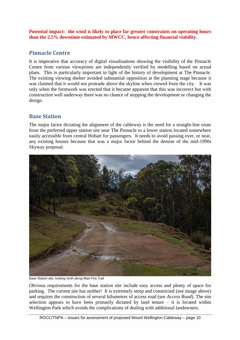
Base Station site, looking north along Main Fire Trail
Obvious requirements for the base station site include easy access and plenty of space for
parking. The current site has neither! It is extremely steep and constricted (see image above)
and requires the construction of several kilometres of access road (see Access Road). The site
selection appears to have been primarily dictated by land tenure – it is located within
Wellington Park which avoids the complications of dealing with additional landowners.

ROCC/TNPA – Issues for assessment of proposed Mount Wellington Cableway – page 11
The MWCC has provided no details apart from a site plan. Elevations are required to
demonstrate that construction is feasible (e.g. substantial earthworks will be required just to
construct a turning loop for buses in the area pictured) and enable consideration of all
environmental impacts.
Parking (customer access)
55 parking spaces are proposed, many in areas which will need to be levelled to
accommodate other aspect of the base station. The steep and constricted nature of the site
dictates that the cost and environmental impact of levelling more ground to provide
additional spaces will be substantial. The MWCC’s proposal as it was in December 2015
included 160 car park spaces in a three story building at the Brewery. Even this number of
parking spaces seems inadequate, but far more realistic that the 55 currently proposed.
In order to consider all impacts of their proposal the MWCC must provide a detailed estimate
of customer numbers and an explanation of how they intend these customers to access the
Base Station. For example, one potential solution would be an additional supermarket-sized
carpark elsewhere in South Hobart, linked to the Base Station by a shuttle bus service. This
would require assessment of its physical, social and traffic impacts.
The proposal will also need to address staff access to base station. There is an obvious
potential for vehicles of MWCC staff to occupy many of the scarce parking spaces for long
periods.
All of the above needs to be explicitly stated in the proposal to enable all aspects of the
proposal to be considered in the evaluation of the EIS. The facilities to be provided also have
implications for the financial viability of the proposal (particularly provision of a shuttle bus
service).
Access Road to Base Station
Road
The proposed road will have an average gradient around 10% (steeper than the road to the
Pinnacle) and traverse steep slopes through sensitive ecological communities (see below).
When the MWCC applied to the Hobart City Council for permission to access this route for
scientific studies, HCC staff recommended refusal of the application and suggested an
alternative route with less environmental impact following existing fire trails. Construction
will require considerable cut and fill which will add substantially to the width of the cleared
area. The final road design must be provided to enable a realistic estimate of environmental
impact.
Threatened species
The state government’s Natural Values Atlas shows the presence of both state and federally
listed threatened species in the area between the McRobies Gully Landfill Site and the Base
Station. A referral to the federal government for assessment under the Environment
Protection and Biodiversity Conservation Act 1999 (EPBC Act) will be required.
The impacts of the road on wildlife will extend well beyond the footprint of the road itself.
Crossing McRobies Gully
The road will need to cross McRobies Gully close to the current entrance to the landfill site.
This is a steep gully which can carry substantial flows after heavy rainfall events, as
ROCC/TNPA – Issues for assessment of proposed Mount Wellington Cableway – page 12
demonstrated by the extensive damage resulting from the May 2018 flood. This crossing will
be expensive.
Cascade Road – McRobies Road intersection
The MWCC correctly identifies that this intersection will need to be upgraded to allow
unrestricted access by full-sized tour buses. This is a steep site and only a plan view is
provided by MWCC. The elevations will show the feasibility and impacts. Construction will
require substantial earthworks (expensive) and it appears likely that several of the adjacent
houses will be very close to a roof-height retaining wall with road on top. Even if they
remain habitable, substantial compensation is likely to be required.
Traffic
The MWCC estimates only a tiny increase in traffic through South Hobart. This must be
reconsidered in light of the issues discussed above.
Cost
All of the above suggest that the construction of the access road will be extremely expensive.
This must be factored into the financial viability of the proposal. The MWCC has stated that
that the proposal will be entirely privately funded. We call on them to confirm that this
extends to all aspects of the proposal, including the access road and the Cascade Road –
McRobies Road intersection.
Claimed recreation benefits
The MWCC claim benefits to paragliding, walk and bike trails and snow play/snowboarding.
Paragliding
The immediate response of the paragliding community is understood to be that the cables and
towers of the cableway will make the site too dangerous for paragliding so the proposed
launch ramp will be not be utilised. In any case, paragliding is only possible in unusually
calm weather conditions. Even if a safe flightpath can be identified, it is unlikely to form the
basis of a commercial tourism operation.
Walk and bike trails
The MWCC promises new mountain bike tracks including an “epic downhill trail connecting
the Chalet to Junction Cabin”. The MWCC is able to offer funding for such proposals
(mountain bikers looking to ride downhill are likely to be a major source of customers for the
cableway) but the provision and management of walking and mountain biking trails is the
responsibility of the Wellington Park Management Trust and Hobart City Council which have
already rejected a similar downhill trail proposal.
Snow play and snowboarding
It is very rare for there to be sufficient snow cover for skiing or snowboarding and most of
the time when the road is closed by snow or ice the weather at the Pinnacle is unsuitable for
anyone without appropriate wind and waterproof clothing. Introducing inadequately equipped
persons into the Pinnacle area in these conditions has substantial risk management
implications for MWCC.

ROCC/TNPA – Issues for assessment of proposed Mount Wellington Cableway – page 13
Sufficient snow for snow play is more frequent but there are only a few days each winter
when even modest snow cover coincides with weather suitable for family fun. It is in these
circumstances that the HCC is usually obliged to restrict traffic on the road to avoid gridlock.
The cableway will provide substantial additional capacity in these circumstances but this is
likely to result in even greater crowding at The Pinnacle and greatly increased impact on
sensitive vegetation. Such days are so few and unpredictable that they will contribute little to
the financial viability of the proposed cableway.
Impacts on traffic and parking on kunanyi
The MWCC assume that the cable car will reduce traffic on The Pinnacle Road and reduce
demand for parking at The Pinnacle. This needs to be justified because the opposite seems
likely. The cheapest way for anyone with a car to access The Pinnacle or the Pinnacle
Centre remains to drive up the road and park in the Pinnacle car park. Hobart residents
are likely to try the cableway once before reverting to driving up the road. Visitors such as
restaurant patrons who drive to the Pinnacle Centre are likely to occupy a parking space for
far longer than the current visitors (predominantly sightseers whose average length of stay
would only be a few minutes). Few, if any, cable cars anywhere in the world are competing
against unrestricted road access to the same destination. The MWCC’s claim that access to
the mountain road will not need to be restricted needs to be scrutinised.
Carbon Footprint
The MWCC estimates a net reduction in Hobart's carbon footprint in excess of 1100 tonnes
per annum from the anticipated reduction (see paragraph above) in traffic. This needs to be
balanced against the carbon cost of construction and operation. It is likely to be many years,
if ever, before a net reduction in carbon emissions is achieved.
If the MWCC wish to claim a reduction in carbon footprint as a benefit of the proposal, this
needs to be supported by an analysis which includes the full carbon cost of construction and
operation of the cableway.
Financial viability
Many of the issues raised in the document have the potential to significantly increase the cost
of the proposal. It is essential that all costs are factored into the final financial viability
assessment. The costs of dismantling and restoration in the event of financial or technical
failure need to be estimated but are likely to be substantial. The MWCC’s undertaking to set
up a trust fund to cover these costs is unlikely to be realistic.
Alternative Vision
Both ROCC and TNPA recognise that kunanyi / Mount Wellington has major overuse issues
which need to be resolved, most obviously in relation to traffic and parking at peak periods.
In the short term further expansion of the shuttle bus service is supported. It directly
addresses the obvious issues of traffic and parking. In contrast to a cableway it requires no
additional infrastructure, the capital cost is miniscule, the service is readily scaleable to match
demand and it provides access for bushwalkers to multiple locations on the road (not just The
Pinnacle).

ROCC/TNPA – Issues for assessment of proposed Mount Wellington Cableway – page 14
In the longer term we would support the development of a shared vision for the future of The
Mountain which acknowledged the importance of the natural environment and the visitor
experience. This should include consideration of limiting peak visitor numbers to preserve an
appropriate experience, what facilities are required by visitors and the best location for them.
These could include, for example, a visitor centre, café, more and better public toilets,
shelters for shuttle bus passengers, lookouts, walking tracks and interpretative information.
It is false logic for the MWCC to imply that their proposal for a large building at The
Pinnacle containing café, restaurant and bar, and associated cableway, is the only option for
the future of The Mountain.