irrigation management for crop diversification in indonesia, the
TRANSCRIPT
IIMI TECHNICAL PAPER 1
Irrigation Management for Crop Diversification in Indonesia, The Philippines, and Sri Lanka
A Synthesis of IIMI's Research
Irrigation Management for Crop Diversification in Indonesia,
The Philippines, and Sri Lanka A Synthesis of IIMI's Research
SENEN M. MIRANDA
...........
.....................
..................
....................
.................. ...............
INTERNATIONAL IRRIGATION MANAGEMENT INSTITUTE IIMI Technical Paper 1

Mianda, Senen M. 1989. Irrigation management for crop diversification in Indonesia, the Philippines, and Sri Lanka: A synthesis of IIMI's research. Colombo, Sri Lanka. ZE EOp x ~ , I ~ t b"p
I irrigation management 1 irrigation practices I irrigation systems I intensive mpping I diversification /constraints/incentives/researchIrice/irrigated farminglrainl water uselwater supply1 water users 1 farmer-agency interactions lcommunicationlequity 1 soil moistureldrainagel crop yield 1 production costs 1 rotational issue I Indonesia 1 Philippines 1 Sri Lanka I
DDC 63 1.7
ISBN 92-9090-106-3
Summary: This paper is a synthesis of IIMI's research on irrigation management for crop diversification in Indonesia, the Philippines, and Sri Lanka. It provides some conclusions and recommendations on the potentials and consuaints to more intensive non-rice production during the drier part of the year in irrigation systems that have been developed primarily for rice production. The research results obtained from selected irrigation system sites in the three coun!ies from 1985 todate wereanalyzedandcomparedby establishingcommonreferencepoints where they existed,suchas common constraints,potentials,andinstitutionalarrangements,and by explainingdifferences basedonobserveddataforeachsystem. Relevantsecondarydarotherthan from the research sites were located to shed further insight in the synthesis.
Please direct inquiries and comments 10:
Information Office International Irrigation Management Institute P.O. Box 2075 Colombo
0 IIMI, 1989 Responsibility for the contents of this publication rests with the author. Funds for printing and dissemination of this publication have been provided by the Asian Development Bank.
All rights reserved
Cover photograph by Senen M. Miranda
Table of Contents
Figures
Tables
Preface
Executive Summary
Introduction
Research Objectives And Rationale
Research Sites Criteria For Site Selection Crops and Cropping Patterns Rainfall Patterns Soils
Chapter 1
Chapter 2
Chapter 3
Chapter 4
Emerging Research Results And Their Implications Irrigation Management Practices
Planning
V
vii
ix
xi
xiii
1
11 11 18 20 21
21 21 21

TABLE OF CONTENTS
29 30
35 37
Implementation Monitoring and evaluation
On-farm Irrigation Practices Crop Decision-Making Considerations
Chapter 5
Preliminary Conclusions And Recommendations Potentials Constraints
Irrigation-related (including institutional) constraints Agronomic constraints Economic consmints
Chapter 6 Indicative Research Agenda
Bibliography
Annexes A : Research Objectives by Country B : Research Sites in the Philippines C : Research Sites in Indonesia D : Research Sites in Sri Lanka E : Irrigation System Management in Indonesia F : Irrigation System.Management in the Philippines G : Irrigation System Management in Sri Lanka H : IIMI-IRRI Collaborative Project on Problems of
Irrigation Management For Rice-based Farming Systems
47 47 49
49 50 50
53
57
63 65 71 75 79 87 93
101
Figures
1.
2.
3.
4.
5.
6.
Rice imports during 1969 to 1985 in Indonesia, the Philippines, and Sri Lanka
Rice yield during 1969 to 1985 in Indonesia, the Philippines, and Sri Lanka
Location of study sites for TA 859 PHI in the Philippines
Location of study researcb sites in Java, 1986 to 1987
Location map of research sites in Sri Lanka
Map of the Upper Talavera River Irrigation System (UTRIS) in Nueva Ecija showing cropped areas for dry season 1987-1988 and critical points of water distribution
Mean monthly rainfall for East, West, and Central Java, Indonesia (20 years' average)
Mean weekly rainfall for South Cotabato, Nueva Ecija, and Ilocos Norte. the Philippines
Mean monthly rainfall for North Central Province, Anuradhapura, Sri Lanka (30 years' average)
Soil map of Mahaweli area, 305-D4
Actual and planned gate operations at MPR 4, Cirebon. West Java
Non-rice crop field irrigation application practices
7.
8.
9.
10.
11.
12.
4
5
12
13
14
19
22
23
24
25
33
37
vii
FIGURES
41 13.
14.
A descriptive model of cropping decision making used in the Philippines
Farmer decision model to plant padi or palawija. h o t 2 Block, Central Java, first planting period of 1986 dry season (Gadu I)
second planting period of 1986 dry season (Gadu II)
showing additional farm-level facilities used by farmers during the dry season
Typical layout of water-dishbution system in a land consolidated area
43
15. Farmer decision model to plant padi or palawija, larot 2 Block, Central Java, 44
16. Layout of rotation area in the Upper Talavera River Irrigation System ( U T R I S ) 49
55 17.
viii
Tables
1.
2.
3.
4.
5.
6.
7.
8:
9.
10.
11.
12.
World prices of major primary commodities (in 1985 constant US$/ton)
Average rice production, area, and yields, 1966-1975 to 1976-1980
Arable land and irrigation development, 1966-1980
Share of rice area irrigated and planted to modem varieties, 1975-1979
Selected statistics for Indonesia, the Philippines, and Sri Lanka showing the
Irrigation research site characterization
Crop mix for first and second dry seasons, 1986 - larot 2 and 5 . Gung Section, C e n d Java
Water requirement coefficients used by the Provincial Irrigation Service (PRIS) in study sites by crop and growth stage. 1986-1987
Mean water use efficiencies (WE) and actual higation diverted (AID) by section of systems for all Philippine study sites, dry season 1987-1988
Seasonal water availability and water use efficiency during the fust and second dry seasons, Indonesia study sites, 1986
Variations in water delivery at various levels in the Sri Lanka study sires, 1985-1986
Irrigation field application practices for rice and non-rice crops by country
1
6
6
6
7
15
20
28
31
32
34
36
ix
TABLES
13. Field irrigation rates and yields for selected non-rice crops at IIMI research sites, Indonesia, 1986 38
Field irrigation rates for selected non-rice crops at IIMI research sites, 14. the Philippines, 1986-1987 39
15. On-farm water delivery rates, drainage class, and dry-season crop yields in research sites, Sri Lanka, 1985-1986
Average rice production costs and returns compared with other crops by the ratio of non-rice crop/rice crop 48
40
16.
X
Preface
When the International Irrigation Management Institute (IIMI) was established in mid-1984. a number of what had been rice-importing countries in the region were on the threshold of becomhg self-sufficient or had already attained self-sufficiency. This situation has been ascribed to the new rice seed fertilizer technology and the rapidexpansion ofimgatedareas whererice was grown. The success in increased rice production has, however, spawned a second-generation problem of declining incomes of farmers from rice production.
It is in this context that IIMI, shortly after its establishment, responded to a request from the Asian Development Bank (ADB) to explore the potential for, as well as consbaints to, accommodating non-rice crops in irrigation systems which have been designed, constructed, and operated to grow rice in the Philippines and in Indonesia. By early 1985, IIMI had begun the study in the Philippines. Thereafter, similar research was started in Sri Lanka on the request of the Institute’s Sri Lanka Consultative Committee. The work in Indonesia got underway before the end of 1985.
In January 1988, as part of an ADB Regional Technical Assistance grant to IIMI, financial support for a synthesis including dissemination of the research in the three countries from 1985 to 1988 wasmadeavailable. Thesynthesis wasdone throughacomparisonoftheresultsobtainedand the use of secondary materials whenever it was found essential to reinforce some of the findings. Some conclusions and recommendations on the potential for, and constraints to, more intensive non-rice production during the drier part of the year in rice-based irrigation systems are presented, as well as an indicative research agenda to tackle the outstanding issues.
The highlights of the synthesis were presented in an organizational and planning workshop for a research network on irrigation management for diversified cropping in rice-based systems held in Bangkok from 30 November to 3 December 1988. The participants - 34 senior irrigation, agricultural, and planning officials from 8 humid tropical countries in Asia - elected the members of a steering committee to oversee the research network to promote intercountry comparisons and information dissemination. The implications of the findings of this synthesis on the rehabilitation and modernization of rice irrigation schemes were discussed in a lecture given at the recently concluded Asian Regional Symposium on the Modernization and Rehabilitation of Irrigation on Drainage Schemes, held at the Development Academy of the Philippines, which was attended by 115 participants from 19 countries.
xi
xii PREFACE
As mentioned above, there are still a number of technical, socioeconomic, and institutional issues identified as important, if not more so than irrigation management, in enhancing cultivation of non-rice crops. Some of these issues are better addressed by national agricultural research systems. Intacklingtheoutstanding issuesonthesubject, however,IIMI willbeabletocollaborate with the relevant irrigation and research organizations in developing and disseminating irrigation management innovations through the newly organized research network.
The manuscript was prepared by the author with materials contributed and suggested by A. Valera. H. Murray-Rust, D. Vermillion, C.R. Panabokke, D. Groenfeldt. N. Raby, E. Martin, and D. Merrey - all at IIMI - as well as by IIMI’s field research staff and the staff of national collaborating irrigation management agencies and research organizations in the three countries where the research is being conducted.
Special thanks is due to M. Agalawatte and D. Bandara for their assistance in preparing some of the tables and figures, T.M.K. Wijesinghe for drawing some of the figures, Ms. Champa Fernando for editing the text, and Ms. Dewaki Nugawela for typing the manuscript.
Finally, the financial support provided by We ADB as part of and ADB Regional Technical Assistance grant is gratefully acknowledged. This assistance made possible the preparation. publishing, and dissemination of this report
Senen M. Miranda Senior Irrigation Specialist International Irrigation Management Institute
Executive Summary
In mid-1984 when IIMI was established in Sri Lanka, a number of what had been rice-importing countries in humid tropical Asia were either becoming self-sufficient or had already attained self- sufficiency in rice production. These included countries like Indonesia, the Philippines, and Sri Lanka. Improved rice seed and fertilizer technologies, along with heavy investment on irrigation facilities, have been ascribed to be responsible for this success.
It has become apparent, however, that aglut in the rice supply has resulted in declining incomes of farmers from rice production. It is in this context that IIMI, soon after its establishment, responded to a request by the ADB to study the potential for, as well as constraints to, accommodating non-rice crops in irrigation systems which have been designed, constructed. and operated to grow rice. The study is an offshoot of an earlier study undertaken jointly by the International Food Policy Research Institute (IFPRI) and the International Rice Research Institute (IRRI). This study, completed in May 1984, concluded that the Philippines, the country that was used as a model, had a comparative advantage, relative to imports. in the production of both irrigated rice and some non-rice crops. The study further identified the critical issue of the need to examine the technical and socioeconomic constraints to profitable production of irrigated diversified crops.
IIMI started addressing the issue in early 1985 in the Philippines, later in Sri La&, and before the year was over, in Indonesia. .Several irrigation system research sites were selected in the Philippines and Indonesia where IIMI received the ADB's technical assistance, and only two sites inSriLankawheretheInstitutehadtorelyonitsunresuictedfunds. TheBank,throughitsRegional Technical Assistance, provided funding to IIMI to make this comparative synthesis of the results of its research on irrigation management for crop diversification in the three countries.
It became apparent early in the conduct of the research that rainfall distribution - and not so much the annual total - significantly influences the cropping pattern. The rainfall pattern itself is determined by the prevailing monsoon and the presence of mountain barriers. During the fxst wet- season cropping, the primary crop grown is rice, as to be expected, in all three countries. During the second or third cropping season, the irrigation and cultivation practices observed vary across countries and situations. In the Philippines and in Sri Lank which basically have two cropping seasons, the service area is reduced to a fraction of the areaserved during the wet season. The
... XI11

xiv EXECUTIVE SUMMARY
reduced irrigated area is rotatedevery year in the Philippines while institutional sharingof reduced area is practiced in Sri Lanka. In Indonesia where the cropping intensity is highest, the third cropping has been decreed by the government to be devoted only for cultivation of non-rice crops.
Rice, however,is still being grownin thepoorly drainedlow-lying areas. Except for theresidual soils in the Sri Lanka sites, the soils in Indonesia, and in the Philippines are all alluvial. The soils range from sand to clay texture, from poorly drained to well-drained, and from good rice land to diversified land class. The Philippines is currently pushing the cultivation of non-rice crops in the diversified and dual land class soils while Sri Lanka is now promoting the same in the well-drained soils.
In the management of the imgation systems, the intensity of operational planning and implementation, monitoring, andevaluation of the plan vary acrosscounuiesand sites within each country. The basic principle in planning in any case is simply to match as closely as possible the water supply with the water demand or soilsandcroprequirements. Theplanningprocess observed can be very simple or complex, depending on the scope for manipulating supplies according to the demand. Inigationand otherassociatedgovernmentofficialsmeetwith farmers todecide formally on the plan before it is finalized and operationalized. The implementation of the agreed plan is dictated by the availability of water at the slrzrt of the main season. The type of system, whether run-of-the-river or storage type, influences the availability of water and, consequently, the water- delivery and distribution schedule. The monitoring of the implementation leaves much to be. desired. Ittends tobreakdownasitgoeslowerin thesystem. Exceptwherethereisactivefarmers’ participation, it is more geared towards office reporting rather than towards day-to-day operations. Consequently, itisgenerally found that systems suffer from deficiencies of water whereas the head or upper portion has excess water. On-farm operations observed are relatively flexible in terms of the farmers’ capability to cope with different conditions of water availability. With reliable water supply at the turnout level, sharing of the water among farmers is better organized withgreater equity andfewerconflicts. Thereverse situation, however.triggers off a chain of undesirable reactions.
It is now pssible to make some conclusions and recommendations on the potentials for, and constraints to, more intensive non-rice production during the drier part of the year in irrigation systems that have been developed primarily for rice production. Some of the potentials are:
* Therearenon-ricecrops grown ineachcountry showing higher andconsistentprofitability than rice.
* There are well-drained and coarse-textured soils in parts of the commands of the irrigation systems which are well-suited to diversified crops.
* A limited water supply not adequate to meet the requirements of rice during the dry season is observed in many schemes with favorable soils. Related to this is the distinct unimodal rainfall pattern which makes it possible to have the desired well-aerated soil condition during the dry season.
* No major land movement or landshaping is needed to irrigate non-rice crops, although farmers have to introduce a rudimentary system of on-farm supply and drainage ditches in these plots to facilitate the timely application of water to their fields, and removal of water. Rice basin
IRRIGATION MANAGEMENT FOR CROP DIVERSIFICATION xv
bunds are retained where the appropriate seedbeds are prepared according to the water- application requirements of specific non-rice crops.
* Irrigation systems properly designed and constructed for supplementary irrigation for wet- season rice, which can meet the land soaking and land-preparation requirements, have enough canal capacity for the intermittent flow of water for irrigating non-rice crops, although the need for greater canal water regulation is apparent.
* Greater interest among all concerned from farmers to policy makers and the donor community is now being generated, and attention paid, to the various issues of evolving a viable strategy for rural diversification of which irrigated crop diversification is a key ingredient.
There are, however, the following constraints:
* Water control is more demanding in terms of supply and removal for non-rice crops due to their far stricter requirements of soil moisture. The intermittent delivery of limited and uncertain water supply during the dry season requires greater joint management effort and, in tun, needs effective communication between irrigation staff and farmers.
* To provide the necessary functional water control, regulation, and measuring facilities have to be present to enable effective monitoring and feedback of the water supply.
* Farmers who have grown only irrigated rice before are unfamiliar with the agronomic and irrigation practices for non-rice crops.
* There are greater economic risks associated with non-rice crops than with rice. Cash and labor inputs can be three orfour times higher for non-rice crops than forrice crops. Institutional credit is scarce while noninstitutional credit carries usurious interest rates.
* Unlike in the case of rice, unstable prices and lack of organized marketing for non-rice crops increase the risks for farmers involved in their production.
Someof thegeneral conclusions and recommendations that can be considered by policy makers are:
* For diversified cropping those irrigation systems with a limited water supply whose conditions are not adequate to meet therequirements of rice for the whole command during the dry season, and which have substantial areas of well-drained, coarser-textured or diversified land class of soils, should be selected fist.
* The irrigation system should be at least in a physical condition that would enable a satisfactory level of water delivery and control at various levels of the system.
* There is an urgent need to improve the interaction between irrigation staff and farmers in imgation system management, from planning and implementation to monitoring of irrigation

xvi EXECUTIVE SUMMARY
deliveries. Some form of joint management by encouraging increased organized fanners' participation in the irrigation management process is needed to meet the more demanding requirements of non-rice crops in a situation of limited and uncertain water supply.
* A more vigorous extension program to disseminate the irrigation as well as agronomic practices for non-rice crops showing potential profitability is suggested to help fanners consider options on what non-rice crops to grow.
An assured and stable market, competitive price, and ready availability of credit are a must in promoting and sustaining irrigated crop diversification.
The synthesis of the research results strongly suggests the following indicative research agenda to tackle the outstanding issues on the subjecc
* Research should focus more on irrigation systems in which management manipulations, practices, and technologies can be applied with the least cost and highest possible efficiency to alternate between rice and non-rice cropping patterns.
* Research needs to focus on the assessment of suitable methodologies for the introduction of an effective process for bringing about the desired improvement in communication between agency staff and fanners in the management of the more demanding intermittent water delivery.
* There is a need to come up with improved methodology for assessing and matching water supply and demand, including water supply augmentation possibilities under diversified cropping conditions.
* To reduce, if not eliminate, the undesirable excess soil moisture condition. there is a need to work out appropriate alternative designs of irrigation and drainage systems which enable the timely application andremoval of water by evaluating a spectrum of available technology from the ingenious rudimentary ways of the fanners to the capital intensive practices already being applied in Japan and Taiwan.
Some of the research issues are better addressed by national agricultural research systems or by international crops research institutes because they arebetter endowed to do so. On the other hand, through the newly organized research network on the subject, IIMl will be able to collaborate with irrigation management agencies and research organizations in developing and disseminating irrigation management innovations to help solve the outstanding problems.
CHAPTER 1
Introduction
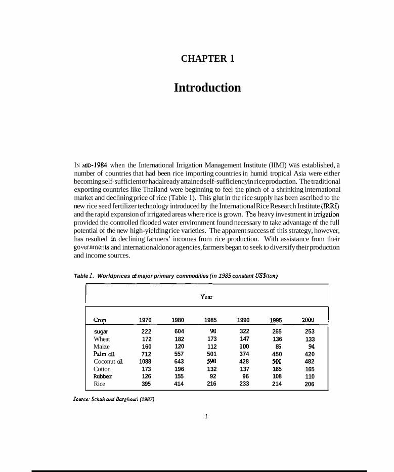
IN ~ 1 ~ - 1 9 8 4 when the International Irrigation Management Institute (IIMI) was established, a number of countries that had been rice importing countries in humid tropical Asia were either becoming self-sufficient or hadalready attained self-sufficiency in rice production. The traditional exporting countries like Thailand were beginning to feel the pinch of a shrinking international market and declining price of rice (Table 1). This glut in the rice supply has been ascribed to the new rice seed fertilizer technology introduced by the International Rice Research Institute (IRRI) and the rapid expansion of irrigated areas where rice is grown. The heavy investment in irrigation provided the controlled flooded water environment found necessary to take advantage of the full potential of the new high-yielding rice varieties. The apparent success of this strategy, however, has resulted in declining farmers’ incomes from rice production. With assistance from their governmencs and international donor agencies, farmers began to seek to diversify their production and income sources.
Table 1. Worldprices of major primary commodities (in I985 constant US$/ton)
Crop sugar Wheat Maize Palm oil Coconut oil Cotton Rubber Rice
1970
222 172 160 712
1088 173 126 395
- 1980
604 182 120 557 643 196 155 414
1985 1990
90 322 173 147 112 100 501 374 590 428 132 137 92 96
216 233
1995
265 136 85
450 500 165 108 214
__ 253 133 94
420 482 165 110 206
Sowee: Schuh andBarghovri (1987)
1
2 INTRODUCTION
It is in this context that IIMI, shortly after its establishment, responded to a request from the Asian Development Bank (ADB) to explore the potential for, as well as consmints to, accommodating non-rice crops in irrigation systems which have been designed, construcled, and operated to grow rice in the Philippines and in Indonesia. By early 1985, IIMI had begun the study in the Philippines. Thereafter, IIMI started a similar research effort in Sri Lanka as requested by its Sri Lanka-IIMI Consultative Committee'. The work in Indonesia got underway before the end of 1985.
The general objective of the research is to identify the physical, managerial, and institutional changes inirrigationmanagementthatmustbemadebeforenon-ncecropscan bemoreintensively cultivated in irrigation systems developed primarily for rice production. The study also examines the technical and socioeconomic factors that constrain as well as encourage more intensive non- rice production during the drier part of the year when water is insufficient to grow rice over entire systems. Because of its mandate, however, IIMI has consciously uied to focus its attention primarily on the critical role of irrigation management in the crop-diversification process. Lately, in its collaborative project with IRRI on the problems of irrigation management in rice-based farming systems, IIMI has further concentrated its focus on the main-system management concerns, in which it has a comparative advantage, and is leaving the on-farm irrigation management questions for IRRI to tackle.
This paper is intended to provide a synthesis of IIMI's research on irrigation management for cropdiversification inIndonesia, thephilippines, andSriLankathrough acomparisonof the results obtained from 1985 to the present. Secondary materials are used whenever it is essential to reinforce some of the findings.
'Irrigation management specialists and officials from higadon agencies as well as IMl staff are included in this committee. Ensuring that IIMl's prugram is responsive to Sri Lanka's needs and communicating IIMI's research findings to key officials of irrigation management agencies are its aims.
CHAPTER 2 .
Research Objectives And Rationale
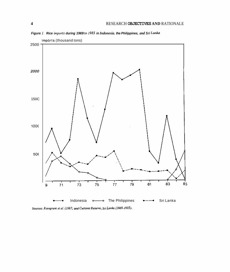
U ~ L R E C ~ Y . INDONESIA. the Philippines, and Sri Lanka were large importers of rice, with Indonesia being the world’s largest in the 1970s as shown in Figure 1. Over the years they have adopted rice production policies aimed towards self-sufficiency. Self-sufficiency, however, was not attained until 1977 in the Philippines and 1984 in Indonesia. The Philippines became a marginal exporter up to 1983 but, due to unfavorable weather, was an importer again beginning in 1984. Sri Lankais nearing self-sufficiency and may even generate surpluses in the next Few years.
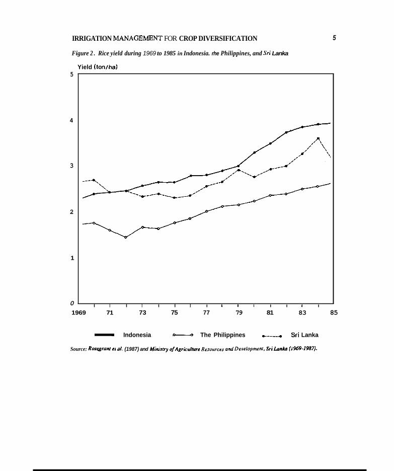
The main government policy initiatives to expand rice production in the three countries have included investment in irrigation expansion and improvement, investment in research capacity for development of rice varieties adapted to specific country conditions, rice intensification programs to encourage the dissemination of new technologies and inputs, rice price support and stabilization policies, and investment in rural infrastructure. Rice is the most important crop in respect of area, number of producers, and contribution to agricultural production. From 1966 to 1975 and from 1976 to 1980, while the average annual rate of growth in rice production in Asia as a whole was 2.6 percent, it was 4.3 percent in Indonesia, 4.9 percent in the Philippines. and 3.6 percent in Sri Lanka as shown in Table 2. The average annual rate of growlh in rice yield obtained by the three countries was about twice the 1.6 percent for Asia. This yield increase is graphically shown in Figure 2. Most gains in rice production have stemmed from increased yields rather than expansion of the area cultivated to rice. The productivity of arable land has been increased by irrigation. Between 1966and 1980, inigatedlandincreasedatanannualrateof 1.88percent inIndonesia,3.93 percent in the Philippines, and 2.00 percent in Sri Lanka (Table 3). The share of rice area irrigated from 1975-1979 is shown in Table 4 for each country, ranging from 42 percent in the Philippines to 84 percent in Indonesia. The percentage of area planted to modern varieties ranged from 50 percent in Indonesia to 68 percent in the Philippines.
The success in increased rice production has spawned a second-generation problem by creating surpluses beyond domestic requirements and depressing rice prices and lowering farm incomes in all three countries including most Asian economies. The relative decline of rice in theseeconomies in the changing of agricultural production is shown in Table 5.
3
4 RESEARCH OBJECTIVES AND RATIONALE
Figure 1 . Rice imports during 1969 10 198s in Indonesia. the Philippines, and Sri Lanka
Imports (thousand tons) 2500
2000
150C
l0OC
50(
Indonesia O--Q The Philippines -----. Sri Lanka
5
Sources: Rosogronr er a/ . (1987) and Cusromr Rorurnr, Sri Lnnka (1969-1985).
IRRIGATION MANAGEh4ENT FOR CROP DIVERSIFICATION 5
Figure 2 . Rice yield during 1969 to 1985 in Indonesia. rhe Philippines, and Sri Lanka
Yield (tonlha) 5
4
3
2
1
0 I I I I I I I I I I I I I I I
1969 71 73 75 77 79 81 83 85
- Indonesia - The Philippines e----* Sri Lanka
Source: Rosegram el 01. (1987) and Ministry o/AgricuNurc Re~ources and Developmenr. Sri Loniln f I 969-1987),
6
Counny Roduction of rice '000 metric tons
RESEARCH OBJECTIVES AND RATIONALE
Annual Area Annual Rice Annual rate of '000 ha rate of yield rate of growth growth (mtha) growth 1961-75 1966-75 1966-75 to 1976-80
to to 1976-80 1976-80
Indonesia Philippines Sri Lanka 1.321 1.721 3.6 658 702 0.9 2.7
IAsia I 279.665 338.015 1 2.6 1 118278 127375 1 1.0 1 i::; 1.6
1966-75 1976-80 (%) 1966-75 1976-80 (%) 1966-75 1976-80 (Yo)
18.738 25.695 4.3 7979 8906 1.5 2.34 2.89 2.9 5.060 7.221 4.9 3287 3524 0.9 1.54 2.05 3.9
Source: ALplrdfiom B a r k . Herdt. and Rose (1985J.
Table 3. Arable land and irrigation developmenr, 1966-1980
C o u n y
~ ~ ~
Total arable land COO0 ha) Irrigated land COO0 ha) Rauo of irrigated/
1966 1980 Annual rate 1966 1980 Annual rate arable land (%I of growth (%I
. . of growlh (%) 1966 1980
Table 4. Share of rice area irrigated andplanred 10 modern varieties. 1975-1979.
Indonesia Philippines Sri Lanka
C o u n y Share of area planted Share of rice area to modem rice (%) irrigated (%) 1
12600 14200 0.86 4175 5418 1. 88 33.13 38.15 7120 7050 -0.07 740 1269 I 3.93 1 10.39 18.00 792 1025 1.86 398 525 2.00 50.25 51.22
, 50 68 61
Indonesia Philippines SriLanka
84 42 61
Source: Barker, llerdr, undRose (1985)
IRRIGATION MANAGEMENT FOR CROP DIVERSIFICATION 7
Table 5 . Selected srarisrics for Indonesia, the Philippines, and Sri Lanku showing the declining starus of the rice economy.
Population (million)
Per capita income (US$)
Paddy yield (tonsha)
Share of GDP (46) Agriculture
Rice
Labor force
- Year
1965 1985
-
1985
1960 1985
1965 1985
1965 1985
1965 1985 -
Indonesia
109.50 168.40
560.00
1.81 3.87
51.00 24.00
18.80 7.80
66.00 55.00
Philippines
32.60 56.80
760.00
1.16 2.49
26.00 27.00
5.20 3.40
54.00 49.00
sri Lank8
11.20 15.90
360.00
1.02 2.80
58.00 24.00
7.20 6.30
55.00 46.00
Source: World Bank (19880).
As domestic requirements for rice have been met locally and prices of rice in world market declined in the mid-l980s, diversification policies involving complementary programs for non- rice crops have received priority attention in these economies. The issue is somehow intertwined with broader agricultural development strategies, especially the interplay between short-term policies designed to meet immediate government objectives for the sector and the long-term relationship of agriculture to the rest of the economy during the process of structural changes.
Rice is uniquely important to the three countries. Its labor intensity, high productivity at low input costs, widespread cultivation in millions of small f m s generating positive growth linkages, and its adaptability to the cultural practices under flooded conditions have made it difficult to design diversification programs.
The primary aim of the imgation projects implemented since the mid-1960s in the three countries has been to provide a more reliable supplementary supply of water during the wet season for the cultivation of rice under wetland conditions. Irrigation during the dry season is asecondaq consideration. In most cases the reduced water supply is used to grow an additional crop of rice on a more limited area. There are exceptions to this, as will be discussed, in some of the systems included in IIMI's research where the growing of non-rice crops was considered from the design stage. Otherwise, sites for irrigation projects have usually been selected because of their suitability for rice, and the systems planned for rice production. Most of the areas have very heavy clay soils. There are some limited areas with relatively light and well-drained soils. The heavy clay soils are suitable for rice and the well-drained soils are suitable for non-rice crops.
The ADB and the World Bank have played major roles in financing the extensive investments in irrigation infrastructure. The two banks, together and separately, initiated imgation sector

8 RESEARCH OBJECTIVES AND RATIONALE
reviews to explore possibilities of assisting governments in such countries as the Philippines and Indonesia in the development of medium- and long-term food production strategies and policies for irrigated agriculture. Earlier, in February 1983, the ADB initiated a study focused on the operational aspects of satisfying future requirements of food consumption and developing suitable approaches and methodologies for use in the analysis and determination of optimum strategies for agricultural development. The study, which was undertaken jointly by the International Food Policy Research Institute (IFF’RI) and IRRI and completed in May 1984, used the Philippines as a model to develop a methodology by which to analyze othercountries. The study concluded that the Philippines had a comparative advantage, relative to imports, in the production of both irrigated rice and some non-rice crops. It identified as one viable alternative the shifting of any “excess capacity”inimgationfromricetotheproductionofcom,soybean,cotton,etc..wheresoilspermit. The study also revealed the availability of an area of about 270,000 hectares (ha) of lighter soil types within currently irrigated areas that would be suitable for diversified crop production during the dry season.
A critical issue identified in that study is the need to examine the technical and socioeconomic constraints to profitable production of irrigated upland (diversified) crops. This became the basis for a technical assistance grant (TA 564 PHI) by the ADB to the Government of the Philippines to collaborate with IIMI on a “Studyon ImgationManagement forCropDiversjfication.” Thestudy was started in early 1985 with the appointment of an IIMI resident scientist in the Philippines.
In Indonesia, the ADB Sector Review and Contact Mission in mid-1984 reached an agreement with the Government of Indonesia to conduct a two-year five-component study on food production and irrigation strategies in Indonesia. It was agreed with the Indonesian Government that the first three components of the study, dealing with the macroeconomic aspects of food demand, supply, and substitution as related to the Government’s food crop market interventions and pricing policies and to regional comparative advantages, should be undertaken by IFPRI. The remaining two components, dealing with the technical, socioeconomic, and institutional aspects of irrigation management and crop diversification, were to be studied by IIMI and got underway in late 1985 with the appointment ofan IIMI resident scientist in Indonesia. Both studies in the Philippines and in Indonesia have been extended for a second two-year phase, and are due to be completed by this year.
In the case of S n Lanka, the National Agriculture, Food, and Nutrition Strategy emphasized the importance of crop diversification and regional specialization to increase the profitability of farm enterprises, and the need for government services in research and extension, supporting the transition through multidisciplinary research programs. Under crop diversification, aspects to be emphasized were the need for a marketing program to ensure the commercial viability of non-rice crops, and greater attention to policy review and assessment of other field crops tn ensure that producer incentives were maintained. The members of the IIMI-Sri LankaConsultative Committee, being fully aware ofthe National Agriculture, Food, and Nutrition Strategy, and after being briefed by IIMI on the newly initiated study on irrigation management for crop diversification in the Philippines, requested IIMI to conduct a similar study in Sri Lanka beginning in the dry season of 1985. Unlike the studies in the Philippines and Indonesia, IIMI had to rely on the limited unrestricted portions of its budget in funding the work in Sri Lanka.
Although IIMI had hoped to develop a unified overall approach for the three country studies, financing and other problems forced it to adopt a variety of strategies in the conduct of the research for eachcountry. While theobjectivesareverysimilar, themethodologiesusedand,consequently,

IRRIGATION MANAGEMENT FOR CROP DIVERSIFICATION
the data collected have varied. As a whole, the research objectives by country (as listed in Annex A) are focused on the examination of the technical and socioeconomic constraints and potentials to more intensive non-rice cropping in irrigated land during the drier part of the year when there is insufficient water available to grow rice throughout many systems. The findings would serve as a basis for developing and recommending policies and practices, including appropriate water control, to promote more intensive diversified (non-rice) cropping.
The research methodologies, albeit different, paid special attention to physical, social, economic, and agricultural factors relevant to a better undersunding of irrigation management technologies. The technologies permit seasonal shifting from rice to non-rice crops in areas particularly well- suited to non-rice crop production. Physical factors, such as water supply, drainage, soil characteristics, and climate: biological factors, such as type of non-rice crops, length of growing season, and water requirements: institutional factors such as requirements for labor, technology, water, and farmer-agency interventions: and economic factors such as profitability of cultivation praclices and yield risk were examined. Decision-tree analysis was used in two counties in identifying which of the foregoing factors were most important and under what circumstances with respect to farmers’ decisions to grow rice versus non-rice crops.
CHAPTER 3
Research sites
CRITERIA FOR SITE SELECTION
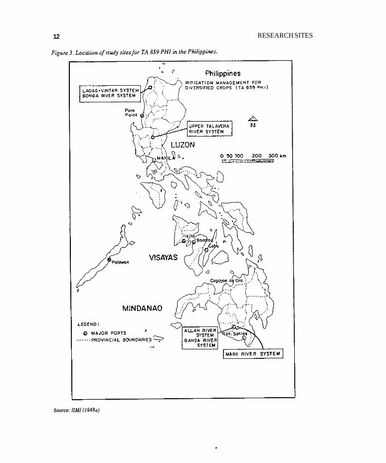
THE CRITERIA APPUED in the selection of research sires varied across countries. In the Philippines, the Allah River Irrigation Project site in South Cotabato was essentially chosen because the Technical Assistance grant was justified by citing the need for the development of an appropriate water management scheme for the proposed rice-based cropping pattern for the project. This Project was designed to accommodate non-rice crops such as corn in the coarse-textured sandy areas during the drier second season. As the Project was still under construction. only the Lateral “A” Extra, where the Pilot Testing and Demonstration Farm Number 2 was to be located, was selected in conducting the research. The adjacent Banga River Irrigation System and the nearby Mani Communal Irrigation System were chosen to understand how they were being managed as fully operational systems in accommodating irrigated corn. The Cavite site, the Second Laguna de Bay Irrigation Project of the National Irrigation Administration. was envisioned to have 2,500 ha out of an aggregate area of 13,160 ha programmed for vegetable production using water to be pumped from the Laguna de Bay Lake. A whitebean production promotion project was in progress when IIMI began its work. The Magat River Integrated Irrigation System in Isabela. which is one of the two biggest systems in the country, has about 11,000 ha of diversified land class in which the Ministry of Agriculture and Food was trying to promote hybrid yellow corn production under its Maisagana program. This system’s initial rehabilitation was funded by ADB and so was the construction of the Second Laguna de Bay Irrigation Project, Banga River Irrigation System, and Allah River Irrigation Project. The other sites such as the Laoag-Vim River Irrigation System. SanFabianRiverIrrigation System, UpperTalaveraRiver Irrigation System, etc. were addedmuch later to gain more insight into why crop diversification has been successful in these systems. Figure 3 shows the location of the Philippine sites. Annex B provides brief descriptions of some of the key sites.
In Indonesia, the research sites were selected in relation to the following criteria: 1) they either have non-rice (palawija) crop production - palawija crop production is high on neighboring fields - or have very high potential for diversified cropping in the area; and 2) they are perceived by the staff of Provincial Department of Public Works to have above-average quality of imgation management - defined in terms of the decision-making process for the allocation of irrigation water, not in terms of the available water supply - or to have the potential for high quality of irrigation management in the area. Because the type and quality of the physical infrastructure are
RESEARCH SITES 12
Source: IIM1 (19880)
IRRIGATION MANAGEMENT FOR CROP DIVERSIFICATION 13
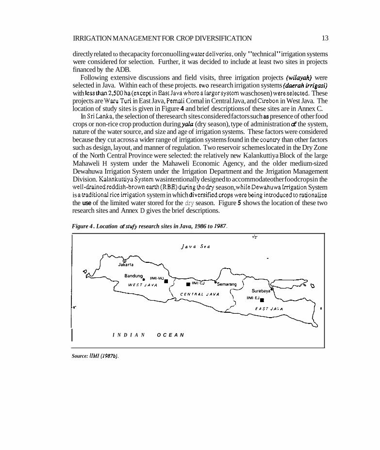
directly related to thecapacity forconuolling waterdeliveries, only "technical" irrigation systems were considered for selection. Further, it was decided to include at least two sites in projects financed by the ADB.
Following extensive discussions and field visits, three irrigation projects (wilayah) were selected in Java. Within each of these projects. two research irrigation systems (doerah irrigusi) with lessthan2,500 ha(except inEastJavawherealargersystem waschosen) wereselected. These projects are Waru Tun in East Java, Pemali Comal in Central Java, and Cirebn in West Java. The location of study sites is given in Figure 4 and brief descriptions of these sites are in Annex C.
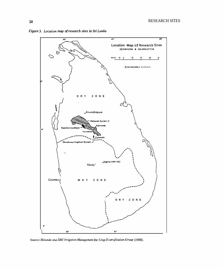
In Sri Lanka. the selection of theresearch sites considered factors such as presence of other food crops or non-rice crop production during yalu (dry season), type of administration of the system, nature of the water source, and size and age of irrigation systems. These factors were considered because they cut across a wider range of irrigation systems found in the counny than other factors such as design, layout, and manner of regulation. Two reservoir schemes located in the Dry Zone of the North Central Province were selected: the relatively new Kalankuttiya Block of the large Mahaweli H system under the Mahaweli Economic Agency, and the older medium-sized Dewahuwa Irrigation System under the Irrigation Department and the Jrrigation Management Division. KalankuttiyaSystem wasintentionally designed to accommodateother foodcropsin the well-drainedreddish-brownearth (RBE)during thedry season, whileDewahuwaIrrigation System is atraditionalriceirrigation system in which diversifiedcrops werebeing introducedtorationalize the use of the limited water stored for the dry season. Figure 5 shows the location of these two research sites and Annex D gives the brief descriptions.
Figure 4 . Location of stujj research sites in Java, 1986 to 1987.
I N D I A N O C E A N I Source: llMl(19876).
14
Figure 5. Locarion map of research sires in Sri Lanka
8, . si.
Location Map of Research Siles DEWAWVWA & I I L A N X U T T I I A
2.n.W"nd.r" -----
.*'
D R Y Z O N E
-0.
W E T Z O N E
D R Y Z O N E
b
RESEARCH SITES
lo. 81.
Source: Mirondn ond IlMl lrrigniion Momgemen, for Crop Divors@colion Group (1988).

IRRIGATION MANAGEMENT FOR CROP DIVERSIFICATION 15
A summary of some important characteristics of all selected irrigation research sites which include location, type of system, service area, crops and cropping patterns, soils, and rainfall patterns is given in Table 6.
Table 6. irrigation research sire charocrerization.
Location Type of Service Crops and Soils/ Rainfall pattern' system area (ha) cropping texture
pattern
WDONESIA
East Java
wan- tun
Nganjuk Section 3 Research blocks
Central Java Pemali Coma1
Gung Section Jarot Conkring Gung Upper Gung Lower
West Java Cirebon
Cirebon- Kuningan Section Jasem
Run-of-the 1366 river diversion scheme (technical)&
Run-of-the river diversion scheme (technical)
1624 1885
Run-of-the river diversion scheme (technical)
R-R-R R-R-P R-P-P
WS-rice Alluvial soils
DSI-rice Clay. Clay Soybean loam to DSI-rice sandy loam Soybean Maize Groundnut Sugarcane
WS-rice
DSI & DS2 Aluvial soils Rice Clay and Soybean clay loam Sugarcane Mazie Peanuts Chili Munghean Sweet potatoes
WS-rice Alluvial soil DSI& DS2 Clay
Rice Clay loam Maize and loam Onion Chili
Annual-17oOmm
Wet-100-ZODmm/mo Dry-100 mm/mo Convective storms of short duration usually in the afternoon
Annual-1900 mm
Annual-2300 mm c0asta1-120omm
2 7 0 h Hilly area> 200omm
16 RESEARCH SITES
Location Type of Service Crops and SoiW Rainfall pattern' system area (ha) cropping texture
patternb
519 Mwgbean Sugarcane
THE PHILIPPINES
South Cotabato Allah Valley IP'
Banga RIS'
Mali Communal IS I
Isabela MRIIS
Cavlte Second Laguna De Bay IP
Tarlac Tarlac-San Miguel ODonnel RIS
Nueva EciJa Upper Talavera
Pangasinan Agno RIS San Fabian RIS
Run-of-the 8000 river Sandy loam diversion scheme
1930 R-R R-Corn R-R-Corn R-R
700 R - Corn
Reservoir 97000 R-R river R-Corn
R-Peanut
h i n g 13120 scheme
Run-of-the R-R river R-Corn
Run-of-the R-R river R-Onion
R-Garlic
Run-of-the 12130 R-R river Run-of-the 4265 R-Mungbean river R - T o m a t o
R-Tobacco R-Cotton
Alluvial soils Type IV 1800 mm
to
clay loam
Alluvial soils
to loamy sand 1900 mm Clay loam Type m
R-R Clay Type I R-Whitebeans 2000mm
Alluvial soils Type I Sandy 10 clayey 2OOOmm
Alluvial soils Type I Sandy to clayey 2 0 0 h
Alluvial soils Type I
Sandy to clayey 1900 mm
IRRIGATION MANAGEMENT FOR CROP DIVERSIFICATION 11
Location Type of Service Crops and Soils/ Rainfall p a t t e d system area (ha) cropping texture
pattern
llocos Norte Laoag-Vintar RIS Bonga F?&p IS
SRI LANKA
North Central Province
Dewahuwa
Irrigation Scheme
Knlonkutriya Block Mahaweli H
Run-of-the 2317 R-R-Mungbean river Pumping 620 R-Garlic -MB scheme
Reservoir 1215 Rice-rice scheme
Rice -chilli -Soybean -mungbeam
Alluvial soils Type I
Sandy to clayer 2300 mm
Residual Bimodal rainfall
soils 1500mm Sandybeam Wet from October
to midJanumy and from mid- March to August
Pan of 2040 Rice-rice Dry in February reservoir Rice-chili Clay loam June to September scheme
- 'Qpe I . two pronounced seasons: dry from November 10 April and wet during the rest of h e year. Type 11 -no dry season with very pronounced maximum rainfall from November to January. Type 111 - season not pronounced and relatively dry from November to April and we1 during the rest of the
Type IV- rainfall more or less evenly distributed throughout the year. @ WS = wet reason - November u) March.
DS 1 = firpi dry season - April to July. DS 2 =second dry ieason - August u) November. R=rice P = pslawija
yea*.
a Techniesl- irrigation systems in which irrigation flow can be measured and conmlled. * Irrigation Projcd. ' River Irrigation System.
1mgation sysrem. Msgat River Integrated Irrigation System.
Source: Variour IIMI reports.
18
CROPS AND CROPPING PATTERNS
RESEARCH SITES
During the fust wet-season cropping, rice which is basically an aquatic plant, is primary crop grown as is to be expecled in all three counaies. Some patches of vegetables, however, are raised inthehigherareas. Sugarcane.beinga16-to 18-monthcrop which bylaw isrequiredinthecrop ratation in Java, is grown through the year.
During the second 01 third cropping season, when water supply becomes relatively scarce, the irrigation and cultivation practices observed vary across countries and sitations. In thephilippines, which basically has only two cropping seasons excepted in the Laoag-Vinm River Irrigation Syslemandrecently, BangaRiverIrrigation System, theserviceareaisreduced toafractionofthe area served during the wet season. The area is normally rotated every year with the area served in one yearreceiving wateragain in thethirdorfourth yeardependingonwhichareaiscoveredduring the dry season. Exceptions are the Laoag-Vintar Irrigation System and Upper Talavera River Irrigation System (Figure 6) in which about the same areas are served every dry season.
ThisissimilartothepracticeinSriLanka,in which theredwedupperportionoftheservicearea is scheduled for cultivation. The farmers from the lower portion share in the cultivatin of the irrigated upper portion. This institutional sharing of reduced irrigated land is called befhma. Rice is still grown especially in the poorly-drained low-humic gley (LHG) soils in the lower portion of the toposequence, but non-rice crops are now being promoted in the well-drained, higher RBEs.
A similar vend is occurring in the Philippines. It involves targeting the cultivation of non-rice crops which grow best under aerated and well-drained conditions on diversified and dual land class soils with high seepage and percolation rates. These are coarse-textured alluvial soils found along riverlevees. Crops with importsubstitution potential suchascornandsoybeansforlivestock feeds are being promoted. The same crops are being emphasized in Indonesia. In all three countries, onion is grown as a cash crop. The other cash crops are chili in Sri hnka, cucumber in Indonesia, and garlic in the Philippines.
In Indonesia, where thecropping intensity is highest (oftenoverUOpercent),thethiudcropping or second dry season has been decreed by the Government of Indonesia to be devoted only to the cultivation of palawija crops. Rice, however, is still being grown (Table 7) in the poorly-drained, low-lying areas where the groundwater table is high. In the Philippines, if a third crop is grown, it isusually mungbean. Mungbean, which is a short duration andrelativelydrought-resistantcrop. is grown in all three countries.
Specifically in Indonesia, the golongan system is used as a procedure for scheduling cropping patterns and planting dates for given secondary or tertiary blocks of irrigation systems. The practice of minimizing water demand through staggering planting dates preceded even the Dutch period, but the Dutch elaborated on the golongan system, particularly the scheduling of cropping patterns to permit sugarcane and rice rotation. This system permits the staggering of land preparation and planting dates within and between irrigation systems in order to spread out water demand so as not to exceed canal capacities and water availability. The system also reduces excessive water demand on irrigation systems by scheduling only as much dry-season rice as can be assured on the basis of irrigation staff estimates concerning adequate water deliveries. Different croppingpatternsmay beassigned todifferentblocks and these mayor may notbe rotated spatially each year. For example, in one year a given block may be scheduled for a rice-rice-palawija pattern, and the next year from a rice-palawija-palawija or perhaps, rice-sugarcane pattern.
IRRIGATION MANAGEMENT FOR CROP DIVERSIFICATION 19
Figure 6. Map ofrhe Upper Tohvera RiverlrrigorionSyslem(UTR1S) inNuevo Ecijo showing croppedorear for dry season 1987-1988 and criricalpoinrs of woler distribution.
LEGEND
20 RESEARCH SITES
Table 6 shows the typical cropping patterns observed in all research sites.
Table 7. Crop mixforfirst and second dry seasom. 1986 . Jarot 2 and 5 . Gung Section. Central Java.
J a m 2 Jarot 5
crop
Rice Soybean Sugarcane Maize Peanuu Long beans Cassava Sweetpotato XX xx Mungbem xx xx Chili xx xx Tomato Inrercmpped Squash
First dry Second dry season season
xx' xx xx xx xx xx xx xx xx xx xx xx xx xx
First dly Second dry season season
xx xx xx xx xx xx xx xx xx xx xx xx xx xx xx xx xx xx xx xx
B XX =crop was present in h e block thsr season
Source: IlMI (19876).
RAINFALL PATTERNS
It became apparent early in the conduct of the research that rainfall distribution, and not so much the annual total, significantly influences the cropping pattern. The rainfall pattern itself is determined by the prevailing monsoons and the presence of mountain barriers. The Philippines and Sri Lanka, being located north of the Equator, experience more rainfaall from May to October when the warmer and more moist Southwest monsoon is active than during the colder Northeast monsoon from November to February. Exceptions in the Philippines are sites in the South and Northeast in which the rainfall is more evenly distributed rather than being distinctly unimodal. Because the sites in Indonesia are located south of the Equator, the seasons are reversed. The wet season is also somewhat extended. The Sri Lankan sites, which are shielded from the Southwest monsoon, have the same wet season as Indonesia, from November to February when the Northeast monsoon is on. Another difference is the bimodal nature of the rainfall in Sri Lanka with the lower peak occurring in April and May. Figures 7,8, and 9 illustrate the mean monthly/weekly rainfall diseibution for the different research sites.
IRRIGATION MANAGEMENT FOR CROP DlVERSIFICATION
SOILS
21
Except for the residual soils in the research sites in Sri Lanka, those in Indonesia and in the Philippines are all water sorted or alluvial soils. The coarsest are found in the Allah River Imgation Project in the Philippines, and the finest in the Java sites, with the well-drained soils in Sri Lanka being more on the coarse side. Using the new soil taxonomy, the texture varies from sandy entisols and inceptisols in the Philippines, to alfisols in Sri Lanka, to clayey vertic inceptisols in Indonesia. In each site in all three countries, there is a range of soil textures. In Sri Lanka, it is from sandy- loam to clay-loam, in Indonesia from loam to clay, and in the Philippines from coarse sand to clay.
The soils in the Sri Lanka sites occur in a catenary sequence with the well-drained RBEs in the upper slopes of the undulating or rolling landscape, and the poorly drained LHGs in the valley bottoms (Figure 10). In the case of the Philippines, the diversified land class soils which have see page and percolation rates greater than eight millimeters per day are found along the river levees and the tine-textured good riceland class at the lower elevation further from the river where the water table is also high. The situation in Indonesia is somewhat similar to the Philippines, especially at thelaoag-Vintar River Irrigation System. The Philippines is trying to encourage the use of the diversified and dual land class in growing non-rice crops in the dry season in much the same way that Sri Lanka is pushing the growing of other food crops in the well-drained RBEs. In Indonesiaall types ofsoils,provided they can bedrained, areking used forpalawijacrops. Raised beds and deep drains are frequently resorted to as a means of providing the well-aerated condition required by the palawija crops. In some cases shallow rooted crops like onions which are irrigated twice daily are grown to take advantage of the high (shallow) water table conditions, especially in the West Java sites.
22 RESEARCH SITES
Figure 7, Mean monrhly rainfall for East, West, and Central Java, Indonesia (20 years's average).
Rainfall (mm)
500 7 400
300
200
100
n - Jan. Feb. Mar. Apr. May June July Aug. Sep. Oct. Nov. Dec.
West Java Central Java
Source: Dolo from ffMf (1 9870).
IRRIGATION MANAGEMENT FOR CROP DIVERSIFICATION
Figure 8 . Mean weekly rainfall. for Sourh Corabaro. Nuevo Ecija. and IlocosNorre. the Philippines.
23
- Nueva Ecija ( 1 975-1986)
- South Cotabato (1 967-1986) ----_ llocos Norte (1965-1 986)
Source: Volrrn el 01. (1988).
24 RESEARCH SITES
Figure 9. Mean monthly rainfallforNorrh CentralPravince. Anuradhapura, SriLanka (30years'overage),
Rainfall (rnrn)
IRRIGATION MANAGEMENT FOR CROP DIVERSIFICATION 25
Figure 10. Soilmap ofMohaweli area, 305-04
Source: PnnoboWre and //MI lrrignrion Monagemnl for Crop Diversifcarion Group (1988).
CHAPTER 4
Emerging Research Results And Their Implications
IRRIGATION MANAGEMENT PRACTICES
IN rn MANAGEMENT of the irrigation systems selected in the three countries, the intensity of operational planning and the implementation, monitoring, and evaluation of the plan vary across countries and sites within each country.
Planning
The basic principle in any case is simply to match as closely as possible the water supply with the water demand or soil crop requirements. The planning process observed can be very simple or complex, depending on the scope for manipulating supplies according to the demand. It can be as simple as the farmers being informed by their association officers about the availability of water and the time of its distribution. as in the Mani Communal Irrigation Systems or the Bonga Pump IrrigationSystem in thephilippines Or,itcan beveryelaborateasinrelativelylargeschernessuch as the Mahaweli System H in Sri Lanka or in the Magat River Integrated Wgation System in the Philippines. In the Magat River Integrated Irrigation System, planning can mean estimating the future water supply and the water demand of the expected cropping pattern. and then matching the two. This procedure of matching the water supply and demand is routinely done in all irrigation systems in Indonesia, and to a lesser degree in the Philippines and in Sri Lanka.
In eslimfing rhefufure supply, the factors considered by the irrigation staff include anticipated rainfall distribution during the wet and dry seasons by using past records; type of water capture, diversion, and storage systems used; and reliability of hydrologic and climatic data. The situation varies from no records kept of rainfall and river and diversion flows, to 5-year moving average for national systems in the Philippines, 10-year records for the “technical” systems in Indonesia, and even longer records of about 30 years as used by the Water Management Secretariat for Mahaweli System H, using a main frame computer to estimate probabilities of flow during the on-coming season. The estimate often becomes pure guesswork in which the future supply is variable and unpredictable, as in some run-of-the-river schemes.
The water demand is determined, when this is done, by estimating the cropping patterns. the cultivation extent, and irrigation efficiencies at the on-farm and main systems. The efficiencies
21
28
1.12 1.12 0.65 0.71 0.46
0.30 0.45 0.30
0.30 0.15 0.15
EMERGING RESEARCH RESULTS AND THEIR IMPLICATIONS
1.20 1.20 0.73 0.79 0.52
0.30 0.45 0.30
0.30 0.15 0.15
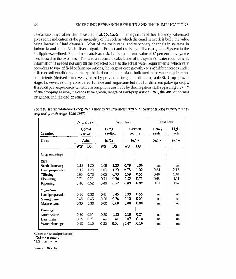
usedareassumedrather than measured in allcounuies. Themagnitudeof theefficiency valueused gives some indication of the permeability of the soils in which the canal network is built, the value being lowest in lined channels. Most of the main canal and secondary channels in systems in Indonesia and in the Allah River Inigation Project and the Banga River Inigation System in the Philippines are lined. For unlined canals as in Sri Lanka, a uniform value of 25 percent conveyance loss is used in the two sites. To make an accurate calculation of the system's water requirement, information is needed not only on the expected but also the actual water requirements (which vary according to type of field or farm operations, the stage of crop growth, etc.) of different crops under different soil conditions. In theory, this is done in Indonesia as indicated in the water-requirement coefficients (derived from pasten) used by provincial irrigation officers (Table 8). Crop-growth stage, however, is only considered for rice and sugarcane but not for different palawija crops. Based on past experience, tentative assumptions are made by the irrigation staff regarding the start of the cropping season, the crops to be grown, length of land-preparation time, the start of normal irrigation, and the end of season.
na 0.61 0.46 0.48 0.31
na na na
na na na
Toble 8. Woler requiremenf coefficienrs used by the Provincial lrrigolion Service (PRIS) in study siles by crop ond growth sroge, 1986-1987.
na 2.12 1.40 1 .A4 0.94
na na na
na na na
Crop and stage
Rice Seeded nursery Land preparation Tillering Flowering Ripening
sugorcane Land preparation Young cane Mature cane
Polowija Much water Less water Water shortage
Units
West lava
Cirebon
__ ws -
1.08 1.08 0.65 0.71 0.46
0.45 0.36 0.00
0.30 na
0.30 -
East Java
soils soils
' Liters per second per hectare. b ws =wet SCBPO".
DS = dry searon.
Source: IIMI (19876)
IRRIGATION MANAGEMENT FOR CROP DIVERSIFICATION 29
Once calculations of the supply and demand are completed, the appropriate allocation and disrribution practices or other measures are considered to determine the target flows at various levels of the irrigation system. The final choice of distribution method depends very much on the characteristics of the physical system in terms of capacity of the canal network, flow regulation available, and the managerial capacity of the irrigation staff and water users. Planning of the delivery schedule when done deliberately is normally tempered by experience gained through some form of monitoring, however crude, of the results of previous cultivation seasons.
Before the plan is finalized and operationalized, irrigation and other associated government officials meet with farmers or theirrepresentatives or both to decide formally on: a) the start of the season; b) areas and types of crops to be cultivated: c) length of land-preparation period; d) the start of normal irrigation: e) the end of the season; f) distribution method, whether continuous or intermittent; and g) the maintenance schedule and responsibilities.
At this meeting, the irrigation staff presents the plan for the season, based on whatever information is at hand and the experience accumulated in operating the system. Discussion of the plan is usually invited before the final decision is made. The suggestions of farmers may or may not be entertained in the process. This type of cultivation meeting is legally required in Sri Lanka, and is now becoming institutionalized in the Philippines. In Indonesia, the plan is approved by the Irrigation Committees at the regency and district levels.
Implementation
The agreed plan is used as the basis for the release and delivery of irrigation water. In most systems field staff have acquired experience in estimating water adequacy by simply observing elevations at intake and diversion structures, and canals. This is practical, but more reliable and accurate measuremenm are needed to assure adequate water supply. In implementing the plan for the main season or wet season in which the crop is basically rice, the starting date and the choice of the distribution method for land soaking and land preparation are dictated by the availability of water at the start of the main season. In run-of-the-river. direct diversion systems, the water flow increases with the relative activity of the monsoon. In this situation, a staggered schedule of delivery is usually chosen by serving gradually increasing acreage in accordance with the flow and rainfall pattern. The diverted flow is concentrated or rotated among sections of the canal service area. This is routinely done in the Banga River Irrigation System and the Laoag-Vintar River Irrigation System in the Philippides, in most of the sites in Java, and even in the Dewahuwa Irrigation System in Sri Lanka.
In the systems with storage facilities where stored water is adequate at the start, the water is delivered continuously to the whole service area simultaneously for a planned 30-day period although this is almost always exceeded. This is the practice in the Mahaweli System H in Sri Lankaandin theMagatRiverlntegratedIrrigation System in thephilippines. Afterplanting isover and normal irrigation commences, these systems have the flexibility to deliver water continuously or intermittently, depending on the canal network configuration and flow regulation present.
In the direct diversion type, continuous water supply is adopted for as long as the diverted flow can meet the requirement of the cultivated service area. When water becomes short as caused by the failure of the monsoon or overdiversion by systems located upstream along a river course,
30 EMERGING RESEARCH RESULTS AND THEIR IMPLICATIONS
however, the reduced flow is rotated among sections of the system. The level of rotation can be below or at theteniary,secondary,or along sections of theprimarycana1,dependingon theseverity of the water shortage. If the value of Faktor K which is the ratio of the water supply and demand falls below 0.6 to 0.7, rotational water issue is followed in Indonesia. The other alternative is to tap a supplementary water source upstream, or suppletion as the practice is called also in Indonesia. At the field level, enterprising fanners who have installed their own shallow tube or open wells use these to augment their water supply. This is routine at the Laoag-Vintar River Irrigation System and the Upper Talavera River Irrigation System in the Philippines, and in several sites in Java, but is seldom seen in Sri Lanka. In really severe cases of water shomge, agreement is sometimes reached in many systems to deliver the limited water according to the sensitivity of the crop and crop-growth stage; the more critical the stage, as in the reproductive stage, the higher the priority of water. Very often, however, the decision is made to deliver the water to areas easy to irrigate.
Interruption of water flow to the canal network for varying periods is normally practiced whenever sufficient rainfall is received in the service area of a storage system. In the direct diversion type, the flow is usually interrupted only if the rainfall is observed to be so heavy as to cause flooding in parts of the service area when combined with the irrigation supply. The other reasonadvancedfor closure ofthe headworks is toavoid breachingand siltingof thecanal network. Drainage of excess water flow is practiced extensively, although drainage facilities are generally inadequate or are not properly maintained.
During the second or thud cropping season when water supply becomes relatively scarce, the irrigation andcultivation practicesobserved vary across locations andsituations. InthePhilippines, which has only two cropping seasons, the service area is automatically reduced with rice being grown in the reduced area and other crops grown in uninigated portions, except in the few systems selected for this study, especially in the Northwest area of the country. The government has attempted to promote cultivation of a greater, if not the whole, service area with a combination of less water-consuming non-rice crops in the well-drained higher land, and rice in the lower-lying lands with high groundwater tables. This situation of having a greater area cultivated already prevailsinallof thesitesin Java,andtoalesserextentintheSriLankasites. But,during thesecond season, if the water, though limited, is still adequate and assured, fanners tend to prefer rice cultivation in all three countries. During the third season, and this is true in all sites in Indonesia, most of the area that could be irrigated is planted to palawija, except the lower-lying, poorly- drained areas. In the Philippines, it is only in the Laoag-Vintar River Irrigation System that a very limited area is planted during the third season and only with mungbean.
Monitoring and evaluation
The monitoring process leaves much to be desired. It tends to break down as it goes lower in the system. It is more geared towards office reporting rather than for day-to-day operations. Consequently, it is generally found that the tail-end portions of the systems suffer from deficiencies of water, whereas the head or upper portion has excess water. This inequity is shown by the water- use efficiency obtained at the head and tail sections in the Upper Talavera River Irrigation System in the Philippines (Table 9) and in the Central Java sites (Table 10). In the Java sites, for example,
IRRIGATION MANAGEMENT FOR CROP DIVERSIFICATION 31
gate tenders generally favor their areas at the expense of downstream fanners. This is illustrated by the value of the management performance ratios (ratio of planned and actual discharge arriving at the divisipn structure) in Figure 11. In Sri Lanka, there is more variation of flows (Table 11) at lower levels of the system with the magnitude being greater in the older Dewahuwa Imgation System. The Kalankuttiya System which has constant head regulating structures in the form of duck-bill weirs along the branch canal has much less flow variation at the head of distributaq canals. While the key requirement of farmers interviewed is for reliable and adequate supply to their fields, less availability and greater variation of water is shown in Tables 9, 10, and 11. The rotation ofthe water supply isa serious attempt to improve reliability andequity ofthe water supply in all sites. Where canal regulation is deficient, farmers themselves put up temporary checks to head up the water so it can flow in the canals serving their areas.
Table 9. Mean wafer we eficiencies (WCJE) and actual irrigation diverted (AID) by section of systems for all Philippine study sites, dry season. 1987-1988.
Site Section AID (mm) W E (5%)
LVRIS' Whole system 2086 60 Division I 2828 56 Division II 1694 67 Division m 2324 49 Division IV 1540 59
UTRISb Whole system 1864 72
Downstream area 1335 89
AMP Whole system 4431 41 Upstream area 4554 42 Midstream area 5324 37 Downstream area 3344 57
Upstream area 1965 M
BANSd Whole system 1838 85 Division A 3718 60 Division B 1300 85 Division C 2158 83
I Laoag-Vintar River Inigalion System. Upper Talavera River Irrigation System. Allah River Irrigation Projecr
* Banga River Irrigation System.
Source:Adnpledfrom Volrrn 11 or. (1988)
32 EMERGING RESEARCH RESULTS AND THEIR IMPLICATIONS
Table 10. Seasonal water availability and wafer use ef/iciency during rhefirst and second dry seasom. lndonesia srudy sites, 1986.
Season
Localion’
Easi Java
B-2 B-3 B-4 B-15 B-17 B-19 B-21 B-23 B-24 B-25 a99 8-29
Average
Central Jav;
Jarot 2 Jarot 5 cangkring : cangkring :
Average
West Java
Mirat I Mirat IIb Jasem II
Average
First dry season
Water available (m)
1103 1778 1079 743
1036 990 955
1027 911
1409 708 721
432 409 463 402
1175 2240 1228
Water efficienc: (percent)
~
47.3 34.1 27.0 74.5 52.1 70.0 42.2
na 47.9 33.8 31.3 45.2
45.9 __
55.4 38.4 73.4 74.1
60.3 ~
38.7 25.5 48.9
37.7 ~
Second dry season
Nater ivailable mm)
976 1422 1079 839
1219 990
1069 1107 1341 1333 554 869
407 442 259 257
1286 726 749
Water efficiency (percent)
31.2 20.6 31.0 39.9 27.5 33.8 31.0 30.3 22.6 20.1 64.5 26.8
31.6
72.3 64.2 69.5 91.7
74.4
18.7 37.3 12.9
23.0
‘Location is usually in order from source, although a99 and B-29 are Tertiary block3 off h e main canal and secondary m a l B-21. respectively.
Source: llM1 f19.976).
IRRIGATION MANAGEMENT FOR CROP DIVERSIFICATION 33
.
- - - -
-
- -
-
-
- - - -
Figure 1 I
2.1
1.8 2 2 u 3
c
L c v) 1.5
E
L
0
m p 1.2 1
ln C 3 1.0 0 u 0.9 II: a 5
0.6
0
0 0
0 0
0 0
0 0 0
0
0 0 0
0 0
o o 0 0
. ..< * ..... 2. 0 . 4
J
- 0.3
0
I I I I I I I I I I I I I
Source: Colmey. MurrayRusl, and Vermiilion (1988).
In the management of an irrigation system, even in its simplest form. the mechanism for delivering and applying water to fanners' fields can be considered to consist of three parts: 1) a set of physical works that moves the water from its source to the crop, 2) a plan that defines the activities to be undertaken, and 3) the people individually and in groups who implement and monitor the plan. Using the new computer lingo, the physical infrastructure is referred to as' hardware, and the nonphysical managerial inputs as software. Up to a certain point, as Levine (1980) puts it, some degree of substitution between the hardware and software elements in each of the basic functions of water delivery, maintenance, and conflict management of irrigation systems is observed. Any gap between the irrigation management practice that is desired and that which exists seems to be caused by one or more of the following:
34
Table 11. Variafions in water delivery af various levels in the Sri h n k n sfudy sires, 1985-1986
EMERGING RESEARCH RESULTS AND THEIR IMPLICATIONS
Season Delivery Numberof Mean Standard Range Coefficients o points' observations delivery deviation (mm) variation
(mm)
Dewahuwa
1985yala DC DT To
1985186 maha Dc
DT To
1986yala DC DT To
Kalankuttiya (Mahaveli H )
1985yala Dc To
1985186 maha Dc
To
1986yala DC To
5 686 302 14 661 306 3 474 172
7 1087 171 20 956 448 17 1129b 515
9 1030 355 20 703 394 10 570 227
3 886 96 11 755 128
5 688 99 28 534 192
5 907 100 29 757 259
310-1228 44 301-1321 46 240-652 36
766-1373 16 339-2050 47 438-2571 46
412-1809 34 190-1846 56 313-1018 40
880-1006 10 624-1037 17
513-797 14 104-859 36
766-1022 11 167-1223 34
DC =Head of disvibutr~ chmel. DT = D k c t tmout from main 4. To = Turnout from Dc lncrrued by inflow from local tunoff.
Source: Mirando and llMI Irrigation Managemnl for Crop Divrrsificnfion Group (1988).
* .* *
poorly maintained and deteriorated condition of the physical system: incomplete or inappropriately designed and constructed physical works such as lack of functional flow-regulating and measuring facilities or inadequate canal capacity; lack of accountability and motivation of irrigation staff due to weakness in the management system, especially in performance monitoring and feedback for the decisionmaking process, interference by politicians and influential people; and uncooperative behavior and attitude of many farmers, probably caused by their noninvolvement and lack of appreciation and trust in system management.
*
IRRIGATION MANAGEMENT FOR CROP DIVERSIFICATION 35
The end result of deficiencies in the hardware-software mix is unstable water supply to various parts of the irrigation system. This problem is common in whole systems or parts of systems included in the study. It may be remedied by timely evaluation and use of monitored information at various levels of the system management as indicated by operational research conducted in the Mahaweli H site with the participation of agency staff and farmer leaders. Regular meetings between the irrigation officials and the farmer leaders after each rotational water delivery proved to be an effective way in improving communication between them and in identifying specific water problems and their solutions at the secondary and tertiary levels. To improve the collection and information neededformanagement decisions, new procedures tested arenow being recommended to Indonesia. This includes the use of a pocket-size book by the gate operator to record discharges, the use of the management performance ratio to monitor and respond to variation in planned and actual discharges, and the making and using of tertiary block maps to improve information on actual crop areas.
Annexes E, F, and G describe the irrigation system management in Indonesia, the Philippines, and Sri Lanka research sites, respectively.
ON-FARM IRRIGATION PRACTICES
On-farm operations are relatively flexible in terms of the farmers' capability to adjust to different conditions of water availability. The reliability of water supply on the farm depends on the supply situation in the main system. With reliable water supply at the turnout, sharing of the water among farmers is better organized, with greater equity and fewer conflicts arising. The reverse situation at the turnout tends to trigger a chain of undesirable reactions and behavior from the fanners which are prompted by their desire to have amore assured water supply toprotect theirinvestmentin their crops.
Basin-to-basin flooding, which is the basic water application method for rice, is also used in irrigating non-rice crops but with a difference. Instead of the supply being continuous and simultaneous, it is intermittent and mostly rotational. The specific method of water application, however,iscloselyrelated tothe typeof seedbed that is preparedand thekindofcropthatisgrown. There are at least four application practices commonly used in all locations: 1) flush basin flooding with rudimentary field ditches for soybean and mungbean; 2) broadbed and furrow for chili, garlic, and cucumber; 3) raised beds for onion; and 4) furrows for corn, as shown in Figure 12 and Table 12.
In Sri Lanka the flush flooding from basin to basin is carried out by starting from the upper basin (liyadde) and ending at the lower one. In this method, the entire basin is flooded in one operation by turning the irrigation stream along the rudimentary ditches that are fashioned within the basin. The first basin to receive a stream size of 4-20 liters per second is impounded by blocking the basin bund spillway or check at the exit. Soon afterwards, the remaining impounded water in the upper basin is released and directed to the adjacent lower basin to irrigate it. With this method, overirrigation of the basins located close to the farm inlet results. Considerable soil loss through erosion also occurs.
The broadbed and furrow method is essentially like flush flooding, except that broadbeds with
36
Table 12. lrrigaiionfield application praciices for rice and non-rice crops by cowltry.
EMERGING RESEARCH RESULTS AND THEIR IMPLICATIONS
Application practice Indonesia Philippines Sri Lanka
A. Basin flooding Rice Rice Rice B. Flush basin flooding soybean Garlic soybean
with rudimentary Peanut Mungbed Mungbean field ditches whitebean
Mungbean Onion (with mulch) Corn
C. Broadbed and funow Cucumber Garlic Chili Onion
D. Raised beds Red onion Onion Bombay onion
E. Furrow Corn Corn Chili Cassava Whitebean
Source: Voriow IlMI reparls
furrows serving as small ditches are created in the basin. Farmers tend to aid this method by splashing water on the chili beds as is done in Sri Lanka, or on garlic and onion plots in the Philippines.
The raised bed method is identified with onion cultivation, especially in fine-textured soils and under high groundwater table conditions. The water impounded in the deep ditches on the side of the beds is scooped and sprinkled or splashed in the beds twice daily in Indonesia, and less frequently in Sri Lanka and the Philippines.
The furrow, the narrow ridge and furrow, or furrowed basin system is extensively used for row crops such as corn andcassava in Indonesia andchili in SriLanka. In the Philippine studies, furrow irrigation is proving to be suitable for irrigating corn in coarse-textured soils in the Banga River Irrigation System and the Allah River Irrigation project by cutting down the irrigation time by at least a third compared to what it takes when flush basin flooding is used.
The amount of labor used in preparing the seed beds for the different water application differs; it is highest in raised bed and hilling up from furrows conditions which can be SO to 100 percent more than for flush basin flooding method.
In terms of water applied, it tends to vary according to type of crop, rainfall and drainage, and water table conditions. Table 13 shows the contribution through capillary action of groundwater in the poorly drained areas planted to maize and soybean in Indonesia. Cropwise. the short- duration soybean requires the least water, followed by peanut and maize. In the Philippines, dry- season rainfall in the Magat River Integrated Irrigation System makes it possible to grow a good crop of corn with one to three irrigation applications only. On the other hand, Table 14 shows that short-duration mungbean needs the lowest amount of water, while onion, more frequently irrigated, needs the highest, with garlic requiring somewhat less.
IRRIGATION MANAGEMENT FOR CROP DIVERSIFICATION
Figure 12 . Non-rice crop field irrigalion applicaiion pracrices.
31
A. Basin flooding A l L l k L Y -
6. Flush Dasin flooding w i th rudimentary shallow field dilchec
C. Broad bed and furrow
D. Raised beds
E. Furrowed basin
Source: Adopted ojer //MI (19876)
In Sri Lanka, it is not obvious from Table 15 which crop requires more water. Five-month chili varieties that are grown, theoretically, have to require more water than mungbean and soybean. It should be noted that no soil moisture stress was detected in the sample areas, indicating arelatively liberal application of water exceeding crop demand. Yieldwise, chili, mungbean, and soybean fared better under well-drained soils with soybean showing the best tolerance for poorer drainage conditions.
CROP DECISION-MAKING CONSIDERATIONS
In order to understand the potential for irrigation in the process of supporting and intensifying non- rice crop production, it became necessay to identify the full range of constraints and incentives involved in the process, both those which are directly related lo irrigation and those which are not.
38 EMERGING RESEARCH RESULTS AND THEIR IMF'LICATIONS
Table 13, Field irrigation rates and yields for selecrednon-rice crops at NMIresearch sires, Indonesia. 1986.
crop Location Amount of water (mm) Yield (kgha)
Soybean
Maize
Peanut
Nganjuk, East Java
Gung. Central Java Cirebon. West lava
Nganjuk. East Java
Gung. Central Java
Cirebon. West Java
Gung, Central Java Cirebon. West Java
85 81 53 0'
376
21 1 63
26' 242 138 131 32' 29' 259
100 173 120
I
' Paorly drained fields.
Source: IIMl(1987bj.
828 380 780 818
2946 2688 3091 2418 775
1676 3478 1785 688
2446 1297 1216
In attempting to do the foregoing, two different decision-tree models were derived and developed. The descriptive model of crop decision making under uncertainty, which was used in the Philippines, is a modified version of Gladwin's (1983) decision-tree model presented in Figure 13. The one developed in Indonesia is made up of a number of models derived from interviews with individuals and groups of fanners in their homes and fields to elicit what local decision criteria are relevant within given irrigation blocks. The models for first and second dry seasons for larot 2 Block in Central Java are illustrated in Figures 14 and 15.
In the Philippines, the study examined and documented six cases of successful crop diversification in irrigated rice lands, focusing particularly on the economic and institutional and. to a lesser extent, the physical and technical factors that have been supportive of the crop production. Non- rice crops included tobacco, cotton, tomato, mungbean, onion, garlic, corn, and peanut in four systems with Type-I rainfall pattern located in Lumn. The following conditions were found to be conducive to the adoption of crop diversification during the dry season (Gonzales-Intal and Valera 1988):
1.
2. 3.
Irrigation water supply for rice in the dry season is insufficient.
Level of income from other sources is low.
The farmer has seen other farmers reap profits from the crop.
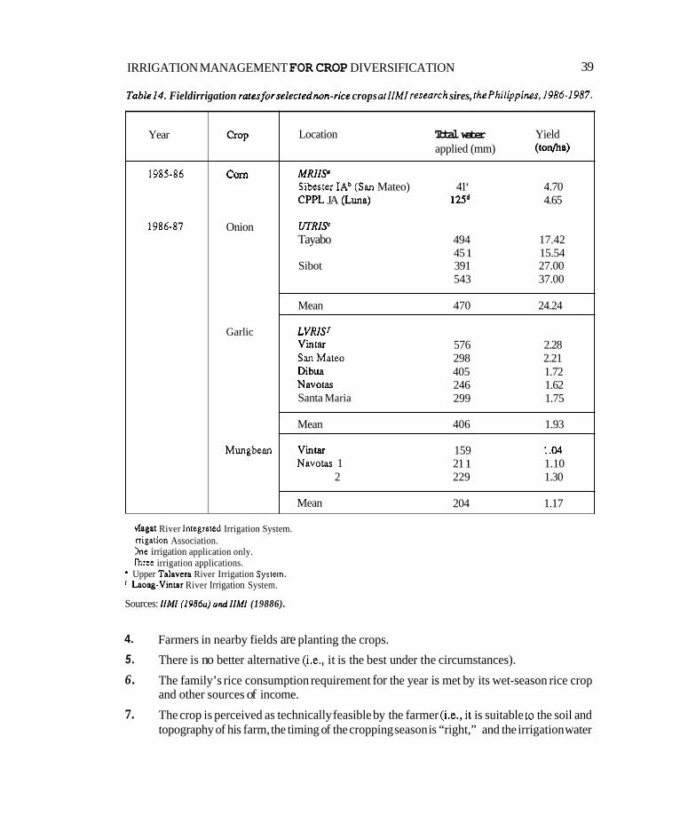
IRRIGATION MANAGEMENT FOR CROP DIVERSIFICATION 39
Table14. Fieldirrigation ralesforselecrednon-rice crops atllMlresearch sires, IhePhilippines, 1986.1987.
Year
1985-86
1986-87
COrn
Onion
Garlic
Mungbean
hagat River Integrated Irrigation System. rrigation Association. h e irrigation application only. Ihm irrigation applications. Upper Talsvera River Irrigation Syrrern. ‘ Lsoag-Vinrar River Irrigation System.
Sources: llMI (1986aj andllMl (19886).
Location Total water Yield applied (mm) (ton/ha)
M R I W Sibester IAb (San Mateo) 41‘ 4.70 CPPL JA (Luna) 125d 4.65
UTRIS Tayabo 494 17.42
45 1 15.54 Sibot 391 27.00
543 37.00
Mean 470 24.24
LVRlSf Vinlar San Matw Dibua Navoias Santa Maria
576 2.28 298 2.21 405 1.72 246 1.62 299 1.75
Mean 406 1.93
Vintar 159 1 .I4 Navotas 1 21 1 1.10
2 229 1.30
Mean 204 1.17
4.
5.
6.
7.
Farmers in nearby fields are planting the crops.
There is no better alternative (i,e,, it is the best under the circumstances).
The family’s rice consumption requirement for the year is met by its wet-season rice crop and other sources of income.
The crop is perceived as technically feasible by the farmer (i.e., i1 is suitable to the soil and topography of his farm, the timing of the cropping season is “right,” and the irrigation water
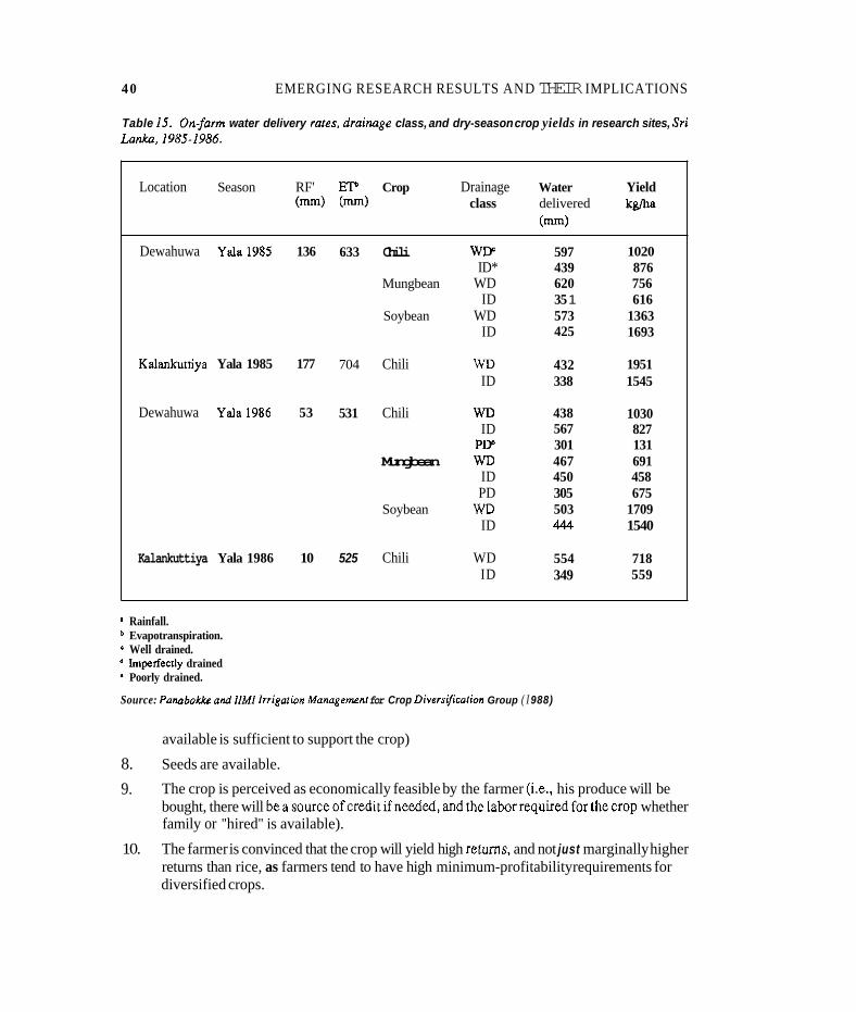
40 EMERGING RESEARCH RESULTS AND THEIR IMPLICATIONS
Table I S . Onfarm water delivery races, draiMge class, and dry-season crop yields in research sites, Sri La&. 1985-1986.
Location Season RF' EP Crop Drainage Water Yield (mm) (m) class delivered kgfha
(m)
Dewahuwa Yala1985 136
Kalankurtiya Yala 1985 177
Dewahuwa Yala1986 53
Kalankuttiya Yala 1986 10
633 Chili WIF ID*
Mungbean WD ID
Soybean WD ID
704 Chili WD ID
531 Chili WD ID PW
Mungbean WD ID PD
ID
525 Chili WD ID
Soybean m
597 439 620 35 1 573 425
432 338
438 567 301 467 450 305 503 444
554 349
1020 876 756 616
1363 1693
1951 1545
1030 827 131 691 458 675
1709 1540
718 559
I Rainfall. Evapotranspiration. Well drained. Imperfecrly drained Poorly drained.
Source: PonnboWrr and IIMI lrrigaiion Mnnngenrenr for Crop Diwrsfimicarion Group ( I 988)
available is sufficient to support the crop)
8. Seeds are available.
9. The crop is perceived as economically feasible by the farmer (Le., his produce will be bought, there will beasourceofcreditifneeded,and thelaborrequiredfor thecrop whether family or "hired" is available).
The farmer is convinced that the crop will yield high returns, and not just marginally higher returns than rice, as farmers tend to have high minimum-profitability requirements for diversified crops.
10.
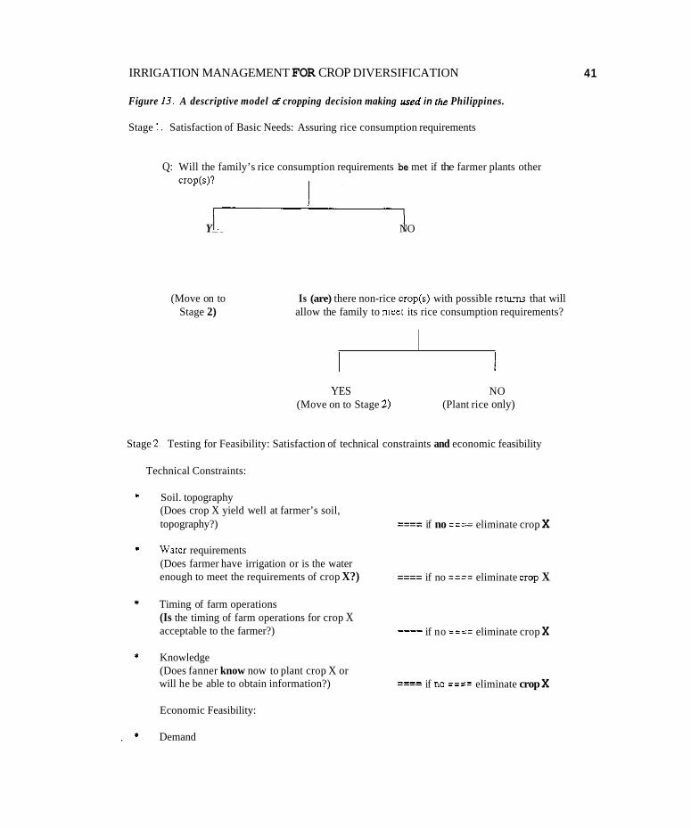
IRRIGATION MANAGEMENT FOR CROP DIVERSIFICATION
Figure 13. A descriptive model of cropping decision making ured in the Philippines.
Stage 1. Satisfaction of Basic Needs: Assuring rice consumption requirements
Q: Will the family’s rice consumption requirements be met if the farmer plants other crop(s)?
YES + NO
(Move on to Stage 2)
Is (are) there non-rice crop(s) with possible reNms that will allow the family to meet its rice consumption requirements?
YES NO (Move on to Stage 2) (Plant rice only)
Stage 2. Testing for Feasibility: Satisfaction of technical constraints and economic feasibility
Technical Constraints:
Soil. topography (Does crop X yield well at farmer’s soil, topography?)
Water requirements (Does farmer have irrigation or is the water
____ ---- if no === eliminate crop X
if no ==== eliminate crop X ____ enough to meet the requirements of crop X?) ____
Timing of farm operations (Is the timing of farm operations for crop X acceptable to the farmer?)
Knowledge (Does fanner know now to plant crop X or
____ ---- if no ==== eliminate crop X
if no ==== eliminate crop X _-__ will he be able to obtain information?) ____
Economic Feasibility:
Demand
41
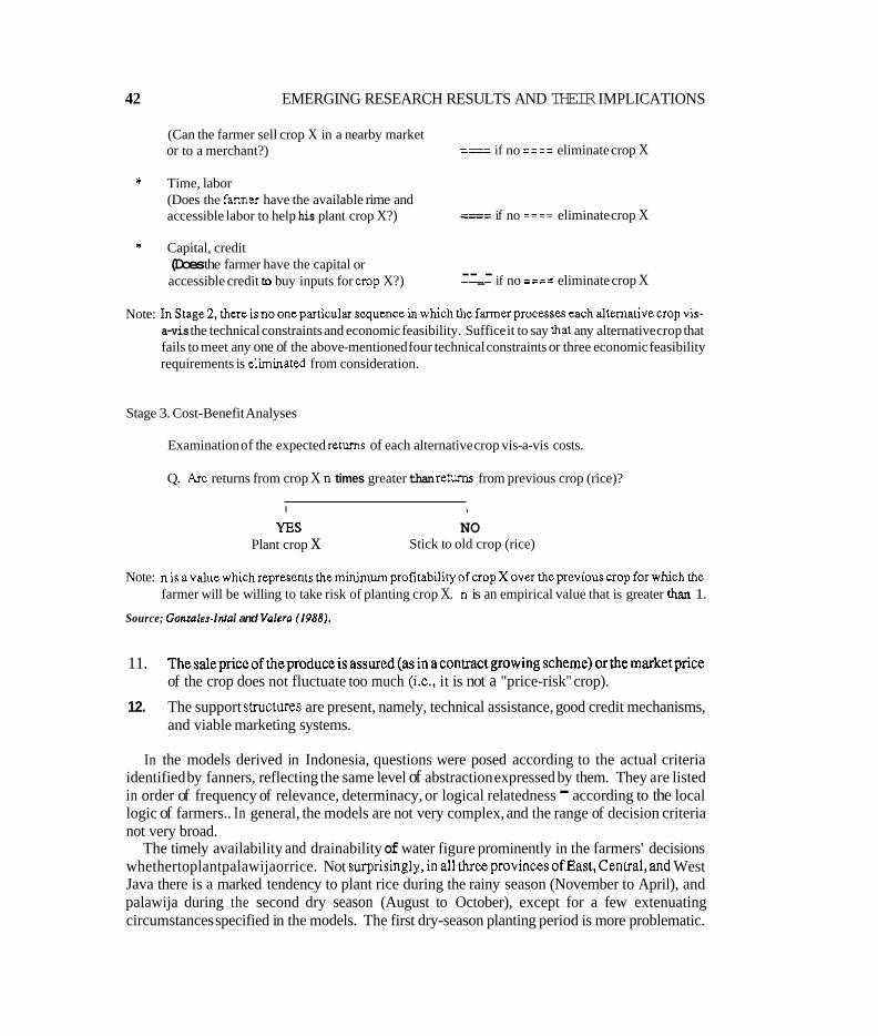
42 EMERGING RESEARCH RESULTS AND THEIR IMPLICATIONS
(Can the farmer sell crop X in a nearby market or to a merchant?) ____ ---- if no ==== eliminate crop X
* Time, labor (Does the farmer have the available rime and accessible labor to help his plant crop X?) ____ ---- if no ==== eliminate crop X
* Capital, credit (Does the farmer have the capital or accessible credit to buy inputs for crop X?) --_- if no ==== eliminate crop X
Note: InStage2. thereisnooneparticularsequencein whichthefarmerprocesseseachaltemativecropvis- a-vis the technical constraints and economic feasibility. Suffice it to say that any alternative crop that fails to meet any one of the above-mentioned four technical constraints or three economic feasibility requirements is eliminated from consideration.
Stage 3. Cost-Benefit Analyses
Examination of the expected returns of each alternative crop vis-a-vis costs.
Q. Are returns from crop X n times greater than returns from previous crop (rice)?
I 1
YES NO Plant crop x Stick to old crop (rice)
Note: nisavaluewhichrepresentstheminimumprofitabilityofcropXoverthepreviouscropforwhichthe farmer will be willing to take risk of planting crop X. n is an empirical value that is greater than 1.
Source; Gonzaldnrol and Vnlero (1988).
11. Thesalepriceoftheproduceisassured(asinacontractgrowingscheme)orthemarketprice of the crop does not fluctuate too much (i.e., it is not a "price-risk" crop).
12. The support structures are present, namely, technical assistance, good credit mechanisms, and viable marketing systems.
In the models derived in Indonesia, questions were posed according to the actual criteria identified by fanners, reflecting the same level of abstraction expressed by them. They are listed in order of frequency of relevance, determinacy, or logical relatedness - according to the local logic of farmers.. In general, the models are not very complex, and the range of decision criteria not very broad.
The timely availability and drainability of water figure prominently in the farmers' decisions whethertoplantpalawijaorrice. Not surprisingly,inallthreeprovincesofEast,Cenual,and West Java there is a marked tendency to plant rice during the rainy season (November to April), and palawija during the second dry season (August to October), except for a few extenuating circumstances specified in the models. The first dry-season planting period is more problematic.
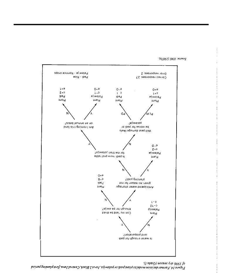
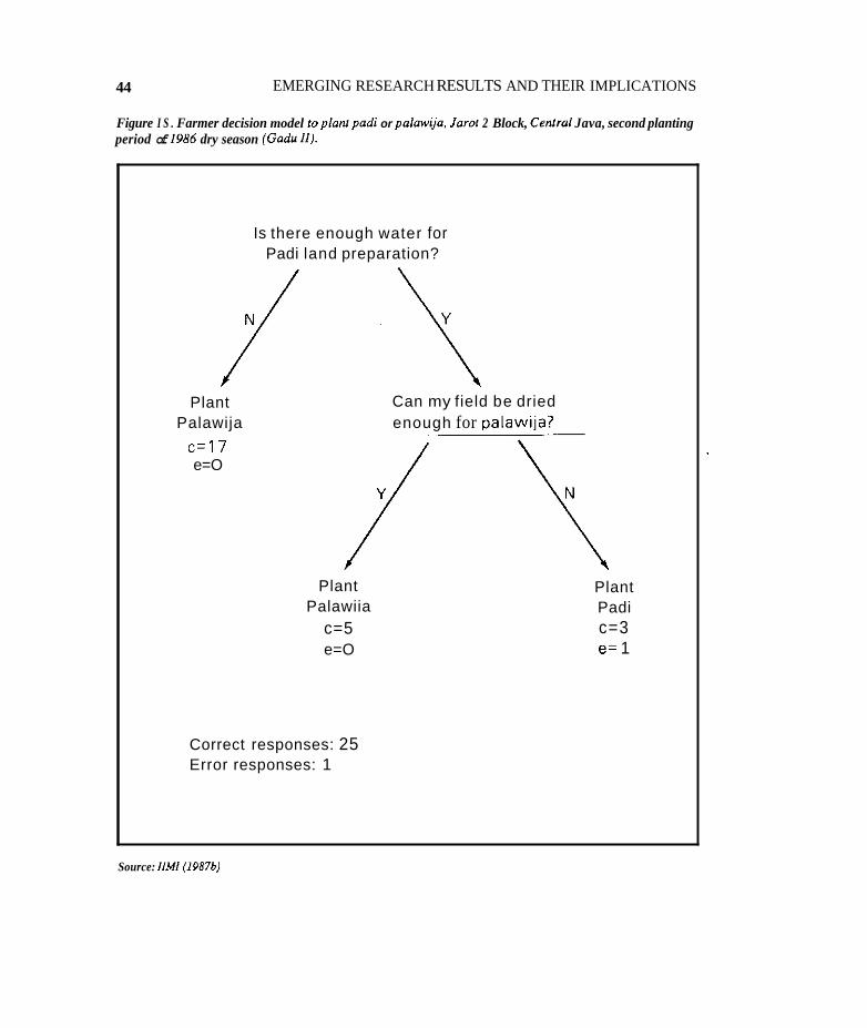
44 EMERGING RESEARCH RESULTS AND THEIR IMPLICATIONS
Figure I S . Farmer decision model 10 planf padi or palawij’a. Jaror 2 Block, Cenrral Java, second planting period of 1986 dry season (Gadu 11).
Is there enough water for Padi land preparation?
Plant Can my field be dried Palawija enough for palawija?
c=17 /
/ e=O
Plant Palawiia
c=5 e=O
Correct responses: 25 Error responses: 1
Plant Padi c=3 e= 1
Source: //MI (1987bJ
IRRIGATION MANAGEMENT FOR CROP DIVERSIFICAI'ION 45
During this season, it appears that farmers often identify the availability of water at the desired time for rice land preparation as a key factor in deciding to plant rice. If experience tells farmers that there is usually enough irrigation or rain water or both for rice cultivation during the frst dry season, farmers use as a seasonal decision criterion the availability of water at the desired point in time to begin rice land preparation (with a range of two weeks generally being the maximum tolerable time for farmers to wait and see if irrigation water or rainfall will be enough). During the seconddry season,inadequatelydrainedsoils aresometimes aconstraht toplantingpalawija. Also during this season, the prevalence of off-farm work, the high risk of crop damage by rats, and the relative insecurity of water supplies, all contribute to prompt farmers to leave their fields fallow or permit landless villagers to cultivate the land free of charge.
In the case of the Sri Lanka sites, no decision-tree model was derived or tried in understanding the crop decision making of the farmers, except by simple observation and documentation of what farmers do within the two schemes. In principle, the cropping decisionKmreaekd at the pre- cultivation meetings. Berhrna farmers are able to make their decisions only after they know the location of their farm lot within the farm allotment, its soil and drainage characteristics, and its
'access to irrigation supply. Although the drainage class of the soil has a significant influence on selecting the land for either non-rice crops (other food crops) or rice during the dry season, it is not the sole criterion. In the tail end of the longer field channels where water supply tends to be limiting, farmers are able to raise other food crops in imperfectly drained soils, and to some extent, in poorly drained soils.
Market availability, profitability as well as experience in growing another food crop influences farmers' cropping decisions. In both sites farmers give preference to chili becauseof higherretums and certainty of the market. They often find it difficult lo sell crops such as mungbean. soybean, and black gram. Availability of credit is an important consideration in growing chili because the cash cost required is about three times that of rice. As marly farmers have defaulted on their previous loans, they are at the mercy of private money lenders who charge an interest rate of 15- 20 percent per month.
!
~
CHAPTER 5
Preliminary Conclusions and Recommendations
POTENTIALS
IRRIGATED CROP DIVERSIFICATION has the potential for increasing rice farmers' incomes, achieving stable food supplies in thecountry, and earningand/orsaving foreignexchange. It may beastarting point to a more general and encompassing agricultural diversification program. It can lead to the development of relatively more income-elastic agricultural production like livestock and poultry (because of the successful production of feedgrains such as corn and soybeans), and fruits which may have greater market demand and higher potential for increased farm incomes.
There are non-rice crops grown in each country showing higher and consistent profitability compared to rice (Table 16). There are well-drained and coarse-textured soils present which are well suited to diversified crops. A limited water supply condition not adequate to meet the requirements of rice during the dry season is experienced in many schemes with favorable soil. Related to this is the distinct unimodal dry-season rainfall pattern which makes it possible to have the desired well-aerated soil conditions. These factors all contribute to a favorable environment for irrigated crop diversification.
Moreover, no major land movement or landshaping is needed to irrigate non-rice crops, although farmers have to introduce a rudimentary system of on-farm supply and drainage ditches to theirplotstofacilitatethetimelyapplicationof water totheirfieldsandremavalofwater(Figure 16). Rice basin bunds are retained when the appropriate seedbeds are prepared to fit the requirements of specific non-rice crops. Furthermore, irrigation systems properly designed for supplementary irrigation for wet-season rice which can meet land soaking and land-preparation requirements. do have enough canal capacity for the desired intermittent flow for irrigating non- rice crops. The placement of additional checks by farmers in the main delivery system to enable the regulation and delivery of a limited water supply up to the turnout level during the dry season, however, is observed.
Greater interest among all concerned from farmers to policy makers and the donor community is now being generated. and attention paid to the various issues in evolving a viable strategy for rural diversification of which irrigated crop diversification is a key ingredient. While the potential for imgatedcrop diversification has been pointed out, there areanumberofconstraints which have to be mitigated.
41
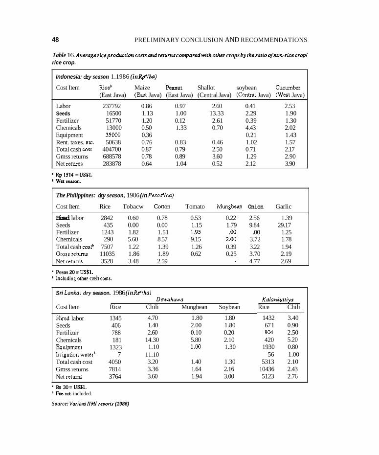
48 PRELIMINARY CONCLUSION AND RECOMMENDATIONS
Table 16. Averagericeproduclioncoslsandrerurnrcomparedwithorher crops byrheralioofnon-ricecropl rice crop.
Indonesia: dry season 1.1986 (in Rplha)
Cost Item Riceb Maize Peanut Shallot soybean cucumber (East Java) (East Java) (East Java) (Central Java) (Ceneal Java) West Java)
Labor 237792 0.86 0.97 2.60 0.41 2.53 Seeds 16500 1.13 1.00 13.33 2.29 1.90 Fertilizer 51770 1.20 0.12 2.61 0.39 1.30 Chemicals 13000 0.50 1.33 0.70 4.43 2.02 Equipment 35000 0.36 0.21 1.43 Rent. taxes. etc. 50638 0.76 0.83 0.46 1.02 1.57 Total cash wst 404700 0.87 0.79 2.50 0.71 2.17 Gmss returns 688578 0.78 0.89 3.60 1.29 2.90 Net returns 283878 0.64 1.04 0.52 2.12 3.90
Rp 1514 = USSI. ' Wet Peaso".
The Philippines: dry season, 1986 (in Pesoflha)
Cost Item Rice Tobacw Conon Tomato Mungbean Onion Garlic
Hired labor 2842 0.60 0.78 0.53 0.22 2.56 1.39 Seeds 435 0.00 0.00 1.15 1.79 9.84 29.17 Fertilizer 1243 1.82 1.51 1.95 .00 .oo 1.25 Chemicals 290 5.60 8.57 9.15 2.00 3.72 1.78 Total cash costb 7507 1.22 1.39 1.26 0.39 3.22 1.94 Grossreturns 11035 1.86 1.89 0.62 0.25 3.70 2.19 Net rehms 3528 3.48 2.59 - 4.77 2.69
Pesos 20 = USS1. Including other cash cost^.
Sri La&: dry season. 1986 (in Rflha) Dewahuwa Kalankuniya
Cost Item Rice Chili Mungbean Soybean Rice Chili
HLed labor Seeds Fertilizer Chemicals huipment Irrigation wateP Total cash cost Gmss returns Net r e m
1345 406 788 181
1323 7
4050 7814 3764
4.70 1.80 1.80 1.40 2.00 1.80 2.60 0.10 0.20
14.30 5.80 2.10 1.10 1.W 1.30
11.10 3.20 1.40 1.30 3.36 1.64 2.16 3.60 1.94 3.00
1432 67 1 804 420
1930 56
5313 10436 5123
~
3.40 0.90 2.50 5.20 0.80 1.00 2.10 2.43 2.76
* Rs 30 = USSI. Fee not included.
Source: Variour I lMl repoils (1986)
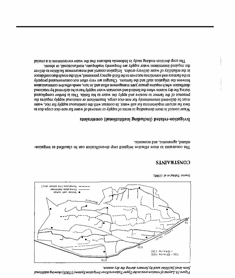
SJINIVBISN03
50 PRELIMINARY CONCLUSIONS AND RECOMMENDATIONS
element in farmers' decisions to plant rice or palawija, being even more determinative than other factors such as the market, prices, and land tenure. This means that without strict control over allocation and distribution of water, crop diversification will not become widespread. Where there is liberal water supply in the d ~ y season, even though non-rice crops return higher net profits than rice, farmers are inclined to grow rice.
Agronomic constraints
Farmers who havegrownonlyinigated ricebeforeare usually unfamiliar withagronomicpractices for non-rice crops. This is particularly true in places where crops such as corn, mungbean, and peanuts are grown only under rain-fed conditions. Farmers are also relatively unfamiliar with the crop husbandry of some important crops such as soybeans. Short-duration and high-yielding varieties of non-rice crops are needed to provide greater flexibility and more productivity to cropping patterns to fit scarce water supply situations.
Economic constraints
There are greater economic risks associated with many non-rice crops than with rice. Cash and labor inputs can be three or four times higher for non-rice crops than for rice crops. Cash inputs -. fertilizers, pesticides, and hired labor fol'weeding and harvesting -- are much higher for non-rice crops (Table 16). Institutional credit is Scarce while noninstitutional credit carries interest rates as high as 20 percent per month.
Unstable prices and lack of organized marketing structures for non-rice crops increase the risks for farmers involved in their production. Otherwise, there are indications that farmers who had grown good crops of corn in the Magat River Integrated Irrigation System in the Philippines and soybean in Sri Lanka, are more than ready u, shift to these crops, if assured of a reasonably competitive price and market for their produce.
To summarize, the following are general conclusions and recommendations that can be considered by policy makers involved with irrigated crop diversification.
* For diversified cropping those irrigation systems with a limited water supply condition not adequate to meet the requirements of rice for the whole command during the dry season, and which have substantial areas of well-drained, coarser-textured or diversified land class of soils should be selected fist .
* The irrigation system should be at least in a physical condition that would enable a satisfactory level of water delivery and control at various levels of the system.
* There is an urgent need to improve the interaction between irrigation staff and farmers in irrigation system management, from planning and implementation to monitoring of irrigation
IRRIGATION MANAGEMENT FOR CROP DIVERSIFICATION 51
deliveries. Some form of joint management by encouraging increased organized farmers participation in the irrigation management process is needed to meet the more demanding requirements of non-rice crops in a situation of limited and uncertain water supply.
* A more vigorous extension program to disseminate the irrigation as well as agronomic practices for non-rice crops showing potential profitability is suggested to help farmers consider options on what non-rice crops to grow.
* An assure? and stable market, competitive price, and ready availability of credit are a must in promoting and sustaining irrigated crop diversification.
CHAPTER 6
Indicative Research Agenda
Two BASIC QUESTIONS were addressed by IIMI in analyzing the implications of crop diversification for irrigationmanagement. First, whatare the potential incentives for.andconstraints to, increased production of non-rice crops in an irrigated, rice-based cropping system? Second. what are the appropriate irrigation management practices where diversified cropping already exists? Until lately, more attention has been given to the first question, which includes how current irrigation practices may constrain crop diversification. More recent work is being directed to address the second question which involves the comparison of the performance of different irrigation management practices for diversified cropping. This comparative analysis on the findings of the three country studies is a pan of this emerging trend. This move is shared specifically by the Philippine Council for Agriculture. Forestry and Natural Resources Research and Development (PCARRD 1988), which in the light of information, knowledge, and practices it reviewed on the subject,pointedoutthateffortswouldhave tobedirectedtolookingintothefollowinginenhancing irrigated crop diversification:
* The research agenda should focus more on irrigation systems in which management manipulations. practices, and technologies can be applied with the least cost and high efficiency to an alternate rice and non-rice cropping pattern, bearing in mind the following:
1. New waterapplicationmethodsor modification oftheexistingonesmustbeuiedat thefarm
2. Management of small, successful irrigation units or systems must be studied, particularly
* Only critically needed data in the design, planning, and operation of irrigation systems for upland crops must be attended to.
* Doubtful information/data on the design and operation of an irrigation system should be verified.
Unreliable water supply serves as a disincentive for the farmer by increasing labor costs because the additional time he spends in waiting for the water reduces his opportunities for off-farm employment. His anxiety is also increased because of the risk of losing his heavy investment on
level.
their advantages, for possible transfer of technology to other areas.
53

54 INDICATIVE RESEARCH AGENDA
cash inputs and labor, resulting from reduced crop yield if he does not get his water supply on tima One answer appears to be better communication between irrigation staff and farmers. What seems to be needed is the introduction of an effective process of bringing about the desired improvement in communication through some form of joint agency-fanner management of the irrigation delivery. More organized farmer participation is implied.
Improved assessment of both water supply and demand needs tobe done to better match the two under diversified cropping conditions. For non-rice crops the supply includes not only canal flow and rainfall but also subsurface supply from the soil profile and the groundwater table. The contribution from the fluctuating water table is harder to estimate. On the water demand, more information needs to be collected periodically in the field on the type and extent, and growth stage of non-rice cropping. The assessment of the water supply and demand needs could be facilitated with active participation of farmers, especially if they are organized.
Reduction of excess moisture and better drainage have been indicated to encourage more crop diversification. Stricter control over water deliveries is implied which may require additional management inputs. Complementary on-farm drainage facilities for fast removal of excess water and lowering of the water table may have to be installed and integrated with the main drainage system. Appropriate alternative designs of irrigation and drainage systems which enable the timely application and removal of water will need to be worked out. The farmers are already seen trying toprovidethesefacilitiesbyamdimentarysystemoffarmditchesandbeds. In JapanandinTaiwan where land consolidation of cultivated areas (shown in Figure 17) is being practiced extensively, consisting ofeachfieldplotbeing serveddirectly by aninigation ditch.adrainageditch. andafarm road, can be consideredas the ultimate in a spectrum of on-farm development possibilities and also not a distant reality.
IIMI, whose primary mission is “to strengthen national efforts to improve and sustain the performance of irrigation systems. through the development and dissemination of management innovations,” has uied to contribute its share in addressing the issues on the subject by working with both irrigation agencies and research organizations in the three counuies. As mentioned earlier, it has also initiated an ongoing collaborative project with IRRI on problems of imgation management for rice-based farming systems in the Philippines, Indonesia, and Bangladesh (Annex H). In this project IIMI is concentrating on the main system aspect, in which it has comparative advantage, by looking at the various factors that may influence the management decision-making procedures at all levels for irrigation systems with diversified cropping, and IRRI is looking at the on-farm concerns. In its newly completed strategy, IIMI has chosen to focus on seven thematic areas in fulfilling its mandate. Four of these themes, management of water resources for imgation, management of irrigation facilities, management of imgation organizations, and management of change in the institutions for irrigation, are involved in this venture. There are a number of technical, socioeconomic, and institutional issues that have been identified to be as important as, if not more vilal than, irrigation management under many situations in enhancing cultivation of non-rice crops. Some of these are better addressed by national agricultural research systems or by international crops research institutes because they are endowed with the human, infrastructural, and other resources to do so. On the other hand, through the newly organized research network on irrigation management for crop diversification in rice-based systems, IIMI will be able to collaborate with irrigation management agencies and research organizations in finding relevant solutions to the outstanding problems of crop diversification through the development and dissemination of irrigation management innovations.
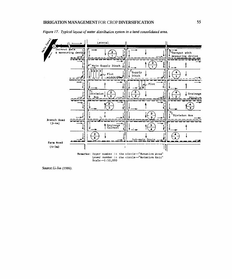
IRRIGATION MANAGEMENT FOR CROP DIVERSIFICATION
Figure 17. Typical layout a/' water distribufion sysrem in a land consalidaied area.
55
Farm Yoad (1-5.) I
Remarks: Upper number i n the c i r c l e - - " R o r a t i o n Area" Lower number i n the circlc--"Rofarion U n i c " Scale--I:10.000
Source: L i J m (1986).

Bibliography
ADB. 1986. Irrigation service fees. Manila, the Philippines: ADB.
ADB. 1986. Review ofbank operationsin the irrigation sector. 1966-1985. Staff working paper. Manila, the Philippines: ADB.
Adriano, M.S. 1988. Implications for policy of the studies on profitability of irrigated non-rice crop production: A Synthesis. Paperpresented at theNationai Workshopon Irrigation Management for Diversified Cropping held at Puerto Azul Beach and Country Club, Ternate, Cavite, the Philippines.
Adriano, M.S.; Julian, S.I.; Gerochi, J.M.; Maglinao, A.R. 1988. Policiesandissues ondiversified cropping in rice-based farming systems in the Philippines. Country paper presented during the Organizational and Planning Workshop for a Research Network on Irrigation Management for Diversified Cropping in Rice-Based Systems held at the Asian Institute of Technology Center, Bangkok, Thailand.
Barker, R.; Herdt, R.W.; Rose, B. 1985. The rice economy of Asia. Washington, DC, U S A Resources for the Future.
Cablayan, D.; Valera, A. 1987. Irrigated diversified cropping constraints in the Philippines: A preliminary study in Irrigation Management for Diversified Cropping. Digana Village, Sri Lanka: IIMI.
Cablayan, D.M.; Valera, A.B. 1988. Constraints to irrigated and diversified cropping. Philippine Agricultural Engineering Journal 29(1): 17-24.
Central Bank Annual Report. 1980-1986.
Colmey, J. 1988. Conclusions. In IIMI Review 2(1):3-7. Digana Village, Sri Lanka: IIMI.
Colmey, J.; Murray-Rust, H.; Vermillion, D. 1988. Indonesia makes the transition to O&M. In IIMI Review 2(2):3-11. Digana Village, Sri Lanka: IIM.
Department of Agriculture. 1981-1988. Subsidiary food crops, Master Plan.
58 BIBLIOGRAPHY
Dimantha, S. 1986. Kalankuttiyaon-farm water managementresearch project. Research findings. Pp 25-38 in S. Abeyratne, P. Ganewatte, and D.J. Merrey (eds.). Proceedings of a Workshop on Water Management in Sri Lanka, Colombo, Sri Lanka, Agrarian Research and Training Institute, 20-22 January 1982. ART1 Documentation Series No. 10.
Dimantha, S. 1987. Irrigation management for crop diversification in S n Lanka. Pp 135.150 in Inigation Management for Diversified Cropping. Digana Village, Sri Lanka: IIMI.
Ekanayake, R.: Groenfeldt, D. 1987. Organizational aspects of irrigation management at Dewahuwa Tank during yala 1986. Digana Village, Sri Lanka: IIMI.
FAO. 1977. Crop water requirements. (FA0 irrigation and drainage paper no. 24). Rome, Italy: FAO.
FAO. 1981. Yield response to water. (FA0 irrigation and drainage paper no. 33). Rome, Italy: FAO.
FAO. 1982. Organization, operation and maintenanceof irrigation schemes. (FA0 irrigation and drainage paper no. 40). Rome, Iraly: FAO.
Gladwin, C.H. 1983. Conuibution of decision-tree methodology to a farming system program. Human Organization 42(2): 146-157.
Gonzales, L.A. 1984. Philippine agricultural diversification: A regional economic comparative advantage analysis. Manila, the Philippines. Unpublished paper.
Gonzales-Intal, A.M.; Valera, J. 1988. Successful crop diversification in irrigated rice lands: Six case studies. Paper presented at the National Workshop on Irrigation Management for Diversified Cropping held at Puerto Azul Beach and Country Club, Ternate, Cavite. the Philippines.
Hutabarat, B.: Pasandaran, E. 1986. Reorientation of Indonesian irrigation management: Utilization towards crop diversification. Pp 69-82 in Irrigation Management for Diversified Cropping. Digana Village, Sri Lanka: IIMI.
IIMI. 1985. Inception report on the technical assistance study (TA No. 654 PHI) on irrigation management for crop diversification (the Philippines). Digana Village, Sn Lanka: IIMI.
IIMI. 1986. Interim report on the technical assistance study (TA No. 654 PHI) on irrigation management for crop diversification (the Philippines). Digana Village, Sri Lanka: IIMI.
IIMI. I986a. Study on irrigation management for crop diversification (TA No. 654 PHI): Final report. Digana Village, Sri Lanka: IIMI.
IIMI. 1987. Irrigation management for diversified cropping. Digana Village, Sri Lanka: IIMI.
IRRIGATION MANAGEMENT FOR CROP DIVERSIFICATION 59
IIMI. 1987a. Interim reporton the technical assistance study ofirrigation management. Indonesia (TA No. 673 INO). Digana Village, Sri Lanka: IIMI.
IIMI. 1987b. Study of irrigation management - Indonesia(TA No. 673 INO). Final report. Digana Village, Sri Lanka: IIMI.
IIMI. 1987c. First progress report on the study on irrigation management for diversified crops (TA No. 850 Philippines). Digana Village, Sri Lanka: IIMI.
IIMI. 1988. Efficient irrigation management and system turnover (TA No. 937 INO): Interim report. Digana Village, Sri Ldnka: IIMI.
IIMI. 1988. Inception report: Efficient Irrigation Management and System Transfer Project: Technical assistance agreement No. 937 - INO, Government of Indonesia - IIMI - ADB. Digana Village, Sri Lanka: IIMI.
1IM1. 1988. Inception report on the technical assistance study (TA No. 846 SRI): Irrigation management and crop diversification. Digana Village, S r i Lanka: IIMI.
IIMI. 1988. Irrigation management and crop diversification (Sri Lanka). Digana Village, Sri Lanka: IIMI.
IIMI. 1988. Main system irrigation’management for crop diversification in Sri Lanka. Draft working paper. Digana Village, Sri Lanka: IIMI.
IIMI. 1988. On-farm irrigation management for crop diversification in Sri Lanka. Draft working paper. Digana Village, Sri Lanka: IIMI.
11M1. 1988. Progress report of Lhe IIMl component in Indonesia in the IIMI-IRRI collaborative project on irrigation management for rice-based farming systems. Digana Village, Sri L a n k IIMI.
IIMI. 1988a. Study on irrigation management for crop diversification (TA No. 859 PHI): Interim report. Digana Village, Sri Lanka: IIMI.
IIMI. 1988b. Second progress report on the study on irrigation management for diversifiedcrops (TA No. 859 Philippines). Digana Village, Sri Lanka: IIMI.
IIMI. 1988~. Workplan for the Rockefeller Foundation funded IIMI-IRRI collaborative project on problems of irrigation management for rice-based farming systems. Digana Village, Sri Lanka: IIMI.
Jayewardene, J. 1988. Irrigation management for diversified cropping in rice-based system in Sri Lanka. Country paper presented during the Organizational and Planning Workshop for a Research Network on Irrigation Management for Diversified Cropping in Rice-Based Systems held at the
60 BIBLIOGRAPHY
Asian Institute of Technology Center. Bangkok, Thailand.
Johnson, S.H. 111; Vermillion. D.L. 1987. IIMI - Indonesia crop diversification research. Pp 233- 266 in Irrigation Management for Diversified Cropping. Digana Village, Sri Lanka: IIMI.
Johnson, S.H. 111. 1987. Irrigated soybeans in Java. Paper prepared for the CGPRT/AAXD .workshop on Soybean Research and Development in Indonesia. Puncak, Indonesia.
Joshua, W.D. 1985. Physical properties of reddish brown earth and their relationship to agriculture. Joachim Memorial Lecture, Soil Science Society of Sri Lanka.
KO, H.S. 1986. Adoption of diversified cropping in rice irrigation projects. Pp 13-26 in Irrigation Management for Diversified Cropping. Digana Village, Sri Lanka: IIMI.
Li-Jen, W. 1986. Idigationmanagementfordiversifiedcropping inTaiwan. Pp27-58 inIrrigation Management for Diversified Cropping. Digana Village, Sri Lanka: IIMI.
Levine, G. 1980. Hardware and software: An engineering perspective on the mix for irrigation management. Pp 5-21 in Report of a Planning Workshop on Imgation Water Management, Los Banos, Laguna, the Philippines, IRRI.
Ministry of Agricultural Development and Research. 1982. Agricultural statistics.
Miranda, Senen M. 1987. Irrigation system principles and practices for reliable and efficient water supply to farmers. Paper presented at the International Rice Research Conference held in Hangzhou, China.
Miranda. Senen M. 1988. Some highlights of IIMI's research on imgation management for crop diversification in Indonesia, the Philippines, and Sri Lanka. Paper presented during the Organizational and Planning Workshop for a Research Network on Imgation Management for Diversified Cropping in Rice-Based Systems held at the Asian Institute of Technology Center, Bangkok, Thailand.
Miranda, Senen M. 1989. Crop diversification: Its implications on the modernization and rehabilitation of rice irrigation systems. Paper presented at the Asian Regional Symposium on the Modernization and Rehabilitation of Irrigation and Drainage Schemes held at the Development Academy of the Philippines, Tagaytay City, the Philippines, 13 to 15 February 1989.
Muanda, Senen M.; IIMIImgation Management for CropDiversification Group. 1988. Draft final report. Main system management for crop diversification in the NCP, Sri Lanka. Digana Village, Sri Lanka: IIMI.
Miranda, Senen M.; Panabokke, C.R. 1987. Imgation management for diversified cropping: Concept paper. 43 -12 in IIMI, IrrigationManagementfor Diversified Cropping. DiganaVillage, Sri Lanka: IIMI.
IRRIGATION MANAGEMENT FOR CROP DIVERSIFICATION 61
Moya,T.B.: Miranda, Senen M. 1988. Socio-technicalissues fordiversifyingrice-basedirrigation systems. Paper presented at the National Workshop on Irrigation Management for Diversified Cropping, Puerto Azul Beach and Country Club, Ternate, Cavite, the Philippines.
Panabokke, C.R.: Balasuriya, I. 1988. A review of literature on on-farm irrigation management for upland crops. Pp 42-65 in D.J. Merrey, P.S. Rao, and Edward Martin, Irrigation Management Research in Sri Lanka: A Review of Selected Literature. IIMI occasional paper. Digana Village, Sri Lanka: IIMI.
Panabokke, C.R.: IIMI Irrigation Management for Crop Diversification Group. 1987. Sratus research report: Sri Lanka. Pp 171-196 in Irrigation Management for Diversified Cropping. Digana Village, Sri Lanka: IIMI.
Panabokke, C.R.; IIMI Irrigation Management for Crop Diversification Group. 1988. On-farm water management for crop diversification in Sri Lanka. Draft final report. Digana Village, Sri Lanka: IIMI.
Pasandaran, E.; Soekarso, D.; Hutabarat, B. 1988. Irrigation management to support crop diversification in Indonesia. Country paper presented during the Organizational and Planning Workshop for a Research Network on Irrigation Management for Diversified Cropping in Rice- Based Systems held at the Asian Institute of Technology Center, Bangkok, Thailand.
Philippine Council for Agriculture, Forestry and Natural Resources Research and Development (PCARRD). 1988. State of the art water management for crop diversification in irrigated rice- based cropping systems. Los Banos, Laguna, the Philippines.
Plusquellec, H.L.; Wickham, T. 1985. Irrigation design and management experience in Thailand and its general applicability (World Bank technical paper no. 40). Washington, DC, USA World Bank.
Raby. N.; Merrey D.J. In press. Professional management in irrigation systems: A case study of performance control in Mahaweli System H, Sri Lanka. Digana Village, Sri Lanka: IIMI.
Rosegrant, M.W.; Gonzales, L.A.: Bouis, H.E.; Sison, J.F. 1987. Price and investment policies for food crop secbr growth in the Philippines. Washington, DC. U S A International Food Policy Research Institute.
Rosegrant, M.W.: Kasryno, F.: Gonzales, L.A.; Rosahan, C.; Saefudin, Y . 1987. Price and investmentpolicies in theIndonesian food crop sector. Washington, DC, USA: InternationalFood Policy Research Institute.
Schuh. G.E.: Barghouti, S . 1987. Meeting the challenges of diversification out ofrice production in Asia towards a research agenda. Paper presented at Meeting of Consultative Group for International Agricultural Research, Montpelier, France.
62 BIBLIOGRAPHY
Shand, R.T.; Hafi, A.A.B. 1986. Ruraldevelopment working paper no. 86/10, Australian National University, Canberra, Australia.
Tabbal, D.F.; Bumanlag, G.S.; Mondal, M.K.; Bhuiyan, S.I. 1988. Farm level water control and management practices for rice and non-rice crop sequence. Progress report presented during the ReviewandPlanning Workshopon the IIMI-IRRI CollaborativeProject on Irrigation Management for Rice-Based Systems held at IRRI, Los Banos, Laguna, the Philippines.
Timmer, P.C. 1987. Crop diversification in rice-based agricultural economics: Conceptual and policy issues. Washington, DC, USA. World Bank. Typescript.
Valera, A,; Cablayan, D.; Elegado, J. 1988. Irrigation management for diversified crops: Opportunities for learning and improvement. A paper presenred at the National Workshop on Irrigation Management for Diversified Cropping held at Puerto Azul Beach and Country Club, Ternate, Cavite, the Philippines.
World Bank. 1986. Thailand irrigation subsector review. Report no. 5847-TH. Washington, DC, USA World Bank.
World Bank. 1988. Draft paper on diversification in Asian agriculture. Washington, DC, USA World Bank.
WorldBank. 1988a. Policiesand issues for diversification in Asian agriculture. Washington, DC, USA: World Bank.
World Bank. 1988b. Draft paper on technical review of diversification in Asian agriculture. Washington, DC, USA: World Bank.
ANNEX A
Research Objectives by Country
Country Research objectives
1. Indonesia * To examine the constraints to more intensive non-rice balawija) in irrigated areas.
* To explore ways of alleviating the above constraints, taking into account associated costs and benefits at the system and fanner levels, social factors, and different soil and topographic conditions.
* To assess existing and potential imgation management practices at the field-, tertiary-, and main-system levels for their effect on the extent and performance of palawija crops.
* To recommend policies and practices which will support more intensive palawija cropping in irrigated areas and assess the likely impact of such measures on imgated cropping patterns.
2. The Philippines Phase I
* To identify technical and socioeconomic constraints to irrigated crop diversification with special attention to:
- imgation management constraints to crop diversification,
- agronomic and economic comparisons of different irrigation management alternatives,
- assessment of institutional aspects relating to crop diversification, and
- general implications emerging from the above findings.
Phase I1
* To determine irrigation management practices most likely to enhance cultivation of selected non-rice crops in limited parts of the irrigation systems during the dry season and to field-test the most promising of these practices. The associated objectives are to:
63
64
Countrv Research obiectives
ANNEXA
- develop a methodology or criteria for identifying parts of the irrigation systems most suitable for selected diversified crops,
- compare the profitability and performance of selected diversified crops under irrigated conditions,
- identify the primary factors and their interaction which condition how farmers prepare their land for irrigated rice in the wet season and for one or more diversified crops in the dry season,
- develop on-farm irrigation methods for at least one upland crop,
- design and field-test operating pmedures for publicly managed portions of irrigation systems, and
- recommend policies most likely to support profitable farming practices and investment in irrigation development for diversified crops and to suggest guidelines for irrigation management practices.
3. Sri Lanka * To identify and develop sb-ategies to facilitate more intensive diversified cropping in areas that have been primarily developed for producing flood irrigate rice. The specific objectives are to:
- identify existing and potential irrigation practices for non-rice crops at the main system, tertiary system, and farm or field levels:
- identify incentives for and constraints to further expansion of non-rice crops:
- identify and pilot-test possible improvements in irrigation management to facilitate the growing of non-rice crops in areas where soil conditions, topography, crop profitability, and other factors generally favor non-rice crops: and
- make recommendations concerning the adoption of improved irrigation practices in irrigated non-rice crop production based on an assessment of the impacts on irrigation and crop production performance of the pilot- tested irrigation practices.
Sources. l lM1 (19876). IIMI (IQ86n). IlMl (1987~). ondMkandn ondllMIIrrigafion MoMgrmnrfor Crop Diversificarion Group (1988).
ANNEX B
Research Sites In The Philippines
SomeofthePhilippine irrigation systems whereIIMIconductsresearchare theLaoag-VintarRiver Irrigation System and Bonga Pump No. 2 in Ilocos Norte, the Upper Talavera River Irrigation System of the Upper Pampanga River Integrated Irrigation Systems in NuevaEcija, and the Allah River Irrigation Project and Banga River Irrigation System in South Cotabato.
The following are brief descriptions of the provinces and the irrigation systems used as research sites located in them.
Ilocos Norte
The province of Ilocos Norte is located at the northwestern portion of Luzon, the largest island of the Philippines. It has a total land area of 339,934 hectares (ha). It consists of alluvial plains (21 percent), hills (31 percent) and mountains (41 percent), and coastal and miscellaneous land types (I percent).
TypicaloftheIlocosRegion,theextentofflat, lowlandareaislimitedtothefarmingpopulation. Relatively fertile lowlands are limited to the narrow coastal plains and inland valleys, plains, and slluvial fans. An extensive alluvial fan is located at the southern part of the province, which is dissected by a wide meandering river.
The alluvial fans have generally coarse-textured soils (sometimes stony) while the lower-lying alluvial plains have fine, clayey soils. Aside from the relatively low inherent fertility other soil properties are generally favorable to plant growth.
The most common crop cultivated is rice. Corn, tobacco, garlic, onion, and cotton are the major secondary crops. The most common cropping patterns practiced are rice-rice, rice-tobacco, rice- garlic, rice-cotton, and rice-vegetables.
The most limiting factor for agricultural development in the province is its rainfall pattern. Although average annual precipitation is relatively high (more than 2,000 millimeters [mm]), it fallsonly withina6-monthperiod (May toOctober). Monthlyrainfallingeneralshows that August has the highest rainfall while February has the lowest. It is too wet for most crops during the wet season and too dry during the dry season.
The mean annual daily temperature is 26.8OC. January is the coolest month while April, May, and June are the hottest.
Seasonal variation in relative humidity is light, the annual mean being 77 percent. The highest average relative humidity is 86 percent in August, and the lowest is in March.
'
65
66 ANNEXB
Evapotranspiration in Ilocos Norte is generally high. This is due to the effects of high temperature, low relative humidity, long hours of sunshine, high wind speed, and relatively many windy days. Generally, 31 to 40 percent of all tropical cyclones entering the Philippine area of responsibility affect Ilocos Norte. The average annual cycle ranges from six to seven. There were 50 major storms that affected the province in an %year series (1968-1975).
The Laoag-Vintar River Irrigation System This is a run-of-the-river type irrigation system located in Ilocos Norte. It is one of eight national irrigation systems comprising the Ilocos Norte Irrigation Service. Its total service area is 2,377 ha and it can serve the whole service area during the wet season. Lowlandrice is planted in the whole service area during the wet season. In tha dry season, only 900 to 1,100 ha are planted of which 400 to 700 ha are planted to diversified crops, mostly garlic. The latter area is located mostly in the lower reaches of the system.
The system imgation network consists of 27.5 kilometers (km) of main canals. It has 7 main laterals and5 sublaterals with atotallength of72.98km. TheLaoag-VintarRiverIrrigationSystem which is headed by an irrigation superintendent has four divisions: 1.2.3, and 4. Each of the four divisions of the system is supervised directly by a watermaster. Each division is divided into sections supervised by a ditchtender.
Mean farm holding in the area is small ranging from less than half a hectare to a little over a hectare, averaging 0.86 ha. The majority of the farmers cultivate several parcels of land under leasehold tenancy. The main reasons given by farmers in selecting garlic as a dry-season crop are: it is a good source of income; it is profitable, commanding a high price; it is suitable for the area; and water is available for its cultivation.
Of the two irrigators' associations working in the command area, the Laoag-Bacarra-Sarrat Irrigator's Association (LABASA) found downstream, with rice-garlic-mung cropping pattern, is more cooperative than the Vintar Irrigators' Association located upstream, using a cropping pattern of rice-rice.
Nueva Ecija Nueva Ecija is located at the central part of Luzon. The irrigated area consists of 112,136 ha, or 61 percent of the total cultivated area.
Climatic conditions in the province show a distinct wet and dry season and fairly uniform temperature. The months of January to April are generally dry, and the rainy season occurs from May to December. Rainfall is usually intense from May to October, the heaviest rainfall being in August. Annual rainfall over the province is about 2,000 mm.
Average monthly temperature ranges from a maximum of 32OC to a minimum of 21'C. Annual mean temperature is 27OC. Data indicate that the coolest months are from December toFebruary while the warmest is May.
The range of relative humidity is 59 to 96 percent with an annual mean of 75 percent. Monthly pan evapouanspiration is minimal in August at 93 mm and maximal in April at 252
IRRIGATION MANAGEMENT FOR CROP DIVERSlFlCATlON
mm. Estimated annual mean is 1.904 mm. Over 70 percent of the area has slopes ranging from 0 to 3 percent. These areas are mostly
suitable for irrigation due to their relatively flat terrain. The rest are almost equally divided among gently sloping areas, moderately sloping areas, and mountains.
Forty-two percent of the province was formed from alluvial deposits of sand, silt, gravel, and clay. These occur in the eastern side of the province. The western side consists of undifferentiated volcanic rocks.
About 46 percent of the province is classified as good cropland which is highly suited to rice production. The soils in this class can be adopted to almost any crop. Fifteen percent is classified as moderately good cropland. This is suited to diversified cropping. It has some slight limitations which may include gentle slope, moderate susceptibility to erosion and slight salinity.
67
The Upper Talavera River Irrigation System
This is also a run-of-the-river type irrigation system. It has intake structures on both banks. One intake serves the main system while the other serves the San Agustin Extension area. The main systemisabout 10,000ha (5,OCOhaseNedbytheTalaveraRiverIrrigation SystemDamand5.000 ha served by the Diversion Canal No. 1 coming from the Rizal Dam which is Served by the Pantabangan Reservoir). The San Agustin Extension is about 500 ha.
The Upper Talavera River Irrigation System is supervised by a Zone Engineer for the irrigation water allocationand minormaintenancework. Itis furtherdividedintoareascovering700 to 1,000 ha under an assistant water management technologist. These technologists are assisted by ditchtenders who help in the cleaning of laterals and main canal. In areas where irrigators' associations are operational, maintenance work is contracted to the associations. During the wet season, the whole area is programmed for lowland rice and water flow is continuous in all canals unless shortages occur when rotation is resorted to. Rotation is done by sections of main canal. Rotation period is usually one week. Water delivery is also cut off when there is enough rainfall to preventdamages in thesystem or flooding of rice fields following theNational Irrigation Administration schedule for accommodating effective rainfall.
During the dry season, normally only 500 ha are programed for irrigation to be planted to diversified crops for this system. No action is taken to prevent farmers from planting lowland rice because some areas are not adaptable to upland crops. There are even adaptable areas also planted to rice. Usually only 50-60 percent are planted with irrigated upland crops.
Most of the farmers now residing in the system's service areaare from other parts of the counuy who had settled in the area before the second world war. A majority of them comprised Ilocanos (those from Ilocos Region) from the North who brought their knowledge of growing diversified crops such as onions and garlic.
Most of the Ilocanos planting onions and garlic settled in the Munoz area. The crop was adopted by other farmers. The area became accessible by train in the early 1960s for cheap transport of products to Manila. This contributed to better profitability of cash crops such as onions and garlic.
There were some cases where farmers harvesting early hit the jackpot and grossed in excess of P100.000 per ha in the late 1970s. This encouraged wider adoption of the crop.
At present, the major buyers of onion are the owners of cold storage facilities in the nearby
!

68 ANNEXB
towns of Bongabon and Palayan City, both of which are located in the western section of Nueva Ecija. Traders from other places also come before or during harvest time to buy the crop. Some enterprising local traders provide seeds and loans to farmers with a contract to buy the product at an agreed price.
The main reason given by the farmers for planting onion is its profitability. Other reasons are because onion is the only crop which they know how to grow that can give them a reasonable profit and insufficient water to grow a second crop of rice. Mean farm sizes in the area range from a little over l.Ohato8.6 ha. Mostfarmerscultivateonetotwoparcelsofland. Theprevailingtenurestatus is leasehold with a few owner operators and Certificate of Land Transfer awardees.
South Cotabato
South Cotabato is located in the southern part of the Philippines. The irrigated area consists of 24,694 ha, or 9.9 percent of the total cultivated area.
The rainfall pattern of the province is classified as Type IV which is characterized by more or less even distribution of rainfall throughout the year. Rainfall record shows that the province has an annual rainfall of about 1.800 mm.
Average monthly temperature ranges from 26.6'C to 28.2"C. Temperature throughout the year is fairly uniform, with the summer months of March, April, and May registering relatively higher temperatures.
The range of the relative humidity is 76 to 83 percent with an annual mean of 80 percent. Monthly pan evaporation ranges from a minimum of 105 mm in February to a maximum of 127
The area is relatively free from tropical cyclones which affect the cenual and northern part of
Rice and corn are the major agricultural products of the province. Rice generally yields more
Dominant cropping patterns are rice-rice for irrigated areas, and ricecorn or corn-corn for rain-
mm in May. Mean annual evapotranspiration is placed at 1.40s mm.
the country.
than 4.4 tonsha, and hybrid corn more than 4.0 tonsha.
fed areas.
Banga River Irrigation System
This is also a run-of-the-river type irrigation system. It has areported irrigable area of 2,500 ha outofadesignedcommand areaof 3,360 ha,partially irrigating thevillages (barangays) within the municipalities of Banga, Norala. and Santo Nino in the province of South Cotabato.
Thedominantproblem is the high amountof siltcaniedbytheriverflow. Tominimizetheentry of silt, the spillway gates are opened twice daily for two hours to clear the entrance 10 the main canal. This system also has a silting basin into which the water is diverted before entering the main canal. Despite these measures, the main canal still needs annual desilting in April.
It is noted that heavy siltation of the irrigation canals causes shortage of irrigation water. Only about 20 percent of the river discharge can be diverted at the main-canal intakes. Also the volume
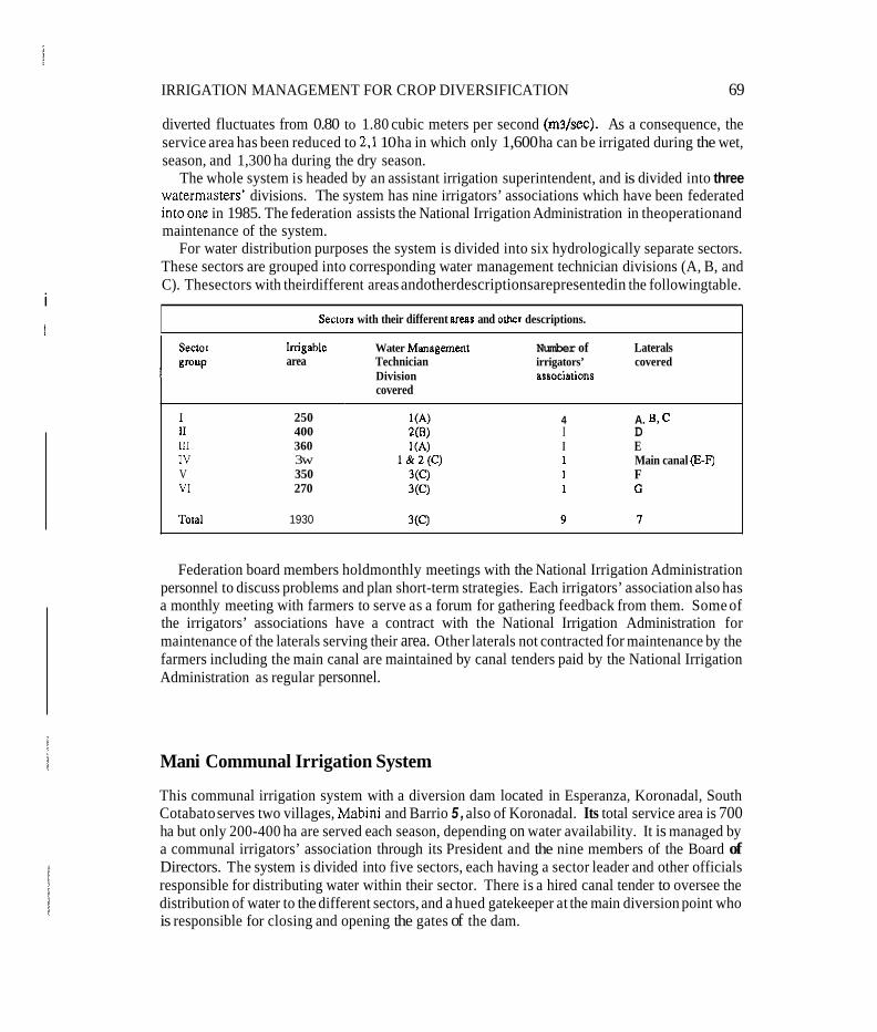
i
IRRIGATION MANAGEMENT FOR CROP DIVERSIFICATION 69
diverted fluctuates from 0.80 to 1.80 cubic meters per second (ms/sec). As a consequence, the service area has been reduced to 2.1 10 ha in which only 1,600 ha can be irrigated during the wet, season, and 1,300 ha during the dry season.
The whole system is headed by an assistant irrigation superintendent, and is divided into three watermasters’ divisions. The system has nine irrigators’ associations which have been federated intoone in 1985. The federation assists the National Irrigation Administration in theoperationand maintenance of the system.
For water distribution purposes the system is divided into six hydrologically separate sectors. These sectors are grouped into corresponding water management technician divisions (A, B, and C). Thesectors with theirdifferent areas andotherdescriptionsarepresentedin the followingtable.
Sectorn with their different areas and other descriptions.
lrrigable area
I 11 111 IV V VI
Total
250 400 360 3w 350 270
1930
Water Management Number of Laterals Technician irrigators’ covered Division associations covered
4 A. B, C I D I E 1 Main canal (E-FJ 1 F 1 G
Federation board members holdmonthly meetings with the National Irrigation Administration personnel to discuss problems and plan short-term strategies. Each irrigators’ association also has a monthly meeting with farmers to serve as a forum for gathering feedback from them. Some of the irrigators’ associations have a contract with the National Irrigation Administration for maintenance of the laterals serving their area. Other laterals not contracted for maintenance by the farmers including the main canal are maintained by canal tenders paid by the National Irrigation Administration as regular personnel.
Mani Communal Irrigation System
This communal irrigation system with a diversion dam located in Esperanza, Koronadal, South Cotabato serves two villages, Mabini and Barrio 5 , also of Koronadal. Its total service area is 700 ha but only 200-400 ha are served each season, depending on water availability. It is managed by a communal irrigators’ association through its President and the nine members of the Board of Directors. The system is divided into five sectors, each having a sector leader and other officials responsible for distributing water within their sector. There is a hired canal tender to oversee the distribution of water to the different sectors, and a hued gatekeeper at the main diversion point who is responsible for closing and opening the gates of the dam.
70 ANNEX B
The Allah River Irrigation Project I
The Allah River Imgation Project I covers a design area of 18,800 ha which is served by two dams on the Allah River. Dam No. 1. located at Surallah, South Cotabato. serves the towns of Surallah, Norala. Santo Nmo. and Banga, and has a service area of 7.300 ha. Dam No. 2 is located in Santo Nino, and will serve part of Santo Nino and Norala in South Cotabato, and the municipality of Isulan in the province of Sultan Kudarat
Dam No. 1 is the study area. It has eight main laterals and five sublaterals. The service area of laterals A-extra, B-exIra and C-extra, lccated along the banks of the Allah River, and which has very light soils, was designed to adopt crop diversification during the dry season. The combined area of these laterals is about 1,OOO ha.
The Allah River Irrigation Project operation is headed by an irrigation superintendent. He is assisted by an assistant irrigation superintendent at each dam. In Dam No. 1 of the Project, there are eight watermasters with each watermaster covering an area of 700 to 1.000 ha. The fanners are being organized into farmer groups. No ditchtenders are employed in the system. Canal maintenance is contracted to informal fanner groups.
The rainfall dishbution pattern at Allah Valley is relatively even. There is significant rainfall even during the dry season. The range of pan evaporation is 3-6 mm/day while seepage and percolation is about 10 mm/day. Significant features of the site. are the relatively porous (sandy) soils and their low organic matter content. The presence of semipermeable layer of 'sandstone- like' material that ranges from 0.5 to 1.5 meter depth, however, reduces the percolation.
In the project site, there are six soil types; three are diversified crop lands and the rest, ricelands. In both classes there are three subclasses: highly suitable, moderately suitable, and marginally suitable. Marginally suitable diversified crop lands are found near the banks of the Allah River. These are very light-textured soils (sandy loam), with slopes of 0 to 2 percent. With adequate irrigation, these can become highly suitable lands for diversified crop during the dry season and moderately suitable rice lands during the wet season. The moderately suitable diversified crop lands are sandy clay-loam textured with slopes of 0 to 1 percent. Highly suitable diversified crop lands are clay-loam textured with slopes of 0 to 1 percent, and will have the same classification under irrigated conditions.
The marginally suitable rice lands are clay to clay-loam textured, and are either low lying flat lands located near drainage waterways or with very steep slopes needing leveling before they can be planted to lowland rice. The moderately suitable rice lands are clay-loam to sandy clay-loam textured relatively flat lands, and have poor to good drainage with high water rables during the wet season. The highly suitable rice lands are clay to clay-loam textured with good drainage.
ANNEX C
Research Sites In Indonesia
The research sites are located in three provinces of East Java, Central Java, and West Java. A brief description of each site is given below.
Waru Turi, East Java
The project area is located in the alluvial plain formed by the Brantas River, one of the largest in Java,anditstributaries. Thethreemainsoilseriesin Wm-Nganjuk, Sentu1,andKertosono-have infiltration rates ranging from 0-2 to 5-12 millimeters (mm) per day. The soils along the Brantas River tend to be lighter than those further west. The Project area consists of three subproject areas: Waru Jayeng (Waru) and Turi-Tunggorono (Turi), which are mostly served by existing schemes drawing water from the Brantas River with flow released from the b a n g Kates Reservoir; and Papar Peterongan, which is now partly irrigated by several schemes supplied by local streams and the Selorejo Dam. The Papar Peterongan is to be integrated into the project.
Waru is a run-of-the-river system whose main intake is at Mrican near Kediri. In Waru the irrigated area (sawah) is 13.366 hectares (ha) - Waru System 12.827 ha and Besuk System 539 ha; both located in Nganjuk Section. There are three subsections: Waru Jayeng. Kertosono. and Lengkong, and a total of 94 villages. The main imgation canal from the Mrican headworks has a lengthof21 kilometers&n). Itfeedsanetworkof29secondarycanals. Thelengthsofthesecanals range from 0.8 to 15.5 km. The total length of the canals is 155 km. Each secondary canal is equipped with a measuring device. The total number of irrigation disaicts (Daemh Irigasi) in the Waruareais two. TheTablebelowshows thedetailsoftheseimgationdistrictsand theirrespective areas. The Waru systems were developed during the Dutch colonial era, with water supply from run-of-the-river flows in theBrantas River. Over the past years, since World War 11, due to the steady increase of sediment entering the canal from the Brantas River and the gradual deterioration of irrigation facilities, both Waru and Besuk systems have required extensive rehabilitation and upgrading.
The Waru area also suffers from periodic inundations over an area up to 2,000 ha in an average year. This is a result of floods mostly originating from the Widas River and its tributaries. On the other hand, there have been threats of flooding to both areas by the Brantas River in the past. Furthermore, the internal drainage condition in the W m area is poor, due to heavy silt deposits, lack of regular maintenance of drains, and some inadequacy in the drainage systems.
The climate of the Project area is tropical, with distinct wet and dry seasons in normal years.
71

ZL

IRRIGATION MANAGEMENT FOR CROP DIVERSIFICATION 73
Pemali-Comal, Central Java In general, rainfall and available water are higher as one moves farther toward the eastern part of the Pemali-Coma1 area. Irrigation in Pemali-Coma1 can be traced back approximately 85 years, to an initial 7,500 ha under Sungapan Weir. Before 1940, the canals and structures were well- maintained, irrigation rules enforced, and water deliveries regulated according to plan. The facilities, however, wereallowed todeterioratelikemostimgation systems in Indonesiaduring and immediately after World War 11. Consequently, during Repelitas (National Plans) I and 11, Pemali- Comal was selected to be rehabilitated, and additional drainage was provided for coastal fields. Beginning in 1970/1971, the Project was rehabilitated with the aid of a World Bank loan.
Irrigation in the Pemali-Coma1 Project is primarily run-of-the-river diversion (over 40 major diversion points), although there are three reservoirs in the Project. The irrigation systems tend to be somewhat above average in size, and many are interconnected with each other. In addition to the diversion points, there are three reservoirs (waduk) - Cacaban, Melahayu. and Penjalin - with holding capacities ranging from 60-86 million cubic meters.
The irrigation canal network consists of 169,300 km of intake channels (saluran induk) and 817,110 km of secondary canals. The tertiary water distribution system was rehabilitated beginning in 1974/1975. about three-fourthsofthe tertiarynetworks in the 124,060 haof technical irrigation systems in Pemali-Coma1 have since been rehabilitated. Beginning in 1975, efforts have been exerted to develop Perkumpulan Perani Pemakai Air (F'3A) or Dharma Tirra in the project area.
The general water supply in the central and western sections of the Pemal-Coma1 Project is definitely less than farther east in the project area. This encourages the production of palawija crops in the central and western parts, but only mono-crop rice in most of the east. The overall cropping intensity throughout the Pemali-Coma1 area is 180-200 percent. In the Comal and Gung irrigation sections, the cropping intensity is roughly 240 percent.
Within Wilayah Pekalongan, two research sites in Irrigation Section Gung have been selected. In this section there is a design irrigation area covering about 41,853 ha. This area includes 9 technical irrigation systems, 2 semitechnical systems, and 11 simple systems. These systems are served by a reservoir, 20 diversion weirs, 38 km of main canals, 270 km of secondary canals, and 2,231 km of tertiary canals. In the section there are 391 employees, with more than 80 percent of them being permanent employees of the Government of Indonesia.
Cirebon, West Java
The research area is administratively situated in the district area of Cirebon in the north-eastern corner of the Province of West Java. Cirebon Wilayah consists of two of Indonesia's largest irrigation sections: Cirebon- Kuningan with 71,000 ha and Sumedang-Majalengka with 67,000 ha. Irrigation was first developed in this area during the second half of the 19th century.
The elevation of much of the area is less than 20 meters above sea level. It becomes flat as it approaches the sea. River alluvium soils dominate the area. The climate is characterized by the prevalence of monsoons. The west monsoon, which is the rainy season, lasts from December to
74 ANNEXC
March, and the east monsoon or dry season lasts from June to about October. In the coastal area the annual rainfall varies from 1,200 mm to 2,700 mm. In the hilly area rainfall is generally more than 2,000 mm.
Bothresearch sitesarelocatedin thehigation Section ofcirebon-Kuningan. The ton1 irrigated area in the district is about 71,000 ha. This area includes 115 imgation systems (daerah irigasi) that range in size from 30 ha to 8,000 ha. In the section there are 3 reservoirs, 102 weirs, 407 km of mainand secondary canals,andover 1,200km of tertiarycanals. Fifteen irrigation watermasters (pengamal) workin thesection, withareasofresponsibilityrangingfrom825 to5,780haeach. The 96imgationinspectors (jurupengairan) inCirebon Kuningan serveanaverageareaof70.5 haeach, with the range of areas being 240 to 2,300 ha each. Over 690 employees work in the section. with approximately 45 percent permanent, and the rest divided between permanent and temporary daily employees.
Food crops, although still dominated by rice, are highly diversified. In addition to wet- and dry- season irrigated rice, variations of the cropping system exist which are influenced by the variability of water status in the field. The Gogorancah system, which is practiced quite extensively in the District of Indramayu, is also followed in some subdistricts in theeastern part of Cirebon. Another variation, the wide-bed system (Sorjan), is quite extensively practiced in the coastal area. It is used either to solve the problems of floods or drought. When it is used to reduce the risks of floods as in the subdistrict of Kapetakan in the eastern part of Cirebon, rice is planted at the top of the bed. The lower part is used for a fish pond. In contrast, when it is used to reduce the risk of drought, rice is planted in the lower part and secondary crops at the top of the bed. This is practiced in the subdisuict of Gegesik and Susukan in the western part of the district. There are about 2,000 ha of Sorjan system cultivated in almost all subdistricts in the coastal area of Ciebon.
Sugarcane has long been cultivated in this area largely to serve the demand of the sugarcane factories. This crop is planted in rotation with rice and palawija crops. During the colonial period, and until quite recently, the area planted for sugarcane was decided by the government. About one third of the area of the proposed village was always in sugarcane and the farmers were forced to rent this land to the factory. There are also private individuals that plant cane to serve local needs. Most of the secondary crops are grown during the late wet season and during the dry season.
ANNEX D
Research Sites In Sri Lanka
The two research sites in the North Central Province, Kalankuttiya and Dewahuwa, are situated in the dry-zone low country of Sri Lanka where most of the major irrigation schemes are located. Nearly 60 percent of the total imgated area of the counlry falls within the category of major irrigation systems and the two research sites represent the two administrative departmenu in the Mahaweli and Lands Development Ministry. The Dewahuwa site is under the authority of the Irrigation Department, which was the sole authority over the major irrigation schemes until 1970, and presently under the Irrigation Management Division a; well. The Mahaweli Development Authority, established with the Mahaweli Project in 1970, has taken control over all the areas scheduled to benefit from this river diversion scheme. The Kalankuttiya site, representing the Mahaweli System, consists of a large local irrigation reservoir linked to a substantial outside river diversion. In contrast, the Dewahuwa site has an independent local storage reservoir within its own catchment supplemented occasionally by diversions.
Both field research sites are characterized by a bimodal pattern of monthly rainfall distribution with two distinct dry periods, one short and the other prolonged. The annual average rainfall is 1,500 millimeters (mm). Nearly 70percent of the annual total rainfall occurs in the period October to mid-January, the maha (wet) season. The remaining rainfall occurs in the period mid-h4arch to mid-May, the yala (dry) season. February, June, July, August, and September are relatively rainless. The 75 percent probability of rainfall expectancy in the maha season is 430 mm. and 200 mm in the yala season.
The pan evaporation measured from aClass-Apan varies from 3.5 to 7.5 mm/day. From thefust week of October to the end of January, the pan evaporation is less than 5 mm/day. The pan evaporation from June to the end of September is over 6 mmlday.
The annual average temperature is 26°C. The minimum temperature varies between 20°C and 25OC over the year while the maximum temperature varies between 27°C and 34T. The daily temperature fluctuation over 10°C occurs during the period mid-February to end of April.
Solar radiation is quite low during the maha season. This is mostly due to the cloudcover during this period. The lowest value of the solar radiation is 300 calories per day which occurs during the month of December.
The soils in the irrigation command areas occur in a catenary sequence in the undulating landscape. The well-drained and imperfectly drained reddish-brown earths W E s ) are found in the convex uplands and mid-slopes respectively. Poorly drained low-humic gley (LHG) soils occur in the concave valleys and bottom-lands.
In the past the LHGs were used for continuous cultivation of rice under both rain-fed and irrigated conditions. With the development of new irrigation schemes, all the soils in the catena
75
76 ANNEXD
werebroughtundercultivation. Rice was theonly crop grown in these lands in the beginning. Loss of excessive quantities of water was observed owing to the high seepage and percolation rates in theRBEs when standing water was maintainedforrice. Other fieldcrops were thereforeintroduced to overcome the situation. Consideration of ground water table behavior and drainage became increasingly important as other field crops proved to be intolerant of excess moisture conditions.
The Kalankuttiya Blockofthe Mahaweli Hsystem was initiallydesigned toaccommodateother food crops in the well-drained RBEs during the dry season. The Dewahuwa site, which is an old and medium-sized irrigation scheme, is a traditional rice irrigation system into which diversified crops are being introduced.
Dewahuwa
Dating to the third century A.D., this ancient tank had been abandoned for centuries when it was reconstructed in the 1950s. Farmers from the reservoir area, from surrounding villages, and from moredistantregions wereallotted2.0-hectare(ha)parcelsofirrigakdlandplus 1.2 ha“high1and” plots near the command area. By 1970, the new system had fallen into a state of disrepair and was rehabilitated under a Japanese aid project. Today the designed command area has been expanded by nearly 20 percent by unauthorized encroachments: the lands originally allotted to families have been subdivided several times. While most household economies remain primarily agricultural, many of the second and third generations rely on rain-fed agriculture outside the scheme, supplemented by off-farm employment. Land tenureis fluid, withabouthalfheoperatorsfarming land which they do not own. Some nonowners are family members who may someday inherit the land they now lease. Others who are classified as owners have taken mortgages and are actually tenants on their own land. Hidden tenancies are common as land transfers through either lease or sale are prohibited by law in Sri Lanka’s settlement schemes.
The system is composed of the Dewahuwa Reservoir, a main conveyance canal with a single embankment, distributaries to nine tracts (1-9). and field channels serving individual farm allotmentsoftwo hectares each. The total commandarea which was initiaIIy943.7 ha (2,336acres) has now increased to 1,215 ha (3,000 acres).
The Dewahuwa Reservoir spreads over a 392 ha (980 acres) area at full capacity level. It is augmented by flows from NawakkaEla,KudaOya,and KalugalOya whichareephemeral streams, and from the Nalanda Reservoir. The catchment area of the reservoir is 67 square kilometers (sq km) (26.0 square miles [sq miles]). The main features of the Reservoir are:
Full storage capacity - 1,197 hectare meters (9,700 acre-feet) Area at full supply level - 396.7 ha (980 acres) Bund length - 583 meters (1,914 feet [ft]) Length of the spill - 184 meters (604.75 ft) Bund top width - 5.5 meters (18.0 ft) Free board - 1.4 meters (4.6 ft) Head at full supply level - 8.7 meters (28.5 ft)
IRRIGATION MANAGEMENT FOR CROP DIVERSIFICATION 77
The spillway is a clear overfall of natural rock with a concrete crest wall built to pass cyclonic flood of 301 cubic meters per second (mshec) (10,630 cubic feet per second [cusecs]).
The 16.09 km single embankment earthen main canal has a capacity varying from 3.2 ms/sec (1 13 cusecs) at the head to 0.2 ms/sec (7.0 cusecs) at the extreme end. It has a gradient of 0.00035.
The main canal has flow regulating and measuring provisions, such as cross-regulators of the underflow and overflow type, and also combinations of these two types. Moreover. there are slope protection suuctures like retaining walls and channel shape guides for maintenance. There are 12 cross-regulators at about 1.6 km intervals. Five of them are with vertical sliding steel gates and the rest are checks with simple wooden flush boards.
Along the main canal, measuring devices like parshall flumes and rectangular contracted weirs can be found. One parshall flume is located at the head of the main canal and the other about eight kilometers downsueam.
There are 11 distributaries in addition to several direct turnouts which take off from the main canal, commanding areas ranging from 14 to 180 ha. Most of these distributaries have functioning sliding gates but with no facility for monitoring flows.
The direct turnouts (direct offtakes) serve areas varying from 2 to 18 ha along the main canal. They have sliding steel control gates and contracted weirs with baffles as measuring facilities.
There are division boxes, chutes, and drop structures along the distributaries. The turnout gates to field channels are made of wooden planks with padlocking arrangements but with no provision for flow measurement. Most of them are not in good condition. Even some of the gates that are in good condition can be tampered by farmers whenever they want to take water illegally.
Kalankuttiya
This is a part of the country’s largest irrigated settlement scheme, a greater part of which is still under construction. System H was completed in 1975. It is the oldest of five separate systems within the scheme, all fed by waters from the Mahaweli River as well as from smallerstreams Prior toitsconstruction,muchofthe27,000ha whichcomprisetheimgatedareaofSystemHwasjungle, with scattered villages based on irrigated agriculture from small village tanks and swidden plots. The new canal system and associated land development obliterated many of these tanks and incorporated others into on-line reservoirs fed by the main-canal system. Settler families from the area, as well as from outside the region, were allotted one-hectare parcels of irrigated land and 0.2 ha for house plots and gardens. Following the precedent of other settlement schemes, the government constructed all irrigation facilities, and cleared and leveled the fields.
The Kalankuttiya Block is located within the H-2 subsystem of system H area. It falls under the Kalawewa Resident Project Manager’s Region. The Kalankuttiya Administrative Block consists of the irrigation blocks 305,306,307,308, and 309, covering approximately 2,021 ha. The whole block is bound by two drainage channels: Kala Oya, the major drainage line in system H and, Kalankuttiya Ela, running in the east-west direction forming the northern and southern boundaries. The water-distribution system consists of a storage tank known as Ihala Kalankuttiya Tank with a maximum capacity of about 190 hectare meters (1,540 acre-feet), of which about 184 hectare meters (1,490 acre-feet) are effective for irrigation. A main canal known as Branch Canal No. 1, which is 11.5 km long, takes off from the tank.
78 ANNEX D
The tank has its own catchment area of 68.86 sq km (26.6 sq miles) but generally, it is replenished from the Kalawewa Right Bank Canal through the Mulanutuwa Tank. To meet the present demand it normally receives about 12-24.5 hectare meters (100-200 acre-feet) per day throughout the season. Water issue from the tank is regulated at the main sluice which consists of three vertical adjustable gates. Two spillways in the tank avoid the possible unexpected overload with the crest level located 10 ft above the sill level.
The Branch canal, which has a maximum design capacity of 5.65 m3/sec (200 cusecs) at the head-end area, traverses the higher aspects of the land-scape and hence, there is no incoming drainage water to the main system. The distributaries are stretched to either side. Two types of cross-regulators can be identified in the main system. One adjustable cross-regulator. which consiso; of two wooden undershot gates located just below the first two head-end distributaries and nine fixed overflow type cross-regulators known as duck-bill weirs, are located in varying places between the first five and last three distributary offtakes, helping to maintain the desired hydraulic head at different sections of the channel. Flow monitoring in the branch canal is done at the head reaches just after the first two distributaries, using a calibrated staff gauge with an automatic water level recorder.
A ma1 of 20 distributary channels with varying design capacities depending on the extent of the command area (which varies from 35 to 3 10 ha) but adequate to carry the peak requirements of all turnouts to field channels in a distributary, is located along the secondary spurs that traverse the landscape. All the distributary offtakes consist of adjustable steel sliding control gates. Except in one distributary, all the others are provided with a monitoring device. In most cases, the device consists of a hump structure and a gauge, except a Cipoletti weir in one distributary. Another distributary is equipped with an automatic water level recorder. A locking mechanism is also provided in some distributary gates to avoid unauthorized adjustments. As there is no drainage system coupled with the branch canal, the last distributary channel functions as a drainage channel during heavy rainy days. To facilitate this, one gate of this disfributary has been removed.
Offtakes (turnouts) from the distributary to fields channels generally serve 4-20 farm allolments of 1 ha each, located along the tertiary spurs of the landscape. The command area of such a field channel is about 16 ha. In general, these field channels are designed to carry a flow of 28.3 liters per second (I cusec).
There are no direct farm offtakes (outlets) to farms from the branch canal. Generally, all the outlets originate from the field channels, except for a few direct ones identified in some distributaries. The outlets consist of a 15 cm (6 inches) diameter pipe designed for a flow of half a cusec (14.15 liters per second). The irrigation system has been designed to accommodate rotational water issues.

ANNEX E
Irrigation System Management In Indonesia
Organizational Setup
Within the Provincial Public Works Department, the Provincial Irrigation Service is responsible for operating and maintaining public irrigation systems. The mostjunior permanent member of the Provincial Irrigation Service staff, the irrigation inspector (jurupengairan) is not only responsible for irrigation facilities serving approximately 1,000 hectares, but also oversees the setting of 15- 25 main and secondary gates. He also records hydrologic and crop data, arranges for regular and emergency maintenance, works with water user associations and village watermasters (ulu-ulu) to maintain tertiary and quaternary distribution canals and arranges for staggered planting dates and water rotations. He is assisted by a few gatekeepers and laborers. The inspector is directly answerable to the subsection chief (Pengamat or Kepala ranting).
The subsection chief has a direct role in managing funds and personnel for maintenance activities. His role with respect to operations, however, is more supportive. Usually, the working out of the crop water-requirement estimates, discharge schedules, and calculation of Faktor-K and PalawijaRelatipFakror (FPR) are delegated to the inspectors. Frequent meetings with inspectors and water user associations facilitate discussions of crop schedules, planting dates and rotations, etc.
The operation process could be categorized into five sections: 1) estimation of the availability of irrigation water at the respective diversion points; 2) eslimation of inigable area, type of crops and the growth stage of the crops; 3) calculation of the required discharge; 4) setting of gates to deliver the discharge; and 5) monitoring of the discharge flow and feedback for necessary adjustments.
The decisions regarding imgated area are taken at the regency and district levels by Irrigation Committees: once the available water for irrigation is estimated, the crop area and the cropping patterns are determined to optimize the irrigation water use. Estimation of available water is done with the help of the historic records of the flow-discharge curve. Operational decisions on water allocations and disrributions to planted areas during a fixed time period are taken at the subsection and with the help of day-to-day records of flow discharge.
In Indonesia, especially in Java, planning and operational decisions revolve around the basic concept ofpasten, where the relationship is between the water supply that is available at the intake gate and turnouts and the crop needs. The modern derivative of pasten is Faktor-K.
Twice each month, the village watermaster assesses and reports to the irrigation inspector the expected area and growth stage of each crop over the next two weeks. This enables the inspector to calculate the field requirement in liters per second per hectare using accepted formulas provided
79
80 ANNEX E
for each crop and growth stage. A constant of 1.20 to 1.30 is used for conveyance losses. The demand (D) for irrigation water at the diversion point (headworks) is calculated by the
subsection chief by aggregating data received from all tertiary blocks served by each diversion point and adjusting it for intake losses and secondary channel losses. The recorded daily average at the diversion points becomes the supply (S). The expected value of Faktor-K = S P for the next two weeks. This information is passed down so that the respective gales at each level can be adjusted accordingly. The value “K” is exhibited on signboards adjacent to thecontrol structures.
During drier parts of the year gatekeepers at diversion points have to calculate the Faktor-K as often as once a day, taking into consideration the actual flow. Changes if required at the various gates downsueam are thus notified; as long as the value of Faktor-K remains above 0.6 to 0.7 continuous supply is assured. But, if the value falls below this level, rotational water issue system is followed.
The assumptions underlying the operational tool-pasten system:
a. The actual number of hectares under each crop and its growth stage is known.
b. The actual flow at the intake is measured.
c. The quantity of water diverted can be measured accurately.
d. The rate of canal and distribution losses is known.
e. Proper control over the gate settings is possible.
If any of these assumptions are violated, the operational value of the system for calculating required discharge is drastically reduced. Data collected in the research sites show that actual irrigation management practices often diverge from prescribed practices. It is not unusual for shortcut methods and rough approximations to be followed. These divergences are related to:
a. lack of field operational staff,
b. lack of trained staff,
c. lack of measuring instruments and structures, ’
d. decentralized control over diversions,
e. diversity within the tertiary blocks regarding crop type and growth stage,
f. prevalence of unmeasured supplementary water supplies,
g. extension of tertiary blocks across more than one village, and
h. alternative arrangements for water dismbution being made between farmers and inspectors.
IRRIGATION MANAGEMENT FOR CROP DIVERSIFICATION 81
Determining irrigation water requirements for the tertiary block, whether the availability meets the demand or not and the future deliveries, depend on the information flows. The irrigation inspector initiates the largest number of information paths. The information flows and related calculations at the level of the village watermaster, however, is usually based on his own observations and estimates. The second vital point is the discharge data from the gate keeper. If either of these is faulty, it affects the rest of the analytical procedure.
Planning Process
The process of planning annual cropping patterns and planting dates begins with the report from the irrigation inspector on the expected cropping pattern at village level and at tertiary block level. The village-level officials are consulted in formulating this report. Before each rainy season Irrigation Committees at district (subsection) level and regency (section) level then meet to decide the crop plan. This information is then sent back down to the village level.
Estimating crop areas
Every year the Provincial Irrigation Service staff must check the area of each block to determine the land which has gone out of production due to development activities. Owing to administrative difficulties and budgetary disincentives, however, it is apparent that these figures are not updated regularly.
On the other hand, the estimations of crop area by the village watermasters and the inspector of aparticularblock are found tobe often differentfrom eachother,although theoretically they should be the same.
Calculating the irrigation requirement
The calculation of irrigation requirement is done in three ways:
I. The pasten method. 2. The Faktor-K method. 3. The Palawija Relatip Faktor method.
Setting the same Palawija Relatip Faktor for all turnouts along a secondary canal tends to ignore the nonhomogeneous features of the various tertiary blocks and, thus introduces a wide margin for error. This is particularly true when wide soil differences exist between blocks.
The main difference between the Palawija Relatip Faktor calculation and the pasten calculation is that the former is based on the water available at the turnout, while the pasten examines water requirement at the rice field (sawah) itself. Apparently, the introduction of the Palawija Relatip Faktor method makes turnout operation easier than the pasten because it directly gives the required flow at gated turnouts where the flow can be adjusted as required. However, if the actual losses
82 ANNEX E
in each tertiary and secondary canal are known, starting at the sawah requirements and adding losses is more rational than the current use of the Palawija Relatip Faktor method.
Implementation
Measuring irrigation discharge
The level of efficiency under which the irrigation system operates depends greally on the flow- monitoring aspects atprimary, secondary, and tertiary discharge levels. At the IIMI research areas it has been found that 39 percent of the offtake structures were not measurable either due to construction faults or due to missing gauges; often the gatekeepers or irrigation inspectors who were responsible for taking measurements, determine the flow either using a wooden stick and a table from another gate or using an eye estimate. In addition, problems encountered with the establishment of a steady flow owing to inordinate amounts of flow in the canals are reported.
The research staff have also reported that there are wide discrepancies in the reported figures to the subsection chief by irrigation inspectors and the actual measurements or recordings. Therefore, it is apparent that, sometimes, repomd data are poor and unreliable to be used effectively at top levels.
Adjusting gate settings
In many parts of the public irrigation systems in Indonesia, check structures and irrigation gates are not readjusted daily in response to frequent discharge fluctuations. although it is recognized that these adjustments are needed to keep actual deliveries in line with planned deliveries. Gate or checking readjustments are made more frequently along main canals and, often within tertiary blocks, than along secondary canals. In some cases, gatekeepers seem to lack skills and seem to perceive that the right to readjust gates has not been fully delegated to them. On the other hand, some gates do not function properly; the gates are fixed and used in such a manner that the water flowing through them approximates a proportional division along the secondaries. In general, the coefficient of variation is directly proportional to the distance from the main gate and it is of a higher magnitude in the second dry season than in the first dry season.
Levels and Trends of Irrigation System Performance
Management intensity of distributing water
IIMI research indicates that there is a tremendous amount of fluctuation within almost all the irrigation canals. Most irrigation systems being run-of-the-river systems, some degree of variation
IRRIGATION MANAGEMENT FOR CROP DIVERSIFICATION 83
is expected. It is the adjustments at the gates which are important in controlling the flow. The relative frequency at which the gates are being operated provides a measure of performance: the number of times the intake was adjusted during the period and the average number of days between the adjustments (indicator of intensity or responsiveness of management). The average number of days between adjustments in the dry season have been two to five days compared to the range of three to seven days in the wet season. There is little difference in gate adjustment responsiveness between upper- and lower-end gates in East Java, but there is a significant difference between upper- and lower-end gates in Central Java.
Management performance ratio
Management performance ratio is a direct comparison of actual irrigation water deliveries with planned deliveries: the ratio of actual delivery (supply) to the planned delivery (demand). .
Actual measured discharge
Planned discharge Management performance ratio =
Good management results in a management performance ratio of 1.0, which is a measure of efficiency (i.e., determining how close a system, during each planning period, is operating to its stated goal). Uncertainties with respect to water supply and rainfall make it difficult for the management performance ratio to be always 1.0. Therefore, there is an acceptable range around the management performance ratio of 1.0 (0.75 to 1.50). When variability is expressed in terms of the coefficient of variation values, comparison between areas, seasons, or systems becomes possible.
The problem is that the field officers do not use actual field data when reporting deliveries but instead, report planned discharge as delivery discharge which provides a very impressive managementperformanceratioof 1.0. The widediscrepancies between theresultsofIIMIdataand the Provincial Imgation Service data c o n f i i the above anomaly. The results of the above study reveal that management performance varies widely from province to province and even from one irrigation system to another within provinces. Cennal Java shows the best management performance.
Data from Cirebon-Kuningan in West Java are more erratic, while data collected in East Java indicate that there is a consistent pattern of overdiversion from the Brantas River into Waru Jayeng Irrigation Scheme. Such haphazard variation in the management performance ratio implies weaknesses in training, monitoring and supervision, and problems in the physical condition of structures.
Although these values serve as a good indicator of management performance, the use of seasonal averages tends to mask interseasonal variation. The range and magnitude of seasonal variation when shown graphically indicate that even irrigation systems that have a seasonal management performance ratio close to 1.0, could have considerable variation from period to period (where irrigation periods are different).
84
Monitoring and Evaluation
ANNEX E
Spatial variation in water delivery
Use of the Faktor-K or Palawija Relatip Faktor method is designed to ensure equity throughout the imgation system. IIMI studies reveal, however, that there is an exuemely wide variation of allocation of water within the system. Except for East Java, availability of irrigation water, in liters per second per hectare, especially during the two dry seasons, lends to decline with distance from the water source. In East Java, the security of overall flow in the Brantas River as well as Waru Jayeng's favorable location along the river illustrates that water is abundant in the head and tail, but tends to be less abundant in the middle of the system. In Central and West Java, availability in the head and middle is better than in the tail end. Relatively low coefficient of variation values in the tail end during the rainy season indicates that many of the systems become drains during part oftheyear. . Water availability
Locationwise water availability per hectare (in millimeters) compared to actual water required per hectare during each season offers another means of evaluating system performance: measure efficiency at the canal or block level. When effective rainfall is practically zero, this statistic becomes more meaningful, as for the second dry season. IIMI studies have mapped actual crop patterns using standard crop coefficients, and have calculated water requirements. These water requirements have been compared with water provided by the irrigation system to determine how close the irrigation system is able to match plant-water requirements. Given that a fixed amount of additional water has to be applied to cover tertiary and secondary canal conveyance losses, efficiency value in the range of 70-80 percent are considered excellent. Values above 85 percent indicate that. unless additional water is supplied from rainfall or another source, the plant may not have been provided with its full requirement due to distribution losses. Higher efficiencies found in Central Java confirm the higher level of management.
Cropping intensities
An improved imgation system management would lead to increasedcroppingintensities. Although theFaktor-Kand thePalawijaRelatipFaktor methods are designed to provideequity alonga single water system, IIMI dataindicatethatthereoftenissignificantvariationincroppingintensities from system to system and from block to block within various systems. There is significant rmm for improvement both in the levels and in the equity of cropping intensities along the two major watersheds in West Java where IIMI research sites are located. Along the Ciwaringin River cropping intensities tend to drop markedly downsueam. Along the Cisangarmng River, the three systems with the lowest cropping intensities are in hilly areas with uneven topography.
IRRIGATION MANAGEMENT FOR CROP DIVERSIFICATION
Maintenance
85
It is recognized that maintenance is generally underfunded. It is the duty of the irrigation inspector to identify the nature and the cost of maintenance required within the year, such as:
* length and width of canals requiring maintenance,
* number of major and minor installations needing repairs,
* number and type of gates not functioning,
* primary and secondary banks that have slipped,
* estimating areas where cutting grass and other plants would improve water flow,
* estimating the amount of sediments lo be removed from canals, and
* listing the number of canal walls that need repairs.
The cost estimates are done according to the standards for operation and maintenance cost analysis suggested by the Directorate General for WaterResources Development. It is not unusual for the central government, however, to provide far less than the requested amount
Based on their extended work in East Java. MacDonald and P m e r s have recommended the following order of priority for selecting maintenance tasks.
* Preventive maintenance: prevent funher deterioration of canals, s!n~~tures, and mechanisms.
* Desilting and bank repairs: ensure that sufficient water can flow through the canal system and can be removed by the drainage system.
* Reduce seepage: l i e canal banks where losses are high.
* Measureflows: repair or construct measuring devices.
* Maintain display boards, efc.: attend to the appearance of the system.

ANNEX F
Irrigation System Management In The Philippines
Planning
Planning is an essential and critical stage in irrigation system operation in the Philippines. In planning, the potential availability of irrigation water and appropriate cropping calendars are determined to optimize the use of the available water supply. Concerning optimization, the timely and sufficient allocation and disuibution of irrigation water where it is needed are of utmost importance.
In planning the cropping calendar, the supply of water (imgation and rainfall) is matched to demand (soil and crop water requirements). In run-of-the-river diversion-type irrigation systems, the amount of water expected to be available for the system during an operational year is determined using a five-year moving average. In this scheme, the most recent five-year data are used as an estimate of the potential availability of water for the system for a particular year, regardless of the data available. The expected rainfall occurrence is likewise determined using the five-year moving average. The demand for irrigation water depends on thecrop to be irrigated and its growth stage. Other water requirements are the amount required for land preparation and other fanning activities, and the amount lost through evaporation, seepage, and percolation. The latter two factors depend on the soil characteristics.
Forrice, thevalueof 13 millimetersperdayor 1.5 literspersecondperheclareisgenerallyused as the on-farm water requirement. In systems with lighter soils, the figure may be higher. For secondary crops, the usual irrigation water requirement can be four times less than that of rice although 60 percent is sometimes used.
The weighted average of the irrigation water requirement for both rice and non-rice crops on a given system determines the area that could be irrigated during any given time.
Before the start of every season, a meeting between the irrigators' associations and the National Irrigation Administration staff is nominally held to discuss a tentative plan that includes the program area and the subsequent water-delivery schedules. The degree of participation by the irrigators' associations is dictated by the level of involvement and functionality of the different irrigators' associations in each of the sites. Among the sites, the irrigators' associations at Banga River Imgation System are observed to be very much involved and committed to observe equitable sharing of water in the dry season. The areas programmed for rice in the dry season are rotated on a yearly basis giving an opportunity for all areas to be imgated in the dry season for rice. The areas not programmed for rice are encouraged to plant corn and other upland crops. These are only imgated upon signing a request for irrigation. This request is needed in order that collection of irrigation fees at the end of the season is facilitated. Moreover, the programmed rice areas get the
87
I ~ .
88 ANNEX F
first priority in case of water scarcity. At the Laoag-Vintar River Imgation System, the locationally favored (upstream) Vintar
Imgators’ Association is not as interested in equitable sharing of water, particularly in the dry season. Thus, only the Laoag-Bacarra-Sarrat Irrigator’s Association (LABASA) is really involved in the water allocation activity. Only the areas near the canals and located at lower elevations are programmed for rice. Areas programmed for non-rice crops are located at the tailend of lateral and sublateralcanals, and withcoarse-texturedsoils. Athirdcropofmungbeanis usuallyprogrammed, depending on the available residual water at the end of the dry season. Usually two to four deliveries are available after the regular second crop. At Bonga Pump (BP) No. 2. water allocation is relatively simpler as the system is partially turned over to the irrigators’ associations with no direct intervention of the National Imgation Administration staff. Notwithstanding this arrangement, not all areas are inigated for rice because water supply is also limited. Location of the farms, soil suitability, and payment record are the criteria used in allocating water for rice in the dry season. Non-rice crops, mostly garlic and water melon, are also programmed.
At the Upper Talavera River Irrigation System which is a part of the Upper Pampanga River Integrated Irrigation System the seasonal imgation plan is theoretically made by the Agricultural Development Coordinating Council. This Council is chaired by the Provincial Governor of Nueva Ecija. The members are the Operations Manager of the Upper Pampanga River Integrated Irrigation System and representatives from the local government, the Department of Agriculture, and private enterprises involved in agriculture, such as rural banks and agricultural chemical companies. The Council meets at least one month before the start of the wet season to prepare the imgation plan for the whole of the Upper Pampanga River Integrated Irrigation System, including the Upper Talavera River Irrigation System, for the following wet and dry seasons.
Actually, however, only the upstream irrigators’ associations are involved in water allocation. Nominal participation of the other irrigators’ associations are observed with no actual involvement in terms of group work activities and frequency of attendance in meetings called by the National Irrigation Administration staff. The major reason cited by farmers is the uncooperative behavior of the farmers from the upstream irrigators’ associations. This situation is the reverse of that at the Laoag-Vintar River Imgation System, where the downstream irrigators’ association is the one functional. In this situation, allocation of water at the start of the season is difficult to implement. Farmers are given the option to plant the crop of their choice. The National Irrigation Administration staff, however, caution the farmers that water will only be sufficient for those areas near the source, particularly for irrigatingrice. Consequently, non-ricecrops (mostly onions) were not programmed until about two years ago when the differential billing of 60 per cent of the fee for rice was implemented for non-rice crops. Whatever areas are planted to rice and non-rice are billed accordingly, when the list of planted areas is prepared. The non-rice crops at the Upper Talavera River Irrigation System are plantedonly in those areas with medium-texture soils. These areas are located mostly in the upper and middle portions of the service area.
At the Allah River Irrigation Project, the participation of the irrigators’ associations in the water allocation activity is just startingtoevolve. The irrigators’associationsof laterals A, B, andCextra are not fully convinced that their areas should be programmed for non-rice in the dry season because they were already planting two rain-fed crops of corn every year before the Project was initiated. Most farmers in these areas prefer to plant rice even without the assurance of irrigation water in the dry season. To these farmers, imgation is synonymous to irrigated rice production owing to the misleading abundance of imgation water as observed in the main canal and the

,
IRRIGATION MANAGEMENT FOR CROP DIVERSIFICATION
occasional rainfall during the dry season.
89
Implementation
The approved plan becomes the primary basis for water allocation and distribution in an irrigation system.
The plan is revised when the actual supply falls short of the expected water supply. This occurs due to the probabilistic nature of the hydrometeorological factors involved in the plan. Any changes or deviations from the plan have to be approved jointly by the National Imgation Administration staff and the irrigators’ associations concerned.
If the actual water flow measured at the intake falls short of the expected value, a system of rotation is enforced. The rotational scheme depends on the severity of the water shortage. Rotational schedule is resorted to as the reduced available water supply can then be directed among sections with greater control and precision.
At the Upper Talavera River Irrigation System, the diversion of water from the dam is continuous even during the scheduled cut-off period, according to the imgation plan prepared by the Agricultural Development Coordinating Council. During the scheduled cut-off in the month ofMay, thereis minimal flow fromtheriver, whichcanonlyirrigateasmallportionoftheupstream area. This area is planted to lowland rice. Water delivery is only suspended when rehabilitation work is needed. Even desilting the main canal of the Upper Talavera River Irrigation System, which is an annual operation, is done without shutting off water delively. Water at the low diversion dam cannot be stored and, if not diverted, is considered lost. Diversion of water is therefore done as long as it can be used in the system.
Thediversion of water from thedam at theUpperTalavera River Irrigation System iscontinuous except during the rainy season when the rainfall is high, requiring the closing of the main canal to prevent flooding of the service area and damages to canal structures. But even then, there is still a water flow from drainage entering the canals from adjacent high areas.
During the wet season, the whole area is programmed for lowland rice and water flow is continuous in all canals unless shortage occurs where rotation is resorted to. Rotation is done by section of the main canal. The rotation period is usually one week.
During the dry season, only 500 hectares (ha) are programmed for irrigated diversified crops in the Upper Talavera River Imgation System. Nothing is done to prevent farmers from planting lowland rice because some areas, owing to their low elevation, are not adapted to upland crops. There are also areas suilable for upland crops planted to lowland rice. In most years only 50-60 percent of the programmed area is planted to upland crops. As the agreed program is to plant irrigated upland crops, farmers following the program are given f i s t priority in getting water. When therice survives, however, thearea plantedtoitis also billedatthe samerateas lhescheduled lowland rice during the dry season. The area planted to diversified crops is billed at 60 percent of the rate charged to rice.
In some years when water from the river is more than enough for the programmed areas, especially during the start oftheseason, theplantedareareaches700 ha. Thiscauses water shortage later in the season. Thus, instead of cutting off water supply to unprogrammed areas, rotation by sections of the main canal is done to enable all the planted areas to have water. This happened
90 ANNEX F
during the dry season of 1986. Some tail-end areas which could not be imgated used small shallow tube well pumps.
Because there are areas planted to lowland rice, it is very hard to enforce the planned rotation schedule. Lowland rice is planted in low areas upstream. The rotation schedule is hardly implemented especially at night. Close guarding of the checkgates is necessary to enforce the rotation schedule. Tail-end farmers planting onions sometimes have crop failures owing to unavailability of water.
Upstream farmers can easily get water. This easier availability of water encourages upstream farmers to plant onions in unmulched plots to produce better quality bulbs. Downstream farmers plant onions in mulched plots because irrigation in the tail-end portion is made available only during their scheduled time. When the tail-end fanners are scheduled to receive water, guarding of checkgates is necessary to prevent theft by upstream farmers. It is not infrequent that tail-end farmers can only get water during daytime when watermasters and ditchtenders are on duty to enforce the schedule.
The duty of the watermaster is to distribute water throughout his service area up to the turnout level. At times when rotation is resorted to, night patrolling is done to ensure that there is no theft of water. Below the turnouts, the farmers share the water among themselves.
Another example is at the Laoag-Vintar River Irrigation System. If there is any acute water shortage in the dry season, priority is given to crops with the most need for water. The district officers and the Boardof Directors of the Laoag-Bacarra-Sarrat Irrigator’s Association (LABASA) have to meet to change the schedule if necessary.
The watermaster is involved in the distribution up to the p i n t of determining the priorities among farmers’ fields. In case of illegal water use by farmers, association members and the watermaster conduct an investigation and, if found guilty, water delivery in the area concerned will be suspended for the next water schedule.
The watermasters and the ditchtenders supervise water delivery to turnouts. The farmers share the water at the turnouts. The watermasters help, however, to determine the priorities. Watermasters and ditchtenders collect the irrigation service fees. Their performance is evaluated partly on the irrigation service fee collection.
The water duty for non-rice crops is 60 percent that of rice. Irrigation rotation for other crops is once a week for light soils, and once in two weeks for heavy soils. During heavy rains, water delivery is suspended to avoid canal wash-outs h d flooding of fields. Even if the sluice is closed, runoff from side hills enters the canal. Ditchtenders are responsible for the upkeep of the canal system up to the laterals. Farmers have to maintain the farm ditches.
At the Banga River Irrigation System, the water supply is rotated among the sectors of the system,on a weekly schedule, decided at the preseasonal farmer meeting. The schedule cannot be altered by the irrigation staff without consultation with the farmer associations. The irrigation agency’s role is to implement and enforce the rotation schedule. To prevent unscheduled water deliveries, unauthorized checks are removed and confiscated by the agency personnel during their daily rounds. Unscheduled sections are sometimes closed with concrete.
In the case of the Mani Communal Irrigation System, control of water distribution is done through the canal tender who patrols the canal every day to ensure the scheduled delivery. In times of water shortages, weekly rotations are practiced. It is observed, however, that upstream farmers resort to unauthorized diversions, causing shortages of water to the downstream farmers.
I
c
IRRIGATION MANAGEMENT FOR CROP DIVERSIFICATION
Monitoring
91
In the National Irrigation Administration systems, the evaluation of the physical performance of the system is reflected in the area irrigated and benefited, and the equity of water distribution. The economic indicators are the irrigation service fee collection efficiency and financial viability of the system.
There is an attempt to utilize data on water flows to determine shortfalls so that preventive measures or action can be planned and instituted during the following season. The different indicators are considered during an overall assessment of system performance.
Specifically, on the Laoag-Vintar River Irrigation System operation as an example, there are seven rain gauges being observed. During heavy rains, there is suspension of water delivery following the National Irrigation Administration’s practice to avoid canal wash-outs and flooding of fields. But even if the dam is closed, there is water flow in the canals because of runoff as indicated earlier from side hills entering the canals.
There are water-measuring structures (staff guages) at major sections of the main canal and at headgates of laterals. Often these are not calibrated properly. Mostly, the rate of water flow is assessed in terms of deoth of water in canals. This may have been caused bv the helolessness of the National Irrigation Administration personnel in increasing supply when there is shortage and nonstorability of water when there is excess. The main performance measurement used is that water should reach areas where they are scheduled to receive it
More recently, however, under the World Bank-assisted Irrigation Operations SupponProject, the National Irrigation Administration is currently pilot-testing an irrigation management information system (monitoring and evaluation) program to help irrigation superintendents manage their irrigation systems more efficiently to bring about a high level of satisfaction to all irrigation water users. The program aims to provide irrigation superintendents with timely monitored information on:
* needs of farmers in complying with programmed water deliveries, so that these can be attended to by the irrigation system or coordinated with concerned agencies;
* the condition of irrigation facilities which are likely to affect water-use efficiency and cropping intensity;
* farming activities to guide adjustments in water deliveries; and
* problems which are likely to affect imgation service fee collection and financial viability of the irrigation system.
The monitored information is intended to be used to evaluate differences between targets and accomplishments so that appropriate management action to correct the causes of the deficiencies can be instituted.

ANNEX G
Irrigation System Management In Sri Lanka
Organizational Setup
The program for Integrated Management of Major Irrigation Schemes seeks to establish a harmonization of the various inputs and services necessary for increasing agricultural productivity with special focus on the use of irrigation water. An interdisciplinary group with experience in agriculture, irrigation institutional development, and management at the Irrigation Management Division functions as the administering authority for the program. Policy guidelines and direction for the program are set by the Central Coordinating Committee consisting of the Secretaries, Ministry of Lands and Land Development, and Agricultural Development and Research. the Department Heads of Irrigation, Agriculture, Land Commission, and Agrarian Services, and the state banks.
At the district level, the instrument for implementation and monitoring is the subcommittee of the District Agricultural Committee set up to direct this program. The District Agricultural Committee comprises the Government Agent (Chairman), the District Heads of all the different agencies involved in the programs, and the Project Managers of projects falling within the district. The subcommittee would identify and implement projects, monitor and review the programs, and also evaluate the previous seasons' performance.
At project level, a project committee consisting of field staff of all agencies involved in agricultural production and farmer representatives, headed by the project manager, determines the program for implementation in the project. The main functions of the Project Committee are to formulate and implement a cultivation program for both yaln (dry) and muha (wet) seasons, ensure proper distribution of water, arrange timely provision of inputs and sale of products, arrange operation and maintenance programs of the irrigation system, andincrease agricultural production.
Under the Mahaweli scheme, lands developed for imgated agriculture are zoned as systems, each being completed at various stages. The systems are in turn divided into projects, each under a resident project manager. The resident project managers are mainly responsible for the overall management of their respective project areas. At the project level, there are four deputy resident project managers to assist the manager, each for varying disciplines: water management. agriculture, community development, and lands.
A project is further divided into blocks, consisting of about 2,000-2,500 farm families, each under a block manager. The block-level management staff consists of an irrigation engineer, an agriculture officer, a marketing officer, a land officer and other supportive staff under the block manager who is responsible for the overall coordination at the block, and who reports to theresident project manager. The irrigation engineer is responsible for water deliveries and scheduling, and
93
94 ANNEX G
all irrigation maintenance work within the block. Block-level agriculture plans are prepared and implemented by the agriculture officer. Arrangements for necessary marketing facilities and supply of relevant information are the main tasks of the marketing officer. Land officers are responsible for keeping records of titles, distributing lands, and solving local problems.
The blocks are furtherdividedinto unitscomprising200-250farm familics under aunit manager in charge of a unit who is the most important element in the management setup. He is the only representative of the government who has direct contact with the farmers. He is in charge of coordinating the timely supply of agricultural input to the farmer, communicating with the line agencies at the block and project level on behalf of the farmer, attending to the health and welfare needs of the farmer family, and water management within the unit.
Farmer organizations provide the forum for dialogue and interaction among farmers and between fanners and officers working in the project. In the establishment of farmer organizations, the following guidelines are emphasized
They should represent a distinct hydrological area, should be bonafide cultivators within the area they represent. and should represent all cultivators within the area.
Turnout groups constitute the lowest level of organization. They form the base on which the higher level-organizations are built.
Planning Process
Dewahuwa
There are two cultivation seasons in a year. Planning for the upcoming season generally begins during the last two months of the preceding season. The officials of the Irrigation Department estimate the available amount of water for irrigation and the effective command area, for which the water level in the storage tank at the time and what is expected to remain at the end of the season are estimated. Then, the anticipated rainfall, estimates through a 75 percent probability, and the expected amount from supplementary sources, if any, are taken into consideration.
The next phase is communicating the above findings to farmers through their representatives at the fortnightly committee meetings. Their opinions are solicited with regard to selection of crops and varieties, especially during the dry season as crops other than rice are involved. This is not a one-shot process. Given its dependence on rainfall, the amount of water available for cultivation may change. Besides, there is always the possibility of an additional water issue being given to offset tail-end problems, late start, etc. As a result, this process of exchanging information continues over a few weeks.
In the preseasonal (kanna) meeting the field-level representatives of all line departments and the farmer representatives meet to formulate the cultivation program. The planned program on water issues such as the first and last dates of water issues, rotation pattern, higable land area for the season or land area for bethma, etc., is prepared by the technical assistant. The appropriate line agencies are consulted on input supply, crop selection, credit procurement, etc. Resolutions with
IRRIGATION MANAGEMENT FOR CROP DIVERSIFICATION 95
regard to irrigation system maintenance, channel clearing, etc. are also passed during this informal plenary session.
The next stage of the planning process is the kanna meeting which is held to formalize the decisions taken atthepre-kanna meeting. Under theImgation Actof 1968, thesedecisions become law. The meeting is chaired by the government agent and attended by all the district-level officers of the line agencies and farmer representatives.
Kalankuttiya
The head office of the Mahaweli Economic Agency initiates the top-level planning about two to three months before the season, with an estimate of the available irrigation water for the forthcoming season. The Central Water Panel, functioning in Colombo (head office), decides and allocates quantities to each project area. The Panel allows each project management to decide on the crops to be cultivated on a land area determined by the quantity of water that is allocated to them. During the initial discussions at the project and block levels, suitable alternative cropping patterns are suggested in order to maximize the land use with the available water supply. The information is then fed back to the Water Panel Board to formulate a tentative cultivation progrm for the entire system.
At the project level, the season begins with the resident project manager requesting his block officers to submit a cultivation plan for the season. This generally occurs around the last six weeks of the preceding cultivation season. The block- and unit-level officials review and discuss the proposed cultivation program with farmer representatives during their usual weekly meetings and refer their views back to the resident project manager. A preseasonal meeting with all unit-level field officers is held to formulate the cultivation plan.
Based on the premise of a minimum adequate water supply, the agriculture officer prepares the cultivation plan. This information includes the land extent to be cultivated and acreage under each crop. In case of rice. the agricultural officer will recommend longer-duration (four and a half month) or shorter-duration (three to three and a half month) varieties depending again on the amount and timing of the water supply. The unit manager makes his estimate based upon the previous season and contact with farmer representatives.
At least about two weeks before the season starts, the resident project manager calls the cultivation meeting (kanna meeting) in accordance with the Irrigation Act of 1968, which is attended by farmers, farmer representatives, unit- and block-level officials, project-level officers, and representatives from the other institutions responsible for support services. The primary purpose of the kanna meeting is to provide information about the coming season's cultivation calendar, type of crops to be grown, irrigation schedule, and to get farmers' approval for the plan,
Planning during continuous issue
Planning during the continuous water issue period is mainly based on the Unit Manager's cultivation progress report submitted at the weekly block meeting. Block-level officials make use of this information to estimate the requirem'ents of inputs and services including water issues and
96 ANNEX G
seeds. In the case of irrigation supplies, day-to-day adjustments in response to farmers' requests are needed.
Planning during rotational issues
Once the land preparation is completed, planning for the rest of the period is as follows:
1. Formulation and implementation of a rotation system: irrigation intervals and frequency of water issues, a)
b) main-canal distributions, and c) secondary- and tertiary-level distributions.
2. Flow adjustments during rotational issues according to the demand and availability of rainfall.
3. Review of previous rotational issues.
4. Shortcomings.
Further planning for clearing distributaries and field channels and distributions along the distributaries and field channels is done by the Unit Manager, who, assisted by field officers and farmer representatives, selects turnouts to receive water. Selection is based on:
1. Closeness to the distributary gate
2. Soil type.
3. Ease in distributing water.
Selection of bethma partners
Owners of the allotments in the area to be irrigated are allowed to select their partners with the consent of the proposed partner. In case of difficulties, the Unit Manager's assistance is sought.
Implementation
Dewuhuwu
The implementation ofwater delivery along the maincana1,especially to the tail-end tracts, is beset with several problems, The main canal is presently irl a poor physical shape because of a lack of
IRRIGATION MANAGEMENT FOR CROP DIVERSIFICATION 91
maintenance over several years. It is silted up in several portions along its length and has a very small gradient beyond tract 6. The few regulators along its length are in poor working condition andcan be easily tampered with by farmers. Pushingareliablesupply of waterdownthemaincanal to the lower tracts is therefore difficult. It is also further complicated by farmers at the direct turnouts in the head end of the main canal illegally opening the offtake gates. Nonetheless, the management has been able to resort to rotational deliveries between che tail-end and head-end tracts to bring about a reasonable measure of allocation between the tracts. During the yala season, when a bethma is practiced over half or one-third extent, management of the main canal has proved to be less difficult.
Sharing of water between turnouts to field channels does not normally follow the stated plan. The designated farmer representatives are not able to perform their allocated task of closing and opening the gates as scheduled. However, most gates lack locking devices oreven control rods and flash boards. Farmers at the head end of the distributary usually tend to take an over supply during the day time while those at the tail end have to manage with the night flow which, at times, can be very high and erosive. This is reflected in the high degree of variation observed for deliveries between turnouts in all seasons.
Following the land-preparation phase, the management of rotational issues during the crop- growth phase has settled down to a workable procedure especially when there is sufficient water at the source. The rotational intervals both for rice in maha and other food crops in yala have been accepted by farmers. Some modifications are however made during very dry periods in yala. Rotational issues between distributaries are mainly managed by the agency staff and operated according to the planned schedule. Rotational sharing of water between field channels along a distributary, however,does not workout so smoothly. Forinstance,inafour-day water issueperiod when it was agreed that the tail-end turnouts in the lower half of the distributary will take water for the first two days, followed by the head-end turnouts for the third and fourth day, many disruptions were caused by farmers. Rotational sharing of water in long field channels is also beset by similar problems.
During one season, for example, within certain distributaries, arotation was planned to divide the head-end portion from the tail-end and deliver water at separate times. According to the plan, the head-end turnouts were to be closed during the first day of water issue to allow water to flow to the tail, and would then reopen on the second day. There was no plan for the third day which was considered an "off" day, as the sluice was closed. But because of the time lag in water conveyance and variations in the exact time the sluice was closed, water flowed in the distributary on the third day as usual. Within the turnout areas, no rotations were planned; farmers were expected to take water continuously, or to work out ad hoc arrangements for sharing the flow.
Kalankuttiya
The irrigation channel system consists of
-
- unlined branch canals,
open single bank earthen main canals with intermediate regulating reservoirs,

98 ANNEX G
unlined distributary channels starting from a branch canal or the main canal, and
unlined field channels of one-cusec (28.3 liters per second) capacity feeding on average of 16.2 hectares (ha) (40 acres).
-
~
The control devices consist of:
- main sluice from reservoir,
- branch canal regulation with manually operated slide gates and duck-bill weirs,
weir type regulators in distributary channels, and
off-take gates 10 control issues from: a) branch canal to distributary channels and b) distributary channels to field channels.
-
-
The supply system is designed in a way that the institutional managers have control over the issues of water up to one cusec to the head of the field channel. Measurement of water is possible from main canal up to the field turnout. Field channels vary in size and length. The farm outlet consists of a 10-centimeter (cm) internal diameter concrete pipe. The command area under each turnout varies from 6-50 ha according to the size and number of allotments.
At the commencementof thecultivation season, water-issue schedules are prepared raking into consideration the waterrequuementsforthe periodof land preparation andcropgrowth. Theland- preparation schedule for maha season (rice) is based on a theoretical water requirement of 12.7 cm (5 inches) in the first week and another 5.08 cm (2 inches) during the second week. An additional week is provided for land preparation during which another 6.35 cm (2.5 inches) of water is delivered. Water-distribution schedules for issues during both yala and maha crop-growth periods as well as the yala land-preparation period are based on 6.35 cm (2.5 inches) per week.
The weekly requirement at the heads of each distributary channel and field channel is thus computed, assuming conveyance losses of 15 percent for distributary channels and field channels, and a total of 25 percent at the head of the main canal.
The operational staff of the system can be broadly divided into three major categories:
1. Main- and branch-canal operational staff consisting of irrigation engineers, assisted by engineering assistants and water management supervisors. Their main function is monitoring, regulating, and issuing water to distributary-channel heads.
2. Distributary-channel operational staff consisting of an engineering assistant, projecthnit manager, and field assistants. They are responsible for allocation of water at the field-channel head.
3. Field-channel operational staff consisting of a field assistant with the assistance of a farmer representative. They are responsible for the distribution of water to each allotment.
IRRIGATION MANAGEMENT FOR CROP DIVERSIFICATION 99
In Kalankuttiya, good control and regulation is provided along the branch canal because of the positive design features such as duck-bill weirs, and the good condition of disuibutary.tumouts which have installed measuring devices of a robust nature. Flow measurements over the last 6 seasons show a good degree of equity in delivery between the 20 distributaries. Similarly, deliveries along the distributaries up to the field-channel turnout are not managed as well, especially in the case of very long distributary channels. When there is sufficient head at the main sluice of the Kalankuttiya Tank, the management has no difficulty in implementing the delivery plan according to schedule. When the water level at the main sluice falls below 1.524 meters (5 feet), appropriate modifications to the delivery plan have to be made on a day to day basis in order to ensure equity of delivery among the 20 distribumies. Also, during the land preparation period in the early phase of the cultivation season difficulties are experienced in meeting the total demand requirement for land soaking, plowing, and puddling. These difficulties are relaxed during the subsequent rotational issue period for crop growth.
Even with the good delivery system that is available in Kalankuttiya it has not been possible to keep to the scheduled 30 days allocated for land preparation either for the maha or the yala seasons.
Monitoring and Evaluation
Dewahuwa
The principal mechanism for monitoring organizational performance at the main-system level is to correlate performance with crop production figures. Yield per unit area is measured through crop-cutting surveys, and a comparison is made between the current yield and the yield during the previous season. At the meetings of the water management subcommittee, for instance, the additional government agent will inquire 1) whether the kanna meeting schedule with reference to water issues was adhered to (primarily to check on under-supply rather than over-supply); and 2) whether there is a drop in yield, and if so, whether this is correlated with inadequate water issues. (It has been pointed out that during the 1986/1987 maha. despite adherence to the schedule, the absence of anticipatedrainfall during the flowering stage of the season resulted in stress to the crop, which in turn, resulted in a lower yield.) The philosophy of project management recognizes the importance of adopting other monitoring approaches and developing performance indicators suitable to an ongoing monitoring system on the assumption that initial improvement in management resulting in a 25 percent increase in yield could be achieved through a more accurate perception of issues.
Monitoring of water deliveries in relation to demand is carried out essentially at the point of the main-sluice issues. The evaluation of water deliveries is essentially based on farmer reactions expressed at the fortnightly Tract Committee meetings where farmers make quantitative statementi on their perceptions of adequacy of supply.
100 ANNEXG
Kalankuttiya
In the Mahaweli Project, plan implementation and monitoring are integral parts of the same process. Under the Mahaweli Authority of Sri Lanka there is a Performance Monitoring Unit. In the Kalankuttiya block, however, it is the Resident Project Manager, Galnewa, who is the key person. With the assistance of the Deputy Resident Project Managers for water management, agriculture, lands, and community development and theProgress and hogram Control Officer, the Resident Project Manager, Galnewa, monitors the implementation of the cultivation program connected with thecultivationcalenderdecided uponat thekannameeting. Thisisdoneinformally through site visits to the block office, and field and personal communication with block- and project-level officials.
Formally. there are management mechanisms set in place for program monitoring and ongoing evaluation. The weekly meeting of the Block Manager and his staff with the Unit Manager and their field assistants, and the monthly meeting of the Resident Project Manager and his key staff with the Block Manager and his staff, Unit Managers and Field Assistants belonging to the particular block, are two such examples. At both these meetings water issues at the unit level (daily orweek1yorboth)aremonitored withreferenceto usage [cusecsreleasedattherequestofeach Unit Manager, the extent of land area over which it was put to use, and for what purpose - this will vary with the stage of cultivation]. At the meeting of the Resident Project Manager, in particular, problems of interblock coordination of water releases from Mulannatuwa Tankare discussed. This is monitored next with the targets of the agricultural program. Finally. programs for the health and welfare of the settler (housing, sanitation, malaria control, etc.) are discussed and evaluated. Monitoring of the performance of the agency connected with the implementation of the workplan is carried out against the self-set targets by officials at the unit level.
In addition, program evaluation occurs on a biannual basis. The Resident Project Manager and his staff meet with the staff of all the block offices within the project. The manager of each block, with the assistance of the irrigahon engineer and agriculture officer, accounts for the progress. or lack of it, of their programs. The Resident Project Manager and his staff then express in words the goals and directions they anticipate for the program for the next few months. Evaluation of the program is done against the set program and resources allocated. This exercise is referred to as progress conwl and program evaluation.

IIMI-IRRI Collaborative Project On Problems Of Irrigation Management For Rice-based Farming Systems
1. National Partner Organizations
In Indonesia Directorate General of Water Resources Development, Gadjah Mada University, and Agency for Agriculture Research and Development.
In the Philippines National Irrigation Administration; Philippine Council for Agriculture, Foresmy and Natural Resources Research and Development; Bureau of Agricultural Research, Department of Agriculture; and the Philippine Rice Research Institute.
In Bangladesh Bangladesh Agricultural Research Council, Bangladesh Water Development Board, Bangladesh Rice Research Institute, Bangladesh Rural Development Board, and Bangladesh Agricultural University.
2. Donor
Rockefeller Foundation.
3. Program Themes of IIMI Involved
Management of water resources for irrigation, management of irrigation organizations, and institutions for irrigation management.
101
I 0
102 ANNEXH
4. Field-Study Locations
In Indonesia Maneungteung Irrigation System in Cirebon, West Java and Ciwaringan Irrigation System in Cirebon, West Java.
In the Philippines Upper Talavera River Irrigation System, Upper Pampanga River Integrated Inigation System, and Laoag-Vintar River Irrigation System.
In Bangladesh Current IRRl research sites: Ganges-Kobadak (major lift system), Thakurgaon (deep tube well area), and a new major deep tube well site to be selected jointly by IIMl and-IRRI.
5. Start Date
July 1 1987.
6. Completion Date
June 30 1990.
7. Objectives
1) To characterize the factors which influence the options for changes in rice-based farming systems, and to identify the more important options in selected geographic locations;
to determine the degree to which different levels of irrigation system performance influence the ability to effectively incorporate changes in the farming systems;
to develop efficient and economical methods for managing irrigation water delivery and use of post-rice residual water for rice-based systems in which non-rice crops are grown, with special reference to implications for agronomic practice and for institutional performance and change;
to transmit and interpret the research findings to agricultural and imgation system
2)
3)
4)
IRRIGATION MANAGEMENT FOR CROP DIVERSIFICATION 103
managers, planners, and policy makers to encourage informed and better decision making;
to enhance the development of trained professionals in the area of irrigation problems through provision of graduate research opportunities; and
to provide opportunity for IRRI and IIMl staff to interact in avariety of collaborative activities which would permit the development of an effective and mutually supporlive long-term relationship.
5 )
6)
8. Brief Description of Activities
* The project is cwrdinatedby Senen M. Miranda for IIMI, and by Sadiqul Bhuiyan for IRRI. Thetwoaresupponedbyinterdisciplinaryheadquartersstaffbomtheirrespectiveinstitutes.
* Beginning in early October 1987, consultation meetings were held with staff of national agencies in the Philippines and in Indonesia. Only a limited consultation in Bangladesh could take place in late January 1988.
* Active research s m e d in the Philippines in December 1987, and in Indonesia in March 1988.
* The IIMI Head of Country Programs for each of the three counmes has been requested to take on the role of overall country project coordinator.
* The point of integration among IRRI. IIMI. and national agencies involved in the project is the research sites (operating irrigation systems).
* Reporting and review meetings, scheduled twice a year, will be attended by the directly concerned headquarters staff.
* An annual review and planning meeting for each country will be held. During the meeting, the progress of all component studies, including the substantive accomplishments and problems, will be reported and discussed. Plans for the subsequent year may be altered to reflect agreements reached during the review.
* About threemonthsbeforetheendofthepmject(April1990).amajorworkshop willbeheld to present the results of the project. Participants will include concerned staff of both institutions as well as key officials and researchers from national agencies involved in the collaboration. At the workshop a decision may be made whether to expand or discontinue the project
Source: IlMl (1988~).