investigation of soil moisture characteristics of
TRANSCRIPT

Investigation of soil moisture characteristics of landslide-prone slopes in Thailand
Apiniti Jotisankasa1), Hansa Vathananukij 2)
Abstract
Flashflood and rainfall-induced landslides have been a serious threat to people in mountainous areas of Thailand. In-
depth understanding of the process of soil moisture changes in soil slope during heavy rainfall is therefore important in
developing early warning systems for such hazards. Past records of rainfall prior to slope failure shows that the rainfall
total in excess of 150 to 300 mm would tend to initiate localized slope failure and large scale debris flow respectively.
A study has been carried out to investigate soil-water characteristics curves of undisturbed soils from slopes which
experienced large scale debris flow as well as localized slope failure in Thailand. New miniature tensiometers
developed at Kasetsart University were employed to monitor the suction changes in these tests and in the field. The
basic properties of the soils indicate that most soils from debris flow areas in Thailand are silty and of low plasticity
(ML, SM, CL). The mechanism of slope failure is also demonstrated using simple infiltration model and slope stability
equation. The wetting front traveling, soil characteristics and drainage condition at the bottom of the slope appear to be
important factors. Application of these test results for early warning system for flashflood and landslide disaster is
finally demonstrated based on some simplifying assumptions.
Keywords: soil-water characteristic curves, soil suction, landslide, early warning system
Introduction Rainfall-induced landslides and debris flow in Thailand have occurred more frequently in the past decades, as shown in Figure 1. The disasters caused considerable loss of lives, properties, as well as economies, and would continue to do so, considering the expanding settlements taking place in many landslide-prone areas and the apparent changes in climatic patterns. A number of organizations and research institutions in Thailand have been working on countermeasures such as landslide risk mapping, stabilization of slopes, rehabilitation of vegetation covers, and developing early warning systems for flashflood and debris flow.
Fig. 1 Frequency of landslide events with direct damage cost
greater than 100 million baht events in Thailand (Suttisak
Soralump, 2007)
ๆ
0 0 0 0 0 0 0
2
0 0 0 0 0 0
2
3
0 0 0 0 0 0
1
00 0 0 0
1
0
1
00
1
2
3
4
1968
- 19
72
1973
- 19
77
1978
- 19
82
1983
- 19
87
1988
- 19
92
1993
- 19
97
1998
- 20
02
2003
- 20
06
Year
Freq
uenc
y
100-300 MB 300-500 MB 300-500 MB >1000 MB
1) Civil Engineering Department, Faculty of Engineering, Kasetsart University, Paholyothin Rd. Bangkok10900, Thailand ([email protected]) 2) Water Resource Engineering Department, Kasetsart University, Paholyothin Rd. Bangkok10900, Thailand ([email protected])
International Conference on Management of Landslide Hazard in the Asia-Pacific Region 11th -15th November 2008 Sendai Japan
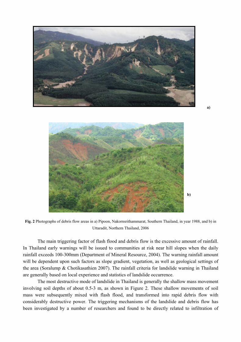
a)
b)
Fig. 2 Photographs of debris flow areas in a) Pipoon, Nakornsrithammarat, Southern Thailand, in year 1988, and b) in
Uttaradit, Northern Thailand, 2006
The main triggering factor of flash flood and debris flow is the excessive amount of rainfall. In Thailand early warnings will be issued to communities at risk near hill slopes when the daily rainfall exceeds 100-300mm (Department of Mineral Resource, 2004). The warning rainfall amount will be dependent upon such factors as slope gradient, vegetation, as well as geological settings of the area (Soralump & Chotikasathien 2007). The rainfall criteria for landslide warning in Thailand are generally based on local experience and statistics of landslide occurrence.
The most destructive mode of landslide in Thailand is generally the shallow mass movement involving soil depths of about 0.5-3 m, as shown in Figure 2. These shallow movements of soil mass were subsequently mixed with flash flood, and transformed into rapid debris flow with considerably destructive power. The triggering mechanisms of the landslide and debris flow has been investigated by a number of researchers and found to be directly related to infiltration of

rainwater into the soil slope (e.g. Johnson & Sitar, 1990, Enoki et al., 1999, Collins & Zhidarcic, 2004, Rahardjo et al., 2007). It is found that in Thailand the shallow soil mass down to the depth of about 3-5 meter in hill slope normally remain unsaturated during most time of the year, as indicated by negative pore water pressure in the soil. This negative pore water pressure or the matric suction provides additional shear strength or the apparent cohesion to the soil slope, ensuring it stability. Only during prolonged and intense rainstorm, that pulses of positive pore water pressure can be observed and the soil thickness would be fully or nearly saturated. The saturation of the soil slope reduced the matric suction, the shear strength of the soil, and subsequently destabilized the slope. In addition, a near saturated soil slope with zero matric suction will also be more susceptible to undrained failure and static liquefaction (e.g. Olivares & Picarelli, 2003, Burland & Ridley, 1996). This might be a reason for retrogressive or progressive failure of slope due to slight perturbation of the nearly saturated slope (Sr ~ 90-95%) after initiation of slope movement.
Fig. 3 Rainfall events observed before major landslides (involving numerous debris flows) and medium landslide
(involving failure of several cut slopes or highway slopes) in Thailand
The role of antecedent rainfall and soil moisture condition prior to a rainfall event have been shown by several researchers to be a significant factor in landslides. (e.g. Crozier & Eyles, 1980, Lumb, 1975, Rahardjo et al., 2007). As the accumulated rainfall increases, the soil water content and pore water pressure increases. This results in increase in water permeability and lateral water flux within surface soil. This situation is more inductive to landslide occurrence and less rain would be required to initiate landslide than it would be for a drier slope. Shown in Figure 3 are the rainfall events in Thailand that were observed before major landslides (those involving numerous debris flows) and medium landslides (those involving failure of several cut slopes or highway slopes). Note that a minor localized slide could happen even when there was no rain, provided that the 3 day antecedent rainfall was great enough. This is probably linked to either delayed infiltration or yielding of the material in the slope. A kind of critical rainfall envelope can be constructed and used as a tool for roughly indicating when landslides are likely to occur. The two such lines are approximated in Figure 3 and represent the total rainfalls of 150 mm and 300 mm, over 4-day
0
100
200
300
400
0 100 200 300 400 500 600 7003-day Antecedent Rainfall (mm)
1-da
y R
ainf
all (
mm)
Total Rainfall = 150
Total Rainfall = 300
major landslide debris flow/vegetated and forested area
minor slides/manmade cut slope

periods (1 day on the failure day + 3 day antecedent). The -1:1 gradient of the lines implicitly assume that evaporation, and deep percolation are negligible over these 4 day periods.
It should be noted that the durations of cumulative antecedant rainfall shown in Figure 3, which is 3 days, and the slope of the envelope are chosen for tentative use only. It is by no means implied that the duration of 3days antecedent rainfall and the envelope gradient are better than other values, since more statistical data is needed before any firm conclusion can be reached, at least for the case of Thailand. It is also chosen with a bias that personnel responsible for providing early warning to communities in Thailand normally observe this duration in practice. The geological settings of the landslide sites in Figure 3 vary which are mainly grainite, and mudstone/siltstone settings. It is noted that the use of another factor such as API or Antecedent Precipitation Index instead of accumulative rainfall would be theoretically more accurate since it takes into account other factors such as evapotranspiration, or underdrainage (DWR, 2007). However, the details will not be presented here for brevity. Measurement of soil suction As stated previously, antecedent rainfall and soil moisture are very important in predicting landslide occurrence. Various methods have been used to monitor soil moisture condition in the field, including tensiometers, TDR, gypsum block or resistivity probe etc. Normally, a kind of calibration curve will be needed for any particular probe and would be soil-type specific. If a tensiometer is used, the soil matric suction is measured and a soil water characteristic curve (i.e. a relationship between volumetric water content, and soil suction) will be needed to estimate the in-situ soil moisture. Johnson & Sitar (1990) characterized antecedent soil moisture conditions using tensiometers installed at various depths, and could find a satisfactory correlation between soil suction and debris flow initiation.
Past research (e.g. Vaughan, 1985, Wang & Sassa, 2003) has shown that it is the high positive pore water pressure which finally triggered slope movement and debris flow. Another advantage of characterizing soil wetness using tensiometer is thus that the device can be adapted to measure positive pore water pressure and act as a piezometer. In this study, new tensiometers have been developed at Kasetsart University which can be used to monitor pore water pressure in a range of -80
to 600 kPa as shown in Figure 4 (Jotisankasa et al., 2007). The devices incorporate MEMs pressure sensors and can be used to monitor suction in laboratory tests as well as in the field. With its small size, the KU tensiometer has been incorporated into direct shear tests as well as wetting/drying tests for soil-water characteristic curve determination, as shown in Figure 5.
Fig. 4 KU miniature tensiometer
1BAR AEV porous stone
Smooth surfaced acrylic tube
MEMs pressure
1 cm

For field application, the tensiometer has been designed so that it can be easily removed from the field for periodical deairing of water within its reservoir. As shown in Figure 6, a PVC lining is inserted in the pre-bored hole before installation of the tensiometer, and the tensiometer is later pushed into the casing and snugly fitted into the hole bottom.
Fig. 5 Devices used for determination of soil-water characteristic curve using tensiometer
Fig. 6 Installation of the tensiometer in the field
Characteristics of soils from some landslide-prone areas in Thailand In order to investigate the fundamental properties of soils in the landslide prone areas of Thailand, undisturbed samples have been collected from the sites as indicated in Figure 7 and Table 1. Soil sampling and ground investigation at most of these sites was undertaken as parts of other related projects carried out by Geotechnical Engineering Research and Development Center of Kasetsart University (DMR, 2008 DWR, 2007, and Rergsomboon, 2008). Sites 1,2,3,5 and 6 are in the areas that experienced numerous shallow slide/debris flows whose appearance was similar to those shown in Figure 2. As for sites 4, 7 and 8, the incidents only involve a few localized slope failures along roadside in the area. In order to obtain undisturbed samples, a test pit was dug close to the landslide source area, and a thin wall cylindrical tube with sharpen edge (with a diameter of about 63 mm) was driven to the ground at desired depths (0-1.5m) to collect the sample. In addition, bag samples
KU tensiometer
soil
Aluminium base
PVC casing and cover
Drill bit Tensiometer
PVC casing

were collected for other basic soil classification tests, including grain size distribution curve, liquid limit as well as plastic limit tests. The grain size distribution and basic properties for all soils tested are summarized in Table 2.
It is interesting to note that all the soils from five debris flow sites in Thailand (Sites 1,2,3,5 and 6) are classified as silty soils with low plasticity (SM, ML, CL). Past research (e.g. Burland & Ridley, 1996) suggests that these types of materials are likely to exhibit brittle undrained behaviour during shearing and could be susceptible to static liquefaction. Wang & Sassa (2003) also showed that sand with fine-particle (loess) contents tend to have greater mobility and high pore water pressure induced during landslide. The materials found in the debris flow areas of Thailand appeared to be in this category.
Fig. 7 Locations of landslide sites where samples have been collected
Table. 1 Details of landslide sites and classification of soils from the sites in this study Location Date of landslide/
Type*
Watershed Parent rock Soil Type
(USCS)
1.Omkoi, Chaingmai May 2003/
Debris flow
Ping Granite Silty soils
CL/ML
2. Mae-ramard, Tak May 2004/
Debris flow
Ping Metamorphic
Gneiss
Sandy silt
(ML)
3. Laplae, Uttaradit May 2006/
Debris flow
Nan Mudstone/ Shale Sandy silt
(ML)
4.Thadan dam,
Nakornnayok
Aug 2004/
Road cut/fill
Bangpakong Volcanic/ Silty soils
MH-OH/
ML-OL
5.Kitchakood,
Chantaburi
July 1999/2001/
Debris flow
Chantaburi Granite Silty sand
(SM)
6.Pipoon,
Nakornsrithammarat
Nov 1988/
Debris flow
Tapi Granite Silty sand
(SM)
7. Doi tung, Chaingrai Sep 2007/
Road cut/fill
Khong Diorite (fine-to-
medium grain)
Silty soils
MH-OH/
ML-OL
8. Phuket 2001/2003/2006
Road cut/fill
Pennisula west
coast
Granite Sandy lean
clay
(CL)
* “Debris flow” indicates numerous shallow slides, debris flow, while “Road cut/fill” indicates only several localized
slides along highway.
1 3
2
7
4
5
6
8

Table 2 Some basic properties of the soils in this study
Location
As-
sampled
void ratio
Liquid
Limit, %
Plastic
Limit, %
Plasticity
Index, %
%
Gravel% sand
%
silt % clay θs-θf (%)
1 0.771
(0.090)* 47.3 31.9 15.4 1.0 45.1 16.1 37.8 5.5
2 1.000
(0.050) 48.3 36.8 11.5 0.9 34.2 40.1 24.9 15
3 0.880
(0.120) 41.6 21.4 20.2 14.2 26.5 36.9 22.3 10
4 1.112
(0.129) 46-51 33-40 6-18 0.5-5.5 13.7-
18.9 38.9-53.9
31.9-36.7 12.5
5 0.815
(0.150) 41-48 36 5-12 2 53.2-
55.4 22.9-26.5
16.0-22.7 7
6 0.783
(0.098) 39.7 31.1 8.6 0.1 53.6 31.8 14.5 10
7 1.406 39.3 32.8 6.5 0 30.26 ND ND 15
8 1.210 37.3 30.8 6.5 2.8 38.9 20.8 37.5 20
* Number in parentheses indicate the standard deviation, where applicable
Soil-Water Characteristic Curve As stated previously, the soil-water characteristic curve for the soils from landslide area are used for converting the tensiometric measurement to the water content. In addition, the water content-suction relationship can also be used for predicting other mechanical behaviour of soil at different degrees of saturation, such as the shear strength variation with suction, and permeability function (Fredlund & Rahardjo, 1993). These properties are also required in performing numerical analysis of rainfall infiltration into slope. In this study, simple wetting/drying tests were carried out on the undisturbed samples as shown in Figure 5. The testing procedure involves gradually wetting the sample with an increment of about 1-2% water content while monitoring its suction after each wetting. Wetting is achieved by directly adding water into the sample using spray or fog generator. It was made sure that the suction measured at the top surface of sample was representative of the whole sample by waiting for equilibrium of suction reading (which normally took about 2 days). After soil suction was below 1kPa, the sample was soaked in water with a nominal overburden pressure of about 1kPa for 4-5 days to ensure complete soaking. The sample was then dried gradually by exposing it in the air and its suction measured incrementally in the same way. For measurement of suction greater than 1000 kPa, a relative humidity sensor was used instead of the tensiometer for total suction measurement. The measurement was made within a temperature controlled chamber with 20±0.5 oC. Even though the characteristic curve for suction greater than 1000 kPa might be of less importance for landslide application, it was determined in order that the permeability function can be estimated using the soil water characteristic curve.

Fig. 8 Soil-water characteristic curves of soils from landslide prone area of Thailand
Figure 8 shows the characteristic curves for all the samples tested. The curves exhibit the
characteristics of sandy and silty materials which normally has low air-entry suction in the range of 1-30 kPa, due to large macro voids within the soil pore.
0
5
10
15
20
25
30
35
40
45
50
0 1 10 100 1000 10000 100000 1000000suction, kPa
Volu
met
ric w
ater
con
tent
, %
1 m (wetting)0.2 m (wetting)1 m (drying)0.2 m (drying)
Depth
Site 1 Omkoi
05
101520253035404550
0.1 1 10 100 1000 10000 100000 1E+06suction, kPa
volu
met
ric w
ater
con
tent
, %
dryingwetting
Site 2. Tak
05
101520253035404550
0.1 1 10 100 1000 10000 100000 1E+06
suction, kPa
volu
met
ric w
ater
con
tent
, %
wetting
drying
Site 3: Uttaradit
05
101520253035404550
0.1 1 10 100 1000 10000 100000 1E+06
Suction, kPa
Vol
umet
ric w
ater
con
tent
, %
Wetting
Drying
Site 4: Nakorn-nayok
0
5
10
15
20
25
30
35
40
45
50
0.1 1 10 100 1000 10000 100000 1E+06
suction, kPa
Vol
umet
ric w
ater
con
tent
, %
Wetting
Drying
Re-wetting
Site 5: Chantaburi
05
101520253035404550
0.1 1 10 100 1000 10000 100000
1E+06suction, kPa
volu
met
ric w
ater
con
tent
, %
wettingdryingrewetting
Site 6: Pipoon
0
10
20
30
40
50
60
70
0.1 1 10 100 1000 10000 100000
1E+06
suction, kPa
Vol
umet
ric w
ater
con
tent
, %
1st wettingredrying
Site 7: Doi Tung
0
5
10
15
20
25
30
35
40
45
50
0 1 10 100 1000 10000 100000 1000000
suction, kPa
Vol
umet
ric w
ater
con
tent
, %
wettingdrying
Site 8: Phuket

Mechanism of landslide and threshold effect In order to assess the stability of slope subjected to rain infiltration, the shear strength properties of the soil in unsaturated state is also required. Various equations have been proposed for unsaturated soil strength , τ (see for example Fredlund & Rahardjo, 1993). A simple effective stress equation can be used with the Bishop’s χ factor equal to degree of saturation, rS , as in Equation 1a below. Alternatively, Equation 1b (Fredlund & Rahardjo, 1993) can also be used and the shearing angle with respect to suction, bφ , can be determined experimentally using direct shear or triaxial shearing tests with soil suction measurement. The effective cohesion, 'c , and effective angle of shearing resistance, 'φ , are determined using slow drained direct shear tests in this study. The value of pore air pressure au is taken as zero, wu is pore water pressure or negative suction, and nσ the normal stress. Based on Equation 1b, the factor of safety for a simple infinite slope model can be derived as in Equation 2 with slope gradient, β , depth of failure, z and soil total unit weight, γ (the values of bφ being equal to 'φ once wu > 0).
'tan)('tan)(' φφστ ⋅⋅−+⋅−+= rwaan Suuuc (1a)
bwaan uuuc φφστ tan)('tan)(' ⋅−+⋅−+= (1b)
(2)
Jotisankasa & Sawangsuriya (2008) performed numerical analysis of the 1-dimensional infiltration into soil slope with two different bottom boundary conditions, namely, no flow and free draining. The study was aimed at investigating the influence of underdrainage condition of the slopes. The parameters used in the analysis include the soil-water characteristics of Chantaburi site (Figure 8), and the strength parameters determined using suction-monitored direct shear tests ( kPac 7.11'= , o6.36'=φ and, ob 22=φ ), and saturated permeability, ks, (10-5 m/sec), determined using double ring infiltrometer (DWR, 2007). The permeability function was estimated using Jackson’s (1982) theory. The mesh of finite elements is shown in Figure 9 and the results of the analysis are shown in Figure 10 and 11.
The factor of safey, F, calculated using Equation 2 is shown in Figure 11, based on the pore water pressure, uw, which was obtained from the 1-D infiltration analysis, as shown in Figure 10. It
is clearly seen that for slopes with no flow bottom boundary, the pore water pressure can build up rapidly once the wetting front traveled down to the bottom or impermeable rock, and this results in the factor of safety became lower than one and slope failed. Thus clearly shown is the threshold effect of wetting front. On the contrary, for free draining bottom, the seepage continued after the wetting front reach the bottom with the pore water pressure maintained at zero.
Fig. 9 Finite Element Mesh for the infiltration analysis (Jotisankasa & Sawangsuriya, 2008)
20 cm
Top boundary:Steady state, q = 1.54x10⁻⁷ m/sTransient, q = 1.39x10⁻⁵ m/s
Bottom boundary:Steady state, pressure = -4 kPaTransient, no flow or unit gradient
ββγφφβγ
cossintan'tan)cos(' 2
⋅⋅⋅−⋅⋅+
=z
uzcFb
w

Fig. 10 Pore water pressure during rainfall intensity of 50 mm/hr (Jotisankasa & Sawangsuriya, 2008)
Fig. 11 Factor of safety during rainfall
intensity of 50 mm/hr (Jotisankasa &
Sawangsuriya, 2008)
It thus can be seen from the numerical analysis that once the wetting front had reached the impermeable bottom boundary within the soil profile, the rise in pore water pressure and destabilization of slope would be expected. By invoking some simplifying assumptions, the soil-water characteristic curve can be used to preliminarily estimate the failure depth of infinite slope which lead to debris flow. The first assumption is that the soil moisture condition prior to intense rainstorm is equal to the volumetric water content at field capacity, fθ , which can be taken directly from the SWCC at suction of 33 kPa. The water content at soaked state, sθ , is also taken from the SWCC at zero suction. It should be noted that the value of sθ might not be equal to soil porosity, n , but should correspond to the degree of saturation, rS , of greater than about 90 %. The second assumption is that the failure mechanism is infinite slope and the saturation of slope would destabilize the slope (this assumption would be more accurate for slopes with gradient 'φβ > ). The final assumption is that before the soil thickness is saturated, all the rain infiltrates the ground and there is only negligible runoff or deep percolation. The total amount of critical rain, cR , required to saturate the uniform soil slope to a critical depth,
cD , and cause slope failure.
( ) cfsc DR ⋅−= θθ (3)
0.2
0.4
0.6
0.8
1
1.2
1.4
1.6
1.8
2
0 5 10 15Time, hr
Fact
or o
f saf
ety
30_sw2_ug
45_sw2_ug
30_sw2_nf
45_sw2_nf
no flow
free draining
no flow
free draining
Slope = 30o
Slope = 45o
3 m
Imperviousrock (nf) or free draning rock (ug)
0
0.5
1
1.5
2
2.5
3
3.5
-20 -15 -10 -5 0 5 10 15 20 25 30
Pore water pressure, kPaD
epth
, m
Initial12345678910
hrs No Flow bottom boundary
0
0.5
1
1.5
2
2.5
3
3.5
-20 -15 -10 -5 0 5 10 15 20 25 30
Pore water pressure, kPa
Dep
th, m
Initial12345678910
hrs Free drainingUnit gradient bottom boundary

Based on the values of ( )fs θθ − in Figure 8 and Table 2, and critical rain in Figure 3 (amount to 4 days rainfall), the critical depth of failure is calculated to be ranging between 2 to 5 metres for large scale debris flow and 0.7-1.2 metres for small local failure. This is in fact in a good agreement with the failure depth observed in the field. Nevertheless, the critical depth, cD should only be viewed as a fictitious or empirical value that reflects only the magnitude or severity of landslide. It is also expect to encompass other factors such as vegetation covers and slope gradient. For more rigorous equation, the value of ( )fs θθ − should also be integrated over the entire depth for non-uniform soil profile. Johnson & Sitar (1990) proposed that the soil-water characteristic curve as well as field tensiometric measurement can be used to estimate the amount of rainfall needed to saturate the slope as in Equation 3 with the value of fθ indicating the real-time moisture converted from the measured suction. The system in this study thus can act as an early warning system in combination with rainfall measurement. In addition, since the KU-tensiometer can be used to monitor positive pore water pressure, Equations 1&2 can be used to calculate real-time factor of safety of the slope and provide additional warning system. Conclusions Some final conclusions can be reached as follows.
1. The soils from landslide prone areas in Thailand appear to be mainly silty soils with low plasticity (ML, SM, CL). The soil-water characteristic curves of the soils are also of silty type and of low air entry suction values. The difference between soaked volumetric water content and field-capacity water content (33kPa suction), ( )fs θθ − , ranged from 5.5% to 20%.
2. The mechanism of slope failure is also demonstrated using simple infiltration model and slope stability equation. Once the wetting front traveled to the undrained bottom of the soil slope, the pore water pressure changed from zero to hydrostatic condition immediately. This pulse of positive pressure significantly destabilizes the slope and may act as a threshold effect.
3. Application of these results for early warning system for flashflood and landslide disaster is finally demonstrated based on some simplifying assumptions, following Johnson & Sitar (1990) approach. The soil-water characteristic curve as well as field tensiometric measurement can be used to estimate the amount of rainfall needed to saturate the slope and provide early warning in combination with rainfall measurement. The monitored pore water pressure can also be used to directly calculate the factor of safety of the slope based on the effective stress stability equations. Acknowledgement
The studies presented in this paper were mainly supported by the National Research Council of Thailand (NRCT) under the project entitled “A Study of Critical Soil Moisture Conditions Leading to Flash Flood and Landslide Based on Infiltration Behavior in Upper Chao Phraya Basin” in year 2007-2008. Reference Burland, J. B. & Ridley, A. M. (1996). The importance of suction in soil mechanics. Proceedings of
the 12th Southeast Asian Geotechnical Conference, Kuala Lumpur. Vol 2, 27-49.

Collins, B. D. and Znidarcic, D (2004). Stability analyses of rainfall induced landslides. Journal of Geotechnical and Geoenvironmental Engineering. Vol. 130, No.4, ASCE. April 1
Crozier, M. J. & Eyles, R. J. 1980. Assessing the probability of rapid mass movement. Proc. 3rd Aus.NZ Conf. Geomech., Wellington. 2: 2.47-2.51
DMR (Department of Mineral Resource) Thailand. (2004) Landslide risk map of Thailand. DMR (Department of Mineral Resource), Thailand. (2008) Study of slope stability in Doi Tung
Development Project, Final report by Geotechnical Engineering Research and Development Centre, Kasetsart University, Thailand (in Thai)
DWR (Department of Water Resource) Thailand. (2007) Evaluation of critical Antecedent Precipitation Index (API) in support of early warning system for flash flood and landslide in Thailand, Final report by Kasetsart University, Thailand (in Thai)
Enoki, M., Kokubu, A.A. and Ikeda, Y. (1999) Infiltration of rainwater and slope failure. Landslides, Griffiths, Stokes, and Thomas (eds), Balkema, Rotterdam
Fredlund, D. G. & Rahardjo, H. (1993) Soil mechanics for unsaturated soils. New York: Wiley. Johnson, K.A., and Sitar, N. (1990) Hydrological conditions leading to debris-flow initiation.
Canadian Geotechnical Journal, 27: 789-801 Jotisankasa, A., Porlila, W., Soralump, S., Mairiang W. (2007). Development of a low cost
miniature tensiometer and its applications. Proceedings of the 3rd Asian Conference on Unsaturated Soils (Unsat-Asia 2007), Nanjing, China.
Jotisankasa, A. & Sawangsuriya, A. (2008). Application of unsaturated soil mechanics to slope stability, Proceedings of the 13th National Convention on Civil Engineering, Thailand. (in Thai)
Lumb, P. 1975. Slope failures in Hong Kong. Quarterly Journal of Engineering Geology. 8: 31-65 Olivares, L. & Picarelli, L. (2003). Shallow flowslides triggered by intense rainfalls on natural
slopes covered by loose unsaturated pyroclastic soils. Geotechnique 53, No. 2, 283–287 Rergsomboon, P. (2008). Final year project (BEng). A study of soil water retention behavior and
shear strength of soils from landslide-prone areas in Thailand with reference to early warning system. Department of Civil Engineering, Kasetsart University (in Thai)
Soralump, S. and Chotikasathien, W. (2007) Integration of geotechnical engineering and rainfall data into landslide hazard map in Thailand. In Geology of Thailand : Towards Sustainable Development and Sufficiency Economy. 21-22 November 2007
Vaughan, P.R. (1985) Pore pressures due to infiltration into partly saturated slopes. Proc. 1st International Conference on Geomechanics in Tropical Lateritic and Saprolitic soils. Vol 2 Brazil.
Wang, G. and Sassa, K. (2003). Pore-pressure generation and movement of rainfall-induced landslides: effects of grain size and fine-particle content. Engineering Geology 69 (2003) 109–125