investigation of rainfall-induced shallow landslides on ... · based on the results of our field...
TRANSCRIPT

Yang et al. Geoenvironmental Disasters (2015) 2:20 DOI 10.1186/s40677-015-0028-3
RESEARCH ARTICLE Open Access
Investigation of rainfall-induced shallowlandslides on the northeastern rim of Asocaldera, Japan, in July 2012
Hufeng Yang1*, Fawu Wang1, Vít Vilímek2, Kiminori Araiba3 and Shiho Asano4Abstract
Background: High-intensity rainfall struck the Northern Kyushu area of Japan between 11 and 14 July 2012. Thisheavy rainfall triggered many shallow landslides, especially on the northeastern rim of Aso caldera, leading tosignificant loss of life and damage to many villages. One landslide site at Ichinomiya (Kumamoto Prefecture) wasselected for detailed study. Field and laboratory investigations were conducted to identify the initiation mechanismof the shallow landslides during heavy rainfall.
Results: The thickness of the soil layer was determined using portable dynamic cone penetration tests. Thesoils became thinner (about 1 m) from the upper to the lower slope. In-situ infiltration tests indicate thathydraulic conductivity of this thin soil layer is low. During heavy rainfall events, most rainfall will transforminto surface runoff instead of infiltration. The results of consolidated-undrained triaxial compression tests showthat the effective friction angle and cohesion of the soil are 36.9° and 6.3 kPa, respectively. Soil behavior inresponse to increase in pore-water pressure was evaluated using a pore-water pressure controlled triaxial test.
Conclusions: The results indicate that the steep slopes on the northeastern rim of Aso caldera will remain stableunder normal rainfall conditions, due to the high shear strength of the soil. The probable initiation mechanism forthe shallow landslides on the northeastern rim of Aso caldera suggests that the initial failure process begins withtoe erosion caused by surface runoff during heavy rainfall. Due to the loss of the resistance force at the toe ofslope, the slope will reach a critical condition when pore-water pressure in the slope also increases.
BackgroundThe Northern Kyushu area of Japan experiencedhigh-intensity rainfall from 11 to 14 July, 2012. Thisheavy rainfall triggered many shallow landslides, espe-cially on the northeastern rim of Aso caldera (Fig. 1).These shallow landslides, as the resource for debrisflows, occurred on the upper slopes, at the inner rimof caldera. Trees growing along the gullies on themiddle slopes were carried away by the debris flows.Many sabo dams (i.e. check dams) in the path of thedebris flows were destroyed. The debris flows affectedmany villages and local settlers. The debris flowsclaimed 30 lives, with another two people remainingunaccounted for, and 13,263 houses were completelyor partially damaged (Fire and Disaster Management
* Correspondence: [email protected] of Geoscience, Shimane University, Matsue 690-8504, JapanFull list of author information is available at the end of the article
© 2015 Yang et al. Open Access This articleInternational License (http://creativecommoreproduction in any medium, provided youlink to the Creative Commons license, and i
Agency, Japan 2012). Transport routes and large areasof farmland were also affected. The total property losswas estimated to be about 2 billion USD (JSCE 2013).Shallow landslides often occur in weathered debris or
loose soil materials on steep slopes during heavy rainfall(Maharaj 1993; Zhu and Anderson 1998; Dai et al. 1999,2004; Dai and Lee 2002; Capra et al. 2003; Yu et al. 2006,Dahal et al. 2009; Giannecchini et al. 2012; Yang et al.2015; Wang et al. 2015). Annual rainfall in Kyushu is quitehigh, due to stagnation of wet fronts in the area duringthe rainy season, from May to July. Normally, few land-slides occur during limited rainfall. However, duringheavy rainfall events, shallow landslides and debrisflows are commonly triggered around the rim of Asocaldera (Miyabuchi et al. 2004, 2007; Miyase 2012;Matsushi et al. 2013). It is obvious that heavy rainfallis the main triggering factor of these geo-disasters.Several studies have been carried out to examine the
is distributed under the terms of the Creative Commons Attribution 4.0ns.org/licenses/by/4.0/), which permits unrestricted use, distribution, andgive appropriate credit to the original author(s) and the source, provide andicate if changes were made.

Fig. 1 Shallow landslides on the northeastern rim of Aso caldera (image courtesy of Kokusai Kogyo Co., Ltd, Japan)
Yang et al. Geoenvironmental Disasters (2015) 2:20 Page 2 of 14
factors contributing to the occurrence of shallowlandslides in Kyushu. Paudel et al. (2003, 2008) andMiyabuchi et al. (2011) reported that the soils on theslopes consisted of different layers, and the slip sur-faces of most landslides formed between upper black-ish and lower brownish tephra layers. Paudel et al.(2007) evaluated the spatio-temporal patterns of his-torical shallow landslides in Aso caldera, based onstatistical analysis of shallow landslides that occurredbetween 1953 and 1998. Kasama et al. (2011) recentlytried to clarify the factors which led to these geo-disasters, based on geo-mechanical and hydro-mechanicalevaluation.One landslide site on Aso caldera was selected for this
study to examine the initiation mechanism of the shal-low landslides during heavy rainfall. The main objectivesof our field investigations were observation of the geo-logical conditions, measurement of the longitudinal pro-file, and collection of soil samples for laboratoryanalysis. Laboratory experiments were conducted to de-termine the physical and mechanical properties of thesoils, and soil behavior in response to increase in pore-water pressure. Based on the results of our field and la-boratory investigations, we propose a probable initiationmechanism for the rainfall-induced shallow landslideson the northeastern rim of Aso caldera.
Study siteGeological conditionThe study site is located at Ichinomiya (KumamotoPerfecture) in the northeast of Aso caldera (Fig. 2).Aso caldera extends some 17 km from east to west,and 25 km from north to south, with an area ofabout 350 km2. The central crater group is referredto as Mt. Aso, and incorporates five peaks (Mt. Taka,
Mt. Naka, Mt. Eboshi, Mt. Kishima and Mt. Neko).The caldera was created by four major eruptiveevents, known as Aso-1, Aso-2, Aso-3 and Aso-4(Table 1). Huge volumes of basaltic to rhyolitic lavasand pyroclastic fall and flow deposits are distributedaround the rim of the caldera (Hunter 1998). TheAso-4 eruption, the latest and largest eruption, pro-duced multiple pyroclastic flows. The pyroclasticflows flowed into valleys and formed pyroclastic-flowplateaus. Eruptions between each of the four majorpyroclastic flow units produced numerous tephra ash-fall layers (Miyabuchi 2011). At the study site, thegeological units present include pyroclastic flow andash fall deposits derived from the Aso-1, Aso-2, Aso-3 and Aso-4 eruptions. Gravels, sands and muds weredeposited at the toe of the slope. Extensive air-fallvolcanic ash covered the top of the slope at the out-side rim of Aso caldera (Fig. 3).The cross section of Aso caldera shows that the
central cones divide the caldera into the Asodani andNangodani valleys (Figs. 2 and 4). The mountainchain and plains surround the outer rim of the cal-dera, and extend to the outer side into a gentle ter-rain overlain by pyroclastic deposits. Most of therainfall-induced shallow landslides generated in July2012 occurred on the inner slope of the northern cal-dera wall. The study site is located on the slope ofthe caldera wall at an elevation of about 700 m a.s.l.,and has a slope angle of more than 30° (Fig. 4).
Heavy rainfallDue to stagnation of the wet front during the rainyseason, torrential rain fell on the northern Kyushuarea (Fukuoka, Kumamoto, Oita and Saga Prefectures)from 11 to 14 July, 2012 (Fig. 5). This event was

Fig. 2 Location map of the study site (modified from Google Earth)
Yang et al. Geoenvironmental Disasters (2015) 2:20 Page 3 of 14
officially named the ‘Northern Kyushu Heavy Rainfallin July 2012’ by the Japan Meteorological Agency(JMA). Based on hourly rainfall data collected fromall meteorological observatories in Northern Kyushuover the last decade, the maximum hourly rainfall re-corded at seven observatories in July 2012 was thehighest local rainfall ever recorded in the area.Among these observatories, cumulative rainfall re-corded over the four-day period exceeded 500 mm atfive sites, with totals ranging from 570.5 to 816.5 mm(Table 2).Most of the shallow landslides occurred on 11 and 12
July, 2012. In order to understand the rainfall character-istics at study site, hourly and cumulative rainfall datafor these days was obtained from the rainfall record atthe Otohime Meteorological Observatory. The OtohimeMeteorological Observatory is located about 10 km westof the study site (Fig. 2), and is the nearest available
Table 1 Characteristics of the four major eruptive events (Aso-1, Aso
Unit Volume (km3) Eruptive age (k
Aso-1 >30 370-270
Aso-2 >25 170
Aso-3 >40 100
Aso-4 >80 80
record. The rainfall data shows that the maximumhourly rainfall was 108 mm in the early morning of 12July, and the cumulative rainfall over the two days was508 mm (Fig. 6). This rainfall is the highest recorded atthe Otohime Meteorological Observatory over the lastdecade. Obviously, heavy rainfall was the main triggeringfactor for this geo-disaster.
MethodsField investigationA representative shallow landslide at Shioi Village inIchinomiya, Kumamoto Prefecture (Fig. 2) was selectedto study the initiation mechanism of shallow landslideson the steep slopes during heavy rainfall. Figure 7 showsthe slope after failure. Several shallow landslides oc-curred in grassland at the rim of Aso caldera (Fig. 8).These shallow landslides were the source of debris flowsin the gully. Field investigations were conducted on the
-2, Aso-3 and Aso-4) (Aramaki 1984; Hunter 1998)
a) Source and dominant geological units
Welded tuff
Welded tuff, in part non-welded deposit of scoria
Vitric ash, pumice or scoria and welded tuff
Non-welded deposit of vitric ash fall and pumice

Fig. 3 Geological map of the study site (after Hunter 1998)
Yang et al. Geoenvironmental Disasters (2015) 2:20 Page 4 of 14
shallow landslide shown in Fig. 8b. Longitudinal profileswere measured to illustrate the terrain of the gully andslope. Soil samples were collected from the main scarpof the shallow landslide for laboratory investigations.Three portable dynamic cone penetration tests wereconducted to determine the thickness of the soil layer.In order to measure the hydraulic coefficient of the soil,in-situ infiltration tests were conducted in hand-drilledboreholes of varying depth, above the top of the mainscarp of the shallow landslide.
Portable dynamic cone penetration testsThe test locations are shown in Fig. 8b. During the dy-namic cone penetration tests, a 5 kg hammer wasdropped (free fall) from a height of 50 cm. The numberof drops (Nd) was recorded for each 10 cm penetrationdepth of the cone tip (Qureshi et al. 2009). The thick-ness of the soil layer and its boundaries could thus bedetermined, due to the differing strength of the potentialsliding bed.
In-situ borehole infiltration testsThe test locations were located above the main scarp ofthe shallow landslide, near point A in Fig. 8b. A portable
Fig. 4 Cross section of Aso caldera
twist drill was used to drill a 0.25 m deep borehole. APVC tube was then inserted into the borehole until thebottom was reached. The tube was then filled withwater, and the initial water level and start time of waterinfiltration were noted. The final depth of the water levelwas measured after a given time interval. A second bore-hole with a depth of 0.75 m was drilled near the firstborehole (Fig. 9) to determine the variation of soil per-meability with increased depth. The same test processwas used for the second borehole. Tests were carriedout twice in each borehole to obtain an average value.The hydraulic coefficient (k) was calculated using Eq. 1(Lambe and Whitman 1969);
k ¼ πD11Δt
Inh1h2
ð1Þ
where h1 and h2 are the two consecutive depths of waterin meters; h1 is the initial depth and h2 is the final depth;D is the diameter of pipe, D = 0.1 m; and Δt expressesthe time interval (in seconds) between the two succes-sive measurements.
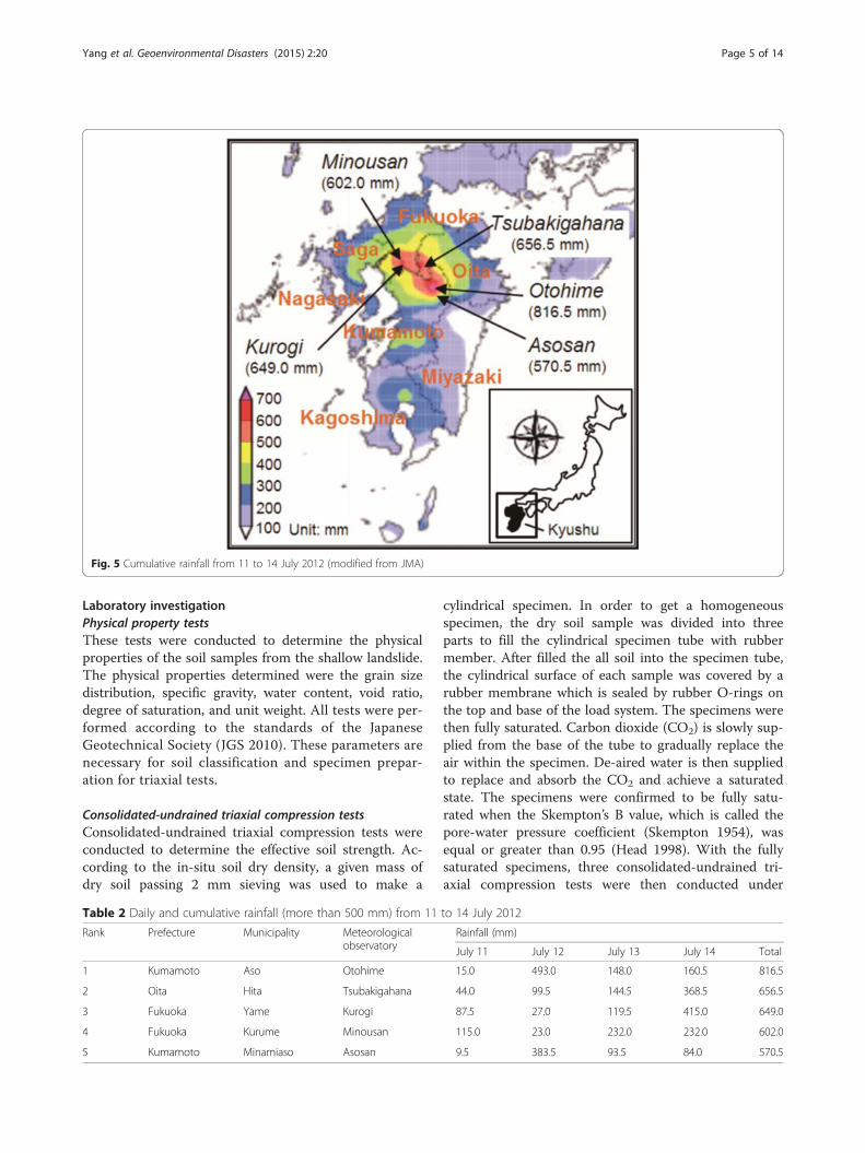
Fig. 5 Cumulative rainfall from 11 to 14 July 2012 (modified from JMA)
Yang et al. Geoenvironmental Disasters (2015) 2:20 Page 5 of 14
Laboratory investigationPhysical property testsThese tests were conducted to determine the physicalproperties of the soil samples from the shallow landslide.The physical properties determined were the grain sizedistribution, specific gravity, water content, void ratio,degree of saturation, and unit weight. All tests were per-formed according to the standards of the JapaneseGeotechnical Society (JGS 2010). These parameters arenecessary for soil classification and specimen prepar-ation for triaxial tests.
Consolidated-undrained triaxial compression testsConsolidated-undrained triaxial compression tests wereconducted to determine the effective soil strength. Ac-cording to the in-situ soil dry density, a given mass ofdry soil passing 2 mm sieving was used to make a
Table 2 Daily and cumulative rainfall (more than 500 mm) from 11
Rank Prefecture Municipality Meteorologicalobservatory
1 Kumamoto Aso Otohime
2 Oita Hita Tsubakigahana
3 Fukuoka Yame Kurogi
4 Fukuoka Kurume Minousan
5 Kumamoto Minamiaso Asosan
cylindrical specimen. In order to get a homogeneousspecimen, the dry soil sample was divided into threeparts to fill the cylindrical specimen tube with rubbermember. After filled the all soil into the specimen tube,the cylindrical surface of each sample was covered by arubber membrane which is sealed by rubber O-rings onthe top and base of the load system. The specimens werethen fully saturated. Carbon dioxide (CO2) is slowly sup-plied from the base of the tube to gradually replace theair within the specimen. De-aired water is then suppliedto replace and absorb the CO2 and achieve a saturatedstate. The specimens were confirmed to be fully satu-rated when the Skempton’s B value, which is called thepore-water pressure coefficient (Skempton 1954), wasequal or greater than 0.95 (Head 1998). With the fullysaturated specimens, three consolidated-undrained tri-axial compression tests were then conducted under
to 14 July 2012
Rainfall (mm)
July 11 July 12 July 13 July 14 Total
15.0 493.0 148.0 160.5 816.5
44.0 99.5 144.5 368.5 656.5
87.5 27.0 119.5 415.0 649.0
115.0 23.0 232.0 232.0 602.0
9.5 383.5 93.5 84.0 570.5

Fig. 6 Hourly and cumulative rainfall at study area on 11 and 12 July, 2012
Fig. 7 Photograph of the slope at Shioi Village, Ichinomiya, after failure (image courtesy of Kokusai Kogyo Co., Ltd, Japan)
Yang et al. Geoenvironmental Disasters (2015) 2:20 Page 6 of 14

Fig. 8 Shallow landslides in the grassland (locations of (a) and (b) are shown in Fig. 7; Points A, B and C in (b) show the locations of portabledynamic cone penetration tests)
Yang et al. Geoenvironmental Disasters (2015) 2:20 Page 7 of 14
three differing confining stresses (50, 75 and 100 kPa).After normal consolidation, the specimens were com-pressed at an axial strain of 1.0 % per minute under theundrained condition. Vertical load, pore-water pressureand vertical displacement data was recorded by a datalogging system. The shear strength parameters can beobtained from these tests.
Fig. 9 In-situ infiltration tests
Pore-water pressure controlled triaxial testA pore-water pressure controlled triaxial test was per-formed to examine behaviour of the soil with increasingpore-water pressure. The process of specimen preparationand saturation was the same as that for the consolidated-undrained triaxial compression tests. In contrast to theisotropic consolidated-undraind triaxial compression test,

Fig. 10 Longitudinal profiles of the gully and slope
Yang et al. Geoenvironmental Disasters (2015) 2:20 Page 8 of 14
the specimen was consolidated under nonisotropic confin-ing stress. The axial and lateral confining stresses can beobtained according to the vertical and lateral earth pres-sure. Through this step, the initial stress condition of thesoil at the potential sliding zone is simulated. After con-solidation, de-aired water is supplied to the specimen by apore-water pressure controller, to increase the pore-waterpressure. The rate of increase in pore-water pressure was0.2 kPa per minute. Through this step, the effect of pore-water pressure accumulation on the potential sliding sur-face is simulated, and the failure process can be observed.
Results and discussionCharacteristics of slope and debris flowThe slopes at the rims of caldera are usually formedby the subsidence of land following volcanic erup-tions. Steep gradients are a typical feature of theseslopes. According to GIS analysis of the distributionof shallow landslides formed in Ichinomiya during the
Fig. 11 Exposed bedrock in gullies
July 2012 heavy rainfall event, landslide frequency is great-est at slope angles between 30 and 40° (GeographicalSurvey and Photography, Japan 2012). As shown inthe longitudinal profiles of the investigated area, theangle of the slope on which shallow landslide oc-curred is 38° (I-I’ in Fig. 10). A steep slope (II-II’ inFig. 10) is also present behind the sabo dams. Thesteep terrain will affect both the slope stability andhydrological conditions, such as surface runoff on theslope and seepage in the soil layer. In addition, thesteep slope enhances the rapid down-slope movementof debris. Erosion from the debris flows removed thethin soil layer in the gully, leaving bedrock exposed(Fig. 11). The speed of the debris flows increased rap-idly as they traveled down the steep slope. The debrisflows contained blocks of rock, and destroyed twosabo dams (Fig. 12) and several houses. Finally, debriswas deposited on the flat land and paddy fields at thebase of the slope.

Fig. 12 Sabo dams destroyed by debris flow
Yang et al. Geoenvironmental Disasters (2015) 2:20 Page 9 of 14
The results of the portable dynamic cone penetrationtests show that the soil layer is about 3.5 m thick at theupper slope (Fig. 13). The soil layers gradually becomethinner (about 1 m) from the upper to the lower slope.In general, soils in the lower parts of hillsides are thickerthan in their upper part, due to soil erosion in the upperparts, and deposition in the lower parts. Consequently,the characteristics of the slope at the rim of Aso calderadiffer from the general condition. This may be becausethat erosion on the lower slope is more severe than onthe upper slope due to surface run-off during heavy
Fig. 13 Results of three portable dynamic cone penetration tests Fig. 14 Main scarp of the shallow landslide

Fig. 15 Grain size distributions of soil samples from different layers
Table 3 Physical properties of different soil layers
Physical properties Layer 1 Layer 2
Specific gravity, Gs 2.271 2.734
Water content, w (%) 187.0 72.0
Void ratio, e 5.452 2.191
Degree of saturation, S (%) 78 90
Total unit weight, γ (kN/m3) 10.1 14.7
Saturated unit weight, γsat (kN/m3) 12.0 15.4
Yang et al. Geoenvironmental Disasters (2015) 2:20 Page 10 of 14
rainfall. Moreover, the slope is quite steep (about 38°).Soil eroded from the upper slope will not be depositedin the lower part. Instead, fine soil particles will be de-posited in the gully, and this material will transform intodebris flows during heavy rainfall.
Physical properties of soilsThe soil in the main scarp of the shallow landslide canbe divided into two layers based on the appearancefeatures (Fig. 14). Layer 1, the black uppermost layer, iscomposed of volcanic ash, humus and plant roots.Coarse sand and gravels occur in the underlying layer 2.Particle size gradually increases downward, reachingmaximum particle diameter of about 20 mm. The slidingzone of the shallow landslide is located at the base oflayer 2, which is underlain by a basal gravel layer. Slidingsurfaces were observed on the surface of the basal gravellayer. Grain size analysis (sieve and hydrometer analysis)of soil samples from each layer was conducted to deter-mine their grain size distribution (Fig. 15). Fine particles(grain size less than 0.075 mm) form around 45 % of thesoils in layers 1 and 2. After the occurrence of shallowlandslides, on steep slopes these fine materials can easilytransform into debris flows during heavy rainfall. Ac-cording to the Unified Soil Classification System (USCS),layer 1 is composed of poorly graded tephra clay. Layer2 is composed of clay with coarse sand gravels.The soil properties of the different layers are shown
in Table 3, which summarizes specific gravity, naturalwater content, void ratio, degree of saturation, totaland saturated unit weight. Although, there had beenno rainfall for several days before sampling, soil layer1 maintained a high water content and degree of
saturation. This indicates that soil layer 1 has highwater retention capability. The unit weight of the top-soil increased about 20 % from natural to saturatedcondition. These phenomena are related to the prop-erties of soil, such as higher void ratio. High void ra-tio (5.452) means that soil layer 1 has a loosestructure. Internal erosion could easily occur in sucha loose soil layer, with high pore-water pressure orseepage.
Rainfall infiltrationAs noted above, heavy rainfall is the main triggering fac-tor for the shallow landslide occurrences at the studysite. The results of in-situ infiltration tests are shown inTable 4. Hydraulic conductivity (k) is 1.28 × 10⁻⁶ m/s atthe shallow depth of 0.25 m, compared to 1.90 × 10⁻⁷ m/sat 0.75 m depth. The soil at the bottom of the hand-drilled boreholes should be compressed and disturbed,and hence the actual hydraulic conductivity should behigher than the experimental value. Nevertheless, these re-sults show that permeability decreases with increase in

Fig. 17 Effective stress paths under different confining pressures (50,75 and 100 kPa). The dotted line indicates the critical state line (CLS)
Table 4 Results of the in-situ permeability tests
Parameters Test A Test B
1 2 1 2
h1 (m) 0.15 0.15 0.60 0.60
h2 (m) 0.14 0.12 0.59 0.58
L (m) 0.25 0.25 0.75 0.75
Δt (s) 1500 5100 2700 4800
k (m/s) 1.31 × 10⁻⁶ 1.25 × 10⁻⁶ 1.78 × 10⁻⁷ 2.02 × 10⁻⁷
Average k (m/s) 1.28 × 10⁻⁶ 1.90 × 10⁻⁷
Yang et al. Geoenvironmental Disasters (2015) 2:20 Page 11 of 14
depth. Paudel et al. (2008) measured the hydraulic con-ductivity of soils on slope surfaces at ten sites in Aso cal-dera. They also found that the hydraulic conductivityof soil layer was low, ranging from 1.0 × 10⁻⁶ m/s to5.0 × 10−6 m/s. With the low hydraulic conductivity ofthe soil layer, during heavy rainfall events most rain-fall will transform into surface runoff.
Shear strength of soilThe stress–strain relationship of the consolidated-undrained tests on the saturated specimens (Fig. 16a)shows that the deviatoric stress increases with the axialstrain. The stress–strain curves provide evidence forstress hardening. When the shear strain is over about13 %, the deviatoric stress begins to flatten. For the spe-cimen with high confining pressure (100 kPa), stresssoftening was observed at the end of the test. Criticalstate was reached for all three tests with a high axialstrain (Fig. 16a).The relationship between excess pore-water pressure
and the axial strain of consolidated-undrained testson the saturated specimens is shown in Fig. 16b.Positive pore-water pressure was recorded in all threeundrained tests. In all soil specimens, pore-water pres-sure increased to a peak at low strain (about 3 %), declines
Fig. 16 a Stress–strain relationship; b relationship between pore-water precompression tests
from its maximum value as the strain increases continu-ously, and finally reached a minimum value at the end ofthe tests. The initial buildup of the pore-water pressuresuggests that the specimens exhibit contractive behavior.The reduction in the pore-water pressure after the peakindicates that the specimens change from contractive todilative behavior during shear, as illustrated by the effect-ive stress paths shown in Fig. 17.All the effective stress paths show a similar trend. Each
path moves toward the right initially (increasingσ
01 þ σ
03
� �=2 ), and then moves to the left (decreasing
σ01 þ σ
03
� �=2) until reaching a turning point, after which
they turn right, before reaching the critical state line(CSL) at the end of the test. The critical states of satu-rated specimens can be represented by the CSL in thestress plane. The gradient of the critical state line is 0.6,which corresponds to a critical state line of effective fric-tion of 36.9° and cohesion of 6.3 kPa. In published re-sults of soil shear strength, it was observed that theeffective friction angle was about 35°, and cohesion var-ied between different soil layers (Paudel et al. 2008). The
ssure and axial strain for the consolidated-undrained triaxial

Fig. 18 Relationships between deviatoric stress, axial strain and pore-water pressure for the pore-water pressure controlled triaxial test
Fig. 19 Probable initiation mechanism of shallow landslides on thenortheastern rim of Aso caldera
Yang et al. Geoenvironmental Disasters (2015) 2:20 Page 12 of 14
high shear strength of these soils explains why the steepslopes on the northeastern rim of Aso caldera are usu-ally stable under normal rainfall during the rainy season.
Soil behavior with the increase in pore-water pressureThe relationships between deviatoric stress, axial strainand pore-water pressure were obtained through thepore-water pressure controlled triaxial test (Fig. 18). Theresults show that when the pore-water pressure in-creased to about 12 kPa, the deviatoric stress started todecrease, while the axial strain increased. With the con-tinuous increase of pore-water pressure, the major fail-ure of the soil occurred when the pore-water pressureincreased to near 15 kPa. At this time, high excess pore-water pressure was generated in the soil, causing the ob-vious decrease of effective stress. In a short time, theaxial strain increased rapidly, and exceeded 20 %. Thissoil behavior in response to increase in pore-water pres-sure can explain the initiation mechanism of the shallowlandslides on the slopes. During heavy rainfall, continu-ous rainfall infiltration can generate a wet front in thesoil layer, and in turn forms a saturated zone above thepotential sliding surface. The saturated zone will movegradually upwards in relation to the slope surface, andthe pore-water pressure acting on the potential slidingsurface will increase. Based on the results, it is evidentthat failure in the soil specimen will not occur, even withhigh pore-water pressure (less than 12 kPa). It alsomeans that the slope can maintain stability when therainfall is not so heavy. However, if the pore-water pres-sure exceeds the critical value as a result of heavy rain-fall, a shallow landslide will be triggered.

Yang et al. Geoenvironmental Disasters (2015) 2:20 Page 13 of 14
Probable initiation mechanismBased on the above discussion of the characteristics ofthe slope, physical properties of the soil, rainfall infiltra-tion, shear strength of the soil, and soil behavior withthe increase in pore-water pressure, a probable initiationmechanism for shallow landslides on steep slopes wasdeveloped, as shown in Fig. 19.
(1)During heavy rainfall, surface water infiltrates intothe soil layer and generates water level in the slope.The soil layer in the lower part will become fullysaturated first because the thickness of the soil layerat the toe of slope is very low.
(2)Due to the limitation imposed by the hydraulicconductivity (k) of the soil, infiltration rate of rainfallis far less than the rainfall intensity. Most of therainfall transforms into surface runoff. On the steepslope, high-speed surface runoff will remove the toeof the slope.
(3)Gradual headward erosion may occur, and removethe soil layer in the lower part that provides theresistance for slope stability. Meanwhile, thegroundwater level in the slope keeps increasing dueto the continuous rainfall infiltration, i.e. the pore-water pressure in the soil builds up at the potentialsliding surface. When the pore-water pressureexceeds the critical value, a shallow landslide will betriggered, as a result of heavy rainfall.
Conclusions
1. High-intensity rainfall is the main triggering factorfor shallow landslides on the northeastern rim ofAso caldera. On these steep slopes, the sliding masscreated after the occurrence of shallow landslidestransformed into debris flows during heavy rainfall.
2. The soil on the slopes on the northeastern rim ofAso caldera has high shear strength. The soil behaviorin response to increase in pore-water pressure showsthat failure of the soil will not occur until the pore-water pressure exceeds a relatively high value. Thisexplains why such steep slopes can be stable undernormal rainfall during the rainy season. However, ifthe pore-water pressure exceeds the critical value asa result of heavy rainfall, shallow landslides will betriggered.
3. The probable initiation mechanism indicates thatthe initial failure process of the shallow landslides onthe northeastern rim of Aso caldera begins with toeerosion caused by surface runoff. The combinationof this loss of resistance force at the toe of the slopeand increase of pore-water pressure in the slopeduring heavy rainfall will finally bring the slope to acritical condition.
Competing interestsThe authors declare that they have no competing interests.
Authors’ contributionsHY, FW, KA and SA paticipated in the field investigations. HY conducted thetriaxial tests and drafted the manuscript. FW and HY conducted the portabledynamic cone penetration tests and in-situ infiltration test. VV contributed tothe sliding mechanism. All authors read and approved the final manuscript.
AcknowledgementsThis work was financially supported by JSPS KAKENHI Grant Number A-2424106 for landslide dam failure prediction. Messrs. Mitani and Sonoyamaof Shimene University joined the field investigtion. The authors thank Dr.Barry Roser for his helpful and constructive comments on the manuscript.Valuable and constructive comments from anonymous reviewers are alsoappreciated.
Author details1Department of Geoscience, Shimane University, Matsue 690-8504, Japan.2Department of Physical Geography and Geoecology, Charles University inPrague, Prague, Czech Republic. 3National Research Institute of Fire andDisaster, Chofu, Tokyo, Japan. 4Forestry and Forest Products ResearchInstitute, Tsukuba, Japan.
Received: 5 February 2015 Accepted: 29 July 2015
ReferencesAramaki S (1984) Formation of the Aira caldera, southern Kyushu, ~22 000 years
ago. J Geophys Res 89:8485–8501.Capra L, Lugo-Hubp J, Borselli L (2003) Mass movements in tropical volcanic
terrains: the case of Teziutlan (Mexico). Eng Geol 69(3–4):359–379.Dahal R, Hasegawa S, Nonomura A, Yamanaka M, Masuda T, Nishino K (2009)
Failure characteristics of rainfall-induced shallow landslides in granitic terrainsof Shikoku Island of Japan. Environ Geol 56:1295–1310.
Dai F, Lee CF (2002) Landslide characteristics and slope instability modelingusing GIS, Lantau Island, Hong Kong. Geomorphology 42(3–4):213–228.
Dai F, Lee CF, Wang S (1999) Analysis of rainstorm-induced slide-debris flows onnatural terrain of Lantau Island, Hong Kong. Eng Geol 51(4):279–290.
Dai F, Lee CF, Tham LG, Ng KC, Shum WL (2004) Logistic regression modelling ofstorm-induced shallow landsliding in time and space on natural terrain ofLantau Island, Hong Kong. Bull Eng Geol Environ 63(4):315–327.
Fire and Disaster Management Agency, Japan (2012) Report of heavy rainfallfrom 11 July 2012. (No. 20). http://www.fdma.go.jp/bn/2012/detail/766.html.Accessed 20 January 2015.
Geographical Survey and Photography, Japan (2012) Investigation of debris flowsat Mt. Aso caldera triggered by Northern Kyushu heavy rainfall in 2012 usingGIS. http://gpi-net.jp/study/aso/aso.html. Accessed 20 January 2015.
Giannecchini R, Galanti Y, Avanzi G (2012) Critical rainfall thresholds for triggeringshallow landslides in the Serchio River Valley (Tuscany, Italy). Nat HazardsEarth Syst Sci 12:829–842.
Head KH (1998) Manual of soil laboratory testing (Vol. 3). John Wiley & Sons,New York.
Hunter AG (1998) Intracrustal Controls on the coexistence of tholeiitic andcalc-alkaline magma series at Aso Volcano, SW Japan. J Petrol39(7):1255–1284.
Japan Society of Civil Engineering (JSCE) (2013) Investigation report of the disastercaused by Northern Kyushu heavy rainfall in July 2012. http://committees.jsce.or.jp/report/system/files/1-1-6.pdf. Accessed 20 January 2015.
Kasama K, Jiang Y, Hiro-oka A, Yasufuku N, Sato H (2011) Geo-and hydro-mechanical evaluation of slope failure induced by torrential rains innorthern-Kyushu area, July 2009. Soils Found 51(4):575–589.
Lambe WT, Whitman RV (1969) Soil Mechanics. John Wiley, New YorkMaharaj R (1993) Landslide processes and landslide susceptibility analysis from
an upland watershed: a case study from St. Andrew, Jamaica, West Indies.Eng Geol 34:53–79.
Matsushi Y, Saito H, Fukuoka H, Furuya G (2013) Landslides of tephra deposits onhillslope of the Aso caldera wall and volcanic central cones by the North-Kyushu heavy rainfall at July 2012. Annuals of Disaster Prevention ResearchInstitute, Kyoto University (No. 56). http://repository.kulib.kyoto-u.ac.jp/dspace/bitstream/2433/181543/1/a56b0p28.pdf. Accessed 20 January 2015.

Yang et al. Geoenvironmental Disasters (2015) 2:20 Page 14 of 14
Miyabuchi Y, Sugiyama S (2011) 90,000-year phytolith record from tephra sectionat the northeastern rim of Aso caldera, Japan. Quat Int 246(1–2):239–246.
Miyabuchi Y, Daimaru H, Komatsu Y (2004) Landslides and lahars triggered bythe rainstorm of June 29, 2001, at Aso Volcano, Southwestern Japan. TransJpn Geomorphol 25(1):23–43.
Miyabuchi Y, Koji T, Ogawa Y, Shimizu T (2007) Runoff and sediment dischargetriggered by the Typhnoon 200514 (Nabi) in forested watersheds, SouthernKyushu, Japan. Trans Jpn Geomorphol 28(2):127–142.
Miyase M (2012) Investigation report of the debris flow caused by heavy rainfallin July 2012. Sabo 112:7–11.
Paudel PP, Moriwaki K, Morita K, Kubota T, Omura H (2003) An assessment ofshallow landslides mechanism Induced by rainfall in Hakoishi area. KyushuJournal of Forest Research 56:122–128.
Paudel PP, Omura H, Kubota T, Inoue T (2007) Spatio-temporal patterns ofhistorical shallow landslides in a volcanic area, Mt. Aso, Japan.Geomorphology 88(1–2):21–33.
Paudel PP, Omura H, Kubota T, Devkota B (2008) Characterization of terrainsurface and mechanisms of shallow landsliding in upper Kurokawawatershed, Mt Aso, western Japan. Bull Eng Geol Environ 67(1):87–95.
Qureshi MU, Towhata I, Yamada S, Aziz M, Aoyama S (2009) Geotechnical riskassessment of highly weathered slops using seismic refraction technique.In: Oka F, Murakami A, Kimoto S (eds) Prediction and simulation methods forgeohazard mitigation. Taylor & Francis Group, London.
Skempton AW (1954) The Pore-Pressure Coefficients A and B. Geotechnique4(4):143–147.
The Japanese Geotechnical Society (JGS) (2010) Soil test: basic and guidance(The second revision). Maruzen press.
Wang F, Wu YH, Yang H, Tanida Y, Kamei A (2015) Preliminary investigationof the 20 August 2014 debris flows triggered by a severe rainstorm inHiroshima City, Japan. Geoenvironmental Disasters 2:17. doi:10.1186/s40677-015-0025-6.
Yang H, Wang F, Miyajima M (2015) Investigation of shallow landslides triggeredby heavy rainfall during typhoon Wipha (2013), Izu Oshima Island, Japan.Geoenvironmental Disasters 2:15. doi:10.1186/s40677-015-0023-8.
Yu FC, Chen TC, Lin ML, Chen CY, Yu WH (2006) Landslides and rainfallcharacteristics analysis in Taipei City during the Typhoon Nari event. NatHazards 37(1–2):153–167.
Zhu JH, Anderson SA (1998) Determination of shear strength of Hawaiianresidual soil subjected to rainfall-induced landslides. Geotechnique48(1):73–82.
Submit your manuscript to a journal and benefi t from:
7 Convenient online submission
7 Rigorous peer review
7 Immediate publication on acceptance
7 Open access: articles freely available online
7 High visibility within the fi eld
7 Retaining the copyright to your article
Submit your next manuscript at 7 springeropen.com