influence of soil development on the geomorphic evolution …eps · geology; march 2002; v. 30;...
TRANSCRIPT
q 2002 Geological Society of America. For permission to copy, contact Copyright Permissions, GSA, or [email protected]; March 2002; v. 30; no. 3; p. 195–198; 4 figures; Data Repository item 2002017. 195
Influence of soil development on the geomorphic evolution oflandscapes: An example from the Transverse Ranges of CaliforniaM.C. EppesL.D. McFadden
Department of Earth and Planetary Sciences, University of New Mexico, Albuquerque,New Mexico 87131, USA
J. Matti U.S. Geological Survey, 520 North Park Avenue, Tucson, Arizona 85719, USAR. Powell U.S. Geological Survey, 904 West Riverside Avenue, Spokane, Washington 99201-1087, USA
ABSTRACTSoil development can significantly influence the topographic evolution of a tectonically
deforming mountain piedmont. Faults and folds associated with the North Frontal thrustsystem deform piedmont sediments of variable compositions along the north flank of theSan Bernardino Mountains. The topographic expressions of folds with similar structuralcharacteristics diverge appreciably, primarily as a function of differences in sedimentcomposition and associated soil development. Soils with petrocalcic horizons in limestone-rich deposits are resistant to erosion, and anticlinal folds form prominent ridges. Foldsforming in granite-derived deposits with argillic soil horizons are eroded and/or buriedand are therefore topographically less pronounced. We propose that these landform con-trasts can be explained by differences in soil-controlled hydrologic and erosion character-istics of deposits without calling upon changes in tectonic style along the mountain front.
Keywords: soil, landscape evolution, tectonics, folds, erosion, San Bernardino Mountains.
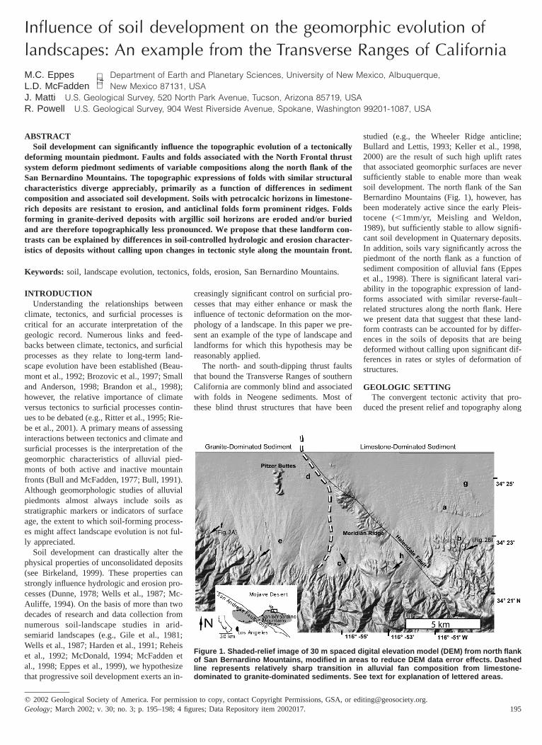
Figure 1. Shaded-relief image of 30 m spaced digital elevation model (DEM) from north flankof San Bernardino Mountains, modified in areas to reduce DEM data error effects. Dashedline represents relatively sharp transition in alluvial fan composition from limestone-dominated to granite-dominated sediments. See text for explanation of lettered areas.
INTRODUCTIONUnderstanding the relationships between
climate, tectonics, and surficial processes iscritical for an accurate interpretation of thegeologic record. Numerous links and feed-backs between climate, tectonics, and surficialprocesses as they relate to long-term land-scape evolution have been established (Beau-mont et al., 1992; Brozovic et al., 1997; Smalland Anderson, 1998; Brandon et al., 1998);however, the relative importance of climateversus tectonics to surficial processes contin-ues to be debated (e.g., Ritter et al., 1995; Rie-be et al., 2001). A primary means of assessinginteractions between tectonics and climate andsurficial processes is the interpretation of thegeomorphic characteristics of alluvial pied-monts of both active and inactive mountainfronts (Bull and McFadden, 1977; Bull, 1991).Although geomorphologic studies of alluvialpiedmonts almost always include soils asstratigraphic markers or indicators of surfaceage, the extent to which soil-forming process-es might affect landscape evolution is not ful-ly appreciated.
Soil development can drastically alter thephysical properties of unconsolidated deposits(see Birkeland, 1999). These properties canstrongly influence hydrologic and erosion pro-cesses (Dunne, 1978; Wells et al., 1987; Mc-Auliffe, 1994). On the basis of more than twodecades of research and data collection fromnumerous soil-landscape studies in arid-semiarid landscapes (e.g., Gile et al., 1981;Wells et al., 1987; Harden et al., 1991; Reheiset al., 1992; McDonald, 1994; McFadden etal., 1998; Eppes et al., 1999), we hypothesizethat progressive soil development exerts an in-
creasingly significant control on surficial pro-cesses that may either enhance or mask theinfluence of tectonic deformation on the mor-phology of a landscape. In this paper we pre-sent an example of the type of landscape andlandforms for which this hypothesis may bereasonably applied.
The north- and south-dipping thrust faultsthat bound the Transverse Ranges of southernCalifornia are commonly blind and associatedwith folds in Neogene sediments. Most ofthese blind thrust structures that have been
studied (e.g., the Wheeler Ridge anticline;Bullard and Lettis, 1993; Keller et al., 1998,2000) are the result of such high uplift ratesthat associated geomorphic surfaces are neversufficiently stable to enable more than weaksoil development. The north flank of the SanBernardino Mountains (Fig. 1), however, hasbeen moderately active since the early Pleis-tocene (,1mm/yr, Meisling and Weldon,1989), but sufficiently stable to allow signifi-cant soil development in Quaternary deposits.In addition, soils vary significantly across thepiedmont of the north flank as a function ofsediment composition of alluvial fans (Eppeset al., 1998). There is significant lateral vari-ability in the topographic expression of land-forms associated with similar reverse-fault–related structures along the north flank. Herewe present data that suggest that these land-form contrasts can be accounted for by differ-ences in the soils of deposits that are beingdeformed without calling upon significant dif-ferences in rates or styles of deformation ofstructures.
GEOLOGIC SETTINGThe convergent tectonic activity that pro-
duced the present relief and topography along
196 GEOLOGY, March 2002
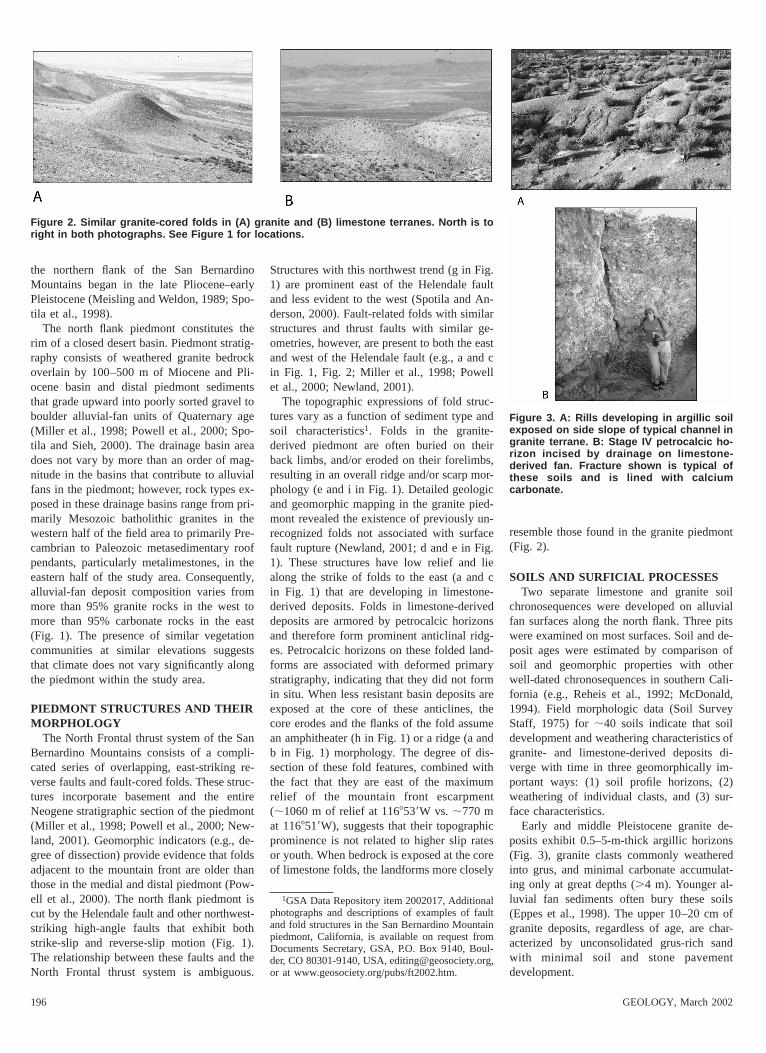
Figure 2. Similar granite-cored folds in (A) granite and (B) limestone terranes. North is toright in both photographs. See Figure 1 for locations.
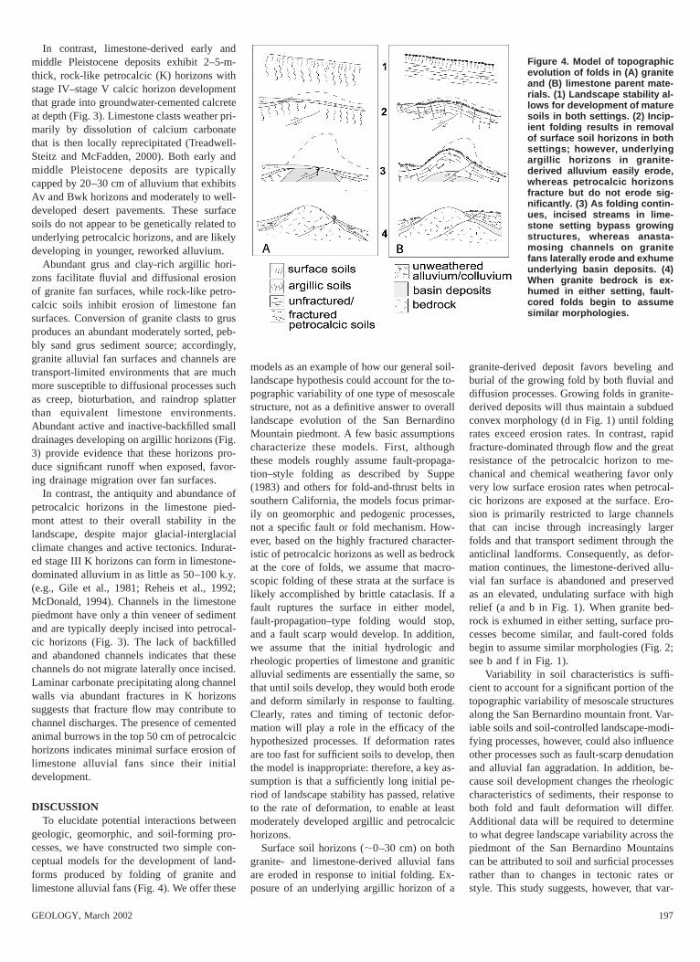
Figure 3. A: Rills developing in argillic soilexposed on side slope of typical channel ingranite terrane. B: Stage IV petrocalcic ho-rizon incised by drainage on limestone-derived fan. Fracture shown is typical ofthese soils and is lined with calciumcarbonate.
the northern flank of the San BernardinoMountains began in the late Pliocene–earlyPleistocene (Meisling and Weldon, 1989; Spo-tila et al., 1998).
The north flank piedmont constitutes therim of a closed desert basin. Piedmont stratig-raphy consists of weathered granite bedrockoverlain by 100–500 m of Miocene and Pli-ocene basin and distal piedmont sedimentsthat grade upward into poorly sorted gravel toboulder alluvial-fan units of Quaternary age(Miller et al., 1998; Powell et al., 2000; Spo-tila and Sieh, 2000). The drainage basin areadoes not vary by more than an order of mag-nitude in the basins that contribute to alluvialfans in the piedmont; however, rock types ex-posed in these drainage basins range from pri-marily Mesozoic batholithic granites in thewestern half of the field area to primarily Pre-cambrian to Paleozoic metasedimentary roofpendants, particularly metalimestones, in theeastern half of the study area. Consequently,alluvial-fan deposit composition varies frommore than 95% granite rocks in the west tomore than 95% carbonate rocks in the east(Fig. 1). The presence of similar vegetationcommunities at similar elevations suggeststhat climate does not vary significantly alongthe piedmont within the study area.
PIEDMONT STRUCTURES AND THEIRMORPHOLOGY
The North Frontal thrust system of the SanBernardino Mountains consists of a compli-cated series of overlapping, east-striking re-verse faults and fault-cored folds. These struc-tures incorporate basement and the entireNeogene stratigraphic section of the piedmont(Miller et al., 1998; Powell et al., 2000; New-land, 2001). Geomorphic indicators (e.g., de-gree of dissection) provide evidence that foldsadjacent to the mountain front are older thanthose in the medial and distal piedmont (Pow-ell et al., 2000). The north flank piedmont iscut by the Helendale fault and other northwest-striking high-angle faults that exhibit bothstrike-slip and reverse-slip motion (Fig. 1).The relationship between these faults and theNorth Frontal thrust system is ambiguous.
Structures with this northwest trend (g in Fig.1) are prominent east of the Helendale faultand less evident to the west (Spotila and An-derson, 2000). Fault-related folds with similarstructures and thrust faults with similar ge-ometries, however, are present to both the eastand west of the Helendale fault (e.g., a and cin Fig. 1, Fig. 2; Miller et al., 1998; Powellet al., 2000; Newland, 2001).
The topographic expressions of fold struc-tures vary as a function of sediment type andsoil characteristics1. Folds in the granite-derived piedmont are often buried on theirback limbs, and/or eroded on their forelimbs,resulting in an overall ridge and/or scarp mor-phology (e and i in Fig. 1). Detailed geologicand geomorphic mapping in the granite pied-mont revealed the existence of previously un-recognized folds not associated with surfacefault rupture (Newland, 2001; d and e in Fig.1). These structures have low relief and liealong the strike of folds to the east (a and cin Fig. 1) that are developing in limestone-derived deposits. Folds in limestone-deriveddeposits are armored by petrocalcic horizonsand therefore form prominent anticlinal ridg-es. Petrocalcic horizons on these folded land-forms are associated with deformed primarystratigraphy, indicating that they did not formin situ. When less resistant basin deposits areexposed at the core of these anticlines, thecore erodes and the flanks of the fold assumean amphitheater (h in Fig. 1) or a ridge (a andb in Fig. 1) morphology. The degree of dis-section of these fold features, combined withthe fact that they are east of the maximumrelief of the mountain front escarpment(;1060 m of relief at 1168539W vs. ;770 mat 1168519W), suggests that their topographicprominence is not related to higher slip ratesor youth. When bedrock is exposed at the coreof limestone folds, the landforms more closely
1GSA Data Repository item 2002017, Additionalphotographs and descriptions of examples of faultand fold structures in the San Bernardino Mountainpiedmont, California, is available on request fromDocuments Secretary, GSA, P.O. Box 9140, Boul-der, CO 80301-9140, USA, [email protected],or at www.geosociety.org/pubs/ft2002.htm.
resemble those found in the granite piedmont(Fig. 2).
SOILS AND SURFICIAL PROCESSESTwo separate limestone and granite soil
chronosequences were developed on alluvialfan surfaces along the north flank. Three pitswere examined on most surfaces. Soil and de-posit ages were estimated by comparison ofsoil and geomorphic properties with otherwell-dated chronosequences in southern Cali-fornia (e.g., Reheis et al., 1992; McDonald,1994). Field morphologic data (Soil SurveyStaff, 1975) for ;40 soils indicate that soildevelopment and weathering characteristics ofgranite- and limestone-derived deposits di-verge with time in three geomorphically im-portant ways: (1) soil profile horizons, (2)weathering of individual clasts, and (3) sur-face characteristics.
Early and middle Pleistocene granite de-posits exhibit 0.5–5-m-thick argillic horizons(Fig. 3), granite clasts commonly weatheredinto grus, and minimal carbonate accumulat-ing only at great depths (.4 m). Younger al-luvial fan sediments often bury these soils(Eppes et al., 1998). The upper 10–20 cm ofgranite deposits, regardless of age, are char-acterized by unconsolidated grus-rich sandwith minimal soil and stone pavementdevelopment.
GEOLOGY, March 2002 197
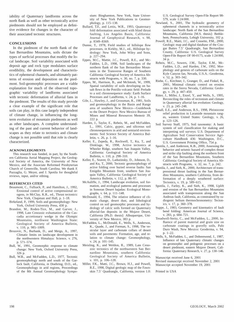
Figure 4. Model of topographicevolution of folds in (A) graniteand (B) limestone parent mate-rials. (1) Landscape stability al-lows for development of maturesoils in both settings. (2) Incip-ient folding results in removalof surface soil horizons in bothsettings; however, underlyingargillic horizons in granite-derived alluvium easily erode,whereas petrocalcic horizonsfracture but do not erode sig-nificantly. (3) As folding contin-ues, incised streams in lime-stone setting bypass growingstructures, whereas anasta-mosing channels on granitefans laterally erode and exhumeunderlying basin deposits. (4)When granite bedrock is ex-humed in either setting, fault-cored folds begin to assumesimilar morphologies.
In contrast, limestone-derived early andmiddle Pleistocene deposits exhibit 2–5-m-thick, rock-like petrocalcic (K) horizons withstage IV–stage V calcic horizon developmentthat grade into groundwater-cemented calcreteat depth (Fig. 3). Limestone clasts weather pri-marily by dissolution of calcium carbonatethat is then locally reprecipitated (Treadwell-Steitz and McFadden, 2000). Both early andmiddle Pleistocene deposits are typicallycapped by 20–30 cm of alluvium that exhibitsAv and Bwk horizons and moderately to well-developed desert pavements. These surfacesoils do not appear to be genetically related tounderlying petrocalcic horizons, and are likelydeveloping in younger, reworked alluvium.
Abundant grus and clay-rich argillic hori-zons facilitate fluvial and diffusional erosionof granite fan surfaces, while rock-like petro-calcic soils inhibit erosion of limestone fansurfaces. Conversion of granite clasts to grusproduces an abundant moderately sorted, peb-bly sand grus sediment source; accordingly,granite alluvial fan surfaces and channels aretransport-limited environments that are muchmore susceptible to diffusional processes suchas creep, bioturbation, and raindrop splatterthan equivalent limestone environments.Abundant active and inactive-backfilled smalldrainages developing on argillic horizons (Fig.3) provide evidence that these horizons pro-duce significant runoff when exposed, favor-ing drainage migration over fan surfaces.
In contrast, the antiquity and abundance ofpetrocalcic horizons in the limestone pied-mont attest to their overall stability in thelandscape, despite major glacial-interglacialclimate changes and active tectonics. Indurat-ed stage III K horizons can form in limestone-dominated alluvium in as little as 50–100 k.y.(e.g., Gile et al., 1981; Reheis et al., 1992;McDonald, 1994). Channels in the limestonepiedmont have only a thin veneer of sedimentand are typically deeply incised into petrocal-cic horizons (Fig. 3). The lack of backfilledand abandoned channels indicates that thesechannels do not migrate laterally once incised.Laminar carbonate precipitating along channelwalls via abundant fractures in K horizonssuggests that fracture flow may contribute tochannel discharges. The presence of cementedanimal burrows in the top 50 cm of petrocalcichorizons indicates minimal surface erosion oflimestone alluvial fans since their initialdevelopment.
DISCUSSIONTo elucidate potential interactions between
geologic, geomorphic, and soil-forming pro-cesses, we have constructed two simple con-ceptual models for the development of land-forms produced by folding of granite andlimestone alluvial fans (Fig. 4). We offer these
models as an example of how our general soil-landscape hypothesis could account for the to-pographic variability of one type of mesoscalestructure, not as a definitive answer to overalllandscape evolution of the San BernardinoMountain piedmont. A few basic assumptionscharacterize these models. First, althoughthese models roughly assume fault-propaga-tion–style folding as described by Suppe(1983) and others for fold-and-thrust belts insouthern California, the models focus primar-ily on geomorphic and pedogenic processes,not a specific fault or fold mechanism. How-ever, based on the highly fractured character-istic of petrocalcic horizons as well as bedrockat the core of folds, we assume that macro-scopic folding of these strata at the surface islikely accomplished by brittle cataclasis. If afault ruptures the surface in either model,fault-propagation–type folding would stop,and a fault scarp would develop. In addition,we assume that the initial hydrologic andrheologic properties of limestone and graniticalluvial sediments are essentially the same, sothat until soils develop, they would both erodeand deform similarly in response to faulting.Clearly, rates and timing of tectonic defor-mation will play a role in the efficacy of thehypothesized processes. If deformation ratesare too fast for sufficient soils to develop, thenthe model is inappropriate: therefore, a key as-sumption is that a sufficiently long initial pe-riod of landscape stability has passed, relativeto the rate of deformation, to enable at leastmoderately developed argillic and petrocalcichorizons.
Surface soil horizons (;0–30 cm) on bothgranite- and limestone-derived alluvial fansare eroded in response to initial folding. Ex-posure of an underlying argillic horizon of a
granite-derived deposit favors beveling andburial of the growing fold by both fluvial anddiffusion processes. Growing folds in granite-derived deposits will thus maintain a subduedconvex morphology (d in Fig. 1) until foldingrates exceed erosion rates. In contrast, rapidfracture-dominated through flow and the greatresistance of the petrocalcic horizon to me-chanical and chemical weathering favor onlyvery low surface erosion rates when petrocal-cic horizons are exposed at the surface. Ero-sion is primarily restricted to large channelsthat can incise through increasingly largerfolds and that transport sediment through theanticlinal landforms. Consequently, as defor-mation continues, the limestone-derived allu-vial fan surface is abandoned and preservedas an elevated, undulating surface with highrelief (a and b in Fig. 1). When granite bed-rock is exhumed in either setting, surface pro-cesses become similar, and fault-cored foldsbegin to assume similar morphologies (Fig. 2;see b and f in Fig. 1).
Variability in soil characteristics is suffi-cient to account for a significant portion of thetopographic variability of mesoscale structuresalong the San Bernardino mountain front. Var-iable soils and soil-controlled landscape-modi-fying processes, however, could also influenceother processes such as fault-scarp denudationand alluvial fan aggradation. In addition, be-cause soil development changes the rheologiccharacteristics of sediments, their response toboth fold and fault deformation will differ.Additional data will be required to determineto what degree landscape variability across thepiedmont of the San Bernardino Mountainscan be attributed to soil and surficial processesrather than to changes in tectonic rates orstyle. This study suggests, however, that var-
198 GEOLOGY, March 2002
iability of Quaternary landforms across thenorth flank as well as other tectonically activepiedmonts should not be employed as defini-tive evidence for changes in the character oftheir associated tectonic structures.
CONCLUSIONSIn the piedmont of the north flank of the
San Bernardino Mountains, soils dictate thetypes of surficial processes that modify the lo-cal landscape. Soil variability associated withdeposit age and rock type modulates surfaceerodibility, the development and characteris-tics of ephemeral channels, and ultimately pat-terns of erosion and deposition on the pied-mont. Soil-geomorphic processes are a viableexplanation for much of the observed topo-graphic variability of landforms associatedwith tectonic deformation of alluvial fans inthe piedmont. The results of this study providea clear example of the significant role thatsoils can play, in this case largely independentof climate change, in influencing the long-term evolution of mountain piedmonts as wellas other landscapes. A complete understand-ing of the past and current behavior of land-scapes as they relate to tectonics and climatechange is not possible until that role is clearlycharacterized.
ACKNOWLEDGMENTSThis research was funded, in part, by the South-
ern California Aerial Mapping Project, the Geolog-ical Society of America, the University of NewMexico, and the Associate Reformed PresbyterianChurch of Greenville, South Carolina. We thank F.Pazzaglia, G. Meyer, and J. Spotila for thoughtfulreviews, input, and/or editing.
REFERENCES CITEDBeaumont, C., Fullsack, P., and Hamilton, J., 1992,
Erosional control of active compressional or-ogens, in McClay, K.R., ed., Thrust tectonics:New York, Chapman and Hall, p. 1–18.
Birkeland, P., 1999, Soils and geomorphology: NewYork, Oxford University Press, 430 p.
Brandon, M., Roden-Tice, M., and Garver, J.,1998, Late Cenozoic exhumation of the Cas-cadia accretionary wedge in the OlympicMountains, northwest Washington State:Geological Society of America Bulletin,v. 110, p. 985–1009.
Brozovic, N., Burbank, D., and Meigs, A., 1997,Climatic limits on landscape development inthe northwestern Himalaya: Science, v. 276,p. 571–574.
Bull, W., 1991, Geomorphic response to climatechange: New York, Oxford University Press,326 p.
Bull, W.B., and McFadden, L.D., 1977, Tectonicgeomorphology north and south of the Gar-lock fault, California, in Doehring, D.O., ed.,Geomorphology in arid regions, Proceedingsof the 8th Annual Geomorphology Sympo-
sium: Binghamton, New York, State Univer-sity of New York Publications in Geomor-phology, p. 115–138.
Bullard, T.F., and Lettis, W.R., 1993, Quaternaryfold deformation associated with blind thrustfaulting, Los Angeles Basin, California:Journal of Geophysical Research, v. 98,p. 8349–8369.
Dunne, T., 1978, Field studies of hillslope flowprocesses, in Kirkby, M.J., ed., Hillslope hy-drology: New York, John Wiley and Sons,p. 227–294.
Eppes, M.C., Mattie, J.C., Powell, R.E., and Mc-Fadden, L.D., 1998, Soil landscapes of thenorthern flank of the San Bernardino Moun-tains in the Transverse Ranges of SouthernCalifornia: Geological Society of America Ab-stracts with Programs, v. 30, no. 7, p. 330.
Eppes, M., Harrison, B., and McIntosh, W., 1999,Spatial variability of soils developing on ba-salt flows in the Potrillo volcanic field: Preludeto a soil chronosequence study: Earth SurfaceProcesses and Landforms, v. 24, p. 1–16.
Gile, L., Hawley, J., and Grossman, R., 1981, Soilsand geomorphology in the Basin and Rangearea of southern New Mexico—Guidebookto the Desert Project: New Mexico Bureau ofMines and Mineral Resources Memoir 39,222 p.
Harden, J., Taylor, E., Reheis, M., and McFadden,L., 1991, Calcic, gypsic, and siliceous soilchronosequences in arid and semiarid environ-ments: Soil Science Society of America Bul-letin, v. 26, p. 1–16.
Keller, E., Zepeda, R., Rockwell, T., Ku, T., andDinklage, W., 1998, Active tectonics atWheeler Ridge, southern San Joaquin Valley,California: Geological Society of AmericaBulletin, v. 110, p. 298–310.
Keller, E., Seaver, D., Laduzinsky, D., Johnson, D.,and Ku, T., 2000, Tectonic geomorphology ofactive folding over buried reverse faults: SanEmigdio Mountain front, southern San Joa-quin Valley, California: Geological Society ofAmerica Bulletin, v. 112, p. 86–97.
McAuliffe, J., 1994, Landscape evolution, soil for-mation, and ecological patterns and processesin Sonoran Desert bajadas: Ecological Mono-graphs, v. 64, p. 111–148.
McDonald, E., 1994, The relative influence of cli-matic change, desert dust, and lithologicalcontrol on soil geomorphic processes and hy-drology of calcic soils formed on Quaternaryalluvial-fan deposits in the Mojave Desert,California [Ph.D. thesis]: Albuquerque, Uni-versity of New Mexico, 383 p.
McFadden, L., McDonald, E., Wells, S., Anderson,K., Quade, J., and Forman, S., 1998, The ve-sicular layer and carbonate collars of desertsoils and pavements: Formation, age, and re-lation to climate change: Geomorphology,v. 24, p. 101–145.
Meisling, K., and Weldon, R., 1989, Late Ceno-zoic tectonics of the northwestern San Ber-nardino Mountains, southern California:Geological Society of America Bulletin,v. 101, p. 106–128.
Miller, F.K., Matti, J.C., Brown, H.J., and Powell,R.E., 1998, Digital geologic map of the Fawn-skin 7.59 Quadrangle, California, version 1.0:
U.S. Geological Survey Open-File Report 98-579, scale 1:24 000.
Newland, S., 2001, The hydraulic geometry ofephemeral channels in a tectonically activelandscape: North flank of the San BernardinoMountains, California [M.S. thesis]: Bethle-hem, Pennsylvania, Lehigh University, 102 p.
Powell, R.E., Matti, J.C., and Cossette, P.M., 2000,Geologic map and digital database of the Cou-gar Buttes 7.59 Quadrangle, San BernardinoCounty, California: U.S. Geological SurveyOpen-File Report OF 00-0175, scale 1:24 000,34 p.
Reheis, M.C., Sowers, J.M., Taylor, E.M., Mc-Fadden, L.D., and Harden, J.W., 1992, Mor-phology and genesis of carbonate soils on theKyle Canyon fan, Nevada, U.S.A.: Geoderma,v. 52, p. 303–342.
Riebe, C., Kirchner, J., Granger, D., and Finkel, R.,2001, Minimal climatic control on erosionrates in the Sierra Nevada, California: Geolo-gy, v. 29, p. 447–450.
Ritter, J., Miller, J., Enzel, Y., and Wells, S., 1995,Reconciling the roles of tectonism and climatein Quaternary alluvial fan evolution: Geology,v. 23, p. 245–248.
Small, E.E., and Anderson, R.S., 1998, Pleistocenerelief production in Laramide mountain rang-es, western United States: Geology, v. 26,p. 123–126.
Soil Survey Staff, 1975, Soil taxonomy: A basicsystem of soil classification for making andinterpreting soil surveys: U.S. Department ofAgriculture Soil Conservation Service Agri-culture Handbook 436: Washington, D.C.,U.S. Government Printing Office, 754 p.
Spotila, J., and Anderson, K.B., 2000, Assessing thebehavior and seismic hazard of complex thrustand strike slip faulting along the northern frontof the San Bernardino Mountains, SouthernCalifornia: Geological Society of America Ab-stracts with Programs, v. 32, no. 7, p. 242.
Spotila, J., and Sieh, K., 2000, Architecture of trans-pressional thrust faulting in the San Bernar-dino Mountains, southern California, from de-formation of a deeply weathered surface:Tectonics, v. 19, p. 589–615.
Spotila, J., Farley, K., and Sieh, K., 1998, Upliftand erosion of the San Bernardino Mountainsassociated with transpression along the SanAndreas fault, California, as constrained by ra-diogenic helium thermochronometry: Tecton-ics, v. 17, p. 360–378.
Suppe, J., 1983, Geometry and kinematics of faultbend folding: American Journal of Science,v. 283, p. 684–721.
Treadwell-Steitz, C., and McFadden, L., 2000, In-fluence of parent material and grain size oncarbonate coatings in gravelly soils, PaloDuro Wash, New Mexico: Geoderma, v. 94,p. 1–22.
Wells, S., McFadden, L., and Dohrenwend, J., 1987,Influence of late Quaternary climatic changeson geomorphic and pedogenic processes on adesert piedmont, eastern Mojave Desert, Cali-fornia: Quaternary Research, v. 27, p. 130–146.
Manuscript received June 6, 2001Revised manuscript received November 2, 2001Manuscript accepted November 19, 2001
Printed in USA