introduction to wrf-sfire. - university of...
TRANSCRIPT

Introduction to WRF-Sfire.
Adam KochanskiJonathan Beezley
Jan Mandel
Outline
• What is WRF• Structure of the WRF modeling system• WRF model setup for real cases• WRF model setup for idealized cases• WRF setup for fire simulations
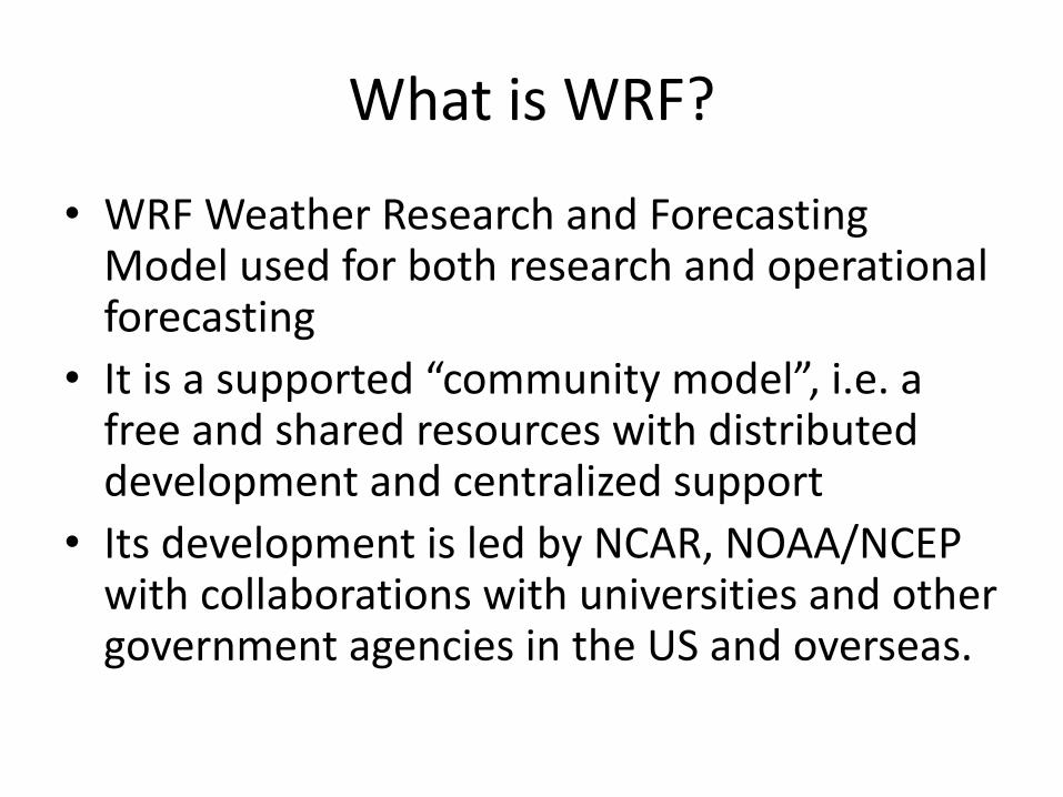
What is WRF?
• WRF Weather Research and Forecasting Model used for both research and operational forecasting
• It is a supported “community model”, i.e. a free and shared resources with distributed development and centralized support
• Its development is led by NCAR, NOAA/NCEP with collaborations with universities and other government agencies in the US and overseas.
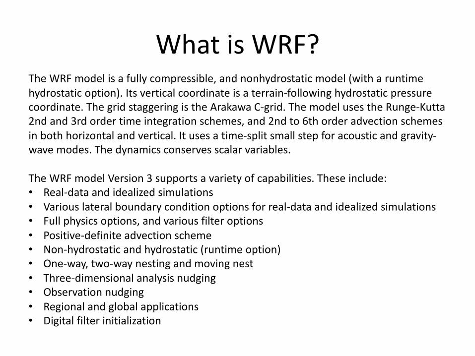
What is WRF?The WRF model is a fully compressible, and nonhydrostatic model (with a runtime hydrostatic option). Its vertical coordinate is a terrain-following hydrostatic pressure coordinate. The grid staggering is the Arakawa C-grid. The model uses the Runge-Kutta2nd and 3rd order time integration schemes, and 2nd to 6th order advection schemes in both horizontal and vertical. It uses a time-split small step for acoustic and gravity-wave modes. The dynamics conserves scalar variables.
The WRF model Version 3 supports a variety of capabilities. These include:• Real-data and idealized simulations• Various lateral boundary condition options for real-data and idealized simulations• Full physics options, and various filter options• Positive-definite advection scheme• Non-hydrostatic and hydrostatic (runtime option)• One-way, two-way nesting and moving nest• Three-dimensional analysis nudging• Observation nudging• Regional and global applications• Digital filter initialization

What can WRF-Sfire be used for?

What can WRF-Sfire be used for?• Atmospheric physics/parameterization research• Case study research• Real-time NWP and forecast system research• Regional climate and seasonal time-scale research• Coupled chemistry applications• Global simulations• Idealized simulations at various scales (convection,
baroclinic waves, LES)• Wildland fire simulations• Idealized fire simulations• Simulation of smoke emission and dispersion• Simulation of smoke impact on air quality
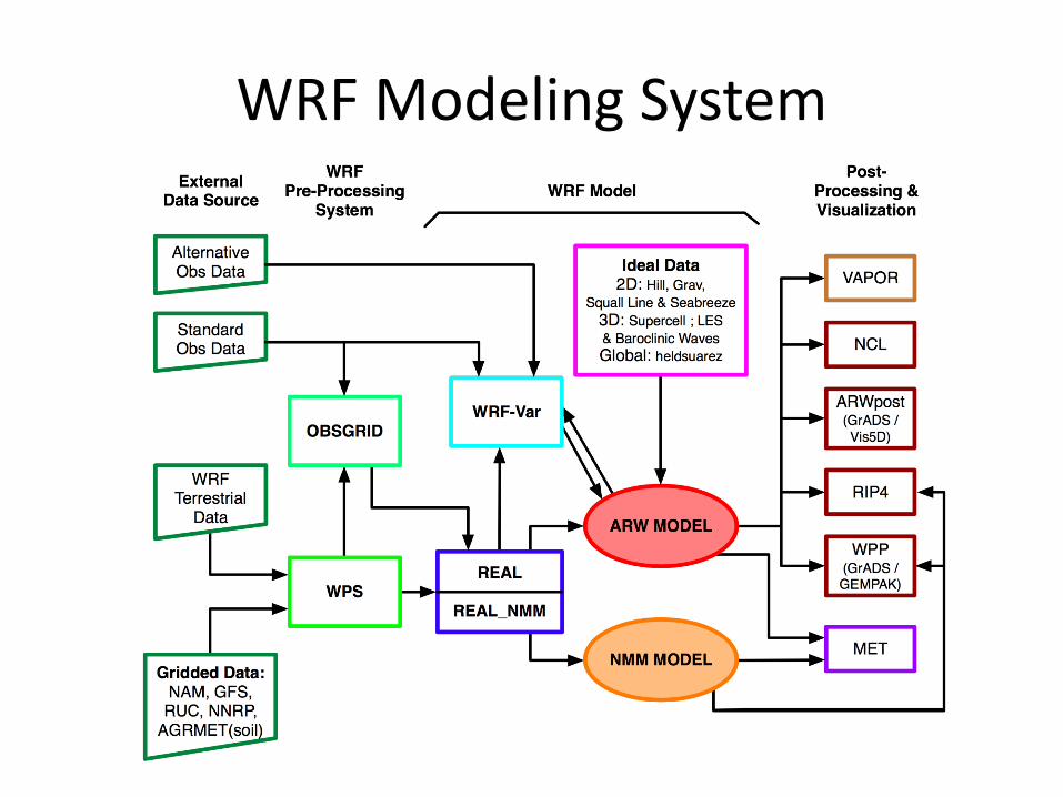
WRF Modeling System
WRF Users’ Tutorial, 25-29 January 2010 2
WRF Modeling System Flowchart

wrfinput.d01wrfinput.d02
…wrflow.d01wrflow.d02
….wrfbdy.d01
WRF Structure for real cases
GEOGRID
Static geographical data:
ElevationLand use
Soli type…Fuel type
High-res elevation
Meteorological gridded data:
Reanalysis dataGFS model output
geo_em.d01.ncgeo_em.d02.nc
…
met_em.d01met_em.d02
…
REAL
Boundary Conditions for the outer domain (d01)
Lower boundary conditions
Initial conditions for domains d01, d02…
METGRIDUNGRIBNARR_a:2012-07-01_00NARR_a:2012-07-02_00NARR_a:2012-07-03_00
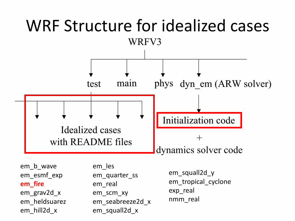
WRF Structure for idealized cases
July 2009 Mesoscale & Microscale Meteorology Division, NCAR
WRF ARW code
WRFV3WRFV3
testtest dyn_em (ARW solver)dyn_em (ARW solver)
Initialization codeInitialization code
++
……
Idealized casesIdealized cases
with README fileswith README files
mainmain physphys
real+
dynamics solver code
em_b_waveem_esmf_expem_fireem_grav2d_xem_heldsuarezem_hill2d_x
em_lesem_quarter_ssem_realem_scm_xyem_seabreeze2d_xem_squall2d_x
em_squall2d_yem_tropical_cycloneexp_realnmm_real

WRF Structure for idealized cases
July 2009 Mesoscale & Microscale Meteorology Division, NCAR
WRF ARW code
WRFV3WRFV3
testtest dyn_em (ARW solver)dyn_em (ARW solver)
Initialization codeInitialization code
++
……
Idealized casesIdealized cases
with README fileswith README files
mainmain physphys
real+
dynamics solver code
IDEALWRFV3/test/em_fire/
chemfireflux_smallheatflux_2d
heatflux_ronanhill
hill_coarsehill_med
hill_simplemoisturenested
rainsmall[…]
Idealized cases in:WRFV3/dyn_em/
module_init_utilities.Fmodule_initialize_fire.F
Module_initialize…
wrfinput.d01wrfinput.d02
namelist.inputinput_sounding
Input_luInput_htInput_fc
wrflow.d01wrflow.d02
….wrfbdy.d01
ideal.exe DOES NOT generate boundary condition files.
Generally, one of the idealized boundary conditions provided
by WRF (open, cyclic, symmetric) should be used in
ideal cases

Input_sounding file structure
July 2009 Mesoscale & Microscale Meteorology Division, NCAR
1000.00 300.00 14.001000.00 300.00 14.00 250.00 300.45 14.00 -7.88 -3.58 250.00 300.45 14.00 -7.88 -3.58 750.00 301.25 14.00 -6.94 -0.89 750.00 301.25 14.00 -6.94 -0.89 1250.00 302.47 13.50 -5.17 1.33 1250.00 302.47 13.50 -5.17 1.33 1750.00 303.93 11.10 -2.76 2.84 1750.00 303.93 11.10 -2.76 2.84 2250.00 305.31 9.06 0.01 3.47 2250.00 305.31 9.06 0.01 3.47 2750.00 306.81 7.36 2.87 3.49 2750.00 306.81 7.36 2.87 3.49 3250.00 308.46 5.95 5.73 3.49 3250.00 308.46 5.95 5.73 3.49 3750.00 310.03 4.78 8.58 3.49 3750.00 310.03 4.78 8.58 3.49 4250.00 311.74 3.82 11.44 3.49 4250.00 311.74 3.82 11.44 3.49 4750.00 313.48 3.01 14.30 3.49 4750.00 313.48 3.01 14.30 3.49
File: File: WRFV3/test/em_quarter_ss/input_soundingWRFV3/test/em_quarter_ss/input_sounding
surface
Pressure
(mb)
surface
potential
Temperature
(K)
Surface vapor
mixing ratio
(g/kg)
line 1
height (m) potential
temperature
(K)
vapor
mixing
ratio (g/kg)
U
(west-east)
velocity
(m/s)
V
(south-north)
velocity
(m/s)
each
successive
line is a
point in the
sounding
Sounding File Format
Height (m)
Potential temperature (K)
Water vaporMixing ratio
(g/kg)
U wind speed(m/s)
V wind speed(m/s)

Input files structure
In order to allow users to easily create more realistic yet simple cases the model can ingest additional surface data from external ASCII files:
input_ht - allows the user to define custom topography in an ideal caseinput_lu – allows the user to add a custom land use in an ideal caseinput_fc – allows the user to add a custom fuel map in an ideal case
How to generate the input_XX files?wrf-fire/other/Matlab/util1_jan/write_array_2d.m
Other useful matlab tools:read_array_2d.mimage_array_2d.m...

namelist.input&time_controlrun_days = 0,run_hours = 0,run_minutes = 20,run_seconds = 0,start_year = 2006, 0001, 0001,start_month = 02, 01, 01,start_day = 23, 01, 01,start_hour = 12, 00, 00,start_minute = 43, 01, 01,start_second = 00, 00, 00,end_year = 2006, 0001, 0001,end_month = 02, 01, 01,end_day = 23, 01, 01,end_hour = 13, 00, 00,end_minute = 00, 600, 600,end_second = 0, 00, 00,history_interval_s = 5, 30, 30,frames_per_outfile = 1000, 1000, 1000,restart = .false.,restart_interval = 5io_form_history = 2io_form_restart = 2io_form_input = 2io_form_boundary = 2debug_level = 1/
d01 d02 d03
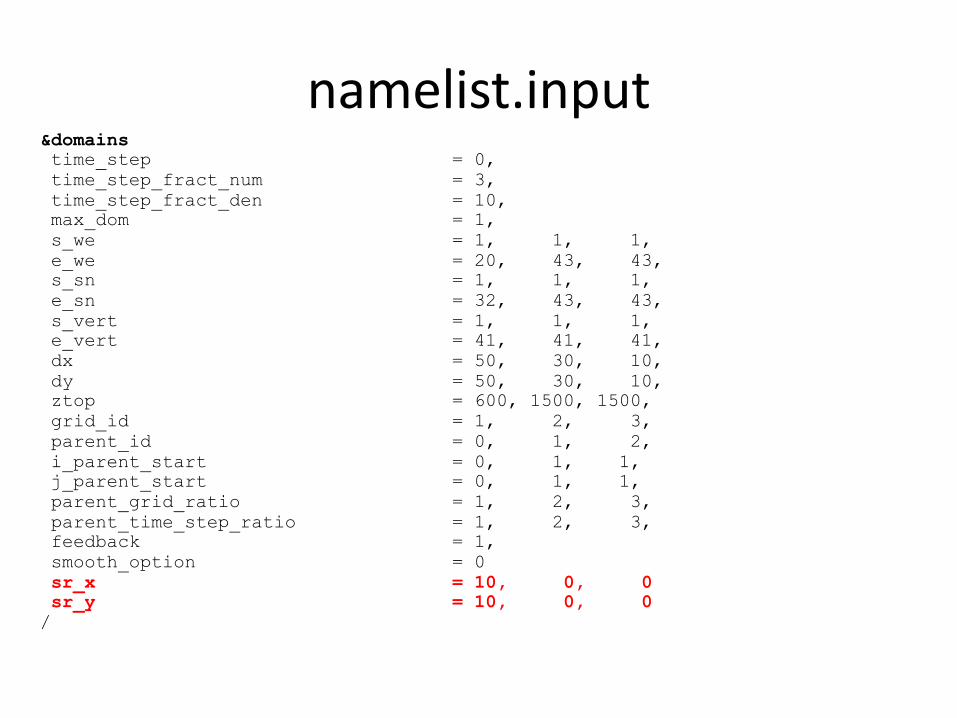
namelist.input&domainstime_step = 0,time_step_fract_num = 3,time_step_fract_den = 10,max_dom = 1,s_we = 1, 1, 1,e_we = 20, 43, 43,s_sn = 1, 1, 1,e_sn = 32, 43, 43,s_vert = 1, 1, 1,e_vert = 41, 41, 41,dx = 50, 30, 10,dy = 50, 30, 10,ztop = 600, 1500, 1500,grid_id = 1, 2, 3,parent_id = 0, 1, 2,i_parent_start = 0, 1, 1,j_parent_start = 0, 1, 1,parent_grid_ratio = 1, 2, 3,parent_time_step_ratio = 1, 2, 3,feedback = 1,smooth_option = 0sr_x = 10, 0, 0sr_y = 10, 0, 0/

namelist.input&physicsmp_physics = 0, 0, 0,ra_lw_physics = 0, 0, 0,ra_sw_physics = 0, 0, 0,radt = 30, 30, 30,sf_sfclay_physics = 1, 0, 0,sf_surface_physics = 1, 0, 0,bl_pbl_physics = 0, 0, 0,bldt = 0, 0, 0,cu_physics = 0, 0, 0,cudt = 0, 0, 0,isfflx = 1,ifsnow = 0,icloud = 0,num_soil_layers = 5,mp_zero_out = 0,/

namelist.input&dynamicsrk_ord = 3,diff_opt = 2,km_opt = 2,damp_opt = 2 ,zdamp = 100., 5000., 5000.,dampcoef = 0.2, 0.2, 0.2khdif = 0.05, 0.05, 0.05,kvdif = 0.05, 0.05, 0.05,smdiv = 0.1, 0.1, 0.1,emdiv = 0.01, 0.01, 0.01,epssm = 0.1, 0.1, 0.1mix_full_fields = .true., .true., .true.,non_hydrostatic = .true., .true., .true.,h_mom_adv_order = 5, 5, 5,v_mom_adv_order = 3, 3, 3,h_sca_adv_order = 5, 5, 5,v_sca_adv_order = 3, 3, 3,time_step_sound = 20, 20, 20,moist_adv_opt = 1, 1, 1,scalar_adv_opt = 1, 1, 1,tracer_opt = 2, 2, 2,/

namelist.input&bdy_controlperiodic_x = .false.,.false.,.false.,symmetric_xs = .false.,.false.,.false.,symmetric_xe = .false.,.false.,.false.,open_xs = .true., .false.,.false.,open_xe = .true., .false.,.false.,periodic_y = .false.,.false.,.false.,symmetric_ys = .false.,.false.,.false.,symmetric_ye = .false.,.false.,.false.,open_ys = .true., .false.,.false.,open_ye = .true., .false.,.false.,nested = .false., .true., .true.,/
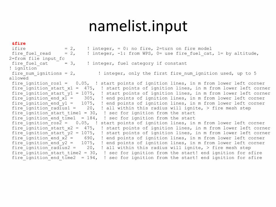
namelist.input&fire ifire = 2, ! integer, = 0: no fire, 2=turn on fire modelfire_fuel_read = 2, ! integer, -1: from WPS, 0= use fire_fuel_cat, 1= by altitude,
2=from file input_fcfire_fuel_cat = 3, ! integer, fuel category if constant
! ignitionfire_num_ignitions = 2, ! integer, only the first fire_num_ignition used, up to 5
allowedfire_ignition_ros1 = 0.05, ! start points of ignition lines, in m from lower left cornerfire_ignition_start_x1 = 475, ! start points of ignition lines, in m from lower left cornerfire_ignition_start_y1 = 1075, ! start points of ignition lines, in m from lower left cornerfire_ignition_end_x1 = 305, ! end points of ignition lines, in m from lower left cornerfire_ignition_end_y1 = 1075, ! end points of ignition lines, in m from lower left cornerfire_ignition_radius1 = 20, ! all within this radius will ignite, > fire mesh stepfire_ignition_start_time1 = 30, ! sec for ignition from the startfire_ignition_end_time1 = 184, ! sec for ignition from the startfire_ignition_ros2 = 0.05, ! start points of ignition lines, in m from lower left cornerfire_ignition_start_x2 = 475, ! start points of ignition lines, in m from lower left cornerfire_ignition_start_y2 = 1075, ! start points of ignition lines, in m from lower left cornerfire_ignition_end_x2 = 690, ! end points of ignition lines, in m from lower left cornerfire_ignition_end_y2 = 1075, ! end points of ignition lines, in m from lower left cornerfire_ignition_radius2 = 20, ! all within this radius will ignite, > fire mesh stepfire_ignition_start_time2 = 30, ! sec for ignition from the start! end ignition for sfirefire_ignition_end_time2 = 194, ! sec for ignition from the start! end ignition for sfire

namelist.inputfire_mountain_type=0, ! in ideal: 0=none, 1= hill, 2=EW ridge, 3=NS ridgefire_mountain_height=500., ! (m) ideal mountain heightfire_mountain_start_x=1000., ! (m) coord of start of the mountain from lower left corder
(just like ignition)fire_mountain_start_y=1100., ! (m) coord of start of the mountain from lower left corder
(just like ignition)fire_mountain_end_x=1500., ! (m) coord of end of the mountain from lower left corder (just
like ignition)fire_mountain_end_y=1400., ! (m) coord of end of the mountain from lower left corder (just
like ignition)fire_topo_from_atm=1, ! 0 = fire mesh topo set from fine-res data, 1 = populate by
interpolating from atmospheredelt_perturbation = 0.0, ! Temperature perturbation for creating cold (negative) / warm
(positive) bubble [K], 0 turns it off!xrad_perturbation = 10000.0, ! Horizontal radius of the bubble in E-W direction [m]!yrad_perturbation = 10000.0, ! Horizontal radius of the bubble in N-S direction [m]!zrad_perturbation = 1500.0, ! Vertical radius of the bubble [m]!hght_perturbation = 1500.0, ! Perturbation height - height at which the warm/cold bubble
will be suspended [m]!!

namelist.input! stretched grid variables!stretch_grd = .true.,stretch_hyp = .true.,z_grd_scale = 2.35
!! Surface initialization!sfc_full_init =.true.sfc_lu_index = 28, ! Defines USGS surface category used for surface initialization
based on LANDUSE.TBL (roughness, albedo etc)sfc_tsk = 285.0, ! Skin surface temperature [K]sfc_tmn = 280.0, ! Mean soil temperature [K]
! sfc_ivgtyp = 18, ! Dominant vegetation category, needed only with Noah LSM (sf_surface_physics=2)! sfc_isltyp = 7, ! Dominant soil type, needed only with Noah LSM (sf_surface_physics=2)! sfc_canwat = 0.2, ! Canopy water content, needed only with Noah LSM (sf_surface_physics=2)! sfc_vegfra = 0.5, ! Vegetation fraction, needed only with Noah LSM (sf_surface_physics=2)!! filesfire_read_atm_ht = .false., ! read terrain height from file ht_inputfire_read_lu = .true., ! read land use data from input_lu file
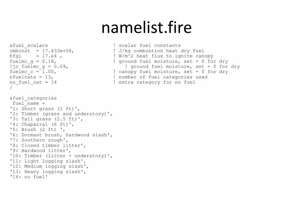
namelist.fire&fuel_scalars ! scalar fuel constantscmbcnst = 17.433e+06, ! J/kg combustion heat dry fuelhfgl = 17.e4 , ! W/m^2 heat flux to ignite canopyfuelmc_g = 0.18, ! ground fuel moisture, set = 0 for dry!jc fuelmc_g = 0.09, ! ground fuel moisture, set = 0 for dryfuelmc_c = 1.00, ! canopy fuel moisture, set = 0 for drynfuelcats = 13, ! number of fuel categories usedno_fuel_cat = 14 ! extra category for no fuel/
&fuel_categoriesfuel_name =
'1: Short grass (1 ft)','2: Timber (grass and understory)','3: Tall grass (2.5 ft)','4: Chaparral (6 ft)','5: Brush (2 ft) ','6: Dormant brush, hardwood slash','7: Southern rough','8: Closed timber litter','9: Hardwood litter','10: Timber (litter + understory)','11: Light logging slash','12: Medium logging slash','13: Heavy logging slash','14: no fuel'
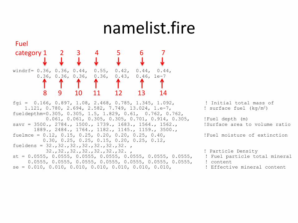
namelist.fire
windrf= 0.36, 0.36, 0.44, 0.55, 0.42, 0.44, 0.44,0.36, 0.36, 0.36, 0.36, 0.43, 0.46, 1e-7
fgi = 0.166, 0.897, 1.08, 2.468, 0.785, 1.345, 1.092, ! Initial total mass of 1.121, 0.780, 2.694, 2.582, 7.749, 13.024, 1.e-7, ! surface fuel (kg/m2)
fueldepthm=0.305, 0.305, 1.5, 1.829, 0.61, 0.762, 0.762,0.061, 0.061, 0.305, 0.305, 0.701, 0.914, 0.305, !Fuel depth (m)
savr = 3500., 2784., 1500., 1739., 1683., 1564., 1562., !Surface area to volume ratio1889., 2484., 1764., 1182., 1145., 1159., 3500.,
fuelmce = 0.12, 0.15, 0.25, 0.20, 0.20, 0.25, 0.40, !Fuel moisture of extinction0.30, 0.25, 0.25, 0.15, 0.20, 0.25, 0.12,
fueldens = 32.,32.,32.,32.,32.,32.,32. ,32.,32.,32.,32.,32.,32.,32. , ! Particle Density
st = 0.0555, 0.0555, 0.0555, 0.0555, 0.0555, 0.0555, 0.0555, ! Fuel particle total mineral0.0555, 0.0555, 0.0555, 0.0555, 0.0555, 0.0555, 0.0555, ! content
se = 0.010, 0.010, 0.010, 0.010, 0.010, 0.010, 0.010, ! Effective mineral content
Fuelcategory 1 2 3 4 5 6 7
8 9 10 11 12 13 14
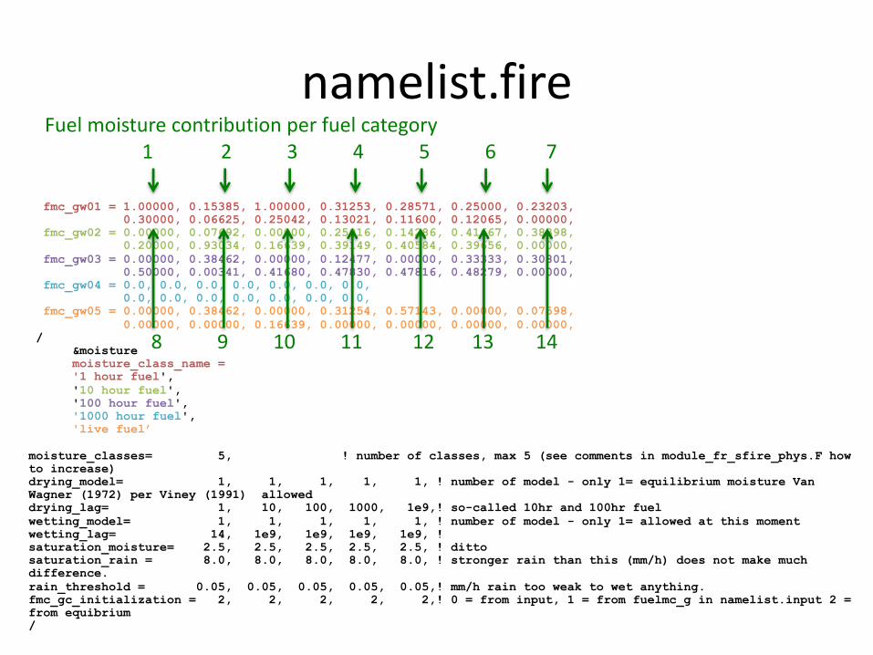
namelist.fire
fmc_gw01 = 1.00000, 0.15385, 1.00000, 0.31253, 0.28571, 0.25000, 0.23203,0.30000, 0.06625, 0.25042, 0.13021, 0.11600, 0.12065, 0.00000,
fmc_gw02 = 0.00000, 0.07692, 0.00000, 0.25016, 0.14286, 0.41667, 0.38398,0.20000, 0.93034, 0.16639, 0.39149, 0.40584, 0.39656, 0.00000,
fmc_gw03 = 0.00000, 0.38462, 0.00000, 0.12477, 0.00000, 0.33333, 0.30801,0.50000, 0.00341, 0.41680, 0.47830, 0.47816, 0.48279, 0.00000,
fmc_gw04 = 0.0, 0.0, 0.0, 0.0, 0.0, 0.0, 0.0,0.0, 0.0, 0.0, 0.0, 0.0, 0.0, 0.0,
fmc_gw05 = 0.00000, 0.38462, 0.00000, 0.31254, 0.57143, 0.00000, 0.07598,0.00000, 0.00000, 0.16639, 0.00000, 0.00000, 0.00000, 0.00000,
/&moisturemoisture_class_name ='1 hour fuel','10 hour fuel','100 hour fuel','1000 hour fuel','live fuel’
moisture_classes= 5, ! number of classes, max 5 (see comments in module_fr_sfire_phys.F howto increase)drying_model= 1, 1, 1, 1, 1, ! number of model - only 1= equilibrium moisture Van Wagner (1972) per Viney (1991) alloweddrying_lag= 1, 10, 100, 1000, 1e9,! so-called 10hr and 100hr fuelwetting_model= 1, 1, 1, 1, 1, ! number of model - only 1= allowed at this momentwetting_lag= 14, 1e9, 1e9, 1e9, 1e9, ! saturation_moisture= 2.5, 2.5, 2.5, 2.5, 2.5, ! dittosaturation_rain = 8.0, 8.0, 8.0, 8.0, 8.0, ! stronger rain than this (mm/h) does not make much difference.rain_threshold = 0.05, 0.05, 0.05, 0.05, 0.05,! mm/h rain too weak to wet anything.fmc_gc_initialization = 2, 2, 2, 2, 2,! 0 = from input, 1 = from fuelmc_g in namelist.input 2 = from equibrium/
Fuel moisture contribution per fuel category1 2 3 4 5 6 7
8 9 10 11 12 13 14

How to set up and run WRF?1. Install git to be able to download git repositories2. Get the code from openwfm git repository:
git clone git://github.com/jbeezley/wrf-fire.git3. Install netcdf and fortran compiler in macports it will be:
sudo port install netcdf-fortran4. Set up your environment
export NETCDF=/opt/local5. Configure the model:
/WRFV3/configure6. Compile the model
/WRFV3/compile em_fire >& compile.log&7. Compile the preprocessing system WPS
/WPS/compile >& compile.log&8. Set up the model parameters in namelist.input and namelist.fire9. Create wrfinput files (initialization): go to a selected case in /WRFV3/test/em_fire/ and run
/WRFV3/test/em_fire/your_case/ideal.exe – it will create wrfinput_d01 file.10. Run the model
/WRFV3/test/your_case/wrf.exe

WRF outputWRF generates files in the netcdf formatThey can be accessed by any visualization package with the nectdf support:
• Ncview• Ncbrowser• NCL• Matlab• Vapor• etc…