intracoastal waterway tampa bay to port richey green light only red light only occulting quick...
TRANSCRIPT
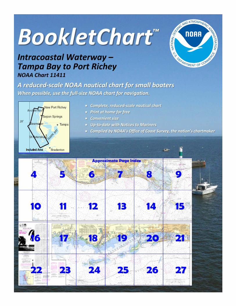
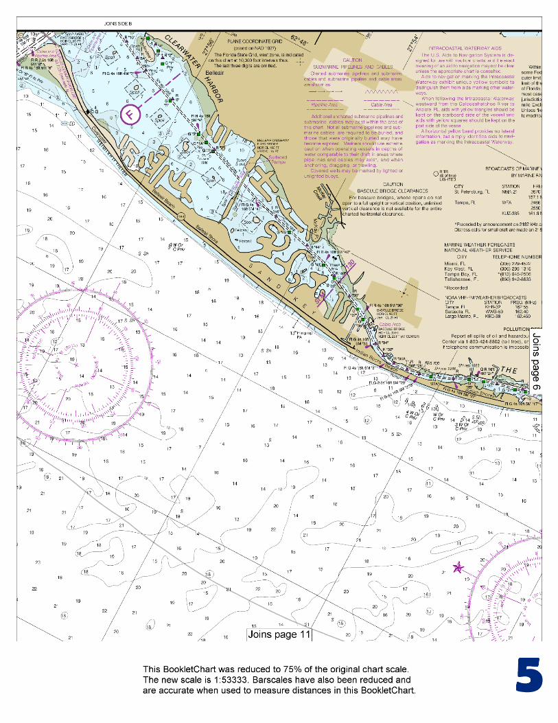
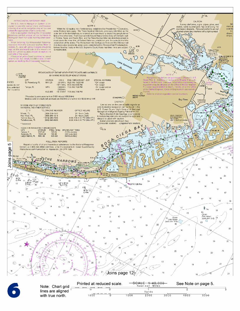
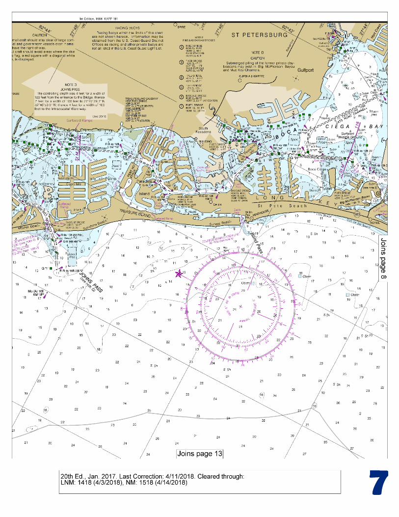
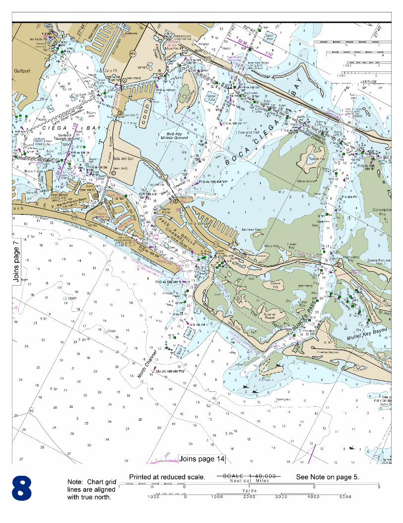
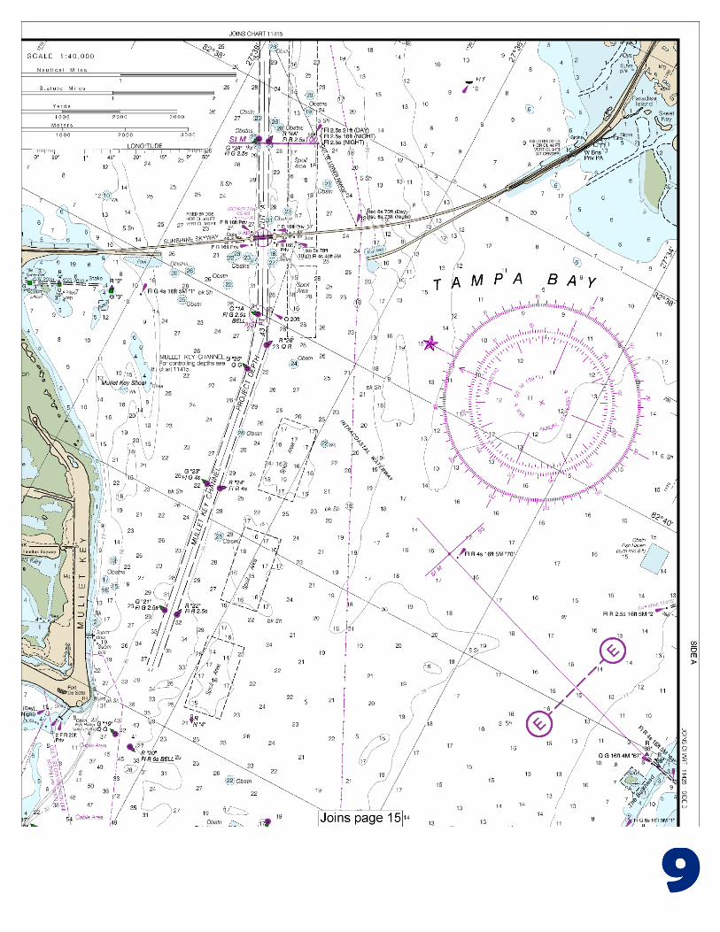
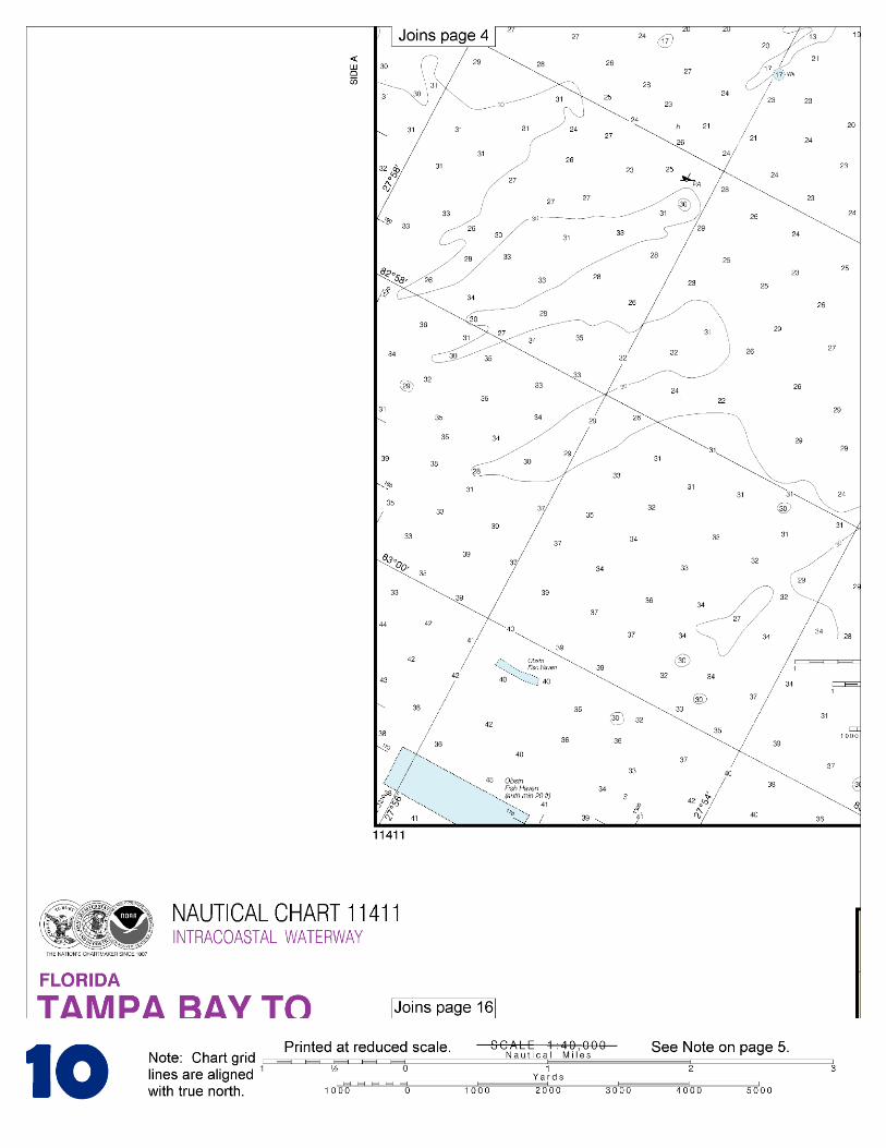
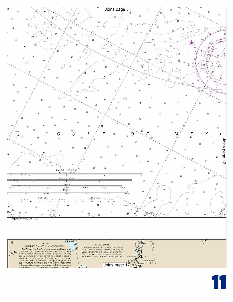
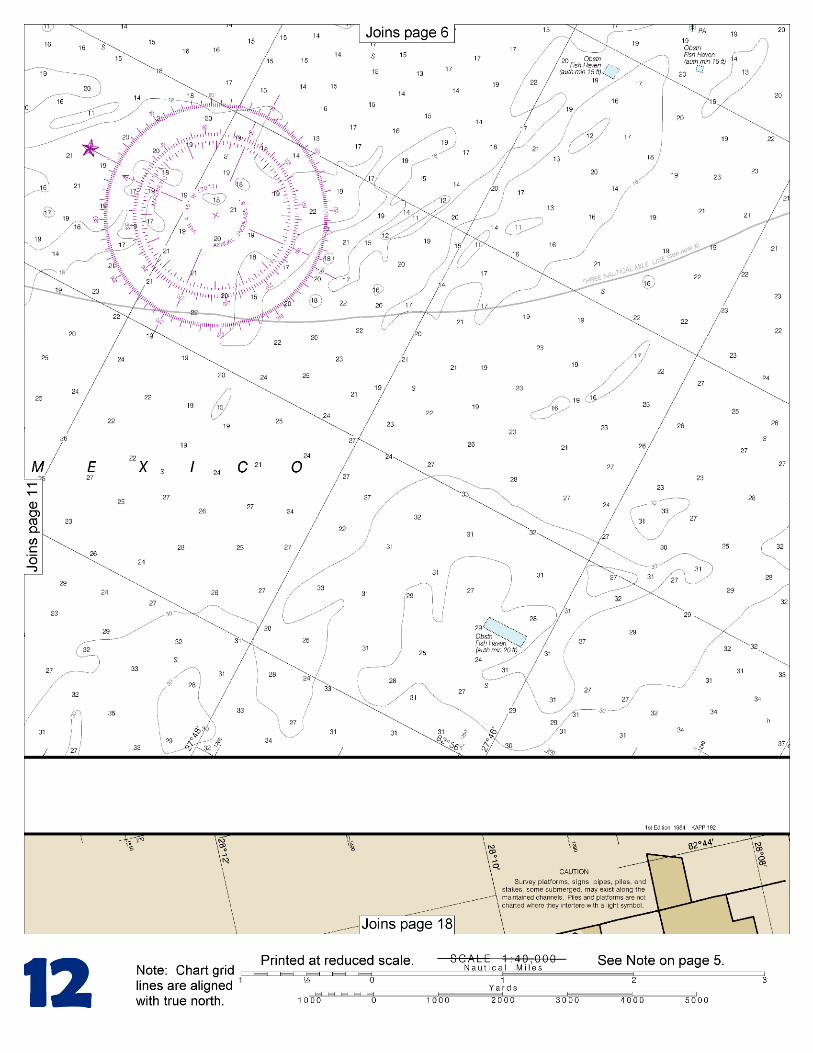
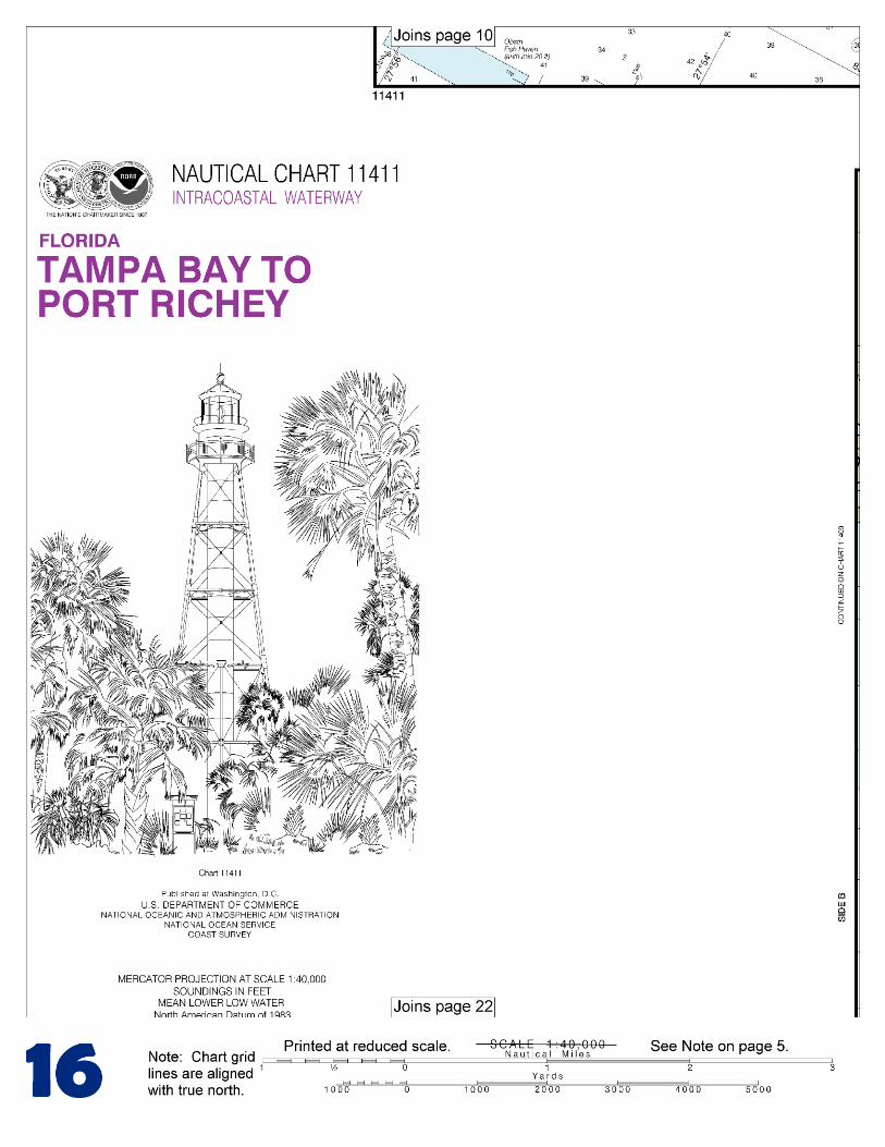
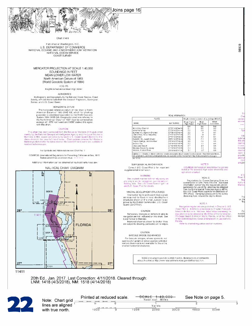
BookletChart™ Intracoastal Waterway – Tampa Bay to Port Richey NOAA Chart 11411
A reduced-scale NOAA nautical chart for small boaters When possible, use the full-size NOAA chart for navigation.
2
Published by the National Oceanic and Atmospheric Administration
National Ocean Service Office of Coast Survey
www.NauticalCharts.NOAA.gov 888-990-NOAA
What are Nautical Charts?
Nautical charts are a fundamental tool of marine navigation. They show water depths, obstructions, buoys, other aids to navigation, and much more. The information is shown in a way that promotes safe and efficient navigation. Chart carriage is mandatory on the commercial ships that carry America’s commerce. They are also used on every Navy and Coast Guard ship, fishing and passenger vessels, and are widely carried by recreational boaters.
What is a BookletChart?
This BookletChart is made to help recreational boaters locate themselves on the water. It has been reduced in scale for convenience, but otherwise contains all the information of the full-scale nautical chart. The bar scales have also been reduced, and are accurate when used to measure distances in this BookletChart. See the Note at the bottom of page 5 for the reduction in scale applied to this chart.
Whenever possible, use the official, full scale NOAA nautical chart for navigation. Nautical chart sales agents are listed on the Internet at http://www.NauticalCharts.NOAA.gov.
This BookletChart does NOT fulfill chart carriage requirements for regulated commercial vessels under Titles 33 and 44 of the Code of Federal Regulations.
Notice to Mariners Correction Status
This BookletChart has been updated for chart corrections published in the U.S. Coast Guard Local Notice to Mariners, the National Geospatial Intelligence Agency Weekly Notice to Mariners, and, where applicable, the Canadian Coast Guard Notice to Mariners. Additional chart corrections have been made by NOAA in advance of their publication in a Notice to Mariners. The last Notices to Mariners applied to this chart are listed in the Note at the bottom of page 7. Coast Pilot excerpts are not being corrected.
For latest Coast Pilot excerpt visit the Office of Coast Survey website at http://www.nauticalcharts.noaa.gov/nsd/searchbychart.php?chart=11411
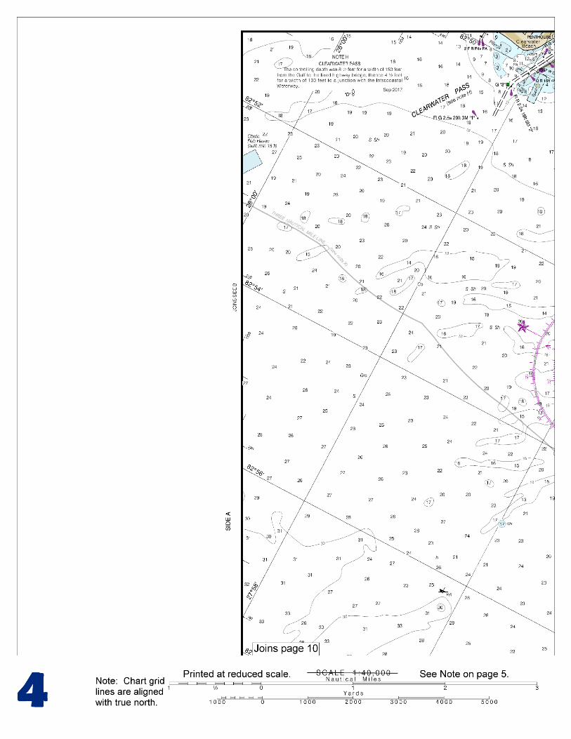
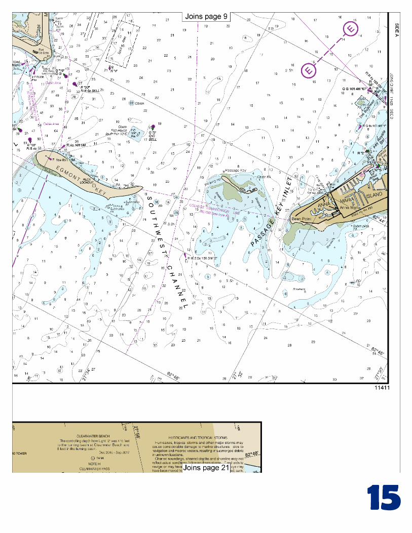
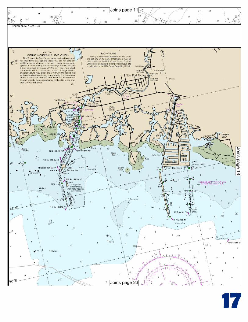
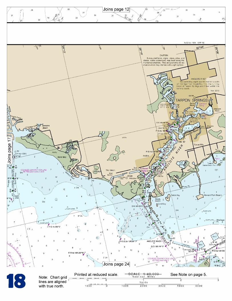
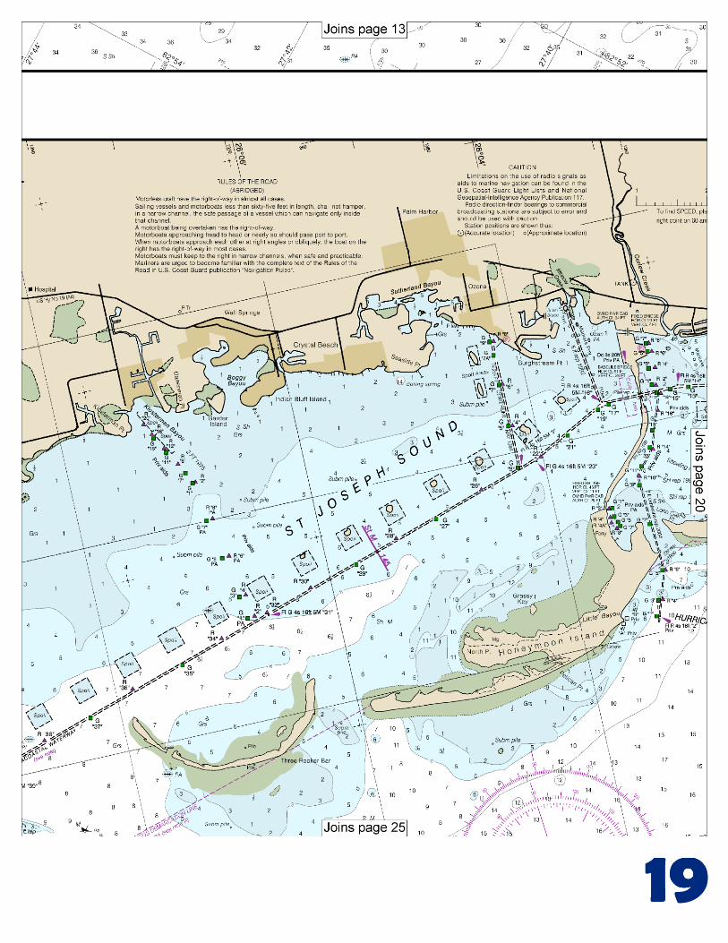
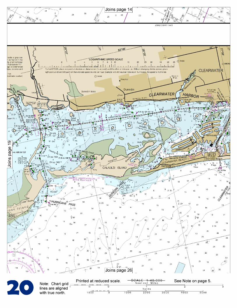
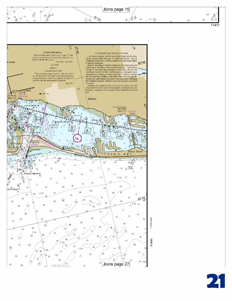
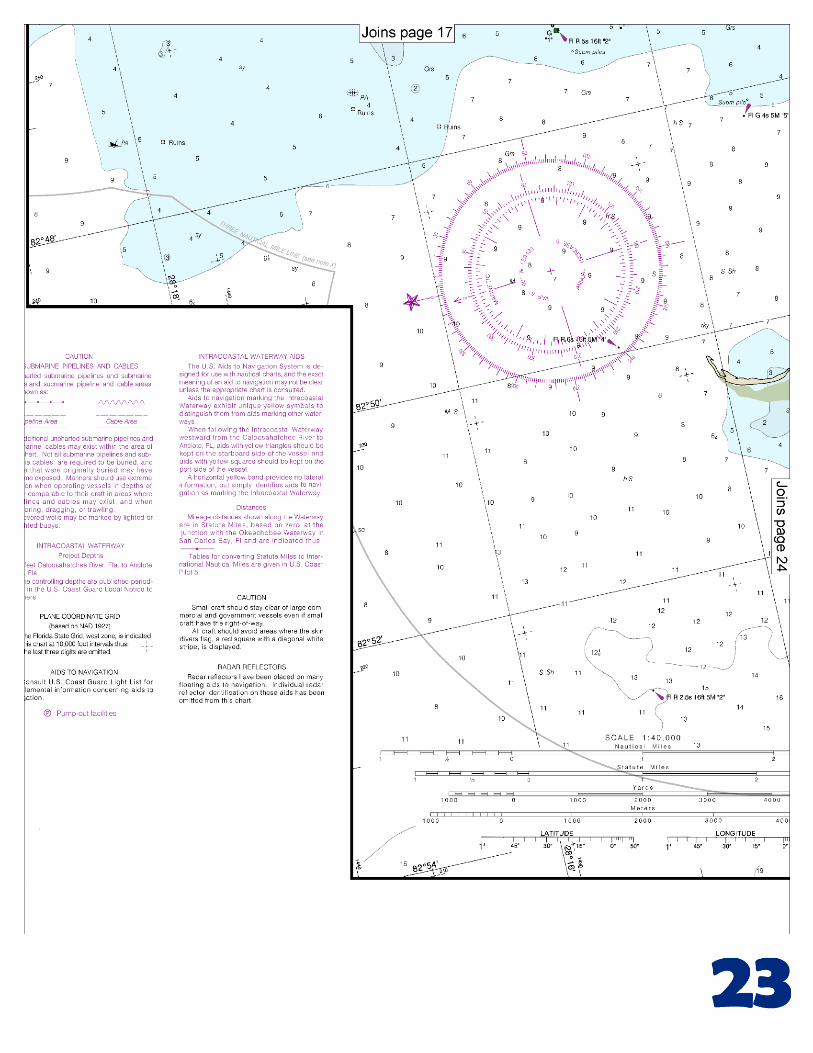
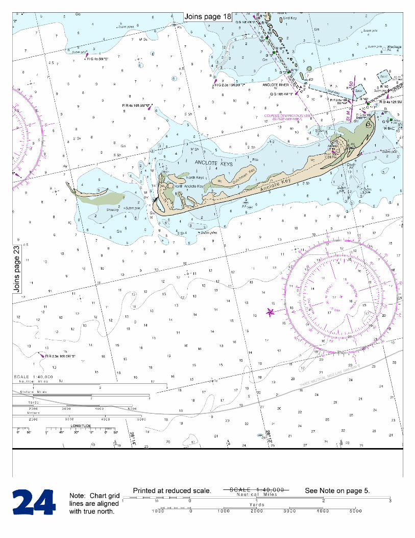
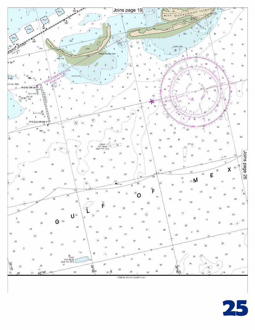
[Coast Pilot 5, Chapter 9 excerpts]. St. Joseph Sound extends N from Clearwater Harbor nearly to Anclote Keys, and is separated from the Gulf for a part of the distance by narrow strips of beach known as Caladesi Island and Honeymoon Island. Dunedin Pass is marked by private daybeacons. The pass was reported shoaled to 1 foot and closed to navigation. Hurricane Pass; with local knowledge 3 to 5 feet could be carried. A light and
daybeacons mark the pass. Vessels should approach the harbor through the Tampa Safety Fairway.
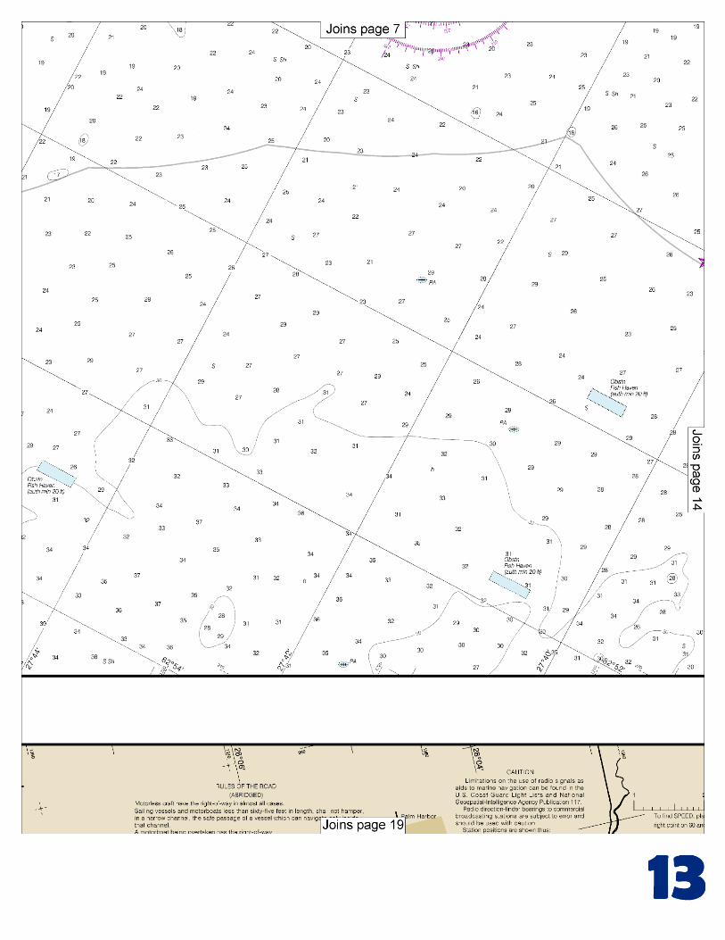
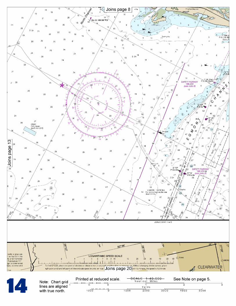
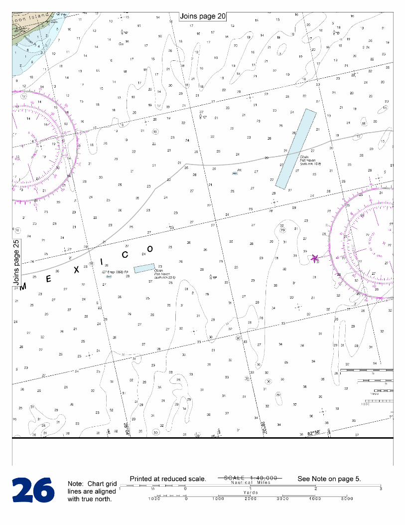
The entrance and all other navigable waters of Tampa Bay, Hillsborough Bay, Old Tampa Bay, and tributaries herein are within a regulated navigation area. Required Reports to the CVTS.–Vessels should contact the CVTS prior to entering Tampa Bay, shifting or departing dock (see paragraphs 39-51 for details). Anchorages.–Vessels with good ground tackle should anchor in the Tampa Anchorages, N of the Tampa Safety Fairway leading to Egmont Channel. An emergency anchorage is S of Mullet Key in depths of 30 to 35 feet; and SW of Gadsden Point in natural depths of 29 to 32 feet. Explosives and quarantine anchorages are E of Mullet Key, NE of Papys Point, and S of Interbay Peninsula. (See 110.1 and 110.193, chapter 2, for limits and regulations.) Dangers.–Shoal areas extend seaward from Egmont Key as far as Palantine Shoal, which is 5 miles W of the key and on the S side of Egmont Channel entrance. Palantine Shoal consists of several small lumps with depths of 11 to 18 feet over them. Spoil areas, for the most part unmarked and with reported depths of 10 feet or less, border the dredged cuts of the main ship channel in Tampa Bay and the channels in Old Tampa Bay. Caution should be observed particularly at the entrances to the side channels leading to Port Manatee, Alafia River, and Port Sutton. Local weather during the thunderstorm season is unpredictable, and intense winds can develop suddenly. Before entering or departing the port, mariners should obtain local weather forecasts, maintain a close watch on the weather, and ensure that light vessels are properly ballasted during the transit. A regulated navigation area has been established to protect vessels from limited water depth in Sparkman Channel caused by an underwater pipeline. Currents.–A strong offshore wind sometimes lowers the water surface at Tampa and in the dredged channels as much as 4 feet, and retards the time of high water by as much as 3 hours. A continued SW wind raises the water by nearly the same amount and advances the time of high water by as much as 1 hour. There is a large daily inequality in the ebb, and velocities of 2 knots or more may be expected at the strength of the greater ebb of the day in Egmont Channel, Passage Key Inlet, and off Port Tampa. Flood velocities seldom exceed 2 knots. Winds have considerable effect in modifying the tidal current. Notice of Arrival Time.–Vessels are requested to contact Pilot Dispatch 24 hours before arrival with the following information: international gross tonnage, LOA, beam, deep draft, and name of local agent. Call the pilot station on VHF-FM Channel 16 four hours prior to arrival and one hour prior to arrival at the sea buoy (Tampa Bay Lighted Buoy T). The pilot station stands by on VHF-FM Channels 16, 17, 13, 12, and 10. Additional instructions will be given upon radio contact. If instructed to anchor, please keep 24-hour watch on VHF-FM Channels 12 and 13. Vessels are normally not moved in dense fog, and during strong northwest winds, vessels are boarded inside Egmont Key.
U.S. Coast Guard Rescue Coordination Center 24 hour Regional Contact for Emergencies
RCC New Orleans Commander
8th CG District (504) 589-6225 New Orleans, LA
G
NOAA’s navigation managers serve as ambassadors to the maritime community. They help identify navigational challenges facing professional and recreational mariners, and provide NOAA resources and information for safe navigation. For additional information, please visit nauticalcharts.noaa.gov/service/navmanagers
To make suggestions or ask questions online, go to nauticalcharts.noaa.gov/inquiry. To report a chart discrepancy, please use ocsdata.ncd.noaa.gov/idrs/discrepancy.aspx.
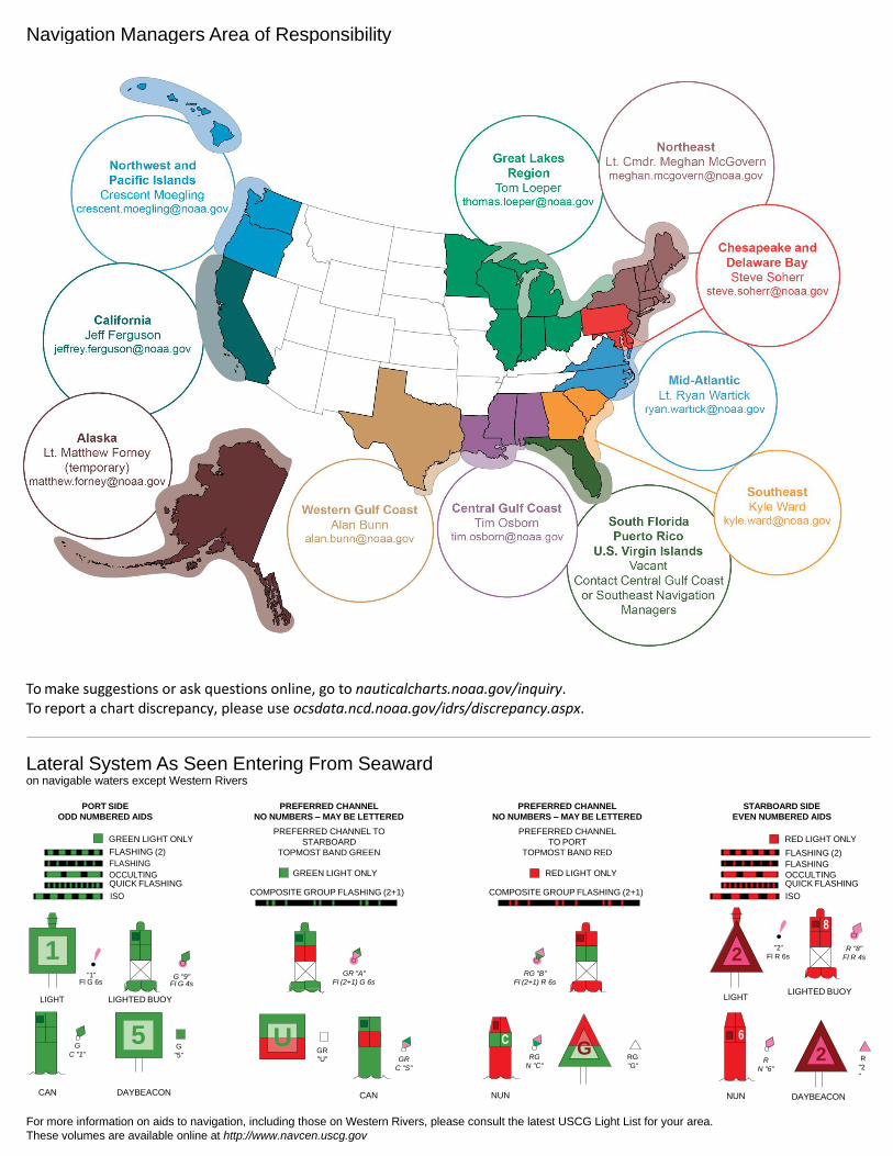
Lateral System As Seen Entering From Seaward on navigable waters except Western Rivers
PORT SIDE
ODD NUMBERED AIDS
GREEN LIGHT ONLY
FLASHING (2)
PREFERRED CHANNEL
NO NUMBERS – MAY BE LETTERED
PREFERRED CHANNEL TO
STARBOARD
TOPMOST BAND GREEN
PREFERRED CHANNEL
NO NUMBERS – MAY BE LETTERED
PREFERRED CHANNEL
TO PORT
TOPMOST BAND RED
STARBOARD SIDE
EVEN NUMBERED AIDS
RED LIGHT ONLY
FLASHING (2)
FLASHING FLASHING
OCCULTING GREEN LIGHT ONLY RED LIGHT ONLY OCCULTING QUICK FLASHING QUICK FLASHING
ISO COMPOSITE GROUP FLASHING (2+1) COMPOSITE GROUP FLASHING (2+1) ISO
"1"
Fl G 6s
G "9"
Fl G 4s
GR "A"
Fl (2+1) G 6s
RG "B"
Fl (2+1) R 6s
"2"
Fl R 6s
8
R "8"
Fl R 4s
LIGHT
G
C "1"
LIGHTED BUOY
G
"5"
GR
"U"
GR
C "S"
RG
N "C"
RG
"G"
LIGHT
6
R
N "6"
LIGHTED BUOY
R
"2
"
CAN DAYBEACON
CAN NUN NUN
DAYBEACON
For more information on aids to navigation, including those on Western Rivers, please consult the latest USCG Light List for your area.
These volumes are available online at http://www.navcen.uscg.gov
Navigation Managers Area of Responsibility
Northeast
Lt. Meghan McGovern
Northwest and
Pacific Islands
Crescent Moegling
Great Lakes Region
Tom Loeper
Chesapeake and
Delaware Bay
Steve Soherr
California
Jeff Ferguson
[email protected] Mid-Atlantic
Lt. Ryan Wartick
Alaska
Lt. Timothy M. Smith
Western Gulf Coast
Alan Bunn
Central Gulf Coast
Tim Osborn
[email protected] South Florida
Puerto Rico
U.S. Virgin Islands
Michael Henderson
Southeast
Kyle Ward
2
2 C U 5
1
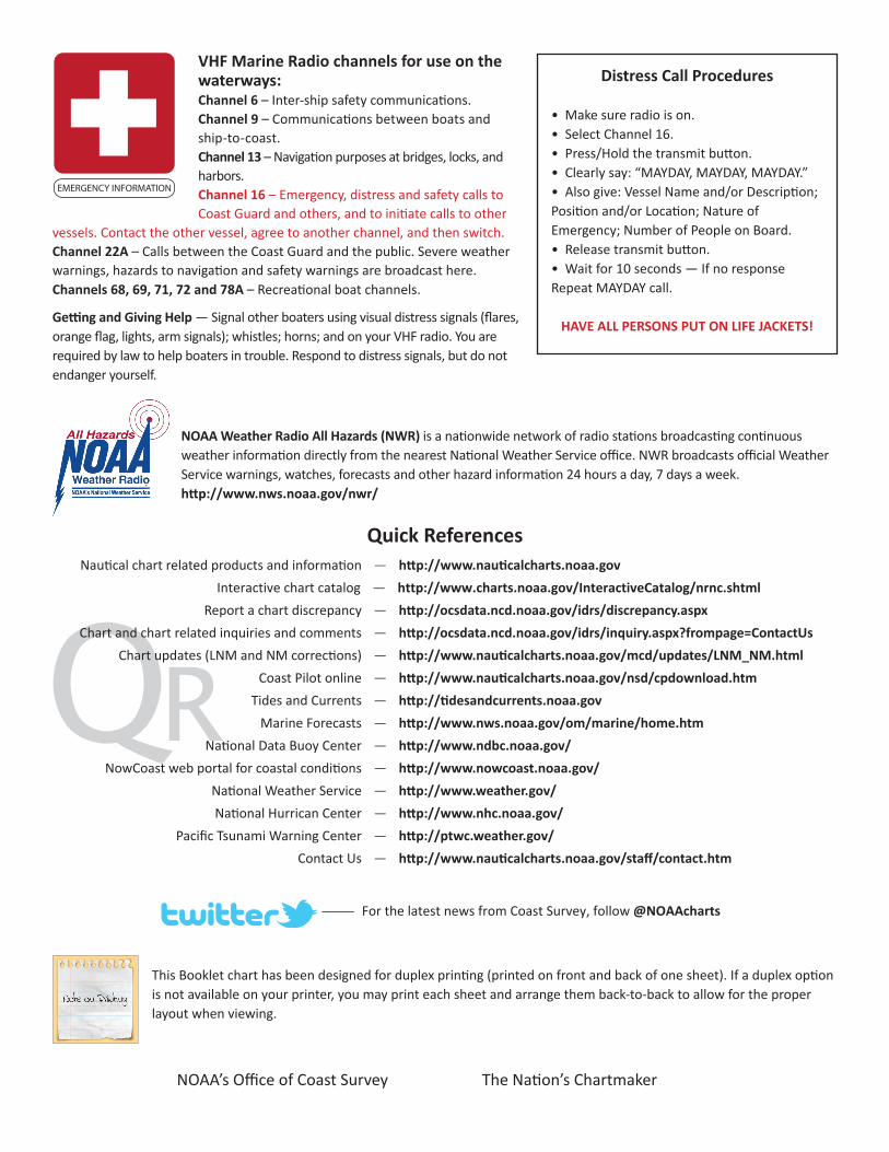
VHF Marine Radio channels for use on the waterways:Channel 6 – Inter-ship safety communications.Channel 9 – Communications between boats and ship-to-coast.Channel 13 – Navigation purposes at bridges, locks, and harbors.Channel 16 – Emergency, distress and safety calls to Coast Guard and others, and to initiate calls to other
vessels. Contact the other vessel, agree to another channel, and then switch.Channel 22A – Calls between the Coast Guard and the public. Severe weather warnings, hazards to navigation and safety warnings are broadcast here.Channels 68, 69, 71, 72 and 78A – Recreational boat channels.
Getting and Giving Help — Signal other boaters using visual distress signals (flares, orange flag, lights, arm signals); whistles; horns; and on your VHF radio. You are required by law to help boaters in trouble. Respond to distress signals, but do not endanger yourself.
EMERGENCY INFORMATION
Distress Call Procedures
• Make sure radio is on.• Select Channel 16.• Press/Hold the transmit button.• Clearly say: “MAYDAY, MAYDAY, MAYDAY.”• Also give: Vessel Name and/or Description;Position and/or Location; Nature of Emergency; Number of People on Board.• Release transmit button.• Wait for 10 seconds — If no responseRepeat MAYDAY call.
HAVE ALL PERSONS PUT ON LIFE JACKETS!
This Booklet chart has been designed for duplex printing (printed on front and back of one sheet). If a duplex option is not available on your printer, you may print each sheet and arrange them back-to-back to allow for the proper layout when viewing.
QR
Quick ReferencesNautical chart related products and information - http://www.nauticalcharts.noaa.gov
Interactive chart catalog - http://www.charts.noaa.gov/InteractiveCatalog/nrnc.shtmlReport a chart discrepancy - http://ocsdata.ncd.noaa.gov/idrs/discrepancy.aspx
Chart and chart related inquiries and comments - http://ocsdata.ncd.noaa.gov/idrs/inquiry.aspx?frompage=ContactUs
Chart updates (LNM and NM corrections) - http://www.nauticalcharts.noaa.gov/mcd/updates/LNM_NM.html
Coast Pilot online - http://www.nauticalcharts.noaa.gov/nsd/cpdownload.htm
Tides and Currents - http://tidesandcurrents.noaa.gov
Marine Forecasts - http://www.nws.noaa.gov/om/marine/home.htm
National Data Buoy Center - http://www.ndbc.noaa.gov/
NowCoast web portal for coastal conditions - http://www.nowcoast.noaa.gov/
National Weather Service - http://www.weather.gov/
National Hurrican Center - http://www.nhc.noaa.gov/
Pacific Tsunami Warning Center - http://ptwc.weather.gov/
Contact Us - http://www.nauticalcharts.noaa.gov/staff/contact.htm
NOAA’s Office of Coast Survey The Nation’s Chartmaker
For the latest news from Coast Survey, follow @NOAAcharts
NOAA Weather Radio All Hazards (NWR) is a nationwide network of radio stations broadcasting continuous weather information directly from the nearest National Weather Service office. NWR broadcasts official Weather Service warnings, watches, forecasts and other hazard information 24 hours a day, 7 days a week. http://www.nws.noaa.gov/nwr/